FRENCH LIMITED SITE CROSBY, TEXAS SUPPLEMENTAL INVESTIGATION PREPARED FOR FRENCH LIMITED TASK GROUP o o o JANUARY,1984 11 G R E E N W A Y P L A Z A , S U I T E 1724, H O U S T O N , T E X A S 77046, (713) 621-5900
Transcript
F R E N C H L I M I T E D S I T EC R O S B Y , T E X A S
S U P P L E M E N T A L I N V E S T I G A T I O N
P R E P A R E D F O R
F R E N C H L I M I T E D T A S K G R O U Pooo
J A N U A R Y , 1 9 8 4
1 1 G R E E N W A Y P L A Z A , S U I T E 1724, H O U S T O N , T E X A S 77046, ( 7 1 3 ) 621-5900
smartin
Rectangle
000444
IT a b l e of Contents
Descr ip t i on .gage
1.0 nroOXJCTICN ................................................. 11.1 Waste C h a r a c t e r i s t i c s ................................... 11.2 PCS Cons id era t i on s ...................................... 31.3 Geohydrological Evaluat ion .............................. 3
2.0 FIELD PRCG.RAMS ............................................. t. 42.1 I.'- 1 on S a m p l i n g ......................................... 42.2 " i d f i l l S a m p l i n g ....................................... 42.3 Groundvater H o n i t c c W e l l s ............................... 52.4 S a f e t y and Chain of Cus tody Procedures .................. 5
3.0 ANALYTICAL FSOGRAMS .......................................... 63.1 Waste Charac t e r i s t i c s ................................... 63.2 Subsoi l Contaminat i on P r o f i l e ........................... 73.3 PCS Concentrat ion ....................................... 73.4 H y d r o l o g i c Grad i en t ..................................... 7
1 S a m p l e Location Diagram2 French Limited S a m p l i n g Plan3 M o n i t o r i n g W e l l I n s t a l l a t i o n4 Proposal T a b u l a t i o n of S a m p l e s and Analyse s
OoO
smartin
Rectangle
000445
French Limited S i t eS u p p l e m e n t a l I n v e s t i g a t i o n
1.0 INTRODUCFICMBased uj-on d r a f t result s of the recent remedial inve s t igat ion of the
F r e n c h L i m i t e d S i t e , several areas of interest have been i d e n t i f i e d whichshould be the subject of a s u p p l e m e n t a l inves t igat ion of the area. B r i e f l y ,the additional in format ion deemed de s irab l e to assess remedial opt ions forthe site are described as f o l l o w s :
1.1 Wast e Character iz aticn ~ A s i g n i f i c a n t quant i ty of data has beenco l l e c t ed over the years relat ive to soil contamination around the mainlagoon at the site. Ihe recent inve s t igat ion also included ul trasonic d e p t hmeasurements of the various strata within the lagoon, f o l l o w e d by somevibracore sampl ing of waste residues. Sel e c t ed samples of these wastes weresubjec ted to a p r i o r i t y p o l l u t a n t analysi s , and an estimate prepared of theto tal volume of waste in the lagoon and volume of surrounding contaminatedsoils. It would be h e l p f u l to have sane add i t i ona l in f ormat i on relat ive towaste quanti t i e s and characteri s t ic s:
1.1.1 Quantity - The LAN estimate of waste quanti ty current lyranges between 30,000 and 48,000 cubic yards of waste and contaminatedsub-soils wi th in the lagoon, with th i s increase over their previous estimateof 8,000 cubic yards based upon emulsion of heavily contaminated sandsbeneath the s ludge s . Since the avai lable geo log i c data indicate that the
smartin
Rectangle
000446
sand layer into which the pit was excavated could have been as thick as 65f e e t , and since a f l o a t i n g barge was u t i l i z ed to .-nine the sands f r o m thispit in the early 60's, there is no conclusive evidence that the "one to *ourf e e t of heavily contaminated sands beneath the sludges" accounts for thei
j total d ep th of waste residue migration. As such, addit ional in format i onwil l be necessary to p r o p e r l y document the total waste quanti ty wi thin thepit to account for waste const i tuents which may have migrated into subgrade1 soils .
1.1.2 C o m p o s i t i o n - Ihe composi t ion of the waste s l udge s has notbeen comple t e ly d e t e rmined , in that only three samples were i n i t i a l l yanalyzed t y G C / f a S , with only base/neutral p r i o r i t y p o l l u t a n t s a n d P C B ' sreported as being present. She organic mater ia l s i d e n t i f i e d ranged f r a n atotal of 4,000 pgn to 8,000 p p n , with the range of the total extractableorganics (TOE) for those same samples ranging f r c m one to nine percent.Materia l balance is f u r t h e r conf irmed by the two supplemental samplesanalyzed by GC/ftS in Novsnber. It is, t h e r e f o r e , questionable whether muchof the organic content of the s ludge is composed of p r i o r i t y p o l l u t a n t s , andto evaluate remedial opt ions , the true composi t ion of the material should beknown.
1.1.3 Regulatory . . C l a s s i f i c a t i o n - Mo data have been reportedwhich would al low the characterization of the s ludge s under Federal or S t a t eguide l ine s . I n s u f f i c i e n t conposit ional data are avai lab l e to evaluate thep o s s i b i l i t y of l i s t ed wastes having entered the lagoon, and the RCRAcharacteri s t i c analyses were not conducted. Waste material t e s t ing underRCPA procedures is necessary to c l a r i f y c l a s s i f i c a t i o n ,
1.1.4 Other f f a s f c e s - Ihere is substantial evidence that municipalwastes have been l a n d f i l l e d in the area, including a large County operated
smartin
Rectangle
000447
II municipal l a n d f i l l near the French Limited lagoon. Since municipall a n d f i l l s were not closely monitored prior to 1976, industrial wastes and/orhazardous municipal wastes may have been managed at that s i te, Hiepo t en t ia l . m u l t i p l e e f f e c t s of the County l a n d f i l l and the French Limi t edlagoon on area groundwater have not been considered.
1.2 PCS Considerations - The current s t u c f y has provided only f o u r PCBanalyses of the waste within the main p i t . Two of these values were below50 p p n , one at about 80 p p n , and the other near 500 ppm. Thes e data ares t a t i s t i c a l l y inadequate to evaluate a p p r o p r i a t e remedial actions.
1.3 Geohydrologi ca l Evaluation - Of the 17 ground*ater monitor w e l l sr e p o r t e d l y ins tal l ed in the upper water bearing zone during the LANinvest igations, most are not u s e fu l in evaluat ing the hydro logy of po t ent ia lsub sur face migration f r o m the French Limited lagoon- T h i s is due to am u l t i t u d e of problems observed in well location, pr imari ly due to thecomplex geology of the site. F o u r w e l l s are u s e fu l but they could bea f f e c t e d by the "mounding e f f e c t " of the lagoon. T h e r e f o r e , in order todeve lops a more comprehensive d e f i n i t i o n of the compl i ca t ed s i teh y d r o g e o l o g i c condit ions , addi t ional monitor we l l s within the shal low waterbearing s tratum would be necessary.
1.4 Conclusion - Based upon these observations, it is recotmended thatsome addi t ional f i e l d and laboratory e f f o r t be expended to c l a r i f y the aboveissues so that the f e a s i b i l i t y of avai lab le remedial opt ions for siteclosure may be p r o p e r l y assessed. S p e c i f i c a l l y , the f i e l d s a m p l i n g andanalytical programs outlined in Sec t i on s 2 and 3 of this report should beconducted to supplonent those data alreaoV available.
— 3 -
t>
smartin
Rectangle
000448
acting upon the shallow water bearing zone and the composit ion of thatleachate can then be obtained ty representative sampl ing of this piezometerand f r o m water level measurements.
2.3 Groundwater .Monitor W e l l s - F o u r additional monitor wel l s wi l l be! in s ta l l ed at the s i te, one h y d r o l o g i c a l l y upgradient of the lagoon and three
at various downgradient locations ( i n c l u d i n g the boring location discussedin 2 , 1 ) . All these locations are shown in Attachment No, 1. The we l l s willbe completed in the uppermost water bearing stratum with construction andi n s t a l l a t i o n d e t a i l s given in Attachment No. 3. C o m p l e t i o n and s a m p l i n gprocedures are also described in Attachment No. 3 for these monitor we l l s .•Rie absolute elevation of each monitor location will be determined forpurpose s of correlating water level measurements with data obtained f r o m theother exi s t ing wel l s .
2.4 S a f e t y and Chain of Cus tody Procedures - The s a f e t y p l a n to bef o l l o w e d dur ing f i e l d s a m p l i n g programs, along with the Chain o f Custodyprotocol for documenting samples , is described as part of the f i e l d programprocedures in Attachment No. 2.
5 -
smartin
Rectangle
000449
3-0 PROGRAMS3.1 Waste C o m p o s i t i o n - F o u r representat ive composite samples (two
f ran shal low areas and two f r o m deep areas of the lagoon) will be pr eparedin the f i e l d for analysis. These waste samples along with onerepre sentat ive leachate sample f r o m the municipal l a n d f i l l will be analyzedas f o l l o w s :
3.1*1 Organic Evaluation - "Hie f i v e samples will be evaluated byGC/MS for a l l three p r i o r i t y p o l l u t a n t f r a c t i o n s , and an estimated f i f t yaddit ional organic peaks i d e n t i f i e d and q u a n t i f i e d . These data will then beu t i l i s e d to es tabli sh a "library" of organic consti tuents to be preservedw i t h i n the mass spec computer for f u t u r e correlat ion with otherenvironmental samples.
3.1.2 Inorganic Evaluation - The twelve TCWR "heavy metals* 1,along with sodium, calcium, potas s iun, magnesium, vanadium, molybdenum,iron, b e r y l l i u m , l i t h i u m , and cobalt will be evaluated by atomic absorpt ionanalysis o f acid diges ted samples. A l s o , total ch lor ide , s u l f a t e , f l u o r i d e ,s u l f ide, and nitrogen wil l be determined.
3.1.3 C o r r e l a t i o n Analyse s - Tota l Organic Carbon, Tota l OrganicH a l o g e n , Oil and Grease, and total s u l f u r analyses wi l l be conducted forcorrelat ion to waste composition.
3.1.4 Proper ty T e s t s - A "par t i t i on analysis" wi l l be conductedto determine the relat ive amounts of water, organics, and inorganics, wi thineach composi te sample. A l s o each composite will be sub j e c t ed to the"characteristic tests" of RCKA, and miscel laneous data (calor imetr i c andvapor pressure d a t a ) will be obtained.
- 6
smartin
Rectangle
000450
I3.2 Subsoil Contamination . P r o f i l e - S a m p l e s of subgrade soil s beneath
; the lagoon and f r o m ad jac en t soil borings will be evaluated fori contamination based upon " f i n g e r p r i n t " parameters i d e n t i f i e d f r a n the abovei
I s ludge analyses. The probable analyses to be u t i l i z e d for this purpose arei
| TtX and phenol i c s to indicate organic contamination; zinc, chronium, andlead to indicate heavy metal contamination; and, ch lor ide and s u l f a t e toindicate inorganic migration. S u f f i c i e n t samples will be analyzed toevaluate soil attenuation of each of these classes of cons t i tuent s , bothver t i ca l ly and rad ia l ly f r o m the waste/soi l in t er fac e .
3.3 PCB_ .Concentrations - Ifce waste samples will be analyzed byelection capture GC/MS to determine the total P03 content, as well as theconcentration of the various Aroclor isomers. Total KB concentrations willthen be determined in selected soil samples chosen f r o m the migrationanalysis under 3.2. The primary ob j e c t iv e s of thi s eva lua t i on will be todetermine the Aroclor isomer ratios, and total concentrations re lat ive toregulatory levels.
3.4 H y d r o l o g i c . Gradient - S u f f i c i e n t g round/a t e r level measurementswill be conducted on some ex i s t ing w e l l s and the f o u r new w e l l s to evaluatethe hydraul i c gradient within the uppei water bearing stratun. W a t e r levelmeasurements w i th in the French Limi t ed lagoon, other adjacent ponds, and theSan J a c i n t o River will also be obtained s imultaneously to evaluate po t en t ia lmounding and di scharge e f f e c t s .
A ta lx i la t i on of the number of samples expected to be analyzed underthis program is given by Attachnent No. 4.
- 7 -
smartin
Rectangle
000451
; 4.0i In oroter to make these essential data available for the establishment| of remedial ob j e c t iv e s for the French Limited site, the schedule fori! c omple t ing the proposed ac t ivi t i e s should coincide with the TEWH/EHV| technical evaluation of the site. It is t h e r e f o r e ant ic ipated that the
I f i e l d s a m p l i n g ac t iv i t i e s must begin around the f i r s t of February , forc o q p l e t i c n on or about February 11. A l l o w i n g f o u r weeks for analyticalprograms and one week to complete a report of the f i n d i n g s , it is p r o j e c t e dthat all act ivit ie s can be comple t ed and reported ty around March 16. T h i sschedule is contingent only upon weather conditions during the f i e l dactivities and concurrence with the objectives of this progran by theand TTWR.
8 -
smartin
Rectangle
000452
W E 8 T E N T R A N C E
L-1
M-2G U L F P U M P R O A D E A S T E N T R A N C E
H - 4 L O C A T E DF U R T H E f l » O U T M
U U O
L E G E N D :l & M - f . B O R E H O L E / M O N I T O R W I L L
0 L - T , t A N P F I l l L E A C H A T E W E L L
X D . S L U O Q C A N D C O N T A M I H A T E D S O I L
n S . S L U D Q E O M L Y
RESOURCE ENGINEERING INC.
F R E N C H L I M I T E D S I T ES A M P L I N G L O C A T I O N S
• • i K C l m j _ _t r s - o z
smartin
Rectangle
000453
1Attachment 2
F r e n c h Limited S a m p l i n g Plan
1.0 DTOOOJCTIONThe s a m p l i n g program at the F r e n c h Limi t ed site is designed to generate
data concerning the exact nature and compos i t ion of the s l udge s and.contaminated s o i l s ly ing beneath the lagoon, and examine groundwater ^
I movements. Core samples will be col lec ted f r o m the bottom of the lagoon. O1 TWo of these samples will extend f r o m the sur fac e of s l u d g e , through the ^
intermediate sand zone to the clay base. The remainder of the samples wi l lbe shal low s l u d g e samples extending f r o m the s ludge s u r f a c e to the so i l sd i r e c t ly below. These sarr.ples wil l be taken continuously using a f i x e dp i s t on core sampler or a s p l i t spoon sampler. Land based s a m p l i n g wi l lconsist of the c o l l e c t i on of soil samples r e s u l t i n g f r o m the in s ta l la t i on off o u r monitor we l l s . Thes e samples will be obtained at f i v e f o o t d e p t hin t erval s and/or at each s t ra tum change. One sample of each s t ra tum changeper boring wi l l be analyzed to determine the extent of migrat ion andconcentration of p o t e n t i a l contaminants. F u l l scale chemical laboratoryanalyses will be conducted on f o u r compos i t e sample s of lagoon s l u d g e s andone grab sample of County l a n d f i l l leachate water.
smartin
Rectangle
000454
These analyses will include a complete GC/M3 scan for p r i o r i t yp o l l u t a n t s , up to 50 addi t ional organic compounds, p e s t i c id e s , and
! volat i le s . In addi t ion, an organic compound "library" will be establishedi\ for purposes of evaluating migration and decontamination e f f e c t i v e n e s sdur ing f u r t h e r environmental tes t ing. F u r t h e r laboratory analyses willinclude TOC, TOX, Oil and Grease, TOR metals, ch lor ide s , s u l f a t e s ,s u l f u r , s u l f i d e s , phenol s , T K N , calcium, sodiun, po ta s s ium, magnesium,vanadium, molybdenum, cobalt, iron, beryl l ium, l i t h i u m , f l u o r i d e s , total 0
Oresidue, vo la t i l e s o l id s , f i x e d so l id s , nitrates, and PCB's . o
smartin
Rectangle
000455
! 2 - ° SLUDGE.i 2.1 Number.. of. . . j S g n p l e s / I / m t j o n s - Two continuous borings to the clay
layer and a p p r o x i m a t e l y eight other s l udge sample s will be taken f r o n thebase of the lagoon. Ihe exact locat ion wil l be determined by f i e l d
, measuranent. 'Die approx imate sample locat ions are shown in Attachment 1.2.2 S a n p l i n g Procedure - S a m p l e s f r c m the two continuous borings wi l l
be c o l l e c t ed f r c m the s u r f a c e of the s l udge layer to the clay base. S a n p l e s1 f r o m the other eight locations will be co l l e c t ed f r c m the s u r f a c e of the\i s l u d g e layer down to a d e p t h of a p p r o x i m a t e l y two f e e t below the s l u d g e / s o i l <i i; i n t e r f a c e . I n e actual d e p t h sampl ing wi l l b e de t ermined i n t h e f i e l d . A t
f i x e d p i s ton core sampler will be used to collect the s ludge sample s , and as p l i t spoon sampler will be used for the under ly ing soils. Decontaminationof s a m p l i n g equipment wi l l consist of s c i a p i n g excess material f r c m thes ampl e r , washing wi th kerosene, washing with de t ergent water, rinsing wi thj
: tap water, rinsing wi th acetone, and air drying. A steam cleaner will bej ava i lab l e for use when necessary. The sample w i l l be v i sual ly inspected and
all observations wi l l be recorded p r i o r to c ompos i t ing . An HNUp h o t o i o n i z a t i o n de t e c t or wi l l be used to determine which sections of thesample s have higher organic contamination. The samples wi l l be compos i t edin a s ta inle s s steel mixing bowl and divided into individual a l iquo t s forthe various analytical t e s t s to be p e r f o r m e d l a t e r . Core borings thatextend into the sub s trate s o i l s wi l l be grou t ed wi th a bentonite-cements lurry dur ing casing removal to prevent contaminant m i g r a t i o n into thesubgrade soils.
O
smartin
Rectangle
000456
••»I2.3 C o n t a i n e r s / L a b e l ing - The Resource Engineer ing laboratory requires
one (1) 1000 ml glas s jar with TFE lined l i d . S p e c t r i x Laboratory requiresone (1) 1000 ml g l a s s jar with TFE lined l i d . The ex ter ior of the samplecontainer wi l l be cleaned using acetone and water, and dried. Each samplewill be labeled to i d e n t i f y sample number, date , sampler, and analyses to bep e r f o r m e d . A d d i t i o n a l samples which are c o l l e c t ed will be placed incontainers, l a b e l e d , and preserved for f u t u r e r e f er ence .
2*4 H a n d l i n g / L o g b o o k - Chain of cu s tody records and laboratory requestp a p e r s wi l l be generated for each sample to sub s tant ia t e its integri ty.^ 1
«vTLogbook entries wi l l be made recording sample number, locat ion, date , time,otype of sample , f i e l d data and observations, and sampler names, the sample o
wil l then be p l a c e d in an ice chest and c h i l l e d ,documentation wil l be t ranspor t ed wi th the samples .
All necessary
- 4
smartin
Rectangle
000457
I3.0 SOIL SAMR.IMGI Number of S a m p l e s / l o c a t i o n s - Soil will be co l l e c t edd u r i n g the i n s t a l l a t i o n of the f o u r monitor w e l l s around the site- S a m p l e swil l be taken at every s t ra tum break or at least every f i v e f e e t .
3-2 S a m p l i n g Procedure s - Soil sample c o l l e c t i on wil l be made wi th a. s p l i t spoon sampler or S h e l b y tube sampler. General laboratory analyses; w i l l be conducted on composited sampl e s , while PCB analysi s wi l l be made on co
selected sample s taken f r o m each well boring. S a m p l i n g equipment w i l l bedecontaminated using detergent so lu t ion and acetone a f t e r each sampl ing and °O, allowed to air dry. A geo logi s t w i l l f i e l d c l a s s i f y all samples taken, and Op r e p a r e a f i e l d log of each boring,
! 3.2 Conta iner s /Labe l ing - Resource Engineer ing Laboratory requires onei(1) 1,000 ml glass jar with TFE lined l i d . S p e c t r i x Laboratory requires oneiI (1) 8 ounce sample jar with TFE l ined l id f or PCB analyses. The ex ter iors
of the sample containers will be cleaned, dried and labeled to i d e n t i f yij s ample number, da t e , s ampl e r , and analyses to be p e r f o r m e d . A d d i t i o n a l
samples which are col lec ted wi l l be p lac ed in containers, lab e l ed , andpreserved f o r f u t u r e reference.
3.4 H a n d l i n g / L o g b o o k - Chain of Custody records and laboratory requestp a p e r s will be generated for each sample to sub s tant ia t e its i n t e g r i t y .I x j g b c o k entries w i l l be made recording sample number, location, date , time,type of sample , d e p t h , f i e l d data, observations, and sampler names. Ttiesample will then be placed in an ice chest and chi l l ed. All necessarydocumentat ion wil l be t ranspor t ed wi th the samples.
smartin
Rectangle
000458
S A F E T Y P O Q S O J R E S
- Previous data indicate moderateconcentration l eve l s o f metals ( C u , N i , F b , Z n , C r ) , K B ' s , a n d organics.S l u d g e sample s have shown the f o l l o w i n g maxirrum concentrations;
CompoundC o p p e rN i c k e lLeadZ i n cChrcmiimP C B ' sN a p h t h a l e n ePhenanthrene
Hie anticipated sampling conditions range f r o m very low hazarddur ing soil s a m p l i n g to a s l i g h t l y higher hazard level for s l udge sampl ing.I t i e cherlcal hazards associated wi th s l u d g e sampl ing are m a g n i f i e d by theviscous compos i t i on of the s ludge which makes sampl ing d i f f i c u l t .
smartin
Rectangle
000459
III I 4- 2 Required Protective E f r u j p n e n t - For the s ludge sampl ing process,I Level 3 s a f e t y protec t ion is required. T h i s consists of the f o l l o w i n g
equipnent:1- Poly lan ina t ed Tyvek coveral l s2. Chemical protec t ive inner gloves3. Chemical protec t ive outer gloves4. Mr p u r i f y i n g r e s p i r a t o r (organic v a p o r ) *5. Cherical protec t ive boots, steel toe6. S a f e t y g la s s e s7. H a r d hat <8. L i f e V e s t s (as r equired)O f f - s i t e soil s a m p l i n g will not require protec t ion to the same
extent as s ludge s a m p l i n g . Level 4 pro t e c t i on wi l l be required foe soils a m p l i n g , and wi l l consist of the f o l l o w i n g equipnent:
1. Tyvbek coverall s2. Chemical protective outer gloves3. Steel toe boots4. H a r d hat5. S a f e t y glasses*A pho to i cn iz ion detector (HNU PID) will be used during all Erases
of sampl ing to measure the level of organic vapors present ( e x c l u d i n gcleaning s o l v e n t s ) . T h i s data will be used to determine the need forre sp ira tory protection. HNU readings in ambient air above 1 ppn wil lt r i g g e r use of re sp irator s . Pe sp ira tor s wi l l also be used if the s ludgeproduces strong odors.
- 7 -
Oo
smartin
Rectangle
000460
I
I4.3 Decontamination of Protective J E f r u i p n e n t - The f o l l o w i n g will be
sealed in p l a s t i c trash bags for disposal at an approved disposal f a c i l i t y .1. Disposable c l o th ing2. Gloves3. Decontamination solutions4. Rags5. Disposable S a m p l i n g EquipnentThe f o l l o w i n g will be cleaned in a s a f e zone at the site or p lac ed
in a p p r o p r i a t e containers and cleaned at the lab f a c i l i t y : r
1. Non d i spo sab l e sample equipnent2. Non d i spo sab l e pro t e c t ive equipnent
4.4 Emergency procedures1. Buddy Sys t em - F i e l d personnel working in the contamination
zone must work in pairs at all times.2. The S i t e S a f e t y O f f i c e r will remain out s ide the contaminated
zone to monitor work and also be r e s p o n s i b l e f o r :a. U p g r a d i n g oquipnent or procedures based upon new
i n f o r m a t i o n gathered dur ing site inspec t ion.b. U p g r a d i n g the l eve l s of pro t e c t i on based upon site
observations.c. E n f o r c i n g the buddy system.d. Determining and p o s t i n g locations and routes to medical
f a c i l i t i e s , inc luding poison control centers; arranging of emergencytran spor ta t i on to medical f a c i l i t i e s .
ooo
- 8 -
smartin
Rectangle
000461
iie. N o t i f y i n g local pub l i c o f f i c i a l s , i.e. s h e r i f f
d epar tment and f i r e d e p a r t m e n t , of the nature of the group's op era t i on s , andi p o s t i n g their t e l ephone numbers of these o f f i c i a l s at the site.,
f. C o n t r o l l i n g entry of all persons to the s i t e ,g. Enter ing the areas of maximum hazard, or exclusion area
if one is so de s ignated, in emergencies when at least one other member ofi the f i e l d team is avai lable to stay behind and n o t i f y emergency services ori
I a f t e r emergency services have been r a t i f i e d .h. Examining work p a r t y members for symptoms of exposure or CM
stress.i. Determining the s u i t a b i l i t y of a group member for work
in the maximum exposure po t en t ia l area or exclusion area.These decis ionswill be based upon the g r o u p m e m b e r ' s physical p r o f i l e de termined by thehealth and s a f e t y program and the g r o u p m e m b e r ' s current physical condit ion.
j. Prov id ing on-site emergency medical care and f i r s t aidas necessary on-site. TTie S i t e S a f e t y O f f i c e r will have the u l t imat er e s p o n s i b i l i t y to s t op any operat ion that threatens the health or s a f e t y ofthe g r o u p or surrounding popu la c e .
4-5 F i r s t Aid - All team members should know general f i r s t aidtechniques and response procedures to medical emergencies. TVie S i t e S a f e t yO f f i c e r shall have Red Cross f i r s t aid and CPR tra ining.
O
smartin
Rectangle
000462
11 4-6 Persona.1 Emergency Card - The site S a f e t y O f f i c e r should have on! t h e job site a personal medical emergency card for every team member. The|card should contain the f o l l o w i n g i n f o r m a t i o n :
; 1. Blood type2. A l l e r g i e s3. Current medical t r e a t m e n t / i l l n e s s e s4. Spec ia l problems5. T e l e f f c o n e numbers of company and personal phys i c ian
4- 7 S i t e Access Contro l - As noted in 4 . 4 . f . above, the S i t e S a f e t y K\O f f i c e r wil l assume r e s p o n s i b i l i t y for c o n t r o l l i n g the entry of personnel to **crthe site. Tfcis will consist of e xp la in ing the S i t e S a f e t y Plan and °
Oassociated required protec t ive equipment to all p a r t i e s wi sh ing to enter the Osite. All persons en t er ing the site will be requested to u t i l i z e thea p p r o p r i a t e s a f e t y equipment. In the event that any person refuse s tocomply with thi s request, that person will be requested to sign a waivers t a t i n g that he or she has had the S i t e S a f e t y Plan and associatedprotec t ive equipment requiranents expla ined and r e f u s e s said equipment.
Entry into the site fcy anyone, whether they be a member of theinve s t igat ive team or a v i s i t o r , will be noted in the f i e l d log book.S h o u l d anyone entering the site r e fu s e both the a p p r o p r i a t e protect iveequipment and the s igning of the waiver, those f a c t s will be noted with thelog book entry.
- 10 -
smartin
Rectangle
000463
I
IAttachment 3
M o n i t o r i n g W e l l s I n s t a l l a t i o n
1 - 0 G B O f l J E M f l E E R K M E Q R I N G W E L L S1.1 I n s t a l l a t i o n and Development - F o u r g r o u n d / a t e r monitoring w e l l s
will be in s ta l l ed in the near vicinity of the French Limited site. Soi lborings wi th in t enni t t en s a m p l i n g will be advanced using rotary washd r i l l i n g techniques. F o l l o w i n g the c o m p l e t i o n of the soil bor ings , thee x i s t i n g soil boring hole will be reamed wi th an 8-inch diameter bit for i t s 'f il d e p t h . At the conclusion of the reaming o p e r a t i o n s , t hr eaded ,f l u s h - j o i n t schedule 40 PVC casing will be set wi th in the reamed hole. T h i s o
j'lush- j o i n t e d casing wil l be machine s l o t t ed at 0.20 inch wid th s t hroughou t 0 |J^he l ength of the bore hole to be monitored for groundwater. The screenedp o r t i o n of the casing wil l also be wrapped wi th a g e o t e x t i l e f i l t e r f a b r i c( F i b e r t e x , Grade 150) .
A f t e r s e t t i n g the casing to the des ired d e p t h , the bore hole wi l lbe f l u s h e d of d r i l l i n g f l u i d s by pumping clean water down through the casingand out through the screen and a spr ing- l oaded check valve at the bottom ofthe casing. F l u s h i n g of the bore hole wil l continue until the return f l o wof water is f r e e of d r i l l i n g mud a d d i t i v e s or natural mud. F o l l o w i n g thef l u s h i n g of the bore hole, the annulus of the casing wi l l be b a c k f i l l e d withclean f r e e dra in ing sand to a minimum of two f e e t above the top of thescreened p o r t i o n of the casing. A f t e r the sand b a c k f i l l has been p l a c e d ,
smartin
Rectangle
000464
e rthe remaining p o r t i o n of the casing annulus will be f i l l e d with a cement/bentonite slurry mix. vented p l a s t i c cape will be placed on the WC casing,and l o c k i n g 5-foot long metal pro t e c tor casing wi l l be placed on top of thewells. Ttie protective casing will be concreted into place. Detail s of thewell c ons truc t i on are presented in the attached f i g u r e .
1.2 M o n i t o r Wel l Development - The monitor w e l l s will bedeveloped by removing approx imate ly 3 to 11 time the volime of water withinthe casing. As a minimum, the w e l l s w i l l be purged unti l the water c l a r i t y ,has s i g n i f i c a n t l y improved. As an additional aid in evaluat ing the w e l l ' s ^d eve lopment , the conduc t iv i ty , £ f l , and t empera tur e of the evacuated water0
Owill be measured. the amount of water in and purged f r o m the well as we l loas the physical p r o p e r t i e s measured dur ing the p u r g i n g of the well wi l l berecorded. The well s will be deve loped by evacuating the water f r o m themonitor w e l l s using a 175 cfm air compressor. A 3/4-inch air hose will belowered to the bottom of the well where it w i l l be maintained toa p p r o x i m a t e l y 85 to 100 psi d u r i n g the development process. W a t e r obtainedf r o n the w e l l s wil l be d i s charged into b a r r e l l s try using an invertedU-shaped d iver t er placed over the top of the casing. The volume of theevacuated water will be recorded and then placed into the main lagoon toprevent any p o t e n t i a l contaminat ion of the area.
— 2 —
smartin
Rectangle
000465
1-3 Groundwater Measurements - F o l l o w i n g the development of the f o u rmonitor we l l s , the tops of the JVC casing wi l l be surveyed to e s t ab l i s hthe ir mean sea level elevation. GrouncWater l eve l s will be measured on aroutine basis using electrical downhole moni tor ing equipment. In a d d i t i o n ,water l ev e l s f r o m the lake gauges set dur ing the LAN inve s t igat ions willalso be monitored for correlation purpose s . F i n a l l y , a river gauge wi l l bee s tab l i shed in the San J a c i n t o River near the crossing point of H i g h w a y US
| 90 and the River. W a t e r l eve l s in the San J a c i n t o River will also bej obtained airing the monitor well groundwater and lake level measurements.
ooo
- 3 -
smartin
Rectangle
000466
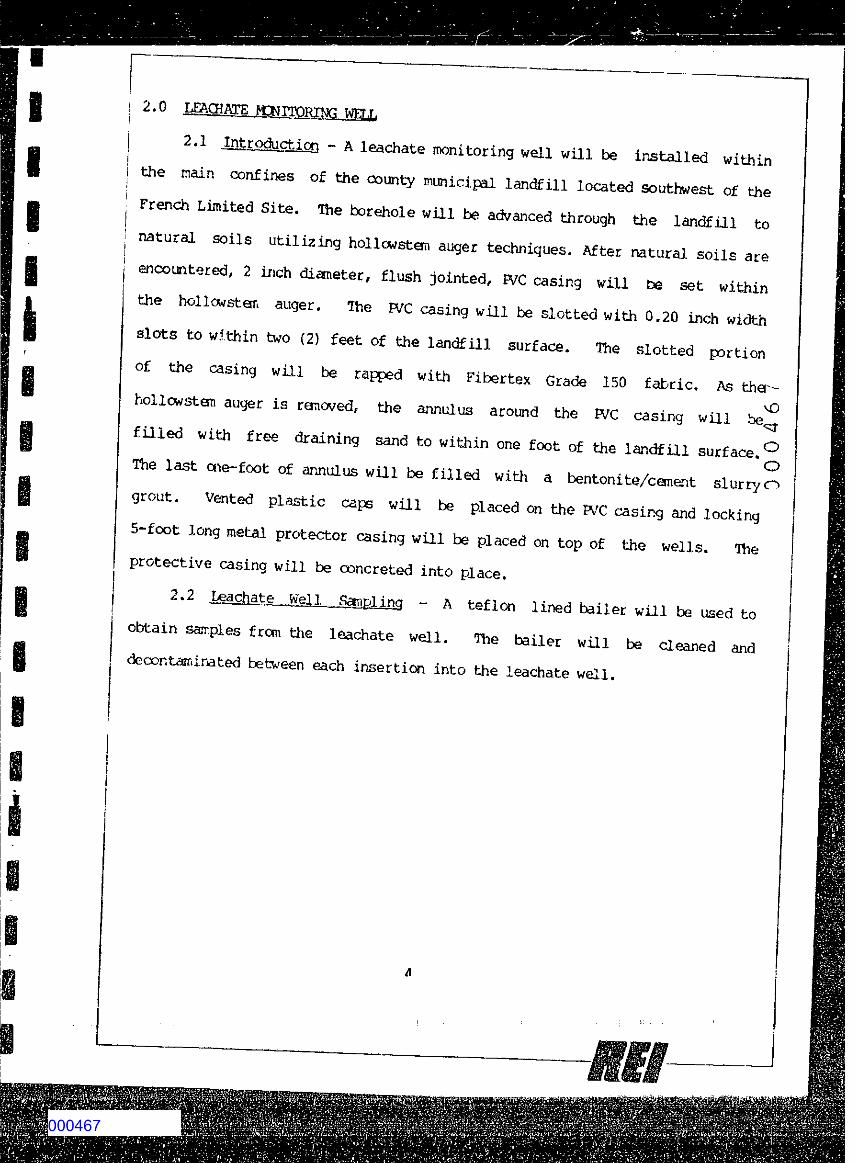
! 2.0i2.1 . .Introduc t ion - A leachate moni tor ing well wil l be i n s t a l l e d wi th inj
j the main conf ine s of the county municipal l a n d f i l l located southwest of thei1 French Limi t ed S i t e , The borehole will be advanced through the l a n d f i l l to
natural so i l s u t i l i z i n g ho l lows t er i i auger techniques. A f t e r natural s o i l s areencountered, 2 inch dianeter, f l u s h j o i n t e d , EVC casing will be set wi thinthe h o l l o w s t e m auger. The JVC casing will be s l o t t ed wi th 0.20 inch widths l o t s to w i th in two (2) f e e t o f the l a n d f i l l s ur fa c e . The s l o t t e d p o r t i o nof the casing wil l be rapped wi th F i b e r t e x G r a d e 150 f a b r i c . As ther-
vOho l l ow s t em auger is rartoved, the annulus around the JVC casing wil l be .f i l l e d wi th f r e e draining sand to wi th in one f o o t of the l a n d f i l l s u r fa c e . 0
OThe last one-foot of annulus wi l l be f i l l e d with a bentonite/canant s l u r r y ogrout . Vented p l a s t i c caps wi l l be p lac ed on the JVC casing and l o c k i n g5-foot long metal protector casing will be p lac ed on top of the we l l s . I t i ep ro t e c t iv e casing wi l l be concreted into place .
2.2 L e a c h a t e . W e l l S a m p l i n g - A t e f l o n l ined ba i l er will be used toobtain sample s f r o m the l eachate we l l . The bailer wi l l be cleaned anddecontaminated between each insert ion into the leachate we l l .
smartin
Rectangle
000467
Attachment No. 4Proposal T a b u l a t i o n of San.Ples and Analyses
RefSect ion3.1 Waste Compos i t eLeachate Grab
AnalysesOrjganicsGC/MS Scan o f p r i o r i t y p o l l u t a n t si n c l u d i n g v o l a t i l e , acid, and bass/neutral f r a c t i o n s (combined pr i orto a n a l y s i s ) ; i d e n t i f i c a t i o n andq u a n t i f i c a t i o n of other organiccompound peaks e s t imated at 50compounds; set up computer l ibraryof p r i o r i t y p o l l u t a n t s and otherorgar.ics.AA analysis for As, Ba, Cd, Cr^Cu, Pb, f - t n , Hg, Ni, Se, A^, z~ 'H a , C a , K , M g , V , M o , F e , B e , L i ,Co; Standard Methods analyses for^ch l or id e , s u l f a t e , f l - J o r i a e , Os u l f i d e , and nitrogen. QoC o r r e l a t i o nTCX:, t D X , Oil and Grease, S u l f u rby Standard Methods
3.2 30 S o i l Grab
3.3 10 S l u d g e Grab30 Soil Grab
Grav metric evaluation of mois-ture, organics, sxJ inorgardcsol ids ; RCRA tests for igni tabi-l i t y , c orro s iv i ty , inac t iv i ty, andEP t ox i c i ty; BTU and ash content;vapor pressure.AA analysi s for Zn, Cr, Ib; TOC,pheno l , c h l o r i d e s , fieri s u l f a t e s l jyS t a n d a r d Method s , other " f i n g e rprints" as deemed Baecessary f r o n3.1.GC ana ly s i s for total PCB
smartin
Rectangle
000468
iiiD e t a i l s o f M o n i t o r W e l l C o n s t r u c t i o n
P r o j e c t N a m e : ________________ B o r i n g N u m b e r :P r o j e c t N u m b e r : _____________ D a t e I n s t a l l e d :W a t e r L e v e l M e a s u r e m e n t : ___________________
p r o t e c t i v e s t e e l c a s i n g
4 i n c h ( i d )P V C w e l l c a s i n g
canent g r o u tB e n t o n i t e s e a l
sand p a c k4 i n c h ( i d )P V C w e l l s creen