35
FREQUENTLY ASKED QUESTIONS JULY 2015
FREQUENTLY ASKED QUESTIONS
JULY 2015

Updated July 2015
1. Project Timeline
Q. What is the proposed timescale for the project?
Irish Water is currently progressing all of the licence applications and environmental studies required to prepare a planning application that it will lodge with An Bord Pleanála towards the end of 2016.
This will be followed by a statutory phase of public consultation run by An Bord Pleanála.
Subject to the planning permission being granted, the GDD team will hold a procurement process to appoint a team to design, build and operate the project facilities.
Construction is estimated to take approximately three years and will begin, at the earliest, in 2019.
It is important to note that until planning permission is obtained for the preferred option at Clonshagh (Clonshaugh), Newtowncorduff and Annsbrook will remain on the shortlist of possible options.
Q. Why is the planning application not being made in 2014 as originally publicised?
A number of additional studies on the GDD project are underway or planned for 2014 to 2016 following results from previous environmental studies, combined with the feedback received during public consultation in Summer 2013. The additional studies will inform the Environmental Impact Statement (EIS), and Natura Impact Statement (NIS) for the project.
Information on the additional studies, including marine surveys and marine investigations, is provided in Section 12 Environmental Surveys and Assessments of this FAQ document.
Q. Will the additional environmental studies delay the project?
Irish Water will ensure that the project is completed in order to provide additional wastewater treatment capacity for the Greater Dublin Area (GDA) by the time it is needed.
2. Planning Process & Application
Q. What is the planning process for the project?
An Bord Pleanála (ABP) is the competent authority that will determine the outcome of the planning application made by Irish Water for the project and it will then manage a statutory public consultation.
Irish Water will submit a planning application to An Bord Pleanála, complete with an Environmental Impact Statement (EIS) and Natura Impact Statement (NIS), towards the end of 2016.
The application will be for the preferred project solution as follows:-
• an underground orbital sewer and two pumping stations; • a wastewater treatment plant (WwTP) on a 23-hectare site at Clonshagh
(Clonshaugh); • an outfall pipe from the wastewater treatment plant discharging 1km north-east of
Ireland’s Eye (6km out to sea).
3. Public Consultation & Communications
Q. How can I contact the Project Team with feedback or questions?
The Project Team welcomes feedback at any time. You may contact us via email ([email protected]) or by phone (Lo-call 1890 44 55 67: Open Monday to Friday 9am – 5pm (closed 1-2pm)).
Irish Water thanks members of the public for their participation in the non-statutory public consultation process undertaken by Fingal County Council from 2011 to 2013, and at a series of information pop-up events held by Irish Water in 2014. All of the feedback received and environmental studies undertaken to date have informed the Project Team.
Q. What is non-statutory consultation?
The consultation undertaken on GDD to date has been non-statutory, in that it is not required by law but undertaken by the GDD team to provide opportunities for the public to inform the development of the project before a planning application is made.
Q. Will there be future public consultations for the GDD project?
Yes, when Irish Water submits its planning application to An Bord Pleanála towards the end of 2016 it will be followed by a statutory phase of public consultation. This statutory phase will be carried out by An Bord Pleanála.
Q. You have now received over 30,000 submissions since the project started in 2011. How have you changed the original proposals to reflect community feedback?
A significant number of submissions were received regarding horticulture and agriculture intensity in the study area. As a result the Project Team employed an Agronomist, at an earlier stage of the process than originally scheduled, to assist in identification of the emerging Preferred Site Options.
Public consultation has also contributed to investigations for further study. An example of this includes considering additional issues as part of the planned archaeological and geophysical studies.
We have and will continue to engage with local groups and interested parties. As a result of the non-statutory public consultation we have become aware of even more groups to engage with.
The issues raised during the public consultation process have been identified in the Consultation Reports and issues raised to date have been responded to in the technical reports.
Relevant feedback received regarding issues to be considered in the EIS, as published in the 4th Consultation Report, December 2013, will be responded to in the EIS.
Q. Does the GDD consultation process comply with the Aarhus Convention?
Yes, the consultation process complies with the requirements set out in the Aarhus Convention. Article 6(3) states that the public participation process should include different phases with reasonable timeframes (which have been provided by Greater Dublin Drainage), allowing the public to be informed (which has been and will be achieved by Greater Dublin Drainage), and for the public to participate effectively during the decision-making process (which has been and will be achieved by Greater Dublin Drainage).
Q. Can the project information be provided in other formats, such as Braille?
Yes, the project information can be provided in Braille upon request and all literature can be produced in an accessible electronic format suitable for use with Job Access with Speech (JAWS) or similar screen reading software for people who are visually impaired. If you have any other communications needs, please contact the Project Team and we will do our best to assist.
Q. I have never seen or visited a modern wastewater treatment plant – is there an opportunity for me (or my organisation/committee) to see one for myself (ourselves)?
During this project, the GDD Project Team has arranged and facilitated a number of study tours of the Bray Shanganagh wastewater treatment plant at Shanganagh (Shankill, Co. Dublin) so that visitors can see firsthand the type of facility and operations that can be found at a modern wastewater treatment facility. If you are interested in attending such a tour, please contact the GDD Project Team.
For further information on the Bray Shanganagh wastewater treatment plant, see Section 15 Other Wastewater Treatment Plants of our FAQs.
4. Why Do We Need New Regional Wastewater Treatment?
Q. Why do we need the GDD project?
Wastewater is part of everyday life, in homes, schools, hospitals, hotels, factories and other businesses and it has to be treated and disposed of properly. As our population grows and facilities increase more wastewater arises. The Greater Dublin Drainage project is therefore required to provide adequate future wastewater treatment capacity in the Greater Dublin Area (GDA) in order to:
• safeguard public health;
• improve and protect the environment; and

• facilitate employment, social progress and economic growth in the wider Dublin Region.
The project is also necessary to meet the Water Framework Directive (WFD) requirements and other relevant EU Directives and National Regulations related to water quality.
The need for the project was first identified in the Greater Dublin Strategic Drainage Strategy (GDSDS) (2005) and was confirmed in the Strategic Environmental Assessment (SEA) of the GDSDS undertaken by Fingal County Council in 2008.
The GDSDS recognised the limiting capacity of the Ringsend plant and of the major arterial sewers draining to it. The GDSDS concluded that in addition to maximising the capacity of the existing wastewater treatment plants in the GDA, a new regional wastewater treatment facility, including a new orbital sewer to intercept flows from the Ringsend catchment, is required to be located in north Dublin, with an outfall to the Irish Sea.
Furthermore the need for the project is aligned with the strategic objectives outlined in Ireland’s first integrated plan for the delivery of water services, produced by Irish Water in February 2015 called the Water Services Strategic Plan (WSSP).
The Greater Dublin Drainage project is aligned with the following strategic objectives included within the WSSP:
• to manage the operation of wastewater facilities in a manner that protects the environment (WW1);
• to manage the availability and resilience of wastewater services now and into the future (WW2);
• to manage the reliability of wastewater services (WW3); and
• to facilitate growth in line with national and regional economic spatial and planning policy (SG2).
Further detail on these objectives is available in the plan.
Q. What is the Greater Dublin Strategic Drainage Strategy (GDSDS)?
The Greater Dublin Strategic Drainage Strategy (GDSDS) dates from 2005 and is a strategic analysis that was completed of the existing foul and surface water systems in the local authority areas of Dublin City, Fingal, South Dublin, Dun Laoghaire-Rathdown and the adjacent catchments in Counties Meath, Kildare and Wicklow. A Strategic Environmental Assessment (SEA) of the GDSDS was undertaken by Fingal County Council in 2008.
The study identified the overloading of the existing drainage systems which resulted in a marked deterioration in water quality and that the drainage system and wastewater treatment plants would have insufficient capacity to cater for future development.

The analysis identified policies, strategies and projects for the development of a sustainable drainage system for the Greater Dublin Region with the aim of meeting the demand of the region now and in the future.
You can view and / or download a copy of the GDSDS by clicking here.
Q. What is the Water Services Strategic Plan (WSSP)?
In February 2015, Irish Water published a draft of the first integrated plan for the delivery of water services in Ireland. This plan is called the Water Services Strategic Plan (WSSP) and information about the plan can be found here and is available for view and/or download by clicking here.
The WSSP is an essential part of ensuring that we have an environment that is protected from the impacts of wastewater discharges, and that we have efficient modern systems that meet the needs of customers and contribute to economic growth and development, and provide value for money.
The plan sets out strategic objectives for the delivery of water and wastewater services over the next 25 years up to 2040 and will be reviewed on at least a five yearly basis to ensure that it continues to be up to date with current and future needs.
Tables NTS1 and NTS2 of the non-technical summary of the Environmental Report, undertaken as part of a Strategic Environmental Assessment (SEA) of the plan (available here), describe strategies to achieve the strategic objectives.
The GDD project is aligned in particular with the strategies listed in Table NTS2 of the Environmental Report and as shown in the table below:
WSSP Strategic Objective and Aims
Associated Number of Strategies to
Support Objectives and Aim
Strategies Aligned with the GDD
Project
Provide Effective Management of Wastewater
14 WW1c, WW2a, WW2b,WW3c,WW3f
Protect and Enhance the Environment
10 EN1e, EN3b
Support Social and Economic Growth
9 SG1a, SG2a, SG2b, SG2c, SG2d, SG3a
Invest in Our Future 12 IF2c, IF4

Irish Water invited submissions on the Draft WSSP together with the SEA Environmental Report and the accompanying Natura Impact Statement from the 19th February to the 17th April, 2015.
All submissions received by Irish Water will be reviewed and addressed where appropriate within the final plan. As required by the SEA Regulations, a statement on the Strategic Environmental Assessment (referred to as an SEA Statement) will be prepared by Irish Water. This statement will include information on how the Environmental Report and submissions/observations received during the process have been taken into account during the preparation of the plan.
Q. What will be treated in the GDD WwTP?
GDD is a regional wastewater treatment project to serve the Greater Dublin Area. At the moment, it is estimated that in its first year of operation, over 50% of the load to the proposed regional wastewater plant at Clonshagh (Clonshaugh) will be generated in Fingal and the remainder will come from the northern fringes of Dublin City and south east Meath.
Q. Where would the wastewater for the proposed regional wastewater treatment plant originate?
The regional wastewater treatment plant at Clonshagh (Clonshaugh) is being proposed to treat wastewater from the Blanchardstown Catchment, which includes parts of south-east Meath, the North Fringe Sewer Catchment (Finglas to Baldoyle) and the North Dublin Drainage Scheme Sewer Catchment (Ashtown to Howth).
At present, it is estimated that in its first year of operation, over 50% of the wastewater treated in the proposed GDD plant at Clonshagh (Clonshaugh) would be generated in Fingal, with the remainder coming from the northern fringes of Dublin City and south east Meath.
Q. Why don’t you upgrade existing WwTPs?
It is a recommendation of the Greater Dublin Strategic Drainage Study (GDSDS) that all existing WwTPs be upgraded to their ultimate capacity and this is either underway or planned.
Irish Water’s Capital Investment Plan (2014-2016) sets out a planned investment of €1.77 billion on 386 water and wastewater infrastructure projects (and a range of sub-programmes) across Ireland, including a number in the Greater Dublin Area (GDA) over the three year period from 2014 – 2016. The plan is available here.
In February 2015, Irish Water has published a draft of the first integrated plan for the delivery of water services in Ireland. This plan is called the Water Services Strategic Plan (WSSP) and is available here.

Q. Why not provide several smaller facilities instead of a regional WwT plant?
Managing our carbon footprint is a key consideration for all major infrastructural projects. Numerous smaller plants are likely to require more energy than a single plant as a result of additional pumping requirements and because energy recovery through sludge digestion is not as feasible at smaller plants.
Adding smaller WwTPs to the existing regional network could have a negative impact on local receiving waters and land availability. Both the Greater Dublin Strategic Drainage Study (GDSDS) in 2005 and its associated Strategic Environment Assessment ,undertaken in 2008, confirmed that the local rivers and streams in north Dublin are too small to absorb treated wastewater from a number of smaller plants.
Existing plants in the Greater Dublin Area (GDA) are being upgraded, but nonetheless receiving waters (Dublin’s river and seas) and available land constraints limit the expansion potential and thus a new regional solution is required.
The existing drainage network is a regional system and therefore an additional plant linked to the existing regional system is needed. It is needed to support the existing regional WwTP at Ringsend. The proposed plant at Clonshagh will operate in conjunction with both this and other existing plants as a regional system for the GDA.
This will enable long term sustainable wastewater drainage and treatment for the GDA so that the required drainage infrastructure is in place for it to continue to develop, both socially and economically into the future.
Small WwTPs are more suitable for small communities.
5. Wastewater & Wastewater Treatment
Q. What is wastewater?
We all create wastewater in our everyday lives. At home, we access water with ease; we twist the tap, we flush the toilet, we hit the button on the washing machine and we twist the nozzle on the shower. Industry, hospitals, schools and offices also create wastewater.
Wastewater can contain a wide range of contaminants, some of which can be broken down in the environment easily while others are not so easily degraded.
For further information, please see our information video on the project by clicking here.
Q. Why do we need to treat wastewater?
Untreated wastewater poses a threat to public health and the environment. Treatment is therefore carried out in order to produce an environmentally safe liquid that is suitable for disposal to our aquatic environment, such as rivers and seas.

Proper wastewater treatment systems are essential for sustaining modern living and contributing to development as householders, businesses, industries, schools and hospitals all rely on a robust wastewater treatment system to maintain their daily activities.
Q. How is wastewater transported to a treatment plant?
Wastewater is transported from homes and businesses to a wastewater treatment plant (WwTP) through an underground drainage network. The Greater Dublin Drainage project therefore includes a new drainage network to carry the wastewater to Clonshagh (Clonshaugh) for treatment.
For further information, please see our information video on the project by clicking here.
Q. How is wastewater treated?
The drainage system transports wastewater via underground sewers / pipelines to a wastewater treatment plant (WwTP) where it is treated to strict standards under EPA licence and in compliance with EU and national water quality legislation, to a standard that is safe to be discharged to the environment.
At the treatment plant contaminants are removed, including fats, oils and greases, along with biological matter such as bacteria and faecal matter.
Stages of treatment
There are three main phases of treatment undertaken in wastewater treatment plants:
When the wastewater reaches the plant, it initially goes through a preliminary treatment stage; it is passed through a mechanically raked screen to remove any large solids.
Phase two sees the wastewater held in a tank where any remaining solids sink to the bottom while fats, oils, grease and lighter solids float to the surface. All of these are removed before the wastewater carries on to its final treatment.
Phase three is a biological treatment phase to cleanse the wastewater further.
Finally, the treated wastewater is then transported through an underground pipeline and discharged out to sea.
For further information, please see our information video on the project by clicking here.
Q. What determines the level of treatment required?
The level of treatment will be determined by the EPA licence which takes account of the designation and quality of the receiving water.
Q. What is population equivalent and how is it determined?
Wastewater treatment plants are described in terms of their designed treatment capacity, which is generally expressed as population equivalents (PE).

This is a measurement of total organic biodegradable load, including industrial, institutional, commercial and domestic organic load, on a wastewater treatment plant, converted to the equivalent number of population equivalents (PE). One person is considered to generate 60g of BOD per day (BOD is the 5 day biochemical oxygen demand); and 1PE is defined as being equivalent to 60g of BOD per day.
Q. What will the population equivalent of the proposed plant be?
In 2040, the design horizon for the Regional WwTP, the organic load on the plant will be approximately 750,000 PE (population equivalent)
Q. What will the proposed Clonshagh (Clonshaugh) plant look like?
The 23 hectare (approx. 56 acres) site will accommodate a range of covered buildings and structures between 3 and 18 metres high (10-60 feet). While a large portion of the site will be required for the plant itself, a significant area will be utilised for extensive landscaping (trees, shrubs and grass) which will minimise any visual impact.
The perimeter of the proposed site at Clonshagh (Clonshaugh) is at least 300 metres (985 feet) from the nearest existing houses and neighbouring buildings.
Q. Will the proposed new regional wastewater plant will be the largest in the country?
No, it will not be the largest plant in the country in terms of the amount of wastewater treated. By 2040 it will deal with approximately one third of the wastewater that will be treated at the expanded Ringsend WwTP in Dublin.
Q. Why is Clonshagh (Clonshaugh) the Preferred Site Option?
Over 13 different experts across a variety of disciplines studied the three shortlisted site options, Annsbrook, Clonshagh (Clonshaugh) and Newtowncorduff, and reached the conclusion that Clonshagh (Clonshaugh) is the most environmentally beneficial and technically advantageous solution, and it is also the best value for money.
From an ecological point of view the Clonshagh (Clonshaugh) site is preferable to the other two site options shortlisted;
The WwTP can be designed to minimise impact on archaeology; This option can be designed, constructed and operated to ensure that it will not
adversely affect the integrity of any Natura 2000 sites; The outfall, discharging 6km out to sea from Baldoyle, allows for better dilution and
mixing of the discharge; The total length of pipeline required is significantly shorter than that required for the other
options. Therefore there will be less ecological impact, fewer watercourse crossings, a lower number of existing and proposed infrastructural crossings, less potential to disrupt the landscape structure and lower energy requirements;
It is closest to the existing areas from which wastewater arises; It is closest to development areas and so will enable the wastewater from the North
Fringe Sewer to be diverted more efficiently than the other options studied. This will free up capacity and future proof the GDA.

Q. What process was undertaken to choose Clonshagh (Clonshaugh) as the Preferred Site Option?
Since the Greater Dublin Drainage project started in 2011, the Technical Team was engaged in a step-by-step process to identify a Preferred Site Option i.e. site, pipeline and marine outfall. From this process, site options with the least impact emerged.
The Study Area was refined down to nine land parcels (chosen following four weeks of public consultation in June 2011), suitable to accommodate the proposed regional plant, along with associated marine outfall and orbital sewer locations. Members of the public were asked to identify any constraints that exist within the broad study area of the Fingal region and these were considered in addition to previously identified features in the landscape that might make an area unsuitable as a location for the project and included protected areas, visual impact, health impact, ecology and the environment.
From these nine land parcels, three emerging Preferred Site Options were determined (Annsbrook, Clonshagh (Clonshaugh) and Newtowncorduff) following an eight-week public consultation (October to December 2011), as well as environmental and technical studies on each of the nine land parcels. Key issues and concerns raised by the public during consultation were considered by the environmental and technical specialists during this stage of the assessment process.
The three emerging Preferred Site Options (Annsbrook, Clonshagh (Clonshaugh) and Newtowncorduff) were brought forward for further public consultation, over eight weeks from May to July 2012. All feedback received during this consultation was reviewed and the relevant items raised by the public were considered in the selection of a preferred site. Each of the three shortlisted site options was also independently assessed by environmental and technical specialists using desktop studies and visual inspections.
These studies have identified that the best solution for the future development of wastewater treatment capacity in the Greater Dublin Area comprises of a 20km pipeline to carry wastewater to a wastewater treatment plant at Clonshagh (Clonshaugh) for treatment and an outfall pipe from the wastewater treatment plant, discharging 6km out to sea from Baldoyle.
A fourth consultation, in 2013, provided the public with an opportunity to submit their views on items to be considered in the Environmental Impact Statement. Relevant issues raised during this consultation phase that are relevant to the Natura Impact Statement (NIS) (which is running in parallel) are being considered as part of the ongoing preparation of the NIS.
Q. How many tonnes of sewage will be treated at the proposed plant?
The quantity of sewage to be treated will vary over the lifetime of the WwTP. At a design load of approximately 750,000 PE (population equivalent), it is anticipated that this will be comprised of approximately:-
60 tonnes of total suspended solids (TSS), 63 tonnes of biochemical oxygen demand (BOD), and 119 tonnes of chemical oxygen demand (COD)
per day will be treated at the proposed WwTP when it reaches its maximum capacity in 2040.
Q. Will the WwTP be expanded post-2040 to deal with growth in Dublin as part of this proposal?
The current design horizon for the project is 2040 and designs generated at this stage will accommodate all expected flows and loads up to this date. Any extension post-2040 will require a further separate EIS and other studies.
Q. What will happen if there is a leak or if the pumps malfunction or something else breaks down at the plant?
The proposed Greater Dublin Drainage wastewater treatment plant will be designed, built and operated to the highest technological standards available at the time and this will include a rigorous maintenance regime.
A plant of the size proposed will have a back-up power generator in place in case of power failure.
It is normal practice that all pumped systems encompass duty/stand-by/assist and back-up pumps.
Additional capacity will be provided through storm tanks located on the site and within the system in the upstream catchments for storage during times of significant rainfall or if any incident occurs.
Additional capacity will be built-in to facilitate regular maintenance and this can be utilised should any malfunction occur at the plant.
Q. Can you guarantee that WwTP will be operated correctly?
It is a requirement for the project that all relevant EU and Irish legislation will be complied with. In addition, the project will require an effluent discharge licence from the EPA.
Irish Water will be required by legislation to apply to the Environmental Protection Agency (EPA) for a licence or wastewater discharge authorisation for the treated effluent discharge from the proposed wastewater treatment plant (WwTP). This licence will be subject to monitoring and auditing by the EPA and the appointed operator will be required to manage all emissions within the licence.
6. Traffic
Q. What are the estimated traffic volumes at the proposed wastewater treatment plant?
It is estimated that there will be fourteen heavy goods vehicles (HGVs) per day on average. This includes removing treated sludge from the proposed regional wastewater treatment plant (WwTP) when it is at its full operational capacity in 2040 (approximately 750,000 P.E.) as well as transporting wastewater sludge from other Fingal County Council municipal WwTPs and domestic dwellings (septic tanks), as recommended by the Review of the Fingal Sludge Management Plan.
These figures are preliminary and are based on a 260 day working year, with no HGV movements anticipated on Saturdays or Sundays. As scheme planning progresses, more precise estimates of HGV movements will be made available. A comprehensive assessment of the scheme’s impact on traffic will be provided in the Environmental Impact Statement (EIS), which must accompany the scheme’s application to An Bord Pleanála for planning permission.
Q. Will traffic be a problem in the area while the plant is being constructed and operated?
The Environmental Impact Statement (EIS) that is currently being prepared will include an assessment of the potential effects on road traffic arising from both the construction and operation phases of the proposed plant. As part of this assessment, the Project Team will consider all submissions received during the public consultations held to date that raised issues around traffic management.
7. Output from Wastewater Treatment Plant
Q. Will the proposed WwTP take in sludge from other locations and what about industrial or abattoir sludge?
There will be capability at the WwTP to accept septage from domestic septic tanks. Sludge from abattoirs or industrial premises will not be accepted.
Q. How will the sludge be treated in the proposed GDD WwTP?
It is a requirement that the wastewater sludge produced by the regional WwTP be treated on site. The most likely method of treatment will be anaerobic digestion followed by thermal drying. The full sludge treatment process will be assessed in the EIS.
Q. How much sludge will the proposed GDD WwTP process?
It is currently estimated that at the maximum capacity of approximately 750,000 PE load, approximately 9,200 tonnes of dry solids will be produced per annum.
8. Clonshagh (Clonshaugh) Community
Q. Will community gain be built into the project?
The project will be assessed under Planning and Development legislation relating to strategic forms of infrastructure (called the Planning and Development (Strategic Infrastructure) Act 2006), which allows for community gain to be incorporated into the project.
Irish Water welcomes recommendations and suggestions from members of the public on forms of community benefit that could be facilitated through the provision of the project.
Q. Will the construction and operation of the proposed Wastewater Treatment Plant at Clonshagh (Clonshaugh) lower the value of our homes?
An appropriately constructed and well operated plant should have no impact on property values.
The GDD Project Team has established a minimum buffer zone distance of 300m from sensitive receptors such as homes, schools, hospitals, etc., to minimise potential impacts such as odour and noise.
Ultimately, the potential impacts of odour and noise on surrounding sensitive receptors from the selected site will be assessed by specialists and against detailed odour and noise modelling that is being undertaken in preparing the Environmental Impact Statement (EIS) for the project.
Furthermore, extensive landscaping will be undertaken.
Q. How are you assessing the impact on the community?
Impacts on communities are taken into consideration by assessing the following criteria in preparing the Environmental Impact Statement on the Preferred Site Option that includes the WwTP for Clonshagh (Clonshaugh):
Socio Economic: This will include economic activity, social patterns, land-use, employment, health and safety, settlement patterns, and will include the impact on the community if the project does not go ahead.
Air Quality, Odour, Noise and Vibration: This section will include potential odour, noise and vibration during construction phase and during the lifetime of the project.
Landscape and Visual Impact: This will include the character and context of the landscape, views and prospects and should describe both historical and manmade landscapes.
Cultural Heritage and Material Assets: Architectural, archaeological and cultural heritage are described here including folklore, tradition and history; architecture and settlements; monuments and features; and the designed landscape. In terms of material assets, natural resources of economic value, buildings and structures as well as infrastructures are important.
Soils, Geology, Hydrology and Hydrogeology: In terms of soils and geology, this section should describe agricultural capability and engineering characteristics, presence of mineral soils, peats, fens and estuarine sediments, surficial bedrock deposits, faulting, weathering as well as chemical characteristics. In terms of hydrology, the presence of aquifers, ground, surface, estuarine or marine water should be identified. The physical, chemical and biotic aspects of the water should be described, along with its beneficial uses.
Climate: Climatic factors will include information on CFC’s, acid rain, thermal pollution, climate change (both macro and micro) as well as pollution transport.
Terrestrial, Aquatic and Marine Ecology: This will include habitats and habitat requirements, breeding/feeding/roosting areas, population stability and management, critical resources, protection status, seasonality, succession and existing management.
Where avoidance is not possible, mitigation measures will be put in place to reduce impact and the residual impact is quantified. It is then up to the independent statutory bodies (i.e. An Bord Pleanála and / or the Environmental Protection Agency) to determine if the residual impact is acceptable.
Q. Have you considered health risks associated with facilities of such a scale?
Modern day wastewater treatment plants, operated with appropriate safeguards ensure there are no significant health risks to the general population.
Furthermore, new EU Directives on the EIA process published in May 2014, will widen the list of issues to be assessed as part of an EIS for a project and this will include risk prevention and environmental and human health. Irish Water will prepare an Environmental Impact Statement that will cover this wider scope of the new EIA procedure including a specific chapter on human health relevant to the project.
For more information on the new Directives on the EIA process, please refer to Section 12 Environmental Surveys and Assessments of the FAQs.
9. Abbotstown (Blanchardstown) Pumping Station and Related Issues
Q. Why is a pumping station required for Abbotstown (Blanchardstown)?
The Greater Dublin Drainage project proposes two new pumping stations – one near Abbotstown (Dublin 15) and another one in Grange (Dublin 13). They will pump wastewater into the underground orbital sewer to bring it to the new regional plant at Clonshagh (Clonshaugh) for treatment.
Q. Where will the proposed Abbotstown (Blanchardstown) pumping station be located?
The preferred site for the proposed Abbotstown (Blanchardstown) pumping station is located in the grounds of the National Sports Campus Development Authority (NSCDA) beside the M50 and 200 metres to the east of the hospital.
Q. Will the pumping station affect the Hospital?
Modern pumping stations, such as that proposed by the GDD project for Abbotstown, are located largely underground with a small building overground for administration and maintenance access. The majority of the pumping station operation takes place below ground in concrete structures. Modern pumping stations are designed to limit the production of odours and any odours will be treated in line with EU directives and Irish regulations. Noise levels are minimal and, again, have to comply with the relevant regulations.
Q. Have alternative solutions been considered?

GDD has undertaken a high level review of an alternative route for the sewer as proposed by local stakeholders but concluded that the route indicated by the GDD Project Team is the route with the least impact on a technical, environmental and cost basis.
Q. Why are four wastewater storage tanks being built in the grounds of Connolly Hospital?
Irish Water has a separate project called the Blanchardstown Regional Drainage Scheme to upgrade the existing wastewater infrastructure in the area and this includes duplicating the existing 9C Sewer and building four storage tanks to cater for storm water overflows from the existing 9C Sewer during rainfall events, thereby protecting the River Tolka.
All wastewater coming from the Blanchardstown area drains to the Wastewater Treatment Plant at Ringsend where it is treated prior to discharge to Dublin Bay. The wastewater flows to the plant in Ringsend through the 9C sewer and this sewer is getting close to its capacity, and as a result the system needs to be upgraded. The existing 9C Sewer therefore requires upgrading that involves duplicating the main trunk sewer between Mulhuddart and the Tolka Valley Park.
The four storm water tanks are proposed to be located approximately 200 metres west of the James Connolly Hospital.
The storage tanks will be constructed below ground level and covered.
The stored storm water from these tanks will be returned to the 9C Sewer when rain stops, using submersible pumps.
Odour treatment facilities will be installed at the storm water storage tanks.
A Part 8 Planning Approval for this scheme was approved by Fingal County Council in April 2008; there is currently no timeline for the proposal to go to construction stage.
10. Pipeline Route / Orbital Sewer
Q. What is the length/distance of the pipeline route and where will it start and end?
The proposed 20km orbital sewer is an underground pipeline:-
it will commence at Abbotstown in Dublin 15 and continue for 13km to the proposed Clonshagh (Clonshaugh) wastewater treatment plant;
separately, a 7km pipeline will bring the wastewater from Grange to the proposed WwTP.
There is also a 12km long outfall pipeline to
bring the treated wastewater from the proposed plant at Clonshagh (Clonshaugh) to Baldoyle (6km);
and a subsea outfall pipeline approximately 6km in length discharging out to sea1km North east from Ireland’s Eye.

Q. Are there other proven examples of lengthy wastewater pipelines, such as is proposed for GDD?
Yes, long interceptor / orbital sewers are currently in use to manage Dublin’s drainage, including:
9C Sewer: Blanchardstown to Ringsend WwTP – 24.5km 9B Sewer: Saggart to Ringsend WwTP – 21.5km North Dublin Drainage Scheme (NDDS) Sewer: Finglas to original outlet off the Nose of
Howth – circa 23.3km North Fringe Sewer: Finglas to Sutton Pumping Station – circa 13.7km Submarine Pipeline under Dublin Bay: Sutton to Ringsend Wastewater Treatment Plant
(WwTP) – circa 11km
These sewers essentially act as interceptor / orbital sewers transferring wastewater from the catchments they serve to the Ringsend WwTP.
11. Portmarnock / Baldoyle
Q. How will the project affect Portmarnock Beach and why?
GDD is being developed primarily to protect human health and the environment.
GDD proposes to treat wastewater at a modern new facility in Clonshagh (Clonshaugh) after which it will go to an outfall pipe discharging out to sea 1km north east of Ireland’s Eye. This currently happens at the other wastewater treatment plants in operation in Dublin (and throughout Ireland and the EU) under strict EU regulations and national licensing.
The level to which the wastewater will be treated will ensure the water quality standards required by EU and national regulations can be achieved. These include the EU Water Framework Directive, Bathing Water Quality Regulations and Urban Wastewater Treatment Regulations. This will safeguard the quality of the marine environment, beaches and bathing water.
Recent new / upgraded wastewater treatment plants in Dublin that discharge treated wastewater to the Irish Sea have enabled beaches to reach Blue Flag status; Killiney Beach got a Blue Flag for water quality as a result of the Shanganagh Wastewater Treatment Plant.
Q. How far below sea level will the outfall pipe be?
At the point of discharge, the outfall pipe will discharge approximately 2 metres above seabed level which is approximately 23 metres below sea level.
Q. Will the construction of the pipeline have an impact on the Rockabill to Dalkey Island cSAC?
Additional environmental and ecological studies are required so that a comprehensive assessment of the potential impacts on the Rockabill to Dalkey Island candidate Special Area of Conservation (cSAC) can be made.
The additional studies, being undertaken between 2014 and 2016, will inform the Environmental Impact Statement (EIS) and Natura Impact Statement (NIS) for GDD and will include Marine Ground Investigations in Baldoyle Bay in 2015, subject to licence.
The Rockabill to Dalkey Island site was designated as a candidate Special Area of Conservation (cSAC) for reefs listed on Annex I and Harbour Porpoise listed on Annex II of the Habitats Directive in April 2013. The Habitats Directive is concerned with conserving and protecting wildlife and nature that are considered to be of European interest and significance.
Further information on the marine surveys is provided in Section 12 Environmental Surveys and Assessments of this FAQ document.
Q. Will construction of this outfall pipeline impact harbour porpoises?
Any potential impact will be assessed as part of the NIS for the project. At an early stage of the project, National Parks and Wildlife (NPWS) made the Greater Dublin Drainage team aware of the proposed candidate Special Area of Conservation (cSAC) and the impacts of this have been considered at all stages of the ASA process. The outline design of the pipeline location has been developed to mitigate any potential impacts on harbour porpoises.
Further information on the marine mammal surveys is provided in Section 12 Environmental Surveys and Assessments of this FAQ document.
Q. Will the treated wastewater be continuously delivered to the outflow discharge point?
The intention is to approach as near a continuous discharge as possible at the outfall.
Q. Why is a pumping station proposed for Grange (Dublin 13)?
As part of GDD, a new 7km underground sewer is planned to bring wastewater from Grange to Clonshagh (Clonshaugh) for treatment and a pumping station will be required to pump the wastewater through the new 7km pipeline.
12. Environmental Surveys and Assessments
Q. What is an Environmental Impact Statement (EIS)?
An Environmental Impact Statement (EIS) is a report that contains detailed analysis of the potential impacts of a proposed project on the existing environment and includes sufficient information to allow the consenting authority (in the case of GDD, An Bord Pleanála) make a decision on whether consent should be given to the project.
The key elements that are considered as part of an EIS include an assessment of the following topics:
Human beings – Community Air Quality, Odour and Climate Noise
Traffic Landscape and visual impact Archaeological and cultural heritage Soils, Geology and Hydrogeology Terrestrial (land based), Aquatic and Marine Ecology
As part of the preparation of the EIS, the Project Team will consider the submissions and the issues raised by the public that relate to the environment, as documented in the Consultation Reports.
Q. How does the new EU Environmental Impact Assessment Directive impact GDD?
The initial Environmental Impact Assessment (EIA) Directive is in place since 1985 (85/337/EEC). This Directive along with three amendments was amalgamated into Directive 2011/92/EU in December 2011.
Proposed changes to the directive were adopted by the Council of the European Union in May 2014 with a 3 year period to transpose the changes. These changes will form the first revision of the Directive 2011/92/EU and it is expected that Ireland, along with all other Member States, will adopt the revised Directive by approximately May 2017.
Q. In summary what are the key changes relating to the information required to be contained in the EIS?
Once the Directive is transposed, changes relating to the information to be contained in the Environmental Impact Statement (EIS) will be required in the following areas;
The description of the main characteristics of the operational phase of the project; The description of reasonable alternatives considered; Consideration of important elements including:
Sustainability (link to glossary) The use of natural resources and resource efficiency Biodiversity with particular attention to species and habitats afforded protection
under other European legislation Human health Impact of a project on climate change (such as greenhouse gases) Risk/ vulnerability of accidents or natural disasters (such as flooding and sea
level rise) relevant to a project; Development of procedures relating to monitoring significant environmental
effects resulting from a project.
Q. What are the implications for the Greater Dublin Drainage Project?
Any EIS submitted before May 2017 will be required to comply with the original amalgamated Directive 2011/92/EU. Currently, the EIS for the Greater Dublin Drainage Project is scheduled to be submitted towards the end of 2016.
The GDD EIS will be drafted taking cognisance of all proposed revisions relevant to the scope of EIS even though the revised Directive is not likely to be transposed in Ireland until May 2017.
This is in keeping with the pro-active approach of the GDD project to date and will ensure a comprehensive and thorough EIS.
Q. What is an appropriate assessment and why is it required?
The EU Habitats Directive requires that a study called an “Appropriate Assessment” (AA) be carried out for any project that is considered likely to have a significant impact on a Natura 2000 site. For the GDD project, this assessment is required to assess any potential impacts of the project on Natura 2000 sites in the study area, including the Rockabill to Dalkey Island SAC.
Guidelines on AA were launched by the Department of Environment, Heritage and Local Government (DEHLG) in December 2009 and further information can be found on their website by clicking here.
Q. Who carries out the Appropriate Assessment (AA)?
The guidance for appropriate assessment, produced by the Department of Environment, Heritage and Local Government (DEHLG), states that it is the responsibility of the competent authority (or consenting authority) to undertake the AA on the basis of information submitted by the proposer of the project in a document called a Natura Impact Statement (NIS).
In the case of the GDD project, once the NIS is submitted by the Project Team, the AA will be undertaken by An Bord Pleanála based on the information provided by ecological specialists working on behalf of the GDD Project.
Q. What is a Natura Impact Statement (NIS)?
A Natura Impact Statement (NIS) is a report that contains an examination of the possible impacts of a project on Natura 2000 sites that allows a decision to be made on whether consent should be given to the project.
Q. Why did GDD apply for a Foreshore Licence? An application for a Foreshore Licence was made to the Department of the Environment, Community & Local Government (DECLG) for permission to undertake investigative surveys in the Irish Sea between Baldoyle and north of Ireland’s Eye. The Foreshore Licence application was accompanied by a statutory public consultation, in compliance with the relevant national and EU legislation, held between 11th December 2014 and 20th January 2015 inclusive. In June 2015, a Foreshore Licence (reference 2015/02242) was granted by the DECLG permitting Greater Dublin Drainage to undertake investigative marine surveys in the foreshore.

Map of Proposed Marine Outfall for GDD Project
The investigative surveys permitted under the foreshore licence include:
Marine ground investigations Underwater noise survey Reef habitat mapping Bathymetry survey and sub-bottom profiling Surface sediment survey Archaeological geophysical survey
Conducting these necessary environmental surveys will help to ensure that the GDD project is developed in a way that safeguards the quality of the marine environment, our beaches and our bathing waters. The application and associated information remain available to view at the DECLG website here. Q. What is a Marine Ground Investigation (GI) survey and why is it needed? A marine ground investigation survey is a type of survey that aims to find out information about the type of soils and rock that lie beneath the seabed, including what it is made of and what its condition is like. This type of survey is required so that the Project Team can make informed design decisions regarding suitable methods to construct the outfall pipe. The survey involves using a jack-up platform (as shown in the image below) in order to make a number of boreholes along the route of the proposed marine outfall.

The platform will be visible from the coastline over a four week period from mid-July into August. A notice to mariners will be issued through the Commissioner for Irish Lights to ensure that other water users are aware of where and when the survey is taking place.
Jack-Up Platform
One borehole will be undertaken on Velvet Strand, Portmarnock (using equipment similar to that shown below). This part of the survey is scheduled to take place in September (weather permitting) in order to minimise any inconvenience for beach users. The survey is envisaged to take 2-3 days and the beach will continue to remain open during the survey.
Borehole Tripod
Q. Will making a borehole on Velvet Strand, Portmarnock mean that the beach will close to the public? Velvet Strand will remain open to the public at all times. To protect public health and safety a small area of the beach (similar to that shown in the image) will be cordoned off and the area will be reinstated and reopened immediately after the survey. This survey has been
scheduled for September so as to minimise any inconvenience for beach users. This element of the GI survey will take 2-3 days to complete.
Q. How deep and wide will the boreholes be?
The boreholes will range from 150mm-200mm in diameter and up to 60m in depth.
Q. What is an underwater noise survey and why is it required?
An underwater noise survey involves the measurement of existing noise levels under the sea. This survey is required so that the GDD Project Team can develop a baseline of existing sub-sea noise levels in the vicinity of the proposed outfall works. Doing so will help the Project Team to predict what noise will be present as a result of constructing the marine outfall. This information will be used by the GDD Project Team as part of the EIS to assess any impacts of construction noise on marine mammals in the area.
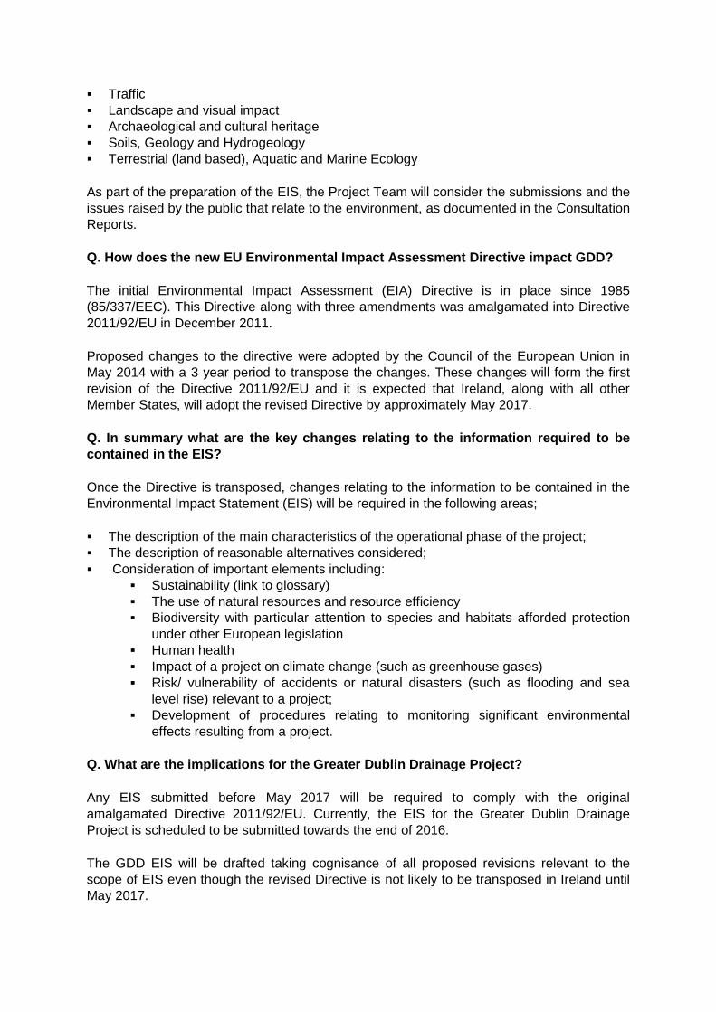
Q. What is reef habitat mapping and why is it needed? Reefs are protected habitats in accordance with Annex I of the Habitats Directive 92/43/EC. They may be made of rock (Geogenic) or constructed by animals (biogenic). Geogenic reefs (cobbles and possible bedrock) are recorded in a number of areas particularly in coastal areas north and east of Howth peninsula, close to Lambay Island and further north. These reefs are found underwater and their structure provides a habitat for many species to survive and thrive such as red seaweeds, sponges and soft corals.
As part of the marine investigation work to be carried out for the GDD project, a survey of reef habitat will be carried out during which scientific divers will dive to the reef to examine its condition and to take photographic records. Gathering this information will enable the GDD Project Team to understand the condition of the reef and to examine any potential impact that the project may have on it.
Reef Habitat Mapping
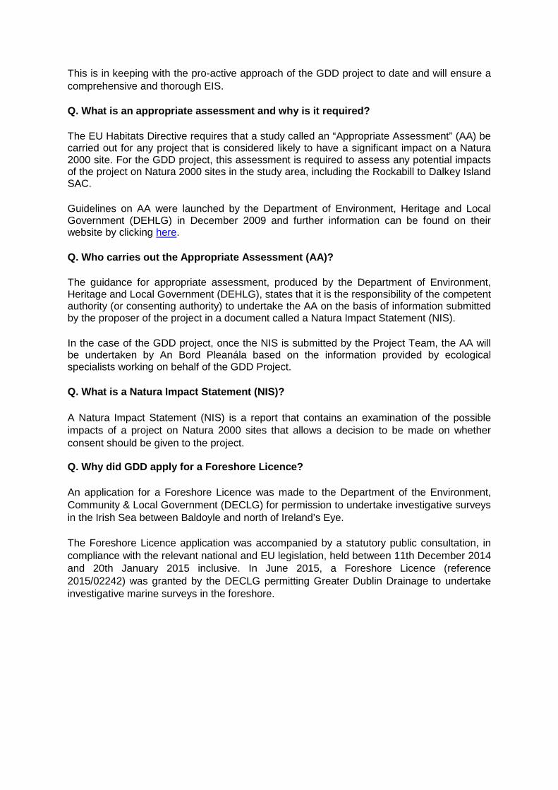
Q. What is a bathymetry and sub-bottom profiling survey? Bathymetry is the study of underwater depth of lake or ocean floors. These surveys will be completed over a four month period and will include side scan sonar surveys, seismic refraction techniques and magnetometer surveys. Side scan sonar is used to create images of the seafloor. Seismic refraction is used to create images of layers below the sea bed. The
magnetometer survey will investigate if there are any metallic artefacts such as those from previous ship wrecks present.
Side Scan Sonar Survey
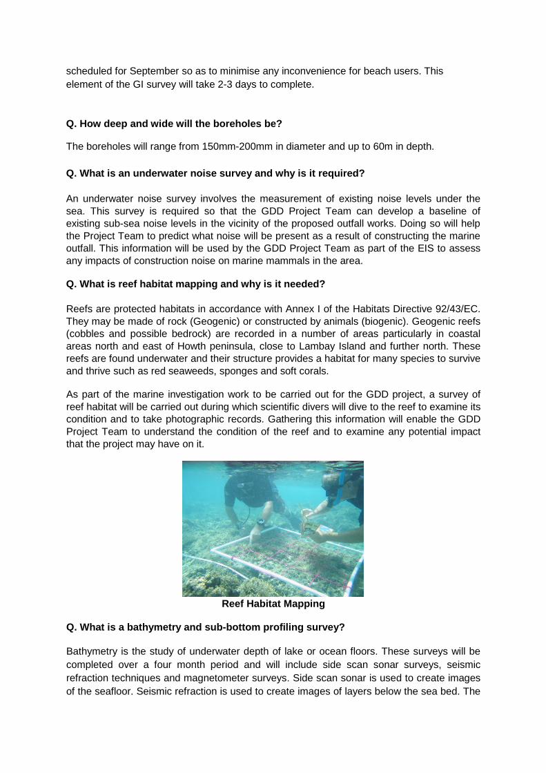
Q. What is a surface sediment survey and why is it needed? Surface sediments are usually particles of fine sand, silt and clay. The sediment is carried by water and settles slowly enough such that it almost never touches the bed. It is maintained in suspension by the turbulence in the flowing water. This surface sediment survey will consist of sampling on an extended study area from Lambay Island to Howth. This survey will provide information on the background of naturally suspended sediments in the water. This will allow the project team to better understand how suspended sediments will react during construction.
Surface Sediment Sampling
Q. What is an archaeological geophysical survey? This survey will utilise bathymetry data, sub-bottom data and magnetometer data (see explanation above) to look for the presence of any items of potential archaeological interest along the outfall pipeline route.
Q. What is a marine tide and current survey, and why is it required?
A marine tide and current survey is a survey that investigates and examines the movement of tides and currents in the sea. This type of survey is required so that the GDD Project Team can establish and assess how sea water moves in the location of the proposed outfall. This information will assist the Project Team to understand the potential impact of discharging treated wastewater in to the marine environment, 1km north east of Ireland’s Eye, and how the treated wastewater would spread out and disperse in the water.
Q. Who will be carrying out the marine tide and current survey and how long will it take?
The survey will be carried out by a specialist marine contractor over a four-month period.
Q. What work will be carried out during the marine tide and current survey?
The survey will involve monitoring activity off the coast of North County Dublin to collect information about the speed and movement of sea currents. This includes the installation of current meters, called Acoustic Doppler Current Profilers (ADCP) that will measure the speed and movement of the sea currents; a dye trace survey that will release a fluorescent dye into the water to track movement of currents and the release of plastic buoys called drogues whose movement will also be tracked. Together with information about the tides from a tide gauge at Howth Harbour, this information will assist the GDD Project Team to understand how the sea behaves at the location of the proposed outfall.
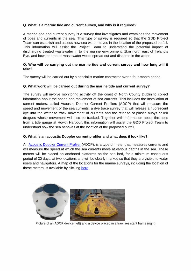
Q. What is an acoustic Doppler current profiler and what does it look like?
An Acoustic Doppler Current Profiler (ADCP), is a type of meter that measures currents and will measure the speed at which the sea currents move at various depths in the sea. These meters will be placed on anchored platforms on the sea bed, for a minimum continuous period of 30 days, at two locations and will be clearly marked so that they are visible to water users and navigators. A map of the locations for the marine surveys, including the location of these meters, is available by clicking here.
Picture of an ADCP device (left) and a device placed in a trawl resistant frame (right)

Q. What is a drogue tracking survey, how long will it last and what may we expect to see?
This is a part of the marine tide and current survey and will be carried out on a Spring and Neap tide during March/April 2015, subject to suitable weather conditions. Cone shaped plastic buoys called “drogues” will be released into the water and their movement will be tracked, for up to 13 hours at a time, so that the direction and speed of movement of the water can be measured. The drogues are fitted with reflectors and flashing beacons so that their location in the water will be obvious to all water users and navigators. Each drogue will be recovered following each track.
Q. What is a dye trace survey and what may be visible to water users?
A dye trace survey is part of the marine and tide survey and will involve the release of a fluorescent dye into the water so that the direction and speed of sea currents can be measured and understood. This survey will enable the Project Team to find out how fast the dye dilutes and spreads out or disperses in the water. The dye may be visible in the sea like in the picture below, but is not a pollutant and will not pose any harm to the environment. Detail and notice of the survey will be provided to the Department of Transport, Tourism and Sport who in turn will publish a marine notice on their website to inform owners of ships and fishing vessels, skippers, fishermen, yachtsmen and seafarers.
A map that includes the locations for the dye trace and drogue tracking survey is provided here.
Picture of fluorescent dye released into the sea during the dye trace survey that took place for GDD on 26th July 2012. Lambay Island is visible in the background of the photo.
Q. Why is a marine mammal survey required and what will it involve?
One of the reasons that the Rockabill to Dalkey Island site was designated as a candidate Special Area of Conservation (cSAC) is because the area supports a population of Harbour Porpoise, a small toothed cetacean species, which is legally protected under Annex II of the Habitats Directive.
The marine mammal survey will gather information about the extent and nature of marine mammals, including the Harbour Porpoise and other cetaceans (marine mammals commonly known as whales, dolphins and porpoises), that will be used by the GDD Project Team for assessment of any impact the project may have on marine animals.
Q. How long will the marine mammal survey take and what activity can we expect to see in the area?
The marine mammal survey will be completed over a 24 month period during which marine mammals will be observed from elevated positions along the shore side at Howth and Loughshinny, and from onboard boats. The extent of the area being surveyed is provided on a map here and extends between Portmarnock and Ireland’s Eye, and in the area off the north Dublin coast at Loughshinny. Observations will be carried out one day per month during favourable weather and sea conditions.
Q. What is the aim of the mammal survey and what type of monitoring will be carried out?
The aim of the survey is to gather information about the size, community structure and distribution of marine mammals that are living in the Portmarnock/Ireland’s Eye study area to inform the preparation of the Environmental Impact Statement and Natura Impact Statement.
The survey will monitor and record the seasonal presence of marine mammals and will assess the turbidity, or cloudiness of the water. The visual observations will be supplemented with the use of underwater microphones called Passive Acoustic Monitoring, abbreviated as PAM, to detect the presence of marine mammals.
Q. What is Passive Acoustic Monitoring and what can I expect to see while this survey is being carried out? Passive Acoustic Monitoring, abbreviated to PAM, is the use of underwater microphones, called hydrophones, used to detect the presence of cetaceans. Three C-pod sensors will be located along the line of the proposed outfall pipe for a maximum of 24 months. The location of the PAMs in the area can be seen by clicking here and their location in the water will be marked with buoys and International Association of Lighthouse Authorities (IALA) lighting.
Q. What is turbidity monitoring and why is it required? This is a type of water quality test that measures the cloudiness in water and it will be undertaken over the 24 month survey period of the mammal survey so that the Project Team can establish what the water conditions are like. Recordings of turbidity will be taken at 20 minute intervals using recorders attached to buoys located at the diffuser location.
Q. What is the importance of the Rockabill to Dalkey Island cSAC? Rockabill to Dalkey Island SAC is designated for the marine Annex I qualifying interest Reefs and the Annex II species harbour porpoise (Phocoena phocoena). Further information on this protected site and the reasons why it was designated (referred to as its qualifying interests) is provided on the NPWS website by clicking here link.
Q. What is a 3D Hydrodynamic Model and how is it used? The results of the marine ground investigation will be supplemented with the suite of marine and ecological survey results (as referenced above) and other completed marine survey findings in order to build a 3D hydrodynamic model of the marine environment. This tool will be used by the project team to inform the detailed design and construction method for the marine outfall.
Q. How are you assessing the impact on the community?
Impacts on communities are taken into consideration by assessing the following criteria in preparing the Environmental Impact Statement on the Preferred Site Option that includes the WwTP for Clonshagh (Clonshaugh):
Socio Economic: This will include economic activity, social patterns, land-use, employment, health and safety, settlement patterns, and will include the impact on the community if the project does not go ahead.
Air Quality, Odour, Noise and Vibration: This section will include potential odour, noise and vibration during construction phase and during the lifetime of the project.
Landscape and Visual Impact: This will include the character and context of the landscape, views and prospects and should describe both historical and manmade landscapes.
Cultural Heritage and Material Assets: Architectural, archaeological and cultural heritage are described here including folklore, tradition and history; architecture and settlements; monuments and features; and the designed landscape. In terms of material assets, natural resources of economic value, buildings and structures as well as infrastructures are important.
Soils, Geology, Hydrology and Hydrogeology: In terms of soils and geology, this section should describe agricultural capability and engineering characteristics, presence of mineral soils, peats, fens and estuarine sediments, surficial bedrock deposits, faulting, weathering as well as chemical characteristics. In terms of hydrology, the presence of aquifers, ground, surface, estuarine or marine water should be identified. The physical, chemical and biotic aspects of the water should be described, along with its beneficial uses.
Climate: Climatic factors will include information on CFC’s, acid rain, thermal pollution, climate change (both macro and micro) as well as pollution transport.
Terrestrial, Aquatic and Marine Ecology: This will include habitats and habitat requirements, breeding/feeding/roosting areas, population stability and management, critical resources, protection status, seasonality, succession and existing management.

Where avoidance is not possible, mitigation measures will be put in place to reduce impact and the residual impact is quantified. It is then up to the independent statutory bodies (i.e. An Bord Pleanála and / or the Environmental Protection Agency) to determine if the residual impact is acceptable.
13. Environment, Agriculture & Tourism
Q. How will this project impact the environment, marine life and beaches?
Every measure will be taken to ensure that there are no adverse impacts on any aspect of the environment in developing the Greater Dublin Drainage project and the conditions of the planning permission and EPA licence will ensure that this is the case throughout all stages of project development and operation.
The level to which the wastewater will be treated will ensure the water quality standards required by EU and national regulations can be achieved. These include the EU Water Framework Directive, Bathing Water Quality Regulations and Urban Wastewater Treatment Regulations. This will safeguard the quality of the marine environment, beaches and bathing water.
In fact, recent new / upgraded wastewater treatment plants have enabled beaches to reach Blue Flag status; Killiney Beach was awarded a Blue Flag for water quality as a result of the Shanganagh Wastewater Treatment Plant.
Legislation can be viewed at the Environmental Protection Agency (EPA) website.
Please refer to Section 12 Environmental Surveys and Assessments of this FAQ document for information on environmental surveys and assessments being carried out for the EIS. These include surveys of marine life such as birds and marine mammals (dolphins, whales and porpoises).
Q. What odour issues are associated with a wastewater treatment plant of this size?
Modern wastewater treatment plants are designed to minimise the risk of odour emissions. There have been extensive engineering advances in the technology employed to run wastewater treatment plants in recent years. Modern plants are covered and have extensive odour, emissions and noise controls in place and this will be the case with the Greater Dublin Drainage project.
The following measures are being taken:-
Even though many modern wastewater treatment plants are as little as 50 metres from houses, the perimeter of the site identified for the Greater Dublin Drainage plant is at least 300 metres from the nearest existing house or neighbouring building.
Odour and noise control are currently being addressed in the environmental studies and modeling for both will be undertaken at the preferred site in Clonshagh (Clonshaugh).
Odour and noise limits at the boundary of the site will be set in the planning conditions and these will have to be achieved during construction and operation of the plant.
Odours will be collected and treated to achieve European odour guideline values (European standard EN 13725) and to avoid impact on the surrounding area.
The treatment plant will need to employ detailed and on-going monitoring.
Q. Will there be any harmful emissions or chemicals discharged into the air from the WwTP?
There are no known health risks to the general population posed by the operation of WwTPs. All gases produced during the treatment processes will be treated on site before venting to the atmosphere.
Q. Are the prevailing winds being considered?
Prevailing winds will be assessed as part of the environmental assessments. A detailed odour model will be carried out on the preferred site in preparing the Environmental Impact Statement (EIS).
Q. Will flies or mosquitoes be a problem?
As it is intended to cover all of the operational parts of the proposed GDD WwTP, there will be no open standing water for flies or mosquitos to breed from. Mosquitoes are not generally a problem at WwTPs in Ireland. In any case, the potential impact of flies and mosquitoes will be assessed in the EIS.
Q. Will there be backwash onto local beaches? Are tidal surges being considered?
Tidal flow analysis forms part of the 3D hydrodynamic modelling that is currently ongoing for the outfall study areas. Results will be incorporated into the EIS.
Q. Are there EU guidelines that must be considered for the proximity of WwTPs to residential areas?
There are no EU Standards for the distance of WwTPs to residential areas. However, many modern wastewater treatment plants are as little as 50 metres from houses but the perimeter of the site identified for the GDD WwTP is at least 300 metres from the nearest existing house or other neighbouring building.
Q. What will be the impact to the coast if flooding occurs – will untreated wastewater be discharged?
Storm water holding tanks are generally constructed at modern WwTPs and pumping stations to manage flood events. It is normal practice for storm water storage tanks to be designed, following risk-based assessment, to retain storm flows from storms with a specified return period dependent on the assimilative capacity of the receiving waters. Storm flows in excess of this volume will overflow.
Q. How will rainfall run-off from the WwTP be managed?
Run-off of rainfall from the WwTP will be managed using a Sustainable Drainage System (SuDS). SuDS principles restrict surface water run-off post development to greenfield run-off rates. Solid hard landscaping will be minimized throughout the 20ha site but hard areas will be necessary for roads, access, etc.

Q. Will the project impact tourism – our coastline in Fingal is key to our tourism industry?
An appropriately constructed and well operated plant and sewer network should have no adverse impact on the area in which it is located.
The Fingal coastline and its value to tourism are being considered by the Project Team. The approach taken in selecting the best location for the wastewater treatment plant and the marine outfall is a rigorous one aimed at avoiding, and where this is not possible, mitigating against, any associated impacts.
Q. How are you addressing the impact on agriculture and horticulture?
We appreciate fully that horticulture is a major local enterprise producing a significant proportion of the national vegetable crop. Potential impacts on agriculture and horticulture were identified by the Project Team during the site selection stage.
From an early stage, the Project Team engaged a specialist Agronomist to assess any impact by the project on agriculture/horticulture and any potential impact will be addressed in the EIS.
Q. What studies has the Agronomist undertaken?
A detailed assessment has been undertaken by the Agronomist as part of the Alternative Sites Assessment (ASA) process. Relevant data has been used both in the selection of the sites and in the assessment process. Details of this assessment, including land quality, details of crop production figures and values obtained from the relevant bodies, are provided in the ASA – Phase 2 Agronomy report included as Appendix 11 of this report. This assessment will continue as part of the Environmental Impact Statement on the preferred site.
Furthermore, consultation has been on-going throughout the process with relevant bodies including the Food Safety Authority of Ireland, Bord Bia and Teagasc, as well as with representatives of the local crop growers.
It should be noted that during normal operation, there will be no physical impact from the WwTP on the surrounding agricultural land. In addition, while there will be some temporary impacts during construction along the pipeline routes, final design and construction will minimise the potential for any unknown impact along the route.
14. Construction
Q. How will lands be acquired?
Ultimately the land required for the GDD project may be acquired through the CPO process. However, Irish Water will endeavour to progress the acquisition of all lands through mutual agreement and negotiations with landowners.

Q. How will construction impact the area?
All potential impacts resulting from construction works will be assessed during the preparation of the Environmental Impact Statement (EIS and Natura Impact Statement (NIS)), and suitable management measures will be identified to reduce or eliminate any impacts.
Lands will be reinstated, that is returned to their previous state, and Irish Water will ensure that the contractor complies with this.
Furthermore, Irish Water and its Contractor will liaise closely with the community before and during construction to ensure a constant flow of information and ensure that local considerations are taken into account, such as in developing the traffic management plan, for example.
15. Other Wastewater Treatment Plants
Q. When was the most recent wastewater treatment plant constructed in Ireland?
One of the most modern wastewater treatment plants in Ireland is the Shanganagh Bray WwTP in Shankill, Co. Dublin that opened in January 2013. It was provided through a Design, Build and Operate contract by Sisk Dragados Drace (SDD) – see photo below.
This plant has a design capacity of 186,000 Population Equivalent (PE) and occupies a site area of approximately 4 hectares. All units within this WwTP are covered and strict odour
and noise controls exist at the boundary of the site. The area around the Shanganagh plant is landscaped and used by the local community for walking, playing pitches and a community garden.
Q. Ringsend WwTP – we’ve heard a lot about odours there – how are they being managed?
The Ringsend WwTP now has an Odour Action Programme which involved short-term odour abatement measures from 2005 to 2007 followed by significant infrastructural works undertaken in 2008. These included permanent covering of open tanks and channels with provision of associated odour control units (OCUs), upgrade to existing main odour control unit and installation of new high capacity combustion chambers to all three dryers. These works were completed in November 2008. Further upgrade works including provision of odour control to dryer buildings, screenings building and grit facility are ongoing and due to complete in second quarter of 2015.
An Odour Monitoring Programme is in place that encompasses continuous on-site monitoring. On receipt of complaints the dedicated odour team will respond to complainants at the first available opportunity. The team endeavours to investigate the sources of the odour based on an odour survey and prevailing wind direction.
There has been just one complaint in the first half of 2014 and only 3 complaints in total for 2013. There were no operational incidents reported on site during the period that any of these complaints were received and all Odour Control Units were functioning as normal. For more information please visit http://www.dublincity.ie/odours
Q. Can the Ringsend WwTP be expanded instead of building this proposed plant?
Both are required. The existing drainage network is a regional system and therefore an additional plant linked to the existing regional system is needed, supporting the WwT plant at Ringsend.
The Ringsend Wastewater Treatment Works will be upgraded and expanded to its maximum capacity, which is estimated to be c. 2.4 million PE. This figure is equivalent to 2.1 million PE ‘firm capacity’ which is defined as the capacity available when the largest treatment process unit is taken out of service, e.g. for maintenance purposes. The proposed upgrade must also achieve improved treated effluent quality in terms of nitrogen and phosphorus standards in order to conserve good water quality in the Liffey Estuary and Dublin Bay, based on their current designations.
Q. How are business and industries regulated in relation to releasing chemicals into the orbital pipeline?
Industries discharging to public sewers require either an IPC license from the EPA or a Section 16 license from Irish Water before discharging.

16. Project Cost, Finance and Management
Q. What is the total cost of the project?
The full cost of the project is likely to be hundreds of millions of euro. While an exact figure is not yet available, Irish Water will ensure that the works are delivered efficiently.
There is a complex and expensive process to treat raw water and transform it into clean drinking water and to treat our wastewater so that it can be reintroduced to our rivers and lakes.
Q. What is Irish Water’s role in GDD?
Irish Water, as Ireland’s national water utility, is responsible for progressing plans for new capacity for both water and wastewater to meet the long term needs of the Greater Dublin Area (GDA).
On 1st January 2014 Irish Water took over responsibility for managing Ireland’s water and wastewater investment and maintenance programmes and this included taking over the Greater Dublin Drainage project (GDD) from Fingal County Council.
Since taking responsibility for GDD, Irish Water has studied all of the technical and consultation reports prepared to date and is progressing the studies required to prepare the planning application which it will submit to An Bord Pleanála towards the end of 2016.
Irish Water will also manage the procurement process for the construction and operation of the plant.
Q. What role, if any, does Fingal County Council have now that Irish Water has taken over the GDD project?
Irish Water recognises the work of Fingal Co. Co to date on the project including the identification of the preferred site for the new WwTP.
Fingal Co. Co. will continue to provide a consultative and advisory role to Irish Water in respect of GDD as it progresses towards a planning application to An Bord Pleanála. Fingal County Council’s Development Plan includes an Objective to “facilitate the implementation of the Greater Dublin Regional Drainage Project” which provides for the operation of a regional wastewater treatment plant, orbital drainage network and marine outfall in the northern part of the Greater Dublin Area, in line with the recommendations of GDSDS and its associated SEA.
In addition, Fingal Co. Co., like the other Local Authorities in Ireland, will continue to deliver water and wastewater services in Ireland on behalf of Irish Water, operating under a Service Level Agreement (SLA). Like other Local Authorities in Ireland, Fingal Co Co will also form part of an advisory panel that will provide Irish Water with advice and support during the planning stages for new water and wastewater treatment projects, such as GDD.

Q. Is Irish Water investing in any other projects?
Yes. While major investment has been made in wastewater treatment over the past decade, there is still a long way to go to achieve full compliance with the Urban Wastewater Treatment Directive.
Irish Water published its Proposed Capital Investment Plan (CIP) for 2014 – 2016 which prioritises investment based on the most urgently needed improvements in drinking water quality, leakage, water availability, wastewater compliance, efficiencies and customer service. The CIP sets out an investment of €1.77 billion on 386 water and wastewater infrastructure projects and a range of sub-programmes over the three year period from 2014-2016.
Q. How are business and industries regulated in relation to releasing chemicals into the orbital pipeline?
Industries discharging to public sewers require either an IPC license from the EPA or a Section 16 license from Irish Water before discharging.
Q. Where can I find out more about Irish Water and its plans?
Visit: www.water.ie
Telephone: 1890 278 278
Minicom: 1890 378 378 (for hearing impaired customers with their own minicom equipment)
Twitter: @irishwater


