10
1
1

2
From Van der Donck to Visscher
A 1648 View of New Amsterdam
By Joep M. J. de Koning
Mercator’s World—The Magazine of Maps, Exploration, and Discovery—July/August 2000
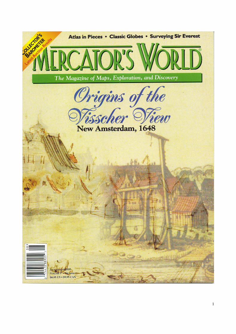
Frontispiece
Origins of the Visscher View, New Amsterdam, 1648
In 1648 Adriaen van der Donck, a Dutch settler in New Amsterdam, began composing a formal protest that
eventually made its way to the highest levels of Dutch government. Though the U.S. Constitution and Bill of
Rights were more than a century in the future, this early New World colonist boldly advanced the outlines of
representative government, an idea that found support in the newly formed Dutch Republic in the Old World.
Map collector Joep M. J. de Koning ties this landmark event to a well-known view of New Amsterdam found on
Claes Janszoon Visscher’s map of New Netherland.
For our cover image Mercator’s World Design Director Stephen Stanley used graphics software to overlay a
recently discovered sketch of New Amsterdam—which accompanied Van der Donck’s protest—with Visscher’s
more familiar etching. The result graphically conveys De Koning’s argument that the drawing served as a
prototype for what has been labeled, perhaps mistakenly, the “Visscher View”.
Maps have always been useful for revealing the truths of their times, whether small or, like those articulated by
Van der Donck, monumental. And we hold such truths to be self-evident.
For more than three centuries a watercolor pen-and-ink drawing depicting a
seventeenth-century view of New Amsterdam was hidden from public view,
until it was discovered in 1991 in the Albertina Collection of the Austrian National
Library. Using original analysis, Joep M. J. de Koning dates this drawing to the
year 1648, when members of the New Netherland colony, under the leadership of
Adriaen van der Donck, began to prepare a Remonstrance for delivery to the
States-General in The Hague. Van der Donck’s Remonstrance protested
conditions in the colony under the leadership of the Dutch West India Company. It
included a manuscript map (now lost) that served as the prototype for Jan
Jansson’s engraved map of “Belgii Novi” (New Netherland), traditionally dated to
1651, as well as a corrected map by Claes Janszoon Visscher, traditionally dated to
circa 1655. In 1988, however, the Jansson map was dated to 1650 in a research
paper by Jan van Bracht and Günter Schilder. De Koning argues that the recently
recovered drawing served as a prototype for an etched view of New Amsterdam by
Johannes Blaeu, which he also dates to 1650, and, subsequently, a nearly identical
view of the Dutch settlement printed on Visscher’s New Netherland map which he
dates to 1650 or 1651. The manuscript map and drawing provide a four-continent
time capsule of the year 1648, and their derived engravings are among America’s
earliest, most detailed images. They represent a momentous decision of profound
importance to American history because they illustrate the first exercise of
Americans’ legal right to seek redress of grievances by directly petitioning the
highest level of government —143 years before ratification of that right in the First
Amendment of the Bill of Rights.
—Gary Turley and Cheri Brooks, Editors
3
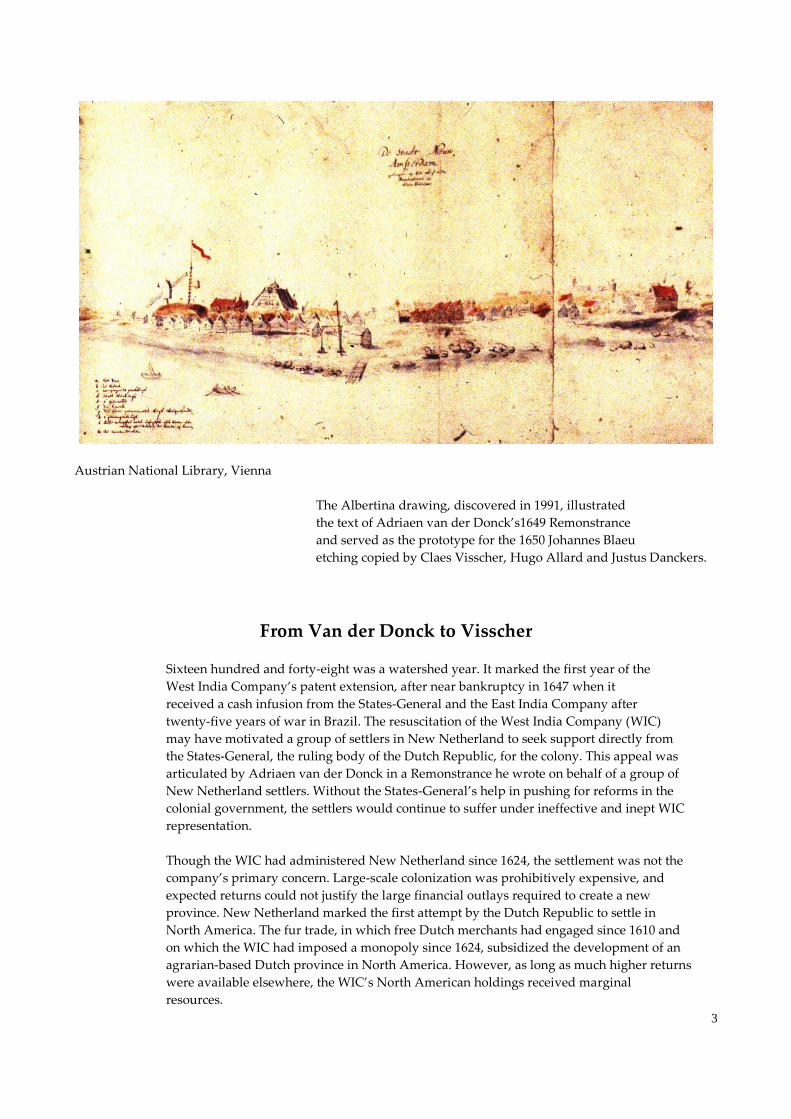
Austrian National Library, Vienna
The Albertina drawing, discovered in 1991, illustrated
the text of Adriaen van der Donck’s1649 Remonstrance
and served as the prototype for the 1650 Johannes Blaeu
etching copied by Claes Visscher, Hugo Allard and Justus Danckers.
From Van der Donck to Visscher
Sixteen hundred and forty-eight was a watershed year. It marked the first year of the
West India Company’s patent extension, after near bankruptcy in 1647 when it
received a cash infusion from the States-General and the East India Company after
twenty-five years of war in Brazil. The resuscitation of the West India Company (WIC)
may have motivated a group of settlers in New Netherland to seek support directly from
the States-General, the ruling body of the Dutch Republic, for the colony. This appeal was
articulated by Adriaen van der Donck in a Remonstrance he wrote on behalf of a group of
New Netherland settlers. Without the States-General’s help in pushing for reforms in the
colonial government, the settlers would continue to suffer under ineffective and inept WIC
representation.
Though the WIC had administered New Netherland since 1624, the settlement was not the
company’s primary concern. Large-scale colonization was prohibitively expensive, and
expected returns could not justify the large financial outlays required to create a new
province. New Netherland marked the first attempt by the Dutch Republic to settle in
North America. The fur trade, in which free Dutch merchants had engaged since 1610 and
on which the WIC had imposed a monopoly since 1624, subsidized the development of an
agrarian-based Dutch province in North America. However, as long as much higher returns
were available elsewhere, the WIC’s North American holdings received marginal
resources.

4
The WIC’s original core objective in 1621 was to conquer Brazil and to exploit the world’s
richest sugar-producing region for the benefit of stockholders. The company’s groot
desseyn, or grand design, was focused on South America rather than North America as it
sought to conquer all of Brazil, as well as to control the supply of labor to Brazil, Peru, and
Mexico. After finally seizing Angola from the Portuguese in 1641, the WIC was assured of
labor for its own Brazilian sugar plantations and gained the ability to withhold labor from its
Portuguese and Spanish rivals. It had thus hoped to weaken its arch enemies and to emerge
victorious in the Spanish/Portuguese trade hegemony in the Atlantic. Ironically, the WIC’s
expensive military adventures had served only to weaken the company substantially by
1648.
In 1648 the WIC lost Angola to the Portuguese and suffered a devastating defeat in Brazil.
That same year, after eighty years of war against Spain, the Dutch Republic, or Seven
United Provinces, gained international recognition as a sovereign nation under the Treaty of
Muenster. The treaty marked the official split-up of the Netherlands (Belgium, in Latin) into
two parts: a sovereign republic in the north (Belgium Foederatum) and a
Spanish-controlled, ten-province region in the south (Belgium Regium). The Treaty of
Muenster probably also emboldened the New Netherland settlers to petition the
States-General, which finally had the time and resources to institute political reforms and
policy changes, to encourage large-scale emigration, and to negotiate with England for
definitive borders of the American province.
Dutch settlers in New Amsterdam — present-day New York City — agreed to send a
deputation to the governing body of the Dutch Republic to protest conditions in the colony,
availing themselves, for the first time, of their legal right to petition their government in
patria. (This right found its way into the American Constitution, in 1791, through the Bill of
Rights, which incorporated various freedoms insisted upon by the New York delegation.)
The settlers were represented by a Board of Nine Men, which the new director-general of
the colony, Petrus Stuyvesant, had appointed in 1647. Through this board, the commonalty
took on a life of its own, showing more power and independence than Stuyvesant had
anticipated.
Van der Donck was appointed to the board in 1648 and became its leading spirit.
Previously a law student at Leyden University and one of the better educated men in New
Netherland, he had arrived in New Amsterdam in 1646 from the upstate settlement of
Rensselaerswyck, where he had been sheriff. In 1648 and 1649 he prepared the
Remonstrance of New Netherland… to the States-General, accusing the WIC of
mismanagement and urging the government to recall Stuyvesant. Van der Donck pleaded
for better government and for policies that would encourage immigration, and he
prophesied that “without special assistance” the Dutch settlement would “utterly fall off and
pass under foreign rule,” noting that “the fort is small and lies upon a point of land which
must be very valuable in case of an increase in population.”
By petitioning the States-General directly, the remonstrants tested the efficacy of their legal
rights and challenged Stuyvesant’s authority. In March 1649 Stuyvesant seized rough drafts
of Van der Donck’s protest, imprisoned him for libel, and expelled him from the Board of
Nine Men. But this didn’t stop Van der Donck from preparing the Remonstrance, which
was signed on 28 July 1649. About three months later the deputation of the petitioners
personally presented their protest and supporting documents to “Their High Mightinesses of
the States-General” in The Hague.
5
The Lost Manuscript Map
Van der Donck’s Remonstrance of New Netherland… referred to a map, among various
other documents, created to induce the States-General to begin negotiations with England
on New Netherland’s exact borders. The map depicted the original Dutch title to New
Netherland based on the prevailing international law. It illustrated the claim from Staten
Hoeck (Cape Cod) to C. Hinlopen, just south of the Zuydt Rivier (Delaware River). The
basis for Dutch ownership dated back to Hudson’s 1609 voyage and the explorations of
the traders Adriaen Block and Cornelis Hendricksz who, between 1611 and 1616,
re-charted the North (Hudson) River and claimed the New Netherland territory for the
Dutch, as shown on two well-preserved manuscript maps of 1614 and 1616.
Just prior to the first WIC colonists of 1624, a 1622 letter from Sir Dudley Carleton, the
English envoy in The Hague, reveals that the English were aware early on of Dutch claims to
New Netherland. “About four or five years since two particular companies of Amsterdam
merchants began a trade in those parts betwixt 40 and 45 degrees to which after their
manner they gave their own names of New Netherlands, a south and a north sea
[Nantucket Sound and Cape Cod Bay], a Texel [Martha’s Vineyard], a Vlieland
[Nantucket Island] & the like … to fetch furrs, for the providing of which they have certaine
factors there continually resident trading with savages,” Carleton noted. Fifteen months
earlier the English had founded Plymouth Colony just north of Nieuw Hollant (the Cape).
These same place-names appear on Jan Jansson’s map of New Netherland, which was
engraved in 1650 from the manuscript map that accompanied the Remonstrance. Claes
Janszoon Visscher’s popular emendatory map (emendata) of New Netherland, which
corrected various errors and omissions of the Jansson map, includes all the same landmarks
and adds a view of New Amsterdam. These place-names follow exactly Van der Donck’s
writings in his Remonstrance, in minute detail and in the correct order.
The Sketched View
In 1991 Dr. Franz Wawrick, head of the map department at the Austrian National Library
in Vienna, discovered two separate watercolor pieces and discerned that, when joined
together, they resembled a well-known view of New Amsterdam that appears in various
etchings and watercolors. This scene generally has been called the “Visscher View,”
because it was presumed to have appeared for the first time as an etched inset on
Visscher’s New Netherland map.
The drawn view that Dr. Wawrick found differs from the etched view joined with
Visscher’s map, as well as a nearly identical etching published by Blaeu. The etchings are
sanitized and embellished versions that portray New Amsterdam as an attractive destination
for settlers, complete with modern infrastructure and essential institutions, and alive with
seventy-two persons scattered around the landscape. By contrast, the sketch is sober and
almost eerie, illustrating a city devoid of people. The pen-and-ink drawing appears to have
been made not by a professional artist or a draftsman, but by a skilled amateur.
Undoubtedly, its purpose was to provide a visual record of New Amsterdam’s physical
condition.
The drawing reflects details that indicate the sketch could only have served as pictorial
support for the descriptions Van der Donck wrote in his Remonstrance. It symbolizes the
“sorrowful condition of New Netherland … lying at its last gasp” after several Indian wars,
and it attempts to portray New Netherland’s “desolate and ruinous state.” It shows the
dispirited physical condition of the town owing to former director Kieft’s misguided
6
decisions that escalated hostilities with the Indians as well as neglect by the WIC due to its war
with the Portuguese in Angola and Brazil, neglect by the States-General due to war with Spain
on the home front, and internal political and religious turmoil in the Dutch Republic.
The Remonstrance highlighted the conflicting interests of the colony (settlers) and the WIC
(traders) that administered it. It also served as a white paper to legitimize, by treaty, the
borders of the province and to describe its bounty for the benefit of the home country and
potential new emigrants. While the manuscript map provided pictorial ammunition to draw
attention to the immense opportunity the New Netherland territory offered, the companion
pen-and-ink view of New Amsterdam provided pictorial support to underline New
Netherland’s neglected condition and to serve as a precise record of the town’s
appearance during the summer of 1648, when Van der Donck described the province’s
“ruinous condition” because of “bad government” and wrote that “the [wind]mill is
neglected and, in consequence of having had a leaky roof most of the time, has become
considerably rotten, so that it cannot now go with more than two arms, and it has been so
for nearly five years,” and that “the fort under which we are to shelter ourselves, and from
which as it seems all authority proceeds, lies like a molehill or a tottering wall, on which
there is not one gun-carriage or one piece of cannon in a suitable frame or on a good
platform.”
Visual evidence, combined with textual and documentary evidence, points to the summer of
1648 as the date when the drawing was made. Major visual clues include the condition of
the fort and the windmill — which Van der Donck described in his text — as well as the
existence of a boat ramp, the depiction of a signal pole, the height and width of the WIC’s
warehouse, the legend that includes the name “Stuyvesant,” the existence of well-leafed
trees and greenery, and the consistency of shadows. The boat ramp dates the view to a
period prior to late 1648 or early 1649. Before he completed his protest, Van der Donck
wrote that Stuyvesant had “from his first arrival up to our leaving been busy building … in
matters of the Compagnie … and shortly afterwards made a wooden wharf (houte kay).”
The drawing doesn’t show this wharf, just a simple boat ramp. We know from an
ordinance of 4 July 1647 that Stuyvesant planned the wharf, recommending the creation of
“a pier (hooft) for the convenience of the traders (handelaers) and citizens (borgers).”
The omission of an extravagant new WIC warehouse narrows the dating to a period prior
to 1649, because on 27 January 1649 WIC directors wrote Stuyvesant: “We cannot
understand why your Honor has begun to erect a storehouse 100 feet long by 19 feet in
width for we do not know what it could be used for.” Leafed trees suggest the view was
drawn during late spring or summer. The name Stuyvesant in the legend indicates the view
was made after the director-general’s arrival in May 1647. The Board of Nine Men’s
decision to send a deputation to the States-General was not made until early in 1648, and
prior to that decision there was no need to provide a record of New Netherland’s “ruinous
condition.” Thus, if the view was made before 1649 and after the summer of 1647, the only
logical date is the summer of 1648.

7
Courtesy of Joep M. J. de Koning
In 1650/1651 Claes Janszoon Visscher published a corrected
[emandata] composite map by combining the 1650 map of New
Netherland [Novi Belgii] by Jan Jansson with the 1650 view of
New Amsterdam by Johannes Blaeu (the “Blaeu View”).
The prototype manuscript version for that map had been compiled
by Adrian van der Donck in 1648 to accompany his 1649 Remonstrance.
This is the second state (1652) which added Fort Kasimier.
The Etched Views
Though useful and effective in pointing out New Amsterdam’s sorrowful condition to the
States-General, the 1648 sketch must have been an embarrassment to the directors of the
WIC. Its distribution as an unsanitized print would also have discouraged settlers to the
colony, and the drawing must have been withdrawn from public view after serving as the
prototype for a more promotionally acceptable etching, which probably was authorized by
Van der Donck to serve as support for his quest to attract new settlers.
The sequence of printed material based on Van der Donck’s manuscript map and drawing
8
begins in 1650, when Blaeu published an etched view as a cutting — that is, several
different images etched onto a plate, printed onto one sheet, and then cut into individual
prints, thus lacking plate marks. All known copies of the Blaeu cutting are printed on
watermarked Blaeu paper, on which he also printed his famous Town Book of 1648. In
1672, a year before Blaeu’s death, a fire destroyed his entire printing business and reduced
his paper inventory, plates, and presses to ashes. No available blank Blaeu paper since has
been found.
This Blaeu view previously was thoughtlessly presumed to be a nineteenth- or
twentieth-century reproduction of the etched view on Visscher’s map of New Netherland
(Novi Belgii, in Latin). But an examination of the cutting, along with analyses of the
historical context, indicates the Blaeu view preceded the Visscher view by several months.
Blaeu anonymously published the etching as a companion to the printed version of the
Remonstrance, titled Vertoogh van Nieu-Neder-Land, a controversial pamphlet
published in 1650, as it focused public attention on the plight of New Netherland’s settlers.
Blaeu undoubtedly issued the etched view in conjunction with Jansson’s map of New
Netherland. Like Blaeu, Jansson engraved his work directly from Van der Donck’s original
and published it anonymously. The 1650 pamphlet makes specific reference to this map,
stating “as the map of New Netherland will prove.”
Both Blaeu and Jansson were central figures in the world of Dutch publishing and
cartography, and doubtlessly both would have been involved in an issue of such tremendous
importance. However, because of the potentially rebellious nature of the printed pamphlet,
they chose to contribute their work anonymously. Because Jansson’s map of New
Netherland was published in a later atlas, it has not been difficult to identify him as author of
the 1650 state. But the date and the source of the (Blaeu) cutting were not realized until
now.
In the past various scholars have speculated that the view as seen in the etchings represents
the period of around 1660, or even later, based on what they conjectured from observed
details. But when the Visscher map was found originally attached to a January 1656 border
resolution, scholars conveniently dated the view to 1655 and conjured up various
justifications for that date. Visscher’s death was later documented to have occurred in June
1652. Then scholars surmised that Visscher’s son must have inserted the etched view onto
the unpublished map after his father’s death and published it for the first time in 1655. Even
though several copies of the map had been found that did not include Fort Kasimier, which
was built in 1651 on the south side of the Delaware River, scholars chose to ignore the
possibility of an earlier date. They conveniently attributed the omission of the fort to an error
(even though the map was itself a correction of Jansson’s) and considered those copies
lacking Fort Kasimier to be “proof copies.” Their stubborn reasoning was due to the fact
that no one had dared challenge the generally accepted wisdom that the view on Visscher’s
map depicted the town not earlier than circa 1652–1653 rather than 1648 as concluded
herein.
In fact, those Visscher maps of New Netherland that lack Fort Kasimier prove that the
map showing the view of New Amsterdam was published prior to Visscher’s death in 1652
and before construction of the fort in 1651. The plate upon which the map was engraved
and the inset view etched was, therefore, produced in 1650 at the earliest and 1651 at the
latest. A Visscher map lacking Fort Kasimier is thus a first state, not a proof copy.
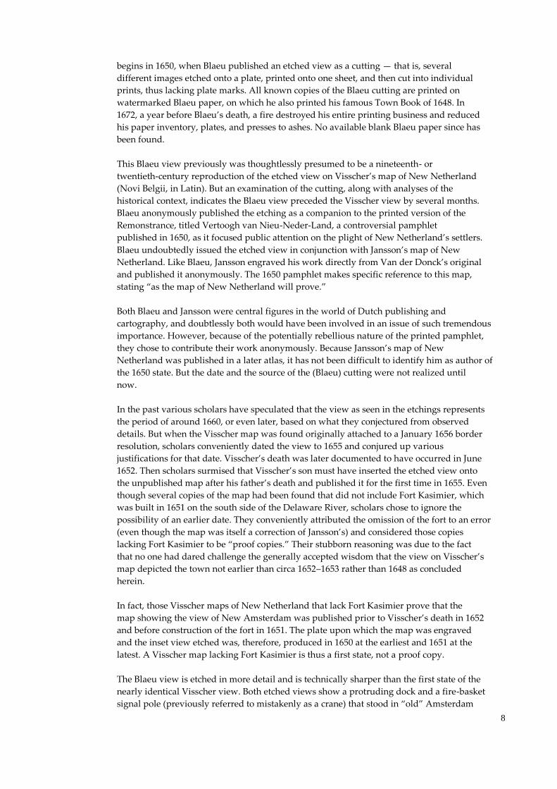
The Blaeu view is etched in more detail and is technically sharper than the first state of the
nearly identical Visscher view. Both etched views show a protruding dock and a fire-basket
signal pole (previously referred to mistakenly as a crane) that stood in “old” Amsterdam
9
and served as a model for the etcher. (A depiction of Amsterdam’s fire-basket pole can be
found at the Prins Hendrik Museum in Rotterdam.) These were embellishments of the
simple boat ramp and smoke-signal pole seen in the 1648 drawing. Because the Blaeu view
is more detailed and technically superior, I judge it to have preceded the Visscher view —
and it thus was published in conjunction with the Vertoogh van Nieu-Neder-Land. The
inset Visscher view etching must have been derived from the Blaeu view etching in the same
way as the Visscher map was derived from the Jansson map. Because of the high-level
technique evidenced in the nearly identical etchings, one may postulate that both Blaeu and
Visscher commissioned the same etcher in the same year, 1650. According to M. Simon’s
1958 dissertation, this etcher was Pieter Hendrikszoon Schut.
Perhaps future scholars and dealers may still want to speculate when looking at Plate 13 of
Frederik Caspar Wieder’s 1925 book, De Stichting van New York in Juli 1625…, that
in addition to the Blaeu view cutting there also was a separate Visscher view cutting. Plate
13 shows a copy of the Visscher view of New Amsterdam as a cutting, which is identical
— dot-for-dot, line-for-line — to the Visscher view etching. However, it is impossible to
reproduce an etched image exactly — dot-for-dot, line-for-line — from one plate to
another. The image can only be transferred to another plate by re-etching. Therefore, Plate
13 of Wieder’s book is a retouched copy of the inset view, as one can vaguely detect the
touch-ups where the Indian bow used to be (a bow appears in the Visscher view but not in
the printed reproduction found in Wieder’s book). Moreover, the purported Visscher view
cutting, as apparently illustrated in Wieder’s book, has never been found.
Thus, it was the 1650 Blaeu view, not the Visscher view, that was the first printed view of
New Amsterdam based on the 1648 watercolor pen-and-ink drawing. A few years later
Hugo Allardt and Justus Danckers engraved their own copperplates in order to produce
facsimiles of Visscher’s map. The New Amsterdam etchings on these maps are
clearly the work of a different hand, because they are technically inferior.
Courtesy of Joep M. J. de Koning
This stand-alone etched view of New Amsterdam
was published as a “cutting” by Johannes Blaeu in 1650.
The prototype pen-and-ink drawing for the Blaeu View
had been compiled by Adrian van der Donck in 1648
to accompany his 1649 Remonstrance
.
A New View of the View
The 1991 discovery of the 1648 drawing represents a significant addition to our knowledge
of New Amsterdam etchings and watercolors. It is the only realistic extant visual
representation of the town since its founding in 1625. It allows us to conclude that all
10
known variants of this view that show a uniquely shaped fire-basket signal pole, visually
identical to the one on the 1650 embellished etching created in Holland, must have been
based on the etching rather than the drawing or from on-the-spot observation in New
Amsterdam. We now know that a simple smoke signal-pole that signified the start of the
roadstead stood in New Amsterdam. None of these variants, therefore — whether drawn,
painted, engraved, or etched — precede the 1650 date of the Blaeu cutting. The so-called
Visscher view has traditionally been called the third-known engraved view of New
Amsterdam. The second-known engraved view (at the I.N. Phelps Stokes Collection of the
New York Public Library), however, depicts the embellished fire-basket signal pole, which
therefore succeeds the Blaeu view. The Blaeu cutting now represents the second view after
the acknowledged first view — an authentic 1625 view of Manhattan on which is
superimposed the planned five-bastion Fort Amsterdam — published as an etching in Joost
Hartger’s 1651 booklet, which includes excerpts from the Remonstrance. When viewed in
terms of publishing chronology, the Blaeu cutting of 1650 is the first extant etching of New
Amsterdam.
It is difficult today to comprehend the immensity of Van der Donck’s proactive undertaking
to force change upon his beloved New Netherland. Taking his Remonstrance directly to
the States-General speaks highly of the enlightened conditions in the Dutch Republic, which
was surrounded by authoritarian regimes. These conditions in the republic clearly
transcended the idiosyncrasies of Stuyvesant’s imperious personality, proved strong enough
to effectuate change in the republic’s only province in the Americas, and ensured that its
1579 constitution and system of law prevailed in its overseas province. The Remonstrance
of 1649 led to the furtherance of America’s earliest democratic principles, the granting of
the first municipal charter to an American city, and the strengthening of the commitment to
tolerance for the diverse New Netherland community under the motto of “Concordia,” or
union — still in the seal of Brooklyn. The constitutional support that made the 1649
Remonstrance possible eventually found its way into the U.S. Constitution.
It represents a tour de force of gargantuan dimensions, undertaken at great odds and
personal risk. Van der Donck was a visionary who knew his legal rights and had the
courage of his convictions. It is time for him to be acknowledged for what he created and
achieved. I propose, therefore, that curators, map dealers, and scholars do away with the
generic and erroneous appellation of “The Jansson-Visscher Series of Maps” and “The
Jansson-Visscher Maps of New England” when referring to the many facsimile maps based
on Van der Donck’s prototypes produced by various engravers after 1651 or reprinted
with alterations for more than a century. These creations were Van der Donck’s intellectual
property as they were specifically created to exemplify his vision for New Netherland. It
would do justice to Van der Donck’s accomplishments to name these maps “The Van der
Donck Series of Maps of the Middle Colonies or of New York” (certainly not New
England), or “The Van der Donck Prototype Map,” or “The Van der Donck Prototype
View of New Amsterdam.”
Joep M.J. de Koning, an expert on the graphic depiction of New Amsterdam, is proprietor of the Batavia Group Ltd, a New York investment firm. He presented a
variation of this paper during a panel discussion at the Museum of the City of New York on 15 October 1998. Readers with questions may e-mail him at
Further Reading
Bracht, Jan van, and Schilder, Günter. “Origins of New York.” Zurich, Switzerland: Edition Seefeld, 1988.
Jameson. J. Franklin, Ed. Narratives of New Netherland, 1608–1664. New York: 1909.
Koning, Joep M.J. de. “Dating the Visscher, or Prototype, View of New Amsterdam.” De Halve Maen 72 (Fall 1999): 47–56.
Stokes, I.N. Phelps. The Iconography of Manhattan Island, 1498–1909. Six volumes. New York: 1915–1928.
Wieder, Frederik Caspar. De Stichting van New York in Juli 1625. Reconstructies en nieuwe gegevens ontleend aan de van Rappard documenten, door dr. F.C.
Wieder, met 28 kaarten en platen. ‘s-Gravenhage: M. Nijhof, 1925.


