The morphometric characteristics of 96 sublacustrine landslide complexes were measured on dense grids ofhigh-resolution seismic reflection data from several lakes worldwide and were statistically analyzed. Thisanalysis reveals that the morphology of the sublacustrine slopes exerts a strong control on the size of slopefailures that occur on them, as the location of the headscarp and frontal ramp of these landslides are mainlydetermined by changes in the slope gradient. Our dataset also shows that the height drop of the failing slopesection and the subsurface depth of the basal shear surface are the main parameters that determine whether alandslide will propagate in a frontally confined or frontally emergent manner. These parameters respectivelyrepresent the gravitational potential energy (driving force) of the sliding mass and the potential energyrequired (a resisting force) for it to emerge at its frontal ramp. These observations open perspectives forpredicting the frontal emplacement style of future sublacustrine and submarine landslides and theirassociated natural hazards (e.g., tsunamis, dense flows). Although the investigated sublacustrine landslideshave smaller dimensions thanmost submarine landslides, our data reveal mostly comparable inter-parametercorrelations and relationships. However, frontally emergent landslides in lakes (and fjords) generally have alarger mobility and underwent a larger disintegration than what would have been expected by extrapolationof empirical relationships derived for ocean margin landslide datasets. This can be explained by the highly-unconsolidated material usually involved in the shallowly excavated slope failures in lakes and fjords.
Sublacustrine landslide deposits and their associated turbidites areimportant components of the sedimentary infill of many lakes and areincreasingly used as proxy for past earthquake activity (e.g., Karlin etal., 2004; Strasser et al., 2006; Moernaut et al., 2007). Most of what isknown today about subaqueous landslide processes has beenobtained through a vast number of marine studies and modeling(e.g., Canals et al., 2004; Masson et al., 2006 and references therein).The use of 3D seismic datasets has allowed imaging and mapping oflarge-scale landslide complexes with unprecedented, data coverageand detail, and has helped revealing various types of kinematicindicators of mass-transport (Gee et al., 2005; Bull et al., 2009). Forexample, impressive fold-and-thrust systems in a landslide toe regionwere analyzed by Frey-Martinez et al. (2006) and allowed theconstruction of a 2-end-member model for the frontal emplacementstyle of submarine landslides (Fig. 1). This includes i) frontallyconfined landslides, in which the frontal part is buttressed against
undisturbed slope strata, and ii) frontally emergent landslides, whichare able to ramp up from their original stratigraphic position andtranslate in an unconfined way over the sea bottom. Frontallyconfined landslides are now beginning to be reported worldwide(e.g., Gafeira et al., 2007; Callot et al., 2008; Tripsanas et al., 2008;Lawrence and Cartwright, 2009; Gamberi et al., 2011), although themechanisms and kinematics involved in their frontal emplacementare still poorly understood. For example, it has not yet beenconclusively established why some submarine landslides stayconfined while others do not, and if these different frontal behaviorsproduce dissimilar associated hazards (e.g., tsunami and high-velocityflows).
Hampton et al. (1996) compiled morphometric data of severalsubmarine landslides known at that time and pointed out that theygenerally exhibit a larger mobility than subaerial landslides. Driven byadvances in marine observation techniques, a vast amount ofsubmarine landslide complexes have been discovered since then,which has allowed their morphometric parameters to be analyzedstatistically (McAdoo et al., 2000; Hühnerbach et al., 2004; Green andUken, 2008). Strong correlations were found between several area-and volume-related parameters, which can help in estimating theexpected volume (and associated hazards) of a landslide given thesubsurface depth of a potential failure plane. Sublacustrine landslidesare on average smaller than submarine ones, but a comprehensive
Fig. 1. Schematic illustration of frontally emergent and confined landslides with indication of the various morphometric parameters that were measured in this study. Note thedifference between total height drop H (between headscarp and toe) and height drop H* (between headscarp and frontal ramp). Dark gray: landslide deposit (deformed and/ordisplaced sediment sequences); light gray: unfailed sediment sequences (with possible in-situ deformations/fractures near the landslide toe).
30 J. Moernaut, M. De Batist / Marine Geology 285 (2011) 29–45
morphometric study of sublacustrine landslides has not yet beenperformed. Therefore, it is not known yet whether similar relation-ships exist and thus whether similar processes control the dimensionsand geometry of sublacustrine landslides.
The aim of our study is therefore two-fold:
i) establishing which parameters determine whether a landslidedevelops a confined or emergent frontal emplacement style (inlacustrine environments);
ii) establishing the relationships between the morphometric param-eters of sublacustrine landslides and their position with respect tosubmarine landslides.
Our study is based on the seismostratigraphic and morphometricanalysis of sublacustrine landslides imaged on high to very-highresolution seismic-reflection data from lakes of various sizes and fromvarious environments. We first present two selected case studies inorder to illustrate the different features related to the frontalemplacement style of sublacustrine landslides. In the second part ofthe paper, we present the statistical analysis of the morphometricparameters of our landslide catalog. This combined approach allowstesting the applicability of the hypotheses made in a particular casestudy on a broader scale.
2. Methods
Over the past 15 years, the Renard Centre of Marine Geology(RCMG; Ghent University) has collected high and very-high resolu-tion seismic-reflection data in the framework of several national andinternational lake research projects (SI Table 1). These data wereacquired using different acoustic sources, such as sparkers, boomersand pingers (SI Table 2), which were towed behind a GPS-positionedsurvey vessel. All seismic data were digitally recorded on a TRITON–ELICS Delph-2 acquisition system. Depending on data quality and userneeds, post-acquisition data processing – including bandpass filtering,scaling and deconvolution –was carried out on a LANDMARK ProMaxsystem. Seismostratigraphic interpretation was performed usingSeismic Micro-Technology's Kingdom Suite package (version 7.5).An acoustic velocity of 1500 m/s was used for time-to-depthconversions in the water column and the upper sediments, which isin agreement with acoustic velocities derived from lacustrinerefraction seismic data (e.g., Finckh et al., 1984), core logging data(e.g., Waldmann et al., 2008) and multi-channel seismic-reflectiondata (e.g., Scholz et al., 2002).
In this paper, we will only use the general terms “landslides” and“landslide deposits” as i) seismic data on their own are not sufficientto establish the exact mass-transport process behind the imaged
31J. Moernaut, M. De Batist / Marine Geology 285 (2011) 29–45
landslide deposits (Tripsanas et al., 2008), ii) landslides can evolvefrom one type into another (Mulder and Alexander, 2001a) and iii)various static and dynamic classification schemes, subdivisions andterminologies exist (e.g., Nardin et al., 1979; Mulder and Cochonat,1996; Mulder and Alexander, 2001a; Tripsanas et al., 2008). Wecataloged landslide complexes that originated from translationalfailure of subaqueous sedimentary slope sequences, thereby exclud-ing deposits resulting from rotational landslides, rock falls, debrisavalanches and turbidity currents (e.g., Hampton et al., 1996;
Fig. 2. A) Overview seismic profile of Lake Challa with landslide deposits at stratigraphic lev(BSS). Yellow: frontally confined landslides; Red: frontally emergent landslides. Inset fi
Paleobathymetric map of BSS 2 with level B and C landslides, which shared the same stratigwhich shared the same stratigraphic level as BSS (BSS 1).
Normark et al., 2004; Schnellmann et al., 2006). The scar region oftranslational landslides can be easily discriminated by the presence ofa clear slide scarp and a bedding-parallel sliding surface. Translationallandslide deposits typically show a chaotic-to-transparent seismicfacies and can have a lens-shaped intercalating geometry (e.g.,Schnellmann et al., 2002). Of the 26 lakes examined, only 12contained a useful landslide record with i) good seismic data quality,and ii) sufficiently dense seismic coverage of the landslide depositsand slide scar region (SI Table 1; SI Fig. 1). The shallower lakes
els A, B and C. Two stratigraphic levels (BSS 1 and 2) were used as basal shear surfacegure at top: bathymetric map (isobaths every 10 m) and seismic survey lines. B)raphic level as BSS (BSS 2). C) Paleobathymetric map of BSS 1 with level A landslides,
32 J. Moernaut, M. De Batist / Marine Geology 285 (2011) 29–45
(b~30 m water depth) do not contain any suitable landslide deposits,as the influence of wave action on the shallower lake bottom producessediment focusing towards the deeper basin parts (Crusius andAnderson, 1995). This can prevent the build-up of sedimentary slopesequences prone to failure. Likewise, the fault-controlled lateralborders of the tectonic lakes in our database are often too steep fortranslational slope failure, as sediments generally do not accumulatein significant amounts on slopes steeper than about 14° (Håkansonand Jansson, 2002).
In this study, landslides are classified based on their frontalemplacement style as this characteristic can easily and objectively bedetermined on seismic-reflection profiles (Fig. 1). Frontally emergentlandslides exhibit a larger downslope translation than frontallyconfined landslides, because the landslide has been able to ramp upfrom its original basal shear surface, abandon its scar surface andcontinue over the contemporaneous seafloor. On seismic sections,frontally confined landslides show frontal thrust structures in the toeregion, separating uplifted, rotated and/or folded blocks of coherentstrata from undeformed foreland sediments (e.g., Schnellmann et al.,2005). In downslope direction, buried frontally emergent landslideswedge out in between parallel-stratified reflections, which representundisturbed units of pre- and postfailure sediments. Upslope, abruptand steep transitions (“lateral margins”) occur between the chaotic-to-transparent facies of the (confined and emergent) landslidedeposits and the parallel-layered facies of the background sediments.For emergent landslides, a “frontal ramp” structure is located at thetransition between the landslide scar and the main depositional area.
Up to 96 sublacustrine landslides fitting this two end-membermodel were identified and included in the database. Of these, 79 wereclassified as frontally emergent and 17 as frontally confined (SI Table5). Dimensional measurements and slope calculations were carriedout on seismic profiles and on maps to determine the morphometricparameters of the evacuational, translational and depositional area ofeach sublacustrine landslide, however with an emphasis on thedepositional area (Fig. 1), where features are better visualized on theseismic data. The deposit volume was calculated using GoldenSoftware SURFER software by subtracting the calculated grids forthe landslide deposit bottom and top. This calculated deposit valuemight also provide a rough estimate of the failed sediment volume,assuming that only a minor fraction of the mass-movementtransformed into turbidity currents. Several ratios between morpho-metric parameters were calculated and included in the statisticalanalysis.
3. Case study 1: Lake Challa
Lake Challa (4.2 km², 880 m a.s.l., maximum depth: 92 m) is avolcanic crater lake on the lower east slope of Mt. Kilimanjaro, on theborder of Kenya and Tanzania. The sedimentary infill mostly has auniform draping geometry, but detailed isopach mapping showedthat certain seismic units display a partially basin-focused deposi-tional pattern (Verschuren et al., 2009; Moernaut et al., 2010).Multiple landslide deposits were found at several stratigraphic levels(Fig. 2): e.g., A1–A5 at stratigraphic level A, B1–B3 at level B and C1–C4 at level C. The basal shear surfaces of level B and C landslides arelocated at a single stratigraphic level (BSS 2; Fig. 2). Level B landslidesinvolved failure of a 0.7 m thick slope sequence, while this is 2.5 mthick for level C landslides. All landslides at level C are frontallyconfined, while these at the lower level B all show a frontallyemergent geometry. Both types of landslides originated along the SEand E margin of the basin where slope profiles are quite similar toeach other. The different emplacement style of level B and level Clandslides suggests that the sub-surface depth of the basal shearsurface (i.e., the thickness of the failed mass) plays an important rolein controlling the ability of lacustrine slope failures to ramp out oftheir stratigraphic confinement (see Section 6).
On stratigraphic level A, two landslides are classified as frontallyemergent while three landslides are frontally confined, but they alluse the same stratigraphic level as basal shear surface (BSS 1). Thisindicates that factors other than the failed mass thickness control thefrontal emplacement style. The values for the height drop betweenheadscarp and frontal ramp (H*) (9 m; 10 m) and maximum slopeangle of mass-transport (1.9°; 2.5°) for confined landslides A1 and A2are considerably lower than for the emergent landslides A4 and A5(20 m and 22 m; 4.9° and 3.4°). Landslide A3 is not evaluated due tothe scarcity and direction of seismic lines at this location. These resultsseem to indicate that the height drop H* and slope angle could beprimary parameters controlling the frontal emplacement style ofsublacustrine landslides.
The seismic characteristics of an acoustically well-resolvedfrontally confined landslide (C2) were studied in high detail (Fig. 3).In the upslope region, a 2.6 m high headscarp is located on adownslope-steepening slope break (0° to 5°). This scarp is evidencedby a discontinuity in seismic reflections, diffraction hyperbola (in bothdirections) and more steeply dipping reflections above the scarp thanbeneath it. The landslide's basal shear surface is tied to one continuousreflector. The landslide deposit surface shows a smooth morphologyin the upslope part and a rugged morphology in its toe region. Atransition zone is located in between the chaotic-to-transparent faciesof the landslide deposit and the horizontally laminated seismic faciesof the undisturbed basin-plain sediments. This transition zone showsparallel reflections that correlate with the basin-plain units, butnarrow, steeply west-ward dipping, low-amplitude zones disrupt thereflection continuity. In the most distal part, such acoustic wipe-outzones are restricted to the upper half of the transition zone and aremore fragmented. The transition zone is considerably thicker (3.6 mthick) than the stratigraphically adjacent basin-plain unit (2.5 mthick). The rugged morphology at the toe of the confined landslidemay be explained by the presence of a series of frontal thrusts (notvisible on the profile) that developed where the foreland progres-sively failed under the gravitational downslope stress of the failingmass. These stresses also induced slope-parallel compression features(i.e., thickened unit, small fractures) in the transition zone, albeitwithout full failure of the sedimentary sequence. The confined-typefrontal emplacement and the fact that the landslide deposit is locatedimmediately at the foot of its headscarp indicate that only a limiteddownslope translation of the failed mass took place.
Thickness measurements for characterizing each confined land-slide (Fig. 4) encompassed i) the undisturbed basin-plain sequence infront of the landslide, ii) the transition zone with compressionfeatures without full failure, and iii) the landslide's toe region wheresediment packages are highly disturbed by frontal thrusting (failedzone). Compared to landslides at the same level, landslide A3 and C4(Figs. 2 and4) exhibit the least thickening in the transition zone (107%and 129%), while having the most thickened toe region (180% and221%). Conversely, landslides A1 and C1, which have the largesttransition zone thickening (129% and 152%), exhibit relatively lessfailed zone thickening (167% and 184%). Furthermore, A3 and C4exhibit higher values of height drop (H=H*) and mean slope anglecompared to landslides at the same level (Fig. 4). These resultsindicate that height drop and slope angle could be primaryparameters in controlling the magnitude of frontal thrusting com-pared to thickening of the transition zone for confined landslides.Other parameters, such as the slope angle at toe or the length of thelandslide did not correlate.
4. Case study 2: Lake le Bourget
Lake Le Bourget (18×2–3 km; 231 m a.s.l.; maximum depth:145 m) is a glacigenic lake in the French NW Alps, the sedimentaryinfill of which has been extensively explored by means of high-resolution 2D seismics, side-scan sonar imaging, multibeam
Fig. 3. Uninterpreted (A) and interpreted (B) seismic profile in Lake Challa (location on Fig. 2A) showing the detailed seismic features of a confined slide (landslide C2). The“transition zone” is located in between the frontal thrusts of the failed zone and the undisturbed basin-floor, and its thickness decreases downslope. Dashed lines: assumed frontalthrusts. Dotted lines: acoustic wipe-out zones and fractures.
33J. Moernaut, M. De Batist / Marine Geology 285 (2011) 29–45
bathymetry and sediment cores (e.g., Chapron et al., 1996; Chapron,1999; Chapron et al., 2004; Ledoux et al., 2010). This case studyfocuses on the “Hautecombe Disturbed Unit” (HDU), which has beenexplained in earlier studies as a complex amalgamation of a largesublacustrine landslide (hereafter named “main lateral landslide”)from the western basin slope and less voluminous landslides from theeast and north of the lake basin (Chapron et al., 1996). New seismicdata were obtained during a seismic equipment test survey in thewinter of 2009 and allowed mapping the main lateral landslide inunprecedented detail (Fig. 5). At the western basin slopes, theheadscarp of the main lateral landslide cross-cuts a ~12 m thicksedimentary sequence where the rock basement forms a discrete highand slope break. At these slopes, the lower boundary (BSS) is locatedat the top of the rock basement and locally within the lacustrine slopesediments. Near the basin plain periphery, the basal shear surfaceobliquely cross-cuts a ~10 m thick lacustrine sequence, creating awedge-like geometry of BSS step-ups. On the basin plain, the BSS islocated at multiple levels with a complex pattern of step-downs andstep-ups (Fig. 5B–D). In the northern part of themain lateral landslide,the BSS progressively used shallower (younger) stratigraphic hori-zons as basal shear surface. In the southern part of the main lateral
landslide, a BSS step-down towards an older and deeper horizon tookplace. The lateral continuation of the BSS levels in the undisturbedbasin-plain is formed by discrete acoustic reflectors with highreflection amplitudes, which are located within the top part ofSeismic Unit 5 of the seismic stratigraphy of Chapron et al. (1996).This seismic unit is probably composed of “rythmites” from theSierroz prodelta and Rhône fan (see also Van Rensbergen et al., 1999).
Estimates of the pre-failure paleo-lake bottom (based on thethickness of adjacent unfailed sequences) allowed calculation ofsimple volume-balances (per unit width) on west–east seismicprofiles for the main lateral landslide. Pre- and post-failure volumesare more or less in equilibrium for the area in between the headscarpand distal frontal ramp, indicating that most of the landslide massremained in its stratigraphic confinement. Moreover, the length of thetotally evacuated slope (max. 300 m) (Fig. 5C) was relatively lowcompared to the main lateral landslide's run-out (max. 1800 m). In itsfrontal part, several reflections from the undisturbed basin-plain canbe tracked into the disturbed mass of the main lateral landslide (insetof Fig. 6), which indicates that these sediment packages were thrusted(and folded) but did not ramp out of their stratigraphic confinement.Recognition of such features allowed the discrimination between a
Fig. 4. A) Thickness measurements of the undisturbed zone, transition zone and failedzone of confined landslides at levels A and C in Lake Challa. B) Mean slope angle andheight drop (H=H*) associated to these landslides.
34 J. Moernaut, M. De Batist / Marine Geology 285 (2011) 29–45
compression zone, characterized by thrusts and topographic bulges,and a translation zone, characterized by few thrust faults and a rathersmooth upper deposit boundary (Fig. 5C). Peculiar small-scalefractures, without vertical off-set, are present at the transitionbetween the frontal compression zone of the main lateral landslideand the undisturbed basin-plain sediments (inset of Fig. 6). This“transition zone” can be regarded as representing the initial stagetowards failure of the foreland sediments (see Section 3).
The frontal compression structures and transition zone, the smalldegree of landslide scar evacuation, and the volume-balances allindicate that the main lateral landslide is in effect a frontally confinedlandslide. It is covered by the unconfined parts of several frontallyemergent landslides that originated on the northern and easternslopes of the basin (Fig. 5B). The largest of these landslides (“axialemergent landslide” on Fig. 6) originated at the paleo-Rhône fan delta(stratigraphic interpretation: Van Rensbergen et al., 1999), where it
Fig. 5. A) Seismic survey lines in the northern half of Lake Le Bourget. B) Bathymetric map (isstratigraphic positions of its basal shear surface. Gray lines indicate the position of the seismlandslide (black) and several emergent landslides (gray). Compared to the L1 level, the Bstratigraphy. The contemporaneous lake floor was located ~12 m higher than L1. C) Areas ofseismic profile (C2 sparker) showing the main lateral landslide. Compression features (thruslandslide deposit (yellow) is buried by emergent landslide deposits (red).
excavated a ~20 m thick sediment sequence and ran out over themain lateral landslide deposit and the basin floor.
5. Morphometry and statistics of 96 sublacustrine landslides
5.1. Median and distribution of landslide parameters
The main dimensional and morphometric parameters of thelandslides in our catalog (Table 1; Fig. 1; SI Table 5) were measuredand their distributions were explored. Themeasured run-out distance(i.e., horizontal distance between headscarp and toe) does notrepresent the traveled distance of individual sediment particles orblocks which – in case of confined landslides – can be many orders ofmagnitude smaller than the run-out distance (e.g., Frey-Martinez etal., 2006). Several dimensional parameters are characterized by a veryasymmetrical distribution (Fig. 7A/C/E) with a few data points havingvery large values. These strongly influence the mean parameter value,which makes the median value more suited for characterizing the“typical” landslide (Table 1). Median length, width, area and run-outdistance are larger for emergent types than for confined ones, whichcan be explained by their free propagation and spreading of sedimentmass over the lake bottom. Median volume is rather similar foremergent and confined types (306,500 m³ versus 285,000 m³) whichsuggests that the volume of the sediment failure is not a crucialparameter in determining the frontal development of sublacustrinelandslides. Cumulative volume or run-out distributions on Log–Logplots (Fig. 7B/D) do not unambiguously fit with a logarithmic orpower–law function, but rather fall in between such distributionmodes. However, inverse power–law functions on reduced fractionsof our dataset give a better fit (higher R² on Fig. 7B/D), especiallywhen discriminating the lowest ~20% of the parameter values whichare delimited by a slope-break in the cumulative distributions.
Median depth of the basal shear zone is slightly shallower foremergent landslides (1.8 m) than for confined ones (2.5 m). Thedistributions of the BSS depth (Fig. 7F) show that a similar range ofslope sequence thicknesses can become unstable in both landslidetypes. Total height drop (H) for emergent landslides has amuch largermedian value (53 m) than that for confined types (9 m) and theirdistributions (Fig. 7E) show that most confined types (13 out of 17cases) have a value of less than 10 m, while most emergent types (77out of 79 cases) underwent a total height drop larger than 10 m. Still,for comparing the initial potential energy conditions at failure (seeSection 6), the height drop H* (to the frontal ramp) should be usedinstead of the total height drop H (to the landslide toe).
The slope angle of frontal thrust planes in confined landslides wasmeasured (Fig. 8A) by tracing the lateral discontinuity and verticaloffset of internal reflections and by the location of topographic bulges.The thrust faults have a median angle of about 12.6° and most of theirdistribution falls between 8° and 18°, which is somewhat less thanslope-angle values for thrust planes (10°–25°) in large-scale subma-rine landslide complexes revealed on 3D seismic volumes (Frey-Martinez et al., 2006). Median slope angle values for the unfailed slope(upslope of the headscarp) and for the steepest part of mass-transportare generally larger for emergent landslides (2.4°; 6.1°) than forconfined landslides (1.5°; 2.5°). Emergent landslides also exhibit awider range of maximum mass-transport slope values (0°–21°) thanconfined landslides (0°–9°) (Fig. 8B). It thus seems that theevacuation area for emergent landslides is generally steeper. Slope
obaths every 10 m; Chapron, 1999) with landslide features of the HDU complex and theic lines in part D and Fig. 6. Arrows indicate the transport direction of the main lateralSS at level 2, 3 and 4 is located respectively ~1.5 m, ~2.5 m and ~8 m higher in thetotal evacuation, translation or compression within the main lateral landslide. D) W–Ets, topographic bulges) are mostly located above BSS step-ups. Locally, the main lateral
35J. Moernaut, M. De Batist / Marine Geology 285 (2011) 29–45
Fig. 6. NW–SE profile (C1 sparker) in Lake Le Bourget showing the main lateral landslide (yellow arrow) and axial emergent landslide (red arrows) of the HDU complex. The axialemergent landslide originated at the paleo-Rhône fan delta slope. L1–L4 represent stratigraphic levels where the BSS of the main lateral landslide developed. The red line indicatesthe pre-failure paleo-lake bottom (as in Fig. 5D). Inset figure (location: green box): zoom of the toe region of the main lateral landslide. A transition zone with small fractures islocated in between highly-disturbed landslide sediments and the undeformed basin-plain. A correlation rectangle (copy/paste of reflection package) shows that the reflections of acoherent sediment block in the landslide body match with the basin-plain sequence.
36 J. Moernaut, M. De Batist / Marine Geology 285 (2011) 29–45
angles at the landslide toe (Fig. 8C) are rather similar for both types(median of 0.3° for emergent landslides versus 0.4° for confined ones)and generally fall in the range of −0.2° (i.e., deposition on slightlyuphill surface) and 1.6° (deposition on downhill surface).
Significant differences between the two landslide types were alsofound when considering some calculated ratios in between param-eters. The median volume/run-out ratio is lower for emergentlandslides (378) than for confined ones (851). This results from thegenerally higher run-out values of emergent landslides – per volumeunit – due to the intrinsic ability of (freely flowing) emergentlandslides to develop a larger translation of individual sedimentaryelements. The median value for the total height drop/depth basalshear surface is much larger for emergent landslides (30.2) than forconfined ones (4.0), which is due to the generally larger total heightdrop for emergent landslides. This ratio possibly characterizes thepotential gravitational energy of a landslide compared to the potentialenergy needed to emerge at the frontal ramp and might be of keyimportance in the frontal development of landslides (see Section 6).The total height drop/run-out ratio (Fig. 8D) is typically used tocharacterize the mobility of a mass movement (Hampton et al., 1996;Locat and Lee, 2002). In general, the most mobile landslides arecharacterized by low values of this ratio. However, in our study, themedian value for this ratio is higher for the emergent types (0.048)than for the confined ones (0.017) due to the generally much larger
total height drop involved with emergent landslides. These medianvalues would suggest that emergent types would have a lowermobility than confined landslides. Contrarily, landslides with aconfined frontal emplacement intrinsically have a very low mobilityand, therefore, their mobility must be assessed by measuring theheight drop and run-out undergone by the center of gravity (Legros,2002) instead of the total height drop/run-out ratio of the landslidecomplex.
These median values and distributions in our sublacustrinelandslide catalog provide a first insight in to the differences betweenconfined and emergent landslides.
5.2. Relationships between landslide parameters
Correlation coefficients were calculated in between all measuredmorphometric parameters and ratios in order to reveal some possiblerelationships between them. In this study, the commonly usedPearson correlation coefficient was not used, as this requires thatthe parameters be normally distributed (Davis, 1986). Instead, weopted to calculate the non-parametric Spearman's rank correlationcoefficient (Spearman's rho) that does not require any specificfrequency distribution of the variables. The Spearman's rank corre-lation coefficient indicates if parameters vary together, but theseshould not necessarily relate in a linear way. Some strong (N0.5) to
Table 1Median values for morphometric parameters and ratios of frontally confined andemergent sublacustrine landslides. “N” is the number of landslides included in theanalysis.
Confined Emergent
Median N Median N
Water depth of headscarp (m) 108 17 89 78Water depth of landslide toe (m) 118 17 128 79Total height drop H (m) 9 17 53 78Water depth of frontal ramp (m) 118 17 116.5 61Length of landslide deposit (m) 280 17 410 79Width of landslide deposit (m) 250 13 490 58Thickness of unconfined part (m) X X 1.2 79Length/width 1.17 13 1.27 58Total height drop/run-out 0.017 17 0.048 68Length/thickness unconfined X X 370 79Area (m²) 70 000 13 223 000 58Volume (m³) 285 000 12 306 500 54Depth basal shear surface (m) 2.5 17 1.8 36Slope angle of frontal thrusts (°) 12.6 9 X XSlope angle at toe (°) 0.40 15 0.30 77Slope angle upslope headscarp (°) 1.5 16 2.4 36Max. slope angle of mass transport (°) 2.5 16 6.1 75Slope angle of snout (°) X X 1.8 71Run-out (m) 390 17 800 69Headscarp height (m) 2.5 16 4.15 32Volume/run-out (m²) 851 12 378 51Total height drop/depth BSS 4.00 17 30.16 36
X: not applicable.
37J. Moernaut, M. De Batist / Marine Geology 285 (2011) 29–45
very strong correlations (N0.9) were found (SI Tables 3 and 4), ofwhich the underlying reason can be explained straightforwardly. Forexample, the large correlations between volume on the one hand, andlength, width, area and unconfined thickness on the other hand areevident because all these parameters are inherent parts of the generalformula for the volume calculation of a body. Correlations that couldnot be explained in this waywere examined using scatter plots. The R²value was used to characterize the goodness of fit of a regression lineto the empirical data values. Despite the rather small quantity ofcataloged confined landslides (n=17), we still consider this avaluable dataset for making comparisons with the emergent land-slides as i) it covers more or less the same dimensional range(Volume: ~104–108 m³), and ii) adding datapoints would not producetotally different relationship values, correlation coefficients or R²values. Obviously, more datapoints would strengthen the reliability(statistical power) of the obtained relationships, especially forconfined landslides with volumes of 106–107 m³ as these are notpresent in our catalog.
A relationship was found between deposit area and volume forboth emergent and confined landslides (Fig. 9A). Both datasets show avery good fit (R² emergent: 0.939; confined: 0.942) to powerfunctions VL=0.0744AL
1.241 (emergent) and VL=0.0727AL1.330 (con-
fined). Volume also relates to run-out distance (Fig. 9B) with a good fit(R² emergent: 0.734; confined: 0.864) to power functions for bothemergent and confined landslides. Rather moderate to poor fits(0.2bR²b0.6) to power functions exist between run-out distance onthe one hand and total height drop (Fig. 9C), unconfined thickness(Fig. 9D) and headscarp height (Fig. 9E) on the other hand. Thissuggests that landslide run-out essentially depends on the failingslope volume and not as much on the total height drop. This alsoexplains the very low correlation (low R² values) between run-outratio (H/Run-out) and volume (Fig. 10A), as the total height dropparameter simply introduces scatter to the data (see Legros, 2002 fordiscussion). Confined landslides principally plot in the lower part ofthe data cloud were a high mobility is assumed, which contradictstheir confined emplacement (Section 5.1).
Plots which include the height drop (H*; to the frontal ramp)parameter (Figs. 9C and 10B) expose the most striking differencesbetween frontally emergent and frontally confined landslides. The
plot of height drop H* compared to the depth of the BSS (Fig. 10B)reveals distinctive chart areas were frontally emergent or confinedlandslides are present. For landslides with a BSS shallower than 5 m,frontal emergence took place for height drops larger than approxi-mately 15 m. For a BSS depth of 10 m, frontally emergent landslideshad a height drop of more than 35 m.
Most headscarps are located at a downslope-steepening slopebreak in the stratigraphic level acting as BSS. These slope breaks rangebetween 0° and 7° (Fig. 9F), with most values in between 1° and 2°(median: 1.7°). This means that rather subtle changes in slopegradient can actually delimit the evacuation zone from the zone inwhich the sedimentary sequence did not fail and remained inposition. Furthermore, the unfailed slope values indicate that – inour catalog – slopes with a gradient up to 3°–4.5° can remain stableeven though their downslope basal support was suddenly removed byslope failure.
Although gravity is the driving force for landslide developmentand landslides are forced to travel downslope on the existingtopography, absolute slope values correlate poorly with most otherparameters (SI Tables 3 and 4) and therefore do not noticeablyinfluence the occurrence and dimensions of sublacustrine landslides.A similar independency from slope angle was also found in submarinelandslide catalogs (McAdoo et al., 2000; Hühnerbach et al., 2004) andsuggests that other factors mainly govern the initiation andpropagation of subaqueous landslides.
6. Factors controlling the frontal emplacement style ofsublacustrine landslides
An important challenge is to reveal which mechanisms controlwhy certain landslides propagate in a frontally confinedmannerwhileothers are able to ramp out on to the contemporaneous lake/sea floor.Based on local case studies, several explanations have been putforward during the past decades. Trincardi and Argnani (1990)suggested that the frontal confinement of the Gela landslide wascontrolled by the presence of a morphostructural obstacle, whichprevented further translation. Huvenne et al. (2002) identified a large,buried submarine confined landslide on a 3D seismic dataset, andhypothesized that its emplacement style was caused by a combinationof abrupt pore-pressure dissipation from the BSS and a rather lowregional slope angle. Frey-Martinez et al. (2006) proposed that thickerlandslides simply require more energy to emerge at the frontal ramp,and thus tend to remain locked in their frontal confinement.
In the present study, descriptive statistics on morphometricparameters of sublacustrine landslides confirmed the discriminativepatterns between frontally confined and emergent landslides thatwere found in the case study on Lake Challa (Case study 1). Heightdrop H* (in between headscarp and frontal ramp), depth of basalshear surface and slope angle of mass transport all seem to exert somecontrol on the frontal emplacement style. The clearest discriminationbetween the two end-members was provided by the scatter plot ofdepth BSS against H* (Fig. 10B). The observed distribution can beexplained by the followingmechanical model, which is partially basedon the hypotheses made by Frey-Martinez et al. (2006).
Failing slope masses can become emergent if their gravitationalpotential energy is high enough to overcome the potential energyrequirements to ramp out of their stratigraphic position. Thickerlandslides are more likely to remain locked in the confined stage dueto their lower center of gravity (CoG) compared to the lake bottomand due to higher energy demands for full frontal ramping.Furthermore, H* essentially determines the gravitational potentialenergy of the initial landslide mass and thus we can consider H* as themain driving parameter for the development of frontal emergenceand depth BSS as the main restricting parameter. Thus, for any givenH*, the proportion between the parameters H* and depth BSS willmainly determine whether a landslide becomes emergent or not
1 case of a frontally confinedlandslide (15m) is not displayed
0 1 2 3 4 5 6 7 8 9 10 11 12 130
2
4
6
Depth of basal shear surface(m below paleo-lake bottom)
(F)
0 2E+006 4E+006 6E+006 8E+0060
4
8
12
16
20
Frontally emergent: 4 cases (21x106; 38x106; 79x106; 224x106)are not displayed
Frontally confined: 2 cases (31.9x10⁶; 80.2x10⁶)are not displayed
Logarithmic:N = -8.1619 ln V + 139.0507R2 = 0.8747
Power 1:N = 190.6028 V-0.11303
R2 = 0.9677
EmergentConfined
(A) (B)n = 15
n = 51
n = 66
0 40 80 120 160 200 240 2800
4
8
12
16(E)
(C)
0 1000 2000 3000 4000 5000 60000
4
8
12
16
20
Run-out distance (m) Run-out distance (m)
2 cases of frontally emergent landslides(9100; 18200) are not displayed
100 1000 10000 1000001
10
100
Power 2:N= 46467.913 V-1.0758
R2 = 0.991
Logarithmic:N = -24.685 ln V + 208.028R2 = 0.881
Power 1:N = 222.016 V-0.1894
R2 = 0.890
(D)n = 18
n = 68
n = 86
Total Height drop (H) (m)
Fig. 7. A, C, E, and F) Histograms of morphometric parameters for sublacustrine landslides. The vertical axis in the graphs shows the number of landslides. Confined slides areindicated by hatched columns. For illustrative clarity, some very large values were not illustrated, but were still included in the parameter calculations. B and D) Cumulativedistribution of sublacustrine landslide volume and run-out. n: number of landslides.
38 J. Moernaut, M. De Batist / Marine Geology 285 (2011) 29–45
(Fig. 10B). In effect, both parameters principally determine the heightof the CoG of the failed mass above (or below) the top of the frontalramp (Fig. 11B). The larger this height difference, the greater thelandslide's ability to ramp out its frontal confinement (Fig. 11A).According to this model, frontal emergence is not possible if the CoG isbelow the frontal ramp top. Once a landslide is able to ramp out, mostof the slide scar gets evacuated as the unconfined propagation allowsthe upper parts of the failing slope to accelerate and gain kineticenergy, creating an uninterrupted process of frontal emergence.
During confined landsliding on a downslope-decreasing slopegradient, mass potential energy gets lost because of the progressivelowering of the CoG of the landslide mass compared to the top of thefrontal ramp. Consequently, less potential energy is available to rampout, and – in spatially uniform deposits – the landslidewill exclusivelypropagate further in a confined manner, progressively executing lesslateral stress on the foreland. As shear strength generally increaseswith burial depth (e.g., Bartetzko and Kopf, 2007), we speculate thatthis stress attenuation can lead to distal step-ups of the BSS. This
Fig. 8.Histograms of morphometric parameters (and ratios) for sublacustrine landslides. The vertical axis in the graphs shows the number of landslides. Confined slides are indicatedby hatched columns. For illustrative clarity, some very large values were not illustrated, but were still included in the parameter calculations.
39J. Moernaut, M. De Batist / Marine Geology 285 (2011) 29–45
might explain the discrete BSS step-ups observed in the northern partof the main lateral landslide in Lake Le Bourget (Case study 2; Fig. 5B)and the shallow “transition zone” at the front of confined slides inLake Challa (Case study 1; Fig. 3). Consequently, the orientation ofsuch BSS step-ups should bemostly located perpendicular to the mainlandslide direction (Fig. 5B). Development of BSS ramp-and-flatgeometries in submarine landslide complexes has been attributed tovariability in the geotechnical properties of the stratigraphic sequence(Frey-Martinez et al., 2005; Solheim et al., 2005; Bull et al., 2009).Geotechnical studies showed that BSS's can either develop at theboundary between major sedimentary units with different shearstrength and/or pore pressure regimes (e.g., Storegga Slide: Leynaudet al., 2007; landslides in Lake Lucerne: Strasser et al., 2007), or atintercalated layers of relatively coarse sediments which are prone toearthquake-induced liquefaction (e.g., coarse silt to sand: Dan et al.,2009; sandy tephra: Harders et al., 2010). Consequently, the thicknessof the failed section is mainly controlled by these (stratigraphic)preconditioning factors, more than by the magnitude of the ultimatetriggering mechanism (e.g., strong earthquake). In the main laterallandslide in Lake Le Bourget, this lithological influence is reflected bythe coincidence of “flat” BSS parts with discrete reflectors with highreflection amplitude. Strachan (2002) postulated that local down-cutting of the BSS may indicate a change from easy slip along the BSStowards reduced slip. In the distal southern part of the main laterallandslide in Lake Le Bourget, eastward driving stress would have beenrelatively low due to the large distance from the failed slope. Possibly,
the small-scale step-downs there might result from the additionalbuttressing effect executed by the slightly west-ward dipping basin-floor sediments as the deformation front was approaching the easternlake basin flank (Fig. 5B).
The case study on Lake Challa (Case study 1) illustrates thatdownslope lateral stresses in the toe region of confined landslides canbe accommodated in a complementary way by either partial frontalramping and/or compression (slope-parallel compaction) of theforeland (Fig. 4). For the spatially uniform deposits of Lake Challa, itcan be assumed that – within the same stratigraphic section – theintrinsic strength of the nearly-flat foreland is similar for differentlandslides. Therefore, the style of confined emplacement must beprimarily controlled by the downslope driving force. For larger valuesof height drop H*, propagation of the failed mass becomes moreemphasized on frontal ramping than on foreland compression(Fig. 11A). As height drop increases above a critical value, the failedmass effectively ramps out creating an emergent-type landslide. Asthe foreland is no longer stressed then, we do not expect to have aprominent “transition zone” associated to emergent landslides. Thus,a continuous spectrum of landslide types – characterized by theirrelative degree of either frontal ramping or foreland compression –
can be ascribed to the two end-member model of Frey-Martinez et al.(2006).
Our landslide catalog shows that the occurrence of confinedlandslides seems to be restricted to slopes angles lower than 8°–9°(Fig. 8B). Steeper slopes (with considerable length) exclusively
103
103
104
104
105 103
102
104
105
106
107
108
105 106 107 108 103 104 105 106 107 108 109
109
Vol
ume(
m3 )
Volume(m3)Area (m)
Confined:V = 0.0727 A1.330
R2
Emergent:V = 0.0744 A1.241
R2 = 0.939
Run
-out
(m
)
Emergent:RO = 11.736 V 0.347
R2 = 0.734
Confined:RO = 2.178 x 0.407
R2 = 0.864
100 1000 10000 1000001
10
100
1000
Run-out (m) Run-out (m)
Emergent:H = 1.546 RO 0.492
R2 = 0.326
Confined:H = 0.121 RO 0.696
R2 = 0.519
(A)
(C)
(E)
(B)
(D)
(F)
100 1000 10000 1000000.1
1
10
100
Thi
ckne
ss o
f unc
onfin
ed p
art (
m) Emergent:
D = 0.050 RO 0.487
R≤= 0.387
10 100 1000 10000 1000000.1
1
10
100
Run-out (m)
Hea
dsca
rp h
eigh
t (m
)
Emergent:h = 1.003 RO 0.209
R2 = 0.234Confined:h = 0.121 RO 0.494
R2 = 0.256
h/RO
: 1/1
0
h/RO
: 1/1
00
h/RO
: 1/1
000
0 2 4 6 8 100
2
4
6
8
10
Slope angle downslope headscarp (°)
Slo
pe a
ngle
ups
lope
hea
dsca
rp (
°)
No slope
brea
k
Slope br
eak:
1°
Slope br
eak:
2°
Slope br
eak:
3°
Slope br
eak:
4°
Slope br
eak:
5°
Slope br
eak:
6°
Tot
al H
eigh
t dro
p (m
)
= 0 .942
EmergentConfined
Fig. 9. Scatter plots of morphometric parameters for sublacustrine landslides. Confined slides are indicated by triangles.
40 J. Moernaut, M. De Batist / Marine Geology 285 (2011) 29–45
generated frontally emergent landslides, possibly due to a reducedstatic and kinetic friction along the BSS and hence more efficientpotential energy transfer. Gradient changes of the slope profile alsoseem to be of critical importance as headscarps form at downslope-steepening slope breaks (Fig. 9F). Frontal ramps are generally locatedin the basin-plain, close to the lower slope break (decreasing slopegradient), which induces a buttressing effect (Mandl and Crans,
1981). Thus, changes in slope gradient strongly control the length ofthe slope section that was involved in slope failure and its height dropH*.
In summary, two principal parameters determine the frontalemplacement style of landslides: i) the shape of the slope profilewhich controls the location of headscarp and frontal ramp (and thusH*), and ii) the geotechnical properties of the sedimentary sequence
H/R
un-o
ut
Emergent:H/RO = 0.178 V -0.112
R2 = 0.098
Confined:H/RO = 0.202 V -0.164
R2 = 0.310
(A)
0 40 80 120
0
4
8
12
16
Height drop (H*) (m)
Dep
th o
f BS
S (
m s
ubsu
rfac
e)
ConfinedEmergent
Boundary curve:BSS = 0.38 H* -3.7
(B)
103
100
10-1
10-2
10-3
104 105 106 107 108 109
Volume(m3)
EmergentConfined
Fig. 10. Scatter plots of morphometric parameters for sublacustrine landslides. Confined slides are indicated by triangles.
41J. Moernaut, M. De Batist / Marine Geology 285 (2011) 29–45
which control the depth of the BSS. This underlines the potential toeffectively predict the frontal emplacement style of future subaqueouslandslides, which is of high importance for natural-hazard assess-ments, as the consequences of frontally confined and emergentlandslides likely differ significantly. For example, the unconfined partof frontally emergent landslides is able to develop into high-speedturbulent sediment flows that can travel large distances and mightcause large infrastructural impacts (e.g., Grand banks disaster; Piperet al., 1988), while confined landslides do not transform into otherkinds of gravitational massmovements. Also, confined landslides haveamuch smaller displacement of mass (and thus water) and probably amuch lower initial acceleration and maximum velocity, and thereforetheir tsunamogenic potential (Harbitz et al., 2006) is expected to be
(A)= CoG
Steeper slope
Slightly steeper slope
Shallower BSS
Longer slope
= Height of frontal ramp
More thrusting
Less thrusting
Frontal emergence
Frontal em
Frontal emergence
Fig. 11. A) Schematic illustration of the factors (slope angle, depth BSS, and slope length) constyle of subaqueous landslides (yellow: confined; red: emergent). These controlling factorsproducemore emphasis on frontal thrusting and emergence. B) Simplified calculation of CoGthe graphs shows the number of landslides.
significantly lower than for emergent landslides. A better knowledgeabout the kinematic factors of confined landslides is however neededto effectively quantify their (reduced) tsunami hazard.
7. Dimensions, disintegration and mobility: comparison withsubmarine landslides
Comparison of our sublacustrine landslide dataset with statisticalstudies on submarine landslides is crucial for determining the valueand significance of the inferred relationships. Our lacustrine catalogprincipally emphasizes on the landslide deposits, while McAdoo et al.(2000) and Hühnerbach et al. (2004) cataloged the dimensions of theentire submarine mass-transport complexes (i.e., the sum of the
-10 0 10 20 30 40 50 60 70 80 900
4
8
12
Calculated height of CoG above top of frontal ramp (m)
CoG (assuming a straight inclined slope)
(B)EmergentConfined
ergence
≈ 1/2H*-1/2BSS
trolling the height of the CoG above the frontal ramp and thus the frontal emplacementare interchangeable, so that steeper slopes, shallower excavation or longer slopes allheight above the frontal ramp for cataloged sublacustrine landslides. The vertical axis in
42 J. Moernaut, M. De Batist / Marine Geology 285 (2011) 29–45
landslide evacuation area and depositional area). Moreover, Chaytoret al. (2009) studied the size distribution of the submarine excavationareas without taking into account the depositional area. Therefore, itis important to keep these methodological differences in mind whencomparing the different landslide catalogs.
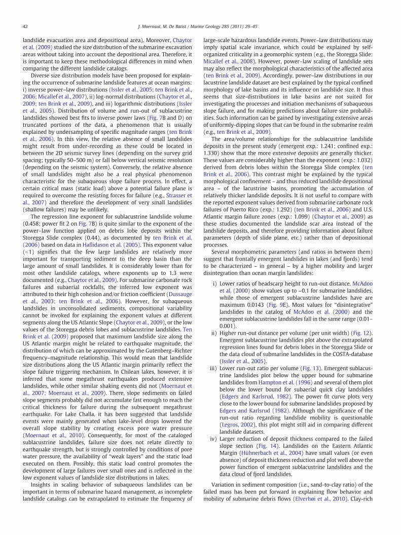
Diverse size distribution models have been proposed for explain-ing the occurrence of submarine landslide features at ocean margins:i) inverse power–law distributions (Issler et al., 2005; ten Brink et al.,2006; Micallef et al., 2007), ii) log-normal distributions (Chaytor et al.,2009; ten Brink et al., 2009), and iii) logarithmic distributions (Issleret al., 2005). Distribution of volume and run-out of sublacustrinelandslides showed best fits to inverse power laws (Fig. 7B and D) ontruncated portions of the data, a phenomenon that is usuallyexplained by undersampling of specific magnitude ranges (ten Brinket al., 2006). In this view, the relative absence of small landslidesmight result from under-recording as these could be located inbetween the 2D seismic survey lines (depending on the survey gridspacing; typically 50–500 m) or fall below vertical seismic resolution(depending on the seismic system). Conversely, the relative absenceof small landslides might also be a real physical phenomenoncharacteristic for the subaqueous slope failure process. In effect, acertain critical mass (static load) above a potential failure plane isrequired to overcome the resisting forces for failure (e.g., Strasser etal., 2007) and therefore the development of very small landslides(shallow failures) may be unlikely.
The regression line exponent for sublacustrine landslide volume(0.458; power fit 2 on Fig. 7B) is quite similar to the exponent of thepower–law function applied on debris lobe deposits within theStoregga Slide complex (0.44), as documented by ten Brink et al.(2006) based on data in Haflidason et al. (2005). This exponent value(b1) signifies that the few large landslides are relatively moreimportant for transporting sediment to the deep basin than thelarge amount of small landslides. It is considerably lower than formost other landslide catalogs, where exponents up to 1.3 weredocumented (e.g., Chaytor et al., 2009). For submarine carbonate rockfailures and subaerial rockfalls, the inferred low exponent wasattributed to their high cohesion and/or friction coefficient (Dussaugeet al., 2003; ten Brink et al., 2006). However, for subaqueouslandslides in unconsolidated sediments, compositional variabilitycannot be invoked for explaining the exponent values at differentsegments along the US Atlantic Slope (Chaytor et al., 2009), or the lowvalues of the Storegga debris lobes and sublacustrine landslides. TenBrink et al. (2009) proposed that maximum landslide size along theUS Atlantic margin might be related to earthquake magnitude, thedistribution of which can be approximated by the Gutenberg–Richterfrequency–magnitude relationship. This would mean that landslidesize distributions along the US Atlantic margin primarily reflect theslope failure triggering mechanism. In Chilean lakes, however, it isinferred that some megathrust earthquakes produced extensivelandslides, while other similar shaking events did not (Moernaut etal., 2007; Moernaut et al., 2009). There, slope sediments on failedslope segments probably did not accumulate fast enough to reach thecritical thickness for failure during the subsequent megathrustearthquake. For Lake Challa, it has been suggested that landslideevents were mainly generated when lake-level drops lowered theoverall slope stability by creating excess pore water pressure(Moernaut et al., 2010). Consequently, for most of the catalogedsublacustrine landslides, failure size does not relate directly toearthquake strength, but is strongly controlled by conditions of porewater pressure, the availability of “weak layers” and the static loadexecuted on them. Possibly, this static load control promotes thedevelopment of large failures over small ones and is reflected in thelow exponent values of landslide size distributions in lakes.
Insights in scaling behavior of subaqueous landslides can beimportant in terms of submarine hazard management, as incompletelandslide catalogs can be extrapolated to estimate the frequency of
large-scale hazardous landslide events. Power–law distributions mayimply spatial scale invariance, which could be explained by self-organized criticality in a geomorphic system (e.g., the Storegga Slide:Micallef et al., 2008). However, power–law scaling of landslide setsmay also reflect the morphological characteristics of the affected area(ten Brink et al., 2009). Accordingly, power–law distributions in ourlacustrine landslide dataset are best explained by the typical confinedmorphology of lake basins and its influence on landslide size. It thusseems that size-distributions in lake basins are not suited forinvestigating the processes and initiation mechanisms of subaqueousslope failure, and for making predictions about failure size probabil-ities. Such information can be gained by investigating extensive areasof uniformly-dipping slopes that can be found in the submarine realm(e.g., ten Brink et al., 2009).
The area/volume relationships for the sublacustrine landslidedeposits in the present study (emergent exp.: 1.241; confined exp.:1.330) show that the more extensive deposits are generally thicker.These values are considerably higher than the exponent (exp.: 1.032)derived from debris lobes within the Storegga Slide complex (tenBrink et al., 2006). This contrast might be explained by the typicalmorphological confinement – and thus reduced landslide depositionalarea – of the lacustrine basins, promoting the accumulation ofrelatively thicker landslide deposits. It is not useful to compare withthe reported exponent values derived from submarine carbonate rockfailures of Puerto Rico (exp.: 1.292) (ten Brink et al., 2006) and U.S.Atlantic margin failure zones (exp.: 1.099) (Chaytor et al., 2009) asthese studies documented the landslide scar area instead of thelandslide deposits, and therefore providing information about failureparameters (depth of slide plane, etc.) rather than of depositionalprocesses.
Several morphometric parameters (and ratios in between them)suggest that frontally emergent landslides in lakes (and fjords) tendto be characterized – in general – by a higher mobility and largerdisintegration than ocean margin landslides:
i) Lower ratios of headscarp height to run-out distance. McAdooet al. (2000) show values up to ~0.1 for submarine landslides,while those of emergent sublacustrine landslides have aremaximum 0.0143 (Fig. 9E). Most values for “disintegrative”landslides in the catalog of McAdoo et al. (2000) and theemergent sublacustrine landslides fall in the same range (0.01–0.001).
ii) Higher run-out distance per volume (per unit width) (Fig. 12).Emergent sublacustrine landslides plot above the extrapolatedregression lines found for debris lobes in the Storegga Slide orthe data cloud of submarine landslides in the COSTA-database(Issler et al., 2005).
iii) Lower run-out ratio per volume (Fig. 13). Emergent sublacus-trine landslides plot below the upper bound for submarinelandslides from Hampton et al. (1996) and several of them plotbelow the lower bound for subaerial quick clay landslides(Edgers and Karlsrud, 1982). The power fit curve plots veryclose to the lower bound for submarine landslides proposed byEdgers and Karlsrud (1982). Although the significance of therun-out ratio regarding landslide mobility is questionable(Legros, 2002), this plot might still aid in comparing differentlandslide datasets.
iv) Larger reduction of deposit thickness compared to the failedslope section (Fig. 14). Landslides on the Eastern AtlanticMargin (Hühnerbach et al., 2004) have small values (or evenabsence) of deposit thickness reduction and plot well above thepower function of emergent sublacustrine landslides and thedata cloud of fjord landslides.
Variation in sediment composition (i.e., sand-to-clay ratio) of thefailed mass has been put forward in explaining flow behavior andmobility of submarine debris flows (Elverhøi et al., 2010). Clay-rich
Volume per unit width (m2)
Run
-out
(m
)
Emergent - power fit:y = 29.40 x 0.526
R2 = 0.729
103
106
105
104
103
102
104 105 106 107 108101 102
Fig. 12. Run-out distance versus volume per unit width for (emergent) sublacustrinelandslides (black dots), and submarine landslides documented by Issler et al. (2005):COSTA project landslides (white squares) and Storegga debris flows (full line: powerfit; dashed line: upper and lower bounds). Note that (emergent) sublacustrinelandslides plot above the values for the Storegga debris flows. As the Storegga andCOSTA databases essentially consist of emergent landslides, confined sublacustrinelandslides are not plotted.
1 10 100
1
10
100
Thi
ckne
ss o
f unc
onfin
ed p
art (
m)
Headscarp height (m)
(A):D = 0.753 hEmergent sublacustrine:
0.641
R2= 0.288
D/h: 1
(A)
Fig. 14. Comparison of deposit thickness reduction in between (emergent) sublacus-trine landslides (black dots), fjord landslides (blue triangles) and ocean marginlandslides (green squares) (Hühnerbach et al., 2004). Ocean margin landslides plotabove the power fit of sublacustrine and fjord landslides.
43J. Moernaut, M. De Batist / Marine Geology 285 (2011) 29–45
cohesive material may achieve long run-out distances on even verygentle slopes due to hydroplaning of the head of the flow, while sand-rich debris flows may evolve into a bipartite flow due to particlesegregation. However, a wide range of compositions have been foundin the sediment sequences involved in failure at ocean margins, fjordsand lakes (Weaver et al., 2000; Cohen, 2003; Canals et al., 2004), andtherefore initial sediment composition does not explain the generaldifferences in mobility and disintegration found in between thesethree settings.
H/R
un-o
ut
Volume (m3)
1) Scheidegger2) Hampton et al.
4) E & K
3) E & K
5)
HigherMobility
LowerMobility
103 104
100
10-1
10-2
10-3
105 106 107 108 109 1010 1011 1012 1013
Fig. 13. Classical plot of run-out ratio versus volume for landslidemobility studies. Blackcircles: Frontally emergent sublacustrine landslides. Red and green circles: Westernand Eastern Atlantic submarine landslides (Hühnerbach et al., 2004). Blue circles andblue squares correspond to respectively non-volcanic and volcanic submarinelandslides derived from Hampton et al. (1996). 1) Average value for subaeriallandslides proposed by Scheidegger (1973). 2) Upper bound for submarine landslidesproposed by Hampton et al. (1996). 3 and 4) Lower bound values for submarinelandslides and subaerial quick clay slides proposed by Edgers and Karlsrud (1982). Notethat the power fit for sublacustrine landslides (5: full line) plots close to the lowerboundary for submarine landslides (3) proposed by Edgers and Karlsrud (1982).
Landslides in fjords and lake basins take place on rather similarslopemorphology. Both are characterized by relatively steep lateral ordeltaic slopes and a abrupt slope break towards a nearly flat basinplain, indicated by their median slope angles for deposition andexcavation areas (fjords: 0.625° and 5.5°; lakes: 0.4° and 6.1°).Submarine landslide catalogs showed a slightly negative correlationin between slope angle in the evacuation area and the run-outdistance (McAdoo et al., 2000; Hühnerbach et al., 2004). Also, theabrupt slope reduction at the edge of the basin-plain should provoke adeceleration of dense flows originating upslope, causing enhanceddeposition near the slope break (Mulder and Alexander, 2001b) andthus less material is available for achieving a long run-out distance.Therefore, the typical slope profile of lakes and fjords does notcontribute to (or even hampers) their high landslide mobility.
In general, sedimentation rates in fjords and lakes (typical-lyN1 mm/yr) are higher than at most ocean margins (Cohen, 2003)because of the direct sediment supply by inflowing river systems.Lacustrine and fjord sequences may therefore have a high watercontent and low consolidation values. The majority of catalogedsublacustrine landslides took place in lakes that are dominated by thedeposition of diatom frustules (Lake Challa: Verschuren et al., 2009;Chilean lakes: Bertrand et al., 2008; Moernaut et al., 2009), which arerenowned for their low degree of compaction (and thus high watercontent) during burial (Hamilton, 1976). As excavation depths in fjordand lacustrine landslides are relatively shallow (Table 1), thesediments involved in failure have a highly-unconsolidated nature.Contrarily, voluminous oceanmargin landslides have a relatively deepexcavation (McAdoo et al., 2000; Canals et al., 2004; Hühnerbach etal., 2004) and thusmight consist of more consolidated sediments withlarger shear strength. Thick ocean margin slope failures thereforerequire more energy to remold and transform (disintegrate) theinitial sedimentary sequences and hence less potential energy can betransformed in kinetic energy, resulting in a relatively lower run-outand mobility.
It has to be noted that the discriminative patterns inferred inbetween landslides at oceanmargins, fjords and lakes must be viewedfrom a general point. For example in some ocean margin landslidecases, very high landslide mobilities were found and were attributedto the highly-unconsolidated nature of the local source sediments, e.g.repeated failures in rapidly deposited glacial till at the Svalbard/Barents Sea margin (Dimakis et al., 2000; De Blasio et al., 2006).
44 J. Moernaut, M. De Batist / Marine Geology 285 (2011) 29–45
8. Conclusions
By combining seismostratigraphic case studies with statisticalanalyses of morphometric parameters of sublacustrine landslides, thisstudy has revealed valuable information regarding the frontaldevelopment andmobility of sublacustrine and submarine landslides:
1. Both frontally emergent and frontally confined landslides can takeplace on sublacustrine slopes, showing a continuous spectrum offrontal emplacement styles. Empirical data showed that thesubsurface depth of the basal shear surface and the height drop(H*) in between headscarp and frontal ramp are the mainmorphometric parameters determining the frontal emplacementstyle of landslides. These parameters essentially determine theheight of the center of gravity of the failingmasswith respect to thetop of the frontal ramp, and correspond to the potentialgravitational energy of the landslide versus the potential energyneeded to ramp out of its stratigraphic position. The absolutevalues for these parameters are predominantly controlled by theslope profile (length, gradient, slope breaks) and geotechnicalproperties of the sedimentary sequence. This implies a predictivebehavior for frontal emplacement style that is of key importance inthe assessment of submarine landslide hazards, such as thedevelopment of tsunamis or destructive high-velocity sedimentflows.
2. It is indispensable to separate frontally confined and emergentlandslides in statistical morphometric studies, as their respectivemechanisms of translation and emplacement are significantlydifferent. Although sublacustrine landslides mostly have smallerdimensions than their submarine counterparts, comparable re-lationships between morphometric parameters were revealed,albeit with some significant exceptions. Obvious correlationsemerged between volume-related parameters, while slope gradi-ents show poor correlations with most other parameters. Severallines of evidence reveal that frontally emergent landslides in lakes(and fjords) generally exhibit a larger mobility and disintegrationthan expected by extrapolating the empirical relationships derivedfrom ocean margin landslides. This could result from theirshallower excavation, so that relatively less-consolidated sedi-ments are involved in the mass-movement. Size distributions andthe area/volume ratio of sublacustrine landslide deposits stronglydeflect from the expected values, which is likely due to a strongmorphological control (i.e., the confinement of lacustrine basins)on the size of slope failures and the resulting landslide deposits.
The lacustrine environment can be regarded as an easily accessiblenatural laboratory in which landslide processes are subjected to lesslithological boundary conditions, but to more morphological controlthan landslides on ocean margins. Therefore, in some cases,systematic morphometric analysis can help to better understandsubaqueous landslide processes in general, and the frontal develop-ment of landslides in particular.
Supplementarymaterials related to this article can be found onlineat doi:10.1016/j.margeo.2011.05.001.
Acknowledgments
The seismic data that were used in this study have been acquiredby RCMG over the years by different field teams and in the context ofdifferent international partnerships and projects that were funded bydifferent funding agencies. We wish to thank: F. Anselmetti, D.Ariztegui, F. Arnaud, C. Beck, D. Boone, R. Brümmer, E. Chapron, F.Charlet, H. Corbella, K. De Rycker, A. Duchkov, T. Haberzettl, K.Heirman, P. Huyghe, Y. Imbo, J. Klerkx, S. Kolobova, V. Matychenkov, L.Naudts, R. Pagni, A. Peña, A. Peretyatko, M. Pino, V. Romanovsky, W.San Martin, V.S. Seleznev, R. Urrutia, T. Van Cauwenberghe, M. VanDaele, P. Van Damme, D. Verschuren, W. Versteeg, B. Zolitschka and
many others that were instrumental for the success of the seismicsurveys; and the Belgian Science Policy Office, FWO-Vlaanderen,Special Research Fund (BOF) of the Universiteit Gent, EC FrameworkProgramme 5, ESF (EuroCLIMATE Programme), INTAS, IPEV and theDFG for funding the field work. J. Moernaut was supported by theInstitute for the Promotion of Innovation through Science andTechnology in Flanders (IWT-Vlaanderen) and is currently fundedby the Research Foundation— Flanders (FWO).We gratefully thank D.Masson, F. Anselmetti and an anonymous reviewer for their verydetailed and constructive comments on an earlier version of thismanuscript.
References
Bartetzko, A., Kopf, A.J., 2007. The relationship of undrained shear strength and porositywith depth in shallow (b50 m)marine sediments. Sedimentary Geology 196 (1–4),235–249.
Bertrand, S., Charlet, F., Charlier, B., Renson, V., Fagel, N., 2008. Climate variability ofsouthern Chile since the Last Glacial Maximum: a continuous sedimentologicalrecord from Lago Puyehue (40°S). Journal of Paleolimnology 39, 179–195.
Bull, S., Cartwright, J., Huuse, M., 2009. A review of kinematic indicators from mass-transport complexes using 3D seismic data. Marine and Petroleum Geology 26 (7),1132–1151.
Callot, P., Odonne, F., Sempere, T., 2008. Liquification and soft-sediment deformation ina limestone megabreccia: the Ayabacas giant collapse, Cretaceous, southern Peru.Sedimentary Geology 212, 49–69.
Canals, M., Lastras, G., Urgeles, R., Casamor, J.L., Mienert, J., Cattaneo, A., De Batist, M.,Haflidason, H., Imbo, Y., Laberg, J.S., Locat, J., Long, D., Longva, O., Masson, D.G.,Sultan, N., Trincardi, F., Bryn, P., 2004. Slope failure dynamics and impacts fromseafloor and shallow sub-seafloor geophysical data: case studies from the COSTAproject. Marine Geology 213 (1–4), 9–72.
Chapron, E., 1999. Contrôles climatique et sismo-tectonique de la sedimentationlacustre dans l'Avant-Pays Alpin (lac du Bourget, Léman) Durant le Quaternairerecent. PhD Thesis, Université de Lille 1, 297 pp.
Chapron, E., Van Rensbergen, P., Beck, C., De Batist, M., Paillet, A., 1996. Lacustrinesedimentary records of brutal events in Lake Le Bourget (Northwestern Alps-Southern Jura). Quaternaire 7 (2–3), 155–168.
Chapron, E., Van Rensbergen, P., De Batist, M., Beck, C., Henriet, J.-P., 2004. Fluid-escapefeatures as a precursor of a large sublacustrine sediment slide in Lake Le Bourget,NW Alps, France. Terra Nova 16, 305–311.
Chaytor, J.D., Ten Brink, U.S., Solow, A.R., Andrews, B.D., 2009. Size distribution ofsubmarine landslides along the U.S. Atlantic Margin. Marine Geology 264, 16–27.
Cohen, A.S., 2003. Paleolimnology: The History and Evolution of Lake Systems. OxfordUniversity Press. 500 pp.
Crusius, J., Anderson, R.F., 1995. Sediment focusing in six small lakes inferred fromradionuclide profiles. Journal of Paleolimnology 13, 143–155.
Dan, G., Sultan, N., Savoye, B., Deverchere, J., Yelles, K., 2009. Quantifying the role ofsandy‐silty sediments in generating slope failures during earthquakes: examplefrom the Algerian margin. International Journal of Earth Sciences 98, 769–789.
Davis, J.C., 1986. Statistics and Data Analysis in Geology (2nd edition). John Wiley &Sons, Inc., New York. 646 pp.
De Blasio, F.V., Elverhøi, A., Engvik, L.E., Issler, D., Gauer, P., Harbitz, C., 2006.Understanding the high mobility of subaqueous debris flows. Norwegian Journal ofGeology 86, 275–284.
Dimakis, P., Elverhøi, A., Høeg, K., Solheim, A., Harbitz, C., Laberg, J.S., Vorren, T.O., Marr,J., 2000. Submarine slope stability on high-latitude glaciated Svalbard–Barents Seamargin. Marine Geology 162, 303–316.
Dussauge, C., Grasso, J.R., Helmstetter, A.S., 2003. Statistical analysis of rockfall volumedistributions: implications for rockfall dynamics. Journal of Geophysical Research-Solid Earth 108 (B6), 2286. doi:10.1029/2001JB000650.
Edgers, L., Karlsrud, K., 1982. Soil Flows Generated by Submarine Flows: Case Studiesand Consequences. NGI Publication 143. Norges Geotekniske Institutt, Oslo,Norway.
Elverhøi, A., Breien, H., De Blasio, F.V., Harbitz, C.B., Pagliardi, M., 2010. Submarinelandslides and the importance of the initial sediment composition for run-outlength and final deposit. Ocean Dynamics 60, 1027–1046.
Finckh, P., Kelts, K., Lambert, A., 1984. Seismic stratigraphy and bedrock forms inperialpine lakes. Geological Society of America Bulletin 95, 1118–1128.
Frey-Martinez, J., Cartwright, J., Hall, B., 2005. 3D seismic interpretation of slumpcomplexes: examples from the continental margin of Israel. Basin Research 17 (1),83–108.
Frey-Martinez, J., Cartwright, J., James, D., 2006. Frontally confined versus frontallyemergent submarine landslides: a 3D seismic characterization. Marine andPetroleum Geology 23 (5), 585–604.
Gafeira, J., Bulat, J., Evans, D., 2007. The southern flank of the Storegga Slide: imagingand geomorphological analyses using 3D seismic. In: Lykousis, V., Sakellariou, D.,Locat, J. (Eds.), Submarine Mass Movements and Their Consequences. SpringerNetherlands, pp. 57–65.
Gamberi, F., Rovere, M., Marani, M., 2011. Mass-transport complex evolution in atectonically active margin (Gioia Basin, Southeastern Tyrrhenian Sea). MarineGeology 279 (1–4), 98–110.
45J. Moernaut, M. De Batist / Marine Geology 285 (2011) 29–45
Gee, M.J.R., Gawthorpe, R.L., Friedmann, J.S., 2005. Giant striations at the base of asubmarine landslide. Marine Geology 214 (1–3), 287–294.
Green, A., Uken, R., 2008. Submarine landsliding and canyon evolution on the northernKwaZulu-Natal continental shelf, South Africa, SW Indian Ocean. Marine Geology254 (3–4), 152–170.
Haflidason, H., Lien, R., Sejrup, H.P., Forsberg, C.F., Bryn, P., 2005. The dating andmorphometry of the Storegga Slide. Marine and Petroleum Geology 22 (1–2),123–136.
Håkanson, L., Jansson, M., 2002. Principles of Lake Sedimentology (2nd edition). TheBlackburn Press, New Jersey. 316 pp.
Hamilton, E.L., 1976. Variations of density and porosity with depth in deep-seasediments. Journal of Sedimentary Petrology 46 (2), 280–300.
Harbitz, C.B., Løvholt, F., Pedersen, G., Masson, D.G., 2006. Mechanisms of tsunamigeneration by submarine landslides: a short review. Norwegian Journal of Geology86, 255–264.
Harders, R., Kutterolf, S., Hensen, C., 2010. Tephra layers: a controlling factor onsubmarine translational sliding? Geochemistry Geophysics Geosystems 11 (5).doi:10.1029/2009GC002844.
Hühnerbach, V., Masson, D.G., partners of the COSTA project, 2004. Landslides in theNorth Atlantic and its adjacent seas: an analysis of their morphology, setting andbehaviour. Marine Geology 213 (1–4), 343–362.
Huvenne, V.A.I., Croker, P.F., Henriet, J.-P., 2002. A refreshing 3D view of an ancientsediment collapse and slope failure. Terra Nova 14 (1), 33–40.
Issler, D., De Blasio, F.V., Elverhoi, A., Bryn, P., Lien, R., 2005. Scaling behaviour of clay-rich submarine debris flows. Marine and Petroleum Geology 22 (1–2), 187–194.
Karlin, R.E., Holmes, M., Abella, S.E.B., Sylwester, R., 2004. Holocene landslides and a3500-year record of Pacific Northwest earthquakes from sediments in LakeWashington. Geological Society of America Bulletin 116 (1–2), 94–108.
Lawrence, G.W.M., Cartwright, J.A., 2009. The initiation of sliding on the mid Norwaymargin of the Møre Basin. Marine Geology 259, 21–35.
Ledoux, G., Lajeunesse, P., Chapron, E., St-Onge, G., 2010. Multibeam bathymetryinvestigations of mass-movements in Lake Le Bourget (NW Alps, France) using aportable platform. In: Mosher, D.C., et al. (Ed.), Submarine Mass Movements andTheir Consequences. : Advances in Natural and Technological Hazards Research, 28.Springer Netherlands, pp. 423–434.
Legros, F., 2002. The mobility of long-runout landslides. Engineering Geology 63,301–331.
Leynaud, D., Sultan, N., Mienert, J., 2007. The role of sedimentation rate andpermeability in the slope stability of the formerly glaciated Norwegian continentalmargin: the Storegga Slide model. Landslides 4 (4), 297–309.
Micallef, A., Berndt, C., Masson, D.G., Stow, D.A.V., 2007. Fractal statistics of the StoreggaSlide. In: Lykousis, V., Sakellariou, D., Locat, J. (Eds.), Submarine Mass Movementsand Their Consequences. Springer Netherlands, pp. 3–10.
Micallef, A., Berndt, C., Masson, D.G., Stow, D.A.V., 2008. Scale invariant characteristicsof the Storegga Slide and implications for large-scale submarine mass movements.Marine Geology 247 (1–2), 46–60.
Moernaut, J., De Batist, M., Charlet, F., Heirman, K., Chapron, E., Pino, M., Brummer, R.,Urrutia, R., 2007. Giant earthquakes in South-Central Chile revealed by Holocenemass-wasting events in Lake Puyehue. Sedimentary Geology 195 (3–4), 239–256.
Moernaut, J., De Batist, M., Heirman, K., Van Daele, M., Pino, M., Brummer, R., Urrutia, R.,2009. Fluidization of buried mass-wasting deposits in lake sediments and itsrelevance for paleoseismology: results from a reflection seismic study of lakesVillarrica and Calafquén (South-Central Chile). Sedimentary Geology 213 (3–4),121–135.
Moernaut, J., Verschuren, D., Charlet, F., Kristen, I., Fagot, M., De Batist, M., 2010. Theseismic-stratigraphic record of lake-level fluctuations in Lake Challa: hydrologicalstability and change in equatorial East Africa over the last 140 kyr. Earth andPlanetary Science Letters 290 (1–2), 214–223.
Mulder, T., Alexander, J., 2001a. The physical character of subaqueous sedimentarydensity flows and their deposits. Sedimentology 48 (2), 269–299.
Mulder, T., Alexander, J., 2001b. Abrupt change in slope causes variation in the depositthickness of concentrated particle-drivendensity currents.MarineGeology 175 (1–4),221–235.
Mulder, T., Cochonat, P., 1996. Classification of offshore mass movements. Journal ofSedimentary Research 66, 43–57.
Nardin, T.R., Hein, F.J., Gorsline, D.S., Edwards, B.D., 1979. A review of mass movementprocesses, sediment and acoustical characteristics, and contrasts in slope and baseof slope systems versus canyon fed basin floor systems. In: Doyle, L.J., Pilkey, O.H.(Eds.), Geology of Continental Slopes: Society of Economic Paleontologists andMineralogists Special Publications, 27, pp. 61–73.
Normark, W.R., McGann, M., Sliter, R., 2004. Ages of Palos Verdes submarine debrisavalanche, southern California. Marine Geology 203 (3–4), 247–259.
Piper, D.J.W., Shor, A.N., Hughes-Clarke, J.E., 1988. The 1929 Grand Banks earthquake,slump and turbidity current. In: Clifton, H.E. (Ed.), Sedimentologic Consequencesof Convulsive Geologic Events: Special Paper Geological Society of America, 229,pp. 77–92.
Scheidegger, A.E., 1973. On the prediction of the reach and velocity of catastrophiclandslides. Rock Mechanics and Rock Engineering 5, 231–236.
Schnellmann, M., Anselmetti, F.S., Giardini, D., McKenzie, J.A., Ward, S.N., 2002.Prehistoric earthquake history revealed by lacustrine slump deposits. Geology30 (12), 1131–1134.
Schnellmann, M., Anselmetti, F.S., Giardini, D., McKenzie, J.A., 2005. Mass movement-induced fold-and-thrust belt structures in unconsolidated sediments in LakeLucerne (Switzerland). Sedimentology 52 (2), 271–289.
Schnellmann, M., Anselmetti, F.S., Giardini, D., McKenzie, J.A., 2006. 15,000 years ofmass-movement history in Lake Lucerne: implications for seismic and tsunamihazards. Eclogae Geologicae Helvetiae 99 (3), 409–428.
Scholz, C.A., Karp, T., Brooks, K.M., Milkereit, B., Amoako, P.Y.O., Arko, J.A., 2002.Pronounced central uplift identified in the Bosumtwi impact structure, Ghana,using multichannel seismic reflection data. Geology 30 (10), 939–942.
Solheim, A., Berg, K., Forsberg, C.F., Bryn, P., 2005. The Storegga Slide complex:repetitive large scale sliding with similar cause and development. Marine andPetroleum Geology 22 (1–2), 97–107.
Strachan, L., 2002. Geometry to genesis: a comparative field study of submarine slumpdeposits and their modes of formation. PhD thesis, Cardiff and Imperial College(UK). 412 pp.
Strasser, M., Anselmetti, F.S., Fah, D., Giardini, D., Schnellmann, M., 2006. Magnitudesand source areas of large prehistoric northern Alpine earthquakes revealed by slopefailures in lakes. Geology 34 (12), 1005–1008.
Strasser, M., Stegmann, S., Bussmann, F., Anselmetti, F.S., Rick, B., Kopf, A., 2007.Quantifying subaqueous slope stability during seismic shaking: Lake Lucerne asmodel for ocean margins. Marine Geology 240 (1–4), 77–97.
ten Brink, U.S., Geist, E.L., Andrews, B.D., 2006. Size distribution of submarine landslidesand its implication to tsunami hazard in Puerto Rico. Geophysical Research Letters33, L11307. doi:10.1029/2006GL026125.
ten Brink, U.S., Barkan, R., Andrews, B.D., Chaytor, J.D., 2009. Size distributions andfailure initiation of submarine and subaerial landslides. Earth and Planetary ScienceLetters 287, 31–42.
Trincardi, F., Argnani, A., 1990. Gela submarine slide — a major basin-wide event in thePlio-Quaternary foredeep of Sicily. Geo-Marine Letters 10 (1), 13–21.
Tripsanas, E.K., Piper, D.J.W., Jenner, K.A., Bryant, W.R., 2008. Submarinemass-transportfacies: new perspectives on flow processes from cores on the eastern NorthAmerican margin. Sedimentology 55 (1), 97–136.
Van Rensbergen, P., De Batist, M., Beck, C., Chapron, E., 1999. High-resolution seismicstratigraphy of glacial to interglacial fill of a deep glacigenic lake: Lake Le Bourget,Northwestern Alps, France. Sedimentary Geology 128, 99–129.
Verschuren, D., Sinninghe Damsté, J.S., Moernaut, J., Kristen, I., Blaauw, M., Fagot, M.,Haug, G.H., CHALLACEA project members, 2009. Half-precessional dynamics ofmonsoon rainfall near the East African equator. Nature 462, 637–641.
Waldmann, N., Ariztegui, D., Anselmetti, F.S., Austin, J.A., Dunbar, R., Moy, C.M.,Recasens, C., 2008. Seismic stratigraphy of Lago Fagnano sediments (Tierra delFuego, Argentina) — a potential archive of paleoclimatic change and tectonicactivity since the Late Glacial. Geologica Acta 6 (1), 101–110.
Weaver, P.P.E., Wynn, R.B., Kenyon, N.H., Evans, J., 2000. Continental marginsedimentation, with special reference to the north-east Atlantic margin. Sedimen-tology 47 (1), 239–256.