Cody Interagency Dispatch Center 2501 Wright Bros Dr. Cody, WY 82414 Office: 307-578-5740 Fax: 307-578-5759 This guide is intended to familiarize you with the organization and local aviation operating procedures in the Cody Dispatch Zone. Contained within this guide is information relating to: General Organization pg 2 Aviation Contacts pg 3 Cody Dispatch Zone Map pg 4 Operations Aviation Operations pg 8 Initial Response Operations/Protocol pg 9 Flight Following Procedures pg 11 Operational Environment Agency Helispots pg 13 Aerial Supervision Requirements pg 14 Helicopter Ordering Guide pg 15 Incident Management Teams pg 16 Preventing Spread of Aquatic Species pg 17 Fire Traffic Area (FTA) pg 20 Airspace/ Flight Planning pg 22 Weather/Topography pg 23 Hazards pg 25 Communications pg 26 Lodging/ Meals pg 32 Emergency Information pg 34 Appendix A 1
Transcript
Cody Interagency Dispatch Center 2501 Wright Bros Dr.
This guide is intended to familiarize you with the organization and local aviation operating procedures in the Cody Dispatch Zone. Contained within this guide is information relating to:
Operational EnvironmentAgency Helispots pg 13Aerial Supervision Requirements pg 14Helicopter Ordering Guide pg 15Incident Management Teams pg 16Preventing Spread of Aquatic Species pg 17Fire Traffic Area (FTA) pg 20Airspace/ Flight Planning pg 22Weather/Topography pg 23Hazards pg 25Communications pg 26
Lodging/ Meals pg 32
Emergency Information pg 34
Appendix A Airport/Seat Base Info. pg 40
GENERAL
ORGANIZATIONThe Cody Interagency Dispatch Center area of influence is comprised of four federal agencies, BLM, USFS, NPS, and BIA, ten Wyoming Counties and the Wyoming State Division of Forestry. The mission of this organization is to provide safe, cost effective, and timely response of fire and aviation resources for wildland fires and other emergency management activities.
1
The Cody Interagency Dispatch Center (CDC) provides support for the following units:
Bureau of Land ManagementWind River/Bighorn Basin District
U.S. Forest ServiceShoshone National ForestBighorn National Forest
National Park ServiceBighorn Canyon National Recreation Area
Bureau of Indian Affairs Wind River Agency
Bighorn County Carbon County Fremont County Hot Springs County Johnson County Natrona County Park County Sheridan County Sweetwater County Washakie County Wyoming State Division of Forestry
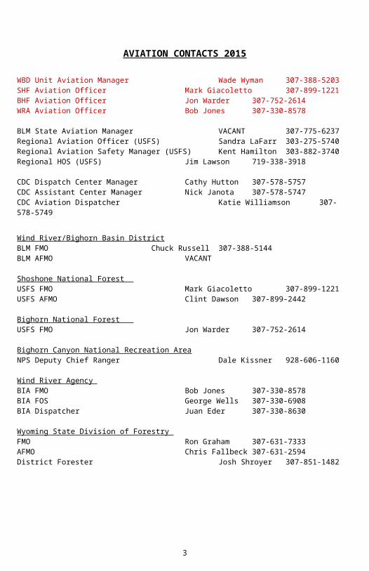
AVIATION CONTACTS 2015
WBD Unit Aviation Manager Wade Wyman 307-388-5203SHF Aviation Officer Mark Giacoletto 307-899-1221BHF Aviation Officer Jon Warder 307-752-2614WRA Aviation Officer Bob Jones 307-330-8578
BLM State Aviation Manager VACANT 307-775-6237Regional Aviation Officer (USFS) Sandra LaFarr 303-275-5740Regional Aviation Safety Manager (USFS) Kent Hamilton 303-882-3740Regional HOS (USFS) Jim Lawson 719-338-3918
CDC Dispatch Center Manager Cathy Hutton 307-578-5757CDC Assistant Center Manager Nick Janota 307-578-5747CDC Aviation Dispatcher Katie Williamson 307-578-5749
Wind River/Bighorn Basin District
2
BLM FMO Chuck Russell 307-388-5144 BLM AFMO VACANT
Shoshone National Forest USFS FMO Mark Giacoletto 307-899-1221USFS AFMO Clint Dawson 307-899-2442
Bighorn National Forest USFS FMO Jon Warder 307-752-2614
Wind River Agency BIA FMO Bob Jones 307-330-8578BIA FOS George Wells 307-330-6908BIA Dispatcher Juan Eder 307-330-8630
Wyoming State Division of Forestry FMO Ron Graham 307-631-7333AFMO Chris Fallbeck 307-631-2594District Forester Josh Shroyer 307-851-1482
3
4
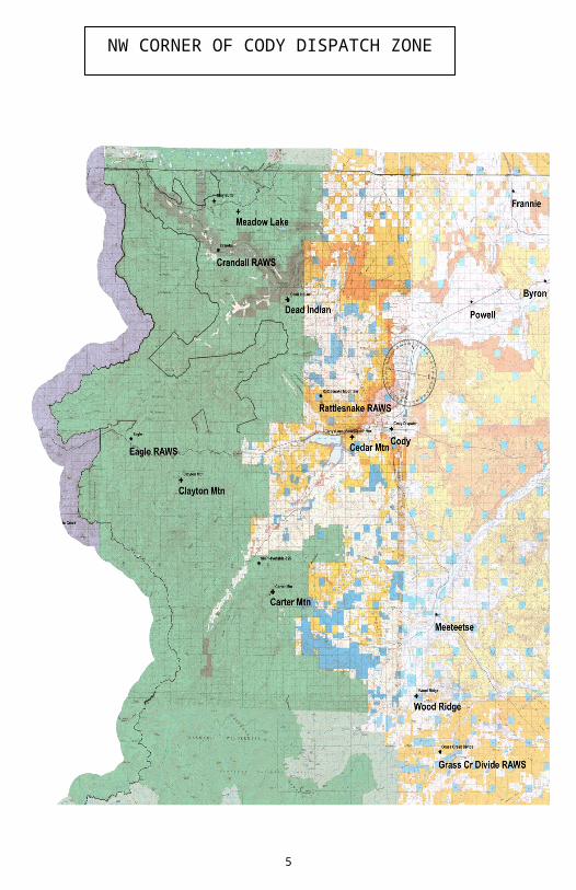
NW CORNER OF CODY DISPATCH ZONE
5
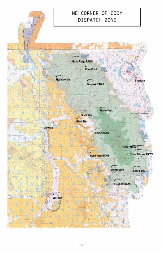
NE CORNER OF CODY DISPATCH ZONE
6
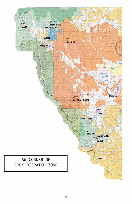
SW CORNER OF CODY DISPATCH ZONE
7
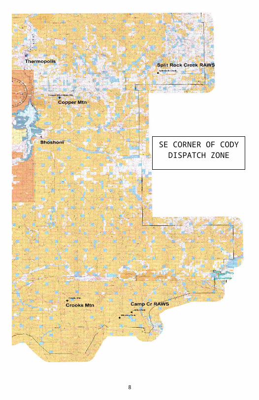
SE CORNER OF CODY DISPATCH
ZONE
OPERATIONSAVIATION OPERATIONSAviation assets in Northwest Wyoming are dispatched out of the Cody Interagency Dispatch Center (CDC). Aviation resources will be dispatched based upon the “Closest Forces Policy”, regardless of agency affiliation.
Dispatch Center is operational 7 days a week during fire season.Normal operating hours: 0730-1800
Aircraft hours of operations: 0900-1800 (pre-flights completed and ready to fly at 0900), hours could be extended on either end by management.
A copy of all Aircraft Daily Cost sheets MUST be submitted to the Aircraft Dispatcher for all fire and non-fire flights. Submit costs to: [email protected]
Aircraft managers must call into Cody Dispatch every morning and evening upon going in service and out of service. Information on status should be relayed at that time, such as upcoming pilot/crew swaps, mandatory days off, scheduled maintenance due on aircraft, needs, issues, etc. Cody Dispatch needs to be notified immediately of any maintenance or mechanical issues that take the aircraft out of service.
Aircraft managers are expected to be at or call into the daily briefing at 0930 when zone planning level reaches High to Extreme. Morning briefing will consist of:
*In addition to the morning briefing call, the Aircraft Dispatcher will email/fax a copy of the Large Incident Aircraft Status Summary page to all FMO’s, Aviation Overhead, Duty Officers, and bordering dispatch centers.
All personnel must be prepared to stay at a different location than where they originated from. This means taking your jammies with you every day!
You are expected to be self-sufficient and on per diem. If this is a problem contact the Aviation Manger/Dispatch Center Manager immediately so arrangements can be made.
Upon demobilization, a flight plan is required by dispatch. This should include all legs of the flight; identify type of flight following, if FAA flight plan has also been filed, manifest of personnel on board, and travel information for any support/chase vehicles.
SAFECOM: It is expected that a Safecom will be filed to report any condition, observation, act, maintenance problem, or circumstance with personnel or the aircraft
that has the potential to cause an aviation related mishap. Notify the Aircraft Desk or Unit Aviation Officer on any Safecom submittals.
INITIAL RESPONSE OPERATIONS/PROTOCOL All orders for aviation assets will come through the Cody Interagency Dispatch
Center Information concerning the assignment will be relayed to the appropriate
Aircraft Manager by the Aircraft Dispatcher All aircraft and crews are expected to be IA ready and in the air within 15
minutes of notification of assignment The Aircraft Manager will provide an estimated off time for the aircraft The pilot/manager will contact the dispatch center once in the air and provide
flight information as appropriate (ie: ETE, FOB, SOB) The IA (Incident Action) number will be used in communications referencing the
fire until the fire has been named and then the fire name will be used While enroute to an incident, do not deviate to check out another smoke – there
may already be aircraft over that incident or responding to it – notify dispatch of the smoke and only go there if directed to do so by dispatch
If you are the first resource on scene – provide a size-up to dispatch as soon as possible
•Do not use any catchment type (reservoir or pond) water source without prior approval from the AFMO, FMO, or Dispatch unless it is a life safety issue. Make sure you document such decisions. If you spot a good water source and would like to use it, provide dispatch with a location (lat/long) Dispatch will contact the appropriate jurisdictional fire authority for permission.
Wyoming Dispatch Centers’ Border Pilot BriefingThe boundary between adjacent dispatch centers has the potential for conflicted airspace when more than one dispatch center dispatches aviation resources to the common corridor. The common corridor, for purposes of airspace de-confliction, is defined as the area 5 statute miles on either side of the boundary line. Cody Interagency Dispatch Center shares boundaries with:
Billings Interagency Dispatch Center to the Northeast Rawlins Interagency Dispatch Center to the South Casper Interagency Dispatch Center to the East Bozeman Interagency Dispatch Center to the Northwest Teton Dispatch Center to the West Yellowstone Dispatch Center to the West-Northwest
9
To provide better aircraft coordination and safety along Wyoming dispatch centers' borders, the following will be followed:
When flying in the areas near dispatch center and state line borders and you see a smoke column:
o DO NOT divert to the smoke. - There may be other aircraft responding or enroute to the area.
Contact the dispatch center you are currently flight following with BEFORE either crossing the border or entering within the 12nm Fire Traffic Area (FTA) limit for that column. Cody Dispatch will contact the dispatch center responsible for that area and acquire information to ensure there are no aircraft present and your services are needed or desired. Also, as applicable, they will provide both the center and you (the aircraft) with necessary contact and response information.
FLIGHT FOLLOWING PROCEDURES
AVIATION PROCEDURES
All flight following will be handled through the Cody Dispatch Center for all tactical fire missions. The standard 15-minute check-in period will be followed, NO EXCEPTIONS!
If aircraft are equipped with automated flight following, then the 15-minute tracking will be done by computer with an “ops normal” check every 30 minutes unless otherwise negotiated with dispatch. The aircraft dispatcher and pilot must agree to which method of flight following will take place (15 min radio check-ins or AFF ops normal).
Pilots must monitor at least one predetermined radio frequency as an alternate means of flight following in the event the AFF system fails in the aircraft or in dispatch, or in case dispatch needs to cancel a mission, divert the aircraft to a higher priority incident, or relay other critical information regarding hazardous weather, TFRs, etc.
Regardless of AFF being used, radio communications must be maintained with all aircraft which the dispatcher has agreed to flight follow. To and from the tanker bases the dispatch center will flight follow using the National Flight Following frequency or automated flight following if available.
10
Emergency in-flight communications will utilize National Air Guard. When using these frequencies, be sure to identify: Cody Dispatch Flight Follow, etc., as other dispatch centers in the area are using the same frequency and they may think you are calling them.
The flight following frequency is to be used only when transporting tactical aircraft from another area to our local area or vice-versa. As soon as feasible, switch all communications over to the identified tactical frequency. This could be a dedicated Air to Ground or the local radio net.
Note: Incident Management Teams are required to request their own discrete tactical frequencies for their incident. Unless mutually agreed upon during the Delegation of Authority, the Dispatch Office will flight follow all tactical aircraft to and from the incident. Once on scene, the aviation resources become the responsibility of the incident management team.
The Aviation Hazard Map is updated annually. You are encouraged to either stop by the dispatch center to review the map prior to commencing flight operations and/or the local Unit Aviation Manager/Officer will provide you with a pilot hazard map.
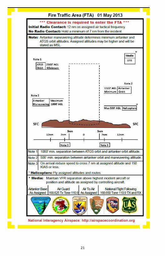
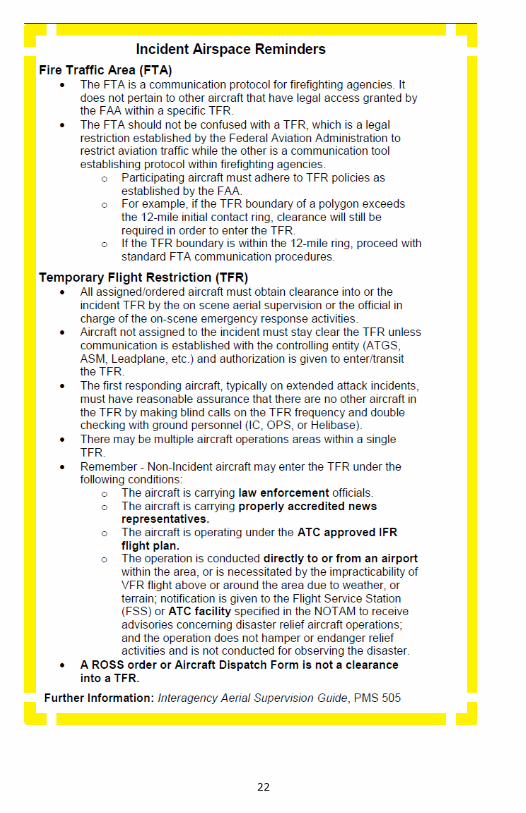
Air Operations within the Rocky Mountain Area will operate utilizing the Fire Traffic Area (FTA) scheme. See the FTA Diagram on page 19 of this guide.
All aviation incidents and accidents will be reported to the dispatch center immediately to ensure the proper procedures are implemented. A Safecom will be required and a copy provided to the Unit Aviation Officer and/or Aircraft Dispatcher within 24 hours of the incident.
Cody Interagency Dispatch Center utilizes BLM and USFS radio systems for communications. Regardless of the jurisdiction of an incident, any of the repeaters may be used to communicate with dispatch. Radio relays are a viable option when encountering dead areas in the radio system.
While on an incident, communications will be maintained with dispatch at all times. If communications cannot be established and maintained, resources will disengage, unless otherwise approved by the Fire Management Officer or Duty Officer.
11
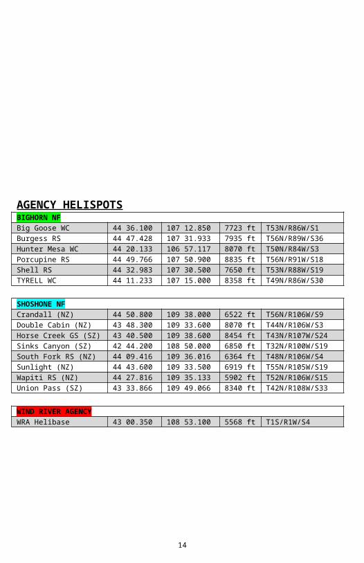
AGENCY HELISPOTSBIGHORN NFBig Goose WC 44 36.100 107 12.850 7723 ft T53N/R86W/S1Burgess RS 44 47.428 107 31.933 7935 ft T56N/R89W/S36Hunter Mesa WC 44 20.133 106 57.117 8070 ft T50N/R84W/S3Porcupine RS 44 49.766 107 50.900 8835 ft T56N/R91W/S18Shell RS 44 32.983 107 30.500 7650 ft T53N/R88W/S19TYRELL WC 44 11.233 107 15.000 8358 ft T49N/R86W/S30
SHOSHONE NFCrandall (NZ) 44 50.800 109 38.000 6522 ft T56N/R106W/S9Double Cabin (NZ) 43 48.300 109 33.600 8070 ft T44N/R106W/S3Horse Creek GS (SZ) 43 40.500 109 38.600 8454 ft T43N/R107W/S24Sinks Canyon (SZ) 42 44.200 108 50.000 6850 ft T32N/R100W/S19South Fork RS (NZ) 44 09.416 109 36.016 6364 ft T48N/R106W/S4Sunlight (NZ) 44 43.600 109 33.500 6919 ft T55N/R105W/S19Wapiti RS (NZ) 44 27.816 109 35.133 5902 ft T52N/R106W/S15Union Pass (SZ) 43 33.866 109 49.066 8340 ft T42N/R108W/S33
WIND RIVER AGENCYWRA Helibase 43 00.350 108 53.100 5568 ft T1S/R1W/S4
12
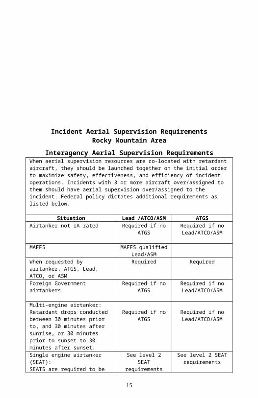
Incident Aerial Supervision RequirementsRocky Mountain Area
Interagency Aerial Supervision Requirements When aerial supervision resources are co-located with retardant aircraft, they should be launched together on the initial order to maximize safety, effectiveness, and efficiency of incident operations. Incidents with 3 or more aircraft over/assigned to them should have aerial supervision over/assigned to the incident. Federal policy dictates additional requirements as listed below.
Situation Lead /ATCO/ASM ATGSAirtanker not IA rated Required if no
ATGSRequired if no
Lead/ATCO/ASM
MAFFS MAFFS qualified Lead/ASM
When requested by airtanker, ATGS, Lead, ATCO, or ASM
Required Required
Foreign Government airtankers Required if no ATGS
Required if no Lead/ATCO/ASM
Multi-engine airtanker:Retardant drops conducted between 30 minutes prior to, and 30 minutes after sunrise, or 30 minutes prior to sunset to 30 minutes after sunset.
Required if no ATGS
Required if no Lead/ATCO/ASM
Single engine airtanker (SEAT):SEATS are required to be “on the ground” by ½ hour after sunset.
See level 2 SEAT requirements
See level 2 SEAT requirements
Level 2 SEAT requirements:Level 2 rated SEAT operating over an incident with more than one other tactical aircraft on scene.
Required if no ATGS
Required if no Lead/ATCO/ASM
Retardant drops in congested/urban interface areas.
Order May use if no Lead/ATCO/ASM
Periods of marginal weather, poor visibility, or turbulence.
Order Order
NOTE: Aerial Supervision Modules may act as either a Lead Plane or ATGS depending on incident requirements and other regional/national priorities.
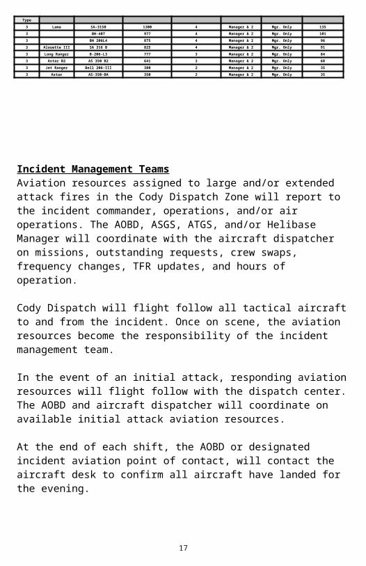
1 Super Puma AS-332-L 3,415 17 Manager & 4 Mgr. Only 250
1 Vertol BV-107-II 3,325 N/A Mgr. Only 353
1 Vertol KV-107-II 3231 N/A Mgr. Only 352
1 S-61A 3,222 N/A Mgr. Only 343
1 S-61L 2,707 N/A Mgr. Only 280
Below this line, type 2 performance may be better than type 1, consider ordering type 2.1 S-61N 1,899 N/A Mgr. Only 183
1 H-43 1,173 N/A Mgr. Only 121
Type2 B-214-B 2,630 13 Manager & 3 Mgr. Only 296
2 Super 205 B-205-A-1++ 2,196 9 Manager & 3 Mgr. Only 244
2 B-UH-IH-703 2,196 N/A Mgr. Only 244
2 B-212-HP 1,743 8 Manager & 3 Mgr. Only 189
2 B-UH-1H-CB 1307 N/A Mgr. Only 137
2 B-212 1,304 6 Manager & 3 Mgr. Only 136
2 B-U/TH-1L/-IK 1,208 N/A Mgr. Only 126
2 B-UH-1F 1207 N/A Mgr. Only 126
2 B-412-EP-9 1,070 5 Manager & 3 Mgr. Only 108
2 B-205-A-1+ 957 4 Manager & 3 Mgr. Only 95
Below this line, type 3 performance may be better than type 2, consider ordering type 3.2 B-UH-1B-13 825 N/A Mgr. Only 80
2 B-UH-1B 825 N/A Mgr. Only 80
2 B-412 803 4 Manager & 3 Mgr. Only 76
2 S-58-T 650 3 Manager & 3 Mgr. Only 57
2 B-205-A-1 599 2 Manager & 3 Mgr. Only 52
2 S-58-E 473 2 Manager & 3 Mgr. Only 38
2 B-UH-1H 0 N/A Mgr. Only -
2 B-204-B 0 N/A Manager & 3 Mgr. Only -
Type
3 Lama SA-315B 1300 4 Manager & 2 Mgr. Only 135
3 BH-407 977 4 Manager & 2 Mgr. Only 101
3 BH 206L4 875 4 Manager & 2 Mgr. Only 96
3 Alouette III SA 316 B 825 4 Manager & 2 Mgr. Only 91
3 Long Ranger B-206-L3 777 3 Manager & 2 Mgr. Only 84
3 Astar B2 AS 350 B2 641 3 Manager & 2 Mgr. Only 68
3 Jet Ranger Bell 206-III 380 2 Manager & 2 Mgr. Only 35
3 Astar AS-350-BA 350 2 Manager & 2 Mgr. Only 35
Incident Management TeamsAviation resources assigned to large and/or extended attack fires in the Cody Dispatch Zone will report to the incident commander, operations, and/or air operations. The AOBD, ASGS, ATGS, and/or Helibase Manager will coordinate with the aircraft
14
dispatcher on missions, outstanding requests, crew swaps, frequency changes, TFR updates, and hours of operation.
Cody Dispatch will flight follow all tactical aircraft to and from the incident. Once on scene, the aviation resources become the responsibility of the incident management team.
In the event of an initial attack, responding aviation resources will flight follow with the dispatch center. The AOBD and aircraft dispatcher will coordinate on available initial attack aviation resources.
At the end of each shift, the AOBD or designated incident aviation point of contact, will contact the aircraft desk to confirm all aircraft have landed for the evening.
Preventing Spread of Aquatic Invasive OrganismsFirefighter and public safety is still the first priority, but aquatic invasive plants and animals pose a risk to both the environment and to firefighting equipment. The following guidelines were developed to help avoid the spread of aquatic invasive species:
Avoid contacting mud and aquatic plants in any body of water.
Avoid transferring water between drainages or between unconnected waters within the same drainage. Avoid dumping water directly from one stream or lake into another.
15
Avoid sucking organic and bottom material into water intakes when drafting or dipping from streams or ponds.
Avoid obtaining water from multiple sources during a single operational period unless drafting/dipping equipment is sanitized between sources.
If contamination of gear with raw or mud/plants is unavoidable make sure all equipment that comes into contact with raw water is sanitized.
Establish sanitation areas where there is no potential for runoff into waterways, storm drains, or sensitive habitats.
Treating a bucket or other water carrying device with chemicals is recommended to kill any aquatic invasive species. Approved chemicals (Quat based) and equipment are available from three offices within the dispatch zone (Cody, Worland, Sheridan) by contacting the Duty Officer.
If a vendor has their own supply, clean the equipment in an area that will not harm the environment. Avoid areas where there is potential runoff into waterways, storm drains, or sensitive habitats.
PAYMENTForest Service Payment - Aviation Business System (ABS)https://apps.fs.usda.gov/cfo/ibs/aviation
DOI Payment – OAS 23Ewww.doi.gov/aviation/library/forms.cfm
GUIDES & MANUALSInteragency Standards for Fire & Aviation Operations (Redbook)http://www.nifc.gov/policies/pol_ref_redbook.htmlDOI Field Reference Guide for Aviation Usershttp://www.doi.gov/aviation/library/guides_index.cfm
Forest Service 5700 Manual – Aviation Managementhttp://www.fs.fed.us/fire/aviation/av_library/
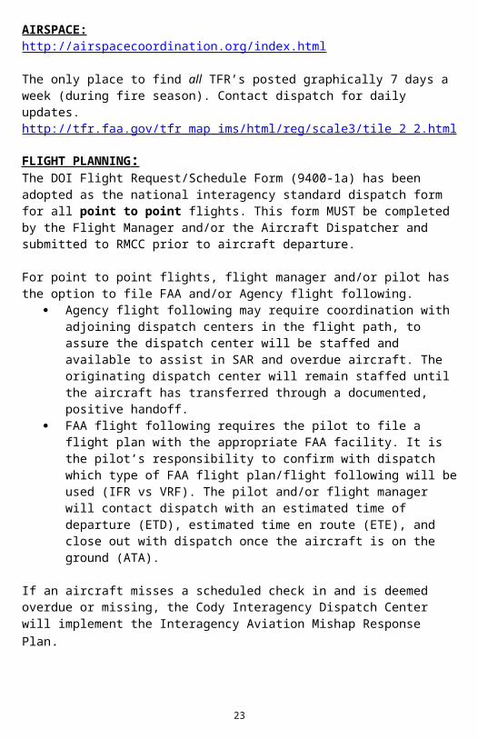
The only place to find all TFR’s posted graphically 7 days a week (during fire season). Contact dispatch for daily updates. http://tfr.faa.gov/tfr_map_ims/html/reg/scale3/tile_2_2.html
FLIGHT PLANNING : The DOI Flight Request/Schedule Form (9400-1a) has been adopted as the national interagency standard dispatch form for all point to point flights. This form MUST be completed by the Flight Manager and/or the Aircraft Dispatcher and submitted to RMCC prior to aircraft departure.
For point to point flights, flight manager and/or pilot has the option to file FAA and/or Agency flight following.
Agency flight following may require coordination with adjoining dispatch centers in the flight path, to assure the dispatch center will be staffed and available to assist in SAR and overdue aircraft. The originating dispatch center will remain staffed until the aircraft has transferred through a documented, positive handoff.
FAA flight following requires the pilot to file a flight plan with the appropriate FAA facility. It is the pilot’s responsibility to confirm with dispatch which type of FAA flight plan/flight following will be used (IFR vs VRF). The pilot and/or flight manager will contact dispatch with an estimated time of departure (ETD), estimated time en route (ETE), and close out with dispatch once the aircraft is on the ground (ATA).
If an aircraft misses a scheduled check in and is deemed overdue or missing, the Cody Interagency Dispatch Center will implement the Interagency Aviation Mishap Response Plan.
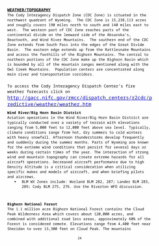
WEATHER/TOPOGRAPHYThe Cody Interagency Dispatch Zone (CDC Zone) is situated in the northwest quadrant of Wyoming. The CDC Zone is 15,238,113 acres and roughly covers 190 miles north to south and 140 miles east to west. The western part of CDC Zone reaches parts of the continental divide on the leeward side of the Absaroka’s, Beartooth, and Wind River Mountains. The southern end of the CDC Zone extends from South Pass into the edges of the Great Divide Basin. The eastern edge extends up from the Rattlesnake Mountains and across the foothills of the Bighorn Mountains. The central to northern portions of the CDC Zone make up the Bighorn Basin which is bounded by all of the mountain ranges mentioned along with the Owl Creek Mountains. Population centers are concentrated along main river and transportation corridors.
To access the Cody Interagency Dispatch Center’s fire weather forecasts click on http://gacc.nifc.gov/rmcc/dispatch_centers/r2cdc/predictive/weather/weather.htmWind River/Big Horn Basin DistrictAviation operations in the Wind River/Big Horn Basin District are typically conducted over a variety of terrain with elevations ranging from 5,000 feet to 12,000 feet above sea level. Typically, climate conditions range from hot, dry summers to cold winters with heavy snowfall. Afternoon thunderstorms develop frequently and suddenly during the summer months. Parts of Wyoming are known for the extreme wind conditions that persist for several days or weeks during certain times of the year. The interaction of strong wind and mountain topography can create extreme hazards for all aircraft operations. Decreased aircraft performance due to high Density Altitude is a critical consideration when utilizing specific makes and models of aircraft, and when briefing pilots and aircrews.
BLM WX Zones include: Worland BLM 282, 287; Lander BLM 283, 289; Cody BLM 275, 276. Use the Riverton WFO discussion.
Bighorn National ForestThe 1.1 million acre Bighorn National Forest contains the Cloud Peak Wilderness Area which covers about 120,000 acres, and combined with additional road less areas, approximately 60% of the Forest is considered remote. Elevations range from 4,400 feet near Sheridan to over 13,300 feet on Cloud Peak. The mountains typically have cooler temperatures and stronger winds than the adjacent lowlands where most airports are located. Strong winds frequently form and are channeled where mountain ranges block the movement of high and low pressure systems creating strong pressure gradients. Significant thermal variations and temperature gradients form between the mountains and valleys creating significant hazards to aviation that include turbulence, lee-side mountain wave and rotor conditions, occasional severe thunderstorms, and high density altitude conditions.
Bighorn NF WX Zone consists of 284 using the Billings WFO discussion.
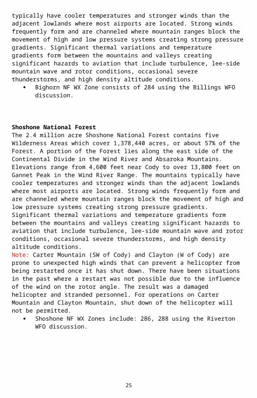
Shoshone National ForestThe 2.4 million acre Shoshone National Forest contains five Wilderness Areas which cover 1,378,440 acres, or about 57% of the Forest. A portion of the Forest lies along the east side of the Continental Divide in the Wind River and Absaroka Mountains. Elevations range from 4,600 feet near Cody to over 13,800 feet on Gannet Peak in the Wind River Range. The mountains typically have cooler temperatures and stronger winds than the adjacent lowlands where most airports are located. Strong winds frequently form and are channeled where mountain ranges block the movement of high and low pressure systems creating strong pressure gradients. Significant thermal variations and temperature gradients form between the mountains and valleys creating significant hazards to aviation that include turbulence, lee-side mountain wave and rotor conditions, occasional severe thunderstorms, and high density altitude conditions. Note: Carter Mountain (SW of Cody) and Clayton (W of Cody) are prone to unexpected high winds that can prevent a helicopter from being restarted once it has shut down. There have been situations in the past where a restart was not possible due to the influence of the wind on the rotor angle. The result was a damaged helicopter and stranded personnel. For operations on Carter Mountain and Clayton Mountain, shut down of the helicopter will not be permitted.
Shoshone NF WX Zones include: 286, 288 using the Riverton WFO discussion.
HAZARDS
There are several high tension power lines and numerous oil rigs scattered throughout the area. With the influx of oil and gas activity there is more aircraft, mainly helicopters associated with this activity, flying in the area. You must be very diligent in “See and Avoid” strategy.
There are few MTRs, SUAs, or other military operations within our dispatch area. However, there are military aircraft that do pass through at low levels and have in the past checked out smoke columns. The
22
Aircraft Dispatcher will contact the military to de-conflict airspace whenever aircraft are operating in or near military airspace.
MTRIFR499Segments IFR499 SK – IFR499 M1IFR473Segments IFR473 P – IFR473J
There are events that typically take place throughout the fire season such as hang gliding, hot air balloons, gliders, and VIP visits.
A hazard map is available in dispatch and you are encouraged to get a copy to take with you.
Communications:
A/G & A/A for 2015
23
Note: The Cody Interagency Dispatch Center will assign the incident Air to Air and Air to Ground frequencies.
Rocky Mountain Area A/G & A/A Map for 2015
24
25
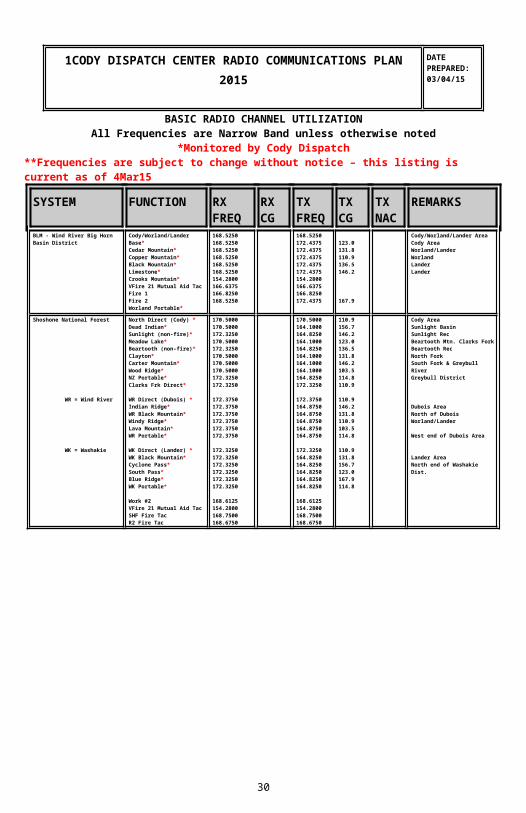
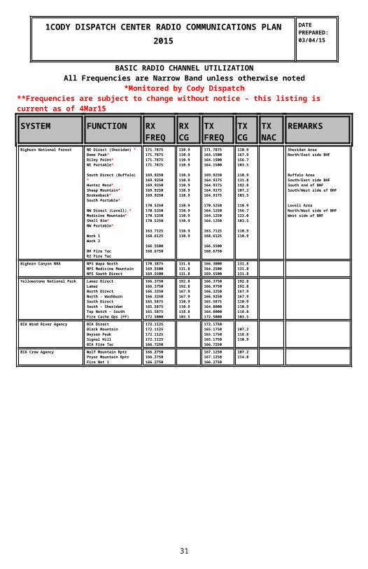
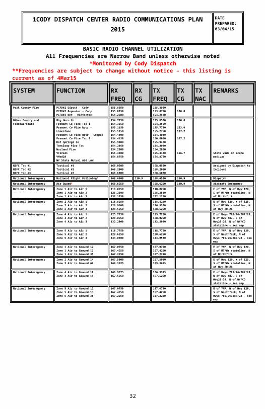
1CODY DISPATCH CENTER RADIO COMMUNICATIONS
PLAN2015
DATEPREPARED:03/04/15
BASIC RADIO CHANNEL UTILIZATIONAll Frequencies are Narrow Band unless otherwise noted
*Monitored by Cody Dispatch**Frequencies are subject to change without notice – this listing is current as of 4Mar15
BIA Wind River Agency BIA DirectBlack MountainBoysen PeakSignal HillBIA Fire Tac
172.1125172.1125172.1125172.1125166.7250
172.1750165.1750165.1750165.1750166.7250
107.2118.8110.9
BIA Crow Agency Wolf Mountain RptrPryor Mountain RptrFire Net 1
166.2750166.2750166.2750
167.1250167.1250166.2750
107.2114.8
1CODY DISPATCH CENTER RADIO COMMUNICATIONS PLAN2015
DATEPREPARED:03/04/15
BASIC RADIO CHANNEL UTILIZATIONAll Frequencies are Narrow Band unless otherwise noted
*Monitored by Cody Dispatch**Frequencies are subject to change without notice – this listing is current as of 4Mar15
SYSTEM FUNCTION RX FREQ
RX CG
TX FREQ
TX CG
TX NAC
REMARKS
Park County Fire PCFD#2 Direct - CodyPCFD#2 Repeater - CodyPCFD#3 Net - Meeteetse
155.8950155.8950154.2500
155.8950153.8750154.2500
100.0
27
Other County and Federal/State
Big Horn CoFremont Co Fire Tac 1Fremont Co Fire Rptr – LimestoneFremont Co Fire Rptr - CopperFremont Co Fire Tac 2Hot Springs CoTensleep Fire TacWorland FireVFire21VMed28WY State Mutual Aid LAW
National Interagency National Flight Following* 168.6500 110.9 168.6500 110.9 DispatchNational Interagency Air Guard* 168.6250 168.6250 110.9 Aircraft EmergencyNational Interagency Zone 1 Air to Air 1
Zone 1 Air to Air 2Zone 1 Air to Air 3
118.0250125.2500132.1250
118.0250125.2500132.1250
E of YNP, W of Hwy 120, S of MT/WY stateline, N of Northfork
National Interagency Zone 2 Air to Air 1Zone 2 Air to Air 2Zone 2 Air to Air 3
118.8250126.9500128.5250
118.8250126.9500128.5250
E of Hwy 120, W of I25, S of MT/WY stateline, N of Hwy 20-26
National Interagency Zone 4 Air to Air 1Zone 4 Air to Air 2Zone 4 Air to Air 3
125.7250128.0250132.2000
125.7250128.0250132.2000
E of Hwys 789/26/287/28, W of Hwy 487, S of Hwy20-26, N of WY/CO stateline – see map
National Interagency Zone 5 Air to Air 1Zone 5 Air to Air 2Zone 5 Air to Air 3
118.7750128.6250134.0500
118.7750128.6250134.0500
E of YNP, W of Hwy 120, S of Northfork, N of Hwys 789/26/287/28 – see map
National Interagency Zone 1 Air to Ground 12Zone 1 Air to Ground 13Zone 1 Air to Ground 35
167.0750167.4250167.2250
167.0750167.4250167.2250
E of YNP, W of Hwy 120, S of MT/WY stateline, N of Northfork
National Interagency Zone 2 Air to Ground 14Zone 2 Air to Ground 62
167.5000169.3625
167.5000169.3625
E of Hwy 120, W of I25, S of MT/WY stateline, N of Hwy 20-26
National Interagency Zone 4 Air to Ground 10Zone 4 Air to Ground 15
166.9375167.5250
166.9375167.5250
E of Hwys 789/26/287/28, W of Hwy 487, S of Hwy20-26, N of WY/CO stateline – see map
National Interagency Zone 5 Air to Ground 12Zone 5 Air to Ground 13Zone 5 Air to Ground 35
167.0750167.4250167.2250
167.0750167.4250167.2250
E of YNP, W of Hwy 120, S of Northfork, N of Hwys 789/26/287/28 – see map
This page intentionally left blank
28
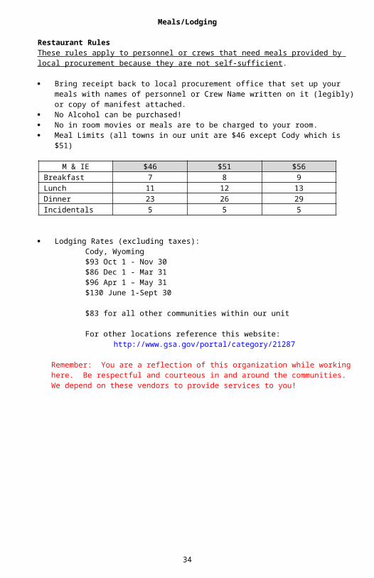
Meals/Lodging
Restaurant RulesThese rules apply to personnel or crews that need meals provided by local procurement because they are not self-sufficient.
Bring receipt back to local procurement office that set up your meals with names of personnel or Crew Name written on it (legibly) or copy of manifest attached.
No Alcohol can be purchased! No in room movies or meals are to be charged to your room. Meal Limits (all towns in our unit are $46 except Cody which is $51)
Lodging Rates (excluding taxes):Cody, Wyoming$93 Oct 1 - Nov 30$86 Dec 1 - Mar 31$96 Apr 1 – May 31$130 June 1-Sept 30
$83 for all other communities within our unit
For other locations reference this website:http://www.gsa.gov/portal/category/21287
29
Remember: You are a reflection of this organization while working here. Be respectful and courteous in and around the communities. We depend on these vendors to provide services to you!
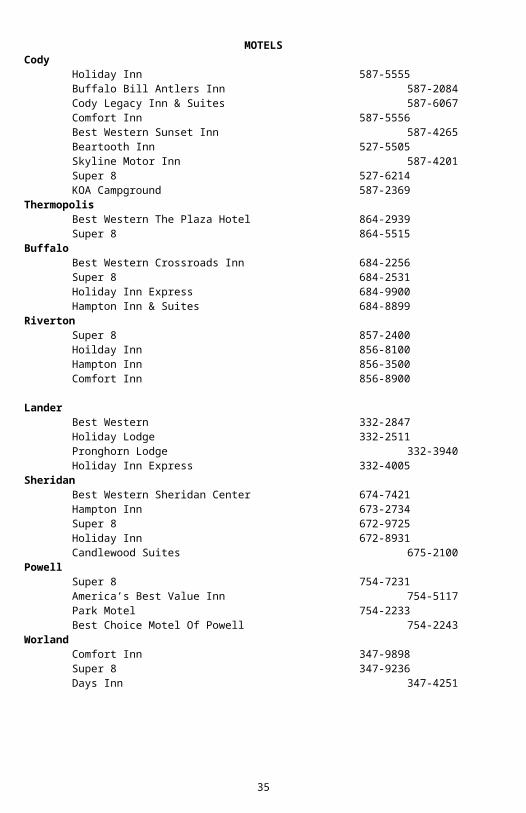
MOTELSCody
Holiday Inn 587-5555Buffalo Bill Antlers Inn 587-2084Cody Legacy Inn & Suites 587-6067Comfort Inn 587-5556Best Western Sunset Inn 587-4265Beartooth Inn 527-5505Skyline Motor Inn 587-4201Super 8 527-6214KOA Campground 587-2369
Thermopolis Best Western The Plaza Hotel 864-2939Super 8 864-5515
BuffaloBest Western Crossroads Inn 684-2256Super 8 684-2531Holiday Inn Express 684-9900Hampton Inn & Suites 684-8899
RivertonSuper 8 857-2400Hoilday Inn 856-8100Hampton Inn 856-3500Comfort Inn 856-8900
LanderBest Western 332-2847Holiday Lodge 332-2511Pronghorn Lodge 332-3940Holiday Inn Express 332-4005
SheridanBest Western Sheridan Center 674-7421Hampton Inn 673-2734Super 8 672-9725Holiday Inn 672-8931Candlewood Suites 675-2100
PowellSuper 8 754-7231America’s Best Value Inn 754-5117Park Motel 754-2233Best Choice Motel Of Powell 754-2243
30
WorlandComfort Inn 347-9898Super 8 347-9236Days Inn 347-4251
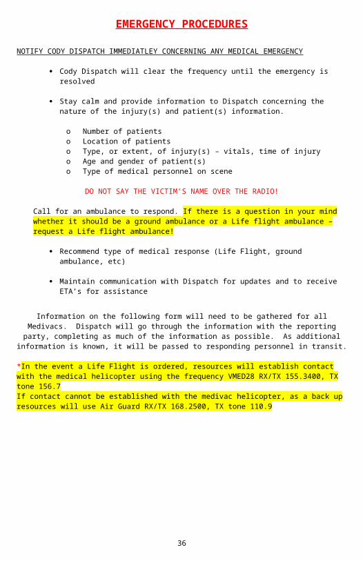
EMERGENCY PROCEDURES
NOTIFY CODY DISPATCH IMMEDIATLEY CONCERNING ANY MEDICAL EMERGENCY
Cody Dispatch will clear the frequency until the emergency is resolved
Stay calm and provide information to Dispatch concerning the nature of the injury(s) and patient(s) information.
o Number of patientso Location of patientso Type, or extent, of injury(s) – vitals, time of injuryo Age and gender of patient(s)o Type of medical personnel on scene
DO NOT SAY THE VICTIM’S NAME OVER THE RADIO!
Call for an ambulance to respond. If there is a question in your mind whether it should be a ground ambulance or a Life flight ambulance – request a Life flight ambulance!
Recommend type of medical response (Life Flight, ground ambulance, etc)
Maintain communication with Dispatch for updates and to receive ETA’s for assistance
Information on the following form will need to be gathered for all Medivacs. Dispatch will go through the information with the reporting party, completing as much of the information as possible. As additional information is known, it will be passed to
responding personnel in transit.
*In the event a Life Flight is ordered, resources will establish contact with the medical helicopter using the frequency VMED28 RX/TX 155.3400, TX tone 156.7 If contact cannot be established with the medivac helicopter, as a back up resources will use Air Guard RX/TX 168.2500, TX tone 110.9
31
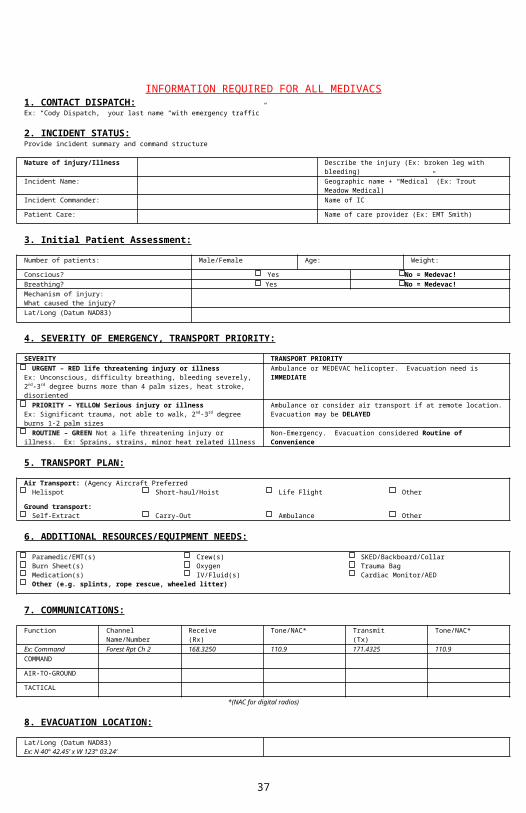
INFORMATION REQUIRED FOR ALL MEDIVACS1. CONTACT DISPATCH:Ex: “Cody Dispatch,” your last name “with emergency traffic”
2. INCIDENT STATUS:Provide incident summary and command structure
Nature of injury/Illness Describe the injury (Ex: broken leg with bleeding)
Incident Name: Geographic name + “Medical” (Ex: Trout Meadow Medical)
Incident Commander: Name of IC
Patient Care: Name of care provider (Ex: EMT Smith)
3. Initial Patient Assessment:
Number of patients: Male/Female Age: Weight:
Conscious? Yes No = Medevac!Breathing? Yes No = Medevac!Mechanism of injury:What caused the injury?Lat/Long (Datum NAD83)
4. SEVERITY OF EMERGENCY, TRANSPORT PRIORITY:
SEVERITY TRANSPORT PRIORITY URGENT – RED life threatening injury or illnessEx: Unconscious, difficulty breathing, bleeding severely, 2nd-3rd degree burns more than 4 palm sizes, heat stroke, disoriented
Ambulance or MEDEVAC helicopter. Evacuation need is IMMEDIATE
PRIORITY – YELLOW Serious injury or illnessEx: Significant trauma, not able to walk, 2nd-3rd degree burns 1-2 palm sizes
Ambulance or consider air transport if at remote location. Evacuation may be DELAYED
ROUTINE – GREEN Not a life threatening injury or illness. Ex: Sprains, strains, minor heat related illness
Non-Emergency. Evacuation considered Routine of Convenience
5. TRANSPORT PLAN:
Air Transport: (Agency Aircraft Preferred Helispot Short-haul/Hoist Life Flight Other
Ground transport: Self-Extract Carry-Out Ambulance Other
6. ADDITIONAL RESOURCES/EQUIPMENT NEEDS:
Paramedic/EMT(s) Crew(s) SKED/Backboard/Collar Burn Sheet(s) Oxygen Trauma Bag Medication(s) IV/Fluid(s) Cardiac Monitor/AED Other (e.g. splints, rope rescue, wheeled litter)
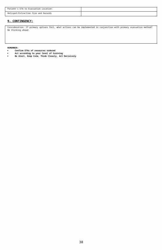
Lat/Long (Datum NAD83)Ex: N 40° 42.45’ x W 123° 03.24’Patient’s ETA to Evacuation Location:
Helispot/Extraction Size and Hazards
9. CONTINGENCY:
Consideration: If primary options fail, what actions can be implemented in conjunction with primary evacuation method? Be thinking ahead
REMEMBER: Confirm ETAs of resources ordered Act according to your level of training Be Alert, Keep Calm, Think Clearly, Act Decisively
32
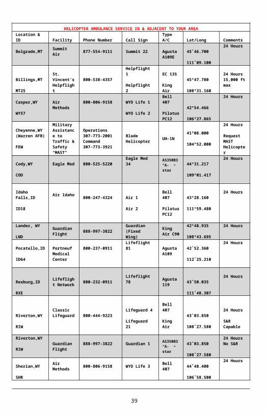
HELICOPTER AMBULANCE SERVICE IN & ADJACENT TO YOUR AREALocation & ID Facility Phone Number Call Sign
Type A/C Lat/Long
Comments
Belgrade,MT Summit Air 877-554-9111 Summit 22 Agusta
A109E45˚46.700
111˚09.100
24 Hours
Billings,MT
MT25
St. Vincent's Helpflight
800-538-4357 Helpflight 1
Helpflight 2
EC 135
King Air
45º47.780
108º31.160
24 Hours15,000 ft max
Casper,WY
WY57
Air Methods
800-806-9158 WYO Life 1
WYO Life 2
Bell 407
Pilatus PC12
42º54.466
106º27.865
24 Hours
Cheyenne,WY (Warren AFB)
FEW
Military Assistance to Traffic & Safety "MAST"
Operations 307-773-2001 Command 307-773-3921
Blade Helicopter UH-1N
41º08.000
104º52.000
24 Hours
Request MAST Helicopter
Cody,WY
COD
Eagle Med 800-525-5220
Eagle Med 34
AS350B3“A-star” 44º31.217
109º01.417
24 Hours
Idaho Falls,ID
ID18
Air Idaho 800-247-4324 Air 1
Air 2
Bell 407
Pilatus PC12
43º28.160
111º59.480
24 Hours
Lander, WY
LNDGuardian Flight 888-997-3822
Guardian(Fixed Wing)
King Air C90
42º48.935
108º43.695
24 Hours
Pocatello,ID
ID64
Portneuf Medical Center
800-237-0911 Lifeflight 81 Agusta A109
42˚52.360
112˚25.210
24 Hours
Rexburg,ID
RXE
Lifeflight Network
800-232-0911 Lifeflight 78 Agusta119
43˚50.035
111˚48.307
24 Hours
Riverton,WY
RIW
Classic Lifeguard 800-444-9223 Lifeguard 4
Lifeguard 21
Bell 407
King Air
43˚03.850
108˚27.580
24 Hours
S&R Capable
Riverton,WY
RIWGuardian Flight
888-997-3822 Guardian 1AS350B3“A-star”
43˚03.850
108˚27.580
24 HoursNo S&R
Sherian,WY
SHR
Air Methods 800-806-9158 WYO Life 3 Bell
407 44˚48.400
106˚58.500
24 Hours
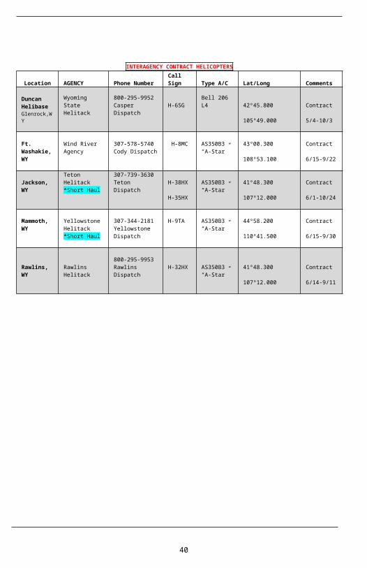
INTERAGENCY CONTRACT HELICOPTERS
Location AGENCYPhone Number
Call Sign Type A/C Lat/Long
Comments
Duncan Wyoming State Helitack
800-295-9952Casper
H-6SG Bell 206 L442º45.800
Contract
33
HelibaseGlenrock,WY
Dispatch105º49.000 5/4-10/3
Ft. Washakie, WY
Wind River Agency
307-578-5740Cody Dispatch
H-8MC AS350B3“A-Star”
43º00.300
108º53.100
Contract
6/15-9/22
Jackson, WY
Teton Helitack*Short Haul
307-739-3630Teton Dispatch
H-38HX
H-35HX
AS350B3“A-Star”
41º48.300
107º12.000
Contract
6/1-10/24
Mammoth, WY
Yellowstone Helitack*Short Haul
307-344-2181Yellowstone Dispatch
H-9TA AS350B3“A-Star”
44º58.200
110º41.500
Contract
6/15-9/30
Rawlins, WY
Rawlins Helitack
800-295-9953Rawlins Dispatch
H-32HX AS350B3“A-Star”
41º48.300
107º12.000
Contract
6/14-9/11
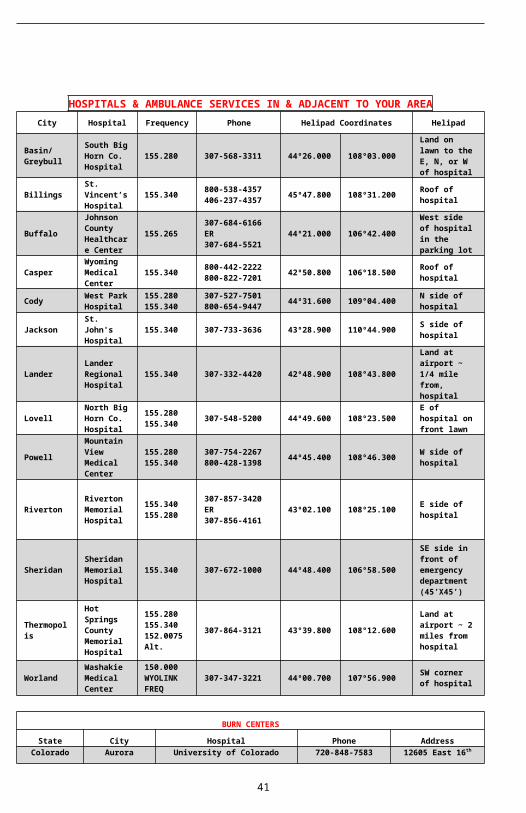
HOSPITALS & AMBULANCE SERVICES IN & ADJACENT TO YOUR AREACity Hospital Frequenc
y Phone Helipad Coordinates Helipad
Basin/Greybull
South Big Horn Co. Hospital
155.280 307-568-3311 44º26.000 108º03.000
Land on lawn to the E, N, or W of hospital
BillingsSt. Vincent’s Hospital
155.340 800-538-4357406-237-4357
45º47.800 108º31.200 Roof of
hospital
BuffaloJohnson County Healthcare Center
155.265307-684-6166 ER307-684-5521
44º21.000 106º42.400
West side of hospital in the parking lot
Casper Wyoming Medical 155.340 800-442-2222
800-822-720142º50.800 106º18.500 Roof of
hospital
34
Center
CodyWest Park Hospital
155.280155.340
307-527-7501800-654-9447
44º31.600 109°04.400 N side of
hospital
Jackson St. John's Hospital 155.340 307-733-3636 43º28.90
0 110º44.900 S side of hospital
LanderLander Regional Hospital
155.340 307-332-4420 42º48.900 108°43.800
Land at airport ~ 1/4 mile from, hospital
LovellNorth Big Horn Co. Hospital
155.280155.340 307-548-5200 44º49.60
0 108º23.500E of hospital on front lawn
PowellMountain View Medical Center
155.280 155.340
307-754-2267800-428-1398
44º45.400 108º46.300 W side of
hospital
RivertonRiverton Memorial Hospital
155.340 155.280
307-857-3420 ER307-856-4161
43º02.100 108º25.100 E side of
hospital
SheridanSheridan Memorial Hospital
155.340 307-672-1000 44º48.400 106º58.500
SE side in front of emergency department (45’X45’)
Thermopolis
Hot Springs County Memorial Hospital
155.280155.340152.0075 Alt.
307-864-3121 43°39.800 108°12.600
Land at airport ~ 2 miles from hospital
WorlandWashakie Medical Center
150.000WYOLINK FREQ
307-347-3221 44º00.700 107º56.900 SW corner
of hospital
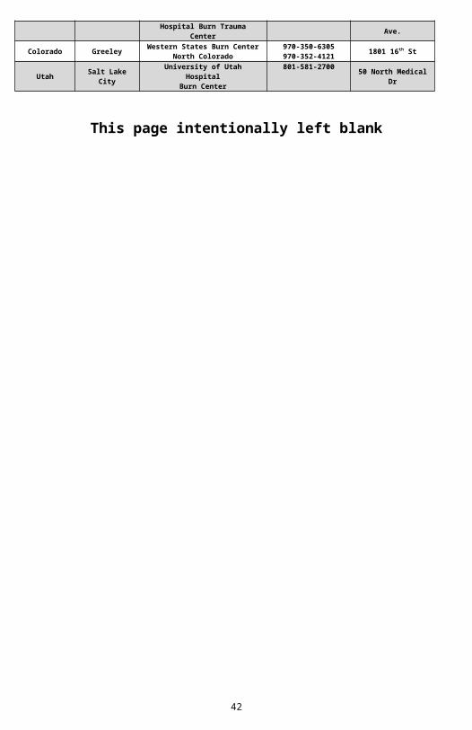
BURN CENTERS
State City Hospital Phone Address
Colorado AuroraUniversity of Colorado Hospital Burn Trauma
Center720-848-7583 12605 East 16th
Ave.
Colorado Greeley Western States Burn Center North Colorado
970-350-6305970-352-4121 1801 16th St
Utah Salt Lake City
University of Utah HospitalBurn Center 801-581-2700 50 North Medical
Dr
This page intentionally left blank
35
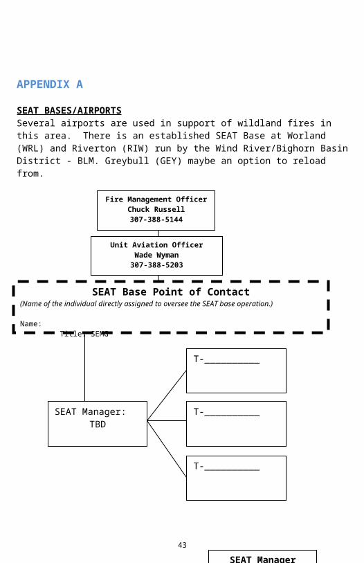
APPENDIX ASEAT BASES/AIRPORTSSeveral airports are used in support of wildland fires in this area. There is an established SEAT Base at Worland (WRL) and Riverton (RIW) run by the Wind River/Bighorn Basin District - BLM. Greybull (GEY) maybe an option to reload from.
36
T-__________
SEAT Base Point of Contact(Name of the individual directly assigned to oversee the SEAT base operation.)
Name: Title: SEMG
Unit Aviation OfficerWade Wyman307-388-5203
Fire Management OfficerChuck Russell307-388-5144
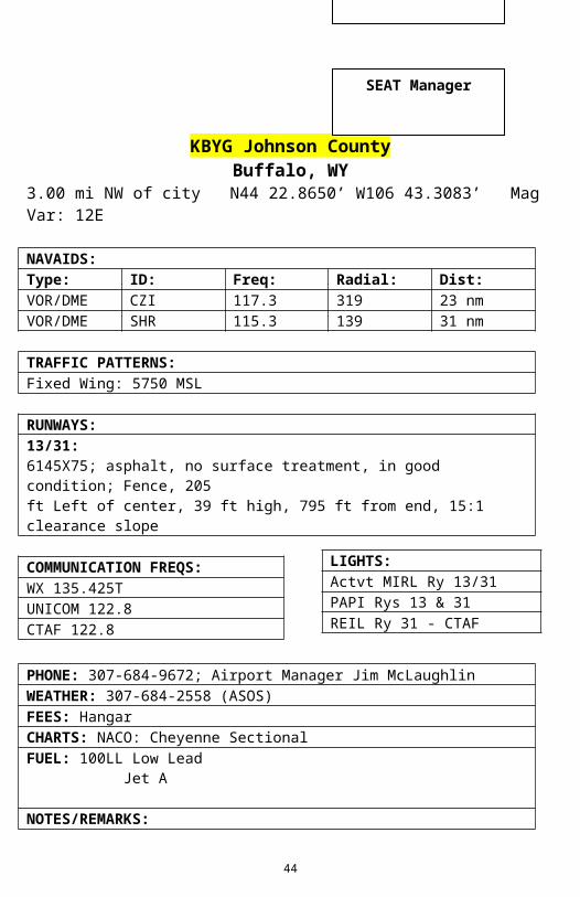
KBYG Johnson CountyBuffalo, WY
3.00 mi NW of city N44 22.8650’ W106 43.3083’ Mag Var: 12E
RUNWAYS:13/31:6145X75; asphalt, no surface treatment, in good condition; Fence, 205ft Left of center, 39 ft high, 795 ft from end, 15:1 clearance slope
COMMUNICATION FREQS:WX 135.425TUNICOM 122.8CTAF 122.8
PHONE: 307-684-9672; Airport Manager Jim McLaughlinWEATHER: 307-684-2558 (ASOS)FEES: Hangar
37
SEAT ManagerSEAT ManagerSEAT Manager
SEAT Manager
T-__________
LIGHTS:Actvt MIRL Ry 13/31PAPI Rys 13 & 31REIL Ry 31 - CTAF
CHARTS: NACO: Cheyenne SectionalFUEL: 100LL Low Lead Jet A
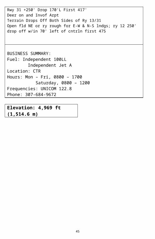
NOTES/REMARKS:Rwy 31 +250' Drop 170'L First 417'Deer on and Invof ArptTerrain Drops Off Both Sides of Ry 13/31Open fld NE or ry rough for E-W & N-S lndgs; ry 12 250' drop off w/in 70' left of cntrln first 475
TRAFFIC PATTERNS:Light Aircraft: 5900 MSLHeavy Aircraft: 6100 MSL
39
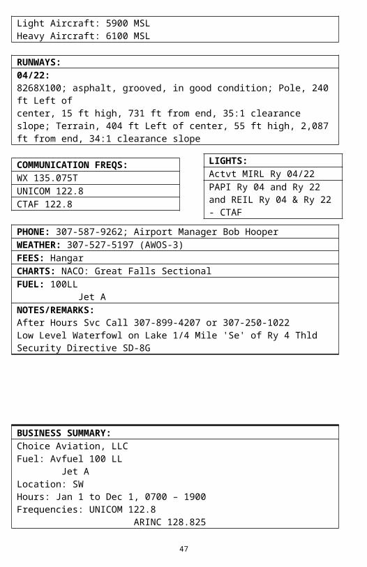
RUNWAYS:04/22:8268X100; asphalt, grooved, in good condition; Pole, 240 ft Left ofcenter, 15 ft high, 731 ft from end, 35:1 clearance slope; Terrain, 404 ft Left of center, 55 ft high, 2,087 ft from end, 34:1 clearance slope
COMMUNICATION FREQS:WX 135.075TUNICOM 122.8CTAF 122.8
PHONE: 307-587-9262; Airport Manager Bob HooperWEATHER: 307-527-5197 (AWOS-3)FEES: HangarCHARTS: NACO: Great Falls SectionalFUEL: 100LL Jet ANOTES/REMARKS:After Hours Svc Call 307-899-4207 or 307-250-1022Low Level Waterfowl on Lake 1/4 Mile 'Se' of Ry 4 ThldSecurity Directive SD-8G
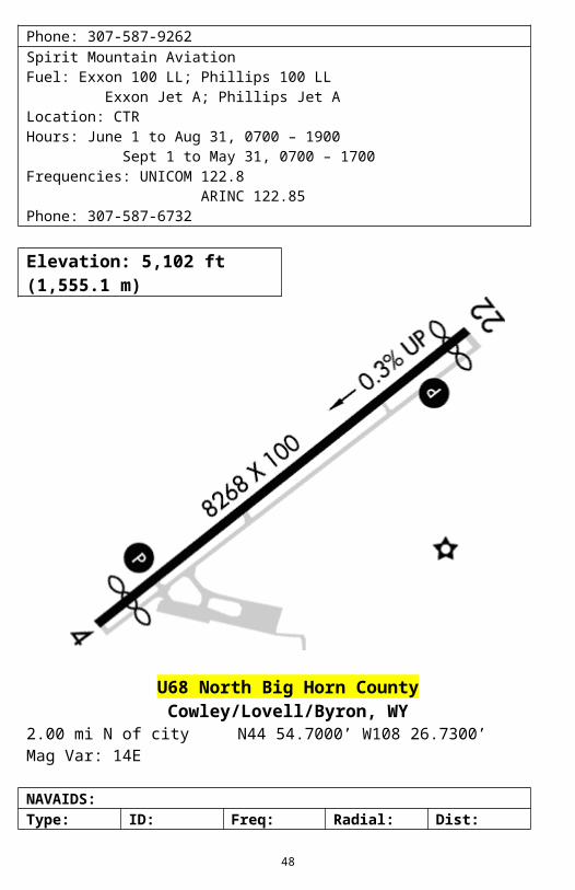
BUSINESS SUMMARY:Choice Aviation, LLCFuel: Avfuel 100 LL Jet ALocation: SWHours: Jan 1 to Dec 1, 0700 – 1900Frequencies: UNICOM 122.8 ARINC 128.825Phone: 307-587-9262Spirit Mountain AviationFuel: Exxon 100 LL; Phillips 100 LL Exxon Jet A; Phillips Jet ALocation: CTRHours: June 1 to Aug 31, 0700 – 1900 Sept 1 to May 31, 0700 – 1700Frequencies: UNICOM 122.8 ARINC 122.85Phone: 307-587-6732
40
LIGHTS:Actvt MIRL Ry 04/22PAPI Ry 04 and Ry 22 and REIL Ry 04 & Ry 22 - CTAF
Elevation: 5,102 ft (1,555.1 m)
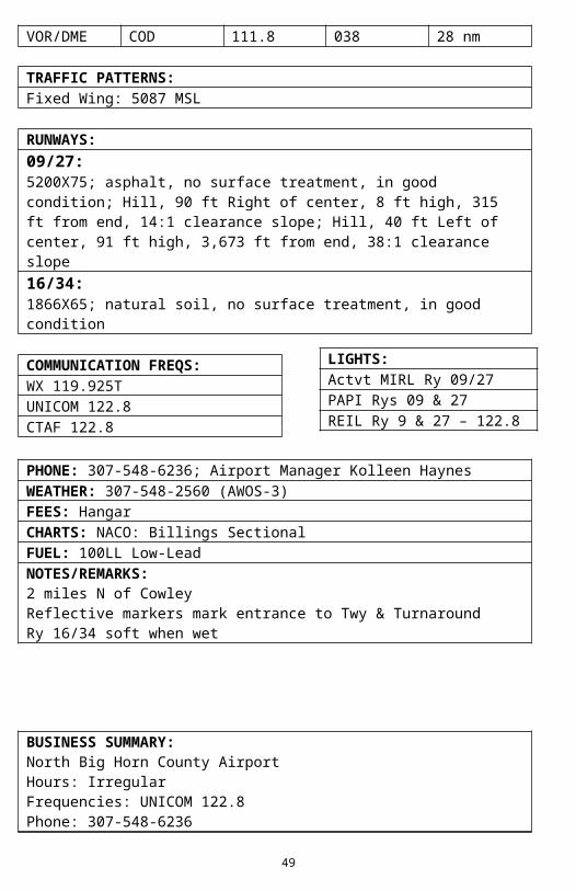
U68 North Big Horn CountyCowley/Lovell/Byron, WY
2.00 mi N of city N44 54.7000’ W108 26.7300’ Mag Var: 14E
RUNWAYS:09/27:5200X75; asphalt, no surface treatment, in good condition; Hill, 90 ft Right of center, 8 ft high, 315 ft from end, 14:1 clearance slope; Hill, 40 ft Left of center, 91 ft high, 3,673 ft from end, 38:1 clearance slope16/34:1866X65; natural soil, no surface treatment, in good condition
COMMUNICATION FREQS:
41
LIGHTS:Actvt MIRL Ry 09/27PAPI Rys 09 & 27REIL Ry 9 & 27 – 122.8
WX 119.925TUNICOM 122.8CTAF 122.8
PHONE: 307-548-6236; Airport Manager Kolleen HaynesWEATHER: 307-548-2560 (AWOS-3)FEES: HangarCHARTS: NACO: Billings SectionalFUEL: 100LL Low-LeadNOTES/REMARKS:2 miles N of CowleyReflective markers mark entrance to Twy & TurnaroundRy 16/34 soft when wet
BUSINESS SUMMARY:North Big Horn County AirportHours: IrregularFrequencies: UNICOM 122.8Phone: 307-548-6236
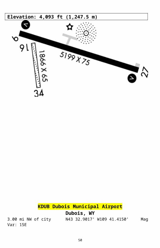
Elevation: 4,093 ft (1,247.5 m)
42
KDUB Dubois Municipal AirportDubois, WY
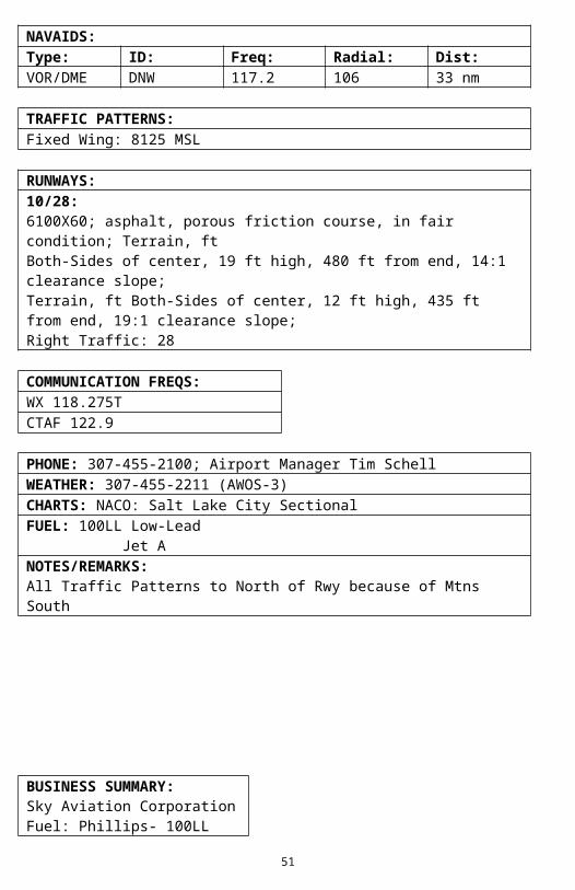
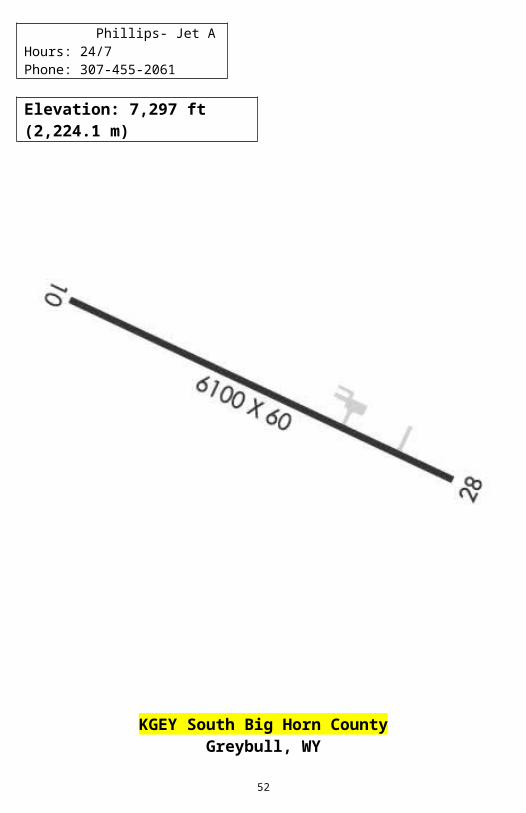
3.00 mi NW of city N43 32.9017’ W109 41.4150’ Mag Var: 15E
RUNWAYS:10/28:6100X60; asphalt, porous friction course, in fair condition; Terrain, ftBoth-Sides of center, 19 ft high, 480 ft from end, 14:1 clearance slope;Terrain, ft Both-Sides of center, 12 ft high, 435 ft from end, 19:1 clearance slope;Right Traffic: 28
COMMUNICATION FREQS:WX 118.275TCTAF 122.9
PHONE: 307-455-2100; Airport Manager Tim SchellWEATHER: 307-455-2211 (AWOS-3)CHARTS: NACO: Salt Lake City SectionalFUEL: 100LL Low-Lead Jet ANOTES/REMARKS:All Traffic Patterns to North of Rwy because of Mtns South
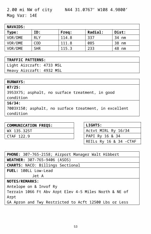
TRAFFIC PATTERNS:Light Aircraft: 4733 MSLHeavy Aircraft: 4932 MSL
RUNWAYS:07/25:3953X75; asphalt, no surface treatment, in good condition16/34:7003X150; asphalt, no surface treatment, in excellent condition
COMMUNICATION FREQS:WX 135.325TCTAF 122.9
PHONE: 307-765-2158; Airport Manager Walt HibbertWEATHER: 307-765-9406 (ASOS)CHARTS: NACO: Billings SectionalFUEL: 100LL Low-Lead Jet ANOTES/REMARKS:Antelope on & Invof RyTerrain 1066 Ft Abv Arpt Elev 4-5 Miles North & NE of ArptGA Apron and Twy Restricted to Acft 12500 Lbs or Less
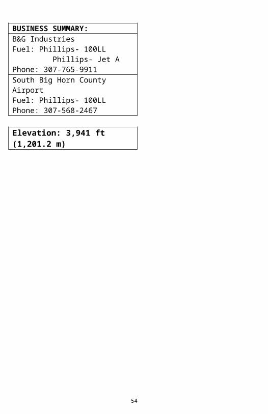
BUSINESS SUMMARY:B&G IndustriesFuel: Phillips- 100LL Phillips- Jet APhone: 307-765-9911South Big Horn County AirportFuel: Phillips- 100LLPhone: 307-568-2467
Elevation: 3,941 ft (1,201.2 m)
46
LIGHTS:Actvt MIRL Ry 16/34PAPI Ry 16 & 34REILs Ry 16 & 34 -CTAF
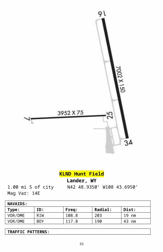
KLND Hunt FieldLander, WY
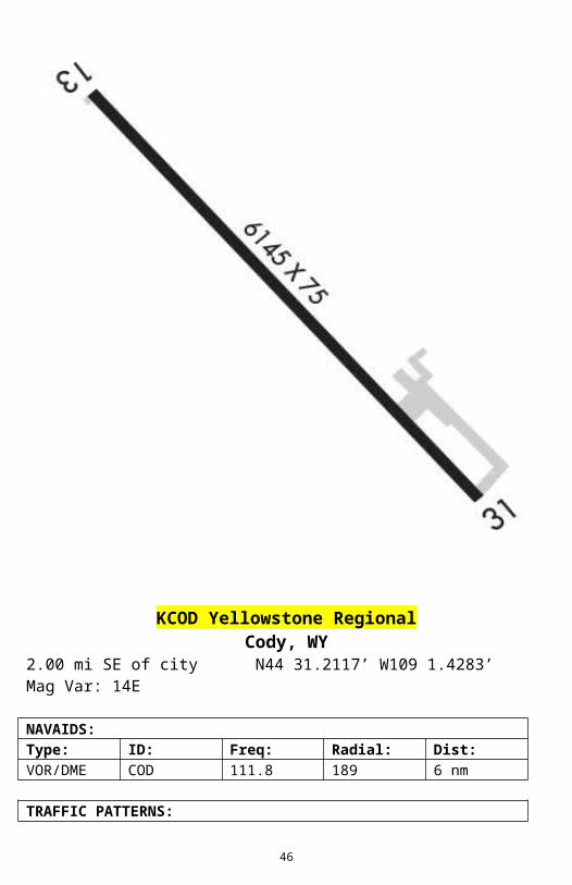
1.00 mi S of city N42 48.9350’ W108 43.6950’ Mag Var: 14ENAVAIDS:Type: ID: Freq: Radial: Dist:VOR/DME RIW 108.8 203 19 nmVOR/DME BOY 117.8 190 43 nm
TRAFFIC PATTERNS:Fixed Wing: 6586 MSLUltralights: 6086 MSL
47
RUNWAYS:03/21:5007X100; asphalt, porous friction course, in good condition; Tree,250 ft Right of center, 144 ft high, 3,538 ft from end, 23:1 clearance slopeH1:40X40; asphalt, no surface treatment, in good condition
COMMUNICATION FREQS:WX 118.15TUNICOM 122.8CTAF 122.8
PHONE: 307-332-3134; Airport Manager Gary LooseWEATHER: 307-332-7707 (ASOS)FEES: HangarCHARTS: NACO: Cheyenne SectionalFUEL: 100LL Low Lead Jet ANOTES/REMARKS:Ry 3/21: Twr 305 Ft Above Approach End Ry 21 14,728 Ft Fm Ry End, 90 Ft Rt of CenterlineBird Activity Invof Arpt(E81) Taxiway Entrance Lgts+4' Reflectors Along Twy & Ry Edges for Winter Plowing
BUSINESS SUMMARY:Wind River AviationLocation: CTRHours: Mon – Fri, 0800 – 1700Frequencies: UNICOM 122.8Phone: 307-332-3134
RUNWAYS:03/21:2623X100; turf, grass, sod, natural soil, no surface treatment, in faircondition; Fence, 21 ft Right of center, 12 ft high, 252 ft from end, 21:1clearance slope13/31:6200X100; asphalt, natural soil, no surface treatment, in good condition; Fence, Both-Sides, 25 ft high, 1,150 ft from end, 38:1 clearance slope16/34:2709X100; turf, grass, sod, natural soil, no surface treatment, in faircondition; Fence, ft Both-Sides of center, 10 ft high, 233 ft from end, 23:1 clearance slope
COMMUNICATION FREQS:WX 119.275TUNICOM 122.7CTAF 122.7
PHONE: 307-754-6921; Airport Manager Sean ChristensonWEATHER: 307-754-7093 (AWOS-3)FEES: HangarCHARTS: NACO: Billings SectionalFUEL: 100LL Low Lead Jet A
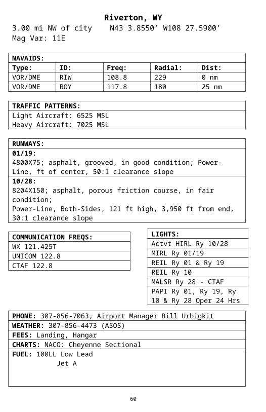
TRAFFIC PATTERNS:Light Aircraft: 6525 MSLHeavy Aircraft: 7025 MSL
51
RUNWAYS:01/19:4800X75; asphalt, grooved, in good condition; Power-Line, ft of center, 50:1 clearance slope10/28:8204X150; asphalt, porous friction course, in fair condition;Power-Line, Both-Sides, 121 ft high, 3,950 ft from end, 30:1 clearance slope
COMMUNICATION FREQS:WX 121.425TUNICOM 122.8CTAF 122.8
PHONE: 307-856-7063; Airport Manager Bill UrbigkitWEATHER: 307-856-4473 (ASOS)FEES: Landing, HangarCHARTS: NACO: Cheyenne SectionalFUEL: 100LL Low Lead Jet A
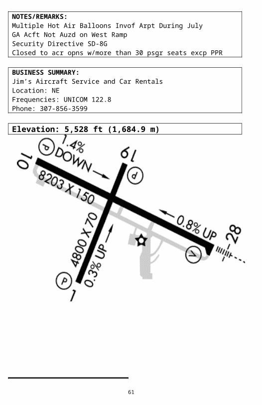
NOTES/REMARKS:Multiple Hot Air Balloons Invof Arpt During JulyGA Acft Not Auzd on West RampSecurity Directive SD-8GClosed to acr opns w/more than 30 psgr seats excp PPR
BUSINESS SUMMARY:Jim’s Aircraft Service and Car RentalsLocation: NEFrequencies: UNICOM 122.8Phone: 307-856-3599
Elevation: 5,528 ft (1,684.9 m)
52
LIGHTS:Actvt HIRL Ry 10/28MIRL Ry 01/19REIL Ry 01 & Ry 19REIL Ry 10MALSR Ry 28 - CTAFPAPI Ry 01, Ry 19, Ry 10 & Ry 28 Oper 24 Hrs
KSHR Sheridan CountySheridan, WY
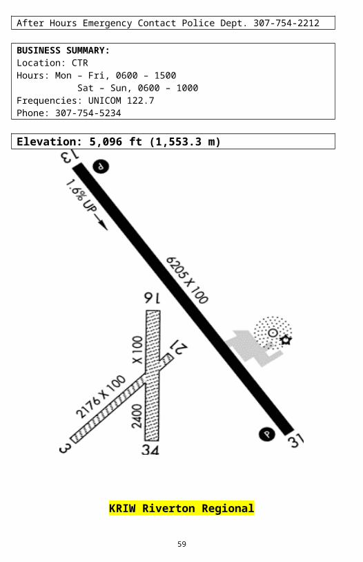
2.00 mi SW of city N44 46.1517’ W106 58.8167’ Mag Var: 13E
5039X75; asphalt, grooved, in good condition; Trees, 200 ft Right of center, 40 ft high, 750 ft from end, 20:1 clearance slope14/32:8301X100; asphalt, porous friction course, in excellent condition
COMMUNICATION FREQS:WX 135.175TUNICOM 123.0CTAF 123.0
PHONE: 307-674-4222; Airport Manager John StopkaWEATHER: 307-672-5349FEES: HangarCHARTS: NACO: Billings SectionalFUEL: 100 Octane Jet A Jet A1 + Icing Inhibitor
NOTES/REMARKS:Glider Activity on and Invof ArptFixed Wing Acft Restricted to Rys & Twys OnlySecurity Directive SD-8GIntensive Flight Training
RUNWAYS:08/26:4650X90; natural soil, no surface treatment, in good condition;Power-Line, Both-Sides, 39 ft high, 312 ft from end, 8:1 clearance slope;
55
Fence, Both-Sides, 8 ft high, 132 ft from end, 16:1 clearance slope11/29:2950X75; natural soil, no surface treatment, in good condition; Fence,Both-Sides, 7 ft high, 93 ft from end, 13:1 clearance slope
COMMUNICATION FREQS:CTAF 122.9
PHONE: 307-876-2515; Airport Manager Bart HumphreyCHARTS: NACO: Cheyenne SectionalFUEL: NoneNOTES/REMARKS:+8 Inch Ant Hills on Sfc of All Rys+2 Ft Berms Either Side of Both RysAntelope on AirportRy 08/26 No Line of Sight Btn Ry EndsRys 08/26 & 11/29 Thlds Not MarkedArpt Has Uncontrolled Vehicle AccessNo line of sight btn 8-26 ry ends
Elevation: 4,818 ft (1,468.5 m)
No Image Available
56
LIGHTS:None
KTHP Hot Spring County – Thermopolis MunicipalThermopolis, WY
1.00 mi N of City N43 39.4974’ W108 12.7893’ Mag Var: 14E
RUNWAYS:01/19:4800X100; asphalt, porous friction course, in poor condition
COMMUNICATION FREQS:UNICOM 122.8CTAF 122.8
PHONE: 307-864-2488, Airport Manager Ray AreyFEES: HangarCHARTS: NACO: Cheyenne SectionalFUEL: 100LL Low LeadNOTES/REMARKS:(E81) Taxiway Entrance LightedRy 01/19 is 118 Ft Higher on South End. Recommend Ldg Uphill Ry 19; TkofDownhill Ry 01 Depending on WindGnd Drops Off 50 Ft at 15 Ft Fm Ry 01 Thld & 15 Ft at 30 Ft Fm Ry
57
LIGHTS:Actvt LIRL Ry 01/19Savasi Ry 19 – 122.8
19 Thld<Hills on Ea Side of Rwy, Not Obstn LgtdDue to Terrain - Opns at Night Not RecommendedDEP rptd 133.25. Normal landings on ry 19
BUSINESS SUMMARY:Crowley Air Service, LLCLocation: CTRHours: Mon – Sun, 0800 – 1700Frequencies: 122.8Phone: 307-864-2488
Elevation: 4,592 ft (1,399.6 m)
58
KWRL Worland Municipal AirportWorland, WY
3.00 mi S. of city N43 57.7733’ W107 57.0317’ Mag Var: 13
RUNWAYS:04/22:2241X60; turf, grass, sod, no surface treatment, in fair condition10/28:2501X60; turf, grass, sod, no surface treatment, in fair condition16/34:7005X100; asphalt, porous friction course, in good condition
COMMUNICATION FREQS:WX 135.475TUNICOM 123.05CTAF 123.05
PHONE: 307-347-8978; Airport Manager Wayne HillWEATHER: 307-347-4217 (ASOS)FEES: HangarCHARTS: NACO: Cheyenne SectionalFUEL: 100LL Low-Lead Jet A
NOTES/REMARKS:Rys 04/22 & 10/28 Clsd Oct 30 – Mar 30 YearlyWind Permitting Land Ry 16Security Directive SD-8GClosed to acr opns w/more than 30 psgr seats; ry 4-22 & 10-28 clsd winters
BUSINESS SUMMARY:Sky Aviation CorporationLocation: CTRPhone: 307-347-6138
60
LIGHTS:Actvt MIRL Ry 16/34REIL Rys 16 & 34PAPI Ry 34 - CTAFPAPI Ry 16 Oper Cont