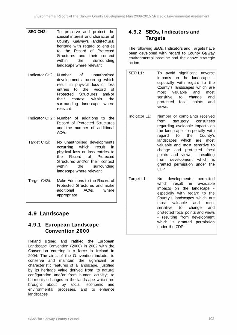
Section 1 SEA Introduction and Background..........................................................1
1.1 Introduction and Terms of Reference .................................................................................1 1.2 SEA Definition ..................................................................................................................1 1.3 Legislative Context............................................................................................................1 1.4 Implications for Galway County Council and the Elected Members.........................................1
2.1 Introduction .....................................................................................................................2 2.2 Scoping ...........................................................................................................................2 2.3 Environmental Baseline Data and Other Strategic Actions.....................................................3 2.4 Alternatives......................................................................................................................4 2.5 The SEA Environmental Report ..........................................................................................4 2.6 The SEA Statement...........................................................................................................4 2.7 Legislative Conformance....................................................................................................4 2.8 Difficulties Encountered.....................................................................................................6
Section 3 County Galway’s Baseline Environment..................................................7
3.1 Introduction .....................................................................................................................7 3.2 Biodiversity and Flora and Fauna........................................................................................9 3.3 Population and Human Health..........................................................................................29 3.4 Soil................................................................................................................................34 3.5 Water ............................................................................................................................39 3.6 Air and Climatic Factors...................................................................................................61 3.7 Material Assets ...............................................................................................................70 3.8 Cultural Heritage ............................................................................................................75 3.9 Landscape .....................................................................................................................82
4.1 Introduction ...................................................................................................................93 4.2 Biodiversity, Flora and Fauna...........................................................................................93 4.3 Population and Human Health..........................................................................................95 4.4 Soil................................................................................................................................96 4.5 Water ............................................................................................................................97 4.6 Air and Climatic Factors...................................................................................................99 4.7 Material Assets ...............................................................................................................99 4.8 Cultural Heritage .......................................................................................................... 100 4.9 Landscape ...................................................................................................................102
Section 5 Context for a Development Plan for County Galway ..........................103
Section 6 Description of Alternative Plan Scenarios...........................................107
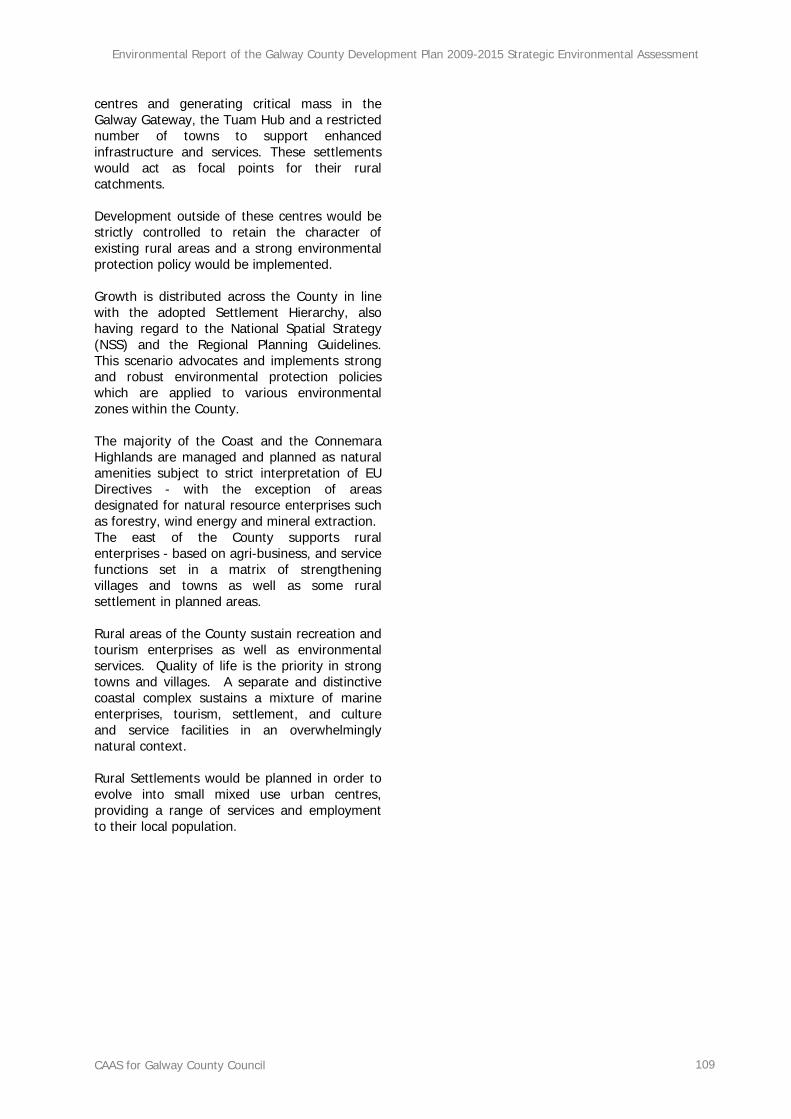
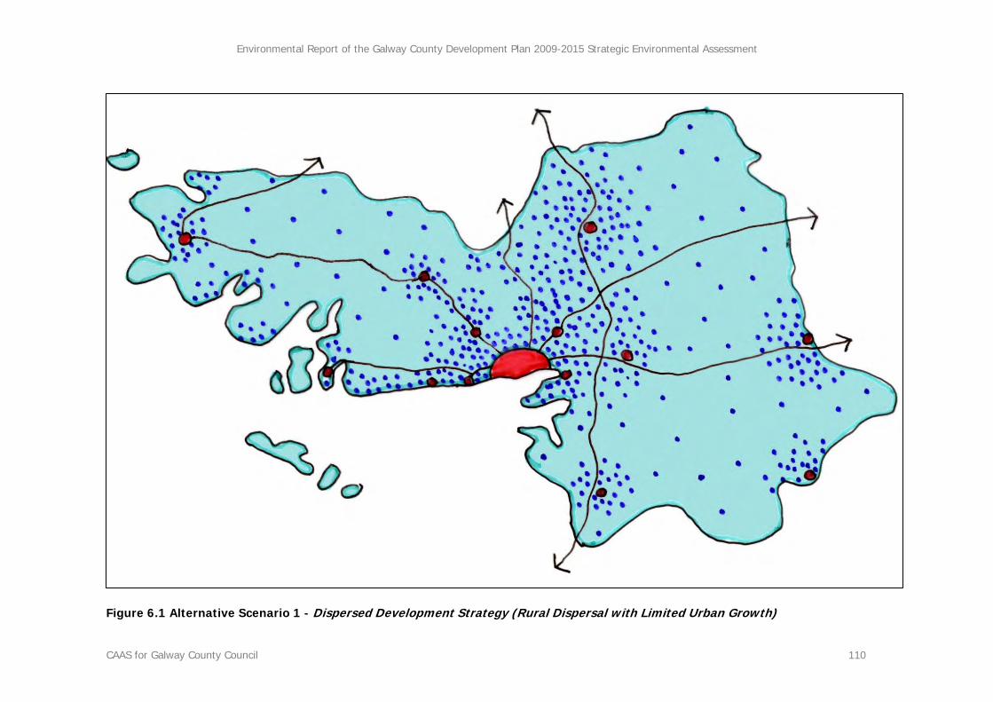
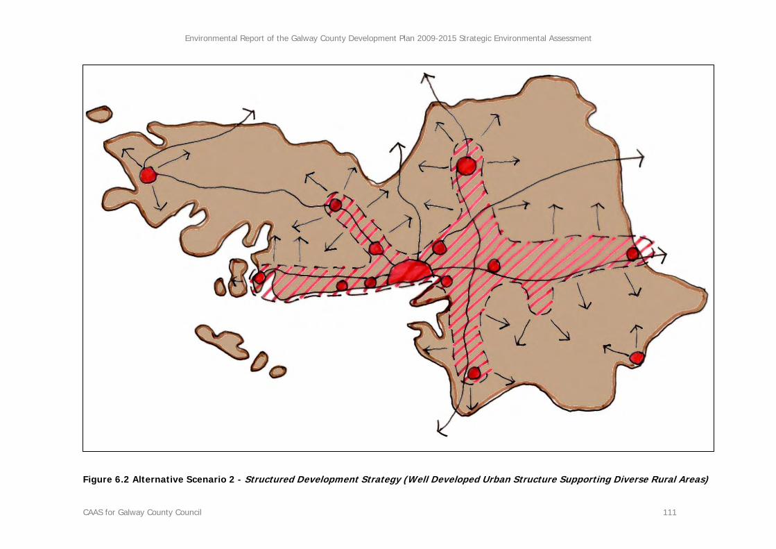
6.1 Introduction ................................................................................................................. 107 6.2 Excluding the ‘Do-Nothing’ Scenario ............................................................................... 107 6.3 Identification and Description of Alternative Scenarios ..................................................... 107
Section 7 Evaluation of Alternative Plan Scenarios ............................................113
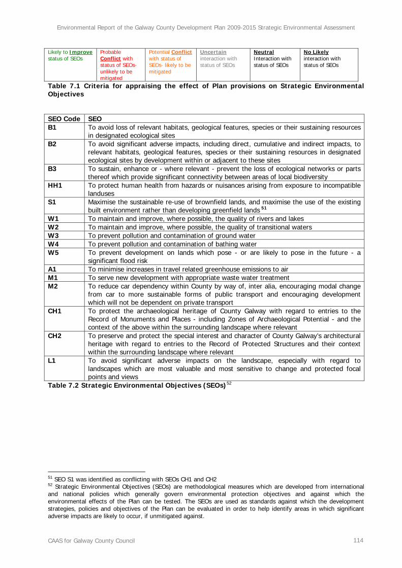
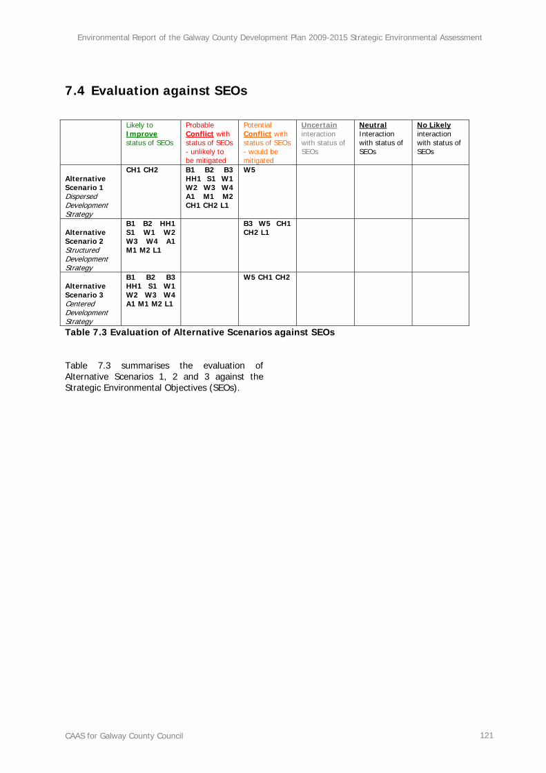
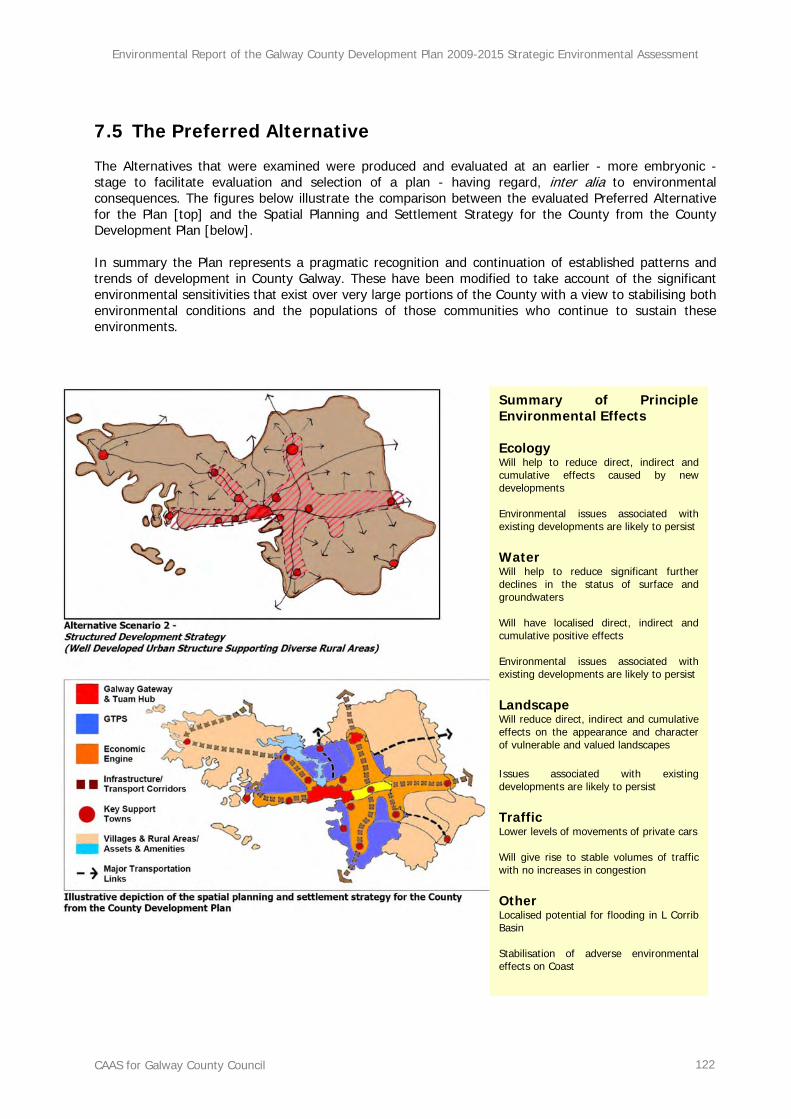
7.1 Introduction ................................................................................................................. 113 7.2 Methodology ................................................................................................................113 7.3 Evaluation ...................................................................................................................115 7.4 Evaluation against SEOs ................................................................................................ 121 7.5 The Preferred Alternative .............................................................................................. 122
Section 8 Evaluation of Plan Policies and Objectives .........................................123
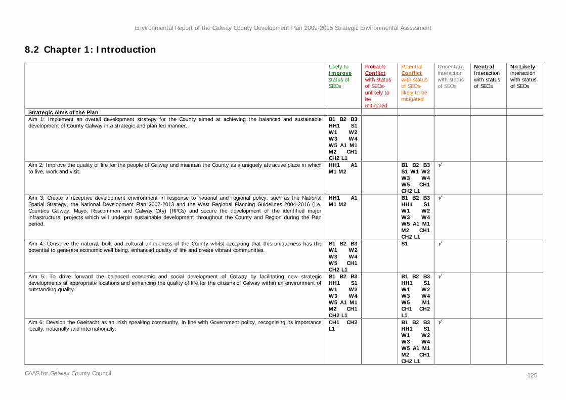
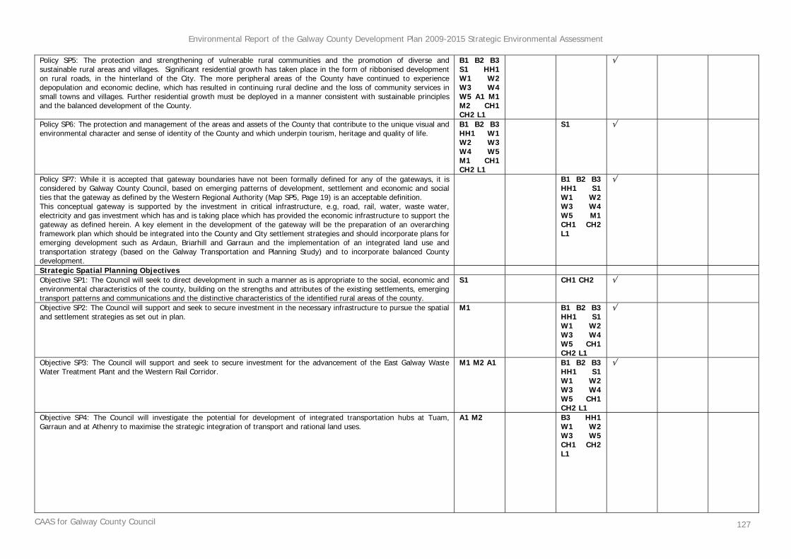
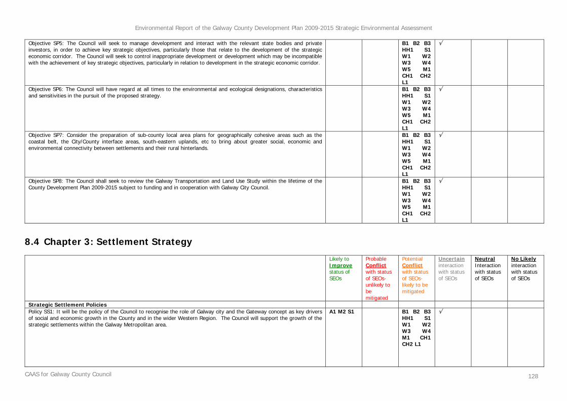
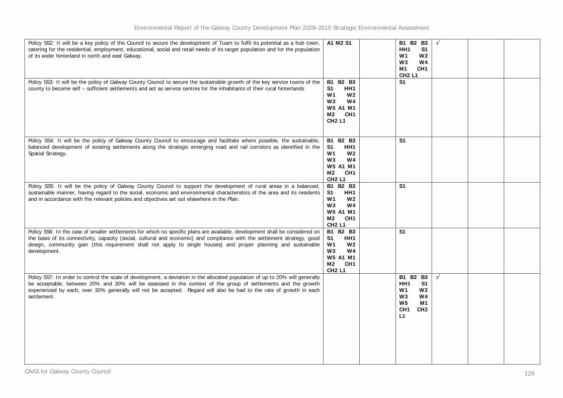
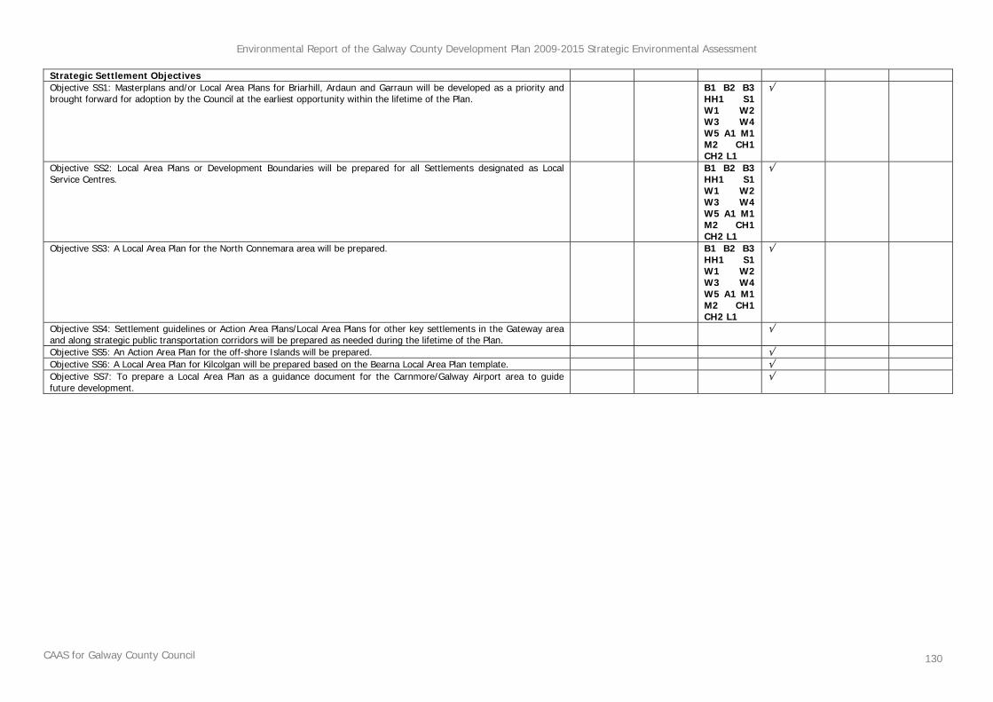
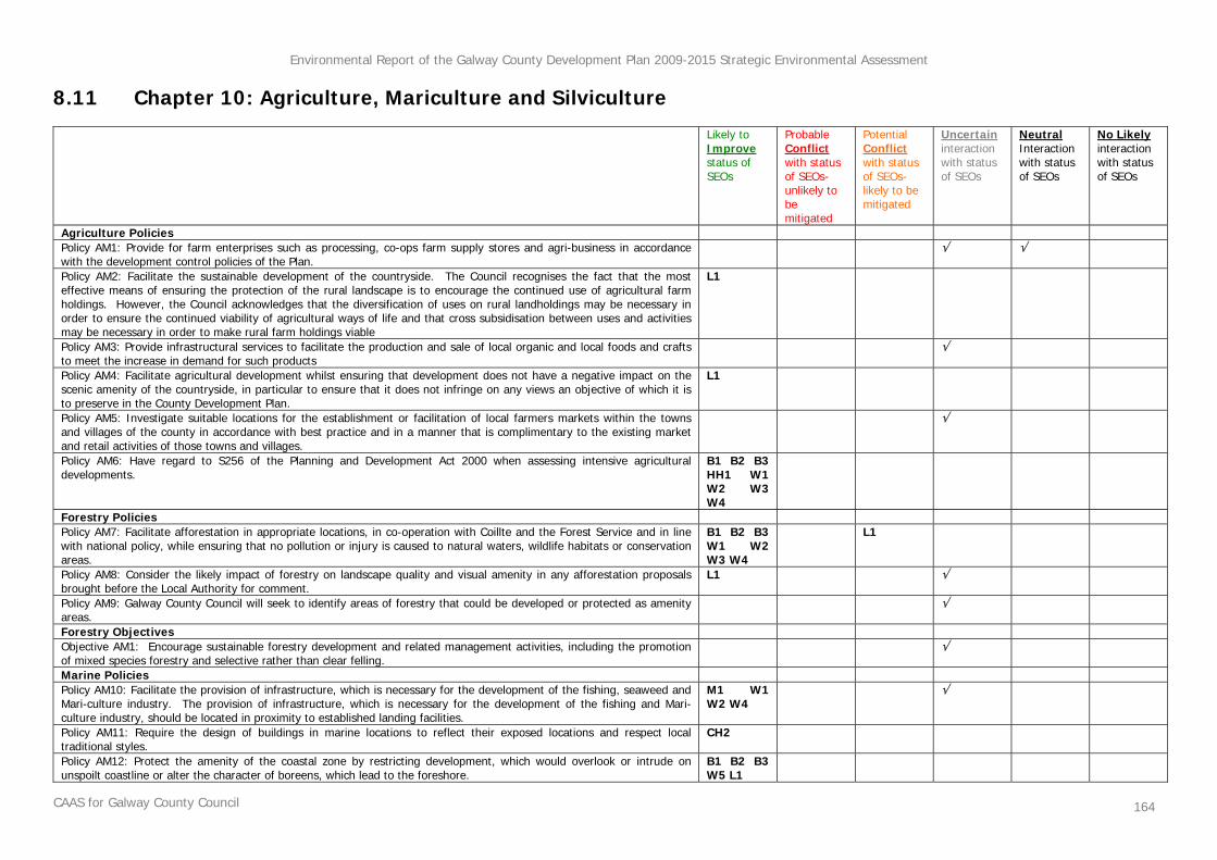
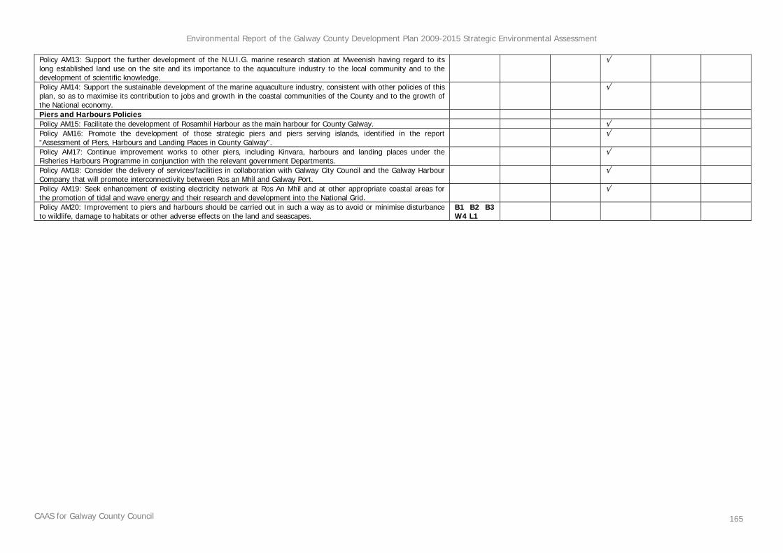
8.1 Methodology ................................................................................................................123 8.2 Chapter 1: Introduction.................................................................................................125 8.3 Chapter 2: Spatial Strategy............................................................................................ 126 8.4 Chapter 3: Settlement Strategy...................................................................................... 128 8.5 Chapter 4: Economic Development and Tourism.............................................................. 131 8.6 Chapter 5: Housing Provision......................................................................................... 137 8.7 Chapter 6: Roads and Transportation ............................................................................. 142 8.8 Chapter 7: Infrastructure and Services ........................................................................... 147 8.9 Chapter 8: Cultural, Social and Community Development ................................................. 151 8.10 Chapter 9: Heritage, Landscape and Environmental Management ..................................... 154 8.11 Chapter 10: Agriculture, Mariculture and Silviculture ........................................................ 164
Appendix I Site Synopses……………………………………………………..Separately Bound
Appendix II Non Technical Summary..………..…………………..……...Separately Bound
Environmental Report of the Galway County Development Plan 2009-2015 Strategic Environmental Assessment
CAAS for Galway County Council iii
List of Figures
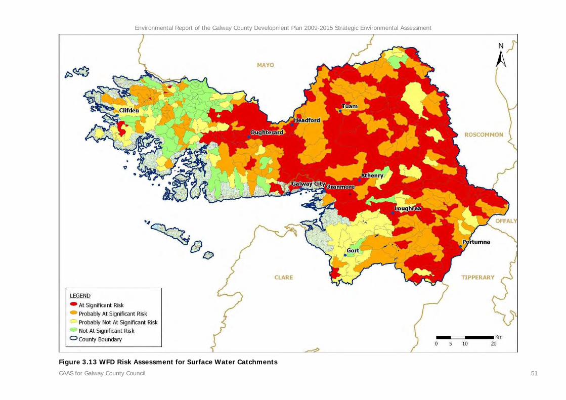
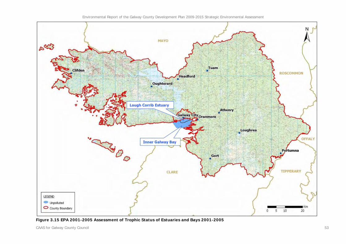
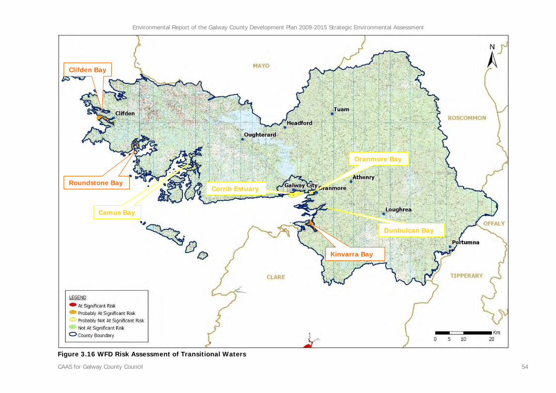
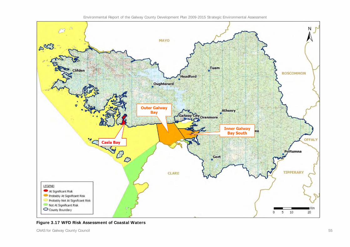
Figure 2.1 County Development Plan and SEA Stages..........................................................................2 Figure 3.1 Context of County Galway in relation to the island of Ireland and surrounding counties ..........8 Figure 3.2 CORINE Landcover 2000 .................................................................................................14 Figure 3.3 CORINE Landcover Changes 1990-2000............................................................................15 Figure 3.4 County Galway SPAs, candidate SACs and NHAs................................................................25 Figure 3.5 Shellfish Waters under the European Communities (Quality of Shellfish Waters) Regulations 2006 .............................................................................................................................................26 Figure 3.6 Population by District Electoral Division 2006 ....................................................................31 Figure 3.7 Population Density by District Electoral Division 2006.........................................................32 Figure 3.8 Population Change (%) by District Electoral Division 2002-2006..........................................33 Figure 3.9 Subsoils .........................................................................................................................37 Figure 3.10 Soils ............................................................................................................................38 Figure 3.11 EPA River Water Quality Monitoring ................................................................................49 Figure 3.12 WFD Risk Assessment for Rivers.....................................................................................50 Figure 3.13 WFD Risk Assessment for Surface Water Catchments.......................................................51 Figure 3.14 WFD Risk Assessment for Lakes .....................................................................................52 Figure 3.15 EPA 2001-2005 Assessment of Trophic Status of Estuaries and Bays 2001-2005.................53 Figure 3.16 WFD Risk Assessment of Transitional Waters...................................................................54 Figure 3.17 WFD Risk Assessment of Coastal Waters.........................................................................55 Figure 3.18 Compliance with EU Guide and Mandatory Values ............................................................56 Figure 3.19 GSI Aquifer Productivity and Vulnerability .......................................................................57 Figure 3.20 WFD Risk Assessment of Ground Water Bodies................................................................58 Figure 3.21 WFD Registers of Protected Areas ..................................................................................59 Figure 3.22 Flood Channels Scheme.................................................................................................60 Figure 3.23 IPPC licensed facilities and Waste Licensed Facilities ........................................................66 Figure 3.24 Archaeological Heritage .................................................................................................79 Figure 3.25 Architectural Heritage - entries to the Record of Protected Structures................................80 Figure 3.26 Architectural Heritage - Architectural Conservation Areas..................................................81 Figure 3.27 Landscape Character Areas............................................................................................89 Figure 3.28 Landscape Values .........................................................................................................90 Figure 3.29 Landscape Sensitivity Classification.................................................................................91 Figure 3.30 Focal Points and Views ..................................................................................................92 Figure 6.1 Alternative Scenario 1 - Dispersed Development Strategy (Rural Dispersal with Limited Urban Growth)....................................................................................................................................... 110 Figure 6.2 Alternative Scenario 2 - Structured Development Strategy (Well Developed Urban Structure Supporting Diverse Rural Areas) .................................................................................................... 111 Figure 6.3 Alternative Scenario 3 - Centered Development Strategy (Strong Urban Centres and Rural Protection)................................................................................................................................... 112
Environmental Report of the Galway County Development Plan 2009-2015 Strategic Environmental Assessment
CAAS for Galway County Council iv
List of Tables
Table 2.1 Checklist of Information included in this Environmental Report ..............................................5 Table 3.1 Candidate Special Areas of Conservation............................................................................21 Table 3.2 Special Protection Areas ...................................................................................................22 Table 3.3 Natural Heritage Areas .....................................................................................................22 Table 3.4 Proposed Natural Heritage Areas Table A...........................................................................23 Table 3.5 Proposed Natural Heritage Areas Table B...........................................................................24 Table 3.6 EPA ATSEBI Classifications of Water Bodies by Monitoring Period.........................................43 Table 3.7 IPPC Licence Holders and Principle Classes of Activity .........................................................64 Table 3.8 IPPC Licence Holders and Principle Classes of Activity .........................................................64 Table 3.9 Available information on Waste Water Treatment Capacity and Demand in certain settlements in County Galway ...........................................................................................................................71 Table 3.10 Summary of Water Supplies ............................................................................................72 Table 3.11 Landscape Character Areas and their Values and Sensitivity...............................................87 Table 7.1 Criteria for appraising the effect of Plan provisions on Strategic Environmental Objectives.... 114 Table 7.2 Strategic Environmental Objectives (SEOs)....................................................................... 114 Table 7.3 Evaluation of Alternative Scenarios against SEOs .............................................................. 121 Table 8.1 Strategic Environmental Objectives (SEOs)....................................................................... 124 Table 10.1 Selected Indicators, Targets and Monitoring Sources....................................................... 179
Environmental Report of the Galway County Development Plan 2009-2015 Strategic Environmental Assessment
CAAS for Galway County Council v
List of Abbreviations
CDP County Development Plan
CSO Central Statistics Office
DEHLG Department of the Environment, Heritage and Local Government
EIA Environmental Impact Assessment
EPA Environmental Protection Agency
EU European Union
GCC Galway County Council
GSI Geological Survey of Ireland
NHA Natural Heritage Area
NIAH National Inventory of Architectural Heritage
NSS National Spatial Strategy
RBD River Basin District
RMP Record of Monuments and Places
RPS Record of Protected Structures
SAC Special Area of Conservation
SEA Strategic Environmental Assessment
SEO Strategic Environmental Objective
SI No. Statutory Instrument Number
SPA Special Protection Area
WFD Water Framework Directive
Environmental Report of the Galway County Development Plan 2009-2015 Strategic Environmental Assessment
CAAS for Galway County Council vi
Glossary
Biodiversity and Flora and Fauna Biodiversity is the variability among living organisms from all sources including inter alia, terrestrial, marine and other aquatic ecosystems and the ecological complexes of which they are a part; this includes diversity within species, between species and of ecosystems’ (United Nations Convention on Biological Diversity 1992). Flora is all of the plants found in a given area. Fauna is all of the animals found in a given area.
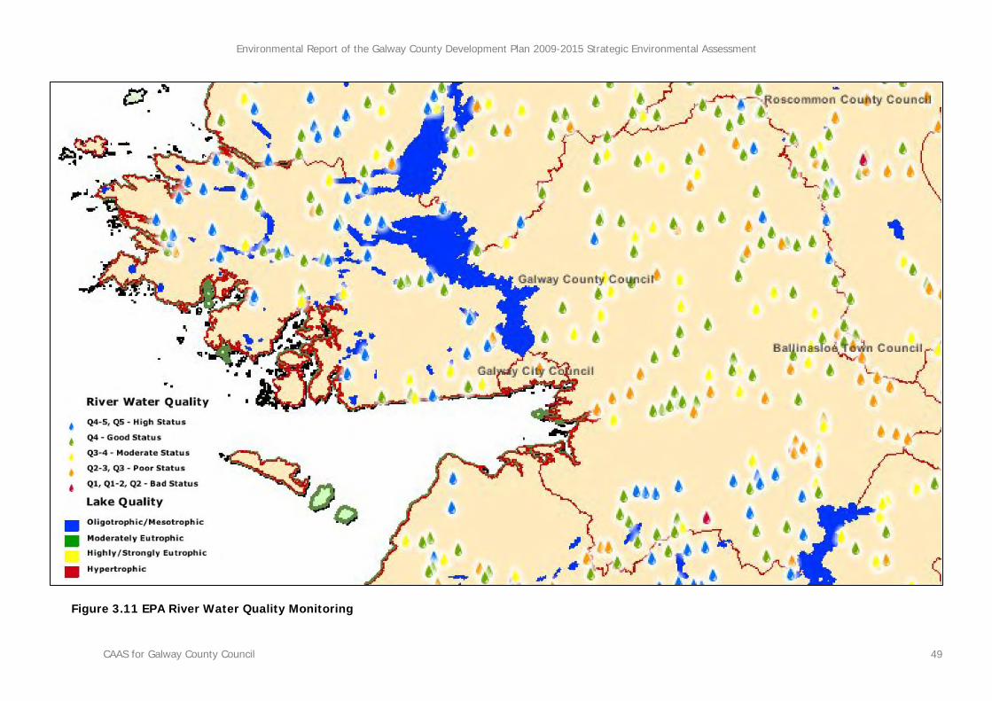
Biotic Index Values (Q Values) The Biotic Index Values, or Q values, are assigned to rivers in accordance with biological monitoring of surface waters - low Q ratings, as low as Q1, are indicative of low biodiversity and polluted waters, and high Q ratings, as high as Q5, are indicative of high biodiversity and unpolluted waters. Good status as defined by the Water Framework Directive equates to approximately Q4 in the national scheme of biological classification of rivers as set out by the Environmental Protection Agency.
Environmental Problems Annex I of Directive 2001/42/EC of the European Parliament and of the Council of Ministers, of 27 June 2001, on the assessment of the effects of certain plans and programmes on the environment (the Strategic Environmental Assessment Directive) requires that information is provided on ‘any existing environmental problems which are relevant to the plan or programme’, thus, helping to ensure that the proposed strategic action does not make existing environmental problems worse. Environmental problems arise where there is a conflict between current environmental conditions and ideal targets. If environmental problems are identified at the offset they can help focus attention on important issues and geographical areas where environmental effects of the plan or programme may be likely.
Environmental Vectors Environmental vectors are environmental components, such as air, water or soil, through which contaminants or pollutants, which have the potential to cause harm, can be transported so that they come into contact with human beings.
Mitigate To make or become less severe or harsh
Mitigation Measures Mitigation measures are measures envisaged to prevent, reduce and, as fully as possible, offset any significant adverse impacts on the environment of implementing a human action, be it a plan, programme or project. Mitigation involves ameliorating significant negative effects. Where there are significant negative effects, consideration should be given in the first instance to preventing such effects or, where this is not possible, to lessening or offsetting those effects. Mitigation measures can be roughly divided into those that: avoid effects; reduce the magnitude or extent, probability and/or severity of effects; repair effects after they have occurred; and compensate for effects, balancing out negative impacts with other positive ones.
Environmental Report of the Galway County Development Plan 2009-2015 Strategic Environmental Assessment
CAAS for Galway County Council vii
Protected Structure Protected Structure is the term used in the Planning Act of 2000 to define a structure included by a planning authority in its Record of Protected Structures. Such a structure shall not be altered or demolished in whole or part without obtaining planning permission or confirmation from the planning authority that the part of the structure to be altered is not protected.
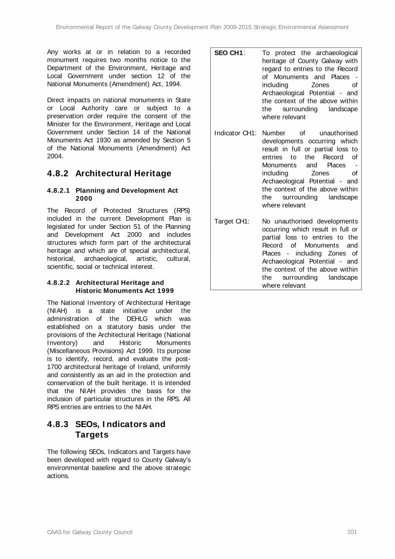
Recorded Monument A monument included in the list and marked on the map which comprises the Record of Monuments and Places that is set out County by County under Section 12 of the National Monuments (Amendment) Act, 1994 by the Archaeological Survey of Ireland. The definition includes Zones of Archaeological Potential in towns and all other monuments of archaeological interest which have so far been identified. Any works at or in relation to a recorded monument requires two months notice to the Department of the Environment, Heritage and Local Government under section 12 of the National Monuments (Amendment) Act, 1994.
Scoping Scoping is the process of determining what issues are to be addressed, and setting out a methodology in which to address them in a structured manner appropriate to the plan or programme. Scoping is carried out in consultation with the appropriate bodies.
Strategic Actions Strategic actions include: Policies, which may be considered as inspiration and guidance for action and which set the framework for plans and programmes; Plans, sets of co-ordinated and timed objectives for the implementation of the policy; and Programmes, sets of projects in a particular area.
Strategic Environmental Assessment (SEA) Strategic Environmental Assessment (SEA) is the formal, systematic evaluation of the likely significant environmental effects of implementing a plan or programme before a decision is made to adopt it.
Strategic Environmental Objective (SEO) Strategic Environmental Objectives (SEOs) are methodological measures which are developed from international, national and regional policies which generally govern environmental protection objectives and against which the environmental effects of the CDP can be tested. The SEOs are used as standards against which the objectives of the CDP can be evaluated in order to help identify areas in which significant adverse impacts are likely to occur, if not mitigated.
Environmental Report of the Galway County Development Plan 2009-2015 Strategic Environmental Assessment
CAAS for Galway County Council 1
Section 1 SEA Introduction and Background
1.1 Introduction and Terms of Reference
This is the Environmental Report of the Galway County Development Plan (CDP) 2009-2015 Strategic Environmental Assessment (SEA). The purpose of the report is to provide a clear understanding of the likely environmental consequences of decisions regarding the future accommodation of development in County Galway. The SEA is carried out in order to comply with the provisions of the Planning and Development (SEA) Regulations 2004 (SI No. 436 of 2004) and in order to improve planning and environmental management of future development in the County. This report should be read in conjunction with the CDP.
1.2 SEA Definition
Environmental assessment is a procedure that ensures that the environmental implications of decisions are taken into account before the decisions are made. Environmental Impact Assessment, or EIA, is generally used for describing the process of environmental assessment which is limited to individual projects such as waste incinerators, housing developments or roads while Strategic Environmental Assessment, or SEA, is the term which has been given to the environmental assessment of plans, and other strategic actions, which help determine what kind of individual projects take place. SEA is a systematic process of predicting and evaluating the likely environmental effects of implementing a proposed plan, or other strategic action, in order to insure that these effects are appropriately addressed at the earliest appropriate stage of decision-making on a par with economic and social considerations. The kind of development occurs in County Galway and where it occurs will be significantly determined by the implementation of the CDP. By anticipating the effects and avoiding areas in which growth cannot be sustainably accommodated and by directing development
towards more compatible and robust receiving environments real improvements in environmental management and planning can occur in the County - planning applications are more likely to be granted permission and the scope of any EIAs which may be required as part of any planning applications are likely to be reduced.
1.3 Legislative Context
Directive 2001/42/EC of the European Parliament and of the Council of Ministers, of 27 June 2001, on the assessment of the effects of certain plans and programmes on the environment, referred to hereafter as the SEA Directive, introduced the requirement that SEA be carried out on plans and programmes which are prepared for a number of sectors, including land use planning. The SEA Directive was transposed into Irish Law through the European Communities (Environmental Assessment of Certain Plans and Programmes) Regulations 2004 (Statutory Instrument Number (SI No.) 435 of 2004) and the Planning and Development (Strategic Environmental Assessment) Regulations 2004 (SI No. 436 of 2004). Both sets of Regulations became operational on 21 July 2004.
1.4 Implications for Galway County Council and the Elected Members
The above legislation requires certain plans and programmes which are prepared by Galway County Council - including the CDP - to undergo SEA. The findings of the SEA are expressed in an Environmental Report which is submitted to the Elected Members alongside the CDP. The Elected Members must take account of the Environmental Report before the adoption of the Plan. When the Plan is adopted a statement must be made public, summarising, inter alia: how environmental considerations have been integrated into the Plan; and, the reasons for choosing the Plan as adopted over other alternatives detailed in the Environmental Report.
Environmental Report of the Galway County Development Plan 2009-2015 Strategic Environmental Assessment
CAAS for Galway County Council 2
Section 2 SEA Methodology
2.1 Introduction
This section details how the SEA for the CDP has been undertaken alongside the preparation of the Plan. The SEA process started in February
2008 and this report has been produced in April 2009. Figure 2.1 lays out the main stages in the CDP SEA process.
Figure 2.1 County Development Plan and SEA Stages
2.2 Scoping
In consultation with the relevant authorities, the scope of environmental issues to be dealt with by the SEA together with the level of detail to which they are to be addressed was broadly decided on after preliminary data collection.
Scoping of the SEA was continuous with certain issues being selected for further examination after certain data was obtained. Scoping helped the SEA to become focused upon the important issues, such as those relating to existing and potential environmental issues and
Environmental Report of the Galway County Development Plan 2009-2015 Strategic Environmental Assessment
CAAS for Galway County Council 3
environmental problems1, thereby avoiding resources being wasted on unnecessary data collection. Scoping facilitated the selection of issues relevant to the environmental components which are specified under the SEA Directive - biodiversity, fauna, flora, population, human health, soil, water, air, climatic factors, material assets, cultural heritage including architectural and archaeological heritage, and landscape. With regard to human health, impacts relevant to the SEA are those which arise as a result of interactions with environmental vectors (i.e. environmental components such as air, water or soil through which contaminants or pollutants, which have the potential to cause harm, can be transported so that they come into contact with human beings). Impacts upon human beings arising as a result of social and economic conditions are not considered by SEA. Consultations were held with: the Environmental Protection Agency (EPA); the Department of the Environment, Heritage and Local Government (DEHLG); the Department of Communications, Energy and Natural Resources; and, the Department of Transport. In addition, Galway County Council’s intention to carry out SEA as part of the review of the CDP was identified during the consultation process on the preparation of the new CDP. The most important strategic environmental issues in County Galway were identified as follows:
• The compliance of all water bodies within the County with the objectives of the Water Framework Directive - the groundwater bodies and surface water bodies and catchments which are at most risk are those which likely to come under the most pressure as a result of development. Compliance with the
1 Annex I of the SEA Directive requires that information is provided on ‘any existing environmental problems which are relevant to the plan or programme’, thus, helping to ensure that the proposed strategic action does not make existing environmental problems worse. Environmental problems arise where there is a conflict between current environmental conditions and ideal targets. If environmental problems are identified at the offset they can help focus attention on important issues and geographical areas where environmental effects of the plan or programme may be likely.
Water Framework Directive will contribute to the protection of drinking water resources and consequently human health.
• Compliance with the objectives of the
Habitats Directive; most of the pressure upon designated habitats as a result of development is likely to occur in coastal areas and on the banks of Lough Corrib where infringement could occur if unmitigated.
• The protection of valuable landscapes
and views; housing has the potential to threaten some of these however wind energy development in the west of the County is the greatest threat.
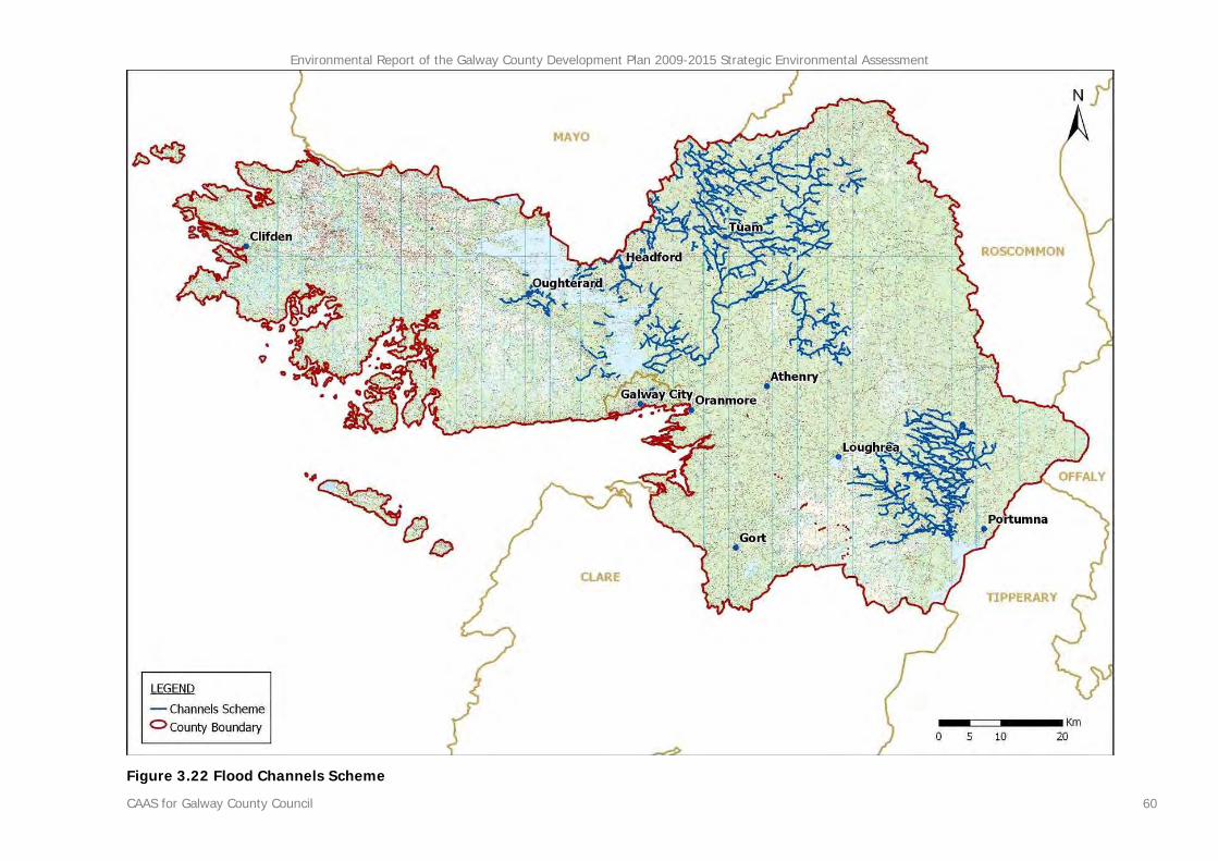
• The prevention of flooding.
• The protection of cultural heritage,
architectural and archaeological. The findings of the SEA were communicated to the plan making team at Galway County Council on an ongoing basis from the outset in order to allow for their integration into the CDP thus minimising the potential for significant negative environmental effects arising from implementation of the Plan.
2.3 Environmental Baseline Data and Other Strategic Actions
The SEA process is informed by the environmental baseline (i.e. the current state of the environment - flora and fauna, soil, water, cultural heritage etc.) to facilitate: the identification and evaluation of the likely significant environmental effects of implementing the Plan and the alternatives; and, the subsequent monitoring of the effects of the Plan as adopted. Data was collected to describe the environmental baseline and its likely evolution without implementation of the Plan. The SEA Directive requires that information is provided on ‘any existing environmental problems which are relevant to the plan or programme’. Information is therefore provided on existing environmental problems which are relevant to the CDP, thus helping to ensure that the CDP does not exacerbate any existing environmental problems in the County.
Environmental Report of the Galway County Development Plan 2009-2015 Strategic Environmental Assessment
CAAS for Galway County Council 4
The SEA Directive requires that information on the baseline environment be focused upon the relevant aspects of the environmental characteristics of areas likely to be significantly affected and the likely evolution of the current environment in the absence of the strategic action i.e. the CDP. Any information that does not focus upon this is surplus to requirements; therefore the CDP SEA focuses on the significant issues, disregarding the less significant ones. In addition, the SEA Directive aims to avoid duplication of the assessment whereby a strategic action forms part of a hierarchy. Furthermore, if certain matters are more appropriately assessed at different levels of the hierarchy in which the CDP is positioned, or, if certain matters have already been assessed by a different level of the hierarchy then additional assessment is not needed. In order to describe the baseline (the current state of the environment) in County Galway, data was collated from currently available, relevant environmental sources.
2.4 Alternatives
The SEA Directive requires that reasonable alternatives (taking into account the objectives and the geographical scope of the plan or programme) are identified described and evaluated for their likely significant effects on the environment. Taking into account the objectives and the geographical scope of the CDP, alternatives were formulated through consultation with the plan-making team at Galway County Council and a number of departments at the Council.
2.5 The SEA Environmental Report
In this Environmental Report, which was placed on public display alongside the Draft CDP, the likely environmental effects of the Plan and the alternatives are predicted and their significance evaluated with regard to the environmental baseline. The Environmental Report provided the decision-makers, the Elected Members of Galway County Council, who decided what type of Plan to adopt, as well as the public, with a clear understanding of the likely environmental consequences of decisions regarding the future accommodation of growth in County Galway.
Mitigation measures to prevent or reduce significant adverse effects posed by the CDP, or to maximise any benefits arising, were recommended for integration into the CDP. Different alternative scenarios for the CDP which were considered are also presented in this report, as are measures concerning monitoring. The Environmental Report had to be updated in order to take account of changes which were made to the Draft CDP after it was put on public display and before it was adopted.
2.6 The SEA Statement
On adoption of the Draft CDP a document - referred to as the SEA Statement - was prepared and made public. This is required to include information on: how environmental considerations have been integrated into the Galway CDP - highlighting the main changes to the Plan which resulted from the SEA process; how the Environmental Report and consultations have been taken into account - summarising the key issues raised in consultations and in the Environmental Report indicating what action, if any, was taken in response; and the reasons for choosing the CDP in the light of the other alternatives, identifying the other alternatives considered, commenting on their potential effects and explaining why the CDP was selected. The SEA Statement must include information on how environmental considerations have been integrated throughout the process. It must also describe how the preferred alternative was chosen to introduce accountability, credibility and transparency into the strategic decision-making process.
2.7 Legislative Conformance
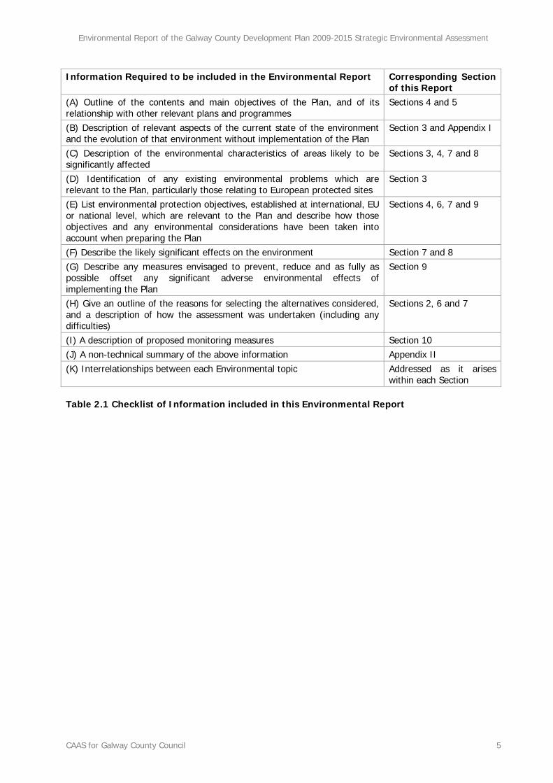
This report complies with the provisions of the SEA Regulations and is written in accordance with Schedule 2B of the Planning and Development (Strategic Environmental Assessment) Regulations 2004 (SI No. 436 of 2004). Table 2.1 (overleaf) is a reproduction of the checklist of information to be contained in the Environmental Report (DEHLG, 2004)2 and includes the relevant sections of this report which deal with these requirements.
2 DEHLG (2004) Implementation of SEA Directive (2001/42/EC): Guidelines for Regional Authorities and Planning Authorities Dublin: Government of Ireland.
Environmental Report of the Galway County Development Plan 2009-2015 Strategic Environmental Assessment
CAAS for Galway County Council 5
Table 2.1 Checklist of Information included in this Environmental Report
Information Required to be included in the Environmental Report Corresponding Section of this Report
(A) Outline of the contents and main objectives of the Plan, and of its relationship with other relevant plans and programmes
Sections 4 and 5
(B) Description of relevant aspects of the current state of the environment and the evolution of that environment without implementation of the Plan
Section 3 and Appendix I
(C) Description of the environmental characteristics of areas likely to be significantly affected
Sections 3, 4, 7 and 8
(D) Identification of any existing environmental problems which are relevant to the Plan, particularly those relating to European protected sites
Section 3
(E) List environmental protection objectives, established at international, EU or national level, which are relevant to the Plan and describe how those objectives and any environmental considerations have been taken into account when preparing the Plan
Sections 4, 6, 7 and 9
(F) Describe the likely significant effects on the environment Section 7 and 8 (G) Describe any measures envisaged to prevent, reduce and as fully as possible offset any significant adverse environmental effects of implementing the Plan
Section 9
(H) Give an outline of the reasons for selecting the alternatives considered, and a description of how the assessment was undertaken (including any difficulties)
Sections 2, 6 and 7
(I) A description of proposed monitoring measures Section 10 (J) A non-technical summary of the above information Appendix II (K) Interrelationships between each Environmental topic Addressed as it arises
within each Section
Environmental Report of the Galway County Development Plan 2009-2015 Strategic Environmental Assessment
CAAS for Galway County Council 6
2.8 Difficulties Encountered
2.8.1 Centralised Data Source
The lack of a centralised data source that could make all environmental baseline data for the County both readily available and in a consistent format posed a significant difficulty to the SEA process. This difficulty is one which is encountered at local authorities across the country and was overcome by investing time in the collection of data from various sources and through the use of Geographical Information Systems.
2.8.2 Waste Water Treatment Predicted Demand
Baseline information regarding predicted future waste water treatment demand (p.e.) which would be likely to arise from implementation of the CDP was not available for use in the assessment. Notwithstanding this, mitigation measures were recommended for integration into the CDP in order to ensure, among other things, that development under the Plan is preceded by sufficient capacity in the public waste water treatment plants and appropriate extensions in the existing public waste water treatment catchments.
2.8.3 Drinking Water Capacity and Predicted Demand
Baseline information regarding the capacity of existing drinking water supplies and predicted future drinking water supply demand which would be likely to arise from implementation of the CDP was not available for use in the assessment. Notwithstanding this, mitigation measures were recommended for integration into the CDP in order to ensure, among other things, that water supplies are protected and that existing and new populations are served with clean and wholesome drinking water.
2.8.4 Water Framework Directive Risk Assessments
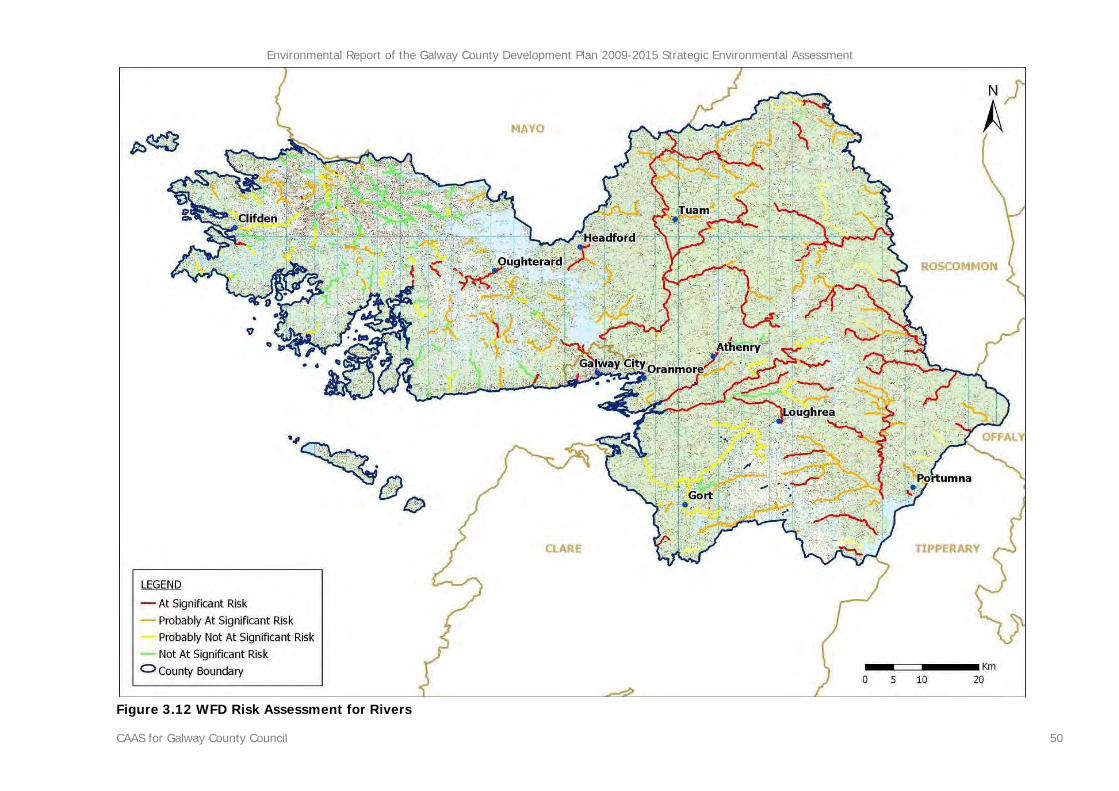
The current Water Framework Directive (WFD) risk assessments for bodies within and surrounding County Galway (see Section 3.5)
was carried out in late 2004 and did not take into consideration either improvements in waste water collection and treatment arising from completion of various schemes or declines in water quality as a result of inappropriate waste water treatment from new developments. The assessments were "snap shots" of the situation at that time and only considered waste water treatment plants which were operational, known combined storm overflows and water quality monitoring results up to and until 2004. The improvements in waste water treatment and collection make it more likely that some waterbodies within the County would achieve their requirements under the WFD whereas any declines would make it less likely that waterbodies would achieve their requirements under the WFD. Therefore, as a result of considering these improvements, the current risk assessments for some waterbodies may be updated in the future.
2.8.5 Rising Sea Levels
The EPA’s ‘Climate Change: Scenarios and Impacts for Ireland’ (2003)3 provides maps showing three sea level rise scenarios applied to selected areas around the Irish coastline however Galway is not included in this mapping (see Section 3.6.4.3). Although mapping is not available for County Galway it is noted that the examples provided in this report demonstrate that rising sea levels could place certain coastal areas of land at risk. The report also provides recommendations for integration into land use plans, a number of which have been recommended as part of this SEA.
3 Department of Geography, National University of Ireland, Maynooth (2003) Environmental RTDI Programme 2000–2006 Climate Change: Scenarios and Impacts for Ireland (2000-LS-5.2.1-M1) Final Report Wexford: Environmental Protection Agency
Environmental Report of the Galway County Development Plan 2009-2015 Strategic Environmental Assessment
CAAS for Galway County Council 7
Section 3 County Galway’s Baseline Environment
3.1 Introduction
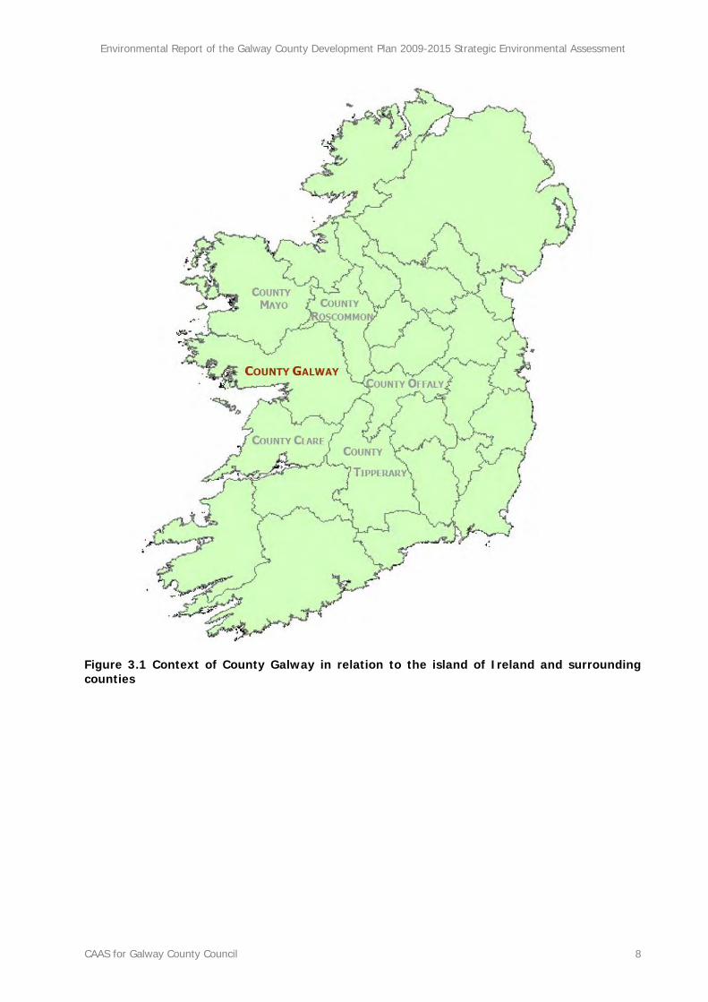
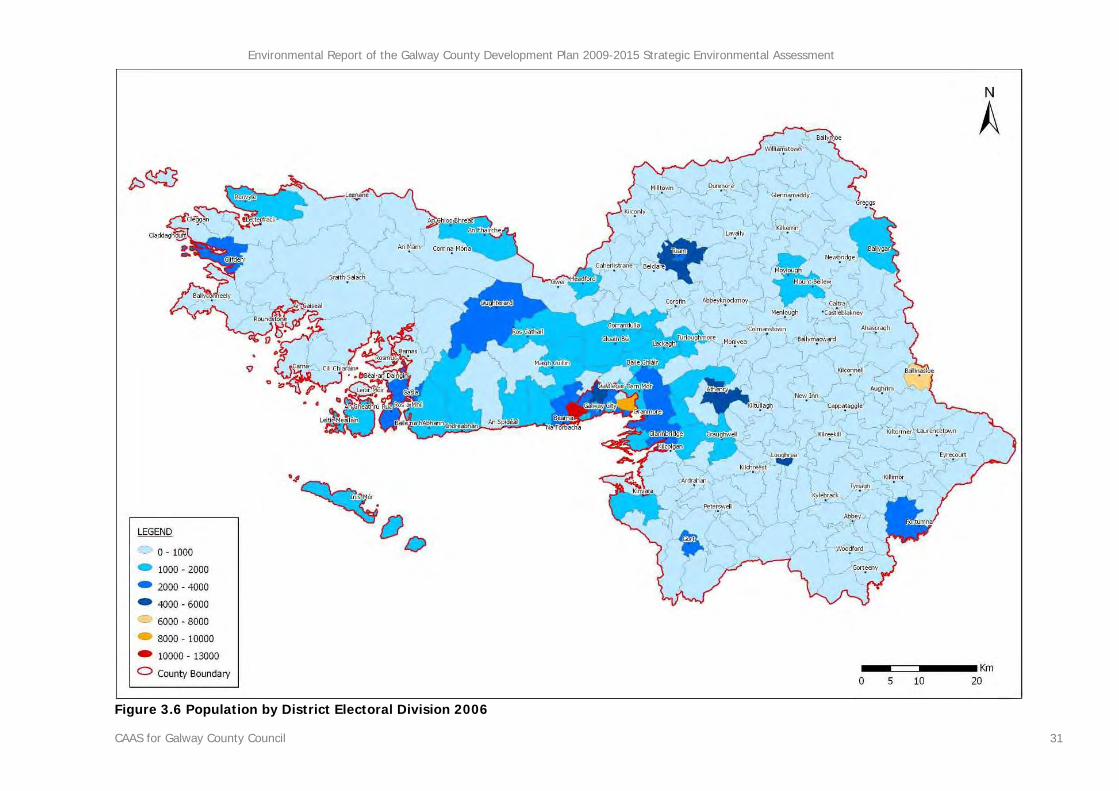
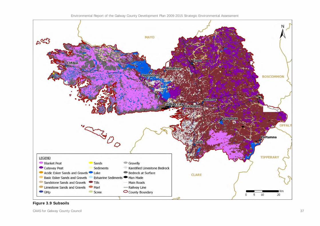
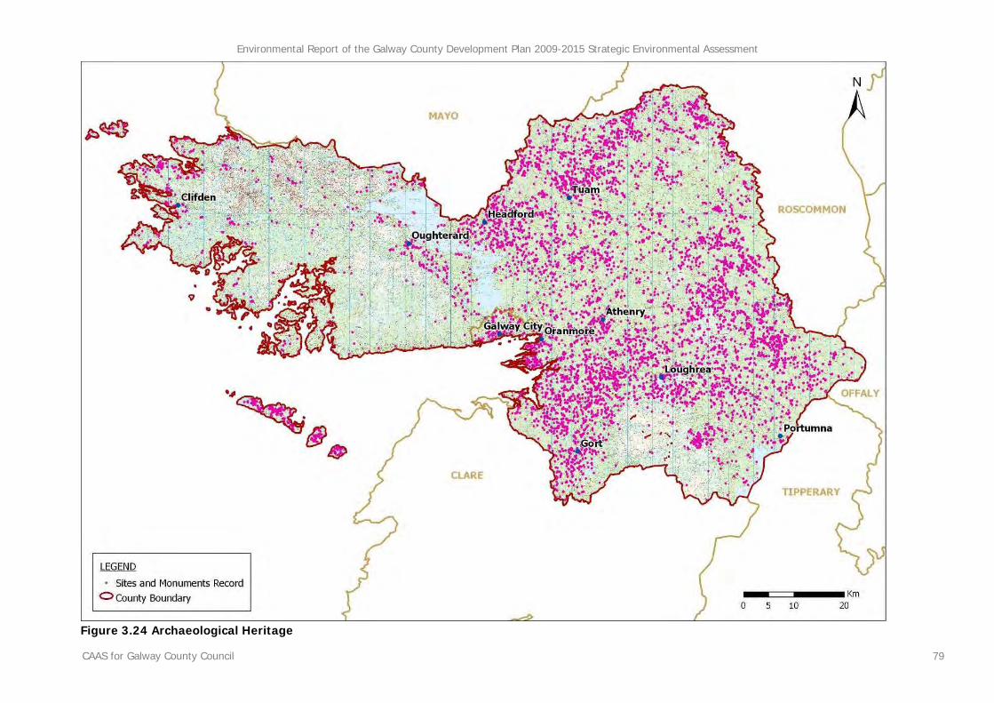
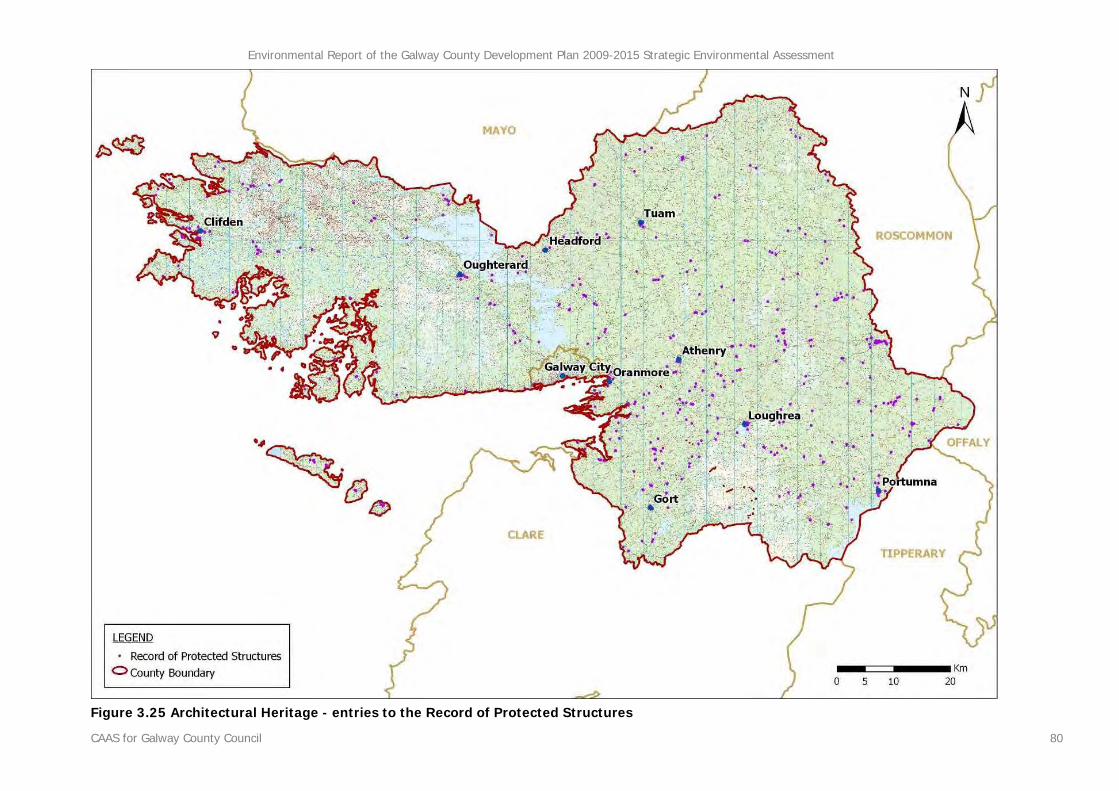
The environmental baseline of County Galway is described in this section. This baseline together with the Strategic Environmental Objectives, which are outlined in Section 4, is used in order to identify, describe and evaluate the likely significant environmental effects of implementing the County Development Plan and in order to determine appropriate monitoring measures. The environmental baseline is described in line with the legislative requirements, encompassing the following components – biodiversity, flora and fauna, population, human health, soil, water, air and climatic factors, material assets, cultural heritage, landscape and the interrelationship between these components. A description is also included of the likely effects upon each environmental component under a do-nothing scenario i.e. the likely evolution of the environment without the implementation of the County Development Plan. County Galway is the second largest county in Ireland with an area of 6,148 square kilometres and a population of 231,035 persons as of Census 20064, 159,052 of which live in the administrative area of Galway County Council and 71,983 of which live in Galway City. Located in the west of Ireland, the County shares borders with five other counties - Mayo, Roscommon, Offaly, Tipperary and Clare - (see Figure 3.1) and borders the Atlantic Ocean to its east with a coastline of around 689 kilometres, excluding that of its many off shore islands. Human interaction with the land and sea is evident from the earliest of times up to the present, from archaeological remains to farmland to growing urban centres such as Galway City, Athenry, Ballinasloe, Clifden, Gort, Headford, Loughrea, Oranmore, Oughterard, Portumna and Tuam.
4 CSO (2007) Census 2006 Volume 1 - Population Classified by Area Cork: CSO
West Galway is characterised by mountains, bogs, rivers and lakes while East Galway is characterised by a low-lying rolling topography of a fertile limestone plain, rich pasturelands, bog, and the River Shannon with its Callows and Lough Derg. Due to its geology, the mild climate and plentiful rainfall, the Galway landscape has an abundance and diversity of wetlands, peatlands and freshwater features. Many of Galway’s most important natural and semi-natural habitats are afforded protection under European and National Legislation by way of designation as National Heritage Areas (NHAs), Special Areas of Conservation (SACs) and Special Protection Areas (SPAs).
Environmental Report of the Galway County Development Plan 2009-2015 Strategic Environmental Assessment
CAAS for Galway County Council 8
Figure 3.1 Context of County Galway in relation to the island of Ireland and surrounding counties
Environmental Report of the Galway County Development Plan 2009-2015 Strategic Environmental Assessment
CAAS for Galway County Council 9
3.2 Biodiversity and Flora and Fauna
3.2.1 Overview of High Value Biodiversity5
3.2.1.1 Introduction
County Galway contains a variety of natural habitats including many of international nature importance such as blanket bogs, fens, heath, ancient oak woodland, turloughs, species-rich calcareous grassland and limestone pavement. The County also contains a large number of rare, threatened and uncommon species, including a large number of plants and animals that are protected under national and European Union legislation. A number of these species are found within the habitats of high value mentioned below as well as within the County’s designated ecological sites (see Section 3.2.4).
3.2.1.2 Peatlands
Peatlands such as raised and blanket bogs, wet and dry heath, and fens are of particular value because of the rarity of these habitats in an international context, and because of the characteristic flora and fauna that live in these wet, peaty and often highly acidic places. Irish raised bogs account for 50% of all the conservation-worthy raised bogs remaining in Europe. A number of high quality active raised bogs are found in the north and east of County Galway, as well as large areas of cutover and degraded raised bog. Ireland, and in particular, Galway, contains some of the best examples of intact blanket bog in Europe. The most extensive habitat of nature importance within County Galway is lowland blanket bog, found mainly in south Connemara. This habitat, which often occurs in close association with nutrient-poor lakes and rivers, provides a habitat for a large number of rare plants including Slender Cotton Grass, Bog Orchid and Pillwort. The mountains of Connemara and other upland areas in the
5 Text in this section is sourced from the Galway County Draft Biodiversity Action Plan 2008 - 2013 which provides a detailed overview of the County’s biodiversity [Galway County Council (2008) Draft Biodiversity Action Plan for County Galway 2008 - 2013 Galway: Galway County Council].
County are generally dominated by upland blanket bog, wet, dry and montane heath. A number of birds live and breed on bogs including Red Grouse, Golden Plover and the Curlew. These birds are very vulnerable to loss of good quality bog habitat and their numbers have been declining for many years. Blanket bog, heath and young coniferous forestry habitats in the Slieve Aughties are important breeding ground for the Hen Harrier. The coastal areas of Connemara tend to be dominated by extensive areas of dry heath and outcropping bedrock (mostly granite). The shallow, peaty soils found in these coastal heaths provide a habitat for a range of rare plants including Pyramidal Bugle, Pale Dog-violet, Green-winged Orchid and Spotted Rock-rose. Fens are another important but less abundant peatland type found in Galway, which often occurs in association with raised bogs, eskers and/ or lakes. The Marsh Fritillary is one of the most endangered species in Europe due to the loss of its habitat across much of its range. County Galway contains a large proportion of the Irish population and colonies can be found on a number of fens and raised bog sites in the east of the County.
3.2.1.3 Limestone Pavement
Limestone pavement is a unique habitat found in the Burren region in Clare, south County Galway and on the Aran Islands. Exposed limestone outcrops and the associated habitats of limestone heath, scrub and woodland form some special habitat mosaics with many uncommon plant species and unusual plant assemblages present. Extensive areas of limestone pavement still occur to the south of Kinvarra with a number of small, isolated patches occurring along a corridor from Kilcolgan to Tuam and near Moycullen. These areas of limestone pavement often occur in close association with species-rich calcareous grassland and sometimes support the protected species, Wood Bitter-vetch. Often associated with limestone pavement, orchid-rich calcareous grasslands are another priority habitat. These species-rich semi-natural grasslands are becoming increasingly scarce in Ireland due to changes in agricultural practice and housing development. Some good examples can still be seen in the Aran Islands and around Castletaylor - both areas of which
Environmental Report of the Galway County Development Plan 2009-2015 Strategic Environmental Assessment
CAAS for Galway County Council 10
are designated as Special Areas of Conservation - and in the Cow Park in Clarinbridge. Underground limestone caves can be important hibernation areas for bats such as the Lesser Horseshoe, which is found in just six counties on the western seaboard including Galway. The Irish population of Lesser Horseshoe bats is internationally important as the species is now in serious decline and even extinct in much of Europe.
3.2.1.4 Woodland
Native woodland is a relatively uncommon habitat in County Galway. In west Galway, Derryclare and Ballinahinch in Connemara are important native woodland sites, while in east Galway, significant areas of oak-birch-holly woodland include Gortnacarnaun, Drummin, and Woodford. An extensive area of oak-ash woodland is found in association with the turloughs of Coole and Garryland. These woodlands support many rare plant species including the Narrow-leaved Helleborine, Bird Cherry and Yellow Bird’s Nest. They are also home to the Brown Hairstreak, a much localised butterfly species that is found only in Galway, Clare and North Tipperary living in limestone woodlands and hedges. Even when dominated by non-native broadleaf trees - such as beech or sycamore -, woodland habitats can support a wide range of plants and animals. Forests such as Portumna Forest Park and Kilcornan Woods in Clarinbridge are home to important populations of Red Squirrel, a species that is in rapid decline in most of the east of the country due to competition from the introduced American Grey Squirrel. The Pine Marten is another important native mammal found in Galway woodlands. Due to centuries of persecution, Pine Marten numbers were critically reduced but now its range is expanding due to legal protection and increasing cover of coniferous forestry and scrub woodland.
3.2.1.5 Eskers
Eskers are distinctive Irish habitats found mostly in the midlands. They are long sinuous rounded hills which were formed at the end of the last ice age when silt, sand and gravel were deposited by rivers of glacial melt water under the ice. As well as being geomorphological features, eskers are important for the characteristic woodland and grassland habitats they support, including species-rich grasslands with abundant orchids. A
number of eskers are found in the north and east of the County including Richmond Esker, a Nature Reserve near Kilkerrin, which has two of the few esker ridges left in the country which still carry native woodland.
3.2.1.6 Freshwater Aquatic Habitats
Turloughs, a priority habitat under the EU Habitats Directive, are unique to limestone regions in the west of Ireland. These seasonal lakes are home to a characteristic suite of animals and plants that are adapted to the fluctuating water table and include some rarities such as Fen Violet, Alder Buckthorn and Dropwort. Turloughs are abundant in north, east and south County Galway and there are a number of exceptional turlough sites in the region such as Coolcam, Croaghill, Ballinastack, Coole-Garryland and Glenamaddy Turloughs. Rahasane Turlough near Craughwell is the largest in Ireland and is important for over-wintering birds. Galway also has an abundance of permanent freshwater lakes, the largest of which, Lough Corrib divides the geographically distinct regions of the east and west of the County. The shores of Lough Corrib provide habitat for a number of rare plant species including Irish Lady’s Tresses, Shrubby Cinquefoil and Alder Buckthorn. Many of the rivers and lakes in County Galway have relatively good water quality (see Section 3.5 Water). These water bodies support a number of rare and important plant and animal species including important fisheries of salmon and brown trout. The Arctic Char is a very rare fish similar in ecology and appearance to the brown trout. One of the first fish to colonise Ireland after the Ice Age, it is confined to just a few of the cold, deeper lakes including Lough Inagh, Fermoyle Lough and Athry in County Galway. It is now believed that one third of all native populations of the Arctic Char in Ireland are likely to be extinct, while the status of a further twenty one populations is unknown. In Galway, Arctic Char is believed to be extinct in three lakes while the population status of a further thirteen lakes is unknown. Pollan, another very rare fish, is found in Lough Derg. In Western Europe, its distribution is limited to just five lakes in Ireland. The Fresh Water Pearl Mussel is a critically endangered species due to pollution, habitat destruction and over-fishing. It requires particularly clean, clear and well-oxygenated
Environmental Report of the Galway County Development Plan 2009-2015 Strategic Environmental Assessment
CAAS for Galway County Council 11
water to survive and in Galway it is restricted to just a few soft-water sites in the west of the County including the Owenriff River in Oughterard. The presence of Freshwater Pearl Mussels in a river system is indicative of water of the highest quality. The White Clawed Crayfish is protected in Ireland and under EU legislation. It prefers calcareous waters and is found in Lough Corrib, Lough Derg and other rivers of the Shannon catchment. The Irish crayfish population is especially important, as it remains free of a fungal disease that has decimated populations elsewhere in Europe. The callows, seasonally flooded grasslands of the floodplains of the Shannon and Suck Rivers, form important wildlife habitats and add to the rich habitat mosaic found along these rivers. During the summer the callows support exceptional flower rich wet meadows, and are home to the globally endangered Corncrake. In the winter they provide food and shelter for large numbers of over-wintering wild fowl including Whooper Swan, Wigeon and Lapwing and a large flock of Greenland White-fronted Geese, an Annex I species under the EU Birds Directive.
3.2.1.7 Coastal Habitats
The coastline of County Galway - including its various offshore islands - stretches for over 2,000 km. It is highly indented and supports a diverse range of habitats including rocky and sandy shores, shingle beaches, and saltwater lagoons. Coastal sand dunes and grasslands are important habitats for many species of invertebrates including rare snails, dragonfly and butterfly species. Machair (flat sandy grassland) is a priority habitat found only along the coast of Ireland and Scotland. In Ireland the distribution of machair is limited to the north-west coast, from Galway Bay to Malin Head in Donegal. Many machair sites have traditionally been used for low intensity mixed-farming, often as commonage land. High quality machair is found at a few sites in Connemara including Dog’s Bay near Roundstone and Slyne Head. These areas are awash with orchids and other wildflowers during the summer months. South Connemara is home to the best site in the country for another priority habitat under EU legislation, coastal lagoons, including some
saline lake lagoons situated on peat. The Foxtail Stonewort, a protected species of algae that grows in highly saline lagoons, has only been recorded at five locations in Ireland, three of which are in Connemara. Salt marshes occur frequently in sheltered locations along the Galway coast. They contain a suite of species able to cope with the saline conditions and often are important habitats for Otters and a wide range of birds. Underwater reefs are found off the Aran Islands and Kilkieran Bay (Ireland’s first marine SAC), and support a biodiversity of marine invertebrates including rare echinoderms, anemones, sponges, soft corals and sea fans. Irelands only known sublittoral population of the Purple Sea Urchin is found on a reef on the west coast of Inishmore. Ireland has one of the most species-rich seaweed floras in Europe with many potential ‘hot-spots’ of seaweed diversity identified including Galway Bay, the coast of the Burren and Connemara. Of particular interest are the maerl beds found in western parts of the coasts of County Galway. These rare habitats are composed of deep deposits of calcareous red algae which produce the distinctive ‘coral’ beaches found around Carraroe. The Atlantic waters off the Galway coast are home to a great diversity of large marine mammals including Bottlenose Dolphins and the Common and Grey Seal. The coast offers a variety of habitats for all manner of sea birds, including the Chough, which breeds on rocky coastal sites, and the Little Tern, which nests on sandy shores.
3.2.2 Ecological Networks and Connectivity
Ecological networks are important in connecting areas of local biodiversity with each other and with nearby designated sites so as to prevent islands of habitat from being isolated entities. They are composed of linear features, such as treelines, hedgerows and rivers/streams, which provide corridors or stepping stones for wildlife species moving within their normal range. They are important for the migration, dispersal and genetic exchange of species of flora and fauna particularly for mammals, especially for bats and small birds. They facilitate linkages both between and within designated ecological sites,
Environmental Report of the Galway County Development Plan 2009-2015 Strategic Environmental Assessment
CAAS for Galway County Council 12
the non-designated surrounding countryside and the more urban areas of the County. The County is dissected by many rivers and lakes with Lough Corrib, Ireland’s second largest, lake at its centre. The banks of these aquatic features together with the extensive coastline of the County provide significant connectivity across the County. Hedgerows are a familiar landscape feature in the countryside of the County, particularly east of Lough Corrib. As well as providing food and shelter for insects, birds and other animals, hedgerows also act as important corridors. Typically, older, denser hedges support a greater abundance and diversity of wildlife. As traditional species-rich grasslands decline, grassy roadside verges and other marginal grasslands act as important habitats and ecological networks for many species of wild flowers and the invertebrates they support. Because of a management regime which is generally of low-intensity, many grassy verges growing along roads contain a great variety of wild flowers. In Connemara, long stretches of grassy verges may contain a great variety of orchid species. Man made structures such as stone walls, bridges and buildings can also be very important for wildlife and provide feeding, hibernating and roosting sites for many species of invertebrates, birds and bats. A diversity of mosses, lichens and other plants are often found on old stone built structures.
3.2.3 Land Cover and Habitat Mapping
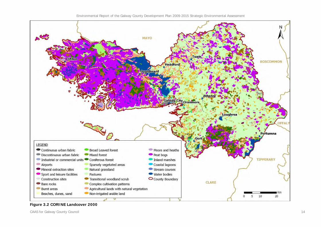
3.2.3.1 CORINE Land Cover Mapping6
The CORINE land cover mapping7 for County Galway classifies land cover under various headings. CORINE land cover mapping for County Galway for the year 2000 is shown on Figure 3.2. The mapping shows an overall difference between land cover to the west of Lough Corrib and land cover to the east of the Lough. The western half of the County is primarily covered by the peat bogs category of land cover whereas the eastern half of the County is primarily covered by pastures as well as significant portions of peat bogs and complex cultivation patterns. Water bodies are spread across the western half of the County as are pockets of transitional woodland scrub and coniferous forest. Agricultural lands with natural vegetation are found near the banks of the Corrib system and other lakes as well as being spread across the north of the County - to the south of Headford and to the north west of Tuam - and across the south west corner of the County. A mosaic of peat bogs, transitional woodland scrub and coniferous forests is found over a wide area located between Gort and Portumna, in the vicinity of the Slieve Aughty Mountains.
6 CORINE Land Cover (CLC) is a map of the European environmental landscape based on interpretation of satellite images. Land cover is the observed physical cover, as seen from the ground or through remote sensing, including for example natural or planted vegetation, water and human constructions which cover the earth's surface. Because of the scale of the CORINE data and the method by which it was collected there are likely to be a number of inaccuracies at the local level. It is noted, however, that the land cover shown on the maps is generally accurate at the County level. The European Environment Agency, in conjunction with the European Space Agency, the European Commission and member countries is currently updating the CORINE land cover database. 7 European Environment Agency Coordination of Information on the Environment (2004) Ireland's Corine Land Cover 2000 (CLC2000) Copenhagen: EEA
Environmental Report of the Galway County Development Plan 2009-2015 Strategic Environmental Assessment
CAAS for Galway County Council 13
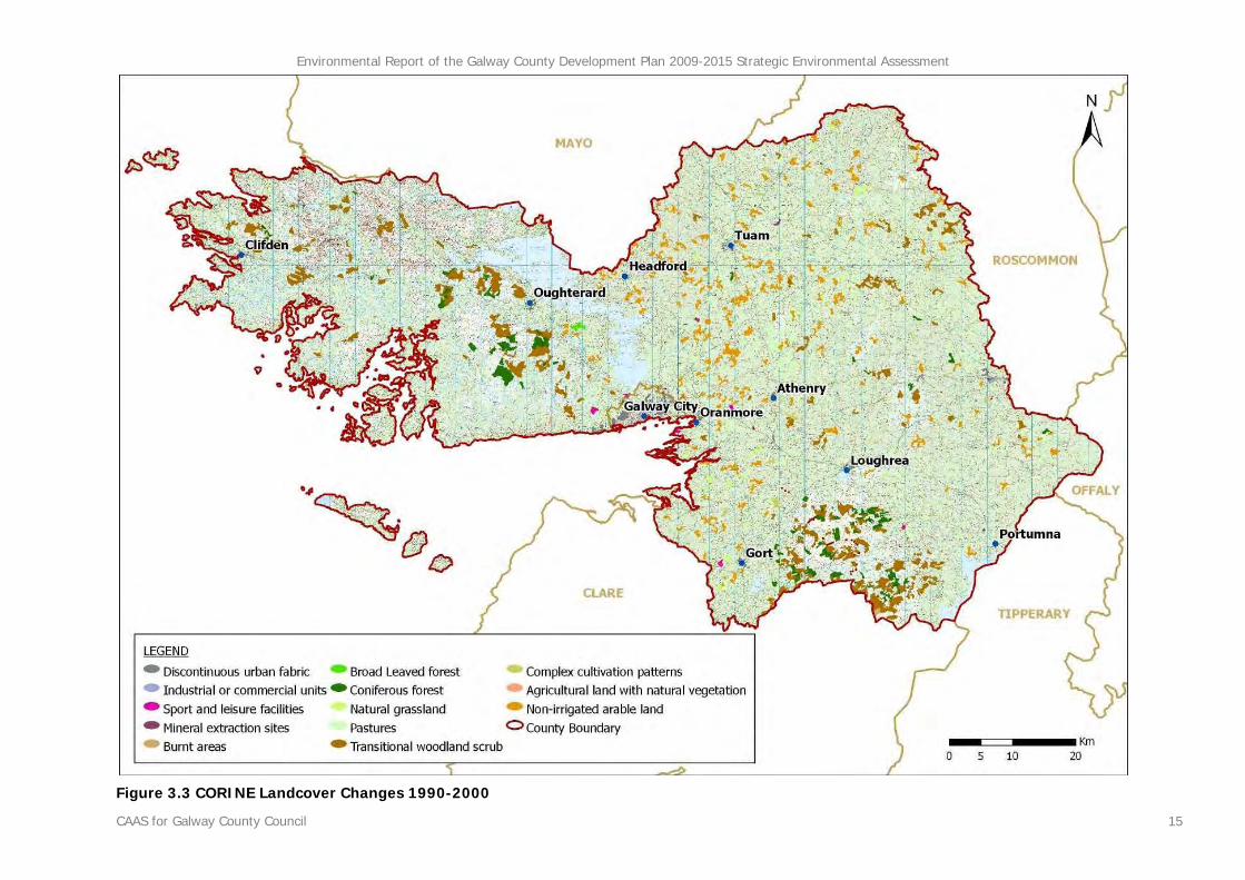
Landcover differences between the CORINE 1990 data and the data for the year 20008 (see Figure 3.3) show that in the west of the County there are new pockets of transitional woodland scrub and coniferous forest, replacing peat bogs. In addition, areas which were identified by the 1990 data as being coniferous forest were identified by the 2000 data as being transitional woodland scrub. These changes in the data reflect the land cover changes as a result of the planting, maturing and felling of coniferous forests. Similar changes to these were experienced in the east of the County in the vicinity of the Slieve Aughty Mountains. Elsewhere in the east of the County, non irrigated arable land and natural grassland were identified as having replaced pastures - reflecting local agricultural changes - and transitional woodland scrub was identified as having replaced coniferous forests - again, reflecting the felling of trees. Changes in land cover from natural/semi natural landcover categories - such as pastures - to the category of discontinuous urban fabric were identified by the data primarily emanating from Galway City but also at Athenry, Ballinasloe, Clifden, Gort, Headford, Loughrea, Oranmore, Oughterard, Tuam, Kilconnell, Bunowen Bay and Craughwell. These changes between 1990 and 2000 landcover indicate a cumulative loss of natural/ agricultural vegetation and associated habitats - and their flora and fauna - at the fringes of the County’s largest settlements. Other changes indicated were the replacement of agricultural categories of landcover with the category of mineral abstraction sites to the north of Aucloggeen, to the east of Beagh and to the north west of Portumna.
8 European Environment Agency Coordination of Information on the Environment (various) Ireland's Corine Land Cover 2000 (CLC2000) and Ireland's Corine Land Cover 1990 (CLC1990) Copenhagen: EEA
3.2.3.2 FIPS Habitat Mapping9
Forest Inventory and Planning System (FIPS) Habitat Indicator Mapping was sought for inclusion in this study however it was not received by the date of publication and was therefore omitted. The findings of the CORINE landcover mapping in the previous section would have been likely to be consistent with findings arising out of the FIPS Habitat Indicator Mapping.
9Teagasc Spatial Analysis Group, Teagasc, Kinsealy Research Centre, Dublin: Forest Inventory and Planning System (FIPS) Habitat Indicator Mapping aims to indicate the likely distribution of particular habitats throughout Ireland. The mapping is an enhancement of the FIPS land cover map by increasing the classification and spatial resolution of many of the land cover thematic classes. These land cover classes are indicative of habitat type in a very broad sense only in that they represent combinations of more detailed habitat classes. The habitat indicator classes reflect habitat type in a broad sense and represent conflations of more detailed habitat classes. The habitat indicator classes have been attributed corresponding codes from A Guide to Habitats in Ireland (Fossitt, 2000).
Environmental Report of the Galway County Development Plan 2009-2015 Strategic Environmental Assessment
CAAS for Galway County Council 14
Figure 3.2 CORINE Landcover 2000
Environmental Report of the Galway County Development Plan 2009-2015 Strategic Environmental Assessment
CAAS for Galway County Council 15
Figure 3.3 CORINE Landcover Changes 1990-2000
Environmental Report of the Galway County Development Plan 2009-2015 Strategic Environmental Assessment
CAAS for Galway County Council 16
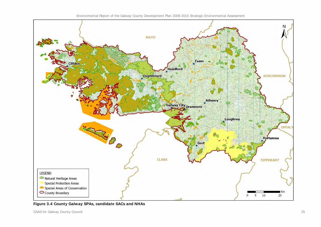
3.2.4 Designations
3.2.4.1 Introduction
The international significance of Galway’s natural heritage is reflected in the fact that a high proportion of the County is designated for nature conservation under European and National legislation. Figure 3.4 shows the spatial distribution of Special Area of Conservation (SAC), Special Protection Area (SPA) and Natural Heritage Area (NHA) designations across the County. As can be seen from the Figure 3.4, many of these sites overlap with each other. Other categories of designations are present in the County and are identified in proceeding sections however these generally overlap with those shown on Figure 3.4. The majority of the western half of the County - including Lough Corrib, inner Galway Bay and most of the County’s islands - is covered by designated sites, the largest of which is the Connemara Bog Complex SAC and NHA which covers much of the County’s peatlands to the west of the Lough Corrib SPA, candidate SAC and proposed NHA. Kilkieran Bay and its islands comprise a candidate SAC and there is an SAC designation covering part of Inishmore Island and its waters. The Galway Bay Complex SAC and pNHA and the Inner Galway Bay SPA together cover an area of the Bay stretching from Salthill (in the east of the Galway City) to Aughinish (on the Galway/Clare border) - as indicated by Figure 3.4 - and further into County Clare’s offshore waters. The eastern half of the County is covered to a significantly lesser extent by such designations; nevertheless a number of important areas are located in this half of the County. The Grange/Clare/Albert/Sinking River system which drains into Lough Corrib is part of the Corrib designated system and the designated River Suck and River Shannon Callows and Lough Derg comprise much of the County’s western border. The Slieve Aughty Mountains SPA covers a wide area located between the settlements of Gort and Portumna.
3.2.4.2 Candidate Special Areas of Conservation
Candidate Special Areas of Conservation (cSACs) have been selected for protection under the European Council Directive on the conservation of natural habitats and of wild fauna and flora
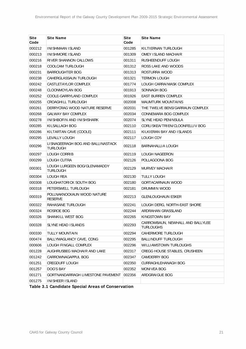
(92/43/EEC) by the DEHLG due to their conservation value for habitats and species of importance in the European Union. The sites are candidate sites because they are currently under consideration by the Commission of the European Union. A total of 73 cSACs have been selected in County Galway for 47 Annex I habitats including 10 priority habitats. Annex I habitats are recognised by the European Union to be of particularly high nature conservation value. Candidate SACs in Galway provide examples of bogs, callows, machair, limestone pavement, headlands, bays, loughs, turloughs, islands, woods and caves. Candidate SACs are listed under Table 3.1 and mapped on Figure 3.410. On designation, these cSACs together with the SPAs identified below will become part of Natura 2000 - a network of protected areas throughout the EU established under the Habitats Directive.
3.2.4.3 Special Protection Areas
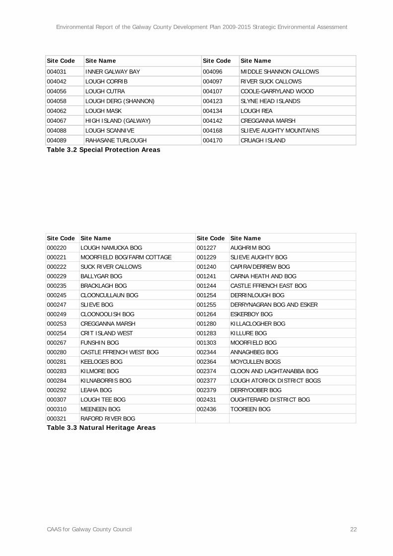
Special Protection Areas (SPAs) have been selected for protection under the 1979 European Council Directive on the Conservation of Wild Birds (79/409/EEC) by the DEHLG due to their conservation value for birds of importance in the European Union. 16 SPAs have been designated in County Galway covering, inter alia, certain bays, loughs, islands, turloughs, callows, woods and marshes. These SPAs along with SACs comprise Natura 2000 - a network of protected areas throughout the EU established under the Habitats Directive. SPAs are listed under Table 3.2 and mapped on Figure 3.411.
3.2.4.4 Natural Heritage Areas
Natural Heritage Areas (NHAs) are designated due to their national conservation value for ecological and/or geological/geomorphological
10 Site synopses for cSACs are available to download from the website of the National Parks and Wildlife Service at http://www.npws.ie/en/ConservationSites/ and are provided as Appendix I to this report. 11 Site synopses for SPAs are available to download from the website of the National Parks and Wildlife Service at http://www.npws.ie/en/ConservationSites/ and are provided as Appendix I to this report.
Environmental Report of the Galway County Development Plan 2009-2015 Strategic Environmental Assessment
CAAS for Galway County Council 17
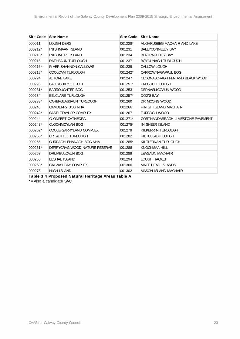
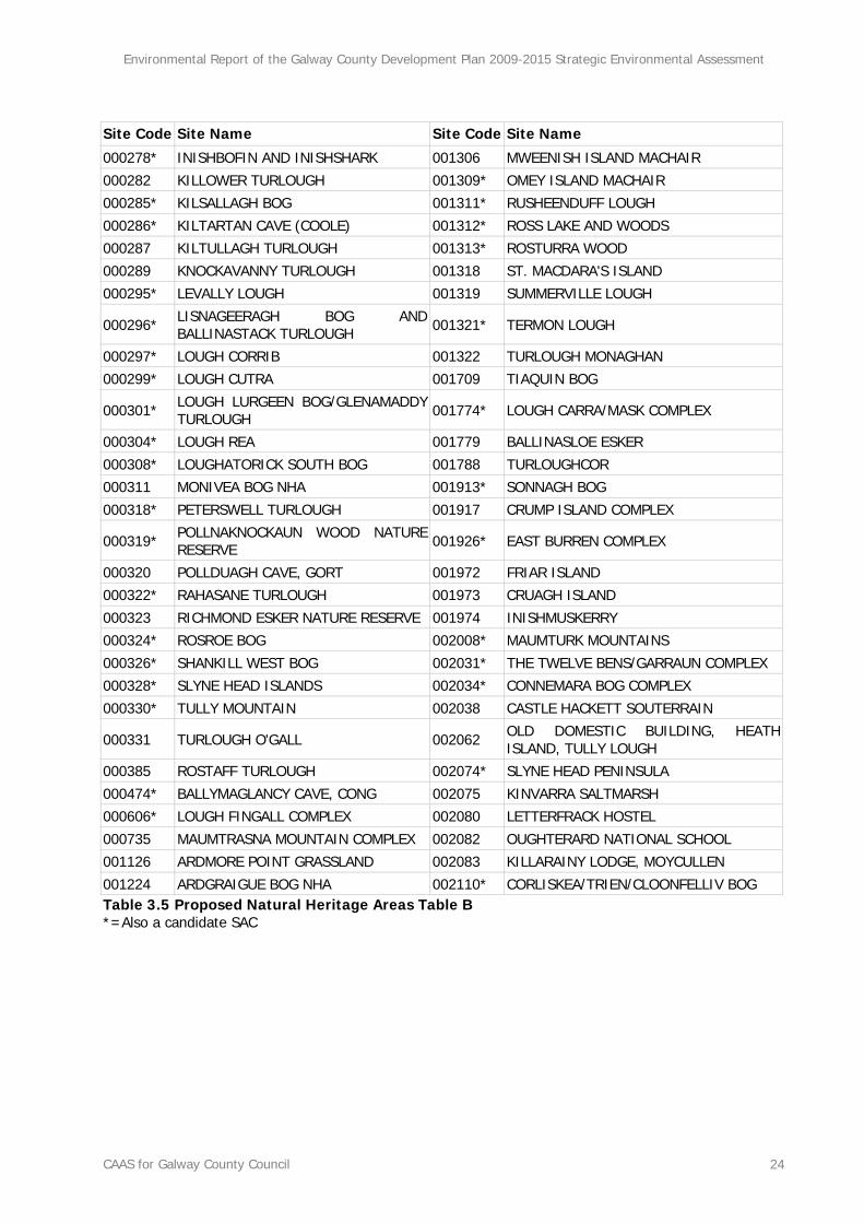
heritage. They cover nationally important semi-natural and natural habitats, landforms or geomorphological features, wildlife plant and animal species or a diversity of these natural attributes. NHAs are designated under the Wildlife (Amendment) Act 2000. 39 NHAs have been designated in County Galway - mainly covering bog habitats with examples of marshes and eskers also included - and there are 106 sites for which Natural Heritage Area designations are proposed, including various bogs, eskers and woods. NHAs are listed under Table 3.3 and mapped on Figure 3.412. Proposed NHAs are listed under Table 3.4 and Table 3.5.
3.2.4.5 Ramsar Sites
Ramsar sites are designated and protected under the Convention of Wetlands of International Importance, especially as Water Fowl Habitat, which was established at Ramsar in 1971 and ratified by Ireland in 1984. Ireland presently has 45 sites designated as Wetlands of International Importance, with surface areas of 66,994 hectares. Three Ramsar sites are located in County Galway comprising 29,997 hectares in total or 44.7% of the national total. The following synopses13 provide details on each of the three sites:
• Lough Corrib Designated: 11/06/96 Area: 17,728 ha Ramsar site no.: 846 The second largest lake in Ireland supports one of the largest areas of wetland vegetation consisting of reed, sedge and rush communities in the Country. Other habitats include Sessile Oak woodland, calcareous fen, callows grassland, marsh and raised bog with a soak system. The site provides important feeding grounds for waterbirds and supports internationally important numbers of several breeding and wintering waterbirds and 12 Site synopses for NHAs are available to download from the website of the National Parks and Wildlife Service at http://www.npws.ie/en/ConservationSites/ and are provided as Appendix I to this report. 13 Ramsar Convention Secretariat (2000) The Annotated Ramsar List of Wetlands of International Importance Switzerland: Ramsar Convention Secretariat
nationally important numbers of numerous other waterbird species. The site supports the otter and numerous rare and threatened plant and fish species. Human activities include fishing and hunting.
• Coole Lough and Garryland Wood Designated: 30/05/90 Area: 364 ha Ramsar site no.: 473 Part of a low-lying karstic limestone area characterized by a subterranean drainage system and seasonal lakes, known as turloughs, set in a matrix of woodland, limestone heath and grassland. The site together with the adjacent nutrient-poor lakes is the most important turlough complex in Ireland. Many rare species of flora and fauna and communities associated with the turlough to woodland transition are supported. Water levels fluctuate widely. The lakes are fringed by aquatic vegetation grading into grassland, tall grass and herb communities and, beyond the level of summer flooding, into scrub and high forest.
• Inner Galway Bay Designated: 11/06/96 Area: 11,905 ha Ramsar site no.: 838 The shallow sheltered part of a large sea bay with numerous intertidal inlets and small low islands composed of glacial deposits. The area provides important habitat for marine life along Ireland’s west coast. The site supports the richest seaweed flora on the Irish Coast (500+ species) and 65% of the Irish marine algal flora occur in the area. The site supports internationally and nationally important numbers of numerous species of waterbirds. There is a large cormorant colony on Teer Island. Human activities include aquaculture.
3.2.4.6 Nature Reserve
A Nature Reserve is an area of importance to wildlife, which is protected under Ministerial order. There are currently 78 Statutory Nature Reserves. Most are owned by the State but some are owned by organisations or private landowners.
Environmental Report of the Galway County Development Plan 2009-2015 Strategic Environmental Assessment
CAAS for Galway County Council 18
There are six of Nature Reserves in County Galway the descriptions of which are given below14:
• Ballynastaig Wood and Coole-Garryland Nature Reserves (9.76ha and 363.58 ha)
Located near Gort, State owned and established in 1983, these two reserves, through their combination of deciduous woods, limestone reefs, lakes and turloughs, constitute one of the most interesting Irish vegetation and faunal complexes still in existence. The Coole-Garryland reserve contains a variety of floral habitats including well-formed high forest on deep pockets of soil, dwarf woodland on limestone pavement, a turlough complex in the Callows and Coole Lake.
• Clochar na gCon/Bealacooan Bog Nature Reserve (1,247 ha)
Situated in South Connemara, State owned and established in 1999, this bog forms part of the greater Connemara Bog Complex. It is a classic and intact example of Atlantic or oceanic blanket bog, with a diverse flora which includes a number of scarce plant species and a blanket bog fauna which includes many of Ireland’s and Europe’s more important and threatened species. Actively growing bog is a priority EU habitat.
• Derrycrag Wood and Rosturra Wood Nature Reserves (110.48 and 17.68)
Located near Woodford, State owned and established in 1983, these two Reserves comprise fragments of a once extensive forest and now contain stands of oak and ash with an understorey of holly and hazel and a rich ground flora.
• Leam West Bog Nature Reserve (373.48 ha)
Situated two miles south east of Maam Cross, State owned and established in 1991, this bog is of international importance. It is an area of very diverse blanket bog developed over both acid and base rich rocks at the north east limit of the Connemara blanket bogs. It forms part of one of 14 National Parks and Wildlife Service (various) Statutory Nature Reserves: County Galway Dublin: Government of Ireland
the largest areas of intact bog in Connemara and it is one of the few sites containing both lowland and highland bog. A large number of habitats occur including rock outcrops, bog pools, extremely wet quaking areas, streams and relatively nutrient rich flushes.
• Pollnaknockaun Wood (38.85 ha) Located 1 km north-east of Woodford village, State owned and established in 1983, this is a semi-natural woodland which once formed part of the extensive forest referred to under the Derrycrag Wood and Rosturra Wood Nature Reserves above.
• Richmond Esker Nature Reserve (15.7 ha)
Located 4 km. north-west of Moylough, State owned and established in 1985, this Nature Reserve is, along with Timahoe Esker Nature Reserve, one of the few esker ridges supporting native woodland left in the country. Although extensively planted with conifers and other exotic species it is planned to expand the native woodland using appropriate management techniques.
3.2.4.7 Connemara National Park
National parks are almost entirely state owned areas designated nationally with the aims of nature conservation and public recreation and appreciation. Situated in the West of Ireland in County Galway, Connemara National Park covers some 2,957 hectares of scenic mountains, expanses of bogs, heaths, grasslands and woodlands. Some of the Park's mountains, namely Benbaun, Bencullagh, Benbrack and Muckanaght, are part of the famous Twelve Bens or Beanna Beola range. Connemara National Park was established and opened to the public in 1980. Much of the present Park lands formed part of the Kylemore Abbey Estate and the Letterfrack Industrial School, the remainder having been owned by private individuals. The Park lands are now wholly owned by the State and managed solely for National Park purposes15.
15 National Parks and Wildlife Service (unknown) Connemara National Park Dublin: Government of Ireland
Environmental Report of the Galway County Development Plan 2009-2015 Strategic Environmental Assessment
CAAS for Galway County Council 19
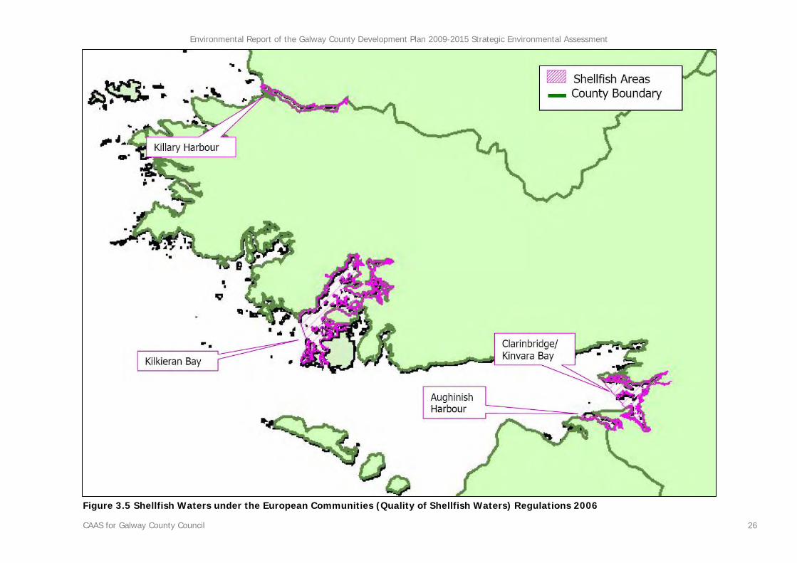
3.2.4.8 Shellfish Waters
The indented nature of County Galway’s coastline protects certain bays from the full force of Atlantic waves and storms and allows for the mixture of fresh and salt water which is vital for producing high quality shellfish such as oysters which are significantly important to tourism and certain local economies along the County’s coastline. At present, there are 14 areas in Ireland designated and afforded protection as Shellfish Waters under the European Communities (Quality of Shellfish Waters) Regulations 2006 (SI No. 268 of 2006) which transposes the Shellfish Waters Directive 1979 (79/923/EEC) into Irish law. These regulations together with the Quality of Shellfish Waters Regulations 1994 (SI No. 200 of 1994) require that the shellfish waters are protected from the effects of the functions of planning authorities and require such functions to be performed in a manner that will comply with certain values for water quality which are specified in the Regulations. Four Shellfish Waters are located along the coastline of County Galway. These Shellfish Waters are mapped on Figure 3.5. The following descriptions are taken from the action programmes for these waters which were published in May 2006:
• Killary Harbour Killary Harbour is a fiord-like inlet straddling the County boundaries of Galway to the south and Mayo to the north on the West Coast of Ireland. The landscape is dominated by Mweelrea Mountain to the north, and the Maam Turk Mountains to the south. Their slopes are steep and mainly covered by peat with associated vegetation. Three main rivers feed into the harbour, the Erriff and Bundorragha on the Mayo side, and the Bunowen on the Galway side. Each is an important salmon fishing river, and each is regularly monitored by the EPA.
• Kilkieran Bay The designated area of Kilkieran or Cill Chiaráin is a south westerly facing bay, almost 13km long and covering approx. 5,800 hectares in the County. It is made up of three smaller bays: Camus Bay to the North East; Casheen Bay to the South East; and Kilkieran Bay to the West. The catchment is dominated by blanket bog, mountainous terrain and nutrient poor water
bodies and extends to approx 300km2. The principal rivers flowing into the bay are the Invermore, and the Inverbeag, which flow into the north of the bay and the Screeb (identified as being slightly polluted in the 2006 action programme) which flows into the North East part. Eight discharges are licensed in the area, principally for effluent from smolt production, fish processing, and light industry. There are no IPPC licensed activities in the area. Marine activities in the area include sailing, diving, windsurfing and angling.
• Clarinbridge/Kinvara Bay The designated area of Clarinbridge/Kinvara Bay covers an area of 2,700ha in the south-eastern corner of Galway Bay on the West Coast of Ireland. The general characteristics of the area are that for the most part, it is low lying and composed of good arable land with cattle rearing and milk production as well as some tillage. The water bodies of the catchment reflect the geological make up of the area in that they naturally have a high nutrient content and generally lie within a mesotrophic-eutrophic range. Another characteristic of the area is the presence of a number of turloughs and underground river systems one of which enters the sea at Kinvara. The principal freshwater inputs into the designated area are the Clarin, identified as being moderately polluted in the 2006 action programme, Kilcolgan, identified as being slightly polluted in the 2006 action programme, Ballynamanagh River, an unnamed stream and an unnamed underground river none of which are classified by the EPA. Marine activities in the area include sailing, diving, windsurfing and angling. There are 15 section 4 licences within the catchment, and of these, 6 are deemed to be significant. There are three IPPCs in the area. These have good monitoring programmes and are unlikely to be a threat to water quality.
• Aughinish Harbour The primary development pressure in the area is from tourism. The environs of Aughinish and the Burren, of which it is a part, are popular destinations for holidaymakers. Most development to date has taken place on the Co. Clare side of the bay.
3.2.4.9 Designated Salmonid Waters
The main channel of the River Corrib and the connecting Lough Corrib is designated and
Environmental Report of the Galway County Development Plan 2009-2015 Strategic Environmental Assessment
CAAS for Galway County Council 20
protected as a Salmonid Water under the European Communities (Quality of Salmonid Waters) Regulations 1988 (SI No. 293 of 1988). Designated Salmonid Waters are capable of supporting salmon (Salmo salar), trout (Salmo trutta), char (Salvelinus) and whitefish (Coregonus).
3.2.4.10 Register of Protected Areas
In response to the requirements of the Water Framework Directive a number of water bodies or parts of water bodies which must have extra controls on their quality by virtue of how their waters are used by people and by wildlife have been listed on Registers of Protected Areas (see Section 3.5 Water and Figure 3.21). There River Corrib is listed on the RPA for Habitats Rivers. The Shellfish Waters identified under Section 3.2.4.8 are listed on the RPA for Shellfish Areas. All the SPAs identified under Section 3.2.4.3 are listed on the RPA for Species SPA.
Environmental Report of the Galway County Development Plan 2009-2015 Strategic Environmental Assessment
CAAS for Galway County Council 21
Site Code
Site Name Site Code
Site Name
000212 INISHMAAN ISLAND 001285 KILTIERNAN TURLOUGH
000213 INISHMORE ISLAND 001309 OMEY ISLAND MACHAIR
000216 RIVER SHANNON CALLOWS 001311 RUSHEENDUFF LOUGH
000218 COOLCAM TURLOUGH 001312 ROSS LAKE AND WOODS
000735 MAUMTRASNA MOUNTAIN COMPLEX 002082 OUGHTERARD NATIONAL SCHOOL 001126 ARDMORE POINT GRASSLAND 002083 KILLARAINY LODGE, MOYCULLEN
001224 ARDGRAIGUE BOG NHA 002110* CORLISKEA/TRIEN/CLOONFELLIV BOG Table 3.5 Proposed Natural Heritage Areas Table B *=Also a candidate SAC
Environmental Report of the Galway County Development Plan 2009-2015 Strategic Environmental Assessment
CAAS for Galway County Council 25
Figure 3.4 County Galway SPAs, candidate SACs and NHAs
Environmental Report of the Galway County Development Plan 2009-2015 Strategic Environmental Assessment
CAAS for Galway County Council 26
Figure 3.5 Shellfish Waters under the European Communities (Quality of Shellfish Waters) Regulations 2006
Environmental Report of the Galway County Development Plan 2009-2015 Strategic Environmental Assessment
CAAS for Galway County Council 27
3.2.5 Existing Problems
With regard to terrestrial flora and fauna, all greenfield development causes an impact - the replacement of natural and semi natural habitats with artificial surfaces results in loss of flora and fauna and therefore adversely impacts upon this environmental component. The significance of the impact of greenfield development depends on whether individual greenfield developments result in the loss of habitats or species of importance together with the cumulative amount of habitats and species lost and fragmented as a result of all greenfield developments. Development of brownfield sites and re-development can also have impacts on terrestrial flora and fauna. Changes in land cover from natural/semi natural landcover categories - such as pastures - to the category of discontinuous urban fabric were identified from the CORINE landcover data primarily emanating from Galway City but also at Athenry, Ballinasloe, Clifden, Gort, Headford, Loughrea, Oranmore, Oughterard, Tuam, Kilconnell, Bunowen Bay and Craughwell. These changes between 1990 and 2000 landcover indicate a cumulative loss of natural/ agricultural vegetation and associated habitats - and their flora and fauna - at the fringes of the County’s largest settlements. Expansion of towns and villages in the urban fringe and rural areas can cause significant habitat destruction, fragmentation and degradation as natural habitats including wetlands, woods and grasslands may be required to be built upon or fragmented to accommodate new development. Ecological networks have been adversely impacted upon by the development of infrastructure such as roads which result in the habitat fragmentation as well as by the development of housing which results in the removal of hedgerows or stone walls, or housing which occurs along the edges of inland surface waters. Galway County Council must help to ensure compliance with the objectives of the Habitats Directive which aims to contribute towards ensuring bio-diversity through the conservation of natural habitats and of wild fauna and flora in the European territory of Member States. Most of the pressure upon designated habitats in County Galway as a result of development is likely to occur in coastal areas and on the banks
of water bodies such as Lough Corrib where infringement could occur if unmitigated. It is noted that in addition to other designated habitats found along the coast, machair (flat sandy grassland) - a priority habitat found only along parts of the coast Scotland and the north-west coast of Ireland - stretches in County Galway from Galway Bay to the Galway-Mayo border. The protection of rare and important habitats and plant and animal species may pose a potential constraint to new development in certain parts of the County. Such species include: the rare flora and fauna which are found throughout some the County’s peatlands; the endangered bird species which are sustained by the flower rich wet meadows of the Shannon Callows; Arctic Char which is believed to be extinct in three lakes in Galway with the population status of a further thirteen lakes unknown; the Fresh Water Pearl Mussel which is a critically endangered species due to pollution, habitat destruction and over-fishing and is now only found in few soft-water sites in the west of the County; and, the White Clawed Crayfish which is protected in Ireland and under EU legislation and is found in Lough Corrib, Lough Derg and other rivers of the Shannon catchment. Ireland, and in particular, Galway, contains some of the best examples of intact blanket bog in Europe. Loss of quality rare bog habitats - especially in the east of the County - has resulted in the decline in numbers of vulnerable birds which live and breed on the bogs. Landcover differences between the CORINE 1990 data and the data for the year 200016 (see Figure 3.3) reflect the land cover changes as a result of the planting, maturing and felling of coniferous forests. These changes are most identifiable in peatland areas in the west of the County and in peatlands in the east of the County over a wide area between Gort and Portumna, in the vicinity of the Slieve Aughty Mountains. Orchid-rich calcareous grasslands have in the recent past experienced pressure due to changes in agricultural practice and housing development. These grasslands are often 16 European Environment Agency Coordination of Information on the Environment (various) Ireland's Corine Land Cover 2000 (CLC2000) and Ireland's Corine Land Cover 1990 (CLC1990) Copenhagen: EEA
Environmental Report of the Galway County Development Plan 2009-2015 Strategic Environmental Assessment
CAAS for Galway County Council 28
associated with limestone pavement and are found south of Kinvarra with a number of small, isolated patches occurring along a corridor from Kilcolgan to Tuam and near Moycullen. The problem of invasive alien species has become very prominent in recent years as a number of introduced plant and animal species have become ecological pests. In September 2007, the Western Regional Fisheries Board confirmed an infestation of zebra mussels in Lough Corrib. The zebra mussel is an invasive alien species which can impact on the lake in terms of water supplies, ecology, fisheries and amenity. The infestations in Lough Corrib are not confined to one particular area as the presence of the mussel has been confirmed at a number of sites in the upper north west section of the lake and at one site in the lower lake. Other examples of invasive alien species include the African Pond Weed, ‘Chilean Rhubarb’, Japanese Knotweed, Rhododendron and the American Mink. Aquatic flora and fauna is vulnerable to all forms of pollution such as that which can occur as a result of agricultural run-off and industrial and municipal effluents. As identified under Section 3.5 Water, several water bodies within and surrounding the County area are ‘at risk’ with regard to meeting legislative water quality objectives under the Water Framework Directive. The indented nature of County Galway’s coastline protects certain bays from the full force of Atlantic waves and storms and allows for the mixture of fresh and salt water which is vital for producing high quality shellfish such as oysters which are significantly important to tourism and certain local economies along the County’s coastline. At present, there are 14 areas in Ireland designated and afforded protection as Shellfish Waters under the Quality of Shellfish Waters Regulations 2006 four of which are located along the coastline of County Galway. The shellfish which live in the waters are extremely sensitive to pollution and it is important that the effluents from existing and new development - both farming and housing - are treated and disposed of so as not to adversely impact upon the water quality of the waters. In May 2005 the Department of Marine and Natural Resources downgraded the classification of Clarin Estuary and Dunbulcan Bay oysters from ‘Grade A’ to ‘Grade B’ however in September 2006, the Department reinstated
the oysters with ‘Grade A’ (DCMNR, 2005)17. Follow-up actions set out since then include septic tank surveys, farm surveys and a review of all of private wastewater treatment systems. The channelling and piping of a number of surface waters within the County Galway area has in the past impacted upon aquatic biodiversity, flora and fauna as well as ecological connectivity.
3.2.6 Evolution of Biodiversity and Flora and Fauna in the absence of a CDP
In the absence of a County Development Plan (CDP), development would have no guidance as to where to be directed and planning applications would be assessed on an individual basis with flora and fauna, habitats and ecological connectivity protected under a number of strategic actions relating to biodiversity and flora and fauna protection. In the absence of a CDP there would not be an integration of the ecological protection measures required by the Habitats Directive with the planning or development management of vulnerable areas. Therefore it is likely that there would be less effective protection of ecological resources in the absence of a CDP. The evolution of biodiversity and flora and fauna would be dependent on the rate and extent of developments which would take place. Any future development along the edges of designated ecological sites would be likely to result in a reduction in habitats and could therefore reduce ecological connectivity on the edges of these sites. Weakly controlled development along or adjacent to the banks of rivers could result in a reduction in ecological connectivity within and between these and other habitats. Pollution of water bodies as a result of any poorly planned future development would be likely to adversely impact upon aquatic biodiversity and flora and fauna including salmonid species and other species protected
17 Department of Communications, Marine and Natural Resources (2005) Irish Quality Oysters Scheme Report 2005 Dublin: Department of Communications, Marine and Natural Resources
Environmental Report of the Galway County Development Plan 2009-2015 Strategic Environmental Assessment
CAAS for Galway County Council 29
under Annex II of the Habitats Directive and, in certain areas, designated Shellfish Waters. Climate change has the potential to result in the loss of habitats - including those designated as SACs and SPAs - through rising sea levels and increased levels of surface run-off (see Section 3.6.4). Some of the County’s coastal habitats which are important to bird populations could eventually be inundated. Increased precipitation may disrupt the salinity gradients within estuarine systems and, coupled with likely increased sedimentation, disrupt spawning and nursery grounds as well as shellfish production and quality in such areas. Breeding seabird colonies at risk include the Connemara islands, Inner Galway Bay and part of the Aran Islands while important bird areas for wintering waterfowl include the Inner Galway Bay.
3.3 Population and Human Health
3.3.1 Population18
The population of the County (all the areas outside of Galway City) was estimated at 159,052 during 2006. This is an increase of 11% on the 2002 Census figure of 143,245. In the same 2002 to 2006 period Galway City experienced a 9.3% increase in population, from 209,077 persons in 2002 to 231,035 persons in 2006. Galway County is predominantly rural with only around 15% of the population living in towns of more than 1,500 people. The largest towns located in east Galway - namely Ballinasloe, Tuam, Athenry, Gort - followed by Clifden in Connemara, west Galway. Significant rural population growth between 1996 and 2006 - the two most recent intercensal periods - occurred within the Galway Transportation and Planning Study boundaries which include Galway City and its catchment within the County.
18 CSO (various) Census 2002 Volume 1 - Population Classified by Area; Census 2006 Volume 1 - Population Classified by Area Cork: CSO
More rural parts of County Galway, i.e. the County area outside the Transportation and Land Use study area experienced mixed growth, with some District Electoral Divisions (DEDs) in the extreme west and uplands areas experiencing population decline. Figure 3.6 shows the location of population across the County’s DEDs in 2006. Districts surrounding and close to the City as well as districts which include large towns such as Ballinasloe, Tuam, Athenry, Gort, Clifden and Oughterard have the highest populations. Figure 3.7 shows population density in persons/km² for the County’s DEDs in 2006. The most densely populated DEDs outside of Galway City are either found surrounding the City and/or in the eastern half of the County and include those which encompass the towns and environs of Ballinasloe, Tuam, Gort and Oranmore. DEDs outside of these, including all DEDs to the west of Bearna, had significantly lower densities. Figure 3.8 shows the percentage population change experienced by the County’s DEDs during the period 2002 to 2006. The greatest percentage increases in population occurred in DEDs in the eastern half of the County and include those which encompass the towns and environs of Gort, Oranmore, Athenry, Tuam, Clarinbridge and Kinvarra. The greatest proportion of DEDs which experienced declines in population occurred in the western half of the County.
3.3.2 Human Health
With regard to human health, impacts relevant to the SEA are those which arise as a result of interactions with environmental vectors (i.e. environmental components such as air, water or soil through which contaminants or pollutants, which have the potential to cause harm, can be transported so that they come into contact with human beings). Human health has the potential to be impacted upon by environmental vectors including water, soil and air. Hazards or nuisances to human health can arise as a result of exposure to these vectors arising from incompatible adjacent landuses, for example. These factors have been considered with regard to the description of: the baseline of each environmental component; and the identification and evaluation of the likely
Environmental Report of the Galway County Development Plan 2009-2015 Strategic Environmental Assessment
CAAS for Galway County Council 30
significant environmental effects of implementing the plan and the alternatives. There existing problems relating to drinking water treatment in, among other water supplies, 35 public water supplies in the County. 10 of these water supplies are identified by the EPA as having inadequate treatment for cryptosporidium and a further 5 Water Supplies are included on the list due to a failure to meet the E.coli standard (see Section 3.7). Water which is not clean and wholesome would be likely to result in significant adverse impacts upon human health. Two seawater bathing areas in the County - Clifden and Na Forbacha - exceeded EU mandatory values different types of coliforms (see Section 3.5). These values are set to protect human health and exceedences of them could lead to adverse impacts upon human health. County Galway is vulnerable to adverse effects from changes in the occurrence of severe rainfall events and associated flooding of the County’s rivers combined with small changes in sea level. Much of the flooding in the County occurs during adverse weather conditions whereby heavy rainfall causes high river flows (see Section 3.5.10). Flooding is an environmental phenomenon which, as well have causing economic and social impacts, could in certain circumstances pose a risk to human health. With regard to air quality (3.6) traffic hotspots within some of the County’s towns are likely to have elevated levels of air pollution and noise due to traffic congestion. Traffic hotspots are located along the main road routes - especially at intersections - and provide for a harsh sensory environment which may impact upon human health. It is noted that Galway County Council have prepared a Major Emergency Plan (2007) in order to:
• to outline generally the procedures to be followed and functions to be undertaken by the County Council services in the event of a Major Emergency; and,
• to co-ordinate the procedures to be
followed and functions to be undertaken
by the County Council with those of the HSE, Gardai and any other agencies responding to the emergency.
The Major Emergency Plan provides for a coordinated response to major emergencies arising, for example, from fires, explosions, gas releases, transportation accidents, spillages of dangerous substances, etc. The total provision for major emergency planning is the combined co-ordinated plans of Galway County Council, Galway City Council, Health Service Executive (Western Area) and Gardai in the area where the emergency occurs.
3.3.3 Existing Problems
Certain environmental vectors within the County area - such as air, water or soil - have the potential to transport and deposit contaminants or pollutants, which have the potential to cause harm and adversely impact upon the health of the County’s population. Issues relevant to this potential in County Galway are expanded upon in the section above.
3.3.4 Evolution of Population and Human Health in the absence of a CDP
The growth or development of locations in environmentally stressed areas can result in adverse effects on populations and their health. As there is likely to be further increases in County Galway’s population over the coming years, there is a need to direct growth towards the most robust environments and away from the most sensitive ones. Such direction of development away from unsuitable receiving environments would be unlikely to occur in the absence of a County Development Plan (CDP) – with resultant adverse effects on local populations and their health. In the absence of a CDP there would be no framework for the provision of infrastructure to serve existing and future development and this could delay or hinder the provision of infrastructure and result in impacts on environmental vectors to which humans are exposed e.g. a lack of appropriate waste water treatment infrastructure could adversely impact upon drinking water quality and subsequently upon human health.
Environmental Report of the Galway County Development Plan 2009-2015 Strategic Environmental Assessment
CAAS for Galway County Council 31
Figure 3.6 Population by District Electoral Division 2006
Environmental Report of the Galway County Development Plan 2009-2015 Strategic Environmental Assessment
CAAS for Galway County Council 32
Figure 3.7 Population Density by District Electoral Division 2006
Environmental Report of the Galway County Development Plan 2009-2015 Strategic Environmental Assessment
CAAS for Galway County Council 33
Figure 3.8 Population Change (%) by District Electoral Division 2002-2006
Environmental Report of the Galway County Development Plan 2009-2015 Strategic Environmental Assessment
CAAS for Galway County Council 34
3.4 Soil
3.4.1 Introduction
Soil is the top layer of the earth’s crust. It is formed by mineral particles, organic matter, water, air and living organisms. Soil can be considered as a non-renewable natural resource because it develops over very long timescales. It is an extremely complex, variable and living medium and performs many vital functions including: food and other biomass production, storage, filtration and transformation of many substances including water, carbon, and nitrogen. Soil has a role as a habitat and gene pool, serves as a platform for human activities, landscape and heritage and acts as a provider of raw materials. Such functions of soil are worthy of protection because of their socio-economic as well as environmental importance. Soils in any area are the result of the interaction of various factors, such as parent material, climate, vegetation and human action. To date, there is no legislation which is specific to the protection of soil resources. However, there is currently an EU Thematic Strategy on the protection of soil which includes a proposal for a Soil Framework Directive which proposes common principles for protecting soils across the EU.
3.4.2 Bedrock Geology
The basic rock formation of County Galway varies between the eastern and western half of the County. The bedrock geology of the County to the east of Lough Corrib consists of limestone which was laid in the carboniferous period, around 280 to 345 million years ago. To the west of Lough Corrib, the bedrock geology type generally differs either side of a line stretching from Glinsk to Oughterard. To the north of this line in areas such as the Connemara Uplands, the bedrock geology is new red sandstone while to the south of this line in coastal and more low-lying areas the bedrock geology is granite19.
19 (Geological Survey of Ireland, undated, as sourced in Aallen et al Atlas of the Irish Rural Landscape)
3.4.3 Quaternary Geology
Quaternary geology comprises the study of soils which have been deposited or formed during the last 2 million years. This quaternary geology - or subsoil - underlies the County’s soils and is shown on Figure 3.920. Glacial deposits and post glacial peat formation have provided the County with the majority of its subsoils. After the end of the last ice age, bog began to form in the County. Initially peat formation was confined to shallow lakes and wet hollows and later, the peat spread out to covering larger areas. Most areas were not engulfed until 4,000 years ago when the climate became wetter. To the west of Lough Corrib, blanket peat comprises subsoil with the exception of areas which are covered by water and upland and coastal areas where the bedrock geology lays exposed. During the last ice age, which ended around 12,000 years ago, glaciers transported eroded materials to certain areas and deposited them in the form of glacial deposition. The eastern half of the County is covered by two main subsoil types - tills and cutaway raised bogs. Although the half of the County to the west of Lough Corrib experienced little or no glacial deposition, much the half of the County to the east of Lough Corrib has been overlain with non-stratified glacial tills which were formed in and beneath the ice which overlay the landscape. Raised bogs formed in the east of the County in the many post-glacial lakes which covered this part of the County and spread to larger areas when the climate became wetter. Karsified limestone bedrock forms the subsoil of the south west of the County, in areas around Lough Corrib and in areas within and surrounding Galway City. Blanket bog is found in the Slieve Aughty Mountains.
20 Teagasc, GSI, Forest Service & EPA (2006) Soils and Subsoils Class Dublin: DEHLG
Environmental Report of the Galway County Development Plan 2009-2015 Strategic Environmental Assessment
CAAS for Galway County Council 35
3.4.4 Soil Types
Soil types in County Galway are mapped on Figure 3.1021. The area of the County to the west of Lough Corrib is generally covered by blanket bog with upland areas in Connemara and areas close to the coast covered by acid mineral soils. The area of the County to the east of Lough Corrib is generally covered with a mix of basic mineral soils and cutaway raised bog, with the latter increasing in occurrence in the north and west of the County. Grey brown podzolic basic mineral soils are deep, well drained soils which are derived from calcareous drift composed mainly of limestone with some coal shales and sandstone. These soils are relatively fertile, support grasslands and are facilitate the production of a wide range of vegetable crops. The Slieve Aughty foothills are covered by acid mineral soils while the Slieve Aughty uplands are by blanket bog. The County’s river floodplains are covered with fertile alluvium. The majority of soils within the County’s towns are urban soils. Urban soils are soils which have been disturbed, transported or manipulated by man’s activities in the urban environment and are often overlain by a non-agricultural, man-made surface layer that has been produced by mixing, filling, or by contamination of land surfaces in urban and suburban areas. The most extensive habitat of nature importance within County Galway is lowland blanket bog, found mainly in south Connemara. This and other areas of bog within the County are internationally important - supporting a large variety of rare flora and fauna - and large areas are protected by a number of ecological designations identified under Section 3.2. Extensive areas of limestone pavement occur to the south of Kinvarra with a number of small, isolated patches occurring along a corridor from Kilcolgan to Tuam and near Moycullen. These areas of limestone pavement often occur in close association with species-rich calcareous grassland and sometimes support the protected species.
21 Teagasc, GSI, Forest Service & EPA (2006) Soils and Subsoils Class Dublin: DEHLG
In addition to being a valuable ecological resource, Galway’s soils provide employment within the County through areas such as agriculture, forestry, harvesting of peat and tourism.
3.4.5 Sites of Geological Interest
At the end of the last ice glacial deposition features named eskers began to form when silt, sand and gravel were deposited by rivers of glacial melt water under the ice of glaciers. They are long sinuous rounded hills. A number of eskers are found to the east of Tuam and Claregalway and between Oranmore and Ballinasloe. As well as being geomorphological features, eskers are important for the characteristic woodland and grassland habitats they support, including species-rich grasslands with abundant orchids.
3.4.6 Structural Issues in Karst Areas
As outlined above a certain areas within the County are underlain by karsified limestone bedrock. In a number of places this geological formation has been the subject of slow chemical processes that have led to the decomposition of rock and the formation of ‘solution features’ such as cracks, fissures and occasional cavities or caves. These features can adversely interact - sometimes severely - with new developments in two principal ways. Firstly the introduction of new loads on the surface - due to new developments - can cause the underlying rock to become overloaded and settle - with resultant structural degradation overhead. The works that are incidental to development - such as the diversion, concentration of removal of surface or groundwaters - can also lead to structural failure - sometimes over an extensive area. There may also be a possibility for this potential effect to be more severe due to changes in the intensity of rainfall events resulting from climate change.
Environmental Report of the Galway County Development Plan 2009-2015 Strategic Environmental Assessment
CAAS for Galway County Council 36
3.4.7 Existing Problems relating to Soil
Greenfield development involves the building upon and thereby sealing off of non-renewable subsoil as well as topsoil. Such sealing can prevent soils from performing certain functions such as drainage. Soil sealing in the County has been indicated by changes in land cover from natural/semi natural landcover categories - such as pastures - to the category of discontinuous urban fabric which were identified from the CORINE landcover data in Section 3.2. These changes generally occurred at Galway City, Athenry, Ballinasloe, Clifden, Gort, Headford, Loughrea, Oranmore, Oughterard, Tuam, Kilconnell, Bunowen Bay and Craughwell. Development that takes place without sufficient surveying and assessment of the potential for the presence of karsified limestone under or adjacent to the site has the potential to give rise to problems both for the structures and for the receiving environment - particularly if storage or piping infrastructure is caused to leak by a geological collapse. Ireland, and in particular, Galway, contains some of the best examples of intact blanket bog in Europe. Loss of quality rare bog habitats has resulted in the decline in numbers of vulnerable birds which live and breed on the bogs. Soil can be polluted and contaminated by development which is not serviced by appropriate waste water infrastructure and by agricultural activities. Soil erosion due mainly to surface erosion resulting from construction works and agricultural / forestry operations has major potential to impact on water quality and fishery resources
3.4.8 Evolution of Soil in the absence of the CDP
In the absence of a Development Plan for County Galway, the evolution of soil would be dependent on developments which take place. The currently proposed Soil Directive suggests encouraging the rehabilitation of brownfield sites, thus reducing the depletion of greenfield sites. However, in the absence of a County Development Plan there would be no framework
for the direction of growth towards brownfield sites in the County, where such direction is appropriate. As a result greenfield development would be likely to occur on an increased basis and would result in the building upon and thereby sealing off of the non-renewable subsoil and soil resources. In the absence of a CDP there would be no framework for the provision of infrastructure - such as that relating to waste water treatment - to serve existing and future development and therefore soil would have the potential to be polluted and contaminated as a result of pollution from development which is not serviced by appropriate waste water infrastructure. The harvesting of peat would be likely to continue in the County non-designated areas resulting in losses of peat soils. It is likely that there would be applications to set up and/or expand quarrying activities in certain areas which are underlain by valuable deposits. Such development would result in the reduction of the non-renewable subsoil and soil resources and could impact upon the County’s eskers.
Environmental Report of the Galway County Development Plan 2009-2015 Strategic Environmental Assessment
CAAS for Galway County Council 37
Figure 3.9 Subsoils
Environmental Report of the Galway County Development Plan 2009-2015 Strategic Environmental Assessment
CAAS for Galway County Council 38
Figure 3.10 Soils
Environmental Report of the Galway County Development Plan 2009-2015 Strategic Environmental Assessment
CAAS for Galway County Council 39
3.5 Water
3.5.1 Introduction
Water within and surrounding County Galway has many functions: it provides drinking water to the County’s population; it sustains the biodiversity and flora and fauna described under Section 3.2; and, it is an integral part of the County’s land and seascapes.
3.5.2 Potential Pressures on Water Quality
Human activities, if not properly managed, can cause deterioration in water quality. Pressures exerted by human activities include the following:
• sewage and other effluents discharged to waters from point sources, e.g. pipes from treatment plants;
• discharges arising from diffuse or
dispersed activities on land;
• abstractions from waters; and,
• structural alterations to water bodies. A point source pressure has a recognisable and specific location at which pollution may originate. Examples of significant point source pressures include direct discharges from waste water treatment plants, licensed discharges from industrial activities, landfills, contaminated lands (e.g. disused gas works) and mines. A diffuse source pressure unlike a point source is not restricted to an individual point or location. The source of a diffuse pressure can be quite extensive. Significant examples of diffuse pressures include runoff from forestry and agricultural lands. Excessive abstractions from surface waters and groundwater for drinking and industrial purposes can create pressures on the ability of a water body to maintain both chemical and ecological status. Structural alterations such as river straightening; construction of embankments, weirs, dams, port facilities and dredging can create conditions such that a water body is no longer able to support the natural ecology which would have existed prior to
such modifications. These pressures are also referred to as morphological pressures.
3.5.3 The Water Framework Directive
3.5.3.1 Introduction and Requirements
Since 2000, Water Management in the EU has been directed by the Water Framework Directive 2000/60/EC (WFD). The WFD requires that all member states implement the necessary measures to prevent deterioration of the status of all waters - surface, ground, estuarine and coastal - and protect, enhance and restore all waters with the aim of achieving good status by 2015. All public bodies, including Galway County Council, are also required to: coordinate their policies and operations so as to maintain the good status of water bodies which are currently unpolluted; and improve polluted water bodies to good status by 2015.
3.5.3.2 River Basin Districts and Water Bodies
For the purpose of implementing the WFD, Ireland has been divided into eight river basin districts (RBDs) or areas of land that are drained by a large river or number of rivers and the adjacent estuarine / coastal areas. The management of water resources will be based upon these river basin districts. The west and centre of County Galway is located within the Western RBD while the east of the County is located within the Shannon RBD. Within each river basin district water has been divided into groundwater, rivers, lakes, estuarine waters and coastal waters which are in turn divided into specific, clearly defined water bodies. This is for the purpose of assessment, reporting and management.
3.5.3.3 WFD Risk Assessments
In order to achieve the objectives of the WFD it is necessary:
• to assess the risk that water bodies may not achieve good quality status;
• to identify the pressures from human
activities causing this risk; and,
Environmental Report of the Galway County Development Plan 2009-2015 Strategic Environmental Assessment
CAAS for Galway County Council 40
• to develop strategies and management plans to minimise the risk.
Risk assessment procedures were developed at national level and applied across all River Basin Districts in order to analyse the impact of the pressures referred to under Section 3.5.2. The risk assessments were predictive, i.e. they examined each pressure and predicted the magnitude which would be likely to have a negative impact. Each water body has been assessed, on the basis of human activity, whether it is at risk or not at risk of failing to achieve the WFD’s objectives by 2015. The classifications used for reporting this assessment are: • (1a) At Significant Risk - water body is at
risk of failing to meet good status in 2015; • (1b) Probably at Significant Risk - water
body is thought to be at risk of failing to meet good status in 2015 pending further investigation;
• (2a) Not at Significant Risk - the water body
is expected to meet good status in 2015; and,
• (2b) Probably Not at Significant Risk - water
body is expected to meet good status in 2015, pending further investigation.
Water bodies placed in the (1a) At Significant Risk category will need improvement to achieve the required status while water bodies in the (1b) Probably at Significant Risk category are likely to need improvement in order to achieve the required status.
3.5.3.4 WFD Registers of Protected Areas
In addition to the these assessments, the WFD requires that Registers of Protected Areas (RPAs) are compiled for a number water bodies or part of water bodies which must have extra controls on their quality by virtue of how their waters are used by people and by wildlife. The WFD requires that these RPAs contain: areas from which waters are taken for public or private water supply schemes; designated shellfish production areas; bathing waters; areas which are affected by high levels of substances most commonly found in fertilizers, animal and human wastes - these areas are considered nutrient sensitive; areas designated for the protection of
habitats or species e.g. salmonid areas; Special Areas of Conservation (SACs); and, Special Protection Areas (SPAs).
3.5.3.5 Limitations of current Risk Assessments
Characterisation Reports were published by the Western and Shannon RBD Project Offices in 200522 including risk assessments for each waterbody in the RBDs as well as RPAs. These risk assessments were carried out in late 2004 and did not take into consideration either improvements in waste water collection and treatment arising from completion of various schemes or declines in water quality as a result of inappropriate waste water treatment from new developments. The assessments were "snap shots" of the situation at that time and only considered waste water treatment plants which were operational, known combined storm overflows and water quality monitoring results up to and until 2004. The improvements in waste water treatment and collection make it more likely that some waterbodies within the County would achieve their requirements under the WFD whereas any declines would make it less likely that waterbodies would achieve their requirements under the WFD. Therefore, as a result of considering these improvements, the current risk assessments for some waterbodies may be changed.
3.5.3.6 River Basin Management Plan
Local Authorities located in the Western and Shannon RBDs, including Galway County Council, have prepared draft River Basin Management Plans which will be implemented in order to help protect and improve waters in the RBDs. These draft Plans were published in December 2009 and a period of public consultation is taking place until 22 June 2009. Public comment will be taken into consideration in preparing the final River Basin Management Plans, which are due for publication by 22 December 2009. The Management Plans will provide specific policies
Environmental Report of the Galway County Development Plan 2009-2015 Strategic Environmental Assessment
CAAS for Galway County Council 41
for individual river basins in order to implement the requirements of the WFD.
3.5.4 Rivers and Lakes
3.5.4.1 River Water Quality
River and lake water quality in County Galway is monitored by both Galway County Council and the EPA. Figure 3.11 shows the most recent water quality data for various rivers and lakes throughout the County. This data is taken from EPA surveys ranging from 2004 to 200623. The data shows that river water quality in the County varies considerably from being of High Status (Q4-5 or Q5) to Good Status (Q4) to Moderate Status (Q3-4) to Poor Status (Q2-3 or Q3) to Bad Status (Q1, Q1-2, or Q2) 24. A pattern of High and Good Status river water quality exists to the west of Lough Corrib, with the exception of a number of Moderate and Poor Status entries which are generally found in coastal areas. In the east of the County there is an increase in the proportion of Moderate and Poor Status entries in comparison to the west, reflective of the larger extent of settlement and agriculture in this half of the County. River water quality in the south of the County in the Slieve Aughty area was found to be generally of High or Good Status with the exception one point which was recorded as having Bad Status. The Kilcrow River - which drains part of the south of the County into Lough Derg - and the Sinking River - which drains lands 23 EPA (2006) Water Quality in Ireland 2005 Wexford: EPA, EPA (2006) Water Quality in Ireland 2004 Wexford: EPA, EPA (2004) Water Quality in Ireland 2003 Wexford: EPA 24 The Biotic Index Values, or Q values, are assigned to rivers in accordance with biological monitoring of surface waters - low Q ratings, as low as Q1, are indicative of low biodiversity and polluted waters, and high Q ratings, as high as Q5, are indicative of high biodiversity and unpolluted waters. Good status as defined by the Water Framework Directive equates to approximately Q4 in the national scheme of biological classification of rivers as set out by the EPA. Waters of Moderate Status (Q3-4) support reduced or much reduced biological community diversity, have water quality which is fair or doubtful, and, may be of a satisfactory or unsatisfactory condition, referring to the likelihood of interference with beneficial or potential beneficial uses. Waters of Poor Status (Q2-3 or Q3) support much reduced or low biological community diversity, have water quality which is doubtful or poor, and, are of unsatisfactory condition.
around Dunmore - both had high concentrations of Moderate/Poor/Bad Status points which are less than the Good Status required in order to achieve the objectives of the WFD.
3.5.4.2 Lake Water Quality
The EPA classifies lakes according to their trophic status25. All lakes in the County monitored by the EPA are identified as being of oligotrophic or mesotrophic status. Oligotrophic lakes have low algal growth, high dissolved oxygen, very low levels of pollution and generally no impairment of use, supporting diverse biological communities. Mesotrophic lakes have moderate to substantial algal growth, moderate to low dissolved oxygen, low to significant levels of pollution and little to significant impairment of use, supporting biological communities of reduced to low diversity. Good status as defined by the Water Framework Directive equates to mesotrophic in the trophic classification of lakes, as set out by the EPA. Therefore the data suggests that the water quality of all lakes in the County is in line with that which is required by the WFD however there are a number of factors other than water quality which are taken into account in the WFD risk assessment - see Section 3.5.4.4 below.
3.5.4.3 Risk Assessment of River Bodies and Surface Water Catchments
Figure 3.12 shows the WFD risk assessment of certain river bodies within the County while Figure 3.13 shows the WFD Risk Assessment of surface water catchments. In terms of achieving the WFD’s objectives by 2015, most river bodies and surface water catchments are either classified as being (1a)
25 Nutrient enrichment, resulting in eutrophication, is the principal pressure on lake quality in Ireland. Nutrient inputs result in plant growth in lakes whose presence is quantified by a measure of the algal pigment chlorophyll. Lake trophic status, or the extent to which a lake is nutrient enriched, is determined by a consideration of the annual maximum chlorophyll values. Trophic Status ranges from Oligotrophic/Mesotrophic to Moderately Eutrophic to Highly/Strongly Eutrophic to Hypertrophic.
Environmental Report of the Galway County Development Plan 2009-2015 Strategic Environmental Assessment
CAAS for Galway County Council 42
at significant risk or (1b) probably at significant risk of meeting the objectives of the WFD by 2015. The west of the County has the greatest proportion of river bodies and surface water catchments which are classified as either (2a) not at significant risk or (2b) probably not at significant risk of meeting the objectives of the WFD by 2015 whereas the east of the County has the greatest proportion of river bodies and surface water catchments which are classified as either (1a) at significant risk or (1b) probably at significant risk of meeting the objectives of the WFD by 2015. It is noted that a number of areas adjacent to the coast appear unclassified on Figure 3.13. These lands are not part of surface water catchments as they drain directly into transitional or coastal water bodies. These lands have not been assessed by the WRBD as part of the first round of risk assessments - only the water bodies into which they drain have been assessed. The WRBD is currently in consultation with the EPA with regard to the inclusion of these catchments in the second round of risk assessments.
3.5.4.4 Risk Assessment of Lakes
Figure 3.14 shows the WFD risk assessment of lakes within the County. Although the water quality of lakes monitored by the EPA in the County meets the requirements of the WFD (see Section 3.5.4.2), there are a number of other factors involved in the WFD Risk Assessment of the lakes which have resulted in the classification of a number of these lakes as being either (1a) at significant risk or (1b) probably at significant risk of meeting the objectives of the WFD by 2015. The largest lake in the County, Lough Corrib is classified as being (1a) at significant risk of meeting the objectives of the WFD by 2015. Factors contributing to this classification in the Upper and Lower Corrib are:
o morphological pressures due to impoundments; and,
o point source pressures due to Section 4
(Local Authority licensed discharges) and waste water treatment plants.
The majority of other lakes in the County occur to the west of Lough Corrib. Most of these lakes are
classified as either (2a) not at significant risk or (2b) probably not at significant risk of meeting the objectives of the WFD by 2015 however a number of the lakes including Lough Inagh, Derryclare Lough, Kylemore Lough, Ballynakill Lough, Lough Anaserd and Ballycuirke Lough are classified as either (1a) at significant risk or (1b) probably at significant risk. To the north of Lough Corrib, the County’s northern border with County Mayo crosses Lough Mask which is classified as (1a) at significant risk of meeting the objectives of the WFD by 2015. In the east of the County, Coolcam Lough, Glenamaddy Lough, Kiltullagh Lough, Rea Lough Doo Lough, and Fiddaun Lough are all classified as (1b) probably at significant risk while Cutra Lough, Mannagh Lough, Nacarriga Lough and Coole Lough are all classified as either (2a) not at significant risk or (2b) probably not at significant risk of meeting the objectives of the WFD by 2015. A significant portion of County Galway’s border with County Tipperary is located at Lough Derg This lake is classified as being (1a) at significant risk. Factors contributing to this classification in Lough Derg are:
o diffuse pressures as a result of inflowing waters; and,
o point source pressures due to Section
4 (Local Authority licensed discharges), waste water treatment plants and water treatment plants.
Environmental Report of the Galway County Development Plan 2009-2015 Strategic Environmental Assessment
CAAS for Galway County Council 43
3.5.5 Transitional Waters
3.5.5.1 Introduction
Transitional waters are bodies of surface water in the vicinity of river mouths which are partly saline in character as a result of their proximity to coastal waters but which are substantially influenced by freshwater flows.
3.5.5.2 EPA Monitoring
The Assessment of Trophic Status of Estuaries and Bays in Ireland (ATSEBI) System is used by the EPA in order to classify the quality status of transitional waters. Categories of criteria for nutrient enrichment, accelerated growth, and undesirable disturbance are used by the ATSEBI in order to classify the estuarine and coastal waters. There are four classifications:
• Eutrophic waterbodies are those in which each of the criteria are breached, i.e. where elevated nutrient concentrations, accelerated growth of plants and undesirable water quality disturbance occur simultaneously.
• Potentially Eutrophic waterbodies
are those in which two of the criteria are breached and a third falls within 15 per cent of the relevant threshold value/values.
• Intermediate waterbodies are those which do not fall into the Eutrophic or Potentially Eutrophic classes but in which breaches one or two of the criteria occur;
• Unpolluted waterbodies are those
which do not breach any of the criteria It is noted that good status as defined by the Water Framework Directive can be attained by estuarine and coastal waters through the achievement of Unpolluted status. There are two waterbodies located off the coast of County Galway which have been classified under the ATSEBI system:
• River Corrib Estuary - comprising a body of water along the coast of Galway City; and
• Inner Galway Bay which is located
adjacent to and on the seaward side of the River Corrib Estuary as well as adjacent to areas of Galway City and County.
The classifications for these water bodies for the three most recent survey periods are shown on Table 3.6. Figure 3.15 maps the classifications of the two adjacent water bodies for the period 2001 to 2005.
Table 3.6 EPA ATSEBI Classifications of Water Bodies by Monitoring Period
Environmental Report of the Galway County Development Plan 2009-2015 Strategic Environmental Assessment
CAAS for Galway County Council 44
3.5.5.3 WFD Risk Assessment of Transitional Waters
Figure 3.16 shows the WFD risk assessment for the transitional waters of the County. In terms of achieving the WFD’s objectives by 2015, Clifden Bay, Roundstone Bay and Kinvarra Bay are classified as being (1b) probably at significant risk while Camus Bay, the Corrib Estuary, Oranmore Bay and Dunbulcan Bay are classified as being (2b) probably not at significant risk. Point source pressures due to waste water treatment plants are the reason behind the (1b) probably at significant risk classification for Clifden, Roundstone and Kinvarra Bays.
3.5.6 Coastal Waters
3.5.6.1 Introduction
Coastal waters are important for tourism, for use as bathing locations and for supporting marine wildlife.
3.5.6.2 WFD Risk Assessment of Coastal Waters
Figure 3.17 shows the WFD risk assessment for the coastal waters located adjacent to Counties Galway, Mayo and Clare. Most of the coastal waters off County Galway - including the waters of many bays which do not have transitional waters - are classified as being (2b) probably not at significant risk. As defined by the WFD, coastal water is: surface water on the landward side of a line, every point of which is at a distance of one nautical mile on the seaward side from the nearest point of the baseline from which the breadth of territorial waters is measured, extending where appropriate up to the outer limit of transitional waters. Casla Bay is however classified as (1a) at significant risk of meeting the objectives of the WFD by 2015 and Outer Galway Bay and Inner Galway Bay South are classified as (1b) probably at significant risk. Morphological pressures due to port tonnage are the reason behind the classification for Casla Bay. Morphological pressures due to built structures (urban/industrial shoreline) are the reason behind the classification for the Outer Galway Bay coastal body.
Hazardous substances are the reason behind the classification for the Inner Galway Bay south water body.
3.5.7 Bathing Waters
3.5.7.1 Bathing Water Directive
EU Mandatory and Guide levels are set out for bathing waters in the Bathing Water Directive (Directive 76/160/EEC concerning the Quality of Bathing water) as implemented in Ireland by the Quality of Bathing Water Regulations, 1992, (SI No. 155 of 1992). The purpose of the Bathing Water Regulations is the protection of human health, local authorities. Mandatory Values are values which must be observed if the bathing area is to be deemed compliant with the Directive. Compliance with guide values exceeds guidance with mandatory values and can be regarded as quality objectives which bathing sites should endeavour to achieve. A new Bathing Water Directive (2006/7/EC) - which entered into force in March 2008 - revises the 1976 Directive with the purpose of: preserving, protecting and improving the quality of the environment and protecting human health by complementing the Water Framework Directive (2000/60/EC). The 2006 Bathing Water Directive is implemented by the Bathing Water Quality Regulations 2008 (SI No. 79) of 2008.
3.5.7.2 Compliance with EU Values
The EPA monitors nine seawater bathing locations around the coast of Galway County Council’s administrative area (An Cnoc in Inverin, Beach at Spiddal Pier, Cill Muirbhthe in Inis Mór, Clifden, Gortin in Cloch Na Rón, Na Forbacha, Main Beach in Spiddal, Trá An Dóilín in Ceathrú Rua, Trá Chaladh bhFuinnse and Traught in Kinvara), two seawater bathing locations along the coast of Galway City Council’s administrative area (Salthill and Silver Strand) and two freshwater bathing locations inland in the County (Bathing Place Lake at Loughrea and Bathing Place at Portumna).
Environmental Report of the Galway County Development Plan 2009-2015 Strategic Environmental Assessment
CAAS for Galway County Council 45
The most recently published figures (EPA, 2008)26 show that two seawater bathing areas in the County - Clifden and Na Forbacha - exceeded EU Mandatory and Guide Values. Clifden exceeded these values due to levels of faecal coliforms while Na Forbacha exceeded Guide Values due to both faecal and total coliforms and Mandatory Values due to total coliforms. In relation to Clifden, the EPA identified that the existing wastewater treatment plant in Clifden is the most significant source of contamination of bathing waters and there is a permanent notice at Clifden beach informing the public that it is unsafe for bathing27. Galway County Council has improved the operation of the Clifden wastewater treatment plant through remediation works. However, the EPA identified in their submission on the scope of this Environmental Report that: a new waste water treatment plant with adequate capacity to treat foul drainage arising from the drainage network associated with the wastewater collection area in Clifden would be required if Clifden is to comply with the EU bathing water standards; and, in advance of this, the OEE has recommended that Galway County Council install temporary waste water treatment in order to improve the quality of the effluent being discharged. In addition to the above the 2008 EPA Bathing Water Quality Report identified that:
• the Seawater Bathing area at Main Beach in Spiddal exceeded EU Guide Values for faecal and total coliforms
• the Seawater Bathing area at Trá Chaladh bhFuinnse exceeded EU Guide Values for faecal coliforms.
• the Freshwater Bathing area at Portumna exceeded the EU Guide Values for both faecal and total coliforms.
• All other bathing areas - including the two seawater bathing locations along the coast of Galway City Council’s administrative area - did not exceed EU Mandatory or Guide Values.
The data for bathing water quality is shown spatially on Figure 3.18.
26 Environmental Protection Agency (2008) Bathing Water Quality in Ireland 2007 Wexford: Environmental Protection Agency 27 Environmental Protection Agency (2008) Bathing Water Quality in Ireland 2007 Wexford: Environmental Protection Agency
3.5.7.3 Blue Flag and Green Coast Award
In 2008, 6 beaches in County Galway (Traught Beach , Kinvara; The Long Point, Loughrea Lake; Trá an Dóilín, An Cheathrú Rua; Trá Mór Coill Rua, Indreabhán; Trá Cill Mhuirbhigh, Inis Mór; An Céibh, An Spidéal) were awarded the internationally recognised Blue Flag Award which requires the meeting of a number of specific criteria including that relating to water quality. In 2008, 4 beaches in the County (Dogs Bay, Roundstone; East End, Inish Boffin; Inis Oirr, Aran Islands; Aillebrack, Ballyconneely) were awarded the Green Coast award which recognises coastal areas which have, inter alia, excellent water quality.
3.5.8 Groundwater
3.5.8.1 Introduction
Groundwater is stored in the void spaces in underground layers of rock, or aquifers. These aquifers are permeable, allowing both the infiltration of water from the soils above them and the yielding of water to surface and coastal waters. Groundwater is the part of the subsurface water that is in the saturated zone - the zone below the water table, the uppermost level of saturation in an aquifer at which the pressure is atmospheric, in which all pores and fissures are full of water. Groundwater bodies within County Galway follow the pattern of the underlying geology, the empty spaces of which they are contained in. Ground water is important for drinking water supply together as well as the source of some surface waters across County Galway.
3.5.8.2 Aquifer Vulnerability
The Geological Survey of Ireland (GSI) rates aquifers according to their vulnerability to pollution. Figure 3.19 shows this rating. The most productive, regionally important aquifers in the County - labelled Major Aquifers - underlie the majority of the area to the east of Lough Corrib as well as areas surrounding Lough Corrib and the Aran Islands. These aquifers are those which are most vulnerable to pollution in the County - most of them are either of high or medium vulnerability - and are those over which most existing development occurs and most new development is likely to occur. Aquifer
Environmental Report of the Galway County Development Plan 2009-2015 Strategic Environmental Assessment
CAAS for Galway County Council 46
vulnerability refers to the ease with which pollutants of various kinds can enter underground water. The less productive aquifers - labelled Poor aquifers - underlie the western half of the County and the south eastern, more upland area of the County. These aquifers have the potential to be productive in local zones. These aquifers are generally of low vulnerability although a number in the east are of medium vulnerability.
3.5.8.3 Risk Assessment
Figure 3.20 maps the risk assessment for groundwater in County Galway. In terms of achieving the WFD’s objectives by 2015, groundwater bodies underlying the western, north eastern and south eastern parts of the County are County Galway are classified as being either (2a) not at significant risk or (2b) probably not at significant risk. Groundwater bodies underlying most of the other areas in the County - those areas in which most development exists and in which most new development is likely to occur - are classified as being (1b) probably at significant risk. The majority of these groundwaters have been classified as such due to diffuse pressures28 and in particular diffuse pressures arising from less mobile nutrients29. In certain groundwater bodies to the south of Athenry diffuse pressures arising from less mobile nutrients are identified in relation to turloughs30 which are sensitive to enrichment.
28 The significant groundwater diffuse pressures addressed in the Irish risk assessment process are nutrients from: agricultural activities (including livestock farming, arable activities and intensive enterprises); unsewered human populations (septic tanks); and, usage of dangerous substances from all land use sectors including agrochemicals, urban and household products. 29 Phosphorous is the most common ‘less mobile nutrient’ referred to here and its movement is a factor of soil type, subsoil type, aquifer type and aquifer vulnerability. While nitrates are not a significant concern to groundwater in County Galway - with no groundwater bodies at risk because of them -, the groundwater pathway for delivering phosphate loading to surface waters receptors is significant resulting in water bodies in the west of the County, which are karstic in nature, being placed in the probably at significant risk (1b) category. 30 A turlough is a topographic depression in karst which is intermittently inundated on an annual basis, mainly
Groundwater bodies underlying the islands of the County are classified as being (1b) probably at significant risk due to abstraction pressures with regard to groundwater balance and intrusion of saline water. Ground water balance can be adversely impacted upon when groundwater abstraction pressures exceed recharge to the groundwater body. Saline intrusion of groundwater bodies can occur in coastal areas when ground water is overabstracted. Saline intrusion can adversely impact upon groundwater quality and its use to humans. Galway’s off-shore islands experience seasonal groundwater recharge due to varying rainfall and seasonal demand due to tourism.
3.5.9 Register of Protected Areas
A number of water bodies within and surrounding the County Galway area have been listed on the WFD Register of Protected Areas (RPAs) - these are as follows (see Figure 3.21):
• There River Corrib is listed on the RPA for Habitats Rivers;
• The Shellfish Waters identified under Section 3.2 Biodiversity and Flora and Fauna are listed on the RPA for Shellfish Areas;
• The SPAs identified under Section 3.2 Biodiversity and Flora and Fauna are listed on the RPA for Species SPA;
• Thirteen of County’s beaches are listed on the RPA for Beaches;
• A number of stretches the County’s rivers, Lough Corrib and Lough Derg and the County’s groundwater are listed on the RPAs for Drinking Water; and
from groundwater, and which has a substrate and/or ecological communities which are characteristic of wetlands. A relationship exists between the water quality, the flooding regime, the morphology and the substrate of a turlough, and the composition and distribution of its plant and animal communities. Turloughs exhibit a specific range of hydrological, morphological and substrate parameters which are associated with a characteristic range of ecologies. Turloughs are listed as priority habitats under Annex I of the Habitats Directive and, as such, a proportion has been designated in the County.
Environmental Report of the Galway County Development Plan 2009-2015 Strategic Environmental Assessment
CAAS for Galway County Council 47
• Loch Derg is listed on the RPA for Nutrient Sensitive Lakes (although this is not shown on Figure 3.21).
3.5.10 Flooding
3.5.10.1 Introduction
County Galway is vulnerable to adverse effects from changes in the occurrence of severe rainfall events and associated flooding of the County’s rivers combined with small changes in sea level. Much of the flooding in the County occurs during adverse weather conditions whereby heavy rainfall causes high river flows. Local conditions within the County including bridges and culverts - which restrict high flows -, debris - which cause blockages - and land use changes can also increase the risk of flooding. Seasonal flooding can be caused by turloughs, seasonal lakes that are a feature of the limestone lowlands of the County. The turloughs drain slowly via underground routes. This tends to cause a backing-up of water over the winter months, causing turloughs to expand. Extensive areas can become inundated if the accumulation of rainfall is greater than average over the autumn and winter months as was the case in the winter of 1994–1995 when severe flooding occurred in the Gort–Ardrahan area in the south of the County.
3.5.10.2 Flood Channels Scheme
Figure 3.22 identifies rivers and streams which are part of the Office of Public Work’s Flood Channels Scheme. These are among the water bodies within the County which are most at risk from flooding and include those which drain the north of the County east of Lough Corrib into the Lough and those which drain the south east of the County - the catchments of the Cappagh, Kilcrow, Killadullisk and Killoran Rivers - into Lough Derg.
3.5.10.3 Future influences of flood risk
Large scale changes in the County over the next 50 to 100 years which could significantly influence flood risk and increase the magnitude and occurrence of flooding may include:
• Climate changes resulting in increased river flows and rising sea levels (see Section 3.6);
• Large scale land use changes such as increased afforestation and associated clear-cutting, changes in agricultural land use and drainage of upland wetlands;
• Urban development increasing the
speed and volume of run-off; and
• Changes to geomorphological processes such as sediment transport, siltation and erosion.
3.5.11 Existing Problems
The above descriptions identify a number of sensitivities with regard to the status of water bodies within and in the vicinity of County Galway. By virtue of how they are used by people and wildlife a number of water bodies are listed on various Registers of Protected Areas. The compliance of all water bodies within the County with the objectives of the Water Framework Directive will contribute to the protection of drinking water resources and consequently human health. Failure to comply could result in adverse impacts upon drinking water resources and consequently human health. A number of Moderate and Poor Status monitoring values for river water quality are found in coastal areas to the west of the Corrib while there is an increase in the proportion of Moderate and Poor Status values in the east of the County, reflective of the larger extent of settlement and agriculture. The Kilcrow River and the Sinking River both had high concentrations of Moderate/Poor/Bad Status points which are less than the Good Status required in order to achieve the objectives of the WFD. In terms of achieving the WFD’s objectives by 2015, most river bodies and surface water catchments are either classified as being (1a) at significant risk or (1b) probably at significant risk of meeting the objectives of the WFD by 2015. The east of the County has the greatest proportion of these bodies and catchments. The largest lakes in the County classified as being (1a) at significant risk of meeting the objectives of the WFD by 2015 are Lough Corrib and Lough Derg. Factors contributing to
Environmental Report of the Galway County Development Plan 2009-2015 Strategic Environmental Assessment
CAAS for Galway County Council 48
this classification for both of these lakes are: morphological pressures due to impoundments; and, point source pressures due to Section 4 (Local Authority licensed discharges) and waste water treatment plants. In terms of achieving the WFD’s objectives by 2015, the transitional waters of Clifden Bay, Roundstone Bay and Kinvarra Bay are classified as being (1b) probably at significant risk. Point source pressures due to waste water treatment plants are the reason behind these classifications. The coastal waters of Casla Bay (morphological pressures due to port tonnage), Outer Galway Bay (morphological pressures due to built structures due to urban/industrial shoreline) and Inner Galway Bay South (hazardous substances) are classified as either (1a) at significant risk or (1b) probably at significant risk. Two seawater bathing areas in the County - Clifden and Na Forbacha - exceeded EU mandatory values different types of coliforms. In relation to Clifden, the EPA identified that the existing wastewater treatment plant in Clifden is the most significant source of contamination of bathing waters and there is a permanent notice at Clifden beach informing the public that it is unsafe for bathing. A new waste water treatment plant with adequate capacity to treat foul drainage arising from the drainage network associated with the wastewater collection area in Clifden would be required if Clifden is to comply with the EU bathing water standards. The most productive aquifers in the County are those which are most vulnerable to pollution and are those over which most existing development occurs and most new development is likely to occur. Most of the groundwater bodies in the western half of the County are classified as being (1b) probably at significant risk in terms of achieving WFD objectives by 2015. The majority of these groundwaters have been classified as such due to diffuse pressures and in particular diffuse pressures arising from phosphates. The seasonal demand of groundwater resources due to tourism on Galway’s off-shore islands has the potential to adversely impact upon groundwater balance and result in saline intrusion which could adversely impact upon groundwater quality and its use to humans
Flooding is a long-established environmental phenomenon in County Galway that gives rise to significant economic and social effects. The magnitude and occurrence of these effects have been increased by development within the County’s flood plains and may be increased in the future should changes in climate occur and should new development be located in flood plains. Structural alterations of surface water bodies within the County Galway area including river straightening and the construction of the City port - in the City Council area - have impacted upon ability of the certain water bodies to support the natural ecology which would have existed prior to these modifications.
3.5.12 Evolution of Water in the absence of a CDP
Based on the risk assessment, a sizable proportion of water bodies in County Galway would be unlikely to meet their commitments under the WFD. If new development was not accompanied by appropriate waste water infrastructure /capacity then it is likely that: a significant amount of water bodies in County Galway would fail to meet WFD commitments; and significant adverse impacts upon the biodiversity and flora and fauna of the County together with significant adverse impacts upon the County’s drinking water supplies and human health as a result of poor water quality would be likely to occur. Changes in sea level, changes in the occurrence of severe rainfall events as a result of climate change, large scale land use changes and urban development could be likely to increase the occurrence and magnitude of flooding events. The flooding nature of turloughs present a difficult management problem and which is likely to become worse as a result of increased rainfall (see Section 3.6.4) and any flood alleviation schemes which do not consider the implications of future climate change could result in increases in the occurrence and magnitude of turlough flooding.
Environmental Report of the Galway County Development Plan 2009-2015 Strategic Environmental Assessment
CAAS for Galway County Council 49
Figure 3.11 EPA River Water Quality Monitoring
Environmental Report of the Galway County Development Plan 2009-2015 Strategic Environmental Assessment
CAAS for Galway County Council 50
Figure 3.12 WFD Risk Assessment for Rivers
Environmental Report of the Galway County Development Plan 2009-2015 Strategic Environmental Assessment
CAAS for Galway County Council 51
Figure 3.13 WFD Risk Assessment for Surface Water Catchments
Environmental Report of the Galway County Development Plan 2009-2015 Strategic Environmental Assessment
CAAS for Galway County Council 52
Figure 3.14 WFD Risk Assessment for Lakes
Environmental Report of the Galway County Development Plan 2009-2015 Strategic Environmental Assessment
CAAS for Galway County Council 53
Figure 3.15 EPA 2001-2005 Assessment of Trophic Status of Estuaries and Bays 2001-2005
Environmental Report of the Galway County Development Plan 2009-2015 Strategic Environmental Assessment
CAAS for Galway County Council 54
Figure 3.16 WFD Risk Assessment of Transitional Waters
Clifden Bay
Roundstone Bay
Camus Bay
Kinvarra Bay
Dunbulcan Bay
Oranmore Bay
Corrib Estuary
Environmental Report of the Galway County Development Plan 2009-2015 Strategic Environmental Assessment
CAAS for Galway County Council 55
Figure 3.17 WFD Risk Assessment of Coastal Waters
Environmental Report of the Galway County Development Plan 2009-2015 Strategic Environmental Assessment
CAAS for Galway County Council 56
Figure 3.18 Compliance with EU Guide and Mandatory Values
Environmental Report of the Galway County Development Plan 2009-2015 Strategic Environmental Assessment
CAAS for Galway County Council 57
Figure 3.19 GSI Aquifer Productivity and Vulnerability
Environmental Report of the Galway County Development Plan 2009-2015 Strategic Environmental Assessment
CAAS for Galway County Council 58
Figure 3.20 WFD Risk Assessment of Ground Water Bodies
Environmental Report of the Galway County Development Plan 2009-2015 Strategic Environmental Assessment
CAAS for Galway County Council 59
Figure 3.21 WFD Registers of Protected Areas
Environmental Report of the Galway County Development Plan 2009-2015 Strategic Environmental Assessment
CAAS for Galway County Council 60
Figure 3.22 Flood Channels Scheme
Environmental Report of the Galway County Development Plan 2009-2015 Strategic Environmental Assessment
CAAS for Galway County Council 61
3.6 Air and Climatic Factors
3.6.1 Ambient Air Quality
3.6.1.1 Introduction and Legislation
In order to protect human health, vegetation and ecosystems, EU Directives set down air quality standards in Ireland and the other member states for a wide variety of pollutants. These pollutants are generated through fuel combustion, in space heating, traffic, electricity generation and industry and, in sufficient amounts, could affect the well being of the County inhabitants. The EU Directives include details regarding how ambient air quality should be monitored, assessed and managed. The principles to this European approach are set out under the Air Quality Framework Directive 1996 as transposed into Irish law under the Environmental Protection Agency Act 1992 (Ambient Air Quality Assessment and Management) Regulations 1999 (SI No. 33 of 1999). Four daughter Directives lay down limits or thresholds for specific pollutants. The first two of these directives cover: sulphur dioxide, nitrogen dioxide and oxides of nitrogen, particulate matter and lead; and carbon monoxide and benzene. Two more daughter directives deal with: ozone; and polyaromatic hydrocarbons, arsenic, nickel, cadmium and mercury in ambient air. In order to comply with these directives, the EPA measures the levels of a number of atmospheric pollutants. For the purposes of monitoring in Ireland, four zones are defined in the Air Quality Standards Regulations 2002 (SI No. 271 of 2002). The main areas defined in each zone are:
• Zone A: Dublin Conurbation. • Zone B: Cork Conurbation.
and rural areas of the country - excluding Zones A, B and C.
The administrative area of Galway County Council is located in Zone D while the administrative area of Galway City Council is located in Zone C. Air quality is monitored at one location in the west of the County - Mace Head.
3.6.1.2 Air Quality Monitoring at Mace Head
The EPA Mace Head site monitors concentrations of ground level Ozone (O3). Ground level ozone is formed from reactions between pollutants such as nitrogen oxides, carbon monoxide and various volatile organic compounds in the presence of sunlight. Ozone is also a transboundary pollutant whose impacts mainly affect central and southern Europe during the summer months. Ozone levels over Ireland can be influenced by the transport of pollutants from other European regions and across the Atlantic from North America. High concentrations of ground level ozone can affect the functioning of the respiratory system and damage crops and other vegetation. The 3rd Daughter Directive (2002/3/EC) on Ozone sets target values and long term objectives for ozone levels rather than limit values. Data at the Mace Head monitoring site identifies that ozone target values are currently being achieved. However the long term objectives for ozone are not currently being achieved - this is due to weather fluctuations and fluctuations of ozone being transported across the Atlantic Ocean, rather than local, county or national causes.
3.6.1.3 Limitation in the Monitoring Data for the County and Likely Issues
Although EPA air quality monitoring data apart from that generated at Mace Head does not exist for Galway County Council’s area, it is likely that, given the rural nature of much of the County, that the Air Quality Standards Regulations 2002 are generally complied with and air quality is good relative to other European urban areas, despite the occurrence of traffic congestion and new development. It is noted however that traffic hotspots within some of the County’s towns are likely to have
Environmental Report of the Galway County Development Plan 2009-2015 Strategic Environmental Assessment
CAAS for Galway County Council 62
elevated levels of air pollution and noise due to traffic congestion. Traffic hotspots are located along the main road routes - especially at intersections - and provide for a harsh sensory environment which may impact upon human health. Traffic hotspots in low lying areas that have retaining high buildings are likely to provide for harsher sensory environments with regard to air pollution and noise levels. Localised air pollution incidences with regard to PM10 and PM2.5 and noise pollution are both likely to occur when demolition/construction takes place - especially in relation to PM10 if suppression techniques are not introduced - and when traffic is queuing for long periods of time. Localised levels of pollution may arise from concentrations of the pollutants described below:
• Particulate matter (PM10 and PM2.5)
Particulate matter (PM10 and PM2.5), or dust, arise from vehicle exhaust emissions, soil and road surfaces, construction works and industrial emissions. Small particles can penetrate the lungs and cause damage. These are known as PM10 (diameter less than 10µm) and PM2.5 (diameter less than 2.5µm). There are high levels of PM10 in many cities and towns. In County Galway and Galway City, levels of particulate matter decreased after the ban on bituminous coal in the City in 2000. The use of catalytic converters, cleaner fuels, and better engine technology and maintenance can result in reductions in the concentrations of PM.
• Sulphur dioxide (SO2) Sulphur dioxide (SO2), the main source of which in Ireland is burning coal and oil to heat homes and industries and to produce electricity. It is an irritant gas which attacks the throat and lungs. It contributes to the formation of acid rain which damages vegetation and buildings. Levels of SO2 have decreased over recent years due to increased use of low-sulphur coal, increased use of natural gas instead of solid fuels and reduced industrial emissions through IPPC licensing.
• Nitrogen oxides (NOX) The main source of nitrogen oxides (NOX), including nitrogen dioxide (NO2), is traffic along with electricity generating stations, industry and space heating, which is mostly used in winter. When fuel is burnt in air, a small fraction of nitrogen in the air is converted to nitric oxide. Nitric oxide slowly converts to NO2 and particularly in the presence of ozone. NO2 can adversely affect the throat and lung causing emphysema and cellular damage. Nitrogen oxides are aesthetically unpleasant as they have a brown colour and gives rise to a brown haze. Levels in Ireland are increasing due to growth in traffic numbers. Increases in the use of catalytic converters, cleaner fuels, better engine technology and maintenance is reducing the amount of NO2 omitted per motor vehicle however this reduction is probably being offset by the increase in the number of cars as well as the increase in the volume and incidences of traffic congestion.
• Carbon monoxide (CO) Carbon monoxide (CO), the main source of which in Ireland is traffic, is absorbed into the bloodstream more readily than oxygen and can have harmful effects. It is an invisible, odourless and toxic gas and is produced by the inefficient combustion of fuel.
• Benzene (C6H6) Benzene (C6H6) arises from vehicle exhaust emissions and is a carcinogen. It can function as an anti-knock agent in petrol in place of banned lead. The maximum concentration of C6H6 permitted in petrol is fixed by an EU Directive. Although complete combustion should eliminate these substances, the engines of motor vehicles are not completely efficient. Catalytic converters can improve this efficiency.
• Lead (Pb) Lead (Pb), the main source of which is vehicular emissions, can - in high concentrations - retard mental development in children and can - through long-term exposure to low levels - affect the nervous system. As a result of the change to unleaded petrol there has been a
Environmental Report of the Galway County Development Plan 2009-2015 Strategic Environmental Assessment
CAAS for Galway County Council 63
dramatic fall in the average concentrations of lead in the air on a national level.
3.6.2 Potential Point Sources of Emissions
3.6.2.1 IPPC Licensed Facilities
The EPA has been licensing certain large-scale industrial and agriculture activities since 1994. Originally the licensing system was known as Integrated Pollution Control (IPC) licensing, governed by the Environmental Protection Agency Act, 1992. The Act was amended in 2003 by the Protection of the Environment Act, 2003 which gave effect to the Integrated Pollution Prevention Control (IPPC) Directive. Detailed procedures concerning the IPPC licensing process are set out in the EPA Acts 1992 to 2007 and the associated licensing regulations. IPPC licences aim to prevent or reduce emissions to air, water and land, reduce waste and use energy/resources efficiently. An IPPC licence is a single integrated licence which covers all emissions from the facility and its environmental management. All related operations that the licence holder carries in connection with the activity are controlled by this licence. Before a licence is granted, the EPA must be satisfied that emissions from the activity do not cause a significant adverse environmental impact. There are eleven IPPC licensed facilities located within the Galway County Council area with two licensed sites located with the Galway City Council area. Industries for which licences have been granted include those relating to wood treatment, metal manufacturing, chemical manufacture, animal carcass and animal waste
recycling/disposal, energy production from combustion, pesticide formulation, electroplating operations and the manufacture or use of coating materials. The locations of IPPC licensed facilities in the County and City are mapped on Figure 3.23 and the principle class of activities for which the licences have been granted are listed on Table 3.7.
3.6.2.2 Waste Licensed Facilities
In 1996 the EPA began licensing certain activities in the waste sector. These include landfills, transfer stations, hazardous waste disposal and other significant waste disposal and recovery activities. A waste licence is a single integrated licence dealing with emissions to all environmental media and the environmental management of the facility. All related waste operations connected to the activity are considered in determining a licence application. The EPA must be satisfied that the activity will not cause environmental pollution when carried on in accordance with the licence conditions. Detailed procedures on processing waste licence applications are set out in the Waste Management Act, 1996 which was amended by the Protection of the Environment Act, 2003 and associated regulations. There are five waste licensed facilities located within the Galway County Council area - three Landfills, a Dredging Facility and a Waste Transfer Station - and one licensed facility located within the Galway City Council area - a Waste Transfer Station. These facilities are listed on Table 3.8 and mapped on Figure 3.23.
Environmental Report of the Galway County Development Plan 2009-2015 Strategic Environmental Assessment
CAAS for Galway County Council 64
Licence Holder (Reg. No.)
Location
Description of Principal Class of Activity
Earrai Coillte Chonnacht Teoranta (P0355-01)
Near Lough Corrib at Corr na Mona
The treatment or protection of wood involving the use of preservatives with a capacity exceeding 10 tonnes per day.
Jedcoe Manufacturing Teo (P0624-01)
15km to the west of Galway City at Inverin
Boilermaking and the manufacture of reservoirs, tanks and other sheet metal containers where the production area exceeds 500 square metres.
Mr John English (P0352-01)
Ahascragh, 5km to the north west of Ballinasloe
The treatment or protection of wood involving the use of preservatives with a capacity exceeding 10 tonnes per day.
Murray Timber Products Limited (P0692-01)
Ballygar, 5km to the east of Mount Bellow Bridge
The treatment or protection of wood, involving the use of preservatives, with a capacity exceeding 10 tonnes of wood per day.
Premier Proteins (2000) Limited (P0045-05)
Poolboy in Ballinasloe
The disposal or recycling of animal carcasses and animal waste with a treatment capacity exceeding 10 tonnes per day.
Tynagh Energy Limited (P0700-01)
Tynagh, 5km to the east of Loughrea
The production of energy in combustion plant the rated thermal input of which is equal to or greater than 50MW other than any such plant which makes direct use of the products of combustion in a manufacturing process.
Byrne-Mech Limited (P0369-01)
Athenry Boilermaking and the manufacture of reservoirs, tanks and other sheet metal containers where the production area exceeds 500 square metres.
Cold Chon (Galway) Ltd. P0056-01
Oranmore The chemical manufacture of glues, bonding agents and adhesives.
Hygeia Chemicals Limited P0324-01
Oranmore The formulation of pesticides.
APW Galway Limited P0619-01
Oranmore Boilermaking and the manufacture of reservoirs, tanks and other sheet metal containers where the production area exceeds 500 square metres.
Medtronic Vascular Galway Limited P0264-01
Parkmore Industrial Estate, outside the Galway City Council area
The manufacture or use of coating materials in processes with a capacity to make or use at least 10 tonnes per year of organic solvents, and powder coating manufacture with a capacity to produce at least 50 tonnes per year.
Irish Finishing Technologies Limited P0384-01
Ballybane Industrial Estate Tuam Rd., Galway City Council Area
Electroplating operations.
Boston Scientific Ireland Limited P0725-01
Ballybrit Upper Industrial Estate, Galway City Council Area
The manufacture or use of coating materials in processes with a capacity to make or use at least 10 tonnes per year of organic solvents, and powder coating manufacture with a capacity to produce at least 50 tonnes per year.
Table 3.7 IPPC Licence Holders and Principle Classes of Activity Waste Licensed Facility
Location
Class of Activity
Rossaveel Harbour Development (W0172-01)
Rossaveel, 15km to the west of Galway City
Dredging Facility
Bruscar Bhearna Teoranta (W0106-02)
Headford Road, outside the Galway City Council area
Waste Transfer Station
Carrowbrowne Landfill Site (W0013-01)
Headford Road, outside the Galway City Council area
Landfill
East Galway Residual Landfill Site (W0178-01)
Ballintober, 8km to the west of Ballinasloe
Landfill
Pollboy Landfill Facility (W0027-02)
Ballinasloe Landfill
Galway Corporation Depot (W0166-01)
Liosban Industrial Estate, inside the Galway City Council area
Waste Transfer Station
Table 3.8 IPPC Licence Holders and Principle Classes of Activity
Environmental Report of the Galway County Development Plan 2009-2015 Strategic Environmental Assessment
CAAS for Galway County Council 65
3.6.2.3 Seveso Sites
The control of major accident hazards involving dangerous substances Directive - also referred to as the Seveso II or COMAH Directive - aims to ensure that, at locations where dangerous substances are handled in quantities above specified thresholds; there will be a high level of protection for people, property and the environment. This is to be achieved by: preventing or minimising the risk of a major accident; and, taking all the necessary measures to limit the consequences of such an accident, should it occur. The Directive is transposed into Irish law through the European Communities (control of major accident hazards involving dangerous substances) Regulations 2006 (SI No. 74 of 2006) implement Council Directive 2003/105/EC (amending Directive 96/82/EC). The Seveso II Directive includes provisions in relation to land use planning. Article 12 of the Directive requires member states to ensure that the objectives of preventing major accidents and limiting the consequences of such accidents are taken into account in land use policies and/or other relevant policies. These objectives must be pursued through controls on the following:
• The siting of new establishments; • Modifications to existing establishments;
• Development in the vicinity of an
establishment which, by virtue of its type or siting, is likely to increase the risk or consequences of a major accident.
There are two Seveso II sites within Galway City both of which have their locations and buffers in Galway Port:
• Topaz Terminal; and,
• Leeside Oil Terminal Where appropriate, the Health and Safety Authority provides advice in respect of planning applications within a certain distance of the perimeter of Seveso sites. The areas covered by these buffers vary depending on the nature of activity at the site. Galway County Council takes such technical advice into account in the consideration of applications for planning permission.
Also it is the policy of Galway County Council to facilitate the implementation of the Seveso II Directive and in doing so; the Council will have regard to major infrastructure projects including Carnmore Airport and its safety zone, other airstrips throughout the County, harbours, the gas distribution network, power generation facilities, rail links and major roads.
3.6.3 Noise
Traffic hotspots within some of the County’s towns are likely to have elevated levels of air pollution and noise due to traffic congestion. These hotspots are located along the main road routes - especially at intersections - and provide for a harsh sensory environment which may impact upon human health. Streets in low lying areas that have high traffic counts as well as enclosing taller buildings are likely to have harsh sensory environments with regard to noise levels. Localised noise pollution is likely to occur when demolition/construction takes place and when traffic is queuing for long periods of time. In addition, there are localised noise sources which include air conditioning equipment, marine traffic, port activities, train movements and night clubs. Certain parts of the County lie below the approaches to Carnmore Airport and are subjected to intermittent levels of noise from that source. The Noise Directive requires Galway County Council to produce a noise map and to reduce noise levels to acceptable noise dose levels.
Environmental Report of the Galway County Development Plan 2009-2015 Strategic Environmental Assessment
CAAS for Galway County Council 66
Figure 3.23 IPPC licensed facilities and Waste Licensed Facilities
Environmental Report of the Galway County Development Plan 2009-2015 Strategic Environmental Assessment
CAAS for Galway County Council 67
3.6.4 Climatic Factors
3.6.4.1 Greenhouse Gases
In order to reduce greenhouse gas emissions the internationally agreed Kyoto Protocol established emissions reduction targets for developing countries. Ireland’s emission target for greenhouse gases is to limit the increase in their combined emissions during the five-year period 2008-2012 to 13 per cent above 1990 levels. Based on the latest inventory figures31, the EPA estimates that Ireland’s emissions in 2006 were 25.5 per cent higher than the baseline estimate that underlies Ireland’s allowable emissions for the period 2008-2012, as agreed in the peer review of Ireland’s 2006 submission to the United Nations Framework Convention on Climate Change. With regard to overall emissions, Agriculture is the single largest contributor, at 27.7% of the total, followed by Energy (power generation & oil refining) at 22.3% and Transport at 19.7%. The remaining 30% is made up by the Residential sector at 10.4%, Industry and Commercial at 17.2%, and Waste at 2.6%. Transport continues to be the dominant growth sector with emissions at 682,000 tonnes higher in 2006 than in 2005. This represents a 5.2% increase on 2005 levels and 165% increase on the 1990 transport emissions. Road transport accounts for 97% of the transport sector emissions. The increase in the GHG emissions from the transport sector reflects sustained increases in fuel consumption with petrol usage up 3.4% and diesel consumption up 7.9% from the previous year.
3.6.4.2 Climate Change
Climate change refers to any change in climate over time, whether due to natural variability or as a result of human activity. The release of greenhouse gases into the atmosphere as a result of human activities adds to natural climate variability by increasing the naturally occurring greenhouse effect. This greenhouse effect occurs in the atmosphere and
31 EPA (2008) Provisional figures for Ireland's 2006 Greenhouse Gas Emissions for the period 1990-2006 Wexford: EPA
is caused by greenhouse gases which exist naturally in the atmosphere. The greenhouse gases retain the radiation which is released from the earth as a result of heating by the sun. This retention maintains a global temperature which is suitable for ecosystems and life. Climate change is not limited to changes in temperatures or weather - it can also mean changes in the occurrence of extreme and unstable weather conditions, storms and floods, droughts and coastal erosion.
3.6.4.3 Climate Model Predictions and Sea Level Rise Scenarios
The EPA’s ‘Climate Change: Regional Climate Model Predictions for Ireland’ (2005)32 report provides an analysis of future Irish climate conditions for the period 2021–2060 based on the outputs from a new regional climate modelling facility located in Met Éireann. Projected temperature changes from the model output show a general warming in the future period with mean monthly temperatures increasing typically between 1.25 and 1.5°C. The largest increases are seen in the southeast and east, with the greatest warming occurring in July. For precipitation, the most significant changes occur in the months of June and December; June values show a decrease of about 10% compared with the current climate, noticeably in the southern half of the country; December values show increases ranging between 10% in the south-east and 25% in the north-west. In the future scenario, the frequency of intense cyclones or storms over the North Atlantic area in the vicinity of Ireland is increased by about 15% compared with the current climate. This is related to the projected general rise in sea surface temperatures. Sea level changes result from changes that occur in external forcing mechanisms, such as changes in the redistribution of heat between the equator and the poles and other atmospheric changes. The EPA’s ‘Climate Change: Scenarios and Impacts for Ireland’
32 Community Climate Change Consortium for Ireland (2005) Environmental RTDI Programme 2000–2006 Climate Change: Regional Climate Model Predictions for Ireland (2001-CD-C4-M2) Final Report Wexford: Environmental Protection Agency
Environmental Report of the Galway County Development Plan 2009-2015 Strategic Environmental Assessment
CAAS for Galway County Council 68
(2003)33 report chose three sea level rise scenarios in order to assess selected areas around the Irish coastline at risk from an increase in sea level: 0.09 m, 0.48 m and 0.88 m in conjunction with a digital elevation model to project probabilities of inundation. Although mapping for County Galway is not provided in the publication, it is noted that the examples provided in this report demonstrate that rising sea levels could place certain coastal areas of land at risk.
3.6.4.4 Potential Effects of Changed Climate and Rising Sea Levels
The EPA’s ‘Climate Change: Scenarios and Impacts for Ireland’ (2003) report identifies where vulnerability to climate change exists in Ireland and what adjustments are likely in the operation of environmental systems in response to such changes. The following potential effects are cited from this report. It is noted that the major cities of Dublin, Cork, Limerick and Galway were seen to be most vulnerable from an economic perspective, with the Shannon Estuary and the rias of the south and west coasts also at risk.
• Flooding and Erosion At the regional scale, the major effects of a sea level rise are loss of land as a consequence of increased erosion (due to changes in coastal currents and sedimentation rates) and inundation and increased risk of flooding (both at the coast and inland along major river networks during storm surge events). Flooding risk would also be enhanced if a storm surge is coupled with intense or long duration precipitation events. Areas in the south of the country are likely to feel the effects of climate change first, particularly low-lying coastal locations with little or no natural protection, located on ‘soft’ or easily eroded material. Coastal floodplains are especially at risk on occasions when a high tide and storm surge couple with a period of intense rainfall lead to a breach in the carrying capacity of the drainage network, a situation in Ireland which has become evident over the last decade.
33 Department of Geography, National University of Ireland, Maynooth (2003) Environmental RTDI Programme 2000–2006 Climate Change: Scenarios and Impacts for Ireland (2000-LS-5.2.1-M1) Final Report Wexford: Environmental Protection Agency
Sea level rise presents itself as a serious problem where there is infrastructure at risk of inundation. In Ireland, the EPA report identifies, the impacts of sea level rise will be most apparent in the major cities of Cork, Limerick, Dublin and Galway. The inability of the shoreline to adjust naturally to a change in conditions in areas of dense infrastructure may enhance any impacts as the system tries to attain a new equilibrium between erosion, transportation and deposition. As increased temperatures will lead to greater amounts of water vapour in the atmosphere and an accelerated global water cycle, it is reasonable to expect that river catchment areas will be exposed to a greater risk of flooding. The increase in winter precipitation will be likely to produce a significant increase in the more intense discharge episodes, raising the risk of future flooding. The report identifies that although it is not possible to comment on changes in flood magnitude and frequency, the increase in winter runoff indicated for many parts of the west, especially under the scenario for the period 2061–2090, is likely to have significant implications. River flooding tends to be more common during the wetter winter months when soils are near saturation and can be exacerbated in coastal areas when interactions occur between high tides and high flows. Many of the rivers draining upland areas have a rapid or ‘flashy’ response to rainfall enhanced by rising topography. Steep slopes and thin soils favour rapid flow pathways and water is rapidly transmitted to the channel network especially in urbanised catchments with extensive areas of impermeable surfaces. The effect of a sea level rise on estuaries will tend to enlarge their vertical and horizontal extent, resulting in the penetration of tides further upstream. The outflow from rivers would be impeded as a consequence, which, in a high intensity rainfall event where runoff is high, would increase the risk of flooding. County Galway is vulnerable to adverse effects from changes in the occurrence of severe rainfall events and associated flooding of the County’s rivers combined with small changes in sea level as well as from the effects of flooding turloughs (see Section 3.5.10).
Environmental Report of the Galway County Development Plan 2009-2015 Strategic Environmental Assessment
CAAS for Galway County Council 69
• Aquifers The inland penetration of saltwater could result in the contamination of low-lying coastal aquifers and other freshwater sources including those which underlie County Galway’s offshore islands.
• Biodiversity Salt marshes and sand dunes are ecological strongholds providing a variety of habitats for a range of different species. Many of the marsh systems in Ireland provide over-wintering feeding grounds for many species of migratory birds. The loss of these habitats could present major problems for species numbers and diversity, aspects dealt with in the previous chapter. Rising sea levels could lead to the covering of some of the County’s habitats which are important to bird populations. As much of the County’s coastal areas slope upward steeply from the shore, the potential for habitats to migrate inland is limited. This could impact in certain areas on waterfowl roosting as well as feeding areas, by reducing or eliminating roosting areas, or making them more liable to human disturbance. Breeding seabird colonies on shores and ‘low’ islands (0–10 m above mean sea level) in the County which are vulnerable to sea-level rise and storm surges include the Connemara islands, Inner Galway Bay and part of the Aran Islands while important bird areas for wintering waterfowl which are low lying and vulnerable to sea level change and storm surge impacts of climate change include the Inner Galway Bay.
• Commercial fishing Changes in the precipitation level and seasonality of precipitation together with rising sea levels may have an impact on the salinity gradients within estuarine systems and enclosed waterbodies. Any reduction in primary production could have an impact on the commercial capture fisheries. Estuarine systems are important nursery and breeding areas for many commercial fish species and for the County’s production areas including those in Killary harbour, Kilkieran Bay, Clarinbridge/Kinvara Bay and Augnish Harbour. Increased precipitation may disrupt the salinity
gradients within such systems and, coupled with likely increased sedimentation, disrupt spawning and nursery grounds as well as shellfish production and quality in such areas.
3.6.5 Existing Problems
An air quality monitoring site at Mace Head monitors concentrations of ground level Ozone (O3). The site’s data identifies that ozone target values are currently being achieved. However the long term objectives for ozone are not currently being achieved - this is due to weather fluctuations and fluctuations of ozone being transported across the Atlantic Ocean, rather than local, county or national causes. Although EPA air quality monitoring data apart from that generated at Mace Head does not exist for Galway County Council’s area, it is likely that, given the rural nature of much of the County, that the Air Quality Standards Regulations 2002 are generally complied with and air quality is good relative to other European urban areas, despite the occurrence of traffic congestion and new development. It is noted however that traffic hotspots within some of the County’s towns are likely to have elevated levels of air pollution and noise due to traffic congestion. Traffic hotspots are located along the main road routes - especially at intersections - and provide for a harsh sensory environment which may impact upon human health. Localised air pollution incidences with regard to PM10 and PM2.5 and noise pollution are both likely to occur when demolition/construction takes place - especially in relation to PM10 if suppression techniques are not introduced - and when traffic is queuing for long periods of time. Ireland’s current emissions are exceeding targets agreed in the peer review of Ireland’s 2006 submission to the United Nations Framework Convention on Climate Change. It is unlikely that Ireland will meet these targets and it is likely therefore that financial penalties will be incurred. Transport related emissions continue to be the dominant growth sector. Changes in sea level and/or changes in the occurrence of severe rainfall events as a result of climate change could adversely impact upon the County’s human beings, its biodiversity and its economy.
Environmental Report of the Galway County Development Plan 2009-2015 Strategic Environmental Assessment
CAAS for Galway County Council 70
3.6.6 Evolution of Air and Climatic Factors in the absence of a CDP
Increases in the use of catalytic converters, cleaner fuels, better engine technology and maintenance is generally reducing the pollution omitted per motor vehicle however this reduction is probably being offset by the increase in the number of cars as well as the increase in the volume and incidences of traffic congestion. Increases in the number of cars as well as the increase in the volume and incidences of traffic congestion may lead to increases in air and noise pollution in the future. The occurrence of new development and/or an intensification of existing land uses within or adjacent to the County’s settlements would be likely to result in adverse impacts upon air quality and noise levels, and resultant impacts upon human health, would be likely to arise if unmitigated. In the absence of a County Development Plan, the realisation of objectives relating to energy efficiency, renewable energy and a reduction in transport related emissions contained within the County would be made more difficult. In the absence of a CDP regeneration of developed areas would be less likely to be achieved and an opportunity to prevent the generation of future transport related greenhouse gas emissions would be missed.
3.7 Material Assets
3.7.1 Waste Water
3.7.1.1 Relevant Legislation
The Urban Waste Water Treatment Directive (91/271/EEC) (amended by Directive 98/15/EEC) aims to protect the environment from the adverse effects of the wastewater discharges by ensuring that wastewater is appropriately treated before it is discharged to the environment. Such treatment is essential in order to meet the requirements of the Water Framework Directive (see Section 3.5).
3.7.1.2 Current and Future Capacity and Demand
Table 3.9 shows available information on waste water treatment capacity and demand in County Galway. Details on 22 waste water treatment plants are provided. 10 of these plants are currently overloaded and as a result are not compliant with the provisions of the Urban Waste Water Treatment Directive. All but one of the waste water treatment plants discharge to inland waters and all of the plants are located within the catchments of water bodies which have been classified as being either (1a) at significant risk or (1b) probably at significant risk with regard to meeting the objectives of the Water Framework Directive by 2015. Factors involved in this classification in each of these cases included: point source waste water treatment plant. Only 13 of the 22 plants provide secondary treatment with 4 of these 13 providing ferric treatment and one providing tertiary treatment. The overloading of the plants, the low level of treatment provided in some of the plants and the discharge of outflow to waterbodies at risk has significant potential to harm human health - through contamination and pollution of bathing water (see Section 3.5.7) and drinking water (see Section 3.7.2) - and biodiversity and contribute to failing Water Framework Directive objectives if unmitigated. At least 10 of the plants need upgrades in order to deal with the needs of existing development. 8 upgrades have been identified however the degree of the upgrades is unknown. Information on predicted future waste water treatment demand likely to arise as a result of implementation of the County Development Plan was not available for inclusion in the assessment.
Environmental Report of the Galway County Development Plan 2009-2015 Strategic Environmental Assessment
CAAS for Galway County Council 71
Settlement
Current Population (Census 2006)
Current waste water treatment capacity (p.e.)
Current plant loading34
Level of treatment Water Body waste water treatment plant discharges to
Compliance with Urban waste water treatment Directive
Significant potential of over loading to harm human health & biodiversity and contribute to failing WFD objectives
Proposed waste water treatment upgrades and the stage at which these proposals are at
Predicted future waste water treatment capacity arising from these projects
Athenry 4,042 2500 3639 Primary and Secondary Clarinbridge River No Yes Yes 2009 Unknown Ballinasloe 6,049 9000 5667 Primary, Secondary and ferric River Suck Yes No None n/a Ballygar 689 500 944 Primary and Secondary River Suck No Yes None n/a Ballymoe 428 405 400 Primary Island River No No None n/a Clifden 1,497 1875 4063 Primary Sea (Estuarine) No Yes Yes 2009 Unknown Clonbur Unknown - 554 Primary Clonbur River No Unknown None n/a Dunmore 614 225 890 Primary Sinking River No Yes Yes 2006 Unknown Eyrecourt 292 200 702 Primary Eyrecourt No Yes Yes 2009 Unknown Glenamaddy 502 300 738 Primary Lake No Yes Yes 2008 Unknown Gort 2,734 4310 4836 Primary and Secondary Cournahowna River No Yes None n/a Headford 760 2100 1390 Primary and Secondary Headford River Yes No Unknown Unknown Killimor 318 1010 500 Primary and Secondary Kilcrew River Yes No None n/a Loughrea 4,532 6300 4800 Primary, Secondary and ferric Dunkellin River - Kilcolgan River Yes No None n/a Mountbellew 746 700 1033 Primary and Secondary Castlegar River No Yes Yes 2009 Unknown Moycullen 883 4000 2500 Primary, Secondary and ferric Stream to Ballycuirke Lake Yes No None n/a Moylough 236 600 328 Primary and Secondary Stream to Castlegar River Yes No None n/a Newbridge Unknown 50 88 Primary Killion River Yes Yes None n/a Oughterard 751 500 2184 Primary and Secondary Owenriff River No Yes Yes 2008 Unknown Portumna 984 3100 2842 Primary, Secondary and ferric Lough Derg Yes No None n/a Tuam 3,487 23,250 13,250 Primary, Secondary and tertiary River Clare Yes No None n/a Williamstown Unknown 330 <300 Primary and Reed Bed Swallow Hole Yes No None n/a Woodford 298 370 480 Primary Woodford River No Yes None n/a
Table 3.9 Available information on Waste Water Treatment Capacity and Demand in certain settlements in County Galway
34 Note that waste water treatment needs arise out of both domestic requirements as well as the requirements of economic activity such as that related to industry.
Environmental Report of the Galway County Development Plan 2009-2015 Strategic Environmental Assessment
CAAS for Galway County Council 72
3.7.2 Drinking Water
3.7.2.1 Water Supply
Drinking water is supplied in County Galway via a range of public and private schemes (Table 3.10)35. Around 40% of the County’s population are served by ‘Public Water Supplies’. These are sanitary authority operated schemes (though these may be run by a private contractor on behalf of the sanitary authority) and they supply water to the majority of households in Ireland. Around 20% of the County’s population are served by ‘Public Group Water Schemes’ - schemes where the water is provided by the sanitary authority but responsibility for distribution of the water rests with the group scheme. These schemes tend to be supplied off larger public water supplies. Around 40% of the County’s population are served by either: • ‘Private Group Water Schemes’ (where the owners of the scheme - usually representatives of the local community - source and distribute their own water). Combined; the ‘public’ and ‘private’ group water schemes supply water to around 10% of the population of Ireland; or, • ‘Small Private Supplies’ (a large group of different types of supplies comprising industrial water supplies (such as those used in the brewing industry) to boreholes serving single houses. The majority of these supplies are exempt from the requirements of the Regulations, except where the water is supplied as part of a public or commercial activity) identified. Type of Supply Number of
Supply Zones Population Served
Public Water Supplies
44 77,215
Public Group Water Schemes
131 31,430
Private Group Water Schemes
182 78,350
Small Private Supplies
Included in Private Group Water Schemes
Table 3.10 Summary of Water Supplies
35 EPA (2007) The Provision and Quality of Drinking Water in Ireland: A Report for the Years 2006-2007 Wexford: EPA
3.7.2.2 EPA Monitoring
Drinking water must be clean and wholesome. That means it must meet the relevant water quality standards and must not contain any other substance or micro-organism in concentrations or numbers that constitute a potential danger to human health. An assessment of the safety of drinking water can be carried out by assessing compliance with the requirements of the drinking water quality standards. Compliance with the drinking water requirements is determined by comparing the results of analyses submitted by water suppliers to the standard for 48 parameters specified in the European Communities (Drinking Water) Regulations (No. 2), 2007. To ensure that these standards are met each water supply must be monitored on a regular basis. Under Section 58 of the Environmental Protection Agency Act 1992 the EPA is required to collect and verify monitoring results for all water supplies in Ireland covered by the European Communities (Drinking Water) Regulations, 2000. The EPA publishes their results in annual reports. Drinking water quality in County Galway is discussed under the sections below with reference to the most recent EPA report on the subject36.
3.7.2.3 Assessment of Monitoring
Galway County Council carried out analysis on 1,328 check and 108 audit samples during 2006. There was no monitoring carried out in 2 public group water schemes and 2 private group water schemes.
3.7.2.4 Overall Compliance
The overall rate of compliance in County Galway, 95.0%, was below the national average (97.3%) and dropped from 95.7% in 2005. Compliance across the three categories of parameters, microbiological, chemical and indicator was unsatisfactory and the EPA report identified there are some serious quality issues that must be addressed in Galway County.
3.7.2.5 Compliance with E. coli Standard
Although the level of compliance with the microbiological parameters in public water supplies in Galway improved slightly to 98.4% in 36 EPA (2007) The Provision and Quality of Drinking Water in Ireland: A Report for the Years 2006-2007 Wexford: EPA
Environmental Report of the Galway County Development Plan 2009-2015 Strategic Environmental Assessment
CAAS for Galway County Council 73
2006 (up from 97.7% in 2005) it was nonetheless below the national average. There were an unacceptably high number of public water supplies in Galway contaminated with E. coli during 2006. In total 8 incidents of E. coli contamination of public water supplies in Galway County during 2006 in the Carraroe, Clarinbridge/Kilcolgan, Cleggan/Claggaduff, Galway City RWSS, Headford, Inishmore, Kilconnell and Teeranea/Lettermore supplies. Of concern is the fact that the Cleggan/Claggaduff water supply was contaminated with E. coli for the third year in a row. The EPA report identified that it is also of concern that 10 public water supplies in Galway originate from surface water (i.e. rivers or lakes) and have no treatment other than chlorination. All such supplies have no treatment barrier to protect against contamination with Cryptosporidium and are thus vulnerable to contamination. The EPA report identified that the Council should urgently address this treatment deficiency and also deal with the large number of public water supplies contaminated with E coli. There was an increase in the number of private group water schemes contaminated with E. coli in Galway during 2006. A total of 68 private group water schemes (up from 50 in 2005) were contaminated during 2006. Thus, almost 40% of private group water schemes in Galway County were contaminated during 2006. The EPA report identified that Galway County Council must ensure that all contaminated schemes have an action programme in place to upgrade, replace or shutdown contaminated supplies. Particular attention should be paid to schemes not participating in the Galway DBO bundles.
3.7.2.6 Compliance with Chemical and Indicator Parametric Values
The overall rate of compliance with the chemical parameters was below the national average. The main reason for this was the high number of schemes with elevated levels of trihalomethanes. In total, 15 public water supplies, 4 public group water schemes and 4 private group water schemes were contaminated with trihalomethanes during 2006. However, the standard for trihalomethanes is tightening in 2008 and it is clear, based on the 2006 results, that 23 (52%) public water supplies, 26 (25%) public group water schemes
and 14 (14% of private group water schemes) monitored will not be able to meet this standard if this situation persists. Compliance with the indicator parametric values in public water supplies was poor due to low rates of compliance with the turbidity (just 30% of treatment plants monitoring complied) and colour (78% compliance) and aluminium (78% compliance) parametric values. If Cryptosporidium is present in the source water of the supplies which are not complying with the turbidity standard then the treatment processes at such plants are operating under conditions of risk such that they may not be adequate to remove the parasite. The EPA report identified that Galway County Council should continue to review operations at these treatment plants to ensure that the levels of turbidity in the treated water are reduced to an acceptable level. Though compliance with the indicator parametric values in private group water schemes was above the national average (92.4%) nonetheless compliance with the coliform bacteria parametric value was poor (68% compliance) and improved only slightly compared to 2005 (when it was 63%).
3.7.2.7 EPA Remedial Action List of Public Water Supplies
The EPA identified37 35 County Galway water supplies on a remedial action list that require detailed profiling to ensure that the supply is providing clean and wholesome drinking water. Of these, for 10 water supplies, the primary reason for inclusion on the remedial Action List is Inadequate Treatment for Cryptosporidium. A further 5 Water Supplies are included on the list due to Failure to meet the E.coli standard. Those water supplies included on the Remedial Action List are as follows: Inadequate Treatment of Cryptosporidium
Possible issues regarding meeting proposed new Bromate standard
Derryrush P.S., Portumna P.S. Excessive levels of Aluminium in treated water
Oughterard
3.7.2.8 Note on Galway City Cryptosporidium Outbreak38
A large outbreak of cryptosporidiosis in Galway was detected as a result of the increased number of cases of cryptosporidiosis observed in the Galway area in the first three months of 2007. These cases were predominantly clustered around an area supplied by the Luimnagh, Headford, Terryland Old and Terryland New treatment plants. These plants serve a population of approximately 90,000. As a consequence, in March 2007, the level of monitoring was increased for the parasite Cryptosporidium. The results indicated that the parasite was not being removed by the treatment plants in Headford and Terryland Old and as a consequence on the 15th of March 2007, the local authorities in consultation with the Health Service Executive, placed a boil water notice on the affected supplies. Since this outbreak occurred the Headford and Terryland Old plants have shut down while further treatment barriers in the form of UV treatment were installed at the Terryland New treatment plant.
38 EPA (2007) The Provision and Quality of Drinking Water in Ireland: A Report for the Years 2006-2007 Wexford: Environmental Protection Agency
The treatment plant at Luimnagh has been upgraded and the capacity increased to replace the production of drinking water at Headford and Terryland Old. The outbreak of cryptosporidiosis in Galway during 2007, caused illness in over 240 people, and led to the imposition of a boil water notice in Galway for a period of 5 months during the peak tourist season. Following confirmation that the Galway outbreak was as a result of drinking water contamination the EPA carried out inspections of the Terryland New, Terryland Old and Luimnagh plants. As a result of these inspections, the EPA issued a direction to Galway City Council requiring specific actions to be taken within a specific timeframe. These actions were completed by Galway City Council though the works were not finished with the timeframes directed. The delays experienced by Galway City Council were assessed by the EPA and were deemed valid. The EPA considers that the direction achieved its aim of improving the safety and security of the water supply in Galway City into the medium term. In view of this, and in light of the powers granted under the Drinking Water Regulations, the EPA is not considering further enforcement action at this time. Arising from ongoing monitoring in County Galway there are a number of improvements which should be made in order to supply water that is both wholesome and clean.
3.7.3 Traffic
Traffic hotspots are found within the County along the main road routes - especially at intersections - and provide for a harsh sensory environment which may impact upon human health (see Section 3.6).
3.7.4 Existing Problems
Table 10.1 identifies certain current waste water treatment shortfalls in the County. The overloading of the identified waste water treatment plants, the low level of treatment provided in some of the plants and the discharge of outflow to water bodies at risk has significant potential to harm human health - through contamination and pollution of bathing water (see Section 3.5.7) and drinking water
Environmental Report of the Galway County Development Plan 2009-2015 Strategic Environmental Assessment
CAAS for Galway County Council 75
(see Section 3.7.2) - and biodiversity and contribute to failing Water Framework Directive objectives if unmitigated. In order to provide sufficient water supply to existing and new populations, water abstraction will need to increase. Projects providing for such increases could have adverse impacts upon the integrity of waterbodies and the life that they support. There existing problems relating to drinking water treatment in 35 public water supplies in the County. 10 of these water supplies are identified as having inadequate treatment for cryptosporidium and a further 5 Water Supplies are included on the list due to a failure to meet the E.coli standard. If new development was not accompanied by appropriate waste water infrastructure /capacity then it is likely that adverse impacts upon a number of environmental components would arise.
3.7.5 Evolution of Material Assets in the absence of a CDP
In the absence of a County Development Plan, there would be no framework to provide the infrastructure which is necessary across the County to serve existing and proposed development such as waste water treatment plants and networks, water supply infrastructure, transport infrastructure and powerlines. Failure to provide sufficient infrastructure for development would be likely to result in significant adverse impacts. For example, failure to upgrade and provide new waste water infrastructure would be likely to adversely impact upon water quality and indirectly significantly adversely impact upon biodiversity and flora and fauna, drinking water supplies and human health. The County Development Plan contains a number of measures relating to the provision of appropriate waste water treatment, the protection of drinking water supplies and the improvement of drinking water treatment. In the absence of these measures being adopted their objectives would be less likely to be achieved.
3.8 Cultural Heritage
3.8.1 Introduction
Heritage, by definition, means inherited properties, inherited characteristics and anything transmitted by past ages and ancestors. It covers everything, from objects and buildings to the environment. Cultural heritage includes physical buildings, structures and objects, complete or in part, which have been left on the landscape by previous and indeed current generations. The heritage of County Galway is a unique resource which is fundamental to the cultural identity of the County and the quality of life of its citizens - it is central to how we see ourselves and to our identity as individuals and communities. Historic buildings can define localities and communities within the County and can become a focus of community identity and pride. An historic church or park, for example, can help define a neighbourhood and create a sense of local cohesion. Human interaction with the land and sea is evident from the earliest of times up to the present in County Galway, from agricultural landscapes to archaeological remains to growing urban centres. The urban streetscape, estate houses, megalithic tombs, castles, ecclesiastical remains, and vernacular buildings, field fences and gates, are some of the aspects of the built heritage that add to the character of the County. The dry stonewalls that delineate fields are another feature that contribute the County’s sense of identity.
3.8.2 Archaeological Heritage
3.8.2.1 Introduction
Archaeology is the study of past societies through the material remains left by those societies and the evidence of their environment. Archaeological heritage consists of such material remains (whether in the form of sites and monuments or artefacts in the sense of moveable objects) and environmental evidence. As archaeological heritage can be used to gain knowledge and understanding of the past it is of great cultural and scientific importance.
Environmental Report of the Galway County Development Plan 2009-2015 Strategic Environmental Assessment
CAAS for Galway County Council 76
Archaeological sites and monuments vary greatly in form and date; examples include earthworks of different types and periods, (e.g. early historic ringforts and prehistoric burial mounds), megalithic tombs from the Prehistoric period, medieval buildings, urban archaeological deposits and underwater features such as wrecks. Archaeological sites may have no visible surface features; the surface features of an archaeological site may have decayed completely or been deliberately removed but archaeological deposits and features may survive beneath the surface. County Galway contains various types of archaeological heritage which are protected as monuments. Multiple remains of prehistoric settlements, burial sites, holy wells, standing stones, earthen mounds and areas containing medieval field bank systems are found across the County. A number of towns are rich in archaeology - the town of Tuam is listed on the Record of Monuments and Places, an entry which includes most of what is understood to be the historic core of the town. Burial Grounds are an important part of the local heritage of certain areas within the County and often contain the standing remains or sites of earlier structures. There are a number of castles located across the County: Aughnanure Castle, situated close to the shores of Lough Corrib, was built in the 16th century and is a particularly well-preserved example of an Irish tower house; Dunguaire Castle is a 16th-century tower house on the south-eastern shore of Galway Bay near Kinvarra; and, Kilcolgan Castle which was completed c.1250 is located on the banks of the Kilcolgan river overlooking Galway Bay. The Aran Island Inishmaan has supported a community since prehistoric times - its bare limestone surface is divided by dry stone walls, reflecting the dense settlement which previously existed on the island. The County contains a number of forts which were used for settlement and protection in the past - Dún Aonghasa, for example, is the largest of the prehistoric stone forts of the Aran Islands
and is situated on a cliff overlooking the Atlantic Ocean.
3.8.2.2 Record of Monuments and Places
County Galway’s archaeological heritage is protected under the National Monuments Acts (1930-2004), Natural Cultural Institutions Act 1997 and the Planning Acts. The Record of Monuments and Places (RMP) is an inventory, put on a statutory basis by amendment to the National Monuments Act 1994, of sites and areas of archaeological significance, numbered and mapped. The RMP includes all known monuments and sites of archaeological importance dating to before 1700 AD, and some sites which date from after 1700 AD. Figure 3.24 shows the spatial distribution of entries to the RMP. The majority of the monuments are located to the east of Lough Corrib, in the eastern half of the County, along the coastline, along river and lake banks and within and surrounding settlements such as Galway City, Headford, Tuam, Oranmore, Athenry, Loughrea and Gort - showing that most people have always lived in the same parts of Galway as they do today. In the western half of the County clusters of monuments are found near the banks of Lough Corrib, within and surrounding Oughterard and in coastal areas to the east of Connemara. A high proportion of monuments are to be found on the Aran Islands.
3.8.3 Architectural heritage
3.8.3.1 Introduction
The term architectural heritage is defined in the Architectural Heritage (National Inventory) and Historic Monuments Act 1999 as meaning all: structures and buildings together with their settings and attendant grounds, fixtures and fittings; groups of structures and buildings; and, sites which are of technical, historical, archaeological, artistic, cultural, scientific, social, or technical interest. The physical form of the individual structures in the countryside and in the towns and villages of County Galway has evolved through many periods. The built heritage which has developed has attained a character that contributes to varied, locally distinctive areas in the County.
Environmental Report of the Galway County Development Plan 2009-2015 Strategic Environmental Assessment
CAAS for Galway County Council 77
3.8.3.2 Record of Protected Structures
The Record of Protected Structures (RPS) included in the current Development Plan is legislated for under Section 51 of the Planning and Development Act 2000. Protected Structures are defined as structures, or parts of structures that are of special interest from an architectural, historical, archaeological, artistic, cultural, scientific, social or technical point of view. In relation to a protected structure or proposed protected structure, the following are encompassed:
(i) the interior of the structure; (ii) the land lying within the curtilage39
of the structure; (iii) any other structures lying within
that curtilage and their interiors; and,
(iv) all fixtures and features which form part of the interior or exterior of any structure or structures referred to in subparagraph (i) or (iii).
County Galway’s rich architectural heritage is reflected in the RPS for the County which currently lists 821 structures. The Record of Protected Structures includes entries for many types of buildings including: castles, such as Claregalway Castle which guarded a crossing over the River Clare; large country houses set within demesne landscapes, such as the Gothic style Kilcornan which is set within a demesne with access provided via a gateway; vernacular structures within towns; mills, which reflect past industrial activities in certain areas; canal structures, reflecting past transport needs; bridges; railway stations; churches; and abbeys.
39 Curtilage is normally taken to be the parcel of ground immediately associated with the Protected Structure, or in use for the purposes of the structure. Protection extends to the buildings and land lying within the curtilage. While the curtilage sometimes coincides with the present property boundary, it can originally have included lands, features or even buildings now in separate ownership, e.g. the lodge of a former country house, or the garden features located in land subsequently sold off. Such lands are described as being attendant grounds, and the protection extends to them just as if they were still within the curtilage of the Protected Structure.
As is the case with archaeological monuments, the majority of Protected Structures are located to the east of Lough Corrib, in the eastern half of the County. Large clusters of the structures are found within the County’s settlements while smaller clusters or individual structures are found in more rural areas. The majority of structures are located in areas where most of the County’s existing development exists and where most new development is likely to occur.
3.8.3.3 Architectural Conservation Areas
In addition to these Protected Structures, there are nine Architectural Conservation Areas (ACAs) adopted in the current County Development Plan. These ACAs are found in the following settlements:
An ACA is a place, area or group of structures or townscape which is of special architectural, historical, archaeological, artistic, cultural, scientific, social or technical interest or value, or contributes to the appreciation of protected structures, whose character it is an objective to preserve in a development plan. The ACA designation requires that planning permission must be obtained before significant works can be carried out to the exterior of a structure in the ACA which might alter the character of the structure or the ACA. ACAs enable the protection of the existing character of areas within the settlements listed above throughout the County. This character is a combination of the various layers of development from earliest times to the present. Though often not individually very important, vernacular buildings contribute to the acknowledged distinctive character of many of the County’s towns. Collectively, if properly used and maintained, they can make a significant impact on the retention and enhancement of that character which is important in maintaining local distinctiveness for both inhabitants and visitors.
Environmental Report of the Galway County Development Plan 2009-2015 Strategic Environmental Assessment
CAAS for Galway County Council 78
Figure 3.26 shows indicative locations of ACAs within the County.
3.8.4 Existing Environmental Problems
No existing problems have been identified with regard to cultural heritage within County Galway; however, although many aspects of the heritage are protected under legislation, impacts can still occur as a result of development. Archaeology can be previously unknown but can be damaged through development causing ground disturbance. This is particularly relevant whereby development encroaches onto areas within the Zones of Archaeological Potential of certain monuments. Developments which involve material alteration or additions to protected structures can detract from the special character of structures and their settings, and have the potential to result in the loss of features of architectural or historic interest and the historic form and structural integrity of structures. Development on sites adjoining protected monuments, places or structures can also impact upon the setting of these cultural heritage items. Encouraging and facilitating the accommodation of growth on brownfield sites will contribute to
mitigating a number of the adverse impacts associated with greenfield development, however, brownfield development has the potential to significantly adversely impact upon cultural heritage - both archaeological and architectural - if unmitigated against. These impacts are most likely in the oldest settlements within the County. The cumulative accommodation of large scale development in the County’s various settlements has the potential to cumulatively impact upon cultural heritage.
3.8.5 Evolution of Cultural Heritage in the absence of a CDP
In the absence of County Development Plan, the evolution of cultural heritage would be dependent on the developments which take place. Such developments would have no guidance as to where to be directed and planning applications would be assessed on an individual basis with archaeological and architectural heritage protected under a number of strategic actions. Beneficial impacts upon the protection of cultural heritage which would be likely to arise as a result of the Plan provisions would not necessarily occur.
Environmental Report of the Galway County Development Plan 2009-2015 Strategic Environmental Assessment
CAAS for Galway County Council 79
Figure 3.24 Archaeological Heritage
Environmental Report of the Galway County Development Plan 2009-2015 Strategic Environmental Assessment
CAAS for Galway County Council 80
Figure 3.25 Architectural Heritage - entries to the Record of Protected Structures
Environmental Report of the Galway County Development Plan 2009-2015 Strategic Environmental Assessment
CAAS for Galway County Council 81
Figure 3.26 Architectural Heritage - Architectural Conservation Areas
Environmental Report of the Galway County Development Plan 2009-2015 Strategic Environmental Assessment
CAAS for Galway County Council 82
3.9 Landscape
3.9.1 Summary
The most valuable and sensitive landscapes in the County are found to the west of Lough Corrib - especially in the uplands of Connemara and in coastal areas. Landscapes of lesser value and sensitivity - with the exception of areas including the coast of the County from Clarinbridge to Gort, the Lower Burren, water bodies and their banks and some upland areas in the Slieve Aughty Mountains - generally occur in the eastern half of the County. As most new development is likely to occur in the eastern half of the County it will be possible to generally largely avoid the majority of the most sensitive landscapes in the County. However, housing development has the potential to threaten valuable and sensitive landscapes in coastal areas throughout the County; and, wind energy development in the west of the County potentially poses the greatest threat to valuable and sensitive landscapes in the west of the County, where wind energy potential is at its greatest.
3.9.2 Introduction
Landscapes are areas which are perceived by people and are made up of a number of layers: landform, which results from geological and geomorphological history; landcover, which includes vegetation, water, human settlements, and; human values which are a result of historical, cultural, religious and other understandings and interactions with landform and landcover. Human interaction with the natural heritage has produced a variety of characteristic landscapes and landscape features. The natural diversity of the landscapes of the County coupled with cultural features such as the archaeological monuments, stonewalls, hedgerows, woodlands, field patterns, settlements and buildings has given the County its distinctive character. County Galway is richly endowed with a variety of landscape types ranging from the quartzite mountain ranges and blanket bogs of Conamara to the fertile patchwork of farmland in east
Galway and the bare karst pavements of the Aran Islands and South Galway. West Galway is a rugged landscape with mountains, bogs, rivers and lakes. Galway is bounded to the west by an extensive and varied Atlantic coastline, which ranges from cliffs to sand dunes and rocky shores to salt marshes. East Galway is characterised by a low-lying rolling topography of a fertile limestone plain, rich pasturelands, bog, and the Shannon system with its Callows and Lough Derg. The County is dissected by many rivers and lakes with Lough Corrib, Ireland’s second largest lake at its centre. A multitude of dry stone walls typifies the landscape of the Aran Islands. Seascapes vary from the steep cliffs of the Aran Islands to sandy beaches and the famous Coral Strand, west of Carraroe, to the long fjord-like inlet of Killary harbour.
3.9.3 Legislation
The importance of landscape and visual amenity and the role of its protection are recognised in the Planning and Development Act 2000, which requires that Development Plans include objectives for the preservation of the landscape, views and the amenities of places and features of natural beauty. The increasing development pressure of recent years has caused changes in the national landscape, which are unprecedented in scale and nature. The DEHLG have set out guidelines40 for landscape assessment in order to help ensure that landscapes are maintained in a sustainable manner, while at the same time enabling a proactive approach to development. Galway County Council has prepared a Landscape Character Assessment for the County which classifies the different landscapes of the County in relation to their different characteristics and values and their degree of sensitivity to various kinds of development.
40 DEHLG (2000) Landscape and Landscape Assessment Guidelines Dublin: Government of Ireland
Environmental Report of the Galway County Development Plan 2009-2015 Strategic Environmental Assessment
CAAS for Galway County Council 83
3.9.4 Landscape Character Assessment41
3.9.4.1 Introduction
Galway County Council’s (2003) Landscape Character Assessment classifies landscapes in Galway according to their:
• Character (see Figure 3.27);
• Values (see Figure 3.28); and,
• Sensitivity (see Figure 3.29). Each of these classifications is described below with an overall summary provided on Table 3.11.
3.9.4.2 Landscape Character Areas
Landscape character is a combination of landform, land cover and visual units, which are attractive in the landscape. Landscape character areas were defined by a combination of professional judgement relating to the physical elements which make up the landscape of an area and the following aspects taken from the DEHLG landscape assessment methodology:
• Physical units i.e. the combination of land form and land cover comprising: - visual units i.e. physical limits of a view and image units i.e. physical features such as focal points.
25 character areas were identified as follows: Area 1: North east Galway (Ballinasloe to Ballymoe) The landscape is flat to undulating open pastoral land is bound by field hedgerows, with small scattered coniferous plantations of 1-6 km² in size. There are no areas of particular scenic value. This area is primarily rural and includes the settlements of Ballinasloe, Mountbellew Bridge, Glennamaddy, Ballymoe and Dumore.
41 Text in this section is sourced from the Galway Landscape Character Assessment (Galway County Council, 2003)
Area 2: Shannon and Suck River Valley between Portumna and Ballinasloe The landscape of the river valley is flat bordered by deciduous trees and water-edge planting. Also along the riverbank are recreational facilities for fishing, bird watching and boating. There are local scenic views along the river and to the local heritage sites. Long distant views are to the Aughty Mountains. Area 3: East central Galway (Athenry, Ballinasloe to Portumna) The landscape is flat, coarse grassland, occasional clumps of coniferous forestry between 1-3 km² in size, fields defined principally by stone walls. There are no areas of particular scenic value although the stone walls are quite distinct. Area 4: Southeast Galway (Clarinbridge to Gort) The landscape is undulating scrubby grassland, bound by field hedgerows without mature trees. The landscape is scenic without being remarkable and there are long distance views of the Slieve Aughty Mountains to the east. Area 5: Northeast Galway (Tuam environs) Landscape is flat, fertile pastoral land bound with field hedgerows. There is little or no coniferous forestry or deciduous woodland. There are no areas of particular scenic value. Area 6: Slieve Aughty Mountains The landscape is mountainous with areas of both coniferous and deciduous woodland. The landscape is wild, natural and scenic. Long distant glimpse views are available through the trees towards the lower ground in the surrounding areas. Area 7: Northwest Lough Derg This is an enclosed, intimate landscape surrounding the northwestern portion of the Lough. The northern and western water edge within County Galway includes many
Environmental Report of the Galway County Development Plan 2009-2015 Strategic Environmental Assessment
CAAS for Galway County Council 84
recreational facilities including forest walks, golf, access to heritage sites and picnic areas. The area is scenic and semi natural. Area 8: Lower Burren The landscape is flat to undulating, with poor quality grassland around an abundance of stones and large rocks. The land is open with no hedgerows or trees or built elements and is quite barren yet scenic in a wild natural sense. Area 9: Inveran to Galway City coastline The coast is flat, comprising rocks and sand merging with natural grassland towards the R336. The coast line commands striking views of County Clare and the Aran Islands. Further inland from the R336 route, there are residential and some light industrial developments which have lowered the scenic value in this area. Area 10: East Connemara Mountains (Moycullen, Recess to Glinsk) The landscape is largely mountainous with slopes covered with coniferous forestry. The lower areas comprise rocky out crops and areas of rough grassland around the many small loughs and turloughs. The landscape is scenic although not remarkable. Area 11: Lough Corrib and environs Lough Corrib is a wide, dramatic expanse of water including many islands supporting deciduous woodland. The land around the northern part of the Lough is undulating heath, bog and coniferous forestry where as the land surrounding the southern section is flat, open grassland. The landscape of the Lough and its surrounds is highly scenic and includes many facilities for visitors. Area 12: South foothills of east Connemara Mountains The landscape of the foothills is undulating heath and scrubland with regular rocky outcrops. The area is generally undeveloped and has expansive views in a southerly direction across Galway Bay towards County Clare.
Area 13: East Galway Bay (Oranmore to Kinvarra Bay and inland to N18 road) The coastline is intimate and sinuous with many sheltered inlets. The coast is scenic and relatively undeveloped. The landscape adjacent to the coast comprises pastureland in large fields bordered by mature hedgerows. The existing vegetation screens the coastline from roads and properties inland of the N18 road. Area 14: West Connemara The landscape is flat low lying bog and heath with many scattered lakes and turloughs. There is very little development and the landscape is atmospheric and quite distinct although not highly scenic. Area 15: Lettermore and Gorumna Islands The landscape is flat, open, rough grass and scrub with frequents rocky out crops. There are many small scale residential and community developments within this area most with south and west facing views towards Galway Bay. The landscape is developed yet not spoilt and the overall setting of the low-lying islands and the sea is quite scenic. Area 16: West foothills of east Connemara Mountains (Glenicmurrin Lough environs) This landscape is flat to undulating, open with little vegetation and comprises lakes and bog land. There is very little development in this area yet it is not of high scenic value. Area 17: Carraroe (Cashla Bay to Glencoh) This area is flat, open and exposed. The landscape comprises wetland and rocky outcrop in-between the many scattered residential dwellings. The landscape is developed yet not spoilt and the overall setting of the coastal inlet and Kilkieran Bay is quite scenic.
Environmental Report of the Galway County Development Plan 2009-2015 Strategic Environmental Assessment
CAAS for Galway County Council 85
Area 18: Bertraghboy bay and eastern banks The landscape around Bertraghboy bay is undulating and rises to meet Cnoc Mordain Mountain. The land comprises rough grass and bog in amongst the scattered residential and light industrial developments. The landscape is not particularly scenic although views towards the bay from the many dwellings are expansive and quite dramatic. Area 19: West Coast (Gorteen bay to Clifden) The coastline from Gorteen Bay to Clifden is low lying, harsh and exposed and the adjacent land is rough grassland with rocky outcrops. There is very little development within this area and the landscape is generally dramatic and scenic. Area 20: West Coast (Clifden to mouth of Killary Harbour) The landscape varies from undulating to mountainous with scattered coniferous forestry up to 1km² in size. There are many residential developments within this area particularly in the Cleggan area, which have reduced the scenic value of the rural landscape land however westerly sea views are expansive and dramatic. Area 21: Killary Harbour and southern banks The landscape along the southern banks of the Killary Harbour is steep heath land with no tree cover. There are no developments along this stretch of land except for a visitor center and several parking areas. The scenic value of the landscape is high due to the dramatic aerial views along the Harbour and to the Mweelrea Mountains beyond. Area 22: Connemara National Park (including Lough Fee, Lough Inagh and Derryclare Lough) This area comprises a diverse range of natural landscapes from mountains, valleys, and loughs to coniferous and deciduous woodlands. Integrated within this area are visitor facilities sensitively located so as to avoid visual intrusion. The area is unspoiled and highly scenic with outstanding views throughout.
Area 23: Joyces Country (including Lehanagh Loughs and south Lough Mask) The landscape of this area includes steep mountains, heath and bog land and rough grass. Within this area woodland is confined to the valley bottom between Maumturk and Bunnacunneen Mountains. In spite of the scattered development and the many parking areas and viewing points this area is highly scenic with dramatic views throughout. Area 24: Aran Islands The landscape of the Aran Islands is flat stony and without tree cover. Small fields used for pasture are bound by stone walls. The coast is steep and rocky along the southern side and flat and stony along the northern side. In spite of the many new residential developments on the Aran Islands, the open character of the landscape is highly scenic with expansive dramatic views in all directions. Area 25: Lough Rea The landscape of Lough Rea is flat, enclosed and intimate. The Lough is screened to the north and the northeast by the town of the same name and to the south by the wooded slopes of the Slieve Aughty Mountains. There are many small vegetated islands in the Lough which add to its high scenic value. Around the banks of the Lough are many recreational facilities including boating, parking and picnic areas, which sit sensitively within the landscape and do not detract from the intimate landscape setting.
3.9.4.3 Landscape Values
Landscape values were derived for each landscape character area by consideration of environmental and cultural benefits such as visual beauty, ecology, archaeology, social history, religious sites and mythology. Landscape values combining all environmental and cultural benefits were decided through liaison with Galway County Council’s Forward Planning Department. The values were given a score ranging from low to medium to high to outstanding.
Environmental Report of the Galway County Development Plan 2009-2015 Strategic Environmental Assessment
CAAS for Galway County Council 86
The landscape value attributed to each of the landscape character areas identified in Section 3.9.4.2 is shown on Table 3.11.
3.9.4.4 Landscape Sensitivity Classes
Landscape sensitivity is a measure of the ability of the landscape to accommodate change or intervention without suffering unacceptable effects to its character and values. Sensitivity ratings are derived from a combination of landscape values and landscape character. The following five sensitivity classes were established by the Landscape Character Assessment:
• Class 1 – Low sensitivity;
• Class 2 – Moderate sensitivity;
• Class 3 – High sensitivity;
• Class 4 – Special; and,
• Class 5 – Unique. The most sensitive landscapes are ‘Class 5 - Unique’, ‘Class 4- Special’ and ‘Class 3- High sensitivity’ while landscapes of lesser sensitivity are ‘Class 2- Moderate sensitivity’ and ‘Class 1- Low sensitivity’. The landscape sensitivity class attributed to each of the landscape character areas identified in Section 3.9.4.2 is shown on Table 3.11.
3.9.5 Focal Points/Views
Focal points and views were identified as part of the Landscape Character Assessment and these are provided a degree protection from the effects of development under the current County Development Plan. There are 122 protected focal points and views in total. They include: long distant views of areas such as Connemara, Lough Corrib, Galway Bay, the Burren, the Slieve Aughty Mountains, the coasts of Galway and North Clare; and, local focal points such as castle ruins, church spires, cemeteries and old mills. Focal points and views are mapped on Figure 3.30.
Environmental Report of the Galway County Development Plan 2009-2015 Strategic Environmental Assessment
CAAS for Galway County Council 87
Area No.
Landscape Character Area Value Sensitivity
1 Northeast Galway (Balinasloe to Ballymoe)
Low Class 1 - Low, with pockets of Class 2 - Moderate
2 Shannon and Suck River Valley between Portumna and Ballinasloe
Medium Class 4 - Special
3 East central Galway (Athenry, Ballinasloe to Portumna)
Low Class 1 - Low, with pockets of Class 2 - Moderate
4 Southeast Galway (Clarinbridge to Gort)
Medium Class 2 - Moderate, with pockets of Class 3-High
5 Northeast Galway (Tuam environs)
Low Class 1 - Low, with pockets of Class 2-Moderate
6 Slieve Aughty Mountains
Medium Class 3 - High
7 Northwest Lough Derg
Medium Class 4 - Special
8 Lower Burren
Outstanding & Medium
Class 4 - Special, with pockets of Class 2 - Moderate
9 Inveran to Galway City coastline High Class 3 - High, with a parallel strip of Class 4-Special
10 East Connemara Mountains High Class 3 - High, with pockets of Class 4 - Special
11 Lough Corrib and environs Outstanding Class 5 - Unique, with pockets of Class 3 - High & Class 4 - Special
12 South foothills of east Connemara Mountains
Medium Approximately half Class 4 - Special, and half Class 3 - High
13 East Galway Bay (Oranmore to Kinvarra Bay and inland to N18 road)
High Class 3 - High with a coastal edge of Class 4 - Special
14 West Connemara Outstanding Class 4 - Special 15 Lettermore and Gorumna Islands High Class 3 - High, with a coastal edge of
Class 4 - Special 16 West foothills of east Connemara
Mountains (Glenicmurrin Lough environs) High Class 3 - High
17 Carraroe (Cashla Bay to Glencoh)
High Class 3 - High, with a coastal edge of Class 4 - Special
18 Bertraghboy bay and eastern banks
High Class 4 - Special
19 West Coast (Roundstone to Clifden).
Outstanding Class 4 - Special
20 West Coast (Clifden to mouth of Killary Harbour)
Outstanding Class 3 - High, with a coastal edge of Class 4 - Special
21 Killary Harbour and southern banks Outstanding Class 5 - Unique, with pockets of Class 4 - Special
22 Connemara National Park (including Lough Fee, Lough Inagh and Derryclare Lough)
Outstanding Class 5 - Unique
23 Joyces Country (including Lehanagh Loughs and south Lough Mask)
Outstanding Class 5 - Unique, with pockets of Class 4 - Special
24 Aran Islands Outstanding Class 5 - Unique, with pockets of Class 4 - Special
25 Lough Rea High Class 4 - Special
Table 3.11 Landscape Character Areas and their Values and Sensitivity
Environmental Report of the Galway County Development Plan 2009-2015 Strategic Environmental Assessment
CAAS for Galway County Council 88
3.9.6 Existing Environmental Problems
Housing development has the potential to threaten valuable and sensitive landscapes in coastal areas throughout the County; and, wind energy development in the west of the County potentially poses the greatest threat to valuable and sensitive landscapes in the west of the County, where wind energy potential is at its greatest. Individual one-off housing developments often do not have significant adverse impacts, however cumulatively they have the potential to cumulatively and adversely significantly impact upon sensitive landscapes.
3.9.7 Evolution of Landscape in the absence of a CDP
New developments would not be directed to the most appropriate locations and would have to
be assessed on an application by application basis. In the absence of a CDP there would be no framework directing developments to appropriate locations or requiring certain mitigation measures for developments located in visually sensitive areas. In the absence of such a framework: housing development would be likely to threaten valuable and sensitive landscapes in coastal areas throughout the County; and, wind energy development in the west of the County would be likely to threaten valuable and sensitive landscapes in the west of the County.
Environmental Report of the Galway County Development Plan 2009-2015 Strategic Environmental Assessment
CAAS for Galway County Council 89
Figure 3.27 Landscape Character Areas
Environmental Report of the Galway County Development Plan 2009-2015 Strategic Environmental Assessment
CAAS for Galway County Council 90
Figure 3.28 Landscape Values
Environmental Report of the Galway County Development Plan 2009-2015 Strategic Environmental Assessment
CAAS for Galway County Council 91
Figure 3.29 Landscape Sensitivity Classification
Environmental Report of the Galway County Development Plan 2009-2015 Strategic Environmental Assessment
CAAS for Galway County Council 92
Figure 3.30 Focal Points and Views
Environmental Report of the Galway County Development Plan 2009-2015 Strategic Environmental Assessment
CAAS for Galway County Council 93
Section 4 Strategic Environmental Objectives
4.1 Introduction
Strategic Environmental Objectives (SEOs) are methodological measures against which the environmental effects of the CDP can be tested. If complied with in full, SEOs would result in an environmentally neutral impact from implementation of the plan. The SEOs are set out under a range of topics and are used as standards against which the provisions of the CDP can be evaluated in order to help identify areas in which significant adverse impacts are likely to occur, if unmitigated. SEOs are distinct from the objectives of the CDP - although they will often overlap - and are developed from international, national and regional policies which generally govern environmental protection objectives. Such policies include those of various European Directives which have been transposed into Irish law, all of which are intended to be implemented at county level in Galway and integrated into any plan for the County. The SEA Directive requires that the evaluation of plans be focused upon the relevant aspects of the environmental characteristics of areas likely to be significantly affected. In compliance with this requirement, the SEA has focused upon the most relevant aspects of the environmental characteristics within and surrounding County Galway. SEOs relating to these environmental characteristics have been developed throughout the SEA. Most attention has been given to environmental components which are likely to be impacted as a result of implementation of a Development Plan. A number of SEOs are linked to indicators which can facilitate monitoring the implementation of the CDP, as well as to targets which the CDP can help work towards. The primary source used in formulating the SEOs was Table 4B of the SEA Guidelines (DEHLG, 2004)42. This list has been amended to give affect to objectives that are considered relevant to this CDP. The use of SEOs, although
42 DEHLG (2004) Implementation of SEA Directive (2001/42/EC): Guidelines for Regional Authorities and Planning Authorities Dublin: Government of Ireland.
not a statutory requirement, does fulfil obligations set out in Schedule 2B of the Planning and Development (Strategic Environmental Assessment) Regulations 2004 (SI No. 436 of 2004).
4.2 Biodiversity, Flora and Fauna
4.2.1 International, European and National Strategic Actions
4.2.1.1 UN Convention on Biological Diversity 1992
The United Nations Convention on Biological Diversity 1992 requires the promotion of the conservation and sustainable use of biodiversity.
4.2.1.2 National Biodiversity Plan 2002
The preparation and implementation of Ireland’s National Biodiversity Plan 200243 complies with an obligation under the UN Convention on Biological Diversity. The overall goal of the Plan is to secure the conservation, including where possible the enhancement and sustainable use of biological diversity in Ireland and to contribute to conservation and sustainable use of biodiversity globally. Objectives following on from this goal are to: • Conserve habitat diversity, including all
sites of special biodiversity importance; • Conserve species diversity; • Conserve genetic diversity, both wild
and domesticated; and • Contribute to the conservation and
sustainable use of biodiversity and to advancing other obligations of the CBD in the EU, regionally and internationally.
43 Department of Arts, Heritage, Gaeltacht and the Islands (2002) National Biodiversity Plan Dublin: Government of Ireland
Environmental Report of the Galway County Development Plan 2009-2015 Strategic Environmental Assessment
CAAS for Galway County Council 94
4.2.1.3 Habitats Directive 1992
The European Council Directive on the Conservation of natural habitats and of wild fauna and flora (92/43/EEC), referred to as the Habitats Directive, aims to ensure the conservation of certain natural habitats and species which are at favourable conservation status. Article 10 of the Habitats Directive recognises the importance of ecological networks as corridors and stepping stones for wildlife, including for migration, dispersal and genetic exchange of species of flora and fauna. The Directive requires that ecological connectivity and areas of ecological value outside the network of designated ecological sites are maintained and it recognises the need for the management of these areas through land use planning and development policies. Special Areas of Conservation (SACs) are designated and protected under the under the Habitats Directive 1992 (92/43/EEC) due to their conservation value for habitats and species of importance in the European Union. In Ireland, the habitats and species occurring in SACs are protected from effects of development occurring outside their boundaries under Section 18 “Prohibition of works on lands outside a European site” of the European Communities (Natural Habitats) Regulations 1997. The Regulations require that where a development is proposed to be carried out, on any land that is not within a protected site and is liable to have an adverse impacts on the protected site in question, including direct, cumulative and indirect impacts, an appropriate assessment, which conforms to an environmental impact assessment, of the likely effects of the proposed development on the site is undertaken. Depending on the conclusions of this assessment such development may be refused planning permission. The Habitats Directive seeks to establish Natura 2000, a network of protected areas throughout the EU. It is the responsibility of each member state to designate SACs to protect habitats and species, which, together with the SPAs designated under the 1979 Birds Directive, form Natura 2000.
4.2.1.4 Birds Directive 1979
The 1979 European Council Directive on the Conservation of Wild Birds (79/409/EEC), referred to as the Birds Directive, - as well as its amending acts - seek to: protect, manage and
regulate all bird species naturally living in the wild within the European territory of the Member States, including the eggs of these birds, their nests and their habitats; and regulate the exploitation of these species. Special Protection Areas (SPAs) are provided protection under the Directive and have been designated by the DEHLG due to their conservation value for birds of importance in the European Union.
4.2.1.5 Widlife Act 1976 and Wildlife (Amendment) Act 2000
Natural Heritage Areas are designated and protected due to their national conservation value for ecological and/or geological/ geomorphological heritage under the Wildlife (Amendment) Act 2000.
4.2.1.6 Convention on Wetlands of International Importance
The Convention of Wetlands of International Importance, especially as Water Fowl Habitat, was established at Ramsar in 1971 and ratified by Ireland in 1984. The main aim of the Convention is to secure the designation by each contracting state of wetlands in its territory for inclusion in a list of wetlands of international importance for waterfowl. This entails the commitment of each contracting state to a policy of protection and management of the designated wetlands, and of formulating and implementing planning so as to promote the conservation of designated wetlands and, as far as possible, the wise use of wetlands in its territory.
4.2.1.7 European Freshwater Directive 1978
Salmonid Waters are designated and protected under the European Communities (Quality of Salmonid Waters) Regulations 1998 (SI No. 293 of 1988) which implements the European Council Directive on the quality of fresh waters needing protection or improvement in order to support fish life (78/659/EEC), referred to as the European Freshwater Directive as amended and codified. Salmonid Water designation imposes an obligation to maintain specific water quality standards and control pollution.
Environmental Report of the Galway County Development Plan 2009-2015 Strategic Environmental Assessment
CAAS for Galway County Council 95
4.2.2 SEOs, Indicators and Targets
The following SEOs, Indicators and Targets have been developed with regard to the County’s environmental baseline and the objectives of the above strategic actions. SEO B1: To avoid loss of relevant
habitats, geological features, species or their sustaining resources in designated ecological sites
Indicator B1: Percentage of relevant habitats
and designated ecological sites lost as a result of implementation of the CDP
Target B1: No losses of relevant habitats,
species or their sustaining resources in designated ecological sites as a result of implementation of the CDP
SEO B2: To avoid significant adverse
impacts, including direct, cumulative and indirect impacts, to relevant habitats, geological features, species or their sustaining resources in designated ecological sites by development within or adjacent to these sites
Indicator B2: Number of significant adverse
impacts, including direct, cumulative and indirect impacts, to relevant habitats, geological features, species or their sustaining resources in designated ecological sites by development within or adjacent to these sites as a result of implementation of the CDP
Target B2: No significant adverse impacts,
including direct, cumulative and indirect impacts, to relevant habitats, geological features, species or their sustaining resources in designated ecological sites by development within or adjacent to these sites
as a result of implementation of the CDP
SEO B3: To sustain, enhance or - where
relevant - prevent the loss of ecological networks or parts thereof which provide significant connectivity between areas of local biodiversity
Indicator B3: Percentage loss of connectivity
between areas of local biodiversity as a result of implementation of the CDP – as evidenced from a resurvey of CORINE mapping
Target B3: No ecological networks or parts
thereof which provide significant connectivity between areas of local biodiversity to be lost without remediation as a result of implementation of the CDP
Note: the impact of implementing the CDP on aquatic biodiversity and flora and fauna is influenced by impacts upon the quality of water bodies which relate to SEOs W1, W2, W3 and W4.
4.3 Population and Human Health
4.3.1 Population
4.3.1.1 Introduction
The impacts of implementing the County Development Plan on both the spatial distribution of population and the nature of development (with regard to greenfield and brownfield development) within County Galway and across the wider region relates to SEO S1 which aims to maximise sustainable brownfield development.
4.3.1.2 National Spatial Strategy 2000-2020
In order to promote sustainable development and allow for public transport systems to function more effectively - as promoted by the NSS - it is essential to consolidate the physical growth of the County. Within the County this can be achieved through the development of vacant, derelict and underutilised lands, in
Environmental Report of the Galway County Development Plan 2009-2015 Strategic Environmental Assessment
CAAS for Galway County Council 96
particular where they are in close proximity to public transport routes.
4.3.1.3 Other DEHLG Guidelines
The DEHLG’s Residential Density Guidelines 1999 and the DEHLG’s Sustainable Residential Development in Urban Areas Draft Guidelines 2008 recommend planning authorities to promote higher residential densities, particularly in redeveloping ‘brownfield’ sites and in proximity to town centres and public transport corridors.
4.3.2 Human Health
The impact of implementing the CDP on human health is influenced by the extent to which new development is accompanied by appropriate infrastructure - this relates to SEO M1 - and impacts upon the quality of water bodies - these relate to SEOs W1, W2, W3 and W4. Strategic actions have been identified under the relevant sections from which the aforementioned SEOs have been developed.
4.3.3 SEOs, Indicators and Targets
It is noted that the impacts of implementing the CDP on both the spatial distribution of population and the nature of development (with regard to greenfield and brownfield development) within the County and across the wider area relates to SEO S1 which deals with aims to maximise sustainable brownfield development. The impact of implementing the CDP on human health is determined by the impacts which the CDP has upon environmental vectors. Emission limits for discharges to air, soil and water are set with regards to internationally recognised exposure limit values. These are generally set to be many times the safe exposure limit - in order to provide protection. In the event that a land-use began to have adverse health effects on surrounding populations it is likely that it would have been identified as being in breach of such emission standards at a very early stage - and long before the manifestation of any adverse health effects in the population. Nonetheless for the sake of consistency with the requirements of the SEA Regulations this section includes objectives, indicators and targets for health.
SEO HH1: To protect human health from hazards or nuisances arising from exposure to incompatible landuses
Indicator HH1: Occurrence (any) of a spatially
concentrated deterioration in human health
Target HH1: No spatial concentrations of
health problems arising from environmental factors
4.4 Soil
4.4.1 Proposal for a Soil Framework Directive
To date, there is no legislation which is specific to the protection of soil resources. However, there is currently an EU Thematic Strategy on the protection of soil which includes a proposal for a Soil Framework Directive which proposes common principles for protecting soils across the EU. Article 5 of the proposed Directive states that, for the purposes of preserving the various functions of soil; sealing, the development of artificial surfaces on top of soil resources, should be limited. The proposed Directive suggests that this may be achieved through rehabilitating brownfield sites, thus reducing the depletion of greenfield sites. The proposed Directive also states soil should be used in a sustainable manner which preserves its capacity to deliver ecological, economic and social services, while maintaining its functions so that future generations can meet their needs.
Environmental Report of the Galway County Development Plan 2009-2015 Strategic Environmental Assessment
CAAS for Galway County Council 97
4.4.2 SEOs, Indicators and Targets
The following SEO, Indicator and Target have been developed with regard to the environmental baseline, the proposed Soil Directive and the land use strategic actions detailed under Section 4.3.1 Population. SEO S1: Maximise the sustainable re-use
of brownfield lands, and maximise the use of the existing built environment rather than developing greenfield lands44
Indicator S1: Area of brownfield land
developed over the plan period Target S1: Reduced availability of
brownfield land (subject to availability on the open market, the demand for such land and the ability for such lands to be sustainably re-used within the provisions of the CDP) at the end of the CDP lifespan
Note: the impact of implementing the CDP on soil quality is influenced by impacts upon the quality of river and ground water bodies which relate to SEO W1 and W3.
4.5 Water
4.5.1 The Water Framework Directive 2000
4.5.1.1 Introduction
Since 2000, Water Management in the EU has been directed by the Water Framework Directive 2000/60/EC (WFD). The WFD has been transposed into Irish legislation by the European Communities (Water Policy) Regulations 2003 (SI No. 722 of 2003). The WFD requires that all member states implement the necessary measures to prevent deterioration of the status of all waters - surface, ground, estuarine and coastal - and protect, enhance and restore all waters with the aim of achieving good status by 2015.
44 SEO S1 was identified as conflicting with SEOs CH1 and CH2
4.5.1.2 Good Status for Surface Waters
Good status as defined by the WFD equates to approximately Q4 in the national scheme of biological classification of rivers and mesotrophic in the trophic classification of lakes, as set out by the EPA.
4.5.1.3 Good Status for Transitional Waters
Good status as defined by the Water Framework Directive can be attained by transitional waters through the achievement of unpolluted status in the Assessment of Trophic Status of Estuaries and Bays in Ireland (ATSEBI) System which is used by the EPA in order to classify the quality status of transitional waters.
4.5.1.4 Quality Standards and Threshold Values for Ground Water
Detailed provisions to achieve the aims of the WFD for ground water have been presented in a Groundwater Daughter Directive (Directive 2006/118/EC on the protection of groundwater against pollution and deterioration). This Directive sets up environmental objectives of good groundwater quantitative and chemical status, as well as ensuring a continuity to the 1980 Groundwater Directive (Directive 80/68/EEC on the protection of groundwater against pollution caused by dangerous substances) which is due to be repealed under the WFD by the end of 2013. Article 3 of the 2006 Directive required that the assessment of the chemical status of groundwater use both quality standards identified in Annex I of the Directive and threshold values to be set by individual member states. Groundwater quality standards are environmental quality standards expressed as the concentration of a particular pollutant, group of pollutants or indicator of pollution in groundwater, which should not be exceeded in order to protect human health and the environment. Annex I of the Directive sets standards for two pollutants: Nitrates - 50mg/l - and; Active substances in pesticides45, including their relevant metabolites, degradation and
45 ‘Pesticides’ means plant protection products and biocidal products as defined in Article 2 of Directive 91/414/EEC and in Article 2 of Directive 98/8/EC, respectively.
Environmental Report of the Galway County Development Plan 2009-2015 Strategic Environmental Assessment
CAAS for Galway County Council 98
reaction products - 0,1 μg/l and 0,5 μg/l (total46). Irish groundwater threshold values47 are currently in the process of being set by the EPA.
4.5.2 Bathing Water
EU Mandatory and Guide levels for bathing waters are set out in the 1976 Bathing Water Directive (76/160/EEC) as implemented into Irish law by the Quality of Bathing Water Regulations (SI No. 155 of 1992). Mandatory Values are values which must be observed if the bathing area is to be deemed compliant with the Directive. Compliance with guide values exceeds guidance with mandatory values and can be regarded as quality objectives which bathing sites should endeavour to achieve. A new Bathing Water Directive (2006/7/EC) - which entered into force in March 2008 - revises the 1976 Directive with the purpose of: preserving, protecting and improving the quality of the environment and protecting human health by complementing the Water Framework Directive (2000/60/EC). The 2006 Bathing Water Directive is implemented by the Bathing Water Quality Regulations 2008 (SI No. 79) of 2008.
4.5.3 Flooding
County Galway is vulnerable to adverse effects from changes in the occurrence of severe rainfall events and associated flooding of the County’s rivers combined with small changes in sea level.
46 ‘Total’ means the sum of all individual pesticides detected and quantified in the monitoring procedure, including their relevant metabolites, degradation and reaction products. 47 Threshold values are to be established by Member States for all pollutants and indicators of pollution which characterise groundwater bodies classified as being at risk of failing to achieve good groundwater chemical status under the WFD. Threshold values are required to be established in a way that, should the monitoring results at a representative monitoring point exceed the thresholds, this will indicate a risk that one or more of the conditions for good groundwater chemical status - with regard to the ability of groundwater to support human uses and with regard to waters used for the abstraction of drinking water - are not being met.
Flooding is an environmental phenomenon which, as well have causing economic and social impacts, could in certain circumstances pose a risk to human health.
4.5.4 SEOs, Indicators and Targets
The following SEOs, Indicators and Targets have been developed with regard to County Galway’s environmental baseline and the objectives of the above strategic actions. SEO W1: To maintain and improve, where
possible, the quality of rivers and lakes
Indicator W1i: Biotic Quality Rating (Q Value) Target W1ia: To maintain a biotic quality
rating of Q4, in line with the requirement to achieve good water status under the Water Framework Directive, by 2015
Target W1ib: To improve biotic quality
ratings, where possible, to Q5 Indicator W1ii: EPA Trophic Status of Lakes Target W1iia: To achieve a minimum trophic
status of mesotrophic, in line with the requirement to achieve good water status under the Water Framework Directive, by 2015
Target W1iib: To improve trophic status,
where possible, to oligotrophic SEO W2: To maintain and improve, where
possible, the quality of transitional waters
Indicator W2: Trophic Status (ATSEBI) Target W2: To maintain or to improve
trophic status, where relevant, to unpolluted in line with the requirement to achieve good water status under the Water Framework Directive, by 2015
Environmental Report of the Galway County Development Plan 2009-2015 Strategic Environmental Assessment
CAAS for Galway County Council 99
SEO W3: To prevent pollution and contamination of ground water
Indicator W3: Groundwater Quality Standards
and Threshold Values under Directive 2006/118/EC
Target W3: Compliance with Groundwater
Quality Standards and Threshold Values under Directive 2006/118/EC
SEO W4: To prevent pollution and
contamination of bathing water Indicator W4: Mandatory and Guide values as
set by Directive (76/160/EEC) Target W4: To achieve - as a minimum -
Mandatory values, and where possible to achieve Guide values as set by Directive (76/160/EEC)
SEO W5: To prevent development on
lands which pose - or are likely to pose in the future - a significant flood risk
Indicator W5: Number of developments
granted permission on lands which pose - or are likely to pose in the future - a significant flood risk
Target W5: Minimise developments granted
permission on lands which pose - or are likely to pose in the future - a significant flood risk
4.6 Air and Climatic Factors
4.6.1 Air Quality
The impact of implementing the CDP on air quality and noise will be determined by the impacts which the Plan has upon the traffic levels which relate to SEO M2.
4.6.2 Climatic Factors
In order to reduce greenhouse gas emissions the internationally agreed Kyoto Protocol established emissions reduction targets for developing countries. Ireland’s emission target
for greenhouse gases is to limit the increase in their combined emissions during the five-year period 2008-2012 to 13 per cent above 1990 levels.
4.6.3 SEOs, Indicators and Targets
The following SEO, Indicators and Targets have been developed with regard to the environmental baseline description and the objectives of the above strategic action. SEO C1: To minimise increases in travel
related greenhouse emissions to air
Indicator C1i48: Percentage of population within
the plan area travelling to work or school by public transport or non-mechanical means
Target C1i: An increase in the percentage of
the population travelling to work or school by public transport or non-mechanical means
Indicator C1ii49: Average distance travelled to
work or school by the population of the County
Target C1ii: A decrease in the average
distance travelled to work or school by the population of the County
4.7 Material Assets
4.7.1 Waste Water
The treatment of wastewater is governed by the Urban Waste Water Treatment Directive (91/271/EEC) (amended by Directive 98/15/EEC) transposed into Irish law by the Urban Waste Water Treatment Regulations 2001 (SI 254 of 2001). The Directive aims to protect the environment from the adverse effects of the wastewater discharges by ensuring that wastewater is appropriately treated before it is discharged to the environment. The Regulations stipulate that sewage treatment facilities are in place in all towns by 2005.
48 As measured by the Central Statistics Office 49 As measured by the Central Statistics Office
Environmental Report of the Galway County Development Plan 2009-2015 Strategic Environmental Assessment
CAAS for Galway County Council 100
Appropriate treatment is essential in order to meet the requirements of the Water Framework Directive (see Section 4.5.1).
4.7.2 Traffic
4.7.2.1 Introduction
Although monitored air quality in County Galway meets current standards and is good relative to other European areas, the occurrence of traffic congestion and new development means that it is likely that traffic hotspots within the County are likely to have elevated levels of air pollution and noise levels due to traffic congestion. Traffic hotspots are located along the main road routes - especially at intersections - and provide for a harsh sensory environment which may impact upon human health. It is noted that in addition to being addressed as part of this assessment traffic issues will also be addressed at the level of individual projects by the development management process and, for certain projects, by EIA.
4.7.3 SEOs, Indicators and Targets
The following SEOs, Indicators and Targets have been developed with regard to County Galway’s environmental baseline and the objectives of the above strategic actions. SEO M1: To serve new development with
appropriate waste water treatment
Indicator M1: Number of new developments
granted permission which cannot be adequately served by a public waste water treatment plant over the lifetime of the CDP
Target M1: No new developments granted
permission which cannot be adequately served by a public waste water treatment plant over the lifetime of the CDP
SEO M2: To reduce car dependency
within the County by way of, inter alia, encouraging modal change from car to more sustainable forms of public transport and encouraging development which will not be dependent on private transport
The use of the SEO M2 provides a qualitative directional measure which is used to evaluate the effects of implementing the CDP.
4.8 Cultural Heritage
4.8.1 Archaeological Heritage
4.8.1.1 Valletta Convention 1992
The European Convention on Protection of the Archaeological Heritage known as the Valletta Convention of 1992. This was ratified by Ireland in 1997 and requires that appropriate consideration be given to archaeological issues at all stages of the planning and development process.
4.8.1.2 National Heritage Plan for Ireland 2002
The core objective of the National Heritage Plan for Ireland 200250 is to protect Ireland’s heritage. In this regard the 'polluter pays' principle and the precautionary principle are operable.
4.8.1.3 National Monuments Acts
Archaeology in Ireland is protected under the National Monuments Acts 1930 to 2004. Recorded monuments are protected by inclusion on the list and marked on the map which comprises the Record of Monuments and Places set out County by County under Section 12 of the National Monuments (Amendment) Act, 1994 by the Archaeological Survey of Ireland. The definition includes Zones of Archaeological Potential in towns and all other monuments of archaeological interest which have so far been identified.
50 Department of Arts, Heritage, Gaeltacht and the Islands (2002) National Heritage Plan for Ireland Dublin: Government of Ireland
Environmental Report of the Galway County Development Plan 2009-2015 Strategic Environmental Assessment
CAAS for Galway County Council 101
Any works at or in relation to a recorded monument requires two months notice to the Department of the Environment, Heritage and Local Government under section 12 of the National Monuments (Amendment) Act, 1994. Direct impacts on national monuments in State or Local Authority care or subject to a preservation order require the consent of the Minister for the Environment, Heritage and Local Government under Section 14 of the National Monuments Act 1930 as amended by Section 5 of the National Monuments (Amendment) Act 2004.
4.8.2 Architectural Heritage
4.8.2.1 Planning and Development Act 2000
The Record of Protected Structures (RPS) included in the current Development Plan is legislated for under Section 51 of the Planning and Development Act 2000 and includes structures which form part of the architectural heritage and which are of special architectural, historical, archaeological, artistic, cultural, scientific, social or technical interest.
4.8.2.2 Architectural Heritage and Historic Monuments Act 1999
The National Inventory of Architectural Heritage (NIAH) is a state initiative under the administration of the DEHLG which was established on a statutory basis under the provisions of the Architectural Heritage (National Inventory) and Historic Monuments (Miscellaneous Provisions) Act 1999. Its purpose is to identify, record, and evaluate the post-1700 architectural heritage of Ireland, uniformly and consistently as an aid in the protection and conservation of the built heritage. It is intended that the NIAH provides the basis for the inclusion of particular structures in the RPS. All RPS entries are entries to the NIAH.
4.8.3 SEOs, Indicators and Targets
The following SEOs, Indicators and Targets have been developed with regard to County Galway’s environmental baseline and the above strategic actions.
SEO CH1: To protect the archaeological heritage of County Galway with regard to entries to the Record of Monuments and Places - including Zones of Archaeological Potential - and the context of the above within the surrounding landscape where relevant
Indicator CH1: Number of unauthorised
developments occurring which result in full or partial loss to entries to the Record of Monuments and Places - including Zones of Archaeological Potential - and the context of the above within the surrounding landscape where relevant
Target CH1: No unauthorised developments
occurring which result in full or partial loss to entries to the Record of Monuments and Places - including Zones of Archaeological Potential - and the context of the above within the surrounding landscape where relevant
Environmental Report of the Galway County Development Plan 2009-2015 Strategic Environmental Assessment
CAAS for Galway County Council 102
SEO CH2: To preserve and protect the special interest and character of County Galway’s architectural heritage with regard to entries to the Record of Protected Structures and their context within the surrounding landscape where relevant
Indicator CH2i: Number of unauthorised
developments occurring which result in physical loss or loss entries to the Record of Protected Structures and/or their context within the surrounding landscape where relevant
Indicator CH2ii: Number of additions to the
Record of Protected Structures and the number of additional ACAs
Target CH2i: No unauthorised developments
occurring which result in physical loss or loss entries to the Record of Protected Structures and/or their context within the surrounding landscape where relevant
Target CH2ii: Make Additions to the Record of
Protected Structures and make additional ACAs, where appropriate
4.9 Landscape
4.9.1 European Landscape Convention 2000
Ireland signed and ratified the European Landscape Convention (2000) in 2002 with the Convention entering into force in Ireland in 2004. The aims of the Convention include: to conserve and maintain the significant or characteristic features of a landscape, justified by its heritage value derived from its natural configuration and/or from human activity; to harmonise changes in the landscape which are brought about by social, economic and environmental processes, and to enhance landscapes.
4.9.2 SEOs, Indicators and Targets
The following SEOs, Indicators and Targets have been developed with regard to County Galway environmental baseline and the above strategic action. SEO L1: To avoid significant adverse
impacts on the landscape - especially with regard to the County’s landscapes which are most valuable and most sensitive to change and protected focal points and views.
Indicator L1: Number of complaints received
from statutory consultees regarding avoidable impacts on the landscape - especially with regard to the County’s landscapes which are most valuable and most sensitive to change and protected focal points and views - resulting from development which is granted permission under the CDP
Target L1: No developments permitted
which result in avoidable impacts on the landscape - especially with regard to the County’s landscapes which are most valuable and most sensitive to change and protected focal points and views - resulting from development which is granted permission under the CDP
Environmental Report of the Galway County Development Plan 2009-2015 Strategic Environmental Assessment
CAAS for Galway County Council 103
Section 5 Context for a Development Plan for County Galway
5.1 Introduction
Under Section 9 of the Planning and Development Act 2000, every planning authority must make a development plan, setting the framework for all future development in the planning authority’s area for the stated period, for the whole functional area of the authority every six years. The plan is required to set out an overall strategy for the proper planning and sustainable development of the area in question. It is in this context in which Galway County Council - the planning authority for the administrative area within the Galway County boundary - has prepared the County Development Plan (CDP). The CDP is intended to provide for the proper planning and sustainable development for County Galway for a duration of six years from the date on which it is adopted, unless amended. The CDP does not include the administrative areas of Galway City Council or Ballinasloe Urban District Council, as they are separate Planning Authorities, but has regard to the role and influence of Galway City and Ballinasloe town on their hinterlands in the County Council’s administrative areas.
5.2 Structure and Content
The CDP consists of:
• the main plan document;
• the Galway County Spatial Strategy;
• the Galway Housing Strategy; and,
• the Record of Protected Structures. The main Plan document is divided into eleven chapters and sets out the aims and objectives for the County under the headings of: Spatial Strategy; Settlement Strategy; Economic Development and Tourism; Housing Provision; Roads and Transportation; Infrastructure and Services; Social Community and Cultural
Heritage; and, Agriculture, Mariculture and Silviculture. The main Plan document also contains development management guidelines.
5.3 Overall Strategic Aims
The overall strategic aims of the CDP are to:
• Implement an overall development strategy for the County aimed at achieving the balanced and sustainable development of County Galway in a strategic and plan led manner;
• Improve the quality of life for the people
of Galway and maintain the County as a uniquely attractive place in which to live, work and visit;
• Create a receptive development
environment in response to national and regional policy, such as the National Spatial Strategy, the National Development Plan 2007-2013 and the West Regional Planning Guidelines 2004-2016 (i.e. Counties Galway, Mayo, Roscommon and Galway City) (RPGs) and secure the development of the identified major infrastructural projects which will underpin sustainable development throughout the County and Region during the Plan period;
• Conserve the natural, built and cultural
uniqueness of the County whilst accepting that this uniqueness has the potential to generate economic well being, enhanced quality of life and create vibrant communities;
• Drive forward the balanced economic
and social development of Galway by facilitating new strategic developments at appropriate locations and enhancing the quality of life for the citizens of Galway within an environment of outstanding quality;
• Develop the Gaeltacht as an Irish
speaking community, in line with Government policy, recognising its
Environmental Report of the Galway County Development Plan 2009-2015 Strategic Environmental Assessment
CAAS for Galway County Council 104
importance locally, nationally and internationally;
• Recognise the Galway Metropolitan
Region as a location with the potential to attract investment both to the City and to the County, with mutually beneficial consequences, if managed and planned properly between the joint Authorities;
• Facilitate and encourage greater public
involvement in the planning process; and,
• To move towards a more sustainable
and integrated concept of development with regard to land use, transportation, water services, energy supply and waste management over the lifetime of the Plan.
5.4 Alternatives
Sections 6 and 7 of this report identify, describe and evaluate different alternative scenarios for the future development of the Plan area, taking into account the relevant land use strategic actions (see Section 5.5), the SEOs identified in Section 4 as well as the geographical scope of the Galway County boundary. The evaluation of the alternatives results in the identification of potential impacts and leads to the emergence of a preferred alternative for the Plan.
5.5 Interactions with Relevant Planning Policy
5.5.1 Introduction
The CDP is nested in a hierarchy of land use forward planning strategic actions with which it must comply and be consistent.
5.5.2 National Development Plan 2007-2013
The National Development Plan 2007-2013 (NDP) envisages a total investment of €184 billion over 7 years to ‘secure the further transformation of our country socially and
economically within an environmentally sustainable framework’. The need for a National Spatial Strategy was formally recognised by the Government with the publication of the 2000-2006 NDP. The 2007-2013 NDP aims to promote the development of all regions in Ireland within a co-ordinated, coherent and mutually beneficial framework. Balanced regional development is, accordingly, central to the investment strategy of the CDP. The NDP aims to implement the promotion of regional development through:
• A major programme of investment under the Plan in infrastructure with a particular focus on addressing deficits in the various National Spatial Strategy Gateway areas;
• Implementation of integrated spatial
planning frameworks at Gateway/Regional Authority level which will address appropriate land use at regional and Gateway levels; and facilitate and complement the Plan investment in infrastructure;
• Investment in Enterprise and Human
Capital development of the Regions, including rural areas - Chapter 4 sets out the strategy for the rural economy in more detail; and,
• The establishment, initially for the
period 2008-2010, of a Gateway Innovation Fund on a competitive basis and as a mechanism to bring about better co-ordination in Gateway development supporting distinctive and innovative projects in Gateway areas which are contributing to the development of the Gateways and their wider regions.
The NDP summarises the objectives of these interventions as:
• Ensuring that each Gateway region maximises its potential for economic and social development;
• Achieving a better balance between the
regions in terms of economic and social development; and,
Environmental Report of the Galway County Development Plan 2009-2015 Strategic Environmental Assessment
CAAS for Galway County Council 105
• Fostering enhanced co-ordination in the development of the Gateways and their regions and between planning and investment at local, regional and national levels.
5.5.3 National Spatial Strategy 2000-2020
The National Spatial Strategy 2000-2020 (NSS) is a twenty year plan for the country which aims to promote a better balance of population, jobs and development between the regions. It has identified Galway City as a Gateway which is to be the focus for population and economic growth in its region -the West Region. Gateways have a strategic location, nationally and relative to their surrounding areas, and provide national scale social, economic infrastructure and support services. Further development of the five existing gateways at Dublin, Cork, Limerick/Shannon, Galway and Waterford is a key component of the NSS. Building on the dynamic role of Galway as a gateway and expanding its influence in promoting economic activity will be at the heart of extending balanced regional development to the West Region (Counties Galway, Mayo and Roscommon). Galway, with its population catchment, quality of life attractions, transport connections and capacity to innovate with the support of its third level institutions, will continue to play the critical role which has been essential in activating the potential of the region. The NSS identifies that support of the additional potential of Tuam in County Galway as well as Castlebar and Ballina in County Mayo and as hubs will also be crucial. Tuam will both assist in building links and interactions between the existing gateway of Galway City and the new gateway at Sligo and energise its own substantial catchment in County Galway. Tuam will perform this role through its position in the area’s urban structure in terms of population, strategic location on the N17 and regional road networks as well as energy and communication links, its substantial capacity for development and local employment and service functions. Also identified by the NSS is the need to strengthen and protect the linguistic and cultural
heritage of the Galway Gaeltacht in seeking to enhance the role of Galway. In order to promote sustainable development and allow for the public transport system to function more effectively - as promoted by the NSS - it is essential to consolidate the physical growth of County Galway. Within the County this can be achieved through the development of greenfield lands and vacant, derelict and underutilised lands, in particular where they are in close proximity to public transport routes.
5.5.4 Regional Planning Guidelines for the West Region 2004-2016
Ireland is divided into eight regional forward planning regions, Dublin, Midlands, Mid East, Mid West, South East, South West, West and Border, each with its own regional planning authority composed of Elected Members selected by the constituent local government councils. Regional planning authorities are required, under the Planning and Development (Regional Planning Guidelines) Regulations 2003 (SI No. 175 of 2003), to draw up regional planning guidelines (RPGs), long term strategic planning frameworks, for their relevant region. RPGs must have regard to the National Spatial Strategy. County Galway is located within the West Regional Planning Authority area for which the Regional Planning Guidelines for the West Region 2004-2016 have been prepared. The RPGs provide a long term planning framework for the development of the West Region in the twelve year period up to 2016 within the vision of the NSS. The principal objective of the RPGs is to put in place a broad planning framework for the region and to provide an overall long term strategy for the making of Development and Local Area Plans for each local authority in the region. Specific goals in the plan setting out to achieve the strategic development of the region are:
• To formulate and implement a settlement strategy for the region that builds up ‘critical mass’ in the nominated gateway, Galway, the hub of Tuam and the linked hub of Castlebar/Ballina whilst creating a network of smaller
Environmental Report of the Galway County Development Plan 2009-2015 Strategic Environmental Assessment
CAAS for Galway County Council 106
settlements which will develop into vibrant communities finding support to/from the gateway and hub/linked hub;
• To support development in the towns
and villages in the region that is in sympathy with the existing built environment and ensures that any approved developments are in keeping with the town/village ethos which may be unique to each town/village;
• To ensure that all routes identified for
construction and up grading in the Regional Planning Guidelines be progress as soon as possible to facilitate the implementation of the NSS and promote balanced regional development;
• To encourage the promotion of the
region as a location for major industrial development by ensuring a coordinated approach to implementing policies and infrastructural priorities set out for the region;
• To recognise the need for increased
employment opportunities in order to sustain viable rural communities; and,
• To place particular emphasis on the
inter regional linkages when formulating policies and adopt a coordinated approach in relevant decision making processes
New population targets have recently been set for the regions by the DEHLG and these have now been translated by the West Regional Authority to new targets for County Galway. The new targets aim to shift some of the expected national growth in population to 2020 to regions outside Dublin and the mid-east, in line with NSS objectives. The Plan addresses ways of enabling the revised targets to be achieved.
5.5.5 Sustainable Development: A Strategy for Ireland 1997
Sustainable Development: A Strategy for Ireland 1997 provides a framework for the achievement of sustainable development at local level. It
identifies 4 key ways Development Plans can contribute to the achievement of sustainability:
• Encourage efficient use of energy, transport and natural resources through careful selection of development locations;
• Promote the most effective use of
already developed areas; • Secure protection and enhancement of
the natural environment; and,
• Accommodate new development needs in an environmentally sustainable way.
5.6 Environmental Protection Objectives
The CDP is subject to a number of high level national, international and regional environmental protection policies and objectives, including those which have been identified as Strategic Environmental Objectives in Section 4. Examples of Environmental Protection Objectives include the aim of the EU Habitats Directive - which is to contribute towards ensuring bio-diversity through the conservation of natural habitats and of wild fauna and flora in the European territory of Member States - and the purpose of the Water Framework Directive - which is to establish a framework for the protection of inland surface waters, transitional waters, coastal waters and groundwater. The CDP must be consistent with these objectives and implement them at County and local level in Galway.
Environmental Report of the Galway County Development Plan 2009-2015 Strategic Environmental Assessment
CAAS for Galway County Council 107
Section 6 Description of Alternative Plan Scenarios
6.1 Introduction
One of the critical roles of the SEA is to facilitate an evaluation of the likely environmental consequences of a range of alternative strategies for accommodating future development in County Galway. These alternative strategies must be realistic, capable of implementation, and should represent a range of different approaches within statutory and operational requirements of the particular plan. In some cases the preferred strategy will combine elements from the various alternatives considered. This section identifies and describes different plan scenarios, taking into account higher level strategic actions as well as the geographical scope of the County. The alternative scenarios are evaluated in Section 7 resulting in the identification of potential impacts and informing the selection of a preferred alternative for the County Development Plan (CDP). The policies and objectives which are required to realise the preferred alternative are evaluated in Section 8 Mitigation measures which attempt to prevent, reduce and as fully as possible offset any significant adverse effects on the environment of implementing the preferred alternative are recommended for integration into the CDP in Section 9.
6.2 Excluding the ‘Do-Nothing’ Scenario
As the current CDP is required to be reviewed and replaced by a new CDP under legislation a ‘do-nothing’ alternative is not considered, nor is it required to be by the SEA Directive. It is noted that Annex I of the SEA Directive specifies that information should be provided in the environmental report on inter alia ‘the relevant aspects of the current state of the environment and the likely evolution thereof without implementation of the plan or programme’. Section 3 identifies the evolution of
each component of the environment in the absence of implementing the CDP.
6.3 Identification and Description of Alternative Scenarios
6.3.1 Introduction
The following summarises a series of ‘Scenarios’ which provide alternative visions of how the future development of County Galway might occur. These are neither predictions nor preferences - instead they offer a range of plausible and internally consistent narratives of the outcome of different planning and development strategies. These provide the basis for the comparative evaluation of the likely environmental effects of each plan, which in turn serves the purpose of identifying which features of plans and policies are likely to be sensitive or robust over the widest range of circumstances.
6.3.2 Description of Alternative Scenario 1: Dispersed Development Strategy
Alternative Scenario 1: Dispersed Development Strategy (Rural Dispersal with Limited Urban Growth) follows a laissez-faire approach to development. The location and nature of development is completely dependent upon market demand and applications are evaluated on a case-by-case basis by the Council - with little consideration of planning or environmental protection - and favourable consideration is given to new development wherever it is applied for across the County. Development under this scenario is not required to adhere to the strategies that have been developed through current Local Area Plans which are amended to reflect the new County Development Plan. The creation of critical mass in certain locations is not a consideration in this development
Environmental Report of the Galway County Development Plan 2009-2015 Strategic Environmental Assessment
CAAS for Galway County Council 108
strategy and no specific targets for or limitations on growth are set in the settlement strategy. The influence of Galway City and Tuam on growth within their commuter zones is strong and significant levels of suburbanisation develop along the roads in the vicinity of these settlements. Low density greenfield ribbon development emanates from existing settlements along the road corridors thereby expanding the footprints of settlements. Extensive areas of weakly controlled rural housing occur:
• throughout the eastern half of the County around the towns of Tuam, Ballinasloe, Claregalway, Athenry, Portumna and Gort;
• in coastal areas stretching from the
outer reaches of Galway City westwards to Connemara and on to, and beyond, Clifden;
• in certain areas of inland Connemara;
• between Galway City and Oughterard,
Oughterard and Maam and Maam and the environs of Cong adjacent to County Mayo.
Due to the highly dispersed nature of new settlement and the disproportionate occurrence of rural housing; villages and towns weaken. Limited brownfield development occurs in built up areas which are in need of regeneration. Instances of inappropriately scaled and designed development do occur however at certain locations within a number of the County’s larger settlements. In areas outside of the County’s towns and villages, natural resource enterprises such as forestry, wind energy and mineral extraction are interspersed with large areas of rural housing. Wind energy development occurs in the western half of the County and in the Slieve Aughty Mountains. There is no strategy as to how to accommodate this development within these areas.
6.3.3 Description of Alternative Scenario 2: Structured Development Strategy
Alternative Scenario 2: Structured Development Strategy (Well Developed Urban Structure supporting Diverse Rural Areas) follows a strong yet flexible approach to development, placing emphasis on building critical mass in the Hub town (Tuam) and at key towns and villages along the strategic development corridors emerging along the new transportation infrastructure (road and rail). Existing settlement strategy to be rationalised based on existing and proposed service infrastructure whilst providing a focus for the continued support of the rural areas. Rural populations to be supported through this settlement strategy and through a sustainable, flexible approach to maintaining rural economy and population, balanced against responsible environmental protection. Some areas of weakly controlled development in rural areas - especially along coasts with reasonable containment of development outside major towns. Large areas of natural habitat remain in the West of the County interspersed with recreation and tourism enterprises adjoining extensive areas of natural resource enterprises such as forestry, wind energy and mineral extraction. The east-west central corridor of the County contains the majority of the settlement, infrastructure and enterprise. Settlement is highly dispersed; villages and towns remain weak - except in tourism areas where they have poor social cohesion. Growth is distributed across the County, generally in line with the adopted Settlement Hierarchy, also having regard to the National Spatial Strategy (NSS).
6.3.4 Description of Alternative Scenario 3: Centred Development Strategy
Alternative Scenario 3: Centred Development Strategy (Strong Urban Centres and Rural Protection) focuses on building strong urban
Environmental Report of the Galway County Development Plan 2009-2015 Strategic Environmental Assessment
CAAS for Galway County Council 109
centres and generating critical mass in the Galway Gateway, the Tuam Hub and a restricted number of towns to support enhanced infrastructure and services. These settlements would act as focal points for their rural catchments. Development outside of these centres would be strictly controlled to retain the character of existing rural areas and a strong environmental protection policy would be implemented. Growth is distributed across the County in line with the adopted Settlement Hierarchy, also having regard to the National Spatial Strategy (NSS) and the Regional Planning Guidelines. This scenario advocates and implements strong and robust environmental protection policies which are applied to various environmental zones within the County. The majority of the Coast and the Connemara Highlands are managed and planned as natural amenities subject to strict interpretation of EU Directives - with the exception of areas designated for natural resource enterprises such as forestry, wind energy and mineral extraction. The east of the County supports rural enterprises - based on agri-business, and service functions set in a matrix of strengthening villages and towns as well as some rural settlement in planned areas. Rural areas of the County sustain recreation and tourism enterprises as well as environmental services. Quality of life is the priority in strong towns and villages. A separate and distinctive coastal complex sustains a mixture of marine enterprises, tourism, settlement, and culture and service facilities in an overwhelmingly natural context. Rural Settlements would be planned in order to evolve into small mixed use urban centres, providing a range of services and employment to their local population.
Environmental Report of the Galway County Development Plan 2009-2015 Strategic Environmental Assessment
CAAS for Galway County Council 110
Figure 6.1 Alternative Scenario 1 - Dispersed Development Strategy (Rural Dispersal with Limited Urban Growth)
Environmental Report of the Galway County Development Plan 2009-2015 Strategic Environmental Assessment
CAAS for Galway County Council 111
Figure 6.2 Alternative Scenario 2 - Structured Development Strategy (Well Developed Urban Structure Supporting Diverse Rural Areas)
Environmental Report of the Galway County Development Plan 2009-2015 Strategic Environmental Assessment
CAAS for Galway County Council 112
Figure 6.3 Alternative Scenario 3 - Centered Development Strategy (Strong Urban Centres and Rural Protection)
Environmental Report of the Galway County Development Plan 2009-2015 Strategic Environmental Assessment
CAAS for Galway County Council 113
Section 7 Evaluation of Alternative Plan Scenarios
7.1 Introduction
The objective of this section is to determine the relative merits of a range of 3 alternative scenarios for the future development of County Galway. This determination sought to understand whether each alternative was likely to improve, conflict with or have a neutral interaction with the County's environment. Scenarios are evaluated in a succinct and focused way for both planning and environmental impacts against both the existing environment and the Strategic Environmental Objectives (SEOs). In order to comply with the SEA Directive Strategic Environmental Objectives have been grouped under relevant parent components such as water and landscape.
7.2 Methodology
7.2.1 Existing Environment
In order to identify the extent to which environmental sensitivities would be likely to be impacted upon by implementation of the Plan, use has been made of the description of the environmental baseline, including the maps which spatially represent components of the environmental baseline, provided within Section 3.
7.2.2 Strategic Environmental Objectives (SEOs)
Based on an understanding of the existing and emerging environmental conditions in the County a series of SEOs were developed in order to assess the likely environmental effects which would be caused by implementation of each of the four alternative scenarios described in Section 6. The alternatives are evaluated using compatibility criteria (see Table 7.1) in order to determine how they are likely to affect the status of these SEOs. Table 7.2 brings together all the SEOs which have been developed from international, national and regional policies which generally govern environmental protection objectives. The SEOs and the alternative scenarios are arrayed against each other to identify which interactions - if any - would cause impacts on specific components of the environment. Where the appraisal identifies a likely conflict with the status of an SEO the relevant SEO code is entered into the conflict column - e.g. B1 which stands for SEO likely to be affected - in this instance ‘to avoid loss of relevant habitats, geological features, species or their sustaining resources in designated ecological sites’.
Environmental Report of the Galway County Development Plan 2009-2015 Strategic Environmental Assessment
CAAS for Galway County Council 114
Likely to Improve status of SEOs
Probable Conflict with status of SEOs- unlikely to be mitigated
Potential Conflict with status of SEOs- likely to be mitigated
Uncertain interaction with status of SEOs
Neutral Interaction with status of SEOs
No Likely interaction with status of SEOs
Table 7.1 Criteria for appraising the effect of Plan provisions on Strategic Environmental Objectives
SEO Code SEO B1 To avoid loss of relevant habitats, geological features, species or their sustaining resources
in designated ecological sites B2 To avoid significant adverse impacts, including direct, cumulative and indirect impacts, to
relevant habitats, geological features, species or their sustaining resources in designated ecological sites by development within or adjacent to these sites
B3 To sustain, enhance or - where relevant - prevent the loss of ecological networks or parts thereof which provide significant connectivity between areas of local biodiversity
HH1 To protect human health from hazards or nuisances arising from exposure to incompatible landuses
S1 Maximise the sustainable re-use of brownfield lands, and maximise the use of the existing built environment rather than developing greenfield lands 51
W1 To maintain and improve, where possible, the quality of rivers and lakes W2 To maintain and improve, where possible, the quality of transitional waters W3 To prevent pollution and contamination of ground water W4 To prevent pollution and contamination of bathing water W5 To prevent development on lands which pose - or are likely to pose in the future - a
significant flood risk A1 To minimise increases in travel related greenhouse emissions to air M1 To serve new development with appropriate waste water treatment M2 To reduce car dependency within County by way of, inter alia, encouraging modal change
from car to more sustainable forms of public transport and encouraging development which will not be dependent on private transport
CH1 To protect the archaeological heritage of County Galway with regard to entries to the Record of Monuments and Places - including Zones of Archaeological Potential - and the context of the above within the surrounding landscape where relevant
CH2 To preserve and protect the special interest and character of County Galway’s architectural heritage with regard to entries to the Record of Protected Structures and their context within the surrounding landscape where relevant
L1 To avoid significant adverse impacts on the landscape, especially with regard to landscapes which are most valuable and most sensitive to change and protected focal points and views
51 SEO S1 was identified as conflicting with SEOs CH1 and CH2 52 Strategic Environmental Objectives (SEOs) are methodological measures which are developed from international and national policies which generally govern environmental protection objectives and against which the environmental effects of the Plan can be tested. The SEOs are used as standards against which the development strategies, policies and objectives of the Plan can be evaluated in order to help identify areas in which significant adverse impacts are likely to occur, if unmitigated against.
Environmental Report of the Galway County Development Plan 2009-2015 Strategic Environmental Assessment
CAAS for Galway County Council 115
7.3 Evaluation 53
7.3.1 Evaluation of Alternative Scenario 1: Dispersed Development Strategy
7.3.2 Planning Effects
The economic and social implications of this scenario would be significantly negative. Protecting the County's natural environment and ensuring a degree of stability and certainty in established residential areas with regard to their future development makes for sound planning. However, to ensure that the County's current form and character determines the future shape and scope of the County would in the long run be to the detriment of the County's social, economic and environmental fabric overall.
7.3.3 Environmental Effects
7.3.3.1 Introduction
This Scenario will have different effects in different areas, which are considered on an area-by-area basis below. A number of general impacts will affect all areas under the following headings:
7.3.3.2 General Effects
A. Water Having regard to the shallow soils, vulnerable aquifers and poor patterns on adequate installation or operation of effluent treatment systems, it is likely that this scenario will lead to significant further declines in the status of surface and groundwaters54 because of the inadequacy of the infrastructure55 to collect, treat and dispose of effluents arising. This will have direct, indirect and cumulative effects on human health56, economic development and on the resources necessary to sustain designated sites and species57.
53 Footnotes like this are used in this section in order to identify instances where interactions between the relevant Scenario and the relevant SEOs occur. The nature of these interactions are identified on Table 7.3. 54 SEOs W1 & W3 55 SEO M1 56 SEO HH1 57 SEOs B1 & B2
B. Ecology Having regard to the significance, sensitivity, extent and integrity of existing designated habitats and species throughout the County - and in particular in the concentrations in the areas mentioned in Section 7.3.3.3 - it is likely that this scenario will give rise to many instances of direct, indirect and cumulative effects on designated sites, protected species and the resources necessary to sustain them58. However, it is extremely important to understand, and accept, that these habitats and their associated species are manifestations of a landscape that has been altered and managed by human beings for the majority59 of their existence since the last Ice Age. Thus the continuation of human occupancy and use - facilitated by these developments - is a potentially significant positive factor in sustaining the management regime that gives rise to and sustains these designated sites. C. Landscape Having regard to the existence of extensive areas of landscapes that are highly valued at a national level as scenic and tourism resources and to the vulnerability of those resources - due to the open and largely unenclosed nature of the landscape - it is likely that this scenario will give rise to many instances of direct, indirect and cumulative effects on the appearance and character of vulnerable and valued landscapes60. However, it is extremely important to understand, and accept, that these landscapes have been altered and managed by human beings for the majority61 of their existence since the last Ice Age. Thus the continuation human occupancy and use - facilitated by these developments - is a potentially significant positive factor in sustaining the management regime that gives rise to and sustains these landscapes. 58 SEOs B1 & B2 59 Agriculture in Ireland is estimated to have been a significant environmental modifier for about six thousand years. Unmodified post-Glacial habitats existed for about four thousand years prior to that time. 60 SEO L1 61 Agriculture in Ireland is estimated to have been a significant environmental modifier for about six thousand years. Unmodified post-Glacial habitats existed for about four thousand years prior to that time.
Environmental Report of the Galway County Development Plan 2009-2015 Strategic Environmental Assessment
CAAS for Galway County Council 116
D. Traffic and associated effects Having regard to the highly dispersed settlement pattern that results from this scenario there are likely to be commensurately high levels of movements of private cars and other transport62. This will give rise to increased volumes of traffic with associated congestion and economic losses as well as direct emissions [air, noise and water runoff] 63, energy uses64 and indirect effects due to the need for new or improved road capacity - resulting in impacts on ecology, landscape, cultural heritage and infrastructure65.
7.3.3.3 Area Effects
A. The Lough Corrib Catchment Having regard to the high concentrations of designations for scenery, ecology and the extreme vulnerability of surface and ground waters together with the absence of adequate infrastructure and the existing high levels of existing settlements, this area will experience significant additional levels of adverse environmental effects in addition to the existing environmental issues that already occur in this area66. B. The Connemara Highlands Having regard to the high concentrations of designations for scenery, ecology together with the absence of adequate infrastructure, this area will experience additional levels of adverse environmental effects67. C. The Coast Having regard to the high concentrations of designations for scenery, ecology and the vulnerability of waters together with the absence of adequate infrastructure and the existing high levels of existing settlements, this area will experience significant additional levels of adverse environmental effects in addition to the existing environmental issues that already occur in this area68. D. East Galway Having regard to the deeper soils, less vulnerable aquifers, lower concentrations of ecological designations, lower scenic significance, lower concentration of dwelling and 62 SEOs A1 & M2 63 SEOs W1, W3 & HH1 64 SEOs A1 & M2 65 SEOs B3, CH1 & CH2 66 SEOs B1, B2, B3, HH1, W1, W3 & M1 67 SEOs B1, B2, B3, HH1, W1, W3 & M1 68 SEOs B1, B2, B3, HH1, W1, W2, W3, W4 & M1
greater frequency of existing settlements with associated infrastructure - this area will experience relatively few additional adverse effects on environmental resources - other than those that already exist - with the possible exception of increased vulnerability to flooding69 in the extreme south-east of the County.
7.3.4 Evaluation of Alternative Scenario 2: Structured Development Strategy
7.3.5 Planning Effects
The approach taken by Scenario 2 - is consistent with national planning policy and aims to maximise urban development on inner suburban and brownfield sites in order to minimise suburban sprawl70. The more intensive urban development provided for by this scenario would enable the delivery of a critical mass of population to underpin new infrastructure and services; in particular, a high quality public transport service for the County71. With future population and economic growth targeted at these key areas, other areas - including existing residential areas - would experience development relative to their carrying capacity which would facilitate the protection of the character and amenity of these areas. By accommodating new populations through the redevelopment of strategic urban areas within the plan area, this approach would reduce the need to accommodate these populations by way of greenfield development72 and facilitate the development of sustainable communities where population and employment can be developed in union thereby reducing travel to work times and traffic congestion and encouraging sustainable living patterns73. By helping to reduce pressure on greenfield land adverse environmental impacts across the region would be reduced74. This approach is a pragmatic mixture of a Plan-led and a Market-led Approach - which would allow for the market to dictate where some development takes place. 69 SEO W5 70 SEO S1 71 SEOs A1 & M2 72 SEO S1 73 SEOs A1 & M2 74 SEOs B1, B2, B3, HH1, W1, W2, W3, W4 & M1
Environmental Report of the Galway County Development Plan 2009-2015 Strategic Environmental Assessment
CAAS for Galway County Council 117
As the market will react to trends and changes in demand and profitability (e.g. whether it is for commercial or residential development) the nature and type of development delivered will depend on changeable economic circumstances. This reduces the coherence of the spatial strategy and increases the difficulty of the delivery of infrastructure and sustainable transport systems and communities75. Some areas of the County will lack a coherency of form and character - thereby undermining the creation of sense of place and belonging for future populations - while more urban areas will improve.
7.3.6 Environmental Effects
7.3.6.1 Introduction
This Scenario will have different effects in different areas, which are considered on an area-by area basis below. A number of general impacts will affect all areas under the following headings:
7.3.6.2 General Effects
A. Water Having regard to the shallow soils, vulnerable aquifers and poor patterns on adequate installation or operation of effluent treatment systems, it is likely that this scenario will help to reduce significant further declines in the status of surface and groundwaters76. This is likely to occur because of the provision of additional infrastructure to collect, treat and dispose of effluents arising77. This, in turn, will have localised direct, indirect and cumulative positive effects on human health78, economic development and on the resources necessary to sustain designated sites and species79. While this will help to reduce the effects of new developments, the environmental issues associated with existing developments are likely to persist beyond the current plan period. B. Ecology Having regard to the significance, sensitivity, extent and integrity of existing designated habitats and species throughout the County - 75 SEOs A1 & M2 76 SEOs W1 & W3 77 SEO M1 78 SEO HH1 79 SEOs B1 & B2
and in particular in the concentrations in the areas mentioned in Section 7.3.6.3 - it is likely that this scenario will help to reduce direct, indirect and cumulative effects caused by new developments on designated sites, protected species and the resources necessary to sustain them80. However the environmental issues associated with existing developments are likely to persist beyond the current plan period. However, it is extremely important to understand, and accept, that these habitats and their associated species are manifestations of a landscape that has been altered and managed by human beings for the majority81 of their existence since the last Ice Age. Thus the reduction of human occupancy and use - due to restrictive rural planning policies in some parts of the County - is a potentially negative factor in contributing to the reduction of the management regime that gives rise to and sustains these designated sites82. C. Landscape Having regard to the existence of extensive areas of landscapes that are highly valued at a national level as scenic and tourism resources and to the vulnerability of those resources - due to the open and largely unenclosed nature of the landscape - it is likely that this scenario will reduce direct, indirect and cumulative effects on the appearance and character of vulnerable and valued landscapes83. However the environmental issues associated with existing developments are likely to persist beyond the current plan period. However, it is extremely important to understand, and accept, that these landscapes have been altered and managed by human beings for the majority84 of their existence since the last Ice Age. Thus the reduction of continuation human occupancy and use - due to restrictive rural planning policies in parts of the County - is a potentially negative factor in 80 SEOs B1 & B2 81 Agriculture in Ireland is estimated to have been a significant environmental modifier for about six thousand years. Unmodified post-Glacial habitats existed for about four thousand years prior to that time. 82 SEOs B1 & B2 83 SEO L1 84 Agriculture in Ireland is estimated to have been a significant environmental modifier for about six thousand years. Unmodified post-Glacial habitats existed for about four thousand years prior to that time.
Environmental Report of the Galway County Development Plan 2009-2015 Strategic Environmental Assessment
CAAS for Galway County Council 118
contributing to the reduction of the management regime that gives rise to and sustains these landscapes. D. Traffic and associated effects Having regard to the more concentrated settlement pattern that are likely to result from this scenario there are likely to be lower levels of movements of private cars and other transport85. This will give rise to stable volumes of traffic with no increases in congestion and economic losses as well as direct reductions in emissions [air, noise and water runoff]86, energy uses87 and a reduction of indirect effects due to the need for new or improved road capacity – resulting in fewer impacts on ecology, landscape, cultural heritage and infrastructure88.
7.3.6.3 Area Effects
A. The Lough Corrib Catchment Having regard to the high concentrations of designations for scenery, ecology and the extreme vulnerability of surface and ground waters, localised potential for flooding together with the absence of adequate infrastructure and the existing high levels of existing settlements this area will experience stabilisation of adverse environmental effects as well as an no further declines of existing environmental conditions in this area89. B. The Connemara Highlands Having regard to the high concentrations of designations for scenery and ecology together with the absence of adequate infrastructure, this area will experience no additional levels of adverse environmental effects90. C. The Coast Having regard to the high concentrations of designations for scenery, ecology and the vulnerability of waters together with the absence of adequate infrastructure and the existing high levels of existing settlements, this area will experience stabilisation of adverse environmental effects because of improved environmental infrastructure that will be more economically feasible for areas with concentrated patterns of development91. 85 SEOs A1 & M2 86 SEOs W1, W3 & HH1 87 SEOs A1 & M2 88 SEOs B3, CH1 & CH2 89 SEOs B1, B2, B3, HH1, W1, W3 & M1 90 SEOs B1, B2, B3, HH1, W1, W3 & M1 91 SEOs B1, B2, B3, HH1, W1, W2, W3, W4 & M1
D. East Galway Having regard to the deeper soils, less vulnerable aquifers, lower concentrations of ecological designations, lower scenic significance, lower concentration of dwelling and greater frequency of existing settlements with associated infrastructure, this area will experience relatively few additional adverse effects on environmental resources - other than those that already exist and an increase vulnerability to flooding92 in the south-east of the County93.
7.3.7 Evaluation of Alternative Scenario 3: Centred Development Strategy
7.3.8 Planning Effects
This Plan-led Approach - would allow for densities to be maximised and efficient use made of serviced land94. A more coherent spatial strategy for the distribution of population will facilitate the delivery of sustainable infrastructure, transport systems and communities. Areas of the County will have improved coherency of form and character thereby bringing about the creation of sense of place and belonging for future populations.
7.3.9 Environmental Effects
7.3.9.1 Evaluation
This Scenario will have different effects in different areas, which are considered on an area-by area basis below. A number of general impacts will affect all areas under the following headings:
7.3.9.2 General Effects
A. Water Having regard to the shallow soils, vulnerable aquifers and poor patterns on adequate installation or operation of effluent treatment systems, it is likely that this scenario will help to reduce or prevent significant further declines in
92 SEO W5 93 The catchments of the Cappagh, Kilcrow, Killadullisk and Killoran Rivers 94 SEOs S1 & M1
Environmental Report of the Galway County Development Plan 2009-2015 Strategic Environmental Assessment
CAAS for Galway County Council 119
the status of surface and groundwaters95. This is likely to occur because of the provision of adequate of the infrastructure to collect, treat and dispose of effluents arising96. This, in turn, will have direct, indirect and cumulative positive effects on human health97, economic development and on the resources necessary to sustain designated sites and species98. B. Ecology Having regard to the significance, sensitivity, extent and integrity of existing designated habitats and species throughout the County - and in particular in the concentrations in the areas mentioned in Section 7.3.9.3 - it is likely that this scenario will help to avoid or reduce direct, indirect and cumulative effects on designated sites, protected species and the resources necessary to sustain them99. However, it is extremely important to understand, and accept, that these habitats and their associated species are manifestations of a landscape that has been altered and managed by human beings for the majority100 of their existence since the last Ice Age. Thus the discontinuation of human occupancy and use – due to restrictive rural planning policies – is a potentially significant negative factor in contributing to the cessation of the management regime that gives rise to and sustains these designated sites101. C. Landscape Having regard to the existence of extensive areas of landscapes that are highly valued at a national level as scenic and tourism resources and to the vulnerability of those resources – due to the open and largely unenclosed nature of the landscape - it is likely that this scenario will avoid or reduce direct, indirect and cumulative effects on the appearance and character of vulnerable and valued landscapes102. However, it is extremely important to understand, and accept, that these landscapes 95 SEOs W1 & W3 96 SEO M1 97 SEO HH1 98 SEOs B1 & B2 99 SEOs B1 & B2 100 Agriculture in Ireland is estimated to have been a significant environmental modifier for about six thousand years. Unmodified post-Glacial habitats existed for about four thousand years prior to that time. 101 SEOs B1 & B2 102 SEO L1
have been altered and managed by human beings for the majority103 of their existence since the last Ice Age. Thus the discontinuation of continuation human occupancy and use - due to restrictive rural planning policies - is a potentially significant negative factor in contributing to the cessation of the management regime that gives rise to and sustains these landscapes. D. Traffic and associated effects Having regard to the concentrated settlement pattern that are likely to result from this scenario there are likely to be commensurately lower levels of movements of private cars and other transport104. This will give rise to reduced volumes of traffic with associated reductions in congestion and economic losses as well as direct reductions in emissions [air, noise and water runoff]105, energy uses106 and avoidance or reduction of indirect effects due to the need for new or improved road capacity - resulting in fewer impacts on ecology, landscape, cultural heritage and infrastructure107.
7.3.9.3 Area Effects
A. The Lough Corrib Catchment Having regard to the high concentrations of designations for scenery, ecology and the extreme vulnerability of surface and ground waters, localised potential for flooding together with the absence of adequate infrastructure and the existing high levels of existing settlements, this area will experience an avoidance or reduction of adverse environmental effects as well as an improvement of existing environmental issues in this area108. B. The Connemara Highlands Having regard to the high concentrations of designations for scenery and ecology together with the absence of adequate infrastructure, this area will experience no additional levels of adverse environmental effects109.
103 Agriculture in Ireland is estimated to have been a significant environmental modifier for about six thousand years. Unmodified post-Glacial habitats existed for about four thousand years prior to that time. 104 SEOs A1 & M2 105 SEOs W1, W3 & HH1 106 SEOs A1 & M2 107 SEOs B3, CH1 & CH2 108 SEOs B1, B2, B3, HH1, W1, W3 & M1 109 SEOs B1, B2, B3, HH1, W1, W3 & M1
Environmental Report of the Galway County Development Plan 2009-2015 Strategic Environmental Assessment
CAAS for Galway County Council 120
C. The Coast Having regard to the high concentrations of designations for scenery, ecology and the vulnerability of waters together with the absence of adequate infrastructure and the existing high levels of existing settlements, this area will experience significant improvements in environmental conditions because of improved environmental infrastructure that will be economically feasible for concentrated patterns of development110. D. East Galway Having regard to the deeper soils, less vulnerable aquifers, lower concentrations of ecological designations, lower scenic significance, lower concentration of dwelling and greater frequency of existing settlements with associated infrastructure - this area will experience relatively few additional adverse effects on environmental resources - other than those that already exist and an increase vulnerability to flooding111 in the south-east of the County112.
110 SEOs B1, B2, B3, HH1, W1, W2, W3, W4 & M1 111 SEO W5 112 The catchments of the Cappagh, Kilcrow, Killadullisk and Killoran Rivers
Environmental Report of the Galway County Development Plan 2009-2015 Strategic Environmental Assessment
CAAS for Galway County Council 121
7.4 Evaluation against SEOs
Likely to
Improve status of SEOs
Probable Conflict with status of SEOs - unlikely to be mitigated
Potential Conflict with status of SEOs - would be mitigated
Uncertain interaction with status of SEOs
Neutral Interaction with status of SEOs
No Likely interaction with status of SEOs
Alternative Scenario 1 Dispersed Development Strategy
Alternative Scenario 2 Structured Development Strategy
B1 B2 HH1 S1 W1 W2 W3 W4 A1 M1 M2 L1
B3 W5 CH1 CH2 L1
Alternative Scenario 3 Centered Development Strategy
B1 B2 B3 HH1 S1 W1 W2 W3 W4 A1 M1 M2 L1
W5 CH1 CH2
Table 7.3 Evaluation of Alternative Scenarios against SEOs Table 7.3 summarises the evaluation of Alternative Scenarios 1, 2 and 3 against the Strategic Environmental Objectives (SEOs).
Environmental Report of the Galway County Development Plan 2009-2015 Strategic Environmental Assessment
CAAS for Galway County Council 122
7.5 The Preferred Alternative
The Alternatives that were examined were produced and evaluated at an earlier - more embryonic - stage to facilitate evaluation and selection of a plan - having regard, inter alia to environmental consequences. The figures below illustrate the comparison between the evaluated Preferred Alternative for the Plan [top] and the Spatial Planning and Settlement Strategy for the County from the County Development Plan [below]. In summary the Plan represents a pragmatic recognition and continuation of established patterns and trends of development in County Galway. These have been modified to take account of the significant environmental sensitivities that exist over very large portions of the County with a view to stabilising both environmental conditions and the populations of those communities who continue to sustain these environments.
Summary of Principle Environmental Effects Ecology Will help to reduce direct, indirect and cumulative effects caused by new developments Environmental issues associated with existing developments are likely to persist Water Will help to reduce significant further declines in the status of surface and groundwaters Will have localised direct, indirect and cumulative positive effects Environmental issues associated with existing developments are likely to persist Landscape Will reduce direct, indirect and cumulative effects on the appearance and character of vulnerable and valued landscapes Issues associated with existing developments are likely to persist Traffic Lower levels of movements of private cars Will give rise to stable volumes of traffic with no increases in congestion Other Localised potential for flooding in L Corrib Basin Stabilisation of adverse environmental effects on Coast
Environmental Report of the Galway County Development Plan 2009-2015 Strategic Environmental Assessment
CAAS for Galway County Council 123
Section 8 Evaluation of Plan Policies and Objectives
8.1 Methodology
This section evaluates the Plan’s aims, policies and objectives. Strategic Environmental Objectives (SEOs) are used as outlined under Section 7.2.2 in order to evaluate the relevant measures of the Plan. Use has been made of the environmental baseline descriptions and the maps of the individual components provided in Section 3 for this purpose. The interactions between the SEOs and the policies and objectives of the Plan determine the effects of implementing the Plan. These effects include secondary, cumulative, synergistic, short, medium and long-term permanent and temporary, positive and negative effects. Table 8.1 brings together all the SEOs which have been developed from international, national and regional policies which generally govern environmental protection objectives.
Note: Uncertainty of Plan Measures With regard to goals, aims, policies and objectives evaluated as having an uncertain interaction with the status of SEOs, the interaction, and environmental impacts, if any, which the implementation of these Plan measures would have would be determined by: the nature and extent of development arising from these Plan measures, and; site specific environmental factors. These impacts may be assessed as part of a lower tier SEA, as part of an EIA of a particular project and/or by the development management process. Avoidance of conflict is dependent upon the development management process only granting permission for individual projects arising from these measures which do not conflict with the status of SEOs. Providing other Plan measures, including the measures recommended by this report, and measures arising out of lower tier assessments are complied with, conflicts with SEOs would be likely to be avoided.
Environmental Report of the Galway County Development Plan 2009-2015 Strategic Environmental Assessment
CAAS for Galway County Council 124
SEO Code SEO B1 To avoid loss of relevant habitats, geological features, species or their sustaining resources
in designated ecological sites B2 To avoid significant adverse impacts, including direct, cumulative and indirect impacts, to
relevant habitats, geological features, species or their sustaining resources in designated ecological sites by development within or adjacent to these sites
B3 To sustain, enhance or - where relevant - prevent the loss of ecological networks or parts thereof which provide significant connectivity between areas of local biodiversity
HH1 To protect human health from hazards or nuisances arising from exposure to incompatible landuses
S1 Maximise the sustainable re-use of brownfield lands, and maximise the use of the existing built environment rather than developing greenfield lands 113
W1 To maintain and improve, where possible, the quality of rivers and lakes W2 To maintain and improve, where possible, the quality of transitional waters W3 To prevent pollution and contamination of ground water W4 To prevent pollution and contamination of bathing water W5 To prevent development on lands which pose - or are likely to pose in the future - a
significant flood risk A1 To minimise increases in travel related greenhouse emissions to air M1 To serve new development with appropriate waste water treatment M2 To reduce car dependency within the County by way of, inter alia, encouraging modal
change from car to more sustainable forms of public transport and encouraging development which will not be dependent on private transport
CH1 To protect the archaeological heritage of County Galway with regard to entries to the Record of Monuments and Places - including Zones of Archaeological Potential - and the context of the above within the surrounding landscape where relevant
CH2 To preserve and protect the special interest and character of County Galway’s architectural heritage with regard to entries to the Record of Protected Structures and their context within the surrounding landscape where relevant
L1 To avoid significant adverse impacts on the landscape, especially with regard to landscapes which are most valuable and most sensitive to change and protected focal points and views
113 SEO S1 was identified as conflicting with SEOs CH1 and CH2 114 Strategic Environmental Objectives (SEOs) are methodological measures which are developed from international, national and regional policies which generally govern environmental protection objectives and against which the environmental effects of the Plan can be tested. The SEOs are used as standards against which the development strategies, policies and objectives of the Plan can be evaluated in order to help identify areas in which significant adverse impacts are likely to occur, if unmitigated against.
Environmental Report of the Galway County Development Plan 2009-2015 Strategic Environmental Assessment
CAAS for Galway County Council 125
8.2 Chapter 1: Introduction
Likely to Improve status of SEOs
Probable Conflict with status of SEOs- unlikely to be mitigated
Potential Conflict with status of SEOs- likely to be mitigated
Uncertain interaction with status of SEOs
Neutral Interaction with status of SEOs
No Likely interaction with status of SEOs
Strategic Aims of the Plan Aim 1: Implement an overall development strategy for the County aimed at achieving the balanced and sustainable development of County Galway in a strategic and plan led manner.
Aim 2: Improve the quality of life for the people of Galway and maintain the County as a uniquely attractive place in which to live, work and visit.
HH1 A1 M1 M2
B1 B2 B3 S1 W1 W2 W3 W4 W5 CH1 CH2 L1
√
Aim 3: Create a receptive development environment in response to national and regional policy, such as the National Spatial Strategy, the National Development Plan 2007-2013 and the West Regional Planning Guidelines 2004-2016 (i.e. Counties Galway, Mayo, Roscommon and Galway City) (RPGs) and secure the development of the identified major infrastructural projects which will underpin sustainable development throughout the County and Region during the Plan period.
Aim 4: Conserve the natural, built and cultural uniqueness of the County whilst accepting that this uniqueness has the potential to generate economic well being, enhanced quality of life and create vibrant communities.
B1 B2 B3 W1 W2 W3 W4 W5 CH1 CH2 L1
S1 √
Aim 5: To drive forward the balanced economic and social development of Galway by facilitating new strategic developments at appropriate locations and enhancing the quality of life for the citizens of Galway within an environment of outstanding quality.
Aim 6: Develop the Gaeltacht as an Irish speaking community, in line with Government policy, recognising its importance locally, nationally and internationally.
Environmental Report of the Galway County Development Plan 2009-2015 Strategic Environmental Assessment
CAAS for Galway County Council 126
Aim 7: Recognise the Galway Metropolitan Region as a location with the potential to attract investment both to the City and to the County, with mutually beneficial consequences, if managed and planned properly between the joint Authorities.
√
Aim 8: Facilitate and encourage greater public involvement in the planning process. √ Aim 9: To move towards a more sustainable and integrated concept of development with regard to land use, transportation, water services, energy supply and waste management over the lifetime of the Plan.
Probable Conflict with status of SEOs- unlikely to be mitigated
Potential Conflict with status of SEOs- likely to be mitigated
Uncertain interaction with status of SEOs
Neutral Interaction with status of SEOs
No Likely interaction with status of SEOs
Strategic Spatial Planning Policies Policy SP1: The promotion and development of the Galway Metropolitan Area as a Gateway and Tuam as a Hub Town – a nationally significant urban centre, whose location and scale support the desired critical mass necessary to sustain strong levels of economic growth and prosperity in the West and a strong, independent hub to support the spatial strategy at national and local level, together with improved connectivity between the gateway and hub to enhance their complementary status and development.
Policy SP2: The careful management of growth in the Galway Transportation and Land Use Study Area, in particular, the commuter zone of the greater Galway City area needs strong policies to shape and direct growth. This area corresponds with what the NSS describes as ‘rural areas under strong urban influences’.
√
Policy SP3: The co-ordination of new growth within the emerging new transportation and economic corridors through the County and Region in order to create more sustainable development patterns and to optimise public and private investment. The development of the Western Rail Corridor and new commuter services, together with significant road network improvement during the plan period will have a major impact on development and settlement patterns.
Policy SP4: The development of Key Support Towns to serve rural areas. Throughout much of County Galway, there is a need to address the imbalance at County level and build on the strengths and scale of existing settlements and to assist in promoting, sustaining and diversifying the rural economy.
Environmental Report of the Galway County Development Plan 2009-2015 Strategic Environmental Assessment
CAAS for Galway County Council 127
Policy SP5: The protection and strengthening of vulnerable rural communities and the promotion of diverse and sustainable rural areas and villages. Significant residential growth has taken place in the form of ribbonised development on rural roads, in the hinterland of the City. The more peripheral areas of the County have continued to experience depopulation and economic decline, which has resulted in continuing rural decline and the loss of community services in small towns and villages. Further residential growth must be deployed in a manner consistent with sustainable principles and the balanced development of the County.
Policy SP6: The protection and management of the areas and assets of the County that contribute to the unique visual and environmental character and sense of identity of the County and which underpin tourism, heritage and quality of life.
B1 B2 B3 HH1 W1 W2 W3 W4 W5 M1 CH1 CH2 L1
S1 √
Policy SP7: While it is accepted that gateway boundaries have not been formally defined for any of the gateways, it is considered by Galway County Council, based on emerging patterns of development, settlement and economic and social ties that the gateway as defined by the Western Regional Authority (Map SP5, Page 19) is an acceptable definition. This conceptual gateway is supported by the investment in critical infrastructure, e.g, road, rail, water, waste water, electricity and gas investment which has and is taking place which has provided the economic infrastructure to support the gateway as defined herein. A key element in the development of the gateway will be the preparation of an overarching framework plan which should be integrated into the County and City settlement strategies and should incorporate plans for emerging development such as Ardaun, Briarhill and Garraun and the implementation of an integrated land use and transportation strategy (based on the Galway Transportation and Planning Study) and to incorporate balanced County development.
B1 B2 B3 HH1 S1 W1 W2 W3 W4 W5 M1 CH1 CH2 L1
√
Strategic Spatial Planning Objectives Objective SP1: The Council will seek to direct development in such a manner as is appropriate to the social, economic and environmental characteristics of the county, building on the strengths and attributes of the existing settlements, emerging transport patterns and communications and the distinctive characteristics of the identified rural areas of the county.
S1 CH1 CH2 √
Objective SP2: The Council will support and seek to secure investment in the necessary infrastructure to pursue the spatial and settlement strategies as set out in plan.
M1 B1 B2 B3 HH1 S1 W1 W2 W3 W4 W5 CH1 CH2 L1
√
Objective SP3: The Council will support and seek to secure investment for the advancement of the East Galway Waste Water Treatment Plant and the Western Rail Corridor.
Objective SP4: The Council will investigate the potential for development of integrated transportation hubs at Tuam, Garraun and at Athenry to maximise the strategic integration of transport and rational land uses.
A1 M2 B3 HH1 W1 W2 W3 W5 CH1 CH2 L1
Environmental Report of the Galway County Development Plan 2009-2015 Strategic Environmental Assessment
CAAS for Galway County Council 128
Objective SP5: The Council will seek to manage development and interact with the relevant state bodies and private investors, in order to achieve key strategic objectives, particularly those that relate to the development of the strategic economic corridor. The Council will seek to control inappropriate development or development which may be incompatible with the achievement of key strategic objectives, particularly in relation to development in the strategic economic corridor.
B1 B2 B3 HH1 S1 W1 W2 W3 W4 W5 M1 CH1 CH2 L1
√
Objective SP6: The Council will have regard at all times to the environmental and ecological designations, characteristics and sensitivities in the pursuit of the proposed strategy.
B1 B2 B3 HH1 S1 W1 W2 W3 W4 W5 M1 CH1 CH2 L1
√
Objective SP7: Consider the preparation of sub-county local area plans for geographically cohesive areas such as the coastal belt, the City/County interface areas, south-eastern uplands, etc to bring about greater social, economic and environmental connectivity between settlements and their rural hinterlands.
B1 B2 B3 HH1 S1 W1 W2 W3 W4 W5 M1 CH1 CH2 L1
√
Objective SP8: The Council shall seek to review the Galway Transportation and Land Use Study within the lifetime of the County Development Plan 2009-2015 subject to funding and in cooperation with Galway City Council.
B1 B2 B3 HH1 S1 W1 W2 W3 W4 W5 M1 CH1 CH2 L1
√
8.4 Chapter 3: Settlement Strategy
Likely to Improve status of SEOs
Probable Conflict with status of SEOs- unlikely to be mitigated
Potential Conflict with status of SEOs- likely to be mitigated
Uncertain interaction with status of SEOs
Neutral Interaction with status of SEOs
No Likely interaction with status of SEOs
Strategic Settlement Policies Policy SS1: It will be the policy of the Council to recognise the role of Galway city and the Gateway concept as key drivers of social and economic growth in the County and in the wider Western Region. The Council will support the growth of the strategic settlements within the Galway Metropolitan area.
Environmental Report of the Galway County Development Plan 2009-2015 Strategic Environmental Assessment
CAAS for Galway County Council 129
Policy SS2: It will be a key policy of the Council to secure the development of Tuam to fulfil its potential as a hub town, catering for the residential, employment, educational, social and retail needs of its target population and for the population of its wider hinterland in north and east Galway.
Policy SS3: It will be the policy of Galway County Council to secure the sustainable growth of the key service towns of the county to become self – sufficient settlements and act as service centres for the inhabitants of their rural hinterlands
Policy SS4: It will be the policy of Galway County Council to encourage and facilitate where possible, the sustainable, balanced development of existing settlements along the strategic emerging road and rail corridors as identified in the Spatial Strategy.
Policy SS5: It will be the policy of Galway County Council to support the development of rural areas in a balanced, sustainable manner, having regard to the social, economic and environmental characteristics of the area and its residents and in accordance with the relevant policies and objectives set out elsewhere in the Plan.
Policy SS6: In the case of smaller settlements for which no specific plans are available, development shall be considered on the basis of its connectivity, capacity (social, cultural and economic) and compliance with the settlement strategy, good design, community gain (this requirement shall not apply to single houses) and proper planning and sustainable development.
Policy SS7: In order to control the scale of development, a deviation in the allocated population of up to 20% will generally be acceptable, between 20% and 30% will be assessed in the context of the group of settlements and the growth experienced by each, over 30% generally will not be accepted. Regard will also be had to the rate of growth in each settlement.
B1 B2 B3 HH1 S1 W1 W2 W3 W4 W5 M1 CH1 CH2 L1
√
Environmental Report of the Galway County Development Plan 2009-2015 Strategic Environmental Assessment
CAAS for Galway County Council 130
Strategic Settlement Objectives Objective SS1: Masterplans and/or Local Area Plans for Briarhill, Ardaun and Garraun will be developed as a priority and brought forward for adoption by the Council at the earliest opportunity within the lifetime of the Plan.
Objective SS3: A Local Area Plan for the North Connemara area will be prepared. B1 B2 B3 HH1 S1 W1 W2 W3 W4 W5 A1 M1 M2 CH1 CH2 L1
√
Objective SS4: Settlement guidelines or Action Area Plans/Local Area Plans for other key settlements in the Gateway area and along strategic public transportation corridors will be prepared as needed during the lifetime of the Plan.
√
Objective SS5: An Action Area Plan for the off-shore Islands will be prepared. √ Objective SS6: A Local Area Plan for Kilcolgan will be prepared based on the Bearna Local Area Plan template. √ Objective SS7: To prepare a Local Area Plan as a guidance document for the Carnmore/Galway Airport area to guide future development.
√
Environmental Report of the Galway County Development Plan 2009-2015 Strategic Environmental Assessment
CAAS for Galway County Council 131
8.5 Chapter 4: Economic Development and Tourism
Likely to Improve status of SEOs
Probable Conflict with status of SEOs- unlikely to be mitigated
Potential Conflict with status of SEOs- likely to be mitigated
Uncertain interaction with status of SEOs
Neutral Interaction with status of SEOs
No Likely interaction with status of SEOs
Rural Enterprise Centres Policies Policy ED1: Small scale enterprises, which applicants seek to establish in rural areas in which the applicant is resident which can be accommodated in existing farm buildings or can be established on brownfield sites and which are not suitable or would not be appropriate on industrial or commercially zoned lands in towns and villages will be considered on individual merit. Criteria that will be considered will include: 1. Scale of development (number of employees, scale of buildings required) 2. Nature of the development 3. Compatability of the development with the rural economic profile (supportive of part time farming families) 4. “Good Neighbour” principles (compatibility with agricultural land uses and impact on existing residences) 5. Impact on road network, road capacity and traffic levels. 6. General suitability in the unserviced rural area. 7. Substantiate need to locate in rural area. 8. Consideration of social, economic and environmental impacts. 9. Re-use of existing buildings. 10. Compliance with the policies of the NRA and Galway County Council with regard to access onto National Roads.
S1 CH1 CH2 √
Policy ED2: Re-use of brownfield sites. In general, new enterprises or industries which seek locate within or adjoining the settlement centres and can demonstrate connectivity and compliance with normal planning conditions and the development control standards as set out in this Plan shall be facilitated. The possibility of re-using old or disused rural buildings for new commercial enterprises shall be encouraged, provided they are capable of conversion and their re-use does not contravene environmental, traffic or visual controls set out elsewhere in the Development Plan.
S1 √
Policy ED1: Where existing enterprise nodes have developed, the Planning Authority will take a positive view of proposals which consolidate the node as a place where new, similar development may be accommodated, subject to normal planning considerations. Where, due to changing economic or physical circumstances, an alternative or expanded enterprise is proposed at an established commercial location, the Planning Authority will be favourably disposed towards same, provided that the traffic, environmental or visual impacts of such a new development are acceptable and in accordance with other policies and objectives of the Development Plan
Policy ED4: Identify Commercial Rural Enterprise Centres consistent with emerging identified demand. √ Policy ED5: Examine the possibility of introducing reduced development contribution levies and/or rates payable by businesses choosing to locate in Clar areas, subject to normal planning considerations and compliance with planning legislation and any permission granted.
√
Environmental Report of the Galway County Development Plan 2009-2015 Strategic Environmental Assessment
CAAS for Galway County Council 132
Policy ED6: Provide a flexible approach to start-up businesses and small-scale industrial/enterprise activities. Where a proposed development needs to locate near an existing natural resource, it will be necessary to demonstrate that it can be accommodated without damage to the visual, natural or heritage environment, or adverse impact on the character of the area.
Policy ED7: Ensure that a high standard of design, layout and amenity is provided and maintained at locations developed for enterprise development.
CH2 L1
Policy ED8: In general, existing commercial or industrial activities in towns and villages will not be permitted to re-locate to unserviced rural areas. However, certain resource industries are more suited to rural than urban environments. These along with their associated service industries should be considered in rural areas.
Policy ED9: Where established, authorised rural based enterprises seek to expand beyond their existing capacity, they will be accommodated by the Local Authority. In principle, existing unauthorised rural enterprises which are in existence for in excess of 7 years prior to the adoption of the plan, and which seek to regularise their unauthorised status, will be considered, subject to the normal planning considerations.
Policy ED10: Enterprises and businesses, which applicants seek to establish in rural areas will be considered on individual merit taking into account the dynamic and positive rural development policies of the EU and the Irish Government.
Rural Enterprise Centres Objectives Objective ED1: Consider the preparation of Area Action Plan for Carrowbrowne. B1 B2 B3
W1 W2 W3 W5 HH1 S1 M1 CH1 CH2 L1
√
Retail Development Policies Policy ED11: Recognise the principles established in the Retail Planning, Guidelines for Planning Authorities, January 2005 as the primary basis for the control of future retail development.
A1 M2
Policy ED12: The Planning Authority will prepare a Retail Strategy in conjunction with Galway City Council for adoption by both Authorities within the lifetime of this Plan.
A1 M2
Policy ED13: The Planning Authority will have regard to and implement the recommendations of the Retail Planning Guidelines in the discharge of its Development Management Functions with regard to retail developments.
A1 M2
Policy ED14: The Planning Authority will consider the possibility of a Regional Retail facility within the Galway Gateway area, subject to the provisions of the Retail Planning Guidelines, the locational requirements of such a facility, the transport assessment requirements and in accordance particularly with the provisions of Paragraph 26 of the Retail Planning Guidelines.
A1 M2 √
Environmental Report of the Galway County Development Plan 2009-2015 Strategic Environmental Assessment
CAAS for Galway County Council 133
Policy ED15: The Planning Authority recognises the inefficient use of land that many marts located in prime town centre locations represents. Existing marts and livestock co-ops that seek to re-locate to edge of town locations thus allowing for the expansion of the town centre/core area will be considered positively, subject to normal planning requirements and development control standards. Where such marts or co-ops seek to consolidate their activities at appropriate edge of town locations, this will be given positive consideration.
S1 A1 M2
Retail Development Objectives Objective ED2: Encourage and promote the development of appropriate types and patterns of retail development that support the vitality and viability of existing town centres and main streets.
A1 M2
Objective ED3: Encourage and promote a high quality of retail development in accordance with the Development Management Standards set out in Section 11.4.
B1 B2 B3 W1 W2 W3 W5 HH1 S1 M1 CH1 CH2 L1
Objective ED4: The Planning Authority will engage with Galway City Council to produce a new joint Retail Strategy for Galway City and County within 2 years of the coming into force of this Development Plan
√
Objective ED5: The Planning Authority will prepare a policy document setting design standards for retail signage and fronts of retail/commercial developments.
CH2 L1
Extractive Development Policies Policy ED16: Facilitate the extraction of stone and mineral material from authorised sites having regard to its location in the landscape sensitivity rating.
L1 L1 √
Policy ED17: Restrict development in the neighbourhood of existing extractive sites or sites which have obvious resource potential, and so avoid conflict in development activities.
HH1
Policy ED18: Control all new operations and carefully evaluate all proposed developments to ensure that the visual or other environmental impacts of such works will not materially injure the amenities of the area.
L1 B1 B2 B3
Policy ED19: The Planning Authority shall be favourably disposed towards planning applications for the use of temporary borrow pits for aggregates or materials that are located adjacent to or adjoining major public roads or infrastructure projects serving the county where the need to haul along public roads is eliminated. All normal planning considerations shall apply.
A1 M2 B1 B2 B3 W1 W2 W3 W5 HH1 S1 M1 CH1 CH2 L1
Extractive Development Objectives Objective ED6: The Planning Authority shall have regard to the Quarries and Ancillary Facilities Guidelines published by the DoEHLG in 2004 and to DM Standard 36 of this Plan in the assessment of any applications for extractive developments.
B1 B2 B3 W1 W2 W3 W4 W5 HH1 S1 CH1 CH2 L1
√
Objective ED7: Consider the preparation of an Extractive Industry Policy to provide greater clarity and guidance regarding extractive industry operations, planning application requirements and environmental and rehabilitation provisions.
√
Tourism Policies Policy ED20: Positively support and promote sustainable Tourism Infrastructure development related to the enhancement of the County’s tourism profile, with facilities such as those related to sailing, boating, angling, walking and pony trekking routes, pier or marina development, golf courses, adventure centres, theme parks, interpretative centres and Gaelic Games and other sporting facilities; and ensure that all such developments are built to a high environmental standard to protect the County’s most significant tourism asset – its natural environment and landscape.
B1 B2 B3 W1 W2 W3 W4 W5 HH1 S1 CH1 CH2 L1
Environmental Report of the Galway County Development Plan 2009-2015 Strategic Environmental Assessment
CAAS for Galway County Council 134
Policy ED21: Some tourism related developments involve the interaction of a number of the above listed activities with accommodation facilities. As not all can be located on one site, facilitate such proposals where integration and linkage between tourism facilities is promoted.
A1 M2 √
Policy ED22: Support the provision of tourism related developments that promote the redevelopment of existing derelict sites and contribute to the economic wellbeing of the community. However, such development, as with all tourism proposals must be capable of being satisfactorily screened and assimilated into the landscape. It shall not be located in areas, or close to areas, where an unsatisfactory level of visually unsympathetic development has already taken place or has otherwise been permitted.
S1 L1
Policy ED23: Key rural assets must be protected and the local potential of rural areas developed. This will be achieved through identifying, conserving and developing on a sustainable basis the various types and combinations of economic strengths of rural areas, with the support of appropriate levels of infrastructure provision. The potential for economic activity in rural areas such as natural resource, local enterprise and tourism related development, and the qualities that underpin such activity such as a clean and attractive environment, will be central to this process.
Policy ED24: Encourage tourism related developments inside existing settlements to preserve the open countryside free of inappropriate development. Tourism related developments outside settlement centres will be considered only where there is proven sustainable need. The need to locate in a particular area must be balanced against environmental, social and cultural impact of the development and benefits to the local community. Alternative energy sources shall be developed and utilized where possible to service such development.
S1 A1 M2 CH1 CH2 √
Policy ED25: Assess existing tourism venues for the purpose of identifying any shortcomings that may exist and / or any over-provisions that may have been made.
√
Policy ED26: Encourage eco-tourism projects or those tourism projects with a strong environmentally sustainable design and operational ethos.
S1 A1 M2 √
Policy ED27: Maintain and preserve the rural character, visual amenity and scenic views of the open countryside. L1 Policy ED28: Protect and maintain water quality, both coastal and inland, in order to maintain and enhance the development of special interest tourism activities.
L1
Policy ED29: Facilitate the provision of tourism information centres and cultural venues at appropriate locations and in co-operation with Fáilte Ireland and other relevant tourism agencies.
W1 W2 W3 W4
Policy ED30: The clustering of appropriately scaled holiday home development will generally be limited to in or adjoining small towns and villages. The Council also recognises that certain other tourism infrastructure facilities listed in elsewhere in this section may be provided as stand alone developments and that ancillary facilities (e.g. club houses, hotel, residential accommodation/development) may be required to ensure long term viability. Where the provision of such facilities meet the other requirements of the County Development Plan as set out and the requirements of proper planning and sustainable development it is the policy of the Council to support the provision of same subject to the submission of the following: 1. Comprehensive justification of need of the facility. 2. Overall master plan of the facility. 3. Documentary evidence of compliance with the other requirements of the development Plan here set out.
Policy ED31: The Planning Authority shall have regard to the cumulative total of holiday homes contained within a Settlement Centre. Maintain this total at a level appropriate to the size and function of the Settlement Centre.
√
Policy ED32: Support on-farm tourism accommodation and supplementary activities such as health farms, heritage and nature trails, pony trekking and boating.
√
Policy ED33: Ensure that all built elements of agri-tourism are appropriately designed and satisfactorily assimilated into the landscape.
L1 L1 √
Policy ED34: Give sympathetic consideration to the improvement of, and modest extension to, existing facilities.
CH2 L1 √
Environmental Report of the Galway County Development Plan 2009-2015 Strategic Environmental Assessment
CAAS for Galway County Council 135
Policy ED35: Support the strategic recommendations of the “Water-based Tourism, A Strategic Vision for Galway” report. B1 B2 B3 S1 HH1 W1 W2 W4 W5 M1 CH1 CH2 L1
√
Policy ED36: Facilitate infrastructure for the leisure craft and marine tourist sector.
B1 B2 B3 S1 HH1 W1 W2 W4 W5 M1 CH1 CH2 L1
√
Policy ED37: Facilitate the development of the an integrated tourism and recreational complex at Bearna Golf and Country Club, including the development of a hotel, leisure centre, conference centre, golf apartments, aparthotel and associated residential units.
B1 B2 B3 S1 HH1 W1 W2 W4 W5 M1 CH1 CH2 L1
√
Policy ED38: Facilitate the development of the Gaeltacht area as a tourist destination in the context of cultural tourism and its importance to the local economy and facilitate the development of sustainable and green tourism which draws on the cultural, linguistic, archaeological, marine and ecological wealth of the islands while protecting the social, cultural and environmental sensitivity of these areas and the Council’s commitment to the protection of the linguistic and cultural heritage of the County.
B1 B2 B3 S1 HH1 W1 W2 W3 W4 W5 M1 CH1 CH2 L1
√
Policy ED39: Facilitate the development of the sustainable, appropriately scaled integrated tourism and recreational facilities at locations where there is already authorised tourist and recreational infrastructure or facilities.
B1 B2 B3 S1 HH1 W1 W2 W3 W4 W5 M1 CH1 CH2 L1
√
Policy ED40: Facilitate the development of integrated tourism proposals at appropriate locations throughout the County inter alia, golfing and sporting complexes and including the development of associated accommodation and/or leisure facilities.
B1 B2 B3 HH1 W1 W2 W3 W4 W5 M1 CH1 CH2 L1
Policy ED41: Encourage and facilitate the development of alternative, appropriately scaled rural tourism products, including agric-tourism projects in the rural areas of the county experiencing economic decline in the traditional agricultural sector having regard to proper planning and sustainable development.
B1 B2 B3 HH1 W1 W2 W3 W4 W5 M1 CH1 CH2 L1
Policy ED42: Implement a strategy for the development of a sustainable tourism industry in consultation with Fáilte Ireland (West Region) and relevant tourism authorities which minimises adverse impacts on local communities, the built heritage, landscapes, habitats and species, while supporting social and economic prosperity.
B1 B2 B3 HH1 W1 W2 W3 W4 W5 M1 CH1 CH2 L1
Environmental Report of the Galway County Development Plan 2009-2015 Strategic Environmental Assessment
CAAS for Galway County Council 136
Policy ED43: Support a geographical spread and diversification of Tourism Product throughout the County through the provision of infrastructural development which complements the area’s natural and built heritage. Ensure that the cultural and natural aspects of tourism, such as the ecclesiastical heritage of East Galway and the recognition of the Burren as a major tourist attraction for South Galway are developed and promoted in an appropriate fashion having regard to the County Settlement Strategy, proper planning and sustainable development.
B1 B2 B3 HH1 W1 W2 W3 W4 W5 M1 CH1 CH2 L1
Policy ED44: Signage for tourism related products shall be limited, innovative, sensitive, and of the highest quality. It shall be minimally intrusive in all areas. Alternative means of tourism information provision shall be provided where at all possible, whether of a directional or informational content. Establish a Signage Policy committee to design, and investigate funding opportunities for integrated welcome, directional and interpretative signage with a timeframe for implementation in the county, and guidance for the appearance and location of these. Opportunities to create additional themed trails with appropriate sign posting will be explored with a view to creating overlapping trails throughout the county – e.g. a folklore trail, music trail, maritime trail, wildlife trail, etc. all of which follow different but overlapping routes through the county. There is a need to ensure joined up thinking in this area and to firstly ensure that developments are in tune with visitor demand and requirements, and secondly to ensure cohesion and integration.
CH2 L1
Policy ED45: Facilitate the improvement and development of the National Programme of Way- Marked Ways including the Beara Breifne-Hymany Way, The Western Way, The Suck Valley Way and traditional walking ways in Ballinasloe to Clontuskert Abbey and Poolboy within the County. Continue to support the Architectural Walking and Ecclesiastical Driving Tours within Galway County
B1 B2 B3
Lakes and Beaches Policies Policy ED46: Restrict development, which would significantly diminish the amenity, landscape value and/or economic value of lakes or beaches or any of their assets or amenities.
B1 B2 B3 HH1 W1 W2 W3 W4 W5 M1 CH1 CH2 L1
S1
Policy ED47: Any additional berth facilities required by angling clubs or commercial berthing facility providers on inland waterways, including Lough Corrib shall be encouraged to locate close to established facilities in order to avoid further erosion of the shoreline.
B1 B2 B3 W1 L1 S1
√
Policy ED48: The Planning Authority shall be generally positively disposed towards the provision of additional berthing and ancillary facilities on Lough Derg, where they are being provided in association with an integrated, sustainable recreational or tourist facility and compatible with the provisions of the Department of Finance’s proposed Tax Relief Scheme for the area.
B1 B2 B3 S1 HH1 W1 W2 W4 W5 M1 CH1 CH2 L1
√
Policy ED49: Seek to identify new beaches and coastline which could be suitable for Blue Flag or Green Coast status B1 B2 M1 B4
Industry and Enterprise Policies Policy ED50: It is the policy of the Council to work with the County Development Board, IDA, Enterprise Ireland, Udarás na Gaeltachta and other relevant agencies to promote industry and enterprise at appropriate locations in accordance with the County Spatial Strategy, Settlement Strategy and Local Area Plans for the County, and to support and facilitate the provision of the necessary infrastructure supports and linkages.
B1 B2 B3 HH1 S1 W1 W2 W3 W4 W5 M1 CH1 CH2 L1
Environmental Report of the Galway County Development Plan 2009-2015 Strategic Environmental Assessment
CAAS for Galway County Council 137
Industry and Enterprise Objectives Objective ED8: Encourage and promote a high quality of industrial/enterprise development in accordance with the Development Management Standards set out in Section 11.4.
B1 B2 B3 HH1 S1 W1 W2 W3 W4 W5 M1 CH1 CH2 L1
Objective ED9: Encourage and promote industrial and enterprise development on the lands zoned for this purpose within the various Local Area Plans in the County, subject to an adequate consideration of the policies and objectives of these plans and the need to protect the vitality and amenities of the town or settlement.
B1 B2 B3 HH1 S1 W1 W2 W3 W4 W5 M1 CH1 CH2 L1
Objective ED10: Seek to ensure that sufficient serviced and suitably-located lands are identified and zoned for different types of industry and enterprise, in accordance with the hierarchical approach to location as set out in the Regional Planning Guidelines. As part of this objective, the Council will endeavour to ensure that an adequate level of start-up/incubation units is provided within industrial/enterprise parks.
B1 B2 B3 HH1 S1 W1 W2 W3 W4 W5 M1 CH1 CH2 L1
8.6 Chapter 5: Housing Provision
Likely to Improve status of SEOs
Probable Conflict with status of SEOs- unlikely to be mitigated
Potential Conflict with status of SEOs- likely to be mitigated
Uncertain interaction with status of SEOs
Neutral Interaction with status of SEOs
No Likely interaction with status of SEOs
Local Authority Housing Policies Policy HP1: Provide public sector housing in the existing towns, villages, settlement centres and rural area in accordance with substantiated eligible need and proper Planning and Sustainable Development.
Policy HP2: Maintain land banks in towns and villages, which will be determined by the periodic assessment of housing needs.
S1 A1 M2
Policy HP3: Provide adequate accommodation facilities for travellers in accordance with the Traveller Accommodation Programme.
B1 B2 B3 HH1 W1 W2 W3 W4 W5 A1 M1 M2 CH1 CH2 L1
√
Environmental Report of the Galway County Development Plan 2009-2015 Strategic Environmental Assessment
CAAS for Galway County Council 138
Policy HP4: Ensure that appropriate units are developed in the housing market for the elderly, people with disabilities and other special needs households.
B1 B2 B3 HH1 W1 W2 W3 W4 W5 A1 M1 M2 CH1 CH2 L1
√
Policy HP5: Incorporate the Housing Authority’s Traveller Accommodation policy into the County Development Plan (Appendix 2).
√
Policy HP6: To implement the provisions of the Derelict Sites Acts to prevent or remove injury to amenity arising from dereliction.
CH1 CH2 HH1
Local Authority Housing Objectives Objective HP1: Provide 450 houses by way of the Social Housing Programme for the years 2008 to 2011. B1 B2 B3
HH1 W1 W2 W3 W4 W5 A1 M1 M2 CH1 CH2 L1
√
Objective HP2: Provide 450 houses by way of the Affordable Housing Programme for the years 2008-2011. It is intended that approximately half of this total number shall be delivered through the provisions of Part V of the Planning and Development Acts 2000 – 2006.
B1 B2 B3 HH1 W1 W2 W3 W4 W5 A1 M1 M2 CH1 CH2 L1
√
Objective HP3: Adopt a new Housing Strategy for the period 2009 – 2015. √ Housing Strategy Policies Policy HP7: The Planning Authority shall encourage the provision of appropriately designed and located residential units to meet the needs of the elderly or those in need of sheltered accommodation, either as stand alone developments or integrated into new residential development projects, in the exercise of Part 5 of the Planning and Development Act or in the discharge of the Development Management functions.
√
Traveller Accommodation Policies Policy HP8: Consult with travellers before the design of new accommodation is finalised. √ Policy HP9: Seek to ensure full participation of the Local Traveller Accommodation Consultative Committee in the preparation of the Traveller Accommodation programme and in the ongoing management of accommodation.
√
Policy HP10: Assist voluntary bodies in providing accommodation for travellers. √ Policy HP11: The Planning Authority will support these policies and measures for the duration of the four-year programme and adopt any amended programme thereafter.
√
Traveller Accommodation Objectives Objective HP4: Seek to support and implement the Traveller Accommodation Programme during the lifetime of the Development Plan.
√
Rural Housing Policies Policy HP12: Rural housing policies shall be interpreted in conjunction with the other policies of this plan.
√
Environmental Report of the Galway County Development Plan 2009-2015 Strategic Environmental Assessment
CAAS for Galway County Council 139
Policy HP13: The Planning Authority will have regard to the Ministerial Guidelines for sustainable rural housing when considering the formulation of policies and in the discharge of its Development Management functions.
B1 B2 B3 HH1 W1 W2 W3 W4 W5 A1 M1 M2 CH1 CH2 L1
√
Policy HP14: Details of the “Design Guidelines for the Single Rural House” are set out in Appendix 5 and shall apply to all new developments
HH1 W1 W2 W3 W4 L1
Policy HP15: While it is necessary to control inappropriate residential development in the countryside (the rural areas of County Galway outside the development boundaries of towns and villages), the Planning Authority will consider “one-off” development for those who are:
• functionally dependent on the land, or • who have an essential rural housing need, or • are involved in rural economic activities
Policy HP16: In determining whether an application within the Galway Transportation and Planning Study (GTPS) area is intended to meet a genuine rural generated housing need, the provisions of the “Sustainable Rural Housing Guidelines for Planning Authorities” (Appendix 6) shall be considered. Any area designated as a CLÁR Region 5 area within the GTPS area shall not be subject to the need to demonstrate compliance with policy HP14 unless that area coincides with Landscape designation 3, 4 or 5 as determined by the Landscape Sensitivity and Character Areas Map included in the Plan. The following factors will also be considered on the documentary evidence presented on a case by case basis. 1.(a) Those applicants with links to the area through long standing existing close family ties seeking to develop their first home on existing family farm holdings. Or 1.(b) Those applicants who have no family lands but who wish to build their first home within the community in which they have long standing links and where they have spent a substantial, continuous part of their lives (i.e. have grown up in the area, schooled in the area and have existing close family connections in the area e.g. son or daughter of longstanding residents of the area). Having established a substantiated rural housing need, such persons making an application on a site within an 8km radius of their original family home will be considered favourably, subject to normal development control criteria and provided the site is not closer to Galway city than the original family home or encroaches within the urban fringe of the towns of Gort, Loughrea, Athenry or Tuam. Or 1.(c) Where applicants can supply land registry or folio details that demonstrate that lands on which they are seeking to build their first home in the area have been in family ownership for a period of 20 years, their eligibility will be considered. Where this has been established to the satisfaction of the Planning Authority, additional intrinsic links will not have to be demonstrated. Or 1. Those applicants who are functionally dependant on a part time or full time basis on the immediate rural area in which they are seeking to develop (employment in neighbouring towns or villages will not in itself quality an applicant as having a rural generated housing need). Or 2. Those applicants who lived for substantial periods of their lives in the rural area, then moved away and who now wish to return and build their first house, in this local area, to reside near other family members. Special consideration will be given to the immediate family of emigrants returning to this local area to live near their family. Or 3. Special consideration shall be given to cases of exceptional health circumstances – supported by relevant documentation from a registered medical practitioner and a disability organisation proving that a person requires to live close to family support, or requires a family member to live in close proximity to that person. In that instance a family member shall be defined as the brother, sister, son, daughter, niece, nephew or grandchild of the person with such exceptional health circumstances.
Environmental Report of the Galway County Development Plan 2009-2015 Strategic Environmental Assessment
CAAS for Galway County Council 140
Policy HP17: In situations where an exception to the restriction on new rural dwellings has been made based on the circumstances outlined above, an enurement condition restricting the occupation of the house shall apply to all Grants of Planning Permission.
√
Policy HP18: he weaker agricultural base and weak urban structure outside the GTPS area in other parts of the County have led to a population and economic decline. These areas are generally distant from major urban areas and the associated pressure for residential development. In general, any demand for permanent residential housing in these areas should be accommodated as it arises, subject to good practise in matters such as design, location and the protection of landscape and environmentally sensitive areas. This shall apply to returning emigrants/migrants and their families who have not returned but who have a family member who may wish to locate will be given special consideration on a case by case basis. Housing need and its associated enurement clause will not apply outside the GTPS. However, language enurement, restrictive road enurement and Classes 3, 4 and 5 landscape sensitivity enurement will apply as appropriate in this area.
Policy HP19: Applicants, who require the demolition or replacement of an existing dwelling house shall be accommodated without the requirement to establish a Housing Need or proof of residence and will not be subject to an enurement clause. Where such existing dwellings are vacated they shall not be used for human habitation except to accommodate the bone fide housing need of a family member of the original owner who has been accommodated by the new permitted dwelling or for tourist or related economic activity.
S1 CH2
Policy HP20: Where restrictions based on housing need apply all new Grants of Planning permission for rural houses shall be subject to an enurement condition which shall apply for a period of 7 years, after the date that the house is first occupied by the person or persons to whom the enurement clause applies.
√
Policy HP21: Within the commuter belt of Galway City (GTPS Area) in the interests of promoting more sustainable patterns of development and the use of infrastructure, urban generated residential development will be strictly controlled.
S1 A1 M2
Policy HP22: The Council, subject to compliance with other policies, objectives and development management standards of this plan, shall require applicants seeking to locate in Landscape Class 3, 4 and 5 to provide a substantiated housing need to reside in such areas and may require to provide a visual impact assessment of their development, particularly where the proposal is located in an area identified as “Focal Points/Views” in the Landscape Character Assessment of the County or in Class 5 areas.
L1
Policy HP23: Bone fide applicants who are not considered eligible under the preceding categories may be considered as qualifying to build a permanent home in the rural areas, which are not subject to strong urban influence, subject to being able to satisfy the planning authority of their commitment to operate a full-time business from their proposed home in a rural area, as part of their planning application, in order, for example, to discourage commuting to towns or cities. Applicants must be able to submit evidence that - their business will contribute to and enhance the rural community in which they seek to live and - that they can satisfy the planning authority that the nature of their employment or business is compatible with those specified in the local needs criteria for rural areas i.e. that they are serving a predominantly local rural business need.
Policy HP24: The planning Authority shall encourage the re-development of derelict/semi ruinous buildings for commercial, residential or economic purposes (including Tourism). The refurbishment of some derelict structures may not be possible due to conflict with building regulations. In such instances the Council will consider permitting development. It will be a requirement that the proposed development be designed to be externally similar to the original property using traditional materials. In practise the redevelopment of these buildings will be permitted where they; (1) Can be adequately serviced (2) Have their original external walls largely intact An enurement will not be imposed where the property is in the ownership of a local farm holder on their holding.
S1
Policy HP25: Building conversions in Gaeltacht areas will be considered for the purposes of advancing Gaeltacht Tourism and Gaeltacht Colleges provided they reach Environmental Protection Agency requirements for effluent.
W1 W2 W3 W4 S1
Policy HP26: Where an applicant possesses a house which was built pre-1963 or where planning was granted under different requirements, of site area of less than 0.5 acres they shall be facilitated in planning, for renovation or extension subject to standard Environmental Protection Agency and road requirements.
W1 W2 W3 W4 HH1
Environmental Report of the Galway County Development Plan 2009-2015 Strategic Environmental Assessment
CAAS for Galway County Council 141
Policy HP27: Lifetime enurement clauses will be considered to have expired after a period of seven years of full time occupancy by the applicant has elapsed. Actual removal of the enurement clause will have to be established by a Planning Application.
√
Rural Housing Objectives Objective HP5: To prepare design guidance for the Settlement Centres that will provide a graphical representation of design styles and layouts appropriate to the rural area. This design guidance will be additional to the provisions of the Development Plan and pending its adoption will not preclude any development-taking place.
√
Objective HP6: The Planning Authority will have regard to the Sustainable Residential Guidelines for Urban Areas and the Urban Design Manual issued by the DoEHLG in 2008 and the Galway Clustered Housing Guidelines in the assessment of any proposals for multiple unit housing developments in settlement centres and rural areas.
Residential Development Policies Policy HP28: Support the consolidation and appropriate development of the urban areas, towns and villages of the County as attractive living environments with a range of services, facilities, amenities and employment opportunities appropriate to its size, role and potential.
S1 CH1 CH2
Policy HP29: Promote high standards of design and quality environments for living, working and recreating in urban areas, towns and villages.
CH1 CH2
Policy HP30: Support the development of infill sites in towns and villages and encourage the use of upper floors of retail premises as residential accommodation as a means of providing additional housing and revitalising settlements.
S1 CH1 CH2
Policy HP31: There shall be a general presumption in favour of the development of nursing homes and retirement facilities within or adjacent to established settlement centres or as suitable re-use for protected structures or other buildings which would have limited re-development potential given their size and architectural character, subject to normal planning, access and servicing requirements.
CH2 S1
Residential Development Objectives Objective HP7: The Planning Authority will have regard to the Sustainable Residential Guidelines for Urban Areas and the Urban Design Manual issued by the DoEHLG in 2008 and the Galway Clustered Housing Guidelines, where appropriate, in the assessment of any proposals for multiple unit housing developments in urban areas, towns and villages.
Objective HP8: Support the implementation of the residential development and design guidelines in any applicable Local Area Plans and seek to provide appropriate guidance in future plans prepared for urban areas, towns and villages in the County.
CH1 CH2
Environmental Report of the Galway County Development Plan 2009-2015 Strategic Environmental Assessment
CAAS for Galway County Council 142
8.7 Chapter 6: Roads and Transportation
Likely to Improve status of SEOs
Probable Conflict with status of SEOs- unlikely to be mitigated
Potential Conflict with status of SEOs- likely to be mitigated
Uncertain interaction with status of SEOs
Neutral Interaction with status of SEOs
No Likely interaction with status of SEOs
Sustainable Transport System Policies Policy RT1: Seek to promote the development of a sustainable transport system that provides a range of transport options for the County, including a safe road network, a range of bus services and rail services, adequate facilities for walking and cycling and opportunities for air and water-based travel. The Council will seek to ensure that improvements in transportation infrastructure and services support the strategic development and settlement strategy for the County and provide an appropriate level of accessibility to urban and rural facilities, services and opportunities. The Planning Authority shall have regard to any new guidance on the integration of roads planning, development planning and development management practices that may issue from the DOEHLG and/or Dept of Transport during the lifetime of this Plan.
Strategic Economic Infrastructure Policies Policy RT2: Seek to protect and safeguard the significant investment made in strategic economic infrastructure, in particular the network of national roads, the existing rail line, the Western Rail Corridor and major water and wastewater projects, through the promotion of appropriate development and settlement patterns and the integration of land use and transportation activities.
Policy RT3: As a general policy, the location of new means of access to the National Primary Road and National Secondary Road network, for residential, commercial, industrial or other development dependent on such means of access, shall not be permitted except in areas where a speed limit of 50-60 km/h applies, or in the case of infilling, in the existing built-up areas. The Planning Authority shall in the first instance, seek to channel traffic from new development onto existing local roads and in this way use established access points to gain entry onto national roads. The only exemptions to this general restriction that may be considered would be developments of national or regional strategic importance which by their nature are most appropriately located outside urban centres and where the developments proposed have specific locational requirements or are dependent on fixed physical characteristics. In this regard, Galway County Council shall engage with relevant stakeholders including the NRA, Dept of Environment, Heritage and Local Government and, if appropriate, neighbouring Local Authorities to develop a strategy to identify such strategic activities or strategic locations and a set of criteria which would guide development in such circumstances. Relevant considerations may include; - Relevance and appropriateness of the proposed development in supporting the aims and objectives of the National Spatial Strategy and the Regional Planning Guidelines. - The nature of the proposed development and the volume of traffic to be generated by it - The implications for the safe and efficient operation of the national road as well as any proposed upgrades or routes for new roads - Implications for the traffic carrying capacity and service life of the road - Suitability of the location vis-à-vis other locations - Existing development in the area - The precedent that could be created for follow-on development of a similar nature and potential implications for national roads
Policy RT4: In general, any proposed development that may contribute to the premature obsolescence or would serve to undermine the strategic transport function of national roads, including interchanges and which would be more appropriately served by the local or regional road network, will not be permitted.
Environmental Report of the Galway County Development Plan 2009-2015 Strategic Environmental Assessment
CAAS for Galway County Council 143
Roads and Transportation Policies Policies RT5-25 Support the National Roads Authority programme of works for National Routes through out the County, including the completion of the M6/N6, the M18/N18 and M17 and other planned new routes over the lifetime of the Plan. Support the provision of the R336 along a new alignment between Galway and Scriob, via Ros a Mhil. Facilitate the safe and efficient movement of people and goods in the interests of the economy. Seek to preserve the visual amenity and rural character of the roadside environment where possible. Endeavour to ensure all footpaths, public roads and crossing points are designed and provided so that they are available to all users, including those with reduced visibility or mobility. Encourage a better environment for pedestrians and cyclists in towns and villages and ensure that new developments comply with the provisions of the Disability Acts. Facilitate the up-grading of air transportation services, including the air services between the mainland and the islands. Provide a safe road system throughout the County through Road Safety Schemes, which will include the continuation of the Low Cost Safety Measure Programme, Signage and Delineation, Traffic Calming, and liaison with the school authorities to ensure that the schools provide safety features as required. Require all commercial, industrial, retail and residential developments greater than 4 units to submit a Traffic Impact Statement (TIA). DM Standard should be amended accordingly and include a requirement for Autotrack analysis at all development as necessary. Provide adequate access for people with disabilities such as through the provision of parking facilities, and disability access facilities, which are incorporated into existing/new development. Ensure, where possible, that adequate off-street parking and loading/ unloading facilities are provided as part of each development, to ensure that parked vehicles do not cause a traffic hazard, obstruct vehicle or pedestrian movement or create a negative visual impact. Where this cannot be provided on site consideration may be given to the payment of a levy to the county council for such a provision off-site. Provide/improve parking facilities in towns and villages as development and traffic demand. Ensure that annual co-ordination between public utility providers and the Roads Authority takes place in relation to work programmes to avoid duplication of excavations and unnecessary nuisance and obstruction of road users and pedestrians. The Planning authority shall comply with the requirements of the EU Transportation Noise Directive 2002/49/EC and the proposed Galway County Council Transportation Noise Plan in the exercise of its Development Management Functions and in the planning and development of its own projects. It shall be the policy of the planning authority to protect the strategic role of the national roads through the county, including the route corridors of planned national roads, and particularly the motorway network to ensure that they continue to function as conduits of traffic in a safe and efficient manner. There shall be a general presumption against direct access to national routes from new housing developments in compliance with the Sustainable Rural Housing Guidelines and against inappropriate retail development adjacent to existing/planned national routes and interchanges as set out in the DOEHLG Retail Planning Guidelines. . In exceptional circumstances, direct access may be considered, in consultation with the NRA on a case by case basis, onto national routes (non-motorways) to accommodate strategic infrastructure or regional significant development. National roads and strategic regional roads shall be protected from inappropriate development to ensure that they are not overloaded with local traffic more appropriately served by the local road network. The planning authority shall have regard to any future statutory guidance that may issue from the DoEHLG, Department of Transport and the National Roads Authority on road planning, development planning and development management processes. Special attention shall be given to any development that will attract many trips and the guidance provided in the Retail Guidelines for the location of such developments within established towns and district centres shall apply. In general, any proposed development that may contribute to the premature obsolescence or would serve to undermine the strategic transport function of national roads, including interchanges and which would be more appropriately served by the local or regional road network, will not be permitted. The local authority recognises the importance of protecting lands which will be needed for the construction of national routes from development is needed. Proposed development in areas identified as study corridors for the route selection of
B1 B2 B3 HH1 W1 W2 W3 W4 W5 CH1 CH2 L1 A1 M2
√
Environmental Report of the Galway County Development Plan 2009-2015 Strategic Environmental Assessment
CAAS for Galway County Council 144
national primary routes generally will not be permitted until such time as a particular route had been identified and approved. Reserve lands to provide for the option of “free flow” interchanges at 1) Glenascaul at the M6/N18 junction, 2) Parkmore at the GCOB/N17 overbridge, 3) Ballindooley at the GCOB/N84 junction and 4) Killeen at the GCOB/N59 junction. Roads and Transportation Objectives Objectives RT1-RT38 Secure the timely completion of the N6 / M6 Galway to Athlone scheme. This includes the construction of the dual carriageway/motorway for the Galway City Outer Bypass along a new alignment, the construction of dual carriageway/motorways under the Galway to Ballinasloe scheme with a new single carriageway link to the Loughrea By pass and the Ballinasloe to Athlone scheme. Secure the timely completion of the N18 / M18 as part of the Atlantic Corridor. This involves the construction of a dual carriageway / motorway under the Oranmore to Gort scheme along a new alignment and the construction of a dual carriageway / motorway under the Gort to Crusheen Co. Clare scheme along a new alignment. Facilitate the development of the N17/M17 Scheme from Galway to Claremorris. Facilitate the development of a new strategic route along the Cois Fharraige corridor from Galway to Scriob via Ros an Mhíl. Secure the timely completion of the Tuam bypass. Retain the existing National Routes N6, N18 and N17 as Class II Controlled roads upon commissioning and opening of the new National Routes through the county. Retain the National Secondary status of the N63 National Secondary Route. Secure the timely completion of inner relief roads for the towns of Tuam, Loughrea, Gort, Athenry, Bearna, Baile an Chláir, Clarinbridge, Craughwell, Headford, Maigh Cuilinn, An Spideal Portumna, and Oughterard all subject to funding. Design and construct new Oughterard and Kinvara inner relief roads. Construct the new Station Road link road in Athenry. Improve the Regional Route R333 between Headford to Tuam Hub & M17 as a Class II controlled road as this facilitates access from North West Galway to the MI7. Improve the Regional Routes R355 and R358 and include these routes as Class II controlled roads in recognition of their function as strategic links between the peripheral areas of the county and the new National Route Network. Continue with the strengthening and improvements of the Local Road network and to improve strategic sections on those roads servicing aquaculture/forestry/agriculture/ industry and tourism. Provide additional maintenance as necessary to those local roads that are under pressure due to high traffic volumes. Continue with the strengthening and improvements of the Regional Road network. Develop strategic service and link roads within towns and village areas to open up lands within settlements and reduce the pressure for ribbon development. Continue to develop and implement Parking Byelaws for the County. Provide car parks for the control of on street and off-street car parking, adequate to meet short-term shopping and business requirements and for the needs of local residents. Carry out Traffic Management Plans in Ballinasloe, Craughwell, Headford, Portumna, Kinvara, Gort, Athenry, Bearna & Baile Chláir. Review existing Plans every 5 years prior to review of Local Area Plan. Construct a Bypass at Baile Chláir on the existing N17 Continue with the strengthening and improvements of the N59, N63, N65, N66, N67, N83, and N84. Construct an N59 bypass for Maigh Cuillinn as well as the Inner Relief Road. Evaluate controlled pelican pedestrian facilities and traffic lights to ensure that an audible signal is installed to assist the visually impaired in crossing the street. Provide designated car parking spaces for the disabled driver in all public car parks in every town as well as at specific priority locations on street. Improve bridges, culverts and all roadside drainage as necessary in accordance with best engineering practices and having regard to the protected status, if applicable of any such structures that may be include in the Record of Protected Structures. Investigate the potential for the development of integrated transportation hubs at Tuam and at Garraun to maximise the
B1 B2 B3 HH1 W1 W2 W3 W4 W5 CH1 CH2 L1
√
Environmental Report of the Galway County Development Plan 2009-2015 Strategic Environmental Assessment
CAAS for Galway County Council 145
strategic integration of transport and rational landuses. The local authority recognises the importance of protecting lands which will be needed for the construction of national routes from development is needed. Proposed development in areas identified as study corridors for the route selection of national primary routes generally will not be permitted until such time as a particular route had been identified and approved. Require all new proposed commercial, industrial and retail developments and all significant proposed residential developments, or where significant changes are proposed to existing commercial, industrial or retail developments, to submit Road Safety Audits and Traffic Impact Assessments as part of their planning application documentation. For large scale developments, a Transport Assessment will also be required. These assessments shall comply with the requirements as set out under DM Standard 22. Develop a pilot scheme to improve the N59 from Galway to the Mayo Boundary via Leenane and the N67 from Ballinderreen to the Clare Boundary. To complete the Oranhill link roads and Bealnabradan roundabout. Facilitate the NRA, OPW & Shannon Navigation to improve the N65 Shannon River crossing in Portumna. Reserve the lands required for improvements on the Tubber Road in Gort and a link between a possible future Tubber Road M18 Interchange and the N18 south of Gort. Provide a pedestrian gateway overbridge on the N6 at Carrowmoneash to link Oranmore Town to the Industrial area on the N18. To facilitate a link road from the proposed N18 Deerpark roundabout to Garraun with extensions to the Airport and Ardaun. To complete the N6 Loughrea Bypass to the N66. To complete the N6 Aughrim-Cappataggle Realignment. To complete the N17 Castletown Realignment. To complete the N84 Luimnagh Realignment. To ensure that the Ballyglunin Railway Overbridge on the N63 is raised with associated road realignment to ensure adequacy of access to the M17 Interchange at Annagh Hill. All new proposed developments within 300 metres of roadways with traffic volumes greater than 8220 AADT, major railways which have more than 60 000 train passages per year and major airports shall include a noise assessment and mitigation measures, if necessary with the planning application documentation.” Public Transport Policies Policy RT26: Seek to extend the public transportation options available to the travelling public throughout the County through the pursuit of a variety of options, including new Quality Bus corridors, to improve the level of commuter rail services between Ballinasloe and Galway including Woodlawn, Attymon and Athenry and appropriately located park and ride facilities. Consideration should also be given, where appropriate, to the creation of additional lanes or alteration to existing lanes for Quality Bus Corridors on the N6, N17, N59, N84 and the Galway City Outer By-Pass and linkage to the Western Rail Corridor.
A1 M2
Policy RT27: Promote and encourage appropriate development patterns and densities that will support the provision and improvement of public transport services. In this regard, it is the policy of the Council to promote development on serviced land in towns and villages, particularly those located along public transport corridors, in accordance with the Sustainable Residential Development in Urban Areas Guidelines, having regard to existing settlement patterns and form, adequacy of existing/planned facilities and services to facilitate the development of viable and effective public transport networks.
A1 M2 S1
Policy RT28: Encourage the high quality design and layout of residential development that reduces reliance on the motor car, supports movement by pedestrians and cyclists, provides adequate and convenient access to public transport and connects well with the wider locality.
A1 M2 S1
Policy RT29: The planning authority and roads authority will seek to consult with and co-ordinate with the City Council with regard to traffic management into, out of and circulating within the metropolitan Gateway area, particularly with regard to the provision of bus priority lanes and park and ride facilities at strategic, suitable locations.
A1 M2
Environmental Report of the Galway County Development Plan 2009-2015 Strategic Environmental Assessment
CAAS for Galway County Council 146
Policy RT30: To consider the development of a strategy for the provision of Park & Ride sites at appropriate locations on the major approaches to Galway City area in consultation and cooperation with Galway City Council and the relevant statutory and other relevant stakeholders, including the National Roads Authority.
A1 M2 L1 B3
Public Transport Objectives Objective RT39: Support the Rural Transport Initiative and seek to have it extended through the county during the lifetime of the plan.
A1 M2
Objective RT40: Support the proposals for the laying of dual track between Galway and Athenry and the development of new commuter stations along the new Western Rail Corridor as appropriate.
A1 M2 B1 B2 B3 HH1 W1 W2 W3 W5 CH1 CH2 L1
√
Objective RT41: Reduce the congestion on public roads caused by the existing commuting movements to and from the City, by consolidating existing towns and villages and thus facilitating a more rational and better quality public transport system.
A1 M2 S1 CH1
Objective RT42: Investigate suitable locations for new park and ride facilities at the “gateways” to Galway City A1 M2 B1 B2 B3 HH1 W1 W2 W3 W5 CH1 CH2 L1
Objective RT43: Investigate the potential of Garraun to the west of Oranmore as a suitable location for the development of an integrated transportation hub and commuter rail station to service the eastern suburbs and Oranmore.
A1 M2 B3 HH1 W1 W2 W3 W5 CH1 CH2 L1
Objective RT44: Facilitate the development of appropriate settlement patterns and densities that support the existing and proposed rail corridors, including intensification of development around rail stations where appropriate in accordance with the DoEHLG Sustainable Residential Guidelines for Urban Areas, subject to the necessary services and facilities being provided and potential impacts fully assessed.
A1 M2 S1
Objective RT45: Promote the development of safe and convenient pedestrian and cycling facilities in towns and villages to minimise the dependence on private motor vehicles and to encourage an active and healthy lifestyle.
A1 M2
Objective RT46: The Planning Authority will support the provision of new bus shelters at appropriate locations in settlement centres and at key rural locations to facilitate and complement the rural transport initiative and private operators of public transportation.
CH2
Objective RT47: The Council will investigate the potential for development of integrated transportation hubs at Tuam, Garraun and Athenry to maximize the strategic integration of transport and rational land uses. Support the development of an Integrated Public Transport Facility in the Tuam Hub Town.
A1 M2 B3 HH1 W1 W2 W3 W5 CH1 CH2 L1
Galway Regional Airport Policy RT31: The Local Authority will support the expansion of Galway Regional Airport and associated facilities and ancillary and complementary activities, subject to normal planning requirements. The Planning Authority, together with Galway City Council shall consider the preparation and implementation of Public Safety Zones in the vicinity of the Galway Regional Airport in the event of same being recommended by the Department of Transport and/or the Department of Environment, Heritage and Local Government.
HH1 A1 √
Policy RT32: The Local Authority will have regard to the recommendations of the Irish Aviation Authority and will control inappropriate development in the vicinity of the Airport which may have technical or other implications for safety or the normal operation of the airport.
HH1
Environmental Report of the Galway County Development Plan 2009-2015 Strategic Environmental Assessment
CAAS for Galway County Council 147
Galway Ports and Harbours Policies Policy RT33: The Council will support the expansion of Galway Sea Port and Ros a Mhíl and potential benefits that can be delivered to the County through the development of rail distribution facilities at appropriate locations in the County.
A1 B1 B2 W2 W4 W5
8.8 Chapter 7: Infrastructure and Services
Likely to Improve status of SEOs
Probable Conflict with status of SEOs- unlikely to be mitigated
Potential Conflict with status of SEOs- likely to be mitigated
Uncertain interaction with status of SEOs
Neutral Interaction with status of SEOs
No Likely interaction with status of SEOs
Water Supply Policies Policy IS1: Pursue the augmentation of the Tuam Regional Water Supply Scheme and extend the public water supply network served by this scheme.
HH1 √
Policy IS2: Consider additional abstraction from the Lough Corrib to service an extended water supply network. √ Policy IS3: Adopt the provisions of the strategic rural water plan and Implement Stage 2 of the Rural Water Strategic Plan. HH1 Policy IS4: Provide and maintain quality water and wastewater services necessary for environmental purposes, and for economic, regional and rural development purposes.
B1 B2 W1 W2 W3 W4 M1 HH1
Policy IS5: Ensure that the provision of water and sewerage facilities is undertaken in accordance with EU policies and directives and national legislation.
B1 B2 W1 W2 W3 W4 M1 HH1
Policy IS6: Work to eliminate existing deficiencies in water supply and drainage facilities. B1 B2 W1 W2 W3 W4 HH1
Policy IS7: Use a mixture of public and private partnerships together with funding under the Serviced Land Initiative to deliver the necessary services.
√
Policy IS8: Identify, prioritise and progress the implementation of the water investment programme. B1 B2 W1 W2 W3 W4 M1 HH1
Policy IS9: Develop and augment the supply of water through the Regional Water Supply networks including the interlinking of networks to ensure continuity and security of supply throughout the expanded network.
HH1 √
Policy IS10: Ensure that the water provided through the Galway Regional Water Supply Scheme meets EU Drinking Water standards.
HH1
Policy IS11: Introduce new Licensing requirements for Group Water Schemes in accordance with the timeframes set out in the Water Services Act 2007.
HH1
Policy IS12: Plan to provide services in unserviced towns villages and countryside, so that all citizens have access to high quality services
HH1
Policy IS13: To promote an ecosystem approach to water and wastewater management through the integrated management of land, water and living resources, a water safety plan approach for the protection of drinking water supplies in County Galway and consideration for hydrological and natural processes, where appropriate.
HH1 B1 B2 B3 W1 W2 W3 W4 M1
Environmental Report of the Galway County Development Plan 2009-2015 Strategic Environmental Assessment
CAAS for Galway County Council 148
Policy IS14: The local authority shall seek to establish ‘source management and protection zones’ around drinking water supply (ground and surface) sources and develop appropriate management and maintenance for same.
HH1 B1 B2 B3 W1 W2 W3 W4 M1
Water Supply Objectives Objective IS1: Implement Water Conservation measures in the County and seek to prepare a Water Conservation Strategy for County Galway.
W1 W2 W3 W4
Waste Water Treatment Policies Policy IS15: Development under the Plan shall be preceded by sufficient capacity in the public waste water treatment plants and appropriate extensions in the existing public waste water treatment catchments.
HH1 B1 B2 B3 W1 W2 W3 W4 M1
Policy IS16: Galway County Council shall implement the relevant recommendations set out in Urban Waste Water Discharges in Ireland for Population Equivalents Greater than 500 Persons – A Report for the Years 2004 and 2005 Office of Environment Enforcement- EPA, 2007.
HH1 B1 B2 B3 W1 W2 W3 W4 M1
Policy IS17: Galway County Council shall provide a waste water treatment plant to meet current water quality standards, with adequate capacity to treat foul drainage arising from the drainage network associated with the WWTP Clifden area. Temporary waste water treatment facilities will be considered in the interim and provided in the event of any new development that would add to the waste loading being permitted. No new development that would add to the existing waste water treatment facility will be permitted.
HH1 B1 B2 B3 W1 W2 W3 W4 M1
Policy IS18: Galway County Council shall examine the feasibility of connecting of unsewered, areas including individual properties/ premises, serviced by septic tanks to existing and planned sewer networks.
HH1 B1 B2 B3 W1 W2 W3 W4 M1
Wastewater Treatment Objectives Objective IS2: Seek to accelerate progress on the delivery of the East Galway Main Drainage Scheme, in particular Phase 3 as a key piece of strategic infrastructure, in conjunction with the Department of Environment, Heritage and Local Government and Galway City Council.
B1 B2 W1 W2 W3 W4 M1 HH1
Objective IS3: Identify, prioritise and progress the implementation of the waste water elements of the Water Services Investment programme.
B1 B2 W1 W2 W3 W4 M1 HH1
Objective IS4: Plan to provide services in unserviced towns and villages, particularly those targeted for strategic expansion in the County Galway settlement strategy.
B1 B2 B3 W1 W2 W3 W4 M1 HH1
Objective IS5: Seek to secure the development of the priority waste water treatment schemes in the programme within the lifetime of the Plan.
B1 B2 B3 W1 W2 W3 W4 M1 HH1
Waste Management Policies Policy IS19: Implement the Replacement Connacht Waste Management Plan 2006, with particular emphasis on the reduction of waste and the development of infrastructure for reuse, recycling and disposal of residual waste in the most appropriate manner.
√
Policy IS20: Increase environmental awareness in relation to waste management.
S1
Environmental Report of the Galway County Development Plan 2009-2015 Strategic Environmental Assessment
CAAS for Galway County Council 149
Policy IS21: Provide this infrastructure through different arrangements such as public private partnerships, non-profit companies, direct provision and any other arrangement that can deliver the required infrastructure. All such facilities are subject to the requirements of waste management licensing or waste management permit regulations.
√
Policy IS22: Facilitate the provision of transfer stations, civic amenity and bring sites in locations, which will not adversely affect residential amenities.
√
Policy IS23: To assess known historical waste disposal sites and to develop appropriate remediation plans as may be necessary to reduce the environmental risk associated with such sites.
B1 B2 B3 W1 W2 W3 W4 HH1
Waste Management Objectives Objective IS6: Implement the National Waste Prevention Programme at local authority level. √ Objective IS7: Provide as a matter of priority organic waste separation as a requirement for waste management in the County.
√
Objective IS8: Support the provision of facilities for the proper recovery and disposal of household hazardous waste. HH1 Objective IS9: Support the implementation of an integrated waste management system for the household sector through segregated waste collection and the provision of being banks and recycling centres.
A1 M2
Objective IS10: Encourage the private sector to provide appropriately sited and designed facilities for the transfer, sorting and recovery of waste streams.
√
Objective IS11: Support the provision of an integrated Waste Management system on the Aran Islands and Inishbofin Island.
A1 M2
Objective IS12: Prepare and implement a Sludge Management Plan before 2010. √ Objective IS13: Implement the Construction and Demolition Waste planning requirements in the carrying out of Development Management functions.
A1
Objective IS14: Support the provision of infrastructure for composting and other forms of recycling for bio waste. √ Objective IS15: Support the provision of bottle banks and bring facilities at appropriate locations in selected towns and villages in cooperation with local communities.
A1 M2
Objective IS16: Have regard to the provisions of both the EPA’s National Hazardous Waste Management Plan and the Connaught Waste Management plan.
HH1
Objective IS17: Support and encourage the private sector in the provision of appropriately sited and designed facilities for end of life car recycling facilities to comply with the European Parliament and Council Directive 2000/53/EC, within each electoral division.
√
Information and Communication Technology Policies Policy IS24: Facilitate the delivery of a high capacity ICT infrastructure and broadband network and digital broadcasting throughout the County.
√
Policy IS25: Support the Department of the Environment and Local Government publication “Telecommunications Antennae and support structures – Guidelines for Planning Authorities”.
Policy IS26: Avoid the location of further masts in the highly scenic areas and biodiversity rich areas of the County or within significant views of national monuments or listed buildings.
L1 CH1 CH2 B1 B2 B3
Policy IS27: Discourage the location of masts close to schools and residential areas. √ Policy IS28: Assist the County Broadband Forum in the roll-out of information and communication technologies though out the county.
√
Policy IS29: It shall be the policy of Galway County Council to promote the co-location of telecommunications masts and facilities where practicable and technically feasible. It shall be the responsibility of the developer of such facilities to demonstrate to the satisfaction of the Planning Authority why co-location is not possible.
L1 CH1 CH2
Policy IS30: Galway County Council shall strive to provide high quality Information and communications systems to all the Area Offices throughout the county.
√
Policy IS31: Galway County Council shall discourage the development of individual telecommunications support structures and antennae for private use.
L1 CH1 CH2
Environmental Report of the Galway County Development Plan 2009-2015 Strategic Environmental Assessment
CAAS for Galway County Council 150
Energy Policies Policy IS32: Support the infrastructural renewal and development of electricity networks in the County, including the overhead infrastructure required to provide the networks.
L1 √
Policy IS33: Facilitate the strategic goal of effective balanced regional development through the implementation of policies that will deliver a reliable and effective electricity network for the West Region including County Galway.
L1 √
Policy IS34: Support the infrastructure development of energy networks in the County so as to provide for the energy needs of the Community while avoiding environmental damage and the location of other developments along strategic routes.
√
Policy IS35: Promote more sustainable development through energy end use efficiency, increasing the use of renewable energy, and improved energy performance of all new building developments throughout the County. Galway County Council shall investigate the potential of LED and Solar technology as a more cost effective and energy efficient alternative to traditional public lighting.
√
Policy IS36: Facilitate the continual development of renewable energy sources having regard to residential amenities, biodiversity and landscape sensitivities.
L1 B1 B2 B3
√
Policy IS37: Facilitate the development of alternative energy sources where such proposals are consistent with landscape preservation, the protection of natural habitats, and comply with County Development Plan policy and the principles of proper planning and sustainable development.
L1 B1 B2 B3
√ √
Policy IS38: Facilitate the extension of a natural gas distribution network to serve both the County and the Western Region.
√
Policy IS39: Support the National Climate Change Strategy by facilitating measures to reduce emissions of greenhouse gases over the committed timeframe 2007-2012.
A1 M2 S1
Policy IS40: Promote the implementation of the Government’s White Paper Document “Delivering a Sustainable Energy Future for Ireland, Energy Policy Framework 2007-2012.”
√
Policy IS41: Encourage planning applications for developments which maximize energy efficiency through their location, layout or design or which make appropriate use of energy conservation techniques, provided the development would not have a detrimental impact on the amenities of occupiers of nearby properties, or the amenities of the area.
A1 M2
Policy IS42: Require a performance based Building Energy Rating (BER) target for all new building developments greater than 10 dwellings or greater than 1,000m2 floor area for non residential and mixed developments.
√
Policy IS43: Ensure that new developments consider the implications of climatic and sea level changes for natural systems, human settlements and infrastructural elements.
HH1 W5
Energy Objectives Objective IS18: Facilitate wind farm developments in suitable locations, having regard to any designations of areas of the county for this purpose, government guidelines and the need to protect, inter alia, designated heritage sites, designated sensitive rural landscapes, visually vulnerable areas, scenic routes and scenic views. The Planning Authority will have regard to DoEHLG Guidelines for Planning Authorities on Wind Energy Development, 2006 in the assessment of any proposals for wind energy production.
L1 B1 B2 √ √
Objective IS19: Undertake a review of the areas of Wind Farm potential in the County, having regard to the designation of lands as Special Areas of Conservation, Special Protection Areas, Natural Heritage Areas or as habitats capable of supporting Annex I species.
√
Objective IS20: Encourage and actively promote innovative housing design and layout solutions that address concerns of environmental sustainability with regard to matters such as energy efficiency and use of materials.
√
Objective IS21: Actively encourage the integration of micro renewable energy sources into the design and construction of single and multiple housing developments throughout the county.
L1 √
Objective IS22: The Planning Authority will have regard to the DoEHLG Guidelines on Sustainable Residential Development in Urban Areas, 2008 in the assessment of any proposals for residential development, including inter alia those in respect of energy efficiency, passive solar design and renewable energy sources.
A1 M2 S1
Objective IS23: Give favourable consideration to small scale commercial renewable energy schemes, such as wind, hydro and biomass, of less than 5MW where grid connection is possible without large scale infrastructural investment in line with national guidelines for sustainable development.
B1 B2 B3 HH1 L1 CH1 CH2
√
Environmental Report of the Galway County Development Plan 2009-2015 Strategic Environmental Assessment
CAAS for Galway County Council 151
Objective IS24: The Planning Authority shall seek to reserve a strategic corridor free from conflicting or inappropriate development as shown on Map IS2 for the purposes of providing necessary overhead electrical supply and distribution infrastructure between Galway and Screeb and other strategic infrastructure elements of the Grid Development Strategy.
√
8.9 Chapter 8: Cultural, Social and Community Development
Likely to Improve status of SEOs
Probable Conflict with status of SEOs- unlikely to be mitigated
Potential Conflict with status of SEOs- likely to be mitigated
Uncertain interaction with status of SEOs
Neutral Interaction with status of SEOs
No Likely interaction with status of SEOs
Preserving and Promoting the Gaeltacht in the Planning Process Policies Policy CS1: The Council is committed to the provisions, policies and objectives as set out in the Gaeltacht Local Area Plan 2008 and to the full implementation of the measures contained therein to protect and encourage the social, cultural and linguistic heritage of the Gaeltacht whilst seeking to realise the economic and development potential of the Gaeltacht in a balanced and sustainable manner over the lifetime of the Plan.
B1 B2 B3 HH1 W1 W2 W3 W4 W5 A1 M2 CH1 CH2 L1
Economic Development in the Gaeltacht Policies Policy CS2: Galway County Council is committed to working closely with all the statutory development agencies, especially Údarás na Gaeltachta, to achieve sustainable development in the Galway Gaeltacht while protecting and promoting the Irish language as the first community language of the area.
B1 B2 B3 HH1 W1 W2 W3 W4 W5 A1 M2 CH1 CH2 L1
Language Impact Statement Policies Policy CS3: The Council accepts that the language is an asset in the Gaeltacht and in order to support the language, the Council shall endeavour to provide services through Irish. The Council shall ensure that Irish is the language medium of the Carraroe office.
√
Policy CS4: Implement the policies and objectives, including the land use zoning objectives, of the Local Area Plan for Gaeltacht na Gaillimhe.
S1 B3 HH1 W1 W3 W4 M1 CH1 CH2 L1
Policy CS5: Recognise the economic, social and cultural importance of Irish in the Gaeltacht and throughout the county. √ Policy CS6: Put in place an effective system through which the various aspects of the Gaeltacht ethos can be assessed and protected as part of the planning process.
√
Policy CS7: Ensure that all contractors employed by Galway County Council in the Gaeltacht will have regard to the culture in which they work.
√
Community Services Policies Policy CS8: Support the County Development Board in its key objectives of strengthening the Community and Voluntary sector throughout the County and developing a long-term strategy of social investment at Community level.
√
Policy CS9: Continue the Planning Authority’s programme of infrastructure improvements in line with available funding.
√
Environmental Report of the Galway County Development Plan 2009-2015 Strategic Environmental Assessment
CAAS for Galway County Council 152
Policy CS10: Promote the improvement of health services throughout the County and in particular pursue the establishment of comprehensive hospital and healthcare facilities and the location of an ambulance base and the location of an ambulance base in Tuam Hub Town. In this regard, the Council shall work closely with the Health Service Executive to identify locations where primary healthcare facilities should and can be provided.
A1 M2 √
Policy CS11: The Planning Authority shall work closely with the Department of Education and the Office of Public Works to identify and protect suitable site for new educational facilities Promote the provision of day care and childcare facilities by both the public and private sectors in settlements and communities throughout the county.
S1 A1 M2 √
Policy CS12: Promote the provision of out-reach third level education opportunities. √ Policy CS13: To continue to promote the use of the library service and further develop each library as a community gathering place.
A1 M2 √
Policy CS14: To advance the projects identified in the Library Development Programme during the lifetime of the Plan. √ Policy CS15: To recognise the community and cultural needs of new communities in the county and facilitate the development of diverse cultural, religious and social facilities in our towns and villages.
√
Policy CS16: Favourable consideration should be given to projects throughout the county and particularly on the county’s offshore islands that integrate services for elderly and children. Capital funding should be provided, where available, for the development of high quality, multi-purpose centres which support a range of services, including childcare services. To promote, within the framework of diversification, where vital services presently exist or will be installed, the further development of community services under the particular headings of health and medical care. To promote the continued improvement and expansion of health and medical care facilities within the county in a planned and co-ordinated way, by accommodating projects that assist in providing such medical care facilities, together with their necessary support services and developments, as well as their infrastructural requirements.
B1 B2 B3 HH1 W1 W2 W3 W4 W5 A1 M1 M2 CH1 CH2 L1
Policy CS17: The planning authority will seek the provision of crèche facilities in mixed use/residential developments in accordance with the ministerial guidelines for Planning Authorities on Childcare Facilities published in 2001”. The Planning Authority shall encourage the development of a broad range of childcare facilities, i.e. part-time, full daycare, after-school care, etc., including those based in residential areas, in employment areas and in areas close to where users of such facilities live. In general, childcare facilities outside of established settlements shall only be permitted adjacent to or in close proximity to existing educational or social facilities (national schools, rural shops/post offices, etc).
A1 M2 B1 B2 B3 HH1 W1 W2 W3 W4 W5 M1 CH1 CH2 L1
Policy CS18: Site reservations for primary and post primary schools shall be implemented in consultation and in accordance with the Department of Education and Science guidelines and recommendations proposed during the Local Area Plan process, and ensuring that an appropriate site is reserved for a new stand alone post primary school in Tuam Hub. The Planning Authority shall consult with the Department of Education with regard to specific sites identified at Local Area Plan stage. Regard shall be had to the guidance document “The Provision of Schools and the Planning System – A Code of Practice for Planning Authorities, the Department of Education and Science and the Department of Environment Heritage and Local Government”.
A1 M2 B1 B2 B3 HH1 W1 W2 W3 W4 W5 M1 CH1 CH2 L1
Policy CS19: Facilitate where possible, the development in future proposals of site reservations as close as possible to community facilities such as sports facilities, libraries etc. so that these can be shared between the school and the community. The Planning Authority shall also consider multi-campus school arrangements e.g. 2/3 primaries side by side or a primary and a post primary school sharing a site, subject to appropriate assessment of specific sites, in order to reduce the land take requirements for school development.
A1 M2 B1 B2 B3 HH1 W1 W2 W3 W4 W5 M1 CH1 CH2 L1
Policy CS20: Co-operate with Ballinasloe Town Council in facilitating the development and expansion of educational facilities to serve the town, particularly in relation to any proposals at the interface areas between the Town and County areas.
A1 M2 B1 B2 B3 HH1 W1 W2 W3 W4 W5 M1 CH1 CH2 L1
Environmental Report of the Galway County Development Plan 2009-2015 Strategic Environmental Assessment
CAAS for Galway County Council 153
Burial Ground Policies Policy CS21: The planning authority will seek to acquire lands where the extension of public burial grounds in the ownership or charge of the Council are likely to be necessary during the Plan period. Archaeologically significant medieval burial grounds will not be considered for extension if such an extension would constitute a proven risk to the archaeological heritage.
CH1
Recreation and Amenity Policies Policy CS22: Where possible, combine with developers and local communities in the provision and improvement of recreational facilities.
A1 M2 √
Policy CS23: Support cycling and walking groups in promoting their disciplines and developing routes and facilities. A1 M2 √ Policy CS24: Co-operate with all agencies in promoting and developing the recreational potential of the county and carry out appropriate development as and when resources permit.
√
Policy CS25: Protect the amenity of scenic and environmentally sensitive areas and promote the knowledge and appreciation of the natural amenities of the County.
L1 B1 B2 B3 W1 W2 W4
Policy CS26: Prohibit the intrusion of development along public walking routes and public rights of way, particularly those in scenic areas, the sea coast and along inland waterways.
L1 B3
Policy CS27: Loss of existing recreational space or facilities will be resisted. S1 Policy CS28: The Council will seek to protect the alignment of the Clifden Railway Line as a cycle and walk way. A1 M2 B3 Policy CS29: Support cycling and walking groups and local community groups in promoting their disciplines and developing routes thoughout the county, including the islands.
A1 M2
Policy CS30: Support and help promote national programmes to develop walking and cycle routes including the Irish Trails Strategy and the Cycle Strategy for the Western Region
A1 M2
Recreation and Amenity Objectives Objective CS1: A systematic survey of the various settlements will be carried out to determine local aspirations and assess their viability.
√
Objective CS2: Enhance the provision of swimming facilities throughout the county and ensure the quality of bathing water.
HH1 W4
Objective CS3: To provide an increased number of recreation outlets, including public parks, play areas and walkways. √ Objective CS4: To develop and implement a sports, recreation, amenity and play policy for the County within the lifetime of the Plan based on the recommendations of the Recreational Needs Study being undertaken by Galway County Council. The policy will have regard to the needs and aspirations of local communities, the potential for mutual benefits between the County and City areas and the Galway City Recreation and Amenity Needs Study 2008.
√
Objective CS5: Develop sport, recreation and amenity facilities in appropriate locations consistent with proper planning and sustainable develoment in the County in partnership with local community and sports groups and/or private parties and maximise revenue from the Sports Capital Programme for investment in local facilities.
√
Objective CS6: To consider and pursue the provision of a municipal golf course in proximity to the metropolitan area to cater for demand arising from the city and county.
√
Objective CS7: To carry out a feasibility study in relation to the potential of Tonabrocky Hill being developed as a civic amenity site area.
√
Objective CS8: Galway County Council will have regard to the importance of the Battlefield site in Aughrim and will be cognisant of any new national guidelines on the management of such heritage sites while balancing these against the development needs of local communities and families.
CH1 L1 √
Objective CS9: The Planning Authority shall ensure that all new placenames and estate names shall be referred to the Placenames Committee of Galway County Council to ensure appropriate placenames that reflect the social, cultural and physical characteristics of the area.
√
Objective CS10: Support and plan for the provision of a coastal path from Oranmore to Bearna. All development along this route shall be encouraged to facilitate this amenity path.
Objective CS11: Support the provision of an inter-county coastal path, linking Mayo, Galway and Sligo. Objective CS12: Consider the provision of a playground or play area on Inis Mór at or close to Cill Rónain.
Environmental Report of the Galway County Development Plan 2009-2015 Strategic Environmental Assessment
CAAS for Galway County Council 154
Objective CS13: To consider positively the provision of, or permission for, the development of allotments within rural and agricultural areas where they are accessible from the built-up area of the County, to be available to the community. The demand and feasibility of allotments should be considered in the Recreation Needs Study being undertaken by Galway County Council.
Social Inclusion and Universal Access Policies Policy CS31: Support the principles of social inclusion and universal access to ensure that all individuals have access to goods and services and to assist them to participate in and contribute to social and cultural life.
√
Social Inclusion and Universal Access Objectives Objective CS14: Support the implementation of the requirements and provisions of the Disability Act 2005 and the Council’s Disability Action Plan 2007-2015.
√
Objective CS15: Support the implementation of the provisions of the County Galway Local Authorities Social Inclusion Strategy 2006-2009 and any subsequent strategy adopted during the lifetime of the Plan.
√
Objective CS16: Consideration should be given to the needs of disabled people in the location, layout and design of housing developments, communal facilities, public spaces and transport services.
√
8.10 Chapter 9: Heritage, Landscape and Environmental Management
Likely to Improve status of SEOs
Probable Conflict with status of SEOs- unlikely to be mitigated
Potential Conflict with status of SEOs- likely to be mitigated
Uncertain interaction with status of SEOs
Neutral Interaction with status of SEOs
No Likely interaction with status of SEOs
Heritage Policies Policy HL1: Conserve, protect and enhance the special character of the County as defined by its natural heritage and biodiversity, its built environment, landscape and cultural, social and sporting heritage.
B1 B2 B3 HH1 W1 W2 W3 W4 M1 CH1 CH2 L1
S1
Policy HL2: Ensure that heritage protection is an integral part of coherent policies of economic and social development and of urban and rural planning.
B1 B2 B3 HH1 W1 W2 W3 W4 M1 CH1 CH2 L1
S1
Policy HL3: Take cognisance, in assessing planning applications and preparing development plans, of the policies and data collected in the “Galway County Heritage Plan 2004-2008” and the Draft ‘Galway County Heritage Plan 2009 – 2015’ when adopted, and to the ‘Galway County Biodiversity Action Plan’.
B1 B2 B3 HH1 W1 W2 W3 W4 M1 CH1 CH2 L1
S1
Policy HL4: The plan shall support achieving the objectives and actions contained in the County Galway Draft Biodiversity Action Plan 2008 - 2013 (Galway County Council, 2008).
B1 B2 B3 W1 W2 W3 W4 L1
Environmental Report of the Galway County Development Plan 2009-2015 Strategic Environmental Assessment
CAAS for Galway County Council 155
Policy HL5: Protect and enhance the built, natural and cultural heritage of the islands. B1 B2 B3 HH1 W1 W2 W3 W4 M1 CH1 CH2 L1
S1
Policy HL6: Implement the legislative provisions of the Planning and Development Act 2000-2002, which offers protection to the architectural heritage, and implement the various legislative provisions relating to the archaeological and natural heritage. Map HL5 shows the Preliminary EcoNet Map.
B1 B2 B3 HH1 W1 W2 W3 W4 M1 CH1 CH2 L1
S1
Policy HL7: Engage with all relevant stakeholders (and in particular local communities) in matters relating to the protection of natural and built heritage.
B1 B2 B3 HH1 W1 W2 W3 W4 M1 CH1 CH2 L1
S1
Architectural Heritage Policies Policy HL8: Protect and conserve the architectural heritage of County Galway, which is a unique and special resource. CH2 S1 Policy HL9: Encourage proposals, which preserve or enhance the intrinsic character, scale and visual amenity of the architectural heritage.
CH2 S1
Policy HL10: Respect the character of existing buildings, important views and spaces and the historic settlement pattern in terms of scale, height, grouping, density, design and materials.
CH2 L1 S1
Policy HL11: Encourage the retention of original windows, doors, renders, roof coverings and other significant features of historic buildings, whether protected or not.
CH2 S1
Policy HL12: Encourage the retention of surviving medieval plots and street patterns in the villages and towns of County Galway and record evidence of ancient boundaries, layouts, etc. in the course of development.
CH1 CH2 S1
Policy HL13: Continue and develop the Council’s advisory/educational role with regard to architectural conservation matters and promote awareness and understanding of the architectural heritage.
CH2
Policy HL14: Recognise the unique cultural significance of Clonmacnoise as a heritage site and support the Department of Environment, Heritage and Local Government’s bid for UNESCO World Heritage Site Status for Clonmacnoise.
CH1
Architectural Heritage Objectives Objective HL1: Undertake architectural heritage inventories of historic towns, villages and settlements, which shall have regard to the guidelines and recommendations of the National Inventory of Architectural Heritage.
CH2 S1
Objective HL2: Include an inventory of the architectural heritage in all Local Area Plans and Integrated Area Plans undertaken, in order to assist in its protection.
CH2 S1
Objective HL3: Encourage the consideration of the rehabilitation of an existing building as a more sustainable option than demolition and construction of a new one. This avoids the generation of unnecessary building demolition waste, helps to foster the development of specialised conservation skills and allows a building to continue to contribute to the character of the area in which it is situated.
CH2 S1
Objective HL4: Demonstrate best practice with regard to the custodianship of Protected Structures, Recorded Monuments and elements of architectural heritage in the Council’s ownership and care.
CH1 CH2 S1
Objective HL5: Seek, where possible, to protect the historic bridges, harbours, railway and roadside features, and street furniture in towns and villages.
CH1 CH2 S1
Objective HL6: Co-operate with neighbouring Local Authorities in establishing a common protection strategy for important heritage sites at Clonmacnoise and the Burren.
B1 B2 B3 CH2 L1
Environmental Report of the Galway County Development Plan 2009-2015 Strategic Environmental Assessment
CAAS for Galway County Council 156
Protected Structures Policies Policy HL15: Adopt a strategy of minimum intervention in relation to proposals concerning Protected Structures and those of local interest that contribute to local distinctiveness.
CH2 S1
Policy HL16: Resist the demolition of any building or item of architectural significance, which is included in the Record of Protected Structures unless a conclusive case based on technical evidence is made for its alteration or removal.
CH2 S1
Policy HL17: Ensure that any interventions to Protected Structures or Proposed Protected Structures are undertaken in accordance with best conservation practice and use sustainable and appropriate materials.
CH2 S1
Protected Structures Objectives Objective HL7: Protect structures of special architectural, historical, archaeological, artistic, cultural, scientific, social or technical interest.
CH2 S1
Objective HL8: Require that the design of any proposed building adjoining or in the same setting as Objective HL6: Protected Structure shall have regard to the architectural context of the building.
CH2 S1
Objective HL9: Proposals for intervention in relation to protected structures or proposed protected structures shall have regard to the Council’s Architectural Survey and Assessment Best Practice Guide and the DoEHLG’s Architectural Heritage Protection Guidelines for Planning Authorities 2004 and any subsequent Guidelines, Acts, Directives or Policies which may be issued during the lifetime of this Plan.
CH2 S1
Objective HL10: Carry out an audit and assessment of condition of all Protected Structures in the ownership of the Council and devise a management/maintenance plan for these structures.
CH2
Objective HL11: Carry out periodic reviews of the Record of Protected Structures. CH2 S1 Architectural Conservation Areas Policies Policy HL17: Protect Architectural Conservation Areas as important elements of the architectural heritage of the County and ensure that new developments or works respect the external character, form, materials and setting of the ACA.
CH2 S1
Policy HL18: Establish where it is considered appropriate, Areas of Special Planning Control if it is considered that all or part of an Architectural Conservation Area is of special importance to, or as respects, the civic life or the architectural, historical, cultural or social character of a town or village in which it is situated.
CH2 S1
Architectural Conservation Areas Objectives Objective HL12: Investigate and, where deemed appropriate, designate historic demesnes in both urban and rural settings throughout the County as Architectural Conservation Areas.
CH2 L1 S1
Objective HL13: Prepare a survey, character appraisal and set of policies and objectives for each ACA as part of the Local Area Plan process where applicable or through the provisions of the County Development Plan.
CH2 S1
Objective HL14: Prohibit the demolition of a Protected Structure, or a structure that contributes positively to the character of an ACA, except in very exceptional circumstances. Where demolition is granted within an ACA, an assessment of the impact of the replacement building on the character of the ACA will be required.
CH2 S1
Vernacular Architecture Policies Policy HL19: Encourage the protection, retention, appreciation and appropriate revitalisation and use of the vernacular heritage in both the towns and rural areas of the County.
CH2 S1
Policy HL20: Encourage the identification, retention and development of traditionally skilled crafts in the county. √ Vernacular Architecture Objectives Objective HL15: Establish a register of thatched cottages within the County and provide measures to support their retention, maintenance and appropriate use.
CH2 S1
Objective HL16: Establish a register of traditional skills, in co-operation with other bodies with an interest in the area. √ Archaeological Heritage Policies Policy HL22: Encourage and promote the appropriate management and enhancement of the County’s archaeological heritage.
CH1 S1
Policy HL23: Support the preservation, conservation and maintenance of archaeological sites, together with the integrity of the setting of these monuments and sites. Development, which would destroy, alter or damage monuments or archaeological sites, or cause inappropriate change to their settings and character will be prohibited.
CH1 S1
Policy HL24: Encourage the appreciation and knowledge of the County’s rich archaeological heritage.
CH1 S1
Environmental Report of the Galway County Development Plan 2009-2015 Strategic Environmental Assessment
CAAS for Galway County Council 157
Policy HL25: Protect and preserve archaeological sites, which have been identified subsequent to the publication of the Record of Monuments and Places.
CH1 S1
Policy HL26: Facilitate public access to the National Monuments, which are in the Council’s ownership or in the care of The Heritage Service, the Department of the Environment, Heritage and Local Government.
√
Policy HL27: Consult the Heritage Service, the Department of the Environment, Heritage and Local Government in relation to proposed developments adjoining archaeological sites.
CH1 S1
Policy HL28: All planning applications for new development, redevelopment, any ground works, refurbishment, and restoration, etc. within areas of archaeological potential and within close proximity to the recorded monuments will take account of the architectural heritage of the area and the need for archaeological mitigation.
CH1 S1
Policy HL29: Protect the burial grounds, identified in the Record of Monuments and Places, in co-operation with the Heritage Service, the Department of the Environment, Heritage and Local Government and the local community and encourage their maintenance in accordance with conservation principles.
CH1 S1
Policy HL30: It will be the general policy of Galway County Council to apply the following principles to the archaeological heritage of the county: • To protect and enhance archaeological monuments and their settings. • To facilitate appropriate guidance in relation to the protection of the archaeological heritage of the area. • To provide guidance to developers and property owners regarding the archaeological implications of proposed developments through the development management pre-planning process and through the heritage forum and various publications and projects as set out in the Heritage Plan 2004-2008. • To promote public awareness of the rich archaeological heritage of the area.
CH1 S1
Archaeological Heritage Objectives Objective HL17: The planning authority will, within the lifetime of this Plan, seek to Identify important archaeological landscapes as part of any landscape character assessment of the plan area or part thereof, and protect these archaeological landscapes from inappropriate development, in consultation with the appropriate Government Agencies and state bodies.
CH1 L1 S1
Objective HL18: Seek archaeological impact assessments as part of the planning submission when proposed development could affect a Recorded Monument, a Zone of Archaeological Potential, or their settings.
CH1 S1
Objective HL19: Establish in-house training programmes for Council staff carrying out repair and maintenance works to historic burial grounds and produce a guidance note on this subject for contractors and local community groups.
CH1
Objective HL20: It shall be an objective of the planning authority to seek to conserve the integrity of existing archaeological monuments and their settings.
CH1 S1
Objective HL21: It shall be an objective of the planning authority to seek to ensure that development in the vicinity of a site of a site of archaeological interest shall not be detrimental to the character of the archaeological site or its setting by reason of its location, scale, bulk or detailing.
CH1 S1
Designated Sites Policies Policy HL31: It is the policy of the Council to implement Article 6(3) of the EU Habitats Directive, and to subject any plan (including County Development Plan, Local Area Plans) or project likely to impact Natura 2000 or European Sites (SACs, SPAs), whether directly (in situ), indirectly (ex-situ) or in combination with other plans or projects, to an Appropriate Assessment in order to inform decision making. A plan or project may only be authorised after the competent authority has made certain, based on scientific knowledge, that it will not adversely affect the integrity of the site; in the case of derogations, authorisation must be pursued under Article 6(4). Refer to Section 9.3 Mitigation Measures of the Environmental Report of the SEA and DM Standard 38
B1 B2 B3 W1 W2 W3 W4 L1
Policy HL32: It shall be the policy of Galway County Council to ensure that development in Galway and the provision of services take into account the relevant Management Plans (if any) for SACs and SPAs in the county.
B1 B2 B3 W1 W2 W3 W4 L1
Policy HL33: Have regard to any impacts developments may have on or near existing and proposed, Natural Heritage Areas, Special Protection Areas and Special Areas of Conservation, Nature Reserves, Ramsar Sites, Wildfowl Sanctuaries, Conamara National Park and any other designated sites including any future designations.
B1 B2 B3 W1 W2 W3 W4 L1
Environmental Report of the Galway County Development Plan 2009-2015 Strategic Environmental Assessment
CAAS for Galway County Council 158
Policy HL34: Consult the Department of the Environment, Heritage and Local Government in relation to proposed developments adjoining designated conservation sites.
B1 B2 B3 W1 W2 W3 W4
Policy HL35: Protect and conserve habitats and Species designated under the Habitats Directive, Birds Directive, Wildlife Act, Flora Protection Order, National Nature Reserves, Conamara National Park, Ramsar Sites and any other Directives, Acts or Policies which may be issued during the lifetime of this Plan.
B1 B2 B3 W1 W2 W3 W4 L1
Designated Sites, Habitats and Species Objectives ObjectiveHL22: Promote the conservation of biodiversity outside of designated areas, while allowing for appropriate development, access and recreational activity.
B1 B2 B3 W1 W2 W3 W4 L1
Objective HL23: It is an objective of the Council to conduct a study to see if any areas would be suitable for designation as Local Nature Reserves.
B1 B2 B3 W1 W2 W3 W4 L1
Objective HL24: It is an objective to provide protection to all natural heritage sites designated or proposed for designation in accordance with National and European legislation. This includes Special Areas of Conservation, Special Protection Areas, Natural Heritage Areas, Statutory Nature Reserves and Ramsar sites.
B1 B2 B3 W1 W2 W3 W4 L1
Natural Heritage and Biodiversity Policies Policy HL36 Promote education, knowledge and pride in the natural heritage of the County. B1 B2 B3
HH1 W1 W2 W3 W4 M1 L1
Policy HL37 Facilitate the identification and protection of the main elements of the ecological network in the County and provide for its appropriate and sustainable use.
B1 B2 B3 HH1 W1 W2 W4 M1 L1
Policy HL38 Seek to maintain and enhance, as far as it is practical and prudent, the natural heritage and amenity of the County by seeking to encourage the preservation and retention of woodlands, individual trees and groups of trees, hedgerows, stonewalls and wetlands. Where their removal or interference with same cannot be avoided, appropriate measures to replace like with like should be considered, subject to considerations of safety and practicality.
B1 B2 B3 HH1 W1 W2 W4 M1 L1
√
Policy HL39 Protect and conserve in so far as is practicable, and in consideration of the strategic aims of this Plan, sites from inappropriate development where those sites demonstrate geological and geo-morphological features of heritage value.
B1 B2 B3 L1
Policy HL40: Encourage and support the protection, enhancement of, and access to, the geological and geo-morphological features of heritage value.
B1 B2 B3 L1
Policy HL41: Ensure that new developments consider the implications of climatic and sea level changes for natural systems, human settlements and infrastructural elements.
W5 B1 B2 B3
Policy HL41: Support national agencies, local and community groups in protection, conservation and enhancement of the landscape and wildlife habitats
B1 B2 B3 L1 W1 W2 W3 W4
Policy HL42: Recognise that nature conservation is not just confined to designated sites and acknowledge the need to protect non-designated habitats and landscapes and to conserve the biological diversity of the County.
B3 W1 W2 W3 W4
Policy HL43: The Local Authority shall seek comply with the Habitats Directive and Natura 2000 recommendations, including the protection of fisheries habitats.
B1 B2 B3 W1 W2 W3 W4
Policy HL44: The local authority shall seek to protect fisheries habitats, in particular those listed in the Annexes of the Habitats Directive and specifically for the Freshwater Pearl Mussel and the White Clawed Crayfish. The avoidance of development in areas where flood risk has been identified shall be the primary response of the Planning Authority. Development proposals which include proposals for mitigation and management of flood risk will only be considered where avoidance is not possible and where development can be clearly justified with the Guidelines Justification Test.
B1 B2 B3 W1 W2 W3 W4
Environmental Report of the Galway County Development Plan 2009-2015 Strategic Environmental Assessment
CAAS for Galway County Council 159
Policy HL45: No projects giving rise to significant adverse direct, indirect or secondary impacts on Natura 2000 sites arising from their size or scale, land take, proximity, resource requirements, emissions (disposal to land, water or air), transportation requirements, duration of construction, operation, decommissioning or from any other effects shall be permitted on the basis of this Plan (either individually or in combination with other plans or projects
B1 B2 B3 W1 W2 W3 W4
Policy HL46: All subsequent plan-making and adoption of plans under the control of Galway County Council arising from this plan will be screened for the need to undertake Appropriate Assessment under Article 6 of the Habitats Directive.
B1 B2 B3 W1 W2 W3 W4
Policy HL47: Galway County Council will set up procedures to ensure that any plan, project, etc would take cognisance of the existing impacts on Natura 2000 sites and assess the cumulative and “in combination” effects that said plans and projects may have on any Natura 2000 site and to ensure complicace with the requirements of Article 6 of the Habitats Directive.
B1 B2 B3 W1 W2 W3 W4
Policy HL48: No ecological networks or parts thereof which provide significant connectivity between areas of local biodiversity are to be lost without remediation as a result of implementation of the County Development Plan.
B1 B2 B3 W1 W2 W3 W4
Policy HL49: Galway County Council shall protect wetlands, and associated surface and groundwater systems within the Plan area.
B1 B2 B3 W1 W2 W3 W4
Policy HL50: Galway County Council shall ensure that, in the supply of services and in zoning of lands and authorisation of development, the threatened habitats and species* which occur within and adjoining the Plan area are not placed under further risk of deterioration (habitats) or reduction in population size (species). *As identified in the National Parks and Wildlife “The Status of EU Protected Habitats and Species in Ireland”, (NPWS, Department of the Environment, Heritage and Local Government, 2008). Galway County Council shall ensure that plan formulation and development control shall take into account the relevant “Major Pressures reported in the assessment of Habitats and Species” and the “Main Objectives Over The Coming Five Years and Beyond” contained in the above publication.
B1 B2 B3 W1 W2 W3 W4
Natural Heritage and Biodiversity Objectives Objective HL25: Prepare an inventory of the geological geo-morphological heritage sites in County Galway and protect them from inappropriate development.
B1 B2 B3 W1 W2 W3 W4
Objective HL26: No ecological networks or parts thereof which provide significant connectivity between areas of local biodiversity are to be lost as a result of implementation of the County Development Plan without appropriate and reasonable remediation and/or compensatory measures.
B1 B2 B3 W1 W2 W3 W4
Objective HL27: The Council will avail of opportunities that may arise to create or promote new features of biodiversity in the context of new developments.
B1 B2 B3 W1 W2 W3 W4
Objective HL28: Discourage the felling of mature trees to facilitate development and encourage tree surgery rather than felling. All works to be carried out in accordance with the provisions of the Forestry Act 1946.
B3 L1
Objective HL29: The Planning Authority will promote the planting of broadleaf woodlands where such planting is environmentally acceptable
B3 L1
Objective HL30: Consider the contents of the Tree and Hedgerow Surveys in planning applications in conjunction with Development Management Standard 11. Landscaping and Screening of the CDP.
B3 L1
Objective HL31: It is the policy of the Council to support the implementation of the National Biodiversity Plan. B1 B2 B3 W1 W2 W3 W4 L1
Esker Objectives Objective HL32: Assess applications for quarrying activity in proximity to eskers, with respect to the importance of the esker to the landscape, scientific value or amenity value of the esker.
B3 L1 B1 B2
Environmental Report of the Galway County Development Plan 2009-2015 Strategic Environmental Assessment
CAAS for Galway County Council 160
Coastal Zone and Inland Waterways Policies Policy HL51: Seek to have protected and preserve in so far as is practicable the quality of the coastline, while balancing against the economic and social needs of coastal communities.
B1 B2 B3 W2 W4 W5 L1
Policy HL52: Seek to have protected in so far as is practicable, the flora and fauna and natural habitats along the coastline. B1 B2 B3 W2 W4 W5 L1
Policy HL53: Seek to have protected any views of special amenity value along the coastline. (Figure 10) L1 Policy HL54: Seek to have protected rivers, streams and other watercourses and, wherever possible, maintain them in an open state capable of providing suitable habitat for fauna and flora.
B1 B2 B3 W1 W2 W5 L1
Policy HL55: Seek to have protected and to enhance the natural heritage and landscape character of river and stream corridors (together with immediate floodplains and valleys of streams and smaller rivers) to maintain them free from inappropriate development, and to provide for public access where feasible and appropriate.
B1 B2 B3 W1 W2 W5 L1
Policy HL56: Seek to have protected and conserve their quality character and features by controlling developments close to navigable and non-navigable waterways.
B3 W1 W2 L1
Policy HL57: Seek to have protected and seek to provide access to inland waterways. B3 W1 W2 L1
√
Policy HL58: Have due regard to the aims, objectives and polices of the Waterways Corridor Study 2002 and the Sustainable Marina and Recreation Strategy for Lough Derg in the consideration of development proposals for this waterway and recreation amenity.
B3 W1 L1
Policy HL59: Ensure the adequate protection and sustainable use of the coastal zone as an area of natural heritage, amenity value, recreational use, economic potential and, where appropriate, quality living environment.
B1 B2 B3 W2 W4 W5 L1
Policy HL60: Incorporate the issue of provision/protection/enhancement of access into an integrated coastal management plan.
√
Policy HL61: Conserve the character, quality and distinctiveness of seascapes. B1 B2 B3 L1
Policy HL62: Ensure the protection of the biodiversity of the islands off the Galway coast and the islands within the network of lakes in the County.
B1 B2
Policy HL63: Address the issue of bathing water quality in County Galway and put in place appropriate policies and objectives with associated commitment and timescales to ensure the provision of adequate and appropriate wastewater treatment in the county.
HH1 M1 W4
Policy HL64: Support the implementation of appropriate measures to manage surface water drainage and prevent/minimise flooding impacts on natural systems, human settlements and infrastructural elements.
B1 B2 W1 W2 W4 W5 M1
Policy HL65: The Local Authority shall seek to seek to comply with the requirements of the Bathing Water Directive HH1 W4 Coastal Zone and Inland Waterways Objectives Objective HL33: Consider the preparation of integrated coastal zone management plans for specific areas of the county’s coastline and off-shore Islands as the need arises, based on identified zones of vulnerability such as shellfish farming areas or expanding harbours.
B1 B2 W2
Objective HL34: Where possible, the landward migration of coastal features, such as dunes and marshes, shall be facilitated as these features form an integral part of the coastal system – both physically and ecologically – and provide protection against wave energy through dissipation.
W5 B1 B2 B3
Objective HL35: Comply with the provisions of the Bathing Water Regulations to ensure that where any bathing water fails the mandatory bathing standards that the public are made aware of this fact by means of information notices posted at the bathing area.
HH1 W4
Objective HL36: Promote and support the development of an inter-county Coastal Path (with the consent of local landowners) linking Galway, Mayo and Sligo.
B1 B2 B3 L1
Environmental Report of the Galway County Development Plan 2009-2015 Strategic Environmental Assessment
CAAS for Galway County Council 161
Objective HL37: Seek the protection of the biodiversity of the islands off the coast and including the islands within the inland waterways
B1 B2 B3 W1 W2 W3 W4
Flood Risk Management and Assessment Policies Policy HL66: It is the policy of the Council to restrict inappropriate development in areas at risk of flooding (whether inland or coastal), erosion and other natural hazards (Refer to Development Management Standards: Section 11.6 Standards for Infrastructure and Services: DM Standard 23.4 Surface Water Drainage and Flooding).
HH1 W5
Policy HL67: It is the policy of the Council to require all significant developments proposed in the settlements identified in the County Settlement Strategy to incorporate SuDS as part of the development proposals where appropriate.
HH1 W5
Policy HL68: It is the policy of the Council to seek to prevent inappropriate risks of flooding. Development will not normally be permitted in flood risk areas unless appropriate flood protection and mitigation measures can be put in place to ensure that the site can be safely developed and occupied and flood risk as a result of the development is not increased elsewhere.
HH1 W5
Policy HL69: It is a policy of the council to require flood studies with all planning applications proposed in flood risk areas to ensure that the development does not increase the flood risk in the relevant catchment. Generally a Flood Impact Assessment will be required with all significant developments and a certificate (from a competent person stating that the development will not contribute to flooding within the relevant catchment) will be required with all small developments of areas of 1hectare or less (see Development Management Standards).
HH1 W5
Policy HL70: It is the policy of the Council to require all significant developments proposed in the settlements identified in the County Settlement Strategy to incorporate SuDS as part of the development proposals where appropriate.
HH1 W5
Flood Risk Management and Assessment Objectives Objective HL38: Carry out Flood Risk Management in accordance with The Planning System and Flood Risk Management Draft Guidelines 2008 and with the approach as adopted by the OPW where there is potential risk of flooding within the County.
HH1 W5
Objective HL39: Adopt appropriate zoning of lands and restriction of use in areas liable to flooding to avoid increased risk of flooding of the lands either within or adjoining the zoned areas.
HH1 W5
Objective HL40: The Council shall implement the provisions of The Planning System and Flood Risk Management Draft Guidelines 2008 in the carrying out of their development management functions.
HH1 W5
Objective HL41: Seek to carry out Flood Risk Assessments in a timely fashion within the lifetime of this County Development Plan, subject to the availability of information from the OPW on flood risk areas in the county.
HH1 W5
Objective HL42: Incorporate the recommendations and measures in the Western River Basin Management Plan and Shannon International River Basin Management Plan once adopted into the Development Plan, as necessary and appropriate. In the interim, seek to ensure that all developments and activities that flow from the Development Plan contribute to the requirement under the EU Water Framework Directive to bring water up to a good standard by 2015 and are guided, where appropriate, by the information and guidance contained in the Draft Western River Basin Management Plan and Draft Shannon International River Basin Management Plan.
B1 B2 B3 W1 W2 W3 W4 W5 M1 HH1
Natural Water Systems Policies Policy HL71: Implement water protection measures to prevent any deterioration of ‘good status’ waters, and to restore substandard waters to ‘good status’.
B1 B2 HH1 W1 W2 W3 W4 M1
Policy HL72: Adopt and implement the provisions of the Western River Basin Management Plan and Shannon International River Basin Management Plan. Have regard to recommendations that may result from the applicable River Basin Management Plan.
B1 B2 HH1 W1 W2 W3 W4 M1
Policy HL73: Introduce a comprehensive and integrated approach to the management of our natural water resources. B1 B2 HH1 W1 W2 W3 W4 M1
Environmental Report of the Galway County Development Plan 2009-2015 Strategic Environmental Assessment
CAAS for Galway County Council 162
Policy HL74: Intensify public awareness of water quality issues and the measures required to protect natural water bodies.
B1 B2 HH1 W1 W2 W3 W4 M1
Policy HL75: Ensure that substandard public wastewater treatment plans are upgraded. In the interim prevent an increase in the nutrient load discharged from these plants and the urgent provision of modern sewerage treatment systems in those towns and villages that have insufficient capacity to meet current demands, do not meet modern standards or currently represent a pollution risk to local water courses.
B1 B2 HH1 W1 W2 W3 W4 M1
Policy HL76: Ensure that industrial facilities and commercial premises discharging wastewater are operating within the parameters of an IPC license or a wastewater discharge license.
B1 B2 HH1 W1 W2 W3 W4 M1
Policy HL77: Ensure that all dwellings outside town sewerage systems have an appropriate wastewater treatment system, correctly installed and maintained.
B1 B2 HH1 W1 W2 W3 W4 M1
Policy HL78: Ensure that agricultural waste is returned to the land in accordance with the provisions of scientifically prepared nutrient management plans.
B1 B2 HH1 W1 W2 W3 W4
Policy HL79: Ensure that all new treatment systems, including single house systems, comply with the relevant EPA wastewater manuals.
B1 B2 HH1 W1 W2 W3 W4 M1
Policy HL80: Protect and maintain the quality of bathing waters and bring back to good status any substandard bathing waters.
W4 HH1
Policy HL81: The Local Authority will investigate other “quality mark” schemes for beaches and work to achieve such awards such as the Green Coast award which will increase the number of recognised beaches with a high standard of environmental quality and tourism potential.
HH1 W4 M1
Policy HL82: Support the relevant agencies and statutory bodies in the control and elimination of invasive species in water bodies.
B1 B2
Policy HL83: Ensure that all new development which is reliant on private waste water treatment and disposal systems is assessed with regard to the impact on ground waters, having regard to the relevant EPA wastewater treatment manuals.
M1 W3
Policy HL84: Adopt the Galway Groundwater Protection Scheme and have regard to the need to protect water sources through the identification of source protection zones in the scheme.
W3 M1
Policy HL85: Have regard to the programme of measures set out in the Western River Basin Management Plan and Shannon International River Basin Management Plan to bring water up to a good standard, as defined in the EU Water Framework Directive, by 2015
B1 B2 B3 HH1 W1 W2 W3 W4 M1
Policy HL86: Ensure that the ongoing development of Towns and their Environs are undertaken in such a way so as not to compromise the quality of surface water (and associated habitats and species) and groundwater within the zone of influence of the Development Plan or Local Area Plan area.
B1 B2 HH1 W1 W2 W3 M1
Policy HL87: The Planning Authority shall consider the use of temporary proprietary effluent treatment units to service new developments as an interim measure until such time as the planned infrastructural investment as set out in the Water Services Investment programme is delivered and commissioned.
B1 B2 W1 W2 W3 W4 M1
Policy HL88: Galway County Council shall address the significant water management issues identified in the Water Matters Consultation publications for the relevant RBDs.
B1 B2 B3 HH1 W1 W2 W3 W4 M1
Environmental Report of the Galway County Development Plan 2009-2015 Strategic Environmental Assessment
CAAS for Galway County Council 163
Policy HL89 When published, the relevant policies and objectives of the Western and Shannon River Basin Management Plans and associated Programmes of Measures shall be integrated into the Plan through amendment or otherwise.
B1 B2 B3 HH1 W1 W2 W3 W4 M1
Policy HL90: Galway County Council shall ensure that the ongoing development of Towns and their Environs are undertaken in such a way so as not to compromise the quality of surface water (and associated habitats and species) and groundwater within the zone of influence of the Development Plan area.
B1 B2 B3 HH1 W1 W2 W3 W4 M1
Policy HL91: Landuses shall not give rise to the pollution of ground or surface waters during the construction or operation of developments. This shall be achieved through the adherence to best practice in the design, installation and management of systems for the interception, collection and appropriate disposal or treatment of all surface waters and effluents.
B1 B2 B3 HH1 W1 W2 W3 W4 M1
Invasive Species Policies Policy HL92: The local authority will have regard to best practice with respect to minimising the spread of invasive species in the carrying out of its own development in the county and shall encourage private developers to have regard to same.
B1 B2 B3 W1 W2
Policy HL93: It is a policy of the Council to support measures for the prevention and eradication of invasive species. This will include the dissemination of information to raise public awareness, consultation with relevant stakeholders, the promotion of the use of native species in amenity planting and landscaping and the recording of invasive/native species as the need arises and resources permit.
B1 B2 B3 W1 W2
Invasive Species Objectives Objective HL43: Support initiatives that reduce the risks of invasions, by non-native species, help control and manage new and established invasive species, monitor impacts, raise public awareness, improve legislations and address international obligations.
B1 B2 B3 W1 W2
Landscape Conservation and Management Policies Policy HL94: The consideration of Landscape Sensitivity Ratings shall be an important factor in determining development uses in areas of the County. In areas of high Landscape sensitivity, the design and the choice of location of proposed development in the landscape will also be critical considerations.
L1
Policy HL95: Preserve and enhance the character of the landscape where, and to the extent that, in the opinion of the Planning Authority, the proper planning and sustainable development of the area requires it, including the preservation and enhancement, where possible of views and prospects and the amenities of places and features of natural beauty or interest. This shall be balanced against the need to develop key strategic infrastructure to meet the strategic aims of the Plan.
L1 B1 B2 B3
Policy HL96: Preserve the status of traditionally open/unfenced landscape. The merits of each case will be considered in light of landscape Sensitivity Ratings and views of amenity importance.
L1 B3
Policy HL97: The Planning Authority shall prepare a detailed scheme of listed views for protection in addition to the views and prospects included in Map HL2 within 2 years of adoption of the Plan.
L1
Policy HL98: Review the views and prospects set out on Map HL2 to provide greater clarity and guidance with respect to important views and prospects to be retained.
L1
Landscape Conservation and Management Objectives Objective HL44: The Planning Authority shall have regard to the Landscape Sensitivity Classification of sites in the consideration of any development proposals and, where necessary, require a Landscape/Visual Impact Assessment to accompany such proposals.
L1
Objective HL26: Development that would have a detrimental effect on listed views and prospects will generally not be permitted.
L1 √
Environmental Report of the Galway County Development Plan 2009-2015 Strategic Environmental Assessment
CAAS for Galway County Council 164
8.11 Chapter 10: Agriculture, Mariculture and Silviculture
Likely to Improve status of SEOs
Probable Conflict with status of SEOs- unlikely to be mitigated
Potential Conflict with status of SEOs- likely to be mitigated
Uncertain interaction with status of SEOs
Neutral Interaction with status of SEOs
No Likely interaction with status of SEOs
Agriculture Policies Policy AM1: Provide for farm enterprises such as processing, co-ops farm supply stores and agri-business in accordance with the development control policies of the Plan.
√ √
Policy AM2: Facilitate the sustainable development of the countryside. The Council recognises the fact that the most effective means of ensuring the protection of the rural landscape is to encourage the continued use of agricultural farm holdings. However, the Council acknowledges that the diversification of uses on rural landholdings may be necessary in order to ensure the continued viability of agricultural ways of life and that cross subsidisation between uses and activities may be necessary in order to make rural farm holdings viable
L1
Policy AM3: Provide infrastructural services to facilitate the production and sale of local organic and local foods and crafts to meet the increase in demand for such products
√
Policy AM4: Facilitate agricultural development whilst ensuring that development does not have a negative impact on the scenic amenity of the countryside, in particular to ensure that it does not infringe on any views an objective of which it is to preserve in the County Development Plan.
L1
Policy AM5: Investigate suitable locations for the establishment or facilitation of local farmers markets within the towns and villages of the county in accordance with best practice and in a manner that is complimentary to the existing market and retail activities of those towns and villages.
√
Policy AM6: Have regard to S256 of the Planning and Development Act 2000 when assessing intensive agricultural developments.
B1 B2 B3 HH1 W1 W2 W3 W4
Forestry Policies Policy AM7: Facilitate afforestation in appropriate locations, in co-operation with Coillte and the Forest Service and in line with national policy, while ensuring that no pollution or injury is caused to natural waters, wildlife habitats or conservation areas.
B1 B2 B3 W1 W2 W3 W4
L1
Policy AM8: Consider the likely impact of forestry on landscape quality and visual amenity in any afforestation proposals brought before the Local Authority for comment.
L1 √
Policy AM9: Galway County Council will seek to identify areas of forestry that could be developed or protected as amenity areas.
√
Forestry Objectives Objective AM1: Encourage sustainable forestry development and related management activities, including the promotion of mixed species forestry and selective rather than clear felling.
√
Marine Policies Policy AM10: Facilitate the provision of infrastructure, which is necessary for the development of the fishing, seaweed and Mari-culture industry. The provision of infrastructure, which is necessary for the development of the fishing and Mari-culture industry, should be located in proximity to established landing facilities.
M1 W1 W2 W4
√
Policy AM11: Require the design of buildings in marine locations to reflect their exposed locations and respect local traditional styles.
CH2
Policy AM12: Protect the amenity of the coastal zone by restricting development, which would overlook or intrude on unspoilt coastline or alter the character of boreens, which lead to the foreshore.
B1 B2 B3 W5 L1
Environmental Report of the Galway County Development Plan 2009-2015 Strategic Environmental Assessment
CAAS for Galway County Council 165
Policy AM13: Support the further development of the N.U.I.G. marine research station at Mweenish having regard to its long established land use on the site and its importance to the aquaculture industry to the local community and to the development of scientific knowledge.
√
Policy AM14: Support the sustainable development of the marine aquaculture industry, consistent with other policies of this plan, so as to maximise its contribution to jobs and growth in the coastal communities of the County and to the growth of the National economy.
√
Piers and Harbours Policies Policy AM15: Facilitate the development of Rosamhil Harbour as the main harbour for County Galway. √ Policy AM16: Promote the development of those strategic piers and piers serving islands, identified in the report “Assessment of Piers, Harbours and Landing Places in County Galway”.
√
Policy AM17: Continue improvement works to other piers, including Kinvara, harbours and landing places under the Fisheries Harbours Programme in conjunction with the relevant government Departments.
√
Policy AM18: Consider the delivery of services/facilities in collaboration with Galway City Council and the Galway Harbour Company that will promote interconnectivity between Ros an Mhìl and Galway Port.
√
Policy AM19: Seek enhancement of existing electricity network at Ros An Mhìl and at other appropriate coastal areas for the promotion of tidal and wave energy and their research and development into the National Grid.
√
Policy AM20: Improvement to piers and harbours should be carried out in such a way as to avoid or minimise disturbance to wildlife, damage to habitats or other adverse effects on the land and seascapes.
B1 B2 B3 W4 L1
Environmental Report of the Galway County Development Plan 2009-2015 Strategic Environmental Assessment
CAAS for Galway County Council 166
Section 9 Mitigation Measures
9.1 Introduction
Mitigation measures are measures envisaged to prevent, reduce and, as fully as possible, offset any significant adverse impacts on the environment of implementing the County Development Plan (CDP). Mitigation involves ameliorating significant negative effects. Where there are significant negative effects, consideration is given in the first instance to preventing such effects or, where this is not possible for stated reasons, to lessening or offsetting those effects. Mitigation measures can be roughly divided into those that: avoid effects; reduce the magnitude or extent, probability and/or severity of effects; repair effects after they have occurred, and; compensate for effects, balancing out negative impacts with other positive ones. The mitigation measures may be incorporated into the briefing of design teams as well as the subsequent design, specification and development management of the landuses to be accommodated within the County. Additional more detailed mitigation measures to those detailed below and those integrated into the CDP would be likely to be required by the development management and EIA processes of individual projects.
9.2 SEA Recommendation
The mitigation measures detailed under Section 9.3 were recommended to be integrated into and adopted as part of the County Development Plan. Note: The wordings of measures contained
hereafter constitute an undertaking - as per the most relevant equivalent Irish Guidelines on the best practice115.
115 The most commonly encountered and significant problem in Environmental Impact Statements is the complete or partial omission of any clear, legally enforceable commitment to undertake the mitigation measures proposed in response to a predicted impact. EPA (2003) Advice notes on Current Practice (In the Preparation in of Environmental Impact Statements) Wexford: EPA
Accordingly Mitigation measures contained hereafter should be incorporated in their entirety - or should be omitted. The degree of undertaking should remain as that the measure ‘shall’ or ‘will’ be implemented. The substitution of these words with the words ‘should’, ‘ought’ or ‘may’ is not in accordance with best practice and should be avoided.
9.3 Mitigation Measures
9.3.1 Biodiversity and Flora and Fauna I
The plan shall support achieving the objectives and actions contained in the County Galway Draft Biodiversity Action Plan 2008 - 2013 (Galway County Council, 2008).
9.3.2 Biodiversity and Flora and Fauna II
No projects giving rise to significant adverse direct, indirect or secondary impacts on Natura 2000 sites arising from their size or scale, land take, proximity, resource requirements, emissions (disposal to land, water or air), transportation requirements, duration of construction, operation, decommissioning or from any other effects shall be permitted on the basis of this Plan (either individually or in combination with other plans or projects)116.
9.3.3 Biodiversity and Flora and Fauna III
All subsequent plan-making and adoption of plans arising from this plan will be screened for the need to undertake Appropriate Assessment under Article 6 of the Habitats Directive.
116 Except as provided for in Section 6(4) of the Habitats Directive, viz.There must be:
(a) no alternative solution available, (b) imperative reasons of overriding public interest for the plan to proceed; and (c) adequate compensatory measures in place.
Environmental Report of the Galway County Development Plan 2009-2015 Strategic Environmental Assessment
CAAS for Galway County Council 167
9.3.4 Biodiversity and Flora and Fauna IV
Galway County Council shall set up procedures to ensure compliance by subsidiary plan-makers with the requirement of Article 6 of the Habitats Directive for all Land Use Plans.
9.3.5 Biodiversity and Flora and Fauna V
Galway County Council shall undertake Habitat Mapping at an appropriate scale and in accordance with agreed national Habitat Mapping Methodology.
9.3.6 Biodiversity and Flora and Fauna VI
Galway County Council shall adopt appropriate buffer zones to protect features of European, national, regional county and local importance including rivers and streams from development proposals both in terms of visual and ecological impacts.
9.3.7 Biodiversity and Flora and Fauna VII
Galway County Council shall ensure the protection of the Biodiversity of the islands off the Galway coast and the islands within the network of lakes in the County.
9.3.8 Biodiversity and Flora and Fauna VIII
Galway County Council shall ensure the protection of ecological corridors/ ecological networks.
9.3.9 Biodiversity and Flora and Fauna IX
No ecological networks or parts thereof which provide significant connectivity between areas of local biodiversity are to be lost without remediation as a result of implementation of the CDP.
9.3.10 Biodiversity and Flora and Fauna X
Galway County Council shall make available of funding and resources for undertaking the recommended Habitat Mapping.
9.3.11 Biodiversity and Flora and Fauna XI
Galway County Council shall, in the initial phase of the habitat survey, focus as a priority on the full range of relevant wetland habitats in the County.
9.3.12 Biodiversity and Flora and Fauna XII
Galway County Council shall protect wetlands, and associated surface and groundwater systems within the Plan area.
9.3.13 Biodiversity and Flora and Fauna XIII
Galway County Council shall ensure that, in the supply of services and in zoning of lands and authorisation of development, the threatened habitats and species* which occur within and adjoining the Plan area are not placed under further risk of deterioration (habitats) or reduction in population size (species). *As identified in the National Parks and Wildlife “The Status of EU Protected Habitats and Species in Ireland”, (NPWS, Department of the Environment, Heritage and Local Government, 2008). Galway County Council shall ensure that plan formulation and development control shall take into account the relevant “Major Pressures reported in the assessment of Habitats and Species” and the “Main Objectives Over The Coming Five Years and Beyond” contained in the above publication.
9.3.14 Biodiversity and Flora and Fauna XIV
Galway County Council shall introduce measures to promote and implement the control and management of alien/invasive species and noxious weeds.
Environmental Report of the Galway County Development Plan 2009-2015 Strategic Environmental Assessment
CAAS for Galway County Council 168
9.3.15 Water Protection I
Galway County Council shall address the significant water management issues identified in the Water Matters Consultation publications for the relevant RBDs.
9.3.16 Water Protection II
When published, the relevant policies and objectives of the Western and Shannon River Basin Management Plans and associated Programmes of Measures shall be integrated into the Plan through amendment or otherwise.
9.3.17 Water Protection III
Galway County Council shall ensure that the ongoing development of Towns and their Environs are undertaken in such a way so as not to compromise the quality of surface water (and associated habitats and species) and groundwater within the zone of influence of the Development Plan area.
9.3.18 Water Protection IV
Landuses shall not give rise to the pollution of ground or surface waters during the construction or operation of developments. This shall be achieved through the adherence to best practice in the design, installation and management of systems for the interception, collection and appropriate disposal or treatment of all surface waters and effluents.
9.3.19 Bathing Water I
Galway County Council shall address the issue of Seawater Bathing areas in County Galway failing to meet EU Mandatory and Guide levels as set out in the EC “Directive concerning the Quality of Bathing water (76/160/EEC)”, the Bathing Water Directive, as implemented in Ireland by the “Quality of Bathing Water Regulations, 1992, (S.I. No. 155 of 1992)”, the Bathing Water Regulations, specifically;-
• Clifden and Na Forbacha • Spiddal (Main Beach) and Trá Chaladh
bhFuinnse
• Freshwater Bathing area at Portumna
9.3.20 Bathing Water II
Galway County Council shall comply with the provisions of the Bathing Water Regulations to ensure that where any bathing water fails the mandatory bathing standards that the public are made aware of this fact by means of information notices posted at the bathing area.
9.3.21 Bathing Water III
Galway County Council shall address the issue of bathing water quality in County Galway and shall put in place appropriate policies and objectives with associated commitment and timescales to ensure the provision of adequate and appropriate wastewater treatment in the County.
9.3.22 Bathing Water IV
Galway County Council shall ensure compliance with Directive on bathing water (Directive 2006/7/EC) as implemented by the Bathing Water Quality Regulations 2008 (S.I. No. 79) of 2008 and particular to:
• ensure bathing waters achieve “sufficient or better status by 2015”.
• increase the number of bathing waters
classified as “good or “excellent”.
9.3.23 Waste Water I
Development under the Plan shall be preceded by sufficient capacity in the public waste water treatment plants and appropriate extensions in the existing public waste water treatment catchments.
9.3.24 Waste Water II
Galway County Council shall implement the relevant recommendations set out in Urban Waste Water Discharges in Ireland for Population Equivalents Greater than 500 Persons – A Report for the Years 2004 and 2005 Office of Environment Enforcement- EPA, 2007.
9.3.25 Waste Water III
Galway County Council shall provide a larger, state of the art, waste water treatment plant, with adequate capacity to treat foul drainage arising from the drainage network associated
Environmental Report of the Galway County Development Plan 2009-2015 Strategic Environmental Assessment
CAAS for Galway County Council 169
with the WWTP Clifden area and shall install temporary waste water treatment in order to improve the quality of the effluent being discharged.
9.3.26 Waste Water IV
Galway County Council shall examine the feasibility of connecting of unsewered, areas including individual properties/ premises, serviced by septic tanks to existing and planned sewer networks.
9.3.27 Drinking Water I
Galway County Council shall ensure conformance with the relevant recommendations set out in The Provision and Quality of Drinking Water in Ireland –A Report for the Years 2006-2007, (Office of Environment Enforcement- EPA, 2007)
9.3.28 Drinking Water II
Existing and new populations under the CDP shall be served with clean and wholesome drinking water. Galway County Council will achieve compliance as a minimum with the 48 parameters set out under the European Communities (Drinking Water) Regulations (No. 2) 2007 and will resolve any outstanding issues in order to achieve the removal of public water supplies from the EPA remedial action list of public water supplies. Galway County Council shall address the specific issues arising in relation to Public Water Supplies on this list, namely:
issues arising from meeting proposed new Bromate standard for: Derryrush P.S., Portumna P.S.
• Address Excessive levels of Aluminium in
treated water at: Oughterard.
9.3.29 Drinking Water III
Galway County Council shall work to develop an appropriate solution that will involve abandoning or replacing the source, upgrading the treatment facilities or improving management and operational practices for water supplies in areas on the Remedial Action List.
9.3.30 Drinking Water IV
Galway County Council shall adopt and implement specific Policies and Objectives regarding the provision of a safe and secure water supply in County Galway.
9.3.31 Drinking Water V
Galway County Council shall ensure the adequacy of the existing water supply in terms of both quality and quantity and the potential risk to human health.
9.3.32 Drinking Water VI
Galway County Council shall implement and complete the Groundwater Protection Plan for County Galway.
9.3.33 Drinking Water VII
Galway County Council shall prepare a Water Conservation Strategy with Specific Timescales assigned to the preparation of such a strategy with clear responsibilities and timescales for its implementation.
Environmental Report of the Galway County Development Plan 2009-2015 Strategic Environmental Assessment
CAAS for Galway County Council 170
9.3.34 Flooding I
The EPA’s Climate Change: Scenarios and Impacts for Ireland report (2003)117 states that the recommendations outlined by Carter (1990)118 (subject to one modification) remain a sensible approach to coastal management for sea level change. These recommendations are as follows:
• no new building or new development within 100 m of ‘soft’ shoreline (Carter (1990) advocated a distance of 50 m);
• no further reclamation of estuary land;
• no removal of sand dunes, beach sand
or gravel; and,
• all coastal defence measures to be assessed for environmental impact.
The CDP shall require new developments to comply with these measures.
9.3.35 Flooding II
Where possible - the landward migration of coastal features, such as dunes and marshes, shall be facilitated as these features form an integral part of the coastal system - both physically and ecologically - and provide protection against wave energy through dissipation.
9.3.36 Flooding III
Landuses shall not give rise to increases in the run-off characteristics above those that currently exist.
9.3.37 Flooding IV
Galway County Council shall carry out Flood Risk Management in accordance with the approach as adopted by the Office of Public Works (OPW)
117 Department of Geography, National University of Ireland, Maynooth (2003) Environmental RTDI Programme 2000–2006 Climate Change: Scenarios and Impacts for Ireland (2000-LS-5.2.1-M1) Final Report Wexford: Environmental Protection Agency 118 Carter, R.W.G. (1990) Sea level changes. In: McWilliams, B. (ed.) Climate Change: Studies on the Implications for Ireland. pp. 110–151: Dublin: Government of Ireland.
where there is potential risk of flooding within Galway County.
9.3.38 Flooding V
Galway County Council shall provide for appropriate flood risk assessments to be undertaken, where proposed development(s) and proposed zoning in areas within the floodplain of rivers is being considered.
9.3.39 Flooding VI
Galway County Council shall adopt appropriate zoning of lands and restriction of use should apply in areas liable to flooding to avoid increased risk of flooding of the lands either within or adjoining the zoned areas.
9.3.40 Flooding V
Galway County Council shall include relevant policies and objectives for the provision and promotion of adequate and appropriate Sustainable Urban Drainage Systems (SUDS).
9.3.41 Flooding VI
It is the policy of Galway County Council to have regard to the Government planning guidelines entitled "The Planning System and Flood Risk Management" in the preparation of plans (both statutory and non statutory) and assessment of planning applications when adopted.
9.3.42 Flooding VII
Development in areas at risk of flooding, particularly floodplains, shall be avoided by not permitting development in flood risk areas unless: it is fully justified that there are wider sustainability grounds for appropriate development; unless the flood risk can be managed to an acceptable level without increasing flood risk elsewhere; and, where possible, it reduces flood risk overall.
9.3.43 Flooding VIII
A sequential approach to flood risk management based on avoidance, reduction and then mitigation of flood risk as the overall framework for assessing the location of new development in the development planning processes shall be adopted.
Environmental Report of the Galway County Development Plan 2009-2015 Strategic Environmental Assessment
CAAS for Galway County Council 171
9.3.44 Flooding IX
Hydrological reports that include flood risk assessments shall accompany applications for planning permission in and adjacent to areas that are liable to flood and these assessments shall be incorporated into the process of making decisions on planning applications.
9.3.45 Flooding X
The Planning Authority shall fulfill its responsibilities under the Flood Risk Directive 2007/60/EC.
9.3.46 Soil and Contamination I
Galway County Council shall ensure that adequate and appropriate investigations are carried out into the nature and extent of any soil and groundwater contamination and the risks associated with site development work, where brownfield development is proposed.
9.3.47 Soil and Contamination II
It is the policy of the Council in relation to proposals for developments on land which is or may be contaminated, to require the applicant to engage a suitably qualified consultant to investigate and assess the possibility and extent of contamination and to recommend remediation measures for agreement with the Council.
9.3.48 Soil and Contamination III
The Council will seek to complete a register of contaminated sites detailing those sites likely to be contaminated within the County.
9.3.49 Cultural Heritage I
Landuses shall not give rise to significant losses of the integrity, quality or context of archaeological material - except as may be conditioned or directed by the appropriate heritage agencies. This shall be achieved by the application of appropriate design standards and criteria.
9.3.50 Cultural Heritage II
It shall be ensured that pre-development archaeological testing, surveying, monitoring and recording are carried out where appropriate.
9.3.51 Cultural Heritage III
In order to protect, strengthen and improve the presentation and the general character of County Galway and its settlements, alterations and interventions to Protected Structures shall be executed to the highest conservation standards (Venice Charter and subsequent ICOMOS Charters), and shall not detract from their significance or value.
9.3.52 Cultural Heritage IV
New developments shall contribute to improving their surrounding neighbourhood, and not result in any significant loss in the integrity, quality or character of the area, where appropriate. Planning applications for developments in sensitive areas shall be accompanied by an assessment undertaken by an accredited conservation architect, where appropriate, detailing the impacts of the relevant development upon the special interest and character of the surrounding architectural heritage. Galway County Council shall be consulted at an early stage in this regard in order to determine whether there is a need for such an assessment or for specific mitigation measures.
9.3.53 Cultural Heritage V
The Record of Protected Structures shall be extended on a phased basis in order to incorporate recommendations from the National Inventory of Architectural Heritage.
9.3.54 Cultural Heritage VI
Galway County Council shall promote linkages between significant features of archaeological/architectural significance.
9.3.55 Landscape I
Galway County Council shall promote linkages between established landmarks and landscape features and views, including recognition of
Environmental Report of the Galway County Development Plan 2009-2015 Strategic Environmental Assessment
CAAS for Galway County Council 172
these elements when zoning land and when considering individual development proposals.
9.3.56 Landscape II
Planning Applications that have the potential to significantly adversely impact upon landscapes classified as being of Unique, Special or High Sensitivity or upon Protected Focal Points or Views (as identified in the County Galway Landscape Character Assessment) may be required to be accompanied by an assessment of the potential landscape and visual impacts of the proposed development - demonstrating that landscape impacts have been anticipated and avoided to a level consistent with the sensitivity of the landscape.
9.3.57 Air and Climatic Factors I
Galway County Council shall protect and improve air quality in areas zoned for increased urban development and transport related development.
9.3.58 Transportation I
Galway County Council shall review the transportation proposals of the Plan in light of The Department of Transport 2020 Vision –Sustainable Travel and Transport Public Consultation Document (Feb 2008)
9.3.59 Transportation II
Galway County Council shall develop traffic management measures to reduce the potential for traffic congestion and associated vehicular emissions in urban areas where issues relating to traffic congestion and associated vehicular emissions arise.
9.3.60 Waste Management I
Galway County Council shall ensure the implementation of an integrated approach to waste management for any proposed development(s) within the lands in question – to include wastes generated during the construction phase of development and the operation and maintenance phases – having particular regard to Best Practice Guidelines on the preparation of Waste Management Plan for Construction & Demolition Projects” July 2006.
9.3.61 Energy/ Energy Conservation I
Galway County Council shall promote energy conservation measures in buildings
9.3.62 Energy/ Energy Conservation II
Galway County Council shall promote the use of renewable energy systems (e.g. solar, wind, geothermal etc.) within the community.
9.4 Other Measures119
9.4.1 Landscape
The Plan shall include relevant policies and objectives for the following as appropriate:
• protect designated scenic landscapes, scenic views, scenic routes and landscape features of local value.
• ensure that an appropriate “visual
impact assessment” be prepared for any proposed development with potential to significantly impact adversely on the landscape character of the Plan area and adjoining lands using agreed and appropriate viewing points and methods for the assessment.
9.4.2 Air and Climatic Factors
Shall include specific policies and objectives with respect to climate change.
9.4.3 Transport
Galway County Council shall include Targets relating to the improvement of the current transport network including an improved public transport network - when required.
119 It is noted that these measures arouse from consultation with the EPA and that the wording of policies and objectives arising from these measures is to be considered by Galway County Council
Environmental Report of the Galway County Development Plan 2009-2015 Strategic Environmental Assessment
CAAS for Galway County Council 173
9.4.4 Human Health -Quality of Life
Galway County Council shall include policies and objectives and associated relevant Targets and Indicators under “Quality of Life” for the following:
• Provision of adequate and appropriate amenity to serve both existing community and likely future increases in population.
• Provision of education and health services.
• Provision of adequate and appropriate cycleway and footpath networks along with adequate relevant signage.
• Promotion of the protection of existing natural and cultural heritage resources in the area as a local amenity and an educational resource.
• Protection of the air quality in the Development Plan area.
• Provision of broadband (for work at home),
• Provision of childcare facilities near work places,
• Localised campaigns to encourage exercise and healthy living for all ages.
9.4.5 Additional Areas
The Plan should include measures on the following:
• Human Health- water quality, air quality • Promotion of Quality of life • Sustainable communities/ Rural life • Tourism • Eco- Tourism • Eco- Education • Culture- Traditional farming practices,
peat harvesting, seaweed harvesting, music, language(s) etc.
• Agricultural land • Soils • Geology- geological heritage- caves,
rock formations etc. • Land slide risk • Coastal Erosion • Forestry • Mineral Extraction/Quarries • Land Reclamation • Fisheries • Aquaculture • Shellfisheries
• Coastal Landscapes, Seascapes • Urban landscapes- building height,
skyscapes, • Lakescapes –Lough Corrib, Lough Mask
etc. • Renewable Energy- wind energy, wave
energy, hydropower, geothermal energy etc.
• Energy conservation • Energy transmission networks • Integrated Coastal Zone Management • Flood Risk Management • Coastal erosion • Climate Change • Waste Management • Construction and Demolition Waste • Unauthorised Waste activities • Brownfield development • Integrated Land Use / Transportation
Planning • Integrated Services Planning- water
supply, wastewater treatment, surface drainage, amenity areas, community resources- schools, hospitals etc. in the context of predicted increase in population.
• Wetland Archaeology • Battle sites • Connemara National Park • The Islands, the lakes, peatlands • Island Biodiversity, lake biodiversity,
peatland biodiversity • Vulnerability of habitats and associated
species • Vulnerability of water resources • Vulnerability of landscape
Environmental Report of the Galway County Development Plan 2009-2015 Strategic Environmental Assessment
CAAS for Galway County Council 174
Section 10 Monitoring Measures
10.1 Introduction
The SEA Directive requires that the significant environmental effects of the implementation of plans and programmes are monitored. This environmental report puts forward proposals for monitoring the likely significant environmental effects of implementing the County Development Plan (CDP). Monitoring enables, at an early stage, the identification of unforeseen adverse effects and the undertaking of appropriate remedial action. In addition to this, monitoring can also play an important role in assessing whether the CDP is achieving its environmental objectives and targets - measures which the CDP can help work towards - whether these need to be reexamined and whether the proposed mitigation measures are being implemented.
10.2 Indicators and Targets
Monitoring is based around the indicators which were chosen earlier in the process. These indicators allow quantitative measures of trends and progress over time relating to the Strategic Environmental Objectives used in the evaluation. Focus is given to indicators which are relevant to the likely significant environmental effects of implementing the CDP and existing monitoring arrangements will be used in order to monitor the selected indicators. Each indicator to be monitored will be accompanied by the relevant target(s) which were identified with regard to the relevant legislation (see Section 4). Table 10.1 below shows the indicator and targets which have been selected with regard to the monitoring of the CDP.
10.3 Sources
Measurements for indicators should come from existing monitoring sources and no new monitoring should be required to take place. Existing monitoring sources exist for each of the indicators and include those maintained by Galway County Council and the relevant authorities e.g. the Environmental Protection
Agency, the National Parks and Wildlife Service and the Central Statistics Office. The Development Management Process in Galway County Council will provide passive monitoring of various indicators and targets on an application by application basis. Where significant adverse effects - including positive, negative, cumulative and indirect - are likely to occur upon, for example, entries to the RMP, entries to the RPS or ecological networks as a result of the undertaking of individual projects or multiple individual projects such instances should be identified and recorded and should feed into the monitoring evaluation.
10.3.1 Excluded Indicators and Targets
As noted on Table 10.1 below, monitoring data on Indicator W3 (Groundwater Quality Standards and Threshold Values under Directive 2006/118/EC) may not be available for the preliminary monitoring evaluation as the groundwater threshold values to which this indicator relates have not yet been identified by the EPA. In addition, future monitoring data for Indicators C1i (Percentage of population within the plan area travelling to work or school by public transport or non-mechanical means) and C1ii (Average distance travelled to work or school by the population of the County) will not be available until the results of the next CSO Census are made available. It is recommended that data for these indicators be sourced for the SEA of the next review of the Plan.
10.4 Reporting
A preliminary monitoring evaluation report on the effects of implementing the CDP will be prepared to coincide with the Manager's report to the elected members on the progress achieved in securing CDP objectives within two years of the making of the plan (this Manager’s report is required under section 15 of the 2000 Planning Act).
Environmental Report of the Galway County Development Plan 2009-2015 Strategic Environmental Assessment
CAAS for Galway County Council 175
10.5 Responsibility
Galway County Council are responsible for collating existing relevant monitored data, the preparation of a monitoring report, the publication of this report and, if necessary, the carrying out of corrective action. It is recommended that a Steering Committee be established to oversee the monitoring process.
10.6 Thresholds
Thresholds at which corrective action will be considered are as follows:
• boil notices on drinking water;
• fish kills;
• the failing of Mandatory Standards by bathing waters.
• court cases taken by the DEHLG
regarding impacts upon archaeological heritage including entries to the Record of Monuments and Places; and,
• complaints received from statutory
consultees regarding avoidable impacts resulting from development which is granted permission under the CDP.
Environmental Report of the Galway County Development Plan 2009-2015 Strategic Environmental Assessment
CAAS for Galway County Council 176
Environmental Component
Selected Indicator(s) Selected Target(s) Source
Biodiversity, Flora and Fauna
B1: Percentage of relevant habitats and designated ecological sites lost as a result of implementation of the CDP B2: Number of significant adverse impacts, including direct, cumulative and indirect impacts, to relevant habitats, geological features, species or their sustaining resources in designated ecological sites by development within or adjacent to these sites as a result of implementation of the CDP B3: Percentage loss of connectivity between areas of local biodiversity as a result of implementation of the CDP – as evidenced from a resurvey of CORINE mapping
B1: No losses of relevant habitats, species or their sustaining resources in designated ecological sites as a result of implementation of the CDP B2: No significant adverse impacts, including direct, cumulative and indirect impacts, to relevant habitats, geological features, species or their sustaining resources in designated ecological sites by development within or adjacent to these sites as a result of implementation of the CDP B3: No ecological networks or parts thereof which provide significant connectivity between areas of local biodiversity to be lost without remediation as a result of implementation of the CDP
CORINE Mapping, DEHLG Records & Development Management Process in Galway County Council Development Management Process in Galway County Council & Consultation with the National Parks and Wildlife Service CORINE mapping and possibly new habitat mapping for the County
Population and Human Health
HH1: Occurrence (any) of a spatially concentrated deterioration in human health
HH1: No spatial concentrations of health problems arising from environmental factors
Galway County Council, EPA, Health and Safety Authority
Soil
S1: Area of brownfield land developed during plan period.
S1: Reduced availability of brownfield land (subject to availability on the open market, the demand for such land and the ability for such lands to be sustainably re-used within the provisions of the CDP) at the end of the CDP lifespan
Development Management Process in Galway County Council
Environmental Report of the Galway County Development Plan 2009-2015 Strategic Environmental Assessment
CAAS for Galway County Council 177
Environmental Component
Selected Indicator(s) Selected Target(s) Sources
Water
Indicator W1i: Biotic Quality Rating (Q Value) Indicator W1ii: EPA Trophic Status of Lakes W2: Trophic Status (ATSEBI) W3: Groundwater Quality Standards and Threshold Values under Directive 2006/118/EC W4: Mandatory and Guide values as set by Directive (76/160/EEC) W5: Number of developments granted permission on lands which pose - or are likely to pose in the future - a significant flood risk
W1ia: To maintain a biotic quality rating of Q4, in line with the requirement to achieve good water status under the Water Framework Directive, by 2015 W1ib: To improve biotic quality ratings, where possible, to Q5 Target W1iia: To achieve a minimum trophic status of mesotrophic, in line with the requirement to achieve good water status under the Water Framework Directive, by 2015 Target W1iib: To improve trophic status, where possible, to oligotrophic W2: To maintain or to improve trophic status, where relevant, to unpolluted in line with the requirement to achieve good water status under the Water Framework Directive, by 2015 W3: Compliance with Groundwater Quality Standards and Threshold Values under Directive 2006/118/EC W4: To achieve - as a minimum - Mandatory values, and where possible to achieve Guide values as set by Directive (76/160/EEC) W5: Minimise developments granted permission on lands which pose - or are likely to pose in the future - a significant flood risk
Environmental Protection Agency Environmental Protection Agency Environmental Protection Agency As noted under Section 10.3.1, monitoring data may not be available for this indicator when the monitoring evaluation is being prepared. Environmental Protection Agency Development Management Process in Galway County Council
Environmental Report of the Galway County Development Plan 2009-2015 Strategic Environmental Assessment
CAAS for Galway County Council 178
Environmental Component
Selected Indicator(s) Selected Target(s) Sources
Air and Climatic Factors
C1i: Percentage of population within the plan area travelling to work or school by public transport or non-mechanical means C1ii: Average distance travelled to work or school by the population of the County
C1i: An increase in the percentage of the population travelling to work or school by public transport or non-mechanical means C1ii: A decrease in the average distance travelled to work or school by the population of the County
Central Statistics Office: As noted under Section 10.3.1, future monitoring data may not be available for these indicators until results from the next Census are made available.
Material Assets
M1: Number of new developments granted permission which cannot be adequately served by a public waste water treatment plant over the lifetime of the CDP
M1: No new developments granted permission which cannot be adequately served by a public waste water treatment plant over the lifetime of the CDP
Development Management Process in Galway County Council
Cultural Heritage
CH1: Number of unauthorised developments occurring which result in full or partial loss to entries to the Record of Monuments and Places - including Zones of Archaeological Potential - and the context of the above within the surrounding landscape where relevant CH2i: Number of unauthorised developments occurring which result in physical loss or loss entries to the Record of Protected Structures and/or their context within the surrounding landscape where relevant CH2ii: Number of additions to the Record of Protected Structures and the number of additional ACAs, where appropriate
CH1: No unauthorised developments occurring which result in full or partial loss to entries to the Record of Monuments and Places - including Zones of Archaeological Potential - and the context of the above within the surrounding landscape where relevant CH2i: No unauthorised developments occurring which result in physical loss or loss entries to the Record of Protected Structures and/or their context within the surrounding landscape where relevant CH2ii: Make Additions to the Record of Protected Structures and make additional ACAs, where appropriate
Development Management Process in Galway County Council; Complaints from statutory consultees Development Management Process in Galway County Council; Complaints from statutory consultees
Environmental Report of the Galway County Development Plan 2009-2015 Strategic Environmental Assessment
CAAS for Galway County Council 179
Environmental Component
Selected Indicator(s) Selected Target(s) Sources
Landscape
L1: Number of complaints received from statutory consultees regarding avoidable impacts on the landscape - especially with regard to landscapes which are most valuable and most sensitive to change and protected focal points and views - resulting from development which is granted permission under the CDP
L1: No developments permitted which result in avoidable impacts on the landscape - especially with regard to the County’s landscapes which are most valuable and most sensitive to change and protected focal points and views - resulting from development which is granted permission under the CDP
Development Management Process in Galway County Council; Complaints from statutory consultees
Table 10.1 Selected Indicators, Targets and Monitoring Sources