GEOSTATIONARY WEATHER SATELLITES Progress Made, but Weaknesses in Scheduling, Contingency Planning, and Communicating with Users Need to Be Addressed Report to the Committee on Science, Space, and Technology, House of Representatives September 2013 GAO-13-597 United States Government Accountability Office
Transcript
GEOSTATIONARY WEATHER SATELLITES
Progress Made, but Weaknesses in Scheduling, Contingency Planning, and Communicating with Users Need to Be Addressed
Report to the Committee on Science, Space, and Technology, House of Representatives
September 2013
GAO-13-597
United States Government Accountability Office
United States Government Accountability Office
Highlights of GAO-13-597, a report to the Committee on Science, Space, and Technology, House of Representatives
September 2013
GEOSTATIONARY WEATHER SATELLITES Progress Made, but Weaknesses in Scheduling, Contingency Planning, and Communicating with Users Need to Be Addressed
Why GAO Did This Study
NOAA, with the aid of the National Aeronautics and Space Administration (NASA), is procuring the next generation of geostationary weather satellites. The GOES-R series is to replace the current series of satellites (called GOES-13, -14, and -15), which will likely begin to reach the end of their useful lives in 2015. This new series is considered critical to the United States’ ability to maintain the continuity of satellite data required for weather forecasting through 2036.
GAO was asked to evaluate GOES-R. GAO’s objectives were to (1) assess GOES-R progress and efforts to address key cost and schedule risks; (2) evaluate efforts to manage changes in requirements and whether any significant changes have recently occurred; and (3) evaluate the adequacy of GOES-R contingency plans. To do so, GAO analyzed program and contractor data, compared GOES-R schedules, requirements changes, and contingency plans to best practices by leading organizations, and interviewed officials at NOAA, NASA, and at other federal agencies that rely on GOES.
What GAO Recommends
GAO is recommending that NOAA address weaknesses in managing reserves and scheduling, improve communications with satellite data users, and address shortfalls in contingency planning. NOAA concurred with GAO’s recommendations and identified steps it is taking to implement them.
What GAO Found
The National Oceanic and Atmospheric Administration (NOAA) has completed the design of its Geostationary Operational Environmental Satellite-R (GOES-R) series and made progress in building flight and ground components. While the program reports that it is on track to stay within its $10.9 billion life cycle cost estimate, it has not reported key information on reserve funds to senior management. Also, the program has delayed interim milestones, is experiencing technical issues, and continues to demonstrate weaknesses in the development of component schedules. These factors have the potential to affect the expected October 2015 launch date of the first GOES-R satellite, and program officials now acknowledge that the launch date may be delayed by 6 months. A launch delay would increase the time that NOAA is without an on-orbit backup satellite. It would also increase the potential for a gap in GOES satellite coverage should one of the two operational satellites (GOES-14 or -15) fail prematurely (see graphic)—a scenario given a 36 percent likelihood of occurring by an independent review team.
Potential Gap in GOES Coverage
While the GOES-R program has established a process for managing requirements changes, it has not effectively involved key satellite data users. Since 2007, the GOES-R program decided not to develop 31 of the original set of GOES products and modified specifications on 20 remaining products. For example, NOAA decreased the accuracy requirement for the hurricane intensity product and decreased the timeliness of the lightning detection product. However, key satellite data users were not fully informed about changes and did not have a chance to communicate their concerns about the impact of these changes on their operations. Until NOAA improves its communication with external satellite data users, obtains input from the users, and addresses user concerns when considering product changes, its changes could cause an unexpected impact on critical user operations.
NOAA has established contingency plans for the loss of its GOES satellites and ground systems that are generally in accordance with best practices; however, these plans are missing key elements. For example, NOAA did not work with the user community to address potential reductions in capability under contingency scenarios or identify alternative solutions for preventing a delay in the GOES-R launch date. Until NOAA addresses the shortfalls in its contingency plans and procedures, the plans may not work as intended in an emergency and satellite data users may not obtain the information they need to perform their missions.
View GAO-13-597. For more information, contact David Powner at (202) 512-9286 or [email protected].
Page i GAO-13-597 Geostationary Weather Satellites
Letter 1
Background 3 NOAA Has Made Progress in Developing GOES-R, but Continues to
Face Challenges that Could Increase the Risk of a Satellite Data Gap 14
NOAA Has a Process for Managing Changes in GOES-R Requirements, but Changes Could Affect Some Users 30
NOAA Developed GOES-R Contingency Plans, but Weaknesses Increase the Impact of a Potential Coverage Gap 39
Conclusions 45 Recommendations for Executive Action 47 Agency Comments and Our Evaluation 47
Appendix I Objectives, Scope, and Methodology 50
Appendix II Comments from the Department of Commerce 53
Appendix III GAO Contact and Staff Acknowledgments 56
Tables
Table 1: Summary of the Procurement History of the Geostationary Operational Environmental Satellites 5
Table 2: Key Changes to the Geostationary Operational Environmental Satellite-R Series Program over Time 8
Table 3: Geostationary Operational Environmental Satellite-R Series Instruments 9
Table 4: Key Components of the Geostationary Operational Environmental Satellite-R Series Ground Project 10
Table 5: Major Development Reviews for the Geostationary Operational Environmental Satellite-R Series 15
Table 6: Development Status of Flight Project Components for the Geostationary Operational Environmental Satellite-R Satellite, as of August 2013 17
Table 7: Development Status of the Geostationary Operational Environmental Satellite-R Series Ground Project Components, as of August 2013 18
Contents
Page ii GAO-13-597 Geostationary Weather Satellites
Table 8: Reserve Levels for the Geostationary Operational Environmental Satellite-R Series Program, as of March 2013 20
Table 9: Delays in Milestones for the Geostationary Operational Environmental Satellite-R Series Program 22
Table 10: Description of Scheduling Best Practices 25 Table 11: Assessment of Selected Schedules Use of Best Practices
over Time 26 Table 12: Best Practices in Managing Requirements Changes 30 Table 13: Assessment of Geostationary Operational Environmental
Satellite-R Series Program Practices in Managing Changes in Requirements 32
Table 14: Summary of Key Changes in Product and Program Requirements between 2007 and 2012 34
Table 15: User Concerns about Key Changes or Deviations in Requirements 36
Table 16: Guidelines for Developing a Sound Contingency Plan 40 Table 17: Implementation of Key Contingency Planning Elements
for Geostationary Operational Environmental Satellites 41
Figures
Figure 1: Approximate Geographic Coverage of the Geostationary Operational Environmental Satellites 4
Figure 2: Generic Data Relay Pattern for the Geostationary Operational Environmental Satellites 6
Figure 3: Organizational Structure and Staffing of the Geostationary Operational Environmental Satellite-R Series Program 11
Figure 4: NASA’s Life Cycle for Flight Systems 15 Figure 5: Potential Gap in Geostationary Operational
Environmental Satellite Coverage 29
Page iii GAO-13-597 Geostationary Weather Satellites
Abbreviations CDR critical design review FOR flight operations review GOES Geostationary Operational Environmental Satellite GOES-R Geostationary Operational Environmental Satellite-R series KDP key decision point MDR mission definition review MOR mission operations review NASA National Aeronautics and Space Administration NESDIS National Environmental Satellite, Data, and Information Service NOAA National Oceanic and Atmospheric Administration NSOF NOAA Satellite Operations Facility ORR operational readiness review PDR preliminary design review SDR system definition review SIR system integration review
This is a work of the U.S. government and is not subject to copyright protection in the United States. The published product may be reproduced and distributed in its entirety without further permission from GAO. However, because this work may contain copyrighted images or other material, permission from the copyright holder may be necessary if you wish to reproduce this material separately.
The Honorable Lamar S. Smith Chairman The Honorable Ralph Hall Chairman Emeritus The Honorable Eddie Bernice Johnson Ranking Member Committee on Science, Space, and Technology House of Representatives
Geostationary environmental satellites play a critical role in our nation’s weather forecasting. These satellites—which are managed by the Department of Commerce’s National Oceanic and Atmospheric Administration (NOAA)—provide information on atmospheric, oceanic, climatic, and solar conditions that help meteorologists observe and predict regional and local weather events. They also provide a means of identifying the large-scale evolution of severe storms, such as forecasting a hurricane’s path and intensity.
NOAA, through collaboration with the National Aeronautics and Space Administration (NASA), is procuring the next generation of geostationary weather satellites, called the Geostationary Operational Environmental Satellite–R (GOES-R) series. The GOES-R series consists of four satellites and is to replace the current series of geostationary environmental satellites as they reach the end of their useful lives. This new series is expected to provide the first major improvement in the technology of GOES instruments since 1994 and, as such, is considered critical to the United States’ ability to maintain the continuity of data required for weather forecasting through the year 2036.
This report responds to your request that we review NOAA’s GOES-R series program (GOES-R program). Specifically, our objectives were to (1) assess GOES-R progress and efforts to address key cost and schedule risks that we identified in our prior report, (2) evaluate efforts to manage changes in requirements and whether any significant changes have recently occurred, and (3) evaluate the adequacy of GOES-R contingency plans. To assess NOAA’s progress in developing GOES-R and addressing key risks, we compared estimated and actual program deliverables and analyzed monthly program status briefings to identify current status and recent development challenges. We also followed up on our prior concerns regarding reserve funds and scheduling practices
by comparing the program’s current level of reserve funding and two component schedules to best practices.1 By recalculating reserve percentages based on supporting data and examining schedule anomalies through use of a standard template, we determined data in both areas to be reliable for the purposes of this audit. To assess NOAA’s efforts to manage changes in requirements, we compared the agency’s policies and practices to best practices identified by leading organizations2 and identified major changes to the program over time. To evaluate the adequacy of the GOES-R contingency plan, we compared the GOES-R contingency plan to best practices in contingency planning identified by leading organizations.3 We also interviewed program officials as well as key internal and external satellite data users.
We conducted this performance audit from October 2012 to September 2013 in accordance with generally accepted government auditing standards. Those standards require that we plan and perform the audit to obtain sufficient, appropriate evidence to provide a reasonable basis for our findings and conclusions based on our audit objectives. We believe that the evidence obtained provides a reasonable basis for our findings and conclusions based on our audit objectives. See appendix I for a complete description of our objectives, scope, and methodology.
1 GAO, GAO Cost Estimating and Assessment Guide: Best Practices for Developing and Managing Capital Program Costs, GAO-09-3SP (Washington, D.C.: Mar. 2009); NOAA, Geostationary Operational Environmental Satellites—R Series Management Control Plan (Silver Spring, Md.: January 2013). 2 NASA, NASA Systems Engineering Handbook (Washington, D.C.: December 2007), Software Engineering Institute, CMMI® for Development, Version 1.3 (Pittsburgh, Pa.: November 2010); Project Management Institute, A Guide to the Project Management Body of Knowledge (Newtown Square, Pa.: 2004); GAO, Federal Information System Controls Audit Manual, GAO-09-232G (Washington, D.C.: February 2009); IT Governance Institute, Control Objectives for Information and related Technology 4.1 (Rolling Meadows, Ill.: 2007). 3 GAO, Year 2000 Computing Crisis: Business Continuity and Contingency Planning, GAO/AIMD-10.1.19 (Washington, D.C.: August 1998); National Institute of Standards and Technology, Contingency Planning Guide for Federal Information Systems, NIST 800-34 (Gaithersburg, Md.: May 2010); Software Engineering Institute, CMMI® for Acquisition, Version 1.3 (Pittsburgh, Pa.: November 2010).
Since the 1970s, geostationary satellites have been used by the United States to provide meteorological data for weather observation, research, and forecasting. NOAA’s National Environmental Satellite, Data, and Information Service is responsible for managing the civilian operational geostationary satellite system, called GOES. Geostationary satellites can maintain a constant view of the earth from a high orbit of about 22,300 miles in space.
NOAA operates GOES as a two-satellite system that is primarily focused on the United States (see fig. 1). These satellites provide timely environmental data about the earth’s atmosphere, surface, cloud cover, and the space environment to meteorologists and their audiences. They also observe the development of hazardous weather, such as hurricanes and severe thunderstorms, and track their movement and intensity to reduce or avoid major losses of property and life. The ability of the satellites to provide broad, continuously updated coverage of atmospheric conditions over land and oceans is important to NOAA’s weather forecasting operations.
Figure 1: Approximate Geographic Coverage of the Geostationary Operational Environmental Satellites
To provide continuous satellite coverage, NOAA acquires several satellites at a time as part of a series and launches new satellites every few years (see table 1). NOAA’s policy is to have two operational satellites and one backup satellite in orbit at all times.
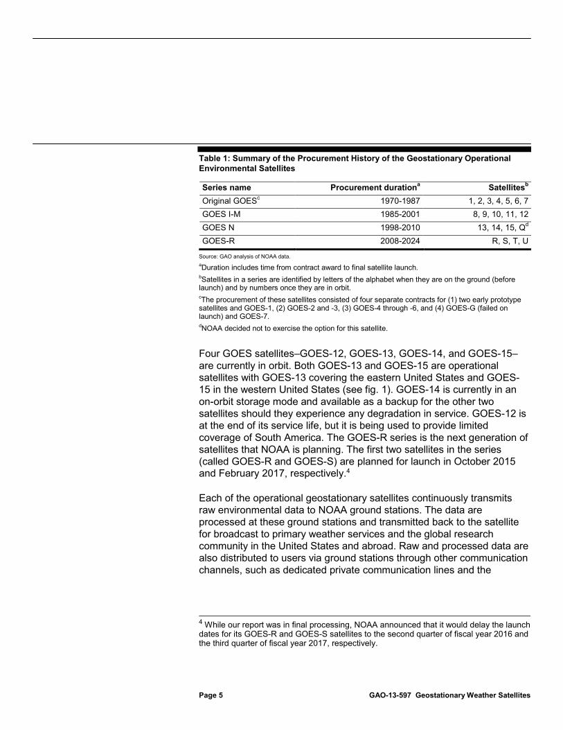
Table 1: Summary of the Procurement History of the Geostationary Operational Environmental Satellites
Series name Procurement durationa Satellitesb Original GOESc 1970-1987 1, 2, 3, 4, 5, 6, 7 GOES I-M 1985-2001 8, 9, 10, 11, 12 GOES N 1998-2010 13, 14, 15, Qd GOES-R 2008-2024 R, S, T, U
Source: GAO analysis of NOAA data. aDuration includes time from contract award to final satellite launch. bSatellites in a series are identified by letters of the alphabet when they are on the ground (before launch) and by numbers once they are in orbit. cThe procurement of these satellites consisted of four separate contracts for (1) two early prototype satellites and GOES-1, (2) GOES-2 and -3, (3) GOES-4 through -6, and (4) GOES-G (failed on launch) and GOES-7. dNOAA decided not to exercise the option for this satellite.
Four GOES satellites–GOES-12, GOES-13, GOES-14, and GOES-15–are currently in orbit. Both GOES-13 and GOES-15 are operational satellites with GOES-13 covering the eastern United States and GOES-15 in the western United States (see fig. 1). GOES-14 is currently in an on-orbit storage mode and available as a backup for the other two satellites should they experience any degradation in service. GOES-12 is at the end of its service life, but it is being used to provide limited coverage of South America. The GOES-R series is the next generation of satellites that NOAA is planning. The first two satellites in the series (called GOES-R and GOES-S) are planned for launch in October 2015 and February 2017, respectively.4
Each of the operational geostationary satellites continuously transmits raw environmental data to NOAA ground stations. The data are processed at these ground stations and transmitted back to the satellite for broadcast to primary weather services and the global research community in the United States and abroad. Raw and processed data are also distributed to users via ground stations through other communication channels, such as dedicated private communication lines and the
4 While our report was in final processing, NOAA announced that it would delay the launch dates for its GOES-R and GOES-S satellites to the second quarter of fiscal year 2016 and the third quarter of fiscal year 2017, respectively.
Internet. Figure 2 depicts a generic data relay pattern from a geostationary satellite to the ground stations and commercial terminals.
Figure 2: Generic Data Relay Pattern for the Geostationary Operational Environmental Satellites
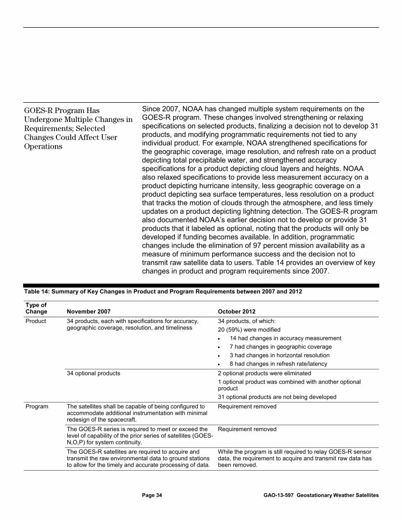
NOAA established the GOES-R program to develop and launch the next series of geostationary satellites and to ensure the continuity of geostationary satellite observations. Since its inception, the GOES-R program has undergone several changes in cost and scope. As originally envisioned, GOES-R was to encompass four satellites hosting a variety of advanced technology instruments and providing 81 environmental products. The first two satellites in the series were expected to launch in September 2012 and April 2014. However, in September 2006, NOAA decided to reduce the scope and technical complexity of the GOES-R program because of expectations that total costs, which were originally estimated to be $6.2 billion, could reach $11.4 billion. Specifically, NOAA reduced the minimum number of satellites from four to two, cancelled plans for developing an advanced instrument (which reduced the number
of planned satellite products from 81 to 68), and divided another instrument into two separate acquisitions. The agency estimated that the revised program would cost $7 billion and kept the planned launch dates unchanged.
Subsequently, NOAA made several other important decisions about the cost and scope of the GOES-R program. In May 2007, NOAA had an independent cost estimate completed for the GOES-R program. After reconciling the program office’s cost estimate of $7 billion with the independent cost estimate of about $9 billion, the agency established a new program cost estimate of $7.67 billion. This was an increase of $670 million from the previous estimate. The program also moved the launch dates for the first two satellites to December 2014 and April 2016. Further, in November 2007, to mitigate the risk that costs would rise, program officials decided to remove selected program requirements from the baseline program and treat them as contract options that could be exercised if funds allowed. These requirements included the number of products to be distributed, the time to deliver the remaining products (product latency), and how often these products would be updated with new satellite data (refresh rate). For example, program officials eliminated the requirement to develop and distribute 34 of the 68 envisioned products, including low cloud and fog, sulfur dioxide detection, and cloud liquid water. Program officials included the restoration of the requirements for the products, latency times, and refresh rates as options in the ground system contract that could be acquired at a later time. Program officials later reduced the number of products that could be restored as a contract option (called option 2) from 34 to 31 because they determined that two products were no longer feasible and two others could be combined into a single product.
In late 2009, NOAA changed the launch dates for the first two satellites to October 2015 and February 2017, in part due to a bid protest related to award of the spacecraft contract. More recently, NOAA restored two satellites to the program’s baseline, making GOES-R a four-satellite program once again. In February 2011, as part of its fiscal year 2012 budget request, NOAA requested funding to begin development for two additional satellites in the GOES-R series—GOES-T and GOES-U. The program estimates that the development for all four satellites in the GOES-R series—GOES-R, GOES-S, GOES-T, and GOES-U—is to cost $10.9 billion through 2036, an increase of $3.2 billion over its prior life cycle cost estimate of $7.67 billion for the two-satellite program. See table 2 for an overview of key changes to the GOES-R program.
Source: GAO analysis of NOAA data. aBased on NOAA’s fiscal year 2012 budget baseline, $7.64 billion of this cost estimate was for the first two satellites in the series, GOES-R and GOES-S. The cost for the remaining two satellites—GOES-T and GOES-U—was estimated at $3.22 billion.
The GOES-R program is divided into flight and ground projects that have separate areas of responsibility and oversee different sets of contracts. The flight project, which is managed by NASA, includes instruments, spacecraft, launch services, satellite integration, and on-orbit satellite initialization. Table 3 summarizes the GOES-R instruments and their planned capabilities.
Table 3: Geostationary Operational Environmental Satellite-R Series Instruments
Planned instrument Description Advanced Baseline Imager Expected to provide variable area imagery and radiometric information of the earth’s surface,
atmosphere, and cloud cover. Key features include • monitoring and tracking severe weather; • providing images of clouds to support forecasts; and • providing higher resolution, faster coverage, and broader coverage simultaneously.
Geostationary Lightning Mapper
Expected to continuously monitor total lightning (in-cloud and cloud-to-ground) activity over the United States and adjacent oceans and to provide a more complete dataset than previously possible. Key features include • detecting lightning activity as an indicator of severe storms and convective weather hazard
impacts to aviation; and • providing a new capability to GOES for long-term mapping of total lightning that only
previously existed on NASA low-earth-orbiting research satellites. Magnetometer Expected to provide information on the general level of geomagnetic activity, monitor current
systems in space, and permit detection of magnetopause crossings, sudden storm commencements, and substorms.
Space Environmental In-Situ Suite
Expected to provide information on space weather to aid in the prediction of particle precipitation, which causes disturbance and disruption of radio communications and navigation systems. Key features include • measuring magnetic fields and charged particles; • providing improved heavy ion detection, adding low-energy electrons and protons; and • enabling early warnings for satellite and power grid operation, telecom services, astronauts,
and airlines. Solar Ultraviolet Imager Expected to provide coverage of the entire dynamic range of solar X-ray features, from coronal
holes to X-class flares, and will provide quantitative estimates of the physical conditions in the Sun’s atmosphere. Key features include • providing information used for geomagnetic storm forecasts, and power grid performance;
and • providing observations of solar energetic particle events related to flares.
Extreme Ultraviolet/X-Ray Irradiance Sensor
Expected to detect solar soft X-ray irradiance and solar extreme ultraviolet spectral irradiance. Key features include • monitoring solar flares that can disrupt communications and degrade navigational accuracy,
affecting satellites, astronauts, high latitude airline passengers; and • monitoring solar variations that directly affect satellite drag/tracking and ionospheric changes,
which impact communications and navigation operations.
Source: GAO analysis of NOAA data.
The ground project is directed by NOAA and is made up of three main components: the core ground system, an infrastructure of antennas, and a product access subsystem. In turn, the core ground system comprises four functional modules supporting operations, product generation, product distribution, and configuration control. Key components of the ground project are described in table 4.
Table 4: Key Components of the Geostationary Operational Environmental Satellite-R Series Ground Project
Component Description Core Ground System Expected to (1) provide command of operational functions of the spacecraft and instruments,
(2) receive and process information from the instruments and spacecraft, (3) distribute satellite data products to users, and (4) provide configuration control and a common infrastructure and set of services for the satellite and instruments.
Antennas Expected to provide six new antenna stations and modify four existing antennas to receive GOES-R data. The antenna contract is also expected to include the construction of related infrastructure, software development for control systems, and maintenance.
Product Distribution and Access System
Expected to provide ingestion of data and distribution for GOES-R products and data to authorized users. When completed, this system will be integrated into the core ground system.
Source: GAO analysis of NOAA data.
NOAA is responsible for GOES-R program funding and overall mission success. The NOAA Program Management Council, which is chaired by NOAA’s Deputy Undersecretary, is the oversight body for the GOES-R program. However, since it relies on NASA’s acquisition experience and technical expertise to help ensure the success of its programs, NOAA implemented an integrated program management structure with NASA for the GOES-R program (see fig. 3). NOAA also located the program office at NASA’s Goddard Space Flight Center.
In recent years, we issued a series of reports aimed at addressing weaknesses in the GOES-R program.5 Key areas of focus included (1) improving communications with external data users, (2) developing contingency plans, and (3) addressing key cost and schedule risks.
• Improving communications with external users. In September 2010, we reported that while NOAA had identified GOES data users and involved internal NOAA users in developing and prioritizing GOES-R requirements, it had not adequately involved other federal users who rely on GOES data by documenting their input and communicating major changes to the program.6 We recommended that the program establish processes for satellite data requirements definition and prioritization that include documented input from external users, as well as processes to notify these non-NOAA agencies of GOES-R program status and changes. In February 2012, the GOES-R program developed a communications plan that described how external stakeholders would be notified of GOES-R progress, status changes, and other relevant activities. However, NOAA has not yet fully implemented the plan, as demonstrated by the communication shortfalls discussed later in this report.
• Developing contingency plans. In September 2010, we reported that while there was a potential gap in backup coverage due to
5GAO, Environmental Satellites: Focused Attention Needed to Mitigate Program Risks, GAO-12-841T, (Washington, D.C.: June 27, 2012); GAO, Geostationary Weather Satellites: Design Progress Made, but Schedule Uncertainty Needs to be Addressed, GAO-12-576, (Washington, D.C.: June 26, 2012); GAO, Geostationary Operational Environmental Satellites: Improvements Needed in Continuity Planning and Involvement of Key Users, GAO-10-799 (Washington, D.C.: Sept. 1, 2010); GAO, Geostationary Operational Environmental Satellites: Acquisition Has Increased Costs, Reduced Capabilities, and Delayed Schedules, GAO-09-596T (Washington, D.C.: Apr. 23, 2009); GAO, Geostationary Operational Environmental Satellites: Acquisition Is Under Way, but Improvements Needed in Management and Oversight, GAO-09-323 (Washington, D.C.: Apr. 2, 2009); GAO, Geostationary Operational Environmental Satellites: Further Actions Needed to Effectively Manage Risks, GAO-08-183T (Washington, D.C.: Oct. 23, 2007); GAO, Geostationary Operational Environmental Satellites: Progress Has Been Made, but Improvements Are Needed to Effectively Manage Risks, GAO-08-18 (Washington, D.C.: Oct. 23, 2007); GAO, Geostationary Operational Environmental Satellites: Additional Action Needed to Incorporate Lessons Learned from Other Satellite Programs, GAO-06-1129T (Washington, D.C.: Sept. 29, 2006); and GAO, Geostationary Operational Environmental Satellites: Steps Remain in Incorporating Lessons Learned from Other Satellite Programs, GAO-06-993 (Washington, D.C.: Sept. 6, 2006). 6 GAO-10-799.
Prior Reports Made Recommendations to Address Program Weaknesses
satellite launch delays, NOAA had not established adequate continuity plans for its geostationary satellites.7 We recommended that the program’s plan include implementation procedures, resources, staff roles, and timetables needed to transition to a single satellite, a foreign satellite, or other solution. In December 2012, NOAA finalized a contingency plan that generally included these elements. However, more work remains to ensure that the plan is viable.
More recently, in February 2013, we added the potential gaps in weather satellite data to our biennial High-Risk list.8 In that report, we noted that NOAA had established a contingency plan for a potential gap in the GOES program, but it needed to demonstrate its progress in coordinating with the user community to determine their most critical requirements, conducting training and simulations for contingency operations scenarios, evaluating the status of viable foreign satellites, and working with the user community to account for differences in product coverage under contingency operations scenarios. We also stated that NOAA should update its contingency plan to provide more details on its contingency scenarios, associated time frames, and any preventative actions it is taking to minimize the possibility of a gap.
• Addressing key cost and schedule risks. In June 2012, we reported that the GOES-R program might not be able to ensure that it had adequate resources to cover unexpected problems in remaining development, and that unresolved schedule deficiencies existed in its integrated master schedule and contractor schedules. We also reported that the program estimated a 48 percent chance that the planned GOES-R launch date of October 2015 would be reached.9 We recommended that the program assess and report on the reserves needed for completing remaining development for each satellite in the series, and address shortfalls in the schedule management practices we identified such as eliminating unnecessary constraints and creating a realistic allocation of resources, in order to minimize the likelihood of a potential gap. The agency agreed with
7 GAO-10-799. 8 GAO, 2013 High-Risk Series: An Update, GAO-13-359T (Washington, D.C.: February 14, 2013). 9 GAO-12-756.
these recommendations and took steps to address them by identifying needed reserve levels and refining program schedules.
NOAA has completed its design of the GOES-R program, and has made progress in building components of the flight and ground segments. Program officials also report that the program is operating within its estimated budget of $10.9 billion. However, key information on reserves has not been reported to management. Further, both the flight and ground segments have experienced delays in achieving major milestones due to technical challenges, and weaknesses in the development of master schedules could cause further delays. Program officials stated that they have made improvements on how they manage cost reserves and schedules, but acknowledged that there will always be opportunities for improvement because the reserves and schedules are so dynamic on a big program like GOES-R. These challenges have the potential to impact the expected launch date of the first GOES-R satellite, which would delay the availability of an on-orbit backup and increase the potential for a gap in GOES satellite coverage should either of the two operational satellites fail prematurely.
NASA and NOAA are following NASA’s standard space system life cycle on the GOES-R program. This life cycle includes distinct phases, including concept and technology development; preliminary design and technology completion; final design and fabrication; system assembly, integration and testing, launch and checkout; and operations and sustainment. There are key program reviews throughout each of the phases, including preliminary design review, critical design review, and system integration review. NOAA and NASA jointly conduct key reviews on the flight and ground segments individually as well as for the program as a whole, and then make decisions on whether to proceed to the next phase. Figure 4 provides an overview of the life cycle phases, key program reviews, and associated decision milestones. In addition, the key reviews are described in table 5.
NOAA Has Made Progress in Developing GOES-R, but Continues to Face Challenges that Could Increase the Risk of a Satellite Data Gap
Program Has Completed Design and Begun Building Components of the First Satellite
Note: According to a NASA official, the MOR and FOR are considered lower-level reviews and are not mandated by NASA’s primary procedural requirements. They are, however, key mission reviews required by NASA’s Goddard Space Flight Center.
Table 5: Major Development Reviews for the Geostationary Operational Environmental Satellite-R Series
Review Description System Definition Review
Performed on the flight and ground segments individually, and then on the program as a whole, this review is to examine the proposed system architecture/design and demonstrate that a system that fulfills the mission objectives can be built within existing constraints.
Preliminary Design Review Performed on the flight and ground segments individually, and then on the program as a whole, this review is to demonstrate that the preliminary design meets all system requirements with acceptable risk and within the cost and schedule constraints and to establish the basis for proceeding with detailed design.
Critical Design Review Performed on the flight and ground segments individually, and then on the program as a whole, this review is to evaluate the completed detailed design of the element and subsystem products in sufficient detail to provide approval for a production stage.
Review Description Mission Operations Review Performed programwide, this review is to establish the adequacy of plans and schedules for
ground systems and flight operations preparation, and to justify readiness to proceed with implementation of the remaining required activities. It is typically held subsequent to completion of detail design and fabrication activity, but prior to initiation of major integration activities of flight or ground-system elements.
System Integration Review Performed programwide, this review is to evaluate the readiness of the project to start system assembly, test, and launch operations. The objectives of the review include ensuring that planning is adequate for all remaining system activities and that available cost and schedule resources support completion of all necessary remaining activities with adequate margin.
Flight Operations Review This review is to present the results of mission operations activities and show that the program has verified compliance with all requirements and demonstrated the ability to execute all phases and modes of mission operations, data processing, and analysis.
Operational Readiness Review This review is to examine characteristics and procedures used in the system’s operation and ensures that all system and support hardware, software, personnel, and procedures are ready for operations and that user documentation accurately reflects the deployed state of the system. It is typically held near the completion of pre-launch testing between the flight segment and the ground system.
Source: GAO analysis of NOAA documentation.
The GOES-R program has completed final design and begun building components of the flight and ground systems. Specifically, the program completed critical design reviews for the flight and ground projects and for the overall program between April and November 2012. In its evaluation of the program as part of the critical design review, an independent review board complimented the program on several recent achievements, stating that the program was beyond the level of maturity expected at that phase, and that the program’s planning was a major factor in the launch date of the first satellite remaining October 2015.
As the spacecraft and instruments are developed, NASA conducts several interim reviews and tests before proceeding to the next major program-level review, the system integration review. These include a pre-environmental review, which represents the conclusion of an initial round of testing before exposing the instrument to testing under adverse environmental conditions; environmental testing of key functions under adverse conditions; and a pre-shipment review, which is conducted on each instrument to ensure it is ready to be shipped for integration and testing on the spacecraft.
The GOES-R flight components are in various stages leading up to the system integration review. Of the six GOES-R instruments, one has completed environmental testing and its pre-shipment review; four instruments are in the midst of these reviews and tests; and one instrument has not yet passed its pre-environmental review. In addition,
• Instrument fully assembled and tested • Pre-environmental review conducted in July 2012 • Pre-ship review conducted in April 2013
Geostationary Lightning Mapper • Assembly of some subcomponents completed, others continuing • Subcomponent testing is under way
Magnetometer • Selected components have completed readiness reviews and tests • Environmental testing is under way
Solar Ultraviolet Imager • Pre-environmental review completed in November 2012 • Environmental testing is under way • Pre-ship review scheduled for October 2013
Space Environmental In-Situ Suite • Individual component testing completed • Pre-environmental review conducted in May 2013
Spacecraft • Core structure testing completed; multiple components delivered • Integration of subsystems under way • Construction of the system module that will host instruments is under way
Source: GAO analysis of NOAA documentation.
Similar to the flight project, major ground system milestones are focused on building and testing components and the program has made progress in this area. Specifically, on the core ground system, a prototype for the operations module was delivered in late 2012 and used for initial testing and training.10 In July 2013, the ground project delivered the iteration of the operations module that will be used to support the first satellite. In addition, the program has installed antenna dishes at NOAA’s primary satellite communications site, and completed two key reviews of antennas at the GOES remote backup site. The Product Distribution and Access System recently completed a review that will allow testing to begin on its first release. An integration review for ground components is also
10 This module is called the Mission Management function.
expected to take place in January 2014. More detail on the progress of the ground project can be seen in table 7.
Table 7: Development Status of the Geostationary Operational Environmental Satellite-R Series Ground Project Components, as of August 2013
Key component Recent progress Core Ground Segment • Critical design review completed in April 2012
• Completed readiness review for receipt of GOES-R antennas • Delivery and installation of a prototype of the mission operations module completed; next iteration of
the module delivered in July 2013 Antenna System • Contractor demonstrated ability to produce 8 of 13 components; remainder due by the end of 2013
• Installation of the first two antenna structures has been completed; the third antenna structure is scheduled to be completed in fiscal year 2014
• Supporting infrastructure built, and two key reviews completed, for remote back-up antenna site Product Distribution and Access System
• Testing begun on first increment/release
Source: GAO analysis of NOAA documentation.
The program’s next major milestone is a programwide system integration review, which is scheduled for March 2014. Based on the results of that review, NOAA and NASA will decide whether to move the program to the next phase: the system assembly, integration and test, and launch and checkout phase.
The GOES-R program is estimated to cost $10.9 billion. As of February 2013, the program estimated that this amount was divided into four categories, with $6.0 billion for the flight project, $1.7 billion for the ground project, $2.0 billion for other program costs (including, among other things, program/project support and formulation) and $1.2 billion for operations and support. Program officials reported that the program is currently operating without cost overruns on any of its main components, but noted that the program life cycle costs may increase by $150 to $300 million if full funding in the current fiscal year is not received.
A portion of the amounts planned for the flight project and ground project are allocated to contingency reserves (also called management reserve). The program also keeps a programwide contingency allocation separate from those of the flight and ground projects. A contingency reserve provides program managers ready access to funding in order to resolve problems as they occur and may be necessary to cover increased costs resulting from unexpected design complexity, incomplete requirements, or
Contingency Reserves Are Generally in Line with Goals for Overall Program Development; Reporting on Reserve Values Remains Limited
other uncertainties.11 NASA’s Goddard Space Flight Center requires its flight projects, including GOES-R, to maintain contingency reserves during system development, at a level of 25 percent of development costs.12 The GOES-R program requires its flight and ground projects to maintain 20 percent of planned remaining development costs as reserve funding.13 The program office also maintains contingency reserves equal to 10 percent of planned remaining development costs to cover program support costs and to supplement the flight and ground projects’ reserves if necessary. According to a NOAA program official, the GOES-R program is able to meet NASA’s requirement through the combination of the 20 percent flight and ground project requirements and the supplemental 10 percent program-level reserve. An official also stated that the method of keeping separate reserves at the program and project levels was chosen as it was successful on past projects.
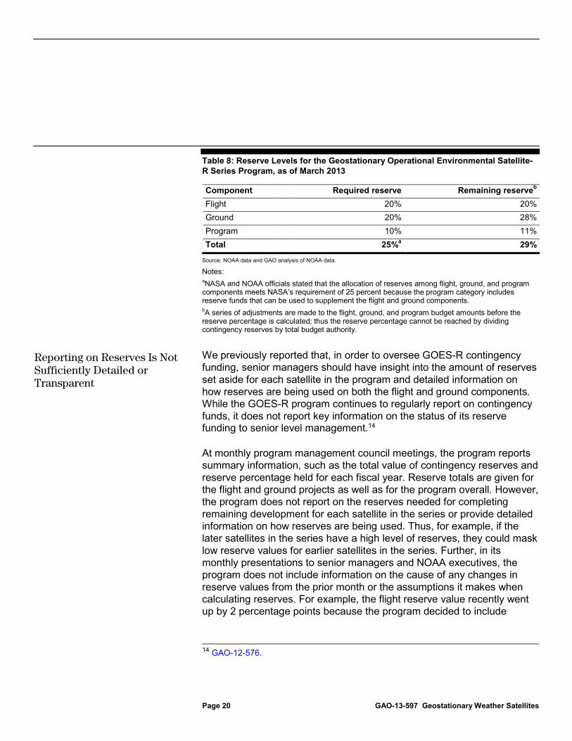
The GOES-R flight project, ground project, and program office are at or above the amount of reserves they are required to carry. Specifically, as of March 2013, the overall contingency reserve percentages for the flight and ground projects were at 20 and 28 percent, respectively, which are at or above the required level of 20 percent. The program reserves were at 11 percent, slightly above the required level of 10 percent. Reserve values and percentages are provided in table 8.
11 GAO, GAO Cost Estimating and Assessment Guide: Best Practices for Developing and Managing Capital Program Costs, GAO-09-3SP (Washington, D.C.: Mar. 2009). 12 While NOAA has ultimate responsibility for GOES-R, NOAA shares program management responsibilities with NASA, and the program office is located at NASA’s Goddard Space Flight Center. 13 Until late 2012, NOAA required the ground project to maintain 30 percent of its development cost as a reserve. However, program officials recently revised the requirement down to 20 percent to reflect the shorter amount of development time before launch and the retirement of some risks.
Table 8: Reserve Levels for the Geostationary Operational Environmental Satellite-R Series Program, as of March 2013
Component Required reserve Remaining reserveb Flight 20% 20% Ground 20% 28% Program 10% 11% Total 25%a 29%
Source: NOAA data and GAO analysis of NOAA data.
Notes: aNASA and NOAA officials stated that the allocation of reserves among flight, ground, and program components meets NASA’s requirement of 25 percent because the program category includes reserve funds that can be used to supplement the flight and ground components. bA series of adjustments are made to the flight, ground, and program budget amounts before the reserve percentage is calculated; thus the reserve percentage cannot be reached by dividing contingency reserves by total budget authority.
We previously reported that, in order to oversee GOES-R contingency funding, senior managers should have insight into the amount of reserves set aside for each satellite in the program and detailed information on how reserves are being used on both the flight and ground components. While the GOES-R program continues to regularly report on contingency funds, it does not report key information on the status of its reserve funding to senior level management.14
At monthly program management council meetings, the program reports summary information, such as the total value of contingency reserves and reserve percentage held for each fiscal year. Reserve totals are given for the flight and ground projects as well as for the program overall. However, the program does not report on the reserves needed for completing remaining development for each satellite in the series or provide detailed information on how reserves are being used. Thus, for example, if the later satellites in the series have a high level of reserves, they could mask low reserve values for earlier satellites in the series. Further, in its monthly presentations to senior managers and NOAA executives, the program does not include information on the cause of any changes in reserve values from the prior month or the assumptions it makes when calculating reserves. For example, the flight reserve value recently went up by 2 percentage points because the program decided to include
14 GAO-12-576.
Reporting on Reserves Is Not Sufficiently Detailed or Transparent
reserve funding for the GOES-T satellite in 2018, and the ground reserve values went down by 10 percentage points because the program shifted reserve funding from the ground to the flight projects. Neither of these changes was identified or explained in the monthly presentations. The lack of insight on how the reserves are calculated and modified could lead executives to misinterpret the size of the remaining reserves. Program officials noted that they took steps after our previous report to clarify what they report about reserves, but noted that the amount of information needed to fully explain reserve calculations and changes could be too much information for an executive-level briefing. Without regularly providing sufficiently detailed budget information, it may be more difficult for program management to have the information they need to make the best decisions possible regarding the program’s future funding.
The GOES-R program established programwide milestones, including the mission operations review and flight operations review, to determine the program’s ability to proceed to system integration and to complete mission operations, respectively. It also established five end-to-end system tests to validate compatibility between the space and ground segments before the launch of the first satellite.
However, over the past year, the program delayed many of these key milestones and tests. Delays in the mission operations review means that the large-scale integration of flight and ground components will not occur until 21 months prior to launch. Similarly, delaying end-to-end tests until 17 months prior to launch will allow the program less time to respond to any problems that occur. Table 9 highlights key milestones and the extent of recent delays.
Recent and Potential Milestone Delays and Continued Weaknesses in Scheduling Practices Increase the Potential for a Delayed Launch
Table 9: Delays in Milestones for the Geostationary Operational Environmental Satellite-R Series Program
Program milestone Date planned (as of Apr 2012)
Date completed or planned (as of Mar 2013) Delay
Mission operations review January 2013 January 2014 12 monthsa End-to-end test #1 February 2014 May 2014 3 months End-to-end test #2 May 2014 August 2014 3 months End-to-end test #3 August 2014 December 2014 4 months Flight operations review September 2014 January 2015 4 months End-to-end test #4 December 2014 March 2015 3 months End-to-end test #5 July 2015 July 2015 No change
Source: GAO analysis of NOAA data. aProgram officials stated that they had erroneously scheduled the mission operations review too soon, and moved the date by 9 months to better reflect when the review was needed. Therefore, only 3 of the 12 months were attributable to a delay.
The GOES-R program is also experiencing technical issues on the flight and ground projects that could cause further schedule delays.
• The original supplier for a key component on the spacecraft moved to a different facility, introducing risk due to the loss of experienced personnel and the impact on schedule. This led the program to find an alternative supplier. While a design review was performed to confirm resolution of the issue in April 2013, this change may lead to a delay of up to 6 months in integrating the component on the spacecraft. Program officials noted that this delay is not expected to impact the program’s critical path or major milestones.
• The Geostationary Lightning Mapper’s electronics unit experienced problems during testing, which led the program office to delay the tests.15 The program is considering several options to address this issue, including using the electronics unit being developed for a later GOES satellite to allow key components to proceed with testing. If the issue cannot be resolved, it would affect the instrument’s performance. As a result, the program is also considering excluding
15 Under testing, the electronics board emitted unexpectedly high levels of radiation, which would cause a high number of false alarms and hinder the program’s ability to assess the instrument’s observations.
Continued Technical Issues Could Cause Further Delays
the Geostationary Lightning Mapper from the first GOES satellite. The program plans to make its decision on whether or not to include the instrument in late 2013. The removal of this instrument would cause a significant reduction in the satellite’s functionality. Key GOES users have stated that they would prefer that NOAA delay launching the GOES-R satellite rather than launch it without the Geostationary Lightning Mapper.
• The program delayed the start of work on the ground system at the NOAA satellite operations facility by three months, from a planned date of October 2012 to January 2013, following a bid protest of the award of a contract to upgrade the facility. This delay compressed an already tight schedule for testing the ground system.
• Testing for a number of ground system requirements has been postponed until future releases and builds, potentially causing modification to the schedule for these future products.
• Power amplifiers for the antenna systems experienced higher than expected failure rates, which could lead to schedule delays and decreases in operational availability.
Given that fewer than 3 years remain before GOES-R’s expected launch in October 2015, continued delays in key milestones and reviews decrease the likelihood that the launch date will be met. Program officials recently acknowledged that the GOES-R launch date may be delayed by about 6 months, and attributed the cause of the delay to a shortfall of $54 million in anticipated funding in fiscal year 2013.16
Delays in the program’s remaining schedule are also at risk of further growth due to weaknesses in the program’s scheduling methods. Program schedules not only provide a road map for systematic program execution, but also provide the means by which to gauge progress, identify and address potential problems, and promote accountability. Achieving success in managing large-scale programs depends in part on having an integrated and reliable schedule that defines, among other things, when work activities and milestone events will occur, how long
16 While our report was in final processing, NOAA announced that it would delay the launch date for its GOES-R satellite from October 2015 to the second quarter of fiscal year 2016.
Scheduling Practices Improved, but Weaknesses Remain
they will take, and how they are related to one another. Without such a reliable schedule, program milestones may slip.
In June 2012, we reported on weaknesses in program schedules that comprised portions of the program’s Integrated Master Schedule, including subordinate schedules for the spacecraft and core ground system. At that time, our work identified nine best practices associated with developing and maintaining a reliable schedule.17 These are (1) capturing all activities, (2) sequencing all activities, (3) assigning resources to all activities, (4) establishing the duration of all activities, (5) integrating schedule activities horizontally and vertically, (6) establishing the critical path for all activities, (7) identifying reasonable float time between activities, (8) conducting a schedule risk analysis, and (9) updating the schedule using logic and durations. See table 10 for a description of each of these best practices.
17 See GAO-09-3SP. In May 2012, we published updated guidance on scheduling best practices. See GAO, Schedule Assessment Guide: Best Practices for Project Schedules—Exposure Draft, GAO-12-120G (Washington, D.C.: May 30, 2012). The updated guidance identifies 10 best practices.
Table 10: Description of Scheduling Best Practices
Practice Description Capturing all activities The schedule should reflect all activities (steps, events, outcomes, etc.) as defined in the
program’s work breakdown structure to include activities to be performed by both the government and its contractors.
Sequencing all activities The schedule should sequence activities in the order that they are to be implemented. In particular, activities that must finish prior to the start of other activities (i.e., predecessor activities), as well as activities that cannot begin until other activities have been completed (i.e., successor activities) should be identified.
Assigning resources to all activities The schedule should reflect who will do the work activities, whether all required resources will be available when they are needed, and whether there are any funding or time constraints.
Establishing the duration of all activities
The schedule should reflect the duration of each activity. These durations should be as short as possible and have specific start and end dates.
Integrating schedule activities horizontally and vertically
The schedule should be horizontally integrated, meaning that it should link the products and outcomes associated with sequenced activities. The schedule should also be vertically integrated, meaning that there is traceability among varying levels of activities and supporting tasks and subtasks.
Establishing the critical path for all activities
The critical path represents the chain of dependent activities with the longest total duration in the schedule.
Identifying reasonable float time between activities
The schedule should identify a reasonable amount of float—the time that an activity can slip before the delay affects the finish milestone—so that schedule flexibility can be determined. As a general rule, activities along the critical path typically have the least amount of float.
Conducting a schedule risk analysis A schedule risk analysis is used to predict the level of confidence in the schedule, determine the amount of time contingency needed, and identify high-priority schedule risks.
Updating the schedule using logic and durations to determine the dates
The schedule should use logic and durations in order to reflect realistic start and completion dates, be continually monitored to determine differences between forecasted completion dates and planned dates, and avoid logic overrides and artificial constraint dates.
Source: GAO analysis of government and industry practices in GAO-09-3SP.
In a previous report, we observed that important schedule components in GOES-R related schedules had not been included or completed, and recommended that these shortfalls be addressed.18 NOAA has since improved selected practices on its spacecraft and core ground schedules, but other practices stayed the same or worsened. Specifically, for the spacecraft, 2 practices were improved, 5 stayed the same, and 2 became weaker. For the core ground system, 4 practices were improved, 3 stayed the same, and 2 became weaker. Table 11 compares our assessments of the spacecraft and core ground system schedules in July 2011 and November 2012.
Table 11: Assessment of Selected Schedules Use of Best Practices over Time
Scheduling best practice Spacecraft schedules Core ground schedules
July 2011 November 2012 July 2011 November 2012 Best practice 1: Capturing all activities ◕ ● ◑ ◕ Best practice 2: Sequencing all activities ◑ ◑ ◑ ◑ Best practice 3: Assigning resources to all activities ◔ ◑ ◑ ◔ Best practice 4: Establishing the duration of all activities ◕ ◕ ◕ ◕ Best practice 5: Integrating schedule activities horizontally and vertically ◕ ◑ ◑ ◔ Best practice 6: Establishing the critical path for all activities ◕ ◕ ◔ ◑ Best practice 7: Identifying float on activities and paths ◑ ◑ ◔ ◔ Best practice 8: Conducting a schedule risk analysis ◔ ◔ ◔ ◑ Best practice 9: Updating the schedule using logic and durations to determine the dates ● ◕ ◕ ●
Source: GAO analysis of schedules provided by GOES-R, documents and information received from GOES-R officials.
Key ● The agency/contractor has fully met the criteria for this best practice ◕ The agency/contractor has substantially met the criteria for this best practice ◑ The agency/contractor has partially met the criteria for this best practice ◔ The agency/contractor has minimally met the criteria for this best practice ○ The agency/contractor has not met the criteria for this best practice
NOAA has improved elements of the schedules for both components. Specifically, the spacecraft schedule has eliminated level of effort activities19 and has assigned resources for a greater percentage of activities. The core ground schedule now has an automated process by which all subcontractor records are combined to create an integrated schedule. It has a series of connected activities that lead to what contractor officials consider its main milestone delivery, and has implemented a detailed schedule risk analysis for a key upcoming release.
However, scheduling issues remain on the schedules for both components. For example, both schedules have issues with sequencing
19 Level-of-effort activities represent work that has no measurable output and cannot be associated with a physical product or defined deliverable. These activities are typically related to management and other oversight that continues until the detailed activities they support have been completed.
remaining activities and integration between activities. Regarding the spacecraft schedule, there is a small subset of activities with incomplete links between activities, and more than 20 percent of remaining detail activities have lags, or a set number of days between an activity and its successor. In the core ground schedule, a number of activities are missing either predecessor or successor activities, and there are several activities representing the end of the project on or about the same date. Without the right linkages, activities that slip early in the schedule do not transmit delays to activities that should depend on them. When this happens, the schedule will not provide a sufficient basis for understanding the program as a whole, and users of the schedule will lack confidence in the dates and the critical path.
Both schedules also have a very high average of total float time for detailed activities.20 Specifically, total float time is greater than two months for nearly two-thirds of remaining detailed activities in the spacecraft schedule, and at least a year for more than 10 percent of remaining detail activities in the core ground schedule. In the case of spacecraft, officials stated that high levels of float time were often due to activities that had been completed at one time for several satellites, only one of which was immediately needed. Officials also provided detailed information on the activities with the highest amount of float. In the case of the core ground schedule, officials stated that many activities occurring after the main milestone date, which occurs nearly five years prior to the end of the schedule, do not have a true successor, and therefore are calculated only to the end of the contract. Officials also stated that values and trends in float time are monitored regularly for both schedules. Such high values of total float time can falsely depict true project status, making it difficult to determine which activities drive key milestone dates. Without reasonable values of total float time, it cannot be used to identify activities that could be permitted to slip and thus release and reallocate resources to activities that require more resources to be completed on time.
In addition, the project’s critical path does not match up with activities that make up the driving path21 on the core ground schedule. Contractors
20 Total float time is the amount of time an activity can be delayed or extended before the delay affects its successors or the program’s finish date. 21 A driving path is the longest path of successive activities that drives the finish date for a key milestone. The driving path often corresponds to a schedule’s critical path.
monitor a driving path monthly to both major and minor milestone deliveries. However, until the schedule can produce a true critical path, it will be more difficult for the program office to provide reliable time line estimates or identify when problems or changes may occur and their effect on downstream work. Also, without a valid critical path to the end of the schedule, management cannot focus on activities that will have a detrimental effect on the key project milestones and deliveries if they slip.
Further, neither schedule file has fully integrated resources with schedule activities. As of November 2012, contractor officials stated that the ground system schedule was not feasible given available resources and that they were in the process of revising their immediate schedules to make them feasible. The spacecraft schedule contains major resource categories that correspond to contractor sites and work phases. However, thresholds for overruns of resource allocations are functionally disabled within the schedules through the setting of an arbitrarily high value for maximum resources per category. In response, contractor officials stated that account managers are responsible for monitoring resource levels and that weekly meetings are held to ensure that resource issues are discussed. Information on resource needs and availability in each work period assists the program office in forecasting the likelihood that activities will be completed as scheduled. If the current schedule does not allow insight into current or project allocation of resources, then the risk of delays in the program’s schedule is significantly increased.
Deficiencies in scheduling practices such as the ones outlined here could increase the likelihood of launch date delays, because decision making would be based on data that does not accurately depict current status, thus impeding management’s ability to conduct meaningful oversight on the program’s schedules. Program officials noted that they have made improvements in scheduling practices, but explained that because the schedules are so dynamic there are always areas for improvement. Lack of the proper understanding of current program status due to schedules that are not fully reliable undercuts the ability of the program office to manage a high-risk program like GOES-R.
Potential delays in the launch date of the first GOES-R satellite would increase the risk of a gap in GOES satellite coverage. NOAA’s policy is to have two operational satellites and one backup satellite in orbit at all times. This policy proved useful in December 2008 and again in September 2012, when the agency experienced problems with one of its
Delays in the GOES-R Launch Date Could Increase the Risk of a Satellite Data Gap
operational satellites, but was able to move its backup satellite into place until the problems had been resolved.
NOAA is facing a period of at least a year when it will not have a backup satellite in orbit. Specifically, in April 2015, NOAA expects to retire one of its operational satellites (GOES-13) and move its backup satellite (GOES-14) into operation. Thus, the agency will have only two operational satellites in orbit—and no backup satellite—until GOES-R is launched and completes an estimated 6-month post-launch test period. If GOES-R is launched in October 2015, the soonest it could be available for operational use would be April 2016. Any delay to the GOES-R launch would extend the time without a backup to more than one year. Figure 5 shows anticipated operational and test periods for the two most recent series of GOES satellites.
Figure 5: Potential Gap in Geostationary Operational Environmental Satellite Coverage
In addition to the year or more during which no back-up satellite would be available, there is a chance that NOAA would have to operate with a single operational satellite. In December 2012, an independent review board estimated that there is a 36 percent chance that the GOES constellation would have only one operational satellite at the expected date of GOES-R’s launch. Thus, if NOAA were to experience a problem with either of its operational satellites before GOES-R is in orbit and
operational, it would need to rely on older satellites that are beyond their expected operational lives and may not be fully functional. Without a full complement of operational GOES satellites, the nation’s ability to maintain the continuity of data required for effective weather forecasting could be compromised. This, in turn, could put the public, property, and the economy at risk.
System requirements describe the functionality needed to meet user needs and perform as intended in an operational environment. According to leading industry, academic, and government entities, a disciplined process for developing and managing requirements can help reduce the risks of developing or acquiring a system.22 One key aspect of effective requirements management involves managing changes to requirements through a standardized process. Table 12 outlines best practices of a sound change management process and key questions for evaluating the process.
Table 12: Best Practices in Managing Requirements Changes
Practice Key questions Manage changes to requirements throughout the life cycle using a standard process
Does the program (or project) have a requirements management plan? Does the program maintain a current and approved set of requirements? Does the program have an approved set of baseline requirements? Does the program’s change management process provide guidance for the identification, review, and management of all requirements changes? Do change management processes apply throughout the program’s life cycle? Does change management documentation, such as meeting notes or change records, indicate that the organization is following its change management policies and procedures?
Document changes to requirements
Does the organization maintain records for all changes? Are all approved requirements changes documented according to a standard process? Are other work products in consistent alignment with requirements changes?
22 Leading industry and governments sources—including the Software Engineering Institute’s Capability Maturity Model®–Integration, the Project Management Institute’s Project Management Body of Knowledge, the Federal Information Security Controls Audit Manual, the IT Governance Institute’s Control Objectives for Information and related Technology governance framework, and NASA system development policies—provide extensive guidance on managing requirements.
NOAA Has a Process for Managing Changes in GOES-R Requirements, but Changes Could Affect Some Users
Practice Key questions Document rationale for change and analyze impact
Does the program document rationales for proposed changes? Does the program maintain a history of these rationales? Do they analyze the impact of a proposed change to the project and to users in impact assessments? Do these assessments address impacts to cost, schedule, risk, and project capabilities?
Have an approval body with appropriate representation review and approve all requirements changes
Has the program established an approval body for requirements changes and defined its responsibilities? Do change management policies require appropriate representation on the approval body? Do change management policies require that the approval body review and approve all changes? Does documentation show that the approval body reviewed and approved program requirements changes?
Ensure that requirements changes are aligned with user needs
Are requirements analyzed according to a standard process to determine if they continue to meet user needs? Do impact assessments show that the requirements remain in alignment with user needs? Has the program traced the changed requirements back to user needs? Has the program verified and validated that changed requirements align with user needs?
Communicate requirements changes to users
When requirements changes occur, are they communicated to end users? Is change information disseminated as part of a standard process?
Source: GAO analysis of government and industry practices.
The GOES-R program has a change management process that satisfied three practices, partially satisfied two practices, and did not satisfy one practice. Specifically, GOES-R has established a change management process that tracks and documents changes in requirements, documents the rationale for the changes as well as the potential impact of the change on cost and schedule, and ensures that changes are reviewed and approved by a change control board. In addition, the program has evaluated the impact of key changes on selected users and communicated with those users. However, as we first reported in 2010, the program is still weak in evaluating the impact of changes on external users who rely on GOES data products and in effectively communicating changes to those satellite data users.23 Specifically, table 13 outlines how the GOES-R program performed on each of the best practices for managing changes in requirements, and is followed by a more detailed discussion of key shortfalls.
Table 13: Assessment of Geostationary Operational Environmental Satellite-R Series Program Practices in Managing Changes in Requirements
Practice Assessment Discussion Manage changes to requirements throughout the life cycle using a standard process
Satisfied The GOES-R program has a requirements management plan and has established a change management process to apply throughout the project’s life cycle. In order to change a high-level requirement, the program must follow a detailed process that begins with proposing a change request, evaluating it, and obtaining approval or rejection of the request. The program also maintains an approved set of high-level baseline requirements and updates them regularly in response to requirements changes.
Document changes to requirements
Satisfied The GOES-R program documents requirements changes in a public change log associated with its high-level requirements document. More detailed information on the changes is tracked in an internal database. The changes documented in the change log align with those documented in the internal tracking database.
Document rationale for change and analyze impact
Partially satisfied
The GOES-R program documented the rationale for individual requirements changes as well as the cost and schedule impact of selected changes. In addition, the program has assessed the impact of key changes on selected users within NOAA. However, the program has not assessed the cost and schedule impact of all changes, and has not assessed the impact of key changes on external users who rely on GOES satellite data. Program officials noted that they assessed the cost and schedule impact of changes that were expected to negatively impact the program’s cost or schedule, and that they focus their impact assessments on users within NOAA because they are considered the primary users.
Have an approval body with appropriate representation review and approve all changes
Satisfied The GOES-R program has a configuration change board with representation from key NOAA and NASA officials. The board’s responsibilities are formalized in program documentation. Further, the board members review and approve requirements changes.
Ensure that requirements changes are aligned with user needs
Not satisfied
The program’s change management process does not require taking steps to ensure that changes in requirements are aligned with user needs. Specifically, the process does not require officials to trace applicable changes to user needs or to test or simulate whether the change still meets user needs. Moreover, for seven selected changes we reviewed, the program did not demonstrate the steps it took to test or validate the changes to ensure they were aligned with user needs. Program officials noted that they utilize a user working group to communicate changes to users and elevate concerns raised by users.
Communicate requirements changes to users
Partially satisfied
The GOES-R program generally communicates requirements changes to key users within NOAA and NOAA’s National Weather Service through mechanisms such as e-mail correspondence and working groups, while it communicates changes to external users through periodic conferences, such as the GOES users’ conferences. However, it does not alert external users who rely on GOES data to perform their missions about specific changes in requirements that will likely affect their operations. These external users include the Federal Aviation Administration, the U.S. Department of Agriculture, and the Department of the Navy. Officials at all three agencies reported that they were not informed about key changes in requirements that could affect their operations. Program officials stated that they work through a variety of working groups to try to communicate changes with those who utilize the satellite data.
While the program generally communicates requirements changes to key users within NOAA’s National Weather Service community, it does not communicate as well with satellite data users external to NOAA. Many such users are dependent on GOES satellite data for their respective missions. Officials responsible for working with satellite weather observations at three agencies were unaware of selected changes in GOES-R requirements. For example, the Federal Aviation Administration uses the satellites’ data and images to manage air traffic across the country, and the Navy uses the data for oceanic weather forecasting, as well as tactical ocean analysis of regions of interest. They stated that NOAA had not reached out to them to alert them to these changes or ask if the changes would impact them. Similarly, Forest Service officials were concerned that potential changes in spectrum allocations could affect their ability to obtain data from their own ground-based weather observation systems because they currently rely on GOES-R communication channels to obtain this data.
GOES-R program officials noted that they provide regular briefings to the Office of the Federal Coordinator for Meteorology, an interagency council with membership from fifteen federal departments and agencies involved in meteorological activities (including the Departments of Agriculture, Defense, and Transportation) and that the Air Force represents the Department of Defense community on the GOES-R Series Independent Advisory Committee. However, they acknowledged that they cannot ensure that the information they provide is disseminated within the agencies. Further, GOES officials explained that one reason for the distinction between the internal and external users is that the internal users belong to formal working groups and receive regular updates from the GOES-R program, while the other users generally have more informal or indirect connections with the program. Instead of direct communications such as e-mails, the other users may receive information about GOES-R requirements changes from publically available information or through other meteorological partnerships with NOAA. Without consistent and direct communication, users may be unaware of changes to program requirements that are critical to their respective missions. Because GOES-R users across the country have missions that preserve and protect property and life, it is critical that these organizations are made aware of any changes as soon as they are made, so that they can assess and mitigate any significant impacts.
Since 2007, NOAA has changed multiple system requirements on the GOES-R program. These changes involved strengthening or relaxing specifications on selected products, finalizing a decision not to develop 31 products, and modifying programmatic requirements not tied to any individual product. For example, NOAA strengthened specifications for the geographic coverage, image resolution, and refresh rate on a product depicting total precipitable water, and strengthened accuracy specifications for a product depicting cloud layers and heights. NOAA also relaxed specifications to provide less measurement accuracy on a product depicting hurricane intensity, less geographic coverage on a product depicting sea surface temperatures, less resolution on a product that tracks the motion of clouds through the atmosphere, and less timely updates on a product depicting lightning detection. The GOES-R program also documented NOAA’s earlier decision not to develop or provide 31 products that it labeled as optional, noting that the products will only be developed if funding becomes available. In addition, programmatic changes include the elimination of 97 percent mission availability as a measure of minimum performance success and the decision not to transmit raw satellite data to users. Table 14 provides an overview of key changes in product and program requirements since 2007.
Table 14: Summary of Key Changes in Product and Program Requirements between 2007 and 2012
Type of Change November 2007 October 2012 Product 34 products, each with specifications for accuracy,
geographic coverage, resolution, and timeliness 34 products, of which: 20 (59%) were modified • 14 had changes in accuracy measurement • 7 had changes in geographic coverage • 3 had changes in horizontal resolution • 8 had changes in refresh rate/latency
34 optional products 2 optional products were eliminated 1 optional product was combined with another optional product 31 optional products are not being developed
Program The satellites shall be capable of being configured to accommodate additional instrumentation with minimal redesign of the spacecraft.
Requirement removed
The GOES-R series is required to meet or exceed the level of capability of the prior series of satellites (GOES-N,O,P) for system continuity.
Requirement removed
The GOES-R satellites are required to acquire and transmit the raw environmental data to ground stations to allow for the timely and accurate processing of data.
While the program is still required to relay GOES-R sensor data, the requirement to acquire and transmit raw data has been removed.
GOES-R Program Has Undergone Multiple Changes in Requirements; Selected Changes Could Affect User Operations
GOES-R is required to meet or exceed the prior series of satellites’ capabilities for storage of environmental data.
The program is required to make products available to NOAA Archival Data Centers, but capabilities for storing the data are not specified.
The GOES-R system need date is specified as December 2014.
Requirement removed
GOES-R is required to achieve “full operational capability,” which is defined, in part, as full coverage of the east and west positions.
The requirement for full operational capability was strengthened to include the production and availability of the full product set of satellite data to users.
Minimum performance success is defined as 97 percent mission availability for collecting, generating, and distributing key products over a defined central coverage zone.
Minimum performance success is redefined as the successful generation and availability of key functions to users. The availability percentage has been removed.
The operational lifetime of the GOES-R series shall extend through 2028.
The individual GOES-R satellites’ lifetimes shall be 5 years in on-orbit storage plus 10 years in operation.
Requirements for a remote backup facility not specified Addition of requirements for a remote backup facility Failover time to backup satellite or backup ground facility not mentioned
This information is now included.
Requirements do not specify the locations of the satellites in on-orbit storage
Added requirements that specify the satellites’ checkout location and the location of on-orbit satellite storage
Source: GAO analysis of NOAA documentation.
While NOAA officials stated that they believe that only one of the changes that were made since 2007 was significant,24 internal and external users noted that they found many of the changes to be significant. In addition, selected satellite data users noted concern at the loss of 17 of the optional products that are no longer being developed. The changes that users found significant, along with user reasoning for why these changes are significant, are listed in table 15. GOES-R program officials acknowledged that the National Weather Service and other users will have impacts from the loss or degradation of products, but that it is not always accurate to assume that GOES-R could have met the original requirements. In 2011, an algorithm development executive board reported that several original requirements could not have been met because, among other reasons, they relied on a hyperspectral instrument that was removed from the program, the requirements were poorly stated and it only became evident later that GOES could not support them, and
24 NOAA officials stated that the sole significant change was a reduction in the accuracy requirement for the magnetometer, and demonstrated that they had obtained approval from the most pertinent user community, the National Weather Service’s Space Weather Prediction Center, before making the change.
there were scientific limitations on the development of the products that only became evident after development had started. Program officials stated that they have identified alternative methods for obtaining certain products (some outside the scope of GOES-R) and that they are proactively trying to develop alternative products in coordination with users and other development organizations.
Table 15: User Concerns about Key Changes or Deviations in Requirements
Product Change User concerns Cloud top height Relaxation of accuracy
requirements Navy officials reported that this change will likely cause significant errors, which will reduce the utility of the cloud top height measurements.
Downward shortwave radiation
Relaxation of accuracy requirements
Navy officials reported that the larger accuracy ranges might make this product difficult to use in a statistically significant way.
Reflected shortwave radiation
Relaxation of accuracy requirements
Navy officials reported that the larger accuracy ranges might make this product difficult to use in a statistically significant way.
Derived stability indices
Relaxation of resolution requirements
Officials from both the Navy and the Federal Aviation Administration expressed concern about this change. The Federal Aviation Administration reported that the reduction in horizontal resolution might result in reduced forecast accuracy and a reduced ability to verify convection, which is useful for predicting severe storms.
Lightning detection
Reduction in product timeliness
Officials from the Federal Aviation Administration expressed concern about this change. They reported that a delay in refresh times could be significant for aviation operations, especially over water areas that rely on satellite data for coverage. In these areas, lightning will be used as an indicator of storm formation and delays in detection and transmission could impact situational awareness.
Magnetometer (geomagnetic field)
Reduction of magnetic field accuracy requirements
The National Weather Service’s Space Weather Prediction Center found this change acceptable for the purposes of GOES-R data, but determined that the reduction of the accuracy requirements would noticeably increase error in the instrument’s readings of solar energy and the geomagnetic field.
Aerosol particle size
An optional product; not planned to be developed or provided.
Officials from the Department of Agriculture’s Forest Service and the Navy expressed concern about not receiving this product. The Forest Service reported that this product would help them monitor and manage air quality.
Aircraft icing threat
An optional product; not planned to be developed or provided.
Officials from the National Weather Service’s Aviation Weather Center, the Navy, and the Federal Aviation Administration expressed concern about not receiving this product. The Aviation Weather Center reported that this product would be useful because icing is a major hazard for safe air travel.
Cloud layers / heights
An optional product; not planned to be developed or provided.
Officials from the National Weather Service’s Aviation Weather Center and the Navy expressed concern about not receiving this product. The Aviation Weather Center reported that this product would help prevent aviation accidents caused by low visibility. Low cloud ceiling and visibility was associated with about 20 percent of all aviation accidents from 1994 to 2003.
Cloud liquid water An optional product; not planned to be developed or provided.
Officials from the National Weather Service’s Aviation Weather Center and the Navy expressed concern about not receiving this product. The Aviation Weather Center reported that this product might help identify regions with low visibility. Because low visibility is associated with airline accidents, this product would help prevent aviation accidents.
Product Change User concerns Cloud type An optional product; not
planned to be developed or provided.
Officials from the National Weather Service’s Aviation Weather Center, the Navy, and the Federal Aviation Administration expressed concern about not receiving this product. The Aviation Weather Center reported that, as it is related to the icing threat, this product would help air traffic controllers know if a cloud was made of ice, water, or a mixture of the two.
Convective initiation
An optional product; not planned to be developed or provided.
Officials from the National Weather Service’s Aviation Weather Center expressed concern about not receiving this product because new convection is critical to air traffic flow management, and convection is a major hazard for safe and efficient flight. In addition, officials from the Navy, the Federal Aviation Administration, and the Department of Agriculture’s Forest Service were concerned by the loss of this product. The Forest Service officials reported that the loss of this product could impact its ability to locate potential ignition areas for wildland fires. The National Weather Service’s Storm Prediction Center also stated that this product was likely to have had a positive impact on its mission, which is to predict and monitor high impact weather events such as tornadoes.
Enhanced “V”/ overshooting top detection
An optional product; not planned to be developed or provided.
Officials from the National Weather Service’s Aviation Weather Center, the Navy, and the Federal Aviation Administration expressed concern about not receiving this product. The Aviation Weather Center reported that this product would indicate the location of turbulence and convection, thereby helping to improve the safety and efficiency of air travel. The National Weather Service’s Storm Prediction Center also stated that this product was likely to have had a positive impact on its mission.
Flood/standing water
An optional product; not planned to be developed or provided.
Officials from the Department of Agriculture’s Forest Service and the Navy expressed concern about not receiving this product. Forest Service officials are concerned that the removal of this product would impact their management of and response to hazards and disasters.
Ice cover An optional product; not planned to be developed or provided.
Officials from the National Weather Service’s Environmental Modeling Center and the Navy expressed concern about not receiving this product. The Environmental Modeling Center reported that ice cover data would help assimilate data received from the sounding sensors.
Low cloud and fog
An optional product; not planned to be developed or provided.
Officials from the National Weather Service’s Aviation Weather Center, the Navy, and the Federal Aviation Administration expressed concern about not receiving this product. The Aviation Weather Center reported that this product would help prevent aviation accidents caused by low visibility. Low ceiling and visibility accounted for about 20 percent of all aviation accidents from 1994 to 2003.
Ozone total An optional product; not planned to be developed or provided.
Officials from the Department of Agriculture’s Forest Service are concerned that the removal of this product would impact its ability to monitor and manage air quality.
Probability of rainfall
An optional product; not planned to be developed or provided.
Officials from the National Weather Service’s Aviation Weather Center, the Navy, and the Federal Aviation Administration expressed concern about not receiving this product. The Aviation Weather Center reported that the loss of this product is significant because heavy rainfall relates to air traffic planning and the efficiency of airport operations, and heavy rainfall is correlated with low ceiling and low visibility and/or convection. Officials from the Department of Agriculture were also concerned that the loss of this product would impact their predictive services.
Product Change User concerns Rainfall potential An optional product; not
planned to be developed or provided.
Officials from the National Weather Service’s Aviation Weather Center, the Navy, and the Federal Aviation Administration expressed concern about not receiving this product. The Aviation Weather Center reported that the loss of this product is significant because heavy rainfall relates to air traffic planning and the efficiency of airport operations, and heavy rainfall is correlated with low ceiling and low visibility and/or convection. Officials from the Department of Agriculture were also concerned that the loss of this product would impact their predictive services.
Tropopause folding turbulence prediction
An optional product; not planned to be developed or provided.
Officials from the National Weather Service’s Aviation Weather Center, the Navy, and the Federal Aviation Administration expressed concern about not receiving this product. The Aviation Weather Center reported that the loss of this product is significant because turbulence is a major hazard for safe air travel.
Vegetation fraction (green vegetation)
An optional product; not planned to be developed or provided.
Officials from the Department of Agriculture’s Forest Service are concerned by the loss of this product because it would help with forest health monitoring and fire danger assessments. Officials from the National Weather Service’s Environmental Modeling Center also expressed concern about not receiving this product because it would help them analyze and predict temperature differences and precipitation.
Vegetation index An optional product; not planned to be developed or provided.
Officials from the Department of Agriculture’s Forest Service are concerned by the loss of this product because it would help with forest health monitoring and fire danger assessments.
Visibility An optional product; not planned to be developed or provided.
Officials from the National Weather Service’s Aviation Weather Center, the Navy, the Federal Aviation Administration, and the Department of Agriculture’s Forest Service expressed concern about the loss of this product. The Aviation Weather Center reported that this product would help prevent aviation accidents caused by low visibility, and the Forest Service reported that it would have helped with air quality monitoring and management.
Source: GAO analysis of federal agency responses.
In addition to the changes that have already been implemented on the GOES-R program, there are other potential changes that could occur. For example, by the end of 2013, the program plans to decide whether or not to include the Geostationary Lightning Mapper on the GOES-R satellite. Also, there could be changes in the spectrum allocated to weather satellite data. Officials from the National Weather Service and Forest Service raised concerns that these potential changes could also affect their operations. Because these changes have the potential to impact satellite data user operations, it is critical that the GOES-R program communicates program changes to the extended user community. By doing so, satellite data users can establish plans to mitigate any shortfalls in data and minimize the impact of the changes on their operations.
GOES satellite data are considered a mission-essential function because of their criticality to weather observations and forecasts. These forecasts—such as those for severe storms, hurricanes, and tornadoes—can have a substantial impact on our nation’s people, infrastructure, and economy. Consequently, NOAA policy requires that there must be two in-orbit GOES satellites and one on-orbit spare in operation at all times. If one of the operational satellites were to fail, the on-orbit spare could be moved into position to take the place of the failed satellite. However, if there are delays in the launch of the GOES-R satellite or if either of the two satellites currently in operation were to fail, NOAA would not have an on-orbit spare to fill the gap.
Government and industry best practices call for the development of contingency plans to maintain an organization’s essential functions in the case of an adverse event.25 These practices include key elements such as defining failure scenarios, identifying and selecting strategies to address failure scenarios, developing procedures to implement the selected strategies, identifying any actions needed to implement the strategies, testing the plans, and involving affected stakeholders. These elements can be grouped into categories, including (1) identifying failure scenarios and impacts, (2) developing contingency plans, and (3) validating and implementing contingency plans (see table 16).
25 See GAO, Year 2000 Computing Crisis: Business Continuity and Contingency Planning, GAO/AIMD-10.1.19 (Washington, D.C.: August 1998); National Institute of Standards and Technology, Contingency Planning Guide for Federal Information Systems, NIST 800-34 (Gaithersburg, Md.: May 2010); Software Engineering Institute, CMMI® for Acquisition, Version 1.3 (Pittsburgh, Pa.: November 2010).
NOAA Developed GOES-R Contingency Plans, but Weaknesses Increase the Impact of a Potential Coverage Gap
Table 16: Guidelines for Developing a Sound Contingency Plan
Category Key elements Identifying failure scenarios and impacts
Define likely failure scenarios Conduct impact analyses showing impact of failure scenarios on business processes and user requirements Define minimum acceptable level of outputs and recovery time objectives, and establish resumption priorities
Developing contingency plans Define roles and responsibilities for implementing contingency plans Identify alternative solutions to address failure scenarios Select contingency strategies from among alternatives based on costs, benefits, and impacts Develop “zero-day” procedures Define actions needed to implement contingency strategies Define and document triggers and time lines for enacting the actions needed to implement contingency plans Ensure that steps reflect priorities for resumption of products and recovery objectives Designated officials review and approve contingency plan
Validating and implementing contingency plans
Identify steps for testing contingency plans and conducting training exercises Prepare for and execute tests Execute applicable actions for implementation of contingency strategies Validate test results for consistency against minimum performance levels Communicate and coordinate with stakeholders to ensure that contingency strategies remain optimal for reducing potential impacts Update and maintain contingency plans as warranted
Source: GAO analysis of guidance documents from the National Institute of Standards and Technology, Software Engineering Institute, GAO, NOAA, and the GOES-R program.
NOAA has established contingency plans for both its GOES satellites and its associated ground systems. In September 2010, we recommended that NOAA develop and document continuity plans for the operation of geostationary satellites that include the implementation procedures, resources, staff roles, and timetables needed to transition to a single satellite, a foreign satellite, or other solution. In September 2011, the GOES-R program provided a draft plan documenting a strategy for conducting operations if there were only a single operational satellite. In December 2012, the program provided us with a final version of this plan. It included scenarios for three, two, and one operational satellites. In addition to this satellite contingency plan, NOAA has another contingency-related plan with activation procedures for its satellites.
Furthermore, the NOAA office responsible for ground-based satellite operations and products has created plans for contingency operations at the GOES ground system facility, the Satellite Operations Control Center. Specifically, NOAA’s plans describe the transfer of critical functions to a
backup facility during an emergency. The continuity plan contains, among other things, descriptions of the alternate locations for resources, and the performance of key functions and implementation procedures.
When compared to best practices, NOAA’s satellite and ground system contingency plans had many strengths and a few weaknesses. Specifically, the satellite contingency plan fully implemented seven elements, partially implemented nine elements, and did not implement one element. The ground system contingency plan fully implemented ten elements, partially implemented six elements, and one element was not applicable. Table 17 shows the extent to which the satellite and ground system contingency plans fully implemented, partially implemented, or did not implement key contingency planning elements.
Table 17: Implementation of Key Contingency Planning Elements for Geostationary Operational Environmental Satellites
Category Key element Satellite system
Ground system Description
Identifying failure scenarios and impacts
Define likely failure scenarios
Fully implemented
Fully implemented
NOAA has defined three likely failure scenarios for its satellite system—the loss of one, two, or all three satellites in the GOES constellation. The agency also defines the conditions that would constitute a satellite failure. NOAA’s scenarios are broad enough that they cover a wide range of situations, including a gap caused by a delay in the GOES-R launch. NOAA has defined likely ground system failure scenarios.
Conduct impact analyses showing impact of failure scenarios on business processes and user requirements
Not implemented
Partially implemented
NOAA did not conduct impact analyses showing the impact of satellite failure scenarios on business processes or user requirements. NOAA conducted impact analyses of ground system outages and disruptions on business processes and user requirements; however, these analyses do not reflect each failure scenario.
Define minimum acceptable level of outputs and recovery time objectives, and establish resumption priorities
Fully implemented
Fully implemented
NOAA defined minimum acceptable output criteria for satellites, instruments and products in its satellite plans as well as for business processes and subsystems in the ground system plans.
Define roles and responsibilities for implementing contingency plans
Partially implemented
Partially implemented
NOAA has defined roles and responsibilities for some, but not all, contingency operations in both the satellite and ground system plans. For example, the satellite contingency plan identifies roles and responsibilities for briefing management in the event of losing an operational satellite, but does not define responsibility for notifying users. The ground system contingency plans describe roles and responsibilities of three contingency teams, but do not clearly define the roles and responsibilities for the contingency coordinator.
Identify alternative solutions to address failure scenarios
Partially implemented
Fully implemented
In its satellite contingency plan, NOAA identified alternative solutions to address satellite failure scenarios, including relocating and using older GOES satellites and requesting coverage by foreign satellites. However, NOAA did not identify alternative solutions for preventing delays in the GOES-R launch, which could cause a reduction in the number of satellites. For its ground systems, NOAA identified a solution for its failure scenarios: to switch operations to one of several backup locations.
Select contingency strategies from among alternatives based on costs, benefits, and impacts
Partially implemented
Partially implemented
In both sets of plans, NOAA has selected contingency strategies to address failure scenarios; however, it did not provide evidence that it had selected these strategies from alternatives based on costs, benefits, and impacts. Moreover, NOAA did not select strategies to prevent one of the most likely situations that would trigger a failure scenario: a delay in the launch of the GOES-R satellite.
Develop “zero-day” procedures
Partially implemented
Fully implemented
NOAA identified strategies and procedures for addressing GOES satellite failure scenarios, but did not establish associated time frames. NOAA developed zero-day strategies and procedures for the GOES ground system.
Define actions needed to implement contingency strategies
Partially implemented
Fully implemented
NOAA has defined high-level activities to implement satellite contingency strategies, such as relocation of a satellite to a central location and user notification of a switch to a single satellite—however, no detailed procedure steps are given for performance of these activities. NOAA has defined the steps to implement GOES ground system contingency strategies.
Define and document triggers and time lines for enacting the actions needed to implement contingency plans
Partially implemented
Partially implemented
NOAA has identified triggers and specific time lines for implementing satellite contingency plans. However, it has not established triggers or time lines for any actions it might take to prevent a delay in the GOES-R launch. NOAA has identified two different triggers for enacting the ground system plan, but the plan does not describe which trigger is to be used.
Ensure that steps reflect priorities for resumption of products and recovery objectives
Partially implemented
Partially implemented
NOAA’s satellite contingency plan describes its recovery objectives and prioritizes GOES instruments and products; however, the steps for implementing contingency strategies do not reflect these priorities and objectives. Ground system contingency strategies establish priorities for resuming operations, but do not define recovery time objectives.
Designated officials review and approve contingency plan
Fully implemented
Fully implemented
A designated official has reviewed and approved both sets of contingency plans.
Validating and implementing contingency plans
Identify steps for testing contingency plans and conducting training exercises
Fully implemented
Fully implemented
NOAA has identified steps for testing GOES satellite contingency plans and has conducted exercises and simulations. NOAA has also identified steps for testing and conducting exercises and simulations on its ground system contingency plans. NOAA provides training to its operations staff on contingency operations for both the satellite and ground systems.
Prepare for and execute tests
Fully implemented
Fully implemented
NOAA officials provided documentation showing preparation for and execution of regular maneuvers of on-orbit satellites. According to officials, these maneuvers are similar to the maneuvers identified as an action in the contingency plans. NOAA also prepared for and executed tests of its ground system contingency plans.
Execute applicable actions for implementation of contingency strategies
Fully implemented
Not Applicable
NOAA has performed actions to implement contingency strategies, including activities to monitor the health and safety of the satellites, and to provide status information to management. Executing actions is not applicable for the ground system contingency plan, because that plan does not identify actions to be taken at the present time.
Validate test results for consistency against minimum performance levels
Partially implemented
Fully implemented
NOAA tested a series of satellite maneuvers similar to those that would be used in the event of a failure, but did not demonstrate how these or other scenario tests would meet minimum performance levels. On the ground system, NOAA performed tests to validate contingency operations, and demonstrated that the transfer of responsibility meets minimum recovery performance levels.
Communicate and coordinate with stakeholders to ensure that contingency strategies remain optimal for reducing potential impacts
Partially implemented
Partially implemented
According to users, NOAA is proactive in communicating potential changes and impacts when issues develop, and responded quickly to a recent outage in a GOES satellite. However, the contingency strategies currently in place of (1) switching to single satellite operations and (2) using a foreign satellite as a temporary replacement would have a major effect on user operations; NOAA has not provided key external users with information on meeting data needs under these scenarios. For example, the Forest Service relies on GOES satellites to obtain data from its distributed ground-based observation network, but NOAA has not discussed potential mitigation options specific to this scenario.
Update and maintain contingency plans as warranted
Fully implemented
Fully implemented
NOAA has updated and maintained contingency plans for both the GOES satellites and ground system.
Source: GAO analysis of NOAA documentation.
NOAA has implemented most of the best practices on both the GOES satellite and ground contingency plans. Specifically, NOAA identified failure scenarios, recovery priorities, and minimum levels of acceptable performance. NOAA also established contingency plans that identify solutions and high-level activities and triggers to implement the solutions. Further, the agency has tested its contingency plans, trained staff on how to implement the contingency plans, and updated the plans when warranted. The agency also successfully implemented its contingency plans when it experienced problems with one of its operational satellites. Specifically, when GOES-13 experienced problems in September and October 2012, NOAA activated its contingency plans to move its back-up satellite into position to provide observations until GOES-13 was once again operational. While the agency has not needed to address the loss of a back-up satellite in recent years, contingency plans cover this situation by determining if older GOES satellites could provide coverage, moving the single satellite into a central position over the country, and seeking data from foreign satellites.
However, both satellite and ground contingency plans contain areas that fall short of best practices. For example, NOAA has not demonstrated that the contingency strategies for both its satellite and ground system are based on an assessment of costs, benefits, and impact on users. Further, the satellite plan does not specify procedures for working with the user community to account for potential reductions in capability under contingency operations. For example, officials from the Federal Aviation Administration noted that NOAA’s contingency plans do not define the compatibility, security, and standard protocol language they should use if a foreign satellite were to be utilized. Also, while selected users reported that, in the past, they have been well informed by NOAA when changes in service occur, including the problems with GOES-13, others were either not informed or received information on outages through a third party. Moreover, selected users stated that certain contingency operations could have a significant impact on their operations. For example, Federal Aviation Administration officials stated that flight approaches in Alaska that were enabled using the Global Positioning System were affected by the GOES-13 outage in late 2012. As another example, Forest Service
officials explained that if GOES were to experience an outage and not have a backup satellite available, it was their understanding that NOAA would either move a single satellite into a central position over the country or obtain observations from a foreign satellite. Under both of these scenarios, they could lose views of wildland fires and their ability to obtain data from ground-based observation networks. Nearly all users stated that the effects of a switch to a single satellite or foreign satellite configuration would be significant.
In addition, while NOAA’s failure scenarios for its satellite system are based on the number of available satellites—and the loss of a backup satellite caused by a delayed GOES-R launch would fit into these scenarios—the agency did not identify alternative solutions or time lines for preventing a GOES-R launch delay. According to NOAA officials, a gap caused by a delayed launch would trigger the same contingency actions as a failure on launch or the loss of a currently on-orbit satellite. However, this does not take into account potential actions that NOAA could undertake to prevent a delayed launch, such as removing selected functionality or compressing test schedules.
NOAA officials stated that their focus on primary users and on the number of available satellites is appropriate for their contingency plans. Given the potential for a delay in the launch of the GOES-R satellite and the expectation that there will be at least a year with no backup satellite in orbit, it is important that NOAA consider ways to prevent a delay in the GOES-R launch, and ensure its contingency plans are fully documented, tested, and communicated to affected stakeholders. Further, it is critical that NOAA and users are aware of how contingency scenarios will affect user operations. Until comprehensive plans are developed, it is less certain that NOAA can provide a consistent level of service and capabilities in the event of an early failure or late launch. This in turn could have a devastating effect on the ability of meteorologists to observe and report on severe weather conditions.
The GOES-R program is well on its way toward developing the first satellite in the series, but it continues to face risks that could delay the first satellite’s launch. Among these risks are issues we have previously raised on how the program manages reserve funds and implements sound scheduling practices. Specifically, the agency does not provide important details on its contingency reserve funds to senior executives, including the reserves allocated for each of the four satellites or key assumptions made in calculating reserves. Without this information,
program officials could misinterpret the size of the remaining reserves and make poor decisions regarding the program’s future funding. The agency has improved selected scheduling practices, but others remain weak—in part, according to agency officials, due to the dynamic nature of scheduling a program as complex as the GOES-R satellite program. As the agency closes in on its expected launch date, technical issues in developing the space and ground segments and scheduling problems could make it more difficult to launch on schedule, and program officials now acknowledge that the launch date may be delayed by 6 months. Any delay in the anticipated launch date would expand a potential one-year gap in the availability of an on-orbit backup GOES satellite, and raise the risk of a gap in geostationary satellite data should one of the two operational satellites experience a problem.
While the agency has made multiple changes to GOES-R requirements in recent years, it has not effectively involved satellite data users in those changes. Specifically, internal NOAA and external satellite data users were not fully informed about changes in GOES-R requirements and did not have a chance to communicate their concerns about the impact these changes could have on their ability to perform their missions. Many of these users expressed concerns about the effect these changes could have on their ability to fulfill their missions, including facilitating air traffic, conducting military operations, and fighting wildland fires. Until NOAA improves its outreach and communication with external satellite data users, its changes in requirements could cause unexpected impacts on critical user operations.
Given the possibility of a gap in geostationary satellite coverage, NOAA has established contingency plans for both its GOES satellites and ground systems; these plans include the likely scenario in which there will not be an on-orbit backup. While these plans include many elements called for in industry best practices, the satellite contingency plan did not assess the potential impacts of a failure on users, or specify actions for working with the user community to address these potential reductions in capability under contingency operations. They also did not identify alternative solutions or time lines for preventing a delay in the GOES-R launch date. The absence of a fully-tested and complete set of GOES-R-related contingency plans and procedures could have a major impact on levels of service provided in the event of a satellite or ground system failure.
To address risks in the GOES-R program development and to help ensure that the satellite is launched on time, we are making the following four recommendations to the Secretary of Commerce. Specifically, we recommend that the Secretary of Commerce direct the NOAA Administrator to:
• Direct program officials to include information on the amount of reserve funding for each of the four satellites in the program as well as information on the calculation and use of reserves in regular briefings to NOAA senior executives, so that executives are fully informed about changes in reserve levels.
• Given the likely gap in availability of an on-orbit GOES backup satellite in 2015 and 2016, address the weaknesses identified in this report on the core ground system and the spacecraft schedules. These weaknesses include, but are not limited to, sequencing all activities, ensuring there are adequate resources for the activities, and conducting a schedule risk analysis.
• Improve communications with internal and external satellite data users on changes in GOES-R requirements by (a) assessing the impact of changes on user’s critical operations; (b) seeking information from users on any concerns they might have about past or potential changes; and (c) disseminating information on past and potential changes in requirements to satellite data users.
• Revise the satellite and ground system contingency plans to address weaknesses identified in this report, including providing more information on the potential impact of a satellite failure, identifying alternative solutions for preventing a delay in GOES-R launch as well as time lines for implementing those solutions, and coordinating with key external stakeholders on contingency strategies.
We sought comments on a draft of our report from the Department of Commerce and NASA. We received written comments on a draft of this report from Commerce transmitting NOAA’s comments. NOAA concurred with all four of our recommendations and identified steps that it is taking to implement them. It also provided technical comments, which we have incorporated into our report, as appropriate. NOAA’s comments are reprinted in appendix II.
While NOAA concurred with our recommendation to include information on reserve funding for each of the four satellites in the program and
information on the calculation and use of reserves in regular briefings to senior executives, and suggested that its current processes fulfill this recommendation, we do not believe they do. Specifically, NOAA stated that the GOES-R program currently reports on reserve funding at two major monthly management meetings, which alerts management if reserves fall below designated thresholds for the remaining work on all four satellites. The agency also stated that its reporting of the percent of “unliened” contingency funding—the amount of contingency funding not allocated to a potential risk or issue—for the remaining work addresses our concern regarding whether there are sufficient reserves to complete the GOES-R series.
However, the GOES-R program does not currently identify the reserve funding needed for each individual satellite or provide details on how reserves are being calculated and used at the monthly management meetings. By not providing reserve information on the individual satellites, the program is not alerting management about potential near-term funding shortfalls. For example, maintaining a high level of reserves on the later satellites could mask a low level of reserves in the near-term for GOES-R and S. Such a scenario could affect the satellites’ development schedules and launch dates. Further, by not obtaining details on the assumptions made when calculating reserves and the causes of changes in reserve values, management is unable to determine if changes in reserve levels are due to the addition, subtraction, or use of funds, or to changes in the assumptions used in the calculations. Given the importance of reserve funds in ensuring the satellite development remains on track, management should be aware of reserve funding levels for each individual satellite and of the underlying reasons for changes in reserve levels. Therefore, we continue to believe that additional action is needed by NOAA to respond to our recommendation.
After we received agency comments and while our report was in final processing, NOAA notified us that the launch dates of the first and second GOES-R series satellites would be delayed. Given the late receipt of this information, our report reflects the previous launch date.
NASA did not provide comments on the report’s findings or recommendations, but noted that it would provide any input it might have to NOAA for inclusion in that agency’s comments.
As agreed with your offices, unless you publicly announce the contents of this report earlier, we plan no further distribution until 30 days from the report date. At that time, we will send copies to interested congressional committees, the Secretary of Commerce, the Administrator of NASA, the Director of the Office of Management and Budget, and other interested parties. The report also will be available at no charge on the GAO website at http://www.gao.gov.
If you or your staff have any questions on the matters discussed in this report, please contact me at (202) 512-9286 or at [email protected]. Contact points for our Offices of Congressional Relations and Public Affairs may be found on the last page of this report. GAO staff who made major contributions to this report are listed in appendix III.
David A. Powner Director, Information Technology Management Issues
Our objectives were to (1) assess the National Oceanic and Atmospheric Administration’s (NOAA) progress in developing the Geostationary Operational Environmental Satellite-R series (GOES-R) program and in addressing key cost and schedule risks that we identified in a prior report, (2) evaluate the program’s efforts to manage changes in requirements and whether any significant changes have recently occurred, and (3) evaluate the adequacy of GOES-R contingency plans.
To assess NOAA’s progress in developing the GOES-R satellite program, we compared the program’s planned completion dates for key milestones identified in its management control plan and system review plan against actual and currently estimated completion dates. We analyzed monthly program status briefings to identify the current status and recent development challenges of flight and ground project components and instruments. To assess NOAA’s efforts to address key cost risks, we compared program-reported data on development costs and reserves to best practices in reserve funding as identified by the program’s management control plan, which, in turn, reflects National Aeronautics and Space Administration requirements. We calculated reserve percentages using program office data on development costs and reserves, and compared these calculations to the reserve percentages reported by the program to management. To assess NOAA’s efforts to address key schedule risks, we compared schedules for two key GOES-R components to best practices in schedule development as identified in our Cost Estimating and Assessment Guide.1 Similar to our previous report, we used a five-part rating system. We then compared our previous assessment to our current assessment to identify practices that were improved, stayed the same, or became weaker over time. We conducted interviews with GOES-R program staff to better understand milestone time frames, to discuss current status and recent development challenges for work currently being performed on GOES-R, and to understand how the program reports costs and reserve totals. We also examined the reliability of data on cost reserves and program schedules. Regarding cost reserves, we examined reliability by recalculating reserve
1 See GAO, GAO Cost Estimating and Assessment Guide: Best Practices for Developing and Managing Capital Program Costs, GAO-09-3SP (Washington, D.C.: Mar. 2009). In May 2012, GAO published updated guidance on scheduling best practices. See GAO, Schedule Assessment Guide: Best Practices for Project Schedules—Exposure Draft, GAO-12-120G (Washington, D.C.: May 30, 2012). The updated guidance identifies 10 best practices. In order to compare past and current results, we conducted our current assessment using the original 9 practices.
percentages based on supporting data over a period of one year, and compared the results to those presented by the program to management. Regarding schedules, we created a template that examined each schedule in areas such as missing logic, tasks completed out of sequence, and completed tasks with start or finish dates in the future. As a result, we found both the reserve information and the schedules to be reliable for the purposes of conducting our analyses.
To evaluate the program’s efforts to manage changes in requirements, we compared GOES-R practices for managing requirements changes against best practices, which we drew from several leading industry sources including the Software Engineering Institute’s Capability Maturity Model®–Integration, the Program Management Institute’s Program Manager’s Body of Knowledge, the Federal Information Security Controls Audit Manual and the Information Technology Governance Institute’s Control Objectives for Information and related Technology governance framework. We assessed GOES-R practices as having satisfied, partially satisfied, or not satisfied each best practice. We analyzed changes from 2007 to the present in the program’s Level I Requirements Document to determine the extent of the changes. We also identified concerns about these changes from a subset of satellite data users. We selected users from both inside and outside NOAA’s National Weather Service, the main GOES satellite user, based on several factors: the importance of GOES data to the organization’s core mission, the user’s reliance on GOES products that have changed or may change, and—for agencies outside of NOAA—the percentage of spending devoted to meteorological operations. The user organizations outside of NOAA included in our review were: the US Department of Agriculture, the Department of Transportation’s Federal Aviation Administration, and the Department of Defense’s Navy and Air Force. User organizations inside of NOAA’s National Weather Service included the Aviation Weather Center, Space Weather Prediction Center, Storm Prediction Center, Environmental Modeling Center, and a Weather Forecast Office.
To evaluate the adequacy of GOES-R contingency plans, we compared contingency plans and procedures for both GOES satellites and the GOES ground system against best practices developed from leading industry sources such as the National Institute of Standards and Technology, the Software Engineering Institute’s Capability Maturity Model®–Integration, and our prior work. We analyzed the contingency plans to identify strategies for various failure scenarios and determined whether the satellite and ground system contingency plans fully implemented, partially implemented, or did not implement each of the
practices. We also interviewed selected satellite data users to better determine the impact of a GOES failure scenario on their operations, and the level of communication they have had with NOAA satellite offices on current contingency plans.
We performed our work at NOAA, National Aeronautics and Space Administration, and US Department of Agriculture offices in the Washington, D.C., area and at National Weather Service offices in Kansas City, Missouri; Norman, Oklahoma; and Sterling, Virginia. We conducted this performance audit from October 2012 to September 2013, in accordance with generally accepted government auditing standards. Those standards require that we plan and perform the audit to obtain sufficient, appropriate evidence to provide a reasonable basis for our findings and conclusions based on our audit objectives. We believe that the evidence obtained provides a reasonable basis for our findings and conclusions based on our audit objectives.
Appendix II: Comments from the Department of Commerce
In addition to the contact named above, individuals making contributions to this report included Colleen Phillips (assistant director), Paula Moore (assistant director), Shaun Byrnes, Kathleen Feild, Nancy Glover, Franklin Jackson, Kaelin Kuhn, Jason Lee, Scott Pettis, Meredith Raymond, Maria Stattel, and Jessica Waselkow.
Appendix III: GAO Contact and Staff Acknowledgments
GAO Contact
Staff Acknowledgments
(311276)
The Government Accountability Office, the audit, evaluation, and investigative arm of Congress, exists to support Congress in meeting its constitutional responsibilities and to help improve the performance and accountability of the federal government for the American people. GAO examines the use of public funds; evaluates federal programs and policies; and provides analyses, recommendations, and other assistance to help Congress make informed oversight, policy, and funding decisions. GAO’s commitment to good government is reflected in its core values of accountability, integrity, and reliability.
The fastest and easiest way to obtain copies of GAO documents at no cost is through GAO’s website (http://www.gao.gov). Each weekday afternoon, GAO posts on its website newly released reports, testimony, and correspondence. To have GAO e-mail you a list of newly posted products, go to http://www.gao.gov and select “E-mail Updates.”
The price of each GAO publication reflects GAO’s actual cost of production and distribution and depends on the number of pages in the publication and whether the publication is printed in color or black and white. Pricing and ordering information is posted on GAO’s website, http://www.gao.gov/ordering.htm.
Place orders by calling (202) 512-6000, toll free (866) 801-7077, or TDD (202) 512-2537.
Orders may be paid for using American Express, Discover Card, MasterCard, Visa, check, or money order. Call for additional information.
Connect with GAO on Facebook, Flickr, Twitter, and YouTube. Subscribe to our RSS Feeds or E-mail Updates. Listen to our Podcasts. Visit GAO on the web at www.gao.gov.
Katherine Siggerud, Managing Director, [email protected], (202) 512-4400, U.S. Government Accountability Office, 441 G Street NW, Room 7125, Washington, DC 20548
Chuck Young, Managing Director, [email protected], (202) 512-4800 U.S. Government Accountability Office, 441 G Street NW, Room 7149 Washington, DC 20548
GAO’s Mission
Obtaining Copies of GAO Reports and Testimony
Order by Phone
Connect with GAO
To Report Fraud, Waste, and Abuse in Federal Programs