57
Garmin GTN 650 Workshop VFR & IFR Operations

Garmin GTN 650 Workshop
VFR & IFR Operations

Presentation Outline GPS Navigation Concepts
Basic 650 Operations GTN 650 Overview
Start-Up Screens
Interface Basics
Terrain Awareness
Traffic & Weather Pages
Useful Features & Tips
Scheduler / Flight Timer
Winds Aloft
Vertical Navigation
Garmin PC Simulator VFR Demonstrations
GPS Do’s and Don’ts
Review
Break
IFR Operations Are you IFR legal?
Database Updates
Flight Plans
Intercepting Airways
SIDs and STARs
Approaches
Amended Flight Plans
Intro to GPS Approaches
GPS Approach Modes
Example Flights
KDXR -> KGON (GON ILS Rwy 5)
OXC RNAV (GPS) Rwy 18
MMK GPS Rwy 36
IFR Do’s and Don’ts
Review

GPS Navigation Concepts
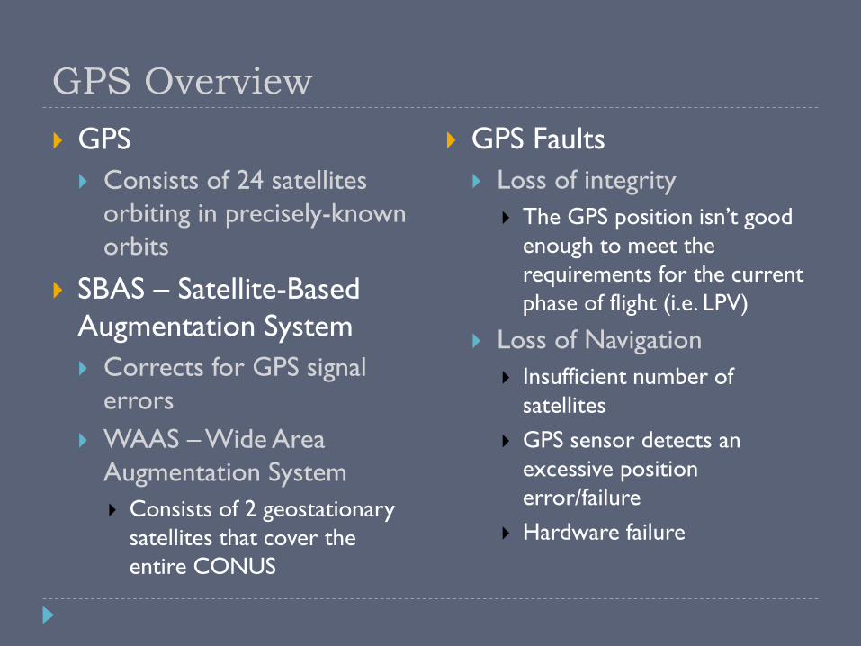
GPS Overview
GPS
Consists of 24 satellites
orbiting in precisely-known
orbits
SBAS – Satellite-Based
Augmentation System
Corrects for GPS signal
errors
WAAS – Wide Area
Augmentation System
Consists of 2 geostationary
satellites that cover the
entire CONUS
GPS Faults
Loss of integrity
The GPS position isn’t good
enough to meet the
requirements for the current
phase of flight (i.e. LPV)
Loss of Navigation
Insufficient number of
satellites
GPS sensor detects an
excessive position
error/failure
Hardware failure
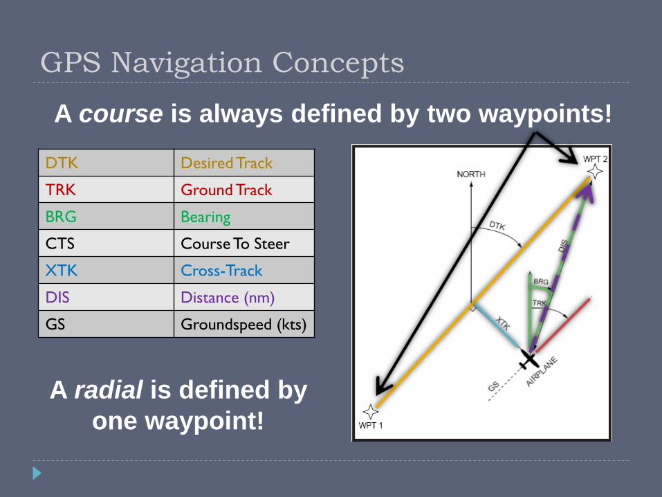
GPS Navigation Concepts
DTK Desired Track
TRK Ground Track
BRG Bearing
CTS Course To Steer
XTK Cross-Track
DIS Distance (nm)
GS Groundspeed (kts)
A course is always defined by two waypoints!
A radial is defined by
one waypoint!

GTN 650 Overview

Instrument Panel Self-Test
Verify CDI / GS displacement is correct
CDI (LCDI) half left
G/S (VCDI) half up
To/From is TO
No flags
Verify OBS course
Garmin “OBS” value and selected OBS course should match
Within 4 degrees (standard VOR accuracy check) is a good reference point for minimum accuracy

Default Nav Page
Press and hold HOME to load from any page
Provides a shortcut button to enter the moving map page
Active leg of flight plan
TO/FROM flag*
Course
deviation
indicator (CDI)
* Always TO when in GPS mode
User-selectable
data fields
Moving Map
Shortcut Button
CDI Source
Selector
OBS
Selector

GTN 650 Home Page
The home page replaces the “chapter” and “page” knobs
of the 430
Replaces the 430
“Nav Group”
Replaces the 430
“Wpt Group”Replaces the 430
“Nrst Group”
Replaces the 430
“Aux Group”
Replaces the 430
FPL button
Replaces the 430
PROC buttonPage/Function
Name

GTN 650 Navigation
NAV group
How do I get to my destination?
Are there any hazards on the way (traffic, terrain, weather)?
WPT group
Where am I going, and what is available there?
The “AFD” section of the Garmin
AUX group
Flight planning and E6B-like utilities
System setup
NRST group
What is nearest to my current location?
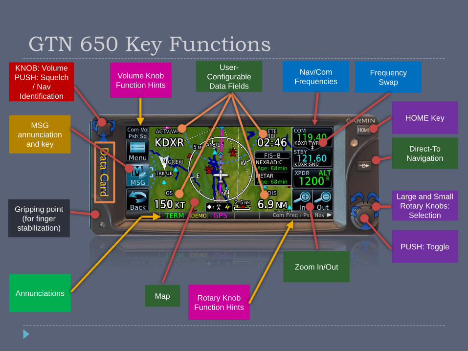
GTN 650 Key FunctionsKNOB: Volume
PUSH: Squelch
/ Nav
Identification
PUSH: Toggle
Large and Small
Rotary Knobs:
Selection
HOME Key
Direct-To
Navigation
Zoom In/Out
Nav/Com
Frequencies
User-
Configurable
Data Fields
Map
Data C
ard
Rotary Knob
Function Hints
MSG
annunciation
and key
Frequency
Swap
Annunciations
Gripping point
(for finger
stabilization)
Volume Knob
Function Hints

Recommended Data Fields
Default Navigation (CW
from upper-left)
DIS – Distance To Waypoint
DTK – Desired Ground Track
BRG – Bearing to Waypoint
ETE to DEST – Estimated
Time En-route to Destination
ETE if transponder is
displayed instead of ETE field
TRK – Actual Ground Track
GS – Groundspeed
Map Page (CW from upper-
left)
ACTV WPT – Active
Waypoint
DTK – Desired Ground Track
DIS – Distance To Waypoint
GS – Groundspeed

GNS 430W vs GTN 650
Default Nav
Page

Direct-To
Direct-To button provides
three destination selection
options
Direct waypoint entry
Defaults to current
destination
Flight plan selection
Nearest airport selection
You can also clear a direct-
to course from this page
Soft key in the upper-left
corner

Map Declutter
There are 4 user-selectable map detail levels
1. All data shown
2. Removes all land data except rivers & lakes.
3. Removes all airspace except Prohibited & Restricted. Also removes NDBs, Intersections, and User waypoints.
4. Removes all data except the Active Flight Plan, Airways, rivers, lakes, traffic, and lightning data.

The OBS Mode
Enroute
Disables waypoint sequencing past the current waypoint
Turns the current waypoint into a virtual VOR
You can select any radial off the waypoint
Also useful for displaying a runway’s extended centerline
Inside FAF
Deactivates “SUSP” mode
Provides immediate course guidance for the missed approach

Terrain Awareness
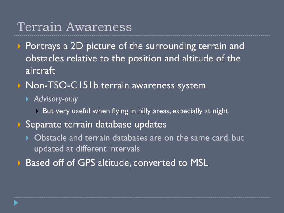
Terrain Awareness
Portrays a 2D picture of the surrounding terrain and
obstacles relative to the position and altitude of the
aircraft
Non-TSO-C151b terrain awareness system
Advisory-only
But very useful when flying in hilly areas, especially at night
Separate terrain database updates
Obstacle and terrain databases are on the same card, but
updated at different intervals
Based off of GPS altitude, converted to MSL

Terrain Awareness Criteria

Terrain Awareness Alerts
430W 650
On-Screen CautionOn-Screen Caution

Terrain Modes360-view Arc-view
Terrain Inhibit Notification

Traffic & Weather Pages

Traffic Page
From the “HOME” page,
select the dedicated traffic
page
Displays the 8 nearest
targets within a specified
filter range (up to 7.5nm)
Green line shows relative
motion
Traffic data can also
optionally be shown on
the moving map page
Traffic Advisory (TA) – Traffic may
pose a collision threat.
Proximity Advisory (PA) – Traffic
Is within 5nm and +/- 1,200’
Other detected traffic

Weather Page
From the “Home” screen, select “Weather” and then “FIS-B Weather”
Displays NEXRAD radar, graphical METARs, TFR, AIRMETs/SIGMETs, and PIREPs
Weather data (radar, stormscope, and METARs) can also optionally be shown on the moving map page
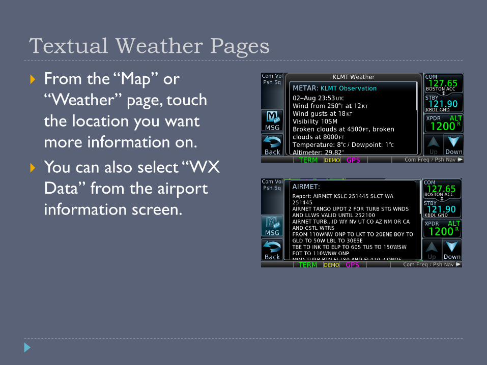
Textual Weather Pages
From the “Map” or
“Weather” page, touch
the location you want
more information on.
You can also select “WX
Data” from the airport
information screen.

Useful Features & Tips
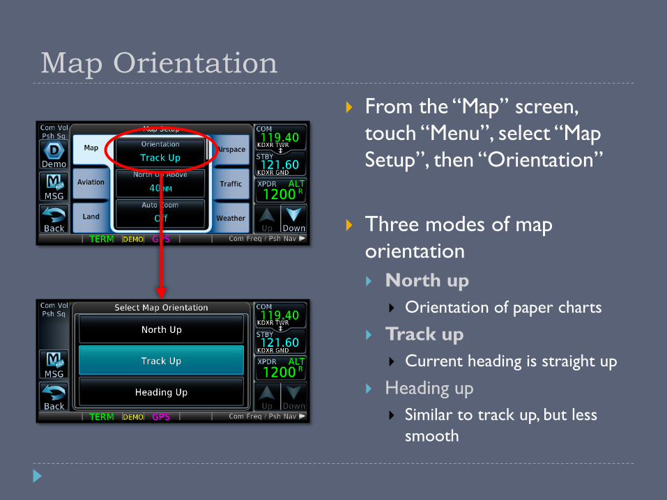
Map Orientation
From the “Map” screen,
touch “Menu”, select “Map
Setup”, then “Orientation”
Three modes of map
orientation
North up
Orientation of paper charts
Track up
Current heading is straight up
Heading up
Similar to track up, but less
smooth

“Nearest” Pages
Provides
Airports
Waypoints
Intersections
VORs
NDBs
User Waypoints
Airspace & Services
Airspace
ARTCC
FSS
Weather (ATIS/etc) Frequencies

Scheduler & Flight Timers
Scheduler Flight Timer

Computing Winds Aloft
Great tool to use when submitting a PIREP
“Ind Alt” will initially show your GPS altitude Will likely need fine tuning,
but not by much
“CAS” will initially show your GPS ground speed
“BARO” will show the last entered value
“HDG” will show your GPS ground track heading This should be set to your
magnetic heading

Vertical Navigation
1) Select target altitude
2) Select altitude reference
3) Select distance relative to waypoint
4) Select before or after waypoint
5) Select waypoint
6) Select VS
1
34
5
62
1
5
6
3
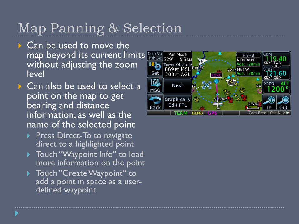
Map Panning & Selection
Can be used to move the map beyond its current limits without adjusting the zoom level
Can also be used to select a point on the map to get bearing and distance information, as well as the name of the selected point Press Direct-To to navigate
direct to a highlighted point
Touch “Waypoint Info” to load more information on the point
Touch “Create Waypoint” to add a point in space as a user-defined waypoint

User-Defined Waypoints
Up to 1000 user-defined waypoints can be stored
Can be created from the User Waypoint page, from the Map page, or from the Direct-To & FPL pages.
User waypoints are referenced by name only
User waypoints are best used for ground references (houses, etc) or common reporting points (e.g. “the prison” at KDXR)
When created from the Direct-To or FPL page,
waypoint will use the aircraft’s current position
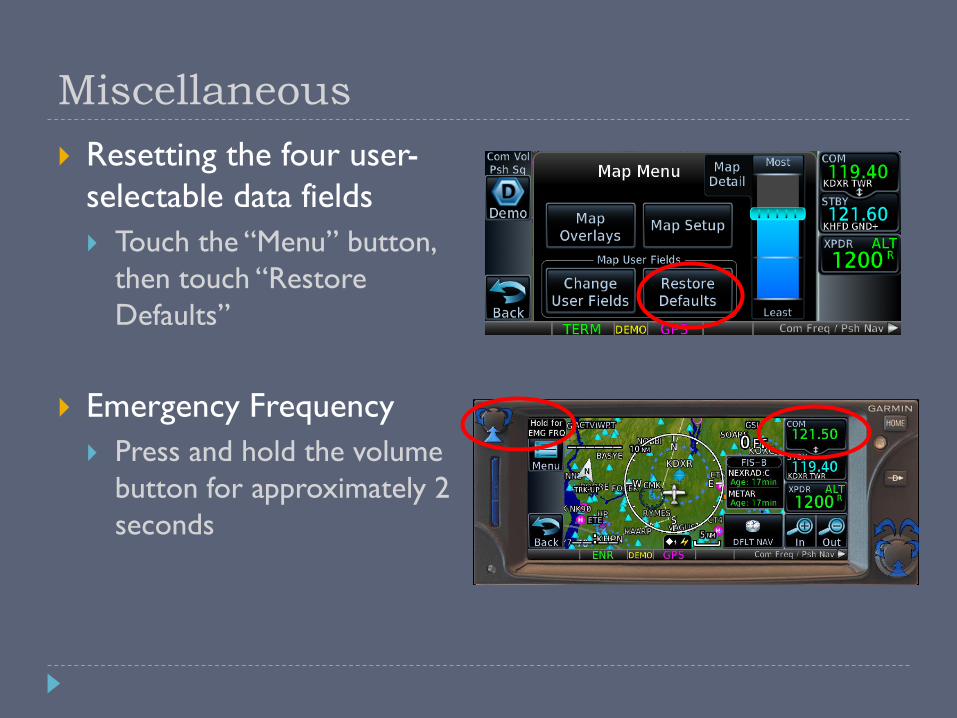
Miscellaneous
Resetting the four user-
selectable data fields
Touch the “Menu” button,
then touch “Restore
Defaults”
Emergency Frequency
Press and hold the volume
button for approximately 2
seconds
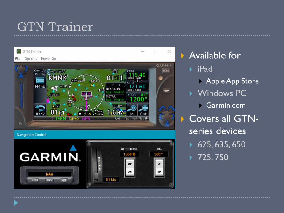
GTN Trainer
Available for
iPad
Apple App Store
Windows PC
Garmin.com
Covers all GTN-
series devices
625, 635, 650
725, 750
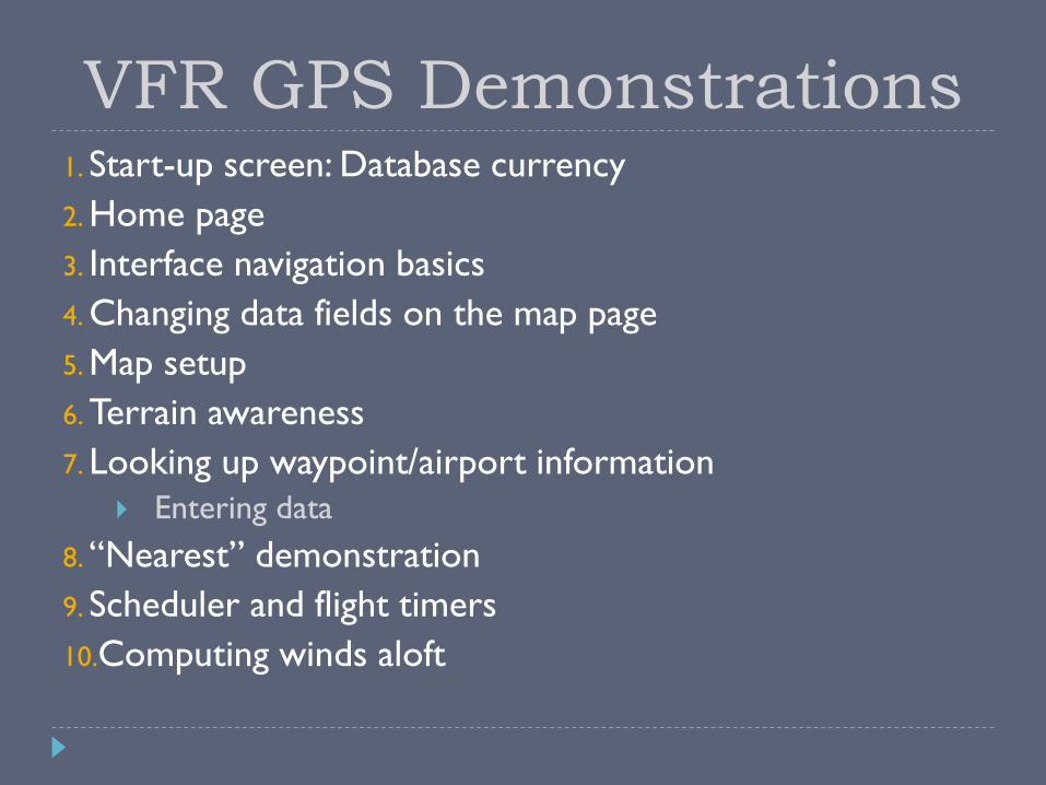
1. Start-up screen: Database currency
2. Home page
3. Interface navigation basics
4. Changing data fields on the map page
5. Map setup
6. Terrain awareness
7. Looking up waypoint/airport information
Entering data
8. “Nearest” demonstration
9. Scheduler and flight timers
10.Computing winds aloft
VFR GPS Demonstrations

GPS Do’s and Don’ts
DO DON’T
Develop skills in stages
Practice with PC
simulators
Program on the ground
Delegate GPS operations
to copilot
Fly the airplane first!
Exceed VFR or personal minimums
Focus inside the cockpit
Rely solely on GPS map display for navigation
Fiddle with it while close to an airport or in a high workload situation
Try new features for the first time in the air
GPS is not a substitute for maintaining situational
awareness!

Wake Up – It’s Quiz Time!
How do you swap frequencies?
How do you cancel a Direct-To
course?
What is the OBS mode used for?
How do you display the default nav
page from any screen?
It allows the pilot to select a desired
course to/from a waypoint (entering
the traffic pattern, or holds).
Direct-To, “Remove”.
Press and hold the “HOME” button.
Press and hold the right knob, or
tap the active frequency.
How do you enter frequencies? Turn the large & small knobs, or tap
the standby frequency.
How do you enter Nav
frequencies?
Press the right knob to toggle
between Nav and Com frequency
selection.

IFR GPS Operations

When Your Database is Not Current
VFR
No legal requirements to have a current database
IFR
Legal for en-route and terminal navigation
Each waypoint must be verified with an alternate source of currentdata (e.g. paper chart, electronic chart)
Per the Garmin 650 STC, “GPS”, “or GPS”, and “RNAV (GPS)” approaches are not allowed
Example: Danbury’s “RNAV (GPS) RWY 08” approach is not allowed, but something like a “VOR or GPS-A” approach is allowed if flown using VOR guidance.
Danbury’s “LOC RWY 08” is also allowed

Flight Plans
Up to 99 stored flight
plans
Up to 100 waypoints per
flight plan
Custom names of up to 18
alpha/numeric characters
Supports victor airways
Unlike the 430W
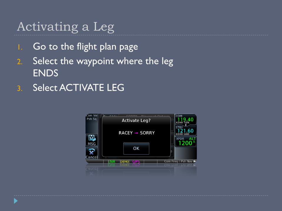
Activating a Leg
1. Go to the flight plan page
2. Select the waypoint where the leg
ENDS
3. Select ACTIVATE LEG

Loading an Approach1. Press the “HOME” button
2. Tap “PROC”
3. Tap “Approach”
4. Select the desired approach
5. Select the desired transition1. “Vectors” draws a reference line
to the FAF
1. Must be on the approach side (not the departure side)
6. “Load” vs “Activate” “Load” adds the approach
waypoints to the flight plan, but doesn’t activate it.
“Activate” also loads the waypoints, but then provides Direct-To course guidance to the initial fix
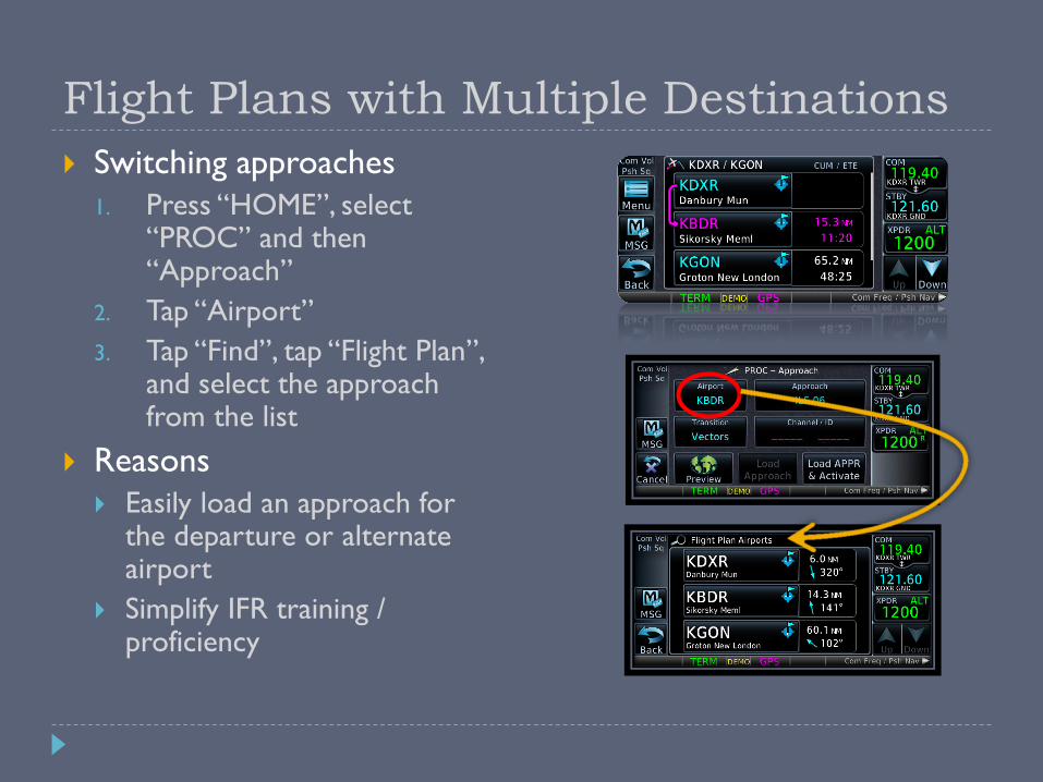
Flight Plans with Multiple Destinations
Switching approaches
1. Press “HOME”, select “PROC” and then “Approach”
2. Tap “Airport”
3. Tap “Find”, tap “Flight Plan”, and select the approach from the list
Reasons
Easily load an approach for the departure or alternate airport
Simplify IFR training / proficiency
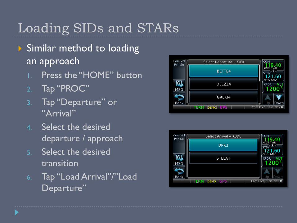
Loading SIDs and STARs
Similar method to loading
an approach
1. Press the “HOME” button
2. Tap “PROC”
3. Tap “Departure” or
“Arrival”
4. Select the desired
departure / approach
5. Select the desired
transition
6. Tap “Load Arrival”/”Load
Departure”

Intro to GPS Approaches
1st Generation – Non-precision VOR/NDB overlay approaches (RNAV)
Many are being replaced by 2nd Gen approaches
2nd Generation – Stand-alone non-precision GPS approaches (RNAV)
3rd Generation – WAAS approach with vertical guidance
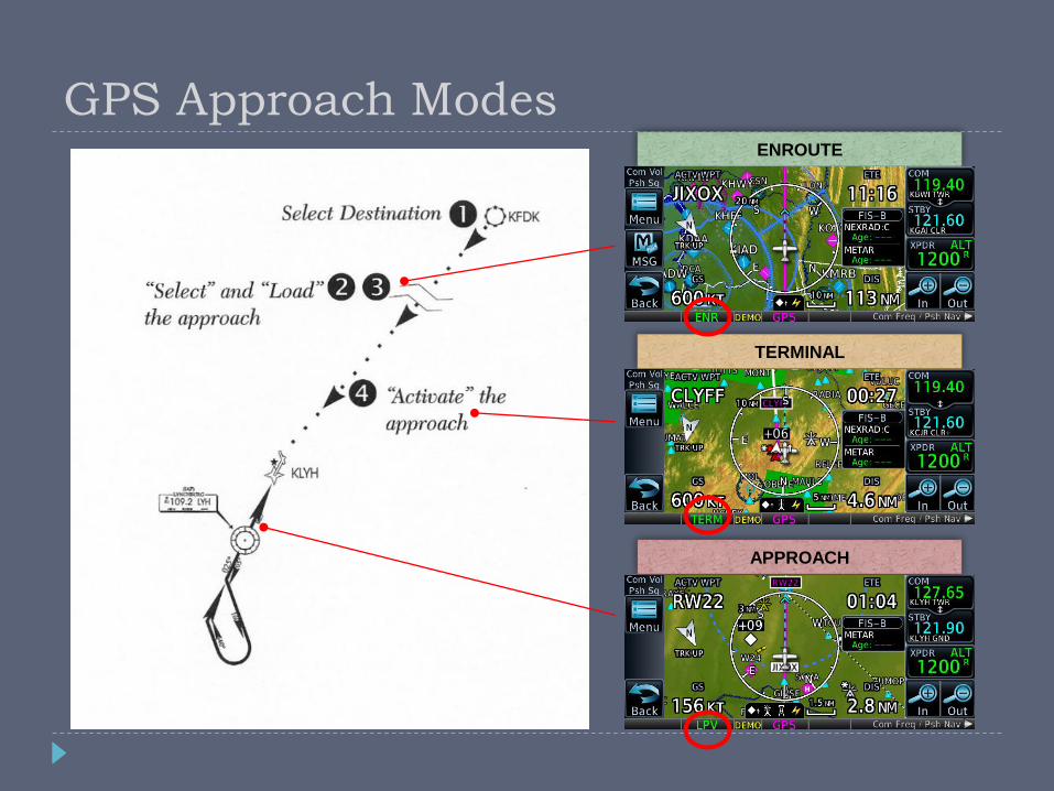
ENROUTE
TERMINAL
APPROACH
GPS Approach Modes

CDI Scale Transitions
During the transition phases, the
CDI may give the impression that
you are off course, even though
you may be on a perfectly good
intercept angle.
31nm
30nm
2nm
2nm 2nm
1nm1nm
2º2º
En-Route
Terminal
ApproachFAF

Annunciation Approach Description
LPV LPV Localizer Performance with Vertical guidance
LP+V LP Non-precision Localizer Performance with advisory
vertical guidance
LP LP Non-precision Localizer Performance – allows for
lower minimums than LNAV
LNAV+V LNAV Non-precision Lateral Navigation with advisory
vertical guidance
LNAV LNAV Non-precision Lateral Navigation
Visual Visual Advisory visual approach with vertical (terrain-
avoidance) guidance
650 GPS Approach Mode Summary
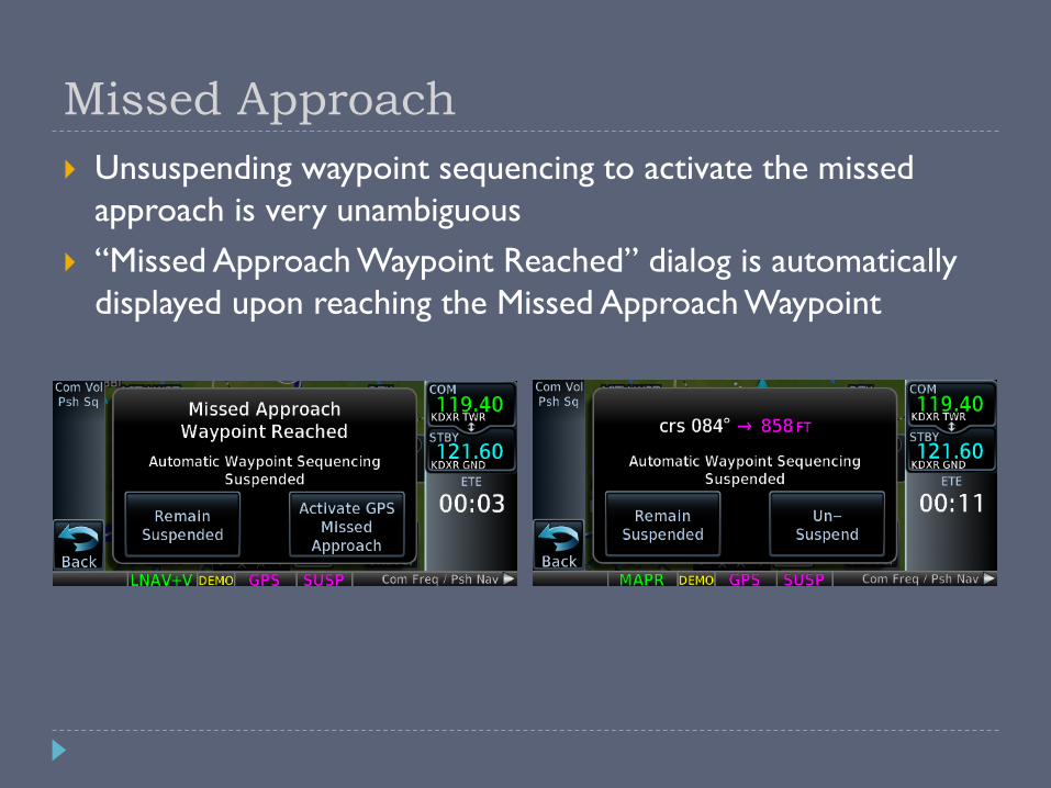
Missed Approach
Unsuspending waypoint sequencing to activate the missed
approach is very unambiguous
“Missed Approach Waypoint Reached” dialog is automatically
displayed upon reaching the Missed Approach Waypoint

Annunciation Description
MAPR Missed Approach
CDI full scale deflection = 0.3 NM
ENR En-route navigation
CDI full scale deflection = 2.0 NM
TERM Terminal area navigation
CDI full scale deflection = 1.0 NM
LOW ALT For LNAV+V and LPV approaches
Indicates the aircraft’s estimated height is lower than the
FAF height by approximately 50 meters (164 feet). Not
active when TAWS is operational.
Additional 650 GPS Modes
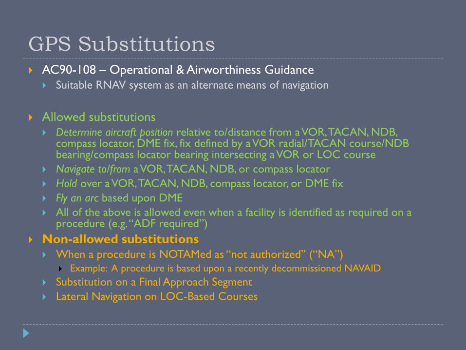
GPS Substitutions AC90-108 – Operational & Airworthiness Guidance
Suitable RNAV system as an alternate means of navigation
Allowed substitutions Determine aircraft position relative to/distance from a VOR, TACAN, NDB,
compass locator, DME fix, fix defined by a VOR radial/TACAN course/NDB bearing/compass locator bearing intersecting a VOR or LOC course
Navigate to/from a VOR, TACAN, NDB, or compass locator
Hold over a VOR, TACAN, NDB, compass locator, or DME fix
Fly an arc based upon DME
All of the above is allowed even when a facility is identified as required on a procedure (e.g. “ADF required”)
Non-allowed substitutions When a procedure is NOTAMed as “not authorized” (“NA”)
Example: A procedure is based upon a recently decommissioned NAVAID
Substitution on a Final Approach Segment
Lateral Navigation on LOC-Based Courses
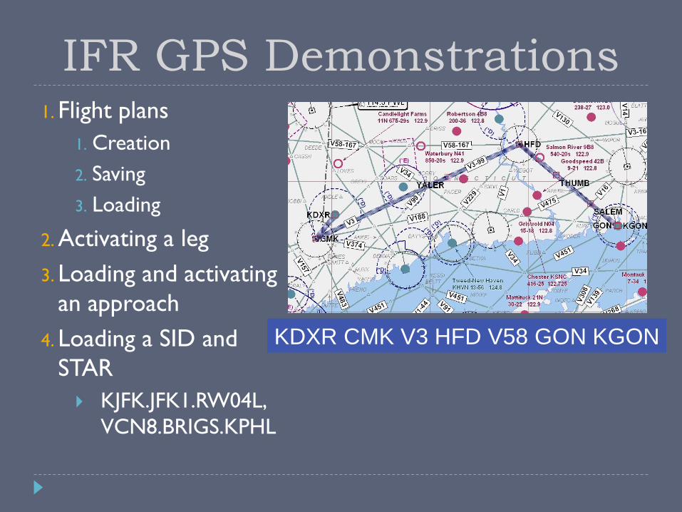
KDXR CMK V3 HFD V58 GON KGON
IFR GPS Demonstrations1. Flight plans
1. Creation
2. Saving
3. Loading
2. Activating a leg
3. Loading and activating
an approach
4. Loading a SID and
STAR
KJFK.JFK1.RW04L,
VCN8.BRIGS.KPHL

IFR Do’s and Don’ts
DO DON’T
Practice in VFR with a safety pilot before using in actual IFR conditions
Set higher personal minimums until comfortable with its use
Check GPS/VLOC CDI indicator often
Check and ID the active VLOC frequency for ILS/LOC
Always set OBS (and heading bug) to DTK
Pay attention to suspended waypoint sequencing and active waypoint
Rely solely on one navsource
DO “shadow” GPS with other systems if available
Program during high workload situations
Forget to check for sequencing to appropriate approach mode prior to FAF

Wake Up – It’s Quiz Time!
When is the “Visual” approach
option available, and what does it
provide?
True or False: INTEG indication in
flight = OK to proceed to
destination via IFR
What are some common Mistakes
when setting up for an ILS?
What is the difference between
activating and loading an
approach?
It’s available within 10nm of the
airport and provides an advisory
terrain avoidance path
Failure to Set CDI VLOC Mode,
Switch and IDENT VLOC Freq
True – Monitor VOR Enroute.
Destination Must Have Non-GPS
Approach
Activating proceeds direct to the
IAF, while loading appends the
approach to the end of the flight
plan (will not auto-sequence)
How do you load and fly the missed
approach procedure?
Touch “Activate Missed Approach”
once the “Missed Approach
Waypoint” dialog is shown.

More Information
Garmin Website –http://www.garmin.com
GTN 650 manual
GTN Trainer
Training Syllabus
Tutorial Videos
Avweb –http://www.avweb.com
AOPA Air Safety Foundation –http://www.aopa.org/asf
ASF Safety Advisor – GPS Technology
Open Sky Aviation, LLC.
http://openskyaviation.biz
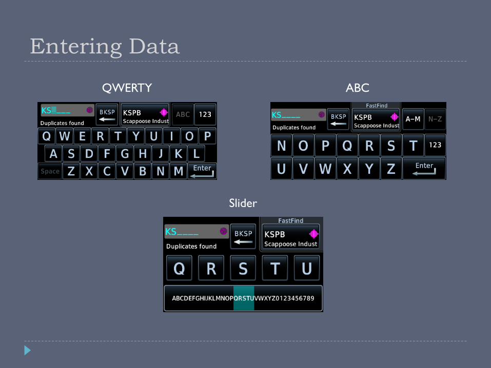
Entering Data
QWERTY ABC
Slider


