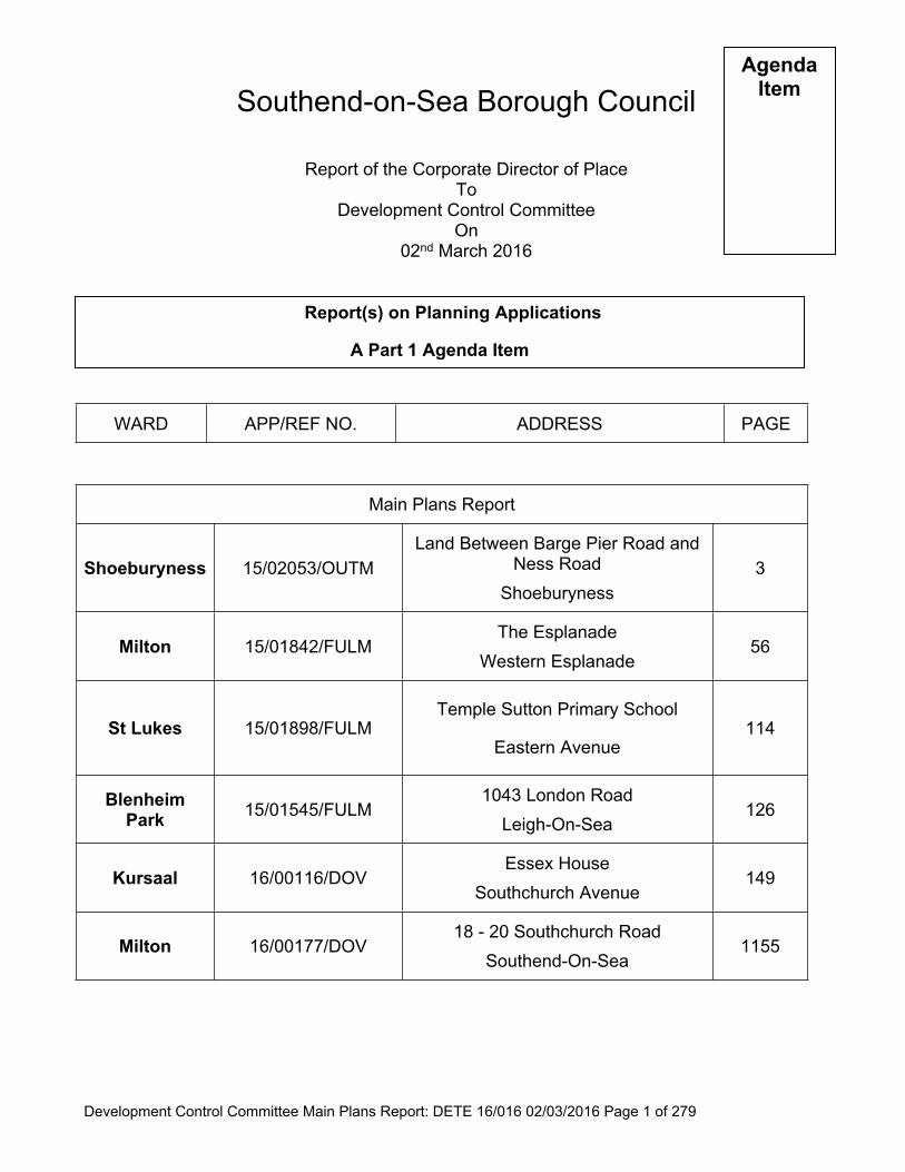
Development Control Committee Main Plans Report: DETE 16/016 02/03/2016 Page 1 of 279 Southend-on-Sea Borough Council Report of the Corporate Director of Place To Development Control Committee On 02 nd March 2016 WARD APP/REF NO. ADDRESS PAGE Main Plans Report Shoeburyness 15/02053/OUTM Land Between Barge Pier Road and Ness Road Shoeburyness 3 Milton 15/01842/FULM The Esplanade Western Esplanade 56 St Lukes 15/01898/FULM Temple Sutton Primary School Eastern Avenue 114 Blenheim Park 15/01545/FULM 1043 London Road Leigh-On-Sea 126 Kursaal 16/00116/DOV Essex House Southchurch Avenue 149 Milton 16/00177/DOV 18 - 20 Southchurch Road Southend-On-Sea 1155 Agenda Item Report(s) on Planning Applications A Part 1 Agenda Item
Transcript
Development Control Committee Main Plans Report: DETE 16/016 02/03/2016 Page 1 of 279
Southend-on-Sea Borough Council
Report of the Corporate Director of PlaceTo
Development Control CommitteeOn
02nd March 2016
WARD APP/REF NO. ADDRESS PAGE
Main Plans Report
Shoeburyness 15/02053/OUTMLand Between Barge Pier Road and
Ness Road Shoeburyness
3
Milton 15/01842/FULMThe Esplanade
Western Esplanade56
St Lukes 15/01898/FULMTemple Sutton Primary School
Eastern Avenue114
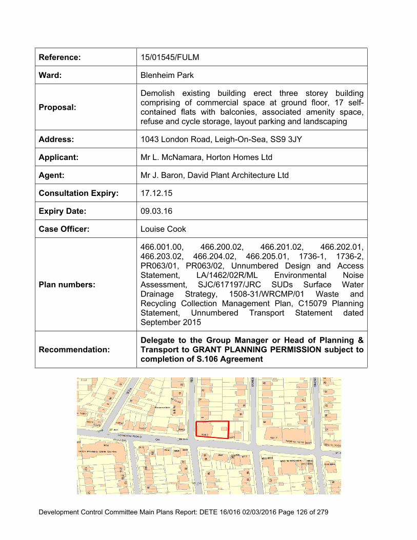
Blenheim Park 15/01545/FULM
1043 London RoadLeigh-On-Sea
126
Kursaal 16/00116/DOVEssex House
Southchurch Avenue149
Milton 16/00177/DOV18 - 20 Southchurch Road
Southend-On-Sea1155
AgendaItem
Report(s) on Planning Applications
A Part 1 Agenda Item
Development Control Committee Main Plans Report: DETE 16/016 02/03/2016 Page 2 of 279
Shoeburyness 15/01997/FULLand Adjacent To 10 - 11 New
Development Control Committee Main Plans Report: DETE 16/016 02/03/2016 Page 3 of 279
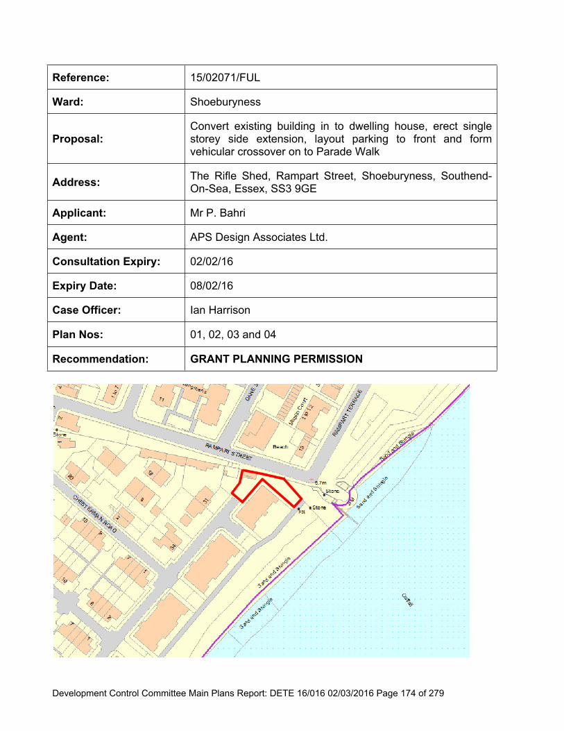
Reference: 15/02053/OUTM
Ward: Shoeburyness
Proposal:Erect 172 dwellinghouses,14,130sqm of Offices (Class B1(a) and Health Centre (Class D1) (outline application)(Amended Proposal)
Address: Land Between Barge Pier Road and Ness Road, Shoeburyness, Southend-On-Sea, Essex
Applicant: Garrison Developments LLP
Agent: Pomery Planning Consultants Ltd
Consultation Expiry: 29.01.2016
Expiry Date: 17.03.2016
Case Officer: Janine Rowley
Plan Nos: Location Plan 6100/1002 Revision A; 6100/1101 Revision G
Recommendation:
DELEGATE authority to the Group Manager for Planning & Building Control, Head of Planning & Transport or Corporate Director for Place to GRANT OUTLINE PLANNING PERMISSION subject the completion of a legal agreement under Section 106 of the Town and Country Planning Act 1990 (as amended).
Development Control Committee Main Plans Report: DETE 16/016 02/03/2016 Page 4 of 279
Executive Summary
I. Outline planning permission is sought to erect 172 dwellinghouses and 14,1300sqm of offices (Class B1) reference and a Health Centre at the above site. A similar application (14/00566/OUTM) was refused on the 8th July 2015 for the following reasons:
1. “The proposed development would result in a significant increase in traffic generation which would be detrimental to the flow of traffic in the immediate area, and be to the detriment of highway safety and efficiency, contrary to Policy CP3 of the Core Strategy DPD1, emerging policy DM15 DPD2 (Development Management) and policies T8 and T11 of the Borough Local Plan”.
2. “It has not been demonstrated that the proposal would provide sufficient surface water attenuation that would restrict discharge to an acceptable rate. As such, it has not been demonstrated that the development could be made safe in flood risk terms without increasing localised flooding elsewhere. This is contrary to the National Planning Policy Framework and Policies KP1 and KP2 of the Core Strategy”.
II. The previous application included 172 dwellinghouses and 15,000sqm of office space (Class B1). The site has an extant permission for commercial (with some leisure) uses and is allocated as employment land within the Local Plan.
III. The Council have commissioned independent consultants to review the information submitted and to establish whether the proposal has overcome the previous reasons for refusal.
IV. The previous decision of the Council is a material consideration and this raised two areas of concern. These are discussed below.
V. 1.2
Highways
The transport statement submitted has been independently reviewed by the Council’s consultants. The report concluded that the comparison in trip generation between the extant 2005 development and the proposed development shows that the impact would generally be neutral, with a small increase in vehicle traffic during the peak hours (as a result of an increase in background traffic on the network since 2005). The traffic flow predictions as a result of the proposed development are generally slightly lower around the surrounding roads with the exception of Ness Road North and Campfield Road West. To mitigate against this increase the applicant has agreed to a contribution towards a highway improvement scheme within the Ness Road area. This would be secured via a Section 106 agreement.
The proposal is now considered acceptable in highways terms.
Development Control Committee Main Plans Report: DETE 16/016 02/03/2016 Page 5 of 279
VI. 1.3
Flooding
The Council has commissioned an independent review of the applicant’s revised surface water attenuation information. The findings conclude that the extant permission (for commercial use) would have an impermeable area greater than that now proposed. The revised drainage strategy sufficiently attenuates post development runoff to less than the greenfield run off rate for 1 in 30 and 1 in 100 year events. The 1 in 1 year runoff, would exceed the existing greenfield rate, but be consistent with the drainage strategy approved by the EA for the area. Therefore, it is not considered the development will increase the risk of flooding elsewhere.
The proposal is thus now considered acceptable in terms of localised flooding.
The Proposal
1.1 This application seeks outline planning permission to erect 172 dwellinghouses and 14,130sqm of office space (Class B1) plus 870sqm for a health centre (Class D1) on land between Barge Pier Road and Ness Road, Shoeburyness. All detailed matters (scale, layout, appearance, access and landscaping) are reserved for future consideration. The proposed office/employment and health centre would occupy the northwest of the site equating to 3.00 ha and the residential site area is to the south and east comprising two parcels of land; A and B equating to 6.62 ha.
1.2 The details are summarised as follows:
Site Area:
Units:
3.00ha commercial land; 6.62ha residential site area
14,130sqm of employment floorspace Class B1 (offices), 870sqm for a health centre (Class D1);
172 houses
Schedule of accommodation for the houses includes:Site A- to the north of Magazine Road (directly south of school)
Unit Types Floor areas sqm Number
2 bed houses 67 153 bed houses 95 374 bed houses 140 3Sub Total Site A 55
Site B- off New Barge Pier RoadUnit Types Floor areas sqm Number
2 bed houses 67 33
Development Control Committee Main Plans Report: DETE 16/016 02/03/2016 Page 6 of 279
3 bed houses 95 634 bed houses 140 21Sub Total Site B 117
1.3 The applicant has submitted a Planning Statement, a Flood Risk Assessment, Flood Response Plan, information to inform Sequential and Exceptions Test, Transport Assessment, Statement of Community Involvement, Schedule of Accommodation, and Landscape Strategy. The applicant has agreed to enter into a S106 for the following:
30% affordable housing: 52 houses 31 x 2 bed units; 19 x 3 bed units; 2 x 4 bed units (60% rented, 40% intermediate housing);
Prior to the commencement of the residential units a marketing strategy for the commercial element of the site
£30,000 future upgrade of highway junction Campfield Road and Ness Road; “Flood sea defence contribution” means a financial contribution the sum of
which is to be agreed between the Owner and the Council once a scheme has been agreed for the flood sea defence at Shoebury Common
Area of Open Space as shown on plan 6100/1101 Rev G to be permanently retained for public access and flood alleviation
Open Space maintenance strategy to be submitted and agreed on submission of the landscaping details as a reserved matters planning application and no development shall commence on the site until this strategy has been agreed
Open Space maintenance sum for a 10 year period (to include funding for a park ranger and interpretation signs) to be agreed prior to commencement
Open Space to be transferred to the Council after it has been maintained by the land owner for a two year period from the date of practical completion; maintenance sum payable on transfer.Drainage:
A minimum 5m wide strip must remain accessible to the Council at all times adjacent to the C-X ditch (which runs along the full length of the western side of the site) for maintenance purposes
Maintenance Strategy for Barge Pier drainage ditch to be submitted and agreed on submission of the landscaping details as a reserved matters planning application and no development shall commence on the site until this strategy has been agreed
1.4 The applicant has also agreed to pay all relevant CIL sums with an overall total of £997,065.38 in relation to the new floorspace to be created for the proposed B1, D1 and C3 uses proposed. This will be discussed in further detail below.
Development Control Committee Main Plans Report: DETE 16/016 02/03/2016 Page 7 of 279
1.5 It should be noted this application has been submitted following the refusal of application 14/00566/OUT to erect 172 dwellinghouses and 15000sqm of offices (Class B1). The application was refused for the reasons below and is subject of an appeal:
1.“The proposed development would result in a significant increase in traffic generation which would be detrimental to the flow of traffic in the immediate area, and be to the detriment of highway safety and efficiency, contrary to Policy CP3 of the Core Strategy DPD1, emerging policy DM15 DPD2 (Development Management) and policies T8 and T11 of the Borough Local Plan”.
2. “It has not been demonstrated that the proposal would provide sufficient surface water attenuation that would restrict discharge to an acceptable rate. As such, it has not been demonstrated that the development could be made safe in flood risk terms without increasing localised flooding elsewhere. This is contrary to the National Planning Policy Framework and Policies KP1 and KP2 of the Core Strategy”.
1.6 The main changes from the previously refused application include the office space (Class B1) has reduced from 15000sqm to 14,130sqm to facilitate the inclusion of 870sqm for a health centre (Class D1). The number of dwellings is as previously proposed.
1.7 The Council have commissioned independent consultants to review the information submitted and to establish whether the proposal has overcome the previous reasons for refusal.
2 Site and Surroundings
2.1 The site consists of the remaining undeveloped land at Shoebury Garrison, which originally gained outline planning permission as part of the wider Shoebury Garrison Masterplan in 2004 (reference 00/00777/OUT). It comprises approximately 9.62 ha. It has outline permission for a business park and leisure use which is supported in the Southend on Sea Core Strategy. To the north of the site is Hinguar School, and to the east Phase I Garrison housing, some of which lies within the Shoebury Garrison Conservation Area. Gunners Park & Nature Reserve lies to the south, and an established residential area beyond Ness Road to the west.
3 Planning Considerations
3.1 The main considerations in the determination of this application are in relation to the principle of development, flood risk, impact on the character of the area, residential amenity, parking implications, ecology, and sustainability, planning contributions and whether the proposal has overcome the previous reasons of refusal under application 14/00566/OUTM.
Development Control Committee Main Plans Report: DETE 16/016 02/03/2016 Page 8 of 279
4.1 In terms of the development plan for the area, the site is allocated as an employment site for which ‘B1 and B2 uses’ are promoted. The Core Strategy, in setting out broad locations for employment growth, identifies the Old Ranges (where the proposed site is located) as a Priority Urban Area where appropriate regeneration and growth will be focused. The Employment Land Review 2010 (ELR) outlines that to support the Core Strategy objective of 1,500 jobs in Shoeburyness, 4.3 ha of the site will be required for commercial use, and this would support, 25,800 sqm m of floorspace to meet future requirement in other urban locations. However, the ELR notes that this amount is in excess of demand and could potentially compete with other locations such as the town centre, A127 and central fringe. To meet forecast demand in this area the review suggests 3.2ha of commercial land is required to support 19,000 sqm of floorspace by 2021.
4.2 The application proposes 3 hectares (ha) of employment land, which is broadly in line with the indicative forecast demand as recommended in the ELR and is therefore considered acceptable in principle. Any permission granted should ensure the employment land could be safeguarded for employment (B1-B8) purposes.
Health Centre
4.3 Policy CP6 of the Core Strategy states that providing health and social care facilities in particular supporting key health and social care agencies where these demonstrate clear net benefits in terms of accessibility to services for the local community. This element of the proposal will provide a new facility for future occupiers and whilst it would reduce the amount of B1 use, it would itself provide a level of skilled employment and provide a use supported by policy. On balance, no objection is raised in principle to this element of the proposal.
Residential
4.4 In terms of the 172 dwellings proposed, the Southend Annual Monitoring Report (2013) outlines that dwelling delivery in Southend is ahead of the Core Strategy phased target (2001 – 2013). However, dwellings completions within Shoeburyness, where the application is proposed, is slightly behind target. The Council is also able to demonstrate a 5 year housing land supply. The proposal would represent a windfall in terms of housing delivery, and it is important to note there is no maximum housing target. Considering the ELR recommendation that new commercial uses should be limited to 3.2ha in the medium term within Shoebury, other uses can be considered. The proposed mix of dwellings includes 2, 3 and 4 bed units.
Development Control Committee Main Plans Report: DETE 16/016 02/03/2016 Page 9 of 279
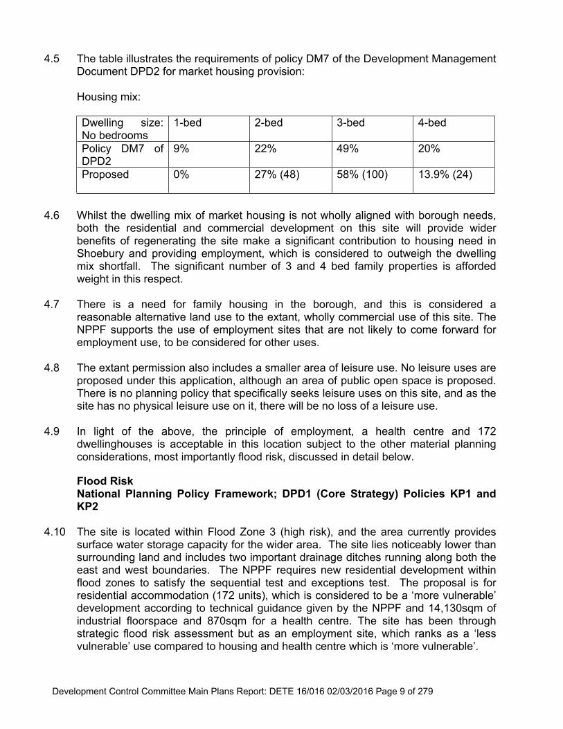
4.5 The table illustrates the requirements of policy DM7 of the Development Management Document DPD2 for market housing provision:
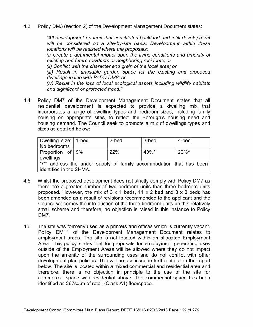
Housing mix:
Dwelling size: No bedrooms
1-bed 2-bed 3-bed 4-bed
Policy DM7 of DPD2
9% 22% 49% 20%
Proposed 0% 27% (48) 58% (100) 13.9% (24)
4.6 Whilst the dwelling mix of market housing is not wholly aligned with borough needs, both the residential and commercial development on this site will provide wider benefits of regenerating the site make a significant contribution to housing need in Shoebury and providing employment, which is considered to outweigh the dwelling mix shortfall. The significant number of 3 and 4 bed family properties is afforded weight in this respect.
4.7 There is a need for family housing in the borough, and this is considered a reasonable alternative land use to the extant, wholly commercial use of this site. The NPPF supports the use of employment sites that are not likely to come forward for employment use, to be considered for other uses.
4.8 The extant permission also includes a smaller area of leisure use. No leisure uses are proposed under this application, although an area of public open space is proposed. There is no planning policy that specifically seeks leisure uses on this site, and as the site has no physical leisure use on it, there will be no loss of a leisure use.
4.9 In light of the above, the principle of employment, a health centre and 172 dwellinghouses is acceptable in this location subject to the other material planning considerations, most importantly flood risk, discussed in detail below.
4.10 The site is located within Flood Zone 3 (high risk), and the area currently provides surface water storage capacity for the wider area. The site lies noticeably lower than surrounding land and includes two important drainage ditches running along both the east and west boundaries. The NPPF requires new residential development within flood zones to satisfy the sequential test and exceptions test. The proposal is for residential accommodation (172 units), which is considered to be a ‘more vulnerable’ development according to technical guidance given by the NPPF and 14,130sqm of industrial floorspace and 870sqm for a health centre. The site has been through strategic flood risk assessment but as an employment site, which ranks as a ‘less vulnerable’ use compared to housing and health centre which is ‘more vulnerable’.
Development Control Committee Main Plans Report: DETE 16/016 02/03/2016 Page 10 of 279
4.11 Shoebury is identified as an area for regeneration and growth within the Core Strategy, and 1,400 new homes earmarked for Shoebury within the plan period. Thus the sequential test need only be applied within the Shoebury area. In relation to point (i), as a ‘more vulnerable’ use, it is proposed by the applicant i.e. residential use, flood risk measures will be required to mitigate against and manage it, including measures to make the buildings resilient to flood risk. It has been identified that this would require further flood defence work to make the scheme acceptable in planning terms, if it fully satisfies the requirements of a flood risk assessment. This is in essence a necessary build cost identified to make the residential use deliverable in a high flood risk zone.
4.12 The existing site currently comprises greenfield land (albeit it has planning permission for commercial use). Following completion of the Flood Alleviation Ditch, the northern reach of Barge Pier Ditch within the site was in-filled and its flows diverted into the flood alleviation ditch. The flood alleviation ditch now conveys runoff from the 52ha urban catchment to the north of the site in a southern direction, under the secondary flood defence bund/Barge Pier Road before discharging into Barge Pier Ditch to the south of the flood defence bund and eventually to the estuary.
4.13 The application is accompanied by information to inform a sequential and exceptions test and Flood Risk Assessment carried out by Ardent Consulting Engineers (March 2014). In accordance with the Environment Agency Standing Advice regarding development and flood risk in England, the EA requires a staged approach based on the following:
Stage 1 strategic application and development vulnerability; Stage 2- defining the evidence based; and Stage 3- applying the Sequential Test
These stages are discussed below.
4.14 Stage 1-Strategic Application and Development Vulnerability
The site as part of the wider Shoebury Garrison development has previously undergone the Sequential Test as a commercial/light industry but not as a mixed use site, therefore a sequential test for other uses has not been carried out before.
The development proposals are considered to be ‘more vulnerable’ (mixed use development-residential/commercial/light Industrial) and are located within tidal Flood Zone 3a. The site status (due to the residential element of the development in terms of its vulnerability) is classified as ‘more vulnerable’. The site will also need to pass the Exception Test.
Development Control Committee Main Plans Report: DETE 16/016 02/03/2016 Page 11 of 279
4.15 Stage 2- Defining the Evidence Base
The sequential test has been applied to the Shoeburyness area, in terms of identification of alternative sites. The site has been sequentially tested via a Strategic Flood Risk Assessment (SFRA) and identified as suitable for an employment area in Shoeburyness. Shoeburyness is identified as an area for regeneration and growth, including new homes. In light of this, the sequential test has been applied to the Shoebury area rather than the borough as a whole.
Alternative sites have been identified in Southend via the Local Development Framework in terms of the Annual Monitoring Report and Strategic Housing Land Availability Assessment.
The Council has identified a five year housing supply and development of this site would be a windfall in terms of providing new housing. Windfall sites are those that have not been specifically identified as available in the Local Plan process that have suddenly become available. The site as a windfall has the potential to facilitate sustainable development while meeting the growth targets set out in the Core Strategy for jobs and dwellings.
The data accompanying this application has been used from comparing the Environment Agency and Southend-on-Sea’s Strategic Flood Risk Assessment maps.
4.16 Stage 3-applying the Sequential Test
In terms of possible alternative sites at a lower risk of flooding, the applicant has highlighted a number sites, taken from the Council’s SHLAA, including; Shoebury Garrison (original residential permission); vacant land adjacent ASDA; High Street sites; Seaview Road; Gunnery Hill; 2 West Road; and the former Hinguar School.
4.17 Following a review of the evidence base to support the sequential test, officers consider that there are no reasonably available sites, as identified above, or a combination of sites in the Shoeburyness area with a lower probability of flooding, which could support the level of development proposed within the current plan period. The above sites would not be able to be viable due to their size, location or availability.
4.18 Policy KP1 of the Core Strategy advocates the need for Shoebury to be a place to live and work, led by successful redevelopment at Shoebury Garrison. The proposal complies with Policy KP1. In terms of timing, the applicant contends that the proposed development can come forward immediately with an estimated delivery programme of 6 years. Furthermore, the provision of 14,130sqm of office floor space (Class B1) accords with the Councils requirements for Shoeburyness area and complies with Policy CP1. The proposed health centre will also provide clear net benefits in terms of accessibility services for the local community in accordance with Policy CP6 of the Core Strategy.
Development Control Committee Main Plans Report: DETE 16/016 02/03/2016 Page 12 of 279
The proposal also has the potential to address the shortfall in social housing (policies CP8 and KP3 of the Core Strategy). The proposed public open space will also have dual purpose with respect to acting as a flood mitigation area (protecting the site) in the event of a breach of sea defences to the south, thus complying with CP7 and KP3.
4.19 The Core Strategy identifies that at least a third of Southend’s total provision for housing will be from windfall sites. The Inspector for the Core Strategy considered that in a wholly built up area where a high proportion of development in the past has been on small sites “it is not unsound to accept that there will be heavy reliance on unidentified sites”.
4.20 In light of the above, it has been clearly demonstrated that there are no other sites available in Shoebury to deliver a significant quantum of dwellings and employment land, which will facilitate sustainable development while meeting the growth targets set out in the Core Strategy and in accordance with policies KP1, KP2, KP3, CP1, CP7 and CP8. It is therefore considered that the site successfully passes the Sequential Test.
4.21 Exceptions Test
As the proposal includes residential uses the exception test must be applied. In line with the NPPF, if following the application of the Sequential Test it has not been possible for the development to be located in zones with a lower probability of flooding the exception test must be applied. Residential uses are classified as a ‘More Vulnerable’ uses and would normally not be considered appropriate development within high risk zones. It is worth noting employment uses falls under the ‘less vulnerable’ category and that this site already has planning permission for a ‘business park’.
4.22 NPPF (Para. 102) outlines that the following two elements of the Exception Test must be passed for the development to be permitted. (1) It must be demonstrated that the development provides wider sustainability benefits to the community that outweigh flood risk, informed by a Strategic Flood Risk Assessment where one has been prepared; (2) and a site-specific flood risk assessment must demonstrate that the development will be safe for its lifetime taking account of the vulnerability of its users, without increasing flood risk elsewhere, and, where possible, will reduce flood risk overall. This application is accompanied by a Flood Modelling Report H521-002 and Flood Risk Assessment H521-001.
4.23 It is considered the proposed development will provide wider sustainability benefits to the community in terms of social, environment, economic and use of natural resources, which has the potential to outweigh the flood risk implications.
Development Control Committee Main Plans Report: DETE 16/016 02/03/2016 Page 13 of 279
4.24 The site will provide an area of open space (currently the site is not formal open space and is private land); provision of affordable housing and range of tenures will make a significant contribution to the needs of the community; surface water drainage for the site will ensure volumes and peak flow rates of surface water leaving the site are no greater than the rates prior to the proposed development, and SUDs will be incorporated in the overall design and will reduce surface water runoff rates and result in a better quality of surface water discharged. Provision of renewable energy within the development is also proposed.
4.25 The raising of the site levels (and buildings’ floor levels within the commercial area) and flood mitigation works will ensure the impact of flooding is minimised. And the utilisation of sustainable rainwater harvesting techniques with respect to reusing runoff from the site thereby reducing potable water demand.
4.26 A FRA prepared by Ardent Consulting Engineers, referenced H521-001 and dated March 2014, and a flood modelling report prepared by Ardent Consulting Engineers, referenced H521-002, dated March 2014, have been submitted, as well as supporting information from Ardent Consulting Engineers, dated 18 June 2014. The documents submitted clearly demonstrate that the proposed development will be safe for its lifetime and no objections have been raised by the Environment Agency subject to appropriate conditions.
4.27 Hydraulic modelling has been carried out and demonstrates that by raising part of the site and providing floodplain compensation (a lowered ‘basin’) within the proposed open space area to the west of the site, it would provide adequate compensation for the raising of land on which dwellings are proposed. This ensures the development will not increase flood risk on or off site and the proposed development would be above flood water levels.
4.28 A residual risk to the Site is the potential failure (breach) in the flood defences. However, the Environment Agency has raised no objection to the proposal subject to flood defence improvements (sea wall) to the west of the site being in place along with proposed onsite flood mitigation works. The applicant has agreed to contribute to flood defence improvements and conditions would ensure the development would not commence until this is in place.
4.29 Barge Pier Ditch runs along the eastern side of the Site and discharges into the Thames Estuary at low tide. It will continue to operate in line with the agreed Shoebury Garrison Surface Water Drainage Strategy for the extant outline planning permission (00/00777/OUT). Due to the site being raised, there is no risk of fluvial flooding from Barge Pier Ditch to either existing or future development.
4.30 A flood alleviation ditch (River Shoe) runs parallel to Ness Road. It collects runoff from the built up area to the north of the. Taking into account the proposal to raise the site there is no risk of fluvial flooding from the ditch/River Shoe to either existing or future development. Overland flow toward the site would drain to Barge Pier Ditch and the Flood Alleviation Ditch systems to the east and west, respectively. They are both designed to cater for extreme storm events.
Development Control Committee Main Plans Report: DETE 16/016 02/03/2016 Page 14 of 279
4.31 The proposed Sustainable Drainage Systems (SuDS) strategy will restrict discharge rates from the site onto surrounding areas at the current levels to ensure there will be no increase in flood risk to the surrounding environment. The application is accompanied by an updated surface water drainage strategy (ref: H521-009A), which states the proposed development will result in a reduction in hardstanding area of some 42% over the extant outline planning permission for the site and restrict surface water discharges to greenfield rates up to 100 year climate change by providing addition attenuation on site within the proposed development. It is considered that the proposed SuDS strategy would result in a better situation than existing extant outline planning permission (00/00777/OUT). Council consultants, AECOM, have independently reviewed the formal submission and conclude that the revised drainage strategy submitted sufficiently attenuates post-development runoff to less than the greenfield runoff rate for 1 in 30 and 1 in 100 year events. They note that although the 1in 1 year post development runoff exceeds the greenfield runoff rate, it is not inconsistent with the previous Drainage Strategy approved by the EA or DEFRA guidelines. Therefore, there are no objections with the 1 in 1 year post development runoff rate being slightly higher than the greenfield runoff rate.
4.32 The proposed highway will include permeable paving and surface water will be tanked and discharge directly to Anglian Water’s surface water sewer network. The permeable pavement within the public highway is to be offered for adoption to the Council similar to that on Shoebury Road. Permeable pavement within the residential and commercial private areas will be maintained by a management company, which will be funded by the developer. Full details of the attenuation properties of this method will be sought at reserved matters stages to ensure sufficient storage is provided during 1 in 30 year storm events.
4.33 The information submitted demonstrates that there would be no increase in flood risk to existing properties and that the proposed development would be safe in the event of a flood. The proposals are consistent with the aims of local and national policy in terms of the Strategy Flood Risk Assessment and National Planning Policy Framework and its Planning Practice Guidance.
4.34 The flood response plan reference H521-007A carried out by Ardent dated December 2015 states that during the 200 year climate change breach scenario, safe dry access and egress is afforded to the residential areas along Barge Pier Road and Magazine Road. During the 1000 year climate change scenario flood depths are observed along Barge Pier Road and Magazine Road of 200mm and 300mm respectively and velocities at these points are low meaning that emergency vehicular access is achievable. The Councils Emergency Planner has stated that the preferred approach to management of residual flood risk is to make the development as self-sufficient and resilient as possible. The flood response plan will be dealt with by condition to ensure future residents are safeguarded in accordance with the NPPF.
Development Control Committee Main Plans Report: DETE 16/016 02/03/2016 Page 15 of 279
4.35 The main measures proposed to reduce flood risk on site and mitigate against any residual risk include:
The integration of SUDs to restrict run-off from the site to that of pre-developed greenfield and to provide attenuation for storm events up to 1 in 100 year (plus 30% for climate change);
Earthworks platform level (residential) 3.10m AOD; Earthworks platform level (commercial) 2.20m AOD; Finished floor level (residential) 3.25m AOD; Minimum level for sleeping accommodation 3.30m AOD; Underside of commercial building floor level 3.10m AOD; Providing flood compensation storage area (1.86ha) as part of the overall land-
raising and earthworks strategy; Safe access and egress via Barge Pier and Magazine Road and
4.36 The Environment Agency have raised no objections to the proposal subject to mitigation (including a requirement for improved defences at Shoebury Common for a 1 in 200 year protection) and recommended conditions. The compensatory flood storage area of 1.86ha is also required to accommodate for the land raising to raise platform levels and no development shall take place until a detailed surface water drainage scheme for the site based on sustainable drainage principles has been agreed.
4.37 In conclusion, the FRA demonstrates that the proposals are consistent with the NPPF and the proposal meets the sequential and exceptions test. Thus no objection is raised on flood risk grounds, subject to conditions and suitable planning obligations (discussed below). Design and impact on the character of the area
National Planning Policy Framework; DPD1 (Core Strategy) policies KP2 and CP4; DPD2 (Development Management) policies DM1 and DM8, Design and Townscape Guide (SPD1) and The National Technical Housing Standards DCLG 2015
4.38 The application is in outline with all matters reserved. Any details shown on the plans are indicative, although the quantum of development is given. It is noted that design is reserved for future consideration.
4.39 As part of the submission of the outline planning application the applicant has submitted an indicative layout and indication of the overall scale of the development including 2, 3 and 4 storeys. These are discussed below.
Development Control Committee Main Plans Report: DETE 16/016 02/03/2016 Page 16 of 279
Employment Area
4.40 The detailed design of the buildings that form this part of the site will be critical, and the development should seek to provide high quality, flexible office accommodation. Earthworks are proposed to raise platforms for both the residential and commercial area. The commercial platform will be set at various levels ranging between 2.2m and 3.50m AOD. However, the underside of the slab level for the commercial building will be set at a minimum level of 200 year climate change breach level (2.80m AOD) plus 300mm (3.10m AOD) to allow breach floodwaters to pass underneath the buildings unrestrictedly. It is not clear from the information provided whether the a ‘stilted’ type development for the commercial premises is proposed, however following the Environment Agency reluctance on stilted development a way to stop infilling is to provide grills along the boundary (between the underside of the raised floor slab and proposed ground level with access for maintenance).
4.41 The commercial development will include 2, 3 and 4 storey blocks. Whilst only indicative drawings have been submitted for consideration at this time and scale is reserved for a future consideration there is concern regarding the 2-3 storey buildings located to the rear of 1 Estuary Mews and 119-121 Ness Road given the proximity of the buildings to the boundary and the overall design in terms of its massing and bulk will have to ensure the impact on the residential amenities of nearby residential occupiers is considered sensitively. Furthermore, the scale of the 4 storey blocks located opposite to ‘Site A’ of the residential development is also of some concern and again as above the overall massing and bulk of the development would need to be designed in such a manner not to result in an overbearing form of development. A condition will be imposed regarding the overall scale and informative added in order to ensure these matters can be addressed at reserved matters stage, should permission be granted.
4.42 In terms of the layout, the employment land being located and accessed from Campfield Road appears acceptable together with the residential properties being accessed only via Ness Road and New Barge Pier Road to the South. Whilst the layout has been reserved for future consideration, the indicative Masterplan submitted shows the commercial buildings can be well-spaced with substantial landscaping and a good level of parking provision. A greater level of setback to the Campfield Road elevation for the commercial premises could be achieved from the road to relate more to the building lines established for example by the adjacent telephone exchange and commercial building on Westgate. This would also allow for a stronger level of landscaping and defensible space to be achieved to the frontage.
4.43 Residential layout
From the indicative layout plan provided houses are, in places, laid out tight to the front boundary, leaving limited opportunity for defensible private spaces and landscaping, which are a key and common feature of development within Southend. This has been successfully achieved elsewhere within the Garrison, for example Gunnery Hill, and should be addressed within this scheme.
Development Control Committee Main Plans Report: DETE 16/016 02/03/2016 Page 17 of 279
Positively, the indicative details show that the site can be broken up into a number of manageable ‘blocks’ with vehicular or pedestrian routes creating a number of opportunities for active street frontages and enhancements to legibility throughout the site.
4.44 Whilst scale is reserved for a future consideration, the overall scale of the buildings appears appropriate at 2 storey houses with some 2/3 storey.
4.45 ‘Site A’ is the smaller of the two residential land parcels. Although there is an area given over to the electricity substation to the edge of this site, properties will be read in context with existing dwellings on Magazine Road which have a consistent and established front building line, creating active frontages onto the street and front gardens. Garages and side boundaries appear to dominate this street frontage, and it is considered that the layout needs to be addressed when reserved matters are considered.
4.46 ‘Site B’ is the larger, linear land parcel which has in the main been broken down into more manageable blocks.
4.47 Ranges of parking options are proposed, although across the site there is a reliance on parking courts and tandem parking spaces. In keeping with local character – referring to the existing Gunnery Hill to the east of the site consideration should be given to other options, garages and single parking bays (and on street parking) for example would provide a more consistent approach and limit/negate reliance on rear parking courts that are behind buildings and do not benefit from natural surveillance. This may also make more space available for amenity space to the front and rear of properties. The concept of creating shared surfaces throughout the development could also aid reductions in traffic speeds. Good quality, permeable surface materials should be employed across the development to reinforce a sense of place, and complement the shared surface concept.
4.48 The Development Management Document DPD2 and the Design and Townscape Guide advocate the need for residential units to have direct access to an area of private amenity space. The layout indicates that all houses have been provided with rear gardens, although at this stage it is not clear as to the size of gardens proposed.
4.49 In terms of living standards for future occupiers of the residential units, no information has been submitted (nor would be expected) in terms of detailed design for the units. However, a schedule of accommodation has been submitted whereby for 2 bed houses 67sqm floorspace is proposed, 95sqm for 3 bed units and 1400sqm for 4 bed units. The proposed indicative internal sizes of the residential dwellings with particular reference to the 2 bed two storey residential dwellings proposed in site B fall short of the national standard, which amounts to 33 of the units below standard. However, the remaining 139 dwellings exceed the minimum requirements. Given the application is outline stage the standard of accommodation will be formally assessed when the detailed design is submitted under the reserved matters.
Development Control Committee Main Plans Report: DETE 16/016 02/03/2016 Page 18 of 279
4.50 Major developments should ensure that at least 10% of new dwellings are wheelchair accessible or easily adaptable to facilitate use by wheelchair users. Lifetime Homes Standards have been dissolved, but their content has been incorporated into Part M of the Building Regulations and it is considered that these standards should now provide the basis for the determination of this application. In this instance it is considered that there is no known reason why the proposed development could not accord with the abovementioned standards and this can be dealt with by condition during the reserved matters stage given this application is for outline consent.
4.51 Policy DM1 of the Development Management Document states all development should add to the overall quality of the area and respect the character of the site, its local context and surroundings in terms of landscape. An indicative landscape plan has been submitted as part of this outline application together with a landscape strategy detailing the type of landscape treatment for both the commercial and residential units, although landscaping is reserved for a future consideration. The landscaping to the commercial and residential areas appears appropriate but this will be dealt with by the reserved matters at a later stage.
4.52 The landscaping plan shows parkland area to be offered to the Council and will provide a flood mitigation area also. The open space is long and linear, and the variety introduced through the range of uses and treatment of this space will be important in terms of aiding way finding and meeting local needs and will be dealt with through the reserved matters application.
4.53 It is considered the level of development proposed could be accommodated on the site in a suitable design and layout (however not necessarily as indicated). It would result in a residential density of approximately 26dph.
Parking and Highways Considerations National Planning Policy Framework; DPD1 (Core Strategy) policies KP2 and CP3; DPD2 (Development Management) policy DM15
4.54 The original Masterplan for the Shoebury Garrison include 18,000sqm of business park and 5,900sqm of leisure uses on the site where this development is now proposed. Therefore, the accessibility based on the above uses has already been considered previously under the application 00/00777/OUT for the wider Shoebury Garrison Masterplan. A Transport Assessment accompanies this application carried out by MLM and this has been reviewed by independent consultants appointment by the Council. The site is in walking distance of local amenities and bus stops; the train station is approximately 900m from the site with trains to London and Southend.
4.55 Whilst it is noted access is reserved for a future consideration, the transport assessment accompanying this application assesses the previous outline application 00/00777/OUT, against the current proposal. Extensive historical assessments have been undertaken given the extant outline permission and the applicant has provided a comparison between the two.
Development Control Committee Main Plans Report: DETE 16/016 02/03/2016 Page 19 of 279
4.56 To ensure the transport statement is robust the Council has sought an independent review carried out by Mott MacDonald. The report concluded the comparison in trip generation between the 2005 development mix and the proposed development shows that overall impact would be neutral with a small increase in vehicle traffic during the peak hours. The traffic flows as a result of the proposed development are generally slightly lower around the surrounding roads with the exception of Ness Road North (+13%) and Campfield Road West (+17%). This is mainly due to an increase in background traffic since 2005. To mitigate against this increase the applicant has proposed to contribution towards a future highway improvement scheme within the Ness Road area. This would be secured via a Section 106 agreement.
4.57 The proposed development would result in a negligible change in vehicle movements in the local highway network, when compared to the extant planning permission in 2005. It is considered that the proposed development would not result in a detrimental impact on the public highway network within the local area.
4.58 Mitigation for vehicular traffic has been previously provided given the previous scheme 00/00777/OUT and includes a ghosted right junction on Ness Road to the southern access linking into Shoebury Garrison. Furthermore, mitigation for cycle and pedestrian movements have already been provided including a puffin crossing on Ness Road, shared pedestrian/cycle route to the south leading to Ness Road, Crossing provision for pedestrians at crossing including tactile paving, pedestrian only route from the south to the north and new flood defence measure’s.
4.59 The main estate roads on the Garrison have been constructed, and the proposed development will include accesses off New Barge Pier Road to serve the residential element, and an access off the existing junction of New Garrison Road and Barge Pier Road to serve the commercial element. The pedestrian/cycleway which runs alongside Hinguar School is to be retained and continued into the site, where it will join New Barge Pier Road. All commercial traffic is proposed to be taken from Campfield Road, with no through-route to the residential area. This is considered an appropriate approach, whereby residential properties will be accessed from Ness Road to the south and New Barge Pier Road.
4.60 No detail on the parking provision has been provided although indicative spaces have been illustrated on the indicative Masterplan drawing. The applicant contends the parking provision will be in accordance with the Development Management DPD2 policy DM15 (i.e. 2 spaces per dwelling) and will be dealt with at reserved matter stage.
4.61 In light of the above, it is considered that the proposal will not have an adverse impact on the highway network, and complies with Policy CP3 of the Core Strategy DPD1, policy DM15 DPD2 (Development Management). This addressed reason 01 of application 14/00566/OUTM.
Development Control Committee Main Plans Report: DETE 16/016 02/03/2016 Page 20 of 279
Impact on Residential Amenity
National Planning Policy Framework; DPD1 (Core Strategy) policies KP2 and CP4; DPD2 (Development Management) policy DM1
4.62 In relation to impact on neighbours, whilst scale is reserved for a future consideration there are concerns with respect to commercial units located to the rear of Estuary Mews and 119-121 Ness Road to the north-western corner of the site whereby only a 15m-20m separation distance is proposed. As discussed in the design detailing above, the overall bulk and massing of the development would have to ensure an acceptable impact onto neighbouring properties in terms of overbearing and enclosure. Furthermore, whilst design has been reserved for a future consideration, there is concern in relation to the siting of the office block abutting the boundary of 121 Ness Road whereby there is only 3m-4m distance to the boundary and overall 19m to the rear of no. 121 Ness Road. There is concern with respect to the siting of the offices to the rear of properties along 119-121 Ness Road; including no. 1 Estuary Mews whereby the buildings could result in overlooking and loss of privacy and any designs under the reserved matters stage would need to address this.
4.63 It is not considered the siting of the three storey commercial buildings will have a harmful impact on the amenities of residents to the west in 123-131 Ness Road taking into account the separation distance of 60m-86m to the rear of the existing residential properties to the west. In relation to impact on 135 Ness Road the 3 storey building to the south of the site is indicated to be located 59m away and careful consideration will be required in relation to the design, which is reserved for a future consideration in terms of how to mitigate against overlooking and loss of privacy. The four storey buildings will be located in excess of 108m-112m to the nearest residential properties to the west of the site along Ness Road. There is some concern with respect to the siting of the residential properties in ‘Site A’ on the western boundary, which is shown as being located 38m away. Four storey blocks in this location could result in an overbearing form of development and consideration should be given for the future reserved matters of design and scale to mitigate against any overlooking, loss of privacy or a sense of enclosure. The two/three storey dwellinghouses to the eastern boundary of ‘Site A’ are shown to be sited 26m-30m from the nearest residential properties in Ashes Road and future consideration will be required in relation to the design and scale to ensure the amenities of existing occupiers are retained and the proposal does not result in overlooking or loss of privacy.
4.64 Whilst the proposal will increase noise and disturbance to the site, taking into account the extant permission of redeveloping the site for leisure and employment purposes it is not considered the development will have a harmful impact on noise and disturbance over and above that originally envisaged.
4.65 In terms of air quality this is mainly influenced by the proximity to the Thames Estuary and East Thames Industry however, there were no significant air pollution sources and air quality was considered to be relatively good previously under 00/00777/OUT. Therefore, the situation has not changed and no concerns are raised.
Development Control Committee Main Plans Report: DETE 16/016 02/03/2016 Page 21 of 279
4.66 Increased levels of dust could be omitted during the construction. However, a comprehensive range of site practices will be adopted to ensure that dust creation is minimised.
Ecology and Bio-DiversityNPPF, DPD1 (Core Strategy) policy CP4
4.67 The NPPF (section 11) states that local authorities should aim to conserve and enhance biodiversity. Planning decisions must prevent harm to bio-diversity and impose adequate mitigation measures where appropriate. An Environmental Assessment was carried out during the determination of the previous application 00/00777/OUT, which was considered acceptable in terms of redeveloping the existing site for development. Mitigation measures were in place with respect to dealing with ecology on site. The applicant has submitted further ecological reports including Habitats Regulations Assessment Report, Assessment of Potential impacts on sites of Special Scientific Interest.
4.68 The ecological reports submitted have considered the potential impacts from the proposed development. The Habitats Regulations Assessment Report P14/68-1B has considered the biophysical changes on the Benfleet and Southern Marshes SPA and Ramsar, the Foulness (Mid-Essex Coast Phase 5) SPA and Ramsar, and The Essex Estuaries SAC as a result of hydrological change, air quality change and an increase in recreational pressure. Likely significant effects on the European sites as a result of changes in water quantity and quality will be avoided through design of the SuDS and through implementation of a Construction Environment Management Plan (CEMP) incorporating appropriate pollution prevention measures which can be secured by appropriate planning condition or obligation. Predicted changes in NOx emissions and nitrogen deposition associated with an increase in traffic from the development will not lead to exceedances of the relevant critical levels and critical loads in respect of the features for which the sites have been designated, therefore likely significant effects as a result of air quality change are not anticipated. Whilst the development has the potential to result in increases in visitor access to the European sites nearby, owing to the physical limitations regarding public access within the intertidal habitats, the potential for conflict between public access and bird disturbance is anticipated to be very small. Although certain parts of the shoreline and associated intertidal habitats are more sensitive to public access for short periods of time during particular parts of the tidal cycle, a number of mitigation measures including appropriate conditions in relation to minimising the increase in visitors through the provision of public open space, provision of signage along the shore to educate the public and provision to expand the zone patrolled by the Gunners Park so that sensitive parts of the shoreline can promote responsible recreation. Such mitigation measures will help to lower the incidences of bird disturbance events.
Development Control Committee Main Plans Report: DETE 16/016 02/03/2016 Page 22 of 279
4.69 The SSSI Impact Assessment contains a number of key recommendations to minimise the potential for further increases in recreational disturbance, and to reduce the current level of unauthorised recreational disturbance. This includes repair works within the SSSI to close all current access points. The remit of the existing Gunners Park Nature Reserve warden should be extended to make regular checks, new signing, a buffer planting shall be planted and these can be dealt with by condition.
4.70 The applicant has submitted a ‘Mammal and Great Crested Newt Surveys’, which concludes and recommends further surveys are required in relation to Water Vole and Otter surveys. The reptile mitigation strategy provides key recommendations including installation of reptile exclusion fencing, reptile trapping, translocation, receptor site, vegetation clearance, destructive search and the overall aims of the strategy will avoid injury or harm to reptiles and prevent any net loss of the local conservation status of any reptiles found within the site. In light of the above, further surveys are required to be dealt with by condition to ensure the ecology on site is safeguarded including a reptile, invertebrate, bird, Great Crested Newt surveys.
4.71 Policy KP2 of the Core Strategy requires all new development to provide at least 10% of renewable energy on site. No details of the renewable energy have been provided, however it is considered this can be dealt with by condition if outline permission were granted.
4.72 Details of Sustainable Urban Drainage systems have been provided but further detail will be required at reserved matter stage to ensure there is suitable drainage and permeable paving to increase surface water run-off.
4.73 Policy DM2 of the Development Management Document requires all new development to include water efficient design measures that limit internal water consumption to 105 litres per person per day (lpd) (110 lpd when including external water consumption). Such measures will include the use of water efficient fittings, appliances and water recycling systems such as grey water and rainwater harvesting. This will be dealt with by condition if the application is deemed acceptable.
Development Control Committee Main Plans Report: DETE 16/016 02/03/2016 Page 23 of 279
4.74 The Community Infrastructure Levy Regulations 2010 came into force on 6th April 2010 and under regulation 122 planning obligations must meet the following statutory tests;
a) necessary to make the development acceptable in planning terms; andb) directly related to the development; and c) fairly and reasonably related in scale and kind to the development.
4.75 The Core Strategy Police KP3 requires that:
“In order to help the delivery of the Plan’s provisions the Borough Council will:2. Enter into planning obligations with developers to ensure the provision of infrastructure and transportation measures required as a consequence of the development proposed”.
4.76 SPD2 adheres to the fundamental principle that planning obligations must only be sought to make acceptable development which would otherwise be unacceptable in planning terms.
4.77 The following S106 contributions (agreed with the applicant) are proposed to mitigate the impact of the development and the applicant has agreed to pay all relevant costs:
30% affordable housing: 52 houses 31 x 2 bed units; 19 x 3 bed units; 2 x 4 bed units (60% rented, 40% intermediate housing);
Prior to the commencement of the residential units a marketing strategy for the commercial element of the site
£30,000 future upgrade of highway junction Campfield Road and Ness Road; “Flood sea defence contribution” means a financial contribution the sum of
which is to be agreed between the Owner and the Council once a scheme has been agreed for the flood sea defence at Shoebury Common
Area of Open Space as shown on plan 6100/1101 Rev G to be permanently retained for public access and flood alleviation
Open Space maintenance strategy to be submitted and agreed on submission of the landscaping details as a reserved matters planning application and no development shall commence on the site until this strategy has been agreed
Open Space maintenance sum for a 10 year period (to include funding for a park ranger and interpretation signs) to be agreed prior to commencement
Open Space to be transferred to the Council after it has been maintained by the land owner for a two year period from the date of practical completion; maintenance sum payable on transfer.
A minimum 5m wide strip must remain accessible to the Council at all times adjacent to the C-X ditch (which runs along the full length of the western side of the site) for maintenance purposes
Development Control Committee Main Plans Report: DETE 16/016 02/03/2016 Page 24 of 279
Maintenance Strategy for Barge Pier drainage ditch to be submitted and agreed on submission of the landscaping details as a reserved matters planning application and no development shall commence on the site until this strategy has been agreed
4.78 The above contributions include site specific mitigation measures required to make the development acceptable in planning terms. The requirements are not included in the Council’s published CIL Regulation 123 Infrastructure List.
Community Infrastructure Levy (CIL) Charging Schedule.
4.79 This application is CIL liable and there will be a CIL charge payable. Section 143 of the Localism Act 2011 states that any financial sum that an authority has received, will, or could receive, in payment of CIL is a material ‘local finance consideration’ in planning decisions. As this is an outline application the CIL amount payable will be calculated on submission of a reserved matters application at which point the floorspace figures will be confirmed. The proposed development is a mixed use development that will create approximately 61,316sqm of new floorspace set out as follows:
4.80 Based on the CIL rates set out in the Council’s Community Infrastructure Levy Charging Schedule (adopted July 2015), the following approximate sums may be payable for each of the above uses:
Residential Zone 1 (£20 per sqm) – £838,411.54 for market housing and zero for the affordable housing which may benefit from social housing relief;
B1 and D1 uses (Other – 10 per sqm) – B1 £149,451.92 and £9,201.92 for the D1 use
In light of the above, the overall total based upon the creation of the new floorspace proposed is at this outline stage is approximately £997,065.38.
Development Control Committee Main Plans Report: DETE 16/016 02/03/2016 Page 25 of 279
Other Matters
Statement of community involvement
4.81 A statement of community involvement accompanies this application whereby the applicant details the consultation methods used in developing this outline planning application including pre- application consultation with officers; briefing to members in September 2013 including a presentation setting out the initial proposals and the parameters of the Garrison Developments application. Also, a mailing to 500 local households and businesses and a public exhibition.
Contaminated Land
4.82 Contaminated land was dealt with under application 00/00777/OUT and no issues were raised and no objections have been raised by the Environment Agency taking into account the previous Masterplan. However, given the time lapse since the original outline planning application the Council will ensure that no new development gives rise to or triggers unacceptable levels of pollution and land instability that could impact on human health, property and the wider environment in accordance with emerging policy DM14 of DPD2 (Development Management). A watching brief for unexploded ordnance should also be conditioned.
Conclusion
4.83 The proposed redevelopment of the site for residential, health centre and employment purposes is considered acceptable in principle. The Flood Risk Assessment demonstrates that the proposals are consistent with the NPPF and the sequential and exceptions test passed, thus no objection is raised on flood risk grounds, subject to conditions and suitable planning obligations.
4.84 The proposal would not result in material harm to highway conditions nor bio-diversity, subject to the detailed design including reserved matters, and subject to conditions and S106 provisions.
4.85 Taking into account the above, and all other material considerations, the proposed development is considered to be in accordance with the NPPF, policies KP1, KP2, KP3, CP1, CP3, CP4, CP6, CP7, CP8 of the DPD1 (Core Strategy), policies DM1, DM2, DM3, DM6, DM7, DM8, DM11, DM14 and DM15 and the Design and Townscape Guide.
Development Control Committee Main Plans Report: DETE 16/016 02/03/2016 Page 26 of 279
5 Planning Policy Summary
5.1
5.2
5.3
5.4
5.5
5.6
National Planning Policy Framework
Development Plan Document 1: Core Strategy Policies KP1 (Spatial Strategy), KP2 (Development Principles), KP3 (Implementation and Resources, CP1 (Employment Generating Development), CP3 (Transport and Accessibility) CP4 (The Environment and Urban Renaissance), CP7 (Sport, Recreation and Green Space) and CP8 (Housing),
Development Plan Document 2: Development Management DPD DM1 (Design Quality), DM2 (Low Carbon Development and Efficient Use of Resources), DM3 (Efficient and Effective Use of Land), DM6 (The Seafront), DM7 (Dwelling Mix, Size and Type), DM8 (Residential Standards), DM11 (Employment Areas), DM14 (Environmental Protection), DM15 (Sustainable Transport Management).
SPD1 Design & Townscape Guide 2009
SPD2 Planning Obligations 2010
Community Infrastructure CIL
6 Representation Summary
Design and Regeneration
6.1 ResidentialLayout - houses are, in places, laid out tight to the front boundary, leaving limited opportunity for defensible private spaces and landscaping, which are a key and common feature of development within Southend. This has been successfully achieved elsewhere within the Garrison, for example Gunnery Hill, and should be addressed within this scheme. Positively, the site has been broken up into a number of manageable ‘blocks’ with vehicular or pedestrian routes creating a number of opportunities for active street frontages and enhancements to legibility throughout the site.
Layout Site A: this is the smaller of the two residential sites. Although there is an area given over to the electricity substation to the edge of this site, properties will be read in context with existing dwellings on Magazine Road which have a consistent and established front building line, creating active frontages onto the street and front gardens. Regrettably the layout of Site A does not replicate this. Garages and side boundaries would dominate this street frontage, and it is considered that the layout needs to be addressed to provide a perimeter block here (and across the site more generally) that successfully addresses the street, as has been achieved elsewhere across the development. There is a route through the site from Magazine Road although this is somewhat convoluted, turning into a central area of car park.
Development Control Committee Main Plans Report: DETE 16/016 02/03/2016 Page 27 of 279
A clearly defined and direct route through the site, leading to a central area of communal space and greenery (see Gunnery Hill for example where this has been successfully achieved) would provide an attractive termination of vista, together with a positive outlook for surrounding properties, and opportunity for communal amenity space. There is a range of parking options on this part of the site, including a reliance on rear parking courts and tandem parking spaces which should be avoided here and across the development. It is considered that the entrance to this site from Magazine Road could be more successfully flanked by dwellings which turn the corner and provide a dual frontage. Consider use of bay windows etc.
Layout Site B: a large, linear site which has in the main been broken down into more manageable blocks, with a number of pedestrian/vehicular routes through providing access to the public space and offering opportunity to enhance legibility and create active street frontages. As with Site A, properties should turn corners with dual frontages and it doesn’t appear that this has been consistently been achieved. There may be scope for larger properties to flank the corners, e.g. detached villas, making use of key local features to aid articulation e.g. bays. To the southern section of the site there is potential for an additional route through the site, although as shown this terminates in a central parking court. This could be opened up.
Parking and Surfaces –consideration should be given to other options, garages and single parking bays (and on street parking) for example would provide a more consistent approach and limit/negate reliance on rear parking courts that are tucked away behind buildings and do not benefit from natural surveillance.
Landscaping – it is pleasing to see a number of trees indicated on the layout plan, a number of which run along the southern side of New Barge Pier Road and within some of the side streets. These are however, in the main, shown in the rear gardens of the dwellings and while a positive feature, it is considered that a stronger provision of tree planting along the main spine roads (north-south), and indeed the side roads that connect these spine routes through the site, would further help to establish a sense of hierarchy and character, and aid way finding. For example, smaller, ornamental trees lining the east-west routes, larger, specimen trees lining the north-south routes.
Amenity Space – houses have been provided with rear gardens, although it is not clear as to the size of gardens proposed. This will be an important consideration, particularly given the level of family sized housing to be provided on the site.
Boundary Treatments – in keeping with local character, any boundaries with a public view (i.e. those fronting the street) should be of a brick construction to complement the local palette of materials, softened with landscaping/hedge/trees.
Renewables – a minimum of 10% energy needs to come from on-site renewable sources in line with Policy KP2 of the core strategy. Given the size of the site, it may offer potential for a community heat network to be developed for example, and the potential for renewable/decentralised energy supplies should be investigated. The emerging development management DPD Policy DM2 also provides context.
Development Control Committee Main Plans Report: DETE 16/016 02/03/2016 Page 28 of 279
Details of renewable technologies should be shown on the plans at the next stage.Summary - Elevations and other plans showing the detailed design have not been provided at this stage however it is considered that there are a number of matters to address in terms of the site layout to ensure that the scheme successfully contributes to successful place making. Strong front building lines, definition to corners, provision of smaller areas of communal spaces within the site (in particular Site A).
The new development at Gunnery Hill provides a useful point of reference in terms of site layout, properties are generally well spaced with clear and cohesive routes through the development, and are successfully linked by two large around of public open space, which is complemented by a strong landscaping scheme and tree planting. The design and finish of properties within Gunnery Hill, regardless of tenure, is considered to be well achieved and well detailed, providing a positive link with existing development and incorporating a high quality palette of materials that reference the wider Garrison site.
EmploymentThe site provides 3ha of employment land (note: the ELR identified the sites potential as offering a minimum of 3.2ha).
The detailed design of the buildings that form this part of the site will be critical, and the development should seek to provide high quality, flexible office accommodation. No indication is provided on future job numbers – yet the site is a key area of employment land for the Borough and any development should reflect this in terms of quality.
It is not clear from the information provided what level of parking is provided for this part of the site, although parking seems to dominate. It is pleasing to see that is has however been located to the rear of buildings in the majority to allow for perimeter blocks to be formed providing opportunity for strong street frontages to be created. Parking on the street frontage should be avoided, an entrances into the site carefully detailed, with a high quality landscaping scheme and tree planting for example. Is this level of parking required which have informed Policy DM15 of the emerging Development Management DPD? The quality of the surface treatment will also be key; a quality, permeable surface material should be used.
Providing areas of linked green space through the site, connecting with the public open space adjacent to the residential development would enhance walking/cycling routes through the site from north to south, soften the impact of the parking areas, improve outlook from offices, as well as providing opportunity for external seating.
In terms of building layout, on the Campfield Road elevation it is considered that a greater level of set-back could be achieved from the road to pick up on the building lines established for example by the adjacent telephone exchange and commercial building on Westgate. This would also allow for a stronger level of landscaping / defensible space to be achieved to the frontage.
Development Control Committee Main Plans Report: DETE 16/016 02/03/2016 Page 29 of 279
There is a 3 storey block proposed to the south west corner of the site, this appears to be surrounded by car parking and it is not clear how this block would be accessed; particular consideration should be given to the accessibility of the office buildings from the street, with dedicated pedestrian routes and avoiding dominating building frontages with parking – is there potential to locate more of the parking away from the building frontage around to the rear of the site, this space is currently shown as vacant land.
There is a run of five 4-storey employment buildings to the east of the site. Three of these buildings form a strong perimeter block with landscaping between them and tree planting to the frontage. The remaining two buildings are less successful in achieving this. To reduce the visual impact of car parking on the street frontage, it would be desirable to see the second block wrapped around the corner to provide a dual frontage. Again, landscaping between buildings and tree planting to the street frontage would be encouraged.
The should be a strong provision of cycle parking across the site to ensure alternatives to private motor vehicle use are viable for future employees of the office developments. Consideration could also be given to providing charging points for electric / low emission vehicles.
Again, a minimum of 10% energy needs should come from on-site renewable sources (Policy KP2) and this should be detailed on the plans. As noted above in comments on the residential scheme, given the size of the site there could be scope for an innovative approach to the supply of renewable/decentralised energy, and opportunities should be investigated.
Traffic and Transportation
6.2 When assessing the impact of the proposed development consideration has been given to the extant permission which included employment and leisure use and the new proposal for employment, leisure and residential. The approved scheme was evaluated using industry standard TRICS traffic modelling software. The new proposal has also used the same software to demonstrate the impact of traffic generation within the local area and compared both development mixes in 2005 and 2014.
TRICS AnalysisIt is the UK and Irelands national system of trip generation analysis, containing over 7150 directional transport surveys at over 110 types of development. TRICS was founded and is owned by 6 County Councils in the south of England. However, its annual collection programme covers the whole of the UK and Ireland across 17 defined regions.
TRICS enables its users to undertake calculation-s, using a number of calculation parameter options, to ascertain potential levels of trip generation for a user-defined development scenario.
Development Control Committee Main Plans Report: DETE 16/016 02/03/2016 Page 30 of 279
What are trip rates? Trip rates show the number of traffic/people movements in and out of a development (or an average of a number of developments within the same land use category), for a given trip rate parameter factor. For example, when trip rates are calculated by Gross Floor Area (GFA), they are shown per 100m2 of GFA. Using this factor, users can apply trip rates to potential developments, and are encouraged to achieve a balance between their selection criteria and the size of their selected data sample to achieve this aim
The applicant has provided TRICS output assessment for the proposed development using 2014 data. See table 2 below.
Southend on Sea Borough Council has undertaken an independent TRICS assessment to validate the applicants data. See table 3 below.
The data provided by the applicant is comparable with the independent TRICS assessment. However to ensure a robust approach the trip rates from the independent assessment have been used as they are marginally higher.
The information below in table 5 is derived from the TRICS database from the independent report commissioned by Southend on Sea Borough Council and demonstrates proposed trip generation for the approved 2005 scheme and the proposed 2014 scheme. In 2005 shows the am/pm (07.00-10.00/16.00-19.00) peak two way vehicle movements as 551. The 2014 scheme shows the am/pm peak two way vehicle movements of 560, this presents a 9 vehicle increase on the public highway as a result of the change of development.
Development Control Committee Main Plans Report: DETE 16/016 02/03/2016 Page 31 of 279
Background traffic.
Department for Transport Guidance, TEMPro (estimating Traffic Growth).
TEMPRO, the Trip End Model Presentation Program, is designed to allow detailed analysis of pre-processed trip-end, journey mileage, car ownership and population/workforce planning data from the National Trip End Model (NTEM).
TEMPRO is also the industry standard tool for estimating traffic growth, which is required when assessing the traffic impact of a development on the local highway network
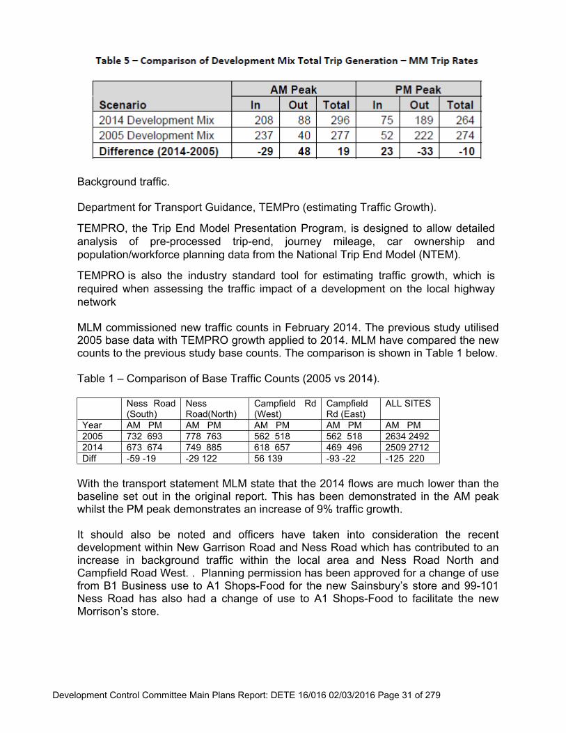
MLM commissioned new traffic counts in February 2014. The previous study utilised 2005 base data with TEMPRO growth applied to 2014. MLM have compared the new counts to the previous study base counts. The comparison is shown in Table 1 below.
Table 1 – Comparison of Base Traffic Counts (2005 vs 2014).
Ness Road (South)
Ness Road(North)
Campfield Rd (West)
Campfield Rd (East)
ALL SITES
Year AM PM AM PM AM PM AM PM AM PM2005 732 693 778 763 562 518 562 518 2634 24922014 673 674 749 885 618 657 469 496 2509 2712Diff -59 -19 -29 122 56 139 -93 -22 -125 220
With the transport statement MLM state that the 2014 flows are much lower than the baseline set out in the original report. This has been demonstrated in the AM peak whilst the PM peak demonstrates an increase of 9% traffic growth.
It should also be noted and officers have taken into consideration the recent development within New Garrison Road and Ness Road which has contributed to an increase in background traffic within the local area and Ness Road North and Campfield Road West. . Planning permission has been approved for a change of use from B1 Business use to A1 Shops-Food for the new Sainsbury’s store and 99-101 Ness Road has also had a change of use to A1 Shops-Food to facilitate the new Morrison’s store.
Development Control Committee Main Plans Report: DETE 16/016 02/03/2016 Page 32 of 279
Commercial/Medical Centre.The proposed employment area (B1a) is approximately 14,000sqm and requires 466 car parking spaces to be policy compliant. A D1 medical centre is also shown but no details are given relating to the number of proposed consulting rooms or staff numbers. The medical centre would need to provide policy compliant parking. Access to the office area and medical centre is gained via New Garrison Road utilizing the non-used spare arm of the roundabout. This is the same access point for the commercial area as the previously approved application therefore the principal of the access being used has already been established with the acknowledgement of traffic movements from the associated development using the existing highway network in the surrounding area. The layout of commercial are and future highway layout are to be conditioned. Any future traffic regulation orders including alterations, travel plans and highway agreements will need to be conditioned and provided at the applicants cost.
ResidentialAccess is gained to the proposed dwellings from New Barge Pier Road/Magazine Road via 4 existing road junctions from the previously approved scheme. The dwellings and highway layout are for illustration purposes with the detailed design to be conditioned. All aspects of parking will be required to meet the DM15 Policy. Any future proposed traffic regulation orders including alterations, travel packs and highway agreements will need to be conditioned and provided at the applicants cost.
The site benefits from being located is a sustainable location with regard to public transport with rail, bus, cycling and walking routes within close proximity and also benefits from having local amenities within a short distance from the site.
Developer contributionsThe following transport infrastructure contributions are required as a result of the development.
30k to contribute to a future highway improvement scheme within the Campfield Road and Ness Road area.
Waste Storage, Collection and Management.All aspects of the proposal should adhere to the relevant guidance to ensure that the development meets the needs of future occupiers.
ConclusionThe comparison in trip generation between the 2005 development mix and the 2014 development shows that overall the impact between the development mixes are neutral with a small increase in vehicle traffic during the peak hours. The traffic flows as a result of the proposed development are generally slightly lower around the surrounding roads with the exception of Ness Road North and Campfield Road West, this mainly due to an increase in background traffic which has been addressed within the report. In traffic generation terms this means in 2005 shows the peak two way vehicle movements as 551. The 2014 scheme shows the peak two way vehicle movements of 560, this presents a 9 vehicle increase on the public highway as a result of the change of development.
Development Control Committee Main Plans Report: DETE 16/016 02/03/2016 Page 33 of 279
To mitigate against this increase the applicant has proposed to contribution towards a future highway improvement scheme within the Ness Road area.
The proposed development would result in a negligible change in vehicle movements in the peak hours in the local highway network, when compared to the extant planning permission in 2005. It is considered that the proposed development would not result in a detrimental impact on the public highway network within the local area.
It should be noted that the NPPF states that Development should only be prevented or refused on transport grounds where the residual cumulative impacts of development are severe.
Strategy & Housing
6.3 The number of units required in line with Core Strategy DPD- 30%. Therefore, 31 units x 2 bed, 3 bed units x 19 and 4 bed units x 2. A split of 60/40 would also be required for 60% rented and 40% intermediate housing in accordance with policy DM7 of the Development Management Document.
Environmental Health
6.4 Contaminated Land The site is classed as being potentially contaminated land. No geotechnical reports have been provided therefore this issue needs to be addressed.
NoiseConstructionDuring the demolition and construction phase noise and vibration issues may arise which could lead to the hours of work being restricted. A construction management plan should be submitted. This should include full details of the works and the method by which they are to be carried out including the proposed steps to be taken to minimise noise resulting from the works. The developer should also consider control measures detailed in Best Practice Guidance “The control of dust and emissions from construction and demolition”.
PlantAny mechanical extraction, ventilation or air conditioning plant particularly that serving the residential and commercial/business units, would need to be carefully located and designed in order to prevent statutory noise or odour nuisance.
External lighting No details on external lighting for the development have been submitted. External lighting shall be directed, sited and screened so as not to cause detrimental intrusion of light into residential property.
Air QualityDemolition and construction activities have the potential to generate fugitive dust emissions. Mitigation measures shall be put in place to control emissions on site and to minimise effects on adjacent residential premises.
Development Control Committee Main Plans Report: DETE 16/016 02/03/2016 Page 34 of 279
As detailed above the developer should consider control measures detailed in Best Practice Guidance “The control of dust and emissions from construction and demolition”.
Waste Management
6.6 Confirmation is required on the collection vehicles being able to pass each residential property, or in the event crew have to walk from the parked collection vehicle to the individual property, that the walked distance is no greater than 25m. Details of non-adopted roads on the development site and are of a construction standard suitable for the weight of the collection vehicles. Sufficient access space and turning areas for the collection vehicles within the proposed road design/layout [Officer Comment: to be addressed at reserved matters stage].
Parks and Trees
6.7 No objections subject to the following comments:
1. It is pleasing to see public open space forms part of the development and a condition should be imposed for the development. There is concern regarding the overall usability of the open space due to its use as part of the flood attenuation.
2. It is not clear how the public open space will be used as part of the surface water drainage system, including how many weeks per year it will be used for surface water drainage. [Officer Comment: A condition will be imposed in relation to Surface Water Drainage which will be dealt with as a future consideration].
3. From the information provided the landscape master plan does not seem practical for an area that will be used for surface water drainage. Some of the features such as allotments are not suitable within a flood attenuation area [Officer Comment: The overall detailing of the landscaping strategy can be dealt with at a later stage as its reserved matter for a future consideration].
4. Management and maintenance of pipes/ headwalls and other drainage features linked to the surface water management of the development should not form part of the open space.
5. It is not clear whether the park is for Council adoption.6. Access would need to be maintained the full length of the ditch numbered 10
on the landscape master plan to allow for maintained if required. A right of access would need to be formalised in an agreement. Access for tractors, excavators etc. will need to form part of this agreement.
7. Requirement for a bridge to be installed across ditch 10 to allow access for the public and maintenance to the existing pond.
8. Inclusion of youth facilities within the public open space made up of Parque and fitness. The inclusion of skate is not appropriate as this is already made available in Gunners Park.
9. A safe pedestrian crossing point installed from the new development to the existing play facilities in Gunners Park.
10.Further comments on the reserved matters will formally assess the proposed tree species used in the development and public open space.
Development Control Committee Main Plans Report: DETE 16/016 02/03/2016 Page 35 of 279
11.A habitat assessment should be undertaken by a qualified ecologist. Protected species are known to be in the vicinity of the development including bats, badgers and common lizards. Note Barn Owls are now nesting in this area [Officer Comment: This will be dealt with by condition].
12.Clarification on who will be responsible for the raised platform linked to the existing bridge is required. Subject to the clarification we would like to reserve the option to make further comments [Officer Comment: Open space will be dealt with during reserved matters].
13.Measures should be in place for a full length of the boundary on the public open space, including entrances to prevent access by unauthorised vehicles.
14. If any area of open space is to be adopted by the council I would wish to see confirmation that the area has been checked for ordnance and contamination along with what action has been taken with regard to findings.
15. If areas of public open space are to be adopted by the council I would wish for a contribution towards maintenance for a minimum of 30 years to form part of the S106 agreement. However, until it is confirmed the areas to be adopted and the features and landscaping it is not possible to confirm the sum [Officer Comment: This will be dealt with under a legal agreement].
Pier and Foreshore
6.8 No comments.
Anglian Water
6.9 Our records show that there are no assets owned by Anglian Water or those subject to an adoption agreement within the development site boundary.
The development site is within the 15 metre cordon sanitaire of a sewage pumping station of this type. This is a significant asset both in itself and in terms of the sewerage infrastructure leading to it. For practical reasons therefore it cannot be easily relocated.
Wastewater TreatmentThe foul drainage from this development is in the catchment of Southend STW that at present has available capacity for these flows.
Foul sewerage networkThe sewerage system at present has available capacity for these flows. If the developer wishes to connect to our sewerage network they should serve notice under Section 106 of the Water Industry Act 1991. We will then advise them of the most suitable point of connection.
Surface water disposal The surface water strategy/flood risk assessment submitted with the planning application is not relevant to Anglian Water and therefore this is outside our jurisdiction for comment and the Planning Authority will need to seek the views of the Environment Agency. We request that the agreed strategy is conditioned in the planning approval.
Development Control Committee Main Plans Report: DETE 16/016 02/03/2016 Page 36 of 279
Recommended condition:The development site is within 15 metres of a sewage pumping station. Whilst Anglian Water takes all reasonably practicable steps to prevent any nuisance arising from the site, there should be no development within 15 metres from the boundary of a sewage pumping station of this type if the development is potentially sensitive to noise or other disturbance or which might give rise to complaint from the occupiers regarding the location of the pumping station.Reason: To avoid causing future amenity problems.
Environment Agency
6.10 Flood Risk Our maps show the site lies within Flood Zone 3, the high probability zone. The application includes residential units, which are considered to be a ‘more vulnerable’land use in Table 2: Flood Risk Vulnerability Classification of the Planning Practice Guidance: Flood Risk and Coastal Change. It is therefore necessary for the application to pass the Sequential and Exception Tests and to be supported by a site-specific Flood Risk Assessment (FRA), which can demonstrate that the ‘development will be safe for its lifetime taking account of the vulnerability of its users, without increasing flood risk elsewhere, and, where possible, will reduce flood risk overall’.
Sequential Test No evidence has been submitted to demonstrate you have considered the Sequential Test. The requirement to apply the Sequential Test is set out in Paragraph 101 of the National Planning Policy Framework. This Test is your responsibility and should be completed before the application is determined.
Exception Test The first part of the Exception Test requires you to be satisfied that the development provides wider sustainability benefits to the community that outweigh flood risk. No evidence has been submitted to demonstrate you have considered this. This Test is your responsibility and should be completed before the application is determined. The second part of the Exception Test requires the submission of a FRA which demonstrates the development will be safe for its lifetime, without increasing flood risk elsewhere, and will reduce the overall flood risk where possible.
Flood Risk Assessment An FRA prepared by Ardent Consulting Engineers, referenced H521-001 and dated March 2014, and a flood modelling report prepared by Ardent Consulting Engineers, referenced H521-002 and dated March 2014, have been submitted and subsequent email from Ardent Consulting Engineers, dated 18 June 2014. We note that the flood risk assessment and flood modelling report submitted as part of this application are unchanged from when we commented on the application in 2014 (under planning application 14/00566/OUT); our comments therefore remain unchanged.
Development Control Committee Main Plans Report: DETE 16/016 02/03/2016 Page 37 of 279
We note that the flood response plan and the drainage strategy have been updated. However, as we no longer comment on surface water schemes, and the acceptability of the flood response plan is also outside of our remit, we have no comments to make with regards to these updated documents.
We are satisfied that the FRA provides you with the information necessary to consider whether the application meets the requirements of the Exception Test. We therefore have no objection to the planning application and are not raising an objection subject to the conditions below, and you concluding that the development is safe for its lifetime. If you are not satisfied with the safety of the development please re-consult us for further comments. Condition Finished ground floor levels for the residential elements of the development shall be provided at a minimum level of 3.25mAOD. Reason To ensure ground floor levels are provided above the flood level. Condition Finished ground floor levels for the commercial development shall be provided at a minimum level of 3.1mAOD.The void space beneath the commercial units must remain open to allow for the storage of flood water should the defences fail and no storage of any materials, whether temporary or otherwise, shall be permitted within this void space. Reason To ensure ground floor levels are provided above the flood level and the void space is maintained for floodplain storage over the lifetime of development.
Condition Prior to the commencement of development of the residential and commercial units, the proposed flood defence improvements at Shoebury Common, to the west of the site, shall be fully constructed and signed off, together with any onsite flood mitigation works. If the flood defence improvement scheme does not go ahead then the FRA will need to be revised to reflect the change in the standard of protection of the defences. Reason To ensure the site is protected to the standard that the development is designed and modelled to within the submitted Flood Risk Assessment. Condition A compensatory flood storage area of 1.86ha shall be provided on site to accommodate for the land raising to raise platform levels for the residential and commercial elements of the development. Reason To provide compensation for land raising across the site.
Development Control Committee Main Plans Report: DETE 16/016 02/03/2016 Page 38 of 279
Summary of Flood Risk Responsibilities for your Council We recommend that it is written into the deeds of the commercial units that the storage or infilling of any type within the void space beneath the commercial units shall not be permitted. These void spaces would provide floodplain storage should the defences fail. We have not considered the following issues as part of this planning application as they are not within our direct remit; nevertheless these are all important considerations for managing flood risk for this development. Prior to deciding this application you should give due consideration to the issues below. It may be that you need to consult relevant experts outside your planning team.
· Safety of people (including the provision and adequacy of an emergency plan, temporary refuge and rescue or evacuation arrangements);
· Safety of the building; · Whether insurance can be gained or not; · Sustainability of the development.
Emergency Planning You need to be satisfied that the proposed procedures will ensure the safety of future occupants of the development. In all circumstances where warning and emergency response is fundamental to managing flood risk, we advise LPAs formally consider the emergency planning and rescue implications of new development in making their decisions. We advise you take advice from your emergency planner, the emergency services and the Local Resilience Forum. We do not normally comment on or approve the adequacy of flood emergency response procedures accompanying development proposals as we do not carry out these roles during a flood. Our involvement with this development during an emergency will be limited to delivering flood warnings to occupants/users covered by our flood warning network.
Essex County Fire & Rescue
6.11 The access arrangements should be in accordance with the details contained in the Approved Document to Building Regulations B5 and more detailed considerations on access and facilities will be provided at building regulation consultation stage.
At present Essex County Fire and Rescue Service (ECFRS) under the Fire and Rescue Services Act 2004 and the Fire and Rescue Services (Emergencies) Order 2007, do not have a statutory duty to respond to flooding issues.
Due to the limited availability of specialist water resource during flooding incidents, as on previous occasions, limit operational response to ‘life threatening situations’ only. Therefore support cannot be given for proposals that are likely to increase this situation or add to the volume of calls received.
Development Control Committee Main Plans Report: DETE 16/016 02/03/2016 Page 39 of 279
Natural England
6.12 The issues about which Natural England had previously expressed concerns were the potential for increased recreational disturbance and/or increased discharges of surface water run-off to the Benfleet and Southend Marshes Site of Special Scientific Interest (SSSI), Special Protection Area (SPA) and Ramsar site and/or to the Foulness SSSI, SPA and Ramsar site; and these concerns were subsequently addressed through the submission of supplementary information. Having examined the current application, it would appear that none of the proposed changes will result in significant changes to the potential increase in recreational disturbance, or will lead to a significant increase in discharge of surface water run-off; as compared to the proposal as previously submitted.
Consequently, Natural England does not wish to add to or amend our previous comments contained in our letters of 01 May 2015 (our ref: 150830) and 12 June 2015 (our ref: 155837).
Previous comments include “The conclusion of no likely significant effect on European sites (either alone or in combination) is based on the legally binding delivery of planning conditions suggested in the applicant’s HRA. To this end conditions shall be attached to any consent for the proposed development”. [Officer Comment: Please refer to condition 10 whereby all mitigation measures will need to be complied with together with the submission of a conservation management plan below under condition 10 Recommendation. Please note Essex Wildlife Trust already patrol Gunners Park Nature Reserve Ranger].
“Natural England would firstly like to take the opportunity to remind the planning authority of the conditions proposed within our letter of 1 May 2015, which will assist with safeguarding the interest of Foulness SSSI (and the internationally designated sites). In addition to the conditions advised in our previous letter, we welcome the key recommendations in section 1.4 of the submitted report. We note that the mitigation is included to address issues relating to Foulness SSSI Unit 1, website ref: 1004751. Therefore we have provided further advice on this unit below.
It is Natural England’s understanding that the SSSI unit 1 (Old Shoeburyness Ranges) mainly supports the thorny scrub species Gorse (Ulex europeaus), Blackthorn (Prunus spinosa), with some Hawthorn (Crataegus monogyna).
It would therefore be appropriate to use these locally occurring characteristic species rather than introducing new species into the adjacent area. Furthermore, Essex Wildlife Trust currently manages areas of the SSSI to remove gorse or blackthorn trees and so there may be opportunities to transplant these trees/shrubs to suitable non-SSSI boundary locations. We therefore recommend that the applicant discusses the mitigation with the Essex Wildlife Trust.
Development Control Committee Main Plans Report: DETE 16/016 02/03/2016 Page 40 of 279
Natural England notes and welcomes the proposed provision set out in 6.3.5, namely: ‘The associated HRA document has already recommended extending the current remit of the Gunners Park Nature Reserve warden to monitor and control recreational disturbance of coastal bird assemblages, with financial support to be provided by the developer’. On this basis, Natural England can confirm that our concerns in this matter are likely to be adequately addressed if the relevant conservation bodies are satisfied with the resource being agreed and provided”.
[Officer Comment: Mitigation measures will be dealt with by condition 10 to ensure all relevant conservation bodies are satisfied in accordance with Natural England’s comments above].
Public Consultation
6.13 Site notices displayed on the 22nd December and neighbours notified of the proposal. 106 letters of representation have been received stating:
Commercial development is too dense and building to eight of 3-4 storeys is excessive for the area;
Negative impact of the increase in traffic congestion; Lack of details relating to the health centre [Officer Comment: All matters
are reserved for future consideration]; Flood risk assessment-could the new development increase the risk of flooding
to existing properties; Need for further geological survey and expect investigations into the cause of
the saturated ground where the residential development is going to be located; Inability to make a breach analysis [Officer Comment: The previous
application 14/00566/OUTM was refused in relation to the surface water attenuation rather than tidal flooding];
Unsuitability of evacuation plan [Officer Comment: No objections raised previously under application 14/00566/OUTM to the evacuation plan];
Lack of affordable housing and consequential questionable viability of the results of the sequential and exceptions test submitted in March 2014 [Officer Comment: add about the applicant paying S106 and no objections raised to the sequential and exceptions test previously]
Shortfall in financial contributions in excess of £1.5 million. Will this be coming out of council tax [Officer Comment: The applicant has agreed to pay all relevant sums for CIL and provide 30% affordable housing as set out S106 planning contributions above];
Absence of a sequential and exception test document and whether those previously submitted with the earlier application would be valid with regard to wider sustainable benefits to the community and in particular relating to whether there is a need for offices and the impact on the already congested roads in that part of Shoeburyness [Officer Comment: No objections have been raised in relation to the sequential and exceptions test under application 14/00566/OUTM];
Development Control Committee Main Plans Report: DETE 16/016 02/03/2016 Page 41 of 279
The land is bounded by two water courses and is subject to flooding. Excess office capacity in area
There are very few large businesses left in Shoebury or Southend so anyone living in the new accommodation will need to travel down main road arteries. The A127 has been improved but is still a nightmare and local roads are even more congested in Shoebury. The council cannot continue to build more and more housing and expect roads to cope [Officer Comment: Mott MacDonald have carried out an independent review of the transport statement and consider the proposal will result in negligible increased traffic generation, thus no objection is raised]
Lack of green space and the Council seem to destroy for quick profit [Officer Comment: The existing site is not designated as a park or green space by the Core Strategy DPD1 or Development Management Document DPD2 and has always been earmarked for redevelopment as set out in the Masterplan approved under application 00/00777/OUT];
This ill-conceived application proposes to grind an incremental commercial profit for private interest at the unacceptable cost of significant financial, property and personal exposure risks - including increased risk to children at Hinguar Schools - which will fall on Southend Borough Council and/or HM Government;
If approved, the opportunity will be lost to use the location of the established flood plain to improve the river environment for both the Thames Urban Tidal and Southend-on-Sea & Rayleigh Catchment Areas.
Flood management will depend on the Barge Pier ditch, which is tide locked. The impact of this concentration and twice daily limitation does not appear to be addressed;
Resident constituents who are at risk may not be reassured by the suggestion that escape routes are available that avoid the flood area;
The focus of all the submitted studies is limited to the immediate development. Since it is unlikely that any catastrophe event will be limited further work is required to ascertain the impact in both of the adjacent catchment areas;
The MOD recognised the tide locked run-off arrangements and chose to leave the site as an undeveloped flood plain for their entire 200 year occupation;
Commercial profit v costs- any profit will accrue to private interest leaving significant residential financial and mortality risks to fall on Southend Borough Council or the Government;
The development is not commercially demanded, viable; Significant actual and contingent flooding cost will fall on the Council or HM
Government; Site should be uses as a managed wetland to the benefit of two major flood
catchment areas; The overall floor area created and in the absence of any very special
circumstances would lead to an inappropriate form of development in the Green Belt detrimental to its open, rural and undeveloped character. Local residents enjoy the area [Officer Comment: The site is not designated within the Green Belt as set out by the Core Strategy DPD1 and Development Management Document DPD2];
Development Control Committee Main Plans Report: DETE 16/016 02/03/2016 Page 42 of 279
There should be no development on the east site of Southend until a new east to west route is built;
Impact on schools and general facilities in the area; Insurance unlikely for the new builds; Increased population to the historic and sought after development; Damage to the nature reserve; Rights of light of nearby residential occupiers will be compromised; This will lead to flooding in a tide surge from East Beach; The site is bordered on three sides by water-the sea just yards away on one
boundary and brooks/drainage channels a few feet away; Whoever agrees to this plan to build at Gunners Park will have to face the
possible devastating consequences of their decisions; Surely there are a number of brownfield sites that could be developed with
housing rather than lose valuable green space which is Southend history and heritage [Officer Comment: The site is not designated as a green space as set out by the Core Strategy DPD1 and Development Management Document DPD2];
This application is premature and should be determined by the Planning Inspectorate.
Size and scale of the development inappropriate; The dumping of earth removed from Southend to Gunners Park Shoebury is
part of a cynical plan by Garrison Developments to further their application to develop, as I understand this earth was to be used by the developer in building the much publicised sea wall that the developers were proposing to build as they were going to donate 1 million towards the construction of the sea wall.
Existing drains are already full; The large office blocks on the Garrison have been empty for 5 years and who
will occupy the new ones; Loss of wildlife habitat; Building over the land with concrete will reduce the sites ability to absorb
surface water and this would result in even worse flooding in the event of heavy rainfall. The recent flooding in the north of the country demonstrates the need for the area to be retained as a flood plain;
No offices should be allowed to have more than 2 storeys to prevent them towering over the local homes;
Infrastructure not viable surrounding the site; It was agreed in 2004 the land would be suitable for a business park and there
is no evidence to support that this decision should be changed in 2016 for residential, which would be required greater protection;
Coastal and pluvial flooding should be objected to as councils are not protecting residents;
It is impossible to calculate pluvial flooding one thing is for a 100 years Gunners Park has been a marshy area where the water table is high and has been badly maintained;
The level of protection is not sufficient;
Development Control Committee Main Plans Report: DETE 16/016 02/03/2016 Page 43 of 279
Southend Council should carry out a sequential test rather than accepting the developers statements [Officer Comment: The Council have reviewed the current SHLAA against the sites stated within the applicants submission and the Council agree there are no other sites of similar size within Shoebury to meet the Core Strategy housing and employment provisions];
It is not clear who is responsible for the maintenance work on the river Shoe. Southend Council should make public how many developers pay the S106
contributions; Houses shouldn’t go in a flood plain; Increased traffic along Campfield Road and Ness Road; Inappropriate and unsympathetic to the surrounding area; Contravenes the Environment Agency’s policy not building in the flood plain
[Officer Comment: The Environment Agency have not objected to this proposal subject to appropriate conditions];
The height of the buildings will impact significantly onto the existing occupiers of Ness Road;
Land to the rear of 119 Road should be tidied similar to that at 121 Ness Road; Surface water attenuation and tide lock has not been addressed; Transport issues have not been addressed; Holland does not have this type of flood risk as they designated land as flood
plains. No new evidence have been submitted relating to traffic issues the transport
statement is the same as the previous application and should be refused on that basis. The transport statement is inaccurate with complex calculations [Officer Comment: Mott MacDonald have carried out an independent review of the transport statement and consider the proposal will result in negligible increased traffic generation, thus no objection is raised];
Not all costs i.e. S106 or CIL have been included on the formal submission [Officer Comment: The applicant has agreed to provide 30% affordable housing and £997,065.38. for CIL contributions];
The disasters up north should be a lesson learned; The site is located within a flood risk zone 3 and should not be built upon; Standard of design a major issue. Apart from the aesthetic look of the
development, the present housing on the estate has suffered design faults and builders are constantly rectifying the problems;
The surface water drainage appears to consider only run off from the proposed development. Flooding already occurs along the route of the old River Shoe south of Campfield Road at times of heavy rainfall;
The mitigation area indicated by applicant is unlikely to be sufficient to accommodate existing storm flows from outside the development area;
No need for offices given they are not occupied now; Schools full too capacity; Will impact on local wildlife;
Development Control Committee Main Plans Report: DETE 16/016 02/03/2016 Page 44 of 279
The current application will utilise nearly 50% of what is now acknowledged to be a valuable natural flood risk resource, as hard standing. As confirmed in the recent AECOM reports on Surface Water Flooding issues facing the area, any developments in this area will not only affect the potential for alleviate flooding issues, it will most certainly have immense impact of the Risk to the wider community. Recent assessment of Flood Risk Zones for the area has escalated the risk as determined by the Environment Agency. If the existing surface water infrastructure which comprises of a flood defence bund, Flood Alleviation Ditch, Barge Pier Ditch and an onsite detention pond and Wetland Pond, are implemented this status will remain. If additional development is undertaken the risk area will be further widened;
1 letter of support received.
6.14 Friends of Shoebury Common and Garrison Residents Association have objected stating:
Current national flood incidents demonstrate that building in floodplains should be avoided;
The site is subject to an on-going appeal process; The applicant has not taken account of the flood issues repeatedly raised by
residents in their recent consultations; Surface water attenuation and tide lock has not been addressed [Officer
Comment: The previous application only refused on surface water not tide lock as stated under application 14/00566/OUTM];
Sea wall repairs and outfalls are not adequate to cope with an extreme weather event;
The developer is using the cost of flood mitigation for the benefit of the be builds to reduce their contribution to the Community Infrastructure Levy [Officer Comment: The applicant has agreed to provide affordable housing policy compliant and all relevant CIL sums];
Transport issues have not been addressed and the Council needs to challenge the assumption that there will be fewer movements for this application which includes a health centre [Officer Comment: Mott MacDonald have carried out an independent review of the transport statement and consider the proposal will result in negligible increased traffic generation, thus no objection is raised];
The location of the health centre for Shoeburyness must be subject to a public consultation;
Costs associated with such a public building will be higher to incorporate flood mitigation and therefore would fail any competitive tender process compared to other sites in Shoeburyness;
Objection to how this application has been handled in relation to availability of documents [Officer Comment: Residents have had from the 22nd December 2015 when site notices were posted until 29th January 2016 to review all of the documents, which is in excess of the 21 day public consultation period];
Development Control Committee Main Plans Report: DETE 16/016 02/03/2016 Page 45 of 279
The Environment Agency imposed conditions that made it clear before any development on the application site, the sea defence improvements at Shoebury Common must be fully constructed and signed off, together with any on site flood mitigation works. The previously approved scheme at Shoebury Common has been rejected and the sea defences at Shoebury Common have been reviewed independently by Mott MacDonald;
No consideration should be given to this planning application until the full details and recommendations of the Mott MacDonald review are in the public domain; full details and estimated costs of what all the onsite flood mitigation works will be required to be construct the development on the application land;
The identification of alternative sites should be applied to the whole borough, the sequential and exceptions test applied within this application is flawed because it is based on the Shoebury Area Action Plan (AAP) that is not targeted to be adopted until 2017 [Officer Comment: The application has been assessed in accordance with the Core Strategy DPD1];
The proposed 1.86 flood mitigation results in 80% drop in current water storage. The flood risk assessment does not provide assurance that the consequences of the very large drop in water storage capacity has been fully and carefully considered;
The lack of attention to non-tidal flooding is a major shortcoming in the FRA and other documents submitted with this application there are a number of examples in relation to pluvial flooding including Southend Observer, AECOM Southend on Sea Water Management Plan and Flood incident report demonstrating the site flood from pluvial flooding;
Of considerable concern is the fact that the Environment Agency (EA) Risk of Surface Water Flooding maps show the application site to be at “Low Risk” from non-tidal flooding, i.e. a chance of flooding between 0.1% (1 in 1,000)and 1% (1 in 100). This concern was raised as an issue in the Public Consultation regarding planning application 14/00566/OUTM made by Garrison Developments on 8th July 2015. The Officer response to that concern was “We would repeat that the classification is an EA classification on an EA map and was neither made with input from the Council nor requested by us. We cannot comment on the EA classification. It does not inform our actions or approach to the flood risk in the area, which was based on engineering modelling and experience”. The EA were approached for guidance. The EA confirmed that Southend Borough Council (SBC) are the Lead Local Flood Authority on non-tidal flooding and that one of their duties in that role is the very important requirement to ensure the accuracy of the EA Risk of Surface Water Flooding maps, that were introduced in December 2013.
Friends of Shoebury Common have long standing concerns regarding the spoil that has been stored on the application site since late 2012, apparently free of charge. The test results confirmed from an independent company that the principle soil type for all of the samples was CLAY/SILT and that typically CLAY/SILT material will tend to be impermeable and offer poor drainage characteristics.
Development Control Committee Main Plans Report: DETE 16/016 02/03/2016 Page 46 of 279
The tests vindicated the concerns and warnings that had been raised by FoSC, that if this material had been spread over Shoebury Common as planned, it would have created a mud bath and ruined the valuable Shoebury Common flood plain.
Friends of Shoebury Common (FoSC) are committed to protecting the beauty, character, and uniqueness of Shoebury Common and the immediate catchment area, as a consequence we oppose this development.
We are very concerned about the lack of clarity, in the supporting documentation to this application, regarding the financial implications of this proposed development.
6.15 Councillor Assenheim has requested this application be dealt with by Development Control Committee.
7 Relevant Planning History
7.1 Erect 172 dwellinghouses and 15000sqm of Offices (Class B1) (outline application)- Refused (14/00566/OUTM).
7.2 Mixed use development comprising conversion of existing buildings and erection of new buildings for: parkland and open space; up to a total of 465 dwellings; up to 23,750sq.m of business floorspace (Class B1(a) and (B); up to 1625sq.m of non-residential (Class D1) uses, including A. a health centre within the mixed use area, B. the former Garrison Church as a community hall, and C. the former battery gun store as a heritage centre; up to 5,900sq.m of leisure (Class D2) uses; up to 800sq.m of retail (Class A1);up to 600sq.m of financial services (Class A2) use; formation of hotel (Class C1) with approximately 40 bedrooms; land for a new school; erection of landmark residential building; construction of new access roads; and associated works (Outline)- Granted in 2004 (00/00777/OUT).
Development Control Committee Main Plans Report: DETE 16/016 02/03/2016 Page 47 of 279
8 Recommendation
(a) Members are recommended to DELEGATE AUTHORITY TO THE GROUP MANAGER FOR PLANNING & BUILDING CONTROL, HEAD OF PLANNING & TRANSPORT or CORPORATE DIRECTOR OF PLACE to GRANT OUTLINE PLANNING PERMISSION subject to the removal of the Natural England objection and completion of a legal agreement under Section 106 of the Town and Country Planning Act 1990 (as amended).
Affordable Housing 30%- 52 houses 31 x 2 bed units; 19 x 3 bed units; 2 x 4 bed units;
“Flood sea defence contribution” means a financial contribution the sum of which is to be agreed between the Owner and the Council once a scheme has been agreed for the flood sea defence.
Prior to the commencement of the residential units a marketing strategy for the commercial element of the site;
Area of Open Space as shown on plan 6100/1101 Rev G to be permanently retained for public access and flood alleviation; Open Space maintenance strategy to be submitted and agreed on submission of the landscaping details as a reserved matters planning application and no development shall commence on the site until this strategy has been agreed
As a minimum, the Open Space must include a parkour facility, outdoor fitness equipment and raised walkways, all of which must remain publicly accessible at times of flood;
Maintenance sum for a 10 year period (to include funding for a park ranger and interpretation signs) to be agreed prior to commencement;
Open Space to be transferred to SBC after it has been maintained by the land owner for a two year period from the date of practical completion; maintenance sum payable on transfer.
Drainage A minimum 5m wide strip must remain accessible to the Council at all
times adjacent to the C-X ditch (which runs along the full length of the western side of the site) for maintenance purposes
Maintenance strategy for Barge Pier drainage ditch to be submitted and agreed on submission of the landscaping details as a reserved matters planning application and no development shall commence on the site until this strategy has been agreed.
Development Control Committee Main Plans Report: DETE 16/016 02/03/2016 Page 48 of 279
1.
b) The Corporate Director of Place or Head of Planning & Transport be authorised to determine the application upon completion of the above obligation, so long as the planning permission when granted and the obligation when executed, accord with the details set out in this report and the conditions listed below:
a. Application for approval of the reserved matters including appearance, access, scale, landscaping, layout and appearance shall be made to the local planning authority not later than 5 years beginning with the date of this permission.
b. The development hereby permitted shall be begun not later than whichever is the later of the following dates:
i) the expiration of 5 years beginning with the date of this permission;ii) the expiration of 2 years beginning with the approval of the last reserved matter to be approved.
Reason: Required to be imposed pursuant to Section 92 of the Town and Country Planning Act 1990.
2 The development hereby permitted shall be carried out in accordance with the approved plans 6100/1101 G; 6100/1002A.
Reason: To ensure that the development is carried out in accordance with the policies in the development plan.
3 Finished ground floor levels for the residential elements of the development shall be provided at a minimum level of 3.25mAOD.
Reason: To ensure ground floor levels are provided above the flood level with the NPPF and policy KP2 of Core Strategy.
4 Finished ground floor levels for the commercial development shall be provided at a minimum level of 3.1mAOD. Any void space beneath the commercial units must remain open to allow for the storage of flood water should the defences fail and no temporary storage of any materials, whether temporary otherwise, shall be permitted within this void space.
Reason: To ensure ground floor levels are provided above the flood level and the void space is maintained for floodplain storage over the lifetime of development in accordance with the NPPF and policy KP2 of Core Strategy.
Development Control Committee Main Plans Report: DETE 16/016 02/03/2016 Page 49 of 279
5 Prior to the commencement of the construction of any residential and commercial units, flood defence improvements at Shoebury Common offering at least 1 in 200 year protection, to the west of the site, shall be agreed by the local planning authority and fully implemented, together with any onsite flood mitigation works. If the flood defence improvement scheme does not go ahead then the FRA will need to be revised to reflect the change in the standard of protection of the defences.
Reason: To ensure the site is protected to the standard that the development is designed and modelled to within the submitted Flood Risk Assessment NPPF and policy KP2 of Core Strategy.
6 A compensatory flood storage area of not less than 1.86ha shall be provided on site in accordance with the approved plans. Prior to the raising of land levels elsewhere on the site.
Reason: To provide compensation for land raising across the site, in order to ensure no additional off site flooding result from the development in accordance with the NPPF and policy KP2 of the Core Strategy.
7 No development shall take place until a detailed surface water drainage scheme for the site, based on sustainable drainage principles and an assessment of the hydrological and hydro-geological context of the development, has been submitted to and approved in writing by the local planning authority. The drainage strategy should demonstrate the surface water run-off generated up to and including the 1 in 100 year critical storm (including appropriate allowances for climate change) will not exceed the run-off from the undeveloped site following the corresponding rainfall event. The scheme shall subsequently be implemented in accordance with the approved details before the development is completed and shall include confirmation of the following:- Details of how and by whom individual elements of the scheme shall be maintained and managed after completion shall be submitted prior to first occupation of the development.- It must be ensured that any replacement of permeable paving which may be required in the future in carried out with the same infiltration properties and storage capacity as designed. Reason: To prevent the increased risk of flooding, both on and off site and to ensure that the SUDs hierarchy has been adequately addressed and to ensure the long term maintenance of the scheme NPPF and policy KP2 of Core Strategy.
8 The development hereby permitted shall operate at all time in accordance with the ‘Flood Response Plan’ dated December 2015 reference H521-007A.
Reason: To ensure that the Flood Warning and Evacuation Plan meets with the requirements of the Environment Agency's Flood Warning Service
Development Control Committee Main Plans Report: DETE 16/016 02/03/2016 Page 50 of 279
9 No development shall take place until a Construction Environmental Management Plan has been submitted to and approved by the local planning authority. The Plan shall include the following details:
(a) Programme of works; (b) Code of practice; (c) 24 hour emergency contact number; (d) Hours of building works and measures taken to ensure satisfactory access and movement within the site taking into consideration any existing occupiers; (e) Lorry routing and traffic management (including control of delivery of materials); (f) Control of noise; (g) Control of dust; (h) Site waste management; (i) Details of the local sourcing of material; (j) Measures to prevent pollution of ground and surface water; (k) Measures to protect areas of vegetation and wildlife within the vicinity of the development during construction works; (l) Compliance with legal consents relating to nature conservation specifically protected species; (m) Details of how the Construction Environmental Management Plan will be monitored on site
Reason: To minimise the environmental impact and disturbance to existing residents, vegetation and wildlife during construction of the development in accordance with NPPF, DPD1 (Core Strategy) 2007 policy KP2 and CP4 and DPD2 (Development Management Document) 2015 policy DM1.
10 Development shall not commence on any part of the site until the mitigation measures and recommendations as set out in the Phase 1 Habitat Assessment 19thDecember 2014, Habitats Regulations Assessment Report April 2015 P14/68-1B and SSSI Impact Assessment reference: DFCP 3398 dated 29th May 2015, have been carried out and completed in accordance with a Conservation Management Plan to be submitted to, and approved by, the local planning authority. The following surveys (details of which are to be submitted and approved by the local planning authority) prior to commencement of work on site including: Reptile Survey; Invertebrate survey; Bird survey; Great Crested Newt Survey.
Reason: To reduce the effect the development has on the biodiversity of the environment in accordance with the National Planning Policy Framework and DPD1 (Core Strategy) 2007 policy KP2 and CP4.
11 No development or archaeological work shall take place until details including samples of the materials to be used on the external elevations; boundary treatments and hard surfaces have been submitted to and approved by the Local Planning Authority. The development shall only be carried out in accordance with the approved details unless otherwise agreed in writing with the Local Planning Authority.
Development Control Committee Main Plans Report: DETE 16/016 02/03/2016 Page 51 of 279
Reason: In the interests of visual amenity and to ensure that the appearance of the building makes a positive contribution to the character and appearance of the area. This is as set out in the National Planning Policy Framework, DPD1 (Core Strategy) 2007 policy KP2 and CP4, DPD2 (Development Management) emerging policy DM1, DPD2 (Development Management Document) 2015 policy DM1 and SPD1 (Design and Townscape Guide).
12 All planting in the approved landscaping scheme for each phase of the development shall be carried out within 12 calendar months of the completion of that phase of development. Any trees or shrubs dying, removed, being severely damaged or becoming seriously diseased within five years of planting shall be replaced with trees or shrubs of such size and species as may be agreed with the local planning authority.
Reason: In the interests of visual amenity and to ensure a satisfactory standard of landscaping, pursuant to Policy DM1 of the Southend on Sea Borough Local Plan.
13 No development shall take place until a site investigation of the nature and extent of contamination (including ordnance risk) has been carried out in accordance with a methodology which has previously been submitted to and approved in writing by the local planning authority. The results of the site investigation shall be made available to the local planning authority before any development begins. If any contamination is found during the site investigation, a report specifying the measures to be taken to remediate the site to render it suitable for the development hereby permitted shall be submitted to and approved in writing by the local planning authority. The site shall be remediated in accordance with the approved measures before development begins. If, during the course of development, any contamination is found which has not been identified in the site investigation, additional measures for the remediation of this source of contamination shall be submitted to and approved in writing by the local planning authority. The remediation of the site shall incorporate the approved additional measures.
Reason: To ensure that any contamination on the site is identified and treated so that it does not harm anyone who uses the site in the future, and to ensure that the development does not cause pollution to DPD2 (Development Management document) policy DM14.
14 No development or preliminary groundwork of any kind shall take place until the applicant has secured the implementation of a programme of Archaeological work in accordance with a written scheme of investigation which has been submitted by the applicant and approved by the Local Planning Authority.
The developer shall afford access at all reasonable times to any archaeologist nominated by the local planning authority and shall allow them to observe the excavations and record items of interest and finds.
Development Control Committee Main Plans Report: DETE 16/016 02/03/2016 Page 52 of 279
Reason: To allow for the excavation and recording of any information of archaeological importance, pursuant to DPD2 (Development Management Document) 2015 policy DM5.
15 No part of the commercial and residential development shall be occupied until a Travel Plan has been submitted to and approved by the local planning authority, incorporating the principles set out in the Core Strategy Policy CP3, such details to include a timetable for the implementation of the plan.
Reason: To promote the principles of sustainable transport, in accordance with Policy CP3 of the Core Strategy and DPD2 (Development Management Document) 2015 policy DM15. and the Design and Townscape Guide.
16 No external lighting shall be erected until details of its siting, design; luminance, screening and dimensions have been submitted to and approved by the local planning authority. The development shall only be carried out in accordance with the approved details.
Reason: To safeguard the character and amenities of the area and in particular to protect the amenities of nearby residential properties and the employment provision within the borough, in accordance with Policy CP1 of the Core Strategy and DPD2 (Development Management Document) 2015 policy DM1.
17 The commercial units, hereby permitted, shall only be used for the purposes falling with Class B1 of the Schedule to the Town and Country Planning (Use Classes) Order, unless otherwise agreed in writing by the Local Planning Authority.
Reason: To safeguard the character and amenities of the area and in particular to protect the amenities of nearby residential properties and the employment provision within the borough, in accordance with Policy CP1 of the Core Strategy, DPD2 (Development Management Document) 2015 policy DM10 and DM11.
18 Details of the proposed hours and days of opening in conjunction with B1 and D1 Class uses shall be submitted to and approved in writing prior to occupation of each unit respectively. Thereafter the B1 and D1 uses shall be operated only in accordance with the approved hours of opening.
Reason: To safeguard the character and amenities of the area and in particular to protect the amenities of nearby residential properties in accordance with DPD2 (Development Management Document) 2015 policy DM1.
Development Control Committee Main Plans Report: DETE 16/016 02/03/2016 Page 53 of 279
19 No dust or fume extraction or filtration equipment, or air conditioning, ventilation or refrigeration equipment shall be installed until full details of its design, siting, discharging points and predicted acoustic performance have been submitted to and approved by the local planning authority. The equipment as installed shall be retained in good working order at all times thereafter. The development shall only be implemented in accordance with the approved details.
Reason: To safeguard the character and amenities of the area and in particular to protect the amenities of nearby residential properties and the employment provision within the borough, in accordance with DPD2 (Development Management Document) 2015 policy DM1.
20 No dwelling shall be first occupied until two parking spaces to serve that dwelling have been laid out, together with properly constructed vehicular access to the adjoining highway, all in accordance with details which shall have been submitted to and approved by the local planning authority, such provision to be permanently reserved for the parking of vehicles of occupiers and callers to the property and not used for any other purpose whether or not permitted by the Town and Country Planning (General Permitted Development) Order 1995 (or any order revoking or re-enacting that order).
Reason: To make provision for parking off the highway, in the interests of highway and pedestrian safety and to safeguard the character and amenities of the area in accordance with Policy CP3 of the Core Strategy DPD1, DPD2 (Development Management) policy DM15 and the Design and Townscape Guide.
21 Before the development hereby permitted is begun a scheme for generating not less than 10% of the predicted energy requirement of the development from decentralised renewable and/or low carbon sources shall be submitted to and approved in writing by the local planning authority. The approved scheme shall be implemented before the development is first occupied and shall remain operational for the lifetime of the development unless otherwise agreed in writing by the local planning authority.
Reason: To minimise the environmental impact of the development through efficient use of resources and better use of sustainable and renewable resources in accordance with the National Planning Policy Framework, DPD1 (Core Strategy) policy KP2 and CP4, and SPD1 (Design and Townscape Guide).
Development Control Committee Main Plans Report: DETE 16/016 02/03/2016 Page 54 of 279
22 Prior to first occupation of the development a Waste Management Plan for the development shall be submitted to and approved in writing by the Local Planning Authority in relation to the residential and commercial premises. The plan shall detail how the development will provide for the collection of general refuse and re-usable and recyclable waste and what strategies will be in place to reduce the amount of general refuse over time. Waste management at the site shall be carried out in accordance with the approved strategy unless otherwise agreed in writing by the Local Planning Authority.
Reason: To protect the environment and ensure adequate and appropriate storage, recycling and collection of waste resulting from the development in accordance with the National Planning Policy Framework, DPD1 (Core Strategy) 2007 policy KP2 and CP4.
23 The development hereby approved shall include not less than 14,130sqm of office B1 (a) floorspace, 870sqm for a health centre (D1) and no more than 172 dwellinghouses.
Reason: In order to define the scope of this permission in the context of the character and amenity of the area, in accordance with policies KP2 and CP4 of the Core Strategy 2007, DPD2 (Development Management Document) 2015 policy DM1, DM7, DM10, DM11. and to ensure the development meets the requirements of the development plan.
(c) In the event that the planning obligation referred to in part (a) above has not been completed by the 17th March 2016 such that planning permission would have been granted, then the Corporate Director Place or Head of Planning & Transport or Group Manager be authorised to consider whether permission should be refused on the grounds that it has not proved possible to complete a S106 agreement within an appropriate timescale, and that the proposals are unacceptable in the absence of the obligation that would have been secured; if so, the Corporate Director of Place, Head of Planning & Transport are authorised to determine the application and agree appropriate reasons for refusal under delegated authority.
Informative
This permission is governed by a legal agreement between the applicant and the Borough Council under Section 106 of the Town and Country Planning Act 1990. The agreement relates to contributions to highways, affordable housing, sea defence, open space and monitoring fee.
Please note that the proposed development subject of this application is liable for a charge under the Community Infrastructure Levy Regulations 2010 (as amended). The amount of levy due will be calculated at the time the reserved matters application is submitted. Further information about CIL can be found on the Council's website at www.southend.gov.uk/cil
You need to speak to our Highway and Traffic Management Service about any work which will affect public roads.
Development Control Committee Main Plans Report: DETE 16/016 02/03/2016 Page 55 of 279
This includes new pavement crossovers, removal of redundant crossovers, changes in threshold levels, changes to on-street parking arrangements, and work which will affect pavement vaults.
You will have to pay all administration, design, supervision and other costs of the work. The Council as local highway authority will carry out any work which affects the highway. For more advice, please phone 01702 215003. However, please note that if any part of your proposals would require the removal or relocation of an on-street parking bay, this is unlikely to be approved by the Borough Council (as highway authority).
The owner of the properties should register with the Agency's Flood Warning Service prior to occupancy of the development.
The applicant is advised to limit commercial building heights to not more than 12.1m high, measured from the finished ground levels set out in the application, in the interests of the character of the area and residential amenity.
Notwithstanding the indicative landscaping drawing 6100/1105 you are advised in any reserved matters submission the inclusion of allotments will not be acceptable.
No development shall be within 15 metres from the boundary of a sewage pumping station if that development is sensitive to noise or other disturbance unless agreed in writing by the local planning authority.
Development Control Committee Main Plans Report: DETE 16/016 02/03/2016 Page 56 of 279
Reference: 15/01842/FULM
Ward: Milton
Proposal:
Demolish existing building, and erect 5 storey building comprising 23 self-contained flats with ground floor restaurant and basement parking, layout amenity area, refuse and cycle storage and landscaping, form new vehicular access onto Western Esplanade (Amended Proposal)
Address: The Esplanade Public House, Western Esplanade, Southend On Sea
Development Control Committee Main Plans Report: DETE 16/016 02/03/2016 Page 57 of 279
1 The Proposal
1.1 The application proposes to demolish all existing buildings on site and to erect a new 5 storey building with basement car parking for 26 cars (including 3 disabled parking bays), a ground floor restaurant (680sqm) with external terrace and 23no 2 bedroom flats at upper floors.
1.2 The application follows refusal of application 15/00155/FULM, which was refused for the following reasons: 01.The development, as a result of its scale, mass and detailed design, is
considered to have an unacceptable impact on the streetscene and the character of the area. The development is therefore considered to be contrary to policies KP2 and CP4 of the Core Strategy, polices H5, C11 and C16 of the BLP, together with DM1, DM2, DM4 and DM6 and the Design and Townscape Guide and SPD 1 Design and Townscape Guide 2009.
02.The proposed development fails to provide a sustainable housing mix in terms of provision of affordable housing and would fail to contribute to the creation of a sustainable and balanced community. The proposal is therefore considered to be contrary to the National Planning Policy Framework, Policy CP8 of the Core Strategy DPD1 and policy DM7 of the Development Management DPD.
03. In the absence of a signed legal agreement, the proposed development fails to:- i) provide an effective means of enforcing/delivering a Travel Plan; ii) provide for a satisfactory provision of public art iii) provide affordable housing based on local need iv) provide for replacement tree planting and vi) provide for a satisfactory method of servicing the development. As such, the proposal would not make a satisfactory contribution towards the quality of the built environment within the vicinity of the site, would result in service vehicles blocking the highway to the detriment of highway safety and is likely to place increased pressure on public services and infrastructure to the detriment of the general amenities of the area, contrary to Policies KP2, KP3, CP3, CP4, CP6 and CP8 of the Core Strategy, Policies C11, C14, U1, T8 and T13 of the Borough Local Plan, Policies DM1, DM7 and DM15 of the DM DPD the Design and Townscape Guide (2009)
1.3 In response to the reasons for refusal and following discussion with officers, the proposals have been revised resulting a contemporary building with a strong horizontal emphasis of a “pavilion” style. Whilst the building remains at 5 storeys, it has been reduced in height by 660mm, the uppermost two floors have been set back from the front elevation and the eastern elevation set away from the eastern boundary, thereby reducing the mass of the building. The number of residential units has consequently been reduced by one (to 23).
Development Control Committee Main Plans Report: DETE 16/016 02/03/2016 Page 58 of 279
1.4 The design of the development has been amended so that its appearance is now characterised by a series of floating white planes, which cantilever forward of the building line. The remainder of the front of the building is characterised by extensive glazing and generous clear glazed balconies. The levels of the building gradually set further back towards the top, allowing the uppermost floor to be concealed from close views and its visual impact educed in middle distant views. The ends of the building will be highly glazed and the east side contains setbacks and projecting balconies. To the rear a “winter garden” would be created to serve the residential occupiers this would employ a “glu lam” timber frame and glazing. The building would have a green roof. 11 trees would be felled as a result of the development.
1.5 The exterior of the building is primarily composed of three materials, white render, glass and a darker solid architectural masonry for the base.
1.6 There would be a single access/egress to the basement car park, controlled by security shutter, with residents gaining access via a security coded system. A new crossover would be provided. A stop/ go control light linked to a barrier at the top of the ramp is proposed to allow cars to enter the car park first. A total of 37 cycle parking spaces are proposed within the development together with 4 motor cycle parking bays. Pedestrian access to the apartments would be from the south eastern corner of the site through a glazed lobby. A platform lift is included to assist access to the restaurant. A new loading bay would be created to the front of the development necessitating in the loss of 3 on street car parking spaces. 5 car parking spaces remain on street to the front of the development. Dedicated refuse stores are provided within the building.
1.7 The applicant has also submitted the following supporting documents: Design and Access/Heritage Statement, Planning Statement, Flood Risk Assessment, Acoustic Statement, Habitat Survey, Travel Plan, Arboricultural Report, Transport Assessment including waste proposals, Planning Statement, Viability Statements, landscape proposals, Geotechnical report, Energy and Sustainability Statement, draft waste management plan, draft car park management plan.
1.8 The applicant has submitted draft heads of terms relating to the following issues: Highways works, Travel Plan, replacement tree planting, and public art.
1.9 It should be noted that permission was granted in 2010 on this site to demolish the public house and park store, and erect a four storey 58 bedroom hotel and restaurant with basement parking, replace park store and form vehicular access onto Western Esplanade. Ref 10/00112/FULM. This permission was renewed in 2013 and remains extant.
1.10 Since application 15/00155/FULM was considered there has been a material change in Policy: the National Technical Standards for Housing have been adopted and the updated consultation draft of the Southend Central Area Action Plan (SCAAP) has been published.
Development Control Committee Main Plans Report: DETE 16/016 02/03/2016 Page 59 of 279
1.11 The applicant undertook pre application discussions, in relation to design issues, with officers prior to submission of this application.
2 Site and Surroundings
2.1 The site is some 0.12 hectares in area and set in a prominent seafront location on Western Esplanade to the west of the Pier. The dual carriageway that is Western Esplanade lies to the south and beyond that the beach and estuary. The site is currently occupied by “The Esplanade” public house and restaurant, a two storey detached building with a first floor roof terrace. An SBC park store lies adjacent to the existing building. The site itself is relatively flat but the land rises up steeply to the side and to the rear of the site. There is open parkland to the north and east. There are steps immediately to the east of the site and to the west lies Marriotts Fish restaurant, more steps and the Pier West café. The cliff lift is located adjacent to the site to the east. Land slippage has occurred to the Cliffs in the past. The slippage area to the west of the site has been granted planning permission for works to be carried out to reinforce the cliff slip area, which has been undertaken, and to erect a new museum complex.
2.2 Although there are a limited number of buildings along Western Esplanade at this point, those that are present are generally characterised by flat roofed buildings and have a horizontal emphasis.
2.3 The existing public house was built in around 1900 and has been altered and extended throughout its life. There is no parking to serve the existing site. On street parking is provided in the form of marked bays on the side of the highway and between the existing carriageways.
2.4 The site abuts an area of Protected Green Space but the building is excluded from it. The application site is located to the south and west of Clifftown Conservation Area. The dwellings immediately to the north of the site in Clifton Terrace and Clifftown Parade are Grade II Listed Buildings. To the south of the site lies the estuary which is a SSSI, SPA, RAMSAR site and SINC. The southernmost part of the site lies in Flood Zone 2. Within the emerging Southend Central Area Action Plan the site lies within the Town Centre and Central Seafront Area, the Seafront Landmark Area and the adjacent Cliff Lift is noted as a landmark building. National Cycle Network Route 16 passes the site to the south.
Development Control Committee Main Plans Report: DETE 16/016 02/03/2016 Page 60 of 279
3 Planning Considerations
3.1 The main planning considerations are: the principal of demolition of the existing building and the principle of residential and restaurant use on this site, design and impact on the character of the area in general and the Clifftown Conservation Area and associated listed buildings, traffic and transport issues, impact on surrounding occupiers, living conditions for future occupiers, impact on cliff stability, loss of trees, flood risk and drainage, ecology/biodiversity, sustainability issues, developer contributions and viability.
4.1 The applicant has stated that the previously permitted hotel is not a commercially viable option on this site and that the proposals for a restaurant at ground floor with flats above is the only commercially viable option in this location and would continue employment use on the site whilst increasing footfall around the site and enliven the seafront out of season.
4.2 One of the Core Planning Principles of the NPPF is to: “encourage the effective use of land by reusing land that has been previously developed (brownfield land), provided that it is not of high environmental value”The proposed development meets this requirement.
4.3 The application site lies within the Town Centre and Seafront Area within the Core Strategy and DMDPD. Although the primary focus for regeneration is the town centre and central area, appropriate regeneration and growth will also be focussed in the Seafront area, “in order to enhance the Seafront’s role as a successful leisure and tourist attraction and place to live, and make the best use of the River Thames, subject to the safeguarding of the biodiversity importance of the foreshore” Policy KP1
4.4 Policy KP2 of the Core Strategy states that:“All new development, including transport infrastructure, should contribute to economic, social, physical and environmental regeneration in a sustainable way throughout the Thames Gateway Area, and to the regeneration of Southend’s primary role within Thames Gateway as a cultural and intellectual hub and a higher education centre of excellence. This must be achieved in ways which: (inter alia)• make the best use of previously developed land, ensuring that sites and buildings are put to best use
Development Control Committee Main Plans Report: DETE 16/016 02/03/2016 Page 61 of 279
• apply a sequential approach to the location and siting of development … and promote the vitality and viability of existing town and local centres.• respect, conserve and enhance and where necessary adequately mitigate effects on the natural and historic environment, including the Borough’s biodiversity and green space resources…• do not place a damaging burden on existing infrastructure;• are within the capacity of the urban area in terms of the services and amenities available to the local community• secure improvements to transport networks, infrastructure and facilities• promote improved and sustainable modes of travel;• secure improvements to the urban environment through quality design;• respect the character and scale of the existing neighbourhood where appropriate;• include appropriate measures in design, layout, operation and materials to achieve a reduction in the use of resources, including the use of renewable and recycled resources”.This approach is reiterated and enlarged upon in further policies within the Core Strategy and Development Management DPD.
4.5 It is recognised that the development will create a small number of jobs within the restaurant use and that in addition by maintaining the apartments. The applicant considers that spending in the local area will be boosted by restaurant patrons and the new residents of the development. Policy CP1 sets out how and where jobs should be provided and 750 jobs within the seafront area are sought by 2021. However it should be noted that policy CP1 also states: “Development proposals involving employment must contribute to the creation and retention of a wide range of jobs, educational and re-skilling opportunities. Employment generating development should be located using a sequential approach in accordance with the spatial priorities and roles set out in Policies KP1 and CP2. Offices, retailing, leisure and other uses generating large numbers of people should be focused in the town centre. Industrial and distribution uses will be supported on existing and identified industrial/employment sites, where this would increase employment densities and/or reinforce their role in regeneration.”
Development Control Committee Main Plans Report: DETE 16/016 02/03/2016 Page 62 of 279
4.6 Policy CP1 also confirms that “in order to promote economic regeneration, development will be expected to: inter alia: • enhance the town’s role as a cultural and intellectual hub, a higher education centre of excellence, visitor destination and cultural centre;• support the town’s regional potential to develop as a Hotel and Conference Resort with high quality hotels, casinos and broad-based leisure and tourism facilities;• contribute to the regeneration and development of existing and proposed employment sites; the Town Centre and Seafront; existing industrial areas and other Priority Urban Areas;• improve the vitality and viability of Southend town centre, the district centres of Leigh and Westcliff and smaller local centres”It is considered that the development generally meets the aspirations of Policy CP1.
4.7 Policy CP8 of the Core Strategy states that some 1,100 new dwellings can be accommodated within the Seafront area, within the plan Period and requires that 80% of residential development should be on previously developed land. The proposals are in accordance with this aspiration and the residential use would not prejudice the tourism compatible use at ground floor.
4.8 The Core Strategy and Development Management DPD recognise that tourism industries within Southend are important for sustained economic growth and the Development Management DPD recognises that: “the growth in tourism and associated leisure activities will enhance the reputation of Southend as a vibrant urban centre.” The existing use of the site is as a public house, and the current facility has become slightly run down in recent years. The proposed new restaurant use would cater to visitors to and residents of the town and seafront in a similar way to the existing public house and would result in regeneration of the site. It is considered on balance therefore that the development meets the aspirations of Policies CP1, CP8 and DM11.
Development Control Committee Main Plans Report: DETE 16/016 02/03/2016 Page 63 of 279
4.9 Within the emerging SCAAP the site lies within the Central Seafront Policy Area Policy CS1 seeks to (inter alia): The Council through its role in determining planning decisions and other initiatives will:1. Consider favourably proposals which enhance or diversify the range of arts, culture, entertainment, tourism, leisure and recreational facilities, subject to an assessment of the scale, character, location and impact of the proposal on existing facilities and environmental designations, including protected green space;3. Secure high quality and sustainable redevelopment of poor quality, vacant or underused sites and buildings to improve the local townscape, including provision of active ground floor frontages to add to the vibrancy and vitality of the streetscene;It is considered that the principle of the proposed uses is generally supported by this policy and that other detailed issues will be discussed below.
4.10 Therefore there is no objection in principle to redevelopment of this site for restaurant use at ground floor with residential use above.
Housing Mix
4.11 To create balanced and sustainable communities in the long term, it is important that future housing delivery meets the needs of households that demand private market housing and also those who require access to affordable housing. Providing dwellings of different types (including tenure) and sizes will help to promote social inclusion by meeting the needs of people with a variety of different lifestyles and incomes. A range of dwelling types will provide greater choice for people seeking to live and work in Southend and will therefore also support economic growth. The Council therefore seeks to ensure that all residential development provides a dwelling mix that incorporates a range of dwelling types and bedroom sizes, including family housing, to reflect the borough’s housing need and housing demand. This requirement is reflected within Policy DM7of the DMDPD.
Development Control Committee Main Plans Report: DETE 16/016 02/03/2016 Page 64 of 279
4.12 The application proposes 23 x 2 bedroom flats, all of which would be market housing. This does not comply with the mix set out in policy DM7. The applicant states that due to the location and topography of the site it is not possible to provide accommodation for families because of their requirement for a garden and parking spaces closer to the front door. They also state that Southend has a large proportion of 1 bed properties. They argue that the development would add to the housing mix within the area, however it is difficult to see how this is achieved. Whilst all the units would be designed to lifetime homes standards, which is welcomed, this is not in itself sufficient to overcome an objection to the homogeneity of unit sizes. Nevertheless it is recognised that the units will be built to a high specification and are within a premium location, thus there are unlikely to appeal to first time buyers etc., thus the lack of one bedroom units is accepted here. Furthermore the units are large and a number have floorspace of circa 126sqm and thus it is considered that if desired by a purchaser, a third bedroom could be created within a number of units, providing an improved dwelling mix. Taking these factors into account, no objection is raised in respect of the housing mix.
4.13 Policy CP8 of the Core Strategy explains that residential development proposals will be expected to contribute to local housing needs, including affordable housing. “All residential developments of 10-49 dwellings will be expected to provide not less than 20% of the total number of units on site as affordable housing” The applicant is seeking not to provide any affordable housing on viability grounds. A viability statement has been submitted with the application and assessed by and independent third party (BNP Parribas). Following refusal of the previous application, the applicant has provided a revised viability statement to reflect the amended proposals and has now used recognised methodologies in the assessment, officers are now satisfied that the submission generally reflects best practice.
4.14 Essentially, such models all work on a similar basis:
■ Firstly, the value of the completed development is assessed. ■ Secondly, the development costs are calculated, using either the profit margin required or land costs (if, indeed, the land has already been purchased).
The difference between the total development value and total costs equates to either the profit (if the land cost has already been established) or the residual value. The output of the appraisal is a Residual Land Value (‘RLV’), which is then compared to an appropriate benchmark, often considered to be the Current Use Value (‘CUV’) of the site plus, where appropriate, a landowner’s premium. An Alternative Use Value (‘AUV’) may also constitute a reasonable benchmark figure where it is considered to be feasible in planning and commercial terms. Development convention and Greater London Authority guidance suggests that where a development proposal generates a RLV that is higher than the benchmark, it can be assessed as financially viable and likely to proceed.
Development Control Committee Main Plans Report: DETE 16/016 02/03/2016 Page 65 of 279
If the RLV generated by a development is lower than the benchmark, clearly a landowner would sell the site for existing or alternative use or might delay development until the RLV improves.
4.15 This development proposal is a product that is relatively new to the locality as comparable developments have in recent times been constructed in nearby Leigh-on-Sea, Chalkwell and Westcliff-on-Sea. Therefore, price points for such a product have not yet been tested by the market in Southend. In essence, the scheme will generate its own market and the extent of achievable sales values can only be ascertained when the units are market tested. BNP Parribas (BNPP) has factored this into their assessment.
4.16 Where BNPP has not agreed with the submissions made by the applicant in their Viability statement, they have used alternative costings and income details based on what they consider to be best practice. Whilst there are some costings within the applicants report that are still not agreed, BNPP has also undertaken a sensitivity analysis to assess what value the scheme will need to achieve in order to make a surplus, which is explained below.
4.17 In summary, the Applicant contends that the proposed scheme cannot support any affordable housing and would produce a deficit of £1.482m. BNPPs own assessment of the proposed scheme on the basis of higher sales values and taking into account their review of the submitted details reduces that deficit to c. £1.10m. On that basis, the scheme cannot support any affordable housing. The sensitivity analysis which has been undertaken suggests that that sales values would need to reach £580 per sq/ft (an increase of some £60 over the current anticipated highest values) in order for the scheme to become marginally viable.
This is a significant increase and on this basis it is agreed that the development as proposed cannot support affordable housing.
4.18 Previously, where the Council has agreed to reductions in affordable housing from the policy compliant position it has only been agreed on the basis of terms consistent with Government guidance in that it should be only for a period of 3 years or such other period agreed between the parties based on evidence relating to the development’s build programme. This was introduced to ensure schemes are built out in a timely and sustainable manner, with any agreed reduction in affordable housing and not simply delayed until market conditions significantly change. It is recommended in all instances where S106 contributions are reduced on viability grounds to include a back stop date where, if the scheme isn’t completed, a policy compliant position will be applied to the remainder of the scheme that isn’t completed unless it can be demonstrated that the scheme still remains unviable. The applicant has agreed a period of 57 months.
4.19 Taking into account the above, officers accept that the development as proposed cannot support Affordable Housing and is acceptable in this regard provided the review mechanism is implemented as discussed in para 4.18.
Development Control Committee Main Plans Report: DETE 16/016 02/03/2016 Page 66 of 279
Design and impact on the character of the area, the adjacent Listed Buildings and Conservation Area
4.20 A core planning principle set out in Paragraph 17 of the NPPF is to seek to secure high quality design and good standards of amenity for existing and future occupants.
4.21 The NPPF also states at paragraph 56: “The Government attaches great importance to the design of the built environment. Good design is a key aspect of sustainable development, is indivisible from good planning, and should contribute positively to making places better for people.”At paragraph 60 “Planning policies and decisions should not attempt to impose architectural styles or particular tastes and they should not stifle innovation, originality or initiative through unsubstantiated requirements to conform to certain development forms or styles. It is, however, proper to seek to promote or reinforce local distinctiveness.”At paragraph 61 “Although visual appearance and the architecture of individual buildings are very important factors, securing high quality and inclusive design goes beyond aesthetic considerations. Therefore, planning policies and decisions should address the connections between people and places and the integration of new development into the natural, built and historic environment.”At paragraph 63 “ In determining applications, great weight should be given to outstanding or innovative designs which help raise the standard of design more generally in the area.”And at paragraph 65 “Local planning authorities should not refuse planning permission for buildings or infrastructure which promote high levels of sustainability because of concerns about incompatibility with an existing townscape, if those concerns have been mitigated by good design (unless the concern relates to a designated heritage asset and the impact would cause material harm to the asset or its setting which is not outweighed by the proposal’s economic, social and environmental benefits).
4.22 Policy CP4 of the Core Strategy states “Development proposals will be expected to contribute to the creation of a high quality, sustainable urban environment which enhances and complements the natural and built assets of Southend” and “promoting sustainable development of the highest quality and encouraging innovation and excellence in design to create places of distinction and a sense of place”.
Development Control Committee Main Plans Report: DETE 16/016 02/03/2016 Page 67 of 279
4.23 Policy DM1 (Design Quality) of the Development Management DPD states: The Council will support good quality, innovative design that contributes positively to the creation of successful places. All developments should draw reference from the design principles set out in the Design and Townscape Guide SPD , where applicable, and where a Design and Access Statement is required demonstrate how this guidance has been addressed to achieve high quality, sustainable design. In order to reinforce local distinctiveness all development should: (i) Add to the overall quality of the area and respect the character of the site, its local context and surroundings in terms of its architectural approach, height, size, scale, form, massing, density, layout, proportions, materials, townscape and/or landscape setting, use, and detailed design features giving appropriate weight to the preservation of a heritage asset based on its significance in accordance with Policy DM5 where applicable; (ii) Provide appropriate detailing that contributes to and enhances the distinctiveness of place; (iii) Contribute positively to the space between buildings and their relationship to the public realm; (iv) Protect the amenity of the site, immediate neighbours, and surrounding area, having regard to privacy, overlooking, outlook, noise and disturbance, visual enclosure, pollution, and daylight and sunlight; (v) Provide an internal and external layout that takes account of all potential users including prioritising pedestrians and cyclists and accessibility to public transport; and (vi) Address security issues by having regard to the principles of “Secured by Design”.These requirements are also broadly highlighted in Policy DM3 (The Efficient and Effective use of Land)
4.24 Policy DM4 of the Development Management DPD refers to “tall and large buildings” and it is considered that, in its context, the application building falls within the definition of such buildings. Policy DM4 states: Tall and large buildings are by definition substantially taller and out of scale with the prevailing built form of the surrounding area and/or have a significant impact on the skyline. Tall buildings will only be permitted in appropriate locations in the Southend Central Area and will only be considered outside this area in exceptional circumstances, where the development would be within the street block of an existing cluster of tall buildings, where it can be demonstrated that it would not be incongruous with the character and function of the area, and where the proposed development meets the criteria set out within this policy.
Development Control Committee Main Plans Report: DETE 16/016 02/03/2016 Page 68 of 279
Tall and large buildings will be considered acceptable where: (i) They are located in areas whose character, function and appearance would not be harmed by the scale, mass or bulk of a tall or large building; and (ii) They integrate with the form, proportion, composition, and character of surrounding buildings, urban grain and public realm (including landscape features), particularly at street level; and (iii) Individually or as a group, form a distinctive landmark that emphasises a point of visual significance and enhances the skyline and image of Southend; and (iv) The highest standards of architecture and materials are incorporated; and (v) The latest regulations and planning policies for minimising energy use and reducing carbon emissions over the lifetime of the development are exceeded, where viable and feasible; and (vi) Ground floor activities provide a positive relationship to the surrounding streets; and (vii) They are located in a sustainable area with frequent public transport links, and where local services are accessible by foot and bicycle 2. Tall and large buildings will not be acceptable where: (i) They adversely affect their surroundings in terms of character, microclimate, wind turbulence, overshadowing, noise, reflected glare, navigation and telecommunication interference; or (ii) They impact adversely on local views that make an important contribution to the character of the area; or (iii) They adversely impact upon the skyline of Southend as viewed from the foreshore and other important viewpoints and vistas within and outside the Borough; or (iv) They adversely impact upon London Southend Airport; or (v) They detrimentally impact upon the setting of heritage assets.
Development Control Committee Main Plans Report: DETE 16/016 02/03/2016 Page 69 of 279
4.25 The site is adjacent to a Conservation Area and close to Listed Buildings therefore Policy DM5 of the Development Management DPD is also relevant. This states (inter alia): 1. All development proposals that affect a heritage asset will be required to include an assessment of its significance, and to conserve and enhance its historic and architectural character, setting and townscape value. 2. Development proposals that result in the total loss of or substantial harm to the significance of a designated heritage asset, including listed buildings and buildings within conservation areas, will be resisted, unless there is clear and convincing justification that outweighs the harm or loss. Development proposals that are demonstrated to result in less than substantial harm to a designated heritage asset will be weighed against the impact on the significance of the asset and the public benefits of the proposal, and will be resisted where there is no clear and convincing justification for this. High quality redevelopment of existing buildings within conservation areas which are considered to be of poor architectural quality will be encouraged. 3. Development proposals that result in the loss of or harm to the significance of a non-designated heritage asset, such as a locally listed building or frontages of townscape merit, will normally be resisted, although a balanced judgement will be made, having regard to the scale of any harm or loss, the significance of the asset and any public benefits.
4.26 The need for good design is reiterated in policies Policies KP2 and CP4 of the Core Strategy, the Design and Townscape Guide and emerging policy SCAAP policy CS1 which covers the Central Seafront Policy Area. It should be noted that emerging policy PA6 refers to the Clifftown Policy Area and reiterates the need to protect views into and out of the area, as does policy DS2 and are therefore relevant to this proposal.
4.28 The Development Management DPD recognises at para 3.5 that along Southend’s stretch of seafront there are several distinctive ‘character zones’ and each has a different built form and function. Each character zone has unique pressures and opportunities that need to be managed appropriately to promote new development as well as maintain, protect and enhance the form and function which made them originally distinctive.
4.29 Western Esplanade at this point is not heavily developed and contains relatively few buildings. The buildings are generally small scale and are of limited height. Where larger buildings do exist, for example The Genting Casino to the south, these have a strong horizontal emphasis and reference the seaside character of the location. This site is in a prominent location and can be viewed from the main commercial area to the east as well as long views from the west.
Development Control Committee Main Plans Report: DETE 16/016 02/03/2016 Page 70 of 279
4.30 It is important to note and take account of the fact that there is an extant permission on this site. This was for a four storey hotel and restaurant, with the fourth floor set back from the front of building. An extended canopy was proposed at second floor, which projected forward to obscure views of the upper floor. The design of the hotel produced a pavilion style building, drawing references from local architecture. The eastern end was curved. There were continuous balconies to the front of the buildings with solid and open continuous balustrading. When the previous application was assessed officers noted that it was considered to be at the limits of what would be considered acceptable on this site.
4.31 Whilst it is accepted that any revised scheme should not necessarily attempt to emulate the extant scheme, that scheme does provide a useful comparison as to what the LPA previously found acceptable on this site. However the current application must be considered to determine whether or not it is acceptable in its own right.
4.32 Following refusal of application 15/00155/FULM the applicants undertook further pre application discussions with officers in relation to the design of the proposed development. The design of the development has been completely revised and the following changes made (inter alia):
A new design approach which has a much more horizontal emphasis
Materials changed, removing timber, incorporating more glazing, render and brickwork
Over 400 sqm of net floor area has been removed from the scheme
Much of the removed footprint is from the upper levels of the proposal with the top floor now set back from the street 1.5m further than the previous scheme and the third floor set back 2m further. Both these floors now align with the consented hotel scheme in relation to the front elevation.
The introduction of setbacks on the east side of the building facing the pier from first floor upwards. The top floor is set back a further 3m to 6.5m total, again to align with the position of the hotel. The first, second and third floors on this elevation which previously had no setback but are now set back 1.5m at first, 1.5m at second, and 4m at third floor level, again matching the hotel footprint in these positions.
The overall height of the proposal has been reduced from 21.87 to 21.21m. The highest point of the hotel application was 21.075mm, a difference of 135mm, and the roof has been flattened
Revisions to the lobby design and car park entrance. The winter garden feature to the rear of the building, the restaurant element at the ground floor and the basement parking, remain unchanged.
Development Control Committee Main Plans Report: DETE 16/016 02/03/2016 Page 71 of 279
4.33 Scale, form and massingThe proposal remains at 5 storeys but significant reductions have been made to the massing of the building particularly at the upper levels, including a reduction in height by 660mm and most significantly progressive stepping of the upper floors which are now set back from both the front and sides of the building to align with the previously consented hotel scheme. These elements, combined with the change in architectural language, have resulted in a noticeable reduction in scale of building and a diminishing form which contrasts to the previously scheme which was refused because it was considered to have an inappropriate boxy profile and to appear over dominant in the streetscene. The changes to the scale, massing and form of the proposal are considered to be a noticeable improvement over the previously refused scheme.
4.34 AppearanceThe Design and Access Statement describes the new architectural approach as being ‘characterised by a series of floating white planes which cantilever forward of the building line to varying distances to create a highly articulated and streamlined form. Between the bright white horizontal panes the glazing will appear darker, set back partially in shade, accentuating the form of the building. Clear glazed balconies further add to the dynamic but not disrupting the horizontal emphasis and allowing clear views from the apartments.’
4.35 This new style of building is essentially a modern take on a seaside pavilion building with strong horizontal lines and overhanging canopies and is in a similar vain to the previously approved hotel scheme. As with the hotel scheme the new design uses over extended feature canopies at the upper levels not only to add drama and interest to the scheme but to conceal the upper floor from view so that the proposal does not appear over dominant from the street below.
4.36 It is considered that this design approach is a much better fit in this context on the esplanade and within close proximity of the central seafront areas and a number of listed buildings. It is pleasing to see that the balconies now wrap around the eastern end facing the Pier which adds interest to this elevation. The design approach also provides significant opportunity for layering of the building in a way which creates an interesting profile, helps to further break up the massing of the proposal but retains the cohesiveness distinct style which has a positive relationship to the distinctive horizontal canopies and balcony features found in the surrounding area. The new design approach is therefore welcomed.
4.37 In terms of design detail the proposal includes details of the balconies, canopies and lobby area and which offer comfort that these key elements of the scheme have been fully considered and will be well detailed.
Development Control Committee Main Plans Report: DETE 16/016 02/03/2016 Page 72 of 279
4.38 There are a number of details, e.g. materials, details of green roof, windows, glazing, lobby, shopfront, signage, fire doors, lighting etc. which require further details to be submitted, however officers are satisfied that this can be addressed by the use of suitable conditions.
4.39 Overall it is considered that the combination of the reduction in scale, particularly at the upper levels and the new more refined design approach has resulted in a building which is well designed and much more compatible with the context of site which includes the more commercial seafront to the south and east and the historical context to the north. This proposal is therefore a great improvement over the previously refused scheme.
4.40 It is also noted, that whilst the impact of the development on the adjacent Conservation Area was not objected to previously, the revised scheme reduces the impact of the development when viewed from the Conservation Area and this is welcomed.
Trees
4.41 A total of 11 trees would need to be felled to build this proposal. Others will need to be pruned. There is no objection to this per se as the trees are of limited quality and the applicants have offered to fund replacement tree planting in the vicinity of the site, although not immediately adjacent to the building. However removal of the trees will open up views of the building, which will be more obvious before the trees mature. On balance and given the changes that have been made to the design and scale of the building no objection is raised to the loss of trees as proposed (taken in conjunction with the benefits of replanting).
Sustainable design and construction
4.42 The applicant states that the building has been designed to be very energy efficient by using passive means, including the position of triple glazing and the inclusion of wintergardens. The developer has confirmed that air source heat will be used and located in the basement, and that condensers will not be required on the roof top. Evidence has also been submitted which suggests that development will meet the requirement for 10% renewable energy sources
Development Control Committee Main Plans Report: DETE 16/016 02/03/2016 Page 73 of 279
Conclusion
4.43 To conclude, this is an exposed site in a very prominent and sensitive location and as such it demands a well scaled high quality landmark building. This should be achieved not by proposing a simply tall or bulky building but warrants a well-considered and executed design that stands alone as a piece of architecture in its own right. Any development on this site needs to contribute to the regeneration of the seafront offer and the townscape and make a positive contribution to the setting of the conservation area, the cliff gardens and the seafront generally. The revised application has resulted in significant changes to the scale, massing and design of the proposed building and although it remains large and will result in a considerable step change in the scale of development on this site, the building that is now proposed is considered to be a considerable improvement over and above the previously refused scheme and subject to resolution of the issue of renewable energy is now considered to be in accordance with policies KP2 and CP4 of the Core Strategy, together with DM1, DM3, DM4 and DM5 and the Design and Townscape Guide. Traffic and Transport
4.44 The site is set in a sustainable location. It is located within walking distance of Southend Central station which connects with London Fenchurch Street, and is adjacent to cycle routes and bus routes. The site is within ready walking distance of the town centre and its associated amenities and is also located close to the A13 and A127, Southend to London arterial roads.
4.45 The proposal includes 684m2 of restaurant floorspace and 23 residential units. It includes 26 car parking spaces, 3 of which would be allocated to disabled persons. It is also noted that the existing public house (585sqm) does not have any parking. 4 motor cycle parking spaces and 37 cycle parking spaces are proposed.
4.46 The scheme is accompanied by a Traffic Assessment; both residential and commercial Travel Plans, a draft Waste Management Plan and a draft Car Park Management Plan. Clarification has been sought from the applicant regarding a number of matters within these reports and subsequently addressed by the applicant.
4.47 The scheme includes alterations to the highway as described at para 1.3 of this report.
4.48 It is noted that the development now proposes one less flat than the previous application. Members raised no objection to the previous application in respect of traffic or parking.
Development Control Committee Main Plans Report: DETE 16/016 02/03/2016 Page 74 of 279
Traffic Generation
4.49 Trip Generation has been assessed using recognised models. The modelling assessed the impact of the development together with other nearby development.
4.50 The modelling demonstrates that the worst case scenario trip generation exercise demonstrates that the development would result in an overall decrease in traffic when compared to the existing public house use, relieving stress on the local highway network.
Car Parking
4.51 Residential - The development is policy compliant with regard to residential parking provision. The scheme includes slightly in excess of 100% parking to serve the residential units (1 space per unit). This provision is in accordance with EPOA standards for accessible sites and the emerging DM15 policy.
4.52 No parking spaces are provided for the commercial use which is the same as with the current public house and previously refused scheme. However the development will include implementation of a travel plan for the commercial unit. Parking standards for commercial development are maxima standards within the current and emerging policy. Taking all these factors into account no objections are raised to the lack of parking provision for the commercial unit.
4.53 It should also be noted that a travel plan has also been submitted for the residential element of the development. These plans set out a number of initiatives and measures which will be implemented with a view to reducing reliance on the private car and maximising the used of sustainable transport modes. Although a number of changes would be sought to the detail of the Travel Plans, the detail, implementation and monitoring requirements for these Travel Plans would be a requirement of the S106 Agreement. The applicant has also agreed to provide travel packs for residential occupiers and resource monitoring.
4.54 The applicants have shown 37 cycle parking spaces to be provided to serve the development. This will be provided in various locations within the site. This is considered acceptable and is welcomed.
Access and Servicing
4.55 The pedestrian access to the development is from Western Esplanade and separate access is provided for the restaurant and residential units.
4.56 Servicing – Service access to the site will take place from the highway. A new layby is proposed and this will be an improvement over the existing situation.
Development Control Committee Main Plans Report: DETE 16/016 02/03/2016 Page 75 of 279
4.57 Separate residential and commercial waste storage is proposed within the development. The detail of residential waste storage is considered to be good and that for the commercial storage is satisfactory. A draft waste management strategy has been submitted with the application and the final detail of this is subject to a condition.
4.58 Servicing and waste facilities to serve the development are therefore considered acceptable.
4.59 Developer Contributions for Highways works are discussed in para 4.98 below.
4.60 Taking all these factors into account proposed development is considered to meet with policies CP3 of the Core Strategy and DM15 of the DMDPD with regard to traffic generation, parking, access and servicing.
Impact on amenity of adjacent occupiers and future occupiers of the development
Planning Policies: NPPF, DMDPD policy DM1, DM8 and The Design and Townscape Guide SPD1
4.61 Policy DM1 of the DMDPD refers to the impact of development on surrounding occupiers. The only residential properties adjacent to the site are those above in Clifton Terrace and Clifftown Parade and those within the accommodation above Pier West Café. Residents are currently facing a smaller development on site; therefore the proposed development will undoubtedly have a greater impact. However the key point is to consider whether the impact of the development will result in material harm to those occupiers.
Impact on existing adjacent occupiers
Outlook, sunlight and daylight and overlooking.
Development Control Committee Main Plans Report: DETE 16/016 02/03/2016 Page 76 of 279
4.62 It should be noted that since the previous application was considered on this site, Pier West Café to the west has been granted permission to extend the residential accommodation within the unit from top floor only, to include the first floor. The window to side which previously served a staircase would now be the sole source of light to a bedroom if converted. The site is physically distant from the properties to the north and these buildings will not be directly affected by the development. The Pier West Café would be affected in terms of overshadowing in the morning. However given that there windows to the top floor residential accommodation are secondary and the south of the building is totally glazed at upper floor level, it is not considered that the impact is material. With regard to the new residential accommodation, this is yet to be commenced and this must be taken into account. The additional bedroom that will be affected will be a second bedroom. Taking the particular circumstances into account, on balance no objection is raised on the grounds of overlooking. It is concluded that the proposed development will therefore not have a significant impact on surrounding buildings and amenity spaces in terms of daylight, sunlight and overshadowing
4.63 Some residents have objected because of a loss of view. However this is not a material consideration when considering the impact of the development on the amenities of residents.
Overlooking
4.64 The development now includes additional glazing along the western elevation facing the Pier West Café. Whereas before the glazing on this elevation was generally high level, except from the fowardmost elements. Now full glazing is proposed on this elevation. Taking into account the distance between the properties, the siting of the windows slightly below the roof of Marriott’s Fish Bar and the presence of Marriott’s between the two sites, on balance no objection is raised in relation to overlooking between the two properties. However should Member’s be concerned regarding overlooking, a condition could be imposed requiring some obscure glazed windows to the side of the new Esplanade development. It is therefore considered that the proposed development would not give rise to undue overlooking.
Noise and disturbance
4.65 The applicant has submitted an acoustic assessment with the application; this contains limited information but states that the development will be compliant with the relevant BS standards for sound insulation and noise reduction in buildings. Given the current use of the existing elderly building as a public house where live music is played, the impact of the new development, which will be built to modern construction standards, is likely to be less than currently.
Development Control Committee Main Plans Report: DETE 16/016 02/03/2016 Page 77 of 279
Plant and ventilation equipment
4.66 The applicant states that no rooftop or external plant is proposed so this will protect nearby properties.
4.67 It Is however considered necessary to control the opening hours of the restaurant, construction noise to be mitigated and hours of construction to be limited. This will be achieved by the imposition of relevant conditions.
Lighting
4.68 The development will be externally lit. The applicants states that lighting will be integrated with the architecture to illuminate the terrace at ground floor as well as the residential terraces at upper floors. Whilst there is no objection in principle to limited illumination of the building, it is considered that details of the lighting should be subject to condition to ensure that the light source is directed away from surrounding residential occupiers and is not excessively bright and will not therefore cause detrimental intrusion of light within the surrounding area, including the SSSI. Impact on future occupiers
4.69 It is also necessary to consider whether the development will result in an acceptable environment for future occupiers of the flats.
Size and layout of units
4.70 It is the Council’s aim to deliver good quality housing, ensuring that new developments contribute to a suitable and sustainable living environment now and for future generations. To achieve this, it is necessary to ensure that new housing developments provide the highest quality internal environment that will contribute to a good quality of life and meet the requirements of all the Borough’s residents. Minimum space standards are intended to encourage provision of enough space in dwellings to ensure that they can be used flexibly by residents, according to their needs, and that sufficient storage can be integrated.
4.71 The DM DPD includes minimum indicative residential space standards at policy DM7 and these have now been superseded by the Technical Housing standards publish by the Government in 2015. The proposed development meets these standards for all units.
Development Control Committee Main Plans Report: DETE 16/016 02/03/2016 Page 78 of 279
4.72 Policy DM8 states that developments should meet the Lifetime Homes Standards unless it can be clearly demonstrated that it is not viable and feasible to do so. Lifetime Homes Standards have been dissolved, but their content has been incorporated into Part M of the Building Regulations and it is considered that these standards should now provide the basis for the determination of this application. Policy DM8 also requires that 10% of dwellings in ‘major applications’ should be built to be wheelchair accessible, thereby complying with Part M4 (3) of the Building Regulations. The applicant has confirmed that the development will accord with the abovementioned standards.
Outlook and light.
4.73 To the rear the proposed winter garden is an interesting concept but there is a concern that this will impact on the outlook and daylight to habitable rooms to the rear. The cross section appears to show that there will be minimal outlook from the first floor rear windows as the car park ventilation shaft runs the full length of the building and rises significantly up the rear wall which means that only high level glazing above head height will be visible from this level. Views into the upper levels of the winter garden will also be severely restricted by the extent of walkways above. This will have a detrimental impact on the outlook and light to the bedrooms on this side at this level in particular. Also due to the depth of the flats and the siting into the cliff it is likely that the rear areas of the flats will be dark. The applicant disagrees with this view, stating that clear glazed balustrades and slender walkways means that any reduction in daylight or outlook will be minimal. However taking the development as a whole and the level of sunlight and day light and outlook on balance no objection is raised to the impact of these restraints on general living conditions. Overlooking
4.74 As noted above it is not considered that there will be undue levels of overlooking between the development and existing properties surrounding the site. Balconies to the development have been designed to both give maximum views out of the development towards the seafront, but also to avoid unacceptable degrees of overlooking between units.
Amenity Space
4.75 Private outdoor space is an important amenity asset and provides adults and children with external, secure recreational areas. It is considered that this space must be useable and functional to cater for the needs of the intended occupants. All new residential units will be expected to have direct access to an area of private amenity space.
Development Control Committee Main Plans Report: DETE 16/016 02/03/2016 Page 79 of 279
4.76 Due to the shape and topography of the site, the applicant has not been able to provide external garden spaces. However every flat has a south facing terrace the full width of the apartment. The size of the amenity space varies between approximately 14 sqm and 70sqm but they average out at approximately 21.5sqm per unit, which is considered acceptable. Some units have rear “private terraces” within the Wintergarden, but in these will have little practical use due to their internal siting and limited size. However the units also have easy access to the amenity space provided by the cliffs and beach. Amenity space provision for the development is therefore considered acceptable.
Noise
4.77 The applicant has chosen not to undertake a noise assessment at this juncture. However an acoustic statement has been submitted with the application. This provides limited information simply setting out what acoustic standards will need to be met. The applicants consider that to protect future residents the units will need to be triple glazed. The application includes details of how the units will be protected from noise from the restaurant below. It is therefore considered that subject to various conditions, the impact of noise of the future residents can be satisfactorily addressed.
4.78 It should be noted that some of the balconies serving the development will be likely experience high levels of noise. Whilst design features and potential balcony screening will help, the impact cannot which be entirely mitigated. However given that they are good levels of communal amenity space (the cliffs) around the development, and that the site is adjacent to the seafront and its beaches, it is considered that the development will still result in a satisfactory level of amenity space for occupiers and no objections are raised on that basis.
Sustainable Construction
Planning Policy: NPPF DPD1 (Core Strategy) policies: Key Policies: KP2, CP4, DMDPD policy DM2, SPD 1 Design and Townscape Guide
4.79 Policy KP2 sets out development principles for the Borough and refers specifically to the need to: “include appropriate measures in design, layout, operation and materials to achieve:a reduction in the use of resources, including the use of renewable and recycled resources.
Development Control Committee Main Plans Report: DETE 16/016 02/03/2016 Page 80 of 279
All development proposals should demonstrate how they will maximise the use of renewable and recycled energy, water and other resources. This applies during both construction and the subsequent operation of the development. At least 10% of the energy needs of new development should come from on-site renewable options (and/or decentralised renewable or low carbon energy sources), such as those set out in SPD 1 Design and Townscape Guide, wherever feasible. How the development will provide for the collection of re-usable and recyclable waste will also be a consideration...........development proposals should demonstrate how they incorporate ‘sustainable urban drainage systems’ (SUDS) to mitigate the increase in surface water run-off...”
4.80 Policy DM2 states: “1. All new development should be energy and resource efficient by incorporating the following requirements: (i) Applying passive and energy efficient design measures; and (ii) Prioritising the use of sustainably sourced material, and adopting sustainable construction methods that minimise the use of raw materials and maximise the recovery of minerals from construction, demolition and excavation wastes produced at development or redevelopment sites; and (iii) Where viable and feasible, achieving a minimum Code for Sustainable Homes Level 3, and move towards zero carbon by 2016 for all residential developments; or achieving a BREEAM ‘very good’ rating, and move towards zero carbon by 2019 for all non-residential developments. Applications should include Interim Code or BREEAM certificates based on the design stage assessment. Planning conditions will require submission of final Code certificates and post-construction BREEAM certificates, as appropriate; and (iv) Water efficient design measures that limit internal water consumption to 105 litres per person per day (lpd) (110 lpd when including external water consumption). Such measures will include the use of water efficient fittings, appliances and water recycling systems such as grey water and rainwater harvesting; and (v) Urban greening measures and promoting biodiversity from the beginning of the design process. Urban greening design measures include, but are not limited to: provision of soft landscaped open space; tree planting; green roofs; living walls; nest boxes; and soft landscaping.”
4.81 The applicants have submitted details their ecology/biodiversity enhancing proposals, details of the green roof of the building and an Environmental Strategy and details of their proposed use of renewable energy sources.
4.82 The residential part of the development will achieved Code for Sustainable Homes level 3 and the units meet lifetime homes standards and M4(2) of the building regulations.
Development Control Committee Main Plans Report: DETE 16/016 02/03/2016 Page 81 of 279
4.83 In terms of renewable energy the applicants have confirmed that they are seeking to use Air Source Heat Pumps and these would be accommodated within the basement area with condensers built into the ventilation shaft at ground floor, this is as shown on the submitted drawings. This is considered acceptable in principle, but further details are required as there are some concerns regarding the functionality of the ASHPS as shown However this can be addressed by condition. Officers are satisfied that the development can meet the requirement for 10% renewable energy.
4.84 The applicant has not formally submitted details of how the development would incorporate a Sustainable Drainage system (SuDs) to manage water runoff from buildings. However the site is currently occupied by a building and hard surfaces and in this respect the development will not increase surface water runoff. The green sedum roof will provide a greater level of attenuation that existing. It is therefore considered that if the development is found acceptable, this matter could be controlled by a suitable condition.
Ecology
NPPF Section 11, Core Strategy Policies KP1, KP2 and CP4.
4.85 The application site is close to an area which forms part of the Benfleet and Southend Marshes SPA and Ramsar site. The location of the proposal in relation to this European and Ramsar site means that the application must be determined in accordance with the requirements of the Habitat Regulations in particular Regulation 61 and in relation to the Wildlife and Countryside Act 1981 (as amended). Consideration of the application must also take into account the impact of the development on protected species. Natural England, the Environment Agency, RSPB and Essex Wildlife Trust have all been consulted regarding the application.
4.86 Natural England has no objection to the proposed development subject to the inclusion of their recommended conditions (which would be imposed if the application were considered to be acceptable) and the proposal being carried out in strict accordance with the details of the application. The reason for this view is that subject to the inclusion of the recommended conditions, Natural England consider that the proposed development, either alone or in combination with other plans or projects, would not be likely to have a significant effect on the Benfleet and Southend Marshes SPA and Ramsar site
4.87 Officers have carried out an assessment of the application under the Habitats Regulations 2010 and in particular Regulation 61. The Habits Regulations require a two-step process. Firstly consideration needs to the given as the whether the development is likely to have a significant effect and if it does, the next step is to make an appropriate assessment.
Development Control Committee Main Plans Report: DETE 16/016 02/03/2016 Page 82 of 279
4.88 As required by the regulations the applicant has provided such information as the authority reasonably requires for the purposes of the assessment or to enable them to determine whether an appropriate assessment is required. An ecological scoping survey has been carried out in relation to the site and surrounding area. This has determined that the site may be suitable for nesting birds but has low potential for roosting bats. Separate assessment has also been carried out in relation to mammals found within the area. The submitted report recommends a number of mitigation measures in relation to the development such as how works should be carried out, incorporation of features to encourage biodiversity, etc. The applicant has confirmed that they are content to include the terms of this condition within their application, thus avoiding the need for Appropriate Assessment. Should the development be considered acceptable these mitigation measures will be required to be carried out by virtue of suitable conditions.
4.89 The authority has consulted the appropriate nature conservation bodies and has had regard to the representations of those bodies.
4.90 Both the applicant’s ecologist and Natural England have assessed the impact of the development and concluded that it would not be likely to have a significant impact on the Benfleet and Southend Marshes SPA and Ramsar site provided suitable conditions imposed limiting the hours of carrying out noisy works. No adverse comments have been received either from Essex Wildlife Trust or the Councils Parks officers in relation to the application (subject to imposition of suitable conditions) and taking into account the information submitted with the application and the opinions of the general public as set out in the representations received. Therefore it is not considered necessary to make an appropriate assessment.
4.91 Given the nature of the seafront being well lit and crowded, and containing other development close to the protected area, it is considered that the impact of the construction works associated with the development, will not be significant in relation to the impact upon the protected sites and wintering birds and indeed Natural England has not raised concerns in relation to construction issues subject to appropriate conditions being imposed. Conditions will be imposed to mitigate the impacts of the development.
4.92 Provided the appropriate mitigation measures are proposed and the recommended conditions are imposed, it is considered that the development would have an acceptable impact in relation to ecology and would not have a significant environmental impact.
Development Control Committee Main Plans Report: DETE 16/016 02/03/2016 Page 83 of 279
4.93 The southern part of the site lies within Flood Zone1 but future increases in sea levels and climate change will draw it into Flood Zone 2 within the lifetime of the development. A Flood Risk Assessment was submitted with the application. This sets out how the building has been designed to mitigate risk from flooding currently and in the future, including providing flood boards to the basement car park and providing and alternative exit to the residential accommodation to the rear of the development. It is also recommended that the building sign up to the EA’s flood warning system. It is considered that the mitigation measures will mean that the development is acceptable in terms of flood risk and it is noted that although consultation response has been received in relation to this application the EA previously raised no objection to the previous application, and this proposal has not materially altered in respect of details which would affect flood risk issues.
4.94 The impact of the development is therefore considered to meet the requirements of the NPPF and the Development Plan and will not have an adverse impact in relation to increased flood risk.
4.95 The Core Strategy Police KP3 requires that:“In order to help the delivery of the Plan’s provisions the Borough Council will:2. Enter into planning obligations with developers to ensure the provision of infrastructure and transportation measures required as a consequence of the development proposed. This includes provisions such as; a. roads , sewers, servicing facilities and car parking; b. improvements to cycling, walking and passenger transport facilities and services; c. off-site flood protection or mitigation measures, including sustainable drainage systems (SUDS); d. affordable housing; e. educational facilities; f. open space, ‘green grid’, recreational, sport or other community development and environmental enhancements, including the provision of public art where appropriate; g. any other works, measures or actions required as a consequence of the proposed development; and h. appropriate on-going maintenance requirements.”
4.96 The applicant has submitted a viability statement which they consider demonstrates that the development is not viable with S106 Contributions relating to Affordable Housing. However they propose enter into an agreement in respect of Public Art, tree planting, Travel Plan, and highways works.
Development Control Committee Main Plans Report: DETE 16/016 02/03/2016 Page 84 of 279
4.97 Affordable Housing – The applicant is seeking not to provide affordable housing on this site on the grounds of viability. This matter is discussed in detail at para 4.13 onwards above. For the reasons set out officers now consider that the viability argument present by the applicants is sound and that a contribution for off-site Affordable Housing is not feasible for this development.
4.98 Highways improvements – If permission were to be granted the applicant would be required to fund the all costs relating to the introduction of the loading bay a re-provision of parking spaces and dropped kerbs. This cost will be £14,000 (an increase since the previous application). Any works on the public highway will require the appropriate highway agreement. The applicant has agreed to make this contribution. As this is a new project it is not on the CIL Regulation 123 Infrastructure List.
4.99 Travel Plans – the submission includes reference to Travel Plans for the residential and commercial units. If the development were to be considered acceptable these would need to be included as a requirement of the S106 Obligation. The applicant has agreed to this and also to the provision of travel packs and to fund monitoring of the Travel Plan.
4.100 Public Art - The applicant has agreed to make a contribution of £40k for public art on or within the vicinity of the site. This is considered to be acceptable.
4.101 The development would result in the loss of several mature trees across the site. Whilst these have limited value as specimens in themselves, they do provide screening of the existing building. The Council would normally seek to replace trees on a two for one basis. Given the location on the cliff, it would not be appropriate to replace all trees in this location and planting needs to be carried out within the wider area. Planting and aftercare should be carried out by the Council and there is a cost associated with this. The cost of replacement tress and aftercare equates to £250 per tree, making a total contribution requested of £5,500. The applicant has agreed to this contribution.
4.102 The contributions proposed are considered to meet the tests set out in the CIL Regulations 2010. Without the contributions that are set out above the development could not be considered acceptable.
Development Control Committee Main Plans Report: DETE 16/016 02/03/2016 Page 85 of 279
Stability of the Cliff
4.103 The site lies adjacent to the areas of the Cliffs which have recently been subject to slippage. It lies within an area of unstable land. Therefore it is imperative that any development should not adversely impact upon the stability of the area. However it should be noted that this area is regularly monitored and is considered to be stable at this time. The Council does not have immediate plans to carry out its own stabilisation works in this area.
4.104 The applicant has submitted a stability report with the application. This refers to the structural examination that was carried out in relation to previous applications on the site. It confirms that the structural condition of the existing building, which was not constructed in such a way as to take account of future cliff stability, is poor and showing signs of cracking. Whilst this does not currently threaten the overall stability of the building the applicant considers that this will escalate over time.
4.105 The applicant has also submitted an outline of how it is intended to deal with stability issues for the new development and options for construction of a retaining wall to the rear. The Councils structural engineer is satisfied with this approach, and content that a suitable condition could be added to any permission which requires full structural details to be submitted prior to the erection of the new development. The development should ultimately improve the stability of the cliff in this location and this factor is welcomed.
4.106 Archaeology – This area of the Cliffs is of geological interest and is potentially a very rich source of Eocene fossils which could be of National importance. Therefore, a condition is which would allow geologists/archaeologists access to the site to record any geological/archaeological finds.
Community Infrastructure Levy Regulations
4.107 The Community Infrastructure Levy Regulations 2010 came into force on 6 April 2010. The planning obligation discussed above and as outlined in the recommendation below has been fully considered in the context of Part 11 Section 122 (2) of the Regulations, namely that planning obligations are:a) necessary to make the development acceptable in planning terms; andb) directly related to the development; andc) fairly and reasonably related in scale and kind to the developmentThe conclusion is that the planning obligation outlined in this report would meet all the tests and so that if the application were otherwise consider to be acceptable this would constitute a reason for granting planning permission in respect of application.
Development Control Committee Main Plans Report: DETE 16/016 02/03/2016 Page 86 of 279
4.108 This application is CIL liable. Section 143 of the Localism Act 2011 states that any financial sum that an authority has received, will, or could receive, in payment of CIL is a material ‘local finance consideration’ in planning decisions. The proposed development will result in a net increase in gross internal area of approximately 4,285sqm (taking into account a deduction of 696sqm for existing ‘in-use’ floorspace that is being demolished). The CIL chargeable rate for residential units in this location (Zone 2) is £30 per square metre and the rate for commercial development is £10 per square metre. Therefore, this equates to a CIL charge of approximately £116,752.67 (figure to be confirmed).
5.0 Conclusion
5.1 The principle of the proposed development is supported as providing an improved restaurant facility which will help attract visitors to the town. There is no objection in principle to the associated residential development. The site is readily accessible and traffic generation from the development can be satisfactorily absorbed into the surrounding highway. Parking is provided at an acceptable level. The application has satisfactorily addressed flood risk issues. In these respects the application is considered acceptable.
5.2 The scale, massing and detailed design of the development have been revised since the previous refusal and it is considered that those changes have resulted in a development which is now appropriate in this location.
5.3 The applicant has now made a satisfactory case to demonstrate that the revised development cannot support the provision of affordable housing and thus reason 02 of the previous reason for refusal has been overcome.
The applicant has agreed to enter into a S106 Agreement to address the matters outlined in paras 4.95 onwards and this document is being progressed. Once this is complete reason 03 of the previous refusal will have been addressed.
5.4 For these reasons the application is considered to be in accordance the Core Strategy and Development Management DPD. Subject to completion of a S106 Agreement the application is considered to be acceptable.
6.0 Planning Policy Summary
6.1 NPPF - National Planning Policy Framework: Achieving sustainable development, Core Planning Principles, Policies: 1.Building a strong, competitive economy; 4. Promoting sustainable transport, 6. Delivering a wide choice of high quality homes; 7. Requiring good design; 8. Promoting healthy communities; 10. Meeting the challenge of climate change, flooding and coastal change; 11. Conserving and enhancing the natural environment.12. Conserving and enhancing the historic environment.
Development Control Committee Main Plans Report: DETE 16/016 02/03/2016 Page 87 of 279
6.2 DPD1 (Core Strategy) Policies- Key Policies, KP1 (Spatial Strategy); KP2 (Development Principles); KP3 (Implementation and Resources); CP1 (Employment Generating Development); CP2 (town Centre and Retail Development) CP3 (Transport and Accessibility); CP4 (The Environment and Urban Renaissance); CP6 (Community Infrastructure); CP8 (Dwelling Provision).
6.3 Development Management DPD Policies: DM1: Design Quality; DM2: Low Carbon development and efficient use of resources, DM3: Efficient and effective use of land; DM4 Tall and Large Buildings, DM5: Historic Environment; DM6: Seafront; DM7: Dwelling Mix; DM8: Residential Standards; DM10 Employment Sectors; DM14 Environmental Management; DM15: Sustainable Transport Management.
6.6 Southend Central Area Action Plan (Consultation document)
7.0 Representation Summary
7.1 Essex and Suffolk Water – No comments received – However the following comments were made in relation to the previous application: We have no objection to the redevelopment of this site subject to compliance with our requirements. Consent is given to this development on the condition that a new metered water connection is made onto the Company’s network for each new dwelling and the restaurant for revenue purposes.For the restaurant, the following applies: Essex & Suffolk Water are the enforcement agents for The Water Supply (Water Fittings) Regulations 1999 within our area of supply, on behalf of the Department for the Environment, Food & Rural Affairs. We understand that a planning application has been made for the above premises which are Notifiable under Regulation 5 of the Water Supply (Water Fittings) Regulations 1999.
7.2 Anglian Water - No comments received – However the following comments were made in relation to the previous application:Assets Affected - records show that there are no assets owned by Anglian Water or those subject to an adoption agreement within the development site boundary. Wastewater Treatment - The foul drainage from this development is in the catchment of Southend Water Recycling Centre that will have available capacity for these flows. Foul Sewerage Network - The sewerage system at present has available capacity for these flows. If the developer wishes to connect to our sewerage network they should serve notice under Section 106 of the Water Industry Act 1991. We will then advise them of the most suitable point of connection.
Development Control Committee Main Plans Report: DETE 16/016 02/03/2016 Page 88 of 279
Surface Water Disposal - The surface water strategy/flood risk assessment submitted with the planning application is not relevant to Anglian Water and therefore this is outside our jurisdiction for comment and the Planning Authority will need to seek the views of the Environment Agency. We request that the agreed strategy is conditioned in the planning approval. Trade Effluent - The planning application includes employment/commercial use. To discharge trade effluent from trade premises to a public sewer vested in Anglian Water requires our consent. It is an offence under section 118 of the Water Industry Act 1991 to discharge trade effluent to sewer without consent. Anglian Water would ask that the following text be included within your Notice should permission be granted. “An application to discharge trade effluent must be made to Anglian Water and must have been obtained before any discharge of trade effluent can be made to the public sewer. Anglian Water recommends that petrol / oil interceptors be fitted in all car parking/washing/repair facilities. Failure to enforce the effective use of such facilities could result in pollution of the local watercourse and may constitute an offence. Anglian Water also recommends the installation of a properly maintained fat traps on all catering establishments. Failure to do so may result in this and other properties suffering blocked drains, sewage flooding and consequential environmental and amenity impact and may also constitute an offence under section 111 of the Water Industry Act 1991.”
7.3 Environment Agency – No comments received – However the following comments were made in relation to the previous application: We have no objection to the proposal. Our maps show the application site is located in Flood Zone 1, although we note that the site is in close proximity to Flood Zones 2. The applicant may wish to sign up to our Flood Warning system, details of which can be found here: https://fwd.environment-agency.gov.uk/app/olr/home
7.4 Natural England Internationally and nationally designated sites - The application site is in close proximity to the Benfleet and Southend Marshes Special Protection Area (SPA), which is a European designated site (also commonly referred to as Natura 2000 sites), and therefore has the potential to affect its interest features. European sites are afforded protection under the Conservation of Habitats and Species Regulations 2010, as amended (the ‘Habitats Regulations’). The site is also listed as the Benfleet and Southend Marshes Ramsar site and also notified at a national level as the Benfleet and Southend Marshes Site of Special Scientific Interest (SSSI). Please see the subsequent sections of this letter for our advice relating to SSSI features. In considering the European site interest, Natural England advises that you, as a competent authority under the provisions of the Habitats Regulations, should have regard for any potential impacts that a plan or project may have.
Development Control Committee Main Plans Report: DETE 16/016 02/03/2016 Page 89 of 279
The Conservation objectives for each European site explain how the site should be restored and/or maintained and may be helpful in assessing what, if any, potential impacts a plan or project may have.No objection – with conditions The consultation documents provided by your authority do not include information to demonstrate that the requirements of Regulations 61 and 62 of the Habitats Regulations have been considered by your authority, i.e. the consultation does not include a Habitats Regulations Assessment. In advising your authority on the requirements relating to Habitats Regulations Assessment, it is Natural England’s advice that the proposal is not necessary for the management of the European site. Your authority should therefore determine whether the proposal is likely to have a significant effect on any European site, proceeding to the Appropriate Assessment stage where significant effects cannot be ruled out. Natural England advices that due to the absence of detail on the timing of works there is currently not enough information to determine whether the likelihood of significant effects can be ruled out. The proposed development has the potential to result in disturbance to the wintering birds which constitute the interest features for which the Benfleet and Southend Marshes SPA and Ramsar site is designated. However, in view of the localised character of the works and the extent of the foreshore, Natural England is satisfied that there would only be a significant risk of disturbance if the workers were using particularly noisy techniques at a time close to the high tide period (when the birds are occupying the upper part of the foreshore) and in particularly cold weather conditions (when the birds are already subject to increased levels of stress) during the over wintering bird season (October to March inclusive). While it is our advice that this risk can be avoided through the condition detailed below, as this is not part of the submitted application the Council, as the Competent Authority, should only impose this condition after carrying out an Appropriate Assessment. Alternatively, if the applicant is willing to confirm to you in writing or by email that they wish to include the terms of this condition within the application, the resultant revised application would then screen out as not being likely to have a significant effect on the European site; thereby removing the need for an appropriate assessment to be carried out.Wildlife and Countryside Act 1981, as amended by the Countryside and Rights of Way Act 2000 No objection – with conditions
Development Control Committee Main Plans Report: DETE 16/016 02/03/2016 Page 90 of 279
This application is in close proximity to the Benfleet and Southend Marshes Site of Special Scientific Interest (SSSI). However, given the nature and scale of this proposal, Natural England is satisfied that there is not likely to be an adverse effect on this site as a result of the proposal being carried out in strict accordance with the details of the application as submitted. We therefore advise your authority that this SSSI does not represent a constraint in determining this application. Should the details of this application change, Natural England draws your attention to Section 28(I) of the Wildlife and Countryside Act 1981 (as amended), requiring your authority to re-consult Natural England. Conditions No particularly noisy demolition equipment (e.g. concrete breakers) or construction techniques (e.g. percussive piling) shall be used during the period from 2 hours before high tide until 2 hours after high tide, on any days when either the air temperature is below 5 degrees Centigrade or the ground remains frozen. This condition is required to ensure that the development, as submitted, will not impact upon the features of special interest for which the Benfleet and Southend Marshes SSSI is notified. If your Authority is minded to grant consent for this application without the condition recommended above, we refer you to Section 28I (6) of the Wildlife and Countryside Act 1981 (as amended), specifically the duty placed upon your authority, requiring that your Authority;Provide notice to Natural England of the permission, and of its terms, the notice to include a statement of how (if at all) your authority has taken account of Natural England’s advice; and Shall not grant a permission which would allow the operations to start before the end of a period of 21 days beginning with the date of that notice. Other advice We would expect the Local Planning Authority (LPA) to assess and consider the other possible impacts resulting from this proposal on the following when determining this application: local sites (biodiversity and geodiversity); local landscape character; and local or national biodiversity priority habitats and species. Natural England does not hold locally specific information relating to the above.
Development Control Committee Main Plans Report: DETE 16/016 02/03/2016 Page 91 of 279
These remain material considerations in the determination of this planning application and we recommend that you seek further information from the appropriate bodies (which may include the local records centre, your local wildlife trust, local geoconservation group or other recording society and a local landscape characterisation document) in order to ensure the LPA has sufficient information to fully understand the impact of the proposal before it determines the application.
7.5 RSPB – no comments
7.6 Essex Wildlife Trust – no comments
7.7 British Gas – no comments
7.8 Essex Police – no comments
7.9 Police Architectural Liaison Officer – no comments
7.10 Design Scale, form and massingThe proposal remains at 5 storeys but significant reductions have been made to the massing of the building particularly at the upper levels including a reduction in height by 660mm and most significantly progressive stepping of the upper floors which are now set back from both the front and sides of the building to align with the previously consented hotel scheme. These elements, combined with the change in architectural language, have resulted in a noticeable reduction in scale of building and a diminishing form which contrasts to the previously scheme which refused because it was considered to have an inappropriate boxy profile and would appear over dominant in the streetscene. The changes to the scale, massing and form of the proposal are considered to be a noticeable improvement over the previously refused scheme.AppearanceThe Design and Access Statement describes the new architectural approach as being ‘characterised by a series of floating white planes which cantilever forward of the building line to varying distances to create a highly articulated and streamlined form. Between the bright white horizontal panes the glazing will appear darker, set back partially in shade, accentuating the form of the building. Clear glazed balconies further add to the dynamic but not disrupting the horizontal emphasis and allowing clear views from the apartments.’ This new style of building is essentially a modern twist on a seaside pavilion building with strong horizontal lines and overhanging canopies and is in a similar vain to the previously approved hotel scheme. As with the hotel scheme the new design uses over extended feature canopies at the upper levels no only to add drama and interest to the scheme but to conceal the upper floor from view so that the proposal does not appear over dominant from the street below.
Development Control Committee Main Plans Report: DETE 16/016 02/03/2016 Page 92 of 279
It is considered that this design approach is a much better fit in this context on the esplanade and within close proximity of the central seafront areas and a number of listed buildings. It is pleasing to see that the balconies now wrap around the eastern end facing the Pier which adds interest to this elevation. The design approach also provides significant opportunity for layering of the building in a way which creates an interesting profile, helps to further break up the massing of the proposal to the building form which but retains the cohesiveness distinct style which has a positive relationship to the distinctive horizontal canopies and balcony features found in the surrounding area. The new design approach is therefore welcomed. In terms of design detail the proposal includes details of the balconies, canopies and lobby area and which offer comfort that these key elements of the scheme have been fully considered and will be well detailed. Internal LayoutIt is noted that the apartments have been slightly reduced in size but they are still well above the required housing standards and therefore comply with policy. The layouts seem logical and it is pleasing to see that all have dedicated storage areas and useable balconies. It is noted that all units are 2 bedroom but the layouts allow for the easy conversion of a number of units to 3 bedroom and this flexibility in the design is welcomed. ConclusionOverall it is considered that the combination of the reduction in scale, particularly at the upper levels and the new more refined design approach has resulted in a building which is well designed and much more compatible with the context of site which includes the more commercial seafront to the south and east and the historical context to the north. This proposal is therefore much more acceptable than the previously refused scheme. Suggested conditions or areas for further clarificationMaterialsThe materials and detailing of the proposal will be key to the success of this scheme and given the prominence of this site it is particularly important that these are of a high quality. Some information regarding materials has been provided with the application. These are: Walls – dark blue grey architectural masonry to ground floor, white polymer render above – there is no objection to this but product details for the masonry block should be clarified or conditioned Windows – dark grey aluminium thin frame (max 100mm) large format sliding doors – these are considered acceptable in principle but a product detail would be help to confirm qualityRoof – green sedum roof to front, glazed roof to wintergarden – the proposal for a green roof is welcomed and should help to integrate the proposal into the landscape when seen from above. Further details on the materials for the winter garden should be conditioned or clarified see below.
Development Control Committee Main Plans Report: DETE 16/016 02/03/2016 Page 93 of 279
Balconies – frameless clear glass with concealed fixings. These are considered acceptable. The privacy screens should be opaque also with minimal fixings. White rendered soffits and white rendered front fascia’s are also considered to be acceptable.Canopies – white polyester powder coated steel canopies with integral louvers – it is understood that the materials and the louvers here are needed for structural reasons and there is no objection to this. Winter garden – glulam beam structure with glazed outer covering – no objections in principle although it would be helpful to have further details of the glazing product including frames.Lobby – glazed with timber front doors – no objections in principle but product details for the doors, roof edge and glazing frame if applicableShopfront, terrace, steps and platform lift to terrace and signage – no details provided, this should be conditioned. It will be important to ensure that the design and material details for the shopfront including signage are compatible with the design and quality of the building as a whole. Fire escape doors - no details provided, this should be conditionedRenewables As before 10% renewables will need to be provided for this proposal. It is understood that this is to be provided by either GSHP or ASHP within the basement area where a plant room is proposed. This would be acceptable in principle. The information submitted in regard to energy and sustainability does not seem to confirm that this 10% energy requirement will be me by the proposed renewables so this will need to be conditioned or clarified. [Officer comment: the applicant has now submitted further information to clarify this issue].Public art Public art of some form will be expected to be provided as part of the development. Public art provision should normally equate to a value of 1% of development costs. External lighting The proposal to uplight the underside of the canopies is welcomed but a comprehensive lighting strategy should be conditioned.
7.11 Structural Engineer - Site investigation report must be carried out for the design of retaining wall, and to maintain the stability of the cliff. The Cliffs will be disturbed due to the excavation for the proposed building, this will change the directions of flow of underground water, therefore a long term monitoring of water level becomes essential, the area to be monitored should be larger than the area near the public house. Excavation in one area of The Cliffs would produce a knock on effect on The Cliffs and its surrounding areas, this has not been considered.
Development Control Committee Main Plans Report: DETE 16/016 02/03/2016 Page 94 of 279
7.12 Parks – No comments received but the following comments were made in respect of the previous application: Seek a condition requiring the recommendations in the ecological and badger report to be carried out. Mammals - All recommendations in section 4 of the mammal survey are undertaken. Nesting birds. Vegetation clearance to be carried out during the period of October to February to avoid nesting season.Roosting bats - Detailed inspection of parks building as it is likely that the development will impact on this building.Soft landscaping - Include areas of soft landscaping within the footprint of the development. We would support the recommendation for the use of a living roof. Bird boxes - Include nest boxes in suitable locations within the footprint of the development.Existing Parks Building - The retention of this building is required along with unrestricted access both during and after development. We would expect notice under the party wall act prior to any development.Trees - We are concerned over the number of trees to be lost as a result of the development. In particular we are concerned over the proposal to remove trees on council owned land.A condition is requested requiring all retained trees to be protected as per the British standard BS5837. If trees are removed as part of a development they should be replaced on a two for one basis. Note the planting of this many trees on Southend Cliffs in the vicinity of the development is unlikely to be possible. Funding should be provided by the developer to plant replacement trees for any trees owned by the council that agreement is granted for removal. Replacement trees for those lost in the development site should be planted within the development. If it is not possible to locate the trees within the development site funding should be provided to the council to plant trees within the town.Utilities. - No details have been provided about utilities. As it is likely that some of them will have to run through or across public open space a condition should be imposed requiring the location of any services across council land to be agreed prior to commencement of works onsite.Design and access statement - The use of a well maintained green wall can enhance the visual appearance of a building. The applicant has acknowledged the challenge of establishing and maintaining a living green wall and has proposed the use of plastic plants. We would not support the use of plastic plants to create a green wall and would request that if this feature is to be included that real plants are used. If a living green wall is not possible we would like to see an alternative feature. [Officer comment: not applicable to the latest application]
Development Control Committee Main Plans Report: DETE 16/016 02/03/2016 Page 95 of 279
Amenity Space. The inclusion of terraces is noted and would be beneficial to the development. However, it is likely the increase in residential properties in the area will impact on the use of the adjoining green space. The applicant has stated that they would like to work with the council on landscaping in the open space. Taking both these points in to account we would like to request a contribution of £24,000 to be used to enhance the hard and soft landscaping in the area. We would also be happy to discuss alternatives such as the developer delivering an agreed landscaping scheme.With regard to T18 as listed in the Arboricultural report. I would consider the retention and safeguarding of this tree as paramount in Arboricultural terms. Therefore it will need full root protection, in the form of appropriate protective fencing etc. before development begins. This fencing should not be breached during development except by prior agreement with the arboriculture section. As a council tree, and the best example under potential threat, we should make it clear that any significant damage or compromise of its long term health would have to be compensated for by the developer in an amount based on its CAVAT valuation (not a two for one replacement option).A 20% crown reduction of T18 is not acceptable. There is little purpose to such works, and trees of the Acer genus often do not take well to crown reduction works, especially in such a potentially arduous environment. As a council we would not undertake such works, and nor would it be acceptable for privately employed contractors to work on council trees. Instead, once development has begun we would consider specific reduction of whatever parts of the crown looked as though they would directly hinder construction by the minimum required.Landscaping contribution –. As a minimum we would be looking to improve the access, usability and amenity value of the area to the east of the proposed development site up to the cliff lift. We would be happy to look at this in two ways, either a financial sum paid to the council to design and undertake the works or alternatively the applicant to produces a landscape design, in consultation and to be agreed with us, and for the applicant to undertake the works with the necessary agreements in place from the council. The improved area would remain public open space.Any works outside the footprint of the existing (e.g. installation of utilities) development that encroached on public open space is something that as a parks section we would object to and loss of public open space is not something that would be supported.
7.13 Asset Management – The council is freeholder of the surrounding land, any required service connections to the proposed development (save those existing) will require the necessary permissions of the freeholder. In addition any access requirements that may be required over the surrounding land to the North, East and West Elevation in connection with the construction works will also need the approval of Southend on Sea Borough Council as Landowner
Development Control Committee Main Plans Report: DETE 16/016 02/03/2016 Page 96 of 279
7.14 Environmental Health Noise - No noise assessment has been provided however the applicant has detailed that that mitigation measures for the façade are likely. They have also advised that they propose to undertake a noise assessment during the summer when activity in the area will be at its busiest. The assessment shall be carried out using the noise criteria outlined in Deane Austin Associates LLP acoustic assessment dated 30th September 2015.Plant - Any mechanical extraction, ventilation or air conditioning plant would need to be carefully located and designed in order to prevent statutory noise or odour nuisance. Construction - During the demolition and construction phase noise and vibration issues may arise which could lead to the hours of work being restricted. External lighting - External lighting shall be directed, sited and screened so as not to cause detrimental intrusion of light into residential property.Air Quality - Demolition and construction activities have the potential to generate fugitive dust emissions. Mitigation measures shall be put in place to control emissions on site and to minimise effects on adjacent residential premises. The developer should also consider control measures detailed in Best Practice Guidance “The control of dust and emissions from construction and demolition”.The developer should also ensure the enclosed car parking areas are adequately naturally or mechanically ventilated to disperse exhaust fumes.Suggested conditions relating to:
Details of Noise assessment, acoustic protection, mitigation measures.
Maximum noise levels within gardens and amenity areas.
Extraction and ventilation equipment details relating to the commercial premises are to be provided and approved prior to installation.
The noise rating level from plant and extraction/ventilation equipment.
Delivery hours.
Construction hours.
No burning of waste material on the site.
External lighting details to be agreed.
Lighting Assessment required. Suggested informatives relating to:
The permission does not bestow compliance with other regulatory frameworks.
Details of Noise assessments.
Control of dust
Food Safety and Hygiene (England) Regulations 2013
Development Control Committee Main Plans Report: DETE 16/016 02/03/2016 Page 97 of 279
Odour and noise from ventilation systems
Licensing
7.15 Economic Development – no comments
7.16 HighwaysHighway improvements - If permission were to be granted the applicant would be required to fund all costs relating to the introduction of the loading bay and re-provision of parking spaces and dropped kerbs. The cost is now estimated at approximately £14,000 due to contract rate increases. The applicant will require the appropriate highway agreement (Section 278 Agreement) to carry out these works on the public highway.Residential Element.Access - Future residents will access the underground parking area via a single access ramp from Western Esplanade. A one-in, one-out arrangement will be operated to prioritise to vehicles entering the car park. This will be controlled via a control light linked to the barrier at the top of the ramp. When the light is read the vehicle exiting will be held in the underground waiting area. this will help reduce the likelihood of vehicles stacking on the highway. A car park management plan will be required by condition. Parking - Parking 26 car parking spaces have been provided for the 23 flats which include 3 disabled spaces with 30 cycle spaces and 4 motorcycle spaces. This is a shortfall of the number of spaces required however consideration has been given to the sustainable location of the site with good public transport links in close proximity.Trip Generation - the applicant has used TRICS software to assess the residential impact of the development which has shown 70 daily two-way vehicle trips, 34 arrivals and 36 departures. The applicant has used Census 2011 data which has indicated a lower vehicle use than the TRICS software assumes. This indicates the estimated TRICS software is likely to be an overestimate and is therefore a robust approach thereby assessing the development in a worst case scenario. There is no objection to this approach and is not considered that the residential element will have a detrimental impact upon the public highway.Servicing - The residential refuse collection point is located within the required collection guidance criteria. Access for the waste collection vehicle will be via a loading by on the public highway which will require the removal of 3 on street parking bays. There are no objections to this approach as it will ensure that the waste collection vehicle will not obstruct the free flow of traffic on Western Esplanade. A waste management plan should be secured via condition. Commercial Element Parking -No commercial parking has been provided in conjunction with the proposal, this is below the required standard however no parking is currently provided for the existing use.
Development Control Committee Main Plans Report: DETE 16/016 02/03/2016 Page 98 of 279
Therefore it is not considered that an objection can be raised on this basis. 7 cycle parking spaces will be provided for staff use as well as 8 cycle spaces for customers to be located opposite the site on national cycle route 16.Trip Generation - The proposal has a smaller gross floor area than the existing use. Traffic generation has been assessed using TRICS software which has shown 177 daily two-way vehicle trips, 90 arrivals and 87 departures. The applicant has used the Census 2011 data to demonstrate that the development will increase the number of pedestrians and public transport users travelling to and from the site, but will reduce the number of vehicles trips. Servicing - The applicant will be making their own refuse collection using the proposed loading bay on the highway. Servicing will be carried out using the same loading bay timings of these deliveries should be subject to a condition.Given the above information there are no highway objections to the proposal. it is not considered that the proposal will have a detrimental impact on the public highway and the surrounding area. The applicant will be required to fund the all costs relating to the introduction of the loading bay and re-provision of parking spaces and dropped kerbs. This cost will be £14,000. Any works on the public highway will require the appropriate highway agreement.Conclusion - It is considered the applicant has provided a detailed analysis of all transport related elements relating to the future use of the proposal. The applicant has used industry standard software which demonstrates that there is a net reduction of 124 daily two-way trips, 65 arrivals and 68 departures. It is considered that this is robust approach and no highway objection is raised. It should be noted that within the NPPF development should only be prevented or refused on transport grounds where the residual cumulative impacts of development are severe.It should be noted that highway officers raised a number of queries with the applicant regarding details of the traffic statement and Travel Plan. The applicant has responded to these and clarified a number of issues in respect of details. They have also agreed to provide travel packs for occupiers and fund Travel Plan monitoring.
Development Control Committee Main Plans Report: DETE 16/016 02/03/2016 Page 99 of 279
7.17 Waste Management – No comments received however the following comments were received in relation to the previous development. Good proposals for waste and storage – quantity of waste storage bins is ok, should be sufficient for proposed development. Proposed unloading/loading area for waste collection vehicle at the front of the proposed development very good. Waste Management – Commercial tenant – Southend Borough Councils waste Management contractor may not necessarily deliver this service, however the Waste Management Team have the following comments:1. Note proposal to store commercial bins in separate bin store and make them available for collection only on the day of collection – which means they will not left on the public footpath prior to collection – when they will be transported from the bin store to the collection vehicle.2. Note proposed slope has gradient of 1:15 which meets the development guidance of no more than 1:12, so access should not be problematic.3. Note that access passageway is also fire access – need to ensure bins are not left in passageway on day of collection in case interference with fire access. [Officer comment – this could be controlled by a waste management plans which could be required by condition]4. Note position of bin store – as long as ventilation is good and the area is kept clean and tidy we can’t see any detrimental impacts – in the event there were it would be for the tenant to resolve.5. Note use of unloading/loading bay for commercial waste collection vehicle – this is acceptable but should be mentioned that in the event collections were early in the morning the contractor will move bins from the access doorway to the collection vehicle with corresponding potential nuisance to residents in the development. [Officer comment – this could be controlled by a waste management plans which could be required by condition]The development proposals related the household waste and storage appear very good. The proposals related to commercial waste management, could be better – for example the storage area could be in a more external position closer to the collection point, but nevertheless the current design is satisfactory.
7.18 Education – no comments received
7.19 Housing – No comments received
7.20 Coastal Defences Engineer – No comments received however the following comments were received in relation to the previous application. This section of the cliffs has been included in all recent annual inspections by CH2M Hill (Previously Halcrow) who was our appointed term geotechnical consultant. A slow rate of creep is general for the cliffs and observing it at this location does not mark it out as requiring monitoring or planned stabilisation measures.
Development Control Committee Main Plans Report: DETE 16/016 02/03/2016 Page 100 of 279
8.0 Public Consultation
8.1 Site notices posted and 92 neighbours notified. Press notice published.
8 letters of objection received. Objecting on the following grounds:
Building too high
Out of keeping with surroundings
Loss of trees
Will be intrusive
Impact on Conservation Area
Impact on views of Estuary
Impact on views from the Conservation Area
The cliffs are currently largely unspoilt this will have an adverse impact on their attractiveness
Reduce attractiveness of the area to tourists
Building will dominate cliffs
Precedent for other similar residential development
Redevelopment should be no bigger than the existing building The Cliffs are not a residential area Residential development not
appropriate in this location should be protected for tourism uses. Size and Mass
Continued erosion of the seafront
This area should be for leisure and tourism
Will add to traffic problems
There are many other empty properties in the area which could be converted to flats
Would be better to rebuild the existing Esplanade which could include restaurant, café etc. and be a benefit to the public.
Keep Southend’s Heritage
Plans 99% same as previous application
Would be the end of Cliff Gardens as we know it.
Will kill off wildlife
Development Control Committee Main Plans Report: DETE 16/016 02/03/2016 Page 101 of 279
8.2 The application has been called in to Committee by Cllr Ware-Lane who objects to the proposals for the following reasons: I am a proud, and usually happy, Westcliffian, and the Esplanade pub sits at the eastern end of the cliffs after which my birthplace is named. It is a beautiful area, much visited and admired. I regret that the integrity of the area is under attack, because once gone it will never come back. Milton has few green spaces as it is, and my role, as I see it, is to defend the few remaining open areas. It is the wish, I also believe, of those who made me a member in 2012. Whilst this application may not increase the footprint of the building that is proposed to be re-developed, it would be an imposing structure that would have a detrimental impact on the immediate vicinity. Not only would it intrude on the vista; a five-storey building is not easily ignored. It would shade and overwhelm the immediate area, and would visually intrude for quite some distance. The character of the area would change. There is a housing shortage in Southend-on-Sea; witness our council housing list. Many are struggling in overcrowded and sub-standard accommodation. This is felt at the low end of the market - I have yet to witness the struggling wealthy and their pressing needs. This application does nothing to address local housing need. There is no provision, as far as I am aware, for either social or affordable housing. We need social and affordable housing, and such housing would genuinely serve those that deliver us to the council chamber. However, I am not opposed to up market developments, but I am struck by the substantial number that already exist along Westcliff seafront, some still lying empty. Occasionally occupied properties do not auger well for local businesses either. Let's have development plans that serve the requirements of Southend people, and let's do what we can to preserve the character of both our conservation areas and our green spaces. Please reject this proposal.
9.0 Relevant Planning History
9.1 2010 – Planning permission granted to demolish public house (class A4) and park store, erect four storey 58 bedroom hotel (class C1) and restaurant with basement parking, replace park store and form vehicular access onto Western Esplanade. Ref 10/00112/FULM
9.2 2013 – Planning permission granted to demolish public house (class A4) and park store, erect four storey 58 bedroom hotel (class C1) and restaurant with basement parking, replace park store and form vehicular access onto Western Esplanade (application to extend time limit for implementation of planning permission 10/00112/FULM dated 18/05/2010). Ref 13/00153/EXTM.
Development Control Committee Main Plans Report: DETE 16/016 02/03/2016 Page 102 of 279
9.3 2015 - Planning Permission refused to: Demolish existing building, erect 5 storey building comprising 24 self-contained flats with ground floor restaurant and basement parking, layout amenity area, refuse and cycle storage and landscaping, form new vehicular access onto Western Esplanade.Refused for the following reasons: 01 The development, as a result of its scale, mass and detailed design, is considered to have an unacceptable impact on the Streetscene and the character of the area. The development is therefore considered to be contrary to policies KP2 and CP4 of the Core Strategy, together with DM1, DM2, DM4 and DM6 and the Design and Townscape Guide and SPD 1 Design and Townscape Guide 2009.02 The proposed development fails to provide a sustainable housing mix in terms of provision of affordable housing and would fail to contribute to the creation of a sustainable and balanced community. The proposal is therefore considered to be contrary to the National Planning Policy Framework, Policy CP8 of the Core Strategy DPD1 and policy DM7 of the Development Management DPD.03 In the absence of a signed legal agreement, the proposed development fails to:- i) provide an effective means of enforcing/delivering a Travel Plan; ii) provide for a satisfactory provision of public art iii) provide affordable housing based on local need iv) provide for replacement tree planting and vi) provide for a satisfactory method of servicing the development. As such, the proposal would not make a satisfactory contribution towards the quality of the built environment within the vicinity of the site, would result in service vehicles blocking the highway to the detriment of highway safety and is likely to place increased pressure on public services and infrastructure to the detriment of the general amenities of the area, contrary to Policies KP2, KP3, CP3, CP4, CP6 and CP8 of the Core Strategy policies DM1, DM7 and DM15 of the DM DPD and the Design and Townscape Guide (2009)This application is now the subject of an appeal which is scheduled for 8th March 2016.
Development Control Committee Main Plans Report: DETE 16/016 02/03/2016 Page 103 of 279
10.0 Recommendation
Members are recommended to:
a) DELEGATE to the Head of Planning and Transport or Group Manager of Planning to GRANT PLANNING PERMISSION subject to completion of a PLANNING AGREEMENT UNDER SECTION 106 of the Town and Country Planning Act 1990 (as amended) and all appropriate legislation to seek the following:
Public art contribution/provision equivalent of £40,000. Highways works – including funding a TRO (£14,000) to facilitate the
introduction of the loading bay a re-provision of parking spaces and dropped kerbs.
Travel Plan, including provision of Travel Packs for residents. Public Art - The applicant has agreed to make a contribution of £40k
for public art on or within the vicinity of the site. This is considered to be acceptable.
Review mechanism requiring the viability to be reassessed if the scheme is not completed within an agreed period to establish if a policy compliant position is viable in respect of affordable housing provision.
Tree Planting Contribution (£5,500)
b) The Head of Planning and Transport or the Group Manager (Development Control & Building Control) be authorised to determine the application upon completion of the above obligation, so long as planning permission when granted and the obligation when executed, accords with the details set out in the report submitted and the conditions listed below:
01 The development hereby permitted shall be begun not later than 3 years beginning with the date of this permission.
Reason: Required to be imposed pursuant to Section 91 of the Town and Country Planning Act 1990
02 Unless otherwise agreed in writing with the local planning authority, the development hereby permitted shall not be carried out except in complete accordance with the details shown on the submitted plan numbers: 51415-P-01, 51415-P-02, 51415-P-03B, 51415-P-04, 51415-P-10; 51415-P-20 F, 51415-P-21 J, 51415-P- 22 F, 51415-P-23F, 51415-P-24 F, 51415-P- 25E, 51415-P- 26C, 51415-P-30, 51415-P-41F, 51415-42, 51415-P-43; 51415-P-44; 51415-P-45; 151415-P- 46; 01 51415-P- 50, 51415-P-51, 51415-P-60D, 51415-P- 61C, 51415-P- 62C, 51415-P- 63C
Development Control Committee Main Plans Report: DETE 16/016 02/03/2016 Page 104 of 279
Reason: To ensure the development is carried out in accordance with the development plan.
03 No development shall take place until samples of the materials to be used on all the external elevations, including, fenestration, wintergarden (including glazing product and frames), balconies, canopies, lobby including roof edge and glazing frame and, on any screen/boundary walls and fences, and on any access way, path or parking area have been submitted to and approved by the local planning authority. The development shall only be carried out in accordance with the approved details. Reason: To safeguard character and appearance of surrounding area and the adjacent Conservation Area in accordance with KP2 and CP4 of the Core Strategy, Policies DM1 and DM5 of the Development Management DPD1 and SPD1 Design and Townscape Guide
04 No development shall take place until product details of fenestration, privacy screens including fixings, glu lam beam structure, glazing and frames, lobby doors, roof edge and glazing frame, terrace screen/boundary treatment, platform lift to terrace and fire escape doors have been submitted to and approved by the local planning authority. The development shall only be carried out in accordance with the approved details.
Reason: To safeguard character and appearance of surrounding area and the adjacent Conservation Area in accordance with KP2 and CP4 of the Core Strategy, Policies DM1 and DM5 of the Development Management DPD1 and SPD1 Design and Townscape Guide.
05 No development shall take place until details of the proposed car park shutter and the restaurant shopfront, and terrace at a scale of no less than 1:50 have been submitted to and approved by the local planning authority. The development shall only be carried out in accordance with the approved details.Reason: To safeguard character and appearance of surrounding area and the adjacent Conservation Area in accordance with KP2 and CP4 of the Core Strategy, Policies DM1 and DM5 of the Development Management DPD1 and SPD1 Design and Townscape Guide.
06 Notwithstanding the provisions of the Town and Country Planning (Control of Advertisements)(England) Regulations 2007 or subsequent amendments to that legislation no advertisements shall be displayed on the building herby approved without the prior written consent of the Local Planning Authority Reason: To safeguard character and appearance of surrounding area and in accordance with KP2 and CP4 of the Core Strategy, Policy DM1 of the Development Management DPD and SPD1 Design and Townscape Guide.
Development Control Committee Main Plans Report: DETE 16/016 02/03/2016 Page 105 of 279
07. Prior to commencement of development of measures to ensure at least 10% of the energy needs of the development will come from onsite renewable options (and/or decentralised renewable or low carbon energy sources) shall be submitted to and approved by the Local Planning Authority and the approved details implemented and brought into use on first occupation of the development.Reason: To ensure the development maximises the use of renewable and recycled energy, water and other resources, in accordance with Policy KP2 of the Core Strategy DPD1and Policy DM2 of the Development Management DPD108. The development shall not be occupied until 26 car parking spaces have been provided as shown on plan P-20 rev F together with a properly constructed vehicular access to the adjoining highway, in accordance with the approved plans. The parking spaces shall be permanently retained thereafter for the parking of occupiers and visitors to the residential development.Reason: To ensure that adequate car parking is provided and retained to serve the development in accordance with Policies CP3 of the Core Strategy DPD1 and policy DM15 of the Development Management DPD.
09. Prior to first occupation of the proposed refuse and cycle stores shown on plans P-20 rev F and P-21 rev J shall be provided. These stores must be clearly marked and made available at all times to everyone using the development. Waste and cycles must be stored inside the appropriate stores and waste only put outside just before it is to be collected. The stores must not be used for any other purpose.Reason: To protect the environment and provide suitable storage for cycles and waste and materials for recycling in accordance with DPD1 (Core Strategy) 2007 policies KP2, CP3 and CP4, Development Management DPD Policies DM1 and DM15.
10. Prior to first occupation of the development a Waste Management Plan for the development shall be submitted to and approved in writing by the Local Planning Authority. The plan shall detail how the development will provide for the collection of general refuse and re-usable and recyclable waste and what strategies will be in place to reduce the amount of general refuse over time. Waste management at the site shall be carried out in accordance with the approved strategy unless otherwise agreed in writing by the Local Planning Authority.Reason: to ensure that the development is satisfactorily serviced and that satisfactory waste management is undertaken in the interests of highway safety and visual amenity and to protect the character of the surrounding area, in accordance with Policies KP2 and CP3 of the Core Strategy DPD1 and Development Management DPD policies DM1 and DM15
Development Control Committee Main Plans Report: DETE 16/016 02/03/2016 Page 106 of 279
11. All deliveries and collections to be between: 07:00-19:00hrs Monday to Friday; and 08:00-13:00hrs Saturday; with no deliveries on Sundays or Bank Holidays.Reason: In order to the protect the amenities of surrounding residents in accordance with policies KP2 and CP4 of the Core Strategy DPD1 and Policy DM1 of the Development Management DPD.
12. The permitted hours for construction and demolition site works including loading and unloading are Monday to Friday 7.30 a.m. to 6.00 p.m. and Saturday 8.00 a.m. to 1.00 p.m. and not at all on Sundays or Bank Holidays.Reason: In order to the protect the amenities of surrounding residents in accordance with policies KP2 and CP4 of the Core Strategy DPD1 and Policy DM1 of the Development Management DPD.
13. During demolition and construction there shall be no burning of waste on site. Reason: In order to the protect the amenities of surrounding residents in accordance with policies KP2 and CP4 of the Core Strategy DPD1 and Policy DM1 of the Development Management DPD.
14. Prior to commencement of development a noise assessment shall be undertaken by a competent person to show compliance with the following internal ambient noise levels - Living room during the day = 35 dB LAeq,T Dining room/area during the day = 40 dB LAeq,TBedroom during the day = 35 dB LAeq,T Bedroom at night = 30 dB LAeq,T Where the internal noise levels will exceed the above criteria, a scheme of acoustic protection should be compiled including all necessary mitigation measures. This scheme shall be submitted to and approved in writing by the Council prior to commencement. Any works that form part of the scheme approved by the Council shall be completed before the permitted dwellings are occupied. The noise prevention measures as installed shall be retained at all times thereafter.Within gardens and amenity areas the daytime 07.00 to 23.00 hrs level of noise should not exceed 55 dB LAeq. This excludes front gardens. Consideration of the amenity area shall also form part of the noise assessment.Reason: In order to the protect the amenities of occupiers of the development in accordance with policies KP2 and CP4 of the Core Strategy DPD1 and Policy DM8 of the Development Management DPD.
Development Control Committee Main Plans Report: DETE 16/016 02/03/2016 Page 107 of 279
15. Before the restaurant use hereby permitted begins, a scheme for the installation of equipment to control the emission of fumes and smell from the premises shall be submitted to, and approved in writing by, the local planning authority and the approved scheme shall be implemented. All equipment installed as part of the scheme shall thereafter be operated and maintained in accordance with the manufacturer’s instructions, unless otherwise agreed in writing by the local planning authority.
Reason: To protect the environment of people in the approved flats, neighbouring properties and general environmental quality in accordance policies KP2 and CP4 of the Core Strategy DPD1 and Policies DM1 and DM8 of the Development Management DPD.
16. The noise rating level arising from all plant and extraction/ventilation equipment should be at least 5dB(A) below the prevailing background at 3.5 metres from the ground floor façades and 1m from all other facades of the nearest noise sensitive property with no tonal or impulsive character.
Reason: To protect the environment of people in the approved flats, neighbouring properties and general environmental quality in accordance policies KP2 and CP4 of the Core Strategy DPD1 and Policies DM1 and DM8 of the Development Management DPD.17. Prior to installation of any external lighting of the development details of the lighting shall be submitted to and approved by the Local Planning Authority together with an assessment using the Institution of Lighting Engineers Guidance Note for the Reduction of Obtrusive Light. The development shall be carried out and retained thereafter in accordance with the approved details. External lighting shall be directed, sited and screened so as not to cause detrimental intrusion of light into residential property. Reason: To protect the character of the surrounding area including the adjacent Conservation Area, to protect the environment of people in the approved flats, neighbouring properties and general environmental quality To ensure that the development, as submitted, will not impact upon the features of special interest for which the Benfleet and Southend Marshes SSSI is notified in accordance with Policies KP2 and CP4 of the Core Strategy DPD1 and Policies DM1, DM6 and DM8 of the Development Management DPD. 18. No particularly noisy demolition equipment (e.g. concrete breakers) or construction techniques (e.g. percussive piling) shall be used during the period from 2 hours before high tide until 2 hours after high tide, on any days when either the air temperature is below 5 degrees Centigrade or the ground remains frozen. Reason: To ensure that the development, as submitted, will not impact upon the features of special interest for which the Benfleet and Southend Marshes SSSI is notified, in accordance with Policies KP2 and CP4 of the Core Strategy DPD1 and Policies DM1, DM6 and DM8 of the Development Management DPD.
Development Control Committee Main Plans Report: DETE 16/016 02/03/2016 Page 108 of 279
19. Notwithstanding the provisions of the Town and Country Planning Act (General Permitted Development) Order 2015, or any order revoking and re-enacting that Order with or without modification, no development shall be carried out within Part 16 to those Orders unless previously agreed in writing by the LPA.
Reason: In the interests of visual amenity and to protect the character of the adjacent Conservation Area in accordance with policy CP4 of the Core Strategy DPD1, Development Management DPD policies DM1 and DM5 and SPD1 (Design and Townscape Guide).
20. Prior to first occupation of the development the flood risk mitigation measures and surface water drainage strategy set out within the Flood Risk Assessment by JMP Consultants Limited dates 27th January 2015, submitted with the application shall be implemented and the permanently retained thereafterReason: In order to mitigate any risk to the development from flooding in accordance with the provisions of Policies KP1 and KP2 of the Core Strategy DPD1. 21. Prior to demolition of the existing building a method statement, prepared by a charted civil engineer, to demonstrate how the surrounding land will be stabilised during and following demolition shall be submitted to and approved by the LPA, demolition shall only be carried out in accordance with the approved method statement.Reason: To ensure the demolition does not adversely affect stability of the surrounding land in accordance with Policy KP2 of the Core Strategy DPD1 and DM14 of the Development Management DPD.
22. Prior to commencement of development (excluding demolition of the existing building) a full site investigation and structural survey, including slip circle analysis and details of mitigation measures prepared by a charted civil engineer shall be submitted to and approved by the LPA. The development shall be carried out in accordance with the approved details and the approved mitigation measures shall be implemented and retained thereafter.Reason: To ensure the demolition does not adversely affect stability of the surrounding land in accordance with Policy KP2 of the Core Strategy DPD1 and DM14 of the Development Management DPD.
23. The A3 use hereby approved shall not be open for customers outside the following hours: - 08.00 - 23.00 Monday to Sunday.
Reason: To protect the environment of people in the approved flats, neighbouring properties and general environmental quality in accordance policies KP2 and CP4 of the Core Strategy DPD1 and Policies DM1 and DM8 of the Development Management DPD.
Development Control Committee Main Plans Report: DETE 16/016 02/03/2016 Page 109 of 279
24. The car park shall be managed in accordance with the Car park management plan set out at Page 4.7 of the submitted Design and Access Statement unless otherwise agreed in writing with the Local Planning authority.
Reason: To ensure effective management of the car park to serve the development in the interest of highway safety and the free flow of traffic in accordance with Policies CP3 of the Core Strategy DPD and DM15 of the Development Management DPD.
25. The mitigation/avoidance measures set out in section 5 of the Extended Phase 1 habitat survey prepared by Peak Ecology Ecological Consultants and submitted with the application shall be implemented and adhered to prior to and during the course of development unless otherwise agreed in writing by the Local Planning Authority.
Reason: To minimise the risk of harm to nesting birds and mammals and protected species in accordance with DPD1 (Core Strategy) policies KP2 and CP4.26. The recommendations set out within section 4 of the Badger Survey report prepared by Peak Ecology Ecological Consultants and submitted with the application shall be implemented and adhered to prior to and during the course of development unless otherwise agreed in writing by the Local Planning Authority.Reason: To minimise the risk of harm to protected species in accordance with DPD1 (Core Strategy) policies KP2 and CP4.
27. The Ecological Enhancement measures set out in section 5 of the Extended Phase 1 habitat survey prepared by Peak Ecology Ecological Consultants and submitted with the application shall be implemented prior to occupation of the development in accordance with details which shall have previously been submitted to and approved by the Local Planning Authority and shall be permanently maintained thereafter unless otherwise agreed in writing by the Local Planning Authority.
Reason: To protect and enhance biodiversity within the site in accordance with DPD1 (Core Strategy) policies KP2 and CP4.
28. Prior to commencement of development a survey of the Parks Store (building B2) shall be carried out to investigate the presence of bats. The survey shall be carried out in accordance with para 5.1 of the of the Extended Phase 1 habitat survey prepared by Peak Ecology Ecological Consultants and submitted with the application.
Reason: To protect biodiversity within the site in accordance with DPD1 (Core Strategy) policies KP2 and CP4.
Development Control Committee Main Plans Report: DETE 16/016 02/03/2016 Page 110 of 279
29. 1) No site clearance, preparatory work or development shall take place until a scheme for the protection of the retained trees as shown on drawing No 1003-002 rev A (the tree protection plan) submitted by JP Watts Design Limited and dated October 2015, and the appropriate working methods (the arboricultural method statement) in accordance with Clause 7 of British Standard BS5837 - Trees in Relation to Construction - Recommendations has been agreed in writing by the local planning authority. These measures shall be carried out as described and approved. 2) All tree work shall be carried out in accordance with British Standard BS3998 - Recommendations for Tree Work. 3) No retained tree shall be cut down, uprooted, destroyed, pruned, cut or damaged in any manner other than in accordance with the approved plans and particulars, without the prior written approval of the local planning authority. 4) If any retained tree is cut down, uprooted or destroyed or dies another tree shall be planted at the same place and that tree shall be of such size and species and planted, in accordance with a planting methodology and which shall have previously agreed in writing with the Local Authority Planning and at such time as may be specified in writing by the local planning authority. 5) No fires shall be lit within 10m metres of the nearest point of the canopy of any retained tree or on the cliff area. 6) No equipment, machinery or structure shall be attached to or supported by a retained tree. 7) No mixing of cement or use of other contaminating materials or substances shall take place within, or close enough to, a root protection area that seepage or displacement could cause them to enter a root protection area. 8) No alterations or variations to the approved works or tree protection schemes shall be made without prior written consent of the local planning authority.Reason: To make sure that the trees on the site are adequately protected during building works in the interests of visual amenity and biodiversity in accordance with DPD1 (Core Strategy) policy KP2 and CP4, and SPD1 (Design and Townscape Guide)
30. During the course of development mitigation measures shall be put in place to control dust emissions on site and to minimise effects on adjacent residential premises in accordance with a scheme which shall be submitted to and approved by the Local Planning Authority prior to commencement of development. Reason: To protect residential amenity and general environmental quality in accordance with DPD1 (Core Strategy) 2007 policy KP2 and CP4, Development Management DPD Policy DM1.
Development Control Committee Main Plans Report: DETE 16/016 02/03/2016 Page 111 of 279
31. (a) No development shall take place until a written scheme of investigation for a programme of archaeological work has been submitted to and approved in writing by the local planning authority. This must include details of the suitably qualified person or organisation that will carry out the archaeological work. (b) The archaeological work and development must then be carried out in accordance with the approved scheme. A written report of the investigation and findings must be produced, showing that the archaeological work and development has been carried out in accordance with the approved scheme. Copies of the written report of the investigation and findings must be sent to Southend Borough Council, Essex County Council and English Heritage.(c) No part of the new building can be used until the local planning authority has provided written confirmation that the archaeological fieldwork and development has been carried out in accordance with the approved scheme. Reason: To avoid damage to archaeological remains on site as set out in Planning DPD1 (Core Strategy) policy KP2 and CP4, Development Management DPD Policy DM5 and SPD1 (Design and Townscape Guide).
31. The ground floor commercial unit shall be used for A3 use only and for no other purpose (including any other purpose in Class A or Class C) of the Schedule to the Town and Country Planning (Use Classes) Order 1987, or any statutory modification or re-enactment or replacement thereof (as the case may be) for the time being in force).Reason: In the interests of residential amenity and to ensure the development continues to provide a leisure and tourism facility to enhance the function of the Seafront Area in accordance with DPD1 (Core Strategy) 2007 policy KP1, KP2 and CP4, and Development Management DPD policy DM1 Informatives:
01. The applicant is reminded that this permission does not bestow compliance with other regulatory frameworks. In particular your attention is drawn to the statutory nuisance provisions within the Environmental Protection Act 1990 (as amended) and also to the relevant sections of the Control of Pollution Act 1974. The provisions apply to the construction phase and not solely to the operation of the completed development. Contact 01702 215005 for more information.02. Noise assessments shall be undertaken by a competent person normally a member of the Institute of Acoustics (IOA). The relevant British Standards and guidance including BS4142, BS8233 and WHO guidelines but not limited to shall be used to compile the assessment.
Development Control Committee Main Plans Report: DETE 16/016 02/03/2016 Page 112 of 279
03. The developer should also consider control measures detailed in Best Practice Guidance “The control of dust and emissions from construction and demolition”. http://www.london.gov.uk/thelondonplan/guides/bpg/bpg_04.jsp
04. The applicant is reminded that this permission does not bestow compliance with the Food Safety and Hygiene (England) Regulations 2013 or any other provision so enacted, such as those located within the Food Safety Act 1990. Applicants should contact the Council’s Environmental Health Officer for more advice on 01702 215005.
05. For further guidance on the control of odour and noise from ventilation systems you are advised to have regard to – Guidance on the Control of Odour and Noise from Commercial Kitchen Exhaust Systems published by DEFRA. This can be downloaded free from www.DEFRA.Gov.UK
06. The applicant is reminded that this permission does not bestow compliance with the Licensing Act 2003. Applicants should contact the Council’s Licensing Team for more advice on 01702 215005.
07. The council is freeholder of the surrounding land, any required service connections to the proposed development (save those existing) will require the necessary permissions of the freeholder.
08 Any access requirements that may be required over the surrounding land to the North, East and West Elevation in connection with the construction works will also need the approval of Southend on Sea Borough Council as Landowner.
09 Existing Parks Building - The retention of this building is required along with unrestricted access both during and after development. Notice under the party wall act should be given prior to any development.
10. Notwithstanding comment within the submitted Phase 1 habitat survey detailed inspection of parks building is required prior to commencement development as this building is potential habitat for bats (which are a protected species) and it is likely that the building development will impact on this building.
11. Tree 18 as shown as retained on drawing No 1003-002 rev A (the tree protection plan) submitted by JP Watts Design Limited and dated October 2015, will need full root protection in the form of appropriate protective fencing etc. before development begins. This fencing should not be breached during development except by prior agreement with the Local Authority section. Any significant damage or compromise of its long term health would be required to be compensated for by the developer in an amount based on its CAVAT valuation.
Development Control Committee Main Plans Report: DETE 16/016 02/03/2016 Page 113 of 279
12. Crown reduction of Tree 18 as shown as retained on drawing No 1003-002 rev A (the tree protection plan) submitted by JP Watts Design Limited and dated October 2015, is NOT agreed and does NOT form part of this consent.13. No details have been provided in relation to the siting of utilities. The location of any services across council land must be agreed with the Local Authority prior to commencement of works on site. Any works outside the footprint of the existing (e.g. installation of utilities) development that encroached on public open space are unlikely to be acceptable.
14. An application to discharge trade effluent must be made to Anglian Water and must have been obtained before any discharge of trade effluent can be made to the public sewer. Anglian Water recommends that petrol / oil interceptors be fitted in all car parking/washing/repair facilities. Failure to enforce the effective use of such facilities could result in pollution of the local watercourse and may constitute an offence. Anglian Water also recommends the installation of a properly maintained fat traps on all catering establishments. Failure to do so may result in this and other properties suffering blocked drains, sewage flooding and consequential environmental and amenity impact and may also constitute an offence under section 111 of the Water Industry Act 1991.
In the event that the planning obligation referred to in part (a) above has not been completed by 30th March the Head of planning and Transport or Group Manager (Development Control & Building Control) be authorised to refuse planning permission for the application on the grounds that the development fails to:- i) provide alterations to the highway to provide for a satisfactory method of servicing the development and replacement parking. ii) provide an effective means of delivering a Travel Plan and Travel packs and iii) provide for a satisfactory provision of public art.
As such would result in service vehicles blocking the highway and the loss of on street car parking and is likely to result in increased parking demand and place increased pressure on public services and infrastructure to the detriment of the general amenities of the area, contrary to Policies KP2, KP3, CP3, CP4, CP6 and CP8 of the Core Strategy, Policies DM1 and DM15 of the Development Management DPD and the Design and Townscape Guide (2009).
Development Control Committee Main Plans Report: DETE 16/016 02/03/2016 Page 114 of 279
Reference: 15/01898/FULM
Ward: St. Lukes
Proposal: Layout one synthetic 5 a-side pitch with associated fencing, lighting and storage container
Applicant: Mr T. Barrett (Temple Sutton Primary School)
Agent: Mr W. Bugg (Surfacing Standards)
Consultation Expiry: 12/01/16
Expiry Date: 11/02/16
Case Officer: Ian Harrison
Plan Nos: SS1898 T1, SS1898 02 Rev 01, SS1898 03, SS1898 04, SS1898 05 and SS1898 06
Recommendation: GRANT Planning Permission
Development Control Committee Main Plans Report: DETE 16/016 02/03/2016 Page 115 of 279
1 The Proposal
1.1 The application proposes the formation of a synthetic sports pitch with associated lighting, fencing and storage at the abovementioned site.
1.2 To the South of the existing school building is a playground area and a sports field that measures approximately 1.5 hectares in area. The application proposes the erection of an artificial sports pitch to the South of the playground, on land at the North of the playing fields. The main part of the sports pitch enclosure would measure 43 metres by 33 metres, and would be located centrally at the site, a minimum of 47 metres from the East boundary, 73 metres from the West boundary and 38 metres from the South boundary. Small projections at the East, West and South sides would be provided to provide goals and storage areas within the facility. A storage container, used to store equipment that would be ancillary to the sports facility, would also be provided to the North of the sports pitch which would measure 2.4 metres by 6 metres with a maximum height of 2.4 metres
1.3 The sports pitch would be enclosed with dark green, steel mesh fencing to the four sides that would measure 4.5 metres tall. 4 lights would be installed on 8 metre tall columns at the edge of the sports pitch, facing downwards.
1.4 The applicant indicates that the proposed sports pitch would be used by the school and also made available to hire in order to cover the costs of maintenance. The application proposes the use of the facility from 0630 to 2200 on Monday to Friday, 0900 to 2000 on Saturdays and 1000 to 2000 on Sundays. The application submissions indicate that the 70 parking spaces within the main school car park will be made available for use in conjunction with the external use of the sports pitches.
2 Site and Surroundings
2.1 The application site is located to the South of Eastern Avenue. The site contains a large single storey building that is used as a primary school with associated car parking at the North frontage of the site and playing fields to the rear.
2.2 The part of the site which this application relates to is not the subject of any site specific policy designations. The playing fields are allocated as Protected Green Space
3 Planning Considerations
3.1 The key considerations of this application are the principle of the development, the design and impact on the character of the area and the impact on residential amenity.
Development Control Committee Main Plans Report: DETE 16/016 02/03/2016 Page 116 of 279
4 Appraisal
Principle of Development
National Planning Policy Framework 2012, Core Strategy Policies KP2, CP4 and CP7, Development Management Policy DM1 and SPD1
4.1 This proposal is considered in the context of the National Planning Policy Framework 2012 and Core Strategy Policies KP2, CP4 and CP7. The NPPF states that “The Government attaches great importance to ensuring that a sufficient choice of school places is available to meet the needs of existing and new communities. Local planning authorities should take a proactive, positive and collaborative approach to meeting this requirement, and to development that will widen choice in education. They should give great weight to the need to create, expand or alter schools.”
4.2 Policy CP7 states that “all existing and proposed sport, recreation and green space facilities will be safeguarded from loss or displacement to other uses, except where it can clearly be demonstrated that alternative facilities of a higher standard are being provided in at least an equally convenient and accessible location to serve the same local community and there would be no loss of amenity or environmental quality to that community.” In this respect it is noted that the proposed sports pitch could be provided in addition to the existing marked sports pitches which could be re-provided at the site and would enable a sports facility to be provided that would be able to be used all year. The applicant’s submissions highlight that the number of children being taught at the school means that they have to rotate ‘morning breaks’ and ‘lunch breaks’ and this conflicts with the ability to undertake Physical Education classes which is dependent on the same playground. The additional facility would therefore provide a dedicated space to undertake classes separately from the casual use of the playground.
4.3 The school playing fields are not currently available for public use without the permission of the school and as such, whilst being a protected green space that provides some visual amenity, it is considered that the existing playing fields are not able to be regularly or informally used by the wider community. The proposed sports pitch would be made available to the wider community, thereby increasing the provision of sports pitches that is available to the wider community. The proposal is therefore considered to be in accordance with the content of Policy CP7 as the proposed facility would represent a qualitative improvement that would be of benefit to the school and would also make the existing green space more available to the community than the existing situation. In this regard it is noted that the proposal is supported by Sport England.
4.4 Also of relevance are Development Plan Policies relating to design. These policies and guidance support alterations to properties in most cases but require that such alterations respect the existing character and appearance of the building. Subject to detailed considerations, the proposed development is considered to be acceptable in principle.
Development Control Committee Main Plans Report: DETE 16/016 02/03/2016 Page 117 of 279
Design and Impact on the Character of the Area:
National Planning Policy Framework 2012, Core Strategy Policies KP2, CP4 and CP7, Development Management Policy DM1 and SPD1
4.5 It should be noted that good design is a fundamental requirement of new development to achieve high quality living environments. Its importance is reflected in the NPPF, in Development Management DPD Policy DM1 and in the Policies KP2 and CP4 of the Core Strategy. The Design and Townscape Guide (SPD1) also states that “the Borough Council is committed to good design and will seek to create attractive, high-quality living environments.”
4.6 The NPPF states that “the Government attaches great importance to the design of the built environment. Good design is a key aspect of sustainable development, is indivisible from good planning, and should contribute positively to making places better for people.”
4.7 The playing fields at the application site are mostly enclosed by residential properties to the South, East and West, with a community care building to the South and the main school building to the North. It is therefore the case that the existing playing fields are visible from many residential properties, but only partially visible from the public domain of the surrounding area. It is therefore considered that the impact of developments within the playing fields would only have a limited impact on the wider area.
4.8 The main visual implications of the development relate to a 4.5 metre tall fence and the lighting columns. The height of these structures means that they will become an obvious feature of the site that would be seen from within many residential properties. However, the structures are not considered to be excessive in terms of height and due to the distance between the development and the vantage points within neighbouring properties and the meshed appearance of the proposed fencing, it is considered that the massing of the structures would not be significant and would ensure that the visual impact is partially mitigated.
4.9 The proposed development would see the loss of a small area of landscaping. It is considered that the loss of this landscaping would not cause material harm to the character or appearance of the site or the surrounding area.
4.10 The proposed storage container would be of relatively small scale and would be located to the North of the sports pitch, close to the school, but not visible from any public vantage points. It is therefore considered that the visual impact of the storage facility would be limited. It is therefore considered that no objection should be raised to the proposed development on visual grounds.
Development Control Committee Main Plans Report: DETE 16/016 02/03/2016 Page 118 of 279
Impact on Residential Amenity:
NPPF; DPD 1 (Core Strategy) Policies KP2 and CP4; Development Management Policy DM1 and SPD 1 (Design & Townscape Guide (2009))
4.11 Policy DM1 of the Development Management DPD also states that development should “Protect the amenity of the site, immediate neighbours, and surrounding area, having regard to privacy, overlooking, outlook, noise and disturbance, visual enclosure, pollution, and daylight and sunlight.
4.12 The distance between the sports pitch and the neighbouring properties means that the structures proposed would not cause a loss of light or outlook within the neighbouring properties and the users of the sports pitch would be a sufficient distance from the neighbouring properties to ensure that there is no loss of privacy within the neighbouring properties.
4.13 The proposed lights would be visible from the neighbouring properties and therefore the land that they would illuminate would be seen from the neighbouring properties. However, the applicant has demonstrated that the direction of the proposed lights and the position of the sports pitch ensures that the most significant light spillage would be contained to the area of playing fields immediately surrounding the sports pitch, not reaching the boundaries of the site. Therefore, whilst the lights and their illumination would be visible in the distance from neighbouring residential properties, the proposed lights would not cause light spillage to an extent that would be materially detrimental to residential amenity.
4.14 The use of the application site as a school, particularly the playgrounds and playing fields, means that there will inevitably be some noise created at the application site that is heard within neighbouring properties during the day. The proposal would enable more activities to occur outside, but it is considered that the level of noise generated during the day would not significantly change.
4.15 However, the use of the facility at night and at weekends is likely to exceed the existing level of use of the application site and therefore, result in additional noise being generated at the site. A noise assessment has been submitted by the applicant which, demonstrates that the noise generated by the use of the facility would not exceed what would reasonably be created by a community sports facility. The separation distances between the proposed sports pitch and the nearest noise sensitive dwellings means that the impact of the noise would be partially mitigated. The applicant indicates that the users of the facility would be required to accord with a Code of Conduct which is supported in principle, but it would not be possible to enforce that the Code of Conduct is complied with and therefore, it is considered that this should not be a condition of any permission and should not be given any weight in the assessment of this application.
Development Control Committee Main Plans Report: DETE 16/016 02/03/2016 Page 119 of 279
4.16 The Council’s Environmental Health Officer has assessed the noise assessment of the applicant and has raised no objection to the proposed development, provided that conditions are imposed to shorten the times that the facility can be used in comparison to the hours of use that were suggested by the applicant. It is suggested that these hours could be reviewed after the facility has been used for a year as it will then be possible to fully assess the actual impact of the development and not just the presumed impact. This opportunity to review would exist through the applicant being able to submit an application to vary a condition in the future should planning permission be granted. As such it is considered that this flexibility and review period should not be included in a condition attached to any planning permission that is granted, although the revised hours proposed by Environmental Health are considered necessary to ensure that the living conditions of neighbouring residents are not materially affected.
Impact on Highway Safety and Parking Provision
The National Planning Policy Framework; DPD1 (Core Strategy) policies KP2, CP4; Development Management Policy DM15.
4.17 Policy DM15 states that “all development should meet the parking standards” and in this respect it is noted that the primary use of the site would remain as a school and therefore parking should be provided at a maximum rate of 1 parking space for every 15 pupils.
4.18 70 parking spaces exist at the application site and it is noted that the time when these would be used by outside uses of the sports pitch would be at a time when the fewest number of parking spaces would be used by the school. The dual use of the car parking area means that parking would not need to be provided specifically for the proposed development as the existing facilities could be used. The applicant identifies that, as a worst case scenario, 44 people could be at the site to use the facility and as such it is considered that the 70 space car park is adequate to meet the potential parking requirements of the facility and the school.
4.19 For these reasons and as no alterations are proposed to the access to the site, it is considered that no objection should be raised on the grounds of parking or highway safety.
Other Matters
4.20 The applicant’s submissions indicate that the proposed playing pitch will be porous and drainage will be provided within the proposed development. It is therefore the case that the proposed additional hardstanding would not cause a material change to surface water drainage within the surrounding area. Any water that exceeds the capacity of these storage facilities would only be likely to enter the playing fields surrounding the application site and would not therefore pose a threat to the wider area.
Development Control Committee Main Plans Report: DETE 16/016 02/03/2016 Page 120 of 279
4.21 The proposed development does not create enough floorspace to be CIL liable.
5 Conclusion
5.1 The principle of increasing the facilities available to an established educational facility is considered to be acceptable in principle and it is considered that the secondary use of the facility by the wider community does not conflict with the content of the abovementioned policies. The visual impact of the development is considered to be acceptable and the proposals would not have an unacceptably harmful impact on the amenities of neighbouring residents, provided that appropriate conditions are imposed. Moreover, it is considered that the parking requirements of the proposed use will be able to be met by the existing car parking facilities at the application site.
6 Planning Policy Summary
6.1 National Planning Policy Framework
6.2
6.3
Core Strategy DPD (adopted December 2007) Polices KP2 (Spatial Strategy), CP4 (Development Principles) and CP7 (Sport, Recreation and Green Space)
Development Management DPD Policies DM1 (Design Quality) and DM15 (Sustainable Transport Management)
6.4
6.5
Design and Townscape Guide SPD (adopted December 2009)
Community Infrastructure Levy.
7 Representation Summary
Sport England
7.1 Sport England have raised no objection to the proposal and offered some support for the proposal as the proposal would represent the enhancement of sports facilities at the site and the existing sports pitches could still be provided at the site. It is requested that conditions are imposed to require the pitch to be built to a suitable standards and to require the preparation of a ‘Community Use Agreement’
Design and Regeneration
7.2 No objection has been raised to the proposal.
Development Control Committee Main Plans Report: DETE 16/016 02/03/2016 Page 121 of 279
Environmental Protection Team
7.3 Noise
The application is for a 3G Artificial Turf Pitch (ATP) to be constructed on the existing playing fields in the grounds of Temple Sutton Primary School. The following hours have been proposed for the development:
6.30am – 10pm Monday to Friday, 9am – 8pm Saturday 10am to 8pm Sunday/Bank Holidays.
The existing hours of use for the playing fields have been confirmed by the applicant as follows:
The playing fields / playground are used daily from 08:00 though to 16:00 in the Autumn / Winter and through to 18:00 Spring Summer. The school has approximately 850 children enrolled in the school, the playground / playing fields are used throughout the day with at times the entire school out at lunch times and break times (the fields are used far more in the summer).
It does not clearly indicate if the playing fields are in use every Saturday/Sunday and Bank Holiday for the duration of the hours detailed above.
The noise assessment provided states that no mitigation measures are necessary however the assessment has been based on noise modelling from data obtained from similar sites. Therefore I would propose that a restriction on hours of use is put in place for a period of not less than 12 months from the time the facility is fully operational (to ensure a spring/summer period is included).
The hours of use we propose are:
8am – 8pm Monday to Friday, 9am – 6pm Saturday 10am to 2pm Sunday/Bank Holidays
If after 12 months of full use of the ATP the applicant can ask for the hours to be reviewed. This review will take into account any noise issues reported and if required a subsequent noise survey will be undertaken to ascertain if the actual noise levels from the ATP use are similar to those predicted in the Environmental Noise Report submitted with the application. If noise issues have arisen, noise mitigation measures shall be considered and implemented as necessary.
Lighting
A lighting assessment has been submitted in respect of the proposed floodlighting. The hours that the floodlights shall be in operation reflect the hours of use for the development.
Development Control Committee Main Plans Report: DETE 16/016 02/03/2016 Page 122 of 279
All external lighting shall be directed, sited and screened so as not to cause detrimental intrusion of light into residential property.
Highway Authority
7.4 There are no highway objections to this proposal. The school has adequate parking for the facility outside of school hours which will help reduce the impact on the public highway way in terms of parking provision.
Public Consultation
7.5 Letters were sent to 149 neighbouring residents and site notices have been posted at the application site. 42 letters of objection have been received which object on the following grounds:
The proposed development is not required as there are other sports pitch facilities available to the community.
The proposed facility is too close to residential properties. The proposed floodlights will be visible from neighbouring residential
properties, having a harmful impact on the enjoyment, value and ‘saleability’ of those properties and cause light pollution.
The proposed hours of use are not appropriate. The users would not use the existing parking but would park in neighbouring
streets and use other pedestrian routes into the site. The use of the sports pitch would generate noise, including profanities, and
noise would also be generated by cars visiting the site. The proposed 4.5 metre tall fence would be visible. The use of a storage container would not be an acceptable permanent
solution. The proposal will also effect the well-being of residents of a centre for people
with learning difficulties. The development will encourage hooligans. The proposal would be a ‘white elephant’ once Southend United’s proposals
are implemented. The local bus enables access to the facilities at The Chase High School The proposal will distress dogs. The school grounds should be used as a new surgery which should be a
priority. The proposed development might affect the security of surrounding
properties and CCTV cameras should therefore be installed. The proposed development would cause drainage issues unless this matter
is adequately considered. The public notification exercise has not been widespread enough. [Officer
Note – The public notification exercise that has been undertaken accords with the statutory requirements set out in legislation]
The proposal represents a change of use and would not serve the school but would be a football venue in its own right. If the proposal was genuinely to serve the school, fencing and lighting would not be required.
Development Control Committee Main Plans Report: DETE 16/016 02/03/2016 Page 123 of 279
The proposal would reduce space for school children at the site. The local community will have less space available if they wish to undertake
public events on the playing fields.
8 Relevant Planning History
8.1 The site has been the subject of a number of planning applications for extensions and alterations. The planning history is considered to be of little relevance to this proposal.
9 Recommendation
9.1 Members are recommended to GRANT PLANNING PERMISSION subject to the following conditions
01 The development hereby permitted shall begin not later than three years from the date of this decision.
Reason: Required to be imposed pursuant to Section 91 of the Town and Country Planning Act 1990.
02 The development hereby permitted shall be carried out in accordance with the following approved plans: SS1898 T1, SS1898 02 Rev 01, SS1898 03, SS1898 04, SS1898 05 and SS1898 06
Reason: To ensure that the development is carried out in accordance with provisions of the Development Plan.
03 The sports pitch and floodlights hereby approved shall only be used between the hours of 0800 to 2000 on Monday to Friday, 0900 to 1800 on Saturdays and 1000 to 1400 on Sundays and Bank Holidays. Reason: In the interests of protecting residential amenity as required by the National Planning Policy Framework, DPD1 (Core Strategy) 2007 policy KP2, DPD2 (Development Management) policy DM1 and SPD1 (Design and Townscape Guide).
04 Users of the sports facility hereby approved outside of school hours shall only access the facility from the Eastern Avenue entrance to the application site, except for in the case of access by emergency services.
Reason: In the interests of protecting residential amenity as required by the National Planning Policy Framework, DPD1 (Core Strategy) 2007 policy KP2, DPD2 (Development Management) policy DM1 and SPD1 (Design and Townscape Guide).
Development Control Committee Main Plans Report: DETE 16/016 02/03/2016 Page 124 of 279
05 All lighting hereby approved shall be installed in accordance with the details set out within the Lighting Specification (prepared by Surfacing Standards LTD, dated 16/11/2015) and shall be maintained to those standards unless otherwise agreed in writing by the Local Planning Authority. The lighting shall only be used at times that accord with the hours of use of the development hereby approved that are set out at condition 3.
Reason: In the interests of protecting residential amenity as required by the National Planning Policy Framework, DPD1 (Core Strategy) 2007 policy KP2, DPD2 (Development Management) policy DM1 and SPD1 (Design and Townscape Guide).
06 Use of the development shall not commence until certification that the Artificial Grass Pitch hereby permitted has met FIFA Quality Concept for Football Turf - One Star accreditation or equivalent International Artificial Turf Standard (IATS), including confirmation that the facility has been registered on the Football Association’s Register of Football Turf Pitches, has been submitted to and approved in writing by the Local Planning Authority.
Reason: To ensure the development is fit for purpose and sustainable, provides sporting benefits and to accord with Core Strategy Policy CP7.
07 The use of the development hereby approved shall not commence until a community use agreement prepared in consultation with Sport England has been submitted to and approved in writing by the Local Planning Authority. The agreement shall apply to the artificial sports pitch hereby approved and include details of pricing policy, hours of use, access by non-educational establishment users, management responsibilities and a mechanism for review, and anything else which the Local Planning Authority in consultation with Sport England considers necessary in order to secure the effective community use of the facilities. The development shall not be used at any time other than in strict compliance with the approved agreement.
Reason: To secure well managed safe community access to the sports facility/facilities, to ensure sufficient benefit to the development of sport and to accord with Core Strategy Policy CP7.
Development Control Committee Main Plans Report: DETE 16/016 02/03/2016 Page 125 of 279
08 Prior to the provision of the approved storage container at the site, details of its size and appearance shall be submitted to and approved in writing by the Local Planning Authority.
In the interests of protecting visual amenity as required by the National Planning Policy Framework, DPD1 (Core Strategy) 2007 policy KP2, DPD2 (Development Management) policy DM1 and SPD1 (Design and Townscape Guide).
The Local Planning Authority has acted positively and proactively in determining this application by assessing the proposal against all material considerations, including planning policies and any representations that may have been received and subsequently determining to grant planning permission in accordance with the presumption in favour of sustainable development, as set out within the National Planning Policy Framework. The detailed analysis is set out in a report on the application prepared by officers.
Development Control Committee Main Plans Report: DETE 16/016 02/03/2016 Page 126 of 279
Reference: 15/01545/FULM
Ward: Blenheim Park
Proposal:Demolish existing building erect three storey building comprising of commercial space at ground floor, 17 self-contained flats with balconies, associated amenity space, refuse and cycle storage, layout parking and landscaping
Address: 1043 London Road, Leigh-On-Sea, SS9 3JY
Applicant: Mr L. McNamara, Horton Homes Ltd
Agent: Mr J. Baron, David Plant Architecture Ltd
Consultation Expiry: 17.12.15
Expiry Date: 09.03.16
Case Officer: Louise Cook
Plan numbers:
466.001.00, 466.200.02, 466.201.02, 466.202.01, 466.203.02, 466.204.02, 466.205.01, 1736-1, 1736-2, PR063/01, PR063/02, Unnumbered Design and Access Statement, LA/1462/02R/ML Environmental Noise Assessment, SJC/617197/JRC SUDs Surface Water Drainage Strategy, 1508-31/WRCMP/01 Waste and Recycling Collection Management Plan, C15079 Planning Statement, Unnumbered Transport Statement dated September 2015
Recommendation:Delegate to the Group Manager or Head of Planning & Transport to GRANT PLANNING PERMISSION subject to completion of S.106 Agreement
Development Control Committee Main Plans Report: DETE 16/016 02/03/2016 Page 127 of 279
1 The Proposal
1.1 Planning permission is sought to demolish the existing building and to erect a three storey building comprising of commercial space at ground floor and 17 self-contained flats with balconies, associated amenity space, refuse and cycle storage, layout parking and landscaping.
1.2 The proposed development which takes the form of an ‘L shaped’ block will have the following maximum dimensions: 13.4m high x 32.3m wide x 23.3m deep. A 267sq.m commercial unit (retail floorspace – Class A1 use) is proposed at ground floor with three floors comprising 17no. flats above and a 144sq.m communal amenity deck. Private balconies and terraces are proposed to the front, side and rear elevations of the building. Solar panels are proposed to be installed on part of the flat roof of the building.
1.3 17no. flats are proposed comprising of 3no. one bed units, 11no. two bed units and 3no. three bed units. The flats vary from 51sq.m to 79sq.m in size.
1.4 17no. car parking spaces for each of the proposed flats will be provided to the rear of the proposed building accessed via an undercroft access off Recreation Avenue. 17no. cycle parking spaces are proposed in a secure covered store accessed off the Recreation Avenue frontage. A commercial and residential refuse store is provided at ground floor level, also accessed off Recreation Avenue. All three entrances proposed to the commercial unit are on the main London Road frontage with access to the flats being provided off Recreation Avenue and at the rear adjacent to the car park.
1.5 In terms of the proposed materials to be used, red stock bricks are proposed with grey zinc metal cladding to the set-back third floor and metal balconies. Full height glazing is proposed for the commercial frontage along London Road (south) and part of the Recreation Avenue (west) frontage.
2 Site and Surroundings
2.1 The site is located on the northern side of London Road at its junction with Recreation Avenue. The site is broadly rectangular in shape measuring a maximum of 35m wide x 30m deep (948sq.m). Vehicular access runs along the northern boundary of the site off Recreation Avenue.
2.2 The site comprises of a part three and part single storey vacant commercial building used as a printers and offices which is proposed to be demolished. The building covers approximately 50% of the site with a large area of open grass/waste land to the east incorporating two large advertisement hoardings and fencing at the front.
2.3 A parking bay is located on the road to the front of the site providing one hour parking Monday to Saturday 9am-6pm. There is a speed camera outside the site on London Road.
Development Control Committee Main Plans Report: DETE 16/016 02/03/2016 Page 128 of 279
2.4 This area of London Road has a mixed residential and commercial character. Immediately to the east of the site is a two storey semi-detached pair of dwellings, one of which (1031) has been converted into two self-contained flats. To the west of the site on the opposite side of Recreation Avenue is a single storey commercial building used for car sales and beyond this are detached bungalows. Opposite the site are two storey residential properties and two storey buildings with commercial uses at ground floor and residential above. Recreation Avenue to the rear of the site is residential in character. Immediately to the rear of the site are two storey terrace dwellinghouses however, Recreation Avenue has a mixed residential character including detached and semi-detached chalets and bungalows. Grange Park Avenue also adjoins the north-eastern corner of the site which is also a residential side street off London Road having a mixed character of bungalows, chalets and two storey dwellinghouses on average sized plots.
2.5 The site and surrounding properties in Recreation Avenue are set slightly higher than the surrounding pavement level by approximately 0.3-0.4m. Land levels gradually drop to the western side of the site.
3 Planning Considerations
3.1 The main considerations in the determination of this application are in relation to the principle of the development, design and impact on the streetscene and impact on neighbouring occupiers, standard of accommodation for future occupiers, traffic and highways, sustainable development and developer contributions.
4 Appraisal
Principle of Development
National Planning Policy Framework; DPD1 (Core Strategy) Policies KP1, KP2, CP4, CP8; Development Management Document Policies DM1, DM3, DM7, DM8 and the Design and Townscape Guide SPD1 (2009)
4.1 One of the Core Planning Principles of the NPPF is to “encourage the effective use of land by reusing land that has been previously developed (brownfield land), provided that it is not of high environmental value”. The proposed development meets this requirement.
4.2 Policy CP8 of the Core Strategy identifies that 6500 dwellings will be provided within the Borough over the plan period and that 2550 of those dwellings should be provided through the intensification of the use of land. The policy also identifies that 80% of residential development should occur on previously developed land, such as the application site. The effective and efficient use of the land is also encouraged by Policy DM3 of the Development Management Document.
Development Control Committee Main Plans Report: DETE 16/016 02/03/2016 Page 129 of 279
4.3 Policy DM3 (section 2) of the Development Management Document states:
“All development on land that constitutes backland and infill development will be considered on a site-by-site basis. Development within these locations will be resisted where the proposals:(i) Create a detrimental impact upon the living conditions and amenity of existing and future residents or neighboring residents; or(ii) Conflict with the character and grain of the local area; or(iii) Result in unusable garden space for the existing and proposed dwellings in line with Policy DM8; or(iv) Result in the loss of local ecological assets including wildlife habitats and significant or protected trees.”
4.4 Policy DM7 of the Development Management Document states that all residential development is expected to provide a dwelling mix that incorporates a range of dwelling types and bedroom sizes, including family housing on appropriate sites, to reflect the Borough’s housing need and housing demand. The Council seek to promote a mix of dwellings types and sizes as detailed below:
Dwelling size: No bedrooms
1-bed 2-bed 3-bed 4-bed
Proportion of dwellings
9% 22% 49%* 20%*
*/** address the under supply of family accommodation that has been identified in the SHMA.
4.5 Whilst the proposed development does not strictly comply with Policy DM7 as there are a greater number of two bedroom units than three bedroom units proposed. However, the mix of 3 x 1 beds, 11 x 2 bed and 3 x 3 beds has been amended as a result of revisions recommended to the applicant and the Council welcomes the introduction of the three bedroom units on this relatively small scheme and therefore, no objection is raised in this instance to Policy DM7.
4.6 The site was formerly used as a printers and offices which is currently vacant. Policy DM11 of the Development Management Document relates to employment areas. The site is not located within an allocated Employment Area. This policy states that for proposals for employment generating uses outside of the Employment Areas will be allowed where they do not impact upon the amenity of the surrounding uses and do not conflict with other development plan policies. This will be assessed in further detail in the report below. The site is located within a mixed commercial and residential area and therefore, there is no objection in principle to the use of the site for commercial space with residential above. The commercial space has been identified as 267sq.m of retail (Class A1) floorspace.
Development Control Committee Main Plans Report: DETE 16/016 02/03/2016 Page 130 of 279
4.7 Since the application has been received, the building has become vacant. The existing building comprises 502sq.m of Class B2 (General Industrial) floorspace. The proposed development will provide a significant element of employment generating floorspace and have the potential to employ approximately 14 employees. The existing building is in a poor condition and it is considered that the age, layout, size and scale of the building and residential surroundings limited the attractiveness for alternative industrial occupation of the site. Substantial investment would be required in order to improve the condition of the building and its services which would be uneconomical and would not warrant a high enough return to cover the significant investment which would otherwise be required.
4.8 The above points with regards to Policy DM8 (Residential Standards) will be addressed in more detail set out in the report below.
4.9 The site is located in a mixed commercial and residential area and therefore, the principle of mixed development on the site is considered to be acceptable.
4.10 Therefore, it is considered that the redevelopment of the site is justified in accordance with Policy DM11 and in light of the existing building’s poor condition. The proposed development will enhance the appearance of the site and provide much needed housing. There is no objection in principle to the introduction of retail units in this location.
4.11 Therefore, the principle of the development is considered to be acceptable and satisfies the policies detailed above.
Design and Impact on the Streetscene
National Planning Policy Framework; DPD1 (Core Strategy) Policies KP2, CP4; Development Management Document Policies DM1 and DM3 and the Design and Townscape Guide SPD1 (2009)
4.12 The proposal is considered in the context of the Borough Council policies relating to design including Core Strategy DPD Policy KP2 and CP4, Development Management Document Policies DM1 (Design Quality) and DM3 (The Efficient and Effective Use of Land) and the Design and Townscape Guide. These policies require that new development respects the existing character and appearance of the building and the townscape and reinforce local distinctiveness.
4.13 A core planning principle set out in Paragraph 17 of the NPPF is to seek to secure high quality design and good standards of amenity for future occupiers.
Development Control Committee Main Plans Report: DETE 16/016 02/03/2016 Page 131 of 279
4.14 The NPPF also states at paragraph 56:
“The Government attaches great importance to the design of the built environment. Good design is a key aspect of sustainable development, is indivisible from good planning, and should contribute positive to making places better for people.”
4.15 Policy CP4 of the Core Strategy seeks development which contributes to the creation of a high quality, sustainable urban environment which enhances and complements the natural and built assets of Southend through maintaining and enhancing the amenities, appeal and character of residential areas, securing good relationships with existing development, and respecting the nature and scale of that development.
4.16 A critique of the proposed development has been undertaken by the Council’s Design and Regeneration Officer and is included in the consultation section below.
4.17 The site is located in a section of London Road which is very mixed both in terms of its uses and its scale. Within the vicinity of the site there are both domestic and commercial buildings ranging from a single storey up to four storeys although most buildings are two to three storeys in height. There are couple of single storey bungalows.
4.18 The existing site contains a narrow three storey flat roofed commercial building on the junction with Recreation Avenue but the majority of the site is concealed behind two billboards. Although the upper front of the tall building has some attractive details, the site generally is not considered to make a positive contribution to the streetscene and there would be no objection in principle to its demolition. The loss of the billboards would be particularly welcomed as these are considered detrimental and out of character with the streetscene.
4.19 Given the status of London Road as the principle public transport corridor and main route into the town centre together with the existence of a three storey building on the site the proposal for three to four storeys in principle is considered reasonable.
4.20 The proposed development will comprise of commercial space at ground floor. The design of the shopfronts is considered to be acceptable and consistent with guidance set out in the Design and Townscape Guide. They will provide a good level of activity at ground floor level adding interest to the streetscene.
4.21 The proposed development incorporates a good level of balconies and large windows and doors which add articulation to the building. The proposed third floor of the building has been set back from the ground, first and second floors below by 1.9m. The third floor has also been set away from the northern edge of the building (adjacent to the neighbouring property at 8 Recreation Avenue) by a minimum distance of 3.1m which increases to 4.4m.
Development Control Committee Main Plans Report: DETE 16/016 02/03/2016 Page 132 of 279
4.22 Whilst the proposed development at three storeys in height will be a minimum of 1.8m higher than existing neighbouring properties in Recreation Avenue, the part of the proposed building closest to this neighbour has been stepped back 1.7m from the remainder of the building.
4.23 In terms of the building height in respect of the immediate neighbouring properties to the east of the site in London Road (1031, 1031A and 1029), the building at its nearest point to these neighbours is 880mm higher than these neighbours. Whilst the proposed third floor is 1.7m higher than these properties in London Road, it will be located in excess of 17m away and therefore, there is a good level of separation so to ensure that the building will not appear over-scaled in relation to these properties.
4.24 Whilst the proposed building will be relatively large in terms of its footprint, it is considered that its good level of articulation with large windows, balconies and shopfront windows, set back of the proposed third floor and parapet feature will help break down its bulk and integrate with the finer grain of the wider context in a positive way.
4.25 Therefore, in light of the above, the design of the proposed development is considered to be satisfactory and would not be detrimental to the character and appearance of the streetscene and satisfies the policies detailed above.
Impact on Neighbouring Occupiers
National Planning Policy Framework; DPD1 (Core Strategy) Policies KP2 and CP4; Development Management Document Policies DM1 and DM3, and the Design and Townscape Guide SPD1
4.26 The proposal is considered in the context of Policy CP4 of the Core Strategy (DPD1) which requires all development within residential streets to be appropriate in its setting by respecting neighbouring development, existing residential amenities and overall character of the locality.
4.27 Policy DM1 of the Development Management Document states that “in order to reinforce local distinctiveness all development should… protect the amenity of the site, immediate neighbours, and surrounding area, having regard to privacy, overlooking, outlook, noise and disturbance, visual enclosure, pollution, and daylight and sunlight…”
4.28 With regard to the impact on the neighbouring properties to the east of the site (1031 and 1031A London Road), the proposed development will be sited 1.3m from the eastern boundary of the site. The neighbouring property is a two storey building containing two self-contained flats and has a single storey flat roof rear extension. The depth of the proposed building closest to no. 1031 will not extend as far rearwards as the existing building and will project 1.2m less deep than the neighbour’s rear extension.
Development Control Committee Main Plans Report: DETE 16/016 02/03/2016 Page 133 of 279
The building extends beyond the rear of neighbouring property at 16.9m away. Whilst there is a ground floor window in the flank wall of no. 1031, this is an obscure glazed window which appears to serve a non-habitable room and therefore, does not afford any protection under planning. The remainder of the rear of the site adjoining 1031 will be occupied by car parking for 17no. vehicles. It is considered necessary than an acoustic fence is imposed along this boundary to mitigate car park noise to these neighbouring properties. This can be dealt with by condition.
4.29 In terms of overlooking and loss of privacy, the depth of the proposed development will fall short of the depth of the neighbouring property at 1031 and 1031A London Road and therefore, given the siting of the second bedroom north facing windows to Flats 6 and 13, in order to prevent direct overlooking and loss of privacy to the neighbour’s garden and it is considered necessary to obscure glaze these windows. This could be dealt with by condition should permission be granted. Whilst obscure glazing the only window to the second bedroom in these flats is not ideal, it is considered necessary to prevent direct overlooking and buyers will be aware of this when purchasing these units.
4.30 With regard to the impact on no. 8 Recreation Avenue, the proposed development will be sited up to the northern boundary of the site at three storeys in height and at four storeys will be stepped in from the northern flank by a minimum distance of 3.1m which increases to 4.4m. Regard must be had to the existing building which is three storeys in height and sited 3.3m away from the neighbouring property. There are no windows in the side of no. 8 facing the application site. This property has a garage separating the main property from the application site. The proposed development will not infringe an indicative 45 degree angle when taken from both the front and rear corners of the main dwellinghouse of no. 8. Taken together with the siting of the building and level of separation, it is not considered that the proposed development would be overbearing upon this neighbouring occupier or any other neighbours in Recreation Avenue.
4.31 With regards to overlooking of no. 8 Recreation Avenue, the only north facing windows in the proposed development are located 15.6m away from the northern boundary of the site with the exception of a set of doors leading out to a proposed terrace at third floor level. However, a 1.8m high privacy screen is proposed along both the northern and eastern boundaries of this terrace which will prevent overlooking and loss of privacy to no. 8. Views from this terrace will be to the west and south only. Given the siting of the proposed east facing windows, it is not considered that they would give rise to undue overlooking or loss of privacy to no. 8. Given the siting of the proposed car parking spaces along the boundary of no. 8’s garden, it is considered necessary than an acoustic fence is imposed along this boundary to mitigate car park noise to this neighbouring property. This can be dealt with by condition.
Development Control Committee Main Plans Report: DETE 16/016 02/03/2016 Page 134 of 279
4.32 Given the level of separation of some 14.7m between the application site and no. 1053 London Road located on the opposite side of the London Road/Recreation Avenue junction, it is not considered that the proposed development would be overbearing upon this neighbour or any others to the west of the site.
4.33 With regard to the impact on 11 Grange Park Drive, the proposed development will be sited 23.2m from the rear of this property. It is considered that this is a sufficient level of separation to prevent the building from being overbearing upon this neighbour and to prevent overlooking and loss of privacy of this neighbouring occupier and those others in Grange Park Drive to the north-east of the site. A 1.8m high privacy screen is proposed along the entire northern and eastern boundary of the communal amenity deck which will prevent any views to the north and east of the site.
4.34 Separation distances of at least 20m will be retained between the proposed development and those neighbours on the opposite side of London Road. It is considered that this is a sufficient distance to prevent the proposed development from being overbearing or detrimental to the amenities of these neighbouring occupiers.
4.35 There is no objection in principle to the introduction of retail (Class A1) uses in this location as it is not considered that such use would have an adverse impact on the amenities of neighbouring occupiers. Should any external extraction/ventilation equipment be required, this would require separate permission and an informative would remind the applicant of this requirement.
4.36 Therefore, it is not considered that the proposed development would be detrimental to the amenities of neighbouring occupiers and satisfies the policies detailed above.
Standard of Accommodation for Future Occupiers
National Planning Policy Framework, Policy KP2 and CP4 of the Core Strategy, Policy DM8 of the Development Management Document and the Design and Townscape Guide SPD1
Development Control Committee Main Plans Report: DETE 16/016 02/03/2016 Page 135 of 279
4.37 Policy DM8 of the Development Management Document states:
“The internal environment of all new dwellings must be high quality and flexible to meet the changing needs of residents. To achieve this all new dwellings should:
(i) Provide convenient, useable and effective room layouts; and (ii) Meet, if not exceed, the residential space standards set out in Policy Table 4 and meet the requirements of residential bedroom and amenity standards set out in Policy Table 5; and (iii) Meet the Lifetime Homes Standards, unless it can be clearly demonstrated that it is not viable and feasible to do so; and (iv) Ensure that at least 10% of new dwellings on major* development sites are wheelchair accessible, or easily adaptable for residents who are wheelchair users; and (v) Make provision for usable private outdoor amenity space for the enjoyment of intended occupiers; for flatted schemes this could take the form of a balcony or easily accessible semi-private communal amenity space. Residential schemes with no amenity space will only be considered acceptable in exceptional circumstances, the reasons for which will need to be fully justified and clearly demonstrated.”
As detailed in the principle of development section above, the Lifetime Homes Standards referred to above, have been recently superseded by The Building Regulations 2015 Volume 1: Dwellings, M4(2): Accessible and Adaptable Dwellings. Amended plans have been received which demonstrate that this will be met and two of the units (10%) are capable of meeting Part M4(3) in respect of ‘wheelchair user dwellings’. Therefore, this element of Policy DM8 has been satisfied.
4.38 The internal floorspace standards set out in Policy DM8 of the Development Management Document have been superseded by the National Technical Housing Standards introduced in October 2015. These set out the following minimum internal space standards:
Flats1 bedroom (2 bed spaces) 50sq.m & built in storage 1.5sq.m. 2 bedroom (3 bed spaces) 61sq.m & built in storage 2sq.m.2 bedroom (4 bed spaces) 70sq.m & built in storage 2sq.m.
The following is also prescribed by the national standard:
The dwelling provides at least the gross internal floor area and built-in storage area set out in by the nationally describe space standards, Table above
A dwelling with two or more bedspaces has at least one double (or twin) bedroom
Development Control Committee Main Plans Report: DETE 16/016 02/03/2016 Page 136 of 279
In order to provide one bedspace, a single bedroom has a floor area of at least 7.5sq.m and is at least 2.15m wide
In order to provide two bedspaces, a double (or twin bedroom) has a floor area of at least 11.5sq.m
One double (or twin bedroom) is at least 2.75m wide and every other double (or twin) bedroom is at least 2.55m wide
Any area with a headroom of less than 1.5m is not counted within the Gross Internal Area unless used solely for storage (if the area under the stairs is to be used for storage, assume a general floor area of 1sq.m within the Gross Internal Area)
Any other area that is used solely for storage and has a headroom of 900-1500mm (such as under eaves) is counted at 50% of its floor area, and any area lower than 900mm is not counted at all
A built-in wardrobe counts towards the Gross Internal Area and bedroom floor area requirements, but should not reduce the effective width of the room below the minimum widths set out above. The built-in area in excess of 0.72sq.m in a double bedroom and 0.36sq.m in a single bedroom counts towards the built-in storage requirement
The minimum floor to ceiling height is 2.3m for at least 75% of the Gross Internal Area.
4.39 Whilst some of the proposed stores to the proposed flats are slightly under the required standard, it is recognised that all of the proposed flats meet or are larger than the minimum internal space standards prescribed above and will provide a satisfactory standard of accommodation in line with the standards set out in the bullet point list above. Therefore, it is not considered reasonable to raise an objection on the basis of insufficient internal storage facilities in those flats concerned.
4.40 The proposed development will provide convenient, useable and effective room layouts with satisfactorily outlook and levels of natural light.
4.41 Adequate waste storage facilities, cycle parking and domestic storage facilities are proposed within the development.
4.42 Whilst the Council has no set standard for amenity space, it is recognised that private outdoor space is an important amenity asset and all new residential units will be expected to have direct access to an area of private amenity space. This is recognised in Policy DM8 of the Development Management (DM) Document. Paragraph 4.43 of the DM states, “…In the case of flats, balconies may take the place of a garden, although easily accessible semi-private communal areas will also be beneficial.”
Development Control Committee Main Plans Report: DETE 16/016 02/03/2016 Page 137 of 279
4.43 All flats benefit from either a private balcony or terrace and access to a communal amenity deck. The proposed balconies vary from 3.9sq.m to 12.3sq.m in size and the terraces 11sq.m to 31.5sq.m in size. The communal amenity deck measures 144sq.m which will be screened to the rear (north) and side (east) by a 1.8m high privacy screen and be suitably landscaped. The amenity deck will be accessible by the communal lift. The size of the communal deck equates to 8.5sq.m per unit.
4.44 It is considered that the standard of external amenity space is satisfactory. Full details of hard and soft landscaping to the communal amenity deck can be required by condition should planning permission be granted.
4.45 It is considered that the proposed development makes best use of the site and will provide an acceptable standard of accommodation, in accordance with Policy DM8 of the Development Management Document.
Traffic and Transportation
National Planning Policy Framework; DPD1 (Core Strategy) Policies KP2, CP4, CP3; Policy DM15 of the Development Management Document, the Design and Townscape Guide SPD1
4.46 Policy DM15 (Appendix 6) of the Development Management Document requires vehicle parking standards of a minimum of one space per flat. Seventeen car parking spaces are proposed for the residential units (one per flat) and therefore, the proposed development meets the requirements in respect of residential parking. A new vehicular crossover is proposed off Recreation Avenue to serve the parking area. This is considered to be an appropriate position which would not be detrimental to highway or pedestrian safety.
4.47 With regard to the proposed commercial space, class A1 (retail use) is proposed. The following maximum parking standards are required for this use:
A1 (shops – food): 1 space per 14sq.m (19 spaces) A1 (shops – non-food): 1 space per 20sq.m (13 spaces)
4.48 No off-street parking is proposed for the retail space. However, there is a lay-by directly outside the front of the site on London Road and others nearby. The application is accompanied by a Transport Statement which assesses the proposed commercial space as A1 (food shop) space as this use would generate the most vehicular trips during the peak hours. The statement has highlighted that there are 26 on-street parking spaces on London Road within 100m walking distance of the site as well as additional parking spaces on the surrounding residential roads where there are no traffic restrictions in place.
Development Control Committee Main Plans Report: DETE 16/016 02/03/2016 Page 138 of 279
4.49 It has been satisfactorily demonstrated that there is sufficient available on-street car parking capacity on the surrounding local highway network to accommodate the parking demand associated with the proposed commercial unit.
4.50 It should be noted that the vehicle parking standards set out above are maximum standards and that the site is within a sustainable location in terms of access to public transport with several bus routes running along London Road.
4.51 It is proposed to alter the existing TRO (Traffic Regulation Order) in the existing layby on London Road to allow sufficient space for a loading bay and three car parking spaces. This will be dealt with through a separate 278 highways agreement.
4.52 With regard to cycle parking for the proposed flats, appendix 6 of DM15 requires one secure covered cycle parking space per dwelling. A secure covered cycle parking area will provide space for 17no. vertical stacked spaces and will meet the required standard.
4.53 In terms of cycle parking for the proposed commercial use, the following minimum standards are required:
A1 (shops – food): 1 space for staff and 1 space for customers. A1 (shops – non-food): 1 space for staff and 1 space for customers.
Ten ‘Sheffield’ cycle parking spaces are proposed to the front of the site which is considered to be acceptable.
4.54 The position, siting and size of both the commercial and residential refuse stores are considered to be acceptable. It is stated that the refuse store will be on secure key fob entry and the Council’s refuse contractor will require a key fob to enable access. The applicant will be reminded of this by informative.
4.55 Therefore, in light of the above, no objection is raised on highways grounds and the proposed development satisfies the policies detailed above.
Sustainable Construction
National Planning Policy Framework; DPD1 (Core Strategy) Policy KP2; Policy DM2 of the Development Management Document and the Design and Townscape Guide SPD1
4.56 Paragraph 97 of the NPPF states that Local Authorities should promote energy from renewable sources. Policy KP2 of the Core Strategy states that all new development proposals should demonstrate how they will maximise the use of renewable and recycle energy, water and other resources.
Development Control Committee Main Plans Report: DETE 16/016 02/03/2016 Page 139 of 279
4.57 Policy DM2 of the Development Management Document requires new development to be energy and resource efficient.
4.58 Photovoltaic panels are proposed to be installed onto the roof of the building and will be sited away from the edges of the roof to allow them to be obscured from public view. Whilst no further details have been provided, should permission be granted, a condition can be imposed to ensure full details are submitted and agreed with the Local Planning Authority if this application is deemed acceptable to ensure the proposal complies with the National Planning Policy Framework 2012, Development Management Policy DM2, Core Strategy Policy KP2, and advice contained within the Design & Townscape Guide SPD1.
4.59 A SUDs strategy has been submitted. The report details that it is proposed to utilise permeable paving for the collection of all surface water run-off from the car parking area. Surface water from the site will then be collected and attenuated below ground in attenuation crates or permeable sub-base storage could be used.
4.60 The Council’s Coastal Defence Engineer has commented on the SUDs strategy and raises no objections subject to the final method of on-site attenuation of run-off being agreed. This can be dealt with by condition should permission be granted.
4.61 Therefore, it is considered that the details of renewables and SUDs are acceptable, in accordance with the policies detailed above.
Developer Contributions
National Planning Policy Framework; DPD1 (Core Strategy) Policies KP3, CP4 and CP8; SPD2 (Planning Obligations); Community Infrastructure Levy Charging Schedule
4.62 This application is CIL liable and there will be a CIL charge payable. Section 143 of the Localism Act 2011 states that any financial sum that an authority has received, will, or could receive, in payment of CIL is a material ‘local finance consideration’ in planning decisions.
4.63 The site is located within Zone 1 and a CIL rate of £20 per square metre is required for the proposed residential development and £10 per square metre for the proposed commercial development. A CIL payment of approximately of £20,492 is payable. The applicant has demonstrated that the commercial space was in continuous lawful use for at least six months in the last three years and therefore, this has been deducted from the overall CIL calculation.
Development Control Committee Main Plans Report: DETE 16/016 02/03/2016 Page 140 of 279
4.64 Policy CP8 of the Core Strategy requires 20% affordable housing (which equates to 3.4 units in this instance) to be provided within the development. Where on-site provision is not practical, the Council will negotiate with developers to obtain a financial contribution to fund off-site provision. The applicant has satisfactorily demonstrated that there is no interest from Registered Providers and the Council’s Strategic Housing Team consider that it is appropriate to allow a commuted sum payment in lieu of on-site affordable housing provision in this instance. This alternative option of a financial contribution represents a policy compliant position.
4.65 The Council adopts a standard approach to calculating affordable housing financial contributions based on accepting 30% of the open market value of the residential units on a site, which is considered to represent the residual land value, plus 10% for costs associated with the Council delivering the affordable housing instead of the developer. When a 20% affordable housing contribution is applied to all the proposed units in the scheme, this equates to £262,837.82 as an off-site affordable housing contribution. Officers are awaiting confirmation from the applicant that this contribution is acceptable as the estimated sales values provided by the applicant were considered too low (based on recent sold prices in the area) and have been adjusted. Consistent with the standard S106 ‘triggers’ relating to when affordable housing would be required if provided on-site, it is recommended that the contribution be payable prior to occupation of the 7th residential unit.
Conclusion
4.66 In light of the above, the principle of a mixed use development is considered to be acceptable and will improve the condition of the site. The design of the proposed development is considered to be acceptable and would not have a detrimental impact upon the character and appearance of the streetscene or upon the amenities of neighbouring occupiers.
4.67 The proposed development will provide a satisfactory standard of accommodation and off-street parking in accordance with policy. Providing an off-site affordable housing contribution of £265,878.74 is provided in lieu of on-site provision, the proposed development is considered acceptable in affordable housing terms. Overall the proposed development is considered to be acceptable subject to the conditions set out below.
5 Development Plan
5.1 National Planning Policy Framework, 2012.
5.2 Development Plan Document 1: Core Strategy Policies KP1 (Spatial Strategy), KP2 (Development Principles), KP3 (Implementation and Resources), CP1 (Employment Generating Development), CP3 (Transport and Accessibility), CP4 (The Environment and Urban Renaissance), CP6 (Community Infrastructure) and CP8 (Dwelling Provision).
Development Control Committee Main Plans Report: DETE 16/016 02/03/2016 Page 141 of 279
5.3 Development Management Document DPD Policies DM1 (Design Quality), DM2 (Low Carbon and Development and Efficient Use of Resources), DM3 (Efficient and Effective Use of Land), DM7 (Dwelling Mix, Size and Type), DM8 (Residential Standards), DM11 (Employment Areas), DM14 (Environmental Protection) and DM15 (Sustainable Transport Management).
5.5 The Community Infrastructure Levy Charging Schedule, 2015.
5.6 Planning Obligations: A Guide to Developer Contributions (SPD2).
5.7 Waste Storage, Collection and Management Guide for New Developments (October 2014).
6 Relevant Planning History
6.1 None.
7 Representation Summary
Highways
7.1 Access to the proposal is via a new entrance from Recreation Avenue. The access width allows two vehicles to pass effectively. The internal car park layout provides sufficient space to enable vehicles to manoeuvre within the site and exit in a forward gear.
7.2 17 car parking spaces have been provided and is accessed in line with current guidance. 17 secure cycle parking spaces have been provided which is also in line with current guidance.
7.3 Commercial and residential refuse storage is provided and is accessed via a secure entry system. The Council’s refuse contractor will require a key fob to enable access. Alternative commercial arrangements will need to be made on the day of collection.
7.4 At the front of the site, a proposed dual loading and parking area is proposed which is acceptable. However, this will require a change in the Traffic Regulation Order for this to be carried out at the applicant’s expense of £4000.
7.5 It is not considered that the development will have a detrimental impact upon the public highway and will not interrupt the free flow of traffic on the A13 and therefore, no highways objections are raised.
Development Control Committee Main Plans Report: DETE 16/016 02/03/2016 Page 142 of 279
Design and Regeneration
7.6 The site is located in a section of London Road which is very mixed both in terms of its uses and its scale. Within the vicinity of the site there are both domestic and commercial buildings ranging from a single storey up to 4 storeys although most buildings are 2-3 storeys. There are couple of single storey bungalows nearby but these do seem rather under scaled in this context.
7.7 The existing site contains a narrow 3 storey flat roofed commercial building on the junction with Recreation Avenue but the majority of the site is open concealed behind billboards. Although the upper front of the tall building has some attractive details the site generally is not considered to make a positive contribution to the streetscene and there would be no objection to its redevelopment for a mixed use scheme. The loss of the billboards would be particularly welcomed and these are detrimental to the streetscene.
7.8 Given the status of London Road as the principle Public Transport Corridor and main route into the town centre and the existence of a 3 storey building on the site the proposal for 3-4 storeys in principle is considered reasonable. Indeed the close proximity of this 3 storey building to the existing houses in Recreation Avenue does to a certain extent justify the scale of the replacement proposal in this section of the site where a lower scale might otherwise be sought, but the proposal will still be required to achieve an appropriate solution here and across the site generally that manages to integrate with the finer grain of the wider context in a positive way.
7.9 The application has sought to do this by articulating the frontage with many large windows and balconies, by introducing a rhythm into the parapet to reference the grain of the area, by relating the scale and proportions of the openings to the adjacent housing, by setting back the top floor so that it is less prominent in the streetscene, by stepping back the footprint of the northern section of the building on Recreation Avenue to provide a positive relationship with the deeper building line of this side street, by stepping the 4th floor away from this frontage to provide a transition to the scale of the houses in Recreation Avenue and through the change in materials at key points to focus attention on the main section of the building fronting London Road and the junction. Overall it is considered that these techniques have been successful in breaking up the massing of the proposal and providing an interesting and well-articulated design which successfully integrating the proposal into the wider streetscene.
7.10 The success of this proposal will rely on achieving good quality detailing for the feature parapet, balconies (including floor), windows, doors and shopfront and therefore detailing or product specification for these items should be conditioned.
Development Control Committee Main Plans Report: DETE 16/016 02/03/2016 Page 143 of 279
Strategic Housing (Affordable Housing)
7.11 The Department for People considered that the applicant has satisfactorily demonstrated that there is no interest from Registered Providers (RP’s) for the relatively small scale provision. The same issue has been encountered recently on a number site within the borough where a small number of affordable units were to be provided. In addition, as far as officers are aware the developer is not in a position to locate the affordable housing on an alternative site, which may also present the risk of a Registered Provider still not being interested in purchasing the units. It is therefore considered appropriate to allow a commuted sum payment to be negotiated with Planning and Housing Officers in lieu of on-site affordable housing provision.
Parks
7.12 No comments received.
Environmental Protection
7.13 No objection.
Coastal Defences Engineer
7.14 The SUDs strategy is acceptable provided the scheme is installed in accordance with the proposals. Options are presented in the strategy document for achieving the necessary on-site attenuation of run-off but no final method is defined. This should be subject to final confirmation.
The Airport Director
7.15 No comments received.
Public Consultation
7.16 Neighbours notified and a site notice displayed. One letter of representation has been received which objects to the proposed development on the basis of overlooking.
Development Control Committee Main Plans Report: DETE 16/016 02/03/2016 Page 144 of 279
8 Recommendation
Members are recommended to:
(a) DELEGATE to the Head of Planning and Transport or Group Manager of Development Control & Building Control to GRANT PLANNING PERMISSION subject to completion of a PLANNING AGREEMENT UNDER SECTION 106 of the Town and Country Planning Act 1990 (as amended) and all appropriate legislation to seek the following:
£262,837.82 affordable housing contribution in lieu of on-site provision, payable prior to occupation of the 7th residential unit
(b) The Head of Planning or Head of Planning and Transportation or the Group Manager (Development Control & Building Control) be authorised to determine the application upon completion of the above obligation, so long as planning permission when granted and the obligation when executed, accords with the details set out in the report submitted and the conditions listed below:
The development hereby permitted shall begin no later than 3 (three) years from the date of this decision. (C01A)
Reason: Required to be imposed pursuant to Section 91 of the Town and Country Planning Act 1990. (R01A)
02. The development hereby permitted shall be carried out in accordance with the approved plans: 466.001.00, 466.200.02, 466.201.02, 466.202.01, 466.203.02, 466.204.02, 466.205.01, 1736-1, 1736-2, PR063/01, PR063/02, Unnumbered Design and Access Statement, LA/1462/02R/ML Environmental Noise Assessment, SJC/617197/JRC SUDs Surface Water Drainage Strategy, 1508-31/WRCMP/01 Waste and Recycling Collection Management Plan, C15079 Planning Statement, Unnumbered Transport Statement dated September 2015.
Reason: To ensure that the development is carried out in accordance with provisions of the Development Plan.
03. No development shall take place until samples of the materials to be used on the external elevations of the development, on any screen/boundary walls, fences and gates, balustrades and on any driveway, access road, forecourt or parking area have been submitted to and approved by the local planning authority. Details of the proposed boundary treatments shall be provided. The development shall only be carried out in accordance with the approved details.
Development Control Committee Main Plans Report: DETE 16/016 02/03/2016 Page 145 of 279
Reason: To safeguard character and appearance of the area and amenities of neighbouring occupiers in accordance with Policies KP2 and CP4 of the Core Strategy, Policies DM1 and DM3 of the Development Management Document and the Design and Townscape Guide, 2009 (SPD1).
04. The landscaping shall be implemented in accordance with planting plan ref. PR063/01, unless otherwise agreed in writing by the Local Planning Authority. Such agreed details shall be permanently retained.
Reason: In the interests of visual amenity and the amenities of occupiers and to ensure a satisfactory standard of landscaping pursuant to Policy CP4 of the Core Strategy, Policy DM1 of the Development Management Document and the Design and Townscape Guide, 2009.
05. All planting in the landscaping scheme referred to in condition 04 above shall be carried out within the first available planting season following the completion of the development. Any trees or shrubs dying, removed, being severely damaged or becoming seriously diseased within five years of planting shall be replaced with trees or shrubs of such size and species as may be agreed with the Local Planning Authority.
Reason: In the interests of visual amenity and to ensure a satisfactory standard of landscaping, pursuant to Policy CP4 of the Core Strategy DPD1 and Policy DM1 of the Development Management Document.
06. A scheme detailing how at least 10% of the total energy needs of the development will be supplied using on site renewable sources shall be submitted to and agreed in writing by the Local Planning Authority and implemented in full prior to the first occupation of the development. This provision shall be made for the lifetime of the development.
Reason: In the interests of providing sustainable development in accordance with Policy KP2 of the Core Strategy, the Design and Townscape Guide (SPD1) and Development Management Document Policy DM2.
07. Prior to the first occupation of the development, all of the proposed car parking spaces including a suitable vehicular access shall be provided and permanently retained in accordance with the approved plans. The car parking spaces shall be permanently retained for occupants and visitors of the flats at 1043 London Road and for no other purpose unless otherwise agreed in writing by the Local Planning Authority.
Development Control Committee Main Plans Report: DETE 16/016 02/03/2016 Page 146 of 279
Reason: To provide satisfactory off-street parking for the development, in accordance with Policy DM15 of the Development Management Document.
08. Prior to the first occupation of the development, the proposed cycle and bin stores shall be provided in accordance with the approved plan no. 466.200.02. The cycle and bin stores shall be retained for the lifetime of the development.
Reason: To provide satisfactory cycle and refuse storage for future occupiers in accordance with Policies KP2 and CP4 of the Core Strategy, Policies DM14 and DM15 of the Development Management Document and the Design and Townscape Guide, 2009.
09. Details of an acoustic fence, including design, height and siting, to be installed around the perimeter of the car park adjacent to existing residential properties shall be submitted to an approved in writing with the Local Planning Authority). The proposed fence shall be installed prior to the first occupation of the development and permanently retained in accordance with the approved details.
Reason: To protect the privacy and environment of people in neighbouring residential properties, in accordance with Policy CP4 of the Core Strategy and Policy DM1 of the Development Management Document.
10. The proposed windows in the northern elevation of Flats 6 and 13 serving the second bedrooms shall only be glazed with obscure glass (the glass to be obscure glazed to at least Level 4 on the Pilkington Levels of privacy, or such equivalents as may be agreed in writing with the Local Planning Authority). These windows shall be fixed shut and unopenable apart from any top hung lights which shall be a minimum of 1.7m above the internal floor area. In the case of multiple glazed units, at least one layer of glass in the relevant units shall be glazed in obscure glass.
Reason: To prevent overlooking of and loss of privacy to neighbouring occupiers at the east of the site at 1031 and 1031A London Road, in accordance with Policy CP4 of the Core Strategy and Policy DM1 of the Development Management Document.
11. Prior to the first occupation of development, details of privacy screens and siting shall be submitted to and approved in writing by the Local Planning Authority. Any glazed privacy screens shall be obscure to at least Level 4 on the Pilkington Levels of Privacy (or such equivalent as may be agreed in writing with the Local Planning Authority). The development shall be carried out prior to first occupation of the flats hereby approved and permanently retained in accordance with the approved details.
Development Control Committee Main Plans Report: DETE 16/016 02/03/2016 Page 147 of 279
Reason: To protect the privacy and environment of people in neighbouring residential properties, in accordance with Policy CP4 of the Core Strategy and Policy DM1 of the Development Management Document. 12. Any external lighting within the development shall be directed, sited and screened so as not to cause detrimental intrusion of light into the proposed and existing residential properties.
Reason: To protect the amenities of existing and surrounding occupiers in accordance with Core Strategy Policies KP2 and CP4 and Policies DM1 and DM7 of the Development Management Document.
13. Demolition or construction works shall not take place outside 07:30 hours to 18:00 hours Mondays to Fridays and 08:00 hours to 13:00 hours on Saturdays and at no time on Sundays or Bank Holidays, unless otherwise agreed in writing with the Local Planning Authority. Reason: To protect residential amenity and general environmental quality in accordance with Core Strategy Policies KP2 and CP4 and Policy DM2 of the Development Management Document.
14. No burning of construction or demolition waste is to take place on the site.
Reason: To protect the amenities of neighbouring properties and general environmental quality in accordance with Core Strategy Policies KP2 and CP4 and Policy DM1 of the Development Management Document.
15. No development hereby permitted shall commence until final details of the surface water attenuation for the site, based on SUDS principles, have been submitted to and approved by the Local Planning Authority. The works agreed shall be carried out in accordance with the approved details unless otherwise first agreed in writing by the Local Planning Authority. The agreed details shall be permanently retained.
Reason: To ensure satisfactory drainage of the site in accordance with Policies KP2 and CP4 of the Core Strategy.
The Local Planning Authority has acted positively and proactively in determining this application by assessing the proposal against all material considerations, including planning policies and any representations that may have been received and subsequently determining to grant planning permission in accordance with the presumption in favour of sustainable development, as set out within the National Planning Policy Framework. The detailed analysis is set out in a report on the application prepared by officers.
Development Control Committee Main Plans Report: DETE 16/016 02/03/2016 Page 148 of 279
Informatives
01. Please note that the proposed development subject of this application is liable for a charge under the Community Infrastructure Levy Regulations 2010 (as amended). Enclosed with this decision notice is a CIL Liability Notice for the applicant’s attention and any other person who has an interest in the land. This contains details of the chargeable amount and how to claim exemption or relief if appropriate. There are further details on this process on the Council's website at: www.southend.gov.uk/cil
02. This permission is governed by a legal agreement between the applicant and the Borough Council under Section 106 of the Town and Country Planning Act 1990. The agreement relates to Affordable Housing.
03. The applicant is advised that any external extraction/ventilation equipment would require separate planning permission.
04. The applicant is advised that the Council’s refuse contractor will require a key fob in order to access the refuse store.
(c) In the event that the planning obligation referred to in part (a) above has not been completed by the 9th March 2016 such that planning permission would have been granted, then the Corporate Director Place or Head of Planning & Transport be authorised to consider whether permission should be refused on the grounds that it has not proved possible to complete a S106 agreement within an appropriate timescale, and that the proposals are unacceptable in the absence of the obligation that would have been secured; if so, the Corporate Director of Place, Head of Planning & Transport are authorised to determine the application and agree appropriate reasons for refusal under delegated authority.
Development Control Committee Main Plans Report: DETE 16/016 02/03/2016 Page 149 of 279
Reference: 16/00116/DOV
Application Type: Deed of Variation
Ward: Kursaal
Proposal: Modification of planning obligation (Section 106 agreement) dated 15/07/2015 pursuant to application 15/00521/FULM to vary the requirement to provide affordable housing.
Recommendation: Delegate to the Head of Planning and Transport or Group Manager for Planning and Building Control to GRANT A MODIFICATION OF THE PLANNING OBLIGATION DATED 15th July 2015 pursuant to planning application 15/00521/FULM
Development Control Committee Main Plans Report: DETE 16/016 02/03/2016 Page 150 of 279
1 Introduction
1.1 Section 106A of the Town and Country Planning Act 1990 allows for an application to be made to a local authority to consider a proposed modification or discharge of a planning obligation, and the Town and Country Planning (Modification and Discharge of Planning Obligations) Regulations 1992 set out the procedure for dealing with any such applications.
1.2 The National Planning Policy Framework (NPPF) 2012 specifically defines “Affordable Housing” in its Glossary as follows (underlining added):
Social rented, affordable rented and intermediate housing, provided to eligible households whose needs are not met by the market. Eligibility is determined with regard to local incomes and local house prices. Affordable housing should include provisions to remain at an affordable price for future eligible households or for the subsidy to be recycled for alternative affordable housing provision.
Social rented housing is owned by local authorities and private registered providers (as defined in section 80 of the Housing and Regeneration Act 2008), for which guideline target rents are determined through the national rent regime. It may also be owned by other persons and provided under equivalent rental arrangements to the above, as agreed with the local authority or with the Homes and Communities Agency.
Affordable rented housing is let by local authorities or private registered providers of social housing to households who are eligible for social rented housing. Affordable Rent is subject to rent controls that require a rent of no more than 80% of the local market rent (including service charges, where applicable).
Intermediate housing is homes for sale and rent provided at a cost above social rent, but below market levels subject to the criteria in the Affordable Housing definition above. These can include shared equity (shared ownership and equity loans), other low cost homes for sale and intermediate rent, but not affordable rented housing.
Homes that do not meet the above definition of affordable housing, such as “low cost market” housing, may not be considered as affordable housing for planning purposes.
Development Control Committee Main Plans Report: DETE 16/016 02/03/2016 Page 151 of 279
1.3 There is a clear distinction between an application made under S106A and S106BA of the Town and Country Planning Act 1990. The latter being based on an argument that a scheme is unviable with the inclusion of affordable housing (this is not the case on this occasion). In this instance, the application is made under S106A of the Town and Country Planning Act 1990. Under this section of the Act, by negotiation between the applicant and the local authority it may be considered that a planning obligation no longer serves a useful planning purpose or if it continues to serve a useful purpose that that purpose may be equally well served if it were to be modified. Alternatively, a local authority may determine that the planning obligation should continue to have effect without modification. If it is more than 5 years since the planning obligation was entered into then section 106B allows for a right of appeal to the Secretary of State should the local authority fail to determine any such application within 8 weeks or refuse an application. In this case less than 5 years has elapsed, which means there is no right of appeal and due to the application being recently considered by the Council, no public consultation is necessary in association with the application.
1.4 A planning obligation is enforceable as a contract and whether it is varied or not is at the local authority’s discretion. On this basis it is considered that a planning obligation should only be discharged or modified under S106A if it can be demonstrated that it no longer serves a useful planning purpose.
2 The Proposal
2.1 Planning permission was granted on 15th July 2015 to “Erect five storey building comprising of 22 flats, layout 39 car parking spaces including undercroft parking, cycle store, bin store, hard and soft landscaping, changes to ground levels and install access gate to front”.
2.2 This permission was subject to a Section 106 (S106) agreement dated 15th July 2015 to secure the following:
Education contribution of £33,852.80 Bus stop improvement contribution of £3,000
2.3 Under S106A the applicant is seeking to vary the requirement for the provision of affordable housing to provide a financial contribution in lieu of on-site provision on grounds that there is no interest from Registered Providers. The financial contribution would still represent a policy compliant position.
2.4 The applicant has submitted the following evidence in support of their application:
Covering letter dated 18th January 2016 Correspondence from Estuary Housing Association Estimated sales values for 5 units allocated for affordable housing List of Housing Associations and details of responses received
3 Planning Considerations
Development Control Committee Main Plans Report: DETE 16/016 02/03/2016 Page 152 of 279
3.1 The legal test and material planning consideration in respect of this application is whether or not the planning obligation still serves a useful planning purpose or if it continues to serve a useful purpose that that purpose may be equally well served if it were to be modified.
4 Appraisal
The National Planning Policy Framework, DPD 1 (Core Strategy) strategic objective SO7, policies KP3, CP6 and CP8; Development Management DPD policy DM7 and SPD2
4.1 Core Strategy policy CP8 states the following:
For sites providing less than 10 dwellings (or below 0.3 ha) or larger sites where, exceptionally, the Borough Council is satisfied that on-site provision is not practical, they will negotiate with developers to obtain a financial contribution to fund off-site provision. The Council will ensure that any such sums are used to help address any shortfall which in affordable housing.
4.2 Paragraph 2.7 of “Supplementary Planning Document: Planning Obligations” (SPD2) reiterates the fact that “The policy [CP8] generally requires 20-30% of the proposed units to be affordable depending on the scale of the development, or a financial contribution to be made where on-site provision is either not feasible or not practicable.” Hence, the preference in terms of affordable housing provision is on-site. Alternatively, the Council may seek to secure the affordable housing provision on another site owned by the applicant or in exceptional circumstances accept a financial contribution in lieu of on-site provision.
4.3 In support of the submission the applicant has provided a list of sixteen Housing Associations and details of responses received. All but one have stated that they have no interest in the five affordable housing units and reasons include the small size of the scheme and the fact that they are only interested in shared ownership units. Whilst the applicant and the Council has considered the option of all units being shared ownership (rather than 60% rented, 40% intermediate/shared ownership) this will not comply with Council Development Management DPD policy DM7, which is aimed at meeting the Borough’s housing needs. An oversupply of shared ownership units will not meet the Council’s affordable housing needs; whereas a financial contribution in lieu of such units will enable the Council to deliver affordable rented accommodation. Hence, Estuary’s expression of interest has not progressed as they are not interested in taking only two shared ownership units (a copy of correspondence with Estuary Housing Association has been provided in support of the application).
Development Control Committee Main Plans Report: DETE 16/016 02/03/2016 Page 153 of 279
4.4 With regard to the provision of affordable housing on site, it is considered that the applicant has satisfactorily demonstrated that there is no interest from Registered Providers (RP’s) for the relatively small scale provision. The same issue has been encountered recently on other sites within the borough where a small number of affordable units were to be provided; and it is consistently proving difficult to secure a Registered Provider on sites where 5 affordable housing units or less are required. In addition, as far as officers are aware the developer is not in a position to locate the affordable housing on an alternative site, which may also present the risk of a Registered Provider still not being interested in purchasing the units. It is therefore, considered appropriate to allow a commuted sum payment in lieu of on site affordable housing provision.
4.5 In this instance the Strategic Housing team consider that is suitable to accept a commuted sum in lieu of on-site provision due to the lack of the interest in these units from Registered Providers who operate in the borough. It should be noted this commuted sum will be used to help to fund the Council’s plans to develop affordable housing in the borough in the coming years.
4.6 The Council adopts a standard approach to calculating affordable housing financial contributions based on accepting 30% of the open market value of the residential units on a site, which is considered to represent the value of the land, plus 10% for costs associated with the Council delivering the affordable housing instead of the developer. The S106 agreement required the provision of 1x1bed, 2x2bed and 3x3bed affordable housing units. The applicant has stated that the estimated sales value of these units is £165,000, £203,000 and £270,000 respectively, which equates to a gross value of £1,111,000 for the five units. These estimated sales values are considered reasonable in the context of recent sales in the area and the high specification of the development. Applying the above stated methodology, this results in a financial contribution of £355,804.89 in lieu of on-site provision of affordable housing. At the time of writing this report, confirmation is awaited from the applicant in relation to acceptance of this amount. The recommendation is subject to the applicant agreeing the financial contribution.
5 Conclusion
5.1 Under the test set out in paragraph 3.1 above, the planning obligation to which this application relates still serves a useful planning purpose (i.e. to deliver affordable housing) but it is considered that that purpose may be equally well served if it were to be modified.
5.2 It is considered that sufficient evidence has been provided to justify a revision to the S106 affordable housing requirement to allow payment of a commuted sum in lieu of on-site provision. The financial contribution towards affordable housing is £355,804.89 (to be agreed with the applicant). In respect of the ‘trigger’ for payment of the contribution, this would be consistent with the existing S106 that requires the affordable housing to be provided prior to occupation of the 6th open market housing unit. It is therefore recommended that a Deed of Variation be completed in relation to the existing Section 106 agreement to reflect this modification.
6 Planning Policy Summary
Development Control Committee Main Plans Report: DETE 16/016 02/03/2016 Page 154 of 279
6.1 National Planning Policy Framework (NPPF) 2012 and National Planning Practice Guidance (NPPG).
6.2 Development Plan Document 1 (2007): Core Strategy Policies KP3 (Implementation and Resources), CP6 (Community Infrastructure) and CP8 (Dwelling Provision).
6.3 Development Management Document (July 2015): Policy DM7 (Dwelling Mix, Size and Type).
6.4 Supplementary Planning Document 2: A Guide to Section 106 & Developer Contributions (2010).
7 Representation Summary
7.1 Housing: In this instance the Strategic Housing team consider that is suitable to accept a commuted sum in lieu of on-site provision due to the lack of the interest in these units from Registered Providers who operate in the borough. Whilst the applicant has considered the option of all units being shared ownership this will not comply with Council policy aimed at meeting the Borough’s affordable housing needs. It should be noted this commuted sum will be used to help to fund the Council’s plans to develop affordable housing in the borough in the coming years.
8 Public Consultation
8.1 None required (see paragraph 1.3 above).
9 Relevant Planning History
9.1 15 July 2015 (15/00521/FULM): Conditional planning permission granted to “Erect five storey building comprising of 22 flats, layout 39 car parking spaces including undercroft parking, cycle store, bin store, hard and soft landscaping, changes to ground levels and install access gate to front”.
10 Recommendation
10.1 Members are recommended to delegate to the Head of Planning and Transport or the Group Manager for Planning and Building Control to GRANT A MODIFICATION OF THE PLANNING OBLIGATION dated 15th July 2015 pursuant to planning application 15/00521/FULM to provide a commuted sum payment for affordable housing of £355,804.89 in lieu of on-site provision.
Development Control Committee Main Plans Report: DETE 16/016 02/03/2016 Page 155 of 279
Reference: 16/00177/DOV
Application Type: Deed of Variation
Ward: Milton
Proposal: Modification of planning obligation (Section 106 agreement) dated 29th July 2013 pursuant to application 13/00484/FULM to vary the requirement to provide affordable housing.
Recommendation: Delegate to the Head of Planning and Transport or Group Manager for Planning and Building Control to GRANT A MODIFICATION OF THE PLANNING OBLIGATION DATED 29th July 2013 pursuant to planning application 13/00484/FULM
Development Control Committee Main Plans Report: DETE 16/016 02/03/2016 Page 156 of 279
1 Introduction
1.1 Section 106A of the Town and Country Planning Act 1990 allows for an application to be made to a local authority to consider a proposed modification or discharge of a planning obligation, and the Town and Country Planning (Modification and Discharge of Planning Obligations) Regulations 1992 set out the procedure for dealing with any such applications.
1.2 The National Planning Policy Framework (NPPF) 2012 specifically defines “Affordable Housing” in its Glossary as follows (underlining added):
Social rented, affordable rented and intermediate housing, provided to eligible households whose needs are not met by the market. Eligibility is determined with regard to local incomes and local house prices. Affordable housing should include provisions to remain at an affordable price for future eligible households or for the subsidy to be recycled for alternative affordable housing provision.
Social rented housing is owned by local authorities and private registered providers (as defined in section 80 of the Housing and Regeneration Act 2008), for which guideline target rents are determined through the national rent regime. It may also be owned by other persons and provided under equivalent rental arrangements to the above, as agreed with the local authority or with the Homes and Communities Agency.
Affordable rented housing is let by local authorities or private registered providers of social housing to households who are eligible for social rented housing. Affordable Rent is subject to rent controls that require a rent of no more than 80% of the local market rent (including service charges, where applicable).
Intermediate housing is homes for sale and rent provided at a cost above social rent, but below market levels subject to the criteria in the Affordable Housing definition above. These can include shared equity (shared ownership and equity loans), other low cost homes for sale and intermediate rent, but not affordable rented housing.
Homes that do not meet the above definition of affordable housing, such as “low cost market” housing, may not be considered as affordable housing for planning purposes.
1.3 There is a clear distinction between an application made under S106A and S106BA of the Town and Country Planning Act 1990. The latter being based on an argument that a scheme is unviable with the inclusion of affordable housing (this is not the case on this occasion). In this instance, the application is made under S106A of the Town and Country Planning Act 1990.
Under this section of the Act, by negotiation between the applicant and the local
Development Control Committee Main Plans Report: DETE 16/016 02/03/2016 Page 157 of 279
authority it may be considered that a planning obligation no longer serves a useful planning purpose or if it continues to serve a useful purpose that that purpose may be equally well served if it were to be modified. Alternatively, a local authority may determine that the planning obligation should continue to have effect without modification. If it is more than 5 years since the planning obligation was entered into then section 106B allows for a right of appeal to the Secretary of State should the local authority fail to determine any such application within 8 weeks or refuse an application. In this case less than 5 years has elapsed, which means there is no right of appeal and due to the application being recently considered by the Council, no public consultation is necessary in association with the application.
1.4 A planning obligation is enforceable as a contract and whether it is varied or not is at the local authority’s discretion. On this basis it is considered that a planning obligation should only be discharged or modified under S106A if it can be demonstrated that it no longer serves a useful planning purpose.
2 The Proposal
2.1 Planning permission was granted on 29th July 2013 to “Erect third floor roof extension and form 16no self-contained flats on first, second and third floors to 18, 20 and 22 Southchurch Road.”
2.2 This permission was subject to a Section 106 (S106) agreement dated 29th July 2013 to secure the following:
Three affordable housing units including 1x2bed rented flat and 2x2bed shared ownership flat
Education contribution of £6,312.36 Public realm improvements contribution of £15,000 S106 monitoring fee of £1,602.46
2.3 Under S106A the applicant is seeking to vary the requirement for the provision of affordable housing to provide a financial contribution in lieu of on-site provision on grounds that there is no interest from Registered Providers. The financial contribution would still represent a policy compliant position.
2.4 The applicant has submitted the following evidence in support of their application:
Covering letter dated 4th February 2016 Correspondence from Dedman Gray including estimated sales values Comparable property information as evidence in support of the sales values Correspondence from Estuary Housing Association and Sanctuary Group
Development Control Committee Main Plans Report: DETE 16/016 02/03/2016 Page 158 of 279
3 Planning Considerations
3.1 The legal test and material planning consideration in respect of this application is whether or not the planning obligation still serves a useful planning purpose or if it continues to serve a useful purpose that that purpose may be equally well served if it were to be modified.
4 Appraisal
The National Planning Policy Framework, DPD 1 (Core Strategy) strategic objective SO7, policies KP3, CP6 and CP8; Development Management DPD policy DM7 and SPD2
4.1 Core Strategy policy CP8 states the following:
For sites providing less than 10 dwellings (or below 0.3 ha) or larger sites where, exceptionally, the Borough Council is satisfied that on-site provision is not practical, they will negotiate with developers to obtain a financial contribution to fund off-site provision. The Council will ensure that any such sums are used to help address any shortfall which in affordable housing.
4.2 Paragraph 2.7 of “Supplementary Planning Document: Planning Obligations” (SPD2) reiterates the fact that “The policy [CP8] generally requires 20-30% of the proposed units to be affordable depending on the scale of the development, or a financial contribution to be made where on-site provision is either not feasible or not practicable.” Hence, the preference in terms of affordable housing provision is on-site. Alternatively, the Council may seek to secure the affordable housing provision on another site owned by the applicant or in exceptional circumstances accept a financial contribution in lieu of on-site provision.
4.3 In support of the submission the applicant has provided copies of correspondence from Sanctuary Group and Estuary Housing Association stating that they are not interested in taking the affordable housing units on this site. The correspondence from Dedman Gray also stated that they have “offered the affordable housing element to a number of residential social landlords and they have confirmed that they would not be interested in taking such accommodation, which is mainly due to the location of the development.”
Development Control Committee Main Plans Report: DETE 16/016 02/03/2016 Page 159 of 279
4.4 With regard to the provision of affordable housing on site, it is considered that the applicant has satisfactorily demonstrated that there is no interest from Registered Providers (RP’s) for the relatively small scale provision. The same issue has been encountered recently on other sites within the borough where a small number of affordable units were to be provided; and it is consistently proving difficult to secure a Registered Provider on sites where 5 affordable housing units or less are required. In addition, as far as officers are aware the developer is not in a position to locate the affordable housing on an alternative site, which may also present the risk of a Registered Provider still not being interested in purchasing the units. It is therefore, considered appropriate to allow a commuted sum payment in lieu of on-site affordable housing provision.
4.5 In this instance the Strategic Housing team consider that it is suitable to accept a commuted sum in lieu of on-site provision due to the lack of the interest in these units from Registered Providers who operate in the borough. It should also be noted this commuted sum will be used to help to fund the Council’s plans to develop affordable housing in the borough in the coming years.
4.6 The Council adopts a standard approach to calculating affordable housing financial contributions based on accepting 30% of the open market value of the residential units on a site, which is considered to represent the value of the land, plus 10% for costs associated with the Council delivering the affordable housing instead of the developer. The applicant has offered £120,563.85 as a financial contribution in lieu of on-site provision of affordable housing. This is based on the fact that the S106 required 3x2bed units, and the average value of a two bedroom unit in this scheme is estimated at £121,150 (comparable property information has been provided as satisfactory evidence in support of sales values of the two bedroom units). The financial contribution offered is generally consistent with the approach taken by the Council on other sites recently and thus is considered reasonable.
5 Conclusion
5.1 Under the test set out in paragraph 3.1 above, the planning obligation to which this application relates still serves a useful planning purpose (i.e. to deliver affordable housing) but it is considered that that purpose may be equally well served if it were to be modified.
5.2 It is considered that sufficient evidence has been provided to justify a revision to the S106 affordable housing requirement to allow payment of a commuted sum in lieu of on-site provision. The agreed financial contribution towards affordable housing is £120,563.85. In respect of the ‘trigger’ for payment of the contribution, this would be consistent with the existing S106 that requires the affordable housing to be provided prior to occupation of the 5th open market housing unit. It is therefore recommended that a Deed of Variation be completed in relation to the existing Section 106 agreement to reflect this modification.
Development Control Committee Main Plans Report: DETE 16/016 02/03/2016 Page 160 of 279
6 Planning Policy Summary
6.1 National Planning Policy Framework (NPPF) 2012 and National Planning Practice Guidance (NPPG).
6.2 Development Plan Document 1 (2007): Core Strategy Policies KP3 (Implementation and Resources), CP6 (Community Infrastructure) and CP8 (Dwelling Provision).
6.3 Development Management Document (July 2015): Policy DM7 (Dwelling Mix, Size and Type).
6.4 Supplementary Planning Document 2: A Guide to Section 106 & Developer Contributions (2010).
7 Representation Summary
7.1 Housing: In this instance the Strategic Housing team consider that is suitable to accept a commuted sum in lieu of on-site provision due to the lack of the interest in these units from Registered Providers who operate in the borough. It should also be noted this commuted sum will be used to help to fund the Council’s plans to develop affordable housing in the borough in the coming years.
7.2 Members: Councillor Walker has objected to the application.
8 Public Consultation
8.1 None required (see paragraph 1.3 above).
9 Relevant Planning History
9.1 29 July 2013 (13/00484/FULM): Conditional planning permission granted to “Erect third floor roof extension and form 16no self-contained flats on first, second and third floors to 18, 20 and 22 Southchurch Road”
10 Recommendation
10.1 Members are recommended to delegate to the Head of Planning and Transport or the Group Manager for Planning and Building Control to GRANT A MODIFICATION OF THE PLANNING OBLIGATION dated 29th July 2013 pursuant to planning application 13/00484/FULM to provide a commuted sum payment for affordable housing of £120,563.85 in lieu of on-site provision.
Development Control Committee Main Plans Report: DETE 16/016 02/03/2016 Page 161 of 279
Reference: 15/01997/FUL
Ward: Shoeburyness
Proposal: Erect four two storey dwellinghouses with associated parking and amenity space
Address:Land adjacent to 10 - 11 New Garrison Road, ShoeburynessSouthend-on-sea, Essex, SS3 9BF
Applicant: The Garrison LLP
Agent: APS Design Associates Ltd.
Consultation Expiry: 12.01.2016
Expiry Date: 27.01.2016
Case Officer: Janine Rowley
Plan Nos: 01; 04; 05; 06; 07
Recommendation: REFUSE PLANNING PERMISSION
Development Control Committee Main Plans Report: DETE 16/016 02/03/2016 Page 162 of 279
1 The Proposal
1.1 Planning permission is sought to erect four 2 storey dwellinghouses with associated parking and amenity space.
1.2 The two pairs of semi-detached dwellings are each 21m wide x 8.9m deep x 8.5m-9.7m high. The dwellings would be constructed from yellow stock brick, aluminium windows, slate roofs and white render.
1.3 The dwellings would include the following internal floorspace and amenity areas to the rear (north of the site):
House Bedrooms Internal Floorspace Garden1 4 bed 119sqm 144sqm2 4 bed 119sqm 141sqm3 4 bed 119sqm 120sqm4 4 bed 119sqm 121sqm
1.4 A single integral garage is proposed per dwelling with one off street parking space in addition. The amenity space is located to the rear of each dwelling.
2 Site and Surroundings
2.1 The site is located on the northern side of New Garrison Road and is currently vacant. To the west of the site are offices and Hinguar School. To the east of the site is Garrison Church a grade 2 listed building and the Shoebury Garrison Conservation Area. To the north of the site are industrial units.
2.2 There are residential properties to the south of the site in St George’s Lane, semi-detached over two storeys.
2.3 The site is designated by the Development Management Document as with an Employment Land Area and is within flood risk Zone 3 (high risk).
3 Planning Considerations
3.1 The main considerations in relation to this application are the principle of the development, flood risk, design, traffic and parking issues, impact on neighbouring properties, living conditions for existing/future occupiers, CIL, sustainable construction, SUDs and CIL requirements.
4 Appraisal
Principle of Development
National Planning Policy Framework; DPD1 (Core Strategy) policies KP1, KP2, CP1, CP2, KP2, CP4, CP8; DPD2 (Development Management) policies DM1, DM3, DM7, DM10, DM11 and the Design and Townscape Guide SPD1 (2009)
Development Control Committee Main Plans Report: DETE 16/016 02/03/2016 Page 163 of 279
Employment
4.1 The site is located on land that has not been previously developed. The core planning principles of the NPPF include:
“To encourage the effective use of land by reusing land that has been previously developed (brownfield land), provided that it is not of high environmental value”
4.2 The existing site is currently vacant and has been designated as employment land by the Development Management Document DPD2.
4.3 Policy CP1 of the Core Strategy states that permission will not normally granted for development proposals that involve the loss of existing employment land unless it can be clearly demonstrated that the proposals will contribute to the objective of regeneration of the local economy in other ways, including significant enhancement of the environment, amenity and condition of the local area.
4.4 The site is located within an area that is promoted as a location for increased modern employment floorspace as set out in policy DM11 of the Development Management Document DPD2.
4.5 Part 2 of policy DM11 of the Development Management Document DPD2 states that the Borough Council will support the retention, enhancement and development of Class B uses within the Employment Areas as designated on the policies map, in which this site is located. The policy states: “Proposals that fall outside of a Class B employment use will only be granted permission where:
A the development proposal is a ‘sui generis’ use of a similar employment nature, which is compatible with and will not compromise the operating conditions of the Employment Area; or
B. the development proposal is in conformity with a planning brief, or similar planning policy document, that has been adopted by the Borough Council for the concerned site, which sets out other appropriate uses; or
C. it can be demonstrated to the Council’s satisfaction that: i. there is no long term or reasonable prospect of the site concerned being used for Class B purposes.(2 year marketing exercise); and ii. the use is compatible with and will not compromise the operating conditions for other employment uses or the potential future use of neighbouring sites for employment uses; and iii. the alternative use cannot be reasonably located elsewhere within the area it serves**; and iv. the use will not give rise to unacceptable traffic generation, noise, odour or vehicle parking; or
D. it can be shown that the development will be a complementary and supporting use, which is both subservient and ancillary to the principal employment uses and serves the day-time needs of the estate’s working population and will not result in a material change to the Class B character and function of the area.
Development Control Committee Main Plans Report: DETE 16/016 02/03/2016 Page 164 of 279
4.6 The applicant states “that the site has not had any specific marketing of the vacant land”. Furthermore, the applicant states that “the 2 years marketing information as required by policy DM11 of the Development Management Document is not mandatory as the proposed development passes the exceptional test in the policy i.e. the remaining units already constructed have been vacant for 10 years. In addition, the northern most unit has changed to retail from B1 based on market evidence that the units cannot be let for Class B1 use”. The application is accompanied by a viability and marketing report prepared by Ayers and Cruicks and a planning statement.
4.7 The market and viability report accompanying this application states “that there is no demand for the application land for Class B1 purposes nor would any development for such a use be viable… whilst there is a market in Shoeburyness for commercial properties this is restricted to existing stock, as the development of new build commercial properties is not a viable proposition given the low rental values that are achievable and the high cost of construction”.
4.8 A telecom company occupies the unit to the immediate west of the site. The west-most unit has been occupied by Sainsburys and the centre building remains vacant. The gateway building as designated by the Garrison Masterplan (00/00777/OUT) and Chapel End building where this site is located have not been constructed and application 11/00892/DOV sought to modify the planning obligation (S106 agreement) dated 6th February 2004 pursuant to application 00/00777/OUT to remove the obligation to speculatively build any more Class B1 (business) employment space beyond that which has already been delivered within the 3 existing office buildings in the "mixed use area"; and to remove obligation to transfer land to East of England Development Agency in lieu of providing employment space. This site did not form part of that application and is therefore not relevant.
4.8 The applicant has submitted an additional statement discussing how the Phase 1 Garrison employment space has remained vacant and Phase II Garrison 14/00556/OUTM has identified 15000sqm would meet the needs for Shoebury. The applicants summarises the position as:
“It is unclear how active marketing of the application site for two years would do anything other than confirm the site remains unviable and sterilise the land for a further two years making a total of twelve years of sterilised land. This is completely contrary to Government policy as set out in the framework.
Policy DM11 does not require marketing as mandatory requirement which is accepted by the Council. The totality of evidence clearly indicates that the site will not be developed for employment purposes given the context of the surrounding employment units.
The Council has permitted changes from employment to retail and residential with the Garrison. The release would allow four units as windfall development to meet the Councils Housing need”.
Development Control Committee Main Plans Report: DETE 16/016 02/03/2016 Page 165 of 279
4.9 As set out in paragraph 4.5 above Policy DM11 of the Development Management Document DPD2, any application needs to provide sufficient information to justify an exception to current planning policy. It is acknowledged the NPPF makes it clear that the long term protection of sites allocated for employment should be avoided. However, in this instance the viability report and subsequent statement fails to demonstrate there is no long term or reasonable prospect of the site being developed and used for Class B purposes nor that; the use is compatible with and will not compromise the operating conditions for other employment users nor that the alternative use cannot be reasonably located elsewhere. It is therefore considered insufficient information has been submitted to demonstrate that the land is no longer useable as Class B1. Thus the proposal is contrary to Policy CP1 of the Core Strategy and Policy DM11 of the Development Management Document.
Flooding
4.10 The National Planning Policy Framework requires new residential development within flood zones to satisfy the flooding sequential test and exceptions test. The site is located within flood risk zone 3, the high risk zone respectively. The proposal is for four dwellings, which is considered to be ‘more vulnerable’ development according to the technical guidance to the National Planning Policy Framework. The application is therefore required to pass the sequential and exception tests.
4.11 The proposed site falls within an employment land area as designated by Policy KP1 of the adopted Core Strategy and policy DM11 of the Development Management Document.
4.12 Shoebury is identified as an area for regeneration and growth within the Core Strategy, and 1,400 new homes earmarked for Shoebury within the plan period. Thus the sequential test need only be applied within the Shoebury area. In relation to being a ‘more vulnerable’ use, it is proposed by the applicant that use, flood risk measures will be required to mitigate against and manage it, including measures to make the buildings resilient to flood risk. The existing site currently comprises undeveloped land.
4.12 The application is accompanied by information to inform a sequential and exceptions test and Flood Risk Assessment carried out by Evolve (August 2015). In accordance with the Environment Agency Standing Advice regarding development and flood risk in England, the EA requires a staged approach based on the following:
Stage 1 strategic application and development vulnerability; Stage 2- defining the evidence based; and Stage 3- applying the Sequential Test
These stages are discussed below.
Development Control Committee Main Plans Report: DETE 16/016 02/03/2016 Page 166 of 279
4.13 Stage 1-Strategic Application and Development Vulnerability
The site as part of the wider Shoebury Garrison development has previously undergone the Sequential Test as a commercial/light industry but not as residential use; therefore a sequential test for other uses has not been carried out before.
The development proposals are considered to be ‘more vulnerable’ (residential/) and are located within tidal Flood Zone 3a.
4.14 Stage 2- Defining the Evidence Base
The sequential test has been applied to the Shoeburyness area, in terms of identification of alternative sites. The site has been sequentially tested via a Strategic Flood Risk Assessment (SFRA) and identified as suitable for an employment area in Shoeburyness. Shoeburyness is identified as an area for regeneration and growth, including new homes. In light of this, the sequential test for this specific proposal only needs to be applied to the Shoebury area rather than the borough as a whole.
Alternative development sites have been identified in Shoebury via the Local Development Framework in terms of the Annual Monitoring Report and Strategic Housing Land Availability Assessment.
The Council has identified a five year housing supply and development of this site would be a windfall in terms of providing new housing. Windfall sites are those that have not been specifically identified as available in the Local Plan process that have suddenly become available. The site as a windfall site has the potential to facilitate sustainable development while contributing to the growth targets set out in the Core Strategy for dwellings.
4.15 Stage 3-applying the Sequential Test
The applicant has submitted information to inform a sequential and exception test dated February 2016. The report states that there is no local plan policy to exclude from the windfall provision land falling within flood zones 2 and 3a.
4.16 The applicant concludes: “The sequential test has revealed there are no SHLAA or Local Plan allocated sites in Shoebury for small windfall sites that would be sequentially preferable than the application site. The Council’s planning portal shows no sites available for development. In any event windfall sites make up over 81% of the Council’s housing supply of which some 25% are small windfall sites. These are included in the Council’s five-year housing supply. The sequential test has confirmed there are no other sites sequential preferable to the application site”.
Development Control Committee Main Plans Report: DETE 16/016 02/03/2016 Page 167 of 279
4.17 Following a review of the SHLAA, the document indicates there are small sites within Shoeburyness that could be developed although a number of the properties fall short of the threshold for the SHLAA study. Whilst it is noted the majority of sites are garage courts and although they provide a better role as a parking court the sites have been identified for redevelopment for housing. The proposal therefore fails to pass the sequential test as there are other sites available with less probability for flooding.
4.18 For the exceptions test to be passed the development must provide wider sustainability benefits, be on previously developed land and by way of a Flood Risk Assessment, demonstrate the development will be safe in flood risk terms. It is noted the development is on not previously developed and would fail to meet this element of the criteria for the exceptions test. Whilst the applicant contends the Council have identified the land as “greenfield” given that the site has planning permission for employment use including reserved matters, weight is given to this.
4.19 In light of this, because the site is located in Flood Zone 3a the proposal fails to pass the requirements of the sequential test and is contrary to the NPPF and policy KP2 of the Core Strategy.
Design and impact on the character of the area
National Planning Policy Framework; DPD1 (Core Strategy) policies KP2, CP4; DPD2 (Development Management) policies DM1, DM3 and the Design and Townscape Guide SPD1 (2009)
4.20 The existing site is a greenfield site and was earmarked for a two storey commercial development under the Garrison outline Masterplan 00/00777/OUT
4.21 The proposed two storey dwellings would have an overall height of 8.5m - 9.7m high, which is set below the height of existing commercial premises to the west of the site. The overall scale of the buildings would not be out of keeping with the residential properties to south of the site in St Georges Lane and will not detract from the grade II listed building Garrison church to the south east of the site.
4.22 The dwellings would be set in line with the frontage of existing commercial premises to the west of the site which is welcomed. The dwellings appear well spaced and are similar in design and appearance to the development at Gunnery Hill Phase 2 within the Garrison site. The overall design includes the gable roofs, yellow stock brick and render used through the Garrison site.
4.23 The overall design and scale of the dwellings will relate satisfactorily to the surrounding area. The internal layout has also altered whereby greater articulation and relief has been provided to the east elevation and the internal layout has been altered to provide a study to the front and kitchen to the rear, which will not affect the overall proportions of the windows. The proposal in terms of its design and scale is considered to satisfy the NPPF, policies KP2 and CP4 of the Core Strategy, policy DM1 of the Development Management Document and the Design and Townscape Guide.
Development Control Committee Main Plans Report: DETE 16/016 02/03/2016 Page 168 of 279
Living conditions for future occupiers
National Planning Policy Framework, Development Management Document policy DM8, The National Technical Housing Standards DCLG 2015 and Design and Townscape Guide (SPD1)
4.24 It should be noted on the 1st October 2015 the National Technical Housing Standards were adopted. All of the dwellings would be in excess of the required standards and therefore no objection is raised. Furthermore, all houses will have sufficient outlook and daylight for future occupiers in all habitable rooms.
4.25 Policy DM8 (iii) states that all new dwellings should meet the Lifetime Home Standards, unless it can be clearly demonstrated that it is not viable and feasible to do so. Lifetime Home Standards has now been superseded by the National Technical Housing Standards and all new dwellings are required to meet building regulation M4 (2)- ‘accessible and adaptable dwellings’. The applicant has submitted information demonstrating that the four dwellings would meet the building regulation M4 (2) requirements and will therefore be dealt with by condition if the application is deemed acceptable.
4.26 Policy DM8 of the Development Management Document DPD2 states that all new dwellings must make provision for useable private outdoor amenity space for the enjoyment of intended occupiers.
4.27 Paragraph 143 of the Design and Townscape Guide, 2009 (SPD1) states:
“There is no fixed quantitative requirement for the amount of amenity space as each site is assessed on a site by site basis according to local character and constraints. However, all residential schemes will normally be required to provide useable amenity space for the enjoyment of occupiers in some form…”
4.28 The level of amenity space proposed is detailed in paragraph 1.3 above and is considered sufficient useable amenity space of the four dwellings and therefore no objection is raised on this element.
4.29 Refuse storage can be accommodated to the rear of the site, which is welcomed and further details can be sought by condition if this application is deemed acceptable to ensure the bin storage is enclosed to protect amenities of surrounding residents.
Development Control Committee Main Plans Report: DETE 16/016 02/03/2016 Page 169 of 279
Traffic and Transport Issues
National Planning Policy Framework; DPD1 (Core Strategy) policies KP2, CP4, CP3; policy DM15 of the DPD2 (Development Management Document) and the Design and Townscape Guide SPD1.
4.30 The vehicle access to the site has already been constructed following the approval of the outline application 00/00077/OUT. Policy DM15 of the Development Management Document requires 2 parking spaces per dwelling. This proposal includes the provision of one parking space for each dwelling within a garage and one to the driveway to the front of the site. Policy DM15 requires all new garages to have an internal dimension of 7m x 3m and will not be considered or counted as a parking space if less. The proposed garages meet current policy and each dwelling would therefore benefit from two parking spaces in accordance with policy DM15 of the Development Management Document.
Impact on residential amenity
National Planning Policy Framework; DPD1 (Core Strategy) policy CP4, policy DM1 of the DPD2 (Development Management Document) and the Design and Townscape Guide SPD1.
4.31 Policy DM1 of the Development Management Document states that any new development should protect the amenity of the site, immediate neighbours, and surrounding area, having regard to privacy, overlooking, outlook, noise and disturbance, visual enclosure, pollution, and daylight and sunlight. Paragraph 343 of SPD1 (under the heading of Alterations and Additions to Existing Residential Buildings) states, amongst other criteria, that extensions must respect the amenity of neighbouring buildings and ensure not to adversely affect light, outlook or privacy of the habitable rooms in adjacent properties.
4.32 It is not considered the proposed dwellings by reason of their siting will result in harm to the any immediate residential occupiers given the nearest property is some 34m away in St Georges Lane in terms of overlooking or loss of privacy. Given the properties to the north and west of the site in commercial it is not considered the development will harm residential amenities of future commercial occupiers.
Sustainable Construction
NPPF, Core Strategy Policy KP2, Development Management Document policy DM2 and SPD1
4.33 Policy KP2 of the DPD1 and the SPD1 require that 10% of the energy needs of a new development should come from onsite renewable resources, and also promotes the minimisation of consumption of resources. Policy DM2 of the Development Management Document states that all new development should contribute to minimising energy demand and carbon dioxide emissions.
Development Control Committee Main Plans Report: DETE 16/016 02/03/2016 Page 170 of 279
The Design and Townscape Guide advises that options for renewable power must be considered at the beginning of the design process so that they are an integral part of the design scheme. No details accompany this planning application in relation to renewable energy however, this can be dealt with by condition to ensure the technologies do not detract from the grade II listed building the Garrison Church to the south east of the site.
4.34 Policy DM2 of the Development Management Document part (iv) requires water efficient design measures that limit internal water consumption to 105 litres per person per day (lpd) (1110 lpd) when including external water consumption). Such measures will include the use of water efficient fittings, appliances and water recycling systems such as grey water and rainwater harvesting. Whilst details have not been submitted for consideration at this time, officers are satisfied this can be dealt with by condition.
Community Infrastructure Levy (CIL) Charging Schedule.
4.35 This application is CIL liable. If the application had been recommended for approval, a CIL charge would have been payable. If an appeal is lodged and allowed the development will be CIL liable. Any revised application may also be CIL liable.
Conclusion
4.36 To conclude, the principle of redeveloping this site will result in the loss of employment land as designated by the Development Management Document DPD2. It is considered that the proposed development fails to meet the requirements of the sequential test and exceptions test in terms of location within a high risk flood zone. The development is therefore considered contrary to policy.
6 Planning Policy Summary
6.1 National Planning Policy Framework
6.2 Development Plan Document 1: Core Strategy policies KP1 (Spatial Strategy), KP2 (Development Principles), KP3 (Implementation and Resources), CP1 (Employment Generation), CP3 (Transport and Accessibility), CP4 (Environment and Urban Renaissance) and CP8 (Housing)
6.3 Development Management Document 2: Development Management Document policies DM1 (Design Quality), DM2 (Low Carbon Development and Efficient Use of Resources), DM3 (Efficient and effective use of land), DM7 (Dwelling Mix, size and type), DM8 (Residential Standards), DM11 (Employment Areas), DM14 (Environmental Management), DM15 (Sustainable Transport Management)
6.4 Supplementary Planning Document 1: Design and Townscape Guide 2009
Development Control Committee Main Plans Report: DETE 16/016 02/03/2016 Page 171 of 279
6.5 Waste Management Guide
6.6 Community Infrastructure Levy CIL Charging Schedule
7 Representation Summary
Design and Regeneration
7.1 The overall design of the dwellings matches the block at the junction of Gunnery Hill Phase 2 of Magazine Road. The materials should match the other houses in the Garrison and timber doors should be used for the garages and front doors. The east elevation nearest to Chapel Road lacks interest and appears bland. The internal layout needs to ensure the window level proposed is retained to the front elevation otherwise it will result in the shortening of the proportions which is out of character with the surrounding area.
[Officer Comment: Amended drawings have been received and the overall design of the dwellings is not objected too].
Details of landscaping, boundary treatments and renewable energy will be required to ensure the proposal does not affect the setting of the listed building or the Shoebury Garrison Conservation Area to the east of the site.
Traffic and Highways
7.2 There is a highway objection to this proposal the garage size does not meet the recommended size as required within the DM15 of 7m/3m, therefore the garage cannot be considered a parking space. Because of this the application does not have sufficient parking provision.
Environment Agency
7.3 Tidal Flood Risk The site lies in Flood Zone 3a, the high probability zone. The application is for residential units, which are considered to be a ‘more vulnerable’ land use in Table 2: Flood Risk Vulnerability Classification of the Planning Practice Guidance: Flood Risk and Coastal Change. It is therefore necessary for the application to pass the Sequential and Exception Tests and to be supported by a site-specific Flood Risk Assessment (FRA), which can demonstrate that the ‘development will be safe for its lifetime taking account of the vulnerability of its users, without increasing flood risk elsewhere, and, where possible, will reduce flood risk overall’. Sequential and Exception Test The requirement to apply the Sequential Test is set out in Paragraph 101 of the National Planning Policy Framework. The Exception Test is set out in paragraph 102. These tests are your responsibility and should be completed before the application is determined.
Development Control Committee Main Plans Report: DETE 16/016 02/03/2016 Page 172 of 279
Flood Risk Assessment An FRA prepared by EAS Transport Planning Ltd, job number 764 and dated August 2015, has been submitted. The important points from the FRA are:
Residual (breach) risk depth of flooding in building is 0m in the design flood event.
Residual (breach) risk depth of flooding on the site/access route is 2 – 2.8m in the design flood event.
Flood Hazard on the access/egress route is ‘Danger for all’ during the design flood event (based upon a breach).
A Flood Response Plan has not been submitted and we recommend that one is drawn up for the site.
These points are expanded upon within the Flood Risk technical appendix. Summary of Our Position We are satisfied that the FRA provides you with the information necessary to make an informed decision, providing that the following points are considered. We have reiterated the key flood risk information from the FRA above and as an appendix to this letter. Although we are not objecting this must be reviewed in full before you determine the proposal as it contains essential information to inform the determination of safety. Summary of Flood Risk Responsibilities for your Council Prior to deciding this application you should give due consideration to the issue(s) below. It may be that you need to consult relevant experts outside your planning team. Sequential Test; Exception Test; Safety of people (including the provision and adequacy of an emergency plan, temporary refuge and rescue or evacuation arrangements); Whether insurance can be gained or not; Sustainability of the development. Public Consultation
7.4 A site notice displayed on the 22nd December 2016 and neighbours notified of the proposal. One letter of representation has been received stating:
Loss of parking should addressed although support for residential use in principle if less dense.
7.5 Councillor Assenheim has requested this application be dealt with by Development Control Committee.
8 Relevant Planning History
8.1 Mixed use development incorporating ground floor office use and first and second floor residential. (Land adjacent to New Garrison Road)- 14/01021/PREAPF
Development Control Committee Main Plans Report: DETE 16/016 02/03/2016 Page 173 of 279
9 Recommendation
Members are recommended to REFUSE PLANNING PERMISSION for the reasons set out below:
1 The proposed development is located within a high risk flood zone, (flood zone 3a), and insufficient evidence has been submitted to demonstrate that other sites appropriate for the proposed development with a lower probability of flooding are not reasonably available. Thus the development is considered to fail the sequential test and therefore the proposal is contrary to the NPPF and policy KP1 and KP2 of the Core Strategy.
2 The proposal would result in the loss of land for employment use, the loss of which has not been sufficiently justified. The loss of this land would impair economic led regeneration contrary to the National Planning Policy Framework, Policy CP1 of the Southend on Sea Core Strategy DPD1, Policy DM11 of the Development Management Document DPD2, which seek to promote building a strong, competitive economy.
Informative
1 Please note that this application would be liable for a payment under the Community Infrastructure Levy Regulations 2010 (as amended) if planning permission had been granted. Therefore if an appeal is lodged and subsequently allowed, the CIL liability will be applied. Any revised application would also be CIL liable.
The Local Planning Authority has acted positively and proactively in determining this application by identifying matters of concern with the proposal and determining the application within a timely manner, clearly setting out the reason(s) for refusal, allowing the Applicant the opportunity to consider the harm caused and whether or not it can be remedied by a revision to the proposal. The detailed analysis is set out in a report prepared by officers. In the circumstances the proposal is not considered to be sustainable development. The Local Planning Authority is willing to discuss the best course of action and is also willing to provide pre-application advice in respect of any future application for a revised development, should the applicant wish to exercise this option in accordance with the Council's pre-application advice service.
Development Control Committee Main Plans Report: DETE 16/016 02/03/2016 Page 174 of 279
Reference: 15/02071/FUL
Ward: Shoeburyness
Proposal:Convert existing building in to dwelling house, erect single storey side extension, layout parking to front and form vehicular crossover on to Parade Walk
Development Control Committee Main Plans Report: DETE 16/016 02/03/2016 Page 175 of 279
1 The Proposal
1.1 Planning permission is sought to convert and extend an existing single storey structure to form a one bedroom dwelling at the abovementioned site.
1.2 The site currently contains a single storey building that is attached to the wall that runs to the South of Rampart Street and represents the North boundary of the Shoebury Garrison Conservation Area. The main part of the existing building measures 9.7 metres wide, with a maximum depth of 4.3 metres and a minimum depth of 3.5 metres. The existing structure features a lean-to roof which is a minimum height of 2.6 metres and a maximum height of 5 metres. The exterior wall measures 5.3 metres tall for a length of approximately 10 metres. The building is a former rifle shed that is understood to have been built in the late 1800s.
1.3 The application seeks permission for the extension of the building with a framed glass structure being erected at the east end of the existing building that would measure 3 metres deep and 3 metres wide, with a flat roof built to a height of 2.3 metres. The structure would provide a kitchen for the proposed dwelling. Within the building, the West part of the building would be excavated to provide a split ground level, with a bedroom on the upper floor and a bathroom and storage areas at basement level. The proposed dwelling would have an internal area of 50 square metres and a bedroom of 9.7 square metres.
1.4 Two parking spaces are shown to be provided at the South West of the site that would be accessed from Parade Walk.
2 Site and Surroundings
2.1 The application site is located to the North East of Parade Walk and to the South of the wall at the South edge of Rampart Street. The application site includes land to the South of the building up to the end of Parade Walk, and land to the East of the building that runs to the North of the Parade Walk flats as far as the coastal footpath. The site contains a single storey building that is described above and is believed to have been used ancillary to the historic use of the surrounding land as Shoebury Garrison.
2.2 The surrounding buildings are used mostly for residential purposes and include buildings of varied scale and architectural detailing. The site is situated within the Shoebury Garrison Conservation Area.
3 Planning Considerations
3.1 The key considerations are the principle of the development, design and impact on the character of the area, the amenities of existing and proposed residents and highway implications.
Development Control Committee Main Plans Report: DETE 16/016 02/03/2016 Page 176 of 279
4 Appraisal
Principle of the Development
The National Planning Policy Framework, DPD1 (Core Strategy) policies KP2, CP1, CP2, CP4 and CP8; DPD2 (Development Management) policies DM1 and DM3.
4.1 Policy CP8 of the Core Strategy identifies that the intensification of the use of land should play a significant role in meeting the housing needs of the Southend Borough, providing approximately 40% of the additional housing that is required to meet the needs of the Borough. Policy CP8 also expects 80% of residential development to be provided on previously developed land and 1,400 homes to be provided within Shoeburyness during the plan period.
4.2 Policy DM3 states that “all development on land that constitutes backland and infill development will be considered on a site-by-site basis. Development within these locations will be resisted where the proposals:
(i) Create a detrimental impact upon the living conditions and amenity of existing and future residents or neighbouring residents; or
(ii) Conflict with the character and grain of the local area; or (iii) Result in unusable garden space for the existing and proposed dwellings in line
with Policy DM8; or (iv) Result in the loss of local ecological assets including wildlife habitats and
significant or protected trees.”
4.3 From this basis, subject to the detailed considerations that will be undertaken below, it is considered that no objection should be raised to the principle of residential development at this site.
Design and Impact on the Character of the Area:
The National Planning Policy Framework; DPD1 (Core Strategy) policies KP2 and CP4; DPD2 (Development Management) policies DM1, DM3 and DM5 and the Design and Townscape Guide.
4.4 It should be noted that good design is fundamental to high quality new development and its importance is reflected in the NPPF as well as Policies DM1 and DM3 of the Development Management DPD and Policies KP2 and CP4 of the Core Strategy. The Design and Townscape Guide (SPD1) also states that the Council is committed to good design and will seek to create attractive, high-quality living environments.
Development Control Committee Main Plans Report: DETE 16/016 02/03/2016 Page 177 of 279
4.5 In determining an appropriate contextual relationship with surrounding development, factors such as height, scale, massing and siting are material considerations. Details such as architectural style, along with colour texture of materials, are also fundamental in ensuring the appearance of any new development is sympathetic to its surrounding and therefore wholly appropriate in its context.
4.6 The NPPF states that “The Government attaches great importance to the design of the built environment. Good design is a key aspect of sustainable development, is indivisible from good planning, and should contribute positively to making places better for people”.
4.7 Section 72 of the Planning (Listed Buildings and Conservation Areas) Act imposes a duty to have special regard to the desirability of preserving or enhancing the character or appearance of a conservation area. This is reiterated in national guidance in the NPPF. Policy DM5 states that “Development proposals that result in the total loss of or substantial harm to the significance of a designated heritage asset, including listed buildings and buildings within conservation areas, will be resisted.” The NPPF states that “When considering the impact of a proposed development on the significance of a designated heritage asset, great weight should be given to the asset’s conservation”.
4.8 The site is located in the Shoebury Garrison Conservation Area and therefore special attention shall be paid to the desirability of preserving or enhancing the character or appearance of the conservation area. The Shoebury Garrison Conservation Area Appraisal pre-dates the development of the Parade Walk properties and it is therefore noted that the character of the area is materially different to that which was assessed in 2004. The Conservation Area Appraisal does however refer to the positive contribution of several sheds to the East of Hospital Road and to the South of Rampart Street, one of which is assumed to be the building that is the subject of this application.
4.9 The character of the surrounding area is defined by featuring two and three storey buildings, with a modern block of flats located to the South East and building so more traditional design to the South West. The existing building is of limited visibility from the North as the structure is masked by the raised part of the wall that demarks the North edge of the Shoebury Garrison Conservation Area. The existing building is a small building that is of simple design reflecting its previous use in conjunction with the Shoebury Garrison. Although a simple building, it is of some charm and contributes positively to the character and appearance of the Conservation Area in its own right but also as part of the narrative of the Conservation Area.
4.10 The building currently has no use and is understood to be owned independently of all surrounding buildings. It is generally considered that there are many benefits to a building being kept in use as it would increase surveillance and improve the likelihood that the building would be maintained. From this basis, it is considered that it would be beneficial to the character of the Conservation Area, in the longer term, for the building to be put to use.
Development Control Committee Main Plans Report: DETE 16/016 02/03/2016 Page 178 of 279
4.11 The works to the existing building would have a limited impact on the character and appearance of the existing building. The existing doors would be retained and fixed shut and therefore it is considered that the existing building would still be able to contribute positively to the character and appearance of the Conservation Area.
4.12 The proposed glass extension does not attempt to replicate the design and appearance of the existing building, representing a modern addition to the building. However, it is considered that modern additions to older buildings can be a successful way to extend a heritage asset as it can provide an interesting contrast without attempting to match the materials or style of a building, which may no longer be possible to achieve in accordance with current legislation and with current materials.
4.13 In this instance it is considered that the lightweight glass structure would be suitably subservient to the host building and would enable the existing building and the attached wall to remain the dominant visual feature of the site and the surrounding area. It is therefore considered that the proposed extension would be an appropriate way to extend the building without causing material visual harm to the character or appearance of the site or the surrounding area. Its successful integration would depend on the use of high quality materials to ensure that the structure would enhance the character of the existing building.
4.14 As no boundary enclosures would be provided at the site, it is considered that there would be no visual impact in this regard and the open nature of the site would discourage the occupants of the dwelling from keeping ancillary domestic items at the site, thereby ensuring that the visual impact of the domestication of the site would be lessened, which could also be ensured trough the removal of permitted development rights. If the proposal is supported it is considered that privacy should be provided through the planting of hedges at the boundary of the site to enclose the private amenity space and kitchen area of the dwelling.
4.15 For these reasons, also giving weight to the detailed design advice that is set out below, it is considered that no objection should be raised to the proposal on visual grounds as the development would not cause material harm to the character of the Conservation Area.
Traffic and Transport Issues
The National Planning Policy Framework; DPD1 (Core Strategy) policies KP2, CP4; DPD2 (Development Management) Policies DM1 and DM3
4.16 Policy DM15 states that a one bedroom dwelling should be served by a minimum of one parking space. This standard has been met by the proposed development as two car parking spaces are proposed to be provided at the site. It is considered that the provision of two parking spaces in the position shown would not pose a threat to highway safety and therefore no objection should be raised to the application on those grounds.
Development Control Committee Main Plans Report: DETE 16/016 02/03/2016 Page 179 of 279
Impact on Residential Amenity:
The National Planning Policy Framework; DPD2 (Development Management) Policy DM1 and the Design and Townscape Guide.
4.17 Paragraph 343 of SPD1 (under the heading of Alterations and Additions to Existing Residential Buildings) states, amongst other criteria, that extensions must respect the amenity of neighbouring buildings and ensure not to adversely affect light, outlook or privacy of the habitable rooms in adjacent properties. Policy DM1 of the Development Management DPD also states that development should “Protect the amenity of the site, immediate neighbours, and surrounding area, having regard to privacy, overlooking, outlook, noise and disturbance, visual enclosure, pollution, and daylight and sunlight.”
4.18 The existing building is 21 metres from the neighbouring property of 31 Parade Walk and the extension would be 5 metres from the flats to the South East of the existing building. No windows exist at ground floor level within the block of flats that would face the proposed extension. Due to these separation distances, the presence of the existing wall at the North edge of the site and the orientation of the neighbouring buildings, It is considered that the extension and the proposed conversion would not cause a loss of light, privacy or outlook within any neighbouring property.
4.19 The proposed parking spaces would be visible from neighbouring properties and the additional car movements associated with the use of the site would not cause material harm to the amenities of neighbouring residents that would justify the refusal of the application on those grounds.
Living Conditions for Future Occupiers
National Planning Policy Framework 2012, Technical Housing Standards 2015, DPD2 (Development Management) Policies DM1 and DM8 and SPD1
4.20 Paragraph 17 of the NPPF states that “planning should always seek to secure high quality design and a good standard of amenity for all existing and future occupants of land and buildings”. It is considered that most weight should be given to the Technical Housing Standards that have been published by the government which are set out as per the below table:
- Minimum property size for a 1 bedroom (2 bed space) dwelling shall be 50 square metres. Although the dwelling features a second floor, it is considered that it is most reasonable to consider this development as a one storey development.
- Bedroom Sizes : The minimum floor area for bedrooms to be no less than 7.5m2 for a single bedroom with a minimum width of 2.15m2 ; and 11.5m2 for a double/twin bedroom with a minimum width of 2.75m or 2.55m in the case of a second double/twin bedroom.
Development Control Committee Main Plans Report: DETE 16/016 02/03/2016 Page 180 of 279
- Floorspace with a head height of less than 1.5 metres should not be counted in the above calculations unless it is solely used for storage in which case 50% of that floorspace shall be counted.
- A minimum ceiling height of 2.3 metres shall be provided for at least 75% of the Gross Internal Area.
Weight should also be given to the content of policy DM8 which states the following standards in addition to the national standards.
- Provision of a storage cupboard with a minimum floor area of 1.25m2 should be provided for 1-2 person dwellings. A minimum of 0.5m2 storage area should be provided for each additional bed space.
- Amenity: Suitable space should be provided for a washing machine and for drying clothes, as well as private outdoor amenity, where feasible and appropriate to the scheme.
- Storage: Suitable, safe cycle storage with convenient access to the street frontage.
- Refuse Facilities: Non-recyclable waste storage facilities should be provided in new residential development in accordance with the Code for Sustainable Homes Technical Guide and any local standards. Suitable space should be provided for and recycling bins within the home. Refuse stores should be located to limit the nuisance caused by noise and smells and should be provided with a means for cleaning, such as a water supply.
- Working: Provide suitable space which provides occupiers with the opportunity to work from home. This space must be able to accommodate a desk and filing/storage cupboards.
4.21 No formal boundary enclosures have been shown on the submitted plans and, on the grounds of visual impact, it is considered that the erection of walls and fences would not be supported at the site. The planting of low hedges is shown on the submitted plans and it is considered that, provided that the landscaping is of sufficient positioning, height and density, this would be able to provide adequate privacy for the amenity space and glazed kitchen area of the proposed dwelling. It is therefore considered that an extensive landscaping scheme should be required through the imposition of a condition. It is also noted that no provision is made for refuse storage at the site, but this matter could also be resolved through the imposition of a condition.
Development Control Committee Main Plans Report: DETE 16/016 02/03/2016 Page 181 of 279
4.22 Policy DM8 states that developments should meet the Lifetime Homes Standards unless it can be clearly demonstrated that it is not viable and feasible to do so. Lifetime Homes Standards have been dissolved, but their content has been incorporated into Part M of the Building Regulations and it is considered that these standards should now provide the basis for the determination of this application. In this instance it is considered that it would be difficult for the building to comply with lifetime home standards given that it already exists and significant alterations would be likely to impact upon the appearance of the building and therefore have a greater impact on the character and appearance of the Conservation Area. It is therefore considered that the proposed development should not be refused on the grounds that it has not been demonstrated that the development would accord with Part M of the Building Regulations.
4.23 The proposed dwelling would measure 50 square metres in area but the double bedroom would measure 9.7 square metres in area and therefore fall below the abovementioned standards. In this instance, the conflict with standards is small, it is considered that weight has to be given to the benefits of finding an alternative use for the building. Therefore, on balance and noting that any future occupiers of the property will be aware of the living conditions prior to occupation, it is considered that the wider benefits of the proposed development should be judged to outweigh the harm caused by virtue of the partial inadequacy of the living conditions.
Sustainable Construction:
The National Planning Policy Framework; DPD1 (Core Strategy) policies KP2, CP4 and CP8.
4.24 Policy KP2 of the Core Strategy states; “All development proposals should demonstrate how they will maximise the use of renewable and recycled energy, water and other resources” and that “at lest 10% of the energy needs of a new development should come from on-site renewable options (and/or decentralised renewable or low carbon energy sources)”. The provision of renewable energy resources should be considered at the earliest opportunity to ensure an integral design
4.25 As the proposal relates to the conversion of an existing building in a Conservation Area, it is considered that there are unlikely to be any opportunities to provide energy generating equipment without causing harm to the character and appearance of the existing building or the conservation area. Therefore, given the unusual circumstances of this proposal, it is considered that the proposal should not be required to comply with the abovementioned standards.
Development Control Committee Main Plans Report: DETE 16/016 02/03/2016 Page 182 of 279
Community Infrastructure Levy
4.25 This application is CIL liable and there will be a CIL charge payable. Section 143 of the Localism Act 2011 states that any financial sum that an authority has received, will, or could receive, in payment of CIL is a material ‘local finance consideration’ in planning decisions. The proposed development would have a gross internal area of 50 square metres which equates to £1057.69.
5 Conclusion
5.1 The proposed development would enable the creation of an additional residential property at the site without causing material harm to the character and appearance of the application site and the surrounding area or having an overbearing impact on the amenities of the neighbouring residents. Whilst the internal standards of the proposed development would not fully comply with the requirements of the Technical Housing Standards and policy DM8 of the Development Management DPD, on balance, it is considered that the harm caused by this is outweighed by the benefits of the proposed development and therefore the proposal can justifiably be supported.
5.2 It is therefore recommended that planning permission is granted.
6 Planning Policy Summary
6.1 National Planning Policy Framework.
6.2 Development Plan Document 1: Core Strategy Policies KP1 (Spatial Strategy), KP2 (Development Principles), CP4 (The Environment and Urban Renaissance), and CP8 (Dwelling Provision).
6.4 Development Management DPD policies DM3 (The Efficient and Effective Use of Land) DM5 (Southend-on-Sea’s Historic Environment) DM8 (Residential Standards) and DM15 (Sustainable Transport Management).
7.1 There are no highway objections to this proposal 2 car parking spaces have been provided which meets current parking standards
Development Control Committee Main Plans Report: DETE 16/016 02/03/2016 Page 183 of 279
Design and Regeneration
7.2 The existing building is the former rifle shed for the Garrison and is located within Shoebury Garrison Conservation Area. Although small it is an attractive and interesting part of the history and townscape of this area and makes a positive contribution to the character of the conservation area.
The proposal seeks to convert the building to a 1 bed dwelling including a small glazed box extension at the eastern end to house the kitchen. This extension has been designed to deliberately contrast the existing building but in a simple manner so that the historic integrity of the building is retained. This would be an acceptable addition to the building provided the detailing of this is high quality. The elevations show this to be a minimal slim profiled glass box with glass roof and this seems to work well however it is likely that the building generally will need significant thermal improvements to meet building regulations and there is a concern that this could have an impact on the detailing of the extension as there will be pressure to find ways of improving the thermal envelope of the building to meet the regulations, glazed extensions usually require more onerous and more expensive upgrading elsewhere. It would therefore be helpful to confirm the detailing of the extension at this stage before the application is determined. Product details and a comment on how the proposal will integrate the required thermal upgrades should be requested. There is a concern that if this issue is not considered at an early stage it may lead to compromises in the external elevations during the build process.
Internally space is tight but with the addition of a basement area and kitchen extension this proposal meets the required space standards. It is pleasing to see that storage areas have been included as this is likely to be an issue in such a small property.
The other element of the proposal which will be important is the landscaping and boundaries and how this relates to and integrates with the wider streetscene and conservation area. The character of this area is for open landscaped frontages without significant divisions and this approach should be adopted for the frontage. There should be no physical boundary divisions along the site boundaries on either side of the parking area up to the building at least as far as the corner. There should be no boundaries other than planting in front of the main SW elevation of the property including the kitchen. Some planting may be used to delineate ownership but the preference would be for an informal shrub planting here – the arrangement shown on the 3d visual on drawing 03 would be generally acceptable. It seems that the private amenity space is proposed to the side of the flats. Again a landscaped boundary would be preferred here although this is less prominent than the main frontage to the west and there may be scope for some form of boundary enclosure provided it is high quality and softened with landscaping on the outside. A 2m fence would not be acceptable. Details of all landscaping and boundaries will need to be conditioned.
Development Control Committee Main Plans Report: DETE 16/016 02/03/2016 Page 184 of 279
It is also noted that 2 parking spaces are proposed. It seems that 1 would be enough for this size of property and this should be considered as the reduction in paving and crossover would be to the benefit of the conservation area. Any parking should be surfaced with high quality materials also to be agreed and softened with landscaping around the edges.
Overall this proposal is considered to be acceptable in principle but its success will rely on the detailing and therefore the following should be conditioned
Product detailing and sections for the proposed extension (if not already sought) No change of windows or doors without prior agreement Tree protection of adjacent mature tree during development Landscaping and boundaries including hardsurfacing Remove all permitted development rights including means of enclosure,
hardstanding, all extensions and changing exterior materials
Public Consultation
7.3 49 neighbouring properties were notified of the application and a site notice was posted at the site. The public consultation period runs until 29/02/15 and therefore any further comments that are received will be summarised within a supplementary report. At the time of writing 18 letters of objection have been received which object on the following grounds:
The visual impact on the Conservation Area. The address of the application site should refer to Parade Walk and not
Rampart Street. The proposed parking would prevent existing on-street car parking and on-
street parking prevents access to some properties within Parade Walk. The use of the building as a dwelling would prevent others from enjoying
their outdoor amenity areas and cause a loss of privacy within neighbouring properties.
Children would no longer be able to play in the street due to the additional vehicle movements.
The previous owners of surrounding land advised current owners that the building would never be used as a dwelling.
The building should have been allocated to a property when the area was developed so that this situation did not arise.
The change of use of buildings within Shoebury Garrison is not allowed as permission is required to convert garages and the same should apply to the building at the application site. [Officer Comment: The change of use of buildings is a materially different matter to the conversion of garages]
It may not be feasible to undertake works beneath the existing structure. The loss of soft landscaping to provide parking spaces should not be
supported. The development would not be able to accord with Part M4(2) of the
Building Regulations.
Development Control Committee Main Plans Report: DETE 16/016 02/03/2016 Page 185 of 279
7.4 The application has been called-in to the Council’s Development Control Committee by Cllr Assenheim.
8 Relevant Planning History
8.1 None
9 Recommendation
9.1
01
02
03
04
Members are recommended to GRANT PLANNING PERMISSON subject to the following conditions
The development hereby permitted shall be begun not later than 3 years beginning with the date of this permission.
Reason: Required to be imposed pursuant to Section 91 of the Town and Country Planning Act 1990
The development shall be carried out in accordance with the approved plans: 01, 02, 03 and 04. Reason: Reason: To ensure the development is carried out in accordance with the development plan.
No development shall take place until samples of the materials to be used on all the external elevations and on the external parking area have been submitted to and approved by the local planning authority. The development shall only be carried out in accordance with the approved details.
Reason: To safeguard character and appearance of surrounding area in accordance with policy DM1 of the Development Management DPD and policies KP2 and CP4 of the Core Strategy
Notwithstanding the provisions of Classes A, B, C, D and E of Part 1 of Schedule 2 to the Town and Country Planning General Permitted Development Order 2015 (or any statutory modification or re-enactment or replacement thereof (as the case may be) for the time being in force), no extensions or outbuildings shall be erected at the site unless otherwise agreed in writing by the local planning authority.
Reason: To safeguard character and appearance of surrounding area in accordance with polices DM1 and DM5 of the Development Management DPD and policies KP2 and CP4 of the Core Strategy
Development Control Committee Main Plans Report: DETE 16/016 02/03/2016 Page 186 of 279
05
06
Notwithstanding the provisions of Classes A and B of Part 2 of Schedule 2 to the Town and Country Planning General Permitted Development Order 2015 (or any statutory modification or re-enactment or replacement thereof (as the case may be) for the time being in force), the building shall not be painted and no fences, walls or other forms of enclosure shall be erected at the site unless otherwise agreed in writing by the local planning authority.
Reason: To safeguard character and appearance of surrounding area in accordance with policies DM1 and DM5 of the Development Management DPD and policies KP2 and CP4 of the Core Strategy
No development shall take place until full details of both hard and soft landscape works, including those of all roof terraces and the public realm proposals, have been submitted to and approved in writing by the local planning authority and the approved hard landscaping works shall be carried out prior to first occupation of the development and the soft landscaping works within the first planting season following first occupation of the development, unless otherwise agreed in writing by the local planning authority. These details shall include, for example:-
i. proposed finished levels or contours; ii. hard surfacing materials; iii. minor artefacts and structures (e.g. street furniture, loggia, bollards,
play equipment, refuse or other storage units, signs, lighting, etc.) iv. This shall include details of details of the number, size and location of
the trees, shrubs and plants to be planted together with a planting specification, details of the management of the site, e.g. the uncompacting of the site prior to planting, the staking of trees and removal of the stakes once the trees are established, details of measures to enhance biodiversity within the site and tree protection measures to be employed during demolition and construction.
Reason: To safeguard character and appearance of surrounding area and the amenities of the occupants of the proposed development in accordance with policies DM1, DM3, DM5 and DM8of the Development Management DPD and policies KP2 and CP4 of the Core Strategy.
07 Prior to the occupation of any of the dwellings hereby approved, details of refuse collection storage facilities (including collection day arrangements) shall be submitted to and approved in writing by the Local Planning Authority. The approved refuse storage facilities shall be provided at the site prior to the first occupation of the dwelling.
Reason: To ensure that satisfactory refuse storage facilities are provided at the site in the interests of sustainability, amenity and highways efficiency and safety, in accordance with the National Planning Policy Framework (NPPF), DPD1 (Core Strategy) 2007 policy KP2, policies DM1 and DM8 of DPD2 (Development Management), and SPD1 (Design and Townscape Guide).
Development Control Committee Main Plans Report: DETE 16/016 02/03/2016 Page 187 of 279
08 Prior to the first occupation of the dwelling hereby approved, 2 parking spaces shall be provided as shown on Drawing No. 03.
Reason: To ensure the adequate provision of parking at the site in accordance with policy DM15 of the Development Management DPD.
The Local Planning Authority has acted positively and proactively in determining this application by assessing the proposal against all material considerations, including planning policies and any representations that may have been received and subsequently determining to grant planning permission in accordance with the presumption in favour of sustainable development, as set out within the National Planning Policy Framework. The detailed analysis is set out in a report on the application prepared by officers.
Informative: Please note that the proposed development subject of this application is liable for a charge under the Community Infrastructure Levy Regulations 2010 (as amended). Enclosed with this decision notice is a CIL Liability Notice for the applicant's attention and any other person who has an interest in the land. This contains details of the chargeable amount and how to claim exemption or relief if appropriate. There are further details on this process on the Council's website at www.southend.gov.uk/cil.
Development Control Committee Main Plans Report: DETE 16/016 02/03/2016 Page 188 of 279
Reference: 15/02106/FUL
Ward: Milton
Proposal:
Demolish existing building, erect four storey building with commercial unit at ground floor and six self-contained flats to upper floors and 3 storey building to rear comprising of three self-contained flats and lay out cycle stores, bin stores and landscaping (amended proposal)
Address: 48 Alexandra Street, Southend-on-Sea, SS1 1BJ
Development Control Committee Main Plans Report: DETE 16/016 02/03/2016 Page 189 of 279
1 The Proposal
1.1 Planning permission is sought to demolish the existing former snooker hall building and to erect a four storey building with a commercial unit at ground floor and six self-contained flats to the upper floors and a three storey building to the rear comprising of three self-contained flats and lay out cycle stores, bin stores and landscaping.
1.2 The application is an amended proposal following planning permission granted in September 2012 (ref. 12/00643/FUL) to demolish the existing building and to erect a four storey building with a commercial unit at ground floor and six self-contained flats to the upper floors and a three storey building to the rear comprising of three self-contained flats. This permission has expired.
1.3 The application is very similar to the previously approved scheme, with changes to take into account the Technical Housing Standards introduced in October 2015 and The Building Regulations 2015 Volume 1: Dwellings, M4(2): Accessible and Adaptable Dwellings which has replaced the Lifetime Homes Standards (as referred to in Policy DM8 of the Development Management Document). The differences are:
3 x 1 bed and 6 x 2 bed units are proposed instead of 2 x 1 bed and 7 x 2 bed units previously approved.
Internal storage has been introduced into the proposed flats.
1.4 The proposed development consists of two separate buildings with a courtyard garden in between. Access to the proposed flats is via an entrance to the rear of the site off the side alleyway and via a partly enclosed staircase attached to each of the two buildings. Access to the commercial unit would be from Alexandra Street.
1.5 The proposed development consists of 175sq.m of commercial floorspace and a total of 9no. flats (3 x 1 bedroom and 6 x 2 bedroom units). A total of 21no. secure cycle parking spaces are proposed for both the commercial unit and the flats. No off-street car parking is proposed.
1.6 Those flats located in the main building fronting Alexandra Street would include balconies.
1.7 Additionally it should be noted that planning permission was granted more recently on the site in May 2015 (ref. 14/01246/FUL) for a separate scheme to demolish the existing snooker hall to the rear and to convert the existing frontage building into a commercial unit to the ground floor (class A1 or A2) with three self-contained flats to the upper floors on the frontage and a three/two storey extension comprising three flats and a three storey building to the rear comprising three self-contained flats.
1.8 Since the previous applications the Council has adopted its Development Management Document (DPD) and schedule of charges in respect of the Community Infrastructure Levy (CIL). The application is CIL liable.
Development Control Committee Main Plans Report: DETE 16/016 02/03/2016 Page 190 of 279
2 Site and Surroundings
2.1 The site is located on the northern side of Alexandra Street between its junctions with Capel Terrace and Clarence Road. The site is rectangular in shape and backs onto the Clarence Road car park.
2.2 The site is located within the Southend Central Area, a secondary office frontage and a Frontage of Townscape Merit. The site is located 200m from the High Street. The site also lies just outside the Clifftown Conservation Area.
2.3 The area is commercial in character and predominantly consists of buildings two to three storeys in height. To the west of the site in Capel Terrace and further along Alexandra Road are residential dwellings.
2.4 The site is currently vacant and was previously used as a snooker club and associated offices which closed in January 2004.
3 Planning Considerations
3.1 The main considerations in the determination of this application are the principle of development, design and impact on the streetscene and adjacent conservation area, standard of accommodation for future occupiers, impact on the amenities of neighbouring residential occupiers, traffic and transportation, sustainable construction and developer contributions.
4 Appraisal
Principle of Development
National Planning Policy Framework; Core Strategy Policies KP2, CP1, CP2, CP3, CP4 and CP8; Development Management Document Policies DM1, DM2, DM3, DM5, DM7, DM8 and DM15; and the Design and Townscape Guide, 2009
4.1 One of the Core Planning Principles of the NPPF is to “encourage the effective use of land by reusing land that has been previously developed (brownfield land), provided that it is not of high environmental value”. The proposed development meets this requirement.
4.2 The site was previously used as a snooker club and associated offices which have been vacant for around 10 years. The site has been marketed since 2007 with no interest shown in either the office suite or leisure use. The applicant states that the rear single storey element of the building has suffered from structural movement and is in need of redevelopment which is what caused the snooker club to relocate elsewhere within the Borough (Rileys, formerly Route 66, above 12 London Road, Southend).
Development Control Committee Main Plans Report: DETE 16/016 02/03/2016 Page 191 of 279
4.3 Therefore, whilst the proposed development results in the loss of an indoor sports facility, this has remained within the Borough through relocation. No objection was raised to the principle of development under previous applications ref’s 08/00774/OUT, 12/00643/FUL or 14/01246/FUL. Therefore, it is not considered that in this instance a leisure use can reasonably be retained given the extent of marketing that the building has had (a minimum of five years).
4.4 Policy CP1 of the Core Strategy details that permission will not normally be granted for proposals that involve the loss of existing employment land and premises unless it can be clearly demonstrated that the proposal will contribute to the objective of regeneration of the local economy in other ways, including regeneration.
4.5 The proposed development will result in the loss of 23sq.m of office (class B1(a)) space however, 175sq.m of commercial space will be retained.
4.6 Policy CP8 of the Core Strategy identifies that 6500 dwellings will be provided within the Borough over the plan period and that 2550 of those dwellings should be provided through the intensification of the use of land. The policy also identifies that 80% of residential development should occur on previously developed land, such as the application site. The effective and efficient use of the land is also encouraged by Policy DM3 of the Development Management Document.
4.7 Policy DM3 (section 2) of the Development Management Document states:
“All development on land that constitutes backland and infill development will be considered on a site-by-site basis. Development within these locations will be resisted where the proposals:(i) Create a detrimental impact upon the living conditions and amenity of existing and future residents or neighbouring residents; or(ii) Conflict with the character and grain of the local area; or(iii) Result in unusable garden space for the existing and proposed dwellings in line with Policy DM8; or(iv) Result in the loss of local ecological assets including wildlife habitats and significant or protected trees.”
The principle of the development, including a separate building to the rear of the site has been accepted under previous applications ref. 12/00643/FUL and 14/01246/FUL. Further details will be set out in the report below.
4.8 The unit mix referred to in Policy DM7 of the Development Management Document does not apply to this scheme as it is not a major development (ten or more units).
4.9 The proposed development will promote regeneration of this site and the immediate locality which could benefit from redevelopment.
Development Control Committee Main Plans Report: DETE 16/016 02/03/2016 Page 192 of 279
4.10 Given the marketing period of over five years and lack of interest in either the existing office or leisure use, together with the fact that this is a mixed use scheme which would align with town centre policy in principle and that no objections were raised to the principle of the previous similar schemes, the principle of the proposed development is considered to be acceptable and satisfies the policies set out above. This is nonetheless subject to each of the considerations detailed below being satisfactorily addressed. An active shopfront will be retained thus providing a degree of activity at street level.
Design, Impact on the Streetscene and adjacent Conservation Area
National Planning Policy Framework; Core Strategy Policies KP2 and CP4; Development Document Policies DM1, DM3, DM5, DM7 and DM8; and the Design and Townscape Guide, 2009
4.11 The NPPF also states at paragraph 56:
“The Government attaches great importance to the design of the built environment. Good design is a key aspect of sustainable development, is indivisible from good planning, and should contribute positive to making places better for people.”
4.12 Policy CP4 of the Core Strategy seeks development which contributes to the creation of a high quality, sustainable urban environment which enhances and complements the natural and built assets of Southend through maintaining and enhancing the amenities, appeal and character of residential areas, securing good relationships with existing development, and respecting the nature and scale of that development.
4.13 Policy DM1 details that all new development should reinforce local distinctiveness should add to the overall quality of the area and respect the character of the site, its local context and surroundings in terms of its architectural approach, height, size, scale, form, massing, density, layout, proportions, materials, townscape and/or landscape setting, use and detailed design features.
4.14 The application site is located adjacent to the Clifftown Conservation Area. The boundary of this runs along the rear of properties in Capel Terrace. The site is also within a frontage of townscape merit.
Development Control Committee Main Plans Report: DETE 16/016 02/03/2016 Page 193 of 279
4.15 Parts 4 and 5 of Policy DM5 of the Development Management Document state:
“Development proposals that result in the loss or harm to the significance of a non-designated heritage asset, such as a locally listed building or frontage of townscape merit, will normally be resisted, although a balance judgement will be made having regard to the scale of any harm or loss, the significance of the asset and any public benefits.”
“Development proposals, including replacement shopfronts, that impact upon the ‘Frontages of Townscape Merit’ will be required to pay regard to the preservation and restoration of features which contribute to the special character of their frontage including form and function…”
4.16 It should be noted that the loss of the frontage was accepted under planning permission ref. 12/00643/FUL and extensive extensions and a new building to the rear of the site granted under 12/00643/FUL and 14/01246/FUL. Therefore, it is not considered that the loss of the frontage can be objected to in this instance.
4.17 The external design of the proposed development remains the same as granted permission under ref. 12/00643/FUL.
4.18 The application incorporates the use of brick detailing on the front elevation which is recognised as an important feature within the street scene which is welcomed together with the use of brick detailing on the roof which picks up upon the architectural features of the existing building.
4.19 Whilst the proposed mansard roof is not characteristic of the local area, this will be largely hidden from public view by neighbouring buildings, the proposed brick detailing on the roof, together with its extensive set back from both front and rear elevations (3.3m from the front and 1.7m from the rear flank walls). It is not considered that the proposed development would be detrimental to the character and appearance of the conservation area given its siting and very limited extent of public views from this area.
4.20 The rear building is in a visible location from the public realm particularly from the north and east of the site from Clarence Road and the car park. This building was accepted under ref. 12/00643/FUL and a similar size three storey (10.6m high) building accepted in this position more recently under ref. 14/01246/FUL.
4.21 Whilst the site is located in close proximity to properties within Capel Terrace which form part of the Clifftown conservation area, given it is the rear of these properties, it is not considered that the proposal would impact upon the character of the Clifftown conservation area.
4.22 The alleyway that runs down the side of the site will be improved as a result of the proposed development and includes the introduction of planters for soft landscaping which is welcomed as at present this is an undesirable area in need of regeneration.
Development Control Committee Main Plans Report: DETE 16/016 02/03/2016 Page 194 of 279
4.23 Therefore, given that the design of the proposed development and loss of the frontage has been accepted previously, no objection is raised to the design and appearance of the proposed development or its impact in the conservation area. It is considered that the proposed development satisfies the policies detailed above.
Standard of Accommodation for Future Occupiers
National Planning Policy Framework; Core Strategy Policies KP2 and CP4; Development Management Document Policies DM1 and DM8; and the Design and Townscape Guide SPD1 (2009)
4.24 Policy DM8 of the Development Management Document states:
“The internal environment of all new dwellings must be high quality and flexible to meet the changing needs of residents. To achieve this all new dwellings should: (i) Provide convenient, useable and effective room layouts; and (ii) Meet, if not exceed, the residential space standards set out in Policy Table 4 and meet the requirements of residential bedroom and amenity standards set out in Policy Table 5; and (iii) Meet the Lifetime Homes Standards, unless it can be clearly demonstrated that it is not viable and feasible to do so; and (iv) Ensure that at least 10% of new dwellings on major* development sites are wheelchair accessible, or easily adaptable for residents who are wheelchair users; and (v) Make provision for usable private outdoor amenity space for the enjoyment of intended occupiers; for flatted schemes this could take the form of a balcony or easily accessible semi-private communal amenity space. Residential schemes with no amenity space will only be considered acceptable in exceptional circumstances, the reasons for which will need to be fully justified and clearly demonstrated.”
As detailed in the principle of development section above, the Lifetime Homes Standards referred to above, have been recently superseded by The Building Regulations 2015 Volume 1: Dwellings, M4(2): Accessible and Adaptable Dwellings. Further clarification has been sought to ensure this will be met.
4.25 The internal floorspace standards set out in Policy DM8 of the Development Management Document have been superseded by the National Technical Housing Standards introduced in October 2015. These set out the following minimum internal space standards:
Flats1 bedroom (2 bed spaces) 50sq.m & built in storage of 1.5sq.m. 2 bedroom (3 bed spaces) 61sq.m & built in storage of 2sq.m. 2 bedroom (4 bed spaces) 70sq.m & built in storage of 2sq.m.
Development Control Committee Main Plans Report: DETE 16/016 02/03/2016 Page 195 of 279
4.26 The proposed development will satisfactorily meet the National Technical Standards.
4.27 Whilst some of the bedrooms in the units in the main building will receive limited light from the proposed lightwell, perspective occupiers will be aware of this when deciding whether to rent or buy the units and this only relates to one bedroom within the two bed units on the first and second floors of the main building.
4.28 Whilst the Council has no set standard for amenity space, it is recognised that private outdoor space is an important amenity asset and all new residential units will be expected to have direct access to an area of private amenity space. This is recognised in Policy DM8 of the Development Management (DM) Document. Paragraph 4.43 of the DM states, “…In the case of flats, balconies may take the place of a garden, although easily accessible semi-private communal areas will also be beneficial.”
4.29 All flats in the main building to the front of the site have access to balconies which vary from 3sq.m to 18sq.m in size. Additionally all occupiers have shared use of a courtyard garden in the centre of the site which is 129sq.m. This is considered to be a reasonable level of amenity space for a town centre location and has been accepted previously under 12/00643/FUL and a lower amenity provision of 93sq.m was accepted under planning permission ref. 14/01246/FUL. It is also noted that the site is within walking distance of the seafront and Prittlewell Square.
4.30 Therefore, in light of the above, the standard of accommodation is considered to be acceptable and satisfies the policies set out above.
Impact on Neighbouring Occupiers
National Planning Policy Framework; DPD1 (Core Strategy) Policies KP2 and CP4; Development Management Document Policies DM1 and DM3, and the Design and Townscape Guide SPD1
4.31 The proposal is considered in the context of Policy CP4 of the Core Strategy (DPD1) which requires all development within residential streets to be appropriate in its setting by respecting neighbouring development, existing residential amenities and overall character of the locality.
4.32 Policy DM1 of the Development Management Document states that “in order to reinforce local distinctiveness all development should… protect the amenity of the site, immediate neighbours, and surrounding area, having regard to privacy, overlooking, outlook, noise and disturbance, visual enclosure, pollution, and daylight and sunlight…”
4.33 The proposed development is immediately surrounded by commercial buildings however, to the west of the site is Capel Terrace which are two storey dwellings with basements containing flats. These properties have relatively small rear gardens which are within close proximity of the application site.
Development Control Committee Main Plans Report: DETE 16/016 02/03/2016 Page 196 of 279
4.34 The existing building on site includes a 7.5m high pitched roof projection which extends from the rear of the main building and fills the entire site (the former snooker hall). Therefore, as two separate buildings are proposed with a separation distance which varies from 6m to a maximum of 14m, the footprint of the proposal will be significantly less than the existing situation on site. The removal of this pitched roof projection will allow greater sunlight particularly in the morning to the rear of 2 & 3 Capel Terrace.
4.35 With regard to the main building located at the front of the application site, this is located up to the site boundary and projects 16.7m rearwards (excluding the proposed external staircase). This will be located 17.8m from the nearest residential property at 1 Capel Terrace which is a sufficient distance so as not to have a significant impact on residential amenity.
4.36 The main building extends 7.4m beyond the neighbouring building at 50 Alexandra Street which is an office building. It is considered that the extent of this rearward projection beyond the neighbour at a height of 12.4m would result in a poor relationship with this neighbour. However, this is a commercial occupier and therefore, the impact on this building is not afforded the same degree of weight as a residential property would have.
4.37 With regard to the proposed building located at the rear of the site, this will have a maximum height of 9.2m and step down to 5.6m on the western boundary. As detailed above, there is currently an existing pitched roof projection in this position which has a maximum height of 7.5m and an eaves height of 3.3m. The overall height of the existing building is significant.
4.38 Whilst the proposed building at the rear is higher than the adjacent outbuilding immediately to the west of the site, it is considered that its bulk would not be to a degree that would be overbearing upon or detrimental to the amenities of neighbouring properties in Capel Terrace. The proposed building at the rear is 9m high however, the recently accepted scheme (14/01246/FUL) permitted a 10.6m high building in this position.
4.39 The roof of the proposed rear building will pitch away from these properties and on balance is not considered to result in a significant increase in bulk in comparison to the existing situation on site. There is also a good level of separation from residential properties in Capel Terrace.
Development Control Committee Main Plans Report: DETE 16/016 02/03/2016 Page 197 of 279
4.40 It is not considered that the proposed development would give rise to overlooking of or loss of privacy to neighbouring occupiers given the level of separation from properties in Capel Terrace.
4.41 Therefore, in light of the above, it is not considered that the proposed development would be detrimental to the amenities of neighbouring occupiers and satisfies the policies set out above.
Traffic and Transportation
National Planning Policy Framework; DPD1 (Core Strategy) Policies KP2, CP4, CP3; Policy DM15 of the Development Management Document, the Design and Townscape Guide SPD1
4.42 Policy DM15 (Appendix 6) of the Development Management Document requires vehicle parking standards of a minimum of one space per flat.
4.43 Whilst no off-street car parking is proposed; there is currently none at present. The site is within a sustainable location in terms of access to public transport, is within the town centre and there is sufficient secure cycle storage proposed. A suitable condition will be attached to ensure that suitable cycle storage is provided and retained. This situation remains the same as per planning permissions ref. 12/00643/FUL and 14/01246/FUL.
4.44 It is considered that this is location where car-free development can be supported and no objections have been raised by the Highways Officer.
4.45 The refuse stores for both the commercial and residential accommodation are accessible via the side access to the building and can be conveniently collected from Alexandra Street.
4.46 Therefore, in light of the above it is considered that the proposed development satisfies the above traffic/parking policies and no objections are raised.
Sustainable Construction
National Planning Policy Framework; Core Strategy Policy KP2; Policy DM2 of the Development Management Document and the Design and Townscape Guide SPD1
4.47 Paragraph 97 of the NPPF states that Local Authorities should promote energy from renewable sources.
Development Control Committee Main Plans Report: DETE 16/016 02/03/2016 Page 198 of 279
4.48 Policy KP2 of the Core Strategy and the Borough Local Plan advocate the need to ensure design maximises the use of sustainable and renewable resources in the construction of development. It also states that all development proposals should demonstrate how they will maximise the use of renewable and recycled energy, water and other resources and at least 10% of the energy needs of new development should come from on-site renewable options. This is reiterated in Policy DM2 of the Development Management Document.
4.49 The applicant states that photovoltaic panels can be installed onto the pitched roofs. Whilst no further information has been provided in respect of this, it is considered that this could satisfactorily be dealt with by condition as per previous applications.
4.50 Additionally, the reduction in the footprint of the building and new soft landscaping will reduce levels of surface water run-off from the site.
4.51 Therefore, in light of the above, the proposed development satisfies the policies set out above.
Developer Contributions
National Planning Policy Framework; DPD1 (Core Strategy) Policies KP3, CP4 and CP8; SPD2 (Planning Obligations), Community Infrastructure Levy Charging Schedule
4.52 This application is CIL liable and there will be a CIL charge payable. Section 143 of the Localism Act 2011 states that any financial sum that an authority has received, will, or could receive, in payment of CIL is a material ‘local finance consideration’ in planning decisions.
4.53 The site is located within Zone 1 and a CIL rate of £30 per square metre is required for the proposed residential development and £10 per square metre for the proposed commercial development. The total CIL rate is £27817.31.
5 Planning Policy Summary
5.1 National Planning Policy Framework, 2012.
5.2 Development Plan Document 1: Core Strategy Policies KP2 (Development Principles), CP1 (Employment Generating Development), CP2 (Town Centre and Retail Development), CP3 (Transport and Accessibility), CP4 (The Environment and Urban Renaissance) and CP8 (Dwelling Provision).
5.3 Development Management Document (DPD2) Policies DM1 (Design Quality), DM2 (Low Carbon Development and Efficient Use of Resources), DM3 (Efficient and Effective Use of Land), DM5 (Southend-on-Sea’s Historic Environment), DM7 (Dwelling Mix, Size and Type), DM8 (Residential Standards) and DM15 (Sustainable Transport Management).
Development Control Committee Main Plans Report: DETE 16/016 02/03/2016 Page 199 of 279
5.4 Design & Townscape Guide, 2009 (SPD1).
5.5 The Community Infrastructure Levy Charging Schedule, 2015.
6 Representation Summary
Design and Regeneration
6.1 Previous comments received:
Whilst the facade appears tired it makes a positive contribution to the local character. There are strong views through the rear of the site from the public realm and as the plans involve extensions to the rear of the building, the impact upon local character needs to be sensitively addressed.
The loss of the front section of the building which forms part of the frontage of townscape merit is of concern and it would be desirable to see this retained and renovated.
Concern is raised regarding the large light well and the level of natural light that this would allow into the rooms, particularly on the western elevation as this appears to be shaded by the adjacent property.
There are also concerns regarding the access to the residential element of the scheme via a central entrance in the boundary wall, presumably accessed via the alleyway.
The use of brick detailing to the front elevation is an important feature in the street scene which is welcomed together with the use of brick detailing on the roof. A mansard roof is proposed which although out of character in the local area, has sought to seek subservience with a set back from the front of the building and neighbouring roofs which has been achieved which should help reduce its visual impact.
The rear elevations are highly visible given the level of openness at the rear of the site which has prominent views from the public realm. The existing rear element of the building has little architectural merit and there would be no objections to its demolition. The amended plans of the rear building which has reduced its scale seems appropriate to the adjacent buildings and is considered to be acceptable.
Highways
6.2 There are no highway objections to this development. The site has good transport links in close proximity and local public car parks within the area.
Development Control Committee Main Plans Report: DETE 16/016 02/03/2016 Page 200 of 279
Environmental Health
6.3 No comments received. Waste Management
6.4 No comments received.
Essex County Fire and Rescue Service
6.5 No comments received.
British Gas
6.6 No comments received.
Anglian Water Services
6.7 No comments received.
Essex and Suffolk Water
6.8 No objection.
Town Centre Management
6.9 The site has been derelict for some considerable time and is having a detrimental impact on this area. The proposed development still provides commercial space but with the added bonus of residential use which is of a high standard.
Public Consultation
6.10 Neighbours notified and a site notice was displayed. No letters of representation have been received.
6.11 The application has been called into the Development Control Committee by Cllr J. Garston.
7 Relevant Planning History
7.1 14/01246/FUL: Demolish existing single storey snooker hall to rear, change of use of ground floor from Snooker Hall (Class D2) to Commercial Unit (Class A1 or A2) raise roof and form three self-contained flats at first floor and second floor with recessed balcony to existing front dormer, erect two storey extension with associated balconies to form three self-contained flats, erect three storey building comprising three self-contained flats with associated balconies, new entrance gates and landscaping to rear – Granted planning permission on 28th May 2015.
Development Control Committee Main Plans Report: DETE 16/016 02/03/2016 Page 201 of 279
7.2 12/12/00643/FUL: Demolish the building at 48 Alexandra Street and erect a four-storey building comprising commercial unit at ground floor and six self-contained flats to upper floors and 3-storey building to rear comprising 3 self-contained flats and layout cycle stores, bin stores and landscaping – Granted planning permission on 12th September 2012.
7.3 08/00774/OUT: Demolish building, erect 4 storey building comprising retail units and restaurant on ground floor with offices and six self-contained flats to upper floors (Outline) – Refused planning permission in January 2009.
8 Recommendation
GRANT PLANNING PERMISSION subject to the following conditions:
01. The development hereby permitted shall be begun not later than three years beginning with the date of this permission.
Reason: Required to be imposed pursuant to Section 91 of the Town and Country Planning Act 1990.
02. The development hereby permitted shall be carried out in accordance with the approved plans: 106-10-11-P01, P02, P03, P04A, P05A, P06A, P07A, P08A, P09, P10, P011.
Reason: To ensure that the development is carried out in accordance with the policies outlined in the Reason for Approval.
03. The ground floor of the main building shall only be used for purposes which fall within classes A1 (retail) or A2 (financial and professional services) and must not be used for any other purpose within the Town and Country Planning (Use Classes) Order 1987, as amended April 2005 (or any statutory modification or re-enactment or replacement thereof (as the case may be) for the time being in force). Reason: To ensure that the development is completed and used as agreed, in the interest of residential amenities and the character and appearance of the area and to ensure that it meets Core Strategy Policies KP2 and CP4 and Policy DM1 of the Development Management Document.
04. No development shall take place until samples of the external materials to be used on the external elevations of the buildings, on any screen/boundary walls, privacy screens, fences and gates, and on any hardsurfacing have been submitted to and approved by the Local Planning Authority.
Reason: To safeguard character and appearance of the area in accordance with Policy DM1 of the Development Management Document and Policies KP2 and CP4 of the Core Strategy.
Development Control Committee Main Plans Report: DETE 16/016 02/03/2016 Page 202 of 279
05. The proposed upgrade works to the alleyway shall be carried out and permanently retained in accordance with drawing number 106-10-11-PO1 unless otherwise agreed in writing by the Local Planning Authority. The works shall be completed in full prior the first occupation of the building.
Reason: In the interests of visual amenity and in the interest of the amenities of future occupiers in accordance with Policy CP4 of the Core Strategy and Policy DM1 of the Development Management Document.
06. The scheme of landscaping shall be carried out and permanently retained in accordance with drawing number 106-10-11-P011, unless otherwise agreed in writing by the Local Planning Authority.
Reason: In the interests of visual amenity, the amenities of future occupiers and to ensure a satisfactory standard of landscaping pursuant to Policy DM1 and Policy CP4 of the Core Strategy.
07. All planting in the landscaping scheme shall be carried out within the first available planting season of the completion of the development. Any trees or shrubs dying, removed, being severely damaged or becoming seriously diseased within five years of planting shall be replaced with trees or shrubs of such size and species as may be agreed with the Local Planning Authority.
Reason: In the interests of visual amenity and to ensure a satisfactory standard of landscaping, pursuant to Policy DM1 of the Development Management Document and Policy CP4 of the Core Strategy.
08. Notwithstanding the conditions above, details of future landscape management for the site shall be submitted to and agreed in writing by the Local Planning Authority prior to the first occupation of the residential units.
Reason: To ensure that the landscaping is satisfactorily maintained for future occupiers in the interest of amenity, pursuant to Policy DM1 of the Development Management Document and Policy CP4 of the Core Strategy. 09. The garden and all balconies/terraces shall be completed in full in accordance with the approved plans prior to first occupation of the development, unless otherwise first agreed in writing by the Local Planning Authority. The development shall be carried out and permanently retained in accordance with the agreed details.
Reason: To provide a suitable level and standard of amenity space for future occupiers, in accordance with Policy DM1 of the Development Management Document and Policy CP4 of the Core Strategy (DPD1).
Development Control Committee Main Plans Report: DETE 16/016 02/03/2016 Page 203 of 279
10. Prior to the first occupation of the development hereby approved, full details of energy efficiency and other sustainability measures, including the provision of at least 10% of the development’s energy needs being provided from on-site renewable sources, including siting of the renewable(s) and their appearance shall be submitted to and agreed in writing by the Local Planning Authority. The development shall be carried out and permanently retained in accordance with the agreed details unless otherwise agreed in writing by the Local Planning Authority.
Reason: To contribute towards sustainable development, in accordance with Policy KP2 of the Core Strategy and Policy DM2 of the Development Management Document.
11. No development shall take place until detailed drawings of the proposed shopfront have been submitted to and approved by the local planning authority. The development shall only be carried out in accordance with the approved details.
Reason: To safeguard character and appearance of the area in accordance with Policies KP2 and CP4 of the Core Strategy, Policy DM1 of the Development Management Document and the Design and Townscape Guide.
12. Details of any vinyls/graphics to be applied onto the shopfront windows shall be first agreed in writing by the Local Planning Authority prior to their installation. The scheme shall be carried out and permanently retained in accordance with the agreed details.
Reason: To prevent an inactive and ‘dead’ frontage which would be to the detriment of the streetscene, in accordance with Policies KP2 and CP4 of the Core Strategy, Policy DM1 of the Development Management Document and the Design and Townscape Guide.
13. Construction and demolition hours are restricted to 7.30am-6pm Monday to Friday, 8am - 1pm Saturday and not at all on Sundays or Bank Holidays.
Reason: In the interests of residential amenity in accordance with Policy DM1 of the Development Management Document.
14. During construction and demolition, given the site’s location close to other properties, no burning of waste material shall take place on the site.
Reason: In the interests of residential amenity in accordance with Policy DM1 of the Development Management Document.
Development Control Committee Main Plans Report: DETE 16/016 02/03/2016 Page 204 of 279
The Local Planning Authority has acted positively and proactively in determining this application by assessing the proposal against all material considerations, including planning policies and any representations that may have been received and subsequently determining to grant planning permission in accordance with the presumption in favour of sustainable development, as set out within the National Planning Policy Framework. The detailed analysis is set out in a report on the application prepared by officers.
Informative
01. Please note that the proposed development subject of this application is liable for a charge under the Community Infrastructure Levy Regulations 2010 (as amended). Enclosed with this decision notice is a CIL Liability Notice for the applicant’s attention and any other person who has an interest in the land. This contains details of the chargeable amount and how to claim exemption or relief if appropriate. There are further details on this process on the Council's website at www.southend.gov.uk/cil
Development Control Committee Main Plans Report: DETE 16/016 02/03/2016 Page 205 of 279
Reference: 15/01293/FUL
Ward: Milton
Proposal:Change of use of ground floor (Class A4) to retail (Class A1), first and second floor (Class A4) to five self-contained flats (Class C3), demolish part of roof to form amenity space
Address:Element, 13 - 17 Alexandra Street, Southend-On-Sea, EssexSS1 1BX
Applicant: Mr Robin Levy
Agent: The Planning And Design Bureau Ltd
Consultation Expiry: 24.02.2016
Expiry Date: 23.03.2016
Case Officer: Janine Rowley
Plan No’s: Location Plan; Proposed site plan within surrounding context; Proposed floor plans, sections and elevations Revision D
Recommendation: REFUSE PLANNING PERMISSION
Development Control Committee Main Plans Report: DETE 16/016 02/03/2016 Page 206 of 279
1 The Proposal
1.1 Planning permission is sought to change the use of ground floor nightclub (Class A4) to retail (Class A1) and first and second floor (Class A4) to five self-contained flats (Class C3) including the demolition of part of roof to form amenity space.
1.2 The proposed retail floorspace equates to 329sqm and the main entrance would be from Alexandra Street.
1.3 The residential units will be to the first and second floor.
Flat Bedroom/Bed spaces Internal Floorspace TerraceFlat 1 2 bed (3 bed spaces) 61sqm 6sqmFlat 2 2 bed (4 bed spaces) 81sqm 16sqmFlat 3 2 bed (3 bed spaces) 62sqm 28sqmFlat 4 1 bed (2 bed spaces) 60sqm 8sqmFlat 5 2 bed (3 bed spaces) 67sqm 14sqm
1.4 The proposed roof garden will include an area of 45sqm together with private terraces as detailed above.
1.5 It should be noted the basement use will still be retained as a restaurant and establishment and does not fall part of this application.
2 Site and Surroundings
2.1 The application site is a three storey building located on the southern side of Alexandra Street. The existing building is used as a nightclub over three floors. The streetscene is characterised by commercial premises to the ground floor. To the west of the site is Market Place with a number of small businesses.
2.2 The site is within the Southend Central Area as designated by the Development Management Document.
3 Planning Considerations
3.1 The main considerations in relation to this application are the principle of the development, design (including the impact of the proposed works on the character and appearance of the building), impact on neighbouring properties, living conditions for existing/future occupiers, planning contributions and traffic and parking issues and CIL.
Development Control Committee Main Plans Report: DETE 16/016 02/03/2016 Page 207 of 279
4 Appraisal
National Planning Policy Framework; DPD1 (Core Strategy) policies KP1, KP2, CP4, CP8; DPD2 (Development Management) policies DM1, DM3 and DM7 and the Design and Townscape Guide SPD1 (2009), emerging Southend Central Area Action Plan (SCAAP) proposed submission
4.1 The Southend Central Area Action Plan (SCAAP) provides a more detailed and comprehensive planning policy framework for the town centre to guide all future development decision. Within the SCAAP the application site falls within the Clifftown Quarter. The SCAAP was last consulted on at proposed submission stage in 2011 but has not been formally adopted and is currently being reviewed for a further round of public consultation. The SCAAP is useful as it sets out the future direction of policy in the town centre.
4.2 Policy DS1 2(iii) of the SCAAP seeks to promote small niche retail development in the Clifftown quarter. Policy DP6 (1b) which sets the development principles for the Clifftown Quarter, within which the site located which promotes independent retailing, boutiques, café culture, restaurants, bars, and small studio style workshops together with residential uses above ground floor level.
4.3 The proposal is considered to make efficient and effective use of the land in accordance with Development Management Document policy DM3. The mix of retail and residential units meets the general aspirations as set out in the SCAAP above for the wider Clifftown Quarter. Therefore, no objection is raised to the principle of a mixed use of retail and residential development, provided it meets all other policy requirements.
4.4 To deliver sustainable communities, the Council seeks to ensure that new housing reflects the needs and demand of Southend-on-Sea’s existing and future communities and improves the quality and mix of housing within the Borough. In order to develop sustainable communities it is considered that a mix of housing (tenure, size, etc.) is required within each development and the mix should reflect the demand for housing within the Borough. The proposed scheme proposes a mix of two bedroom and one bedroom self-contained flats, which is considered acceptable in this case.
Design and impact on the character of the area
National Planning Policy Framework; DPD1 (Core Strategy) policies KP2, CP4; DPD2 (Development Management Document) policies DM1 and DM3 and Design and Townscape Guide SPD1.
4.5 Paragraph 56 of the NPPF states
“The Government attaches great importance to the design of the built environment. Good design is a key aspect of sustainable development, is indivisible from good planning, and should contribute positively to making places better for people”.
Development Control Committee Main Plans Report: DETE 16/016 02/03/2016 Page 208 of 279
4.6 Paragraph 60 of the NPPF states:
“Planning policies and decisions should not attempt to impose architectural styles or particular tastes and they should not stifle innovation, originality or initiative through unsubstantiated requirements to conform to certain development forms or styles”.
4.7 Policy KP2 of the Core Strategy requires all new developments to respect the character and scale of the existing neighbourhood where appropriate. Policy CP4 of the Core Strategy states that development proposals will be expected to contribute to the creation of a high quality, sustainable urban environment which enhances and complements the natural and built assets of Southend.
4.8 Policy DM1 and DM3 and the Design and Townscape Guide advocate the need for any new development to respect the character of the area and complement the local character.
4.9 To facilitate the change of use the applicant is seeking to demolish the central part of the building at first floor to create a courtyard for future occupiers of the flats, that is not visible from the streetscene. The external alterations to the front elevation include the installation of a new shopfront and changes to the fenestration to the rear. Subject to conditions ensuring the materials of the fenestration and shopfront changes match existing, it is not considered the proposed changes will have a detrimental impact on the overall character and appearance of the existing building and will continue to make a positive impact on the surrounding area.
Living Conditions for Future Occupiers
National Planning Policy Framework, Development Management Document policy DM8, The National Technical Housing Standards DCLG 2015 and Design and Townscape Guide (SPD1)
4.10 It should be noted from the 1st October 2015 the National Housing Standards have been adopted and state 50sqm floorspace per one bedroom flat (2 bed spaces) and 61sqm per two bedroom flat (3 bed spaces) is required to ensure the development is in line with building control requirements. The proposed internal sizes of the flats are given at paragraph 1.3 above. All of the flats would be in excess of the required standards and therefore no objection is raised. Furthermore, all flats will have sufficient outlook and daylight for future occupiers.
4.11 Policy DM8 of the Development Management Document DPD2 states that all new dwellings must make provision for useable private outdoor amenity space for the enjoyment of intended occupiers; for flatted schemes this can take the form of a balcony or semi-private communal amenity space.
Development Control Committee Main Plans Report: DETE 16/016 02/03/2016 Page 209 of 279
4.12 Paragraph 143 of the Design and Townscape Guide, 2009 (SPD1) states:
“There is no fixed quantitative requirement for the amount of amenity space as each site is assessed on a site by site basis according to local character and constraints. However, all residential schemes will normally be required to provide useable amenity space for the enjoyment of occupiers in some form…”
Communal amenity space should be a useable size and shape.
4.14 As stated in paragraph 1.3 above, all flats will benefit from a small private terrace area together and the first floor flats will also have access to 45sqm communal courtyard. Given the town centre location, the level of amenity space proposed is considered sufficient.
4.15 Policy DM8 of the Development Management Document requires all new dwellings to meet the Lifetime Home Standards, this has now been superseded by the National Housing Standards it is not considered reasonable to enforce building regulation M4 (2) given that the current building does not meet standards and this is a conversion.
Impact on Neighbouring Properties
National Planning Policy Framework, Core Strategy Policy CP4, Development Management Document policy DM1, and Design and Townscape Guide (SPD1)
4.16 Policy DM1 of the Development Management Document states that any new development should protect the amenity of the site, immediate neighbours, and surrounding area, having regard to privacy, overlooking, outlook, noise and disturbance, visual enclosure, pollution, and daylight and sunlight. Paragraph 343 of SPD1 (under the heading of Alterations and Additions to Existing Residential Buildings) states, amongst other criteria, that extensions must respect the amenity of neighbouring buildings and ensure not to adversely affect light, outlook or privacy of the habitable rooms in adjacent properties.
4.17 It is not considered the proposed development will result in any harm to adjoining properties in terms of being overbearing or resulting in overshadowing given no additions is proposed. The amenity area to the first and second floor serving the new flats will not result on overlooking or loss of privacy to adjacent properties.
4.18 There is a greater emphasis towards supporting residential development, especially following the revocation of PPG24, it is considered that it remains important to ensure that residential units can be guaranteed a reasonable living environment. Therefore, whilst it is noted that the occupants of the proposed units would be aware of the surrounding uses when choosing to occupy the units (primarily the basement level nightclub). Officers are unable to state that the living conditions would be acceptable.
Development Control Committee Main Plans Report: DETE 16/016 02/03/2016 Page 210 of 279
4.19 The noise impact assessment report accompanying this application suggests a number of mitigation measures proposed for the residential properties against environmental noise including glazing and ventilation to meet criteria BS8233:2014. Figure 4 of the report depicts and amended layout to the flats to improve noise levels within the proposed bedrooms, however the layout does not appear to be reflected on the submitted drawings and therefore as proposed will result in material harm to future occupiers. In terms of night club noise, the new flats will fall within the WHO guidance of 55dBLAeq as the amenity space is within the courtyard area of the development and screened from Alexandra Street. However, it is not clear to what impact the night club may have on amenity space if residents use balconies and terraces after 2100 hours. The nightclub does not have any windows and the noise will be transferred directly through the building and out through the doors or other openings to the amenity space and therefore result in material harm to the future occupiers, unless can be demonstrated otherwise.
4.20 Assumptions have been made on the night club and commercial plant noise and whilst measuring took place on the noisiest facade facing Alexandra Street is it not clear of the specific values as to how much quieter the background level may be at night within this area. This could mean the plant equipment would need to be reduced if located closer to the other facades of the building. It should also be noted no details of the plant equipment have been submitted as part of this application. Furthermore, the report fails to assess the impact from patrons visiting the night club such as queuing and use of the club reception area located directly under flat 1 and the use of the designated smoking area while the premises is in operation. The report also fails to account for the outside seating area of the restaurant to the rear of the site, noise from the car park and commercial premises such as adjacent burger bar. The impact of the noise to the flats needs to be formally assessed and it is apparent the proposal will have an adverse impact on the residential amenities of future occupiers, which would be contrary to policy DM1 of the Development Management Document.
4.21 This position is further justified by virtue of the comments that have been received from the Council’s Environmental Health Officer, which recommends the refusal of this application until it has been demonstrated that the proposed residential properties would not be harmfully impacted by noise from the nightclub use and surrounding commercial premises.
Traffic and Parking
National Planning Policy Framework; DPD1 (Core Strategy) policies KP2, CP4, CP3; DPD2 (Development Management Document) policy DM15; and the Design and Townscape Guide SPD1.
Development Control Committee Main Plans Report: DETE 16/016 02/03/2016 Page 211 of 279
4.22 The site falls within the town centre area as designated by the Development Management Plan. Policy DM15 of the Development Management Document requires drinking establishments (Class A4) to have at least one parking space per 6sqm (. The existing site does not currently benefit from off street parking. The proposal is to have retail to the ground floor and five flats to the first and second floor. In accordance with policy DM15 of DPD2 18 spaces would be required for the A1 retail use and 5 spaces for the flats.
4.23 Policy DM15 of DPD2 states that more flexibility will be given dependant on how sustainable the site is location with access to public transport. Southend Central railway station is located less than 150m from the site and it is 200m to the bus station to the east. Taking into account the location of the site within walking distance of Southend bus station and Southend Central Station together with the amenities available in the high street, no objection is raised on parking grounds. Furthermore, reference should be made to a recent appeal decision at 3-5 High Street (APP/D1590/A/14/2212527) where the Inspector concluded no parking provision for 18 flats was acceptable taking into account the nearby car parks and level of accessibility to public transport would constitute a satisfactory and convenient alternative provision to the car parking. There appears to be sufficient space within the site to accommodate cycle storage whereby 1 space for the retail unit and 5 for the residential units in accordance with the Development Management Document DPD2 requirements.
Refuse
4.24 The applicant has confirmed the refuse storage for the existing use is stored to the rear of the site in Market Place and a refuse store could be within the site. However, it is not clear how the commercial and residential refuse could be successfully accommodated within the site. Furthermore, an objection has been received from the Councils Refuse Officer suggesting the information submitted is limited as it is unclear how 2 x 100 litre bin and 1 x 140 litre bin for the residential units together with the commercial refuse can be successfully accommodated. Whilst it is noted the applicant has suggested an alternative solution whereby a refuse store could be constructed on land to the rear of the site this is objected to from the Councils Highway Officer as it would be sited on highway land, which is not permitted. In addition, the siting of the refuse store to the rear of the building would be harmful to the character and appearance of the area and the Councils Refuse Officer has also raised concern. Renewable Energy
NPPF, Core Strategy Policy KP2, Development Management Document policy DM2 and SPD1
Development Control Committee Main Plans Report: DETE 16/016 02/03/2016 Page 212 of 279
4.25 Policy KP2 of the DPD1 and the SPD1 require that 10% of the energy needs of a new development should come from onsite renewable resources, and also promotes the minimisation of consumption of resources. Policy DM2 of the Development Management Document states that all new development should contribute to minimising energy demand and carbon dioxide emissions. Given the proposal is a change of use application and no new development is being created this not considered applicable in this instance.
4.26 Policy DM2 of the Development Management Document part (iv) requires water efficient design measures that limit internal water consumption to 105 litres per person per day (lpd) (110 lpd when including external water consumption). Such measures will include the use of water efficient fittings, appliances and water recycling systems such as grey water and rainwater harvesting. Whilst details have not been submitted for consideration at this time, this can be dealt with by condition.
Community Infrastructure Levy (CIL) Charging Schedule.
4.27 This application is CIL liable. If the application had been recommended for approval, a CIL charge would have been payable. If an appeal is lodged and allowed the development will be CIL liable. Any revised application would also be CIL liable.
5 Planning policies
5.1 National Planning Policy Framework 2012.
5.2 Development Plan Document 1: Core Strategy Policies KP1 (Spatial Strategy), KP2 (Development Principles), KP3 (Implementation and Resources) CP3 (Transport and Accessibility) CP4 (The Environment and Urban Renaissance), and CP8 (Housing).
5.3 Development Plan Document 2: Development Management policies DM1 (Design Quality), DM2 (Low Carbon Development and Efficient Use of Resources), DM3 (Efficient and Effective Use of Land), DM7 (Dwelling Mix, size and type), DM8 (Residential Standards), DM14 (Environmental Management), DM15 (Sustainable Transport Management)
Development Control Committee Main Plans Report: DETE 16/016 02/03/2016 Page 213 of 279
6 Representation Summary
Design and Regeneration
6.1 No objections in principle but this is an attractive historic building which has intact frontages that make a positive contribution to the streetscene and therefore it is considered that the existing timber sash windows facing Alexandra Street and Market Place should be retained. This appears to be the case as the application drawing just notes that the black film will be removed but it would be beneficial to condition this for the sake of clarity.
Traffic and Highways
6.2 Having reviewed the application it is considered that the existing use has the potential to generate a greater number of vehicle movements than the proposed use. The site does benefit from being in a sustainable location with regards to public transport with good links in close proximity; the location also has a number of public car parks within walking distance of the site. The applicant should provide cycle parking for the dwellings as this will provide a sustainable travel choice for future residents. It is not clear from the plans the arrangements for refuse storage or collection. Both cycle parking and refuse arrangements should be conditioned..
Given the above information it is not considered that the proposal will have a detrimental impact upon the local highway network and will actually reduce the traffic movements associated with the site. Therefore no highway objections are raised on highway grounds. RefuseThe applicant has provided an alternative plan (although this does not form part of the application) showing the provision of a bin store. Having checked with highway records the proposal is located on highway therefore a highway objection is raised to the provision of the bin store at this location
Environmental Health
6.3 Following a review of the noise report by Sound Solution Consultants, dated 17th December 2015 which has been submitted in support of a planning application for the proposed change of use of the premises at 13-17 Alexandra Street, Southend. It is proposed to retain the basement as a night club with the first floor to be used as commercial/retail (A1). The upper floors of the premises will then have five residential flats and amenity space. The following comments to make:Noise
Residential Mitigation: Environmental NoiseThe main environmental noise source affecting the proposed residential aspect of the development is road traffic along Alexandra Street as stated in the report. Mitigation has been proposed to ensure that the weak elements of the façade such as the glazing and ventilation, is sufficient to meet criteria stated in BS8233:2014.
Development Control Committee Main Plans Report: DETE 16/016 02/03/2016 Page 214 of 279
If the existing windows of the proposed residential flats are to be retained (by requirement of the Council’s Design Team), then an alternative method of reducing noise transfer through the window will be required if shown to be necessary. The consultant should provide an alternative method if this is the case.
A secondary pane may be required; and ventilation options may also need to be taken into account.
Figure 4 of the report depicts an amended layout to the residential units which are required to improve noise levels within the proposed bedrooms. However this layout does not appear to have been implemented in the plans submitted with the application. The final proposed layout needs to be clarified.
Night Club Noise: Amenity Noise LevelsIt is predicted within the noise report that amenity noise levels due to environmental noise to the new flats will fall within The WHO guidance of 55dBLAeq as the amenity space is within the courtyard area of the development and screened from Alexandra Street.
It is not totally clear as to what impact the night club may have on amenity space if residents use their balconies / terrace after 2100hrs. It is assumed that the night club does not have any windows as it is in the basement and so any noise transfer will be directly through the building and out through doors or other openings to the amenity space.
Night Club / Commercial: Plant NoiseBackground levels were measured at a position facing Alexandra Street and sample positions during the day to enable noise limiting criteria to be set from possible plant associated with the commercial aspect of the development and club. This façade was considered the noisiest by the consultant but was limited by security and access also.
Although assumptions were made as to the noise reduction for the LAeq noise levels measured to the courtyard facades, there are no specific values as to how much quieter the background level may be at night within this area. This could possibly mean that plant will need to be reduced further if located near to these facades / flats. Clarification as to possible noise limits in this area from plant would be beneficial so that they are not based on the noisier background levels measured facing Alexandra Street.
Other Noise Related Issues:I note that any impact from patrons visiting the night club has not been assessed, such as queuing outside, use of the club reception area located directly under flat 1 and use of the designated smoking area while the premises is in operation. The impact of noise to the flats needs to be assessed as there is a high chance that there will be raised voices in these areas that could be disturbing to sleep patterns.
Development Control Committee Main Plans Report: DETE 16/016 02/03/2016 Page 215 of 279
Other sources which do not appear to have been considered include the outside seating area of the restaurant to the rear of the site (as shown on the location map), noise from the car park and noise from commercial premises in close proximity such as Henry Burgers.
It is also recommended an assessment of the site at night when these premises are open may determine and highlight any issues which can be mitigated against as necessary. This may not be such an issue if all the bedrooms are facing inwards towards the courtyard area as recommended in the report.
There is also plant located on an adjacent premises to the rear of the development (Market Place) which does not appear to have been assessed as a potential noise source which may affect the rear facades of the development.
Sound InsulationPart of the report deals with sound insulation testing and necessary requirements to reduce airborne and structure borne noise transmission. It is not within Environmental Health to comment on the sound reduction and Building Regulation details of the separating structures between the night club and the premises above (such as floors / ceilings). Separate advice should be sought from Building Control in respect of the proposal, its validity and the appropriateness of the consultant’s recommendations for sound insulation requirements.
Based on the above points, further information is required in order to fully assess the proposal.
Waste Management
6.4 It is are unclear of the current commercial waste storage and collection arrangements – Southend Borough Council does not collect commercial waste – and reviewing the supplied documents we are unclear where current commercial waste is stored or where it will be stored once the development is completed.
It is noted that the development ‘re-introduces residential use’ (1 x 1 bedroom flat, 4 x 2 bedroom flats) and a new commercial development on the ground floor. There appears to be no reference to how the waste generated from the residential properties will be stored and whilst the local authority is not directly responsible for the waste generated from the new commercial unit we assume that separate waste storage facilities will also be required.
Market Place has historically been used by commercially premises to store commercial waste bins due to lack of internal storage. This can be problematic, with associated anti-social attention to the bins, negative street scene impacts and potential encouragement of fly-tipping or ‘side waste’ (i.e. waste left next to the bins). We envisage the proposed development potentially requiring additional waste and recycling bins – the Waste Management Team recommend the following containment for 5 flats: 1 x 1100 litre bin for recycling; 1 x 1100 litre bin for residual waste; and 1 x 140 litre bin for food waste.
Development Control Committee Main Plans Report: DETE 16/016 02/03/2016 Page 216 of 279
We are unclear where this bins will be stored, our initial view being that we should not add to bins already historically stored in this location.
It is recommended the developer has a clear strategy for waste, specifically they consider how the waste and recycling will be stored and ideally all receptacles are stored in some sort of containment either internally within the development or externally – we believe that much of Market Place is recognised as Highway that is not repairable at public expense because it has been open to the Public for over 20 years and there are also some areas of private land, so any proposed storage would need to be considered carefully.
There would not normally recommend that 4 wheeled bins (for the flats) are transported further than 10 metres between developments and collections.
Public Consultation
6.5 A site notice displayed on the 3rd February 2016 and neighbours notified of the proposal. One letter of representation has been received stating:
As the courtyard of 19b backs onto the site I am unhappy as the flats will result in overlooking and loss of privacy;
No parking; No refuse store for occupiers
6.6 Councillor Garston has requested this application be dealt by Development Control Committee.
7 Relevant Planning History
7.1 Application for approval of details pursuant to Conditions 2 (Materials), 3 (Noise) and 4 (Waste) of planning permission SOS/09/00305/FUL- Pending consideration (09/01836/AD).
7.2 Erect 2 storey/part first floor side extension and enclose staircase to east elevation- Granted (09/00305/FUL).
7.3 Install internally illuminated lettering to fascia and 2 externally illuminated banners to front elevation- Granted (04/00860/ADV).
7.4 Alter front elevation and re-position entrance doors (retrospective)- Granted (99/00826/FUL).
Development Control Committee Main Plans Report: DETE 16/016 02/03/2016 Page 217 of 279
Members are recommended to REFUSE PLANNING PERMISSION:
1 Insufficient evidence has been submitted to demonstrate that the commercial uses at the site could be carried out without resulting in undue noise and disturbance to the amenities of future occupiers of the proposed flats proposed. The proposal would therefore be contrary to the NPPF, Core Strategy Policy KP2 and policy DM1 of the Development Management Document DPD2.
2 Insufficient information has been submitted to demonstrate a refuse store can be accommodated within the site for this mixed use development not resulting in harm to the character and appearance of the surrounding area contrary to NPPF, Policies KP2 and CP4 of the DPD1 (Core Strategy), Policy DM1 of the Development Management DPD2, and the Design and Townscape Guide (SPD1).
Informatives
1 Please note that this application would be liable for a payment under the Community Infrastructure Levy Regulations 2010 (as amended) if planning permission had been granted. Therefore if an appeal is lodged and subsequently allowed, the CIL liability will be applied. Any revised application would also be CIL liable.
The Local Planning Authority has acted positively and proactively in determining this application by identifying matters of concern within the application (as originally submitted) and negotiating, with the Applicant, acceptable amendments to the proposal to address those concerns. As a result, the Local Planning Authority has been able to grant planning permission for an acceptable proposal, in accordance with the presumption in favour of sustainable development, as set out within the National Planning Policy Framework. The detailed analysis is set out in a report on the application prepared by officers.
8 Recommendation
Development Control Committee Main Plans Report: DETE 16/016 02/03/2016 Page 218 of 279
Reference: 15/01877/FUL
Ward: Kursaal
Proposal:Change of use from existing Care Home (Class C2) to form 4 self-contained flats (Class C3), external alterations and layout parking to rear
Plan Nos:Existing and Proposed Site and Block Plans Revision 02; Proposed Elevations Revision 02; Proposed Plan- Ground Revision 02; Proposed Plan-First Floor Revision 02
Recommendation: GRANT PLANNING PERMISSION
Development Control Committee Main Plans Report: DETE 16/016 02/03/2016 Page 219 of 279
It should be noted this application was deferred from the 13th January 2016 Development Control Committee to enable the applicants to address concerns relating to the previously refused recommendation. The main amendments include the omissions of the single storey extensions and reduction in flats from 5 to 4 together with alterations to the internal layout.
1 The Proposal
1.1 Planning permission is sought to change the use of an existing Care Home (Class C2) to form 4 self-contained flats (Class C3), external alterations to the fenestration and removal of an existing staircase and layout parking to rear together with amenity space.
1.2 The other external alterations in include new windows and doors to the rear elevation and replacement of windows to the side elevation at first floor.
1.3 The five flats would have an internal floorspace as follows:
1.4 One parking space is proposed per flat with one extra space and all flats will have access to a communal garden area to the rear equating to 181sqm (45.2sqm per flat). Refuse storage is also proposed to rear of the site. Flats 3 and 4 to the first floor benefit from balconies.
1.5 Replacement doors and windows would match existing.
2 Site and Surroundings
2.1 The site is located on the corner of Cromer Road and Kilworth Avenue. The existing building is an Edwardian villa on the junction of Cromer Road and Kilworth Avenue that has been altered to the side facing Cromer Road, to form a new entrance and ancillary rooms to the nursing home. These changes, including the use of small modern casement windows have not enhanced the building but nevertheless it sits comfortably in the wider streetscene.
2.2 The surrounding area is residential and is characterised by terraced and semi-detached dwellings.
Development Control Committee Main Plans Report: DETE 16/016 02/03/2016 Page 220 of 279
3 Planning Considerations
3.1 The main considerations in relation to this application are the principle of the development, design (including the impact of the proposed works on the character and appearance of the building), impact on neighbouring properties, living conditions for existing/future occupiers, traffic and parking issues and CIL.
4 Appraisal
Principle
National Planning Policy Framework; DPD1 (Core Strategy) policies KP1, KP2, CP4, CP8; DPD2 (Development Management) policies DM1, DM3, DM7, and the Design and Townscape Guide SPD1 (2009)
4.1 The existing property is currently in use as a residential care home. There are no policies contained within the Core Strategy DPD1 or the Development Management Document DPD2 that seek the retention of such uses. Policy DM3 of DPD2 states that the Council will seek to support development that is well designed and that seeks to optimise the use of land in a sustainable manner that responds positively to local context and does not lead to over-intensification, which would result in undue stress on local services, and infrastructure, including transport capacity.
4.2 Notwithstanding the above, the principle of the provision of additional housing is supported by policy CP8 of the Core Strategy and policy DM7 of the Development Management Document. Subject to other material planning considerations discussed in detail below no objection is raised to the principle of change of use to residential.
Design and impact on the character of the area
National Planning Policy Framework; DPD1 (Core Strategy) policies KP2, CP4; DPD2 (Development Management) policies DM1, DM3 and the Design and Townscape Guide SPD1 (2009)
4.3 National Planning Policy Framework (NPPF) states “The Government attaches great importance to the design of the built environment. Good design is a key aspect of sustainable development is indivisible from good planning and should contribute positively to making places better for people”.
Development Control Committee Main Plans Report: DETE 16/016 02/03/2016 Page 221 of 279
4.4 Policy KP2 of the Core Strategy advocates the need for all new development to respect the character and scale of the existing neighbourhood where appropriate and secure urban improvements through quality design. Policy CP4 of the Core Strategy states that development proposals will be expected to contribute to the creation of a high quality, sustainable, urban environment which enhances and complements the natural and built assets of Southend by maintaining and enhancing the amenities, appeal and character of residential areas, securing good relationships with existing development, and respecting the scale and nature of that development.
4.5 Policy DM1 of the Development Management DPD2 advocates the need for good quality design that contributes positively to the creation of successful places. All developments should respect the character of the site, its local context and surroundings in terms of its architectural approach, height, scale, from and proportions.
4.6 The proposal includes a number of alterations including the replacement of doors at first floor with two paned windows, which are welcomed. The windows to the ground floor facing Cromer Road, will remain unchanged and no objection is raised to the replacement doors and windows to the rear elevation.
4.7 The proposed external changes satisfactorily relate to the existing building and would not affect the overall character and appearance of this building, streetscene and surrounding area contrary to the National Planning Policy Framework, policies KP2 and CP4 of the Core Strategy, policy DM1 of the Development Management Document DPD2, and the advice contained with the Design and Townscape Guide SPD1.
Living conditions for future occupiers
National Planning Policy Framework, Development Management Document policy DM8, The National Technical Housing Standards DCLG 2015 and Design and Townscape Guide (SPD1)
4.8 It should be noted from the 1st October 2015 the National Technical Housing Standards have been adopted and require 50sqm internal floorspace (2 bed spaces) for 1 bed units and 61sqm internal floorspace (3 bed spaces) for 2 bed units. The proposed internal sizes of the 4 flats are given at paragraph 1.3 above. All of the dwellings would be in excess of the required standards and therefore no objection is raised.
4.9 It is noted the layout of flat 1 has been altered from the original drawings whereby the bedroom and lounge area will now have windows to the rear elevation rather than the flank elevation facing Cromer Road. Furthermore, whilst no objection is raised to the replacement of doors at first floor with windows occupiers of flat 4 will not be able to access the balcony facing onto Cromer Road.
Development Control Committee Main Plans Report: DETE 16/016 02/03/2016 Page 222 of 279
4.10 The internal layout of the four flats will enable all future occupiers to have sufficient outlook and daylight in accordance with the National Planning Policy Framework, policies KP2 and CP4 of the Core Strategy, policy DM8 of the Development Management Document and advice contained within the Design and Townscape Guide SPD1.
4.11 Policy DM8 of the Development Management Document requires all new dwellings to meet the Lifetime Home Standards, this has now been superseded by the National Housing Standards however in this instance, because this is a conversion of an existing building which does not meet standard, it is considered there is reasonable justification not to enforce building regulation M4 (2).
4.12 Policy DM8 of the Development Management Document DPD2 states that all new dwellings must make provision for useable private outdoor amenity space for the enjoyment of intended occupiers; for flatted schemes this can take the form of a balcony or semi-private communal amenity space.
4.13 Paragraph 143 of the Design and Townscape Guide, 2009 (SPD1) states:
“There is no fixed quantitative requirement for the amount of amenity space as each site is assessed on a site by site basis according to local character and constraints. However, all residential schemes will normally be required to provide useable amenity space for the enjoyment of occupiers in some form…”
Communal amenity space should be a useable size and shape.
4.14 The level of amenity space proposed is detailed in paragraph 1.3 above whereby the communal garden area to the rear equates to 181sqm (45.2sqm per flat), which considered a satisfactory provision for future occupiers.
4.15 Refuse storage is proposed to the rear of the buildings, which is welcomed and further details can be sought by condition if this application is deemed acceptable to ensure the bin storage is sufficient and is enclosed to protect amenities of surrounding residents. Traffic and Transport Issues
National Planning Policy Framework; DPD1 (Core Strategy) policies KP2, CP4, CP3; policy DM15 of the DPD2 (Development Management Document) and the Design and Townscape Guide SPD1.
4.16 The site is located on Cromer Road with the junction with Kilworth Avenue to the north of the site. The site benefits from 5 off street parking spaces. Policy DM15 of the Development Management Document states that 1 parking space per dwelling is required in this location and the proposed is therefore policy compliant with one additional space. Cycle provision can be successfully accommodated to the rear of the site alongside the refuse storage and further details will be required to be dealt with by condition if this application is deemed acceptable.
Development Control Committee Main Plans Report: DETE 16/016 02/03/2016 Page 223 of 279
Impact on residential amenity
National Planning Policy Framework; DPD1 (Core Strategy) policy CP4, policy DM1 of the DPD2 (Development Management Document) and the Design and Townscape Guide SPD1.
4.17 Policy DM1 of the Development Management Document states that any new development should protect the amenity of the site, immediate neighbours, and surrounding area, having regard to privacy, overlooking, outlook, noise and disturbance, visual enclosure, pollution, and daylight and sunlight. Paragraph 343 of SPD1 (under the heading of Alterations and Additions to Existing Residential Buildings) states, amongst other criteria, that extensions must respect the amenity of neighbouring buildings and ensure not to adversely affect light, outlook or privacy of the habitable rooms in adjacent properties.
4.18 The proposed change of use will utilise the existing footprint of the building therefore not requiring any extensions as previously proposed and will therefore not impact on the amenities of 20 Kilworth Avenue.
4.19 The level of activity, noise and disturbance generated by 4 flats is not considered to be greater than that generated by the existing nursing home and therefore it is not considered the proposed change of use will have an adverse impact on the residential amenities enjoyed by existing occupiers to the east, south and north of the site.
Community Infrastructure Levy (CIL) Charging Schedule.
4.20 The existing care home has an internal floorspace of 180sqm and the proposed conversion to 4 self-contained flats will not result in any increase of internal floorspace. The proposal is therefore exempt from CIL under the Community Infrastructure Levy Regulations 2010 (as amended) and as such no charge is payable.
6 Planning Policy Summary
6.1 National Planning Policy Framework
6.2 Development Plan Document 1: Core Strategy policies KP1 (Spatial Strategy), KP2 (Development Principles), KP3 (Implementation and Resources), CP3 (Transport and Accessibility), CP4 (Environment and Urban Renaissance) and CP8 (Housing)
6.3 Development Management Document 2: Development Management Document policies DM1 (Design Quality), DM2 (Low Carbon Development and Efficient Use of Resources), DM3 (Efficient and effective use of land), DM7 (Dwelling Mix, size and type), DM8 (Residential Standards), DM14 (Environmental Management), DM15 (Sustainable Transport Management)
Development Control Committee Main Plans Report: DETE 16/016 02/03/2016 Page 224 of 279
6.4 Supplementary Planning Document 1: Design and Townscape Guide 2009
6.5 Waste Management Guide
6.6 Community Infrastructure Levy CIL Charging Schedule
7 Representation Summary
Design and Regeneration
7.1 No objections.
Traffic and Highways
7.2 5 parking spaces are being provided for the proposed change of use from care home to flats. This is considered acceptable given the sustainable location of the site with regard to public transport with good bus and rail links in close proximity. Consideration has also been given to the existing use of the site and the potential traffic movements associated with it. The proposal would result in a vehicle movements being reduced and therefore reducing the impact of traffic within the local area. it should also be noted that the national planning policy framework document states that development should only be prevented or refused on transport grounds where the residual cumulative impacts of development are severe.
Therefore given the above information no highway objections are raised.
Public Consultation
7.3 A site notice displayed on the 20.11.2015 and neighbours notified of the proposal. 1 letter of representation has been received stating:
The balcony proposed above the new extension will directly breach no. 20 Kilworth Avenue in terms of privacy and everyone else that lives in Kilworth Avenue [Officer Comment: The extensions have now been omitted from the proposals];
This balcony will also reduce light to my property, which is already very limited [Officer Comment: The balcony has now been omitted from the proposals];
There is a side window that is opposite my lounge, this is there toilet at present and has frosted glass, my concern is that any windows on that side of the property will be changed to clear glass and will be looking directly into no. 20 Kilworth Avenue [Officer Comment: The extensions have now been omitted from the proposals]
There is limited parking in the area and 1 space per unit is not sufficient. Due to lots of drug activity in the area, a secure entry system be
implemented to stop any social behaviour.
Development Control Committee Main Plans Report: DETE 16/016 02/03/2016 Page 225 of 279
Ward Councillor
7.4 Councillor McMahon has requested this application be dealt with by Development Control Committee.
8 Relevant Planning History
8.1 Erect a single storey front extension, two storey side and rear extensions, first floor balcony side and rear, roof extension at rear convert dwellinghouse into a nursing home and layout parking at the rear with new widened vehicular access onto Cromer Road- Refused (90/0484)
8.2 Erect a conservatory to the rear- Granted (90/0853)
9 Recommendation
Members are recommended to GRANT PLANNING PERMISSION subject to the reasons set out below:
1 The development hereby permitted shall be begun not later than 3 years beginning with the date of this permission.
Reason: Required to be imposed pursuant to Section 91 of the Town and Country Planning Act 1990.
2 The development hereby permitted shall be carried out in accordance with the approved plans Existing and Proposed Site and Block Plans Revision 02; Proposed Elevations Revision 02; Proposed Plan- Ground Revision 02; Proposed Plan-First Floor Revision 02.
Reason: To ensure that the development is carried out in accordance with provisions of the Development Plan.
3 All new work to the outside of the building must match existing original work in terms of the choice of materials, method of construction and finished appearance. This applies unless differences are shown on the drawings hereby approved or are required by conditions to this permission.
Reason: In the interests of visual amenity and to ensure that the appearance of the building makes a positive contribution to the character and appearance of the area. This is as set out in National Planning Policy Framework, DPD1 (Core Strategy) 2007 policy KP2 and CP4, DPD2 (Development Management Document) Policy DM1 and SPD1 (Design and Townscape Guide).
Development Control Committee Main Plans Report: DETE 16/016 02/03/2016 Page 226 of 279
4 Car parking spaces shall be provided in accordance with plan no. Proposed plan-ground Revision 02 prior to occupation of the flats hereby approved and shall thereafter be permanently retained for the parking of private motor vehicles solely for the benefit of the occupants of the dwellings to which they relate and for no other purpose unless otherwise agreed in writing by the local planning authority. Permeable paving shall be used for the hardstanding area to the front unless otherwise agreed by the Local Planning Authority.
Reason: To ensure that satisfactory off-street car parking is provided for occupants of the new dwellings and in the interests of residential amenity and highway efficiency and safety, in accordance with the National Planning Policy Framework, DPD1 (Core Strategy) 2007 policy KP2, DPD2 (Development Management Document) policy DM15, and SPD1 (Design and Townscape Guide).
5 Prior to occupation of flats hereby approved details of the refuse storage and cycle storage shall be submitted and agreed in writing by the local planning authority and shall be installed and be permanently retained for the occupants of the flats.
Reason: To protect the environment of people in neighbouring properties and general environmental quality in accordance with the National Planning Policy Framework, DPD1 (Core Strategy) 2007 policy KP2 and CP4, and DPD2 (Development Management Document) policies DM8 and DM15.
Informative
1 You are advised that as the proposal does not create any new floorspace therefore the Community Infrastructure Levy Regulations 2010 (as amended) is not applicable and as such no charge is payable. See www.southend.gov.uk/cil for further details about CIL.
The Local Planning Authority has acted positively and proactively in determining this application by identifying matters of concern within the application (as originally submitted) and negotiating, with the Applicant, acceptable amendments to the proposal to address those concerns. As a result, the Local Planning Authority has been able to grant planning permission for an acceptable proposal, in accordance with the presumption in favour of sustainable development, as set out within the National Planning Policy Framework. The detailed analysis is set out in a report on the application prepared by officers.
Development Control Committee Main Plans Report: DETE 16/016 02/03/2016 Page 227 of 279
Reference: 15/01990/FUL
Ward: Southchurch
Proposal:
Demolish existing retail unit and erect two storey building comprising of retail unit (Class A1) to ground floor with office to first floor and one self-contained flat to first floor (Class C3), layout refuse store and amenity area to rear and parking spaces to front and side (Amended Proposal)
Plan Nos: GE1533P01 Revision A; GE1533P03 Revision B; GE1533P04 Revision B
Recommendation: GRANT PLANNING PERMISSION
Development Control Committee Main Plans Report: DETE 16/016 02/03/2016 Page 228 of 279
1 The Proposal
1.1 Planning permission is sought to redevelop the site with a two storey building including a retail unit to the ground floor and 1 self-contained flat to the first floor.
1.2 The proposed development is 9.7m wide x 23m deep x 7.6m high is of a traditional design. The retail floorspace equates to 134sqm. The proposed materials will include yellow stock brick to the external elevations, black asphalt concrete pantiles to the roof, white aluminium shopfront, white aluminium to the doors. The overall internal floorspace of the retail unit proposed including the shop, storage and staff room is 160sqm to the ground floor and 42.6sqm to the first floor( 202.8sqm)
1.3 The proposed first floor flat is 54sqm and will include 1 bedroom (2 persons) and an external amenity area of 25sqm with a first floor terrace.
1.4 It should be noted this application has been submitted following the refusal of application 15/00766/FUL, which was refused for the following reasons:
1. “The development does not provide sufficient off-street car parking space for the occupants of the new flats nor the retail unit and the unimplementable parking layout along Sherwood Way would lead to an increase in demand for on-street parking to the detriment of highway efficiency and safety, contrary to Policy CP3 of the Core Strategy; Policy DM15 of the Development Management Document and advice contained within the Design and Townscape Guide SPD1 and the National Planning Policy Framework (NPPF)”.
2. “The proposed development would result in overlooking and loss of privacy to the surrounding residential occupiers at no. 77 Newington Avenue contrary to National Planning Policy Framework, Policy CP4 of the Core Strategy, Policy DM1 of the Development Management Document and guidance contained within the Design and Townscape Guide”.
1.5 The following changes from the previously refused application include:
5 spaces along Sherwood Way and two spaces to the front compared to the previously refused application 15/00766/FUL where only 5 parking spaces proposed;
Internal layout of the upper floor changed whereby the managers office and staff room are facing no. 77 Newington Avenue
2 Site and Surroundings
2.1 The existing building is single storey with a part flat/part mono pitched roof with parking to the side. The surrounding streetscene includes two storey properties and high rise flatted blocks to the north of the site.
Development Control Committee Main Plans Report: DETE 16/016 02/03/2016 Page 229 of 279
3 Planning Considerations
3.1 The main considerations in relation to this application are the principle of the development, design (including the impact of the proposed works on the character and appearance of the building), impact on neighbouring properties, living conditions for existing/future occupiers, traffic and parking issues and CIL and whether the proposal has overcome the reasons of application 15/00766/FUL.
4 Appraisal
Principle
National Planning Policy Framework; DPD1 (Core Strategy) policies KP1, KP2, CP4, CP8; DPD2 (Development Management) policies DM1, DM3, DM7, and the Design and Townscape Guide SPD1 (2009)
4.1 The proposal is considered in the context of the National Planning Policy Framework, DPD (Core Strategy) policies KP2 and CP4, DPD (Development Management Document) policies DM1 and DM3 and the Design and Townscape Guide. These policies and guidance support new development but require that any new development respect the existing character and appearance of the surrounding area. The proposed development is considered acceptable in principle and would make an efficient use of the land, but is subject to the detailed design considerations below.
Design and impact on the character of the area
National Planning Policy Framework; DPD1 (Core Strategy) policies KP2, CP4; DPD2 (Development Management) policies DM1, DM3 and the Design and Townscape Guide SPD1 (2009)
4.2 National Planning Policy Framework (NPPF) states “The Government attaches great importance to the design of the built environment. Good design is a key aspect of sustainable development is indivisible from good planning and should contribute positively to making places better for people”.
4.3 Policy KP2 of the Core Strategy advocates the need for all new development to respect the character and scale of the existing neighbourhood where appropriate and secure urban improvements through quality design. Policy CP4 of the Core Strategy states that development proposals will be expected to contribute to the creation of a high quality, sustainable, urban environment which enhances and complements the natural and built assets of Southend by maintaining and enhancing the amenities, appeal and character of residential areas, securing good relationships with existing development, and respecting the scale and nature of that development.
Development Control Committee Main Plans Report: DETE 16/016 02/03/2016 Page 230 of 279
4.4 Policy DM1 of the Development Management DPD2 advocates the need for good quality design that contributes positively to the creation of successful places. All developments should respect the character of the site, its local context and surroundings in terms of its architectural approach, height, scale, from and proportions.
4.5 It is proposed to demolish the existing retail unit, and replace with a two storey building comprising a larger retail unit at ground floor and two residential units at first floor. The existing building is of a modest scale and surrounded by a large area of forecourt, benefitting from 5 off-street parking spaces. The plans indicate that it is serviced to the side / rear, and there are some large gates in this location, adjacent to the side boundary.
4.6 With respect to the scale, no objection is raised to the development being part two storey and part single storey which relates to the surrounding area. The overall design approach has been simplified and a more traditional approach taking into account the roof form of the adjacent properties, eaves lines and fenestration proportions together with the materials is proposed.
4.7 Given the corner site, the proposal will have a dual, active frontage, which has been achieved to an extent with relatively strong provision of fenestration at first floor and the shopfront at ground floor to both ‘front’ elevations.
4.8 With respect to the layout, the proposal will be in line with the existing building line fronting Newington Avenue and will be extended on Sherwood Way to the existing building line of residential properties to the north.
4.9 In light of the above, the proposal by reason of detailed design and scale will result in a form of development, satisfactorily relating to the streetscene reinforcing local character and distinctiveness, providing a simplified design. It is considered the proposal complies with the National Planning Policy Framework, policies KP2 and CP4 of the Core Strategy, policy DM1 of the Development Management Document and the Design and Townscape Guide.
Living conditions for future occupiers
National Planning Policy Framework, Development Management Document policy DM8, The National Technical Housing Standards DCLG 2015 and Design and Townscape Guide (SPD1)
4.10 It should be noted from the 1st October 2015 the National Technical Housing Standards have been adopted and require 50sqm internal floorspace (2 bed spaces). The proposed internal size of the flat at 54sqm will be in excess of the current standards. The habitable rooms will benefit from sufficient outlook and light.
Development Control Committee Main Plans Report: DETE 16/016 02/03/2016 Page 231 of 279
4.11 Part M4(2) of the Building Regulations adopted by the National Technical Housing Standards 1st October 2015 requires the need to provide accessible and adaptable dwellings. The applicant has submitted drawing GE1533/P03 Revision B to include a step free access to the flats and associated parking space, private outdoor space and accessible accommodation and sanitary facilities for older people or wheelchair users and sockets outlets and other controls reasonably accessible to people with reduced reach. It is considered the proposed flat would be accessible and adaptable dwellings for older people or wheelchair users. A suitable condition will be imposed to ensure the development is carried out in accordance with Part M4(2) of the Building Regulations.
4.12 Policy DM8 of the Development Management Document DPD2 states that all new dwellings must make provision for useable private outdoor amenity space for the enjoyment of intended occupiers; for flatted schemes this can take the form of a balcony or semi-private communal amenity space.
4.13 Paragraph 143 of the Design and Townscape Guide, 2009 (SPD1) states:
“There is no fixed quantitative requirement for the amount of amenity space as each site is assessed on a site by site basis according to local character and constraints. However, all residential schemes will normally be required to provide useable amenity space for the enjoyment of occupiers in some form…”
4.14 The level of amenity space proposed is detailed in paragraph 1.4 above whereby the amenity terrace at first floor equates to 25sqm, which considered a satisfactory provision for future occupiers.
Traffic and Transport Issues
National Planning Policy Framework; DPD1 (Core Strategy) policies KP2, CP4, CP3; policy DM15 of the DPD2 (Development Management Document) and the Design and Townscape Guide SPD1.
4.15 Policy DM15 of DPD2 states that 1 parking space per 14m² is required for A1 use with food and 1 space per residential unit outside the central area. The existing site benefits from 5 off street parking spaces, which complies with current policy. The proposal will retain 5 parking spaces reconfigured within the site along Sherwood Way and add two to the front of the site. In accordance with policy DM15, 9 parking spaces would be required for the retail unit and 1 space for the flat to the first floor. The applicant has submitted supporting information with respect to car ownership within the area and the population mix. The applicant contends that over one third of households in the vicinity of the site do not own a car and a high density population is in walking distance of the surrounding area.
4.16 Whilst the parking provision for the retail unit falls short of current standards taking into account the ownership information submitted and existing situation. The flat meets current policy and no objection is raised on highway grounds.
Development Control Committee Main Plans Report: DETE 16/016 02/03/2016 Page 232 of 279
Refuse Storage and Servicing
4.17 Refuse storage is proposed to the rear of the existing building, which is acceptable.
Impact on residential amenity
National Planning Policy Framework; DPD1 (Core Strategy) policy CP4, policy DM1 of the DPD2 (Development Management Document) and the Design and Townscape Guide SPD1.
4.18 Policy DM1 of the Development Management Document states that any new development should protect the amenity of the site, immediate neighbours, and surrounding area, having regard to privacy, overlooking, outlook, noise and disturbance, visual enclosure, pollution, and daylight and sunlight. Paragraph 343 of SPD1 (under the heading of Alterations and Additions to Existing Residential Buildings) states, amongst other criteria, that extensions must respect the amenity of neighbouring buildings and ensure not to adversely affect light, outlook or privacy of the habitable rooms in adjacent properties.
4.19 With respect impact on residential amenity, it is not considered the proposal will have an adverse impact on the amenities on the no. 73 Newington Avenue in terms of being overbearing, overshadowing or loss of privacy. It is not considered the proposal will have any adverse impact on the amenities of occupiers to the north or east in terms of being overbearing.
4.20 With respect to overlooking and loss of privacy. Currently a single storey building occupies the site and the development proposed is part single and part two storeys. Windows are proposed to the west elevation facing no. 73 Newington Avenue, which could be dealt with by condition to be obscure glazed. In order to protect the amenities of nearby residents to the north, west and east of the site a suitable condition can be imposed to ensure a 1.8m obscure screen is installed around the first floor amenity space.
4.21 To the east of the site the proposed flats at first floor will be set 14.7m away from the adjacent property of 77 Newington Avenue. The windows to the flank elevation facing the private garden area of no. 77 will serve a staff room and office. Windows proposed within the commercial unit at first floor will be required to be obscure glazed and can be dealt by condition. The proposal has therefore overcome reason 02 of 15/00766/FUL.
Renewable Energy
National Planning Policy Framework, Core Strategy Policy KP2, Development Management Document policy DM2 and SPD1
Development Control Committee Main Plans Report: DETE 16/016 02/03/2016 Page 233 of 279
4.22 Policy KP2 of the DPD1 and the SPD1 require that 10% of the energy needs of a new development should come from onsite renewable resources, and also promotes the minimisation of consumption of resources. The Design and Townscape Guide advises that options for renewable power must be considered at the beginning of the design process so that they are an integral part of the design scheme. No details have been submitted with this application, but it is considered this can be dealt with by condition.
4.23 Policy DM2 of the Development Management Document requires all new development to include water efficient design measures that limit internal water consumption to 105 litres per person per day (lpd) (110 lpd when including external water consumption). Such measures will include the use of water efficient fittings, appliances and water recycling systems such as grey water and rainwater harvesting. This will be dealt with by condition.
Community Infrastructure Levy (CIL) Charging Schedule.
4.24 This application is CIL liable and there will be a CIL charge payable. Section 143 of the Localism Act 2011 states that any financial sum that an authority has received, will, or could receive, in payment of CIL is a material ‘local finance consideration’ in planning decisions. CIL is payable on net additional gross internal floorspace. The existing floorspace of the site calculates to approximately 83sqm. The proposed development will result in 202.8sqm for the commercial floorspace (£10 per sqm) and 54sqm for the residential floorspace (£20 per sqm zone 1). The proposed development will therefore, result in a CIL liability of approximately £2224.82. It should be noted the sums as stated above differ from that on the CIL information form submitted
6 Planning Policy Summary
6.1 National Planning Policy Framework
6.2 Development Plan Document 1: Core Strategy policies KP1 (Spatial Strategy), KP2 (Development Principles), KP3 (Implementation and Resources), CP3 (Transport and Accessibility), CP4 (Environment and Urban Renaissance) and CP8 (Housing)
6.3 Development Management Document 2: Development Management Document policies DM1 (Design Quality), DM2 (Low Carbon Development and Efficient Use of Resources), DM3 (Efficient and effective use of land), DM7 (Dwelling Mix, size and type), DM8 (Residential Standards), DM14 (Environmental Management), DM15 (Sustainable Transport Management)
6.4 Supplementary Planning Document 1: Design and Townscape Guide 2009
6.5 Waste Management Guide
6.6 Community Infrastructure Levy CIL Charging Schedule
Development Control Committee Main Plans Report: DETE 16/016 02/03/2016 Page 234 of 279
7 Representation Summary
Design and Regeneration
7.1 No comments.
Traffic and Highways
7.2 No objections.
Public Consultation
7.3 A site notice displayed on the 21st January 2016 and 14 neighbours notified.
3 letter of support:
This expansion of the shop would benefit local residents who do not drive or have restricted mobility;
The level of parking is similar to that at the convenience stores at Hamstel Road and South Avenue given the main roads and double yellow lines, Newington Avenue shop is in the middle of a social housing estate and the majority of shop is by foot.
Proforma letter with 287 signatures of support stating:
This shop is heart of the residents and rely on the store heavily for purchasing everyday essentials;
Extending the store will provide greater product range as we don’t have to use cars;
Expanding the store will provide jobs, have larger aisles and make the store disable friendly;
The owners Mr and Mrs Patel have been running the shop for the last 16 years and have improved the shop tremendously.
One letter of objection has been received stating:
The proposal is supported in principle since it is clearly well used by the local people;
The two parking spaces to the front of the shop are positively dangerous. Either a vehicle backing out of one of the spaces runs across the store entrance and should be deleted [Officer Comment: No objections were raised to the two parking spaces to the front of the site under application 15/00766/FUL. Bollards can be installed to provide an area safe for pedestrians].
If this means the shop is deficient in parking spaces I do not believe it is critical given the majority of business on foot;
Development Control Committee Main Plans Report: DETE 16/016 02/03/2016 Page 235 of 279
The front window is permanently shuttered which gives credence to those to those who consider the area a sink estate.
Ward Councillor
7.4 Councillor Garston has requested this application be dealt with by Development Control Committee.
8 Relevant Planning History
8.1 Demolish existing retail unit and erect two storey building comprising of retail unit (Class A1) to ground floor and two self-contained flats to first floor and balcony (Class C3) , layout refuse store to rear and parking spaces to front and side (Amended Proposal)- Refused (15/00766/FUL)
8.2 Demolish existing retail unit and erect two storey building comprising 133 sqm retail unit (Class A1) to ground floor and 1 self-contained flat and amenity space (Class C3) and separate staff room to first floor, layout refuse store to rear and parking spaces to front and rear (Amended Proposal)- Withdrawn (14/01616/FUL).
8.3 Demolish exiting retail unit and erect two storey building comprising 144 sqm retail unit (Class A1) to ground floor and 2 self-contained flats to first floor (Class C3) and refuse store and provide one delivery vehicle parking space- Refused (14/01050/FUL).
9 Recommendation
Members are recommended to GRANT PLANNING PERMISSION subject to the reasons set out below:
1 The development hereby permitted shall begin not later than three years from the date of this decision.
Reason: Required to be imposed pursuant to Section 91 of the Town and Country Planning Act 1990.
2 The development hereby permitted shall be carried out in accordance with the approved plans GE1533P01 Revision A; GE1533P03 Revision B; GE1533P04 Revision B.
Reason: To ensure that the development is carried out in accordance with the provisions of the Development Plan.
3 No development shall take place until samples of the facing materials to be used, including elevations, brickwork, glazing, doors, shopfront, have been submitted to and approved in writing by the local planning authority. The works must then be carried out in accordance with the approved materials unless otherwise agreed in writing by the local planning authority.
Development Control Committee Main Plans Report: DETE 16/016 02/03/2016 Page 236 of 279
Reason: In the interests of visual amenity and to ensure that the appearance of the building makes a positive contribution to the character and appearance of the area. This is as set out in the National Planning Policy Framework (NPPF), DPD1 (Core Strategy) 2007 policy KP2 and CP4, DPD2 (Development Management Document) policy DM1, and SPD1 (Design and Townscape Guide).
4 Prior to the first occupation of the development hereby permitted 7 car parking spaces (1 space for residential flat and 6 spaces for the commercial premises) shall be provided in accordance with drawing GE1533/P03 Revision B and shall thereafter be permanently retained for the parking of private motor vehicles solely for the benefit of the occupants of the new flat and retail unit and for no other purpose unless otherwise agreed in writing by the local planning authority.
Reason: To ensure that satisfactory off-street car parking is provided in the interests of residential amenity and highways efficiency and safety, in accordance with the National Planning Policy Framework (NPPF), DPD1 (Core Strategy) 2007 policy KP2, DPD2 (Development Management Document) policy DM15 and SPD1 (Design and Townscape Guide).
5 Details of bollards to protect entrance for pedestrians to be submitted and agreed in writing by the local planning authority. The bollards shall be retain in perpetuity.
Reason: To highway safety, in accordance with the National Planning Policy Framework (NPPF), DPD1 (Core Strategy) 2007 policy KP2, DPD2 (Development Management Document) policy DM15 and SPD1 (Design and Townscape Guide).
6 No flat roofed areas of the proposed development, with the exception of the roof terrace specified on plan GE1533/P03 Revision B, are to be used for sitting out or any type of amenity space unless otherwise agreed in writing by the Local Planning Authority.
Reason: To protect the privacy and environment of people in neighbouring residential properties, DPD1 (Core Strategy) 2007 policy CP4, DPD2 (Development Management Document) policy DM1, and SPD1 (Design and Townscape Guide).
7 Prior to the commencement of the development hereby approved details of a glazed screen to the roof terrace shall be submitted and agreed in writing by the Local Planning Authority. The screen shall be installed as approved prior to first occupation of the flat and permanently retained thereafter.
Development Control Committee Main Plans Report: DETE 16/016 02/03/2016 Page 237 of 279
Reason: In the interests of visual amenity and to ensure that the appearance of the building makes a positive contribution to the character and appearance of the area and to protect the amenities of nearby residential occupiers. This is as set out in the National Planning Policy Framework (NPPF), DPD1 (Core Strategy) 2007 policy KP2 and CP4, DPD2 (Development Management Document) policy DM1, and SPD1 (Design and Townscape Guide).
8 Prior to the commencement of development a renewable energy assessment shall be submitted to and agreed in writing with the Council to demonstrate how at least 10% of the energy needs of the development will come from onsite renewable options (and/or decentralised renewable or low carbon energy sources. The scheme as approved shall be implemented and brought into use on first occupation of the development unless otherwise agreed in writing with the Local Planning Authority.
Reason: To minimise the environmental impact of the development through efficient use of resources and better use of sustainable and renewable resources in accordance with the National Planning Policy Framework, DPD1 (Core Strategy) policy KP2 and CP4, DPD2 (Development Management) policy DM2 and SPD1 (Design and Townscape Guide).
9 Prior to occupation of the development hereby approved details of the water efficient design measures set out in Policy DM2 (iv) of the Development Management Document to limit internal water consumption to 105 litres per person per day (lpd) (110 lpd when including external water consumption), including measures of water efficient fittings, appliances and water recycling systems such as grey water and rainwater harvesting.
Reason: To minimise the environmental impact of the development through efficient use of water in accordance with the National Planning Policy Framework, DPD1 (Core Strategy) policy KP2, DPD2 (Development Management Document) policy DM2 and SPD1 (Design and Townscape Guide).
10 The development hereby approved shall be carried out in accordance with drawing GE1533/P03 Revision B to ensure the flats complies with building regulation M4 (2)-‘accessible and adaptable dwellings’.
Reason: To ensure the residential units hereby approved provides high quality and flexible internal layouts to meet the changing needs of residents in accordance with National Planning Policy Framework, DPD1 (Core Strategy) policy KP2, DPD2 (Development Management Document) policy DM2 and SPD1 (Design and Townscape Guide).
Development Control Committee Main Plans Report: DETE 16/016 02/03/2016 Page 238 of 279
11 The shopfront windows shall not be obscured and no window vinyls applied.
Reason: To protect the character and appearance of the street and maintain its visual interest in accordance with DPD1 (Core Strategy) 2007 policy KP2 and CP4, DPD2 (Development Management Document) policy DM1 and SPD1 (Design and Townscape Guide).
12 The windows to the east elevation serving the managers office at first floor shall only be glazed in obscure glass (the glass to be obscure to at least Level 4 on the Pilkington Levels of Privacy, or such equivalent as may be agreed in writing with the local planning authority) and fixed shut, except for any top hung fan light which shall be a minimum of 1.7 metres above internal floor level unless otherwise agreed in writing by the local planning authority. In the case of multiple or double glazed units at least one layer of glass in the relevant units shall be glazed in obscure glass to at least Level 4.
Reason: To protect the privacy and environment of people in neighbouring residential properties, DPD1 (Core Strategy) 2007 policy CP4, DPD2 (Development Management Document) policy DM1 and SPD1 (Design and Townscape Guide).
Informative
1 Please note that the proposed development subject of this application is liable for a charge under the Community Infrastructure Levy Regulations 2010 (as amended). Enclosed with this decision notice is a CIL Liability Notice for the applicant’s attention and any other person who has an interest in the land. This contains details of the chargeable amount and how to claim exemption or relief if appropriate. There are further details on this process on the Council's website at www.southend.gov.uk/cil .
2 You are advised that the development hereby approved is likely to require approval under Building Regulations. Our Building Control Service can be contacted on 01702 215004 or alternatively visit our website http://www.southend.gov.uk/info/200011/building_control for further information.
3 Please be advised formal planning permission will be required if the applicant wishes to install roller shutters to the property.
Development Control Committee Main Plans Report: DETE 16/016 02/03/2016 Page 239 of 279
The Local Planning Authority has acted positively and proactively in determining this application by identifying matters of concern with the proposal and determining the application within a timely manner, clearly setting out the reason(s) for refusal, allowing the Applicant the opportunity to consider the harm caused and whether or not it can be remedied by a revision to the proposal. The detailed analysis is set out in a report prepared by officers. In the circumstances the proposal is not considered to be sustainable development. The Local Planning Authority is willing to discuss the best course of action and is also willing to provide pre-application advice in respect of any future application for a revised development, should the applicant wish to exercise this option in accordance with the Council's pre-application advice service.
Development Control Committee Main Plans Report: DETE 16/016 02/03/2016 Page 240 of 279
Reference: 15/01644/FUL
Ward: Milton
Proposal:Change of use from residential care home (Class C2) to hotel (Class C1), erect single storey front extension, form additional floor with roof terrace and alter elevations
Development Control Committee Main Plans Report: DETE 16/016 02/03/2016 Page 241 of 279
1 The Proposal
1.1 Planning permission is sought to refurbish and convert an existing care home (class C2) to a boutique hotel (class C1), erect a single storey front extension and erect a fourth floor with roof terrace. The existing roof extension at fourth floor and ground floor front extension would be demolished and the elevations would be altered.
1.2 The existing ground floor front extension would be demolished and a single storey flat roof L-shape front extension would be erected. The extension would measure a maximum of 18.4 metres wide x a maximum of 9.9m deep (stepping in to the west to 5.1 metres), with a maximum height of 3.9 metres. An 800mm deep canopy would project beyond the main entrance and to the west, while a similar 1m glazed canopy would overhang the front bar area. Timber raised decking would be installed under the canopies.
1.3 The extension at fourth floor would be sited approximately 2.2 metres back from the frontage of the building and it would measure 19.4m wide to the front and 7.9m to the rear x a maximum of 14.7m deep, resulting in a maximum height of 14.2 metres (550mm less than the existing maximum height of the building).
1.4 The gross internal area of the building would be increased by 133sqm, resulting in a total of 1628sqm. The plans indicate that the proposed refurbished hotel would provide 37 rooms at first to fourth floors. The ground floor would accommodate a reception area, a bar/restaurant, a kitchen, a luggage storage room, 6 no. WCs, a conference room, a linen room, a store and a staff room. The plant area and a storage area would be provided at basement.
1.5 11 parking spaces would be formed to the rear of the building, two of which would be disabled parking spaces. A drop-off point is proposed to be provided in front of the main entrance of the proposed hotel. The existing area in front of the building which is currently covered in tarmac would be partially hardsurfaced over and partially formed with bonded gravel to provide access to the rear car park. The existing front timber access ramp would be removed and replaced with a vehicle drop-off point. Disabled access would be provided to the front by this ramp and a 1010mm door to the left of the revolving front doors.
1.6 Refuse storage would be enclosed and sited attached to the far end of the east flank elevation of the building. A protected cycle store for 8 no. cycles would be provided to the rear of the proposed car park, north of parking space 1.
Development Control Committee Main Plans Report: DETE 16/016 02/03/2016 Page 242 of 279
1.7 Materials to be used in the external elevations would include glazing to entrance and bar doors, polyester powder coated metal dark grey windows, with replacement external doors to be painted timber to match windows and revolving doors in the front main entrance. The new roof would be finished in polymeric sheeting, while the existing roof would be converted to a roof terrace and finished in pavilion tiles. The external walls would be finished in render and new timber cladding.
1.8 The applicant has submitted a design and access statement, a heritage statement, a traffic report and 3D visuals, in support of his application.
1.9 It is noted that a separate application for advertisement consent would be required to be submitted for the proposed signage shown on the plans and visuals.
2 Site and Surroundings
2.1 The site is located on the northern side of Clifton Terrace within Clifftown Conservation Area. The property is located between a neat run of three storey listed terraces to the west and a locally listed building to the east. This is the most historically significant part of the conservation area. The existing building does not form part of the listed terrace and it is not considered to make a positive contribution to the character of the conservation area.
2.2 The listed terrace to the west was built in 1860 and it is a run of 7 three storey plus basement houses, now converted to flats, each with a three storey canted bay and recessed porch above entrance steps. Finishing materials include stock brick with render to basement, ground floor and bay and rendered detail to window and porch surrounds and horizontal band at second floor level and sliding sash windows.
2.3 The application building is a four storey 1970s building; finished in brown brick, with four slimmer bays, top parapet and single storey front extension, which detracts from the historic character of the attached listed buildings. Parking to serve the development is located to the rear.
2.4 The property lies within a Southend Central Area, which forms part of the ‘key areas’ for visitor accommodation, according to the Development Management DPD.
3 Planning Considerations
3.1 The main consideration in relation to this application are the principle of the development, impact on the character of the conservation area, impact on neighbouring properties, any traffic and transport issues and CIL/Developer Contributions.
Development Control Committee Main Plans Report: DETE 16/016 02/03/2016 Page 243 of 279
4 Appraisal
Principle of Development
National Planning Policy Framework 2012, Core Strategy Policies KP1, KP2, CP1 and CP4, Development Management DPD Policies DM1, DM5, DM9, DM12 and DM15 and SPD1.
4.1 The building is located within Southend Central Area and hence within the ‘key areas’ for visitor accommodation. Policy KP1 and CP1 identifies the need to generate 6,500 new jobs within Southend Town Centre between 2001 and 2021 in order to secure a full range of quality sub-regional services. Both Policies CP1 and CP2 emphasise the need for the improvement of the vitality and viability of the town centre.
4.2 In relation to the loss of the existing residential care home use (C2) of the property policy DM9 of the Development Management DPD recognises the “need to limit further growth of the residential care homes market in Southend, owing to modifications in the approach to national and local social care policy. Increasingly, social care policy now seeks to enhance the level of support available for older people, the vulnerable and those with disabilities, allowing them to remain in their own homes or live as independently as possible, rather than in residential care homes. It is the Council’s corporate policy to limit the further growth of residential care and instead to focus on promoting improvements to the existing facilities, as well as to support increased care within people’s homes.” There is therefore no objection to the loss of the care home.
4.3 Policy DM12 of the Development Management DPD highlights that “new visitor accommodation will be focused within the Southend Central Area, London Southend Airport area and at locations with good access and a clear and strong relationship with the Seafront (the ‘Key Areas’). Proposals must relate well to strategic routes and the distributor road network, have good public transport accessibility, and meet the requirements of other relevant planning policies.”
4.4 The site lies within Southend central area, one of the ‘Key Areas’ for visitor accommodation, as identified in policy DM12 of the Development Management DPD. It is therefore considered that the proposed hotel (C1) use would be appropriate in this location, given that it is sited in very close proximity to the town centre and the seafront and it would also generate 20 new jobs.
4.5 In light of the above, it is considered that the proposed change of use of the residential care home to a hotel would be acceptable in principle, as the site is located in a marked as ‘key area’ for visitor accommodation, the reduction of the existing residential care home stock is supported by the national and local social care policy and also the proposal would result in approximately 20 new jobs.
Development Control Committee Main Plans Report: DETE 16/016 02/03/2016 Page 244 of 279
Design and Impact on the Character of the Clifftown Conservation Area
NPPF; DPD 1 (Core Strategy) Policies KP2 and CP4; Development Management DPD Policy DM1, DM5 and DM12; SPD 1 (Design & Townscape Guide (2009))
4.6 It should be noted that good design is a fundamental requirement of new development to achieve high quality living environments. Its importance is reflected in the NPPF, in the Policies KP2 and CP4 of the Core Strategy and also in Policy DM1 of the Development Management DPD. The Design and Townscape Guide (SPD1) also states that “the Borough Council is committed to good design and will seek to create attractive, high-quality living environments.” Paragraph 56 of the NPPF states that “good design is a key aspect of sustainable development, is indivisible from good planning, and should contribute positively to making places better for people.”
4.7 Policy DM1 of the Development Management DPD states that all development should “add to the overall quality of the area and respect the character of the site, its local context and surroundings in terms of its architectural approach, height, size, scale, form, massing, density, layout, proportions, materials, townscape and/or landscape setting, use, and detailed design features”. Policy DM5 advices that “All development proposals that affect a heritage asset will be required to include an assessment of its significance, and to conserve and enhance its historic and architectural character, setting and townscape value. ”
4.8 According to Policy KP2 of Core Strategy (CS) new development should “respect the character and scale of the existing neighbourhood where appropriate”. Policy CP4 of CS requires that development proposals should “maintain and enhance the amenities, appeal and character of residential areas, securing good relationships with existing development, and respecting the scale and nature of that development”.
4.9 A number of external alterations have been incorporated to the original proposal following discussion with the conservation officer. The Main alterations include the following :
Increase of solidity to main frontage in order to achieve a positive reference to the much more solid frontage of the attached listed terrace.
The existing front bay glazing has been elongated to draw reference from the long bay windows of the listed terrace and also compensate for the loss of the glazing to the side.
Reduction in scale of ground floor extension Retention of front boundary wall Introduction of further landscaping. Introduction of new materials and glazing in the east elevation. Internal layout alterations to avoid obscure glazing in the front elevation.
Development Control Committee Main Plans Report: DETE 16/016 02/03/2016 Page 245 of 279
4.10 As it is noted above the existing building it is not considered to make a positive contribution to the character of the conservation area and the nearby listed buildings and it is therefore a scope for its enhancement. The setting of the existing ground floor extension is considered ‘obtrusive’ and the fourth floor element is not considered to enhance the character of the area and as such, their replacement is welcomed. The proposed alterations would result in a more modern appearance and character of the existing building, drawing reference from the general design and proportions of the neighbouring listed properties, which is considered the correct approach to improve the existing building and also protect the character of the conservation area. Proposed materials have been submitted during the process of the determination of this application and are considered appropriate.
4.11 There is no objection in principle to the proposed alterations to the fenestration. The solidity of the façade has been increased, without significantly impacting on the expanse of glazing as the windows have been elongated to match the proportion of the adjoining terrace. It is therefore considered that the alterations to the front elevation would improve the appearance of the existing building and they would enhance the character of the conservation area.
4.12 With respect to the front extension, it is noted that the building already has a sizeable front extension but the conservation area appraisal notes this as being ‘obtrusive’ and it is prominent in the streetscene. The front extension is not considered to be overly prominent in the streetscene. Furthermore, it is of a more refined design and it would be fully glazed. Products materials have been submitted and the proposal would have maximum transparency and it would be of a lightweight structure which is considered an improvement to the existing building and more sympathetic to the conservation area.
4.13 A cross section of the roof and canopy profiles including explanation of how building control thermal requirements will be addressed has been submitted and it is considered that neither of the proposed structures would result in a thick unattractive structure, which would have a detrimental impact on the conservation are and as such, no objection is raised to the design of the proposed front canopy or roof.
4.14 Regarding the replacement of the roof extension (4th floor element), there is no objection to a larger footprint, roof extension. The extension as proposed would not be set higher the existing roof extension and a sufficient distance would be maintained to the front building line. The detailing of the proposed extension in the roof would be of high quality and similar to the ground floor extension and this would result in a more transparent and lightweight structure, which is considered preferable to the existing roof extension. A canopy would be provided in front of the roof extension, which would be glazed and would be similar to that at ground floor and as such it would not result in an unacceptable or prominent feature in the roof. No objection is raised to the proposed roof terrace in design terms.
Development Control Committee Main Plans Report: DETE 16/016 02/03/2016 Page 246 of 279
4.15 The existing front boundary wall would be largely retained/reconstructed and it would be finished in render to match the external finishing of the building. This is considered to provide definition between the public and private areas and it is characteristic of the wider streetscene. It is however, noted that any replacement of the wall close to the existing preserved horse chestnut tree (TPO 5/77 T11) would require submission of details of the works, in order to protect the health of the tree. This would be required by condition.
4.16 A vehicular drop off point has been shown outside the main entrance of the proposed hotel. Although this would result in an additional crossover in front of the property, given that the landscaping has been enhanced by increasing the grassed area and that the material of the proposed front hard surface of the driveway would be appropriate for the conservation area, on balance, it is considered that it would be acceptable in design terms. A sitting area is shown outside the single storey front extension to serve the ground floor bar. The proposed raised decking and internal feature wall of the east side wall would be finished in timber cladding, which is considered acceptable. Details of the materials would be required to be submitted.
4.17 With regard to the other elevations, although they would be predominantly finished in render, some additional detailing and change in materials (timber cladding) has been incorporated to various areas where long views are maintained form Royal Mews, which is considered to enrich the appearance of the building.
4.18 Whilst limited information has been submitted in relation to the air conditioning units, an area to the rear roof terrace has been indicated as the area where the air conditioning condensers would be positioned. Given that this would be sited high and to the rear of the building and it would have the least impact on views from public vantage points and as such, it is considered acceptable, subject to the approval of details.
4.19 In light of the above, it is considered that the proposed alterations and extensions as proposed would improve the appearance of the existing building and would enhance the character of the conservation area. Therefore they are considered acceptable.
Impact on Neighbouring Properties
NPPF; Development Management DPD Policy DM1; SPD 1 (Design & Townscape Guide (2009))
Development Control Committee Main Plans Report: DETE 16/016 02/03/2016 Page 247 of 279
4.20 The Design and Townscape Guide (SPD1) states that “extensions must respect the amenity of neighbouring buildings and ensure not to adversely affect light, outlook or privacy of the habitable rooms in adjacent properties.” (Paragraph 343 - Alterations and Additions to Existing Residential Buildings). Policy DM1 of the Development Management DPD requires all development to be appropriate in its setting by respecting neighbouring development and existing residential amenities “having regard to privacy, overlooking, outlook, noise and disturbance, sense of enclosure/overbearing relationship, pollution, daylight and sunlight.”
4.21 In terms of levels of activity, the proposed hotel would result in some increase in comparison to the current residential care home. However, given that the existing use involves additional traffic movements and noise generation by the staff (carers) and that the proposal is for a medium-sized boutique hotel, on balance, it is considered that the levels of activity would not be such that would result in unacceptable noise and disturbance to the nearby residential properties.
4.22 Although the size of the fourth floor extension would be increased, the maximum height would be marginally reduced and it would still be sited away from the neighbouring residential properties. A 6.9m and 32m separation distance would be maintained between the extension and the western and northern boundaries, respectively. A minimum of 5.5 metres separation distance would be retained between the proposed extension and neighbouring locally listed building to the east. These distances of separation are considered sufficient to prevent from any unacceptable loss of light or domination.
4.23 With regard to the ground floor front extension, it would be sited around 3.5 metres away from the adjacent property to the west and it would project 3.5 metres forward the neighbouring front building line. Given the separation distance and the limited height of the proposed front extension, it is considered that it would not result in loss of light to neighbouring front windows. Furthermore, given that it would be a lightweight structure (fully glazed), it is not considered that it would appear obtrusive from the neighbouring front garden.
4.24 The extension would be sited approximately 3.6 metres away from the neighbouring property to the east; however, it would not project beyond its front wall. Given the separation distance, the limited height of the extension and the fact that it would replace an existing extension, it is not considered that it would result in a greater or materially harmful impact on the amenity of the nearby neighbours to the east.
4.25 No additional windows are proposed to the flank and rear elevations and as such, the proposal would not result in a material increase in overlooking the neighbouring properties.
4.26 The proposed roof terrace would be located to the front and it would therefore impact on the highway, the Thames estuary and the neighbouring front gardens only, which is considered acceptable.
Development Control Committee Main Plans Report: DETE 16/016 02/03/2016 Page 248 of 279
Traffic and Transport Issues
NPPF; Policy DM15 of the emerging Development Management DPD
4.27 Policy DM15 of the Development Management DPD requires that all development should have adequate parking. The off-street parking requirement for hotels is 1 parking space/bedroom. The proposed hotel would have 37 bedrooms and 11 parking spaces are proposed. Although the proposal would not meet the maximum off-street parking standards, the applicant has submitted a transport report demonstrating that the building is located within a sustainable location, close to extensive and frequent public transportation, pedestrian and cycle routes and also a pick-up, drop-off point for the visitors would be provided outside the main entrance of the hotel.
4.28
Traffic Generation
The report also tests the difference between the traffic generated by the existing use of the building (residential care home) and the proposed use (hotel) in peak hours (between 8.00 and 9.00 hours in the morning and 17.00 and 18.00 hours in the evening). The report concludes the following:
“Therefore the net increase in trips amounts to 7 in the AM peak hour and 3 in the PM peak hour.”
This in not considered a significant increase in traffic movements and taking into account the very sustainable location of the hotel (within the town centre and in close proximity to the seafront) and the drop-off, pick-up service which is proposed to be provided, it is not considered that it would result in unacceptable traffic movement to the detriment of the highway network. It is however considered appropriate to require the submission and agreement of a travel plan to help reduce vehicle movements and the associated need for parking.
4.29
Parking
Although currently there are 18 parking spaces on site, it is noted that they are not all of them usable, given that the internal layout of the car park restricts vehicle movement within the site as the required 6m turning area is not achievable. As such, the proposal would not result in net loss of usable parking spaces.
4.30 It is also noted that there are other larger hotels within the town centre with no parking spaces provided on-site. 11 parking spaces would be provided for the proposed hotel and 8 cycle spaces. As justification for the level of parking provision that is proposed, the applicant has undertaken a comparison with the Travelodge hotel, the TRICS data for which shows that the peak parking demand equates to 0.44 cars per bedroom. Applying a the same ratio of parking demand per bedroom to this site would see a peak demand for 16.6 car parking spaces at the site.
From this basis, noting the availability of public car parks within the vicinity of the
Development Control Committee Main Plans Report: DETE 16/016 02/03/2016 Page 249 of 279
site, the presence of parking restrictions within surrounding highways, the lack of parking at other hotels in close proximity to the application site and the sustainable location of the application site, it is considered that the proposed hotel use would not cause on-street parking and would not result in a material harm on the highway network or parking availability.
Use of on Site Renewable Energy Resources
National Planning Policy Framework 2012, Core Strategy Policy KP2 and SPD1; Policy DM2 of the emerging Development Management DPD; National Housing Standards
4.31 Policy KP2 of the Core Strategy requires that “at least 10% of the energy needs of new development should come from on-site renewable options (and/or decentralised renewable or low carbon energy sources), such as those set out in SPD 1 Design and Townscape Guide, wherever feasible. How the development will provide for the collection of re-usable and recyclable waste will also be a consideration.”. Policy DM2 of the emerging Development Management DPD also states that “to ensure the delivery of sustainable development, all development proposals should contribute to minimising energy demand and carbon dioxide emissions”
4.32 Policy KP2 requires 10% of energy provided by on-site renewables, and this has not been demonstrated that can be provided on-site. Although it is considered that there is space in the roof, which can be used for the installation of renewables, given the sensitive location of the site (within a conservation area), it is necessary to protect the adverse impact on the streetscene and the character of the conservation area. It is therefore considered reasonable a condition in relation to the submission of details and features of on-site renewables to be imposed.
Community Infrastructure Levy
CIL Charging Schedule 2015
4.33 This application is CIL liable as the internal floorspace created is more than 100sqm. The additional gross internal area created of the proposed hotel would be 133sqm. The CIL charging rate for hotels is £10 per sqm. Therefore, the CIL liability equates to (133sqm x £10 x inflation) and is approximately £1406.73.
Waste Storage
4.34 Refuse storage would be enclosed and sited attached to the far end of the east flank elevation of the building and it would be accessed via a door to the east flank elevation contained within the store and kitchen of the proposed ground floor bar area. The size of the refuse area is considered reasonable in relation to the proposed use and the waste which would be generated. It is positioned in an easily accessible location for the staff and also not visible from the public realm.
Development Control Committee Main Plans Report: DETE 16/016 02/03/2016 Page 250 of 279
5 Conclusion
5.1 The proposed development, subject to appropriate conditions, is considered to be acceptable based on the specific circumstances of this site.
6 Planning Policy Summary
6.1 National Planning Policy Framework (2012): Section 4 (Promoting sustainable transport) and Section 7 (Requiring good design)
6.2 Development Plan Document 1: Core Strategy Policies KP1 (Spatial Strategy), KP2 (Development Principles), CP2 (Town Centre and Retail Development) and CP4 (Environment & Urban Renaissance)
6.3 Development Management DPD 2015: Policies DM1(Design Quality), Policy DM5 (Southend-on-Sea’s Historic Environment), DM9 (Specialist Residential Accommodation), DM12 (Visitor Accommodation) and DM15 (Sustainable Transport Management)
7.1 Having reviewed the transport statement supplied by the applicant. It has been clearly demonstrated that the site does benefit from being in a sustainable location with regard to public transport with good links in close proximity. The proposal does provide parking for staff and will operate a concierge pick up and drop off service for future residents which will help reduce the impact on one street parking within the local area. On street parking is available within the local area and also has a number of public car parks within walking distance.
Given the above information and that contained within the transport statement there are no highway objections raised to this proposal.
Design and Regeneration
7.2 This is a sensitive site within the most historically significant part of the conservation area and between listed and locally listed buildings. The listed terrace is one of the most important, most impressive and most prominent listed buildings in the conservation area. The existing building is of its time but is not considered to make a positive contribution to the character of the conservation area or the setting of the listed terrace to which it is attached so there would be certainly be scope for its enhancement and this is welcomed in principle.
Development Control Committee Main Plans Report: DETE 16/016 02/03/2016 Page 251 of 279
It is considered that the intention to update the appearance of the building to have a more modern character is the right approach to take but it will be imperative that the design detailing and materials as well as the overall design approach are of the highest quality and this would seem compatible for the proposed use as a high end boutique hotel. There is no objection in principle to the introduction of more and better glazing to the main frontage but a balance needs to be struck between the solidity of the frontage and the extent of glazing so that the building does not appear too commercial, so that the bay features appear well integrated and to ensure that the proposal has a positive reference to the much more solid frontage of the attached listed terrace. The benefits of picture windows in this location is appreciated from an internal perspective but it is considered that these should be reduced in width (approx. ¼ - 1/3)– see attached sketch. This would be to the benefit of the streetscene and in particular the relationship with the listed buildings. There may be scope to increase the depth of the bay glazing to compensate for the loss of the glazing to the side if desired as at present they are rather short in their proportions. Details of the proposed windows will need to be provided with the application.
In addition to window specifications a cross section of the exposed floor plate, including explanations of materials and elements of the floor/ceiling/suspended ceiling/ insulation etc. also needs to be provided so that this element / feature can be better understood. This seems to be rather a commercial detail, it will need to be neatly resolved if it is to be an integral part of the design.
The other main areas of change are the front extension and the 4th floor. It is noted that the building already has a sizeable front extension but the conservation area appraisal notes this as being ‘obtrusive’ and it is prominent in the streetscene. The plans show the proposal to be significantly larger but of a much more refined design. The enhancement of the design is welcomed but again it is important to ensure that this does not become too dominant in the streetscene, however the scale of any replacement will be mitigated to some extent by achieving high quality design and detailing. It is considered, however, that as proposed the increase in scale is too much given the impact of the existing in this context. This element should therefore be reduced in size so that it does not dominate the frontage. Details of the glazing/doors, canopy and roof will also need to be submitted with the application so that the council can be reassured that the proposal will achieve a high quality intervention in this important location. Please provide details of the proposed bi-fold doors, these seem very wide and tall, which works well but may be heavy?( Is this a realistic representation of the chosen product? ) The roof and canopy are key features in this part of the proposal and a cross section of the roof profile including and explanation of how building control thermal requirements will be addressed will be required.
A reduction in depth of this element would enable the majority of the boundary wall and a landscape buffer to be achieved at the front of the site. This is important to provide definition between the public and private areas and is characteristic of the wider streetscene. An open frontage would not be considered acceptable in this location.
Development Control Committee Main Plans Report: DETE 16/016 02/03/2016 Page 252 of 279
The easiest option would be to maintain and render the existing wall match the building rather than rebuild it, especially as any replacement may impact on the preserved horse chestnut tree on the frontage ( TPO 5/77 T11) This tree must be protected during development and any pruning works required should be specified in this application or within a separate tree application.
The proposal for a vehicular drop of at this point outside the entrance is noted however as shown it seems rather wide for this purpose and will result in an over scaled crossover which will be detrimental to the streetscene. It is considered that this should be reduced in width to a more reasonable size for a single car. This would enable additional landscaping to flank the path to the entrance which would be to the benefit of the scheme. A raised table/pavement level crossover at this point should be considered to improve pedestrian access and enhance the streetscene. An increase in the width of the main vehicular access crossover would be more justified but again this should not appear over scaled.
The proposal to enhance the materials for the driveway are welcomed as the existing tarmac in this area is considered to be detrimental to the character of the conservation area. Some form of landscaping to the parking area to the rear would be to the benefit of the scheme.
With regard to the 4th floor there is no objection to the replacement of this element with a larger footprint in principle provided that this too is well detailed. It is essential that the roof of this element is elegant in its profile. Therefore, as will the front extension, a cross section of the roof profile and detailing will be required so that the depth and detailing of this element can be assessed. This needs to explain how building control thermal standards have been addressed. It also appears that there is some form of brise soleil or canopy here but the design of this is unclear. Further details should be provided.
It is also unclear if the area to the front of this is proposed as a terrace as there appears to be no openings onto this area. This should be clarified. It would seem that this would be a benefit to the scheme although there may need to be a low profile screen dividing this area.
With regard to the other elevations of this addition there seems to be a number of significant blank areas that have no windows and this is a concern especially for the east elevation which has public views. Some additional fenestration in these locations, clear or obscured, would be beneficial to the scheme.
The change in materials to the side will have a noticeable impact on the view from the east where the building provides the backdrop between The Plaza flats. There is some concern that the use of only render here will result in a rather monotonous elevation especially given the basic fenestration in this side. It is therefore suggested that render be used on the two end sections only where they wrap around to the front and the rear and either the existing brick retained in the centre or an alternative cladding be used.
I
Development Control Committee Main Plans Report: DETE 16/016 02/03/2016 Page 253 of 279
internally it is noted that the proposal is constrained by the existing building somewhat but there is particular concern about the proposal to have a bathroom against the picture window in room 24. This will result in 1 obscure glazed window to the front which will appear out of place. It is suggested that this bathroom be omitted and the bathroom for 23 be used for 24. There would be scope to provide an additional bathroom within the eastern end of 23. The bathroom for 30 also seems tight and consideration should be given to enlarging it to take in the second window on this side.
It appears that the only signage for the proposal will be on the feature wall to the east of the frontage. It would be helpful to have this confirmed as it appears that the design does not lend itself to additional signage on the building itself. The materials for this element should be explained including the letter, capping detail and any illumination required.
The proposal for a roof garden is welcomed. It appears that no new balustrades or privacy screens are proposed and this should be clarified. It is also noted that there is no provision of cycle parking for staff or visitors and this may be a requirement.The proposal includes a reasonably sized café/restaurant kitchen and therefore the need for new/additional extraction equipment should be clarified. If this is necessary details including location of extracts should be provided. It is noted that there may be some provision of this in association with the existing use that could be reused if it is fit for purpose.
Sustainability
The proposal will be required to comply with policy KP2 which requires 10% renewables to be provided. In this sensitive location this will need to be integrated into the design at the application stage. Utilising the roof towards the rear of the building would seem to be the best option but it should be demonstrated that there would be no public impact.
[Officer comment: It is noted that the above comments have been submitted prior to the submission of the amended plans, which have been altered to incorporate the above comments.]
Parks
7.3 No comments received.
The Southend Society
7.4 No comments received.
Milton Conservation Area
7.5 No comments received.
Development Control Committee Main Plans Report: DETE 16/016 02/03/2016 Page 254 of 279
Public Consultation
7.6 19 neighbours have been consulted and a site notice posted on site and five letters of objection have been received, as follows:
The proposed contemporary design is not in keeping with the local Georgian and Victorian conservation area. The proposed roof and ground floor extensions are out of place. [Officer comment: Please refer to section ‘Design and Impact on the Character of the Clifftown Conservation Area’]
The proposed hotel is unacceptable as it is sited within a residential area. Unacceptable noise generation.
The roof terrace and larger windows in the west side elevation would result in loss of privacy. [Officer comment: It is noted that although it is proposed to replace the existing fenestration, the proportions of the windows would be no larger than the existing. The proposed roof terrace would be located to the front and it would therefore overlook the highway, the Thames estuary and the neighbouring front gardens]
The glass front elevation of dinner and bar are would be an invasion of residential privacy. [Officer comment: Similar to the comment above the glazed front bar area would overlook the highway, the Thames estuary and the neighbouring front gardens, which is considered acceptable.]
The proposal would result in further congestion to an already busy cul de sac and traffic generation. [Officer comment: Please refer to section ‘Traffic and Transport Issues’]
If the hotel extends backwards this would result in loss of light. [Officer comment: There is no provision of extensions to the rear of the existing building.]
There are already many hotels in the area. Only residential flats should be approved in this location. The plans are not available online. [Officer comment: All associated
documents and plans are available on the Council’s website.]
7.7 Councillor Garston has requested that this planning application go before the Development Control Committee for consideration.
8 Relevant Planning History
8.1 15/01632/TPO - Height reduction of 5m and circumference reduction of 1.5m to one Horse Chestnut tree to front (Works to a tree covered by a Tree Preservation Order). Consent for works to tree refused.
Development Control Committee Main Plans Report: DETE 16/016 02/03/2016 Page 255 of 279
9 Recommendation
9.1 GRANT PLANNING PERMISSION subject to the following conditions:
01 The development hereby permitted shall begin not later than three years from the date of this decision. (C01A)
Reason: Required to be imposed pursuant to Section 91 of the Town and Country Planning Act 1990. (R01A)
02 The development hereby permitted shall be carried out in accordance with the following approved plans: 15158/002/P5; 15158/008/P3; 15158/009/P3; 15158/010/P3; 15158/011/P3; 15158/012/P3; 15158/013/P3; 15158/014/P3 & 15158/017/P1 (C01D)
Reason: To ensure that the development is carried out in accordance with the provisions of the Development Plan.
03 No development shall take place until external finishing materials including product details to be used have been submitted to and approved in writing by the local planning authority. The works must then be carried out in accordance with the approved materials unless otherwise agreed in writing by the local planning authority.
Reason: In the interests of visual amenity and to ensure that the appearance of the building makes a positive contribution to the character and appearance of the area. This is as set out in the National Planning Policy Framework (NPPF), DPD1 (Core Strategy) 2007 policy KP2 and CP4, Development Management DPD Policy DM1, and SPD1 (Design and Townscape Guide).
04 A scheme detailing how at least 10% of the total energy needs of the development will be supplied using on site renewable sources shall be submitted to and agreed in writing by the Local Planning Authority prior to commencement of the development and implemented in full prior to the first occupation of the dwelling houses. This provision shall be made for the lifetime of the development.
Reason: In the interests of providing sustainable development in accordance with Policies KP2 and CP4 of the Core Strategy (DPD1).
05 Prior to the occupation of the development refuse and cycle storage facilities shall be provided and thereafter retained in perpetuity in accordance with plans No’s 15158 002 P5.
Development Control Committee Main Plans Report: DETE 16/016 02/03/2016 Page 256 of 279
Reason: To safeguard the amenities of the future occupants of the proposed flats and adjoining properties in accordance with the National Planning Policy Framework (NPPF), DPD1 (Core Strategy) 2007 policy CP4, Development Management DPD policy DM1, and SPD1 (Design and Townscape Guide).
06 A tree protection plan shall be submitted to and approved in writing by the local planning authority, including details related to the demolition and reconstruction of the front boundary wall.
Reason: To ensure the preserved tree at the site is adequately protected during building works in the interests of visual amenity and in accordance with DPD1 (Core Strategy) policy KP2 and CP4, Development Management DPD policy DM1, and SPD1 (Design and Townscape Guide).
07 Prior to the installation of any plant/ air conditioning condensers, full details of the equipment including a noise report shall be submitted to and approved in witting by the Local Planning Authority. The equipment shall only be installed in accordance with the approved details.
Reason: To safeguard the amenities of the adjoining properties in accordance with the National Planning Policy Framework (NPPF), DPD1 (Core Strategy) 2007 policy CP4, Development Management DPD policy DM1, and SPD1 (Design and Townscape Guide).
08 Prior to the commencement of the development details of soft and hard landscape works shall be submitted to and approved by the local planning authority. The approved landscaping scheme shall be implemented within the first planting season following first use of the hotel.
Reason: To ensure that the development is satisfactory in terms of its appearance and that it makes a positive contribution to the amenity of future occupants in accordance with DPD1 (Core Strategy) policy KP2 and CP4, Development Management DPD policy DM1 and SPD1 (Design and Townscape Guide.
09 Prior to the first use of the building as a hotel, the parking shown on the Proposed Site Plan hereby approved (shown on drawing 15158 0002 P5) shall be provided, marked out and made available for use in conjunction with the operation of the hotel. The parking spaces shall subsequently be retained in perpetuity and only be used in conjunction with the operation of the hotel use.
Development Control Committee Main Plans Report: DETE 16/016 02/03/2016 Page 257 of 279
Reason: To ensure that a suitable level of parking is provided at the application site in accordance with DPD1 (Core Strategy) policy KP2, Development Management DPD policy DM15 and SPD1 (Design and Townscape Guide.
10 Prior to the first use of the building as a hotel a travel plan, including sustainable transport targets and details of the monitoring of the travel plan, shall be submitted and approved in writing by the Local Planning Authority.
Reason: To encourage sustainable forms of transport to the hotel in accordance with DPD1 (Core Strategy) policy KP2, Development Management DPD policies DM1 and DM15.
The Local Planning Authority has acted positively and proactively in determining this application by identifying matters of concern within the application (as originally submitted) and negotiating, with the Applicant, acceptable amendments to the proposal to address those concerns. As a result, the Local Planning Authority has been able to grant planning permission for an acceptable proposal, in accordance with the presumption in favour of sustainable development, as set out within the National Planning Policy Framework. The detailed analysis is set out in a report on the application prepared by officers.
Informative
1 Please note that this application would be liable for a payment under the Community Infrastructure Levy Regulations 2010 (as amended) if planning permission had been granted. Therefore if an appeal is lodged and subsequently allowed, the CIL liability will be applied. Any revised application would also be CIL liable.
2 Please note that the signage shown on the plans hereby approved would require separate advertising consent under the terms of the Town and Country Planning (Control of Advertisements) Regulations 2007 prior to their installation.
Development Control Committee Main Plans Report: DETE 16/016 02/03/2016 Page 258 of 279
Reference: 15/02070/FUL
Ward: Kursaal
Proposal: Erect second floor extension with external staircase to rear, install dormers to front and form two self-contained flats
Development Control Committee Main Plans Report: DETE 16/016 02/03/2016 Page 259 of 279
1 The Proposal
1.1 Planning permission is sought to erect a second floor extension with external staircase to the rear, install dormers to the front and form two self-contained flats on the second floor of the building. The existing building consists of 4no. self-contained flats.
1.2 Two dormer windows are proposed to be inserted into the existing roof space to the front elevation. The larger of the two dormers will measure a maximum of 3.1m wide x 3.9m deep x 3m high and have a pitched roof and the other dormer 2.1m wide x 3.9m deep x 3m high and have a pitched roof.
1.3 The proposed second floor alterations will result in a flat roof extension to the main building which will extend the full width of the existing roof and be set off the flank wall. The flat roof will be set down 400mm from the ridge of the main roof. The proposed extension into the existing two storey outrigger will form a three storey outrigger with a flat roof increasing the height of this element by 1.4m (from 7.7m to 9.1m high).
1.4 An external staircase is proposed to run from the rear of the building alongside the full depth of the outrigger to the ground floor. This will have a maximum height of 6.3m.
1.5 The proposed flats are one bedroom units and each would have an internal floorspace of 48sq.m.
1.6 The proposed external materials to be used on the extensions include shiplap cladding, render, concrete interlocking roof tiles and white UPVC windows and doors.
1.7 No additional off-street parking is proposed.
1.8 The application is CIL liable and chargeable.
2 Site and Surroundings
2.1 The application property is a two storey detached building located on the southern side of Kilworth Avenue approximately 25m to the west of its junction with Southchurch Avenue.
2.2 The building contains four self-contained flats and has a small rear garden with a raised terrace.
2.3 The area is predominantly residential in character and characterised by two storey traditional buildings, many of which have been converted into flats.
2.4 The front garden consists entirely of hardstanding and there is a side access to the east of the building which leads to the rear garden.
Development Control Committee Main Plans Report: DETE 16/016 02/03/2016 Page 260 of 279
2.5 Whilst the application form states that there is existing off-street parking for two vehicles, the depth of the frontage is only suitable to accommodate one vehicle without overhanging the public footpath.
3 Planning Considerations
3.1 The main issues for consideration are the principle of the development, design and impact on the streetscene, any impact on neighbours, standard of accommodation for future occupiers, traffic and transportation issues and developer contributions
4 Appraisal
Principle of Development
National Planning Policy Framework, Core Strategy Policies KP2, CP3 CP4 and CP8 and Development Management Document Policies DM1 and DM3
4.1 Policy DM1 requires that all new development should reinforce local distinctiveness should add to the overall quality of the area and respect the character of the site, its local context and surroundings in terms of its architectural approach, height, size, scale, form, massing, density, layout, proportions, materials, townscape and/or landscape setting, use and detailed design features.
4.2 Policy DM3 states:
“Alterations and additions to a building will be expected to make a positive contribution to the character of the original building and surrounding area through:(i) The use of materials and detailing that draws reference from, and where appropriate enhances, the original building, and ensures successful integration with it; and(ii) Adopting a scale that is respectful and subservient to that of the original building and surrounding area; and(iii) Where alternative materials and detailing to those of the prevailing character of the area are proposed, the Council will look favourably upon proposals that demonstrate high levels of innovative and sustainable design that positively enhances the character of the original building or surrounding area.”
4.3 It is considered that the proposed development by reason of its design, scale, substandard accommodation and amenity space, detrimental impact on neighbours and lack of off-street parking represents overdevelopment of the site and therefore, the principle of providing two additional units in this building is considered to be unacceptable, contrary to the policies detailed above.
Development Control Committee Main Plans Report: DETE 16/016 02/03/2016 Page 261 of 279
Design and Impact on the Streetscene
National Planning Policy Framework, Core Strategy Policies KP2 and CP4, Core Strategy Policies KP2 and CP4, Development Management Document Policies DM1 and DM3, and the Design and Townscape Guide (SPD1)
4.4 Policy CP4 of the Core Strategy seeks development which contributes to the creation of a high quality, sustainable urban environment which enhances and complements the natural and built assets of Southend through maintaining and enhancing the amenities, appeal and character of residential areas, securing good relationships with existing development, and respecting the nature and scale of that development.
4.5 Policy DM1 details that all new development to reinforce local distinctiveness should add to the overall quality of the area and respect the character of the site, its local context and surroundings in terms of its architectural approach, height, size, scale, form, massing, density, layout, proportions, materials, townscape and/or landscape setting, use and detailed design features.
4.6 Policy DM3 is also relevant (refer to paragraph 4.2).
4.7 Paragraph 377 of the Design and Townscape Guide states that “additional storeys to flatted and commercial buildings will, in the main, be unacceptable as the increase in scale is normally a significant issue. In the few instances where such additions will have an acceptable and limited visual impact, the design should have maximum transparency and a lightweight structure and complementary to the existing building.”
4.8 Paragraphs 375 and 376 of the Design and Townscape Guide states that where it is possible to extend a property upwards by adding an additional storey, it should not conflict with the character of the street. In order to provide a cohesive development, it is essential that the additional storey draws reference from the lower floors and adjacent properties, or an overall integrated design is developed.
4.9 Paragraph 366 of the Design and Townscape Guide states:
“Proposals for additional roof accommodation within existing properties must respect the style, scale and form of the existing roof design and the character of the wider townscape. Dormer windows, where appropriate, should appear incidental in the roof slope (i.e. set in from both side walls, set well below the ridgeline and well above the eaves). The position of the new opening should correspond with the rhythm and align with existing fenestration on lower floors…The size of any new dormer windows, particularly on the front and side elevations, should be smaller to those on lower floors and the materials should be sympathetic to the existing property…”
Development Control Committee Main Plans Report: DETE 16/016 02/03/2016 Page 262 of 279
4.10 The proposed front dormer windows are excessively large, will appear at odds with one another and will appear overly dominant in the roof space, to the detriment of the character and appearance of the building and streetscene. The larger of the two dormers will interrupt the pitch of the existing bay window and appear overly dominant. The dormers would fail to appear as subservient features in the roof slope. Additionally, it is noted that dormer windows are not commonplace along this particular section and side of Kilworth Avenue.
4.11 It is also considered that the proposed extensions to the rear of the building by reason of its flat roof design and increase in roof height would appear overly dominant and out of scale with the existing building, to the detriment of its character and appearance.
4.12 It is also considered that the external staircase is excessively large and would detract from the character and appearance of this traditional dwellinghouse.
4.13 Therefore, in light of the above, the proposed development would be contrary to the policies and guidance set out above.
Impact on Neighbouring Occupiers
National Planning Policy Framework, Core Strategy Policies KP2 and CP4 and Development Management Document Policy DM1
4.14 The proposal is considered in the context of Policy CP4 of the Core Strategy (DPD1) and Policy DM1, which requires all development within residential streets to be appropriate in its setting by respecting neighbouring development, existing residential amenities and overall character of the locality.
4.15 The proposed front dormer windows will not affect the amenities of neighbouring occupiers given their position in the front roof slope in public view.
4.16 Access to all existing flats is through the communal entrance door on the front of the building. Access to the proposed flats will be via a narrow side access and via an external staircase located to the rear of the building. It is considered that the position of this access and external staircase would result in noise and disturbance to existing occupiers of the flats to the rear of the site which have their only habitable room windows adjacent to the proposed staircase and would result in overlooking and loss of privacy. It is also considered that the external staircase would give rise to undue overlooking, loss of privacy and noise and disturbance to neighbouring occupiers to the east of the site and their rear garden (flats at 42 Kilworth Avenue).
Development Control Committee Main Plans Report: DETE 16/016 02/03/2016 Page 263 of 279
4.17 It is considered that the increase in height and bulk of the existing outrigger extension which is located up to the western side boundary and in close proximity of no. 42, would be overbearing upon and result in undue loss of light and amenity to both immediate neighbouring properties and their amenity space.
4.18 With regard to the impact upon neighbours to the rear of the site at 115 & 115A Southchurch Avenue, there will be a minimum separation distance of 13m from the rear of the proposed extension and this neighbour. It is considered that this is sufficient distance to ensure that the proposed development would not be overbearing. Additionally, it is not considered that the proposed development would give rise to a material increase in overlooking given the prevalence of existing rear windows in the building.
4.19 Therefore, in light of the above, the proposed development would be detrimental to the amenities of neighbouring occupiers and fail to satisfy the policies set out above.
Standard of Accommodation for Future Occupiers
National Planning Policy Framework, Core Strategy Policies KP2 and CP4, Development Management Document Policy DM8 and the Design and Townscape Guide (SPD1)
4.20 Policy DM8 of the Development Management Document states:
“The internal environment of all new dwellings must be high quality and flexible to meet the changing needs of residents. To achieve this all new dwellings should:
(i) Provide convenient, useable and effective room layouts; and (ii) Meet, if not exceed, the residential space standards set out in Policy Table 4 and meet the requirements of residential bedroom and amenity standards set out in Policy Table 5; and (iii) Meet the Lifetime Homes Standards, unless it can be clearly demonstrated that it is not viable and feasible to do so; and (iv) Ensure that at least 10% of new dwellings on major* development sites are wheelchair accessible, or easily adaptable for residents who are wheelchair users; and (v) Make provision for usable private outdoor amenity space for the enjoyment of intended occupiers; for flatted schemes this could take the form of a balcony or easily accessible semi-private communal amenity space. Residential schemes with no amenity space will only be considered acceptable in exceptional circumstances, the reasons for which will need to be fully justified and clearly demonstrated.”
Development Control Committee Main Plans Report: DETE 16/016 02/03/2016 Page 264 of 279
The Lifetime Homes Standards referred to above, have been superseded by The Building Regulations 2015 Volume 1: Dwellings, M4(2): Accessible and Adaptable Dwellings. No information has been provided to demonstrate that this could be met.
4.21 The internal size standards set out in Policy DM8 of the Development Management Document have been superseded by the Technical Housing Standards, implemented in October 2015, which require a one bedroom, (2 bed space) one storey dwelling to have a minimum internal floor space of 50sq.m and built-in storage of 1.5sq.m . Each of the proposed flats is 48sq.m and contains no built-in storage and therefore would fail to provide an acceptable standard of accommodation.
4.22 Whilst the Council has no set standard for amenity space, it is recognised that private outdoor space is an important amenity asset and all new residential units will be expected to have direct access to an area of private amenity space. This is recognised in Policy DM8 of the Development Management (DM) Document.
4.23 The site has a small garden which is currently shared by all four flats. There is an area of raised decking which is in use for the rear ground floor flat only. The overall garden area including the decking is 68sq.m. Therefore, if shared between a total of 6 flats this equates to 11.3sq.m of space per unit. It is not considered that the amenity space is large enough to provide useable space for 6 flats and would be unacceptable. No new amenity space is proposed as a result of the proposed development.
4.24 Therefore, as set out above, the proposed development would fail to provide an acceptable standard of accommodation and fails to satisfy the policies set out above.
Traffic and Transportation
National Planning Policy Framework, Core Strategy Policies KP2, CP3 and CP4 and Development Management Document Policy DM15
4.25 Policy DM15 of the Development Management Document requires the proposed flats to each have one off-street parking space.
4.26 At present there is a dropped kerb to the front of the property with a hard paved front garden used for parking. Whilst the application forms state that there is space for two car parking spaces, given the limited depth of the front garden at 4.3m, this is likely to result in vehicles overhanging onto the public footpath.
Development Control Committee Main Plans Report: DETE 16/016 02/03/2016 Page 265 of 279
4.27 Notwithstanding the above, given that no parking will be provided for the proposed flats, this will fail to satisfy the parking standards set out in Policy DM15 and exacerbate existing on-street parking stress in the local area which already suffers from high levels of stress.
4.28 Therefore, the proposed development is contrary to the policies detailed above.
Developer Contributions
National Planning Policy Framework; DPD1 (Core Strategy) Policies KP3, CP4 and CP8; SPD2 (Planning Obligations), Community Infrastructure Levy Charging Schedule
4.29 This application is CIL liable and there will be a CIL charge payable. Section 143 of the Localism Act 2011 states that any financial sum that an authority has receive, will, or could receive, in payment of CIL is a material ‘local finance consideration’ in planning decisions.
4.30 The application site is located within Zone 1 therefore a CIL rate of £20 per sq.m is required for the proposed development. The proposed development has a total of 101.7sq.m and therefore, the CIL charge required is £2034 (not taking into account inflation).
5 Planning Policy Summary
5.1 National Planning Policy Framework, 2012.
5.2 Development Plan Document 1: Core Strategy Policies KP2 (Development Principles), CP3 (Transport and Accessibility), CP4 (The Environment and Urban Renaissance) and CP8 (Dwelling Provision).
5.3 Development Management Document (DPD) Policies DM1 (Design Quality), DM3 (Efficient and Effective Use of Land), DM8 (Residential Standards) and DM15 (Sustainable Transport Management).
5.4 Design & Townscape Guide, 2009 (SPD1).
5.5 The Community Infrastructure Level Regulations (as amended) and The Community Infrastructure Levy Charging Schedule, 2015.
6 Representation Summary
Highways
6.1 Objection – no parking will be provided for the flats which will fail to satisfy the standards set out in Policy DM15 and exacerbate existing on-street parking stress.
Development Control Committee Main Plans Report: DETE 16/016 02/03/2016 Page 266 of 279
Design and Regeneration
6.2 The proposal seeks to construct two significant dormers to the front and add a full 2nd storey to the rear elevation including the rear projection. It is considered that this proposal is of poor design and would be detrimental to the streetscene and the character of the existing building. In particular the dormer above the bay conflicts with this feature which would be unacceptable and both front dormers are over scaled for this property. Front dormers are not common in this street although there are a couple further down the road. Whilst one small dormer to the front may be achievable rooflight would be more appropriate in this case.
6.3 The proposed rear extension is hugely over-scaled and of poor design. There would be no objection to a rear dormer to the main section of the roof but this should not impact on the rear projection or include it.
6.4 This proposal as it stands is poor design and an over-development of the site.
Parks
6.5 No comments received.
Public Consultation
6.6 Neighbours notified and site notice displayed – One letter of representation has been received which objects to the proposed development on the following grounds:
Additional parking required which would not be possible. Overdevelopment. The works would require other tenants to move out. Contrary to covenants set out on the deeds. [Officer comment: This is a
private legal matter. The Council has no control over covenants.]
6.7 The application has been called in by Cllr McMahon.
7 Relevant Planning History
7.1 86/1245: Convert dwellinghouse into four self-contained flats – Approved on 18th November 1986.
Development Control Committee Main Plans Report: DETE 16/016 02/03/2016 Page 267 of 279
8 Recommendation
REFUSE PLANNING PERMISSION for the following reasons:
01. The proposed development by reason of its poor design, substandard accommodation, lack of amenity space, detrimental impact on neighbouring occupiers and lack of off-street parking represents overdevelopment of the site and therefore, contrary to the National Planning Policy Framework, Core Strategy Policies KP2, CP3 CP4 and CP8 and Development Management Document Policies DM1 and DM3.
02. The proposed development by reason of the poor design, excessive size and scale of the extensions and dormer windows would appear overly dominant, out of keeping and detract from the character and appearance of the existing building and wider streetscene. This is contrary to the National Planning Policy Framework, Core Strategy Policies KP2 and CP4, Core Strategy Policies KP2 and CP4, Development Management Document Policies DM1 and DM3, and the Design and Townscape Guide (SPD1).
03. The proposed development by reason of the external staircase would result in noise, disturbance, overlooking and loss of privacy to the detriment of the amenities of neighbouring occupiers either side of the site. This is contrary to the National Planning Policy Framework, Core Strategy Policies KP2 and CP4 and Development Management Document Policy DM1.
04. The proposed development will fail to provide any off-street parking for the proposed flats which will exacerbate existing on-street parking stress, and be detrimental to the free flow of traffic contrary to National Planning Policy Framework, Core Strategy Policies KP2, CP3 and CP4 and Development Management Document Policy DM15.
05. The applicant has failed to demonstrate that the proposed development can meet The Building Regulations 2015 Volume 1: Dwellings, M4(2): Accessible and Adaptable Dwellings and would therefore, fail to provide housing accommodation suitable for the changing needs of Southend’s residents. This is contrary to the National Planning Policy Framework, Policies KP2 and CP4 of the Core Strategy and Policy DM8 of the Development Management Document.
Development Control Committee Main Plans Report: DETE 16/016 02/03/2016 Page 268 of 279
The Local Planning Authority has acted positively and proactively in determining this application by identifying matters of concern with the proposal and determining the application within a timely manner, clearly setting out the reason(s) for refusal, allowing the Applicant the opportunity to consider the harm caused and whether or not it can be remedied by a revision to the proposal. The detailed analysis is set out in a report prepared by officers. In the circumstances the proposal is not considered to be sustainable development. The Local Planning Authority is willing to discuss the best course of action and is also willing to provide pre-application advice in respect of any future application for a revised development, should the applicant wish to exercise this option in accordance with the Council's pre-application advice service.
Informatives
01. This application is CIL liable. If the application had been recommended for approval, a CIL charge would have been payable. If an appeal is lodged and allowed the development will be CIL liable. Any revised application would also be CIL liable.
Development Control Committee Main Plans Report: DETE 16/016 02/03/2016 Page 269 of 279
Reference: 15/02118/FULH
Ward: Chalkwell
Proposal:Erect first floor side extension, alter elevations, convert part of existing garage into habitable accommodation and extend vehicular crossover onto Fernleigh Road
Development Control Committee Main Plans Report: DETE 16/016 02/03/2016 Page 270 of 279
1 The Proposal
1.1 Planning permission is sought to erect a first floor side extension, alter elevations, convert part of existing garage into habitable accommodation and extend the vehicular crossover onto Fernleigh Road.
1.2 The first floor side extension is 2.9m wide x 8.1m deep x 8.9m high (5.8m high to the eaves). The extension will provide one additional bedroom to the front and a new bathroom to the rear. The existing garage to be converted will include a store and utility room and the garage door will be retained. The proposal also includes an external alteration to the roof of the existing single storey side and rear extension to provide a gable roof.
2 Site and Surroundings
2.1 The site is detached and has been previously extended at the side of the property. The streetscene is characterised by two storey detached and semi-detached properties.
3 Planning Considerations
3.1 The main considerations are in relation to the principle of the development, design and impact on the character of the area, traffic and transportation issues and impact on residential amenity.
4 Appraisal
Principle of Development
National Planning Policy Framework; DPD1 (Core Strategy) policies KP2, CP4; DPD2 Development Management policy DM1 and the Design and Townscape Guide SPD1 (2009)
4.1 This proposal is considered in the context of the National Planning Policy Framework, DPD1 Core Strategy and DPD2 Development Management, and the Design and Townscape Guide relating to design. These policies and guidance support extensions to properties in most cases but require that such alterations and extensions respect the existing character and appearance of the building.
Design and impact on the character of the area
National Planning Policy Framework; DPD1 (Core Strategy) policies KP2, CP4; DPD2 Development Management policy DM1 and Design and Townscape Guide SPD1.
Development Control Committee Main Plans Report: DETE 16/016 02/03/2016 Page 271 of 279
4.2 National Planning Policy Framework (NPPF) states “The Government attaches great importance to the design of the built environment. Good design is a key aspect of sustainable development is indivisible from good planning and should contribute positively to making places better for people”.
4.3 Policy KP2 of the Core Strategy advocates the need for all new development to respect the character and scale of the existing neighbourhood where appropriate and secure urban improvements through quality design. Policy CP4 of the Core Strategy states that development proposals will be expected to contribute to the creation of a high quality, sustainable, urban environment which enhances and complements the natural and built assets of Southend by maintaining and enhancing the amenities, appeal and character of residential areas, securing good relationships with existing development, and respecting the scale and nature of that development.
4.4 Policy DM1 of the Development Management DPD2 advocates the need for good quality design that contributes positively to the creation of successful places. All developments should respect the character of the site, its local context and surroundings in terms of its architectural approach, height, scale, from and proportions.
4.5 Paragraph 351 of SPD1 states that “side extensions should be designed to appear subservient to the parent building. This can generally be achieved by ensuring the extension is set back behind the existing building frontage line and that its design, in particular the roof, is fully integrated with the existing property. Poorly designed side extensions will detrimentally affect the proportions and character of the existing property and so extreme care should be taken to ensure the original design qualities are preserved. Setbacks can also alleviate the difficulty of keying new materials (particularly brickwork) into old and disguises slight variations.”
4.6 The first floor side extension by reason of its design and scale relates satisfactorily to the existing property in terms of eaves alignment, set back from the existing building line and the fenestration proportions align with the existing windows. Whilst the overall roof pitch differs from existing and appears shallow on balance it is not considered the proposal will have an adverse impact on the character and appearance of the dwelling or the streetscene. The rear elevation is less well-structured but will not have significant visibility. The proposal complies with the NPPF, policies KP2 and CP4 of Core Strategy, policy DM1 of the Development Management Document and Design and Townscape Guide.
4.7 The conversion of the existing garage at ground floor will not affect the overall character and appearance of the dwelling given the garage door is to be retained. The change to the pitched roof to the single storey rear extension will not affect the overall appearance of the dwelling.
Development Control Committee Main Plans Report: DETE 16/016 02/03/2016 Page 272 of 279
4.8 Soft landscaping and a low boundary wall to the front of the dwelling are to be removed and replaced with hardstanding ‘Tegula Paving’. It is noted a street tree is in close proximity to the hardstanding area proposed and subject to conditions if the application is deemed acceptable tree protection measures can be implemented to ensure the tree is protected. A small amount of landscaping is proposed and further details will be sought by condition if the application is deemed acceptable.
Traffic and Transportation
National Planning Policy Framework; DPD1 (Core Strategy) policies KP2, CP4, CP3; Development Management Plan policy DM15, and the Design and Townscape Guide SPD1.
4.9 The existing property benefits from one off street parking space to the front of the existing garage. The existing garage falls below current standards to accommodate a vehicle as set out in policy DM15 of the Development Management Document DPD2. The proposal seeks to extend the existing vehicle crossover from 2.4m to 4.3m and provide two off street parking spaces to the front of the site complying with policy DM15 of the Development Management Document DPD2 and the Councils Highway Officer has raised no objection to the proposal.
Impact on residential amenity
Impact on Neighbouring OccupiersNational Planning Policy Framework; DPD1 (Core Strategy) Policies KP2 and CP4; Development Management DPD2 policy DM1, and the Design and Townscape Guide SPD1 (2009).
4.10 Policy DM1 of the Development Management Document states that any new development should protect the amenity of the site, immediate neighbours, and surrounding area, having regard to privacy, overlooking, outlook, noise and disturbance, visual enclosure, pollution, and daylight and sunlight. Paragraph 343 of SPD1 (under the heading of Alterations and Additions to Existing Residential Buildings) states, amongst other criteria, that extensions must respect the amenity of neighbouring buildings and ensure not to adversely affect light, outlook or privacy of the habitable rooms in adjacent properties.
4.11 The proposed first floor extension is located to the north side of the existing dwelling facing no. 61 Fernleigh Drive and will be set 0.8m off the boundary. The existing occupiers have a window on the south elevation at ground floor serving their existing dining room (which is the sole source of light) and a bedroom window at first floor (which is the sole source of light). The proposed extension, by reason of its siting will result in material harm and is considered to be overbearing causing an unreasonable sense of enclosure and loss of light to the occupiers of no. 61 Fernleigh Drive and is therefore contrary to policy DM1 of the Development Management Document.
Development Control Committee Main Plans Report: DETE 16/016 02/03/2016 Page 273 of 279
4.12 It is not considered the proposed single storey roof extension or first floor extension will affect the amenities of occupiers to the rear of the site in Lansdowne Avenue taking into account the separation distance of approximately 25m and 26m to the nearest property to the front of the site no. 66 Fernleigh Drive.
4.13 In terms of overlooking and loss of privacy, it is not considered the proposed windows to the front and rear of the first floor side extension will result in overlooking or loss of privacy, taking into account the separation distance from adjacent occupiers. If the application was deemed acceptable a condition could be imposed in relation to the bathroom window being obscure glazed.
Community Infrastructure Levy (CIL) Charging Schedule.
4.14 The proposed extension to the existing property equates to less than 100sqm of new floorspace the development benefits from a Minor Development Exemption under the Community Infrastructure Levy Regulations 2010 (as amended) and as such no charge is payable.
5 Planning Policy Summary
5.1 National Planning Policy Framework
5.2 Development Plan Document 1: CP4 (The Environment and Urban Renaissance) KP2 (Development Principles), CP8 (Dwelling Provision).
5.3 Development Plan Document 2: policy DM1 (Design Quality)
5.4 SPD1 Design & Townscape Guide 2009
6 Representation Summary
Design and Regeneration
6.1 No objections to the proposed design subject to matching materials and windows.
It seems that almost all of the landscaping to the frontage is to be removed although this is unclear. A significant amount of landscaping and front boundary should be retained.
Highways
6.2 No objections to this proposal, as the application still retain two off street parking spaces in accordance with policy DM15 of the Development Management Document DPD2.
Development Control Committee Main Plans Report: DETE 16/016 02/03/2016 Page 274 of 279
Public Consultation
6.3 8 neighbours notified of the proposal and three letters of representation received stating:
The extension will result in loss of light to the bedroom and dining room of no. 61 Fernleigh Drive;
The windows to the rear elevation will result in overlooking and loss of privacy.
Increase in noise; Will affect overall quality of life; The proposal will reduce sky line and outlook and the plans should be
rejected [Officer Comment: The first floor side extension and single storey roof alteration to the existing extension is approximately 25m away from the rear of nos. 64 and 66 Lansdowne Avenue and is considered sufficient to mitigate against overlooking and loss of privacy];
The view from properties in Lansdowne Avenue to Fernleigh Drive will be lost [Officer Comment: The right to a view is not a material planning consideration];
The roof at single storey and first floor side extension will be an eyesore.
6.4 Councillor Habermel has requested this application be dealt with by Development Control Committee.
7 Relevant Planning History
7.1 None.
8 Recommendation
Members are recommended to REFUSE PLANNING PERMISSION subject to the following reason:
1 The proposed first floor side extension by reason of its proximity to the northern boundary would be an un-neighbourly and overbearing development resulting in an unreasonable sense of enclosure and loss of light to the detriment of the residential amenity of the property at No. 61 Fernleigh Drive. It would therefore be contrary to advice contained within the National Planning Policy Framework, Policy KP2 (Development Principles) and CP4 (The Environment and Urban Renaissance) of the Core Strategy, Development Management Document DPD2 policy DM1.
Development Control Committee Main Plans Report: DETE 16/016 02/03/2016 Page 275 of 279
Informative
1 You are advised that as the proposed extension(s) to your property equates to less than 100sqm of new floorspace the development benefits from a Minor Development Exemption under the Community Infrastructure Levy Regulations 2010 (as amended) and as such no charge is payable. See www.southend.gov.uk/cil for further details about CIL.
The Local Planning Authority has acted positively and proactively in determining this application by identifying matters of concern with the proposal and determining the application within a timely manner, clearly setting out the reason(s) for refusal, allowing the Applicant the opportunity to consider the harm caused and whether or not it can be remedied by a revision to the proposal. The detailed analysis is set out in a report prepared by officers. In the circumstances the proposal is not considered to be sustainable development. The Local Planning Authority is willing to discuss the best course of action and is also willing to provide pre-application advice in respect of any future application for a revised development, should the applicant wish to exercise this option in accordance with the Council's pre-application advice service.
Recommendation: GRANT CONSENT FOR WORKS TO PRESERVED TREES
Development Control Committee Main Plans Report: DETE 16/016 02/03/2016 Page 277 of 279
The Proposal
1.1 The applicant has requested consent to fell a preserved Ash tree (T3) in their rear garden.
1.2 The reason given for the works is the low amenity value of the tree and the excessive shading that it causes in the garden of the property.
1.3 In 2014 the neighbouring property, 21 Cambridge Road was given consent to remove a similarly protected Ash tree - reference: 14/01648/TPO.
2 Site and Surroundings
2.1 The site is located in the Clifftown Conservation Area.
2.2 The tree is a mature Ash tree and is covered by TPO 4/77 T3.
2.3 The tree is located on the rear boundary of 19 Cambridge Road in the rear garden of the site. The rear garden backs onto properties in Scratton Road. The tree is not prominent in the street scene but is visible from the rear access way between the terraces.
2.4 Upon viewing the tree it is apparent that previous pruning work has been carried out and there are numerous new growths. It is noted that the garden fence to the rear of the tree has been disrupted by the tree growth.
3 Planning Considerations
3.1 The sole consideration for this application is whether the proposed felling works are justified.
4 Appraisal
The National Planning Policy Framework, DPD1 Core Strategy Policies KP2 and CP4, Development Management DPD Policy DM1 and SPD1 the Design and Townscape Guide
4.1 The Council seeks to protect and preserve trees which make a positive contribution to the townscape of an area. Applications for the removal of preserved trees therefore need to be justified.
4.2 SPD1 Design and Townscape Guide paragraph 149 states that, “existing trees should be retained, especially where they make a significant contribution to public amenity.”
Development Control Committee Main Plans Report: DETE 16/016 02/03/2016 Page 278 of 279
4.3 The tree in question is located within the rear garden of 19 Cambridge Road and is not visible within the streetscene. It is noted that the felling of a tree which is protected by way of a TPO should be a last resort, however the purpose of TPO legislation is to protect trees of high amenity value for the benefit of the public. In this case the proposed felling of the tree would not result in a detrimental impact on the amenity of the area given the limited visibility of the tree, given that it is not a notable specimen and that the surrounding area is well planted with mature trees an objection is not raised in this case.
4.4 The Council’s Arboricultural officer has raised no objections to the proposal. It is also of note that in the report for previous work to the tree reference 14/01076/TPO the Arboricultural officer stated that the tree was “no longer worthy of its TPO status.”
4.5 Taking into account the lack of objection from the Arboricultural officer and the previous comments made with regards to the worthiness of the tree’s TPO status it is considered that the removal of the tree is justified.
4.6 It is noted that when felling work takes place regarding trees that are subject to a TPO it is normally a requirement to replace the removed tree. In the case of this application this is not required due to the positioning being in an area where the tree is not publically visible.
5 Representations Summary
5.1 5 neighbours were notified and a site notice was displayed on 3/2/16. No comments have been received to date. It is noted that the consultation period has not yet expired and any further comments will be reported.
5.2 The application has been called in to the Council’s Development Control Committee by Councillor Walker.
Parks
5.3 No objection.
Design and Regeneration
5.4 Responded stating, “This tree has no public amenity value and is of poor condition so it is not considered that a replacement is necessary in this case therefore there are no objections to the removal of this tree.”
The Southend Society
5.5 No comments.
Development Control Committee Main Plans Report: DETE 16/016 02/03/2016 Page 279 of 279
6 Planning Policy Summary
6.1 National Planning Policy Framework 2012.
6.2 Development Plan Document 1: Core Strategy Policies KP2 (Development Principles) and CP4 (Environment & Urban Renaissance)
6.3 Development Management Document DPD Policy DM1 (Design Quality)
6.4 Supplementary Planning Document 1: Design and Townscape Guide, 2009
7 Relevant Planning History
7.1 2004 - No objection to proposal to prune one Ash tree (works to a tree in a conservation area) - Reference - 04/01675/TCA
7.2 2014 - Consent given to prune one Ash tree (works to a tree covered by a Tree Preservation Order - Reference - 14/01076/TPO
8 Recommendation
Members are recommended to GRANT CONSENT FOR WORKS TO TREES subject to the following condition:
01 01 The works covered by this consent must be begun not later than the expiration of two years beginning with the date of this consent.
Reason: To enable the circumstances to be reviewed at the expiration of the period if the consent has not been implemented, in accordance with the National Planning Policy Framework (NPPF), DPD1 (Core Strategy) Policy KP2 and CP4, Development Management Policy DM1 and SPD1 (Design and Townscape Guide).
The Local Planning Authority has acted positively and proactively in determining this application by assessing the proposal against all material considerations, including planning policies and any representations that may have been received and subsequently determining to grant planning permission in accordance with the presumption in favour of sustainable development, as set out within the National Planning Policy Framework. The detailed analysis is set out in a report on the application prepared by officers.