Government of Western Australia Department of Water s e i r e S n o i t c e t o r P e c r u o s e R r e t a W REPORT NO. 84 February 2008 Gascoyne Junction Water Reserve Drinking Water Source Protection Plan Gascoyne Junction Town Water Supply
Transcript
Government of Western AustraliaDepartment of Water
This work is copyright. You may download, display, print and reproduce this material in unaltered form only (retaining this notice) for your personal, non-commercial use or use within your organisation. Apart from any use as permitted under the Copyright Act 1968, all other rights are reserved. Requests and inquiries concerning reproduction and rights should be addressed to the Department of Water.
ISSN 1326-7442 (pub) ISSN 1835-3924 (pdf)
ISBN 978-1-921-468-33-9 (pbk) ISBN 978-1-921-468-34-6 (pdf)
Acknowledgements
The Department of Water would like to thank the following for their contribution to this publication: Chris Stanley (Environmental Officer, Department of Water) – report preparation and photographs; Stephen Watson (Program Manager, Department of Water) and Nigel Mantle (A/Branch Manager) – supervision; Katrina Burton (NRMO, Mid-West Gascoyne Region, Department of Water) and Mike Pickering (Water Quality Co-ordinator, Mid West Region, Water Corporation) – report liaison; Melanie Webb (GIS Officer, Department of Water) – drafting.
For more information about this report, contact Chris Stanley, Environmental Officer on 6364 6890 or send your query to [email protected].
Cover photograph: Gascoyne River looking downstream from the Killili Road crossing (Photo: Chris Stanley)
Water Resource Protection Report No. 84 Gascoyne Junction Water Reserve Drinking Water Source Protection Plan
1.5.1 Existing water source protection.............................................................................................3 1.5.2 Current allocation licence .......................................................................................................3
2 Water quality ........................................................................................................... 6
3 Land use and contamination risk .......................................................................... 10
3.1 Existing land uses............................................................................................................ 10 3.1.1 Crown land....................................................................................................................... 10 3.1.2 Private land ...................................................................................................................... 10 Pastoral activities....................................................................................................................... 11 Special rural lots ........................................................................................................................ 11 Commerce ................................................................................................................................. 11 Industry ...................................................................................................................................... 12 Other town site land uses .......................................................................................................... 12 3.2 Proposed land uses ......................................................................................................... 13
Figure 1 Gascoyne Junction Water Reserve locality map............................................4 Figure 2 Gascoyne Junction Water Reserve................................................................5 Figure 3 Land uses in the Gascoyne Junction Water Reserve...................................14 Figure 4 Priority areas and protection zones for Gascoyne Junction Water Reserve 26
Tables
Table 1 Land use, potential water quality risks and recommended strategies ...........15
Water Resource Protection Report No. 84 Gascoyne Junction Water Reserve Drinking Water Source Protection Plan
Department of Water v
Preface
The Department of Water has prepared this Drinking Water Source Protection Plan to assess risks to water quality within the Gascoyne Junction Water Reserve and to recommend management strategies to minimise the identified risks. The Department is committed to protecting drinking water sources to meet public health requirements and ensure the supply of safe, good quality drinking water to consumers.
The Australian Drinking Water Guidelines recommend a risk based, multiple barrier approach to protect public drinking water sources. Catchment protection is the first barrier, with subsequent barriers implemented at the water storage, treatment and distribution stages of a water supply system. Catchment protection requires an understanding of the catchment, the hazards and hazardous events that can compromise drinking water quality, and development of preventative strategies and operational controls to ensure the safest possible water supply.
This plan details the location and boundary of the drinking water catchment, which provides potable water to the Gascoyne Junction Town Water Supply. It discusses existing and future usage of the water source, describes the water supply system, identifies risks and recommends management approaches to maximise protection of the water reserve.
This plan should be used to guide State and Local Government land use planning decisions. It should be recognised in the Shire of Upper Gascoyne Town Planning Scheme, consistent with the Western Australian Planning Commission’s Statement of Planning Policy No. 2.7 - Public Drinking Water Source Policy. Other stakeholders should use this document as a guide for protecting the quality of water in the Gascoyne Junction Water Reserve.
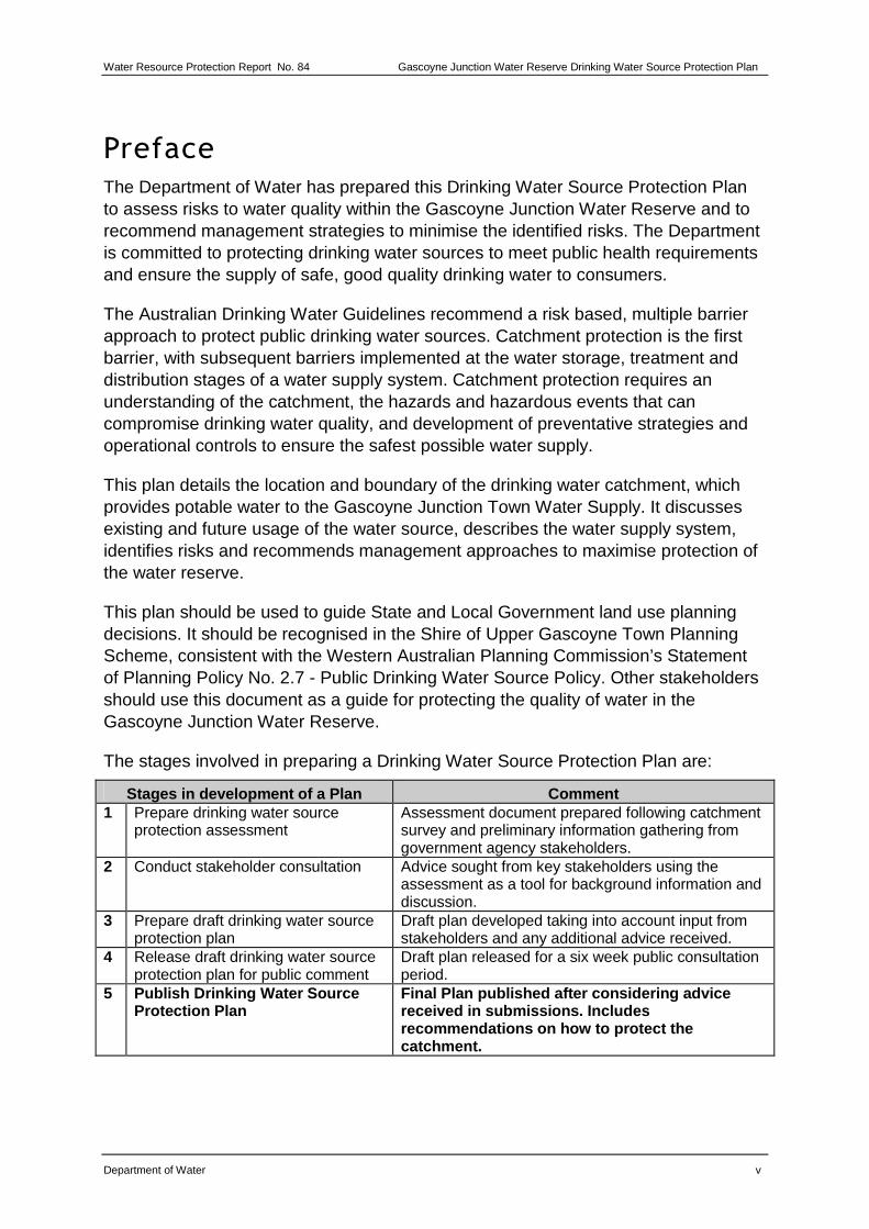
The stages involved in preparing a Drinking Water Source Protection Plan are:
Stages in development of a Plan Comment 1 Prepare drinking water source
protection assessment Assessment document prepared following catchment survey and preliminary information gathering from government agency stakeholders.
2 Conduct stakeholder consultation Advice sought from key stakeholders using the assessment as a tool for background information and discussion.
3 Prepare draft drinking water source protection plan
Draft plan developed taking into account input from stakeholders and any additional advice received.
4 Release draft drinking water source protection plan for public comment
Draft plan released for a six week public consultation period.
5 Publish Drinking Water Source Protection Plan
Final Plan published after considering advice received in submissions. Includes recommendations on how to protect the catchment.
Gascoyne Junction Water Reserve Drinking Water Source Protection Plan Water Resource Protection, Report No. 84
vi Department of Water
Summary
The town of Gascoyne Junction is located in the Gascoyne region of Western Australia. It is approximately 1070 kilometres north of Perth on the banks of the Gascoyne River, about 160 kilometres inland from Carnarvon. Just downstream of the town is the junction between the Gascoyne and Lyons Rivers, from which the town draws its name. Gascoyne Junction is the administrative centre for the Shire of Upper Gascoyne, servicing surrounding pastoral stations and regional tourism enterprises.
The public drinking water supply for Gascoyne Junction is obtained from groundwater within the alluvial sands of the Gascoyne River. The water is pumped from the alluvial sands by two bores. The Gascoyne region is semi-arid, with most rain coming from summer thunderstorms. The thunderstorms can cause flooding of the Gascoyne River and this is when most recharge of the aquifer occurs.
The salinity of the groundwater can increase significantly between recharge events. This has led to the commissioning of a reverse osmosis plant to treat the water. Microfiltration is also used to treat the water supply for high turbidity and bacteriological contamination following river flows, when salinity levels are not as high.
The quality of the groundwater is at risk of contamination from surrounding land uses. Cattle grazing within the Gascoyne Junction Water Reserve has been identified as a high contamination risk to the town water supply. Other risks include rubbish dumping, cross contamination of private and public bores, picnic sites and a river crossing for vehicles.
The following strategies are recommended to protect the water quality of the Gascoyne Junction Water Reserve:
• all Crown land in the water reserve should be managed for Priority 1 source protection;
• the water reserve should be expanded to ensure production bores are adequately protected;
• wellhead protection zones should be established for each production bore;
• a fencing project should be trialled to prevent stock from grazing in the water reserve; and
• use best practice management techniques to ensure that the town’s water resources are being used in the most efficient way to help manage water quality issues.
Water Resource Protection Report No. 84 Gascoyne Junction Water Reserve Drinking Water Source Protection Plan
Department of Water 1
1 Drinking water source overview
1.1 Existing water supply system
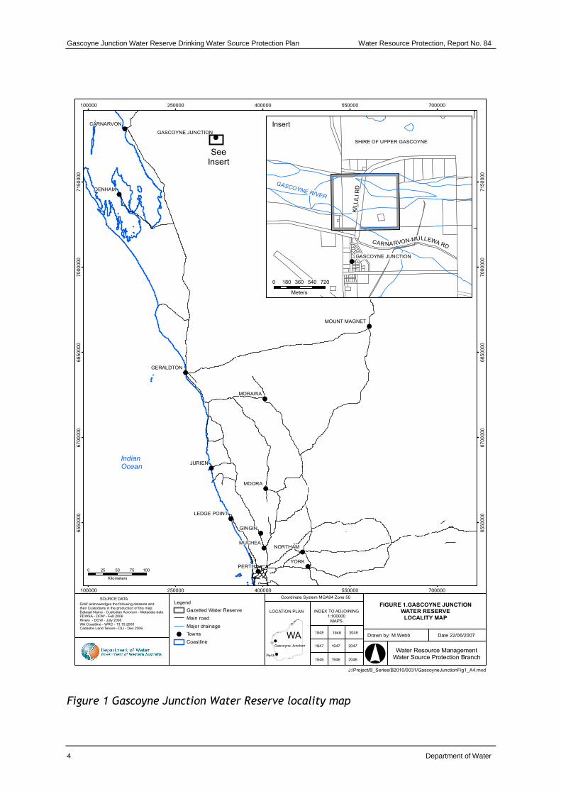
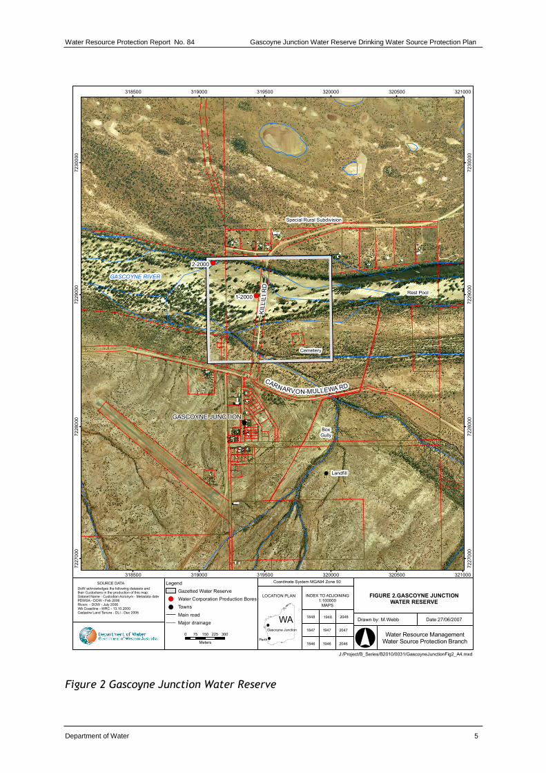
Groundwater is abstracted from the Water Corporation wellfield located within the Gascoyne River bed. The location of the water reserve is shown in Figures 1 and 2.
The wellfield currently consists of two production bores (1/2000 and 2/2000) that are located in the riverbed downstream from the Killili Road river crossing. Bore 2/2000 is operated as the preferred production bore during extended drought periods because the salinity of the groundwater abstracted by bore 1/2000 can increase significantly between aquifer recharge events.
Water is pumped from the two bores to a storage tank following treatment and subsequently gravity fed to the town water supply reticulation scheme. The current number of services is 29 with consumption in 2006/07 being 34 megalitres.
1.2 Water treatment
Raw water is chlorinated before being supplied to the town. A microfiltration plant was commissioned in February 2006 to treat turbidity during periods when the Gascoyne River is flowing. A temporary reverse osmosis plant was commissioned in August 2006 to reduce the salinity and hardness of the water during non-flow periods. Plans are in place to install a permanent plant.
It should be recognised that although treatment and disinfection are essential barriers used to ensure a safe, good quality drinking water supply, catchment management and water source protection are fundamental first barriers for the protection of water quality. This approach is endorsed by the Australian Drinking Water Guidelines (ADWG) (NHMRC & NRMMC, 2004) and reflects a risk based, catchment to consumer multiple barrier approach for the provision of safe drinking water to consumers.
1.3 Catchment details
1.3.1 Physiography
The physiography of the region is dominated by the Carnarvon Basin and is traversed by the Gascoyne River system which, with its main tributary the Lyons River, extends a further 400 kilometres east and 150 kilometres north from Gascoyne Junction. The closest significant elevated landform is the Kennedy Ranges about 40 kilometres north of the town site.
The catchment area of the Gascoyne River system above Fishy Pool (60 km west of Gascoyne Junction) is about 70 000 km2. Flood events generally result when
Gascoyne Junction Water Reserve Drinking Water Source Protection Plan Water Resource Protection, Report No. 84
2 Department of Water
significant runoff occurs from rain falling in the Kennedy Ranges and Yilgarn Province in the eastern part of the Carnarvon Basin.
1.3.2 Climate
The climate of Gascoyne Junction is semi-arid, with typically hot summers and warm to mild winters. The long-term average annual rainfall is about 210 millimetres, but occurrence is extremely variable. Most rain results from tropical thunderstorms during summer, with occasional falls during winter associated with cold fronts.
1.3.3 Hydrogeology
The Gascoyne Junction town water supply bores draw groundwater from the alluvial deposits of the Gascoyne River. The riverbed sands are up to 10 metres thick in this locality and form an unconfined aquifer with a maximum saturated thickness of about five metres. The sands are underlain by black Permian Shale and siltstone that contains brackish to saline groundwater.
Recharge occurs during river flood events when river water directly infiltrates the coarse sands in the riverbed. Frequency of flow significantly influences the reliability of supply, with storage declining and salinity increasing during non-flow periods. Flooding can be widespread in the area of the wellfield, inundating properties and buildings that flank the main river channel and extending to areas used for cattle grazing. This has the potential to mobilise contaminants associated with these activities and increases the vulnerability of the aquifer to pollution.
The current production bores are drilled less than 10 metres into the alluvial sediments and intersect an average of two metres of saturated sands.
1.4 Future water-supply requirements
The Water Corporation have undertaken a number of reviews of future water source development for Gascoyne Junction. The most recent in 2001 was prompted by an anticipated growth in town demand that could potentially double the supply required. Currently town expansion is restricted by the lack of water supplies. A new water source is required for Gascoyne Junction to improve the reliability of supply during drought periods. It appears that over-extraction of groundwater from the aquifer contributes to salinity problems within the water reserve. Consideration should be given to a fit-for-purpose review of groundwater allocation and use to ensure that best quality water is retained for drinking water until an alternative source is developed.
Of the several options considered, the preferred option is to drill additional bores in the river sands in areas where the sediments are deeper. The most promising site is about three kilometres upstream of the river crossing. Other sites likely to be investigated are downstream of the existing wellfield and the alluvial sediments of
Water Resource Protection Report No. 84 Gascoyne Junction Water Reserve Drinking Water Source Protection Plan
Department of Water 3
Lyons River, upstream of its junction with the Gascoyne River. However, bores drilled to date have not identified sufficient yields and further investigation is required.
1.5 Protection and allocation
1.5.1 Existing water source protection
The Gascoyne Junction water reserve was proclaimed in 1965 under the Country Areas Water Supply Act 1947 for the purpose of protecting the public drinking water source. It was extended in 1990 to include the western section of the wellfield (see Figure 2). Further changes to the boundary are recommended in section 4.2.
1.5.2 Current allocation licence
Water resource use and conservation in Western Australia is administered by the Department of Water in accordance with the Rights in Water and Irrigation Act 1914 (RIWI Act). Under the Act, the right to use and control surface and groundwater is vested with the Crown. This Act requires licensing of groundwater abstraction within proclaimed groundwater areas. Gascoyne Junction is located within the Gascoyne Groundwater Area, which was proclaimed in 1981 under the RIWI Act to allocate groundwater resources within its boundaries and to manage its sustainable use.
The Water Corporation is licensed by the Department of Water to draw 40 megalitres/year from the Gascoyne Junction wellfield for public water supply purposes. In 2006/07 the Water Corporation were temporarily approved to abstract more than their licensed limit and abstracted 56 megalitres. This extra amount was necessary due to the loss of consumable water from the reverse osmosis treatment process. The Water Corporation has applied for a permanent increase in its allocation limit to 70 megalitres/year to allow for the losses due to treatment.
Gascoyne Junction Water Reserve Drinking Water Source Protection Plan Water Resource Protection, Report No. 84
Water Resource ManagementWater Source Protection Branch
INDEX TO ADJOINING1:100000
MAPS
LOCATION PLAN
WA
SOURCE DATA
DoW acknowledges the following datasets and their Custodians in the production of this map:Dataset Name - Custodian Acronym - Metadata datePDWSA - DOW - Feb 2006Rivers - DOW - July 2006WA Coastline - WRC - 13.10.2000Cadastre Land Tenure - DLI - Dec 2006
20481848
20471847
20461846
Gascoyne Junction
Perth
Coordinate System MGA94 Zone 50
1948
1947
1946
0 25 50 75 100
Kilometers
SHIRE OF UPPER GASCOYNE
GASCOYNE JUNCTION
SeeInsert
Insert
Legend
Gazetted Water Reserve
Main road
Major drainage
Towns
Coastline
GASCOYNE RIVER
KIL
LIL
I R
D
CAR NARVON-MULLEWA RD
Indian
Ocean
0 180 360 540 720
Meters
Figure 1 Gascoyne Junction Water Reserve locality map
Water Resource Protection Report No. 84 Gascoyne Junction Water Reserve Drinking Water Source Protection Plan
Water Resource ManagementWater Source Protection Branch
INDEX TO ADJOINING1:100000
MAPS
LOCATION PLAN
WA
SOURCE DATA
DoW acknowledges the following datasets and their Custodians in the production of this map:Dataset Name - Custodian Acronym - Metadata datePDWSA - DOW - Feb 2006Rivers - DOW - July 2006WA Coastline - WRC - 13.10.2000Cadastre Land Tenure - DLI - Dec 2006
20481848
20471847
20461846
Gascoyne Junction
Perth
Coordinate System MGA94 Zone 50
1948
1947
1946
0 75 150 225 300
Meters
Legend
Gazetted Water Reserve
Water Corporation Production Bores
Towns
Main road
Major drainage
KIL
LIL
I R
D
CARNARVON-MULLEWA RD
GASCOYNE RIVER
Special Rural Subdivision
Rest Pool
BoxGully
Landfill
Cemetery
Figure 2 Gascoyne Junction Water Reserve
Gascoyne Junction Water Reserve Drinking Water Source Protection Plan Water Resource Protection, Report No. 84
6 Department of Water
2 Water quality
The Water Corporation has monitored the raw (source) water quality from the Gascoyne Junction wellfield in accordance with the ADWG and interpretations agreed to with the Department of Health. The raw water is regularly monitored for health-related and aesthetic characteristics.
The results of water quality monitoring are shown in Appendix A. It is important to appreciate that the raw water data presented does not represent the quality of drinking water distributed to the consumers. Following treatment, the drinking water supplied to the town of Gascoyne Junction complies with ADWG for microbiological, health and aesthetic parameters. For more information on the quality of drinking water supplied, refer to the most recent Water Corporation Drinking Water Quality Annual Report at www.watercorporation.com.au > Publications > Annual Reports > Drinking Water Quality Annual Report.
2.1 Microbiological contaminants
Pathogens are types of micro-organisms that are capable of causing diseases. These include bacteria (such as Escherichia coli), protozoa (such as Cryptosporidium and Giardia) and viruses. In water supplies the pathogens of concern that can cause illness are mostly found in the faeces of humans and domestic animals. Escherichia coli counts are a way of measuring these pathogens and are an indicator of faecal contamination.
Pathogen contamination of a drinking water source is influenced by the existence of pathogen carriers (i.e. humans and domestic animals, such as dogs or cattle); their subsequent transfer to and movement in the water source; and the ability of the pathogen to survive in the water source.
Pathogens may enter a water source through activities involving direct contact of people and domestic animals with the main water body or its tributaries (such as fishing, marroning and swimming), primarily through the direct transfer of faecal material (even a very small amount can cause contamination), or indirectly through runoff moving faecal material into the water.
There are a number of pathogens that are commonly known to contaminate water supplies worldwide. These include bacteria (eg Salmonella, Escherichia coli and Cholera), protozoa (eg Cryptosporidium, Giardia) and viruses. The percentage of humans in the world that carry various pathogens varies. For example, it is estimated that between 0.6 to 4.3 per cent of people are infected with Cryptosporidium worldwide, and 7.4 per cent with Giardia (Geldreich, 1996).
The ability of pathogens to survive in surface water differs between species. For example, Salmonella may be viable for two to three months, Giardia may still infect after one month in the natural environment (Geldreich, 1996) and Cryptosporidium
Water Resource Protection Report No. 84 Gascoyne Junction Water Reserve Drinking Water Source Protection Plan
Department of Water 7
oocysts (cells containing reproductive spores) may survive weeks to months in freshwater (NHMRC & NRMMC, 2004).
The effect on people consuming drinking water that is contaminated with pathogens is considerably varied, ranging from mild illness (such as stomach upset or diarrhoea) to death. This was the case in Walkerton, Canada in 2000, where seven people died due to the contamination of a pathogenic strain of Escherichia coli and Campylobacter in the town water source and supply (NHMRC & NRMMC, 2004). Preventing the introduction of pathogens into the water source is the most effective barrier in avoiding this public health risk.
Microbiological testing of the raw water from Gascoyne Junction wellfield has been conducted on a monthly basis since January 2002. Since October 2004, E. Coli counts have replaced thermotolerant coliform counts as the indicator of faecal contaminants for Gascoyne Junction. A count less than 20 most probable number (mpn) per 100 mL is typically associated with low levels of faecal contamination and is used as a microbiological contamination benchmark (WHO, 1996). Testing at Gascoyne Junction has shown increases in microbiological contamination after rainfall and during and just after river flows. Given the proximity of cattle to the bores combined with historical evidence that microbes from cattle faeces have human health impacts, this increase in microbiological contamination is of significant concern. The results of microbiological contaminant testing are discussed in Appendix A.
2.2 Health-related chemicals
A number of chemicals (organic and inorganic) are of concern in drinking water from a health perspective because they are potentially toxic to humans. Chemicals usually occur in drinking water sources attached to suspended material such as soil particles and may result from natural leaching from mineral deposits or from different land use (NHMRC & NRMMC, 2004).
Pesticides include agricultural chemicals such as insecticides, herbicides, nematicides (used to control nematodes (or worms)), rodenticides and miticides (used to control mites). Contamination of a drinking water source by pesticides may occur as a result of accidental spills, incorrect or over use and leakage from storage areas. In such cases, prompt action is required to notify relevant authorities and clean up the spill.
Nutrients (such as nitrogen) can enter drinking water supplies from leaching of fertiliser, septic tanks, and from faeces of domestic animals (such as cattle grazing on the land). Nitrate and nitrite (ions of nitrogen) can be toxic to humans at high levels, with infants less than three-months old being most susceptible (NHMRC & NRMMC, 2004).
Gascoyne Junction Water Reserve Drinking Water Source Protection Plan Water Resource Protection, Report No. 84
8 Department of Water
Hydrocarbons (fuels, oils, solvents) are potentially toxic to humans, and harmful by-products may be formed when they are combined with chlorine in water treatment processes. Hydrocarbons can occur in water supplies from pollution events from vehicle accidents, refuelling and leakage from storage areas.
Raw water from Gascoyne Junction wellfield is analysed for health related chemicals, such as inorganics, heavy metals, industrial hydrocarbons and pesticides. Health related water quality parameters that have been measured at detectable levels in the sources since January 2002 are summarised in Appendix A. During this period there were no exceedance of health related guideline values. Health related parameters will continue to be monitored.
2.3 Aesthetic characteristics
Impurities in drinking water can affect the aesthetic qualities of water such as appearance, taste, smell and ‘feel’. Such impurities are not necessarily hazardous to human health, for example water that is cloudy and has a distinctive colour may not be harmful (NHMRC & NRMMC, 2004).
Iron and dissolved organic matter can affect the colour and appearance of water and salinity can affect the taste. The ADWG have set limits on water quality characteristics to meet aesthetic requirements of consumers.
Some properties such as pH can contribute to the corrosion and encrustation of pipes. The ADWG also sets out aesthetic guidelines for these types of water quality characteristics.
Aesthetic water quality analyses for raw water from the Gascoyne Junction wellfield are summarised in Appendix A. The values are taken from ongoing raw water monitoring since January 2002. Hardness, sodium and chloride exceed the aesthetic guidelines at Gascoyne Junction. Aesthetic parameters will continue to be monitored.
2.4 Groundwater bores
Under the provisions of sections 26D and 5C of the RIWI Act, a licence is required to construct a bore or extract water (unless exempt under the RIWI Exemption and Repeal (Section 26C) Order 2001) within a proclaimed groundwater area. The Gascoyne Junction Water Reserve is located within the Gascoyne Groundwater Area.
Any bores drilled near to a public drinking water supply bore have the potential to contaminate the drinking water source. For example, a poorly constructed bore may introduce contaminants through surface leakage down the outside of the bore casing into an otherwise uncontaminated aquifer. If a public drinking water source bore is nearby, it may abstract the contaminated water.
Water Resource Protection Report No. 84 Gascoyne Junction Water Reserve Drinking Water Source Protection Plan
Department of Water 9
A number of private bores are within the water reserve, most of which are currently licensed. The drawdown of water by these bores is thought to exacerbate salinity problems in the aquifer. Allocation limits may help protect the aquifer against salinity problems. A number of the bores in the water reserve are licensed to landowners on the north side of the Gascoyne River. These properties are not currently connected to scheme water. Consideration should be given to connection of these properties to the town’s water supply system to reduce the number of active bores in the water reserve.
It is important to ensure that bores are appropriately located and constructed in order to prevent contamination and other impacts on the public drinking water source. This will be assessed through the Department of Water’s water licensing process where applicable under the RIWI Act.
All bores should be constructed in accordance with Minimum Construction Requirements for Water Bores in Australia (National Minimum Bore Specifications Committee, 2003).
Gascoyne Junction Water Reserve Drinking Water Source Protection Plan Water Resource Protection, Report No. 84
10 Department of Water
3 Land use and contamination risk
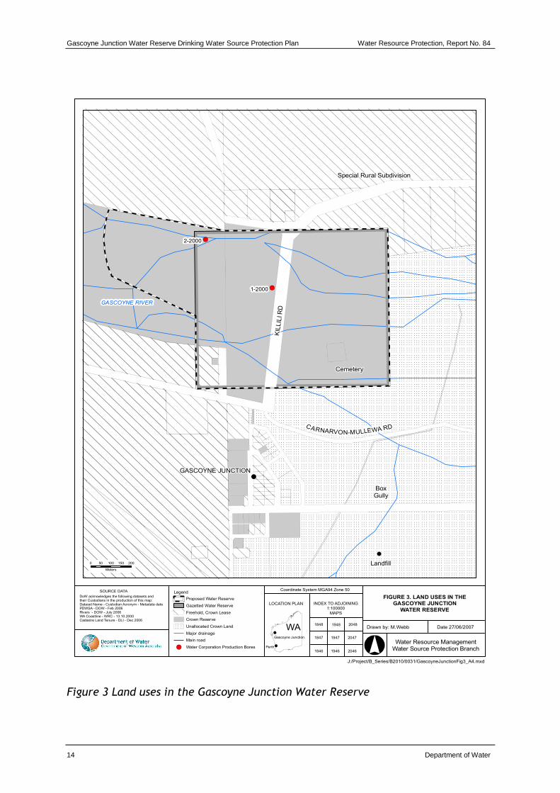
3.1 Existing land uses
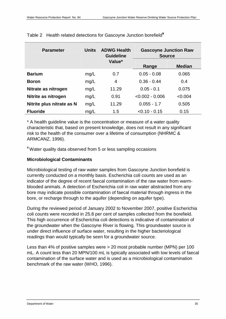
The majority of the Gascoyne Junction Water Reserve is located on Crown Land. Stock from a nearby pastoral property grazes in the riverbed adjacent to the town’s production bores. The low-level Killili Road concrete river crossing traverses the centre of the reserve (see photo 1 Appendix B). The old town cemetery is located within the reserve about 300 metres upstream of the crossing.
The majority of the town is outside the recharge area for the water reserve. However, following intensive rainfall or flooding the drainage from areas adjacent to the water reserve could potentially contribute recharge to the aquifer. The possibility of this is increased if the water reserve is expanded downstream as a result of finding new sources of water for Gascoyne Junction. Best management practices should therefore be implemented for town site land uses.
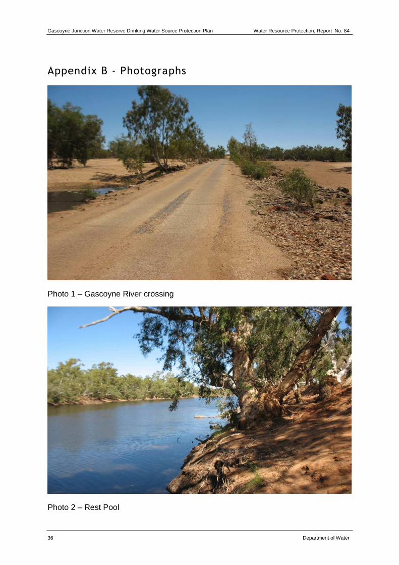
Some small-scale horticulture occurs on special rural lots on the northern bank of the river adjacent to the water reserve. The town’s main residential area is located south of the reserve. Camping occasionally occurs at Rest Pool (see photo 2 Appendix B) located about 500 metres upstream of the reserve. The southern part of the town site includes a date farm and the Koorda Aboriginal Community housing project.
3.1.1 Crown land
Most of the water reserve is Crown land and includes the Gascoyne River, the town cemetery, which was last used in 1984, and the Gascoyne River vehicle crossing on Killili Road. Development of this land is unlikely as it lies within the river’s 100-year average recurrence interval flood level. The CSIRO’s Floodplain Management in Australia: Best practice principles and guidelines (2000) recommends against the development of flood prone areas.
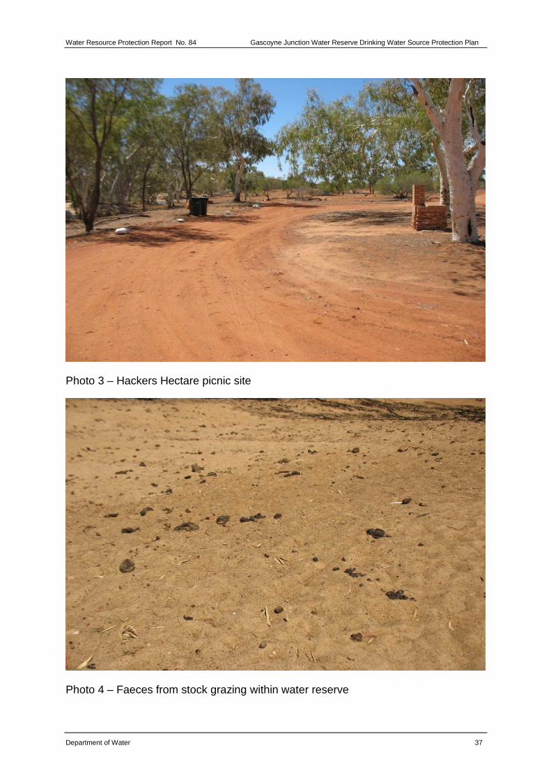
There is some recreation in the water reserve such as picnicking at the Hackers Hectare picnic site, which is managed by the Shire of Upper Gascoyne. This site is established as part of the Gascoyne Murchison Outback Pathways tourist route which includes the Kingsford Smith Mail Run and the Wool Wagon Pathway (see photo 3 Appendix B).
3.1.2 Private land
The majority of the town’s private land is outside of the Gascoyne Junction Water Reserve. The hydrology and hydrogeology of the area means that any contaminants (e.g. pesticides or hydrocarbons) from land uses are unlikely to contaminate the Gascoyne Junction drinking water supply. However, the need to find alternative water sources for Gascoyne Junction could result in new bores being established downstream of the existing water reserve. If this occurs, changes to the boundary of
Water Resource Protection Report No. 84 Gascoyne Junction Water Reserve Drinking Water Source Protection Plan
Department of Water 11
the water reserve will be required and these private land uses may become a contamination risk for an enlarged town water source area. Therefore best management practices are encouraged for these land uses to ensure that they don’t contaminate the water resources of Gascoyne Junction.
Pastoral activities
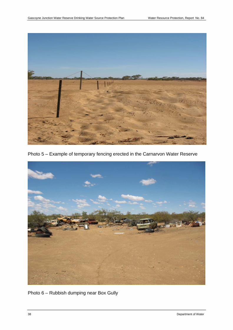
Stock grazing within the water reserve is common and poses a risk of microbial contamination of the aquifer. Accumulated deposits of animal faeces close to the production bores occur because of unrestricted stock access (see photo 4 Appendix B). It is advisable that stock be excluded from the reserve as they provide the greatest long-term risk to the source, compared with other activities in the area.
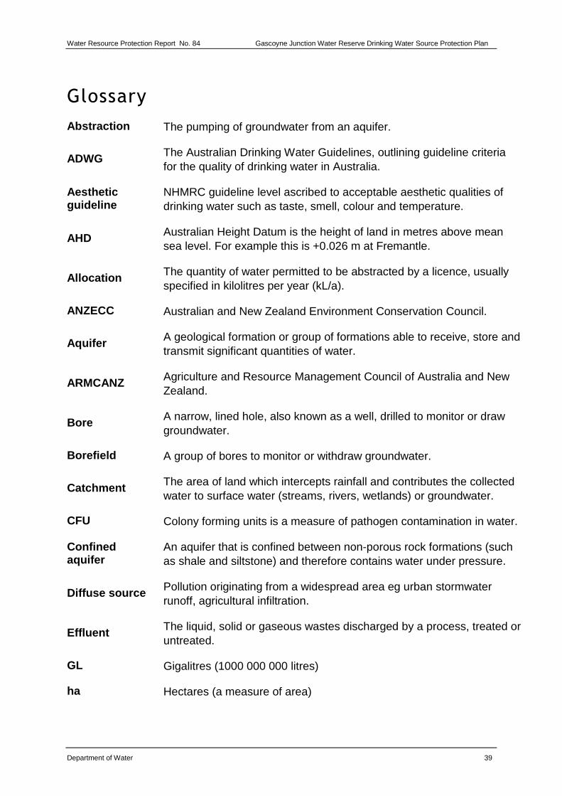
As the water reserve is subject to periods of significant flooding, erecting fencing that is flood proof may be necessary to exclude livestock from the water reserve. Options include a simple star picket and wire fence similar to that used at Carnarvon (see photo 5 Appendix B). This fencing is able to be removed during periods of flooding and then put back up once flood waters have subsided. Grazing and stock access is most evident when the flood waters begin to subside and pools of water begin to form around the water reserve, attracting stock that seek water and shade.
Special rural lots
A small number of special rural lots have been developed on the north bank of the river, adjacent to and outside of the water reserve. These properties source their water supplies from bores drilled into the river sands within the water reserve close to the Water Corporation’s production bores.
The properties are within the river floodplain and nutrients, hydrocarbons and chemicals could potentially be mobilised during large river flows. When the river is flowing there is connectivity between the surface water system and the aquifer. The likelihood of effects on bore water quality are low because flooding will significantly dilute concentrations and carry any contaminants downstream away from the wellfield. The current low density of septic tanks and relative inactivity in horticultural production indicate these developments pose little risk during non-flow periods and as such they have been excluded from the water reserve.
Further intensification is limited by a lack of groundwater resources and by current land planning conditions. It is recommended that these planning controls remain to protect the integrity of the town’s drinking water supply.
Commerce
Commerce in Gascoyne Junction is focused around the town’s hotel, located adjacent to the water reserve on the south bank of the Gascoyne River. The hotel has motel style accommodation units at the rear of the property and the main building incorporates the local shop, with a service station and mechanical workshop
Gascoyne Junction Water Reserve Drinking Water Source Protection Plan Water Resource Protection, Report No. 84
12 Department of Water
attached. It is unlikely the hotel site would impact on town water supply quality because it is outside the capture zone of the existing production bores. The main building and fuel storage area are within the floodplain, providing potential for contaminants to be mobilised during large river flows. However given the significant dilution and flow direction away from the water reserve, little threat is expected.
Industry
The industrial zone, in the southern part of the town, is outside the water reserve and does not pose a risk to groundwater quality. Nonetheless, general environmental issues should be attended to in terms of storing fuels and chemicals in the shire’s work depot and the Western Power station site. For further guidance on best practice management see the Department of Water’s Internet site www.water.wa.gov.au and select Drinking Water >Water Quality > Publications > Water Quality Protection Notes.
Other town site land uses
Although Gascoyne Junction is unsewered, it presents little risk to the town water supply because the developed area of town is outside the recharge area of the water reserve. This includes the caravan park and the town’s public buildings and community areas.
The Koorda Aboriginal community on the southern edge of the town appears to be in an area where recharge to the water reserve is also unlikely. There are plans to build up to 40 houses, with five houses so far completed. Further development in accordance with state and local planning policies is considered acceptable.
The date farm located south of the industrial area also appears to be in an area unlikely to provide recharge to the water reserve. It has been inactive for two years and is constrained by the high salinity of irrigation water.
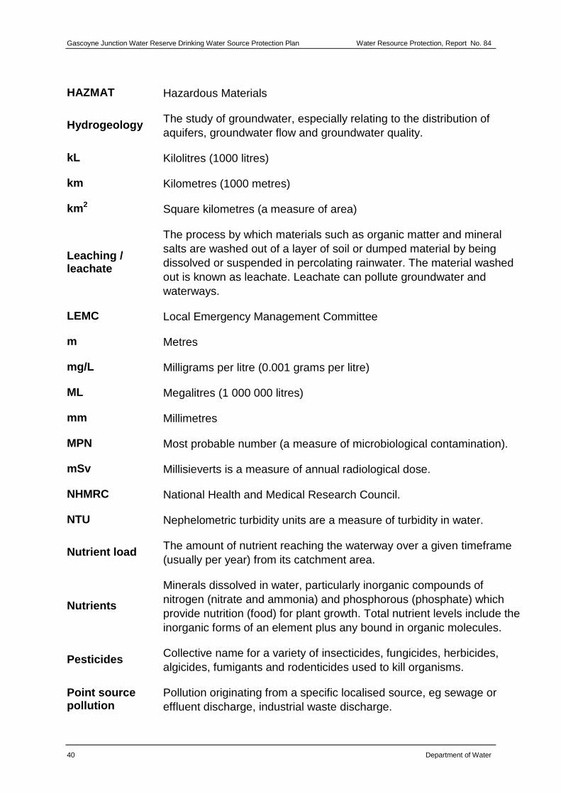
Dumping of car bodies, tyres and fuel drums has occurred east of the town very close to Box Gully, a minor tributary of the Gascoyne River (see photo 6 Appendix B). The Gascoyne Junction putrescible landfill is also located about 100 metres from Box Gully. It is a Class III landfill (license number L385/97) under the Environmental Protection Act 1986.
There is potential for contaminants from the illegally dumped rubbish and the licensed landfill entering Box Gully and be carried into the Gascoyne River. Although discharge from the gully is unlikely to be captured by the production bores, it is desirable that the car bodies and other refuse are removed. Management of the landfill and the types of waste accepted should be regularly reviewed by the Department of Environment and Conservation and the facility upgraded for environmental reasons.
Water Resource Protection Report No. 84 Gascoyne Junction Water Reserve Drinking Water Source Protection Plan
Department of Water 13
A separate septage disposal pit is licensed by the Department of Environment and Conservation. Due to the possibility of run-off carrying pathogens down Box Gully and into the water reserve, this pit needs to be properly managed. The septage pit should be constructed with sufficient capacity to contain water and not overflow during a 100-year ARI rainfall event. Disposal should not exceed the licensed amount (up to 100 tonnes per year) and only septage from the Gascoyne Junction township should be disposed of at the site i.e. waste from other areas should not be imported into the area. Consideration should be given to developing an alternative septage disposal site that poses less risk to the Gascoyne Junction water reserve.
3.2 Proposed land uses
A new caravan park has been built in the northern part of town and the shire proposes to release six lots in the light industrial area south of the main residential area. Neither of these uses are expected to pose a risk to the water reserve.
The proposed Dampier to Bunbury Natural Gas Pipeline expansion crosses the Gascoyne River around seven kilometres upstream of the water reserve. The expansion work has the potential to increase the contamination risks as it is expected that more people will use the facilities and infrastructure of Gascoyne Junction.
Gascoyne Junction Water Reserve Drinking Water Source Protection Plan Water Resource Protection, Report No. 84
Water Resource ManagementWater Source Protection Branch
INDEX TO ADJOINING1:100000
MAPS
LOCATION PLAN
WA
SOURCE DATA
DoW acknowledges the following datasets and their Custodians in the production of this map:Dataset Name - Custodian Acronym - Metadata datePDWSA - DOW - Feb 2006Rivers - DOW - July 2006WA Coastline - WRC - 13.10.2000Cadastre Land Tenure - DLI - Dec 2006
20481848
20471847
20461846
Gascoyne Junction
Perth
Coordinate System MGA94 Zone 50
1948
1947
1946
0 50 100 150 200
Meters
Legend
Proposed Water Reserve
Gazetted Water Reserve
Freehold, Crown Lease
Crown Reserve
Unallocated Crown Land
Major drainage
Main road
Water Corporation Production Bores
KIL
LIL
I R
D
CARNARVON-MULLEWA RD
GASCOYNE RIVER
Special Rural Subdivision
Landfill
BoxGully
Cemetery
Figure 3 Land uses in the Gascoyne Junction Water Reserve
Water Resource Protection Report No. 84 Gascoyne Junction Water Reserve Drinking Water Source Protection Plan
Department of Water 15
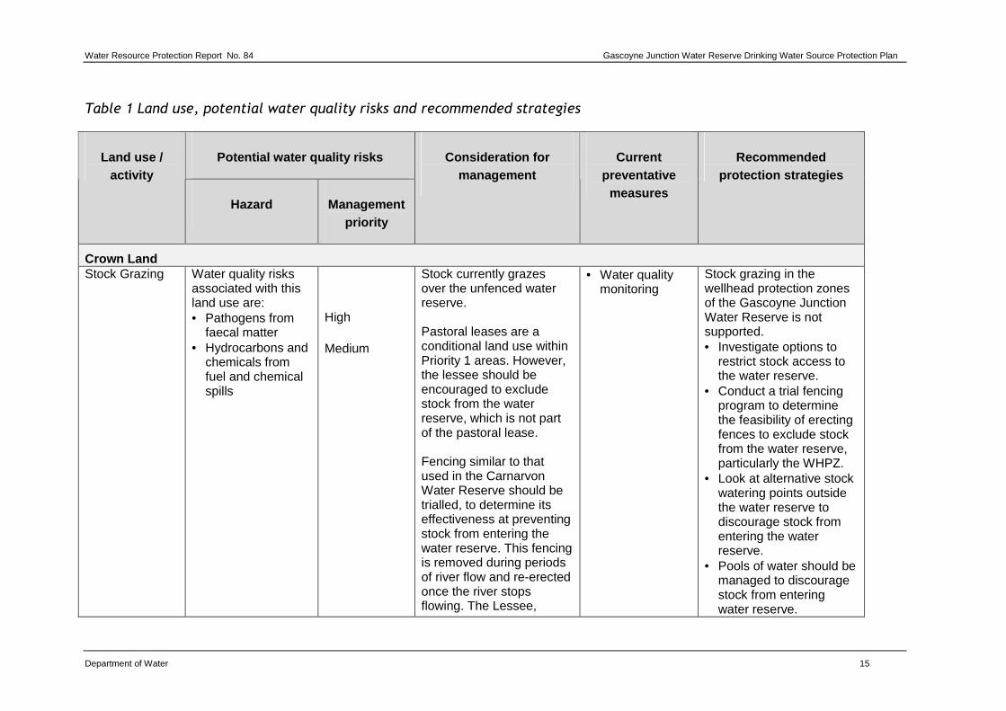
Table 1 Land use, potential water quality risks and recommended strategies
Potential water quality risks Land use / activity
Hazard Management priority
Consideration for management
Current preventative
measures
Recommended protection strategies
Crown Land Stock Grazing Water quality risks
associated with this land use are: • Pathogens from
faecal matter • Hydrocarbons and
chemicals from fuel and chemical spills
High Medium
Stock currently grazes over the unfenced water reserve. Pastoral leases are a conditional land use within Priority 1 areas. However, the lessee should be encouraged to exclude stock from the water reserve, which is not part of the pastoral lease. Fencing similar to that used in the Carnarvon Water Reserve should be trialled, to determine its effectiveness at preventing stock from entering the water reserve. This fencing is removed during periods of river flow and re-erected once the river stops flowing. The Lessee,
• Water quality monitoring
Stock grazing in the wellhead protection zones of the Gascoyne Junction Water Reserve is not supported. • Investigate options to
restrict stock access to the water reserve.
• Conduct a trial fencing program to determine the feasibility of erecting fences to exclude stock from the water reserve, particularly the WHPZ.
• Look at alternative stock watering points outside the water reserve to discourage stock from entering the water reserve.
• Pools of water should be managed to discourage stock from entering water reserve.
Gascoyne Junction Water Reserve Drinking Water Source Protection Plan Water Resource Protection, Report No. 84
16 Department of Water
Potential water quality risks Land use / activity
Hazard Management priority
Consideration for management
Current preventative
measures
Recommended protection strategies
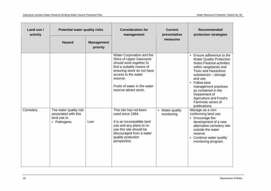
Water Corporation and the Shire of Upper Gascoyne should work together to find a suitable means of ensuring stock do not have access to the water reserve. Pools of water in the water reserve attract stock.
• Ensure adherence to the Water Quality Protection Notes Pastoral activities within rangelands and Toxic and Hazardous substances – storage and use.
• Follow best management practices as contained in the Department of Agriculture and Food’s Farmnote series of publications.
Cemetery The water quality risk associated with this land use is: • Pathogens
Low
This site has not been used since 1984. It is an incompatible land use and any plans to re-use this site should be discouraged from a water quality protection perspective.
• Water quality monitoring
Manage as a non-conforming land use. • Encourage the
development of a new alternative cemetery site outside the water reserve.
• Continue water quality monitoring program.
Water Resource Protection Report No. 84 Gascoyne Junction Water Reserve Drinking Water Source Protection Plan
Department of Water 17
Potential water quality risks Land use / activity
Hazard Management priority
Consideration for management
Current preventative
measures
Recommended protection strategies
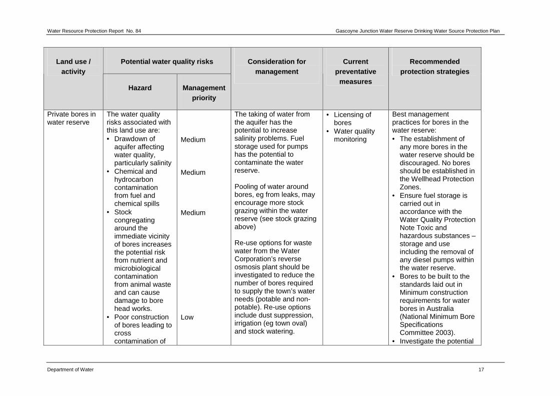
Private bores in water reserve
The water quality risks associated with this land use are: • Drawdown of
aquifer affecting water quality, particularly salinity
• Chemical and hydrocarbon contamination from fuel and chemical spills
• Stock congregating around the immediate vicinity of bores increases the potential risk from nutrient and microbiological contamination from animal waste and can cause damage to bore head works.
• Poor construction of bores leading to cross contamination of
Medium Medium Medium Low
The taking of water from the aquifer has the potential to increase salinity problems. Fuel storage used for pumps has the potential to contaminate the water reserve. Pooling of water around bores, eg from leaks, may encourage more stock grazing within the water reserve (see stock grazing above) Re-use options for waste water from the Water Corporation’s reverse osmosis plant should be investigated to reduce the number of bores required to supply the town’s water needs (potable and non-potable). Re-use options include dust suppression, irrigation (eg town oval) and stock watering.
• Licensing of bores
• Water quality monitoring
Best management practices for bores in the water reserve: • The establishment of
any more bores in the water reserve should be discouraged. No bores should be established in the Wellhead Protection Zones.
• Ensure fuel storage is carried out in accordance with the Water Quality Protection Note Toxic and hazardous substances – storage and use including the removal of any diesel pumps within the water reserve.
• Bores to be built to the standards laid out in Minimum construction requirements for water bores in Australia (National Minimum Bore Specifications Committee 2003).
• Investigate the potential
Gascoyne Junction Water Reserve Drinking Water Source Protection Plan Water Resource Protection, Report No. 84
18 Department of Water
Potential water quality risks Land use / activity
Hazard Management priority
Consideration for management
Current preventative
measures
Recommended protection strategies
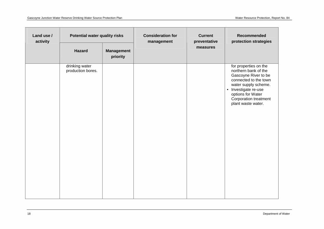
drinking water production bores.
for properties on the northern bank of the Gascoyne River to be connected to the town water supply scheme.
• Investigate re-use options for Water Corporation treatment plant waste water.
Water Resource Protection Report No. 84 Gascoyne Junction Water Reserve Drinking Water Source Protection Plan
Department of Water 19
Potential water quality risks Land use / activity
Hazard Management priority
Consideration for management
Current preventative
measures
Recommended protection strategies
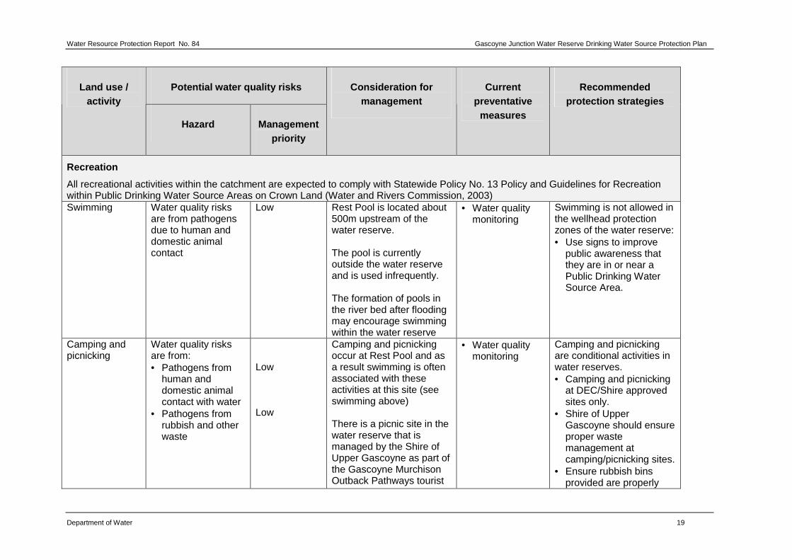
Recreation
All recreational activities within the catchment are expected to comply with Statewide Policy No. 13 Policy and Guidelines for Recreation within Public Drinking Water Source Areas on Crown Land (Water and Rivers Commission, 2003) Swimming Water quality risks
are from pathogens due to human and domestic animal contact
Low Rest Pool is located about 500m upstream of the water reserve. The pool is currently outside the water reserve and is used infrequently. The formation of pools in the river bed after flooding may encourage swimming within the water reserve
• Water quality monitoring
Swimming is not allowed in the wellhead protection zones of the water reserve: • Use signs to improve
public awareness that they are in or near a Public Drinking Water Source Area.
Camping and picnicking
Water quality risks are from: • Pathogens from
human and domestic animal contact with water
• Pathogens from rubbish and other waste
Low Low
Camping and picnicking occur at Rest Pool and as a result swimming is often associated with these activities at this site (see swimming above) There is a picnic site in the water reserve that is managed by the Shire of Upper Gascoyne as part of the Gascoyne Murchison Outback Pathways tourist
• Water quality monitoring
Camping and picnicking are conditional activities in water reserves. • Camping and picnicking
at DEC/Shire approved sites only.
• Shire of Upper Gascoyne should ensure proper waste management at camping/picnicking sites.
• Ensure rubbish bins provided are properly
Gascoyne Junction Water Reserve Drinking Water Source Protection Plan Water Resource Protection, Report No. 84
20 Department of Water
Potential water quality risks Land use / activity
Hazard Management priority
Consideration for management
Current preventative
measures
Recommended protection strategies
routes. Rubbish bins are provided at this picnic site.
maintained and not used for dumping domestic waste.
• Signage around the water reserve to advise people that they are within a Public Drinking Water Source Area.
Motor Rally Events (Gascoyne Dash)
The risks associated with motor rally events include: • Fuel and oil spills
from vehicles; • Pathogen and litter
contamination from spectators entering the catchment;
Low Low
The Gascoyne Dash is an annual event that is run around Gascoyne Junction and in the Gascoyne River bed. This event receives annual approval from the Department of Water. This approval includes specifying water quality protection objectives. This event currently occurs outside the water reserve.
• Water quality monitoring
• Conditions on annual approval
Rally events are prohibited in the water reserve: • Conditions on annual
approval to ensure water quality protection objectives are met, including keeping the event outside of the water reserve.
• Ensure adherence to the Water Quality Protection Note Motor sport facilities near sensitive waters. This note applies to temporary as well as permanent facilities used for motor sport.
Water Resource Protection Report No. 84 Gascoyne Junction Water Reserve Drinking Water Source Protection Plan
Department of Water 21
Potential water quality risks Land use / activity
Hazard Management priority
Consideration for management
Current preventative
measures
Recommended protection strategies
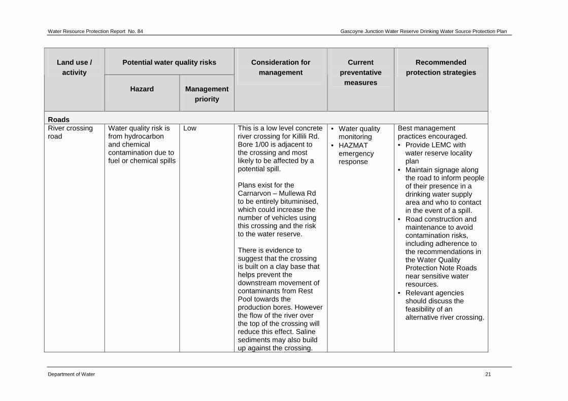
Roads River crossing road
Water quality risk is from hydrocarbon and chemical contamination due to fuel or chemical spills
Low This is a low level concrete river crossing for Killili Rd. Bore 1/00 is adjacent to the crossing and most likely to be affected by a potential spill. Plans exist for the Carnarvon – Mullewa Rd to be entirely bituminised, which could increase the number of vehicles using this crossing and the risk to the water reserve. There is evidence to suggest that the crossing is built on a clay base that helps prevent the downstream movement of contaminants from Rest Pool towards the production bores. However the flow of the river over the top of the crossing will reduce this effect. Saline sediments may also build up against the crossing.
• Water quality monitoring
• HAZMAT emergency response
Best management practices encouraged. • Provide LEMC with
water reserve locality plan
• Maintain signage along the road to inform people of their presence in a drinking water supply area and who to contact in the event of a spill.
• Road construction and maintenance to avoid contamination risks, including adherence to the recommendations in the Water Quality Protection Note Roads near sensitive water resources.
• Relevant agencies should discuss the feasibility of an alternative river crossing.
Gascoyne Junction Water Reserve Drinking Water Source Protection Plan Water Resource Protection, Report No. 84
22 Department of Water
Potential water quality risks Land use / activity
Hazard Management priority
Consideration for management
Current preventative
measures
Recommended protection strategies
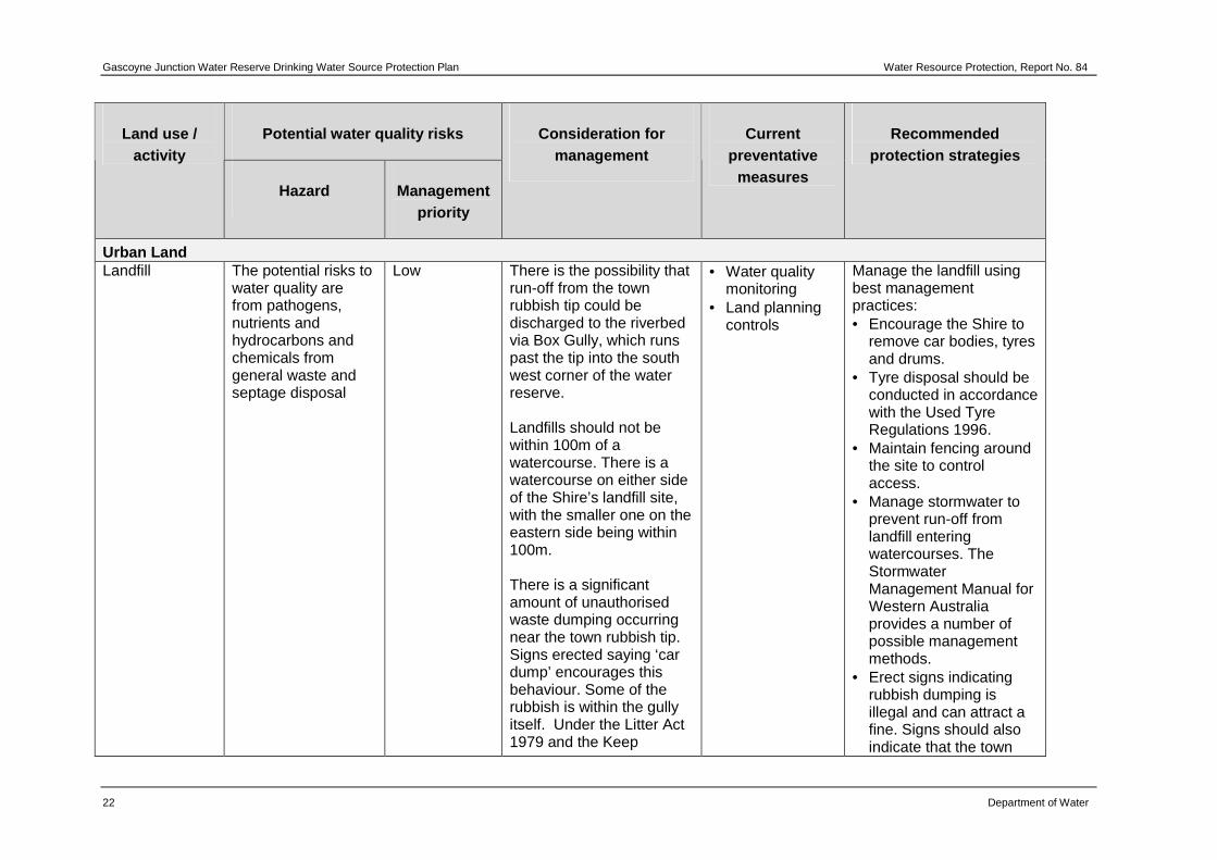
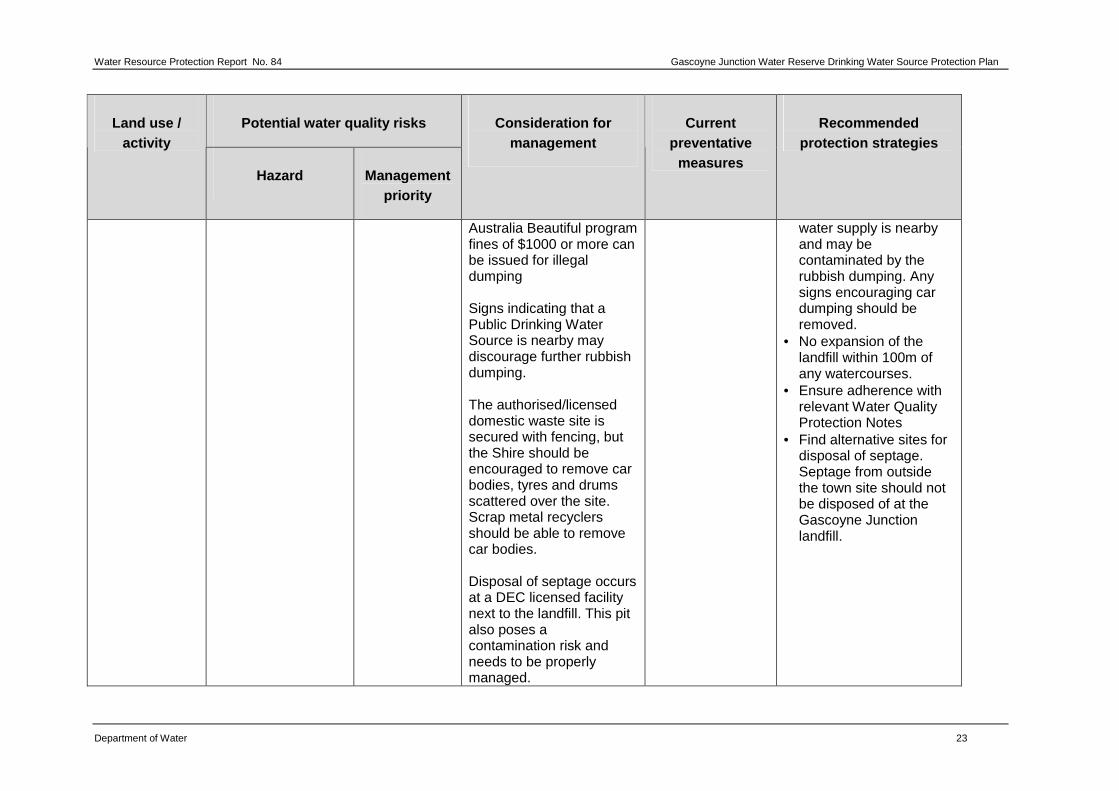
Urban Land Landfill The potential risks to
water quality are from pathogens, nutrients and hydrocarbons and chemicals from general waste and septage disposal
Low There is the possibility that run-off from the town rubbish tip could be discharged to the riverbed via Box Gully, which runs past the tip into the south west corner of the water reserve. Landfills should not be within 100m of a watercourse. There is a watercourse on either side of the Shire’s landfill site, with the smaller one on the eastern side being within 100m. There is a significant amount of unauthorised waste dumping occurring near the town rubbish tip. Signs erected saying ‘car dump’ encourages this behaviour. Some of the rubbish is within the gully itself. Under the Litter Act 1979 and the Keep
• Water quality monitoring
• Land planning controls
Manage the landfill using best management practices: • Encourage the Shire to
remove car bodies, tyres and drums.
• Tyre disposal should be conducted in accordance with the Used Tyre Regulations 1996.
• Maintain fencing around the site to control access.
• Manage stormwater to prevent run-off from landfill entering watercourses. The Stormwater Management Manual for Western Australia provides a number of possible management methods.
• Erect signs indicating rubbish dumping is illegal and can attract a fine. Signs should also indicate that the town
Water Resource Protection Report No. 84 Gascoyne Junction Water Reserve Drinking Water Source Protection Plan
Department of Water 23
Potential water quality risks Land use / activity
Hazard Management priority
Consideration for management
Current preventative
measures
Recommended protection strategies
Australia Beautiful program fines of $1000 or more can be issued for illegal dumping Signs indicating that a Public Drinking Water Source is nearby may discourage further rubbish dumping. The authorised/licensed domestic waste site is secured with fencing, but the Shire should be encouraged to remove car bodies, tyres and drums scattered over the site. Scrap metal recyclers should be able to remove car bodies. Disposal of septage occurs at a DEC licensed facility next to the landfill. This pit also poses a contamination risk and needs to be properly managed.
water supply is nearby and may be contaminated by the rubbish dumping. Any signs encouraging car dumping should be removed.
• No expansion of the landfill within 100m of any watercourses.
• Ensure adherence with relevant Water Quality Protection Notes
• Find alternative sites for disposal of septage. Septage from outside the town site should not be disposed of at the Gascoyne Junction landfill.
Gascoyne Junction Water Reserve Drinking Water Source Protection Plan Water Resource Protection, Report No. 84
24 Department of Water
4 Catchment protection strategy
4.1 Protection objectives
The objective of a drinking-water source protection plan is to ensure the availability of safe drinking water to consumers now and in the future.
This objective needs to be achieved whilst recognising the rights of existing approved land uses to continue to operate. There are limited alternative water source options for Gascoyne Junction and the quantity of available water is restrictive on the town’s growth. The existing water supply is proposed to be protected by:
• preventing contamination of the Gascoyne Junction Water Reserve, including expanding the boundaries
• encouraging the adoption of best management practices for land uses
• ensuring the most efficient fit-for-purpose use of Gascoyne Junction’s water resources.
4.2 Proclaimed area
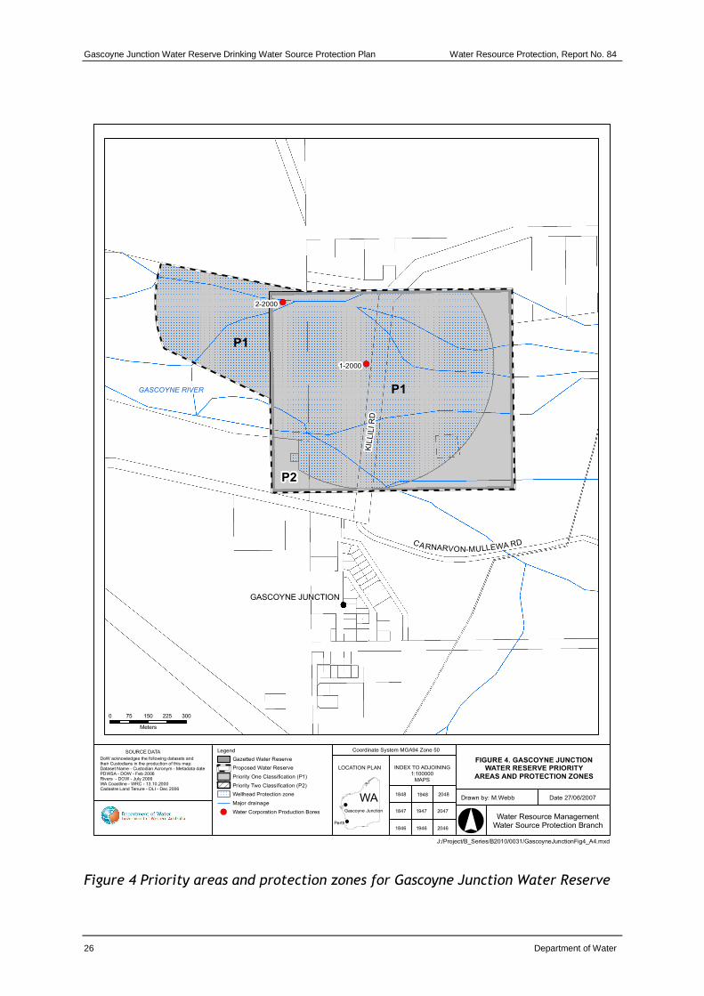
The Gascoyne Junction water reserve is already proclaimed under the Country Areas Water Supply Act 1947 (see section 1.5.1 Existing water source protection). As part of the preparation of this plan the boundaries of the water reserve were reviewed. It is recommended the Gascoyne Junction water reserve is expanded downstream of the existing water reserve to ensure production bore 2-2000 is adequately protected. This will require the water reserve to be re-gazetted under the CAWS Act.
Box Gully joins the Gascoyne River towards the western boundary of the water reserve. A large mound creates a well defined drainage line that continues to direct run-off from the gully, downstream and away from the production bores. The expansion of the water reserve should be along the northern edge of this mound to the end of a 500-metre wellhead protection zone and across to the northern side of the cadastral boundary of Crown Reserve 33320 (Lot 71 on Plan 188126) and then back along the northern side of the lot in an easterly direction to meet the existing boundary of the water reserve. The existing and planned proclaimed areas are shown in Figures 2 and 4.
4.3 Priority areas
The Gascoyne Junction water reserve will be managed as a Priority 1 (P1) source protection area, except for the private land in the south west corner of the water reserve which is classified as a Priority 2 (P2) source protection area. Managing the Gascoyne Junction Water Reserve as a predominantly P1 area is appropriate because:
Water Resource Protection Report No. 84 Gascoyne Junction Water Reserve Drinking Water Source Protection Plan
Department of Water 25
• the water source is of strategic importance as it is the only potable water source for the town of Gascoyne Junction
• the groundwater is vulnerable to contamination from surrounding land uses as the aquifer is unconfined, has transmissive coarse sands and has a shallow depth to groundwater
• the water reserve covers the wellfield, which is directly recharged by river flows
• the vast majority of the water reserve is Crown land
• current land uses within the water reserve are generally compatible with P1 objectives.
The private land within the water reserve is used for grazing as part of a pastoral lease, which is an acceptable activity in P2 source protection areas.
The priority areas are shown in Figure 4.
4.4 Protection zones
In addition to priority areas, wellhead protection zones (WHPZ) (a circular boundary encompassing the production bore) with a 500-metre radius are defined to protect the water source from contamination in the immediate vicinity of production bores in P1 areas. The CAWS Act By-laws define compatible land uses within wellhead protection zones. A WHPZ of 500-metre radius is defined around the two production bores (1/2000 and 2/2000). These zones will not extend outside the proclaimed Gascoyne Junction Water Reserve, as they exist over the area that contributes to direct recharge to the aquifer. The recommended WHPZ are shown in Figure 4.
Gascoyne Junction Water Reserve Drinking Water Source Protection Plan Water Resource Protection, Report No. 84
Water Resource ManagementWater Source Protection Branch
INDEX TO ADJOINING1:100000
MAPS
LOCATION PLAN
WA
SOURCE DATA
DoW acknowledges the following datasets and their Custodians in the production of this map:Dataset Name - Custodian Acronym - Metadata datePDWSA - DOW - Feb 2006Rivers - DOW - July 2006WA Coastline - WRC - 13.10.2000Cadastre Land Tenure - DLI - Dec 2006
20481848
20471847
20461846
Gascoyne Junction
Perth
Coordinate System MGA94 Zone 50
1948
1947
1946
0 75 150 225 300
Meters
Legend
Gazetted Water Reserve
Proposed Water Reserve
Priority One Classification (P1)
Priority Two Classification (P2)
Wellhead Protection zone
Major drainage
Water Corporation Production Bores
KIL
LIL
I R
D
CARNARVON-MULLEWA RD
GASCOYNE RIVER
P1
P2
P1
Figure 4 Priority areas and protection zones for Gascoyne Junction Water Reserve
Water Resource Protection Report No. 84 Gascoyne Junction Water Reserve Drinking Water Source Protection Plan
Department of Water 27
4.5 Land use planning
It is recognised under the State Planning Strategy (Western Australian Planning Commission, 1997) that the establishment of appropriate protection mechanisms in statutory land-use planning processes is necessary to secure the long-term protection of drinking water sources. As outlined in Statement of Planning Policy No.2.7: Public Drinking Water Source Policy (Western Australian Planning Commission, 2003) it is appropriate that the Gascoyne Junction Water Reserve, wellhead protection zones and priority areas be recognised in the Shire of Upper Gascoyne’s town planning scheme. Any development proposals within the Gascoyne Junction water reserve that are inconsistent with the Department of Water’s water quality protection note – Land use compatibility in public drinking water source areas should be referred to the Department of Water for advice and recommendations. Land use and activities in this water reserve should be guided by this plan and water quality protection note.
The Department of Water’s protection strategy for public drinking water source areas (PDWSA) provides for lawfully established and operated developments to continue within proclaimed areas despite their location or facilities posing a possible risk to water quality (which would not be accepted for new developments). The department may negotiate with landowners/operators on measures to improve these facilities or processes to lessen the level of water contamination risk.
In critical areas close to water sources, the department may make an offer to purchase land or development rights where the level of contamination risk is considered significant enough to potentially compromise the quality of water resources.
4.6 Best management practices
There are opportunities to significantly reduce risks to water quality by carefully considering design and management practices. The adoption of best management practices for land uses will continue to be encouraged to help protect water quality. On freehold land, the Department of Water aims to work with landowners to achieve best management practices for water quality protection through the provision of management advice, and assistance to seek funding if required.
There are guidelines available for many land uses in the form of industry codes of practice, environmental guidelines or water quality protection notes. These have been developed in consultation with stakeholders such as industry groups, producers, state government agencies and technical advisers. Examples include Pastoral activities within rangelands, Wastewater treatment – onsite domestic systems and Toxic and hazardous substances – storage and use, which are listed in the References section of this document. These documents help managers and land owners reduce the risk of their operations causing unacceptable environmental impacts. They are recommended as best practice for water quality protection.
Gascoyne Junction Water Reserve Drinking Water Source Protection Plan Water Resource Protection, Report No. 84
28 Department of Water
Education and awareness (eg signage and information material) is another mechanism for water quality protection, especially for people visiting the area who are unfamiliar with the Gascoyne Junction water reserve. A brochure will be produced once this plan is endorsed, describing the water reserve, its location and the main threats to water quality protection. This brochure will be made available to the community and will serve to inform people in simple terms about the drinking water source, its importance and the need to protect it.
4.7 Surveillance and By-law enforcement
The quality of public drinking water sources within country areas of the State is protected under the CAWS Act. Declaration of these areas allows existing By-laws to be applied to protect water quality.
The Department of Water considers By-law enforcement, through on-ground surveillance of land use activities in PDWSA as an important water quality protection mechanism. Surveillance is also important in raising the general level of awareness of the need to protect water quality.
Signs are erected to educate the public and to advise of activities that are prohibited or regulated. This plan recommends that delegation of surveillance and By-law enforcement to the Water Corporation is continued.
4.8 Emergency response
Escape of chemicals during unforeseen incidents and use of chemicals during emergency responses can result in water contamination. The Shire of Upper Gascoyne’s Local Emergency Management Committee (LEMC) through the Mid West–Gascoyne Emergency Management District should be familiar with the location and purpose of the Gascoyne Junction water reserve. A locality plan should be provided to the Fire and Rescue Services headquarters for the Hazardous Materials Emergency Advisory Team (HAZMAT). The Water Corporation should have an advisory role to any HAZMAT incident in the Gascoyne Junction water reserve.
Personnel who deal with WESTPLAN HAZMAT (Western Australian Plan for Hazardous Materials) incidents within the area should have access to a map of the Gascoyne Junction water reserve. These personnel should also receive training to ensure they gain an adequate understanding of the potential impacts of spills on the water resource.
4.9 Recommended protection strategies
Table 1 identifies the potential water quality risks associated with existing land uses in the Gascoyne Junction water reserve and recommends protection strategies to minimise these risks.
Water Resource Protection Report No. 84 Gascoyne Junction Water Reserve Drinking Water Source Protection Plan
Department of Water 29
Following publication of this document, an implementation strategy will be drawn up based on the recommendations in Table 1 and the Recommendations section. It will describe timeframes for the protection strategies, identify responsible stakeholders and sources of funding. This is reflected in the Recommendations section of this plan.
Gascoyne Junction Water Reserve Drinking Water Source Protection Plan Water Resource Protection, Report No. 84
30 Department of Water
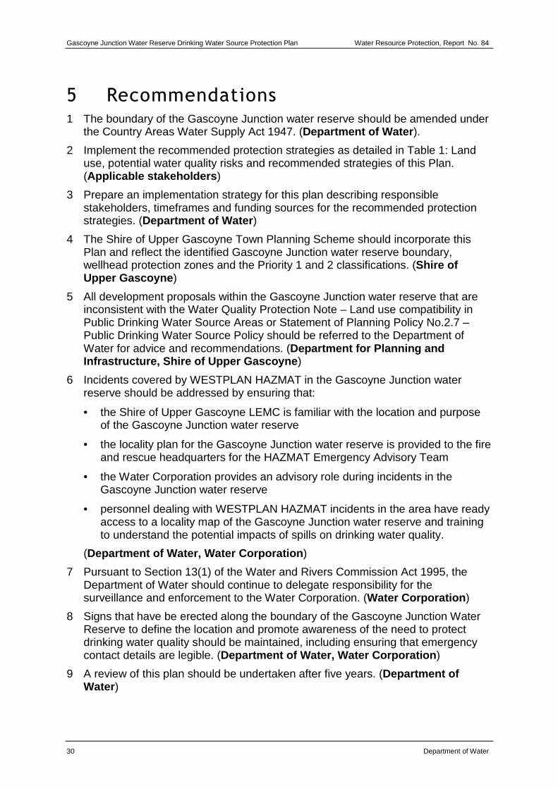
5 Recommendations 1 The boundary of the Gascoyne Junction water reserve should be amended under
the Country Areas Water Supply Act 1947. (Department of Water ).
2 Implement the recommended protection strategies as detailed in Table 1: Land use, potential water quality risks and recommended strategies of this Plan. (Applicable stakeholders )
3 Prepare an implementation strategy for this plan describing responsible stakeholders, timeframes and funding sources for the recommended protection strategies. (Department of Water )
4 The Shire of Upper Gascoyne Town Planning Scheme should incorporate this Plan and reflect the identified Gascoyne Junction water reserve boundary, wellhead protection zones and the Priority 1 and 2 classifications. (Shire of Upper Gascoyne )
5 All development proposals within the Gascoyne Junction water reserve that are inconsistent with the Water Quality Protection Note – Land use compatibility in Public Drinking Water Source Areas or Statement of Planning Policy No.2.7 – Public Drinking Water Source Policy should be referred to the Department of Water for advice and recommendations. (Department for Planning and Infrastructure, Shire of Upper Gascoyne )
6 Incidents covered by WESTPLAN HAZMAT in the Gascoyne Junction water reserve should be addressed by ensuring that:
• the Shire of Upper Gascoyne LEMC is familiar with the location and purpose of the Gascoyne Junction water reserve
• the locality plan for the Gascoyne Junction water reserve is provided to the fire and rescue headquarters for the HAZMAT Emergency Advisory Team
• the Water Corporation provides an advisory role during incidents in the Gascoyne Junction water reserve
• personnel dealing with WESTPLAN HAZMAT incidents in the area have ready access to a locality map of the Gascoyne Junction water reserve and training to understand the potential impacts of spills on drinking water quality.
(Department of Water, Water Corporation )
7 Pursuant to Section 13(1) of the Water and Rivers Commission Act 1995, the Department of Water should continue to delegate responsibility for the surveillance and enforcement to the Water Corporation. (Water Corporation )
8 Signs that have be erected along the boundary of the Gascoyne Junction Water Reserve to define the location and promote awareness of the need to protect drinking water quality should be maintained, including ensuring that emergency contact details are legible. (Department of Water , Water Corporation )
9 A review of this plan should be undertaken after five years. (Department of Water )
Water Resource Protection Report No. 84 Gascoyne Junction Water Reserve Drinking Water Source Protection Plan
Department of Water 31
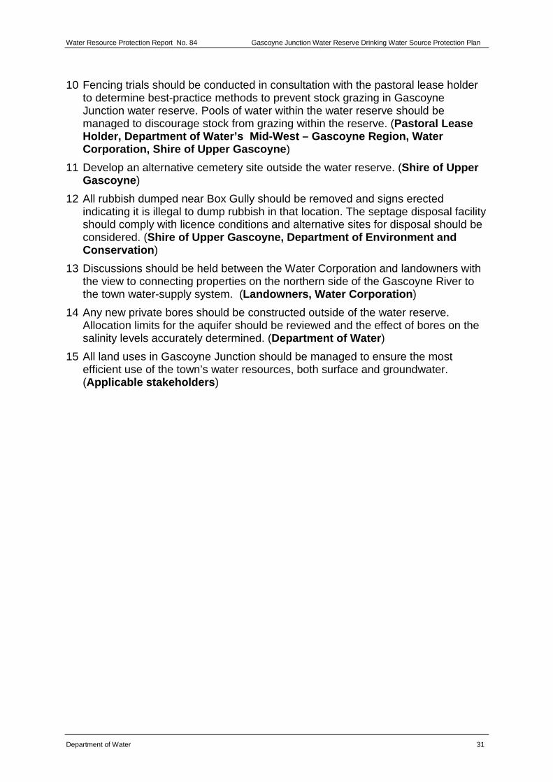
10 Fencing trials should be conducted in consultation with the pastoral lease holder to determine best-practice methods to prevent stock grazing in Gascoyne Junction water reserve. Pools of water within the water reserve should be managed to discourage stock from grazing within the reserve. (Pastoral Lease Holder, Department of Water’s Mid-West – Gascoyne Regi on, Water Corporation, Shire of Upper Gascoyne )
11 Develop an alternative cemetery site outside the water reserve. (Shire of Upper Gascoyne )
12 All rubbish dumped near Box Gully should be removed and signs erected indicating it is illegal to dump rubbish in that location. The septage disposal facility should comply with licence conditions and alternative sites for disposal should be considered. (Shire of Upper Gascoyne, Department of Environment and Conservation )
13 Discussions should be held between the Water Corporation and landowners with the view to connecting properties on the northern side of the Gascoyne River to the town water-supply system. (Landowners, Water Corporation )
14 Any new private bores should be constructed outside of the water reserve. Allocation limits for the aquifer should be reviewed and the effect of bores on the salinity levels accurately determined. (Department of Water )
15 All land uses in Gascoyne Junction should be managed to ensure the most efficient use of the town’s water resources, both surface and groundwater. (Applicable stakeholders )
Water Resource Protection Report No. 84 Gascoyne Junction Water Reserve Drinking Water Source Protection Plan
Department of Water 33
Appendices
Appendix A - Water quality
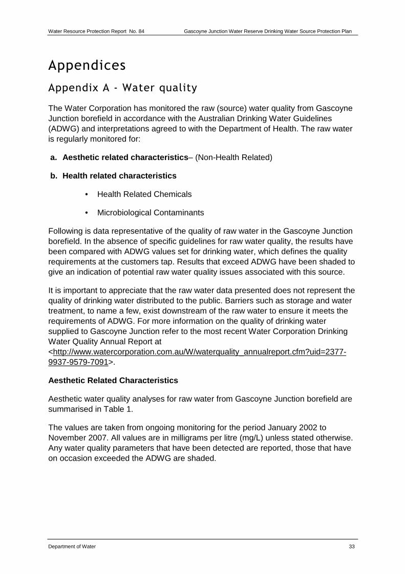
The Water Corporation has monitored the raw (source) water quality from Gascoyne Junction borefield in accordance with the Australian Drinking Water Guidelines (ADWG) and interpretations agreed to with the Department of Health. The raw water is regularly monitored for:
a. Aesthetic related characteristics – (Non-Health Related)
b. Health related characteristics
• Health Related Chemicals
• Microbiological Contaminants
Following is data representative of the quality of raw water in the Gascoyne Junction borefield. In the absence of specific guidelines for raw water quality, the results have been compared with ADWG values set for drinking water, which defines the quality requirements at the customers tap. Results that exceed ADWG have been shaded to give an indication of potential raw water quality issues associated with this source.
It is important to appreciate that the raw water data presented does not represent the quality of drinking water distributed to the public. Barriers such as storage and water treatment, to name a few, exist downstream of the raw water to ensure it meets the requirements of ADWG. For more information on the quality of drinking water supplied to Gascoyne Junction refer to the most recent Water Corporation Drinking Water Quality Annual Report at <http://www.watercorporation.com.au/W/waterquality_annualreport.cfm?uid=2377-9937-9579-7091>.
Aesthetic Related Characteristics
Aesthetic water quality analyses for raw water from Gascoyne Junction borefield are summarised in Table 1.
The values are taken from ongoing monitoring for the period January 2002 to November 2007. All values are in milligrams per litre (mg/L) unless stated otherwise. Any water quality parameters that have been detected are reported, those that have on occasion exceeded the ADWG are shaded.
Gascoyne Junction Water Reserve Drinking Water Source Protection Plan Water Resource Protection, Report No. 84
34 Department of Water
Table 1 Aesthetic related detections for Gascoyne Junction borefield
* An aesthetic guideline value is the concentration or measure of a water quality characteristic that is associated with good quality water.
† Water quality data observed from 5 or less sampling occasions
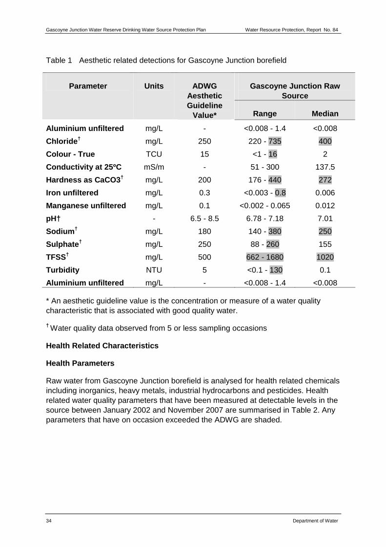
Health Related Characteristics
Health Parameters
Raw water from Gascoyne Junction borefield is analysed for health related chemicals including inorganics, heavy metals, industrial hydrocarbons and pesticides. Health related water quality parameters that have been measured at detectable levels in the source between January 2002 and November 2007 are summarised in Table 2. Any parameters that have on occasion exceeded the ADWG are shaded.
Water Resource Protection Report No. 84 Gascoyne Junction Water Reserve Drinking Water Source Protection Plan
Department of Water 35
Table 2 Health related detections for Gascoyne Junction borefield¥
Gascoyne Junction Raw Source
Parameter Units ADWG Health Guideline
Value* Range Median
Barium mg/L 0.7 0.05 - 0.08 0.065
Boron mg/L 4 0.36 - 0.44 0.4
Nitrate as nitrogen mg/L 11.29 0.05 - 0.1 0.075
Nitrite as nitrogen mg/L 0.91 <0.002 - 0.006 <0.004
Nitrite plus nitrate as N mg/L 11.29 0.055 - 1.7 0.505
Fluoride mg/L 1.5 <0.10 - 0.15 0.15
* A health guideline value is the concentration or measure of a water quality characteristic that, based on present knowledge, does not result in any significant risk to the health of the consumer over a lifetime of consumption (NHRMC & ARMCANZ, 1996).
¥ Water quality data observed from 5 or less sampling occasions
Microbiological Contaminants
Microbiological testing of raw water samples from Gascoyne Junction borefield is currently conducted on a monthly basis. Escherichia coli counts are used as an indicator of the degree of recent faecal contamination of the raw water from warm-blooded animals. A detection of Escherichia coli in raw water abstracted from any bore may indicate possible contamination of faecal material through ingress in the bore, or recharge through to the aquifer (depending on aquifer type).
During the reviewed period of January 2002 to November 2007, positive Escherichia coli counts were recorded in 25.8 per cent of samples collected from the borefield. This high occurrence of Escherichia coli detections is indicative of contamination of the groundwater when the Gascoyne River is flowing. This groundwater source is under direct influence of surface water, resulting in the higher bacteriological readings than would typically be seen for a groundwater source.
Less than 4% of positive samples were > 20 most probable number (MPN) per 100 mL. A count less than 20 MPN/100 mL is typically associated with low levels of faecal contamination of the surface water and is used as a microbiological contamination benchmark of the raw water (WHO, 1996).
Gascoyne Junction Water Reserve Drinking Water Source Protection Plan Water Resource Protection, Report No. 84
36 Department of Water
Appendix B - Photographs
Photo 1 – Gascoyne River crossing
Photo 2 – Rest Pool
Water Resource Protection Report No. 84 Gascoyne Junction Water Reserve Drinking Water Source Protection Plan
Department of Water 37
Photo 3 – Hackers Hectare picnic site
Photo 4 – Faeces from stock grazing within water reserve
Gascoyne Junction Water Reserve Drinking Water Source Protection Plan Water Resource Protection, Report No. 84
38 Department of Water
Photo 5 – Example of temporary fencing erected in the Carnarvon Water Reserve
Photo 6 – Rubbish dumping near Box Gully
Water Resource Protection Report No. 84 Gascoyne Junction Water Reserve Drinking Water Source Protection Plan
Department of Water 39
Glossary
Abstraction The pumping of groundwater from an aquifer.
ADWG The Australian Drinking Water Guidelines, outlining guideline criteria for the quality of drinking water in Australia.
Aesthetic guideline
NHMRC guideline level ascribed to acceptable aesthetic qualities of drinking water such as taste, smell, colour and temperature.
AHD Australian Height Datum is the height of land in metres above mean sea level. For example this is +0.026 m at Fremantle.
Allocation The quantity of water permitted to be abstracted by a licence, usually specified in kilolitres per year (kL/a).
ANZECC Australian and New Zealand Environment Conservation Council.
Aquifer A geological formation or group of formations able to receive, store and transmit significant quantities of water.
ARMCANZ Agriculture and Resource Management Council of Australia and New Zealand.
Bore A narrow, lined hole, also known as a well, drilled to monitor or draw groundwater.
Borefield A group of bores to monitor or withdraw groundwater.
Catchment The area of land which intercepts rainfall and contributes the collected water to surface water (streams, rivers, wetlands) or groundwater.
CFU Colony forming units is a measure of pathogen contamination in water.
Confined aquifer
An aquifer that is confined between non-porous rock formations (such as shale and siltstone) and therefore contains water under pressure.
Diffuse source Pollution originating from a widespread area eg urban stormwater runoff, agricultural infiltration.
Effluent The liquid, solid or gaseous wastes discharged by a process, treated or untreated.
GL Gigalitres (1000 000 000 litres)
ha Hectares (a measure of area)
Gascoyne Junction Water Reserve Drinking Water Source Protection Plan Water Resource Protection, Report No. 84
40 Department of Water
HAZMAT Hazardous Materials
Hydrogeology The study of groundwater, especially relating to the distribution of aquifers, groundwater flow and groundwater quality.
kL Kilolitres (1000 litres)
km Kilometres (1000 metres)
km2 Square kilometres (a measure of area)
Leaching / leachate
The process by which materials such as organic matter and mineral salts are washed out of a layer of soil or dumped material by being dissolved or suspended in percolating rainwater. The material washed out is known as leachate. Leachate can pollute groundwater and waterways.
LEMC Local Emergency Management Committee
m Metres
mg/L Milligrams per litre (0.001 grams per litre)
ML Megalitres (1 000 000 litres)
mm Millimetres
MPN Most probable number (a measure of microbiological contamination).
mSv Millisieverts is a measure of annual radiological dose.
NHMRC National Health and Medical Research Council.
NTU Nephelometric turbidity units are a measure of turbidity in water.
Nutrient load The amount of nutrient reaching the waterway over a given timeframe (usually per year) from its catchment area.
Nutrients
Minerals dissolved in water, particularly inorganic compounds of nitrogen (nitrate and ammonia) and phosphorous (phosphate) which provide nutrition (food) for plant growth. Total nutrient levels include the inorganic forms of an element plus any bound in organic molecules.
Pesticides Collective name for a variety of insecticides, fungicides, herbicides, algicides, fumigants and rodenticides used to kill organisms.
Point source pollution
Pollution originating from a specific localised source, eg sewage or effluent discharge, industrial waste discharge.
Water Resource Protection Report No. 84 Gascoyne Junction Water Reserve Drinking Water Source Protection Plan
Department of Water 41
Pollution
Water pollution occurs when waste products or other substances, eg effluent, litter, refuse, sewage or contaminated runoff, change the physical, chemical biological or thermal properties of the water, adversely affecting water quality, living species and beneficial uses.
Public Drinking Water Source Area (PDWSA)
Includes all underground water pollution control areas, catchment areas and water reserves constituted under the Metropolitan Water Supply Sewerage and Drainage Act 1909 and the Country Areas Water Supply Act 1947.
Recharge Water infiltrating to replenish an aquifer.
Recharge area
An area through which water from a groundwater catchment percolates to replenish (recharge) an aquifer. An unconfined aquifer is recharged by rainfall throughout its distribution. Confined aquifers are recharged in specific areas where water leaks from overlying aquifers, or where the aquifer rises to meet the surface.
Run-off Water that flows over the surface from a catchment area, including streams.
Scheme supply Water diverted from a source or sources by a water authority of private company and supplied via a distribution network to customers for urban, industrial or irrigation use.
Stormwater Rainwater which has run off the ground surface, roads, paved areas etc. and is usually carried away by drains.
TCU True colour
TDS Total dissolved salts, a measurement of ions in solution, such as salts in water.
Treatment
Application of techniques such as settlement, filtration and chlorination to render water suitable for specific purposes including drinking and discharge to the environment.
Unconfined aquifer
An aquifer in which the upper surface of water is lower than the top of the aquifer itself. The upper surface of the groundwater within the aquifer is called the watertable.
Wastewater Water that has been used for some purpose and would normally be treated and discarded. Wastewater usually contains significant quantities of pollutant.
Gascoyne Junction Water Reserve Drinking Water Source Protection Plan Water Resource Protection, Report No. 84
42 Department of Water
Water quality The physical, chemical and biological measures of water.
Water Reserve An area proclaimed under the Country Areas Water Supply Act 1947 or the Metropolitan Water Supply Sewerage and Drainage Act 1909 for the purposes of protecting a drinking water supply.
Watertable The upper saturated level of the unconfined groundwater.
Wellfield A group of bores to monitor or withdraw groundwater.
Wellhead The top of a well (or bore) used to draw groundwater. A wellhead protection zone (WHPZ) is usually declared around wellheads in drinking water areas to protect the water source from contamination.
WESTPLAN HAZMAT
Western Australian Plan for Hazardous Materials.
Water Resource Protection Report No. 84 Gascoyne Junction Water Reserve Drinking Water Source Protection Plan
Department of Water 43
References
Agriculture and Resource Management Council of Australia and New Zealand (ARMCANZ) & Australian and New Zealand Environment and Conservation Council (ANZECC) 1996, Draft Rural Land Uses and Water Quality – A Community Resource Document, ARMCANZ & ANZECC, Canberra.
Commonwealth Scientific and Industrial Research Organisation, 2000, Floodplain management in Australia: Best practice principles and guidelines, CSIRO Publishing, Collingwood.
Department of Health 2007, Use of Herbicides in Water Catchment Areas, Circular No: PSC 88, 28 February 2007, Department of Health, Perth.
Department of Water Various dates, Water Quality Protection Notes – Various titles, Department of Water, Perth, available <www.water.wa.gov.au> Water Quality > Publications > Water Quality Protection Notes.
Government of Western Australia 1914, Rights in Water and Irrigation Act, Reprinted under the Reprints Act 1984 as at 1 February 2008, available <http://www.slp.wa.gov.au/legislation/statutes.nsf/default.html>.
Government of Western Australia 1947, Country Areas Water Supply Act, reprinted under the Reprints Act 1984 as at 1 February 2008, available <http://www.slp.wa.gov.au/legislation/statutes.nsf/default.html>.
National Health and Medical Research Council & ARMCANZ 2004, National Water Quality Management Strategy: Australian Drinking Water Guidelines, NHMRC & ARMCANZ, Canberra, available <http://www.nhmrc.gov.au/publications/synopses/eh19syn.htm>
National Minimum Bore Specifications Committee 2003, Minimum construction requirements for water bores in Australia, 2nd edn, Land and Water Biodiversity Committee, Queensland, available <http://portal.water.wa.gov.au/portal/page/portal/LicensingWaterIndustryServices/Licensing/Publications/Content/MCRWBA.pdf>
State Emergency Management Committee 2005, Policy Statement No.7 Western Australian Emergency Management Arrangements, Government of Western Australia, Perth.
Water and Rivers Commission 2000, Statewide Policy No.2 – Pesticide Use in Public Drinking Water Source Areas, Water and Rivers Commission, Perth, available <www.water.wa.gov.au> > Policies.
Gascoyne Junction Water Reserve Drinking Water Source Protection Plan Water Resource Protection, Report No. 84
44 Department of Water
Water and Rivers Commission 2003, Statewide Policy No.13 – Policy and Guidelines for Recreation within Public Drinking Water Source Areas on Crown Land, Water and Rivers Commission, Perth, available <www.water.wa.gov.au> > Policies.
Water Corporation 2006, SG097 Source Protection Operations Manual, Water Corporation, Perth.
Western Australian Planning Commission 1997, State Planning Strategy, State Government of Western Australia, Perth, available <www.wapc.wa.gov.au/Publications/52.aspx>.
Western Australian Planning Commission 2003, Statement of Planning Policy No. 2.7 – Public Drinking Water Source Policy, Government Gazette WA, 10 June 2003, pp. 2077-82, Government of Western Australia, Perth, available <www.wapc.wa.gov.au/Publications/149.aspx>.
Western Australian Planning Commission 2006, State Planning Policy No. 2.9 - Water Resources, Government Gazette WA, 19 December 2006, pp. 5707-22 Government of Western Australia, Perth, available <http://www.wapc.wa.gov.au/Publications/1281.aspx>
World Health Organisation 1996, Guidelines for Drinking-Water Quality – Volume 2 – Health Criteria and Other Supporting Information, 2nd edn, World Health Organisation, Geneva, available <www.who.int/water_sanitation_health/dwq/en/2edvol2p1.pdf>.
Government of Western AustraliaDepartment of Water