18
GEMAS: Geochemical mapping of agricultural and grazing land soil at the continental scale Clemens Reimann and the GEMAS Project Team
GEMAS: Geochemical mapping of agricultural
and grazing land soil at the continental scale
Clemens Reimann and the GEMAS Project Team

GEMAS – The Project Team

Geochemical Mapping of Agricultural Soil (GEMAS)
2007: Eurometaux
contacts EuroGeoSurveys:
Land-use relatet geochemical data needed at the European
scale for REACH (Registration,
Evaluation, Authorisation and restriction of CHemical substances)
grazing land soil, 0-10 cm
agricultural soil (Ap-horizon), 0-20 cm
2 sample materials at 1 site/2500 km2
<2 mm fraction
aqua regia extraction

Agricultural soils (Ap) 0-20 cm
Grazing land soils (Gr) 0-10 cm
GEMAS - 2008
N= 2108 N= 2024
33 countries - 5.6 million km2 - 4132 samples in total
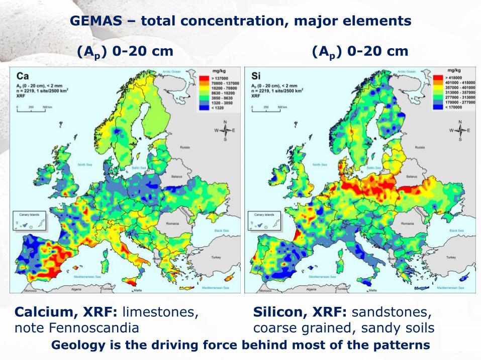
(Ap) 0-20 cm (Ap) 0-20 cm
GEMAS – total concentration, major elements
Calcium, XRF: limestones, note Fennoscandia
Silicon, XRF: sandstones, coarse grained, sandy soils
Geology is the driving force behind most of the patterns
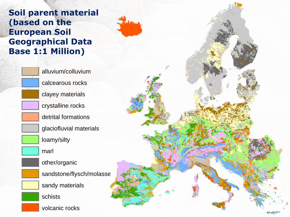
Soil parent material (based on the European Soil Geographical Data Base 1:1 Million)
alluvium/colluvium
calcearous rocks
clayey materials
crystalline rocks
detrital formations
glaciofluvial materials
loamy/silty
marl
other/organic
sandstone/flysch/molasse
sandy materials
schists
volcanic rocks
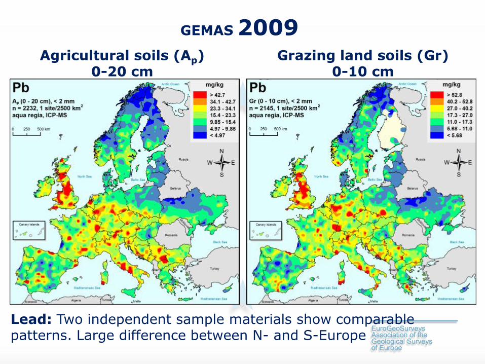
Agricultural soils (Ap) 0-20 cm
Grazing land soils (Gr) 0-10 cm
GEMAS 2009
Lead: Two independent sample materials show comparable patterns. Large difference between N- and S-Europe
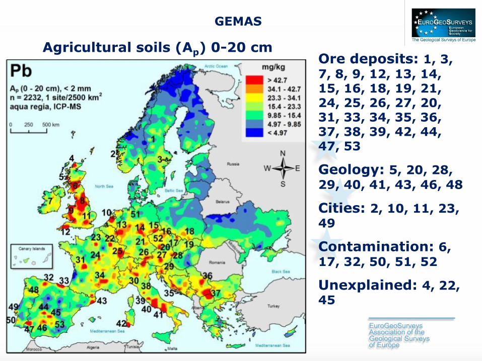
Agricultural soils (Ap) 0-20 cm
GEMAS
Ore deposits: 1, 3,
7, 8, 9, 12, 13, 14, 15, 16, 18, 19, 21, 24, 25, 26, 27, 20, 31, 33, 34, 35, 36, 37, 38, 39, 42, 44, 47, 53
Geology: 5, 20, 28,
29, 40, 41, 43, 46, 48
Cities: 2, 10, 11, 23,
49
Contamination: 6,
17, 32, 50, 51, 52
Unexplained: 4, 22, 45

(Ap) 0-20 cm GEMAS
Mercury: natural sources (ore deposits, volcanoes), some cities, border of last glaciation – with regards to metals: EUROPE´S SOIL IS SURPRISINGLY CLEAN!
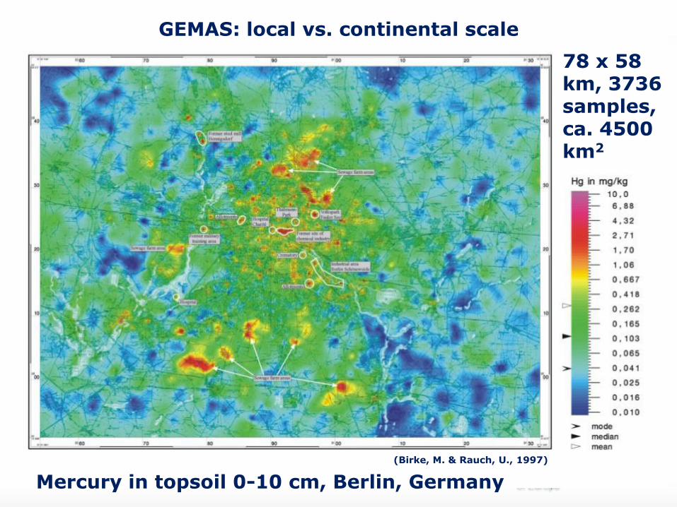
Mercury in topsoil 0-10 cm, Berlin, Germany
(Birke, M. & Rauch, U., 1997)
GEMAS: local vs. continental scale
78 x 58 km, 3736 samples, ca. 4500 km2

Ap 0-20 cm Ap 0-20 cm
GEMAS 2010-2013
Zr, aqua regia: note the Italian alkaline volcanics
Zr, XRF: the central European loess belt is visible

Photo: ©Daniela Szczepanski
Pinatubo, eruption 1991, within 2 days:
10,000,000,000 t magma
20,000,000 t SO2
2,000,000 t Zn
1,000,000 t Cu
550,000 t Cr
300,000 t Ni
100,000 t Pb
5,500 t Cd
800 t Hg
(Ap) 0-20 cm (Ap) 0-20 cm
GEMAS
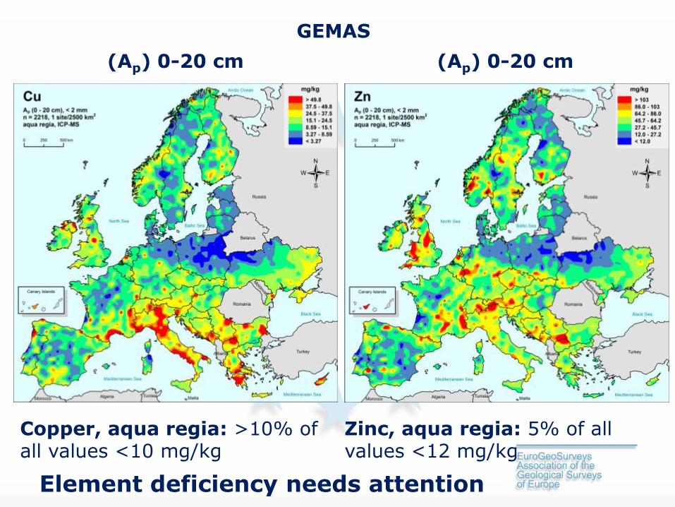
Copper, aqua regia: >10% of all values <10 mg/kg
Zinc, aqua regia: 5% of all values <12 mg/kg
Element deficiency needs attention
(Ap) 0-20 cm (Ap) 0-20 cm
GEMAS
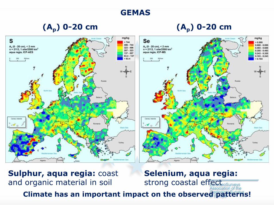
Sulphur, aqua regia: coast and organic material in soil
Selenium, aqua regia: strong coastal effect
Climate has an important impact on the observed patterns!
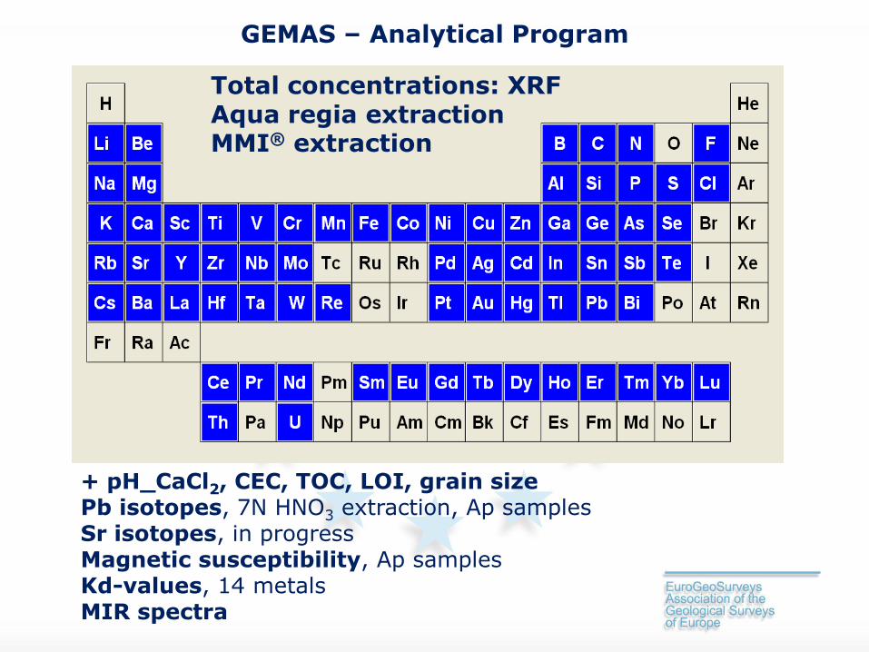
GEMAS – Analytical Program
+ pH_CaCl2, CEC, TOC, LOI, grain size
Pb isotopes, 7N HNO3 extraction, Ap samples Sr isotopes, in progress Magnetic susceptibility, Ap samples Kd-values, 14 metals MIR spectra
Total concentrations: XRF Aqua regia extraction MMI® extraction

GEMAS
Evidence for diffuse industrial contamination? Evidence of other anthropogenic impacts?
What levels of potentially harmful elements?
Element deficiencies? Differences between the European countries?
Geology and/or Climate reflected?
Is European agricultural soil of good chemical quality?

2004
2005 2006 2010 Dec.2013
GEMAS history – 1950ies to 2013
1998 1992 2003
Thank you for your attention!
Photo: ©André Stein
For more details join us at the EuroGeoSurveys GEMAS workshop this afternoon


