48
General guide to the vegetation clearing codes Accepted development vegetation clearing codes Effective 7 February 2020 For landholders throughout Queensland

General guide to the vegetation clearing codes
Accepted development vegetation clearing codes
Effective 7 February 2020
For landholders throughout Queensland

7 February 2020 General guide to the vegetation clearing codes
2
CS8227 © State of Queensland, 2020 The Queensland Government supports and encourages the dissemination and exchange of its information. The copyright in this publication is licensed under a Creative Commons Attribution 4.0 International (CC BY 4.0) licence. Under this licence you are free, without having to seek our permission, to use this publication in accordance with the licence terms.
You must keep intact the copyright notice and attribute the State of Queensland as the source of the publication. Note: Some content in this publication may have different licence terms as indicated. For more information on this licence, visit https://creativecommons.org/licenses/by/4.0/. The information contained herein is subject to change without notice. The Queensland Government shall not be liable for technical or other errors or omissions contained herein. The reader/user accepts all risks and responsibility for losses, damages, costs and other consequences resulting directly or indirectly from using this information.
Interpreter statement:
The Queensland Government is committed to providing accessible services to Queenslanders from all culturally and linguistically diverse backgrounds. If you have difficulty in understanding this document, you can contact us within Australia on 13QGOV (13 74 68) and we will arrange an interpreter to effectively communicate the report to you.

7 February 2020 General guide to the vegetation clearing codes
i
Contents Accepted development vegetation clearing codes 1
Contents i
About this guide iii
Code abbreviations used in this document iii
Further information iii
Glossary 1
Part 1: General information 3
Vegetation management framework 3
Accepted development vegetation clearing codes 3
Vegetation management report 5
Notification process 5
Confirmation from the Department of Natural Resources, Mines and Energy 6
Part 2: Vegetation management mapping 7
Online maps 7
Essential habitat map 8
Regional ecosystems 8
Bioregions 10
Reading regional ecosystem maps 10
Part 3: Wetlands, watercourse and drainage features 11
Part 4: Essential habitat 13
Identifying essential habitat 13
Interacting with essential habitat 14
Part 5: Koala habitat in South East Queensland 14
Koala protections 14
Koala priority areas 15
Koala habitat areas 15
Part 6: Soil and water quality protections 15
Soil erosion and instability 16
Salinity 17
Acid sulfate soils 18
Part 7: Avoid and minimise 18
Part 8: Exchange areas 19
Legally securing an exchange area 20
Management plan 22

7 February 2020 General guide to the vegetation clearing codes
ii
Identifying a suitable exchange area 23
Part 9: Rehabilitation 25
Part 10: Measuring height and slope 30
Measuring tree height 30
Measuring slope 32
Appendix 1- VMA schedule terms 35

7 February 2020 General guide to the vegetation clearing codes
iii
About this guide This guide has been developed to help landholders operate under the accepted development
vegetation clearing codes. It refers to the requirements of the Vegetation Management Act 1999 and
the Planning Act 2016, which jointly regulate the clearing of vegetation for land use and development
under the Queensland vegetation management framework.
The guide is not intended to be exhaustive. It provides supplementary information only, and is
designed to be read in conjunction with the relevant codes. It includes:
general supporting information that applies to all codes
technical information that applies to all codes.
It is recommended that you familiarise yourself with the
local, state and federal Acts and Regulations that apply to
your operations. Be sure you have any permits or
approvals that are required under other legislation.
Codes, guides and self-audit sheets are available at on the
accepted development vegetation clearing codes
webpage
Code abbreviations used in this document
Fodder code = Accepted Development Vegetation Clearing Code: Managing Fodder
Harvesting
Encroachment code = Accepted Development Vegetation Clearing Code: Managing
Encroachment
Weeds code = Accepted Development Vegetation Clearing Code: Managing Weeds
NEC code = Accepted Development Vegetation Clearing Code: Necessary Environmental
Clearing
Extractive code = Accepted Development Vegetation Clearing Code: Clearing for an
Extractive Industry
Infrastructure code = Accepted Development Vegetation Clearing Code: Clearing for
Infrastructure
Ag efficiency code = Accepted Development Vegetation Clearing Code: Clearing to Improve
Agricultural Efficiency
Regrowth code = Accepted Development Vegetation Clearing Code: Managing Regulated
Regrowth Vegetation
Further information
For more information:
call 135 VEG (135 834)
email [email protected]
search ‘Vegetation Management’ on www.qld.gov.au.

7 February 2020 General guide to the vegetation clearing codes
1
Glossary All terms in this guide have the meaning provided in the codes or the Vegetation Management Act 1999.
A list of terms defined in the Vegetation Management Act 1999 is available in Appendix 1.
Common
terms
General meaning
Category A
area
An area which is:
a declared area
an offset area, an exchange area, an area that has been subject to unlawful clearing or an
enforcement notice, an area subject to clearing as a result of a clearing offence
or
an area that the chief executive determines to be Category A.
Category A areas are colour-coded red on the regulated vegetation management map.
Category B
area
An area which is remnant vegetation or an area the chief executive determines to be Category
B.
Category B areas are colour-coded dark blue on the regulated vegetation management map.
Category C
area
An area which is high-value regrowth vegetation on freehold land, Indigenous land or land the
subject of a lease issued under the Land Act 1994 for agriculture or grazing purposes or an
occupation licence under that Act, in an area that has not been cleared in the last 15 years
which is also an endangered, of concern, or least concern regional ecosystem.
Category C areas may also include vegetation which the chief executive decides to show as
Category C.
Category C areas are colour-coded light blue on the regulated vegetation management map.
Category R
area
An area which is a regrowth watercourse and drainage feature area located within 50 metres of
a watercourse located in the Burdekin, Burnett–Mary, Eastern Cape York, Fitzroy, Mackay–
Whitsunday or Wet Tropics catchments identified on the vegetation management watercourse
and drainage feature map.
The vegetation management framework regulates clearing of native vegetation within this
buffer area.
Category R areas are colour-coded yellow on the regulated vegetation management map.
Category X
area
All areas other than Category A, B, C and R areas.
Category X areas are areas not generally regulated by the vegetation management laws.
Category X areas are coloured-coded white on the regulated vegetation management map.
Clear
(vegetation)
To remove, cut down, ringbark, push over, poison or destroy in any way, including by burning,
flooding or draining; but not including destroying standing vegetation by stock, or lopping a tree
Code Accepted development vegetation clearing code
DA Development approval
DES Department of Environment and Science
Department/
DNRME
Department of Natural Resources, Mines and Energy
DSDMIP Department of State Development, Manufacturing, Infrastructure and Planning
Environmental
offset
An activity undertaken to counterbalance or compensate for a lasting adverse impact on
significant environmental matters (e.g. valuable species and ecosystems) on one site.
Offsets can be financial or property-driven (i.e. by securing land at another site and managing
that land over time to replace those significant environmental matters that were lost); or a
combination of both.
Environmental offsets provide the flexibility to approve development in one place on the basis
of a requirement to make an equivalent environmental gain in another place where there is not
the same value to industry.
EPBC Act Environment Protection and Biodiversity Conservation Act 1999 (Qld)
Essential
habitat map
A map certified by the chief executive as showing areas of the state the chief executive
reasonably believes are areas of essential habitat for protected wildlife.
Exempted
development
See the Planning Regulation 2017, Schedule 24

7 February 2020 General guide to the vegetation clearing codes
2
Common
terms
General meaning
Fodder
harvesting
The clearing of vegetation that predominantly consists of fodder species for use as a food
source for livestock.
Used as a normal part of land management and during droughts, fodder harvesting is typically
carried out in strips, blocks or other sections so as to leave a proportion of vegetation intact to
conserve the area and broader regional ecosystem; and with the cleared vegetation remaining
where it is cleared, for nearby stock to feed on.
Koala habitat
tree
(a) a tree of the Corymbia, Melaleuca, Lophostemon or Eucalyptus genera that is edible by
koalas; or
a tree of a type typically used by koalas for shelter, including, for example, a tree of the
Angophora genus
Immature
koala habitat
tree
Means a koala habitat tree that is not a mature tree or habitat tree and is two metres or more
in height.
Koala Habitat
Area
See the Nature Conservation (Koala) Conservation Plan 2017, section 7B
Koala offset Means an environmental offset under the Environmental Offsets Act 2014 provided for a matter
of State environmental significance mentioned in schedule 2, section 6(3) or 6(4) of the
Environmental Offset Regulation 2014 that is in relation to a koala habitat area.
Koala Priority
Area
See the Nature Conservation (Koala) Conservation Plan 2017,section 7A
Managing
thickened
vegetation
The selective clearing of vegetation at a locality that does not include clearing using a chain or
cable linked between two tractors, bulldozers or other traction vehicles:
to restore a regional ecosystem to the floristic composition and range of densities typical of
the regional ecosystem in the bioregion in which it is located
to maintain ecological processes and prevent loss of diversity.
NCA Nature Conservation Act 1992 (Qld)
Planning Act Planning Act 2016 (Qld)
PMAV Property map of assessable vegetation—a map certified by the chief executive as a PMAV for
an area and showing the vegetation category areas for the area (e.g. Category C area,
Category X area)
RE Regional ecosystem.
Regrowth
watercourse
and drainage
feature area
An area located within 50 metres of a watercourse or drainage feature located in the Burdekin,
Burnett–Mary, Eastern Cape York, Fitzroy, Mackay–Whitsunday or Wet Tropics catchments
identified on the vegetation management watercourse and drainage feature map.
Regulated
regrowth
vegetation
Vegetation contained in a category C or category R area.
Remnant
vegetation
Vegetation that:
is an endangered regional ecosystem, an of concern regional ecosystem, or a least concern
regional ecosystem
forms the predominant canopy of the vegetation covering more than 50% of the undisturbed
predominant capacity; averaging more than 70% of the vegetation’s undisturbed height; and
composed of species characteristic of the vegetation’s undisturbed predominant canopy.
RPP Riverine protection permit.
SLATS Statewide Landcover and Trees Study.
SLATS is a vegetation monitoring initiative of the Queensland Government with the primary
objective of assessing the extent of woody vegetation in Queensland and assessing all woody
vegetation change (clearing) in Queensland.
VMA or Act Vegetation Management Act 1999 (Qld)
Water Act Water Act 2000 (Qld)

7 February 2020 General guide to the vegetation clearing codes
3
Part 1: General information
Vegetation management framework
The Vegetation Management Act 1999, in conjunction with the Planning Act 2016 and subordinate
legislation, regulates the clearing of vegetation in Queensland. By providing an alternative path to
development application and assessment processes, accepted development vegetation clearing codes
offer opportunities for landholders to clear for low-risk property management activities, while ensuring the
objectives of the Act are achieved.
Accepted development vegetation clearing codes
Each code outlines the requirements for clearing vegetation for particular purposes and to achieve the
desired environmental outcomes.
Each accepted development vegetation clearing code:
describes the scope of the activities covered by that code
outlines the compulsory notification process to be followed before undertaking the clearing
activity (section 2 of the code)
stipulates the compliance requirements (section 3 of the code)
prescribes the clearing requirements.
Any clearing that complies with an applicable code is accepted development (under Schedule 7, Part 3,
12, of the Planning Regulation 2017), meaning that you can undertake operational work that is the
clearing of native vegetation without a development approval. Some requirements of a code may however
require you to obtain another approval before commencing clearing under the code e.g.Material Change
of Use development approval. If the proposed clearing is for a relevant purpose but does not comply with
the code for that purpose, it is assessable development and you must obtain a development approval
before clearing. Please note that you may be committing an offence under the Planning Act (section 163)
if you undertake the clearing without appropriate approval.
Scope
Each accepted development vegetation clearing code defines the activities, locations and other
requirements that must be met for that code to apply. If your proposed clearing activity does not fall within
the scope, then you cannot operate under that particular code, and you won’t need to read any further
into the code.
Scope requirements generally include:
land tenure (e.g. freehold, Indigenous, leasehold etc.)
vegetation categories, as defined in the VMA and displayed on the regulated vegetation
management maps (e.g. Category B area being remnant vegetation)—see Part 2 of this guide
REs (some clearing activities are only permitted in certain REs).
The Figure 1 flow chart may help you determine your options for lawfully clearing native vegetation under
the Queensland vegetation management framework.

7 February 2020 General guide to the vegetation clearing codes
4
Figure 1: Flow chart for determining approvals required for clearing native vegetation
In some cases, certain types of clearing qualify as exempt clearing work, which means that you can clear
without having to do so under a code and without having to obtain a development approval under the
vegetation management framework. For example, exempt clearing work includes clearing during a
bushfire emergency under the directions of an authorised fire officer, and clearing to reduce an imminent
risk that vegetation poses to people or property.
See www.qld.gov.au and search ‘exempt clearing work’ for
further information on exemptions.

7 February 2020 General guide to the vegetation clearing codes
5
Vegetation management report
For relevant information about your property, you should obtain a vegetation management property report
(also known as a property report) and accompanying maps. To do this, use the online request form at
www.qld.gov.au (search for ‘vegetation management maps’).
You will need a lot number and plan number
before you start.
The report will give you maps and information about vegetation categories and REs on your property.
This information will help you determine whether your proposed activities are within the scope of a
particular code and will also provide information you will need in order to notify DRNME of your intention
to clear.
Notification process
Before operating under a code, you must notify DNRME of your intention to clear under the code and
provide particular supporting information. The notification can be made by either:
landholders - undertaking their own work
third parties - undertaking work on the landholder’s land, with the consent of the landholder to
enter, access and undertake clearing or other works on their land.
Examples
A machinery contractor may be authorised by a landholder to notify DNRME on
the landholder’s behalf.
A resource company or natural resource management group may undertake their
own work on a landholder’s land (with the consent of the landholder).
Either the landholder or the third party may authorise another person to lodge the notification on their
behalf. Anyone who lodges the application, other than the landholder, will need to certify that they have
the landholder’s consent to lodge the application.
Landholders and third parties are encouraged to notify DNRME online. Notification forms are also
available at DNRME offices, and may be lodged in person or by post. There is no notification fee.
Before notifying
Make sure you read and understand the relevant code/s before completing the notification form.
If you intend to clear native vegetation on leasehold land or land subject to a forest consent area or forest
entitlement area, contact the Department of Agriculture and Fisheries to ensure the state has no
commercial interest in the timber.
If your property report identifies any part of the intended clearing area as a high-risk area for protected
plants (i.e. all plants that are native to Australia), read the protected plants information for further
requirements.
If your property is located in the South East Queensland (SEQ) Regional Plan area and your property
report identifies that the proposed clearing is in a koala habitat area, seek guidance from the
Department of Environment and Science on koala habitat protections.
Department of Environment and Science – Koala protection
W: https://environment.des.qld.gov.au/wildlife/animals/living-
with/koalas
P: Koala team –13 QGOV (13 74 68)

7 February 2020 General guide to the vegetation clearing codes
6
Preparing and submitting your notification
You are required to provide the following details when you notify DNRME:
Contact details
Lot on plan on which the clearing is proposed
Tenure of the property (e.g. freehold, leasehold etc.)
Landholder’s details
Your details
Information that clearly identifies the area to be cleared (i.e. maps, GPS coordinates using the
Map Grid of Australia MGA 94 format, delineated area) estimate (in hectares) of the area to be
cleared
REs in which the clearing is proposed1
Notifications are not transferable when a property is sold. If
you have recently purchased a property, you will need to
notify DNRME of your intention to clear under the code.
Confirmation from the Department of Natural Resources, Mines and
Energy
If you complete an online notification form, you should receive confirmation by email within 10 minutes of
completing the notification. If you do not receive a confirmation email, your notification has not been
received. For more information call 135 VEG (135 834), email [email protected] or search
‘vegetation management’ on www.qld.gov.au
If you complete a hard copy notification form, we will confirm receipt of your notification by email or post.
Do not commence clearing until you receive confirmation of
your notification from DNRME.
Landholder or third-party obligations
The landholder or third party whose name appears on the notification is legally liable for any clearing
activity undertaken. This is the case even if the application was lodged by a contractor, employee or
another agent.
If you have lodged a notification and another person will undertake clearing on your behalf, you should:
ensure they view a copy of the notification confirmation provided by DNRME before commencing
any clearing activity
document and retain your instructions to contractors, employees or other agents
supervise any clearing activity undertaken to ensure that it is done in accordance with the code
keep a record of the name, address and contact details of the person clearing on your behalf.
Record-keeping requirements
Additional record-keeping requirements, including any that are code-specific, are detailed in the
compliance requirements of each code.
We strongly recommend that you keep copies of any invoices
provided by agents, such as a clearing contractor.
1 DNRME collects this information to meet its obligations under the VMA. Only the location and the purpose of the notified activity are included on the public
register. Your personal information will not be disclosed to any other parties unless authorised or required by law.

7 February 2020 General guide to the vegetation clearing codes
7
Self-auditing
To help you monitor your compliance with the codes, we recommend that you (or the person clearing on
your behalf) undertake a self-audit after operating within a small portion of the total area that you propose
to clear. If your self-audit results show that you have not followed the code requirements when clearing
this portion, stop further clearing operations and contact DNRME for assistance on how to proceed.
Before you lodge another notification, some of the codes require you to complete a self-audit to ensure
that the clearing has satisfied the code requirements. You are not required to provide the results of the
self-audit to DNRME when you re-notify, however, as part of the compliance requirements, you must
keep the results and make them available to DNRME upon request.
Keep your self-audit results on file!
Landholders must use the relevant self-audit sheet for the clearing that has been undertaken. Self-audit
sheets are available at www.qld.gov.au on the accepted development clearing codes page. To obtain
hard copies of self-audit sheets, call 135 VEG (135 834), email [email protected] or search
‘Vegetation Management’ on www.qld.gov.au
Compliance with the code does not exempt you from
requirements under other State, Commonwealth or local
government laws. Landholders should contact other relevant
agencies to discuss their proposed activities prior to clearing.
Contact information is provided in each code.
Part 2: Vegetation management mapping Online maps
You can download a range of maps and reports to help you understand the vegetation types and
categories that are relevant to the vegetation management framework over your area of interest:
Regulated vegetation management maps show the vegetation categories needed to determine
clearing requirements. More detail on these maps is provided in the section below. These maps
are updated monthly to show new property maps of assessable vegetation (PMAVs).2
A vegetation management supporting map is provided as an attachment to a regulated
vegetation management map. This supporting map gives information on REs, wetlands,
watercourses and essential habitat.
Vegetation management reports (also known as property reports) contain the maps detailed
above plus a protected plants flora survey trigger map, Koala habitat areas and koala priority
areas map (SEQ Regional Plan area only) and a range of related information that may help in the
self-assessment process.
To request a map or report, use the online request form at
www.qld.gov.au (search for ‘vegetation management maps’).
2 If, after viewing the regulated vegetation management map for your property, you consider that the on-ground vegetation is not consistent with the mapped RE,
you may apply to amend the map by lodging a PMAV application. For more information, visit www.qld.gov.au (search for ‘vegetation management’).

7 February 2020 General guide to the vegetation clearing codes
8
Regulated vegetation management maps
Regulated vegetation management maps show the different vegetation categories that are present on
your land. This information will help you determine the type of approval you need for vegetation clearing.
Therefore, it is useful to understand the types of vegetation in each category:
Category A area—vegetation that is subject to compliance notices, offsets and voluntary
declarations
Category B area—remnant vegetation shown on a regional ecosystem or remnant map as an
endangered regional ecosystem, an of concern regional ecosystem or a least concern regional
ecosystem
Category C area—high-value regrowth vegetation
Category R area—regrowth watercourse area
Category X area—vegetation that is generally exempt from requirements under vegetation
management laws.
The vegetation management supporting maps are colour-coded to the status of vegetation shown:
Pink—endangered regional ecosystem
Orange—of concern regional ecosystem
Green—least concern regional ecosystem.
If you believe that the vegetation shown on the map doesn’t
match what’s on the ground, please let us know by applying
for a PMAV. For more information, visit www.qld.gov.au
(search for ‘vegetation management’)
The supporting maps (provided as attachments to your requested property report) give you additional
information such as the location of wetlands, watercourses and essential habitat on your property.
Essential habitat map
Essential habitat is defined by the VMA as the habitat of endangered, vulnerable or near-threatened
wildlife (protected wildlife) prescribed under the Nature Conservation Act 1992.
Essential habitat is shown on the vegetation management supporting maps. The mapping relies on
information sourced by a number of different government and non-government agencies and experts.
Essential habitat is mapped over areas of vegetation that are likely to contain either:
three or more essential habitat factors3
or
the relevant species at any stage of its life cycle.
The maps help to identify the essential habitat so that clearing of vegetation may be managed to prevent
the loss of biodiversity.
Regional ecosystems
Regional ecosystems (REs) are vegetation communities that are consistently associated with a particular
combination of geology, landform and soil in a bioregion. REs are shown on the vegetation management
supporting map.
3 Biological and/or non-biological requirements of a species that are necessary or desirable for the wildlife at any stage of its life cycle, including vegetation
community, altitude, soils, position in landscape, or regional ecosystem.

7 February 2020 General guide to the vegetation clearing codes
9
Using a combination of satellite imagery, aerial photography and on-ground investigation, the Queensland
Herbarium has mapped the remnant extent of REs for much of the state.4 Each RE has been assigned a
vegetation management status based on its current remnant extent—that is, how much of it remains in a
bioregion.
Endangered status means:
the area of remnant vegetation is less than 10% of the pre-clearing extent of the RE
or
the area of remnant vegetation is 10–30% of the pre-clearing extent of the RE, and less than
10 000 hectares.
Of concern status means:
the area of remnant vegetation is 10–30% of the pre-clearing extent of the RE
or
the area of remnant vegetation is more than 30% of the pre-clearing extent of the RE, and less
than 10 000 hectares.
Least concern status means:
the area of remnant vegetation is more than 30% of the pre-clearing extent of the RE
and
more than 10 000 hectares.
REs are further categorised into the following five groups based on vegetation structure—dense, mid-
dense, sparse, very sparse and grassland. These structural categories are indicative of the expected
density or composition of vegetation in its natural state.
4 Science, Information Technology and Innovation, Queensland Government 2016, ‘Regional ecosystem framework’, viewed 21 December 2016,
<https://www.qld.gov.au/environment/plants-animals/plants/ecosystems/framework/>.

7 February 2020 General guide to the vegetation clearing codes
10
Bioregions
Queensland has been divided into 13 bioregions, each of which represents a broad landscape pattern
that is the result of the interplay between factors including geology, climate and biota. Within each
bioregion, there are a number of REs that make up the diversity of landscapes across the region. As each
bioregion is different in nature, the vegetation management requirements under the framework differ.
Figure 2: Queensland bioregions
Reading regional ecosystem maps
A full description of each ecosystem is available on the
Regional Ecosystem Description Database—download the
database at www.qld.gov.au (search for ‘regional ecosystem
description database’).
Regional ecosystem mapping can also be viewed through the
Queensland Globe at www.qld.gov.au (search ‘Queensland
Globe’).
Each identified area on the map is called a polygon. Each polygon is labelled with a three-number code
identifying the RE:
The first number indicates the bioregion in which the RE is situated.
The second number refers to the land zone in which the ecosystem occurs.
The third number refers to the specific ecosystem and denotes vegetation type.

7 February 2020 General guide to the vegetation clearing codes
11
Example
In the RE code 6.3.21:
6 is the code for the Mulga Lands bioregion
3 indicates alluvial systems such as creeks, rivers and floodplains
21 indicates low woodlands of mulga on low alluvial sand dunes.
Most regional ecosystem maps show polygons with more than one RE code. The order in which the REs
are listed reflects the relative size and extent of these different ecosystems on the ground.
Example
A mixed polygon labelled 6.5.1/6.5.2, 70/30 contains approximately 70% of RE
6.5.1 and 30% of RE 6.5.2.
If you have areas mapped as more than one RE, you may need to determine precisely where on the
ground each RE is located.
Part 3: Wetlands, watercourse and drainage features The codes apply additional restrictions to clearing in or near wetlands, watercourses and drainage
features.
While each of these water features is described generally below, their proper definition is contained in the
VMA. This definition requires that each water feature:
is displayed on a relevant map (see details below in ‘Mapping’) that has been certified by the
chief executive of the VMA
adheres to the written definition in the VMA (see ‘General descriptions’ below).
The use of certified maps gives landholders certainty about which wetlands, watercourses and drainage
features are regulated by the codes.
If you believe the maps to be incorrect, call 135 VEG
(135 834), email [email protected]
or search ‘Vegetation Management’ on www.qld.gov.au
Mapping
The certified map that displays each regulated water feature is described in Table 1 below.
Feature Certified map under Vegetation Management Act
Wetlands Vegetation management wetlands map
Watercourse
Vegetation management watercourse and drainage feature map
Drainage feature
Table 1: Certified maps that display regulated water features
These maps are displayed as layers on the vegetation management support map. To request a map, use
the online request form at www.qld.gov.au (search ‘vegetation management maps’). You can also view
the layers on Queensland Globe at www.qld.gov.au (search Queensland Globe).

7 February 2020 General guide to the vegetation clearing codes
12
When implementing the codes on the ground, you are likely to need more detail than is shown on the
certified map. For example, if the requirement is ‘no mechanical clearing within 20 metres of a wetland’,
you will need to determine the edge of the wetland from on-ground observations rather than using the
map. You will still need to understand and apply the written definitions from the VMA below.
Wetlands
In general, wetlands are identified on the vegetation management wetlands map, and are features that:
support plants that are adapted to and rely on inundation of water for at least part of their life
cycle
can include fresh, brackish and marine environments
can be dry for long periods of time between inundations (even 10 years or longer)
include lakes, lagoons, estuaries, rivers, floodplains, swamps, bogs, billabongs, marshes, coral
reefs and seagrass beds.
Watercourse
In general, a watercourse is identified on the vegetation management watercourse and drainage feature
map, and is a feature that:
is a river, creek or stream, including an anabranch, in which water flows permanently or
intermittently, regardless of how frequently flows occur
includes natural and artificial channels
includes in-stream islands or bars
extends to the outer banks of the watercourse
does not include drainage features (see the definition of ‘drainage feature’ below).
Watercourse and drainage feature mapping outside of South East Queensland is at a 1:100,000 scale
(with stream orders), whilst SEQ watercourse and drainage feature mapping is at a finer 1:25,000 scale
(without stream orders) for all codes other than extractive industry. Stream ordered vegetation
management watercourse and drainage feature mapping at a 1:100,000 scale is available for the purpose
of the extractive industry code in SEQ.
Drainage feature
In general, drainage features are identified on the vegetation management watercourse and drainage
feature map, and are features that:
contain overland-flow water during and immediately after rain
only flow for a short period of time after rain
generally do not have enough continuing flow to create a riverine environment.
Defining bank
The defining bank (as referred to in the codes) is the bank that confines the seasonal flows, but which
may be inundated by flooding from time to time. The defining bank can be either:
the bank or terrace that confines the water before the point of flooding
or
where there is no bank, the seasonal high water line that represents the point of flooding.
The seasonal high water line is defined as a zone that represents the usual peak seasonal flow level,
identifiable by deposition, debris or characteristic vegetation zonation.
The defining bank is used by the codes as a starting point to measure riparian buffers away from the
water feature.

7 February 2020 General guide to the vegetation clearing codes
13
Figure 3: Example of a defining bank and buffer area—the width of the buffer is dependent on the stream
order
Locating the defining bank on the ground
In many cases, the defining bank of a wetland, watercourse or drainage feature is reasonably clear by
observing the ground topography. If there are several defining banks, with each corresponding to higher
flows, the highest defining bank is normally used. The only exception may be if local knowledge indicates
that this highest bank corresponds to infrequent large flood events, in which case the next lower defining
bank may be appropriate to use instead.
If no defining bank is evident, look for any evidence of a seasonal high water line such as the deposition
of sediment, build-up of debris or a characteristic vegetation zonation. This area is used as a surrogate
for the defining bank when measuring buffer distances.
Part 4: Essential habitat Essential habitat is the habitat of native wildlife prescribed under the Nature Conservation Act 1992 as
endangered, vulnerable or near-threatened (protected wildlife). Essential habitat is important for
biodiversity and is protected under the VMA.
Identifying essential habitat
When you request a property report for your lot, essential habitat for protected wildlife will include suitable
habitat on the lot, or where a species has been known to occur up to 1.1 km from the sighting. The
following information is included in a vegetation management property report to help you identify essential
habitat:
Section 3.5 provides information on how essential habitat is calculated and if it has been
identified on the lot.
Table 6 in section 3.5 provides information about the protected wildlife species captured by the
essential habitat areas on the lot.
The vegetation supporting map in section 5.2 shows any essential habitat on the lot as blue
hatching.

7 February 2020 General guide to the vegetation clearing codes
14
Interacting with essential habitat
If you have identified essential habitat on your property you cannot clear it unless the clearing is exempt,
you have a development approval authorising the clearing, or the clearing is authorised in accordance
with a code. Guidance is provided in Part 8 below if you are required to legally secure an exchange area
in order to clear in essential habitat for a category C area or a category R area.
Part 5: Koala habitat in South East Queensland In response to declining Koala population numbers in South East Queensland (SEQ), new koala
regulations have been introduced which place restrictions on interfering with koala habitat in the SEQ
Regional Plan area. To align with koala protections, relevant codes have been amended to enhance
koala conservation outcomes in SEQ whilst ensuring that reasonable and necessary vegetation clearing
can be undertaken.
Koala protections
Clearing in accordance with the codes is generally exempted development under the Koala regulations,
meaning that you can conduct your clearing as usual without a development approval, as long as you
meet the requirements of the code. However, there are certain circumstances where clearing in
accordance with the codes may not be exempt under the Koala regulations. These circumstances
(Planning Regulation 2017, Schedule 24) include clearing in a koala habitat area for:
(a) the construction or maintenance of a fence, road, track, irrigation channel, contour bank or other
linear infrastructure, other than a powerline or drainage and erosion control structure, if the
cleared area is more than 5m wide
or
(b) the construction or maintenance of an airstrip or helipad if the cleared area is more than 500m2
or
(c) the construction or maintenance of non-linear infrastructure, other than an airstrip or helipad, in a
category B area or category C area if the cleared area is more than 500m2
or
(d) an extractive industry, other than clearing for a fence, road, track, irrigation channel, contour bank
or other linear infrastructure, in a category C area if the cleared area is more than 500m2
or
(e) the diversion of a section of a watercourse or drainage feature, within the meaning of the Water
Act 2000, schedule 4, in a way that replicates the section, in a category C area if the cleared area
is more than 500m2.
If your proposed clearing is within a koala habitat area and meets any of the clearing circumstances
above, it is recommended that you seek further information from the Department of Environment and
Science on whether your proposed clearing is regulated by the koala protection framework and what
further actions to take.

7 February 2020 General guide to the vegetation clearing codes
15
If you have any queries about the Koala Strategy, regulations
or mapping, please contact the Department of Environment
and Science:
W: https://environment.des.qld.gov.au/wildlife/animals/living-
with/koalas
P: 13 QGOV (13 74 68)
Koala priority areas
Koala priority areas (KPAs) are areas in SEQ that have been identified as having the highest likelihood of
achieving conservation outcomes for koalas. KPAs are shown as grey hatching on the Koala habitat
areas and koala priority areas map. Regulations apply under the koala protection framework to KPAs. If
you require further information about what you can do in a KPA, contact the Department of Environment
and Science.
Koala habitat areas
Koala habitat areas (KHAs) are areas in SEQ that contain koala habitat which is essential for the
conservation of a viable koala population in the wild. KHAs are shown as dark green and light green on
the map of Koala priority areas and koala habitat areas. Some codes have requirements that apply to
koala habitat areas. Regulations apply under the koala protection framework to KHAs. If you require
further information about what you can do in a KHA, contact the Department of Environment and Science
The map of Koala priority areas and koala habitat areas is provided as an attachment to the vegetation
management property report. You can find out whether there is koala habitat on your lot by downloading
a property report.
To request a map or report, use the online request form at
www.qld.gov.au (search for ‘vegetation management maps’).
Part 6: Soil and water quality protections All codes contain soil and water quality protections to avoid potential land degradation and its secondary
impacts. The primary land degradation issues dealt with by the codes are:
soil erosion and instability
salinity
acid sulfate soils.
These issues can all lead to reduced water quality. Some codes include practices to deal with all three,
while others may only deal with two, due to the types of activities authorised by the code or types of REs
in which clearing may occur. For example, the Managing Fodder Harvesting code does not cover acid
sulfate soil issues because there are minimal acid sulfate soils in the REs in which fodder harvesting can
occur.

7 February 2020 General guide to the vegetation clearing codes
16
Soil erosion and instability
Soil erosion and instability is defined in the codes as the occurrence of gully erosion greater than
30 centimetres in depth, landslips, a scarp, soil scalding or stream-bank slumping.
Landslips are normally obvious where the earth slides away from an adjacent piece of earth, sometimes
with only minor movement. A scarp is a steep bank or slope resulting from movement of adjacent earth.
Soil scalding is an area bare of vegetation due to extremely adverse growing conditions, such as loss of
topsoil and/or being too salty or acidic.
The codes require that for areas subject to clearing, ‘recognised best practice methods’ must be
employed to:
prevent increased soil erosion and instability
stabilise any soil erosion and instability caused by clearing
prevent increased sediment run-off entering a wetlands, watercourse or drainage feature.
‘Recognised best practice methods’ may include activities such as clearing methods, stock management
strategies, timing, revegetation and infrastructure location. Further options and details on recognised best
practice methods can be obtained from a range of sources, including federal, state and local government
publications.
Soil conservation
A useful state government publication is the Soil conservation
guidelines for Queensland (3rd edition)—download the
guide at www.qld.gov.au (search ‘soil conservation guidelines
for Queensland’).
The methods described in the Soil conservation guidelines for Queensland apply to a wide range of
scenarios. While specific reference may not be made to vegetation clearing activities, many of the
methods described will be applicable, depending on your own individual situation and clearing activities.
The guidelines describe a range of things to consider in the management of your land to prevent and
rectify soil erosion and instability from clearing activities. They include:
slope of the land cleared
placement of access tracks
maintenance and growth of vegetative ground cover
grazing pressure
working along the contour
control of stock access
species selection
fence locations
off-stream watering points
preventing run-off water from concentrating.
More detail is available in the various chapters of the guidelines. The following chapters may be relevant
to your situation:
Chapter 2 ‘Soil conservation planning’ highlights the need for coordinated planning of soil
conservation issues across the whole landscape, including consideration of clearing activities.
Chapter 14 ‘Property infrastructure’ deals with access tracks and laneways that would be
associated with clearing activities. This chapter may also be useful when considering stabilisation
actions that may involve a change in infrastructure or property layout.

7 February 2020 General guide to the vegetation clearing codes
17
Chapter 10 ‘Land management on flood plains’ covers management issues on grazing lands (e.g.
stocking rates, stock movements, fencing, off-stream water points) that may be relevant to your
proposed clearing activities and any potential stabilisation actions.
Chapter 11 ‘Stream stability’ provides explanations of stream-bank erosion processes and
considerations to reduce erosion, including the role of vegetation in stabilising land around
streams.
Chapter 13 ‘Gully erosion and its control’ provides considerable detail on how to minimise,
manage and rectify gully erosion on grazing lands.
Other considerations
Care must be taken to ensure that clearing does not expose subsoils that are highly erodible and prone to
deep or extensive gullying. Such subsoils can also develop tunnel erosion beneath the surface if water
flow is able to penetrate into the subsoil. These soils occur in some parts of the Burdekin and Fitzroy
catchments, as well as in other zones with extensive areas of dispersive soils.
Extra care needs to be taken in sensitive areas, such as those within the defining bank of a wetlands,
watercourse or drainage feature, or within various buffers around these areas. While mechanical clearing
is not permitted in these areas, non-mechanical selective management and harvesting in these areas
may be permitted. Any such clearing in these areas need to be done with great care to avoid any
increase in erosion or instability.
If you are undertaking controlled burning, you should consider the implications for subsequent erosion
risk from reduced vegetative cover. Issues to consider include the location, extent, intensity and timing of
the fire, along with any other management practices to reduce the erosive power of wind and water.
Salinity
When clearing vegetation, ensure the activity does not further contribute to any dryland salinity in the
area. Salinity may be caused by rising groundwater tables that bring salts closer to the surface. There
may be other surface expressions of saline water in the landscape caused by seepage due to local
geology. Maintaining deep-rooted vegetation such as trees and shrubs in these areas helps to prevent
the water table rising and other surface expressions of saline water.
The codes generally prevent or limit the extent of clearing within 100 metres of a salinity expression area,
which is defined in the code as an area containing more than one of the following salinity indicators:
Plant species tolerant of saline conditions, shallow water tables or poor drainage (waterlogging)5
Wet areas in lower parts of the landscape or bare soil (soil scalding)
Dieback of larger trees in low, wetter parts of the landscape (outside drought conditions or the
effects of fire)
Salt accumulations on the surface (often white and powdery, sometimes crystalline)
Areas of shallow groundwater6
Various resources provide examples of these indicators and other relevant information on salinity.
The Queensland Government website provides information on
identifying salinity areas and how to prevent and manage
such areas—visit www.qld.gov.au (search ‘salinity’). A useful
reference from these web pages is the Salinity management
handbook.
5 For example—Melaleuca spp. (in particular Melaleuca bracteata and Melaleuca quinquenervia), Sporobolus spp. (in particular saltwater or marine couch),
Salsola australis (soft roly-poly), Sclerolaena spp. (in particular prickly roly-poly), Cyperus spp. (sedges), Juncus spp. (rushes), Atriplex spp. (saltbushes),
Paspalum spp. (water couch), Enchylaena tomentosa (ruby saltbush), Sesuvium portulacastrum (purslane), Tecticornia species (samphires), Phragmites spp.
6 A water table less than 5 metres from the surface would generally be considered as shallow for this purpose. One mechanism to identify this is from a nearby
bore.

7 February 2020 General guide to the vegetation clearing codes
18
Acid sulfate soils
Acid sulfate soils are soils containing iron sulfides. In Queensland, acid sulfate soils are frequently located
in coastal areas at elevations of less than 5 metres above mean sea level. They can also be found in
some inland areas at higher elevations. When they are disturbed and exposed to air, oxygen reacts with
them to produce sulfuric acid and soluble iron.
The acid can mobilise aluminium, lead or other heavy metals if present in the soil, and the discharge
water can degrade waterways and adversely affect the surrounding environment. Due to this risk, some
codes prohibit mechanical disturbance to a depth greater than 30 centimetres in land zone 3 at elevations
less than 5 metres. Acid sulfate soils may also occur in other land zones, but these zones are not covered
by the codes.
Mechanical disturbance is the use of machinery (e.g. tractors, dozers, graders, rippers) that physically
disturbs topsoil and potentially uproots vegetation.
Land zone 3 is termed ‘alluvial river and creek flats’. Land zones are also described in more detail at
www.qld.gov.au (search ‘land zone definitions’).
The land zone of an area can be identified by the middle
number in the RE code (e.g. 6.3.21) from a vegetation
management supporting map.
Elevation information can be obtained from various sources, such as printed topographic maps, GPS
units or online topographic maps on the QTopo website at qtopo.dnrm.qld.gov.au.
The Queensland Globe online mapping tool also contains an acid sulfate soil layer that displays areas
where acid sulfate soils have been mapped.
Visit Queensland Globe at www.qld.gov.au (search
‘Queensland Globe’).
Part 7: Avoid and minimise Where a code requires avoid and minimise, you must make sure that the clearing has been reasonably
avoided, and where it cannot be avoided, that the clearing and the adverse impacts of clearing have been
minimised.
Where it is not reasonable to undertake the necessary clearing entirely in category X areas or existing
cleared areas, you must apply the following ‘avoid and minimise’ principles (steps) to the location and
extent of clearing:
First step—Locate as much of the clearing in category X areas or existing cleared areas as
reasonably possible.
Second step—Locate as much of the remaining clearing in a category C area or category R area
where reasonably possible.
Third step—Where necessary to clear in a category B area, locate the clearing within least
concern regional ecosystems where reasonably possible.
Fourth step—Take all possible steps to avoid, or if avoidance is not possible, minimise to the
greatest extent possible, clearing:
a. within riparian protection zones (clearing buffers listed in codes)
b. in essential habitat
c. in a koala habitat area

7 February 2020 General guide to the vegetation clearing codes
19
d. of immature koala habitat trees
e. of habitat trees
The hierarchy for avoiding and minimising impacts to regulated vegetation is detailed in figure 4.
The locations of essential habitat, koala habitat, wetlands and watercourses are included in the
Vegetation Management Property Report and on Queensland Globe.
Figure 4: Avoid and minimise hierarchy
Part 8: Exchange areas An exchange area is an area of vegetation that must be protected in exchange for clearing vegetation
under a code. Exchange areas are required when clearing above specified limits or in sensitive areas in
accordance with the following codes:
Fodder
Regrowth
Extractive
Infrastructure
NEC
When you are required to legally secure an exchange area to conduct your clearing activity, ensure your
exchange area complies with the ‘exchange areas’ section of the code you have notified under. Guidance
is provided below on how to identify a suitable exchange area and draft a management plan.
Each code also contains an appendix outlining three options and their associated requirements for
establishing your exchange area. Depending on the condition of the area proposed to be exchanged, you
will need to follow either ‘Option 1’, ‘Option 2’ or ‘Option 3’. The quality of vegetation and land for the
proposed exchange area will determine the appropriate option to follow as well as the suitability and size
requirements.
Cat X• Locate in category X or existing
cleared areas if possible
Cat C or Cat R
• Least Concern then
• Of Concern then
• Endangered
Cat B• Least Concern then
• Of Concern then
• Endangered as a last resort
Avoid where possible
• Essential habitat
• Wetlands
• Watercourse
• Koala habitat areas

7 February 2020 General guide to the vegetation clearing codes
20
Exchange areas and Koala Habitat (SEQ only)
If you intend to conduct clearing in a koala habitat area you may require a
development approval for interfering with koala habitat. That development
approval may require an environmental offset as a condition of approval (a koala
offset). You do not need to provide an exchange area for your proposed clearing
where it is required under the Infrastructure code, Extractive industry code or NEC
code if a Koala offset has already been required for clearing of that same area.
For more information on the koala regulations, contact the Department of Environment and Science on
the details below.
Department of Environment and Science – Koala protection
W: https://environment.des.qld.gov.au/wildlife/animals/living-
with/koalas
P: 13 QGOV (13 74 68)
Legally securing an exchange area
All exchange areas are required to be legally secured before clearing commences.
There are two mechanisms to legally secure and manage an exchange area under ‘Option 1’ of the
exchange area requirements:
A PMAV that shows the exchange area as a category A area and its associated management
plan
or
A declared area (secured through a voluntary declaration) and its associated management plan.
‘Option 2’ and ‘Option 3’ of the exchange area requirements can only be legally secured and managed
through a voluntary declaration and a management plan.
Exchange area requirement recommendation
Before undertaking clearing that requires legally securing an exchange area, it is
recommended that independent legal and financial advice is obtained regarding
the impact of any subsequent certification of a property map of assessable
vegetation (PMAV) or declared area (voluntary).
Exchange area PMAV
You can apply for an exchange area PMAV to legally secure your exchange area by completing an
Application to secure an exchange area, which is available from the Queensland Government website on
the exchange areas webpage.
An exchange area PMAV displays the exchange area as a category A area. A category A area has a
similar level of protection to remnant vegetation (shown as category B on the RVMM) that is an
endangered RE.

7 February 2020 General guide to the vegetation clearing codes
21
If you are considering securing your exchange area through an exchange area PMAV, it is important to
keep in mind the management activities you intend to conduct to achieve the outcomes of your
management plan. The scope of the codes do not apply to category A areas, and clearing native
vegetation required under an exchange area management plan is not itself exempt clearing work under
the Planning Regulation 2017. If the area you are proposing to exchange requires extensive active
management (e.g. fencing, weed management) to meet the exchange area requirements, it is
recommended that you secure your exchange area through a voluntary declaration. If the exchange area
is not secured through a voluntary declaration and clearing of regulated native vegetation is required
under the exchange area management plan, the clearing may be assessable development under the
Planning Act and require a development permit.
It is recommended that you talk to a DNRME officer before legally securing your
exchange area to determine which instrument, an exchange area PMAV or a
voluntary declaration, is most appropriate in the circumstances for the
management activities proposed and the condition of the area.
If the exchange area PMAV is determined to be the most suited instrument in your circumstance, then
you can lodge an application for an exchange area PMAV. The standard exchange area PMAV process is
shown in figure 5 below.

7 February 2020 General guide to the vegetation clearing codes
22
Figure 5: Standard process for legally securing an exchange area through an exchange area PMAV
Voluntary declaration
You can apply for a voluntary declaration to secure an exchange area by completing the Application to
secure an exchange area, which is available from the Queensland Government website on the accepted
development clearing codes page.
It is strongly recommended that you familiarise yourself with the requirements of the voluntary declaration
process and seek advice from DNRME before completing your application to secure an exchange area.
A guide to voluntary declarations is available at
www.qld.gov.au. Search “development approvals for clearing
native vegetation”.
The following clearing activities are exempt under a voluntary declaration and management plan
(Planning Regulation 2017, Schedule 21, Part 1, Section 1, item 3):
Weed control
Public safety
Fodder harvesting
Managing thickened vegetation
Clearing for encroachment
Necessary environmental clearing
Clearing to establish a necessary fence, firebreak, road or vehicular track, where the clearing
cannot reasonably be avoided or minimised
It is recommended that you legally secure your exchange area using a voluntary declaration if clearing of
regulated native vegetation is required to achieve the outcomes of your management plan. The voluntary
declaration instrument is mandatory when securing an exchange area under ‘Option 2’ or ‘Option 3’ of the
requirements for exchange areas.
Management plan
Exchange areas, whether secured by an exchange area PMAV or a voluntary declaration, must be
managed in accordance with a management plan. The management plan must contain information that
demonstrates how the area will be managed to meet either of the following management objectives:
1. to return the exchange area to category B remnant vegetation as soon as possible and within
20 years
or
2. to achieve the nominated substantial conservation outcome or address the nominated
significant land degradation issue as soon as possible.
Management objective 1
If your exchange area is located in a category X area, category C area or category R area, your
management plan must have this management objective. You will need to outline in your management
plan what works and management actions you will take to ensure that the vegetation in the exchange
area will reach remnant status as soon as possible and within 20 years. These actions need to include
methods, timing, frequency and intended benefits.
Option 1: If you are following the exchange area requirements for ‘Option 1’ then the vegetation in the
category X area for your exchange area will be more than 10 years of age and a functioning regional
ecosystem. In order to meet the management objective you may need to conduct minimal weed control
and fence the area (to prevent grazing) to help the area regenerate and reach remnant status. This

7 February 2020 General guide to the vegetation clearing codes
23
should be documented as your management works. However, if you need to clear native vegetation for
more intensive weed management or to construct the fences, securing the exchange area under a
voluntary declaration may be a more appropriate instrument that will allow you to undertake the clearing
required by the management plan under the voluntary declaration exemptions. Alternatively, if you secure
the exchange area under an exchange area PMAV you could apply for a development approval to
undertake this clearing.
When deciding on the management actions you are going to achieve under your
management plan, it is recommended that you speak to a DNRME officer to
determine whether you will require a development approval or voluntary
declaration to conduct your activities.
Option 2: If you are following the exchange area requirements for ‘Option 2’ then your category X area
will most likely need further management actions to improve the condition of the vegetation and reach
remnant status as soon as possible and within 20 years. An exchange area under ‘Option 2’ can only be
legally secured through a voluntary declaration, so you will have clearing activities available to you for
more extensive management such as clearing for weed management. See Part 8 of this guide for more
information on what management activities are permitted under a voluntary declaration as this may help
you in describing the works you will undertake in the management plan.
Option 3: if you are following the exchange area ‘Option 3’ your management objective must be to return
the category X, category C or category R area to remnant status. However, you are also required to
achieve an identified substantial conservation outcome or address a significant land degradation issue as
soon as possible. For example, a substantial conservation outcome may be restoring a severely weed
infested area that is an endangered RE. In this case, your management plan would need to detail the
weed management activities you will conduct and the frequency and intensity of treatment. Parts 6 and 9
of this guide provide more information on rehabilitation activities if addressing a significant land
degradation issue such as soil erosion or stream bank instability.
Management objective 2
The second management objective applies to an exchange area located in a category B area and to
‘Option 3’ of the exchange area requirements. In this case, the exchange area is already of remnant
vegetation status so your management works may include restoring, conserving and improve high nature
conservation values or repairing and restoring degraded land, and preventing further land degradation.
Monitoring and auditing processes
Your management plan must also detail monitoring and auditing processes put in place to ensure your
exchange area is on track to meet its objective within the required timeframe. When periodically
monitoring and auditing your exchange area, if the results are negative or not progressing as anticipated,
you should re-evaluate and adapt your management actions. For example, if you have been conducting
minimal weed control and after six months find more invasive species that require intensive mechanical
treatment, you may need to contact a DNRME officer for advice on what options are available to you to
increase the intensity of your management activities.
The exchange area management plan can provide for adaptive management approaches to mitigate any
foreseeable risks such as natural disasters.
Identifying a suitable exchange area
In order to identify a suitable exchange area on your property you need to consider the type and extent of
the area required in accordance with the chosen option in the exchange area appendix. For example,

7 February 2020 General guide to the vegetation clearing codes
24
‘Option 1’ requires an exchange area equal to the size of the impact area and ‘Option 2’ requires an
exchange area double the impact area. Both require the type of area to be at least one of the following:
The same pre-clear regional ecosystem as the impact area. The vegetation management
property report includes a pre-clear regional ecosystem map of the pre-clear extent of your
property to find an appropriate area of the same regional ecosystem.
A higher pre-clear ecosystem regional ecosystem status than the values of the impact area.
Table 5 of the vegetation management property report outlines the regional ecosystems on your
property and their status. If you have a regional ecosystem of a higher status i.e. endangered,
and its size is big enough to cover the exchange area ratio, you may use this area as your
exchange area.
Within 50 meters of the defining bank of a watercourse or wetland- Watercourse and wetland
mapping is available in your vegetation management property report on the Vegetation
Management Supporting Map. In a location that creates a corridor of at least 100 meters of width
or an area that adjoins an area mapped as a category A area or category B area. The regulated
vegetation management map in your vegetation management property report shows category A
and category B areas. You will need to ensure that these areas are at least 4 hectares in size and
then check the corridor or area on-ground to confirm its width is at least 100 metres.
An area of environmental significance to flora and fauna. The supporting map in your vegetation
management property report also shows essential habitat for flora and fauna, you can then check
other relevant legislation (appendix 1 of each code) to determine the area’s significance.
‘Option 3’ requires an exchange area three times the size of the impact area. You will also need to
identify and nominate a substantial conservation outcome or land degradation issue for the area you are
going to exchange. Conservation outcomes such as habitat for threatened species and ecological
communities can be checked by contacting the relevant agency for other legislation in appendix 1 of each
code. Most land degradation issues will need to be identified on-ground.
Impact area means the total area to be cleared in a category C area or category R
area that requires an exchange area to be legally secured under a code. The total
area to be cleared includes the area below the limit specified in the code and the
area that exceeds the specified limit in the code.
Figure 6: an area to be used as an exchange area that is in poor condition (left), an exchange area returning
to remnant status (right)
You should plan the exchange area in advance so you can
provide the specific location of the exchange area and the
size of the area to be cleared when you notify DNRME.

7 February 2020 General guide to the vegetation clearing codes
25
Part 9: Rehabilitation Rehabilitation means actively managing an area containing native vegetation in order to improve the
ecological function of that area. This guidance applies to rehabilitation requirements in some codes as
well as rehabilitating other areas of native vegetation to address land degradation or achieve
conservation outcomes.
Revegetation guidance is general guidance only and rehabilitation techniques
may vary on a site by site basis. For further information on rehabilitation
techniques relevant to your area please contact an environmental specialist or
local environmental management groups. Guidance may also be available from
local governments.
The NEC and managing weeds codes both include requirements to rehabilitate cleared areas, where a
clearing practice requires you to do so. In the section ‘rehabilitation requirements’, both codes outline a
process which must be followed to achieve the revegetation outcomes for the area cleared. Guidance on
this process is provided below.
Step 1 – Stabilising the area
Step 1 involves addressing any erosion and instability issues within the rehabilitation area to prevent soil
erosion and instability from occurring within the rehabilitated area.
If you are about to clear an area, and you know you will be required to rehabilitate the area post clearing,
the way you clear will influence the success of your rehabilitation efforts. For example, clearing in a way
which does not cause, or exacerbate erosion and instability in the area. Removing vegetation using
mechanical methods that disturbs the root mass of the vegetation will inherently disturb the soil. Before
you clear using high disturbance mechanical methods, consider the erosion risk of the site. If it is high,
clearing methods involving less soil disturbance will be more effective.
Erosion risk is likely to be high:
if erosion is occurring on the site before clearing
if the subsoil is of a highly erodible variety (like sodic soils), any exposing of the subsoil can result
in serious erosion issues.
if there are steep slopes (i.e. >5%)
within the defining banks of a wetland, watercourse or drainage feature.
By recognising erosion risk and tailoring your clearing methods accordingly, you may be able to prevent
soil erosion from occurring or worsening and reduce the work required to stabilise the area post-clearing.
Once clearing has occurred, your stabilisation requirements will vary depending on the level of erosion
present on the site. The following resources are available to help prevent or stabilise erosion, based on
the type of erosion and instability at the site:
Gully erosion—Chapter 13 of the Soil Conservation Guidelines ‘Gully erosion and its control’ i.e.
how to minimise, manage and rectify gully erosion.
Landslips and scarps (mass movement) - Chapter 1 of the Soil Conservation Guidelines.
Soil scalding—Scald reclamation case study in the ‘Managing Grazing Lands in Queensland’,
which is a guide available on the Queensland Government website.
Stream bank slumping—Chapter 11 of the Soil Conservation Guidelines ‘Stream stability’
provides explanations of stream-bank erosion processes and considerations to reduce erosion,
including the role of vegetation in stabilising land around streams.

7 February 2020 General guide to the vegetation clearing codes
26
Refer to the Soil Conservation Guidelines for information about other types of erosion and land management techniques.
Step 2 – Preparing the area
Step 2 involves preparing the cleared area so that the vegetation you are aiming to restore is able to
grow. Preparation activities are listed below.
Fencing to exclude browsing animals
Fencing can be a useful tool to exclude livestock, native animals or pests from the rehabilitation area.
This will prevent animals grazing on re-established or newly planted vegetation. Fencing may be
temporary or permanent depending on the grazing risk, the types of animals posing the risk, and the
nature of rehabilitation plans. Fencing can also assist in preventing unauthorized access by people and
vehicles. If the risks are low, then fencing may not be required.
Controlling weeds
Weed control is a critical part of successful rehabilitation. It helps to ensure that competition for resources
between weeds and native plants or seedlings is minimised, and reduces the need for large scale weed
control in the future which may require a further clearing authority.
For more information on weeds, pests and appropriate control methods, refer to the Department of
Agriculture and Fisheries.
Cultivation and ripping
Cultivation when the soil is dry will accelerate the natural breakdown of clods. This tillage needs to be
shallow so that deeper (and usually wetter) soil is not compacted. Before starting, check the soil moisture
profile to at least cultivation depth to ensure the soil is dry and that it will fracture rather than smear (the
localised spreading and smoothing of soil by applied pressure).
Ripping can be beneficial where the rehabilitation site is affected by soil compaction or contains roots and
rocks that may interfere with vegetation restoration. The result is allowing better root and water
penetration to encourage more root development.
Deep ripping should only be used as a last resort. Ripping moist to wet soil will cause further smearing
and compaction. If the soil is dry enough to deep rip, the paddock should be cultivated first to leave some
loose soil on the surface. It is important to consider erosion risk and only undertake ripping were it will not
cause ongoing erosion issues.
Soil moisture levels
Planting and seeding should, where possible, be undertaken prior to a predicted rainfall event or timed to
correspond to the expected wet season as much as possible to maximise the successful establishment of
plants and seedlings. It is important not to operated machinery on soil that is too moist or wet.
Topsoil
Topsoil is soil from the upper horizon, which normally contains organic matter. Where possible, topsoil
from the site should be spread around the rehabilitation area, as it will contain local seed source and the
right nutrients conducive to revegetation. Topsoil should be used as soon as possible after clearing. If this
is not possible, you can stockpile the top soil for later use. Note that the topsoil’s health (i.e. nutrients and
living biota) and native seed viability will deteriorate the longer it is stockpiled. If topsoil is not available on
site, you can use off site topsoil and rely on mulched local vegetation for a native seed source.

7 February 2020 General guide to the vegetation clearing codes
27
Mulching
Spreading mulch over topsoil can help to maintain soil moisture levels and suppress weed recruitment. A
good source of mulch is the vegetation you have cleared on the site, as long as it is weed free. Mulching
can spread native seeds and boost the recruitment of local species.
Step 3 – Revegetating
Once the site is prepared and made conducive to the re-establishment of native vegetation, this step can
be achieved by natural regeneration, active revegetation, or a combination of both.
Natural regeneration
Natural regeneration is the easiest and most affordable method to revegetate an area. It relies on natural
seed sources, and requires the site to be conducive to the re-establishment of native species (step 1).
You can encourage natural regeneration through the following actions:
Spread out top soil from the area, which contains a natural seed bank.
Keep the site weed free.
Maintain sufficient soil moisture levels.
Exclude animals and processes which may disturb or destroy regeneration.
Spread a natural seed source around the site.
There are a few ways natural seed can be spread across the site, including:
Where the site has been recently cleared, mulch the weed free cleared vegetation and spread it
over the topsoil.
Collect seeding branches of local species and shake them around the site.
Use local seeds in ‘seed balls’ and distribute these balls around the site. The method to make
seed balls is available at many gardening sites on the internet.
Once natural regeneration has started, you should identify the range of species recruiting to ensure they
are consistent with the RE you are aiming to rehabilitate. RE descriptions are available in the regional
ecosystem description database (REDD) Regional Ecosystem Description Database. Note that REs may
exhibit different ranges and proportions of species as they mature, starting with fast growing pioneer
species which recruit quickly after disturbance, and moving through to successional stages until a more
stable mature growth is achieved. Consult with an environmental specialist if you would like to better
understand what to expect over time.
Active revegetation
In areas which are not conducive to natural regeneration, you may need to actively revegetate. This
includes very dry regions, drought stricken areas, a lack of local topsoil, or weed infestations
contaminating cleared vegetation and preventing mulching and spreading.
Active revegetation involves sourcing young individuals of local species to plant across the site. These
may be sourced from:
areas which are not regulated by the vegetation management framework (or local and federal
government laws)
tube stock suppliers.
When sourcing these species, care should be taken to acquire a diverse variety of the dominant species
listed in the RE description which you are aiming to rehabilitate. If this is not possible, consultation with an
environmental specialist who may be able to help to identify substitute species. Care should be taken to
acquire seedlings from disease and pathogen-free sources.

7 February 2020 General guide to the vegetation clearing codes
28
Step 4 – Maintaining the area
After revegetation has commenced (whether through natural or active means), you should maintain the
area to support the revegetation process. The actions outlined in step 2 are also relevant for maintaining
the site, in particular ongoing weed management and maintaining soil moisture levels. Early in the
revegetation process, low impact weed control methods should be employed such as grubbing or spot
spraying, as higher impact methods may impact rehabilitation.
Step 5 – Achieving revegetation outcomes
If you are voluntarily rehabilitating, it is a good idea to set yourself some benchmarks (i.e. a certain
density of immature trees expected after a certain timeframe). Benchmarks are best expressed by a
required density or vegetation cover percentage after a certain period of time. The density should reflect
the required vegetation structure of the RE you are aiming to rehabilitate. The vegetation structure
category for each RE is provided in the regional ecosystem description database (REDD) Regional
Ecosystem Description Database.
If you are rehabilitating to comply with the weeds or NEC codes, you are required to meet the
revegetation outcomes outlined in the table under the section ‘rehabilitation requirements’. The
timeframes provided in the table for a 12 month groundcover benchmark and a 36 month
groundcover/immature tree benchmark allow for climatic and landscape variability. It is recommended
that you assess the progress of regeneration before these timeframes to measure whether they are on
track. To do this, you can use a variety of density and cover estimation techniques; guidance on two of
these methods is provided below.
Immature tree density estimation technique
Stem density can be estimated using the following transect / line plot method:
1. Select the number of sites per hectare, evenly spaced out. The number and location of the
transects / plots for the proposed clearing area and the representative site should be sufficient
depending on the extent of clearing, the number of regional ecosystems and the variability within
the regional ecosystem. Transects / plots should be located in areas that are representative of
the area being assessed (for both the proposed clearing area and the reference site). Transects /
plots should also be at least 50 metres from any major disturbance (e.g. road, dam).
2. At each site:
a. Record the GPS coordinate and take photographs of the vegetation (this is important as
you are rehabilitating to comply with a code).
b. Walk 100 metres in a straight line, laying out a 100 metre tape. At the end of the tape,
record the GPS coordinates photographs of the vegetation.
c. Walk back along the tape and record all immature trees within 2 metres either side of the
tape (some people carry a two metre stick to assist them to quickly determine if trees are
in or out).
3. Calculate the tree density using the process described above and the transect/plot field sheet for
measuring tree density. This data sheet is available from the Queensland Government webpage
on the development approvals for clearing native vegetation page under the section relevant
purpose determination.
A YouTube video for Measuring Tree density is available here.
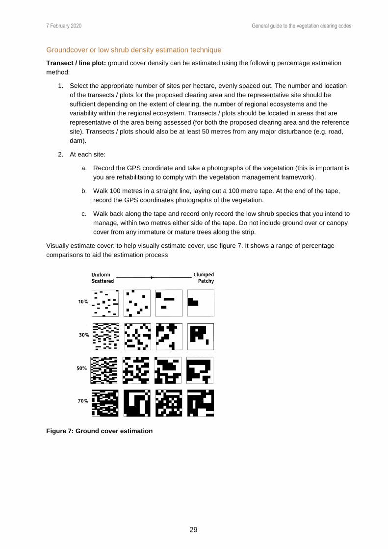
7 February 2020 General guide to the vegetation clearing codes
29
Groundcover or low shrub density estimation technique
Transect / line plot: ground cover density can be estimated using the following percentage estimation
method:
1. Select the appropriate number of sites per hectare, evenly spaced out. The number and location
of the transects / plots for the proposed clearing area and the representative site should be
sufficient depending on the extent of clearing, the number of regional ecosystems and the
variability within the regional ecosystem. Transects / plots should be located in areas that are
representative of the area being assessed (for both the proposed clearing area and the reference
site). Transects / plots should also be at least 50 metres from any major disturbance (e.g. road,
dam).
2. At each site:
a. Record the GPS coordinate and take a photographs of the vegetation (this is important is
you are rehabilitating to comply with the vegetation management framework).
b. Walk 100 metres in a straight line, laying out a 100 metre tape. At the end of the tape,
record the GPS coordinates photographs of the vegetation.
c. Walk back along the tape and record only record the low shrub species that you intend to
manage, within two metres either side of the tape. Do not include ground over or canopy
cover from any immature or mature trees along the strip.
Visually estimate cover: to help visually estimate cover, use figure 7. It shows a range of percentage
comparisons to aid the estimation process
Figure 7: Ground cover estimation

7 February 2020 General guide to the vegetation clearing codes
30
Part 10: Measuring height and slope
Measuring tree height
There are several methods you can use to measure the height of trees.
Using specialist tools
The clinometer is a tool commonly used by foresters to measure tree heights and slope angles. If you
have a clinometer, please follow the manufacturer’s instructions for use.
There are also many videos online that show how to make and use a simple clinometer, using a
protractor, some string and a small weight.
The heights of the crown can also be measured using a laser instrument called a hypsometer. If the top of
the tree is not directly above the base of the trunk, it is important to also measure the point directly below
the highest point of the tree canopy to get an accurate crown height.
Pencil (or stick) method
This is a very simple method requiring only a pencil (or small straight stick) and a tape measure. Take a
pencil (or small stick) and move several metres or more away from the tree. (Refer to figure 8.)
Outstretch your arm and hold the pencil so that you can measure the height of the tree on the pencil (e.g.
line up the top of the pencil with the top of the tree and slide your thumb along the stick to correspond
with the base of the tree). You may also need to move closer or further away from the tree to allow a
length of the pencil to align with the height of the tree.
Keeping your thumb in the same position and lined up with the base of the tree (and your arm still
outstretched), turn the pencil at the base of the tree by 90°. Note the location on the ground that lines up
with the top of the pencil. Mark or note this point on the ground and then measure the distance from this
point to the base of the tree. This is the height of the tree.
Figure 8: The pencil method

7 February 2020 General guide to the vegetation clearing codes
31
Stick and shadow method
For this method you will need to see the tree’s shadow on the ground. You will also need a tape measure,
a calculator and a stake of any height to hammer into the ground.
Figure 9: Stick and shadow method
1. Hammer a stake vertically into the ground so you can see its shadow. Record the height of the stake
above ground (H) and the length of the stake’s shadow (S) from the base of the stake.
2. Measure the length of the tree’s shadow from the centre of the base of the tree (L).
3. Ensure that both shadow measurements are taken within a few minutes of each other, using the
same units (e.g. metres).
4. The tree’s height may be estimated using simple proportions:
Height of stake above ground (H)
Height of tree = ——————————————— × Length of tree shadow (L)
Length of stake’s shadow (S)
Stick method 2
You can measure the height of trees by
projecting a right-angled triangle (one
that includes a 90° angle) using your
arm, a stick and your line of sight (see
figure 10).
1. Find a straight stick or length of
dowel about 750 mm long. Holding
the stick upright in your outstretched
hand and in front and level with your
eye, measure the horizontal distance
from your eye to the stick. Mark the
same distance on the stick.
2. Grasp the stick at the mark and hold
it out in front of you with your arm
fully extended and at eye level. The
stick must be held vertically pointing
upwards. (The distance from your
eye to the base of the stick should
equal the length of the stick above
your hand.)
3. Walk toward or away from the tree
until the tip of the stick is visually lined up with the top of the tree. It’s often easiest to walk along the
Figure 10: Diagrammatic representation of stick method 2

7 February 2020 General guide to the vegetation clearing codes
32
contour so the mark on the stick remains lined up with a point on the tree the same height as your
eye. When sighting the top and bottom of the stick, move your eyes rather than your head.
4. The height of the tree will be the distance from your eye to the tree trunk (measure this distance with
a measuring tape) plus the height of your eye above the ground.
Height of tree = distance A to B – eye height
5. If no long-distance measuring device is available, calibrate your step (the walking distance between
your two feet) or pace (walking distance for two steps) over a known distance (e.g. 20 metres). Then
measure the distance from A to B in paces or steps and convert to metres.
Smart phone apps
Various smart phone apps are available that claim to help measure tree height. Care should be taken if
using these because:
the accuracy may depend on the quality of your phone (and may require some manual
calibration)
some apps still require subsequent trigonometric calculations
the reliability and accuracy of the app may not be proven.
If such apps are used, it is recommended to first verify the results with other methods before using the
apps operationally.
Measuring slope
Definition
For the purposes of the codes, slope is measured in percentages, and is defined as the change in vertical
height relative to the change in horizontal distance multiplied by 100.
Vertical distance
Slope (%) = ————————— × 100
Horizontal distance
For example, for this illustrated slope from A to B:
1
Slope (%) = —— × 100 = 5%
20
The location of points A and B should be selected so the line between them is representative of the slope
in question. For example, don’t choose high or low spots in the landscape for these points.
1 m
20 m
A
B

7 February 2020 General guide to the vegetation clearing codes
33
Using a clinometer
The Suunto clinometer (clino) is a tool commonly used by foresters to
measure tree heights and slope angles. There are many types of
clinometers that are relatively inexpensive. If you can have access to
one, ensure it has a scale to measure percentage slope.
Using a clinometer is one of the most accurate methods of measuring
slope—differences in vertical height and horizontal distances may be
measured accurately in order to calculate the slope. The exact
measuring method will depend on the equipment used; please follow the
manufacturer’s instructions.
Homemade clinometer
You can also make your own
clinometer using a large protractor
with a hole drilled (as shown in
figure 12), string and a small
weight.
Attach the string through the drilled
hole and tie the small weight to the
other end of the string. When the
flat edge of the protractor is held
horizontally, the string should hang
down vertically and indicate 90° on
the protractor.
To measure a slope, look along the
flat edge of the protractor and line it
up with a point in the distance (up
or down slope) that is the same
height above the ground as your
eye. The aim is for the flat edge of
the protractor to be parallel to the
slope you are measuring.
Using the location of the string
against the protractor’s scale, read
off the angle observed—that is, the
angle between the 90° line on the
protractor and the location of the
string.
This angle is in degrees and needs to be converted to a percentage. To do this, use a scientific calculator
to find the ‘tan’ of this number and then multiply by 100. For example, if you measured 3°, then:
tan (3°) × 100 = 5.2% slope
Using a line level
You will need string, two stakes, a line level and a measuring tape.
Hammer one stake into the ground on the upper side of slope. Tie a long piece of string (e.g. 10 metres)
to the base of the stake and lay the string out directly down the slope.
Figure 11: Surveyor’s level
Figure 12: Home-made clinometer and its use in the field

7 February 2020 General guide to the vegetation clearing codes
34
Walk down to near the end of the string. Hammer the second stake vertically into the ground and pull the
string tight to the base of the second stake. Ensure both stakes are in locations that are representative of
the overall slope. Raise the string up the second stake until it is perfectly horizontal, as indicated by using
the line level along the top of the string.
Figure 13: Using a line level to measure slope
Measure the second stake between the string and the ground. This is the vertical distance for the slope
calculation. Keep the string tight and measure the length of string between each stake. This is the
horizontal distance for the slope calculation.
Use these two distances to calculate slope as shown in figure 13.
Topographic map
Topographic maps show contour lines that join points of equal elevation. Contour lines that are spaced
evenly apart indicate a fairly uniform slope. If ground observations confirm a uniform slope, you can
calculate the slope by determining vertical height from adjacent contour lines and the horizontal distance
from the scale bar of the map.
For example, if the contour interval is 10 metres, this is the vertical height for the slope calculation. If the
horizontal distance between the contour lines is 400 metres (using the scale bar on the map), the slope
will be (10 ÷ 400) × 100 = 2.5%.
Care should be taken to ensure you locate yourself accurately on the map and that the land between the
contour lines is of uniform slope. If not, other more reliable methods should be used.
Smart phone apps
Various smart phone apps are available that claim to measure slope. Care should be taken if using these
because the:
accuracy may depend on the quality of your phone’s components
reliability and accuracy of the app may not be proven.
If such apps are used, it is recommended to first verify their results with other methods before using the
apps operationally.

7 February 2020 General guide to the vegetation clearing codes
35
Appendix 1- VMA schedule terms7 accepted development see the Planning Act, section 44(4).
accepted development vegetation clearing code see section 19O(1) and (2).
approved form means a form approved by the chief executive under section 68D.
approved restoration plan means a restoration plan approved by the chief executive under part 3,
division 1, subdivision 8.
area management plan see section 21.
area of high nature conservation value means an area declared to be an area of high nature
conservation value under—
(a) a declaration made by the Governor in Council under section 17; or
(b) an interim declaration made by the Minister under section 18; or
(c) a declaration made by the chief executive under section 19F.
area vulnerable to land degradation means an area declared to be an area vulnerable to land
degradation under—
(a) a declaration made by the Governor in Council under section 17; or
(b) an interim declaration made by the Minister under section 18; or
(c) a declaration made by the chief executive under section 19F.
assessable development see the Planning Act, section 44(3).
assessment benchmarks see the Planning Act, section 43(1)(c).
biodiversity means the variability among living organisms from all sources, including terrestrial, marine
and other aquatic ecosystems and the ecological complexes of which they are part, and includes—
(a) diversity within species and between species; and
(b) diversity of ecosystems.
bioregion means a bioregion shown on map number V0001 held by the department.
built infrastructure includes a building, or other structure, built or used for any purpose.
category A area see section 20AL.
category B area see section 20AM.
category C area see section 20AN.
category R area see section 20ANA.
category X area see section 20AO.
centre of endemism means an area containing concentrations of species that are largely restricted to
the area.
change application means a change application under the Planning Act.
clear, for vegetation—
7 Current as at 11 April 2019

7 February 2020 General guide to the vegetation clearing codes
36
(a) means remove, cut down, ringbark, push over, poison or destroy in any way including by burning,
flooding or draining; but
(b) does not include destroying standing vegetation by stock, or lopping a tree.
clearing offence means an offence under the Forestry Act 1959, the Nature Conservation Act or the
Environmental Protection Act 1994.
commercial timber includes timber of a species prescribed under a regulation for section 70A(3).
contaminant includes a gas, liquid, solid or energy source, including radioactivity and electromagnetic
radiation.
criminal history, of a person, means the convictions, including spent convictions, recorded against the
person for offences, in Queensland or elsewhere, whether before or after the commencement of this Act.
CYPH Act means the Cape York Peninsula Heritage Act 2007.
decision, for part 4, division 4, see section 68CA.
declared area means an area declared under section 17, 18 or 19F.
declared pest means a plant or an animal, other than a native species of plant or animal, that is—
(a) invasive biosecurity matter under the Biosecurity Act 2014; or
Notes—
1 See the Biosecurity Act 2014, schedule 1, part 3 or 4 or schedule 2, part 2.
2 See also the note to the Biosecurity Act 2014, schedules 1 and 2.
(b) controlled biosecurity matter or regulated biosecurity matter under the Biosecurity Act 2014.
deemed refusal means a deemed refusal as defined under the Planning Act.
development means development as defined under the Planning Act.
development application means a development application under the Planning Act.
development approval means a development approval under the Planning Act for a vegetation clearing
application.
document certification requirement see section 52(5) and (6).
downstream limit, of a watercourse, see the Water Act 2000, schedule 4.
drainage feature see the Water Act 2000, schedule 4.
encroachment means a woody species that has invaded an area of a grassland regional ecosystem to
an extent the area is no longer consistent with the description of the regional ecosystem.
endangered regional ecosystem means a regional ecosystem declared to be an endangered regional
ecosystem under section 22LA.
enforceable undertaking see section 68CC(1).
equipment includes machinery.
essential habitat, for protected wildlife, see section 20AC(2).
essential habitat map see section 20AC(1).

7 February 2020 General guide to the vegetation clearing codes
37
exchange area means an area of vegetation that must be protected in the way provided under an
accepted development vegetation clearing code in exchange for clearing vegetation under the code.
extractive industry—
(a) means 1 or more of the following—
(i) dredging material from the bed of any waters;
(ii) extracting, from a pit or quarry, rock, sand, clay, gravel, loam or other material;
(iii) screening, washing, grinding, milling, sizing or separating material extracted from a pit or
quarry; and
(b) includes carrying out work that is the natural and ordinary consequence of carrying out the work
mentioned in paragraph (a).
Example— constructing roads, buildings and other infrastructure
FA chief executive means the chief executive of the department that administers the Forestry Act 1959.
fodder harvesting—
1 Fodder harvesting is the clearing of vegetation, predominantly consisting of fodder species—
(a) necessary to provide fodder for stock; and
(b) carried out in a way that—
(i) conserves the vegetation in perpetuity; and
(ii) conserves the regional ecosystem in which the vegetation is situated; and
(iii) results in the woody biomass of the cleared vegetation remaining where it is cleared.
2 For paragraph 1, fodder species are any of the following—
(a) Acacia aneura;
(b) Acacia brachystachya;
(c) Acacia excelsa;
(d) Acacia pendula;
(e) Acacia sibirica;
(f) Alphitonia excelsa;
(g) Flindersia maculosa;
(h) Geijera parviflora.
forest practice—
1 Forest practice means planting trees, or managing, felling and removing standing trees, on freehold
land or indigenous land on which the State does not own the trees, for an ongoing forestry business in
a—
(a) plantation; or
(b) native forest if, in the native forest, all the activities are conducted in a way that—
(i) ensures restoration of a similar type, and to the extent, of the removed trees; and

7 February 2020 General guide to the vegetation clearing codes
38
(ii) ensures trees are only felled for the purpose of being sawn into timber or processed into
another value-added product (other than woodchips for an export market); and
(iii) does not cause land degradation; and
(iv) is consistent with the accepted development vegetation clearing code for native forest
practice.
2 The term includes carrying out limited associated work, including, for example, drainage, construction
and maintenance of roads or vehicular tracks, and other necessary engineering works.
3 The term does not include clearing vegetation for the initial establishment of a plantation.
freehold land includes land in a freeholding lease under the Land Act 1994.
grassland regional ecosystem means a regional ecosystem prescribed under a regulation as a
grassland regional ecosystem.
high value regrowth vegetation means vegetation located—
(a) on freehold land, indigenous land, or land subject of a lease issued under the Land Act 1994 for
agriculture or grazing purposes or an occupation licence under that Act; and
(b) in an area that has not been cleared (other than for relevant clearing activities) for at least 15
years, if the area is—
(i) an endangered regional ecosystem; or
(ii) an of concern regional ecosystem; or
(iii) a least concern regional ecosystem.
indigenous community use area see the CYPH Act, schedule.
indigenous land means, for regulating the clearing of vegetation, land held under a following Act by, or
on behalf of or for the benefit of, Aboriginal or Torres Strait Islander inhabitants or purposes—
(a) the Aboriginal Land Act 1991;
(b) the Torres Strait Islander Land Act 1991;
(c) the Land Act 1994.
information notice, about a decision, means a notice stating each of the following—
(a) the decision, and the reasons for it;
(b) the rights of review under this Act;
(c) the period in which any review under this Act must be started;
(d) how rights of review under this Act are to be exercised.
lake see the Water Act 2000.
Land Act notice means a compliance notice given for a tree clearing offence under the Land Act 1994 as
in force immediately before the commencement of the Vegetation Management and Other Legislation
Amendment Act 2004, section 3.
Land Act tenure means any of the following—
(a) unallocated State land;
(b) a road;

7 February 2020 General guide to the vegetation clearing codes
39
(c) an area subject to a lease under the Land Act 1994.
land degradation includes the following—
(a) soil erosion;
(b) rising water tables;
(c) the expression of salinity;
(d) mass movement by gravity of soil or rock;
(e) stream bank instability;
(f) a process that results in declining water quality.
least concern regional ecosystem means a regional ecosystem declared to be a least concern regional
ecosystem under section 22LC.
lopping, a tree, means cutting or pruning its branches, but does not include—
(a) removing its trunk; and
(b) cutting or pruning its branches so severely that it is likely to die.
managing thickened vegetation means the selective clearing of vegetation at a locality that does not
include clearing using a chain or cable linked between 2 tractors, bulldozers or other traction vehicles—
(a) to restore a regional ecosystem to the floristic composition and range of densities typical of the
regional ecosystem in the bioregion in which it is located; and
(b) to maintain ecological processes and prevent loss of biodiversity.
minor change application means a change application for a minor change to a development approval,
as defined in the Planning Act.
moratorium exemption means an exemption under the repealed Moratorium Act.
native forest practice means a forest practice other than—
(a) a forest practice in a plantation; or
(b) the harvesting, on freehold land, of sandalwood.
Nature Conservation Act means the Nature Conservation Act 1992.
necessary environmental clearing means clearing of vegetation that is necessary to—
(a) restore the ecological and environmental condition of land; or
Example— stabilising banks of watercourses, works to rehabilitate eroded areas, works to prevent
erosion of land or for ecological fire management
(b) divert existing natural channels in a way that replicates the existing form of the natural channels;
or
(c) prepare for the likelihood of a natural disaster; or
Example— removal of silt to mitigate flooding
(d) remove contaminants from land.
occupier, of land, means—
(a) the person in actual occupation of the land or, if there is no person in actual occupation, the
person entitled to possession of the land; and

7 February 2020 General guide to the vegetation clearing codes
40
(b) if there is more than 1 occupier of the land—any of the occupiers.
of concern regional ecosystem means a regional ecosystem declared to be an of concern regional
ecosystem under section 22LB.
official means—
(a) the chief executive; or
(b) an authorised officer.
offset area means a legally secured offset area under the Environmental Offsets Act 2014.
original decision see section 63A(1)(a).
owner, of land, includes the following—
(a) for freehold land—the registered owner;
(b) for a lease, licence or permit under the Land Act 1994— the lessee, licensee or permittee;
(c) for indigenous land—the holder of the title to the land;
(d) for any tenure under any other Act—the holder of the tenure.
plan area, for part 2, division 5B, see section 21.
Planning Act means the Planning Act 2016.
planning chief executive means the chief executive of the department in which the Planning Act is
administered.
plantation forestry means the planting and cultivation of timber for commercial purposes.
PMAV see section 20AK.
PMAV application, for part 4, division 4, see section 68CA.
pre-clearing extent, of a regional ecosystem, means the extent of the regional ecosystem before it was
cleared.
primary producer, for part 2, division 4C, see section 19Y.
primary production business, for part 2, division 4C, see section 19Y.
primary production entity, for part 2, division 4C, see section 19Y.
property map of assessable vegetation see section 20AK.
proponent, for part 2, division 4, subdivision 2, see section 19E(1).
protected wildlife means native wildlife prescribed under the Nature Conservation Act as endangered
wildlife, vulnerable wildlife or near threatened wildlife.
public place means a place the public is entitled to use, open to the public or used by the public, whether
or not on payment of an amount.
reasonably believes means believes on grounds that are reasonable in the circumstances.
reasonably suspects means suspects on grounds that are reasonable in the circumstances.
referral agency, for a development application, see the Planning Act, section 54(2).
regional ecosystem means a vegetation community in a bioregion that is consistently associated with a
particular combination of geology, landform and soil.

7 February 2020 General guide to the vegetation clearing codes
41
Editor’s note— The Queensland Herbarium publishes a map of the regional ecosystems in Queensland
and the map is available on the department’s website.
regional ecosystem number, for a regional ecosystem, means the regional ecosystem number that is
established under the Regional Ecosystem Description Database.
Note— The Regional Ecosystem Description Database is a database containing regional ecosystem
numbers and descriptions of the regional ecosystems that is maintained by the Queensland Herbarium.
The database is available on the department’s website at www.dnrm.qld.gov.au.
regrowth vegetation means vegetation that is not remnant vegetation.
regrowth watercourse and drainage feature area means an area located within 50m of a watercourse
or drainage feature located in the Burdekin, Burnett-Mary, Eastern Cape York, Fitzroy, Mackay
Whitsunday or Wet Tropics catchments represented on the vegetation management watercourse and
drainage feature map.
regulate includes prohibit.
regulated regrowth vegetation is vegetation contained in a category C or category R area.
regulated vegetation management map see section 20A.
relevant clearing activities means—
(a) fodder harvesting; or
(b) managing thickened vegetation; or
(c) clearing of encroachment; or
(d) controlling non-native plants or declared pests; or
(e) necessary environmental clearing; or
(f) managing, felling and removing trees for an ongoing forestry business.
relevant infrastructure activities means—
(a) establishing and maintaining a necessary fence, firebreak, road, or vehicular track; or
(b) constructing and maintaining necessary built infrastructure.
relevant PMAV application, for part 4, division 4, see section 68CA.
remnant vegetation means vegetation—
(a) that is—
(i) an endangered regional ecosystem; or
(ii) an of concern regional ecosystem; or
(iii) a least concern regional ecosystem; and
(b) forming the predominant canopy of the vegetation—
(i) covering more than 50% of the undisturbed predominant canopy; and
(ii) averaging more than 70% of the vegetation’s undisturbed height; and
(iii) composed of species characteristic of the vegetation’s undisturbed predominant canopy.
repealed Moratorium Act means the Vegetation Management (Regrowth Clearing Moratorium) Act
2009.

7 February 2020 General guide to the vegetation clearing codes
42
restoration notice see section 54B(2).
restoration plan see section 55AA(b).
restricted (fodder harvesting) land, for part 2, division 5B, see section 21A.
review decision see section 63A(1)(b).
road see the Transport Infrastructure Act 1994, schedule 6.
sandalwood means a plant of the species Santalum lanceolatum.
spent conviction means a conviction—
(a) for which the rehabilitation period under the Criminal Law (Rehabilitation of Offenders) Act
1986 has expired under that Act; and
(b) that is not revived as prescribed by section 11 of that Act.
State land means all land (including roads and reserves), other than—
(a) freehold land or land contracted to be granted in fee simple by the State; or
(b) indigenous land on which the State does not own the trees.
State policy means the policy approved under section 10(3).
stop work notice see section 54A(2).
trespass notice means a trespass notice under the Land Act 1994, section 406.
undisturbed height, for vegetation, means the height to which the vegetation normally grows.
undisturbed predominant canopy, for vegetation, means the predominant canopy the vegetation
normally has.
unlawfully cleared means cleared of vegetation by a person in contravention of—
(a) a vegetation clearing provision, or the repealed Sustainable Planning Act 2009, section 578(1),
580(1), 581(1), 582 or 594(1) if the person—
(i) has not contested an infringement notice given for the contravention; or
(ii) has been convicted of the contravention, whether or not the conviction is recorded; or
(b) a tree clearing provision under the Land Act 1994, as in force before the commencement of the
Vegetation Management and Other Legislation Amendment Act 2004, section 3.
vegetation see section 8.
vegetation category area see section 20AKA.
vegetation clearing application means—
(a) a development application for development that involves the clearing of vegetation and is
categorised as assessable development under a regulation made under the Planning Act; or
(b) a change application, other than a minor change application, to change a development approval,
as defined in that Act, to approve development mentioned in paragraph (a), if the development
approval does not already approve that development.
vegetation clearing offence means an offence against a vegetation clearing provision.

7 February 2020 General guide to the vegetation clearing codes
43
vegetation clearing provision means any of the following to the extent the provision relates to the
clearing of vegetation—
(a) the Planning Act, section 162, 163(1), 164, 165 or 168(5);
(b) for the clearing of vegetation that happened before the repeal of the Sustainable Planning Act
2009— section 578(1), 580(1), 581(1), 582 or 594(1) of that Act.
vegetation management see section 9.
vegetation management map means—
(a) the essential habitat map; or
(b) the regulated vegetation management map; or
(c) the vegetation management watercourse and drainage feature map; or
(d) the vegetation management wetlands map; or
(e) a PMAV.
vegetation management watercourse and drainage feature map see section 20AB.
vegetation management wetlands map see section 20AA.
watercourse has the meaning given by the Water Act 2000, section 5, but a reference to a watercourse
in this Act includes a reference to anywhere that is downstream of the downstream limit of the
watercourse.
Note for definition watercourse— For the purposes of this Act, the length of a watercourse is not limited
by any downstream limit applying to it under the Water Act 2000.
wetland means an area of land that supports plants or is associated with plants that are adapted to and
dependent on living in wet conditions for at least part of their life cycle.
wildlife refugium means an area that is a sanctuary to which a species or group of species has
retreated, or been confined, in response to threatening processes, including a climatic change.


