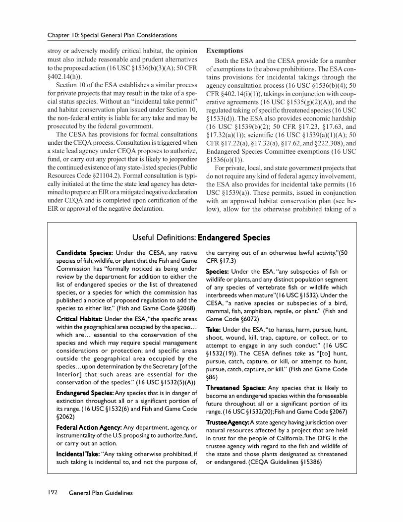
State of California Gener Gener Gener Gener Gener al Plan al Plan al Plan al Plan al Plan Guidelines Guidelines Guidelines Guidelines Guidelines Governor’s Office of Planning and Research 2 0 0 3
Governor’s Office of Planning and ResearchTal Finney, Interim Director1400 Tenth StreetSacramento, CA 95814916-322-2318
State Clearinghouse Director: Terry RobertsLead Editor: Brian GrattidgeAssistant Editor: Anya Lawler
October 2003
Please feel free to reproduce all or part of this document. You need not secure permission; we ask that youprint it accurately and give credit to the Governor’s Office of Planning and Research.
This document is available on the Internet at http://www.opr.ca.gov.
3General Plan Guidelines
Director’s Message
The Governor’s Office of Planning and Research (OPR) is proud to announce the publication of the 2003General Plan Guidelines. These advisory guidelines serve as a valuable reference for cities and counties in thepreparation of local general plans. It is our hope that the General Plan Guidelines will be useful not only to cityand county planning staffs, but to elected officials, planning consultants, and members of the public.
The State Legislature declared in 1976 that “decisions involving the future growth of the state, most of whichare made and will continue to be made at the local level, should be guided by an effective planning process,including the local general plan, and should proceed within the framework of officially approved statewide goalsand policies.” In all of its work, OPR attempts to encourage more collaborative and comprehensive land useplanning at the local, regional, and statewide levels to achieve sustainable development goals of protecting theenvironment, maintaining a healthy economy, and ensuring equitable treatment of all people.
In addition to the General Plan Guidelines, OPR has recently published the Municipal Service Review Guide-lines, which provide guidance for Local Agency Formation Commissions (LAFCOs) to address the delivery ofmunicipal services at a regional level, in a manner that informs other LAFCO boundary-setting decisions. TheMunicipal Service Review Guidelines will be followed by A Guide to the LAFCO Process for Incorporations,which will assist LAFCOs in establishing new city boundaries. Finally, for the first time in twenty-five years, theEnvironmental Goals and Policy Report will provide the statewide framework that guides the infrastructureinvestments and comprehensive plans of state agencies and departments.
As the General Plan Guidelines enters its thirtieth year, I know you will find the 2003 edition to be aninvaluable tool in the practice of local planning.
OPR INTERNS OPR INTERNS OPR INTERNS OPR INTERNS OPR INTERNS AND AND AND AND AND ASSOCIAASSOCIAASSOCIAASSOCIAASSOCIATES:TES:TES:TES:TES:
♦ Rebecca Farrington♦ Becky Frank♦ Aaron Bock
REVIEWERSREVIEWERSREVIEWERSREVIEWERSREVIEWERS
OPR would like to thank everyone who reviewed andcommented on the preliminary draft of this publication.We would also like to thank the following individualsfor their support and professional advice:♦ Daniel J. Curtin, Jr., Bingham McCutchen LLP♦ Laura Hall, Fisher & Hall Urban Design♦ Nancy J. Hanson, California Energy Commission♦ Gregory King, California Department of Transpor-
tation♦ Larry Mintier, J. Laurence Mintier and Associates♦ Romel Pascual, California Environmental Protec-
tion Agency
♦ Elizabeth Patterson, California Floodplain Manage-ment Taskforce
♦ Alison Pernell, Local Government Commission♦ Nancy Pfeffer, Southern California Association of
Governments♦ Shankar Prasad, California Air Resources Board♦ Cecily T. Talbert, Bingham McCutchen LLP♦ Linda Wheaton, California Department of Hous-
ing and Community Development
In addition to the individuals named above, we wouldlike to thank for the following state agencies for theircontributions:♦ California Air Resources Board♦ California Energy Commission♦ California Environmental Protection Agency♦ California Integrated Waste Management Board♦ California Resources Agency♦ Department of Conservation♦ Department of Forestry and Fire Protection♦ Department of Housing and Community
Development♦ Department of Parks and Recreation♦ Department of Toxic Substances Control♦ Department of Transportation♦ Department of Water Resources
The 2003 General Plan Guidelines is an update of the1998 edition, written by Antero Rivasplata and GreggMcKenzie, whose contributions are gratefully acknowl-edged.
5General Plan Guidelines
Table of Contents
Introduction ......................................................................................... 8Milestones in California’s Planning Law ............................................................................................................ 9
Chapter 1: General Plan Basics .............................................................. 10Comprehensiveness ........................................................................................................................................ 10Internal Consistency ....................................................................................................................................... 12Long-Term Perspective ................................................................................................................................... 13Defining the Parts of the General Plan ........................................................................................................... 14Community Plans, Area Pans, and Specific Plans ............................................................................................ 17Elements, Issues, and Flexibility ...................................................................................................................... 17Adoption of Another Jurisdiction’s General Plan and Joint Adoption .............................................................. 18
Chapter 2: Sustainable Development and Environmental Justice ............ 20Sustainable Development .............................................................................................................................. 20Environmental Justice .................................................................................................................................... 22Transit-Oriented Development ....................................................................................................................... 28
Chapter 3: Preparing and Amending the General Plan ............................ 32The Work Program .......................................................................................................................................... 32Formulate Goals ............................................................................................................................................. 35Collect and Analyze Data ................................................................................................................................ 36Refine Goals and Determine Objectives .......................................................................................................... 42Developing and Evaluating Alternative Plans ................................................................................................. 43Selecting the Preferred Plan ........................................................................................................................... 43Implementing the General Plan ..................................................................................................................... 46General Plan Amendments ............................................................................................................................. 47
Chapter 4: Required Elements .............................................................. 48Relationships Among Elements and Issues ..................................................................................................... 48Land Use Element ........................................................................................................................................... 49Circulation Element ........................................................................................................................................ 55Housing Element ............................................................................................................................................ 61Conservation Element .................................................................................................................................... 75Open-Space Element ...................................................................................................................................... 82Noise Element ................................................................................................................................................ 87Safety Element ............................................................................................................................................... 90
Chapter 5: Format and Element Integration .......................................... 98Equal Status and Internal Consistency ............................................................................................................ 98
6 General Plan Guidelines
Element Consolidation ................................................................................................................................... 98Style and Presentation ................................................................................................................................. 100
Chapter 7: CEQA and the General Plan ................................................. 136EIR Preparation ............................................................................................................................................. 136Timing .......................................................................................................................................................... 137Public Review of the EIR ............................................................................................................................... 137Adoption and Certification ........................................................................................................................... 138Program and Master EIRs ............................................................................................................................. 138Combining the General Plan and its EIR ....................................................................................................... 140Findings ........................................................................................................................................................ 140Mitigation Monitoring and Implementation ................................................................................................ 140Master Environmental Assessment ............................................................................................................... 141Exemptions .................................................................................................................................................. 141
Chapter 8: Public Participation ........................................................... 142Environmental Justice .................................................................................................................................. 142Goals and Outcomes ..................................................................................................................................... 142Process Design .............................................................................................................................................. 143Tools ............................................................................................................................................................. 144
Chapter 9: Implementing the General Plan ......................................... 149Zoning .......................................................................................................................................................... 149Specific Plans ................................................................................................................................................ 152Subdivision Regulations ............................................................................................................................... 153Capital Facilities ............................................................................................................................................ 154Redevelopment ............................................................................................................................................ 155Development Agreements ............................................................................................................................ 156Building and Housing Codes ......................................................................................................................... 157Acquisition ................................................................................................................................................... 157
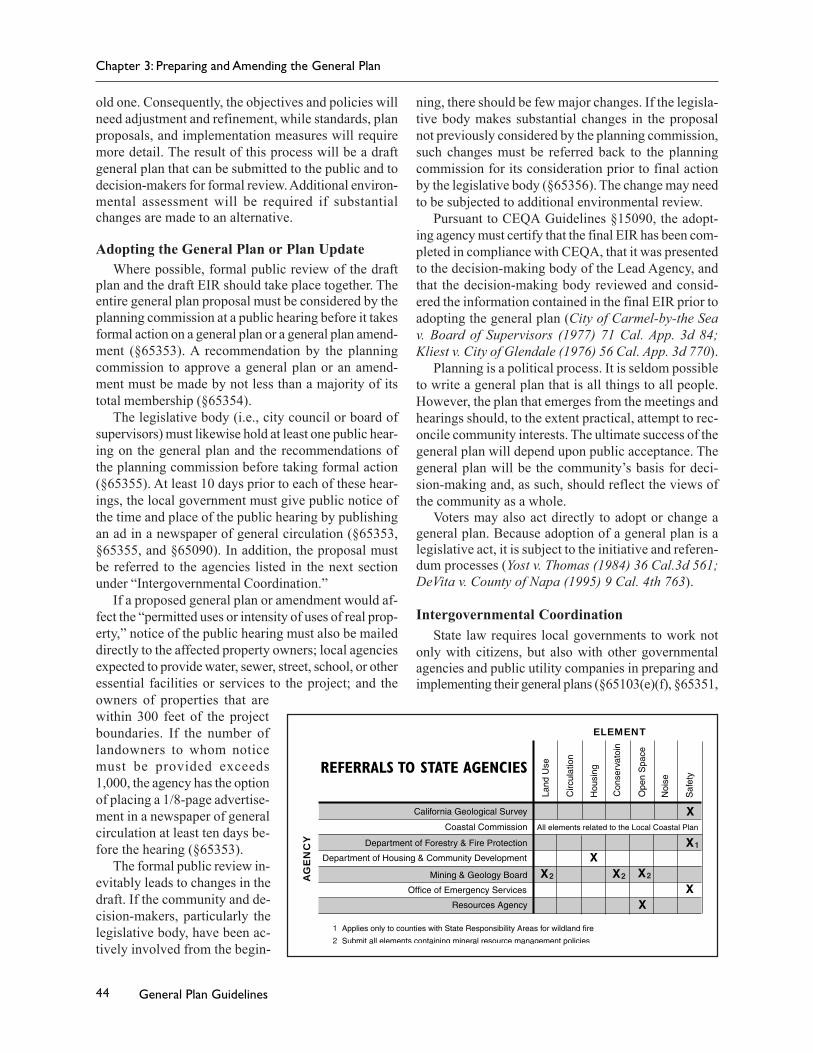
Chapter 10: Special General Plan Considerations.................................. 174California Coastal Act .................................................................................................................................... 174Surface Mining and Reclamation Act............................................................................................................ 176California Integrated Waste Management Act .............................................................................................. 180County Hazardous Waste Management Plans .............................................................................................. 182Alquist-Priolo Earthquake Fault Zoning Act .................................................................................................. 183Seismic Hazards Mapping Act ...................................................................................................................... 184Cobey-Alquist Floodplain Management Act ................................................................................................. 185Airport Land Use Commission Law ............................................................................................................... 185Cortese-Knox-Hertzberg Local Government Reorganization Act of 2000 ..................................................... 186Regional Transportation Planning ................................................................................................................ 188Endangered Species Laws ............................................................................................................................. 189Wetlands Protection ..................................................................................................................................... 196Air Quality .................................................................................................................................................... 199Water Quality ............................................................................................................................................... 200Delta Protection Act of 1992 ......................................................................................................................... 200
Appendix A: Pertinent State Code Sections .......................................... 201Appendix B: Court and Attorney General Opinions ............................... 231Appendix C: Noise Element Guidelines ................................................ 244Glossary ............................................................................................ 255Bibliography ..................................................................................... 274Internet Resources ............................................................................ 282Index ................................................................................................ 284
8 General Plan Guidelines
Introduction
Each city and county in California must pre-pare a comprehensive, long term general planto guide its future. To assist local govern-
ments in meeting this responsibility, the Governor’sOffice of Planning and Research is required to adoptand periodically revise guidelines for the preparationand content of local general plans (Government Code§65040.2).
The 2003 edition of the General Plan Guidelinessupercedes all previous editions. Important changessince the 1998 edition include the following:♦ Guidance for addressing environmental justice in
the general plan.♦ Guidance on developing optional water and energy
elements.♦ Expanded guidance on public participation in the
development of the general plan.♦ Revised and expanded housing element guidelines.♦ Guidance on developing optional water and energy
elements.♦ Expanded guidance on consolidation of individual
general plan elements.♦ Suggested reporting formats for the annual general
plan progress report.
The 2003 edition of the General Plan Guidelines isthe first to incorporate an extensive public review pro-cess. OPR hosted a series of forums in early 2002 togain preliminary input into the General Plan Guide-lines. A preliminary draft of the revised General PlanGuidelines was available for public review from Octo-ber through December, 2002. Two public hearings wereheld in Sacramento in December, 2002, with telecon-ference links to Eureka, Alameda, Bakersfield and SanDiego. A second draft was released in July 2003 for a30 day review period. The final document reflects manyof the suggestions received by OPR during this pro-cess.
This document is arranged into the following chap-ters. Chapter 1 provides an overview of the general plan.Chapter 2 provides guidance on integrating environ-
mental justice into the general plan, and relates envi-ronmental justice to the broader issue of sustainabledevelopment. Chapter 3 outlines how to prepare or re-vise the general plan within the framework of planninglaw.
Chapter 4 elaborates on the statutorily required gen-eral plan elements, citing relevant court interpretationsand Attorney General opinions. Chapter 5 discusses for-matting options for the general plan and opportunitiesfor element integration and consolidation. Chapter 6offers suggestions on preparing selected optional ele-ments and includes new guidance for energy and waterelements.
Chapter 7 reviews the California EnvironmentalQuality Act’s integral role in the general plan process.Chapter 8 discusses the role of public participation inthe general plan process.
Chapter 9 discusses a wide range of general planimplementation techniques and offers suggestions onhow to prepare the required annual general plan imple-mentation report.
Chapter 10 explains the local general plan’s rela-tionship to other statutory planning requirements, suchas the California Coastal Act, the Seismic Hazards Act,and the federal and state Endangered Species Acts.
The General Plan Guidelines concludes with sev-eral appendices, a glossary, and a bibliography of bothprinted and on-line planning references.
The General Plan Guidelines is advisory, not man-datory. Nevertheless, it is the state’s only official docu-ment explaining California’s legal requirements forgeneral plans. Planners, decision-making bodies, andthe public depend upon the General Plan Guidelinesfor help when preparing local general plans. The courtshave periodically referred to the General Plan Guide-lines for assistance in determining compliance withplanning law. For this reason, the General Plan Guide-lines closely adheres to statute and case law. It alsorelies upon commonly accepted principles of contem-porary planning practice. When the words “shall” or“must” are used, they represent a statutory or other le-gal requirement. “May” and “should” are used whenthere is no such requirement.
9General Plan Guidelines
19071907190719071907 First Subdivision Map Act enacted.
19151915191519151915 Cities authorized to create planning commissions.
19171917191719171917 Initial zoning law enacted.
19271927192719271927 Cities and counties authorized to prepare master plans (general plans).
19291929192919291929 Adoption of master plans made mandatory for those cities and counties establishingplanning commissions (based largely on the 1928 U.S. Department of Commerce ModelStandard City Planning Enabling Act). Subdivision Map Act revised enabling localgovernments to require dedication of improvements.
19371937193719371937 All cities and counties required to adopt master plans. Cities and counties authorized toprepare “precise plans” (similar to specific plans of today) to implement the master plan.
19531953195319531953 Planning law recodified into Government Code §65000, et seq.
19551955195519551955 Land use and circulation elements required in the general plan.
19651965196519651965 Planning and Zoning Law reorganized. Cities and counties authorized to prepare “specificplans.”
19671967196719671967 Housing element required in the general plan (effective July 1, 1969).
19701970197019701970 Conservation and open-space elements required in the general plan.
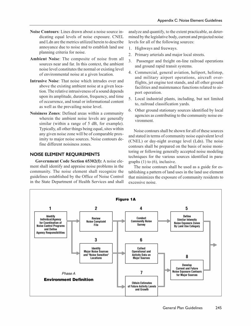
19711971197119711971 Safety, seismic safety, noise, and scenic highway elements required in the general plan.Zoning and subdivision approvals required to be consistent with the adopted generalplan.
19731973197319731973 OPR issues first General Plan Guidelines.
19741974197419741974 Subdivision Map Act recodified from the Business and Professions Code into the StatePlanning and Zoning Law within the Government Code.
19751975197519751975 Legislature clarifies statute on general plans’ internal consistency.
19801980198019801980 Detailed content standards and adoption procedures added to the housing elementrequirement. Appeals court says public works must be consistent with general plans(Friends of B Street).
19821982198219821982 Appeals court says land use and circulation elements must correlate (Twaine Harte).
19841984198419841984 Planning statutes substantially revised, seismic safety and scenic highways elements droppedas required elements, seismic safety merged with safety element.
19901990199019901990 California Supreme Court says zoning in conflict with the general plan invalid (Lesher v.Walnut Creek).
20012001200120012001 Legislature requires General Plan Guidelines to include environmental justice.
This summary does not include other major planning and land use statutes that have been important inshaping local planning, such as the California Environmental Quality Act, the Williamson Act, the CaliforniaCoastal Act, and the Cortese-Knox-Hertzberg Local Government Reorganization Act.
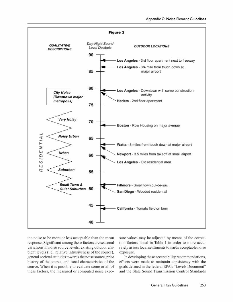
Milestones in California’s Planning Law
10 General Plan Guidelines
CHAPTER 1
General Plan Basics
California state law requires each city andcounty to adopt a general plan “for the physi-cal development of the county or city, and
any land outside its boundaries which bears relation toits planning” (§65300). The California Supreme Courthas called the general plan the “constitution for futuredevelopment.” The general plan expresses thecommunity’s development goals and embodies publicpolicy relative to the distribution of future land uses,both public and private.
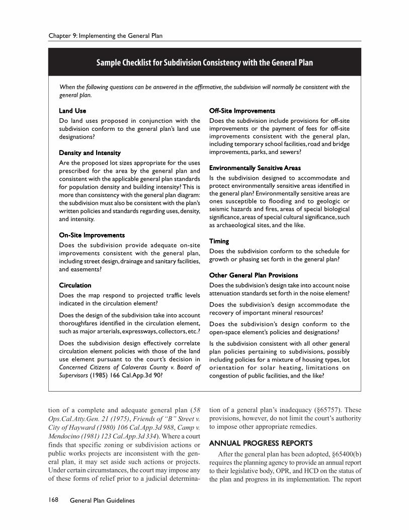
As will be discussed in Chapter 9, the policies ofthe general plan are intended to underlie most land usedecisions. Pursuant to state law, subdivisions, capitalimprovements, development agreements, and manyother land use actions must be consistent with theadopted general plan. In counties and general law cit-ies, zoning and specific plans are also required to con-form to the general plan.
In addition, preparing, adopting, implementing, andmaintaining the general plan serves to:♦ Identify the community’s land use, circulation, en-
vironmental, economic, and social goals and poli-cies as they relate to land use and development.
♦ Provide a basis for local government decision-mak-ing, including decisions on development approvalsand exactions.
♦ Provide citizens with opportunities to participatein the planning and decision-making processes oftheir communities.
♦ Inform citizens, developers, decision-makers, andother cities and counties of the ground rules thatguide development within a particular community.
COMPREHENSIVENESSCOMPREHENSIVENESSCOMPREHENSIVENESSCOMPREHENSIVENESSCOMPREHENSIVENESSEvery city and county must adopt “a comprehen-
sive, long term general plan” (§65300). The generalplan must cover a local jurisdiction’s entire planningarea and address the broad range of issues associatedwith a city’s or county’s development.
Geographic ComprehensivenessThe plan must cover the territory within the bound-
aries of the adopting city or county as well as “any
land outside its boundaries which in the planningagency’s judgment bears relation to its planning”(§65300). For cities, this means all territory within thecity limits, both public and private. Counties must ad-dress all unincorporated areas.
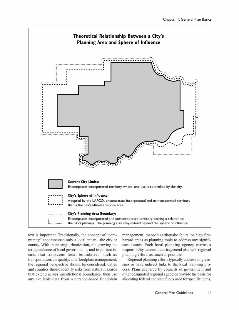
When establishing its planning area, each city shouldconsider using its sphere of influence as a starting point.The Local Agency Formation Commission (LAFCO)in every county adopts a sphere of influence for eachcity to represent “the probable physical boundaries andservice area” of that city (§56076). Although there isno direct requirement that the sphere and the planningarea match, the former provides a convenient measureof the city’s region of interest.
A county should consider the general plans of everycity within the county in its own plans. City planning poli-cies may be reflected in the county plan in various ways.The county plan may discuss city policies in the broadcontext of countywide policy. It may summarize city poli-cies while laying out the county policies for the surround-ing unincorporated area. It may examine city policies inthe context of community plans that it has adopted for thesurrounding unincorporated areas.
In addition, since issues are not confined to politi-cal boundaries, the law provides for planning outsideof the jurisdiction’s territory. Cooperative extraterrito-rial planning can be used to guide the orderly and effi-cient extension of services and utilities; ensure thepreservation of open space, agricultural, and resourceconservation lands; and establish consistent standardsfor development in the plans of adjoining jurisdictions.
Cities and counties should work together to delin-eate planning areas and may establish formal agree-ments for processing development proposals. Forexample, Yolo County delegates a portion of its landuse authority to the City of Davis within areas surround-ing the city. As urbanization occurs and adjoining cit-ies expand, the potential for conflict between citiescompeting for the same lands increases. Intercity co-operation in establishing planning areas can proactivelyhelp to avoid such disputes.
RegionalismViewing the local general plan in its regional con-
All statutory references are to the California Government Code unless otherwise noted.
11General Plan Guidelines
text is important. Traditionally, the concept of “com-munity” encompassed only a local entity—the city orcounty. With increasing urbanization, the growing in-terdependence of local governments, and important is-sues that transcend local boundaries, such astransportation, air quality, and floodplain management,the regional perspective should be considered. Citiesand counties should identify risks from natural hazardsthat extend across jurisdictional boundaries, then useany available data from watershed-based floodplain
management, mapped earthquake faults, or high fire-hazard areas as planning tools to address any signifi-cant issues. Each local planning agency carries aresponsibility to coordinate its general plan with regionalplanning efforts as much as possible.
Regional planning efforts typically address single is-sues or have indirect links to the local planning pro-cess. Plans prepared by councils of government andother designated regional agencies provide the basis forallocating federal and state funds used for specific items,
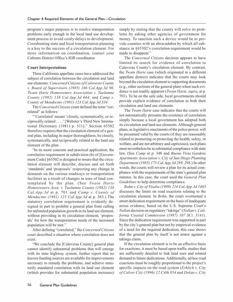
Encompasses incorporated territory where land use is controlled by the city.
Adopted by the LAFCO, encompasses incorporated and unincorporated territory that is the city's ultimate service area.
Encompasses incorporated and unincorporated territory bearing a relation to the city's planning. The planning area may extend beyond the sphere of influence.
Theoretical Relationship Between a City'sPlanning Area and Sphere of Influence
Current City Limits:
City's Sphere of Influence:
City's Planning Area Boundary:
Chapter 1: General Plan Basics
12 General Plan Guidelines
such as transportation facilities. Other regional plans,such as those for air or water quality, spell out mea-sures that local governments must institute in order tomeet federal or state standards for the region. Still oth-ers, such as regional housing allocation plans, measureeach local government’s responsibility for satisfying aspecific share of regional needs. Some regional agen-cies have put together useful information on seismicsafety and other issues that can be helpful in the plan-ning process.
The Legislature has mandated consideration of cer-tain regional impacts in the general plan. For example,if a city or county adopts or amends a mandatory gen-eral plan element limiting the number of residentialunits that may be constructed on an annual basis, itmust explain that action. The city or county must makespecific findings concerning the efforts it has made toimplement its housing element and the public health,safety, and welfare considerations that justify reduc-ing housing opportunities in the region (§65302.8). Fur-ther, cities and counties must balance the housing needsof the region against the needs of their residents forpublic services and the available fiscal and environ-mental resources (§65863.6, §66412.3). In addition,the housing element of the general plan must includeaction programs to accommodate the locality’s regionalfair share of housing (§65583, §65584).
Local general plans should recognize the city’s orcounty’s regional role if regional needs are to be satis-fied, federal and state standards met, and coordinationachieved in the location of public facilities. Accord-ingly, general plans should include a discussion of theextent to which the general plan’s policies, standards,and proposals correspond to regional plans and the plansof adjoining communities. A city or county may needto reexamine its own general plan when its neighborsmake important changes to their plans.
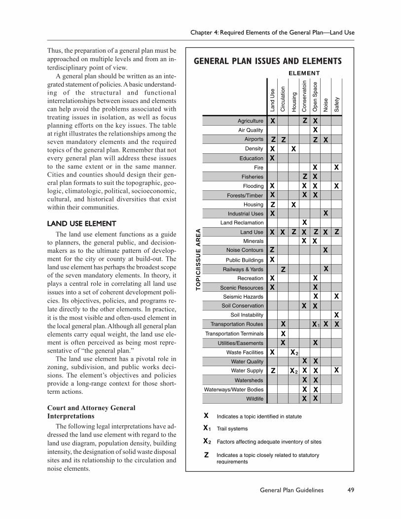
Issue ComprehensivenessA general plan must address a broad range of issues.
Under the “shoe fits” doctrine discussed in Chapter 4,the plan should focus on those issues that are relevantto the planning area (§65301(c)). The plan must addressthe jurisdiction’s physical development, such as gen-eral locations, appropriate mix, timing, and extent ofland uses and supporting infrastructure. The broad scopeof physical development issues may range from appro-priate areas for building factories to open space for pre-serving endangered species (see Chapter 4 forexamples). This may include not only those issues de-scribed in the planning statutes, but regional issues aswell.
In the 1960s, planners began to assert that land usedecisions have not only immediate and future physicaland environmental impacts, but also social and economicimpacts. Because a general plan represents the mostcomprehensive local expression of the general welfareas it relates to land use regulation, recognizing socialand economic concerns in the general plan may be quiteappropriate. Social and economic issues may be dis-cussed within the context of the mandatory elements,such as housing and land use. Some jurisdictions haveadopted an optional economic development element aspart of their general plans (see Chapter 6). Environmen-tal justice, which recognizes that land use decisions haveconsequences for social equity, may also be addressedwithin the context of the mandatory elements. This isdiscussed in Chapter 2.
The concept of internal consistency holds that nopolicy conflicts canexist, either textualor diagrammatic, be-tween the compo-nents of an otherwisecomplete and ad-equate general plan.Different policiesmust be balanced andreconciled within theplan. The internalconsistency require-ment has five dimen-sions, describedbelow.
Equal Status Among ElementsAll elements of the general plan have equal legal
status. For example, the land use element policies arenot superior to the policies of the open-space element.
A case in point: in Sierra Club v. Board of Super-visors of Kern County (1981) 126 Cal.App.3d 698,two of Kern County’s general plan elements, landuse and open space, designated conflicting land usesfor the same property. A provision in the general plantext reconciled this and other map inconsistenciesby stating that “if in any instance there is a conflictbetween the land use element and the open-space el-ement, the land use element controls.” The court ofappeal struck down this clause because it violatedthe internal consistency requirement under §65300.5.No element is legally subordinate to another; the gen-
“In construing theprovisions of this article,the Legislature intends thatthe general plan andelements and parts thereofcomprise an integrated,internally consistent andcompatible statement ofpolicies for the adoptingagency.” (§65300.5)
Chapter 1: General Plan Basics
13General Plan Guidelines
eral plan must resolve potential conflicts among theelements through clear language and policy consis-tency.
Consistency Between ElementsAll elements of a general plan, whether mandatory
or optional, must be consistent with one another. Thecourt decision in Concerned Citizens of CalaverasCounty v. Board of Supervisors (1985) 166 Cal.App.3d90 illustrates this point. In that case, the county landuse element contained proposals expected to result inincreased population. The circulation element, however,failed to provide feasible remedies for the predictedtraffic congestion that would follow. The county sim-ply stated that it would lobby for funds to solve thefuture traffic problems. The court held that this vagueresponse was insufficient to reconcile the conflicts.
Also, housing element law requires local agenciesto adopt housing element programs that achieve thegoals and implement the policies of the housing ele-ment. Such programs must identify the means by whichconsistency will be achieved with other general planelements (§65583(c)).
A city or county may incorporate by reference intoits general plan all or a portion of another jurisdiction’splan. When doing so, the city or county should makesure that any materials incorporated by reference areconsistent with the rest of its general plan.
Consistency Within ElementsEach element’s data, analyses, goals, policies, and
implementation programs must be consistent with andcomplement one another. Established goals, data, andanalysis form the foundation for any ensuing policies.For example, if one portion of a circulation elementindicates that county roads are sufficient to accommo-date the projected level of traffic while another sectionof the same element describes a worsening traffic situ-ation aggravated by continued subdivision activity, theelement is not internally consistent (Concerned Citi-zens of Calaveras County v. Board of Supervisors(1985) 166 Cal.App.3d 90).
Area Plan ConsistencyAll principles, goals, objectives, policies, and plan
proposals set forth in an area or community plan mustbe consistent with the overall general plan.
The general plan should explicitly discuss the roleof area plans if they are to be used. Similarly, each areaplan should discuss its specific relationship to the gen-eral plan. In 1986, the Court of Appeal ruled on an areaplan that was alleged to be inconsistent with the larger
general plan. The court upheld both the area plan andthe general plan when it found that the general plan’s“nonurban/rural” designation, by the plan’s own descrip-tion, was not intended to be interpreted literally or pre-cisely, especially with regard to small areas. The courtnoted that the area plan’s more specific “urban resi-dential” designation was pertinent and that there wasno inconsistency between the countywide general planand the area plan (Las Virgenes Homeowners Federa-tion, Inc. v. County of Los Angeles (1986) 177Cal.App.3d 300). However, the court also noted thatin this particular case the geographic area of allegedinconsistency was quite small.
Text and Diagram ConsistencyThe general plan’s text and its accompanying dia-
grams are integral parts of the plan. They must be inagreement. For example, if a general plan’s land useelement diagram designates low-density residential de-velopment in an area where the text describes the pres-ence of prime agricultural land and further containswritten policies to preserve agricultural land or openspace, a conflict exists. The plan’s text and diagramsmust be reconciled, because “internal consistency re-quires that general plan diagrams of land use, circula-tion systems, open-space and natural resources areasreflect written policies and programs in the text for eachelement.” (Curtin’s California Land-Use and PlanningLaw, 1998 edition, p. 18)
Without consistency in all five of these areas, thegeneral plan cannot effectively serve as a clear guideto future development. Decision-makers will face con-flicting directives; citizens will be confused about thepolicies and standards the community has selected; find-ings of consistency of subordinate land use decisionssuch as rezonings and subdivisions will be difficult tomake; and land owners, business, and industry will beunable to rely on the general plan’s stated priorities andstandards for their own individual decision-making. Be-yond this, inconsistencies in the general plan can ex-pose the jurisdiction to expensive and lengthy litigation.
Since the general plan affects the welfare of currentand future generations, state law requires that the plantake a long-term perspective (§65300). The general planprojects conditions and needs into the future as a basisfor determining objectives. It also establishes long-termpolicy for day-to-day decision-making based upon thoseobjectives.
The time frames for effective planning vary amongissues. The housing element, for example, specifically
Chapter 1: General Plan Basics
14 General Plan Guidelines
involves time increments of five years. Geologic haz-ards, on the other hand, persist for hundreds or thou-sands of years. Sewer, water, and road systems aregenerally designed with a 30- to 50-year lifespan. Capitalimprovement planning is typically based upon a five-or seven-year term. Economic trends may change rap-idly in response to outside forces.
Differences in time frame also affect the formula-tion of general plan goals, objectives, policies, and imple-mentation measures. Goals and objectives are longer term,slowly evolving to suit changing community values or toreflect the success of action programs.Specific policies tend to be shorter term,shifting with the political climate or self-imposed time limits. Implementation pro-grams tend to have the shortest spanbecause they must quickly respond to thedemands of new funding sources, the re-sults of their own activities, and thejurisdiction’s immediate needs and prob-lems.
Most jurisdictions select 15 to 20 yearsas the long-term horizon for the generalplan. The horizon does not mark an endpoint, but rather provides a general context in which tomake shorter-term decisions. The local jurisdiction maychoose a time horizon that serves its particular needs.Remember that planning is a continuous process; thegeneral plan should be reviewed regularly, regardlessof its horizon, and revised as new information becomesavailable and as community needs and values change.For instance, new population projections that indicatethat housing will be needed at a greater clip than antici-pated, an unexpected major development in a neigh-boring jurisdiction that greatly increases traffic congestion,or a ballot initiative that establishes an urban growthboundary may all trigger the need to revise the generalplan. A general plan based upon outdated information andprojections is not a sound basis for day-to-day decision-making and may be legally inadequate. As such, it will besusceptible to successful legal challenge.
DEFINING DEFINING DEFINING DEFINING DEFINING THE PTHE PTHE PTHE PTHE PARARARARARTS 0F TS 0F TS 0F TS 0F TS 0F A GENERAL PLANA GENERAL PLANA GENERAL PLANA GENERAL PLANA GENERAL PLAN
A general plan is made up of text describing goalsand objectives, principles, standards, and plan propos-als, as well as a set of maps and diagrams. Together,these constituent parts paint a picture of the community’sfuture development. The following discussions help toclarify the meanings of these and other important terms.
Development PolicyA development policy is a general plan statement
that guides action. In a broad sense, development poli-
cies include goals and objectives, principles, policies,standards, and plan proposals.
DiagramA diagram is a graphic expression of a general plan’s
development policies, particularly its plan proposals.Many types of development policies lend themselveswell to graphic treatment, such as the distribution ofland uses, urban design, infrastructure, and geologic andother natural hazards.
A diagram must be consistent with the general plantext (§65300.5) and should have the samelong-term planning perspective as the restof the general plan. The Attorney Gen-eral has observed that “...when the Leg-islature has used the term ‘map,’ it hasrequired preciseness, exact location, anddetailed boundaries....” as in the case ofthe Subdivision Map Act. No such pre-cision is required of a general plan dia-gram (67 Cal.Ops.Atty.Gen. 75,77).
As a general rule, a diagram or dia-grams, along with the general plan’s text,should be detailed enough so that the
users of the plan, whether staff, elected and appointedofficials, or the public, can reach the same general con-clusion on the appropriate use of any parcel of land at aparticular phase of a city’s or county’s physical devel-opment. Decision-makers should also be able to use ageneral plan, including its diagram or diagrams, in co-ordinating day-to-day land use and infrastructure deci-sions with the city’s or county’s future physicaldevelopment scheme.
At the same time, given the long-term nature of ageneral plan, its diagram or diagrams and text shouldbe general enough to allow a degree of flexibility indecision-making as times change. For example, a gen-eral plan may recognize the need for and desirability ofa community park in a proposed residential area, butthe precise location of the park may not be known whenthe plan is adopted. The plan would not need to pin-point the location, but it should have a generalized dia-gram along with policies saying that the park site willbe selected and appropriate zoning applied at the timethe area is subdivided. In this sense, while zoning mustbe consistent with the general plan, the plan’s diagramor diagrams and the zoning map are not required to beidentical.
GoalA goal is a general direction-setter. It is an ideal future
end related to the public health, safety, or general welfare.
“The general plan shallconsist of a statement ofdevelopment policiesand shall include adiagram or diagramsand text setting forthobjectives, principles,standards, and planproposals.” (§65302)
Chapter 1: General Plan Basics
15General Plan Guidelines
A goal is a general expression of community values and,therefore, may be abstract in nature. Consequently, a goalis generally not quantifiable or time-dependent.
Although goals are not mentioned in the descriptionof general plan contents in §65302, they are includedhere for several reasons. First, defining goals is oftenthe initial step of a comprehensive planning process,with more specific objectives defined later, as discussedin Chapter 3. Second, goals are specifically mentionedin the statutes governing housing element contents(§65583). Third, while the terms “goal” and “objective”are used interchangeably in some general plans, manyplans differentiate between broad, unquantifiable goalsand specific objectives. Either approach is allowable,as flexibility is a characteristic of the general plan.
Examples of goals:♦ Quiet residential streets♦ A diversified economic base for the city♦ An aesthetically pleasing community♦ A safe community
Goals should be expressed as ends, not actions. Forinstance, the first example above expresses an end,namely, “quiet residential streets.” It does not say, “Es-tablish quiet residential streets” or “To establish quietresidential streets.”
ObjectiveAn objective is a specified end, condition, or state
that is an intermediate step toward attaining a goal. Itshould be achievable and, when possible, measurableand time-specific. An objective may pertain to one par-ticular aspect of a goal or it may be one of several suc-cessive steps toward goal achievement. Consequently,there may be more than one objective for each goal.
Examples of objectives:♦ The addition of 100 affordable housing units over
the next five years.♦ A 25 percent increase in downtown office space by
2008.♦ A 50 percent reduction in the rate of farmland con-
version over the next ten years.♦ A reduction in stormwater runoff from streets and
parking lots.
PrincipleA principle is an assumption, fundamental rule, or
doctrine guiding general plan policies, proposals, stan-dards, and implementation measures. Principles arebased on community values, generally accepted plan-ning doctrine, current technology, and the general plan’sobjectives. In practice, principles underlie the processof developing the plan but seldom need to be explic-itly stated in the plan itself.
Examples of principles:♦ Mixed use encourages urban vitality.♦ The residential neighborhoods within a city should
be within a convenient and safe walking distanceof an elementary school.
♦ Parks provide recreational and aesthetic benefits.♦ Risks from natural hazards should be identified and
avoided to the extent practicable.
PolicyA policy is a specific statement that guides deci-
sion-making. It indicates a commitment of the locallegislative body to a particular course of action. Apolicy is based on and helps implement a general plan’sobjectives.
A policy is carried out by implementation measures.For a policy to be useful as a guide to action it must beclear and unambiguous. Adopting broadly drawn andvague policies is poor practice. Clear policies are par-ticularly important when it comes to judging whetheror not zoning decisions, subdivisions, public worksprojects, etc., are consistent with the general plan.
When writing policies, be aware of the differencebetween “shall” and “should.” “Shall” indicates an un-equivocal directive. “Should” signifies a less rigid di-rective, to be honored in the absence of compelling orcontravening considerations. Use of the word “should”to give the impression of more commitment than actu-ally intended is a common but unacceptable practice. Itis better to adopt no policy than to adopt a policy withno backbone.
Solid policy is based on solid information. The analy-sis of data collected during the planning process pro-vides local officials with the knowledge about trends,existing conditions, and projections that they need toformulate policy. If projected community conditions arenot in line with a general plan’s objectives, local legis-lative bodies may adopt policies that will help bringabout a more desirable future.
Examples of policies:♦ The city shall not approve a parking ordinance vari-
Chapter 1: General Plan Basics
16 General Plan Guidelines
ance unless the variance pertains to the rebuilding ofan unintentionally destroyed non-conforming use.
♦ The city shall not approve plans for the downtownshopping center until an independently conductedmarket study indicates that the center would be eco-nomically feasible.
♦ The city shall give favorable consideration toconditional use permit proposals involving adap-tive reuse of buildings that are designated as “ar-chitecturally significant” by the cultural resourceselement.
StandardsA standard is a rule or measure establishing a level
of quality or quantity that must be complied with orsatisfied. Standards define the abstract terms of ob-jectives and policies with concrete specifications.
The Government Code makes various references togeneral plan standards. For example, §65302(a) statesin part that the land use element must “...include a state-ment of the standards of population density and build-ing intensity recommended for the various districts andother territory covered by the plan.” Other examplesof statutory references to general plan standards in-clude those found in §66477 (the Quimby Act) and§66479 (reservations of land within subdivisions). Ofcourse, a local legislature may adopt any other generalplan standards it deems desirable.
Examples of standards:♦ A minimally acceptable peak hour level of service
for an arterial street is level of service C.♦ The minimum acreage required for a regional shop-
ping center is from 40 to 50 acres.♦ High-density residential means 15 to 30 dwelling
units per acre and up to 42 dwelling units per acrewith a density bonus.
♦ The first floor of all new construction shall be atleast two feet above the base flood elevation.
Plan ProposalA plan proposal describes the development intended
to take place in an area. Plan proposals are often ex-pressed on the general plan diagram.
Examples of plan proposals:♦ First Street and Harbor Avenue are designated as
arterials.♦ The proposed downtown shopping center will be
located within the area bound by D and G Avenuesand Third and Fourth Streets.
♦ A new parking structure shall be located in the vi-cinities of each of the following downtown inter-sections: First Street and A Avenue, and Fifth Streetand D Avenue.
Implementation MeasureAn implementation measure is an action, procedure,
program, or technique that carries out general planpolicy. Each policy must have at least one correspond-ing implementation measure.
Examples of implementation measures:♦ The city shall use tax-increment financing to pay
the costs of replacing old sidewalks in the redevel-opment area.
♦ The city shall adopt a specific plan for the indus-trial park.
♦ Areas designated by the land use element for agri-culture shall be placed in the agricultural zone.
Linking Objectives to ImplementationThe following examples show the relationships
among objectives, policies, and implementation mea-sures. The examples are arranged according to a hier-archy from the general to the specific—from goals toimplementation measures. In an actual general plan,there might be more than one policy under each objec-tive, more than one implementation measure under eachpolicy, etc.
Goal:♦ A thriving downtown that is the center of the city’s
retail and service commercial activities.
Objective:♦ Development of a new regional shopping center in
the downtown.
Policy:♦ The city shall not approve discretionary projects
or building permits that could impede developmentof the downtown regional shopping center.
Implementation measures:♦ The city shall adopt an interim zoning ordinance
restricting further development in the general vi-cinity of the proposed downtown shopping center
Chapter 1: General Plan Basics
17General Plan Guidelines
until a study has been completed determining itsexact configuration.
♦ During the interim zoning period, the city shalladopt a special regional shopping center zoningclassification that permits the development of theproposed downtown mall.
♦ Upon completion of the study, the city council shallselect a site for the downtown mall and shall applythe shopping center zone to the property.
Goal:♦ Affordable, decent, and sanitary housing for all
members of the community.
Objective:♦ 500 additional dwelling units for low-income
households by 2010.
Policy:♦ When a developer of housing within the high-den-
sity residential designation agrees to construct atleast 30 percent of the total units of a housing de-velopment for low-income households, the cityshall grant a 40 percent density bonus for the hous-ing project.
Implementation measure:♦ The city shall amend its zoning ordinance to allow
for a 40 percent density bonus in the high-densityresidential zone.
COMMUNITY PLANS,COMMUNITY PLANS,COMMUNITY PLANS,COMMUNITY PLANS,COMMUNITY PLANS, AREA PLANS,AREA PLANS,AREA PLANS,AREA PLANS,AREA PLANS,AND SPECIFIC PLANSAND SPECIFIC PLANSAND SPECIFIC PLANSAND SPECIFIC PLANSAND SPECIFIC PLANS
Area and community plans are part of the generalplan. A specific plan, on the other hand, is a tool forimplementing the general plan but is not part of thegeneral plan. The following paragraphs look briefly ateach of these types of plans.
“Area plan” and “community plan” are terms forplans that focus on a particular region or communitywithin the overall general plan area. An area or com-munity plan is adopted by resolution as an amendmentto the general plan, in the manner set out in §65350, etseq. It refines the policies of the general plan as theyapply to a smaller geographic area and is implementedby ordinances and other discretionary actions, such aszoning. The area or community plan process also pro-vides a forum for resolving local conflicts. These plansare commonly used in large cities and counties wherethere are a variety of distinct communities or regions.
As discussed earlier, an area or community plan mustbe internally consistent with the general plan of whichit is a part. To facilitate such consistency, the generalplan should provide a policy framework for the detailedtreatment of specific issues in the various area or com-munity plans. Ideally, to simplify implementation, thearea or community plans and the general plan shouldshare a uniform format for land use categories, termi-nology, and diagrams.
Each area or community plan need not address allof the issues required by §65302 when the overall gen-eral plan satisfies these requirements. For example, anarea or community plan need not discuss fire safety ifthe jurisdiction-wide plan adequately addresses thesubject and the area or community plan is consistentwith those policies and standards. Keep in mind thatwhile an area or community plan may provide greaterdetail to policies affecting development in a definedarea, adopting one or a series of such plans does notsubstitute for regular updates to the general plan.Many of the mandatory general plan issues are mosteffectively addressed on a jurisdiction-wide basis thatties together the policies of the individual area orcommunity plans.
A specific plan is a hybrid that can combine policystatements with development regulations (§65450, etseq.). It is often used to address the development re-quirements for a single project such as urban infill or aplanned community. As a result, its emphasis is on con-crete standards and development criteria. Its text anddiagrams will address the planning of necessary infra-structure and facilities, as well as land uses and openspace. In addition, it will specify those programs andregulations necessary to finance infrastructure and pub-lic works projects. A specific plan may be adopted ei-ther by resolution, like a general plan, or by ordinance,like zoning.
Specific plans must be consistent with all facets ofthe general plan, including the policy statements. Inturn, zoning, subdivisions, and public works projectsmust be consistent with the specific plan (§65455). SeeChapter 9 for more about specific plans. The publica-tion A Planner’s Guide to Specific Plans, by theGovernor’s Office of Planning and Research (OPR),is another good source of information.
In statute, the general plan is presented as a collec-tion of seven “elements,” or subject categories (see§65302). These elements and the issues embodied byeach are briefly summarized below. They are discussedin detail in Chapter 4.
Chapter 1: General Plan Basics
18 General Plan Guidelines
The land use element designates the type, intensity,and general distribution of uses of land for housing,business, industry, open space, education, public build-ings and grounds, waste disposal facilities, and othercategories of public and private uses.
The circulation element is correlated with the landuse element and identifies the general location and ex-tent of existing and proposed major thoroughfares,transportation routes, terminals, and other local publicutilities and facilities.
The housing element is a comprehensive assessmentof current and projected housing needs for all economicsegments of the community. In addition, it embodiespolicies for providing adequate housing and includesaction programs for that purpose. By statute, the hous-ing element must be updated every five years.
The conservation element addresses the conserva-tion, development, and use of natural resources, includ-ing water, forests, soils, rivers, and mineral deposits.
The open-space element details plans and measuresfor the long-range preservation and conservation ofopen-space lands, including open space for the preser-vation of natural resources, the managed production ofresources (including agricultural lands), outdoor rec-reation, and public health and safety.
The noise element identifies and appraises noiseproblems within the community and forms the basisfor land use distribution.
The safety element establishes policies and pro-grams to protect the community from risks associatedwith seismic, geologic, flood, and wildfire hazards.
The level of discussion given to each issue in thegeneral plan depends upon local conditions and the rela-tive local importance of that issue. When a city or countydetermines that an issue specified in the law is not lo-cally relevant, the general plan may briefly discuss thereason for that decision but does not otherwise have toaddress that issue (§65301).
A local general plan may also include other topicsof local interest. For instance, a city or county maychoose to incorporate into its land use element a de-tailed program for financing infrastructure and timingcapital improvements. The safety element of a city orcounty that suffers from wildfire hazards may containstrategic fire protection planning policies to mitigatesuch hazards.
In the statutory descriptions of the elements, a num-ber of issues appear in more than one element. In orderto minimize redundancies or internal conflicts in thegeneral plan, combining elements or organizing the planby issue often makes practical sense. This idea is ex-plored further in Chapter 5.
There are a number of state and federal laws, suchas the Surface Mining and Reclamation Act, the Seis-mic Hazards Mapping Act, the Endangered Species Act,and others, that can affect the content of the generalplan. These are discussed in detail in Chapter 9.
In addition to the mandatory elements, a city orcounty may adopt any other elements that relate to itsphysical development (§65303). Once adopted, theseoptional elements become an integral part of the gen-eral plan with the same force and effect as the manda-tory elements. Accordingly, zoning, subdivisions, publicworks, specific plans, and other actions that must beconsistent with the general plan must be consistent withany optional elements.
Common themes for optional elements include airquality, capital improvements, community design, eco-nomic development, energy, parks and recreation, andwater. Suggestions for preparing a number of optionalelements are provided in Chapter 6.
An optional element may clarify how a local govern-ment exercises its police powers, and in some instances,can expand a local government’s authority. For example,the California Energy Commission may delegate geother-mal power plant licensing authority to counties with certi-fied geothermal elements (see Chapter 6 for guidelines).In the more typical situation, an optional element willindicate how a local government will apply its exist-ing police power or other authority. For example, ahistoric preservation element may lay the foundation forhistoric district regulations or participation in the Cali-fornia Main Street Program. A strategic fire preven-tion planning element could identify wildfire hazard areas,control new development within those areas, and pro-vide the basis for zoning, subdivision, and brush clear-ance ordinances intended to minimize fire hazards.
ADOPTION OF ADOPTION OF ADOPTION OF ADOPTION OF ADOPTION OF ANOANOANOANOANOTHER JURISDICTION’STHER JURISDICTION’STHER JURISDICTION’STHER JURISDICTION’STHER JURISDICTION’SGEGEGEGEGENERAL PLAN NERAL PLAN NERAL PLAN NERAL PLAN NERAL PLAN AND JOINT AND JOINT AND JOINT AND JOINT AND JOINT ADOPTIONADOPTIONADOPTIONADOPTIONADOPTION
A city or county may adopt all or a portion of thegeneral plan of another public agency (§65301(a)). Ad-ditionally, §65302(g) specifically provides that a citymay adopt the county’s safety element if the county’selement “is sufficiently detailed containing appropriatepolicies and programs for adoption by a city.” One of thebenefits of this approach is that it eliminates duplicationof effort in collecting data for the more technical elements.
A city and county may jointly prepare and separatelyadopt a general plan or individual elements. A city orcounty may adopt a functional plan such as a regionaltransportation plan prepared by a special district, re-gional planning agency, or some other public agency.
Although joint adoption of another jurisdiction’s
Chapter 1: General Plan Basics
19General Plan Guidelines
plan or elements may be advantageous, a city or countyremains solely responsible for the legal adequacy ofits general plan. The other jurisdiction’s plan and/orelements or the jointly prepared plan and/or elementsmust be sufficiently detailed to address the concernsof the adopting agency and to provide adequate cover-age of the issues required in the Government Code. Aplan or element that is jointly prepared or adopted fromanother jurisdiction’s general plan has the same legalstanding as the rest of the adopting agency’s generalplan and internal consistency requirements continueto apply. Similarly, discretionary zoning, subdivision,and capitol improvement project decisions must be con-sistent with the joint plan or element.
Despite options such as adopting anotherjurisdiction’s general plan or joint adoption between
multiple agencies, each adopting agency must retainits sole and independent authority to make amendmentsto its general plan unless a joint powers agreement hasbeen approved. In Alameda County Land Use Asso-ciation v. City of Hayward (1995) 38 Cal.App.4th 1716,the appellate court overturned a memorandum of un-derstanding (MOU) adopted by Alameda County andthe cities of Hayward and Pleasanton to specify gen-eral plan goals and policies regarding the “RidgelandsArea.” The MOU provided that any amendment to theapplicable sections by one jurisdiction would not beeffective unless “parallel amendments” were approvedby the other two. The court held this arrangement tobe an impermissible divestment of the police power,restricting the individual agencies’ legislative author-ity to amend their general plans.
Chapter 1: General Plan Basics
20 General Plan Guidelines
CHAPTER 2
Sustainable Development andEnvironmental Justice
All statutory references are to the California Government Code unless otherwise noted.
This chapter addresses the incorporation of en-vironmental justice into the general plan.While environmental justice is not a manda-
tory topic in the general plan, there is a strong case forits inclusion. Federal and state anti-discrimination stat-utes, which have a long history, apply to planning asthey do to other policy areas. As discussed below, envi-ronmental justice issues are often related to failures inland use planning. Planning policies that promote liv-able communities and smart growth can be tools forachieving environmental justice. In keeping with thatidea, this chapter begins with a discussion of sustain-able development. Sustainable development provides acontext for understanding how environmental justicefits into land use planning. This chapter concludes witha discussion of transit-oriented development, which hasimportant implications for environmental justice andsustainable development.
SUSTSUSTSUSTSUSTSUSTAINABLE DEVELOPMENTAINABLE DEVELOPMENTAINABLE DEVELOPMENTAINABLE DEVELOPMENTAINABLE DEVELOPMENTSustainable development encompasses established
principles of good planning and advocates a proactiveapproach to future development. The basic concept ofsustainability is meeting the needs of current genera-tions without compromising the ability of future gen-erations to meet their own needs. Sustainabledevelopment can be further defined as promoting the“three E’s:” environment, economy, and equity. Forexample, a decision or action aimed at promoting eco-nomic development should not result in decreased en-vironmental quality or social inequity. Ensuring that agiven decision or action promotes all three E’s is oftenreferred to as the triple bottom line.
What does sustainable development look like on theground? In a community that is developing sustainably,the neighborhood is the basic building block of urbandesign and is characterized by walkability, mixed-usedevelopment, and mixed-income housing. Walkabilityis a function of compactness and density. Attention tostreetscape and public spaces is a key design elementin creating desirable places to live. Such neighborhoods,
also known as neo-traditional or new urbanist develop-ment, are more likely to support efficient transit systems.The character and function of each neighborhood is thenplaced properly within its regional setting. This approachto planning, from the neighborhood to the regional level,is often referred to as smart growth.
Sustainable development goals and policies includethe following:♦ Decrease urban sprawl.
cluding water quality and natural floodways.� Avoid natural hazards.
♦ Create strong local and regional economies.� Encourage jobs/housing balance.� Provide adequate housing for all income
levels.� Encourage the expansion of telecommuni-
cations infrastructure.� Provide a fair and predictable land use plan-
ning process.♦ Promote energy and resource efficiency.
� Support energy- and resource-efficient in-dustries.
� Promote waste reduction programs, such asrecycling.
21General Plan Guidelines
� Promote alternative forms of transportation.� Promote energy- and resource-efficient build-
ings.♦ Promote equitable development.
� Require fair treatment in the development,adoption, implementation, and enforcement ofenvironmental laws, regulations, and policies.
� Promote mixed-income housing development.� Promote alternative transportation options to
increase access.� Promote economic opportunity for all seg-
ments of the community.� Protect culturally significant sites.
The comprehensive, integrated, and long-term na-ture of the general plan makes it an ideal vehicle forimplementing local sustainable development goals.When preparing or amending a general plan, sustain-able development policies or programs may be ad-dressed within the various elements of the plan. Forexample, policies on minimizing urban sprawl may beaddressed in the land use element; policies for primeagricultural land preservation may be introduced in theopen-space element; and the transportation element maybe used to address public transportation concerns.
The principles of sustainable development may alsoguide the overall goals of the general plan. For example,Santa Clara County’s general plan addresses four themesof sustainable development in its general plan vision:social and economic well-being, managed and balancedgrowth, livable communities, and responsible resourceconservation. The general plan’s goals for social andeconomic well-being include achieving “a healthy, di-verse economy and adequate employment opportuni-ties” by reaching “sustainable levels of growth and jobformation consistent with planned improvements inhousing, transportation, urban services, and maintenanceof environmental quality.” Goals for the other themesalso reflect the necessary balance of social, environ-mental, and economic objectives that characterizes sus-tainable development.
General plans can work in concert with other plansand policy documents to promote sustainability. Forinstance, the City of Pasadena uses a quality-of-life in-dex to identify, measure, and set quality-of-life indica-tors for a healthier, more sustainable city. “The Qualityof Life in Pasadena” index combines information fromthe city’s general plan and other documents and ad-dresses such topics as the environment, health, educa-tion, transportation, the economy, and employment. TheCity of Oakland includes in each staff report to the CityCouncil a discussion of how the proposed action would
promote the three E’s of sustainability. The concept andapplication of sustainable development is evolvingthrough creative interpretation and use.
Jobs/Housing BalanceOne issue that cuts across several elements of the
general plan is jobs/housing balance. Jobs/housing bal-ance compares the available housing and availalbe jobswithin a community, a city or other geographically de-fined subregion. Relying on the automobile as our pri-mary means of transportation has encouraged patternsof development and employment that are often ineffi-cient. Suburbanites routinely commute 25 miles or morefrom their homes to their places of employment. Publictransit is impractical for most people because jobs aredispersed throughout employment regions and housingdensity is too low. With residential and commercial landuses often separated by long distances, people mustmake multiple car trips to perform routine errands, suchas grocery shopping, going to the bank, eating out, go-ing to the dentist, etc.
Jobs/housing balance is based on the premise thatcommuting, the overall number of vehicle trips, and theresultant vehicle miles traveled can be reduced whensufficient jobs are available locally to balance the em-ployment demands of the community and when com-mercial services are convenient to residential areas.Planning for a jobs/housing balance requires in-depthanalyses of employment potential (existing and pro-jected), housing demand (by income level and housingtype), new housing production, and the relationshipbetween employment opportunities and housing avail-ability. Other factors, such as housing costs and trans-portation systems, must also be evaluated.
Improving the jobs/housing balance requires carefullyplanning for the location, intensity, and nature of jobs andhousing in order to encourage a reduction in vehicle tripsand miles traveled and a corresponding increase in theuse of mass transit and alternative transportation meth-ods, such as bicycles, carpools, and walking. Strategiesinclude locating higher-density housing near employmentcenters, promoting infill development, promoting transit-oriented development, actively recruiting businesses thatwill utilize the local workforce, developing a robust tele-communications infrastructure, developing workforceskills consistent with evolving local economies, and pro-viding affordable housing opportunities within the com-munity. Jobs-housing provisions most directly affect theland use, circulation, and housing elements.
The question of a jobs/housing balance on the scaleof a community should not be confused with the designof mixed-use, walkable neighborhoods. Planning for a
Chapter 2: Sustainable Development and Environmental Justice
22 General Plan Guidelines
jobs/housing balance alone could easily result in a citycomposed of single-use residential subdivisions on oneside of town and single-use business parks and shop-ping centers on the other side of town. At the scale ofthe region, this might be preferable to a jobs/housingimbalance, but at the scale of the community and of theneighborhood it does not improve livability or reducedependence on the automobile. While it is not likelythat most employees of a local business will also live inthe neighborhood, it is important that the planning ofthe neighborhood not preclude that possibility for thosewho would chose it.
Environmental justice is defined in state planninglaw as the fair treatment of people of all races, cultures,and incomes with respect to the development, adoption,implementation, and enforcement of environmental laws,regulations, and policies (§65040.12(e)). The Governor’sOffice of Planning and Research (OPR) is required to pro-vide guidance to cities and counties for integrating envi-ronmental justice into their general plans (§65040.12(c)).This section discusses the framework for environmentaljustice and the relationship of environmental justice to thegeneral plan. The recommendations in this chapter arealso reflected in the chapters on the required general planelements (Chapter 4), optional elements (Chapter 6), andpublic participation (Chapter 8).
Federal FrameworkThe basis for environmental justice lies in the Equal
Protection Clause of the U.S. Constitution. The Four-teenth Amendment expressly provides that the statesmay not “deny to any person within [their] jurisdic-tion the equal protection of the laws” (U.S. Constitu-tion, amend. XIV, §1).
On February 11, 1994, President Clinton signed Ex-ecutive Order (E.O.) 12898, titled “Federal Actions toAddress Environmental Justice in Minority Populationsand Low-Income Populations.” The executive order fol-lowed a 1992 report by the U.S. Environmental Protec-tion Agency (U.S. EPA) indicating that “[r]acial minorityand low-income populations experience higher than av-erage exposures to selected air pollutants, hazardouswaste facilities, and other forms of environmental pol-lution.” Among other things, E.O. 12898 directed fed-eral agencies to incorporate environmental justice intotheir missions.
In a memorandum accompanying E.O. 12898, Presi-dent Clinton underscored existing federal laws that canbe used to further environment justice. These laws in-
clude Title VI of the Civil Rights Act of 1964 and theNational Environmental Policy Act (NEPA), amongothers. Title VI prohibits any recipient (state or localentity or public or private agency) of federal financialassistance from discriminating on the basis of race,color, or national origin in its programs or activities(42 USC §2000d-§2000d-7). State and local agenciesthat receive federal funding must comply with Title VI.Pursuant to the Civil Rights Restoration Act of 1987,this requirement applies to all agency programs andactivities, not just those that receive direct federal fund-ing. In response, many state and local agencies that re-ceive federal funding have initiated environmentaljustice programs of their own.
NEPA applies to projects carried out or funded by afederal agency (including the issuance of federal per-mits). NEPA is useful relative to environmental justicebecause it requires public participation and discussionof alternatives and mitigation measures that could re-duce disproportionate effects on low-income and mi-nority populations. On December 10, 1997, the Councilon Environmental Quality (CEQ) released NEPA Guid-ance for Federal Agencies on Key Terms in E.O. 12898.This document is a useful reference for planners, al-though it is focused on environmental review of indi-vidual projects rather than long-term comprehensiveland use planning.
State FrameworkAnti-discrimination laws existed in California prior
to the passage of the first state environmental justicelegislation in 1999. The California Constitution prohibitsdiscrimination in the operation of public employment,public education, or public contracting (Article I, §31).State law further prohibits discrimination under anyprogram or activity that is funded or administered bythe state (§11135). The Planning and Zoning Law pro-hibits any local entity from denying any individual orgroup of the enjoyment of residence, land ownership,tenancy, or any other land use in California due to therace, sex, color, religion, ethnicity, national origin, an-cestry, lawful occupation, or age of the individual orgroup of individuals (§65008). The Fair Employmentand Housing Act (FEHA) specifically prohibits hous-ing discrimination on the basis of race, color, religion,sex, sexual orientation, marital status, national origin,ancestry, familial status, disability, or source of income(§12900, et seq.)
In 1999, Governor Davis signed SB 115 (Solis,Chapter 690, Statutes of 1999) into law, defining envi-ronmental justice in statute and establishing OPR as
Chapter 2: Sustainable Development and Environmental Justice
23General Plan Guidelines
the coordinating agency for state environmental jus-tice programs (§65040.12). SB 115 further required theCalifornia Environmental Protection Agency (Cal/EPA)to develop a model environmental justice mission state-ment for boards, departments, and offices within theagency by January 1, 2001 (Public Resources Code§72000-72001).
In 2000, Governor Davis signed SB 89 (Escutia,Chapter 728, Statutes of 2000), which complementedSB 115 by requiring the creation of an environmentaljustice working group and an advisory group to assistCal/EPA in developing an intra-agency environmentaljustice strategy (Public Resources Code §72002-72003). SB 828 (Alarcón, Chapter 765, Statutes of2001) added and modified due dates for the develop-ment of Cal/EPA’s intra-agency environmental justicestrategy and required each board, department, and of-fice within Cal/EPA to identify and address any gapsin its existing programs, policies, and activities that mayimpede environmental justice no later than January 1,2004 (Public Resources Code §71114-71115).
AB 1553 (Keeley, Chapter 762, Statutes of 2001)required OPR to incorporate environmental justice con-siderations in the General Plan Guidelines. AB 1553specified that the guidelines should propose methodsfor local governments to address the following:♦ Planning for the equitable distribution of new pub-
lic facilities and services that increase and enhancecommunity quality of life.
♦ Providing for the location of industrial facilities anduses that pose a significant hazard to human healthand safety in a manner that seeks to avoidoverconcentrating these uses in proximity to schoolsor residential dwellings.
♦ Providing for the location of new schools and resi-dential dwellings in a manner that avoids proxim-ity to industrial facilities and uses that pose asignificant hazard to human health and safety.
♦ Promoting more livable communities by expand-ing opportunities for transit-oriented development.
Forms of InequityProblems of environmental justice can be broken
down into two categories: procedural inequity andgeographic inequity. In other words, unfair treatmentcan manifest itself in terms of process or in terms ofresults.
Procedural inequity occurs when the planning pro-cess is not applied uniformly. Examples of proceduralinequity include:
♦ “Stacking” commissions or committees with cer-tain interests while ignoring the interests of othersegments of the community, such as minority andlow-income residents.
♦ Holding meetings at times or in locations that mini-mize the ability of certain groups or individuals toparticipate.
♦ Using English-only written or verbal communica-tion when a non-English speaking population willbe affected by a planning decision.
♦ Requiring lower levels of mitigation for projectsaffecting low-income or minority populations.
♦ Unevenly enforcing environmental rules.
Geographic inequity describes a situation in whichthe burdens of undesirable land uses are concentratedin certain neighborhoods while the benefits are re-ceived elsewhere. It also describes a situation inwhich public amenities are concentrated only in cer-tain areas. Examples of geographic inequity includesituations in which:♦ Certain neighborhoods have a disproportionate
share of industrial facilities that handle or producehazardous waste, while the economic benefits aredistributed to other neighborhoods (in the form ofjobs and tax revenue).
♦ Certain neighborhoods have a disproportionateshare of waste disposal facilities, while the ben-efits of such facilities are received by the commu-nity or region as a whole.
♦ Certain neighborhoods have ample community cen-ters, parks, and open space and thus experiencemore of the environmental benefits associated withthese amenities, while other neighborhoods havefewer such amenities.
Public ParticipationCommunity involvement in the planning process is
an important part of environmental justice. Cities andcounties should develop public participation strategiesthat allow for early and meaningful community involve-ment in the general plan process by all affected popu-lation groups. Participation plans should incorporatestrategies to overcome linguistic, institutional, cultural,economic, and historic barriers to effective participa-tion. Chapter 8 is dedicated to the issue of public par-ticipation and suggests methods to improve outreachto and communication with all population groups, in-cluding low-income and minority populations.
Chapter 2: Sustainable Development and Environmental Justice
24 General Plan Guidelines
CompatibilityAt the general plan level, discussions about envi-
ronmental justice involve a central land use concept:compatibility. The primary purpose of planning, andthe source of government authority to engage in plan-ning, is to protect the public health, safety, and wel-fare. Incompatible land uses may create health, safety,and welfare issues for the community. Geographic in-equity occurs when incompatible land uses dispropor-tionately affect a particular socioeconomic segment ofthe community. In this sense, environmental justiceproblems indicate a failure of land use planning to de-liver on its original promise—reducing the harmful ef-fects of incompatible land uses.
Traditionally, zoning has attempted to minimizehealth and safety risks by segregating land uses. How-ever, taking this approach too far has negative conse-quences that run counter to the goals of sustainabledevelopment. Rigid separation of land uses has resultedin disconnected islands of activity and contributed tosprawl. As discussed above, development patterns char-acterized by single-use zoning result in the automobilebeing the only viable transportation option, which hashigh environmental, economic, and social costs.
The traditional pyramidal zoning model placessingle-family homes at the pinnacle, followed by densermulti-family housing, followed by office and commer-cial uses, and, finally, followed by industrial uses atthe base. In this model, land uses at a lower level onthe pyramid are not allowed within the higher designa-tions (e.g., commercial uses are not allowed in multi-family zones, and apartments are not allowed insingle-family zones). This is giving way to a much moresustainable model, where the middle of the pyramidconsists of mixed-use development that integrates hous-ing, commercial, and recreational/cultural activities.Despite the desirability of mixed-use zoning, it is im-portant to recognize that there are certain industrial usesthat will always be incompatible with residential andschool uses.
Residential and school uses are harmed by incom-patible land uses that have environmental effects, suchas noise, air emissions (including dust), and exposureto hazardous materials. The compatibility problem alsooperates in reverse. Incompatible uses adjacent to resi-dential units, schools, or environmentally sensitive ar-eas may also suffer negative consequences in the formof higher mitigation costs or the curtailment of eco-nomic activities. Specific examples of land use incom-patibility include:♦ Residential and school uses in proximity to indus-
trial facilities and other uses that, even with the best
available technology, will contain or produce ma-terials that, because of their quantity, concentration,or physical or chemical characteristics, pose a sig-nificant hazard to human health and safety.
♦ Residential and school uses adjacent to intensiveagricultural uses.
♦ Residential and school uses adjacent to major thor-oughfares, such as highways.
♦ Residential or commercial uses in proximity to re-source utilization activities, such as mining or oiland gas wells.
Issues related to industrial overconcentration and thelocation of residential dwellings and schools are dis-cussed below.
Information and AnalysisGood information is critical to making informed
decisions about environmental justice issues. The analy-sis of environmental justice problems has benefitedfrom the advancement of geographic information sys-tems (GIS), as has the entire planning field. The role ofdata in the general plan process is discussed more fullyin Chapter 3. The data suggestions for the mandatorygeneral plan elements (Chapter 4) include much of theinformation necessary for developing environmentaljustice policies.
Relevant information for addressing environmentaljustice issues includes, but is not limited to:♦ Base map of the city or county planning area.♦ General plan designations of land use (existing and
proposed).♦ Current demographic data.
� Population location and density.� Distribution of population by income.� Distribution of population by ethnicity.� Distribution of population by age.
♦ Location of public facilities that enhance commu-nity quality of life, including open space.
♦ Location of industrial facilities and other uses thatcontain or produce materials that, because of theirquantity, concentration, or physical or chemicalcharacteristics, pose a significant hazard to humanhealth and safety.
♦ Location of existing and proposed schools.♦ Location of major thoroughfares, ports and airports.♦ Location and density of existing and proposed resi-
dential development.
Chapter 2: Sustainable Development and Environmental Justice
25General Plan Guidelines
Although the use of population data is a normal partof the planning process, cities and counties do not al-ways gather socioeconomic data when preparing orsubstantially revising their general plans. Jurisdictionsdo have to collect some socioeconomic data during thepreparation of the housing element, such as incomelevel and persons with special housing needs (elderly,farmworkers, single head of household, etc.), but thisrequired information is not enough to paint a completesocioeconomic picture of the community. From an en-vironmental justice perspective, socioeconomic data isuseful for a number of things, including:♦ Improving the public participation process.♦ Identifying low-income and minority neighbor-
hoods that are underserved by public facilities andservices that enhance quality of life and planningfor the equitable distribution of such facilities andservices.
♦ Planning for infrastructure and housing needs.♦ Identifying low-income and minority neighbor-
hoods in which industrial facilities and uses thatpose a significant hazard to human health and safetymay be overconcentrated.
As discussed below, the definitions of both equi-table distribution and overconcentration do not dependon socioeconomic factors. However, reversing historicalproblems of procedural and geographic inequity requiresaccurate socioeconomic information in order to developpolicies and prioritize implementation measures.
Relationship to the General PlanCities and counties may incorporate environmental
justice into their general plans in several ways. A cityor county may choose to adopt an optional environ-mental justice element. However, OPR recommendsincorporating policies supportive of environmental jus-tice in all of the mandatory elements of the general plan.These policies should also be reflected in any optionalelements. In keeping with the internal consistency re-quirement, environmental justice policies in one elementcannot conflict with the policies of another element. Forexample, if the land use element contains a policy pro-hibiting residential uses adjacent to certain industrialuses, properties affected by that policy could not beused as part of the housing element site inventory.
Public Facilities and ServicesCities and counties should plan for the equitable
distribution throughout the community of new publicfacilities and services that increase and enhance com-
munity quality of life, given the fiscal and legal con-straints that restrict the siting of such facilities.
Public facilities and services that enhance qualityof life include, but are not limited to, parks, open space,trails, greenbelts, recreational facilities (including se-nior and youth centers), community centers, child carecenters, libraries, museums, cultural centers, sciencecenters, and zoos. The equitable distribution of facili-ties and services has two components. The first com-ponent is the number and size of facilities. Simply put,a community should have adequate facilities and ser-vices to serve all residents equally. The second compo-nent is access, which can be measured as the distanceor travel time from each residential area to the facilityor service. Access may also be measured by the abilityto use a variety of transportation modes, including pub-lic transit, walking, and bicycling, to travel betweeneach residential area and the facility or service. A geo-graphic analysis of residential areas and the location ofpublic amenities may reveal underserved neighbor-hoods. Policies addressing the distribution of benefi-cial public facilities and services should address existingdisparities as well as the needs of future residents.
Public facilities and services that enhance commu-nity quality of life can be divided into three basic typesfor purposes of distribution. The first type is neighbor-hood facilities, such as parks, that serve a specific neigh-borhood or subdivision. The second type is districtfacilities, such as branch libraries or recreational cen-ters, that serve more than one neighborhood. The thirdtype is unique facilities, where one facility serves theentire community—“community” being an incorpo-rated city or, for counties, an unincorporated area.
Neighborhood facilities should be geographicallydispersed throughout the community. Examples includeparks, tot lots, and neighborhood activity centers. Thesefacilities should be located within the neighborhoodthey serve. Public amenities can serve to anchor a neigh-borhood and should be centrally located. Furthermore,locating neighborhood-serving public facilities withinwalking distance of most residents will encourage useand provide a sense of place. A distance of a quarter toa half mile is generally considered a walkable distance.
Planning for the location of district facilities shouldfollow the same principles as above. Since these facilitiesserve several neighborhoods, they should be centrally lo-cated relative to the neighborhoods they serve. Locatingsuch facilities along transit corridors or in transit-orienteddevelopments will increase their accessibility (see Tran-sit-Oriented Development later in this chapter).
Examples of unique public facilities include the cen-tral library or city museum. Where a community has
Chapter 2: Sustainable Development and Environmental Justice
26 General Plan Guidelines
only one recreational or cultural center, that would beconsidered a unique facility or service. These facilitiesshould be located in the civic center or urban core ratherthan isolated in remote single-use complexes. Theyshould be close to transit to allow maximum access forthe entire community.
Consideration should also be given to regional fa-cilities, which may exhibit the characteristics of all threebasic types described above. Re-gional facilities include trails,networks of open space such asgreenbelts, regional parks andrecreation areas, etc. Linear facili-ties (such as trails and greenbelts)may serve several neighborhoodsbut are also a unique amenity forthe entire area. The same is trueof large regional recreational ar-eas. Individual cities and countiesmay have less control over the lo-cation of regional facilities, whichmay be operated by special dis-tricts or joint powers authorities.Cities and counties have even lesscontrol over state and federal parks, recreational areas,and forests, although cities and counties should accountfor such facilities in the planning process. New regionalfacilities are rare, and when the opportunity to acquireor develop such facilities arises, the location may bepredetermined by such factors as natural features, aban-doned rail lines (for trail use), or the availability of largeundeveloped properties. Nevertheless, planners shouldconsider existing and proposed regional facilities whenanalyzing community access to public facilities thatcontribute to quality of life and when planning for fu-ture such facilities.
Locating public facilities and uses according to theseplanning principles may be limited by fiscal and legalconstraints. Fiscal constraints include the relative costof land and the ability of public agencies to obtain fi-nancing for acquisition and construction. Legal con-straints include, but are not limited to, local, state, andfederal regulations for the protection of the environ-ment, public health and safety, and the preservation ofnatural and cultural resources, including historical andarcheological resources.
Industrial FacilitiesCities and counties should develop policies that pro-
vide for the location of industrial facilities and otheruses that, even with the best available technology, willcontain or produce materials that, because of their quan-
tity, concentration, or physical or chemical character-istics, pose a significant hazard to human health and safetyin a manner that seeks to avoid overconcentrating theseuses in proximity to schools or residential dwellings.
Overconcentration occurs when two or more indus-trial facilities or uses, which do not individually ex-ceed acceptable regulatory standards for public healthand safety, pose a significant hazard to adjacent resi-
dential and school uses due totheir cumulative effects.
Facilities that emit, handle,store, or dispose of hazardousmaterials are regulated by a vari-ety of agencies. These agenciesinclude local Certified UnifiedProgram Agencies (such as en-vironmental health departmentsor fire departments), air dis-tricts, regional water qualitycontrol boards, the CaliforniaDepartment of Health Services,the California Integrated WasteManagement Board, and theCalifornia Department of Toxic
Substance Control (DTSC). However, cities andcounties, as the local land use authority, are prima-rily responsible for the location and distribution ofpotentially hazardous industrial facilities throughtheir general plans and zoning ordinances.
Cities and counties may pursue several strategieswithin their general plans to address overconcentration.Strategies may include:♦ Buffer zones between industrial and residential
land uses.♦ Policies addressing individual project siting decisions.♦ Capping the number of certain facilities and uses.♦ Changing land use designations in
overconcentrated areas.
Buffer zones are a broad approach to land usecompatibility. Buffer zone policies may be ap-proached in one of two ways. First, the general planland use diagram may designate transitional land usesbetween industrial and residential areas. Transitionaluses may include open space, light industry, officeuses, business parks, or heavy commercial uses. Theland use policies for these buffer areas should pro-hibit school uses (see discussion below on schoolsiting). Appropriate distances for buffer areas willvary depending on local circumstances. Factors suchas the intensity of nearby residential uses, prevailing
A University of Southern Californiastudy, Parks and Park Funding in LosAngeles: An Equity Mapping Analysis,is an example of how equitabledistribution of public amenities (inthis case, parks and open space)can be analyzed using a geographicinformation system (GIS). Thereport is available at www.usc.edu/dept/geography/espe.
Analyzing Equitable Distribution
Chapter 2: Sustainable Development and Environmental Justice
27General Plan Guidelines
winds, geographic features, and the types of facili-ties and uses allowed in industrial areas should beconsidered.
Second, buffer zones may be implemented at theproject level. One weakness of general buffer zone poli-cies is the difficulty of making a priori decisions abouthow much distance is needed to minimize potentialhealth and safety hazards to residential and school uses.A stronger approach may be buffer policies aimed atindividual siting decisions.
Approval of certain industrial facilities or uses canbe made conditional if they are within a certain dis-tance of residential or school uses and/or contain orproduce hazardous materials. This allows the city orcounty to consider the potential hazards associated withindividual facilities or uses on a case-by-case basis.General plan policies can outline consistent standardsto be used in approving, conditionally approving, ordenying proposed locations for industrial facilities andother uses that may pose a significant hazard to humanhealth and safety. Such standards should be reflected inthe zoning ordinance that implements the general plan(see Chapter 10 for a discussion of zoning consistency).
Approval of a conditional use is discretionary andthus would be subject to the California EnvironmentalQuality Act (CEQA). CEQA requires decision makersto consider the environmental consequences of theiractions. CEQA also serves as an important consulta-tion tool. A lead agency must consult with an affectedschool district if any facility that would create hazard-ous air emissions or handle acutely hazardous materialis proposed within a quarter mile of a school (PublicResources Code §21151.4).
Another policy response to overconcentration is tocap the number of potentially hazardous facilities withina certain distance of each other. For example, the Stateof Georgia does not allow siting of a new solid wastefacility if two such facilities already exist within a twomile radius of the proposed facility. While capping poli-cies are easy to implement and understandable to the pub-lic, they have serious drawbacks. Numerical caps are morelikely to be based on perception and political compromisethan scientific merit. Without analyzing the type, quan-tity, and concentration of materials to be contained or pro-duced at a proposed facility, it is difficult to determine thenumber of facilities that would create a situation ofoverconcentration.
The general plan strategies above can assist a cityor county in addressing future problems ofoverconcentration. General plans, which are by theirnature concerned with future development, are not aseffective at correcting past problems. One way to ad-
dress existing or potential future problems ofoverconcentration is to change the land use designa-tion for existing industrial areas. This approach differsfrom buffer zones in that buffer zones affect the landuse designation of areas adjacent to existing or pro-posed industrial areas. Changing the allowable landuses in existing industrial areas prevents new indus-trial land uses from being established and may affectthe expansion of existing facilities and uses (depend-ing on how local policies treat pre-existing or “legalnon-conforming,” land uses).
An important caveat is to consider what new useswill be allowed in the previously industrial areas. Anew environmental justice problem could be createdif residences and schools are allowed without consid-ering any lingering effects of industrialoverconcentration. At the same time, whereoverconcentration is no longer an issue and effectiveremediation or clean-up is possible, so-called“brownfield” development is an important tool for acommunity’s continued sustainable development.
Finally, planners should remember to differentiatebetween overconcentration and the mere presence ofmaterials that may be classified as hazardous. Many neigh-borhood businesses, such as gas stations, photographystudios, retail paint stores, dry cleaners, etc., may havehazardous materials present. While these activities mustbe conducted in a responsible manner in accordancewith all environmental regulations, they should not beconfused with those truly industrial activities that are in-appropriate for residential or mixed-use areas.
New Residential Uses and SchoolsCities and counties should provide for the location
of new schools and residential dwellings in a mannerthat seeks to avoid locating these uses in proximity toindustrial facilities and uses that will contain or pro-duce materials that, because of their quantity, concen-tration, or physical or chemical characteristics, pose asignificant hazard to human health and safety.
The location of new residential and school develop-ment is the flip side of the problem discussed in thesection above. Given the need for new housing andschools and given the need to make efficient use of land,how do cities and counties deal with existingoverconcentration of industrial uses? When designat-ing areas for residential development, the city or countyshould identify any areas of overconcentration. Appro-priate buffers should be placed betweenoverconcentrated industrial areas and new residentialareas. Using their authority over the approval and de-sign of subdivisions, cities and counties may develop
Chapter 2: Sustainable Development and Environmental Justice
28 General Plan Guidelines
policies and standards related to industrialoverconcentration and new residential subdivision ap-provals. These policies could include buffer zones, as wellas the criteria to be used for rejecting new residential de-velopment (such as standards for risk to human healthand safety from nearby industrial facilities and uses).
The location of new schools is of particular concernto both local governments and school districts. The gen-eral plan should identify possible locations for newschools. Such locations may be approximate and neednot indicate specific parcels. Identifying appropriateschool locations as part of the general plan process mayavoid project-level problems of proximity to certain in-dustrial facilities and uses. Due to the fragmentation ofauthority in the areas of land use planning and schoolsiting and construction, it is recommended that the plan-ning agency work closely with the school district to iden-tify suitable school locations. Prior to adopting oramending a general plan, the planning agency must re-fer the proposed action to any school district within thearea covered by the proposed action (§65352). The cityor county should use this opportunity to engage schooldistricts on issues of school siting.
For their part, school districts are required to notifythe planning commission of the city or county prior toacquiring property for new schools or expansion of anexisting school. School districts are not bound by localzoning ordinances unless the ordinance provides for thelocation of schools and the city or county has adopted ageneral plan (§53091). School districts can override thegeneral plan and zoning ordinances with regard to theuse of property for classroom facilities by a two-thirdsvote of the school board (§53094). The school boardcannot exercise this power for non-classroom facilities,such as administrative buildings, bus storage and main-tenance yards, and warehouses. If the school board ex-ercises their override power, they must notify the cityor county within 10 days (§53904).
CEQA requires that the environmental documentprepared for a new school identify whether the proposedsite is any of the following: a current or former hazard-ous waste or solid waste disposal facility, a hazardoussubstances release site identified by DTSC, the site ofone or more pipelines that carry hazardous substances,or located within a quarter mile of a facility that emitshazardous air emissions or handles acutely hazardousmaterial (Public Resources Code §21151.8). If suchfacilities exist, the school board must make findings thatthe facilities would not endanger the health of thoseattending or employed by the proposed school or thatexisting corrective measures would result in the miti-gation of any health endangerment.
TRANSITTRANSITTRANSITTRANSITTRANSIT-ORIENTED DEVELOPMENT-ORIENTED DEVELOPMENT-ORIENTED DEVELOPMENT-ORIENTED DEVELOPMENT-ORIENTED DEVELOPMENTCities and counties should promote more livable
communities by expanding opportunities for transit-ori-ented development (TOD) so that residents minimizetraffic and pollution impacts from traveling for purposesof work, shopping, school, and recreation.
TOD is defined as moderate- to high-density devel-opment located within an easy walk of a major transitstop, generally with a mix of residential, employment,and shopping opportunities. TOD encourages walkingand transit use without excluding the automobile. TODcan be new construction or redevelopment of one ormore buildings whose design and orientation facilitatetransit use (Statewide Transit-Oriented DevelopmentStudy: Factors for Success in California, CaliforniaDepartment of Transportation, 2002).
A well-designed, vibrant TOD community can pro-vide many benefits for local residents and businesses,as well as for the surrounding region. Compact devel-opment near transit stops can increase transit ridershipand decrease rates of vehicle miles traveled (VMT),thereby yielding a good return on transit system invest-ments. TOD can also provide mobility choices, increasepublic safety, increase disposable household income byreducing transportation costs, reduce air pollution andenergy consumption rates, help conserve resources andopen space, assist in economic development, and con-tribute to the housing supply.
TOD is a strategy that may help a community achieveits general plan goals related to circulation, housing,environmental quality, and economic development.Additionally, by improving access to jobs and housingand revitalizing existing neighborhoods, TOD can be atool for promoting environmental justice.
A variety of factors need to be considered during thedevelopment and implementation of TOD. These fac-tors include transit system design; community partner-ships; understanding of local real estate markets;coordination among local, regional, and state organiza-tions; and providing the right mix of planning and fi-nancial incentives and resources. A successful TOD willreinforce the community and the transit system. Transitoperators, property owners, and residents should be in-volved in the development of TOD proposals.
Data to identify and assess potential locations forTOD should be collected during preparation of the landuse, circulation, and housing elements of the generalplan. An inventory of potential development (and rede-velopment) sites within a quarter to a half mile of exist-ing and proposed transit stops may reveal potentiallocations for TOD. Additional data may be used to verifythe optimum location and mix of uses to further refine
Chapter 2: Sustainable Development and Environmental Justice
29General Plan Guidelines
the viability of TOD at specific transit hubs. This datamay include origin and destination studies, transit rid-ership projections, and data to determine the appropri-ate jobs-to-housing ratio and level of retail services. Theappropriate density and intensity will support a highlevel of transit service. An optimal mix of uses will pro-vide opportunities to shop, work, live, and recreate with-out the need for an automobile.
Local governments can promote TOD through gen-eral plan policies that encourage supportive densitiesand designs and a mix of land uses. TOD-supportivepolicies may provide for higher land use densities, re-duced parking requirements, decreased automobile traf-fic levels of service, and increased transit levels ofservice. TOD policies should facilitate a pedestrian-ori-ented environment with features such as traffic calm-ing strategies, traditional grid street patterns with smallerblocks, and architecture that orients buildings to side-walks, plazas, and parks rather than to parking.
TOD Standards and PoliciesTOD design will vary with local needs and context,
but there are several generally accepted characteristics.These characteristics should be addressed broadly ingeneral plan policies and standards. Policies for spe-cific neighborhood districts or development sites canbe implemented through the planning tools discussedat the end of this section.
DensityDensity is a key concern in designing TOD policies.
A higher residential density relative to the communityas a whole is necessary to achieve a high level of transitservice and maximize the use of land suitable for suchdevelopments. Density levels vary significantly basedon local circumstances, but a minimum of 15 to 25 unitsper acre may be required to sustain an appropriate levelof transit use and commercial activity. The location ofthe TOD (regional urban core, town center, suburbandevelopment, etc.) and the mix of uses envisioned for aparticular TOD will affect the optimal level of densityand intensity.
Mixed UseA mix of uses is also a key element in TOD. Mixed-
use development facilitates a pedestrian-oriented envi-ronment, encouraging walking and transit overautomobile trips. A mix of uses also creates an environ-ment that encourages both day and night activity. Forexample, residential development supports restaurantsand entertainment uses after regular work hours haveended.. This can increase safety by avoiding the “deadzone” atmosphere that many residential areas have by
day and that many downtowns and commercial districtshave in the evening. Public uses also can contribute tothe success of TOD. Some TODs are anchored by apublic facility, such as a police station, child care cen-ter, recreation center, or government office. Not onlydoes a TOD benefit from the presence of public ameni-ties, but the public also benefits by having these ameni-ties convenient to transit.
A mix of uses may be within the same building (suchas first-floor commercial with residential units above)or in separate buildings within a quarter to a half mileof the transit stop. Particularly with the latter case, re-ferred to as “horizontal mixed-use,” it is important toprovide safe and direct pedestrian linkages betweendifferent uses.
It is recommended that general plan standards anddefinitions of mixed-use development exclude indus-trial facilities and uses that, even with the best avail-able technology, will contain or produce materials that,because of their quantity, concentration, or physical orchemical characteristics, pose a significant hazard tohuman health and safety.
is important. Pedestrian scale should be maintainedthrough appropriate street and sidewalk widths, blocklengths, the relationship of the buildings to the street,and the use of public spaces.
SafetyIn addition to the round-the-clock activity mentioned
above, it is important to maintain “eyes on the street”in urban development through the appropriate place-ment of windows and entrances. Appropriate lightingalso contributes to safety and the attractiveness of thedevelopment.
LandscapingA TOD, particularly when it is infill development,
may not have large areas available for landscaping.Nevertheless, high quality landscaping should be usedto enhance public spaces. The generous use of trees cre-ates a more livable environment and reduces energycosts for cooling. Street trees can make developmentmore pedestrian friendly by providing a barrier betweenthe sidewalk and street.
CirculationCirculation within a TOD should, in addition to sup-
porting transit, maximize walking and bicycling with-out eliminating the automobile. Cities and counties maydesignate certain qualifying areas served by transit as
Chapter 2: Sustainable Development and Environmental Justice
30 General Plan Guidelines
“infill opportunity zones.” (§65088.1) These zones,which must be identified by December 31, 2009, areexempt from county Congestion Management Planlevel of service requirements (§65088.4).
ParkingParking requirements for TOD are typically lower
than for conventional development and often specify amaximum rather than a minimum number of spaces. Inorder to maximize the use of land, parking structuresare favored over surface parking, particularly at infillTOD sites. The placement of parking structures shouldnot physically separate the TOD from the surroundingcommunity.
Implementation ToolsSuccessful TOD implementation is dependent upon
TOD-supportive general plan policies enabled by spe-cific zoning codes, development regulations, and de-sign guidelines. To create an effective regulatory andreview environment, local jurisdictions can modifyexisting zoning codes to encourage TOD; tailor de-velopment regulations to individual TOD sites whereappropriate; develop TOD-friendly design standards;and simplify and streamline the permit and reviewprocess.
The following planning tools are typical ways acommunity can implement TOD-supportive generalplan policies.
CASE STUDY: Integrating Transit-Oriented Development into the General Plan
The following policies from the agriculture and land use element of the Fresno County General Plan illustratehow local jurisdictions can facilitate and guide transit-oriented development:
PPPPPolicy LU-Folicy LU-Folicy LU-Folicy LU-Folicy LU-F.1.1.1.1.1 The County shall encourage mixed-use development that locates residences near compatiblejobs and services.
PPPPPolicy LU-Folicy LU-Folicy LU-Folicy LU-Folicy LU-F.2.2.2.2.2 The County shall encourage the combination of residential, commercial, and office uses inmixed use configurations on the same site.
PPPPPolicy LU-Folicy LU-Folicy LU-Folicy LU-Folicy LU-F.3.3.3.3.3 The County shall promote development of higher-density housing in areas located along majortransportation corridors and transit routes and served by the full range of urban services, including neighbor-hood commercial uses, community centers, and public services.
PPPPPolicy LU-Folicy LU-Folicy LU-Folicy LU-Folicy LU-F.4 .4 .4 .4 .4 The County shall selectively redesignate vacant land for higher density uses or mixed uses tofacilitate infill development.
PPPPPolicy LU-Folicy LU-Folicy LU-Folicy LU-Folicy LU-F.5.5.5.5.5 The County shall encourage subdivision designs that site neighborhood parks near activitycenters such as schools, libraries, and community centers.
PPPPPolicy LU-Folicy LU-Folicy LU-Folicy LU-Folicy LU-F.6.6.6.6.6 The County shall encourage the creation of activity centers including schools, libraries, andcommunity centers in existing neighborhoods.
PPPPPolicy LU-Folicy LU-Folicy LU-Folicy LU-Folicy LU-F.7.7.7.7.7 The County shall seek to reduce the amount of land devoted to parking in new urban non-residential development and encourage the use of shared parking facilities.
PPPPPolicy LU-Folicy LU-Folicy LU-Folicy LU-Folicy LU-F.8.8.8.8.8 The County shall adopt transit- and pedestrian-oriented design guidelines and incorporatethem into community plans and specific plans. The County shall review development proposals for compli-ance with its adopted transit-and pedestrian-oriented design guidelines to identify design changes that canimprove transit, bicycle, and pedestrian access.
PPPPPolicy LU-Folicy LU-Folicy LU-Folicy LU-Folicy LU-F.9.9.9.9.9 The County shall plan adequate pedestrian-oriented neighborhood commercial shoppingareas to serve residential development.
PPPPPolicy LU-Folicy LU-Folicy LU-Folicy LU-Folicy LU-F.10.10.10.10.10 The County shall encourage school districts to site new schools in locations that allowstudents to safely walk or bicycle from their homes, and to incorporate school sites into larger neighborhoodactivity centers that serve multiple purposes.
Chapter 2: Sustainable Development and Environmental Justice
31General Plan Guidelines
Specific PlanSpecific plans are a useful zoning tool for imple-
menting the TOD-related policies and objectives of thegeneral plan. A specific plan can provide detailed landuse policies, development standards, and infrastructurerequirements in the TOD area. For a further discussionof specific plans, see Chapter 10 as well as the OPRpublication The Planner’s Guide to Specific Plans.
Transit Village PlanThe Transit Village Development Planning Act of
1994 (§65460, et seq.) authorizes cities and countiesto prepare “transit village plans” to encourage mixed-use development in close vicinity to transit stations.Transit village plans occupy a niche similar to the com-munity plans described in Chapter 1. What distinguishesthem is their specific role in encouraging high-densitypedestrian-oriented development around transit stations.
A transit village plan must be consistent with thecity or county general plan (§65460.8). The plan isadopted by resolution, like the general plan, and be-comes the policy foundation for village zoning provi-sions, public works projects, and future subdivisionactivity.
To encourage pedestrian use, the entire village mustbe contained within a one-quarter mile radius of a tran-sit station. The Act provides that a city or county adopt-ing a plan will be eligible for state transportation fundsbut does not indicate that areas with such plans willreceive priority funding. Transit villages may be ex-cluded from conformance with county CongestionManagement Plan level of service standards with theapproval of the Congestion Management Agency.
ZoningTransit-oriented development will typically involve
changes in zoning, either as a separate action or in con-junction with a specific plan or a transit village plan.The purpose of the rezoning is to specify uses and al-low the necessary density and building intensity for asuccessful TOD. Zoning changes may take the form ofa new zoning district or an overlay zone. Planned unitdevelopment (PUD) zoning may also be used for TOD.Considerations for TOD zoning include mixed-use,minimum residential densities, intensity of commercialand office uses, appropriate automobile parking stan-dards, and optimal building setbacks to create pedes-trian scale.
The following policies from the 1998 City of Oakland General Plan illustrate how local jurisdictions can facili-tate and guide transit-oriented development:
Goal:Goal:Goal:Goal:Goal: Integrate land use and transportation planning: Integrate transportation and land use planning at theneighborhood, city and regional levels by developing transit-oriented development where appropriate attransit and commercial nodes.
ObjectivObjectivObjectivObjectivObjectiveeeee: Provide mixed use, transit-oriented development that encourages public transit use and increasespedestrian and bicycle trips at major transportation nodes.
PPPPPolicy 1olicy 1olicy 1olicy 1olicy 1: Encourage Transit-Oriented Development. Transit-oriented development should be encouraged atexisting or proposed transit nodes, defined by the convergence of two or more modes of public transporta-tion such as BART, bus, shuttle service, light rail or electric trolley, ferry and inter-city or commuter rail.
PPPPPolicy 2olicy 2olicy 2olicy 2olicy 2: Guiding Transit Oriented Development. Transit-oriented developments should be pedestrian ori-ented, encourage night and day time use, provide the neighborhood with needed goods and services, containa mix of land uses, and be designed to be compatible with the character of surrounding neighborhoods.
PPPPPolicy 3olicy 3olicy 3olicy 3olicy 3: Promoting Neighborhood Services. Promote neighborhood-serving commercial developmentwithin one-quarter to one-half mile of established transit routes and nodes.
PPPPPolicy 5olicy 5olicy 5olicy 5olicy 5: Linking Transportation and Activities. Link transportation facilities and infrastructure improvementsto recreational uses, job centers, commercial nodes, and social services (i.e., hospitals, parks, or communitycenters).
CASE STUDY: Integrating Transit-Oriented Development into the General Plan
Chapter 2: Sustainable Development and Environmental Justice
32 General Plan Guidelines
CHAPTER 3
Preparing and Amending the General PlanAll statutory references are to the California Government Code unless otherwise noted.
A local government often faces one or moreof the following tasks: (1) amending its gen-eral plan, (2) preparing or revising one or
more elements, (3) completely revising its general plan,or, in the case of a newly incorporated city, (4) prepar-ing an entire general plan for the first time. In this chap-ter, we will primarily focus on publicly initiated generalplan amendments—those described by items (2), (3),and (4) above. The most common sort of amendment,that initiated for a specific private development project,usually affects a limited area and does not require thetype of detailed consideration afforded publicly initi-ated changes. However, privately initiated amendmentsare discussed briefly at the end of the chapter.
The first part of this chapter describes the develop-ment of a general plan work program. Beginning withthe second section, we outline a strategic approach tothe process of preparing or revising a general plan. Thisis a suggested approach and is not mandatory. The pro-cess will vary as circumstances dictate.
THE THE THE THE THE WORK PRWORK PRWORK PRWORK PRWORK PROGRAMOGRAMOGRAMOGRAMOGRAM
Developing the work program should be one of thefirst tasks after deciding to prepare or amend a generalplan. The program should define the responsibilities ofeach department and/or individual, the scope and di-rection of the work to be performed, the funding mecha-nisms, the roles of any consultants, communityparticipation, and budget. The following paragraphs de-tail a number of things to consider when putting to-gether a general plan work program.
Early Policy GuidanceReceiving early policy direction from the legislative
body is important in defining the scope of the work.The guidance may be as simple as a single purpose state-ment or as complex as a set of visions of how the plan-ning area should be developed or how variouspopulation growth issues and public facility demandswill be resolved.
The role of the legislative body in the ongoing de-velopment of the draft general plan will be differentwith each jurisdiction. Some may delegate the day-to-day role to a committee or a planning commission, while
others will stay directly involved. In either case, receiv-ing clear early guidance and support is important to asuccessful general plan process.
ConsultantsDue to the complexity of issues and demands upon
local agency planning staff, most new general plans orcomprehensive revisions will involve the use of con-sultants. A consultant team may be hired to do the lion’sshare of drafting the general plan, or individual con-sultants may be hired to supplement planning staff inspecific areas such as transportation, noise, biology,geology, environmental review, and public partici-pation. Consultants may also be used to prepare theCEQA document or carry out the community partici-pation program.
Planning agency staff should be involved in the gen-eral plan process as much as time and budget consider-ations allow. Plans that are prepared entirely byconsultants may be more difficult to implement. Hav-ing planning agency staff involved in the general planprovides a sense of ownership in the plan, creates fa-miliarity with the details of the plan, which make imple-mentation easier, and may build the capacity of theplanning agency. When consultants and planning agencystaff are both involved in a general plan process, theremay be a tendency to have agency staff involved morewith the background data and less with analysis andpolicy alternatives. This is understandable, given thatit is often more cost effective to have staff compile back-ground information. However, it is desirable to havestaff directly involved with analysis and policy recom-mendations for the reasons discussed above.
The decision whether or not to hire a consultantwill depend upon considerations such as the scopeof the work to be completed, the available staff time,and the cost to the local agency in staff hours and/orconsultant contracts. Talking to other jurisdictions thathave recently gone through the process can offerinsight into the role that consultants played and pro-vide ideas for oversight and quality control. TheAmerican Planning Association’s publication Select-ing and Retaining a Planning Consultant (1993) is auseful reference.
33General Plan Guidelines
The first step in selecting a consultant should be tosend to prospective candidate firms a request for quali-fications (RFQ) and a description of the consultants’expected role. The RFQ will help narrow the searchfor qualified consultants. After evaluating the responses,the agency should send a request for proposal (RFP) tothe three to five firms that seem to be the best match.Responding to an RFP is costly for consultants, so RFPsshould only be sent to those firms the agency wouldconsider hiring. The firms with the top responses tothe RFP can be interviewed to select the one best suitedto the agency’s needs, work program, and budget.
Adoption DeadlinesA newly incorporated city has 30 months after in-
corporation to prepare and adopt a complete generalplan (§65360). During that time, the city is not subjectto the requirements that a general plan be adopted orthat its decisions be consistent with the general plan.However, the jurisdiction must make the following find-ings for each decision that would otherwise be requiredto be consistent with the general plan (§65360(b)):♦ There is a reasonable probability that the land use
or action proposed will be consistent with the gen-eral plan proposal being considered or studied orthat will be studied within a reasonable time.
♦ There is little or no probability of substantial detri-ment to or interference with the future adopted gen-eral plan if the proposed use or action is ultimatelyinconsistent with the plan.
♦ The proposed use or action complies with all otherapplicable requirements of state law and local or-dinances.
The director of the Governor’s Office of Planningand Research (OPR) has the authority to grant a timeextension of up to two years for the preparation andadoption of the general plan. The city or county mustmake certain findings when requesting an extensionand the OPR director may place conditions upon theextension of time.
Each city and county is required by law to revise itshousing element at least every five years (§65588).Deadlines for housing element revisions are defined instatute. To find the housing element deadline for a par-ticular jurisdiction, go to the Department of Housingand Community Development’s website atwww.hcd.ca.gov.
OPR is required to notify a city or county when itsgeneral plan has not been revised within eight years. Ifa city or county has not revised its general plan within
ten years, OPR must also notify the Attorney General.This notification does not necessarily mean the plan isout of date, but may serve as a reminder to comprehen-sively review the general plan if the city or county hasnot already done so.
In order to help keep the planning process on track,the work program should establish realistic milestonesfor completion of its various stages (i.e., data gather-ing, workshops, draft plan completion, draft EIRcompletion, etc.). The work program should also set aprojected completion date for the new plan or update.Most jurisdictions find that approximately two years issufficient time to complete a new plan.
Environmental ReviewEnvironmental review is fundamental to the plan-
ning process, so undertaking a concurrent CEQA docu-ment is usually more efficient than waiting until theplan is ready for adoption to begin the EIR. The workprogram should schedule sufficient time for the con-sultation and review periods mandated under CEQA.In addition, the program should block out sufficienttime to respond to comments on the EIR. Chapter 7discusses CEQA’s requirements in detail.
Public ParticipationPublic participation plays an important role in for-
mulating a general plan; opportunities for participationshould be reflected in the work program. State lawspecifies that “[d]uring the preparation or amendmentof the general plan, the planning agency shall provideopportunities for the involvement of citizens, publicagencies, public utility companies, and civic, educa-tion, and other community groups, through public hear-ings and any other means the city or county deemsappropriate” (§65351). When drafting the housing ele-ment, the law requires local governments to “make adiligent effort to achieve public participation of all eco-nomic segments of the community” (§65583). Publicparticipation is discussed in detail in Chapter 8.
FundingThe work program will also include a budget. The
cost of preparing or revising the general plan will varytremendously with the scope of the program and thejurisdiction’s circumstances. A new plan or a com-prehensive revision will be much more costly than ageneral plan amendment. On average, county gen-eral plans are more costly than city general plans. Arecent survey by OPR indicated that the average costof a general plan update was $845,000 for counties
Chapter 3: Preparing and Amending the General Plan
34 General Plan Guidelines
and $255,000 for cities (The 2003 California Plan-ners’ Book of Lists, Governor’s Office of Planningand Research).
For most jurisdictions, preparing and maintainingthe general plan is a general fund expense. The avail-ability of general purpose planning grants is limited.There are, however, federal and state funds for par-
ticular planning issues, such as housing, transportation,and habitat. These planning processes can be incorpo-rated into the general plan process in order to leverageresources.
The cost of a general plan amendment associatedwith a particular development is typically passed on tothe developer. Some jurisdictions attempt to recoup the
CA
LIF
OR
NIA
EN
VIR
ON
ME
NTA
L Q
UA
LIT
Y A
CT
PU
BL
IC P
AR
TIC
IPA
TIO
N A
ND
INT
ER
GO
VE
RN
ME
NTA
L R
EV
IEW
Work ProgramEarly policy guidance, scope of work,
adoption deadlines
Alternatives AnalysisDevelop and evaluate alternative plans
Formulate GoalsVisioning, articulate principles, identify issues and assumptions
Collect & Analyze DataExamine current conditions and trends
Refine GoalsRefine goals and formulate objectives
Plan AdoptionSelect and adopt preferred plan
ImplementationPlan implementation, monitoring,
and maintenance
Suggested Local General Plan Process in California
Chapter 3: Preparing and Amending the General Plan
35General Plan Guidelines
costs of comprehensive updates in a similar manner. In2002, the Legislature changed state law to allow de-velopment fees to include “costs reasonably necessaryto prepare and revise the plans and policies that a localagency is required to adopt before it can make any nec-essary findings and determinations” (§66014). Thischange makes it clear that an update of the general planmay be a recoverable expense. Exactions and develop-ment fees are discussed briefly in Chapter 9.
After the work program has been established, thefirst step in a general plan process is to formulate someinitial goals. These goals, which are refined through-out the process, may come from the legislative body orthrough a public visioning process. The initial generalplan goals may be in reaction to some other event, suchas identification of seismic or flooding hazards, infra-structure limitations, or the need to accommodate re-gional housing needs. They may be internally driven,such as a desire to alter the jobs/housing balance withinthe community or revitalize certain neighborhoods.
At this point, planners may wish to identify the prin-ciples that will guide the development of the generalplan. As discussed in Chapter 1, these principles arenot always listed in the final product, but they help toguide the development of the plan. When jurisdictionsdo choose to enumerate guiding principles in the plan,they are often included in the introduction.
Community VisionA number of jurisdictions have begun their general
plan process by defining a vision of the community-preferred future. This vision, a statement of generalgoals to be achieved by the plan, provides the founda-tion for more specific objectives and policies. The vi-sioning process also has the advantage of identifyingissues important to the community and providing earlydirection to data collection. Jurisdictions that chooseto begin with visioning should structure the process sothat the resulting product will be useful and the pro-cess will be completed in a timely manner.
Evaluating Issues: The “Shoe Fits” DoctrineIssues define the general scope of the work plan-
ners must undertake and the course of action they mustfollow in the planning process. Identify important lo-cal and regional issues that should be addressed in thegeneral plan, as well as existing constraints and oppor-tunities. These form the context within which the gen-eral plan will be prepared or updated.
While state law establishes the basic contents of thegeneral plan, the full list of issues contained in §65302and other statutes are not intended to apply in everyjurisdiction. Section §65301(c) provides that each state-mandated element need address only those issues thatare relevant to the city’s or county’s planning area. Thisis commonly referred to as the “shoe-fits” doctrine(from the old saying, “if the shoe fits, wear it”). Forexample, an urbanized city need not discuss prime ag-ricultural soils. Open-space issues in a county whereagricultural land and wildlife habitat are important willbe very different than those in an urbanized city, whichmay have parks as its only open space. The exceptionis the housing element, which must meet all the spe-cific requirements of §65580, et seq.
Several points should be kept in mind when evalu-ating issues. The elimination of a state-mandated issuefrom further consideration should be based on a rea-sonable assessment of the issue’s relevance. For ex-ample, wildland fire hazard may be eliminated asirrelevant if the local government has examined theavailable information and consulted local and state fireagencies that are likely to have information and foundno hazard to exist. When an issue is found to be irrel-evant, the basis for this judgment may be briefly notedin the general plan.
An issue that seems irrelevant in the short term butthat may be important in the long term should be ad-dressed in the general plan, even if only conceptually.This might include, for example, a major flood controlsystem that is in a preliminary planning stage.
When new information becomes available indicat-ing that a previously excluded issue is now relevant,the general plan must be revised to address the issue.The discovery of a previously unknown earthquake faultis an example. Another example is the increased po-tential fire hazard that follows growth in foothills andmountainous areas.
Whether the jurisdiction is a city or county, rural orurban, mature or growing will color its analysis anddefine the issues that are of greatest importance. Asdiscussed later, the general plan should focus on thoseissues that are relevant to the planning area.
Traditionally, counties have been concerned withthe management of natural resources. Counties alsohave an important role in coordinating the plans andprograms of cities and special districts and in direct-ing urban development to areas with available ser-vices. The county plan should also provideinformation for city planning through studies ofareawide concerns such as population and economictrends, seismic hazards, wildfire hazards, agricultural
Chapter 3: Preparing and Amending the General Plan
36 General Plan Guidelines
lands, natural resources, and environmental conditions.Cities control land use, provide urban services, andpromote more localized community interests. Citiesshould operate within the context of the county, neigh-boring cities, and the region.
Differences also exist between rural and urban ju-risdictions. The economies of rural jurisdictions gen-erally rest on the use and development of naturalresources, while the economies of urban jurisdictionsnormally revolve around industry, commerce, and ser-vices. Rural jurisdictions tend to deal extensively withthe federal government on matters relating to federallands, while urban jurisdictions tend to work closelywith regional planning agencies, particularly concern-ing air and water quality programs.
AssumptionsIn preparing a general plan, a city or county will
make certain assumptions about its future. For example,a jurisdiction with winter ski resorts might assume thattourism will continue to be important to its economy.Urbanized areas might assume continued populationgrowth. Assumptions such as these will influence a lo-cal government’s selection of its planning policies andits preferred general plan alternative.
To ensure that the assumptions list will be compre-hensive and representative of the community, cities andcounties should promote community participation inthe enumeration process. Naturally, at this stage, thelist will be preliminary. It may be refined at laterstages as general plan background data is collectedand analyzed.
Assumptions are essential to the formulation of ob-jectives, policies, and plan proposals. They need notbe included in the final general plan, although theymight be included in an appendix in order to documentthe basis for the plan.
COLLECT COLLECT COLLECT COLLECT COLLECT AND AND AND AND AND ANALANALANALANALANALYZE DAYZE DAYZE DAYZE DAYZE DATTTTTAAAAA
The next step is to examine existing physical con-ditions, regulatory requirements, and plans, includ-ing plans of other agencies. This step is sometimesbegun concurrently with or in anticipation of goal for-mulation.
Data CollectionThe general plan must be based on solid data if it is
to serve as the primary source of community planningpolicy. Identifying issues, constraints, and opportuni-ties and defining a community vision helps to set thedirection for studies and establishes the range of infor-
mation and the level of detail that will be needed tocomplete the plan. Collecting and analyzing data canbe expensive and the capacity of any governmentagency to process and use information is limited. Ju-risdictions must consider their general objectives anduse their best judgment when determining the typesand amount of information they need forpolicymaking.
Background information for all of the elementsshould be referenced or summarized in the generalplan. Technical appendices are a good place in theadopted general plan for this information. Placingbackground information in an appendix enables usersof the plan to more easily find the plan’s policies whenthey need them.
Information collection and analysis is importantthroughout the planning process. For example, addi-tional information regarding the state of the commu-nity may be needed during the fine-tuning of draftpolicies by the city council.
After the plan has been adopted, evaluating its imple-mentation and making course corrections relies uponthe local agency’s ability to continue collecting and ana-lyzing information. The general plan is a long-termdocument. It must be regularly refreshed with new dataas it becomes available in order to ensure that its long-term outlook does not become outdated. This ongoingrevision and refreshment is particularly important wherea master EIR is certified for the plan as described inChapter 7.
Existing Land UsesWhen preparing or revising a general plan, plan-
ners need an accurate picture of the existing land usesin the planning area. There are a number of sources ofland use information:♦ Subdivision maps and assessor’s maps provide in-
formation on existing lot sizes and land uses, bothof which can be indicators of land use intensity.
♦ Field surveys are useful both for identifying gener-alized land use distributions and for cataloging usesparcel by parcel.
♦ Low-altitude aerial photography provides an overheadview that can be translated to land use categories.
♦ High-altitude photography and satellite imagery canidentify land uses at a broader scale. Satellite im-agery, including LANDSAT and infrared photos,is available from the U.S. Geological Survey’sWestern Geographic Science Center (http://wgsc.wr.usgs.gov).
Chapter 3: Preparing and Amending the General Plan
37General Plan Guidelines
♦ The California Department of Conservation’s “Im-portant Farmland Series” maps identify existingfarmland in various areas of the state. Thedepartment’s oil and gas maps identify oil, gas, andgeothermal fields and well locations and its seis-mic and geologic hazard maps identify those haz-ard zones (www.conservation.ca.gov).
♦ The California Department of Water Resourcesmaintains land use maps and aerial photographsthat can be of use to local planning agencies(www.water.ca.gov).
♦ The U.S. Geological Survey’s Land Use and LandCover Classification System employs 1:250,000 and1:100,000 scale base maps providing informationon urban or developed land, agricultural land, range-land, forests, water, and wetlands (www.usgs.gov).
♦ The Legacy Project, within the California ResourcesAgency, has created a California Digital Conserva-tion Atlas. The atlas provides information on natu-ral resources at a regional and statewide level in aGIS format. Users can create thematic maps online(www.legacy.ca.gov).
Information Available from Other Governmental Agencies
Local
Assessor’s Office: base maps, assessed valuation data
Building Department: water quality, septic tank usage,housing conditions
Fire Department: fire hazard assessment, fire flows,hazardous materials, emergency response
Health Department: water quality standards, septicsystem percolation standards, environmentalhealth hazards
Parks Department: park use, projected park needs, parkdesign
Regional Water Quality Control Board: wastewatermanagement, waste discharge, surface andgroundwater aquifer protection
School District: enrollment data, school facilitiesprojections, population information
Special District: infrastructure, service consumptionrates, demand projections, planned expansions ofservices, service limits
StateAir Resources Board: air quality studies, data, and
guidelines
California Environmental Protection Agency: air and waterquality, toxic and hazardous materials
California Highway Patrol: traffic accident statistics,hazardous materials transport
Coastal Commission: local coastal program
Department of Conservation: geologic and seismichazards, important farmlands maps, WilliamsonAct, oil recycling, gas and geothermal well locationsand conditions
Department of Finance: census information, populationestimates and projections and special censuses,school enrollment projections
Department of Fish and Game: game and non-gamespecies, including threatened and endangeredplants and animals, habitat, riparian areas, wetlands,and other wildlife topics
Department of Forestry and Fire Protection: wildfire hazardassessment and control, regional soil and vegetationmaps, watershed and resource management
Chapter 3: Preparing and Amending the General Plan
38 General Plan Guidelines
♦ For organizing land uses in a standardized format,particularly if you will be revamping your zoningordinance at the same time as your general plan,you may want to use a land use classification sys-tem. Several standard classifications systems exist.One of the most common is the North AmericanIndustry Classification System (NAICS), developedby the U.S. Census Bureau and its counterparts inCanada and Mexico to provide a common frame-work for collecting economic statistics withinNAFTA (www.census.gov/epcd/www/naics.html).It replaced the Standard Industrial Classification
(SIC) system. A classification system tailored toland use planners is the Land-Based ClassificationStandards (LBCS) system. This system was devel-oped by the American Planning Association andseveral federal agencies (www.planning.org/lbcs).
Planning IdeasAn important aspect of preparing a plan is incorpo-
rating new ideas. Throughout California, communitiesare adopting new general plans or plan elements andrevising existing plans. Other jurisdictions of similarsize to your own may have useful ideas on how to ap-
Department of General Services: state buildingsinventory
Department of Health Services: water system licensing,wastewater reclamation, hazardous materials,noise element and noise insulation assistance
Department of Housing and Community Development:housing element assistance, mobilehomes andmobilehome parks, low- moderate incomehousing, density bonuses, CDBGs, housing-relatedissues
Depar tment of Parks and Recreation: historicpreservation, park use statistics, archeologicalresources, state parks
Department of Transportation: traffic counts andprojections, transportation system design andmanagement, road funding sources, freeway noiseinformation and mitigation programs, scenichighways, district system management plans,Interregional Road System Plan, transportationcorridor preservation plans, California AviationSystem Plan
Department of Water Resources: floodplains andfloodplain management, urban and agricultural landuse data, State Water Plan
Employment Development Department: labor forcestatistics, employment statistics
Energy Commission: power plant and transmission linesiting, energy conservation, environmental impactsand mitigation
Integrated Waste Management Board: solid wastedisposal and reduction
Mining and Geology Board: important mineral resources,Surface Mining and Reclamation Act (SMARA)
Office of Emergency Services: emergency responseplanning, dam failure inundation maps, earthquakepreparedness, hazard mitigation grant program
State Lands Commission: state lands inventory, navigablewaters and tidelands
Technology, Trade and Commerce Agency: economicconditions, economic development
Water Resources Control Board: water quality regulations
Federal
Army Corps of Engineers: flood control, floodplainmanagement, special flood studies, wetlandsregulations
Bureau of Land Management: federal land inventory,resource information
Bureau of Reclamation: flood control and management,water projects
Environmental Protection Agency: grants and permitsaffecting air, water, solid waste, toxic and hazardousmaterials, wetlands, endangered species
Federal Emergency Management Agency: flood hazardmapping, flood insurance rate maps
Fish and Wildlife Service: wetland survey, endangeredspecies
Forest Service: biota and resource information, landinventory, National Forest plans
National Park Service: biota and resource information,National Park plans
Natural Resources Conservation Service: soils maps, soilsand erosion control information
Information Available from Other Governmental Agencies, Continued
Chapter 3: Preparing and Amending the General Plan
39General Plan Guidelines
proach local issues. The California Planners’ Book ofLists, produced annually by OPR, can help to locaterecently adopted elements. The Book of Lists can befound online at www.calpin.ca.gov. In addition, theyearly awards presented by the California Chapter ofthe American Planning Association recognize examplesof good plans.
There are many current books on planning ap-proaches, as well as technical subjects. The AmericanPlanning Association’s Planner’s Book Service and theUrban Land Institute sell books on subjects ranging fromeconomic analysis to urban design. See the Bibliogra-phy for titles.
Recent court cases may provide insights that affectthe general plan. Publications that track and analyzeplanning-related litigation include:♦ Curtin’s California Land-use and Planning Law,
which examines the California planning codes inthe context of applicable court cases.
♦ Longtin’s California Land Use Regulations, whichtakes a detailed look at California’s developmentcodes and related litigation.
♦ California Zoning Practice, published by the Cali-fornia Continuing Education of the Bar, which issimilar to the previous two books.
Information about planning, including cutting edgetheory, is also available on the Internet. Two notable sitesamong the many cited in the Resources section are:♦ The Land Use Planning and Information Network
(LUPIN) at http://ceres.ca.gov/planning, which con-tains links to resource information, county generalplans, and other useful tools.
♦ Cyburbia (www.cyburbia.org) is a treasure trove ofinformation about planning and contains links tohundreds of other sites.
Reviewing state planning and development laws isalso beneficial. Each year, the Legislature enacts lawsaffecting local government planning activities. OPRannually compiles these statutes in one publication,Planning, Zoning and Development Laws, available fordownload on LUPIN.
The Natural EnvironmentExamining the jurisdiction’s existing environment
is a classic early step in preparing or revising a generalplan. Communities should identify their green infrastruc-ture, determining their regional form and natural sys-tems, such as water, habitat, forest, natural features and
boundaries, mineral deposits, open space and parks,and working landscapes such as agricultural land.The connectivity of these natural systems should alsobe examined. Information about environmental haz-ards, such as wildland fires, floods, and landslides,can also help determine the relative suitability of landsfor development.
Data gathered during this stage, whether in writtenor map form, will be useful during the concurrent prepa-ration of the general plan’s EIR. For future use, thisdata can be organized into a Master Environmental As-sessment (MEA) inventorying the physical and biologi-cal characteristics of the planning area. Chapter 7contains a detailed discussion of the MEA.
Regional, state, and federal agencies have topicalinformation about environmental conditions. Regionalair quality agencies have information on air qualitytrends, growth assumptions, meteorology, and land use/transportation control measures. Councils of governmentoften have special studies and plans that discuss regionalenvironmental attributes. The Association of Bay AreaGovernments, for example, has extensive informationon seismic hazards available online (www.abag.ca.gov).
The California Geological Survey, within the De-partment of Conservation (www.conservation.ca.gov/cgs), has maps of earthquake faults and other seismichazards useful to developing the safety element. TheDepartment of Water Resources (www.water.ca.gov)has flood hazard maps. The Department of Fish andGame (www.dfg.ca.gov) has compiled the CaliforniaNatural Diversity Database (CNDDB), which provideslocation and condition information concerningCalifornia’s rarest plants, animals, and natural commu-nities. The California Department of Forestry and FireProtection (www.fire.ca.gov) has wildland fire hazardseverity maps and the Office of Emergency Services(www.oes.ca.gov) has maps showing the potential forinundation from dam failure.
The U.S. Fish and Wildlife Service’s NationalWetlands Inventory has published a comprehensiveset of maps of wetlands throughout the state(www.nwi.fws.gov). The Natural Resources Conser-vation Service (www.nrcs.usda.gov) has compiled de-tailed information on soil types and erosion controlmethods. More sources of information are cited in Chap-ter 9 and in the Bibliography and Resources sections.
EIRs prepared for past projects are another sourceof environmental and resource data. Although thisinformation is usually pertinent to a relatively smallarea, when taken together EIRs can provide valuableresource and environmental data that is applicablejurisdiction-wide.
Chapter 3: Preparing and Amending the General Plan
40 General Plan Guidelines
Infrastructure CapacityOne determinant of the amount and location of fu-
ture development is the capacity of the physical infra-structure (i.e., schools, fire stations, roads, sewer trunklines, drainage systems, water and gas transmissionlines, electric and other utilities, etc.). The current andprojected capacities of these systems should be evalu-ated and compared to current levels of use, the levelsprojected by the existing plan, and the levels projectedby the draft plan alternatives. The resulting analysiswill help to identify available opportunities for devel-opment as well as potential constraints.
The location of infrastructure elements such as sewerand water trunk lines should be mapped as part of thisstudy. The adequacy of water supplies to serve futuredevelopment is of particular concern in most parts ofthe state (see Chapter 6 for a description of water sup-ply planning issues). Consult with affected public utili-ties and special districts, if any, for information on thelocation and capacity of their facilities. Contact localschool districts for information regarding school ca-pacities, projected needs, and surplus properties, if any.
Regional and state transportation, air quality, andwater quality plans and regulations should also be re-viewed. Consider whether any of these plans affect thefuture operation and expansion of public and private fa-cilities. Still another regional consideration involves thehousing element. State law mandates that cities and coun-ties recognize their share of their region’s existing andprojected housing needs (§65583(a)(1) and §65584).
The following basic questions should be answeredin regard to infrastructure:♦ Is capacity sufficient to serve current planned demand?♦ Are there any areas with acute shortages of service?♦ Are there areas with excess capacity?♦ Will additional infrastructure be necessary to ac-
commodate future development?
This information will help decide when and whereexpansion will be needed and how infrastructure im-provements and expansions will be funded and will helpin estimating the cost of extending services for each ofthe plan alternatives. It will also inform decision-mak-ers about which of the general plan alternatives may bethe most cost effective.
Demographic InformationIdentifying population trends is necessary to the
development of realistic community goals. Populationdata are particularly important when preparing the landuse, circulation, and housing elements. Population
figures include estimates and projections. An estimateis a measure developed for some point of time in thepast, e.g., a city’s total population as of January 2002.A projection is a conditional population figure for somepoint in the future based on a given set of assumptions,e.g., a city’s population in 2015 if historical growthtrends continue.
The Demographic Research Unit within the Cali-fornia Department of Finance (DOF) prepares annualpopulation estimates for the state and for individualcounties and cities. Information on housing units, va-cancies, average household size, components of popu-lation change, and special populations is also available.DOF also forecasts both population and public schoolenrollment for the state and for each county for 50 yearsinto the future with age, sex, and race/ethnic detail.
DOF data are used to comply with various statecodes, including the Regional Housing Needs Assess-ment (RHNA) process, and for research and planningpurposes by federal, state, and local agencies, the aca-demic community, and the private sector.
Cities and counties working on local population pro-jections should also contact the council of government(COG) for their region. COGs frequently prepare popu-lation projections for regional traffic and housing stud-ies. COGs also may act as coordinators for federalCensus data.
While estimates of population, projected change intotal population size, and the rate of change are com-monly used in community assessment, the composi-tion of the subject population is more important thanthe mere size of the population. California is undergo-ing strong population growth and has been growingincreasingly diverse in its ethnic composition. Differ-ent population subgroups account for varying patternsof behavior that impact planning assumptions and pro-jected outcomes. Housing, schools, transportation, em-ployment, and recreation needs are all affected by age,sex, and ethnicity.
Understanding the nature of population change isparticularly useful for land use planning. Populationchanges not only in total size, but also undergoes com-positional change and membership change. Composi-tional change is represented by net shifts in populationsubgroups, such as the shift in the proportion of an eth-nic majority from white to Hispanic, and is often asso-ciated with different behavioral characteristics.Membership change is turnover in the individual mem-bers of the population, such as college students whoenter and leave a community, and may or may not changethe composition, and thus the characteristic behavior,of the population.
Chapter 3: Preparing and Amending the General Plan
41General Plan Guidelines
As discussed in the previous chapter, understand-ing the distribution of low-income and minority popu-lations has important implications for environmentaljustice. Good demographic information serves to iden-tify disproportionate effects of environmental burdensand subgroups underserved by public facilities and ser-vices. It can also improve public participation in theplanning process.
Housing Stock and NeedsUnder housing element requirements (§65583), lo-
cal governments must identify and analyze existing andprojected housing needs and inventory the resourcesand constraints relevant to meeting those needs. Thecontents of the element must include the following:♦ Population and employment trends, documentation
of projections, and quantification of the existing andprojected housing needs for all income levels. Thisneeds analysis must include the locality’s share ofthe regional housing need.
♦ Household characteristics, including level of hous-ing costs compared to ability to pay, housing char-acteristics, including overcrowding, and housingstock conditions.
♦ Land suitable for residential development, includ-ing vacant sites and those with redevelopment po-tential, and the relationship of zoning and publicfacilities and services to these sites.
♦ Governmental constraints on the maintenance, im-provement, or development of housing for all in-come levels, including land use controls, buildingcodes and their enforcement, site improvements,fees and other exactions required of developers, andlocal processing and permit procedures.
♦ Non-governmental constraints on the maintenance,improvement, or development of housing for allincome levels, including the availability of financ-ing, the price of land, and the cost of construction.
♦ Special housing needs, such as those of the disabled,the elderly, large families, persons in need of emer-gency shelter, farmworkers, and families with fe-male heads of household.
♦ Opportunities for energy conservation in residen-tial development.
Projection of the city’s or county’s housing needsshould be consistent with the regional housing needsassessment prepared by the COG or the Department ofHousing and Community Development (HCD) for theregion within which the jurisdiction is located. Infor-
mation and assistance in preparing the analyses and pro-jections may be obtained from HCD or the COG. Inlarge measure, the information and data evaluationmethods used will be the same as those described inthe preceding section. Because the regional housingneed is calculated in periods of five years and generalplan projections are typically twenty years, plannersshould ensure that the projections are compatible.
Economic ConditionsAssessing economic trends is also important in pre-
paring a realistic general plan. Jurisdictions may un-dertake one or more economic studies on such subjectsas employment, market demand, and the fiscal impactof various plan alternatives on the city or county. Theprojections that result from these studies will form thebasis for planning assumptions.
The Bureau of Economic Analysis(www.bea.doc.gov) and the Census Bureau(www.census.gov) collect national and state data. Stateinformation is also available from the Employment De-velopment Department (www.edd.ca.gov), the Depart-ment of Finance, and the State Board of Equalization(www.boe.ca.gov). Data for small areas may be avail-able from local special censuses or surveys.
Existing Commitments and PoliciesYour jurisdiction’s past decisions—approval of a
vesting tentative subdivision map, approval of devel-opment agreements, agricultural preserve boundaries,a commitment to provide certain services, etc.—influ-ence future actions. Carefully review your previouscommitments to determine which are irreversible.
Also important are the plans and commitments ofadjoining cities and counties, local school districts, utili-ties, councils of government and other regional agen-cies, Caltrans and other state agencies, federal agenciessuch as the Bureau of Land Management and the U.S.Forest Service, and others. Collect and review the plansof adjoining cities, counties, and affected regional agen-cies. The information in these plans, as well as theirobjectives, policies, and programs, will be importantwhen evaluating the regional context of the proposedgeneral plan.
Irreversible commitments will generally be amongthe “givens” that are included in the plan. These willbe in the draft plan as a matter of course or carried overfrom the previous plan and probably will not be al-tered. Commitments must be consistent with the goals,objectives, and policies of the proposed general plan ifthey are to be included as part of the plan.
Current land use policies should be examined in
Chapter 3: Preparing and Amending the General Plan
42 General Plan Guidelines
similar fashion. If long-standing policies would be al-tered by the proposed plan, would this affect projectsthat previously have been approved but not completed?The general plan may provide a transition between newpolicies and those under which projects were previouslyconsidered.
Regulatory SettingCities and counties in California are subject to a va-
riety of state and federal regulations. These regulationsaffect future development, often on a project-by-projectbasis. The general plan is a means to address many ofthese regulations at a programmatic level and perhapsreconcile potential conflicts. Conversely, some of theseregulations may provide tools for general plan imple-mentation. For example, the Williamson Act may helpa county achieve it’s open space goals for agriculturallands. Chapter 9 discusses a number of state and fed-eral regulations that may need to be considered in thegeneral plan process.
AnalysisThe planning staff must distill the mass of raw data
that has been collected during the early stages of planpreparation into a usable form. The analysis of dataserves as the bridge of logic from raw data to policy.The staff’s methods and information base should beavailable for review by both decision-makers and thepublic. As part of the hearing process, it will be thetask of the planning commission, the planning advi-sory body, and the city council or board of supervisorsto make further refinements to the preliminary workdone by staff.
At the conclusion of the analysis phase, the plan-ning staff should have gathered not only enough infor-mation to complete the plan in accordance with the workschedule, but also to answer the pertinent questions ofboth the public and decision-makers. Ideally, the plan-ners will act as a central source of information aboutthe community’s history, environment, infrastructure,economy, and social characteristics.
Data collection, data analysis, and special studiesshould be coordinated with the needs of the CEQAdocument being written for the plan. In the interest ofefficiency, data collection and analysis should be com-prehensive enough to satisfy the needs of both theCEQA document and the general plan. For instance,the traffic analysis prepared for the land use and circu-lation elements must be complete enough to allow theevaluation of alternative plans, the final plan, and theproject alternatives discussed in the general plan’s fi-nal EIR.
REFINE GOREFINE GOREFINE GOREFINE GOREFINE GOALS ALS ALS ALS ALS AND DETERMINEAND DETERMINEAND DETERMINEAND DETERMINEAND DETERMINEOBJECTIVESOBJECTIVESOBJECTIVESOBJECTIVESOBJECTIVES
After data has been collected and analyzed, the goalsdeveloped early in the planning process may need tobe revised. These refined goals should then lead to aset of objectives. Many jurisdictions do not separategoals and objectives, and proceed directly to the for-mulation of policies and alternative plan proposals.
Formulating Objectives and PolicyAs noted in the definition of policy statements in
Chapter 1, general plan objectives provide the direc-tion for a community’s physical development. Theseobjectives help define the range and types of data nec-essary for preparing the plan. Consequently, cities andcounties should draft their general plan objectives inthe early stages of plan preparation once the issues,opportunities, and assumptions have been determined.
State law mandates citizen involvement in general planpreparation “through public hearings and any other meansthe city or county deems appropriate” (§65351). The pub-lic should be involved in the formulation of objectives tohelp make sure that they reflect community values.
Developing objectives can be difficult. Objectivestend to be general and futuristic and their direct effectson individual citizens often are not readily apparent.Conversely, identifying objectives may also crystallizeareas of disagreement. Nevertheless, a plan that is for-mulated without some type of community consensusmay be headed for an early major revision. Ample pub-licity about the formulation process, along with somespecific examples of the potential effects of objectives,may help stimulate public interest and allay concerns.
Even with good community participation, problemsmay arise when:♦ Objectives are not held in common by all commu-
nity members.♦ There are conflicts between the objectives of indi-
viduals and those of the community.♦ There is disagreement about whether certain ob-
jectives are intermediate or ultimate in nature.♦ There is disagreement about what ends the objec-
tives serve.♦ Objectives conflict with one another.♦ There is disagreement about the relative value of
objectives.♦ Objectives are unrealistic or infeasible to attain, such
as objectives that are contrary to law or beyond thejurisdiction’s authority.
Chapter 3: Preparing and Amending the General Plan
43General Plan Guidelines
Here are some suggestions for working throughissue-related conflicts:♦ Establish the perimeter of concern for the issue.
Decide the types of issues to be addressed by thegeneral plan’s objectives. This focuses discussionon a set of relevant issues.
♦ Establish a range of choice. Within the perimetersof concern, the jurisdiction should select the majordesirable objectives that have a chance of beingrealized.
♦ Consider the relationships between issues. Relation-ships will exist among the selected objectives. Forexample, some may be means to higher objectives.Others may be mutually exclusive. Directing efforttoward certain objectives may draw resources fromthe work toward others.
♦ Assign relative values to related issues. This evalu-ation can be carried out in part with the precedingstep to eliminate unwanted or unnecessary objectives.
♦ Establish policy. At this point, the jurisdictionshould be able to select a tentative set of objec-tives. These will guide subsequent work on the gen-eral plan and may be revised at later steps in theprocess.
For any set of objectives, there will be a number ofpossible courses of action a community may pursue.Alternative plan proposals should be developed andexamined at this stage to enable a community to weighits possible directions. Besides the objectives, the vary-ing plans should contain alternative sets of principles,policies, standards, and plan proposals. To the extentpossible, the alternatives should be developed withimplementation measures in mind. This will help to en-sure the feasibility of the basic policies of each alterna-tive.
The nature and detail of the alternatives will dependupon the extent of the planning program. For new gen-eral plans and comprehensive general plan revisions,the alternatives may focus on population levels and onthe scale, location, and type of development. The alter-natives in a more limited planning program, such asfor a single element, may deal with a narrower rangeof options. In some cases, alternative plans may differonly in their treatment of a particular region or issue.In these instances, take care that the alternative poli-cies and implementation measures are consistent withother parts of the plan.
Alternatives need not be highly detailed. The ideais to look at possible futures. Detailed objectives and poli-cies will be developed once the preferred plan is selected.Additionally, the alternatives need not be mutually exclu-sive. Ultimately, decision-makers may select an amalgamof two or more alternatives as the best choice.
Each alternative should be evaluated for its short-and long-term effects on the community. Three majorareas should be examined: economic, social, and envi-ronmental. Performance in these areas will help selectthe preferred plan.
In this era of tight city and county budgets, the as-sessment of the economic effects of general plan pro-posals and of specific projects has become increasinglyimportant. Economic impact assessment, focusing onboth fiscal impacts and broader economic effects, triesto quantify the relative economic efficiency of alterna-tive proposals. Books such as Development ImpactAnalysis (1990) by Robert W. Burchell and the Devel-opment Impact Assessment Handbook (1994), also byRobert W. Burchell (see the Bibliography), are helpfulin calculating the fiscal impacts of growth.
Social impact assessment has become fairly com-mon in recent years. Unlike environmental and eco-nomic impact assessments, which focus primarily onthe effects on systems and institutions, social impact as-sessment focuses on individuals and groups of peoplewithin the community. It attempts to identify and assesschanges in people’s well-being and/or quality of life.
CEQA Guidelines §15126 specifically requires thatan EIR,including a general plan EIR, address feasiblealternatives that will reduce or avoid one or more ofthe significant effects associated with the proposed plan.The EIR must also analyze the “no project” alterna-tive. The level of detail in the analysis of the alterna-tives should correspond to the specificity of the planningdocument. The EIR’s analysis should help local legis-lators select the most appropriate general plan alterna-tive to adopt. For a more detailed discussion, seeChapter 7.
SELECTING SELECTING SELECTING SELECTING SELECTING THE PREFERRED PLANTHE PREFERRED PLANTHE PREFERRED PLANTHE PREFERRED PLANTHE PREFERRED PLAN
After the community thoroughly reviews the plan-ning alternatives, decision-makers should be able toselect a preferred course of action, either one of thealternatives examined or a synthesis of parts of severalalternatives. Whatever the decision, the basic directionmust be set as clearly as possible.
The preferred alternative at this point may lack suf-ficient detail to meet all state requirements and com-munity needs. This will be particularly true whenpreparing a new general plan or thoroughly revising an
Chapter 3: Preparing and Amending the General Plan
44 General Plan Guidelines
Land
Use
Circ
ulat
ion
Hou
sing
Con
serv
atoi
n
Ope
n S
pace
Noi
se
Saf
ety
California Geological Survey
Mining & Geology Board
ELEMENT
Coastal Commission
Department of Forestry & Fire Protection
Department of Housing & Community Development
Resources Agency
Office of Emergency Services
X
X
X
All elements related to the Local Coastal Plan
X1
X2 X2 X2
X
1 Applies only to counties with State Responsibility Areas for wildland fire
2 Submit all elements containing mineral resource management policies
REFERRALS TO STATE AGENCIES
AG
EN
CY
old one. Consequently, the objectives and policies willneed adjustment and refinement, while standards, planproposals, and implementation measures will requiremore detail. The result of this process will be a draftgeneral plan that can be submitted to the public and todecision-makers for formal review. Additional environ-mental assessment will be required if substantialchanges are made to an alternative.
Adopting the General Plan or Plan UpdateWhere possible, formal public review of the draft
plan and the draft EIR should take place together. Theentire general plan proposal must be considered by theplanning commission at a public hearing before it takesformal action on a general plan or a general plan amend-ment (§65353). A recommendation by the planningcommission to approve a general plan or an amend-ment must be made by not less than a majority of itstotal membership (§65354).
The legislative body (i.e., city council or board ofsupervisors) must likewise hold at least one public hear-ing on the general plan and the recommendations ofthe planning commission before taking formal action(§65355). At least 10 days prior to each of these hear-ings, the local government must give public notice ofthe time and place of the public hearing by publishingan ad in a newspaper of general circulation (§65353,§65355, and §65090). In addition, the proposal mustbe referred to the agencies listed in the next sectionunder “Intergovernmental Coordination.”
If a proposed general plan or amendment would af-fect the “permitted uses or intensity of uses of real prop-erty,” notice of the public hearing must also be maileddirectly to the affected property owners; local agenciesexpected to provide water, sewer, street, school, or otheressential facilities or services to the project; and theowners of properties that arewithin 300 feet of the projectboundaries. If the number oflandowners to whom noticemust be provided exceeds1,000, the agency has the optionof placing a 1/8-page advertise-ment in a newspaper of generalcirculation at least ten days be-fore the hearing (§65353).
The formal public review in-evitably leads to changes in thedraft. If the community and de-cision-makers, particularly thelegislative body, have been ac-tively involved from the begin-
ning, there should be few major changes. If the legisla-tive body makes substantial changes in the proposalnot previously considered by the planning commission,such changes must be referred back to the planningcommission for its consideration prior to final actionby the legislative body (§65356). The change may needto be subjected to additional environmental review.
Pursuant to CEQA Guidelines §15090, the adopt-ing agency must certify that the final EIR has been com-pleted in compliance with CEQA, that it was presentedto the decision-making body of the Lead Agency, andthat the decision-making body reviewed and consid-ered the information contained in the final EIR prior toadopting the general plan (City of Carmel-by-the Seav. Board of Supervisors (1977) 71 Cal. App. 3d 84;Kliest v. City of Glendale (1976) 56 Cal. App. 3d 770).
Planning is a political process. It is seldom possibleto write a general plan that is all things to all people.However, the plan that emerges from the meetings andhearings should, to the extent practical, attempt to rec-oncile community interests. The ultimate success of thegeneral plan will depend upon public acceptance. Thegeneral plan will be the community’s basis for deci-sion-making and, as such, should reflect the views ofthe community as a whole.
Voters may also act directly to adopt or change ageneral plan. Because adoption of a general plan is alegislative act, it is subject to the initiative and referen-dum processes (Yost v. Thomas (1984) 36 Cal.3d 561;DeVita v. County of Napa (1995) 9 Cal. 4th 763).
Intergovernmental CoordinationState law requires local governments to work not
only with citizens, but also with other governmentalagencies and public utility companies in preparing andimplementing their general plans (§65103(e)(f), §65351,
Chapter 3: Preparing and Amending the General Plan
45General Plan Guidelines
and §65352). Intergovernmental coordination involvesmore than a formal exchange of information and plans.In the planning process, legitimate conflicts can cropup between agencies with different responsibilities, con-stituencies, and viewpoints.
Upon request, a city must refer a proposal to amendor adopt a general plan or zoning ordinance to a countywhose planning review area would be affected by theaction. A county must do the same for an affected city(§65919 and §65919.3).
The affected county or city must be notified no laterthan the date upon which the city or county providesnotice of the planning commission’s hearing on the pro-posal. The hearing notice must be delivered by mail orby hand, contain the information provided in generalhearing notices, and state the earliest date upon whichthe city council or county board of supervisors will acton the proposal (§65919.4). A city or county desiringreferrals of this type must file a map or other documen-tation as specified in §65919.2 Alternatively, a cityand county may agree on a referral procedure.
A local government that receives a referral has 45days to review, comment, and make recommendationsregarding the plan proposal’s consistency with the af-fected city’s or county’s general and specific plans andzoning ordinance. Before a city or county adopts oramends a plan, it must consider the affectedjurisdiction’s comments and recommendations. If a lo-cal legislative body modifies and sends the proposedaction back to its planning commission, it must alsorefer the change to the affected city or county.
Cities and counties must send their adopted hous-ing element, and any amendments, to all public agen-cies and private entities that provide water and sewerservice (§65589.7). Water and sewer service providersshall, when allocating resources, give priority to thoseproposed developments that help meet the city’s orcounty’s share of the regional housing need for lower-income households.
A local planning agency is entitled to review for con-sistency with its general plan real property acquisitionsfor public works, real property dispositions, and pro-posed public buildings or structures as specified by§65402(b)(c). These are actions and projects undertakenby another city, county, or local agency within the re-viewing agency’s jurisdiction.
Cities and counties should also consult with tribalgovernments within their planning area. Indian tribesretain certain inherent powers of self-government de-rived from their quasi-sovereign status. Thus, Indiantribes and federally owned lands in trust for CaliforniaIndians are not subject to the planning and land use regu-
lations of cities and counties. Nevertheless, cities andcounties containing Indian lands need to work closelywith local tribes so that the general plan reflects thetribal governments’ development plans for these areas.Close coordination is also important in arriving at com-patible land use proposals for the areas adjacent to In-dian trust lands.
Submitting Plans to State AgenciesState law and selected regulations require cities and
counties to send copies of their general plan documentsto selected state agencies for review. In only one casedoes a state agency actually have authority to approvegeneral plans: the Coastal Commission certifies theadequacy of Local Coastal Programs, which includerelevant portions of local general plans for jurisdictionsin the coastal zone.
Cities and counties must send draft housing elementsand proposed amendments to HCD for review prior toadoption (§65585(b)). State law requires local govern-ments to send the drafts of new housing elements toHCD at least 90 days prior to adoption. When a city orcounty considers a housing element amendment, theplanning agency must send a draft of the proposal toHCD 60 days prior to adoption.
HCD is required to send its comments on a draftto the city or county planning agency within 90 daysfor new housing elements and 60 days for an amend-ment. The city council or county board of supervi-sors must consider those HCD comments that arriveon time. If the comments arrive late, local govern-ments must consider them in conjunction with fu-ture housing element amendments. Furthermore, eachcity and county must send to HCD copies of theadopted housing element and any amendments(§65585(c)). For any housing element that has been foundby HCD to substantially comply with the requirements ofstate housing law, there is a rebuttable presumption ofvalidity in any legal challenge.
Every city and county must consult with the Cali-fornia Geological Survey and the Office of Emer-gency Services before the adoption or revision of asafety element. Local governments must respond tothe findings of these agencies as specified in§65302(g).
In addition, state law directs counties containing stateresponsibility areas for fire protection to seek and re-spond to safety element advice from the State Boardof Forestry and every local agency that provides fireprotection to unincorporated territory in the county(Public Resources Code §4128.5). Similarly, citiesand counties must submit proposed mineral resource
Chapter 3: Preparing and Amending the General Plan
46 General Plan Guidelines
management polices to the State Mining and Geol-ogy Board for review and comment. The same is truefor subsequently proposed policy amendments (PublicResources Code §2762(b) and (c)).
Local governments must send their open-space ele-ments to the Secretary of the Resources Agency. Sec-tion 65563 provides in part that, “on or beforeDecember 31, 1973, every city and county shall pre-pare, adopt, and submit to the Secretary of the Re-sources Agency a local open-space plan.”
Jurisdictions may seek input from other state agen-cies besides those cited above. Agencies such asCaltrans, the Department of Fish and Game, the De-partment of Conservation, the Office of EmergencyServices, and the Regional Water Quality Control Boardoften have a major interest in the consequences of lo-cal planning. As a matter of intergovernmental coordi-nation, cities and counties should send copies of theirdraft general plans to their state contacts.
As a final requirement, under the CEQA Guidelines,local jurisdictions must submit draft EIRs for generalplans, elements, and amendments to the State Clear-inghouse within the Office of Planning and Researchto allow review by state agencies (Title 14, CaliforniaCode of Regulations, §15161.6).
While not required by law, planning agencies maysend a copy of a newly adopted or revised general planor element, along with subsequent amendments, to theCounty Municipal Collection in the State Library’s Gov-ernment Publications Section. The library makes gen-eral plans available to the public for reference. Libraryusers may also borrow plan documents through anylocal library’s inter-library loan process. In addition,the Resources Agency, through the Land Use PlanningInformation Network (LUPIN, www.ceres.ca.gov/lu-pin), has an electronic library of local general plansand always appreciates getting electronic copies to addto the collection.
IMPLEMENTING IMPLEMENTING IMPLEMENTING IMPLEMENTING IMPLEMENTING THE GENERAL PLANTHE GENERAL PLANTHE GENERAL PLANTHE GENERAL PLANTHE GENERAL PLAN
A person can determine a city’s or county’s commit-ment to its general plan by the manner in which localofficials implement the plan’s policies to achieve itsobjectives. The most successful plans are those that werewritten from the start with a concern for realistic andwell-timed implementation measures.
Adopting infeasible planning policies or implemen-tation measures is a waste of time. To avoid this, theplanners who will be implementing the plan should beinvolved in its preparation. In addition, the general planshould identify, where appropriate, the local agenciesresponsible for carrying out implementing actions (i.e.,
the current planning division of the planning depart-ment or the development/traffic engineering division ofthe public works department).
While existing law specifically requires an identifi-cation of implementation actions in the open-space,housing, and noise elements, the general plan shouldidentify such measures relative to every element. Forexample, the land use element might indicate that itsprovisions will be carried out by particular zoning mea-sures, subdivision procedures, specific plans, develop-ment agreements, or the local building code. Chapter10 contains a more detailed discussion of general planimplementation measures.
CEQA requires that general plan policies and theimplementation program reflect the mitigation measuresidentified in the plan’s EIR. In addition, the jurisdictionmust adopt a mitigation monitoring or reporting pro-gram to ensure that mitigation measures are imple-mented (Public Resources Code §21081.6(b)).
Monitoring ImplementationThe general plan should be a dynamic document. It
is based on a snapshot of community values, politics,and conditions at a particular moment in time, i.e., uponplan adoption. Since these factors are always in flux,local governments should continually monitor the rel-evance of their plans to ensure that they remain in touchwith their evolving communities.
Each city and county should establish formal proce-dures for regularly monitoring the effectiveness of its gen-eral plan. When a monitoring program reveals a planinadequacy, the city or county should amend or, if neces-sary, totally revise the general plan to bring it up to date.
Those portions of the plan having a short-term fo-cus, such as the implementation program, should beannually reviewed and amended as necessary. The re-view should take into account the availability of newimplementation tools, changes in funding sources, andthe feedback from plan monitoring activities. Indeed,§65400(b) requires the planning agency to “[p]rovidean annual report to the legislative body on the status ofthe plan and progress in its implementation.” The localagency must include as part of this report an evaluationof its progress toward meeting its share of the regionalhousing need (§65584) and local efforts to remove thegovernmental constraints that may serve as obstacles tomeeting those needs (§65583). More information on theannual progress report is provided in Chapter 9.
At least once every five years, each local planningagency should thoroughly review its entire general planand revise the document as necessary. State law requiresevery city and county to evaluate its housing element as
Chapter 3: Preparing and Amending the General Plan
47General Plan Guidelines
frequently as necessary and to revise the element asappropriate not less than every five years (§65588).
Under CEQA, a local government must establish amitigation monitoring or reporting program for its gen-eral plan whenever approving the plan involves eitherthe adoption of a mitigated negative declaration or speci-fied EIR-related CEQA findings. Logically, the programshould be part of plan monitoring activities, such as theannual planning report.
GENERAL PLAN GENERAL PLAN GENERAL PLAN GENERAL PLAN GENERAL PLAN AMENDMENTSAMENDMENTSAMENDMENTSAMENDMENTSAMENDMENTS
The most common sort of revision to a general planis an amendment associated with a privately initiated de-velopment project. Generally, local governments may notamend any one of the mandatory elements of the generalplan more than four times in one calendar year(§65358(b)). However, this limitation does not apply to:♦ Optional elements.♦ Amendments requested and necessary for afford-
able housing (§65358(c)).♦ Any amendment necessary to comply with a court
decision in a case involving the legal adequacyof the general plan (§65358(d)(1)).
♦ Amendments after January 1, 1984, to bring a gen-eral plan into compliance with an airport land useplan (§65302.3).
♦ Amendments needed in connection with the adop-tion of a comprehensive development plan underthe Urban Development Incentive Act (Health andSafety Code §56032(d)).
♦ Any amendments for the purpose of developing acertified Local Coastal Program (Public ResourcesCode §30500(b)).
Section 65358(b) provides that each amendment mayinclude more than one change to the general plan. Atfour times during the year, many local governmentsgroup together several proposals for change, reviewthem individually, and analyze their cumulative effects.Any one proposal in the package can be altered or de-leted up until the time of adoption.
If the board or council finds itself making frequentpiecemeal amendments, major defects may exist in thegeneral plan. In these cases, the jurisdiction should con-sider a plan update or a major plan revision to addressthese issues.
Amendment of a general plan is subject to the ini-tiative and referendum processes. In DeVita v. County ofNapa (1995) 9 Cal. 4th 763, the California Supreme Courtheld that Elections Code §9111 permits the adoption oramendment of a general plan by initiative and referen-dum (although the court left open the question of whetherthe housing element may be so adopted or amended). Inaddition, the court stated that initiative amendmentsmust conform to the requirements of planning law, in-cluding consistency requirements.
For amendments other than those undertaken by ini-tiative, local governments must follow the notice andhearing procedures outlined in §65350, et seq. The pro-cedure is the same as for enactment of a general plan,including adoption of a resolution by the legislativebody. Section 65354.5(a) requires cities and countiesto establish procedures for any interested party to ap-peal a planning commission decision.
Additionally, general plan amendments are subjectto CEQA. Pursuant to Landi v. County of Monterey(1983) 139 Cal.App.3d 934 and later case law, amend-ments are not subject to the Permit Streamlining Act(§65920 et seq.).
Chapter 3: Preparing and Amending the General Plan
48 General Plan Guidelines
CHAPTER 4
Required Elements of the General Plan
A general plan is required to address the speci-fied provisions of each of the seven man-dated elements listed in §65302—land use,
circulation, housing, conservation, open space, noise,and safety—to the extent that the provisions are locallyrelevant. The purpose of this chapter is to outline thecontent of each element as required by statute. Theseare statewide guidelines, so they offer a broad over-view of what a general plan might contain. The orderin which the elements are presented matches the orderin which they are listed in §65302. This should not bemisconstrued as the order of importance or the order inwhich a jurisdiction should prepare elements. All ele-ments have equal weight under the law and can be pre-pared in any order or even combined, as is discussedfurther in Chapter 5.
The discussion of each element includes the fol-lowing sections: an overview, court and attorney gen-eral interpretations, relevant issues, ideas for data andanalysis, and ideas for development policies. The “Rel-evant Issues” section discusses the required contentsof each element and may include recommendations ontopics related to those issues. The housing elementguidelines expand on this basic format due to the com-plex statutory requirements of this particular element.For both the housing element and the open space ele-ment guidelines, there is a discussion of implementa-tion measures. Despite the fact that statute requires adiscussion of implementation only in these two ele-ments, each planning agency has a duty to implementthe entire general plan (§65103 and §65400). The dis-cussion of each element concludes with a section ontechnical assistance.
Each of the seven mandatory elements is presentedseparately in this chapter, however there is no require-ment that a plan consist of seven separate elements. Ajurisdiction proposing a comprehensive or multi-ele-ment revision of its general plan may choose to con-solidate elements so long as all of the relevant statutoryissues are addressed (Kings County Farm Bureau v.City of Hanford (1990) 221 Cal.App.3d 692). When
All statutory references are to the California Government Code unless otherwise noted.
revising a single element, local agencies should exam-ine and revise all of the other elements, including op-tional elements, as necessary to avoid internalinconsistencies or conflicts. This chapter provides cross-references between elements to help identify where statu-tory requirements overlap and consolidation may occur.
The statutory requirements for the elements over-lap and intertwine. For example, conservation of openspace and agricultural land are topics under the open-space, conservation, and land use elements. Similarly,the noise element is directly related to both the landuse and circulation elements. Most general plans mixand consolidate some or all of their elements. The im-portant thing is that the elements and issues form anintegrated, internally consistent plan of which all partsare equally weighed in their application (Sierra Clubv. Board of Supervisors of Kern County (1981) 126Cal.App.3d 698). A concise general plan avoids repeti-tive discussions of topics by consolidating the statu-tory requirements into a few functional elements. Ingeneral plans, conciseness is a virtue.
General plan elements and issues interrelate func-tionally. For example, consideration given in the con-servation element to the vegetation that supports anendangered wildlife species also involves analyzing to-pography, weather, fire hazards, availability of water,and density of development in several other elements.
KKKKKeeeeey to y to y to y to y to AbbrAbbrAbbrAbbrAbbreeeeeviations in Chaviations in Chaviations in Chaviations in Chaviations in Chapter 4pter 4pter 4pter 4pter 4The following abbreviations are used in this chapterto denote other elements that might also address aparticular issue:
LLLLL: Land UseCICICICICI: CirculationHHHHH: HousingCOCOCOCOCO: ConservationOOOOO: Open SpaceNNNNN: NoiseSSSSS: Safety
MAPMAPMAPMAPMAP or DIADIADIADIADIA indicates information that can beshown on one or more maps or diagrams.
49General Plan Guidelines
Thus, the preparation of a general plan must beapproached on multiple levels and from an in-terdisciplinary point of view.
A general plan should be written as an inte-grated statement of policies. A basic understand-ing of the structural and functionalinterrelationships between issues and elementscan help avoid the problems associated withtreating issues in isolation, as well as focusplanning efforts on the key issues. The tableat right illustrates the relationships among theseven mandatory elements and the requiredtopics of the general plan. Remember that notevery general plan will address these issuesto the same extent or in the same manner.Cities and counties should design their gen-eral plan formats to suit the topographic, geo-logic, climatologic, political, socioeconomic,cultural, and historical diversities that existwithin their communities.
LAND USE ELEMENTLAND USE ELEMENTLAND USE ELEMENTLAND USE ELEMENTLAND USE ELEMENT
The land use element functions as a guideto planners, the general public, and decision-makers as to the ultimate pattern of develop-ment for the city or county at build-out. Theland use element has perhaps the broadest scopeof the seven mandatory elements. In theory, itplays a central role in correlating all land useissues into a set of coherent development poli-cies. Its objectives, policies, and programs re-late directly to the other elements. In practice,it is the most visible and often-used element inthe local general plan. Although all general planelements carry equal weight, the land use ele-ment is often perceived as being most repre-sentative of “the general plan.”
The land use element has a pivotal role inzoning, subdivision, and public works deci-sions. The element’s objectives and policiesprovide a long-range context for those short-term actions.
Court and Attorney GeneralInterpretations
The following legal interpretations have ad-dressed the land use element with regard to theland use diagram, population density, buildingintensity, the designation of solid waste disposalsites and its relationship to the circulation andnoise elements.
Chapter 4: Required Elements of the General Plan—Land Use
Land
Use
Circ
ulat
ion
Hou
sing
Con
serv
atoi
n
Ope
n S
pace
Noi
se
Saf
ety
Agriculture
Education
Flooding
Industrial Uses
Land Use
Recreation
ELEMENT
TO
PIC
/IS
SU
E A
RE
A
X Indicates a topic identified in statute
Z Indicates a topic closely related to statutory requirements
Trail systems
Air Quality
Airports
Density
Fisheries
Fire
Forests/Timber
Housing
Land Reclamation
Noise Contours
Minerals
Public Buildings
Railways & Yards
Scenic Resources
Seismic Hazards
Soil Conservation
Soil Instability
Transportation Routes
Transportation Terminals
Utilities/Easements
Waste Facilities
Water Quality
Water Supply
Watersheds
Waterways/Water Bodies
Wildlife
X1
X XX XX XX XX X
X
XX XXX X XX1
XX X
XX
X
Z
XX
Z XX
Z Z XX
X XXZX XX XXX X
XZX X
XX X X XZ Z Z
XXX
XZ X
X XX X
GENERAL PLAN ISSUES AND ELEMENTS
Z
X2
X2Z
Factors affecting adequate inventory of sitesX2
50 General Plan Guidelines
The land use diagramAttorney General Opinion No. 83-804, March 7,
1984 addresses the required level of specificity of theland use diagram. In answer to the question of whethera parcel specific map is required for the land use ele-ment of a general plan, the Attorney General reasonedthat the detail necessary for a parcel specific map maybe developed at a later stage in the land use process(through specific plans, zoning ordinances and subdi-vision maps); therefore, a parcel specific map is notrequired, only a diagram of general locations illustrat-ing the policies of the plan.
The California Supreme Court, in United OutdoorAdvertising Co. v. Business, Transportation and Hous-ing Agency (1988) 44 Cal.3d 242, briefly discussedthe degree of precision which can be expected of ageneral plan. The high court held that when San Ber-nardino County used a circle to distinguish the com-munity of Baker as a “Desert Special Service Center”the county did not delineate a well-defined geographicarea. According to the opinion of the court, “the circleon the general plan no more represents the preciseboundaries of a present or future commercial area thanthe dot or square on a map of California represents theexact size and shape of Baker or any other community.”
The concept of the diagram as a general guide toland use distribution rather than a parcel specific mapalso figured in the case of Las Virgenes HomeownersAssociation v. Los Angeles County (1986) 177Cal.App.3d 310. There, the court of appeal upheld theadequacy of a county plan which contained a general-ized land use map and which delegated specific landuse interpretations to community plans. See Chapter 1for a discussion of consistency between the diagramsand the plan text.
Population densityCamp v. County of Mendocino (1981) 123
Cal.App.3d 334 established that a general plan mustcontain standards for population density. It did not,however, define such standards. The court in TwainHarte Homeowners Association v. Tuolumne County(1982) 138 Cal.App.3d 664 defined population den-sity as the “numbers of people in a given area and notthe dwelling units per acre, unless the basis for corre-lation between the measure of dwelling units per acreand numbers of people is set forth explicitly in theplan.” Quantifiable standards of population densitymust be provided for each of the land use categoriescontained in the plan.
Population density standards need not be restrictedsolely to land use designations with residential devel-
opment potential. As the court stated in Twain Harte:“it would not be unreasonable to interpret the term“population density” as relating not only to residentialdensity, but also to uses of nonresidential land catego-ries and as requiring an analysis of use patterns for allcategories . . . it appears sensible to allow local gov-ernments to determine whether the statement of popu-lation standards is to be tied to residency or, moreambitiously, to the daily usage [sic] estimates for eachland classification.”
Although applied differently from one jurisdictionto another, population density can best be expressedas the relationship between two factors: the number ofdwellings per acre and the number of residents perdwelling. Current estimates of the average number ofpersons per household are available from the Depart-ment of Finance’s Demographic Research and CensusData Center (www.dof.ca.gov).
Building intensityThe Camp decision also held that an adequate gen-
eral plan must contain standards for building intensity.Again, the Twain Harte court has provided the mostcomplete interpretation of building intensity availableto date. These are its major points: intensity should bedefined for each of the various land use categories inthe plan; general use captions such as “neighborhoodcommercial” and “service industrial” are insufficientmeasures of intensity by themselves; and, building in-tensity is not synonymous with population density. In-tensity will be dependent upon the local plan’s contextand may be based upon a combination of variables suchas maximum dwelling units per acre, height and sizelimitations, and use restrictions. Unfortunately, thecourt stopped short of defining what are proper mea-sures of building intensity.
Local general plans must contain quantifiable stan-dards of building intensity for each land use designa-tion. These standards should define the most intensiveuse that will be allowed under each designation. Whilethe land use designation identifies the type of allow-able uses, the building intensity standard will definethe concentration of use. Intensity standards can in-clude provisions for flexibility such as density bonuses,cluster zoning, planned unit developments, and the like.
OPR recommends that each intensity standard in-clude these variables: (1) permitted lands uses or build-ing types; and (2) concentration of use. Permitted usesand building types is a qualitative measure of the usesthat will be allowable in each land use designation.The concentration of use can be defined by one or morequantitative measures that relate directly to the amount
Chapter 4: Required Elements of the General Plan—Land Use
51General Plan Guidelines
of physical development that will be allowed. Maxi-mum dwelling units per acre is a good residential stan-dard. Floor area ratio (the ratio of building floor areato the total site area) is a useful measure of commer-cial and industrial intensity. The dual standard ofmaximum lot coverage and maximum building heightis suitable for agricultural, open-space, and recre-ational designations where development is being lim-ited. On the other hand, lot size, which has beenwidely used for agricultural and open-space designa-tions, is an inadequate standard of building intensitybecause although it regulates lot area, it does not quan-tify the allowable concentration of development oneach lot.
Solid waste sitesConcerned Citizens of Calaveras County v. Board
of Supervisors (1985) 166 Cal.App.3d 90, held thatthe general plan is not required to identify existing solidwaste disposal sites. However, because the purpose ofthe land use element is to designate “the proposed gen-eral distribution and general location and extent” ofland uses, the element must identify future sites.
The identification of future solid waste disposal sitesis particularly important when preparing or imple-menting Integrated Waste Management Plans(IWMPs). Public Resources Code §41720 now re-quires that the IWMP’scountywide siting ele-ment, including any areasidentified for the locationof a new or expanded solidwaste transformation ordisposal facility, be con-sistent with the applicablegeneral plan.
CirculationThe Twain Harte and
Concerned Citizens deci-sions also discussed theclose relationship betweenthe land use and circula-tion elements. Pursuant tothe decisions of the Con-cerned Citizens, TwainHarte, and Camp v.Mendocino courts, thegeneral plan must reflectboth the anticipated levelof land development (rep-resented in the land use el-
ement) and the road system necessary to serve that level(represented in the circulation element). The road sys-tem proposed in the circulation element must be“closely, systematically, and reciprocally related to theland use element of the plan” (Concerned Citizens, su-pra, at p.100).
NoiseAccording to §65302(f), the noise element is to be
used as “a guide for establishing a pattern of land usesin the land use element that minimizes the exposure ofcommunity residents to excessive noise.” When thenoise element is inadequate, the land use element maybe invalid, as in the Camp case.
Relevant IssuesThis discussion offers a general guide to the con-
tents of the land use element. Note that while thefocus is on the minimum requirements for an ad-equate land use element, an effective general plan willfocus on those issues of greatest relevance to thecommunity.
The purpose of the land use element is to designate“the proposed general distribution and general loca-tion and extent of uses of the land.” The land use ele-ment should focus on the future growth and physical
development of the com-munity and planning area.
A land use elementshould contain a sufficientnumber of land use cat-egories to convenientlyclassify the various landuses identified by theplan. Land use categoriesshould be descriptiveenough to distinguish be-tween levels of intensityand allowable uses. Theelement should includecategories reflecting exist-ing land uses as well asprojected development.
There need not be anequal number of land usedesignations and zoningclassifications. In manycases, there may be morethan one zone that wouldbe consistent with eachland use designation.
The land use element should, consistent with§65302(a), address each of the following issuesto the extent that it is relevant:
♦ Distribution of housing, business, andindustry
♦ Distribution of open space, including agricul-tural land
♦ Distribution of mineral resources andprovisions for their continued availability
♦ Distribution of recreation facilities andopportunities
♦ Location of educational facilities
♦ Location of public buildings and grounds
♦ Location of future solid and liquid wastefacilities
♦ Identification of areas subject to flooding
♦ Identification of existing Timberland PreserveZone lands
♦ Other categories of public and private usesof land.
Chapter 4: Required Elements of the General Plan—Land Use
52 General Plan Guidelines
Ideas for Data and AnalysisThe following is a list of topics that should be con-
sidered during the preparation of the general planand, if relevant, included in the land use element.These subjects are based upon a close reading ofthe statutes and case law. When the information col-lected for the land use element overlaps that neededfor other elements, the related element has been notedin parenthesis.
Housing, business, and industry♦ Examine current and future population data. (H)
� Identify demographic trends (age, income,persons per household, etc.).
� Identify concentrations of low-income andminority populations.
♦ Inventory existing residential, commercial, and in-dustrial land use in the planning area. (DIA) (CI)
♦ Assess local housing needs based upon projectedcommunity and regional growth trends, includingthe regional housing need allocation plan. (H)
♦ Project needs for specific land uses, including resi-dential, commercial, and industrial development,based upon projections of future population andeconomic conditions. (H)
♦ Assess the capacity and availability of infrastruc-ture necessary to support proposed land uses. (H)
♦ Assess the general efficiency of movement ofpeople, goods, and services. (CI)
♦ Inventory potential transit-oriented developmentsites located near transit routes (within 1/4 to 1/2mile). (L, H)
� Assess appropriate density for the transit sta-tion community.
� Assess appropriate residential/commercialmix.
Open space♦ Inventory open-space lands, including open space
for conservation and agricultural, forest, grazing,and recreational lands. (DIA) (CO, O)
♦ Assess local open-space needs based upon com-munity goals and objectives, the existing open-space/population ratio, and the anticipatedpopulation growth. (O)
♦ Delineate the boundaries of watersheds, aquiferrecharge areas, and floodplains and the depth ofgroundwater basins. (DIA) (CO, O, S)
♦ Delineate the boundaries and descriptions of uniquewater resources (e.g., saltwater and freshwatermarshes, wetlands, riparian corridors, lakes, wildrivers and streams, etc.). (CO)
♦ Describe the species, distribution, and populationof wildlife and fish, including rare and endangeredspecies. Normally, this will coincide with a habitatinventory that includes the location and type of bod-ies of water; the type, location, and extent of plants,identified according to the Department of Fish andGame’s classification system; and identification ofkey wildlife habitats, including winter range andmigration routes for deer, wintering and nestinggrounds for waterfowl and other birds, salmonspawning areas, and habitats of rare or endangeredspecies. (DIA) (CO, O)
♦ Describe species of rare, threatened, and endan-gered plants, their distribution, and rate of occur-rence. (DIA) (CO, O)
Agricultural resources, including grazing land♦ Identify the location, amount, and ownership pat-
terns of land in agricultural production and suit-able for agricultural production. (DIA) (O)
♦ Include location, acreage, and extent of classifica-tion of soils (including identification of prime andother farmland classifications) in the planning areaby Land Capability Classification. (DIA) (CO)
♦ Generally describe agricultural production in theplanning area by crop type. (O)
♦ Identify land within the boundaries of AgriculturalPreserves and land subject to Williamson Act con-tracts and Farmland Security Zone contracts or inother land conservation programs. (DIA) (CO)
Mineral resources♦ Identify the type, location, quality, and extent of min-
eral resources, including oil and gas. (DIA) (CO, O)♦ Inventory the location of significant mineral re-
source areas classified and designated by the StateMining and Geology Board pursuant to the SurfaceMining and Reclamation Act (California Code ofRegulations §2762(a)). (DIA) (CO, O)
Other natural resources♦ Inventory areas available for the management or
utilization of natural resources, such as wind en-ergy generation, hydroelectric power, geothermalpower, and large-scale solar power.
Chapter 4: Required Elements of the General Plan—Land Use
53General Plan Guidelines
Assessment of the demand for public and privateparks and recreational facilities and inventory ofareas suitable for parks and recreational purposes♦ Describe the type, location, and size of existing pub-
lic and private parks and recreational facilities. (DIA)♦ Assess present and future demands for parks and
recreational facilities, including trails, river and lakeaccess, and per capita supply of parks (acres perthousand inhabitants).
� Identify underserved areas.♦ Identify future park and recreational sites. (DIA)♦ Review federal, state, and local plans for the acqui-
sition and improvement of public parks. (DIA)♦ Inventory areas of outstanding scenic beauty and
scenic vistas. (DIA) (O)♦ Identify programs for protecting, conserving, and
acquiring open-space lands. (O, CO)
Enjoyment of scenic beauty♦ Inventory scenic viewsheds and points of interest. (O)♦ Define community scenic values.♦ Identify programs for protecting and promoting
community aesthetics. (O)♦ Identify scenic highways and byways. (O)
Education♦ Inventory existing schools and school facilities. (DIA)♦ Assess the adequacy of school facilities and the
need, if any, for additional facilities based upon ex-isting and projected numbers of school-age children.The projections should correlate with projected resi-dential development.
♦ Identify suitable locations for new school facilitiesbased upon population projections and land usecompatibility.
Public buildings and grounds♦ Inventory public buildings and grounds. (DIA)
� Assess distribution of public facilities andidentify underserved areas.
♦ Assess the need for additional facilities based uponexisting need for additional services and projectedincreases in land use intensity and population.
♦ Inventory public and private historical landmarkspursuant to Public Resources Code §5020, et seq.
♦ Inventory existing public surplus land and disposi-tion pursuant to §54220, et seq. and §25539.4.
Solid and liquid waste facilities♦ Inventory existing solid and liquid waste disposal
facilities, correlated with the County IntegratedWaste Management Plan and the County Hazard-ous Waste Management Plan. (DIA) (CI)
♦ Assess the need for additional facilities based uponthe projected levels of land use and population andcorrelated with the County Integrated Waste Man-agement Plan.
♦ Identify land uses near existing solid and liquidwaste facilities, waste-to-energy plants, and sitesreserved for future such facilities. (O)
� Identify overconcentrated waste facilitiesnear residential uses and schools.
Assessment of the potential for flooding♦ Collect historical data on flooding. (CO, O, S)♦ Identify areas subject to inundation by a 100-year
flood. (DIA) (CO, O, S)♦ Identify floodways and flood channels. (DIA) (CO,
O, S)♦ Identify areas subject to inundation as a result of
dam failure. (S)♦ Identify areas subject to flooding as a result of tidal
action occurring in conjunction with river andstream runoff. (S)
♦ Identify areas subject to flooding due to tsunami,seiche, or flash flood.
Timber production♦ Describe the location, type, amount, and owner-
ship of land and timber resources subject to tim-berland production zoning. (DIA)
Other public and private uses of land♦ Identify redevelopment projects areas.♦ Identify areas covered under a Local Coastal Land
Use Plan.
♦ Inventory lands subject to regulation by otheragencies (e.g., state land, federal land, etc.).
♦ Inventory lands designated under Habitat Conser-vation Plans (HCPs) and Natural Community Con-servation Planning (NCCP) programs for theprotection or restoration of threatened or endan-gered species and their habitat. (O, CO)
Chapter 4: Required Elements of the General Plan—Land Use
54 General Plan Guidelines
Ideas for Development PoliciesPolicies contribute to a framework of plan propos-
als and implementation programs and in some instancesprovide the basis for requiring exactions and develop-ment fees of new projects (for example, parks and rec-reational facilities under the Quimby Act (§66477)).The distribution of land use categories which is re-flected in the plan diagram must conform to the planspolicies. Existing development may not adhere to allof the development policies set forth by the plan, how-ever, new and future development must be in uniformcompliance.
The following subjects should be addressed throughdevelopment policies in the land use element to theextent that they are relevant.♦ Type, intensity, general distribution, and general
location of each class of land use proposed by theplan. (DIA) (CI, CO, H, N, O, S)
♦ Categories and standards for establishing the allow-able levels of residential, commercial, and indus-trial land use intensity. (CI)
♦ Population density standards for each land use cat-egory with residential potential. (CI, H)
♦ Density and intensity standards for areas to beserved by transit. (CI, H)
♦ Standards for transit-oriented development� Appropriate mix of uses near transit stations.� Increased density and intensity standards near
transit stations.� Limitations on the amount and location of
parking.♦ The location of new development allowed by the
plan, including requirements for the considerationof impacts to the environment, surrounding landuses, and infrastructure. (CI, O, CO, H, S, N)
♦ The spatial relationships between types of land use(e.g., housing, business, industry, open space, etc.).(H, O)
� Community design principles.� Buffer zones between residential/school uses
and industrial uses that pose a hazard to hu-man health and safety.
♦ The location of town/community/village centers.� Encourage locating public facilities that ben-
efit the community in town centers.♦ General standards for mixed-use development.♦ The type, location, and intensity of development
(if any) to be allowed within flood hazard areas,including standards for allowable uses. (CO, S)
♦ Development regulations for open-space areas. (O)♦ The type and intensity of allowable development
in areas with severe slopes.♦ The evaluation and regulation of timberland pro-
duction zones, including standards for inclusion inthe zones. (CO)
♦ The location of existing oil, gas, and geothermalresources as identified by the Department ofConservation’s Division of Oil, Gas, and Geother-mal Resources.
♦ The location, acquisition, development, and man-agement of public and private parks and recre-ational areas, including access to lakeshores,beaches, rivers, and streams. (O)
� The equitable distribution of parks and recre-ational facilities.
♦ The evaluation and regulation of important wild-life habitats (such as HCP or NCCP lands, criticalhabitat, or deer wintering areas), including allow-able uses and/or density of development.
♦ The preservation and protection of rare, threatened,or endangered species within the planning area, in-cluding candidate species and species of specialconcern.
♦ The promotion and protection of agricultural land,including policies regulating development.
� Allowable uses, intensity, and density atagricultural-urban interface
♦ The promotion and protection of areas of scenicbeauty, including policies regulating development.
♦ The relationship between the land use element andthe local zoning, subdivision, and building ordi-nances.
♦ The location, type, and height of development inareas surrounding airports, correlated to the localAirport Land Use Plan.
♦ The location of schools and the future use of sur-plus school facilities, coordinated with the plans oflocal school districts.
� Restrictions on proposed school locationsnear industrial facilities that pose a hazard tohuman health and safety.
♦ The development, maintenance, and siting of ex-isting and projected public facilities, includingbuildings and infrastructure.
� The equitable distribution of beneficialpublic facilities.
Chapter 4: Required Elements of the General Plan—Land Use
55General Plan Guidelines
♦ The analysis, approval, and regulation of future liq-uid and solid waste facilities. (CI)
♦ The compatibility of nearby land uses with existingsolid waste and liquid waste facilities and with sitesreserved for future facilities. (O)
♦ The relationship between the distribution of landuses and the local capital improvements programand guidelines for the timing and siting of capitalimprovements.
♦ The protection and future productivity of mineralresource lands, including significant mineral depos-its classified or designated by the California Geo-logical Survey.
♦ General plan designations to allow local govern-ments to comply with §65583 regarding the provi-sion of low and moderate income housing. (H)
Technical AssistanceThe following state agencies may provide informa-
tion or assistance for the preparation of the land useelement:♦ Coastal Commission♦ Coastal Conservancy♦ Department of Conservation♦ Department of Forestry and Fire Protection♦ Department of Health Services, Division of
Drinking Water♦ Department of Housing and Community Devel-
opment♦ Department of Transportation (Caltrans), including
district offices♦ Department of Water Resources♦ Energy Commission♦ Environmental Protection Agency♦ Integrated Waste Management Board♦ Public Utilities Commission♦ Office of Emergency Services♦ Office of Planning and Research♦ Technology, Trade and Commerce Agency
CIRCULACIRCULACIRCULACIRCULACIRCULATION ELEMENTTION ELEMENTTION ELEMENTTION ELEMENTTION ELEMENT
The circulation element is not simply a transporta-tion plan. It is an infrastructure plan addressing the cir-culation of people, goods, energy, water, sewage, stormdrainage, and communications. By statute, the circula-tion element must correlate directly with the land use
element. The circulation element also has direct rela-tionships with the housing, open-space, noise and safetyelements.
The provisions of a circulation element affect acommunity’s physical, social, and economic environ-ment as follows:♦ Physical—The circulation system is one of the chief
generators of physical settlement patterns and itslocation, design, and constituent modes have ma-jor impacts on air quality, plant and animal habi-tats, environmental noise, energy use, communityappearance, and other environmental components.
♦ Social—The circulation system is a primary deter-minant of the pattern of human settlement. It has amajor impact on the areas and activities it serves,on community cohesion, and on the quality of hu-man life. The circulation system should be acces-sible to all segments of the population, includingthe disadvantaged, the young, the poor, the elderly,and the disabled.
♦ Economic—Economic activities normally requirecirculation for materials, products, ideas, and em-ployees, thus the viability of the community’seconomy is directly affected by the circulation ele-ment. The efficiency of a community’s circulationsystem can either contribute to or adversely affectits economy.
No city or county can ignore its regional setting.The local planning agency should coordinate its circu-lation element provisions with applicable state and re-gional transportation plans (see §65103(f) and §65080,et seq.). Likewise, the state must coordinate its planswith those of local governments (§65080(a)). The fed-eral government is under a similar obligation (Title 23USC §134).
Caltrans is particularly interested in the transporta-tion planning roles of local general plans and suggeststhat the following areas be emphasized:♦ Coordination of planning efforts between local
agencies and Caltrans districts.♦ Preservation of transportation corridors for future
system improvements.♦ Development of coordinated transportation system
management plans that achieve the maximum useof present and proposed infrastructure.
These areas of emphasis are addressed throughCaltrans’ Intergovernmental Review (IGR), RegionalPlanning, and System Planning programs. One of the
Chapter 4: Required Elements of the General Plan—Circulation
56 General Plan Guidelines
program’s major purposes is to resolve transportationproblems early enough in the local land use develop-ment process to avoid costly delays to development.Coordinating state and local transportation planningis a key to the success of a circulation element. Formore information on coordination, contact yourCaltrans District Office’s IGR coordinator.
Court InterpretationsThree California appellate cases have addressed the
subject of correlation between the circulation and landuse elements: Concerned Citizens of Calaveras Countyv. Board of Supervisors (1985) 166 Cal.App.3d 90,Twain Harte Homeowners Association v. TuolumneCounty (1982) 138 Cal.App.3d 664, and Camp v.County of Mendocino (1981) 123 Cal.App.3d 334.
The Concerned Citizens court defined the term “cor-related” as follows:
“‘Correlated’ means ‘closely, systematically, or re-ciprocally related . . . .’ [Webster’s Third New Interna-tional Dictionary (1981) p. 511].” Section 65302therefore requires that the circulation element of a gen-eral plan, including its major thoroughfares, be closely,systematically, and reciprocally related to the land useelement of the plan.
“In its more concrete and practical application, thecorrelation requirement in subdivision (b) of [Govern-ment Code] §65302 is designed to insure that the circu-lation element will describe, discuss and set forth‘standards’ and ‘proposals’ respecting any change indemands on the various roadways or transportationfacilities as a result of changes in uses of land con-templated by the plan. (See Twain HarteHomeowners Assn. v. Tuolumne County (1982) 138Cal.App.3d at p. 701 and Camp v. County ofMendocino (1981) 123 Cal.App.3d at p. 363.) Thestatutory correlation requirement is evidently de-signed in part to prohibit a general plan from callingfor unlimited population growth in its land use element,without providing in its circulation element, ‘propos-als’ for how the transportation needs of the increasedpopulation will be met.”
After defining “correlated,” the Concerned Citizenscourt described a situation where correlation does notexist:
“We conclude the [Calaveras County] general plancannot identify substantial problems that will emergewith its state highway system, further report that noknown funding sources are available for improvementsnecessary to remedy the problems, and achieve statu-torily mandated correlation with its land use element(which provides for substantial population increases)
simply by stating that the county will solve its prob-lems by asking other agencies of government formoney. To sanction such a device would be to pro-vide counties with an abracadabra by which all sub-stance in §65302’s correlation requirement would bemade to disappear.”
The Concerned Citizens decision appears to havelimited its search for evidence of correlation toCalaveras County’s circulation element. By contrast,the Twain Harte case (which originated in a differentappellate district) indicates that the courts may lookbeyond the circulation element to supporting documents(e.g., other sections of the general plan) when such evi-dence is not readily apparent (Twain Harte, supra, at p.701). To be on the safe side, local governments shouldprovide explicit evidence of correlation in both theircirculation and land use elements.
The Twain Harte case indicates that the courts willnot automatically presume the existence of correlationsimply because a local government has adopted bothits circulation and land use elements. Although generalplans, as legislative enactments of the police power, willbe presumed valid by the courts (if they are reasonablyrelated to promoting or protecting the health, safety, orwelfare, and are not arbitrary and capricious), such plansmust nevertheless be in substantial compliance with statelaw. (See Camp at p. 348 and Buena Vista GardensApartments Association v. City of San Diego PlanningDepartment (1985) 175 Cal.App.3d 289, 298.) In otherwords, the courts will review a plan for its actual com-pliance with the requirements of the state’s general planstatutes. In this case, the court used the General PlanGuidelines to help determine compliance.
Rohn v. City of Visalia (1989) 214 Cal.App.3d 1463discusses the limits on road exactions relating to thecirculation element. In Rohn, the court overturned astreet dedication requirement on the basis of inadequatenexus evidence, based on the U.S. Supreme Court’sNollan decision on regulatory “takings” (Nollan v. Cali-fornia Coastal Commission (1987) 107 SCt. 3141).Since the dedication requirement was supported in partby the city’s general plan but not by empirical evidenceof a need for the required dedication, this case showsthat the general plan by itself is not armor against atakings claim.
If the circulation element is to be an effective basisfor exactions, it must be based upon traffic studies thatare sufficiently detailed to link land uses and relateddemand to future dedications. Additionally, ad hoc roadexactions must be roughly proportional to the project’sspecific impacts on the road system (Erhlich v. Cityof Culver City (1996) 12 C4th 854 and Dolan v. City
Chapter 4: Required Elements of the General Plan—Circulation
57General Plan Guidelines
of Tigard (1994) 114 SCt. 2309). The circulation el-ement alone may be an insufficient basis for exac-tions otherwise. This issue is discussed in greater detailin Chapter 9.
Relevant IssuesMandatory circulation element issues as defined in
statute are:♦ Major thoroughfares♦ Transportation routes♦ Terminals♦ Other local public utilities and facilities
In addressing the above mandatory issues, cities andcounties may wish to consider the following topics. Thelist below was derived from the mandatory issues andalso includes possible local optional issues. It is notmeant to be all-inclusive.♦ Streets and highways♦ Public transit routes, stops, and terminals (e.g., for
♦ Transit-oriented development♦ Private bus routes and terminals♦ Bicycle and pedestrian routes and facilities♦ Truck routes♦ Railroads and railroad depots♦ Paratransit plan proposals (e.g., for jitneys, car
pooling, van pooling, taxi service, and dial-a-ride)♦ Navigable waterways, harbors (deep-draft and
small-boat), and terminals♦ Airports (commercial, general and military)♦ Parking facilities♦ Transportation system management♦ Air pollution from motor vehicles♦ Emergency routes
Ideas for Data and AnalysisThe following suggestions are meant to stimulate
thinking rather than encompass all of the research areasthat may go into preparing or amending a circulationelement. Not all of these suggestions will be relevant inevery jurisdiction.
Major thoroughfares and transportation routes♦ Assess the adequacy of the existing street and high-
way systems and the need for expansion, improve-ments, and/or transportation system managementas a result of traffic generated by planned land usechanges. (L)
♦ Analyze existing street and highway traffic condi-tions. (N)
♦ Determine current street and highway capacities.♦ Determine existing traffic volumes (using peak-rate
flows).♦ Determine the levels of service of existing streets
and highways.♦ Determine the abilities of streets and highways to
accommodate local bus transit services. (N)♦ Analyze projected street and highway traffic con-
ditions. (N)♦ Estimate the number of trips generated by proposed
land uses.♦ Make assumptions about the routes of such trips.♦ Make assumptions about the modal split (i.e., esti-
mate the percentages of trips by transit, passengercar, van pools, etc.).
♦ Project future traffic volumes on existing streets andhighways (using peak-rate flows) by adding to-gether current traffic volumes and the estimatedmarginal increase in volumes resulting from plannedland use changes.
♦ Determine the effects of projected traffic volumeson existing street and highway capacities.
♦ Determine the future levels of service of existingstreets and highways.
♦ Review traffic projects pertinent to local planningthat are proposed within neighboring jurisdictions.
♦ Review pertinent regional transportation plan andproject funding priorities under the regional trans-portation improvement program.
♦ Compare projected with desired levels of service.♦ Analyze the potential effects of alternative plan pro-
posals and implementation measures (related totransportation and/or land use) on desired projectedlevels of service.
♦ Analyze the potential effects of alternative plan pro-posals and implementation measures (related totransportation) on residential land uses.
♦ Analyze the adequacy of emergency access and evacu-ation routes. (S)
♦ Analyze historical data and trends with regard to
Chapter 4: Required Elements of the General Plan—Circulation
58 General Plan Guidelines
automobile accidents.
Terminals♦ Evaluate the use of existing transportation termi-
nals. (L)♦ Evaluate the need for new or relocated transporta-
tion terminals. (L)
Local public utilities and facilities♦ Assess the adequacy and availability of existing
community water, sewer, and drainage facilities and
the need for expansion and improvements. (L)♦ Assess existing and projected capacity of treatment
plants and trunk lines.♦ Examine trends in peak and average daily flows.♦ Determine the number and location of existing and
proposed power plants, oil and gas pipelines, andmajor electric transmission lines and corridors. (L)
♦ Assess potential future development of powerplants. Consider such factors as the demand fortransmission facilities, the transport and storage ofhazardous materials, and local transportation im-
ArArArArArterial:terial:terial:terial:terial: A major street carrying the traffic of local andcollector streets to and from freeways and othermajor streets, with controlled intersections andgenerally providing direct access to properties.
CollectorCollectorCollectorCollectorCollector::::: A street for traffic moving between arte-rial and local streets, generally providing direct ac-cess to properties.
ExprExprExprExprExpressessessessesswawawawaway:y:y:y:y: A highway with full or partial control ofaccess with some intersections at grade.
FrFrFrFrFreeeeeeeeeewawawawaway:y:y:y:y: A highway serving high-speed traffic with nocrossings interrupting the flow of traffic (i.e., nocrossings at grade). Streets and Highways Code§23.5, in part, states that “Freeway means a high-way in respect to which the owners of abuttinglands have no right or easement of access to orfrom their abutting lands or in respect to whichsuch owners have only limited or restricted rightor easement of access.”
Local Scenic HighwaLocal Scenic HighwaLocal Scenic HighwaLocal Scenic HighwaLocal Scenic Highway:y:y:y:y: A segment of a state or localhighway or street that a city or county has desig-nated as “scenic.”
Local StrLocal StrLocal StrLocal StrLocal Street:eet:eet:eet:eet: A street providing direct access toproperties and designed to discouragethrough-traffic.
LeLeLeLeLevvvvvel-of-Serel-of-Serel-of-Serel-of-Serel-of-Service:vice:vice:vice:vice: According to the TransportationResearch Board’s 1985 Highway Capacity ManualSpecial Report 209, level-of-service is a qualitativemeasure describing the efficiency of a traffic stream.It also describes the way such conditions are per-ceived by persons traveling in a traffic stream.Level-of-service measurements describe variablessuch as speed and travel time, freedom to maneu-ver, traffic interruptions, traveler comfort and con-venience, and safety. Measurements are graduated,ranging from level-of-service A (representing free
Useful Definitions: Cir Cir Cir Cir Circulation Elementculation Elementculation Elementculation Elementculation Elementflow and excellent comfort for the motorist, pas-senger, or pedestrian) to level-of-service F (reflect-ing highly congested traffic conditions where traf-fic volumes exceed the capacities of streets, side-walks, etc.). Levels-of-service can be determinedfor freeways, multi-lane highways, two-lane high-ways, signalized intersections, intersections that arenot signalized, arterials, and transit and pedestrianfacilities.
National Scenic BywaNational Scenic BywaNational Scenic BywaNational Scenic BywaNational Scenic Byway:y:y:y:y: A segment or a state or In-terstate highway route that the United States For-est Service has designated as a scenic byway orwhich another federal agency has designated as anational scenic and recreational highway.
Official County Scenic HighwaOfficial County Scenic HighwaOfficial County Scenic HighwaOfficial County Scenic HighwaOfficial County Scenic Highway:y:y:y:y: A segment of acounty highway the Director of Caltrans has des-ignated as “scenic.”
Official State Scenic HighwaOfficial State Scenic HighwaOfficial State Scenic HighwaOfficial State Scenic HighwaOfficial State Scenic Highway:y:y:y:y: A segment of a statehighway identified in the Master Plan of State High-ways Eligible for Official Scenic Highway Designa-tion and designated by the Director of Caltrans.
Paratransit:Paratransit:Paratransit:Paratransit:Paratransit: Transportation systems such as jitneys,car pooling, van pooling, taxi service, and dial-a-ridearrangements.
RecrRecrRecrRecrRecreational eational eational eational eational TTTTTrails:rails:rails:rails:rails: Public areas that include pedes-trian trails, bikeways, equestrian trails, boatingroutes, trails, and areas suitable for use by physi-cally handicapped people, trails and areas foroff-highway recreational vehicles, and cross-countryskiing trails.
Scenic Scenic Scenic Scenic Scenic HighwaHighwaHighwaHighwaHighway Cory Cory Cory Cory Corridorridorridorridorridor::::: The visible area outsidethe highway’s right-of-way, generally described as“the view from the road.”
TTTTTransit:ransit:ransit:ransit:ransit: Urban and suburban rail, bus systems, and fer-ryboats.
Chapter 4: Required Elements of the General Plan—Circulation
59General Plan Guidelines
pacts of current and future power plant develop-ments. (L, S)
Transit♦ Examine trends in transit use and estimates of fu-
ture demand.♦ Determine existing and projected levels-of-service
for transit.♦ Assess the needs of people who depend on public
transit.♦ Assess the number and distribution of households
without an automobile.♦ Assess the transportation needs of special groups
within the population and the extent to which suchneeds are being met (e.g., the disabled and the eld-erly).
♦ Assess the adequacy of existing transit routes, ser-vices and facilities and the need for expansion andimprovements.
♦ Review the regional transportation improvementprogram.
Private buses♦ Evaluate private bus company services.♦ Identify the private bus routes within the local ju-
risdiction.♦ Evaluate the transportation needs that are or are not
being met by private bus companies.♦ Examine private bus company plans to provide bus
service in the future.
Bicycles and pedestrians♦ Assess the adequacy of existing bicycle routes and
facilities and the need for new ones.♦ Examine trends in bicycle usage.♦ Assess adequacy of pedestrian routes and the need
for new ones.♦ Assess historical data and trends with regard to bi-
Railroads♦ Inventory rail lines and facilities and assess plans
for expansion and improvements. (L, N)
♦ Determine transportation needs that are or are notbeing met by railroads.
♦ Identify abandoned railroad rights of way whichcould be preserved for future transportation corri-dor use. (L)
Paratransit♦ Inventory existing paratransit services, uses, and
routes.♦ Identify the needs served by paratransit.♦ Determine future paratransit needs.
Navigable waterways, ports, and harbors♦ Assess the adequacy of navigable waterways and
port and harbor facilities, including the need forexpansion and improvements. (L, O)
♦ Examine historical data on the use of facilities andvessel registrations.
♦ Project future demand based on new or expandedeconomic activities and recreational trends.
♦ Project future needs for navigable waterways andport and harbor facilities.
♦ Review plans for improvements by harbor and portdistricts.
Airports♦ Assess the adequacy of and safety hazards associ-
ated with existing aviation facilities (general, com-mercial, and military) and the need for expansionand improvements.
♦ Inventory potential safety hazards posed by airportactivities to surrounding land uses. (N)
♦ Inventory potential safety hazards to aircraft pas-sengers posed by existing or proposed land uses nearairports.
♦ Assess the provisions of any airport land use planprepared pursuant to Public Utilities Code §21675.(N)
♦ Describe existing facilities.♦ Assess the adequacy of ground access to airports,
based on existing and projected passenger andcargo load.
Parking facilities♦ Assess the adequacy of existing on- and off-street
parking, particularly in urban and commercialareas. (L)
Chapter 4: Required Elements of the General Plan—Circulation
60 General Plan Guidelines
♦ Assess the effects of parking policies (i.e., off-streetparking standards, on-street parking restrictions,graduated parking fees, etc.) on congestion, energyuse, air quality, and public transit ridership.
♦ Assess the need for bicycle parking.
Transportation system management♦ Analyze existing and projected transportation sys-
tem levels of service. (L)♦ Identify existing and proposed modes of trans-
portation.♦ Analyze the projected effects on the transportation
system of construction improvements versus the pro-jected effects of transportation system management.
♦ Compare the costs of construction improvementsversus the costs of transportation system man-agement.
♦ Analyze high-occupancy vehicle (HOV) lane us-age and vehicle occupancy counts.
Air pollution from motor vehicles♦ Estimate air quality impacts. (CO, L)♦ Analyze air quality trends.♦ Assess existing air quality, pursuant to air quality
district plans♦ Estimate air quality impacts of motor vehicle trips
generated by land use changes and new thorough-fares, based on regional air quality and transporta-tion plans.
♦ Identify and evaluate measures that will reduce theair quality impacts of motor vehicle trips, consis-tent with regional air quality and transportationplans. (CO, L)
Ideas for Development PoliciesThe circulation element should contain objectives,
policies, principles, plan proposals, and/or standardsfor planning the infrastructure that supports the circu-lation of people, goods, energy, water, sewage, stormdrainage, and communications. These developmentpolicies should be consistent with regional air qualityand transportation plans. With this and the above ideasfor data and analysis in mind, cities and counties may wishto consider development policies for the following:♦ The development and improvement of major thor-
oughfares, including future acquisitions and dedi-cations, based on proposed land use patterns andprojected demand. This may include a street and
highway classification system. (L)♦ The location and design of major thoroughfares in
new developments. (N)� Consideration of street pattern (curvilinear,
grid, modified grid, etc.).♦ The design of local streets (including, but not lim-
ited to, width, block size, and accommodation ofparking and bicycle and pedestrian traffic).
♦ Level-of-service standards for transportation routes,intersections, and transit.
� Separate level-of-service standards for bi-cycle and pedestrian traffic or integratedlevel-of-service standards that consider mul-tiple modes.
♦ Enhanced circulation between housing and work-places. (L)
♦ The scheduling and financing of circulation sys-tem maintenance projects.
♦ The location and characteristics of transportationterminals. (L)
♦ The development, improvement, timing, and loca-tion of community sewer, water, and drainage linesand facilities. (L, CO)
♦ The current and future locations of:� Oil and natural gas pipelines.� Power plants.� Major electric transmission lines and corri-
dors. (DIA) (L)♦ The acquisition of necessary public utility rights-
of-way. (L)♦ Preferences for financing measures to expand and
improve public utilities.♦ Standards for transportation and utility-related ex-
actions.♦ Assistance to those who cannot afford public utility
services.♦ The mix of transportation modes proposed to meet
community needs.♦ The development and improvement of transit and
paratransit services.♦ Transit and paratransit assistance.♦ The roles of railroads and private bus companies in
the transportation system. (N)♦ The development and improvement of rail and pri-
vate bus facilities and services.♦ The encouragement of railroad and private bus com-
pany services.
Chapter 4: Required Elements of the General Plan—Circulation
61General Plan Guidelines
♦ Transit-oriented development strategies. (L)� Identify transportation nodes suitable for fu-
(traffic congestion standards) around tran-sit-oriented developments to promote tran-sit ridership.
♦ The preservation of abandoned railroad rights ofway for future transportation corridor use. (L)
♦ The development and improvement of bicycleroutes and walkways.
♦ Proposed truck routes. (N)♦ Policies supporting truck route regulations. (N)♦ The safety of the traveling public, including pedes-
trians and bicyclists.♦ The development and improvement of port, harbor,
and waterway facilities. (L, CO)♦ The development and improvement of aviation fa-
cilities. (L)♦ The mitigation of aviation-related hazards (includ-
ing hazards to aircraft and hazards posed by air-craft). (L, N)
♦ The consistency of the general plan with the provi-sions of any airport land use plan (§65302.3). (L, N)
♦ Strategies for the management of parking supplysuch as increased parking fees, graduated parkingfees, metered on-street parking, and staggered workschedules.
♦ Strategies for the control of parking demand suchas improved transit service, amenities for bicyclists,and subsidized rideshare vehicles.
♦ Transportation system management policies.♦ The respective roles of the private sector and vari-
ous public agencies in developing, improving andmaintaining circulation infrastructure.
♦ The identification, development and maintenanceof evacuation and emergency access routes. (S)
♦ Measures that reduce motor vehicle air pollution,consistent with the regional air quality and trans-portation plan policies. (L, CO)
Technical AssistanceThe following agencies may provide information or
assistance in the preparation of the circulation element:♦ California Department of Transportation (Caltrans),
including district offices, the Division of Aeronau-tics, and the Division of Transportation Planning
♦ California Public Utilities Commission♦ Regional Transportation Planning Agency (RTPA)
or Metropolitan Planning Organization (MPO)For assistance regarding software to estimate trans-
portation-related air quality impacts, contact the Cali-fornia Air Resources Board’s Technical SupportDivision or the California Energy Commission’sPLACE3S Program.
HOUSING ELEMENTHOUSING ELEMENTHOUSING ELEMENTHOUSING ELEMENTHOUSING ELEMENT
Unlike the other mandatory elements, the housingelement is subject to detailed statutory requirementsregarding its content and must be updated every fiveyears. The housing element is also subject to manda-tory review by a state agency. This reflects the statu-tory recognition that the availability of housing is amatter of statewide importance and that cooperationbetween government and the private sector is criticalto attainment of the state’s housing goals.
Housing element law requires local governments toadequately plan to meet their existing and projectedhousing needs including their share of the regional hous-ing need. Housing element law is the state’s primarymarket-based strategy to increase housing supply. Thelaw recognizes the most critical decisions regardinghousing development occur at the local level withinthe context of the general plan. In order for the privatesector to adequately address housing needs and demand,local governments must adopt land-use plans and regu-latory schemes that provide opportunities for, and donot unduly constrain, housing development for all in-come groups.
Statutory RequirementsThe housing element requirements listed below are
derived from Article 10.6 of the Government Code,§65583 through §65590. The housing element must becomprehensively revised at least every five years toreflect the results of the required periodic review.Section 65588 establishes the timetable for theserevisions. Local governments may address these re-quirements in any format they deem most meaning-ful to meet the community’s needs. A housing element,regardless of its format, must clearly identify and ad-dress, at a minimum, each of the statutory requirements,as follows:♦ Quantifying projected housing needs. This is accom-
plished through the regional housing needs allo-cation (RHNA) process pursuant to §65584. Thecity or county’s share of the RHNA, as determined
Chapter 4: Required Elements of the General Plan—Housing
62 General Plan Guidelines
by their Council of Governments (COG) and HCD,is the projected housing need for the planning pe-riod of the housing element. To accommodate theRHNA, the element must demonstrate site devel-opment capacity equivalent to, or exceeding, theprojected housing need, to facilitate developmentof a variety of types of housing for all incomegroups.
♦ Review and revise of the housing element. Unlikethe other elements of the general plan, state lawexplicitly requires that the housing element be re-viewed and updated as frequently as appropriate,but not less than once every five years (§65588).The “review and revise” evaluation is a three-stepprocess:
1. Section 65588(a)(2): “Effectiveness of theelement”—Review the results of the pre-vious element’s goals, objectives, policies,and programs. The results should be quan-tified where possible (e.g., the number ofunits rehabilitated), but may be qualitativewhere necessary (e.g., mitigation of govern-mental constraints).
2. Section 65588(a)(3): “Progress in implemen-tation”—Compare what was projected orplanned in the previous element to what wasactually achieved. Analyze the significantdifferences between them. Determine wherethe previous housing element met, exceeded,or fell short of what was anticipated.
3. Section 65588(a)(1): “Appropriateness ofgoals, objectives and policies”—Based on theabove analysis, describe how the goals, ob-jectives, policies and programs in the updatedelement have been changed to incorporatewhat has been learned from the results of theprevious element.
♦ Describe how the jurisdiction made a diligent effortto achieve public participation from all economicsegments of the community in the development ofthe housing element.
♦ Assess housing needs and analyze an inventoryof resources and constraints (§§65583(a)(1-8)),including an analysis of population and house-hold characteristics and needs, an inventory ofland, analysis of governmental and non-govern-mental constraints, analysis of special housingneeds, analysis of energy conservation opportu-nities and an analysis of assisted housing devel-opment at-risk of converting to market rate uses.
♦ Estimate the amount of funds expected to accrue tothe Redevelopment Agency Low- and Moderate-Income Housing Fund (LMIHF) over the planningperiod of the element and describe the planned usesfor those funds §65583(c)).
♦ Establish a housing program that sets forth a five-year schedule of actions to achieve the goals andobjectives of the element. Programs are to be imple-mented through the administration of land use anddevelopment control; provision of regulatory con-cessions and incentives; and the utilization of ap-propriate federal and state financing and subsidyprograms; and when available, use of funds in alow and moderate income housing fund of a rede-velopment agency (§65583(c)). The housing pro-gram must:
� Identify adequate sites with appropriate zon-ing, development standards and public facili-ties that encourage and facilitate a variety ofhousing types to accommodate all incomelevels of the local share of regional housingneeds, including multifamily rental, factory-built housing, mobile homes, farmworkerhousing, emergency shelters and transitionalhousing (§65583(c)(1)).
� Assist in development of housing to meet theneeds of low- and moderate-income house-holds (§65583( c)(2)).
� Address and, where possible, remove govern-mental constraints on the development, main-tenance and improvement of housing. Theprogram shall also remove constraints or pro-vide reasonable accommodation for housing forpersons with disabilities (§65583(c)(3)).
� Conserve and improve the condition of theexisting affordable housing stock(§65583(c)(4)).
� Promote equal housing opportunities for allpersons (§65583(c)(5)).
� Preserve for lower income households themultifamily assisted housing developmentsat-risk of conversion to market rate uses(§65583(c)(6)).
♦ Quantify objectives by income level for the con-struction, rehabilitation, and conservation of hous-ing (§65583(b)).
♦ Demonstrate the means by which consistency willbe achieved with the other general plan elementsand community goals (§65583(c))
Chapter 4: Required Elements of the General Plan—Housing
63General Plan Guidelines
� Analyze housing in the Coastal Zone(§65588(c)(d) and §65590(h)(2)).
♦ Distribute a copy of the adopted housing element toarea water and sewer providers. The purpose ofthis section of the law is to ensure that public and/or private water and wastewater providers providea priority to proposed housing development projectsfor lower income households in their current andfuture resource or service allocations (§65589.7).
Regional Housing Needs Allocation ProcessHousing element law (§65583) requires quantifica-
tion of each jurisdiction’s existing and projected hous-ing needs for all income levels. The housing element’srequirements to accommodate projected housing needsare a critical factor influencing the housing supply andavailability statewide and within regional housing mar-kets. The local regulation of the housing supply throughplanning and zoning powers affects the State’s abilityto achieve the State housing goal of “decent housingand a suitable living environment for every Californiafamily,” and is an important influence on housing costs.The regional housing needs allocation process addressesthis statewide concern, and reflects shared responsibil-ity among local governments for accommodating thehousing needs of all economic levels.
Shares of the regional housing need are determinedfor constituent cities and counties of the affectedregion(s) of the housing element update cycle. This in-volves an iterative process conducted among state, re-gional, and local levels of government which is drivenby projected population growth. The Department ofFinance’s (DOF) Demographic Research Unit periodi-cally prepares population projections by county, and alsoprepares current population, household, and housingunit estimates by city and county. DOF’s populationprojections are prepared using the demographic meth-odology of cohort survival and net migration. House-hold projections are prepared using headship rates(historical rates of household formation relative to ageand ethnic composition of population), along with ad-justments of existing stock conditions, e.g., demographicand income factors from the most recent U.S. Census,DOF’s annual E-5 report, etc. The projected housingneed is allocated by income category pursuant to thestate income limits. In consultation with the affectedcouncil of government (COG) and DOF, HCD submitsto each COG projected housing needs. HCD also ful-fills the functions of a COG in those counties for whichthere is no COG. While HCD forwards projections forthe region, the distribution of the need within the region is
subject to determination by the COG.The COGs develop the distribution in draft regional
housing need allocation plans based on regional popu-lation and economic models, and also incorporate con-sideration of factors such as market demand, commutingpatterns, site and public facility availability, and typeand tenure of housing need, needs of farmworkers, orthe conversion of assisted units. Attorney General Opin-ion 87-206 interpreted that the availability of suitablehousing sites is to also consider the potential for in-creased residential development under alternative zon-ing ordinances and land use restrictions. During a 90-dayperiod, each city and county has an opportunity to re-quest revision of their need allocation by the COG. TheCOG may revise the initial allocations, subject to ac-ceptance of the revised allocation plan by HCD. HCDis authorized to revise the COG’s determination, if nec-essary, to be consistent with statewide housing needs.The needs allocations from an accepted COG RHNAplan are then incorporated into the city’s/county’s hous-ing element as a basis for planning for adequate resi-dential development sites and housing assistanceprograms.
Court InterpretationsThe following judicial decisions have addressed the
housing element with regard to statutory compliance,growth control measures, voter initiatives and remedieswhich the courts may impose after invalidating a gen-eral plan.
Compliance with statutory requirementsBuena Vista Gardens Apartments Association v. City
of San Diego Planning Department (1985) 175Cal.App.3d 289, provides the most thorough judicialdiscussion of housing element law. It is the first appel-late level decision to interpret Article 10.6 of the Gov-ernment Code. The plaintiff and appellant in the casewere tenants occupying a large apartment complex forwhich the city had approved a long-term plan to de-molish the existing units and develop condominiumson the site. The tenants challenged the plan’s final ap-proval, alleging that the city’s housing element failedto meet statutory requirements in seven respects.
The appellate court found that in six of the sevenrespects the element substantially complied with statelaw. The court did find, however, that the element lackedany programs encouraging the conservation ofmobilehome parks or existing affordable apartmentrental units. The fact that the city had no basis uponwhich to deny the developer a demolition permit dem-onstrated the city’s lack of a program to conserve af-
Chapter 4: Required Elements of the General Plan—Housing
64 General Plan Guidelines
HOUSING ELEMENT CONTENTSHOUSING ELEMENT CONTENTSHOUSING ELEMENT CONTENTSHOUSING ELEMENT CONTENTSHOUSING ELEMENT CONTENTS
Existing Needs♦ Overpayment♦ Overcrowding♦ Special housing needs♦ Units at risk of converting to non-low income uses♦ Substandard conditions
PrPrPrPrProgramsogramsogramsogramsograms♦ Identify adequate sites♦ Assist development of low- & moderate-income housing♦ Remove or mitigate constraints♦ Conserve & improve existing affordable housing♦ Promote equal housing opportunity♦ Preserve units at risk of conversion from low-income use
Quantified ObjectivQuantified ObjectivQuantified ObjectivQuantified ObjectivQuantified Objectives bes bes bes bes by Income Gry Income Gry Income Gry Income Gry Income Groupoupoupoupoup♦ New construction♦ Rehabilitation♦ Conservation of existing affordable units, including preseravation of at-risk units
♦ Results♦ Comparison of results vs. planned objectives♦ Implications for new element
ReReReReRevievievievieview of Prw of Prw of Prw of Prw of Preeeeevious Elementvious Elementvious Elementvious Elementvious Element
Constraints on HousingConstraints on HousingConstraints on HousingConstraints on HousingConstraints on HousingGovernmental Constraints♦ Land use controls♦ Codes & enforcement♦ On/off-site improvements♦ Fees & exactions♦ Permit procedures♦ Other
Non-governmental Constraints♦ Financing♦ Land costs♦ Construction costs♦ Other
Land Inventory♦ Accomodate regional share by income group♦ Public facilities and services♦ Suitability of lands
ResourResourResourResourResource Ince Ince Ince Ince Invvvvventorentorentorentorentoryyyyy
Financial Resources♦ RDA & other funds available over the next 5 years♦ Funds available for preservation
Chapter 4: Required Elements of the General Plan—Housing
65General Plan Guidelines
fordable rental housing. As a result, the court prohib-ited the permit’s issuance until the city amended its hous-ing element with conservation programs substantiallyconforming to statutory requirements.
Buena Vista Gardens is consistent with a number ofcases that support the general plan’s integrity and re-quire “substantial” (i.e., actual) compliance with itsstatutorily stated content. For example, a project maybe halted when the general plan either lacks a relevantelement or the relevant element is inadequate, as manycases have demonstrated.
A number of subsequent cases have reiterated thesubstantial compliance test, with its application a mat-ter of law subject to independent appellate review. Acourt will not usually disturb legislative action such asa housing element revision unless the action is arbitrary,capricious or entirely lacking in evidentiary support.However, the housing element will be judged as to itsactual compliance with respect to the substance essen-tial to every reasonable objective of the statute. SeeBlack Property Owners v. City of Berkeley (1994) 22Cal. App.4th 974, where the court upheld the city’s hous-ing element update against a claim that it failed to ad-equately address the governmental constraint of acity-imposed rent control ordinance.
Despite agreement as to the formulation of the sub-stantial compliance test, courts have diverged widely intheir application of the test to particular circumstances.In Hernandez v. City of Encinitas (1994) 28 Cal.App.4th1048, the court rejected a wide-ranging challenge tovirtually every aspect of the city’s housing element. Thedecision revealed a “check list” approach to determin-ing substantial compliance with the detailed statutoryrequirements: the mere mention or discussion of an is-sue was found sufficient. The court at times even re-cited topical headings in the housing element todemonstrate compliance.
In sharp contrast is the approach taken in Hoffmasterv. City of San Diego (1997) 55 Cal.App.4th 1098,where the court upheld a narrow challenge to thecity’s housing element for its failure to provide ad-equate sites for emergency shelters and transitionalhousing, despite considerable treatment of the issuein the element and amendments adopted under orderof the trial court. The Hoffmaster court was willingto look at the circumstances behind the city’s con-clusions in order to give effect to the purpose andintent of the statute. In addition, the court adoptedHCD’s definition of adequate sites for homeless shel-ters as a logical extension of the legal requirementand, despite the lack of a specific statutory provi-sion, held the city to this standard.
Growth control measuresThe ruling in Building Industry Association v. City
of Oceanside (1994) 27 Cal.App.4th 744, demonstratesthe effect that housing element requirements may haveon growth control measures. In that case, at the culmi-nation of lengthy litigation, the court overturned thecity’s growth control initiative, in part because it con-flicted with broad, general language in the housing ele-ment to “protect, encourage and, where feasible provide,low and moderate income housing opportunities.”
Effect of voter initiativesIn DeVita v. County of Napa (1995) 9 Cal.4th 763,
the issue was whether an initiative ordinance whichprohibited the rezoning of agricultural land without avote of the electorate conflicted with the county’s abil-ity to update its land use element in accordance withthe law. The court upheld the initiative. It expresslynoted, however, that the status of an initiative that ei-ther amends or conflicts with the housing element hasnot been determined, and that the ordinance might bereconsidered if it poses an obstacle to the adequacy offuture revisions. The court emphasized that an initia-tive amendment must conform to all statutory specifi-cations and may not cause the general plan to beinternally inconsistent.
Remedies for invalidated general planAnother case, Committee for Responsible Planning
v. City of Indian Wells (1989) 209 Cal.App.3d 1005,exemplifies the type of action a court may take after itinvalidates a general plan. After holding Indian Well’sgeneral plan invalid for failure to achieve internal con-sistency and failure to address various statutorily re-quired issues in the housing element, the trial courtordered the city to bring its general plan into compli-ance with state law and imposed a moratorium. Thecourt order prevented the city from granting buildingpermits and discretionary land use approvals such assubdivision maps, rezoning, and variances until it up-dated its general plan.
In the meantime, a developer sought approval torecord a final tract map. Pursuant to §65755(b), thesubdivider requested that the court waive themoratorium’s restrictions. The court may do so whenit finds that the project would “not significantly im-pair” the city’s ability to adopt all or part of the newplan in compliance with statutory requirements. Rec-ognizing the Legislature’s statutory guidance reflect-ing the housing element’s “preeminent importance,”the court disagreed with the developer’s arguments that
Chapter 4: Required Elements of the General Plan—Housing
66 General Plan Guidelines
the tract map would not affect the city’s ability to adoptan adequate housing element. The court refused to allowapproval of the map until the general plan was adopted.
Ideas for Data and AnalysisThe following descriptions and suggestions for data
are meant as a tool to guide analysis of the many uniqueneeds in each locality. For further guidance, consultHCD’s publication Questions and Answers and con-tact HCD for additional resources, assistance, andexamples.
Analysis of existing housing needs (§§65583(a)(1)and (2))
Existing needs include current basic demographicand housing stock information such as the number andtenure of households, vacancies, affordability data suchas sales prices and rental rates and household charac-teristic information such as the extent of lower-incomehouseholds overpaying for housing and the number ofhouseholds that are overcrowded. A community pro-file typically includes the following quantitative andqualitative data and descriptive household information,most of which is available from the most recent Cen-sus or the American Community Survey:
General information♦ Total population and demographic data (e.g., age,
sex, race/ethnicity, etc.). Many jurisdictions alsodiscuss population changes over time.
♦ Total number of households in the community. DOFprepares annual estimates, including population,households, and dwelling units. The E-5 report isavailable annually in May.
♦ Tenure characteristics. The number and proportionof renter and owner households in the community.
♦ Total number of housing units. Where possible, theelement should describe the distribution and recentactivity of housing units by type (single-family,multifamily, mobilehomes). An analysis should alsoinclude information on current vacancies for ownerand rental units.
♦ Housing affordability. A discussion of current salesand rental prices compared to local household in-comes.
Specific existing needs to be analyzed♦ Households overpaying. In comparing level of pay-
ment with ability to pay, the element should quan-
tify and analyze the number of lower- income ownerand renter households (those at or below 80 per-cent of the area median income) who are overpay-ing (more than 30 percent of gross income) forhousing.
♦ The incidence of overcrowding. The Census de-fines overcrowded when occupancy exceeds morethan one person per room (excluding bathroomsand kitchens). Households are considered severelyovercrowded when more than 1.5 persons per roomoccupy the unit. Localities should include a quali-tative and quantitative analysis of overcrowded andseverely overcrowded households by tenure.
Analysis of special housing needs (§65583(a)(6))The statute specifically requires an analysis of per-
sons with special housing needs, including elderly, per-sons with disabilities, large families, farmworkers,families with female heads of households and familiesand persons in need of emergency shelters. An analy-sis should include:♦ A quantification of the total number of persons or
households.♦ A quantification and qualitative description of the
housing need.♦ An identification of potential programs, policy op-
tions and resources to address the community’s spe-cial housing needs.
For example, an analysis of homeless needs shouldinclude an estimate or count of the number of personslacking permanent shelter, an inventory of the num-ber, approximate location, and type of existing shel-ter beds, hotels/motel accepting vouchers, and unitsof transitional housing available and an estimate, de-rived from the figures above, of the number of addi-tional beds or shelters and transitional housing unitsneeded.
An analysis of farmworkers should quantify andseparately discuss the housing needs of permanent mi-grant and seasonal farmworkers. The analysis shoulddiscuss resources and programs addressingfarmworker housing needs and shortfalls that existin addressing those needs.
Land inventory (§65583(a)(3))The purpose of the land inventory is to identify sites
with appropriate zoning and development standardssuitable for residential development, with adequatepublic facilities to accommodate the locality’s share of
Chapter 4: Required Elements of the General Plan—Housing
67General Plan Guidelines
the regional housing need within the planning periodof the element. The land inventory must identify landby zoning district and could also include general plandesignations. The inventory must demonstrate how zon-ing and development standards encourage and facili-tate a variety of housing types, including factory builthousing, mobilehomes, multifamily rentals, emergencyshelters, transitional housing and housing for agricul-tural employees. An analysis of the land inventoryshould also determine whether current zoning and den-sities are appropriate to accommodate the new construc-tion need in total and by income level. Sites identifiedthat require rezoning may be included as an adequatesite as long as a program for accomplishing any neces-sary rezoning is included in the element.
An analysis of the land inventory should describethe suitability of land for residential development in thecurrent planning period and future planning periodswithin the general plan horizon. The inventory shouldinclude sufficient information about identified sites todetermine if the sites are appropriate to accommodate thecommunity’s regional housing need. While some infor-mation in the inventory may be presented in the aggre-gate (i.e., 30 acres zoned R-3), it should also include moredetailed site specific information about the suitabilityof the land. Land “suitable for residential development”has characteristics that make the sites appropriate forhousing construction. These characteristics include:♦ Physical features and general characteristics not
impacted by flooding, seismic hazards, extremewildfire hazards, slope instability or erosion, chemi-cal contamination, or other environmental con-straints. Suitability may also be impacted byproximity to hazardous industrial facilities and uses,consistency with airport land use plans, and otherconditions or contracts, such as conservation ease-ments or farmland security zones, disallowing de-velopment in the planning period.
♦ Location and proximity to transit, job centers, andpublic and community services, etc. A thoroughanalysis of the land inventory should include a mapof the suitable lands to help illustrate the suitabilityof the land in the inventory.
♦ Parcel size. A general discussion of the number andcharacteristics of parcels, their appropriateness inthe five year planning period given any develop-ment, infrastructure or other constraints. The dis-cussion should also address the extent of lands,identified in the land inventory, that are not feasiblefor development due to small parcel sizes. This dis-cussion could also demonstrate recent development
on small lots and include information on site spe-cific tools, policies and regulations facilitating smalllot development.
The element must also identify the zones and densi-ties that can accommodate the locality’s share of theregional housing need for low- and moderate-incomehouseholds. Particularly, the element should analyzehow specific zoning districts with their allowed densitycan facilitate development of housing for low- and mod-erate-income households. For example, a local govern-ment could demonstrate appropriate zoning for housingfor low and moderate income households by gatheringinformation form developers on what densities providethe potential to maximize financial resources and develophousing for lower and moderate income households. Thisanalysis should also cover whether development standardsinhibit the ability to achieve maximum densities andwhether sufficient sites exist with zoning to accommo-date lower-income needs identified in the city’s share ofthe regional housing need. The analysis of appropriatezoning should also identify any standards, conditionsor processing that impact the development capacity ofthe sites. For example, the element should identify mid-point requirements that limit densities within a zoningdistrict unless certain amenities are provided or that re-quire a conditional use permit for multifamily projectswithin a multifamily zone.
An analysis of the land inventory must also includea discussion of realistic capacity of lands by zoning dis-trict. Specifically, the element should demonstrate theability to achieve the densities assumed in the land in-ventory either through a discussion of past developmenttrends by zoning district or city regulations, policies orprograms requiring the assumed densitieis. Also, as-sumed densities should not include density bonuses.
In communities with limited vacant land, the landinventory should identify and analyze sites with rede-velopment potential for new and more intensive resi-dential development. In such cases, the land inventoryshould describe the acreage, zoning and developmentstandards existing uses and their ripeness forredeelopment, realistic development capacity, generalcharacter and size of sites judged suitable for residen-tial development, market trends and conditions and anypolicies or incentives to facilitate their development.The inventory should estimate the realistic (not theo-retical) development capacity based on an analysis ofthese factors. Such sites may be made available byimplementing programs applicable to redevelopment,recycling, infill, and/or redesignating and rezoning non-residential sites to appropriate residential use.
Chapter 4: Required Elements of the General Plan—Housing
68 General Plan Guidelines
The inventory must also discuss the availability ofessential public facilities and services (e.g., sewer andwater system trunklines and treatment facilities, roads,and storm drainage facilities) for sites identified for resi-dential development. The analysis should describe andanalyze existing capacity and the capacity that will beprovided during the current planning period of the ele-ment.
Any phasing of plans relevant to a specific plan, de-velopment agreement or capital facilities financing planshould be described. Upon completing the infrastruc-ture capacity analysis, the locality will be able to iden-tify where facilities and services are lacking in order toestablish program actions (capital improvement plans,financing through general obligation or special districtbonds, etc.), that will permit the development of suffi-cient units to meet the new construction objectiveswithin the planning period. In addition, in the case thatthe element has identified lands within specific plans,the element should discuss how the phasing mecha-nisms within the specific plans affect the suitability ofthe lands to accommodate housing needs over the hous-ing element planning period.
An analysis of adequate sites should include a dis-cussion of whether sufficient land is available to ad-dress a variety of housing types, including emergencyshelters, transitional housing and farmworker housing.An analysis of these housing types should describe thezones where a variety of housing for farmworkers isallowed, how the zoning and development standardsincluding permit process encourages and facilitates de-velopment, evaluate whether sufficient opportunitiesfor housing for these housing needs exists, and describeany conditions on development. In the case offarmworker housing needs, the element should iden-tify sufficient sites or zones for permanent, seasonaland migrant seasonal farmworkers.
In the case the land inventory does not identify ad-equate sites to accommodate the locality’s share of hous-ing needs for all income groups, the locality will needto include programs to provide sufficient sites withzoning and development standards that permits owneroccupied and rental multifamily residential uses, by-right, to accommodate the regional housing need withinthe planning period.
Analysis of governmental and non-governmentalconstraints (§§65583(a)(4) and (5))Governmental
The element must describe and analyze each of thefollowing areas for their impact on the cost and suppy
of housing:♦♦♦♦♦ Land Use Controls: Zoning and development stan-
dards including density, parking requirements, lotcoverage, lot sizes, unit sizes, floor area ratios, set-backs, moratoria and prohibitions against multifam-ily housing developments, growth controls, urbangrowth boundaries and open space requirements, etc.
♦ Codes and Enforcement: Any local amendments tostate housing law or the Uniform Building Codeand the type and degree of enforcement.
♦ On- and off-site improvement requirements: Streetwidths, curb, gutter, and sidewalk requirements,water and sewer connections, and circulation im-provement requirements.
♦ Fees and exactions: Permit, planning, developmentand impact fees (e.g., park, school, open space,parking district, general plan amendments, rezone,etc.), in-lieu fees, land dedication requirements(e.g., streets, public utility and other right-of-ways,easements, parks, open space, etc.) and other exac-tions imposed on developers. The analysis shouldestimate the total fees compared to typical devel-opment costs for multifamily and single family.
♦♦♦♦♦ Processing and permit procedures: Describe thetypes of permits, discretionary review and approvalprocedures, and processing time required for recentresidential projects. The analysis should describeall permits applicable to residential developmentand additional mechanisms that place conditionsand performance standards (i.e., Community PlanImplementation Zones, Hillside Overlay Zones,Environmentally Sensitive Areas, etc.) on develop-ment. Other applicable regulations and processessuch as design review and planned districts shouldalso be included. As part of this analysis, localitiesshould describe and evaluate the permit and approv-als process for a typical single-family subdivisionand a typical multifamily project, as well as emer-gency shelters, transitional housing, group homesand farmworker housing.
The analysis should describe past or current effortsto remove any governmental constraints. Where theanalysis identifies a constraints, the element must in-clude program responses to address and mitigate theeffects of the constraint.
Ordinances, policies, procedures, or measures im-posed by the local government that specifically limitthe amount or timing of residential development shouldbe analyzed as a potential governmental constraints andmitigated, where necessary. The analysis will vary de-pending on the nature of the measure. In general, the
Chapter 4: Required Elements of the General Plan—Housing
69General Plan Guidelines
measure and its implementation procedures shouldspecifically be described and analyzed as to the impacton the cost and supply of housing.
In accordance with recently enacted legislation (SB520, Chapter 671, Statutes of 2001), the element mustanalyze the potential and actual governmental con-straints on the development of housing for persons withdisabilities and demonstrate the city’s efforts to removegovernmental constraints on housing for persons withdisabilities, such as accommodating procedures for theapproval of group homes, ADA retrofit efforts, an evalu-ation of the zoning code for ADA compliance or othermeasures that provide flexibility in the development ofhousing for persons with disabilities.
Non-governmental constraintsThe housing element must include an analysis of
non-governmental constraints, including♦ Land Prices: In analyzing the price of land, esti-
mate the average per unit cost of land, or the rangeof costs for developable parcels, in both single-fam-ily and multifamily zones.
♦ Construction Costs: The analysis of constructioncosts, for typical single-family and multifamilyprojects, should focus on the total cost to the de-veloper, exclusive of profit, but including land, fees,material, labor, and financing.
♦ Financing Availability: An analysis of financing
LAND INVENTLAND INVENTLAND INVENTLAND INVENTLAND INVENTORORORORORY Y Y Y Y ASSESSMENTASSESSMENTASSESSMENTASSESSMENTASSESSMENT
⇓⇓⇓⇓⇓
AnalAnalAnalAnalAnalysis of Land Inysis of Land Inysis of Land Inysis of Land Inysis of Land Invvvvventorentorentorentorentoryyyyy
♦ Suitability of lands (physical, environmental, location, parcel size)♦ Public facilities♦ Appropriateness of zoning and development standards for low- and moderate-income
housing needs♦ Zoning & development standards for a variety of housing types
⇓⇓⇓⇓⇓ ⇓⇓⇓⇓⇓YESYESYESYESYES
No further action requiredto identify adequate sites.
NONONONONO
Determination of Determination of Determination of Determination of Determination of Adequate SitesAdequate SitesAdequate SitesAdequate SitesAdequate Sites
Does the land inventory identify adequate sites to accomodate the locality’sshare of the regional housing need in total and by income level?
Locality will need to include aprogram to identify adequatesites in its housing element.
Chapter 4: Required Elements of the General Plan—Housing
70 General Plan Guidelines
should consider whether financing is generallyavailable in the community or whether there areany mortgage deficient areas.
Analysis of energy conservation opportunities(§65583(a)(7))
The purpose of this analysis is to ensure the localityconsider how energy conservation can be achieved inresidential development and how energy conservationrequirements may contribute to reducing overall de-velopment costs and therefore, the supply andaffordability of units.
Analysis of assisted housing at risk of convertingto market rate uses (§65583(a)(8))
The element must include a project inventory of mul-tifamily rental housing that could convert to market raterents because of expiration of affordability restrictions inmortgage and/or rental subsidy contracts. The at-risk analy-sis must:♦ Prepare an inventory of all units at risk of conver-
sion within the current planning period and the sub-sequent 5-year period (e.g., 2000-2010).
♦ Assess the conversion risk.♦ Estimate and analyze the costs of replacement ver-
sus preservation for units at risk in the current five-year planning period.
♦ Identify entities qualified to preserve at-risk units.♦ Specify financing and subsidy resources.
Quantified objectives (§65583(b))Quantified objectives should establish the maximum
number of housing units by income category that canbe constructed, rehabilitated, and conserved over a five-year time period.
Policies and Implementation ProgramsLocal governments have the responsibility to adopt
a program that implements the policies, goals and ob-jectives of the housing element through their vestedpowers, particularly over land use and developmentcontrols, regulatory concessions and incentives and theutilization of financial resources.
Programs are the specific action steps the localitywill take to implement its policies and achieve its goalsand objectives. Programs must include a firm commit-ment to implementation, specific time frame for imple-mentation and identify the agencies or officialsresponsible for implementation. Effective program de-scriptions also include:
♦ Immediate, short-term and long-term action steps.♦ Proposed measurable outcomes.♦ Specific funding sources, where appropriate.
All housing elements must include programs to ad-dress the following six areas:
Adequate sites program (§65583(c)(1))The purpose of the adequate sites program is to pro-
vide sufficient sites that will be made available throughappropriate zoning and development standards and withpublic services and facilities to encourage and facili-tate a variety of housing types and address thecommunity’s share of the regional housing need. Wherethe land inventory does not identify adequate sites toaccommodate the locality’s share of housing needs forall income groups, the program shall provide for suffi-cient sites with zoning that permits owner-occupied andrental multifamily, by right, without a conditional usepermit. The zoning must include density and develop-ment standards that accommodate and facilitate the fea-sibility of housing for very low- and lower-incomehouseholds.
Providing sufficient sites may entail rezoning landto more appropriate densities or rezoning land fromother uses to residential to facilitate development ofhousing for lower income households. When a com-munity must provide sites in addition to those identi-fied in the land inventory, the community shouldconsider all lands such as residential, commercial andpublic institutional as a potential resource, while main-taining sound principles of land use compatibility. Thecommunity should also consider options that maximizethe locality’s land resources, such as a compact mix ofuses.
A locality’s ability to accommodate all units neededduring the planning period is best served by designat-ing appropriate zoning as early as possible. The mostdirect procedure is for the locality to undertake rezon-ing when the housing element is adopted. If a localityis unable to undertake rezoning concurrently with thehousing element, the rezoning should occur early inthe planning period in order to allow development tooccur before the end of the housing element planningperiod.
Once a locality has designated the allowable resi-dential density of lands in its sites inventory, there is aresponsibility to maintain that density throughout theplanning period. A city or county cannot reduce, throughadministrative, quasi-judicial or legislative action, theresidential density of any parcel to a density lower than
Chapter 4: Required Elements of the General Plan—Housing
71General Plan Guidelines
that used by HCD in determining compliance with hous-ing element law unless certain findings are made(§65863). These findings, which must be in writing andsupported by substantial evidence, are as follows: (1)the reduction is consistent with the general plan, in-cluding the housing element; and (2) the remainingidentified sites are adequate to accommodate the juris-dictions share of the regional housing need. If thesefindings cannot be made, the city or county must iden-tify additional adequate sites to ensure no net loss ofresidential unit capacity.
As part of the adequate sites requirement, commu-nities with limited vacant land should focus programson underutilized land with the potential for recyclingor rezoning and opportunities for mixed uses (combin-ing residential and commercial uses, for example). Pro-grams to encourage redevelopment and/or reuse shoulddescribe actions to initiate any necessary rezoning, es-tablish appropriate regulatory and/or financial incen-tives, relax development standards (parking, buildingheight, setback requirements, etc.), support more com-pact and higher density residential developments, andfacilitate the new construction of multifamily rental andowner-occupied units.
The element must also identify sites or zoneswhere emergency shelters, transitional housing andfarmworker housing (when farmworker housingneeds are identified for the region) are allowed bypermitted or conditional use. When these housingtypes are permitted by conditional use, the elementshould demonstrate adequate sites are available thatcan be approved with conditional use permit andcompatibility findings.
For emergency shelters and transitional housing, theelement should specify:♦ Location. The sites should be located within the
boundaries of the jurisdiction, close to public ser-vices and facilities, including transportation, andeasily accessible from areas where homeless per-sons congregate.
♦ Zoning. Any zoning district that explicitily allowsthe siting of a shelter and transitional housingproject, and does not impede the development ofthe sites, or the conversation or use of an existingstructure is appropriate. The element should dem-onstrate howthe development standards and permitprocessing encourage and facilitate the developmentof shelters and transitional housing.
Where farmworker housing needs are identified, theelement must describe how the permit processes, zon-
ing and development standards encourage and facili-tate the development of a variety of farmworker hous-ing for migrant and permanent farmworkers in additionto identifying land with zoning that can accommodatefarmworker housing needs.
Programs to assist in the development of housingto meet the needs of low- and moderate-incomehouseholds (§65583(c)(2))
Upon the completion of the assessment and identi-fication housing needs of low- and moderate-incomehouseholds, localities can develop programs to implementstrategies to assist in developing adequate housing to meetidentified needs.
Localities can offer direct support for the develop-ment of affordable housing through various financingmechanisms including the issuance of municipal andmortgage revenue bonds and use of redevelopmentpowers. Direct assistance can also be provided throughthe utilization of appropriate federal and state financ-ing and subsidy programs to create rental and owner-ship opportunities. Localities can create first timehomebuyer, equity sharing, or self-help housing pro-grams to provide affordable homeownership opportu-nities. Local governments can also assist developers inmaking applications for other public or private hous-ing funds or low-income housing tax credits to pro-mote rental housing development.
Each city and county is required to adopt a bonusdensity ordinance. The ordinance shall provide for anincrease in allowable residential density and at leastone other incentive for certain affordable housingprojects (§65915).
Local governments can indirectly facilitate the de-velopment of more affordable housing through effec-tive administration of land use controls and by providingappropriate regulatory concessions and incentives. Forexample, communities can reduce development stan-dards where appropriate to promote the development ofhousing for low and moderate income households.
Program to remove governmental constraints onhousing (§65583(c)(3))
For each policy, requirement, or procedure identi-fied as a governmental constraint, the element must in-clude an appropriate program action to eliminate ormodify the constraint or demonstrate how it will beoffset by another policy or program. In accordancewith recently enacted legislation (SB 520, Chapter 671,Statutes of 2001) the element must contain a programthat removes constraints or provides reasonable accom-modations for housing intended for persons with dis-
Chapter 4: Required Elements of the General Plan—Housing
72 General Plan Guidelines
abilities.The following are some strategies that communi-
ties have found appropriate to remove regulatorybarriers:Land use controls♦ Modify and/or reduce growth controls to ensure
accommodation of projected housing needs andexempt affordable housing projects from growthcontrol ordinances.
♦ Identify areas appropriate for reduced standards.For example: lessen front yard set backs (20 feet orless), encourage small lot development (less than5,000 square feet) and reduce parking requirements(less than two parking spaces).
Codes and enforcement procedures♦ Allow use of alternative building design and con-
struction materials and methods.♦ Use state housing law codes without additional lo-
cal requirement, except where local variations arenecessary for reasons of climate, geology, or to-pography (Health and Safety Code §17958.5).
On- and off-site improvement requirements♦ Provide opportunities for cluster development.♦ Promote reduction of street widths (e.g., 36 feet or
less) and right of ways (e.g., 56 feet or less).
Fees and exactions♦ Reduce or waive fees, and exactions for particular
types of development (e.g., rental or assisted hous-ing, second units, mixed-use and infill projects,housing affordable to low- and moderate-incomehouseholds) on a basis that is predictable and trans-parent for the developer.
♦ Allow payment of fees upon certificate of occu-pancy, rather than prior to building permit issuanceto reduce developer construction financing costsand overall development costs.
Processing and permit procedures♦ Expedite permit processing (allow one-stop, con-
solidated, and concurrent permit processing).♦ Eliminate conditional use permit requirements for
multifamily projects when land is zoned multi-family.
♦ Prepare and present explanatory materials, adoptstandards for findings of denial and mitigate addi-
tional layers of review, such as design review.
Programs to conserve and improve the conditions ofthe existing affordable housing stock (§65583(c)(4))
The existing affordable housing stock is a valuableresource that should be conserved and improved whilemaintaining affordability. Strategies used to conserveand improve the condition of the affordable housingstock include:
Conservation♦ Provide stable zoning to preserve affordable hous-
ing. For example, change the underlying zoning fora mobilehome park from commercial tomobilehome park.
♦ Maintain long-term affordability restrictions on as-sisted rental units.
♦ Implement a weatherization program for lower in-come homeowners through existing service provid-ers.
Improvement♦ Access state and federal owner and rental rehabili-
tation grant and loan programs including HCDrental housing programs, Community DevelopmentBlock Grant programs, HOME, etc.
♦ Rehabilitate residential hotels and motels (SROs)for very low- and low-income households includ-ing the homeless and those at-risk of homelessness.
Programs to promote equal housing opportunitiesfor all persons (§65583(c)(5))
A local equal housing opportunity program shouldprovide a means for the resolution of local housing dis-crimination complaints and should be promotedthroughout the community. The local program shouldinvolve the dissemination of information on fair hous-ing laws, and provide for referrals to appropriate in-vestigative or enforcement agencies. Sites for displayof fair housing information include buses, in public li-braries, community and senior centers, local social ser-vice offices, and other public locations including civiccenters and county administrative offices. In addition,where appropriate, local governments should distrib-ute fair housing information in languages other thanEnglish and consider distributing information in vari-ous media (radio, television).
Programs to preserve for lower-income house-holds the assisted housing development at risk ofconversion to market rate uses (§65583(c)(6))
Chapter 4: Required Elements of the General Plan—Housing
73General Plan Guidelines
The nature of conversion risk varies significantlyamong projects depending on the type of subsidy andrelated affordability controls. Individual program re-sponses should be tailored to the results of the analysesand specific local situations. Examples could include:♦ Establish an early warning system and monitor lo-
cal, State and Federal at-risk units.♦ Gauge owner’s intent to prepay a government as-
sisted mortgage or opt out of a rental assistanceprogram.
♦ Identify qualified entities interested in participat-ing in the Offer of Opportunity to Purchase andRight of First Refusal programs (§65863.11).
♦ Respond to any federal and/or state notices.♦ Facilitate refinancing or purchase by a qualified
entity.♦ Provide technical assistance to affected tenants.
Housing Element Law and CommunityRedevelopment Law
California Community Redevelopment Law (CRL)is contained in Health and Safety Code §33000, et seq.CRL specifies requirements that enable communitiesto form a redevelopment agency, adopt a blighted areaas a project area, and address housing and economicdevelopment within a project area. Agencies redevelopproject areas by incurring debt that is repaid from thefuture increases in project area property taxes allocatedto redevelopment agencies.
Although the majority of agency activities, funds,and expenditures relate to economic development, agen-cies also have a responsibility to increase, improve, andpreserve the community’s supply of low- and moder-ate-income housing. Agencies are required to depositat least 20 percent of tax revenues into a separate Low-and Moderate-Income Housing Fund strictly for afford-able housing. In recognition of agencies’ important rolerelevant to housing, the Legislature, over the years, re-vised and linked the following provisions of housingelement and redevelopment law:♦ The housing element must estimate the amount of
funds expected to accrue to the RedevelopmentAgency Low- and Moderate-Income Housing Fund(LMIHF) over the planning period of the elementand describe the planned uses for those funds(§65583(c)).
♦ To use redevelopment powers, communities musthave a housing element that substantially complieswith state law before any area is designated for re-
development (Health and Safety Code §33300 and§33302).
♦ Redevelopment agencies are required to developproject area implementation plans that are consis-tent with the housing element. Implementation plansare required to be updated every five years eitherin conjunction with the housing element cycle orthe plan implementation cycle (Health and SafetyCode §33413(b)(4)).
♦ Before an applicable redevelopment project areaplan can be amended to extend the time limit topay debt and receive tax increment, the communitymust have a current adopted housing element thatthe department has determined to be in substantialcompliance (Health and Safety Code §33333.10(h)(SB 211, Chapter 741, Statutes of 2001).
♦ In order for a redevelopment agency to allocate lessthan the required set-aside amount to its Low- andModerate-Income Housing Fund, the agency mustdetermine that the current housing need is consis-tent with the current housing element that the de-partment has determined to be in compliance(Health and Safety Code §33334.2(a)).
♦ Over the duration of a redevelopment plan, pur-suant to Health and Safety Code §33334.4, theagency is required to spend housing funds on house-holds that are at or below the moderate-incomelevel. Assistance shall be provided to persons andto families with children. Persons shall be assistedin at least the same proportion as the community’stotal number of housing units needed for each in-come group bears to the total number of unitsneeded for persons of very low, low, and moderateincome (as determined under §65584). Over theduration of the implementation plan, the agencyshall assist persons regardless of age in at least thesame proportion as the population under the age of65 years bears to the total population of the com-munity (as reported in the most recent census)(Health and Safety Code §33334.4) (AB 637, Chap-ter 738, Statutes 2001).
Relationship with Other ElementsInternal consistency
Section 65583(c) requires that the housing elementdescribe “the means by which consistency will beachieved with other general plan elements and com-munity goals.” This requirement exists to ensure thathousing elements will maintain the mandated inter-nal consistency of the plan. The housing element
Chapter 4: Required Elements of the General Plan—Housing
74 General Plan Guidelines
Income LeIncome LeIncome LeIncome LeIncome Levvvvvels:els:els:els:els: Income categories are defined withrespect to the area median income, and adjustedadjusted for household size. Are median incomeis determined for each county. For detailed defi-nitions of these terms, the reader should consultChapter 6.5 (commencing with §6910) of Title25 of the California Code of Regulations. The in-come categories below are based on the follow-ing general parameters, but are adjusted for anumber of factors, including household size, rent-income ratios, a statewide floor, and a nationalcap.
VVVVVererererery Loy Loy Loy Loy Low Incomew Incomew Incomew Incomew Income: No more than 50 percent ofthe area median income.
Other LoOther LoOther LoOther LoOther Lowwwwwer Incomeer Incomeer Incomeer Incomeer Income: Between 50 and 80 per-cent of the area median income.
LoLoLoLoLowwwwwer Incomeer Incomeer Incomeer Incomeer Income: No more than 80 percent of thearea median income (i.e., combination of verylow income and other lower income).
Moderate IncomeModerate IncomeModerate IncomeModerate IncomeModerate Income: Between 80 and 120 percentof the area median income.
AboAboAboAboAbovvvvve Moderate Incomee Moderate Incomee Moderate Incomee Moderate Incomee Moderate Income: Above 120 percentof the area median income.
Useful Definitions: Housing Element Housing Element Housing Element Housing Element Housing Element
Quantified ObjectivQuantified ObjectivQuantified ObjectivQuantified ObjectivQuantified Objective:e:e:e:e: The housing element must in-clude quantified objectives that specify the maxi-mum numbers of housing units that can be con-structed, rehabilitated, and conserved by incomelevel within a five-year time frame, based on theneeds, resources, and constraints identified in thehousing element (§65583(b)). The number of unitsthat can be conserved should include a subtotal forthe number of existing assisted units subject to con-version to non-low income uses that can be pre-served for lower-income households. Wheneverpossible, objectives should be set for each particu-lar housing program, establishing a numerical targetfor the effective period of the program.
Ideally, the sum of the quantified objectives willbe equal to the identified housing needs. However,identified needs may exceed available resources.Where this is the case, the quantified objectives neednot equal the identified housing needs, but shouldestablish the maximum number of units that can beconstructed, rehabilitated, and conserved (includ-ing existing subsidized units subject to conversionthat can be preserved for lower-income use), giventhe constraints. See the definition of “objective” inChapter 1.
program should evaluate any potential conflict be-tween general plan elements and the housing element,and must describe the means by which consistency willbe achieved and maintained.
Housing elements are updated according to a par-ticular schedule (§65588) and the scheduled updatesare usually on a five year planning horizon. The fiveyear planning horizon is much less than the traditionalgeneral plan horizon of 15 to 20 years. Due to the dif-ference in planning periods, inconsistencies can arisebetween the assumptions in the housing element andthe rest of the general plan, if the other elements arenot required or updated in consideration of the hous-ing element update. As a result, the preparation of thehousing element should accommodate the differencein planning periods.
In order to comply with statutory requirements, theland inventory in the housing element will need to iden-tify land with a variety of zoning and development stan-dards (i.e., low and high density) to meet the localgovernment’s share of the regional housing need in thefive year planning period. At the same time, the land
use element will be setting a variety of land use desig-nations with acreages that drive goals, policies and pro-grams in other elements on a 20-year planning period.In order to maintain consistency with the housing ele-ment, a local government should pay particular atten-tion to incorporate and anticipate land needed toaccommodate their share of the regional housing needin the five-year planning period and the longer generalplan horizon.
Since, the housing element affects a locality’s poli-cies for growth and residential land uses, the jurisdic-tion should review the entire general plan, especiallyland-use provisions, to ensure internal consistency ismaintained upon any amendment to the housing ele-ment or other general plan elements.
Public participationThe housing element has a requirement for public
participation that is in addition to public participationprovisions in the preparation or update of the generalplan (§65351). Specifically, housing element law re-quires the local government to describe and make dili-
Chapter 4: Required Elements of the General Plan—Housing
75General Plan Guidelines
gent efforts to achieve public participation of all eco-nomic segments of the community in the developmentof the housing element.
An effective public participation process should be-gin at the outset of the housing element update pro-cess. Members of the community should be involvedin evaluating the accomplishments of the previous ele-ment, identifying current needs, resources and con-straints, as well as assisting in the development ofcommunity goals, policies and actions. Most commu-nities engage residents in the process prior to prepar-ing the draft element. In addition to holding requiredpublic hearings at the planning commission and citycouncil or board of supervisor level, an adequate andeffective citizen participation process must include ad-ditional steps to ensure the public participation of alleconomic segments of the community (including low-and moderate-income households). The housing ele-ment should describe efforts by the locality to:♦ Include all economic segments of the community
in the public participation process.♦ Circulate the housing element among housing ad-
vocates, organizations serving lower income house-holds and individuals.
♦ Involve such groups and persons in the develop-ment of the element.
Also, see discussion of General Plan pulci partici-pation in Chapter 8.
Technical AssistanceThe California Department of Housing and Com-
munity Development has extensive materials availableto assist in the preparation of local housing elementsand appreciates the opportunity to facilitate the prepa-ration and implementation of housing elements. Hous-ing element technical assistance information is availableon HCD’s website at www.hcd.ca.gov. Refer to the Di-vision of Housing Policy Development and the sectionpertaining to State Housing Planning. Among otheritems, the Housing Element section contains thedepartment’s publication Housing Element Questionsand Answers and the Government Code sections ad-dressing state housing element law.
In addition to a variety of demographic data, in-cluding Census data, HCD’s website includes informa-tion about planning and community development laws,housing element update schedule and review status ofhousing elements. HCD also operates a computerizeddatabase, the Clearinghouse for Affordable Housing andCommunity and Economic Development Finance, to
provide up-to-date date information about financial re-sources available to local governments, housing devel-opers and sponsors.
CONSERCONSERCONSERCONSERCONSERVVVVVAAAAATION ELEMENTTION ELEMENTTION ELEMENTTION ELEMENTTION ELEMENT
The conservation element provides direction regard-ing the conservation, development, and utilization ofnatural resources. Its requirements overlap those of theopen-space, land use, safety, and circulation elements.The conservation element is distinguished by beingprimarily oriented toward natural resources.
Population growth and development continually re-quire the use of both renewable and nonrenewable re-sources. One role of the conservation element is toestablish policies that reconcile conflicting demandson those resources. In recent years, some jurisdictionshave adopted policies related to mitigation banking,conservation easement programs, and the state and fed-eral Endangered Species acts in their conservation el-ements. Other local jurisdictions have incorporatedpolicies related to Natural Community ConservationPlanning (NCCP) programs. NCCP is a broad-basedapproach to the regional protection of plants and ani-mals and their habitats while allowing for compatible andappropriate economic activity. This and other programs,such as those under the Williamson Act (§51230, etseq.) and the Timberland Productivity Act (§51100, etseq.), provide important implementation tools.
Court and Attorney General InterpretationsAs of this writing, the conservation element has not
been the specific subject of either court decisions orlegal opinions of the California Attorney General.
Relevant IssuesTo the extent that they are relevant, the following
issues must be addressed with regard to the conserva-tion, development, and utilization of natural resources:♦ Water and its hydraulic force♦ Forests♦ Soils♦ Rivers and other waters♦ Harbors♦ Fisheries♦ Wildlife♦ Minerals♦ Other natural resources
The discussion of water in the conservation element
Chapter 4: Required Elements of the General Plan—Conservation
76 General Plan Guidelines
must be prepared in coordination with water suppliersand include any information on water supply and de-mand prepared pursuant to §65352.5. The conserva-tion element may also cover the following optionalissues:♦ The reclamation of land and waters.♦ The prevention and control of the pollution of
streams and other waters.♦ The regulation of the use of land in stream chan-
nels and other areas required for the accomplish-ment of the conservation plan.
♦ The prevention, control, and correction of the ero-sion of soils, beaches, and shores.
♦ The protection of watersheds.♦ The location, quantity, and quality of rock, sand,
and gravel resources and other minerals of state-wide or local significance.
♦ Flood control and floodplain management.♦ Biologic diversity and it implications for the eco-
logic sustainability of plant and wildlife habitats.
Ideas for Data and AnalysisEvaluating and quantifying a city’s or county’s natu-
ral resources, including the condition and sustainabilityof natural resources systems, is necessary for the prepa-ration of a comprehensive conservation element. Analy-ses should be based upon sound ecologic principles andshould recognize the relationships among natural com-munities and the importance of the natural environmentin land use planning. The following is a list of ideas fordata and analysis that should be considered in the de-velopment of locally relevant policies for the conser-vation, development, and utilization of naturalresources.
Water♦ Inventory water resources, including rivers, lakes,
♦ Identify the boundaries of watersheds, aquifer re-charge areas, and groundwater basins (includingdepths). (MAP) L, O)
� Assess local and regional water supply andthe related plans of special districts and otheragencies.
� Analyze the existing land use and zoningwithin said boundaries and the approximateintensity of water consumption.
♦ Map the boundaries and describe unique water re-
sources (e.g., saltwater and freshwater marshes andwild rivers). (L, O)
♦ Assess the current and future quality of variousbodies of water, water courses, and groundwater.(L, O)
♦ Inventory existing and future water supply sourcesfor residential, commercial, industrial, and agricul-tural uses. (L, O)
♦ In conjunction with water suppliers, assess exist-ing and projected demands upon water supplysources, including agricultural, commercial, resi-dential, industrial, and public demands. (L, O)
♦ In conjunction with water suppliers, assess the ad-equacy of existing and future water supply sources.(L, O)
♦ Map riparian vegetation. (L, O)♦ Assess the use of water bodies for recreational pur-
poses. (L, O)
Forests♦ Inventory forest resources and perform a compre-
hensive analysis of conservation needs for forestsand woodlands and of the interrelationships forestsand woodlands have with watersheds. (MAP) (L, O)
� Describe the type, location, amount, andownership of forests with a value for com-mercial timber production, wildlife protec-tion, recreation, watershed protection,aesthetics, and other purposes.
� Project alternative land uses within resourceareas, including density and intensity of de-velopment.
� Describe the types, location, amount, and lotsizes of land and timber resources subject totimberland production zoning.
� Identify areas of five acres or more contain-ing oak woodlands made up of Blue,Engelman, Valley, or Coast Live oak species.(MAP)
Soils♦ Inventory soil resources. (MAP) (L, O)
� Describe the location, acreage, and extent ofdifferent soil types and farmland soils (includ-ing prime farmland) in the planning area usingthe Natural Resources Conservation Service’sLand Capability Classification System or theStorie Index.
� Identify areas subject to soil erosion andlandslides.
Chapter 4: Required Elements of the General Plan—Conservation
77General Plan Guidelines
� Map land within Agricultural Preserves and/or subject to Williamson Act contracts orFarmland Security Zone contracts.
� Identify additional areas potentially qualify-ing for inclusion in Agricultural Preserves orother agricultural preservation programs.
Harbors♦ Assess the adequacy of port, harbor, and water-re-
lated transportation facilities and the need for ex-pansion and improvements. (L, CI)
� Gather historical data on the use of facilities.� Project future demand based on new or ex-
panded economic activities and recreationaltrends.
� Review harbor and port district plans for in-formation on planned improvements.
Fisheries♦ Identify water bodies and watersheds that must be
protected or rehabilitated to promote continued rec-reational and commercial fishing, including key fishspawning areas.
♦ Evaluate water quality, temperature, and sources ofcontaminates.
♦ Identify physical barriers (man-caused or natural)to fish populations within the watershed.
♦ Identify water bodies used for subsistence fishing.
Wildlife♦ Inventory natural vegetation, fish, wildlife, and their
habitats, including rare, threatened, and endangeredspecies. (MAP) (L, O)
� Inventory plants, natural communities, andspecial animals using the Department of Fishand Game’s Natural Diversity Database. Thedatabase covers all areas of the state and pro-duces overlay printouts for use with USGSquadrangle maps.
� Identify the types of animals that might befound in a particular habitat, the time of yearthey might be found there, and their activi-ties (e.g., winter range, breeding, etc.) usinginformation from the Department of Fish andGame’s Wildlife Habitat Relationships Pro-gram. Contact the Wildlife Management Di-vision of the Department of Fish and Gamefor more information.
� Consult with the Department of Fish andGame and U.S. Fish and Wildlife Service
regarding listed species� Analyze any adopted Habitat Conservation
Plan or Natural Communities ConservationPlan for pertinent policies. (O)
♦ Assess the potential effects of development on thecontinuity of plant and wildlife habitats.
� Analyze the potential for development pat-terns to fragment plant and wildlife habitat.
� Analyze regional trends in development todetermine their effects on natural resources.
Minerals, including rock, sand, and gravel resources♦ Inventory mineral resources. (MAP) (L, O)
� Identify the type, location, extent, and qual-ity of mineral, oil, gas, and geothermal re-sources. (O)
� Locate mineral resource areas classified ordesignated by the State Mining and GeologyBoard under the Surface Mining and Recla-mation Act. (MAP) (L, O)
� Identify existing mining areas and oil, gasand geothermal wells (and associated devel-opments). (MAP) (L, O)
Reclamation of land♦ Inventory lands adversely affected by mining,
prolonged irrigation, landfill activities, the stor-age or disposal of hazardous materials, erosion,etc., for which reclamation may be feasible. (MAP)(L, O)
♦ Review existing mines for compliance with ap-proved plans of operation. (L)
♦ Review previous reclamation projects for consis-tency with the approved standards of the reclama-tion plan.
� Contact the Department of Conservation’sOffice of Mine Reclamation for informationconcerning mining activities, reclamationstandards, and permitted mining sites.
Pollution of water bodies♦ Examine the existing water quality in aquifers,
streams, and other bodies of water.♦ Identify existing and potential water pollution
and storage sites using information plans de-veloped pursuant to Health and Safety Code§25500, et seq.
� Identify proposed, existing, and abandoned
Chapter 4: Required Elements of the General Plan—Conservation
78 General Plan Guidelines
landfill sites. (MAP)� Examine the results of groundwater tests con-
ducted in the vicinity of landfills and haz-ardous materials dumps, ponds, tanks, andstorage areas.
� Examine regulations regarding the use,storage, and disposal of hazardous materi-als.
� Inventory existing and proposed land usesthat could contribute to the pollution ofstreams and other waters.
♦ Identify the need for community sewage collectionand treatment.
♦ Assess the capacity of sewers and the treatmentcapacity of sewage treatment plants.
� Contact any of the state’s nine Regional Wa-ter Quality Control boards for informationconcerning water quality, wastewater man-agement, and other water-related topics.
Reclamation of water♦ Identify polluted water sources for which reclama-
tion is feasible.
Erosion♦ Identify areas subject to erosion using soils data
from the Natural Resources Conservation Service.(MAP)
♦ Assess historical data regarding beach and shoreerosion.
♦ Identify areas subject to potential beach and shoreerosion. (MAP)
Flood management♦ Identify flood-prone areas using, among other
things: (MAP) (L, S)� Reasonably foreseeable flood flows.� National Flood Insurance Program maps pub-
lished by the Federal Emergency Manage-ment Agency.
� Information available from the U.S. ArmyCorps of Engineers.
� State Reclamation Board designated flood-way maps.
� Dam failure inundation maps prepared pur-suant to §8589.5 (available from the Officeof Emergency Services).
� Historical data on flooding, including localknowledge.
♦ Identify present and possible flood control works,
their effects and effectiveness, and their costs, in-cluding: (MAP) (L, S)
♦ Describe federal, state, and local agencies in-volved in flood control, including informationsuch as: (L, S)
� Jurisdiction.� Regulatory powers.� Existing floodplain regulations, such as presi-
dential or gubernatorial executive orders, in-terstate compacts, and statutes.
� The Federal Emergency ManagementAgency’s National Flood Insurance Program.
� Available funding and technical assistance.♦ Identify existing and planned development in flood-
plains, including:� Structures, roads, and utilities.� Construction methods or designs to protect
against flooding.� Compliance with existing regulations for
flood control (see “Flood Management Ele-ment” in Chapter 6).
Other natural resources (examples)♦ Inventory agricultural resources, including grazing
land. (L, OS)� Identify location, amount, and ownership of
land in agricultural production. (MAP)� Describe agricultural production in the plan-
ning area by crop type.� Identify farmlands in accordance with the
Natural Resources Conservation Service’s landinventory and monitoring criteria, as shownon the “Important Farmland Maps” preparedby the Department of Conservation. (MAP)
� Inventory irrigated versus non-irrigated ag-ricultural land use
♦ Generally inventory wetlands.♦ Assess air quality, consistent with regional air qual-
ity and transportation plans. (O, CI)� Analyze air quality trends.� Assess current air quality.� Analyze potential impacts on air quality of
alternative plan proposals and implementa-
Chapter 4: Required Elements of the General Plan—Conservation
ConserConserConserConserConservation:vation:vation:vation:vation: The management of natural resourcesto prevent waste, destruction, or neglect.
ErErErErErosion:osion:osion:osion:osion: The process by which soil and rock are de-tached and moved by running water, wind, ice, andgravity.
Habitat:Habitat:Habitat:Habitat:Habitat: The natural environment of a plant or animal.
IIIIImpormpormpormpormportant Farmland Series Matant Farmland Series Matant Farmland Series Matant Farmland Series Matant Farmland Series Maps:ps:ps:ps:ps: Maps maintainedby the California Department of Conservation’sFarmland Mapping and Monitoring Program(www.conservation.ca.gov/dlrp/fmmp) to showfarmland and urban areas in California. These mapsare based in part on modern soil surveys publishedby the Natural Resources Conservation Service andcover much of the state. The maps and associatedacreage data are for information only and do notconstitute a state prescription for local land use.The maps use eight classifications: “Prime Farmland,”“Farmland of Statewide Importance,” “Unique Farm-land,” “Farmland of Local Importance,” “GrazingLand,” “Urban and Built-up Land,” “Other Land,”and “Water.” A separate overlay category of “LandCommitted to Nonagricultural Use” is also main-tained. The Department of Conservation has de-tailed definitions of these classifications. Generallythey are defined as follows:
Prime Farmland: Prime Farmland: Prime Farmland: Prime Farmland: Prime Farmland: Farmland with the best combi-nation of physical and chemical features ableto sustain long term production of agricul-tural crops. This land has the soil quality, grow-ing season, and moisture supply needed toproduce sustained high yields. The land musthave been used for the production of irrigatedcrops at some time during the two updatecycles prior to the mapping date.
Farmland of StateFarmland of StateFarmland of StateFarmland of StateFarmland of Statewide Imporwide Imporwide Imporwide Imporwide Importance:tance:tance:tance:tance: Farmlandsimilar to “Prime Farmland,” but with minorshortcomings, such as greater slopes, or withless ability to hold and store moisture. Theland must have been used for the productionof irrigated crops at sometime during the twoupdate cycles prior to the mapping date.
Unique Farmland: Unique Farmland: Unique Farmland: Unique Farmland: Unique Farmland: Farmland of lesser quality soilsused for the production of the state’s leadingagricultural crops. This land is usually irrigated,but may include nonirrigated orchards or vine-yards as found in some climatic zones in Cali-fornia. The land must have been cropped atsome time during the two update cycles priorto the mapping date.
Farmland of Local ImporFarmland of Local ImporFarmland of Local ImporFarmland of Local ImporFarmland of Local Importance:tance:tance:tance:tance: Land, of im-portance to the local economy, as definedby each county’s local advisory committeeand adopted by its Board of Supervisors.Farmland of Local Importance is either cur-rently producing, or has the capability of pro-duction, but does not meet the criteria ofPrime Farmland, Farmland of Statewide Im-portance, or Unique Farmland. Authority toadopt or to recommend changes to the cat-egory of Farmland of Local Importance restswith the Board of Supervisors in each county.
Grazing Land:Grazing Land:Grazing Land:Grazing Land:Grazing Land: Land on which the existing veg-etation is suited to the grazing of livestock.This category is used only in California andwas developed in cooperation with the Cali-fornia Cattlemen’s Association, the Univer-sity of California Cooperative Extension Ser-vice, and other groups interested in knowingthe extent of grazing activities. The minimummapping unit for Grazing Land is 40 acres.
Urban and Built-Up Land:Urban and Built-Up Land:Urban and Built-Up Land:Urban and Built-Up Land:Urban and Built-Up Land: Land occupied bystructures with a building density of at leastone unit to one and a half acres, or approxi-mately six structures to a ten-acre parcel.
Land Committed to Nonagricultural Use:Land Committed to Nonagricultural Use:Land Committed to Nonagricultural Use:Land Committed to Nonagricultural Use:Land Committed to Nonagricultural Use:Land that is permanently committed by lo-cal elected officials to nonagricultural de-velopment by virtue of decisions which can-not be reversed simply by a majority voteof a city council or county board of super-visors. “Land Committed to NonagriculturalUse” must be designated in an adopted localgeneral plan for future nonagricultural devel-opment. The resulting development mustmeet the requirements of “Urban and Built-upLand” or “Other Land.” County boards of su-pervisors and city councils have the final au-thority to designate lands in this category.
WWWWWateraterateraterater::::: Water areas of at least 40 acres.
Land CaLand CaLand CaLand CaLand Capability Classification (Upability Classification (Upability Classification (Upability Classification (Upability Classification (U.S..S..S..S..S. Natural Re- Natural Re- Natural Re- Natural Re- Natural Re-soursoursoursoursources Conserces Conserces Conserces Conserces Conservation Servation Servation Servation Servation Service):vice):vice):vice):vice): A grouping ofsoils into classes (I-VIII), subclasses, and unitsaccording to their suitability for agricultural use,based on soil characteristics and climatic conditions.
Minerals:Minerals:Minerals:Minerals:Minerals: Any naturally occurring chemical elementor compound, or groups of elements and com-pounds, formed from inorganic processes and or-ganic substances, including, but not limited to, coal,
Chapter 4: Required Elements of the General Plan—Conservation
80 General Plan Guidelines
tion measures.� Identify air quality impacts from vehicle
emissions.� Identify air quality impacts from all other
sources.♦ Inventory energy-producing resources and energy
conservation opportunities.� Inventory resources, including wind, solar,
hydroelectric, and biomass (using forest, do-mestic, and agricultural wastes).
� Inventory energy conservation opportunities,including transportation economies, urban
design (i.e., land use patterns), and residen-tial, commercial, and industrial conservationprograms.
Ideas for Development PoliciesThe conservation element should contain objectives,
policies, principles, plan proposals, and standards forthe conservation, development, and utilization of ajurisdiction’s natural resources. Policies should be spe-cific enough to cover the individual resources yet broadand inclusive enough to include the natural systemsfrom which they are produced. The following is a list
peat, and bituminous rock, but excluding geother-mal resources, natural gas, and petroleum (PublicResources Code §2005). Gold, sand, gravel, clay,crushed stone, limestone, diatomite, salt, borate,potash, etc., are examples of minerals. Despite thestatutory definition of “mineral,” local governmentsmay also want to consider geothermal, petroleumand natural gas resources along with their planningfor minerals.
Non-ReneNon-ReneNon-ReneNon-ReneNon-Renewable Natural Resourwable Natural Resourwable Natural Resourwable Natural Resourwable Natural Resources:ces:ces:ces:ces: Inanimate re-sources that do not increase significantly with timeand whose use diminishes the total stock (e.g., min-erals, fossil fuels and fossil water).
Prime Prime Prime Prime Prime Agricultural Land:Agricultural Land:Agricultural Land:Agricultural Land:Agricultural Land: “Prime agricultural land”means the following:
(1) All land which qualifies for rating as Class I orClass II in the Natural Resources ConservationService land use capability classifications.
(2) Land which qualifies for rating 80 through 100in the Storie Index Rating.
(3) Land which supports livestock used for the pro-duction of food and fiber and which has an annualcarrying capacity equivalent to at least one animalunit per acre as defined by the United States De-partment of Agriculture.
(4) Land planted with fruit- or nut-bearing trees,vines, bushes, or crops that have a non-bearing pe-riod of less than five years and which will normallyreturn during the commercial bearing period onan annual basis from the production of unprocessedagricultural plant production not less than two hun-dred dollars ($200) per acre.
(5) Land that has returned from the production ofunprocessed agricultural plant products an annualgross value of not less than two hundred dollars
Useful Definitions: ConserConserConserConserConservation Element (Continvation Element (Continvation Element (Continvation Element (Continvation Element (Continued)ued)ued)ued)ued)
($200) per acre for three of the previous five years(§51201 (c)). (NOTE: This statutory definition maybe somewhat dated.)
ReneReneReneReneRenewable Natural Resourwable Natural Resourwable Natural Resourwable Natural Resourwable Natural Resources:ces:ces:ces:ces: Resources that canbe replaced by natural ecological cycles or soundmanagement practices (e.g., forests and plants).
Riparian Habitat:Riparian Habitat:Riparian Habitat:Riparian Habitat:Riparian Habitat: The land and plants bordering awatercourse or lake.
SSSSStorie Index:torie Index:torie Index:torie Index:torie Index: A numerical system (0-100) rating the de-gree to which a particular soil can grow plants or pro-duce crops, based on four factors, including soil pro-file, surface texture, slope, and soil limitations.
TimberTimberTimberTimberTimber::::: “ Trees of any species maintained for eventualharvest for forest products purposes, whetherplanted or of natural growth, standing or down, onprivately or publicly owned land, including Christ-mas trees, but does not mean nursery stock”(§51104(e)).
Timberland PrTimberland PrTimberland PrTimberland PrTimberland Production Zone:oduction Zone:oduction Zone:oduction Zone:oduction Zone: An area which has beenzoned pursuant to §51112 or §51113 and is de-voted to and used for growing and harvesting tim-ber, or for growing and harvesting timber and com-patible uses.
WWWWWatershed:atershed:atershed:atershed:atershed: The total area above a given point on awatercourse that contributes water to the flow ofthe watercourse; the entire region drained by a wa-tercourse.
WWWWWetlands:etlands:etlands:etlands:etlands: Areas that are permanently wet or periodi-cally covered with shallow water, such as saltwaterand freshwater marshes, open or closed brackishmarshes, swamps, mud flats, vernal pools, and fens. Thisalso includes wetlands under the jurisdiction of theU.S. Army Corps of Engineers which encompasses ver-nal pools and other areas with hydrology, soils, andvegetation meeting federal regulatory standards.
Chapter 4: Required Elements of the General Plan—Conservation
81General Plan Guidelines
of subjects that should be considered during the prepa-ration of the conservation element and included as de-velopment policies to the extent that they are locallyrelevant.♦ The type and intensity of development in or adja-
cent to water bodies and courses. (L, O)♦ The protection, use, and development of bodies of
water and water courses (i.e., rivers, lakes, streams,bays, harbors, estuaries, marshes, and reservoirs).(O)
♦ The protection of and development in watershedsand aquifer recharge areas. (L, O)
♦ The enhancement and protection of the quality ofsurface water resources and the prevention of con-tamination.
♦ The protection or improvement of water quality. (O)♦ The preservation of wetlands, including jurisdic-
tional wetlands and saltwater and freshwatermarshes consistent with federal and state require-ments. (O)
♦ The protection of wild rivers and their watersheds.(O)
♦ The provision of domestic, industrial, and agricul-tural water. (O)
♦ The conservation of water supplies (ground and sur-face).
♦ The conservation of riparian vegetation. (O)♦ The designation and utilization of hydroelectric
power generating sites. (MAP) (L)♦ The management and protection of forestry re-
sources. (L, O)♦ The conservation of forests for wildlife protection,
recreation, aesthetic purposes, etc. (L, O)♦ The conservation of oak woodlands. (O)♦ The application of timberland production zoning. (L)♦ The rezoning of land zoned for timberland produc-
tion. (L)♦ The minimization of conflict between agricultural
and urban land uses through transitions in land usedesignations. (L)
♦ The management and use of agricultural soils.(L, O)
♦ The control and prevention of erosion. (O, S)♦ The encouragement of the use of public advisory
committees to develop landscape-level goals, stan-dards, and measures for protecting plant and wild-
life communities and sensitive watersheds. (O)♦ The development and improvement of port, harbor,
and waterway facilities. (CI)♦ The protection of water bodies and watersheds that
are important for the management of commercialand recreational fishing. (L, O)
� Protection of water bodies that are importantfor subsistence fishing.
♦ The protection of fish and wildlife and their habi-tats. (O)
♦ The protection of plant species and their habitats.(O)
♦ The preservation and protection of rare, threatened,or endangered species within the planning area, in-cluding candidate species and species of specialconcern consistent with state and federal regula-tions and law. (O)
♦ The promotion of congruency and cooperation withthe management plans and policies of other local,state, and federal agencies, non-profits, and othergroups involved with the preservation of resources.
♦ The recognition and implementation of enactedHabitat Conservation Plans (including multispeciesplans) and Natural Communities Conservation Pro-grams. (O)
♦ The protection, use, and development of mineraldeposits, including oil, gas, and geothermal re-sources. (This should include policies developedunder the Surface Mining and Reclamation Act. SeeChapter 9.) (O)
♦ Development adjacent to or near mineral deposits,mining sites, and oil, gas, and geothermal develop-ments. (L, O)
♦ Land reclamation in areas where mining, prolongedirrigation, landfill activities, hazardous materialsstorage or disposal, erosion, etc., have occurred. (L)
♦ The establishment of resource conservation areas.(O)
♦ The elimination of existing water pollutionsources.
♦ The development, improvement, and timing of ma-jor sewer, water, and storm drainage projects neededto maintain water quality. (L, CI)
♦ The siting of landfills in relation to water bodies(among other considerations).
♦ The siting of hazardous materials storage and dis-posal facilities with regard to nearby water bodies(among other considerations). (L)
Chapter 4: Required Elements of the General Plan—Conservation
82 General Plan Guidelines
♦ The control of hazardous materials in areas wherewater pollution is possible.
♦ The reclamation of polluted water bodies.♦ Flood management.
� Floodwater management. (O, S)� Floodplain management. (L, O, S)
♦ The conservation, development, and utilization ofother natural resources, such as:
� Farm and grazing lands. (L, O)� Air quality. (CI, L, O)� Energy resources. (H)
♦ The protection or improvement of air qualitythrough coordinated efforts with other public agen-cies and jurisdictions. (L, CI, O)
♦ The enhancement and protection of archaeologi-cal, historical, and paleontological resources.
Technical AssistanceThe following state agencies may provide informa-
tion or assistance for the preparation of the land useelement:♦ Coastal Commission♦ Coastal Conservancy♦ Department of Boating and Waterways♦ Department of Conservation, including the Divi-
sion of Land Resource Protection and the Divisionof Mines and Geology
♦ Department of Fish and Game♦ Department of Food and Agriculture♦ Department of Forestry and Fire Protection♦ Department of Water Resources♦ Energy Commission♦ Environmental Protection Agency♦ Integrated Waste Management Board♦ Wildlife Conservation Board
OPEN-SPOPEN-SPOPEN-SPOPEN-SPOPEN-SPAAAAACE ELEMENTCE ELEMENTCE ELEMENTCE ELEMENTCE ELEMENT
The open-space element guides the comprehensiveand long-range preservation and conservation of “open-space land” (§65563). Open-space land is defined instatute as any parcel or area of land or water that isessentially unimproved and devoted to open-space use(§65560(b)).
Along with the housing element, the open-space el-ement has the most detailed statutory intent (see §65561and §65562) and, next to land use, is the broadest in
scope. Because of this breadth, open-space issues over-lap those of several elements and the open-space ele-ment is commonly combined with other elements.
For example, the land use element’s issues aroundagriculture, natural resources, recreation, enjoyment ofscenic beauty and, to a certain extent, public groundsare covered by open-space provisions. “Open space forthe preservation of natural resources” and “open spaceused for the managed production of resources” encom-pass the concerns of the conservation element. “Openspace for public health and safety” covers issues simi-lar to those found in the safety element.
Court InterpretationsIn Save El Toro Association v. Days (1977) 74
Cal.App.3d 64, the California Court of Appeal held thatbecause the City of Morgan Hill had not adopted an open-space plan, the city could not acquire, regulate, or restrictopen-space land or approve a subdivision map. Mereadoption, however, does not protect a local jurisdictionfrom the adverse consequences of a lawsuit challengingan open-space element. An open-space element must alsomeet the specifications of the Government Code.
Open-space elements have equal legal status withall other elements. In Sierra Club v. Board of Supervi-sors of Kern County (1981) 126 Cal.App.3d 698, theCalifornia Court of Appeal voided a precedence clausethat gave a land use element priority over an open-space element on the grounds that it violated §65300.5(which requires that elements of a general plan com-prise an integrated, internally consistent, and compat-ible statement of policy).
No Oil, Inc. v. City of Los Angeles (1988) 196Cal.App.3d 223 interprets the meaning of the term“open space for the managed production of resources.”A citizens’ group challenged the city’s approval of oildrilling zones in a coastal area designated as open spaceby the Brentwood-Pacific Palisades district plan. Ab-sent specific contradictory language in the district plan,the court held that because oil recovery is the managedproduction of a natural resource, it was therefore con-sistent with the plan’s open-space designations. In lightof this decision, OPR strongly suggests that local gen-eral plans specify the types of land use that are intendedto comprise open space.
Relevant IssuesThe following topics should be addressed in the
open-space element to the extent that they are locallyrelevant:♦ Open space for the preservation of natural resources
including, but not limited to:
Chapter 4: Required Elements of the General Plan—Open Space
83General Plan Guidelines
� Areas required for the preservation of plantand animal life including habitat for fish andwildlife.
� Areas required for ecologic and other scien-tific study; rivers, streams, bays and estuar-ies; and, coastal beaches, lake shores, banksof rivers and streams, and watersheds.
♦ Open space used for the managed production ofresources including, but not limited to:
� Forest lands, rangeland, agricultural landsand areas of economic importance for theproduction of food or fiber.
� Areas required for recharge of ground waterbasins.
� Bays, estuaries, marshes, rivers and streamswhich are important for the management ofcommercial fisheries.
� Areas containing major mineral deposits, in-cluding those in short supply.
♦ Open space for outdoor recreation including, butnot limited to:
� Areas of outstanding scenic, historical, andcultural value.
� Areas particularly suited for park and recre-ational purposes, including access to lakeshores, beaches, and rivers and streams.
� Areas that serve as links between major rec-reational and open-space reservations, in-cluding utility easements, banks of rivers andstreams, trails, and scenic highway corridors.
♦ Open space for public health and safety including,but not limited to:
� Areas that require special management orregulation because of hazardous or specialconditions, such as earthquake fault zones,unstable soil areas, floodplains, watersheds,areas presenting high fire risks, areas requiredfor the protection of water quality and waterreservoirs, and areas required for the protec-tion and enhancement of air quality.
� Open-space areas designed for fuel break andfuel reduction zones, helispots, and fire ac-cess. Open-space fire safety standards andpolicies can be implemented by the adoptionof open-space zoning regulations. Such regu-lations would help eliminate the owner-by-owner agreements and public agencyfinancing now necessary for construction andmaintenance.
♦ Demands for trail-oriented recreational use (PublicResources Code §5076). (Cities and counties mustconsider such demands in developing specific open-space programs.)
♦ The retention of all publicly owned corridors forfuture use (e.g., abandoned rail lines, utility corri-dors, easements, etc.).
♦ The feasibility of integrating city and county trailroutes with appropriate segments of the CaliforniaRecreational Trails System (Public Resources Code§5076). (See the California Recreational Trails Act,commencing with Public Resources Code §5070.)
Ideas for Data and AnalysisThe following are suggested topics for data collec-
tion and analysis for the development of open-spacepolicies.
Open space for the preservation of natural re-sources♦ Inventory of natural vegetation, fish and wildlife,
and their habitats, including rare and endangeredspecies. (MAP) (CO, L)
� Inventory plants, natural communities, andspecial animals using the Department of Fishand Game’s Natural Diversity Database. Thedatabase covers all areas of the state and pro-duces overlay printouts for use with USGSquadrangle maps.
� List the types of animals that might be foundin a particular habitat, the time of year theymight be found there, and their activities (e.g.,breeding) using information from the Wild-life Habitat Relationships Program. Contactthe Department of Fish and Game’s WildlifeManagement Division for information.
� Inventory existing and proposed areas forecologic and other scientific study.
� Examine any adopted Habitat ConservationPlan (HCP) or Natural Communities Con-servation Plan (NCCP).
� Inventory oak woodlands. (CO)1. Identify existing oak woodlands where
the density of trees is five or more oaksper acre and Blue, Engelman, Valley,or Coast Live oak species dominate.(MAP)
2. Assess the effects of past land use de-cisions on oak woodlands and identify
Chapter 4: Required Elements of the General Plan—Open Space
84 General Plan Guidelines
factors causing any decline in oakwoodlands.
♦ Consult with the Department of Fish and Game andthe U.S. Fish and Wildlife Service regarding spe-cies on the threatened or endangered species lists.
♦ Inventory water resources, including rivers, lakes,streams, bays, estuaries, reservoirs, groundwaterbasins (aquifers), and watersheds. (MAP) (CO)
� Map water bodies.� Identify the uses of waterways and other bod-
ies of water (e.g., transportation, harbors, anddomestic, industrial, agricultural, and recre-ational use).
� Delineate the boundaries of watersheds andaquifer recharge areas and the depth ofgroundwater basins.
� Analyze seasonal factors in water availability.♦ Assess the quality of various bodies of water, wa-
ter courses, and groundwater. (CO)� Generally delineate the boundaries of and de-
scribe unique water resources (e.g., saltwa-ter and freshwater marshes, wild rivers, etc.).
� Map beaches, lakeshores, and river andstream banks.
� Review plans prepared by the state for des-ignated wild and scenic rivers. (MAP)
Open space for resource management♦ Inventory forest resources. (L, CO)
� Describe the type, location, amount, andownership of forests with value for commer-cial timber production, wildlife protection,recreation, watershed protection, aesthetics,and other purposes. (MAP)
� Describe the type, location, amount, and own-ership of land and timber resources subject totimberland production zoning. (MAP)
♦ Inventory agricultural resources, including range-land. (CO, L)� Identify the location, amount, and ownership
of land in agricultural production. (MAP)� Describe agricultural production in the plan-
ning area by crop type.♦ Inventory soil resources. (MAP) (CO)
� Describe the location, acreage, and extent ofdifferent soil types and farmland soils (in-cluding prime farmland) in the planning areausing the Natural Resources ConservationService’s Land Capability Classification Sys-tem or the Storie Index (see “Useful Defini-
� Identify areas subject to soil erosion.♦ Inventory groundwater recharge areas. (MAP) (CO)♦ Inventory water bodies that are important for the
management of commercial fisheries. (MAP) (CO)♦ Inventory mineral resources. (L, CO)
� Identify the type, location, extent, and qual-ity of mineral resources, including oil andgas. (MAP)
� Describe the location and extent of geother-mal resources. (MAP)
� Describe the location of mineral resource ar-eas classified and designated by the StateMining and Geology Board under the Sur-face Mining and Reclamation Act. (MAP)
Open space for outdoor recreation♦ Inventory areas of outstanding scenic beauty.
(MAP) (L)♦ Inventory historical and cultural resources, includ-
ing archaeological sites and historically and archi-tecturally significant structures, sites, and districts.(Note: Because of the possibility that archaeologi-cal sites may be vandalized, the exact locations ofthe sites must not be publicized.) (MAP)
♦ Assess the demand for public and private parks andrecreational facilities and inventory areas particu-larly suited to parks and recreational purposes. (L)
� Describe the type, location, and size of ex-isting public (federal, state, regional, and lo-cal) and private parks and recreationalfacilities. (MAP)
� Review federal, state, regional, and localplans and proposals for the acquisition andimprovement of public parks. (MAP)
� Assess present and future demands for parksand recreational facilities.
� Identify underserved areas of the community.♦ Inventory points of public access to lakeshores,
beaches, rivers, and streams. (MAP) (L)♦ Inventory scenic highway corridors.
� Identify state highways included in the Mas-ter Plan of State Highways Eligible for Offi-cial State Designation as Scenic Highways,local highways of scenic significance, andNational Scenic Byways and All-AmericanRoads as designated by the U.S. Forest Ser-vice. (MAP)
� Assess identified scenic highway corridors
Chapter 4: Required Elements of the General Plan—Open Space
85General Plan Guidelines
and their appropriate boundaries, scenic fea-tures, and relationship to surroundings; theincompatible, existing development withinthe corridor; the proposed realignments orimprovements; and the potential for futurepublic and private development within thecorridor.
♦ Inventory recreational trails and areas and assessthe demand for them. (MAP) (L)
♦ Inventory trails proposed by and develped underthe California Recreational Trails Plan of 1978 (De-partment of Parks and Recreation. See Public Re-sources Code §5076 and §5070, et seq.).
Open space for public health and safety♦ Review the general geology and seismic history of
the region and the planning area. (S)♦ Assess the potential for surface rupture. (S)
� Perform a geologic evaluation of the poten-tial for displacement along active and po-tentially active faults in the planning area.(MAP)
� Map the location of earthquake fault zonesdesignated by the State Geologist under theAlquist-Priolo Earthquake Fault Zoning Act(see Chapter 9). (MAP)
♦ Assess the potential for ground shaking. (S)� Identify active and potentially active faults
in the region. (MAP)� Review historical data on seismic ground
shaking within the planning area.� Perform a geologic evaluation of the poten-
tial for ground shaking based on a maximumcredible earthquake. (MAP)
♦ Assess the potential for ground failure. (S)� Perform a geologic evaluation of the poten-
tial for seismically induced landslides,mudslides, liquefaction, and soil compac-tion. (MAP)
♦ Assess slope stability. (CO, S)� Review historical data on landslides and
mudslides.� Perform a geologic evaluation of the po-
tential for landslides and mudslides.(MAP)
♦ Assess the potential for cliff erosion. (S)� Review historical data on cliff erosion.� Perform a geologic evaluation of the poten-
tial for cliff erosion. (MAP)
♦ Assess the potential for land subsidence. (S)� Review historical data on land subsidence re-
sulting from extraction of groundwater, gas,oil, and geothermal resources and fromhydrocompaction and peat oxidation.
� Perform a geologic evaluation of the poten-tial for further subsidence. (MAP)
♦ Identify flood-prone areas using: (L, CO, S)� National Flood Insurance Program maps pub-
lished by the Federal Emergency Manage-ment Agency.
� Information from the U.S. Army Corps ofEngineers.
� State Reclamation Board designated flood-way maps (for the Sacramento and SanJoaquin valleys only).
� Dam failure inundation maps prepared pur-suant to §8589.5 (available from the Officeof Emergency Services).
� Historical data on flooding, including infor-mation from conversations with long-time lo-cal residents.
♦ Identify watersheds and key areas for the protec-tion of water quality and reservoirs. (MAP) (CO)
♦ Assess the risk of wildland fires. (S)� Identify areas of varying fire hazard sever-
ity based on fuel loading (vegetation),weather, slope, and historical data. (MAP)
� Identify the developments, facilities, andpeople in and near hazardous areas.
� Evaluate the adequacy of access to hazard-ous areas (e.g., types of roads, dead-endroads, etc.).
♦ Identify areas necessary for the protection and en-hancement of air quality. (MAP)
♦ Identify areas with naturally occurring shallow gasdeposits.
Ideas for Development PoliciesThe following are topics that might be covered by
open-space element policies:♦ The protection of fish and wildlife and their habi-
tats, including rare and endangered species. (CO)♦ The promotion of and consistency with adopted
HCPs and NCCPs. (CO)♦ The protection of rare and endangered plants. (CO)
Chapter 4: Required Elements of the General Plan—Open Space
86 General Plan Guidelines
♦ Development in or near existing and proposed ar-eas of ecologic or other scientific study.
♦ The protection and preservation of oak woodlandsand mandated replacement planting of native oakswhere oak woodlands are proposed for alteration.(CO)
♦ The protection, use, and development of water bod-ies and water courses (e.g., rivers, lakes, streams,bays, harbors, estuaries, marshes, and reservoirs).(CO)
♦ The protection of beaches, lakeshores, and river andstream banks. (CO)
♦ The protection of water quality. (CO)♦ The protection of watersheds and aquifer recharge
areas. (L, CO)� Type and intensity of development.� Drainage runoff and performance standards.
♦ The protection of designated wild and scenic riv-ers. (CO)
♦ The protection of forestry resources, includingspecifications for compatible uses and minimumparcel sizes. (L, CO)
♦ The use of timberland production zoning. (L, CO)♦ The protection, use, and development of agricul-
tural lands (e.g., field crops, orchards, grazing, etc.),including specifications for compatible uses andminimum parcel sizes. (L)
♦ The encouragement of the use of public advisorycommittees to develop landscape-level goals, stan-dards, and measures for protecting plant and wild-life communities and sensitive watersheds. (O)
♦ The prevention of soil erosion. (CO, S)♦ The preservation of groundwater recharge areas.♦ The protection of water bodies and watersheds that
are important for the management of commercialfisheries. (CO)
♦ Land use relationships in areas containing major min-eral deposits, including policies, plan proposals, andstandards developed under the Surface Mining andReclamation Act (see Chapter 9). (L, CO)
♦ The protection of areas of outstanding scenic beauty.(L)
♦ The protection of archaeological sites. (L)♦ The preservation of historically or culturally sig-
nificant sites. (L)♦ The type, location, acquisition, development, and
management of public and private parks and recre-ational areas. (L)
♦ A framework for park exactions under the Subdivi-sion Map Act (§66477(d)). (L)
♦ The protection of and improved access tolakeshores, beaches, rivers and streams. (L)
♦ The protection of local scenic highway corridors.♦ The protection, improvement, development, and
maintainence of recreational trails and related fa-cilities.
♦ The coordination of trails with access to waterwaysrequired under the Subdivision Map Act.
♦ The integration of local trails with state and federaltrail systems (see Public Resources Code §5076).
♦ The type, location, and intensity of development inareas of seismic hazards. (L, S)
♦ The type, location, and intensity of land uses in ar-eas with unstable soils. (L, CO, S)
♦ The type, location, and intensity of land uses withinflood-prone areas. (L, CO, S)
♦ The type, location, and intensity of development inareas subject to inundation from dam failures. (L, S)
♦ The type, location, and intensity of land uses in fire-hazard areas. (S)
Ideas for Open-Space Action ProgramsEvery local open-space element is required to con-
tain a specific action program (§65564). What followsare some ideas for action programs to preserve openspace. While the first item on the list (open-space zon-ing) is a state requirement for counties and general lawcities, the other ideas are only suggestions and are meantto stimulate thinking about action programs. More de-tailed suggestions can be found in OPR’s publicationPutting Action into the Open-Space Element.♦ Open-space zoning pursuant to §65910 (e.g., ex-
clusive agriculture zones, large-lot zones, overlayzones for hazards areas, etc.).
♦ Public acquisition of open space (see Chapter 10).♦ Private acquisition of open space (e.g., non-profit
land trusts or conservancies).♦ Preferential assessments (see Chapter 10).♦ Application of the Quimby Act to subdivision ap-
provals (see §66477).♦ Provisions for open space in specific plans (see
Chapter 10).♦ Provisions for open space in development agree-
Chapter 4: Required Elements of the General Plan—Open Space
87General Plan Guidelines
ments (see Chapter 10).♦ Transfer of development rights.♦ Open space in planned unit developments.♦ Action programs for open space within urbanized
areas:� Connect existing open spaces to the popula-
tion with the greatest need for these openspaces. This can be facilitated by:
1. Extending the hours of existing recre-ational facilities by lighting them at night.
2. Creating a “vacant lot” task force toexamine ways to allow publicly ownedvacant parcels to convert to interim pas-sive use parks and community gardens.
3. Expanding parks and schools and assist-ing schools to convert asphalt to turf.
4. Funding and expanding various typesof parks and recreational programs.
� Impose impact fees on new developmentwhere justified:
1. Include open-space acquisition in capi-tal improvement programs.
2. Employ land use controls to imposereasonable and proportional impactfees to acquire open space.
Technical AssistanceThe following state agencies may provide informa-
tion or assistance for the preparation of the open spaceelement:♦ Air Resources Board♦ Coastal Commission♦ Coastal Conservancy♦ Department of Boating and Waterways♦ Department of Conservation♦ Department of Fish and Game♦ Department of Forestry and Fire Protection♦ Department of Parks and Recreation♦ Department of Water Resources♦ Resources Agency, including the Legacy Project♦ Seismic Safety Commission♦ Wildlife Conservation Board
NOISE ELEMENTNOISE ELEMENTNOISE ELEMENTNOISE ELEMENTNOISE ELEMENT
The purpose of the noise element is to limit the ex-posure of the community to excessive noise levels. In1976, the Department of Health Services issued the first
Noise Element Guidelines pursuant to Health andSafety Code §46050.1, followed shortly thereafter bya model noise ordinance. In 1984, revisions to the gen-eral plan statutes made extensive changes to the noiseelement requirements (Chapter 1009, Statutes of 1984).These revisions shortened the list of issues required bystatute and gave flexibility to local governments in ana-lyzing the issues and subjects pertinent to the local plan-ning area.
Local governments must “analyze and quantify”noise levels and the extent of noise exposure throughactual measurement or the use of noise modeling. Tech-nical data relating to mobile and point sources must becollected and synthesized into a set of noise controlpolicies and programs that “minimizes the exposure ofcommunity residents to excessive noise.” Noise levelcontours must be mapped and the conclusions of theelement used as a basis for land use decisions. The el-ement must include implementation measures and pos-sible solutions to existing and foreseeable noiseproblems. Furthermore, the policies and standards mustbe sufficient to serve as a guideline for compliance withsound transmission control requirements. The noise el-ement directly correlates to the land use, circulation,and housing elements.
The noise element must be used to guide decisionsconcerning land use and the location of new roads andtransit facilities since these are common sources of ex-cessive noise levels. The noise levels from existing landuses, including mining, agricultural, and industrial ac-tivities, must be closely analyzed to ensure compatibil-ity, especially where residential and other sensitivereceptors have encroached into areas previously occu-pied by these uses.
Caltrans administers several freeway noise controlprograms. In general, these are applied to residentialand school uses that preexisted the particular freeway.For instance, noise attenuating walls are installed alongthe freeway frontages of qualified residential develop-ment under the New Construction or Reconstructionand Community Noise Abatement programs. In addi-tion, there are a number of schools adjacent to free-ways that have qualified for School Noise AbatementProgram funds for the acoustical attenuation of class-rooms.
Local airports are subject to the noise requirementsof the Federal Aviation Administration and noise stan-dards under Title 21, §5000, et seq., of the CaliforniaCode of Regulations. These standards are designed tocause the airport proprietor, aircraft operators, local gov-ernments, pilots, and Caltrans to work cooperatively todiminish noise problems. The Federal Aviation Act,
Chapter 4: Required Elements of the General Plan—Noise
88 General Plan Guidelines
however, preempts local regulations controlling noiseat airports themselves and limits arrival and departuretimes of jet aircraft flights. (See City of Burbank v.Lockheed Air Terminal (1973) 93 S.Ct 1854 and 53Ops.Cal.Atty.Gen 75 (1970)).
The Caltrans Office of Transportation Laboratorypublishes the Caltrans Noise Manual and numerousreports on mitigating transportation noise. The Cali-fornia Airport Land Use Planning Handbook, publishedby Caltrans’ Division of Aeronautics, includes noiseinformation relating to airports.
Court and Attorney General InterpretationsAs of this writing, no noise element prepared since
the statutes’ 1984 revision has been the subject of anappellate court decision or Attorney General opin-ion. However, three past appellate court cases remaingermane.
The content of the noise element was one of thecentral issues in Camp v. County of Mendocino (1981)123 Cal.App.3d 334. Mendocino County’s element didnot quantify noise levels, did not include an inventoryof current and expected noise exposure (noise contours),and was apparently not supported by monitoring data.As a result, the court found the element to be inad-equate. The county’s argument that the existing ele-ment was sufficient for a quiet rural county was notpersuasive to the court, since the statute was neithersubjective nor geographical. The Camp decision un-derscores the importance of comprehensive data col-lection and analysis.
The decision in Neighborhood Action Group v.County of Calaveras (1984) 156 Cal.App.3d 1176, high-lights the importance of including the noise element inthe land use decision-making process. In this instance,where a conditional use permit for a surface miningoperation was at issue, the appeal court stated that “aquantitative inventory of existing transportation noisemust be compared with that added by a particularproject. The aggregate noise level must be measuredagainst policy statements and standards required to bein the general plan.” This decision makes clear that thenoise element must be adequate to serve as the basisfor analyzing projects that may potentially increasenoise levels.
Pursuant to the decision in Guardians of Turlock’sIntegrity v. City of Turlock (1983) 149 Cal.App.3d 584,a general plan is invalid if it lacks a noise element. Fur-thermore, in the words of the court, “unless the generalplan sets noise guidelines, an EIR addressing noise is-sues lacks meaning.”
Relevant IssuesThe noise element should cover those issues and
sources of noise relevant to the local planning area.The element should utilize the most accurate and up-to-date information available to reflect the noise envi-ronment, stationary sources of noise, predicted levelsof noise, and the impacts of noise on local residents. Itshould be as detailed as necessary to describe the localsituation and offer solutions to local noise problems.Issues to be addressed by the noise element include thefollowing:♦ Major noise sources, both mobile and stationary.♦ Existing and projected levels of noise and noise
contours for major noise sources.♦ Existing and projected land uses and locational re-
lationship to existing and projected noise sources.(MAP) (L)
♦ Existing and proposed sensitive receptors, includ-ing:
� Hospitals.� Convalescent homes.� Schools.� Churches.� Sensitive wildlife habitat, including the
habitat of rare, threatened, or endangeredspecies.
♦ The extent of “noise problems in the community.”� Survey of community to determine location
and extent.♦ Methods of noise attenuation and the protection of
residences and other sensitive receptors from ex-cess noise.
♦ Implementation measures and possible solutionsthat address existing and foreseeable noise prob-lems.
Ideas for Data and AnalysisThe following are suggested topics for data collec-
tion and analysis:Identification and appraisal of major noise sources♦ Identify major noise sources, including:
� Highways and freeways.� Primary arterials and major local streets.� Passenger and freight on-line railroad opera-
tions and ground rapid transit systems.� Commercial, general aviation, heliport, he-
listop, and military airport operations; aircraftoverflights; jet engine test stands; and allother ground facilities and maintenance func-
Chapter 4: Required Elements of the General Plan—Noise
89General Plan Guidelines
tions related to airport operation.� Local industry, including, but not limited to,
railroad classification yards.� Other ground stationary noise sources iden-
tified by local agencies as contributing to thecommunity noise environment.
Analysis and quantification of the local noiseenvironment♦ Select the method of noise measurement or model-
ing to be used in the noise element.♦ Measure major sources of noise, including, but not
limited to, highways and freeways, arterial andmajor streets, railroads, railroad yards, ground rapidtransit, airports and aviation-related sources, indus-trial plants, and other stationary ground sources.
♦ Map noise level contours, expressed in CNEL orLdn, for the area surrounding each of the identifiednoise sources.
♦ Project future noise sources, noise levels, and antici-pated impacts upon existing and proposed land uses.
♦ Analyze the current and future impacts on commu-nity residents of noise emanating from the identi-fied sources. (L)
♦ Analyze current and predicted levels of transporta-tion noise consistent with the requirements of theFederal Intermodal Surface Transportation Effi-ciency Act. (CI)
Minimization of noise exposure♦ Inventory existing and proposed sensitive uses, in-
cluding residential areas, hospitals, convalescenthomes, schools, churches, and sensitive wildlifehabitat.
♦ Identify local noise problems and areas of conflictbetween noise sources and sensitive uses.
♦ Identify means of noise mitigation, such as sound-proofing, landscaping and berms, building designand setbacks, buffer areas, operating hours of ma-jor sources, and other techniques.
Ideas for Development PoliciesThe following are the types of development poli-
cies that may be contained in a noise element, as lo-cally relevant:♦ The adoption of noise impact and attenuation stan-
dards, consistent with the Noise Element Guide-
lines and the Uniform Building Code.♦ Guidance for zoning and development through the
adoption of specified noise mitigation, includingprovisions for increased building setbacks, bufferareas, compatibility zoning, and other land use strat-egies. (L)
♦ The establishment of local standards and guidelinesfor noise evaluation, including baseline specifications.
♦ The evaluation of new residential and other sensi-tive uses for consistency with noise standards inareas adjacent to major sources of noise. (L)
♦ The review of all land use and development pro-posals for compliance with noise and land use com-patibility standards.
♦ Guidance for the location and design of transporta-tion facilities to maintain acceptable noise levels.(L, CI)
♦ The control of stationary noise at the source throughthe use of insulation, berms, building design/orien-tation, buffer areas, staggered operating hours, andother techniques. (L, O)
♦ The minimization of noise exposure around airportsin correlation with the policies of the local AirportLand Use Plan and airport noise standards pursu-ant to Title 21, §5000, et seq., California Code ofRegulations. (L)
♦ The correlatation of noise element concerns withthe objectives, policies, and plan proposals of the landuse, circulation, and open-space elements in order tominimize community noise exposure.
♦ The achievement of noise compatibility betweenresidential and other surrounding land uses, includ-ing commercial and industrial.
Technical AssistanceVarious noise prediction models can be used to ad-
dress transportation and aircraft noise in the noise ele-ment. For example, the Federal Highway Administration’sTraffic Noise Model can calculate noise levels usingacoustical algorithms and emission levels for five stan-dard vehicle types: automobiles, medium trucks, heavytrucks, buses, and motorcycles. More information canbe obtained from the Federal Highway Administration’sTurner-Fairbank Highway Research Center atwww.tfhrc.gov. Information regarding noise models canalso be obtained from the Federal AviationAdministration’s Office of Environment and Energy atwww.aee.faa.gov.
Chapter 4: Required Elements of the General Plan—Safety
90 General Plan Guidelines
SAFETY ELEMENTSAFETY ELEMENTSAFETY ELEMENTSAFETY ELEMENTSAFETY ELEMENT
The aim of the safety element is to reduce the poten-tial risk of death, injuries, property damage, and eco-nomic and social dislocation resulting from fires, floods,earthquakes, landslides, and other hazards. Other lo-cally relevant safety issues, such as airport land use,emergency response, hazardous materials spills, andcrime reduction, may also be included. Some local ju-risdictions have even chosen to incorporate their haz-ardous waste management plans into their safetyelements.
The safety element overlaps topics also mandated inthe land use, conservation, and open-space elements.When preparing a new general plan or undertaking acomprehensive revision of an existing general plan,OPR suggests addressing these common topics in asingle place rather than scattering them among four sepa-rate elements. The key concern should be to integrateeffectively these common issues into the decision-mak-ing process.
The safety element must identify hazards and haz-ard abatement provisions to guide local decisions re-lated to zoning, subdivisions, and entitlement permits.The element should contain general hazard and risk re-duction strategies and policies supporting hazard miti-gation measures. Policies should address theidentification of hazards and emergency response, aswell as mitigation through avoidance of hazards by newprojects and reduction of risk in developed areas. Com-munities may use the safety element as a vehicle fordefining “acceptable risk” and the basis for determin-ing the level of necessary mitigation. Policies may ad-dress not only methods of minimizing risks, but alsoways to minimize economic disruption and expedite re-covery following disasters.
Seismic HazardsThe safety element must establish policies to mini-
mize the loss of property and life as a result of earth-quake. The Alquist-Priolo Earthquake Fault Zoning Act(Public Resources Code §2621, et seq.), the SeismicHazards Mapping Act (Public Resources Code §2690,et seq.), the Unreinforced Masonry Law (§8875, et seq.),and the associated maps and regulations of the StateBoard of Geologists and Geophysicists and the StateMining and Geology Board offer crucial informationand a starting point for local policies.
The Department of Conservation’s California Geo-logical Survey (CGS, also known as the Division ofMines and Geology), the Seismic Safety Commission(SSC), the Office of Emergency Services (OES), andthe U. S. Geological Survey (USGS) offer a number ofpublications that are very useful in identifying, analyz-
ing, and addressing seismic hazards. The CGS has haz-ard maps and other information available online atwww.conservation.ca.gov/cgs. The SSC’s CaliforniaEarthquake Loss Reduction Plan 1997-2001 is a stra-tegic plan for state and local government actions to miti-gate earthquake hazards. Technical information aboutearthquake hazards is available online from USGS athttp://quake.wr.usgs.gov (maps and reports); the North-ern California Earthquake Data Center at http://quake.geo.berkeley.edu (technical earthquake data); andthe Southern California Earthquake Center atwww.scec.org (earthquake modeling and probability).In the San Francisco Bay Area, the Association of BayArea Governments (ABAG) offers a variety of earth-quake hazard and mitigation information on its websiteat http://quake.abag.ca.gov.
The Alquist-Priolo Earthquake Fault Zoning Act(Public Resources Code §2621, et seq.) restricts devel-opment on the surface traces of known active faults.The State Geologist has produced maps that identifyfaults throughout the state and makes copies availableto planning agencies. The Seismic Hazards MappingAct (Public Resources Code §2690, et seq.) directs theState Geologist to map potential ground shaking, lique-faction, earthquake-triggered landslides, and other iden-tifiable earthquake-related hazards in California. Currentinformation and an index map of the over 70 quadrangleszoned under the Seismic Hazards Mapping Act in Or-ange, Los Angeles, Ventura, Contra Costa, Alameda,Santa Clara, and San Mateo counties can be found onthe website of the California Geological Survey,www.conservation.ca.gov/cgs. Call (916) 445-5716 formore information.
The Unreinforced Masonry Law (Government Code§8875, et seq.) requires cities and counties within Seis-mic Zone 4 to identify hazardous unreinforced masonrybuildings and consider local regulations to abate poten-tially dangerous buildings through retrofitting or demo-lition. The 1990 Loma Prieta quake graphicallyillustrated the advantages of abatement ordinances: al-though seismic retrofitting is primarily aimed at savinglives rather than protecting buildings, structural dam-age was substantially less in communities that had en-acted abatement ordinances than in neighboringcommunities that had not. Information on theUnreinforced Masonry Law, including the status of com-pliance as of 2000 and a 1995 model seismic retrofitordinance, is available online from the Seismic SafetyCommission at www.seismic.ca.gov. Call (916) 263-5506 for more information.
Flood HazardThe safety element must also identify flood hazard
areas and establish policies to avoid unreasonable flood
Chapter 4: Required Elements of the General Plan—Safety
91General Plan Guidelines
risks. A comprehensive approach should include map-ping floodplains; establishing general policies to keepintensive new development out of floodplains or tomitigate and protect against flood impacts if develop-ment is to be located in such areas; minimizing impactson existing development where possible; establishingpolicies regarding capital improvements or acquisitionsnecessary to ensure flood protection; and establishingflood management policies which may include bothstructural and non-structural approaches to flood con-trol using a multi-objective watershed approach.
Flooding is often a regional problem that crossesmultiple jurisdictional boundaries. Policies should bedeveloped cooperatively with local, state, and federalagencies, including special districts, to create feasiblesolutions.
The Department of Water Resources’ Division ofFlood Management can provide floodplain managementand flood control information, including floodplainmaps where available (www.dfm.water.ca.gov). TheFederal Emergency Management Agency (FEMA) alsohas helpful information on mitigation. It offers a floodinsurance program for communities that enact zoningregulations to limit development within flood zones andprepares Flood Insurance Rate Maps delineating thosezones. Information on maps can be found at http://web1.msc.fema.gov/MSC. The telephone number forthe flood insurance program at FEMA’s western re-gional office is (510) 627-7177. Another federal sourceof flood hazard information is the U.S. Army Corps ofEngineers at (415) 977-8173. The Corps can developor interpret data on flood depths or stages; the ex-tent, duration, and frequency of flooding; and ob-structions to flooding. The Corps also offers specialstudies on all aspects of floodplain management plan-ning. The Natural Resources Conservation Service(NRCS), part of the U.S. Department of Agriculture,offers an Emergency Watershed Protection program andcan provide advice on erosion control. NRCS’s Cali-fornia office can be contacted at (530) 792-5600.
Fire HazardThe safety element must identify urban fringe and
rural-residential areas that are prone to wildland firehazards. It must also analyze systems, such as adequateevacuation routes and peakload water supplies, that canreduce fire hazards. The policies of the safety elementshould form the basis for adopting fire safe ordinancesand strategic fire defense system zoning.
The State Board of Forestry has adopted the Cali-fornia Fire Plan, which describes the environment atrisk for fire and the state’s activities to reduce that risk.It has also adopted fire safe regulations for countieswith State Responsibility Areas (SRAs) as a means of
reducing pre-fire fuel loads (Title 14, §1270, et seq.,California Code of Regulations). Although most of theseregulations are too specific and regulatory in nature toinclude in a general plan, they offer useful ideas forlocal policies and can be adapted into local fire safeordinances and regulations outside of SRAs. The state-wide fire safe regulations include:♦ Road standards, including width, surface, and grade,
for emergency access and evacuation.♦ Standards for signs identifying streets, roads, and
buildings.♦ Minimum water supply reserves for emergency fire
use.♦ Fuel breaks (i.e., defensible space) around struc-
tures and greenbelts around new subdivisions.
With certain exceptions, after July 1, 1991, all newconstruction and subdivisions within SRAs must meetthe Title 14 standards or equivalent local requirementsthat have been certified by the State Board of Forestry.In addition, any city or county within an SRA is re-quired to submit a copy of its draft safety element orany amendments to that element to the State Board ofForestry and to every local agency that provides fireprotection in its jurisdiction for review and comment atleast 90 days prior to adopting or amending the ele-ment (Public Resources Code §4128.5). If the city orcounty decides not to follow the board’s or a localagency’s recommendations, it must advise the board inwriting as to its reasons for not doing so.
For SRAs, the California Department of Forestry andFire Protection (CDF) and counties that contract withCDF for SRA fire protection can identify areas of highrisk/high asset value under the California Fire Plan.The objective is to reduce the costs and losses fromcatastrophic fire by fostering public/private partnershipsfor prevention, fuels management, and other activities.The California Fire Plan may be obtained from CDFor viewed at http://www.fire.ca.gov. Individual data lay-ers for counties can be obtained from local Ranger Unitoffices.
Fire hazard severity zoning information developedby CDF pursuant to Government Code §51175-§51179is available from the State Fire Marshal (http://osfm.fire.ca.gov) for adoption by local agencies. TheState Fire Marshal, pursuant to §51189.5, has also de-veloped a model ordinance for space and structure de-fensibility linking hazard severity zoning orclassification with building standards.
General information about fire safety, includingvegetation (fuel load) maps and fire managementmaps, is available from CDF’s Fire and ResourceAssessment Program at http://frap.cdf.ca.gov or (916)
Chapter 4: Required Elements of the General Plan—Safety
92 General Plan Guidelines
227-2651.Health and Safety Code §13143.5 allows local fire
officials to change or modify state fire safety codes whenreasonable and necessary because of local climate orgeologic or topographical conditions. Any changes can-not be less restrictive than the minimum state standard.
LandslidesThe landslides generated by the El Nino storms of
1998 and 1992 illustrated the hazards to life and prop-erty posed by debris flows and landslides. Deep-seatedlandslides are caused by the infiltration of water fromrain or other origin into unstable material. Fast-mov-ing debris flows are triggered by intense rains thatoversaturate pockets of soil on hillsides. Landslidesare the result of both natural conditions and the worksof man. The California Geological Survey and theU.S. Geological Survey have published landslide in-ventory and landslide and debris-flow susceptibilitymaps at a variety of scales for selected areas of Cali-fornia. Areas prone to rainfall-triggered landslidesoverlap areas where earthquake-induced landslides,mapped under the Seismic Hazard Mapping Act, arelikely.
Other HazardsThe Office of Emergency Services administers the
Standardized Emergency Management System (SEMS),which provides a framework for coordinating multi-agency emergency responses (§8607 and Title 19,§2400, et seq., California Code of Regulations). SEMS
incorporates mutual aid agreements, establishes linesof communication during emergencies, and standard-izes incident command structures, among other things.Local agencies are not required to participate in SEMSbut are not eligible for reimbursement of response costsunder disaster assistance programs unless they do so.The safety element may include general policies for co-operation and assistance consistent with SEMS. For in-formation about emergency response planning, contactthe OES Planning and Technological Assistance Branchat (916) 464-3200.
The safety element may address any other subjectsthat, in the judgment of the local legislative body, re-late to the physical development of the county or city(§65303). A number of local jurisdictions have chosento include the subject of crime safe community plan-ning. The safety element may be used to establish pro-grams and policies that promote neighborhood,institutional, governmental, and business safety. Thisneed not be limited to protection against criminal ac-tivity, but may also include policies designed to avoidaccidents throughout the community. These policies arecommonly implemented through the design review pro-cess and address issues such as:♦ Adequate lighting and landscaping for improved
natural surveillance.♦ Park and open-space usership, safety, and accident
avoidance.♦ Homelessness issues and residential shelters.♦ Safety and accident prevention through design.
Prior to preparing or revising its safety element, acity or county must consult with the Office of Emer-gency Services and submit one copy of its draft safetyelement to the California Geological Survey for review(§65302(g)). These agencies can provide safety elementadvice, particularly in the areas of emergency response,inundation resulting from dam failure, seismic hazards,and geologic hazards. Local governments must considerthe findings of the California Geological Survey priorto final adoption of the safety element. In addition, theDepartment of Water Resources, pursuant to §65303.4,may develop site design and planning policies to assistlocal agencies that request help in implementing floodcontrol objectives and other land management needs.
Court and Attorney General InterpretationsAs of this writing, the provisions of a safety element
have not been the subject of a decision by an appellatecourt or an interpretation by the California AttorneyGeneral.
Planners, architects, and law enforcement officialshave become increasingly aware of the relationshipbetween urban design and crime prevention. Termsfor this concept include Safescape and CrimePrevention Through Environmental Design(CPTED). Planning and design strategies that detercrime include natural surveillance (eyes on thestreet), walkable environments (human/pedestrianscale), demarcated public and private space, andmixed-use development (high levels of activity).
Resources:
♦ International CPTED Association,www.cpted.net
♦ Safescape, by Art Zelinka and Dean Brennan(APA Planners Press, 2001)
Urban Design as Crime Prevention
Chapter 4: Required Elements of the General Plan—Safety
93General Plan Guidelines
Relevant IssuesThe safety element must examine issues related to
protecting the community from any unreasonable risksassociated with:♦ Seismically induced surface rupture, ground shak-
ing, ground failure, tsunami, seiche, and dam failure.♦ Slope instability leading to mudslides and landslides.♦ Subsidence, liquefaction, and other seismic hazards
identified on seismic hazard maps.♦ Other known geologic hazards.♦ Flooding.♦ Wildland and urban fires.
It must also address the following as they relate toknown fire and geologic hazards:♦ Evacuation routes and signage.♦ Peakload water supply requirements.♦ Minimum road widths and turnouts.♦ Clearances around structures.
The safety element must also contain a map or mapsof known seismic and other geologic hazards. The of-ficial maps of the Alquist-Priolo Earthquake Fault Zonesand seismic hazard zones, available from the Califor-nia Geological Survey, may be included or incorporatedby reference.
Ideas for Data and AnalysisThe following are suggested as topics for consider-
ation during the data collection and analysis phase ofpreparing a safety element.
The general geology and seismic history of theregion and the planning area♦ Map known seismic and geologic hazards. (MAP)
(O)
The potential for seismically induced surface rupture♦ Determine the location of active fault zones desig-
nated by the State Geologist under the Alquist-PrioloEarthquake Fault Zoning Act. (MAP) (O)
♦ Perform a geologic evaluation of the potential fordisplacement along active and potentially activefaults in the planning area. (MAP) (O)
The potential for seismically induced ground shaking♦ Identify active and potentially active faults in the
region. (MAP) (O)♦ Gather historical data on seismic ground shaking
within the planning area.♦ Perform a geotechnical evaluation of the potential
for localized ground shaking based on the stateprobabilistic earthquake hazard map. (MAP)
♦ Identify hazardous or substandard structures thatmay be subject to collapse in the event of an earth-quake, including, but not limited to, unreinforcedmasonry buildings (§8875, et seq.).
The potential for seismically induced ground failure♦ Perform a geotechnical evaluation of the potential
for earthquake-triggered landslide, mudslide, liq-uefaction, and soil compaction. (MAP) (O)
♦ Determine the location of zones of required inves-tigation for liquefaction and earthquake-inducedhazards on a seismic hazard zone map prepared bythe State Geologist. (MAP) (O)
The potential for seismically induced dam failure♦ Identify areas that would be inundated in the event
of a dam failure. Dam inundation maps are avail-able from the Office of Emergency Services.(MAP) (O)
♦ Identify the development, facilities, and people po-tentially at risk in areas subject to potential inunda-tion. (O)
Slope instability and the associated risk ofmudslides and landslides♦ Gather historical data on landslides and mudslides.
(O)♦ Identify areas that are landslide-prone by using,
among other sources, landslide features maps pro-duced by USGS and the California GeologicalSurvey’s seismic hazard zone maps, landslide haz-ard identification maps, watershed maps, and geol-ogy for planning maps. (MAP) (O)
♦ Perform a geotechnical evaluation of the local po-tential for landslides and mudslides. (MAP) (O)
The potential for seismically induced seiches andtsunamis♦ Gather historical data on the occurrence of tsuna-
mis and seiches within the planning area. (O)♦ Perform a geophysical evaluation of the poten-
tial “run-up” of tsunami and seiche waves. (MAP)(O)
Chapter 4: Required Elements of the General Plan—Safety
94 General Plan Guidelines
Alquist-Priolo EarAlquist-Priolo EarAlquist-Priolo EarAlquist-Priolo EarAlquist-Priolo Earthquakthquakthquakthquakthquake Fault Zone:e Fault Zone:e Fault Zone:e Fault Zone:e Fault Zone: A regulatoryzone, delineated by the State Geologist, within whichsite-specific geologic studies are required to identifyand avoid fault rupture hazards prior to subdivision ofland and/or construction of most structures for humanoccupancy.
Critical FacilityCritical FacilityCritical FacilityCritical FacilityCritical Facility: Facilities that either (1) provideemergency services or (2) house or serve many peoplewho would be injured or killed in case of disasterdamage to the facility. Examples include hospitals, firestations, police and emergency services facilities, utilityfacilities, and communications facilities.
FaultFaultFaultFaultFault: A fracture or zone of closely associated fracturesalong which rocks on one side have been displacedwith respect to those on the other side. A fault zone isa zone of related faults which commonly are braided,but which may be branching. A fault trace is the lineformed by the intersection of a fault and the earth’ssurface.
ActivActivActivActivActive Fault:e Fault:e Fault:e Fault:e Fault: A fault which has exhibited surfacedisplacement within Holocene time (approximately thepast 11,000 years).
PPPPPotentiallotentiallotentiallotentiallotentially y y y y ActivActivActivActivActive Fault:e Fault:e Fault:e Fault:e Fault: A fault which shows evidenceof surface displacement during Quaternary time (thelast 2 million years).
FloodingFloodingFloodingFloodingFlooding: A rise in the level of a water body or therapid accumulation of runoff, including related mudslidesand land subsidence, that results in the temporaryinundation of land that is usually dry. Riverine flooding,coastal flooding , mud flows, lake flooding, alluvial fanflooding , flash flooding, levee failures, tsunamis, andfluvial stream flooding are among the many forms thatflooding takes.
HazarHazarHazarHazarHazardous Buildingdous Buildingdous Buildingdous Buildingdous Building: A building that may be hazardousto life in the event of an earthquake because of partialor complete collapse. Hazardous buildings may include:
1. Those constructed prior to the adoption andenforcement of local codes requiring earthquakeresistant building design.
2. Those constructed of unreinforced masonry.
3. Those which exhibit any of the followingcharacteristics:
♦ exterior parapets or ornamentation whichmay fall on passersby
♦ exterior walls that are not anchored to thefloors, roof or foundation
♦ sheeting on roofs or floors incapable ofwithstanding lateral loads
♦ large openings in walls that may causedamage from torsional forces
♦ lack of an effective system to resist lat-eral forces
LandslideLandslideLandslideLandslideLandslide: A general term for a falling, sliding, orflowing mass of soil, rocks, water, and debris. Includesmudslides, debris flows, and debris torrents.
LiquefactionLiquefactionLiquefactionLiquefactionLiquefaction: A process by which water-saturatedgranular soils transform from a solid to a liquid stateduring strong ground shaking.
PPPPPeakload eakload eakload eakload eakload WWWWWater Supplater Supplater Supplater Supplater Supplyyyyy: The supply of wateravailable to meet both domestic water and firefighting needs during the particular season and timeof day when domestic water demand on a watersystem is at its peak.
SeicheSeicheSeicheSeicheSeiche: An earthquake-induced wave in a lake,reservoir, or harbor.
Seismic HazarSeismic HazarSeismic HazarSeismic HazarSeismic Hazard Zone:d Zone:d Zone:d Zone:d Zone: A regulatory zone, delineatedby the State Geologist, within which site-specificgeologic, soils, and foundation engineering studiesare required to identify and avoid earthquake-causedground-failure hazards, or selected other earthquakehazards, prior to subdivision of land and forconstruction of most structures for humanoccupancy.
SubsidenceSubsidenceSubsidenceSubsidenceSubsidence: The gradual, local settling or sinking ofthe earth’s surface with little or no horizontal motion(subsidence is usually the result of gas, oil, or waterextraction, hydrocompaction, or peat oxidation, andnot the result of a landslide or slope failure).
SeismicallSeismicallSeismicallSeismicallSeismically Induced Surface Ruptury Induced Surface Ruptury Induced Surface Ruptury Induced Surface Ruptury Induced Surface Ruptureeeee: A break inthe ground’s surface and associated deformationresulting from the movement of a fault.
TsunamiTsunamiTsunamiTsunamiTsunami: A wave, commonly called a tidal wave,caused by an underwater seismic disturbance, suchas sudden faulting, landslide, or volcanic activity.
Wildland FirWildland FirWildland FirWildland FirWildland Fireeeee: A fire occurring in a suburban orrural area which contains uncultivated lands, timber,range, watershed, brush or grasslands. This includesareas where there is a mingling of developed andundeveloped lands.
Useful Definitions: Saf Saf Saf Saf Safety Elementety Elementety Elementety Elementety Element
Chapter 4: Required Elements of the General Plan—Safety
95General Plan Guidelines
The potential for land subsidence, liquefaction,and other seismic hazards♦ Collect historical data on land subsidence resulting
from extraction of groundwater, natural gas, oil,and geothermal resources and fromhydrocompaction. (O)
♦ Identify areas of known risk from liquefaction, sub-sidence, or ground shaking. (MAP)
♦ Evaluate the potential risks associated with otherknown geologic hazards, such as volcanic activity,avalanche, or cliff erosion.
♦ Refer to information from the state seismic hazardmaps, when available.
The risk of wildland fires♦ Identify and classify areas of varying fire hazard
severity based on degree of development, fuel load-ing (vegetation), weather and slope, accessibilityto fire protection assistance (i.e., response time,availability of helispots, proximity of air tanker at-tack bases, etc.), historical data, and other perti-nent information. (MAP) (O)
♦ Analyze the potential for fire to critically impact oreliminate habitat or open-space values. Identify thepolicy implications of fire safe or fuels reductionpolicies for both public and private conservation oropen-space areas. (CO, O)
♦ Assess the need for greenbelts, fuel breaks, fuel re-duction, and buffer zones around communities fordifferent levels or zones of fire hazard to mitigatepotential losses.
The potential for flooding♦ Define the reasonably foreseeable floodplain
(MAP) (CO, L, O)� Identify areas subject to inundation by a 100-
year flood and a 500-year flood.♦ Collect historical data on flooding, such as fre-
quency and intensity. (CO, L, O)♦ Identify areas vulnerable to post-wildfire flooding.
The risk of fires in urban areas♦ Identify and classify areas of varying fire hazard
severity based on age, condition, size, occupancyand use of structures and the spacing between them;access; fire flows; fire crew and equipment avail-ability; response time; historical fire data; and otherpertinent information. (MAP)
Emergency evacuation routes as they relate to knownfire and geologic hazards♦ Evaluate the adequacy of access routes to and from
hazardous areas relative to the degree of develop-ment or use (e.g., road width, road type, length ofdead-end roads, etc.). (CI, O)
♦ Identify potential improvements necessary to avoidunreasonable community risk.
Peakload water supply requirements necessary toavoid unreasonable risks from known fire andgeologic hazards♦ Evaluate the adequacy of the existing peakload
water supply.♦ Project future peakload water supply and demand
and needed improvements, if any, to ensure the pro-vision of adequate water supplies.
Minimum road widths and clearances aroundstructures necessary to avoid unreasonable risksfrom known fire and geologic hazards♦ Evaluate the adequacy of existing standards.♦ Analyze the need for revised standards.♦ Assess the potential for disruption to evacuation
routes from landslide movement, fault ruptures,earthquake-triggered failures, and volcaniceruption.
Emergency response♦ Determine the service areas of emergency services,
including fire, police, ambulance, etc.♦ Evaluate the adequacy of existing service and the
demand for additional service.
Ideas for Development PoliciesHere are some ideas for the general types of poli-
cies that may be incorporated into the safety element tothe extent that they are locally relevant. Policies maytake the following forms:♦ Development standards and restrictions to limit risk
to acceptable levels within Alquist-Priolo Earth-quake Fault Zones, including limits on allowabledevelopment, development intensity, and setbacksfrom the fault trace. (L, O)
♦ A determination of what constitutes an “acceptablerisk” in the community (e.g., life safety—the state-wide minimum or some higher standard).
♦ Requirements for a geologic evaluation of the po-
Chapter 4: Required Elements of the General Plan—Safety
96 General Plan Guidelines
tential for displacement prior to site developmentto limit risk to acceptable levels along identifiedactive and potentially active faults. (O)
♦ Regular safety element revisions to incorporate newseismic hazard maps or other information as it be-comes available.
♦ The removal or rehabilitation of hazardous or sub-standard structures that may be expected to collapsein the event of an earthquake, including, but notlimited to, unreinforced masonry buildings, bridges,and critical facilities.
♦ Development standards and restrictions, such aslimits on the types of allowable development, de-velopment intensity/density standards, and subdi-vision design policies, to limit risk to acceptablelevels for sites subject to seismically induced land-slide, mudslide, liquefaction, or subsidence. (L)
♦ Requirements for geotechnical evaluation of the po-tential for earthquake-triggered landslide, mudslide,liquefaction, and subsidence prior to site develop-ment to limit risk to acceptable levels in areas wheresuch hazards have been identified. (L, O)
♦ Use of geologic hazard abatement districts to fi-nance the prevention, mitigation, abatement, or con-trol of geologic hazards. (Public Resources Code§26500, et seq.).
♦ Development standards and restrictions to limit riskto acceptable levels within areas that would be in-undated as a result of dam failure. (L, O)
♦ Development standards and restrictions, such assubdivision design policies and building setbacks,to limit risk to acceptable levels within areas sub-ject to inundation as a result of a tsunami or seiche.(L, O)
♦ Development standards and restrictions, such aslimits on development and restrictions on waterwells, in areas subject to subsidence. (L)
♦ Development policies, standards, and require-ments, including setback requirements and sub-division design, to limit risk to acceptable levelswithin areas subject to other known geologic haz-ards (e.g., volcanic activity, avalanches, cliff ero-sion, etc.).
♦ Contingency plans for immediate post-earthquakeresponse and longer-term reconstruction activitiesin areas potentially subject to significant damage.
♦ Requirements for evaluating the potential risks as-sociated with other known geologic hazards, suchas volcanic activity, avalanches, or cliff erosion, and
for limiting risk to acceptable levels prior to devel-opment.
♦ Requirements for geotechnical evaluation prior tosite development of the potential for liquefactionand earthquake-triggered landslides in identifiedseismic hazard zone. (O)
♦ Development standards and restrictions to limit therisk of loss to acceptable levels within identifiedfloodplains or areas subject to potential inundationby a 100-year flood or by levee failuree. Thesemight include subdivision design, setback require-ments, and development intensity/density standards.(CO, L, O)
♦ Floodplain management policies, including bothstructural and non-structural approaches, and co-operative actions with other agencies. (CO, L, O)
♦ Policies to support the enactment of floodplain zon-ing necessary to qualify for FEMA’s National FloodInsurance Program. (CO, L, O)
♦ Development policies, standards, and restrictionsto reduce the risk of urban and wildland fires to anacceptable level, including:
� Peakload water supply requirements and per-formance standards for urban, suburban, andrural development.
� Clearances around structures (i.e., defensiblespace).
� Property line setbacks for structures in wild-land fire hazard areas.
� Fire equipment response time.� Land use intensity/density standards.� Subdivision design for fire safety, including
defensible space.� Fire safe building materials.� Standards conforming to the fire safety stan-
dards established by the State Board of For-estry for SRAs (Title 14 §1270, et seq.,California Code of Regulations).
� Road standards for fire equipment access.� Standards for signs identifying streets, roads,
and buildings.� Minimum private water supply reserves for
emergency fire use.� Land use policies and safety standards that
take into account the recurrent nature of wild-land fires.
♦ Strategies for both structural fire protection and for
Chapter 4: Required Elements of the General Plan—Safety
97General Plan Guidelines
preventing or mitigating wildland fire impacts thatcorrespond to different fire hazard levels (e.g., highor very high fire severity in LRAs or high risk/highvalue areas in SRAs).
♦ Policies and standards addressing multihazardevacuation and emergency access, including:
� Evacuation routes. (MAP)� Design, reservation, and requirements for
emergency access in new development.� Minimum road widths. (CI)
♦ Future service facilities. (MAP)♦ Emergency preparedness protocol and procedures,
including SEMS.♦ Crime safe community policies and programs to en-
courage community support and involvement in
crime and accident prevention through planning.
Technical AssistanceThe following state agencies can provide informa-
tion or assistance in the preparation of the safety ele-ment:♦ Department of Conservation, including the Califor-
nia Geological Survey (also know as the Divisionof Mines and Geology) and the State Geologist
♦ Department of Forestry and Fire Protection♦ Department of Transportation (Caltrans)♦ Department of Water Resources♦ Governor’s Office of Planning and Research.♦ Office of Emergency Services♦ Seismic Safety Commission
Chapter 4: Required Elements of the General Plan—Safety
98 General Plan Guidelines
CHAPTER 5
Format and Element IntegrationAll statutory references are to the California Government Code unless otherwise noted.
While state law specifies the basic contentof the general plan, §65301(a) providesthat the general plan may be adopted in
any format the city or county chooses. A key consider-ation in deciding on a format is that the plan should beclear, concise, and easy to use.
The various issues identified in the seven manda-tory elements overlap to a great extent. For example,simply following the statute would mean that floodingwould have to be discussed separately in the land use,open-space, conservation, and safety elements. A goodgeneral plan avoids this sort of repetitiveness. Com-bining related elements, such as land use and circula-tion or open-space, conservation, and safety, is oneeffective way to do this. Organizing the general planby issue area, such as community development, envi-ronmental resources management, and hazards, ratherthan by the individual mandatory elements, is anothereffective approach.
EQUEQUEQUEQUEQUAL STAL STAL STAL STAL STAAAAATUS TUS TUS TUS TUS AND INTERNALAND INTERNALAND INTERNALAND INTERNALAND INTERNALCONSISTENCYCONSISTENCYCONSISTENCYCONSISTENCYCONSISTENCY
Every general plan must contain the seven manda-tory elements: land use, housing, circulation, noise,conservation, open space, and safety (§65302). Theplan and its elements must comprise “an integrated,internally consistent and compatible statement of poli-cies…” (§65300.5). In other words, the land use el-ement must be correlated with the circulationelement, and so on. All elements of the general planhave equal legal status. No one element takes prece-dence over any other.
Statute requires that a general plan be integratedand internally consistent, both among the elements andwithin each element. For example, the data, assump-tions, and growth projections in the various parts ofthe plan must be consistent with one another. This iscalled horizontal consistency.
Each jurisdiction is allowed to determine the ap-propriate format for its general plan and statute spe-cifically allows elements to be combined (§65301).However, it is most common for jurisdictions toadopt elements individually, resulting in separate
documents for each element. This practice creates prob-lems, particularly if the elements are prepared andadopted over many years without proper correlationamong elements.
The overarching requirement that general plans beinternally consistent is easy to forget during the inten-sive public process of creating the individual elements.Part of the problem lies in the manner in which theformat and elements of the general plan are describedin planning statute. The general plan statutes describethe seven mandatory elements individually, giving theimpression that each element is a stand-alone docu-ment. Most general plan amendments and revisionsoccur in an incremental fashion, one element at a time.While elements may be combined, general plan stat-utes give no clear direction on how or why.
Careful formatting and presentation style make thedocument easier to understand and make it easier toidentify key policy issues that cross the boundaries ofindividual elements. Element consolidation is anothermeans to achieve internal consistency within the gen-eral plan. Performing periodic comprehensive reviewsand updates of the general plan can help to identifyinternal inconsistencies so that they may be corrected.
ELEMENT CONSOLIDELEMENT CONSOLIDELEMENT CONSOLIDELEMENT CONSOLIDELEMENT CONSOLIDAAAAATIONTIONTIONTIONTION
Merging or consolidating elements allows a city orcounty to combine the discussion of related issues intofunctional chapters and to eliminate redundancieswithin the general plan. This is easiest to do when acity or county is preparing to write a new general planor to perform a comprehensive update of an existingplan. However, this approach can also be effectivewhen revising two or more related elements of an ex-isting general plan. Mentioned below are some of theways that cities and counties have consolidated ele-ments of their general plans to provide better integra-tion of issues and policies.
Local FlexibilityAlthough planning law separates planning issues
into seven elements (land use, housing, circulation,noise, conservation, open space, and safety), there is
99General Plan Guidelines
no requirement that a general plan contain seven dis-crete sections having these titles. In fact, whereas adecade ago many general plans were comprised of sev-eral stand-alone elements under separate covers, nearlyall new plans are written as a single document. Eachof the issues is then addressed in a separate chapter orsection of the document.
Numerous communities organize their general plansalong functional lines, combining two or more issuesinto discrete chapters or sections with titles differentfrom the seven elements enumerated in planning law.Most jurisdictions have at least one optional element,such as economic development, public facilities, envi-ronmental resources management, or community de-sign. Each chapter of the general plan describes a setof related issues from the list of seven mandatory ele-ments and the local jurisdiction’s own optional ele-ments. These consolidated elements may be entitlednatural resources, community facilities, health andsafety, environmental hazards, or community design,to name a few.
Advantages of ConsolidationThe advantages of combining elements are many:
internal consistency is easier to achieve; functionallyrelated goals, objectives, and policies can be groupedtogether for easier reference; redundancy is minimized;and the general plan text can be held to a reasonablelength, making the plan both easier to understand andeasier to implement.
Streamlining to minimize duplication and overlapis a primary goal and benefit of element consolidation.For example, state planning law identifies flooding asan issue of concern in the land use, open-space, con-servation, and safety elements. A consolidated planmight have an environmental hazards element contain-ing a single set of goals and policies addressing issuessuch as flood hazards, floodplain management, floodcontrol, and appropriate land uses for areas subject toflooding, in addition to treatment of seismic and firehazards.
All too often, when separate general plan ele-ments are revised or adopted, inconsistencies seepin among the goals, policies, objectives, and pro-grams of the various elements. This is a real dangerwhen the same or related issues are addressed inde-pendently in more than one discrete element. Con-solidation reduces the possibility of inconsistenciesby reducing duplication.
Because of the overlap among the planning is-sues required to be addressed in the general plan, thereare certain elements that are particularly suited to con-
solidation. For example, the safety and noise elementsshare the goal of avoiding environmental hazards. Theopen-space and conservation elements have many re-source-related issues in common. The land use, circu-lation, and housing elements all deal with the locationand distribution of built facilities.
Consolidation ModelsAround the state, the most recent trend is to con-
solidate elements into chapters that deal with cross-cutting issues, such as environmental resourcesmanagement, community design, or community facili-ties. The following models and examples illustratesome of the ways in which consolidated plans may beorganized. There is no “best” method; each commu-nity should select the format that best meets its par-ticular needs. In practice, general plans oftenincorporate more than one of these methods of organi-zation.
When selecting a format for the general plan, keepthe following goals in mind:♦ The plan and its parts must address the statutorily
required issues to the extent that they are locallyrelevant.
♦ The general plan must be internally consistent.♦ Goals, objectives, and policies must be understand-
able and practical to implement.♦ The general plan document(s) should be as easy to
use as possible.
One model for organizing the general plan is to con-solidate along functional lines. For example, the plan-ning issues identified in the seven mandatory elementscan be reorganized into four elements:♦ Housing and economic development (to address
jobs, housing, and development in general)♦ Resources (to address natural resources, including
open space and resource conservation)♦ Health and safety (to address noise, safety, and
hazards of all types)♦ Public and quasi-public facilities and services (to
address support services for development, includ-ing transportation and other circulation issues)
A model well-suited to areas with a high concentra-tion of natural resources or where there are numerousdevelopment constraints posed by natural resources isthe resource-based general plan. Some communitieswith these characteristics have adopted an environmen-
Chapter 5: Format and Element Integration
100 General Plan Guidelines
tal resources management element that combines theopen-space, conservation, and safety elements and theresource issues from the land use element (such as iden-tification of flood-prone areas and timberland produc-tivity zones). A general plan with a resource emphasismight satisfy statutory requirements by including thefollowing four elements or chapters:♦ Environmental resources management♦ Land use and circulation♦ Housing♦ Noise
A variation of this theme is to organize the manda-tory general plan issues around development con-straints and opportunities as follows:♦ Constraints element (issues: land use, open space,
conservation, and safety)♦ Opportunities element (issues: land use)♦ Commercial and industrial element (issues: land
use)♦ Noise element♦ Circulation element♦ Housing element
A third model, which is often used in urban set-tings, involves a community development element thatcombines the issues that are central to land develop-ment. A model with a land use emphasis might com-bine mandatory issues as follows:♦ Community development element (issues: land use,
circulation, housing, and open space as it relatesto resource production)
♦ Open-space and conservation element (issues: openspace for the preservation of natural resources, out-door recreation, and public health and safety)
♦ Noise element♦ Safety element
Alternatively, the noise and safety elements in the ex-ample above can be consolidated further into a hazardmanagement element.
A variation on the community development elementused by some jurisdictions is the community formelement. This element typically combines the landuse and circulation elements, an optional design orhistoric preservation element, and possibly the hous-ing element.
The following are some suggestions on style andpresentation of information to make the general planeasy to understand and follow.
Clearly Identifying PoliciesAs statements of development policy, general plans
should be functional and easily interpreted. Readersshould be able to quickly reference objectives, poli-cies, and programs without having to wade throughtechnical data, explanations of methodology, or othermiscellaneous information. Policies should flow co-herently from objectives and implementation shouldbe clearly described.
Ideally, any user of the plan, whether a staff mem-ber, decision-maker, member of the public, developer, orother person, should reach the same understanding whenreviewing a given objective, policy, or plan proposal.
The general plan should clearly distinguish its ob-jectives, policies, and plan proposals from backgroundinformation and discussion. Although data and analy-sis are important to the preparation of the plan andhelp put the objectives and policies in context, includ-ing them in the main body of the general plan can ob-scure the primary purpose of the plan: to provide “astatement of development policies.” A preferable ap-proach is to include the data and analysis in a techni-cal appendix or in a separate volume (often called abackground report). This way, the policies are easilydiscernible but the background information is readilyavailable as needed.
Keeping the Audience in MindA general plan will be used by decision-makers and
the public as well as by professional planners, so itshould be written with these audiences in mind. To theextent possible, the text should be free of jargon, acro-nyms, and overly technical language. A concise glos-sary can help in this regard.
The general plan should be available for anyone tostudy or review. Accordingly, the format should nei-ther hinder nor make prohibitively expensive duplica-tion. Designing the format so that it eventually may beplaced online is worth considering.
When drafting the plan, the staff or consultantsshould encourage the advisory committee, planningcommission, and/or city council or board of supervi-sors to avoid writing in a bureaucratic style. Objec-tives and policies should be written in the active voice.Avoid policies that either provide little in the way ofguidance for decision-making (i.e., “pursue an orga-
Chapter 5: Format and Element Integration
101General Plan Guidelines
nized system of open-spaces”) or pass the buck (i.e.,“encourage the preparation of a citywide parkingstudy”). Try to stick to objectives and policies that areboth feasible and concrete, as illustrated in the follow-ing examples: “Acquire open space along the north sideof Alphabet Creek between Lincoln Park and MonroeAvenue for a Class I bike path” or “Parking in the Cen-tral Business District shall comply with the provisionsof the 2001 Central Business District parking study.”
Using Diagrams and GraphicsGeneral plan diagrams should be clear and concise.
They should be of a convenient size for easy referenceand duplication. Whenever possible, the diagramsshould share a common base map. Designations andsymbols should be consistent between diagrams.
Text boxes enclosing short discussions or explana-tions of particular points can provide information with-out detracting from the flow of the text. Illustrations,whether photos of preferred commercial developmenttypes or renderings of multipurpose trail profiles, forexample, enliven the text.
Combining with the EIRLocal agencies may choose to combine the general
plan and its environmental impact report into a singledocument (CEQA Guidelines Section §15166). How-ever, OPR does not generally recommend this ap-proach because it loads a great deal of informationinto a single document and may make revisions dif-ficult. Refer to Chapter 7 for a discussion of CEQAcompliance.
Chapter 5: Format and Element Integration
102 General Plan Guidelines
CHAPTER 6
Optional Elements
State law offers considerable flexibility to gobeyond the mandatory elements of the general plan. Section 65303 enables a county or
city to adopt “any other elements or address any othersubjects, which, in the judgment of the legislative body,relate to the physical development of the county orcity.” Once adopted, an optional element carries thesame legal weight as any of the seven mandatory ele-ments and must be consistent with all other elements,as required by §65300.5.
Localities have adopted all kinds of optional ele-ments on topics ranging from aesthetics to water re-sources. The flexibility of content and format offeredby the Government Code allows cities and counties tofashion elements that uniquely address subjects of par-ticular concern to them. This chapter offers some ad-vice on several of the most common and useful optionalelements: air quality, capital improvements/public fa-cilities, community design, economic/fiscal develop-ment, energy, floodplain management, geothermal,parks and recreation, and water. Of course, these areonly suggestions; the actual scope and level of detailcontained in an optional element is left to the city orcounty to decide.
AIR QUAIR QUAIR QUAIR QUAIR QUALITYALITYALITYALITYALITY
Chronic exposure to air pollutants is a serious healthrisk to millions of California residents, particularly theyoung, the elderly, and people with heart disease andrespiratory problems. Safeguarding public health hasbeen the primary focus of federal and state air qualitylegislation and activities for many years. Air pollutionalso impacts local economies by damaging agriculturalcrops, natural vegetation, buildings, and other exposedmaterials. In addition, the economic health of an areacan be affected adversely if insufficient air quality im-provement triggers more stringent federally mandatedair pollution controls on business. Air pollution also canimpair visibility and obscure views. For these reasons,cities and counties should strive to reduce emissions forthe benefit of both their own residents and those of othercommunities in their region and the state as a whole.
Local jurisdictions have responsibility for land useplanning and can also significantly affect the design,
creation, and management of development and the lo-cal circulation system. Local governments have an op-portunity to address air quality issues through generalplans, development ordinances, local circulation sys-tems, transportation services, and other plans and pro-grams. No other level of government has suchresponsibility, including air districts.
The general plan, as the foundation for all local plan-ning and development, can be an important tool forimplementing policies and programs beneficial to airquality. Communities may choose to adopt a separateair quality element or to integrate air quality-beneficialobjectives, policies, and strategies in other elements ofthe plan, such as the land use, circulation, conserva-tion, and community design elements. Currently, ap-proximately 100 cities and counties in California haveadopted air quality elements. Whichever method is se-lected, consistency among elements and policies withinthe plan is essential for successful implementation. Inaddition, cooperation between localities is importantsince air pollution does not stop at political boundaries.
Relevant IssuesMotor vehicles are a major source of carbon mon-
oxide, fine particulates, and pollutants that combineto form ground-level ozone in the state’s metropoli-tan areas. The dispersed growth patterns prevalentin many metropolitan areas of California have re-
All statutory references are to the California Government Code unless otherwise noted.
Key to Abbreviations in Chapter 6The following abbreviations are used in this chapterto denote other elements that might also addressa particular issue:
LLLLL: Land UseCICICICICI: CirculationHHHHH: HousingCOCOCOCOCO: ConservationOOOOO: Open SpaceNNNNN: NoiseSSSSS: Safety
MAPMAPMAPMAPMAP or DIADIADIADIADIA indicates information that can beshown on a map or diagram.
103General Plan Guidelines
sulted in longer travel distances and have increasedthe need for reliance on motor vehicles. Land useand transportation planning and development pat-terns over the last 50 years have generally empha-sized the use of the automobile. Less-pollutingalternative modes of transportation, such as walk-ing, bicycling, and public transit, have not beenemphasized in many areas.
Land use patterns and transportation facilities canaffect the number of vehicle trips, miles traveled, andrelated vehicle emissions per household. The location,density, accessibility, and design of buildings, streets,and other land uses in part determine the distancespeople need to travel to reach employment sites, stores,schools, and other destinations. These factors also in-fluence which mode of transportation can be providedand used (i.e., car, vanpool, bus, train, walking, or bi-cycling). Recent research conducted in California hasfound that land uses and transportation infrastructurethat are more friendly to alternative travel modes areassociated with reduced per-household driving ratesand related pollutant emissions while still affordingpeople the mobility they need, especially in congestedmetropolitan areas.
Each community contains a unique combination ofexisting and planned land uses, transportation infra-structure, employment sites, open spaces, and other fea-tures. Therefore, strategies must be tailored to fit eacharea—there is no one-size-fits-all solution to land use,transportation, and air quality issues. In addition, theseverity of local air pollution problems may affect thenumber and scope of strategies that communities mayselect.
Jurisdictions may also wish to address other activi-ties related to air quality, such as energy conservation;cleaner-fuel vehicles; measures to reduce particulateemissions from roads, construction sites, and fireplaces;and public education programs.
Later in this chapter, guidance on an optional en-ergy element is provided. The issues of energy and airquality are interrelated. Jurisdictions adopting oramending an optional air quality element should con-sider policies related to the production and use of en-ergy, including energy used for transportation.
Jurisdictions should also examine land use policiesaffecting the siting of facilities that emit toxic air pol-lutants. While such facilities may require permits fromthe local air district, cities and counties retain their re-sponsibility for land use decisions. Chapter 2 discussesthe issues of land use compatibility and theoverconcentration of hazardous industrial uses.
Ideas for Data and AnalysisAir quality elements typically include many of the
following items:♦ Local Environment: Brief description of the local
setting, including location within a region, and me-teorological conditions that may affect air quality.
♦ Air Quality Designation: Brief description of thearea’s current air quality designation, as well asprojected attainment dates if applicable.
♦ Ambient Air Quality: Air quality data from local moni-toring stations, if available, including the number ofdays that federal or state standards were exceeded.
♦ Air Quality Laws and Requirements: A summaryof applicable federal and state standards and lawspertaining to air pollution.
♦ Sources of Air Pollution: A summary of the typesof sources located in the jurisdiction or county.These typically include stationary sources, such asfactories and power plants; mobile sources, includ-ing cars, trucks, buses, motorcycles, and off-roadvehicles; area sources, such as lawn and gardenequipment, construction activities, and consumerproducts; sources of toxic air contaminants, whichmay include certain incinerators, landfills, andmanufacturing facilities; and indirect sources suchas major thoroughfares, port facilities and airports.(Air districts can provide this information.)
♦ Inventory of Emissions: A summary of the amountsof emissions produced by categories of sources ofair pollution. (Air districts can also provide thisdata.) Emissions typically include the criteria pol-lutants for which there are currently national ambi-ent air quality standards: carbon monoxide, ozone,particulates, nitrogen dioxide, and sulfur dioxide.
♦ Air Quality Plans and Programs: Reference to ap-plicable local or regional air quality plans, whichoften contain policies, regulations, and programsthat may affect local government activities. These mayinclude stationary source permitting requirements,regulations related to major sources of toxic air con-taminants, and transportation control measures(TCMs), such as voluntary ridesharing programs.
♦ Transportation: Local, regional, and state transpor-tation programs, such as congestion managementprograms and regional transportation planning man-dated by the federal Transportation Equity Act(TEA 21), affect the type and location of transpor-tation facilities and therefore also relate to air qual-ity. The federal Transportation Conformity Rule
Chapter 6: Optional Elements—Air Quality
104 General Plan Guidelines
requires that Regional Transportation Plans (RTPs)conform to motor vehicle emission budgets in theapplicable air quality management plan. In addi-tion, vehicle registration fee surcharges providefunding in many areas for local projects and pro-grams that reduce emissions from motor vehicles.(These funds are distributed by air districts, exceptin the South Coast Air Quality Management Dis-trict, where a portion of the funds is allocated di-rectly to local governments.)
Ideas for StrategiesAir quality elements may also contain goals, objec-
tives, and policies related to the density and location ofland uses, the transportation and circulation system,community design, and other strategies that can helpreduce per-household rates of driving and related ve-hicle emissions. Alternatively, these strategies could beplaced in the other parts of the general plan, such asthe land use, circulation, conservation, and communitydesign elements.
Research has shown that certain land use and trans-portation strategies can lead to fewer per-householdmotor vehicle emissions from driving. These include:♦ Concentrated activity centers, including downtowns,
with mixed commercial, office, and residential landuses that can serve as focal points for transit andencourage pedestrian activity.
♦ Consolidated growth patterns, such as infill devel-opment within existing urban areas, higher-densityhousing within walking distance of transit stations,and clustered employment centers that enable al-ternative travel modes.
♦ Transit-oriented development (TOD) that provideshigher-density mixed-use development around ma-jor transit stops.
♦ Mixed land uses that bring destinations closer to-gether and make walking, bicycling, and transit usefeasible and more attractive.
♦ Interconnected street networks that provide numer-ous routes for autos, pedestrians, and bicyclists ratherthan focusing traffic onto a few major arterials.
♦ Pedestrian and bicycle pathways that provide attrac-tive and safe alternatives to driving.
♦ Transit service that provides convenient alternativesto single-occupant automobile travel, especially incongested metropolitan areas.
♦ Developing a robust information technology infra-structure to support telecommuting.
Several air districts have developed guidelines thatsuggest a number of strategies jurisdictions may con-sider. Some of these include land use and transporta-tion-related strategies, such as those listed above, thatcan help reduce the need for reliance on automobiles.Jurisdictions are encouraged to contact their air districtfor additional suggestions and information.
The general plan can also address other air qualityissues, such as stationary or “point” sources of air pol-lution including factories and powerplants. While thepermitting of new sources of air empissions falls underthe jurisdiction of the local air district, regulation ofthese use remains a city or county issue. For a discus-sion of compatibility issues regarding certain industrialland uses, see Chapter 2. Cities and counties can alsowork with the local air districts to develop policies toreduce emissions from area sources, such as construc-tion activities and consumer products.
The staff at the California Air Resources Board hascreated a computer program called URBEMIS (UrbanEmissions Model) that can be used to estimate emis-sions associated with land use development projects inCalifornia. URBEMIS uses the vehicle emissions modelEmfac to calculate motor vehicle emissions. For moreinformation on this and other programs, please see theBibliography under “Air Quality.”
Numerous cities and counties accentuate the im-portance of planning for capital improvements andpublic facilities by adopting a separate capital improve-ments and/or public facilities element. Capital improve-ments, such as roads, drainage facilities, sewer andwater lines, treatment plants, and transit lines, are theframework that supports development. Their availabil-ity plays an important part in determining the patternof land uses within the community, as well as thedirection and intensity of growth. Public facilities,such as police and fire stations, city and county of-fices, libraries, and parks, are important to residents’safety and quality of life. The ability to provide thesefacilities is important to the well-being of the commu-nity. Technology infrastructure, such as wired andwireless communication systems, also affect devel-opment patterns, quality of life, and economic op-portunity.
Capital improvements and public facilities are sub-jects that are listed under the land use and circulationelements in §65302. In addition, §65401 requires thatproposed public works projects be reviewed annuallyfor conformity with the general plan. Further, §65402prohibits acquisition or disposal of public property with-
Chapter 6: Optional Elements—Air Quality
105General Plan Guidelines
out a finding from the planning commission of confor-mity with the general plan.
A capital improvements/public facilities element pro-vides the policy basis to guide shorter-term documents,such as the capital improvements program and the an-nual capital budget. The element should offer general-ized long-term policies grounded in realistic analysesof existing capacity, future demand, and financing op-tions. If facilities and services are to be provided to ex-isting and future development in an efficient andcost-effective way, then the element must discuss thelocation of future facilities and improvements, accept-able levels of service, funding priorities, and the timingof facility or service availability.
Public facilities can also be important communitydesign features. Although seldom done, it makes senseto incorporate general community design principles intothe element. Good community design creates interest-ing and attractive spaces that provide positive experi-ences for those who live, work, or play there. Theconfiguration, location, and orientation to their sur-roundings of public buildings, such as libraries, city halls,community centers, and schools, can define public space,create community focal points, foster neighborhoodintegrity, and generally help establish community iden-tity. The capital improvements and/or public facilitieselement should encourage public structures and facili-ties that benefit community form. The siting of beneficialpublic facilities is discussed in Chapter 2.
Consultation with the city or county departmentsresponsible for capital improvements and public facili-ties (e.g., public works, roads, solid waste, etc.) is onekey to realistic planning. The city or county should alsoconsult with other service providers, such as school dis-tricts, public water systems (required pursuant to§65352.5), special districts (e.g., fire, drainage, sewer,flood control, etc.), adjoining cities and counties, the Re-gional Transportation Planning Agency, and public utili-ties. Given the fiscal need for the efficient developmentand use of public facilities, the element may be a goodplace to address the issue of joint use. Additionally, theelement should consider the provisions of the city’s orcounty’s present and future capital improvements pro-gram or other programs for funding, maintaining, andinstalling specific capital improvements.
Although discussed here in the context of a sepa-rate element, a city or county need not adopt a separatecapital improvements/public facilities element. In ageneral plan that has blended and consolidated themandatory elements, capital improvements/public fa-cilities might be addressed as one component of a landuse and circulation section.
Relevant IssuesAs always, the issues covered in a general plan ele-
ment should be limited to those that are relevant to thecommunity. The subjects covered in a capital improve-ments/public facilities element will depend on the sizeof the community, the age and adequacy of existinginfrastructure and facilities, its fiscal situation, projecteddemand, the ability of other agencies to provide infra-structure and facilities, and many other factors. The fol-lowing are some suggestions for the kinds of issues thatmay be important:♦ General distribution, location, and extent of exist-
ing and proposed infrastructure (e.g., water treat-ment and distribution facilities, wastewaterdistribution and treatment facilities, streets androads, drainage facilities, public utilities, flood con-trol structures, etc.).
♦ General distribution, location, and extent of exist-ing and proposed public facilities (e.g., police andfire stations, schools, parks, libraries, city hall, publicbuildings and grounds, etc.).
♦ The equitable distribution of new public facilitiesand services that increase and enhance communityquality of life, given the fiscal and legal constraintsthat restrict the siting of these facilities.
♦ General extent of the existing and proposed servicecapacity of infrastructure and public facilities.
♦ Plans of other entities that provide public services orfacilities, including service capacities.
♦ Schedule or timetable for improvements, expansion,and replacement of infrastructure and facilities.
♦ Sources of funding for improvements, expansion,retirement, and maintenance.
♦ Consultation/coordination with other service pro-viders and public utilities.
Ideas for Data and AnalysisThe following text expands upon the general issues
listed above. A city or county may add or subtract itemsas relevant to its situation and the format and contentof its general plan.
General distribution, location, and extent ofexisting and proposed infrastructure♦ Inventory existing water distribution and treatment
facilities (CI), wastewater collection and treatmentfacilities (L), streets and roads (L, CI), drainage fa-cilities, public utilities (CI), and flood control struc-tures (L, O, S).
♦ Analyze, in correlation with the land use element, pro-jected demand for infrastructure and facilities. (L)
♦ Inventory the condition of existing infrastructureand analyze the estimated need for maintenanceand improvements to meet projected demand.
General distribution, location, and extent ofexisting and proposed public facilities♦ Inventory existing police and fire stations, parks,
libraries, community centers, city and county gov-ernment buildings, schools, and other public build-ings and grounds.
♦ Identify areas underserved by public facilities thatenhance community quality of life.
♦ Analyze, in correlation with the land use element,projected demand for public facilities. (L)
♦ Inventory the condition of existing facilities andanalyze the estimated need for maintenance and im-provements to meet projected demand.
♦ Consider community design standards where ap-plicable.
Plans of other entities that provide public servicesor facilities♦ Collect and review capital improvements and other
plans of cities and counties, public utilities, watersuppliers, special districts (e.g., fire protection,flood protection, wastewater treatment, schools,etc.), local child care planning and development coun-cils, and other entities that may provide services.
♦ Identify opportunities for joint use projects (e.g.,new schools and park facilities).
♦ Review the Regional Transportation ImprovementProgram.
Schedule or timetable for improvements, expansion,and replacement of facilities♦ Identify needs of existing facilities.♦ Estimate demand for new facilities.♦ Review capital improvements programs, including
those of other affected agencies.
Sources of funding for improvements, expansion,retirement, and maintenance♦ Estimate costs of needed improvements, expansion,
and maintenance.♦ Identify viable sources of funding, correlated with
the pace of improvements.
Consultation/coordination with other serviceproviders and public utilities♦ Contact other service providers and public utilities
regarding service capacities, planned expansions,financing, and other common interests.
Ideas for Development PoliciesThe following list of suggestions is intended to stimu-
late ideas; it does not include all possible policies.♦ Identify the locations of existing and proposed ma-
jor roads and interchanges. (MAP) (CI)♦ Identify the locations of existing and proposed ma-
jor water transmission and sewer collection linesand treatment facilities. (MAP) (L)
♦ Identify the locations of existing and proposed po-lice and fire protection facilities and their servicearea boundaries. (MAP) (L)
♦ Identify the locations of existing and proposed com-munity facilities, such as libraries, community cen-ters, auditoriums, city hall, county courthouse, etc.(MAP) (L)
♦ Specify the location, acquisition, development, andmanagement of public parks and recreational ar-eas, including level-of-service standards. (L)
♦ Identify the locations of schools and school facili-ties, coordinated with the plans of the local schooldistrict(s). (MAP) (L)
♦ Specify the relationship between the distributionof land uses and the local capital improvements pro-gram, including the timing and siting of capitalimprovements. (L)
♦ Specify level-of-service standards for specific typesof infrastructure and facilities to guide the timingand siting of future capital improvements.
♦ Recognize and coordinate with the plans and pro-grams of other cities and counties, public utilities,public water systems (urban water managementplan and capital improvements program or plan),special districts (including fire protection, flood pro-tection, and wastewater treatment, as relevant), andother entities that may provide services.
♦ Coordinate with the plans and programs of otherpublic agencies that fund public improvements, suchas the Regional Transportation Planning Agency(Regional Transportation Plan and Regional Trans-portation Improvement Program).
♦ Provide for the development, maintenance, and sit-
ing of existing and projected public facilities,including buildings and infrastructure.
♦ Promote joint use projects where appropriate.♦ Specify the relationship between the element,
the city’s or county’s local capital improvementsprogram, if any, and the capital budget.
♦ Establish linkages with economic developmentprograms and redevelopment agency activities,if any.
♦ Identify a menu of preferred financing methodsfor infrastructure (e.g., general fund, special taxmeasure, general obligation bond measure, ben-efit assessment, tax increment financing, impactfees, etc.), if any.
♦ Identify the type of capital improvements to beobtained through development exactions, therelative public/private cost share, and the basisfor such exactions (this is expected to be a gen-eral guide for exactions, not the sole basis forsuch exactions).
♦ Establish standards for addressing capital im-provements/capital facilities in specific plans andcommunity plans.
♦ Adopt an energy resources plan, including con-servation measures, alternative energy sources,and cost-effective supplies.
♦ Establish design standards for public facilitiesand grounds.
For useful references, see the Bibliography un-der “Funding and Financial Impact,” “InfrastructurePlanning,” and “Urban Design.”
COMMUNITY DESIGNCOMMUNITY DESIGNCOMMUNITY DESIGNCOMMUNITY DESIGNCOMMUNITY DESIGNA community design element may provide addi-
tional direction, beyond that of the land use element,to the planning area’s development pattern, form,structure, and sense of place. A community designelement may provide the basis for aesthetic regu-lation of public and private land and structures,which is a valid exercise of the police power (seeEhrlich v. Culver City, (1996) 12Cal.4th 854).OPR’s 2002 Local Government Survey identified113 jurisdictions with adopted community design el-ements.
The policies and programs of a community de-sign element may provide specific guidance to en-hance the sense of place and quality of life in theplanning area. It should bring together the principlesof the other elements into an overall set of qualita-
tive policies. It may be used to establish principles to guidethe form and appearance of neighborhoods, streets, parks,public facilities, new development, and redevelopment.
Relevant IssuesThe issues covered by the community design element
should be relevant to the physical development of the plan-ning area. The subjects analyzed should reflect those thatare important to both public and private interests. The is-sues should reflect the changing community and the fac-tors that form its existing identity. The following is a list ofbasic issues that should be covered.♦ Community Form: Elements that define the charac-
ter of the community (e.g., viewsheds, parks, openspace, airport, freeways, ridgelines, rivers, etc.).
♦ Neighborhood Structure: Favorable features that char-acterize the neighborhoods in the planning area. Streettypes, parks, landscaping, lot sizes, boundary elements,and architectural types all contribute to the sense ofplace.
♦ Community Conservation: Patterns of open space, cir-culation, and landmarks provide identity to the plan-ning area and neighborhoods, making them morelivable. The positive attributes of existing neighbor-hoods should be preserved and utilized in planning forrevitalization with common or related themes.
♦ Commercial/Industrial Connections: Office buildingsand office and industrial parks may include patternsand features that enhance or detract from the existing
One example of the development andimplementation of a community design element isthe City of Dana Point’s urban design element in its1991 general plan. The intent of the element is to“...provide proposals and policies to improve theimage, character, and quality of life of the city.” Theelement includes urban design issues, goals, andpolicies for its viewsheds, civic center, beaches, andother related public and private spaces.
The element is implemented through designguidelines that contain specific standards for publicand private projects subject to discretionary designreview. These guidelines are intended to “promotehigher quality design that is sensitive to Dana Point’snatural setting, surrounding environment, andcommunity design goals.”
OPTIONAL ELEMENTSIN ACTION
Chapter 6: Optional Elements—Community Design
108 General Plan Guidelines
community or the general plan vision of the future.Specific design policies should be developed withthe input of both the public and business interests.
Ideas For Data And AnalysisThe following list of ideas for data and analysis ex-
pands upon the relevant issues to provide some broadtopics for consideration. Topics may be added or re-moved depending upon relevance and consistency withthe issues pertinent to the planning area.♦ Transition Areas: Identify areas in transition. These
may include commercial or industrial areas whereuse is declining or that have been abandoned. Con-sider implementing zoning and land use designa-tions to allow for adaptive reuse. Analyze thepossible causes for the loss of vitality.
♦ Commercial and Industrial Sites: Analyze criteriafor measuring compatibility between proposed de-velopment and existing land uses. Formulate flex-ible development standards that promote solutionsto common problems (e.g., unused parking, parkingas dominant feature, noise, incompatible uses, etc.).
♦ New Residential Development: Develop conceptsfor residential design and identify features of theundeveloped land that will provide continuity withand connections to existing neighborhoods and ar-eas of new development.
♦ Landmarks: Identify public places, buildings, andopen spaces (including landmark trees) that distin-guish the planning area and give it a sense of place.Encourage the placement of art within areas usedfor public gatherings. Consider the use of area his-tory and cultural background as defining factors forpublic art and displays.
♦ Spatial Definition: Identify community features thatdefine space (e.g., building mass, landscaping,streets, walls, etc.). Identify community spaces thatare attractive (e.g., shopping districts, parks, land-scaping, etc.). Analyze how good features may beduplicated through design requirements.
♦ Continuity and Connection: Identify existing fea-tures (e.g., creeks, trails, bike paths, streets, etc.)that provide continuity and connection throughoutthe planning area. Identify neighborhood and com-munity attributes that can be strengthened to es-tablish connections to the entire planning area.
♦ Landscaping and Trees: Analyze street landscap-ing, trees, and the types of landscaping on privateresidential and commercial lots for visual relief andshade effectiveness. Landscaping and trees provide
energy conservation benefits and add distinctive-ness, a sense of quality, spatial definition, and fo-cal breaks to otherwise monotonous streetscapes.
♦ Historic Preservation: Identify historic and archi-tecturally significant buildings and evaluate theircondition. Inventory structures or landmarks thathave been or should be designated as historic re-sources and establish policies for their preserva-tion, protection, and maintenance.
♦ Street Design: Analyze the relationships betweenexisting streets and the areas and uses they serve.Streets are not important only for transportation;when thoughtfully designed, they establish bound-aries, provide focal relief, and contribute to the liv-ability and safety of the community.
♦ Public Art: Identify existing public art, its location,and the public’s reaction to its ability to enhancethe community. Classify types of art and the suit-able locations for its display. Public art may pro-vide a focal point or social aspect to parks, publicfacilities, and structures, thereby enhancing the aes-thetic environment.
♦ Signage: Inventory signs that are unique and re-flective of the community. Identify sizes, shapes,and designs that are considered to be character-istic of specific areas or commercial districts. Forexample, commercial strips may be characterized byneon signs whereas the downtown core may be dis-tinguished by natural colors and wooden signs.
Ideas for Development PoliciesThe following list of broad development policies is
intended to provide general guidance in the develop-ment of more specific policies oriented to the particu-lar issues facing a local jurisdiction. Many of thesepolicies should be correlated with the land use and cir-culation elements to ensure that decisions incorporatecommunity design principals.♦ Encourage the development of pedestrian-friendly
neighborhoods and communities.♦ Define the urban extent of the community. Iden-
tify transitional spaces between the urban limits andthe edge of the planning area. (L, O)
♦ Encourage community-based rehabilitation andneighborhood improvements, particularly in tran-sition areas.
♦ Promote neighborhood cohesiveness through neigh-borhood-based design guidelines that are consistentwith existing or proposed architectural themes. Con-sider spatial definition, continuity, and building scale.
Chapter 6: Optional Elements—Community Design
109General Plan Guidelines
♦ Pursue loan programs specific to the rehabilitationof existing neighborhoods.
♦ Foster new development that is consistent with thetype, intensity, character, and scale of the area.
♦ Encourage higher-density housing near transit. (L)♦ Adopt historic preservation ordinances to preserve
and protect historic and cultural resources.♦ Adopt development guidelines for central commer-
cial and shopping areas that encourage compact (asopposed to strip) form, pedestrian access, and in-creased pedestrian traffic. (L)
♦ Design focal points and architectural features intothe development or rehabilitation of existing neigh-borhoods.
♦ Establish siting and design criteria for publicbuildings and parks to enhance spatial definition,create focal points, and provide landscaping andtrees.
♦ Design and install entry landscapes at the majorentrances to the community and along transporta-tion routes.
♦ Encourage cooperative efforts to provide art inpublic buildings and private businesses perma-nently or as part of a rotation of works of art.
♦ Streamline permit processes for the addition of pub-lic art and landmarks to existing locations. Provideincentives for development with provisions for thedisplay of art and favorable structural design.
♦ Amend or adopt a sign ordinance that regulates size,type, material, height, location, and lighting con-sistent with the policies and objectives of the com-munity design element. (L)
♦ Finance and construct gateway structures at themajor entrances to the community that are reflec-tive of the community.
♦ Assist private business in the aesthetic improvementof buildings in the downtown business district.
♦ Preserve and protect natural land forms and fea-tures, such as rivers, ridgelines, and theirviewsheds, that contribute to the identity of thecommunity. (CO, O)
♦ Encourage new development projects to incorpo-rate natural amenities (i.e., landmark trees and rockoutcroppings) into their design.
♦ Require connections between neighborhoods,parks, and open space areas for bicycle and jog-ging paths. (L, CI)
♦ Incorporate flexibility in design and architecturalfeatures into development standards.
♦ Encourage and assist in the placement of overheadutilities underground.
♦ Adopt a cellular tower ordinance that promotesflexibility and creative design for placement onexisting public and private buildings and structures(e.g., light poles).
For references on this topic, see the Bibliographyunder “Transportation and Circulation” and “UrbanDesign.”
ECONOMIC/FISCECONOMIC/FISCECONOMIC/FISCECONOMIC/FISCECONOMIC/FISCAL DEVELOPMENTAL DEVELOPMENTAL DEVELOPMENTAL DEVELOPMENTAL DEVELOPMENT
The structure of a city’s or county’s economy playsan important role in the physical development of theplanning area and the stability of the local tax base.The purpose of adopting an economic/fiscal develop-ment element varies by jurisdiction. However, mostare based upon a desire to maintain and enhance theeconomic character of the community while providingfor a stable annual budget. An effective element willestablish a consistent set of policies that provide gen-eral direction to local government on how the commu-nity can focus resources to retain local business, attractnew industries, support the tax base, and sustain the abil-ity to provide public services for current and future resi-dents.
Economic development elements can function be-yond mere statements of policy. An effective elementmay be used as the basis for a more specific economicdevelopment strategy. Consideration should be givenduring the preparation of the element to the cumula-tive effectiveness of the integration of policies centralto land use, circulation, and public facilities.
Relevant IssuesThe contents of an economic/fiscal development
element may vary widely between jurisdictions. Theelement may include any locally or regionally relevantissues and must take into account those issues identi-fied in the other elements. The following is a list ofgeneral issues that may be covered:♦ Business Retention and Development by Sector:
The needs, limitations, and alternatives to existingbusinesses and potential improvements and strate-gies to encourage business retention.
♦ Employment Development: Areas of employmentgrowth, shortages, and needs.
♦ Business Recruitment: The types, number, and
Chapter 6: Optional Elements—Economic/Fiscal Development
110 General Plan Guidelines
success of existing and potential recruitmentstrategies. Identification of businesses that wouldbe compatible with the objectives of the generalplan and consistent with the carrying capacity ofthe land and infrastructure.
♦ Fiscal Stability: Existing and potential revenue re-sources, costs of services and facilities, and eco-nomic forecasts.
♦ Budgetary Structure: Existing outlays to depart-ments, services, and comparable revenue recoup-ment mechanisms and levels. Comparison offacilities and services versus efficiency of provid-ing the programs.
Ideas for Data and AnalysisBackground analysis♦ Historical Perspective on the Local Economy: Iden-
tify the major developments and trends in the localeconomy over time to provide a basis for futuregrowth projections.
♦ Current Economic Conditions: Identify economictrends by sector to identify strengths, weaknesses,and opportunities. Use this information to formu-late policies and objectives for the retention andattraction of business and employment.
♦ Projected Economic Conditions: Identify growingsectors of the economy to facilitate and plan forfuture development. Inventory weak sectors to planfor change or allocation of low-interest funding or
other assistance for viable enterprises.♦ Employment Characteristics/Demographics: Ana-
lyze existing and predicted employment charac-teristics and demographics. An economicdevelopment strategy must be based upon the in-ternal capacity of the population to provide laborin different stages and sectors of the economy.
Land use♦ Land Use Inventory and Analysis: Analyze the type,
location, and intensity of land uses designated bythe general plan and the ability to support existingand proposed uses consistent with the economicdevelopment strategy.
♦ Infrastructure Analysis: Analyze the capacity of ex-isting and planned infrastructure to accommodategrowth, which will directly affect the viability ofeconomic development. Determining the ability ofexisting systems to support current and future de-mands and planning for future increases in capac-ity and extensions must be based on accurate,up-to-date information.
Financing♦ Capital Improvements Financing: Analyze the vi-
ability, estimated costs, and potential fundingsources for each project prior to its submission forapproval. Identify effective programs for the re-placement of structures and equipment.
♦ Fee Studies: Conduct comprehensive fee studiesto identify the relative amount of recovery for theservice provided as compared with other jurisdictions.Prepare long-term comprehensive fee structures andproposed changes, consistent with Proposition 218of 1996.
Fiscal analysis♦ Fiscal Stability: Identify programs that will main-
tain a diverse and stable revenue system. Evaluatethe viability of revenue sources in order to identifythose that enhance or limit tax burdens on residentsand businesses.
♦ Historic and Projected General Fund Trends: Iden-tify past, current, and future general fund revenuesources to plan for effective asset management andrevenue collection. Provide for the cost-effective sup-ply of services and recovery of costs.
♦ Balanced Budget: Identify current and prospectivesources of revenue to establish funding programsin anticipation of future capital outlays. Identify the
One example of the development andimplementation of an economic/fiscal developmentelement is Marin County’s Economic Element inits 1994 Countywide Plan. The intent of theelement is to “promote a sustainable localeconomy which will benefit present and futuregenerations without detrimentally affectingresources or biological systems and which willresult in balanced communities where residentshave opportunities to enjoy the components of ahigh quality of life: employment, housing which isaffordable, transportation services, and physicaldevelopment...” As part of plan implementation,the Board of Supervisors established the MarinEconomic Commission which facilitates economicactivities and provides a forum for cooperativeeconomic development in the cities and the county.....
OPTIONAL ELEMENTSIN ACTION
Chapter 6: Optional Elements—Economic/Fiscal Development
111General Plan Guidelines
steps necessary to maintain a balanced budget toensure that future obligations can be met by addingto reserves. Evaluate services to identify cost-cut-ting measures and efficient delivery systems.
Economic development and implementation♦ Economic Objectives: Identify objectives for the
local economy and develop economic indicators tomeasure the success of the implementing programsand policies.
♦ Economic Strategy: Identify a general strategy (pro-cess) for accomplishing economic objectives and alocal agency with the ability to procure funding andimplement the strategy.
♦ Business Recruitment: Identify areas that could sup-port a variety of industrial, commercial, and pro-fessional businesses (consistent with the land useelement), keeping in mind the desirability of mixed-use districts and also the need to keep certain in-dustrial businesses away from other uses, such asresidences, schools, and parks. Identify areas withinolder, established business districts that could simi-larly support new businesses.
♦ Business Retention: Identify strategies that includeprovisions for adequate infrastructure, qualifiedemployees, funding resources, and regulatory policydesigned to foster the competitiveness of existingbusinesses.
♦ Welfare-to-Work Programs: Develop strategies toencourage the business community to form partner-ships with state and local efforts for job placementopportunities and training for welfare recipients.
♦ Influencing Factors and Trends: California’seconomy is in a period of transition, which is rede-fining the role of the workforce. The change is be-ing influenced by an evolution in the perceivedvalue of quality of life and an emphasis on childwelfare and family time. Consider the increasingtrend towards more home-based offices,telecommuting, and flexible work schedules. Con-sider designing flexibility into zoning and land usedesignations to encourage alternative office/livingspace arrangements. Policies and programs may di-rectly influence the assumptions made in the hous-ing and circulation elements of the general plan.
Ideas For Development PoliciesThe following is a laundry list of ideas that may
lead to useful economic development policies:♦ Develop and maintain public facilities and in-
frastructure to encourage business recruitment, sup-
port future demand, and ensure an adequate futuresupply.
♦ Encourage long-term partnerships between localgovernment, businesses, and business organiza-tions and the educational, arts, and environmen-tal communities.
♦ Enhance recruitment and retention factors that drawemployers, such as ambiance and educational, cul-tural, recreational, and environmental resources.
♦ Encourage the development of housing of types andat prices that are consistent with the housing require-ments of workers in the community’s various em-ployment sectors.
♦ Develop a business recruitment program that in-cludes permit assistance and other incentives.
♦ Hire or retain an economic development coordinator.♦ For older, established business areas, hire an eco-
nomic development coordinator, provide support formerchant organizations, and promote business dis-trict marketing strategies.
♦ Apply for inclusion in the California Main StreetProgram to develop a public/private strategy forrevitalizing older downtowns through design,economic restructuring, organization, and promo-tion. (Contact the California Technology, Tradeand Commerce Agency for more information,www.commerce.ca.gov.)
♦ Recover the cost of new facilities and infrastruc-ture necessary for new development.
♦ Apply for and establish an Enterprise Zone. (Con-tact the California Technology, Trade and CommerceAgency for more information.)
♦ Maintain a stable revenue base that is promoted bya diversified economic base.
♦ Adopt a balanced budget.♦ Establish an assistance program to aid businesses
in the fulfillment of their employment objectives.♦ Avoid short-term borrowing and long-term debt.♦ Promote cultural amenities and facilitate commu-
nity-based events.♦ Develop incentive programs for business retention
and recruitment in targeted areas.♦ Encourage mutually reinforcing businesses to lo-
cate near one another.♦ Adopt an economic development strategic plan.
Consider smaller-scale strategic plans for older busi-ness areas.
Chapter 6: Optional Elements—Economic/Fiscal Development
112 General Plan Guidelines
♦ Aggressively pursue grants from state and federalsources.
♦ Achieve sustainable economic development by lim-iting growth to that which is compatible with thecarrying capacity of the environment and the ser-vice infrastructure.
♦ Identify and implement ways inwhich workforce preparation canbe improved and create trainingprograms for welfare recipientsto meet employers’ needs.
For useful references on thistopic, see the Bibliography under“Economic Development and Re-development.”
ENERGYENERGYENERGYENERGYENERGYEnergy production and con-
sumption are inextricably linkedwith the physical development ofland. As the overarching policydocument that guides the physicaldevelopment of a city or county, there are importantenergy implications in the general plan. Choices aboutland use patterns and transportation systems greatly af-fect the need for and use of energy, which in turn affectthe economy and the environment. For example, thedensity, mix, and spatial arrangement of land uses pre-scribed in a general plan result in either a large or alimited set of travel options and, therefore, commit thejurisdiction and each business and citizen to a level of
gasoline consumption and tailpipe emissions. Settingpolicy with an awareness of the level of energy con-sumption it prescribes will help local governments seethe interrelated benefits of conserved energy resources.These benefits include more dollars in the localeconomy, reduced air pollution, and enhanced economic
viability for area businesses.Communities may address en-
ergy production and consumptionin the mandatory elements of thegeneral plan or consolidate en-ergy policies in an optional en-ergy element. An energy elementcan help integrate the economicand environmental effects of en-ergy costs and benefits into a city’sor county’s long-term growth plan-ning. In this way, an energy ele-ment can be a useful component ofa sustainable development strategy.
Planning for the efficient useand generation of energy is agood strategy for simultaneouslyaccomplishing other general plan
goals, including:♦ Affordable Housing: Lower heating, cooling, and
transportation-related costs increase the eligibilityfor home financing. The housing element require-ments include “an analysis of opportunities for en-ergy conservation with respect to residentialdevelopment” (§65583(a)(7)).
♦ Greater Mobility Options and Reduced Traffic Con-gestion: Energy-efficient travel options, such aswalking, biking, and public transit, can reduce au-tomobile dependence. Improved land use patternscan reduce the number and length of automobiletrips. Strategies to increase automobile occupancycan further reduce traffic congestion.
♦ Improved Air Quality and Reduced Greenhouse GasEmissions: Fewer automobile trips and more effi-cient houses and businesses result in significantlyfewer air pollutants and lower levels of greenhousegas emissions.
♦ Reduced Cost to Provide Public Services: Policiesthat favor urban infill, redevelopment, and a bettermix of uses in the urban core also reduce the lengthof water, sewer, natural gas, and electric linesneeded to serve a community. Reduced lengthmeans a potential for significant savings in the con-struction, operation, and maintenance of lines,booster pumps, etc.
Although many people use these termsinterchangeably, it is useful to differentiate betweenenergy efficiency and conservation. Energyefficiency means using less energy/electricity toperform the same function. Conservationconnotes “doing without” in order to save energyrather than using less energy to do the same thing.For example, turning off lights, turning down theair conditioner, and making fewer vehicle trips areall conservation measures. Installing lighting thatuses less electricity, installing additional insulation,and switching to a vehicle with better gas mileageare energy efficiency measures.
Energy Efficiency vs.Energy Conservation
“You know you are on the righttrack when your solution to oneproblem . . . solves several others.You decide to minimize automobileuse to conserve fossil fuels, forexample, and realize that this willreduce noise, conserve land byminimizing streets and parking,multiply opportunities for socialcontact, beautify the neighborhood,and make it safer for children.”
Michael Corbett, Developer
Chapter 6: Optional Elements—Energy
113General Plan Guidelines
♦ Open Space and Agricultural Land Preservation: Theefficient development of compact regions and cit-ies reduces the amount of energy needed to buildroads; fuel police cars, school buses, garbagetrucks, and other public vehicles; and pump wa-ter and sewage.
♦ Increased Personal and Business Income: Energysavings translate into more disposable income forindividuals and more working capital for busi-nesses. These dollars tend to recirculate in the lo-cal economy, creating more economic benefit thandollars used to purchase energy.
♦ Job Retention and Creation: Reduced commercialand industrial energy costs and reinvestment ofsavings can mean better protection of existingjobs and greater potential for new jobs. Economicstability also makes a business more durable dur-ing periods of energy supply disruptions and pricechanges.
♦ Economic Security and Environmental Quality: Ad-vanced planning to provide space for preferred en-ergy generation options and necessary transmissioninfrastructure to meet industrial, commercial, andresidential long-term needs is good for business andthe environment. Preplanned energy supply will en-hance the reliability of the energy supply systemand help cut construction and operation costs. En-vironmentally preferred technologies can be inte-grated more easily if the general plan provides arecommended portfolio of preferred systems.
Relevant IssuesLand use
Inefficient land use patterns lead to inefficient en-ergy use. Leapfrog development and large blocks oflow-density development increase both transportationcosts (by increasing vehicle miles traveled) and the costto bring electric and natural gas transmission facilitiesto the new development. Private utility companies to-day are less willing to absorb all of the costs associ-ated with serving new development. Compact andmixed-use development can reduce energy usage associ-ated with travel and extending transmission facilities. Cli-mate-sensitive development patterns that take advantageof natural landscapes and landscaping techniques canreduce energy costs associated with heating, cooling,and the transmission of water, sewer, and stormwater.Wide, unshaded streets and large paved areas withoutadequate landscaping add to cooling demands (a ma-jor source of energy usage) by creating heat islands.
CirculationTransportation consumes 46 percent of all energy
in California (California Energy Demand 2000-2010,California Energy Commission, June 2000). This is afunction of the number of vehicles, total vehicle milestraveled, and the fuel efficiency of vehicles. Local gov-ernments can foster energy efficiency measures in allthree of these areas. Development patterns that pro-mote the use of alternative transportation modes, in-cluding transit use, can reduce the number of vehicleson the road. Encouraging working from home and/ortelecommuting is another way to reduce the number ofvehicle trips made. Infill development, compact de-velopment, and modified grid street patterns can re-duce the number of vehicle miles traveled. Localagencies can encourage fuel efficiency by using alter-native fuel vehicles in their own fleets and providingalternative fueling facilities in new development.
Subdivision designThe Subdivision Map Act requires the design of a
subdivision to provide for future passive or naturalheating or cooling opportunities (§66473.1). Forexample, lot size and orientation may take advan-tage of solar exposure for heating or prevailingbreezes for cooling. In addition, the approving agencymay require solar easements as a condition of approval(§55475.3). Properly placed shade trees and other veg-etation is one of the most cost-effective and quality-enhancing urban design options for reducing ambientair temperature, air conditioning loads, and energyconsumption.
Energy facility siting policiesSome local authority for siting energy facilities is
The California Energy Commission has thestatutory authority to site and license thermalpower plants that are rated at 50 megawatts andlarger and related transmission lines, fuel supplylines, and other facilities. For more informationabout the Commission’s Energy Facility SitingProcedures, please contact the California EnergyCommission, Energy Facility Licensing OfficeManager, 1516 Ninth Street, MS-15, Sacramento,CA 95814, (916) 654-5100.
Energy Commission Siting Authority
Chapter 6: Optional Elements—Energy
114 General Plan Guidelines
preempted by the State of California. However, the statewill consider locally adopted policy when making en-ergy facility siting decisions. Also, many energy facili-ties fall outside of state siting authority.
Distributed generationDistributed generation (DG) refers to small-scale
power generation technologies(typically in the range of 3 to10,000 kilowatts) located close towhere electricity is used (e.g., ahome or business). DG provides analternative to or an enhancement ofthe traditional electric power sys-tem. DG may include diesel en-gines, fuel cells, small and microgas turbines, solar photovoltaic(PV), micro-hydro turbines, andwind turbines. Such technologiesmay also be combined with elec-tric storage technologies (i.e., bat-teries). Applications includeemergency and stand-by power; co-generation and renewable energysystems to supplement utility supplies and sell excesspower to the transmission grid; power to serve off-gridelectric loads; uninterruptible power supplies for sen-sitive electronic equipment; peaking power to main-tain the transmission grid during times of high demand;and facilities that allow customers to respond to pricesignals by switching to on-site power sources.
DG facilities are subject to the normal local build-ing, zoning, and air district requirements. Local juris-dictions can promote energy independence byspecifying suitable location and design standards forvarious DG technologies. These policies and standardsshould be carried through local zoning and buildingstandards. Some communities have presented a portfo-lio of acceptable energy technologies selected to contrib-ute to air quality and economic development goalsexpressed in other parts of the general plan.
Public facilities and fleetsThe cost and reliability of energy systems in public
facilities are a concern for local governments. Energyconservation, efficiency, and generation options shouldbe considered when building, acquiring, or retrofittingpublic facilities. The location of public facilities canaffect transportation costs for both employees and usersof the facility. Alternative fuel vehicle fleets are in opera-tion in many local governments in California, saving dol-
lars and reducing air pollution from mobile sources.
Geothermal energyCounties that adopt an optional geothermal element
can exert local control over some aspects of geothermalenergy exploration, recovery, and power production.Absent this delegation of authority to the county, theDepartment of Conservation’s Division of Oil, Gas, and
Geothermal Resources regulatesgeothermal well drilling, while theCalifornia Energy Commissionlicenses geothermal power plantsof 50 megawatts (MW) or greater.Geothermal element guidelinesappear later in this chapter.
Building standardsTitle 24 of the California Code
of Regulations incorporates energyefficiency standards into theuniform building code. However,communities can plan for greaterenergy efficiency in public andprivate construction than is
minimally required by Title 24. A more comprehensiveapproach to energy conservation in buildingconstruction is known as “green building.” Greenbuilding techniques integrate energy efficiency andsustainable building practices into the design andconstruction phases. There are several private andgovernmental rating systems for green buildings, suchas the voluntary LEED (Leadership in Energy andEnvironmental Design) standard developed by the U.S.Green Building Council.
Water and wastewaterEnergy represents the largest controllable cost of
providing water and wastewater services to the public.California water and wastewater agencies spend more than$500 million each year on energy costs.
Environmental justiceEnvironmental justice concerns should be
considered when siting new energy production facilities.Siting policies should seek to avoid overconcentrationin proximity to residential dwellings and schools (seeChapter 2). Communities should also take advantageof opportunities to address environmental justice issues,such as through the encouragement of clean DGfacilities to lessen the need for conventional powerplants.
Government Code §65892.13creates uniform standards for theapproval of small wind energysystems by cities and counties.Cities and counties that do notadopt a small wind energyordinance must use the statestatute for approval of small windenergy systems and the conditionsthat may be placed on them.
Small Wind Energy Systems
Chapter 6: Optional Elements—Energy
115General Plan Guidelines
Ideas for Data and AnalysisBefore establishing general plan policies for energy
production and consumption, it is important tounderstand all of the factors that influence a localgovernment’s energy-related activities. Energy reliability,production, consumption, and conservation are amongthese factors. The data and analysis required to preparean energy element may include the following:♦ An analysis of historic and projected energy
demands for residential, commercial, industrial,agricultural, and other land uses.
♦ An analysis of historic and projected numbers ofvehicles and vehicle miles traveled (VMT). (CI)
♦ An analysis of energy supply, including localproduction (thermal power plants, hydroelectric,distributed generation, etc.) and imports.
♦ An inventory of existing and potential energy-producing resources, including wind, solar,hydroelectric, geothermal, and biomass. (CO)
♦ An inventory of energy conservationopportunities, including transportation, urbandesign, and residential, commercial, and industrialconservation programs.
♦ An inventory of existing energy transmissionsystems. (CI)
♦ The identification of the need for futuretransmission lines and preferred routes. (CI)
♦ An inventory of community facilities withdistributed generation and back-up capacity fordisaster preparedness.
Ideas for Policy DevelopmentA good energy element should define the city’s or
county’s role in energy production, distribution, andconsumption. This role will vary with localcircumstances. For example, some communities may
have significant energy resources, while others maybe primarily energy importers. Some communities mayfocus their efforts in areas of conservation andefficiency, while others may act as energy providers.
The following provides examples of policies that ajurisdiction may wish to include in an optional energyelement:♦ Policies, objectives, and standards for energy
efficiency in new subdivision design. (L)♦ Policies, objectives, and standards for infill
development, compact development, transit-oriented development, and mixed-usedevelopment. (L)
♦ Policies, objectives, and standards for energyefficiency in residential, commercial, industrial,and public buildings.
♦ Policies, objectives, and standards for energyefficiency in water and wastewater facilities.
♦ Policies, objectives, and standards for thedevelopment of new distributed generation.
♦ Policies on the siting of new energy productionand transmission facilities. (CI, L, N)
♦ Policies for development of areas available forthe production of renewable energy, such as wind,large solar PV, or geothermal. (L, CO)
♦ Policies to reduce vehicle miles traveled,including transit-supportive policies anddevelopment of bicycle and pedestrian facilities. (CI)
♦ Standards for bicycle and pedestrian facilities.(CI)
♦ Standards for the development of new streets,including width, landscaping, and grid ormodified grid pattern. (CI)
♦ Policies and objectives related to alternative fuelsfor public vehicle fleets.
Technical Assistance and ResourcesThe California Energy Commission has a variety of
information and resource available on its website,www.energy.ca.gov, including:♦ The Energy Yardstick: Using PLACE3S to Create
More Sustainable Communities♦ The Energy-Aware Planning Guide
Other useful information on energy-efficient build-ings and communities available on the Internet includesthe following:♦ U.S. Green Building Council, www.usgbc.org
The Solar Rights Act of 1978 authorizes citiesand counties to require solar easements as acondition of subdivision approval to assure eachparcel or unit the right to receive sunlight acrossadjacent parcels or units for any solar energysystem. The Act precludes legislative bodies fromenacting ordinances that would make the use ofsolar energy infeasible.
California Solar Rights Act of 1978
Chapter 6: Optional Elements—Energy
116 General Plan Guidelines
♦ Smart Communities Network, U.S. Department ofEnergy, www.sustainable.doe.gov
Information on energy-efficient school facilities isavailable from the following sources:♦ Division of the State Architect,
w w w. s u s t a i n a b l e s c h o o l s . d g s . c a . g o v /sustainableschools
♦ Collaborative for High Performance Schools,www.chps.net
For other useful resources on this topic, see the Bib-liography under “Energy.”
Flooding is a natural function of every river, allu-vial fan, and coastal area. In riverine systems, flood-waters enrich bottomlands and provide spawning habitatsfor native fish. There are ecological benefits to maintain-ing connections between the river and its floodplain.
Land use decisions directly influence the functionof floodplains and may either reduce or increase po-tential flood hazards. The functions of floodplains in-clude, but are not limited to, water supply, water quality,flood and erosion control, and fish and wildlife habi-tat. Development within floodplains may not only ex-pose people and property to floods, but also increasethe potential for flooding elsewhere and negativelyimpact floodplain ecosystems. Land use regulations,such as zoning and subdivision ordinances, are the pri-mary means of implementing general plan policies es-tablished to minimize flood hazards. In addition toincluding floodplain management policies in the gen-eral plan, making related changes to zoning and subdi-vision ordinances is crucial to the success of a floodplainmanagement program.
The following flood management element guidelineswill discuss flood management at both the individualcommunity level and the regional level. They areequally useful in situations where a city or county hasunilaterally included flood management in its generalplan and where an individual jurisdiction’s flood man-agement element is part of a larger regional strategy tobe implemented by more than one agency.
Key TermsFlood management is defined as the overarching
term that encompasses both floodwater managementand floodplain management.
Floodwater ManagementFloodwater management includes actions to modify
the natural flow of floodwaters to reduce losses to hu-man resources and/or to protect benefits to natural re-sources associated with flooding. Examples offloodwater management actions include containingflows in reservoirs, dams, and natural basins; convey-ing flows via levees, channels, and natural corridors;managing flows through reservoir reoperation; andmanaging watersheds by decreasing rainfall runoff andproviding headwater stream protection.
Floodplain ManagementFloodplain management includes actions to the
floodplain to reduce losses to human resources withinthe floodplain and/or to protect benefits to natural re-sources associated with flooding. Examples of flood-plain management actions include minimizing impactsof flows (e.g., flood-proofing, insurance); maintainingor restoring natural floodplain processes (e.g., riparianrestoration, meander corridors, etc.); removing ob-stacles within the floodplain voluntarily or with just com-pensation (e.g., relocating at-risk structures); keepingobstacles out of the floodplain (through subdivision andzoning decisions); education and emergency prepared-ness planning (e.g., emergency response plans, data col-lection, outreach, insurance requirements, etc.); andensuring that operations of floodwater management sys-tems are not compromised by activities in the floodplain.
Floodplain management measures interrelate andoccasionally overlap with floodwater managementmeasures to reduce losses within the floodplain. Ex-amples of such measures include emergency responseactivities; realigning levees; reconnecting historicalfloodplains; and reoperation of reservoirs.
Multi-Hazard Mitigation ApproachFederal law directs states to develop a multi-hazard
mitigation program (administered in California by theOffice of Emergency Services) to implement effectivehazard mitigation measures that reduce the potentialdamage from natural disasters to reduce the loss of lifeand property, human suffering, economic disruption,and disaster assistance costs resulting from natural disas-ters. While the state directs local governments throughexisting law to deal with fire and earthquakes in theirlocal planning, the state does not play a major role withland use issues associated with flooding. The general planlaw calls for the consideration of flood hazards, flooding,and floodplains in the land use, open-space, conserva-
Chapter 6: Optional Elements—Flood Management
117General Plan Guidelines
tion, and safety elements. Local jurisdictions may ben-efit by taking a multi-hazard planning approach to meetmultiple federal and state requirements.
Flood management also may be approached as astand-alone program or as one component of the broadernotion of watershed planning, which also includes ob-jectives such as improved water quality, erosion con-trol, system-wide flood management, and habitatconservation and enhancement. Where possible, a com-munity should take a broader watershed approach toflood management, which would result in a coordinatedregional approach to land use planning and flood lossreductions. When incorporated into the general plan,either as an optional element or as a section in the landuse, open-space, conservation, or safety element, floodmanagement principles will be reflected as long-termdevelopment policies.
BackgroundRelationship to the General Plan
Flood management may be addressed in an optionalelement pursuant to §65303. Once adopted, the floodmanagement element becomes an integral part of andcarries the same weight as the other elements of thegeneral plan. Its objectives, policies, plan proposals,and implementation measures must be consistent withthe entire general plan (§65303.5). The objectives andpolicies that are adopted as part of the flood manage-ment element must not conflict with the general planas a whole nor with any individual element. A flood-plain management element should provide directionand specific policies correlated with the land use, hous-ing, conservation, safety, and open-space elements. Forexample, policies limiting development within thefloodplain to compatible agricultural uses must alsobe reflected in and internally consistent with the landuse, housing, open-space, and conservation elements.Policies regarding levee and channel maintenancemight be reflected in the safety element. Many of theprovisions under flood management will affect otherelements of the general plan, and they should be cross-referenced as necessary.
Where a regional approach is being taken, the poli-cies of a city’s or county’s flood management elementshould also correlate to the regional flood managementplan. That plan should be specific enough to recog-nize the differing characteristics of the involved citiesand counties and identify the respective roles of each.The regional plan may stipulate that participating cit-ies and counties self-certify the consistency of theirflood management elements with the regional plan.
Relationship to CEQAThe adoption or amendment of a floodplain man-
agement element is subject to the requirements ofCEQA (described in Chapter 4). The element may havedirect physical consequences on residential develop-ment, wildlife habitat, anadromous fish migration, ag-ricultural resources, vector control, water quality, andother environmental resources common to rivers andtheir floodplains. The hydrologic and hydraulic char-acteristics of the rivers and associated floodplains andecosystems of each river basin or hydrologic unit rep-resents a complete and interconnected system. Changesto one part of the system may change other parts of thesystem. Floodwater and floodplain approaches mustconsider these factors. There may be flood manage-ment benefits from a watershed perspective for assess-ing potential impacts and opportunities for mitigationmeasures.
• Be sure that a watershed-based or risk-based planning process is needed and hasbroad community support.
• Invite all those with a stake in the outcome(landowners, residents, cities, counties, etc.)to participate.
• Establish a steering committee of commu-nity opinion leaders.
• Inform participants of the issues amd prob-lems and a range of possible solutions.
• Identify sources of funding early in the pro-cess to help focus the range of potential ac-tions.
• Respect the opinions of residents and otherparticipants.
• Encourage a consensus approach, maintain-ing good communication among participants.
• Establish clear, measurable goals and fea-sible objectives.
• Assign responsibility and funding for specificaspects of the plan to each agency.
• Where possible, integrate floodplain man-agement policies and regulations with localgeneral plans, zoning ordinances, and sub-division ordinances.
Tips for Tackling aRegional Floodplain Management Plan
(adapted from U.S. EPA’s “Top 10 Watershed Lessons Learned”)
Chapter 6: Optional Elements—Flood Management
118 General Plan Guidelines
Flood InsuranceThe most common means of planning to avoid or at
least mitigate flood damage is participation in the Na-tional Flood Insurance Program (NFIP). The FederalEmergency Management Agency (FEMA) administersthe program, which makes flood insurance availableto those communities that have enacted local ordi-nances restricting development within the 100-yearfloodplain. The local floodplain ordinances must meetor exceed FEMA’s regulations. As part of NFIP, FEMAprepares a Flood Insurance Rate Map (FIRM) delin-eating the theoretical boundaries of the 100-year flood-plain (i.e., the area within which the statistical frequencyof flooding is believed to be 1 in 100 in any given year).These maps form the basis for regulating floodplaindevelopment and the rating of flood insurance policies.
The responsibilities of cities and counties participat-ing in NFIP include requiring that all new constructionhave its lowest floor elevated to or above the “base floodelevation” (this is calculated in conjunction with the100-year floodplain delineation) and keeping recordsof development occurring within the designated flood-plain. Under federal law, flood insurance must be pur-chased when obtaining a federally backed loan for ahome within the FIRM 100-year floodplain. The avail-ability of other federal funds also may be affected byparticipation in NFIP. The city or county must submit abiennial report to FEMA describing any changes in thecommunity’s flood hazard area, development activitiesthat have taken place within the floodplain, and thenumber of floodplain residents and structures. As ofApril 1998, all but 20 of the cities and one of the coun-ties in California participate in NFIP.
Participating in NFIP is no guarantee that a commu-nity will escape flood damage or that floods will notoccur outside the boundaries of mapped floodplains.The program has a number of recognized shortcom-ings. For example, FEMA maps tend to underestimatethe extent of the floodplain. Existing FIRM maps donot take into account the effects of future developmentwhen estimating flood potential and they are not up-dated frequently enough to reflect changes in the wa-tershed or the floodplain with or without futureconditions. New FEMA regulations allow FIRM mapsto provide for consideration of future conditions, in-cluding build-out and changes to weather patterns as-sociated with climate changes for either upstream ordownstream areas that may affect local flood levels. Ifthese maps are to be used as a planning tool, they shouldbe updated using locally collected data to identify ex-isting and future flood levels. The Department of WaterResources (DWR) is currently working in cooperation
with FEMA to update many of these maps.Residents and decision-makers are not always aware
of the actual level of flood risk. The 100-year floodplainis a theoretical construct. In many cases there is simplyinsufficient historical flood data to accurately judgeflood frequency. In addition, the 100-year floodplain des-ignation is commonly misunderstood by the public. It issimply a frequency and intensity probability, meaning thatin reality, severe flooding may occur even more than oncein any year and in any number of years over a 100-yearspan. NFIP is a program to enable communities to seekflood insurance and, along with its related mapping,should be viewed as the foundation on which to buildcomprehensive flood management policies. The generalplan may augment this program by providing long-rangeguidance to avoid and reduce flood hazards.
Flood Management on a Regional BasisRivers, creeks, and other potential sources of flood-
ing often cross jurisdictional boundaries. Thus, a re-gional watershed-based approach may be the mosteffective means of flood management. The broaderscope offers the advantage of involving local govern-ments, other public agencies, interest groups, landown-ers, and the general public throughout the watershed ina comprehensive, multi-jurisdictional program for re-ducing flood risk and potential damages and restoringand enhancing floodplain functions. The larger area mayoffer a wider range of potential projects and policyand regulatory options than would be available in asingle jurisdiction. However, regional flood manage-ment is also more politically and logistically diffi-cult than management undertaken within a singlejurisdiction.
As a component of watershed management, floodmanagement can reduce downstream flood stagesand flood damages with benefits for water qualityand supply and for ecosystems. The watershed-basedapproach maintains the floodplain functions of sedi-mentation, deposition, water filtering, and floodwaterabsorption. For additional discussion on watershedplanning, refer to the optional water element later inthis chapter.
Because the dynamics of regional flood managementare very situation-specific, the following discussion ofregional approaches is limited to generalities. For ad-ditional advice, refer to the technical and funding re-sources listed at the end of this section or refer to theBibliography under “Flood Management.”
Successfully developing a regional flood manage-ment plan that includes floodplain strategies dependson several basic prerequisites. There must be:
Chapter 6: Optional Elements—Flood Management
119General Plan Guidelines
♦ General recognition that there is a regional flood-ing problem that requires a solution.
♦ Some impetus for the involvement of critical agen-cies and interest groups in the search for a solution.
♦ A willingness among the involved agencies and in-terest groups to work toward a consensus solution.
♦ At least one person, group, or agency that will spon-sor or champion the process.
♦ A range of feasible and practical solutions avail-able.
♦ A reasonable possibility that funding exists to payfor both the necessary planning and the implemen-tation of the accepted plan.
♦ Specific criteria to measure the effectiveness of planimplementation.
Few of the regional flood management efforts cur-rently being implemented around the state, includingwatershed management programs, are directly linkedto city and county general plans. In fact, city and countyland use planning agencies are often conspicuously lowon the list of participants. When possible, city and countyplanners should take an active role in any regional floodmanagement planning process. The local general plans,as well as zoning and subdivision ordinances, can playan important part in a comprehensive, multi-jurisdic-tional program for flood management. Cities and coun-ties should amend their general plans and revise theirzoning and subdivision ordinances when agreed to aspart of a regional effort.
MethodologyThe process of adopting a flood management ele-
ment is the same as any other element of the generalplan and must follow the procedures set forth by §65350and §65400. Under state law, the planning agency mustprovide opportunities for involvement by residents,public agencies, public utility companies, and othercommunity groups through public hearings and anyother means found to be necessary or desirable. Theplanning agency should include in its process affectedcities and counties, FEMA, the U.S. Army Corps ofEngineers, DWR, reclamation districts, levee districts,resource conservation districts, and interest groups in-cluding environmentalists, farmers, builders, and othernon-governmental organization (e.g., land trust, con-servancy, etc.) that might have an interest in floodplains.
Establishing a steering committee may be useful. Thecommittee can help identify floodplain issues and com-munity objectives, develop policies, and draft the ele-ment. Members of the committee should be selected
from among representatives of interested groups, agen-cies, organizations, and residents. Alternatively, a sepa-rate technical advisory group may also be establishedfrom among agency representatives.
An optional flood management element may beadopted in any format deemed necessary or appropri-ate. Flood management is interrelated with most, if notall, of the required elements of the general plan. OPRrecommends taking particular care to correlate floodmanagement objectives and policies with those of theland use, open-space, conservation, and safety elements.
Relevant IssuesWhen a flood management element is being pre-
pared, the issues covered should be limited to those thatare relevant to the community, the floodplain, and thewatershed. The subjects covered by the flood manage-ment element will depend upon the community’s loca-tion in relation to rivers, streams, alluvial fans, and thecoast; the past or future potential for flood events; andthe potential to be affected by upstream or to impactdownstream land use decisions and flood potential. Thefollowing is a list of common issues, not all of which willbe relevant in every jurisdiction.♦ State Multi-Hazard Mitigation Plan, prepared by the
Office of Emergency Services (OES).♦ The reasonably foreseeable flood area.♦ FEMA NFIP program and community rating sys-
tem (to reduce flood insurance rates).♦ DWR awareness mapping and other historical
flooding resources.♦ Repetitive losses.♦ Land use designations and flood hazard overlay des-
ignations.♦ Flood control facilities (i.e., structural approaches
to flood management, such as dams, levees, etc.).♦ Floodplain management approaches (i.e., non-struc-
tural approaches, including elevation, flood-proof-ing, floodplain storage, ring levees, etc.).
♦ Conformity with federal, state, and local regulations.♦ Regulatory relationships, including permitting.♦ Multi-jurisdictional coordination and watershed
planning.♦ Downstream impacts as consequences of land use
decisions.♦ Downstream land use planning considerations as
consequences of upstream actions.♦ Alternative non-structural allowable floodplain
Chapter 6: Optional Elements—Flood Management
120 General Plan Guidelines
land uses.♦ Multi-objective floodplain management planning
with regional share housing needs; existing landuses; conservation of agricultural land, parks, andopen space; habitat restoration; and flood manage-ment mitigation measures.
♦ Funding of management activities.
Ideas For Data and AnalysisIn the process of preparing a flood management ele-
ment, the city or county will have to collect a substan-tial amount of information concerning its floodplainsand its watershed. There are a variety of sources forthis information. FEMA maps are available for mostcommunities. The U.S. Army Corps of Engineers willdo floodplain delineation on a cost-sharing basis andhas information on floodplains and project levees. DWRalso has floodplain information and a floodplain man-agement program, as does the State Reclamation Boardin the Central Valley. OES and DWR have informationon past flooding and flood levels based on awarenessmapping. Local levee districts and resource conservationdistricts may also have information to share.
The following are ideas for data and analysis to sup-port the development of objectives, policies, and imple-mentation measures.♦ Comprehensively define the floodplain (FEMA vs.
Army Corps of Engineers vs. State ReclamationBoard vs. local agency definition).
♦ Determine the extent and depth of historic flood-ing. (MAP)
♦ Gather historical flooding data.� Frequency.� Intensity.� Duration.� Paleoflood.� Hydrologic modeling using transposition or
meteorologic models.♦ Gather alluvial fan floodplain data.
� Reasonably foreseeable flood apex flowpaths.
� Flood flow path depths and velocities.� Debris and scour.
♦ Inventory land and land uses within the floodplain(s)� Open space.� Habitat.� Agriculture.� Flood control.� Developed (e.g., residential, commercial, in-
dustrial, etc.).
♦ Identify existing and future problems and opportu-nities.� Development within hazard areas.� Undeveloped land suitable for bypass con-
struction.� Loss of productive farmland and opportuni-
ties for conjunctive farming and floodplainmanagement activities.
� Community apathy or support.� Funding shortfalls.
♦ Inventory flood control structures and areas man-aged for flood control and their controlling agencies.� Levees.� Flood walls.� Bypasses.� Dams and reservoirs.
♦ Inventory pertinent regulations of federal, state, andlocal agencies.� Regulatory authority.� Existing land use and zoning restrictions.
♦ Inventory ongoing floodplain or watershed man-agement and planning activities.� Local/regional, including those of non-gov-
ernmental organizations.� State.� Federal.
♦ Inventory past and planned management activities.� Local agencies.� Reclamation districts.� State and federal agencies.
♦ Identify sources of funding for planning efforts andfor potential implementation activities.
♦ Benefit/cost analysis of alternative floodplain man-agement strategies.
Ideas for Development PoliciesA flood management element should conform to the
pertinent policies, objectives, plans, and proposals cen-tral to the land use, conservation, open-space, and safetyelements. Policies should recognize existing floodplainmanagement programs and existing regulations. As al-ways, policies must conform to constitutional prohibi-tions on “regulatory takings.” Further, the policiesselected should be physically and economically fea-sible to implement.
The following are ideas for the general types of poli-cies that may be incorporated into the flood manage-ment element:♦ Specify allowable uses within the floodway fringe
and floodplains.
Chapter 6: Optional Elements—Flood Management
121General Plan Guidelines
♦ Specify limits on and construction standards for de-velopment and encroachment within floodplainsand floodway fringe (e.g., land use density and in-tensity, elevations, location, etc.), including areasof shallow flooding.
♦ Establish policies, plan proposals, and standards fordealing with constraints and minimizing land useand floodplain conflict.
♦ Retain and preserve floodplains for open space andrecreation.
♦ Encourage compatible agricultural uses and prac-tices with habitat banking where compatible withfloodplains.
♦ Mitigate for impacts, such as loss of agriculturalland or changes in flood characteristics.
♦ Cooperate with the programs of other agencies andnon-governmental organizations, where applicable.
♦ Establish consultation procedures with other af-fected agencies and jurisdictions.
♦ Identify criteria for public agency acquisition of de-velopment rights in flood-prone areas.
♦ Encourage cooperation with non-governmental or-ganizations to acquire development rights.
♦ Establish policies, guidelines, standards, and build-ing criteria to ensure that new development will notbe damaged by special risks associated with allu-vial floods.
♦ Encourage multi-jurisdictional flood managementcooperation when watersheds cross jurisdictionalboundaries.
♦ Encourage coordination between flood manage-ment and multi-hazard management planning andmitigation.
♦ Retain and preserve connectivity between rivers orstreams and their floodplains to preserve floodplainfunction and natural processes.
Ideas for ImplementationLocal agencies should select the combination of
implementation measures and strategies that best ad-dress the unique characteristics of the specific commu-nity and establish an effective long-term approach tofloodplain management. The following examples illus-trate the kinds of actions local governments may taketo implement the floodplain management element:
♦ Adopt flood hazard zoning.♦ Enact floodplain management standards as part of
any development ordinance, such as zoning or sub-division ordinances.
♦ Consider improved building standards to exceedminimum federal flood insurance requirements.
♦ Adopt transfer of development rights programs.♦ Adopt other land use development regulations.♦ Reconnect the river and its floodplain through pub-
lic land acquisition and structural modification ofexisting flood control devices.
♦ Include non-structural floodplain management ap-proaches to help conserve beneficial uses and func-tions of the floodplain.
♦ Identify the capacity of the floodplain to rechargegroundwater.
♦ Develop a program for preventative maintenanceof active floodplains, control structures, riverbanks,and channels.
♦ Identify and utilize floodplain management grantsand assistance to develop and implement floodplainmanagement plans and programs.
♦ Develop public outreach programs and information.♦ Incorporate watershed and floodplain mapping,
from several sources if available, into the city orcounty geographic information system (GIS).
♦ Regularly review floodplain maps and update whennew information becomes available.
♦ Participate in and provide assistance to streamgauges as appropriate.
♦ Develop reasonably foreseeable alluvial fan flood-plain maps.
♦ Identify repetitive losses, if any (in cooperation withOES and DWR).
♦ Prepare and update emergency preparedness plans.♦ Direct local emergency services offices to develop
and implement flood warning systems.♦ Establish resources and provide funding for public
acquisition of private lands and structures withinthe floodplain and subject to flood hazards.
♦ Institute a planning mechanism and institutionalframework to coordinate flood management pro-grams with opportunities for agricultural conser-vation, ecosystem protection and restoration, andenvironmental management activities with local,state, federal agencies, and other stakeholders.
Chapter 6: Optional Elements—Flood Management
122 General Plan Guidelines
♦ Promote a multi-objective management approachin flood management projects.
♦ Initiate actions to avoid inadequate or unclear re-sponsibilities among agencies.
♦ Enter into cooperative agreements (e.g., joint pow-ers authority, memorandum of understanding, etc.)with other entities specifying relative roles.
♦ Facilitate the coordination of responsibilities andactivities among agencies and the public for flood-plain management.
♦ Develop aquatic and terrestrial habitat restorationplans consistent with floodplain and river channeluse guidelines.
♦ Develop information and coordination plans withother agencies to educate the public and all planningagencies about floodplain management objectives.
♦ Refer to FEMA DMA 2000 Multi-Hazard Mitiga-tion Plan Criteria.
♦ Develop awareness mapping.
Technical and Funding AssistanceThe following governmental and nongovernmental
organizations may provide technical and funding assis-tance in preparing and adopting a flood managementelement or incorporating its objectives, plans, policies,and implementation measures into other elements of thegeneral plan.
Floodplain Management Association4145 Maybell WayPalo Alto, CA 94306http://floodplain.org
United States Army Corps of EngineersFloodplain Management ServicesSouth Pacific Division630 Sansome Street, Room 720San Francisco, CA 94111(415) 556-0914www.usace.army.mil/inet/functions/cw/cwfpms
Federal Emergency Management Agency1111 Broadway, Suite 1200Oakland, CA 94607(510) 627-7100www.fema.govFunding mechanisms: Hazard Mitigation Grant Pro-gram, Public Assistance Section 406, National FloodInsurance Program, Performance Partnership Program,Community Assistance Program-State Support Services
Element, Individual and Family Grant Program, Disas-ter Housing Assistance Program
Governor’s Office of Emergency ServicesPlanning and Technological Assistance BranchP.O. Box 419047Rancho Cordova, CA 95741-9047(916) 464-3200orDisaster Assistance Programs BranchHazard Mitigation SectionP.O. Box 419023Rancho Cordova, CA 95741-9023www.oes.ca.govFunding mechanism: Hazard Mitigation Grant Program
California Department of Water ResourcesFloodplain Management BranchP.O. Box 942836Sacramento, CA 94236-0001(916) 653-9902www.water.ca.gov
United States Environmental Protection Agency75 Hawthorne StreetSan Francisco, CA 94105www.epa.govFunding mechanisms: Clean Water Act: 104(b)(3) StateWetland Protection Development Grant; 104(b)(3)NPDES demonstration projects
United States Department of AgricultureNatural Resource Conservation Service2121-C 2nd Street, Suite 102Davis, CA 95616www.nrcs.usda.gov
For more information on this topic, refer to the Bib-liography under “Flood Management.”
The Public Resources Code offers counties (but notcities) the opportunity to exert local control over someaspects of geothermal energy exploration, recovery, andpower production. Counties that have adopted geother-mal elements may be delegated lead agency responsi-bilities (defined in the California Environmental QualityAct) for exploratory geothermal well projects and pri-mary permitting powers for large geothermal plants(Public Resources Code §3715.5 and §25540.5). Ab-sent such delegation, these duties are otherwise admin-istered by the Department of Conservation’s Divisionof Oil, Gas, and Geothermal Resources and the Cali-
Chapter 6: Optional Elements—Flood Management
123General Plan Guidelines
fornia Energy Commission (CEC), respectively.To put this into perspective, under usual circum-
stances the Division of Oil, Gas, and Geothermal Re-sources regulates geothermal well drilling (PublicResources Code §3700, et seq. and Title 14, Chapter 4,Subchapter 4, California Code of Regulations). CECregulates the siting of geothermal power plants over 50megawatts (MW) to the exclusion of local land use con-trol. Counties may regulate exploratory wells and devel-opment-field wells through zoning and other land usecontrols provided that their regulations do not conflict withthose of the state (59 Ops.Cal.Atty.Gen. 461 (1976)).
The administrative regulations adopted by CEC fordelegating authority to counties require that OPR re-view proposed geothermal elements for adequacy (Title20, California Code of Regulations, §1862). OPR is re-sponsible for developing geothermal element guidelinesas a basis for this review. What follows is the currentversion of these guidelines.
Relationship to the General PlanA county geothermal element is an optional element
under §65303 of the Government Code. Once adopted,it becomes an integral part of the county general plan;
DeDeDeDeDevvvvvelopment elopment elopment elopment elopment WWWWWell:el l :el l :el l :el l : “...a well, other than anexploratory well, drilled for the purpose of producingeither high-temperature or low-temperaturegeothermal fluids in commercial quantities” (Title 14,California State Code of Regulations, §1920.1(c)).
Equivalent CerEquivalent CerEquivalent CerEquivalent CerEquivalent Certification Prtification Prtification Prtification Prtification Program:ogram:ogram:ogram:ogram: “...a program, asfurther defined in §25540.5, administered by a countyand approved by the [California Energy] commission,which may substitute for the site and related facilitycertification procedures established pursuant to thisdivision.” (Public Resources Code §25115)
ExploratorExploratorExploratorExploratorExploratory Geothermal y Geothermal y Geothermal y Geothermal y Geothermal WWWWWell:ell:ell:ell:ell: “...a well, other thana development well, drilled to discover or evaluatethe presence of either low- or high-temperaturegeothermal fluids, including steam, where the surfacelocation of the well is at least .8km or one-half milefrom the surface location of an existing well capableof producing geothermal fluids in commercialquantities.” (Title 14, California Code of Regulations,§1920.1(b))
Geothermal Element:Geothermal Element:Geothermal Element:Geothermal Element:Geothermal Element: “‘Geothermal element’ meansan element of a county general plan consisting of astatement of geothermal development policies,including a diagram or diagrams and text setting forthobjectives, principles, standards, and plan proposals,including a discussion of environmental damages andidentification of sensitive environmental areas,including unique wildlife habitat, scenic, residential, andrecreational areas, adopted pursuant to §65303 ofthe Government Code.” (Public Resources Code§25133)
Geothermal Exp loratorGeothermal Exp loratorGeothermal Exp loratorGeothermal Exp loratorGeothermal Exp loratory Pry Pry Pry Pry Pro ject :o jec t :o jec t :o jec t :o jec t : “ . . .aproject...composed of not more than six wells andassociated drilling and testing equipment, whose chiefand original purpose is to evaluate the presence and
characteristics of geothermal resources prior tocommencement of a geothermal field project asdefined in §65928.5 of the Government Code. Wellsincluded within a geothermal exploratory projectmust be located at least one-half mile fromgeothermal development wells which are capable ofproducing geothermal resources in commercialquantities.” (Public Resources Code §21065.5)
Geothermal Field DeGeothermal Field DeGeothermal Field DeGeothermal Field DeGeothermal Field Devvvvvelopment Prelopment Prelopment Prelopment Prelopment Project:oject:oject:oject:oject: “...adevelopment project...composed of geothermal wells,resource transportation lines, production equipment,roads, and other facilities which are necessary tosupply geothermal energy to any particular heatutilization equipment for its productive life, all withinan area delineated by the applicant.” (GovernmentCode §65928.5)
Geothermal ResourGeothermal ResourGeothermal ResourGeothermal ResourGeothermal Resources:ces:ces:ces:ces: “...the natural heat of theearth, the energy in whatever form below the surfaceof the earth present in, resulting from, created by, orfrom which may be extracted natural heat, and allminerals in solution or other products in whateverform obtained from naturally heated fluids, brines,associated gases and steam, excluding oil, hydrocarbongas or other hydrocarbon substances.” (Title 14,California Code of Regulations, §1920(e))
Thermal PThermal PThermal PThermal PThermal Pooooowwwwwer Plant:er Plant:er Plant:er Plant:er Plant: “Any stationary or floatingelectrical generating facility using any source ofthermal energy, with a generating capacity of 50megawatts or more, and any facilities appurtenantthereto. Exploratory, development, and productionwells, resource transmission lines, and other relatedfacilities used in connection with a geothermal fielddevelopment project are not appurtenant facilitiesfor the purposes of this division.” (Public ResourcesCode §25120)
Useful Definitions: Geothermal ElementGeothermal ElementGeothermal ElementGeothermal ElementGeothermal Element
Chapter 6: Optional Elements—Geothermal
124 General Plan Guidelines
its objectives, policies, plan proposals, and implemen-tation measures must be consistent with the entire gen-eral plan (§65300.5). A geothermal element addressesland use, circulation, open-space, safety, housing, noise,and conservation issues. Consequently, its provisionsaffect each of the seven mandatory general plan elements.It may be necessary for a county to amend its mandatoryelements (and any affected optional ones) concurrent withadoption of the geothermal element in order to maintainthe internal consistency of its general plan.
When making subsequent amendments to the geo-thermal element, take care to ensure that the amend-ments do not conflict with the general plan as a wholeor with any other individual element. In cases where aproposed amendment to the geothermal element wouldconflict with the general plan, the county must eitherdeny the proposed amendment or make related changesto the general plan.
MethodologyThe process of adopting a geothermal element is
the same as that for any other element of the generalplan; counties must follow the procedures establishedby §65350 through §65400. The county must hold ub-lic hearings and provide opportunities for involve-ment by community groups, residents, publicagencies, and utilities. The board of supervisors mayappoint a planning advisory committee or other simi-lar body in order to assist in the preparation of theelement if it so desires.
Not all counties have reached the same stage in de-veloping their geothermal energy resources. Conse-quently, the contents of the geothermal element willvary from county to county. In any case, preparationof the local geothermal energy element should followthe basic methodology established in Chapter 3, witha few additional considerations. When formulatingobjectives, for example, the county must recognizethe alternative energy goals of the state as expressedin Public Resources Code §25008. During data gath-ering, it should contact the California GeologicalSurvey and the Division of Oil, Gas and Geother-mal Resources, both within the Department of Con-servation, and the CEC for information ongeothermal energy resources in the area. The elementshould enable the county to assume permit responsi-bilities, including adoption of any necessary ordinances.Furthermore, the element must discuss “environmen-tal damages and identification of sensitive environmen-tal areas, including unique wildlife habitat, scenic,residential, and recreational areas” (Public ResourcesCode §25133).
A county with existing geothermal exploration anddevelopment activities should be able to discuss is-sues in depth, presenting a detailed program for pro-cessing proposals. Counties without such backgroundwill be expected to proceed in a more anticipatory andprospective manner. In either case, the geothermal el-ement must include policies that are consistent withthe adopted policies of CEC “with respect to the de-velopment of geothermal resources for the generationof electrical energy” (Title 20, California Code of Regu-lations, §1860(b)).
The element must also provide for the following:♦ Certification of geothermal areas as potential mul-
tiple facility sites, if so applied for.♦ Processing of and decision on geothermal power
plant applications within twelve months of the fil-ing date.
♦ Periodic review and updating as may be requiredby law and CEC.
♦ Opportunity for input and review of proposedprojects by the public and interested public agencies.
♦ Distribution of all applications to the CEC and re-sponsible federal, state, and local agencies and pro-visions for the receipt of and response to thecomments and recommendations of each agency.
♦ Public hearings and notice as required for generalplan amendments. Hearings must include provi-sions for adjudication of disputed issues of factthrough testimony taken under oath and refutationby cross-examination.
♦ Formal intervention by any person with a legallyrecognizable interest in the outcome of the pro-ceedings.
♦ Distribution of a written decision on each powerplant application. The decision shall contain eachof the findings and conclusions required by §1752through §1753 of Title 20 of the California Codeof Regulations and shall be based upon the formalrecord of the proceedings.
♦ Appeal procedures, including appeals to CEC onsubstantive issues (Public Resources Code§25540.5 and Title 20, California Code of Regula-tions, §1863).
In addition, the element should:♦ Identify areas of potential geothermal resources.♦ Identify other land uses, including those that would
be affected by geothermal resource exploration andrecovery.
Chapter 6: Optional Elements—Geothermal
125General Plan Guidelines
♦ Establish policies for minimizing conflicts betweengeothermal resource exploration and recovery ac-tivities and sensitive land uses (e.g., residential, sce-nic, habitat, schools, etc.).
Ideas for Data and AnalysisIn the process of preparing a geothermal element,
the county will have to collect a good deal of informa-tion on a specialized subject. This will include infor-mation on the geothermal energy regulatory scheme.Federal and state reports, as well as plans and environ-mental impact reports prepared for surrounding areas,should be the starting point in describing the environ-mental setting and the potential for geothermal devel-opment. If there is little such information available, thecounty may have to contract for a report on geothermalpotential. CEC’s Siting and Environmental Division andthe Department of Conservation’s Division of Oil, Gas,and Geothermal Resources can provide help in under-standing the regulations surrounding geothermal en-ergy exploration and recovery.
The analysis should include, but is not limited to,the following information. If any of this informationappears in other parts of the general plan, the geothermalelement may simply refer to the appropriate sections.♦ A description of geothermal resources, including:
� The location of reservoirs (known and po-tential).
� The location of existing and proposed wells.� An estimate of the ultimate magnitude of geo-
thermal resources.� A brief history of local geothermal develop-
ment.� The types of geothermal resources (e.g.,
steam, hot water, etc.), temperature, poten-tial use (i.e., electric, non-electric), and del-eterious materials that limit use.
� A description of each phase in developingthe geothermal resource.
1. The exploratory phase.2. The development field phase.3. The power plant phase, if the geother-
mal energy will be used to generateelectricity.
♦ A description of areas sensitive to geothermal en-ergy activities, including:� Unique wildlife and/or plant habitats, migra-
� Hospitals, schools, rest homes, and other usesthat are sensitive to traffic and noise impacts.
� Areas subject to subsidence, slope instabil-ity, and earthquakes.
� Archaeological and other cultural sites.♦ A description of the potential environmental, eco-
nomic, and social effects of each phase of the geo-thermal development process, including:� Potential conflicts with other land uses (e.g.,
agriculture, forestry, mineral extraction,fish and wildlife habitats, recreation, resi-dential, etc.).
� Water use.� Water quality, both surface water and
groundwater.� Noise and nuisance problems.� Demand for emergency services.� Disposal of hazardous and non-hazardous
wastes.� Housing and employment.� Air quality.� Traffic.� Land subsidence.� Slope stability.� Seismic stability.� Soil erosion.� Community attitudes.� Costs and revenues to local governments.
♦ A description of the impacts of geothermal devel-opment on incorporated, state and federal landswithin the county.
Ideas for Development PoliciesThe geothermal element’s level of specificity will
largely depend on the available data and the state ofgeothermal development in the county. Policies, planproposals, and standards must be consistent with thosefound elsewhere in the general plan. At minimum, thegeothermal element should include the following:♦ Policies, plan proposals, and standards for dealing
with constraints and minimizing conflicts betweengeothermal development and other land uses, suchas agriculture, forestry, mineral extraction, fish andwildlife habitat, recreation, and residential.
♦ Policies and standards for minimizing environmen-tal damage from geothermal development (i.e., en-vironmental performance standards for each of thethree phases of development).
♦ Policies and standards for minimizing aestheticimpacts resulting from facility and transmission line
Chapter 6: Optional Elements—Geothermal
126 General Plan Guidelines
development.♦ Policies, plan proposals, and standards for the dis-
posal and recovery of resources from hazardous andnon-hazardous geothermal wastes.
♦ Policies, plan proposals, and standards for evaluat-ing the feasibility of proposed geothermal powerplant sites.
♦ Policies, plan proposals, and standards for locatingpower line transmission corridors.
♦ Policies and standards for monitoring the environ-mental effects of geothermal development and miti-gating adverse effects as necessary.
Ideas for Implementation MeasuresThe geothermal element should specify implemen-
tation measures, such as:♦ Adoption of an ordinance that establishes a permit
system for geothermal projects.♦ Appointment of a planning body for the purpose of
administering the geothermal permit program (forcounties that process numerous permits annually).
♦ Adoption of geothermal overlay zoning for plantsites and buffer zoning for surrounding lands.
♦ Adoption of performance standards governing theenvironmental effects of geothermal development(e.g., air quality, water quality, waste disposal, noise,aesthetic, soil erosion, slope stability, subsidence,etc.).
♦ Establishment of a program to monitor the effectsof geothermal development (e.g., subsidence, in-crease in seismic activity, air quality changes, ero-sion, etc.) and the mitigation measures adopted tolessen the significant effects identified in the EIR
♦ Amendment of the county’s capital improvementsprogram to include improvements to roads and fa-cilities supporting geothermal development.
PARKS PARKS PARKS PARKS PARKS AND RECREAAND RECREAAND RECREAAND RECREAAND RECREATIONTIONTIONTIONTION
Public parks and the passive and active recreationopportunities they provide are important contributorsto a community’s quality of life. More than 40 percentof the cities and counties in California have adopted aparks and recreation element, according to OPR’s 2002local government planning survey. This number illus-trates the importance placed upon parks and recreationalfacilities by local jurisdictions.
The Quimby Act (§66477) authorizes cities andcounties to require the dedication of parks and recre-
ational land or the payment of in-lieu fees as a condi-tion of tentative subdivision map approval. The QuimbyAct can only be invoked when the city or county “hasadopted a general plan...containing policies and stan-dards for parks and recreation facilities.” A parks andrecreation element can be used to meet this require-ment. Keep in mind that these exactions are limited tothe impacts caused by new residential development andthey must bear a reasonable relationship to the use ofthe park and recreational facilities by the future inhab-itants of the area (§66477(e)).
Parks and recreational facilities provide a variety ofbenefits. Urban parks can offer a soothing contrast tohigh-density office, commercial, and residential uses.Parks can provide active (e.g., baseball, basketball, soc-cer, horseback riding, etc.) and passive (e.g., picnick-ing, fishing, bird watching, etc.) recreational activitiesfor a neighborhood, city, or region. Parks can preserveareas of beauty or historical significance. They canhouse facilities, such as nature centers, zoos, and his-torical displays, that educate residents about naturalhistory or allow them to learn about the past.
The utility of parks can transcend simple recreationaland educational uses. Bicycle paths offer a non-motor-ized alternative for commuters, providing traffic andair quality benefits. Urban parks can frame vistas, bal-ance hard structures with massed plantings, and other-wise contribute to effective urban design. Managedopen-space lands may also protect watersheds from de-velopment or provide habitat for threatened or endan-gered species. River parkways and golf courses canoffer non-structural flood protection or high-water by-passes as part of a floodplain management strategy.
Relevant IssuesThe subjects covered in a parks and recreation ele-
ment and the level of detail at which they are addressedvary greatly among jurisdictions. The size of the juris-diction, its level of urbanization, location, and fundingbase all direct the issues that may be included. The userbase and the demands it makes on parks and recreationalfacilities also helps define the important issues. Countyissues often include regional parks, open-space orhabitat preserves, watershed management, and trailsystems. Cities, on the other hand, often addressneighborhood parks and playgrounds, communityparks, recreational facilities, school facilities jointuse, and pocket parks. Some issues, such as riverparkways and other inter-jurisdictional resources, canbe important in both city and county plans.
The following are some basic suggestions for thekinds of issues that may be important:
Chapter 6: Optional Elements—Parks and Recreation
127General Plan Guidelines
♦ The general distribution, location, and extent ofexisting public park, recreation, and open-spaceland and facilities.
♦ Parks and recreation plans of adjacent cities andof regional, state, and federal agencies.
♦ Projected future demand for facilities, by user groupand type of facility.
♦ Existing zoning and land uses.♦ General plan land use designations and transporta-
tion plans. (CI, L)♦ Park and recreational facility policies and standards
(including level of service standards and supportfor Quimby Act exactions).
♦ Natural resource areas (e.g., habitat, natural landand water areas, floodplains, groundwater rechargeareas, etc.) amenable to recreational open-space(i.e., passive recreational) use. (O)
♦ The general location of school district propertiesand their availability for joint use.
♦ Recreational trail systems (e.g., pedestrian, eques-trian, bicycle, etc.).
♦ Interagency coordination with open-space districts,parks and recreation districts, other cities and coun-ties, state parks, national parks, forests, monuments,and recreational areas, etc.
♦ Schedule or timetable for improvements, expan-sion, and retirement of infrastructure and facilities.
Ideas for Data and AnalysisThe following are ideas for data and analysis to sup-
port the development of objectives, policies, and imple-mentation measures for the parks and recreationelement. The suggestions are loosely based on theframework for park planning contained in the NationalRecreation and Park Association’s publication Park,Recreation, Open-Space, and Greenway Guidelines.These are only suggestions, local circumstances andpreferences may dictate broadening or narrowing thescope of inquiry.♦ Inventory the general distribution, location, and con-
dition of existing public park, recreation, and open-space land and facilities, including:� Neighborhood and community parks.� Recreation centers and playgrounds.� Recreational open space.
� Parkways and greenways.� Trails and trail systems.� Regional, state, and federal parks.� Equipment and facilities (e.g., playground
♦ Review adjacent cities’ parks and recreation plans,as well as the plans of regional, state, and federalagencies (e.g., parks districts, open-space districts,state parks, National Park Service, etc.).
♦ Project future demand for facilities by user groupand type of facility.� Inventory existing facilities, types of facili-
ties, and levels of use.� Identify major user groups and their park and
recreational needs.� Project future demand for facilities, changes
in demand, and capacity to meet future de-mand.
Santa Clara County’s 1995-2010 General Plandedicates Chapters G (countywide level) and N(rural unincorporated areas) to parks andrecreation strategies, policies, and implementationmeasures. As a county, Santa Clara takes a regional(as opposed to a neighborhood) approach thatfocuses on regional parks and open-space, trails,and scenic highways. The County has long workedtoward the goal of creating a “necklace of parks”encompassing important hillsides, environmentallysensitive lands, bay lands, and stream corridors,linked by a system of multi-use trails. To that end,its strategies, policies, and implementationmeasures address development standards,accessibility, the balance between recreational andenvironmental objectives, inter-jurisdictionalcooperation relative to planning, acquisition, andoperation (with the cities and Midpeninsula Open-Space District), involvement of the private andnon-profit sectors in acquisition and operation,the planned trail network, and the designation ofscenic highways and protection of scenic corridors.The General Plan pragmatically recognizes thatprojects such as linear parks and trail systems cantake years to complete and involve give and takeamong agencies, the public, and landowners.
OPTIONAL ELEMENTSIN ACTION
Chapter 6: Optional Elements—Parks and Recreation
128 General Plan Guidelines
♦ Review existing land uses for potential sites andland use plans for compatible sites and policies,including:� General plan land use, conservation, and
Ideas for Development PoliciesThe following are some general ideas for develop-
ment policies. These are intended to stimulate discus-sion; actual policies would be more focused.♦ Identify the locations of existing and future public
parks and recreational areas. (MAP) (L).♦ Establish standards for park acreage by type of park
(acres per 1000 residents).♦ Establish standards for providing active and pas-
sive recreational facilities.♦ Describe a range of park types (e.g., regional,
areawide, neighborhood, pocket, etc.) to serve inspecified situations and establish principles (e.g.,access, service area, timing, parking, etc.) to guidethe location of each type. (L)
♦ Establish policies for park and recreational facilityaccessibility consistent with the Americans withDisabilities Act.
♦ Establish policies for the dedication of public parksand recreational areas (or payment of in-lieu fees) inconjunction with new subdivisions, including stan-dards for the amount and type or quality of parklandrequired, consistent with the Quimby Act. (L)
♦ Establish a policy framework for trails plans, bal-ancing trail needs with environmental and land-owner concerns. (CI)
♦ Establish policies for the use of utility corridors,reclaimed solid waste facilities, abandoned railroadrights of way, etc., for parks and trails.
♦ Establish principles for preserving natural re-sources, historical resources, habitat, and watershedlands within parks. (O)
♦ Preserve visually and environmentally significantopen spaces. (O)
♦ Provide for joint use of school properties as neigh-borhood parks and recreational centers. (L)
♦ Coordinate planning and standards with other agen-cies, such as cities, counties, regional parks districts,open-space districts, state parks, and national parksand forests.
♦ Establish policies to guide parks and recreationalfacilities funding, identifying preferable fundingsources and general spending priorities.
♦ Encourage involvement by the non-profit and pri-vate sectors in acquisition, maintenance, and pro-grams.
♦ Establish neighborhood, community, and regionalpark planning committees for consultation and in-put regarding park policy.
♦ Establish policies requiring linkages between pastand future development projects through a net-work of parks, open space, and bicycle and walk-ing paths.
For more information on this topic, see the Bibli-ography under “Parks and Recreation.”
WAWAWAWAWATERTERTERTERTER
Few resources are as intimately tied to the orderlygrowth and development and economic and environ-mental well being of California as water, and fewpresent so many planning challenges. California’s 34million residents, 9 million acres of irrigated agricul-tural land, and abundant environmental needs requireover 80 million acre-feet of water in a normal year(in a drought, this drops to about 59 million acre-feet). By 2020, when California’s population willhave grown by an additional 12 million people, theDepartment of Water Resources (DWR) projects thatthe state may be short by over 2 million acre-feet ofwater in a normal year and by over 6 million acre-feetin a drought year.
Chapter 6: Optional Elements—Parks and Recreation
129General Plan Guidelines
Since 1976, the state has seen major droughts oftwo and six years in duration. At the same time, due tothe seasonal nature of California’s rainfall and runoff,flooding is commonplace during winter storm events.Water quality concerns are expanding to all parts ofthe state, especially areas that rely on groundwater fortheir water supply.
Given the importance of water to the state’s future,a community would be well served to create a separatewater element, in conjunction with the appropriate watersupply and resource agencies, in which each aspect ofthe hydrologic cycle is integrated into a single chapterof the general plan. With recent law that requires landuse decisions to be linked to water availability, a waterelement takes on increased importance.
Water Resources in General Plan Statute andRelated Requirements
Water resources are cited in various sections ofgeneral plan statute (see §65302, §65302.2,
§65303.4, §65352 and §65352.5). However, water-related information, including policies, resource in-ventories, and supply and demand analysis, aretypically fragmented throughout various chapters ofthe general plan.
Based on several recent state statutes, coordinationof water supply and demand information with land useplanning is required. Prior to action by a legislativebody to adopt or substantially amend a general plan,the planning agency must send a copy of the pro-posed plan or amendment to any public water sys-tem, as defined in Health and Safety Code §4010.1,with 3000 or more service connections and that serveswater to customers within the area covered by the pro-posal. The public water system has at least 45 days tocomment on the proposed plan in accordance with§4010.1(b) and to provide the planning agency withthe information set forth in §65958.1. Additionally,upon adoption or amendment of the general plan,the same referral must be made (§65357(a)). Fur-
In 2001, two water supply planning bills were enacted that require greater coordination and more extensivedata to be shared between water suppliers and local land use agencies for large development projects andplans.
Senate Bill 610Senate Bill 610Senate Bill 610Senate Bill 610Senate Bill 610 (see California Water Code §10631, §10656, §10910, §10912, §10915, §10657) requires awater supply assessment for any development project or related land use plan of more than 500 housingunits, 500,000 square feet of retail use, 250,000 square feet of office use, 500 hotel rooms, 40 acres, or650,000 square feet of business park use or a mixed-use project with any combination equal to the scalenoted above. The water supply assessment needs to be part of any CEQA document prepared for theproject (EIR or negative declaration). If there is not adequate water to reliably supply the project (and all theother present and future water demands anticipated) in normal, dry, and multiple dry years, new watersources need to be identified. The Urban Water Management Plan may be used, in part, to satisfy the WaterSupply Assessment requirement. A strong water element in the general plan that incorporates a coordinatedeffort between the land use agency and the water supply agency will facilitate implementation of SB 610.
Senate Bill 221Senate Bill 221Senate Bill 221Senate Bill 221Senate Bill 221 (see Government Code §66410, et seq.) prohibits any land use agency from approving asubdivision map of more than 500 housing units (or a proposed subdivisions of less than 500 units if theproject represents 10 percent or more of all connections of a smaller water purveyor—one with fewer than5,000 connections) unless there is written verification from a water provider that a sufficient and reliablewater supply is available. Sufficient water supply is defined as adequate water to supply the new growth innormal, dry, and multiple dry years, taking account of existing and planned water demands on the system. Thestatute also sets a rigorous standard for considering new water sources. The water source must includewater entitlements, capital financing, and all regulatory permits. If a water provider does not respond torequests by the land use agency for water supply data, or the water provider indicates that sufficient water isnot available, the land use agency has the ability to seek other water sources to serve the subdivision.However, before the project can be approved, reliable water sources must be secured. Infill housing andexclusively affordable housing are exempt from these requirements. Urban Water Management Plans andrelated water system master plans are very valuable tools in demonstrating adequate water supplies. An up-to-date water element could be valuable in demonstrating a comprehensive basis for future water supply.
Water Supply Planning Legislation
Chapter 6: Optional Elements—Water
130 General Plan Guidelines
thermore, §65352.5 directs the water supplier to pro-vide a copy of its most recent Urban Water Manage-ment Plan and other water supply information to thecity or county upon receiving the aforementioned no-tice.
Issues and Potential Policy StrategiesOne way to conceptualize a water
element is to consider the entire hy-drologic cycle and how communitypolicies and actions affect each com-ponent of the system. The followingdiscussion divides the hydrologiccycle into components and highlightsa sampling of issues and general policystrategies that might be included in awater management element.
Water supply and demandBased on statutes passed in 2001 (see
discussion about Senate Bills 221 and610 on previous page), land use decisions for major plansand projects now must be linked to a long-term reliablesource of water. Additionally, state law requires that Ur-ban Water Management Plans (water supply/demand plansrequired of all urban water purveyors of 3000 acre-feetof service or 3000 connections) must be sent to the lo-cal land use agency and considered in the general plan.
Typically, water supply issues are addressed as partof the conservation element or in an optional public fa-cilities or services element. A comprehensive assessmentwould include the following:♦ Inventory of existing water demands, supplies, and
providers, as well as established programs for wa-ter use efficiency (conservation), recycling, trans-fers, and conjunctive use of surface andgroundwater.
♦ Analysis of future water demands based on generalplan land use build-out and projected cumulativedemands in the region.
♦ Assessment of future opportunities for water useefficiency (conservation), recycling of water, wa-ter transfers, conjunctive use of groundwater andsurface water, additional storage or water develop-ment projects, and other potential increases in wa-ter entitlements and supply.
♦ Assessment of any shortfalls in future water de-mands based on wet, normal, dry, and multiple dryyear types and contingency plans for drought con-ditions.
♦ Inventory of existing ordinances that imple-ment water management issues (e.g., ModelWater Recycling Ordinance).
A typical policy response is to ensure the availabil-ity and timing of reliable water supplies for existingand future needs under changing hydrologic conditions.
This entails realistic assessment ofplanned facilities and projects, ad-ditional water entitlements, and fu-ture regulatory requirements. Suchanalyses must be coordinated withthe local water purveyor(s). Muchof the data are contained in apurveyor’s Urban Water Manage-ment Plan or Water Master Plan (orrelated document).
In particular, water use efficiency(conservation) and water recyclinghave become major “sources” forcommunities to stretch their availablesupplies and enable growth without
costly or environmentally damaging water projects. Statelaw requires that local jurisdictions implement landscapewater conservation practices and low water use plumb-ing in new development. Agreements among many ofthe state’s major water providers also require the use ofbest management practices for water conservation in theurban sector. These policies and actions should be in-corporated into general plans.
Many counties that rely heavily on groundwater alsohave general plan policies (and implementing ordi-nances) protecting local groundwater supplies fromwater quality degradation, excessive extraction, or ex-port.
Before embarking on water supply policies, it is im-portant to understand the institutions that provide waterin the area, the various plans and projects in the works,and the constraints on future water supplies.
Water qualityGeneral plans address water quality in various ways,
usually in the mandatory conservation and open-spaceelements or in optional public facilities or environmen-tal elements. Typical issues include:♦ Groundwater contamination from specific sources,
such as underground tanks, known spills, contami-nation sites, or landfills, or from generalized sources,such as septic systems.
♦ Sedimentation and related pollutants from land-based activities throughout the watershed, includ-
The California Urban WaterConservation Council is avoluntary association of themajor urban water purveyors inCalifornia. They have developeda list of best managementpractices in water use efficiencyfor members who have agreedto implement these practices ina consistent manner. Theirwebsite is www.cuwcc.org.
Chapter 6: Optional Elements—Water
131General Plan Guidelines
ing resource extraction, such as logging or vineyarddevelopment, or grading for land development.
♦ Wastewater treatment and industrial discharges frompoint sources.
♦ Urban and rural stormwater runoff and related non-point source pollutants.
Policy responses vary from general policies to com-ply with state and federal water quality requirements tospecific requirements related to local grading or ero-sion control ordinances and runoff standards. Many re-cent water quality requirements link directly to land useand development practices (see Stormwater section be-low). For example, §303(d) of the Clean Water Act re-quires states to identify “impaired” water bodies (whichCalifornia has done) and prepare Total Maximum DailyLoad (TMDL) studies and plans to reduce pollutantloads in watersheds and clean up impaired streams orlakes. As these studies become more prevalent, land useplans and development policies and standards will needto be refined to improve water quality.
Wastewater treatment and disposalAnalysis and polices related to wastewater are usu-
ally included in the circulation element or in an optionalpublic facilities element. At a minimum, the general planshould inventory existing and planned wastewater treat-ment and disposal facilities (and regulatory require-ments) and any polices and requirements for on-siteseptic or related disposal systems. Best practices sug-gest that projections for wastewater demands should bebased on the general plan land use build-out assump-tions and closely linked to water supply demand assump-tions. In addition, where appropriate, opportunities toutilize treated wastewater (recycled or reclaimed wa-ter) for landscape, recreational, industrial, or agricul-tural uses (so-called non-potable reuse) should beanalyzed wherever feasible. Urban Water ManagementPlans are required to address opportunities for usingrecycled water.
Watershed features and processesGeneral plans typically identify and map important
hydrologic features, such as wetlands, estuaries, streams,designated wild and scenic rivers, lakes, vernal pools,riparian zones, floodplains, and groundwater rechargeareas. There are many reasons to protect such water re-sources, including aquatic biological value; maintain-ing “free” watershed functions, such as aquifer rechargeand runoff filtering; and open space for aesthetic andrecreational value. Policies to protect water features are
often articulated in the conservation or open-space ele-ment.
There are hundreds of options for policies related tomaintaining healthy and functional watersheds, rang-ing from land use designations (or minimum parcel sizes)that protect floodplains, recharge areas, riparian corridors,wetlands, and other ecologically significant lands to ero-sion control policies and standards to maintain water qual-ity. Setbacks from riparian corridors, lakes, ponds, andwetlands are typical, as are low-intensity land uses ingroundwater recharge zones or water supply watersheds.Watershed-based policies also provide an opportunityto integrate state and federal requirements for protec-tion of wetlands and endangered species habitat.
Flood managementThe safety element must identify flood hazard areas
and establish policies to avoid unreasonable floodingrisks. A comprehensive approach should include care-ful mapping of floodplains and high-risk areas, estab-lishing polices to keep intensive uses out of these areasand mitigation measures or design requirements to re-duce flood risk where improvements are at risk. Addi-tionally, local or regional flood management plans andfacilities should be incorporated. A watershed-based ap-proach would employ both structural and non-structuralsolutions to maintain the floodplain functions of sedimen-tation, deposition, water filtering, and floodwater absorp-tion. An optional floodplain management element wasdiscussed earlier in this chapter.
Stormwater managementWith the expansion of non-point source water qual-
ity regulations (under various sections of the Clean Wa-ter Act and the Porter Cologne Water Quality ControlAct), communities throughout the state are being facedwith strict requirements on urban stormwater runoff (andsome rural runoff). As a result, general plans have be-gun to suggest (or require) runoff performance standardsthat result in an array of site planning and design tech-niques to reduce storm flows, capture runoff water, andallow it to percolate or filter/settle before being dischargedto channels, streams, or lakes. Urban residential and com-mercial projects and even rural developments are beingdesigned with multi-use stormwater basins, catchmentbasins and swales, parking lot capture systems, bufferstrips to capture and filter water, and similar features toreduce peak storm flows and provide water quality ben-efit.
These type of facilities and site design features canalso restore local aquatic habitat, maintain or enhancegroundwater recharge, reduce local flooding peaks,
Chapter 6: Optional Elements—Water
132 General Plan Guidelines
1. On-Stream Reservoirs
2. Fish Hatchery and Fisheries RestorantionProject
3. Runoff from Rangeland Opreatioin
4. Agricultural Tailings Water Pond for Habitatand Pollutant Reduction
5. In Situ Groundwater Treatment
6. Urban Retention Basin for Water QualityBenefit and Flood Management, Recreation,and Habitat
7. Groundwater Pollution from Urban Sources:Movement of Contaminated Plume
8. Wastewater Treatment and Disposal:Reclamation of Treated Effluent
9. Wells for Agricultural and Urban Use
10. Direct Groundwater Recharge
11. Surface Water Treatment
12. Well for Recreational Use
13. Useable Aquifer
14. Proposed Desalination Plant Location
15. Natural or Artificial Wetland to Clean UpWater
16. Unsaturated, Unconfined Aquifer
17. Saturated, Confined Aquifer
18. Confining Layer
19. Bedrock
20. Agricultural Pollution of UpperGroundwater Aquifer
21. Upstream Fisheries and Riparian HabitatRestoration Project
22. Lateral and Downslope Movement ofPolluted Groundwater Plume
23. Agricultural Groundwater Use
Modified Land Use/Hydrologic Cycle as a Basis for an Optional Water Element
Graphics: Lindsey Holm
Chapter 6: Optional Elements—Water
133General Plan Guidelines
and provide visual and recreational benefit to thecommunity.
Interagency coordination and collaborationCommunities are often served by multiple districts,
agencies, or companies for the different aspects of wa-ter management. State law requires coordination be-tween water purveyors and land use planning agencies.State and federal regulators, such as the Department ofFish and Game, the U.S. Fish and Wildlife Service, theNational Marine Fisheries Service, the U.S. Army Corpsof Engineers, the State Water Resources Control Board,and the Regional Water Quality Control Boards, are sig-nificantly involved in water resource protection and en-hancement. As a result, a water management elementis a useful place to incorporate policies and proceduresfor coordinating all of the entities involved in waterresources management.
Why a Water Element is UsefulThere are a number of reasons why an integrated
water element might be of benefit to a community. Byhaving all water-related polices and actions in one place,the complex issues surrounding water resources aremore accessible and understandable to the general pub-lic. Few people interact with water districts or the plansand documents they produce, but many lay people in-teract with a community’s general plan.
By directly linking each aspect of the hydrologicsystem, the projections and forecasts used by the city,county, or special district can be more consistent. Forexample, future water supply demands, wastewater de-mands, and drainage needs could all rely on the sameland use map and future growth and build-out assump-tions. This will help with consistency between generalplan elements and lead to more coordinated infrastruc-ture and capital decisions. Each planning agency, whethera water, wastewater, or land-use agency, should considerrelying on the general plan land use map and projectionsfor all water-related infrastructure plans and policies. Inaddition, water suppliers must grant priority to housingprojects that would help in the attainment of housing ele-ment goals for low income housing when allocating avail-able and future water resources (§65589.7).
An integrated water element can also lead to reducedcosts and increased efficiencies for needed infrastruc-ture. For example, placement and location of wastewa-ter treatment and conveyance facilities may be betterlinked to potential land uses, such as industrial facili-ties or golf courses, that might take advantage of re-cycled water. Watershed protection policies might bebetter linked to groundwater recharge needs or stream
and riparian protection policies. Once a watershed hasbeen modified for urbanization or intensive agriculture(or similar use), it can be prohibitively expensive andpotentially impossible to restore the water supply, wa-ter quality, and environmental protection value backinto the ecosystem.
An integrated water management element might alsohelp with other regulatory and planning functions, suchas water quality discharge permits, wetland protectionrequirements, floodplain management, water supply as-sessment needs, and the preparation of CEQA documents.Finally, a single water management element might increasethe visibility of water and highlight its importance in thefuture of the community.
Ideas for Data and AnalysisThe type and quality of data on water resources will
depend on many factors, including the water-relateddistricts and agencies in the area, previous studies, andthe level of public attention that has been devoted to
Several jurisdictions have developed or are nowpreparing water elements or chapters. ImperialCounty, for example, developed an integratedwater element that combines water supply, quality,flood management, wastewater and stormwaterpolices and analysis into a single General Planelement. This “one-stop” document has beenuseful to them as the County has engaged incomplex negotiations over water transfers andsupplies with neighboring jurisdictions. InyoCounty has a separate water resources chapterthat focuses on water quality, groundwaterprotection and restoration of water-relatedhabitats. Santa Clara County has an extensivepolicy base for water supply, water quality andwatershed protection as part of its ResourceConservation Element. Nevada County is currentlyworking on a Water Element. Additionally, manyjurisdictions have established comprehensivepolicies for water resource protection ormanagement in different elements in the generalplan. Mendocino County, for example,incorporated watershed management polices inits General Plan as early as 1981. Santa Cruz, Marinand Santa Barbara counties have extensivewatershed management, water quality, stream andriparian protection polices.
OPTIONAL ELEMENTSIN ACTION
Chapter 6: Optional Elements—Water
134 General Plan Guidelines
water. For comprehensive planning purposes, the follow-ing data and analysis should be part of the general plan:♦ Inventory of existing natural water-related features,
such as wetlands, streams, lakes, bays, estuaries,reservoirs, and vernal pools. Information may beavailable from local, regional, and state GIS data-bases, specific studies, such as EIRs or specificplans, or from specialized databases such as theResources Agency’s Legacy Project or the CERESdatabase. (CO, L, O)
♦ Delineation of the boundaries of watersheds, aqui-fer recharge areas, floodplains, and various param-eters about groundwater basins (water levels,storage volume, safe or operational yield, etc.). Gen-eral data on groundwater can be obtained from theDepartment of Water Resources (Bulletin 118-02or the State Water Plan) or from individual basinstudies. (CO, L, O, S)
♦ Analysis of existing water sources, treatment anddistribution systems, service district boundaries,wastewater treatment and distribution systems,stormwater and drainage facilities, flood manage-ment facilities, and service districts. These data areavailable from each individual district or serviceprovider. Urban Water Management Plans are a goodsource for water supply, demand, conservation, andrelated information. This information will be usefulin meeting the information requirements of SB 610and SB 221.
♦ Capacity of existing and planned water and waste-water infrastructure to accommodate new growthand support expansion and improvement. Typicaldata sources include the Urban Water ManagementPlans of local water purveyors, Water or Wastewa-ter Master Plans or Integrated Resources Plans ofwater agencies, and capital improvements plans.Statewide and regional information is available inthe State Water Plan. (CI)
♦ Reliable water supply and projected demand bal-ance in wet, normal, dry, and multiple dry years;analysis of new sources; drought contingency plan-ning; opportunities for conservation, reuse, trans-fers, etc.
♦ Land-use based projections of build-out and waterand wastewater demands specific to each land use.Different land uses and intensities have vastly dif-ferent demands for water supply. There are also vastdifferences between different regions in the state.
♦ Analysis of generalized water quality in the wa-tershed, available data on water pollution sources,
and various programs and agencies working onthese issues.
♦ Examination of existing water quality in the water-shed.� Identify existing and potential water pollu-
and storage sites (using information plans de-veloped pursuant to Health and Safety Code§25500, et seq.).
� Identify proposed, existing, and abandonedlandfill sites. (MAP)
� Examine the results of groundwater tests con-ducted in the vicinities of landfills and haz-ardous materials dumps, ponds, tanks, andstorage areas.
� Examine regulations regarding the use, stor-age, and disposal of hazardous materials.
� Inventory existing and proposed land usesthat could contribute to the pollution ofstreams and other waters.
� Data sources include the Water Quality Con-trol Plan for the region, TMDL studies (ifthey are complete), watershed plans for theregion, and specific data from the RegionalWater Quality Control Board or local waterpurveyor.
♦ Identification of polluted water sources for whichreclamation is feasible.
♦ Identification of watershed groups, programs, andstudies in progress and environmental enhance-ment programs and projects that are water-re-lated.
♦ Identification of water conservation programs thatare, or will be, implemented by the water supplieror other entity supplying water to the city or county.This may include information contained in the Ur-ban Water Management Plan or in the Water Recy-cling Ordinance.
♦ Assessment of the use of water bodies for recre-ational purposes. (CO, L, O)
♦ Identification of water bodies and watersheds thatmust be protected or rehabilitated to promote con-tinued recreational and commercial fishing, includ-ing key fish spawning areas. (CO)
Ideas for Development PoliciesWater element policies should conform to those
found in other elements, such as the land use, circula-tion, conservation, open-space, and safety elements.
Chapter 6: Optional Elements—Water
135General Plan Guidelines
Water-related policies can be centralized in a water el-ement to avoid duplication. Such policies must be con-sistent with the general plan as a whole, including allmandatory and optional elements. The following pro-vides examples of policies that a jurisdiction may wishto include in a water element:♦ The development, improvement, timing, and loca-
tion of community sewer, water, and drainage linesand facilities. (CI, CO, L)
♦ The protection, use, and development of water bod-ies and courses (rivers, lakes, streams, harbors, es-tuaries, and reservoirs). (CO, O)� Erosion control and sediment reduction
policies.♦ The siting of large new water users. (L)
� Opportunities for recycled water use.♦ The type and intensity of development in or adja-
cent to water bodies and courses. (CO, L, O)� Setback standards near sensitive water fea-
tures.♦ The protection of watersheds and aquifer recharge
areas. (CO, L, O)� Type and intensity of development.� Drainage runoff policies and performance
standards, such as the reduction ofhardscaped areas.
♦ Expansion alternatives for new reliable watersupplies. (CO)
♦ Water efficiency and recycling policies.♦ The use of native vegetation or drought-tolerant
landscaping for public facilities and other large in-stallations.
♦ The protection of water bodies and watersheds thatare important for the management of commercialfisheries. (CO, O)
♦ Floodplain management policies. (CO, L, O, S)♦ Minimum private water supply reserves for emer-
gency fire use. (S)
ChallengesPlanners face challenges in preparing a single, stand-
alone water element. Water districts, wastewater dis-tricts, or private water purveyors serve multiple citiesand counties with other customers and other planningand reporting requirements. Some cities, such as SanJose, and counties, such as Alameda, have multiplewater providers from many different sources. Oftenthere is a wholesaler of water (such as Metropolitan
Water District of Southern California), one or more re-tailers, and other districts and jurisdictions for waste-water, storm drainage, and flood management. The datafor a comprehensive water element may be difficult tocollect and analyze. The plans, time horizons, and pro-jections made by various districts and jurisdictions maynot be consistent or easily integrated. It is importantthat the water element neither contradict nor diminishalready agreed upon community goals contained inother elements of the general plan. Still, given the com-plexity of the topic and the critical role water will playin every community’s future, a water element is a valu-able way to focus on key issues and policy choices.
Technical AssistanceThere are hundreds of applicable references that can
assist in water resources planning, just a few of whichare listed here. Internet resources include:♦ Association of California Water Agencies,
www.acwanet.com♦ CALFED Bay Delta Program,
www.calfed.water.ca.gov♦ California Department of Water Resources,
www.water.ca.gov♦ California Urban Water Conservation Council,
www.cuwcc.org♦ State Water Resources Control Board,
www.swrcb.ca.gov♦ Water Education Foundation,
www.watereducation.org
Useful books and reports include:♦ California Department of Water Resources, State
Water Plan Update, Bulletin 160-98, 1998. (Note:An updated version is due out at the end of 2003.)
♦ Johnson and Loux, Water and Land Use: Planningfor the Future of California as if Water Mattered,Solano Press Books, 2003.
♦ Littleworth and Gardner, California Water, SolanoPress Books, 1995 (Note: An updated version isdue out in 2003).
♦ Water Education Foundation, Layperson’s Guide toCalifornia Water, 2000. (Note: 15 other Layperson’sGuides are available on topics such as EnvironmentalRestoration, Flood Management, etc.)
For more information on this topic, see the Bibliog-raphy under “Water.”
Chapter 6: Optional Elements—Water
136 General Plan Guidelines
Adopting or amending a general plan or a gen-eral plan element is subject to the CaliforniaEnvironmental Quality Act (CEQA, Public
Resources Code §21000, et seq.) and often requirespreparation and consideration of an environmental impactreport (EIR). The primary purpose of an EIR is to informdecision-makers and the public of the potential significantenvironmental effects of a proposal, less damagingalternatives, and possible ways to reduce or avoid thepossible environmental damage. This information enablesenvironmental considerations to influence policydevelopment, thereby ensuring that the plan’s policies willaddress potential environmental impacts and the meansto avoid them. This chapter discusses some aspects of therelationship between the general plan and its EIR. Referto the Bibliography for sources of more detailedinformation about CEQA and its requirements.
The procedure for preparing and using an EIR isdescribed in detail in the state CEQA Guidelines (Title14, California Code of Regulations, §15000, et seq.),so we will not review the entire process here. The fol-lowing discussion highlights some of the key pointsthat are particularly important when preparing an EIRfor a new general plan, an element, or a comprehen-sive revision. Since the environmental document for aprivately initiated general plan amendment is usuallyproject-specific, we will not discuss it at any length.
A general plan for which an EIR is prepared is con-sidered a project of statewide, regional, or areawidesignificance (CEQA Guidelines §15206). Projects ofstatewide, regional, or areawide signficance have somespecific requirements for scoping, review and mitiga-tion monitoring, as discussed later in this chapter.
To the extent feasible, the planning process and theenvironmental analysis should proceed concurrently, shar-ing the same information. The plan EIR, to a certain ex-tent, can be seen as describing the relationship betweenthe proposed density and intensity of land use describedby the plan and the carrying capacity of the area.
The EIR must describe the existing local and re-gional physical environment, emphasizing those fea-tures that are likely to be affected by the plan and the
environmental constraints and resources that are rare orunique to the area. It should describe existing infrastruc-ture, such as roads, water systems, and sewage treat-ment facilities, along with their capacities and currentlevels of use. It should also discuss any inconsistenciesbetween the proposed plan and adopted regional plansas they may relate to environmental issues.
The EIR must describe the significant environmen-tal effects that may result from the plan’s policies andproposals. Effects that are found to be insignificant needonly a brief discussion in the EIR (CEQA Guidelines§15006(p)). When a new general plan or a revision isbeing considered, the EIR must evaluate the proposedplan’s or revision’s effects on both the existing physi-cal conditions of the actual environment and the envi-ronment envisioned by the existing general plan(Environmental Planning and Information Council v.County of El Dorado (1982) 131 Cal.App.3d 354).
In addition to the direct impacts of any immediateprojects that will occur under the general plan, the EIRmust focus on the secondary effects that can be ex-pected to follow from the plan’s adoption, includingcumulative and growth-inducing effects. The generalplan EIR need not be as detailed as an EIR for the spe-cific projects that will follow (CEQA Guidelines§15146). Its level of detail should reflect the level con-tained in the plan or plan element being considered (RioVista Farm Bureau Center v. County of Solano (1992)5 Cal.App.4th 351). At the same time, however, thelead agency cannot defer to later tiered EIRs its analy-sis of any significant effect of the general plan(Stanislaus Natural Heritage Project, Sierra Club v.County of Stanislaus (1996) 48 Cal.App.4th 182).
The EIR must identify mitigation measures and al-ternatives to avoid or minimize potential impacts, tothe extent feasible. The general plan EIR is a particu-larly useful tool for identifying measures to mitigatethe cumulative effects of new development. For ex-ample, a general plan might anticipate a significant in-crease in industrial employment in the community. Ifthis proposal would lead to increased automobile com-muting, the EIR could identify measures to reduce peak-hour traffic volumes, such as new transit routes orimproved bicycle facilities. Where other agencies are re-sponsible for mitigating the effects of the general plan,
CHAPTER 7
CEQA and the General PlanAll statutory references are to the California Government Code unless otherwise noted.
137General Plan Guidelines
they should be identified in the EIR. Pursuant to PublicResources Code §21081.6, the general plan must incor-porate the approved mitigation measures identified in theEIR into its policies and plan proposals.
Several alternative draft plans are typically consid-ered en route to adopting a general plan. Similarly, theEIR for the plan must describe a reasonable range ofalternatives and analyze each of their effects (CEQAGuidelines §15126). Consistent with CEQA, the alter-native plans should share most of the same objectives.Each of the alternatives should avoid or lessen one ormore of the significant effects identified as resultingfrom the proposed plan. A reasonable range of alterna-tives would typically include different levels of den-sity and compactness, as well as different locations andtypes of uses for future development. In a situationwhere the proposal is yet to be selected from amongthe alternatives, the competing alternatives should notall have the same level of impacts.
The EIR must also evaluate the “no project” alter-native. This would describe what physical changesmight reasonably be expected to occur in the foresee-able future if the new or revised general plan were notadopted, based on the existing general plan (if any) andavailable infrastructure and services.
Special studies prepared for the general plan willyield information useful to the EIR. For example, thetraffic model developed to analyze the circulation im-pacts of proposed land use intensities should be usedduring EIR preparation to evaluate traffic impacts andalternative approaches to minimizing those impacts.
The EIR must analyze the cumulative effects of theplan’s policies and proposals on the environment. Forexample, a planning policy authorizing rural residen-tial uses in or near wild lands could cumulatively in-crease the potential severity of fire damage by hinderingwildfire suppression efforts. Increased traffic couldcontribute to cummulative air quality impacts in ozonenon-attainment areas.
Growth-inducing impacts must also be analyzed.These may include any policies, proposals, and pro-grams of the general plan likely to stimulate commu-nity growth and development. Examples include plansfor street and highway improvements in undevelopedareas, a proposal for wastewater treatment plant ex-pansion, and proposals for the expansion of employ-ment in basic industries, any of which is likely toincrease pressure for or facilitate residential and otherdevelopment.
TIMINGTIMINGTIMINGTIMINGTIMING
The CEQA process runs concurrently with the de-
velopment, review, and approval of the general plan,element, or general plan revision. These parallel pro-cesses should be carefully synchronized so that neithertime nor work will be wasted through unnecessary de-lay or duplication. When developing a draft work pro-gram for the general plan, staff should lay out theschedule for preparing the EIR. Pay particular atten-tion to the point at which sufficient information will beavailable to prepare an informative NOP. The draft EIRmust reflect the draft plan and examine the various al-ternative plans being proposed, so it should not be re-leased for review until the draft plan is nearingcompletion. Try to anticipate the number and extent ofchanges that may be made to the draft plan as it movesthrough planning commission hearings. Time the re-lease of the draft EIR after a preferred plan alternativehas been identified. Otherwise, if the major changes inthe plan necessitate substantial changes in the draft EIR,the EIR may need to be recirculated. If the planningprocess works as it should, with all levels of decision-makers well informed, this uncertainty can be avoided.
PUBLIC REVIEW OF PUBLIC REVIEW OF PUBLIC REVIEW OF PUBLIC REVIEW OF PUBLIC REVIEW OF THE EIRTHE EIRTHE EIRTHE EIRTHE EIRPrior to writing the draft EIR, the city or county
must send a Notice of Preparation (NOP) of the EIRdescribing the draft general plan proposal to a numberof parties, including all affected state responsible andtrustee agencies, the State Clearinghouse, any large wa-ter agency that may provide domestic water in the plan-ning area, and the other agencies listed under §65352,to solicit their input. Their responses are intended toidentify important issues and focus the scope and con-tent of the draft EIR. In addition, the city or countymust provide for at least one scoping meeting to re-ceive input on the scope and content of of the draftEIR (Public Resources Code §21083.9).
The draft EIR (incorporating the comments from theNOP) must be circulated among interested local andregional agencies and the public for review. Copies ofthe draft EIR should be made available in local librar-ies. Copies must also be sent to the State Clearinghousewithin OPR for distribution to state agencies. The 45-day review period for a general plan’s draft EIR offersa formal opportunity to comment on the potential envi-ronmental impacts of the proposed plan and the ad-equacy of the environmental analysis.
CEQA does not require a public hearing on the draftEIR, but many localities choose to hold one or moreEIR hearings in conjunction with their considerationof the draft general plan. If a city or county does holda separate hearing on the draft EIR, it should clearlyadvise attendees to direct their comments to the ad-
Chapter 7: CEQA and the General Plan
138 General Plan Guidelines
equacy of that draft EIR (as opposed to their opinionsabout the draft general plan). Some cities and countieschoose to hold a hearing during the draft EIR’s reviewperiod to provide the opportunity for public comment.After the end of the draft EIR’s review period, the ju-risdiction must prepare a final EIR containing the com-ments received during the review period and its writtenresponses to those comments.
Before adopting the general plan, element, or revi-sion for which the EIR was prepared, the city councilor county board of supervisors must consider the finalEIR, certify its adequacy, and make explicit findingsexplaining how the significant environmental effectsidentified in the EIR have been or should be mitigatedor explain why mitigation measures and identified al-ternatives are not feasible (CEQA Guidelines §15091).The city or county cannot approve the general planunless the approved plan will not result in a significanteffect on the environment or, more commonly, the cityor county has eliminated or substantially lessened allsignificant effects where feasible and made a writtenstatement of overriding considerations explaining thereasons why any remaining unavoidable significant ef-fects are acceptable (CEQA Guidelines §15093). Thejurisdiction must also adopt a mitigation monitoring orreporting program to ensure that the mitigation incor-porated into the plan in accordance with the EIR willbe implemented.
In order to minimize the need to reanalyze a seriesof projects related to the general plan, CEQA and thestate CEQA Guidelines encourage using a general planEIR to address subsequent discretionary projects, suchas adopting zoning ordinances and approving specificcapital improvement or development projects that areconsistent with the general plan. This streamlined ap-proach to environmental review is commonly called“tiering” (CEQA Guidelines §15152). By using a tieredapproach, the environmental review for a subsequentproject can be limited to those project-specific signifi-cant effects that either were not examined or not exam-ined fully in the general plan EIR.
Later environmental analysis for more specific ac-tions can be tiered from the general plan EIR in severalways. The following paragraphs present a brief discus-sion of program EIRs, master EIRs, tiering under Pub-lic Resources Code §21083.3, and the use of certain
statutory exemptions.
Program EIRsThe program EIR prepared for a general plan ex-
amines broad policy alternatives, considers the cumu-lative effects and alternatives to later individualactivities where known, and contains plan-level miti-gation measures. Later activities that have been de-scribed adequately under the program EIR will notrequire additional environmental documents. When nec-essary, new environmental documents, such as a sub-sequent or supplemental EIR or a negative declaration,will focus on the project-specific impacts of later ac-tivities, filling in the information and analysis missingfrom the program EIR.
The “project” being examined in the program EIRis the general plan, element, or revision. The CEQAGuidelines recommend that program EIRs deal withthe potential effects of a general plan, element, or revi-sion “as specifically and comprehensively as possible.”A good rule of thumb is that the program EIR’s level ofdetail should be commensurate with the level of detailcontained in the general plan element (Rio Vista FarmBureau Center v. County of Solano (1992) 5Cal.App.4th 351).
A program EIR should pay particular attention tothe following EIR components:♦ The significant environmental effects, including
cumulative effects of anticipated later activitiesunder the plan or element.
♦ Mitigation measures, including plan-wide measures.♦ Alternatives to the basic policy considerations set
forth by the plan or element.
When evaluating a later activity to determinewhether it is eligible for consideration under a programEIR, OPR suggests the following sequential approach.
First, the lead agency must determine whether theactivity meets both of the following criteria and, if so,adopt findings to that effect:1. It is consistent with the plan or element for which
the program EIR was certified. A general planamendment obviously would not qualify (Sierra Clubv. County of Sonoma (1992) 6 Cal.App.4th 1307).
2. It incorporates the feasible mitigation measures andalternatives developed in the program EIR. (Addi-tional mitigation measures and alternatives may alsobe applied when a subsequent or supplemental EIRis prepared.)
Second, the lead agency must evaluate the later ac-
Chapter 7: CEQA and the General Plan
139General Plan Guidelines
tivity and its location to determine whether the envi-ronmental effects of that activity were adequately ex-amined in the program EIR. If there are any newsignificant effects from the later activity, the lead agencymust prepare an initial study to determine the signifi-cance of those effects. No subsequent EIR is necessaryfor a project that is essentially part of the “project” de-scribed by the general plan’s program EIR unless:1. The later project would propose substantial changes
in the plan that were not described in the programEIR, requiring revisions to the program EIR due tothe involvement of a new significant effect or a sub-stantial increase in the severity of a previously iden-tified effect.
2. Substantial changes have occurred in the circum-stances under which the general plan was under-taken, requiring revisions to the program EIR dueto the involvement of a new significant effect or asubstantial increase in the severity of a previouslyidentified effect.
3. New information of substantial importance that wasnot known and could not have been known at thetime the program EIR was certified indicates thatsignificant effects were not adequately analyzed orthat mitigation measures or alternatives should berevisited (CEQA Guidelines §15162).
If no subsequent EIR is required, the project isdeemed to be within the scope of the program EIRand the program EIR can be certified for that project.No additional environmental document would be re-quired.
A subsequent EIR is subject to the standard EIRcontent requirements (i.e., project description, envi-ronmental setting, significant effects, mitigation mea-sures, etc.). However, the subsequent EIR need notduplicate information and analysis that is already in-cluded in the program EIR. This may include such ar-eas as environmental setting, project alternatives, andcumulative impacts. Pertinent discussions from the pro-gram EIR, to the extent that it examines regional influ-ences, secondary effects, cumulative effects, broadalternatives, and other factors that apply to the laterproject, should be incorporated by reference into thesubsequent EIR.
Master EIRsAnother option is to prepare and certify a master
EIR (MEIR, Public Resources Code §21157, et seq.and CEQA Guidelines §15175, et seq.). The MEIR isintended to be the foundation for analyzing the envi-
ronmental effects of subsequent projects. Those projectsthat have been described in some detail in the MEIRmay avoid the need for a later EIR or negative declara-tion. Other projects will need to be analyzed in a fo-cused EIR that examines project-specific impacts whilereferencing the MEIR’s analysis of cumulative andgrowth-inducing impacts.
Section 15178 of the CEQA Guidelines specificallyallows later projects that are consistent with the landuse designations and the permissible densities and in-tensities of use described in the general plan to pro-ceed under the MEIR. This avoids the need for anotherEIR or negative declaration. The OPR publication Fo-cusing on Master EIRs offers detailed technical infor-mation about using MEIRs.
In practice, an MEIR is similar to a program EIR.However, there are at least three differences worth not-ing. First, the requirements for preparing and applyingan MEIR and its associated focused EIRs are describedin detail in both statute and the CEQA Guidelines. Theprogram EIR is less specifically described in the CEQAGuidelines. Second, once a subsequent project is de-termined to be within the scope of the MEIR, a fo-cused EIR must be prepared whenever it can be fairlyargued on the basis of substantial evidence in the recordthat the project may have a significant effect, even ifevidence exists to the contrary. In contrast, when a pro-gram EIR has been certified, a subsequent EIR is re-quired only when the evidence of a significant effectis incontrovertible. Third, MEIRs must be re-examinedand, if necessary, supplemented at least once every fiveyears. This ensures that the analysis contained in anMEIR remains topical. Although there is no “fresh-ness date” on program EIRs, agencies that are using aprogram EIR must be just as careful not to rely on out-dated analysis.
TieringA more generic approach to tiering is found in Pub-
lic Resources Code §21083.3. When an EIR has beencertified for a general plan, the CEQA analysis of laterprojects can be limited to those significant effects that“are peculiar to the project” and that either were notaddressed as significant effects in the plan’s EIR orthat new information shows will be more significantthan when the plan’s EIR was certified. The require-ments of this option are detailed in CEQA Guidelines§15183.
The CEQA Guidelines specify that any EIR or nega-tive declaration using the tiering principle must referto the prior EIR, state where a copy of that documentmay be examined, and state that tiering is being used.
Chapter 7: CEQA and the General Plan
140 General Plan Guidelines
Tiering cannot be employed when the project is incon-sistent with the general plan or zoning (CEQA Guide-lines §15152(c)). Overall, tiering can result insignificant cost savings to local governments and ap-plicants because it reduces the processing time for sub-sequent projects and simplifies the environmentalreview process.
COMBINING COMBINING COMBINING COMBINING COMBINING THE GENERAL PLANTHE GENERAL PLANTHE GENERAL PLANTHE GENERAL PLANTHE GENERAL PLANAND ITS EIRAND ITS EIRAND ITS EIRAND ITS EIRAND ITS EIR
Because a general plan and its EIR overlap in con-tent and are prepared as part of a single planning pro-cess, a few local governments have combined them intoa single document or set of documents as authorizedunder CEQA Guidelines §15166.
A local government may prepare a combined gen-eral plan and EIR as a set of three documents. The firstdocument would contain information on the physicaland environmental setting, including inventories ofsoils, geology, hydrology, air quality, vegetation, wild-life, energy, cultural heritage, ambient noise, existingland use, transportation, population, public services, andwater quality. It might also describe federal and statelaws and regional plans concerning these issues. Thisdocument would provide the data and analysis out ofwhich general plan policies would evolve and wouldconstitute the “environmental setting” section of theEIR. The second document would consist of the poli-cies, plan proposals, standards, and implementation pro-gram of the draft general plan. In essence, it wouldconstitute the “project description” for purposes ofCEQA. The third document would consist of the envi-ronmental assessment—that is, the discussion of effects,mitigation measures, and alternatives needed to satisfythe requirements of an EIR.
Revisions to the three documents would occurthroughout the planning process. The first would changeas new data became available. The second wouldchange to reflect the public’s comments, as well as de-cisions by the planning commission and elected offi-cials. It would also be revised to reflect the analysisof effects in the third document, the environmentalassessment. The environmental assessment would bemodified in response to input from the public andother agencies and to ongoing revisions in the pro-posal itself.
The three documents would be circulated togetherfor review as the draft EIR and ultimately certified asthe EIR. The city council or board of supervisors wouldadopt the policy document and perhaps the data andanalysis by resolution to become the general plan.
A cautionary note on using this approach: com-bining the general plan and its EIR is often impracti-cal. The draft combined plan/EIR can be unwieldyfor reviewers to analyze and expensive to revise andreproduce. Additionally, unless the final plan is care-fully purged of those mitigation measures and alterna-tives identified in the EIR that were rejected uponplan approval, it will contain extraneous policies andplan proposals that were not intended to be carriedout. In addition, where an inconsistency exists be-tween the plan and its EIR section (essentially thiswould be an internal inconsistency in the generalplan), the statute of limitations would not be the usual30 to 180 days under CEQA but could be extendedto such time as a land use decision is made based onthe general plan.
FINDINGSFINDINGSFINDINGSFINDINGSFINDINGS
Upon certifying a general plan EIR, the city orcounty must make findings pursuant to CEQA Guide-lines §15091 for each of the significant effects identi-fied in the EIR. These findings require the jurisdictionto state which mitigation measures or alternatives areto be imposed on the plan, which are the responsibilityof other agencies to carry out, and which are infea-sible. These findings must be supported by substantialevidence in the record.
In addition, CEQA Guidelines §15093 requires thecity or county to make a statement of overriding con-siderations for any significant effects that cannot bemitigated. This statement must describe the specific eco-nomic, legal, social, technological, or other benefits ofthe project that outweigh the unavoidable significanteffects identified in the EIR. This statement of reasonsmust be based on the information that is in the EIR oris part of the record. The record includes all of the in-formation that was available to decision-makers dur-ing the course of considering the general plan.
When a general plan is enacted or amended basedupon an EIR or a mitigated negative declaration, thecity council or board of supervisors must also adopt areporting or monitoring program for ensuring com-pliance with the adopted mitigation measures (Pub-lic Resources Code §21081.6). The city or countyshould coordinate general plan policies and environ-mental mitigation measures during the planning pro-cess so that the mitigation measures will be reflectedin the plan policies and those policies realisticallycan be implemented.
Chapter 7: CEQA and the General Plan
141General Plan Guidelines
The city or county must adopt a specific programthat will enable it to track compliance with the mitiga-tion measures. One approach is to use the yearly “stateof the plan” report prepared for the city council or boardof supervisors pursuant to §65400(b) as the reportingprogram for a new general plan. See OPR’s publica-tion Tracking Mitigation Measures Under AB 3180 formore information about designing a mitigation moni-toring program. Transportation information resultingfrom the mitigation monitoring program must be sub-mitted to the local transporation planning agency andto Caltrans (CEQA Guidelines §15206).
A general plan can be measured by how well its ob-jectives, policies, and programs are implemented. Thesame is true for the mitigation measures identified inthe plan’s EIR. When drafting mitigation measures,consider how they can be reflected in plan objectives,policies, and programs and how they will be imple-mented. The mitigation measures should be an integralpart of the plan, not an afterthought.
MASTER ENVIRMASTER ENVIRMASTER ENVIRMASTER ENVIRMASTER ENVIRONMENTONMENTONMENTONMENTONMENTAL AL AL AL AL ASSESSMENTASSESSMENTASSESSMENTASSESSMENTASSESSMENTA local government may prepare a master environ-
mental assessment (MEA) inventorying the physicaland biological characteristics of an area and discuss-ing air and water quality and supply, the capacities andlevels of use of existing services and facilities, and theeffects of different development projects by type, scale,and location (CEQA Guidelines §15169). The MEA isessentially a collection of environmental data—a re-
source that simplifies the data gathering for future nega-tive declarations or EIRs. Unlike a master EIR, it doesnot analyze environmental effects.
An MEA may be put together from the informationgathered during the process of preparing the generalplan and its EIR. In this case, it will be available forlater project-specific environmental analyses.
The bulk and cost of project-level environmentaldocuments can be reduced by referencing the appli-cable data from the MEA in a project-specific EIR ornegative declaration. This approach necessitates regu-larly updating the MEA with new information as it be-comes available.
A general plan EIR can facilitate the use of certainCEQA statutory exemptions for later projects. A projectthat is described by a statutory exemption is exemptfrom the requirements of CEQA. In 2002, several statu-tory exemptions for housing projects were changed.Certain low-income housing, farmworker housing, andinfill housing projects may qualify for an exemptionunder CEQA if they meet certain criteria (Public Re-sources Code §21159.21). Among these criteria are con-sistency with the general plan (thus eliminating projectsrequiring a general plan amendment) and the completionof a “community-level environmental review.” An EIRprepared for a general plan adoption or revision qualifiesas a community-level environmental review.
Chapter 7: CEQA and the General Plan
142 General Plan Guidelines
CHAPTER 8
Public Participation
When a general plan is written or amended,state law requires the planning agency toprovide opportunities for the involvement
of public agencies, public utility companies, commu-nity groups, and the general public through public hear-ings or other appropriate methods (§65351). The lawalso requires that a jurisdiction make a diligent effortto include all economic groups when drafting its hous-ing element (§65583).
Statute requires two public hearings before a juris-diction can adopt or amend a general plan: one by theplanning commission and another by the legislativebody (either the city council or the board of supervi-sors). However, this minimal number of hearings doesnot constitute what most planners would consider anadequate public participation program for adopting orupdating a general plan.
People have come to expect that public participa-tion—the process by which the public can give inputor otherwise participate in decision-making—will be apart of any planning process. Excluding the public canbe time consuming, expensive, and divisive. Failure toallow the public to meaningfully participate in plan-ning decisions that affect their communities can resultin litigation or ballot initiatives that may overturn theresults of a general plan process.
There are many benefits to including ample oppor-tunities for public input and involvement in a planningprocess. This chapter discusses these benefits, as wellas ways to successfully engage and include the public.
State and federal environmental justice laws andpolicies have further emphasized the need for publicparticipation in the decision-making process. Concernthat minority and low-income populations were shoul-dering a disproportionate share of environmental andhealth burdens led to President Clinton issuing Execu-tive Order 12898 in 1994, which focused federal agencyattention on environmental equity issues.
In 1999, California became one of the first states topass legislation codifying environmental justice in stat-ute. State law defines environmental justice as, “Thefair treatment of people of all races, cultures, and in-
All statutory references are to the California Government Code unless otherwise noted.
comes with respect to the development, adoption, imple-mentation, and enforcement of environmental laws,regulations and policies” (§65040.12).
Section 65040.12 requires OPR to develop guid-elines for cities and counties to address environmentaljustice matters in their general plans. The relationship be-tween environmental justice and the general plan is dis-cussed in Chapter 2. Although not expressly addressed by§65040.12, public participation is an important partof environmental justice. A well-designed public partici-pation process allows planners, decision-makers, and thecommunity to engage in a meaningful dialogue about thefuture development of the city or county.
OPEN MEETINGSOPEN MEETINGSOPEN MEETINGSOPEN MEETINGSOPEN MEETINGS
In addition to any organized participation activities,state law allows the public to attend all meetings ofappointed advisory committees, planning commissions,and local legislative bodies, with a few exceptions(Brown Act, §54950, et seq.) For more information onBrown Act requirements, see the California AttorneyGeneral’s Office’s publication The Brown Act: OpenMeetings for Local Legislative Bodies (2003).
GOGOGOGOGOALS ALS ALS ALS ALS AND OUTCOMESAND OUTCOMESAND OUTCOMESAND OUTCOMESAND OUTCOMES
There are many practical reasons to involve the pub-lic in the general plan process or in any other planningprocess. These include:♦ Providing valuable information leading to more in-
formed policy development by decision-makers.♦ Insuring the plan’s successful implementation by build-
ing a base of long-term support with the public.♦ Reducing the likelihood of conflict and drawn-out
battles by addressing public concerns during thegeneral plan process rather than on a case-by-casebasis in the future. This can also speed the devel-opment process and reduce project costs.
Public participation as part of the general plan pro-cess can have positive impacts on the entire commu-nity, including:♦ Educating the public about community issues.
143General Plan Guidelines
♦ Increasing the public’s ability and desire to partici-pate in the community.
♦ Enhancing trust in government by strengthening therelationship between elected officials, governmentstaff, and the public.
♦ Working towards community consensus and creat-ing a vision for the future.
♦ Laying the groundwork for community revitaliza-tion and increased investment in the community.
♦ Obtaining public input regarding plan policies andcommunity issues and objectives.
♦ Providing the public with opportunities to evaluatealternative plans and to participate in developingand choosing a plan that works for their commu-nity.
A general plan process is a valuable opportunity tofocus on current issues in the community. If you arestrategic in your process design, your community canget more out of the process than just an updated plan.The following are some important points to considerwhen designing a public participation process:♦ Public participation processes take time and re-
sources. Dedicate adequate staff time and other re-sources to the process.
♦ Community members should be included in thegeneral plan process as soon as possible. A vision-ing process, focus groups, or an advisory commit-tee can be used to identify issues and involve thecommunity before the process is designed.
♦ Participants need to know up front what they canexpect from their participation and what the pro-cess sponsors will do with the information thatcomes out of the process.
♦ It is critical to understand the issues that are impor-tant to different segments of the community, includ-ing residents, business owners, and electeddecision-makers. Address their issues and concernsduring the process. Make sure that all stakeholdergroups feel that they have an opportunity to giveinput early in the process.
♦ The process should be simple and transparent; par-ticipants should be updated frequently as the pro-cess moves forward.
♦ The process should be designed to meet the needs
of your community. No two processes should bethe same. Questions to consider include: Will com-munity members need childcare in order to attendmeetings? Are residents more likely to participateon a weekend or early in the morning due to workobligations? Will providing refreshments influencemore people to attend? How do community mem-bers get their information? How comfortable arethey with technology? Is translation necessary?
♦ The entire process should be documented. This in-cludes keeping a record of and reporting on allgroups that have been contacted, any informationthat is used to inform the process, and all decisionsthat are made. Documentation can be done throughmedia stories, a website, newsletters, or other ma-terials in order to keep the public informed.
♦ The process should be as engaging, interactive, andfun as possible.
SponsorshipIt is important to the public that the process they
participate in has an impact on the final product. Com-munity members often do not participate in public par-ticipation processes because they suspect that their inputwill not be used or that the outcome of the process willbe disregarded. In order to encourage the public to beinvolved, participants need to know that the processhas the support of local elected officials and that deci-sion-makers will respect the outcome. The city coun-cil, board of supervisors, or planning commissionshould act as the sponsor, providing its support andendorsement of the process. Trusted community groupscan act as partners or co-sponsors in the process as ameans to increase community support.
InclusivenessAll affected stakeholders should be represented in
any public participation process. In a general plan pro-cess, this is the entire community. Stakeholder groupsin the general plan process may include:♦ Community and neighborhood groups.♦ Utility and public service providers.♦ Educational institutions.♦ Industry and business.♦ Civic and community service organizations.♦ Non-governmental organizations.♦ Religious communities.♦ Other public agencies.
Chapter 8: Public Participation
144 General Plan Guidelines
Planners should seek to engage the complete rangeof community interests, such as environmentalists, de-velopers, the elderly, youth, lower-income residents,special needs populations, etc. Inclusive representationis critical in the planning process, as highlighted by thegrowth of the environmental justice movement. It isnot enough to contact community groups. The processmust be open and accessible to theentire community. This can be ac-complished in a number of ways.
LanguageAll communication should be
done in all of the major languagesspoken in the community. This in-cludes any advertising and writtenbackground materials. Some docu-ments, such as the draft general planor the draft environmental impact re-port associated with the general plan,may be infeasible to translate in theirentirety. In such cases, the planningagency should consider translating an executive sum-mary into the major languages spoken in the commu-nity. Translators should be available at meetings whennecessary. Those conducting the process should avoidusing jargon, which can make it difficult for partici-pants to understand the proceedings and also can maketranslation difficult.
Advertising and outreach activitiesIdentify the outlets where different segments of the
population get their information, such as the local news-paper, the radio, church, civic or social clubs, andschools. Work with community leaders to identify thebest ways to advertise the process and events to theirconstituencies.
Location and timeHold events in locations where participants feel wel-
come and that are familiar to them. This may meanholding meetings in several different neighborhoods.Work with stakeholders to understand which locationsto choose. Some groups may feel comfortable meetingat local schools, while other groups may feel intimi-dated by schools. Meeting sites should be close to pub-lic transportation and comply with the requirements ofthe Americans with Disabilities Act.
Schedule a variety of meeting times based on theneeds of your community. Working families most of-
ten attend evening meetings at which child care is pro-vided. However, evening meeting times may not workfor the elderly, young people, or those with specialneeds. They may also preclude participation by thosewith evening jobs. A mix of weekday, weeknight, andweekend meetings will allow all segments of the com-munity to participate.
PartnershipsWork with a variety of stake-
holder groups so that their membersfeel comfortable participating inthe process. It is important to iden-tify and include groups whose re-jection of the outcome will makeadoption or implementation of theplan difficult.
InformationParticipants should have access to
information about the issues that arebeing addressed by the process. Thisinformation should be objective and
fairly represent different planning alternatives. Provid-ing adequate information helps participants workthrough emotionally charged and controversial issues.The process should allow time for participants to dis-cuss the issues and the impacts of alternatives.
CommunicationCommunication between the community, the plan-
ning agency, and other process sponsors should bean interactive dialogue. Participants should be ableto voice their questions and ideas to the process spon-sors. The sponsors should respond to participant con-cerns.
TOOLSTOOLSTOOLSTOOLSTOOLS
There are a wide variety of tools that can be used toinform and engage your community in a public partici-pation process. Pick tools based on the needs, strengths,and resources of the community. Use a variety of tools.Different people understand and access information indifferent ways. By using different techniques, you willreach a wider range of community residents. Beloware examples of different tools you may wish to em-ploy.
MailingsMailings can be used to advertise your process, re-
quest input, or share information. They can include:
“The general plan updateprocess is an opportunity tobuild community connectionsby bringing people togetherto work for a better future. Itis also an opportunity toeducate community membersabout their community andbuild a sense of pride.”
Bruce RacePlanning Consultant
Chapter 8: Public Participation
145General Plan Guidelines
Culter and Orosi are two unincorporated towns in Tulare County in the southern San Joaquin Valley. Themajority of these low-income communities’ populations are Latino: Cutler is 97 percent Latino and Orosi is82 percent. Farmworkers make up a large portion of the population in both communities. The two towns areconnected and intersected by a state highway, SR-63. In 2001, the Tulare County Redevelopment Agencyreceived a Caltrans planning grant to redesign the highway to make it safer for all users, including automobiles,bicycles, and pedestrians. While not a general plan update, the community involvement strategies could beadopted for an update process.
Working with the Local Government Commission, a statewide nonprofit organization, the redevelopmentagency engaged in extensive community outreach to involve the community in the project. Tools and techniquesincluded:♦ A resident advisory committee to help plan the process. This committee, which already existed to advise on
redevelopment issues, suggested that the workshops have a festive atmosphere, including food and music.They also let planners know which days and times would not work for community members.
♦ The formation of partnerships with community organizations that were already trusted by the community,such as churches, civic groups, and local advocacy groups.
♦ Focus groups with community partners and community members in a variety of accessible and unintimidatinglocations where residents were used to going, such as churches, community centers, multifamily housingcomplexes, peoples’ homes, local restaurants, and schools.
♦ Youth activities to prepare for the design charrette, including a focus group with 5th graders and an activitywith high-school students. This also helped to involve parents.
♦ Multiple methods of event advertising, in both English and Spanish, including:� Religious and other community groups announcing workshops to their constituencies� Advertisments in local newspaper� School districts sending home information with children� Caltrans posting the meetings on their portable road signs along the highway
♦ A design charrette activity consisting of two community meetings, one to collect input and the other to getfeedback on the proposed design.
Over 240 residents and stakeholders participated in two large community events and in several focus groupmeetings. The organizers credit their success to:♦ Involving community members and organizations in the early planning stages and incorporating their sug-
gestions in the outreach efforts and charrette activities.♦ Identifying sources that the community uses to receive information and using those sources to advertise.♦ Taking information to the community by holding workshops in locations that were accessible and familiar.♦ Making workshops and information available in the languages of the participants.♦ Designing workshops to appeal to the community.
A group of community residents is in the process of forming a nonprofit, the Cutler-Orosi Visioning Com-mittee, to follow up on the recommendations of the charrette.
For more information contact:Steve Hoyt, Local Government Commission, (916)448-1198, [email protected] Brown, Tulare County Redevelopment Agency, (559) 733.6291, [email protected]
PUBLIC PARTICIPATION CASE STUDY: Cutler-Orosi
Chapter 8: Public Participation
146 General Plan Guidelines
♦ Mass mailings with response coupons or surveys.♦ Brochures inserted into local utility bills.♦ Newsletters.♦ E-mail announcements.
The types of mailing you use should be based onwhat you want to accomplish. Mass surveys or opinionmailings work well to broaden the range of participantsin the process and can also share information aboutprocess scope, timelines, and issues. Newsletters workto keep the public updated on the progress of the pro-cess. E-mailed or mailed announcements or brochuresare too short to contain detailed information and arebest used to publicize the process or an event associ-ated with the process, or to direct residents to locationswhere they can obtain more information.
SurveysSurveys are most often used in the beginning of a
general plan process to help identify community issuesand concerns and to identify residents’ opinions aboutthe strengths and weaknesses of their community. Asurvey can help identify issues to be addressed by thegeneral plan and areas where residents would like moreinformation. Surveys can be designed to provide sta-tistically accurate data or more qualitative responses.Surveys can also be in the form of interviews. In-depthinterviews with selected stakeholders may help tosupplement the results of a broader written survey.
Surveys can be distributed in a variety of ways, in-cluding:♦ Mailing them.♦ Including them in community newsletters.♦ Inserting them in utility bills.♦ Printing them in local newspapers.♦ Leaving them in city hall or county offices, coffee
shops, and other community gathering places.♦ Posting them on a website.
One of the criticisms of surveys is that they solicitopinions from a public that may or may not yet under-stand the issues. Often, educational materials precedeor are included with surveys to address this issue. Agood survey includes the public early on in the pro-cess, broadens the range of those involved by includingresidents who do not come to meetings, and publicizesthe general plan process. A statistically valid survey,while more difficult to conduct, can be very persuasiveto decisions-makers and the public.
DataProviding good, unbiased information will help par-
ticipants address complicated, emotional issues. Dataand information can be presented through issue papers,case studies, reports, and scientific studies. The draw-back is that this information is sometimes difficult tounderstand. Holding a workshop where topic experts ex-plain the issues and answer residents’ questions mayhelp increase understanding of complex issues.
PartnershipsPartnerships are valuable ways to build community
awareness and enthusiasm for a general plan pro-cess. Civic groups can encourage their members toparticipate, hold informational meetings, and distrib-ute information.
General plan process events can be held in conjunc-tion with other community events. You can set up abooth, distribute surveys, answer questions, and shareinformation about the process.
The media can also be a partner. Media outletscan publicize the process by announcing and report-ing on events, discussing the issues, printing educa-tional information, and publishing surveys and theirresults.
CommitteesCommittees can be used to provide guidance and
information and more intensive involvement in the day-to-day general plan process. They are not a replace-ment for outreach and activities that require widerrepresentation from the community. Different types ofcommittees can include:
♦ Focus groups to identify issues and help strategizeon outreach efforts.
♦ Neighborhood associations.
♦ Task forces developed around the specific issuesor elements of the plan.
♦ Planning advisory committees and technical reviewcommittees to provide specialized input.
♦ A steering committee to provide ongoing policy andprocess direction and to address any problems thatmay arise.
MeetingsIdentify what you want a meeting’s outcomes to be
when you are designing it. Do you want communityinput, such as identifying issues and communityneeds? Do you want to share information? Do you
Chapter 8: Public Participation
147General Plan Guidelines
want feedback?Think about how you want each meeting to move
the process forward. For example, is your meeting in-tended to help identify the five highest community pri-orities or is it a meeting to build trust?
Plan meetings at key points during the general planprocess based on the desired outcome. Tell participantswhat the outcome of the meeting is intended to be andhow the information from the meeting will be used inthe process.
Meetings should be held in a variety of locations toattract different segments of the population. Includingrefreshments will add to the cost of the meeting but mayimprove turnout and encourage participants to stay forthe entire meeting. Community sponsors may be ableto help with refreshments. On-site child care, while alsoan additional expense, may allow for the participationof more families, particularly at evening and weekendmeetings.
Meeting types can vary depending on purpose, par-ticipants, and a variety of other factors. Meeting typesinclude:♦ Public hearings.♦ Town hall meetings.♦ Open houses.♦ Panel discussions.♦ Neighborhood meetings.♦ Focus groups.♦ Small in-home meetings.♦ Planning fairs.
Workshops and ActivitiesWorkshops can educate community members and
help identify community values and issues. Commu-nity members who understand the issues can better par-ticipate in identifying feasible solutions. Manyworkshops use interactive activities and games to en-gage participants. Workshops can also consist of a se-ries of speakers. Examples of activities may include:
Tours to other municipalities to show decision-mak-ers and participants examples from other communitiesand help them visualize ideas for their community. Or-ganized tours of recent or proposed projects within thecommunity may also provide a good basis of discus-sion for decision-makers and participants.
Open houses that allow community members to viewplan proposals, data, and maps in a casual environment.Open houses can be held at a church, school, commu-nity center, local business, or other location easily ac-
cessible to the public. Planners should be available totalk informally about the planning process with visi-tors. Consider having translators present. Open housescan be combined with other tools, such as written orvisual surveys.
Visual preference/community image surveys, whichcan accomplish the same thing as tours but work forlarger groups and take less time. These surveys usuallyconsist of pictures of civic buildings, housing, streets,and design elements, which participants rate based onwhat they like and feel would work in their community.Pictures are a very powerful way to help communitymembers understand the implications of general planlanguage. The surveys can be adapted to television orvideo format so community members can take them attheir convenience.
Design charrettes and design workshops, which alsoallow participants to visualize issues and solutions. Acharrette is an intensive, interactive design processwhere the public is part of an interdisciplinary team thatcan include planners, architects, engineers, and artists.This team meets for several days. They identify issuesand needs and produce strategies and implementationdocuments for complex design and planning projects.While charrettes are often used for specific plans andindividual projects, they can also help community mem-bers visualize what they want their community to looklike. These preferences can then be translated into gen-eral plan goals and specifications. Design workshops,like charrettes, engage community members in visualproblem-solving, but they are usually short in duration.For more information on charrettes visitwww.charretteinstitute.org.
Visioning processes, which bring community mem-bers together to identify key community values andgoals. The resulting vision statement should provide thebroad goals to be achieved by the general plan. A vi-sioning process can occur as part of the general planprocess or can happen before the plan process begins.Starting the general plan process with visioning alsowill help to educate the public about issues facing thecommunity and will lay the groundwork for evaluatingplan alternatives.
Interactive games, such as creating physical mapsshowing where new development or desired commu-nity amenities should be built, which can help participantsunderstand issues, appreciate different opinions, and ac-tively participate in problem-solving.
TechnologyNew technologies are constantly expanding the tools
available for public participation. However, technology
Chapter 8: Public Participation
148 General Plan Guidelines
can be expensive and may not be the right tool for ev-ery process. Make sure that using technology adds tothe effectiveness of your process. If technology is theright tool for your community but is unaffordable, theremay be opportunities for your jurisdiction to partner witha local university, company, or non-profit organizationto experiment with innovative technology.
Websites allow for information- and idea-sharing be-tween the process sponsor and participants and amongparticipants themselves. They are also a good way tokeep people up to date on the process. Many jurisdic-tions use their city or county website to post informa-tion about the general plan process, such as progress,meeting dates and times, and supporting materials. Acity or county may also choose to create a separatewebsite specifically for the general plan process. Onlinetechnology offers the opportunity for community mem-bers to share ideas and ask questions and can allow fora greater number of people to participate without hav-ing to attend meetings or workshops. E-mail can be usedto send meeting reminders and updates to the public, aswell as to receive input on planning issues. However,not everyone has access to this technology. Always pro-vide information in several different ways; for example,mail out a survey, send e-mails to those with Internetaccess pointing them to a website where they can fillout the survey, print the survey in the local paper, ad-vertise the website address, and advertise a phone num-ber where residents can call and request that the surveybe mailed to them.
Electronic voting technology uses hand-held poll-ing devices so participants can share their opinions witheach other in real time at a meeting and give feedbackto decision-makers. Some companies market electronic
town hall meetings. These meetings use electronic vot-ing and other technology, such as networked laptops,instead of flip charts to share information and opinionsmore quickly.
Computer simulation and modeling lets the com-munity see how proposed projects and policies wouldlook. This can make new ideas easier to understandand support. Some communities are putting modelingprograms on their websites and allowing participantsto create and submit scenarios. Many of the modelingprograms use a geographic information system (GIS)to map existing conditions. Examples of modeling pro-grams include:♦ The Index model, which evaluates proposed changes
and their cost and impact on a wide range of issues,including traffic, the environment, energy use, andquality of life. For more information visitwww.crit.com/index.
♦ PLACE3S, which is based on the Index software. Itfocuses on energy as a measure for how a plan willimpact a community’s environment and economy. Formore information visit www.energy.ca.gov/places.
♦ CommunityViz, which is an interactive 3-D model-ing program that uses planning data to create multi-dimensional images of proposed plans andalternatives. For more information visitwww.communityviz.com.
The U.S. Department of Energy maintains an onlinedatabase of community design and decision-makingtools. To view this database, visit www.ncat.org/comtool. Another useful source of information on thesetypes of tools is www.placematterstools.org.
Chapter 8: Public Participation
149General Plan Guidelines
A good plan goes to waste if it isn’t imple-mented. For its implementation, the generalplan primarily relies upon regulations, such
as specific plans, the zoning ordinance, and subdivi-sion ordinances, and public project consistency require-ments. State law requires cities and counties to havesubdivision and building regulations and open-spacezoning, while most of the other measures described inthis chapter are adopted at the discretion of the city orcounty. If the objectives, policies, and proposals of thegeneral plan are to be served effectively, implement-ing measures must be carefully chosen, reflective oflocal needs, and carried out as an integrated programof complementary and mutually reinforcing actions.
ZONINGZONINGZONINGZONINGZONING
Zoning is one of the primary means of implement-ing a general plan. In contrast to the long-term outlookof the general plan, zoning classifies the specific, im-mediate uses of land. The success of a general plan,and in particular the land use element, rests in part uponthe effectiveness of a consistent zoning ordinance intranslating the long-term objectives and policies con-tained in the plan into everyday decisions.
The typical zoning ordinance regulates land use bydividing the community into districts or “zones” andspecifying the uses that are to be permitted, condition-ally permitted, and prohibited within each zone. Textand map(s) describe the distribution and intensity ofland uses in such categories as residential, commer-cial, industrial, and open space. On the zoning maps,land uses of compatible intensity are usually groupedtogether and obnoxious or hazardous uses are sepa-rated from residential areas to the extent possible.Written regulations establish procedures for consid-ering projects, standards for minimum lot size, build-ing height and setback limits, fence heights, parking,and other development parameters within each landuse zone.
In counties, general law cities, and charter citieswith a population of more than two million, zoningprovisions must be consistent with the general plan(§65860). Charter cities with a population of under twomillion are exempt from the zoning consistency require-
ment unless their charters provide otherwise. An in-depth discussion of zoning consistency can be foundlater in this chapter under the heading “Consistency inImplementation.”
Zoning ToolsThe following are some common examples of zon-
ing provisions that can be used to further general planobjectives and policies.♦ Cluster zoning: A district that allows the cluster-
ing of structures upon a given site in the interest ofpreserving open space. Cluster zones typically havea low standard for gross residential density and ahigh minimum open-space requirement to encour-age the clustering of structures.
♦ Conditional use permit (CUP): A discretionarypermit that enables a city or county to consider, onan individual basis, specific land uses that mightotherwise have undesirable effects upon an areaand to approve such uses when conditions can beplaced on them that would avoid those effects.
♦ Design review: Required review of project designand/or architectural features for the purpose of en-suring compatibility with established standards. Itis often used in historic districts or areas that havea distinct character worthy of protection. Designreview is a means of enforcing aesthetic standards.
♦ Floating zone: A district described in the zoningordinance but not given a specific location on thezoning maps until a property owner or developerapplies for it. Planned Unit Development (PUD)zoning is a common example of a floating zone.Floating zones can implement development stan-dards established in the general plan.
♦ Floodplain zone: A district that restricts devel-opment within delineated floodplains in order toavoid placing people and structures in harm’s wayand obstructing flood flows. The zone may al-low for agricultural, open-space or similar low-in-tensity uses.
♦ Hillside development ordinance: Provisions regu-lating development on steep slopes, often by es-
CHAPTER 9
Implementing the General PlanAll statutory references are to the California Government Code unless otherwise noted.
150 General Plan Guidelines
tablishing a direct relationship between the degreeof slope and minimum lot size. This can implementspecific policies and standards that may be foundin the land use, open-space, and safety elements.
♦ Mixed-use zoning: An ordinance provision thatauthorizes several land uses to be combined in asingle structure or project. It is often used for of-fice/commercial/high-density residential projects,such as San Francisco’s Embarcadero Center, andincreasingly for urban projects that combineground floor retail/commercial with residentialunits above.
♦ Open-space zoning: Section 65910 specificallyrequires the adoption of open-space zoning toimplement the open-space element. Similarly, theTimberland Productivity Act (§51100, et seq.) re-quires local governments with qualifying timber-lands to adopt Timberland Productivity Zoning(TPZ) for qualifying timberlands.
♦ Overlay zone: Additional regulations superim-posed upon existing zoning in specified areas. Sub-sequent development must comply with therequirements of both the overlay zone and the basedistrict. Historic districts, airport height restrictions,and floodplain regulations are commonly estab-lished by overlay zones.
♦ Planned unit development (PUD) zoning: A typeof floating zone designed to provide flexibility inproject design and standards. It is usually charac-terized by comprehensive site planning, clusteringof structures, and a mixture of land uses. A PUDcan implement specific density, open-space, com-munity design, and hazard mitigation standardscontained in the general plan.
♦ Specific plan zone: A district that mandates thepreparation of a specific plan prior to development.The specific plan establishes zoning regulationstailored to that site, consistent with the general plan.
♦ Transfer of development rights (TDR): A deviceby which the development potential of a site is sev-ered from its title and made available for transferto another location. The owner of a site within atransfer area retains property ownership but not ap-proval to develop. The owner of a site within a re-ceiving area may purchase transferable developmentcredits, allowing a receptor site to be developed ata greater density. The California Coastal Commis-sion has used this technique to “retire” antiquated sub-division lots in environmentally sensitive areas.
♦ Tree preservation ordinance: Regulations thatlimit the removal of specified types of trees andrequire replacement of trees that are removed.
Form-Based Codes
Conventional zoning divides municipalities into a series of mapped districts (zones), and then assigns a permitteduse(s) to each zone. Critics of conventional zoning point out that it ignores the importance of design. Onealternative to conventional zoning is known as the form-based code. Compared with traditional zoning, aform-based code doesn’t focus on specific uses. Instead, you start with a question—what does the communitywant to look like—and then work back from there.
Physical patterns—the design of buildings, streetscapes, and civic infrastructure are the central issue. Form-based codes control only the most important physical attributes of a group of buildings. This often includestheir alignment on a street, the disposition of space between them, and their overall height. Typically, suchcontrols are not expressed as absolutes, but rather as ranges of acceptable values. Form-based codes aremore visual in nature and are thus more understandable to the community than complicated zoning regulations.
The emphasis on design supports mixed-use development and allows uses to evolve as the market changes.One can study older towns and find that in their development over time, land use regulation was secondary toform. The mix of uses has responded to market forces and buildings have changed their uses any number oftimes since they were built.
A form-based code is a useful implementation measure for achieving certain general plan goals, such as walkableneighborhoods and mixed-use and transit-oriented development. As of this writing, no local government inCalifornia has entirely replaced its conventional zoning ordinance with a form-based code. However, form-based codes have been used in selected planning areas.
Chapter 9: Implementing the General Plan
151General Plan Guidelines
Zoning-Related StatutesAlthough local governments have broad discretion
in zoning matters, there are a number of state-man-dated zoning requirements that directly relate to thegeneral plan. The following summarizes most of therequirements that apply to general law cities, charter cit-ies with a population above two million, and counties:♦ Surplus school sites: School districts may request
the rezoning of certain surplus school sites(§65852.9). The city or county must then zone thesite consistently with the general plan. The localgovernment may not rezone surplus school sites toopen-space, recreational, or park uses unless sur-rounding lands are similarly zoned or the schooldistrict agrees to the rezoning.
♦ Prezoning: Section 65859 allows a city to prezoneadjacent unincorporated territory. The prezoningaction is subject to the requirements applicable tozoning in the city, including the requirement for con-sistency with the general plan. Prezoning has no regu-latory effect until the property is annexed to the city.Local agency formation commission (LAFCO) lawrequires prezoning as part of the annexation process.
♦ Interim ordinance: Cities and counties may enactinterim ordinances prohibiting uses that may con-flict with a contemplated general plan, specificplan, or zoning proposal (§65858). Interim zoningmay be imposed for an initial period of 45 daysand extended for up to two years. It can be usedeffectively when the general plan is being revisedor when major rezonings are being undertakenin order to achieve general plan consistency. Lo-cal governments should exercise caution when im-posing land use controls or moratoriums, even ifthey are only temporary. Excessive restrictions mayconstitute a regulatory taking entitling affectedlandowners to just compensation. City andcounty officials should consult with their legalcounsel to determine what degree of developmentcontrol is reasonable.
♦ Regional housing needs: Local governments mustconsider the effects of proposed ordinances on re-gional housing needs and balance them against theavailability of public services, fiscal resources, andenvironmentally suitable sites. A zoning ordinancelimiting the number of new housing units must con-tain findings regarding the public health, safety, andwelfare that justify reducing regional housing op-portunities (§65863.6). Pursuant to §65913.1, thelocal government must zone a sufficient amount ofvacant land for residential use to maintain a bal-
ance with land zoned for nonresidential use and tomeet the community’s housing needs as projectedin the housing element. In addition, §65863 restrictsthe ability of a city or county to reduce, throughadministrative, quasi-judicial, or legislative action,the residential density of any parcel to a densitylower than that used by the Department of Hous-ing and Community Development (HCD) in deter-mining compliance with housing element law.
♦ Housing development projects: Section 65589.5restricts cities and counties from disapproving hous-ing development project affordable to very low-,low- or moderate-income households except un-der certain circumstances. These circumstances in-clude inconsistency with the general plan, specificunavoidable impacts on the public health andsafety, and overconcentration of low-income house-holds, among others. This code section further re-stricts the ability of cities and counties to disapproveor lower the density of a housing developmentproject that is consistent with general plan and zon-ing standards unless there is an impact on the pub-lic health and safety that cannot otherwise bemitigated.
♦ Density bonus: Local governments must provideincentives to developers of specified housing de-velopments. A density bonus and at least one otherregulatory incentive must be provided when a de-veloper pledges to set aside specific percentages ofthe total amount of housing for low- or very low-in-come residents, seniors, or—for condominiumprojects only—moderate-income residents (§65915).In return, the developer must reserve these units forthis purpose for a certain number of years. Incen-tives may include a reduction in site development stan-dards or approval of mixed-use zoning. A bonusdensity must exceed the maximum allowable generalplan or zoning density by at least 25 percent.
♦♦♦♦♦ Second units: Local governments may, by ordi-nance, provide for the creation of second residen-tial units in single family and multifamily zoningdistricts (§65852.2). The ordinance may designateareas where second units are permitted, based onspecified criteria, as well as impose certain zoningand design conditions. Second unit applicationsmust be considered ministerially without discre-tionary review or a hearing. A local governmentcannot adopt an ordinance totally precluding sec-ond units unless it makes certain findings. In theabsence of any local ordinance, state law providesfor the approval of second units that meet the re-quired standards.
Chapter 9: Implementing the General Plan
152 General Plan Guidelines
SPECIFIC PLANSSPECIFIC PLANSSPECIFIC PLANSSPECIFIC PLANSSPECIFIC PLANS
A specific plan is a great tool for systematicallyimplementing the general plan within all or a portionof the planning area (§65450, et seq.). Any interestedparty may request the adoption, amendment, or repealof a specific plan. A plan may be prepared by eitherthe public or private sector, however, responsibility forits adoption, amendment, and repeal lies with the citycouncil or county board of supervisors. As a legisla-tive act, a specific plan can also be adopted by voterinitiative and is subject to referendum.
At a minimum, a specific plan must include a state-ment of its relationship to the general plan (§65451(b))and text and diagram(s) specifying all of the followingin detail:♦ The distribution, location, and extent of the uses
of land, including open space, within the area cov-ered by the plan.
♦ The proposed distribution, location, extent, and in-tensity of major components of public and privatetransportation, sewage, water, drainage, solid wastedisposal, energy, and other essential facilities proposedto be located within the area covered by the plan andneeded to support the land uses described in the plan.
♦ Standards and criteria by which development willproceed and standards for the conservation, devel-opment, and utilization of natural resources, whereapplicable.
♦ A program of implementation measures, includingregulations, programs, public works projects, andfinancing measures necessary to carry out the pro-visions of the preceding three paragraphs(§65451(a)).
♦ Any other subjects that, in the judgment of the plan-ning agency, are necessary or desirable for generalplan implementation (§65452).
Pursuant to §65103, each planning agency shall perform all of the following functions:
♦ Prepare, periodically review, and revise, as necessary, the general plan.
♦ Implement the general plan through actions including, but not limited to, the administration of specificplans and zoning and subdivision ordinances.
♦ Annually review the capital improvements program of the city or county and the local public worksprojects of other local agencies for their consistency with the general plan, pursuant to Article 7 of theGovernment Code (commencing with §65400).
♦ Endeavor to promote public interest in, comment on, and understanding of the general plan and regulationsrelating to it.
♦ Consult and advise with public officials and agencies; public utility companies; civic, educational, professional,and other organizations; and the general public concerning implementation of the general plan.
♦ Promote the coordination of local plans and programs with the plans and programs of other publicagencies.
♦ Perform other functions as the legislative body provides, including conducting studies and preparing plansother than those required or authorized by Title 7 of the Government Code.
After the legislative body has adopted all or part of a general plan, §65400 requires the planning agency to doboth of the following:
♦ Investigate and make recommendations to the legislative body regarding reasonable and practical meansfor implementing the general plan or elements of the general plan so that it will serve as an effective guidefor orderly growth and development, preservation and conservation of open-space land and naturalresources, and efficient expenditure of public funds relating to the subjects addressed in the general plan.
♦ Provide an annual report to the legislative body of the city or county, the Office of Planning and Research,and the Department of Housing and Community Development on the status of the plan and progress inits implementation, including the progress in meeting the jurisdiction’s share of regional housing needsdetermined pursuant to §65584 and local efforts to remove governmental constraints to the maintenance,improvement, and development of housing pursuant to paragraph (3) of subdivision (c) of §65583.
Requirements Related to General Plan Implementation
Chapter 9: Implementing the General Plan
153General Plan Guidelines
A specific plan is especially useful for large projects,as well as for sites with environmental and fiscal con-straints. A specific plan may be adopted by resolution(like a general plan) or ordinance (like a zoning ordi-nance). Some jurisdictions have chosen to adopt thepolicy portions of their specific plans by resolution andthe regulatory portions by ordinance. This enables acity or county to assemble, in one package, a set ofland use specifications and implementation programstailored to the unique characteristics of a particular site.
A regulatory specific plan often has advantages overzoning. A community’s control of development phas-ing provides a good example. The regulatory effectsof zoning are immediate, while the provisions of a gen-eral plan are long term. If a general plan’s implemen-tation is limited to zoning, phasing a long-termdevelopment so that it meets the general plan’s objec-tives can be difficult. The one-time adoption of a specificplan that stipulates development timing or schedules in-frastructure installation can solve the problem.
Statutory provisions allow streamlined permittingonce a specific plan is in place. For example, residen-tial development projects are exempt from CEQA ifthey implement and are consistent with a specific planfor which an EIR or supplemental EIR has been pre-pared (§65457).
A specific plan can reduce development costs. Forexample, the specific plan’s land use specifications, incombination with its capital improvements program,can eliminate uncertainties as to future utility capaci-ties and help avoid costly oversizing.
A specific plan must be consistent with thejurisdiction’s general plan (§65454). In turn, zoningordinances, subdivisions (including tentative tract andparcel maps), public works projects, developmentagreements, and land projects (as defined in Businessand Professions Code §11004.5) must be consistentwith any applicable specific plan (§65455, §66473.5,§66474(a), §66474.5(b), §66474.61(a), and §65867.5).Furthermore, a special district, school district, or jointpowers authority may not carry out its capital improve-ments program (prepared pursuant to §65403) if theaffected city or county finds the program or any partinconsistent with a specific plan. The district or localagency may carry out an inconsistent project only if itexplicitly overrules the city’s or county’s finding(§65403(c)).
A specific plan is prepared, adopted, and amendedin the same manner as a general plan, except that itmay be adopted by resolution or ordinance and it maybe amended as often as the local legislature deems nec-essary (§65453(a)). A specific plan is repealed in the
same manner as it is amended (§65453(b)). To defraythe cost of specific plan preparation, a city or countymay impose a fee upon persons whose projects mustbe consistent with the plan. The fee must be proratedaccording to the benefit a person receives from the spe-cific plan (§65456).
For more information about specific plans, see OPR’spublication The Planner’s Guide to Specific Plans.
Land cannot be subdivided for sale, lease, or financ-ing in California without local government approval.The Subdivision Map Act (§66410, et seq.) establishesstatewide uniformity in local subdivision procedureswhile giving cities and counties the authority to regu-late the design and improvement of subdivisions, re-quire dedications of public improvements or relatedimpact fees, and require compliance with the objec-tives and policies of the general plan. This includes theauthority to approve and design street alignments, streetgrades and widths, drainage and sanitary facilities, lot sizeand configuration, traffic access, and other measures“as may be necessary or convenient to insure consis-tency with, or implementation of, the general plan or anyapplicable specific plan” (§66418 and §66419).
These regulatory powers can promote the usual ar-ray of land use, circulation, open-space, and safety el-ement objectives, policies, and plan proposals. Goodsubdivision design can encourage pedestrian access,residential street calming, urban forestry, tree preser-vation, floodplain management, wildland fire safety,and other principles or policies that may be articulatedin the general plan.
Subdivisions provide infrastructure that will servethe new lots being created. Local governments can re-quire dedications of public improvements or the pay-ment of in-lieu fees for:♦ Streets, alleys, drainage, public utility easements,
and public easements. (§66475)♦ Local transit facilities, such as bus turnouts,
benches, shelters, and landing pads. (§66475.2)♦ Bicycle paths. (§66475.1)♦ Parks and recreational facilities, if the city’s gen-
eral plan or specific plan contains policies andstandards for such facilities. (Quimby Act,§66477)
♦ School sites (this is actually a reservation with aright to purchase at a later date). (§66478)
♦ Access to waterways, rivers, and streams.(§66478.11)
Chapter 9: Implementing the General Plan
154 General Plan Guidelines
♦ Access to coastline or shoreline. (§66478.11)♦ Access to public lakes and reservoirs. (§66478.12)♦ Drainage and sanitary sewer facilities. (§66483)♦ Bridges and major thoroughfares. (§66484)
No tentative subdivision map or parcel map can beapproved unless the city or county finds that the sub-division, together with design and improvement pro-visions, is consistent with all aspects of the generalplan or any applicable specific plan (§66473.5, §66474,and §66474.61). Lot line adjustments must also be con-sistent with the general plan (§66412). The local gov-ernment must deny a proposed subdivision if it findsthat the proposed subdivision map is inconsistent withthe general plan or any applicable specific plan; thedesign or improvement of the subdivision is inconsis-tent with the general plan or any applicable specificplan; the site is physically ill-suited for either the typeor proposed density of development; or thesubdivision’s design or types of improvements arelikely to cause substantial environmental damage, sub-stantially and avoidably injure fish or wildlife or theirhabitat, or cause public health problems. Cities andcounties must make written findings of fact supportedby substantial evidence for each of these matters whendeciding upon a subdivision.
The special rules applicable to vesting tentativemaps are worth noting, as detailed in §66498.1, et seq.When subdividers receive city or county approval of avesting tentative map, they also obtain a limited rightto develop the subdivision in substantial compliancewith those ordinances, policies, and standards(§66498.1(b)) in effect at the time the application wasdeemed complete (Kaufman and Broad v. City ofModesto (1994) 25 Cal.App.4th 1577). If, however, alocal agency has initiated formal proceedings to amendapplicable plans or regulations prior to the applicationbeing deemed complete, the amendments, if adopted,will apply to the vesting map. The local agency maycondition or deny building permits for parcels createdunder a vesting tentative map if the agency determinesthat a failure to do so would threaten community healthor safety or the condition or denial is required by state orfederal law. The vesting tentative map law applies to allsubdivisions, including commercial and industrial tracts.
CAPITCAPITCAPITCAPITCAPITAL FAAL FAAL FAAL FAAL FACILITIESCILITIESCILITIESCILITIESCILITIES
Capital facilities must be consistent with the gen-eral plan (Friends of B Street v. City of Hayward (1980)106 Cal.App.3d 988). The network of publicly ownedfacilities, such as streets, water and sewer facilities,
public buildings, and parks, forms the framework of acommunity. Although capital facilities are built to ac-commodate present and anticipated needs, some (mostnotably water and sewer facilities and roads) play amajor role in determining the location, intensity, andtiming of development. For instance, the availabilityof sewer and water connections can have a profoundimpact upon the feasibility of preserving agriculturalor open-space lands.
The general plan should identify existing capital fa-cilities and the need for additional improvements. Thecirculation element is the most obvious place to ad-dress infrastructure issues, but it is not the only elementwhere capital improvements come into play. For example:♦ The housing element implementation program must
identify adequate sites for various housing typesbased in part on public services and facilities.
♦ The safety element must “address evacuationroutes, peakload water supply requirements, andminimum road widths...as those items relate to fireand geologic hazards” (§65302(g)).
♦ The land use element must include education-re-lated land uses, open-space for recreation, publicbuildings and grounds (the placement of publicbuildings may play an important role in urban de-sign), and solid and liquid waste disposal facilities.
♦ The open-space element may consider “open-spacefor outdoor recreation...areas particularly suited forpark and recreation purposes” (§65560(b)(3)). Itmay also address open-space areas for protectingwater quality and for water reservoirs.
♦ The conservation element can address flood con-trol measures and is required to be developed incoordination with any countywide water agencyand with all district and city agencies that have “de-veloped, served, controlled or conserved water forany purpose for the county or city for which theplan is prepared” (§65302(b)).
Local governments can underscore their interest inpublic services and facilities by adopting an optionalpublic facilities element, as is discussed in Chapter 6.According to OPR’s 2002 local government survey,over 20 percent of cities and counties have some formof public facilities element in their general plan.
Each year, the local planning agency is required to“review the capital improvement program of the cityor county and the local public works projects of otherlocal agencies for consistency with their general plan”(§65103(c)). To fulfill this requirement, all departmentswithin the city or county and all other local govern-
Chapter 9: Implementing the General Plan
155General Plan Guidelines
mental agencies (including cities, counties, school dis-tricts, and special districts) that construct capital fa-cilities must submit a list of proposed projects to theplanning agency (§65401).
In lieu of considering individual projects or onlythose projects to be undertaken in a single year, manycities and counties prepare and annually revise a 5- to7-year capital improvement program (CIP). The CIPprojects annual expenditures for acquisition, construc-tion, maintenance, rehabilitation, and replacement ofpublic buildings and facilities, including sewer, water,and street improvements; street lights; traffic signals;parks; and police and fire facilities. In rapidly devel-oping areas, a CIP coordinated with a general plan canhelp shape and time growth according to adopted poli-cies. In an older city with a declining tax base and de-teriorating capital facilities, a CIP can help stimulateprivate investment or stabilize and rehabilitate olderneighborhoods by demonstrating a public commitmentto the provision of key public facilities on a predeter-mined schedule.
Many federal grant programs, including those un-der the Clean Air Act and the Transportation EquityAct for the 21st Century (TEA 21), require or promoteconsistency between federally assisted capital projectsand local, regional, and state plans. For example, theClean Air Act requires that the population projectionsused in planning capital facilities conform to the as-sumptions contained in the regional air quality man-agement plan adopted as part of the StateImplementation Plan (SIP) when federal funding orapproval is sought. The federal government gives pri-ority to implementing those programs that conform tothe SIP and will not fund those that do not.
Capital improvements also have regional implica-tions. The growing interrelatedness of planning issuesamong local governments applies directly to local capi-tal improvement projects. The location of major roads,sewer facilities, water trunk lines, and emergency ser-vice buildings within the city or county can affect sur-rounding communities by encouraging or deflecting thedirection of growth. Although the LAFCO exists toencourage the orderly provision of services within cit-ies and special districts, it is seldom an effective sub-stitute for every city and the county consulting andcooperating with its neighbors.
REDEVELOPMENTREDEVELOPMENTREDEVELOPMENTREDEVELOPMENTREDEVELOPMENTState community redevelopment law (Health and
Safety Code §33000, et seq.) authorizes cities and coun-ties to carry out redevelopment projects in blighted ar-eas. Redevelopment is one of the most powerful tools
available to a local government for implementing itsgeneral plan, and particularly its land use and housingelements. Where the private sector alone is unable orunwilling to assemble land and invest the necessarycapital for revitalizing blighted areas, redevelopmentis a means of focusing resources to transform a dete-riorating area into a healthier part of the community.
The city or county planning commission must re-view a redevelopment plan before it is adopted by thecity council or board of supervisors. The law requiresthat a city or county have an adequate general planbefore it adopts a redevelopment plan. Any redevelop-ment plan must conform to the adopted general plan(Health and Safety Code §33302 and §33331). A rede-velopment plan must include, among other things, plansfor streets, buildings, and open space; a statement ofthe effect of the plan on existing residents of the area;a description of the proposed financing methods; and aplan for the participation of affected property owners.
Only predominantly urban areas that are physicallyand economically blighted qualify for inclusion in aredevelopment area. “Physical blight” includes any ofthe following: unsafe or unhealthy buildings; factorsthat prevent or hinder economically viable use of build-ings or lots; proximate incompatible uses that preventeconomic development; or lots of irregular shape andform in multiple ownership that are not useful or de-velopable. “Economic blight” includes one of the fol-lowing: depreciated or stagnant property values orimpaired investments, abnormally high business va-cancies, low lease rates, high turnover rate, abandonedbuildings or excessive numbers of vacant lots, a lackof necessary commercial facilities, residential over-crowding or an excess of bars and liquor stores, or ahigh crime rate.
Agricultural and open-space lands that areenforceably restricted, such as land enrolled inWilliamson Act contracts, may not be included withina redevelopment project area. Nonrestricted agricul-tural land larger than two acres may not be includedunless specified findings are made. If a project areacontains agricultural land, the project’s draft EIR mustbe circulated to the Department of Conservation, speci-fied agricultural entities, and general farm organiza-tions (Health and Safety Code §33333.3(b)).
Redevelopment agency powers may be put to useto meet land use element objectives, such as revitaliz-ing a depressed urban center. Within the project area,the agency may acquire land, manage property, relo-cate people and businesses, prepare sites, build facili-ties, sell land, and rehabilitate buildings and structures.A redevelopment agency may acquire land by purchase,
Chapter 9: Implementing the General Plan
156 General Plan Guidelines
lease, or gift or by eminent domain (Health and SafetyCode §33391). It may construct public improvementsalone or in cooperation with other public authorities(Health and Safety Code §33421). It may clear andgrade land for lease or resale to people who agree todevelop the land in accordance with the redevelopmentplan (Health and Safety Code §33432). The agency isrequired to prepare a relocation plan for people andlocal community institutions that a redevelopmentproject temporarily or permanently displaces (Healthand Safety Code §33411).
Redevelopment agencies also have the power to im-prove and develop housing. Thus, agency funding canplay a crucial role in meeting regional fair share hous-ing needs. Each redevelopment agency is required toset aside 20 percent of its tax increment revenues in aspecial Low and Moderate Income Housing Fund(L&M Fund) unless the agency makes certain findings.Reports filed with HCD for fiscal year 1995-96 indi-cated that ending balances in L&M Funds statewidetotaled over $515 million. These funds can be an impor-tant source of financing for housing element initiatives.
Most redevelopment agencies rely primarily on taxincrement financing to fund their activities. The taxincrement is the growth in property tax revenue abovethe level that existed prior to creation of the redevel-opment area. The increased margin or increment of taxrevenues from subsequent improvements goes to theredevelopment agency instead of being turned over tothe usual taxing agency (i.e., city, county, or specialdistrict). This lasts until the project is completed andany project bonds repaid.
In addition to using tax increment financing, theagency may accept loans or grants from agencies ofthe federal government, state government, or any otherpublic agency. One of the main funding sources forredevelopment has been the federal Community De-velopment Block Grant program.
DEVELOPMENT DEVELOPMENT DEVELOPMENT DEVELOPMENT DEVELOPMENT AGREEMENTSAGREEMENTSAGREEMENTSAGREEMENTSAGREEMENTS
A development agreement is a contractual agree-ment between a city or county and a developer thatidentifies vested rights that apply to a specific devel-opment project. By its nature, it offers opportunitiesfor a city or county to assure that general plan objec-tives, policies, and plan proposals will be implementedas development occurs within an area.
A development agreement provides that, for a speci-fied time period, the rules, regulations, and policiesthat are applicable to a particular development will notchange. This gives developers who have otherwise yetto attain a vested right to develop a degree of assur-
ance that their project preparations will not be nulli-fied by some future local policy or regulation change(e.g., the rezoning of a commercial project site to resi-dential), with limited exceptions. In exchange for theprivilege of a regulation “freeze,” the city or countyusually will obtain certain concessions from the de-veloper. For example, the developer might provide extraaffordable housing, open space, or public facilities.
Development agreements must specify the durationof the agreement, the permitted uses of property, thedensity or intensity of use, the maximum height andsize of proposed buildings, and the provisions for res-ervation or dedication of land for public purposes(§65865.2). In addition, development agreements mayinclude the conditions, terms, restrictions, and require-ments for subsequent discretionary actions; provide thatsuch stipulations shall not prevent development of theland with regard to the uses, densities, and intensitiesset forth in the agreement; specify the timing of projectconstruction or completion; and set forth the terms andconditions relating to applicant financing of necessarypublic facilities and subsequent reimbursement over time.
One advantage of development agreements is thatthe developer may be asked to obligate the project toimprovements that exceed the usual legal limits on ex-actions. The limits do not apply when the developerhas voluntarily entered into a contract with the city orcounty. A disadvantage of development agreements isthat a city or county may be unable to respond to achanging market or apply new regulations to a projectthat is controlled by a long-term development agreement.
A city can enter into a development agreement cov-ering unincorporated territory that is within its sphereof influence. This allows for planning in advance ofan annexation. Such an agreement is not operative un-less annexation proceedings are completed within theperiod of time specified by the agreement (§65865). Ifterritory covered by a county development agreementbecomes part of a newly incorporated city or is an-nexed to a city, the agreement is valid for its originalduration or eight years from the date of incorporation,whichever is earlier.
It is important to stipulate the existing rules, regu-lations, and policies that will be subject to a develop-ment agreement. In the absence of such specification,all development rules, regulations, and official poli-cies noted in §65866 that are in force upon the execu-tion of a development agreement will be frozen. Thiscould result in unanticipated consequences for both adeveloper and a city or county. A detailed specific planprepared and adopted prior to a development agree-ment is one way to specify development details for a
Chapter 9: Implementing the General Plan
157General Plan Guidelines
site, including the regulations and policies that wouldapply under the development agreement. Specific planpreparation can also facilitate further citizen partici-pation in planning a development.
BUILDING BUILDING BUILDING BUILDING BUILDING AND HOUSING CODESAND HOUSING CODESAND HOUSING CODESAND HOUSING CODESAND HOUSING CODESA community’s building and housing codes imple-
ment primarily the land use, housing, noise, and safetyelements. Building and housing codes have their great-est effect on new construction and rehabilitation, butcertain parts of the codes apply to the use, maintenance,change in occupancy, and public health and safety haz-ards of existing buildings.
State housing law (Health and Safety Code §17910,et seq.) requires cities and counties to adopt regula-tions imposing substantially the same requirements asthose contained in the various uniform industry codes:the Uniform Housing Code, the Uniform BuildingCode, the Uniform Plumbing Code, the National Elec-trical Code, and the Uniform Mechanical Code. Statehousing law applies to buildings such as apartments,hotels, motels, lodging houses, manufactured housing,and dwellings but not to mobilehomes. In addition tomeeting the requirements of state housing law, local codesmust also comply with other state requirements relatedfire safety, noise insulation, soils reports, earthquake pro-tection, energy insulation, and access for the disabled.
State law allows a city or county, when adoptingthe uniform codes, to make such changes “as it deter-mines ... are reasonably necessary because of local cli-matic, geological or topographical conditions” (Healthand Safety Code §17958.5). Further, the local build-ing department can authorize the use of materials andconstruction methods other than those specified in theuniform codes where the department finds the proposeddesign satisfactory and the materials or methods at leastequivalent to those prescribed by the uniform codeswith regard to performance, safety, and the protectionof life and health (Health and Safety Code §17951).These provisions can be used to promote the construc-tion of affordable housing and the rehabilitation ofsubstandard housing.
Other provisions are particularly useful where acommunity intends to encourage historic preservation.Health and Safety Code §17958.8 allows the use oforiginal materials and construction methods in olderbuildings. Health and Safety Code §17980(b)(2) re-quires local enforcement agencies to consider needsexpressed in the housing element when decidingwhether to require abandonment or repair of a sub-standard dwelling. In the reconstruction of older build-ings that would be hazardous in the event of an
earthquake, the law allows cities and counties to usebuilding standards that provide for the protection ofthe occupants but that are less rigorous in other respectsthan current building standards (Health and Safety Code§19160, et seq.).
Code enforcement and abatement procedures areanother means of implementing the general plan, par-ticularly the housing and safety elements. Various statelaws and regulations spell out abatement proceduresthat local government may enforce upon buildings that,because they are substandard or unsafe, constitute apublic nuisance. The most common procedures involvecitation and misdemeanor action on the part of the cityor county to mandate abatement by repair, abandon-ment, or demolition.
ACQUISITIONACQUISITIONACQUISITIONACQUISITIONACQUISITIONCity and county acquisition of real property rights
can help to implement the plan proposals of the landuse, circulation and open-space elements. In imple-menting the land use element, cities and counties mayacquire land designated for government offices, po-lice and fire stations, parks, access easements, etc., orfor public purposes such as urban redevelopment. Withregard to the circulation element, local governmentsmay acquire land for public rights-of-way (e.g., streets,sidewalks, bicycle paths, etc.), transit terminals, air-ports, etc. Cities and counties may advance open-spaceelement policies and proposals through the acquisitionof open-space and conservation easements.
Open-space acquisition has some advantages overpurely regulatory approaches to implementation, suchas zoning. Ownership ensures that the land will be con-trolled by either the city or county or another publicagency. Acquiring an open-space or conservationeasement rather than full ownership ensures that de-velopment will be limited, while the private land-owner who continues to hold the underlying rights iscompensated for lost development opportunities. Thisavoids the question of whether regulatory limitationshave unconstitutionally “taken” private propertywithout just compensation.
The primary disadvantage to acquisition is its cost.Land often is expensive, particularly when urbaniza-tion is imminent or where the supply of potentially de-velopable land is limited. Funding sources, such astaxes and assessments, are limited in this post-Proposi-tion 13 and post-Proposition 218 environment. A suc-cessful acquisition program often involves theresourceful blending of several funding sources.
Acquisition can take various forms. An overall pro-gram can be tied to general plan consistency or a capi-
Chapter 9: Implementing the General Plan
158 General Plan Guidelines
tal improvements program. A city or county, in con-sultation with its legal counsel, may wish to con-sider the following:♦♦♦♦♦ Fee simple absolute interests: A fee simple absolute
estate in land consists of all the real property interestsassociated with the land, including the rights to sell,lease, and develop the property. Consequently, feesimple absolute ownership entitles a city or county todevelop or not develop the land as it chooses.
♦♦♦♦♦ Easement interests: An easement consists of a por-tion of the rights to real property, such as the rightto travel over the property or the right to build struc-tures. The seller retains all property rights not stipu-lated in the easement. Travelways and open spaceare the two most common uses of easements.
♦♦♦♦♦ Leasing: The lessee possesses and occupies leasedreal property for a determinable time period, al-though the landlord retains full ownership. A cityor county may lease land from a property owner foraccess purposes, open-space preservation, etc.
♦♦♦♦♦ Lease-purchase agreements: Real property may beleased by a city or county and rental payments may beput toward purchasing the property. If a local juris-diction does not have enough capital to buy the landoutright, the lease-purchase method can spread pay-ments over time.
♦♦♦♦♦ Purchase and resale or lease: Once a city or countyhas purchased a parcel of land or the parcel’s de-velopment rights, the jurisdiction may preserve openspace (or otherwise control land use) by selling theland or the development rights with deed restrictionsspecifying permitted land uses. A local jurisdictionmay also lease property subject to a rental contractspecifying permitted uses. These techniques enablethe jurisdiction to recover at least a portion of itspurchasing expenses.
♦♦♦♦♦ Joint acquisition: Two or more local governmentsmay combine their funding resources to acquirejoint ownership of real property rights. Joint acqui-sition allows local governments to share the finan-cial burden of purchasing land.
♦♦♦♦♦ Land swapping: Local governments may exchangesome of their land for parcels owned by private land-owners or other jurisdictions in order to obtain desir-able open space, park sites, etc.
♦♦♦♦♦ Eminent domain: Eminent domain involves thecompensated taking of property for a public use orpurpose, such as the acquisition of open space fora city greenbelt. This may include fee simple inter-est and less-than-fee interests such as easements.
An owner whose property is taken is entitled to re-ceive just compensation through the payment of fairmarket value for the loss (California Constitution,Article I, §19). Cities and counties are authorizedto exercise the power of eminent domain (§25350.5for counties and §37350.5 for cities) in accordancewith eminent domain law (Code of Civil Procedure,§1230.010 to §1230.020).
PREFERENTIAL PRPREFERENTIAL PRPREFERENTIAL PRPREFERENTIAL PRPREFERENTIAL PROPEROPEROPEROPEROPERTY TY TY TY TY TAXTAXTAXTAXTAXASSESSMENTSASSESSMENTSASSESSMENTSASSESSMENTSASSESSMENTS
Preferential assessment programs provide landown-ers an economic incentive to keep their land in agricul-tural, timber, open-space, or recreational use. This canhelp implement the land use, open-space, and conser-vation elements by protecting areas designated for suchuses from premature development. State law provideslocal governments with several preferential assessmentprograms, the most common of which are discussedbelow.
Williamson ActThe Legislature enacted the California Land Con-
servation Act (§51200, et seq.) in response to the rapidloss of agricultural land in areas of increasing land val-ues. Typically, as development approaches an agriculturalarea, the price of land is driven upward by owners andbuyers speculating on the future development potentialof the land. The increase in prices leads to a correspond-ing increase in the assessed value of the land and to theowner’s property taxes. At some point, the increased taxburden makes it uneconomical to continue farming andencourages the sale of the land for development.
The Williamson Act allows counties and cities toestablish agricultural preserves and to assess agricul-tural and open-space land on the basis of its agricul-tural, rather than market, value. Owners of qualifiedland located in an agricultural preserve contract withthe county or city to continue agricultural or compat-ible activities for a period of at least ten years. Thestate annually reimburses the local agency for a por-tion of its resultant tax losses.
A Williamson Act contract automatically renews it-self each year. Termination of the contract may be ac-complished by one of three methods. The landowneror local government can file a notice of “nonrenewal.”The notice halts the yearly contract renewal, resultingin its expiration at the end of ten years. Alternatively, alocal government may immediately cancel a contractafter making certain strict findings. Such a cancella-tion requires the owner to pay penalty fees. A contract
Chapter 9: Implementing the General Plan
159General Plan Guidelines
may be rescinded without penalty when the city orcounty has entered into an agreement with the land-owner to simultaneously place an equal or greateramount of equally suitable agricultural land into anagricultural conservation easement (§51256). The valueof the proposed conservation easement must be at least12.5 percent of the land subject to contract rescissionand other restrictions apply. Nonrenewal is intendedto be the normal route for ending a Williamson Actcontract. Cancellation is meant to be reserved for spe-cial circumstances (Lewis v. City of Hayward (1986)177 Cal.App.3d 103) and rescission is intended to pro-vide more flexibility.
Williamson Act contracts are voluntary, which isboth their greatest strength and weakness. On the posi-tive side, voluntary contracts lessen the potential forlitigation over the uncompensated taking of land thatis sometimes alleged when land uses are restricted.Also, because the owner is directly involved in enter-ing the program, responsibility is imparted to the land-owner for ensuring that the program works. On theother hand, the potential profits anticipated from fu-ture development on the urban fringe may outweighthe tax advantages of the contract. Thus, in the veryareas where it could be most effective in preventingthe premature conversion of farmland, there are strongeconomic incentives not to join the program.
In 1998, in response to the perceived weaknessesof the Williamson Act program, the Legislature addedadditional nonregulatory protection in the form of farm-land security zones for specific classifications of farm-land, including prime farmland, farmland of statewideimportance, unique farmland, and farmland of localimportance. Land can be entered into a farmland secu-rity zone contract for a 20-year term rather than the10-year term of Williamson Act contracts. During thistime, the land is assessed at 65 percent of either itsWilliamson Act valuation or its Proposition 13 valua-tion, whichever is lower, rather than on the actual useof the land for agricultural purposes as is required un-der the Williamson Act. Cities and special districts thatprovide non-agricultural services are generally prohib-ited from annexing land enrolled under a farmland se-curity zone contract, with certain exceptions.Additionally, contracted land cannot be used for schoolfacility purposes or acquired by school districts. Farm-land security zone contracts also provide that any voter-approved special taxes levied after January 1, 1999,for urban-related services be levied upon the contractedland or the trees, vines, or crops on the land at a re-duced rate, unless the urban service directly benefitsthe land or living improvements.
For more information on the Williamson Act andfarmland security zone contracts, contact the Depart-ment of Conservation’s Division of Land Resource Pro-tection at (916) 324-0850 or go to their website atwww.conservation.ca.gov/dlrp.
Timberland Productivity ActThe Timberland Productivity Act of 1982 requires
all counties and cities with productive private timber-land to establish timberland production zones (TPZs)to discourage the premature conversion of timberlandto other uses (§51100, et seq.). The land use element mustreflect the distribution of existing TPZs and have a landuse category that provides for timber production. A cityor county also may use TPZs to implement the conserva-tion element’s timber resource provisions.
Patterned after the Williamson Act, TPZs are roll-ing 10-year contracts that provide preferential tax as-sessments to qualified timberlands. Under this program,assessments on timber are based on the value of thetimber at the time of harvest rather than on the marketvalue of standing timber. Assessment of zoned timber-land is based on a statutory value of land that is relatedto site capability and is annually indexed to changes inthe periodic immediate harvest value.
During the first two years of the Act, local govern-ments could adopt TPZs on qualified parcels withoutapproval of the property owner, provided that statu-tory procedures were followed. Currently, additions tolocal programs are limited to requests from propertyowners. Subject to approval by the local legislativebody, land may be removed from a TPZ by rezoning.The effective date of the new zone generally must bedeferred until expiration of the 10-year restriction.However, the local legislative body may, under spe-cial circumstances, approve immediate rezonings.
The Timberland Productivity Act did not rely onvoluntary inclusion during its beginning stages. Thiswas advantageous because restrictions could be ap-plied in a more comprehensive manner thanWilliamson Act contracts and could provide coher-ent preserves of timberland. The primary disadvan-tage is that there is greater potential for conflict betweenproperty owners and local governments over the des-ignation of lands.
Conservation, Open-Space, and Scenic EasementsState law provides several means of conserving open
space through easements. Easements are attractive be-cause they are less expensive than full-fee rights, canbe more effective than zoning, do not displace prop-erty owners, and may yield property or inheritance tax
Chapter 9: Implementing the General Plan
160 General Plan Guidelines
advantages to the grantor. Recording the easement inthe office of the County Recorder places future own-ers on notice of the easement’s provisions.
The Conservation Easement Act (Civil Code §815-§816) enables a local government or a non-profit or-ganization to acquire perpetual easements for theconservation of agricultural and open-space lands and
for historic preservation. Granting of a conservationeasement may qualify as a charitable contribution for taxpurposes. The easement may also qualify as an enforce-able restriction for purposes of preferential assessment.
The Open-Space Easement Act of 1974 (§51070-§51097) authorizes local governments to accept ease-ments granted to them or to non-profit organizations
Listed below are various transportation system management (TSM) techniques aimed at improving the efficiency ofcirculation on highway and transit systems by improving flow, reducing congestion, and increasing the carrying capacityof existing facilities. Caltrans has divided these techniques into seven categories, each containing particular measuresthat may be applied to specific TSM cases.
Examples of Transportation System Management Techniques
PrPrPrPrPrograms to Imprograms to Imprograms to Imprograms to Imprograms to Improoooovvvvve e e e e TTTTTraffic Floraffic Floraffic Floraffic Floraffic Flowwwww– Signalization– Traffic signal synchronization– One-way streets– Changeable message signs– Computerized traffic systems– Integrated single-system traffic operations systems– Reversible lanes– Ramp meters– Intersection widening
PrPrPrPrProoooovision fvision fvision fvision fvision for Por Por Por Por Pedestrians,edestrians,edestrians,edestrians,edestrians, Bicycles, Bicycles, Bicycles, Bicycles, Bicycles, and the Disabled and the Disabled and the Disabled and the Disabled and the Disabled– Bicycle lanes/paths– Bicycle storage– Pedestrian and/or transit malls– Pedestrian signals– Bicycle-actuated signals– Bicycle/transit integration– Weather- and theft-resistant bicycle parking
facilities at places of employment, shopping areas,etc.
– Shower and locker facil ities at places ofemployment for bicycling employees
– Universal access improvements
Actions to Reduce Motor Actions to Reduce Motor Actions to Reduce Motor Actions to Reduce Motor Actions to Reduce Motor VVVVVehicle Useehicle Useehicle Useehicle Useehicle Use– Carpool/vanpool matching program– Carpool public information– Carpool/vanpool incentives– Neighborhood ridesharing– Highway surveillance– Subsidized rideshare vehicles– Guaranteed ride home for carpoolers, transit
PrPrPrPrPrefefefefeferererererential ential ential ential ential TTTTTrrrrreatment featment featment featment featment for or or or or TTTTTransit and Other High-ransit and Other High-ransit and Other High-ransit and Other High-ransit and Other High-Occupancy Occupancy Occupancy Occupancy Occupancy VVVVVehicle (HOehicle (HOehicle (HOehicle (HOehicle (HOV) StrategiesV) StrategiesV) StrategiesV) StrategiesV) Strategies– Exclusive highway bus or bus/carpool lanes– Contra-flow HOV lanes– Reserved lanes or dedicated streets for buses and
HOVs– Bus turnouts– Bus-actuated signals– Ramp meter bypass lanes for HOVs
Changes in Changes in Changes in Changes in Changes in WWWWWork Schedules,ork Schedules,ork Schedules,ork Schedules,ork Schedules, Far Far Far Far Fares,es,es,es,es, and and and and and TTTTTollsollsollsollsolls– Work hour management (compressed work week,
flexible work hours)– Transit/HOV bypass at toll plazas– Bus fare restructuring/subsidies– Telecommuting
ImprImprImprImprImprooooovvvvved Public ed Public ed Public ed Public ed Public TTTTTransitransitransitransitransit– Feeder services improvements– Demand responsive system– Shelters and other passenger amenities– Rehabilitated/expanded bus fleet– Passenger information system improvements– Transit marketing
Management/ContrManagement/ContrManagement/ContrManagement/ContrManagement/Control of Parkingol of Parkingol of Parkingol of Parkingol of Parking– On-street parking controls– Increased parking fees– Park-and-ride facilities– Preferential parking for carpools/vanpools– Residential permit parking– Removal of on-street parking– Strict enforcement of on-street parking codes– Graduated parking fees with higher fees for single-
occupant vehicles– Metered on-street parking
Chapter 9: Implementing the General Plan
161General Plan Guidelines
for the purpose of conserving agricultural and open-space lands. These easements are established for a 10-year period and renew annually. They must be consistentwith the general plan and are considered enforceablerestrictions of land under a preferential taxation pro-gram. The local government is prohibited from grant-ing building permits for land subject to such easements.Procedures for termination by nonrenewal and by aban-donment are set out in statute.
The Agricultural Land Stewardship Program (ALSP)Act of 1995 (Public Resources Code §10200-§10277)authorizes the Department of Conservation to providegrants to local governments and qualified non-profitland trusts to assist in the voluntary acquisition of ag-ricultural conservation easements. In order to be eli-gible for consideration, the ALSP requires that a parcelbe large enough and be located in an area that is con-ducive to sustained commercial agricultural produc-tion. In addition, the local government within whosejurisdiction the parcel is located must support the ease-ment acquisition and have a general plan that demon-strates a long-term commitment to agricultural landconservation. Finally, there must be evidence that with-out protection, the parcel is likely to be converted to anonagricultural use in the foreseeable future.
There are other noteworthy open-space provisionsin the Government Code. The Scenic Easement DeedAct (§6950-§6954) authorizes a local government topurchase fee rights or scenic easements but does notpromote a specific mechanism for obtaining them. Sec-tions §65870 through §65875 enable local governmentsto adopt an ordinance for the purpose of establishingopen-space covenants with property owners. These aredeed restrictions regulating land uses.
LAND LAND LAND LAND LAND TRTRTRTRTRUSTSUSTSUSTSUSTSUSTSA land trust is a private non-profit organization es-
tablished for the purpose of preserving or conservingnatural resource and agricultural lands through acqui-sition. A city or county may establish cooperative poli-cies with a local land trust or one of the national trusts,such as the Nature Conservancy, the Trust for PublicLand, or the American Farmland Trust, to promote theobjectives and policies of the land use, open-space,conservation, and safety elements of its general plan.
Land trusts, whether local, statewide, or national,are often funded through membership dues and dona-tions from individuals, businesses, and foundations.Working in cooperation with landowners and govern-mental agencies but outside of the structure of govern-ment, a land trust can quickly, flexibly, andconfidentially obtain land or development rights that
would otherwise enter the open market. In many cases,particularly where natural lands are being preserved,after obtaining the land or development rights the trusttransfers its rights to a governmental agency at below-market rate for the agency to manage.
Transportation system management (TSM) is ameans of improving the efficiency of the existing trans-portation system through more effective utilization offacilities and selective reduction of user demand. TSMstrategies, either individually or as a package of sup-portive programs, attempt to reduce existing traffic con-gestion and vehicle miles traveled and increase theperson-carrying capacity of the transportation system.Other benefits of TSM include improved air quality,conservation of energy resources, reduction of newtransportation and parking facility needs, and prolongedlife of existing transportation facilities.
Generally, TSM strategies cost less than traditionalcapacity-increasing capital projects. To achieve the high-est degree of success, transportation and planning agen-cies, transit providers, developers, and employers shouldall coordinate in the planning and implementation of TSM.
TSM policies can be used to help correlate the landuse and circulation elements by assuring that plannedstreet and highway capacities will adequately accommo-date traffic generated by planned land uses. TSM pro-grams that discourage single-passenger car commutes andthat promote flexible hours at places of employment mayimprove the levels of service of area streets and high-ways by reducing peak-hour flows. If a jurisdiction’s con-servation element includes clean air or energyconservation policies, such provisions may be imple-mented through TSM programs that reduce motor ve-hicle trips and thereby air pollution and energy use.
INFRASTRINFRASTRINFRASTRINFRASTRINFRASTRUCTURE FUNDING MECHANISMSUCTURE FUNDING MECHANISMSUCTURE FUNDING MECHANISMSUCTURE FUNDING MECHANISMSUCTURE FUNDING MECHANISMSThe timing, type, and quality of development is of-
ten directly related to the availability of infrastructureand public services. The principal funding sources forlocal government infrastructure are taxes, benefit as-sessments, bonds, and exactions (including impact fees).The following discussion briefly describes each of these.For more information, consult A Planner’s Guide to Fi-nancing Public Improvements, published by OPR.
TaxesTaxes are either general or special. A general tax,
such as the ad valorem property tax (which is cappedat one percent of assessed valuation by Proposition 13),a utility tax, or a hotel tax, is collected and placed in
Chapter 9: Implementing the General Plan
162 General Plan Guidelines
the city’s or county’s general fund. General taxes arenot dedicated to any specific purpose and are usuallyimposed to pay for capital improvements or servicesthat will used by the entire community.
A special tax is a non-ad valorem tax that is eitherlevied by a city or county and dedicated to a particularuse or levied by a special district (e.g., a school dis-trict a transit district, etc.) to finance its activities. Spe-cial taxes often finance specific projects or services,such as flood control or ambulance service.
The Mello-Roos Community Facilities Act of 1982authorizes a special tax that is primarily intended andcommonly used to finance the infrastructure needs ofnew development. Under the Mello-Roos Act, cities,counties, and special districts create “community facili-ties districts” and levy special taxes within those districtsto finance new public improvements, police and fire pro-tection, and school construction (§53311, et seq.). TheMello-Roos Act also authorizes the issuance of bonds.
Proposition 218, approved by voters in November1996, requires a popular election in order to levy alocal general tax (with a simple majority needed forapproval) or a special tax (with a two-thirds majorityneeded for approval). It also requires a simple major-ity election in order to levy certain service fees, al-though generally not development impact fees.Theeffect of Proposition 218 on local financing has beenprofound. Prior to its passage, an election usually wasnot required in order to impose or increase taxes, so ajurisdiction could more easily raise needed revenue.
Benefit AssessmentsBenefit assessments (also known as special assess-
ments) are among the oldest techniques for financingthe construction and maintenance of such physicalimprovements as sidewalks, sewers, streets, stormdrains, lighting, and flood control that benefit distinctareas. Most of the numerous assessment acts authorizethe use of bonds, paid for by an assessment.
Unlike general taxes, benefit assessments are notsubject to a two-thirds vote requirement. Instead, as aresult of Proposition 218 of 1996, a proposed assess-ment is subject to a ballot procedure that enables prop-erty owners to reject the proposal by majority protestamong those returning ballots. Property owners’ bal-lots are weighted: those who would pay a larger as-sessment have a greater vote.
A benefit assessment cannot be levied on a parcelthat does not receive a direct benefit from the improve-ment or service being financed. The amount assessedto a parcel is strictly limited to the pro-rata share ofbenefit being received. The improvement must provide
a special benefit to each assessed parcel, above andbeyond any general benefit that might accrue.
Proposition 218 created important limitations on theuse of benefit assessments. Prior to levying any suchassessment, OPR recommends reviewing Proposition218 and any implementing statutes. For more infor-mation, see the following sources: Proposition 218Implementation Guide (League of California Cities,1997), Understanding Proposition 218 (Office of theLegislative Analyst, 1996), and A Planner’s Guide toFinancing Public Improvements (OPR, 1997).
BondsCities, counties, school districts, and other districts
may issue general obligation (G.O.) bonds for the ac-quisition or improvement of real property, such asbuildings, streets, sewers, water systems, and other in-frastructure, upon approval by two-thirds of the voterscasting ballots. G.O. bonds are secured by local gov-ernments’ ability to levy property taxes but may alsobe repaid from other revenue sources as available.
Revenue bonds are secured by the future revenuesof the facility or enterprise they are financing. Stadi-ums, wastewater treatment facilities, and parking facili-ties are three examples of the types of revenue-producingfacilities that are commonly financed by revenue bonds.The Revenue Bond Law of 1941 (§54300, et seq.) pro-vides for a source of funds for the construction of hospi-tals, water facilities, sewer plants, parking facilities,bridges, auditoriums, and other such public facilities. Be-cause revenue bonds are secured by the proceeds fromthe enterprise they fund, they generally carry higher in-terest rates than general obligation bonds.
Lease revenue bonds are a similar tool. Instead ofbeing issued by the city or county, lease revenue bondsare issued by a non-profit corporation or a special au-thority that constructs a facility and leases it to the cityor county. Lease payments provide the revenue to payoff the bond. When the bond is retired, the facility isturned over to the city or county. Some local agencieshave used this method to finance administrative cen-ters and schools.
ExactionsExactions are dedications of land, improvements,
or impact fees imposed on new development to fundthe construction of capital facilities. They cannot beused for operations and maintenance. The authority toimpose exactions on development derives from the po-lice power and statute. An exaction is levied to financea specific activity, facility, or service and can only belevied once, at the time of project approval.
Chapter 9: Implementing the General Plan
163General Plan Guidelines
Exactions may only be imposed where they will ad-vance a legitimate state interest (e.g., health, safety,and welfare issues, such as smooth traffic flow, avail-ability of recreational facilities, sewer and water ser-vice, etc.) and are necessary to mitigate the adverseimpact to that interest that would otherwise result fromthe project (Nollan v. California Coastal Commission(1987) 107 S.Ct. 3141). This principle is reflected inthe Mitigation Fee Act (§66000, et seq.), which laysout the groundrules for imposing development impactfees and other exactions.
While the general plan may form a policy basis forexactions, keep in mind that it does not preempt con-stitutional limits on regulatory “takings” or enable anyexaction that would conflict with state law. The Nollandecision established that there must be a nexus betweenthe exaction and the state interest being advanced. TheU.S. Supreme Court, in Dolan v. City of Tigard (1994)114 S.Ct. 2309, added a second step to the analysis:there must be a “rough proportionality” between theexaction being imposed and the relative need createdby the project. Reducing Dolan to its simplest terms,the court overturned the city’s requirements for bicyclepath and floodway dedications because they were outof proportion to the impact on flooding and the contri-bution to bicycle traffic that would have resulted fromthe proposed expansion of a plumbing supply store,even though Tigard’s comprehensive plan containeddefinitive policies relating to such dedications.
The California Supreme Court clarified the Nollanand Dolan principles in Ehrlich v. City of Culver City(1996) 12 C4th 854. The court made two key points:1. Developers who wish to challenge a development
fee on either statutory or constitutional groundsmust do so under provisions of the Mitigation FeeAct (§66020).
2. The two part Nollan/Dolan test applies only to adhoc fees and dedications of land (as opposed tolegislatively enacted fee ordinances). The “roughproportionality” component does not apply to leg-islatively enacted fees, such as Culver City’s Art inPublic Places (here the court also held that this or-dinance, which was enacted to enhance aesthetics,was a reasonable use of the city’s police powerunder Nollan).
In some jurisdictions, where development may ad-versely affect the availability of low- and moderate-income housing, exactions are levied upon developersto finance the construction of sufficient housing to al-leviate that impact. San Francisco, for example, has aninclusionary housing program that mandates the con-
struction of affordable housing or payment of in-lieufees in accordance with a prescribed formula, which linksprojected employment to the number of housing units, asa condition of new downtown office development.
Public Needs and Private Dollars, by WilliamAbbott, Marian E. Moe, and Marilee Hansen (see theBibliography) discusses the legal basis for develop-ment exactions and offers practical, California-specificadvice about calculating and imposing them.
PrivatizationRecent years have seen a growth in the popularity
of privatization--the use of private contractors or pri-vate ownership--to provide local services, such as gar-bage collection, fire protection, and street maintenance.Although not strictly a financing measure, privatizationis a strategy that can help stretch limited public funds.Privatization has certain advantages: local governmentsneed not purchase and maintain specialized machin-ery, personnel for specialized or seasonal tasks neednot be maintained on salary, and the costs to local gov-ernments of providing services may be reduced. It alsohas disadvantages: special skills are needed to estab-lish and manage the contract with the private-serviceprovider, quality is beyond the direct control of thelocal government and elected officials, and, if it is nec-essary to replace the contractor, residents may face aperiod of interrupted service.
TRANSPORTRANSPORTRANSPORTRANSPORTRANSPORTTTTTAAAAATION FINANCING METHODSTION FINANCING METHODSTION FINANCING METHODSTION FINANCING METHODSTION FINANCING METHODSCaltrans’ Division of Transportation Planning has
provided the following descriptions of general catego-ries and examples of measures to generate additionalfunds for transportation projects:♦ Business license taxes, which are often based upon
gross receipts or number of employees, since busi-ness activity and employment concentration affecttraffic congestion. San Francisco has used thismethod to provide funds for the operation of itsmunicipal railway.
♦ Parking regulations, such as neighborhood park-ing stickers, parking meters, and daily tickets,which can bring in substantial funds in urban ar-eas. These revenues can be used for a variety oflocal transportation programs.
♦ Transportation impact fees (also called traffic im-pact mitigation fees, system development charges,and adequate public facilities fees) based upon thetraffic projected to be generated and/or the cost es-timates of public transportation facilities necessi-tated by development. In the Westchester area of
Chapter 9: Implementing the General Plan
164 General Plan Guidelines
Los Angeles, a one-time fee is collected for eachp.m. peak-hour trip generated by new commercialand office development to cover needed areawideimprovements. In Thousand Oaks, the city requirestraffic mitigation fees to pay for signals, the cost ofpaving adjacent arterials, and off-site improvements,all of which are made necessary by the traffic re-sulting from new development. To offset develop-ment impacts on the local transit system, SanFrancisco charges a transit impact fee based onbuilding square footage.
♦ Airspace leasing, which taps the value of publicrights-of-way in urban areas. A governmentalagency may capitalize on that value by leasing tothe private sector unoccupied space over, under, orwithin the right-of-way. This has been used for avariety of purposes, including parks, parking lots,cellular communications, office buildings, restau-rants, and public facilities.
♦ Public/private partnerships, development agree-ments, and cost-sharing, which involve developingagreements between the private and public sec-tors that split responsibilities for the cost of in-frastructure provision, operation, andmaintenance. This technique tends to be moreflexible and less bound by legal constraints thanother measures.
♦ Privatization, which may reduce or eliminate theneed for public funds for transportation infrastruc-ture if the prospect of profit exists. California’s firstmodern toll roads were built in Orange County byprivate funds. Private provision of transit servicesis becoming more common as it is connected tospecific developments. Individual developers andemployers have designed and initiated traffic miti-gation programs, such as traffic flow improvements,flexible work hours, and bicycle facilities. In addi-tion, recent trends show groups of developers, em-ployers, and businesses banding together intransportation management associations to addressmutual traffic concerns in a specific area and de-veloping programs such as those mentioned above.Such measures have been established in the citiesof El Segundo, Pleasanton, and Berkeley (in coop-eration with the University of California).
CONSISTENCY IN IMPLEMENTCONSISTENCY IN IMPLEMENTCONSISTENCY IN IMPLEMENTCONSISTENCY IN IMPLEMENTCONSISTENCY IN IMPLEMENTAAAAATIONTIONTIONTIONTIONThe general plan is largely implemented through
zoning and subdivision decisions. In 1971, the Legis-lature made consistency with the general plan a deter-minative factor for subdivision approvals. Since then,
lawmakers have continued to add consistency require-ments to California’s planning and land use laws. Otherstatutes, while not mandating consistency, require find-ings or a report on whether various local actions con-form to the general plan. Consistency statutes and legalprecedents are detailed below.
In order for zoning and other measures to complywith consistency requirements, the general plan itselfmust first be complete and adequate (i.e., it must ad-dress all locally relevant issues and be internally con-sistent). In 1984, the Court of Appeal ruled that a findingof consistency based on an inadequate general plan wasa legal impossibility (Neighborhood Action Group v.County of Calaveras (1984) 156 Cal.App.3d 1176,1184, based on 58 Opps. Cal.Atty.Gen 21, 24 (1975)).More recently, the appeals court ruled that a subordi-nate land use approval, such as a subdivision map, canonly be challenged on the basis of an internal generalplan inconsistency when there is a nexus between theparticular approval and the claimed inconsistency inthe general plan (Garat v. Riverside (1991) 2Cal.App.4th 259).
The California Attorney General has opined that “theterm ‘consistent with’ is used interchangeably with‘conformity with’” (58 Ops.Cal.Atty.Gen. 21, 25(1975)). A general rule for consistency determinationscan be stated as follows: “An action, program, or projectis consistent with the general plan if, considering all itsaspects, it will further the objectives and policies ofthe general plan and not obstruct their attainment.”
The city or county is responsible for determiningwhether an activity is consistent with the general plan.A city council’s finding of a project’s consistency withthe plan would be reversed by a court if, based onthe evidence before the council, a reasonable personcould not have reached the same conclusion (No Oil,Inc. v. City of Los Angeles (1987) 196 Cal.App.3d223).
In Families Unafraid to Uphold Rural El DoradoCounty v. El Dorado County Board of Supervisors(1998) 62 Cal.App.4th 1332, the court held that “[The]nature of the policy and the nature of the inconsistencyare critical factors to consider.” A project is clearly in-consistent when it conflicts with one or more specific,fundamental, and mandatory policies of the general plan(Families Unafraid, supra). However, any given projectneed not be in perfect conformity with each and ev-ery policy of the general plan if those policies arenot relevant or leave the city or county room for inter-pretation (Sequoayah Hills Homeowners Associationv. City of Oakland, (1998) 23 Cal.App 4th 704 (1993)).
Placer County’s Online General Plan is one method
Chapter 9: Implementing the General Plan
165General Plan Guidelines
to help ensure consistency. Upon receiving a develop-ment proposal or other entitlement request, county staffenters distinguishing project features into a computerprogram. The program analyzes the proposal by check-ing for general plan and community plan consistency,identifying goals and policies by topic, and preparinga report of its results. The software can compare projectcharacteristics to the goals and policies of the generalplan and each of its elements, providing an unbiasedconsistency analysis.
Counties, general law cities, and charter cities withpopulations of more than two million are required tomaintain consistency between their zoning ordinanceand their adopted general plan (§65860). Charter cit-ies with populations under two million are not sub-ject to this mandate but may choose to enact theirown code requirements for consistency (§65803 and§65860).
Where the consistency requirement applies, everyzoning action, such as the adoption of new zoning or-dinance text or the amendment of a zoning ordinancemap, must be consistent with the general plan. A zon-ing ordinance that is inconsistent with the general planat the time it is enacted is “invalid when passed” (LesherCommunications v. City of Walnut Creek (1990) 52Cal.3d 531; Sierra Club v. Board of Supervisors (1981)126 Cal.App.3d 698).
By the same token, when a general plan amend-ment makes the zoning inconsistent, the zoning mustbe changed to re-establish consistency “within a rea-sonable time” (§65860(c)). According to the Califor-nia Supreme Court, “[t]he Planning and Zoning Lawdoes not contemplate that general plans will beamended to conform to zoning ordinances. The tail doesnot wag the dog.” (Lesher Communications v. City ofWalnut Creek, supra).
State law does not prescribe what constitutes “a rea-sonable time” for reconciling the zoning ordinance withthe general plan. OPR suggests that when possible,general plan amendments and necessary related zon-ing changes be heard concurrently (§65862). Whenconcurrent hearings are not feasible, OPR suggests thefollowing time periods:
♦ For minor general plan amendments (those involv-ing a relatively small area), six months.
♦ For extensive amendments to the general plan (suchas a revision that results in the inconsistency oflarge areas), two years.
Zoning-related initiatives and referenda must alsomaintain general plan consistency. An initiative seek-ing to impose growth management regulations was in-validated when it was found to be inconsistent withthe general plan (Lesher Communications v. City ofWalnut Creek, supra). A referendum that sought tooverturn a rezoning approval was invalidated becausethe rezoning was necessary to maintain or achieve con-sistency with the general plan (deBottari v. City ofNorco (1985) 171 Cal.App.3d 1204; City of Irvine v.Irvine Citizens Against Overdevelopment (1994) 25Cal.App.4th 868).
Assessing and Achieving Zoning ConsistencyZoning consistency can be broken down into
three parts: uses and standards, spatial patterns, andtiming. These are described below.
The local agency’s general plan and zoning ordi-nance contain text and maps that specify developmentstandards and the proposed location of uses for thecommunity. The development standards and usesspecified for all land use categories in the zoning or-dinance—density, lot size, height, and the like—mustbe consistent with the development standards and usesspecified in the general plan’s text and diagram ofproposed land use. This has several implications.
The zoning scheme, with its range of zoning dis-tricts and their associated development standards orregulations, must be broad enough to implement thegeneral plan. For example, if a general plan containsthree residential land use designations, each with itsown residential intensity and density standard, thenthe zoning ordinance should have at least as manyzoning districts with appropriate standards. Similarly,if the general plan identifies seismic hazard areas andcalls for zoning measures to implement safety poli-cies, the zoning ordinance must contain appropriateprovisions, such as a hazard overlay zone, or specificdevelopment standards.
When a new element or major revision to a gen-eral plan is adopted, the zoning scheme should be thor-oughly reviewed for consistency. It must be amendedif necessary to ensure that it is adequate to carry outthe new element or revisions.
When rezoning occurs, the newly adopted zoningmust be appropriate and consistent with all elementsof the general plan. This includes not only the landuses and development standards, but also the trans-portation, safety, open-space, and other objectives andpolicies contained in the plan.
Both the general plan diagram of proposed landuse and the zoning map should set forth similar pat-
Chapter 9: Implementing the General Plan
166 General Plan Guidelines
terns of land use distribution. However, the maps neednot be identical if the general plan text provides forflexibility of interpretation or for future development(Las Virgenes Homeowners v. County of Los Angeles(1986) 177 Cal.App.3d 312). For example, a land usediagram may designate an area for residential develop-
ment while the zoning map may show the same area aspredominantly residential with a few pockets of com-mercial use. Despite the residential designation, thecommercial zoning could be consistent with the gen-eral plan if the plan’s policies and standards allow forneighborhood commercial development within residen-
Hypothetical General Plan/Zoning Compatability Matrix
Chapter 9: Implementing the General Plan
167General Plan Guidelines
tial areas. Likewise, more than one zoning classifica-tion may be consistent with any one of the general plan’sland use categories. For example, both R-1 (residen-tial) and PUD (planned unit development) may be con-sistent zoning for a low-density residential category inthe plan.
The timing of development is closely linked to thequestion of consistency of spatial patterns. A generalplan is long term in nature, while zoning responds toshorter-term needs and conditions. In many cases, zon-ing will only gradually fulfill the prescriptions of thegeneral plan. Timing may be particularly important inrural areas designated for future urbanization. If thegeneral plan contains policies regarding orderly devel-opment, adequate public services, and compact urbangrowth, rezoning a large area from a low-intensityuse (e.g., agriculture) to a more intensive one (e.g.,residential) before urban services are availablewould be inconsistent with the general plan. Con-versely, an inconsistency may be created when gen-eral plan policies promote high-intensity developmentin an area but the jurisdiction instead permits low-in-tensity uses.
Since timing can be a problem, general plans shouldprovide clear guidance for the pace of future develop-ment, perhaps by using five-year increments or by es-tablishing a set of conditions to be met before consistentzoning would be considered timely.
Local governments have devised a number of waysto evaluate and achieve zoning consistency. A fairlycommon approach is to employ a matrix comparingthe general plan’s land use categories and associateddevelopment standards with the zoning districts andtheir corresponding zoning ordinance developmentstandards. To indicate the degree of zoning consistencywith the plan, many matrices feature categories rang-ing from “highly compatible” to “clearly incompat-ible.” An intermediate category, “conditionallycompatible,” could reflect zoning that by itself isnot compatible but could become compatible if mea-sures such as a PUD overlay were imposed to reduceor eliminate potential conflicts. The chart on the pre-vious page illustrates a hypothetical matrix. It may bemodified to match local conditions.
The matrix approach has its limitations. By itself, amatrix cannot answer questions about the zoning’scompatibility with the objectives, policies, and pro-grams of the general plan, nor can it answer questionsabout timing. A number of local governments use achecklist to evaluate the consistency of individual zon-ing proposals. The checklist repeats the major goalsand policies of the general plan and rates the degree to
which the proposed zoning conforms to each of them(e.g., “furthers,” “deters,” “no effect”). A point systemthat rates development projects by their level of con-sistency with the goals, objectives, and policies of thegeneral plan is a similar approach.
Subdivision ConsistencyBefore a city or county may approve a subdivision
map (including parcel maps) and its provisions for de-sign and improvement, the city or county must findthat the proposed subdivision map is consistent withthe general plan and any applicable specific plans(§66473.5). These findings can only be made whenthe local agency has officially adopted a general planand the proposed subdivision is “compatible with theobjectives, policies, general land uses and programsspecified in such a plan.”
Section 66474 and §66474.61 require a city orcounty to deny approval of a tentative map if it makeseither of the following findings: the proposed map isnot consistent with applicable general and specificplans or the design or improvement of the proposedsubdivision is not consistent with applicable generaland specific plans.
The checklist on the following page demonstratesone way to evaluate subdivision consistency.
ENFORCEMENT ENFORCEMENT ENFORCEMENT ENFORCEMENT ENFORCEMENT AND REMEDIESAND REMEDIESAND REMEDIESAND REMEDIESAND REMEDIESAny resident, property owner, or other aggrieved
party, including a public agency, may sue to enforcethe requirements for the adoption of an adequate gen-eral plan (58 Ops.Cal.Atty.Gen. 21 (1975)). The sameis true for zoning consistency with the general plan(§65860(b)), and for subdivisions (§66499.33). As thestate’s chief law enforcement officer, the Attorney Gen-eral may do the same (§12606 and California Consti-tution, Article V, §13). Additionally, persons livingoutside a city have standing to sue if the city’s zoningpractices exclude them from residing in the city or raisetheir housing costs by adversely affecting the regionalhousing market (Stocks v. City of Irvine (1981) 114Cal.App.3d 520).
The courts may impose various remedies for fail-ure to have a complete and adequate general plan orfor inconsistency of zoning and subdivision actions andpublic works projects (§65750, et seq.). One is a writof mandate to compel a local government to adopt alegally adequate general plan. The courts also have gen-eral authority to issue an injunction to limit approvalsof additional subdivision maps, parcel maps, rezonings,and public works projects or (under limited circum-stances) the issuance of building permits pending adop-
Chapter 9: Implementing the General Plan
168 General Plan Guidelines
Land UseLand UseLand UseLand UseLand Use
Do land uses proposed in conjunction with thesubdivision conform to the general plan’s land usedesignations?
Density and IntensityDensity and IntensityDensity and IntensityDensity and IntensityDensity and Intensity
Are the proposed lot sizes appropriate for the usesprescribed for the area by the general plan andconsistent with the applicable general plan standardsfor population density and building intensity? This ismore than consistency with the general plan diagram:the subdivision must also be consistent with the plan’swritten policies and standards regarding uses, density,and intensity.
Does the subdivision provide adequate on-siteimprovements consistent with the general plan,including street design, drainage and sanitary facilities,and easements?
Does the map respond to projected traffic levelsindicated in the circulation element?
Does the design of the subdivision take into accountthoroughfares identified in the circulation element,such as major arterials, expressways, collectors, etc.?
Does the subdivision design effectively correlatecirculation element policies with those of the landuse element pursuant to the court’s decision inConcerned Citizens of Calaveras County v. Board ofSupervisors (1985) 166 Cal.App.3d 90?
Sample Checklist for Subdivision Consistency with the General Plan
When the following questions can be answered in the affirmative, the subdivision will normally be consistent with thegeneral plan.
Does the subdivision include provisions for off-siteimprovements or the payment of fees for off-siteimprovements consistent with the general plan,including temporary school facilities, road and bridgeimprovements, parks, and sewers?
EnEnEnEnEnvirvirvirvirvironmentallonmentallonmentallonmentallonmentally Sensitivy Sensitivy Sensitivy Sensitivy Sensitive e e e e ArArArArAreaseaseaseaseas
Is the subdivision designed to accommodate andprotect environmentally sensitive areas identified inthe general plan? Environmentally sensitive areas areones susceptible to flooding and to geologic orseismic hazards and fires, areas of special biologicalsignificance, areas of special cultural significance, suchas archaeological sites, and the like.
TimingTimingTimingTimingTiming
Does the subdivision conform to the schedule forgrowth or phasing set forth in the general plan?
Other General Plan PrOther General Plan PrOther General Plan PrOther General Plan PrOther General Plan Prooooovisionsvisionsvisionsvisionsvisions
Does the subdivision’s design take into account noiseattenuation standards set forth in the noise element?
Does the subdivision’s design accommodate therecovery of important mineral resources?
Does the subdivision’s design conform to theopen-space element’s policies and designations?
Is the subdivision consistent with all other generalplan policies pertaining to subdivisions, possiblyincluding policies for a mixture of housing types, lotorientation for solar heating, limitations oncongestion of public facilities, and the like?
tion of a complete and adequate general plan (58Ops.Cal.Atty.Gen. 21 (1975), Friends of “B” Street v.City of Hayward (1980) 106 Cal.App.3d 988, Camp v.Mendocino (1981) 123 Cal.App.3d 334). Where a courtfinds that specific zoning or subdivision actions orpublic works projects are inconsistent with the gen-eral plan, it may set aside such actions or projects.Under certain circumstances, the court may impose anyof these forms of relief prior to a judicial determina-
tion of a general plan’s inadequacy (§65757). Theseprovisions, however, do not limit the court’s authorityto impose other appropriate remedies.
After the general plan has been adopted, §65400(b)requires the planning agency to provide an annual reportto their legislative body, OPR, and HCD on the status ofthe plan and progress in its implementation. The report
Chapter 9: Implementing the General Plan
169General Plan Guidelines
must detail progress in meeting the jurisdiction’s share ofregional housing needs determined pursuant to §65584and local efforts to remove governmental constraints tothe maintenance, improvement, and development of hous-ing pursuant to §65583(c)(3).
The annual progress report must be provided to thelegislative body, OPR, and HCD on or before October1 of each year. Some jurisdictions report on a calen-dar-year basis (January 1 through December 31), andothers on a fiscal-year basis (July 1 through June 30).The October 1 deadline allows time to prepare an an-nual progress report regardless of the reporting periodthat is used.
There is no standardized format for the preparationof the annual progress report. The form and content ofthe report may vary based on the circumstances, re-sources, and constraints of each jurisdiction. Thissection is meant to provide general guidance to cit-ies and counties in the preparation of their annualprogress reports.
Purpose of the Report♦ To provide enough information to allow local
legislative bodies to assess how the general plan isbeing implemented in accordance with adoptedgoals, policies, and implementation measures.
♦ To provide enough information to identifynecessary course adjustments or modifications tothe general plan as a means to improve localimplementation.
♦ To provide a clear correlation between land usedecisions that have been made during the 12-month reporting period and the goals, policies,and implementation measurescontained in thegeneral plan.
♦ To provide information regarding local agencyprogress in meeting its share of regional housingneeds and local efforts to remove governmentalconstraints to the development of housing (asdefined in §65584 and §65583(c)(3)).
Format of the ReportThe following describes ways in which various cit-
ies and counties have organized and formatted theirannual progress reports:♦♦♦♦♦ Focus on individual policies and implementa-
tion measures: Provide a comprehensive listingof all general plan policies, categorized by ele-ment, with a commentary on how each policywas implemented during the reporting period
(i.e., a description of the activities underway orcompleted for implementation of each policy).This listing can most easily be accomplished byusing a table format. (Examples: Carlsbad, Cit-rus Heights)
♦♦♦♦♦ Focus on development activities and projectsapproved: Provide a comprehensive listing ofall development applications that the planningagency received and processed with commentaryon how the agency’s actions on these develop-ment applications further the goals, policies, and/or implementation measures of the general plan.Link the major projects, including publicprojects, to the general plan using policy num-bers or by element. (Examples: Placer County,Signal Hill)
♦♦♦♦♦ Focus on general plan elements: Provide a gen-eral summary of each of the mandatory and op-tional elements of the general plan with a briefdescription of various actions taken by the agency(e.g., development application approvals, adoptionof ordinances or plans, agency-initiated planningstudies, etc.) that advanced specific goals and poli-cies of each element. (Examples: Camarillo, SanLuis Obispo, Redlands)
♦♦♦♦♦ Broad annual report format: Incorporate the an-nual progress report into a broadly focused annualreport on all of the activities and programs of thejurisdiction, drawing upon data and sources suchas an annual performance report on budgeting,processing of land use entitlements, redevelop-ment activities, housing construction, or other pro-grams or “state of the city/county” reports.(Example: Windsor)
Contents of the ReportEach jurisdiction should determine which locally rel-
evant issues are important to include in the annual re-port. The following items may be useful in the annualprogress report:♦ Introduction.♦ Table of contents.♦ Date of presentation to and acceptance by the local
legislative body.♦ List of major agency-initiated planning activities
that were initiated, in progress, or completed dur-ing the reporting period (i.e., master plans, spe-cific plans, master environmental assessments,annexation studies, and other studies or plans car-ried out in support of specific general plan imple-
Chapter 9: Implementing the General Plan
170 General Plan Guidelines
Consistency Provisions in State Law and Legal Precedents
♦ §51234 requires that agricultural preservesestablished under the Williamson Act beconsistent with the general plan.
♦ §51282 requires a city or county, when approvinga Williamson Act contract cancellation, to makea finding that the proposed alternate use isconsistent with the general plan.
♦ §65401 and §65402 require planning agenciesto review and report on the consistency withthe applicable general plan of proposed city,county, and special district capital projects,including land acquisition and disposal.
♦ §65103(c) requires planning agencies to reviewannually their city or county capital improvementprograms and other local agencies’ public worksprojects for consistency with the general plan.
♦ Friends of B Street v. City of Hayward (1980) 106Cal.App.3d 988 held that governmental capitalfacilities projects must be consistent with thegeneral plan.
♦ §53090, et seq., require that most public worksprojects undertaken by special districts, includingschool districts, must be consistent with localzoning, which in turn must be consistent withthe general plan. A special district governingboard may render the zoning ordinanceinapplicable if it makes a finding after a publichearing that there is no feasible alternative tothe project (§53096). State entities are anexception to this consistency requirement (RapidTransit Advocates, Inc. v. Southern California RapidTransit District (1986) 185 Cal.App.3d 996).
♦ §66427.2 requires that when the general plancontains objectives and policies addressing theconversion of rental units to condominiums, anyconversion must be consistent with thoseobjectives and policies.
♦ Public Resources Code §4170 states that if acounty determines that the existing capacity ofa solid waste facility will be exhausted within 15years or if the county desires additional capacity,then the countywide siting element of thecounty’s hazardous waste management planmust identify an area or areas, consistent withthe applicable general plan, for the location ofnew solid waste transformation or disposalfacilities or for the expansion of existing facilities.
♦ Public Resources Code §41702 states that anarea is consistent with the city or county generalplan if:
1. The city or county has adopted a generalplan.
2. The area reserved for the new or expandedfacility is located in, or coextensive with, a
mentation measures). Include a brief commenton how each of these activities advances thegoals, policies, and/or implementation measurescontained in the general plan. Provide specificreference to individual elements where appli-cable.
♦ List each of the general plan amendments that havebeen processed, along with a brief description andthe action taken (e.g., approval, denial, etc.). This
listing should include agency-initiated as well asapplicant-driven amendments.
♦ List each of the development applications that havebeen processed, along with a brief description, theaction taken (e.g., approval, denial, etc.), and a briefcomment on how each action furthers the goals,policies, and/or implementation measures of thegeneral plan. Provide specific reference to indi-vidual elements where applicable.
All statutory references are to the California Government Code unless otherwise noted
Chapter 9: Implementing the General Plan
171General Plan Guidelines
Consistency Provisions in State Law and Legal Precedents, Continued
land use area designated or authorized bythe applicable general plan for solid wastefacilities.
3. The adjacent or nearby land useauthorized by the applicable general planis compatible with the establishment orexpansion of the solid waste facility.
♦ Public Resources Code §41703 requires that,except as provided in Public Resources Code§41710(a), any area or areas identified for thelocation of a new solid waste transformation ordisposal facility be located in, coextensive with,or adjacent to a land use area authorized for asolid waste transformation or disposal facility inthe applicable city or county general plan.
♦ Public Resources Code §41710(a) states that acounty may tentatively reserve an area or areasfor the location of a new or expanded solidwaste transformation or disposal facility eventhough that reservation is inconsistent with theapplicable city or county general plan. A reservedarea is tentative until it is made consistent withthe applicable general plan.
♦ Public Resources Code §41711 requires that atentatively reserved area be removed from thecountywide siting element if a city or countyfails or has failed to find that the area isconsistent with the general plan.
♦ Public Resources Code §41720 requires that thecountywide siting element submitted to theCalifornia Integrated Waste Management Boardinclude a resolution from each affected city orthe county stating that any areas identified forthe location of a new or expanded solid wastetransformation or disposal facility pursuant to
Public Resources Code §41701 is consistent withthe applicable general plan.
♦ §65974(a)(5) specifies that when localgovernments obtain the dedication of land, thepayment in lieu thereof, or a combination of bothfor interim elementary or high school classroomfacilities, such facilities must be consistent withthe general plan.
♦ Public Resource Code §30513 requires thezoning ordinances of the Local Coastal Programto conform to the certified coastal land use plan(a portion of the general plan).
LLLLLooooow and Moderate Income Housingw and Moderate Income Housingw and Moderate Income Housingw and Moderate Income Housingw and Moderate Income Housing
♦ §65589.5(d) states that a city or county maydisapprove a low- or moderate-income housingproject if the jurisdiction finds that the developmentis inconsistent with the general plan land usedesignation, as specified in any plan element.
Mineral ResourMineral ResourMineral ResourMineral ResourMineral Resourcescescescesces
♦ Public Resources Code §2763 requires that cityand county land use decisions affecting areas withminerals of regional or statewide significance beconsistent with mineral resource managementpolicies in the general plan.
♦ Public Resources Code §2762 states that thegeneral plan must establish mineral resourcemanagement policies if the State Geologist hasidentified resources of statewide or regionalsignificance within the city or county.
♦ Identify priorities for land use decision-making thathave been established by the local legislative body(e.g., passage of moratoria, emergency ordinances,development of community or specific plans, etc.).
♦ Quantify, where appropriate, existing and projectedhousing needs for all income levels pursuant to hous-ing element law (§65583) with regard to:� The appropriateness of the housing goals,
objectives, and policies in contributing to
the attainment of state housing goals.� The effectiveness of the housing element
in attaining the community’s housing goalsand objectives.
� The progress in implementing the housingelement.
♦ The annual progress report should identify goals,policies, objectives, standards, or other plan pro-
All statutory references are to the California Government Code unless otherwise noted
♦ Health and Safety Code §6965 requires a findingthat the operation of an on-site wastewaterdisposal zone created under Health and Safety Code§6950, et seq., will not result in land uses that areinconsistent with the applicable general plan.
Open SpaceOpen SpaceOpen SpaceOpen SpaceOpen Space
♦ §65566 requires that acquisition, disposal,restriction, or regulation of open-space land by acity or county be consistent with the open-spaceelement of the general plan.
♦ §65567 prohibits the issuance of building permits,approval of subdivision maps, and adoption ofopen-space zoning ordinances that are inconsistentwith the open-space element of the general plan.
♦ §65910 specifies that every city and county mustadopt an open-space zoning ordinance consistentwith the open-space element of the general plan.
♦ §51084 requires cities and counties accepting orapproving an open-space easement to make afinding that preservation of the open-space land isconsistent with the general plan.
Park DedicationsPark DedicationsPark DedicationsPark DedicationsPark Dedications
♦ §66477 enables local governments to require as acondition of subdivision and parcel map approvalthe dedication of land or the payment of in lieu
fees for parks and recreational purposes if theparks and recreational facilities are consistentwith adopted general or specific plan policiesand standards.
♦ Streets and Highway Code §32503 specifies thatparking authorities, in planning and locating anyparking facility, are subject to the relationship ofthe facility to any officially adopted master plan orsections of such master plan for the developmentof the area in which the authority functions to thesame extent as if it were a private entity.
♦ §65855 requires that the planning commission’swritten recommendation to the legislative bodyon the adoption or amendment of a zoningordinance include a report on the relationship ofthe proposed adoption or amendment to thegeneral plan.
PrPrPrPrProject Reoject Reoject Reoject Reoject Revievievievieview Under CEQAw Under CEQAw Under CEQAw Under CEQAw Under CEQA
♦ Title 14, California Code of Regulations,§15125(b) (CEQA Guidelines) requiresexamination of projects subject to the provisionsof CEQA for consistency with the general plan.
♦ Public Resources Code §21080.10 and 21080.14exempt specified housing projects from the
Consistency Provisions in State Law and Legal Precedents, Continued
posals that need to be added, deleted, amended, orotherwise adjusted.
♦ If the jurisdiction is in the process of a comprehen-sive general plan update, the progress report canbe limited to a brief letter describing the scope ofwork and anticipated completion date.
HCD recommends the following step-by-step ap-proach for cities and counties to report their progress inmeeting their share of the regional housing needs.
First, determine the total net housing units added inthe reporting year. If the progress report is based on the
All statutory references are to the California Government Code unless otherwise noted
calendar year, one approach is to report the change inthe Department of Finance’s (DOF) total units estimateover the year. If the progress report is based on thefiscal year or other time period, local estimates willneed to be prepared using DOF and local data. Alocal estimate of net units added should reflect thefollowing:♦ An estimate or records for total units completed.♦ If unit completion data is not available, units com-
pleted may be estimated from permit issuance datawith the use of an estimate of the average time lagbetween permit issuance and completion and an es-timate of the percentage of permits issued that werenot used.
Chapter 9: Implementing the General Plan
173General Plan Guidelines
Consistency Provisions in State Law and Legal Precedents, Continued
requirements of CEQA, but only when consistentwith the general plan and meeting other criteria.
♦ Health and Safety Code §33331 requires everyredevelopment plan to conform to the adoptedgeneral plan.
ReserReserReserReserReservations of Land vations of Land vations of Land vations of Land vations of Land Within SubdivisionsWithin SubdivisionsWithin SubdivisionsWithin SubdivisionsWithin Subdivisions
♦ §66479 specifies that reservations of land for parks,recreational facilities, fire stations, libraries, andother public uses within a subdivision mustconform to the general plan.
♦ Health and Safety Code §50689.5 specifies thathousing and housing programs developed underHealth and Safety Code §50680, et seq., for thedevelopmentally disabled, mentally disordered, andphysically disabled must be consistent with thehousing element of the general plan.
Specific PlansSpecific PlansSpecific PlansSpecific PlansSpecific Plans
♦ §65359 requires that a specific plan be reviewedand amended as necessary to make it consistentwith the applicable general plan.
♦ §65454 specifies that a specific plan may not beadopted or amended unless the proposed plan isconsistent with the general plan.
S t rS t rS t rS t rS t reet ,ee t ,ee t ,ee t ,ee t , H ighwa Highwa Highwa Highwa Highwayyyyy,,,,, and Ser and Ser and Ser and Ser and Serv ice Easementv ice Easementv ice Easementv ice Easementv ice EasementAbandonmentsAbandonmentsAbandonmentsAbandonmentsAbandonments
♦ Streets and Highways Code §8313 specifies thatprior to vacating a street, highway, or publicservice easement, the legislative body mustconsider the applicable general plan.
TTTTTransit ransit ransit ransit ransit Village DeVillage DeVillage DeVillage DeVillage Devvvvvelopment Planelopment Planelopment Planelopment Planelopment Plan
♦ §65460.8 states that a transit village plan preparedunder the Transit Village Development PlanningAct of 1994 must be consistent with the city orcounty general plan.
♦ Public Utilities Code §12808.5 requires cities andcounties approving electrical transmission anddistribution lines of municipal utility districts tomake a finding concerning the consistency of thelines with the general plan.
Use PUse PUse PUse PUse Permitsermitsermitsermitsermits
♦ Neighborhood Action Group v. County of Calaveras(1984) 156 Cal.App.3d 1176 provides thatconditional use permits must be consistent withthe local general plan. While state statutes do notexpressly require such consistency, the courtfound an implicit requirement since use permitsare struck from the mold of local zoning andzoning must conform to the adopted general plan.
All statutory references are to the California Government Code unless otherwise noted
♦ An estimate or records for total units removed.
♦ A definition of what constitutes a new unit for re-gional share purposes.
On the latter point, for example, shared housingarrangements do not produce new dwelling units asthe term is used in DOF estimates and in regionalprojected needs shares and should not be included.In general, a unit should be counted if it meets DOF’sfunctional definition for inclusion in its annual unitestimates.
Second, determine affordability characteristics ofunits added in the reporting year. Third, compare unitsadded to regional share objectives.
Submitting the Report to OPR and HCDAnnual progress reports can be submitted to OPR
in either electronic or paper format. If you wish to sub-mit your annual report to OPR electronically, e-mail itto [email protected] and limit the file sizeto 2 KB or less. Word, Excel, PowerPoint, text, RTF,PDF, or PageMaker are the only acceptable file for-mats. Printed copies of the annual report should be sentto Governor’s Office of Planning and Research, StateClearinghouse and Planning Unit, P.O. Box 3044, Sac-ramento, CA 95812-3044.
A copy of the report must also be sent to the Depart-ment of Housing and Community Development, Hous-ing Policy Division, 1800 Third St., Rm. 430,Sacramento, CA 95814.
Chapter 9: Implementing the General Plan
174 General Plan Guidelines
A number of state and federal statutes andregulatory programs can have a direct bear-ing on the general plan and need to be con-
sidered in any general plan process. For example, theCalifornia Coastal Act requires each community withinthe coastal zone to prepare a local coastal program(LCP), including a coastal land use plan. The SurfaceMining and Reclamation Act (SMARA) requires cit-ies and counties containing minerals of regional orstatewide significance to adopt policies protecting min-eral resources from incompatible uses. The CaliforniaIntegrated Waste Management Act requires counties,with the concurrence of a majority of the cities con-taining a majority of the incorporated county popula-tion, to prepare and adopt solid waste managementplans. The Alquist-Priolo Earthquake Fault Zoning Actrequires cities and counties with designated fault zonesto limit new development within those zones. The Air-port Land Use Commission Law requires cities andcounties to amend their general plans to conform withadopted airport land use plans.
Regional transportation planning laws require anidentification of regional transportation and roadprojects and provide a basis for obtaining federal andstate funding. As part of this, Congestion ManagementPlans (CMPs) must be prepared within each of the 31California counties containing an urbanized area. Al-though these CMPs are not necessarily prepared bylocal planning agencies, because they affect the trans-portation system they will directly affect local plan-ning efforts.
Environmental regulations have a direct impact onthe location, intensity, and types of land uses that maybe allowed. Just as a general plan should reflect re-gional planning efforts, it should recognize pertinentstate and federal environmental regulations. The Cali-fornia and Federal Endangered Species Acts prohibitthe killing, harming, or harassing of endangered spe-cies of plants and animals, except under limited cir-cumstances and with express permission from theDepartment of Fish and Game and the U.S. Fish andWildlife Service. The state and federal Clean Air Actsmandate regional air quality planning through air qual-ity management and air pollution control districts, as
well as enforceable air basin regulations to reduce theproduction of specified air pollutants. The federal CleanWater Act empowers the U.S. Army Corps of Engi-neers to review and regulate land use activities thatwould fill or otherwise disturb jurisdictional wetlands.
This chapter summarizes the key points of the ma-jor statutes and programs that relate to and impact theplanning process. It should not be considered a substi-tute for reading the full texts of the laws and any otherrelated materials that fully explain their provisions andrequirements. Not everything mentioned in this chapteris relevant to every community. However, when a par-ticular law or program is relevant to your jurisdiction,you should be aware of its requirements and incorporatethem into your planning process from the outset.
CALIFORNIA COCALIFORNIA COCALIFORNIA COCALIFORNIA COCALIFORNIA COASTASTASTASTASTAL AL AL AL AL ACTACTACTACTACT
The California Coastal Act of 1976 (Public Re-sources Code §30000, et seq.) was enacted to “pro-tect, maintain, and, where feasible, enhance and restorethe overall quality of the coastal zone environment andits natural and artificial resources” (Public ResourcesCode §30001.5). The Coastal Act applies to the coastalzone, a strip along the California coast generally “ex-tending seaward to the state’s outer limit of jurisdic-tion, including all offshore islands, and extending inlandgenerally 1,000 yards from the mean high tide line ofthe sea” (Public Resources Code §30103). The actualcoastal zone boundary is delineated on a set of mapsadopted by the Legislature and located at the CoastalCommission’s San Francisco office. The coastal zoneexcludes the area of jurisdiction of the San FranciscoBay Conservation and Development Commission. TheCoastal Act otherwise applies to all those portions ofcities (charter and general law) and counties that liewithin the coastal zone (70 Ops.Cal.Atty.Gen. 220(1987)).
The Coastal Commission regulates developmentwithin portions of the coastal zone and oversees coastalplanning efforts along the entire coast. The Act’s poli-cies (Public Resources Code §30200, et seq. and§30702, et seq.) are implemented through cooperativeaction between the Commission and local governments.A central feature of this joint action is the local coastal
CHAPTER 10
Special General Plan ConsiderationsAll statutory references are to the California Government Code unless otherwise noted.
175General Plan Guidelines
program (LCP). With certain exceptions, developmentwithin the coastal zone is subject to a coastal develop-ment permit issued either by a local government pursuantto a certified LCP or, where no certified LCP exists, by theCoastal Commission. A city or county that lacks a certi-fied LCP surrenders a good deal of planning authoritywithin the coastal zone.
Each city or county lying in whole or in part within thecoastal zone is supposed to prepare an LCP for that part ofits jurisdiction within the zone. However, any local gov-ernment may request, in writing, that the commission pre-pare an LCP for them (Public Resources Code §30500(a)).An LCP adopted by the local government may be certifiedby the Coastal Commission as advancing the policies of theCoastal Act. Until an LCP has been certified, the local gov-ernment cannot take over the issuance of coastal develop-ment permits (Public Resources Code §30519(a) and§30600(d)). Decisions made under an LCP may be ap-pealed to the Commission (Public Resources Code §30603).The Commission retains permanent jurisdiction over devel-opment on coastal zone tidelands, submerged lands, and pub-lic trust lands (Public Resources Code §30519(b)).
An LCP consists of a coastal land use plan, (i.e., por-tions of a city’s or county’s general plan), zoning ordi-nance, zoning district maps, and where required, other
programs necessary to implement the Coastal Act.In addition, it must contain a specific public accesscomponent to assure that maximum public accessto the coast and public recreation areas is provided(Public Resources Code §30500).
The Coastal Act provides that the precise con-tent of each LCP shall be determined by the localgovernment, consistent with §30501, in full con-sultation with the Commission and with full pub-lic participation (Public Resources Code§30500(c)). The Commission’s methodology forpreparing LCPs can be found at Title 14, Divi-sion 5.5 of the California Code of Regulations,§13506 through §13514.
Amendments to certified LCPs must be submit-ted to the Commission for review and, in the caseof major amendments, certification (70Ops.Cal.Atty.Gen. 220 (1987)). LCP amendmentsthat are minor in nature or that require rapid or ex-peditious action are reviewed by the Commission’sexecutive director (Public Resources Code §30514;Title 14 of the California Code of Regulations,§13554 and §13555).
The Coastal Act has special requirements for thecoastal zone portions of the ports of Hueneme, LongBeach, and Los Angeles and the San Diego Uni-fied Port District. Rather than preparing LCPs, theseports must prepare master plans and have them cer-tified by the Coastal Commission (Public ResourcesCode §30711 and §30714). With certain exceptions,each development within a port requires a devel-opment permit and must conform to the port’s mas-ter plan (Public Resources Code §30715(a) and§30715.5). The cities and counties that have theseports within their jurisdictions must, for informa-tional purposes, incorporate the master plan intotheir LCPs (Public Resources Code §30711(a)).
Relation to the General PlanCoastal cities and counties are subject to both
planning and zoning laws and the California CoastalAct. Ideally, an LCP links Coastal Act policies tolocal planning. The contents of coastal land useplans overlap some of the required provisions ofgeneral plans. For instance, the Coastal Act requirespolicies concerning diking, dredging, filling, andshoreline structures (Public Resources Code§30233 and §30235), while planning and zoninglaw does not. Conversely, planning and zoning lawrequires the general plan to address noise, whilethe Coastal Act does not. To simplify implementa-tion, coastal zone communities should integrate
Land Use PlanLand Use PlanLand Use PlanLand Use PlanLand Use Plan: The relevant portions of a localgovernment’s general plan or local coastal elementthat are sufficiently detailed to indicate the kinds,location, and intensity of land uses; the applicableresource protection and development policies; and,where necessary, a listing of implementing actions(Public Resources Code §30108.5)
Local Coastal ElementLocal Coastal ElementLocal Coastal ElementLocal Coastal ElementLocal Coastal Element: That portion of a generalplan applicable to the coastal zone that may beprepared by local government pursuant to theCalifornia Coastal Act, or any additional elements ofthe local government’s general plan prepared pursuantto §65303 of the Government Code, as the localgovernment deems appropriate. (Public ResourcesCode §30108.55)
Local Coastal PrLocal Coastal PrLocal Coastal PrLocal Coastal PrLocal Coastal Programogramogramogramogram: A local government’s landuse plans, zoning ordinances, zoning district maps, and,within sensitive coastal resources areas, otherimplementing actions, that, when taken together, meetthe requirements of and implement the provisionsand policies of the California Coastal Act at the locallevel. (Public Resources Code §30108.6)
both sets of requirements into a coherent and inter-nally consistent local general plan
There are many ways to integrate the general andcoastal plan policies. Some communities have adoptedcoastal elements within their general plans. Anotheroption is to incorporate coastal plan policies, plan pro-posals, and standards directly into the general plan’sland use, open-space, and conservation elements. Athird option is to adopt a specific plan or communityplan for urbanized areas within the coastal zone. A com-munity plan focuses the general plan’s policies oncoastal issues. A specific plan may also do that, as wellas enact coastal land use regulations.
If a jurisdiction wants to submit its general plan aspart of the LCP, it must describe how coastal policiesare addressed therein. In many cases, new coastal plansor elements will be needed to address the Coastal Act’sspecific requirements. In order to encourage the gen-eral plan amendments necessary to preparing a certi-fied LCP, such actions do not count toward the limit offour general plan amendments per year (65358(d)).
A general plan need not be parcel-specific. TheCoastal Act, however, specifies that coastal land useplan provisions be sufficiently detailed to indicate thekind, location, and intensity of land uses (Public Re-sources Code §30108.5). According to the CoastalCommission’s legal staff, this standard may require thatthe coastal land use plan specify the principal permit-ted use, the specific conditional uses, and the specificstandards that will be used in reviewing developmentproposals for the various land use categories.
Pursuant to Public Resources Code §30108.5 and§30108.55, a coastal land use plan is incorporated intothe community’s general plan, therefore it must be con-sistent with the rest of the plan. For instance, proposeddevelopment within the coastal zone must conform tocommunity-wide policies for concerns not prescribedby the Coastal Act, such as noise. Likewise, develop-ment proposed within the coastal zone that would bepermissible elsewhere within the community may besubject to unique policy considerations under theCoastal Act. For example, a commercial developmentwithin the coastal zone may need to provide visitor-serving commercial uses rather than, or in addition to,general commercial uses.
There is a special situation where a community hasa certified coastal land use plan but has not preparedthe necessary implementing measures to obtain fullLCP certification. If such communities adopt generalplan amendments without updating the land use plan(through amendments that must be certified by theCoastal Commission), discrepancies may arise between
land uses and densities authorized under the generalplan and those authorized in the coastal land use plan.If the general plan and coastal land use plan divergesignificantly, problems will arise when a project ap-plies to the Commission for a coastal development per-mit. Communities may avoid these problems byreviewing all general plan amendments affecting thecoastal zone for consistency with their coastal land useplan. Communities can more efficiently control theirplanning process and obtain the authority to issuecoastal development permits locally by completing theirLCPs and seeking full certification from the CoastalCommission.
Housing Requirements in the Coastal ZoneIn 1981 the Legislature deleted housing policies
from the Coastal Act and established within the Gov-ernment Code special requirements for the protectionand provision of low- and moderate-income housingwithin the coastal zone (§65590). These requirementssupplement housing element requirements. They ap-ply only to cities and counties whose LCPs were certi-fied on or after January 1, 1982. Any amendments tothe housing provisions in previously certified LCPsmust be consistent with the 1981 requirements(§65590(f)).
Section 65588, subdivisions (c) and (d), states thatwhen coastal jurisdictions update their housing ele-ments, they must document the number of low- andmoderate-income housing units converted or demol-ished and the number of replacement units provided.This helps the locality determine whether affordablehousing stock in the coastal zone is being protectedand provided as required by §65590.
SURFSURFSURFSURFSURFAAAAACE MINING CE MINING CE MINING CE MINING CE MINING AND RECLAMAAND RECLAMAAND RECLAMAAND RECLAMAAND RECLAMATION TION TION TION TION ACTACTACTACTACT
The Surface Mining and Reclamation Act(SMARA) is California’s answer to two seemingly con-tradictory demands—the need for a continuing supplyof mineral resources and the assurance that the signifi-cant adverse impacts of surface mining will be miti-gated. SMARA requires that local governments addressmineral recovery activities at two levels: through di-rect regulation of mining operations (including recla-mation) and through planning policies that harmonizethe mineral resource needs of the state and region withthe maintenance of local environmental quality.SMARA also contains strong policies for the conser-vation of known mineral deposits in the face of com-peting development so that they will be available forextraction and use.
Chapter 10: Special General Plan Considerations
177General Plan Guidelines
SMARA requires cities and counties to adopt ordi-nances in accordance with state policy for the reviewand approval of reclamation plans and for the issu-ance of permits to conduct surface mining operations(Public Resources Code §2774). With certain excep-tions, issuance of a surface mining permit is condi-tional upon approval of a reclamation plan and financialassurances for reclamation (Public Resources Code§2770). Local ordinances adopted to implement thisrequirement must be reviewed and certified by the StateMining and Geology Board for conformity with statelaw and the Board’s policies and procedures (PublicResources Code §2774.3 and §2774.5). CaliforniaSurface Mining and Reclamation Policies and Proce-dures, available from the California Geological Sur-vey, describes SMARA in detail.
Classification/DesignationSMARA establishes a two-step mineral lands inven-
tory process called “classification-designation,” in-tended to ensure that important mineral deposits areidentified and protected for continued and furtherextraction.
ClassificationDuring the classification phase, the State Geologist
prepares a geological inventory of selected importantmineral commodities within defined study regions. Theobjectives of a classification report include identify-ing the market area of the commodity, projecting thefuture needs for the commodity within the study re-gion, and geologically classifying the lands within theregion as to the presence or absence of mineral re-sources. Classification is based solely on geologicalfactors and does not consider existing land uses. Thepriority by which areas are classified is based upon anevaluation of which potential mineral lands are mostlikely to be converted to uses that are incompatiblewith mining or that would preclude mining.
Under SMARA and the Board’s 1979 Guidelines,the State Geologist classified mineral areas as one offour Mineral Resource Zones (MRZ) or a ScientificZone (SZ):♦ MRZ-1: Areas where adequate information indi-
cates that no significant mineral deposits are presentor where it is judged that little likelihood exists fortheir presence.
♦ MRZ-2: Areas where adequate information indi-cates that significant mineral deposits are presentor where it is judged that a high likelihood for theirpresence exists.
♦ MRZ-3: Areas containing mineral deposits the sig-nificance of which cannot be evaluated from avail-able data.
♦ MRZ-4: Areas where available information is in-adequate for assignment to any other MRZ zone.
♦ SZ: Areas containing unique or rare occurrencesof rocks, minerals, or fossils that are of outstand-ing scientific significance shall be classified in thiszone.
As the classification of each area is completed andapproved, the state board sends copies of the StateGeologist’s report and maps classifying the minerallands to the affected cities and counties. Within twelvemonths of receiving the maps and report, the city orcounty must, as part of its general plan, adopt mineralresource management policies that:♦ Recognize the mineral classification information,
including the classification maps, transmitted to itby the Board.
♦ Assist in the management of land uses that affectareas of statewide and regional significance.
♦ Emphasize the conservation and development ofidentified significant mineral deposits. (Public Re-sources Code §2762(a))
Proposed city or county policies must be submittedto the Board for review and comment prior to adop-tion. The same is true of any subsequent amendmentsto these policies. If a use is proposed that might threatenthe potential recovery of minerals from an area thathas been classified MRZ-2, the city or county mustspecify its reasons for permitting the use, provide pub-lic notice of those reasons, and forward a copy of itsstatement of reasons to the State Geologist and theBoard (Public Resources Code §2762(d)).
DesignationIn contrast to classification, which disregards land
use, the purpose of designation is to identify those de-posits that are of prime importance to the future needsof the study region and that are available from a landuse perspective. Designation fine-tunes the findings ofthe classification report.
Following a public hearing and consultation withthe affected cities and counties, the State Mining andGeology Board may designate all or part of the areasclassified MRZ-2 or SZ as areas containing significantmineral resources of statewide or regional significance.As is the case following state classification, the Board
Chapter 10: Special General Plan Considerations
178 General Plan Guidelines
ArArArArArea of Regional Significanceea of Regional Significanceea of Regional Significanceea of Regional Significanceea of Regional Significance: An area that has beendesignated by the State Mining and Geology Boardpursuant to Public Resources Code §2790 that isknown to contain a deposit of minerals that are ofprime importance in meeting future area mineralneeds and that, if developed in a non-compatible use,would result in the permanent loss of regionallysignificant minerals.
ArArArArArea of Stateea of Stateea of Stateea of Stateea of Statewide Significancewide Significancewide Significancewide Significancewide Significance: An area that has beendesignated by the State Mining and Geology Boardpursuant to Public Resources Code §2790 that isknown to contain a deposit of minerals that are ofprime importance to meeting the future needs ofthe state and that, if developed with non-compatibleuses, could result in the loss of minerals that are ofstatewide significance.
Compatible Land UsesCompatible Land UsesCompatible Land UsesCompatible Land UsesCompatible Land Uses: Land uses inherentlycompatible with mining and/or that require aminimum public or private investment in structuresand land improvements and that may allow miningbecause of the relative economic value of the landand its improvements. Examples of such uses mayinclude, but shall not be limited to, very low densityresidential, geographically extensive but low-impactindustrial, recreational, agricultural, silvicultural,grazing, and open-space. (California Code ofRegulations, Title 14, §3675)
Incompatible Land UsesIncompatible Land UsesIncompatible Land UsesIncompatible Land UsesIncompatible Land Uses: Land uses inherentlyincompatible with mining and/or that require publicor private investment in structures, landimprovements, and landscaping and that may preventmining because of the greater economic value of theland and its improvements. Examples of such usesmay include, but shall not be limited to, high-densityresidential, low-density residential with high unit value,
Useful Definitions: Surface Mining and Reclamation Surface Mining and Reclamation Surface Mining and Reclamation Surface Mining and Reclamation Surface Mining and Reclamation ActActActActAct
public facilities, geographically limited but impact in-tensive industrial, and commercial. (California Codeof Regulations, Title 14, §3675)
MineralsMineralsMineralsMineralsMinerals: “Any naturally occurring chemical elementor compound, or groups of elements and compounds,formed from inorganic processes and organicsubstances, including, but not limited to, coal, peat,and bituminous rock, but excluding geothermalresources, natural gas, and petroleum.” (CaliforniaCode of Regulations, Title 14, §3501)
ReclamationReclamationReclamationReclamationReclamation: “… the combined process of landtreatment that minimizes water degradation, airpollution, damage to aquatic or wildlife habitat,flooding, erosion, and other adverse effects fromsurface mining operations, including adverse surfaceeffects incidental to underground mines, so that minedlands are reclaimed to a usable condition which isreadily adaptable for alternate land uses and createno danger to public health or safety. The process mayextend to affected lands surrounding mined lands,and may require backfilling, grading, resoiling,revegetation, soil compaction, stabilization, or othermeasures.” (Public Resources Code §2733)
Surface Mining OperationsSurface Mining OperationsSurface Mining OperationsSurface Mining OperationsSurface Mining Operations: “…all, or any part of,the process involved in the mining of minerals onmined lands by removing the overburden and miningdirectly from the mineral deposits, open-pit miningof minerals naturally exposed, mining by the augermethod, dredging and quarrying, or surface workincident to an underground mine. Surface miningoperations shall include, but are not limited to: (a) Inplace distillation or retorting or leaching; (b) Theproduction and disposal of mining waste; and (c)Prospecting and exploring activities.” (PublicResources Code §2735)
must transmit a report of its action to the affected cityor county. Within twelve months of receiving this re-port, the city or county must:♦ Recognize and include in its general plan the des-
ignated areas of statewide or regional significancetransmitted to it by the Board.
♦ Develop and adopt policies for the management ofland use of areas classified MRZ-2 or SZ and des-ignated by the Board as areas of statewide and re-gional significance to protect those areas frompremature development incompatible with mining.
♦ Emphasize the conservation and development ofmineral deposits designated by the Board to be ofstatewide or regional significance.
Prior to adopting its mineral resource managementpolicies, the city or county must submit them to theBoard for review and comment. It must also submitsubsequent amendments prior to adoption (Public Re-sources Code §2762(c)).
While SMARA describes the classification and des-ignation process as two separate steps, designation usu-ally closely follows classification. Thus, a city or county
Chapter 10: Special General Plan Considerations
179General Plan Guidelines
should have to amend its general plan only once to in-corporate the information and policies for both the clas-sification and the designation.
Relation to the General PlanAn affected city or county must amend its general
plan to recognize classification or designation infor-mation, assist in the management of land uses that af-fect areas with minerals of statewide and regionalsignificance, and adopt policies that emphasize the con-servation and extraction of identified mineral deposits(Public Resources Code §2762). The land use, conser-vation, and open-space elements are the most commonlocations for such policies. Alternatively, several ju-risdictions have adopted mineral resources elements.
The criteria to be used by affected cities and coun-ties in developing their own mineral resource manage-ment policies are laid out by the State Mining andGeology Board (California Code of Regulations, Title14, §3676). Local policies should include:♦ A summary of the data and analysis provided in
the classification and/or designation reports, incor-poration of Public Resources Code §2710, et seq.,and state policy by reference (together with mapsof the identified mineral deposits), or incorpora-tion by reference of the classification and/or des-ignation reports and maps.
♦ Policies that recognize the mineral informationtransmitted by the state Board, assist in the man-agement of land uses affecting areas of regionaland statewide significance, and emphasize the con-servation and development of the identified min-eral deposits.
♦ Implementation measures, including:� Reference in the general plan to the location
of identified mineral deposits and a discus-sion of those areas targeted for conservationand possible future resource extraction.
� Use of maps to clearly delineate identifiedmineral deposits and those areas targeted forconservation and possible future resource ex-traction.
� At least one of the following:1. Special purpose overlay zones, mineral
resource/open-space zoning, or anyother appropriate zoning that identifiesthe presence of mineral deposits and re-stricts the encroachment of incompat-ible land uses in those areas that are tobe conserved.
2. Requirements for recording notice ofthe presence of identified mineral de-posits in the chain of property title.
3. Conditions placed upon incompatibleland uses within and next to any areascontaining identified mineral depositsfor the purpose of mitigating any sig-nificant land use conflicts.
Once policies have been incorporated into the gen-eral plan to protect areas containing minerals of re-gional or statewide significance, all of the city’s orcounty’s land use decisions affecting the designatedareas must be in accordance with those policies. Whenmaking land use decisions involving identified min-eral deposits, the jurisdiction must consider the im-portance of the mineral resource to the market regionfor deposits of regional significance or to the state andthe nation for deposits of statewide significance ratherthan simply their importance within the jurisdiction(Public Resources Code §2763).
If a city or county intends to approve a use thatwould threaten the potential to extract minerals froman area designated as either of regional or statewidesignificance, the city or county must submit a state-ment specifying its reasons to the State Mining andGeology Board (Public Resources Code §2762 and§2763). Unless the project is subject to CEQA, whichhas its own public notice requirements, the city orcounty must also provide notice of the availability ofthis statement, make the statement available for publicreview for at least 60 days, and hold a public hearingfor the purpose of receiving public comments. Prior toapproving the use, the agency must evaluate all com-ments received and make a written response to eachexplaining its reasons for approval (Public ResourcesCode §2762(a)).
Undesignated landsPublic Resources Code §2764 requires that when
an area has not been designated as having mineral de-posits of statewide or regional significance and wherethe local jurisdiction has not adopted mineral resourcepolicies in its general plan, the local agency must amendits general plan or the applicable specific plan or adopta new specific plan whenever so requested by the op-erator of an existing surface mine or other interestedperson (the party requesting the designation is respon-sible for paying its estimated cost).
The affected city or county must “plan for futureland uses in the vicinity of, and access routes serving,the [existing] surface mining operation in light of the
Chapter 10: Special General Plan Considerations
180 General Plan Guidelines
importance of the minerals to their market region as awhole, not just their importance to the lead agency’sarea of jurisdiction” (Public Resources Code §2764).Evaluations prepared for the purpose of making amend-ments to the general plan or adopting a new specificplan must be sent to the State Geologist and the Min-ing and Geology Board.
When adopting such amendments or a new specificplan, the city or county must make written findingsrelative to the compatibility of the land uses and ac-cess routes to the continuing surface mining operation.If the land uses and access routes are not compatiblewith the continuation of surface mining, the city orcounty must also state why incompatible uses are tobe provided for in the face of the regional importanceof the operation (Public Resources Code §2764).
In 1989, the state comprehensively revised its ap-proach to solid waste management and established thegoal of reducing the state’s production of solid wasteby 25 percent by 1995 and 50 percent by 2000. TheCalifornia Integrated Waste Management Act of 1989(Public Resources Code §40000, et seq.) codified thisapproach.
At the state level, the Integrated Waste ManagementBoard ensures that the Act is enforced (Public Re-sources Code §40400, et seq.). The Board reports an-nually to the Legislature on the progress of theintegrated waste management program, writes localwaste management planning guidelines, and providestechnical assistance to local agencies. The Act givesthe Integrated Waste Management Board authority tooversee local waste management programs.
Each county must prepare a Countywide IntegratedWaste Management Plan (CIWMP) promoting the poli-cies of the Act and establishing local waste manage-ment policies to be adopted cooperatively by the countyand its cities. The CIWMP must provide a summary ofthe significant waste management problems facing thecounty, an overview of the specific steps that its localagencies will take to meet the goals of the Act, and astatement of countywide goals and objectives relativeto waste management. These plans and the related ele-ments are intended to complement, but stand separatefrom, the local general plan. References to “element” inthe Act are not intended to mean a general plan element.
Upon completion, each element of the CIWMP mustbe submitted to the Integrated Waste ManagementBoard for review and approval or disapproval (PublicResources Code §41800). Once it has been approved
by the Board, each jurisdiction shall review its sourcereduction and recycling element or the countywide in-tegrated waste management plan at least once everyfive years to correct any deficiencies in the element orplan (Public Resources Code §41822). If any revisionsare made, they must also be submitted to the Board forapproval or disapproval. In addition, each year afterapproval of a jurisdiction’s source reduction and recy-cling element, household hazardous waste element,nondisposal facility element, or countywide siting ele-ment and summary plan, the jurisdiction must submita progress report to the Board (Public Resources Code§41821 and §41821.1).
The CIWMP is, in effect, a cooperative statementof policies by the county and its cities (or a regionalagency and its constituent counties and cities) regard-ing solid waste management issues of countywide orregional concern; the need for solid waste collectionsystems, processing facilities, and marketing strategies;and the development of multi-jurisdictional arrange-ments for marketing recyclable materials. To the ex-tent possible, the CIWMP mediates conflicts andinconsistencies among individual city source reductionand recycling elements. The CIWMP must include:♦ The county’s and all cities’ source reduction and
recycling elements.♦ The county’s and all cities’ household hazardous
waste elements.♦ The countywide siting element.♦ The county’s and all cities’ nondisposal facility el-
ements. (Public Resources Code §41750)
The countywide siting element and any amendmentsto it must be approved by the county board of supervi-sors and by the councils of a majority of the cities con-taining a majority of the county’s population (PublicResources Code §41760). Upon receiving the draftcountywide siting element and summary plan, oramended countywide siting element and summary planfor consideration, a city must ratify or reject it within90 days. Failure to act within that time period consti-tutes approval.
Countywide Siting ElementThe county must prepare a countywide siting ele-
ment describing the areas to be developed as disposalor transformation facilities (Public Resources Code§41700). The siting element must be consistent withthe development and implementation of the individualcounty and city source-reduction and recycling ele-ments. The countywide siting element must contain:
Chapter 10: Special General Plan Considerations
181General Plan Guidelines
♦ Goals and policies for the environmentally safetransformation or disposal of solid waste that can-not be reduced, recycled or composted.
♦ An estimate of the total capacity that will be neededfor a 15-year planning period to handle solid wastesgenerated within the county that cannot be reduced,recycled or composted.
♦ A statement of the remaining combined capacityof existing solid waste transformation and disposalfacilities at the time that the element was preparedor revised.
♦ Identification of specific areas for new or expandedsolid waste transformation or disposal facilities,consistent with the applicable county or city gen-eral plan. This is only required if the county deter-mines that existing capacity will be exhaustedwithin the 15-year planning horizon.
♦ For elements submitted or revised on or after Janu-ary 1, 2003, a description of the actions taken to
solicit public participation by the affected commu-nities, including, but not limited to, minority andlow-income populations.
Source Reduction and Recycling ElementsThe county and each of its constituent cities must
prepare their own source reduction and recycling ele-ments (Public Resources Code §41000, et seq., for citiesand §41300, et seq., for counties). These elements must:♦ Identify the constituents of solid waste by volume
and weight, type of material, and source.♦ Describe the methods, including recycling and
composting, by which the jurisdiction will reducethe amount of solid waste being generated.
♦ Identify and describe projected costs, revenues, andrevenue sources necessary to implement the element.
♦ Describe existing handling and disposal practicesfor special wastes such as asbestos and sewagesludge.
Disposal FacilityDisposal FacilityDisposal FacilityDisposal FacilityDisposal Facility: Any facility or location where thedisposal of solid waste occurs (Public Resources Code§40121).
Disposal SiteDisposal SiteDisposal SiteDisposal SiteDisposal Site: The place, location, tract of land, area,or premises in use, intended to be used, or that hasbeen used for the landfill disposal of solid wastes,including a solid waste landfill (Public Resources Code§40121).
HazarHazarHazarHazarHazardous dous dous dous dous WWWWWasteasteasteasteaste: A waste or combination of wastesthat, because of its quantity, concentration, or physical,chemical, or infectious characteristics, may either: (a)Cause, or significantly contribute to, an increase inmortality or an increase in serious irreversible, orincapacitating reversible, illness; or (b) Pose asubstantial present or potential hazard to humanhealth or environment when improperly treated,stored transported, or disposed of, or otherwisemanaged (Public Resources Code §40141).
RecyclingRecyclingRecyclingRecyclingRecycling: The process of collecting, sorting, cleansing,treating, and reconstituting materials that wouldotherwise become solid waste and returning them tothe economic mainstream in the form of raw materialfor products which meet the quality standards to beused in the marketplace (Public Resources Code §40180).
Solid Solid Solid Solid Solid WWWWWasteasteasteasteaste: All putrescible and nonputrescible solid,semisolid, and liquid wastes, including: garbage; trash;
refuse; paper; rubbish; ashes; industrial wastes;demolition and construction wastes; abandonedvehicles and parts thereof; discarded home andindustrial appliances; dewatered, treated, or chemicallyfixed sewage sludge that is not hazardous waste;manure, vegetable, or animal solid and semisolid wastes;and other discarded solid and semisolid wastes (PublicResources Code §40191). Solid waste does not includehazardous waste.
SourSourSourSourSource Reduction:ce Reduction:ce Reduction:ce Reduction:ce Reduction: Any action that causes a netreduction in the generation of solid waste. Thisincludes, but is not limited to: reducing the use ofnonrecyclable materials; replacing disposable materialsand products with reuseable materials and products;reducing packaging; reducing the amount of yardwastes generated; establishing garbage rate structureswith incentives to reduce the amount of wastes thatgenerators produce; and increasing the efficiency ofthe use of paper, cardboard, glass, metal, plastic, andother materials in the manufacturing process. Sourcereduction does not include steps taken after thematerial becomes solid waste or action that wouldimpact air or water resources in lieu of land (PublicResources Code §40196).
Chapter 10: Special General Plan Considerations
182 General Plan Guidelines
The source reduction, recycling, and compostingcomponents of the element must contain specific ac-tion programs as well as schedules for meeting the Act’sdiversion goals. The source reduction component mustalso identify and evaluate programs and economic in-centives to reduce the use of non-recyclable materials,and to replace disposable materials and products withreusable materials and products.
Household Hazardous Waste ElementsThe county and its cities must each prepare and adopt
a household hazardous waste element identifying a pro-gram for the safe collection, treatment, and disposal ofhazardous wastes generated by residences that shouldbe separated from the rest of the solid waste stream.(Public Resources Code §41500 for cities and §41510for counties).
Nondisposal Facility ElementsThe county and its cities each must prepare and adopt
a nondisposal facility element (Public Resources Code§41730 for cities and §41731 counties). This elementdescribes any new solid waste facilities and expansionsof existing solid waste facilities needed to implementthe jurisdiction’s source reduction and recycling ele-ment. Facilities that will recover or recycle at least fivepercent of the total volume of materials they receivemust be included in the element. Transfer stations thatrecover less than five percent of the volume of materi-als received for reuse or recycling must be included inthe element, but those portions of the element are notsubject to Board approval.
Relation to the General PlanSound planning practice suggests close coordina-
tion of waste management planning with local generalplans. General plans contain information, assumptions,and projections that should serve as the basis for countywaste management planning. General plans, for ex-ample, project future population growth and economicactivity and designate areas proposed for residential,commercial, industrial, agricultural, and institutionalland uses. General plans also contain information re-garding transportation routes, existing land uses, andenvironmental conditions. This information is criticalto developing estimates in the integrated waste man-agement plans.
The countywide siting element of the CIWMP andthe land use elements of the affected city and countygeneral plans are the primary vehicles for planning thelocation of solid waste disposal or transformation sites.The siting element must correlate with local general
plans. Accordingly, all siting elements submitted to theIntegrated Waste Management Board as part of a CIWMPmust contain a resolution from each affected city and thecounty stating that any area identified for location of newor expanded facilities is consistent with the applicablegeneral plan (Public Resources Code §41720). Further-more, the Act establishes standards for determining con-sistency (Public Resources Code §41702).
A siting element may tentatively reserve an area fora new or expanded waste facility even though the areais not consistent with the applicable general plan. How-ever, the designation will not become permanent un-less the affected city or county expressly finds that thearea is consistent with its plan. The designation willnot become permanent if the affected agency finds thatthe area should not be used for a facility (Public Re-sources Code §41710-§41712).
The land use element is required to designate fu-ture locations for solid waste disposal facilities(§65302(a)). Similarly, the countywide siting elementmust identify and reserve sites for the establishmentor expansion of solid waste transformation or disposalfacilities consistent with applicable city or county gen-eral plans (Public Resources Code §41702).
An area is consistent with the city or county gen-eral plan when the adopted general plan complies withstate planning law, the area being reserved for a newor expanding solid waste facility is located in or adja-cent to an area designated for that use on the appli-cable general plan, and the land uses authorized in thearea adjacent or near the area being reserved for a solidwaste transformation or disposal facility are compat-ible with the establishment or expansion of such a fa-cility. (Public Resources Code §41702)
The law provides no direction for what constitutescompatible land uses or how much area around a siteis subject to the compatibility requirement. Cities andcounties, therefore, must make their own determina-tions. Their land use elements should contain goals,objectives, and policies addressing the question ofcompatibility. When developing policies for allowableuses near solid waste facilities, cities and counties shouldpay special attention to particularly sensitive uses such asschools, hospitals and health care facilities, residentialdevelopment, and commercial and office developments.
COUNTY HAZARDOUS COUNTY HAZARDOUS COUNTY HAZARDOUS COUNTY HAZARDOUS COUNTY HAZARDOUS WASTEWASTEWASTEWASTEWASTEMANAMANAMANAMANAMANAGEMENT PLANSGEMENT PLANSGEMENT PLANSGEMENT PLANSGEMENT PLANS
A county may, at its discretion, prepare and adopt ahazardous waste management plan (HWMP) for man-aging all hazardous wastes produced in the county(Health and Safety Code §25135, et seq.). State law
Chapter 10: Special General Plan Considerations
183General Plan Guidelines
creates a strong incentive for doing so by giving thestate authority to supersede local land use powers overthe siting and permitting of new hazardous waste fa-cilities if the county does not have an approved HWMP(Health and Safety Code §25199, et seq.). As a result,most counties have adopted a HWMP.
County hazardous waste management planning isa cooperative effort. The county, the cities withinthe county, the public, and industry jointly developa county or regional HWMP. The HWMP must dis-cuss the volume of the waste stream, existing andprojected additional facilities, facility siting policies,and implementation actions, among other things(Health and Safety Code §25135.1(d)). In addition,it may include a description of any other local pro-grams the county determines to be necessary to pro-vide for the proper management of hazardous wastes.
A HWMP must be prepared with theassistance of a locally appointed advisorycommittee (Health and Safety Code§25135.2) and it must be adopted by thesponsoring county. In addition, it mustbe approved by a majority of the citieswithin the county that contain a majorityof the population of the incorporatedarea. The plan must be submitted to thestate Department of Health Services forreview and final approval before it be-comes effective. The state will review theplan for its compliance with statute andthe Department of Health Services’ guide-lines for preparing and adopting hazardouswaste management plans (Health andSafety Code §25135.5 and §25135.7). Theschedules for preparing and adopting anHWMP are specified in Health and SafetyCode §25135.6 and §25135.7.
Relation to the General PlanThe HWMP must either be incorpo-
rated by reference into a county’s gen-eral plan or a county must enact anordinance requiring that all applicablezoning, subdivision, conditional use per-mit, and variance decisions be consistentwith its HWMP (Health and Safety Code§21135.7(b)). Obviously, consistencywith the land use element is important inorder to avoid policy conflicts. The safetyelement may also be involved if, for ex-ample, the element addresses hazardouswaste handling and transport.
The Legislature originally enacted the Alquist-PrioloAct in 1972 (Public Resources Code §2621, et seq.) toassure that homes, offices, hospitals, public buildings,and other structures for human occupancy are not builton active faults. The Act requires a geological investi-gation before a local government can approve mostdevelopment projects in the vicinity of known earth-quake faults.
The State Geologist maps earthquake fault zonesalong the traces of known potentially and recently ac-tive major faults. These zones usually are one-quartermile or less in width (Public Resources Code §2622).The State Geologist periodically revises these maps anddesignates new zones as studies identify hazardousfaults. Before the zones are designated officially by
ActivActivActivActivActive Faulte Faulte Faulte Faulte Fault: A fault that has had surface displacement withinHolocene time (approximately the past 11,000 years). (CaliforniaCode of Regulations, Title 14, §3601(a))
Fault Fault Fault Fault Fault TTTTTraceraceraceracerace: The line formed by the intersection of a fault and theearth’s surface. It is the representation of a fault as depicted on amap, including maps of earthquake fault zones. (California Codeof Regulations, Title 14, §3601(b))
PrPrPrPrProjectojectojectojectoject: Any of the following (Public Resources Code §2621.6):
♦ Any subdivision of land that is subject to the Subdivision MapAct (Division 2, commencing with §66410, of the GovernmentCode), and that contemplates the eventual construction ofstructures for human occupancy.
♦ Structures for human occupancy, with the exception of:
� Single-family wood frame dwellings to be built onparcels of land for which geologic reports have beenapproved pursuant to the provisions of paragraph (1)of this subdivision.
� A single-family wood frame dwelling not exceeding twostories when such dwelling is not part of a developmentof four or more dwellings. A mobilehome whose bodywidth exceeds eight feet is considered to be asingle-family wood frame dwelling not exceeding twostories.
StructurStructurStructurStructurStructure fe fe fe fe for Human Occupancy:or Human Occupancy:or Human Occupancy:or Human Occupancy:or Human Occupancy: Any structure used orintended for supporting or sheltering any use or occupancy, whichis expected to have a human occupancy rate of more than 2,000person hours per year. (California Code of Regulations, Title 14,§3601(e))
Useful Definitions: EarEarEarEarEarthquakthquakthquakthquakthquake Fault Zoning e Fault Zoning e Fault Zoning e Fault Zoning e Fault Zoning ActActActActAct
Chapter 10: Special General Plan Considerations
184 General Plan Guidelines
the Mining and Geology Board, preliminary maps aresent to all affected cities, counties, and state agenciesfor review and comment (Public Resources Code§2622). Within 90 days of final approval of an earth-quake fault zones map by the Board, the State Geolo-gist must send copies to affected cites and counties.The Board provides specific policies and criteria toguide cities and counties in implementing the law.
The affected city or county must inform the pub-lic of the locations of all designated earthquake faultzones. Disclosure can be made by reference in generalplans, specific plans, property maps, or other appro-priate local maps (Title 14, California Code of Regu-lations, §3603(b)). The city or county must also adoptprocedures for reviewing and approving permits fornew buildings located within fault zones. For example,before the city or county can approve a project withinan earthquake fault zone, the applicant must submit aregistered geologist’s report describing any possibilityof a surface rupture. If the city or county finds that noundue hazard exists, it can waive the requirement for ageologic report with the approval of the State Geolo-gist (Public Resources Code §2623).
The California Geological Survey’s Fault-RuptureHazard Zones in California contains guidelines forevaluating hazards, a suggested outline for geologicreports on faults, and other useful items.
Relation to the General PlanThe Alquist-Priolo Act states that its purpose is to
provide for “the adoption and administration of zon-ing laws, ordinances, rules, and regulations by citiesand counties in implementation of the general plan.”(Public Resources Code §2621.5). TheAct’s provisions should be reflected inthe plan’s land use, safety, and open-space elements. As with other planningissues, the Alquist-Priolo programshould be addressed at three levels: dataand analysis, policy; and implementation.
The data on the State Geologist’smaps, including the approximate locationof the faults and the boundaries of theearthquake fault zones, should be trans-ferred to the hazard maps already in-cluded in the general plan. The generalplan should incorporate Alquist-PrioloAct policies restricting building withinfault zones. A city or county may alsoestablish policies and criteria more re-strictive than those of the Act oradopted by the State Mining and Geol-
ogy Board. Implementation may occur through dis-closure requirements as well as through zoning andsubdivision requirements.
The Seismic Hazards Mapping Act (Public Re-sources Code §2690, et seq.) complements the Alquist-Priolo Act by requiring the State Geologist to compilemaps identifying seismic hazard zones—those areas thatduring an earthquake are susceptible to ground shak-ing, landslides, or liquefaction. Where official seismichazard maps exist, cities and counties must require thatthe developer prepare a geotechnical report delineat-ing any seismic hazard and proposing mitigation mea-sures before they may approve any project in a seismichazard zone (Public Resources Code §2697). The mini-mum level of mitigation for a project should be to re-duce the acceptable risk of ground failure in anearthquake to a level that does not cause the collapseof buildings for human occupancy (note that this levelwould not preclude ground failure or major damage tostructures short of collapse). Further, before real estatemay be sold, the seller must disclose to the prospectivebuyer the existence of a seismic hazard zone. To viewofficial seismic hazard maps, go to the website for theSeismic Hazards Mapping Program within the Depart-ment of Conservation’s California Geological Surveyat www.conservation.ca.gov/cgs.
Relation to the General PlanThe Seismic Hazards Mapping Act specifically re-
quires cities and counties to take into account the in-formation available in seismic hazard maps when
Acceptable LeAcceptable LeAcceptable LeAcceptable LeAcceptable Levvvvvel of Riskel of Riskel of Riskel of Riskel of Risk: The level that provides reasonableprotection of the public safety, though it does not necessarilyensure continued structural integrity and functionality of theproject. (California Code of Regulations, Title 14, §3721)
PrPrPrPrProject:oject:oject:oject:oject: The same meaning as in the Alquist-Priolo Earthquake FaultZoning Act, except as follows:
♦ A single-family dwelling otherwise qualifying as a project maybe exempted by the city or county having jurisdiction.
♦ “Project” does not include alterations or additions to anystructure within a seismic hazard zone that do not exceedeither 50 percent of the value of the structure or 50 percentof the existing floor area of the structure. (Public ResourcesCode §2693)
Chapter 10: Special General Plan Considerations
185General Plan Guidelines
preparing their safety elements and when adopting orrevising land use planning regulations such as zoning(Public Resources Code §2699). Policies may also beincluded in the open-space and land use elements whennot redundant. The State Mining and Geology Board’sGuidelines for Evaluating and Mitigating Seismic Haz-ards offers useful suggestions for compliance.
This act encourages local governments to plan,adopt, and enforce floodplain management regulations(Water Code §8400, et seq.). Where a federal floodcontrol project report has been issued designatingfloodway boundaries, the Department of Water Re-sources or the State Reclamation Board will not ap-propriate money in support of the project unless theapplicable agency has enacted floodplain regulations.Those regulations must provide that:♦ Construction of structures in the floodway that may
endanger life or significantly reduce its carryingcapacity shall be prohibited.
♦ Development will be allowed within the “restric-tive zone” between the floodway and the limits ofthe floodplain as long as human life and the carry-ing capacity of the floodplain are protected. (Wa-ter Code §8410)
Relation to the General PlanThe Act supports restrictive general plan policies
and zoning provisions with respect to floodplain man-agement. Policies and programs providing for pro-tection and prevention of community flood hazardsshould be incorporated into the safety element. Fur-ther, floodways and floodplain boundaries shouldbe designated and a consistent land use designationgiven to affected lands in the land use element (in-cluding its diagram).
AIRPORAIRPORAIRPORAIRPORAIRPORT LAND USE COMMISSION LAT LAND USE COMMISSION LAT LAND USE COMMISSION LAT LAND USE COMMISSION LAT LAND USE COMMISSION LAWWWWW
Each county containing one or more public useairport is required to either establish an airport landuse commission (ALUC) or, in cooperation with af-fected cities and Caltrans’ Division of Aeronautics,adopt processes and designate an alternative agencyfor the purpose of preparing an airport land use planfor each such airport (Public Utilities Code §21670and §21670.1). Adjoining counties may also estab-lish an inter-county ALUC when there is an airportthat straddles county lines (Public Utilities Code§21670.4). The airport land use plan (ALUP) pro-
vides for the orderly growth of each public use airportover a 20-year span and minimizes land use conflictsover height and noise with the surrounding area. TheALUP may include building height restrictions,specify allowable land uses, and determine buildingstandards (including soundproofing) within the plan-ning area of each airport.
Public Utilities Code §21674 empowers the ALUCto do the following:♦ Assist local agencies in ensuring compatible land
uses in the vicinity of all new airports and in thevicinity of existing airports to the extent that theland in the vicinity of those airports is not alreadydevoted to incompatible uses.
♦ Coordinate planning at the state, regional, and lo-cal levels so as to provide for the orderly develop-ment of air transportation while at the same timeprotecting the public health, safety, and welfare.
♦ Prepare and adopt an ALUP pursuant to Public Utili-ties Code §21675.
♦ Review the plans, regulations, and other actions oflocal agencies and airport operators pursuant to Pub-lic Utilities Code §21676.
The ALUC does not, however, have the power toregulate airport operations.
Until an ALUC adopts an ALUP, a city or countyconsidering a project within the vicinity of a public-use airport must submit the proposal to the ALUC forreview and approval. (Public Utilities Code §21675.1)In effect, the ALUC is making land use decisions inplace of the city or county during this period. Projectsmay only be approved when the ALUC finds that it ismaking progress toward completing its plan, the actionwill probably be consistent with that plan, and there islittle probability that the project will interfere with thefuture plan, even if the action is ultimately inconsistentwith that plan. If a project is denied by the ALUC, thecity’s or county’s legislative body may overrule thatdecision by a two-thirds vote if it makes findings thatdoing so is consistent with the purpose of ALUCs (Pub-lic Utilities Code §21670).
In some counties that choose not to establish anALUC or delegate its duties, the county and affectedcities can prepare an ALUP for each airport and adoptprocesses for the amendment of general and specificplans to be consistent with the comprehensive ALUPs.These processes are subject to review and ratificationby Caltrans’ Division of Aeronautics. Other exceptionsto the rule on establishing an ALUC are described inPublic Utilities Code §21670.1.
Chapter 10: Special General Plan Considerations
186 General Plan Guidelines
Relation to the General PlanOnce an ALUP has been adopted, pertinent city
and county general plans and other local land useand building regulations must be made consistent withit unless the city council or county board of supervi-sors votes by a two-thirds majority to overrule theALUC and makes specific findings to justify notamending their regulations and plans (Public Utili-ties Code §21676). The findings must show that theaction of the legislative body:♦ Provides for the orderly development of each pub-
lic use airport and the area surrounding such air-ports in such a manner as to promote the overallgoals and objectives of the California airport noisestandards adopted pursuant to Public Utilities Code§21669 (Title 21, California Code of Regulations,§5000, et seq.) and prevent the creation of newnoise and safety problems.
♦ Protects public health, safety, and welfare by en-suring the orderly expansion of airports and theadoption of land use measures that minimize thepublic’s exposure to excessive noise and safety haz-ards within areas around public airports to the ex-tent that such areas are not already devoted toincompatible uses (Public Utilities Code §21670and §21676(b)).
Subsequent changes to the general plan, specificplans, zoning ordinance, or building regulations affect-ing areas covered by an ALUP must also be referred tothe ALUC before being adopted by the city or county(Public Utilities Code §21676(b)). The ALUC has 60days to determine whether the proposed action is con-sistent with the airport land use plan. If the ALUC de-termines that the proposed action is inconsistent withits plan, the city council or board of supervisors musteither modify the proposed action or overrule theALUC’s determination by a two-thirds vote after a pub-lic hearing. Where an alternative approach to airportland use planning has been approved by the Divisionof Aeronautics, consistency protocols will be estab-lished by the county and affected cities and ratified bythe Division.
ALUPs apply to land use, noise, and other devel-opment issues that also are addressed in the local gen-eral plan. The local general plan should incorporate,at least in summary form, essential background datafrom the ALUPs, such as information regarding safetyzones and areas affected by aircraft noise. The noisecontours for each airport in the planning area shouldbe part of the noise element.
The general plan should contain development poli-cies, plan proposals, and standards for land use anddevelopment around airports, including:♦ Policies consistent with the purposes of the Air-
port Land Use Commission Law.♦ Land use designations specifying allowable uses
that are compatible with identified hazards andnoise problems.
♦ Standards for building heights that minimize haz-ards from aircraft.
♦ Standards for noise insulation at least as rigorousas those required by the state and the airport landuse plans.
♦ Objective criteria for determining when it may beappropriate to override the recommendations ofthe land use commission or alternative body inaccordance with the policies of Public ResourcesCode §21670.
The California Airport Land Use Planning Hand-book, prepared by the Division of Aeronautics, is thestate’s primary reference for airport land use planning.The publication discusses the requirements of the statestatutes, overriding findings, noise compatibility plan-ning, safety aspects of airport planning, height restric-tions, and airport master plans. CEQA specificallyrequires use the California Airport Land Use PlanningHandbook (Public Resources Code §21096).
CORCORCORCORCORTESE-KNOTESE-KNOTESE-KNOTESE-KNOTESE-KNOX-HERX-HERX-HERX-HERX-HERTZBERGTZBERGTZBERGTZBERGTZBERGLOCLOCLOCLOCLOCAL GOAL GOAL GOAL GOAL GOVERNMENT REORGANIZAVERNMENT REORGANIZAVERNMENT REORGANIZAVERNMENT REORGANIZAVERNMENT REORGANIZATIONTIONTIONTIONTIONACT OF 2000ACT OF 2000ACT OF 2000ACT OF 2000ACT OF 2000
The Cortese-Knox-Hertzberg Local GovernmentReorganization Act of 2000 (CKHA) establishes pro-cedures for local government changes of organization,including a city incorporation, annexation to a city orspecial district, and consolidation of cities or specialdistricts (§56000, et seq.).
The Local Agency Formation Commission(LAFCO) of each county is the agency with the au-thority and responsibility to regulate these activities.LAFCOs have numerous powers under CKHA, butthose of primary concern are the power to act on localagency boundary changes and to adopt spheres of in-fluence (SOIs) for local agencies.
Incorporation is the formation, creation, and estab-lishment of a city with corporate powers (§56043). In-corporation must be initiated by voter petition, followedby a study and approval process supervised by theLAFCO.
Chapter 10: Special General Plan Considerations
187General Plan Guidelines
Annexation is the inclusion, attachment, or additionof territory to a city or district (§56017). Annexation isa type of boundary change that increases the jurisdic-tional area of a city or special district. Annexation maybe initiated by voter petition or by resolution of thegoverning body of a city or special district.
A sphere of influence is a plan for the probablephysical boundaries and service area of a city or dis-trict, as determined by the LAFCO (§56076). This planserves as a basis for making future annexation deci-sions and is intended to provide for orderly growth anddevelopment. Annexation of land outside the SOI isgenerally not allowed.
LAFCOs are subdivisions of the state. They haveno authority to dictate the land use policies of citiesand counties and no direct land use control. However,CHKA assigned LAFCOs a prominent role in regionalplanning issues by charging them to consider a widerange of land use and growth factors when acting onmatters under their jurisdiction. A LAFCO has broadstatutory responsibility to facilitate planned, orderly,efficient patterns of urban development; preserve ag-ricultural lands; and discourage urban sprawl. LAFCOdecisions must balance the competing needs for afford-able housing, economic opportunities, and the preser-vation of natural resources. Because of this, someconsider LAFCOs to be the state’s only true regionalgrowth management agencies.
By making decisions about the extent of the geo-graphic area over which a local government or specialdistrict may control planning and development, theLAFCO can exert great influence over the extent and rateof growth and development both locally and regionally.
Relationship to the General PlanLAFCO actions have a direct bearing on general
plans, especially those of cities, through the LAFCO’sdirect role as an approval authority and indirect role asa commenting agency.
A community that desires to incorporate must re-ceive LAFCO approval after a public process thatweighs numerous factors, including fiscal balance,housing needs, and natural resource protection. TheLAFCO establishes the new city’s SOI at the time ofincorporation or shortly thereafter. In addition, theLAFCO must review and update SOIs every five years,which means that it periodically considers whether thecity’s or district’s growth warrants changes to the physi-cal limits of its ultimate service area. A city or districtmay apply to the LAFCO for an amendment to the SOIbut approval is subject to review based on LAFCOpolicy objectives. As discussed in Chapter 1, the SOI
frequently serves as a starting point for the city or countyplanning area.
A city must receive approval from the LAFCO toannex land to the city. By law, the LAFCO must requireas a condition of annexation that a city prezone the terri-tory to be annexed (§56375(a)). Prezoning may take placeprior to an application for annexation or at the same timeas the annexation proposal. The LAFCO may review thetype and intensity of development that is proposed forthe area to be annexed before making its decision.
In making any of the above decisions, the LAFCOmust review applicable local general plan policies anddevelopment proposals to ensure that LAFCO objec-tives for efficient development are achieved and thatlegal findings can be made. Local general plan poli-cies may need to be reconciled with LAFCO policiesin order for the city or district to receive LAFCO ap-proval. The LAFCO, for instance, may be unable toapprove an annexation or SOI amendment if those ac-tions could be construed to encourage sprawl devel-opment on prime agricultural land.
LAFCOs also have an important role in consulta-tion on local general plans. State planning law requirescities and counties to refer their general plans to theLAFCO before adopting or amending the general plan(§65352). LAFCOs act as both lead agency and re-sponsible agency when making CEQA determinations.
LAFCOs can have a powerful influence on localland use planning decisions through participation incity and county general plan processes. On one hand,LAFCOs must consider consistency with local generalplans when making boundary decisions, but LAFCOs alsohave the ability to influence the nature of those generalplans through active participation in their creation.
A LAFCO has responsibilities under the CaliforniaEnvironmental Quality Act (CEQA) that require it toact as either a lead agency or responsible agency. TheLAFCO serves as the lead agency under CEQA for in-corporations and establishment of SOIs and is there-fore responsible for conducting the appropriateenvironmental review. The LAFCO acts as a CEQAresponsible agency for annexations and prezoning ac-tions, with the city serving as the lead agency. In itscapacity as a responsible agency, the LAFCO must con-sult with the affected city and county prior to givingits approval. In either case the consistency of the pro-posed action with the general plan is an importantCEQA consideration.
LAFCOs should be an integral participant in re-gional growth and planning forums. Local and regionalplanners should involve the LAFCO in any discussionsregarding long range planning issues.
Transportation planning is much more than map-ping future freeway alignments. It involves planningfor various modes of transportation, complex trafficmodeling, conformity with air quality standards, con-gestion management, and many other factors. Regionaltransportation planning is a complex field populatedby multitudinous state and federal laws and regulations.Effective in 1998, California revised its local trans-portation planning process to give greater authority toregional transportation planning agencies and to specifythat most state transportation funds allocated throughthe regional transportation planning process must goto regional projects (Chapter 622, Statutes of 1997).The following is a brief discussion of the major points,but is not intended to be a comprehensive review ofthe requirements and processes involved in this branchof planning.
State law requires each of California’s RegionalTransportation Planning Agencies (RTPAs) to preparea Regional Transportation Plan (RTP) and a RegionalTransportation Improvement Program (RTIP) that co-ordinate and balance the regional transportation sys-tem, addressing such topics as highways, railroads,mass transportation, bicycle and pedestrian facilities,aviation facilities, and ships (§65080, et seq.).
The RTP and the RTIP, as part of the CaliforniaTransportation Commission’s process of selectingprojects for the State Transportation Improvement Pro-gram (STIP), establish the basis for state funding oflocal and regional transportation projects. Federal lawalso requires an RTP as a prerequisite to funding suchprojects. Under federal requirements, a TransportationImprovement Program (TIP) identifies individualprojects that may be eligible for available funding.
Most of the state’s regional councils of governmentfunction as RTPAs (most are also designated as Met-ropolitan Planning Organizations under federal law).The Metropolitan Transportation Commission and theTahoe Regional Planning Agency are designated as theRTPAs for the nine-county San Francisco Bay Areaand the Lake Tahoe region, respectively. The RTPAscoordinate with the public, advocacy groups, localgovernments, transit operators, congestion manage-ment agencies, air quality districts, Caltrans andother state agencies, and federal transportation andenvironmental protection agencies when preparing theirplans and programs.
Pursuant to §65080, et seq., the RTP must include:♦ A policy element setting out the area’s transporta-
tion objectives and policies, consistent with the fi-nancial element.
♦ An action element describing the programs and ac-tions necessary for specified agencies to implementthe plan over its 20-year lifespan and integratingcounty congestion management programs.
♦ A financial element summarizing the cost of planimplementation, including a comparison of avail-able revenues to expected costs, and recommenda-tions for the allocation of funds and developmentof new revenue sources. The element is based onCaltrans’ four-year estimate of available state andfederal funding.
Each RTPA whose planning area includes a primaryair carrier airport must include within its RTP an air-port ground access improvement program (§65081.1).The program must address the development and ex-tension of mass transit lines to the airport.
The RTIP identifies and prioritizes specific trans-portation projects within the region on a five-yearschedule, updated every two years (§65082). A projectstudy must be done for each project included in theRTIP (§14527(f)). The RTIP is submitted to Caltransand the California Transportation Commission,which consider it for inclusion in the STIP. The Com-mission may reject an RTIP that does not meet Com-mission guidelines or that is not cost-effective, butcannot reject individual projects within an RTIP.Projects included in the STIP are eligible for statefunding of project planning, programming, and moni-toring.
State law provides that 25 percent of the funds madeavailable through the STIP must be programmed andexpended for interregional improvements (the Interre-gional Transportation Improvement Program, or ITIP)and mandates that 75 percent go to regional improve-ments (the RTIPs) (Streets and Highways Code§164(a)). The STIP must specify the funding for per-mits and environmental studies, planning, right-of-wayacquisition, and construction for each project in theprogram (§14529).
Under state law, each county containing an urban-ized area must establish a congestion managementagency (CMA) to prepare and adopt a congestion man-agement plan (CMP) (§65089, et seq.). The CMP es-tablishes programs for mitigating the traffic impactsof new development, including deficiency programswhere congestion is extreme, and monitoring the per-formance of system roads relative to established Levelof Service standards. The CMP is expected to link landuse, transportation, and air quality concerns. At a mini-mum it must include all state highways and all princi-pal arterial roads.
Chapter 10: Special General Plan Considerations
189General Plan Guidelines
The CMP must contain the following components:♦ An element defining the CMP transportation sys-
tem and Level of Service (LOS) standards for thehighway portion of the system.
♦ A performance element evaluating system perfor-mance across several modes.
♦ A travel demand element.♦ A program for analyzing the impact of land use
decisions.♦ A seven-year capital improvement program.
(§65089)
In addition to these components, the CMA must de-velop a traffic database for use in a countywide traf-fic model.
CMPs are integrated into the RTP’s action elementand their projects are included in the RTIP. If the CMAfinds that a local agency has not complied with theadopted CMP, it must so inform the State Controllerand California Transportation Commission. The statewill then withhold the local agency’s share of statetransportation funds.
A county may exempt itself from the CMP require-ments when a majority of the cities and county repre-senting a majority of the population of the county adoptresolutions of exemption (§65088.3). In that case, therequirements for incorporating the CMP into the RTIPdo not apply (§65082(f)).
Federal law also imposes transportation planningrequirements. The Federal Clean Air Act imposes “con-formity” requirements on transportation planning, pro-gramming, and projects in non-attainment areas underfederal air quality standards. RTPs must be project-specific, cover at least a 20-year timeframe, and re-flect reasonably expected fiscal restraints and abilityto either meet emission budgets in the federal EPA-approved air quality plan (State Implementation Plan,or SIP) or demonstrate lower emissions with the pro-posed projects than without. Transportation Improve-ment Programs (TIPs) must implement the projectsfrom the RTP in the TIP timeframe or a new 20-yearconformity analysis must be prepared and the RTPamended to reflect the revisions to the transportationsystem that differs from the prior RTP approval. Re-gionally significant transportation projects and all trans-portation projects that receive federal funding mustdemonstrate through the environmental review process(NEPA and/or CEQA) that they come from a conform-ing RTP and TIP, will not create a “hot spot” for cer-tain types of emissions, and will not interfere withimplementing transportation control measures. All
transportation projects that receive federal funding musteither do the conformity analysis or demonstrate thatthey are exempt from conformity requirements. Fed-eral transportation enabling legislation generally offersflexible funding of a multimodal range of projects, in-cluding projects specifically targeted to air quality improve-ments such as the funded through the CongestionMitigation and Air Quality (CMAQ) program.
Relation to the General PlanThe policies and plan proposals contained in the land
use and circulation elements should reflect the RTP andRTIP. Clearly, transit standards, congestion manage-ment measures, proposed facilities, and transportation-related funding may directly affect land use patternsand capital improvements. Although there is no explicitrequirement that the RTP and RTIP be consistent withlocal general plans, good practice dictates that citiesand counties should address these regional goals, poli-cies, and programs to the extent they are relevant. Thecity or county should consult with the RTPA and CMAwhen updating or adopting a circulation element or whenconsidering changes to the land use element that wouldinvolve traffic or transportation issues.
ENDENDENDENDENDANGERED SPECIES LAANGERED SPECIES LAANGERED SPECIES LAANGERED SPECIES LAANGERED SPECIES LAWSWSWSWSWSAlthough there are several laws and regulations that
protect animals and plants in California (see OtherLaws), the two that have the most impact are the fed-eral Endangered Species Act (ESA) and the CaliforniaEndangered Species Act (CESA).
Enacted in 1973, the federal Endangered SpeciesAct (16 USC §1531, et seq.) is one of the most power-ful environmental laws to date. The United States Su-preme Court has described the ESA as “the mostcomprehensive legislation for the preservation of en-dangered species ever enacted by any nation...The plainintent of Congress was to halt and reverse the trendtoward species extinction, whatever the cost” (Tennes-see Valley Authority v. Hill, (1973) 437 U.S. 153,180,184 (1973)). The purpose of the act is not only toprotect endangered and threatened species and the eco-systems upon which they depend, but also to facilitatethe recovery of these species (16 USC §1531(b)).
The California Endangered Species Act (Fish andGame Code §2050, et seq.), was first enacted in 1970and substantially revised in 1984. The revised act wasmodeled after the ESA and is intended to provide ad-ditional protection to endangered and threatened spe-cies in California. The CESA does not supersede the ESA,but rather operates in conjunction with it. Species may belisted as endangered or threatened under one act and not
Chapter 10: Special General Plan Considerations
190 General Plan Guidelines
the other, or under both acts, in which case the provi-sions of the act that provides greater protection forthe species in question applies (16 USC §1535(f)).
JurisdictionThe Secretary of the Interior and the Secretary of
Commerce (acting through the U.S. Fish and WildlifeService and the National Marine Fisheries Service, re-spectively) are responsible for the administration ofthe ESA. The Secretary of Commerce has jurisdictionover all but a few marine species. The Secretary of theInterior is responsible for all other species (16 USC§1532(15) and §1533(a)(2); 50 CFR §402.01(b)). Theterm “Secretary” as used in this section refers to the Sec-retary who has jurisdiction over the species in question.
Under the CESA, the California Fish and GameCommission is responsible for the listing of species(Fish and Game Code §2070) and the California De-partment of Fish and Game (DFG) is responsible for ad-ministering and enforcing all other aspects of the Act.
ListingThe cornerstone of both the ESA and the CESA is
the listing of species. Once a species is placed on ei-ther the endangered or threatened list it is granted thesubstantial protections of the Act (see Prohibitionsbelow). In California, CESA protections are also ex-tended to those species that the Fish and Game Com-mission has formally noticed as a candidate species(Fish and Game Code §2085).
Several factors are considered in the decision toplace a species on the list, including the current statusof the species and the nature of the threat (50 CFR§424.10, §424.11; 14 California Code of Regulations§670.1(b)). Listing decisions must be based on the bestavailable scientific data and the status of listed speciesmust be reviewed every five years to determine if theconditions leading to the original listing are still present(16 USC §1533(c)(2)(A); Fish and Game Code §2077).Economic impacts are not taken into consideration inthe listing process (16 USC §1533(b)(1)(A)).
Both the ESA and the CESA provide that individu-als, organizations, or other agencies may petition theadministering agency to add, delete, or change the list-ing status of any species (16 USC §1533(b); Fish andGame Code §2071). Both acts also contain emergencylisting provisions, allowing normal listing proceduresto be bypassed and a species to be immediately placedon the endangered or threatened list if there is a seri-ous risk of the species becoming extinct before otheradequate measures can be taken (16 USC §1533(b)(7);Fish and Game Code §2076.5).
Critical HabitatUnder the federal ESA, in addition to listing a spe-
cies, the Secretary is required to designate critical habi-tat. This may include areas of land, water, and air spacerequired by a listed species for its survival and recov-ery. Although critical habitat may be designated onprivate or state lands, activities on these lands arenot restricted by the ESA unless direct harm to alisted species would result or a federal agency isinvolved, directly or indirectly, in the activity. If a fed-eral agency is involved, the activities can proceed onlyif the Secretary determines that they will not result inthe destruction or adverse modification of the habitat(16 USC §1536(a); see Agency Consultation sectionon the next page).
Economic impacts are considered when designat-ing critical habitat. The Secretary may exclude any areafrom critical habitat determination if he finds, basedon the best scientific and commercial data available,that the benefits of such an exclusion outweigh the ben-efits of inclusion and the exclusion will not result inthe extinction of the species concerned (16 USC§1533(b)(2)).
Recovery PlansBesides listing and the designation of critical habi-
tat under the ESA, the Secretary is also responsible forthe development and implementation of recovery plans(16 USC §153(f)(1)). The intention of these plans isnot only to stem the decline of the species, but also tofacilitate its recovery. Either single species or multi-species plans may be prepared, but the Secretary isrequired to give priority to those endangered or threat-ened species that are most likely to benefit from suchplans, especially those species that are, or may be, inconflict with construction or other developmentprojects or other forms of economic activity (16 USC§1533(f)(1)(A)).
Recovery plans must contain the following:
♦ A description of such site-specific managementactions as may be necessary to achieve the plan’sgoal for the conservation and survival of the species.
♦ Objective, measurable criteria that, when met,would result in a determination, in accordance withthe provisions of this section, that the species beremoved from the list.
♦ Estimates of the time required and the cost to carryout those measures needed to achieve the plan’sgoal and to achieve intermediate steps toward thatgoal. (16 USC §1533(f)(1)(B)).
Chapter 10: Special General Plan Considerations
191General Plan Guidelines
ProhibitionsThe ESA makes it illegal to import, export, take,
possess, purchase, sell, deliver, or transport any endan-gered fish or wildlife species (16 USC §1538(a)(1)).With respect to endangered plants, the prohibitions arethe same, except that take prohibitions apply only toareas under federal jurisdiction or when done in know-ing violation of any law or regulation of any state or inthe course of any violation of a state criminal trespasslaw (16 USC §1538(a)(2)). Threatened species of fish,wildlife, and plants have similar, but slightly weaker,protections (50 CFR §17.31, §17.71).
The CESA provides similar protections to endan-gered and threatened species, making it illegal to im-port, export, take, possess, purchase, or sell anyendangered or threatened species (Fish and Game Code§2080). Additionally, the CESA extends these protec-tions to candidate species (Fish and Game Code§2085).
Although both the ESA and the CESA prohibit thetaking of a listed species, a significant difference liesin their definitions of take. The broader ESA defini-tion includes the terms harass and harm (see Glossary).The Fish and Wildlife Service’s regulatory definitionof harm includes any action that “may include signifi-cant habitat modification or degradation where it ac-tually kills or injures wildlife by significantly impairingessential behavioral patterns, including breeding, feed-ing, or sheltering.” (50 CFR §17.3)
In contrast, CESA does not recognize habitat modi-fication or degradation or any act as a taking unless itis the “proximate cause of death of an individual of alisted species or the natural and probable consequencesof which would lead to the death of any listed spe-cies.” The California Attorney General further clari-fied the relationship between habitat modification andtaking in a May 15, 1995 opinion stating that unlikethe ESA, the CESA “does not prohibit indirect harmto a state-listed endangered or threatened species byway of habitat modification.” (78 Ops. Cal.Atty Gen.137 (1995)).
Agency ConsultationBoth the ESA and CESA impose a number of pro-
cedural requirements to ensure that federal and stateagencies do not carry out any actions that would jeop-ardize the continued existence of any listed species orresult in the destruction or adverse modification ofhabitat essential to its existence.
Under Section 7 of the ESA, any federal agencyproposing to authorize, fund, or carry out a major con-
struction activity or any action that will “significantlyaffect the quality of the human environment” as re-ferred to in the National Environmental Policy Act(NEPA) (42 USC §4332(2)(c)), must first inquire ofthe Secretary whether any federally listed species ordesignated critical habitat may be present in any areadirectly or indirectly affected by the proposed action(16 USC Section §1536(c)(1); 50 CFR §402.02,§402.12(c)). This is triggered by actions such as con-sideration of a Section 404 permit by the U.S. ArmyCorps of Engineers.
If any federally listed species or designated criticalhabitat may be present in the area, the agency mustprepare a biological assessment to determine whetherthe action is likely to affect the species (16 USC§1536(c)(1); 50 CFR §402.12(d)(2)). The purpose ofa biological assessment is threefold:♦ To evaluate the effects of the action on listed and
proposed species and critical habitat.♦ To determine the need for consultation or confer-
ence with the Secretary.♦ To achieve compliance with the ESA and the NEPA.
Biological assessments are combined with environ-mental review documents required by NEPA (16 USC§1536(c)(1); 50 CFR §402.06(a)). For instance, in caseswhere the agency’s action may affect a federally listedspecies, both a biological assessment and an environ-mental impact statement (EIS) will be required and maybe combined into one document (50 CFR §402.06(b)).However, a federal agency’s compliance with otherlaws does not relieve the agency of its duty to complywith all other requirements of the ESA (50 CFR§402.06(a)).
If the biological assessment determines that the pro-posed federal agency action may affect the listed spe-cies, the agency must formally consult with theSecretary (16 USC §1536(a)(4); 50 CFR§402.12(k)(1)). During the formal consultation periodall relevant information concerning the species and/orcritical habitat must be reviewed, the proposed action’sdirect and indirect impacts must be evaluated, and theSecretary must formulate conservation recommenda-tions concerning the species and/or critical habitat (50CFR §402.14(g)).
After consultation between the parties is complete,the Secretary must provide the agency with a writtenbiological opinion evaluating the proposed action’simpact on the species or critical habitat (50 CFR§402.02). If the opinion finds that the proposed actionmay jeopardize the species’ continued existence or de-
Chapter 10: Special General Plan Considerations
192 General Plan Guidelines
stroy or adversely modify critical habitat, the opinionmust also include reasonable and prudent alternativesto the proposed action (16 USC §1536(b)(3)(A); 50 CFR§402.14(h)).
Section 10 of the ESA establishes a similar processfor private projects that may result in the take of a spe-cial status species. Without an “incidental take permit”and habitat conservation plan issued under Section 10,the non-federal entity is liable for any take and may beprosecuted by the federal government.
The CESA has provisions for formal consultationsunder the CEQA process. Consultation is triggered whena state lead agency under CEQA proposes to authorize,fund, or carry out any project that is likely to jeopardizethe continued existence of any state-listed species (PublicResources Code §21104.2). Formal consultation is typi-cally initiated at the time the state lead agency has deter-mined to prepare an EIR or a mitigated negative declarationunder CEQA and is completed upon certification of theEIR or approval of the negative declaration.
ExemptionsBoth the ESA and the CESA provide for a number
of exemptions to the above prohibitions. The ESA con-tains provisions for incidental takings through theagency consultation process (16 USC §1536(b)(4); 50CFR §402.14(i)(1)), takings in conjunction with coop-erative agreements (16 USC §1535(g)(2)(A)), and theregulated taking of specific threatened species (16 USC§1533(d)). The ESA also provides economic hardship(16 USC §1539(b)(2); 50 CFR §17.23, §17.63, and§17.32(a)(1)); scientific (16 USC §1539(a)(1)(A); 50CFR §17.22(a), §17.32(a), §17.62, and §222.308), andEndangered Species Committee exemptions (16 USC§1536(o)(1)).
For private, local, and state government projects thatdo not require any kind of federal agency involvement,the ESA also provides for incidental take permits (16USC §1539(a)). These permits, issued in conjunctionwith an approved habitat conservation plan (see be-low), allow for the otherwise prohibited taking of a
Useful Definitions: EndangerEndangerEndangerEndangerEndangered Speciesed Speciesed Speciesed Speciesed Species
Candidate Species:Candidate Species:Candidate Species:Candidate Species:Candidate Species: Under the CESA, any nativespecies of fish, wildlife, or plant that the Fish and GameCommission has “formally noticed as being underreview by the department for addition to either thelist of endangered species or the list of threatenedspecies, or a species for which the commission haspublished a notice of proposed regulation to add thespecies to either list.” (Fish and Game Code §2068)
Critical Habitat:Critical Habitat:Critical Habitat:Critical Habitat:Critical Habitat: Under the ESA, “the specific areaswithin the geographical area occupied by the species…which are… essential to the conservation of thespecies and which may require special managementconsiderations or protection; and specific areasoutside the geographical area occupied by thespecies…upon determination by the Secretary [of theInterior] that such areas are essential for theconservation of the species.” (16 USC §1532(5)(A))
EndangerEndangerEndangerEndangerEndangered Species:ed Species:ed Species:ed Species:ed Species: Any species that is in danger ofextinction throughout all or a significant portion ofits range. (16 USC §1532(6) and Fish and Game Code§2062)
FFFFFederal ederal ederal ederal ederal Action Action Action Action Action Agency:Agency:Agency:Agency:Agency: Any department, agency, orinstrumentality of the U.S. proposing to authorize, fund,or carry out an action.
Incidental Incidental Incidental Incidental Incidental TTTTTakakakakake:e:e:e:e: “Any taking otherwise prohibited, ifsuch taking is incidental to, and not the purpose of,
the carrying out of an otherwise lawful activity.”(50CFR §17.3)
Species:Species:Species:Species:Species: Under the ESA, “any subspecies of fish orwildlife or plants, and any distinct population segmentof any species of vertebrate fish or wildlife whichinterbreeds when mature”(16 USC §1532). Under theCESA, “a native species or subspecies of a bird,mammal, fish, amphibian, reptile, or plant.” (Fish andGame Code §6072)
TTTTTakakakakake:e:e:e:e: Under the ESA, “to harass, harm, pursue, hunt,shoot, wound, kill, trap, capture, or collect, or toattempt to engage in any such conduct” (16 USC§1532(19)). The CESA defines take as “[to] hunt,pursue, catch, capture, or kill, or attempt to hunt,pursue, catch, capture, or kill.” (Fish and Game Code§86)
ThrThrThrThrThreatened Species:eatened Species:eatened Species:eatened Species:eatened Species: Any species that is likely tobecome an endangered species within the foreseeablefuture throughout all or a significant portion of itsrange. (16 USC §1532(20); Fish and Game Code §2067)
TTTTTrustee rustee rustee rustee rustee Agency:Agency:Agency:Agency:Agency: A state agency having jurisdiction overnatural resources affected by a project that are heldin trust for the people of California. The DFG is thetrustee agency with regard to the fish and wildlife ofthe state and those plants designated as threatenedor endangered. (CEQA Guidelines §15386)
Chapter 10: Special General Plan Considerations
193General Plan Guidelines
species listed under the ESA if:♦ The taking will be incidental.♦ The applicant will, to the extent practical, minimize
and mitigate the impacts of the taking and will en-sure that adequate funding is available to do so.
♦ The taking will not appreciably reduce the likeli-hood of the survival and recovery of the species.
♦ The applicant will ensure that other measures thatare deemed necessary or appropriate by the Secre-tary will be provided (16 USC §1539(a)(2)(B); 50CFR §17.22(b)(2), §17.32(b)(2)).
To help minimize and mitigate the impacts of theanticipated take, the incidental take permit applicantmust submit a Habitat Conservation Plan (HCP). HCPsvary in size, scope, and the activities that they address,from small-scale, single-species plans to large, multi-species, multi-jurisdictional arrangements. Regardlessof size, all HCPs must contain the following:♦ The likely impacts of the proposed take.♦ The steps the applicant will undertake to monitor,
minimize, and mitigate such impacts, the fundingthat will be made available to implement thesesteps, and the procedures to deal with any unfore-seen circumstances.
♦ Any alternatives to the taking that the applicantconsidered and why they were rejected.
♦ Any additional measures the Secretary requires tobe addressed. (16 USC §1539(a)(2)(A); 50 CFR§17.22(b)(1)(iii) and §17.32(b)(1)(iii)(c))
Pursuant to CESA, DFG may similarly excuse stateagencies, other agencies or individuals from the inci-dental take of an endangered, threatened, or candidatespecies through the consultation process. The Depart-ment may, under Fish and Game Code §2081, issuepermits or memoranda of understanding (MOU) thatauthorize individuals, public agencies, universities, zoo-logical gardens, and scientific or educational institu-tions to import, export, take, or possess any endangeredspecies, threatened species, or candidate species forscientific, educational, or management purposes.
DFG’s authority to issue §2081 permits for inciden-tal take is specified in subdivision (b) of that section.The department may issue permits when the incidentaltake:♦ Is in conjunction with an otherwise lawful activity.♦ Is minimized and fully mitigated.
♦ The permit is consistent with DFG regulations.♦ The applicant commits to adequate funding of
mitigation and monitoring compliance and effec-tiveness.
No permit can be issued where it would jeopardizethe continued existence of the species.
Farm and Ranch ActivitiesThe CESA contains special provisions for the take
of species in the course of ranch or farm activities (Ar-ticle 3.5 (commencing with §2086) of Chapter 1.5 ofDivision 3 of the Fish and Game Code). Until Decem-ber 31, 2002, the accidental take of candidate, threat-ened, or endangered species resulting from inadvertentor ordinary negligent acts that occur on a farm or aranch in the course of otherwise lawful routine andongoing agricultural activities is not prohibited (Fishand Game Code §2087). Further, Fish and Game Code§2086 directs DFG to adopt regulations (to be devel-oped in cooperation with the Department of Food andAgriculture and other interested parties) for locally de-signed, voluntary programs for habitat conservation onfarms and ranches. The programs must: (1) includemanagement practices to avoid or minimize the takeof species while enhancing habitat; (2) be based onthe best available scientific information; (3) be con-sistent with CESA; (4) be designed to be flexibleenough to encourage participation; and (5) contain pro-visions allowing farmers or ranchers to withdraw fromthe program without penalty. DFG would be requiredto reauthorize such programs every five years.
Other LawsIn California there are several additional laws and
regulations that, directly and indirectly, protect fish,wildlife, and plant species, including the National For-est Management Act, the Marine Mammal ProtectionAct, the Migratory Bird Treaty Act, Section 404 of theClean Water Act, the California Native Plant Protec-tion Act, the California Z’Berg/Nejedly Forest Prac-tice Act of 1973, certain provisions of the Fish andGame Code, and local and state government land useand permitting processes.
Natural Community ConservationPlanning Act
Enacted in 1991, the Natural Community Conser-vation Planning Act (NCCPA) represents a shift fromthe traditional single-species protection approach to abroader, multi-species approach centered on ecosys-
Chapter 10: Special General Plan Considerations
194 General Plan Guidelines
tems. The Act is intended to minimize the conflicts be-tween land use development and endangered speciesprotection by protecting species and their habitats inadvance of listing and encouraging cooperation betweenoften competing interests.
The NCCPA (Fish and Game Code §2800) achievesthese goals through the development and implementa-tion of Natural Community Conservation Plans(NCCPs). These plans, which may be undertaken bylocal, state, and federal agencies independently orin cooperation with other persons, identify and pro-vide for regional or areawide protection and perpetu-ation of natural wildlife diversity while allowingcompatible and appropriate development andgrowth. The plans are required to provide compre-hensive management and conservation of multiplewildlife species and may include any wild animals,birds, plants, amphibians, and related ecologicalcommunities, including the habitat that the wildlifedepends upon.
Plan implementation often includes, but is not lim-ited to, the following elements:♦ Conservation Strategy—The strategy might in-
clude such techniques as habitat reserve assemblyor watershed management designed to promotebiodiversity; provide for high likelihoods for per-sistence for covered species and ecosystem func-tion, and provide for no net loss of habitat valuesfrom the present, taking into account managementand enhancement. This means no net reduction inthe ability of the planning region involved to main-tain viable populations of target or indicator spe-cies over the long term.
♦ Adaptive Management—Adaptive managementallows for changes in management strategies thatmay be necessary to reach long-term goals. Thisrecognizes that environmental conditions and sci-entific information evolve over time.
♦ Monitoring—Implementation of the plan includesa monitoring program to ensure that data will beproperly collected, analyzed, and used to adjustmanagement strategies as appropriate, and to mea-sure compliance with plan implementation mecha-nisms and biological performance.
NCCPA requirements do not supplant the require-ments of the ESA and the CESA. NCCPs are requiredto be developed and implemented consistent with theESA, CESA, NEPA, and CEQA (Fish and Game Code§2825(a)(6), (b)). Compliance with the NCCPA, how-
ever, is designed to meet some of the requirements ofthese other laws. For instance, the approval of an NCCPconstitutes authority to take any identified specieswhose conservation and management is provided forin the plan, whether or not the species is listed underthe ESA or CESA (Fish and Game Code §2830).
Pilot programBegun in late 1991, the NCCPA pilot program
known as the Coastal Sage Scrub Natural CommunityConservation Plan (CSS NCCP) focuses on the coastalsage scrub habitat area of Southern California. The areais home to the endangered California gnatcatcher andapproximately 90 other potentially threatened or en-dangered species of plants and animals. The planningarea covers over 6,000 square miles and includes largeportions of Orange, San Diego, and Riverside coun-ties and smaller portions of Los Angeles and San Ber-nardino counties. Approximately 60 local governmentjurisdictions, scores of landowners and developers,state and federal wildlife authorities, and environmen-tal groups are actively participating in the program.
The program’s goal is the development and imple-mentation of 10 to 15 subregional NCCPs within theCSS planning area and will include the acquisition oflands, the creation of conservation banks, and the in-corporation of habitat conservation plans (HCPs).Achievements of the pilot program include:♦ The San Diego Multiple Species Conservation Pro-
gram (MSCP), a 582,000-acre habitat plan that es-tablishes a 172,000-acre preserve system, protecting85 species and 23 vegetation types.
♦ The Orange County Central Coastal NCCP Subre-gional Plan, a 37,380-acre wildlife preserve thatincludes 12 major habitat types and 39 sensitiveplant and animal species;
♦ The Poway HCP/NCCP Subarea Plan, a 25,000 acreplan, establishing a 13,300 acre Mitigation Area andproviding incidental take coverage for 43 species.
♦ The San Diego Gas and Electric Company(SDG&E) NCCP Subarea Plan, providing a com-bination of land, easements, mitigation measures,and habitat connectivity in areas where little natu-ral habitat remains. The plan project covers 110species and extends south from southern OrangeCounty to the Mexican Border.
Official Policy on Conservation BanksIn April 1995, the California Secretary for Resources
and the Secretary for Environmental Protection estab-lished the Official Policy on Conservation Banks. Built
Chapter 10: Special General Plan Considerations
195General Plan Guidelines
on the concept of mitigation banking, which has beenused in California since the mid-1970s, the policy offi-cially recognizes mitigation banking and provides astate-sanctioned approach to the establishment andmaintenance of these banks.
A conservation bank is a parcel or series of parcelsof land whose natural resource values—habitat typesor species present—are sold or traded as credits to in-dividuals, firms, or agencies that are required underlaw to compensate for adverse environmental impactsof a development or other activity. These credits fundhabitat restoration at the site of the conservation bankand provide a permanent endowment for operation ofthe bank as a wildlife preserve.
Any individual or entity, public or private, can es-tablish a conservation bank. There is no minimum ormaximum size for the bank. However, the bank and eachof its subparcels, if it contains any, must be large enoughto be self sustaining or be part of a larger conservationstrategy that has a “reasonable expectation of being ac-complished.” (Policy Section 3).
Although the creation of the banks is establishedpursuant to a regulatory agreement between the bankdeveloper and the appropriate regulatory agency (PolicySection 2), the price of credits and the financial arrange-ments surrounding their sale are determined by bankersand buyers.
Before selling bank credits, a proposed conserva-tion bank should be approved by the appropriate re-source management agency(s). Basic elements in anyapprovable bank proposal should include, but are notlimited to:♦ Identification of a bank manager.♦ Identification of the geographical boundaries of the
bank and the service area of the bank.♦ Provision for fundamental property protection mea-
sures (e.g., fencing some or all of the bank prop-erty if deemed appropriate, control of off-roadvehicle use, etc.).
♦ Provisions for the resolution of current or prospec-tive land use conflicts involving the bank lands(e.g., rights-of-way issues, existing use issues, ad-jacent land-use issues, etc.).
♦ Provisions requiring an annual report by the bankmanager to be submitted to the appropriate regula-tory agency(s).
Natural Diversity DatabaseThe Natural Diversity Database (NDDB) is a com-
puterized inventory of information on the general lo-
cation and condition of California’s sensitive popula-tions of plants, animals, and natural communities, in-cluding all federal and state listed plants and animalsand all species that are candidates for listing.
The NDDB, which was initiated by the Nature Con-servancy in 1979 and incorporated into the Departmentof Fish and Game’s Natural Heritage Division in 1981,is used by developers, local government planners, stateand federal agencies, and conservation groups to de-termine where declining species and natural communi-ties are located and if planned projects will affect them.The information is also used to identify biologicallyrich areas that can be targeted for protection throughland conservation actions.
As of April 1994, the NDDB contained over 22,800records for nearly 1,200 native species and natural com-munities. The data for the NDDB comes from severaldifferent sources. Locational information comes fromprivate consultants, biologists from other state and fed-eral agencies, academicians, and DFG field biologists.
Information from the NDDB is made available inthree formats:♦ Text, which can be generated by 7.5 minute quad,
1:100,000 scale map, by county or custom area.♦ Overlay, computer generated for any scale base
map.♦ Rarefind2, a microcomputer database application
program that can include the entire state or be cus-tomized to include just one or several counties.
Information may be obtained from the CaliforniaDepartment of Fish and Game, Wildlife and HabitatData Analysis Branch, 1807 13th Street, Suite 202, Sac-ramento, CA 95814, (916) 322-2493 orwww.dfg.ca.gov/whdab.
Relation to the General PlanThe requirements of the various endangered spe-
cies laws affect the general plan in two ways. First, theplan should include objectives, policies, principles,plan proposals, and standards to address the preserva-tion and protection of any endangered, threatened,or candidate species. Most often these will be lo-cated within the conservation, open-space, and landuse elements.
Section 65302(d) requires that the general plan in-clude a conservation element for “the conservation,development, and utilization of natural resources in-cluding fisheries [and] wildlife” (see Conservation El-ement in Chapter 4). Development policies concerningthe preservation and protection of endangered, threat-
Chapter 10: Special General Plan Considerations
196 General Plan Guidelines
ened, or candidate species should therefore be addressedwithin this element, including the promotion of con-gruency and cooperation with the management plansand policies of other agencies or organizations and rec-ognition and implementation of enacted HCPs andNCCPs.
Development policies designed to protect endan-gered, threatened, or candidate species may also be in-cluded in the open-space element. Government Code§65560(b)(1) provides that land designated in the open-space element may include “open-space for the pres-ervation of natural resources including areas requiredfor the preservation of plant and animal life, includinghabitat for fish and wildlife species” (see Open SpaceElement in Chapter 4). Open-space development poli-cies are often used to preserve and protect habitat or toprovide land to mitigate for the destruction or adversemodification of habitat by development in other areas.As with the conservation element, congruency and co-operation with management plans and policies of otheragencies or organizations should be part of the open-space element.
Areas designated for the preservation and protec-tion of endangered, threatened, or candidate species,such as HCP and NCCP planning areas, conserva-tion banks, and areas determined as critical habitat,should be identified within the land use element.Government Code §65302(a) requires that the landuse element designate “the proposed general distri-bution and general location and extent of the uses ofland” (see Land Use Element in Chapter 4). Other im-portant wildlife habitats, such as migration routes,breeding grounds, and nesting areas for endangered,threatened, or candidate species may also be identi-fied. The evaluation and regulation of these areas, aswell as the impacts to endangered, threatened, or can-didate species from new development allowed by theplan, should also be addressed.
The second way in which endangered species lawsmay affect the general plan is through CEQA require-ments. Adopting or amending a general plan or an ele-ment of a general plan is a project under CEQA (seeChapter 7). According to §15064(a)(1) of the CEQAGuidelines, “if there is substantial evidence, in light ofthe whole record before the lead agency, that a projectmay have a significant effect on the environment, theagency shall prepare a draft EIR.” A project is usuallyconsidered to have a significant effect on the environ-ment if it will substantially affect an endangered, rare,or threatened species of animal or plant or the habitatof the species. Where a significant effect is found toexist, CEQA obligates the city or county to incorpo-
rate mitigation measures into the policies of the gen-eral plan (Public Resources Code §21081.6). The cityor county must also adopt a reporting or monitoringprogram for ensuring compliance with these mitiga-tion measures. The CEQA process should be informedby existing HCPs and similar plans.
Wetlands are the subject of federal, state, and localregulation due to their importance as a natural resourceand the historic loss of a large percentage of California’spre-European era wetlands. Wetlands represent impor-tant wildlife habitat, are natural filters of water con-taminants, and act to regulate the temperature and levelsof water bodies including bays, estuaries, and river del-tas. Wetland regulations are implemented by a numberof agencies, and are typically triggered by developmentproposals.
Federal Regulatory ProgramsThe Clean Water Act provides federal agencies the
authority to monitor and restrict discharges of pollu-tion into waters of the United States. Under §404 ofthis act, the U.S. Army Corps of Engineers regulatesby permit the placement of fill or dredged material intowater bodies (broadly interpreted to include wetlands).The U.S. Army Corps of Engineers also has permittingauthority pursuant to §10 of the federal Rivers andHarbors Act.
Other federal acts that influence wetland regulationsinclude the federal ESA, the National EnvironmentalPolicy Act (NEPA), the Resource Conservation and Re-covery Act (RCRA), the Comprehensive Environmen-tal Response, Compensation, and Liability Act(CERCLA), and the Coastal Zone Management Act.The requirements are triggered by projects undertakenor funded by federal agencies that often involve wet-lands. Projects affecting wetlands in the coastal zonemust be consistent with the Coastal Zone ManagementAct. The Act requires state agencies to adopt manage-ment programs for coastal resources. The ESA is par-ticularly pertinent where wetlands provide habitat forendangered species.
The distinction between federal and state programsis not always clear cut. The next section discusses regu-latory activities established under federal law but op-erated by state agencies in addition to regulatoryprograms established solely under state law.
State Regulatory ProgramsCalifornia’s wetlands conservation policy includes
the goal to achieve no overall net loss and a long-term
Chapter 10: Special General Plan Considerations
197General Plan Guidelines
net gain in wetlands acreage and values. This goal is inpart through combined federal and state agency imple-mentation of §401 and §404 of the federal Clean WaterAct, as well as through the California Coastal Act, theCalifornia Fish and Game Code, and the Porter-Co-logne Water Quality Control Act. Additional restric-tions are imposed under CESA and CEQA.
The Water Quality Certification Program is estab-lished by §401 of the federal Clean Water Act and isrun by the individual states. Applicants for federal li-censes or permits involving activities that may resultin a pollutant discharge to national jurisdictional wa-ters must seek state certification that any such dischargewill comply with state and federal water quality stan-
UUUUU.S..S..S..S..S. Fish and Fish and Fish and Fish and Fish and WildlifWildlifWildlifWildlifWildlife Sere Sere Sere Sere Service (USFWS)vice (USFWS)vice (USFWS)vice (USFWS)vice (USFWS)(www.usfws.gov)Responsible for the implementation of the EndangeredSpecies Act. Actions under §404 of the Clean WaterAct where endangered species may be present inwetland habitat requires consultation with the USFWS.
UUUUU.S..S..S..S..S. ArmArmArmArmArmy Corps of Engineersy Corps of Engineersy Corps of Engineersy Corps of Engineersy Corps of Engineers(www.usace.army.mil)Authorized under §404 of the Clean Water Act toregulate the placement of dredged or fill material intowetlands. Delineates wetlands under its jurisdiction.
UUUUU.S..S..S..S..S. En En En En Envirvirvirvirvironmental Pronmental Pronmental Pronmental Pronmental Protection otection otection otection otection AgencyAgencyAgencyAgencyAgency(www.epa.gov)Enforcement and commenting authority under §404of the Clean Water Act, the Endangered Species Act,and the National Environmental Policy Act concerningwetlands and habitat protections.
Other fOther fOther fOther fOther federal agencies with indirederal agencies with indirederal agencies with indirederal agencies with indirederal agencies with indirect wect wect wect wect wetlandsetlandsetlandsetlandsetlandsauthority:authority:authority:authority:authority:National Marine Fisheries ServiceNatural Resources Conservation ServiceNational Park Service
State State State State State AgenciesAgenciesAgenciesAgenciesAgencies
CalifCalifCalifCalifCalifornia Coastal Commissionornia Coastal Commissionornia Coastal Commissionornia Coastal Commissionornia Coastal Commission(www.coastal.ca.gov)Permitting authority pursuant to the Coastal Act andthe Public Resources Code for projects within thecoastal zone, including permit requirements involvingwetlands and associated habitat.
CalifCalifCalifCalifCalifornia Deparornia Deparornia Deparornia Deparornia Department of Fish and Gametment of Fish and Gametment of Fish and Gametment of Fish and Gametment of Fish and Game(www.dfg.ca.gov)A Trustee Agency for California’s natural resourceswith permitting authority for the alteration of water
bodies, including wetlands under §1603 of the Fish andGame Code. Requirements for consultation under theCalifornia Endangered Species Act where wetlandhabitat supports rare, threatened, or endangeredspecies.
San Francisco BaSan Francisco BaSan Francisco BaSan Francisco BaSan Francisco Bay Consery Consery Consery Consery Conservation and Devation and Devation and Devation and Devation and DevvvvvelopmentelopmentelopmentelopmentelopmentCommission (BCDC)Commission (BCDC)Commission (BCDC)Commission (BCDC)Commission (BCDC)(www.bcdc.ca.gov)The BCDC is the state coastal management agencyfor San Francisco Bay and has jurisdiction to administerthe State McAteer-Petris Act pursuant to §66651, theSan Francisco Bay Plan, and the Suisun MarshPreservation Act. Its primary role is the protection,enhancement, and restoration of wetlands. All projectsproposed in tidal wetlands in the planning area requirean approved BCDC permit.
Delta PrDelta PrDelta PrDelta PrDelta Protection Commissionotection Commissionotection Commissionotection Commissionotection Commission(www(www(www(www(www.delta.ca.g.delta.ca.g.delta.ca.g.delta.ca.g.delta.ca.gooooov)v)v)v)v)Pursuant to Public Resources Code §29760 and theDelta Protection Act of 1992, the Delta ProtectionCommission’s Land Use And Resource Management PlanFor The Primary Zone of the Delta (February 23,1995),established policies and programs for the preservationand restoration of wetlands and associated habitat ina 500,000 acre area of central California. Local agencieswithin the planning area are required to maintainconsistency between the policies of the managementplan and their respective general plans.
Other state agencies with indirOther state agencies with indirOther state agencies with indirOther state agencies with indirOther state agencies with indirect wect wect wect wect wetlandsetlandsetlandsetlandsetlandsauthority:authority:authority:authority:authority:State Water Resources Control Board/Regional WaterQuality Control BoardsState Lands CommissionState Coastal ConservancyDepartment of Water ResourcesWildlife Conservation BoardDepartment of Parks and Recreation
Chapter 10: Special General Plan Considerations
198 General Plan Guidelines
dards. In California, certifications are issued by the StateWater Resources Control Board (State Board) in closeconsultation with the Regional Water Quality ControlBoards (Regional Boards). This is addressed in moredetail in the water quality section that follows.
Another federal program managed by the states mayalso help protect wetlands. Point sources of pollutionare regulated through Clean Water Act §402, NationalPollutant Discharge Elimination System (NPDES),municipal storm water permits, and construction gen-eral permits. In California, these permits are issued bythe Regional Boards and the State Board.
Not all regulatory programs originated at the fed-eral level. California Water Code §13000, et seq.,known as the Porter-Cologne Water Quality ControlAct, establishes various regulatory authorities underwhich the State Board and the Regional Boards pro-tect beneficial uses of surface and ground waters, in-cluding wetlands. Beneficial use categories listed inwater quality control plans include uses of water re-lated directly to wetlands protection. The water qual-ity agencies may choose to regulate discharges towetlands and other surface waters under the CleanWater Act program or by using their Porter-Cologneauthorities.
The Coastal Act is implemented through the Cali-fornia Coastal Commission, which has jurisdiction overwetlands within the coastal zone. Pursuant to PublicResources Code §30233(a), the Coastal Commissionrequires that development within the coastal zoneinclude measures that minimize or avoid adverse im-pacts to wetlands (see Procedural Guidance forEvaluating Wetland Mitigation Projects inCalifornia’s Coastal Zone, California Coastal Commis-sion, September 1995).
The Department of Fish and Game is a TrusteeAgency with respect to the natural resources of Cali-fornia and, in particular, the wetland communities as-sociated with lakes, rivers, and other water bodies. TheDepartment’s Fish and Game Code §1603 Stream Bedand Bank Alternation Agreements may allow for themodification of stream channels or banks provided thatthere is adequate mitigation or no net loss of wetlands.Projects involving wetlands habitat that supports rare,threatened, or endangered species are subject to re-view by DFG for consistency with CESA and the Cali-fornia Fish and Game Code.
For a detailed discussion of wetlands and pertinentregulations, see Wetlands Regulation in the Bibliogra-phy. For more information regarding specific programs,see the California Wetlands Information System via theInternet at http://ceres.ca.gov/wetlands
Relation to the General PlanAs a long-term plan for the physical development
of the community, the general plan should reflect thevalue and importance of wetlands and their associatedhabitat. Wetlands are a natural resource that can bedramatically affected by the physical developmentwithin a planning area and should be an important con-sideration in the development of the general plan andits policies. Policies, especially those of the land useelement, should proactively promote the identificationand protection of wetlands.
Policies should address the preservation and pro-tection of wetlands through the conservation and open-space elements or as a limitation on development inthe land use element. Wetlands may be broadly identi-fied in the general plan diagrams of the land use, open-space and conservation elements as natural resourcecommunities or potential development constraints. Thishelps to inform landowners that their properties maybe subject to the stringent requirements of federal wet-lands laws.
Although the general plan should provide protec-tive policies, it must also recognize that the precisedelineation of wetlands and specific mitigation that willbe applied to development projects lies within the statu-tory responsibilities of federal and state agencies suchas the USFWS and DFG. Accordingly, the general planshould refrain from policies that dictate specific stan-dards for replacement ratios and site-specific mitiga-tion measures. Similarly, there is no need for the generalplan to attempt to precisely delineate all wetlands—that will be done by the federal and state regulatoryagencies. Where adoption of the general plan may ad-versely impact wetlands, protection and mitigationshould be addressed by the CEQA document and miti-gation measures identified. These measures must beincorporated into the policies of the general plan (Pub-lic Resources Code §21081.6).
The general plan may establish programs and gen-eral standards for the implementation of wetlandspolicy. For example, areas may be designated and setaside for wetlands banking purposes. Policies for openspace and parks may also designate areas for the pro-tection or revitalization of larger areas.
Adopting or amending a general plan is a projectsubject to CEQA and often requires the preparation andconsideration of an EIR. The effect that the plan’s poli-cies and programs may have on wetlands must be takeninto consideration in the plan EIR. Mitigation or alter-natives selected to avoid, reduce, compensate for, orotherwise lessen the effects of the plan must be adoptedas plan policies (Public Resources Code §21081.6).
Chapter 10: Special General Plan Considerations
199General Plan Guidelines
AIR QUAIR QUAIR QUAIR QUAIR QUALITYALITYALITYALITYALITY
California has 35 air pollution control districts(APCDs) and air quality management districts(AQMDs). These cover one or more counties and aregoverned by locally elected officials. These air districtshave regulatory control over stationary sources of airpollutants such as industrial and manufacturing facili-ties. They are also responsible for local plans and pro-grams to reduce emissions from transportation sourcessuch as cars, trucks, motorcycles, and buses. In addi-tion, air districts prepare air quality plans that specifyhow federal and state air quality standards will be met.In some areas, Councils of Government (COGs) alsocarry out certain components of air quality planning.In addition, COGs with transportation planning respon-sibilities must address air quality in order to ensure thatregional transportation plans and programs conform toair quality plans.
The California Air Resources Board (ARB) sets stan-dards for the amount of pollutants that can be emittedby new motor vehicles sold in California. California’sstrict motor vehicle emission standards have resultedin dramatic decreases in the amount of pollutants pro-duced by motor vehicles throughout the state. Althoughthese standards will continue to greatly improve airquality, especially in areas where motor vehicle emis-sions are a significant source of air pollution, continu-ing increases in population and driving partially offsetthe benefits of cleaner motor vehicles.
National ambient air quality standards (NAAQS)were established in 1970 by the federal Clean Air Actfor six pollutants: carbon monoxide, ozone, particulates,nitrogen dioxide, sulfur dioxide, and lead. The Act re-quires states with air pollution exceeding NAAQS toprepare air quality plans demonstrating how the stan-dards would be met. The federal Clean Air Act wasamended in 1977 and again in 1990 to extend dead-lines for compliance and the preparation of revised StateImplementation Plans (SIPs).
The 1990 amendments also established categoriesof severity for non-attainment areas (from marginal toextreme). Air quality program requirements vary de-pending on the degree of severity. In 1994, the Califor-nia Air Resources Board adopted a revised StateImplementation Plan for ozone to meet the requirementsof the 1990 amendments. The 1994 SIP is California’sblueprint for achieving the federal ozone standards bythe applicable dates (which vary for different parts ofthe state). It contains commitments to adopt regulationsand implement programs that significantly reduce pollut-ants from stationary, mobile, and area sources to be imple-mented by federal, state, and local agencies. The U.S. EPA
approved California’s SIP in September of 1996.In July 1997, U.S. EPA revised the NAAQS for
ozone and total inhalable particulate matter (PM10). Inaddition, U.S. EPA also adopted new standards for fineparticulate matter 2.5 microns in size and smaller(PM2.5). The creation of PM2.5 standards represents asignificant increase in nationwide health protectionfrom the smallest particles. The 1994 California SIPand local plans to reduce PM10 levels lay the founda-tion for meeting the new federal PM2.5 standard. Someareas may need additional emission reductions to meetthis standard.
The 1988 California Clean Air Act (CCAA), whichwas amended in 1992 and again in 1996, requires at-tainment of California’s ambient air quality standards,which are more health-protective than the national stan-dards. In general, the CCAA requires regions whose airquality exceeds state standards to reduce pollutants byfive percent or more per year or to implement all fea-sible measures to meet state air quality standards as ex-peditiously as possible.
In 2001, the CCAA was amended to require air dis-tricts with one million residents or more to ensure thatnot less than fifty percent of the funds for certain mo-bile source programs are expended in communities withthe most significant exposure to air contaminants, in-cluding, but not limited to, low-income or minoritycommunities, or both. Although this new requirementwould only affect the five most populous air districts,the legislation includes language that encourages theother 30 districts with less than one million residentsto expend these funds in a similar manner to the re-quirements of the largest districts. This requirement willexpire on January 1, 2007.
Relation to the General PlanLand use and air quality are linked by automobile
use. Over the past 30 years, the total number of vehiclemiles traveled (VMT) in the state has increased at amuch faster rate than population growth. Between 1970and 1995, total annual VMT in California more thandoubled, increasing from 103 billion miles to over 270billion miles of travel per year. During the same timeperiod, the state’s population grew by about 60 per-cent, increasing from 20 to 32 million people. Rela-tionships between land use patterns, traffic circulation,and accessibility can have an impact on the amountand type of travel, which in turn affects air quality.Urban design that reduces the need for vehicle trips orthe distances people need to drive and that provides readyaccess to public transit, bike paths, and pedestrian facili-ties can have a positive impact on air quality.
Chapter 10: Special General Plan Considerations
200 General Plan Guidelines
Cities and counties have an opportunity to addressair quality issues in their general plans, developmentand zoning ordinances, circulation systems, and otherlocal programs. Especially important is the inclusionof strategies that are beneficial to air quality in the landuse and circulation elements of the general plan. In ad-dition, optional air quality elements may be adoptedthat include additional strategies and programs.
The staff at the California Air Resources Board hascreated a computer program called URBEMIS (UrbanEmissions Model), which can be used to estimate emis-sions associated with land use development projects inCalifornia. For more information, go to the ARB’swebsite at http://www.arb.ca.gov.
WAWAWAWAWATER QUTER QUTER QUTER QUTER QUALITYALITYALITYALITYALITYCalifornia is divided into nine water quality regions,
each under the regulatory authority of a Regional Wa-ter Quality Control Board (RWQCB). Under §208 ofthe federal Clean Water Act Amendments of 1982,COGs or other regional agencies also carry out waterquality planning in metropolitan areas. In all other ar-eas, the state has assumed these responsibilities. Sec-tion 208 plans include control measures for improvingwater quality and institutional and financial mechanismsto implement the control measures for municipal andindustrial wastewater, storm runoff, and similar sources.All permits for liquid waste discharge must be consis-tent with the plan. Only those water pollution controlfacilities consistent with the plan may receive federalgrants.
The National Pollution Discharge Elimination Sys-tem (NPDES) requires permits for point source pollu-tion, such as that from sewage treatment plants, as wellas non-point source pollution, essentially pollutants in-troduced by water runoff into streams, storm drains,and sewer systems. Although NPDES permitting is theresponsibility of the State Water Resources ControlBoard and the RWQCBs, the nature of non-point sourcepollution necessitates local participation if pollutedrunoff is to be minimized.
Besides the federal plan, there are state water qual-ity planning requirements. Each RWQCB must preparea regional water quality control plan for its jurisdiction(Water Code §13240, et seq.). The plan is similar infunction to the §208 document.
Relation to the General PlanWater quality is an issue that is required to be ad-
dressed in the conservation element. Water quality mayalso be addressed in an optional water element. Localgeneral plans should incorporate water quality policiesfrom regional plans to the extent that they are relevant.
Policies may address wetlands and stream protectionand stormwater runoff controls, for example. In addi-tion, a general plan should reflect the water quality regu-latory framework so that property owners,decision-makers, and the public have an accurate pic-ture of the permitting requirements and developmentlimitations that may exist as a result.
DELDELDELDELDELTTTTTA PRA PRA PRA PRA PROOOOOTECTION TECTION TECTION TECTION TECTION AAAAACT OF 1992CT OF 1992CT OF 1992CT OF 1992CT OF 1992Recognizing the threat of potential urban and subur-
ban encroachment to the Sacramento San Joaquin Delta,the Legislature enacted the Delta Protection Act of 1992.The Act established the Delta Protection Commission,a state entity to plan for and guide the conservation andenhancement of the natural resources of the Delta, whilesustaining agriculture and meeting increased recreationaldemand. The Act defines a Primary Zone, which com-prises the principal jurisdiction of the Delta ProtectionCommission, and a Secondary Zone. The Primary Zoneincludes approximately 500,000 acres of waterways,levees and farmed lands extending over portions of fivecounties: Solano, Yolo, Sacramento, San Joaquin andContra Costa. The Secondary Zone is the area outsidethe Primary Zone but within the “Legal Delta.” The Sec-ondary Zone is not within the planning area of the DeltaProtection Commission.
The Act provides broad authority to the Commis-sion to plan for the stated legislatives goals of main-taining agricultural lands and natural resources in theDelta while increasing recreation opportunities and pub-lic access. The Act requires the Commission to prepareand adopt a long-term resource management plan forland uses within the Delta and enumerates certain goalsto be addressed by the plan. The Act provides that localplans and decisions must be in conformance with theCommission’s plan, and local decisions will be subjectto appellate review by the Commission.
Relation to the General PlanWithin 180 days of the adoption or amendment of
the management plan by the Delta Protection Commis-sion, all local governments shall submit to the Com-mission proposed amendments which will cause theirgeneral plan to be consistent with the resource manage-ment plan. Following approval of the amendments bythe Commission, the local government must adopt theproposed amendments to the general plan within 120days. Prior to amending their general plan, local gov-ernment must make certain findings before approvingany development projects within the Primary Zone.Amendment of the general plan by a local governmentin order to achieve consistency with the resource man-agement plan is statutorily exempt from the CaliforniaEnvironmental Quality Act (PRC §21080.22).
Chapter 10: Special General Plan Considerations
201General Plan Guidelines
APPENDIX A
Pertinent State Code SectionsGOGOGOGOGOVERNMENT CODEVERNMENT CODEVERNMENT CODEVERNMENT CODEVERNMENT CODE
General Plans§65300 Plan required
Each planning agency shall prepare and the legisla-tive body of each county and city shall adopt a com-prehensive, long-term general plan for the physicaldevelopment of the county or city, and of any land out-side its boundaries which in the planning agency’s judg-ment bears relation to its planning. Chartered cities shalladopt general plans which contain the mandatory ele-ments specified in Section 65302.
(Amended by Stats. 1984, Ch. 1009)
§65300.5 Internal consistency In construing the provisions of this article, the Leg-
islature intends that the general plan and elements andparts thereof comprise an integrated, internally consis-tent and compatible statement of policies for the adopt-ing agency.
(Added by Stats. 1965, Ch. 1104)
§65300.7 Local implementationThe Legislature finds that the diversity of the state’s
communities and their residents requires planning agen-cies and legislative bodies to implement this article inways that accommodate local conditions and circum-stances, while meeting its minimum requirements.
(Added by Stats. 1980, Ch. 837)
§65300.9 Balance of local situation/compliancewith state and federal laws
The Legislature recognizes that the capacity of Cali-fornia cities and counties to respond to state planninglaws varies due to the legal differences between citiesand counties, both charter and general law, and to dif-ferences among them in physical size and characteris-tics, population size and density, fiscal andadministrative capabilities, land use and developmentissues, and human needs. It is the intent of the Legisla-ture in enacting this chapter to provide an opportunityfor each city and county to coordinate its local budgetplanning and local planning for federal and state pro-gram activities, such as community development, withthe local land use planning process, recognizing that
each city and county is required to establish its ownappropriate balance in the context of the local situa-tion when allocating resources to meet these purposes.
(Added by Stats. 1984, Ch. 1009)
§65301 Adoption and format(a) The general plan shall be so prepared that all or
individual elements of it may be adopted by the legis-lative body, and so that it may be adopted by the legis-lative body for all or part of the territory of the countyor city and such other territory outside its boundarieswhich in its judgment bears relation to its planning.The general plan may be adopted in any format deemedappropriate or convenient by the legislative body, in-cluding the combining of elements. The legislative bodymay adopt all or part of a plan of another public agencyin satisfaction of all or part of the requirements of Sec-tion 65302 if the plan of the other public agency is suf-ficiently detailed and its contents are appropriate, asdetermined by the legislative body, for the adopting cityor county.
(b) The general plan may be adopted as a single docu-ment or as a group of documents relating to subjects orgeographic segments of the planning area.
(c) The general plan shall address each of the ele-ments specified in Section 65302 to the extent that thesubject of the element exists in the planning area. Thedegree of specificity and level of detail of the discus-sion of each such element shall reflect local conditionsand circumstances. However, this section shall not af-fect the requirements of subdivision (c) of Section65302, nor be construed to expand or limit the author-ity of the Department of Housing and Community De-velopment to review housing elements pursuant toSection 50459 of the Health and Safety Code. The re-quirements of this section shall apply to charter cities.
(Amended by Stats. 1985, Ch. 67)
§65301.5 Judicial standard of reviewThe adoption of the general plan or any part or ele-
ment thereof or the adoption of any amendment to suchplan or any part or element thereof is a legislative actwhich shall be reviewable pursuant to Section 1085 ofthe Code of Civil Procedure.
(Added by Stats. 1980, Ch. 837)
202 General Plan Guidelines
65302 Seven mandated elementsThe general plan shall consist of a statement of de-
velopment policies and shall include a diagram or dia-grams and text setting forth objectives, principles,standards, and plan proposals. The plan shall includethe following elements:
(a) A land use element which designates the proposedgeneral distribution and general location and extent ofthe uses of the land for housing, business, industry, openspace, including agriculture, natural resources, recreation,and enjoyment of scenic beauty, education, public build-ings and grounds, solid and liquid waste disposal facili-ties, and other categories of public and private uses ofland. The land use element shall include a statement ofthe standards of population density and building inten-sity recommended for the various districts and otherterritory covered by the plan. The land use element shallidentify areas covered by the plan which are subject toflooding and shall be reviewed annually with respect tothose areas. The land use element shall designate, in aland use category that provides for timber production,those parcels of real property zoned for timberland pro-duction pursuant to the California Timberland Produc-tivity Act of 1982, Chapter 6.7 (commencing with Section51100) of Part 1 of Division 1 of Title 5.
(b) A circulation element consisting of the generallocation and extent of existing and proposed major thor-oughfares, transportation routes, terminals, and otherlocal public utilities and facilities, all correlated withthe land use element of the plan.
(c) A housing element as provided in Article 10.6(commencing with Section 65580).
(d) A conservation element for the conservation, de-velopment, and utilization of natural resources includ-ing water and its hydraulic force, forests, soils, riversand other waters, harbors, fisheries, wildlife, minerals,and other natural resources. That portion of the conser-vation element including waters shall be developed incoordination with any countywide water agency andwith all district and city agencies which have devel-oped, served, controlled or conserved water for any pur-pose for the county or city for which the plan is prepared.Coordination shall include the discussion and evalua-tion of any water supply and demand information de-scribed in Section 65352.5, if that information has beensubmitted by the water agency to the city or county.The conservation element may also cover:
(1) The reclamation of land and waters.(2) Prevention and control of the pollution of streams
and other waters.(3) Regulation of the use of land in stream channels
and other areas required for the accomplishment of the
conservation plan.(4) Prevention, control, and correction of the ero-
sion of soils, beaches, and shores.(5) Protection of watersheds.(6) The location, quantity and quality of the rock,
sand and gravel resources.(7) Flood control. The conservation element shall
be prepared and adopted no later than December 31,1973.
(e) An open-space element as provided in Article 10.5(commencing with Section 65560).
(f) A noise element which shall identify and appraisenoise problems in the community. The noise elementshall recognize the guidelines established by the Officeof Noise Control in the State Department of Health Ser-vices and shall analyze and quantify, to the extent prac-ticable, as determined by the legislative body, currentand projected noise levels for all of the followingsources:
(1) Highways and freeways.(2) Primary arterials and major local streets.(3) Passenger and freight on-line railroad operations
and ground rapid transit systems.(4) Commercial, general aviation, heliport, helistop,
and military airport operations, aircraft overflights, jetengine test stands, and all other ground facilities andmaintenance functions related to airport operation.
(5) Local industrial plants, including, but not lim-ited to, railroad classification yards.
(6) Other ground stationary noise sources identifiedby local agencies as contributing to the community noiseenvironment.
Noise contours shall be shown for all of these sourcesand stated in terms of community noise equivalent level(CNEL) or day-night average level (Ldn). The noisecontours shall be prepared on the basis of noise monitor-ing or following generally accepted noise modeling tech-niques for the various sources identified in paragraphs(1) to (6), inclusive.
The noise contours shall be used as a guide for es-tablishing a pattern of land uses in the land use elementthat minimizes the exposure of community residents toexcessive noise. The noise element shall include imple-mentation measures and possible solutions that addressexisting and foreseeable noise problems, if any. Theadopted noise element shall serve as a guideline forcompliance with the state’s noise insulation standards.
(g) A safety element for the protection of the com-munity from any unreasonable risks associated with theeffects of seismically induced surface rupture, groundshaking, ground failure, tsunami, seiche, and dam fail-ure; slope instability leading to mudslides and landslides;
Appendix A: Pertinent State Code Sections
203General Plan Guidelines
subsidence, liquefaction and other seismic hazardsidentified pursuant to Chapter 7.8 (commencing withSection 2690) of the Public Resources Code, andother geologic hazards known to the legislative body;flooding; and wild land and urban fires. The safetyelement shall include mapping of known seismic andother geologic hazards. It shall also address evacua-tion routes, peakload water supply requirements, andminimum road widths and clearances around struc-tures, as those items relate to identified fire and geo-logic hazards. Prior to the periodic review of itsgeneral plan and prior to preparing or revising itssafety element, each city and county shall consultthe Division of Mines and Geology of the Depart-ment of Conservation and the Office of EmergencyServices for the purpose of including informationknown by and available to the department and theoffice required by this subdivision.
To the extent that a county’s safety element is suffi-ciently detailed and contains appropriate policies and pro-grams for adoption by a city, a city may adopt thatportion of the county’s safety element that pertains tothe city’s planning area in satisfaction of the requirementimposed by this subdivision.
At least 45 days prior to adoption or amendment ofthe safety element, each county and city shall submitto the Division of Mines and Geology of the Depart-ment of Conservation one copy of a draft of the safetyelement or amendment and any technical studies usedfor developing the safety element. The division mayreview drafts submitted to it to determine whether theyincorporate known seismic and other geologic hazardinformation, and report its findings to the planningagency within 30 days of receipt of the draft of the safetyelement or amendment pursuant to this subdivision. Thelegislative body shall consider the division’s findingsprior to final adoption of the safety element or amend-ment unless the division’s findings are not availablewithin the above prescribed time limits or unless thedivision has indicated to the city or county that the di-vision will not review the safety element. If thedivision’s findings are not available within those pre-scribed time limits, the legislative body may take thedivision’s findings into consideration at the time it con-siders future amendments to the safety element. Eachcounty and city shall provide the division with a copyof its adopted safety element or amendments. The divi-sion may review adopted safety elements or amend-ments and report its findings. All findings made by thedivision shall be advisory to the planning agency andlegislative body.
(Amended by Stats. 2002, Ch. 971)
§65302.2 Urban water management planUpon the adoption, or revision, of a city or county’s
general plan, on or after January 1, 1996, the city orcounty shall utilize as a source document any urbanwater management plan submitted to the city or countyby a water agency.
(Added by Stats. 1995, Ch. 88)
§65302.3 Consistency with airport land use plans(a) The general plan, and any applicable specific plan
prepared pursuant to Article 8 (commencing with Sec-tion 65450), shall be consistent with the plan adoptedor amended pursuant to Section 21675 of the PublicUtilities Code.
(b) The general plan, and any applicable specificplan, shall be amended, as necessary, within 180 daysof any amendment to the plan required under Section21675 of the Public Utilities Code.
(c) If the legislative body does not concur with anyprovision of the plan required under Section 21675 ofthe Public Utilities Code, it may satisfy the provisionsof this section by adopting findings pursuant to Section21676 of the Public Utilities Code.
(Amended by Stats. 2002, Ch. 971)
§65302.5 Safety element reviewWith respect to the safety element required in the
general plan, pursuant to subdivision (g) of Section65302, each county which contains state responsibilityareas, as determined pursuant to Section 4125 of thePublic Resources Code, shall comply with Section4128.5 of the Public Resources Code.
(Added by Stats. 1989, Ch. 778)
§65302.8 Findings on housing limitsIf a county or city, including a charter city, adopts or
amends a mandatory general plan element which oper-ates to limit the number of housing units which may beconstructed on an annual basis, such adoption or amend-ment shall contain findings which justify reducing thehousing opportunities of the region. The findings shallinclude all of the following:
(a) A description of the city’s or county’s appropri-ate share of the regional need for housing.
(b) A description of the specific housing programsand activities being undertaken by the local jurisdic-tion to fulfill the requirements of subdivision (c) ofSection 65302.
(c) A description of how the public health, safety,and welfare would be promoted by such adoption oramendment.
Appendix A: Pertinent State Code Sections
204 General Plan Guidelines
(d) The fiscal and environmental resources availableto the local jurisdiction.
(Added by Stats. 1980, Ch. 823)
§65303. Optional elements and subjectsThe general plan may include any other elements or
address any other subjects which, in the judgment ofthe legislative body, relate to the physical developmentof the county or city.
(Repealed and added by Stats. 1984, Ch. 1009)
§65303.4 Assistance in flood control and landmanagement needs
The Department of Water Resources and the De-partment of Fish and Game may develop site designand planning policies to assist local agencies which re-quest help in implementing the general plan guidelinesfor meeting flood control objectives and other land man-agement needs.
(Added by Stats. 1984, Ch. 1130)
Preparation, Adoption, and Amendment of theGeneral Plan§65350 Procedure
Cities and counties shall prepare, adopt, and amendgeneral plans and elements of those general plans inthe manner provided in this article.
(Repealed and added by Stats. 1984, Ch. 1009)
§65351 Public involvementDuring the preparation or amendment of the gen-
eral plan, the planning agency shall provide opportuni-ties for the involvement of citizens, public agencies,public utility companies, and civic, education, and othercommunity groups, through public hearings and anyother means the city or county deems appropriate.
(Repealed and added by Stats. 1984, Ch. 1009)
§65352 Referral of plans(a) Prior to action by a legislative body to adopt or
substantially amend a general plan, the planningagency shall refer the proposed action to all of thefollowing entities:
(1) Any city or county, within or abutting the areacovered by the proposal, and any special district thatmay be significantly affected by the proposed action,as determined by the planning agency.
(2) Any elementary, high school, or unified schooldistrict within the area covered by the proposed action.
(3) The local agency formation commission.
(4) Any areawide planning agency whose operationsmay be significantly affected by the proposed action,as determined by the planning agency.
(5) Any federal agency if its operations or landswithin its jurisdiction may be significantly affected bythe proposed action, as determined by the planningagency.
(6) Any public water system, as defined in Section116275 of the Health and Safety Code, with 3,000 ormore service connections, that serves water to custom-ers within the area covered by the proposal. The pub-lic water system shall have at least 45 days to commenton the proposed plan, in accordance with subdivision(b), and to provide the planning agency with the infor-mation set forth in Section 65352.5.
(7) The Bay Area Air Quality Management Districtfor a proposed action within the boundaries of the dis-trict.
(b) Each entity receiving a proposed general plan oramendment of a general plan pursuant to this sectionshall have 45 days from the date the referring agencymails it or delivers it in which to comment unless alonger period is specified by the planning agency.
(c) (1) This section is directory, not mandatory, andthe failure to refer a proposed action to the other enti-ties specified in this section does not affect the validityof the action, if adopted.
(2) To the extent that the requirements of this sec-tion conflict with the requirements of Chapter 4.4 (com-mencing with Section 65919), the requirements ofChapter 4.4 shall prevail.
(Amended by Stats. 1996, Ch. 799)
§65352.2 Coordination with school districts(a) It is the intent of the Legislature in enacting this
section to foster improved communication and coordi-nation between cities, counties, and school districts re-lated to planning for school siting.
(b) Following notification by a local planningagency pursuant to paragraph (2) of subdivision (a) ofSection 65352, the governing board of any elemen-tary, high school, or unified school district, in additionto any comments submitted, may request a meeting withthe planning agency to discuss possible methods ofcoordinating planning, design, and construction of newschool facilities and school sites in coordination withthe existing or planned infrastructure, general plan, andzoning designations of the city and county in accor-dance with subdivision (d). If a meeting is requested,the planning agency shall meet with the school districtwithin 15 days following notification.
Appendix A: Pertinent State Code Sections
205General Plan Guidelines
(c) At least 45 days prior to completion of a schoolfacility needs analysis pursuant to Section 65995.6 ofthe Education Code, a master plan pursuant to Sections16011 and 16322 of the Education Code, or other longrange plan, that relates to the potential expansion ofexisting school sites or the necessity to acquire addi-tional school sites, the governing board of any schooldistrict shall notify and provide copies of any relevantand available information, master plan, or other longrange plan, including, if available, any proposed schoolfacility needs analysis, that relates to the potential ex-pansion of existing school sites or the necessity to ac-quire additional school sites, to the planning commissionor agency of the city or county with land use jurisdic-tion within the school district. Following notification,or at any other time, the affected city or county mayrequest a meeting in accordance with subdivision (d).If a meeting is requested, the school district shall meetwith the city or county within 15 days following notifi-cation. After providing the information specified in thissection within the 45-day time period specified in thissubdivision, the governing board of the affected schooldistrict may complete the affected school facility needsanalysis, master plan, or other long-range plan withoutfurther delay. (d) At any meeting requested pursu-ant to subdivision (b) or (c) the parties may review andconsider, but are not limited to, the following issues:
(1) Methods of coordinating planning, design, andconstruction of new school facilities and school sitesin coordination with the existing or planned infrastruc-ture, general plan, and zoning designations of the cityand county.
(2) Options for the siting of new schools and whetheror not the local city or counties existing land use ele-ment appropriately reflects the demand for public schoolfacilities, and ensures that new planned developmentreserves location for public schools in the most appro-priate locations.
(3) Methods of maximizing the safety of personstraveling to and from school sites.
(4) Opportunities to coordinate the potential sit-ing of new schools in coordination with existing orproposed community revitalization efforts by the cityor county.
(5) Opportunities for financial assistance which thelocal government may make available to assist theschool district with site acquisition, planning, or prepa-ration costs.
(6) Review all possible methods of coordinatingplanning, design, and construction of new school fa-cilities and school sites or major additions to existingschool facilities and recreation and park facilities and
programs in the community.(Added by Stats. 2001, Ch. 396. Effective January
1, 2002)
§65352.5 Water supply coordination(a) The Legislature finds and declares that it is vital
that there be close coordination and consultation be-tween California’s water supply agencies andCalifornia’s land use approval agencies to ensure thatproper water supply planning occurs in order to accom-modate projects that will result in increased demandson water supplies.
(b) It is, therefore, the intent of the Legislature toprovide a standardized process for determining the ad-equacy of existing and planned future water suppliesto meet existing and planned future demands on thesewater supplies.
(c) Upon receiving, pursuant to Section 65352, no-tification of a city’s or a county’s proposed action toadopt or substantially amend a general plan, a publicwater system, as defined in Section 116275 of the Healthand Safety Code, with 3,000 or more service connec-tions, shall provide the planning agency with the fol-lowing information, as is appropriate and relevant:
(1) The current version of its urban water manage-ment plan, adopted pursuant to Part 2.6 (commencingwith Section 10610) of Division 6 of the Water Code.
(2) The current version of its capital improvementprogram or plan, as reported pursuant to Section31144.73 of the Water Code.
(3) A description of the source or sources of the to-tal water supply currently available to the water supplierby water right or contract, taking into account historicaldata concerning wet, normal, and dry runoff years.
(4) A description of the quantity of surface waterthat was purveyed by the water supplier in each of theprevious five years.
(5) A description of the quantity of groundwater thatwas purveyed by the water supplier in each of the pre-vious five years.
(6) A description of all proposed additional sourcesof water supplies for the water supplier, including theestimated dates by which these additional sourcesshould be available and the quantities of additionalwater supplies that are being proposed.
(7) A description of the total number of customerscurrently served by the water supplier, as identified bythe following categories and by the amount of waterserved to each category:
(D) Residential users.(8) Quantification of the expected reduction in to-
tal water demand, identified by each customer categoryset forth in paragraph (7), associated with future imple-mentation of water use reduction measures identifiedin the water supplier’s urban water management plan.
(9) Any additional information that is relevant todetermining the adequacy of existing and planned fu-ture water supplies to meet existing and planned fu-ture demands on these water supplies.
(Amended by Stats. 1996, Ch. 1023)
§65353 Commission notice and hearing(a) When the city or county has a planning com-
mission authorized by local ordinance or resolution toreview and recommend action on a proposed generalplan or proposed amendments to the general plan, thecommission shall hold at least one public hearing be-fore approving a recommendation on the adoption oramendment of a general plan. Notice of the hearingshall be given pursuant to Section 65090.
(b) If a proposed general plan or amendments to ageneral plan would affect the permitted uses or inten-sity of uses of real property, notice of the hearing shallalso be given pursuant to paragraphs (1) and (2) ofsubdivision (a) of Section 65091.
(c) If the number of owners to whom notice wouldbe mailed or delivered pursuant to subdivision (b) isgreater than 1,000, a local agency may, in lieu of mailedor delivered notice, provide notice by publishing no-tice pursuant to paragraph (3) of subdivision (a) of Sec-tion 65091.
(d) If the hearings held under this section are heldat the same time as hearings under Section 65854, thenotice of the hearing may be combined.
(Amended by Stats. 1988, Ch. 859.)
§65354 Commission recommendationsThe planning commission shall make a written rec-
ommendation on the adoption or amendment of a gen-eral plan. A recommendation for approval shall bemade by the affirmative vote of not less than a major-ity of the total membership of the commission. Theplanning commission shall send its recommendationto the legislative body.
(Repealed and added by Stats. 1984, Ch. 1009)
§65354.5 Appeal procedure required(a) A city or county with a planning agency, other
than the legislative body itself, which has the author-ity to consider and recommend the approval, conditional
approval, or disapproval of a proposed amendment toa general plan, shall establish procedures for any inter-ested party to file a written request for a hearing by thelegislative body with its clerk within five days after theplanning agency acts on the proposed amendment. No-tice of the hearing shall be given pursuant to Section65090.
(b) The legislative body may establish a fee to coverthe cost of establishing the procedures and conductingthe hearing pursuant to subdivision (a). The legisla-tive body shall impose the fee pursuant to Section66016.
(Amended by Stats. 1990, Ch. 1572)
§65355 Legislative body notice and hearingPrior to adopting or amending a general plan, the
legislative body shall hold at least one public hearing.Notice of the hearing shall be given pursuant to Sec-tion 65090.
(Repealed and added by Stats. 1984, Ch. 1009)
§65356 Referral of changesThe legislative body shall adopt or amend a general
plan by resolution, which resolution shall be adoptedby the affirmative vote of not less than a majority ofthe total membership of the legislative body. The leg-islative body may approve, modify, or disapprove therecommendation of the planning commission, if any.However, any substantial modification proposed by thelegislative body not previously considered by the com-mission during its hearings, shall first be referred tothe planning commission for its recommendation. Thefailure of the commission to report within 45 calendardays after the reference, or within the time set by thelegislative body, shall be deemed a recommendationfor approval.
(Repealed and added by Stats. 1984, Ch. 1009)
§65357 Copies of plans(a) A copy of the adopted general plan or amend-
ment to the general plan shall be sent to all public en-tities specified in Section 65352 and any other publicentities that submitted comments on the proposed gen-eral plan or amendment to the general plan during itspreparation. Failure to send the adopted general planor amendment as provided in this section shall not af-fect its validity in any manner.
(b) Copies of the documents adopting or amendingthe general plan, including the diagrams and text, shallbe made available to the general public as follows:
(1) Within one working day following the date of
Appendix A: Pertinent State Code Sections
207General Plan Guidelines
adoption, the clerk of the legislative body shall makethe documents adopting or amending the plan, includ-ing the diagrams and text, available to the public forinspection.
(2) Within two working days after receipt of a re-quest for a copy of the adopted documents adopting oramending the plan, including the diagrams and text,accompanied by payment for the reasonable cost ofcopying, the clerk shall furnish the requested copy tothe person making the request.
(c) A city or county may charge a fee for a copy ofthe general plan or amendments to the general planthat is reasonably related to the cost of providing thatdocument.
(Amended by Stats. 1985, Ch. 338)
§65358 Amendments(a) If it deems it to be in the public interest, the
legislative body may amend all or part of an adoptedgeneral plan. An amendment to the general plan shallbe initiated in the manner specified by the legislativebody. Notwithstanding Section 66016, a legislativebody that permits persons to request an amendment ofthe general plan may require that an amount equal tothe estimated cost of preparing the amendment be de-posited with the planning agency prior to the prepara-tion of the amendment.
(b) Except as otherwise provided in subdivision (c)or (d), no mandatory element of a general plan shall beamended more frequently than four times during anycalendar year. Subject to that limitation, an amend-ment may be made at any time, as determined by thelegislative body. Each amendment may include morethan one change to the general plan.
(c) The limitation on the frequency of amendmentsto a general plan contained in subdivision (b) does notapply to amendments of the general plan requested andnecessary for a single development of residential units,at least 25 percent of which will be occupied by oravailable to persons and families of low or moderateincome, as defined by Section 50093 of the Health andSafety Code. The specified percentage of low- or mod-erate-income housing may be developed on the samesite as the other residential units proposed for devel-opment, or on another site or sites encompassed by thegeneral plan, in which case the combined total num-ber of residential units shall be considered a single de-velopment proposal for purposes of this section.
(d) This section does not apply to the adoption ofany element of a general plan or to the amendment ofany element of a general plan in order to comply with
any of the following:(1) A court decision made pursuant to Article 14
(commencing with Section 65750).(2) Subdivision (b) of Section 65302.3.(3) Subdivision (d) of Section 56032 of the Health
and Safety Code.(4) Subdivision (b) of Section 30500 of the Public
Resources Code.(Amended by Stats. 1990, Ch. 1572)
§65359 Local plan consistencyAny specific plan or other plan of the city or county
that is applicable to the same areas or matters affectedby a general plan amendment shall be reviewed andamended as necessary to make the specific or otherplan consistent with the general plan.
(Repealed and added by Stats. 1984, Ch. 1009)
§65360 Deadline for new city/county to adopt planThe legislative body of a newly incorporated city
or newly formed county shall adopt a general planwithin 30 months following incorporation or forma-tion. During that 30-month period of time, the city orcounty is not subject to the requirement that a generalplan be adopted or the requirements of state law thatits decisions be consistent with the general plan, if allof the following requirements are met:
(a) The city or county is proceeding in a timely fash-ion with the preparation of the general plan.
(b) The planning agency finds, in approving projectsand taking other actions, including the issuance ofbuilding permits, pursuant to this title, each of thefollowing:
(1) There is a reasonable probability that the landuse or action proposed will be consistent with the gen-eral plan proposal being considered or studied or whichwill be studied within a reasonable time.
(2) There is little or no probability of substantialdetriment to or interference with the future adoptedgeneral plan if the proposed use or action is ultimatelyinconsistent with the plan.
(3) The proposed use or action complies with allother applicable requirements of state law and localordinances.
(Repealed and added by Stats. 1984, Ch. 1009)
§65361 Extension of time to adopt plan(a) Notwithstanding any other provision of law,
upon application by a city or county, the Director ofPlanning and Research shall grant a reasonable exten-sion of time not to exceed two years from the date of
Appendix A: Pertinent State Code Sections
208 General Plan Guidelines
issuance of the extension, for the preparation and adop-tion of all or part of the general plan, if the legislativebody of the city or county, after a public hearing, makesany of the following findings:
(1) Data required for the general plan shall beprovided by another agency and it has not yet beenprovided.
(2) In spite of sufficient budgetary provisions andsubstantial recruiting efforts, the city or county has notbeen able to obtain necessary staff or consultant assis-tance.
(3) A disaster has occurred requiring reassignmentof staff for an extended period or requiring a completereevaluation and revision of the general plan, or both.
(4) Local review procedures require an extendedpublic review process that has resulted in delaying thedecision by the legislative body.
(5) The city or county is jointly preparing all or partof the general plan with one or more other jurisdictionspursuant to an existing agreement and timetable forcompletion.
(6) Other reasons exist that justify the granting ofan extension, so that the timely preparation and adop-tion of a general plan is promoted.
(b) The director shall not grant an extension of timefor the preparation and adoption of a housing elementexcept in the case of a newly incorporated city or newlyformed county that cannot meet the deadline set bySection 65360. Before the director grants an extensionof time pursuant to this subdivision, he or she shallconsult with the Director of Housing and CommunityDevelopment.
(c) The application for an extension shall containall of the following:
(1) A resolution of the legislative body of the city orcounty adopted after public hearing setting forth in de-tail the reasons why the general plan was not previ-ously adopted as required by law or needs to be revised,including one or more of the findings made by the leg-islative body pursuant to subdivision (a), and the amountof additional time necessary to complete the prepara-tion and adoption of the general plan.
(2) A detailed budget and schedule for preparationand adoption of the general plan, including plans forcitizen participation and expected interim action. Thebudget and schedule shall be of sufficient detail to al-low the director to assess the progress of the applicantat regular intervals during the term of the extension.The schedule shall provide for adoption of a completeand adequate general plan within two years of the dateof the application for the extension.
(3) A set of proposed policies and procedures which
would ensure, during the extension of time granted pur-suant to this section, that the land use proposed in anapplication for a subdivision, rezoning, use permit, vari-ance, or building permit will be consistent with the gen-eral plan proposal being considered or studied.
(d) The director may impose any conditions on ex-tensions of time granted that the director deems neces-sary to ensure compliance with the purposes and intentof this title. Those conditions shall apply only to thoseparts of the general plan for which the extension hasbeen granted. In establishing those conditions, the di-rector may adopt or modify and adopt any of the poli-cies and procedures proposed by the city or countypursuant to paragraph (3) of subdivision (c).
(e) During the extension of time specified in thissection, the city or county is not subject to the require-ment that a complete and adequate general plan beadopted, or the requirements that it be adopted withina specific period of time. Development approvals shallbe consistent with those portions of the general planfor which an extension has been granted, except as pro-vided by the conditions imposed by the director pursu-ant to subdivision (d). Development approvals shall beconsistent with any element or elements that have beenadopted and for which an extension of time is not sought.
(f) If a city or county that is granted a time exten-sion pursuant to this section determines that it cannotcomplete the elements of the general plan for whichthe extension has been granted within the prescribedtime period, the city or county may request one addi-tional extension of time, which shall not exceed oneyear, if the director determines that the city or countyhas made substantial progress toward the completion ofthe general plan. This subdivision shall not apply to anextension of time granted pursuant to subdivision (b).
(g) An extension of time granted pursuant to thissection for the preparation and adoption of all or partof a city or county general plan is exempt from Divi-sion 13 (commencing with Section 21000) of the Pub-lic Resources Code.
(Amended by Stats. 1996, Ch. 872)
§65362 AppealsAny city, county, or city and county whose applica-
tion for an extension of time under Section 65361 hasbeen denied or approved with conditions by the direc-tor may appeal that denial or approval with conditionsto the Planning Advisory and Assistance Council. Thecouncil may review the action of the director and actupon the application and approve, conditionally ap-prove, or deny the application, and the decision of thecouncil shall be final. If the council acts on an appeal
Appendix A: Pertinent State Code Sections
209General Plan Guidelines
and by doing so grants a one-year extension, that ex-tension of time shall run from the date of the action bythe council.
(Added by Stats. 1984, Ch. 1009)
§65400 Implementation of planAfter the legislative body has adopted all or part of
a general plan, the planning agency shall do both of thefollowing:
(a) Investigate and make recommendations to thelegislative body regarding reasonable and practicalmeans for implementing the general plan or elementof the general plan, so that it will serve as an effec-tive guide for orderly growth and development, pres-ervation and conservation of open-space land andnatural resources, and the efficient expenditure ofpublic funds relating to the subjects addressed inthe general plan.
(b) (1) Provide an annual report to the legislativebody, the Office of Planning and Research, and theDepartment of Housing and Community Developmenton the status of the plan and progress in its implemen-tation, including the progress in meeting its share ofregional housing needs determined pursuant to Section65584 and local efforts to remove governmental con-straints to the maintenance, improvement, and devel-opment of housing pursuant to paragraph (3) ofsubdivision (c) of Section 65583.
(2) The housing portion of the annual report requiredto be provided to the Office of Planning and Researchand the Department of Housing and Community De-velopment pursuant to this subdivision shall be pre-pared through the use of forms and definitions adoptedby the Department of Housing and Community Devel-opment pursuant to the Administrative Procedure Act(Chapter 3.5 (commencing with Section 11340) of,Chapter 4 (commencing with Section 11370) of, andChapter 5 (commencing with Section 11500) of, Part 1of Division 3 of Title 2). This report shall be providedto the legislative body, the Office of Planning and Re-search, and the Department of Housing and Commu-nity Development on or before October 1 of each year.
(Amended by Stats. 2000, Ch. 506)
§65401 Review of public works projects forconformity with plan
If a general plan or part thereof has been adopted,within such time as may be fixed by the legislative body,each county or city officer, department, board, or com-mission, and each governmental body, commission, orboard, including the governing body of any special dis-
trict or school district, whose jurisdiction lies wholly orpartially within the county or city, whose functions in-clude recommending, preparing plans for, or construct-ing, major public works, shall submit to the officialagency, as designated by the respective county board ofsupervisors or city council, a list of the proposed publicworks recommended for planning, initiation or construc-tion during the ensuing fiscal year. The official agencyreceiving the list of proposed public works shall list andclassify all such recommendations and shall prepare acoordinated program of proposed public works for theensuing fiscal year. Such coordinated program shall besubmitted to the county or city planning agency for re-view and report to said official agency as to conformitywith the adopted general plan or part thereof.
(Amended by Stats. 1970, Ch. 1590.)
§65402 Restrictions on acquisition and disposal ofreal property
(a) If a general plan or part thereof has been adopted,no real property shall be acquired by dedication or oth-erwise for street, square, park or other public purposes,and no real property shall be disposed of, no street shallbe vacated or abandoned, and no public building orstructure shall be constructed or authorized, if theadopted general plan or part thereof applies thereto,until the location, purpose and extent of such acquisi-tion or disposition, such street vacation or abandon-ment, or such public building or structure have beensubmitted to and reported upon by the planning agencyas to conformity with said adopted general plan or partthereof. The planning agency shall render its report asto conformity with said adopted general plan or partthereof within forty (40) days after the matter was sub-mitted to it, or such longer period of time as may be des-ignated by the legislative body.
If the legislative body so provides, by ordinance orresolution, the provisions of this subdivision shall notapply to: (1) the disposition of the remainder of alarger parcel which was acquired and used in partfor street purposes; (2) acquisitions, dispositions, orabandonments for street widening; or (3) alignmentprojects, provided such dispositions for street pur-poses, acquisitions, dispositions, or abandonmentsfor street widening, or alignment projects are of aminor nature.
(b) A county shall not acquire real property for anyof the purposes specified in paragraph (a), nor disposeof any real property, nor construct or authorize a publicbuilding or structure, in another county or within thecorporate limits of a city, if such city or other countyhas adopted a general plan or part thereof and such gen-
Appendix A: Pertinent State Code Sections
210 General Plan Guidelines
eral plan or part thereof is applicable thereto, and a cityshall not acquire real property for any of the purposesspecified in paragraph (a), nor dispose of any real prop-erty, nor construct or authorize a public building or struc-ture, in another city or in unincorporated territory, ifsuch other city or the county in which such unincorpo-rated territory is situated has adopted a general plan orpart thereof and such general plan or part thereof is ap-plicable thereto, until the location, purpose and extentof such acquisition, disposition, or such public build-ing or structure have been submitted to and reportedupon by the planning agency having jurisdiction, as toconformity with said adopted general plan or partthereof. Failure of the planning agency to report withinforty (40) days after the matter has been submitted to itshall be conclusively deemed a finding that the proposedacquisition, disposition, or public building or struc-ture is in conformity with said adopted general planor part thereof. The provisions of this paragraph (b)shall not apply to acquisition or abandonment forstreet widening or alignment projects of a minor na-ture if the legislative body having the real propertywithin its boundaries so provides by ordinance orresolution.
(c) A local agency shall not acquire real propertyfor any of the purposes specified in paragraph (a) nordispose of any real property, nor construct or authorizea public building or structure, in any county or city, ifsuch county or city has adopted a general plan or partthereof and such general plan or part thereof is appli-cable thereto, until the location, purpose and extent ofsuch acquisition, disposition, or such public buildingor structure have been submitted to and reported uponby the planning agency having jurisdiction, as to con-formity with said adopted general plan or part thereof.Failure of the planning agency to report within forty(40) days after the matter has been submitted to it shallbe conclusively deemed a finding that the proposed ac-quisition, disposition, or public building or structure is inconformity with said adopted general plan or part thereof.If the planning agency disapproves the location, purposeor extent of such acquisition, disposition, or the publicbuilding or structure, the disapproval may be overruledby the local agency.
Local agency as used in this paragraph (c) means anagency of the state for the local performance of govern-mental or proprietary functions within limited bound-aries. Local agency does not include the state, or county,or a city.
(Amended by Stats. 1974, Ch. 700)
§65403 Optional school/special district CIPs
(a) Each special district, each unified, elementary,and high school district, and each agency created by ajoint powers agreement pursuant to Article 1 (commenc-ing with Section 6500) of Chapter 5 of Division 7 ofTitle 1 that constructs or maintains public facilities es-sential to the growth and maintenance of an urban popu-lation may prepare a five-year capital improvementprogram. This section shall not preclude, limit, or gov-ern any other method of capital improvement planningand shall not apply to any district or agency unless itspecifically determines to implement this section. Asused in this section, “public facilities” means any of thefollowing:
(1) Public buildings, including schools and relatedfacilities.
(2) Facilities for the storage, treatment, and distribu-tion of nonagricultural water.
(3) Facilities for the collection, treatment, reclama-tion, and disposal of sewage.
(4) Facilities for the collection and disposal of stormwaters and for flood control purposes.
(5) Facilities for the generation of electricity and thedistribution of gas and electricity.
(6) Transportation and transit facilities, including,but not limited to, streets, roads, harbors, ports, airports,and related facilities.
(7) Parks and recreation facilities. However, thissection shall not apply to a special district which con-structs or maintains parks and recreation facilities if theannual operating budget of the district does not exceedone hundred thousand dollars ($100,000).
(b) The five-year capital improvement program shallindicate the location, size, time of availability, meansof financing, including a schedule for the repayment ofbonded indebtedness, and estimates of operation costsfor all proposed and related capital improvements. Thefive-year capital improvement program shall also indi-cate a schedule for maintenance and rehabilitation andan estimate of useful life of all existing and proposedcapital improvements.
(c) The capital improvement program shall beadopted by, and shall be annually reviewed and revisedby, resolution of the governing body of the district orlocal agency. Annual revisions shall include an exten-sion of the program for an additional year to update thefive-year program. At least 60 days prior to its adop-tion or annual revision, as the case may be, the capitalimprovement program shall be referred to the planningagency of each affected city and county within whichthe district or agency operates, for review as to its con-sistency with the applicable general plan, any applicablespecific plans, and all elements and parts of the plan.
Appendix A: Pertinent State Code Sections
211General Plan Guidelines
Failure of the planning agency to report its findingswithin 40 days after receipt of a capital improvementprogram or revision of the program shall be conclusivelydeemed to constitute a finding that the capital improve-ment program is consistent with the general plan.
A district or local agency shall not carry out its capi-tal improvement program or any part of the program ifthe planning agency finds that the capital improvementprogram or a part of the capital improvement programis not consistent with the applicable general plan, anyspecific plans, and all elements and parts of the plan. Adistrict or local agency may overrule the finding andcarry out its capital improvement program.
(d) Before adopting its capital improvement program,or annual revisions of the program, the governing bodyof each special district, each unified, elementary, andhigh school district, and each agency created by a jointpowers agreement shall hold at least one public hear-ing. Notice of the time and place of the hearing shall begiven pursuant to Section 65090. In addition, mailednotice shall be given to any city or county which may besignificantly affected by the capital improvement program.
(Amended by Stats. 1984, Ch. 1009)
§65404 Conflict Resolution(a) On or before January 1, 2005, the Governor
shall develop conflict resolution processes to do allof the following: (1) Resolve conflicting requirements of two ormore state agenciesfor a local plan, permit, or development project. (2) Resolve conflicts between state functionalplans. (3) Resolve conflicts between state infrastructureprojects. (b) The conflict resolution process may berequested by a local agency, project applicant, or oneor more state agencies.
(Added by Stats. 2002, Ch. 1016)
Open-Space Lands§65560 Definitions
(a) “Local open-space plan” is the open-space ele-ment of a county or city general plan adopted by theboard or council, either as the local open-space plan oras the interim local open-space plan adopted pursuantto Section 65563.
(b) “Open-space land” is any parcel or area of landor water which is essentially unimproved and devotedto an open-space use as defined in this section, andwhich is designated on a local, regional or state open-
space plan as any of the following:(1) Open space for the preservation of natural re-
sources including, but not limited to, areas required forthe preservation of plant and animal life, including habi-tat for fish and wildlife species; areas required for eco-logic and other scientific study purposes; rivers, streams,bays and estuaries; and coastal beaches, lakeshores, banksof rivers and streams, and watershed lands.
(2) Open space used for the managed production ofresources, including but not limited to, forest lands,rangeland, agricultural lands and areas of economicimportance for the production of food or fiber; areasrequired for recharge of ground water basins; bays, es-tuaries, marshes, rivers and streams which are impor-tant for the management of commercial fisheries; andareas containing major mineral deposits, including thosein short supply.
(3) Open space for outdoor recreation, including butnot limited to, areas of outstanding scenic, historic andcultural value; areas particularly suited for park and rec-reation purposes, including access to lakeshores,beaches, and rivers and streams; and areas which serveas links between major recreation and open-space res-ervations, including utility easements, banks of riversand streams, trails, and scenic highway corridors.
(4) Open space for public health and safety, includ-ing, but not limited to, areas which require special man-agement or regulation because of hazardous or specialconditions such as earthquake fault zones, unstable soilareas, flood plains, watersheds, areas presenting highfire risks, areas required for the protection of water qual-ity and water reservoirs and areas required for the pro-tection and enhancement of air quality.
(Amended by Stats. 2002, Ch. 971)
§65561 PolicyThe Legislature finds and declares as follows:(a) That the preservation of open-space land, as de-
fined in this article, is necessary not only for the main-tenance of the economy of the state, but also for theassurance of the continued availability of land for theproduction of food and fiber, for the enjoyment of sce-nic beauty, for recreation and for the use of natural re-sources.
(b) That discouraging premature and unnecessaryconversion of open-space land to urban uses is a matterof public interest and will be of benefit to urban dwell-ers because it will discourage noncontiguous develop-ment patterns which unnecessarily increase the costs ofcommunity services to community residents.
(c) That the anticipated increase in the population ofthe state demands that cities, counties, and the state at
Appendix A: Pertinent State Code Sections
212 General Plan Guidelines
the earliest possible date make definite plans for thepreservation of valuable open-space land and take posi-tive action to carry out such plans by the adoption andstrict administration of laws, ordinances, rules and regu-lations as authorized by this chapter or by other appro-priate methods.
(d) That in order to assure that the interests of all itspeople are met in the orderly growth and developmentof the state and the preservation and conservation of itsresources, it is necessary to provide for the develop-ment by the state, regional agencies, counties and cit-ies, including charter cities, of statewide coordinatedplans for the conservation and preservation of open-space lands.
(e) That for these reasons this article is necessaryfor the promotion of the general welfare and for theprotection of the public interest in open-space land.
(Added by Stats. 1970, Ch. 1590)
§65562 IntentIt is the intent of the Legislature in enacting this
article:(a) To assure that cities and counties recognize that
open-space land is a limited and valuable resourcewhich must be conserved wherever possible.
(b) To assure that every city and county will pre-pare and carry out open-space plans which, along withstate and regional open-space plans, will accomplishthe objectives of a comprehensive open-space program.
(Added by Stats. 1970, Ch. 1590)
§65563 Deadlines for adoption and submission ofopen-space plans
On or before December 31, 1973, every city andcounty shall prepare, adopt and submit to the Secretaryof the Resources Agency a local open-space plan forthe comprehensive and long-range preservation andconservation of open-space land within its jurisdiction.Every city and county shall by August 31, 1972, pre-pare, adopt and submit to the Secretary of the ResourcesAgency, an interim open-space plan, which shall be ineffect until December 31, 1973, containing, but not lim-ited to, the following:
(a) The officially adopted goals and policies whichwill guide the preparation and implementation of theopen-space plan; and
(b) A program for orderly completion and adoptionof the open-space plan by December 31, 1973, includ-ing a description of the methods by which open-spaceresources will be inventoried and conservation measuresdetermined.
(Amended by Stats. 1973, Ch. 120)
§65564 ImplementationEvery local open-space plan shall contain an action
program consisting of specific programs which the leg-islative body intends to pursue in implementing its open-space plan.
(Added by Stats. 1970, Ch. 1590)
§65566 Consistency of acquisitions, disposal, andregulation
Any action by a county or city by which open-spaceland or any interest therein is acquired or disposed ofor its use restricted or regulated, whether or not pursu-ant to this part, must be consistent with the local open-space plan.
(Added by Stats. 1970, Ch. 1590)
§65567 Consistency of building permits, subdivi-sion maps, and zoning
No building permit may be issued, no subdivisionmap approved, and no open-space zoning ordinanceadopted, unless the proposed construction, subdivisionor ordinance is consistent with the local open-space plan.
(Added by Stats. 1970, Ch. 1590)
§65568 ProvisionsIf any provision of this article or the application
thereof to any person is held invalid, the remainder ofthe article and the application of such provision to otherpersons shall not be affected thereby.
(Added by Stats. 1970, Ch. 1590)
Housing Element§65580 Policy
The Legislature finds and declares as follows:(a) The availability of housing is of vital statewide
importance, and the early attainment of decent housingand a suitable living environment for every Californian,including farmworkers, is a priority of the highest order.
(b) The early attainment of this goal requires thecooperative participation of government and the pri-vate sector in an effort to expand housing opportuni-ties and accommodate the housing needs of Californiansof all economic levels.
(c) The provision of housing affordable to low- andmoderate-income households requires the cooperationof all levels of government.
(d) Local and state governments have a responsibil-ity to use the powers vested in them to facilitate theimprovement and development of housing to make ad-equate provision for the housing needs of all economic
Appendix A: Pertinent State Code Sections
213General Plan Guidelines
segments of the community.(e) The Legislature recognizes that in carrying out
this responsibility, each local government also has theresponsibility to consider economic, environmental, andfiscal factors and community goals set forth in the gen-eral plan and to cooperate with other local governmentsand the state in addressing regional housing needs.
(Amended by Stats. 1999, Ch. 967)
§65581 IntentIt is the intent of the Legislature in enacting this
article:(a) To assure that counties and cities recognize their
responsibilities in contributing to the attainment of thestate housing goal.
(b) To assure that counties and cities will prepareand implement housing elements which, along with fed-eral and state programs, will move toward attainmentof the state housing goal.
(c) To recognize that each locality is best capableof determining what efforts are required by it to con-tribute to the attainment of the state housing goal, pro-vided such a determination is compatible with the statehousing goal and regional housing needs.
(d) To ensure that each local government cooper-ates with other local governments in order to addressregional housing needs.
(Added by Stats. 1980, Ch. 1143)
§65582 DefinitionsAs used in this article:(a) “Community,” “locality,” “local government,”
or “jurisdiction” means a city, city and county, orcounty.
(b) “Council of governments” means a single ormulticounty council created by a joint powers agree-ment pursuant to Chapter 5 (commencing with Sec-tion 6500) of Division 1 of Title 1.
(c) “Department” means the Department of Hous-ing and Community Development.
(d) “Housing element” or “element” means the hous-ing element of the community’s general plan, as re-quired pursuant to this article and subdivision (c) ofSection 65302.
(e) “Low- and moderate-income households” meanspersons and families of low or moderate incomes as de-fined by Section 50093 of the Health and Safety Code.
(Amended by Stats. 1990, Ch. 1441)
§65583 Housing element contentThe housing element shall consist of an identifica-
tion and analysis of existing and projected housingneeds and a statement of goals, policies, quantified ob-jectives, financial resources, and scheduled programsfor the preservation, improvement, and developmentof housing. The housing element shall identify ad-equate sites for housing, including rental housing, fac-tory-built housing, and mobilehomes, and shall makeadequate provision for the existing and projected needsof all economic segments of the community. The ele-ment shall contain all of the following:
(a) An assessment of housing needs and an inven-tory of resources and constraints relevant to the meet-ing of these needs. The assessment and inventory shallinclude the following:
(1) An analysis of population and employmenttrends and documentation of projections and a quanti-fication of the locality’s existing and projected hous-ing needs for all income levels. These existing andprojected needs shall include the locality’s share of theregional housing need in accordance with Section65584.
(2) An analysis and documentation of householdcharacteristics, including level of payment comparedto ability to pay, housing characteristics, including over-crowding, and housing stock condition.
(3) An inventory of land suitable for residential de-velopment, including vacant sites and sites having po-tential for redevelopment, and an analysis of therelationship of zoning and public facilities and servicesto these sites.
(4) An analysis of potential and actual governmen-tal constraints upon the maintenance, improvement, ordevelopment of housing for all income levels and forpersons with disabilities as identified in the analysispursuant to paragraph (4) of subdivision (a), includingland use controls, building codes and their enforce-ment, site improvements, fees and other exactions re-quired of developers, and local processing and permitprocedures. The analysis shall also demonstrate localefforts to remove governmental constraints that hinderthe locality from meeting its share of the regional hous-ing need in accordance with Section 65584 and frommeeting the need for housing for persons with disabili-ties identified pursuant to paragraph (6).
(5) An analysis of potential and actual nongovern-mental constraints upon the maintenance, improve-ment, or development of housing for all income levels,including the availability of financing, the price of land,and the cost of construction.
(6) An analysis of any special housing needs, suchas those of the elderly, persons with disabilities, largefamilies, farmworkers, families with female heads of
Appendix A: Pertinent State Code Sections
214 General Plan Guidelines
households, and families and persons in need of emer-gency shelter.
(7) An analysis of opportunities for energy conser-vation with respect to residential development.
(8) An analysis of existing assisted housing devel-opments that are eligible to change from low-incomehousing uses during the next 10 years due to termina-tion of subsidy contracts, mortgage prepayment, or ex-piration of restrictions on use. “Assisted housingdevelopments,” for the purpose of this section, shallmean multifamily rental housing that receives govern-mental assistance under federal programs listed in sub-division (a) of Section 65863.10, state and localmultifamily revenue bond programs, local redevelop-ment programs, the federal Community DevelopmentBlock Grant Program, or local in-lieu fees. “Assistedhousing developments” shall also include multifamilyrental units that were developed pursuant to a localinclusionary housing program or used to qualify for adensity bonus pursuant to Section 65916.
(A) The analysis shall include a listing of each de-velopment by project name and address, the type ofgovernmental assistance received, the earliest possibledate of change from low-income use and the total num-ber of elderly and nonelderly units that could be lostfrom the locality’s low-income housing stock in eachyear during the 10-year period. For purposes of stateand federally funded projects, the analysis required bythis subparagraph need only contain information avail-able on a statewide basis.
(B) The analysis shall estimate the total cost of pro-ducing new rental housing that is comparable in sizeand rent levels, to replace the units that could changefrom low-income use, and an estimated cost of pre-serving the assisted housing developments. This costanalysis for replacement housing may be done aggre-gately for each five-year period and does not have tocontain a project by project cost estimate.
(C) The analysis shall identify public and privatenonprofit corporations known to the local governmentwhich have legal and managerial capacity to acquireand manage these housing developments.
(D) The analysis shall identify and consider the useof all federal, state, and local financing and subsidyprograms which can be used to preserve, for lower in-come households, the assisted housing developments,identified in this paragraph, including, but not limitedto, federal Community Development Block Grant Pro-gram funds, tax increment funds received by a rede-velopment agency of the community, and administrativefees received by a housing authority operating withinthe community. In considering the use of these financ-
ing and subsidy programs, the analysis shall identifythe amounts of funds under each available programwhich have not been legally obligated for other pur-poses and which could be available for use in preserv-ing assisted housing developments.
(b) (1) A statement of the community’s goals, quan-tified objectives, and policies relative to the mainte-nance, preservation, improvement, and developmentof housing.
(2) It is recognized that the total housing needs iden-tified pursuant to subdivision (a) may exceed avail-able resources and the community’s ability to satisfythis need within the content of the general plan require-ments outlined in Article 5 (commencing with Section65300). Under these circumstances, the quantifiedobjectives need not be identical to the total housingneeds. The quantified objectives shall establish themaximum number of housing units by income categorythat can be constructed, rehabilitated, and conservedover a five-year time period.
(c) A program which sets forth a five-year scheduleof actions the local government is undertaking or in-tends to undertake to implement the policies andachieve the goals and objectives of the housing ele-ment through the administration of land use and de-velopment controls, provision of regulatory concessionsand incentives, and the utilization of appropriate fed-eral and state financing and subsidy programs whenavailable and the utilization of moneys in a low- andmoderate- income housing fund of an agency if the lo-cality has established a redevelopment project areapursuant to the Community Redevelopment Law (Di-vision 24 (commencing with Section 33000) of theHealth and Safety Code). In order to make adequateprovision for the housing needs of all economic seg-ments of the community, the program shall do all ofthe following:
(1) (A) Identify adequate sites which will be madeavailable through appropriate zoning and developmentstandards and with services and facilities, includingsewage collection and treatment, domestic water sup-ply, and septic tanks and wells, needed to facilitate andencourage the development of a variety of types ofhousing for all income levels, including multifamilyrental housing, factory-built housing, mobilehomes,housing for agricultural employees, emergency shel-ters, and transitional housing in order to meet thecommunity’s housing goals as identified in subdivi-sion (b).
(i) Where the inventory of sites, pursuant to para-graph (3) of subdivision (a), does not identify adequatesites to accommodate the need for groups of all house-
Appendix A: Pertinent State Code Sections
215General Plan Guidelines
hold income levels pursuant to Section 65584, the pro-gram shall provide for sufficient sites with zoning thatpermits owner-occupied and rental multifamily resi-dential use by right, including density and develop-ment standards that could accommodate and facilitatethe feasibility of housing for very low and low-incomehouseholds.
(ii) Where the inventory of sites pursuant to para-graph (3) of subdivision (a) does not identify adequatesites to accommodate the need for farmworker hous-ing, the program shall provide for sufficient sites tomeet the need with zoning that permits farmworkerhousing use by right, including density and develop-ment standards that could accommodate and facilitatethe feasibility of the development of farmworker hous-ing for low- and very low income households.
(B) For purposes of this paragraph, the phrase “useby right” shall mean the use does not require a condi-tional use permit, except when the proposed project isa mixed-use project involving both commercial or in-dustrial uses and residential uses. Use by right for allrental multifamily residential housing shall be providedin accordance with subdivision (f) of Section 65589.5.
(C) The requirements of this subdivision regardingidentification of sites for farmworker housing shall ap-ply commencing with the next revision of housing ele-ments required by Section 65588 following theenactment of this subparagraph.
(2) Assist in the development of adequate housingto meet the needs of low- and moderate-income house-holds.
(3) Address and, where appropriate and legally pos-sible, remove governmental constraints to the mainte-nance, improvement, and development of housing,including housing for all income levels and housingfor persons with disabilities. The program shall re-move constraints to, or provide reasonable accommo-dations for housing designed for, intended foroccupancy by, or with supportive services for, personswith disabilities.
(4) Conserve and improve the condition of the ex-isting affordable housing stock, which may include ad-dressing ways to mitigate the loss of dwelling unitsdemolished by public or private action.
(5) Promote housing opportunities for all personsregardless of race, religion, sex, marital status, ances-try, national origin, color, familial status, or disability.
(6) (A) Preserve for lower income households theassisted housing developments identified pursuant toparagraph (8) of subdivision (a). The program for pres-ervation of the assisted housing developments shall uti-lize, to the extent necessary, all available federal, state,
and local financing and subsidy programs identified inparagraph (8) of subdivision (a), except where a com-munity has other urgent needs for which alternativefunding sources are not available. The program mayinclude strategies that involve local regulation and tech-nical assistance.
(B) The program shall include an identification ofthe agencies and officials responsible for the imple-mentation of the various actions and the means bywhich consistency will be achieved with other generalplan elements and community goals. The local gov-ernment shall make a diligent effort to achieve publicparticipation of all economic segments of the commu-nity in the development of the housing element, andthe program shall describe this effort.
(d) The analysis and program for preserving assistedhousing developments required by the amendments tothis section enacted by the Statutes of 1989 shall beadopted as an amendment to the housing element byJuly 1, 1992.
(e) Failure of the department to review and reportits findings pursuant to Section 65585 to the local gov-ernment between July 1, 1992, and the next periodicreview and revision required by Section 65588, con-cerning the housing element amendment required bythe amendments to this section by the Statutes of 1989,shall not be used as a basis for allocation or denial ofany housing assistance administered pursuant to Part2 (commencing with Section 50400) of Division 31 ofthe Health and Safety Code.
(Amended by Stats. 2002, Ch. 971 and Ch. 1038)
§65583.1 Closed military bases; housing element(a) The Department of Housing and Community
Development, in evaluating a proposed or adoptedhousing element for consistency with state law, mayallow a city or county to identify adequate sites, asrequired pursuant to Section 65583, by a variety ofmethods, including, but not limited to, redesignationof property to a more intense land use category andincreasing the density allowed within one or more cat-egories. Nothing in this section reduces the responsi-bility of a city or county to identify, by income category,the total number of sites for residential developmentas required by this article.
(b) Sites that contain permanent housing units lo-cated on a military base undergoing closure or conver-sion as a result of action pursuant to the DefenseAuthorization Amendments and Base Closure and Re-alignment Act (Public Law 100-526), the Defense BaseClosure and Realignment Act of 1990 (Public Law 101-510), or any subsequent act requiring the closure or
Appendix A: Pertinent State Code Sections
216 General Plan Guidelines
conversion of a military base may be identified as anadequate site if the housing element demonstrates thatthe housing units will be available for occupancy byhouseholds within the planning period of the element.No sites containing housing units scheduled or plannedfor demolition or conversion to nonresidential usesshall qualify as an adequate site.
Any city, city and county, or county using this sub-division shall address the progress in meeting this sec-tion in the reports provided pursuant to paragraph (1)of subdivision (b) of Section 65400.
(c) (1) The Department of Housing and Commu-nity Development may allow a city or county to sub-stitute the provision of units for up to 25 percent of thecommunity’s obligation to identify adequate sites forany income category in its housing element pursuantto paragraph (1) of subdivision (c) of Section 65583 ifthe community includes in its housing element a pro-gram committing the local government to provide unitsin that income category within the city or county thatwill be made available through the provision of com-mitted assistance during the planning period coveredby the element to low- and very low income house-holds at affordable housing costs or affordable rents,as defined in Sections 50052.5 and 50053 of the Healthand Safety Code, and which meet the requirements ofparagraph (2). Except as otherwise provided in thissubdivision, the community may substitute one dwell-ing unit for one dwelling unit site in the applicableincome category. The program shall do all of the fol-lowing:
(A) Identify the specific, existing sources of com-mitted assistance and dedicate a specific portion of thefunds from those sources to the provision of housingpursuant to this subdivision.
(B) Indicate the number of units that will be pro-vided to both low- and very low income householdsand demonstrate that the amount of dedicated funds issufficient to develop the units at affordable housingcosts or affordable rents.
(C) Demonstrate that the units meet the requirementsof paragraph (2).
(2) Only units that comply with subparagraph (A),(B), or (C) qualify for inclusion in the housing ele-ment program described in paragraph (1), as follows:
(A) Units that are to be substantially rehabilitatedwith committed assistance from the city or county andconstitute a net increase in the community’s stock ofhousing affordable to low- and very low income house-holds. For purposes of this subparagraph, a unit is noteligible to be “substantially rehabilitated” unless all ofthe following requirements are met:
(i) At the time the unit is identified for substantialrehabilitation, (I) the local government has determinedthat the unit is at imminent risk of loss to the housingstock, (II) the local government has committed to pro-vide relocation assistance pursuant to Chapter 16 (com-mencing with Section 7260) of Division 7 of Title 1 toany occupants temporarily or permanently displacedby the rehabilitation or code enforcement activity, (III)the local government requires that any displaced oc-cupants will have the right to reoccupy the rehabili-tated units, and (IV) the unit has been cited and foundby the local code enforcement agency or a court to beunfit for human habitation and vacated or subject tobeing vacated because of the existence for not less than120 days of four of the conditions listed in subdivi-sions (a) to (g), inclusive, of Section 17995.3 of theHealth and Safety Code.
(ii) The rehabilitated unit will have long-termaffordability covenants and restrictions that require theunit to be available to, and occupied by, persons orfamilies of low- or very low income at affordable hous-ing costs for at least 20 years or the time period re-quired by any applicable federal or state law orregulation, except that if the period is less than 20 years,only one unit shall be credited as an identified adequatesite for every three units rehabilitated pursuant to thissection, and no credit shall be allowed for a unit re-quired to remain affordable for less than 10 years.
(iii) Prior to initial occupancy after rehabilitation,the local code enforcement agency shall issue a cer-tificate of occupancy indicating compliance with allapplicable state and local building code and health andsafety code requirements.
(B) Units that are located in a multifamily rentalhousing complex of 16 or more units, are convertedwith committed assistance from the city or county fromnonaffordable to affordable by acquisition of the unitor the purchase of affordability covenants and restric-tions for the unit, are not acquired by eminent domain,and constitute a net increase in the community’s stockof housing affordable to low- and very low incomehouseholds. For purposes of this subparagraph, a unitis not converted by acquisition or the purchase ofaffordability covenants unless all of the following oc-cur:
(i) The unit is made available at a cost affordable tolow- or very low income households.
(ii) At the time the unit is identified for acquisition,the unit is not available at a cost affordable to low- orvery low income households.
(iii) At the time the unit is identified for acquisitionthe unit is not occupied by low- or very low income
Appendix A: Pertinent State Code Sections
217General Plan Guidelines
households.(iv) The unit is in decent, safe, and sanitary condi-
tion at the time of occupancy.(v) The acquisition price is not greater than 120 per-
cent of the median price for housing units in the cityor county.
(vi) The unit has long-term affordability covenantsand restrictions that require the unit to be affordable topersons of low or very low income for not less than 30years.
(C) Units that will be preserved at affordable hous-ing costs to persons or families of low or very low in-comes with committed assistance from the city orcounty by acquisition of the unit or the purchase ofaffordability covenants for the unit. For purposes ofthis subparagraph, a unit shall not be deemed preservedunless all of the following occur:
(i) The unit has long-term affordability covenantsand restrictions that require the unit to be affordable toand reserved for occupancy by persons of the same orlower income group as the current occupants for a pe-riod of at least 40 years.
(ii) The unit is multifamily rental housing that re-ceives governmental assistance under any of the fol-lowing state and federal programs: Section 221(d)(3)of the National Housing Act (12 U.S.C. Sec.1715l(d)(3) and (5)); Section 236 of the National Hous-ing Act (12 U.S.C. Sec. 1715z-1); Section 202 of theHousing Act of 1959 (12 U.S.C. Sec. 1701q); for rentsupplement assistance under Section 101 of the Hous-ing and Urban Development Act of 1965, as amended(12 U.S.C. Sec. 1701s); under Section 515 of the Hous-ing Act of 1949, as amended (42 U.S.C. Sec. 1485);and any new construction, substantial rehabilitation,moderate rehabilitation, property disposition, and loanmanagement set-aside programs, or any other programproviding project-based assistance, under Section 8 ofthe United States Housing Act of 1937, as amended(42 U.S.C. Sec. 1437f); any state and local multifam-ily revenue bond programs; local redevelopment pro-grams; the federal Community Development BlockGrant Program; and other local housing assistance pro-grams or units that were used to qualify for a densitybonus pursuant to Section 65916.
(iii) The city or county finds, after a public hearing,that the unit is eligible, and is reasonably expected, tochange from housing affordable to low- and very lowincome households to any other use during the nextfive years due to termination of subsidy contracts, mort-gage prepayment, or expiration of restrictions on use.
(iv) The unit is in decent, safe, and sanitary condi-tion at the time of occupancy.
(v) At the time the unit is identified for preserva-tion it is available at affordable cost to persons or fami-lies of low or very low income.
(3) This subdivision does not apply to any city orcounty that, during the current or immediately priorplanning period, as defined by Section 65588, has notmet any of its share of the regional need for affordablehousing, as defined in Section 65584, for low- and verylow income households. A city or county shall docu-ment for any such housing unit that a building permithas been issued and all development and permit feeshave been paid or the unit is eligible to be lawfullyoccupied.
(4) For purposes of this subdivision, “committedassistance” means that the city or county enters into alegally enforceable agreement during the first two yearsof the housing element planning period that obligatessufficient available funds to provide the assistancenecessary to make the identified units affordable andthat requires that the units be made available for occu-pancy within two years of the execution of the agree-ment. “Committed assistance” does not includetenant-based rental assistance.
(5) For purposes of this subdivision, “net increase”includes only housing units provided committed as-sistance pursuant to subparagraph (A) or (B) of para-graph (2) in the current planning period, as defined inSection 65588, that were not provided committed as-sistance in the immediately prior planning period.
(6) For purposes of this subdivision, “the time theunit is identified” means the earliest time when anycity or county agent, acting on behalf of a public en-tity, has proposed in writing or has proposed orally orin writing to the property owner, that the unit be con-sidered for substantial rehabilitation, acquisition, orpreservation.
(7) On July 1 of the third year of the planning pe-riod, as defined by Section 65588, in the report re-quired pursuant to Section 65400, each city or countythat has included in its housing element a program toprovide units pursuant to subparagraph (A), (B), or (C)of paragraph (2) shall report in writing to the legisla-tive body, and to the department within 30 days ofmaking its report to the legislative body, on its progressin providing units pursuant to this subdivision. Thereport shall identify the specific units for which com-mitted assistance has been provided or which have beenmade available to low- and very low income house-holds, and it shall adequately document how each unitcomplies with this subdivision. If, by July 1 of thethird year of the planning period, the city or countyhas not entered into an enforceable agreement of com-
Appendix A: Pertinent State Code Sections
218 General Plan Guidelines
mitted assistance for all units specified in the programsadopted pursuant to subparagraph (A), (B), or (C) ofparagraph (2), the city or county shall, not later thanJuly 1 of the fourth year of the planning period, adoptan amended housing element in accordance with Sec-tion 65585, identifying additional adequate sites pur-suant to paragraph (1) of subdivision (c) of Section65583 sufficient to accommodate the number of unitsfor which committed assistance was not provided. If acity or county does not amend its housing element toidentify adequate sites to address any shortfall, or failsto complete the rehabilitation, acquisition, purchaseof affordability covenants, or the preservation of anyhousing unit within two years after committed assis-tance was provided to that unit, it shall be prohibitedfrom identifying units pursuant to subparagraph (A),(B), or (C) of paragraph (2) in the housing elementthat it adopts for the next planning period, as definedin Section 65588, above the number of units actuallyprovided or preserved due to committed assistance.
(Amended by Stats. 1998, Ch. 796)
§65584 Regional housing needs(a) For purposes of subdivision (a) of Section 65583,
the share of a city or county of the regional housingneeds includes that share of the housing need of per-sons at all income levels within the area significantlyaffected by a general plan of the city or county. Thedistribution of regional housing needs shall, based uponavailable data, take into consideration market demandfor housing, employment opportunities, the availabil-ity of suitable sites and public facilities, commutingpatterns, type and tenure of housing need, the loss ofunits contained in assisted housing developments, asdefined in paragraph (8) of subdivision (a) of Section65583, that changed to non-low-income use throughmortgage prepayment, subsidy contract expirations, ortermination of use restrictions, and the housing needsof farmworkers. The distribution shall seek to reducethe concentration of lower income households in cit-ies or counties that already have disproportionately highproportions of lower income households. Based uponpopulation projections produced by the Department ofFinance and regional population forecasts used in pre-paring regional transportation plans, and in consulta-tion with each council of governments, the Departmentof Housing and Community Development shall deter-mine the regional share of the statewide housing needat least two years prior to the second revision, and allsubsequent revisions as required pursuant to Section65588. Based upon data provided by the departmentrelative to the statewide need for housing, each coun-
cil of governments shall determine the existing and pro-jected housing need for its region. Within 30 days fol-lowing notification of this determination, thedepartment shall ensure that this determination is con-sistent with the statewide housing need. The depart-ment may revise the determination of the council ofgovernments if necessary to obtain this consistency.The appropriate council of governments shall determinethe share for each city or county consistent with thecriteria of this subdivision and with the advice of thedepartment subject to the procedure established pursu-ant to subdivision (c) at least one year prior to the sec-ond revision, and at five-year intervals following thesecond revision pursuant to Section 65588. The coun-cil of governments shall submit to the department in-formation regarding the assumptions and methodologyto be used in allocating the regional housing need. Aspart of the allocation of the regional housing need, thecouncil of governments, or the department pursuant tosubdivision (b), shall provide each city and county withdata describing the assumptions and methodology usedin calculating its share of the regional housing need.The department shall submit to each council of gov-ernments information regarding the assumptions andmethodology to be used in allocating the regional shareof the statewide housing need. As part of its determi-nation of the regional share of the statewide housingneed, the department shall provide each council of gov-ernments with data describing the assumptions andmethodology used in calculating its share of the state-wide housing need. The councils of governments shallprovide each city and county with the department’s in-formation. The council of governments shall providea subregion with its share of the regional housing need,and delegate responsibility for providing allocationsto cities and a county or counties in the subregion to asubregional entity if this responsibility is requested bya county and all cities in the county, a joint powersauthority established pursuant to Chapter 5 (commenc-ing with Section 6500) of Division 7 of Title 1, or thegoverning body of a subregional agency establishedby the council of governments, in accordance with anagreement entered into between the council of gov-ernments and the subregional entity that sets forth theprocess, timing, and other terms and conditions of thatdelegation of responsibility.
(b) For areas with no council of governments, thedepartment shall determine housing market areas anddefine the regional housing need for cities and coun-ties within these areas pursuant to the provisions forthe distribution of regional housing needs in subdivi-sion (a). If the department determines that a city or
Appendix A: Pertinent State Code Sections
219General Plan Guidelines
county possesses the capability and resources and hasagreed to accept the responsibility, with respect to itsjurisdiction, for the identification and determinationof housing market areas and regional housing needs,the department shall delegate this responsibility to thecities and counties within these areas.
(c) (1) Within 90 days following a determination ofa council of governments pursuant to subdivision (a),or the department’s determination pursuant to subdi-vision (b), a city or county may propose to revise thedetermination of its share of the regional housing needin accordance with the considerations set forth in sub-division (a). The proposed revised share shall be basedupon available data and accepted planning methodol-ogy, and supported by adequate documentation.
(2) Within 60 days after the time period for the re-vision by the city or county, the council of governmentsor the department, as the case may be, shall accept theproposed revision, modify its earlier determination, orindicate, based upon available data and accepted plan-ning methodology, why the proposed revision is in-consistent with the regional housing need.
(A) If the council of governments or the department,as the case may be, does not accept the proposed revi-sion, then the city or county shall have the right to re-quest a public hearing to review the determinationwithin 30 days.
(B) The city or county shall be notified within 30days by certified mail, return receipt requested, of atleast one public hearing regarding the determination.
(C) The date of the hearing shall be at least 30 daysfrom the date of the notification.
(D) Before making its final determination, the coun-cil of governments or the department, as the case maybe, shall consider comments, recommendations, avail-able data, accepted planning methodology, and localgeological and topographical restraints on the produc-tion of housing.
(3) If the council of governments or the departmentaccepts the proposed revision or modifies its earlierdetermination, the city or county shall use that share.If the council of governments or the department grantsa revised allocation pursuant to paragraph (1), the coun-cil of governments or the department shall ensure thatthe current total housing need is maintained. If thecouncil of governments or the department indicates thatthe proposed revision is inconsistent with the regionalhousing need, the city or county shall use the sharethat was originally determined by the council of gov-ernments or the department.
(4) The determination of the council of governmentsor the department, as the case may be, shall be subject
to judicial review pursuant to Section 1094.5 of theCode of Civil Procedure.
(5) The council of governments or the departmentshall reduce the share of regional housing needs of acounty if all of the following conditions are met:
(A) One or more cities within the county agree toincrease its share or their shares in an amount that willmake up for the reduction.
(B) The transfer of shares shall only occur betweena county and cities within that county.
(C) The county’s share of low-income and very lowincome housing shall be reduced only in proportion tothe amount by which the county’s share of moderate-and above moderate-income housing is reduced.
(D) The council of governments or the department,whichever assigned the county’s share, shall have au-thority over the approval of the proposed reduction,taking into consideration the criteria of subdivision (a).
(6) The housing element shall contain an analysisof the factors and circumstances, with all supportingdata, justifying the revision. All materials and dataused to justify any revision shall be made availableupon request by any interested party within seven daysupon payment of reasonable costs of reproduction un-less the costs are waived due to economic hardship.
(d) (1) Except as provided in paragraph (2), any or-dinance, policy, or standard of a city or county thatdirectly limits, by number, the building permits thatmay be issued for residential construction, or limitsfor a set period of time the number of buildable lotsthat may be developed for residential purposes, shallnot be a justification for a determination or a reduc-tion in the share of a city or county of the regionalhousing need.
(2) Paragraph (1) does not apply to any city orcounty that imposes a moratorium on residential con-struction for a specified period of time in order to pre-serve and protect the public health and safety. If amoratorium is in effect, the city or county shall, priorto a revision pursuant to subdivision (c), adopt find-ings that specifically describe the threat to the publichealth and safety and the reasons why construction of thenumber of units specified as its share of the regional hous-ing need would prevent the mitigation of that threat.
(e) Any authority to review and revise the share ofa city or county of the regional housing need grantedunder this section shall not constitute authority to re-vise, approve, or disapprove the manner in which theshare of the city or county of the regional housing needis implemented through its housing program.
(f) A fee may be charged to interested parties forany additional costs caused by the amendments made
Appendix A: Pertinent State Code Sections
220 General Plan Guidelines
to subdivision (c) by Chapter 1684 of the Statutes of1984 reducing from 45 to 7 days the time within whichmaterials and data shall be made available to interestedparties.
(g) Determinations made by the department, a coun-cil of governments, or a city or county pursuant to thissection are exempt from the California EnvironmentalQuality Act, Division 13 (commencing with Section21000) of the Public Resources Code.
(Amended by Stats. 2001, Ch. 159. Effective Janu-ary 1, 2002)
§65584.3 City of Industry(a) A city that is incorporated to promote commerce
and industry, that is located in the County of Los Ange-les, and that has no residentially zoned land within itsboundaries on January 1, 1992, may elect to adopt ahousing element that makes no provision for new hous-ing or the share of regional housing needs as determinedpursuant to Section 65584 for the current and subse-quent revisions of the housing element pursuant to Sec-tion 65588, for the period of time that 20 percent of alltax increment revenue accruing from all redevelopmentprojects, and required to be set aside for low- and mod-erate-income housing pursuant to Section 33334.2 ofthe Health and Safety Code, is annually transferred tothe Housing Authority of the County of Los Angeles.
(b) (1) The amount of tax increment to be transferredeach year pursuant to subdivision (a) shall be deter-mined at the end of each fiscal year, commencing withthe 1992-93 fiscal year. This amount shall be trans-ferred within 30 days of the agency receiving each in-stallment of its allocation of tax increment moneys,commencing in 1993.
(2) On or before December 31, 1992, the agencyshall make an additional payment to the Housing Au-thority of the County of Los Angeles that eliminatesany indebtedness to the low- and moderate-incomehousing fund pursuant to Section 33334.3. This amountshall be reduced by any amount actually expended bythe redevelopment agency for principal or interest pay-ments on agency bonds issued prior to the effective dateof the act that adds this section, when that portion ofthe agency’s tax increment revenue representing thelow- and moderate-income housing set-aside funds waslawfully pledged as security for the bonds, and only tothe extent that other tax increment revenue in excess ofthe 20-percent low- and moderate-income set-aside fundsis insufficient in that fiscal year to meet in full the princi-pal and interest payments.
(c) The Department of Housing and CommunityDevelopment shall annually review the calculation and
determination of the amount transferred pursuant tosubdivisions (a) and (b). The department may conductan audit of these funds if and when the Director of Hous-ing and Community Development deems an audit appro-priate.
(d) The amount transferred pursuant to subdivisions(a) and (b) shall fulfill the obligation of that city’s re-development agency to provide for housing for low-and moderate-income families and individuals pursu-ant to Sections 33334.2 to 33334.16, inclusive, of theHealth and Safety Code. The use of these funds forlow- and moderate-income families in the region of theSouthern California Association of Governments withinwhich the city is located shall be deemed to be of ben-efit to the city’s redevelopment project areas.
(e) (1) The amount transferred pursuant to subdivi-sions (a) and (b) to the Housing Authority of the Countyof Los Angeles shall be expended to provide housingand assistance, including, but not limited to, that speci-fied in subdivision (e) of Section 33334.2 of the Healthand Safety Code for low-and moderate-income fami-lies and individuals, in the region of the Southern Cali-fornia Association of Governments within which thecity is located.
(2) Funds expended pursuant to this subdivision shallbe expended in accordance with all of the following:
(A) The funds shall be expended for the construc-tion of low- and moderate-income housing located nofurther than 15 miles from the nearest boundary line ofthe City of Industry.
(B) The low- and moderate-income housing con-structed pursuant to this subdivision shall be in addi-tion to any other housing required by the housingelement of the general plan of the jurisdiction in whichthe low- and moderate-income housing is constructed.
(C) Funds may be encumbered by the Housing Au-thority of the County of Los Angeles for the purposesof this subdivision only after the authority has prepareda written plan for the expenditure of funds to be trans-ferred to the authority pursuant to this subdivision andhas filed a copy of this expenditure plan with the De-partment of Housing and Community Development.
(f) A city that meets the conditions specified in sub-division (d) shall continue to have responsibility forpreparing a housing element pursuant to Section 65583only to the extent to which the assessment of housingneeds, statement of goals and objectives, and the five-year schedule of actions relate to the city’s plan to main-tain, preserve, and improve the housing that exists inthe city on the effective date of the act which adds thissection.
(g) This section shall not become operative unless
Appendix A: Pertinent State Code Sections
221General Plan Guidelines
and until a parcel of land, to be dedicated for the con-struction of a high school, is transferred pursuant to awritten agreement between the City of Industry and thePomona Unified School District, and a copy of thisagreement is filed with the County Clerk of the Countyof Los Angeles.
(Amended by Stats. 1998, Ch. 829)
§65584.5 Housing share transfer(a) A city or county may transfer a percentage of its
share of the regional housing needs to another city orcounty, if all of the following requirements are met:
(1) Both the receiving city or county and the trans-ferring city or county comply with all of the conditionsspecified in subdivision (b).
(2) The council of governments or the departmentreviews the findings made pursuant to paragraph (2) ofsubdivision (c).
(3) The transfer does not occur more than once in afive-year housing element interval pursuant to subdivi-sion (b) of Section 65588.
(4) The procedures specified in subdivision (c) aremet.
(b) (1) Except as provided in paragraph (5) of sub-division (c) of Section 65584, a city or county transfer-ring a share of its regional housing needs shall first havemet, in the current or previous housing element cycle,at least 15 percent of its existing share of the region’saffordable housing needs, as defined in Section 65584,in the very low and lower income category of incomegroups defined in Section 50052.5 of the Health and SafetyCode if it proposes to transfer not more than 15 percent.In no event, however, shall the city or county transfermore than 500 dwelling units in a housing element cycle.
(2) A city or county shall transfer its regional hous-ing needs in the same proportion by income group asthe jurisdiction has met its regional housing needs.
(3) The transfer shall be only between jurisdictionsthat are contiguously situated or between a receivingcity or county that is within 10 miles of the territory ofthe community of the donor city or county. If both thedonor community and receiving community are coun-ties, the donor county shall be adjacent to, in the samecouncil of governments region as, and in the same hous-ing market as, the receiving county. The sites on whichany transferred housing units will be constructed shallbe in the receiving city or county, and within the samehousing market area as the jurisdiction of the donorcity or county.
(4) The transferring and receiving city or county shallhave adopted, and shall be implementing, a housingelement in substantial compliance with Section 65583.
(5) The transferring city or county and the receivingcity or county shall have completed, and provided tothe department, the annual report required by subdivi-sion (b) of Section 65400.
(c) (1) The donor city or county and the receivingcity or county shall, at least 45 days prior to the trans-fer, hold a public hearing, after providing notice pursu-ant to Section 6062, to solicit public comments on thedraft contract, including its terms, conditions, and de-terminations.
(2) The transferring and the receiving city or countyshall do all of the following:
(A) Adopt a finding, based on substantial evidenceon the record, that the transfer of the regional housingneed pursuant to the terms of the agreement will notcause or exacerbate racial, ethnic, or economic segre-gation and will not create a detrimental financial im-pact upon the receiving city or county.
(B) Adopt a finding, based on substantial evidenceon the record, that the transfer of the regional housingneed will result in the construction of a greater numberof similar type dwelling units than if the transfer doesnot occur.
(3) (A) The transferring city or county and the re-ceiving city or county shall enter into an agreement totransfer units eligible under subdivision (b). A copy ofthis agreement shall be sent to the council of govern-ments and the department to be kept on file for publicexamination.
(B) The agreement shall include a plan and sched-ule for timely construction of dwelling units, includ-ing, in addition to site identification, identification ofand timeframes for applying for sufficient subsidy ormortgage financing if the units need a subsidy or mort-gage financing, and a finding that sufficient servicesand public facilities will be provided.
(4) At least 60 days prior to the transfer, the receiv-ing city or county planning agency and the transferringcity or county planning agency shall submit to the de-partment a draft amendment to reflect the identifiedtransferred units. A transferring agency may reduce itshousing needs only to the extent that it had not previ-ously reduced its housing needs pursuant to paragraph(2) of subdivision (b) of Section 65583. A county plan-ning agency that has its share of the regional housingneed reduced pursuant to paragraph (5) of subdivision(c) of Section 65584 shall comply with this section. Areceiving city or county shall, in addition to any otherprovisions of the article, identify in its housing elementsufficient sites to meet its initial low- and moderate-in-come housing needs and sufficient sites to meet all trans-ferred housing needs.
Appendix A: Pertinent State Code Sections
222 General Plan Guidelines
(5) The department shall review the draft amend-ment and report its written findings to the planningagency within 45 days of its receipt.
(6) The department’s review shall follow the sameprocedure, requirements, and responsibilities of Sec-tions 65583, 65585, 65587, and 65589.3. The courtshall consider any written findings submitted by thedepartment.
(d) No transfer made pursuant to this section shallaffect the plans for a development that have been sub-mitted to a city or county for approval 45 days prior tothe adoption of the amendment to the housing element.
(e) No transfer made pursuant to this section shallbe counted toward any ordinance or policy of a local-ity that specifically limits the number of units that maybe constructed.
(f) The Attorney General or any other interested per-son shall have authority to enforce the terms of theagreement and the provisions of this section.
(g) For a period of five years after the transfer oc-curs, the report required by subdivision (b) of Section65400 shall include information on the status of trans-ferred units, implementation of the terms and condi-tions of the transfer contract, and information on anydwelling units actually constructed, including the num-ber, type, location, and affordability requirements inplace for these units.
(h) (1) At least 60 days prior to the proposed trans-fer, the donor city or county shall submit the proposedagreement to the council of governments, or to the de-partment if there is no council of governments thatserves the city or county, for review. The governingboard of the council or the director shall determinewhether there is substantial evidence to support theterms, conditions, and determinations of the agreementand whether the agreement complies with the substan-tive and procedural requirements of this section. If thecouncil or the director finds that there is substantialevidence to support the terms, conditions, and deter-minations of the agreement, and that the agreementcomplies with the substantive and procedural re-quirements of this section, the participating juris-dictions may proceed with the agreement. If thegoverning board or the director finds that there isnot substantial evidence to support the terms, con-ditions, and findings of the agreement, or that theagreement does not comply with the substantive andprocedural requirements of this section, the boardor the director may make recommendations for re-vising or terminating the agreement. The partici-pating jurisdictions shall then include those revisions,if any, or terminate the agreement.
(2) The council or the director may convene a com-mittee to advise the council or the director in conduct-ing this review. The donor city or county and thereceiving community shall pay the council’s or thedepartment’s costs associated with the committee.Neither the donor city or county, nor the receiving cityor county, may expend moneys in its Low and Moder-ate Income Housing Fund of its redevelopment agencyfor costs associated with the committee.
(3) Membership of the committee appointed pursu-ant to paragraph (2) shall include all of the following:
(A) One representative appointed by the director.(B) One representative appointed by the donor
agency.(C) One representative appointed by the receiving
community.(D) Two low- and moderate-income housing advo-
cates, appointed by the director, who represent thosepersons in that region.
(i) (1) The receiving city or county shall constructthe housing units within three years of the date that thetransfer contract is entered into pursuant to this sec-tion. This requirement shall be met by documentingthat a building permit has been issued and all fees havebeen paid.
(2) Any portion of a regional share allocation that istransferred to another jurisdiction, and that is not con-structed within the three-year deadline set forth in para-graph (1), shall be reallocated by the council ofgovernments to the transferring city or county, and thetransferring city or county shall modify its zoning ordi-nance, if necessary, and amend its housing element toreflect the reallocated units.
(3) If, at the end of the five-year housing elementplanning period, any portion of a regional share alloca-tion that is transferred to another jurisdiction is not yetconstructed, the council of governments shall add theunbuilt units to the normal regional fair share allocationand reallocate that amount to either of the following:
(A) The receiving city, if the three-year deadline forconstruction has not yet occurred; or
(B) The transferring city, if the three-year deadlinefor construction has occurred.
(4) If the transferred units are not constructed withinthree years, the nonperforming jurisdictions participat-ing in the transfer of regional share allocations shall beprecluded from transferring their regional shares, pur-suant to this section, for the planning period of the nextperiodic update of the housing element.
(j) On or after January 1, 2000, no transferring cityor county shall enter into an agreement pursuant to thissection unless a later enacted statute, which is enacted
Appendix A: Pertinent State Code Sections
223General Plan Guidelines
before January 1, 2000, deletes or extends that date.(k) If Article XXXIV of the California Constitution
is applicable, the receiving city or county shall certifythat it has sufficient authority under Article XXXIV ofthe California Constitution to allow development ofunits transferred pursuant to this section.
(l) The receiving city or county shall not, within threeyears of the date of the transfer agreement entered intopursuant to this section, or until transferred units areconstructed, whichever is longer, enter into a contractto transfer units outside the territorial jurisdiction ofthe agency pursuant to this section.
(m) Communities that have transferred a portion oftheir share of the regional housing need to another cityor county pursuant to this section shall comply with allother provisions of law for purposes of meeting the re-maining regional housing need not transferred, includ-ing compliance with the provisions of Section 65589.5.
(n) As used in this section, “housing market area”means the area determined by a council of governmentsor the department pursuant to Section 65584, and basedupon market demand for housing, employment oppor-tunities, the availability of suitable sites and public fa-cilities, and commuting patterns.
(o) This section shall not be construed to interferewith the right of counties to transfer shares of regionalhousing needs pursuant to paragraph (5) of subdivi-sion (c) of Section 65584.
(Added by Stats. 1994, Ch. 1235)
§65584.6 Napa County(a) The County of Napa may, during its current hous-
ing element planning period, identified in Section65588, meet up to 15 percent of its existing share ofthe regional housing need for lower income households,as defined in Section 65584, by committing funds forthe purpose of constructing affordable housing units,and constructing those units in one or more cities withinthe county, only after all of the following conditionsare met:
(1) An agreement has been executed between thecounty and the receiving city or cities, following a publichearing held by the county and the receiving city orcities to solicit public comments on the draft agreement.The agreement shall contain information sufficient todemonstrate that the county and city or cities have com-plied with the requirements of this section and shallalso include the following:
(A) A plan and schedule for timely construction ofdwelling units.
(B) Site identification by street address for the unitsto be developed.
(C) A statement either that the sites upon whichthe units will be developed were identified in thereceiving city’s housing element as potential sitesfor the development of housing for lower-incomehouseholds, or that the units will be developed on pre-viously unidentified sites.
(D) The number and percentage of the county’slower-income housing needs previously transferred,for the appropriate planning period, pursuant to thissection.
(2) The council of governments that assigned thecounty’s share receives and approves each proposedagreement to meet a portion of the county’s fair sharehousing allocation within one or more of the cities withinthe county after taking into consideration the criteria ofsubdivision (a) of Section 65584. If the council of gov-ernments fails to take action to approve or disapprovean agreement between the county and the receiving cityor cities within 45 days following the receipt of theagreement, the agreement shall be deemed approved.
(3) The city or cities in which the units are devel-oped agree not to count the units towards their share ofthe region’s affordable housing need.
(4) The county and the receiving city or cities, basedon substantial evidence on the record, make the fol-lowing findings:
(A) Adequate sites with appropriate zoning exist inthe receiving city or cities to accommodate the units tobe developed pursuant to this section. The agreementshall demonstrate that the city or cities have identifiedsufficient vacant or underutilized or vacant andunderutilized sites in their housing elements to meettheir existing share of regional housing need, as allo-cated by the council of governments pursuant to sub-division (a) of Section 65584, in addition to the sitesneeded to construct the units pursuant to this section.
(B) If needed, additional subsidy or financing forthe construction of the units is available.
(C) The receiving city or cities have housing ele-ments that have been found by the Department of Hous-ing and Community Development to be in compliancewith this article.
(5) If the sites upon which units are to be developedpursuant to this section were previously identified inthe receiving city’s housing element as potential sitesfor the development of housing sufficient to accom-modate the receiving city’s share of the lower incomehousehold need identified in its housing element, thenthe receiving city shall have amended its housing ele-ment to identify replacement sites by street address forhousing for lower-income households. Additionally,the Department of Housing and Community Develop-
Appendix A: Pertinent State Code Sections
224 General Plan Guidelines
ment shall have received and reviewed the amendmentand found that the city’s housing element continues tocomply with this article.
(6) The county and receiving city or cities shall havecompleted, and provided to the department, the annualreport required by subdivision (b) of Section 65400.
(7) For a period of five years after a transfer occurs,the report required by subdivision (b) of Section65400 shall include information on the status oftransferred units, implementation of the terms andconditions of the transfer agreement, and informa-tion on any dwelling units actually constructed, in-cluding the number, type, location, and affordabilityrequirements.
(8) The receiving city demonstrates that it has met,in the current or previous housing element cycle, atleast 20 percent of its share of the regional need forhousing for very low-income households allocated tothe city pursuant to Section 65584.
(b) The credit that the county receives pursuant tothis section shall not exceed 40 percent of the numberof units that are affordable to lower income householdsand constructed and occupied during the same hous-ing element cycle in unincorporated areas of the county.The county shall only receive the credit after the unitshave been constructed and occupied. Within 60 daysof issuance of a certificate of occupancy for the units,the county shall inform the council of governments andthe department in writing that a certificate of occu-pancy has been issued.
(c) Concurrent with the review by the council ofgovernments prescribed by this section, the Depart-ment of Housing and Community Development shallevaluate the agreement to determine whether the cityor cities are in substantial compliance with this sec-tion. The department shall report the results of itsevaluation to the county and city or cities for inclusionin their record of compliance with this section.
(d) If at the end of the five-year period identified insubdivision (c) of Section 65583, any percentage ofthe regional share allocation has not been constructedas provided pursuant to subdivision (a), or, after con-sultation with the department, the council of govern-ments determines that the requirements of paragraphs(5) and (7) of subdivision (a) have not been substan-tially complied with, the council of governments shalladd the unbuilt units to Napa County’s regional shareallocation for the planning period of the next periodicupdate of the housing element.
(e) Napa County shall not meet a percentage of itsshare of the regional share pursuant to subdivision (a)on or after June 30, 2007, unless a later enacted stat-
ute, that is enacted before June 30, 2007, deletes orextends that date.
(Amended by Stats. 2000, Ch. 358)
§65585 Housing element guidelines(a) In the preparation of its housing element, each
city and county shall consider the guidelines adoptedby the department pursuant to Section 50459 of theHealth and Safety Code. Those guidelines shall beadvisory to each city or county in the preparation of itshousing element.
(b) At least 90 days prior to adoption of its housingelement, or at least 60 days prior to the adoption of anamendment to this element, the planning agency shallsubmit a draft element or draft amendment to the de-partment. The department shall review the draft andreport its written findings to the planning agency within90 days of its receipt of the draft in the case of an adop-tion or within 60 days of its receipt in the case of adraft amendment.
(c) In the preparation of its findings, the departmentmay consult with any public agency, group, or person.The department shall receive and consider any writtencomments from any public agency, group, or personregarding the draft or adopted element or amendmentunder review.
(d) In its written findings, the department shall de-termine whether the draft element or draft amendmentsubstantially complies with the requirements of thisarticle.
(e) Prior to the adoption of its draft element or draftamendment, the legislative body shall consider the find-ings made by the department. If the department’s find-ings are not available within the time limits set by thissection, the legislative body may act without them.
(f) If the department finds that the draft element ordraft amendment does not substantially comply withthe requirements of this article, the legislative bodyshall take one of the following actions:
(1) Change the draft element or draft amendmentto substantially comply with the requirements of thisarticle.
(2) Adopt the draft element or draft amendmentwithout changes. The legislative body shall include inits resolution of adoption written findings which ex-plain the reasons the legislative body believes that thedraft element or draft amendment substantially com-plies with the requirements of this article despite thefindings of the department.
(g) Promptly following the adoption of its elementor amendment, the planning agency shall submit a copyto the department.
Appendix A: Pertinent State Code Sections
225General Plan Guidelines
(h) The department shall, within 90 days, reviewadopted housing elements or amendments and reportits findings to the planning agency.
(Amended by Stats. 2000, Ch. 471)
65585.1 SANDAG self certification(a) The San Diego Association of Governments
(SANDAG), if it approves a resolution agreeing to par-ticipate in the self-certification process, and in consul-tation with the cities and county within its jurisdiction,its housing element advisory committee, and the de-partment, shall work with a qualified consultant to de-termine the maximum number of housing units thatcan be constructed, acquired, rehabilitated, and pre-served as defined in paragraph (11) of subdivision (e)of Section 33334.2 of the Health and Safety Code, andthe maximum number of units or households that canbe provided with rental or ownership assistance, byeach jurisdiction during the third and fourth housingelement cycles to meet the existing and future housingneeds for low- and very low income households as de-fined in Sections 50079.5, 50093, and 50105 of theHealth and Safety Code, and extremely low incomehouseholds. The methodology for determining themaximum number of housing units that can be pro-vided shall include a recognition of financial resourcesand regulatory measures that local jurisdictions can useto provide additional affordable lower income hous-ing. This process is intended to identify the availableresources that can be used to determine the maximumnumber of housing units each jurisdiction can provide.The process acknowledges that the need to producehousing for low-, very low, and extremely low incomehouseholds may exceed available resources. The de-partment and SANDAG, with input from its housingelement advisory committee, the consultant, and localjurisdictions, shall agree upon definitions for extremelylow income households and their affordable housingcosts, the methodology for the determination of themaximum number of housing units and the number eachjurisdiction can produce at least one year before thedue date of each housing element revision, pursuant toparagraph (4) of subdivision (e) of Section 65588. IfSANDAG fails to approve a resolution agreeing toparticipate in this pilot program, or SANDAG and thedepartment fail to agree upon the methodology bywhich the maximum number of housing units is deter-mined, then local jurisdictions may not self-certify pur-suant to this section.
(1) The “housing element advisory committee”should include representatives of the local jurisdictions,nonprofit affordable housing development corporations
and affordable housing advocates, and representativesof the for-profit building, real estate and banking in-dustries.
(2) The determination of the “maximum number ofhousing units” that the jurisdiction can provide assumesthat the needs for low-, very low, and extremely lowincome households, including those with special hous-ing needs, will be met in approximate proportion totheir representation in the region’s population.
(3) A “qualified consultant” for the purposes of thissection means an expert in the identification of financialresources and regulatory measures for the provision ofaffordable housing for lower income households.
(b) A city or county within the jurisdiction of theSan Diego Association of Governments that elects notto self-certify, or is ineligible to do so, shall submit itshousing element or amendment to the department, pur-suant to Section 65585.
(c) A city or county within the jurisdiction of theSan Diego Association of Governments that elects toself-certify shall submit a self-certification of compli-ance to the department with its adopted housing ele-ment or amendment. In order to be eligible toself-certify, the legislative body, after holding a publichearing, shall make findings, based on substantial evi-dence, that it has met the following criteria for self-certification:
(1) The jurisdiction’s adopted housing element oramendment substantially complies with the provisionsof this article, including addressing the needs of all in-come levels.
(2) For the third housing element revision, pursu-ant to Section 65588, the jurisdiction met its fair shareof the regional housing needs for the second housingelement revision cycle, as determined by the San Di-ego Association of Governments.
In determining whether a jurisdiction has met itsfair share, the jurisdiction may count each additionallower income household provided with affordablehousing costs. Affordable housing costs are definedin Section 6918 for renters, and in Section 6925 forpurchasers, of Title 25 of the California Code of Regu-lations, and in Sections 50052.5 and 50053 of theHealth and Safety Code, or by the applicable fundingsource or program.
(3) For subsequent housing element revisions, pur-suant to Section 65588, the jurisdiction has providedthe maximum number of housing units as determinedpursuant to subdivision (a), within the previous plan-ning period.
(A) The additional units provided at affordable hous-ing costs as defined in paragraph (2) in satisfaction of
Appendix A: Pertinent State Code Sections
226 General Plan Guidelines
a jurisdiction’s maximum number of housing units shallbe provided by one or more of the following means:
(i) New construction.(ii) Acquisition.(iii) Rehabilitation.(iv) Rental or ownership assistance.(v) Preservation of the availability to lower income
households of affordable housing units in developmentswhich are assisted, subsidized, or restricted by a pub-lic entity and which are threatened with imminent con-version to market rate housing.
(B) The additional affordable units shall be providedin approximate proportion to the needs defined in para-graph (2) of subdivision (a).
(4) The city or county provides a statement regard-ing how its adopted housing element or amendmentaddresses the dispersion of lower income housingwithin its jurisdiction, documenting that additional af-fordable housing opportunities will not be developedonly in areas where concentrations of lower incomehouseholds already exist, taking into account the avail-ability of necessary public facilities and infrastructure.
(5) No local government actions or policies pre-vent the development of the identified sites pursuantto Section 65583, or accommodation of thejurisdiction’s share of the total regional housing need,pursuant to Section 65584.
(d) When a city or county within the jurisdiction ofthe San Diego Association of Governments duly adoptsa self-certification of compliance with its adopted hous-ing element or amendment pursuant to subdivision (c),all of the following shall apply:
(1) Section 65585 shall not apply to the city orcounty.
(2) In any challenge of a local jurisdiction’s self-certification, the court’s review shall be limited to de-termining whether the self-certification is accurateand complete as to the criteria for self-certification.Where there has not been a successful challenge ofthe self-certification, there shall be a rebuttable pre-sumption of the validity of the housing element oramendment.
(3) Within six months after the completion of therevision of all housing elements in the region, thecouncil of governments, with input from the citiesand county within its jurisdiction, the housing ele-ment advisory committee, and qualified consultant shallreport to the Legislature on the use and results of theself-certification process by local governments withinits jurisdiction. This report shall contain data for thelast planning period regarding the total number of ad-ditional affordable housing units provided by income
category, the total number of additional newly con-structed housing units, and any other informationdeemed useful by SANDAG in the evaluation of thepilot program.
(e) This section shall become inoperative on June30, 2009, and as of January 1, 2010, is repealed, unlessa later enacted statute that is enacted before January 1,2010, deletes or extends the dates on which it becomesinoperative and is repealed.
(Amended by Stats. 2001, Ch. 159. Effective Janu-ary 1, 2002)
§65585.2 EligibilityNotwithstanding any other provision of law, any city
or county that has a housing element that has been self-certified pursuant to the requirements of Section 65585.1shall be considered to be fully eligible to participate inany program created by, or receiving funds through, theHousing and Emergency Shelter Trust Fund Act of 2002in an identical manner and to the same degree, as thoselocal jurisdictions deemed in substantial compliancewith the requirements of this article by the Departmentof Housing and Community Development pursuant toSection 65585.
(Added by Stats. 2002, Ch. 711)
§65586 Deadline for adoptionLocal governments shall conform their housing ele-
ments to the provisions of this article on or before Oc-tober 1, 1981. Jurisdictions with housing elementsadopted before October 1, 1981, in conformity withthe housing element guidelines adopted by the Depart-ment of Housing and Community Development on De-cember 7, 1977, and located in Subchapter 3 (commencingwith Section 6300) of Chapter 6 of Part 1 of Title 25 ofthe California Administrative Code, shall be deemed incompliance with this article as of its effective date. Alocality with a housing element found to be adequateby the department before October 1, 1981, shall bedeemed in conformity with these guidelines.
(Added by Stats. 1980, Ch. 1143)
§65587 Deadline extension(a) Each city, county, or city and county shall bring
its housing element, as required by subdivision (c) ofSection 65302, into conformity with the requirementsof this article on or before October 1, 1981, and thedeadlines set by Section 65588. Except as specificallyprovided in subdivision (b) of Section 65361, the Di-rector of Planning and Research shall not grant an ex-tension of time from these requirements.
Appendix A: Pertinent State Code Sections
227General Plan Guidelines
(b) Any action brought by any interested party toreview the conformity with the provisions of this ar-ticle of any housing element or portion thereof or revi-sion thereto shall be brought pursuant to Section 1085of the Code of Civil Procedure; the court’s review ofcompliance with the provisions of this article shall ex-tend to whether the housing element or portion thereofor revision thereto substantially complies with the re-quirements of this article.
(c) If a court finds that an action of a city, county, orcity and county, which is required to be consistent withits general plan, does not comply with its housing ele-ment, the city, county, or city and county shall bring itsaction into compliance within 60 days. However, thecourt shall retain jurisdiction throughout the period forcompliance to enforce its decision. Upon the court’sdetermination that the 60-day period for compliancewould place an undue hardship on the city, county, orcity and county, the court may extend the time periodfor compliance by an additional 60 days.
(Amended by Stats. 1990, Ch. 1441)
§65588 Periodic review and revision(a) Each local government shall review its housing
element as frequently as appropriate to evaluate all ofthe following:
(1) The appropriateness of the housing goals, objec-tives, and policies in contributing to the attainment ofthe state housing goal.
(2) The effectiveness of the housing element in at-tainment of the community’s housing goals and objec-tives.
(3) The progress of the city, county, or city and countyin implementation of the housing element.
(b) The housing element shall be revised as appro-priate, but not less than every five years, to reflect theresults of this periodic review.
(c) The review and revision of housing elements re-quired by this section shall take into account any low-or moderate-income housing provided or required pur-suant to Section 65590.
(d) The review pursuant to subdivision (c) shall in-clude, but need not be limited to, the following:
(1) The number of new housing units approved forconstruction within the coastal zone after January 1,1982.
(2) The number of housing units for persons andfamilies of low or moderate income, as defined in Sec-tion 50093 of the Health and Safety Code, required tobe provided in new housing developments either withinthe coastal zone or within three miles of the coastal zonepursuant to Section 65590.
(3) The number of existing residential dwelling unitsoccupied by persons and families of low or moderateincome, as defined in Section 50093 of the Health andSafety Code, that have been authorized to be demol-ished or converted since January 1, 1982, in the coastalzone.
(4) The number of residential dwelling units for per-sons and families of low or moderate income, as de-fined in Section 50093 of the Health and Safety Code,that have been required for replacement or authorizedto be converted or demolished as identified in paragraph
(3). The location of the replacement units, eitheronsite, elsewhere within the locality’s jurisdiction withinthe coastal zone, or within three miles of the coastalzone within the locality’s jurisdiction, shall be desig-nated in the review.
(e) Notwithstanding subdivision (b) or the date ofadoption of the housing elements previously in exist-ence, the dates of revisions for the housing element shallbe modified as follows:
(1) Local governments within the regional jurisdic-tion of the Southern California Association of Govern-ments: December 31, 2000, for the third revision, andJune 30, 2006, for the fourth revision.
(2) Local governments within the regional jurisdic-tion of the Association of Bay Area Governments: De-cember 31, 2001, for the third revision, and June 30,2007, for the fourth revision.
(3) Local governments within the regional jurisdic-tion of the Council of Fresno County Governments, theKern County Council of Governments, and the Sacra-mento Area Council of Governments: June 30, 2002,for the third revision, and June 30, 2008, for the fourthrevision.
(4) Local governments within the regional jurisdic-tion of the Association of Monterey Bay Area Govern-ments: December 31, 2002, for the third revision, andJune 30, 2008, for the fourth revision.
(5) Local governments within the regional jurisdic-tion of the San Diego Association of Governments:December 31, 1999, for the third revision cycle endingJune 30, 1999, and June 30, 2005, for the fourth revi-sion.
(6) All other local governments: December 31, 2003,for the third revision, and June 30, 2009, for the fourthrevision.
(7) Subsequent revisions shall be completed not lessoften than at five-year intervals following the fourth re-vision.
SEC. 2. This act is an urgency statute necessaryfor the immediate preservation of the public peace,health, or safety within the meaning of Article IV of the
Appendix A: Pertinent State Code Sections
228 General Plan Guidelines
Constitution and shall go into immediate effect. Thefacts constituting the necessity are:
In order to provide local governments with suffi-cient time to finish their allocation of housing needsprior to the deadline established by Section 65584 ofthe Government Code, it is necessary that this act takeeffect immediately.
(Amended by Stats. 2003, Ch. 58)
§65588.1 Housing element annual review(a) The planning period of existing housing elements
prepared pursuant to subdivision (b) of Section 65588shall be extended through the housing element due dateprescribed in subdivision (e) of Section 65588. Localgovernments shall continue to implement the housingprogram of existing housing elements and the annualreview pursuant to Section 65400.
(b) The extension provided in this section shall notlimit the existing responsibility under subdivision (b)of Section 65588 of any jurisdiction to adopt a housingelement in conformance with this article.
(c) It is the intent of the Legislature that nothing inthis section shall be construed to reinstate any man-dates pursuant to Chapter 1143 of the Statutes of 1980suspended by the Budget Act of 1993-94.
(Amended by Stats. 2000, Ch. 117)
§65589 Legal effect(a) Nothing in this article shall require a city, county,
or city and county to do any of the following:(1) Expend local revenues for the construction of
housing, housing subsidies, or land acquisition.(2) Disapprove any residential development which
is consistent with the general plan.(b) Nothing in this article shall be construed to be a
grant of authority or a repeal of any authority whichmay exist of a local government to impose rent con-trols or restrictions on the sale of real property.
(c) Nothing in this article shall be construed to be agrant of authority or a repeal of any authority whichmay exist of a local government with respect to mea-sures that may be undertaken or required by a localgovernment to be undertaken to implement the hous-ing element of the local general plan.
(d) The provisions of this article shall be construedconsistent with, and in promotion of, the statewide goalof a sufficient supply of decent housing to meet theneeds of all Californians.
(Added by Stats. 1980)
§65589.3 Rebuttable presumption
In any action filed on or after January 1, 1991, takento challenge the validity of a housing element, thereshall be a rebuttable presumption of the validity of theelement or amendment if, pursuant to Section 65585,the department has found that the element or amend-ment substantially complies with the requirements ofthis article.
§2762 Mineral resources(a) Within 12 months of receiving the mineral in-
formation described in Section 2761, and also within12 months of the designation of an area of statewide orregional significance within its jurisdiction, every leadagency shall, in accordance with state policy, establishmineral resource management policies to be incorpo-rated in its general plan which will:
(1) Recognize mineral information classified by theState Geologist and transmitted by the board.
(2) Assist in the management of land use which af-fect areas of statewide and regional significance.
(3) Emphasize the conservation and developmentof identified mineral deposits.
(b) Every lead agency shall submit proposed min-eral resource management policies to the board for re-view and comment prior to adoption.
(c) Any subsequent amendment of the mineral re-source management policy previously reviewed by theboard shall also require review and comment by theoard.
(d) If any area is classified by the State Geologist asan area described in paragraph (2) of subdivision (b)of Section 2761, and the lead agency either has desig-nated that area in its general plan as having importantminerals to be protected pursuant to subdivision (a), orotherwise has not yet acted pursuant to subdivision (a),then prior to permitting a use which would threaten thepotential to extract minerals in that area, the lead agencyshall prepare, in conjunction with preparing any envi-ronmental document required by Division 13 (com-mencing with Section 21000), or in any event if nosuch document is required, a statement specifying itsreasons for permitting the proposed use, and shall for-ward a copy to the State Geologist and the board forreview.
If the proposed use is subject to the requirements ofDivision 13 (commencing with Section 21000), the leadagency shall comply with the public review require-
Appendix A: Pertinent State Code Sections
229General Plan Guidelines
ments of that division. Otherwise, the lead agency shallprovide public notice of the availability of its state-ment by all of the following:
(1) Publishing the notice at least one time in a news-paper of general circulation in the area affected by theproposed use.
(2) Directly mailing the notice to owners of prop-erty within one-half mile of the parcel or parcels onwhich the proposed use is located as those owners areshown on the latest equalized assessment role.
The public review period shall not be less than 60days from the date of the notice and shall include atleast one public hearing. The lead agency shall evalu-ate comments received and shall prepare a written re-sponse. The written response shall describe thedisposition of the major issues raised. In particular,when the lead agency’s position on the proposed use isat variance with recommendations and objections raisedin the comments, the written response shall address indetail why specific comments and suggestions were notaccepted.
(e) Prior to permitting a use which would threatenthe potential to extract minerals in an area classified bythe State Geologist as an area described in paragraph(3) of subdivision (b) of Section 2761, the lead agencymay cause to be prepared an evaluation of the area inorder to ascertain the significance of the mineral de-posit located therein. The results of such evaluationshall be transmitted to the State Geologist and the board.
(Amended by Stats. 1990, Ch. 1097)
§2763 Land use decisions (a) If an area is designated by the board as an area
of regional significance, and the lead agency either hasdesignated that area in its general plan as having im-portant minerals to be protected pursuant to subdivi-sion (a) of Section 2762, or otherwise has not yet actedpursuant to subdivision (a) of Section 2762, then priorto permitting a use which would threaten the potentialto extract minerals in that area, the lead agency shallprepare a statement specifying its reasons for permit-ting the proposed use, in accordance with the require-ments set forth in subdivision (d) of Section 2762. Leadagency land use decisions involving areas designatedas being of regional significance shall be in accordancewith the lead agency’s mineral resource managementpolicies and shall also, in balancing mineral valuesagainst alternative land uses, consider the importanceof these minerals to their market region as a whole andnot just their importance to the lead agency’s area ofjurisdiction.
(b) If an area is designated by the board as an area
of statewide significance, and the lead agency eitherhas designated that area in its general plan as havingimportant minerals to be protected pursuant to subdi-vision (a) of Section 2762, or otherwise has not yetacted pursuant to subdivision (a) of Section 2762, thenprior to permitting a use which would threaten the po-tential to extract minerals in that area, the lead agencyshall prepare a statement specifying its reasons for per-mitting the proposed use, in accordance with the re-quirements set forth in subdivision (d) of Section 2762.Lead agency land use decisions involving areas desig-nated as being of statewide significance shall be in ac-cordance with the lead agency’s mineral resourcemanagement policies and shall also, in balancing min-eral values against alternative land uses, consider theimportance of the mineral resources to the state andnation as a whole.
(Amended by Stats. 1990, Ch. 1097.)
§2764 Compatible future land uses; general planamendments
(a) Upon the request of an operator or other inter-ested person and payment by the requesting person ofthe estimated cost of processing the request, the leadagency having jurisdiction shall amend its general plan,or prepare a new specific plan or amend any applicablespecific plan, that shall, with respect to the continua-tion of the existing surface mining operation for whichthe request is made, plan for future land uses in the vicin-ity of, and access routes serving, the surface mining op-eration in light of the importance of the minerals to theirmarket region as a whole, and not just their importanceto the lead agency’s area of jurisdiction.
(b) In adopting amendments to the general plan, oradopting or amending a specific plan, the lead agencyshall make written legislative findings as to whetherthe future land uses and particular access routes willbe compatible or incompatible with the continuationof the surface mining operation, and if they are foundto be incompatible, the findings shall include a state-ment of the reasons why they are to be provided for,notwithstanding the importance of the minerals to theirmarket region as a whole or their previous designationby the board, as the case may be.
(c) Any evaluation of a mineral deposit prepared bya lead agency for the purpose of carrying out this sec-tion shall be transmitted to the State Geologist and theboard.
(d) The procedure provided for in this section shallnot be undertaken in any area that has been designatedpursuant to Article 6 (commencing with Section 2790)if mineral resource management policies have been
Appendix A: Pertinent State Code Sections
230 General Plan Guidelines
established and incorporated in the lead agency’s gen-eral plan in conformance with Article 4 (commencingwith Section 2755).
(Added by Stats. 1986, Ch. 82)
§4102 State responsibility area“State responsibility areas” means areas of the state
in which the financial responsibility of preventing andsuppressing fires has been determined by the board pur-suant to Section 4125, to be primarily the responsibilityof the state.
(Repealed and added by Stats. 1965, Ch. 1144)
§4125 Classification of state responsibility areas(a) The board shall classify all lands within the state,
without regard to any classification of lands made by orfor any federal agency or purpose, for the purpose ofdetermining areas in which the financial responsibilityof preventing and suppressing fires is primarily the re-sponsibility of the state. The prevention and suppres-sion of fires in all areas that are not so classified isprimarily the responsibility of local or federal agencies,as the case may be.
(b) On or before July 1, 1991, and every 5th yearthereafter, the department shall provide copies of mapsidentifying the boundaries of lands classified as stateresponsibility pursuant to subdivision (a) to the countyassessor for every county containing any of those lands.The department shall also notify county assessors ofany changes to state responsibility areas within thecounty resulting from periodic boundary modificationsapproved by the board.
(c) A notice shall be posted at the offices of the countyrecorder, county assessor, and county planning agencythat identifies the location of the map, and of any infor-mation received by the county subsequent to the receiptof the map regarding changes to state responsibility ar-eas within the county.
(Amended by Stats. 1998, Ch. 65)
§4128.5 Submission of draft safety element(a) It is the intent of the Legislature that decisions
affecting the use of land in state responsibility areasresult in land uses which protect life, property, and natu-ral resources from unreasonable risks associated withwild land fires.
(b) At least 90 days prior to the adoption or amend-ment to the safety element of its general plan, the plan-ning agency of each county which contains stateresponsibility areas shall submit the draft element ordraft amendment to the board and to every local agencywhich provides fire protection to unincorporated terri-tory in the county. The board shall, and a local agencymay, review the draft and report its written recommen-dations to the planning agency within 60 days of itsreceipt of the draft. The board and local agency shallreview the draft for consistency with the intent of thissection. The board and local agency may offer writtenrecommendations for changes to the draft which wouldmake the draft consistent with the intent of this section.
(c) Prior to the adoption of its draft element or draftamendment, the board of supervisors of the county shallconsider the recommendations made by the board andany local agency which provides fire protection to un-incorporated territory in the county. If the board of su-pervisors determines not to accept all or some of therecommendations, if any, made by the board or localagency, the board of supervisors shall communicate inwriting to the board or local agency its reasons for notaccepting the recommendations. The communicationshall explain how its decisions affecting the uses of landand policies in state responsibility areas will protectlives, property, and natural resources from unreason-able risks associated with wild land fires.
(d) If the board’s or local agency’s recommendationsare not available within the time limits set by this sec-tion, the board of supervisors may act without them.The board of supervisors shall take the recommenda-tions into consideration at the next time it considers fu-ture amendments to the safety element.
(Added by Stats. 1989, Ch. 778)
Appendix A: Pertinent State Code Sections
231General Plan Guidelines
APPENDIX B
Court and Attorney General OpinionsThis appendix summarizes major planning-related
litigation and pertinent opinions of the California At-torney General. The brief summaries highlight one ormore pertinent principles, but are by no means com-prehensive discussions of each case or opinion. The
Alameda County Land Use Association v. City of Hayward ........................................................................... 232Arnel Development Company v. City of Costa Mesa ...................................................................................... 230Associated Homebuilders of the East Bay v. City of Livermore...................................................................... 231Buena Vista Garden Apartment Association v. City of San Diego Planning Department ................................ 235Camp v. County of Mendocino ........................................................................................................................ 237Chandis Securities Co. v. City of Dana Point .................................................................................................. 232City of Santa Cruz v. Superior Court of Santa Cruz County (Bombay Corp.) ................................................. 232Concerned Citizens of Calaveras County v. Board of Supervisors of Calaveras County ................................ 235deBottari v. City Council of Norco .................................................................................................................. 235DeVita v. County of Napa ................................................................................................................................ 229Dolan v. City of Tigard .................................................................................................................................... 229Elysian Heights Residents Association v. City of Los Angeles ........................................................................ 234Families Unafraid to Uphold Rural El Dorado County v. El Dorado County Board of Supervisors ............... 231Friends of B Street v. City of Hayward ............................................................................................................ 238Hernandez v. City of Encinitas ........................................................................................................................ 233Hoffmaster v. City of San Diego ...................................................................................................................... 232Karlson v. City of Camarillo ............................................................................................................................ 238Las Virgenes Homeowners Federation, Inc. v. County of Los Angeles ........................................................... 234Lesher Communications v. City of Walnut Creek ............................................................................................ 229Marblehead v. City of San Clemente ............................................................................................................... 233Neighborhood Action Group v. County of Calaveras ...................................................................................... 236Nollan v. California Coastal Commission ........................................................................................................ 229No Oil, Inc. v. City of Los Angeles. ................................................................................................................. 233San Mateo County Coastal Landowners’ Association v. County of San Mateo ............................................... 233Save El Toro Association v. Days .................................................................................................................... 238Sierra Club v. Board of Supervisors of Kern County ....................................................................................... 237Twain Harte Homeowners Association, Inc. v. County of Tuolumne .............................................................. 236Yost v. Thomas ................................................................................................................................................. 230Youngblood v. Board of Supervisors of San Diego County ............................................................................. 230
intent is to bring these cases to your attention; pleaserefer to the full text of the cases and opinions for in-depth information. For advice regarding the applicabil-ity of a case to specific situations, particularly thosecases involving “takings,” consult your counsel.
Dolan v. City of Tigard (1994) 114 S.Ct. 2309As conditions of approval for a building permit, the
City of Tigard required that the owners of a plumbingsupply store dedicate a strip along their street frontagefor a bicycle lane and dedicate the drainage ditch alongthe side of their property for flood control purposes.Tigard cited its land use plan as the basis for theseexactions. The owners sued, alleging that the dedica-tion requirements amounted to regulatory takings forwhich just compensation was due.
The U.S. Supreme Court reversed the lower court’sdecision and overturned Tigard’s exactions. The courtheld that in addition to the essential “nexus” describedin the court’s Nollan decision, the extent of an exac-tion must have a “rough proportionality” to the demandor impact of the project. The court found that the city’sexactions exceeded the proportional impact the en-larged store would contribute to bicycle traffic andflooding.
This case demonstrates the Supreme Court’s con-cern over regulations that attempt to place an unfairburden on a single property owner. A general plan canprovide the broad basis for ordinances that impose ex-actions to implement the plan, but may not be specificenough to be the sole basis for exactions.
Nollan v. California Coastal Commission (1987)107 S.Ct. 3141
The Nollans wished to demolish and rebuild theirsingle family residence in the coastal zone. The CoastalCommission approved a permit for the new residence,conditional upon the Nollans dedicating a strip of landalong the property’s beach frontage for public access.The purpose of the dedication was to carry out the goalsof the Coastal Act in preserving the public’s view ofthe ocean from Highway 1. The Nollans sued, allegingthat the dedication was a regulatory “taking,” uncon-stitutional under the Fifth Amendment of the U.S. Con-stitution, which prohibits governmental taking of privateproperty without just compensation.
The Supreme Court overturned the lower court’s de-cision and held for the Nollans. Government’s power toregulate land uses is well established in law. However,such regulations must advance a legitimate public pur-pose and be linked to the land use’s impacts on that pub-lic purpose. In this case, the Commission may legitimatelyregulate development along the coast in a manner thatprotects public views of the ocean from Highway 1. How-ever, the dedication of beachfront land for public ac-cess is not necessary, nor is it related to this purpose.
This case introduced the word “nexus” to the lexi-con of exactions. Nollan instructs that governmentsmust document the link, or nexus, between the exac-tions being imposed, the legitimate public purpose be-ing served, and the necessity of the exaction to remedyprojects’ impacts on that public purpose.
DeVita v. County of Napa (1995) 9 Cal.4th 763In 1990, Napa County voters approved an initiative
amending the county’s general plan to limit develop-ment in agricultural areas for a 30-year period and torestrict the ability of the Board of Supervisors to con-sider, with certain exceptions, general plan amendmentsthat would change agricultural designations. Proposedgeneral plan amendments in agricultural areas wouldbe subject to a countywide election. DeVita challengedthe initiative, arguing that the measure rendered thegeneral plan internally inconsistent and that amendingthe general plan is the responsibility of the Board ofSupervisors and not properly undertaken by initiative.The trial court and the court of appeal held for thecounty.
The Supreme Court affirmed, holding that the ref-erence to “legislative body” in Government Code§65356 and §65358 does not limit the authority toamend a general plan solely to a city council or countyboard of supervisors. The initiative power reserved tothe voters by the California Constitution allows themto take any legislative action that is otherwise withinthe power of their elected legislative body, unless suchpower is specifically restricted to the legislative body.In this case, the court concluded that the statute wasnot so specific as to exclude the electorate from actingas the legislative body. As a valid amendment to thegeneral plan, the measure did not create any internalinconsistency.
Lesher Communications v. City of Walnut Creek(1990) 52 Cal.3d 531
Walnut Creek voters approved an initiative linkingthe level of allowable office development to the levelof service on key roads within the city. Its effect wasto limit future development throughout the city. LesherCommunications sued, alleging, in part, that the initia-tive failed to amend the general plan and thus was in-consistent with the plan.
The Supreme Court agreed, concluding that thevoter initiative was a zoning change rather than a gen-eral plan amendment and, because of its inconsistencywith the plan, was invalid when passed. Simply be-
Appendix B: Court and Attorney General Opinions
233General Plan Guidelines
cause a measure is passed by the voters rather thanadopted by the city council does not absolve it frommeeting the consistency requirement.
Yost v. Thomas (1984) 36 Cal.3d 561The Park Plaza Corporation filed several applica-
tions, including a specific plan, to authorize construc-tion of a 360-room hotel and conference center underthe City of Santa Barbara’s certified Local Coastal Pro-gram (LCP). After the council had approved the project,a local citizens’ group attempted to file a referendumpetition to reverse the council’s action. The petitionwas rejected by city clerk Thomas. The city argued thatits approval was ministerial under the Coastal Act andnot subject to referendum. The citizens’ group suedand the trial court found for the city, holding that thecity’s actions were administrative under the Act andthat the powers of initiative and referendum apply onlyto legislative actions by a local governing body.
The Supreme Court reversed, citing the establishedprinciple that a referendum applies only to legislativeacts. Since adopting or amending a general plan andrezoning are legislative acts, the court reasoned thatspecific plans are likewise legislative. The court alsoconcluded that in enacting the Coastal Act, the Legis-lature had not intended to limit local authority to a pointbeyond the reach of referendum. While the CoastalCommission may disapprove an LCP that is inconsis-tent with state policy or too weak to effectively imple-ment it, the Commission may not specify the precisecontent of the LCP. Furthermore, local governmentsmay choose the means of implementing the CoastalAct and may be more restrictive of particular develop-ment than state policies require.
Arnel Development Company v. City of CostaMesa (1980) 28 Cal.3d 511 (California Court ofAppeal (1981) 126 Cal.App.3d 330)
Arnel Development Company (Arnel) proposed todevelop a 50-acre parcel in Costa Mesa. The city ap-proved a specific plan and rezoned the Arnel propertyto planned development residential low-density andplanned development residential medium-density. Afinal development plan and a tentative subdivision mapwere also approved.
After the city’s action, city voters approved an ini-tiative measure rezoning the Arnel property and adja-cent agricultural parcels to single-family residential.Thereafter, the city refused to process Arnel’s applica-tions for a final subdivision map and building permits.In response, Arnel sought to have the initiative invali-
dated, arguing that the rezoning of specific, relativelysmall parcels was an adjudicative, rather than a legis-lative, act and thus could not be enacted by initiative.
The Supreme Court ruled for the city, concludingthat enactment or amendment of a zoning ordinance isa legislative act regardless of the size or ownership ofthe land involved and is subject to enactment by initia-tive. It noted that an initiative may be declared invalidbecause it is arbitrary or unreasonable, it bears no rea-sonable relationship to the regional welfare, or it de-prives property owners of substantially all use of theirland. Furthermore, zoning changes, even those adoptedby initiative, must conform to the general plan.
The Supreme Court remanded the case to the Cali-fornia Court of Appeal to address the other argumentsmade by Arnel contesting the validity of the initiative.The California Court of Appeal ruled for Arnel, hold-ing that the initiative ordinance was arbitrary and unrea-sonable and, therefore, invalid. In contrast to the zoningadopted by the city after 18 months of planning and 30public hearings, the zoning initiative was not based onany significant change in circumstances, but enacted forthe sole purpose of thwarting the Arnel project. Further,the zoning initiative was invalid because it failed to meetthe regional welfare test set out in AssociatedHomebuilders of the East Bay v. City of Livermore(1976) 18 Cal.3d 582. By precluding development ofmultifamily residences in the area, the initiative ordinancedid not effect a reasonable accommodation of the com-peting interest on a regional basis and was, therefore, aninvalid exercise of the police power.
Youngblood v. Board of Supervisors of San DiegoCounty (1978) 22 Cal.3d 644
In 1974, the Santa Fe Company filed a tentative mapfor 131 lots based on the adopted San Dieguito Com-munity Plan. The Planning Commission and the Boardof Supervisors determined that the map was consis-tent with the community plan and granted approval.Shortly thereafter, the Board of Supervisors adopted anamended the San Dieguito Community Plan. The boarddenied a request by Youngblood and other neighboringproperty owners to rezone Santa Fe’s property to the lowerdensity called for in the amended plan. Santa Fe fileda final map in 1975, which the county approved.
Youngblood sued to force the board to rezone theproperty “within a reasonable time” to the reduceddensity specified in the amended general plan.Youngblood alleged that the board abused its dis-cretion by refusing to rezone the property to con-form to the amended plan and by approving finalsubdivision maps that did not conform to the amended
Appendix B: Court and Attorney General Opinions
234 General Plan Guidelines
plan. Youngblood claimed that the Subdivision MapAct requirement for consistency of final subdivisionmaps with general and specific plans should be inter-preted to mean the general and specific plans in ef-fect at the time of review of the final map, even ifdifferent from the plans in effect at the time of thetentative map approval.
Youngblood argued alternatively that if consistencywith the general plan is determined upon approvalof the tentative map, a tentative map is not actuallyapproved until all the conditions placed on the mapare met. Thus, consistency with the plan would notbe determined until the conditions are satisfied, notwhen the map is submitted. This would subject the ten-tative map to any changes in the general plan or spe-cific plans occurring in the interim.
The California Supreme Court ruled for the county,holding that “approval” of a tentative map occurs whenit is approved by the local body, not upon fulfillmentof the imposed conditions. In addition, since the 1967community plan did not specify a minimum lot size,only a density range of 0 to 0.75 dwelling units peracre, a subdivision map allowing 0.6 dwelling unitsper acre was consistent with that plan. The appropriateplan for determining consistency, then, was the plan ineffect at the time of the tentative map’s approval.
Associated Homebuilders of the East Bay v. Cityof Livermore (1976) 18 Cal.3d 582
Livermore voters enacted an initiative ordinance inApril 1972 restricting the issuance of building permits.No permits were to be issued unless it could be shownby the developer that the project would not lead toschool overcrowding or double sessions in the localschool district and would not exceed sewage treatmentand water supply capacity as regulated by the RegionalWater Quality Control Board.
Associated Homebuilders (Builders) sued, arguingthat the ordinance was vague and that its effect wouldbe to unconstitutionally bar immigration. The trial courtissued an injunction against the city on the basis thatthe ordinance was unconstitutionally vague and pre-cluded by Hurst v. City of Burlingame (1929) 207Cal.3d 134, which held that state statutes requiringnotice and hearing to precede enactment of zoning or-dinances also applied to initiatives. The city appealed.
The Supreme Court held in favor of the city. Thecourt reversed its earlier Hurst decision, concluding thatto require notice and hearing would preclude the useof initiatives in general law cities and unconstitution-ally limit the electorate’s constitutional right to the ini-tiative process. Further, it held that the ordinance was
not vague. By interpreting the ordinance to incorpo-rate standards established by the Livermore Valley JointSchool District and the Regional Water Quality Con-trol Board, the court found its terms to be sufficientlyspecific to allow their implementation. The failure todesignate a person or agency to determine when thestandards are met was likewise not unconstitutionallyvague. The duty to enforce the ordinance lies with thecity’s building inspector.
Finally, the court rejected the claim that the ordi-nance unconstitutionally barred immigration. The courtestablished a standard based not upon sustainability bya compelling state interest, but rather upon a reason-able relationship to “the welfare of the region affectedby the ordinance.” In other words, the city does notexceed its police powers when they are “reasonablyrelated” not only to the welfare of the city’s residents,but also to those of the surrounding region.
CCCCCALIFORNIA COURALIFORNIA COURALIFORNIA COURALIFORNIA COURALIFORNIA COURT OF T OF T OF T OF T OF APPEAL CASESAPPEAL CASESAPPEAL CASESAPPEAL CASESAPPEAL CASES
Families Unafraid to Uphold Rural El DoradoCounty v. El Dorado County Board ofSupervisors (1998) Cal.App.4th 1332
In March of 1998, the 3rd District California Courtof Appeal considered allegations that the El DoradoCounty Board of Supervisors failed to comply with thecounty’s Draft General Plan and the California Envi-ronmental Quality Act in approving a residential sub-division encompassing 566 lots on 7,868 acres.
The appellate court found that the project was sub-mitted at the time when the county was preparing ageneral plan update and was subject to the conditionsof a general plan extension as approved by the Of-fice of Planning and Research (OPR). As it was au-thorized to do, OPR required the county to makespecific findings reasonably supported by evidencein the record that any development approved be con-sistent with the county’s draft general plan and thatthere be little or no probability that the developmentwould be detrimental to or interfere with the futureadopted general plan. The draft general plan includeda policy stating that designations for developmentsthe size of the subject proposal only be assigned tolands contiguous to “Community Regions and RuralCenters.” The project was not contiguous to any suchlands.
In reviewing this matter, the court relied on Corona-Norco Unified School District v. City of Corona (1993)17 Cal.App.4th 985, in which the court, quoting theGeneral Plan Guidelines, held that a project is consis-tent with the general plan “if, considering all its as-
Appendix B: Court and Attorney General Opinions
235General Plan Guidelines
pects, it will further the objectives and policies of thegeneral plan and not obstruct their attainment.” Thecourt concluded that the project was inconsistent withclear and essential policies of the land use element ofthe draft general plan, and the county’s finding of con-sistency was not supported by substantial evidence.
Hoffmaster v. City of San Diego (1997) 55Cal.App.4th 1098
In 1994, Mr. and Mrs. Hoffmaster, as class repre-sentatives for the homeless of the city, sued San Diegoasserting that its general plan housing element did notidentify adequate sites for homeless emergency shel-ters and transitional housing as required by Govern-ment Code §65583(c)(1) and that the element had notbeen revised in a timely manner.
The trial court found that the city failed to adopt ahousing element meeting the statutory requirements ofGovernment Code §65588(b)(3) and ordered the cityto adopt an adequate element within 120 days. The cityadopted a revised element in March of 1995, whichprompted the filing of a subsequent amended complaintthat the revised element was again not adequate. Thetrial court again found that the city had not identifiedadequate emergency shelters or transitional housing.Finding again for the plantiffs, the court ordered thecity to revise its housing element and ordered it to ap-prove all use permits for emergency shelters and tran-sitional housing until compliance was achieved.
The Court of Appeal also found that the revised el-ement failed to “substantially comply” with housingelement law (Government Code §65583(c)(1)) re-quiring agencies to identify adequate sites designedto facilitate the development of emergency sheltersand transitional housing. The Court of Appeal di-rected the trial court to stay for 60 days its order thatthe city approve all use permit applications for emer-gency shelters and transitional housing until com-pliance was reached, giving the city additional timeto adopt an element consistent with statutory require-ments.
Chandis Securities Co. v. City of Dana Point(1997) 52 Cal.App.4th 475
The Dana Point City Council approved Chandis’general plan amendment and specific plan for a hoteland 370-unit residential development on the Headlands.Petitions were filed forcing a successful voter referen-dum against the project and, as a result, the council’saction was reversed.
The court held that although the city council actedreasonably to approve the project, the electorate is
empowered to reverse that action, particularly sincereversal did not conflict with the general plan and main-tained the status quo. The court held that the restric-tion on denying a “development project” underGovernment Code §65589.5 does not apply to legisla-tive projects.
City of Santa Cruz v. Superior Court of SantaCruz County (Bombay Corp.) (1995) 40Cal.App.4th 1146
The City of Santa Cruz adopted a new general planafter numerous public hearings. The plan included anarea identified as a greenbelt that was to be restrictedto open-space uses. During deliberations on the plan,Bombay Corp. had unsuccessfully requested that thecity exclude its property from the greenbelt. Bombaysued to overturn the city’s general plan adoption, charg-ing that city officials had failed to proceed as requiredby law because they had allegedly predetermined notto allow development of the greenbelt, regardless ofthe evidence presented to them. The trial court ordereddepositions from city officials seeking to define theirmotives in ignoring Bombay’s request.
The Court of Appeal reversed, holding that judi-cial inquiry into the motives of officials is prohib-ited by the separation of powers doctrine, absentsome evidence of illegal activity. The city’s decisionwas upheld.
Alameda County Land Use Association v. City ofHayward (1995) 38 Cal.App.4th 1716
Alameda County and the cities of Hayward andPleasanton entered into a Memorandum of Understand-ing (MOU) pledging to use their “best efforts” to adoptcommon open-space designations for the 13,100-acreRidgelands Area, which lay, in part, in each of theirjurisdictions. The MOU prohibited any change in thesegeneral plan designations without the approval of allthree entities. The Alameda County Land Use Asso-ciation sued, alleging that the MOU invalidly restrainedthe cities and the county from acting independently,even when an amendment would be in the public inter-est. The jurisdictions countered that these claims werenot ripe for review and the trial court dismissed thecase on those grounds.
The Court of Appeal reversed. The court found thatthe MOU impaired the jurisdictions’ future exercise oftheir exclusive power to amend their respective gen-eral plans. This would have effectively provided eachjurisdiction with veto power over outside jurisdictions’future general plan amendments.
Appendix B: Court and Attorney General Opinions
236 General Plan Guidelines
San Mateo County Coastal LandownersAssociation v. County of San Mateo (1995) 38Cal.App.4th 523
In 1986, San Mateo County voters approved initia-tive Measure A amending the county’s Local CoastalProgram (LCP). The initiative, with minor exceptions,did not amend the substance of the LCP, but ratheridentified a number of LCP land use policies and pro-vided that those policies could only be amended byvoter approval. These amendments were subsequentlycertified by the Coastal Commission. The Coastal Land-owners Association sued, alleging, among other things,that Measure A dealt with a matter of statewide con-cern that could not be addressed by local initiative andthat it conflicted with the Coastal Act by circumvent-ing the statutory requirements for public hearings, par-ticipation, and involvement by the Coastal Commissionotherwise applicable to LCP amendments. The trialcourt held for the county.
The Court of Appeal affirmed the trial court’s deci-sion. Under Yost v. Thomas (1984) 36 Cal.3d 561 andthe Coastal Act, local governments have broad discre-tion to determine the content of the land use plan por-tion of their LCP. Accordingly, Measure A was notpreempted by the Coastal Act. In addition, DeVita v.County of Napa (1995) 9 Cal.4th 763 supported amend-ment of the county general plan, of which the land useplan was a part, by initiative. Based on DeVita, the courtopined that none of the procedural requirements of theCoastal Act can limit proper exercise of the initiativepower. The county’s coastal protection initiative didnot conflict with and was not preempted by the Cali-fornia Coastal Act.
Hernandez v. City of Encinitas (1994) 28Cal.App.4th 1048
Low-income and homeless residents brought suitagainst the city, claiming that, among other things,in quantifying its housing needs and goals for low-income residents the city had not used “regional fairshare” data in identifying adequate housing oppor-tunities for low-income and homeless people.
The court reviewed the general plan based uponthe well-established standard for determining theadequacy of a general plan: the plan must be in “sub-stantial compliance” with the law and the reviewcannot be based upon the “merits” of the plan.
The court upheld the city’s land use and housingelements, finding actual compliance with the law anddescribing many of the arguments as being based onthe “merits” of the general plan and thus beyond thescope of the review.
Marblehead v. City of San Clemente (1991) 226Cal.App.3d 1504
In 1988, San Clemente voters approved Measure E,which established traffic levels of service intended toserve as standards by which future general plan amend-ments, specific plans, rezonings, and other land usedecisions were to be judged. Measure E purported it-self to be a general plan amendment and directed thecity to revise its zoning ordinance accordingly.Marblehead sued.
The Court of Appeal concluded, after examiningMeasure E, that the initiative was not a general planamendment but rather a resolution by voters that thegeneral plan and zoning should be amended to reflectthe Measure’s principles. Although the electorate isempowered to enact legislation such as a general planamendment or rezoning, the initiative power does notenable voters to direct the city council to amend theplan or effectuate a rezoning.
No Oil, Inc. v. City of Los Angeles (1988) 196Cal.App.3d 223
Occidental Petroleum (Occidental) filed applicationswith the City of Los Angeles to establish three oil drill-ing districts and a drill site in Pacific Palisades. Theproposed drilling zones were designated for open-spaceuse in the city’s Brentwood-Pacific Palisades districtplan. The city planning commission considered theapplications and project EIR and denied the rezonings.Occidental appealed to the city council, which reversedthe commission’s decision. When the ordinances werereferred back to the planning commission, the com-mission denied them again and Occidental made an-other appeal to the council, which granted finalapproval.
No Oil, an association of area landowners, filed suit.The trial court held for No Oil and this appeal ensued.No Oil cross-appealed, contending, in part, that thedrilling ordinances were inconsistent with the city’sdistrict plan and with the open-space and conservationelements of its general plan. Their argument rested ontwo main points: that oil drilling is an exclusively in-dustrial use and that the project site’s open-space des-ignation precludes industrial uses.
The Court of Appeal reversed and held that underthe provisions of the city’s plans and Government Code§65560, “open-space land” may include open spaceused for “the managed production of resources” in ar-eas containing major mineral deposits. Since oil recov-ery is managed production of a natural resource, theproject could reasonably be found consistent with thepolicies of the general and district plans. With regard
Appendix B: Court and Attorney General Opinions
237General Plan Guidelines
to zoning, the city did not act in an arbitrary manner orreach a conclusion that could not reasonably be madegiven the evidence before it. The city’s zoning schemedid not limit oil drilling exclusively to industrial zones.It was apparent that drilling and production could beapproved in any zone upon approval of a supplementaluse district.
Under this interpretation of Government Code§65560(b), open-space uses could be construed to in-clude such resource recovery operations as oil produc-tion facilities. In light of this, it behooves localgovernments to specify the types of open-space landbeing designated in their open-space elements (e.g., isit open space for the preservation of natural resources,for the managed production of resources, for outdoorrecreation, or for public health and safety).
Las Virgenes Homeowners Federation, Inc. v.County of Los Angeles (1986) 177 Cal.App.3d 300
Los Angeles County approved a project proposing1,192 dwelling units, one million square feet of lightindustrial space, and various public uses on 516 ruralacres located south of the Ventura Freeway in the SantaMonica Mountains. The Las Virgenes HomeownersFederation (Homeowners) filed suit against the countyand the developer, alleging, among other things, thatthe Malibu/Santa Monica Mountains Area Plan(MSMMAP) was inconsistent with the county plan andthat the project was inconsistent with both plans. Thetrial court held for the county and the developer.Homeowners appealed.
The Court of Appeal affirmed the lower court deci-sion and found the following. Los Angeles County’splan consists of general elements that set countywidepolicy and community plans that deal with local is-sues. The MSMMAP’s purpose is “to identify specificland uses, determine actual boundaries between landuse categories, and establish specific residential den-sity ranges within the parameters established by thecountywide goals and policies.” Although a 35-acreportion of the project was not literally consistent withthe densities shown on the county’s planning maps, thecourt held that the project was consistent when the mapswere read with the text of the MSMMAP. Since thegeneral plan map did not apply at a small scale, theMSMMAP was the pertinent land use policy documentand there was no inconsistency between the countywideplan and the MSMMAP. As a result, the court held thatproject density did not exceed the overall ceiling set bythe MSMMAP and was consistent with both theMSMMAP and the county general plan.
Elysian Heights Residents Association v. City of LosAngeles (1986) 182 Cal.App.3d 21
Morton Park Associates (Morton) intended to con-struct a 46-unit apartment complex as allowed by ex-isting city zoning. Morton obtained the necessary citypermits, demolished existing structures, and begansite preparation. The Elysian Heights Residents As-sociation (Elysian) attempted to halt construction byappealing the issuance of the building permit. Theyclaimed that the project density exceeded the twelve-unit per acre maximum prescribed by the city’s SilverLake-Echo Park district plan and, by inference, the citygeneral plan.
While Elysian’s administrative appeals were inprogress, as a result of an unrelated lawsuit the Supe-rior Court ordered the city to bring its zoning intoconsistency with its general plan. To demonstrateits good faith, the city enacted an ordinance prohib-iting further issuance of permits for projects thatwere incompatible with the general plan. This ordi-nance exempted previously issued permits such asMorton’s.
Elysian filed suit against the city claiming thatthe building permit issued by the city was inconsis-tent with the district and citywide plans. The trialcourt dismissed Elysian’s case, ruling that Mortonhad a vested right to proceed. Elysian appealed.
The California Appeal Court affirmed. It opinedthat “neither the language of [Government Code]Section 65860 nor the statutory scheme in generalmandates that building permits be scrutinized forplan consistency...[H]ad the legislature intended tofashion such a requirement, it clearly had the power todo so.” In dismissing Elysian’s central argument—that case law had established a link between the gen-eral plan and all land use decisions—the court heldthat Neighborhood Action Group v. County ofCalaveras (1984) 156 Cal.App.3d 1176 was distin-guishable from this case because it was based uponan alleged inadequacy of the Calaveras County gen-eral plan. Elysian had not claimed that the city gen-eral plan was inadequate.
Furthermore, there was no local requirement forconsistency between the plan and building permits. Theordinance in effect at the time Morton’s permit wasissued required only consistency between the zoningand the use. The city’s interim ordinance, which re-quired consistency with the plan, was not applicable inthe case because it took effect after Morton had ob-tained permits.
Appendix B: Court and Attorney General Opinions
238 General Plan Guidelines
Buena Vista Garden Apartments Association v.City of San Diego Planning Department (1985)175 Cal.App.3d 289
The 56-acre Buena Vista Gardens Apartments com-plex represented approximately 34 percent of the avail-able rental housing in the San Diego community ofClairemont Mesa. At the request of the developers, thecity council conditionally approved a planned residentialdevelopment permit allowing demolition of 1,023 apart-ments and their replacement with 2,287 condominiumsover a ten-year period. The Buena Vista Gardens Apart-ments Association and others (together Association)brought suit. The Association claimed that San Diegolacked the authority to approve the development permitbecause portions of the city’s housing element failed tocomply with the requirements of the Government Code.
San Diego countered Association’s challenges to itshousing element by maintaining that the standard ofreview for a housing element was found in Bownds v.City of Glendale (1980) 113 Cal.App.3d 875 (“Absenta complete failure or at least substantial failure on thepart of a local governmental agency to adopt a planwhich approximates the Legislature’s expressed de-sires, the courts are ill-equipped to determine whetherthe language used in a local plan is ‘adequate’ toachieve the broad general goals of the Legislature.”).Further, the city claimed that the housing element require-ments interfered with San Diego’s charter city status. Inthe city’s view, the statute wrongfully required San Di-ego to use its legislative and administrative authority toaccomplish the state’s housing goal. The trial court de-cided in favor of the city and Association appealed.
The California Court of Appeal affirmed in part andreversed in part, holding as follows. San Diego’s hous-ing element lacked necessary programs for conservingexisting affordable housing opportunities and, there-fore, did not substantially comply with GovernmentCode §65583(c)(4). The court granted a writ directingthe lower court to refuse approval of the developmentpermit until the housing element was brought into com-pliance. The court rejected use of Bownds, noting that“the Bownds decision no longer accurately reflects thestate of the legislatively mandated housing element norits standard of review. The standard of review is notlimited to whether there is a ‘complete’ or ‘substan-tial’ failure of a city to adopt a plan which ‘approxi-mates the Legislature’s expressed desires’ (Bownds v.City of Glendale, supra) but whether there is ‘actualcompliance’ (Camp v. Board of Supervisors, 123Cal.App.3d 334, 348) with specified requirements.Bownds retains validity to the extent it prohibits a courtfrom examining the ‘merits’ of an element.”
The court observed that both the Legislature andthe judiciary have found housing to be a matter of state-wide concern. As a result, “if a matter is of state-wideconcern, then charter cities [such as San Diego] mustyield to the applicable general state laws regardless ofthe provisions of its [sic] charter.”
deBottari v. City Council of Norco (1985) 171Cal.App.3d 1204
The Norco City Council approved a general planamendment that redesignated a parcel of land from resi-dential/agricultural (up to two units per acre) to resi-dential-low density (three to four units per acre). Thecouncil also rezoned the site accordingly.
Louis deBottari circulated referendum petitions chal-lenging the zone change ordinances. After the Norcocity clerk certified the correctness of the petitions, theywere presented to the Norco City Council pursuant toCalifornia Elections Code §4055, which requires thecouncil to either repeal the rezoning ordinances or calla referendum. The council refused to do either, con-tending that a repeal of the ordinances would result inzoning that was inconsistent with the city’s general plan.deBottari then sought a writ of mandate to compel thecouncil to act. The trial court denied the writ anddeBottari appealed.
The California Court of Appeal affirmed. Normally,Norco’s city council would have been required by theElection Code to act on the referendum. Additionally,court review of a challenged referendum is usuallymore appropriate after the election than before. How-ever, two exceptions exist to this general rule. First, acourt will intervene before an election if the voters arenot empowered to adopt the disputed proposal. Thecourt noted, for example, that election officials havebeen required to withhold initiative and referendumproposals from the ballot when such measures werenot legislative in nature. Secondly, pre-election reviewwould be warranted if the substantive provisions of aballot measure were legally invalid. The court agreedwith the city that a repeal of the challenged ordinanceswould have violated Government Code §65860, mak-ing the city’s zoning ordinance inconsistent with its gen-eral plan.
Concerned Citizens of Calaveras County v. Boardof Supervisors of Calaveras County (1985) 166Cal.App.3d 90
In 1982, the Calaveras County Board of Supervi-sors adopted a new general plan. Subsequently, Con-cerned Citizens of Calaveras County (Citizens) filedsuit, alleging that the general plan was inadequate be-
Appendix B: Court and Attorney General Opinions
239General Plan Guidelines
cause the circulation and the land use elements wereinternally inconsistent and insufficiently correlated,solid and liquid waste disposal facilities were not des-ignated, and the plan omitted population density stan-dards for three areas of the county.
The trial court concluded that the circulation ele-ment was adequate and areas for waste disposal didnot need to be designated in the general plan until theywere identified by the county. However, the land useelement’s omission of population density standardsrendered it legally inadequate. Citizens appealed.
The Court of Appeal reversed the trial court on theadequacy of the circulation element. Section 65300.5of the Government Code requires that a general planand its elements comprise an integrated, internally con-sistent, and compatible statement of policies. Section65302(b) requires that a general plan contain a circu-lation element that addresses transportation infrastruc-ture and that is correlated with the land use element.The court found that one portion of the element indi-cated that county roads were sufficient to accommo-date the projected traffic, while another described aworsening traffic situation aggravated by continuedsubdivision activity and development in areas with in-adequate roads. The court concluded that the circula-tion element was internally inconsistent.
On the issue of correlation between the land useand the circulation elements, the court interpreted§65302(b) to mean that the circulation element mustdescribe, discuss, and set forth standards and propos-als reflecting any change in demands on the variousroadways or transportation facilities of the county as aresult of changes in uses of land contemplated by theplan. The court noted that the land use element, whichprovided for substantial growth, neither discussed thepotential inadequacy of the roadways nor containedproposals by which growth would be restricted in theevent the road system was overwhelmed. At the sametime, the circulation element pointed out current andexpected deficiencies in the state highways serving thecounty. Further, the element’s only policy for rectify-ing the situation was to “lobby for funds.” No otherfunding sources were identified. The court concludedthat the land use and circulation elements were notsufficiently correlated and violated §65302(b).
Neighborhood Action Group v. County ofCalaveras (1984) 156 Cal.App.3d 1176
The Calaveras County Planning Commission ap-proved a conditional use permit (CUP) to allow pro-cessing of sand and gravel from hydraulic mine tailingsnear the town of Jenny Lind and certified a final envi-
ronmental impact report (EIR). The NeighborhoodAction Group (NAG), an association of neighbors,appealed the matter to the Board of Supervisors whichsubsequently upheld the commission’s decision. NAGfiled suit, claiming that the CUP was invalid becausethe county’s general plan did not comply with statestatute and the CUP did not conform to the currentgeneral plan. The trial court ruled for the county andNAG appealed.
The Court of Appeal reversed. Upon reviewing rel-evant law, the court held that although there is no ex-plicit requirement that a CUP be consistent with anadequate general plan, it’s validity is derived from com-pliance with the hierarchy of planning laws—a CUP isgoverned by zoning, which in turn must comply withthe adopted general plan, which in turn must conformto state law. According to the court, a general plan thatfails to provide the required statutory criteria relevantto the use being sought, will not provide a valid mea-sure by which a CUP can be evaluated. The court alsofound the county noise element lacking. The EIR pre-pared for the CUP could not adequately assess the po-tential noise impacts of the project without the noisestandards that should have been provided by the noiseelement.
Twain Harte Homeowners Association, Inc. v.County of Tuolumne (1982) 138 Cal.App. 3d 664
The Tuolumne County Board of Supervisors certi-fied an EIR for a new general plan. At the same hear-ing, the board made several wording changes to the draftplan, referring it back to the planning commission forconsideration. When the planning director later declaredthe wording changes to be consistent with the EIR, theboard adopted the modified plan.
The Twain Harte Homeowners Association (Asso-ciation) filed suit to compel the county to rescind certi-fication of the EIR (claiming that the wording changescreated potential environmental impacts not addressed)and prepare a new plan (alleging the land use, circula-tion, and housing elements to be inadequate). The trialcourt ruled for the county, except to require the countyto reconsider including certain timberlands in the gen-eral plan. Association appealed.
The California Court of Appeal reversed. The courtfound that the EIR was an adequate, reasoned analysis,and a good-faith effort at full disclosure; however, itwas deficient in addressing the wording changes madeto the draft plan after certification of the EIR. Thesechanges deleted provisions restricting heavy industrialdevelopment in a certain area and amended a policystatement regarding seismic safety. The court held that
Appendix B: Court and Attorney General Opinions
240 General Plan Guidelines
these changes, without further analysis in the EIR, con-stituted an abuse of the county’s authority.
Regarding the general plan, the court found that thehousing element was adequate but not the land use andcirculation elements. The land use element failed toinclude standards of population density and buildingintensity as required by Government Code §65302(a).The court reasoned that population density refers tonumbers of people in a given area and not to dwellingunits per acre, unless the basis for correlation betweenthe measure of dwelling units per acre and numbers ofpeople is set forth in the plan. Tuolumne County’s plancontained no such correlation. Further, the plan con-tained no standards for building intensity for the non-residential areas of the county. In addition, the courtcould not discover whether in fact the circulation ele-ment was correlated with the land use element as re-quired by Government Code §65302(b), and soconcluded that it was not.
Sierra Club v. Board of Supervisors of KernCounty (1981) 126 Cal.App.3d 698
The Kern County Board of Supervisors approved azoning change from agricultural to residential use onproperty owned by the Ming Center Investment Com-pany. At the time of the zoning approval, the residen-tial zoning was consistent with the land use element ofthe general plan but inconsistent with the open-space/conservation element. Anticipating possible conflictsbetween elements of the general plan, the boardadopted a statement as part of the land use elementthat its policies would take precedence over those ofthe adopted open-space/conservation element whereconflicts existed.
The Sierra Club filed suit to set aside the zoningapproval, arguing that the zoning change was invalidon several grounds, including inconsistencies betweenthe land use and open-space/conservation elements.After the trial court ruled against the Sierra Club, thecounty adopted the Rosedale Community Plan, whicheliminated the inconsistency between elements.
The California Court of Appeal ruled in part for theSierra Club, holding that the general plan, at the timethe zoning ordinance amendment for Ming Center wasadopted, was internally inconsistent. Accordingly, thezoning ordinance amendment was invalid when passed.The use of a precedence clause subordinating the open-space element to another element violated the generalplan internal consistency requirement, as well as spe-cific requirements of the Open-Space Lands Act. How-ever, the issue of internal consistency was moot asapplied to the Ming Center zoning because adoption
of the Rosedale Community Plan had eliminated theproblem. Since the zoning was consistent with the com-munity plan and the general plan was now internallyconsistent, no purpose would be served by setting asidethe zoning ordinance and requiring the board of super-visors to rezone the property.
Camp v. County of Mendocino (1981) 123Cal.App.3d 334
The Mendocino County Board of Supervisorsadopted its general plan as a collection of elementsover the period between 1967 and 1977. In 1978 thecounty approved several tentative subdivision maps,including two for projects known as Eden Valley Ranchand Waunita Meadows. Walter Camp filed a writ ofmandate to set aside the tentative map approval forWaunita Meadows. Other local residents and the StateAttorney General filed additional writs to overturn theboard’s approval of the Eden Valley Ranch map. Ineach suit, the plaintiffs alleged that the general planwas inadequate and, as a result, tentative subdivisionmaps could not be approved.
The plaintiffs sought several remedies, including adeclaratory order that the general plan was legally in-adequate, an order compelling the county to set asidethe Waunita Meadows and the Eden Valley Ranch ap-provals, an order requiring the county to adopt an ad-equate general plan, and an injunction against futuresubdivision activity until an adequate plan was pre-pared. The county challenged the authority of the courtto examine the plan for its adequacy, alleging that thisconstituted an impermissible inquiry into the merits ofthe plan.
The Court of Appeal combined the three cases andruled for the plaintiffs. Courts have the authority toreview a general plan for substantial compliance withthe requirements of the Government Code. The landuse element failed to comply with the requirements ofGovernment Code §65302(a) because it did not iden-tify population and building density standards. In ad-dition, the circulation element was legally deficientbecause it was not correlated with the land use ele-ment. The housing element was inadequate because itdid not include standards and plans for improving hous-ing and for the provision of adequate sites for housing.It also lacked adequate provisions for the housing needsof all economic segments of the community and a com-prehensive problem-solving strategy. The noise elementwas inadequate because it contained no noise expo-sure information and the county failed to monitor ar-eas deemed noise sensitive. The county’s argument thatthe existing element was adequate for a quiet rural
Appendix B: Court and Attorney General Opinions
241General Plan Guidelines
county did not persuade the court since the statutoryrequirement is neither subjective nor geographical.
Prohibiting the processing of zoning changes andcertificates of compliance was an appropriate courtremedy where the county failed to adopt an adequategeneral plan. However, the county could not be en-joined from approving final maps that were in sub-stantial compliance with a tentative map approved priorto the injunction and not subject to court challenge (ap-proval of a final map is ministerial under Youngbloodv. Board of Supervisors (1978) 22 Cal.3d 644).
Karlson v. City of Camarillo (1980) 100Cal.App.3d 789
Camarillo amended its land use element in Octoberof 1977, changing a 132-acre parcel from agriculturalto low-density residential. Two months later, the cityamended its land use element for a 10-acre parcel,changing it from agricultural to commercial use. Thisparcel was adjoined by agricultural land on three sides,which would remain agricultural. An amendment for athird parcel was considered, but rejected by the coun-cil.
Mr. Karlson sued, alleging that the city failed tocomply with the internal consistency requirement inGovernment Code §65300.5 because the two amend-ments were inconsistent with general plan policies onleapfrog development and conversion of agriculturallands; violated the former §65361 (now §65358) byexceeding the allowable number of yearly general planamendments; and violated §65356 by failing to returnthe set of general plan amendments to the planningcommission for recommendation after revising thecommission’s recommendations.
The Court of Appeal ruled for the city, holding thata general plan amendment, regardless of the size orownership of the parcel affected, is a legislative act.Therefore, the appropriate standard for judicial reviewis Code of Civil Procedure §1085, which limits thescope of review to an examination of the proceedingsbefore the local agency to determine whether its ac-tions were arbitrary or capricious or entirely lackingin evidentiary support and whether it has proceeded inthe manner prescribed by law. The internal consistencyrequirement does not modify this scope of review. Adifference of opinion over changes in the general plandoes not warrant a court’s rejection of a city’s action ifopposing viewpoints were presented, extensively con-sidered, and on the basis of the evidence, the city coun-cil selected one of the alternatives.
Section 65361 limited the number of occasions onwhich amendments to a general plan could be consid-
ered to three per calendar year [now four]. The courtopined that there is no limit on the number of parcelsthat can be considered on each of those occasions.
Friends of B Street v. City of Hayward (1980) 106Cal.App.3d 988
The City of Hayward approved a city project towiden B Street and construct a bridge. The projectwould have removed existing residences and busi-nesses, as well as 153 mature trees. The citizens’ groupFriends of B Street filed suit, seeking to set aside thedecision to improve B Street. The group also soughtan injunction on the grounds that the public worksproject was inconsistent with the city’s general planand that the city’s general plan lacked a noise element.
The Court of Appeal ruled for Friends of B Street,holding that in requiring cities and counties to preparegeneral plans, it must have been the Legislature’s in-tent that all local decisions involving future growth,including decisions by a city to undertake public worksprojects, be consistent with the general plan. An in-junction against a public works project is an appropri-ate remedy until the local government adopts a completeand adequate general plan. Any appropriate legal orequitable remedy, including an injunction or writ ofmandate, is available as relief for the failure of a gen-eral plan to contain a mandatory element.
Save El Toro Association v. Days (1977) 74Cal.App.3d 64
The City of Morgan Hill adopted its open-space el-ement in 1973. Later that year, it adopted a policy stat-ing that all lands on El Toro Mountain above the800-foot elevation would remain in permanent openspace. In 1976, the city approved final subdivisionmaps for 52 acres of land below the 800-foot eleva-tion and created an assessment district to fund neces-sary improvements. Save El Toro Association (El Toro)sued the city to halt the proposal and to annul approvalof the maps and the resolution creating the district. ElToro alleged that the city’s actions were unlawful be-cause any action that restricted the use of open-spaceland must be consistent with the open-space plan andthe city had not adopted a legally valid open-space el-ement or general plan.
The Court of Appeal ruled for El Toro, holding thatfor the open-space element to be adopted as a part ofthe general plan, there must be a general plan. Althoughthe city offered a number of ordinances that it claimedfulfilled the statutory requirements for a general plan,these ordinances did not approach satisfying the re-quirements of state law. Of the nine elements then re-
Appendix B: Court and Attorney General Opinions
242 General Plan Guidelines
quired, the plan lacked five. As the city did not have ageneral plan, it could not have adopted an open-spaceelement as part of that plan. Further, without an inven-tory of available open-space resources, there could notbe a plan as contemplated in the Open-Space Lands Act.Instead, only isolated, uncoordinated projects would oc-cur—the type of development the Act specifically intendedto prevent. Morgan Hill had also failed to adopt the open-space zoning ordinance required by the Act. In light ofthe above, the court concluded, the city could not takeany action to acquire or regulate open-space land or toapprove a subdivision map.
STSTSTSTSTAAAAATE TE TE TE TE AAAAATTTTTTTTTTORNEY GENERAL OPINIONSORNEY GENERAL OPINIONSORNEY GENERAL OPINIONSORNEY GENERAL OPINIONSORNEY GENERAL OPINIONS
82 Ops.Cal.Atty.Gen. 135 (1999)Subject: General plan applicability to school district
Question: May a school district construct an elemen-tary school on land designated for “agricultural, openspace, or rural land use” under a county ordinance thatwas adopted by the electorate as an initiative measureamending the county’s general plan?
Conclusion: A school district may construct an el-ementary school on land designated for “agricultural,open space, or rural land use” under a county ordinancethat was adopted by the electorate as an initiative mea-sure amending the county’s general plan, provided thegoverning board of the school district, by vote of two-thirds of its members, renders the ordinance inappli-cable to the proposed use of the property and such actionis not arbitrary and capricious.
81 Ops.Cal.Atty.Gen. 57 (1998)Subject: Combined general plan and zoning landuse designations
Question: May a county adopt a single set of landuse designations to serve both the general plan andzoning ordinance? If that is done, may it then repeal itszoning ordinances and replace them with a single ordi-nance that requires all land use activity to conform tothe general plan?
Conclusion: Yes to both questions. The Califor-nia Codes provide sufficient flexibility to allow ageneral plan to be parcel-specific and to address is-sues of local importance, such as zoning. Similarly,the Codes allow flexibility in zoning schemes, so acounty may repeal its zoning ordinances and replacethem with a single ordinance that requires all landuse activity in the county to conform to its generalplan, including the incorporated zoning ordinances. Theopinion points out possible pitfalls of a combined gen-eral plan/zoning approach, such as loss of long-term
perspective.
78 Ops.Cal.Atty.Gen. 327 (1995)Subject: Posting of Public Hearing Agenda
Question: Are weekend hours counted as part of the72-hour period for posting an agenda prior to the regu-lar meeting of a local agency? Does posting within apublic building that is locked during evening hourscount toward the 72-hour posting?
Conclusion: The Ralph M. Brown Open MeetingAct (Government Code 54950, et seq.) requires thatthe agenda of a regular public meeting of a local agencybe posted 72 hours in advance of that meeting. Week-end hours do count as part of the notice period. How-ever, posting within a building that is inaccessible for aportion of the 72-hour period does not meet the require-ments of the Brown Act. The notice must be posted ina location where it may be read by the public at anytime during the 72 hours prior to the meeting.
75 Ops.Cal.Atty.Gen 89 (1992)Subject: Public Testimony at Public Hearings
Question: May the legislative body of a publicagency limit public testimony on particular issues atits meetings to five minutes or less for each speaker,depending upon the number of speakers?
Conclusion: Yes, it may, depending upon the cir-cumstances, such as the number of speakers.
70 Ops.Cal.Atty.Gen. 231 (1987)Subject: Determination of a locality’s share of re-
gional housing needs by a council of governmentsQuestion: (1) Must the determination include both
the existing and projected housing needs of the local-ity? (2) Must the availability of suitable housing sitesbe considered based upon the existing zoning ordinancesand land use restrictions of the locality or based uponthe potential for increased residential development un-der alternative zoning ordinances and land use restric-tions? (3) Must the income categories of sections6910-6932 of title 25 of the California AdministrativeCode be used?
Conclusion: (1) The determination of a locality’sshare of the regional housing needs by a council of gov-ernments must include both the existing and projectedhousing needs of the locality. (2) The availability ofsuitable housing sites must be considered based not onlyupon the existing zoning ordinances and land use re-strictions of the locality but also based upon the poten-tial for increased residential development underalternative zoning ordinances and land use restrictions.
Appendix B: Court and Attorney General Opinions
243General Plan Guidelines
(3) The income categories of sections 6910-6932 of title25 of the California Administrative Code must be used.
67 Ops.Cal.Atty.Gen. 75 (1984)Subject: City and County General Plan Diagrams
Question: Is a parcel-specific map required for theland use element of a general plan adopted by a city orcounty, as described in Government Code §65302?
Conclusion: A parcel-specific map is not required.The Legislature used the word “diagram” in §65302rather than “map.” When the Legislature recodified thestatutory requirements for general plans in 1965, it sub-stituted the word “diagram” for the term “map,” whichhad been used previously. When the Legislature hasused the term “map,” it has required preciseness, exactlocation, and detailed boundaries (for example, a sub-division map). A diagram, on the other hand, is definedin Webster’s as “a graphic design that explains ratherthan represents: a drawing that shows arrangement and
relations.”Various commentators have concluded that the pur-
pose of the general plan is to provide general guidancefor land use decision-making. A specific mapping ofland uses should not be necessary for this purpose ifthe plan’s policies are detailed in reflecting commu-nity objectives for the spatial relationships among landuses. Use of a parcel-specific map can hinder the mak-ing of logical connections between various land usedecisions and the community’s goals and objectives aspresented in the plan text. This may lead to over-reli-ance upon a precise map in place of the plan as anintegrated whole.
This does not mean, however, that the owner of aspecific parcel of land may not be able to determinethe range of possible uses of his or her property. Al-though the diagram locations are general, the plan’spolicies should be detailed enough when applied to aparticular parcel to identify the possible uses.
Appendix B: Court and Attorney General Opinions
244 General Plan Guidelines
APPENDIX C
Guidelines for the Preparation and Contentof the Noise Element of the General PlanThe noise element of the general plan provides a
basis for comprehensive local programs to control andabate environmental noise and to protect citizens fromexcessive exposure. The fundamental goals of the noiseelement are:
♦ To provide sufficient information concerning thecommunity noise environment so that noise maybe effectively considered in the land use planningprocess. In so doing, the necessary groundwork willhave been developed so that a community noiseordinance may be utilized to resolve noise com-plaints.
♦ To develop strategies for abating excessive noiseexposure through cost-effective mitigating mea-sures in combination with zoning, as appropriate,to avoid incompatible land uses.
♦ To protect those existing regions of the planningarea whose noise environments are deemed accept-able and also those locations throughout the com-munity deemed “noise sensitive.”
♦ To utilize the definition of the community noiseenvironment in the form of CNEL or Ldn noise con-tours as provided in the noise element for local com-pliance with the State Noise Insulation Standards.These standards require specified levels of outdoorto indoor noise reduction for new multifamily resi-dential constructions in areas where the outdoornoise exposure exceeds CNEL (or Ldn) 60 dB.
The 1976 edition of the Noise Element Guidelines,prepared by the California Department of Health Ser-vices (DHS), was a result of SB 860 (Beilenson, 1975),which became effective January 1, 1976. SB 860,among other things, revised and clarified the require-ments for the noise element of each city and countygeneral plan and gave DHS the authority to issue guide-lines for compliance thereto. Compliance with the 1976version of these guidelines was mandated only for thosenoise elements that were not submitted to the Office ofPlanning and Research by the effective date of SB 860and to subsequent revisions of previously submittednoise elements.
A comparison between the 1976 Noise ElementGuidelines and this revised edition will not reveal sub-stantial changes. The basic methodology advanced bythat previous edition remains topical. Where necessary,code references have been updated and the text revisedto reflect statutory changes.
Decibel, dB: A unit of measurement describing theamplitude of sound, equal to 20 times the loga-rithm to the base 10 of the ratio of the pressure ofthe sound measured to the reference pressure,which is 20 micropascals (20 micronewtons persquare meter).
A-Weighted Level: The sound level in decibels asmeasured on a sound level meter using the A-weighting filter network. The A-weighting filterde-emphasizes the very low and very high frequencycomponents of the sound in a manner similar to theresponse of the human ear and gives good correla-tion with subjective reactions to noise.
L10: The A-weighted sound level that is exceeded tenpercent of the sample time. Similarly, L50, L90, etc.
Leq: Equivalent energy level. The sound level corre-sponding to a steady-state sound level containingthe same total energy as a time-varying signal overa given sample period. Leq is typically computedover 1-, 8-, and 24-hour sample periods.
CNEL: Community Noise Equivalent Level. The av-erage equivalent A-weighted sound level duringa 24-hour day, obtained after addition of five deci-bels to sound levels in the evening from 7 p.m. to10 p.m. and after addition of 10 decibels to soundlevels in the night from 10 p.m. to 7 a.m.
Ldn: Day-Night Average Level. The average equivalentA-weighted sound level during a 24-hour day, ob-tained after the addition of 10 decibels to sound lev-els in the night after 10 p.m. and before 7 a.m. (Note:CNEL and Ldn represent daily levels of noise ex-posure averaged on an annual or daily basis, whileLeq represents the equivalent energy noise expo-sure for a shorter time period, typically one hour.)
245General Plan Guidelines
Noise Contours: Lines drawn about a noise source in-dicating equal levels of noise exposure. CNELand Ldn are the metrics utilized herein to describeannoyance due to noise and to establish land useplanning criteria for noise.
Ambient Noise: The composite of noise from allsources near and far. In this context, the ambientnoise level constitutes the normal or existing levelof environmental noise at a given location.
Intrusive Noise: That noise which intrudes over andabove the existing ambient noise at a given loca-tion. The relative intrusiveness of a sound dependsupon its amplitude, duration, frequency, and timeof occurrence, and tonal or informational contentas well as the prevailing noise level.
Noisiness Zones: Defined areas within a communitywherein the ambient noise levels are generallysimilar (within a range of 5 dB, for example).Typically, all other things being equal, sites withinany given noise zone will be of comparable prox-imity to major noise sources. Noise contours de-fine different noisiness zones.
NOISE ELEMENT REQUIREMENTSNOISE ELEMENT REQUIREMENTSNOISE ELEMENT REQUIREMENTSNOISE ELEMENT REQUIREMENTSNOISE ELEMENT REQUIREMENTS
Government Code Section 65302(f): A noise ele-ment shall identify and appraise noise problems in thecommunity. The noise element shall recognize theguidelines established by the Office of Noise Controlin the State Department of Health Services and shall
analyze and quantify, to the extent practicable, as deter-mined by the legislative body, current and projected noiselevels for all of the following sources:1. Highways and freeways.2. Primary arterials and major local streets.3. Passenger and freight on-line railroad operations
and ground rapid transit systems.4. Commercial, general aviation, heliport, helistop,
and military airport operations, aircraft over-flights, jet engine test stands, and all other groundfacilities and maintenance functions related to air-port operation.
5. Local industrial plants, including, but not limitedto, railroad classification yards.
6. Other ground stationary sources identified by localagencies as contributing to the community noise en-vironment.
Noise contours shall be shown for all of these sourcesand stated in terms of community noise equivalent level(CNEL) or day-night average level (Ldn). The noisecontours shall be prepared on the basis of noise moni-toring or following generally accepted noise modelingtechniques for the various sources identified in para-graphs (1) to (6), inclusive.
The noise contours shall be used as a guide for es-tablishing a pattern of land uses in the land use elementthat minimizes the exposure of community residents toexcessive noise.
Appendix C: Noise Element Guidelines
246 General Plan Guidelines
The noise element shall include implementationmeasures and possible solutions that address existingand foreseeable noise problems, if any. The adoptednoise element shall serve as a guideline for compli-ance with the state’s noise insulation standards.
NOISE ELEMENT DEVELOPMENT PRNOISE ELEMENT DEVELOPMENT PRNOISE ELEMENT DEVELOPMENT PRNOISE ELEMENT DEVELOPMENT PRNOISE ELEMENT DEVELOPMENT PROCESSOCESSOCESSOCESSOCESS
The sequential steps for development of a noise el-ement as an integral part of a community’s total noisecontrol program are illustrated in the flow diagrams offigures 1A and 1B. The concept presented herein uti-lizes the noise element as the central focus of thecommunity’s program and provides the groundworkfor all subsequent enforcement efforts. The process maybe described in terms of four phases:
Phase A: Noise Environment Definition
Phase B: Noise-Compatible Land Use PlanningPhase C: Noise Mitigation MeasuresPhase D: Enforcement
These phases encompass a total of eighteen definedtasks, the first thirteen of which relate directly to thestatutory requirements contained in Government Code§65302(f). The remainder relate to critical supportiveprograms (noise ordinances, etc.). Citations from§65302(f) are contained within quotation marks.
Phase A: Noise Environment DefinitionThe purpose of this phase is to adequately identify
and appraise the existing and future noise environmentof the community in terms of Community NoiseEquivalent Level (CNEL) or Day-Night Average Level
Appendix C: Noise Element Guidelines
247General Plan Guidelines
(Ldn) noise contours for each major noise source andto divide the city or county into noise zones for subse-quent noise ordinance application.
Step 1:Identify a specific individual or lead agency within
the local government to be responsible for coordina-tion of local noise control activities. This individual oragency should be responsible for coordinating all in-tergovernmental activities and subsequent enforcementefforts.
Step 2:Review noise complaint files as compiled by all
local agencies (police, animal control, health, air-port, traffic department, etc.) in order to assess thefollowing:1. Location and types of major offending noise sources.2. Noise-sensitive areas and land uses.3. Community attitudes towards specific sources of
noise pollution.4. Degree of severity of noise problems in the commu-
nity.5. Relative significance of noise as a pollutant.
Step 3:Specifically identify major sources of community
noise based upon the review of complaint files andinteragency discussion and the following statutory sub-jects:
4. Commercial, general aviation, heliport, helistop, andmilitary airport operations, aircraft overflights, jetengine test stands, and all other ground facilitiesand maintenance functions related to airport op-eration.
5. Local industrial plants, including, but not limitedto, railroad classification yards.
6. Other ground stationary noise sources identified bylocal agencies as contributing to the communitynoise environment. (§65302(f))
In addition, the land uses and areas within the com-munity that are noise sensitive should be identified atthe same time.
Step 4:Given the identification of major noise sources and
an indication of the community’s attitude toward noisepollution (when available), it is advisable to conduct acommunity noise survey. The purposes of the surveyare threefold:
First and foremost, to define by measurement thecurrent noise levels at those sites deemed noise sourcesand to establish noise level contours around them.The noise contours must be expressed in terms ofCNEL or Ldn.
Second, the collected data will form the basis foran analysis of noise exposure from major sources.
Finally, the survey should define the existing ambi-ent noise level throughout the community. Intrusivenoises over and above this general predetermined am-bient level may then be controlled through implemen-tation of a noise ordinance.
Step 5:Given the definition of existing ambient noise lev-
els throughout the community, one may proceed witha classification of the community into broad regionsof generally consistent land uses and similar noise en-vironments. Because these regions will be varying dis-tances from identified major noise sources, the relativelevels of environmental noise will be different fromone another. Therefore, subsequent enforcement effortsand mitigating measures may be oriented towards main-taining quiet areas and improving noisy ones.
Step 6:Directing attention once again to the major noise
sources previously identified, it is essential to gatheroperations and activity data in order to proceed withthe analytical noise exposure prediction. This data issomewhat source-specific but generally should con-sist of the following information and be supplied bythe owner/operator of the source:1. Average daily level of activity (traffic volume, flights
per day, hours of operation, etc.).2. Distribution of activity over day and night time pe-
riods, days of the week, and seasonal variations.3. Average noise level emitted by the source at various
levels of activity.4. Precise source location and proximity to noise-im-
pacted land uses.5. Composition of noise sources (percentage of trucks
on highway, aircraft fleet mix, industrial machin-ery type, etc.).
Appendix C: Noise Element Guidelines
248 General Plan Guidelines
Step 7:In addition to collecting data on the variables af-
fecting noise-source emission for the existing case,future values for these parameters need to be assessed.This is best accomplished by correlating the noise ele-ment with other general plan elements (i.e. land use,circulation, housing, etc.) and regional transportationplans and by coordination with other responsible agen-cies (Airport Land Use Commission, Caltrans, etc.).
Step 8:Analytical noise exposure modeling techniques may
be utilized to develop source-specific noise contoursaround major noise sources in the community.
“The noise contours shall be prepared on the basisof noise monitoring or following generally acceptednoise modeling techniques...” (§65302(f))
Simplified noise prediction methodologies are avail-able through the Department of Health Services forhighway and freeway noise, railroad noise, simple fixedstationary and industrial sites, and general aviation air-craft (with less than twenty percent commercial jet air-craft activity—two engine jet only). Noise contours forlarger airport facilities and major industrial sites aresufficiently complex that they must be developed viasophisticated computer techniques available throughrecognized acoustical consulting firms. (Airport con-tours generally have already been developed in accor-dance with requirements promulgated by Caltrans’Division of Aeronautics: Noise Standards, Title 21, Sec-tion 5000, et seq., California Code of Regulations.)
Although considerable effort may go into develop-ing noise contours that, in some instances, utilize rathersophisticated digital programming techniques, thepresent state of the art is such that their accuracy isusually no better than +/- 3 dB. In fact, the accuracy ofthe noise exposure prediction decreases with increas-ing distance from the noise source. In the near vicinityof the source, prediction accuracy may be within therange of +/- 1 dB, while at greater distances this maydeteriorate to +/- 5 dB or more. At greater distances, me-teorological and topographic effects, typically not totallyaccounted for in most models, may have significant in-fluence. Thus, while dealing with the concept of noisecontours, it is best not to think of them as absolute linesof demarcation on a map (such as topographical contours),but rather as bands of similar noise exposure.
In addition to assessment of the present-day noiseenvironment, it is recommended that the noise expo-sure data be projected through the time horizon of thegeneral plan. The noise element should be updated and
corrected every five years, or sooner as is necessary,and, at that time, the forecasted noise exposure shouldbe projected an additional five years.
Phase B: Noise-Compatible Land Use PlanningA noise planning policy needs to be rather flexible
and dynamic to reflect not only technological advancesin noise control, but also economic constraints gov-erning application of noise-control technology and an-ticipated regional growth and demands of thecommunity. In the final analysis, each community mustdecide the level of noise exposure its residents are will-ing to tolerate within a limited range of values belowthe known levels of health impairment.
Step 9:Given the definition of the existing and forecasted
noise environment provided by the Phase A efforts, thelocality preparing the noise element must now approachthe problem of defining how much noise is too much.Guidelines for noise-compatible land use are presentedin Figure 2. The adjustment factors given in Table 1may be used in order to arrive at noise-acceptabilitystandards that reflect the noise-control goals of the com-munity, the particular community’s sensitivity to noise(as determined in Step 2), and the community’s assess-ment of the relative importance of noise pollution.
Step 10:As a prerequisite to establishing an effective noise-
control program, it is essential to know, in quantitativeterms, the extent of noise problems in the community.This is best accomplished by determining, for eachmajor noise source around which noise contours havebeen developed, the number of community residentsexposed and to what extent. It is also useful to identifythose noise-sensitive land uses whose noise exposureexceeds the recommended standards given in Figure2. The exposure inventory can be accomplished by us-ing recent census data, adjusted for regional growth,and tabulating the population census blocks withingiven noise contours.
Step 11:Once the noise exposure inventory is completed, the
relative significance of specific noise sources in thecommunity (in terms of population affected) will be-come apparent. The local agencies involved may wishto use this information to orient their noise-control andabatement efforts to achieve the most good. Clearly,control of certain major offending sources will be be-
Appendix C: Noise Element Guidelines
249General Plan Guidelines
yond the jurisdiction of local agencies; however, rec-ognition of these limitations should prompt more ef-fective land use planning strategies.
Step 12:A major objective of the noise element is to utilize
this information to ensure noise-compatible land useplanning:
“The noise contours shall be used as a guide forestablishing a pattern of land uses in the land use ele-ment that minimizes the exposure of community resi-dents to excessive noise.” (§65302(f))
The intent of such planning is to:(1) Maintain those areas deemed acceptable in terms
of noise exposure.(2) Use zoning or other land use controls in areas
with excessive noise exposure to limit uses to thosewhich are noise compatible and to restrict other, lesscompatible uses.
Phase C: Noise Mitigation MeasuresStep 13:
Based upon the relative importance of noise sourcesin order of community impact and local attitudes to-wards these sources, “[t]he noise element shall includeimplementation measures and possible solutions thataddress existing and foreseeable noise problems, ifany” (§65302(f)).
Selection of these noise-mitigating measures shouldbe coordinated through all local agencies in order tobe most effective. Minimization of noise emissionsfrom all local government-controlled or sanctionedactivities should be a priority item. This includes lownoise specifications for new city or county ownedand operated vehicles (and noise reduction retrofit-ting where economically possible) and noise emis-sion limits on public works projects. Localgovernments should insure that public buildings (es-pecially schools) are sufficiently insulated to allowtheir intended function to be uninterrupted by exte-rior noise. Local agencies can work with state andfederal bodies to minimize transportation noise, pri-marily through transitway design, location, or configu-ration modifications.
Additional measures might include such policies aslimitation of siren usage by police, fire, and ambulanceunits within populated areas. Animal control units maybe encouraged to minimize barking dog complaintsthrough use of an improved public relations campaigntermed “Animal Philosophy.” This involves workingwith pet owners to determine why the dog barks and
attempting solutions rather than just issuing citations.Local zoning and subdivision ordinances may requirethe use of noise-reducing building materials or the in-stallation of sound-insulating walls along major roadsin new construction and subdivisions.
In general, local noise reduction programs need toaddress the problems specific to each community, withthe ultimate goals being the reduction of complaint fre-quency and the provision of a healthful noise environ-ment for all residents of the community.
The remaining steps are beyond the scope of thenoise element requirements, but pertain to coordinationwith other state noise-control programs and achievementof the goals set forth in the noise element through devel-opment of an active local noise-control effort.
Step 14:While the noise element identifies problem areas and
seeks to develop medium- and long-range solutions tothem, a community noise ordinance is the only viableinstrument for short-term or immediate solutions to in-trusive noise. A model noise ordinance that can betailored to the specific needs of a given communityby simply incorporating those sections deemed mostapplicable has been developed by the Department ofHealth Services. The model ordinance also suggests acure for non-stationary or transient types of noiseevents, for which noise contours are generally mean-ingless.
Phase D: EnforcementTo adequately carry out the programs identified in
the noise element and to comply with state require-ments for certain other noise-control programs, spe-cific enforcement programs are recommended at thelocal level.
Step 15:Adopt and apply a community noise ordinance for
resolution of noise complaints.
Step 16:Recent studies have shown that the most objection-
able feature of traffic noise is the sound produced byvehicles equipped with illegal or faulty exhaust sys-tems. In addition, such hot rod vehicles are often oper-ated in a manner that causes tire squeal and excessivelyloud exhaust noise. There are a number of statewidevehicle noise regulations that can be enforced by localauthorities as well as the California Highway Patrol.Specifically, Sections 23130, 23130.5, 27150, 27151,
Appendix C: Noise Element Guidelines
250 General Plan Guidelines
and 38275 of the California Vehicle Code, as well asexcessive speed laws, may be applied to curtail thisproblem. Both the Highway Patrol and the Departmentof Health Services (through local health departments)are available to aid local authorities in code enforce-ment and training pursuant to proper vehicle sound-level measurements.
Step 17:Commercial and public airports operating under a
permit from Caltrans’ Aeronautics Program are required
to comply with both state aeronautics standards gov-erning aircraft noise and all applicable legislation gov-erning the formation and activities of a local AirportLand Use Commission (ALUC). The function of theALUC is, among other things, to develop a plan fornoise-compatible land use in the immediate proximityof the airport. The local general plan must be reviewedfor compatibility with this Airport Land Use Plan andamended if necessary (Public Utilities Code §21676).Therefore, the developers of the noise element will needto coordinate their activities with the local ALUC to
Appendix C: Noise Element Guidelines
251General Plan Guidelines
ensure that compatible standards are utilized through-out the community and that the noise element devel-ops as part of a coherent master plan, of which theALUP forms an integral component.
Step 18:“The adopted noise element shall serve as a guide-
line for compliance with the State’s noise insulationstandards.” (§65302(f))
Recognizing the need to provide acceptable habita-tion environments, state law requires noise insulationof new multifamily dwellings constructed within the60 dB (CNEL or Ldn) noise exposure contours. It isa function of the noise element to provide noise con-tour information around all major sources in sup-port of the sound transmission control standards(Appendix, Chapter 2-35, Part 2, Title 24, CaliforniaCode of Regulations).
Appendix C: Noise Element Guidelines
252 General Plan Guidelines
RELARELARELARELARELATIONSHIP OF TIONSHIP OF TIONSHIP OF TIONSHIP OF TIONSHIP OF THE NOISE ELEMENT THE NOISE ELEMENT THE NOISE ELEMENT THE NOISE ELEMENT THE NOISE ELEMENT TTTTTOOOOOOTHER GENERAL PLAN ELEMENTSOTHER GENERAL PLAN ELEMENTSOTHER GENERAL PLAN ELEMENTSOTHER GENERAL PLAN ELEMENTSOTHER GENERAL PLAN ELEMENTS
The noise element is related to the land use, hous-ing, circulation, and open-space elements. Recognitionof the interrelationship of noise and these four othermandated elements is necessary in order to prepare anintegrated general plan. The relationship between noiseand these four elements is briefly discussed below.♦♦♦♦♦ Land Use—A key objective of the noise element
is to provide noise exposure information for use inthe land use element. When integrated with thenoise element, the land use element will show ac-ceptable land uses in relation to existing and pro-jected noise contours. Section 65302(f) states that:“The noise contours shall be used as a guide forestablishing a pattern of land uses in the land useelement that minimizes the exposure of commu-nity residents to excessive noise.”
♦ Housing—The housing element considers the pro-vision of adequate sites for new housing and stan-dards for housing stock. Since residential land useis among the most noise sensitive, the noise expo-sure information provided in the noise element mustbe considered when planning the location of newhousing. Also, state law requires special noise in-sulation of new multifamily dwellings constructedwithin the 60 dB (CNEL or Ldn) noise exposurecontour. This requirement may influence the loca-tion and cost of this housing type. In some cases,the noise environment may be a constraint on hous-ing opportunities.
♦ Circulation—The circulation system must be cor-related with the land use element and is one of themajor sources of noise. Noise exposure will thusbe a decisive factor in the location and design ofnew transportation facilities and the possible miti-gation of noise from existing facilities in relationto existing and planned land uses. The local plan-ning agency may wish to review the circulation andland use elements simultaneously to assess theircompatibility with the noise element.
♦ Open Space—Excessive noise can adversely af-fect the enjoyment of recreational pursuits in des-ignated open space. Thus, noise exposure levelsshould be considered when planning for this kindof open-space use. Conversely, open space can beused to buffer sensitive land uses from noisesources through the use of setbacks and landscaping.Open-space designation can also effectively excludeother land uses from excessively noisy areas.
SSSSSELECTION OF ELECTION OF ELECTION OF ELECTION OF ELECTION OF THE NOISE METRICTHE NOISE METRICTHE NOISE METRICTHE NOISE METRICTHE NOISE METRICThe community noise metrics to be used in noise
elements are either CNEL or Ldn (as specified in§65302(f)). A significant factor in the selection of thesescales was compatibility with existing quantificationsof noise exposure currently in use in California. CNELis the noise metric currently specified in the State Aero-nautics Code for evaluation of noise impacts at spe-cific airports that have been declared to have a noiseproblem. Local compliance with state airport noisestandards necessitates that community noise be speci-fied in CNEL. The Ldn represents a logical simplifica-tion of CNEL. It divides the day into two weightedtime periods (Day—7 a.m. to 10 p.m. and Night—10p.m. to 7 a.m.) rather than the three used in the CNELmeasure (Day—7 a.m. to 7 p.m., Evening—7 p.m. to10 p.m., and Night—10 p.m. to 7 a.m.) with no signifi-cant loss in accuracy.
CRITERIA FOR NOISE-COMPCRITERIA FOR NOISE-COMPCRITERIA FOR NOISE-COMPCRITERIA FOR NOISE-COMPCRITERIA FOR NOISE-COMPAAAAATIBLE LANDTIBLE LANDTIBLE LANDTIBLE LANDTIBLE LANDUSEUSEUSEUSEUSE
Figure 2 summarizes the suggested use of the CNEL/Ldn metrics for evaluating land use noise compatibil-ity. Such criteria require a rather broad interpretation,as illustrated by the ranges of acceptability for a givenland use within a defined range of noise exposures.
Denotation of a land use as “normally acceptable”on Figure 2 implies that the highest noise level in thatband is the maximum desirable for existing or conven-tional construction that does not incorporate any spe-cial acoustic treatment. In general, evaluation of landuse that falls into the “normally acceptable” or “nor-mally unacceptable” noise environments should in-clude consideration of the type of noise source, thesensitivity of the noise receptor, the noise reductionlikely to be provided by structures, and the degree towhich the noise source may interfere with speech,sleep, or other activities characteristic of the land use.
Figure 2 also provides an interpretation as to thesuitability of various types of construction with respectto the range of outdoor noise exposure.
The objective of the noise compatibility guidelinesin Figure 2 is to provide the community with a meansof judging the noise environment it deems to be gener-ally acceptable. Many efforts have been made to ac-count for the variability in perceptions of environmentalnoise that exist between communities and within agiven community.
Beyond the basic CNEL or Ldn quantification ofnoise exposure, one can apply correction factors to themeasured or calculated values of these metrics in or-der to account for some of the factors that may cause
Appendix C: Noise Element Guidelines
253General Plan Guidelines
the noise to be more or less acceptable than the meanresponse. Significant among these factors are seasonalvariations in noise source levels, existing outdoor am-bient levels (i.e., relative intrusiveness of the source),general societal attitudes towards the noise source, priorhistory of the source, and tonal characteristics of thesource. When it is possible to evaluate some or all ofthese factors, the measured or computed noise expo-
sure values may be adjusted by means of the correc-tion factors listed in Table 1 in order to more accu-rately assess local sentiments towards acceptable noiseexposure.
In developing these acceptability recommendations,efforts were made to maintain consistency with thegoals defined in the federal EPA’s “Levels Document”and the State Sound Transmission Control Standards
Appendix C: Noise Element Guidelines
254 General Plan Guidelines
for multifamily housing. In both of these documents,an interior noise exposure of 45 dB CNEL (or Ldn) isrecommended to permit normal residential activity. Ifone considers the typical range of noise reduction pro-vided by residential dwellings (12 to 18 dB with win-dows partially open), the 60 dB outdoor value identifiedas “clearly acceptable” for residential land use wouldprovide the recommended interior environment.
Figure 3 has been included in order to better ex-plain the qualitative nature of community noise envi-ronments expressed in terms of Ldn. It is apparent thatnoise environments cover a broad range and that, ingeneral, it may be observed that the quality of the en-vironment improves as one moves further away frommajor transportation noise sources.
Airport Land Use Planning Handbook: A Referenceand Guide for Local Agencies, prepared for theCalifornia Department of Transportation, Divi-sion of Aeronautics (California Department ofTransportation, Sacramento, CA), 1994.
Lynch, Kevin and Hack, Gary: Site Planning. Massa-chusetts Institute of Technology, Cambridge, MA,1984.
Peterson, Arnold P.G. and Gross, Ervin E. Jr.: Hand-book of Noise Measurement. General Radio Co.,Concord, MA, 1974.
Simplified Procedures for Estimating the Noise ImpactBoundary for Small and Medium Size Airports inthe State of California. Wyle Research Report No.
WCR 72-3, prepared for the California Depart-ment of Aeronautics by Wyle Laboratories, May1973.
Swing, J.W. and Pies, D.B.: Assessment of Noise En-vironments Around Railroad Operations. WyleResearch Report No. WCR 73-5, Wyle Labora-tories, El Segundo, CA, July 1973.
Swing, J.W.: Estimation of Community Noise Expo-sure in Terms of Day-Night Average Level NoiseContours. California Office of Noise Control, De-partment of Health, Berkeley, CA, May 1975.
U.S. Department of Housing and Urban Development:Aircraft Noise Impact - Planning Guidelines forLocal Agencies. Prepared by Wilsey and Ham,(GPO Stock No. 2300-00214), Pasadena, CA, No-vember 1972.
U.S. Department of Transportation, Federal HighwayAdministration, National Highway Institute: Fun-damentals and Abatement of Highway TrafficNoise. (Report No. FHWA-HHI-HEV-73-7976-1), June 1973.
U.S. Environmental Protection Agency: Informationon Levels of Environmental Noise Requisite toProtect Public Health and Welfare with an Ad-equate Margin of Safety. (550/9-74-004), March1974.
Veneklasen, Paul S.: Development of a Model NoiseOrdinance. Performed under contract to the Cali-fornia Office of Noise Control, Department ofHealth, Berkeley, CA, March 1975.
Appendix C: Noise Element Guidelines
255General Plan Guidelines
GlossaryThe terms in this glossary are adapted from the Cali-
fornia General Plan Glossary (1997), published by theCalifornia Planning Roundtable, Naphtali H. Knox,AICP, and Charles E. Knox, Editors. Any errors are theresponsibility of the Governor’s Office of Planning andResearch.
ADT: Average daily trips made by vehicles or per-sons in a 24-hour period
ALUC: Airport land use commissionBMR: Below-market rate dwelling unitCBD: Central business districtCC&Rs: Covenants, conditions, and restrictionsCDBG: Community development block grantCEQA: California Environmental Quality ActCFD: Mello-Roos community facilities districtCHFA: California Housing Finance AgencyCIP: Capital improvements programCMP: Congestion management planCNEL: Community noise equivalent levelCOG: Council of governmentsCRA: Community redevelopment agencydB: DecibelEIR: Environmental impact report (California)EIS: Environmental impact statement (Federal)FAR: Floor area ratioFAUS: Federal aid to urban systemsFEMA: Federal Emergency Management AgencyFHWA: Federal Highway AdministrationFIR: Fiscal impact reportFIRM: Flood insurance rate mapFmHA: Farmers Home AdministrationGMI: Gross monthly incomeOPR: Governor’s Office of Planning and Research
(State of California)HAP: Housing Assistance PlanHCD: Department of Housing and Community De-
velopment (State of California)HOV: High-occupancy vehicleHUD: U.S. Department of Housing and Urban De-
velopmentJPA: Joint powers authorityLAFCO: Local agency formation commissionLHA: Local housing authorityLOS: Level of serviceLRT: Light-duty rail transitNEPA: National Environmental Policy Act
PUD: Planned unit developmentUBC: Uniform Building CodeUHC: Uniform Housing CodeUMTA: Urban Mass Transportation AdministrationSRO: Single-room occupancyTDM: Transportation demand managementTDR: Transfer of development rightsTOD: Transit-oriented developmentTSM: Transportation systems managementVMT: Vehicle miles traveled
Acceptable Risk: A hazard that is deemed to be a tol-erable exposure to danger given the expected ben-efits to be obtained. Different levels of acceptablerisk may be assigned according to the potentialdanger and the criticalness of the threatened struc-ture. The levels may range from “near zero” fornuclear plants and natural gas transmission linesto “moderate” for open-space, ranches and low-intensity warehouse uses.
Acres, Gross: The entire acreage of a site. Most com-munities calculate gross acreage to the centerlineof proposed bounding streets and to the edge ofthe right-of-way of existing or dedicated streets.
Acres, Net: The portion of a site that can actually bebuilt upon. The following generally are not in-cluded in the net acreage of a site: public or pri-vate road rights-of-way, public open-space, andflood ways.
Adaptive Reuse: The conversion of obsolescent or his-toric buildings from their original or most recentuse to a new use. For example, the conversion offormer hospital or school buildings to residentialuse, or the conversion of an historic single-fam-ily home to office use.
Affordable Housing: Housing capable of being pur-chased or rented by a household with very low,low, or moderate income, based on a household’sability to make monthly payments necessary toobtain housing. “Affordable to low-and moder-ate-income households” means that at least 20 per-cent of the units in a development will be sold orrented to lower income households, and the re-maining units to either lower or moderate incomehouseholds. Housing units for lower incomehouseholds must sell or rent for a monthly costnot greater than 30 percent of 60 percent of area
256 General Plan Guidelines
median income as periodically established byHCD. Housing units for moderate income mustsell or rent for a monthly cost not greater than 30percent of area median income.
Agricultural Preserve: Land designated for agricul-ture or conservation. (See “Williamson Act.”)
Agriculture: Use of land for the production of foodand fiber, including the growing of crops and/orthe grazing of animals on natural prime or im-proved pasture land.
Air Rights: The right granted by a property owner to abuyer to use space above an existing right-of-wayor other site, usually for development.
Airport-Related Use: A use that supports airport op-erations including, but not limited to, aircraft re-pair and maintenance, flight instruction, andaircraft chartering.
Ambient: Surrounding on all sides; used to describemeasurements of existing conditions with respectto traffic, noise, air and other environments.
Annex, v.: To incorporate a land area into an existingdistrict or municipality, with a resulting changein the boundaries of the annexing jurisdiction.
Approach Zone: The air space at each end of a land-ing strip that defines the glide path or approachpath of an aircraft and which should be free fromobstruction.
Aquifer: An underground, water-bearing layer of earth,porous rock, sand, or gravel, through which wa-ter can seep or be held in natural storage. Aqui-fers generally hold sufficient water to be used asa water supply.
Arable: Land capable of being cultivated for farming.Architectural Control; Architectural Review: Regu-
lations and procedures requiring the exterior de-sign of structures to be suitable, harmonious, andin keeping with the general appearance, historiccharacter, and/or style of surrounding areas. A pro-cess used to exercise control over the design ofbuildings and their settings. (See “Design Re-view.”)
Arterial: Medium-speed (30-40 mph), medium-capac-ity (10,000-35,000 average daily trips) roadwaythat provides intra-community travel and accessto the county-wide highway system. Access tocommunity arterials should be provided at col-lector roads and local streets, but direct accessfrom parcels to existing arterials is common.
Assessment District: See “Benefit Assessment Dis-trict.”
Assisted Housing: Generally multifamily rental hous-ing, but sometimes single-family ownership units,
whose construction, financing, sales prices, orrents have been subsidized by federal, state, orlocal housing programs including, but not lim-ited to Federal §8 (new construction, substantialrehabilitation, and loan management set-asides),Federal §213, §236, and §202, Federal §221(d)(3)(below-market interest rate program), Federal§101 (rent supplement assistance), CDBG, FmHA§515, multifamily mortgage revenue bond pro-grams, local redevelopment and in lieu fee pro-grams, and units developed pursuant to localinclusionary housing and density bonus programs.
Attainment: Compliance with state and federal ambi-ent air quality standards within an air basin. (See“Non-attainment.”)
Base Flood: In any given year, a 100-year flood thathas a one percent likelihood of occurring, and isrecognized as a standard for acceptable risk.
Below-market rate (BMR): (1) Any housing unit spe-cifically priced to be sold or rented to low- ormoderate-income households for an amount lessthan the fair-market value of the unit. Both theState of California and HUD set standards for de-termining which households qualify as “low in-come” or “moderate income.” (2) The financingof housing at less than prevailing interest rates.
Benefit Assessment District: An area within a publicagency’s boundaries that receives a special ben-efit from the construction of one or more publicfacilities. A Benefit Assessment District has noindependent life; it is strictly a financing mecha-nism for providing public infrastructure as al-lowed under various statutes. Bonds may be issuedto finance the improvements, subject to repaymentby assessments charged against the benefitingproperties. Creation of a Benefit Assessment Dis-trict enables property owners in a specific area tocause the construction of public facilities or tomaintain them (for example, a downtown, or thegrounds and landscaping of a specific area) bycontributing their fair share of the constructionand/or installation and operating costs.
Bicycle Lane (Class II Facility): A corridor expresslyreserved for bicycles, existing on a street or road-way in addition to any lanes for use by motorizedvehicles.
Bicycle Path (Class I Facility): A paved route not ona street or roadway and expressly reserved forbicycles traversing an otherwise unpaved area.Bicycle paths may parallel roads but typically areseparated from them by landscaping.
Bicycle Route (Class III Facility): A facility shared
Glossary
257General Plan Guidelines
with motorists and identified only by signs, a bi-cycle route has no pavement markings or lanestripes.
Bikeways: A term that encompasses bicycle lanes, bi-cycle paths, and bicycle routes.
Biotic Community: A group of living organisms char-acterized by a distinctive combination of bothanimal and plant species in a particular habitat.
Blight: A condition of a site, structure, or area thatmay cause nearby buildings and/or areas to de-cline in attractiveness and/or utility. The Com-munity Redevelopment Law (Health and SafetyCode §33031 and §33032) contains a definitionof blight used to determine eligibility of proposedredevelopment project areas.
Blueline Stream: A watercourse shown as a blue lineon a U.S. Geological Service topographic quad-rangle map.
Bond: An interest-bearing promise to pay a stipulatedsum of money, with the principal amount due ona specific date. Funds raised through the sale ofbonds can be used for various public purposes.
Brownfield: An area with abandoned, idle, or under-used industrial and commercial facilities whereexpansion, redevelopment, or reuse is compli-cated by real or perceived environmental contami-nation. (See “Greenfield.”)
Buffer Zone: An area of land separating two distinctland uses that acts to soften or mitigate the ef-fects of one land use on the other.
Buildout; Build-out: Development of land to its fullpotential or theoretical capacity as permitted un-der current or proposed planning or zoning des-ignations. (See “Carrying Capacity”)
Busway: A vehicular right-of-way or portion thereof-often an exclusive lane-reserved exclusively forbuses.
California Environmental Quality Act (CEQA): Astate law requiring state and local agencies to regu-late activities with consideration for environmen-tal protection. If a proposed activity has thepotential for a significant adverse environmentalimpact, an environmental impact report (EIR)must be prepared and certified as to its adequacybefore taking action on the proposed project.
California Housing Finance Agency (CHFA): A stateagency established by the Housing and Home Fi-nance Act of 1975 that is authorized to sell rev-enue bonds and generate funds for thedevelopment, rehabilitation, and conservation oflow- and moderate-income housing.
Caltrans: California Department of Transportation.
Capital Improvements Program (CIP): A programestablished by a city or county government andreviewed by its planning commission, which sched-ules permanent improvements, usually for a mini-mum of five years in the future, to fit the projectedfiscal capability of the local jurisdiction. The pro-gram generally is reviewed annually, for conform-ance to and consistency with the general plan.
Carrying Capacity: Used in determining the poten-tial of an area to absorb development: (1) Thelevel of land use, human activity, or developmentfor a specific area that can be accommodated per-manently without an irreversible change in thequality of air, water, land, or plant and animalhabitats. (2) The upper limits of development be-yond which the quality of human life, health,welfare, safety, or community character within anarea will be impaired. (3) The maximum level ofdevelopment allowable under current zoning. (See“Buildout.”)
Central Business District (CBD): The major commer-cial downtown center of a community. Generalguidelines for delineating a downtown area are de-fined by the U.S. Census of Retail Trade, with spe-cific boundaries being set by the local municipality.
Channelization: (1) The straightening and/or deepen-ing of a watercourse for purposes of storm-run-off control or ease of navigation. Channelizationoften includes lining of stream banks with a re-taining material such as concrete. (2) At the in-tersection of roadways, the directional separationof traffic lanes through the use of curbs or raisedislands that limit the paths that vehicles may takethrough the intersection.
Clear Zone: That section of an approach zone of anairport where the plane defining the glide path is50 feet or less above the center-line of the run-way. The clear zone ends where the height of theglide path above ground level is above 50 feet.Land use under the clear zone is restricted.
Clustered Development: Development in which anumber of dwelling units are placed in closerproximity than usual, or are attached, with the pur-pose of retaining an open-space area.
Collector: Relatively-low-speed (25-30 mph), rela-tively-low-volume (5,000-20,000 average dailytrips) street that provides circulation within andbetween neighborhoods. Collectors usually serveshort trips and are intended for collecting tripsfrom local streets and distributing them to the ar-terial network.
Community Care Facility: Housing for the elderly
Glossary
258 General Plan Guidelines
licensed by the Department of Social Serviceswithin the California Health and Human ServicesAgency, typically for residents who are frail andneed supervision. Services normally include threemeals daily, housekeeping, security and emer-gency response, a full activities program, super-vision in the dispensing of medicine, personalservices such as assistance in grooming and bath-ing, but no nursing care. Sometimes referred toas residential care or personal care. (See “Con-gregate Care.”)
Community Development Block Grant (CDBG): Agrant program administered by HUD on a formulabasis for entitlement communities and by HCD fornon-entitlement jurisdictions. This grant allotsmoney to cities and counties for housing rehabilita-tion and community development, including pub-lic facilities and economic development.
Community Facilities District: Under the Mello-RoosCommunity Facilities Act of 1982 (§53311, etseq.), a legislative body may create within its ju-risdiction a special tax district that can financetax-exempt bonds for the planning, design, acqui-sition, construction, and/or operation of public fa-cilities, as well as public services for districtresidents. Special taxes levied solely within thedistrict are used to repay the bonds.
Community Noise Equivalent Level (CNEL): A 24-hour energy equivalent level derived from a vari-ety of single-noise events, with weighting factorsof 5 and 10 dBA applied to the evening (7 p.m. to10 p.m.) and nighttime (10 p.m. to 7 a.m.) peri-ods to allow for greater sensitivity to noise dur-ing these hours.
Community Park: Land with full public access in-tended to provide recreation opportunities beyondthose supplied by neighborhood parks. Commu-nity parks are larger in scale than neighborhoodparks but smaller than regional parks.
Community Redevelopment Agency (CRA): A localagency created under California RedevelopmentLaw (Health and Safety Code §33000, et. seq.),or a local legislative body that has been electedto exercise the powers granted to such an agency,for the purpose of planning, developing, re-plan-ning, redesigning, clearing, reconstructing, and/or rehabilitating all or part of a specified area withresidential, commercial, industrial, and/or public(including recreational) structures and facilities.The redevelopment agency’s plans must be com-patible with adopted community general plans.
Community Service District (CSD): A geographic
subarea of a city or county used for the planningand delivery of parks, recreation, and other hu-man services based on an assessment of the ser-vice needs of the population in that subarea. ACSD is a taxation district with independent ad-ministration.
Concurrency: Installation and operation of facilitiesand services needed to meet the demands of newdevelopment simultaneous with the development.
Condominium: A structure of two or more units, theinterior spaces of which are individually owned;the balance of the property (both land and build-ing) is owned in common by the owners of theindividual units.
Congestion Management Plan (CMP): A mechanismemploying growth management techniques, in-cluding traffic level of service requirements, stan-dards for public transit, trip reduction programsinvolving transportation systems management andjobs/ housing balance strategies, and capital im-provement programming, for the purpose of con-trolling and/or reducing the cumulative regionaltraffic impacts of development.
Consistency; Consistent with: Free from significantvariation or contradiction. The various diagrams,text, goals, policies, and programs in the generalplan must be consistent with each other, not con-tradictory or preferential. The term “consistentwith” is used interchangeably with “conformitywith.” The courts have held that the phrase “con-sistent with” means “agreement with; harmoni-ous with.” The term “conformity” means inharmony therewith or agreeable to (Sec 58Ops.Cal.Atty.Gen. 21, 25 [1975]). California lawalso requires that a general plan be internally con-sistent and also requires consistency between ageneral plan and implementation measures suchas the zoning ordinance. As a general rule, an ac-tion program or project is consistent with the gen-eral plan if, considering all its aspects, it willfurther the objectives and policies of the generalplan and not obstruct their attainment.
Covenants, Conditions, and Restrictions (CC&Rs):A term used to describe restrictive limitations thatmay be placed on property and its use, and whichusually are made a condition of holding title orlease.
Critical Facility: Facilities housing or serving manypeople, that are necessary in the event of an earth-quake or flood, such as hospitals, fire, police, andemergency service facilities, utility “lifeline” fa-cilities, such as water, electricity, and gas supply,
Glossary
259General Plan Guidelines
sewage disposal, and communications and trans-portation facilities.
Cul-de-sac: A short street or alley with only a singlemeans of ingress and egress at one end and witha large turnaround at its other end.
Cumulative Impact: As used in CEQA, the total im-pact resulting from the accumulated impacts of in-dividual projects or programs over time.
Day-Night Average Sound Level (Ldn): The A-weighted average sound level for a given area(measured in decibels) during a 24-hour periodwith a 10 dB weighting applied to night-time soundlevels. The Ldn is approximately numericallyequal to the CNEL for most environmental set-tings.
dBA: The “A-weighted” scale for measuring sound indecibels; weighs or reduces the effects of low andhigh frequencies in order to simulate human hear-ing. Every increase of 10 dBA doubles the per-ceived loudness though the noise is actually tentimes more intense.
Decibel (dB): A unit used to express the relative inten-sity of a sound as it is heard by the human ear.See Appendix C: Noise element Guidelines) fora technical definition.
Dedication: The turning over by an owner or devel-oper of private land for public use, and the accep-tance of land for such use by the governmentalagency having jurisdiction over the public func-tion for which it will be used. Dedications forroads, parks, school sites, or other public uses of-ten are made conditions for approval of a develop-ment by a city or county.
Dedication, In lieu of: Cash payments that may be re-quired of an owner or developer as a substitutefor a dedication of land, usually calculated in dol-lars per lot, and referred to as in lieu fees or inlieu contributions.
Defensible Space: (1) In firefighting and prevention, a30-foot area of non-combustible surfaces separat-ing urban and wildland areas. (2) In urban areas,open-spaces, entry points, and pathways config-ured to provide maximum opportunities to right-ful users and/or residents to defend themselvesagainst intruders and criminal activity.
Deficiency Plan: An action program for improving orpreventing the deterioration of level of service onthe Congestion Management Agency street andhighway network.
Density, Residential: The number of permanent resi-dential dwelling units per acre of land. Densitiesspecified in the general plan may be expressed in
units per gross acre or per net developable acre.(See “Acres, Gross,” and “Developable Acres,Net.”)
Density Bonus: The allocation of development rightsthat allows a parcel to accommodate additionalsquare footage or additional residential units be-yond the maximum for which the parcel is zoned.Under Government Code §65915, a housing de-velopment that provides 20 percent of its unitsfor lower-income households, ten percent of itsunits for very-low income households, or 50 per-cent of its units for seniors is entitled to a densitybonus and other concessions.
Density, Employment: A measure of the number ofemployed persons per specific area (for example,employees per acre).
Density Transfer: A way of retaining open space byconcentrating densities—usually in compact ar-eas adjacent to existing urbanization and utilities—while leaving unchanged historic, sensitive, orhazardous areas. In some jurisdictions, for ex-ample, developers can buy development rights ofproperties targeted for public open space and trans-fer the additional density to the base number ofunits permitted in the zone in which they proposeto develop. (See “Transfer of DevelopmentRights.”)
Design Review; Design Control: The comprehensiveevaluation of a development and its impact onneighboring properties and the community as awhole, from the standpoint of site and landscapedesign, architecture, materials, colors, lighting, andsigns, in accordance with a set of adopted criteriaand standards. “Design Control” requires that cer-tain specific things be done and that other thingsnot be done. Design Control language is most of-ten found within a zoning ordinance. “Design Re-view” usually refers to a system set up outside ofthe zoning ordinance, whereby projects are re-viewed against certain standards and criteria by aspecially established design review board or com-mittee. (See “Architectural Control.”)
Detachment: Withdrawal of territory from a specialdistrict or city; the reverse of annexation.
Detention Dam/Basin/Pond: Dams may be classifiedaccording to the broad function they serve, suchas storage, diversion, or detention. Detention damsare constructed to retard flood runoff and mini-mize the effect of sudden floods. Detention damsfall into two main types. In one type, the water istemporarily stored and released through an outletstructure at a rate that will not exceed the carry-
Glossary
260 General Plan Guidelines
ing capacity of the channel downstream. Often,the basins are planted with grass and used for openspace or recreation in periods of dry weather. Theother type, most often called a retention pond, al-lows for water to be held as long as possible andmay or may not allow for the controlled release ofwater. In some cases, the water is allowed to seepinto the permeable banks or gravel strata in the foun-dation. This latter type is sometimes called a water-spreading dam or dike because its main purposeis to recharge the underground water supply.Detention dams are also constructed to trapsediment. These are often called debris dams.
Developable Acres, Net: The portion of a site that canbe used for density calculations. Some commu-nities calculate density based on gross acreage.Public or private road rights-of-way are not in-cluded in the net developable acreage of a site.
Developable Land: Land that is suitable as a locationfor structures and that can be developed free ofhazards to, and without disruption of, or sig-nificant impact on, natural resource areas.
Development Agreement: A legislatively approvedcontract between a jurisdiction and a person hav-ing legal or equitable interest in real propertywithin the jurisdiction (Government Code§65865, et seq.) that “freezes” certain rules, regu-lations, and policies applicable to developmentof a property for a specified period of time, usu-ally in exchange for certain concessions by theowner.
Development Fee: See “Impact Fee.”Easement: Usually the right to use property owned by
another for specific purposes or to gain access toanother property. For example, utility companiesoften have easements on the private property ofindividuals to be able to install and maintain util-ity facilities.
Easement, Conservation: A tool for acquiring openspace with less than full-fee purchase, whereby apublic agency buys only certain specific rightsfrom the land owner. These may be positive rights(providing the public with the opportunity to hunt,fish, hike, or ride over the land) or they may berestrictive rights (limiting the uses to which theland owner may devote the land in the future.)
Easement, Scenic: A tool that allows a public agencyto use an owner’s land for scenicenhancementsuch as roadside landscaping or vistapreservation.
Elderly: Persons age 62 and older. (See “Seniors.”)Elderly Housing: Typically one- and two-bedroom
apartments or condominiums designed to meet theneeds of and restricted to occupancy by persons 62years of age and older or, if more than 150 units,persons 55 years of age and older.
Emergency Shelter: A facility that provides immedi-ate short-term housing and supplemental servicesfor the homeless. Shelters come in many sizes,but an optimum size is considered to be 20 to 40beds. Supplemental services may include food,counseling, and access to other social programs.(See “Transitional Housing.”)
Eminent Domain: The right of a public entity to acquireprivate property for public use by condemnation andthe payment of just compensation.
Emission Standard: The maximum amount of pollut-ant legally permitted to be discharged from a singlesource, either mobile or stationary.
Endangered Species: A species of animal or plantwhose prospects for survival and reproduction arein immediate jeopardy from one or more causes.
Environment: In CEQA, “the physical conditionswhich exist within the area which will be affectedby a proposed project, including land, air, water,mineral, flora, fauna, noise, and objects of his-toric or aesthetic significance.”
Environmental Impact Report (EIR): A report requiredpursuant to the California Environmental QualityAct that assesses all the environmental characteris-tics of an area, determines what effects or impactswill result if the area is altered or disturbed by aproposed action, and identifies alternatives or othermeasures to avoid or reduce those impacts. (See“California Environmental Quality Act.”)
Environmental Impact Statement (EIS): Under theNational Environmental Policy Act, a statement onthe effect of development proposals and other ma-jor actions that significantly affect the environment.
Environmental Justice: The fair treatment of people ofall races, cultures, and incomes with respect to thedevelopment, adoption, implementation, and en-forcement of environmental laws, regulations, andpolicies (Government Code §65040.12).
Erosion: (1) The loosening and transportation of rockand soil debris by wind, rain, or running water.(2) The gradual wearing away of the upper layersof earth.
Exaction: A contribution or payment required as an au-thorized precondition for receiving a developmentpermit; usually refers to mandatory dedication (orfee in lieu of dedication) requirements found in manysubdivision regulations.
Expansive Soils: Soils that swell when they absorb
Glossary
261General Plan Guidelines
water and shrink as they dry.Expressway: A divided multi-lane major arterial street
for through traffic with partial control of accessand with grade separations at major intersections.
Exurban Area: The region that lies beyond a city andits suburbs.
Fair Market Rent: The rent, including utility allow-ances, determined by HUD for purposes of ad-ministering the Section 8 Existing HousingProgram.
Family: (1) Two or more persons related by birth, mar-riage, or adoption (U.S. Bureau of the Census).(2) An individual or a group of persons living to-gether who constitute a bona fide single-familyhousekeeping unit in a dwelling unit, not includinga fraternity, sorority, club, or other group of personsoccupying a hotel, lodging house or institution ofany kind (California).
Farmers Home Administration (FmHA): A federalagency that provides loans and grants for improve-ment projects and low-income housing.
Fault: A fracture in the earth’s crust forming a bound-ary between rock masses that have shifted.
Feasible: Capable of being accomplished in a success-ful manner within a reasonable time taking intoaccount economic, environmental, social, andtechnological factors.
Field Act: Legislation, passed after a 1933 Long Beachearthquake that collapsed a school, that estab-lished more stringent structural requirements andstandards for construction of schools than forother buildings.
Fire Hazard Zone: An area where, due to slope, fuel,weather, or other fire-related conditions, the po-tential loss of life and property from a fire neces-sitates special fire protection measures andplanning before development occurs.
Fiscal Impact Analysis: A projection of the direct pub-lic costs and revenues resulting from populationor employment change to the local jurisdiction(s)in which the change is taking place. Enables lo-cal governments to evaluate relative fiscal meritsof general plans, specific plans, or projects.
Flood, 100-Year: The magnitude of a flood expectedto occur on the average every 100 years, basedon historical data. The 100-year flood has a 1/100, or one percent, chance of occurring in anygiven year.
Flood Insurance Rate Map (FIRM): For each com-munity, the official map on which the Federal In-surance Administration has delineated areas ofspecial flood hazard and the risk premium zones
applicable to that community.Floodplain: The relatively level land area on either
side of the banks of a stream regularly subject toflooding. That part of the floodplain subject to aone percent chance of flooding in any given yearis designated as an “area of special flood hazard”by the Federal Insurance Administration.
Floodplain Fringe: All land between the floodway andthe upper elevation of the 100-year flood.
Floodway: The channel of a river or other watercourseand the adjacent land areas that must be reservedin order to discharge the “base flood” withoutcumulatively increasing the water surface eleva-tion more than one foot. No development is al-lowed in floodways.
Floor Area, Gross: The sum of the horizontal areasof the several floors of a building measuredfrom the exterior face of exterior walls, or fromthe centerline of a wall separating two build-ings, but not including any space where the floor-to-ceiling height is less than six feet. Some citiesexclude specific kinds of space (e.g., elevator shafts,parking decks) from the calculation of gross floorarea.
Floor Area Ratio (FAR): The gross floor area permit-ted on a site divided by the total net area of thesite, expressed in decimals to one or two places.For example, on a site with 10,000 net square feetof land area, a floor area ratio of 1.0 will allow amaximum of 10,000 gross square feet of buildingfloor area to be built. On the same site, an FAR of1.5 would allow 15,000 square feet of floor area;an FAR of 2.0 would allow 20,000 square feet;and an FAR of 0.5 would allow only 5,000 squarefeet. Also commonly used in zoning, FARs typi-cally are applied on a parcel-by-parcel basis asopposed to an average FAR for an entire land useor zoning district.
Freeway: A high-speed, high-capacity, limited-accessroad serving regional and countywide travel. Suchroads are free of tolls, as contrasted with turn-pikes or other toll roads. Freeways generally areused for long trips between major land use genera-tors. At Level of Service E, they carry approximately1,875 vehicles per lane per hour in both directions.Major streets cross at a different grade level.
Granny Flat: See “Second Unit.”Ground Failure: Ground movement or rupture caused
by strong shaking during an earthquake. Includeslandslide, lateral spreading, liquefaction, and sub-sidence.
Ground Shaking: Ground movement resulting from
Glossary
262 General Plan Guidelines
the transmission of seismic waves during an earth-quake.
Groundwater: Water under the earth’s surface, oftenconfined to aquifers capable of supplying wellsand springs.
Groundwater Recharge: The natural process of in-filtration and percolation of rainwater from landareas or streams through permeable soils into wa-ter-holding rocks that provide underground stor-age (aquifers).
Growth Management: The use by a community of awide range of techniques in combination to de-termine the amount, type, and rate of develop-ment desired by the community and to channelthat growth into designated areas. Growth man-agement policies can be implemented throughbuilding permit caps, public facilities/infrastruc-ture ordinances (“concurrence”), urban limit lines,standards for levels of service, phasing, and otherprograms. (See “Congestion Management Plan.”)
Guideway: A roadway system that guides the vehiclesusing it as well as supporting them. A monorail isone such system. The most familiar and still mostused guideway is the railroad. Most guidewaytransit systems make use of wayside electricalpower for propulsion.
Habitat: The physical location or type of environmentin which an organism or biological populationlives or occurs.
Hazardous Material: Any substance that, because ofits quantity, concentration, or physical or chemi-cal characteristics, poses a significant present orpotential hazard to human health and safety or tothe environment if released into the workplace orthe environment. The term includes, but is notlimited to, hazardous substances and hazardouswastes.
High-Occupancy Structure: All pre-1935 buildingswith over 25 occupants and all pre-1976 build-ings with over 100 occupants.
High-Occupancy Vehicle (HOV): Any vehicle other thana driver-only automobile (e.g., a vanpool, a bus, ora car carrying two or more persons).
Historic Preservation: The preservation of historicallysignificant structures and neighborhoods in order tofacilitate restoration and rehabilitation of thebuilding(s) to a former condition.
Household: All those persons, related or unrelated,who occupy a single housing unit. (See “Family.”)
Households, Number of: The count of all year-roundhousing units occupied by one or more persons.The concept of household is important because
the formation of new households generates thedemand for housing. Each new household formedcreates the need for one additional housing unitor requires that one existing housing unit beshared by two households. Thus, household for-mation can continue to take place even withoutan increase in population, thereby increasing thedemand for housing.
Housing and Community Development, Departmentof (HCD): The state agency that has principal re-sponsibility for assessing, planning for, and assist-ing communities to meet the needs of low- andmoderate-income households.
Housing and Urban Development, U.S. Departmentof (HUD): A cabinet-level department of the fed-eral government that administers housing and com-munity development programs.
Housing Authority, Local (LHA): A local housingagency established in state law, subject to localactivation and operation. Originally intended tomanage certain federal subsidies, but vested withbroad powers to develop and manage other formsof affordable housing.
Housing Unit: A house, an apartment, a mobilehomeor trailer, a group of rooms, or a single roomthat is occupied as a separate living quarters,or, if vacant, is intended for occupancy as aseparate living quarters (2000 U.S. Census defi-nition).
Impact Fee: A fee, also called a development fee, lev-ied on the developer of a project by a city, county,or other public agency as compensation for oth-erwise-unmitigated impacts the project will pro-duce. Government Code §66000, et seq., specifiesthat development fees shall not exceed the esti-mated reasonable cost of providing the servicefor which the fee is charged. To lawfully imposea development fee, the public agency must verifyits method of calculation and document properrestrictions on use of the fund. Impact/develop-ment fees may be used to pay for preparing andupdating general plans and specific plans.
Impacted Areas: Census tracts where more than 50percent of the dwelling units house low- and very-low income households.
Impervious Surface: A surface through which watercannot penetrate, such as a roof, road, sidewalk,or paved parking lot. The amount of impervioussurface increases with development and estab-lishes the need for drainage facilities to carry theincreased runoff.
Inclusionary Zoning: Provisions established by a pub-
Glossary
263General Plan Guidelines
lic agency to require that a specific percentage ofhousing units in a project or development remainaffordable to very low and low-income house-holds for a specified period.
Incorporation: Creation of a new city.Incubator Space: Retail or industrial space that is af-
fordable to new, low-margin businesses.Industrial: The manufacture, production, and process-
ing of consumer goods. Industrial is often di-vided into “heavy industrial” uses, such asconstruction yards, quarrying, and factories;and “light industrial” uses, such as research anddevelopment and less intensive warehousing andmanufacturing.
Infill Development: Development of vacant land(usually individual lots or leftover properties)within areas that are already largely developed.
Infrastructure: Public services and facilities such assewage-disposal systems, water-supply systems,other utility systems, schools, and roads.
In-Lieu Fee: (See “Dedication, In lieu of.”)Institutional Uses: (1) Publicly or privately owned and
operated activities such as hospitals, convalescenthospitals, intermediate care facilities, nursinghomes, museums, and schools and colleges; (2)churches and other religious organizations; and(3) other non-profit activities of a welfare, edu-cational, or philanthropic nature that cannot beconsidered residential, commercial, or industrial.(See “Public and Quasi-Public Facilities.”)
Intensity, Building: For residential uses, the actualnumber or the allowable range of dwelling unitsper net or gross acre. For non-residential uses, theactual or the maximum permitted floor area ratios(FARs).
Interagency: Indicates cooperation between or amongtwo or more discrete agencies in regard to a spe-cific program.
Interest, Fee: Entitles a land owner to exercise com-plete control over use of land, subject only to gov-ernment land use regulations.
Interest, Less-than-fee: The purchase of interest in landrather than outright ownership; includes the pur-chase of development rights via conservation,open-space, or scenic easements. (See “Easement,Conservation,” “Easement, Scenic,” “Lease,” and“Leasehold Interest.”)
Intermittent Stream: A stream that normally flowsfor at least thirty (30) days after the last majorrain of the season and is dry a large part of theyear.
Issues: Important unsettled community matters or prob-
lems that are identified in a community’s generalplan and dealt with by the plan’s objectives, poli-cies, plan proposals, and implementation programs.
Jobs/Housing Balance; Jobs/Housing Ratio: Theavailability of affordable housing for employees.The jobs/housing ratio divides the number of jobsin an area by the number of employed residents.A ratio of 1.0 indicates a balance. A ratio greaterthan 1.0 indicates a net in-commute; less than 1.0indicates a net out-commute.
Joint Powers Authority (JPA): A legal arrangementthat enables two or more units of government toshare authority in order to plan and carry out aspecific program or set of programs that servesboth units.
Land Banking: The purchase of land by a local gov-ernment for use or resale at a later date. Bankedlands have been used for development of low-and moderate-income housing, expansion ofparks, and development of industrial and com-mercial centers. Federal rail-banking law allowsrailroads to bank unused rail corridors for futurerail use while allowing interim use as trails.
Landmark: (1) A building, site, object, structure, orsignificant tree having historical, architectural,social, or cultural significance and marked for pres-ervation by the local, state, or federal government.(2) A visually prominent or outstanding structure ornatural feature that functions as a point of orienta-tion or identification.
Landslide: Downslope movement of soil and/or rock,which typically occurs during an earthquake orfollowing heavy rainfall.
Land Use Classification: A system for classifying anddesignating the appropriate use of properties.
Lateral Spreading: Lateral movement of soil, oftenas a result of liquefaction during an earthquake.
Leapfrog Development: New development separatedfrom existing development by substantial vacantland.
Lease: A contractual agreement by which an owner ofreal property (the lessor) gives the right of pos-session to another (a lessee) for a specified pe-riod of time (term) and for a specifiedconsideration (rent).
Leasehold Interest: (1) The interest that the lessee hasin the value of the lease itself in condemnationaward determination. (2) The difference betweenthe total remaining rent under the lease and therent the lessee would currently pay for similarspace for the same time period.
Leq: The energy equivalent level, defined as the aver-
Glossary
264 General Plan Guidelines
age sound level on the basis of sound energy (orsound pressure squared). The Leq is a “dosage”type measure and is the basis for the descriptorsused in current standards, such as the 24-hourCNEL used by the State of California.
Level of Service (LOS) Standard: A standard used bygovernment agencies to measure the quality oreffectiveness of a municipal service such as po-lice, fire, or library, or the performance of a facil-ity, such as a street or highway.
Level of Service (Traffic): A scale that measuresthe amount of traffic that a roadway or inter-section can accommodate, based on such fac-tors as maneuverability, driver dissatisfaction,and delay.
Level of Service A: Indicates a relatively free flow oftraffic, with little or no limitation on vehicle move-ment or speed.
Level of Service B: Describes a steady flow of traffic,with only slight delays in vehicle movement andspeed. All queues clear in a single signal cycle.
Level of Service C: Denotes a reasonably steady, high-volume flow of traffic, with some limitations onmovement and speed, and occasional backups oncritical approaches.
Level of Service D: Designates the level where traf-fic nears an unstable flow. Intersections stillfunction, but short queues develop and cars mayhave to wait through one cycle during shortpeaks.
Level of Service E: Represents traffic characterizedby slow movement and frequent (although mo-mentary) stoppages. This type of congestion is con-sidered severe but is not uncommon at peak traffichours, with frequent stopping, long-standingqueues, and blocked intersections.
Level of Service F: Describes unsatisfactory stop-and-go traffic characterized by traffic jams and stop-pages of long duration. Vehicles at signalizedintersections usually have to wait through one ormore signal change and “upstream” intersectionsmay be blocked by the long queues.
Life-Cycle Costing: A method of evaluating a capitalinvestment that takes into account the sum totalof all costs associated with the investment overthe lifetime of the project.
Light-Duty Rail Transit (LRT): Streetcars or trol-ley cars that typically operate entirely or sub-stantially in mixed traffic and in non-exclusive,at-grade rights-of-way. Passengers typicallyboard vehicles from the street level (as opposedto a platform that is level with the train) and the
driver may collect fares. Vehicles are each elec-trically self-propelled and usually operate in oneor two-car trains.
Linkage: With respect to jobs/housing balance, a pro-gram designed to offset the impact of employmenton housing need within a community, wherebyproject approval is conditioned on the provisionof housing units or the payment of an equivalentin-lieu fee. The linkage program must establishthe cause-and-effect relationship between a newcommercial or industrial development and the in-creased demand for housing.
Liquefaction: The transformation of loose, wet soilfrom a solid to a liquid state, often as a result ofground shaking during an earthquake.
Live-Work Quarters: Buildings or spaces within build-ings that are used jointly for commercial and resi-dential purposes where the residential use of thespace is secondary or accessory to the primary useas a place of work.
Local Agency Formation Commission (LAFCO): Afive- or seven-member commission within eachcounty that reviews and evaluates all proposalsfor formation of special districts, incorporation ofcities, annexation to special districts or cities, con-solidation of districts, and merger of districts withcities. Each county’s LAFCO is empowered toapprove, disapprove, or conditionally approvesuch proposals. The LAFCO members generallyinclude two county supervisors, two city councilmembers, and one member representing the gen-eral public. Some LAFCOs include two represen-tatives of special districts.
Local Coastal Program (LCP): A combination of alocal government’s land use plans, zoning ordi-nances, zoning district maps, and (within sensitivecoastal resources areas) other implementing actionsthat together meet the local requirements of, andimplement the provisions and policies of, the Cali-fornia Coastal Act of 1976.
Local Coastal Program Land Use Plan: The relevantportion of a local government general plan orcoastal element that details type, location, and in-tensity of land use, applicable resource protectionand development policies, and, where necessary,implementation actions.
Low-Income Household: A household with an annualincome usually no greater than 80 percent of thearea median family income adjusted by householdsize, as determined by a survey of incomes con-ducted by a city or a county, or in the absence ofsuch a survey, based on the latest available eligibil-
Glossary
265General Plan Guidelines
ity limits established by HUD for the Section 8 hous-ing program.
Low-Income Housing Tax Credits: Tax reductionsprovided by the federal and state governments forinvestors in housing for low-income households.
L10: A statistical descriptor indicating peak noise lev-els—the sound level exceeded ten percent of thetime. It is a commonly used descriptor of commu-nity noise and has been used in Federal HighwayAdministration standards and the standards ofsome cities and counties.
Manufactured Housing: Residential structures that areconstructed entirely in the factory and that, sinceJune 15, 1976, have been regulated by the federalManufactured Home Construction and Safety Stan-dards Act of 1974 under the administration of HUD.(See “Mobilehome” and “Modular Unit.”)
Mean Sea Level: The average altitude of the sea sur-face for all tidal stages.
Median Strip: The dividing area, either paved or land-scaped, between opposing lanes of traffic on aroadway.
Mello-Roos Bonds: Locally issued bonds that are re-paid by a special tax imposed on property ownerswithin a community facilities district establishedby a governmental entity. The bond proceeds canbe used for public improvements and for a lim-ited number of services. Named after the program’slegislative authors.
Mercalli Intensity Scale: A subjective measure of theobserved effects (human reactions, structuraldamage, geologic effects) of an earthquake. Ex-pressed in Roman numerals from I to XII.
Microclimate: The climate of a small, distinct area,such as a city street or a building’s courtyard;can be favorably altered through functionallandscaping, architecture, or other design fea-tures.
Mineral Resource: Land on which known deposits ofcommercially viable mineral or aggregate depos-its exist. This designation is applied to sites deter-mined by the Califiornia Geological Survey asbeing a resource of regional significance and is in-tended to help maintain the quarrying operations andprotect them from encroachment of incompatibleland uses.
Minipark: A small neighborhood park of approximatelyone acre or less.
Mixed Use: Properties on which various uses such asoffice, commercial, institutional, and residentialare combined in a single building or on a singlesite in an integrated development project with sig-
nificant functional interrelationships and a coher-ent physical design. A “single site” may include con-tiguous properties.
Mobilehome: A structure, transportable in one or moresections, built on a permanent chassis and designedfor use as a single-family dwelling unit that (1)has a minimum of 400 square feet of living space;(2) has a minimum width in excess of 102 inches;(3) is connected to all available permanent utili-ties; and (4) is tied down (a) to a permanent foun-dation on a lot either owned or leased by thehomeowner or (b) is set on piers, with wheels re-moved and skirted, in a mobilehome park. (See“Manufactured Housing” and “Modular Unit”)
Moderate-Income Household: A household with anannual income between the lower income eligi-bility limits and 120 percent of the area medianfamily income adjusted by household size, usu-ally as established by HUD for the Section 8 hous-ing program. (See “Area” and “Low-IncomeHousehold.”)
Modular Unit: A factory-fabricated, transportablebuilding or major component designed for use byitself or for incorporation with similar units onsite into a structure for residential, commercial, edu-cational, or industrial use. Differs from mobilehomesand manufactured housing by (in addition to lack-ing an integral chassis or permanent hitch to al-low future movement) being subject to Californiahousing law design standards. California stan-dards are more restrictive than federal standardsin some respects (e.g., plumbing and energyconservation). Also called factory-built hous-ing and regulated by state law of that title. (See“Mobilehome” and “Manufactured Housing.”)
Multiplier Effect: Refers to the impact the recircula-tion of money through the economy has on joband wealth creation. For example, money paid assalaries to industrial and office workers is spenton housing, food, clothing, and other locally avail-able goods and services. This spending createsjobs in housing construction, retail stores, and pro-fessional offices. The wages paid to workers inthose industries is again re-spent, creating stillmore jobs. Overall, one job in basic industry isestimated to create approximately one more jobin non-basic industry.
Municipal Services: Services traditionally providedby local government, including water andsewer, roads, parks, schools, and police and fireprotection.
National Ambient Air Quality Standards: The pre-
Glossary
266 General Plan Guidelines
scribed level of pollutants in the outside air thatcannot be exceeded legally during a specified timein a specified geographical area.
National Environmental Policy Act (NEPA): An actpassed in 1974 establishing federal legislation fornational environmental policy, a council on envi-ronmental quality, and the requirements for envi-ronmental impact statements.
National Flood Insurance Program: A federal pro-gram that authorizes the sale of federally subsi-dized flood insurance in communities where suchflood insurance is not available privately.
National Historic Preservation Act: A 1966 federallaw that established a National Register of His-toric Places and the Advisory Council on HistoricPreservation, and that authorized grants-in-aid forpreserving historic properties.
National Register of Historic Places: The official list,established by the National Historic PreservationAct, of sites, districts, buildings, structures, andobjects significant in the nation’s history or whoseartistic or architectural value is unique.
Natural State: The condition existing prior to devel-opment.
Neighborhood: A planning area commonly identifiedas such in a community’s planning documents, andby the individuals residing and working within theneighborhood. Documentation may include a mapprepared for planning purposes, on which the namesand boundaries of the neighborhood are shown.
Neighborhood Park: City- or county-owned land in-tended to serve the recreation needs of people liv-ing or working within one-half mile radius of thepark.
Neighborhood Unit: According to one widely-ac-cepted concept of planning, the neighborhood unitshould be the basic building block of the city. Itis based on the elementary school, with other com-munity facilities located at its center and arterialstreets at its perimeter. The distance from the schoolto the perimeter should be a comfortable walkingdistance for a school-age child; there would be nothrough traffic uses. Limited industrial or com-mercial would occur on the perimeter where ar-terials intersect. This was a model for Americansuburban development after World War II.
Neotraditional Development: An approach to land useplanning and urban design that promotes thebuilding of neighborhoods with a mix of uses andhousing types, architectural variety, a central pub-lic gathering place, interconnecting streets and al-leys, and edges defined by greenbelts or
boulevards. The basic goal is integration of theactivities of potential residents with work, shop-ping, recreation, and transit all within walking dis-tance.
Noise: Any sound that is undesirable because it inter-feres with speech and hearing, or is intense enoughto damage hearing, or is otherwise annoying.Noise, simply, is “unwanted sound.”
Noise Attenuation: Reduction of the level of a noisesource using a substance, material, or surface,such as earth berms and/or solid concrete walls.
Noise Contour: A line connecting points of equal noiselevel as measured on the same scale. Noise levelsgreater than the 60 Ldn contour (measured in dBA)require noise attenuation in residential development.
Non-Attainment: The condition of not achieving a de-sired or required level of performance. Frequentlyused in reference to air quality. (See “Attainment.”)
Non-conforming Use: A use that was valid whenbrought into existence, but by subsequent regula-tion becomes no longer conforming. “Non-con-forming use” is a generic term and includes (1)non-conforming structures (by virtue of size, typeof construction, location on land, or proximity toother structures), (2) non-conforming use of a con-forming building, (3) non-conforming use of anon-conforming building, and (4) non-conform-ing use of land. Thus, any use lawfully existingon any piece of property that is inconsistent witha new or amended general plan, and that in turnis a violation of a zoning ordinance amendmentsubsequently adopted in conformance with thegeneral plan, will be a non-conforming use. Typi-cally, non-conforming uses are permitted to con-tinue for a designated period of time, subject tocertain restrictions.
Notice (of Hearing): A legal document announcingthe opportunity for the public to present theirviews to an official representative or board of apublic agency concerning an official action pend-ing before the agency.
Official County Scenic Highway: A segment of statehighway identified in the Master Plan of StateHighways Eligible for Official Scenic HighwayDesignation and designated by the Director of theDepartment of Transportation (Caltrans).
Open-Space Land: Any parcel or area of land or wa-ter that is essentially unimproved and devoted toan open-space use for the purposes of (1) the pres-ervation of natural resources, (2) the managed pro-duction of resources, (3) outdoor recreation, or (4)public health and safety.
Glossary
267General Plan Guidelines
Ordinance: A law or regulation set forth and adoptedby a governmental authority, usually a city orcounty.
Outdoor Advertising Structure: Any device used orintended to direct attention to a business, profes-sion, commodity, service, or entertainment con-ducted, sold, or offered elsewhere than upon thelot where such device is located.
Outdoor Recreation Use: A privately or publiclyowned or operated use providing facilities foroutdoor recreation activities.
Outer Approach Zone: Airspace in which an air-traf-fic controller initiates radar monitoring for incom-ing flights approaching an airport.
Overlay: A land use designation on the General PlanLand Use Map, or a zoning designation on a zon-ing map, that modifies the basic underlying des-ignation in some specific manner.
Parcel: A lot in single ownership or under single con-trol, usually considered a unit for purposes of de-velopment.
Park Land; Parkland: Land that is publicly ownedor controlled for the purpose of providing parks,recreation, or open-space for public use.
Parking, Shared: A public or private parking area usedjointly by two or more uses.
Parking Area, Public: An open area, excluding a streetor other public way, used for the parking of auto-mobiles and available to the public, whether forfree or for compensation.
Parking Management: An evolving TDM techniquedesigned to obtain maximum utilization from alimited number of parking spaces. Can involvepricing and preferential treatment for HOVs, non-peak period users, and short-term users. (See“High Occupancy Vehicle” and “TransportationDemand Management.”)
Parking Ratio: The number of parking spaces pro-vided per 1,000 square of floor area, e.g., 2:1 or“two per thousand.”
Parking Space, Compact: A parking space (usually7.5 feet wide by 16 feet long when perpendicu-lar to a driveway or aisle) permitted in somelocalities on the assumption that many moderncars are significantly smaller, and require lessroom, than a standard automobile. A standardparking space, when perpendicular to a drive-way or aisle, is usually 8.5 feet wide by 18 feetlong.
Parks: Open-space lands whose primary purpose isrecreation. (See “Open-Space Land,” “Commu-nity Park,” and “Neighborhood Park”)
Parkway: An expressway or freeway designed for non-commercial traffic only; usually located within astrip of landscaped park or natural vegetation.
Parkway Strip: A piece of land located between therear of a curb and the front of a sidewalk, usuallyused for planting low ground cover and/or streettrees, also known as “planter strip.”
Performance Standards: Zoning regulations that per-mit uses based on a particular set of standards ofoperation rather than on particular type of use.Performance standards provide specific criterialimiting noise, air pollution, emissions, odors, vi-bration, dust, dirt, glare, heat, fire hazards, wastes,traffic impacts, and visual impact of a use.
Plan Line: A precise line that establishes future rights-of-way along any portion of an existing or pro-posed street or highway and which is depicted ona map showing the streets and lot line or lines andthe proposed right-of-way lines, and the distancethereof from the established centerline of the streetor highway, or from existing or established prop-erty lines.
Planned Community: A large-scale developmentwhose essential features are a definable bound-ary; a consistent, but not necessarily uniform, char-acter; overall control during the developmentprocess by a single development entity; privateownership of recreation amenities; and enforce-ment of covenants, conditions, and restrictions bya master community association.
Planned Unit Development (PUD): A description of aproposed unified development, consisting at aminimum of a map and adopted ordinance settingforth the regulations governing, and the locationand phasing of all proposed uses and improve-ments to be included in the development.
Planning Area: The area directly addressed by the gen-eral plan. A city’s planning area typically encom-passes the city limits and potentially annexableland within its sphere of influence.
Planning Commission: A body, usually having five orseven members, created by a city or county in com-pliance with California law (65100) which requiresthe assignment of the planning functions of thecity or county to a planning department, planningcommission, hearing officers, and/or the legisla-tive body itself, as deemed appropriate by the leg-islative body.
Pollution, Non-Point: Sources for pollution that are lessdefinable and usually cover broad areas of land, suchas agricultural land with fertilizers that are carriedfrom the land by runoff, or automobiles.
Glossary
268 General Plan Guidelines
Pollution, Point: In reference to water quality, a dis-crete source from which pollution is generatedbefore it enters receiving waters, such as a seweroutfall, a smokestack, or an industrial waste pipe.
Poverty Level: As used by the U.S. Census, familiesand unrelated individuals are classified as beingabove or below the poverty level based on a pov-erty index that provides a range of income cutoffsor “poverty thresholds” varying by size of family,number of children, and age of householder. Theincome cutoffs are updated each year to reflectthe change in the Consumer Price Index.
Prime Agricultural Land: (1) Land used actively in theproduction of food, fiber, or livestock. (2) All landthat qualifies for rating as Class I or Class II in theNatural Resources Conservation Service land usecompatibility classifications. (3) Land that qualifiesfor rating 80 through 100 in the Storie Index Rating.(See “Storie Index.”)
Prime Farmland: Land which has the best combina-tion of physical and chemical characteristics forthe production of crops. Prime Farmland musthave been used for the production of irrigatedcrops within the last three years. Prime Farmlanddoes not include publicly-owned lands for whichthere is an adopted policy preventing agriculturaluse.
Private Road/Private Street: Privately owned (andusually privately maintained) motor vehicle ac-cess that is not dedicated as a public street. Typi-cally the owner posts a sign indicating that thestreet is private property and limits traffic in somefashion. For density calculation purposes, somejurisdictions exclude private roads when establish-ing the total acreage of the site; however, aisleswithin and driveways serving private parking lotsare not considered private roads.
Pro Rata: Refers to the proportionate distribution ofsomething to something else or to some group,such as the cost of infrastructure improvementsassociated with new development apportioned tothe users of the infrastructure on the basis of pro-jected use.
Public and Quasi-Public Facilities: Institutional, aca-demic, governmental and community service uses,either owned publicly or operated by non-profitorganizations, including private hospitals and cem-eteries.
Public Services: See “Municipal Services.”Ranchette: A single dwelling unit occupied by a non-
farming household on a parcel of 2.5 to 20 acresthat has been subdivided from agricultural land.
Reclamation: The reuse of resources, usually thosepresent in solid wastes or sewage.
Reconstruction: As used in historic preservation, theprocess of reproducing by new construction theexact form and detail of a vanished structure, orpart thereof, as it appeared during a specific pe-riod of time. Reconstruction is often undertakenwhen the property to be reconstructed is essentialfor understanding and interpreting the value of anhistoric district and sufficient documentation existsto insure an exact reproduction of the original.
Recreation, Active: A type of recreation or activity thatrequires the use of organized play areas includ-ing, but not limited to, softball, baseball, footballand soccer fields, tennis and basketball courts andvarious forms of children’s play equipment.
Recreation, Passive: Type of recreation or activity thatdoes not require the use of organized play areas.
Redevelop: To demolish existing buildings; or to in-crease the overall floor area existing on a prop-erty; or both; irrespective of whether a changeoccurs in land use.
Regional: Pertaining to activities or economies at a scalegreater than that of a single jurisdiction, and af-fecting a broad geographic area.
Regional Housing Needs Plan/Share: A quantifica-tion by a COG or by HCD of existing and pro-jected housing need, by household income group,for all localities within a region.
Regional Park: A park typically 150-500 acres in sizefocusing on activities and natural features not in-cluded in most other types of parks and often basedon a specific scenic or recreational opportunity.
Rehabilitation: The repair, preservation, and/or im-provement of substandard housing.
Retrofit: To add materials and/or devices to an exist-ing building or system to improve its operation,safety, or efficiency. Buildings have been retrofit-ted to use solar energy and to strengthen their abil-ity to withstand earthquakes, for example.
Rezoning: An amendment to the map and/or text of azoning ordinance to effect a change in the nature,density, or intensity of uses allowed in a zoningdistrict and/or on a designated parcel or land area.
Richter Scale: A measure of the size or energy releaseof an earthquake at its source. The scale is loga-rithmic; the wave amplitude of each number onthe scale is 10 times greater than that of the previ-ous whole number.
Ridgeline: A line connecting the highest points along aridge and separating drainage basins or small-scaledrainage systems from one another.
Glossary
269General Plan Guidelines
Right-of-Way: A strip of land occupied or intended tobe occupied by certain transportation and public usefacilities, such as roads, railroads, and utility lines.
Riparian Lands: Riparian lands are comprised of thevegetative and wildlife areas adjacent to peren-nial and intermittent streams. Riparian areas aredelineated by the existence of plant species nor-mally found near freshwater.
Sanitary Landfill: The controlled placement of refusewithin a limited area, followed by compaction andcovering with a suitable thickness of earth andother containment material.
Sanitary Sewer: A system of subterranean conduits thatcarries refuse liquids or waste matter to a plantwhere the sewage is treated, as contrasted withstorm drainage systems (that carry surface water)and septic tanks or leech fields (that hold refuseliquids and waste matter on-site). (See “SepticSystem”)
Scenic Highway Corridor: The area outside a high-way right-of-way that is generally visible to per-sons traveling on the highway.
Scenic Highway/Scenic Route: A highway, road, drive,or street that, in addition to its transportation func-tion, provides opportunities for the enjoyment ofnatural and man-made scenic resources and ac-cess or direct views to areas or scenes of excep-tional beauty or historic or cultural interest. Theaesthetic values of scenic routes often are pro-tected and enhanced by regulations governing thedevelopment of property or the placement of out-door advertising. Until the mid-1980s, generalplans in California were required to include a Sce-nic Highways element.
Second Unit: A self-contained living unit, either at-tached to or detached from, and in addition to, theprimary residential unit on a single lot. “GrannyFlat” is one type of second unit intended for theelderly.
Section 8 Rental Assistance Program: A federal(HUD) rent-subsidy program that is one of themain sources of federal housing assistance for low-income households. The program operates by pro-viding “housing assistance payments” to owners,developers, and public housing agencies to makeup the difference between the “Fair Market Rent”of a unit (set by HUD) and the household’s con-tribution toward the rent, which is calculated at30 percent of the household’s adjusted grossmonthly income (GMI). “Section 8” includes pro-grams for new construction, existing housing, andsubstantial or moderate housing rehabilitation.
Seiche: An earthquake-generated wave in an enclosedbody of water such as a lake, reservoir, or bay.
Seismic: Caused by or subject to earthquakes or earthvibrations.
Seniors: Persons age 62 and older. (See “Elderly.”)Senior Housing: See “Elderly Housing.”Septic System: A sewage-treatment system that includes
a settling tank through which liquid sewage flowsand in which solid sewage settles and is decom-posed by bacteria in the absence of oxygen. Sep-tic systems are often used for individual-homewaste disposal where an urban sewer system isnot available. (See “Sanitary Sewer.”)
Settlement: (1) The drop in elevation of a ground sur-face caused by settling or compacting. (2) Thegradual downward movement of an engineeredstructure due to compaction. Differential settle-ment is uneven settlement, where one part of astructure settles more or at a different rate thananother part.
Siltation: (1) The accumulating deposition of erodedmaterial. (2) The gradual filling in of streams andother bodies of water with sand, silt, and clay.
Single Room Occupancy (SRO): A single room, typi-cally 80-250 square feet, with a sink and closet,but which requires the occupant to share a com-munal bathroom, shower, and kitchen.
Solar Access: The provision of direct sunlight to anarea specified for solar energy collection when thesun’s azimuth is within 45 degrees of true south.
Solar System, Active: A system using a mechanicaldevice, such as a pump or a fan, and energy inaddition to solar energy to transport a conductivemedium (air or water) between a solar collectorand the interior of a building for the purpose ofheating or cooling.
Solar System, Passive: A system that uses direct heattransfer from thermal mass instead of mechanicalpower to distribute collected heat. Passive systemsrely on building design and materials to collectand store heat and to create natural ventilation forcooling.
Solid Waste: Any unwanted or discarded material thatis not a liquid or gas. Includes organic wastes,paper products, metals, glass, plastics, cloth, brick,rock, soil, leather, rubber, yard wastes, and wood,but does not include sewage and hazardous mate-rials. Organic wastes and paper products compriseabout 75 percent of typical urban solid waste.
Specific Plan: A tool authorized by Government Code§65450, et seq. for the systematic implementationof the general plan for a defined portion of a
Glossary
270 General Plan Guidelines
community’s planning area. A specific plan mustspecify in detail the land uses, public and privatefacilities needed to support the land uses, phasingof development, standards for the conservation,development, and use of natural resources, and aprogram of implementation measures, includingfinancing measures.
Sphere of Influence: The probable physical boundariesand service area of a local agency, as determinedby the Local Agency Formation Commission ofthe county.
Standards: (1) A rule or measure establishing a levelof quality or quantity that must be complied withor satisfied. Government Code §65302 requiresthat general plans spell out the objectives, prin-ciples, “standards,” and proposals of the generalplan. Examples of standards might include thenumber of acres of park land per 1,000 popula-tion that the community will attempt to acquireand improve, or the “traffic Level of Service”(LOS) that the plan hopes to attain. (2) Require-ments in a zoning ordinance that govern buildingand development as distinguished from use restric-tions-for example, site-design regulations such aslot area, height limit, frontage, landscaping, andfloor area ratio.
State Responsibility Areas: Areas of the state in whichthe financial responsibility for preventing and sup-pressing fires has been determined by the StateBoard of Forestry (pursuant to Public ResourcesCode 4125) to be primarily the responsibility ofthe State.
Stock Cooperative Housing: Multiple-family owner-ship housing in which the occupant of a unit holdsa share of stock in a corporation that owns thestructure in which the unit is located.
Storie Index: A numerical system (0-100) rating thedegree to which a particular soil can grow plantsor produce crops, based on four factors: soil pro-file, surface texture, slope, and soil limitations.(See “Prime Agricultural Land.”)
Street Tree Plan: A comprehensive plan for all treeson public streets that sets goals for solar access,and standards for species selection, maintenance,and replacement criteria, and for planting trees inpatterns that will define neighborhood characterwhile avoiding monotony or maintenance prob-lems.
Streets, Local: See “Streets, Minor.”Streets, Major: The transportation network that in-
cludes a hierarchy of freeways, arterials, and col-lectors to service through traffic.
Streets, Minor: Local streets not shown on the Circu-lation Plan, Map, or Diagram, whose primary in-tended purpose is to provide access to frontingproperties.
Streets, Through: Streets that extend continuously be-tween other major streets in the community.
Structure: Anything constructed or erected that requireslocation on the ground (excluding swimming pools,fences, and walls used as fences).
Subdivision: The division of a tract of land into de-fined lots, either improved or unimproved, whichcan be separately conveyed by sale or lease, andwhich can be altered or developed. “Subdivision”includes a condominium project as defined in§1350 of the California Civil Code and a com-munity apartment project as defined in §11004of the Business and Professions Code.
Subdivision Map Act: Section 66410, et seq. of theCalifornia Government Code, this act vests in lo-cal legislative bodies the regulation and controlof the design and improvement of subdivisions,including the requirement for tentative and finalmaps.
Subregional: Pertaining to a portion of a region.Subsidence: The sudden sinking or gradual downward
settling and compaction of soil and other surfacematerial with little or no horizontal motion. Sub-sidence may be caused by a variety of human andnatural activity, including earthquakes. (See“Settlement”)
Subsidize: To assist by payment of a sum of money orby the granting of terms or favors that reduce theneed for monetary expenditures. Housing subsidiesmay take the forms of mortgage interest deductionsor tax credits from federal and/or state income taxes,sale or lease at less than market value of land to beused for the construction of housing, payments tosupplement a minimum affordable rent, and the like.
Substandard Housing: Residential dwellings that, be-cause of their physical condition, do not providesafe and sanitary housing.
Sustainability: Community use of natural resources ina way that does not jeopardize the ability of futuregenerations to live and prosper.
Sustainable Development: Development that main-tains or enhances equity, economic opportunity,and community well-being while protecting andrestoring the natural environment upon whichpeople and economies depend. Sustainable devel-opment meets the needs of the present without com-promising the ability of future generations to meettheir own needs.
Glossary
271General Plan Guidelines
Tax Increment: Additional tax revenues that result fromincreases in property values within a redevelopmentarea. State law permits the tax increment to be ear-marked for redevelopment purposes but requires atleast 20 percent to be used to increase and improvethe community’s supply of low- and very-low in-come housing.
Telecommuting: Working at home or in a location otherthan the primary place of work and communicatingwith the workplace and conducting work via wire-less or telephone lines, using modems, fax machines,or other electronic devices in conjunction with com-puters.
Traffic Model: A mathematical representation of traf-fic movement within an area or region based onobserved relationships between the kind and in-tensity of development in specific areas. Many traf-fic models operate on the theory that trips areproduced by persons living in residential areas andare attracted by various non-residential land uses.(See “Trip”)
Transfer of Development Rights: Also known as“Transfer of Development Credits,” a program thatcan relocate potential development from areaswhere proposed land use or environmental impactsare considered undesirable (the “donor” site) toanother (“receiver”) site chosen on the basis of itsability to accommodate additional units of devel-opment beyond that for which it was zoned, withminimal environmental, social, and aesthetic im-pacts.
Transit: The conveyance of persons or goods from oneplace to another by means of a local public trans-portation system.
Transit, Public: A system of regularly-scheduled busesand/or trains available to the public on a fee-per-ride basis. Also called mass transit.
Transit-Dependent: Refers to persons unable to oper-ate automobiles or other motorized vehicles, orthose who do not own motorized vehicles. Tran-sit-dependent citizens must rely on transit,paratransit, or owners of private vehicles for trans-portation. Transit-dependent citizens include theyoung, the handicapped, the elderly, the poor, andthose with prior violations in motor vehicle laws.
Transit-Oriented Development (TOD): Moderate- tohigher-density development, located within easywalk of a major transit stop, generally with a mixof residential, employment, and shopping oppor-tunities designed for pedestrians without exclud-ing the auto. TOD can be new construction orredevelopment of one or more buildings whose
design and orientation facilitate transit use. (State-wide Transit-Oriented Development Study, Cali-fornia Department of Transportation, 2002).
Transition Zone: Controlled airspace extending upwardfrom 700 or more feet above the ground whereinprocedures for aircraft approach have been desig-nated. The transition zone lies closer to an airportthan the outer approach zone and outside of theinner approach zone. (See “Approach Zone” and“Outer Approach Zone”)
Transitional Housing: Shelter provided to the home-less for an extended period, often as long as 18months, and generally integrated with other so-cial services and counseling programs to assist inthe transition to self-sufficiency through the ac-quisition of a stable income and permanent hous-ing. (See “Emergency Shelter.”)
Transportation Demand Management (TDM): Astrategy for reducing demand on the road systemby reducing the number of vehicles using the road-ways and/or increasing the number of persons pervehicle. TDM attempts to reduce the number ofpersons who drive alone on the roadway duringthe commute period and to increase the number incarpools, vanpools, buses and trains, walking, andbiking. TDM can be an element of TSM (see be-low).
Transportation Systems Management (TSM): A com-prehensive strategy developed to address the prob-lems caused by additional development, increasingtrips, and a shortfall in transportation capacity.Transportation Systems Management focuses onmore efficiently utilizing existing highway andtransit systems rather than expanding them. TSMmeasures are characterized by their low cost andquick implementation time frame, such as com-puterized traffic signals, metered freeway ramps,and one-way streets.
Trees, Street: Trees strategically planted-usually inparkway strips, medians, or along streets-to en-hance the visual quality of a street.
Trip: A one-way journey that proceeds from an originto a destination via a single mode of transporta-tion; the smallest unit of movement considered intransportation studies. Each trip has one “produc-tion end,” (or origin—often from home, but not al-ways), and one “attraction end,” (destination). (See“Traffic Model.”)
Trip Generation: The dynamics that account for peoplemaking trips in automobiles or by means of pub-lic transportation. Trip generation is the basis forestimating the level of use for a transportation sys-
Glossary
272 General Plan Guidelines
tem and the impact of additional development ortransportation facilities on an existing, local trans-portation system. Trip generations of householdsare correlated with destinations that attract house-hold members for specific purposes.
Truck Route: A path of circulation required for all ve-hicles exceeding set weight or axle limits, a truckroute follows major arterials through commercialor industrial areas and avoids sensitive areas.
Tsunami: A large ocean wave generated by an earth-quake in or near the ocean.
Uniform Building Code (UBC): A national, standardbuilding code that sets forth minimum standardsfor construction.
Uniform Housing Code (UHC): State housing regu-lations governing the condition of habitable struc-tures with regard to health and safety standardsand providing for the conservation and rehabilita-tion of housing in accordance with the UniformBuilding Code (UBC).
Urban: Of, relating to, characteristic of, or constitut-ing a city. Urban areas are generally character-ized by moderate and higher density residentialdevelopment (i.e., three or more dwelling units peracre), commercial development, and industrial de-velopment, and the availability of public servicesrequired for that development, specifically centralwater and sewer, an extensive road network, publictransit, and other such services (e.g., safety and emer-gency response). Development not providing suchservices may be “non-urban” or “rural.” (See “Ur-ban Land Use.”) CEQA defines “urbanized area”as an area that has a population density of at least1,000 persons per square mile (Public ResourcesCode §21080.14(b)).
Urban Design: The attempt to give form, in terms ofboth beauty and function, to selected urban areasor to whole cities. Urban design is concerned withthe location, mass, and design of various urbancomponents and combines elements of urban plan-ning, architecture, and landscape architecture.
Urban Growth Boundary: An officially adopted andmapped line dividing land to be developed fromland to be protected for natural or rural uses. Ur-ban growth boundaries (also called urban limitlines) are regulatory tools, often designated forlong periods of time (20 or more years) to providegreater certainty for both development and con-servation goals. (Source: Greenbelt Alliance).
Urban Land Use: Residential, commercial, or indus-trial land use in areas where urban services areavailable.
Urban Reserve: An area outside of an urban servicearea but within an urban growth boundary, inwhich future development and extension of mu-nicipal services are contemplated but not immi-nent.
Urban Services Area: (1) An area in which urban ser-vices will be provided and outside of which suchservices will not be extended. (2) Developed, un-developed, or agricultural land, either incorporatedor unincorporated, within the sphere of influenceof a city, which is served or will be served duringthe first five years of an adopted capital improve-ment program by urban facilities, utilities, and ser-vices. The boundary around an urban service areais called the “urban service area boundary” and isto be developed in cooperation with a city andadopted by the county’s local agency formation com-mission (Government Code §56080).
Urban Services: Utilities (such as water, gas, electric-ity, and sewer) and public services (such as po-lice, fire, schools, parks, and recreation) providedto an urbanized or urbanizing area
Urban Sprawl: Haphazard growth or outward exten-sion of a city resulting from uncontrolled or poorlymanaged development.
Utility Corridors: Rights-of-way or easements for util-ity lines on either publicly or privately owned prop-erty. (See “Right-of-Way” or “Easement”)
Vehicle-Miles Traveled (VMT): A key measure ofoverall street and highway use. Reducing VMT isoften a major objective in efforts to reduce ve-hicular congestion and achieve regional air qual-ity goals.
Very-Low Income Household: A household with anannual income usually no greater than 50 percent ofthe area median family income adjusted by house-hold size, as determined by a survey of incomesconducted by a city or a county, or in the absenceof such a survey, based on the latest available eligi-bility limits established by HUD for the Section 8housing program.
View Corridor: The line of sight - identified as toheight, width, and distance - of an observer look-ing toward an object of significance to the com-munity (e.g., ridgeline, river, historic building,etc.); the route that directs the viewers attention.
Viewshed: The area within view from a defined obser-vation point.
Volume-to-Capacity Ratio: A measure of the operat-ing capacity of a roadway or intersection, in termsof the number of vehicles passing through, dividedby the number of vehicles that theoretically could
Glossary
273General Plan Guidelines
pass through when the roadway or intersection isoperating at its designed capacity. Abbreviated as“V/C.” At a V/C ratio of 1.0, the roadway or inter-section is operating at capacity. If the ratio is lessthan 1.0, the traffic facility has additional capacity.Although ratios slightly greater than 1.0 are pos-sible, it is more likely that the peak hour will elon-gate into a “peak period.” (See “Level of Service”)
Water-Efficient Landscaping: Landscaping designedto minimize water use and maximize energy effi-ciency.
Watercourse: Natural or once natural flowing (peren-nially or intermittently) water including rivers,streams, and creeks. Includes natural waterwaysthat have been channelized, but does not includemanmade channels, ditches, and underground drain-age and sewage systems.
Watershed: The total area above a given point on a wa-tercourse that contributes water to its flow; the en-tire region drained by a waterway or watercoursethat drains into a lake, or reservoir.
Waterway: See “Watercourse.”Wetlands: Transitional areas between terrestrial and
aquatic systems where the water table is usuallyat or near the surface, or the land is covered byshallow water. Under a “unified” methodologynow used by all federal agencies, wetlands aredefined as “those areas meeting certain criteria forhydrology, vegetation, and soils.”
Wildlife Refuge: An area maintained in a natural statefor the preservation of both animal and plant life.
Williamson Act: Known formally as the CaliforniaLand Conservation Act of 1965, it was designedas an incentive to retain prime agricultural landand open-space in agricultural use, thereby slow-ing its conversion to urban and suburban devel-opment. The program entails a ten-year contractbetween the City or County and an owner of landwhereby the land is taxed on the basis of its agri-cultural use rather than its market value. The landbecomes subject to certain enforceable restrictions,and certain conditions need to be met prior to ap-proval of an agreement.
Woodlands: Lands covered with woods or trees.Zero Lot Line: A detached single family unit distin-
guished by the location of one exterior wall on aside property line.
Zone, Combining: A special purpose zone that is su-perimposed over the regular zoning map. Com-bining zones are used for a variety of purposes,such as airport compatibility, floodplain or wet-lands protection, historic designation, or specialparking regulations. Also called “overlay zone.”
Zone, Interim: A zoning designation that temporarilyreduces or freezes allowable development in anarea until a permanent classification can be fixed;generally assigned during general plan prepara-tion to provide a basis for permanent zoning.
Zone, Traffic: In a mathematical traffic model the areato be studied is divided into zones, with each zonetreated as producing and attracting trips. The pro-duction of trips by a zone is based on the numberof trips to or from work or shopping, or other tripsproduced per dwelling unit.
Zoning: The division of a city or county by legislativeregulations into areas, or zones, that specify al-lowable uses for real property and size restrictionsfor buildings within these areas; a program thatimplements policies of the general plan.
Zoning District: A designated section of a city or countyfor which prescribed land use requirements andbuilding and development standards are uniform.
Zoning, Exclusionary: Development regulations thatresult in the exclusion of low- and moderate-in-come and/or minority families from a community.
Zoning, Incentive: The awarding of bonus credits toa development in the form of allowing more in-tensive use of land if public benefits-such as pres-ervation of greater than the minimum requiredopen-space, provision for low- and moderate-in-come housing, or plans for public plazas and courtsat ground level-are included in a project.
Zoning, Inclusionary: Regulations that increase hous-ing choice by providing the opportunity to con-struct more diverse and economical housing to meetthe needs of low- and moderate-income families.Often such regulations require a minimum percent-age of housing for low- and moderate-income house-holds in new housing developments and inconversions of apartments to condominiums.
Glossary
274 General Plan Guidelines
BibliographyAIR QUAIR QUAIR QUAIR QUAIR QUALITYALITYALITYALITYALITYsee also Transportation and CirculationAir Quality Guidelines for General Plans, by Dave
Mitchell, San Joaquin Valley Unified Air PollutionControl District, 1994.
CEQA Air Quality Handbook, by Connie Day, SouthCoast Air Quality Management District, April 1993.
Creating Transportation Choices Through DevelopmentDesign & Zoning: A Guide for the Communities ofSan Luis Obispo County, San Luis Obispo Councilof Governments and the San Luis Obispo County AirPollution Control District, July 1995.
Energy-Aware Planning Guide, by Nancy Hanson, etal., California Energy Commission, 1993.
Energy-Aware Planning Guide: Energy Facilities, byNancy Hanson, et al., California EnergyCommission, 1996.
Guidelines for the Development of Local Air QualityElements, Southern California Association ofGovernments, 1990.
Improving Air Quality Through Local Plans andPrograms: A Guidebook for City and CountyGovernments, Association of Bay AreaGovernments and Bay Area Air QualityManagement District, April 1994.
The Land Use-Air Quality Linkage: How Land Useand Transportation Affect Air Quality, by TerryParker, et al., California Air Resources Board, 1997.
Land Use, Transportation, and Air Quality: A Manualfor Planning Practitioners, by Susan DeSantis, etal., The Planning Center, 1993.
Let’s Clear the Air: A Public Participation Guide toAir Quality Decision Making in California,California Air Resources Board, 2003.
Tools for Reducing Vehicle Trips through Land UseDesign, by Andy Hamilton, San Diego County AirPollution Control District, December 1997.
The Transportation-Land Use Connection: AFramework for Practical Policy, by Paul Thorsnes,American Planning Association Planning AdvisoryService, 1994.
Transportation-Related Land Use Strategies toMinimize Motor Vehicle Emissions: An IndirectSource Research Study, by JHK & Associates forthe California Air Resources Board, 1995.
AIRPORAIRPORAIRPORAIRPORAIRPORTSTSTSTSTSsee also NoiseCalifornia Airport Land Use Planning Handbook,
California Department of Transportation, Divisionof Aeronautics, 2002.
ECONOMIC DEVELOPMENT ECONOMIC DEVELOPMENT ECONOMIC DEVELOPMENT ECONOMIC DEVELOPMENT ECONOMIC DEVELOPMENT ANDANDANDANDANDREDEVELOPMENTREDEVELOPMENTREDEVELOPMENTREDEVELOPMENTREDEVELOPMENTThe Ahwahnee Principles for Smart Economic
Development: An Implementation Guidebook, byRick Cole, Trish Kelly, and Judy Corbett withSharon Sprowls, Local Government Commission’sCenter for Livable Communities, 1998.
Building Economically Competitive CommunitiesThrough Greater State-Local Cooperation,California Association for Local EconomicDevelopment, 1999.
Economic Development Handbook, CaliforniaAssociation for Local Economic Development andthe League of California Cities, 1997.
Local Economic Development: Analysis and Practice,by John P. Blair, Sage Publications, 1995.
Planning Local Economic Development: Theory andPractice, 3rd Edition, by Edward J. Blakely and TedK. Bradshaw, Sage Publications, 2002.
Redevelopment in California, 2nd Edition, by DavidF. Beatty, et al., Solano Press, 1995.
Revitalizing Downtown, National Trust for HistoricPreservation’s Main Street Center, 1991.
Understanding Your Economy: Using Analysis toGuide Local Strategic Planning, 2nd Edition, byMary L. McClean and Kenneth P. Voytek, AmericanPlanning Association Planners Press, 1992.
ENERGYENERGYENERGYENERGYENERGYEnergy-Aware Planning Guide, by Nancy Hanson, et
al., California Energy Commission, 1993.Energy-Aware Planning Guide: Energy Facilities, by
Nancy Hanson, et al., California EnergyCommission, 1996.
The Energy Yardstick: Using PLACE3S to Create MoreSustainable Communities, by Oregon Departmentof Energy, Washington State Energy Office, andCalifornia Energy Commission (for the Center ofExcellence for Sustainable Development, Office of
275General Plan Guidelines
Energy Efficiency and Renewable Energy, U.S.Department of Energy), 1996.
ENVIRENVIRENVIRENVIRENVIRONMENTONMENTONMENTONMENTONMENTAL IMPAL IMPAL IMPAL IMPAL IMPAAAAACT CT CT CT CT ASSESSMENTASSESSMENTASSESSMENTASSESSMENTASSESSMENTCalifornia State Clearinghouse Handbook, California
Governor’s Office of Planning and Research, 2000.CEQA Deskbook: A Step-by-Step Guide on How to
Comply with the California Environmental QualityAct, by Ron Bass, et al., Solano Press, 1997 with2001 Supplement.
Circulation and Notice under the CaliforniaEnvironmental Quality Act, 2nd Edition, CEQATechnical Advice Series, California Governor’sOffice of Planning and Research, 2001.
Focusing on Master EIRs, 3rd Edition, CEQA TechnicalAdvice Series, California Governor’s Office ofPlanning and Research, 1997.
Guide to the California Environmental Quality Act,10th Edition, by Michael H. Remy, et al., SolanoPress, 1999.
The NEPA Book: A Step-By-Step Guide on How toComply with the National Environmental PolicyAct, 2nd Edition, by Ronald E. Bass, et al., SolanoPress, 2001.
Practice Under the California Environmental QualityAct, by Stephen L. Kostka and Michael H. Zischke,Continuing Education of the Bar-California, 1996.
Tracking CEQA Mitigation Measures Under AB 3180,3rd Edition, California Governor’s Office ofPlanning and Research, 1996.
ENVIRENVIRENVIRENVIRENVIRONMENTONMENTONMENTONMENTONMENTAL JUSTICEAL JUSTICEAL JUSTICEAL JUSTICEAL JUSTICEsee also Transit-Oriented Development and PublicParticipation“Addressing Environmental Justice in California,” by
Gregory King, Environmental Monitor, Summer2001.
Compliance Procedure for Environmental Justice inthe Transportation Planning Process, SouthernCalifornia Association of Governments, 2000.
Desk Guide: Environmental Justice in TransportationPlanning and Investments, by ICF Consulting withMyra L. Frank & Associates for the CaliforniaDepartment of Transportation, 2003.
Environmental Equity: Reducing Risks for AllCommunities, U.S. Environmental ProtectionAgency, 1992.
Environmental Justice Guidance Under the NationalEnvironmental Policy Act: Guidance for Agencies
on Key Terms in Executive Order 12898, Councilon Environmental Quality, Executive Office of thePresident, 1997.
Environmental Justice: Law, Policy & Regulation, byClifford Rechtschaffen and Eileen P. Gauna,Carolina Academic Press, 2002.
Executive Order 12898: Federal Actions to AddressEnvironmental Justice in Minority Populations andLow-Income Populations, 59 Fed. Reg. 7629, 3C.F.R. §859, reprinted in 42 U.S.C. §4321, 1994.
The Law of Environmental Justice: Theories andProcedures to Address Disproportionate Risk,edited by Michael B. Gerrard, American BarAssociation’s Section of Environment, Energy andResources, 1999.
Planning and Community Equity, by the AmericanInstitute of Certified Planners, American PlanningAssociation Planners Press, 1994.
“The Politics and Reality of Environmental Justice: AHistory and Considerations for PublicAdministrators and Policy Makers,” by William M.Bowen and Michael V. Wells, PublicAdministration Review, Nov.-Dec. 2002.
Siting of Hazardous Waste Landfills and theirCorrelation with Racial and Economic Status ofSurrounding Communities, U.S. GeneralAccounting Office, GAO-RCED-83-168, B-211461, 1983.
Technical Methods to Support Analysis ofEnvironmental Justice Issues, National CooperativeHighway Research Program, 2002.
California Debt and Investment Advisory Commissionand Orrick, Herrington & Sutcliffe, 1998.
Development Impact Assessment Handbook, by RobertW. Burchell, et al., Urban Land Institute, 1994.
Development Impact Analysis, by Robert W. Burchelland David Listokin, Center for Urban PolicyResearch, Rutgers University, 1988.
Development Impact Fees: Policy Rationale, Practice,Theory, and Issues, by Arthur C. Nelson, ed.,Planners Press, 1988.
Exactions and Impact Fees in California: AComprehensive Guide to Policy, Practice, and theLaw, by William W. Abbot, et al., Solano Press, 2001.
The Fiscal Impact Handbook, by Robert W. Burchelland David Listokin, Center for Urban PolicyResearch, Rutgers University, 1978.
Bibliography
276 General Plan Guidelines
The New Practitioner’s Guide to Fiscal ImpactAnalysis, by Robert W. Burchell and DavidListokin, Center for Urban Policy Research,Rutgers University, 1985.
A Planner’s Guide to Financing Public Improvements,California Governor’s Office of Planning andResearch, June 1997.
A Practitioner’s Guide to Development Impact Fees,by James C. Nichols et al., American PlanningAssociation Planners Press, 1991.
Public Needs and Private Dollars, by William Abbott,et al., Solano Press Books, 1995.
GENERAL PLANNINGGENERAL PLANNINGGENERAL PLANNINGGENERAL PLANNINGGENERAL PLANNINGBuilding Greener Neighborhoods: Trees as Part of the
Plan, 2nd Edition, by Jack Petit, et al., Home BuilderPress, 1998.
Blueprint for a Sustainable Bay Area, Urban Ecology,Oakland, CA, 1996.
The California General Plan Glossary, by Charles E.Knox and Naphtali H. Knox, eds., CaliforniaPlanning Roundtable, 1997.
Comprehensive City Planning, by Melville C. Branch,American Planning Association Planners Press,1985.
Element Consolidation: Streamlining Local GeneralPlans, California Governor’s Office of Planningand Research, 1998.
Growth Within Bounds, California Speaker’sCommission on Local Governance for the 21st
Century, January 2000.Guide to California Planning, 2nd Edition, by William
J. Fulton, Solano Press, 1999.The Job of the Planning Commissioner, 3rd Edition, by
Albert Solnit, American Planning AssociationPlanners Press, 1987.
LAFCOs, General Plans, and City Annexations,California Governor’s Office of Planning andResearch, 1997.
The Planner’s Guide to Specific Plans, Revised,California Governor’s Office of Planning andResearch, 2001.
Planning and Community Equity, by the AmericanInstitute of Certified Planners, AmericanPlanning Association Planners Press, 1994.
Planning and Community Equity, by the AmericanInstitute of Certified Planners, AmericanPlanning Association Planners Press, 1994.
The Practice of Local Government Planning, 3rd
Edition, by Charles J. Hoch, Linda C. Dalton, andFrank S. So, eds., Municipal Management Series,International City/County ManagementAssociation, 2000.
Preparing a Historic Preservation Element, byBradford J. White and Richard J. Roddewig,American Planning Association Planning AdvisoryService, 1994.
Preserving the Environment Through IncreasedRegional Planning: The Integration of SmartGrowth Principles and Resource ConservationPolicies, by Cecily T. Talbert and Elizabeth M.Naughton, McCutchen, Doyle, Brown & Enerson,LLP, March 21, 2002.
Selecting and Retaining a Planning Consultant, by EricDamien Kelly, American Planning AssociationPlanning Advisory Service, 1993.
Small Town Planning Handbook, 2nd Edition, byThomas L. Daniels, et al., American PlanningAssociation Planning Advisory Service, 1995.
Transportation and Land Use Innovations, by ReidEwing, American Planning Association PlannersPress, 1997.
The Urban General Plan, by T.J. Kent, Jr., AmericanPlanning Association Planners Press, 1990.
Urban Planning and Politics, 2nd Edition, by WilliamC. Johnson, American Planning AssociationPlanners Press, 1997.
GEOLOGICGEOLOGICGEOLOGICGEOLOGICGEOLOGIC,,,,, SEISMIC SEISMIC SEISMIC SEISMIC SEISMIC,,,,, AND OTHER HAZARDSAND OTHER HAZARDSAND OTHER HAZARDSAND OTHER HAZARDSAND OTHER HAZARDSCalifornia Earthquake Loss Reduction Plan: 2002-
2006. California Seismic Safety Commission, No.SSC 02-02, 2002.
Checklist of Nonstructural Earthquake Hazards,Association of Bay Area Governments, 1985.
City Comprehensive Earthquake PreparednessGuidelines, California Office of EmergencyServices, 1985.
Community Flood Mitigation Planning Guidebook,Wisconsin Department of Natural Resources,Bureau of Water Regulation and Planning, 1995.
County Comprehensive Earthquake PreparednessGuidelines, California Office of EmergencyServices, 1985.
A Discussion of the County General Plan and Role ofStrategic Fire Protection Planning, by Bob Irwinfor California Department of Forestry and FireProtection, 1989.
Bibliography
277General Plan Guidelines
Earthquake Vulnerability Analysis for LocalGovernments, Bay Area Regional EarthquakePreparedness Project, 1989.
Fault-Rupture Hazard Zones in California, CaliforniaDepartment of Conservation, Division of Mines andGeology, Special Publication No. 42, 1997.
Fire Safe Guides for Residential Development inCalifornia, California Department of Forestry,1993.
Flood Proofing Techniques, Programs, and References,U.S. Army Corps of Engineers, 1996.
Guidebook to Identify and Mitigate Seismic Hazardsin Buildings , California Seismic SafetyCommission, 1987.
Guidelines for Evaluating and Mitigating SeismicHazards in California, California Department ofConservation, Division of Mines and Geology,Special Publication No. 117, 1996.
Landslide Loss Reduction: A Guide for State and LocalGovernment Planning, Federal EmergencyManagement Administration, Earthquake HazardsReduction Series 52, FEMA 182, 1989.
The Liability of Local Governments for EarthquakeHazards and Losses: A Guide to the Law andits Impacts in the States of Alaska, California,Utah and Washington, by the Association ofBay Area Governments, 1989.
Model Floodplain Management Ordinance forCalifornia Communities, California Department ofWater Resources, Floodplain Management Branch,1995.
Preparing for California’s Earthquakes: LocalGovernment and Seismic Safety, by Allan J. Wynerand Dean E. Mann, University of California,Institute of Governmental Studies, 1986.
Putting Seismic Safety Policies to Work, Associationof Bay Area Governments, Oakland, CA, 1988.
Recommended Model Ordinance for the Seismic Retrofitof Hazardous Masonry Bearing Wall Buildings,California Seismic Safety Commission, 1995.
GRGRGRGRGROOOOOWTH MANAWTH MANAWTH MANAWTH MANAWTH MANAGEMENTGEMENTGEMENTGEMENTGEMENTsee Land Use Controls
HAZARDOUS MAHAZARDOUS MAHAZARDOUS MAHAZARDOUS MAHAZARDOUS MATERIALSTERIALSTERIALSTERIALSTERIALSGuide to Hazardous Materials and Waste
Management: Risk, Regulations, andResponsibility, by Marilyn Kraft, et al., SolanoPress, 1997.
Hazardous Waste and Substances: Sites List, CaliforniaDepartment of Toxic Substances Control.
HOUSING HOUSING HOUSING HOUSING HOUSING AND RESIDENTIAL DEVELOPMENTAND RESIDENTIAL DEVELOPMENTAND RESIDENTIAL DEVELOPMENTAND RESIDENTIAL DEVELOPMENTAND RESIDENTIAL DEVELOPMENTBlueprint 2001: Housing Element Ideas and Solutions
for a Sustainable and Affordable Future, by the BayArea Council and the Association of Bay AreaGovernments, et al., Oakland, CA, 2001.
Housing Special Populations: A Resource Guide, U.S.Department of Housing and Urban Development,Washington, DC, 1988.
Regulating Manufactured Housing, American PlanningAssociation Planning Advisory Service, 1986.
Second Units, California Department of Housing andCommunity Development, Division of HousingPolicy Development, Sacramento, CA, 1989.
Shelter for the Homeless:Housing ElementRequirements, California Department of Housingand Community Development, Division of HousingPolicy Development, Sacramento, CA, 1989.
Time-Saver Standards for Housing and ResidentialDevelopment, by Joseph DeChiara, et al., McGraw-Hill Professional, 2nd Ed., 1994.
INFRASTRINFRASTRINFRASTRINFRASTRINFRASTRUCTURE PLANNINGUCTURE PLANNINGUCTURE PLANNINGUCTURE PLANNINGUCTURE PLANNINGsee also Funding and Financial ImpactAdequate Public Facilities Ordinances and
Transportation Management, by S. Mark White,American Planning Association Planning AdvisoryService, 1996.
Capital Improvements Programs, by Robert A. Bowyer,American Planning Association Planning AdvisoryService, 1993.
Implementing the New Telecommunications Law,American Public Works Association, 1996.
A Planner’s Guide to Financing Public Improvements,by Antero Rivasplata, California Governor’s Officeof Planning and Research, 1997.
LAND USE CONTRLAND USE CONTRLAND USE CONTRLAND USE CONTRLAND USE CONTROLS OLS OLS OLS OLS AND GRAND GRAND GRAND GRAND GROOOOOWTHWTHWTHWTHWTHMANAMANAMANAMANAMANAGEMENTGEMENTGEMENTGEMENTGEMENTThe Administration of Flexible Zoning Techniques, by
Michael J. Meshenberg, American PlanningAssociation Planning Advisory Service, 1976.
Alternative Techniques for Controlling Land Use: AGuide for Small Cities and Rural Areas inCalifornia, 2nd Ed., by Irving Schiffman, CaliforniaState University, Chico, University Center forEconomic Development and Planning, 1989.
Bibliography
278 General Plan Guidelines
Balanced Growth: A Planning Guide for LocalGovernment, by John M. DeGrove, InternationalCity Management Association, 1991.
Code Enforcement: A Comprehensive Approach, byJoseph M. Schilling with James B. Hare, SolanoPress, 1994.
Design Review, by Mark Hinshaw, American PlanningAssociation Planning Advisory Service, 1995.
Development Agreements: Practice, Policy, andProspects, by Douglas R. Porter with LindellMarsh, Urban Land Institute, 1989.
Do Growth Controls Work?, by John Landis, CaliforniaPolicy Seminar, 1992.
Enforcing Zoning and Land Use Controls, by EricDamien Kelly, American Planning AssociationPlanning Advisory Service, 1988.
Flexible Zoning: How it Works, by Douglas R. Porter,et al., Urban Land Institute, 1988.
Growth Management Principles and Practices, byArthur C. Nelson and James B. Duncan, AmericanPlanning Association Planners Press, 1995.
How Shall We Grow?, by John Landis, CaliforniaPolicy Seminar, 1992.
Managing Community Growth, by Eric Damien Kelly,Praeger Publishers, 1993.
Model Zoning Ordinance for Recycling Centers,California Department of Conservation, 1987.
Performance Standards for Growth Management,American Planning Association Planning AdvisoryService, 1996.
Planning for Hillside Development, by RobertOlshansky, American Planning AssociationPlanning Advisory Service, 1996.
Preemption of Local Land Use Authority in California,California Governor’s Office of Planning andResearch, 1998.
Putting Transfer of Development Rights to Work inCalifornia, by Rick Pruetz, Solano Press, 1993.
Tools for the Greenbelt, A Citizen’s Guide to ProtectingOpen-Space, People for Open-Space, 1985.
Understanding Development Regulations, by RobertE. Merritt and Ann R. Danforth, Solano Press, 1994.
LEGAL REFERENCESLEGAL REFERENCESLEGAL REFERENCESLEGAL REFERENCESLEGAL REFERENCESBridging the Gap: Using Findings in Local Land Use
Decisions, 2nd Edition, California Governor’sOffice of Planning and Research, 1989.
California Environmental Laws, by Brian E. Gray, WestPublishing Company, 1997.
California Subdivision Map Act Practice, by Daniel J.Curtin, Jr., et al., California Continuing Educationof the Bar, 1987 with 1997 Supplement.
California Zoning Practice, by Donald G. Hagman, etal., California Continuing Education of the Bar,1969 with 1991 Supplement.
Curtin’s California Land-Use and Planning Law, byDaniel J. Curtin, Jr. and Cecily T. Talbert, SolanoPress, 2003.
Environmental Law Update, State Bar of California,Environmental Law Section, monthly.
Land Use and the Constitution: Principles for PlanningPractice, by Brian W. Blaesser and Alan C.Weinstein, American Planning Association PlannersPress, 1995.
Land Use Initiatives and Referenda in California, byMichael P. Durkee, et al., Solano Press, 1991.
Land Use Law, 3rd Edtion, by Daniel R. Mandelker,Michie Company, 1993.
Land Use Law and Zoning Digest, American PlanningAssociation, monthly.
The Law of Zoning and Planning, 4th Edition, by ArdenH. Rathkopf and Daren A. Rathkopf, ClarkBoardman Co., 1986.
Longtin’s California Land Use, by James Longtin,Local Government Publications, 1988 with 1997Supplement.
Planning, Zoning, and Development Laws, CaliforniaGovernor’s Office of Planning and Research, 2000with 2002 Supplement.
Subdivision Map Act Manual: A Desk ReferenceCovering California’s Subdivision Laws andPractices, by Daniel J. Curtin, Jr. and Robert E.Merritt, Solano Press, 2003.
Takings: Land Development Conditions andRegulatory Takings after Dolan and Lucas, byDavid L. Callies, American Bar Association, 1996.
Transportation Law in California: A Guide to Federal,State, and Regional Requirements, by Jeremy G.March, Solano Press, 2000.
Zoning and Planning Law Report, Clark BoardmanCo., monthly.
MISCELLANEOUSMISCELLANEOUSMISCELLANEOUSMISCELLANEOUSMISCELLANEOUSCalifornia Permit Handbook, California Technology
Trade and Commerce Agency, Office of PermitAssistance, 1996.
Bibliography
279General Plan Guidelines
Encyclopedia of Community and EnvironmentalManagement, by Marilyn Spigel Schultz and VivianLoeb Kasen, Facts on File Publications, 1984.
The Illustrated Book of Development Definitions, byHarvey S. Moskowitz and Carl G. Lindbloom,Center for Urban Policies Research, RutgersUniversity, 1997.
The Language of Zoning: A Glossary of Words andPhrases, by Michael J. Meshenberg, AmericanPlanning Association Planner Advisory Service, 1976.
Public Opinion Polling: A Manual for Public InterestGroups, by Celinda Lake and Pat C. Harper, IslandPress, 1987.
Siting Cellular Towers: What You Need to Know, WhatYou Need to Do, by the National League of Cities,American Planning Association Planners Press, 1997.
Sources: An Annotated Bibliography for CaliforniaPlanners, California Governor’s Office of Planningand Research, 1998.
A Survey of Zoning Definitions, by Tracy Burrows,American Planning Association Planning AdvisoryService, 1989.
Telecommunications: The Governmental Role inManaging the Connected Community, by PaulValle-Riestra, Solano Press, 2002.
NOISENOISENOISENOISENOISEAircraft Noise Impacts: Planning Guidelines for Local
Agencies, U.S. Department of Housing and UrbanDevelopment, Office of Research and Technology,1972.
Airport Noise Regulations, by Vince Papsidero,American Planning Association Planning AdvisoryService, 1992.
Airport Noise Standards, California Department ofTransportation, Division of Aeronautics, CaliforniaCode of Regulations, Title 21, §5000-§5090.
Model Community Noise Control Ordinance, CaliforniaDepartment of Health Services, Office of NoiseControl, 1977.
OPEN SPOPEN SPOPEN SPOPEN SPOPEN SPAAAAACECECECECEsee also Parks and Recreation and Resource
ManagementFarmland and Open-Space Preservation in the Four
North Bay Counties, by Mary Handel and AlvinSokolow, University of California, Davis,Department of Applied Behavioral Sciences,Cooperative Extension, 1994.
Putting Action into the Open-Space Element:Techniques for Preserving Open-Space andFarmland, by Jack Ferguson, et al., CaliforniaGovernor’s Office of Planning and Research, 1997.
Putting TDR s to Work in California, by Rick Pruetz,Solano Press Books, 1993.
Rural By Design, by Randall G. Arendt, AmericanPlanning Association Planners Press, 1994.
PARKS PARKS PARKS PARKS PARKS AND RECREAAND RECREAAND RECREAAND RECREAAND RECREATIONTIONTIONTIONTIONGuidelines for Open-Space Planning and Management,
East Bay Regional Parks District, 1991.Parks, Recreation, and Open Spaces: An Agenda for the
21st Century, by Alexander Garvin, American PlanningAssociation Planning Advisory Service, 2000.
Park, Recreation, Open-Space, and GreenwayGuidelines, 3rd Edition, National Recreation andPark Association, 1996.
Parks: Design and Management, by Leonard E.Phillips, McGraw-Hill Professional, 1996.
REDEVELOPMENTREDEVELOPMENTREDEVELOPMENTREDEVELOPMENTREDEVELOPMENTsee Economic Development
PUBPUBPUBPUBPUBLIC PLIC PLIC PLIC PLIC PARARARARARTICIPTICIPTICIPTICIPTICIPAAAAATIONTIONTIONTIONTIONsee also Environmental JusticeThe Brown Act: Open Meetings for Local Legislative
Bodies, California Attorney General’s Office, 2003.A Guide to Community Visioning, Revised Edition, by
Steven C. Ames, American Planning AssociationPlanners Press, 1998.
The Model Plan for Public Participation, U.S.Environmental Protection Agency, 1996.
Open and Public: A User’s Guide to the Ralph M.Brown Act, League of California Cities, 1994.
Public Notice and Land Use Planning: AnOverview of the Statutory Requirements forPublic Notice, Circulation, and Review,California Governor’s Office of Planning andResearch, 1998.
Successful Public Meetings, 2nd Edition, by ElaineCogan, American Planning AssociationPlanners Press, 2000.
RESOURCE MANARESOURCE MANARESOURCE MANARESOURCE MANARESOURCE MANAGEMENTGEMENTGEMENTGEMENTGEMENTsee also Open SpaceCalifornia Surface Mining and Reclamation Policies and
Procedures, California Department of Conservation,Division of Mines and Geology, 1983.
Bibliography
280 General Plan Guidelines
A Decade with LESA: The Evolution of Land Evaluationand Site Assessment, by Frederick R. Steiner, et al.,Soil and Water Conservation Society, 1994.
Design with Nature, by Ian McHarg, John Wiley andSons, 1995.
Evaluation of Agricultural Land Trusts, CaliforniaCoastal Conservancy, 1989.
Land Conservation Resource Guide, AgriculturalResources Branch, California Department of Foodand Agriculture, 1988.
Land Conservation Through Public/PrivatePartnerships, Eve Endicot, Lincoln Institute ofLand Policy, 1993.
A Manual of California Vegetation, by John Sawyerand Todd Keeler-Wolf, California Native PlantSociety Press, 1995.
San Francisco Estuary Project: ComprehensiveConservation and Management Plan, SanFrancisco Estuary Project, San Francisco RegionalWater Quality Control Board, 1993.
Saving the Farm: A Handbook for ConservingAgricultural Land, American Farmlands Trust,1989.
Wetlands: Mitigating and Regulating DevelopmentImpacts, by David Salvesen, Urban Land Institute,1994.
Wetlands Regulation: A Complete Guide to Federaland California Programs, by Paul D. Cylinder, etal., Solano Press Books, 1995.
TRANSIT ORIENTED DEVELOPMENTTRANSIT ORIENTED DEVELOPMENTTRANSIT ORIENTED DEVELOPMENTTRANSIT ORIENTED DEVELOPMENTTRANSIT ORIENTED DEVELOPMENTsee also Environmental Justic, Housing and ResidentialDevelopment, Transportation and Circulation, andUrban DesignThe Next American Metropolis, by Peter Calthorpe,
Princeton Architectural Press, 1993.Statewide Transit-Oriented Development Study:
Factors for Success in California, CaliforniaDepartment of Transportation, 2002.
The Transit Metropolis: A Global Inquiry, byRobert Cervero, Island Press, 1998.
Transportation and Environmental Justice CaseStudies, Federal Highway Administration,Publication No. FHWA-EP-01-010, 2000.
TRANSPORTRANSPORTRANSPORTRANSPORTRANSPORTTTTTAAAAATION TION TION TION TION AND CIRCULAAND CIRCULAAND CIRCULAAND CIRCULAAND CIRCULATIONTIONTIONTIONTIONsee also Air QualityBest Practices for Achieving Context-Sensitive
Solutions, Transportation Research Board, 2003.
The Car and the City: 24 Steps to Safe Streets andHealthy Communities, by Alan Thein Durning,Northwest Environment Watch, 1996.
Flexible Parking Requirements, American PlanningAssociation Planning Advisory Service, 1983.
Neighborhood Street Design Guidelines, Institute forTransportation Engineers, 2003.
Parking Generation, 2nd Edition, Institute ofTransportation Engineers, 1987.
Planning Urban Arterial and Freeway System, Revised,Institute of Transportation Engineers, 1997.
Residential Streets, 2nd Edition, by Walter M. Kulash,Urban Land Institute, National Association ofHomebuilders, American Society of CivilEngineers, and Institute of TransportationEngineers, 2001.
Shared Parking, Urban Land Institute, 1983.Smart Growth Transportation Guidelines, Institute of
Transportation Engineers, 2003.Traffic Calming, by Cynthia L. Hoyle, American Planning
Association Planning Advisory Service, 1995.Traffic Engineering Handbook, 4th Edition,, by James L.
Pline, Institute of Transportation Engineers, 1992.Transportation and Land Development, 2nd Edition,
Institute of Transportation Engineers, 2002.The Transportation-Land Use Connection: A
Framework for Practical Policy, by Terry Mooreand Paul Thorsnes, American Planning AssociationPlanning Advisory Service, 1994.
Transportation and Land Use Innovations, by ReidEwing, American Planning Association PlannersPress, 1997.
Transportation Law in California: A Guide to Federal,State, and Regional Requirements, by Jeremy G.March, Solano Press, 2000.
Transportation Planning Handbook, 2nd Edition, byJohn D. Edwards, Jr., Institute of TransportationEngineers, 1992.
Trip Generation, 6th Edition, Institute of TransportationEngineers, 1997.
Best Development Practices: Doing the Right Thingand Making Money at the Same Time, by ReidEwing, American Planning Association PlannersPress, 1996.
Bibliography
281General Plan Guidelines
Creating a Healthy Environment: The Impact of theBuilt Environment of Public Health, by Dr. RichardJ. Jackson and Chris Kotchtitzky, Centers forDisease Control and Prevention, Sprawl WatchClearinghouse Monograph Series, 2003.
Crime Prevention through Environmental Design:Applications of Architectural Design and SpaceManagement Concepts, 2nd Edition, by Timothy D.Crowe, Butterworth-Heinemann, 2000.
Crossroads, Hamlet, Village, Town: DesignCharacteristics of Traditional Neigborhoods, Oldand New, by Randall Arendt, American PlanningAssociation Planning Advisory Service, ReportNos. 487-88, 1999.
Defensible Space: Deterring Crime and BuildingCommunity, by Henry G. Cisneros, U.S. Departmentof Housing and Urban Development, 1995.
Developing Downtown Design Guidelines, JanicePregliasco, California Main Street Program, 1988.
Fundamentals of Urban Design, by Richard Hedman,American Planning Association Planners Press,1984.
Land Use Strategies for More Livable Places, by JudyCorbett and Steve Weismann, Local GovernmentCommission, 1992.
The New Urbanism: Toward an Architecture ofCommunity, Peter Katz and Vincent Jr. Scully,McGraw-Hill Professional, 1994.
The Pedestrian Pocket Book, by Doug Kelbaugh,Princeton Architectural Press, 1996.
Redesigning Cities: Principles, Practice, andImplementation, by Jonathan Barnett, AmericanPlanning Association Planners Press, 2003.
Rural By Design, by Randall G. Arendt, AmericanPlanning Association Planners Press, 1994.
SafeScape: Creating Safer, More Livable CommunitiesThrough Planning and Design, by Dean Brennanand Art Zelinka, American Planning AssociationPlanners Press, 2001.
Site Planning, 3rd Edition, by Kevin Lynch and GaryHack, MIT Press, 1984.
Towns and Town-Making Principles, by Andres Duanyand Elizabeth Plater-Zyberk, Rizzoli Press, 1991.
The Urban Pattern: City Planning and Design,6th
Edition, by Arthur B. Gallion, Stanley Eisner, andSimon Eisner, Van Nostrand Reinhold, 1993.
Visions for a New American Dream: Process,Principles, and an Ordinance to Plan and DesignSmall Communities, 2nd Edition, by Anton C.Nelessen, American Planning Association PlannersPress, 1994.
WAWAWAWAWATERTERTERTERTERCalifornia Water, by Arthur L. Littleworth and Eric L.
Garner, Solano Press, 1995.Laypersons Guide to California Water, Water
Education Foundation, 2000.State Water Plan Update, Bulletin 160-98, California
Department of Water Resources, 1998.Water and Land Use: Planning for the Future of
California as if Water Mattered, by Johnson andLoux, Solano Press Books, 2003.
Bibliography
282 General Plan Guidelines
Internet ResourcesCOUNCILS OF GOCOUNCILS OF GOCOUNCILS OF GOCOUNCILS OF GOCOUNCILS OF GOVERNMENTVERNMENTVERNMENTVERNMENTVERNMENT
Association of Bay Area Governments,www.abag.ca.gov
Association of Monterey Bay Area Governments,www.ambag.org
Butte County Association of Governments,www.bcag.org
Calaveras Council of Governments, www.calacog.orgCouncil of Fresno County Governments,
www.fresnocog.orgKern County Council of Governments,
www.kerncog.orgMerced County Association of Governments,
www.mcag.cog.ca.usSacramento Area Council of Governments,
www.sacog.orgSan Diego Association of Governments,
www.sandag.cog.ca.usSan Joaquin County Council of Governments,
www.sjcog.orgSan Luis Obispo Council of Governments,
www.slocog.orgSiskiyou Association of Governmental Entities,
www.co.siskiyou.ca.govSouthern California Association of Governments,
www.scag.ca.govCoachella Valley Association of Governments,
www.planning.org/lbcsNorth American Industry Classification System
(NAICS), www.census.gov/epcd/www/naics.html
FEDERAL FEDERAL FEDERAL FEDERAL FEDERAL AGENCIESAGENCIESAGENCIESAGENCIESAGENCIES
Army Corps of Engineers, www.usace.army.milBureau of Economic Analysis, www.bea.doc.govBureau of Land Management, www.blm.govBureau of Reclamation, www.usbr.govCensus Bureau, www.census.govDepartment of Energy, www.energy.govDepartment of Housing and Urban Development,
www.hud.govEnvironmental Protection Agency, www.epa.govEnvironmental Protection Agency, Region IX (includes
www.conservation.ca.gov/cgsCaltrans (Department of Transportation),
www.dot.ca.govCoastal Commission, www.coastal.ca.govDepartment of Housing and Community Development,
www.hcd.ca.govDepartment of Conservation, www.conservation.ca.govDepartment of Finance, www.dof.ca.govDepartment of Fish and Game, www.dfg.ca.govDepartment of Forestry and Fire Protection,
www.fire.ca.govDepartment of General Services, www.dgs.ca.govDepartment of Health Services, www.dhs.ca.govDepartment of Toxic Substances Control,
www.dtsc.ca.govDepartment of Water Resources, www.water.ca.govEmployment Development Department,
www.ciwmb.ca.govLegacy Project, www.legacy.ca.govMining and Geology Board, www.consrv.ca.gov/smgbOffice of Emergency Services, www.oes.ca.govOffice of Planning and Research, www.opr.ca.govResources Agency, www.resources.ca.govState Lands Commission, www.slc.ca.govState Water Resources Control Board,
www.swrcb.ca.govTechnology, Trade and Commerce Agency,
www.commerce.ca.gov
STSTSTSTSTAAAAATE TE TE TE TE AND NAAND NAAND NAAND NAAND NATIONAL ORGANIZATIONAL ORGANIZATIONAL ORGANIZATIONAL ORGANIZATIONAL ORGANIZATIONSTIONSTIONSTIONSTIONS
Association of California Water Agencies,www.acwanet.com
American Planning Association, www.planning.orgAmerican Planning Association, California Chapter
www.calapa.orgAssociation of Environmental Professionals, Califor-
nia Chapter www.califaep.orgCalifornia Association of Local Agency Formation
Commissions, www.calafco.orgCalifornia Association of Local Economic Develop-
ment, www.caled.orgCalifornia Redevelopment Association, www.ca-
redevelopment.orgCalifornia Special Districts Association, www.csda.netCalifornia State Association of Counties,
www.csac.counties.orgCalifornia Urban Water Conservation Council,
www.icma.orgLeague of California Cities, www.cacities.orgNational Charrette Institute, www.charretteinstitute.orgWater Education Foundation, www.watereducation.orgUrban Land Institute, www.uli.orgU.S. Green Building Council, www.usgbc.org
General Plan 32, 34, 47Annexation 187Annual Progress Report 169Area Plan 13, 17Army Corps of Engineers 78, 85, 91Arnel Development Company v. City of Costa Mesa
233Assessments
Benefit 162Associated Homebuilders of the East Bay v. City of
Livermore 234Assumptions 36
B
Benefit Assessments 162Black Property Owners v. City of Berkeley 65Board of Equalization 41Board of Forestry 45, 91Board of Geologists and Geophysicists 90Bonds 162Brown Act 142Buena Vista Gardens Apartments Association v. City
of San Diego Planning Department 56, 63, 238Buffer Zones 26, 54Building Codes 157
Building Industry Association v. City of Oceanside65
Building Intensity 50Bureau of Economic Analysis 41Bureau of Land Management 41
C
California Coastal Act 174–176California Environmental Quality Act (CEQA)
39, 45, 55, 90, 92, 93, 177, 184California Recreational Trails Plan 85California Recreational Trails System 83Caltrans (Department of Transportation)
46, 55, 61, 87, 97, 185, 188Camp v. County of Mendocino 50, 56, 88, 240Capital Facilities 154–155Capital Improvement
Element 104Program 55, 155
Census 66Bureau 38, 41
CEQA. See California Environmental Quality ActCertified Unified Program Agency 26Chandis Securities Co. v. City of Dana Point 235Child Care Centers 25, 29, 106Circulation Element 51, 55–61, 154City of Burbank v. Lockheed Air Terminal 88City of Carmel-by-the Sea v. Board of Supervisors 44City of Santa Cruz v. Superior Court of Santa Cruz
235Clean Air Act, Federal 155, 189Cluster Zoning 50, 149Coastal Commission 45, 55, 82, 87, 174Coastal Conservancy 55, 87Coastal Zone 63, 174
Housing within 176Cobey-Alquist Floodplain Management Act 185Committee for Responsible Planning v. City of Indio
65Community Design Element 107Community Noise Abatement Program 87Community Plan 17. See also Area PlanCompatibility
Concerned Citizens of Calaveras County v. Board ofSupervisors 13, 51, 56, 238
Congestion ManagementAgency 188Plan 30, 31, 188
Conservation Easement 157, 159–161Conservation Element 75–82Consistency
Area Plan 13Element 13Internal 12, 73, 98Subdivision 167Text and Diagrams 13Transit Village Plan 31Zoning 165–167
ConsolidationElement 48, 98
Consultants 32Cortese-Knox-Hertzberg Local Government Reorga-
nization Act 186Cost to Prepare 33Council of Government (COG) 40, 41, 62, 63County Hazardous Waste Management Plan 182–183Countywide Siting Element 180
61Department of Parks and Recreation 85, 87Department of Toxic Substance Control 26, 28Department of Transportation 55. See CaltransDepartment of Water Resources
104, 109Development Agreements 156–157Development Policy 14DeVita v. County of Napa 44, 47, 65, 232Diagrams 13, 14, 50, 101Dolan v. City of Tigard 56, 232
E
Earthquake Fault Zoning Act, Alquist-Priolo 183Easements 159Economic/Fiscal Development Element 109–112EIR. See Environmental Impact ReportElement
Air Quality 102Capital Improvements/Public Facilities 104–107Circulation 51–55, 154Community Design 107–109Conservation 75–82Consolidation 48, 98Economic/Fiscal Development 109–112Energy 112–116Flood Management 116Geothermal 123–126Housing 45–46, 61, 172, 176Land Use 49–55, 56, 182, 196Noise 87–89Open Space 46, 82–87Optional 18Parks and Recreation 126–128Safety 45, 90–97Water 129–135
Elysian Heights Residents Association v. City of LosAngeles 237
286 General Plan Guidelines
Index
Employment Development Department 41Endandered Species
California Endangered Species Act 189Endangered Species 52, 54, 84, 189–196
Endangered Species Act, Federal 189Energy 52, 58, 60, 70, 80
Element 112–116Geothermal 123–126
Energy Commission 18, 61, 82Environmental Impact Report (EIR) 101, 136–137
Combined with General Plan 101Master 36, 139Program 138
Equal Status 12–13, 98Erhlich v. City of Culver City 56Exactions 162
F
Fair Employment and Housing Act 22Families Unafraid to Uphold Rural El Dorado
County v. Board of Supervisors 234Farmland Security Zone 52, 77Federal Agencies
Army Corps of Engineers 78, 85, 91Bureau of Economic Analysis 41Bureau of Land Management 41Census Bureau 38, 41Environmental Protection Agency 22Federal Aviation Administration 88Federal Emergency Management Agency 78, 91Federal Highway Administration 89Fish and Wildlife Service 39, 77, 84Forest Service 41Natural Resources Conservation Service
Flood Management Element 116–122Floodplain Zone 149Format 98Friends of B Street v. City of Hayward 241Funding for a General Plan 33
G
General Obligation Bonds 162General Plan Amendment 32, 34Geographic Inequity 23Geographic Information Systems (GIS) 24, 27, 148Geothermal Element 123–126Goals 14, 35, 42, 147Governor's Office of Planning and Research 39, 169Governor’s Office of Planning and Research
17, 22, 33Growth Control 65, 72Guardians of Turlock’s Integrity v. City of Turloc 88
H
Habitat Conservation Plan 53, 77, 81, 84, 86Hazardous Waste Facility 28Hazardous Waste Management Plan 53Hazardous Waste Management Plan, County 182–
183Hearings 44, 142Hernandez v. City of Encinitas 65, 236Hoffmaster v. City of San Diego 65, 235Horizontal Mixed-Use 29Household Hazardous Waste Element 182Housing Element 33, 45, 61–75, 172, 176Housing Needs
26, 55, 82, 180Integrated Waste Management Plan 51, 53, 180
Countywide Siting Element 180Household Hazardous Waste Element 182Nondisposal Facility Element 182Recycling Element 181Source Reduction Element 181
IntensityBuilding 50, 54
Intergovernmental Coordination 44Interim Ordinance 151Internal Consistency 12–13, 73, 98Invalidated General Plan 65Issues 35
Comprehensiveness 12
J
Jobs/Housing Balance 21–22Joint Adoption 18
K
Karlson v. City of Camarillo 241Kings County Farm Bureau v. City of Hanford 48Kliest v. City of Glendale 44
L
LAFCO. See Local Agency Formation Commission(LAFCO)
Land Capability Classification System 52, 76, 84Land Inventory 66–67Land Trusts 161Land Use Element 49–55, 56, 182, 196Land Use Planning Information Network (LUPIN)
46Land-Based Classification Standards 38Landi v. County of Monterey 47Landslides 92, 93, 96Las Virgenes Homeowners Federation, Inc. v. County
of Los Angeles 13, 50, 237Legacy Project 37, 87Lesher Communications v. City of Walnut Creek 232Level of Service Standards 61, 188Livable Communities 23Local Agency Formation Commission (LAFCO)
10, 155, 186–187Cortese-Knox-Hertzberg Local Government
Reorganization Act 186Local Coastal
Plan 53Program 45, 47, 174
Local Government Reorganization Act, Cortese-Knox-Hertzberg 186
Long-Term Perspective 13–14LUPIN. See Land Use Planning Information Net-
work (LUPIN)
M
Main Street Program 18Marblehead v. City of San Clemente 236Master Environmental Assessment 39, 141Master Environmental Impact Report 139Metropolitan Planning Organization 61, 188Mineral Resource Zone 177Mineral Resources 52, 55, 77, 83, 84, 176Mining and Geology Board
Agency 61Metropolitan Planning Organization 188Regional Transportation Improvement Progra 188Regional Transportation Plan 104, 188State Transportation Improvement Program 188Transportation Improvement Program 188
Regional Transportation Planning Agency 188Regional Water Quality Control Board 46, 78Regionalism 10–12Resources Agency 46, 87
Land Use Planning Information Network (LUPIN)46
Legacy Project 87Rohn v. City of Visalia 56
S
Safety Element 45, 90–97San Francisco Bay Conservation and Development
Commission 174San Mateo County Coastal Landowners Association
v. County of San Mateo 236Save El Toro Association v. Days 82, 241Scenic Beauty 54, 84, 86Scenic Highways 84, 86School Facilities 27, 53, 54, 88, 106, 128, 153
Surplus Sites 151School Noise Abatement Program 88Scientific Zone 177Seismic Hazards 85, 86, 90, 93
Sewers 45"Shoe Fits" Doctrine 12, 35Sierra Club v. Board of Supervisors of Kern County
12, 48, 82, 240
289General Plan Guidelines
Index
Smart Growth 20Solid Waste Disposal Facility 181Solid Waste Disposal Sites 28, 51, 55Source Reduction Element 181Specific Plan 17, 31, 150, 152–153Sphere of Influence 10, 187Standardized Emergency Management System 92Standards 16State Agencies
Air Resources Board 61, 87Board of Equalization 41Board of Forestry 45, 91Board of Geologists and Geophysicists 90California Environmental Protection Agency
23, 55, 82Caltrans (Department of Transportation)
41, 46, 55, 61, 87, 97, 185, 188Coastal Commission 45, 55, 82, 87, 174Coastal Conservancy 55, 82, 87Department of Boating and Waterways 82, 87Department of Conservation
California Recreational Trails Plan 85Transfer of Development Rights 87, 150Transit 21, 28, 57, 59, 60, 67, 104, 153Transit Village Planning and Development Act 31Transit-Oriented Development 21, 23, 25, 28–
31, 52, 54, 57, 61, 104, 109Transportation
Financing 163Transportation Commission 188, 189Transportation Control Measures 189Transportation Improvement Program 188Transportation System Management 60, 161Twain Harte Homeowners Association v. Tuolumne
County 50, 56, 239
U
U.S. Forest Service 41U.S. Geological Survey 36, 37, 90, 92, 93
290 General Plan Guidelines
Index
Uniform Building Code 89United Outdoor Advertising Co. v. Business, Trans-
portation and Housing Agency 50Unreinforced Masonry Law 90Urban Design. See Community Design ElementUrban Development Incentive Act 47
Watersheds 76, 81, 83, 84, 85, 131Wetlands Protection 196–198Wild and Scenic Rivers 86Wildland Fire 85
Wildlife Conservation Board 82, 87Wildlife Habitat Relationships Program 83Williamson Act 42, 52, 75, 77, 158Work Program 32–35
Y
Yost v. Thomas 44, 233Youngblood v. Board of Supervisors of San Diego
County 233
Z
Zoning 24, 31, 54, 70, 71, 149–151Buffer Zones 26, 54Cluster 50, 149Consistency 164, 165–167District 31, 67Floodplain 149Overlay Zones 31Planned Unit Development 31, 50, 150Pyramid Zoning 24Timberland Production Zones
53, 54, 76, 81, 86, 159Transit-Oriented Development 31