There is an increasing awareness that dust plays important roles in climate change, bio-geochemical cycles, nutrient supply to ecosys-tems, and soil formation. In Channel Islands National Park, California, soils are clay-rich Vertisols or Alfi sols and Mollisols with vertic properties. The soils are overlain by silt-rich mantles that contrast sharply with the under-lying clay-rich horizons. Silt mantles contain minerals that are rare or absent in the volca-nic rocks that dominate these islands. Immo-bile trace elements (Sc-Th-La and Ta-Nd-Cr) and rare-earth elements show that the basalt and andesite on the islands have a composi-tion intermediate between upper-continental crust and oceanic crust. In contrast, the silt fractions and, to a lesser extent, clay fractions of the silt mantle have compositions closer to average upper-continental crust and very similar to Mojave Desert dust. Island shelves, exposed during the last glacial period, could have provided a source of eolian sediment for the silt mantles, but this is not supported by mineralogical data. We hypothesize that a more likely source for the silt-rich mantles is airborne dust from mainland California and Baja California, either from the Mojave Des-ert or from the continental shelf during gla-cial low stands of sea. Although average winds
are from the northwest in coastal California, easterly winds occur numerous times of the year when “Santa Ana” conditions prevail, caused by a high-pressure cell centered over the Great Basin. The eolian silt mantles con-stitute an important medium of plant growth and provide evidence that abundant eolian silt and clay may be delivered to the eastern Pacifi c Ocean from inland desert sources.
Keywords: Silt mantles, dust, eolian, soils, ma-rine terraces, volcanic rocks, California, Chan-nel Islands National Park, Santa Cruz Island, Santa Barbara Island, Anacapa Island, mineral-ogy, geochemistry, trace elements, rare earths, Santa Ana winds.
INTRODUCTION
Dust plays important roles in many aspects of Earth’s physical systems (Mahowald et al., 1999, 2006; Harrison et al., 2001; Kohfeld and Harrison, 2001). Because dust can travel inter-continental distances (Rea, 1994; Prospero et al., 2002; Prospero and Lamb, 2003), it can infl uence radiative transfers in the atmosphere and affect climate (Tegen, 2003). Iron-rich dust can fertilize the ocean’s primary producers, such as phytoplankton (Jickells et al., 2005) and, consequently, can affect the global carbon cycle (Falkowski et al., 1998). Furthermore, dust may be important for plant communities in nutrient-limited ecosystems (Swap et al., 1992;
Reynolds et al., 2001, 2006; Muhs and Bene-dict, 2006).
Dust can form the parent material for soils or can infl uence soils that have developed from other parent materials (see Birkeland, 1999, for many examples). Yaalon and Ganor (1973) present a useful conceptual model of the importance of dust to soils, based on fi eld cri-teria. They recognize four broad members in a continuum of varying eolian infl uence. At one extreme, soils develop completely from fi ne-grained eolian sediment, such as loess. With a decreasing eolian infl uence, soils have devel-oped in part from some other parent material, but such soils still have a substantial dust input. In fact, in this member of the continuum, eolian dust inputs are signifi cant enough that not only have fi ne-grained eolian particles been added to the matrix of the original parent material, but also an eolian mantle is found in the upper part of the solum. Still less eolian infl uence can be seen frequently with soils that have received abundant fi ne-grained eolian inputs and have developed substantially from them, but these soils lack a purely eolian mantle in their upper parts. Finally, there are some soils that have evidence of eolian inputs that can be detected only by detailed mineralogical or geochemi-cal studies, because the eolian infl uence is not apparent in the fi eld. Yaalon and Ganor (1973) refer to such a condition as “eolian contamina-tion,” implying that while the eolian input can be identifi ed and measured, it is secondary to
Geochemical evidence for airborne dust additions to soils in Channel Islands National Park, California
Daniel R. MuhsJames R. BudahnU.S. Geological Survey, M.S. 980, Box 25046, Federal Center, Denver, Colorado 80225, USA
Donald L. JohnsonDepartment of Geography, University of Illinois, Urbana, Illinois 61801, USA
Marith ReheisJossh BeannGary SkippEric FisherU.S. Geological Survey, M.S. 980, Box 25046, Federal Center, Denver, Colorado 80225, USA
Julia A. JonesDepartment of Geosciences, 104 Wilkinson Hall, Oregon State University, Corvallis, Oregon 97331-5506, USA
GSA Bulletin; January/February 2008; v. 120; no. 1/2; p. 106–126; doi: 10.1130/B26218.1; 18 fi gures; Data Repository Item 2007261.
106
Dust in Channel Islands soils
Geological Society of America Bulletin, January/February 2008 107
another parent material with regard to impor-tance for pedogenesis.
Soil and Quaternary stratigraphic studies over the past few decades have identifi ed good exam-ples of the extreme end members of the dust-soil continuum of Yaalon and Ganor (1973). Thick loess deposits of China, Europe, New Zealand, South America, and North America are obvious examples of parent material for soils developed entirely from a fi ne-grained eolian sediment. At the other extreme, there are also good examples of “eolian contamination” of soils, from both short-range and long-range transportation. Basalt-hosted soils of Victoria, Australia, contain quartz, which must be derived from an external source (Jackson et al., 1972). Long-range eolian transport of exotic particles, such as Asian quartz in basalt-derived soils of Hawaii, is well documented (Rex et al., 1969).
There are fewer examples of the intermedi-ate members of the Yaalon and Ganor (1973) dust-soil continuum. Exceptions to this include the rapidly accumulating evidence that much of the carbonate and clay in desert soils may be of eolian origin, despite the absence of an obvious eolian mantle. In many arid regions, calcic, petrocalcic, and argillic horizons may be derived largely from eolian inputs of carbonate and clay. Studies in desert areas of New Mexico, Nevada, and California, for example, have dem-onstrated that both clay-rich and carbonate-rich soil horizons in desert soils owe their origins to substantial additions of eolian particles (Gile and Grossman, 1979; Reheis et al., 1995). Aus-tralia also has many examples of soils developed mostly in eolian particles, but without an obvi-ous eolian mantle (see Hesse and McTainsh, 2003), and similar interpretations have been made for soils and paleosols on Bermuda (Her-witz et al., 1996).
There is also a growing recognition of fi ne-grained eolian silt mantles in the upper parts of soils that have developed in or on some other substrate. Quaternary deposits of many high-mountain areas, such as till, rock glacier depos-its, and talus, are often characterized by silt mantles interpreted to be of eolian origin (see review in Muhs and Benedict, 2006). Silt or loess mantles have been described at the mar-gins of, or even outside of the major loess belts of China (Sun, 2002), Europe (Coudé-Gaussen, 1990), New Zealand (Eden and Hammond, 2003), South America (Zárate, 2003), and North America (Muhs et al., 2004a).
Eolian silt mantles have been described from arid and semi-arid regions well away from major loess regions of mid-latitudes. For example, African-dust–derived silt mantles have been described and mapped on parts of the basalt terrains of the Canary Islands (Rognon and
Coudé-Gaussen, 1987), and thicker paleosol sequences on these islands may have similar ori-gins (Zöller et al., 2003, 2004). In many parts of the Mojave Desert in California, there are numerous occurrences of silt-rich eolian mantles on basaltic volcanic fl ows or alluvial fan depos-its of variable lithologies (Wells et al., 1985; McFadden et al., 1986, 1998; Reheis et al., 1995; Anderson et al., 2002). The Mojave Desert silt mantles commonly have numerous vesicles and are often referred to as “vesicular horizons” or “Av” horizons. Along with clay-rich Australian loess, or “parna” (Hesse and McTainsh, 2003), the silt mantles of the Canaries and the Mojave may be some of the best examples of what has been called “desert loess,” or eolian silt that does not have a glaciogenic origin.
Several of the Channel Islands, off the coast of California (Fig. 1), have soils developed on volcanic substrates, mainly Miocene andesite and basalt. Muhs (1983) reported silt mantles, interpreted to be of eolian origin, on marine ter-races cut into andesite on San Clemente Island. A recent reexamination of these features on San Clemente Island confi rms that they are likely eolian and are derived from a source external to the island (Muhs et al., 2007b). On Santa Cruz Island, within Channel Islands National Park, Butterworth et al. (1993) reported that many soil A horizons are characterized by silt-loam textures, despite clay-rich subsoils. If the surface horizons of soils on these two islands, ~200 km apart, are of eolian origin, this sug-gests that fi ne-grained, airborne dust additions may be a regionally important process in coastal southern California. In the present study, we undertook an investigation of soils on three of the islands in Channel Islands National Park to test this hypothesis. The issue is an important one, because these islands have a long history of soil erosion from the introduction of grazing animals by nineteenth century ranchers (John-son, 1980). Furthermore, the upper horizons of soils in Channel Islands National Park are the media of growth for numerous endemic or near-endemic plants, many of which are rare or endangered (Schoenherr et al., 1999).
USE OF TRACE-ELEMENT GEOCHEMISTRY IN SOIL OR SEDIMENT ORIGINS (PROVENANCE)
Our primary method in this study is to use relatively immobile trace elements as “fi n-gerprints” for source materials, following an approach we have used in studying eolian sediments in Alaska, western Atlantic islands, and elsewhere in California (see Muhs and Budahn, 2006; Muhs et al., 2007a, 2007b, and references therein). Certain trace elements in
rocks, sediments, and soils are very useful for provenance studies. We chose two suites of relatively immobile elements, Sc-Th-La and Ta-Nd-Cr. These elements, when arrayed on ternary plots, show clearly separated com-positional fi elds for oceanic crust and upper continental crust (e.g., Taylor and McLennan, 1985, p. 29). If the particles in the silt mantles are locally derived, they should plot within the basalt or andesite fi elds of the local bedrock. If the mantles are dominantly dust particles derived from an external source, the silt par-ticles will likely have a composition that falls on or close to that of upper-continental crust.
The rare-earth elements (REE), La through Lu, also can be valuable as provenance indica-tors. The upper-continental crust (UCC) has a distinctive composition with regard to REE (Taylor et al., 1983; McLennan 1989; Taylor and McLennan, 1985, 1995). On chondrite-normalized REE plots, sediments from the UCC are characterized by enriched light REE, a negative Eu anomaly, and depleted heavy REE (expressed on plots as a “fl at” curve). Loesses from a variety of regions worldwide have a typical upper-crustal composition based on REE abundances (Taylor et al., 1983; Gallet et al., 1998; Jahn et al., 2001; Muhs and Budahn, 2006; Muhs et al., 2007a), as does modern dust collected in the southwestern United States (Reheis et al., 2002).
The suite of elements chosen, Sc, Th, Ta, Cr, and the REE, are hosted by a variety of miner-als. The most likely host minerals for Cr and Sc are micas, amphiboles, and clay minerals. Th and Ta are found in micas, amphiboles, zircon, sphene, and clay minerals; in addition, Ta can be found in magnetite or ilmenite. The REE are usually hosted by micas, chlorite, clay minerals, amphiboles, sphene, zircon, monazite, apatite, and, in small amounts, feldspars.
LABORATORY METHODS
For particle-size analyses, samples were analyzed using a Malvern Mastersizer model MSSL [use of trade names is for descriptive purposes only and does not imply endorse-ment by the U.S. Geological Survey] laser particle-size instrument. Prior to analysis, the silt mantle samples were treated with hydro-gen peroxide to remove organic matter and dilute (~20%) HCl to remove carbonates. Sodium hexametaphosphate was then added as a dispersant and left overnight. Following this procedure, samples were treated by ultra-sonic shaking to aid dispersion of clays. The same method was used for selected samples of Mojave Desert dust, at localities described in Reheis and Kihl (1995), Reheis et al. (2002),
Muhs et al.
108 Geological Society of America Bulletin, January/February 2008
and Reheis (2003, 2006). The Mojave Desert samples described in these papers and used in this study consist of deposited (as opposed to suspended) dust-trap samples, dominated by silt-sized particles. In comparisons of particle sizes of Channel Islands silt mantles with other eolian sediments, we use only those data that have been generated by the laser particle-size method, similar to that used in our laboratory (e.g., Muhs and Benedict, 2006).
Prior to geochemical analyses, sands, silts, and clays in the silt mantles were fractionated and analyzed separately. The same pretreat-ments used for the particle-size analyses were used for these separations, except that HCl was not used. To obtain different size fractions, sands were removed by wet sieving (53-µm sieve), and repeated settling and decantation segregated clays and silts. We chose to make the sand-silt break at 53 µm, because this is closest to the conventional boundary (50 µm) used in soil science for sands versus silts.
Because fi ne-grained volcanic rocks dominate the bedrock of the three islands, classifi cation of the rock types and inferences about mineralogy were determined by major-element analyses using wavelength-dispersive X-ray fl uores-cence. In addition, however, bulk mineralogy of the volcanic bedrock and the silt (53–2 µm) fractions of the silt mantles was determined by X-ray diffraction (XRD). We also determined the mineralogy of the clay (<2 µm) fractions of the silt mantles by XRD on oriented samples using three treatments—air-dry, glycolated, and heat-treated (550 °C).
Concentrations of low-mobility trace ele-ments in both soils and pulverized island bed-rock samples were determined by instrumental neutron-activation analysis (INAA), as described by Budahn and Wandless (2002). INAA in U.S. Geological Survey laboratories was also used for samples of Mojave Desert dust (Reheis et al., 2002; Reheis, 2003), and permits easy com-parison with our data.
GEOLOGY AND GEOMORPHOLOGY OF EASTERN CHANNEL ISLANDS NATIONAL PARK
Bedrock Geology
Miocene volcanic rocks dominate the bed-rock geology of the easternmost Channel Islands (Santa Barbara Island, the three Anacapa Islands, and eastern Santa Cruz Island). These rocks are part of a series of extensive Miocene volcanic rocks found in much of southern Cali-fornia (Weigand and Savage, 2002; Weigand et al., 2002). Weigand (1993), Weigand et al. (1998), and Weigand and Savage (2002) have conducted the most extensive geochemical stud-ies of the volcanic rocks of the Channel Islands. Weigand and Savage (2002) conclude that Mio-cene magmas in southern California, including those on the Channel Islands, are the result of decompression melting in response to extension, which is, in turn, a function of tectonic rotation
120° 119°
35°
34°
33°
SANTA YNEZ MOUNTAINS
SAN RAFAEL MOUNTAINS
MOJAVEDESERT
LOSANGELES BASIN
SAN GABRIEL
MOUNTAINS
TEHACHAPI
MOUNTAINS
San MiguelIsland
Santa RosaIsland
Santa CruzIsland
Anacapa Island
Santa BarbaraIsland
San NicolasIsland
San ClementeIsland
Santa CatalinaIsland
SANTA MONICAMOUNTAINS
OXNARD PLAIN
PACIFIC
OCEAN
CHANNEL ISLANDS NATIONAL PARK
Santa Barbara Channel
SAN JOAQUIN VALLEY
SANTAMARIABASIN
Washington
Oregon
California
Idaho
Colorado
Nevada
Montana
Utah
Arizona New Mexico
Wyoming
UNITED STATES
CANADA
MEXICO
CHANNEL ISLANDSNATIONAL PARK
PACIFIC
OCEAN
45°
40°
35°
30°
120° 110°
AREAENLARGED
0 100
KILOMETERS
0 500
KILOMETERS
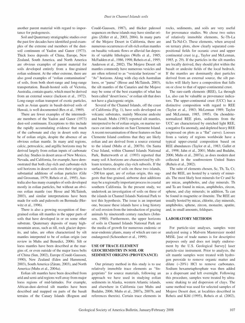
Figure 1. Left: map of the western United States, showing location of Channel Islands National Park. Right: enlargement of study area shown in larger map, showing coastal southern California, Channel Islands National Park, and the southern group of Chan-nel Islands.
Dust in Channel Islands soils
Geological Society of America Bulletin, January/February 2008 109
of the western Transverse Ranges crustal block. This igneous activity probably began ca. 19 Ma, was widespread by ca. 17 Ma, and diminished ca. 13 Ma, based on 40Ar/39Ar ages reported by Luyendyk et al. (1998).
Santa Cruz Island is the largest of the Chan-nel Islands and has a much more complex geol-ogy than any of the other islands. Nevertheless, the geology of the easternmost part of the island, where our studies were conducted, is similar to that of Anacapa Island. The bedrock in our study area is dominated by the Santa Cruz Island Vol-canics of Miocene age (Dibblee, 2001b), with whole-rock (groundmass separate) 40Ar/39Ar ages of 17.1 ± 0.1 and 16.3 ± 0.3 Ma and pla-gioclase 40Ar/39Ar ages of 16.9 ± 0.2 and 17.0 ± 0.1 Ma (Luyendyk et al., 1998). Chemical analyses presented by Weigand (1993) and Weigand and Savage (2002) show that the Santa Cruz Island Volcanics range in composition from basaltic andesite to dacite, although all the samples we collected (DR1) at Scorpion Anchor-age are andesite (Fig. 2). Unlike Santa Barbara and Anacapa Islands, the Miocene Monterey Formation overlies the volcanic rocks of parts
of eastern Santa Cruz Island (Dibblee, 2001b). The Monterey Formation is siliceous marine shale that also contains bentonite, carbonate nodules, and marine fossils. Based on Dibblee’s (2001b) mapping, the Monterey Formation, in many places, appears to be in fault contact with the Santa Cruz Island Volcanics along a series of northwest-trending faults.
Volcanic rocks dominate Anacapa Island’s bedrock. Mapping by Scholl (1960) and Dib-blee (2001a) shows that the rocks consist of the Santa Cruz Island Volcanics and/or the Conejo Volcanics units of middle Miocene age. On Middle and West Anacapa Islands, there are also beds of the San Onofre Breccia (Norris, 1995). Although previous researchers have not reported it, we found very small outcrops of San Onofre
Breccia exposed on the west side of Cathedral Cove on East Anacapa Island. This unit contains clasts of quartzite or vein quartz, blueschist, shale, and sandstone. Chemical analyses pre-sented here (Fig. 2) and by Weigand and Savage (2002) show that rocks on Anacapa Island are mostly andesites. Luyendyk et al. (1998) report 40Ar/39Ar ages on plagioclase separates from Anacapa rocks of 16.2 ± 0.2 and 16.3 ± 0.2 Ma.
Santa Barbara Island is composed almost completely of mafi c volcanic rocks (Dibblee, 2001a). Chemical analyses presented here, and by Weigand et al. (1998) and Weigand and Sav-age (2002), show that the rocks range in compo-sition from basalt to andesite (Fig. 2). We col-lected 15 samples from exposures near Landing Cove. A whole-rock, 40Ar/39Ar age from basalt on Santa Barbara Island is 15.5 ± 1.0 Ma ( Luyendyk et al., 1998).
Quaternary Geology and Geomorphology
Marine terraces dominate the geomorphol-ogy of low-elevation portions of eastern Santa Cruz Island (Fig. 3A). Terraces are also found
0
1
2
3
4
5
6
7
8
9
40 45 50 55 60 65 70 75
SiO2 (%)
0
1
2
3
4
5
6
7
8
9
40 45 50 55 60 65 70 75
East Anacapa Island
0
1
2
3
4
5
6
7
8
9
40 45 50 55 60 65 70 75
San Clemente Island
Santa Barbara Island ( ) and Santa Cruz Island ( )
SiO2 (%) SiO2 (%)
Na
2O
+ K
2O
(%
)
Na
2O
+ K
2O
(%
)N
a2
O +
K2
O (
%)
A
B C
Basalt
Basalticandesite
Andesite
Dacite
Rhyolite
Picro-basalt
Basalt
Basalticandesite
Andesite
Dacite
Rhyolite
Picro-basalt
Basalt
Basalticandesite
Andesite
Dacite
Rhyolite
Picro-basalt
1GSA Data Repository Item 2007261, Major and trace element concentrations of volcanic rocks, trace element concentrations of silt mantles, and particle size data of silt mantles, Channel Islands National Park, California, is available at www.geosociety.org/pubs/ft2007.htm. Requests may also be sent to [email protected].
Figure 2. Classifi cation of volcanic rocks on the Channel Islands as a function of SiO2 versus Na2O + K2O, using the classifi cation scheme of Le Bas et al. (1986, 1992). All data are from this study.
Muhs et al.
110 Geological Society of America Bulletin, January/February 2008
on the western side of the island, where they have received more detailed study. Pinter et al. (1998) and Scott and Pinter (2003) recognize three broad terrace levels on this island, based on elevations: T1 (low elevation), T2 (interme-diate elevation), and T3 (high elevation). Pinter et al. (1998) report U-series ages on corals of ca. 120 ka for the T1 terrace on western Santa Cruz Island and infer ages of ca. 320 ka for T2 and ca. 400 ka for T3, based largely on an assumption of a constant uplift rate and correla-tion with the deep-sea, oxygen-isotope record. Terraces on eastern Santa Cruz Island have not received as much study. Weaver and Meyer (1969) identifi ed marine terrace deposits and overlying eolianite that they called the Potato Harbor Formation, between Cavern Point and
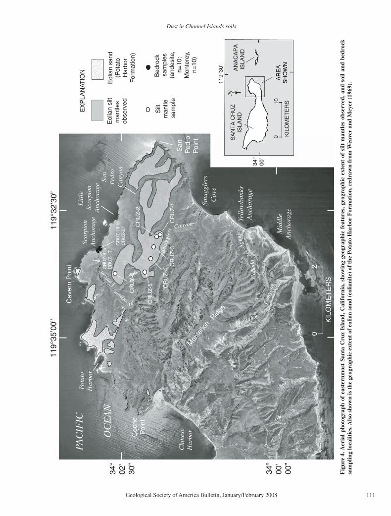
Potato Harbor (Fig. 4). These workers consid-ered the marine terrace facies of the Potato Har-bor Formation to be of Pliocene age, based on the presence of an extinct faunal element, Pec-ten healeyi Arnold. The same terrace surface is shown as Figure 4 in Scott and Pinter (2003), and is correlated with their T3 terrace group, considered to be ca. 400 ka. Thus, whether this terrace is Pliocene or Pleistocene is still not clear. In addition, however, Scott and Pinter (2003) mapped additional terrace remnants northwest of San Pedro Point. Our observations suggest that even higher terrace remnants exist on the interfl uve between Smugglers Canyon and San Pedro Canyon. Soils are better pre-served here, and our samples come from this area (Fig. 4).
Marine terraces also dominate the geomor-phology of East and Middle Anacapa Islands and parts of West Anacapa Island (Fig. 3C). According to Scott and Pinter (2003) and Pinter et al. (2003), who correlated the terraces on Ana-capa with those on Santa Cruz Island, the main surface on East and Middle Anacapa Islands is the T3 terrace, interpreted to be ca. 400 ka. On Middle Anacapa Island, this terrace occurs at an elevation of ~76 m and contains an extinct faunal element (the gastropod Calicantharus fortis), also found on Santa Barbara Island (Valentine and Lipps, 1963), consistent with the ca. 400-ka age estimate of Scott and Pinter (2003). Our soil localities are all on what Scott and Pinter (2003) called the T3 terrace surface of East Anacapa Island. Our own observations
Miocene volcanic
rocks
Carbonate eolianite Marine terracedeposits
Eroded Vertisol
Marine terrace
Paleosol
Geologist for scale
A Santa Cruz Island
D Anacapa Islands
Miocene volcanic rocks
EastAnacapa Island
Middle Anacapa Island
West Anacapa Island
Marine terraces
B Santa Barbara Island
Marine terraces
Miocene basalt
Miocene MontereyFormation
C East Anacapa Island
Stripped marineterrace surface
Silt mantleClay-richsubsoil
Figure 3. Geology and coastal geomorphology of Channel Islands National Park on (A) Santa Cruz Island, (B) Santa Barbara Island, (C) East Anacapa Island, and (D) all three Anacapa Islands. Photographs by the authors.
Dust in Channel Islands soils
Geological Society of America Bulletin, January/February 2008 111
Cav
ern
Poi
nt
Sco
rpio
nA
ncho
rage
Smug
gler
s C
ove
Scorp
ion
Canyo
n
Cañ
ada
del
Agu
aje
Smug
gler
s Canyon
Yell
owba
nks
Anc
hora
ge
Montañon
Can
yon
34°
00’
00”
34°
02’
30”
119°
32’3
0”
PAC
IFIC
OC
EA
N
San
Ped
roP
oint
Silt
m
antle
sa
mpl
e
Bed
rock
sa
mpl
es(a
ndes
ite,
n=10
;M
onte
rey,
n=10
)
KIL
OM
ET
ER
S
02
Eol
ian
silt
man
tles
obse
rved
Pot
ato
Har
bor
Chi
nese
Har
bor
Mid
dle
Anc
hora
ge
119°
35’0
0”
Eol
ian
sand
(Pot
ato
Har
bor
For
mat
ion)
EX
PLA
NAT
ION
Mon
taño
n
Ridge
Coc
heP
oint
San
Pedr
oC
anyo
n
CR
UZ
-1
CR
UZ
-2
CR
UZ
-3C
RU
Z-4
CR
UZ
-5
CR
UZ
-6
CR
UZ
-8 to
CR
UZ
-17
CR
UZ
-18
toC
RU
Z-2
7
Lit
tle
Scor
pion
Anc
hora
ge
119°
30’
34°
00’
100 K
ILO
ME
TE
RS
SA
NT
A C
RU
Z
IS
LAN
DA
NA
CA
PA
IS
LAN
D
AR
EA
SH
OW
N
Fig
ure
4. A
eria
l ph
otog
raph
of
east
ernm
ost
Sant
a C
ruz
Isla
nd, C
alif
orni
a, s
how
ing
geog
raph
ic f
eatu
res,
geo
grap
hic
exte
nt o
f si
lt m
antl
es o
bser
ved,
and
soi
l an
d be
droc
k sa
mpl
ing
loca
litie
s. A
lso
show
n is
the
geo
grap
hic
exte
nt o
f eo
lian
sand
(eo
liani
te)
of t
he P
otat
o H
arbo
r F
orm
atio
n, r
edra
wn
from
Wea
ver
and
Mey
er (
1969
).
Muhs et al.
112 Geological Society of America Bulletin, January/February 2008
suggest that more than one terrace level is prob-ably present on East Anacapa Island, but avail-able exposures do not allow a clear differentia-tion of multiple terraces.
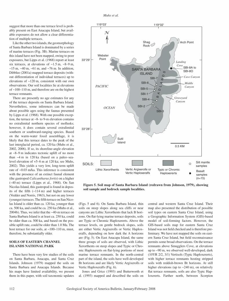
Like the other two islands, the geomorphology of Santa Barbara Island is dominated by a series of marine terraces (Fig. 3B). Marine terraces on this island have not been mapped, owing to poor exposures, but Lipps et al. (1968) report at least six terraces, at elevations of ~1.5 m, ~8–9 m, ~15 m, ~40 m, ~61 m, and ~76 m. In addition, Dibblee (2001a) mapped terrace deposits (with-out differentiation of individual terraces) up to elevations of ~120 m, consistent with our own observations. Our soil localities lie at elevations of ~100–110 m, and therefore are on the highest terrace remnants.
There are presently no age estimates for any of the terrace deposits on Santa Barbara Island. Nevertheless, some inferences can be made about possible ages using the faunas presented by Lipps et al. (1968). With one possible excep-tion, the terrace at ~8- to 9-m elevation contains no extralimital northern species of mollusks; however, it does contain several extralimital southern or southward-ranging species. Based on the warm-water fossil assemblage, it is likely that this terrace dates to the peak of the last interglacial period, ca. 120 ka (Muhs et al., 2002, 2006). If so, its shoreline-angle elevation at ~8–9 m indicates tectonic uplift of no more than ~4 m in 120 ka (based on a paleo–sea-level elevation of +5–6 m at 120 ka; see Muhs, 2002). This yields a very low, long-term uplift rate of ~0.03 m/ka. This inference is consistent with the presence of an extinct faunal element (the gastropod Calicantharus fortis) on a higher (~40 m) terrace (Lipps et al., 1968). On San Nicolas Island, this gastropod is found in depos-its of the fi fth (~114 m) and higher terraces (Vedder and Norris, 1963), but not on any lower (younger) terraces. The fi fth terrace on San Nico-las Island is older than ca. 120 ka, younger than ca. 500 ka, and could be ca. 250 ka (Muhs et al., 2004b). Thus, we infer that the ~40-m terrace on Santa Barbara Island is at least ca. 250 ka, could be older than ca. 500 ka, and based on the pos-sible uplift rate, could be older than 1.0 Ma. The host terrace for our soils, at ~100–110 m, must, therefore, be substantially older.
SOILS OF EASTERN CHANNEL ISLANDS NATIONAL PARK
There have been very few studies of the soils on Santa Barbara, Anacapa, and Santa Cruz Islands. Johnson (1979) mapped the soils on Santa Barbara and Anacapa Islands. Because his maps have limited availability, we present them in this paper, with soil taxonomic updates
(Figs. 5 and 6). On Santa Barbara Island, thin soils on steep slopes along sea cliffs or near canyons are Lithic Xerorthents that lack B hori-zons. On fl at-lying marine terrace deposits, soils are Typic or Chromic Haploxererts. Above the terrace levels, on gentle bedrock slopes, soils are either Vertic Argixerolls or Vertic Haplox-eralfs, depending on how dark the A horizons are (Fig. 5). On East Anacapa Island, the same three groups of soils are observed, with Lithic Xerorthents on steep slopes and Typic or Chro-mic Haploxererts on fl at-lying portions of most marine terrace remnants. In the north-central part of the island, the soils have well-developed Bt horizons and are likely Vertic Argixerolls or Vertic Haploxeralfs (Fig. 6).
Jones and Grice (1993) and Butterworth et al. (1993) mapped and described the soils on
central and western Santa Cruz Island. Their map also presented the distribution of possible soil types on eastern Santa Cruz Island, using a Geographic Information System (GIS)-based model of soil-forming factors. However, the GIS-based soils map for eastern Santa Cruz Island was not fi eld checked and is therefore pre-liminary. We have not mapped the soils on east-ern Santa Cruz Island, but fi eld reconnaissance permits some broad observations. On the terrace remnants above Smugglers Cove, at elevations up to ~90 m, we observed well-developed, dark (10YR 2/2, 3/1) Vertisols (Typic Haploxererts), with higher terrace remnants hosting stripped soils with reddish-brown Bt horizons. At still higher elevations (up to ~240 m), on relatively fl at terrace remnants, soils are also Typic Hap-loxererts. Farther north, between Scorpion
Figure 5. Soil map of Santa Barbara Island (redrawn from Johnson, 1979), showing soil sample and bedrock sample localities.
Dust in Channel Islands soils
Geological Society of America Bulletin, January/February 2008 113
Anchorage and Potato Harbor (Fig. 4), on old marine terrace remnants capped by carbonate eolianite, upland soils are also Typic Haplox-ererts or remnants of these soils (Fig. 3). Many soils in this area have been stripped, but in places we observed and described well-developed Ver-tisols as much as 100 cm thick.
SILT MANTLES ON SOILS OF EASTERN CHANNEL ISLANDS NATIONAL PARK
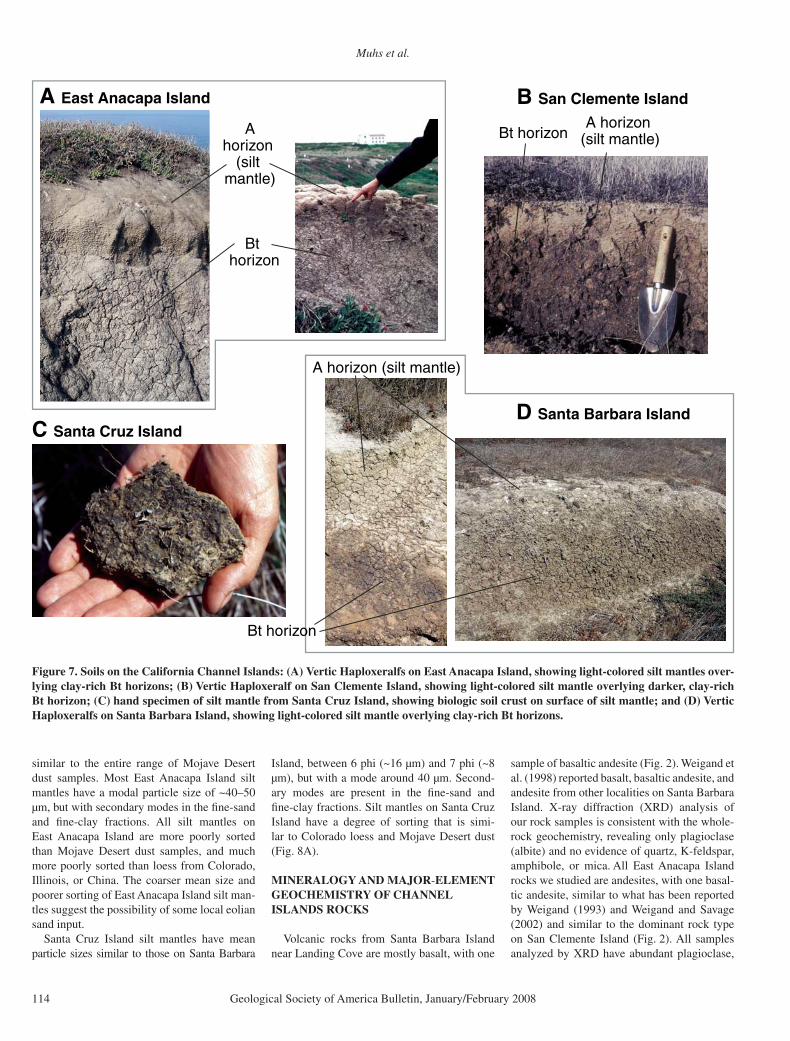
Silt mantles are present on all three of the islands studied (Fig. 7). On Santa Barbara Island, they are present in all areas in the central part of the island, except in the “Badlands” area, where historic soil stripping has been active. Where present, they are 2–5 cm thick, have light brown-ish gray (10YR 6/2) colors (all colors given here are for dry soil), and a silt loam texture. The silt mantles on Santa Barbara Island resemble those described by Muhs (1982, 1983) and Muhs et al. (2007b) from San Clemente Island, ~70 km to the southeast (Figs. 1 and 7). The silt mantles have an abrupt boundary with the underlying, dark, clay-rich Vertisols on both islands. On San Clemente Island, silt mantles have similar morphology and thicknesses on terraces ranging in age from less than 100,000 yr to greater than 1,000,000 yr (Muhs et al., 2007b).
On East Anacapa Island, silt mantles are very similar to those on Santa Barbara Island, although colors are somewhat darker and more variable. Most are dark, grayish brown (10YR
4/2) or grayish brown (10YR 5/2), but they range from brown (10YR 5/3) to very dark, grayish brown (10YR 3/2). On East Anacapa Island, silt mantles range from ~2 cm thick to as much as ~30 cm thick. The silt mantles here also contrast strongly with the clay-rich, angular blocky peds of the underlying Vertisol horizons or Bt horizons of soils that are vertic intergrades (Fig. 7). In places, we observed silt coatings on ped faces as deep as ~58 cm, where silt-mantle material has fallen into cracks dur-ing the dry season.
Unlike Santa Barbara and East Anacapa Islands, silt mantles are not ubiquitous on east-ern Santa Cruz Island. They are best preserved on broad, fl at interfl uves between Smugglers Canyon and Scorpion Canyon (Fig. 4). They are as thick as ~24 cm, and some have platy struc-ture and small vesicles. Colors of silt mantles on eastern Santa Cruz Island range from light, yellowish brown (10YR 6/4) to brown (10YR 5/3, 4/3), grayish brown (10YR 5/2), or dark, grayish brown (10YR 4/2). Where we observed them, silt mantles are underlain by dark Verti-sols with clayey textures and well-developed angular blocky structure. As on Anacapa Island, silt coatings were observed on Vertisol ped faces to depths of ~80 cm or more, where they have been eroded into cracks. Biologic (“crypto-gamic”) soil crusts cover silt mantles on all three islands (Fig. 7). These crusts are similar to those described by Rosentreter and Belnap (2001) for San Nicolas Island.
PARTICLE-SIZE DISTRIBUTION OF CHANNEL ISLANDS SILT MANTLES
Silt mantles on the Channel Islands have particle-size distributions that resemble fi ne-grained eolian sediments found in other regions (Figs. 8A–8C). All silt mantles are fi ner grained and more poorly sorted than shelf sands from Anacapa Island (although, note that these samples were not analyzed by laser particle-size methods) or typical dune sand from desert regions (the Taklimakan Desert in China and the Kalahari Desert in Africa). Furthermore, the silt mantles have mean particle sizes and degrees of sorting that are similar to, though not identical to, loess from North America (Colorado and Illinois) and China. The particle-size distributions of silt mantles are closest to Mojave Desert dust.
On Santa Barbara Island, mean particle sizes (as calculated by the method of moments) fall between 6 phi (~16 µm) and 7 phi (~8 µm), although modes are typically around 30 µm (Fig. 8C). A secondary mode in the fi ne-clay fraction (~0.3–0.4 µm) explains mean particle size that is fi ner than the modal particle size. Santa Barbara Island silt mantles have mean particle sizes and degrees of sorting that fall into the fi ner range of Mojave Desert dust samples (Fig. 8C).
Silt mantles on East Anacapa Island have a wider range of mean particle sizes (Fig. 8B). Mean values range from just under 5 phi (31 µm) to somewhat less than 7 phi (~8 µm),
Figure 6. Soil map of East Anacapa Island (redrawn from Johnson, 1979), showing soil sample and bedrock sample localities.
Muhs et al.
114 Geological Society of America Bulletin, January/February 2008
similar to the entire range of Mojave Desert dust samples. Most East Anacapa Island silt mantles have a modal particle size of ~40–50 µm, but with secondary modes in the fi ne-sand and fi ne-clay fractions. All silt mantles on East Anacapa Island are more poorly sorted than Mojave Desert dust samples, and much more poorly sorted than loess from Colorado, Illinois, or China. The coarser mean size and poorer sorting of East Anacapa Island silt man-tles suggest the possibility of some local eolian sand input.
Santa Cruz Island silt mantles have mean particle sizes similar to those on Santa Barbara
Island, between 6 phi (~16 µm) and 7 phi (~8 µm), but with a mode around 40 µm. Second-ary modes are present in the fi ne-sand and fi ne-clay fractions. Silt mantles on Santa Cruz Island have a degree of sorting that is simi-lar to Colorado loess and Mojave Desert dust (Fig. 8A).
MINERALOGY AND MAJOR-ELEMENT GEOCHEMISTRY OF CHANNEL ISLANDS ROCKS
Volcanic rocks from Santa Barbara Island near Landing Cove are mostly basalt, with one
sample of basaltic andesite (Fig. 2). Weigand et al. (1998) reported basalt, basaltic andesite, and andesite from other localities on Santa Barbara Island. X-ray diffraction (XRD) analysis of our rock samples is consistent with the whole-rock geochemistry, revealing only plagioclase (albite) and no evidence of quartz, K-feldspar, amphibole, or mica. All East Anacapa Island rocks we studied are andesites, with one basal-tic andesite, similar to what has been reported by Weigand (1993) and Weigand and Savage (2002) and similar to the dominant rock type on San Clemente Island (Fig. 2). All samples analyzed by XRD have abundant plagioclase,
D Santa Barbara Island
A horizon (silt mantle)
Bt horizon
C Santa Cruz Island
B San Clemente Island
A horizon (silt mantle)Bt horizon
A East Anacapa Island
A horizon
(silt mantle)
Bt horizon
Figure 7. Soils on the California Channel Islands: (A) Vertic Haploxeralfs on East Anacapa Island, showing light-colored silt mantles over-lying clay-rich Bt horizons; (B) Vertic Haploxeralf on San Clemente Island, showing light-colored silt mantle overlying darker, clay-rich Bt horizon; (C) hand specimen of silt mantle from Santa Cruz Island, showing biologic soil crust on surface of silt mantle; and (D) Vertic Haploxeralfs on Santa Barbara Island, showing light-colored silt mantle overlying clay-rich Bt horizons.
Dust in Channel Islands soils
Geological Society of America Bulletin, January/February 2008 115
Figure 8. Plot of mean particle size and degree of sorting (standard deviation of the mean particle size) of silt-enriched mantles (squares) from (A) eastern Santa Cruz Island, (B) East Anacapa Island, and (C) Santa Barbara Island. Also shown for comparison are ranges of mean particle size and degree of sorting of eolian sediments from other areas. Eastern Colorado loess data are from Muhs and Benedict (2006); northern Illinois loess data are new, from the section at Morrison, Illinois (Muhs and Bettis, 2000; Bettis et al., 2003); Chinese loess data are from the Luochuon and Xifeng sections and are from Lu et al. (2001). Mojave Desert dust data are from Reheis (2003). Chi-nese dune sand data are from the Tak-limakan Desert and are from Wang et al. (2002); Kalahari dune sand data are from Livingstone et al. (1999); Ana-capa Island shelf sediments are from Scholl (1960). All analyses were done by laser particle-size methods, except Anacapa Island shelf sediments.
Muhs et al.
116 Geological Society of America Bulletin, January/February 2008
and most have identifi able pyroxene, consistent with the major-element chemistry and simi-lar to what was reported by Weigand (1993), based on more detailed petrography. Only one sample we studied showed a very small quartz peak; all others have no evidence of quartz. None of the East Anacapa Island rocks have identifi able mica, amphibole, or K-feldspar.
The eastern part of Santa Cruz Island has volcanic rocks (named the Santa Cruz Island Volcanics) of Miocene age, overlain in places by the Monterey Formation shale. We deter-mined major-element geochemistry of volcanic rocks collected at Scorpion Anchorage on Santa Cruz Island (Fig. 4). These analyses show that one sample is basaltic andesite and all others are andesite. These data are in broad agree-ment with Weigand (1993) and Weigand and Savage (2002), who report that rock composi-tion on Santa Cruz Island ranges from basaltic andesite to dacite. Basaltic andesite samples have plagioclase, pyroxene, opaque oxides, and glass; andesite and dacite samples also contain thin quartz veins (Weigand, 1993). We are not aware of any detailed mineralogical studies of the Monterey Formation on Santa Cruz Island, although Weaver and Meyer (1969) report that it is siliceous shale with abundant chert and ben-tonite (smectite).
MINERALOGY AND TRACE-ELEMENT GEOCHEMISTRY OF SILT MANTLES ON THE CHANNEL ISLANDS
Mineralogy
We determined the mineralogy of selected silt fraction (53–2 µm) samples to compare with the local island bedrock. In this paper, we use Santa Barbara Island and East Anacapa Island as examples. On Santa Barbara Island, the silt (53–2 µm) fractions of all silt mantles contain quartz, plagioclase, and K-feldspar. All but two samples also contain amphibole, and one Santa Barbara Island sample also contains mica. On East Anacapa Island, the silt (53–2 µm) fractions of all silt mantle samples ana-lyzed have quartz, plagioclase, K-feldspar, and, with one exception, amphibole. In addi-tion, two samples also contain mica. The min-eralogical compositions of these silts contrast strongly with the local bedrock of both islands, since quartz, K-feldspar, amphibole, and mica were not detected in bedrock. The only possible local sources of quartz, K-feldspar, amphibole, and mica are from the very small outcrops of the San Onofre Breccia, previously unreported, but observed by us in the western part of Cathe-dral Cove (Fig. 6). However, these outcrops are of such limited extent that they cannot even be
mapped at 1:24,000. It is diffi cult to imagine, therefore, how they could be the main source for minerals in soil-surface horizons over the entire island. We conclude, therefore, that these minerals must have had origins external to the islands, because none of them is likely to have formed pedogenically.
The mineralogy of the clay (<2 µm) frac-tion of the silt mantles also shows differences between the silt mantles and both the local bedrock and underlying soil horizons. We con-ducted detailed clay mineralogical analyses of two soil profi les, one on East Anacapa Island and one on Santa Cruz Island. The East Ana-capa Island profi le has a thin (~2-cm) silt man-tle that forms the A horizon, with a well-devel-oped Bt horizon more than 60 cm thick below it. X-ray diffractometry shows that clays in the silt mantle are mica, kaolinite, and possibly quartz. In contrast, the underlying Bt1 and Bt2 horizons have all these minerals, but also con-tain abundant smectite (Fig. 9). The absence of smectite in the silt mantle suggests a different origin for this horizon compared to the lower horizons. In the horizons below the silt mantle, the height and sharpness of the smectite peaks increase with depth. Interestingly, mica and quartz (?) are present at all depths, suggest-ing that input of minerals external to the island may not be limited to the silt mantles. On Santa Cruz Island, the silt mantle is ~12 cm thick, and clays in it are kaolinite, minor smectite and mica, and possibly quartz. The profi le as a whole is a Vertisol, and abundant smectite and kaolinite (but no mica) characterize the lowest depths (Fig. 10).
Trace-Element Geochemistry: Sc-Th-La and Ta-Nd-Cr
Studies by Taylor and McLennan (1985) have shown that Sc-Th-La ternary diagrams show distinct differences between oceanic crust and upper-continental crust. Because of enrich-ments of Sc in oceanic crust and enrichments of Th and La in upper-continental crust, basalts will plot in the lower right (near the Sc apex) portion of a Sc-Th-La ternary diagram, whereas upper-crustal rocks will plot in the upper center. Ternary diagrams for Sc-Th-La have been used for a variety of provenance studies, including the origin of graywackes in Australia (Bhatia and Crook, 1986), the provenance of Pacifi c Ocean pelagic sediments (Olivarez et al., 1991), and the original tectonic setting of siliciclastic rocks in Tibet (Zhang, 2004).
Bedrock on all three islands has Sc-Th-La fi elds distinct from upper-continental crust. A ternary diagram of Sc-Th-La for basalt from Santa Barbara Island (Fig. 11A) compared to
Mojave Desert dust shows precisely the kind of discrimination between oceanic crust and upper-continental crust described by Taylor and McLennan (1985). Santa Barbara Island basalt plots in the lower-right portion of the diagram, showing a relative enrichment in Sc, whereas Mojave Desert dust, though variable, is centered on the average composition of upper continental crust. Andesites on Santa Cruz Island and East Anacapa Island (Figs. 11B and 11C) show less Sc enrichment than basalt, which is expected. Nevertheless, the fi elds defi ned by these volca-nic rocks are distinct from Mojave Desert dust. Monterey Formation shale from Santa Cruz Island defi nes a fi eld closer to, but distinct from, Mojave Desert dust.
The silt fractions of the silt mantles on all three islands have very similar Sc-Th-La com-positions, despite differences in local bedrock compositions. Furthermore, none of the islands has a silt composition that falls on the Sc-Th-La fi elds defi ned by the local bedrock. In contrast, silt fractions of all three islands fall within the Sc-Th-La fi eld defi ned by Mojave Desert dust.
The clay fractions of silt mantles for all islands also do not fall on the Sc-Th-La fi elds defi ned by local bedrock, although the clays from East Anacapa Island are close to the bed-rock fi eld. On Santa Cruz and Santa Barbara Islands, however, clays fall between the fi elds defi ned by local bedrock and Mojave Desert dust. The clay fractions from silt mantles on Santa Cruz Island are close to, but do not fall within, the fi eld defi ned by Monterey shale, suggesting possible derivation of the clays from Monterey shale. However, such an inter-pretation would also require a mix with some high-Th, low-La source, and none of the other parent materials has this composition. The positions of the clays from Santa Cruz and Santa Barbara Islands do, however, permit an interpretation of a mix of local bedrock and Mojave Desert dust.
The relative abundances of Ta-Nd-Cr, plot-ted in ternary form, provide an assessment of possible parent materials complementary to Sc-Th-La. Oceanic-crustal rocks are enriched in Cr and relatively depleted in Ta and Nd, whereas upper-continental crustal rocks are depleted in Cr and relatively enriched in Ta and Nd. As with Sc-Th-La, the basalt on Santa Barbara Island, when compared to Mojave Desert dust, shows these differences very clearly (Fig. 12). The silt fractions of silt mantles from all three islands have similar abundances of Ta-Nd-Cr, as they do with Sc-Th-La. Furthermore, none of the silt-fraction fi elds overlaps the fi eld defi ned by local volcanic bedrock, although (as was the case with Sc-Th-La), the silt fraction fi eld for East Anacapa Island plots close to the andesite
Dust in Channel Islands soils
Geological Society of America Bulletin, January/February 2008 117
2 4 6 8 10 12 14 16 18 20 22 24 26 28 30 32 34K
aolin
ite, 7
.1-7
.2 Å Mic
a,q
uart
z (?
)
Sm
ectit
e, 1
7Å
Mic
a,10
Å
Mic
a, 5
Å
Kao
linite
Degrees 2Θ
Silt mantle, 0-12 cm
Vertisol, 24-40 cm
Vertisol, 40-55 cm
Vertisol, 55-70 cm
Vertisol, 70-85 cm
SANTA CRUZ ISLAND:
Soil profile CRUZ-1:
Figure 10. X-ray diffractograms (glycolated, Mg-saturated) of the clay fractions of a Vertisol on Santa Cruz Island, showing contrast in mineralogy between the silt-rich, A horizon and underlying, clay-rich, vertic horizons.
2 4 6 8 10 12 14 16 18 20 22 24 26 28 30 32 34
Kao
linite
, 7.1
-7.2
Å Mic
a,qu
artz
(?)
Sm
ectit
e, 1
7Å
Mic
a,10
Å
Mic
a, 5
Å
Kao
linite
Degrees 2Θ
A horizon, silt mantle, 0-2 cm
Bt1 horizon, 2-12 cm
Bt2 horizon, 12-36 cm
Bt2 horizon, 36-60 cm
Bt2 horizon, 60-65 cm
EAST ANACAPA ISLAND:
Soil profile ANA-1:
Figure 9. X-ray diffractograms (glycolated, Mg-saturated) of the clay fractions of a Vertic Haploxeralf on East Anacapa Island, showing contrast in mineralogy between the silt-rich, A horizon and underlying, clay-rich, Bt horizons.
0.0
0.2
0.4
0.6
0.8
1.0
0.0
0.2
0.4
0.6
0.8
1.0
0.0
0.2
0.4
0.6
0.8
1.0
East Anacapa Island
Sc
Th
La
ClaysAndesite
Mojavedust
Silts
0.0
0.2
0.4
0.6
0.8
1.0
0.0
0.2
0.4
0.6
0.8
1.0
0.0
0.2
0.4
0.6
0.8
1.0
Santa Cruz Island
Sc
Th
LaClays
Andesite
Mojavedust
Silts
Montereyshale
0.0
0.2
0.4
0.6
0.8
1.0
0.0
0.2
0.4
0.6
0.8
1.0
Santa Barbara Island
0.0
0.2
0.4
0.6
0.8
1.0
Sc
Th
La
Clays
Basalt
Mojavedust
Silts
A B C
Figure 11. Ternary diagrams showing relative proportions of immobile elements Sc, Th, and La in silt fractions (53–2 µm) and clay fractions (<2 µm), of silt mantles on (A) Santa Barbara Island, (B) Santa Cruz Island, and (C) East Anacapa Island. Also shown is the range in values for these elements in local bedrock, consisting of andesite and shale (Santa Cruz Island), basalt (Santa Barbara Island), and andesite (East Anacapa Island). Field defi ned by Mojave Desert dust collected in traps is from data in Reheis (2003) and Reheis et al. (2002).
Muhs et al.
118 Geological Society of America Bulletin, January/February 2008
fi eld. The clay fractions of the silt mantles of all three islands are also similar in Ta-Nd-Cr. However, in contrast to the Sc-Th-La plots, the clay fractions of Santa Cruz and Santa Bar-bara Islands fall on the Ta-Nd-Cr fi eld defi ned by Mojave Desert dust. The clay fractions of both of these islands have a position that could be interpreted as a mix of local bedrock and Mojave Desert dust, but a derivation solely, or at least mostly, from Mojave Desert dust could also be permitted. On East Anacapa Island, the clays of the silt mantles overlap the local bedrock, but also overlap part of the Ta-Nd-Cr fi eld defi ned by Mojave Desert dust.
Trace-Element Geochemistry: Rare-Earth Elements (REE)
Rare-earth elements provide very sensitive indicators of sediment provenance (Taylor and McLennan, 1985, 1995; McLennan, 1989). REE concentrations are typically normalized to chon-dritic meteorite compositions, and we have fol-lowed this protocol. In the discussions of REE patterns that follow, the terms “enriched” and “depleted” are used in descriptions and inter-pretations. Because all samples analyzed have higher concentrations of REE compared to chondrite, “enriched” and “depleted” refer to relative abundances of different parts of the REE suite compared to other parts, e.g., light REE compared to heavy REE. Oceanic-crustal rocks (basalt) or sediments derived from such rocks have, overall, very low REE concentrations, a relatively “fl at” curve (i.e., similar concentra-tions of light REE and heavy REE), and no Eu anomaly (i.e., Eu concentrations similar to Sm and Gd). In contrast, upper-continental crustal
rocks such as granite, or sediments derived from such rocks, have enriched light REE, a negative Eu anomaly, and depleted heavy REE. Mojave Desert dust shows typical, upper–crustal-rock REE patterns (Reheis et al., 2002).
The REE compositions of volcanic rocks with varying SiO
2 content on the Channel Islands
illustrate the concepts above very clearly. Basalts on Santa Barbara Island show a typical oceanic-crust type of signature, with low REE concentrations, a “fl at” curve overall, and no Eu anomaly (Fig. 13). Andesites on East Ana-capa Island show higher concentrations overall, somewhat enriched light REE, a negative Eu anomaly, and somewhat depleted (relative to the light REE) heavy REE. Although most of the rocks on San Clemente Island are andesite (Olmsted, 1958), small amounts of rhyolite are also present, and these rocks show a REE pat-tern typical of the upper crust. Rhyolites on San Clemente Island have high REE concentrations overall, enriched light REE, a strongly negative Eu anomaly, and depleted heavy REE. Andes-ites on Santa Cruz Island show REE patterns similar to those of andesites on East Anacapa Island, but Monterey shale on this island shows complex patterns (Fig. 14). Overall, Monterey shale has relatively low REE concentrations, only slightly enriched light REE, but strongly negative Eu anomalies. A few samples also have negative Ce anomalies.
Both the silt and clay fractions of the silt mantles in Channel Islands National Park dis-play very typical upper-crustal REE composi-tions (Fig. 15). Both size fractions from all three islands have high overall REE concentrations (relative to chondrite), enriched light REE, neg-ative Eu anomalies, and slightly depleted heavy
REE. Thus, both the silt and clay fractions of the silt mantles have patterns much like Mojave Desert dust but differ from local island andesites and basalts.
In using REE for soil or sediment prove-nance studies, it is helpful to reduce the data to certain key-element ratios (chondrite normal-ized) that give a quantitative measure of parts of the REE suite. The sign and degree of any Eu anomaly can be quantifi ed by the Eu/Eu* value, where Eu is the chondrite-normalized Eu concentration (Eu
N), and Eu* is (Sm
N ×
GdN)0.5. Values less than 1.0 indicate negative
Eu anomalies; values greater than 1.0 indicate positive Eu anomalies. Loess from China, for example, has Eu/Eu* values that range from 0.61 to 0.66 (Jahn et al. 2001), indicating nega-tive Eu anomalies, typical of average upper continental crust. Another measure of REE composition refl ects abundances of light and heavy REE. La
N/Yb
N is a measure of the over-
all enrichment of light REE, where high values refl ect signifi cant light REE enrichment.
Local island-volcanic bedrock and Mojave Desert dust are easily distinguished from one another using Eu/Eu* versus La
N/Yb
N plots
(Fig. 16). Mojave Desert dust has much higher La
N/Yb
N than basalt or andesite and generally
lower Eu/Eu*. On Santa Cruz Island, Monterey Formation shale has lower La
N/Yb
N and mostly
lower Eu/Eu* than Mojave Desert dust. The clay fractions of silt mantles on all three islands fall mostly within the fi eld defi ned by Mojave Desert dust. The silt fractions of silt mantles fall mostly between the fi elds defi ned by Mojave Desert dust and local volcanic bedrock, with the exception of East Anacapa Island, where some silts fall within the andesite fi eld.
0.0
0.2
0.4
0.6
0.8
1.0 0.0
0.2
0.4
0.6
0.8
1.0
0.0
0.2
0.4
0.6
0.8
1.0
East Anacapa Island
Ta x 10
Nd
Cr/10Clays
Andesite
Mojave dust
Silts
0.0
0.2
0.4
0.6
0.8
1.0 0.0
0.2
0.4
0.6
0.8
1.0
0.0
0.2
0.4
0.6
0.8
1.0
Nd
Santa Cruz Island
Cr/10Ta x 10
Clays
Andesite
Mojave dust
Silts
Montereyshale
0.0
0.2
0.4
0.6
0.8
1.0
0.0
0.2
0.4
0.6
0.8
1.0
Nd
Santa Barbara Island
Cr/10Ta x 10
0.0
0.2
0.4
0.6
0.8
1.0
Clays
Basalt
Mojave dust
Silts
A B C
Figure 12. Ternary diagrams showing relative proportions of immobile elements Ta (×10), Nd, and Cr (/10) in silt fractions (53–2 µm) and clay fractions (<2 µm) of silt mantles on (A) Santa Barbara Island, (B) Santa Cruz Island, and (C) East Anacapa Island. Also shown is the range in values for these elements in local bedrock, consisting of andesite and shale (Santa Cruz Island), basalt (Santa Barbara Island), and andesite (East Anacapa Island). Field defi ned by Mojave Desert dust collected in traps is from data in Reheis (2003) and Reheis et al. (2002).
Dust in Channel Islands soils
Geological Society of America Bulletin, January/February 2008 119
DISCUSSION
Field and Particle-Size Evidence for an External, Eolian Origin for Silt Mantles on Channel Islands National Park
The presence of silt-loam A horizons on Vertisols or soils intergrading to Vertisols is unusual. Vertisols are common in the western United States, and the U.S. Natural Resources Conservation Service (NRCS) recognizes and maps 86 offi cial soil series (local mapping units) that belong to this order in California alone (Soil Survey Staff, 2006). Almost all of these soil series, with the exception of those estab-lished on Santa Cruz Island itself (or nearby San Clemente Island), have surface horizons with textures that fall into the “clay” or “silty clay” categories, not silt loam, which is the dominant texture of surface horizons of soils in Channel Islands National Park. Furthermore, virtually all of the Vertisols on mainland California have surface horizons with well-developed, angular blocky, subangular blocky, granular, or, less commonly, prismatic structure. Thus, massive or platy, light-colored, silt-rich surface horizons are not characteristic of Vertisols in California. We interpret this to mean that the silt mantles have a geologic, rather than pedogenic origin.
The particle-size data presented in this paper also support an external origin for the silt man-tles. Although cemented dune sands are present on the Channel Islands (Fig. 3), the mean par-ticle size of the silt mantles is distinctly differ-ent from dune sand (Fig. 8). In contrast, the silt mantles have mean particle sizes that are very similar to North American loess, Chinese loess, and Mojave Desert dust.
Mineralogical Evidence for an External Origin for Silt Mantles
Mineralogical data from both the silt and clay fractions of the silt mantles support the idea that these features have an external origin. Santa Barbara Island and East Anacapa Island are composed dominantly of basalt or andesite bedrock, yet the silt fractions of the mantles on these islands contain quartz, K-feldspar, and amphibole. Although clasts in the San Ono-fre Breccia contain these minerals, the extent of this unit is extremely limited, compared to the volcanic rocks. In the clay fractions of silt mantles on East Anacapa Island (and to a lesser extent on Santa Cruz Island), mica is present, which is not present in the volcanic bedrock and is unlikely to have formed pedogenically (Fan-ning and Keramidas, 1977). Furthermore, mica is present at all depths in soils on East Anacapa Island, suggesting that external supply of clay
minerals may have been an ongoing process for much of the period of soil formation.
Mojave Desert dust has both silt and clay mineralogy very similar to the silt mantles. The silt fractions of Mojave Desert dust have abundant quartz, followed by plagioclase and K-feldspar, with smaller amounts of mica and chlorite (Reheis and Kihl, 1995). The clay
fractions of Mojave Desert dust are dominated by mica, followed by quartz, kaolinite, and smectite, with smaller amounts of chlorite and mixed-layer minerals. The mineralogy is very similar to that of the silt mantles on all three of the Channel Islands, supporting not only an external origin, but also one specifi cally from the Mojave Desert.
1
10
100
Roc
k/ch
ondr
ite
La Ce Pr Nd Sm Eu Gd Tb Dy Ho Er Tm Yb Lu
1
10
100
Roc
k/ch
ondr
ite
La Ce Pr Nd Sm Eu Gd Tb Dy Ho Er Tm Yb Lu
Element
1
10
100R
ock/
chon
drite
La Ce Pr Nd Sm Eu Gd Tb Dy Ho Er Tm Yb Lu
RHYOLITE, San Clemente Island
ANDESITE, East Anacapa Island
BASALT, Santa Barbara Island
Pm
Pm
Pm
Figure 13. Chondrite-normalized, rare-earth element (REE) plots of volcanic rocks on the Channel Islands, showing decreasing light REE enrichment and decreasing negative Eu anomaly with increasingly mafi c rock types (rhyolite to andesite to basalt).
Muhs et al.
120 Geological Society of America Bulletin, January/February 2008
Geochemical Evidence for an External Origin for Silt Mantles
All three geochemical indexes used here indi-cate that the silt fractions of the silt mantles have origins external to the islands. The silts on all three islands resemble one another, geochemi-cally, and do not have any compositional over-lap with local bedrock on Sc-Th-La or Ta-Nd-Cr plots. On REE plots (Eu/Eu* versus La
N/Yb
N),
silts overlap island bedrock only slightly on East Anacapa Island. In contrast, silts fall within the fi elds defi ned by Mojave Desert dust for Sc-Th-La and Ta-Nd-Cr, and close to the Mojave Des-ert dust fi eld for Eu/Eu* versus La
N/Yb
N. This
does not require that Mojave Desert dust is nec-essarily the only source or even the main source of the silts, but that the silts are almost certainly derived from sediments of an upper–continen-tal-crustal origin, with a composition similar to that of Mojave Desert dust.
The origin of the clay fractions of the silt mantles is not as clear as that of the silt frac-tions. On all three islands, clays fall between
the fi elds defi ned by volcanic bedrock and Mojave Desert dust on Sc-Th-La and Ta-Nd-Cr plots, although they fall within the fi eld defi ned by Mojave Desert dust on Eu/Eu* versus La
N/
YbN plots. We interpret these data to indicate
that the clay fractions of the silt mantles may have a complex origin. Part of the clay fraction may be derived from in situ weathering of local volcanic bedrock minerals and part of the clay fraction may be from an external source. The abundance of clay-sized mica in silt mantles on East Anacapa Island, and to a lesser extent on Santa Cruz Island, supports this interpretation, since mica is not present in the bedrock and is not likely to have formed pedogenically. On the other hand, smectite and kaolinite could be either detrital or derived from chemical weath-ering of volcanic bedrock.
Westerly Winds and an Asian Source of Dust
It is well documented that Asian (Chinese and Mongolian) dust can travel great dis-tances across the Pacifi c Ocean, and there is a
long-term record of this transport in deep-sea sediments (Rea, 1994). There is also little ques-tion that Asian dust provides regular inputs to soils of the Marianas Islands (Birkeland, 1999) and Hawaii (Rex et al., 1969; Jackson et al., 1971; Chadwick et al., 1999). Finally, there is direct observation of Asian dust traveling as far east as the Pacifi c Coast of North America (Husar et al., 2001), such as the dust event of April, 1998. Indeed, this latter event was observed on nearby San Nicolas Island (Tratt et al., 2001). The composition of Chinese loess is similar to that of silt mantles on the California Channel Islands in that it has REE abundances (Eu/Eu*, La
N/Yb
N, Gd
N/Yb
N) that are typical of
the upper-continental crust. Nevertheless, deliv-ery of Asian dust to North America is likely to occur only infrequently. Furthermore, the mean particle diameters during the April, 1998 event are reported to be ~2 µm to ~4 µm, a particle size to be expected, given the distance of eolian transport (Husar et al., 2001; Tratt et al., 2001). However, mean particle sizes of Channel Islands silt mantles are much coarser, suggesting a source that is not as distant as Asia. Therefore, while we cannot exclude an Asian origin for the silt mantles on the Channel Islands, we consider this to be a less likely source.
Northwesterly Winds and a California Mainland Source of Dust
During most of the year, the dominant winds in coastal southern California are from the north-west or west. Because of the east-west–trending aspect of mainland California to the north of Channel Islands National Park, it is possible that silts and clays could have been defl ated from the Santa Ynez River valley, situated to the north of the Santa Ynez Mountains, and even the Santa Maria River valley, whose westernmost part is in the Santa Maria Basin (Fig. 1). Eolian sand, derived from northwesterly winds, is found on north-south–trending segments of the main-land coastline, well to the north of the Channel Islands, but we are not aware of any observa-tions of signifi cant dust entrainment from the Santa Maria or Santa Ynez River valleys. Nev-ertheless, a source of eolian silt and clay from these northerly valleys remains as a hypothesis to be tested in the future.
Northwesterly Winds and an Insular-Shelf Source of Dust
Another potential source of dust from north-westerly winds is the insular shelf that would have been exposed during glacioeustatically lowered sea levels. Studies of well-dated, sub-merged reefs off Barbados show that sea level
0.1
1
10
100
Roc
k/ch
ondr
ite
La Ce Pr Nd Sm Eu Gd Tb Dy Ho Er Tm Yb Lu
0.1
1
10
100
Roc
k/ch
ondr
ite
La Ce Pr Nd Sm Eu Gd Tb Dy Ho Er Tm Yb Lu
ANDESITE, Santa Cruz Island
MONTEREY SHALE, Santa Cruz Island
Pm
Pm
Figure 14. Chondrite-normalized, rare-earth element (REE) plots of highly contrasting rock types (andesite and shale) on eastern Santa Cruz Island.
Dust in Channel Islands soils
Geological Society of America Bulletin, January/February 2008 121
was ~120 m below present at the last glacial maximum, ca. 22–21 ka (Bard et al., 1990). On the northern Channel Islands, this magnitude of sea-level lowering would have connected all of the northern islands, and exposed a broad shelf around them, particularly to the north and west
of the island chain (Fig. 17). Johnson (1977) has documented that a signifi cant amount of carbon-ate eolian sand (cemented into eolianite) was deposited on San Miguel Island during the last glacial maximum. Dip azimuths of eolianite indi-cate deposition by northwesterly winds, which
also dominate the region today (Fig. 17). Thus, it is possible that fi ner grained materials may have been deposited from such a source as well.
Several observations argue against an insu-lar-shelf source of dust for the Channel Islands, however. Scholl (1960) studied shelf sediments off Anacapa Island in detail and reported that fi ne-grained sediments (silts and clays) are rare (see also Fig. 8), and sand-sized shelf sedi-ments are composed largely of either carbonate skeletal grains or volcanic grains derived from the local island bedrock. Although quartz, K-feldspar, amphibole, and mica are all found in the silt mantles, they are extremely rare in the insular-shelf sediments off Anacapa Island (see Scholl, 1960, his Table 3). On eastern Santa Cruz Island, eolianite (the upper part of the Potato Harbor Formation) appears to be derived from northern shelf sediments, based on its geo-graphic location and dip azimuths. The eolianite facies of the Potato Harbor Formation contains sand-sized particles that are dominated by skel-etal carbonate grains (~70%), along with locally derived volcanics, Monterey shale, or Santa Cruz Island schist (Weaver and Meyer, 1969). Because San Miguel, Santa Rosa, and eastern Santa Cruz Islands have a variety of sandstones, siltstones, and shales (see, for example, Dibblee and Ehrenspeck, 1998), it is possible that shelf sediments off the western islands may have con-tributed to the silt mantles on the eastern islands during glacial times.
A more persuasive argument against glacial-age shelf sediments being a signifi cant source of particles for silt mantles on the Channel Islands is the presence of silt mantles on Santa Bar-bara Island. This island has only a very narrow insular shelf and is distant from other insular shelves, both to the north and south. Neverthe-less, silt mantles are common on Santa Barbara Island and have close compositional similari-ties to those on Anacapa and Santa Cruz Island. These observations argue for a common exter-nal source, unrelated to the island shelves that would have been exposed during glacial times.
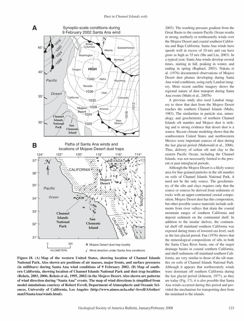
Santa Ana Winds and a Mainland California Source of Dust
Dust from western North America can be delivered to the eastern Pacifi c Ocean during “Santa Ana” wind conditions. In contrast to the usual westerly fl ow of air from the Pacifi c Ocean to southern California, Santa Ana conditions bring about strong northeasterly winds. Santa Ana winds develop when there is relatively low pressure over the eastern Pacifi c Ocean off southern California and a high-pressure cell settles in the Great Basin (Fig. 18) after the pas-sage of a cold front (Raphael, 2003; Lu et al.,
1
10
100
Roc
k/ch
ondr
ite
La Ce Pr Nd Sm Eu Gd Tb Dy Ho Er Tm Yb Lu
Santa Cruz Island
East Anacapa Island
Santa Barbara Island
1
10
100
Roc
k/ch
ondr
ite
La Ce Pr Nd Sm Eu Gd Tb Dy Ho Er Tm Yb Lu
1
10
100
Roc
k/ch
ondr
ite
La Ce Pr Nd Sm Eu Gd Tb Dy Ho Er Tm Yb Lu
Clay fraction of silt mantles
Silt fraction of silt mantles
Clay fraction of silt mantles
Silt fraction of silt mantles
Clay fraction of silt mantles
Silt fraction of silt mantles
Element
Pm
Pm
Pm
Figure 15. Chondrite-normalized, rare-earth element (REE) plots of silt (53–2 µm) and clay (<2 µm) fractions of silt mantles on Santa Cruz, East Anacapa, and Santa Barbara Islands.
Muhs et al.
122 Geological Society of America Bulletin, January/February 2008
0.30
0.50
0.70
0.90
1.10
Eu/
Eu*
0 5 10 15 20
LaN/YbN
0.30
0.50
0.70
0.90
1.10
Eu/
Eu*
0 5 10 15 20
LaN/YbN
0.30
0.50
0.70
0.90
1.10
Eu/
Eu*
0 5 10 15 20
LaN/YbN
Silt fraction (53-2 µm)
Clay fraction (<2 µm)
BasaltAndesite
Andesite
MojaveDesert dust
MojaveDesert dust
Mojave Desert dust MontereyFormation
Santa Barbara Island Santa Cruz IslandEast Anacapa IslandA B C
Figure 16. Eu/Eu* versus LaN/YbN values in silt fractions (53–2 µm; circles) and clay frac-tions (<2 µm; solid squares), of silt mantles on (A) Santa Barbara Island, (B) East Anacapa Island, and (C) Santa Cruz Island. Also shown are the ranges in these values for bedrock, consisting of andesite and shale (Santa Cruz Island), basalt (Santa Barbara Island), and andesite (East Anacapa Island). Field defi ned by Mojave Desert dust collected in traps is from data in Reheis (2003) and Reheis et al. (2002).
San Miguel Island
Santa Rosa Island
Anacapa Islands
Exposed shelf (-120 m) at last-glacial maximum, ~21 ka
34°00’
34°15’
33°45’
120°00’ 119°30’120°30’
PACIFIC
OCEAN
Santa Cruz Island
~18%52
~18%
43
~2%
92
~2%
96
~36%
29
~15%60
~6%78
Figure 17. Map of the northern Channel Islands, showing the extent of present offshore shelf that would have been exposed during the last glacial maximum, ca. 21–22 ka, when sea level was lowered ~120 m (Bard et al., 1990) and wind roses for Channel Islands stations and off-shore buoys. Map generated by the authors, using bathymetry from 1:100,000- and 1:250,000-scale U.S. Geological Survey topographic maps. Length of arm is proportional to amount of time that wind is above velocity of 5 m/s; approximate percentage fi gure is given for the longest arm; thus, scale for each rose differs. Number in center circle is percent of time that winds are below 5 m/s. Note that periods of record vary for each station, but all are two years or more. Geographic positions of wind roses are approximate for clarity of presentation. Wind roses gener-ated by the authors from data from the Western Regional Climate Center (http://www.wrcc.dri.edu/channel_isl/index.html).
Dust in Channel Islands soils
Geological Society of America Bulletin, January/February 2008 123
2003). The resulting pressure gradient from the Great Basin to the eastern Pacifi c Ocean results in strong, northerly or northeasterly winds over the Mojave Desert and coastal southern Califor-nia and Baja California. Santa Ana winds have speeds well in excess of 10 m/s and can have gusts as high as 35 m/s (Hu and Liu, 2003). In a typical year, Santa Ana winds develop several times, starting in fall, peaking in winter, and ending in spring (Raphael, 2003). Nakata et al. (1976) documented observations of Mojave Desert dust plumes developing during Santa Ana wind conditions, using early Landsat imag-ery. More recent satellite imagery shows the regional nature of dust transport during Santa Ana events (Muhs et al., 2007b)
A previous study also used Landsat imag-ery to show that dust from the Mojave Desert reaches the southern Channel Islands (Muhs, 1983). The similarities in particle size, miner-alogy, and geochemistry of northern Channel Islands silt mantles and Mojave dust is strik-ing and is strong evidence that desert dust is a source. Recent climate modeling shows that the southwestern United States and northwestern Mexico were important sources of dust during the last glacial period (Mahowald et al., 2006). Thus, delivery of eolian silt and clay to the eastern Pacifi c Ocean, including the Channel Islands, was not necessarily limited to the pres-ent or past interglacial periods.
Although the Mojave Desert is a likely source area for fi ne-grained particles in the silt mantles on soils of Channel Islands National Park, it need not be the only source. The geochemis-try of the silts and clays requires only that the source or sources be derived from sediments or rocks with an upper-continental crustal compo-sition. Mojave Desert dust has this composition, but other possible source materials include sedi-ments from river valleys that drain the coastal mountain ranges of southern California and deposit sediment on the continental shelf. In addition to the insular shelves, the continen-tal shelf off mainland southern California was exposed during times of lowered sea level, such as the last glacial period. Fan (1976) shows that the mineralogical compositions of silts in both the Santa Clara River basin, one of the major drainage basins in coastal southern California, and shelf sediments off mainland southern Cali-fornia, are very similar to those of the silt man-tles on soils of Channel Islands National Park. Although it appears that northwesterly winds were dominant off southern California during the last glacial period (Johnson, 1977), as they are today (Fig. 17), it is also possible that Santa Ana winds occurred during this period and pro-vided the mechanism for transporting dust from the mainland to the islands.
CALIFORNIA
NEVADA
AR
IZO
NA
CALIFO
RN
IA
Pacific
Ocean
MojaveDesert
34°
33°
32°
31°
35°
36°
120°122°
37°
124° 118° 116° 114°
BAJA
Mojave Desert dust trap locality
Wind direction under Santa Ana conditions
Paths of Santa Ana winds andlocations of Mojave Desert dust traps
SanClemente Island
Channel IslandsNational Park
0 200
KILOMETERS
B
1040
1036
1032
1028
1024
102010
16
1012
1028
1024
1020
1016
45°
40°
35°
30°
HIGHOregon
California
Utah
Nevada
Arizona
NewMexico
Idaho
Colorado
Wyoming
AlbertaSaskatchewan
BritishColumbia
Montana
Washington
Pacific
Ocean
SanClemente Island
Mojave Desert
Channel IslandsNational Park
Synoptic-scale conditions during9 February 2002 Santa Ana wind
A
Figure 18. (A) Map of the western United States, showing location of Channel Islands National Park. Also shown are positions of air masses, major fronts, and surface pressures (in millibars) during Santa Ana wind conditions of 9 February 2002. (B) Map of south-ern California, showing location of Channel Islands National Park and dust trap localities (Reheis, 2003, 2006; Reheis et al., 1995, 2002) in the Mojave Desert. Also shown are patterns of wind direction during “Santa Ana” events. The map of wind directions is simplifi ed from model simulations courtesy of Robert Fovell, Department of Atmospheric and Oceanic Sci-ences, University of California, Los Angeles (http://www.atmos.ucla.edu/~fovell/ASother/mm5/SantaAna/winds.html).
Muhs et al.
124 Geological Society of America Bulletin, January/February 2008
Evidence for Eolian Silt and Clay Accumulation in Mainland Southern California Soils
If eolian silt and clay are delivered to Chan-nel Islands National Park from the Mojave Des-ert, it follows that these particles must also be deposited on soils of mainland southern Califor-nia. As discussed earlier, in many parts of the Mojave Desert in California, there are numerous occurrences of silt-rich eolian mantles (“Av” horizons) on basaltic volcanic fl ows or alluvial fan deposits of variable lithologies (Wells et al., 1985; McFadden, 1988; McFadden et al., 1986, 1998; Reheis et al., 1995; Anderson et al., 2002). Farther coastward in southern California, detailed studies of soils developed on Holo-cene and Pleistocene alluvial terrace deposits in the San Gabriel–San Bernardino Mountains of southern California show good evidence of eolian silt accretion (McFadden and Weldon, 1987; McFadden, 1988). Soils in this area show progressive increases in silt content with terrace age. Chemical weathering of terrace gravels is ruled out as a source of silt because younger gravels are not weathered and older gravels do not weather to anything other than sand. McFadden and Weldon (1987) and McFadden (1988) interpret the progressive increase in silt contents with terrace age as refl ecting accumu-lation of eolian silt over time, derived from the Mojave Desert.
Distinctive silt-rich eolian mantles are not present on top of mainland soils, such as those in the San Gabriel–San Bernardino Mountains. Silt is relatively enriched in surface horizons (McFadden and Weldon, 1987; McFadden, 1988), but silt amounts are usually around 20%–30%, much lower than on the Channel Islands. Even in the Mojave Desert, silt mantles present as Av horizons typically have only 20%–50% silt (Reheis et al., 1995). Lower silt and higher sand contents in Av horizons of Mojave Desert soils may be explained in part by the proximity of these soils to source areas, where eolian sand contents are expected to be higher. However, farther west, soils with high silt content overall, but without an enriched silt mantle, are compar-atively more diffi cult to explain.
One factor that explains the silt mantles on the islands (and their absence on the mainland) is that the islands have comparatively few bur-rowing animals (Wenner and Johnson, 1980; Schoenherr et al., 1999). As a prime example, the Botta pocket gopher (Thomomys bottae), one of the major bioturbators of mainland soils, especially along the coast of California, is absent on the islands, and presumably has been absent during the entire time the islands have existed (Johnson, 1983). The role of this
animal in homogenizing the fi ne fraction and small pebbles throughout coastal soils, and concomitantly sorting large clasts into basal stone layers, has been well documented (John-son, 1989, 1990). Such soils, notably, have not been recorded on the islands. Furthermore, we personally have observed, over many years of working on the islands, that other less obvious, though important, soil bioturbators, the array of invertebrate fauna normally encountered in mainland soils, are notably few on the islands. Thus, preservation of silt-rich eolian mantles on the Channel Islands likely refl ects the dearth of burrowing taxa.
SUMMARY AND CONCLUSIONS
We conclude that silt-rich surface horizons of soils on Santa Cruz, Anacapa, and Santa Bar-bara Islands, Channel Islands National Park, are eolian, the result of wind transport of particles from a distant source. Silt mantles on clay-rich Vertisols have not been reported on the main-land, despite the ubiquity of this soil type in Cal-ifornia. This suggests that the silt mantles have a geologic, rather than a pedogenic, origin. The mean particle size of the mantles is distinctly fi ner than eolian sand, but is similar to loess and closely overlaps the range of particle sizes for Mojave Desert dust. As such, these eolian silt mantles are intermediate members of a contin-uum of eolian infl uences on soils. The mineral-ogy of the silt mantles is dominated by quartz in the silt fractions and mica in the clay fractions. Both quartz and mica are rare or absent alto-gether from the volcanic rocks that constitute the only bedrock on Anacapa and Santa Barbara Islands. The relative abundances of Sc-Th-La and Ta-Nd-Cr show that the silts and clays in the surface mantles are not derived from volcanic rocks on any of the three islands, or in the case of Santa Cruz Island, from Monterey shale. How-ever, the relative abundance of these elements in the island silts and clays is similar to that in Mojave Desert dust, supporting a mainland-derived eolian origin, or at least a source with an upper-crustal composition. Island shelves could have been a source of dust during glacioeustati-cally lowered sea levels, but particle-size and mineralogical data from the modern island shelf sediments are not consistent with this source. However, dust can be delivered to the eastern Pacifi c Ocean from mainland California and Baja California during Santa Ana wind events, after high pressure develops in the Great Basin following the passage of a cold front. The ulti-mate source of the dust is uncertain and could be the Mojave Desert, the mainland California shelf during lowered sea levels, or some combi-nation of these sources.
Identifi cation of eolian silt mantles on soils of Channel Islands National Park has several impor-tant implications. The favorable particle-size and moisture-holding capacity of the silt mantles may be signifi cant as a medium of growth for numerous island endemic plants, many of which are rare or endangered. Eolian soil “renewal” is particularly signifi cant for island landscapes that have undergone severe soil erosion due to many decades of grazing and feral animal activity. If eolian silt is delivered to islands offshore, then it follows that it is also delivered to the surround-ing ocean. Thus, eolian silt and clay could be more signifi cant components of the ocean-sedi-ment budget than previously suspected and may provide key elements for growth of primary pro-ducers, such as phytoplankton. Because of the possible biogeochemical and climatic effects of dust delivery to the ocean, more study is needed to ascertain whether North America is providing a signifi cant amount of eolian dust to the eastern Pacifi c Ocean.
ACKNOWLEDGMENTS
The work in this study was supported by the Earth Surface Dynamics Program of the U.S. Geological Survey and is a contribution to the “Eolian History of North America” and “Effects of Climatic Variability and Land Use on American Drylands” projects. We extend our sincere appreciation to Kate Faulkner, U.S. National Park Service (NPS), and Channel Islands National Park, for permission to collect soils on the islands and for essential logistical support. Boat skip-pers Keith Duran and Mike Alfred (NPS) and biolo-gist Paige Martin (NPS) kindly allowed us to join them on a special trip to Santa Barbara Island to collect soils. We also thank biologist Dirk Rodriguez (NPS), who identifi ed plants for us. We thank Robert Fovell (UCLA) for allowing us to redraw his maps of Santa Ana wind patterns. Special thanks to Linda Gunder-sen, Tom Armstrong, Randy Schumann, and Scott Minor (all U.S. Geological Survey), who took time from busy schedules to visit Channel Islands National Park and give us valuable feedback. We appreciate the insightful reviews of an earlier draft of this paper by Natalie Mahowald, Kathleen Simmons, Sam Marx, Peter Jacobs, and Diana Johnson.
REFERENCES CITED
Anderson, K., Wells, S., and Graham, R., 2002, Pedogenesis of vesicular horizons, Cima Volcanic Field, Mojave Desert, California: Soil Science Society of America Journal, v. 66, p. 878–887.
Bard, E., and Hamelin, B., Fairbanks, R.G., and Zindler, A., 1990, Calibration of the 14C timescale over the past 30,000 years using mass spectrometric U-Th ages from Barbados corals: Nature, v. 345, p. 405–410.
Bettis, E.A., III, Muhs, D.R., Roberts, H.M., and Wintle, A.G., 2003, Last glacial loess in the conterminous U.S.A: Quaternary Science Reviews, v. 22, p. 1907–1946, doi: 10.1016/S0277-3791(03)00169-0.
Bhatia, M.R., and Crook, K.A.W., 1986, Trace element characteristics of graywackes and tectonic setting discrimination of sedimentary basins: Contributions to Mineralogy and Petrology, v. 92, p. 181–193, doi: 10.1007/BF00375292.
Birkeland, P.W., 1999, Soils and geomorphology: London, Oxford University Press, 430 p.
Dust in Channel Islands soils
Geological Society of America Bulletin, January/February 2008 125
Budahn, J.R., and Wandless, G.A., 2002, Instrumental neu-tron activation by long count: U.S. Geological Survey Open-File Report, OF 02-0223, p. X1–X13.
Butterworth, J.B., Jones, J.A., and Jones, S., 1993, Soil form-ing factors, morphology and classifi cation—Santa Cruz Island, California, in Hochberg, F.G., ed., Third Cali-fornia Islands Symposium: Santa Barbara, California, Santa Barbara Museum of Natural History, p. 39–44.
Coudé-Gaussen, G., 1990, The loess and loess-like depos-its along the sides of the western Mediterranean Sea: Genetic and palaeoclimatic signifi cance: Quater-nary International, v. 5, p. 1–8, doi: 10.1016/1040-6182(90)90020-5.
Chadwick, O.A., Derry, L.A., Vitousek, P.M., Huebert, B.J., and Hedin, L.O., 1999, Changing sources of nutrients during four million years of ecosystem development: Nature, v. 397, p. 491–497, doi: 10.1038/17276.
Dibblee, T.W., Jr., 2001a, Geologic map of Anacapa and Santa Barbara Islands, Channel Islands National Park, Ventura and Santa Barbara Counties, California: Santa Barbara, California, Dibblee Geological Foundation Map DF-73, scale 1:24,000.
Dibblee, T.W., Jr., 2001b, Geologic map of eastern Santa Cruz Island, Santa Barbara County, California: Santa Barbara, California, Dibblee Geological Foundation Map DF-78, scale 1:24,000.
Dibblee, T.W., Jr., and Ehrenspeck, H.E., 1998, General geology of Santa Rosa Island, California, in Weigand, P.W., ed., Contributions to the geology of the North-ern Channel Islands, southern California: Bakersfi eld, California, American Association of Petroleum Geolo-gists, Pacifi c Section, MP-45, p. 49–75.
Eden, D.N., and Hammond, A.P., 2003, Dust accumulation in the New Zealand region since the Last Glacial Max-imum: Quaternary Science Reviews, v. 22, p. 2037–2052, doi: 10.1016/S0277-3791(03)00168-9.
Falkowski, P.G., Barber, R.T., and Smetacek, V., 1998, Bio-geochemical controls and feedbacks on ocean primary production: Science, v. 281, p. 200–206, doi: 10.1126/science.281.5374.200.
Fan, P.-F., 1976, Recent silts in the Santa Clara River drain-age basin, southern California: A mineralogical inves-tigation of their origin and evolution: Journal of Sedi-mentary Petrology, v. 46, p. 802–812.
Fanning, D.S., and Keramidas, V.Z., 1977, Micas, in Dixon, J.B., and Weed, S.B., eds., Minerals in soil environ-ments: Madison, Wisconsin, USA, Soil Science Soci-ety of America, p. 195–258.
Gallet, S., Jahn, B., Van Vliet-Lanoe, B., Dia, A., and Rossello, E.A., 1998, Loess geochemistry and its implications for particle origin and composition of the upper continen-tal crust: Earth and Planetary Science Letters, v. 156, p. 157–172, doi: 10.1016/S0012-821X(97)00218-5.
Gile, L.H., and Grossman, R.B., 1979, The desert project soil monograph: U.S. Department of Agriculture, Soil Conservation Service, 984 p.
Harrison, S.P., Kohfeld, K.E., Roelandt, C., and Claquin, T., 2001, The role of dust in climate changes today, at the last glacial maximum and in the future: Earth-Sci-ence Reviews, v. 54, p. 43–80, doi: 10.1016/S0012-8252(01)00041-1.
Herwitz, S.R., Muhs, D.R., Prospero, J.M., Mahan, S., and Vaughn, B., 1996, Origin of Bermuda’s clay-rich Qua-ternary paleosols and their paleoclimatic signifi cance: Journal of Geophysical Research, v. 101, p. 23,389–23,400, doi: 10.1029/96JD02333.
Hesse, P.P., and McTainsh, G.H., 2003, Australian dust deposits: Modern processes and the Quaternary record: Quaternary Science Reviews, v. 22, p. 2007–2035, doi: 10.1016/S0277-3791(03)00164-1.
Hu, H., and Liu, W.T., 2003, Oceanic thermal and bio-logical responses to Santa Ana winds: Geophysi-cal Research Letters, v. 30, no. 11, 1596, doi: 10.1029/2003GL017208.
Husar, R.B., 28 others, 2001, Asian dust events of April 1998: Journal of Geophysical Research, v. 106, p. 18317–18330, doi: 10.1029/2000JD900788.
Jackson, M.L., Levelt, T.W.M., Syers, J.K., Rex, R.W., Clayton, R.N., Sherman, G.D., and Uehara, G., 1971, Geomorphological relationships of tropospherically-derived quartz in the souls of the Hawaiian Islands: Soil Science Society of America Proceedings, v. 35, p. 515–525.
Jackson, M.L., Gibbons, F.R., Syers, J.K., and Mokma, D.L., 1972, Eolian infl uence on soils developed in a chrono-sequence of basalts in Victoria, Australia: Geoderma, v. 8, p. 147–163, doi: 10.1016/0016-7061(72)90043-2.
Jahn, B., Gallet, S., and Han, J., 2001, Geochemistry of the Xining, Xifeng and Jixian sections, Loess Plateau of China: Eolian dust provenance and paleosol evolu-tion during the last 140 ka: Chemical Geology, v. 178, p. 71–94, doi: 10.1016/S0009-2541(00)00430-7.
Jickells, T.D., An, Z.S., Andersen, K.K., Baker, A.R., Bergametti, G., Brooks, N., Cao, J.J., Boyd, P.W., Duce, R.A., Hunter, K.A., Kawahata, H., Kubilay, N., LaRoche, J., Liss, P.S., Mahowald, N., Prospero, J.M., Ridgwell, A.J., Tegen, I., and Torres, R., 2005, Global iron connections between desert dust, ocean biogeo-chemistry, and climate: Science, v. 308, p. 67–71, doi: 10.1126/science.1105959.
Johnson, D.L., 1977, The late Quaternary climate of coastal California: Evidence for an Ice Age refugium: Quater-nary Research, v. 8, p. 154–179, doi: 10.1016/0033-5894(77)90043-6.
Johnson, D.L., 1979, Geology, soils, and erosion, in Power, D.M., ed., Natural resources study of the Channel Islands National Monument, California: Santa Bar-bara, California, Santa Barbara Museum of Natural History, p. 3.1–3.73.
Johnson, D.L., 1980, Episodic vegetation stripping, soil erosion, and landscape modifi cation in prehistoric and recent time, San Miguel Island, California, in Power, D.M., ed., The California Islands: Proceed-ings of Multidisciplinary Symposium: Santa Barbara, California, Santa Barbara Museum of Natural History, p. 103–121.
Johnson, D.L., 1983, The California continental border-land: Landbridges, watergaps and biotic dispersals, in Masters, P.M., and Flemming, N.C., eds., Quaternary coastlines and marine archaeology: London, Academic Press, p. 481–527.
Johnson, D.L., 1989, Subsurface stone lines, stone zones, artifact-manuport layers, and biomantles produced by bioturbation via pocket gophers (Thomomys bot-tae): American Antiquity, v. 54, p. 370–389, doi: 10.2307/281712.
Johnson, D.L., 1990, Biomantle evolution and the redistri-bution of earth materials and artifacts: Soil Science, v. 149, p. 84–102, doi: 10.1097/00010694-199002000-00004.
Jones, J.A., and Grice, D., 1993, A computer-generated soils map of Santa Cruz Island, California, in Hochberg, F.G., ed., Third California Islands Symposium: Santa Barbara, California, Santa Barbara Museum of Natural History, p. 45–56.
Kohfeld, K.E., and Harrison, S.P., 2001, DIRTMAP: The geological record of dust: Earth-Science Reviews, v. 54, p. 81–114.
Le Bas, M.J., Le Maitre, R.W., and Woolley, A.R., 1992, The construction of the total alkali-silica chemical classi-fi cation of volcanic rocks: Mineralogy and Petrology, v. 46, p. 1–22, doi: 10.1007/BF01160698.
Le Bas, M.J., Le Maitre, R.W., Streckeisen, A., and Zanettin, B., 1986, A chemical classifi cation of volcanic rocks based on the total alkali-silica diagram: Journal of Petrology, v. 27, p. 745–750.
Lipps, J.H., Valentine, J.W., and Mitchell, E., 1968, Pleis-tocene paleoecology and biostratigraphy, Santa Bar-bara Island, California: Journal of Paleontology, v. 42, p. 291–307.
Livingstone, I., Bullard, J.E., Wiggs, G.F.S., and Thomas, D.S.G., 1999, Grain-size variation on dunes in the southwest Kalahari, southern Africa: Journal of Sedi-mentary Research, v. 69, p. 546–552.
Lu, H., Vandenberghe, J., and An, Z., 2001, Aeolian ori-gin and palaeoclimatic implications of the “red clay” (north China) as evidenced by grain-size distribu-tion: Journal of Quaternary Science, v. 16, p. 89–97, doi: 10.1002/1099-1417(200101)16:1<89::AID-JQS578>3.0.CO;2-8.
Lu, R., Turco, R.P., Stolzenbach, K., Friedlander, S.K., Xiong, C., Schiff, K., Tiefenthaler, L., and Wang, G., 2003, Dry deposition of airborne trace metals on the Los Angeles Basin and adjacent coastal waters: Journal of Geophysical Research, v. 108, 4074, doi: 10.1029/2001JD001446, doi: 10.1029/2001JD001446.
Luyendyk, B.P., Gans, P.B., and Kamerling, M.J., 1998, 40Ar/ 39Ar geochronology of southern California Neo-gene volcanism, in Weigand, P.W., ed., Contribu-tions to the geology of the Northern Channel Islands, southern California: Bakersfi eld, California, American Association of Petroleum Geologists, Pacifi c Section, MP-45, p. 9–35.
Mahowald, N., Kohfeld, K., Hansson, M., Balkanski, Y., Har-rison, S.P., Prentice, I.C., Schulz, M., and Rodhe, H., 1999, Dust sources and deposition during the last gla-cial maximum and current climate: A comparison of model results with paleodata from ice cores and marine sediments: Journal of Geophysical Research, v. 104, p. 15,895–15,916, doi: 10.1029/1999JD900084.
Mahowald, N., Muhs, D.R., Levis, S., Rasch, P.J., Yoshioka, M., Zender, C.S., and Luo, C., 2006, Change in atmo-spheric mineral aerosols in response to climate: Last glacial period, pre-industrial, modern and doubled car-bon dioxide climates: Journal of Geophysical Research, v. 111, D10202, doi: 10.1029/2005JD006653.
McFadden, L.D., 1988, Climatic infl uences on rates and processes of soil development in Quaternary deposits of southern California: Geological Society of America Special Paper 216, p. 153–177.
McFadden, L.D., and Weldon, R.J., III, 1987, Rates and pro-cesses of soil development on Quaternary terraces in Cajon Pass, California: Geological Society of Amer-ica Bulletin, v. 98, p. 280–293, doi: 10.1130/0016-7606(1987)98<280:RAPOSD>2.0.CO;2.
McFadden, L.D., Wells, S.G., and Dohrenwend, J.C., 1986, Infl uences of Quaternary climatic changes on pro-cesses of soil development on desert loess deposits of the Cima volcanic fi eld, California: Catena, v. 13, p. 361–389, doi: 10.1016/0341-8162(86)90010-X.
McFadden, L.D., McDonald, E.V., Wells, S.G., Anderson, K., Quade, J., and Forman, S.L., 1998, The vesicular layer and carbonate collars of desert soils and pavements: Formation, age and relation to climate change: Geomor-phology, v. 24, p. 101–145, doi: 10.1016/S0169-555X(97)00095-0.
McLennan, S.M., 1989, Rare earth elements in sedimentary rocks: Infl uence of provenance and sedimentary pro-cesses: Reviews in Mineralogy, v. 21, p. 169–200.
Muhs, D.R., 1982, A soil chronosequence on Quaternary marine terraces, San Clemente Island, California: Geo-derma, v. 28, p. 257–283, doi: 10.1016/0016-7061(82)90006-4.
Muhs, D.R., 1983, Airborne dust fall on the California Chan-nel Islands, U.S.A: Journal of Arid Environments, v. 6, p. 223–238.
Muhs, D.R., 2002, Evidence for the timing and duration of the last interglacial period from high-precision uranium-series ages of corals on tectonically stable coastlines: Quaternary Research, v. 58, p. 36–40, doi: 10.1006/qres.2002.2339.
Muhs, D.R., and Benedict, J.B., 2006, Eolian additions to late Quaternary alpine soils, Indian Peaks Wilderness Area, Colorado Front Range: Arctic, Antarctic, and Alpine Research, v. 38, p. 120–130, doi: 10.1657/1523-0430(2006)038[0120:EATLQA]2.0.CO;2.
Muhs, D.R., and Bettis, E.A., III, 2000, Geochemical varia-tions in Peoria loess of western Iowa indicate pal-eowinds of midcontinental North America during last glaciation: Quaternary Research, v. 53, p. 49–61, doi: 10.1006/qres.1999.2090.
Muhs, D.R., and Budahn, J.R., 2006, Geochemical evidence for the origin of late Quaternary loess in central Alaska: Canadian Journal of Earth Sciences, v. 43, p. 323–337, doi: 10.1139/E05-115.
Muhs, D.R., Simmons, K.R., Kennedy, G.L., and Rock-well, T.K., 2002, The last interglacial period on the Pacifi c Coast of North America: Timing and paleocli-mate: Geological Society of America Bulletin, v. 114, p. 569–592, doi: 10.1130/0016-7606(2002)114<0569:TLIPOT>2.0.CO;2.
Muhs, D.R., McGeehin, J.P., Beann, J., and Fisher, E., 2004a, Holocene loess deposition and soil formation as competing processes, Matanuska Valley, southern Alaska: Quaternary Research, v. 61, p. 265–276, doi: 10.1016/j.yqres.2004.02.003.
Muhs, D.R., Wehmiller, J.F., Simmons, K.R., and York, L.L., 2004b, Quaternary sea level history of the United States, in Gillespie, A.R., Porter, S.C., and Atwater, B.F., eds.,
Muhs et al.
126 Geological Society of America Bulletin, January/February 2008
The Quaternary period in the United States: Amster-dam, Elsevier, p. 147–183.
Muhs, D.R., Simmons, K.R., Kennedy, G.L., Ludwig, K.R., and Groves, L.T., 2006, A cool eastern Pacifi c Ocean at the close of the last interglacial complex: Quater-nary Science Reviews, v. 25, p. 235–262, doi: 10.1016/j.quascirev.2005.03.014.
Muhs, D.R., Budahn, J., Prospero, J.M., and Carey, S.N., 2007a, Geochemical evidence for African dust inputs to soils of western Atlantic islands: Barbados, the Baha-mas and Florida: Journal of Geophysical Research, v. 112, F02009, doi: 10.1029/2005JF000556.
Muhs, D.R., Budahn, J., Reheis, M., Beann, J., Skipp, G., and Fisher, E., 2007b, Airborne dust transport to the eastern Pacifi c Ocean off southern California: Evi-dence from San Clemente Island: Journal of Geo-physical Research,v. 112, D13203, doi: 10.1029/2006JD007577.
Nakata, J.K., Wilshire, H.G., and Barnes, G.G., 1976, Ori-gin of Mojave Desert dust plumes photographed from space: Geology, v. 4, p. 644–648, doi: 10.1130/0091-7613(1976)4<644:OOMDDP>2.0.CO;2.
Norris, R.W., 1995, Little Anacapa Island: California Geol-ogy, v. 48, p. 3–9.
Olivarez, A.M., Owen, R.M., and Rea, D.K., 1991, Geo-chemistry of eolian dust in Pacifi c pelagic sediments: Implications for paleoclimatic interpretations: Geochi-mica et Cosmochimica Acta, v. 55, p. 2147–2158, doi: 10.1016/0016-7037(91)90093-K.
Olmsted, F.H., 1958, Geologic reconnaissance of San Cle-mente Island, California: U.S. Geological Survey Bul-letin 1071-B, 68 p.
Pinter, N., Sorlien, C.C., and Scott, A.T., 2003, Fault-related fold growth and isostatic subsidence, California Chan-nel Islands: American Journal of Science, v. 303, p. 300–318, doi: 10.2475/ajs.303.4.300.
Pinter, N., Lueddecke, S.B., Keller, E.A., and Simmons, K.R., 1998, Late Quaternary slip on the Santa Cruz Island fault, California: Geological Society of Amer-ica Bulletin, v. 110, p. 711–722, doi: 10.1130/0016-7606(1998)110<0711:LQSOTS>2.3.CO;2.
Prospero, J.M., and Lamb, P.J., 2003, African droughts and dust transport to the Caribbean: Climate change impli-cations: Science, v. 302, p. 1024–1027, doi: 10.1126/science.1089915.
Prospero, J.M., Ginoux, P., Torres, O., Nicholson, S.E., and Gill, T.E., 2002, Environmental characterization of global sources of atmospheric soil dust identifi ed with the Nimbus 7 Total Ozone Mapping Spectrometer (TOMS) absorbing aerosol product: Reviews of Geo physics, v. 40, no. 1, 1002, doi: 10.1029/2000RG000095.
Raphael, M.N., 2003, The Santa Ana winds of California: Earth Interactions, v. 7, no. 8, p. 1–13, doi: 10.1175/1087-3562(2003)007<0001:TSAWOC>2.0.CO;2.
Rea, D.K., 1994, The paleoclimatic record provided by eolian deposition in the deep sea: The geologic history of wind: Reviews of Geophysics, v. 32, p. 159–195, doi: 10.1029/93RG03257.
Reheis, M.C., 2003, Dust deposition in Nevada, California, and Utah, 1984–2002: U.S. Geological Survey Open-File Report 03-138, version 1.0 (http://pubs.usgs.gov/of/2003/ofr-03-138/).
Reheis, M.C., 2006, A 16-year record of eolian dust in south-ern Nevada and California, USA: Controls on dust generation and accumulation: Journal of Arid Envi-ronments, v. 67, p. 487–520, doi: 10.1016/j.jaridenv.2006.03.006.
Reheis, M.C., and Kihl, R., 1995, Dust deposition in south-ern Nevada and California, 1984–1989: Relations to cli-mate, source area, and source lithology: Journal of Geo-physical Research, v. 100, p. 8893–8918, doi: 10.1029/94JD03245.
Reheis, M.C., Budahn, J.R., and Lamothe, P.J., 2002, Geo-chemical evidence for diversity of dust sources in the southwestern United States: Geochimica et Cosmochi-mica Acta, v. 66, p. 1569–1587, doi: 10.1016/S0016-7037(01)00864-X.
Reheis, M.C., Goodmacher, J.C., Harden, J.W., McFadden, L.D., Rockwell, T.K., Shroba, R.R., Sowers, J.M., and Taylor, E.M., 1995, Quaternary soils and dust deposition in south-ern Nevada and California: Geological Society of Amer-ica Bulletin, v. 107, p. 1003–1022, doi: 10.1130/0016-7606(1995)107<1003:QSADDI>2.3.CO;2.
Rex, R.W., Syers, J.K., Jackson, M.L., and Clayton, R.N., 1969, Eolian origin of quartz in soils of Hawaiian islands and in Pacifi c pelagic sediments: Science, v. 163, p. 277–279, doi: 10.1126/science.163.3864.277.
Reynolds, R., Belnap, J., Reheis, M., Lamothe, P., and Luiszer, F., 2001, Aeolian dust in Colorado Plateau soils: Nutrient inputs and recent change in source: Proceedings of the National Academy of Sciences of the United States of America, v. 98, p. 7123–7127, doi: 10.1073/pnas.121094298.
Reynolds, R., Neff, J., Reheis, M., and Lamothe, P., 2006, Atmospheric dust in modern soil on aeolian sandstone, Colorado Plateau (USA): Variation with landscape position and contribution to potential plant nutri-ents: Geoderma, v. 130, p. 108–123, doi: 10.1016/j.geoderma.2005.01.012.
Rognon, R., and Coudé-Gaussen, G., 1987, Reconstitution paléoclimatique à partir des sédiments du Pleistocène supérieur et de l’Holocène du Nord de Fuerteventura (Canaries): Zeitschrift für Geomorphologie N.F., v. 31, p. 1–19.
Rosentreter, R., and Belnap, J., 2001, Biological soil crusts of North America, in Belnap, J., and Lange, O.L., eds., Biological soil crusts: Structure, function, and manage-ment: Berlin, Springer, p. 31–50.
Schoenherr, A.A., Feldmeth, C.R., and Emerson, M.J., 1999, Natural history of the islands of California: Berkeley, University of California Press, 502 p.
Scholl, D.W., 1960, Relationship of the insular shelf sedi-ments to the sedimentary environments and geology of Anacapa Island, California: Journal of Sedimentary Petrology, v. 30, p. 123–139.
Scott, A.T., and Pinter, N., 2003, Extraction of coastal ter-races and shoreline-angle elevations from digital ter-rain models, Santa Cruz and Anacapa Islands, Califor-nia: Physical Geography, v. 24, p. 271–294.
Soil Survey Staff, Natural Resources Conservation Service, U.S. Department of Agriculture, 2006, Offi cial soil series descriptions: Available online, http://soils.usda.gov/technical/classifi cation/osd/index.html.
Sun, J., 2002, Source regions and formation of the loess sed-iments on the high mountain regions of northwestern China: Quaternary Research, v. 58, p. 341–351, doi: 10.1006/qres.2002.2381.
Swap, R., Garstang, M., Greco, S., Talbot, R., and Kållberg, P., 1992, Saharan dust in the Amazon Basin: Tellus, v. 44B, p. 133–149.
Taylor, S.R., and McLennan, S.M., 1985, The continental crust: Its composition and evolution: Oxford, Black-well, 312 p.
Taylor, S.R., and McLennan, S.M., 1995, The geochemical evolution of the continental crust: Reviews of Geo-physics, v. 33, p. 241–265, doi: 10.1029/95RG00262.
Taylor, S.R., McLennan, S.M., and McCulloch, M.T., 1983, Geochemistry of loess, continental crustal composition and crustal model ages: Geochimica et Cosmochi-mica Acta, v. 47, p. 1897–1905, doi: 10.1016/0016-7037(83)90206-5.
Tegen, I., 2003, Modeling the mineral dust aerosol cycle in the climate system: Quaternary Science Reviews, v. 22, p. 1821–1834, doi: 10.1016/S0277-3791(03)00163-X.
Tratt, D.M., Frouin, R.J., and Westphal, D.L., 2001, 1998 Asian dust event: A southern California perspective: Journal of Geophysical Research, v. 106, p. 18,371–18,379, doi: 10.1029/2000JD900758.
Valentine, J.W., and Lipps, J.H., 1963, Late Cenozoic rocky-shore assemblages from Anacapa Island, California: Journal of Paleontology, v. 37, p. 1292–1302.
Vedder, J.G., and Norris, R.M., 1963, Geology of San Nico-las Island, California: U.S. Geological Survey Profes-sional Paper 369, 65 p.
Wang, X., Dong, Z., Zhang, J., and Zhao, A., 2002, Rela-tions between morphology, air fl ow, sand fl ux and par-ticle size on transverse dunes, Taklimakan Sand Sea, China: Earth Surface Processes and Landforms, v. 27, p. 515–526, doi: 10.1002/esp.324.
Weaver, D.W., and Meyer, G.L., 1969, Stratigraphy of north-eastern Santa Cruz Island, in Weaver, D.W., ed., Geol-ogy of the Northern Channel Islands: Association of American Petroleum Geologists–Society of Economic Paleontologists and Mineralogists, Pacifi c Sections, Special Publication, p. 95–104.
Weigand, P.W., 1993, Geochemistry and origin of middle Miocene volcanic rocks from Santa Cruz and Ana-capa Islands, Southern California Borderland, in Hochberg, F.G., ed., Third California Islands Sym-posium: Santa Barbara, California, Santa Barbara Museum of Natural History, p. 21–37.
Weigand, P.W., and Savage, K.L., 2002, Summary of the Miocene igneous rocks of the Channel Islands, southern California, in Browne, D.R., Mitchell, K.L., and Chaney, H.W., eds., Proceedings of the Fifth California Islands Symposium, v. 1: Santa Barbara, California, Santa Barbara Museum of Natural History, p. 106–114.
Weigand, P.W., Savage, K.L., and Nicholson, C., 2002, The Conejo Volcanics and other Miocene volcanic suites in southwestern California: Geological Society of Amer-ica Special Paper 365, p. 187–204.
Weigand, P.W., Savage, K.L., Reid, T., and Chinn, B., 1998, Composition of volcanic rocks on Santa Rosa, San Miguel, and Santa Barbara Islands, California, in Weigand, P.W., ed., Contributions to the geology of the Northern Channel Islands, southern California: Bakers-fi eld, California, American Association of Petroleum Geologists, Pacifi c Section, MP-45, p. 37–47.
Wells, S.G., McFadden, L.D., Dohrenwend, J.C., Turrin, B.D., and Mahrer, K.D., 1985, Late Cenozoic landscape evo-lution of lava fl ow surfaces of the Cima volcanic fi eld, Mojave Desert, California: Geological Society of Amer-ica Bulletin, v. 96, p. 1518–1529, doi: 10.1130/0016-7606(1985)96<1518:LCLEOL>2.0.CO;2.
Wenner, A.M., and Johnson, D.L., 1980, Land vertebrates on the California Channel Islands: Sweepstakes or bridges?, in Power, D.M., ed., The California Islands: Proceedings of a Multidisciplinary Symposium: Santa Barbara, California, Santa Barbara Museum of Natural History, p. 497–530.
Yaalon, D.H., and Ganor, E., 1973, The infl uence of dust on soils during the Quaternary: Soil Science, v. 116, p. 146–155, doi: 10.1097/00010694-197309000-00003.
Zárate, M.A., 2003, Loess of southern South America: Qua-ternary Science Reviews, v. 22, p. 1987–2006, doi: 10.1016/S0277-3791(03)00165-3.
Zhang, K.-J., 2004, Secular geochemical variations in the Lower Cretaceous siliciclastic rocks from central Tibet (China) indicate a tectonic transition from con-tinental collision to back-arc rifting: Earth and Plan-etary Science Letters, v. 229, p. 73–89, doi: 10.1016/j.epsl.2004.10.030.
Zöller, L., von Suchodoletz, H., and Küster, N., 2003, Geo-archaeological and chronometrical evidence of early human occupation on Lanzarote (Canary Islands): Quaternary Science Reviews, v. 22, p. 1299–1307, doi: 10.1016/S0277-3791(03)00042-8.
Zöller, L., von Suchodoletz, H., Blanchard, H., Faust, D., and Hambach, U., 2004, Reply to the comment by J.C. Car-racedo et al. on “Geoarchaeological and chronometri-cal evidence of early human occupation on Lanzarote (Canary Islands)”: Quaternary Science Reviews, v. 23, p. 2049–2052, doi: 10.1016/j.quascirev.2004.02.011.
MANUSCRIPT RECEIVED 9 MARCH 2007REVISED MANUSCRIPT RECEIVED 22 JUNE 2007MANUSCRIPT ACCEPTED 25 JUNE 2007