1.1 Introduction Chapter 1 INTRODUCTION Rivers constitute the lifeline for any country and some of the world's great civilizations (e.g. Indus Valley, Mesopotamian, and Egyptian) have all prospered on banks of river systems. People of ancient India considered rivers as sacred and have personified them as deities and sung their praises in their religious literature. In the broader perspective of geological evolution, disappearance or disintegration of rivers, shifting of their courses, capture of one river by another and steady decline of discharge resulting in drying up of their beds, are all normal responses to several geological processes singly or jointly acting on the Earth's crust. These include tectonism, resulting from both orogenic and epeirogenic causes, sea level changes, and even climatic factors such as rainfall. Human interaction with river systems may also bring about several perceptible changes. A few of the south Indian rivers like the east-flowing Pennar, Palar and Cauvery draining into the Bay of Bengal and west- flowing Swarna, Netravathi and Gurupur draining into the Arabian Sea are known to have changed their morphology due to several of these causes. Erosion processes and fluvial transport of materials have become a focus of revived attention more recently owing to their significance in land use and environmental aspects. Geological investigations of river basins and measurements of riverine transport of sediments and water can provide a reasonable estimate of several dynamic factors of a drainage basin. Most attempts to estimate denudation on a continental scale rely heavily on measurements of sediment yield from the rivers of the world. Considerable effort has been expended both to estimate sediment yield of the major rivers and to understand controls on sediment transfer within river systems. Studies on large rivers in transporting the denudation products of the continents to the sea have emphasized that topographical, lithological, and climatic factors play important roles in controlling the rate of weathering and continental denudation.
Transcript
1.1 Introduction
Chapter 1
INTRODUCTION
Rivers constitute the lifeline for any country and some of the world's great
civilizations (e.g. Indus Valley, Mesopotamian, and Egyptian) have all prospered on
banks of river systems. People of ancient India considered rivers as sacred and have
personified them as deities and sung their praises in their religious literature. In the
broader perspective of geological evolution, disappearance or disintegration of
rivers, shifting of their courses, capture of one river by another and steady decline of
discharge resulting in drying up of their beds, are all normal responses to several
geological processes singly or jointly acting on the Earth's crust. These include
tectonism, resulting from both orogenic and epeirogenic causes, sea level changes,
and even climatic factors such as rainfall. Human interaction with river systems may
also bring about several perceptible changes. A few of the south Indian rivers like the
east-flowing Pennar, Palar and Cauvery draining into the Bay of Bengal and west
flowing Swarna, Netravathi and Gurupur draining into the Arabian Sea are known to
have changed their morphology due to several of these causes.
Erosion processes and fluvial transport of materials have become a focus of
revived attention more recently owing to their significance in land use and
environmental aspects. Geological investigations of river basins and measurements
of riverine transport of sediments and water can provide a reasonable estimate of
several dynamic factors of a drainage basin. Most attempts to estimate denudation
on a continental scale rely heavily on measurements of sediment yield from the
rivers of the world. Considerable effort has been expended both to estimate
sediment yield of the major rivers and to understand controls on sediment transfer
within river systems. Studies on large rivers in transporting the denudation products
of the continents to the sea have emphasized that topographical, lithological, and
climatic factors play important roles in controlling the rate of weathering and
continental denudation.
Assessing the impact of continental fluvial processes on the ocean require
detailed studies of small and medium-size rivers in Asia. About 65% of fresh water
and 80% of the sediment input to the oceans are from the tropics and a part of the
subtropics (between 300 N and 300 S), where the major rivers are located (Eisma,
1988; Milliman, 1991). Rivers annually transport about 35 x 103 km3 of fresh water
(Milliman, 1991) and 4 x 10⁹ tons of dissolved organic and inorganic matter (Emery
and Milliman, 1978; Martin and Meybeck, 1979) to the world oceans. Small rivers
(drainage basin <10,000 km2) cover only 20% of the land area, but their large
numbers result in their collectively contributing much more sediment than previously
estimated. The estimates of contributions from small and large rivers to the total flux
of particulate solids to the ocean has increased from ca. 16 x 109 ton/yr (large rivers
alone) to ca. 20 x 109 ton/yr (Milliman and Syvitski, 1992). Of the total sediment yield
to the world oceans, Indian sub-continent alone contributes about 35% (Milliman and
Meade, 1983). Among the rivers of the Indian sub-continent, the sediment erosion is
more significant than chemical erosion in the case of all the Himalayan rivers,
whereas in the case of Peninsular rivers, chemical erosion is more significant. This is
relatable to the active geodynamics of the Himalayas compared to the greater
stability of the Peninsular shield, that make a marked difference to the eroding
capacity of the rivers.
1.2 Sediment in stream channels
Alluvial stream channels are natural channels in which bed and bank
materials have been deposited by the stream sufficiently recently and are still
unconsolidated. These channels therefore are the product of processes produced by
the interaction between flowing water and moving sediment. Furthermore, it is
assumed that characteristic channel forms reflect the processes that produced them.
Therefore, it is believed that an understanding of morphology, morphometry, and
spatial relations of the characteristic forms in alluvial channels will facilitate
deductions about the processes, which interact to produce the forms.
It is conceded that no two streams are exactly alike. The possible
combinations and spatial arrangement of controlling variables such as climate, bed
and bank material, and slope make each stream unique. Therefore, generalizations
2
concerning fluvial processes are nebulous and the more general the statement the
more exceptions may be found. However, when a certain type or group of streams
such as gravel-bed or alluvial streams are considered, the number of exceptions to
generalized statements may decrease.
1.3 Fluvial hydraulics
In many gravel-bed alluvial channels, pools, riffles and point bars appear to be
produced at relatively high, channel - forming flows and are modified only at low flow.
Under these conditions, conventional hydraulics apply at low flow, when the channel
is essentially a rigid container for liquid phase. However, at high flow when
appreciable sediment is being transported by the stream, the hydraulics becomes
complex because many of the variables are not unique (cf. Maddock, 1969).
Leliavsky (1966) distinguishes fluvial hydraulics from hydraulics in general as a
necessity to understanding natural stream. Perhaps the most significant and early
recognised principle in fluvial hydraulics is de Leliavsky's (1894) convergence
divergence criterion: the processes by which bed forms like pools, riffles, and point
bars are formed.
Excluding the fluid phase, the most obvious forms in an alluvial channel are
bed forms. A bed form is any irregularity produced on the bed of an alluvial channel
by the interaction between flowing water and moving sediment (Si mons and
Richardson, 1966). According to them there appears to be two main types of groups
of bed forms: (a) pools, riffles, and point bars, which tend to give some gravel-bed
channels their basic morphology; and (b) ripples, dunes, and antidunes, which are
controlled by the fluid phase and are not generally a significant part of the basic
channel morphology in gravel-bed channels. However, if sufficient sand is available,
slowly migrating ripples and dunes at low flow may be superposed on and partly
mask the more stable pools, riffles, and point bars.
Less than 5 percent of a stream's energy is available after overcoming friction.
This is used for transporting sediment, which is carried in solution or suspension or
dragged near the bed. The total amount of sediment transported is considered the
load of the stream, differentiated according to the mode of transport. The total load of
a stream therefore is the sum of dissolved load, suspended load, and bedload.
St::)lIard, working in the basins of the Amazon and the Orinocco, has shown that in
3
the humid tropics where chemical alteration of the bedrock is advanced, the amount
of dissolved load in streams could vary extremely, depending on neotectonics, relief,
and rock types (Stallard, 1985). Suspended load and bedload imply a two-way
operation. The sediment grains first have to be picked up from their position of rest
on banks, bars, channel bed, etc. Second, they have to be kept moving. Sand grains
are eroded first as they are only 0.06 to 2 mm in diameter and lack adhesion. Finer
grains (silt and clay) are eroded at higher velocity than sand because of their
property of adhering to each other. Clasts coarser than sand (pebbles, cobbles, and
boulders) are eroded also at higher velocity because of their size. The coarser they
are, the bigger is the velocity of entrainment. Such coarse material moves only at
very high velocities, i.e., floods. As the velocity drops, sediment of a given size
cannot be carried any longer and is therefore deposited, this time in a regular fashion
from the coarsest to the finest. The velocity at which the grains begin to be
deposited, indicating the end of transportation, is known as fall velocity. Clay and silt
therefore, once entrained, can be carried for a long distance. Pebbles, cobbles, and
boulders are only carried in floods and even then probably not too far. Sand is
carried shorter distance than clay and silt, but is carried frequently.
Sediment deposited during falling stage of the hydrograph is stored in the
channel awaiting transportation in the next high flow. Such sediment may be stored
(a) on the bed in the middle of the channel as bed material (b) on the side and
middle of the channel forming bars (c) on banks or (d) on flat areas next to the river.
Floodplain material away from the bank may stay in storage for at least hundreds of
years. Material forming bank, bar and bed may be eroded and transported much
more frequently, but there is no evidence to support a continuous transfer of a
sediment grain along the entire length of the channel. That happens only in rivers
with a length limited to tens of km in extremely high-magnitude floods (such as
following rainfall from a tropical cyclone) which may flush the channel free of
sediment. In general, sediment on channel bed tends to decrease in size relatively
rapidly in the first few km, and rather slowly thereafter. Bed material also gets
moderately sorted within a short distance of transport. Beyond this distance, sorting
improves at a slow rate.
4
The discharge and sediment load of Indian rivers are measured routinely at
various discharge/gauge stations set up by the State and Central government
agencies. Most measurements of the sediment discharge carried by stream omit
bedload which is estimated to be 10% or less of the annual total load for many rivers.
In some rivers, such as the Brahmaputra or the Zaire (Congo), bed load is high and
one does not enjoy this short cut in sediment estimation (Meade, 1996). Sediment
load is taken as a measure of physical weathering in the drainage basin. The relative
fractionation of the total load into suspension (TSM-total suspended matter) and bed
depends on hydraulic conditions. Primary silicates produce clay minerals and also
yield coarser size population due to physical weathering. Both these components are
transported by rivers and interaction (re-suspension, deposition etc.) will be
regulated by hydraulic parameters such as velocity, bed gradient, channel shape,
depth and other factors.
1.4 Geochemical relationships between rocks and sediments
The chemical composition of stream sediments are better understood in
comparison with the chemical composition of their probable source rocks. It is one of
the important considerations in stream sediment geochemical studies (e.g. Cullers et
al., 1988; Cullers, 1994) since stream sediments represent the rock materials
derived from within a drainage basin. It is therefore necessary to study the behavior
of these geochemical indicators in modern sediments with good provenance control
(e.g. Cullers et al., 1988). Chemical weathering of rocks is involved in the
consumption of atmospheric C02. Compared to carbonate weathering, the flux of
atmospheric C02 consumed during the silicate weathering is high (Broecker and
Peng, 1994; Macfarlane et al., 1994). The elemental composition of rock forming
minerals and minerals formed during weathering make up a greater proportion of the
elemental composition in stream sediments (Stendal and Theobald, 1994). In this
respect, materials from present-day river systems are useful, because they integrate
some of the Iithological and chemical diversity of the local upper continental crust
(Oupre et al., 1996)
Similarly, in order to understand the geochemical budget of individual
elements, the chemical composition of river-borne sediments needs to be known.
Several attempts have been made to estimate the average composition of modern
5
river sediments, but the present understanding of sediment chemistry is limited to
information available on the large sediment-carrying rivers of the world. On the other
hand, our present knowledge of chemical composition of bedload sediments of small
rivers is limited and scarce. In this background, the present work have studied
various aspects of the chemical composition of a small river system on the basis of
reconnaissance-scale sampling of bed sediments. An attempt is made in this study
to understand some aspects of erosion, sediment transport mechanism, source area
weathering conditions and provenance characteristics of the Chaliyar River Basin,
which is one of the important and most intensively utilised basins in Kerala based on
mineralogical and geochemical studies carried out on bed load sediments of the river
system during the period 1996-99. The present doctoral work also incorporates a
detailed study of bulk geochemistry in conjunction with the texture and mineralogy of
bedload sediments in the Chaliyar main channel and its major headwater tributaries,
and thereby to infer the provenance characteristics and the factors involved in the
evolution of sediments as well as their changes in composition and petr:ography with
degree of transport. In addition to this, an attempt is made to understand the
distribution of gold in sediments, the variation in gold particle shape, chemistry and
grain morphology in this dynamic fluvial system. The emphasis on gold arises from
the fact that the source areas of Chaliyar are known for gold mineralization and
extensive old workings.
1.5 Study area
The Chaliyar basin lies between Lat. (N) 11° 08' & 11° 38' and Long. (E) 75°
45' & 76° 35' and spreads over parts of Malapuram, Kozhikode and Wynad districts
of Kerala and Niligiri district of Tamil Nadu. Chaliyar is the third largest river in Kerala
with a catchment area of around 2900 km2 and originates from the Niligiri hills at an
elevation of 2100 m. The Chaliyar river joins the Arabian sea south of Calicut after
flowing for a distance of -140 km. The drainage area is dominated by rain forests of
medium to high productivity and is submitted to a humid tropical climate. The major
tributaries in the head water regions are Chali puzha, Punna puzha and Karim
puzha. The name Punna puzha/Ponnu puzha (golden stream) points out that the
river is known for its concentration of alluvial gold. During its course the river cuts
through a number of lithologies like gneisses, charnockite, metapelites, schists and
quartz reefs of Precambrian age. Laterites, older and younger gravels, sediments
along river terraces, alluvium and soil represent Sub-Recent to Recent deposits seen
in the basin. The Chaliyar is the major river which drains the Wynad Gold Fields
(WGF). It is worth noting that the headwater tributaries flow exclusively above
laterites developed over gneissic country rocks. However, the downstream tributaries
thdt joins lower reaches of Chaliyar main stem is underlain essentially by
charnockite. The present study essentially pertains to the mail1' stem of the river
which is around 80 km in length.
1.6 Geographic setting of Chaliyar basin
The basin includes parts of highly rugged Niligiri hills, the Nilambur valley with
moderate relief and the more or less plain land between Nilambur and river valley.
The basin covers parts of Mallapuram, Kozhikode and Wynad districts of Kerala.
Nilambur valley is located in Malappuram district of Kerala bordering the Niligiri
district of Tamil Nadu. Nilambur town lies about 40-60 m above sea level with some
low hills rising to 180 m. The area is drained by Chaliyar river and its tributaries,
where the main river is flowing from north to south. Punna puzha forms a major
tributary in NE-SW direction. The lower reaches of the Chaliyar River is blessed with
fertile alluvial soil and is densely populated and cultivated by the farming community.
A good motorable road from Kozhikode to Mysore intersects the area. Nilambur lies
100 km to the north-east of Kozhikode.
1.7 Hydrological and sediment load characteristics of Chaliyar river basin
The chemical and sediment load carried by river depends on discharge and
hence monthly variations in material transport is commonly observed for a number of
rivers (Gibbs, 1967; Grove, 1972). Hydrological and sediment gauge data are
available for the year 1993-94 from a single station of the Southern Water Resources
Division (SWRD), Central Water Commission (CWC) at Kuniyil across the Chaliyar
river. The total annual discharge from Chaliyar basin is around 45613 Cumec days,
over 60% of it is in the monsoon months (July and August). The run off (in 1000 MC
ft.) for Chaliyar river (8eypore) is 185. It is observed that the Chaliyar river is a truly
monsoonal river, sediment discharge approaching to zero during non-monsoon
months.
7
The dynamics of sediment transport complicates attempts to quantify both the
influence of transport mode and intensity on channel form and the total denudational
yie!d of sediments from the catchment. Suspended sediment and bed load transport
are successively more discontinuous, responding variously to changes of stream
discharge and sediment supply. It is well established that only bed material load has
a definite. relationship with water discharge whereas the wash load (the fine fraction
of suspended material as defined by the Subcommittee on Sediment Terminology of
the American Geophysical Union) carried by a river may not be related to discharge.
While the amount of wash load is dependent upon the availablity of material in
watershed and the processes of bank/sheet erosion, the transport of bed material
load depends upon the hydraulic conditions and characteristics of bed material. As
expected the maximum sediment load transport in the Chaliyar river (in Metric
Tonnes) takes place between July and October (data source: Water Year Book
1993-94). However, the maximum sediment load transport takes place in the
monsoon months (July and August) which also corresponds to the maximum water
discharge. The sediment yield rate of catchment area during monsoon period is
0.1216 mm while during non-monsoon period is 0.0030 mm (data source: Water,
Year Book 1993-94).
1.8 Geomorphic and Geologic setting
1.8.1 Geomorphology of Chaliyar basin and drainage pattern
Geomorphologically the Chaliyar drainage basin includes parts of distinct
provinces like the Wynad plateau and the Niligiri hills at higher altitude~, the
Nilambur valley forming the slopes of the foot hills and low lands adjoining the main
trunk of the Chaliyar river. Nilambur valley region has the characteristics of the gently
undulating peneplain of semicircular shape, the area represents a low level tract
bounded on the east and north by lofty hills of the Wynad and Nilgiris. The general
elevation of the Nilambur valley is between 40-60 m above the sea level. Numerous
mounds and ridges are enclosed in small flat land patches in between (mostly paddy
fields). Susceptibility to weathering and denudational processes control the
topography to a great extent. The low lying strips in the area is composed of schist
and gneises, which are more susceptable to weathering; whereas banded magnetite
8
quartzite, basic intrusives being less susceptable to weathering stand out as mounds
and prominent hills. The flanks of these mounds and hills are highly lateritised.
The northern and eastern parts of the area are occupied by high hills of the
Western Ghats, forming the southern slopes of the Wynad plateau and western
flanks of Niligiri hills. The average elevation of the plateau is 966 m above M.S.L.,
the highest hill of the pl.ateau falling in the area is the Elambaleri rising to a height of
2260 m. Deep gorges and mountain stream are characteristic of these ranges. The
eastern and southern parts of the area falls in the Muriam and Nilambur Reserve
Forests respectively and are infested with wild animals of varied types. Incidentally
the Nilambur valley forms the western part of the area enclosed within two major
sh~ar zones viz., the Moyar shear trending E-W in the north and the Bhavani shear
trending ENE-WSW in the south.
The relatively low relief of the Wynad plateau facilitated thick accumulation of
residual soil concealing the bed rock. However, along the southern slopes of the
plateau deforestation resulted in the exposure of the top soil to running water directly
causing the removal of soil very rapidly.
Nilambur region is drained by Chaliyar river towards south. Punna puzha,
Chali puzha and Karim puzha are the major tributaries draining the region. The
perennial tributaries originates from Wynad plateau and hills surrounding the valley.
The lower reaches of the Chaliyar main channel shows a sudden change in
the geomorphology beyond -110 km from the source in the downstream direction.
The channel takes a sharp bent at -110 km and beyond this the river shows
meanders at consistent intervals. Two major tributaries joins the right bank of the
main stem beyond 110 km. The above change in the geomorphology and may be in
the relief of the channel is reflected in the bi-modality of several parameters like
texture, mineralogy and geochemistry of bed load sediments, undertaken in the
present study which is discussed in the subsequent chapters.
The drainage network analysis by Cvetkovic (1980) of Nilambur region shows
it to be dendritic combined with rectangular drainage (Fig. 1.1). The later is more
characteristic for the area close to the confluence of Punna puzha with Chaliyar river.
Dendritic pattern is typically developed on rocks with uniform resistance. The over
print of rectangular drainage pattern over the dendritic pattern as seen to the north of
9
Nilambur, is due to the presence of right angle fault system. The drainage density of
whole Nilambur valley is of medium texture (Cvetkovic, 1980).
The geomorphological studies of laterites by Sambandam and Krishnan Nair
(1982) in parts of Nilambur valley has led to the identification of five sets of
landforms formed during polycycles of erosion. The landforms consist of remnants of
two older planation surfaces without laterite cover, two surfaces with laterite cover
and the plains of contemporary cycle laterite. The vestiges of first two surfaces have
been identified around 550 m and 350-400 m above sea level based on accordant
summits, flat crests and smooth profile of ridge crests. The remnants of next two
older surfaces occur around 150-230 m and 45-130 m above sea level forming
summits of ridges, mesas and hillslope benches. The plains (planation surface-V) of
contemporary cycle consist of pediments (1-1.5 km wide) and coastal plain (3-5 km
wide) formed by the dissection of the above surfaces. All the five surfaces had been
carved out in the charnockitic and migmatitic rocks and the last three surfaces are
covered by primary laterite (5-8 m thick) derived from above rocks. The internal
topography of the remnants of surfaces III and IV are subdued with central part of
the summits subrounded. They collectively show regional basinward as well as
seaward slope of about 1° and individual remnants show local slopes of about 1° - 2°
towards the tributary valleys. The coastal plain and central parts of the pediments
slope less than one degree while the slope of peripheral part of the pediment varies
from 1° - 7°.
The operation of geomorphic processes on landscapes during periods of
tectonic stability leads to the formation of planation surfaces having subdued
topography. The geochemical weathering of the rocks on such plains leads to the
formation of laterites. The polycyclic nature of the landforms of the region and the
distribution of laterites at different level on the planation surfaces are due to
repetitive regional uplifts (epeirogenic) with intermittent periods of quiescence or
tectonic stablity. During the periods of quiescence, the planation surfaces were
carved out and late rites were formed over them pari passu with planation.
10
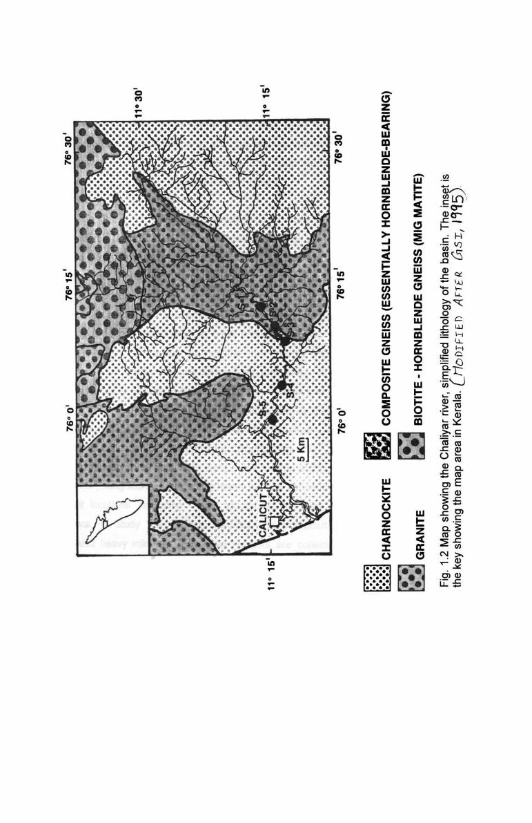
1.8.2 Regional Geology
The area forms part of the Southern Indian Granulite terrain and is underlain
by Precambrian metamorphic rocks (Fig. 1.2).
The geologic framework of southern India is broadly defined by granite
greenstone terrane in the north and a granulite facies terrane in the south. Gold
deposits of economic significance occur in both terranes (cf. Ziauddin and
Narayanaswami, 1974; Radhakrishna and Curtis, 1991 and 1999); the Kolar Gold
Field is located in the Archean low-grade terrane, and the Wynad Gold Field in the
Proterozoic high-grade terrane. The Wynad-Nilambur Gold Field consists of lowlands
bounded on the east and north by the high hills of Wynad and Niligiris. The major
rock types in this area comprise hornblende gneiss, granitic gneiss, pyroxene
granulites inter-banded with magnetite quartzites, charnockites and granulite-grade
metapelites.
In several places, at the margin of the quartz lodes with the host rocks, veins,
and aggregates of carbonate minerals (principally calcite) have developed. Thin
calcite veins, stringers, and pods also fill fractures within the quartz lodes and some
times cut across and extend into the country rock. From the field relations, Santosh
et al. (1995) inferred that the timing of carbonate precipitation was during the late, or
post-emplacement stage of the quartz reefs.
Nilambur forms the eastern extension of Wynad gold belt. Gold is hosted by
metamorphic rocks which consist mainly of biotite-hornblende gneiss, amphibolite,
charnockite, pyroxene granulites and actinolite schist. Pegmatites, quartz veins,
metagabroo, dolerites, norites represent the later intrusives. Laterite, older and
younger gravels, recent river terraces, alluvium and soil represent the Sub-recent to
recent deposits.
8anded-magnetite-quartzite (BMQ) forms elongated lenses and bands within
the biotite-hornblende gneisses and stands out as hills and mounds due to its
resistance to weathering. The strike of the BMQ varies from NW to EW in the
southern parts to NS in the northern sector of the region. The general structure of the
rocks in the southern sector of Nilambur conforms to the Dharwarian trend (Davay,
1975).
11
A few outcrops of pyroxene granulite are exposed west of Chaliyar puzha and
along Karim puzha. Charnockite is observed south of Porur. Tremolite-actinolite
chlorite schists and talcose-carbonate rocks are exposed as lenticular
bodies/isolated outcrops in Manali west of Edakkara. The rock types of Nilambur
have resemblances to the occurrences in Wynad Gold Field and are presumed to be
equivalents to those at Dharwars (Mahadevan. 1965). Dykes of norite. meta-dolerite
and metagabroo are restricted to the southern part of the area.
The area is traversed by numerous quartz veins and quartz stringers. These
quartz veins traverse almost all the rock types and are of two varities viz (i) milky
white and massive type and (ii) small veins with ferruginous material and cavities
typical of sulphides leaching. All the rock units of the area mentioned above are
lateritised. Extensive laterite cover is seen as mounds. on the high grounds and on
the flanks of the hills. Ferruginous and gravelly-pebbly laterites of secondary origin
and insitu laterites have developed over the Pre-cambrian rocks. Soil forms a thin
veneer over the laterite. Alluvium occupies the river valleys and depressions
between mounds and ridges.
As described in the previous sections lateritization is wide spread in the
region. Laterite profiles in the Nilambur valley generally consist of humus zone at the
top followed by a pebbly layer. Further below is vermicular laterite. In some of the
profiles. pallid zone consisting of kaolinitic clay is developed over granitic gneiss.
This is followed by completely and partly weathered zones which merge with fresh
parent rock below. Contacts between the various zones are gradational. All the
weathering units are not exposed/present in a single profile. Maximum thickness of
the weathering profile is 32 m over biotite-hornblende gneiss seen in the quarry
cutting near Nilambur whereas bore holes in Maruda indicate a maximum thickness
of 22 m (Narayanaswamy and Krishna Kumar. 1996). The laterites are compact and
have brick red to purplish colour with cavities filled with kaolinitic clay. Laterites are
also classified into two groups in terms of their genetic relation - (i) primary. the term
used for insitu weathering product. (ii) secondary. for that formed by partial or
complete consolidation of transported lateritic material.
12
1.8.3 Structure
The rocks of the Wynad - Nilambur Gold Field have been multiply deformed.
The region falls within the Moyar-Bhavani lineament, a transcrustal shear system
extending NW-SE from the western part of the craton and swinging to NE-SW in the
east, dissecting major crustal blocks in southern India (Drury et al., 1984). Recent
Nd-isotope data (Harris et al., 1994) indicate that this shear zone is of late
Proterozoic age and is a major crustal divide between the Archean block in the north
and the Proterozoic granulite blocks in the south.
Several mesoscopic shears and faults have developed within the major zone
of shear, which are now occupied by quartz veins carrying gold and sulphide
mineralization (Santosh et al., 1995). The veins comprise milky translucent quartz,
fresh and unsheared. They occur as a series of sub-parallel, moderate to steeply
dipping reefs, trending NNE-SSW to NE-SW, with widths varying from a few tens of
centimeters up to few meters. Some veins extend in strike length up to 1600 m, as in
the Richmond mine, and to an exposed depth of over 70 m as in the Solomon mine
(cf. Ziauddin and Narayanaswami, 1974). All the reefs are emplaced within zones of
faults/shears that cut across the regional metamorphic fabric of the country rocks.
The quartz veins do not display any preference to particular lithology, but show a
strong structural control.
The area is characterised by shear induced tension gashes and retrograded
metamorphism as evident from the general observation of the contact zones
between greenstone belt and granulite mobile belt. The regional trend of foliation is
NNW-SSW with steep dips to SE. The foliation swerves to EW and NW-SE
directions towards the foot of Wynad hills.
1.9 Economic geology
The geologic importance of the Wynad plateau and the Nilambur valley lies in
their gold resources. The auriferous nature of some of the quartz veins of these
areas has been established beyond doubt' by earlier workers. Mineralization is
confined to zones of intense shearing and dislocation which have acted as loci for
emplacement of auriferous veins. The vein gold system of the Wynad - Nilambur
Gold Field is associated with the Proterozoic granulite facies terrane of southern
India. In the quartz veins, native gold occurs along fracture planes in quartz and as
13
fine disseminations within sulphide minerals. Gold also occurs as subsequent grains,
thin flakes, veins and as inclusions within pyrite, the principal sulphide mineral.
Chalcopyrite, pyrrhotite and arsenopyrite are also identified as subordinate gangue
minerals. The abundance of pyrite and gold are directly correlated, in that lodes rich
in pyrite are usually found to contain more gold. Since the gold-bearing quartz veins
are localized within this shear zone, it is inferred that the gold metallogeny in Wynad
is post-Archean and most probably of late Proterozoic age, correlatable with late
Proterozoic incipient charnockite formation and carbonate metasomatism found
farther east and south of the terrain (cf. Farquhar and Chacko, 1991; Wickham et al.,
1994). Stable isotopic evidences (Santosh et al., 1995) suggest a model involving
derivation of C02 by degassing of underplated mantle-derived magmas and transfer
of juvenile C02 to higher crustal levels through felsic magmatic conduits. They also
envisage a common link between Proterozoic CO2 influx and incipient charnockite
formation, carbonate alteration, and gold mineralization in this terrain.
There are many abandoned gold workings in laterites near Nilambur town.
Illegal mining activities are still prevalent in these areas. The main old workings are
confined to the regions south of Nilambur town. A few occurrences are located to the
north. Gold dust, grains and even nuggets are known to be present in the lateritic
cover resting on the auriferous rocks of the Wynad belt in the Nilambur valley.
Intensive panning is still going on even during the summer months in the Nilambur
valley.
One of the principal modes of occurrence of gold in the area is as placers
along the first order streams in the region. Nilambur is known for gold washing along
the streams draining the area since previous century (Ainslie, 1826; Nicolson 1874;
Smyth 1880). Gold occurrences have been reported in older gravels forming terraces
and recent placers found in present day river channels draining the area (Sawarkar,
1965, 1980; Nair et al., 1987). First report on the primary gold mineralization from
Wynad - Nilambur belt and auriferous gravel of Nilambur valley were from Geological
Survey of India (Crookshank, 1940; Narayanaswami, 1963; Mahadevan, 1965;
Sawarkar, 1980) and the exploration programme for primaryllateritic/placer gold
recently carried out by KMED project (Cvetkovic, 1980; Anthrapar et al., 1985),
CESS (Narayanaswamy, 1994; Narayanaswamy and Krishna Kumar, 1996) and GSI
14
(Nair and Suresh Chandran, 1996) have given a surge to the exploration activities in
Wynad-Nilambur area. A number of quartz veins, most of them trending NE or NW
were traced around Maruda (Vidyadharan and Sukumaran, 1978). They established
the auriferous nature of some of these quartz veins by panning the soil nearby.
Therefore the contention of earlier workers that the primary source for the alluvial
gold in Nilambur valley lies only in the well known auriferous tract of Pandalur -
Devala of Tamil Nadu is not valid. Certainly the Maruda source must be contributing
a substsntial amount to the alluvial gold in the Nilambur valley - Chaliyar river. From
the sediments of Chaliyar river and Punna puzha and their tributaries gold is even
now being won by local panners (paniyars) using wooden pans (maravi).
Vidyadharan and Sukumaran (1978) reported an old working for gold right in
the quartz vein south east of Maruda for a strike length of approximately one
kilometer in a NE-SW direction. It is also reported to have produced lot of gold. It is
gathered that panning the minewaste and the adjoining soil indicated specks of gold
and during monsoon hundreds of people get engaged in panning here.
Thus, gold in the Chaliyar basin occurs in three geological set ups viz. (a)
primary gold occuring in the quartz veins; (b) alluvial gold seen in the older gravels
forming high and middle level terraces, which are invariably lateritised and (c) detrital
gold seen in the present day river gravels/in the bed of the river channels. Recent
offshore exploratory survey by the Geological Survey of India has also revealed
interesting concentrations of gold in the marine sediments from the area adjacent to
the place where Chaliyar meets the Arabian sea. More detailed discussions on
different types and the occurrences of gold in the region is given in chapter 7.
A number of pegmatites are seen in the Wynad region. Although many of
them are mica-bearing they may not be of economic significance owing to their small
extent.
Some of the quartz veins in the Nilambur valley may be of optical quality.
Magnetite quartzite bands are also numerous in the area, bu are of small
dimensions.
Laterites as well as the crystalline rocks of the area are extensively used as
building materials. Sand for construction purposes is mined from river channels and
adjacent areas.
15
1.10 Environmental geology
In the plateau area of Wynad, deforestation and plantation of tea, coffee and
spices like cardamom have resulted in environmental degradation and signifies
increased human activity in the region. The uncontrolled use of pesticides,
insecticides and herbicides in tea, coffee and cardamom estates may be polluting
the surface and subsurface waters.
Coming down to the foot hills of Wynad to the Nilambur valley the problem is
of a different type. Here, the illicit panning for gold by local people add lot of mercury
to the river water. The panners use mercury for amalgamating the gold fines
occuring associated with other heavies. For the past one decade or so the Chaliyar
has become notorious for being a polluted river by industries like Mavoor Gwalior
Rayons.
The strongly contrasting physiography of the hilly terrain and uncontrolled
deforestation of the steep slopes by local settlers poses still another problem. This
causes tremendous erosion of the top soil and frequent landslips during monsoons.
Landslips, locally called "Urulpottal", resulting in loss of life and property are
frequently reported at some parts in the Nilambur valley. Another side effect of
deforestation is the heavy loss of water by evaporation from the streams so that
many minor streams, which otherwise would be perennial go dry during summer.
Sand mining from the river channels too have attracted the concerns of
environmentalists.
1.11 Accessibility
The area is easily accessible by road and rail. There are good net work of
roads, Nilambur lies right on the Calicut - Ooty road is connected to Shornur. The
railway broad gauge track which ends at Nilambur Road is connected to Shornur
Junction of the Southern Railway.
1.12 Climate
The Chaliyar basin enjoys a humid tropical climate with alternative dry and
wet season. The annual temperature ranges between 22° to 33°C. The area receives
300-400 cm/yr of rainfall, of which 75 per cent is received during southwest monsoon
(June to August) and the rest during northeast monsoon (September to November).
16
Rainfall increases towards the hilly terrain. The dry weather is prevalent during
January to May.
1.13 Objectives of the present work
The present research work is carried out with the following objectives :
1) to understand the elemental concentration and its distribution in the Chaliyar
basin sediments in relation to mineralogy, texture and the degree of transport
they have undergone;
2) to infer the provenance and weathering/transportation conditions utilizing major,
trace and rare earth element analysis, by studying the bulk geochemistry of
bed load sediments of Chaliyar river;
3) to estimate the concentration of gold in the Chaliyar river sediments and to
establish geochemical affinity and differential migration of selected trace
elements like Cu, Zn, Ni, Cr, Co and V in relation to gold in fluvial system;
4) to understand the various physical features like outline, shape, roundness,
flatness index and rim characteristics of gold particles from different locations of
Chaliyar river and their relationship with distance of transport from lode/lateritic
source;
5) to study the chemical variation in gold grains and identify the factors causing it;
and
6) to understand the mode of occurrence, genesis of gold associated with the
Chaliyar river sediments and to have a preliminary estimate of placer gold in the
main channel.
17
76°0' 76°30'
11°30'
5km I
11°15'" '11°15'
76°0' 76°15' 76°30' Fig. 1.1· Drainage pattern of Chaliyar basin. The inset is the key showing the map area in Kerala
In .... o .... ..-
"0 o CD ,....
-CJ z it c( w m • w Q Z W ..J m z Cl: o ::z:: > ..J ..J c(