* L Journal of Hydrology, 26(1975)153--171 O Elsevier Scientific Publishing Company, Amsterdam - Printed in The Netherlands GEOCHEMISTRY AND NATURAL IONIC AND ISOTOPIC TRACING; TWO COMPLEMENTARY WAYS TO STUDY THE NATURAL SALINITY REGIME OF THE HYDROLOGICAL SYSTEM OF LAKE CHAD . MICHEL-ALAIN ROCHE O.R.S.T.O.M., Service Hydrologique, Paris (France) (Geceived February 12, 1975; accepted March 6, 1975) ABSTRACT Roche, M.-A., 1975. Geochemistry and natural ionic and isotopic tracing; two comple- mentary ways to study the natural salinity regime of the hydrological system of Lake Chad. J. Hydrol., 26: 153-171. As a consequence of intense evaporation and transit through a succession of sedimentary traps (flood plains, lake, dune aquifer and interdune depressions), the isotopic composi- tion of the water and the characteristics of the dissolved and suspended loads change downstream in a regular manner resembling chromatography. The migration of the water and chemical constituents, from one end to the other of this endorheic basin extending from the humid tropics to the desert margins, is outlined and quantified. The erosion, transport and sedimentation phenomena, and the natural saline and isotope tracing methods are studied simultaneously. This study illustrates that these two avenues of re- search prove to be complementary, justifying the use of common models and, in the final analysis, are indispensable to each other. The control of the salinity in these calcium and (then) sodium bicarbonate waters ap- pears to be one of the most remarkable characteristics of the system. This control begins in the flood plains, where about 10% of the major constituents settle out. A regulation in time exists; the deviation between the average annual salinity of the yields to the lake and the long-term average does not exceed k 10%. In spite of considerable dissolved salt inflow from rivers (ions 42 mg/l, 1.8*106 t/year; silica 25 mg/l, 1.1.106 t/year) and of a very high rate of evaporation, Lake Chad has a low salinity (ions 329 qg/l; silica 50 mgll) and does not become noticeably more saline with time. Over periods of several years, a chemical steady-state exists as a result of sedimentation and infiltration. The removal of Caz+, Mg", K', CO,H-, and SiO, by sedimentation in the lake is evaluated (using a simple model) at more than 58, 45, 23, 37 and 83% of the input, respectively. Removal of sodium, which is not evaluated, is the smallest. All these removals are the result of clay diagenesis (formation of montmorillonites), adsorption, and the physicochemical and biochemical precipitation of carbonates and silica. The salt budget provides a means of evaluating water losses by infiltration. These are between 4 and 7%, or less, of the inflow. The isotopic composition of the waters shows a large contribution (300 "/year) to .the groundwater by rain falling on the dunes which border the lake. The lake water infil- trates into the banks and is then partly lost by evaporation. The dissolved substances are, taken up again by the rains on the banks. Major floods at intervals of several years also eva- cuate some of the dissolved saIls from the vicinity of the lake towards' the land bordering it. In the interdune depressions, these solutes give 'rise to evaporite parageneses where ' 9 2 2 G E409P, p75 0. w. S" 8. os M o trona is predominant. '..\ O. R.S.T. O. M. Fonds Documentai react aQ No: wqz SO CDk
Transcript
* L
Journal of Hydrology, 26(1975)153--171 O Elsevier Scientific Publishing Company, Amsterdam - Printed in The Netherlands
GEOCHEMISTRY AND NATURAL IONIC AND ISOTOPIC TRACING; TWO COMPLEMENTARY WAYS TO STUDY THE NATURAL SALINITY REGIME OF THE HYDROLOGICAL SYSTEM OF LAKE CHAD
.
MICHEL-ALAIN ROCHE O.R.S.T.O.M., Service Hydrologique, Paris (France) (Geceived February 12, 1975; accepted March 6, 1975)
ABSTRACT
Roche, M.-A., 1975. Geochemistry and natural ionic and isotopic tracing; two comple- mentary ways to study the natural salinity regime of the hydrological system of Lake Chad. J. Hydrol., 26: 153-171.
As a consequence of intense evaporation and transit through a succession of sedimentary traps (flood plains, lake, dune aquifer and interdune depressions), the isotopic composi- tion of the water and the characteristics of the dissolved and suspended loads change downstream in a regular manner resembling chromatography. The migration of the water and chemical constituents, from one end to the other of this endorheic basin extending from the humid tropics to the desert margins, is outlined and quantified. The erosion, transport and sedimentation phenomena, and the natural saline and isotope tracing methods are studied simultaneously. This study illustrates that these two avenues of re- search prove to be complementary, justifying the use of common models and, in the final analysis, are indispensable to each other.
The control of the salinity in these calcium and (then) sodium bicarbonate waters ap- pears to be one of the most remarkable characteristics of the system. This control begins in the flood plains, where about 10% of the major constituents settle out. A regulation in time exists; the deviation between the average annual salinity of the yields to the lake and the long-term average does not exceed k 10%. In spite of considerable dissolved salt inflow from rivers (ions 42 mg/l, 1.8*106 t/year; silica 25 mg/l, 1.1.106 t/year) and of a very high rate of evaporation, Lake Chad has a low salinity (ions 329 qg/l; silica 50 mgll) and does not become noticeably more saline with time. Over periods of several years, a chemical steady-state exists as a result of sedimentation and infiltration. The removal of Caz+, Mg", K', CO,H-, and SiO, by sedimentation in the lake is evaluated (using a simple model) at more than 58, 45, 23, 37 and 83% of the input, respectively. Removal of sodium, which is not evaluated, is the smallest. All these removals are the result of clay diagenesis (formation of montmorillonites), adsorption, and the physicochemical and biochemical precipitation of carbonates and silica. The salt budget provides a means of evaluating water losses by infiltration. These are between 4 and 7%, or less, of the inflow.
The isotopic composition of the waters shows a large contribution (300 "/year) to .the groundwater by rain falling on the dunes which border the lake. The lake water infil- trates into the banks and is then partly lost by evaporation. The dissolved substances are, taken up again by the rains on the banks. Major floods at intervals of several years also eva- cuate some of the dissolved saIls from the vicinity of the lake towards' the land bordering it. In the interdune depressions, these solutes give 'rise to evaporite parageneses where
'
9 2 2 G E409P, p75 0. w. S" 8. os M o
trona is predominant.
'..\ O. R.S.T. O. M. Fonds Documentai react
aQ N o : wqz SO C D k
154
INTRODUCTION
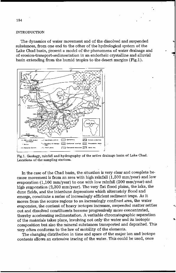
The dynamics of water movement and of the dissolved and suspended substances, from one end to the other of the hydrological system of the Lake Chad basin, present a model of the phenomena of water drainage and of erosion-transport-sedimentation in an endorheic crystalline and alluvial basin extending from the humid tropics to the desert margins (Fig.1).
.
In the case of the Chad basin, the situation is very clear and complete be- cause movement is from an area with high rainfall (1,500 "/year) and low evaporation (1,100 "/year) t o one with low rainfall (200 "/year) and high evaporation (2,300 "/year). The very flat flood plains, the lake, the dune fields, and the interdune depressions which alternately flood and emerge, constitute a series of increasingly efficient sediment traps. As it moves from the source regions to an increasingly confined area, the water evaporates, the content of heavy isotopes increases, suspended matter settles out and dissolved constituents become progressively more concentrated, thereby accelerating sedimentation. A veritable chromatographic separation of the materials takes place, involving not only the water and its isotopic composition but also the mineral substances transported and deposited. This very often conforms to the law of mobility of the elements.
contents allows an extensive tracing of the water. This could be used, once The changing distribution in time and space of the major ion and isotope
155
and quantify the processes that regulate the salinity of the lake. Our study is based upon 20,000 measurements of electrical conductivity,
8,000 analyses of ions or of silica, 1,200 measurements of oxygen isotope, 100 of deuterium and 30 of tritium. This paper is a resumé of the principal
WEATHERED HIGH DRAINAGE BASINS
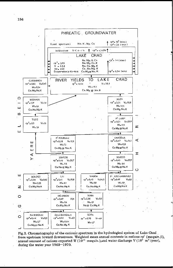
The Logone-Chari rivers rise in high-crystalline source regions of weathering granites, migmatites, gneisses, charnockites etc. (Rodier, 1964; Billon et al., 1974). In these tropical latitudes, leaching is dominant and kaolinite diagenesis the rule in the ferralitic or ferruginous soils. Water from these watersheds con- tains onLy bicarbonates which have originated from the atmosphere. There are only traces of chlorides and sulphates (< 0.5 mg/l) because of the petro- graphy and the distance from the ocean. The river waters have a mean salinity of 30 mg/l, a mean cationic spectrum (cations classified in order based upon the decreasing milliequivalent content) Ca.Na ?f Mg. K“ (Fig.2) and a silica concentration of about 20 mg/l. Downstream, runoff from the sands, sand- stones and lateritized clays of the “Continental Terminal” (Tertiary Period) yields less sodium, but more calcium than the African Shield. This contribu- tion is however insufficient to modify the cationic spectrum of the Logone river.
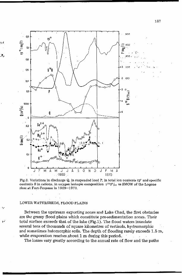
term tropical-degraded Sahelian, is characterized by strong seasonal varia- tions and by very marked changes with latitude, though in opposite senses, in the dissolved and suspended phases (Fig.3). This is explained by the alter- nation of well-defined rainy and dry seasons and its bearing on the cycle of wetting-drying of the soil and the life-cycle of the grassy vegetation. On an annual scale, this role presents certain similarities with that assigned by Erhart (1956) to climatic changes and to the shifts of vegetational belts on a geological time scale. An “annual bio-rhexistasy” therefore appears as an essen-
The pattern of erosion and of alluvial transport towards the lake, which we
7)
v tial factor of the’regimen.
*Mequiv. Ca greater than mequiv. Na; mequiv. Na approx. equal to mequiv. Mg and greater than mequiv. K.
t
156
__-- F P H R E A T l C GROUNDWATER
Na. C a . M g . U Ca. N a . M g . U
Evaporation>93-96% C a . M g # N a I K rp+= 0.54 (min1
w Ca.Na.Mg.K
TILDE
w = 1.8
Ca.Mg # N a . H
+
Ca.Mg.Na.K
rp+=0.58 V=IZ,~ rp+=0,47 V=21.5 a w U w
Ca.Mg# N a . K C a Mg#Na.K
rp+.0.46 V.207 rp+=0,45 V-299
a >
C a N a f f M g K Ca.Mg#Na.K
2 Ca.Mg.Na.K Ca.Na.Mg.K Ca.Na.Mg.K Ca.Mg.iuã 6
O W.: Z6 W = I 9
W Ca.Mg.Na. K Na# Ca.Mg K
EAIEDKDUM OULI-EANGALA
Wn5.7 WzO.64 C a Na.Mg. U C a M g # Na.K
Fig.2. Chromatography of the cationic spectrum in the hydrological system of Lake Chad from upstream toward downstream. Weighted mean annual contents in cations rp+ (mequiv./l), annual amount of cations exported W (lo '* mequiv.),and water discharge V ( lo9 m3 /year), during the water year 1969-1970.
157
500
300. , . . " t
2 200 c c ' r L I ,
o 100
6
J F M A M J J A S O N D J F M A 1969 1970
Fig.3. Variations in discharge Q, in suspended load P, in total ion contents rp' and specific contents S incations, in oxygen isotopic composition 61*00/oo vs SMOW of the Logone river at Fort-Foureau in 1969-1970.
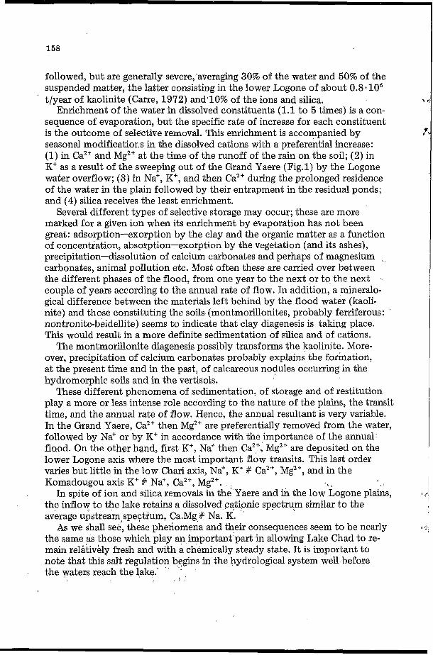
LOWER WATERSHEDS, FLOOD PLAINS Y
Between the upstream exporting zones and Lake Chad, the first obstacles are the grassy flood plains which constitute pre-sedimentation zones. Their total surface exceeds that of the lake (Fig.1). The flood waters inundate several tens of thousands of square kilometres of vertisols, hydromorphic and sometimes halomorphic soils. The depth of flooding rarely exceeds 1.5 m, while evaporation reaches .about 1 m during this period..
The losses vary greatly according to the annual rate of flow and the paths
Q d
158
followed, but are generally severe, averaging 30% of the water and 50% of the suspended matter, the latter consisting in the lower Logone of about 0.8-106 t/year of kaolinite (Carre, 1972) andalo% of the ions and silica.
Enrichment of the water in dissolved constituents (1.1 to 5 times) is a con- sequence of evaporation, but the specific rate of increase for each constituent is the outcome of selective removal. This enrichment is accompanied by seasonal modificatior, s in the dissolved cations with a preferential increase: (1) in Ca2' and Mg2+ at the time of the runoff of the rain on the soil; (2) in K' as a result of the sweeping out of the Grand Yaere (Fig.1) by the Logone water overflow; (3) in Na', K', and then Ca2+ during the prolonged residence of the water in the plain followed by their entrapment in the residual ponds; and (4) silica receives the least enrichment.
marked for 8. given ion when its enrichment by evaporation has not been great: adsorption-exorption by the clay and the organic matter as a function of concentration, absorption-exorption by the vegetation (and its ashes), precipitation-dissolution of calcium carbonates and perhaps of magnesium ~
carbonates, animal pollution etc. Most often these are carried over between the different phases of the flood, from one year to the next or to the next %
couple of years according to the annual rate of flow. In addition, a mineralo- gical difference between the materials left behind by the flood water (kaoli- nite) and those constituting the soils (montmorillonites, probably ferriferous: nontronite-beidellite) seems to indicate that clay diagenesis is taking place. This would result in a more definite sedimentation of silica and of cations.
The montmorillonite diagenesis possibly transforms the kaolinite. More- over, precipitation of calcium carbonates probably explains the formation, at the present time and in the past, of calcareous nodules occurring in the hydromorphic soils and in the vertisols.
These different phenomena of sedimentation, of storage and of restitution play a more or less intense role according to the nature of the plains, the transit time, and the annual rate of flow. Hence, the annual resultant is very variable. In the Grand Yaere, Ca2' then Mg2* are preferentially removed from the water, followed by Na' or by K' in accordance with the importance of the annual f l o ~ d . On the other hand, first K', Na+ then Ca", Mgzf are deposited on the lower Logone axis where the most important flow transits. This last order varies but little in the low Chari axis, Na", K+ # Ca2', Mg2', and in the Komadougou axis K' # Na' , Ca2+, Mg2'.
the inflow to the lake retains a dissolved cationic spectru,m similar to the average upstream,spe$rum, Ca.Mg # Na. K.
the same as those which play an important part in allowing Lake Chad to re- main relatively fresh and with a chemically steady state. It is important to note that this salt regulation begins in the hydrological system well before the waters reach the lake.'
Several different types of selective storage may occur; these are more
In spite of ion and silica removals in the Yaere and in the low Logone plains,
As we shall see, these phenomena and their consequences seem to be nearly
L
, i
159
In addition to the foregoing control in mace, a time regulation of the in- flow concentration from the entire lake watershed also exists. The annual deviation from the long-term average (12 years) remains less than -+ 10% for salinity even when the mean annual discharge varies from +40% to -20% with respect to the long-term value for t$e same time period. Deviations of less than +_ 5% for each ion (2 years) and for turbidity (3 years) have also been measured. The rate of weathering in the high drainage basins and the salinity increase in the plains thereby compensate each other. Both are func- tions of the annual discharge, but are acting in opposite ways.
h C
/ i
LAKE CHAD
Lake Chad is a closed basin gf approximately 20,000 km2 without surface outlets. During normal periods, depths do not exceed 5 to 8 m (3.3 m average in 1969). The annual turnover coefficient, due essentially to evaporation, is is GO to 70% (Touchebeuf et al., 1969).
River yields to Lake Chad
During an average year, in addition to 6.5 - l o 9 m3 of precipitation falling on the lake, 43 - l o 9 m3 of river water flows into the lake which has an oxygen isotopic composition of -3°/00 vs SMOW (Fontes et al., 1970) and suspended matter, ion and silica concentration of 71, 42, and 25 mg/l, respectively. These values, given in Table I, do not appear to be very high in comparison with those found in similar latitudes elsewhere (Livingstone, 1963) and are com- parable to those found by Grove (1972) in the Senegal and Niger. They cor- respond to a mean annual inflow of 3.0.106 t of suspended material, half of which is kaolinite (Carre, 1972), 1.8 . lo6 t of ions and 1.1 - l o 6 t of silica
'
for the period 1954-1969. It is estimated that these values were greater by +6% for the period 1870-1970.
In conclusion, the yields to the lake can be summarized as 50 -10' m3 / year of water and 6.0.106 t/year of mineral substances (Table I). The Chari river alone provides, respectively, 96, 91 and 98% of the water, solutes, and suspended minerals, of which about 85% are furnished frqm July to Decem- ber. Soluble material carried in by wind and rain represent no more than 15% of the river contribution.
'r" Aspects of salinity control
The waters in the lake follow a course from the Chari delta towards the banks, with a circular movement in the northern region which leads to some mixing. More than 93 to 96% of the waters evaporate progressively and their oxygen-18 and solute contents increase. In spite of a considerable salt input during thousands of years, the salinity, at the lake margins, is only 3 to 40 times greater than that of the inflowing water. These values range from 2 to I
r':
TABLE I
Chemical budget of Lake Chad (period 19!54-1969)
CaZ+ MgZ + Na+ K+ rp+ f CO,H-+CO, '- SiO, (mg/l and lo4 t)
Mean dissolved contents of the Chari (mequiv./l) - 0.191 0.135 0.122 0.041 0.488 24 Mean dissolved contents of the Logone (mequiv./l) 0.429 0.297 0.363 0.104 1.193 50 Mean dissolved contents of the Komadougou (mequiv./l) 0.341 0.216 0.191 0.066 0.814 ( 50)
Mean dissolved contents of river yields (mequiv./l) 0.200 0.141 0.131 0.043 0.515 River yields (10'' mequiv./year) 8.68 6.12 5.67 1.88 22.3
Mean concentrations in lake water (mequiv./l) 1.03 0.96 1.60 0.41 3.95 Dissolved salt amount (10" mequiv.) 57.5 53.3 89.3 22.9 220 Residence time (years) 7 9 16 12 10
25 109
53 300 3
Removals by sedimentation (%) 58 45 O 23 37 83
161
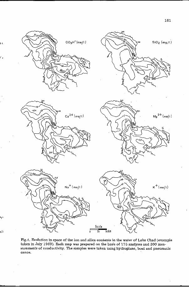
Fig.4. Evolution in space of the ion and silica contents in the water of Lake Chad (example taken in July 1969). Each map was prepared on the basis of 175 analyses and 300 mea- surements of conductivity. The samples were taken using hydroplane, boat and pneumatic canoe.
162
6 times for silica (Fig.4). The isotopic composition frequently attains + 5 to + 17'/00. Nevertheless, the average concentration remains very low (ions : 320 mg/l; silica: 50 mg/l). No marked evolution in time could be observed from the data acquired in 1908,1957 and from 1962 to 1970 (for a lake level higher than 281 m).
exists and hence processes of salinity control must occur; (2) water and salinity conditions in the lake as a whole, at any particular moment, represent the stages of the evolution in time at any point; (3) the salinity of the water at any point is a function of the time elapsed since'that water entered the lake. This is the basis of the principle of saline tracing and has been used in simple mathematical models to determine the chronology, the directions, the velocities of the movement of the water and the age of the water (see Roche, 1973b, c).
Three important conclusions can be drawn: (1) a chemical steady-state
' Na. MQ. K. Ca
Na. Ca. MQ. K 39.27.23.11
Na. Ca. MQ. K
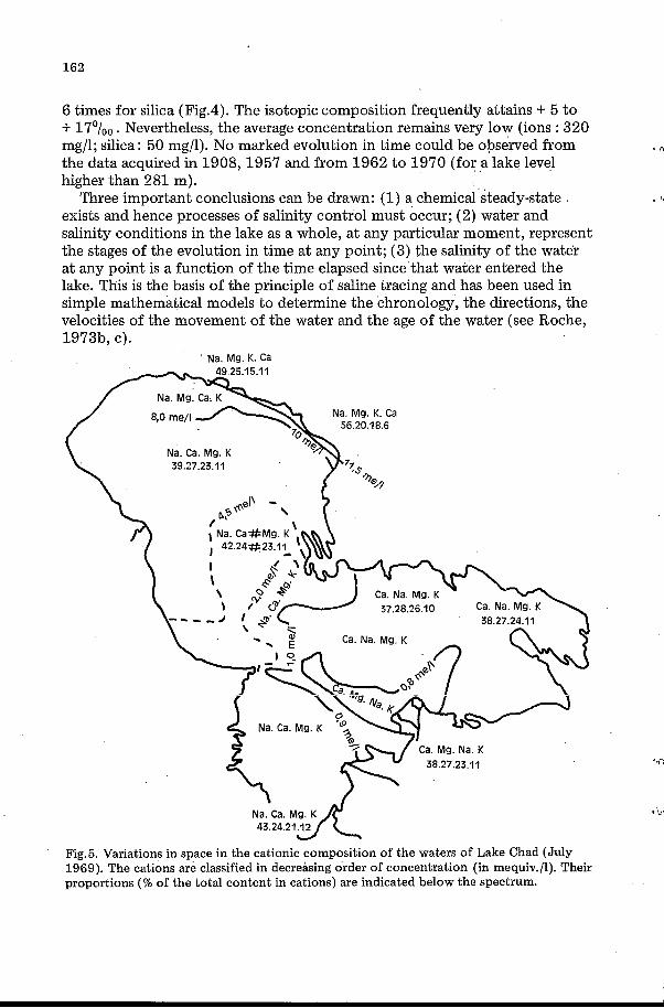
Fig.5. Variations in space in the cationic composition of the waters of Lake Chad (July 1969). The cations are classified in decreasing order of concentration (in mequiv./l). Their proportions (% of the total content in cations) are indicated below the spectrum.
163
Bicarbonate remains the principal anion in the lake even though a relatively weak carbonate content appears among a total anion concentration of 4 mequiv./l. Chloride remains approximately at 1% of the anion content and the sulphate concentration is still lower. On the other hand, as is often ob- served in groundwater of arid or semi-arid zones, but rarely in surface water, the cation spectrum passes through five successive stages and evolves from Ca. Mg. Na. K to Na. Mg. K. Ca (Fig.5), the particular stage depending on the salinity, the elapsed time, and the areas where water remains. The ratio of silica (mg/l) to ion (mequiv./l) content decreases from 45 at the Chari delta to 8 at the extremity of the most mineralized branches of the northern shore.
(Table I) shows that the residence times range from 16 years for sodium to 3 years for silica. The total amount of ions dissolved in the lake is equivalent to only 10 years of river discharge.
n i
f r*
Thus, a selective control of solutes operates in the lake. The chemical budget
The salt control processes
Salt control of the water of Lake Chad is ensured by two main types of
(1) Interaction with the organic and mineral environment leads to the re- phenomenon.
moval of solute components from the lake itself. At the same time, these phenomena also ensure a chemical stabilization (buffer capacity), without effective long-term sedimentation.
(2) A non-selective evacuation of the water and of the salt in solution is effected by infiltration through the shore and the lake floor and, secondljï, by evaporation from the littoral basins which function as natural brine pits, filling and emptying with fluctuations of lake level.
Sedimentation in the lake Sodium remains in the lake water longer than any of the other solutes
under consideration. In other respects, the general behaviour of this element in the hydrosphere, the chemical phenomena which lead to the modification and control of the salinity and the relationships between the lake and the water-table hardly fit the concept of an annual liberation of sodium in the lake. Consequently, the differences found for the residence times appear to be attributable to removal of the other dissolved substances. This is confirmed by the rate of increase in the mean sodium concentration for the entire lake from March-April to July, when the inflow is negligible. Actually, this rate is only slightly different from that which can be estimated, as a function of evaporation, rainfall, and depth, by using a mathematical model (Roche, 1 9 7 3 ~ ) .
Therefore, sodium is removed from the lake very slowly and that ion can be used as a quantitative reference tracer in order to estimate the removal of other solutes by sedimentation and of the solutes and water by infiltration. By defining the sodium as constituent x, the relative removal Ss/S of a con- stituent from the water since its input into the lake can be written as Ss/S =
Y’
J *
164
1 -Sox S / S, So, where S is the lake-water concentration and So the mean inflow concentration.
sited therein. The relative removals in Ca2+, Mg'+, K' and C03H- are at least 58, 45, 23, and 37%, respectively. Similar results have been confirmed by
removals would be 53% and that of silica 87%. All the suspended matter, 50% of it being kaolinite, remains in the lake.
This kaolinite which is practically the only clay mineral carried into the lake (Carre, 1972; Gac and Pinta, 1973), does not persist there. The stabil- ity conditions are those of montmorillonites (Lemoalle, 1969) and these minerals are present on the bottom in dominant proportions (Dupont, 1970; Cheverry, 1974). A tentative calculation shows that the kaolinite is degraded in part; the montmorillonites are diagenetic. The evolution of the dissolved constituents in the lake (of which iron is one, after Lemoalle and Dupont, 1973), leads to the supposition that they may be ferriferous, aluminous and magnesian (nontronite, beidellite, stevensite), the three cations predominating
mouth of the Chari river. A part of the aluminium oxide input, contained in kaolinite and in gibbsite, could contribute to their diagenesis. The adsorption capacity of the clay minerals is thereby permanently increased; its effects be- come even stronger as the salinity increases. Montmorillonite diagenesis re- moves silica, iron, aluminium, and magnesium from the water and from the sediments and adsorbs, in decreasing order, calcium, magnesium, potassium, and sodium. Tentative calculations prove that the adsorption capacity of the clays is not sufficient to adsorb all the elements removed from the water. This adsorption seems to involve other adsorbant substances, organic matter in particular.
Iron (goethite), associated with silica, is precipitated in the southern part of the lake; calcite and possibly magnesium carbonates in the northern part. Silica (tests of diatoms, phytolites) and, in the north, aragonite (shells of mollusca) are deposited biologically.
Adsorption by clays and organic matter and absorption by plants and
At least 37% of the ions and 83% of the silica entering the lake are depo- 1 r,
Carmouze (1972). For example, assuming a 25% sodium removal, the ions 1 1,
. successively in the crystal network, as a function of the distance from the
(*I'IILILy" - n i m o l - anc.il*o G'""urSlr, CY""b olr\nr( T x T i f h . I L V I 1 u c~p 1 nffnrtiwn "....""UA." " cnrlimnntatinn 1 -..--, 2 b l_~f f~ r ,--~pa-cii,y capable of stabilizing salinity over several years.
Losses o f waters and dissolved components by infiltration and from the surface
The quantity of ions and silica evacuated from the lake, by water which infiltrates, is equal to the inflow quantities minus those retained on the floor of the lake: less than 63% of the ions and 17% of the silica reach the phreatic groundwater. Knowing the sodium content of the water, this same principle affords a means of calculating the losses of the lake by infiltration and from the surface: 4 to 7%, or less, of the inflow is lost by these means. The ratio .between the surface area of the lake and of the littoral basins where water
165
may be le€t behind, limits the losses from water surfaces to less than 0.5%: That is to say that the infiltration is 9 to 15 cmlyear, or less, and the evapo- ration 220 to 226 cm/year, or more. h t
THE PHREATIC GROUNDWATERS, THE INTERDUNE BASINS, THEIR RELATIONS .f WITH THE LAKE
When the shore of Lake Chad is considered, the phenomena are seen to operate over a long time period and prove to be complex.
Aquifer, piezometry, origins, and dynamics o f the groundwaters
The lake overlies a phreatic aquifer, 70 m thick, within the dunes (Kanem Erg) and in the fluvio-lacustrine deposits of the Holocene and the Upper and Middle Pleistocene ( Fig.6). Schneider (1967) showed that it is surrounded by piezometric de;;ïessions in the centre of which the level of the ground- water is 30 to 50 m lower than the surface water. A piezometric low gutter, whose level is some metres lower than that of the lake, runs along the north-
Fig.6. Piezometric map of the phreatic groundwater in the zone of Lake Chad. Position of the regions where the relationships between the lake and the groundwater were studied.
166
eastern shore. On the other side of this depression, in Kanem, the level rises and the water-table takes on a dome shape rising about 30 metres above lake level. Boreholes drilled to varying depths in the banks (Fig.7) confirm that the piezometric slopes are favorable to movement of water by infiltration from the lake into the dunes. However, the lithology and the structure of the formation regulate the evaporation and feed by surface and rain waters. They seem to be the determining factors in the long-term budget of the water-table which is deficient in sandy-clay deposits, but better balanced in the dunes.
The oxygen-18 contents and, in certain cases, the salinity and tritium contents invalidate the previously accepted hypothesis of a massive seepage of the lake water as far as the interdune closed basins (Fontes et al., 1970).
Two main types of ground water are identified by their isotopic oxygen composition: water of lake origin which is rich in "O (6 SMOW) and water of pluvial origin which is not very enriched in heavy iso- topes (6 l 8 = -4 to -5'/oo vs SMOW). This latter is the richest in tritium (135 T.U. for example). In fact, there is most often a mixing of the two types of water.
'
A
>
= + 5 to + 15°/00 vs
POLDER DE NO-MdIGA POLDER DE NO-MADIROM I I I & K E
1505t5.5 i i 795 +7,4 ,-.- ,-
' il070-3.6
i 2080-2.7 250
, .','/. , * ' / / / , ' , / I 1 200 Ij ,,,,,,, o / ,,,,,,, 1000 i,,//,/,, oistance Iml 3000
I ' I
POLDER DE SORO ESE
440-42 LAKE11 LAKE DAM I 1013+6.1 1 h 630+&2 II 2420+186 l770+9.6
300 LAKE
7
o iooo ~ i ~ t a n c e 1m1 4000 5000 _.-_ - - 1 duuLrì inoo zio0 "
Fig.7. Electrical conductivity and oxygen-isotopic composition of the phreatic ground- water in the dunes and in the interdune depressions on the edge of Lake Chad. The ground- water is contained in 60 to 70 m of dune sand with some intercalated clay lenses. It lies upon an impermeable clay floor. The bottoms of the closed basins, covered with aqui- ferous crackled clay, are cultivated as polders.
+.
As distance from the lake shore increases, in the upper part of the water- table tho i@-C,opic composition shows a progressive decrease in lake-water proportion, in favour of rain water that has infiltrated through the dunes. Thus the contribution of water derived from the lake often becomes imper-
167
ceptible in the groundwater, even near the first littoral closed basin. For example, Fig.7 shows a variation in composition from f in the lake to - 5'/00 at a distance of 1 km. Along the northernmost banks, water of lake origin is confined t o a band, a few kilometres wide. It finally gives way to water of pluvial origin. Along the southern shore, likewise, the composition denotes a mixing of these two types of water.
lake water that has suffered evaporation losses, in proportions which de- crease toward the base (Fig.7). However, in certain places, along the axes of effluent flow lines, lake water constitutes the entire thickness. In such *cases, it mixes, to a degree according to the site, with rain water draining from the ad- jacent dunes. Finally, the littoral basins are fed on their periphery by the two types of water mixed in varying proportions.
Concurrently with an isotopic stratification, a saline stratification also fre- quently exists. This is brought about by the progressive dilution of the ground- water by precipitation.
The present-day geodynamic phenomena are the final result of a long Quaternary evolution characterized by the alternation of arid and humid phases which resulted in several lake transgressions and regressions (Faure, 1969; M. Servant, 1973; S. Servant, 1973). It would seem that the aquifer was fed during these periods and up to the present time by waters of two types according to the extent of the lake, this alternation leading towards a homogenization of the waters. The last phase probably goes back to the last high lake level of 287-290 ~n dating from 3,200 to 1,800 years B.P. Since this inundation, precipitation has been largely responsible for the present water composition and structure. The isotopic composition reveals that cur- rent precipitation contributes to the supply of the whole Kanem water-table, with an annual rainfall of 250 to 350 mm. As in the case of Saharan studies I
(Conrad and Fontes, 1972; Roche, 1973a), this confirms the sometimes disputed fact that infiltration does occur in dune regions even where precipitation is scanty.
No matter what their origin is, the lake and pluvial waters increase their dissolved-constituent content in the aquifer by dissolving ancient salt deposits and by slowly taking up ions and dissolved material stored in the colloids and clays during the Quaternary. This could have taken place, in part, when the water reserves were augmented as a result of an increased relief of the erg before the Holocene. These salts in solution could also be less ancient and have been deposited in the existing interdune closed basins following high levels of the lake or of the groundwater. The drop of the level which followed could have provoked a vertical washing of the salt deposits by the rains or by the lake during a subsequent long-term inundation. All the observations con- cur to show the slow velocity of the flow.
P-5
l i
Throughout the depth of the aquifer, infiltrating rainwater mixes with older
p.
Jt
168
The pattern o f salinity control by water infiltration
In the Kanem erg, local piezometric slopes, specific to each littoral basin
the aquifer plays the role of an accumulator that absorbs a part of the waters
4 7
but reversible according to the lake level, superimpose themselves on the general slope. The values for isotopic composition confirm that, essentially,
and salts from the lake during high lake levels. These in turn mix with the infiltrated rainwater in variable proportions and are then restored to the lit- toral basins when the lake level falls after several years or even hundreds or thousands of years. The removal can also be superficial when the branches of the lake are cut off as ponds. By evaporation, the water ends up by almost entirely evaporating in these residual basins.
components (Maglione, 1974; Cheverry, 1974), leading either to a sodium- carbonate paragenesis (alkalinization) associated with sodium-silicate dia- geneses, in a confined and reducing medium, or to a sodium sulphate-chloride paragenesis (salinization) in a less confined and oxydizing medium.
However, on the other banks, the piezometric slope always remains oriented toward the land side: the return of the solutions to the depressions is im- possible.
Thus, the long-term oscillations in lake level over hundreds or thousands of years resulted in a subsurface and surface migration of salts from the vi- cinity of the lake to the surrounding country.
On an annual scale, such a pattern, which implies large variations in lake level, is a less satisfactory explanation of salinity regulation. As a matter of fact, the minimum volume of the lake water infiltration, estimated by the salt budget to be 4% of the inflow, seems to be much too high with regard to the origins and distribution of the waters in the shore, as is shown by its iso- topic composition. Without invalidating the evidence of the large long-term movement of salts, it appears that some lake water is evaporated from the aquifer quite near the shore shortly after infiltration. This “capillary fringe” corresponds principally to the surface which emerges during the seasonal variations in the lake level.
nents shortly after infiltration. These are picked up again by the rainwater which falls at the time of the low lake level.
I C
In the dune depressions, two means of evolution are open to the dissolved
The lake water than has a permanent tendency to lose its chemical compo-
Here, even more than in other regions, the history of Quaternary hydrolo- gical and geological events has an important influence in various ways on i-r
water and salt conditions of the present day.
Quaternary salinity control in the Chad basin .LI
The meagre quantity of evaporites in this endorheic basin is surprising. The anomaly can be explained, using the current system as a model, in terms of the storage of salts in groundwaters and deposition of various minerals such
169
as clays with a large adsorption capacity, limestones, diatomites etc. Evapo- rites deposited in interdune depressions and salts dissolved in the ground- water correspond to about half of the solute yields. The amount of ions dis-
15,000 years of salt inflow. Even taking into account chemical sedimentation, this order of magnitude is very low and leads to the supposition that surface outlets from the Chad basin occurred in the course of the Middle of the Late Pleistocene and even in the Holocene, with the maximum extention of the Paleo-Chad Lake (400,000 km2 ).
w i solved in the phreatic groundwater is estimated between less than 1,200 and
: h
CONCLUSION
From these studies, the fundamental role played by the dynamics of the water in the phenomena of erosion, transport, and sedimentation on every scale of space and time stands out. Hydrologists, who are increasingly called upon to study water quality, erosion, and pollution problems, must find a convincing illustration that flow takes place in a very*active chemical en- vironment. Unusual deposits, often resulting from interactions between water, dissolved and suspended material, silicates (phyllosilicates in particular), plant and animal life, and organic matter, are responsible for the removal of dissolved constituents from the water. The processes involved are not easily discovered but are favored by an increase of chemical concentration caused '_
by evaporation of the lake water. Following the flow of water downstream, one finds that sedimentation,
interactions with the mineral, animal, and vegetable environment and purely hydrological phenomena are all involved in the control of the salinity of the hydrological system. Together they establish a chemical steady-state over long periods of time. This can be interrupted after several years or decades by a long climatic drought of the type which has raged in all of the Sahelian region since 1972. The consequence is the drying of vast areas and, particularly, of Lake Chad whose surface has been reduced by half. This is the second time in a century that such a catastrophe has occurred. We can be sure that, once the water rises again, the lake will regain a chemical steady-state com- parable to that which has been described.
the other. Over a distance of 1,000 km, large variations occur in climate, hydrology and hydrochemical processes. Sin ilar variations, but in time in stead of space, took place duri:: tLe laïge climatic changes during the Quater- nary and on a smaller scale during climatic oscillations with a period of a decade or so, which greatly influence the lake level. This idea helps us to understand and evaluate the Quaternary heritage in the tropical, Sahelian and desert regions and allows us to forecast certain geochemical and hydrolo- gical consequences of the main low-water periods such as the one which began after the close of our investigations.
In such a system, evolution in space and in time can be deduced one from
Ir?t
YU
With regard to natural tracing the maximum amount of information has
170
been provided on the one hand by the dissolved constituents in the surface
shows or foretells certain possibilities of natural saline or isotopic tracing in
I water and on the other by the isotopes in the groundwater. While this study
different environments, it also illustrates the absolute necessity of using the two types of tracers togeth:r and with a full appreciation of the hydrometric,
+*~
geochemical and biochemical environment. ' y l
REFERENCES I
Billon, B., Guiscafre, J., Herbaud, J. and Oberlin, G., 1974. Le bassin du fleuve Chari. O.R.S.T.O.M., Paris, 450 pp.
Bouchardeau, A. and Billon, B., 1968. Monographie hydrologique du Logone. O.R.S.T.O.M., Paris, 8 vol., 770 pp.
Carmouze, J.P., Carre, P., et al., 197 2. Alteration, erosion, transport, sedimentation dans un bassin continental endorbique: la cuvette tchadienne. Rapport preliminaire. Coll. GBoLAbadan, pp. 363-370.
Carmouze, J.P., 1972. Originalit6 de la regulation saline du lac Tchad. C.R. Acad. Sci.
Carre, P., 1972. Quelques aspects du regime des apports fluviatiles de materiaux solides
Cheverry, C., 1974. Contributiod A 1'6tude pedologique des polders du lac Tchad. Dyna-
Paris, 275: 1871-875. 1 I
en suspension vers le lac Tchad. Cah. O.R.S.T.O.M., Ser. Hydrol., Paris, IX (1): 19-45.
mique des sels en milieu continental subaride dans des sediments argileux et organiques. These doct. 6s-sc., Strasbourg, 0.R:S.T. O.M., 27 5 pp.
Fontes, J.C., Gonfiantini, R. and Roche, M.A., 1970. Deuterium et oxygene 1 8 dans les eaux du lac Tchad. Coll. sur les Isotopes en Hydrologie, A.I.E.A., Vienne, pp. 387-404.
Gac, Y. and Pinta, M., 1973. Bilan de 1'6rosion et de l'altdration en climat tropical humide. Estimation de la vitesse d'approfondissemert des profils. Etude du bassin de l'Ouham (R.C.A.). Cah. O,R.S.T:O:M., SBrrGBol., Paris, V (1): 83-96.
Senegal, Niger, Benue and Shari. J. Hydrol., XVI: 277-300.
Conrad, G. and Fontes, J.C., 1972. Circulations, aires et periodes de recharge dans les
Dieleman,'P.J. and De Ridder, NIA., 1963. Expertise sur les mouvements des eaux et du
Dupont, B., 1970. Distribution et nature des fonds du lac Tchad. Cah. O.R.S.T.O.M.,
Erhart, H., 1956. La genese des sols en tant que phhomene geologique. Esquisse d'une . Masson (Editor), Coll.
Grove, A.T., 1972. The dissolved and solid load carried by some west African rivers:
Lemoalle, J., 1969: Premihres donnees sur la repartition du fer soluble dans le lac Tchad.
iron sedimentation in Lake Chad. In: G.C. Awtu tz and A.J. Bernard (Editors), Ores
w a Sect. Hydrobiol. O.R.S.T.O.M., Paris, 1 0 pp.-
Lemoalle, J. and Dupont, B., 1973. Iron bearing oolites and the present conditions of QV
in Sediments. Springer, Berlin, pp. 167-178.
m e e a n d brine in closed lakes. Limnol. OcBanogr., 1 8 (1): 72-85.
Pap., 440: 64 pp.
Lerman, A. and Jones, B.F., 1973. Transient and steady-state salt transport between sedi-
Livingstone, D.A., 1963. Chemical composition of rivers and lakes. U.S. Geol. Surv. Prof.
171
Maglione, G., 1974. Gkochimie des Bvaporites et silicates ndoformks en milieu continental confinb. Les dkpressions interdunaires du Tchad, Afrique. These doct. Bs-sc., Paris, O,R.S.T.O.M., 332 pp.
Rodier, J., 1964. Rdgimes hydrologiques de l’Afrique noire A l’est du Congo. O.R.S.T.O.M., Paris, 137 pp.
Roche, M.A., 1970. Evaluation des pertes du lac Tchad par abandon superficial et infil- trations marginales. Cah. O.R.S.T.O.M., Skr. GBol., Paris, II (2): 67-80.
Roche, M.A., 1973a. Hydrogbologie de la Haute Saoura (Sahara nord occidental). C.N.R.S. Paris, et Serv. Gkol. de 1’ Algdrie, Bull., 43, 91 pp.
Roche, M.A., 1973b. Tracage hydrochimique naturel du mouvement des eaux dans le lac Tchad. Symp. Hydrol. Lacs, A.I.H.S. Helsinki, pp. 18-27.
Roche, M.A., 1973c. Tracade naturel salin et isotopique des eaux du Systeme hydrologique du lac Tchad. These doct. 6s-sc., Paris, O.R.S.T.O.M., 398 pp.
Schneider, J.L., 1967. Relation entre le lac Tchad et la nappe phrkatique. A.I.H.S., Symp. Garde, pp. 122-131.
Servant, M., 1973. Skquences continentales et variations climatiques: &volution du bassin du Tchad au Cknozoigue supkrieur. These doct. 6s-sc., Paris, O.R.S.T.O.M., 348 pp.
Servant, S., 197 3. Stratigraphie et nkotectonique du Plio-Pleistocene ancien du Tchad d’aprBs l’ktude des Diatomkes. C.R. Acad. Sci. Paris, 276: 2633-636.
Touchebeuf, P., 1969. Monographie hydrologique du lac Tchad. O.R.S.T.O.M., Paris, 3 vol., 300 pp.