TS01F - Dam and Reservoir Engineering Surveying, 5505 Marco Di Mauro and Joel van Cranenbroeck Geodetic and Geotechnical Combined Monitoring Concept FIG Working Week 2012 Knowing to manage the territory, protect the environment, evaluate the cultural heritage Rome, Italy, 6-10 May 2012 1/20 Geodetic and Geotechnical Combined Monitoring Concept Marco DI MAURO, Italy and Joel VAN CRANENBROECK, Belgium Key words: Data fusion, sensor fusion, integration, collocation, monitoring systems, system integration SUMMARY The value of a monitoring system is to provide reliable data on timely manner to support the authorities in their responsibility of preserving people’s safety, engineering structures and the environment. Today by using high-precision sensors in automatic mode to control the daily behavior of points located on bridges, dams, buildings, landslides or subsidence area’s it is possible to be warned early in advance of motions and deflections diverging from a normal state that could announce potential failures and to face the causes or at least to take actions that will mitigate the impact on the population. Monitoring systems using geodetic instrumentations will most of the time produce a feedback on possible movements from geometric point of view (position domain) and operate from outside while geotechnical sensors will be inside structures or below the ground level. The integration of the measurements from both sensors at the processing level will allow mutual checks and will definitively improve the parameters of the deformation model that is the basis of risk management. The necessary conditions to fulfill such innovative approach are time synchronization and collocation (offset’s) which means to create a geometric relationships between the sensors in a common time frame. To illustrate that proposal, the authors will review existing projects such the Cixerri Dam and a construction project in Milano, Italy and the Grohovo landslide in Croatia.
Transcript
TS01F - Dam and Reservoir Engineering Surveying, 5505 Marco Di Mauro and Joel van Cranenbroeck Geodetic and Geotechnical Combined Monitoring Concept FIG Working Week 2012 Knowing to manage the territory, protect the environment, evaluate the cultural heritage Rome, Italy, 6-10 May 2012
1/20
Geodetic and Geotechnical Combined Monitoring Concept
Marco DI MAURO, Italy and Joel VAN CRANENBROECK, Be lgium
Key words: Data fusion, sensor fusion, integration, collocation, monitoring systems, system integration SUMMARY The value of a monitoring system is to provide reliable data on timely manner to support the authorities in their responsibility of preserving people’s safety, engineering structures and the environment. Today by using high-precision sensors in automatic mode to control the daily behavior of points located on bridges, dams, buildings, landslides or subsidence area’s it is possible to be warned early in advance of motions and deflections diverging from a normal state that could announce potential failures and to face the causes or at least to take actions that will mitigate the impact on the population. Monitoring systems using geodetic instrumentations will most of the time produce a feedback on possible movements from geometric point of view (position domain) and operate from outside while geotechnical sensors will be inside structures or below the ground level. The integration of the measurements from both sensors at the processing level will allow mutual checks and will definitively improve the parameters of the deformation model that is the basis of risk management. The necessary conditions to fulfill such innovative approach are time synchronization and collocation (offset’s) which means to create a geometric relationships between the sensors in a common time frame. To illustrate that proposal, the authors will review existing projects such the Cixerri Dam and a construction project in Milano, Italy and the Grohovo landslide in Croatia.
TS01F - Dam and Reservoir Engineering Surveying, 5505 Marco Di Mauro and Joel van Cranenbroeck Geodetic and Geotechnical Combined Monitoring Concept FIG Working Week 2012 Knowing to manage the territory, protect the environment, evaluate the cultural heritage Rome, Italy, 6-10 May 2012
2/20
Geodetic and Geotechnical Combined Monitoring Systems
Marco DI MAURO, Italy and Joel VAN CRANENBROECK, Be lgium 1. INTRODUCTION Understanding structural and environmental behaviors nowadays represent an entire field of new challenges for engineers, construction companies and designers. New buildings and towers are designed higher and higher, new bridges are lighter and longer, tunnels are designed in more risky conditions and for those projects there is few or no experience in term of how deflection and motion will happen during and after the construction phases. New construction techniques are needed and experimented to reach the desiderata of the designers referring to their models (Finite Elements Model) as well as the development of new materials not only to create aesthetic effects but to match the structural requirements, reduce the costs or at least to fit the budget. The worldwide economy of today is based on connection and sensitive infrastructures such high speed railways, bridges, tunnels, hydropower dams, power lines, pipelines must be permanently monitored to keep their usage longer than often initially expected. The development of the population and the expansion of the cities are increasing and often now we found buildings and infrastructures erected in the vicinity of critical areas subject to land sliding, active seismic faults, volcanoes or directly around large water reservoirs and nuclear power plants to quote some of them. Also in western countries lot of infrastructures are aging faster (fatigue due to the change of traffic load for instance) and even coming to an end of their planned lifecycle while in emerging economies such in China, the development of the infrastructures have been setup so fast and at risk than now the crucial question is to keep them safely in service. Monitoring is therefore becoming essential to protect the huge investment needed for building up the infrastructures, to mitigate the risk of failure on the population, to protect the environment and to guarantee a sustainable economy. 2. THE NECESSITY OF RISK MANAGEMENT There is nowadays much consideration in preventive risk management for crucial and sensitive infrastructures where a failure can not only impact the population and cause significant human life lost but can ruin the economy of a region, a country or a nation. In case of disaster, the media show often impressive pictures related to the visible dramatic
TS01F - Dam and Reservoir Engineering Surveying, 5505 Marco Di Mauro and Joel van Cranenbroeck Geodetic and Geotechnical Combined Monitoring Concept FIG Working Week 2012 Knowing to manage the territory, protect the environment, evaluate the cultural heritage Rome, Italy, 6-10 May 2012
3/20
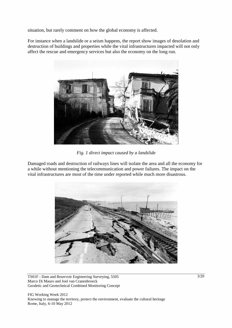
situation, but rarely comment on how the global economy is affected. For instance when a landslide or a seism happens, the report show images of desolation and destruction of buildings and properties while the vital infrastructures impacted will not only affect the rescue and emergency services but also the economy on the long run.
Fig. 1 direct impact caused by a landslide Damaged roads and destruction of railways lines will isolate the area and all the economy for a while without mentioning the telecommunication and power failures. The impact on the vital infrastructures are most of the time under reported while much more disastrous.
TS01F - Dam and Reservoir Engineering Surveying, 5505 Marco Di Mauro and Joel van Cranenbroeck Geodetic and Geotechnical Combined Monitoring Concept FIG Working Week 2012 Knowing to manage the territory, protect the environment, evaluate the cultural heritage Rome, Italy, 6-10 May 2012
4/20
Fig. 2 Indirect impact of a disease Another recent example is what happened with the Costa Concordia boat disaster in January 2012. The direct impact has been the lost of human lives and of the boat while the indirect impact on the local economy (mainly tourism) of the Giglio island and the activity of the harbour of Genova - headquarter of Costa Crociere - will affect severely the local population for a while. Risk management related to infrastructures is today part of good governance attitude. Monitoring systems will then play a critical role to maintain the infrastructures on service and to gain better understanding of potential risks linked with natural hazards. The essence of a monitoring system is to provide on time accurate and reliable data to evaluate correctly the parameters of a deformation model that will be used to predict failures with a certain level of probability warning in advance the authorities to let them have the necessary time and resources to implement and activate their safety plans. 3. MONITORING SYSTEM, DATA FUSION AND INTEGRATION To be successful in delivering sensitive information’s to a deformation model candidate, a monitoring project needs a proper design where geodetic and geotechnical sensors will be selected and placed accordingly to the magnitude and the velocity of the deformation, the communication infrastructure designed to insure high reliable real time transmission and the power system sufficiently backed up. A local logging devices or a centralized approach will also be decided at that stage. At the end simulation tests will be reported to justify the complete design prior any deployment on the field. An innovative guideline for a proper and efficient design is to consider the combination of the various sensors (geodetic and geotechnical in our case) to provide redundancy and optimal estimation of the data that will feed the deformation model. The main advantages of such consideration are:
1. To consider a mutual benefit of various technologies 2. To eventually over come the inherent limitations 3. To deliver various parameters on a point of interest and to produce a much
comprehensive understanding of a movement (thermal effect or inclination affecting a GNSS antenna support, water pore pressure variations affecting the stability of an station pillar, absolute deflections provided by a GNSS antenna + receiver versus the response of a vertical pendulum sensor, etc.)
4. To better isolate and identify the various causes (correlation) 5. And finally to increase the reliability of the data through a certain level of redundancy
while also having possibility to still deliver results on critical points in case of sensor
TS01F - Dam and Reservoir Engineering Surveying, 5505 Marco Di Mauro and Joel van Cranenbroeck Geodetic and Geotechnical Combined Monitoring Concept FIG Working Week 2012 Knowing to manage the territory, protect the environment, evaluate the cultural heritage Rome, Italy, 6-10 May 2012
5/20
failure. There are two main strategies to adopt when designing an efficient monitoring system with geodetic and geotechnical sensors:
• A physical integration (collocation) of the sensors on site and • The data fusion at the control centre that the authors named as “mutual offsetting
method”. 3.1 Physical Integration Physical integration on site means to take advantage of different hardware devices to create much robust system architecture at an affordable cost. GNSS receivers need for instance a powerful and reliable communication network to transfer the measurement to a control centre but can be also considered as network’s nodes for other sensors. The benefit of designing the communication network in such way is to provide access points to other sensors and increase the robustness (backup) of an independent geotechnical sensor network. GNSS receivers, as nodes of a communication network, can also provide signal synchronization (pulse per second, time tagging) to the whole monitoring network and therefore will deliver all the measurements on the same timeline. A similar approach can be considered for powering the various sensors. Nowadays geodetic and geotechnical sensors, are networked separately and installed on site without any consideration of sharing the resources which increases the complexity of the management and maintenance of separated installation (especially in case of failure) and the costs associated. 3.2 Data fusion Collocating different sensors on a common location has also other advantages. In case of dam safety operations, a line of piezometer is often considered as one of the most important monitoring segment. As the performances of a borehole piezometer is affected by settlement’s effects, a reflector collocated and sighted by an Automatic Total Station or a GNSS antenna will provide just the necessary information to take into account during the data analysis. Data fusion is not just adding more data on a time series. Data fusion is about considering more than a single source of data per point to generate unbiased input to a deformation model. And “Mutual Offsetting” is the key to this process.
TS01F - Dam and Reservoir Engineering Surveying, 5505 Marco Di Mauro and Joel van Cranenbroeck Geodetic and Geotechnical Combined Monitoring Concept FIG Working Week 2012 Knowing to manage the territory, protect the environment, evaluate the cultural heritage Rome, Italy, 6-10 May 2012
6/20
Generally for a structural monitoring project, geotechnical sensors are placed to deliver physical information from inside a structure and around while geodetic sensors are monitoring the geometry of a structure from outside. With a proper design, the geotechnical sensors will be able to propagate inside the structure the information delivered by geodetic sensors to points not visible from outside. On the other hand, GNSS antenna’s can be placed in a structure with no view outside while at a short distance there will be reflectors sighted by Automatic Total Station from outside. In that case there is a significant advantage to create a relation between the GNSS “point” and the location of a reflector by measuring the offsets and to consider an extensometer to ensure that both points will be able to represent the same displacement. Let’s consider the case of a tower where several points are observed by an Automatic Total Station installed on a reputed stable point. The system can be completed with two digital thermometers outside and a precise dual axis inclinometer inside. In that case the design will be able to produce effective data to determine if the tower axis is effectively deflecting or not.
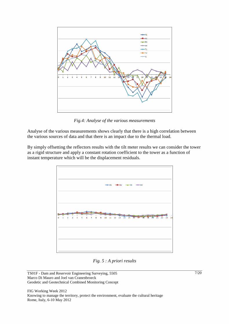
Fig.3 Test monitoring system design The next figure shows the result of all sensors performed at the post-processing stage.
TS01F - Dam and Reservoir Engineering Surveying, 5505 Marco Di Mauro and Joel van Cranenbroeck Geodetic and Geotechnical Combined Monitoring Concept FIG Working Week 2012 Knowing to manage the territory, protect the environment, evaluate the cultural heritage Rome, Italy, 6-10 May 2012
7/20
Fig.4: Analyse of the various measurements Analyse of the various measurements shows clearly that there is a high correlation between the various sources of data and that there is an impact due to the thermal load. By simply offsetting the reflectors results with the tilt meter results we can consider the tower as a rigid structure and apply a constant rotation coefficient to the tower as a function of instant temperature which will be the displacement residuals.
Fig. 5 : A priori results
TS01F - Dam and Reservoir Engineering Surveying, 5505 Marco Di Mauro and Joel van Cranenbroeck Geodetic and Geotechnical Combined Monitoring Concept FIG Working Week 2012 Knowing to manage the territory, protect the environment, evaluate the cultural heritage Rome, Italy, 6-10 May 2012
8/20
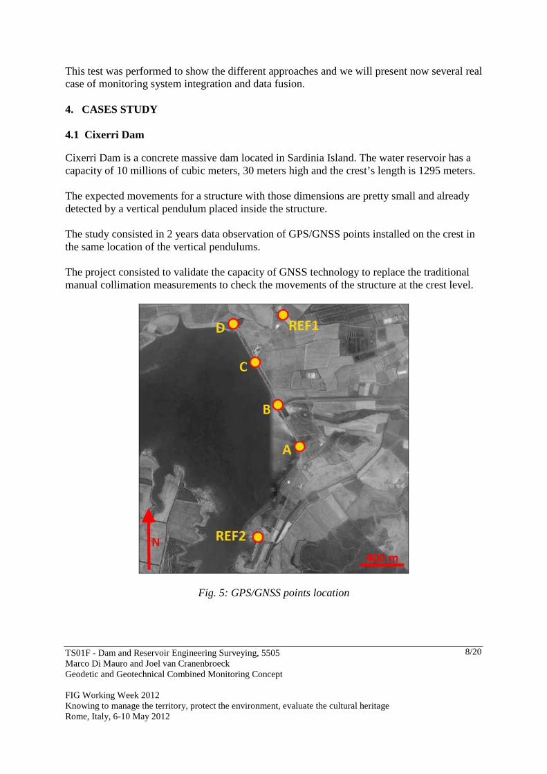
This test was performed to show the different approaches and we will present now several real case of monitoring system integration and data fusion. 4. CASES STUDY 4.1 Cixerri Dam Cixerri Dam is a concrete massive dam located in Sardinia Island. The water reservoir has a capacity of 10 millions of cubic meters, 30 meters high and the crest’s length is 1295 meters. The expected movements for a structure with those dimensions are pretty small and already detected by a vertical pendulum placed inside the structure. The study consisted in 2 years data observation of GPS/GNSS points installed on the crest in the same location of the vertical pendulums. The project consisted to validate the capacity of GNSS technology to replace the traditional manual collimation measurements to check the movements of the structure at the crest level.
Fig. 5: GPS/GNSS points location
TS01F - Dam and Reservoir Engineering Surveying, 5505 Marco Di Mauro and Joel van Cranenbroeck Geodetic and Geotechnical Combined Monitoring Concept FIG Working Week 2012 Knowing to manage the territory, protect the environment, evaluate the cultural heritage Rome, Italy, 6-10 May 2012
9/20
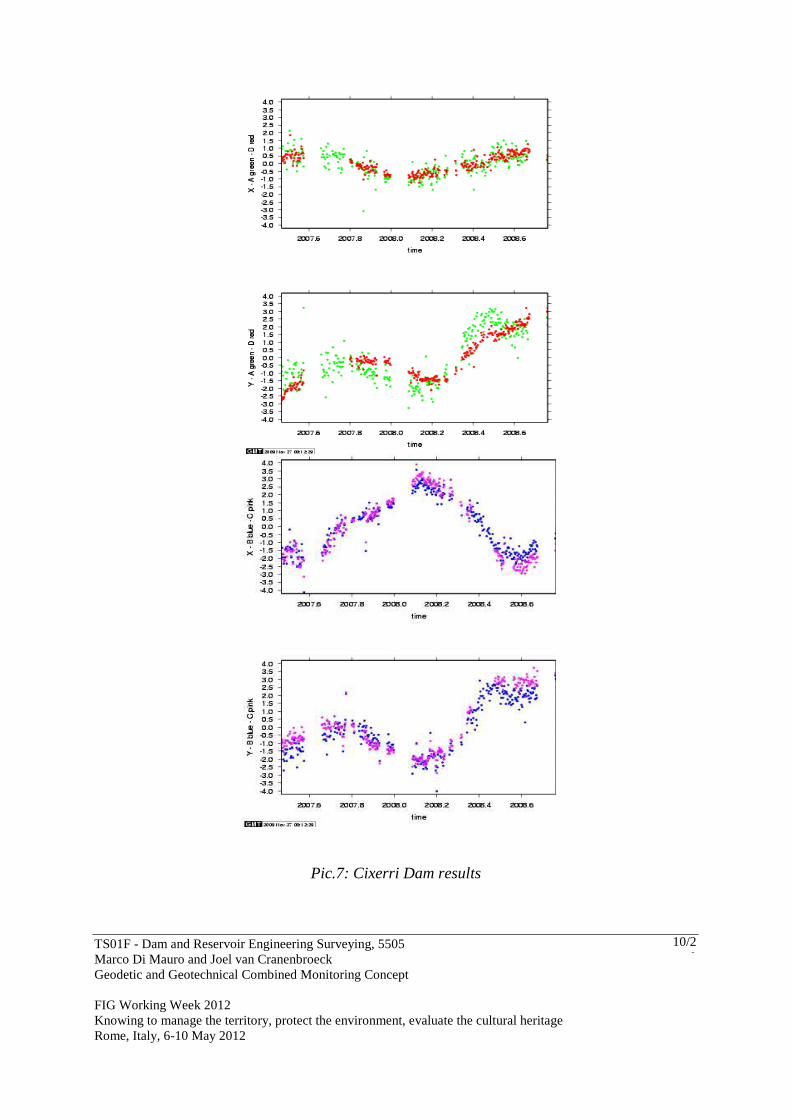
Fig. 6: GNSS network and Leica GMX902 receiver used The Leica GMX902 GNSS receivers and antennas were deployed on site for a period of two years, period that has been considered to produce significant results as it is often the case for that industry when a new measuring method is suggested. The analysis of the results has been conducted by Politecnico di Milano. The following figures show the results and the comparisons between GNSS and the vertical pendulum. .
TS01F - Dam and Reservoir Engineering Surveying, 5505 Marco Di Mauro and Joel van Cranenbroeck Geodetic and Geotechnical Combined Monitoring Concept FIG Working Week 2012 Knowing to manage the territory, protect the environment, evaluate the cultural heritage Rome, Italy, 6-10 May 2012
10/20
Pic.7: Cixerri Dam results
TS01F - Dam and Reservoir Engineering Surveying, 5505 Marco Di Mauro and Joel van Cranenbroeck Geodetic and Geotechnical Combined Monitoring Concept FIG Working Week 2012 Knowing to manage the territory, protect the environment, evaluate the cultural heritage Rome, Italy, 6-10 May 2012
11/20
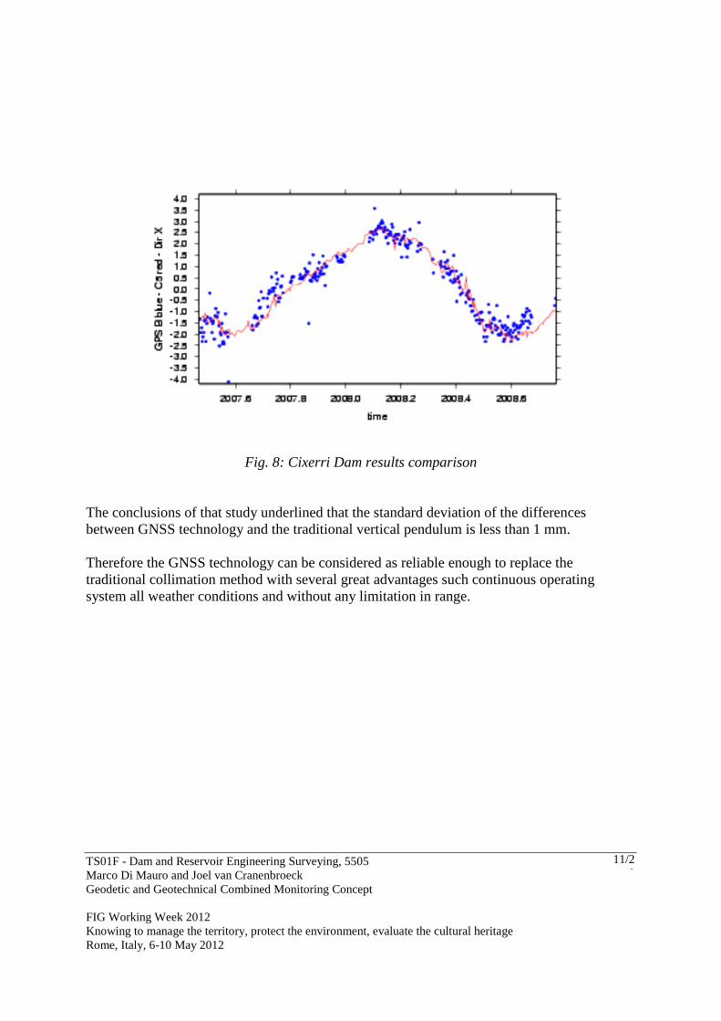
Fig. 8: Cixerri Dam results comparison The conclusions of that study underlined that the standard deviation of the differences between GNSS technology and the traditional vertical pendulum is less than 1 mm. Therefore the GNSS technology can be considered as reliable enough to replace the traditional collimation method with several great advantages such continuous operating system all weather conditions and without any limitation in range.
TS01F - Dam and Reservoir Engineering Surveying, 5505 Marco Di Mauro and Joel van Cranenbroeck Geodetic and Geotechnical Combined Monitoring Concept FIG Working Week 2012 Knowing to manage the territory, protect the environment, evaluate the cultural heritage Rome, Italy, 6-10 May 2012
12/20
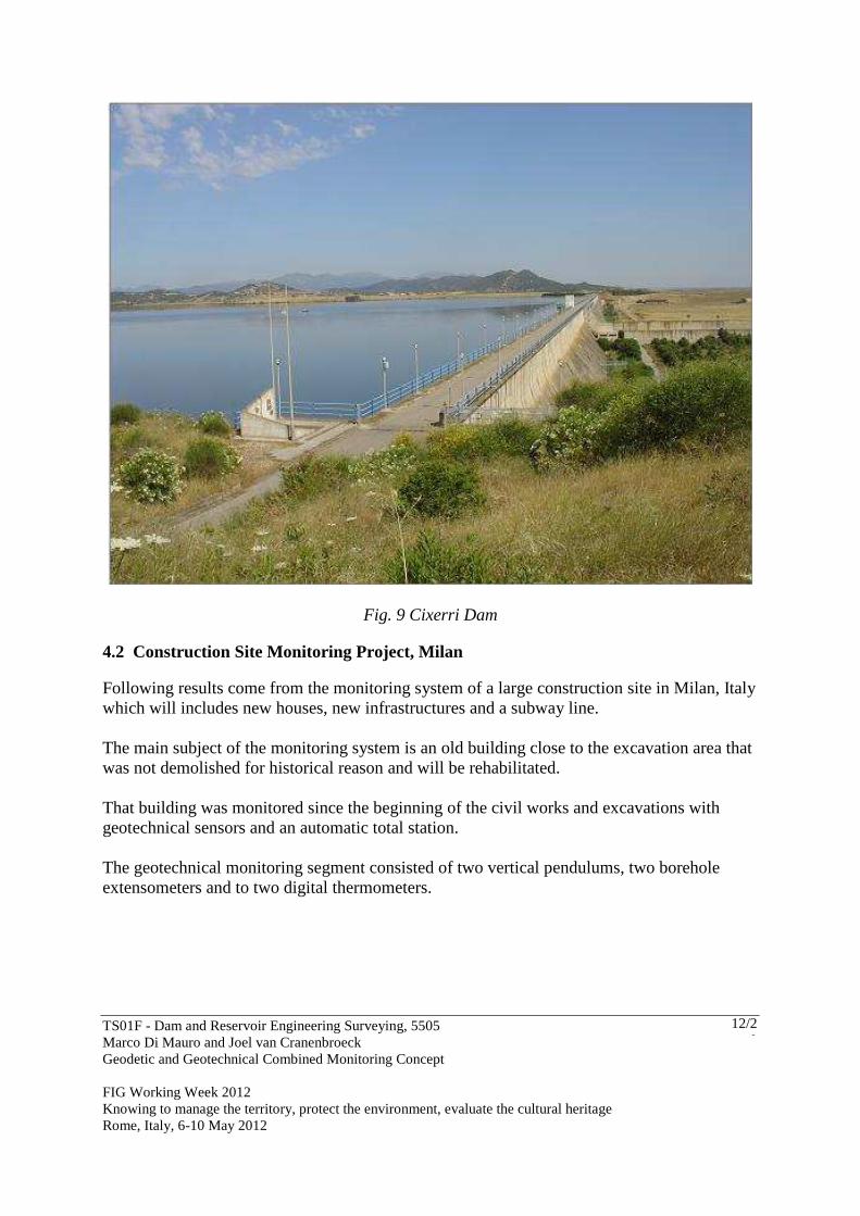
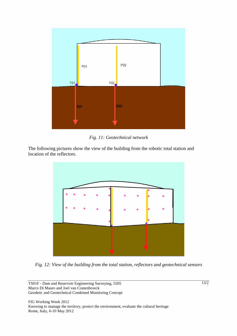
Fig. 9 Cixerri Dam 4.2 Construction Site Monitoring Project, Milan Following results come from the monitoring system of a large construction site in Milan, Italy which will includes new houses, new infrastructures and a subway line. The main subject of the monitoring system is an old building close to the excavation area that was not demolished for historical reason and will be rehabilitated. That building was monitored since the beginning of the civil works and excavations with geotechnical sensors and an automatic total station. The geotechnical monitoring segment consisted of two vertical pendulums, two borehole extensometers and to two digital thermometers.
TS01F - Dam and Reservoir Engineering Surveying, 5505 Marco Di Mauro and Joel van Cranenbroeck Geodetic and Geotechnical Combined Monitoring Concept FIG Working Week 2012 Knowing to manage the territory, protect the environment, evaluate the cultural heritage Rome, Italy, 6-10 May 2012
13/20
Fig. 11: Geotechnical network The following pictures show the view of the building from the robotic total station and location of the reflectors.
Fig. 12: View of the building from the total station, reflectors and geotechnical sensors
TS01F - Dam and Reservoir Engineering Surveying, 5505 Marco Di Mauro and Joel van Cranenbroeck Geodetic and Geotechnical Combined Monitoring Concept FIG Working Week 2012 Knowing to manage the territory, protect the environment, evaluate the cultural heritage Rome, Italy, 6-10 May 2012
14/20
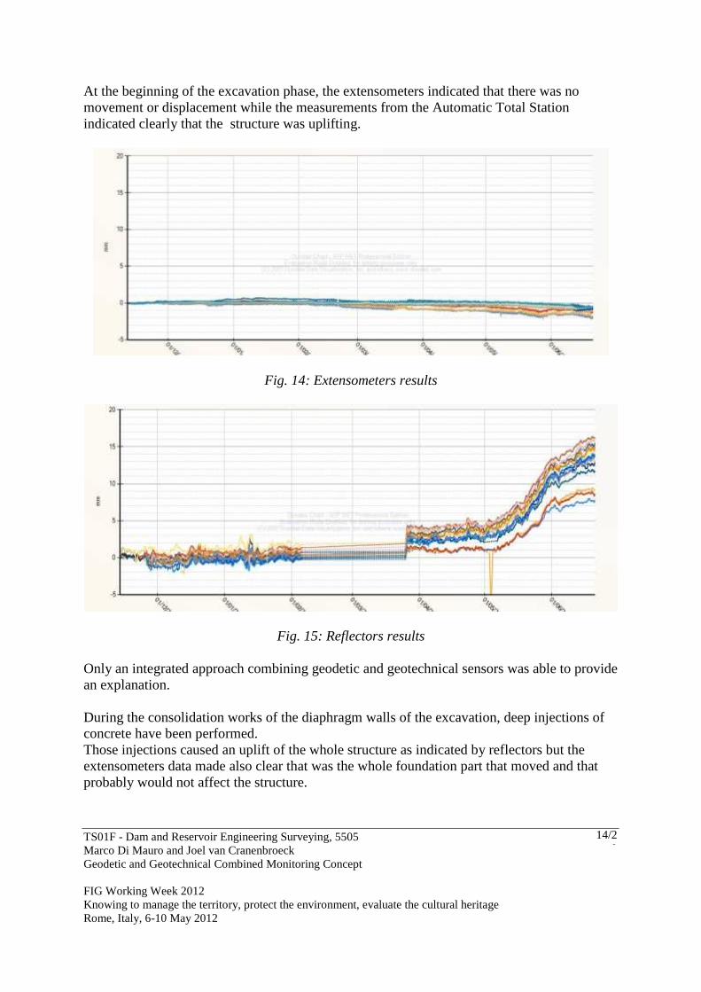
At the beginning of the excavation phase, the extensometers indicated that there was no movement or displacement while the measurements from the Automatic Total Station indicated clearly that the structure was uplifting.
Fig. 14: Extensometers results
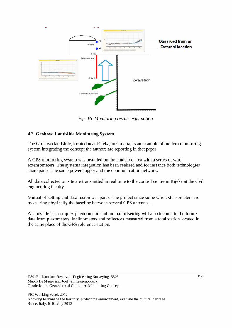
Fig. 15: Reflectors results Only an integrated approach combining geodetic and geotechnical sensors was able to provide an explanation. During the consolidation works of the diaphragm walls of the excavation, deep injections of concrete have been performed. Those injections caused an uplift of the whole structure as indicated by reflectors but the extensometers data made also clear that was the whole foundation part that moved and that probably would not affect the structure.
TS01F - Dam and Reservoir Engineering Surveying, 5505 Marco Di Mauro and Joel van Cranenbroeck Geodetic and Geotechnical Combined Monitoring Concept FIG Working Week 2012 Knowing to manage the territory, protect the environment, evaluate the cultural heritage Rome, Italy, 6-10 May 2012
15/20
Fig. 16: Monitoring results explanation.
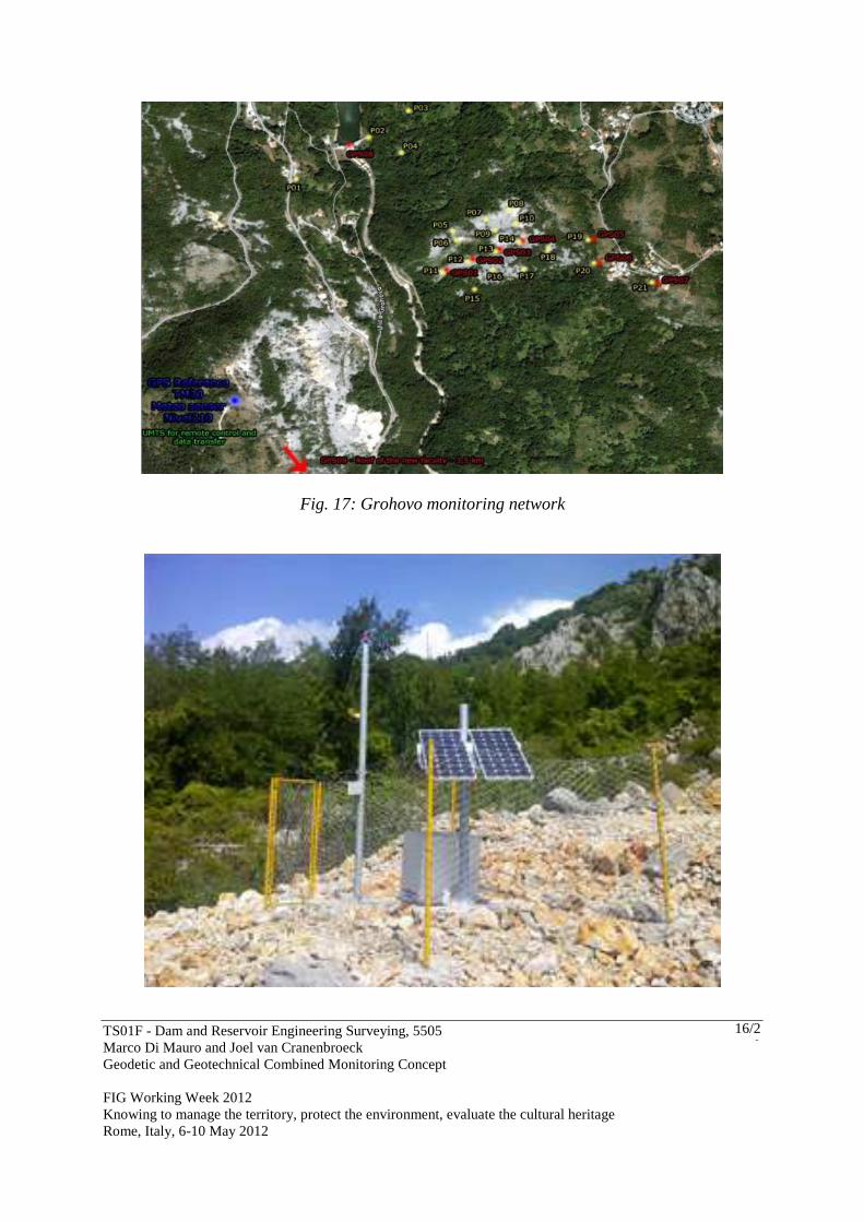
4.3 Grohovo Landslide Monitoring System The Grohovo landslide, located near Rijeka, in Croatia, is an example of modern monitoring system integrating the concept the authors are reporting in that paper. A GPS monitoring system was installed on the landslide area with a series of wire extensometers. The systems integration has been realised and for instance both technologies share part of the same power supply and the communication network. All data collected on site are transmitted in real time to the control centre in Rijeka at the civil engineering faculty. Mutual offsetting and data fusion was part of the project since some wire extensometers are measuring physically the baseline between several GPS antennas. A landslide is a complex phenomenon and mutual offsetting will also include in the future data from piezometers, inclinometers and reflectors measured from a total station located in the same place of the GPS reference station.
TS01F - Dam and Reservoir Engineering Surveying, 5505 Marco Di Mauro and Joel van Cranenbroeck Geodetic and Geotechnical Combined Monitoring Concept FIG Working Week 2012 Knowing to manage the territory, protect the environment, evaluate the cultural heritage Rome, Italy, 6-10 May 2012
16/20
Fig. 17: Grohovo monitoring network
TS01F - Dam and Reservoir Engineering Surveying, 5505 Marco Di Mauro and Joel van Cranenbroeck Geodetic and Geotechnical Combined Monitoring Concept FIG Working Week 2012 Knowing to manage the territory, protect the environment, evaluate the cultural heritage Rome, Italy, 6-10 May 2012
17/20
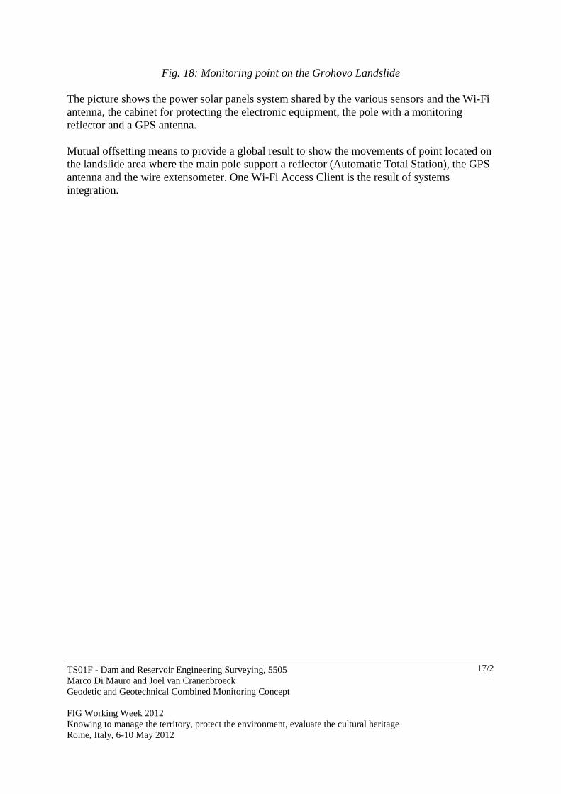
Fig. 18: Monitoring point on the Grohovo Landslide The picture shows the power solar panels system shared by the various sensors and the Wi-Fi antenna, the cabinet for protecting the electronic equipment, the pole with a monitoring reflector and a GPS antenna. Mutual offsetting means to provide a global result to show the movements of point located on the landslide area where the main pole support a reflector (Automatic Total Station), the GPS antenna and the wire extensometer. One Wi-Fi Access Client is the result of systems integration.
TS01F - Dam and Reservoir Engineering Surveying, 5505 Marco Di Mauro and Joel van Cranenbroeck Geodetic and Geotechnical Combined Monitoring Concept FIG Working Week 2012 Knowing to manage the territory, protect the environment, evaluate the cultural heritage Rome, Italy, 6-10 May 2012
18/20
5. CONCLUSION The authors are convinced that geodetic and geotechnical sensors combined at the hardware and processing levels are paving the way for a new and innovative way to provide pertinent and consolidated data as input to a deformation model that is the core element of any risk management and early warning systems. Authorities and responsible of population, vital infrastructures and environmental protection must be informed that if a monitoring system is beneficial to provide information’s that will help them in their tasks to assume their responsibilities, attention must be paid on the design and expertise is needed to effectively engage actions that at the end will result in mitigating the effects of natural disasters or the impact of engineering structures failures. Traditionally geodetic and geotechnical sensors were installed independently and often without any effort or attention that would have been of the great interest during the analysis. We do hope that this paper will open more experiences, investigations and reports demonstrating that the concept the authors are promoting will provide significant benefits compared to the actual situation. Monitoring is a serious matter that forces the professionals to innovate and every time to refine and to improve their proposals. Multi-sensors, integration and analysis are every time also a task that needs a multi-disciplinary approach. The technology has reached a mature level than combining sensors just makes sense. Offsetting geodetic and geotechnical sensors however will most probably also stimulate the industry to consider new developments. REFERENCES [1] Brown, N., Kaloustian, S., Roeckle M. (2008). Monitoring of Open Pit Mines using Combined GNSS Satellite Receivers and Robotic Total Stations. [2] Brown, N., Troyer Lienhart, Zelzer, O., Van Cranenbroeck, J. (2006). Advanced in RTK and Post Processed Monitoring with Single Frequency GPS. Journal of Global Positioning Systems, Vol 5, N°. 1-2:145-151 [3] Van Cranenbroeck, J., Brown N. (2004). Networking Motorized Total Stations and GPS Receivers for Deformation Measurement. FIG Working Week, Athens, Greece. [4] Zog, H-M., Lienhart, W., Nindl D. (2009). Leica TS30 – The Art of Achieving Highest Accuracy and Performance. [5] Van Cranenbroeck. J., Aschroft. N. (2007). Single to Multi Frequency GNSS Signal Processing Solutions for Engineering Structure Monitoring Applications. The International Global Navigation Satellites Systems Society Inc. (IGNSS) IGNSS2007 Symposium – The University of New South Wales, Sydney Australia.
TS01F - Dam and Reservoir Engineering Surveying, 5505 Marco Di Mauro and Joel van Cranenbroeck Geodetic and Geotechnical Combined Monitoring Concept FIG Working Week 2012 Knowing to manage the territory, protect the environment, evaluate the cultural heritage Rome, Italy, 6-10 May 2012
19/20
[6] Van Cranenbroeck. J., Lui. V., Wu. X. (2007). ICE 5th International Conference Bridge – Beijing, supported by the FIG Commission 6 WG4. [7] Van Cranenbroeck. J. (2007). Continuous Beam Deflection Monitoring Using Precise Inclinometers. Strategic Integration of Surveying Services FIG Working Week, Hong Kong SAR, China. [8] Van Cranenbroeck, J. (2007). An Integrated Geodetic Measurement and Analysis System for Large Dams Monitoring. Hydropower & Dams issue 2 : INSTRUMENTATION SYSTEMS FOCUS. [9] Van Cranenbroeck, J. (2006). Core Wall Survey Control System. Opening paper – 3rd IAG Symposium on Geodesy for Geotechnical and Structural Engineering, 12th FIG Symposium on Deformation Measurement. [10] Lienhart, W. (2007). Analysis of Inhomogeneous Structural Monitoring Data. Engineering Geodesy – TU Graz, Austria. Shaker Verlag [11] Leonards, G.A. (1962). Foundation Engineering, MacGraw Hill, New York [12] Terzaghi, K., and Peck, R.B. (1967). Soil Mechanics in Engineering Practice, 2d ed., Wiley, New York. [10] Dunnicliff, J., (1988). Geotechnical instrumentation for monitoring field performance. Wiley-Interscience, New York
TS01F - Dam and Reservoir Engineering Surveying, 5505 Marco Di Mauro and Joel van Cranenbroeck Geodetic and Geotechnical Combined Monitoring Concept FIG Working Week 2012 Knowing to manage the territory, protect the environment, evaluate the cultural heritage Rome, Italy, 6-10 May 2012
20/20
BIOGRAPHICAL NOTES Marco Di Mauro is Competence Manager for Infrastructure working for IMoSS AG a company part of the Hexagon Group and reporting to the New Business Division of Leica Geosystems AG. Involved in monitoring and early warning systems since years starting with geotechnical and ending up with geodetic instrumentation, Marco contributed as inventor (European patent) of a new profile measurement system based on electrolytic tilt sensor. He has been for several years project manager for AGISCO srl, Italy and recently for Leica Geosystems AG, Switzerland Joël van Cranenbroeck is currently Business Technology Manager at the New Business Division of Leica Geosystems AG, Heerbrugg, Switzerland. He led the development of hardware and software solutions for GNSS Network-RTK since 2001 and made significant contributions in geodetic monitoring development and applications such as the method for aligning high rise structures (such as the Burj Dubai). Joel is Chair of Working Group 6.2 in FIG Commission 6, was awarded in 2009 the title of Honored Lecturer of the Siberian State Academy of Geodesy in Novosibirsk, and is senior scientist consultant for two universities in Belgium. He designed numerous projects for structural monitoring applications such as bridges, dams, tunnels, etc. He worked at the Belgian Cadastre organization, at the Geodetic Department of the Belgian National Geographical Institute and in Star Informatic – a GIS software based Belgian company – before he joined Van Hopplynus, the Leica Geosystems exclusive representative in Belgium in 1993 as product specialist in GPS, GIS, Engineering and Industrial applications. CONTACTS Marco Di Mauro IMoSS AG Heinrich Wild Strasse CH-9435 HEERBRUGG SWITZERLAND Email: [email protected] Web site: www.imoss.ch Joël van Cranenbroeck Leica Geosystems AG Heinrich Wild Strasse CH-9435 HEERBRUGG SWITZERLAND Tel. +32 474 98 61 93 Email: [email protected] Web site: www.leica-geosystems.com