Page 1
GeoEvent Server:Best Practices
Adam MollenkopfReal-Time & Big Data GIS Capability Lead, Esri
[email protected]
@amollenkopf
Suzanne FossReal-Time & Big Data Product Engineer, Esri
[email protected]
@sfoss_esri
Page 2
1
2
3
4
Agenda
ingestion & analytics
dissemination & visualization
storage
resilience & scalability
Page 3
ingestion & analytics1
Page 4
you can create
your own
connectors
Ingestionuse an existing input connector
GeoEvent Server
Inp
uts
Ou
tpu
ts
GeoEvent Services
Poll an ArcGIS Server for Features
Poll an external website for GeoJSON, JSON, or XML
Receive Features, GeoJSON, JSON, or XML on a REST endpoint
Receive RSS
Receive GeoJSON or JSON on a WebSocket
Receive Text from a TCP or UDP Socket
Subscribe to an external WebSocket for GeoJSON or JSON
Watch a Folder for new CSV, GeoJSON, or JSON Files
Ou
t o
f th
e B
ox
REST
.csv
WS
WS
HTTP
Esri
Gallery
ActiveMQ
CAP
Instagram
Exploitation Support Data
Cursor-on-Target
RabbitMQ
NMEA 0183
MQTT
Sierra Wireless (RAP)
KML
Kafka
Trimble (TAIP)
Twitter
Part
ner
Gallery
CompassLDE
enviroCar
GNIP
FAA (ASDI)
exactEarth AIS
Waze
Valarm
Networkfleet
OSIsoft *
*
*
*
Zonar *
Amazon IoT
Azure IoT
Page 5
you can create
your own
connectors
Ingestionconfigure a new input connector by pairing a transport & adapter together
GeoEvent Server
Inp
uts
Ou
tpu
ts
GeoEvent Services
Feature-JSON
Connectors Transport Adapter
GeoJSON
Receive Feature-JSON from Kafka
Receive GeoJSON on a REST endpoint
Feature-JSON
Adapters
GeoJSON
JSON
RSS
Text
XML
CAP
Cursor-on-Target
GeoMessage
Instagram
NMEA
Sierra Wireless (RAP)
Trimble (TAIP)
Twitter
VMF
Es
riG
all
ery
Waze
Feature Service
Transports
File
HTTP
HTTP+BasicAuth
HTTP+OAuth
TCP
UDP
Waze
WebSocket
Esri
Gallery Amazon IoT
Azure IoT
Kafka
IRC
Kafka
MQTT
Kafka
HTTP
RabbitMQ
Twitter
Page 6
Ingestionclone an existing connector & tailor it’s properties to make a more specific connector
Page 7
Ingestionclone an existing connector & tailor it’s properties to make a more specific connector
Page 8
Ingestionextend GeoEvent by downloading additional transports & adapters
https://github.com/esri/solutions-geoevent-java
http://links.esri.com/geoevent-gallery
Page 9
AnalyticsGeoEvent Services best practices
input1 output1buffer
• Which is better?
- have fewer but more complex GeoEvent Services
- or have more but simpler GeoEvent Services
geofences
filter(spatial)
input1 output2
geofences
filter(spatial)
geofences
geotagger
input2 output3
geofences
filter(spatial)
motioncalculator
geometry inside Zones/.*
geometry inside Zones/.* geometry inside Zones/.*
geometry inside Zones/.*
Page 10
AnalyticsGeoEvent Services best practices
• Which is better?
- have fewer but more complex GeoEvent Services
- or have more but simpler GeoEvent Services
input1 output1buffer
geofences
filter(spatial)
input2 output2
geofences
geotagger
output3motion
calculator
geometry inside Zones/.*
geometry inside Zones/.*
Page 11
dissemination & visualization2
Page 12
you can create
your own
connectors
Disseminationuse an existing output connector
GeoEvent Server
Inp
uts
Ou
tpu
ts
GeoEvent Services
Ou
t o
f th
e B
ox
Add or Update a Feature
Publish Text to a UDP Socket
Send a Text Message
Send an Email
Push Text to an external TCP Socket
Push GeoJSON or JSON to an external WebSocket
Push GeoJSON or JSON to an external Website
Send an Instant Message
Send Features to a Stream Service
Write to a CSV, GeoJSON, or JSON File .csv
WS
im
HTTP
Add a Feature to a spatiotemporal big data store
Update a feature in a spatiotemporal big data store
ActiveMQ
Esri
Gallery
Cursor-on-Target
Hadoop
Kafka
MongoDB
MQTT
RabbitMQ
Twitter
Amazon IoT
Azure IoT
Page 13
you can create
your own
connectors
Disseminationconfigure a new output connector by pairing an adapter & transport together
GeoEvent Server
Inp
uts
Ou
tpu
ts
GeoEvent Services
Message Formatter SMTP
Connectors TransportAdapter
Feature-JSON Kafka
Send an Email
Publish Feature-JSON to Kafka
Big Data Store
Transports
Feature Service
File
HTTP
HTTP+BasicAuth
HTTP+OAuth
SMTP
Stream Service
TCP
UDP
WebSocket
XMPP
Cache
Adapters
Feature-JSON
GeoJSON
JSON
Message Formatter
RSS
Text
WebSocket
ActiveMQ
Amazon IoT
Azure IoT
Hadoop
IRC
Kafka
Esri
Gallery
MongoDB
MQTT
RabbitMQ
Cursor-on-Target
Esri
Gallery
SMS
TCP-Squirt
Twitter
Page 14
you can create
your own
connectors
GeoEvent Server
Inp
uts
Ou
tpu
ts
GeoEvent Services
Ou
t o
f th
e B
ox
Add or Update a Feature
Publish Text to a UDP Socket
Send a Text Message
Send an Email
Push Text to an external TCP Socket
Push GeoJSON or JSON to an external WebSocket
Push GeoJSON or JSON to an external Website
Send an Instant Message
Send Features to a Stream Service
Write to a CSV, GeoJSON, or JSON File .csv
WS
im
HTTP
ActiveMQ
Esri
Gallery
Cursor-on-Target
Hadoop
Kafka
MongoDB
MQTT
RabbitMQ
Twitter
Add a Feature to a spatiotemporal big data store
Update a Feature in a spatiotemporal big data store
Visualizationvisualizing real-time observation results using Esri clients
Page 15
Visualizationchoosing a service type: stream service, feature service, map service
Stream Layer
Map Layer
Feature Layer
• Stream layers in apps subscribe to stream services to immediately visualize observations
- does not require storage, low latency, no playback
• Map & Features layers in apps periodically poll to visualize most current observations
- backed by an enterprise geodatabase (EGDB) or a spatiotemporal big data store (BDS)
- history can be retrieved & queried for playback
desktop
device
web
ArcGIS
Enterprise
Stream Service
Send Features to a Stream Service subscribe (push)
polling (pull)
Map Service
Feature Service
GeoAnalytics
Server
Add a Feature to a BDS
Update a Feature in a BDS
spatiotemporal
big data store
Add or Update a Feature
EGDBGeoEvent
Server
Page 16
Visualizationworkflow for creating a real-time service using stream service, feature service, map service
• Configure an input to receive real-time data & define a geoevent definition accordingly
• Create an output and publish a Stream / Feature / Map Service using the geoevent definition
• Author and publish a geoevent service
• Visualize your Stream / Feature / Map Service
ArcGIS Enterprise
spatiotemporal
big data storeGeoEvent
Server
input
geoevent
definition
geoevent service
Stream Service
Map Service
Feature Service
output
Page 18
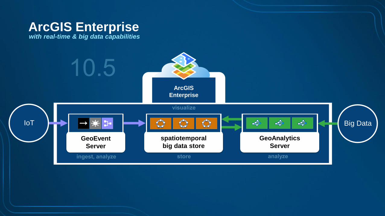
ArcGIS Enterprisewith real-time & big data capabilities
ArcGIS
Enterprise
GeoEvent
Server
spatiotemporal
big data store
Big DataIoT
GeoAnalytics
Server
Page 19
ArcGIS Enterprisewith real-time & big data capabilities
ArcGIS
Enterprise
GeoEvent
Server
spatiotemporal
big data store
Big DataIoT
GeoAnalytics
Server
1
2 43
MINIMUM environment
functional servers & spatiotemporal big data store
SHOULD BE on ISOLATED machines!!!
Page 20
ArcGIS Enterprisewith real-time & big data capabilities
ArcGIS
Enterprise
GeoEvent
Server
spatiotemporal
big data store
Big DataIoT
GeoAnalytics
Server
1
2 3 64 75 8
RECOMMENDED environment
functional servers & spatiotemporal big data store
SHOULD BE on ISOLATED machines!!!
Page 21
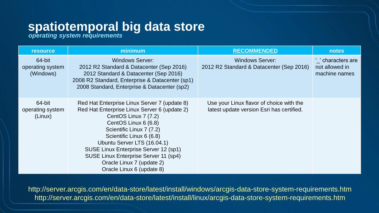
resource minimum RECOMMENDED notes
64-bit
operating system
(Windows)
Windows Server:
2012 R2 Standard & Datacenter (Sep 2016)
2012 Standard & Datacenter (Sep 2016)
2008 R2 Standard, Enterprise & Datacenter (sp1)
2008 Standard, Enterprise & Datacenter (sp2)
Windows Server:
2012 R2 Standard & Datacenter (Sep 2016)
‘_’ characters are
not allowed in
machine names
64-bit
operating system
(Linux)
Red Hat Enterprise Linux Server 7 (update 8)
Red Hat Enterprise Linux Server 6 (update 2)
CentOS Linux 7 (7.2)
CentOS Linux 6 (6.8)
Scientific Linux 7 (7.2)
Scientific Linux 6 (6.8)
Ubuntu Server LTS (16.04.1)
SUSE Linux Enterprise Server 12 (sp1)
SUSE Linux Enterprise Server 11 (sp4)
Oracle Linux 7 (update 2)
Oracle Linux 6 (update 8)
Use your Linux flavor of choice with the
latest update version Esri has certified.
http://server.arcgis.com/en/data-store/latest/install/windows/arcgis-data-store-system-requirements.htm
http://server.arcgis.com/en/data-store/latest/install/linux/arcgis-data-store-system-requirements.htm
spatiotemporal big data storeoperating system requirements
Page 22
resource requirements: processors
http://server.arcgis.com/en/data-store/latest/install/windows/arcgis-data-store-system-requirements.htm
http://server.arcgis.com/en/data-store/latest/install/linux/arcgis-data-store-system-requirements.htm
resource minimum RECOMMENDED notes
processors 8 cores 16 cores
More processors results in
faster writes (indexing time),
higher write throughput &
faster query response time.
spatiotemporal big data store
Page 23
resource requirements: processors, memory
http://server.arcgis.com/en/data-store/latest/install/windows/arcgis-data-store-system-requirements.htm
http://server.arcgis.com/en/data-store/latest/install/linux/arcgis-data-store-system-requirements.htm
resource minimum RECOMMENDED notes
processors 8 cores 16 cores
More processors results in
faster writes (indexing time),
higher write throughput &
faster query response time.
storage 400 GB 1 TB or moreStorage need is dictated by data velocity & size.
SSD results in much faster writes & queries.
spatiotemporal big data store
Page 24
resource requirements: processors, memory, storage
http://server.arcgis.com/en/data-store/latest/install/windows/arcgis-data-store-system-requirements.htm
http://server.arcgis.com/en/data-store/latest/install/linux/arcgis-data-store-system-requirements.htm
resource minimum RECOMMENDED notes
processors 8 cores 16 cores
More processors results in
faster writes (indexing time),
higher write throughput &
faster query response time.
storage 400 GB 1 TB or moreStorage need is dictated by data velocity & size.
SSD results in much faster writes & queries.
memory 16 GB 32 GBMore memory results in
higher likelihood of query cache hits.
32 GB is the maximum due to JVM limitations.
spatiotemporal big data store
Page 25
resource requirements: processors, memory, storage & instances
resource minimum RECOMMENDED notes
processors 8 cores 16 cores
More processors results in
faster writes (indexing time),
higher write throughput &
faster query response time.
storage 400 GB 1 TB or moreStorage need is dictated by data velocity & size.
SSD results in much faster writes & queries.
memory 16 GB 32 GBMore memory results in
higher likelihood of query cache hits.
32 GB is the maximum due to JVM limitations
# of
ISOLATED
instances
1 3 or more
With one instance there is risk of data loss.
With three instances replicas are written
increasing data reliability.
The # of instances will vary based on the velocity of
incoming data as well as the data retention policy
configured on each data source.
http://server.arcgis.com/en/data-store/latest/install/windows/arcgis-data-store-system-requirements.htm
http://server.arcgis.com/en/data-store/latest/install/linux/arcgis-data-store-system-requirements.htm
spatiotemporal big data store
Page 26
spatiotemporal
big data store
GeoEvent
Server
shards & replication factor
GeoAnalytics
Server
node 1
node 2
node 3node 4
node 5
T1
T3
T2
T2
r = 1
T1
T3
spatiotemporal big data store
Page 27
spatiotemporal
big data store
auto-rebalancing of data upon node membership changes, + or -, in the big data store
GeoEvent
Server
GeoAnalytics
Server
node 2
node 3node 4
node 5
T1
T3
T2
T2
r = 1
x
T1
T3
T1
T1T3
spatiotemporal big data store
Page 28
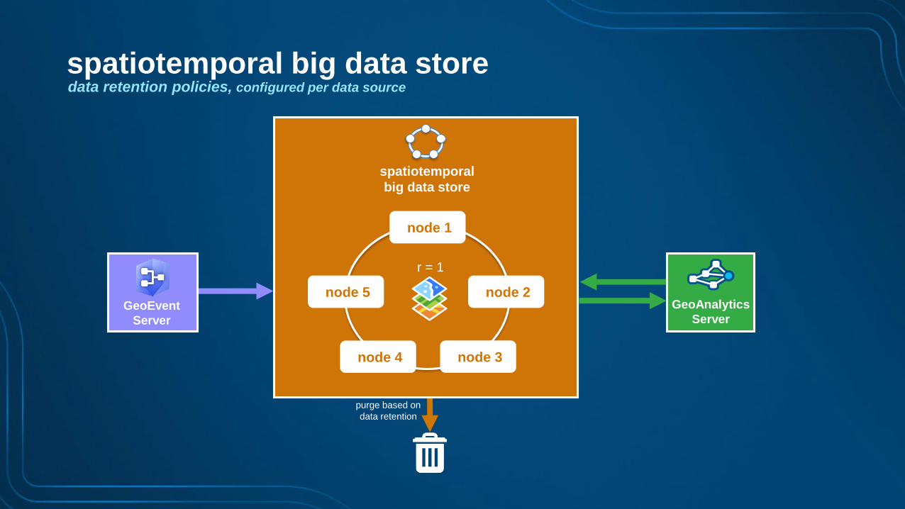
purge based on
data retention
spatiotemporal
big data store
GeoEvent
Server
data retention policies, configured per data source
GeoAnalytics
Server
node 1
node 2
node 3node 4
node 5
r = 1
spatiotemporal big data store
Page 29
purge based on
data retention
spatiotemporal
big data store
GeoEvent
Server
rolling index option, set appropriately to the velocity of your observation data
GeoAnalytics
Server
node 1
node 2
node 3node 4
node 5
r = 1
indices indices
indices indices
indices
spatiotemporal big data store
Page 30
purge based on
data retention
spatiotemporal
big data store
GeoEvent
Server
automatic data backups using periodic snapshots, including ability to restore from a snapshot
GeoAnalytics
Server
node 1
node 2
node 3node 4
node 5
r = 1
snapshot-2016-05-17-11-0-0.snapshot
snapshot-2016-05-17-12-0-0.snapshot
…
spatiotemporal big data store
Page 31
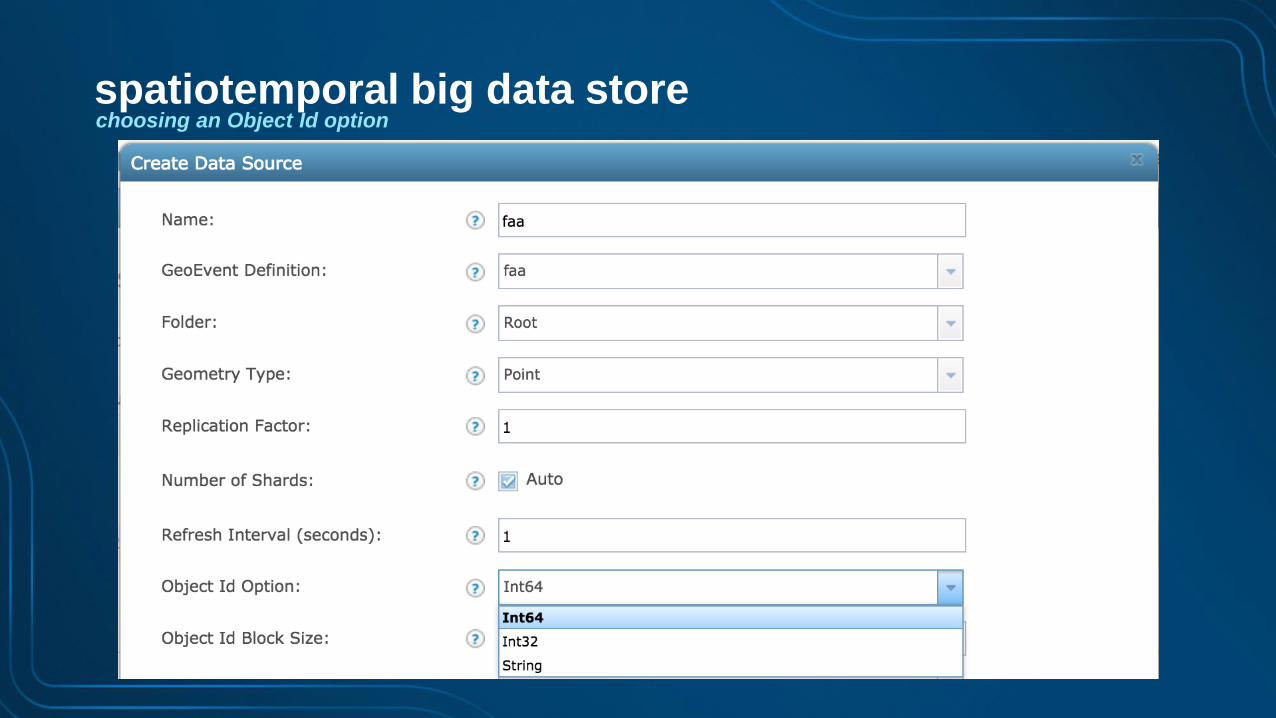
choosing an Object Id optionspatiotemporal big data store
Page 32
choosing an Object Id optionspatiotemporal big data store
Page 33
choosing an Object Id option
Max Value # of IDs ArcGIS Clients
Int32 2,147,483,647 2.1 billion Pro, Desktop, Ops Dashboard, …
events per day Int32
1,000 e/s 86,400,000 25 days
10,000 e/s 864,000,000 2.5 days
100,000 e/s 8,640,000,000 6 hours
1,000,000 e/s 86,400,000,000 36 minutes
10,000,000 e/s 864,000,000,000 4 minutes
spatiotemporal big data store
Page 34
choosing an Object Id option
Max Value # of IDs ArcGIS Clients
Int32 2,147,483,647 2.1 billion Pro, Desktop, Ops Dashboard, …
Int64 (signed) 9,223,372,036,854,775,807 9.2 quintillion JavaScript, custom apps
events per day Int32
1,000 e/s 86,400,000 25 days
10,000 e/s 864,000,000 2.5 days
100,000 e/s 8,640,000,000 6 hours
1,000,000 e/s 86,400,000,000 36 minutes
10,000,000 e/s 864,000,000,000 4 minutes
spatiotemporal big data store
Page 35
choosing an Object Id option
Max Value # of IDs ArcGIS Clients
Int32 2,147,483,647 2.1 billion Pro, Desktop, Ops Dashboard, …
Int64 (signed) 9,223,372,036,854,775,807 9.2 quintillion JavaScript, custom apps
events per day Int32 Int64 (signed)
1,000 e/s 86,400,000 25 days 292,472,000 years
10,000 e/s 864,000,000 2.5 days 29,247,200 years
100,000 e/s 8,640,000,000 6 hours 2,924,720 years
1,000,000 e/s 86,400,000,000 36 minutes 292,472 years
10,000,000 e/s 864,000,000,000 4 minutes 29,248 years
spatiotemporal big data store
Page 36
choosing an Object Id option
Max Value # of IDs ArcGIS Clients
Int32 2,147,483,647 2.1 billion Pro, Desktop, Ops Dashboard, …
Int64 (signed) 9,223,372,036,854,775,807 9.2 quintillion JavaScript, custom apps
UniqueStringID n/a unlimited JavaScript, custom apps
events per day Int32 Int64 (signed)
1,000 e/s 86,400,000 25 days 292,472,000 years
10,000 e/s 864,000,000 2.5 days 29,247,200 years
100,000 e/s 8,640,000,000 6 hours 2,924,720 years
1,000,000 e/s 86,400,000,000 36 minutes 292,472 years
10,000,000 e/s 864,000,000,000 4 minutes 29,248 years
spatiotemporal big data store
Page 37
resilience & scalability4
Page 38
best practices
000
GeoEvent resilience & scalability
• GeoEvent clustering was introduced at 10.3
• However, observed to be brittle and subject to failure:
- Required at least 3 nodes in a cluster
- when a node goes down, it must be brought back up ASAP.
- a 2-node cluster can cause a split-brain condition in cluster.
- Must be physical hardware
- many customers only have virtualized environments.
- Network must be stable
- network instabilities can result in intermittent membership.
• Given this, GeoEvent clustering
- has been deprecated at the 10.5 release
- should be avoided and is discouraged
• Instead, if resiliency or addt’l scalability is required:
- isolated deployments should be employed
- this is true at 10.3, 10.4 & 10.5
Page 39
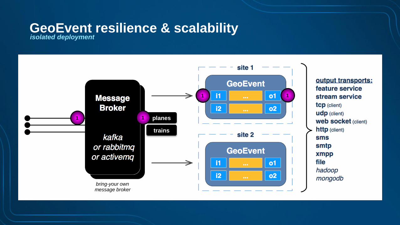
isolated deployment
• Each GeoEvent instance exists in it’s own site and shares a common configuration manually.
• A message broker must be stood up in front to provide a common event source.
• GeoEvent instances share a common message broker and run active/active competing to
consume events.
GeoEvent resilience & scalability
bring-your ownmessage broker
Page 40
isolated deployment
planes
trains
1 1
1 1
GeoEvent resilience & scalability
bring-your ownmessage broker
Page 41
isolated deployment
planes
trains
2
2 2
2
GeoEvent resilience & scalability
bring-your ownmessage broker
Page 42
isolated deployment
planes
trains
1 1
1 1
GeoEvent resilience & scalability
bring-your ownmessage broker
Page 43
isolated deployment
• Known constraints:
- does not support failover of state: enter, exit, track gap detection, idle detector
- project team/IT staff needed to setup/configure message broker and get all sensor events into it
- input to GeoEvent is the message broker only, lose flexibility of all the input connectors available
GeoEvent resilience & scalability
bring-your ownmessage broker
Page 44
isolated deployment
• An isolated deployment of GeoEvent instances leads to challenges with Stream Services:
- Client A & B see event 1, while client C & D do not
- Client C & D see event 2, while client A & B do not
1
1 1
1
1
2
2
2
2
2
Stream Service resilience & scalability
bring-your ownmessage broker
Page 45
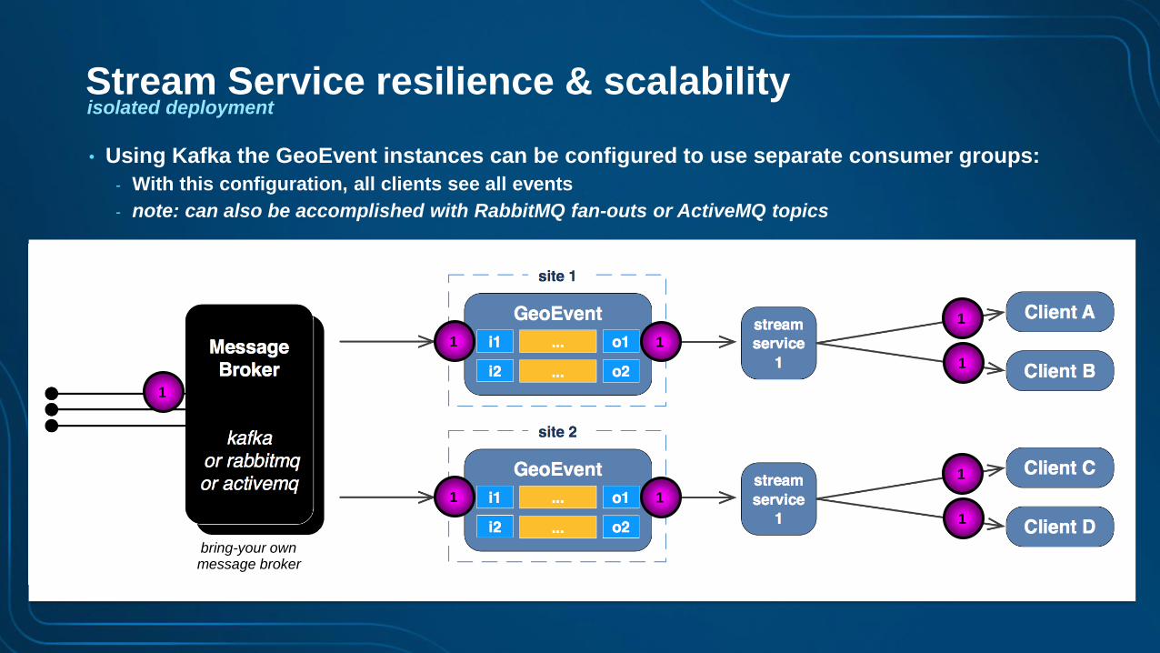
isolated deployment
• Using Kafka the GeoEvent instances can be configured to use separate consumer groups:
- With this configuration, all clients see all events
- note: can also be accomplished with RabbitMQ fan-outs or ActiveMQ topics
1
1 1
1
1
1 1
1
1
Stream Service resilience & scalability
bring-your ownmessage broker
Page 46
isolated deployment
• Using Kafka the GeoEvent instances can be configured to use separate consumer groups:
- With this configuration, all clients see all events
- note: can also be accomplished with RabbitMQ fan-outs or ActiveMQ topics
2
2
2
2
2
2 2
2
2
1
1
1
1
Stream Service resilience & scalability
bring-your ownmessage broker
Page 47
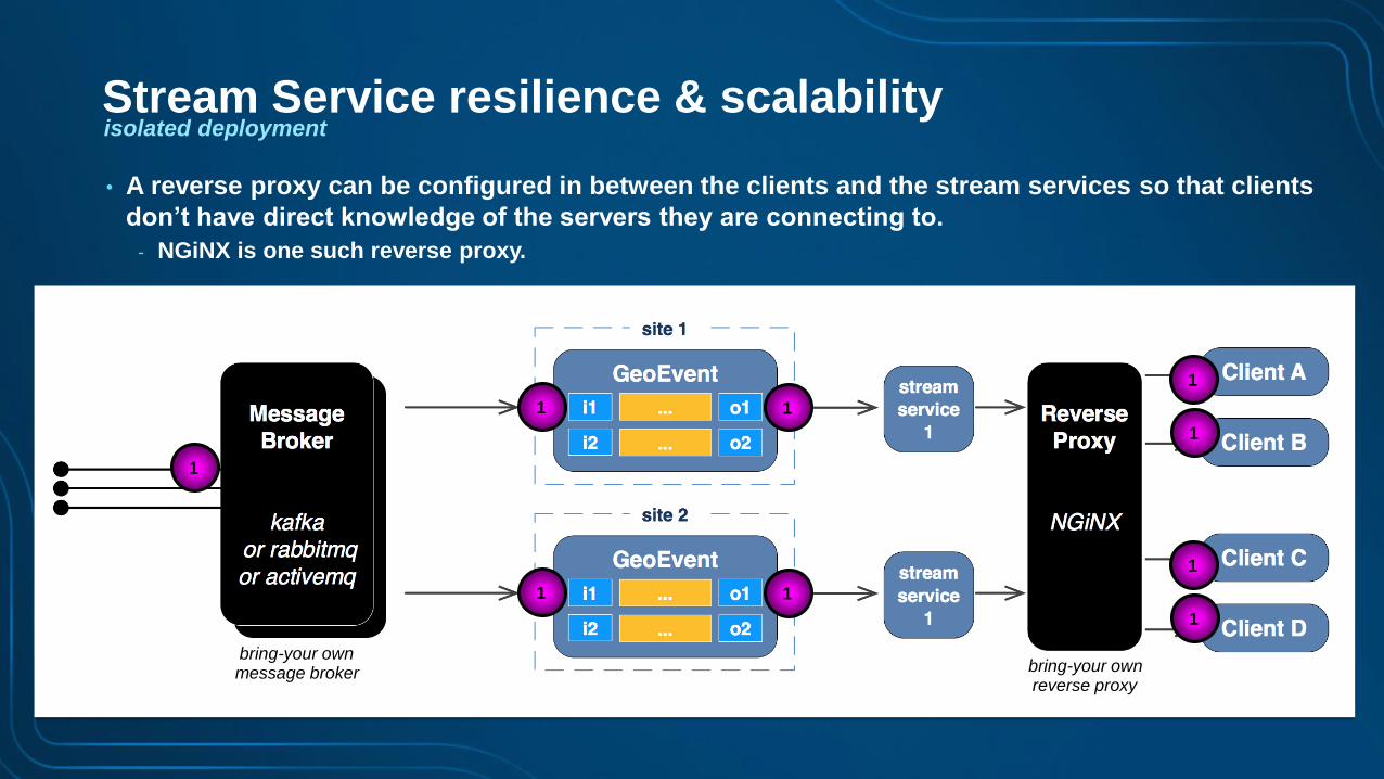
isolated deployment
• A reverse proxy can be configured in between the clients and the stream services so that clients
don’t have direct knowledge of the servers they are connecting to.
- NGiNX is one such reverse proxy.
1
1 1
1 1
1
1
1
1
Stream Service resilience & scalability
bring-your ownmessage broker bring-your own
reverse proxy
Page 48
isolated deployment
• Using Kafka the GeoEvent instances can be configured to use separate consumer groups:
- With this configuration, all clients see all events
- note: can also be accomplished with RabbitMQ fan-outs or ActiveMQ topics
2
2
2
2 2
2
2
1
1
1
1
Stream Service resilience & scalability
bring-your ownmessage broker bring-your own
reverse proxy
Page 49
How can we
simplify this?
Page 50
Resilience & scalabilityof real-time capabilities @ 10.5
ArcGIS
Enterprise
spatiotemporal
big data store
GeoEvent
Server
4K e/s
4K e/s
4K e/s
Big Data
GeoAnalytics
Server
bring-your ownmessage broker
Page 51
Resilience & scalabilityof real-time capabilities @ 10.6
ArcGIS
Enterprise
spatiotemporal
big data store4K e/s
4K e/s
4K e/s
Big Data
GeoAnalytics
Server
connect, event hub &
GeoEvent Server
Page 52
Resilience & scalabilityof real-time capabilities @ 10.6
ArcGIS
Enterprise
spatiotemporal
big data store4K e/s
4K e/s
4K e/s
Big Data
GeoAnalytics
Server
connectevent hub &
GeoEvent Server
Page 53
Resilience & scalabilityof real-time capabilities @ 10.6
ArcGIS
Enterprise
spatiotemporal
big data store4K e/s
4K e/s
4K e/s
Big Data
GeoAnalytics
Server
event
hubconnect
GeoEvent
Server
Page 54
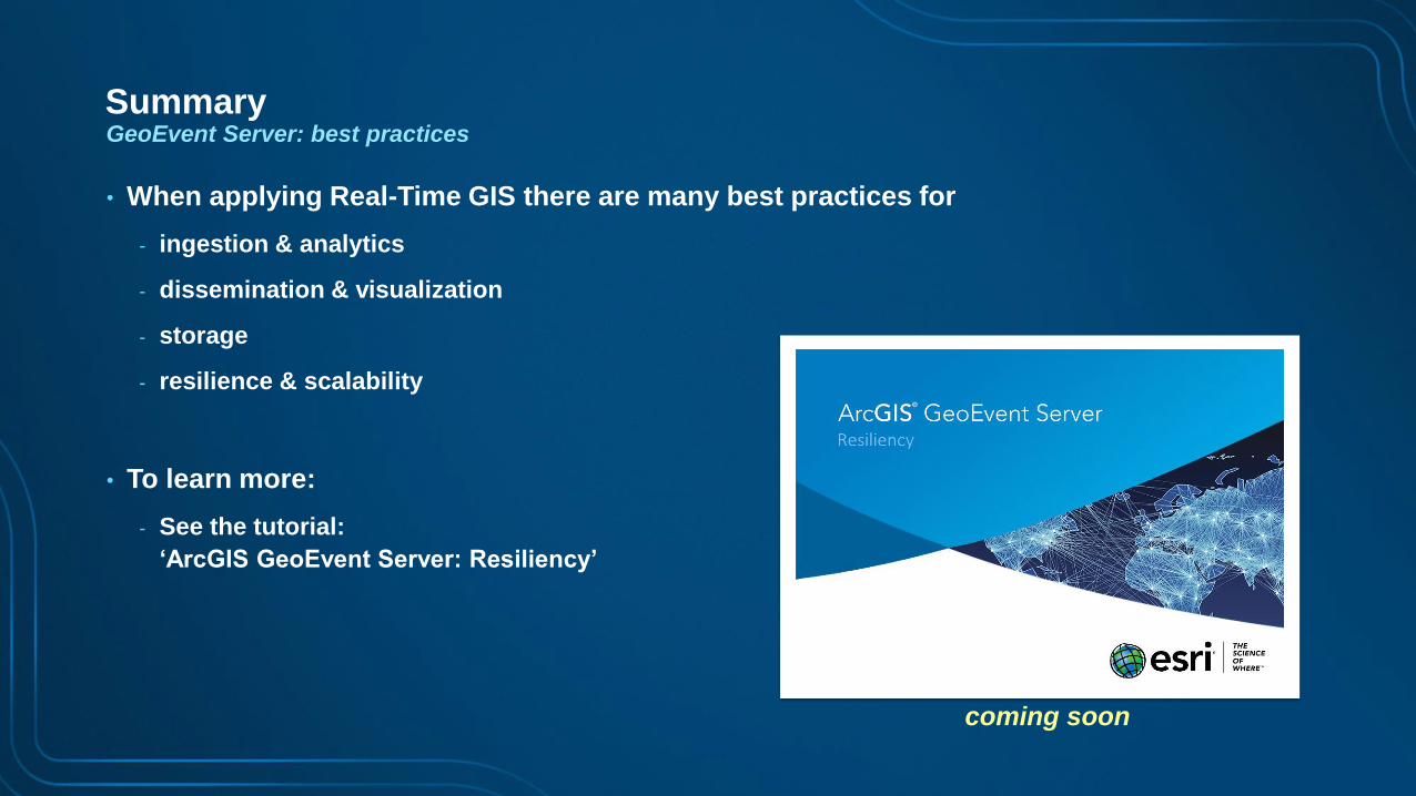
SummaryGeoEvent Server: best practices
• When applying Real-Time GIS there are many best practices for
- ingestion & analytics
- dissemination & visualization
- storage
- resilience & scalability
• To learn more:
- See the tutorial:
‘ArcGIS GeoEvent Server: Resiliency’
coming soon
Page 55
Real-Time & Big Data GIS
• Developing Real-Time Web Apps with JavaScript Thu, 3:00-3:30pm, Demo Theater 1, Oasis 1
• Big Data: Leveraging the Spatiotemporal Big Data Store Thu, 4:00-5:00pm, Catalina/Madera
• Building Android Location Awareness with GeoEvent Server Thu, 6:00-6:30pm, Mesquite C
• GeoEvent Server: Making 3D Scenes Come Alive Fri, 8:30-9:30am, Primrose C-D
• GeoEvent Server: Internet of Things (IoT) Fri, 1:00-2:00pm, Primrose
other sessions
Page 56
Questions / Feedback?
http://links.esri.com/geoevent
http://links.esri.com/geoevent-forum
To learn more:
Adam MollenkopfReal-Time & Big Data GIS Capability Lead, Esri
[email protected]
@amollenkopf
Suzanne FossReal-Time & Big Data Product Engineer, Esri
[email protected]
@sfoss_esri