Geographic Relations of Landslide Distribution and Assessment of Landslide Hazards in the Blanco, Cibuco, and Coamo Basins, Puerto Rico By MATTHEW C. LARSEN and ANGEL J. TORRES- SANCHEZ ___ U.S. Geological Survey Water-Resources Investigations Report 95-4029 Prepared in cooperation with the PUERTO RICO PLANNING BOARD San Juan, Puerto Rico 1996
Transcript
Geographic Relations of Landslide Distribution and Assessment of Landslide Hazards in the Blanco, Cibuco, and Coamo Basins, Puerto RicoBy MATTHEW C. LARSEN and ANGEL J. TORRES- SANCHEZ ___
U.S. Geological SurveyWater-Resources Investigations Report 95-4029
Prepared in cooperation with the PUERTO RICO PLANNING BOARD
San Juan, Puerto Rico 1996
U.S. DEPARTMENT OF THE INTERIOR
BRUCE BABBITT, Secretary
U.S. GEOLOGICAL SURVEY Gordon P. Eaton, Director
For additional information write to:
Chief, Caribbean District U.S. Geological Survey Water Resources Division GSA Center651 Federal Drive, Suite 400-15 Guaynabo, Puerto Rico 00965
Copies of this report can be purchased from:
U.S. Geological SurveyEarth Science Information CenterOpen-File Reports SectionBox 25286, MS 517Federal CenterDenver, CO 80225
Purpose and Scope ........................................................................................................................................................ 3Previous Studies............................................................................................................................................................ 3Acknowledgments...................................................^ 5
Setting and Description of Study Basins................................................................................................................................. 5Topography and Land Use ............................................................................................................................................ 5Climate and Hydrology................................................................................................................................................. 6Geology and Soils ......................................................................................................................................................... 8
Methods of Investigation.................................................................^ 9Aerial Photographs and Geographic Information System Analyses............................................................................. 9Characterization of Topography and Land Use............................................................................................................. 10Characterization of Geology and Soils.......................................................................................................................... 11
Rainfall Characteristics of Landslide-Triggering Storms ....................................................................................................... 11Landslide Characteristics........................................................................................................................................................ 15Geographic and Geologic Attributes of Landslide Distribution ............................................................................................. 16
Land use ................................................................................. 16Blanco Basin....................................................................................................................................................... 18Cibuco Basin....................................................................................................................................................... 18Coamo Basin....................................................................................................................................................... 18
Assessment of Rainfall Characteristics and Landslide Hazards ............................................................................................. 43Rainfall Accumulation-Duration Relation.............................................................................................................................. 43Rainfall Accumulation and Storm Recurrence Intervals......................................................................................................... 44Assessment of Geographic and Geologic Attributes and Landslide Hazards......................................................................... 45
Simplification of Geographic Attributes....................................................................................................................... 45Geographic Attribute Matrix of Landslide Frequency.................................................................................................. 46Interpretation of the Landslide Frequency Matrices..................................................................................................... 46
Geomorphic Aspects........................................................................................................................................... 46Landslide Hazard Assessment for Land-Use Managers ..................................................................................... 47
Summary and Conclusions.................................................................................................................................... 52References............................................................................................................................................................................... 53
Contents III
FIGURES
1. Map showing location of the Rio Blanco, Rio Cibuco, and Rio Coamo drainage basins,location of landslide-triggering storms, annual average rainfall isohyets, and a USGSrecording raingage in Puerto Rico................................................................................................................................ 4
2-4. Graphs showing:2. Mean-annual wind direction for San Juan and Ceiba, Puerto Rico..................................................................... 73. Annual number of landslide-triggering storms recorded for the central
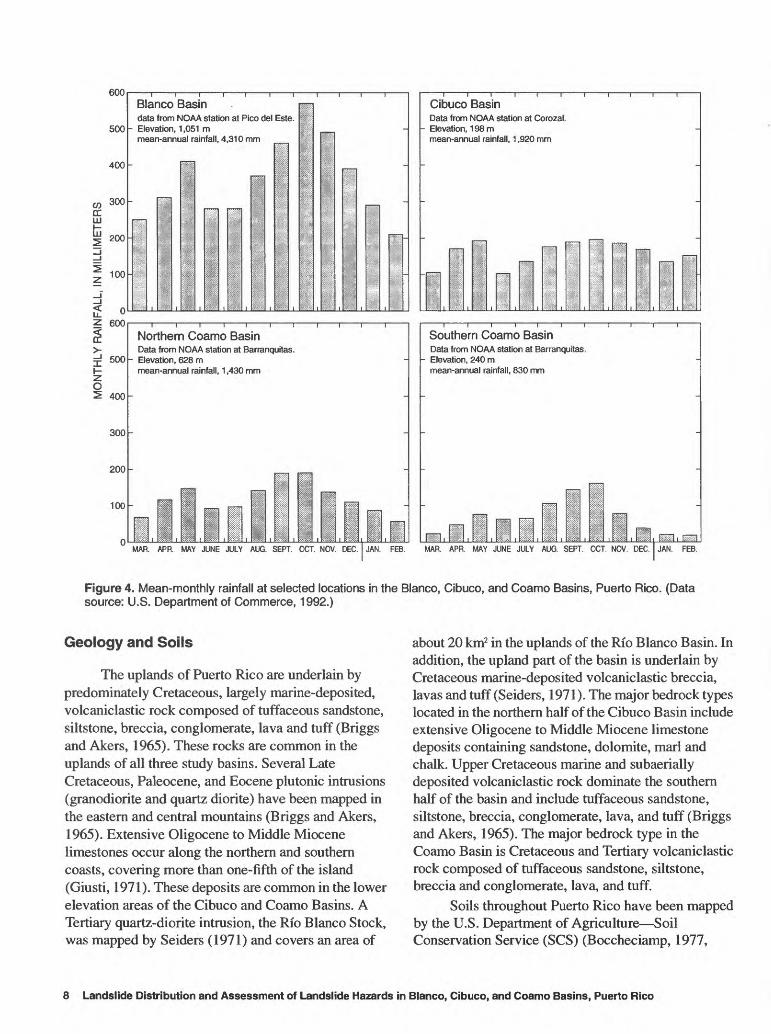
mountains of Puerto Rico, 1960-90..................................................................................................................... 74. Mean-monthly rainfall at selected locations in the Blanco, Cibuco, and
Coamo Basins, Puerto Rico................................................................................................................................. 85-7. Maps showing landslide locations, highways, and generalized:
5. Land-use characteristics in the Blanco Basin, Puerto Rico................................................................................. 196. Land-use characteristics in the Cibuco Basin, Puerto Rico................................................................................. 207. Land-use characteristics in the Coamo Basin, Puerto Rico................................................................................. 21
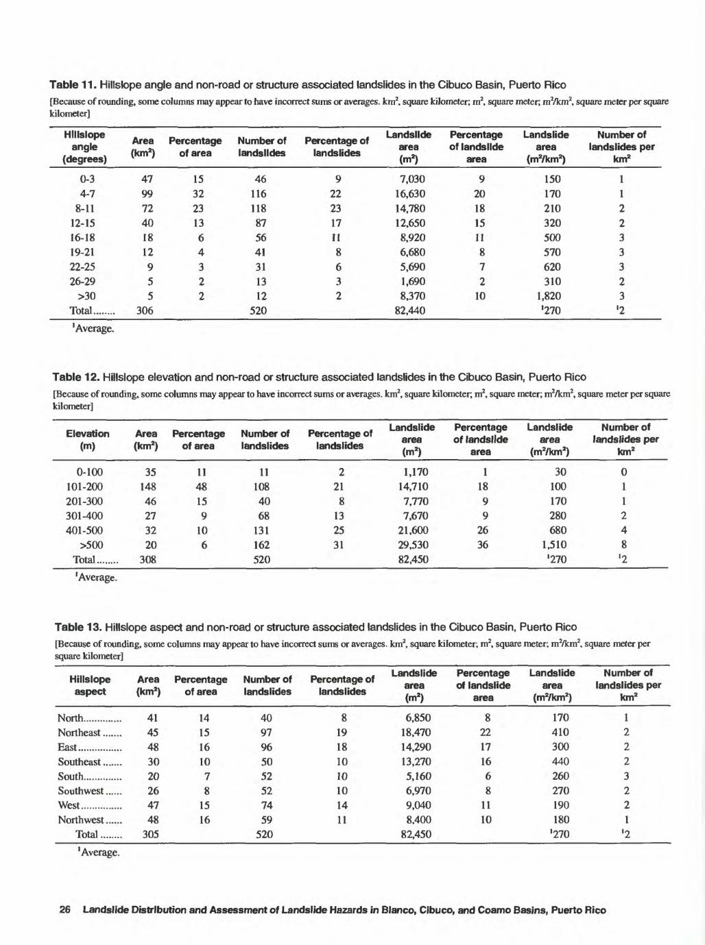
8-13. Maps showing landslide locations, rivers, canals, and generalized:8. Topography in Blanco Basin, Puerto Rico .......................................................................................................... 239. Topography in Cibuco Basin, Puerto Rico.......................................................................................................... 27
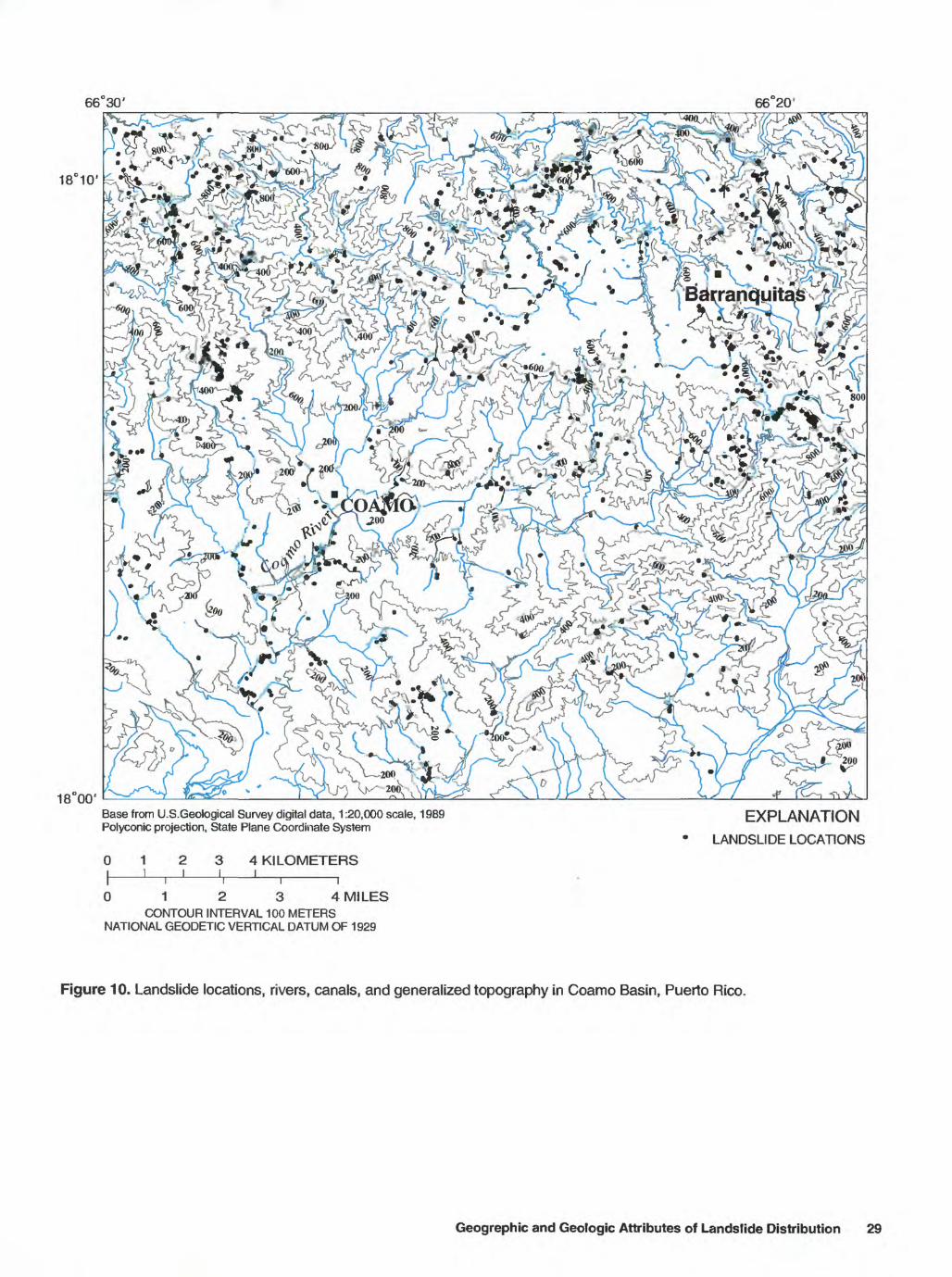
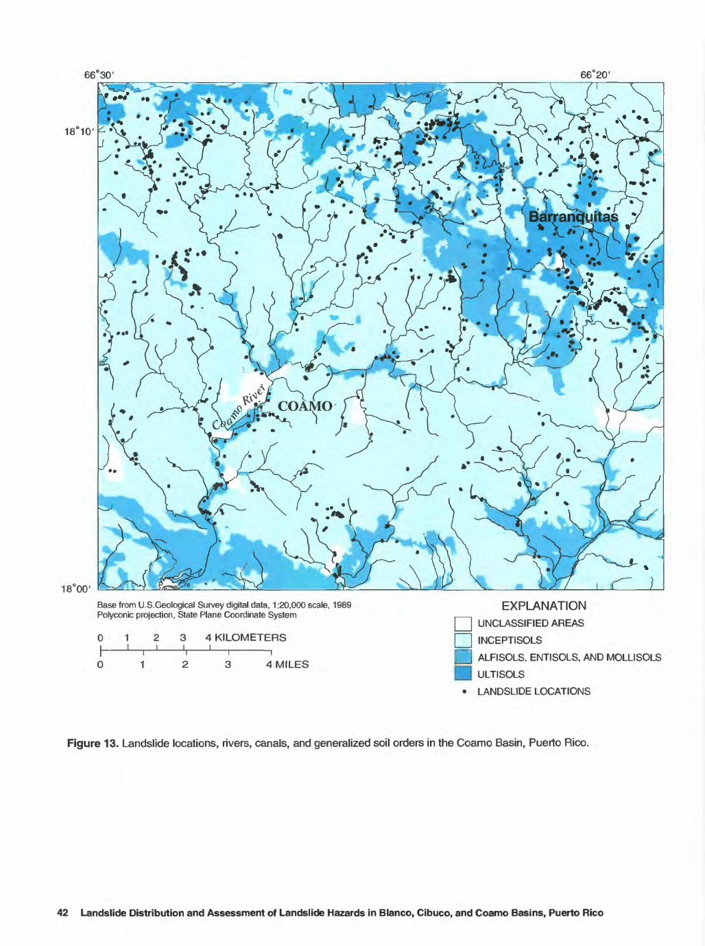
10. Topography in Coamo Basin, Puerto Rico.......................................................................................................... 2911. Soil orders in the Blanco Basin, Puerto Rico ...................................................................................................... 3612. Soil orders in the Cibuco Basin, Puerto Rico...................................................................................................... 3913. Soil orders in the Coamo Basin, Puerto Rico...................................................................................................... 42
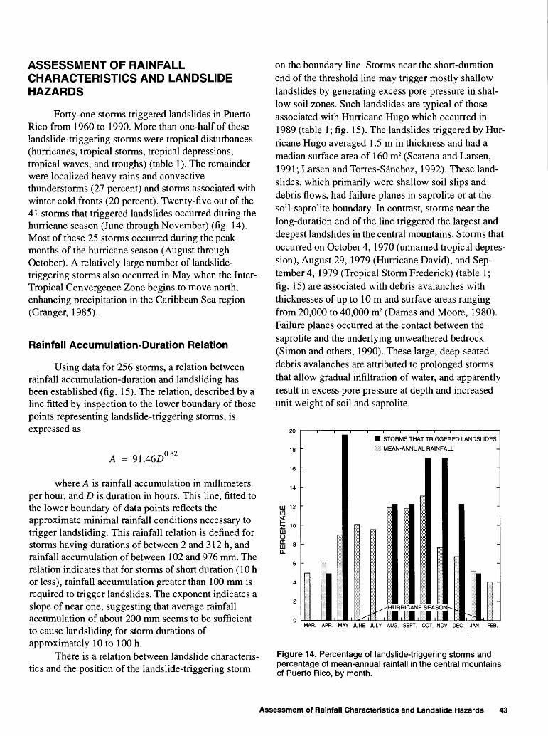
14,15. Graphs showing:14. Percentage of landslide-triggering storms and percentage of mean-annual
rainfall in the central mountains of Puerto Rico, by month................................................................................. 4315. Relation between average rainfall accumulation and duration for 256 storms in the
central mountains of Puerto Rico dating from 1959 to 1991............................................................................... 44
TABLES
1. Date of occurrence and rainfall characteristics of 41 storms that triggered tens to hundredsof landslides in Puerto Rico, 1960-90.......................................................................................................................... 12
2. Characteristics of 215 rainfall events that were not observed to have triggered landslidesin eastern Puerto Rico................................................................................................................................................... 13
3. Landslide types in the Blanco, Cibuco, and Coamo Basins, Puerto Rico.................................................................... 154. Landslide area according to land use for the Blanco, Cibuco, and Coamo Basins, Puerto Rico................................. 155. Land-use categories and landslides in the Blanco Basin, Puerto Rico......................................................................... 176. Land-use categories and landslides in the Cibuco Basin, Puerto Rico......................................................................... 177. Land-use categories and landslides in the Coamo Basin, Puerto Rico......................................................................... 178. Hillslope angle and non-road or structure associated landslides in the Blanco Basin, Puerto Rico ............................ 249. Hillslope elevation and non-road or structure associated landslides in the Blanco Basin, Puerto Rico ...................... 24
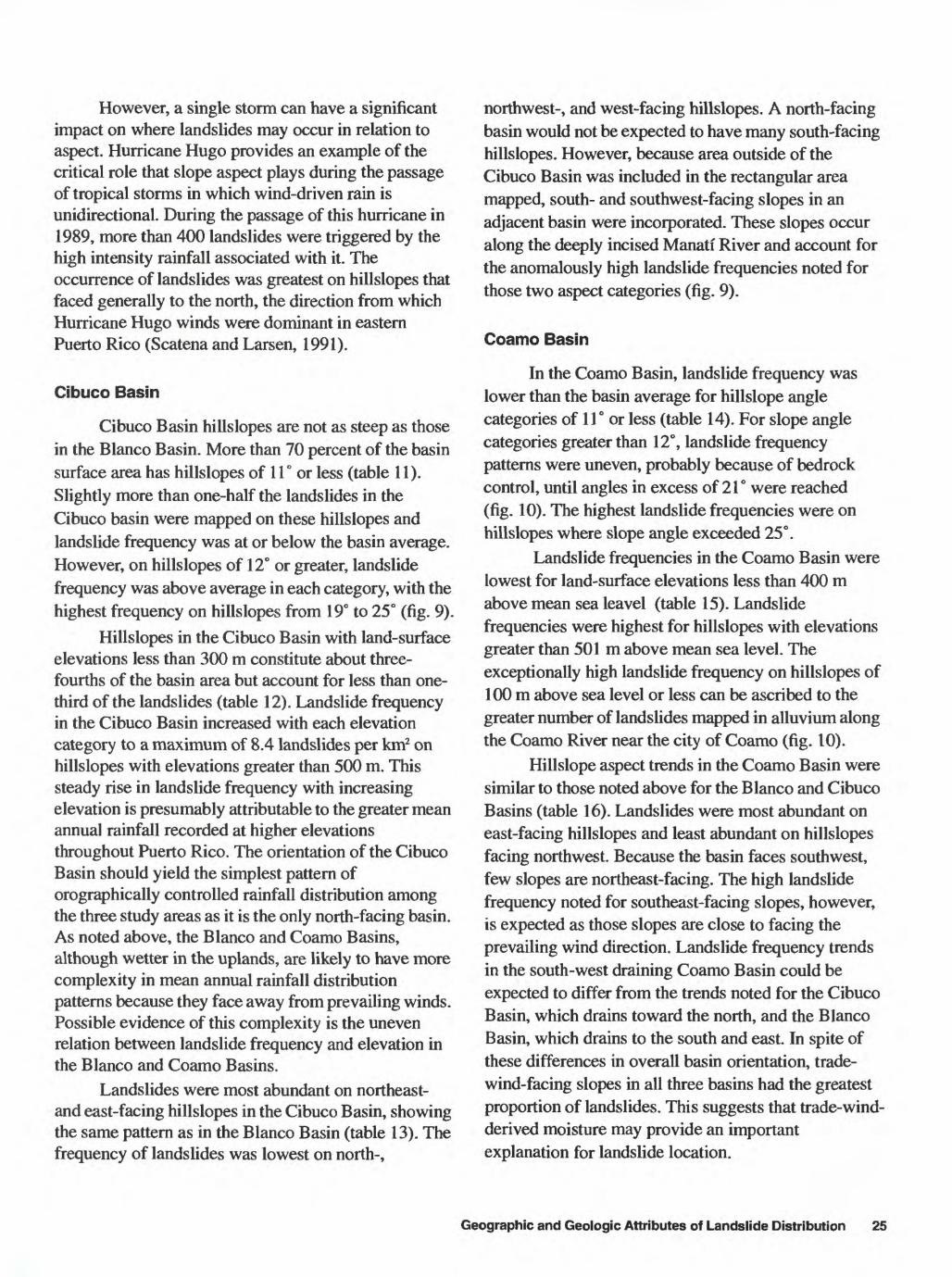
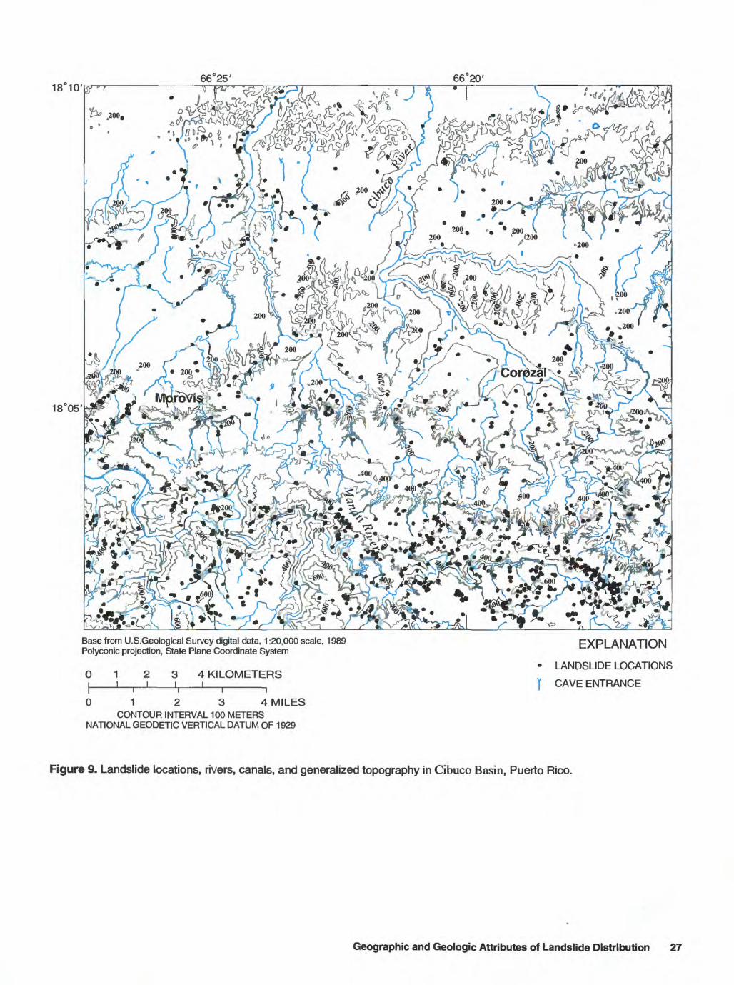
10. Hillslope aspect and non-road or structure associated landslides in the Blanco Basin, Puerto Rico........................... 2411. Hillslope angle and non-road or structure associated landslides in the Cibuco Basin, Puerto Rico............................ 2612. Hillslope elevation and non-road or structure associated landslides in the Cibuco Basin, Puerto Rico...................... 2613. Hillslope aspect and non-road or structure associated landslides in the Cibuco Basin, Puerto Rico........................... 2614. Hillslope angle and non-road or structure associated landslides in the Coamo Basin, Puerto Rico............................ 2815. Hillslope elevation and non-road or structure associated landslides in the Coamo Basin, Puerto Rico...................... 2816. Hillslope aspect and non-road or structure associated landslides in the Coamo Basin, Puerto Rico........................... 28
IV Contents
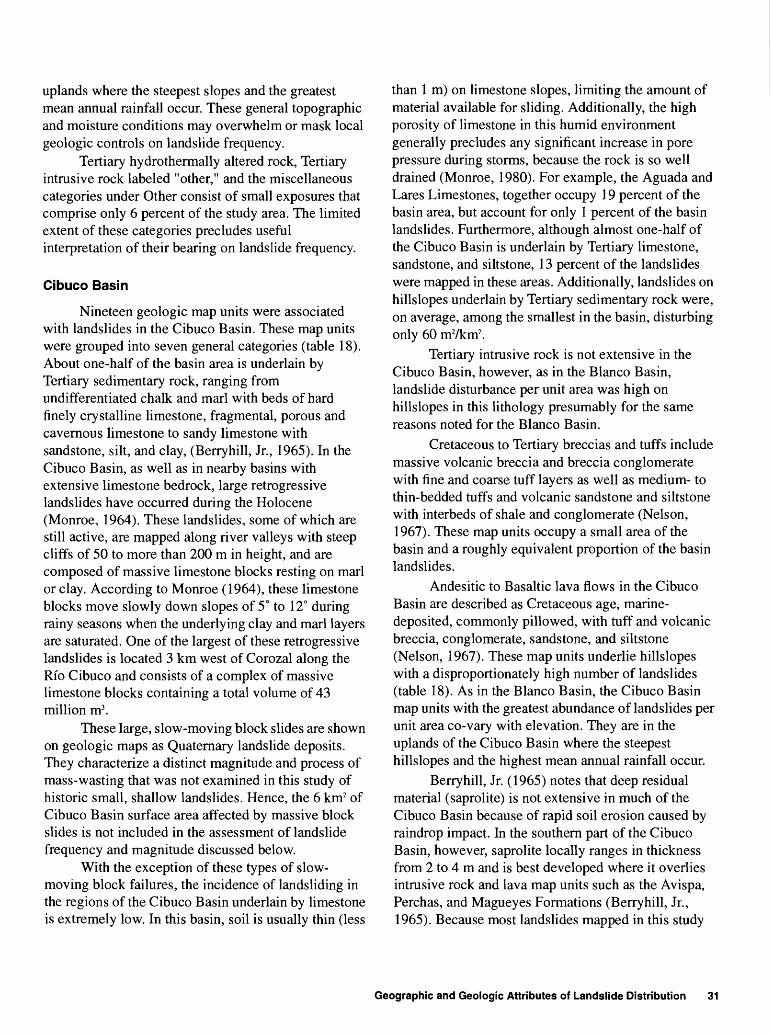
17. Bedrock geology and non-road or structure associated landslides in theBlanco Basin, Puerto Rico................................................................._ 32
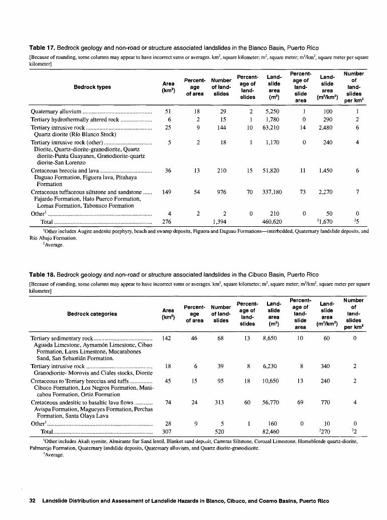
18. Bedrock geology and non-road or structure associated landslides in theCibuco Basin, Puerto Rico ........................................................................................................................................... 32
19. Bedrock geology and non-road or structure associated landslides in theCoamo Basin, Puerto Rico ........................................................................................................................................... 33
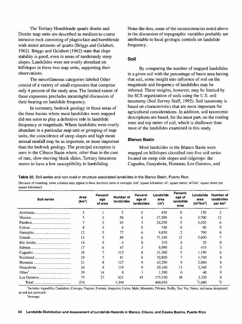
20. Soil series and non-road or structure associated landslides in theBlanco Basin, Puerto Rico............................................................................................................................................ 34
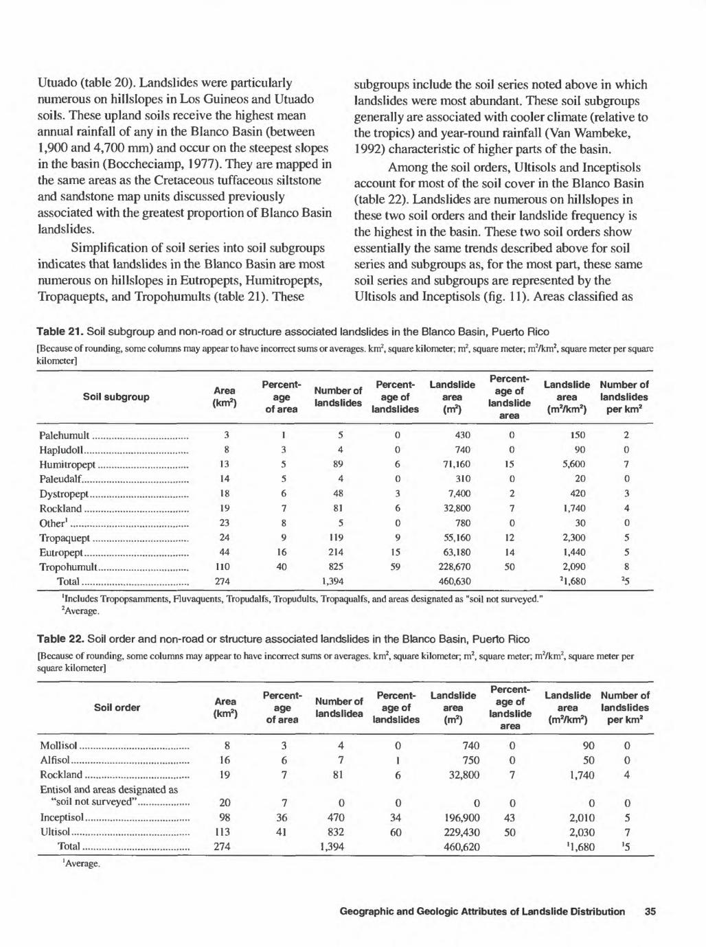
21. Soil subgroup and non-road or structure associated landslides in theBlanco Basin, Puerto Rico............................................................................................................................................ 35
22. Soil order and non-road or structure associated landslides in theBlanco Basin, Puerto Rico............................................................................................................................................ 35
23. Soil series and non-road or structure associated landslides in theCibuco Basin, Puerto Rico ........................................................................................................................................... 37
24. Soil subgroup and non-road or structure associated landslides in theCibuco Basin, Puerto Rico ........................................................................................................................................... 38
25. Soil order and non-road or structure associated landslides in theCibuco Basin, Puerto Rico ........................................................................................................................................... 38
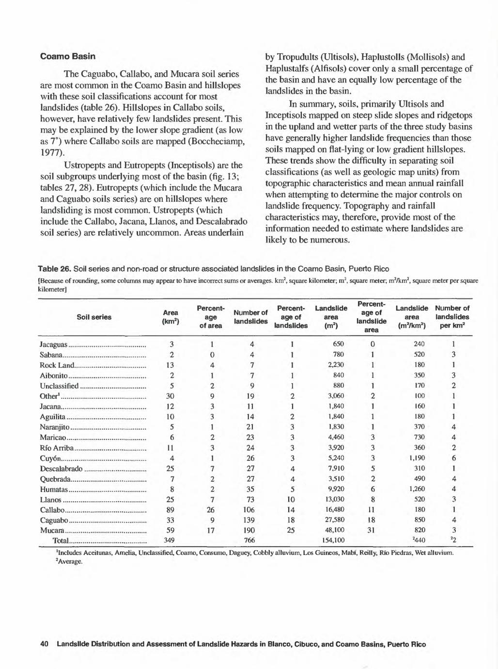
26. Soil series and non-road or structure associated landslides in theCoamo Basin, Puerto Rico ........................................................................................................................................... 40
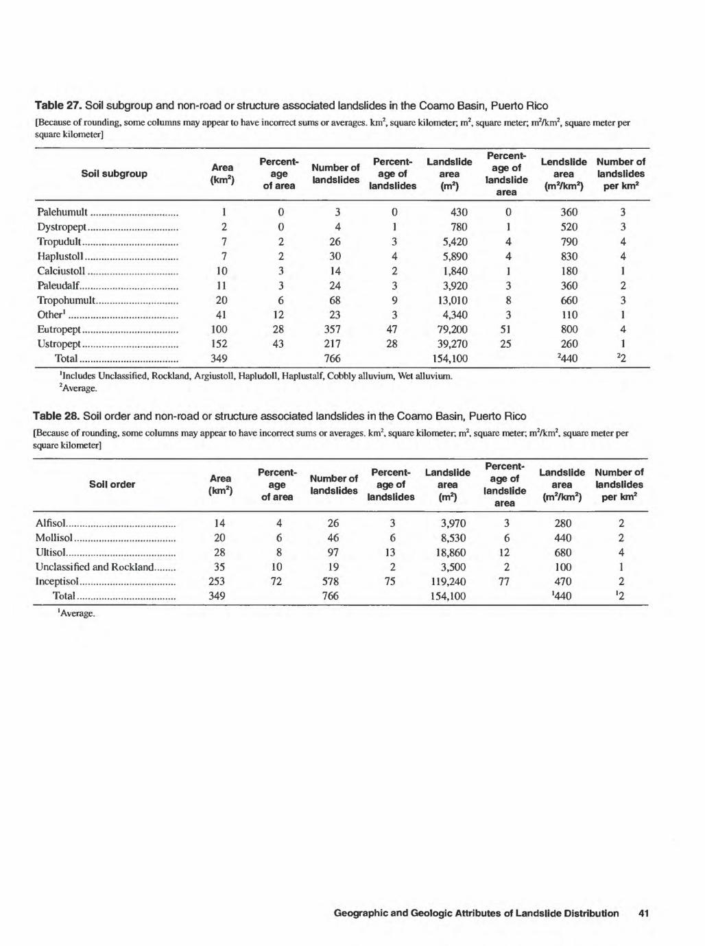
27. Soil subgroup and non-road or structure associated landslides in theCoamo Basin, Puerto Rico ........................................................................................................................................... 41
28. Soil order and non-road or structure associated landslides in theCoamo Basin, Puerto Rico ........................................................................................................................................... 41
29. Rainfall characteristics for storms estimated to trigger landslides in thecentral mountains of Puerto Rico................................................................................................................................. 45
30. Matrix showing number of landslides associated with 36 geographic categories in theBlanco Basin, Puerto Rico............................................................................................................................................ 48
31. Matrix showing estimated area in hectares for 36 geographic categories in theBlanco Basin, Puerto Rico............................................................................................................................................ 48
32. Matrix showing estimated number of landslides per square kilometer per decade in36 geographic categories in the Blanco Basin, Puerto Rico......................................................................................... 49
33. Matrix showing number of landslides associated with 36 geographic categories in theCibuco Basin, Puerto Rico ........................................................................................................................................... 49
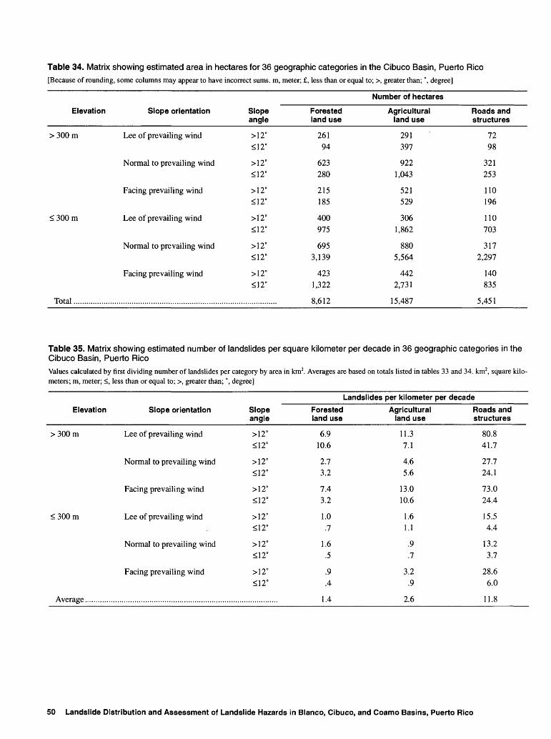
34. Matrix showing estimated area in hectares for 36 geographic categories in theCibuco Basin, Puerto Rico ........................................................................................................................................... 50
35. Matrix showing estimated number of landslides per square kilometer per decade in36 geographic categories in the Cibuco Basin, Puerto Rico ........................................................................................ 50
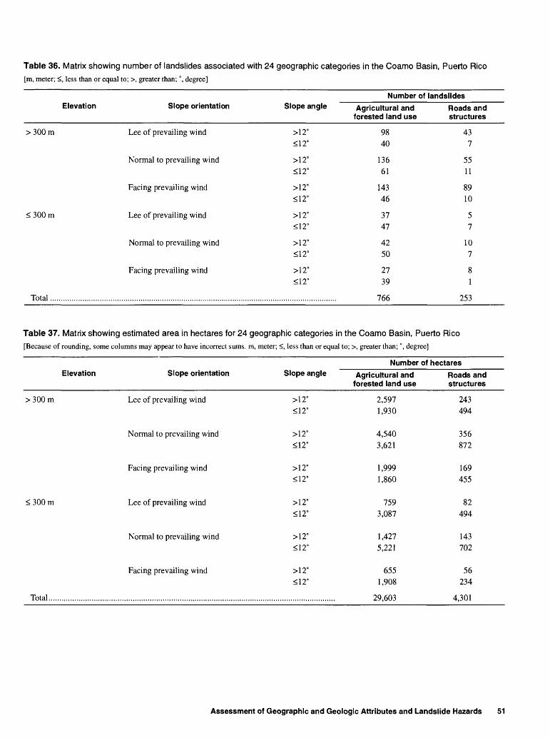
36. Matrix showing number of landslides associated with 24 geographic categories in theCoamo Basin, Puerto Rico ........................................................................................................................................... 51
37. Matrix showing estimated area in hectares for 24 geographic categories in theCoamo Basin, Puerto Rico ........................................................................................................................................... 51
38. Matrix showing estimated number of landslides per square kilometer per decade in24 geographic categories in the Coamo Basin, Puerto Rico ........................................................................................ 52
Contents
CONVERSION FACTORS AND ACRONYMS
CONVERSION FACTORS
Multiply By To obtain
centimeter (cm) 0.3937 inch centimeter per hour (cm/h) 0.3937 inch per hour
cubic meter per second (m3/s) 35.31 cubic foot per secondhectare (ha) 0.003861 square mile
kilometer (km) 0.6214 mile meter (m) 3.281 foot
millimeter (mm) 0.03937 inch square kilometer (km2) 0.3861 square mile
Temperature: Temperature in degree Fahrenheit (°F) may be converted todegree Celsius (°C) as follows:
_________________________"C = 5/9 x (°F - 32)_________________________
ACRONYMS
GIS Geographic Information SystemIITF International Institute of Tropical ForestryLEF Luquillo Experimental ForestMAP mean annual precipitationMMI Modified Mercalli intensityPRDNER Puerto Rico Department of Natural and Environmental ResourcesSCS Soil Conservation ServiceU.S. United StatesUSDA U.S. Department of Agriculture
USGS U.S. Geological Survey
VI Contents
Geographic Relations of Landslide Distribution and Assessment of Landslide Hazards in the Blanco, Cibuco, and Coamo Basins, Puerto RicoBy Matthew C. Larsen and Angel J. Torres-Sanchez
Abstract
Landslide occurrence is common in mountainous areas of Puerto Rico where mean annual rainfall and the frequency of intense storms are high and hillslopes are steep. Each year, landslides cause extensive damage to property and occasionally result in loss of life. Landslide maps developed from 1:20,000 scale aerial photographs in combination with a computerized geographic information system were used to evaluate the landslide potential in the Blanco, Cibuco, and Coamo Basins of Puerto Rico. These basins, ranging in surface area from 276 to 350 square kilometers, are described in this report. The basins represent a broad range of the climatologic, geographic, and geologic conditions that occur in Puerto Rico. In addition, a variety of landslide types were documented. Rainfall-triggered debris flows, shallow soil slips, and slumps were most abundant.
The most important temporal control on landslide occurrence in Puerto Rico is storm rainfall. Forty-one storms triggered widespread landsliding about 1 to 2 times per year during the last three decades. These storms were frequently of 1 to 2 days duration in which, on average, several hundred millimeters of rainfall triggered tens to hundreds of landslides in the central
mountains. Most of these storms were tropical disturbances that occurred during the hurricane season of June through November.
Land use and the topographic characteristics of hillslope angle, elevation, and aspect are the most important spatial controls governing landslide frequency. Hillslopes in the study area that have been anthropogenically modified, exceed 12 degrees in gradient and about 350 meters in elevation, and face the east-northeast are most prone to landsliding. Bedrock geology and soil order seem less important in the determination of landslide frequency, at least when considered at a generalized level.
A rainfall accumulation-duration relation for the triggering of numerous landslides throughout the central mountains, and a set of simplified matrices representing geographic conditions in the three river basins were developed and are described in this report. These two elements provide a basis for the estimation of the temporal and spatial controls on landslide occurrence in Puerto Rico. Finally, this approach is an example of a relatively inexpensive technique for landslide hazard analysis that may be applicable to other settings.
Abstract
INTRODUCTION
Landslides are a common, natural mass-wasting phenomena in mountainous areas throughout the world. The term landslide means the downward and outward movement of hillslope-forming materials, such as natural rock, soils, artificial fills or combinations of these materials (Schuster, 1978). Landslides can include falls, topples, slides, spreads, and flows. Landslides are part of the process of hillslope erosion that is responsible for introduction of sediment into streams, rivers, lakes, reservoirs, and finally the oceans. In populated areas landslides pose serious public safety problems. Manmade structures on, or near, hillslopes may be in jeopardy if geologic, hydrologic, and climatologic conditions are appropriate for landsliding.
Deaths and injuries resulting from landslides have occurred all over the world. According to Varnes (1981), an average of nearly 600 people per year were killed by landslides between 1971 and 1974. Schuster (1978) estimated that direct and indirect costs of landslide damage exceeded 1 billion per year in the United States. However, Petak and Atkisson (1982) estimated that if appropriate grading regulations were applied to construction in the U.S., as much as 60 percent of all U.S. building losses from landsliding could be avoided. One example of a successful mitigation strategy is that employed in the Los Angeles, California region. Implementation of hillside grading codes based on site-specific investigations has reportedly been successful in reducing losses in areas of new construction by 92 to 97 percent (Slosson and Krohn, 1982).
Landslides are a recurrent problem throughout most of Puerto Rico. Various factors contribute to landslide occurrence. A major earthquake in 1918 caused many rockfalls and slumps along stream and riverbanks in western Puerto Rico, where the earthquake modified Mercalli intensity (MMI) exceeded VII (Reid and Taber, 1919). The earthquake intensity, MMI, exceeded VI over virtually the entire island. According to Harp and others (1981), landsliding triggered by the 1976 magnitude 7.5 earthquake in Guatemala occurred mostly within the area where the MMI exceeded VI, and the areas of highest landslide frequency were in areas where the MMI exceeded VII. This indicates that earthquake- triggered landsliding was probably widespread in
Puerto Rico during the earthquake of 1918. Landsliding triggered by earthquakes may be the most significant type of major landslide hazard in the long term. However, landslides caused by excessive rainfall are more common and can be equally destructive in mountainous areas of the tropics.
In Jamaica, virtually every heavy storm causes numerous soil slips that block roads in mountainous areas, requiring regular and substantial maintenance and repair (O'Hara and Bryce, 1983). In Puerto Rico, hillslope modification for construction of highways and other structures has also resulted in frequent landsliding (Sowers, 1971; Dames and Moore, 1980; Molinelli, 1984). A quarry operator-triggered rockslide of about 1,000,000 cubic meters (m3) occurred in southern Puerto Rico in 1982 (Alex Soto, University of Puerto Rico, written commun., 1990). However, rainfall-triggered landslides are the most common type of landslide, occurring throughout the central mountains and foothills of the island. Between 1960 and 1990, one to two rainstorms per year had sufficient accumulation and duration to cause tens to hundreds of landslides in the central mountains of Puerto Rico (U.S. Weather Service, 1960-1990; Larsen and Simon, 1993).
As urban development in Puerto Rico continues on hillslopes and adjacent areas, more people and property are threatened by landslides. Puerto Rico, with a population exceeding 3.6 million concentrated in an area of about 9,000 square kilometers (km2), is one of the most densely populated areas on Earth (Pico, 1974). Since the 1960's, a major construction boom has created numerous new urban centers in mountainous areas of Puerto Rico. For example, the population of Caguas, located in an upland valley south of San Juan, increased 23 percent between 1970 and 1980; the number of housing units increased by 42 percent during the same period (U.S. Department of Commerce, 1982).
In 1985, Tropical Storm Isabel caused intense and prolonged rainfall lasting 2 days in southern Puerto Rico. A hillslope in Barrio Mameyes, Ponce, saturated by this rainfall, failed, resulting in the worst landslide disaster in the history of the U.S. in terms of loss of life (Jibson, 1989). More than 120 people lost their lives as an entire hillside covered with homes slid downslope. This tragedy brought the problem of landslides to the attention of both the general public and government
2 Landslide Distribution and Assessment of Landslide Hazards in Blanco, Cibuco, and Coamo Basins, Puerto Rico
agencies responsible for public planning and safety. As a result, a study funded cooperatively by the U.S. Geological Survey (Survey) and the Puerto Rico Planning Board was begun in 1988 to describe landslide distribution and to estimate landslide hazards in Puerto Rico. The Blanco, Cibuco, and Coamo drainage basins were chosen for this study because they are representative of the range of geologic, soil, topographic, and annual rainfall settings for Puerto Rico (fig. 1).
Several landslide types were identified in the basins investigated in this study. Shallow landslides, which include shallow soil slips, debris flows, and slumps, are the predominate type of landslides in all three basins. A few debris avalanches also have been identified in each basin (classification according to Campbell, 1975; and Varnes, 1978). These terms relate to the kind of slope movement that occurred. The shallow landslides discussed in this report are those that occur in material defined as engineering soils: unconsolidated, inorganic mineral, residual, or transported material (colluvium or alluvium), including rock fragments. Soil slips occur mainly during heavy rainfall, and are generally limited to steep hillslopes (Campbell, 1975). Debris flows, usually initiated as soil slips, are rapid, fluidized movements that commonly follow preexisting drainages. They can be of high density, as much as 70 percent solids by weight (Varnes, 1978), and may travel distances equivalent to many times their width. Slumps and debris avalanches tend to occur only after deep infiltration of water has taken place, often days to weeks after a storm. Debris avalanches are rapid to extremely rapid movements that flow or tumble downslope. Their momentum is often sufficient to carry material short distances upslope on the opposite valley wall.
Purpose and Scope
This report presents the results of a 3-year study to describe the distribution of landslides and assess landslide hazards in the Blanco, Cibuco, and Coamo drainage basins in Puerto Rico. The report also describes a rainfall accumulation-duration threshold developed for the central mountains of Puerto Rico. The objectives of this study were to evaluate the geographic relations of landslide distribution across the range of topography, climate, soils, and bedrock geology that occur in Puerto Rico. An additional
objective was to determine the accumulation-duration characteristics of storms likely to trigger landslides in the central mountains of the island. Finally, this report demonstrates a relatively inexpensive method that can be used by land-use managers and public safety agencies for assessing landslide hazards.
Previous Studies
Previous studies of landsliding in Puerto Rico include work on mitigation and repair of landslide damaged areas in the Blanco Basin (Dames and Moore, 1980). This work focused on possible remediation of the effects of several large debris avalanches that filled a small reservoir and severed a penstock in the Luquillo Experimental Forest (LEF). Landslide mechanisms and weathering of bedrock and saprolite in the LEF were examined in detail by Deere and Patton (1971). Landslide problems associated with highway construction in the LEF were studied by Sowers (1971) after construction of a short stretch of mountain-top highway triggered dozens of small slumps and greatly increased the cost and time needed for completion of the road. Molinelli (1984) examined the impacts of landslide problems associated with the construction of a major trans-island highway constructed in the 1970's. Landslides resulting from a 1985 tropical disturbance caused more than 120 fatalities and damaged hundreds of roads and structures (Jibson, 1989 and 1992). Most of these landslides were debris flows triggered by high intensity rainfall during a 2-day period. A relatively fast moving hurricane in 1989 triggered more than 400 landslides in northeastern Puerto Rico (Scatena and Larsen, 1991, Larsen and Torres-Sanchez, 1992). Most of these were shallow soil slips and debris flows that occurred during or shortly after a 6-hour period of high intensity rainfall. A rainfall intensity-duration threshold described the types of storms that triggered landslides in the central mountains of Puerto Rico (Larsen and Simon, 1993). A generalized landslide hazard map developed at 1:240,000 scale by Monroe (1979) classified most of Puerto Rico as moderately susceptible to landsliding. Physical mechanisms of landslide failure in saprolite in the LEF were described by St. John and others (1969). They stated that relict joint surfaces in saprolite that weathered from intrusive bedrock may provide failure surfaces for landslides when sufficient moisture is present.
Introduction
67°0
0'30
'66
eOO
'
ff qI'
5s D> Q. J2.
ff Q.
(0 5'
2 D>
§ cr o p D> Q.
O o 00 D> w 5'
w o CD o1
18°3
0'
18°0
0'
ATL
AN
TIC
OC
EA
N
an J
uan
Cei
ba
'Rio
Bla
nco
Rio
Coa
mo
CA
RIB
BE
AN
SEA
9080
°7
0'
60°
30'
10'
1 1
11
3 10
I 20I 30
MIL
ES
EX
PLA
NA
TIO
N
STU
DY
BA
SIN
LIN
E O
F E
QU
AL
AN
NU
AL
RA
INFA
LL-
inte
rval
500
mill
imet
ers
US
GS
RE
CO
RD
ING
RA
IN G
AG
E
T)
LO
CA
TIO
N O
F 4
1 LA
ND
SLID
E-
TR
IGG
ER
ING
ST
OR
MS
LIS
TE
D I
N T
AB
LE
1
Figu
re 1
. Loc
atio
n of
the
Rio
Bla
nco,
Rio
Cib
uco,
and
Rfo
Coa
mo
drai
nage
bas
ins,
loc
atio
n of
land
slid
e-tri
gger
ing
stor
ms,
ann
ual a
vera
ge r
ainf
all i
sohy
ets,
and
a
US
GS
rec
ordi
ng r
aing
age
in P
uerto
Ric
o.
An extensive body of literature exists for development of rainfall thresholds sufficient to trigger landsliding in tropical areas. For the most part, this work identified one to several storms that have resulted in abundant landslides, and includes work by Tianchi and Minghua (1985) for China; Brand and others (1984) for Hong Kong; Tatizana and others (1987) for Brazil; Wentworth (1943) for Hawaii; Haldemann (1956) for Tanganyika; de Meis and Silva (1968) for Brazil; Starkel (1970) for Darjeeling; So (1971) for Hong Kong; Temple and Rapp (1972) for Tanzania; Jones (1973) for Brazil; Guidicini and Iwasa (1977) for Brazil; Li Jian and Wang Jingrung (1984) for China; DeGraff (1990) for Thailand; and Wilson and others (1992) for Hawaii.
Studies of landslide distribution include those of Simonett (1967), Garwood and others (1979), Harp and others (1981), and Jibson (1988) in which seismically triggered landslides were examined in relation to topographic and geologic variables. Haigh and others (1988), and Carrara and others (1991) related the distribution of landslides to land-use practices, particularly highway construction and maintenance. Guariguata (1990) related landslide disturbance to forest regeneration in the uplands of the LEF. A preliminary map of landslide locations in the LEF was prepared by Guariguata and Larsen (1990).
Acknowledgments
Numerous individuals and agencies assisted this study in many ways. Ariel Lugo, U.S. Department of Agriculture (USD A) International Institute of Tropical Forestry (IITF) Director, and Frederick Scatena, USDA, IITF Research Hydrologist, provided valuable advice, insight, and guidance. William Wolfe, Clark University, assisted in fieldwork and with helpful discussion of geographic data. Manuel Guariguata, Yale University, assisted in field mapping of landslides in the Luquillo Experimental Forest. The Puerto Rico Department of Natural and Environmental Resources, USDA-IITF, and Puerto Rico Center for Energy and Environmental Research provided access to aerial photographs.
SETTING AND DESCRIPTION OF STUDY BASINS
Puerto Rico is the smallest island of the Greater Antilles, located about 1,700 km southeast of Miami, Florida. It is in the trade-wind belt at the boundary between the Caribbean Sea and the Atlantic Ocean. Because of tectonically controlled geologic complexity and strong orographic control on island rainfall distribution, a variety of land use, topographic, and soil characteristics exist in the relatively small (9,000 km2) area of Puerto Rico. Several major bedrock types, typical of island arc systems throughout the world, have been mapped in Puerto Rico (Donnelly, 1989). This degree of geographic and geologic variability required that at least three different drainage basins be selected for this study to represent conditions that are typical of the island.
The three basins included in this study range in area from 275 to 350 km2 . The coastal-plain sections of the basins were excluded from study because the low relief results in limited landslide occurrence in those areas. The Blanco Basin as discussed in this report includes an additional 70 km2 area of the LEF located north of the basin divide. This 70 km2 area was added because it is an area of relatively undisturbed forested hillslopes and therefore allows for the examination of landslide trends with minimum anthropogenic disturbance. Finally, some adjacent land area was included around the perimeters of the three drainage basins resulting in rectangular data arrays. The basins as discussed in this report are therefore not strictly defined by the actual watershed drainage boundaries.
Topography and Land Use
Puerto Rico is an island of high relief with a maximum elevation of 1,338 meters (m) in the central mountain range. Topography is moderately steep to rugged and mountain slopes are dissected with perennial and ephemeral streams. The central mountain range is fringed by a relatively flat coastal plain 8 to 16 km wide. Gradual forest removal began in the 1600's as land was cleared for agriculture by European settlers. After three centuries of extensive agricultural land use, most (94 percent) of Puerto Rico's 890,000 hectares (ha) of land had been deforested by the late 1940's (Birdsey and Weaver, 1987). The term deforestation defines anthropogenic changes to pristine forest that
Setting and Description of Study Basins
include not only clear cutting, but also less disturbing actions such as selective timber harvesting and charcoal burning. A shift away from agriculture towards industry began in the 1950's and has resulted in much abandoned pasture and farmland. By 1985, total forest area had increased to 300,000 ha, or 34 percent of the total land area of the island (Birdsey and Weaver, 1987). The principal agricultural products grown include sugar cane, coffee, tobacco, pineapple, bananas, plantains, citrus, and many subsistence crops. Chicken and cattle are also raised.
The Blanco Basin lies in eastern Puerto Rico and, as defined in this study, encompasses an area of 275 km2 . It has the greatest relief of the three study basins and drains to the south and east, into the Caribbean Sea. Land-surface elevations range from mean sea level to 1,074 m above mean sea level. Topography is rugged and stream channels are deeply incised. Much of the basin falls within the boundaries of the LEF, an 11,300 ha preserve that is completely covered with forest vegetation. The Blanco Basin is largely uninhabited except in the foothills and coastal plain. Land surrounding the LEF is used for small farms and pasture and has been extensively deforested. Human land use for most of the basin has historically been limited because of extremely high annual rainfall (Scatena, 1989). Since the arrival of Europeans minor cutting of trees for charcoal and small subsistence farm plots have been the major land use. By the late 1800's much of the Blanco Basin had become a protected forest preserve, which later came under the jurisdiction of the U.S. Forest Service.
Topography in the 306 km2 Cibuco Basin study area is rolling to moderately rugged with elevations ranging from mean sea level to 670 m above mean sea level. Rivers in the basin drain towards the north and empty into the Atlantic Ocean. Upland slopes are moderate to steep and covered with second growth forest, abandoned pasture, and farmland. Two large towns, Morovis and Corozal, are in valley bottoms in the uplands. Conversion of forest to crop land was widespread in this basin and is comparable to the description of the island-wide land-use history noted above.
The Coamo Basin covers 353 km2 in south- central Puerto Rico, lies in an orographic rainshadow, and is relatively dry in its southern one-half. The basin
drains towards the south and west, into the Caribbean Sea. Topography is rolling to moderate and ranges in elevation from mean sea level to 860 m above mean sea level. Upland slopes are moderate to steep and covered with second growth forest, abandoned pasture, and small farms. A large town, Coamo, is located in the southern part of the basin. The Coamo Basin land-use history is also comparable to the island-wide pattern. Poultry and cattle raising are the dominate agricultural practices. Many streams are ephemeral because of the low mean-annual rainfall.
Climate and Hydrology
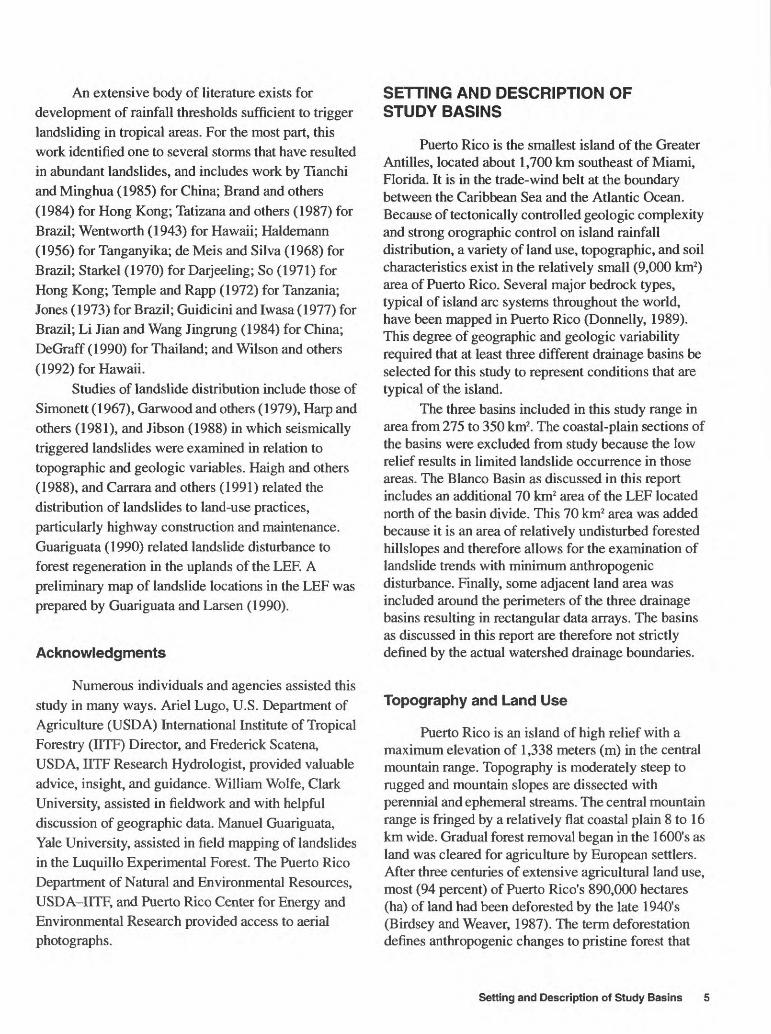
The climate of Puerto Rico is dominated by the easterly trade winds (fig. 2) which control regional climate and are strongest during the wet season months of May through December (Calvesbert, 1970). Much of the annual rainfall is delivered by tropical waves, depressions, storms, and hurricanes imbedded in the trade winds. Northerly cold fronts bring about one- quarter to one-third of the total annual rainfall during the winter months (Calvesbert, 1970). Annual rainfall in Puerto Rico ranges from 760 to more than 5,000 millimeters (mm) and varies across the island because of the orographic effects of an east-west trending central mountain range. The climate of Puerto Rico ranges from humid-tropical non-seasonal throughout the central mountains and northern coast, to seasonal dry tropical (dry winters, wet summers) along the southern coastal plain. Mean annual temperature also varies with elevation, from 19° Celsius (C) at the highest peaks (1,000 to 1,300 m) to 27° C along the coastal plains. About 65 percent of annual island-wide rainfall is lost to evaporation (Torres-Sierra and Rodriguez-Alonso, 1990). Potential evaporation ranges from 1,300 mm in northern uplands to 2,070 mm along the dry south coast (Calvesbert, 1970). Along the south coast, annual potential evaporation exceeds annual rainfall, which ranges from 760 to 1,000 mm. The average number of rainy days varies from about 300 in the northeastern mountains, to less than 100 along the south coast, and fewer than 50 in some areas.
An average of 8 to 11 hurricanes occur in the Atlantic Ocean each year (Riehl, 1979; Gray, 1990). The annual occurrence of hurricanes throughout the Caribbean Sea region averages from one to two in
6 Landslide Distribution and Assessment of Landslide Hazards in Blanco, Cibuco, and Coamo Basins, Puerto Rico
30
25
20
15
_
mi
i "...
i;
*
i
Iji
|
1
ij; -j
1
:
j
i
1 ...
; :;
L JL;
~
il
Wind direction frequency at San Juan, Puerto Rico NOAA weather station
1;
111 20
15
10
-
-
-HI 111
-
: T
1 :-¥:
I
i?
D
i it
Wind direction frequency at Ceiba, Puerto Rico NOAA weather station
-
1
n Fl n Fl FlN NNE NE ENE E ESE SE SSE S SSW SW WSW W WNW NW NNWCALM
DIRECTION
Figure 2. Mean-annual wind direction for San Juan and Ceiba, Puerto Rico. (Data source: U.S. Department of Commerce, 1992.)
recent decades while landslide triggering storms in Puerto Rico range from zero to five during the same period (fig. 3). About once every 21 years, Puerto Rico is hit directly by a hurricane.
More than 100 rivers flow to the ocean in Puerto Rico, discharging 32 percent (570 mm) of annual average rainfall (1,780 mm) (Torres-Sierra and Rodriguez-Alonso, 1990). The largest drainage basins and highest discharge are associated with rivers that drain the north slope of the island. These basins are as
cc
LLo ccUJ CD
1960 1965 1970 1975 1980 1985 1990
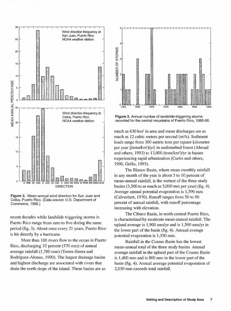
Figure 3. Annual number of landslide-triggering storms recorded for the central mountains of Puerto Rico, 1960-90.
much as 630 km2 in area and mean discharges are as much as 12 cubic meters per second (m3/s). Sediment loads range from 300 metric tons per square kilometer per year [(tons/km2)/yr] in undisturbed forest (Ahmad and others, 1993) to 13,000 (tons/km2)/yr in basins experiencing rapid urbanization (Curtis and others, 1990, Gellis, 1993).
The Blanco Basin, where mean monthly rainfall in any month of the year is about 5 to 10 percent of mean-annual rainfall, is the wettest of the three study basins (3,500 to as much as 5,000 mm per year) (fig. 4). Average annual potential evaporation is 1,590 mm (Calvesbert, 1970). Runoff ranges from 50 to 90 percent of annual rainfall, with runoff percentage increasing with elevation.
The Cibuco Basin, in north-central Puerto Rico, is characterized by moderate mean-annual rainfall. The upland average is 1,900 mm/yr and is 1,500 mm/yr in the lower part of the basin (fig. 4). Annual average potential evaporation is 1,350 mm.
Rainfall in the Coamo Basin has the lowest mean-annual total of the three study basins. Annual average rainfall in the upland part of the Coamo Basin is 1,400 mm and is 800 mm in the lower part of the basin (fig. 4). Annual average potential evaporation of 2,030 mm exceeds total rainfall.
Setting and Description of Study Area
600
500
400
300
200
100
600
500
400
300
200
100
Blanco Basindata from NOAA station at Pico del Este. Elevation, 1,051 m mean-annual rainfall, 4,310 mm
Cibuco BasinData from NOAA station at Corozal Elevation, 198 m mean-annual rainfall, 1,920 mm
<cc>-
Northern Coamo BasinData from NOAA station at Barranquitas.
- Elevation, 628 m mean-annual rainfall, 1,430 mm
Southern Coamo BasinData from NOAA station at Barranquitas. Elevation, 240 m mean-annual rainfall, 830 mm
MAR. APR MAY JUNE JULY AUG. SEPT. OCT. NOV. DEC. JAN. FEB. MAR. APR. MAY JUNE JULY AUG. SEPT. OCT. NOV. DEC. JAN. FEE,
Figure 4. Mean-monthly rainfall at selected locations in the Blanco, Cibuco, and Coamo Basins, Puerto Rico. (Data source: U.S. Department of Commerce, 1992.)
Geology and Soils
The uplands of Puerto Rico are underlain by predominately Cretaceous, largely marine-deposited, volcaniclastic rock composed of tuffaceous sandstone, siltstone, breccia, conglomerate, lava and tuff (Briggs and Akers, 1965). These rocks are common in the uplands of all three study basins. Several Late Cretaceous, Paleocene, and Eocene plutonic intrusions (granodiorite and quartz diorite) have been mapped in the eastern and central mountains (Briggs and Akers, 1965). Extensive Oligocene to Middle Miocene limestones occur along the northern and southern coasts, covering more than one-fifth of the island (Giusti, 1971). These deposits are common in the lower elevation areas of the Cibuco and Coamo Basins. A Tertiary quartz-diorite intrusion, the Rio Blanco Stock, was mapped by Seiders (1971) and covers an area of
about 20 km2 in the uplands of the Rio Blanco Basin. In addition, the upland part of the basin is underlain by Cretaceous marine-deposited volcaniclastic breccia, lavas and tuff (Seiders, 1971). The major bedrock types located in the northern half of the Cibuco Basin include extensive Oligocene to Middle Miocene limestone deposits containing sandstone, dolomite, marl and chalk. Upper Cretaceous marine and subaerially deposited volcaniclastic rock dominate the southern half of the basin and include tuffaceous sandstone, siltstone, breccia, conglomerate, lava, and tuff (Briggs and Akers, 1965). The major bedrock type in the Coamo Basin is Cretaceous and Tertiary volcaniclastic rock composed of tuffaceous sandstone, siltstone, breccia and conglomerate, lava, and tuff.
Soils throughout Puerto Rico have been mapped by the U.S. Department of Agriculture Soil Conservation Service (SCS) (Boccheciamp, 1977,
8 Landslide Distribution and Assessment of Landslide Hazards in Blanco, Cibuco, and Coamo Basins, Puerto Rico
1978; Gierbolini, 1975 and 1979; Acevedo, 1982). Most of the soil orders of the world occur in Puerto Rico, and most occur within the three basins discussed in this report. Upland areas of high annual rainfall are dominated by Inceptisols and Ultisols. In areas of moderate annual rainfall, Alfisols, Mollisols, Ultisols and Oxisols are common. Vertisols occur in areas adjacent to the dry southern coastal plain.
The soil orders present in the Blanco Basin include Ultisols and Inceptisols with minor amounts of Mollisols and Alfisols (Boccheciamp, 1977). The Cibuco and Coamo Basins have a greater variety of soil associations present. Soil in the Cibuco Basin is dominated by Ultisols and Inceptisols in the volcanic uplands, and Mollisols and Alfisols in the northern areas underlain by limestone (Gierbolini, 1979; Acevedo, 1982). Small amounts of Entisols, Oxisols, and Spodosols are also present. Inceptisol is the dominant soil order in the Coamo Basin. The remaining soil orders include Ultisols, Mollisols, and Alfisols.
METHODS OF INVESTIGATION
Aerial photographic data and topographic, geologic, land use, and soils data from the three basins were collected, processed, and digitized for use with a geographic information system (GIS). These spatial data were evaluated using a matrix of geographic land surface types to normalize landslide frequency in each basin.
Sufficient detail from 1:20,000 aerial photographs and digitized geographic and geologic information is available to make basin-wide analysis possible. These analyses used the aerial photographs and a GIS to determine if specific geographic attributes could be used to characterize landslide frequency.
Aerial Photographs and Geographic Information System Analyses
Approximately 300 sets of stereo aerial photographs were used to map recent landslides and to assemble a data base to assess the surface area and number of landslides in each of three basins. For the Blanco Basin, photographs for the years 1951, 1962- 67, 1971-77, and 1990 were used. For the Cibuco and
Coamo Basins, the photographs used were from 1987 and 1951, respectively. Because more sets of photographs were examined for the Blanco Basin, a higher number of landslides was mapped compared to the Cibuco and Coamo Basins, where only one set of photographs was used.
Recent landslides were observed on aerial photographs as a break in the forest canopy, bare soil, or other geomorphic characteristics typical of landslide scars (head and side scarps, flow tracks, and soil and debris deposits below the scar). If these types of observations could not be made, no landslide was noted. Each landslide was assigned an identification number, the landslide type (debris flow, slump, shallow soil slip, and debris avalanche) was estimated; and general land-use categories (forest, pasture, crops, and anthropogenic modification highways or other structures) were noted. The length and width of each landslide was measured on the aerial photograph using a magnifying glass and ruler in increments as small as 0.25 mm. Some landslide scars, particularly those along highways, were also measured in the field. Many of these highway-associated landslides were too small to be easily measured on the 1:20,000-scale aerial photographs. Lengths and width measurements of landslides mapped from the aerial photographs included the estimates of evacuated scar and flow track dimensions. The total area of the scar and flow track provide an estimate of net landslide disturbance on a hillslope.
Analysis of aerial photographs allowed for examination of extensive areas (basin sizes of several hundred square kilometers), however, the technique is limited by the poor quality of some black and white photographs taken between the 1930's and 1950's. Additionally, forest canopy and shadows on steep hillslopes mask landslide features, probably reducing the total number of identified landslides in such areas. Finally, many of the observed landslide scars were relatively small, near the limit of observation (about 5x5 m on 1:20,000-scale photographs), suggesting that a number of small landslides were missed.
A vector-based GIS software (ARC-INFO) was used to relate landslide location to various geographic and geologic factors. Landslide locations in each basin were compared to digitized topography (slope angle, slope elevation, and slope aspect), land use, SCS- mapped soil series, and bedrock geology. GIS software
Methods of Investigation
was used to determine the identification number of each landslide falling into each subcategory defined for each geographic and geologic attribute. GIS software was then used to determine the area in square meters that each attribute covered in each basin.
Although a GIS is an excellent tool for rapid examination of regional trends, certain topographic limitations must be noted. GIS software uses topography digitized from topographic maps, which in turn, were developed from aerial photographs. Topography has therefore been filtered first by the camera, second by the mapping technique, and thirdly by the digitization technique. The result is a generalized topography. For example, slope angles determined from contour spacing are approximate since they do not account for changes in slope that may occur between the 10 m elevation contours used in this study. Landslides attributed to a given slope angle may actually have occurred on a length of slope that was steeper or less steep than that indicated by the GIS. An additional limitation of GIS-based analyses is a slight variation (about one percent) in total basin surface area when different topographic or geographic attributes are examined. GIS software divides the basin into polygons whose total areas do not always add up to the total basin area.
Characterization of Topography and Land Use
Basin topography was taken from an existing USGS GIS data base which includes topographic contours scanned at 1,200 dots per inch from 1:20,000 scale maps. Topographic analysis in the study basins involved categorizing the slope angle, slope aspect, and land-surface elevation for each basin. Slope angle was simplified into nine categories in each basin. These nine categories were modified from ARC-INFO software default values that failed to sufficiently discriminate useful slope angle categories. For example, default slope-angle categories that contained a large number of landslides were divided into smaller categories and the basin was re-analyzed. Slope aspect was simplified into eight categories in each basin based on standard compass divisions. Land-surface elevations categories varied with basin relief and were simplified into nine categories in the Blanco Basin. In the Cibuco and Coamo Basin, six and eight land- surface elevation categories, respectively, were used.
Land-use attributes for each basin were digitized from 1:20,000 scale maps. These attributes were then simplified into four categories and compared to the distribution of landslides mapped from aerial photographs. The land-use attributes in each basin were determined from unpublished Puerto Rico Department of Natural and Environmental Resources (PRDNER) 1:20,000 scale maps made in 1971 for the Coamo Basin, in 1977 for the Blanco Basin, and in 1987 for the Cibuco Basin. Different sets for each basin were used because island land-use maps are not available for all years. These maps are based on aerial photograph interpretation and include more than 100 categories of land use. Because of the gradual reforestation of agricultural areas in the central mountains that has occurred at the same time as increased urbanization of other areas, land-use categories are considered to be only estimates. Finally, these categories, as well as those discussed below, may contain some inconsistencies as some degree of spatial distortion may be incorporated into a GIS database when spatial data are digitized from maps.
The four land-use categories used in this study were forest, pasture, cropland, and developed areas (roads and structures). Forest, as defined by PRDNER includes primary and secondary forest, canopy of varying density and height, and publicly and privately owned forest. These categories were placed in a single category to simplify the GIS analyses. Cropland included those areas used to grow coffee, sugar cane, citrus, coconut, pineapple, plantain, banana, tobacco, rice, flowers, and other crops. Pasture and degraded pasture (former pasture that is in the early stages of recovery to forest) were combined into a single category.
Roads were estimated to affect a 10 m wide swath along their course, either from cutting into the upper side of the road embankment, placement of fill on the lower side of the road embankment, or both. Wide, paved roads may affect a broader swath but most roads in the basins are narrow two-lane highways or dirt and gravel tracks. Developed areas included all roads and clusters of houses as well as small towns. Extensively urbanized regions in the three study areas ranged from 0.5 to 2 km2 in area, and were not examined for landslides.
10 Landslide Distribution and Assessment of Landslide Hazards in Blanco, Cibuco, and Coamo Basins, Puerto Rico
Characterization of Geology and Soils
Contacts between bedrock types were digitized from 1:20,000 and 1:200,000 scale geologic maps (Berryhill and Glover, III, 1960; Pease and Briggs, 1960; Glover III, 1961; Briggs and Gelabert, 1962; Monroe, 1962 and 1963; Berry hill, Jr., 1965; Nelson, 1967; Briggs, 1971; Seiders, 1971; Glover III and Mattson, 1973; M'Gonigle, 1978, 1979; Briggs and Aguilar-Cortes, 1980). Digitized geology was then compared to digitized landslide locations using GIS software and each landslide location was classified according to the underlying bedrock geology.
USGS-digitized soil series polygons in each of the three basins (based on standard SCS soil series maps at 1:20,000 scale), were examined for landslide occurrence using GIS software (Gierbolini, 1975 and 1979; Boccheciamp, 1977 and 1978; Acevedo, 1982). The landslide locations were then classified according to soil series, soil subgroup, and soil order. Mapped SCS soil series are shown with discrete boundaries between different series. These boundaries, unlike most geologic contacts, are actually gradational in most cases. In addition, SCS soil classifications are based on U.S. soil taxonomy (Soil Survey Staff, 1992), a system designed primarily for agricultural and not geotechnical purposes. Finally, the great number of soil mapping units described by the SCS may limit the usefulness of soil surveys for relating soil and landslide frequency because a large sample population of landslides would be required to adequately define trends for each mapping unit. However, the large number of soil mapping units and soils series can be simplified into fewer categories. These categories soil subgroups and soil orders, reduce the number of soils but may obscure trends by grouping geotechnically dissimilar soils. For example, 53 soil mapping units are simplified by the SCS into 28 soil series in the Blanco Basin. The 28 soil series fall into 13 soil subgroups, which can be further simplified into 5 soil orders (and a non-soil classification: "rockland"). Soil series, subgroups, and orders may therefore have only coincidental significance in estimating how soil influences landslide occurrence.
RAINFALL CHARACTERISTICS OF LANDSLIDE-TRIGGERING STORMS
As part of this study, a relation between storm rainfall and landslide occurrence was developed (Larsen and Simon, 1993). Records of storm rainfall and landslide occurrence are available for various locations throughout Puerto Rico. The number of records is sufficient to develop a relation for the central mountains in general, but not for specific drainage basins. Rainfall records from three sources were examined and the rainfall accumulations and durations of a total of 256 storms were used. The U.S. Weather Service Storm Data series (U.S. Weather Service, 1959-1990) provided a record of storm rainfall data that included comments on the occurrence and abundance of landslides. Storms were selected only if total rainfall accumulation and duration, and the occurrence or non-occurrence of landslides could be established. In some cases, landslide occurrence for selected storms was verified by using archival newspaper accounts of storm damage when no other data source was available (San Juan Star, 1959-1990). The landslide type (debris flow, slump, or other) was not noted in the U.S. Weather Service Storm Data series (U.S. Weather Service, 1959-1990). This data source yielded 42 storms that occurred from 1960 to 1990 in the central mountains and/or adjoining foothills of Puerto Rico where mean annual precipitation (MAP) is close to, or in excess of 2,000 mm (tables 1 & 2 j. Forty of these storms were documented as triggering tens to hundreds of landslides (table 1) and two caused no landslides.
The monthly summaries of the U.S. Weather Service data were examined for indications of storms not yet published in the U.S. Weather Service Storm Data series. One multi-day storm that began on October 5, 1990, was reported to have triggered landslides and was documented from this source (table 1) (U.S. Department of Commerce, 1990).
A USGS recording rain gage located in the central mountains 5 km southwest of the Rio Blanco study basin boundary was selected for further sampling of rainfall accumulation and duration and documentation of landslide occurrence (fig. 1). Although covering only a 2-year period, this data sample was assumed to be derived from the same population as the sample from the U.S. Weather Service Storm Data series because it is located in an area of the central mountains that receives MAP of
Rainfall Characteristics of Landslide-Triggering Storms 11
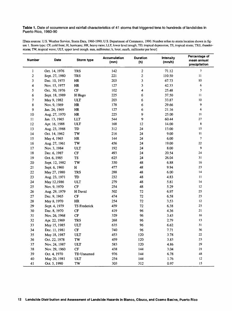
Table 1 . Date of occurrence and rainfall characteristics of 41 storms that triggered tens to hundreds of landslides in Puerto Rico, 1960-90
[Data sources: U.S. Weather Service, Storm Data, 1960-1990; U.S. Department of Commerce, 1990. Number refers to storm location shown in fig ure 1. Storm type: CF, cold front; H, hurricane; HR, heavy rains; LLT, lower level trough; TD, tropical depression; TS, tropical storm; TRS, thunder storm; TW, tropical wave; ULT, upper level trough, mm, millimeter; h, hour; mm/h, millimeter per hour]
12 Landslide Distribution and Assessment of Landslide Hazards in Blanco, Cibuco, and Coamo Basins, Puerto Rico
2,000 mm, roughly equivalent to the average MAP of 2,040 mm reported by Calvesbert (1970) for the central mountains. Furthermore, the site is within a 20-km radius of the centers of 10 of the 41 landslide- triggering storms indicating that local geographic attributes are sufficient for landsliding to occur. Topography and land use in this area are typical of much of the central mountains: moderate to steep slopes in pasture, pasture recovering to forest, and forest (Quinones-Marquez and others, 1989). The area is underlain by bedrock comparable to most of the central mountains: marine-deposited volcaniclastic rock and plutonic intrusions (Briggs and Akers, 1965). Soils in the area are mainly Inceptisols, common throughout the central mountains (Acevedo, 1982; Gierbolini, 1975 and 1979; Boccheciamp, 1977 and 1978). Weekly to biweekly visits to the raingage site from April 1989 to April 1991, as part of a study of erosion and sedimentation (Gellis, 1991) allowed the confirmation of the occurrence or non-occurrence of
landslides during the 2-year period. Rainfall-triggered landslides were not noted in the 40-km2 area near the raingage during this period.
A total of 213 rainfall events, none of which triggered landslides, were recorded by this raingage. These 213 rainfall events, along with the 2 storms documented by the U.S. Weather Service (1959-1990) that did not lead to landsliding are listed in table 2.
Periods of higher intensity rainfall that may have occurred during storms are not reflected in the long- duration rainfall data, which are recorded as total rainfall averaged for the storm duration. High-intensity periods may be important as discrete events that trigger landsliding during long-duration storms (Jibson, 1989). In addition, the rainfall data presented in tables 1 and 2 and used to develop the rainfall threshold, show rainfall at a single location, which may overestimate regionally distributed rainfall and underestimate maximum intensities that occur over small areas within a storm.
Table 2. Characteristics of 215 rainfall events that were not observed to have triggered landslides in eastern Puerto Rico)[Of these 215 rainfall events, 213 were near a USGS recording raingage. The two remaining storms were described by the U.S. Weather Service (1959-1990). See figure 1 for location of raingage. mm, millimeter; h, hour; mm/h, millimeter per hour]
14 Landslide Distribution and Assessment of Landslide Hazards in Blanco, Cibuco, and Coamo Basins, Puerto Rico
Rainfall data derived from storm durations greater than 9 hours (h) were compiled by the U.S. Weather Service (1959-1990) into 24,48, and 72 h (and so on) categories. The data in the monthly summaries of the U.S. Weather Service (U.S. Department of Commerce, 1990) is in the form of daily rainfall totals. Rainfall data for the USGS raingage are generally recorded in 15-minute increments. The USGS data were categorized as 24 h totals for 1-day storms, and grouped into multiples of 24 h if rainfall on successive days exceeded 3 mm. Days with rainfall totals of less than 3 mm were disregarded. In addition, 15-minute increments of rainfall accumulation were examined for all days on which rainfall accumulation exceeded 3 mm. Events of less than 24 h were included if one or more consecutive 15-minute increment exceeded 3 mm of rainfall accumulation.
LANDSLIDE CHARACTERISTICS
The number of landslides mapped as part of this study totaled 1,859 in the Blanco Basin, 1,019 in the Coamo Basin, and 1,161 in the Cibuco Basin. Because only one set of aerial photographs was examined in the Cibuco and Coamo Basins, the number of landslides mapped in those basins was smaller than the number mapped in the Blanco Basin. Landslides in the Blanco Basin were relatively evenly distributed between shallow soil slips, debris flows, and slumps, with only a few debris avalanches present (table 3). Slumps were most common in the Blanco Basin, where wetter conditions prevail. Most of the landslides in the Cibuco and Coamo Basins were shallow soil slips and debris flows. The Coamo Basin, with some of the driest conditions and thinnest soils among the three basins, had the greatest percentage of debris flows.
Most of the landslides mapped in this study affected relatively little surface area (table 4). Median landslide size in the basins ranged from 70 m2 on hillslopes in crop and pasture, to 220 m2 on hillslopes modified by roads or structures. The range in median landslide surface areas among the various land-use settings as well as between basins was surprisingly narrow. This suggests that landslide magnitude is only weakly affected by human modification of hillslopes. It also indicates that the climatic, topographic, and geologic differences between basins do not greatly affect landslide magnitude.
Table 3. Landslide types in the Blanco, Cibuco, and Coamo Basins, Puerto Rico
Table 4. Landslide area (in square meters) according to land use for the Blanco, Cibuco, and Coamo Basins, Puerto Rico
Landslide area
Roadand
structure
Crop Forest Pasture
Blanco Basin
Median surface areaMean surface areaMinimum surface areaMaximum surface area
220510<10
8,640
80130<10910
180440<10
32,940
80230<10
12,400
Cibuco Basin
Median surface areaMean surface areaMinimum surface areaMaximum surface area
110210<10
5,720
70150<10
S2,050
110240<10
6,190
80130<10
1,650
Coamo Basin
Median surface areaMean surface areaMinimum surface areaMaximum surface area
110370<10
8,710
80180<10
3,050
100230<10
2,320
100210<10
12,360
Landslide Characteristics 15
GEOGRAPHIC AND GEOLOGIC ATTRIBUTES OF LANDSLIDE DISTRIBUTION
Landslide frequency and location in the three study basins can be related to geographic and geologic controls in several ways. A simple approach is to determine the percentage of the basin that falls into a geologic or geographic category and relate it to the percentage of the landslides mapped in that same category. A second measure of landslide occurrence is to calculate the area disturbed by mass wasting in square meters for each geographic and geologic category. This is listed in tables 5 through 28 as 'Landslide area.' An additional calculation is listed as 'Percentage of landslide area, 1 and is determined by dividing the area of landslide disturbance in a land-use category by the total area of landslide disturbance in the basin. 'Landslide area in square meters per square kilometer' is determined by dividing the 'Landslide area' in square meters, for a given category by the basin area, in square kilometer, that is in that land-use category. The average number of landslides per square kilometers in the basin (referred to here as frequency) provides another measure of geographic and geologic controls on landslide occurrence. All calculated numbers (percentages, areas, and number of landslides per square kilometer) reported in tables 4 to 28 were rounded. In addition, averages and totals of landslide area and landslide area per square kilometers may vary between geographic categories in the same basin. As noted in the methods section, this is because of slight variations in GIS-determined surface area.
Land Use
Land use is the factor with the greatest variability in landslide frequency in the study basins, indicating that human modification fundamentally alters hillslope stability in the study basins. The most common construction-related activities involve undercutting the foot of a slope or deposition of soil and rock along the upper edge of a slope. Both practices tend to increase shear stress in the ground beneath the slope (Terzaghi, 1950). If the average shear stress of the hillslope material then becomes equal to the average shear resistance, a landslide can occur.
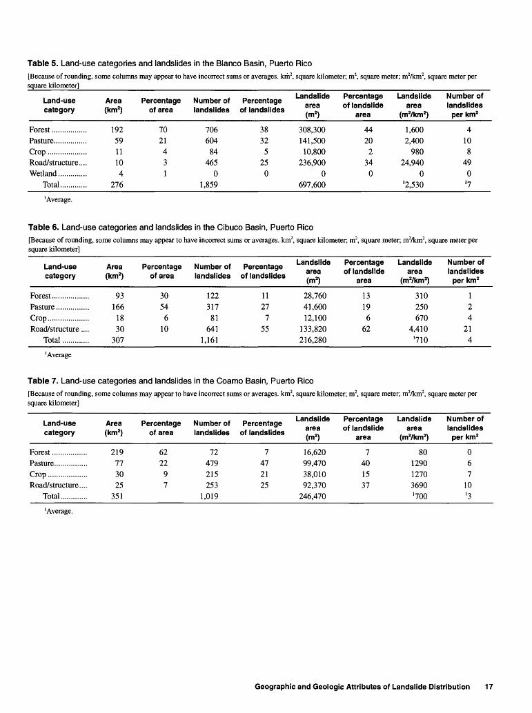
Landslide frequency in each basin generally increased with escalating hillslope modification following a sequence from forest to pasture to crop to roads and structures. In the Blanco Basin, the number of landslides ranged from 4 landslides per square kilometer on forested hillslopes to almost 50 landslides per square kilometer on hillslopes modified for highway and other construction (table 5). In the Cibuco Basin, the number of landslides ranged from 1 landslide per square kilometer on forested hillslopes to 21 landslides persquare kilometer on hillslopes modified for highway and other construction (table 6). In the Coamo Basin, landslide frequency ranged from less than 1 landslide per square kilometer on forested hillslopes to 10 landslides per square kilometer on hillslopes modified for construction of highways or other structures (table 7). Because different periods of time were represented by the sets of aerial photographs used in each basin, landslide frequencies between basins are not directly comparable. Landslide frequencies in each basin are comparable.
16 Landslide Distribution and Assessment of Landslide Hazards in Blanco, Cibuco, and Coamo Basins, Puerto Rico
Table 5. Land-use categories and landslides in the Blanco Basin, Puerto Rico[Because of rounding, some columns may appear to have incorrect sums or averages, km2, square kilometer; m2, square meter; mVkm2, square meter per square kilometer]
Table 6. Land-use categories and landslides in the Cibuco Basin, Puerto[Because of rounding, some columns may appear to have incorrect sums or averages, km2, square kilometer]
Table 7. Land-use categories and landslides in the Coamo Basin, Puerto[Because of rounding, some columns may appear to have incorrect sums or averages, km2, square kilometer]
square kilometer; m2, square meter; mVkm2, square meter per
Landslide area (m2)
28,760 41,600 12,100
133,820 216,280
Percentage of landslide
area
13 19 6
62
Landslide area
(mVkm2)
310 250 670
4,410 '710
Number of landslides
per km2
12 4
21 4
Rico
square kilometer; m2, square meter; mVkm2, square meter per
Landslide area (m2)
16,620 99,470 38,010 92,370
246,470
Percentage of landslide
area
7 40 1537
Landslide area
(mVkm2)
80 1290 1270 3690 '700
Number of landslides
per km2
0 67
10 '3
'Average.
Geographic and Geologic Attributes of Landslide Distribution 17
Blanco Basin
In the Blanco Basin, forest covers more than two-thirds of the study area (fig. 5). However, only slightly more than one-third of the landslides were in forest and landslide frequency in forest areas was the lowest among the four land-use categories examined (table 5). The relatively large surface area disturbed by landslides in forest is attributable to several large debris avalanches mapped there (tables 4 and 5).
Pasture encompassed only about one-fifth of the Blanco Basin area but about one-third of the landslides were on slopes used for pasture. Landslide frequency in land used for pasture was higher than the basin average.
The percentage of land used to grow crops and the percentage of landslides in cropland were about equal in the Blanco Basin. Landslide frequency in cropland was about equal to the basin average.
Land in roads and structures accounted for less than 4 percent of the Blanco Basin area but 25 percent of the landslides in the basin. The frequency of landslides associated with roads and structures was about 12 times the frequency of landslides on forested hillslopes. In addition, about one-third of the total area disturbed by landslides in the basin is associated with roads and structures.
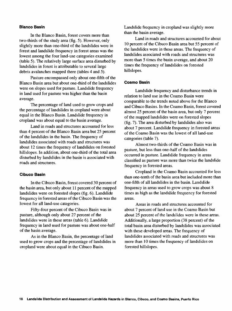
Cibuco Basin
In the Cibuco Basin, forest covered 30 percent of the basin area, but only about 11 percent of the mapped landslides were on forested slopes (fig. 6). Landslide frequency in forested areas of the Cibuco Basin was the lowest for all land-use categories.
Fifty-four percent of the Cibuco Basin was in pasture, although only about 27 percent of the landslides were in these areas (table 6). Landslide frequency in land used for pasture was about one-half of the basin average.
As in the Blanco Basin, the percentage of land used to grow crops and the percentage of landslides in cropland were about equal in the Cibuco Basin.
Landslide frequency in cropland was slightly more than the basin average.
Land in roads and structures accounted for about 10 percent of the Cibuco Basin area but 55 percent of the landslides were in these areas. The frequency of landslides associated with roads and structures was more than 5 times the basin average, and about 20 times the frequency of landslides on forested hillslopes.
Coamo Basin
Landslide frequency and disturbance trends in relation to land use in the Coamo Basin were comparable to the trends noted above for the Blanco and Cibuco Basins. In the Coamo Basin, forest covered almost 25 percent of the basin area, but only 7 percent of the mapped landslides were on forested slopes (fig. 7). The area disturbed by landslides also was about 7 percent. Landslide frequency in forested areas of the Coamo Basin was the lowest of all land-use categories (table 7).
Almost two-thirds of the Coamo Basin was in pasture, but less than one-half of the landslides occurred in pasture. Landslide frequency in areas classified as pasture was more than twice the landslide frequency in forested areas.
Cropland in the Coamo Basin accounted for less than one-tenth of the basin area but included more than one-fifth of all landslides in the basin. Landslide frequency in areas used to grow crops was about 8 times as high as the landslide frequency for forested areas.
Areas in roads and structures accounted for about 7 percent of land use in the Coamo Basin but about 25 percent of the landslides were in these areas. Additionally, a large proportion (38 percent) of the total basin area disturbed by landslides was associated with these developed areas. The frequency of landslides associated with roads and structures was more than 10 times the frequency of landslides on forested hillslopes.
18 Landslide Distribution and Assessment of Landslide Hazards in Blanco, Cibuco, and Coamo Basins, Puerto Rico
66°50' 66°45'
Base from U.S.Geological Survey digital data, 1:20,000 scale. 1989 Polyconic projection, State Plane Coordinate System
01234 KILOMETERSi___i___i___i___i_i i
4 MILES
EXPLANATION| | AGRICULTURAL LAND USE
| | LAND IN FOREST
URBAN LAND USE
LANDSLIDE LOCATION
Figure 5. Landslide locations, highways, and generalized land-use characteristics in the Blanco Basin, Puerto Rico.
Geographic and Geologic Attributes of Landslide Distribution 19
66°25 66°20'
18°05'
Base from U.S.Geological Survey digital data, 1:20,000 scale, 1989 Polyconic projection, State Plane Coordinate System
0123 4 KILOMETERSi___i___i___i ] \0 1 4 MILES
EXPLANATION| | AGRICULTURAL LAND USE
| | LAND IN FOREST
URBAN LAND USE
LANDSLIDE LOCATION
Figure 6. Landslide locations, highways, and generalized land-use characteristics in the Cibuco Basin, Puerto Rico.
20 Landslide Distribution and Assessment of Landslide Hazards in Blanco, Cibuco, and Coamo Basins, Puerto Rico
66°30' 66°20'
18 00'Base from U.S.Geological Survey digital data, 1:20,000 scale, 1989 Polyconic projection. State Plane Coordinate System
0123 4 KILOMETERSI___i___i___|___i________
4 MILES
EXPLANATION| | AGRICULTURAL LAND USE
| | LAND IN FOREST
URBAN LAND USE
LANDSLIDE LOCATION
Figure 7. Landslide locations, highways, and generalized land-use characteristics in the Coamo Basin, Puerto Rico.
Geographic and Geologic Attributes of Landslide Distribution 21
Topography
GIS software was used to determine the frequency of landslides in relation to hillslope angle, aspect, and elevation. The discussion below, as well as for the soil and geology sections, describes trends for only those landslides not associated with roads or other structures. Road and structure-associated landslides were omitted because, as noted above, human modification can alter hillslope stability and obscure trends that relate topography to landslide occurrence. For example, the relation between elevation and landslide frequency in a basin might be distorted if that basin had a number of landslides associated with a road constructed at a constant elevation.
Blanco Basin
Hillslope angle is an essential component of hillslope stability analysis. As hillslope angle increases, shear stress in soil, saprolite, or other unconsolidated material generally increases as well (Huang, 1983). However, steep natural slopes can be the result of outcropping bedrock that may sustain relatively stable slopes in spite of high gradient. In the Blanco Basin, most landslides occurred on slopes that had slope angles from 8° to 18° with the highest percentage occurring on slopes with angles from 12° to 15° (table 8; fig. 8). The frequency of landslides was greatest on hillslopes with angles ranging from 16° to 21°, and lowest on hillslopes with angles of less than 11° and greater than 30°. Gentle hillslopes are expected to have low landslide frequencies because of generally lower shear stresses associated with low gradients. The low landslide frequency on steep hillslopes is likely a consequence of bedrock control. Although this was not verified with the GIS analyses, it was a common field observation in the three study basins.
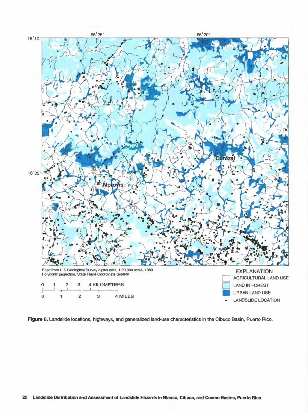
About 46 percent of the Blanco Basin had land surface elevations from mean sea level and 200 m above mean sea level, but only 26 percent of the landslides in the basin occur in this elevation range (table 9). Landslide frequency was highest at elevations from 300 to 500 m and generally decreased above or below that range. Several large debris avalanches associated with a 1970 tropical depression were mapped from an elevation of 600 to 700 m above sea level and contribute to the anomalously large area disturbed by landsliding in that range.
Mean-monthly soil moisture generally is greater at higher elevations in part because air and soil
temperatures generally decrease by 0.6°C for each 100 m increase in elevation (Van Wambeke, 1992). Additionally, evapotranspiration losses are lower and average cloud cover is greater at higher elevations in the central mountains of Puerto Rico (Odum and others, 1970). The generally wetter soil conditions in the basin uplands may mean that not much additional soil water is required to increase soil pore pressure sufficiently to trigger landslides, at least in hillslopes in unconsolidated material (Larsen and Simon, 1993). However, the Blanco Basin south- to southwest-facing hillslope orientation complicates simple orographic controls on rainfall distribution, resulting in uneven patterns of landslide frequency in relation to elevation in this basin. An additional complication for the Blanco Basin, as well as for the Cibuco and Coamo Basins, is the covariation of elevation and slope angle: as elevation increases, so generally does hillslope angle.
Hillslope aspect appears to be a factor governing landslide frequency in Puerto Rico. The percentage of landslides in the Blanco Basin was highest on northeast- and east-facing slopes (table 10). The percentage of landslides was lowest on those slopes facing to the southwest, west, and northwest. On average, landslide frequency and percentage of landslide area followed the same patterns as the distribution of landslide percentage.
Given the low latitude of the tropics, the north or south aspect of hillslopes does not cause the large differences in soil temperature that occur in temperate regions (Van Wambeke, 1992). Instead, diurnal patterns of afternoon cloudiness as well as prevailing wind direction may be more important in controlling soil moisture. Rainfall is delivered much of the year by trade winds that are dominantly from the east and north east (fig. 2). This regional pattern results in regional rainshadows across the Puerto Rico and can be observed on a local scale between adjacent drainage basins. Those drainage basins facing towards the trade winds frequently show greater runoff than those facing the opposite direction (Curtis and others, 1990). Finally, a significant part of annual moisture input in tropical montane cloud forests (the highest elevations in the eastern mountains of Puerto Rico) is delivered by condensation and direct contact of cloud droplets (Bruijnzeel and Proctor, 1993). This input of water has been termed 'horizontal precipitation1 and is conveyed by clouds moving with the trade winds. These factors may explain the higher landslide frequency noted on hillslopes that face prevailing winds in the study basins.
22 Landslide Distribution and Assessment of Landslide Hazards in Blanco, Cibuco, and Coamo Basins, Puerto Rico
66°50' 66°45'
18°20'
Base from U.S.Geological Survey digital data, 1:20,000 scale, 1989 Polyconic projection, State Plane Coordinate System
0123 4 KILOMETERS
EXPLANATION
LANDSLIDE LOCATIONS
0123 4 MILESCONTOUR INTERVAL 100 METERS
NATIONAL GEODETIC VERTICAL DATUM OF 1929
Figure 8. Landslide locations, rivers, canals, and generalized topography in Blanco Basin, Puerto Rico.
Geographic and Geologic Attributes of Landslide Distribution 23
Table 8. Hillslope angle and non-road or structure associated landslides in the Blanco Basin, Puerto Rico[Because of rounding, some columns may appear to have incorrect sums or averages, km2, square kilometer; m2, square meter; mVkm2, square meter per square kilometer]
Hillslope angle
(degrees)
0-34-7
8-1112-1516-1819-2122-2526-29
>30Total ........
Area F (km2)
4239515631241897
276
'ercentage of area
15141920119732
Number of landslides
341482743302201791135937
1,394
Percentage o landslides
21120241613
843
, Lendslide f eree
(m2)
3,58033,90065,520
103,09058,33049,86048,91030,06067,370
460,630
Percentage of landslide
area
17
14221311117
15
Landslide area (irrVkm2)
90870
1,2801,8501,8602,1202,7203,500
10,360'1,670
Number of landslides
per km2
145678676'5
'Average
Table 9. Hillslope elevation and non-road or structure associated landslides in the Blanco Basin, Puerto Rico[Because of rounding, some columns may appear to have incorrect sums or averages, km2, square kilometer, m2, square meter; m2/km2, square meter per square kilometer]
Table 10. Hillslope aspect and non-road or structure associated landslides in the Blanco Basin, Puerto Rico[Because of rounding, some columns may appear to have incorrect sums or averages, km2, square kilometer, m2, square meter; m2/km2, square meter per square kilometer]
Hillslope espect
North ...................Northeast.............East .....................Southeast.............South ...................Southwest.. ......... .West ....................Northwest............Flat, no aspect.....
Total..............
Area F (km2)
3736293439382927
8 276
'ercentage of area
1413111214141010
3
Number of landslides
154316218163204145112820
1,394
Percentage o landslides
112316121510
860
Landslide area (m2)
44,89091,95071,78037,73063,76049,08058,01043,430
0 460,630
Percentage of landslide
area
102016
814111390
Landslide area
(m2/km2)
1,2002,5902,4401,1101,6401,3102,0201,600
0 '1,670
Number of landslides
per km2
497554430 '5
'Average.
24 Landslide Distribution and Assessment of Landslide Hazards In Blanco, Cibuco, and Coamo Basins, Puerto Rico
However, a single storm can have a significant impact on where landslides may occur in relation to aspect. Hurricane Hugo provides an example of the critical role that slope aspect plays during the passage of tropical storms in which wind-driven rain is unidirectional. During the passage of this hurricane in 1989, more than 400 landslides were triggered by the high intensity rainfall associated with it. The occurrence of landslides was greatest on hillslopes that faced generally to the north, the direction from which Hurricane Hugo winds were dominant in eastern Puerto Rico (Scatena and Larsen, 1991).
Cibuco Basin
Cibuco Basin hillslopes are not as steep as those in the Blanco Basin. More than 70 percent of the basin surface area has hillslopes of 11 ° or less (table 11). Slightly more than one-half the landslides in the Cibuco basin were mapped on these hillslopes and landslide frequency was at or below the basin average. However, on hillslopes of 12° or greater, landslide frequency was above average in each category, with the highest frequency on hillslopes from 19° to 25° (fig. 9).
Hillslopes in the Cibuco Basin with land-surface elevations less than 300 m constitute about three- fourths of the basin area but account for less than one- third of the landslides (table 12). Landslide frequency in the Cibuco Basin increased with each elevation category to a maximum of 8.4 landslides per km2 on hillslopes with elevations greater than 500 m. This steady rise in landslide frequency with increasing elevation is presumably attributable to the greater mean annual rainfall recorded at higher elevations throughout Puerto Rico. The orientation of the Cibuco Basin should yield the simplest pattern of orographically controlled rainfall distribution among the three study areas as it is the only north-facing basin. As noted above, the Blanco and Coamo Basins, although wetter in the uplands, are likely to have more complexity in mean annual rainfall distribution patterns because they face away from prevailing winds. Possible evidence of this complexity is the uneven relation between landslide frequency and elevation in the Blanco and Coamo Basins.
Landslides were most abundant on northeast- and east-facing hillslopes in the Cibuco Basin, showing the same pattern as in the Blanco Basin (table 13). The frequency of landslides was lowest on north-,
northwest-, and west-facing hillslopes. A north-facing basin would not be expected to have many south-facing hillslopes. However, because area outside of the Cibuco Basin was included in the rectangular area mapped, south- and southwest-facing slopes in an adjacent basin were incorporated. These slopes occur along the deeply incised Manati River and account for the anomalously high landslide frequencies noted for those two aspect categories (fig. 9).
Coamo Basin
In the Coamo Basin, landslide frequency was lower than the basin average for hillslope angle categories of 11° or less (table 14). For slope angle categories greater than 12°, landslide frequency patterns were uneven, probably because of bedrock control, until angles in excess of 21° were reached (fig. 10). The highest landslide frequencies were on hillslopes where slope angle exceeded 25°.
Landslide frequencies in the Coamo Basin were lowest for land-surface elevations less than 400 m above mean sea leavel (table 15). Landslide frequencies were highest for hillslopes with elevations greater than 501 m above mean sea level. The exceptionally high landslide frequency on hillslopes of 100 m above sea level or less can be ascribed to the greater number of landslides mapped in alluvium along the Coamo River near the city of Coamo (fig. 10).
Hillslope aspect trends in the Coamo Basin were similar to those noted above for the Blanco and Cibuco Basins (table 16). Landslides were most abundant on east-facing hillslopes and least abundant on hillslopes facing northwest. Because the basin faces southwest, few slopes are northeast-facing. The high landslide frequency noted for southeast-facing slopes, however, is expected as those slopes are close to facing the prevailing wind direction. Landslide frequency trends in the south-west draining Coamo Basin could be expected to differ from the trends noted for the Cibuco Basin, which drains toward the north, and the Blanco Basin, which drains to the south and east. In spite of these differences in overall basin orientation, trade- wind-facing slopes in all three basins had the greatest proportion of landslides. This suggests that trade-wind- derived moisture may provide an important explanation for landslide location.
Geographic and Geologic Attributes of Landslide Distribution 25
Table 11. Hillslope angle and non-road or structure associated landslides in the Cibuco Basin, Puerto Rico[Because of rounding, some columns may appear to have incorrect sums or averages, km2, square kilometer; m2, square meter; mVkm2, square meter per square kilometer]
Hillslope angle
(degrees)
0-34-7
8-11
12-1516-1819-2122-2526-29
>30Total........
Area F (km2)
479972401812955
306
ercentage of area
1532231364322
Number of landslides
46116118875641311312
520
Percentage of landslides
9222317118632
. Landslide area (m2)
7,03016,63014,78012,6508,9206,6805,6901,6908,370
82,440
Percentage of landslide
area
920181511872
10
Landslide area
(rrrVkm2)
150170210320500570620310
1,820'270
Number of landslides per
km2
112233323'2
'Average.
Table 12. Hillslope elevation and non-road or structure associated landslides in the Cibuco Basin, Puerto Rico[Because of rounding, some columns may appear to have incorrect sums or averages, km2, square kilometer; m2, square meter; rrrYkm2, square meter per square kilometer]
Elevation (m)
0-100101-200201-300301-400401-500
>500Total ........
'Average.
Area Percentage (km2) of area
3514846273220
308
Table 13. Hillslope aspect
1148159
106
Number of landslides
111084068
131162520
Percentage of landslides
221
8132531
Landslide area (m2)
1,17014,7107,7707,670
21,60029,53082,450
and non-road or structure associated landslides in the[Because of rounding, some columns may appear to have incorrect sums or averages.square kilometer]
km2, square kilometer; m2, square meter; mVkm2. square meter per
Landslide area (m2)
6,85018,47014,29013,2705,1606,9709,0408.400
82,450
Percentage of landslide
area
822171668
1110
Landslide area
(m2/km2)
170410300440260270190180
'270
Number of landslides per
km2
12223221
'2
'Average.
26 Landslide Distribution and Assessment of Landslide Hazards in Blanco, Cibuco, and Coamo Basins, Puerto Rico
18°1066°25' 66°20'
18°05'
Base from U.S.Geological Survey digital data, 1:20,000 scale, 1989 Polyconic projection, State Plane Coordinate System
234 KILOMETERSi___i___i________
EXPLANATION
LANDSLIDE LOCATIONS
CAVE ENTRANCE
0 1 2 3 4 MILESCONTOUR INTERVAL 100 METERS
NATIONAL GEODETIC VERTICAL DATUM OF 1929
Figure 9. Landslide locations, rivers, canals, and generalized topography in Cibuco Basin, Puerto Rico.
Geographic and Geologic Attributes of Landslide Distribution 27
Table 14. Hillslope angle and non-road or structure associated landslides in the Coamo Basin, Puerto Rico[Because of rounding, some columns may appear to have incorrect sums or averages, km2, square kilometer; m2, square meter; mVkm2, square meter per square kilometer]
Hillslope angle
(degrees)
0-34-7
8-1112-1516-1819-2122-2526-29
>30Total ....
Area Percentage (km2) of area
41897354292220119
349
1225211586632
Number of landslides
881951251294053543250
766
Percentage of La ide .andsHdes H
1125161757747
14,41037,88022,61022,09019,7306,540
15,6504,120
11,060154,090
Percentage of landslide
area
9251514134
1037
Landslide area
(nWkm2)
350430310410670290780360
1,300'440
Number of landslides per
km2
222212336'2
'Average.
Table 15. Hillslope elevation and non-road or structure associated landslides in the Coamo Basin, Puerto Rico[Because of rounding, some columns may appear to have incorrect sums or averages, km2, square kilometer; m2, square meter; mVkm2, square meter per square kilometer]
Elevation (m)
0-100101-200201-300301-400401-500501-600601-700
>700Total....
Area Percentage (km2) of area
4772644027314925
353
1320181189
147
Number of landslides
128114795258
13913066
766
Percentage of La"*'ide
andslides Jm2)
17151078
18179
22,15021,95017,52021,74012,24024,72024,0109,760
154,090
Percentage of landslide
area
14
14
11
14
8
16
16
6
Landslide area
(nWkm2)
480300280540460800500400'440
Number of landslides per
km2
32112
533
'2
'Average
Table 16. Hillslope aspect and non-road or structure associated landslides in the Coamo Basin, Puerto Rico[Because of rounding, some columns may appear to have incorrect sums or averages, km2, square kilometer; m2, square meter; mVkm2, square meter per square kilometer]
Hillslope aspect
North..........Northeast ... East ............Southeast ... South..........Southwest .. West ...........Northwest ..
28 Landslide Distribution and Asseasment of Landslide Hazards in Blanco, Cibuco, and Coamo Basins, Puerto Rico
66 20'
18 00'Base from U.S.Geological Survey digital data, 1:20,000 scale, 1989 Polyconic projection. State Plane Coordinate System
EXPLANATION
LANDSLIDE LOCATIONS
2i
3 4 KILOMETERS_l___|________
01234 MILESCONTOUR INTERVAL 100 METERS
NATIONAL GEODETIC VERTICAL DATUM OF 1929
Figure 10. Landslide locations, rivers, canals, and generalized topography in Coamo Basin, Puerto Rico.
Geogrephic and Geologic Attributes of Landslide Distribution 29
Geology
According to Monroe (1979), landslides are relatively common in a variety of rock types in Puerto Rico. The results described in this section of the report support this observation and indicate that landslides are generally abundant in almost all the bedrock types discussed below. Detailed correlation of bedrock with landslide occurrence was not within the scope of this study. A large number of bedrock types exist in the study basins relative to the number of mapped landslides and, with one exception, the geologic maps digitized into the GIS lacked geotechnical data. However, using a GIS and geologic maps, landslide occurrence was related to generalized bedrock geology by combining similar geologic map units. Additionally, in the Coamo Basin, descriptions of the engineering geology of map units are available and are included below. As in the above section on topography, the discussion of geology and soils describes trends for only those landslides not associated with roads or other structures. Finally, Quaternary landslide deposits are one of the map units discussed below. This unit is in most cases comprised of massive deposits that are orders of magnitude more extensive than the historic landslides mapped in this study. As such, they represent a distinct population of mass-wasting phenomena that was not examined in this study.
Blanco Basin
Most (86 percent) of the Blanco Basin is classified into nine geologic map units listed in order of increasing surface area: Daguao Formation, Pitahaya Formation, Figuera Lava, Tabonuco Formation, Quartz diorite, Lomas Formation, Quaternary alluvium, Fajardo Formation, and the Hato Puerco Formation (table 17). Blanco Basin map units were simplified by grouping similar lithologies into six categories. In order of increasing geologic age, these categories are: Quaternary alluvium, Tertiary hydrothermally altered rock, Tertiary intrusive rock, Tertiary intrusive rock (other), Cretaceous breccia and lava, and Cretaceous tuffaceous siltstone and sandstone.
Quaternary alluvium consists of gravel, sand, silt, and clay in flood plains along streams. It mantles about 19 percent of the basin but, because it is flat lying, accounts for only 2 percent of the basin landslides. Most of these landslides were bank slumps along river channels.
The Tertiary intrusive rock map unit is a medium- to coarse-grained quartz-diorite also known as the Rio Blanco Stock, composed mainly of plagioclase, quartz, hornblende, and orthoclase (Seiders, 1971). Because intrusive rock is easily weathered in humid tropical environments (Ruxton and Berry, 1957) hillslope gradients in the area of the basin underlain by the Rio Blanco Stock are less steep than gradients in surrounding areas underlain by marine- deposited siltstone and sandstone. Hillslopes underlain by the Rio Blanco Stock are unremarkable in terms of landslide abundance. None the less, landslides in this rock type tend to disturb a surface area larger than the basin average. About 10 percent of Blanco Basin landslides were mapped in areas underlain by the Rio Blanco Stock, but 14 percent of the total area disturbed by landsliding was calculated for these landslides. Landslides in this lithology had the highest disturbance rate among the six map unit groups, 2,480 mVkm2 (table 17).
The Daguao Formation, Pitahaya Formation and Figuera Lava map units are Lower Cretaceous massive volcaniclastic breccia and lava with some pillow-lava structure present (M'Gonigle, 1978; Briggs and Aguilar-Cortes, 1980). These units underlie a small portion of the Blanco Basin and have a landslide frequency that is close to the basin average, indicating that these lithologies do not strongly influence landslide occurrence.
The four other principal map units can be combined into a single category of Cretaceous marine- deposited andesitic to basaltic thin- to massive-bedded tuffaceous siltstone and sandstone, interbedded with thick-bedded to massive breccia (Seiders, 1971; Briggs and Aguilar-Cortes, 1980). This category underlies 54 percent of the Blanco Basin, but accounts for 70 percent of the landslides. Bedding planes and dip slope bedding in rock are important factors controlling landslide probability in some areas of Puerto Rico (Jibson, 1989). However, although these four map units are bedded, no landslide scars observed in the field showed evidence of movement along bedrock bedding planes. Bedrock weathering is extensive in most of the Blanco Basin, so that many hillslopes are covered with as much as 5 to 10 m of saprolite and soil (Deere and Patton, 1971; Simon and others, 1990). This degree of weathering may reduce the geotechnical effects of the original rock structure and bedding planes. However, this group of map units underlies the Blanco Basin
30 Landslide Distribution and Assessment of Landslide Hazards in Blanco, Cibuco, and Coamo Basins, Puerto Rico
uplands where the steepest slopes and the greatest mean annual rainfall occur. These general topographic and moisture conditions may overwhelm or mask local geologic controls on landslide frequency.
Tertiary hydrothermally altered rock, Tertiary intrusive rock labeled "other," and the miscellaneous categories under Other consist of small exposures that comprise only 6 percent of the study area. The limited extent of these categories precludes useful interpretation of their bearing on landslide frequency.
Cibuco Basin
Nineteen geologic map units were associated with landslides in the Cibuco Basin. These map units were grouped into seven general categories (table 18). About one-half of the basin area is underlain by Tertiary sedimentary rock, ranging from undifferentiated chalk and marl with beds of hard finely crystalline limestone, fragmental, porous and cavernous limestone to sandy limestone with sandstone, silt, and clay, (Berryhill, Jr., 1965). In the Cibuco Basin, as well as in nearby basins with extensive limestone bedrock, large retrogressive landslides have occurred during the Holocene (Monroe, 1964). These landslides, some of which are still active, are mapped along river valleys with steep cliffs of 50 to more than 200 m in height, and are composed of massive limestone blocks resting on marl or clay. According to Monroe (1964), these limestone blocks move slowly down slopes of 5° to 12° during rainy seasons when the underlying clay and marl layers are saturated. One of the largest of these retrogressive landslides is located 3 km west of Corozal along the Rio Cibuco and consists of a complex of massive limestone blocks containing a total volume of 43 million m3 .
These large, slow-moving block slides are shown on geologic maps as Quaternary landslide deposits. They characterize a distinct magnitude and process of mass-wasting that was not examined in this study of historic small, shallow landslides. Hence, the 6 km2 of Cibuco Basin surface area affected by massive block slides is not included in the assessment of landslide frequency and magnitude discussed below.
With the exception of these types of slow- moving block failures, the incidence of landsliding in the regions of the Cibuco Basin underlain by limestone is extremely low. In this basin, soil is usually thin (less
than 1 m) on limestone slopes, limiting the amount of material available for sliding. Additionally, the high porosity of limestone in this humid environment generally precludes any significant increase in pore pressure during storms, because the rock is so well drained (Monroe, 1980). For example, the Aguada and Lares Limestones, together occupy 19 percent of the basin area, but account for only 1 percent of the basin landslides. Furthermore, although almost one-half of the Cibuco Basin is underlain by Tertiary limestone, sandstone, and siltstone, 13 percent of the landslides were mapped in these areas. Additionally, landslides on hillslopes underlain by Tertiary sedimentary rock were, on average, among the smallest in the basin, disturbing only 60 mVkm2 .
Tertiary intrusive rock is not extensive in the Cibuco Basin, however, as in the Blanco Basin, landslide disturbance per unit area was high on hillslopes in this lithology presumably for the same reasons noted for the Blanco Basin.
Cretaceous to Tertiary breccias and tuffs include massive volcanic breccia and breccia conglomerate with fine and coarse tuff layers as well as medium- to thin-bedded tuffs and volcanic sandstone and siltstone with interbeds of shale and conglomerate (Nelson, 1967). These map units occupy a small area of the basin and a roughly equivalent proportion of the basin landslides.
Andesitic to Basaltic lava flows in the Cibuco Basin are described as Cretaceous age, marine- deposited, commonly pillowed, with tuff and volcanic breccia, conglomerate, sandstone, and siltstone (Nelson, 1967). These map units underlie hillslopes with a disproportionately high number of landslides (table 18). As in the Blanco Basin, the Cibuco Basin map units with the greatest abundance of landslides per unit area co-vary with elevation. They are in the uplands of the Cibuco Basin where the steepest hillslopes and the highest mean annual rainfall occur.
Berryhill, Jr. (1965) notes that deep residual material (saprolite) is not extensive in much of the Cibuco Basin because of rapid soil erosion caused by raindrop impact. In the southern part of the Cibuco Basin, however, saprolite locally ranges in thickness from 2 to 4 m and is best developed where it overlies intrusive rock and lava map units such as the Avispa, Perchas, and Magueyes Formations (Berryhill, Jr., 1965). Because most landslides mapped in this study
Geographic and Geologic Attributes of Landslide Distribution 31
Table 17. Bedrock geology and non-road or structure associated landslides in the Blanco Basin, Puerto Rico[Because of founding, some columns may appear to have incorrect sums or averages, km2 , square kilometer; m2, square meter; m2/km2, square meter per square kilometer]
Bedrock types
Quaternary alluvium ......................................Tertiary hydrothermally altered rock .............Tertiary intrusive rock................ ....................
Area (km2)
........ 51
........ 6
........ 25
Percent age
of area
1829
Number of land slides
2915
144
Percent age of land slides
21
10
Land slide area (m2)
5,2501,780
63,210
Percent age of land slide area
10
14
Land slide area
(m2/km2)
100290
2.480
Number of
land slides
per km2
126
Quartz diorite (Rio Blanco Stock) Tertiary intrusive rock (other).............................
Diorite, Quartz-diorite-granodiorite, Quartz diorite-Punta Guayanes, Granodiorite-quartz diorite-San Lorenzo
Cretaceous breccia and lava...............................Daguao Formation, Figuera lava, Pitahaya Formation
'Other includes Augite andesite porphyry, beach and swamp deposits, Figuera and Daguao Formations- Rio Abajo Formation.
2 Average.
-interbedded, Quaternary landslide deposits, and
Table 18. Bedrock geology and non-road or structure associated landslides in the Cibuco Basin, Puerto Rico[Because of rounding, some columns may appear to have incorrect sums or averages, km2, square kilometer; m2, square meter; mVkm2, square meter per square kilometer]
Bedrock categoriesArea (km2)
Percent age
of area
Number of land slides
Percent age of land slides
Land slide area (m2)
Percent age of land slide area
Land slide area
(m2/km2)
Number of
land slides
per km2
Tertiary sedimentary rock....................................... 142Aguada Limestone, Aymamdn Limestone, Cibao Formation, Lares Limestone, Mucarabones Sand, San Sebastian Formation.
Tertiary intrusive rock............................................Granodiorite- Morovis and Ciales stocks, Diorite
Cretaceous to Tertiary breccias and tuffs ...............Cibuco Formation, Los Negros Formation, Mani- caboa Formation, Ortiz Formation
Cretaceous andesitic to basaltic lava flows ............Avispa Formation, Magueyes Formation, Perchas Formation, Santa Olaya Lava
'Other includes Akali syenite, Almirante Sur Sand lentil, Blanket sand deposit, Carreras Siltstone, Corozal Limestone, Horneblende quartz-diorite, Palmarejo Formation, Quaternary landslide deposits, Quaternary alluvium, and Quartz diorite-granodiorite.
2 Average.
32 Landslide Distribution and Assessment of Landslide Hazards in Blanco, Cibuco, and Coamo Basins, Puerto Rico
occur in soil and saprolite, the greater thickness of saprolite noted to overlie these map units may contribute to the abundance of landslides there.
The miscellaneous categories labeled Other consists of a variety of small exposures that comprise only 9 percent of the study area. The limited extent of these exposures precludes meaningful discussion of their bearing on landslide frequency.
Coamo Basin
Much of the Coamo Basin (79 percent) is underlain by five Cretaceous tuffaceous sandstone and siltstone map units: the Coamo Formation, Maravillas Formation, the Cariblanco Formation, the Cotorra Tuff, and the Robles Formation (table 19) (Briggs and Gelabert, 1962; Glover and Mattson, 1973). These map units consist of marine-deposited tuff, tuffaceous breccia, tuffaceous conglomerate, and tuffaceous sandstone, which interfinger with mudstone, limestone, and wacke conglomerate. The most extensive bedrock type included in this grouping is the Robles Formation, a sequence of andesitic tuffs, tuffaceous mudstone, radiolarian mudstone, pillow lavas, and minor amounts of limestone, volcanic breccia, and conglomerate. Briggs and Gelabert (1962) provide some estimates of geotechnical characteristics noting that these five formations generally have only fair to good slope stability, except where slopes are steep or where strata
dip approximately parallel to the land surface where slope stability is worse. This grouping of map units underlies most of the basin hillslopes and contains most of the landslides making it difficult to determine if these map units exercise significant control on landslide occurrence.
The Cretaceous Malo Breccia and Torrecilla Breccia map units are both described as Cretaceous andesitic and basaltic breccias interfingered with tuffaceous sandstone (Briggs, 1971). Together they occupy a small part of the northwest corner of the Coamo Basin where hillslopes are steep and mean annual rainfall is high. About 13 percent of the basin landslides were in these map units even though they occupied only about 6 percent of the basin surface area (table 19). Steep slope and wet conditions may be the principal reasons why landslides are more abundant on hillslopes underlain by the Breccia map units. According to Briggs (1971) slope stability for these two map units is fair to good.
Quaternary alluvium, deposited on low-gradient slopes is nonetheless unconsolidated, which increases susceptibility to failure (Briggs and Gelabert, 1962). Many of the landslides associated with alluvium were mapped near the city of Coamo where human modification of hillslopes and riverbanks is great. Land use may therefore be a contributing factor for the relative abundance of landslides there.
Table 19. Bedrock geology and non-road or structure associated landslides in the Coamo Basin, Puerto Rico[Because of founding, some columns may appear to have incorrect sums or averages, km2 , square kilometer; m2, square meter; mVkm2, square meter per square kilometer]
Bedrock types
. . Percent-_ i, . Percent- Land- .. Percent- Number . ... age ofArea .. . age of slide , .,. 2x age of land- , . land-(knr) . 3 ... land- area ...v ' of area slides ... . ,. slideslides (m2)
Other 1 .................................................................Total.............................................................
24
15
19
264
29
351
7
4
6
79
94
35
102
531
4
766
12
5
13
69
19,950
5,490
17,360
108,820
13
4
11
71
1 2,470
154,090
840
370
910
410
902440
'Other includes Achiote Conglomerate, Cotuf Limestone, Cuevas Formation, Formation B basalt and chert, Formation C basalt and chert, Fault breccia, Los Puertos Formation, Quaternary landslide deposits, Rio Descalabrado Formation, and Raspaldo Formation.
2 Average.
Geographic and Geologic Attributes of Landslide Distribution 33
The Tertiary Hornblende quartz diorite and Diorite map units are described as medium to coarse intrusive rock consisting of plagioclase and hornblende with minor amounts of quartz (Briggs and Gelabert, 1962). Briggs and Gelabert (1962) state that slope stability is good, even in areas of moderately steep slopes. Landslides were not overly abundant on hillslopes in these two map units, supporting their observations.
The miscellaneous categories labeled Other consist of a variety of small exposures that comprise only 4 percent of the study area. The limited extent of these exposures precludes meaningful discussion of their bearing on landslide frequency.
In summary, bedrock geology in those areas of the three basins where most landslides were mapped did not seem to play a definitive role in landslide frequency or magnitude. Where landslides were overly abundant in a particular map unit or grouping of map units, the coincidence of steep slopes and high mean annual rainfall may be as important, or more important than the bedrock geology. The principal exception is seen in the Cibuco Basin where, other than in the case of rare, slow-moving block slides, Tertiary limestone seems to have a low susceptibility to landsliding.
None-the-less, some of the inconsistencies noted above in the discussion of topographic variables probably are attributable to local geologic controls on landslide frequency.
Soil
By comparing the number of mapped landslides in a given soil with the percentage of basin area having that soil, some insight into influence of soil on the magnitude and frequency of landslides may be inferred. These insights, however, may be limited by the SCS organization of soils using the U.S. soil taxonomy (Soil Survey Staff, 1992). Soil taxonomy is based on characteristics that are most important for agricultural considerations. In addition, soil taxonomic descriptions are based, for the most part, on the rooting zone and top meter of soil, which is shallower than most of the landslides examined in this study.
Blanco Basin
Most landslides in the Blanco Basin were mapped on hillslopes classified into five soil series located on steep side slopes and ridgetops: the Caguabo, Guayabota, Humatas, Los Guineos, and
Table 20. Soil series and non-road or structure associated landslides in the Blanco Basin, Puerto Rico[Because of rounding, some columns may appear to have incorrect sums or averages, km2, square kilometer; m2 , square meter; mVkm2 , square meter per square kilometer]
'Includes Aguadilla, Candalero, Corcega, Daguao, Fortuna, Junquitos, Lirios, Mabi, Maunabo, Pinones, Reilly, Toa, Via, Yunes, and areas designated as soil not surveyed.
2Average.
34 Landslide Distribution and Assessment of Landslide Hazards in Blanco, Cibuco, and Coamo Basins, Puerto Rico
Utuado (table 20). Landslides were particularly numerous on hillslopes in Los Guineos and Utuado soils. These upland soils receive the highest mean annual rainfall of any in the Blanco Basin (between 1,900 and 4,700 mm) and occur on the steepest slopes in the basin (Boccheciamp, 1977). They are mapped in the same areas as the Cretaceous tuffaceous siltstone and sandstone map units discussed previously associated with the greatest proportion of Blanco Basin landslides.
Simplification of soil series into soil subgroups indicates that landslides in the Blanco Basin are most numerous on hillslopes in Eutropepts, Humitropepts, Tropaquepts, and Tropohumults (table 21). These
subgroups include the soil series noted above in which landslides were most abundant. These soil subgroups generally are associated with cooler climate (relative to the tropics) and year-round rainfall (Van Wambeke, 1992) characteristic of higher parts of the basin.
Among the soil orders, Ultisols and Inceptisols account for most of the soil cover in the Blanco Basin (table 22). Landslides are numerous on hillslopes in these two soil orders and their landslide frequency is the highest in the basin. These two soil orders show essentially the same trends described above for soil series and subgroups as, for the most part, these same soil series and subgroups are represented by the Ultisols and Inceptisols (fig. 11). Areas classified as
Table 21. Soil subgroup and non-road or structure associated landslides in the Blanco Basin, Puerto Rico
[Because of rounding, some columns may appear to have incorrect sums or averages, km2, square kilometer; m2, square meter; rrrVkm2. square meter per square kilometer]
Includes Tropopsamments, Fluvaquents, Tropudalfs, Tropudults, Tropaqualfs, and areas designated as "soil not surveyed." 2Average.
Table 22. Soil order and non-road or structure associated landslides in the Blanco Basin, Puerto Rico
[Because of rounding, some columns may appear to have incorrect sums or averages, km2, square kilometer; m2, square meter; nvVkm2, square meter per square kilometer]
Geographic and Geologic Attributes of Landslide Distribution 35
66°50' 66°45'
18°20'
ST r~7i\L - i,- *>" "-5vS-w._J - Mf^ ^ C. 4 <.
Base from U.S.Geological Survey digital data, 1:20,000 scale, 1989 Polyconic projection, State Plane Coordinate System
0123 4 KILOMETERSI I , I I. r-
3 4 MILES
EXPLANATION
| | INCEPTISOLS
S ALFISOLS, ENTISOLS, AND MOLLISOLS
ULTISOLS
LANDSLIDE LOCATIONS
Figure 11. Landslide locations, rivers, canals, and generalized soil orders in the Blanco Basin, Puerto Rico.
36 Landslide Distribution and Assessment of Landslide Hazards in Blanco, Cibuco, and Coamo Basins, Puerto Rico
Rockland also have a high landslide frequency. The Rockland classification encompasses very steep slopes where soil development is poor. Alfisols, Entisols, and Mollisols together comprise most of the remaining area of the Blanco Basin, primarily in flat-lying areas, and are associated with less than 1 percent of the landslides occurring in this basin.
Cibuco Basin
Most (72 percent) landslides in the Cibuco Basin were mapped on upland hillslopes classified into the Consumo, Humatas, and Mucara soil series (table 23). As in the Blanco Basin, these soil series generally occur on steep side slopes and ridge tops in areas where mean annual rainfall exceeds 1,900 mm (Boccheciamp, 1977). In addition, these soil series occur in the same
areas as the Cretaceous to Tertiary breccias, tuffs, and lava map units, noted above to account for most of the basin landslides.
Simplification of the Consumo, Humatas, and Mucara soil series into soil subgroups provides no reduction in categories as they are Tropodults, Tropohumults, and Eutropepts, respectively (table 24). The additional simplification into soil orders groups the Tropodults and Tropohumults into Ultisols and the Eutropepts into Inceptisols (table 25). As is the case in the_ Blanco Basin, these soil subgroups are all generally associated with cooler temperature and year-round rainfall characteristic of basin uplands (Van Wambeke, 1992). Also as in the Blanco Basin, Alfisols, Entisols, and Mollisols together comprise most of the remaining area of the Cibuco Basin, mainly in flat-lying areas, and are associated with few (about 8 percent) of the landslides occurring in this basin (fig. 12).
Table 23. Soil series and non-road or structure associated landslides in the Cibuco Basin, Puerto Rico[Because of rounding, some columns may appear to have incorrect sums or averages, km2, square kilometer; m2, square meter; m2/km2, square meter per square kilometer]
'Includes Aceitunas, Aibonito, Algarrobo, Almirante, Alonso, Baja, Bajura, Bayamon, Corozal, Espinosa, Estacion, Guerrero, Ingenio, Jobos, Juncal, Lares, Maricao, Matanzas, Mayagiiez. Morado. Reilly, Rio Arriba, San Germim. Santa Clara, San Sebastian, Seller, Toa, Torres, Vega, Vega Alta, Vivi, Volodora, and areas designated as "soil not surveyed."
2Average.
Geographic and Geologic Attributes of Landslide Distribution 37
Table 24. Soil subgroup and non-road or structure associated landslides in the Cibuco Basin, Puerto Rico[Because of rounding, some columns may appear to have incorrect sums or averages, km2, square kilometer; m2, square meter; irrVkm2, square meter per square kilometer]
'Includes Eutrorthox, Haplohumod, Hapludoll, Haplorthox, Palehumult, Paleudalf, Rhodudult, Tropaqualf, Ustorthent and areas designated as soil not surveyed.
2Average.
Table 25. Soil order and non-road or structure associated landslides in the Cibuco Basin, Puerto Rico[Because of rounding, some columns may appear to have incorrect sums or averages, km2, square kilometer; m2, square meter; mVkm2, square meter per square kilometer]
'Includes Spodosols, Oxisols, and areas designated as soil not surveyed. 2Average.
38 Landslide Distribution and Assessment of Landslide Hazards in Blanco, Cibuco, and Coamo Basins, Puerto Rico
66°25' 66°20'
YlMorovis (r x '" \rV .. :18 05' J
Base from U.S.Geological Survey digital data, 1:20,000 scale, 1989 Polyconic projection, State Plane Coordinate System
01234 KILOMETERSi___i i___i i _____I I T I I
01234 MILES
EXPLANATION
| | UNCLASSIFIED AREAS
| | INCEPTISOLS
I ALFISOLS, ENTISOLS, AND MOLLISOLS
ULTISOLS
LANDSLIDE LOCATIONS
Figure 12. Landslide locations, rivers, canals, and generalized soil orders in the Cibuco Basin, Puerto Rico.
Geographic and Geologic Attributes of Landslide Distribution 39
Coamo Basin
The Caguabo, Callabo, and Mucara soil series are most common in the Coamo Basin and hillslopes with these soil classifications account for most landslides (table 26). Hillslopes in Callabo soils, however, have relatively few landslides present. This may be explained by the lower slope gradient (as low as 7°) where Callabo soils are mapped (Boccheciamp, 1977).
Ustropepts and Eutropepts (Inceptisols) are the soil subgroups underlying most of the basin (fig. 13; tables 27, 28). Eutropepts (which include the Mucara and Caguabo soils series) are on hillslopes where landsliding is most common. Ustropepts (which include the Callabo, Jacana, Llanos, and Descalabrado soil series) are relatively uncommon. Areas underlain
by Tropudults (Ultisols), Haplustolls (Mollisols) and Haplustalfs (Alfisols) cover only a small percentage of the basin and have an equally low percentage of the landslides in the basin.
In summary, soils, primarily Ultisols and Inceptisols mapped on steep slide slopes and ridgetops in the upland and wetter parts of the three study basins have generally higher landslide frequencies than those soils mapped on flat-lying or low gradient hillslopes. These trends show the difficulty in separating soil classifications (as well as geologic map units) from topographic characteristics and mean annual rainfall when attempting to determine the major controls on landslide frequency. Topography and rainfall characteristics may, therefore, provide most of the information needed to estimate where landslides are likely to be numerous.
Table 26. Soil series and non-road or structure associated landslides in the Coamo Basin, Puerto Rico
[Because of rounding, some columns may appear to have incorrect sums or averages, km2, square kilometer; m2, square meter; m2/km2, square meter per square kilometer]
'Includes Aceitunas, Amelia, Unclassified, Coamo, Consume, Daguey, Cobbly alluvium, Los Guineos, Mabi, Reilly, Rio Piedras, Wet alluvium. 2Average.
40 Landslide Distribution and Assessment of Landslide Hazards in Blanco, Cibuco, and Coamo Basins, Puerto Rico
Table 27. Soil subgroup and non-road or structure associated landslides in the Coamo Basin, Puerto Rico[Because of rounding, some columns may appear to have incorrect sums or averages, km2, square kilometer; m2, square meter; m2/km2, square meter per square kilometer]
Table 28. Soil order and non-road or structure associated landslides in the Coamo Basin, Puerto Rico[Because of rounding, some columns may appear to have incorrect sums or averages, km2, square kilometer; m2, square meter; m2/km2, square meter per square kilometer]
Soil order
Alfisol........................................Mollisol. ....................................Ultisol........................................Unclassified and Rockland........
Total ....................................
Area (km2)
14202835
253349
Percent age
of area
468
1072
Number of landslides
26469719
578766
Percent age of
landslides
36
132
75
Landslide area (m2)
3,9708,530
18,8603,500
119,240154,100
Percent age of
landslide area
36
122
77
Landslide area
(m2/km2)
280440680100470'440
Number of landslides
per km2
22412
'2
'Average.
Geographic and Geologic Attributes of Landslide Distribution 41
66°30' 66"20'
18°10
18 00
Base from U.S.Geological Survey digital data, 1:20,000 scale, 1989 Polyconic projection, State Plane Coordinate System
01234 KILOMETERSI___i i___i i _____ I l 1 i i0123 4 MILES
EXPLANATION
UNCLASSIFIED AREAS
INCEPTISOLS
ALFISOLS, ENTISOLS, AND MOLLISOLS
ULTISOLS
LANDSLIDE LOCATIONS
Figure 13. Landslide locations, rivers, canals, and generalized soil orders in the Coamo Basin, Puerto Rico.
42 Landslide Distribution and Assessment of Landslide Hazards in Blanco, Cibuco, and Coamo Basins, Puerto Rico
ASSESSMENT OF RAINFALL CHARACTERISTICS AND LANDSLIDE HAZARDS
Forty-one storms triggered landslides in Puerto Rico from 1960 to 1990. More than one-half of these landslide-triggering storms were tropical disturbances (hurricanes, tropical storms, tropical depressions, tropical waves, and troughs) (table 1). The remainder were localized heavy rains and convective thunderstorms (27 percent) and storms associated with winter cold fronts (20 percent). Twenty-five out of the 41 storms that triggered landslides occurred during the hurricane season (June through November) (fig. 14). Most of these 25 storms occurred during the peak months of the hurricane season (August through October). A relatively large number of landslide- triggering storms also occurred in May when the Inter- Tropical Convergence Zone begins to move north, enhancing precipitation in the Caribbean Sea region (Granger, 1985).
Rainfall Accumulation-Duration Relation
Using data for 256 storms, a relation between rainfall accumulation-duration and landsliding has been established (fig. 15). The relation, described by a line fitted by inspection to the lower boundary of those points representing landslide-triggering storms, is expressed as
A = 91.46D082
where A is rainfall accumulation in millimeters per hour, and D is duration in hours. This line, fitted to the lower boundary of data points reflects the approximate minimal rainfall conditions necessary to trigger landsliding. This rainfall relation is defined for storms having durations of between 2 and 312 h, and rainfall accumulation of between 102 and 976 mm. The relation indicates that for storms of short duration (10 h or less), rainfall accumulation greater than 100 mm is required to trigger landslides. The exponent indicates a slope of near one, suggesting that average rainfall accumulation of about 200 mm seems to be sufficient to cause landsliding for storm durations of approximately 10 to 100 h.
There is a relation between landslide characteris tics and the position of the landslide-triggering storm
on the boundary line. Storms near the short-duration end of the threshold line may trigger mostly shallow landslides by generating excess pore pressure in shal low soil zones. Such landslides are typical of those associated with Hurricane Hugo which occurred in 1989 (table 1; fig. 15). The landslides triggered by Hur ricane Hugo averaged 1.5 m in thickness and had a median surface area of 160 m2 (Scatena and Larsen, 1991; Larsen and Torres-Sanchez, 1992). These land slides, which primarily were shallow soil slips and debris flows, had failure planes in saprolite or at the soil-saprolite boundary. In contrast, storms near the long-duration end of the line triggered the largest and deepest landslides in the central mountains. Storms that occurred on October 4, 1970 (unnamed tropical depres sion), August 29, 1979 (Hurricane David), and Sep tember 4, 1979 (Tropical Storm Frederick) (table 1; fig. 15) are associated with debris avalanches with thicknesses of up to 10m and surface areas ranging from 20,000 to 40,000 m2 (Dames and Moore, 1980). Failure planes occurred at the contact between the saprolite and the underlying unweathered bedrock (Simon and others, 1990). These large, deep-seated debris avalanches are attributed to prolonged storms that allow gradual infiltration of water, and apparently result in excess pore pressure at depth and increased unit weight of soil and saprolite.
i!U
18
16
14
LU 12 O
lioLU 0E flLU ° Q.
6
4
2
n I
s13 M
**/
TO
EA
HL
11
RMS
N-AIV
RRIC
1
THA
JNU/S
;ANI
TT
LF
.S
1
RIGG
3AINF
EASC
1,1
ERED
ALL
-
.ANDSLIDES
,!-MAR. APR. MAY JUNE JULY AUG. SEPT. OCT. NOV. DEC. JAN. FEB.
Figure 14. Percentage of landslide-triggering storms and percentage of mean-annual rainfall in the central mountains of Puerto Rico, by month.
Assessment of Rainfall Characteristics and Landslide Hazards 43
1,000
: STORMS THAT TRIGGERED LANDSLIDES David ' Frederick g
C/) DC LJJ
LUlioo
z
O
O 10 O
Unnamed
STORMS THAT DID NOT TRIGGER LANDSLIDESi__i i
0.1 10 DURATION, IN HOURS
100 1,000
Figure 15. Relation between average rainfall accumulation and duration for 256 storms in the central mountains of Puerto Rico dating from 1959 to 1991.
Rainfall Accumulation and Storm Recurrence Intervals
Using the rainfall threshold relation, various rainfall duration and accumulation values can be generated (table 29). When these values are compared to estimated storm recurrence intervals, an estimate of the conditions likely to trigger abundant landslides in the central mountains of Puerto Rico can be made. Additionally, the probability of such an event can be approximated. These estimates provide a set of guidelines for public safety agencies allowing the determination of when, and if, rainfall conditions will approach hazardous levels. For example, a 6 h storm with an accumulation of 127 mm is estimated to trigger abundant landslides in the central mountains. A storm of this magnitude, affecting much of the central mountains, has about a 5 to 10-year recurrence interval,
or a 10 to 20 percent probability of occurrence in any given year. These return periods are only approximations and must be viewed with caution as they are developed from a limited data base.
Based on the characteristics of the 41 landslide- triggering storms, the median duration and accumulation for storms triggering abundant landslides in much of the central mountains are 48 hours and 288 mm, respectively. A storm of this magnitude is estimated to have a 10-year recurrence interval or a 10 percent probability of occurrence in any given year. The average of one to two landslide-triggering storms per year in the central mountains of Puerto Rico during 1960-90 results from the inclusion of localized and regional storms in the data set. This one to two storm per year average indicates that there is a 100 percent probability of a storm triggering abundant landslides somewhere in the central mountains each year.
44 Landslide Distribution and Assessment of Landslide Hazards in Blanco, Cibuco, and Coamo Basins, Puerto Rico
Table 29. Rainfall characteristics for storms estimated to trigger landslides in the central mountains of Puerto Rico[Recurrence interval data from U.S. Weather Bureau (1961) and Miller (1965). h, hour; mm, millimeter; yr, year]
ASSESSMENT OF GEOGRAPHIC AND GEOLOGIC ATTRIBUTES AND LANDSLIDE HAZARDS
An examination of spatial (geographic and geologic) data provides a tool for the assessment of potential landslide occurrence and location. This spatially based assessment can then be used in conjunction with a determination of temporal (rainfall intensity and duration) conditions likely to trigger numerous landslides. The combination of spatial and temporal approaches affords a promising approach to landslide hazard assessment.
Storm rainfall from individual storms has triggered tens to hundreds of landslides in a wide variety
of geographic settings in the central mountains of Puerto Rico. The rainfall intensity and duration of these storms define the temporal characteristics of landslide occurrence. However, the location of any particular storm likely to trigger numerous landslides cannot be predicted. Geographic (spatial) factors must therefore be considered in estimating the likelihood of landslide occurrence for a given area of Puerto Rico. In addition, the preceding discussion of spatial controls on landslide frequency demonstrates that no single geographic attribute adequately explains the landslide frequency or distribution. What is needed, therefore, is a method by which geographic attributes can be integrated to determine where landslides are most likely to occur.
Simplification of Geographic Attributes
GIS software allows for detailed description and analysis of the various geographic attributes that are associated with landslides mapped from aerial photographs. The total number of categories defined for each geographic attribute (land use, slope angle, elevation, aspect, bedrock geology, and soil) for the three study basins ranged from 75 to 102 for each basin. Given the number of landslides mapped in each basin (1,019 to 1,859), even 75 categories is too many to permit a meaningful determination of the control that geographic attributes exert on landslide frequency over time. A simplification or grouping of categories is therefore necessary.
Each topographic attribute (hillslope angle, elevation, and aspect) was simplified into two or three categories for analysis. Land use was simplified to three categories by combining pasture and cropland into a single agricultural category. In the case of the Coamo Basin, the forest land-use category was combined with agricultural land use because: 1) little of the basin is forested and 2) much of the forested area is in coffee shade forest, an agricultural land use, and 3) most forest shown on the land-use maps is for the most part only very recently (20 years) recovered from former pasture or cropland.
In general, the influences of bedrock geology and soils seem to co-vary with basin topography except for the case of Cibuco Tertiary sedimentary rocks noted above. As geologic map units and soil categories (series, subgroups, or orders) are not easily simplified into three meaningful categories, they were not included in the simplification of geographic attributes.
Assessment of Geographic and Geologic Attributes and Landslide Hazards 45
The simplification of topographic attributes was achieved by combining slope angle into low (12° or less) and high (greater than 12°) angles for each basin. Twelve degrees was chosen because it was, on average, the angle above or below which relative abundance of landslides changed markedly in each of the three basins. Elevation categories were similarly combined into low and high subdivisions for each basin. A 300 to 400 m break in elevation was chosen because it divides each basin into drier (less than 1,750 mm mean-annual rainfall) and wetter (more than 1,750 mm mean-annual rainfall) regions, respectively. The eight slope-aspect categories for each basin were grouped according to whether the slope faced the prevailing wind direction for the island (north east and east), was in the lee of the prevailing wind direction (southwest and west), or faced a direction normal to the prevailing wind (southeast and south, northwest and north) (fig. 2).
Geographic Attribute Matrix of Landslide Frequency
These simplifications resulted in 24 combinations of hillslope attributes for the Coamo Basin, and 36 combinations for the Blanco and Cibuco Basins. Using the previously determined geographic attribute categories for each landslide, the number of landslides for each of the 24 to 36 hillslope types was determined (tables 30, 33, and 36).
Using GIS software an 8,075- to 8,170-point grid (95 rows and 85 or 86 columns) with a point spacing of about 180 m was overlain with each geographic coverage for each basin. This permitted determination of which of the 24 to 36 possible categories of hillslope attributes existed at each grid point. After eliminating as much as 9 percent of the points (because some of them fell over ocean, wetlands, and other areas that were so flat that GIS software could not determine a slope aspect) the remaining 7,300 to 7,400 points were then assumed to represent the center of a cell with an area of about 3.4, 3.8, and 4.4 ha, respectively, in the Blanco, Cibuco, and Coamo Basins.
Cells were designated as forest or agricultural land use if the GIS software determined that the cell coincided with a forest or agricultural polygon. If the GIS determined that the cell contained roads or structures, land use was reclassified to that category. This may have resulted in a slight over-estimation of total area in roads and structures. However, the landslide frequency trends for each basin are consistent with the
pre-simplification analyses, indicating that this land use reclassification was reasonable.
Cells with the same combination of attributes were added together to determine the approximate total area, in hectares, for each of the 24 to 36 combinations (tables 31, 34, and 37). The number of landslides on each of the 24 to 36 hillslope types was then divided by the total area, in square kilometers, for that same hillslope type. This normalized the landslide frequency for each hillslope type, giving the number of landslides per square kilometer (tables 32, 35, and 38).
Aerial photograph sets covering a 39 year period were used to map landslides in the Blanco Basin. Landslide scars as old as 10 years could be recognized in the aerial photographs, suggesting that the period of time represented is about 50 years. The landslide frequency for the Blanco Basin was therefore divided by five, which results in the approximate number of landslides per square kilometer per decade that have occurred in each of the 36 hillslope types described above (table 32). Because only one set of aerial photographs was used for the Cibuco and Coamo Basins, the normalized landslide frequency per square kilometer was assumed to represent a decade (table 35 and 38).
Interpretation of the Landslide Frequency Matrices
The data presented in the landslide frequency matrices, although simplified, support the previous discussion regarding topography, land use, and landscape disturbance by landsliding. The landslide frequencies shown in the matrices seem to be reasonable estimates of landslide occurrence through time in most cases.
Geomorphic Aspects
In general, each basin displayed similar geomorphic trends with respect to elevation, slope angle, and slope aspect. Land use however, is clearly one of the most important controls on landslide frequency and geomorphic effects must be considered with this in mind. For example, although landslide frequency is generally lower in forested areas, much of the existing forest in the three study basins is on steep slopes where agriculture is less advantageous. Conversely, agricultural practices increase landslide frequency, but, because gentler slopes are more likely to be under cultivation than steeper ones, the landslide-frequency relation is sometimes obscured.
46 Landslide Distribution and Assessment of Landslide Hazards in Blanco, Cibuco, and Coamo Basins, Puerto Rico
The average landslide frequency in the Blanco Basin for all hillslope types was lower than the that for the Cibuco and Coamo Basins (tables 32, 35, 38). The Blanco Basin has been the least modified, retaining the high percentage of forest cover, which probably explains its lower landslide frequency in spite of having the greatest mean annual rainfall. In each basin studied, the average landslide frequency increased markedly as landscape disturbance increased from forest to agriculture to roads and structures. This can be easily seen by reading across any row in the landslide frequency matrices starting with the forest land-use category and ending with the roads and structures land- use category. This trend is apparent for almost every hillslope type noted for all three basins illustrating the distinct effects of land use on landslide disturbance.
In most cases, hillslopes where slope angle exceeded 12° clearly had higher landslide frequencies. Landslides are more likely to occur on steep hillslopes. Landslide frequencies generally were higher on hillslopes facing the prevailing winds than those facing normal or opposite to prevailing winds, particularly in the Blanco Basin, located at the windward end of Puerto Rico. Prevailing wind direction does not appear to be as significant for the Cibuco and Coamo Basins, perhaps because of their location farther west of the windward end of the island.
Landslide frequencies were high on Cibuco and Coamo Basin hillslopes at elevations greater than 300 m above mean sea level presumably because of greater mean annual rainfall there. Soils on hillslopes at elevations greater than 300 m above mean sea level, assuming all other factors being equal, are more often saturated, or nearly saturated, and generally receive a higher total accumulation of storm rainfall than hillslopes on or near the coastal plain.
Cumulative average landslide frequencies on Blanco Basin forested hillslopes were not greater at elevations greater than 400 m above mean sea level (0.8) when compared to those less than 400 m above mean sea level (0.9). This suggests that soil moisture conditions throughout the elevation range of the basin may be sufficient for the triggering of landslides as mean-annual rainfall is high throughout the basin. Additionally, although the higher elevation hillslopes receive high mean annual rainfall, rainfall runoff is rapid, as seen by quick responses of stream hydrographs in the area (Scatena and Larsen, 1991). Rapid runoff is usually associated with lower infiltration of storm rainfall that might otherwise lead to increased pore pressures. Never- the-less, landslide frequency on forested hillslopes in the
Blanco Basin should be the most representative of pristine hillslope conditions among the three basins. The forested area of about 190 km2 is dominated by slopes that (1) exceed 12° and (2) are higher than 400 m above mean sea level in elevation and therefore receive in excess of 3,500 mm of mean-annual rainfall. The low landslide frequency on forested hillslopes and minimal variability among hillslope types within forested areas reinforces the conclusion that landscape disturbance by human modification may be the most important factor controlling landslide frequency.
The Blanco Basin landslide frequency for hillslopes modified for roads and structures is much higher than that for forested hillslopes in almost every case. The number of landslides per square kilometer is as much as 15 times greater, attesting to the dramatic effects of construction in this environment. An example of this instability is a major Blanco Basin highway in the LEF that has been closed for almost 25 years because of massive debris avalanches that severed the highway in 1970 and 1979 (Dames and Moore, 1980). In addition, during the 1960's, construction of another LEF highway was so hampered by landsliding that the cost and time required to build it were two to three times what was anticipated by the contractor (Sowers, 1971).
Landslide Hazard Assessment for Land-Use Managers
Approximate landslide hazard in the Blanco, Cibuco, or Coamo Basins can be estimated using the matrices shown in tables 30 to 38. The geographic characteristics of a site under evaluation can be determined from land use and topographic maps available from Commonwealth and Federal agencies. After concluding which of the geographic categories exists at the site in question, the approximate number of landslides per square kilometer per decade can be read from the matrix. A landslide frequency determined from the matrices must be considered in conjunction with pertinent information obtained from an actual field visit to the site. The geomorphic and hydrologic characteristics of a site, such as perennial or ephemeral drainages that act as debris flow paths during intense rainfall, should be included in an assessment of landslide potential. However, the matrices developed by this study provide a reasonable determination of the pattern of previous landslide occurrence in a various geographic settings. These patterns may then be considered as estimates of future landslide frequency.
Assessment of Geographic and Geologic Attributes and Landslide Hazards 47
Table 30. Matrix showing number of landslides associated with 36 geographic categories in the Blanco Basin, Puerto Rico[m, meter; <, less than or equal to; >, greater than; °, degree]
Number of landslidesElevation
>400m
<400m
Total..................
Slope orientation Slope angle
Lee of prevailing wind >12°<12°
Normal to prevailing wind >12°<12°
Facing prevailing wind >12°<12°
Lee of prevailing wind >1 2°<12°
Normal to prevailing wind >12°<12°
Facing prevailing wind >12°<12°
Forested land use
4734
14348
12838
3511
8432
8323
706
Table 31. Matrix showing estimated area in hectares for 36 geographic categories in the[Because of rounding, some columns may appear to have incorrect sums, m, meter; <, less than or equal to; >,
Agricultural land use
66
207
413
6652
157111
12891
688
Blanco Basin, Puertogreater than; °, degree]
Roads and structures
2413
7240
7437
3113
6816
5819
465
Rico
Number of hectaresElevation
>400m
<400m
Total..................
Slope orientation Slope angle
Lee of prevailing wind > 1 2°<12°
Normal to prevailing wind > 1 2°<12°
Facing prevailing wind > 1 2°<12°
Lee of prevailing wind >12°<12°
Normal to prevailing wind >12°<12°
Facing prevailing wind > 1 2°<12°
Forested land use
1,816791
4,3551,317
2,119709
850760
1,6551,706
9771,004
18,059
Agricultural land use
12476
175103
9324
399998
6981,720
306695
5,411
Roads and structures
8986
227144
9683
103440
306839
131341
2,886
48 Landslide Distribution and Assessment of Landslide Hazards in Blanco, Cibuco, and Coamo Basins, Puerto Rico
Table 32. Matrix showing estimated number of landslides per square kilometer per decade in 36 geographic categories in the Blanco Basin, Puerto Rico[Values calculated by first dividing number of landslides per category by area in km2 and then dividing by 5 to account for five-decade span of data. Averages are based upon totals listed in tables 30 and 31. km2 , square kilometer; m, meter; <, less than or equal to; >, greater than; °, degree]
Landslides per kilometer per decade
Elevation
>400m
<400m
Average.. ............
Slope orientation Slope angle
Lee of prevailing wind > 1 2°<12°
Normal to prevailing wind >12°<12°
Facing prevailing wind > 1 2°<12°
Lee of prevailing wind > 1 2°<12°
Normal to prevailing wind >12°<12°
Facing prevailing wind >12°<12°
Forested land use
0.5.9
.7
.7
1.21.1
.8
.3
1.0.4
1.7.5
0.8
Agricultural land use
1.01.6
2.31.4
8.82.5
3.31.0
4.51.3
8.42.6
2.5
Roads and structures
5.43.0
6.35.5
15.49.0
6.00.6
4.4.4
8.91.1
3.2
Table 33. Matrix showing number of landslides associated with 36 geographic categories in the Cibuco Basin, Puerto Rico[m, meter; <, less than or equal to; >, greater than; °, degree]
Elevation
>300m
<300m
Total ...................
Slope orientation Slope angle
Lee of prevailing wind >1 2°<12°
Normal to prevailing wind >12°<12°
Facing prevailing wind >1 2°<12°
Lee of prevailing wind >1 2°<12°
Normal to prevailing wind >12°<12°
Facing prevailing wind >12°<12°
Forested land use
1810
179
166
47
1115
45
122
Number of landslidesAgricultural
land use
3328
4258
6856
521
841
1424
398
Roads and structures
5841
8961
8048
1731
4284
4050
641
Assessment of Geographic and Geologic Attributes and Landslide Hazards 49
Table 34. Matrix showing estimated area in hectares for 36 geographic categories in the Cibuco Basin, Puerto Rico
[Because of rounding, some columns may appear to have incorrect sums, m, meter; £, less than or equal to; >, greater than; °, degree]
Table 35. Matrix showing estimated number of landslides per squan Cibuco Basin, Puerto RicoValues calculated by first dividing number of landslides per category by area in km2 , meters; m, meter; <, less than or equal to; >, greater than; °, degree]
Forested Agricultural Roads and land use land use structures
261 291 72 94 397 98
623 922 321 280 1,043 253
215 521 110 185 529 196
400 306 110 975 1,862 703
695 880 317 3,139 5,564 2,297
423 442 140 1,322 2,731 835
8,612 15,487 5,451
3 kilometer per decade in 36 geographic categories in the
Averages are based on totals listed in tables 33 and 34. km2 , square kilo-
Landslides per kilometer per decade
Forested Agricultural Roads and land use land use structures
6.9 11.3 80.8 10.6 7.1 41.7
2.7 4.6 27.7 3.2 5.6 24.1
7.4 13.0 73.0 3.2 10.6 24.4
1.0 1.6 15.5 .7 1.1 4.4
1.6 .9 13.2 .5 .7 3.7
.9 3.2 28.6
.4 .9 6.0
1.4 2.6 11.8
50 Landslide Distribution and Assessment of Landslide Hazards in Blanco, Cibuco, and Coamo Basins, Puerto Rico
Table 36. Matrix showing number of landslides associated with 24 geographic categories in the Coamo Basin, Puerto Rico
[m, meter; <, less than or equal to; >, greater than; °, degree]
Number of landslides
>300m
<300m
Total .....
Table 37.
Elevation Slope orientation Slope angle
Lee of prevailing wind >12°<12°
Normal to prevailing wind >12°<12°
Facing prevailing wind >12°<12°
Lee of prevailing wind > 1 2°<12°
Normal to prevailing wind >12°<12°
Facing prevailing wind >12°<ir
Agricultural and forested land use
9840
13661
14346
3747
4250
2739
766
Matrix showing estimated area in hectares for 24 geographic categories in the Coamo Basin, Puerto[Because of rounding, some columns may appear to have incorrect sums, m, meter; <, less than or equal to; >, greater than; °, degree]
Roads and structures
437
5511
8910
57
107
81
253
Rico
Number of hectares
>300m
<300m
Total......
Elevation Slope orientation Slope angle
Lee of prevailing wind >12°<ir
Normal to prevailing wind >12°<12°
Facing prevailing wind >1 2°<12°
Lee of prevailing wind >1 2°<12°
Normal to prevailing wind >12°<12°
Facing prevailing wind >12°<ir
Agricultural and forested land use
2,5971,930
4,5403,621
1,9991,860
7593,087
1,4275,221
6551,908
29,603
Roads and structures
243494
356872
169455
82494
143702
56234
4,301
Assessment of Geographic and Geologic Attributes and Landslide Hazards 51
Table 38. Matrix showing estimated number of landslides per square kilometer per decade in 24 geographic categories in the Coamo Basin, Puerto Rico[Values calculated by first dividing number of landslides per category by area in km2 . Averages are based upon totals listed in tables 36 and 37. km2 , square kilometer; m, meter; <, less than or equal to; >, greater than; °, degree]
Landslides per square kilometer per decadeElevation Slope orientation
> 300 m Lee of prevailing wind
Normal to prevailing wind
Facing prevailing wind
< 300 m Lee of prevailing wind
Normal to prevailing wind
Facing prevailing wind
Average
Slope angle Agricultural and forested land use
>12° 3.8<12° 2.1
>12° 3.0<12° 1.7
>12° 7.2<12° 2.5
>12° 4.9<12° 1.5
>12° 2.9<12° 1.0
>12° 4.1<12 0 2.0
2.6
Roads and structures
17.71.4
15.51.3
52.62.2
6.11.4
7.01.0
14.2.4
5.9
SUMMARY AND CONCLUSIONS
A relatively simple approach to estimating landslide hazard is presented in this report. The approach uses aerial photography, a Geographic Information System, storm rainfall records, and archival documentation of landslide occurrence associated with specific storms. These elements were combined to assess the spatial and temporal likelihood of landsliding under various geographic and storm rainfall conditions in Puerto Rico.
Storm rainfall conditions associated with landsliding were determined for the central mountains of Puerto Rico using a set of 41 landslide-triggering storms occurring over a 31-year period. Specific geographic controls of land use, topography, geology, and soil were evaluated in three study basins representing about 10 percent of the total land surface area of the 9,000 km2 island. The data base used for the geographic evaluation consisted of more than 4,000 landslides mapped from six sets of 1:20,000 scale color and black-and-white stereo aerial photographs.
The marked effects of land use on landslide occurrence in the study basins are apparent in that the median surface area of landslides was greatest in land use associated with roads and structures. Additionally,
the number of landslides per square kilometer per decade was on average, highest in these areas. The higher average landslide frequency on hillslopes in agricultural land use, and in land used for roads and structures in the basins provides strong evidence that although mean annual rainfall is high, intense storms are frequent, and hillslopes are steep, forested hillslopes are relatively stable as long as they are not modified. The greater the modification of a hillslope from its original, forested state, the greater its landslide frequency.
In all three basins, a slope angle in excess of 12° seemed to be a threshold above which landslide frequency increased. In addition, landslide frequency was highest at elevations greater than about 300 m above mean sea level in the Cibuco and Coamo Basins. In the Blanco Basin, increasing elevation did not show a consistent increase in landslide frequency among the various geographic and topographic categories examined.
Slope aspect appears most relevant to the frequency of landslide occurrence in relation to prevailing winds and resulting rainfall and soil moisture conditions. The dominance of the east- northeasterly tradewinds can be seen by examination of mean annual wind frequency. Additionally, single large
52 Landslide Distribution and Assessment of Landslide Hazards in Blanco, Cibuco, and Coamo Basins, Puerto Rico
storms such as hurricanes may trigger numerous landslides on hillslopes facing the predominant wind- driven rainfall delivered by the storm. Hillslopes in all three basins generally had the highest proportion of landslides on northeast- and east-facing hillslopes. Conversely, southwest- to northwest-facing hillslopes had the lowest proportion of landslides in all three basins. In addition, more than one-half of the 41 landslide-triggering storms used to define the rainfall accumulation-duration threshold were tropical disturbances that generally approach the island from the east and northeast. Hillslopes that face the east and northeast may therefore have wetter soils because of this greater exposure to rainfall. Landslides are more likely to occur on hillslopes that are constantly saturated or nearly saturated. Because of these local and orographic effects on rainfall distribution, hillslopes facing the west may be generally drier and therefore less prone to failure.
The greatest variation in landslide frequency exists between land-use categories, and such topographic categories as hillslope angle, aspect, and elevation. These categories therefore were the most important geographic factors to consider when estimating landslide frequency in the three study basins described in this report.
Because of the deep, intense weathering profiles typical of humid tropical regions, the importance of underlying bedrock type seems to be minimized for shallow landsliding. The most likely reasons for this are that bedrock in the humid central mountains is commonly weathered to saprolite to depths of 5 to 10 m, and the landslide types studied from aerial photography are primarily shallow, less than 2 to 3 m deep. Saprolite may retain relict structure and some characteristics of the parent rock, but may not provide significant variation between bedrock types to affect landslide frequency. These results demonstrate that without including an extensive field component, a regional, aerial-photograph based study of these basins cannot easily assess the geologic controls on shallow landsliding.
Soils mapped in the uplands of each basin were associated with the greatest number of landslides. Two soil orders, Ultisols and Inceptisols, dominate these areas. However, the upland, wetter parts of each basin had a significantly greater portion of slopes in excess of 12° than the lowland, drier parts of the basins. This makes separation of topographic controls from the effects of soil classification problematic. Estimates of
landslide frequency were therefore made without consideration of soil taxonomic descriptions.
An analysis of a 31-year record of storm-rainfall data that includes records of landslide occurrence indicates that tens to hundreds of landslides have occurred over a wide range of rainfall accumulation- duration conditions. On average, short duration rainfall (10 hours or less) requires an accumulation in excess of 100 mm to trigger landslides. Durations of 100 hours or more require a rainfall accumulation of 200 mm or more. In general, landslides triggered by short-duration storms are shallow soil slips and debris flows. Long- duration storms generally produce larger, deeper debris avalanches and slumps.
The rainfall accumulation-duration relation presented here for landslides in the central mountains of Puerto Rico is generalized. No differentiation among geologic and topographic settings, failure types, or land use was attempted. A more extensive data set that provided a detailed inventory of failure locations and mechanisms would increase the accuracy of this relation for a given locale in Puerto Rico. Still, the threshold presented is a reasonable first approximation for humid-tropical Puerto Rico and may be applicable to other humid-tropical areas of high relief. In addition, the relation provides a key element for a potential landslide warning system.
The rainfall accumulation-duration relation for the triggering of numerous landslides throughout the central mountains, and the set of simplified matrices representing geographic conditions in the three river basins, provide the means to evaluate temporal and spatial controls on landslide frequency. This approach is an example of a relatively inexpensive technique for landslide hazard analysis that is easily transferable to other settings.
REFERENCES
Acevedo, Gilberto, 1982, Soil survey of the Arecibo area of northern Puerto Rico: U.S. Department of Agriculture Soil Conservation Service, 169 p.
Ahmad, Rafi, Scatena, F.N., and Gupta, Avijit, 1993,Morphology and sedimentation in Caribbean montane streams: examples from Jamaica and Puerto Rico: Sedimentary Geology, v. 85, p. 157-169.
Berryhill, H.L., Jr., 1965, Geology of the Ciales quadrangle, Puerto Rico: U.S. Geological Survey Bulletin 1184, 116p.
References 53
Berryhill, H.L., Jr., and Glover, Lynn, III, 1960, Geology of the Cayey quadrangle: Miscellaneous Geologic Investigations Map 1-319, scale 1:20,000, 1 sheet.
Birdsey, R.A., and Weaver, P.L., 1987, Forest area trends in Puerto Rico: U.S. Department of Agriculture-Forest Service Research Note SO-331, 5 p.
Boccheciamp, R.A., 1977, Soil survey of the Humacao area of eastern Puerto Rico. U.S. Department of Agriculture, Soil Conservation Service, 103 p.
___ 1978, Soil survey of San Juan area of Puerto Rico: U.S. Department of Agriculture, Soil Conservation Service, 141 p.
Brand, W.E., Premchitt, J., and Phillipson, H.B., 1984, Relationship between rainfall and landslides in Hong Kong, in Fourth International Symposium on Landslides: Toronto, 1984, Proceedings, University of Toronto, v. 1, p. 377-384.
Briggs, R.P., 1971, Geologic map of the Orocovis quadrangle, Puerto Rico: U.S. Geological Survey Miscellaneous Geologic Investigations Map 1-615, 1 sheet, 1:20,000 scale.
Briggs, R.P., and Aguilar-Cortes, Eduardo, 1980, Geologic map of the Fajardo and Cayo Icacos quadrangles, Puerto Rico: Miscellaneous Geologic Investigations Map 1-1153, scale 1:20,000, 1 sheet.
Briggs, R.P. and Akers, J.P., 1965, Hydrogeologic map of Puerto Rico and adjacent islands: Hydrologic Investigations Atlas HA-197, scale 1:240,000, 1 sheet.
Briggs, R.P., and Gelabert, P.A., 1962, Preliminary report of the geology of the Barranquitas quadrangle, Puerto Rico: U.S. Geological Survey Miscellaneous Geologic Investigations Map 1-336, 2 sheets, 1:20,000 scale.
Bruijnzeel, L.A., and Proctor, J., 1993, Hydrology and biogeochemistry of tropical montane cloud forests, in Hamilton, L.S., Juvik, J.O., and Scatena, F.N., Tropical montane cloud forests: Symposium proceedings, San Juan, Puerto Rico, May 31-June 5, 1993, UNESCO International Hydrological Programme, Paris, France, p. 25-46.
Calvesbert, R.J., 1970, Climate of Puerto Rico and the U.S. Virgin Islands: U.S. Department of Commerce, Climatography of the States, no. 60-52, 29 p.
Campbell, R.H., 1975, Soil slips, debris flows andrainstorms in the Santa Monica Mountains and vicinity, southern California: U.S. Geological Survey Professional Paper 851, 51 p.
Carrara, A., Cardinali, M., Detti, R., Guzzetti, F, Pasqui, V., and Reichenbach, P., 1991, GIS techniques and statistical models in evaluating landslide hazard: Earth Surface Processes and Landforms, v. 16, p. 427-445.
Curtis, R.E., Aquino, Zaida, Diaz, PL., and Vachier, R.J., 1990, Water resources data Puerto Rico and the U.S. Virgin Islands: U.S. Geological Survey Water-Data Report PR 89-1,460 p.
Dames and Moore, Inc., 1980, Report on the Rehabilitation of Rio Blanco Hydroelectric Project for Puerto Rico Electric Power Authority: Houston, Texas, Job No. 11905-002-14, 77 p.
Deere, D.U., and Patton, F.D., 1971, Slope stability in residual soils, in 4th Panamerican Conference on Soil Mechanics and Foundation Engineering, Proceedings: American Society of Civil Engineers, v. 1, p. 87-170.
DeGraff, J.V, 1990, Landslide dams from the November 1988 storm event in southern Thailand: Landslide News, Japan Landslide Society, Tokyo, v. 4, p. 12-15.
de Meis, R.M., and Silva, R., 1968, Mouvements de mass recents a Rio de Janeiro: une etude de geomorphologe dynamique: Revue Geomorphologie Dynamique v. 18, p. 145-151.
Donnelly, T.W, 1989, Geologic history of the Caribbean and Central America, in Bally, A.W, and Palemer A R., eds., The Geology of North America An Overview: Geological Society of America, The Geology of North America, v. A., p. 299-321.
Garwood, N.C., Janos, D.P., and Brokaw, Nicholas, 1979, Earthquake-caused landslides: a major disturbance to tropical forests: Science, v. 205, p. 997-999.
Gellis, Alien, 1991, Construction effects on sediment for two basins in Puerto Rico: Proceedings of the Fifth Federal Interagency Sedimentation Conference, Las Vegas, Nevada, March 18-20, 1991, chap. 4, p. 72-78.
___ 1993, The effects of Hurricane Hugo on suspended- sediment loads, Lago Loiza basin, Puerto Rico: Earth Surface Processes and Landforms, v. 18, no. 6, p. 505-517.
Gierbolini, R.E., 1975, Soil survey of Mayagiiez area of western Puerto Rico: U.S. Department of Agriculture, Soil Conservation Service, 296 p.
___ 1979, Soil survey of the Ponce area of southern Puerto Rico: U.S. Department of Agriculture, Soil Conservation Service, 80 p.
Giusti, E.V, 1971, Water resources of the Coamo area,Puerto Rico: U.S. Geological Survey, Water Resources Bulletin 9, 31 p.
Glover, Lynn, III, 1961, Preliminary report on the geology of the Coamo quadrangle, Puerto Rico: U.S. Geological Survey Miscellaneous Geologic Investigations Map I- 335, 1 sheet, 1:20,000 scale.
Glover, Lynn, III, and Mattson, PH., 1973, Geologic map of the Rio Descalabrado quadrangle, Puerto Rico: U.S. Geological Survey Miscellaneous Geologic Investigations Map 1-375, 1 sheet, 1:20,000 scale.
Granger, O.E., 1985, Caribbean climates: Progress in Physical Geography, v. 9, p. 16-43.
Gray, W.M., 1990, Strong association between west African rainfall and U.S. landfall of intense hurricanes: Science, v. 249, p. 1251-1256.
Guariguata, M.R., 1990, Landslide disturbance and forest regeneration in the upper Luquillo Mountains of Puerto Rico: Journal of Ecology, v. 78, p. 814-832.
Guariguata, M.R., and Larsen, M.C., 1990, Preliminary map showing landslides in El Yunque quadrangle, Puerto Rico: U.S. Geological Survey Open-File Report, 89- 257, scale 1:20,000, 1 sheet.
54 Landslide Distribution and Assessment of Landslide Hazards in Blanco, Cibuco, and Coamo Basins, Puerto Rico
Guidicini, G., Iwasa, O.Y., 1977, Tentative correlation between rainfall and landslides in a humid tropical environment, Bulletin of the International Association of Engineering Geology, no. 16, p. 13-20.
Haigh, M.J., Rawat, Almora, and Baraya, S.D., 1988, Environmental correlations of landslide frequency along new highways in the Himalaya- preliminary results: Catena, v. 15, p. 539-553.
Haldemann, E.G., 1956, Recent landslide phenomena in the Rungwe volcanic area, Tanganyika: Tanganyika Notes Records, v. 43, p. 3-14.
Harp, E.L., Wilson, R.C., and Wieczorek, G.F., 1981, Landslides from the February 4, 1976, Guatemala earthquake: U.S. Geological Survey Professional Paper 1204-A, 35 p.
Huang, Y.H., 1983, Stability analysis of earth slopes: Van Nostrand Reinhold Co., New York, 305 p.
Jibson, R.W., 1988, Landslides triggered by earthquakes in the central Mississippi valley, Tennessee and Kentucky: U.S. Geological Survey Professional Paper 1336-C, 24 p.
___ 1989, Debris flows in southern Puerto Rico:Geological Society of America, Special Paper 236, p. 29-55.
1992, The Mameyes, Puerto Rico, landslide disasterof October 7, 1985, in Slosson, I.E., Keene, A.G., andJohnson, J.A., eds., Landslides/Landslide mitigation:Boulder, Colorado, Geological Society Reviews, inEngineering Geology, v. 9., p. 37-54.
Jones, P.O., 1973: Landslides of Rio de Janeiro and the Serrada Araras escarpment, Brazil: U.S. Geological SurveyProfessional Paper 697, 42 p.
Larsen, M.C., and Simon, Andrew, 1993, Rainfall-thresholdconditions for landslides in a humid-tropical system,Puerto Rico: Geografiska Annaler, v. 75A, no. 1-2,p. 13-23.
Larsen, M.C., and Torres-Sanchez, A.J., 1992, Landslidestriggered by Hurricane Hugo in eastern Puerto Rico,September 1989: Caribbean Journal of Science, v. 28,no. 3-4, p. 113-125.
Li Jian, C., and Wang Jingrung, L., 1984, Mudflows in theXiaojiang basin, Yunnan province: Geookodynamik,v. 5, p. 243-258.
M'Gonigle, J.W., 1978, Geologic map of the Humacaoquadrangle, Puerto Rico: U.S. Geological SurveyMiscellaneous Geologic Investigations Map 1-1070,1 sheet, 1:20,000 scale.
___ 1979, Geologic map of the Naguabo and part of thePunta Puerca quadrangles, Puerto Rico: MiscellaneousGeologic Investigations Map 1-320, scale 1:20,000,1 sheet.
Miller, J.F., 1965, Two- to ten-day rainfall for return periodsof 2 to 100 years in Puerto Rico and Virgin Islands:Weather Bureau, U.S. Department of Commerce,Technical Paper 53, 35 p.
Molinelli, J.A., 1984, Geomorphic processes along theAutopista Las Americas in north central Puerto Rico Implications for highway construction, design, andmaintenance: University Microfilms International, AnnArbor, Michigan, 156 p.
Monroe, W.H., 1962, Geology of the Manati quadrangle,Puerto Rico: Miscellaneous Geologic InvestigationsMap 1-334, scale 1:20,000, 1 sheet.
___ 1963, Geology of the Vega Alta quadrangle, PuertoRico: U.S. Geological Survey Geologic QuadrangleMaps of the United States Map GC-191, 1 sheet,1:20,000.
___ 1964, Large retrogressive landslides in north-centralPuerto Rico: U.S. Geological Survey ProfessionalPaper 501, chap. B, p. B123-B125.
___ 1979, Map showing landslides and areas ofsusceptibility to landsliding in Puerto Rico: U.S.Geological Survey Map 1-1148, scale 1:240,000,1 sheet.
___ 1980, Geology of the Middle Tertiary Formations ofPuerto Rico: U.S. Geological Survey Professional Paper 953, 93 p.
Nelson, A.E., 1967, Geologic map of the Corozalquadrangle, Puerto Rico: Miscellaneous Geologic Investigations Map 1-473, scale 1:20,000, 1 sheet.
O'Hara, M.K., and Bryce, R.J., 1983, A geotechnicalclassification of Jamaican rocks: Jamaican Geological Survey Division, Bulletin No. 10-1983, 46 p.
Pease, M.H., and Briggs, R.P., 1960, Geology of the Comerio quadrangle, Puerto Rico: Miscellaneous Geologic Investigations Map 1-320, scale 1:20,000, 1 sheet.
Odum, H.T., Lugo, A.E., Cintron, Gilberto, and Jordan, C.F., 1970, Metabolism and evapotranspiration of some rain forest plants and soil, in Odum, H.T., and Pigeon, R.F., eds., A tropical rain forest: U.S. Department of Commerce, National Technical Information Service, Springfield, Virginia, p. 1103-1164.
Petak, W.J., and Atkisson, A.A., 1982, Natural hazard risk assessment and public policy: New York, Springer- Verlag, 489 p.
Pico, Rafael, 1974, The geography of Puerto Rico: Aldine Publishing Co., Chicago, 439 p.
Quinones-Marquez, Ferdinand, Green, Bruce, and Santiago, Luis, 1989, Sedimentation survey of Lago Loiza, Puerto Rico, July 1985: U.S. Geological Survey Water- Resources Investigations Report 87-4019, 17 p.
Reid, H.F., and Taber, Stephen, 1919, The Puerto Ricoearthquakes of October-November 1918: Bulletin of the Seismological Society of America, v. 9, p. 95-127.
Riehl, H., 1979, Climate and Weather in the Tropics: Academic Press, New York, N.Y, 611 p.
Ruxton, B.P., and Berry, L., 1957, The weathering of granite and associated erosional features in Hong Kong: Bulletin of the Geological Society of America, v. 68, p. 1263-92.
References 55
St. John, B.J., Sowers, G.F., and Weaver, C.E., 1969, Slickensides in residual soils and their engineering significance: Seventh International Conference on Soil Mechanics and Foundation Engineering, Mexico, v. 2, p. 591-597.
San Juan Star, 1959-1990, San Juan Star Newspaper, San Juan, Puerto Rico. v. 1-32.
Scatena, F.N., 1989, An introduction to the physiography and history of the Bisley experimental watersheds in the Luquillo mountains of Puerto Rico: U.S. Department of Agriculture General Technical Report SO-72, 22 p.
Scatena, F.N., and Larsen, M.C., 1991, Physical aspects of Hurricane Hugo in Puerto Rico: Biotropica, v. 23, no. 4A, p. 317-323.
Schuster, R.L., 1978, Introduction, in Schuster, R.L., and Krizek, R.J., eds., Landslides, analysis and control: National Research Council, Transportation Research Board Special Report 176, p. 1-10.
Seiders, V.M., 1971, Geologic map of the El Yunque quadrangle, Puerto Rico, Miscellaneous Geologic Investigations Map 1-658, scale 1:20,000, 1 sheet.
Simon, Andrew, Larsen, M.C., and Hupp, C.R., 1990, The role of soil processes in determining mechanisms of slope failure and hillslope development in a humid- tropical forest: eastern Puerto Rico, in Kneuper, P.L.K., and McFadden, L.D., eds., Soils and Landscape evolution: Geomorphology, v. 3, p. 263-286.
Simonett, D.S., 1967, Landslide distribution and earthquakes in the Bewani and Torricelli Mountains, New Guinea, in Jennings, J.N., and Mabbutt, J.A., eds., Landform Studies from Australia to New Guinea: Cambridge University Press, p. 64-84.
Slosson, J.E., and Krohn, J.P., 1982, Southern California landslides of 1978 and 1980, in Storms, floods and debris flows in southern California and Arizona, 1978 and 1980, Proceedings of a Symposium, National Research Council, and Environmental Quality Laboratory, California Institute of Technology, Pasadena, California, September 17-18, 1980: Washington, D.C., National Academy Press, p. 29-319.
So, C.L., 1971, Mass movements associated with the rain storm of June 1966 in Hong Kong: Transactions of the Institute of British Geographers, v. 53, p. 55-65.
Soil Survey Staff, 1992, Keys to soil taxonomy (5th edition): Soil Management Support Services Technical Monograph no. 19, Pocahontas Press, Blacksburg, Virginia, 556 p.
Sowers, G.F., 1971, Landslides in weathered volcanics in Puerto Rico: 4th Panamerican Soil Mechanics and Foundation Engineering Conference, Proceedings, v. 2, p. 105-115.
Starkel, L., 1970, Cause and effects of a heavy rainfall in Darjeeling and in the Sikkim Himalayas: Journal Bombay Natural History Society, v. 67, p. 1-6.
Tatizana, C, Ogura, A.T., Rocha, M., and Ceni, L.E.S., 1987, Analise de correlaceao entre chuva e escorregamentos, Serrado mar Municipio de Cubato,
Proceedings of the Fifth Congress Brasiler Geological Engineering, Sao Paulo, p. 225-236.
Temple, P.H., and Rapp, Anders, 1972, Landslides in the Mgeta area, Western Uluguru Mountains, Tanzania: Geografiska Annaler, v. 54A, p. 157-193.
Terzaghi, Karl, 1950, Mechanism of landslides: Geological Society of America, Engineering Geology, Berkey volume, p. 83-123.
Tianchi, L, and Mingua, L., 1985, A preliminary study of landslides triggered by heavy rainfall: International Symposium on Erosion, Debris flow and Disaster Prevention, Tsukuba, Japan, 1985, Proceedings, p. 317-320.
Torres-Sierra, Heriberto, and Rodrfguez-Alonso, Teresita, 1990, Puerto Rico water supply and use, in Carr, J.E., Chase, E.B., Paulson, R.W, and Moody, D.W, compilers, National Water Summary 1987 Hydrologic events and water supply and use: U.S. Geological Survey Water-Supply Paper 2350, p. 441-446.
U.S. Department of Commerce, 1982, 1980 census of population and housing: Puerto Rico: Bureau of Census, PHC80-V-53, p. 53-1-53-11.
___1990, Climatological Data, Puerto Rico and Virgin Islands, October 1990: National Oceanic and Atmospheric Administration, v. 35, no. 10, 20 p. .1992, Climatological Puerto Data, Puerto Rico and
Virgin Islands, 1992: National Oceanic and Atmospheric Administration, v. 38, nos. 1-12.
U.S. Weather Bureau, 1961, Generalized estimates ofprobable maximum precipitation and rainfall-frequency data for Puerto Rico and the Virgin Islands: Technical Report 52, 94 p.
U.S. Weather Service, 1959 to 1990, Storm data with annual summaries: National Oceanic and Atmospheric Administration, v. 1, no. 1 to v. 32, no. 8.
Van Wambeke, Armand, 1992, Soils of the tropics properties and appraisal: McGraw-Hill Inc., New York, 343 p.
Varnes, D.J., 1978, Slope movement types and processes, in Schuster, R.L., and Krizeck, R.J., eds., Landslides, Analysis and Control: Special Report 176, Transportation Research Board, National Academy of Sciences, Washington, D.C., p. 12-33.
____1981, Slope-stability problems of the circum-Pacific region as related to mineral and energy sources, in Halbouty, M.T., ed., Energy Resources of the Pacific region: American Association of Petroleum Geologists, Studies in Geology, no. 12, p. 489-505.
Wentworth, C.K., 1943, Soil avalanches on Oahu, Hawaii: Bulletin of the Geological Society of America, v. 54, p. 53-64.
Wilson, R.C., Torikai, J.D., and Ellen, S.D., 1992,Development of rainfall warning thresholds for debris flows in the Honolulu district, Oahu: U.S. Geological Survey Open-File Report, 35 p.
56 Landslide Distribution and Assessment of Landslide Hazards in Blanco, Cibuco, and Coamo Basins, Puerto Rico