American Geographical Society Geographical Elements in the Turkish Situation: A Note on the Political Map Source: Geographical Review, Vol. 13, No. 1 (Jan., 1923), pp. 122-129 Published by: American Geographical Society Stable URL: http://www.jstor.org/stable/208207 . Accessed: 09/05/2014 00:27 Your use of the JSTOR archive indicates your acceptance of the Terms & Conditions of Use, available at . http://www.jstor.org/page/info/about/policies/terms.jsp . JSTOR is a not-for-profit service that helps scholars, researchers, and students discover, use, and build upon a wide range of content in a trusted digital archive. We use information technology and tools to increase productivity and facilitate new forms of scholarship. For more information about JSTOR, please contact [email protected]. . American Geographical Society is collaborating with JSTOR to digitize, preserve and extend access to Geographical Review. http://www.jstor.org This content downloaded from 169.229.32.137 on Fri, 9 May 2014 00:27:28 AM All use subject to JSTOR Terms and Conditions
Transcript
American Geographical Society
Geographical Elements in the Turkish Situation: A Note on the Political MapSource: Geographical Review, Vol. 13, No. 1 (Jan., 1923), pp. 122-129Published by: American Geographical SocietyStable URL: http://www.jstor.org/stable/208207 .
Accessed: 09/05/2014 00:27
Your use of the JSTOR archive indicates your acceptance of the Terms & Conditions of Use, available at .http://www.jstor.org/page/info/about/policies/terms.jsp
.JSTOR is a not-for-profit service that helps scholars, researchers, and students discover, use, and build upon a wide range ofcontent in a trusted digital archive. We use information technology and tools to increase productivity and facilitate new formsof scholarship. For more information about JSTOR, please contact [email protected].
.
American Geographical Society is collaborating with JSTOR to digitize, preserve and extend access toGeographical Review.
http://www.jstor.org
This content downloaded from 169.229.32.137 on Fri, 9 May 2014 00:27:28 AMAll use subject to JSTOR Terms and Conditions
GEOGRAPHICAL ELEMENTS IN THE TURKISH SITUATION: A NOTE ON THE
POLITICAL MAP
The Treaty of Sevres, signed but never ratified, has finally become a dead letter with the consequence that the revised political maps of the past two years must undergo another revision. The treaties between the Allied and Associated Powers and the Central Powers have been ratified, and their territorial clauses have gone into effect with minor modifications.' The different fate of the Treaty of Sevres is not surprising. It was apparent early in the war that the Turkish settlement would probably be the most diffi- cult of all. The policy of the Ottoman Empire with reference to deporta- tions, massacres, and conscription had brought about ethnic distributions calculated to make the setting up of government by minorities an almost impossible task even if the matters of territorial adjustment and boundary definition had not presented problems of the first magnitude. Treaty mak- ing was further complicated by the territorial provisions of the so-called Secret Treaties (London, Sykes-Picot, St. Jean de Maurienne, Sazanov- Paleologue) signed during the war by which nearly the whole of Turkish territory was divided into spheres of influence designed to be under the con- trol of Great Britain, France, and Italy.
For an understanding of the developments that have led to the present situation it is helpful to turn to the geographical elements of the problem. On the one hand, we have the distribution of the chief material assets of the Turkish Empire-population, railways, ports, products; on the other, the less ponderable but no less vital questions of religion and prestige.
RELIGION AND PRESTIGE
The Turk has grown too well accustomed to modern life to miss the sig- nificance of trade in making religion a business. And there is no doubt at all that Mohammedanism is good business for the Turk. Most of the 270,000,000 Mohammedans in the world are so situated that they can make
capital out of their religious kinship if they so desire. They form a soit of fraternity inhabiting an area of unrest wider and deeper than Europe itself and separating Europe from the tropical and subtropical lands of the Old World. In their arid or semiarid terrain they have an excellent natural defense. Their geographical situation places in their hands vast possibil- ities for making trouble. For the past one hundred years the Turk has given ample proof that he well knows the principle that not only power but also the balance of power matters, whether in business or politics. England
I See the Geogr. Rev.: The New Boundaries of Germany According to the Peace Treaty, Vol. 7, 19I9, pp. 281-
29o; The New Boundaries of Austria, Vol. 8, I919, pp. 345-349; The New Boundaries of Bulgaria, Vol. 9, I920, pp. 299-305; The New Boundaries of Hungary, Vol. 10, I920, pp. 408-4I2.
122
This content downloaded from 169.229.32.137 on Fri, 9 May 2014 00:27:28 AMAll use subject to JSTOR Terms and Conditions
could be relied on to solve the Mohammedan question of northern India if there were not millions of other Mohammedans beyond the Indian fron- tier. France is perpetually involved in the Mohammedan question, holding Morocco at one end of the Mediterranean and Syria at the other, a distance of more than 2000 miles.2 Italy was giving a new orientation to her Moham- medan policy when she signed a treaty of peace with the head of the Senussi confraternity whose stronghold is desert Libya3 and when she retired from Albania to please the Mohammedans there and thus keep the goodwill of the Mohammedan populations about the eastern end of the Mediterranean.
The trade motive is likewise revealed in the Near Eastern policies of the three powers-France, Italy, and Great Britain. The war debts of these powers and the need for trade revival under exceptionally favorable circum- stances have increased the competition for Levantine trade and economic privileges in the tributary lands. Given such a situation, the opportunity of the Turk, historically an exploiter himself long before the western powers learned the art, lies plain before him.
DISTRIBUTION OF POPULATION ACCORDING TO NUMBERS
AND RELIGION
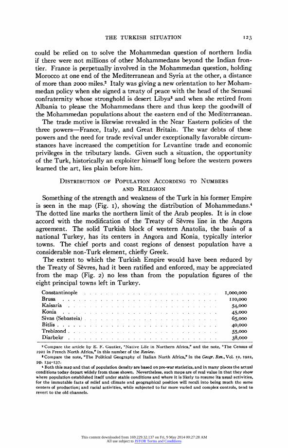
Something of the strength and weakness of the Turk in his former Empire is seen in the map (Fig. I), showing the distribution of Mohammedans.4 The dotted line marks the northern limit of the Arab peoples. It is in close accord with the modification of the Treaty of Sevres line in the Angora agreement. The solid Turkish block of western Anatolia, the basis of a national Turkey, has its centers in Angora and Konia, typically interior towns. The chief ports and coast regions of densest population have a considerable non-Turk element, chiefly Greek.
The extent to which the Turkish Empire would have been reduced by the Treaty of Sevres, had it been ratified and enforced, may be appreciated from the map (Fig. 2) no less than from the population figures of the eight principal towns left in Turkey.
2 Compare the article by E. F. Gautier, "Native Life in Northern Africa," and the note, "The Census of 192I in French North Africa," in this number of the Review.
I Compare the note, "The Political Geography of Italian North Africa," in the Geogr. Rev., Vol. I2, 1922,
pp. 134-I37. 4 Both this map and that of population density are based on pre-war statistics, and in many places the actual
conditions today depart widely from those shown. Nevertheless, such maps are of real value in that they show where population established itself under stable conditions and where it is likely to resume its usual activities. for the immutable facts of relief and climate and geographical position will recall into being much the same centers of production; and racial activities, while subjected to far more varied and complex controls, tend to revert to the old channels.
123
This content downloaded from 169.229.32.137 on Fri, 9 May 2014 00:27:28 AMAll use subject to JSTOR Terms and Conditions
FIG. i-Percentage of Moslem population in Asiatic Turkey by sanjaks before the war (see footnote 4). The line of heavy. dots represents approximately the northern and eastern boundary of the Arab lands.
FIG. 2-Density of population in Asiatic Turkey by sanjaks before the war. In conjunction is shown the proposed'division of Turkey by the Treaty of Sevres (solid lines) and the Tripartite Agreement (broken lines): Zone of the Straits, Greek zone in the Smyrna district, Italian zone in southwestern Anatolia, French mandatory area in Syria and zone of influence in southeastern Anatolia, British mandatory area in Mesopotamia and Palestine. The dot-and-dash line represents President Wilson's boundary on the Turkish side for the pro- posed state of Armenia.
124
This content downloaded from 169.229.32.137 on Fri, 9 May 2014 00:27:28 AMAll use subject to JSTOR Terms and Conditions
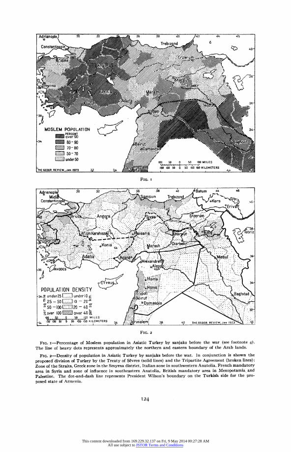
The disposition of the main bodies of population about the rim of the Anatolian peninsula takes on a further significance if examined in conjunc- tion with the map showing railroads and port statistics. The dry interior of the peninsula being ill served with railroads, it follows that sea communi- cation between the different parts of Turkish territory (as cut down by the Treaty of Sevres) is vitally affected by the control of the Bosporus. Upon this historic strait focuses the national life of Turkey. It is by ship and
FIG. 3-Adjacent to the principal ports are rectangles representing proportional value of trade-the open portion, imports; the shaded portions, exports. Statistics are for I9IO-I9I1, that is before the Balkan wars in which Turkey lost the majority of her European holdings. The railway net is for 1922. Zones of influence are drawn as laid down in the Secret Treaties. A, B, C are supplementary zones; D, E, F, G are special areas men- tioned in the various agreements. Compare with Figure 2.
caravan that the principal trade of Turkey is transported; the era of rail- road building has only begun. The representation of port statistics shows graphically that the interest of Constantinople and of the Anatolian peoples in the Aegean Sea is of the first order, a fact not to be overlooked when appraising the historic position or trade or ambitions of the Greeks.
Smyrna is the chief exporting center, and Constantinople leads in imports. The statistics for the seven ports are as in Table I.
The territorial losses of the Balkan wars deprived Turkey of Saloniki and Dedeagatch, two of the seven ports of chief importance. The prospec- tive loss of Smyrna to Greece, of Beirut to France, and of Trezibond to Armenia together with the inclusion of Haidar Pasha in the zone of the
I25
This content downloaded from 169.229.32.137 on Fri, 9 May 2014 00:27:28 AMAll use subject to JSTOR Terms and Conditions
Straits and the special regime of Constantinople (with its tributary terri- tory in Europe reduced to the needs of water and vegetable supplies) placed practically every outlet of Turkish trade in foreign hands.
TABLE I-COMMERCE OF THE PRINCIPAL PORTS OF THE TURKISH EMPIRE (I9IO-II)
Total value of exports in 9IO-II ................... $80,ooo,ooo0 Total value of imports in 1910-1I .................. 150,000,000
Were the interior of Turkey a closely organized agricultural unit the loss of coastal outlets might have been less serious. On the contrary, the arable lands of the peninsula lie for the most part near the sea in patches and narrow belts or tongues of valley floor or on the lower soil-covered hill slopes. Elsewhere, and notably in the steppe-like interior, the pastoral- nomadic type of life prevails. Because this life is on a more primitive level than in Europe it follows that the Turk could afford to waste his land and people without fearing for their future if he could in the end recover the coastal outlets.
Moreover, another geographical element enters into the present situa- tion. The Turk has been fighting on his own distant ground, and the Allies have had to come to him; and that is costly. Here time has told on the side of the Turk. It was, therefore, logical to conclude that the Treaty of S6vres and the supplementary Tripartite Agreement of even date (1920) between Great Britain, France, and Italy would have no validity at all unless the Turk agreed. The Allies could not force him to accept their terms.
TURKEY'S TERRITORIAL GAIN IN THE ANGORA AGREEMENT
The first step in Turkey's territorial advancement over the Treaty of Sevres was made in the military confines bordering northern Syria. Down from the northeast runs a string of valleys towards salt water at the Gulf of Alexandretta. By the Treaty of SEvres France encircled that outlet, whence a considerable trade reaches the coast and where fertile lands already productive are susceptible of still greater development. It is not a principal Turkish outlet, but it is an important one. By the Angora Agree- ment (I921) it was recovered by Turkey though France still retains an economic priority in the vilayets of Adana, Diarbekr, Sivas, and Kharput- virtually the French zone of the Secret Treaties and of the Tripartite
126
This content downloaded from 169.229.32.137 on Fri, 9 May 2014 00:27:28 AMAll use subject to JSTOR Terms and Conditions
Agreement. Of chief importance in the region is the Cicilian plain. While the northern part is gravelly and dry and supports a population chiefly nomadic, the southern half has a fertile soil abundantly supplied with water available for irrigation. In recent times Egyptians, Syrians, Bulga- rians, and Circassians have colonized it and notably displaced the old Turk- ish population.5
SMYRNA, CONSTANTINOPLE, AND THE STRAITS
As soon as the Angora Agreement had gained them the first of their essential outlets the Turks turned to Smyrna. Smyrna is far and away the largest export port of the Turkish realm. Besides it is the center of one of the few really dense populations of Turkey. Nothing could be more cer- tain either from the historical or the commercial standpoints than that it would become one of the chief objectives of the Turkish army. With Smyrna in his hands Mustapha Kemal Pasha turned to Constantinople; and, though he had no fleet, it was obvious at the beginning that he would try to enlarge his European holdings and get control of Constantinople also as a basis of negotiation and compromise. By this act he would regain the capital and the greatest importing city of the Turkish Empire. Second only to the recovery of Constantinople as a symbol of power and prestige through- out the Mohammedan world is that of the European hinterland-eastern Thrace with Adrianople. Before the Turk had reached the Golden Horn, Adrianople had been his European capital. In 19I3 Turkey had put forth her "historic rights" to the city and had recovered it by agreement with Bulgaria at the close of the Second Balkan War, thus modifying the Enos- Midia line upon which they had agreed at the close of the First Balkan War.
The present situation finds the Allies not unprepared for concessions. In March, I922, the Allied Ministers at Paris had already proposed sub- stantial departures from the Treaty of S6vres. Two prime objectives were, however, retained-protection of Christian minorities and freedom of the Straits. In this last point lies the crux of the entire situation. Unlike the other territorial questions this of the Straits is primarily of international importance. Attention has already been called to the economic value to Turkey of the western waterways of the old Empire, in particular of the ports of Smyrna and Constantinople, but there is also the trade of the Straits distinct from that of the bordering ports. The Straits is one of the great maritime passages of the world. Up to I9IO the movement of ship- ping surpassed that through Suez.
THRACE
The debatable ground of Thrace has long been a political storm belt. Turk, Bulgar, and Greek meet there in an environment that offers some- thing congenial to all three races. The present division of territory is only
Ewald Banse: Die Tiirkei: Eine Moderne Geographie, 3rd edit., Brunswick, I9I9, p. I75.
127
This content downloaded from 169.229.32.137 on Fri, 9 May 2014 00:27:28 AMAll use subject to JSTOR Terms and Conditions
the last of a long series made to establish boundaries where no natural or ethnic divisions in truth can be found.
Elsewhere in the Balkan Peninsula two (or rarely three) powers have been in conflict over disputed territory, whereas in Thrace at least five groups of interests are in conflict. Greece has sought to encircle Constantinople and shut off Bulgaria from the Aegean as well as Turkey from Europe. Bulgaria has persistently sought a territorial and commercial outlet to the Aegean on the south. Turkey has resisted both Greece and Bulgaria, and in I920
FIG. 4-Sketch map illustrating the political geography of Thrace. Boundaries established by the following treaties are shown: San Stefano, I878; Berlin, I878; London, I913; Bucharest, 1913; Constantinople, i9r3; Sofia. i95i; Neuilly, 19Io: Sevres, 1920.
the Powers put into force a special regime for the Zone of the Straits that introduced a fourth group of interests. The trade of Russia gives her also a primary interest as a fifth power.
The positions of the various treaty lines are geographically interesting. The line of San Stefano followed natural features in western Thrace; in eastern Thrace it would have produced serious dislocations in the life of that time, because it cut across the grain of the country owing to the absence of dominating natural features that run in an east-west direction. The Treaty of Berlin that superseded it put the line in a more natural posi- tion, in closer relation to minor watersheds northeast of Adrianople while still retaining the natural features of river (Arda) and mountain crest (Black Balkans) in western Thrace for a considerable distance. The Treaty of Constantinople between Bulgaria and Turkey (I913) provided for a frontier on the Maritsa River for a short distance above its mouth. It then
I28
This content downloaded from 169.229.32.137 on Fri, 9 May 2014 00:27:28 AMAll use subject to JSTOR Terms and Conditions
ran west of north, cutting across drainage and relief in such a way as to encircle Adrianople at a distance, while it gave Bulgaria on the border of the Black Sea a block of territory whose southern margin followed the Res- vaja River. The changes stipulated by Bulgaria in I915 as part of the price of her entry into the World War placed her frontier on the Maritsa River opposite Adrianople and also gave her ownership of the left bank of the Maritsa. The border of the Zone of the Straits and of the Constanti- nople zone of the Treaty of Sevres on the north side of the Sea of Marmora took advantage of natural features only to a limited degree, for the special regime under which these two territories were to operate was itself designed to provide flexibility of frontier arrangements.
The Turkish victories of the past few months have brought the Turk into the problem again. Further modification will come no doubt both here and in northeastern Turkey where the Armenian boundary was projected and where the State of Kurdistan was outlined by the Treaty of Sevres.
At the present writing (Dec. 2, 1922) the question of Mosul and its oil fields has also been brought into the Turkish settlement. The British man- datory area, as at first proposed, encircled the oil district and this position was incorporated into a treaty (S'vres) only when France had relinquished an overlapping territorial claim in return for the privilege of securing one- fourth of the oil produced in Mesopotamia. France also gave the British the right to build oil pipe lines to the Mediterranean across the French manda- tory area in Syria in return for the privilege of buying one-fourth of the oil that may be piped in this way from Persia.
The agreements between France and Great Britain, mentioned above, were all based upon the supposition that Turkey would sign the treaty of Sevres. But the recent Turkish successes have definitely put that treaty aside and also reopened the question of oil; just as in northern Syria the Turkish successes of 1921 obliged the French to modify their limits of con- trol about the head of the Gulf of Alexandretta. The problem can hardly be expected to be solved without further changes in the political map of the Turkish Empire, since irrigation possibilities, oil reserves, and strategical considerations make Mesopotamia a highly desirable block of territory-to the British, with Egyptian and Indian territory on either hand and an oil-burning navy, no less than to the Turk trying to piece out his national domain and recover some part of his former economic strength.
Traversing the British and Turkish interests are those of Mesopotamia (Iraq) itself. If King Feisal looks at the political map and gives a thought to oil and irrigated land and trade routes he may well become a deciding factor. In any event the political geography of the Near East promises to have more rather than less significance as the underlying causes of boundary changes come one by one to the front.
I29
This content downloaded from 169.229.32.137 on Fri, 9 May 2014 00:27:28 AMAll use subject to JSTOR Terms and Conditions