American Geographical Society Geographical Record Source: Geographical Review, Vol. 2, No. 2 (Aug., 1916), pp. 152-160 Published by: American Geographical Society Stable URL: http://www.jstor.org/stable/207389 . Accessed: 09/05/2014 16:24 Your use of the JSTOR archive indicates your acceptance of the Terms & Conditions of Use, available at . http://www.jstor.org/page/info/about/policies/terms.jsp . JSTOR is a not-for-profit service that helps scholars, researchers, and students discover, use, and build upon a wide range of content in a trusted digital archive. We use information technology and tools to increase productivity and facilitate new forms of scholarship. For more information about JSTOR, please contact [email protected]. . American Geographical Society is collaborating with JSTOR to digitize, preserve and extend access to Geographical Review. http://www.jstor.org This content downloaded from 62.122.76.43 on Fri, 9 May 2014 16:24:53 PM All use subject to JSTOR Terms and Conditions
Transcript
American Geographical Society
Geographical RecordSource: Geographical Review, Vol. 2, No. 2 (Aug., 1916), pp. 152-160Published by: American Geographical SocietyStable URL: http://www.jstor.org/stable/207389 .
Accessed: 09/05/2014 16:24
Your use of the JSTOR archive indicates your acceptance of the Terms & Conditions of Use, available at .http://www.jstor.org/page/info/about/policies/terms.jsp
.JSTOR is a not-for-profit service that helps scholars, researchers, and students discover, use, and build upon a wide range ofcontent in a trusted digital archive. We use information technology and tools to increase productivity and facilitate new formsof scholarship. For more information about JSTOR, please contact [email protected].
.
American Geographical Society is collaborating with JSTOR to digitize, preserve and extend access toGeographical Review.
http://www.jstor.org
This content downloaded from 62.122.76.43 on Fri, 9 May 2014 16:24:53 PMAll use subject to JSTOR Terms and Conditions
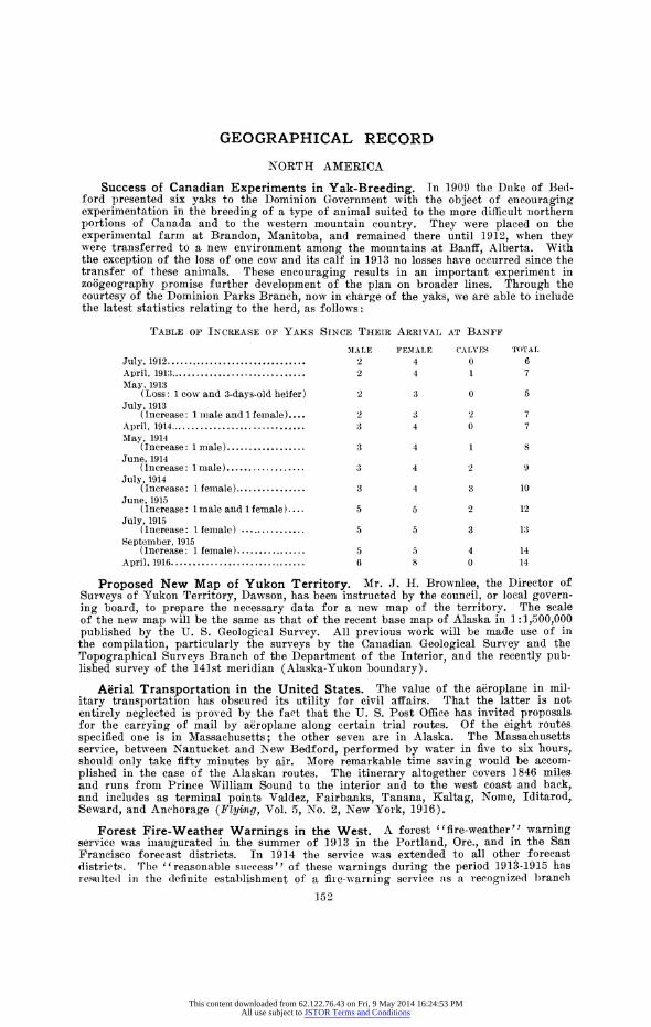
Success of Canadian Experiments in Yak-Breeding. In 1909 the Duke of Bed- ford presented six yaks to the Dominion Government with the object of encouraging experimentation in the breeding of a type of animal suited to the more difficult northern portions of Canada and to the western mountain country. They were placed on the experimental farm at Brandon, Manitoba, and remained there until 1912, when they were transferred to a new environment among the mountains at Banff, Alberta. With the exception of the loss of one cow and its calf in 1913 no losses have occurred since the transfer of these animals. These encouraging results in an important experiment in zoogeography promise further development of the plan on broader lines. Through the courtesy of the Dominion Parks Branch, now in charge of the yaks, we are able to include the latest statistics relating to the herd, as follows:
TABLE OF INCREASE OF YAKS SINCE THEIR ARRIVAL AT BANFF
April, 1916 ............................... 6 8 0 14
Proposed New Map of Yukon Territory. Mr. J. H. Brownlee, the Director of Surveys of Yukon Territory, Dawson, has been instructed by the council, or local govern- ing board, to prepare the necessary data for a new map of the territory. The scale of the new map will be the same as that of the recent base map of Alaska in 1:1,500,000 published by the U. S. Geological Survey. All previous work will be made use of in the compilation, particularly the surveys by the Canadian Geological Survey and the Topographical Surveys Branch of the Department of the Interior, and the recently pub- lished survey of the 141st meridian (Alaska-Yukon boundary).
Aerial Transportation in the United States. The value of the aeroplane in mil- itary transportation has obscured its utility for civil affairs. That the latter is not entirely neglected is proved by the fact that the U. S. Post Office has invited proposals for the carrying of mail by airoplane along certain trial routes. Of the eight routes specified one is in Massachusetts; the other seven are in Alaska. The Massachusetts service, between Nantucket and New Bedford, performed by water in five to six hours, should only take fifty minutes by air. More remarkable time saving would be accom- plished in the case of the Alaskan routes. The itinerary altogether covers 1846 miles and runs from Prince William Sound to the interior and to the west coast and back, and includes as terminal points Valdez, Fairbanks, Tanana, Kaltag, Nome, Iditarod, Seward, and Anchorage (Fly4img, Vol. 5, No. 2, New York, 1916).
Forest Fire-Weather Warnings in the West. A forest "fire-weather" warning service was inaugurated in the summer of 1913 in the Portland, Ore., and in the San Francisco forecast districts. In 1914 the service was extended to all other forecast districts. The "reasonable success" of these warnings during the period 1913-1915 has resulted in the (lefinite establishment of a fire-warning service as a recognized branch
152
This content downloaded from 62.122.76.43 on Fri, 9 May 2014 16:24:53 PMAll use subject to JSTOR Terms and Conditions
of Weather Bureau activity. Instructions No. 26 (April 10, 1916) are as follows: I District forecasters are authorized to issue warnings, to be known as 'fire-weather warnings,' of conditions favorable for the inception of fires in the forested regions of their respective districts." That this new service has already proved of value to the Pacific Slope forest interests is evidenced by the adoption, by the Forestry Industry Conference, at San Francisco, October 19-20, 1915, of a resolution appealing to Congress for an annual appropriation of $10,000 to be applied in strengthening and improving the service. The preamble to the resolution reads as follows: "The usefulness of the U. S. Weather Bureau in forecasting dangerous fire weather is no longer open to question." Mr. E. A. Beals, District Forecaster at Portland, Ore., points out (Monthly Weather Rev., Vol. 44, 1916, pp. 135-138) that forest fires cause an annual loss of about seventy human lives, the destruction of trees worth at least $25,000,000, and the loss of crops, buildings, and live-stock worth many millions more. Warnings of the probable occur- rence of winds of sufficient velocity to be dangerous make it possible to increase the fire crews, to stop burning permits, and to take other precautionary measures.
R. DEC. WARD.
EUROPE
Sunshine in the British Isles. A paper by Mr. F. J. Brodie on " The Incidence of Bright Sunshine over the United Kingdom during the Thirty Years 1881-1910 " appears in the Quarterly Journal of the Royal Meteorological Society for January, 1916. At the close of the decade ending with 1910, the total number of stations reporting sun- shine to the Meteorological Office and to the Royal Meteorological Society had reached 198. In discussing the average distribution, the data from 66 stations were utilized, the maps constructed showing the seasonal and annual incidence. The broad features of the distribution show an increase from north to south, with a tendency to coastal maxima and inland minima. There is ample confirmation, even ignoring the records of the large manufacturing towns, for an area of small sunshine over the central parts of northern England. A special examination of the records in London and other manufacturing centers shows a marked deficiency resulting from smoke, more particularly in the winter months. There is evidence, however, that the abatement of the smoke evil has somewhat remedied these conditions in recent years. R. DEC. WARD.
Sledge Traffic Between Norway and Finland. The February number of the Review, discussing Russia's war-time outlets to the sea (pp. 128-132), mentioned sledge traffic between Kandalaksha and Rovaniemi (map on p. 130) as an adjunct to rail transportation. The extent to which Russia is exerting herself to improve her inadequate means of communication in the hour of her trial is manifested once again by the news of the establishment of a winter sledge route between Kirkenes, on Varanger Fiord in northernmost Norway, and Finland. According to a report from the Italian lega- tion in Christiania (Rapp. dei Agenti diplomatici e consolari, March, 1916, No. 5, p. 4), the journey between the Norwegian seaport and Kyr6 in Finland requires four days. The return trip, however, is made in three days. From Kyr6 the road extends as far as Rovaniemi, where rail connection is made. The condition of the road for the entire length favors the journey. A minor traffic is carried on from Bug6, also in Varanger Fiord. Here reindeer are used as draught animals, whereas over the Kirkenes line horses are employed exclusively.
Between 3,500 and 4,000 tons of merchandise are now shipped during the winter season. Each sledge carries between 1,500 and 2,000 pounds. Efforts are made to increase the number of sledges to one hundred and fifty per day. The freight has in the past months consisted largely of cotton for Finnish factories. The line has proved of great value to the industry of Finland in general.
An Old-Established Fair in Modern France. Above Grenoble the left bank of the Gr6sivaudan Valley is occupied by alluvial fans whose apexes have long been so many crystallization points of population. In the old days it was the agriculture of the lower slopes of the fans that held the population. Now it is industrialism. There is one exception. This is the village of Goncelin, less overshadowed by the mountains and less blessed with resources of "white coal," but more favored agriculturally. Yet agri- culture is not Goncelin's distinction. Because it is a center of local roads, situated at a river ford and at the point where one of the main roads for Savoy leaves the valley, Goncelin has always enjoyed a commercial prominence. Its commercial activity, well established at the commencement of the eighteenth century, is concentrated into a system of fairs.
Fairs are held every Saturday of May and June and again in November and December, and a summer fair is held in August. The fairs are in harmony with the
153
This content downloaded from 62.122.76.43 on Fri, 9 May 2014 16:24:53 PMAll use subject to JSTOR Terms and Conditions
pastoral rhythm of the region. The cattle go up to the mountains for the summer and return to the valley for the winter. The valley farmers, however, seldom move with their flocks but loan them to the hill men. The loan is usually based on a payment in kind, butter and cheese for the milk animals, in silver for the others. It is reckoned that of the three months of estivation the first pays the loan, the second, pasturage and the hire of herdsmen, and the third brings in clear profit. In summer the fabrication of butter and cheese is particularly active, and the summer fair is the "Fair of Cheeses." A special feature of the Goncelin fair is the importation of pigs to supply the local demand. Every peasant of the valley fattens a pig during the summer and kills it in the fall, but he does no breeding. The animal is replaced at the following spring fair. Goncelin's sphere of economic influence is in the main limited to its own region. Cattle represent a commodity most advantageously bought "au vu." The personal and simultaneous presence of buyer and seller, the individual and fragmentary nature of the sales, and the almost exclusive use of ready money are characteristic features. They suit the economic life of the region, and the fair flourishes. To a limited extent the Goncelin fairs attract attention over a wider area. Outside causes are generally determinants in such cases. Thus, in 1909-1910 the great epizootic that ravaged Italian cattle caused a considerable movement of stock from Goncelin across the Alps.
Unlike most fairs, those of Goncelin are unconnected with religious rite or festival, and the town itself derives little benefit from them. Nomad merchants who establish themselves on the fair grounds are exclusively patronized, and the comparatively short journeys entailed on the part of most of the frequenters of the fairs preclude the necessity for inns. Hence the fairs appear as a very distinct economic phenomenon. (See A. Allix: La foire de Goncelin, Travaux de l'Institut de Gdogr. Alpine, Vol. 2, No. 3, Grenoble, 1914.)
Russian Fairs. As a vehicle of trade in western Europe the fair has been prac- tically extinguished or unrecognizably transformed: in the east it still remains a prominent commercial feature. Present-day Russia numbers some 16,000 fairs. Most of them, about 87 per cent, are merely local agricultural affairs with a business turn- over of under $5,000. These continue to flourish, especially in the more eastern prov- inces, where communications have been less improved, where population is scanty and capital small. All the larger fairs have declined. Only one per cent of the total number does a business exceeding $50,000, and that of the greatest, Nizhni-Novgorod, placed at $65,000,000, is little more than two-thirds that of the maximum of thirty-five to forty years ago.
Like that of most other famous Russian fairs the history of this greatest one goes back several centuries. From the tenth century the banks of the Volga between the Oka and the Kama have been a meeting ground, pacific and otherwise, for Slav and Tatar. In the mid-seventeenth century the fair acquired a fixed locus under the care of the monastery of St. Macarius. The combination of spiritual and temporal interests was a characteristic feature in the evolution of this form of trading. In the earlier nine- teenth century the fair was transferred to its present site 70 miles farther upstream and there became the foremost mart of its kind in the country. The site is ideal. South, the 1,450 miles of the Volga are open to steam navigation. East, the Kama gives access to the Ural provinces, and, west, the Oka extends the Muscovian sphere of influ- ence. North, canal and river make connection with Petrograd and Archangel. The fair occupies the strip of ground lying between the Volga and Oka at their confluence. It is connected with the permanent town dn the hills across the Oka by a bridge of boats annually replaced in June and removed on the approach of winter. (For views of the fair, see Figures 2, 3, and 5 of the first article in the April Review.) Transactions at the fair depend to a large extent on the nature of the harvest that governs the date of the fair. It is in session from the end of July to the first part of September, though most business is done during the second fortnight of August. Then the temporary population is estimated to amount to four hundred thousand. While the merchandise of the fair remains infinitely varied, some of its former important products have declined in prominence. This is particularly the case with furs, tea, and raw cotton. The opening of the Suez Canal and railroad progress in western Russia reduced the importance of Nizhni-Novgorod as an entrepot for the overland trade with China. The fur trade has diminished with that of Irbit and others on which it is dependent.
Irbit, ranking second among Russian fairs, is primarily a mart for furs and hides. Twenty or thirty years ago it was estimated to attract approximately a hundred thou- sand visitors, that is a temporary winter population about twenty times as large as the fixed population of the town. Since the construction of the Trans-Siberian railroad and the growth of direct business between fur companies and foreign markets the fair has
154
This content downloaded from 62.122.76.43 on Fri, 9 May 2014 16:24:53 PMAll use subject to JSTOR Terms and Conditions
declined, though the high prices and keen demand of the 1916 market sent the gross return on furs up to $1,500,000-nearly double that of the previous year.
Details of the trade may be found in Commerce Reports (Nos. 119 and 123, Wash- ington, 1916). A descriptive and statistical article on Russian fairs in general appears in the new Russian-American trade journal Russia (The Great Fairs of Russia, Russia, June, 1916, pp. 12-23, New York). 'This may be compared with the account in "La Russie a la fin du 19e siecle" by M. W. De Kovalevsky, Paris, 1900.
AFRICA
The Physical Subdivisions of Southwest Africa. A prompt illustration, in the domain of geographical publications, of the change of sovereignty brought about by the war in German Southwest Africa is furnished by a recent report of the Geological Sur- vey of the Union of South Africa on that one-time German colony (P. A. Wagner: The Geology and Mineral Industry of South-west Africa, Memoir No. 7, Pretoria, 1916; [in English and Dutch]). A discussion of the physical divisions of the region forms the most interesting part of the report. This, together with the accompanying map in 1] :6,000,000, is mainly based on the text and map of Leonhard Schultze's geography of German Southwest Africa in Hans Meyer's "Das Deutsche Kolonialreich" (2 vols., Leipzig, 1910; section in Vol. 1, pp. 131-298). The following six divisions are established:
The first region, the Namib, is the strip of coastal desert from 15 to 85 miles in width. In topographic expression it varies from a waste-cloaked plain in the neighbor- hood of Walvis Bay (this is the form of the name now authorized by the government; see Charles Pettman: An Inquiry into the Derivation of Certain South African Place Names, South African Journ. of Sci., Vol. 12, 1915, No. 5) to a series of valleys parallel- ing the coast on the south. The latter has lately acquired fame through the discovery of valuable diamond deposits. A predominant feature of the coastal belt are the great sand ridges (barchans) piled up by the prevailing south-southwesterly winds to heights that reach 700 feet and constitute a menace to transportation by reason of their rapid move- ment. Their crest-forms are frequently modified by occasional strong winds from the north. Aridity is the keynote of the geography of the coastal belt. ~5wakopmund has a mean annual rainfall of 0.89 inches, Walvis Bay of 0.3 inches. Perennial streams reach the coast, but the dry beds of the intermittent torrents will commonly yield water at no great depth. Fogs are characteristic of the immediate shore. To a considerable degree this aridity is due to the cold Benguella Current. The phenomenon in its physical aspects and human responses is comparable with the Atacama Desert of corresponding latitudes in South America. Fish and a deep-rooted species of the pumpkin and melon family con- stitute the staple food of the tribes inhabiting the Walvis Bay territory (Journ. South African Soc., Vol. 15, 1916), a diet comparable with that of the fish-eating Changos and the Llipis Indians of the Atacama Desert. Marcoy found the latter living solely upon seaweed, water-melons, and shell fish (Travels in South America, Vol. 1, New York, 1875). The small islands lining the shore have been exploited for guano like the Lobos Islands off the Peruvian coast. The prospective value of these deposits was indicated as early as 1861 by the explorer Andersson, to whom we owe an excellent description of the entire Southwest African area (The Okavango River, by C. T. Andersson, New York, 1861). Since 1908 the diamond workings of Liideritz Bay and the interior neighborhood have introduced problems of water-supply and transportaion similar to those of the Chilean nitrate fields.
From the center of the desert a transition belt leads eastwards to the central high- land region of (2) Damaraland. The average rainfall is stated to be 15 inches, but it varies greatly from place to place. At Waterberg a rainfall of 40 inches has been recorded. In years of good rainfall the alluvial soil of the valleys proves excellent for cultivation. Such is the case with the important Windhuk Valley. From the central region isolated ranges superimposed on the plateau run northeast towards Otavi and northwest into the Kaokoveld. Between them and eastward the country merges into the Kalahari Plains. Southward it develops features of the inselberg type. South of Damaraland is (3) the plateau of Great Namaqualand, semi-desert and apparently best suited for sheep and ostrich farming. The region is characterized by extensive faulting and great erosion canyons. The dolomite formation of the Otavi region gives a distinct unit, (4) the Karstfeld. The most important of its numerous sink holes is the Otjikoto See, containing in normal years 600 feet depth of water but subject to great fluctuations under varying rainfall. The region is well grassed and the northeastern part appears to be suited to corn and tobacco cultivation, though even here good crops can only be depended on once in three years. Between the northern part of the coast zone and the Kalahari lies (5) the broken country of the Kaokoveld,
155
This content downloaded from 62.122.76.43 on Fri, 9 May 2014 16:24:53 PMAll use subject to JSTOR Terms and Conditions
forming the dissected rim of the western plateau. Most extensive of all is (6) the Kalahari. The Kalahari includes northern and eastern areas of interior drainage to salt pans; a northeastern zone, the Caprivi Belt, hot and unhealthful, draining to the Zambezi, and a small unimportant tract in the extreme south draining to the Orange River. Over the greater part of the Kalahari the typical topographic form is the sandveld-old dunes evidently formed during times of north or northwest winds and now generally fixed by vegetation. Northward and eastward trees become more numer- ous and the sandveld gradually passes into tree-steppe.
South African Coast Temperatures. A paper on "South African Coast Tempera- tures" was read by Dr. J. R. Sutton before the Royal Meteorological Society (London), on February 16, 1916 (Quart. Jotrn. Roy. Meteorol. Soc., April, 1916). A study of the mean monthly maximum and minimum temperatures for several stations leads the author to the conclusion that the night temperatures of the coast are determined almost entirely by inland conditions, whereas the day temperatures are modified by the sea. An explanation is sought in the lowering of the surface temperature of the sea by the churning effect of the spring gales. R. DEC. WARD.
ASIA
Cyclonic Rainfall in Japan. The distribution of rainfall around cyclones has often been discussed, but a study of the causes which determine this distribution has largely been neglected. Recently, Messrs. T. Yokota and S. Otuki, students in the Science College of the University of Tokyo, have undertaken a statistical investigation of this problem in Japan. The chief data were the Japanese daily weather maps from January, 1905, to December, 1915. The general facts of rainfall distribution over the islands are summarized for various positions of the cyclonic centers. A theoretical dis- cussion of the problem leads to the conclusion that the secondary influences which pro- duce the unsymmetrical distribution of cyclonic precipitation are as follows-(a) the change of temperature with latitude: this tends to locate the center of rainfall on the southeastern side of the low center (in the northern hemisphere) if other conditions are uniform; (b) the temperature contrast between land and water: this influence differs widely according to the season and according to the humidity of the land; (c) the influence of the topography (Torahiko Terada: On the Distribution of Cyclonic Precipi- tations, Journ. Coll. Sci. Tokyo Univ., Vol. 37, 1916; abstracted in Monthly Weather Rev., Vol. 44, 1916). R. DEC. WARD.
Opening of the First Persian Railroad. Tangible effects of Russia's ever-growing influence in Persia are manifested by the opening, on March 7, 1916, of the first railroad built in the country. The 61/2-mile line leading out of Teheran toward Resht, which was built in 1888 and has often been mentioned under the heading of Persian railroads, was in reality nothing more than a street conveyance. Afghanistan now remains the only independent state without a single mile of railway in Asia. According to Commerce Reports for April 28, 1916 (pp. 372-373) the new Persian line starts from the boundary with Russian Transcaucasia at Julfa on the Arax River and extends as far as Tabriz, a distance of 93 miles. The ordinary three-day carriage journey between these two points is reduced to a twelve-hour railroad ride. The tracks run parallel to the wires of the Indo-European telegraph system which connects India with European points. The gage adopted is of the broad Russian type, and the line is under Russian manage- ment. A branch line diverges westward to Lake Urmiah from the town of Sofian at a distance of 25 miles north of Tabriz.
A readjustment of transportation facilities is likely to follow the inauguration of this line. It is expected that the ancient caravan route of penetration into Persia from Turkey, of which Trebizond was the terminal, will be abandoned in favor of the railway route through Tiflis and other points in the Caucasus. Much of the trade which was conducted through the Persian ports of the Caspian Sea will likewise be deflected toward the railroad. It looks as if Tabriz will be converted, during the next few years at all events, into the great entrep6t, not only of Persia, but of the whole plateau of Iran.
The prolongation of the line south and east from Tabriz may follow without great delay. The objectives are connection .with the Indian railway system in Baluchistan and extension to the shores of the Persian Gulf. The important towns of Hamadan, Teheran, and Isfahan lie in the path of these extensions.
POLAR
Mikkelsen's Explorations in Northeastern Greenland. Mikkelsen's expedition of 1909-1912 was sent out to find the records of the ill-fated Mylius-Erichsen expedition of 1906-1908. Lieutenant Trolle's brief and striking account of the original expedition
156
This content downloaded from 62.122.76.43 on Fri, 9 May 2014 16:24:53 PMAll use subject to JSTOR Terms and Conditions
(Geogr. Journ., Vol. 33, 1909, pp. 40-61) aroused widespread interest. The fate of the leader was known, but it was hoped that his diaries and sketches might still be recovered; and it had not been determined where'he made his last camp. Mikkelsen's first report (Geogr. Jou r., Vol. 41, 1913, pp. 313-322) contained his chief results. In the same year he published a book entitled "Lost in the Arctic'" (reviewed in Bull. Amer. Geogr. Soc., Vol. 45, 1913, p. 862). His final report, entitled "Report on the Alabama Expedition to North-East Greenland, 1909-1912," has now been published and reaches the Society as a reprint from Meddelelser om Gr0nland (Vol. 52, pp. 1-143, Copenhagen, 1915).
Though his main object was to recover the note-books and other records of the Mylius-Erichsen expedition, there was time for a large amount of sketching and observa- tion. The report has therefore great scientific value.
On Mikkelsen's first search expedition the grave of Bronlund was found where Koch had buried him in 1908; but nothing was found of either Erichsen or of Hagen, who died with him.
The second search expedition was one of the most daring in the history of Arctic exploration. Mikkelsen's plan was to sledge from Shannon Island (75? N.) to Danmark Fiord (81? N.), on the extreme northeast coast of Greenland, by way of the inland ice, then around Northeast Foreland and down the outer coast where Mylius-Erichsen did his survey work, and back to Shannon Island (for the northern part of this area see the map in the June Review, p. 450, and the small map illustrating the item below). The distance was about 1,400 miles, with only five depots on the way and these far apart. Mikkelsen gives a detailed account of his plans, equipment, and food supplies. Of the five men in the party only Iversen was to accompany him to Danmark Fiord and back. These two men made about three-fourths of the journey alone.
Mikkelsen hoped to find the bodies of the two explorers and their records on his way back south; meanwhile there was a chance that he would recover records they might have left, possibly in Danmark Fiord. For a long distance north he chose the inland ice as a highway. The undulations in the surface of the ice made it a rugged sledge route. The ice slopes towards the coast and is gullied into deep channels by large streams of water. Nunataks diversify the landscape for half the route between the point where the party struck the main ice sheet northward to its termination at the head of Danmark Fiord. They are ringed with crevasses and in turn crossed at right angles by still deeper cracks that converge toward the nunataks. The elevation of the inland ice along the line of traverse was from 2,000 to about 3,500 feet above the sea.
On emerging from the inland ice Mikkelsen followed the western shore of Danmark Fiord. Here he found, several journeys apart, two cairns, each containing a statement of progress by Mylius-Erichsen, which are reproduced in facsimile in the report (Pls. VII and VIII). In the earlier of the two letters, dated August 8, 1907, Mylius-Erichsen described his journey westward to Peary's Cape Glacier and his discovery that "Peary Channel does not exist; Navy Cliff is connected by fast land with Heilprin Land. We renamed Independence Bay 'Independence Fiord' and built a cairn (with report) on a low point near Cape Glacier. On the way out through the fiord we discovered and investigated two side fiords, 'Br6nlund's fiord' towards the northwest and 'Hagen 's Fiord' towards the southeast" (p. 86). Mikkelsen gives much space to an attempt to reconstruct the probable route of Mylius-Erichsen to the place where he and Hagen died. He believes they perished in a fiord in the northern part of Lambert Land and that their bodies and their records sank with the melting of the ice.
The report notes the comparative sparsity of vegetation and animal life on the east coast in latitudes corresponding to the Cape York-Etah regions on the west coast, where animals and especially birds are numerous. An extraordinary abundance of life is noted at the edge of the great ice cap. "'We had expected to find a very desolate country when we came down from the inland ice, but we were agreeably surprised to find a vegetation so luxuriant that we had seen nothing like it north of Danmark's Havn.
"Large tracts were covered by a layer of moss, so thick that it felt quite elastic under our feet, and furthermore we noticed several kinds of grasses, some of which had a length of 30 centimeters and covered areas so large that they gave the impression of fields. Not only the valleys but also the slopes of the hills were quite covered with vegetation, moss, grass, heather, and willows, the trunks of which were as thick as a thumb and a decimeter high.
"A large number of animals found their means of existence on this luxuriant vegeta- tion, and the first traces of animal life we found only 25 meters from the foot of the snow-bank over which we came down" (p. 68).
Peary found many traces of former inhabitants in northeastern Greenland, and the Danish expeditions have greatly extended the first meager observations. In addi- tion, Mikkelsen notes their former occupation of Pendulum Island and Bass Rock, lati-
157
This content downloaded from 62.122.76.43 on Fri, 9 May 2014 16:24:53 PMAll use subject to JSTOR Terms and Conditions
tude 741/2? N. Those in the north, 81? to 82? N., appear to have depended chiefly on an abundance of musk-oxen. Those in the south probably depended to a greater degree upon the sea. A number of fox traps, meat caches, shelters, and tent rings were investigated. In eastern Greenland traces of former Eskimo habitations coincide almost everywhere with the limits of range of land animals, and these in turn depend upon ice-free land a part of the year and at least a thin cover of vegetation. This fact lends great interest to the large -extent of ice-free slopes in Peary Land where the northern limits of former Eskimo occupation may some day be traced.
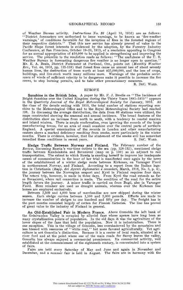
Revised Survey of the Head of Danmark Fiord, Northeastern Greenland. Danmark Fiord is the deep re-entrant whose waters wash the western shore of the peninsula which juts farthest seaward from Greenland's northeastern coast. The true proportions of this major depression have only now come to be realized, as a result of
surveys made by Mikkelsen on 3 25 the expedition described in the
preceding note. From the in- <// -^%^b??^^ c yordland ice to the mouth of the ene
^ ^^ ^ ^2^^ ^ ^ fiord its axis measures about 115 miles. This, in Greenland, makes it comparable only to
Its representation on a map goes back to Lieut. N. P. Heg-Hagen's survey in 1907
Scale of miles 40 M -Y on the Mylius-Erichsen expedi-
F
' 25 X tion. The only form in which FIG. 1-Sketch-map showing revised survey by Mikkelsen of this survey has been preserved
the head of Danmark Fiord, based on Meddelelser om Gr0nland, is in two rough pencil draw- Vol. 52, Pl. I. Scale, 1:3,850,000. whih ar rprodud The map on the same scale in the June Review (Vol. I, p. 450) ings, which are reproduced in should be corrected accordingly for this region. facsimile as Plates IV and V
of Meddelelser om Gr0nland, Vol. 51, No. 1, 1913. The two drafts are on the same scale (1:500,000) and of the same area: the earlier (PI. V) is, however, somewhat fuller and shows the sights taken from the various observation points as well as the extent of the inland ice, while the latter, cleaner draft (Pl. IV) gives the coastal outline only and the names of the larger geographic features. These maps were found with the Eskimo Br6nlund's, body on the search expedition led by Lieut. J. P. Koch in March, 1908, that determined the tragic fate which, the November before, had overtaken Mylius-Erichsen and his two compan- ions, Hagen and Br6nlund. They were not intended to serve as the final maps. When, in their last straits, the three men realized, however, that they might not be able to reach the ship, it is probable that they so divided the records among themselves that, whoever survived, the main results of their work would reach the outside world. Bronlund carried his own diary and the two rough maps. These, together with the two letters of Mylius-Erichsen which Mikkelsen found, as related in the previous item, are the only available sources for the geography of Independence and Danmark Fiords, the most important region explored by the expedition.
In view of the preliminary nature of Hagen's maps, it is not astonishing that they have developed to be incorrect with regard to a portion of the area. On Mikkelsen's sledge journey north in the spring of 1910 (see preceding item) he descended from the inland itce by way of Danmark Fiord. He thus had an excellent opportunity to survey the region about the head of the fiord. His survey is laid down on a map in 1:650,000 constituting Plate I of Volume 52 of Meddelelser om Gronland, published in 1915, which is reduced in the accompanying figure (according to which the correspond- ing portion of the map in the June Review, p. 450, should be corrected). The salient
158
This content downloaded from 62.122.76.43 on Fri, 9 May 2014 16:24:53 PMAll use subject to JSTOR Terms and Conditions
point is that Mikkelsen shows the head of the fiord to trend in practically the same direction as its lower part, i. e. north-northeast, while Hagen represented it as occupying an east-west position. The account given in Mikkelsen's report (op. cit., pp. 77-78) of the methods of surveying used and the checks applied leave no doubt as to the correct- ness of his representation. As showing Mikkelsen's original faith in Hagen's map it may be 'mentioned that the map accompanying both his preliminary account and his book (see preceding item) in each case shows the head of the fiord oriented according to Hagen, a circumstance which forced Mikkelsen to swing the representation of his route over the inland ice westward in order to strike the fiord at the proper point. At that time Mikkelsen's observations had probably not been worked out with the finality which characterizes the present report.
The question naturally presents itself, How is it that Hagen's map, which otherwise has proved so correct in spite of its general and sketchy character, should be unreliable with regard to this region? The facsimile (P1. V) suggests a possible explanation. The line of sight shown on it radiating from the observati6n point near Gundersteddal on the western shore of the fiord (see the accompanying figure for place names) include two bearing south-southwest. One of these, if prolonged, strikes Cape Viborg on the eastern side of the fiord. The other, which forms an angle of only 3? with the first, is only half-heartedly drawn and, if prolonged, strikes no prominent point. It might be that, with the primitive means at Hagen's disposal-some of the sights are evidently not even drawn with a straight-edge, but freehand-these two lines were meant to repre- sent the same sight and it was a matter of chance as to which one was used. The position of Cape Viborg was, it seems, determined by the intersection with a sight from an observation point a little farther south, near Pinseskaeret Island. If the first line of sight from Gundersteddal be selected, the sight from Pinseskaeret intersects it at a point which would give Cape Viborg a position 10 kilometers farther north, in close agreement with Mikkelsen's determination. If now the few sights that Hagen was able to take in the uppermost section of the fiord were tied up to the position of Cape Viborg as he had drawn it, instead of where it actually lies, then this alone would account for a shifting of the axis of the upper fiord by about 30? to 40?, or from east- northeast to north-northeast.
In any case, the fact that the region lies on the outer edge of the area surveyed and that its representation is based on long sights and acute intersections would sufficiently account for the possibility of error. The error consists, it should be noted, mainly in faulty orientation of the whole area; the details are in general correct.
This latter point is illustrated by the region above the head of the fiord. On Hagen's earlier draft (Pl. V) a valley is shown parallel on the north to the head of the fiord and draining a small lake above. On his later draft (Pl. IV) this lake has lengthened to 75 kilometers and is designated Fyn Lake (Mikkelsen uses "Fyen"; both are native forms for the Danish island of Funen, after which the lake was evidently named). Although Amdrup in his discussion of the maps (op. cit., Vol. 41, p. 222) designates Plate IV as the later and more carefully executed version and has used it as the basis of the official map of the regions explored by the expedition (op. cit., Vol. 46, No. 2, PI. IV, 1:1,000,000) he makes an exception for the lake and here follows Plate V. Mikkelsen's expedition, however, has shown that Hagen's later chart (Pl. IV) was sub- stantially correct. There is a lake here, some 28 miles long and from 2 to 5 miles wide. It draws its waters from the melting of the inland ice, at which it heads, and is separated by a morainic dam from Danmark Fiord.
GEOGRAPHICAL NEWS
PERSONAL
PROF. JOSEPH BARRELL of Yale University received the honorary degree of Doctor of Science at Lehigh University on the occasion of the commencement exercises in June celebrating the fiftieth anniversary of the founding of the institution.
REV. T. A. BENDRAT, known for his geographical and geological work in Venezuela, started in July on an expedition to the headwaters of the Orinoco River to explore its sources and the surrounding region.
DR. FRANK M. C'HAPMAN of the American Museum of Natural History has left on an expedition to the Andes for the summer to secure the setting for habitat groups of several birds in South America, including the condor and the rhea. Doctor Chapman is accompanied by Mr. George K. Cherrie and Mr. Leo E. Miller. Mr. Miller, it will be recalled, contributed an article on the Gy-Parana River to the March number of the Review.
159
This content downloaded from 62.122.76.43 on Fri, 9 May 2014 16:24:53 PMAll use subject to JSTOR Terms and Conditions
DR. JOHN M. CLARKE, state geologist of New York, received the honorary degree of Doctor of Science at the quarter-centennial celebration held at the University of Chicago, June 2-6.
DR. J. WALTER FEWKES of the Bureau of American Ethnology is engaged in arch- aeological and ethnological field work northeast of the Hopi villages in northern Arizona.
PROF. A. W. GRABAU at the annual dinner of the Geological Journal Club, Columbia University, on May 17, was presented by the students and members of the departmental faculty with a copy of Suess's "'The Face of the Earth" in commemoration of the com- pletion of fifteen years of active service as a teacher in Columbia University and as a philosophic student of geology.
PROF. I{. E. GREGORY of Yale University spent the winter of 1915-1916 in the Australian (leserts. In June he returned to New Haven.
PROF. J. W. IHARSHBERGER of the University of Pennsylvania conducted an illustrated science conference on "Field Research in Plant Geography and Ecology" on April 22 at the Brooklyn Institute of Arts and Sciences.
SiR THOMAS IL. HOLLAND, F.R.S., professor of geology in the University of Man- chester, has been appointed chairman of the commission which the British Government is forming to survey the economic resources and industrial possibilities of India.
DR. C. F. MARBUT, Chief of the Bureau of Soils of the U. S. Department of Agricul- ture, received the degree of Doctor of Laws at the commencement exercises of the Uni- versity of Missouri in June.
PROF. T. P. SAVAGE and DR. F. M. VAN TUYL of the department of geology of the University of Illinois are engaged on a geological expedition to Hudson Bay to last until the middle of September. The region south of the Churchill River will be examined.
MR. J. W. SLAUGHTER, recent lecturer on sociology at the University of London, gave a paper on "Is There a Need of More Reality in the Elementary School Curriculum in History and Geography?" before the meeting of the National Educational Association in New York City, July 1-8.
MR. R. F. STUPART, Director of the Meteorological Service of Canada, received the honor of knighthood on the occasion of King George's birthday.
OBITUARY.
COMMANDER H. L. L. PENNELL, who was killed in the naval battle of Jutland Bank on May 31, was one of the officers of the Terra Nova of the British Antarctic Expedi- tion of 1910.
160 160
This content downloaded from 62.122.76.43 on Fri, 9 May 2014 16:24:53 PMAll use subject to JSTOR Terms and Conditions