American Geographical Society Geographical Record Source: Geographical Review, Vol. 23, No. 1 (Jan., 1933), pp. 132-149 Published by: American Geographical Society Stable URL: http://www.jstor.org/stable/209562 . Accessed: 08/05/2014 21:19 Your use of the JSTOR archive indicates your acceptance of the Terms & Conditions of Use, available at . http://www.jstor.org/page/info/about/policies/terms.jsp . JSTOR is a not-for-profit service that helps scholars, researchers, and students discover, use, and build upon a wide range of content in a trusted digital archive. We use information technology and tools to increase productivity and facilitate new forms of scholarship. For more information about JSTOR, please contact [email protected]. . American Geographical Society is collaborating with JSTOR to digitize, preserve and extend access to Geographical Review. http://www.jstor.org This content downloaded from 169.229.32.137 on Thu, 8 May 2014 21:19:47 PM All use subject to JSTOR Terms and Conditions
Transcript
American Geographical Society
Geographical RecordSource: Geographical Review, Vol. 23, No. 1 (Jan., 1933), pp. 132-149Published by: American Geographical SocietyStable URL: http://www.jstor.org/stable/209562 .
Accessed: 08/05/2014 21:19
Your use of the JSTOR archive indicates your acceptance of the Terms & Conditions of Use, available at .http://www.jstor.org/page/info/about/policies/terms.jsp
.JSTOR is a not-for-profit service that helps scholars, researchers, and students discover, use, and build upon a wide range ofcontent in a trusted digital archive. We use information technology and tools to increase productivity and facilitate new formsof scholarship. For more information about JSTOR, please contact [email protected].
.
American Geographical Society is collaborating with JSTOR to digitize, preserve and extend access toGeographical Review.
http://www.jstor.org
This content downloaded from 169.229.32.137 on Thu, 8 May 2014 21:19:47 PMAll use subject to JSTOR Terms and Conditions
Emigration Versus Immigration in Canada. What does the growth of population in Canada owe to immigration? " Strange as it may seem, had we never had a single immigrant come within our borders since Confederation, 63 years ago, it is probable that our population would not be materially different from what it is . . . except when we had large areas of vacant land to be filled up very quickly, our immigrant population simply displaced the native born," says R. M. Lower presenting "The Case Against Immigration" (Queen's Quart., Summer, I930, pp. 557-574). The
' ~~~EMIGRATION E;/
2000 A. ; -NI.d0 . O~~~~~~~~ I G. A N
+200 r - GAI N S
-100 _LOSSES. _
8171 1881 1891 1901 1911 1921
FIG. i-The upper graph shows the progress of immigration into and emigration from Canada for the period I868-I925; the lower graph shows the net gain or loss from migration. (After Professor Roland Wilson.)
populating of a country involves more than mathematics, of course; but, considering the numerical aspect only, Mr. Lower's contention is confirmed by Roland Wilson in "Migration Movements in Canada, i868-i925" (Canadian Hist. Rev., Vol. I3,
I932, pp. i57-i82). Until recently no statistics of emigration have been kept-such is the difficulty of recording the movements of peoples across the four thousand-mile boundary between Canada and the United States-and until i897 even statistics of immigration were not satisfactory. Professor Wilson explains the method by which he arrives at his estimate, and in an introduction to the paper Gilbert Jackson expresses the belief that it is unlikely the figures " will ever be modified so drastically as to distort really seriously the picture that he has drawn." The accompanying figure gives the picture. According to Professor Wilson's figures the net account of migration is a deficit to Canada of over 500,000.
The Belcher Islands and the New Hudson Bay Ports. " With the extension of the Temiskaming and Northern Ontario Railway to Moose Factory (Moosonee) on
I32
This content downloaded from 169.229.32.137 on Thu, 8 May 2014 21:19:47 PMAll use subject to JSTOR Terms and Conditions
James Bay and the near completion of the new harbor at Churchill, 700 miles to the northwest, a knowledge of the coast line and islands of Hudson Bay at once be- comes of greater economic importance." This was the stimulus for the Canadian Government survey in the Belcher Islands in I93I, described by Captain Noel J. Ogilvie in " Geodetic Control for the Plotting of the Aerial Photographs of the Belcher Islands" (Trans. Amer. Geophys. Union, Thirteenth Ann. Meeting, April 28 and 29,
1932, National Research Council, Washington, I932, pp. 64-68). The Belcher Islands, of which the first fair representation was made by R. J. Flaherty (The Belcher Islands of Hudson Bay: Their Discovery and Exploration, Geogr. Rev., Vol. 5, I9I8, pp. 433-458), lie some sixty miles off the east coast of Hudson Bay. Two hun- dred Eskimos live on the islands, and in the north-central area an iron formation of unproved commercial value is known to exist. The survey carried its triangula- tion net over this area, covered the archipelago with oblique aerial photography, and also established astronomical control points in the extreme south and east. It was discovered that the archipelago as depicted on existing maps is about 30 miles out of place, an error connected with the general displacement of the eastern coast of Hudson Bay 25 miles too far to the west.
Progress on the two new ports of the Hudson Bay region is described in recent articles in the Canadian Geographical Journal. The Temiskaming and Northern Ontario Railway reached tidewater 667 miles from Toronto in August, 1931. Arthur A. Cole completes his account of the economic possibilities of "Ontario's Route to the Sea" (Canadian Geogr. Journ., Vol. 5, I932, pp. I30-I53) with a description of the terminal where a town site has been laid out a few miles from the site of the orig- inal fort of Moose Factory (Hudson's Bay Co.). The blacksmith's forge erected there in I740 is said to be probably the oldest building in Ontario. We are likewise reminded of the early interest in the Churchill region, which dates back to the first decades of the seventeenth century, by Denzil G. Ridout in " Port Churchill " (Cana- dian Geogr. Journ., Vol. 4, I93I, pp. 104-128). Among his illustrations is an excel- lent aerial photograph of Fort Prince of Wales built between 1733 and 1747 and in its day " one of most formidable strongholds of North America. " The story of " The Founding of Churchill " is told by James F. Kenney in the book of this name (J. M. Dent and Sons, I932), in which a substantial introduction gives the setting to the Journal of Captain James Knight, Governor-in-Chief in Hudson Bay from July I4 to September I3, 1717, here published for the first time. Besides its future as a port Churchill is likely to serve as an aerial base for northern prospecting. And thereby history is repeated, for it was from Fort Prince of Wales that Samuel Hearne in I 769 set off for the exploration of the copper country to the northwest of Churchill.
Moosonee is also a strategic point for an airplane base in mineral exploration, and it has been mentioned as a station on the proposed northern route to Europe via Greenland.
A New Population Map of the United States. Under this title Dr. F. A. Stilgen- bauer presents a wall map compiled on the basis of the United States Census reports for 1930 (Rand McNally & Co., 1932). The map is on a scale of about 48 miles to the inch and is printed in black and white. State boundaries are shown, but no names or topographical features. Eleven insets on larger scales represent metro- politan areas of over I,000,000 population. On the main map rural population is shown by dots, each dot indicating 2000 persons. Somewhat larger dots of uniform size show "rural-urban" centers of between 2500 and I5,000 inhabitants. For still larger places shaded circles are employed of sizes proportionate to the population represented. A feature open to criticism is the manner in which solid black is used. On the main map " metropolitan-urban " areas of over 650,000 inhabitants as defined by the Census Bureau are indicated in black. This tends to give an exaggerated impression of the density in the environs of certain centers, notably Boston and
This content downloaded from 169.229.32.137 on Thu, 8 May 2014 21:19:47 PMAll use subject to JSTOR Terms and Conditions
Pittsburgh. On the insets the principal municipality in each case is shown in black, but these administrative areas bear no necessary relation to population. The city of Boston includes only a small part of metropolitan Boston. On a population map Staten Island with its sparse population should not appear in black unless the much more thickly settled parts of northeastern New Jersey are shown in the same manner. It would have been preferable to use black only for areas where the population exceeds a given density. The map as a whole, however, gives a clear picture.
A wall map entitled " Trading Center and Distribution Map of the United States" (scale 53 miles to the inch), has also been published recently by Rand McNally & Co. Four grades of population density are shown by counties, and cities of over 5000 inhabitants are indicated, according to size, by five different symbols. The title is misleading, however, as the map shows merely densities and distribution of population and nothing concerning trade or the distribution of commodities.
Michigan in Prehistoric Times. Of late years the staff of the University of Michigan Museums has been mapping the distribution of the Indian relics of Michi- gan. The results are presented by Wilbert B. Hinsdale in a magnificent "Archaeo- logical Atlas of Michigan" (Michigan Handbook Series No. 4, Ann Arbor, 193I).
The Atlas contains seventeen sectional maps of the state, showing Indian trails, villages, burying grounds, mounds, garden beds, and inclosures. Symbols for these are printed in red on a black base representing drainage, roads, towns, and boundaries. In the text, besides a general introduction, a brief account is given of the outstanding archeological features of each county.
The whole state was covered in a systematic manner; hence the villages and burying grounds mapped probably give a fair clue to the actual former distribution of Indian population. "The sparseness of population in some of the counties may be partially explained by the topography and other environmental conditions. In those parts the soil is very sandy or rocky, as in the Upper Peninsula, and non-pro- ductive of food for men and animals. Where there were heavy forests of pine and hemlock, other kinds of vegetation were scarce. The rivers were too swift and the lakes too pebbly to permit much of a growth Qf wild rice, an important food for Indians, and the fish were limited in kinds and size-a condition strongly in contrast, for instance, with that of the Saginaw and Grand River valleys." Parts of the sandy north-central interior of the Lower Peninsula were more or less of a no-man's land in Indian times.
"The unique contribution that Michigan makes to archaeology lies primarily in
beds of material for a metallurgic industry. The natives developed considerable skill as miners and quarrymen." Copper for manufacture into " spears, knives, celts, wedges, beads, and other implements and ornaments" was found in veins and seams of the bed rock of the EKeweenaw Peninsula as well as in nuggets ("float copper") carried south by the ice sheet. " In no other district in America did nature leave so
abundant a quantity of metal that was particularly amenable to the crude workman-
ship of her primitive mechanics." (Compare G. A. West: Copper: Its Mining and Use by the Aborigines of the Lake Superior Region, Bull. Public Museum, Milwaukee, Vol. 10, 1929, pp. I-I84.)
Indian trails formed a network over the more thickly settled parts of the region. The routes have been reconstructed mainly from the field notes of early government surveyors. It is significant that most of the improved highways of the present time
follow these routes. Michigan was connected by Indian trails with the Mississippi Valley, the Atlantic seaboard, and the Gulf of Mexico. Over these trails, as well
as by waterways and portages, copper was transported from the Michigan deposits "to every state east of the Mississippi and even farther to the west and southwest."
The waterways were as important as the forest trails, but owing to clearing and
draining of the land many creeks open to canoes in Indian times have now vanished.
This content downloaded from 169.229.32.137 on Thu, 8 May 2014 21:19:47 PMAll use subject to JSTOR Terms and Conditions
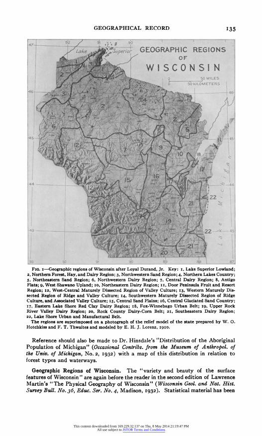
FIG. -Geograhc regions of W.sconsin after LoyalDurd50r Ke iLOMETERi
2, NotenFrs,Hy ndDiyRgo45NrhwsenSn ein NotenLksCuty
46 92 1 9 10 89 l87 l _ u1
s, Northeastemn Sand Region; 6, Northwestern Dairy Region; 7, Central Dairy Region; 8, Antigo Flats; g, West Shawano Upland; i10, Northeastern Dairy Region; i i, Door Peninsula Fruit and Resort Region; 12, West-Central Maturely Dissected Region of Valley Culture; z3, Western Maturely Dis- sected Region of Ridge and Valley Culture; 14, Southwestern Maturely Dissected Region of Ridge Culture, and Associated Valley Culture; iS, Central Sand Plains; i6, Central Glaciated Sand Country; 17, Eastern Lake Shore Red Clay Dairy Region; i8, Fox-Winnebago Urban Belt; ig, Upper Rock River Valley Dairy Region; 20, Rock County Dairy-Corn Belt; 2I, Southeastern Dairy Region; 22, Lake Shore Urban and Manufactural Belt.
The regions are superimposed on a photogrph of the relief model of the state prepared by W. 0. Hotchkiss and F. T. Thwaites and modeled by E. H. 3. Lorenz, i9io.
Reference should also be made to Dr. Hinsdale's "Distribution of the Aboriginal Population of Michigan" (Occasional Contribs. from the Museum of Anthropol. of the Univ. of Michigan, No. 2, 1932) with a map of this distribution in relation to forest types and waterways.
Geographic Regions of Wisconsin. The "variety and beauty of the surface features of Wisconsin " are again before the reader in the second edition of Lawrence Martin's "The Physical Geography of Wisconsin" (Wisconsin Geol. and Nat. Hist. Survey Bull. No. 36, Educ. Ser. No. 4, Madison, 1932). Statistical material has been
This content downloaded from 169.229.32.137 on Thu, 8 May 2014 21:19:47 PMAll use subject to JSTOR Terms and Conditions
brought up to date, and there is a new and strikingly different map of average annual rainfall by Eric R. Miller. The delimitation of the " five geographical provin- ces," which is primarily physiographic, remains as before. The division is naturally on broad lines, for Wisconsin is larger than England and is topographically diversi- fied.
A detailed classification recently essayed by Loyal Durand, Jr., is shown in Figure I. Map and brief characterization of the regions form a part of "Wisconsin Dairying" (by Walter H. Ebling, Samuel J. Gilbert, Gilbert T. Gustafson, Jr., Wisconsin Crop and Livestock Reporting Service Bull. No. 120, I931). In his classifica- tion Dr. Durand shows a genuine respect for the natural landscape; but, as he also takes into account cultural features, the boundaries of his divisions are not permanent but will shift with changes in the use of the land. For instance, the Southeastern Dairy Region, which supplies whole milk to the Chicago and other urban markets, might be expected to encroach upon the provinces directly to the west.
In this one industry alone, as "Wisconsin Dairying" makes clear, the regional aspects of the state are revealed. Among the wealth of illustrative material, for instance, are dot maps showing graphically that Wisconsin has a rather uniform and dense cow population except in the central sand plain and the northern third of the state. Other charts and maps show that there is a regionalism in the use of the milk. In the areas adjacent to the Chicago-Milwaukee urban districts the milk is sold for immediate human consumption. The cheese industry, though widely dispersed, shows some concentration in the southwestern counties, in a section along the northern lake shore and adjacent to Green Bay, and in north-central Wisconsin. Butter manufacture is the predominant industry in the western part of the state and represents the eastern edge of the principal butter-producing region of the United States. An isopleth map by Helen I. Olson gives the ratio of milk production to acres of land in crops. It shows that in the southern two-thirds of the state a rather uniform relationship exists, but in the northern part there are small island-like areas where the yield of milk per acre of land devoted to crops exceeds four thousand pounds.
A detailed description and interpretation of one of the Wisconsin regions by Ray- mond E. Murphy has appeared under the title " The Geography of the Northwestern Pine Barrens in Wisconsin " ( Univ. of Wisconsin Papers in Geography No. I; Trans. Wisconsin Acad. of Sci., Arts and Letters, Vol. 26, Madison, I93I, pp. 69-I2o). This area of barrens is further regionalized into the Northeastern Hill Section, the Pitted Sand Plain, and the Southwestern Marsh. The typical barren land makes up, respectively, 52.8 per cent, 33.9 per cent, and 26 per cent of the three regions. Most of the remainder is in poor forest, but limited patches have been utilized for agricul- ture. The cultivated land amounts to only I.3 per cent in the Northeastern Hill Section, 2.9 per cent in the Pitted Sand Plain, and 5.2 per cent in the Southwestern Marsh. In the two northernmost provinces clover and timothy predominate, but in the marsh section corn ranks first, occupying 28.7 per cent of the cultivated land. In this region the frontier has ceased to be an advancing line of pioneers conquering the wilderness; instead, it has become a condition of limited opportunities, impelling specialization in fur-farming, dairying, tourism, the growing of cranberries, and the cutting of jack pine for wood pulp.
Recently there has been published H. 0. Lathrop's study of " The Geography of the Upper Rock River Valley of Wisconsin" ( Univ. of Wisconsin Papers in Geography No. 2, Wisconsin Academy of Sciences, Arts and Letters, Madison, 1932). Within this northern portion of the Rock River drainage basin Dr. Lathrop has discovered a four-fold regionalism. He has delineated and described a southern region of general dairying which includes within its borders a tobacco district. To the northward dairying is still the dominant industry, and he has divided the area into a cheese district and a northernmost section of general dairying. GUY-HAROLD SMITH
This content downloaded from 169.229.32.137 on Thu, 8 May 2014 21:19:47 PMAll use subject to JSTOR Terms and Conditions
Rainfall Intensity and the Drainage Problem in New Orleans. The heaviest rains in New Orleans are those of the spring storms, which exceed even the heavy falls produced by the passage of tropical storms (W. F. McDonald: Hourly Frequency and Intensity of Rainfall at New Orleans, La., Monthly Weather Rev., Vol. 57, I929, pp. i-8). A record of I4 inches of rain in I9 hours occurred in April, I927, or nearly a quarter of the average annual rainfall, 57 inches. In the same storm a fall of 20 inches in 24 hours was reported nine miles south of the city. The five-year period I926-I930 was indeed remarkable for the frequency and intensity of great rainfalls, as George G. Earl points out in "Rainfall at New Orleans and Its Re- moval" (Civil Engineering, Vol. 2, 1932, pp. 289-294). Such a type of rainfall distri- bution has a peculiar significance for New Orleans because of the relation between the city and the adjacent bodies of water. Of the area of 44 square miles on which the larger part of the population dwells, one-third is at or below mean sea level and the level of Lake Pontchartrain; one-third is higher but below high tide or storm level of the lake; and the remaining third, still higher, is yet below high-water level in the Mississippi. Water introduced into the city area that is not evaporated must be removed by pumping, hence the importance of the frequency and duration rates in relation to rates of discharge. Mr. Earl publishes a chart showing the course of precipitation during record storms in the New Orleans district with comparable removal rates and urges the need of supplementary records to show how rain falls in heavy storms, for which he has devised a special type of rain gauge.
EUROPE
Social and Economic Problems of the Zuider Zee Reclamation. May 28, I932, will long stand as the date of a major victory in the only war the Netherlands have been engaged in during the last one hundred years, the never-ending struggle with the water. On that day the one remaining gap in the great dike between Wieringen and the coast of Friesland was finally closed: the Zuider Zee ceased to exist; Yssel Lake was born.
After nearly twelve years of indefatigable labor the major technical difficulties of the reclamation project have thus been successfully surmounted (compare K. Jansma: The Drainage of the Zuider Zee, Geogr. Rev., Vol. 21, I93I, pp. 574-583). The further completion of this great work will principally be a matter of time and of financial considerations. Meanwhile the social and economic problems growing out of the reclamation of the Zuider Zee are to the fore (H. N. ter Veen: Die soziale und wirtschaftliche Bedeutung der Abschliessung und Trockenlegung der Zuidersee, Weltwirtschaftl. Archiv, Vol. 35, I932, pp. 594-6II).
Among these the much discussed problem of the fishing industry of the Zuider Zee is of only minor importance. This industry never was a particularly lucrative one. Even including all those engaged in occupations directly dependent upon the in- dustry the number involved did not exceed six thousand. The strongly seasonal character of the industry, the limited size of the fishing grounds, and the predomi- nance of small, individual enterprises precluded any appreciable improvement in the condition of the fishing population. The disappearance of this industry, therefore, could not be considered a great economic loss. From a social point of view, how- ever, the problem could hardly be left to solve itself, and the state undertook to assist the fishing population in moving or reequipping their enterprises. Especially the younger generation have benefited from the provisions made for free or partly free tuition to all those who wished to fit themselves for other occupations. Although the fishing industry as it existed will have to be abandoned, it is unlikely that it will disappear altogether. The Yssel Lake, with an area of nearly three hundred thousand acres, will undoubtedly offer possibilities for the development of a fresh- water fishery.
This content downloaded from 169.229.32.137 on Thu, 8 May 2014 21:19:47 PMAll use subject to JSTOR Terms and Conditions
The reclamation project, when completed, will make available a total of about 55o,ooo acres of new and mostly very fertile clay lands, which must be considered a valuable addition to the agricultural area of a country as densely populated and as highly urbanized as the Netherlands. Between the years I9IO and i92i the num- ber of people actively engaged in agriculture increased only by 6 per cent, while the total population of the Netherlands increased by more than I7 per cent. The popula- tion of the cities is growing at an alarming rate-nearly 30 per cent of the population of the country living in cities with more than ioo,ooo, and nearly 50 per cent in towns with more than 20,000 inhabitants. The western part of the Netherlands is gradu- ally being transformed into one large urban area. But even then the average size of the individual agricultural holding is declining steadily (I i.66 hectares in i9io; IO.89 hectares in 1921). The demand for land is so great that rents tend to increase beyond the point where a fair profit to the farmer is possible, even under a most intensive system of cultivation.
The reclamation project while it may alleviate cannot solve the population prob- lem of the country. On the basis of the average density of rural population in the Netherlands the entire new area will be able to support from 250,000 to 300,000
people. The annual increment for the entire country is about IOO,OOO, for the rural districts alone about 30,000.
More important than the quantitative side of the problem is the qualitative. As the examples of other reclaimed areas have shown, such regions of internal coloniza- tion tend to become centers of progress in agriculture. In new surroundings tradi- tions are more easily abandoned, and the road is clear for experimentation and the introduction of new crops and new methods. Such a development may eventually greatly and favorably affect the agriculture of the surrounding regions. The out- standing example in this respect is the Haarlemmermeer polder, which was reclaimed during the years I849 to I852, and where the settlers have always shown a spirit considerably more progressive than that of the farmers in the neighboring areas.
The outright purchase of newly reclaimed land usually carries with it considerable economic risks. In the past colonization of such lands under the unbridled system of laissez fire, laissez aller, involved much suffering and considerable hardships for those who first attempted to settle. Even in conservative circles, belief in the un- surpassable efficiency of such an economic system is weakening, and everywhere new roads are being sought to draw optimum use out of capital and labor. Doubts have arisen regarding the social expediency of private property in land, even among those who prefer cultivation of the land by free entrepreneurs above an industry regulated by the state.
In a densely populated country like the Netherlands the danger of undue frac- tionation of the land is only too real. It is, therefore, generally considered advisable not to sell any of the new Zuider Zee lands but to give the land in hereditary tenure.
In the report of the government committee regarding the disposal of the Zuider Zee lands, direct government exploitation was opposed not so much as a matter of prin- ciple as for reasons of a practical nature. Since no precedent exists in the Nether- lands, it was considered difficult to foresee whether such a system of exploitation would actually result in greater benefits for society as a whole. The committee therefore recommended that one-fourth of the XWieringermeer polder be set aside for an experiment with large-scale agriculture under leadership of the state.
Whatever mode or modes of exploitation may be chosen, the settlement of the new polders will be an attempt at planned economy, which, if successful, will undoubtedly prove of more than mere local importance. W. VAN RoYEN
The PoHsh Tide Station at Gdynia. In connection with various oceanographic and hydrographic investigations, and more particularly for the purpose of deriving the plane of mean sea level which is the basic datum for elevations, the different
This content downloaded from 169.229.32.137 on Thu, 8 May 2014 21:19:47 PMAll use subject to JSTOR Terms and Conditions
countries facing the Baltic Sea have established a number of tide stations along the shores of that sea. To coordinate this work the Third Hydrologic Conference of Baltic States, held in Warsaw in 1930, adopted a resolution looking toward the establishment of a network of tide stations along the Baltic coasts with distances of not more than i50 kilometers between stations. In accordance with this resolution the Polish Government has established a well equipped tide station at Gdynia, on the Polish coast of the Baltic, which was put into operation in January, 1931. The details of the establishment and of the instrumental equipment are described in a brochure of the State Hydrographical Service recently published in the Polish lan- guage with a full French summary entitled "Stacja Mareograficzna na Polskiem Wybrzezu Baltyku w Gdyni," Warsaw, I932 (see also the official account of "L'institut national meteorologique de Pologne" by its director, Jean Lugeon, Warsaw, I932: Part III on "L'observatoire maritime a Gdynia).
The instrument used at this station is that devised several years ago by the Finnish oceanographers Henrik Renquist and Rolf Witting. This furnishes a continuous record of the height of the tide and will thus furnish not only the datum of mean sea level for the precise level net of the region but at the same time basic data for various oceanographic and hydrographic investigations, among which the changes in sea level and the changes in relation of land to sea are of special geographic interest.
H. A. MARMER
London Basin and London River. London one might perhaps describe as the product of the London Basin and London River, In "The Physiographic Evolution of the London Basin" (Geography, Vol. I7, 1932, pp. 99-I i6) Dr. S. W. Wooldridge traces the development of the area from early Tertiary times when there already existed a clearly marked synclinal basin drained by a stream analogous and ancestral to the present Thames. In detail the structure is complex: from the genetic stand- point the area can be considered as a series of maturely dissected plateaus forming a stairway "whose highest tread occurs on the bounding Chalk Downs and whose lower members are the familiar terraces of the Thanmes and its tributaries." The result is a mosaic of subregions for which London from its early days served as a focus. One of the more important of these subregions in early days because well suited to agriculture, the Essex Boulder Clay Plateau, Dr. Wooldridge elsewhere describes more fully (S. W. Wooldridge and D. J. Smetham: The Glacial Drifts of Essex and Hertfordshire, and Their Bearing upon the Agricultural and Historical Geography of the Region, Geogr. Journ., Vol. 78, 193I, pp. 243-269). In addition to the reasons commonly advanced for the siting of London he adds another drawn from the relation of the site to the Essex drift area: farther east a broad belt of London Clay had to be crossed, in ancient times "heavily forested, dangerously impassable in winter and effectively waterless in summer," while farther west access was less direct.
From the beginning London has been a port, and in the life of the port the tidal regime of the waterway has played a dominant part giving advantages of particular importance in the earlier days. A curious instance of advantage taken of the tides in the estuary by mine-laying German submarines in the war is cited by D. Trevor XVilliams in "Some Problems of the Strategic Geography of London and the Thames Estuary (I9I4-i9i8) (Scottish Geogr. Mag., Vol. 48, 1932, pp. 274-279).
The nature of the tides, the character of the channel and other physical charac- teristics of the river in relation to the habit of the port of London are the theme of "The Geography of London River" by LI. Rodwell Jones (New York, I932). Pro- fessor Jones is concerned chiefly with the developments since the beginning of the century, when the industrial revolution was leading to the rapid expansion of foreign trade and the growing tax on the natural capacity of the port began to call for modern engineering works. These twin aspects of the growth of the port he treats in illumina-
This content downloaded from 169.229.32.137 on Thu, 8 May 2014 21:19:47 PMAll use subject to JSTOR Terms and Conditions
tive detail, of which a good summary is given by Professor Demangeon in the Annales de Ge'ographie for September, 1932.
ASIA
"Manchukuo" and Mongolia. Early in 1932 a "Declaration of Independence" was proclaimed in Manchuria. The new state was named "Manchukuo" and the new capital established at Changchun (Hsinching). "For the purposes of local government 'Manchukuo' is divided into five provinces and two special districts, " says the Lytton Commission's report to the League of Nations. "The provinces are Fengtien, Kirin, Heilungkiang, Jehol, and Hsin-An or Hsingan . . . The special districts are the old Chinese Eastern Railway, or Harbin, district, and the newly established Chientao or Korean district. " This would imply a recognition of regional interests. Since the Lytton Commission was concerned with the Sino- Japanese controversy special consideration is given to the Korean problem and Chientao (compare Hoon K. Lee: Korean Migrants in Manchuria, Geogr. Rev., Vol. 22, 1932, pp. i96-204). The brief mention of the Mongol problem may be supplemented by Owen Lattimore's article "The Unknown Frontier of Manchuria" in the contemporary number of Foreign Affairs (Vol. II, 1933, pp. 315-330).
The Hsingan province is based on the Hsingan (Khingan) Mountains. It is divided into three sub-provinces, a northeastern division, including a part of the Nonni basin; a northwestern division, Barga; a southern or Cherim division named after one of the Mongol leagues. The area is "virtually a Mongol reserve." For the most part it lies west of the railways; there is, however, a Chinese outlier round Tung- liao on the Tatung Railway which it is said will be governed by Chinese (Manchu- kuo) officials while paying land rent to the Mongols. The Mongolian boundary of Manchuria is vague. "Tribal boundaries exist, but are they to be recognized as national boundaries? Where can the physical frontier be defined? When it is de- fined, what will be the feeling and relationship between the Mongols included in Manchuria, those remaining under Chinese overlordship in Inner Mongolia, and the independent or quasi-independent Mongols of Outer Mongolia?" Outer Mon- golia turned towards Soviet Russia for help and a "model for modernization" but "basically the new Outer Mongolia is no more communistic in feeling and instinct than China is republican. " In Inner Mongolia the nomadic Mongols have for many years been retreating before the colonizing Chinese. The only part of Inner Mongolia proper not yet encroached on is the Silingol league, southwest of Hsingan, nominally part of Chahar Province, and this area is the stronghold of Mongol conservatism. The status of Jehol changes bewilderingly. This mountainous province is a key to northern China. Jehol has been colonized by Chinese settlers, but many Mongol islands survive. In the three Mongolias and Jehol the number of Mongols is es- timated at some 3Y2 to 4 millions.
The situation of the Manchurian Mongols and Manchuria is viewed by Mr. Latti- more as part of a larger problem. He describes Manchuria as the eastern abutment and ocean gateway of the greater region of Mongolia, which itself is a boundary be- tween "Continental Asia and Continental Russia," and he discusses the possibility of the revival of a Mongol state.
British Malaya: A "Dynamic" Census Report. The report on the I931 census of British Malaya is of quite exceptional interest. In preliminary preparations and presentation of results alike the Superintendent, Mr. C. A. Vlieland, has taken "the dynamic standpoint" and gives a living picture of the country. For economic or- ganization it was necessary to have some idea of the dimensions of the population to be enumerated: official estimates based on the I92I census ("arithmetical" method) forecast four millions; published migration statistics suggested the pos- sibility of "something like seven millions." An estimate made by the Superintendent in July, 1930, gave 4,320,000, and the actual count (April I, I931) was 4,385,346!
This content downloaded from 169.229.32.137 on Thu, 8 May 2014 21:19:47 PMAll use subject to JSTOR Terms and Conditions
The outstanding feature of the demog- raphy of British Ma- laya is migration. To this "Eldorado in the eyes of neighboring peoples" come other Malayans (from Java, Sumatra, etc.), Chinese, and Indians (chiefly Tamils). Only little more than half the population is Malaya-born. Migra- tion statistics, especial- ly of emigration, are, however, faulty and easily lead to wrong deductions, for in- stance as to the nat- ural increase of the Malay element of the population. Non- Malaysian immigrants for the most part are sojourners rather than settlers. The Chinese element increased by over 8oo,ooo during the last two decades and now totals over
100 161 00 03 10
* N
Georgetown
MALAYA Malacca
POPULATION DENSITY 1931
I S AOverooo ersoo'spersyooareooo/eI no soo-ffaoo ,,, .......... mlw
60 00-1IML I 117de-r /0 0
? O0KILOMETERS si.gapore I . . I . I . . 0000GR. RE00I0 JAN. 10933 .
FIG. I-Distribution of population in the Malay Peninsula, after the map on a scale of I8 miles to an inch accompanying the report on the I93I census of British Malaya.
I ,700,000, but the proportion of those who have been many years in the country is very small. With so heterogeneous a population there are difficulties in applying the ordinary categories of civil condition, race, and the like. These problems have been intelligently handled. Here is the definition of "race" "for census purposes," as far as it can be defined: "a judicious blend, for practical ends, of the ideas of geographic and ethnographic origin, political allegiance, and racial and social affinities and sympathies."
The geographical background against which Mr. Vlieland sets his figures is as skillfully interpreted. He makes particular protest against the designation of British Malaya as a "tropical" country, pointing out that temperatures of 9go F., with no appreciable seasonal variation and small diurnal range, and a humidity of go per cent are characteristics of an equatorial or marine-equatorial climate. His picture of conditions, it may be noted, is closely paralleled by C. F. Strickland's description of " Contrasts of the Indian and Malayan Countryside" in the Journal of the Central Asian Society (Vol. I7, I930, pp. 43-54).
On the basis of the geographical background and with the aid of revenue maps showing alienated land, forest reserves, and the like (topographical maps not being available) a map of population distribution is drawn up for the peninsular region. This is in color and on a scale of i8 miles to an inch. A reproduction in black and white on a reduced scale appears as Figure I.
Density of population "is not a matter of even gradation." The population is mostly included in the five classes: (i) urban, with a density of several thousand to the square mile; (2) continuous mining areas, with a density approximating 700 to
This content downloaded from 169.229.32.137 on Thu, 8 May 2014 21:19:47 PMAll use subject to JSTOR Terms and Conditions
the square mile; and (3) continuous areas of small holdings, with a similar density; (4) estates and discontinuous small holdings, with a density approximating iso; (5) virgin forest and swamp, with a negligible population. " There is practically nothing between these densities."
Seventy per cent of British Malaya is primeval forest, the bulk of it east of the main divide. Only a single area of dense population appears in the east, the plain of Kelantan. Racially this is the purest part of the country; it is too rural to tempt the Chinese, its small-holdings system of agriculture is not attractive to the Indian, and it is too far for the Javanese or Sumatran to penetrate. The whole of the east coast suffers from inaccessibility and lack of good harbors and in every way contrasts with the west. The recent completion of the railway line between Singapore and Kelantan may, however, be noted.
It is chiefly of the west that Mr. Vlieland writes "it is exceedingly difficult to con- vey to the outsider anything resembling a true picture of British Malaya as it is today with its magnificent road system, its railways, its busy towns, its trim villages, and its highly organized social services. . . . Few would not be . . . surprised to learn that land in the heart of the city of Singapore may change hands at a figure higher than land in the immediate neighborhood of Piccadilly and that the standard price of virgin land for planting in the Federated Malay States is over ?5 an acre. " Aside from the urban areas, dense areas of population on the west coast are chiefly rice fields in the north with more complex cultivation in Malacca, the old estab- lished, and in Johore, with its recent growth. The latter state increased nearly 80 per cent in population in the last decade, mainly on account of the ease of passage from overpopulated Java. Inland, Kuala Lumpur, capital of the Federated Malay States, with a focal situation, stands out; and the Kinta Valley with its tin, "the abiding source of Malaya's prosperity." Elsewhere in the west rubber plantations and virgin forest, mostly reserved, alternate and reflect the north-to-south ribbed structure of the country.
In forecasting population developments due heed must be paid to the future of rubber. "COne school of thought envisages the gradual elimination of 'estates' and the reversion of rubber growing to a native industry. . . . Another school looks forward with confidence to world consumption of rubber overtaking production, and the most optimistic even believe that in the not distant future yet more planta- tions will be required to meet the demand." In any event the opening up of virgin country is likely, for areas now open are "far nearer to saturation than is commonly supposed." The non-volcanic soil of British Malaya is relatively poor, contrasting unfavorably with the rich volcanic soils of Java; and additions to the population, whether arising from natural or migrational causes, would need to seek new land.
Fronts of the Bay of Bengal Tropical Cyclones. Fronts have been associated with extra-tropical cyclones by Bjerknes, but only recently has the India Meteorolo- gical Department found them associated with tropical cyclones in the Bay of Bengal. A few severe storms have been studied, and the data supplemented by excellent maps have been published (K. R. Ramanathan, A. A. N. Iyer, V. D. Iyer, V. V. Sohoni, H. C. Banerjee, S. Mal, and B. N. Desai, Scientific Notes India Meteorol. Dept., Vol. 3, Nos. i8, 22, and 29; Vol. 4, Nos. 33, 34, and 39, Calcutta, 1931). The follow- ing is a summary of some of their findings.
There are three periods of tropical cyclones, the pre-monsoon (April-June), the monsoon (July-Sept.), and the post-monsoon (Oct.-Dec.). Of these the pre-monsoon and the post-monsoon cyclones are the most numerous and the most severe. These storms start in the Bay of Bengal or in the Pacific and enter the bay by way of the Gulf of Siam and the Isthmus. There is a formation of an active front at the meeting place of the southerly equatorial air and the northerly air, which is a preliminary to the formation of the depression in both pre-monsoon and post-monsoon types.
This content downloaded from 169.229.32.137 on Thu, 8 May 2014 21:19:47 PMAll use subject to JSTOR Terms and Conditions
In the pre-monsoon cyclone the forepart of the advancing column of fresh southerly air is called the "monsoon front," or the "moist cold front," because it is associated with a fall of temperature and an increase of relative humidity. The warm dry air from the hot land at the north forms a "warm dry front" and ascends over the monsoon air when the two fronts meet. At an altitude of 3-4 kilometers the monsoon air will be warmer than the land air, so it spreads out into the region of land air. The pre-monsoon storms have strong winds and squalls occurring in advance of the dry warm front and generally in the monsoon sector.
In the post-monsoon storms there is an incursion of warm, humid air from the equatorial seas which meets the cold land air of northwest origin. This ascends over the cold land air, leading to the formation of a "warm front" much the same as is found in extra-tropical cyclones. During its northward movement the low is strengthened by its approach to the land, owing to contrasts between land and water. For example, the storm of November, I926, shows a strong secondary cold front appearing as an occluded front, reenforcing the cyclone. Strong winds and squalls occur before the "moist warm front" in the post-monsoon storms.
The monsoon cyclones are about the same in origin and structure. They are disturbances on the quasi stationary front between the monsoon air in the Ganges plain and the dry northwest air.
In a study of the causes of the Calcutta thunderstorms by V. V. Sohoni it was found that they are not the local or heat variety of storms, with surface heating as their cause. These thunderstorms are associated with the passage of cold fronts in which there is an underrunning and consequent uplift of a saturated layer by denser air. Warm moist air from the bay supplies the lower layers in March, April, and May which is the thunderstorm season; and at 2-3 kilometers or higher there is the general northwest or westerly flow of colder air from the land. This massing of air of different properties results in instability and frequently in thunderstorms.
W. F. SMITH
HUMAN GEOGRAPHY
African Survivals in the New World. Among survivals of African culture, pre- served in the New World a case close at home is to be found in the Sea Islands off the coast of South Carolina, the home of a group of negroes with as pure an African descent as can be found in the United States. These islands, especially St. Helena, were the scene of a sudden and complete transition from white to negro ownership when, at the end of the Civil War, the plantations were virtually turned over to the slaves. From that time until the present the Sea Islands have enjoyed an isolation so complete as to allow, for instance, the development of a distinct dialect, Gullah. But the construction of a modern highway has now destroyed this isolation, and, to record what is probably a fast disappearing culture, field studies were begun under the auspices of the Social Science Research Council and the University of North Carolina. T. J. Woofter, whose "Black Yeomanry" (1930) is a summary of this investigation, concludes: " Looking at the folk culture of St. Helena in a broad way one is led to the conclusion that the outstanding thing about it is the way in which geographical and cultural isolation have made for the survival of old culture patterns both European and African. . . . The segment of Negro culture which comes nearest to being a replica of African culture is found in the animal tales. . " The Gullah dialect and folk tales are given in "Folk Culture on St. Helena Island, South Caro- lina," by Guy B. Johnson (1930). "A Social History of the Sea Islands," by G. G. Johnson (I930), completes the trio. The negro population of the island declined from 8285 in I900 to 44,58 in 1930. A study of the process of migration by Clyde Vernon Kiser (Sea Island to City: A Study of St. Helena Islanders in Harlem and Other Urban Centers, New York, I932) points to the same causes as are responsible for the general drift from country to city.
This content downloaded from 169.229.32.137 on Thu, 8 May 2014 21:19:47 PMAll use subject to JSTOR Terms and Conditions
"The Ile a Gonave offers an excellent field of study to those interested in primitive society or in African inheritances among New World Negroes." R. B. Hall in "The Societe Congo of the Ile a Gonave" (Amer. Anthropologist, Vol. 3I, I929,
pp. 685-700) describes the interesting secret societies that dominate the economic and social life on this isolated Haitian island. "The Societe Congo is primarily a co6perative agricultural society. It has, in addition, social, protective, and benevolent functions. In its organization and operation, influences of American Indian, French, and African cultures can be seen.... The organization and origins of the Societe Congo appear to be primarily African."
In Surinam a tropical forest environment provides the virtual isolation in which the unique culture of the Djuka or Bush Negro has developed. Brought directly from Africa to the plantations of Surinam, many slaves managed to escape to the bush. There they found an environment somewhat similar to that of their still- remembered African home, and there they have developed a form of African culture slightly modified by their contact with the whites and the Guiana Indians. From the bush the escaped slaves harrassed the white planters so successfully that the authorities were forced to treat with the former slaves, and to this day an annual subsidy is paid to the Djukas, the first new people in the western hemisphere to establish their independence.
Morton C. Kahn, who has made three visits to these people for the American Museum of Natural History, has recorded his experiences in "Djuka" (New York, 1931). In I927 he made a special study of the Saramaccaners, a tribe that inhabits the lower Saramacca and the Middle and Upper Surinam rivers (Amer. Anthropol- ogist, Vol. 3I, I929, pp. 468-490). M. J. Herskovits, leader of the Northwestern University expeditions to Surinam in I928 and I929 is engaged in determining the African origins of the New World negro. He feels it "admissible to state that the region from which they came centers about Loango, Dahomey, Nigeria and the Gold Coast. Some of the clans . . . represent definite African groupings" (De West-Indische Gids, Vol. II, I930, pp. 393-402). In seeking further links between the Djuka and the West African negroes Dr. Herskovits visited Africa in I93I (Some Aspects of Dahomean Ethnology, Africa, Vol. 5, I932, pp. 266-296).
Gold Production. A "rich gold discovery'" in The Granites, 400 miles northwest of Alice Springs, Central Australia; a new alluvial gold field on the Guiana border of Venezuela; the new Kakamenga gold field in western Kenya on which Sir Albert Kitson reports favorably-these three headliners of current news are symptomatic of the world-wide gold fever of the day. Governments, financiers, and economists are in a state of concern over the adequacy of future supplies of the precious metal, a commodity unique "in virtue of a peculiar and concerted psychological regard in which it is held, " to use the expression of Dr. L. C. Graton in a comprehensive paper that passes from the economic perspective and the present status of gold production to consider the future (Future Gold Production-The Geological Outlook, Trans. Amer. Inst. of Mining and Metallurgical Engineers, I93I, pp. 534-557). There is no agreement in predictions on the future. The world's record production was made in 19I5 with 22,737,520 ounces. Early returns are said to indicate that the figure for I932 will exceed the record (S. D. Strauss: The Gold Supply Increases, Engineer- ing and Mining Journ., Vol. I33, I932, pp. 210-2I4). But is this a flash in the pan? Has a definite decline set in? Mr. Joseph Kitchin holds that the prospects are not bright (Gold Production, in "The International Gold Problem: A Record of the Discussions of a Study Group of Members of the Royal Institute of International Affairs, I929-I93I," London, I931, pp. 56-68), though his forecast of a production of I8,500,000 ounces by I940 is somewhat more liberal than that of the Financial Committee of the League of Nations in its interim report of 1930 (compare G. F. Loughlin: Precious-Metal Supplies and the Price Level, in "Mineral Economics:
This content downloaded from 169.229.32.137 on Thu, 8 May 2014 21:19:47 PMAll use subject to JSTOR Terms and Conditions
Lectures under the Auspices of the Brookings Institution," New York and London, I932, pp. 251-276). The tenor of Dr. Graton's paper is more hopeful. True, three unfavorable circumstances can be pointed out-the mere passage of time, the magnitude of recent production, and the dominance of a single producer, the Rand, which, as another writer, F. Lynwood Garrison, points out, has in 40 years yielded one-fourth as much gold as has been produced in the whole world since the discovery of America.
Dr. Graton discusses possible improvements in mining and metallurgy of gold and in prospecting. He notes that aerial prospecting has been chiefly of value in trans- portation to mines and in the discovery of surface outcrops, whereas at present and in the future deep-seated deposits would seem to be of greatest importance. There is a field for the interpretation of large-scale geological relationships and structure by aerial photography. The fate of gold production must for some time be deter- mined by the performance of South Africa, and the prospects are less gloomy than has been commonly thought. Recent despatches, it may be noted, report the dis- covery of a forty-mile extension of the famous Witwatersrand reef. The gold fields of southeastern New Guinea are interesting geographically for the dependence on aerial transportation as well as for their promise as gold producers (see the mandatory Report to the Council of the League of Nations on the Administration of the Ter- ritory of New Guinea for the year I930oI931, Canberra, 1932). Thorough prospect- ing in the Gold Coast is urged by the former director of its geological survey, Sir Albert E. Kitson, who points out that costs of production are lowered and speaks favorably of the Tarkwa-Abosso field, an auriferous conglomerate that presents close similarities to the banket of the Rand (The Gold Resources of the Gold Coast, United Empire, Vol. 23, 1932, pp. 83-88).
Regional prospects of gold production are bright in Canada. Here the activity of prospectors has led the government to anticipate the detailed study in course of preparation with "Gold Occurrences of Canada: Summary Account," by H. C. Cooke and W. A. Johnston (Canada Geol. Survey, Econ. Geol. Ser. No. Io, I932).
Gold holds second place in the mineral production of Canada, and Canada now holds second place in the world production of gold, having outranked the United States in I930. About 45 per cent of Canada's total output up to 1930 and go per cent of its present output is credited to the Canadian Shield. The total area of the Shield is I,825,000 square miles, of which only the southern end has been prospected with any thoroughness. But the report warns against the assumption that the more northerly parts will prove as productive as the south. Preliminary traverses have shown that immense areas are underlain by apparently barren granites. "It is probably true that not more than io per cent of the northern part of the Shield is underlain by rocks in which mineral deposits are likely to occur." However, even this represents a large area.
HISTORICAL GEOGRAPHY
The Columbus and Magellan Concepts of South American Geography. " It has been so much the fashion in the last forty years for critical scholarship to cast doubts of one kind or another on the enterprise of Columbus that it has seemed necessary to assemble in one place the more important data in regard to the time at which Columbus came to the conclusion that Asia was not far distant from Europe and why he so reasoned." This George E. Nunn has done in a study "The Columbus and Magellan Concepts of South American Geography" (privately printed, Glenside, 1932).
The gist of his thesis may be stated as follows. Ptolemy had believed that the known world extends over I8o degrees of longitude from the prime meridian of the Canaries to eastern Asia. He had also thought that the Indian Ocean is completely
This content downloaded from 169.229.32.137 on Thu, 8 May 2014 21:19:47 PMAll use subject to JSTOR Terms and Conditions
surrounded by land. Marco Polo demonstrated that an ocean lies east of Asia and is connected with the Indian Ocean. Hence, on the famous Behaim globe of I492,
which combines the geography of Ptolemy with that of Marco Polo, the Indian Ocean is shown as merging with the ocean to the east. Ptolemy's lands east of the Indian Ocean, however, are retained in the form of a great promontory projecting far south from the southeastern corner of Asia. Another result of Marco Polo's travels is also shown on Behaim's globe-the addition of 6o degrees to the longitude of Asia. Columbus had not actually seen Behaim's globe; but the globe, except for one important point, reflects the geographical theory on which he apparently based his plan for the first voyage. The exception is that Columbus shortened the length of the degree, thus reducing the distance from the Canaries to Zipango, or Japan, to about 62 degrees or only 775 leagues. Consequently it seemed to Columbus a relatively simple matter to reach Asia by sailing west.
In a volume published in 1924 by the American Geographical Society ("The Geographical Conceptions of Columbus") Nunn set forth this thesis, and it is further elaborated in the little volume under review. In addition, evidence is presented to show that two theories prevailed early in the sixteenth century in regard to South America. According to one theory that continent was identified with the south-
eastern promontory of Asia that figures on Behaim's globe. The other view was that South America is a huge island wholly unconnected with Asia. Magellan, it would seem, accepted the first theory. Otherwise, Nunn argues, he would hardly have sailed so far north after passing through the strait but would have taken a more westerly course in order to circumvent the southern end of the hypothetical Asiatic promontory which still presumably would have lain in his way. His failure to encounter this promontory on his voyage across the Pacific seemed to his con- temporaries definitely to prove that South America is a part of Asia, and "after Magellan's voyage it was so represented cartographically for more than twenty-five years."
Some Geographical Studies Made for Cosimo de' Medici. Under the rule (I537-
I 574) of Duke Cosimo de' Medici, who enjoyed the support of the Hapsburg emperors in Austria, Florence became the most powerful Italian state. A strong navy and a large merchant marine were built up; Florentine trade flourished throughout the Mediterranean and western Europe, and commercial relations were extended to the Far East and America. Cosimo was intensely interested in maritime affairs. At his naval station at Pisa he maintained what we should now call a hydrographic office, where charts were drawn and pilot books prepared for the benefit of sailors. The unpublished manuscripts of two of the more notable of these pilot books, or
portolacns, are now preserved in the National Library at Florence. One of these, entitled "Portolano delle Indie Orientale ed Occidentale" is in part a translation from the Portuguese and in part the original work of a Florentine nobleman and
traveler, Bernardo Baroncelli. It gives a minute description of ports, sailing routes, currents, marine hazards, etc., on the trade routes eastward to China and the Indies and westward into the New World. The other, " Cosmographia Universale, "
is more elaborate. Although anonymous, it was undoubtedly written by Baroncelli. Probably "the most complete contemporary description of all the coastal regions of the world explored to I563," it is much more than the usual portolan. It con-
stitutes, indeed, a geographical treatise of the first rank. Other "cosmographies" of the period are for the most part mere compilations from the writings of many authors. The "Cosmographia Universale" is based almost wholly on first-hand
observation and on information gathered directly from sailors, merchants, and other travelers. Baroncelli might be likened to a Florentine Hakluyt. His "Cosmo-
graphia" contains an amazing fund of details on questions of applied astronomy and navigation, physical geography, climates, flora and fauna, history, politics,
This content downloaded from 169.229.32.137 on Thu, 8 May 2014 21:19:47 PMAll use subject to JSTOR Terms and Conditions
military affairs, and economic and commercial geography. Professor Crino has made available the first extended statement and critique covering the contents of this extraordinary manuscript (Sebastiano Crino: Portolani manoscritti e carte da navigare compilati per la Marina Medicea: I, Portolani di Bernardo Baroncelli, Rivista Marittima, Suppl. to Sept. number, I93I, Ministero della Marina, Rome, I93')
Professor Crino also discusses certain maps of the same period drawn by the Portuguese Lopo Homen, a member of a distinguished family of cartographers (ibid., II, Le carte da navigare conservate nel Museo degli Strumenti Antichi di Firenze e la Carta di Lopo Homen posseduta dal Duca Salviati di Migliarino (Pisa), Ministero della Marina, I932). It is likely that these maps, which were made in Lisbon, were acquired by or for Cosimo de' Medici.
Alexander the Great in India. No other man has done more to throw light on the secrets of innermost Asia than Sir Aurel Stein, who now has set himself the task of deciding the point at which Alexander crossed the Hydaspes (modern Jhelum) to win a victory over Poros, as the Greeks called the great Paurava king, one of the most brilliant feats of strategy in his entire career (The Site of Alexander's Passage of the Hydaspes and the Battle with Poros, Geogr. Journ., Vol. 8o, I932, PP. 3I-46). Alexander's advance into the Punjab derives further interest from the fact that it was the first of the many invasions of India from the northwestern frontier recorded by history and also because of its effects upon the culture of India.
The details, preserved mainly by Arrian, are briefly these: Leaving Taxila (the Takshasila of early Indian texts and identified by General Alexander Cunningham with the ruined site of Shahki-dheri, between Hassan Abdal and Rawalpindi), Alex- ander must have proceeded by way of the Salt Range to the Hydaspes, where he found Poros, with a large army, awaiting him. It was early summer (326 B.C.), and rains made fording impossible. Alexander marched from his camp with a select force I 50 stadia ('I 732 miles) to a headland, where the river made a great bend. Here there was a deep ravine, in which soldiers and horses might hide, and in the river there was a large island. At dawn Alexander began to cross but, through ignorance of the locality, landed not on the mainland but on another island. The delay gave Poros an opportunity to reach the scene and deploy his army. The battle must have been fought on a large plain, for Poros' front line of infantry alone stretched over four miles. After a great victory, Alexander founded a city, Nikaia, on the battle- field in honor of his success, and another, Boukephala, in memory of his famous charger, at the point whence he had started to cross the Hydaspes.
Sir Aurel Stein made a close study of this region in the last months of I93I. Vari- ous identifications suggested by scholars in the past were obviously wrong, for not one of them fitted all the conditions. Sir Aurel shows in his article that Alexander, leaving Taxila, crossed the Salt Range by the pass of Nandana, to the west of the Grand Trunk Road. This brought him to the village of Haranpur, where the Hy- daspes offers an excellent crossing place, and here he made his camp. A road leads from Haranpur to Jalalpur, exactly I7Y2 miles away. At Jalalpur there is a head- land overlooking the river at a marked bend; there is the ravine of Kandar Kas and a large island opposite Jalalpur. That Boukephala was built where now stands Jalalpur is further confirmed by antiquities discovered there. Somewhere on the broad plains across the river Alexander founded Nikaia, but no ruins remain to indicate its exact position. C. A. ROBINSON, JR.
EDUCATIONAL GEOGRAPHY AND METHODOLOGY
The Spelling of Foreign Geographical Names. The problem, perplexing even to geographers, of how to spell foreign geographical names has been brought to a
This content downloaded from 169.229.32.137 on Thu, 8 May 2014 21:19:47 PMAll use subject to JSTOR Terms and Conditions
solution for American users by a recent report published by the United States Geo- graphic Board ("First Report on Foreign Geographic Names," II 3 pp., Washington, 1932). Always difficult, the question was made more complicated by the territorial changes that followed the World War, and it has increasingly called for regulariza- tion. A committee was appointed by the Board four years ago consisting of two of its members, Mr. S. W. Boggs, geographer of the Department of State and chairman of the Board's executive committee, and Dr. Helen M. Strong, geographer of the Bureau of Foreign and Domestic Commerce, Department of Commerce. Drawing into consultation a wide circle of linguists, lexicographers, geographers, blusiness men, and publishers, they and their colleagues of the Board, of which Mr. Frank Bond, formerly of the General Land Office, is chairman and Mr. John J. Cameron is secretary, have produced an admirably balanced work, practical and yet scholarly. Although the decisions of the Board are only binding on the departments and establishments of the Federal Government they are bound to find widespread accept- ance in the country as a whole. It is of historical interest to note that the early interdepartmental exchanges that led to the establishment of the Board in I890 by Executive Order found their first fruition in a report by the Hydrographic Office of the Navy on precisely the same topic (" Report on Uniform System for Spelling Foreign Geographic Names," 89 pp., Washington, D. C., I89I).
The bulk of the report (pp. 42-II3) consists of an alphabetical list of some 2500
names of countries, cities, provinces, rivers, and other natural features in all parts of the world except the United States and its possessions. In bold face type are printed the spellings approved by the Board. As cross references are given, in ordinary Roman type, forms in a language other than that of the country concerned, for example "La Haye," the French name of The Hague, and, in italic, rejected names or spellings, so that every feature listed is readily identifiable under one of its spellings. Under each bold face name is given a brief characterization of the feature it represents together with its latitude and longitude.
The first section of the report (pp. 3-30) discusses the problems involved in spelling foreign geographical names, the policy adopted by the Board, and the rules estab- lished. As a result of its consideration of the numerous problems, theoretical and practical, the Board adopted six rules for its guidance in arriving at its decisions. In brief, these rules provide for the use (i) of conventional English names for countries, for geographic features straddling two or more countries, and, alternatively, for certain local names; (2) of " local official" names for local names in countries in which a Latin alphabet is used, including use of accents and diacritical marks; (3) transliterations, for non-Latin alphabet names (a) according to official translitera- tion where such is provided, or (b) according to a letter-for-letter transliteration scheme where an official transliteration is not provided.
Thus the decisions call for the use of (i) "Poland" and "Finland" instead of "Polska" and " Suomi, " of " Pyrenees" and " Danube" instead of terms by which these features are known in the countries in which they are located, and the alter- native use of such names as Florence for Firenze and Munich for Mflnchen; (2) of Cetinje and Lodi and Plzein; of (3a) Anhwei and Tokyo and Asytlt; and of (3b) Chelyabinsk and Blagoveshchensk.
In the matter of transliteration the United States Geographic Board follows closely the principles established by the British " Permanent Committee on Geo- graphical Names," thereby insuring substantial uniformity throughout the English- speaking world. The transliteration table (to be used for spelling in the case of non-Latin alphabets and as a guide to pronunciation with reference to languages that employ the Latin alphabet) published by the Board (pp. 33-36) is practically the same as that of the British committee (so-called "RGS II System") except for the symbols used to represent the sounds of the letter " j " as used in English and French respectively. The British key uses " dj " for the former and " j " for the latter;
This content downloaded from 169.229.32.137 on Thu, 8 May 2014 21:19:47 PMAll use subject to JSTOR Terms and Conditions
the American key, wisely, we believe, "j" and "zh" respectively. There is also a Russian transliteration table (p. 20) and a table of equivalent values of consonantal sounds in a number of Latin-alphabet languages that do not occur in Latin,
The obligatory use of diacritical marks and accents on names in languages using the Latin alphabet is a direct reversal of the Board's earlier policy (see Fifth Report of the United States Geographic Board, I890 to 1920, Washington, 1921, pp. 14 and 19). This reversal, it would seem, is the inevitable result of the closer scrutiny of the linguistic questions involved-a scrutiny brought about by our closer contact with European problems during and since the World War. It would be a fortunate consequence if this experience should help clarify and lead to a reconsideration of some of the minor points of domestic spelling and usage now officially in force, notably the omission of the apostrophe in possessives (e.g. Youngs Point) and (not within the province of the Board) the omission of the definite article before river names when these are followed by the word " River" and before an adjective modify- ing "United States" (e.g. "on Colorado River," "in central United States"), which are contrary to the spirit of the English language and linguistic principles in general.
GEOGRAPHICAL NEWS
The Cape Geographical Society. Announcement is made of the organization of the Cape Geographical Society. The seat of the Society is in Cape Town. As its medium of publication the Society will use the South African Geographical Journal, Johannesburg. The president for 1932-1933 is Sir Herbert Stanley; secretary and treasurer, Mr. J. W. Nankivell, Diocesan College, Rondebosch.
OBITUARY
Louis Agricola Bauer. Dr. Louis A. Bauer, director emeritus of the Department of Terrestrial Magnetism of the Carnegie Institution of Washington, died on April 12
at the age of 67. The September (1932) number of Terrestrial Magnetism and Atmos- pheric Electricity, of which magazine he was the founder, is dedicated to him. This memorial issue includes tributes from former associates in all parts of the world and a number of papers on phases of the work to which he had devoted his energies. Three accomplishments, says Dr. N. H. Heck, constitute "a three-fold monument to his memory":". . . the development of a world-wide viewpoint of the problems of terrestrial magnetism. His establishment of the International Journal of Ter- restrial Magnetism and Atmospheric Electricity has done much to contribute to such a viewpoint and to coo5rdinate international activity; . . the organization of the Department of Terrestrial Magnetism of the Carnegie Institution of Washing- ton; . . . the part which he took in developing the standards of accuracy in magnetic work and the magnetic work itself of the United States Government through the Coast and Geodetic Survey."
Robert Lee Faris. Robert Lee Faris, assistant director of the Coast and Geodetic Survey for almost eighteen years, died at Washington, D. C., on October 5, 1932.
His early surveys included work on the Missouri River and the Yukon Delta. Later on he served in Puerto Rico and on assignments to various parts of the Atlantic coast of the United States. In I906 he began magnetic work and followed this with the supervision of hydrographic and topographic surveys. His isogonic chart of the United States with secular change tables showed the distribution of magnetic dec- lination in the United States for January I, I9I0. In I9I9 he became a member of the Mississippi River Commission. His services to the National Research Council and to the Federal Board of Surveys and maps were both varied and substantial.
This content downloaded from 169.229.32.137 on Thu, 8 May 2014 21:19:47 PMAll use subject to JSTOR Terms and Conditions