Academic Research International Vol. 8(2) June 2017
____________________________________________________________________________________________________________________________________________________________________________________
Copyright © 2017 SAVAP International ISSN: 2223-9944, e ISSN: 2223-9553
www.savap.org.pk 18 www.journals.savap.org.pk
GEOGRAPHICAL SYNTHESIS OF BIU PLATEAU, NORTH
EASTERN NIGERIA
Ikusemoran Mayomi1, J.O.
Odihi
2, Manu H. Yelwa
3
Department of Geography, University of Maiduguri,
NIGERIA.
[email protected],
[email protected],
[email protected]
ABATRACT
Geospatial techniques were used to analyze the position and size, topography
and relief, drainage and hydrology, soils, landuse and landcover as well as
the settlements of Biu Plateau in this paper. The land area of Biu plateau was
extracted from Digital Elevation Dataset of Shuttle Radar Topographical
Mission (SRTM) DEM data which was acquired online. The DEM data was
processed to generate the elevation, slope and 3-Dimentional view of the
plateau which were all used to analyze the plateau. The soil type of the
plateau was extracted from the Food and Agriculture Organization (FAO) soil
types, while the landuse and landcover was generated from a classified
Landsat Satellite image of 2015 obtained online from earthexplorer.usgs.gov.
ArcGIS 10.1 software was used to classify and calculate the land areas of the
plateau and to determine the heights and area coverage of some features of
interest. The study revealed that the plateau was found to occupy mainly Biu
and Hawul LGAs with little extensions into Kwaya Kusar in Borno State as
well as into Gulani and Gujba LGA in Yobe State. The total land area of the
plateau that has been hitherto quoted as more than 5,000 km2 was discovered
in this study to occupy only a land area of 2635.12 km2. The Craters and
Crater lakes on the plateau were identified, while the heights and area
coverage of each of them were also generated. The main soils type of the
plateau was found to be Phaeozem and Leptosols, the plateau was also found
to be mainly covered by grasses and shrubs. It was recommended that the
plateau can be harnessed for tourism because of the presence of attractive
natural features like plateau, craters and crater lakes, and since the plateau
consists of abundant grasses and shrubs, the Federal and Borno State
government can make the plateau a good site for animal grazing like the
Obudu cattle ranch in southern Nigeria.
Keywords: Biu Plateau, Craters, Crater Lakes, Geospatial
INTRODUCTION
Nigeria is blessed with numerous natural resources, among which are the beautiful hills,
plateaus, plains, rivers and vegetation. The Mandara highlands in the north east, the Obudu
hills in Cross River State, the Jos Plateau from which Plateau State derived its name, the
Rivers Niger and Benue, the Niger-Benue trough and other natural endowed features all add
to the beauty, and as well serve as tourist sites in Nigeria. The Biu Plateau is the second most
popular plateau after Jos Plateau in Nigeria. It serves as watershed to so many rivers, a site of
animal grazing and transhumance and tourist centers among others. Until recently most of the
natural endowments in the country are rarely studied or when they do, they are often
generalized which creates loss of information and dearth of data on some of the features.
Academic Research International Vol. 8(2) June 2017
____________________________________________________________________________________________________________________________________________________________________________________
Copyright © 2017 SAVAP International ISSN: 2223-9944, e ISSN: 2223-9553
www.savap.org.pk 19 www.journals.savap.org.pk
Moreover, most of the studies that have been carried out on these natural features on the
plateau were achieved through manual techniques [1, 2, 3]. Though, in the work of [3], some
digital maps were used in their analysis of the morphology of volcanic craters but all other
measurements were manually determined. The use of manual techniques have been proved
to consume so much time, energy and resources and at the end may not be reliable because of
its prone to human errors, excessive generalization and difficulty in updating and storage of
such information [4,5].
The use of remotely sensed data and Geographical Information System have however been
adopted on few studies on Biu plateaus. For instance, [6] used Geospatial techniques in the
analysis of the terrain of the plateau for road transport development. This means that a lot is
yet to be done on the plateau in order to have extensive knowledge and documentation on the
plateau which may serve as data bank for current researchers or for the future generations.
Due to the current security challenges especially in north-eastern Nigeria, effective studies
are needed on the natural endowments in the region for proper terrain assessments which can
only be effectively achieved through geospatial techniques. For instance, in the previous
studies, different values were recorded for the size, shape, height and location of Biu Plateau.
In terms of size, [7] reported that the plateau is a rugged terrain overlain by volcanic rocks,
whose extent covers over 500 sq. km. In the study of [8] the plateau was said to have covered
about 2000sq miles, while, [9] reported that the elevation of the plateau is less than 900m, [3]
put the elevation to fall between 600 and 800 m above sea level.
Since all the aforementioned values on the size and heights of Biu plateau are not the same, it
means they are not accurate probably because most of them were based on mere estimation or
at best by the use of manual methods of measurements. It is therefore necessary to apply
modern techniques of spatial analysis which is less in human error and more accurate [4,5]
and can be considered to be more reliable to assess the plateau in order to have accurate and
reliable documentation of the plateau. Therefore, the main objectives of this study are to:
analyze the topography of Biu Plateau using remotely sensed data and GIS techniques,
generate some digital maps of the area which portray its true shape, size and heights for
reliable data generation and documentation for present and future use.
THE STUDY AREA
According to [7] Biu Plateau is a structural and topographic divide between the Upper Benue
Basin to the south and the Chad Basin to the north. A number of well-preserved volcanic
hills, made up of basaltic agglomerates, ash, lavas and tuff create miniature escarpments and
also form permanent relief features in the northern parts of the plateau. In the work of [6],
there is evidence of early volcanic activity in the Biu plateau during the Cretaceous, however,
the plateau was built around the end of the Miocene, and the bulk of the rocks are Pliocene
basalts that have erupted from small vents or fissures, and then spread in a thin layer over
wide areas. Activity resumed in the Quaternary with thin flows of lava issuing from small
cinder cones and filling the valleys. Most of the basalts date between 7 and 2 million years
ago, but some are less than a million years old. The plateau includes many small pyroclastic
cones caused by explosions when water penetrated downward and came into contact with
fresh lava. There are a number of well-preserved volcanic cones rising above the Plateau
along a NNW-SSE axis in the Miringa volcanic zone.
According to [10], Biu plateau which is largely owing to its varied geological composition
provides a great variety of topographical forms featuring rugged hills of granite and
sandstone, volcanic plugs and plateau developed on sedimentary and volcanic rocks.
Maiduguri Metrological Services (1992) in [6] described Biu Plateau as an area that is
Academic Research International Vol. 8(2) June 2017
____________________________________________________________________________________________________________________________________________________________________________________
Copyright © 2017 SAVAP International ISSN: 2223-9944, e ISSN: 2223-9553
www.savap.org.pk 20 www.journals.savap.org.pk
characterized by three seasons the cold dry season (harmattan) from October to March, hot
dry season from April to June and rainy season from July to September. Temperatures are
high all the year round with hot season temperature ranging from 39 and 47 °C. The mean
annual rainfall on the plateau is about 800mm and rain season lasts for about 150 days. The
plateau is covered with the Sudan savannah type of vegetation which consists mainly of scrub
vegetation interspersed with tall trees and woodland. The vegetation has been modified in
most parts of the area as a result of over cultivation and overgrazing.
Biu plateau also has its problems, [9] reported that the problem in the Biu plateau is lack of
extensive good farmland owing to great dissection of the high relief of the area. Moreover,
water supplies are also poor on the Biu plateau which is heavily dissected by numerous
streams, most of which contain no water during the dry season. He concluded that the water
supply problem is a major handicap not only to cropping but also to attempts at
sedentarization of the cattle Fulani.
MATERIALS AND METHODS
SRTM DEM of Biu plateau was acquired online from Landsat Earth Data Interface. The
DEM was classified into three based on altitude. Other relief features like contours, 3D view
and flow accumulation was generated from the DEM map. The area land cover and heights
of features of interest were derived by extracting such areas from the entire DEM map and
using the area calculation modules of ArcGIS to calculate the areas. The classified DEM also
shows the minimum and maximum elevation which gives the heights and depth of such areas.
The coordinates of sixty eight (68) numbers of settlements were obtained, processed and
added to the DEM image. The results show the actual position of such settlements on the
plateau.
The positions of the rivers and streams on the plateau were also obtained from the DEM map
by generating the flow accumulation data from the DEM. In fact, no river or stream was
digitized in this paper as they were all processed from the DEM, which means positional
accuracy and shape of all the rivers and streams were maintained. The Strauller’s method of
stream ordering was adopted which was also generated from the DEM map by the use of the
stream ordering module of the ArcGIS.
The acquired Landsat image was classified into seven identifiable landuse and landcover
features of interest using a supervised type of classification. The area coverage of each
landuse and landcover types from the classified image was obtained by the use of the area
calculation module of the ArcGIS software. The soil map of the area was extracted from an
existing soil map of Nigeria prepared by [11]. The identified soil types on the plateau were
digitized while the area of each soil type was also calculated in ArcGIS environment. The
coordinates of Sixty eight villages were obtained and added to the digital map so as to assess
the villages that fall in each of the soil type.
RESULTS
The results of the various generated features in terms of the position and size, relief, drainage
and vegetation among others are discussed in this section.
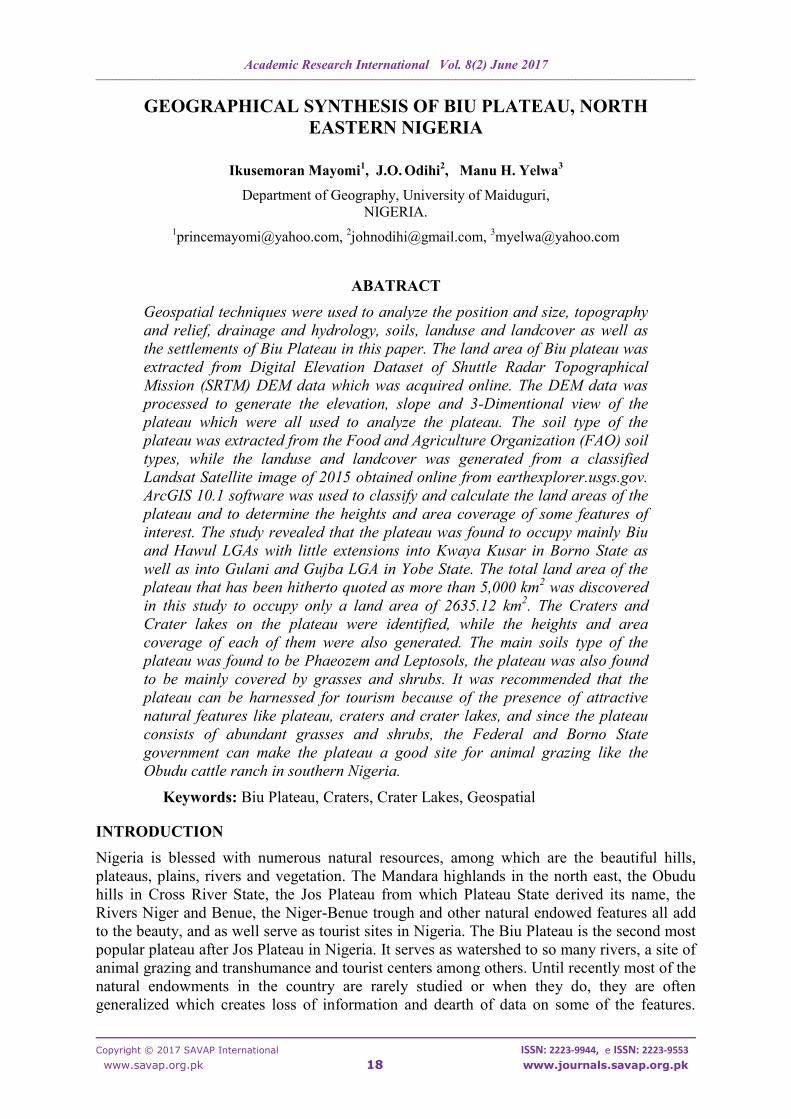
Position and Size of Biu Plateau
Biu plateau is located in Biu, Hawul and Kwaya Kusar LGAs in the southern part of Borno
state with extension into Gulani and Gujba LGA in southern Yobe State. The plateau lies
between latitudes 10˚.18N and 11˚.06'N and longitudes 11˚.49' and 12˚.25'E as shown in
Fig.1.
Academic Research International Vol. 8(2) June 2017
____________________________________________________________________________________________________________________________________________________________________________________
Copyright © 2017 SAVAP International ISSN: 2223-9944, e ISSN: 2223-9553
www.savap.org.pk 21 www.journals.savap.org.pk
Figure 1. The Study Area
In terms of size, Biu plateau covers a land area of 2635.12km2 from the total land area of
74832.71km2
of Borno State, which means that the plateau covers 3.52% of the land area of
Borno State. The small isolated hills at the foot of the plateau are however excluded from the
plateau. The area coverage of the plateau in each of the five LGAs is presented in Table 1.
Table. 1. Area landmass of Biu Plateau in each of the LGAs
LGA Plateau Area (km2) Percentage
Borno State
Biu 1979.54 75.12
Hawul 533.76 20.26
Kwaya Kusar 82.36 3.13
Yobe State
Gujba 25.85 0.98
Gulani 13.61 0.52
Total 2635.12 100
Academic Research International Vol. 8(2) June 2017
____________________________________________________________________________________________________________________________________________________________________________________
Copyright © 2017 SAVAP International ISSN: 2223-9944, e ISSN: 2223-9553
www.savap.org.pk 22 www.journals.savap.org.pk
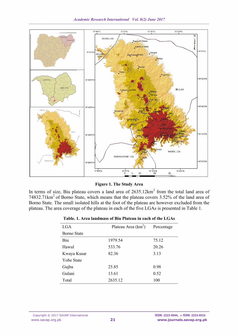
The actual size of Biu plateau (2635.12km2) as revealed from Table 1, is far less than what
have been quoted in some previous studies. For instance, [12] reported the size of the plateau
to have covered over 5000 km2.
Relief of Biu Plateau
The relief of Biu plateau comprises of the remnant of the dissected plateau itself and the
numerous craters on the plateau. The elevation of the plateau ranges from 498 to 923m above
the sea level. This finding is similar to the report of [8] that the plateau surface consists of
undulating plains lying between 500-800m above sea level; Biu plateau has been heavily
dissected as revealed from Figs 2, 3 and 4. The current shape of the plateau shows a step-like
structure from the foot up to the top of the plateau as shown in Fig 2a. All the craters are
found on the middle step as revealed in Figs 2a and 4.
Figure 2a. Elevation of Biu Plateau Figure 2b. Slope of Biu Plateau
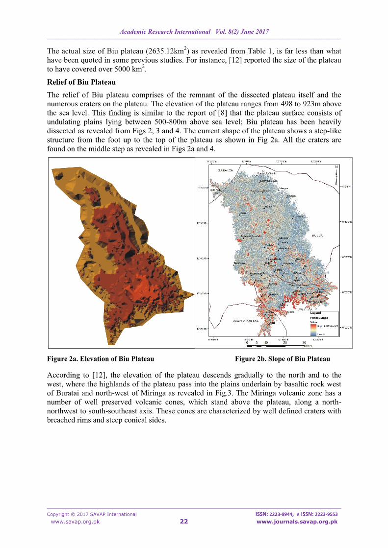
According to [12], the elevation of the plateau descends gradually to the north and to the
west, where the highlands of the plateau pass into the plains underlain by basaltic rock west
of Buratai and north-west of Miringa as revealed in Fig.3. The Miringa volcanic zone has a
number of well preserved volcanic cones, which stand above the plateau, along a north-
northwest to south-southeast axis. These cones are characterized by well defined craters with
breached rims and steep conical sides.
Academic Research International Vol. 8(2) June 2017
____________________________________________________________________________________________________________________________________________________________________________________
Copyright © 2017 SAVAP International ISSN: 2223-9944, e ISSN: 2223-9553
www.savap.org.pk 23 www.journals.savap.org.pk
Figure 3. The Relief of Biu Plateau
The relief of Biu Plateau cannot be effectively analyzed without discussing the Craters. [13]
described volcanic crater as a circular depression in the ground caused by volcanic activity. It
Academic Research International Vol. 8(2) June 2017
____________________________________________________________________________________________________________________________________________________________________________________
Copyright © 2017 SAVAP International ISSN: 2223-9944, e ISSN: 2223-9553
www.savap.org.pk 24 www.journals.savap.org.pk
is typically a basin, circular in form within which occurs a vent (or vents) from which magma
erupts as gases, lava, and ejecta. A crater can be of large dimensions, and sometimes of great
depth. A crater can be of large dimensions, and sometimes of great depth. [10] also reported
that a number of well preserved volcanic hills, made up of basaltic agglomerates, ash, lavas
and tuff create miniature escarpments also form permanent relief features in the northern
parts of the plateau. [4] took the coordinates of some craters on the plateau to assess the
morphology of the craters. These coordinates were used in this paper to identify the craters as
well as to determine the area coverage and the heights of each of the craters as presented in
Table 2. The craters were arranged in descending order based on their heights.
Table. 2. The coordinates, area coverage and heights of some important Craters on Biu Plateau
S/N Craters Latitudes Longitudes Area Coverage
(km2)
Maximum
Heights (m)
1 Kumba 10˚47′33.023ʺN 12˚5′ 25.441ʺE 10.21 923
2 Padam 10˚50′39.037ʺN 12˚6′ 9.862ʺE 3.72 874
3 Tilla 10˚39′54.929ʺN 12˚7′ 55.363ʺE 1.78 868
4 Kwari Tilla 10˚38′48.297ʺN 12˚8′ 3.692ʺE 3.11 850
5 Jali Tagurmi 10˚42′38.732ʺN 12˚7′ 35.528ʺE 0.62 836
6 Kufakana 10˚44′7.575ʺN 12˚7′ 19.27ʺE 3.34 824
7 Hujiga 10˚49′24.076ʺN 12˚2′ 38.861ʺE 2.84 814
8 Pidarta 10˚55′19.446ʺN 12˚0′25.597ʺE 1.20 805
9 Sugwi 10˚54′1.709ʺN 12˚1′12.795ʺE 0.22 771
10 Sugur 10˚44′18.68ʺN 12˚4′ 49.349ʺE 1.48 768
11 Higzi 10˚40′17.139ʺN 12˚14′ 7.391ʺE 1.28 767
12 Zamta 10˚40′49.7ʺN 12˚0′ 17.329ʺE 0.23 765
13 Kidi 10˚46′29.167ʺN 12˚6′ 1.533ʺE 3.18 759
Table 2 shows that in terms of area coverage, Kumba (10.21 km2), Padam (3.74 km
2) and
Kufakana (3.34 km2) were the three largest craters on the plateau, while Kumba (923m),
Padam (874m) and Tilla (868m) were the three highest craters on the plateau. Figure 5
shows the locations of the thirteen craters, while the 3-Dimentinoal view in Figure 4 shows
the shape and height of each of the craters.
Figure 4. 3D-View of Biu Plateau
PidartaSugwi
Hujiga
Padam Kumba
Kidi Sug
ur
Kuf
akan
a
Jali T
agru
mi
Tilla
Academic Research International Vol. 8(2) June 2017
____________________________________________________________________________________________________________________________________________________________________________________
Copyright © 2017 SAVAP International ISSN: 2223-9944, e ISSN: 2223-9553
www.savap.org.pk 25 www.journals.savap.org.pk
Legend
Biu_Craters LGABoundary StateBoundary
Figure 5. Craters on Biu Plateau
Drainage and Hydrology of Biu Plateau
Biu plateau is drained by three principal sources: rivers, streams and Crater Lakes. The main
rivers as shown in Fig. 6 include Rivers Divana, Hauwale, Korode, Kajola among others. The
longitudinal north-south alignment of the central part of the plateau forms the watershed for
most of the rivers from the third-half northwards. All the rivers take their sources from this
watershed area and flow either eastwards or westwards (Fig.6). At the extreme north, the
rivers takes their sources from the central plateau and flow northwards, while the rivers and
streams in the extreme south flow southwards from the central plateau. The foot of the
plateau was also found to contain only few rivers/streams as shown in Fig. 6
Academic Research International Vol. 8(2) June 2017
____________________________________________________________________________________________________________________________________________________________________________________
Copyright © 2017 SAVAP International ISSN: 2223-9944, e ISSN: 2223-9553
www.savap.org.pk 26 www.journals.savap.org.pk
Fig. 6. Drainage of Biu plateau
According to [4], only four craters (Hujiga, Kukafana, Tila and Sugur) out of the thirteen
identified craters in Biu plateau have crater lakes. The land area and the shape of each of the
four crater lakes were assessed in this study as presented in Table 3 and Fig.7 respectively.
Academic Research International Vol. 8(2) June 2017
____________________________________________________________________________________________________________________________________________________________________________________
Copyright © 2017 SAVAP International ISSN: 2223-9944, e ISSN: 2223-9553
www.savap.org.pk 27 www.journals.savap.org.pk
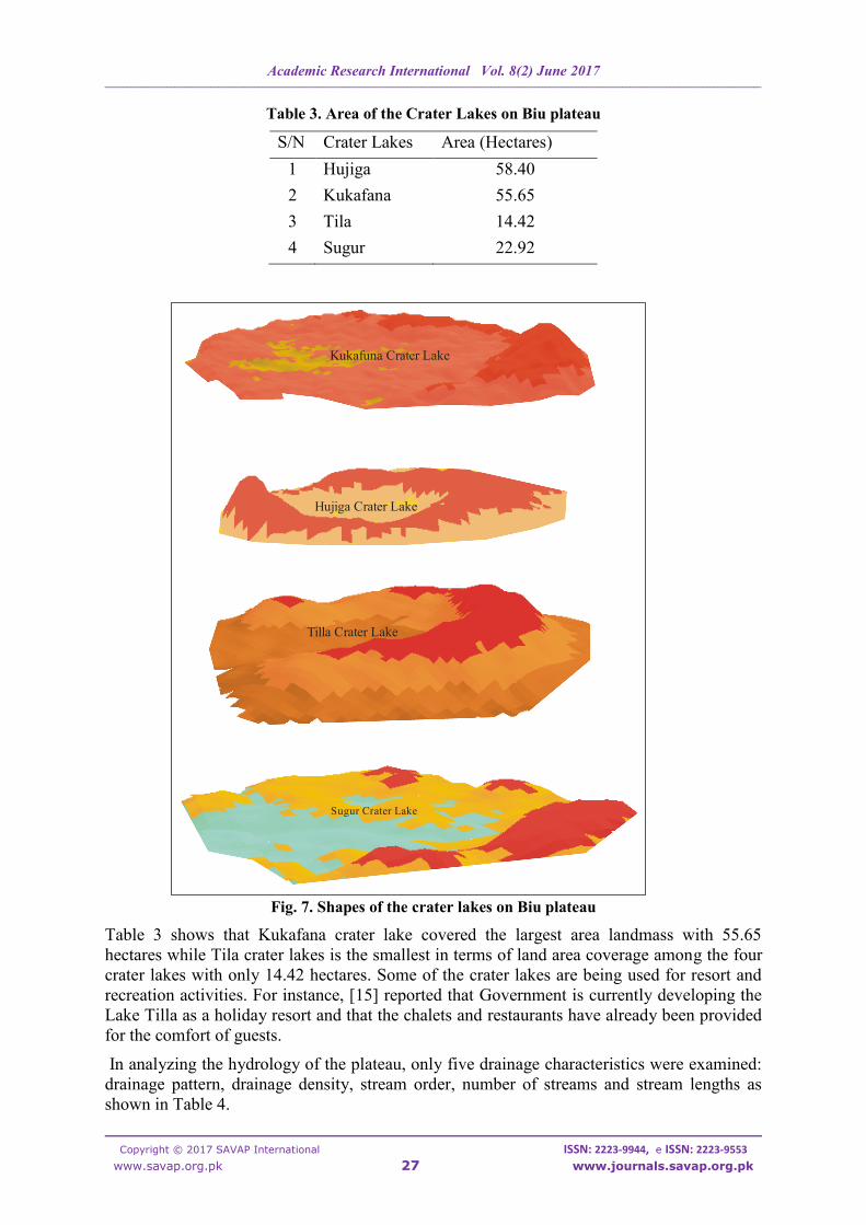
Table 3. Area of the Crater Lakes on Biu plateau
S/N Crater Lakes Area (Hectares)
1 Hujiga 58.40
2 Kukafana 55.65
3 Tila 14.42
4 Sugur 22.92
Fig. 7. Shapes of the crater lakes on Biu plateau
Table 3 shows that Kukafana crater lake covered the largest area landmass with 55.65
hectares while Tila crater lakes is the smallest in terms of land area coverage among the four
crater lakes with only 14.42 hectares. Some of the crater lakes are being used for resort and
recreation activities. For instance, [15] reported that Government is currently developing the
Lake Tilla as a holiday resort and that the chalets and restaurants have already been provided
for the comfort of guests.
In analyzing the hydrology of the plateau, only five drainage characteristics were examined:
drainage pattern, drainage density, stream order, number of streams and stream lengths as
shown in Table 4.
Hujiga Crater Lake
Kukafuna Crater Lake
Tilla Crater Lake
Sugur Crater Lake
Academic Research International Vol. 8(2) June 2017
____________________________________________________________________________________________________________________________________________________________________________________
Copyright © 2017 SAVAP International ISSN: 2223-9944, e ISSN: 2223-9553
www.savap.org.pk 28 www.journals.savap.org.pk
Table 4. Stream Characteristics of Biu Plateau
Drainage Pattern
The drainage pattern of the plateau is dendretic as the shape look like a tree with several
branches (Fig. 6). According to [14] it is the most common drainage pattern, and tends to
occur on flat land with uniform, non-porous bedrock. Straller’s pattern of stream order was
also adopted to assess the stream order of the plateau. The results revealed that the highest
stream order of Biu plateau is 6th
Order. [14] concluded that the dendretic drainage pattern
reflects the uniform nature of the soil and geology while homogenous rock structure accounts
for the evolution of dendritic drainage pattern.
Drainage Density
According to [16], drainage density looks at the relationship between the total length of all
the rivers and streams in a drainage basin (km) and the total area of a drainage basin (km2). If
an area has a high density, it means that precipitation gets into streams quicker, but if an area
has a low drainage density, it means that more precipitation has to travel by surface run-off,
through flow and base flow. They concluded that drainage densities are usually higher on
steep land because there is less infiltration and often less vegetation (depending on aspect),
higher on impermeable surfaces because of low infiltration, and vegetation increases
interception and reduces drainage density. The nature of Biu plateau confirmed the
aforementioned factors because the drainage density of the plateau can be said to be low
(2.61) because the slope (Fig 2b) is not steep in most part of the plateau, while 82.7% of the
plateau are covered with vegetation; that is either with forest (11.62%), woodland (28.72%)
and grassland/shrubs (42.66%) as shown in Table 6.
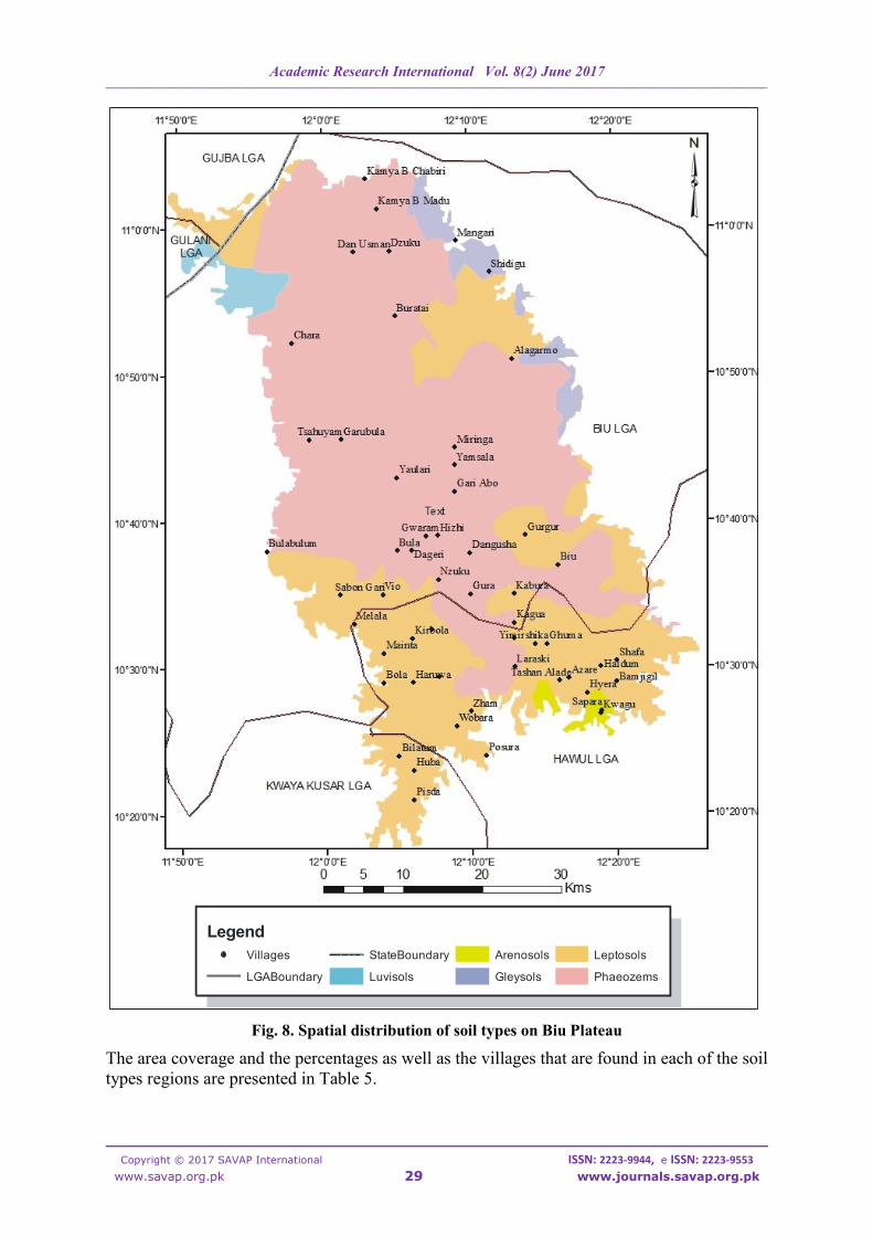
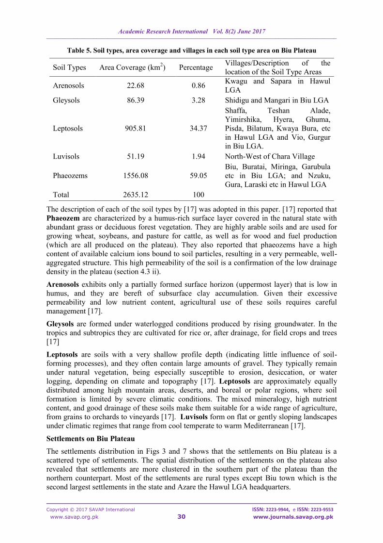
Soil of Biu Plateau
The five major soil types that were identified based on Food and Agriculture Organization
classifications on the plateau are: arenosols, gleysols, leptosols, luvisols and phaeozems. The
area coverage, percentages and spatial location of the soil types are presented in Fig 8.
Stream
Order
Number of Streams
(Nu) Stream Length (Lu)
1 9814 2402.34
2 3783 2384.32
3 837 1185.16
4 193 595.21
5 35 235.11
6 9 77.36
Total 14671 6879.5
Academic Research International Vol. 8(2) June 2017
____________________________________________________________________________________________________________________________________________________________________________________
Copyright © 2017 SAVAP International ISSN: 2223-9944, e ISSN: 2223-9553
www.savap.org.pk 29 www.journals.savap.org.pk
Fig. 8. Spatial distribution of soil types on Biu Plateau
The area coverage and the percentages as well as the villages that are found in each of the soil
types regions are presented in Table 5.
Legend
Villages
LGABoundary
StateBoundary
Luvisols
Arenosols
Gleysols
Leptosols
Phaeozems
Academic Research International Vol. 8(2) June 2017
____________________________________________________________________________________________________________________________________________________________________________________
Copyright © 2017 SAVAP International ISSN: 2223-9944, e ISSN: 2223-9553
www.savap.org.pk 30 www.journals.savap.org.pk
Table 5. Soil types, area coverage and villages in each soil type area on Biu Plateau
Soil Types Area Coverage (km2) Percentage
Villages/Description of the
location of the Soil Type Areas
Arenosols 22.68 0.86 Kwagu and Sapara in Hawul
LGA
Gleysols 86.39 3.28 Shidigu and Mangari in Biu LGA
Leptosols 905.81 34.37
Shaffa, Teshan Alade,
Yimirshika, Hyera, Ghuma,
Pisda, Bilatum, Kwaya Bura, etc
in Hawul LGA and Vio, Gurgur
in Biu LGA.
Luvisols 51.19 1.94 North-West of Chara Village
Phaeozems 1556.08 59.05
Biu, Buratai, Miringa, Garubula
etc in Biu LGA; and Nzuku,
Gura, Laraski etc in Hawul LGA
Total 2635.12 100
The description of each of the soil types by [17] was adopted in this paper. [17] reported that
Phaeozem are characterized by a humus-rich surface layer covered in the natural state with
abundant grass or deciduous forest vegetation. They are highly arable soils and are used for
growing wheat, soybeans, and pasture for cattle, as well as for wood and fuel production
(which are all produced on the plateau). They also reported that phaeozems have a high
content of available calcium ions bound to soil particles, resulting in a very permeable, well-
aggregated structure. This high permeability of the soil is a confirmation of the low drainage
density in the plateau (section 4.3 ii).
Arenosols exhibits only a partially formed surface horizon (uppermost layer) that is low in
humus, and they are bereft of subsurface clay accumulation. Given their excessive
permeability and low nutrient content, agricultural use of these soils requires careful
management [17].
Gleysols are formed under waterlogged conditions produced by rising groundwater. In the
tropics and subtropics they are cultivated for rice or, after drainage, for field crops and trees
[17]
Leptosols are soils with a very shallow profile depth (indicating little influence of soil-
forming processes), and they often contain large amounts of gravel. They typically remain
under natural vegetation, being especially susceptible to erosion, desiccation, or water
logging, depending on climate and topography [17]. Leptosols are approximately equally
distributed among high mountain areas, deserts, and boreal or polar regions, where soil
formation is limited by severe climatic conditions. The mixed mineralogy, high nutrient
content, and good drainage of these soils make them suitable for a wide range of agriculture,
from grains to orchards to vineyards [17]. Luvisols form on flat or gently sloping landscapes
under climatic regimes that range from cool temperate to warm Mediterranean [17].
Settlements on Biu Plateau
The settlements distribution in Figs 3 and 7 shows that the settlements on Biu plateau is a
scattered type of settlements. The spatial distribution of the settlements on the plateau also
revealed that settlements are more clustered in the southern part of the plateau than the
northern counterpart. Most of the settlements are rural types except Biu town which is the
second largest settlements in the state and Azare the Hawul LGA headquarters.
Academic Research International Vol. 8(2) June 2017
____________________________________________________________________________________________________________________________________________________________________________________
Copyright © 2017 SAVAP International ISSN: 2223-9944, e ISSN: 2223-9553
www.savap.org.pk 31 www.journals.savap.org.pk
Land Use and Land Cover
The classified landsat image of the plateau revealed farmland and settlements as the main
landuse types, while bare surface, woodland, forest, open water and grasslands/shrubs were
the identified landcover types. It was also revealed that some parts of the grassland/shrub
areas are used for animal grazing [3] and [8]. The seven classified landuse and landcover
types are presented in Fig 9 and analyzed in Table 6.
Fig. 9. Landuse and Landcover of Biu Plateau
The land area and the percentages of each of the classified landuse and landcover on the
plateau is shown on Table 6.
Legend
Villages
LGABoundary
StateBoundary
Farming
Bare Surface
Grassland
Forest
Settlements
Open Water
Woodland
Academic Research International Vol. 8(2) June 2017
____________________________________________________________________________________________________________________________________________________________________________________
Copyright © 2017 SAVAP International ISSN: 2223-9944, e ISSN: 2223-9553
www.savap.org.pk 32 www.journals.savap.org.pk
Table 6. Areas and Percentages of Landuse and Landcover types in Biu Plateua
Table 6 revealed that grassland/shrub covered the largest portion of the plateau (42.36%). It
was also revealed that despite being a plateau, 40.34% of the plateau was covered with forest
(11.62%) and woodland (28.72%). This findings show that major parts of the plateau are
covered with vegetation as reported by [7] that the plateau is covered by Sudan savanna type
of vegetation which consists mainly of scrub vegetation interspersed with tall trees and
woodland; the vegetation type has been greatly modified in most parts by over-cultivation
and overgrazing.
Fig 6 also revealed that bare surface areas were found mainly in southern Biu LGA especially
in areas where rocks are exposed and where farming activities are extensively carried out,
hence some places around Bula, Vio, Kagua, Biu among others were bare surface (Fig.6).
Moreover, the widest areas where bare surface were found (between Yaulari in the north and
Vio in the south) have long been a cattle grazing reserve [18]. The grazing activities in this
area have turned some parts of the area into bare surface. Some parts of Shaffa, Yimirshika,
Azare and other areas in Hawul LGA were also places where farming activities were carried
out. Forest and woodland areas are found especially at the central towards the western parts
of Biu LGA. A large area bounded by Miringa in the south, Alagarmo and Shidigu in the
north-east and Buratai in the west commonly refered to as Alagarmo forest. Alagarmo forest
has been reported by [19] to be the spiritual power base of the insurgents in north-eastern
Nigeria, the base that was dislodged on 31st March, 2016. The extended portions of the
plateau into Yobe State (Gulani and Gujba LGAs) are mainly forest or woodland areas.
Grassland/shubs areas are found almost everywhere on the plateau except the Alagarmo
forest region. The grassland areas are usually home to animal grazing as reported by [3] that
Miringa in Biu LGA is known as a veritable livestock rearing area with the highest
concentration of livestock population, especially cattle. The popular Demsikari Forest
Reserve which is located between Biu and Gurgur [18] is also conspicuously shown as a
forest and woodland areas on the classified image
The settlements types are mostly rural which are difficult to be discerned with naked eyes on
the image (except when zoomed in), while open water has the least land area. Following the
fact that the image was captured in November when most of the rivers must have dried off as
reported by [8] that water supplies are poor on Biu plateau which has been heavily dissected
by numerous streams, most of which contain no water during the dry season.
Landuse and Landcover Types Area (km2) Percentages
Bare Surface 204.22 7.75
Farming 238.03 9.03
Forest 306.33 11.62
Grassland/Shrub 1116.28 42.36
Open Water 2.96 0.11
Settlements 10.49 0.40
Woodland 756.81 28.72
Total 2635.12 100
Academic Research International Vol. 8(2) June 2017
____________________________________________________________________________________________________________________________________________________________________________________
Copyright © 2017 SAVAP International ISSN: 2223-9944, e ISSN: 2223-9553
www.savap.org.pk 33 www.journals.savap.org.pk
CONCLUSION
The position and size, topography and relief, drainage and hydrology, soils, settlements and
landuse and landcover of Biu Plateau has been analyzed in this paper using geospatial
techniques. The adopted method was found to be more accurate and reliable especially in the
assessments of the shapes, sizes, heights and depths of some features on the plateau than the
previous studies that were carried out using manual methods. The plateau was found to
mainly occupy Biu and Hawul LGAs in Borno state, but this study revealed that little parts of
the plateau extended to Kwaya Kusar in Borno State as well as into Gulani and Gujba LGA
in Yobe State. The total land area of the plateau that has been hitherto quoted as more than
5,000 km2 was discovered in this study to occupy only a land area of 2635.12 km
2. The actual
locations of some important features especially craters and crater lakes on Biu plateau were
also generated in this study. The generated depth, heights and area coverage of the craters and
crater lakes can be used for the classifications of these features based on the obtained values
of their area, depth and heights. The main soil type of the plateau is Phaeozem which are
highly arable soils and are used for growing wheat, soyabeans, and pasture for cattle, as well
as for wood and fuel production; all of which are carried out on the plateau. From the many
landuse and landcover types, the plateau was covered mainly by grasslands and shrubs.
Geospatial techniques can also be used for the assessments and analysis of other important
natural endowed features such as vegetation, plains, troughs, deserts and other plateaus and
highlands in the country in future studies.
RECOMMENDATIONS
This study has revealed some important facts about the Biu Plateau environment and the
techniques used in the study. On the basis of these findings the following recommendations
are made.
1. Geospatial techniques should be adopted in the assessment and documentation of
important natural endowments in Nigeria because of its high accuracy, reliability and
easy documentations
2. The study area can be harnessed for tourism because of the presence of attractive
natural features like plateau, craters and crater lakes.
3. Since the plateau was also found to contain much grasslands and shrubs, the federal
and Borno State government can make the plateau a good site for animal grazing like
the Obudu cattle ranch in southern Nigeria.
Academic Research International Vol. 8(2) June 2017
____________________________________________________________________________________________________________________________________________________________________________________
Copyright © 2017 SAVAP International ISSN: 2223-9944, e ISSN: 2223-9553
www.savap.org.pk 34 www.journals.savap.org.pk
REFERENCE
[1] Turner, D.C. (1978). Volcanoes of the Biu basalt plateau, north-east Nigeria. Journal
of Mining and Geology, 15.
[2] Saidu, Y. (2004). Geochemical characteristics and evolution of the Biu Plateau
basalt. Nigeria: Jos University.
[3] Abdullahi, J., Odihi, J.O., & Wannah, B.B. (2015). Analysis of morphology of Biu
plateau, Borno State, Nigeria. Journal of geography, environment and earth sciences,
3(1), 1-10.
[4] Burrough, P. A. (1986), Principles of geographical information system for land
resources assessment. Oxford: Clarendon Press.
[5] Heywood, I., Cornelius, S., & Carner, S. ((1998). An introduction to geographic
information systems. Essex, England: Addision Wesley Longman Limited.
[6] Ikusemoran, M., Abdullahi, J., & Dami, A. (2013). Terrain analysis of Biu plateau
for road development, Borno State, Nigeria. Journal of geography and geology, 6 (2),
29-35.
[7] Encyclopedia Britannica. Biu Plateau. Retrieved on 25th
April, 2017.
[8] Udo, R.K. (1978). Geographical regions of Nigeria. London: Heinemann Press,
[9] Udo, R.K. (1982). A comprehensive geography of West Africa. Nigeria: Heinemann.
[10] Ijere, J.A., & Daura, M.M. (2000). Borno state in NIGERIA: A people united, a future
assured. Nigeria: Gabumo Publishing.
[11] FAO/UNESCO/ISRC (1996). Dominant Soils of Nigeria. Center for world food
studies, thirteen west and central African soil correlation sub-committee meeting,
Kumasi Ghana; 11-15th
Nov; 1996
[12] Lar, U.A., and Usman, A.M. (2012). Environmental distribution of trace metals in the
Biu volcanic province, Nigeria: exposure and environmental health problems.
International journal of scientific and engineering research, 3(10). Pp 1-16.
[13] Quizlet, I. (2017). Geography quiz 7 & 8 flashcard. Retrieved from
quizlet.com/11336699/geography-quiz-7-and-8.
[14] Otu, R, O. (2014). Drainage characteristics of Galtimari gully system in Maiduguri
urban, Borno state. Nigeria: University of Maiduguri.
[15] Northern Nigeria Tourism and Trade. (2011). Tilla lake. Retrieved from
www.northernnigeriatourism.com/states/borno.html.
[16] Greenfieldgeography (2017). Hydrograph. Retrieved from
greenfieldgeography.wikispaces.com/Hydrographs
[17] Food and Agricultural Organization (FAO). (2017). FAO soil group. Retrieved from
www.britannica.com/science/phaeozem
[18] Federal Survey (1970). Biu Topographical Map, Sheet 133. Nigeria: Federal Survey.
[19] Olugbode, M. (2016). Spiritual headquarters of Boko Haram Captured. Retrieved
from allafrica.com/stories/201603300289.html