+ All Categories
Home > Documents > Geographically Aware Web Text Mining · A ambiguidade e a vagueza existentes nestes recursos...

Geographically Aware Web Text Mining · A ambiguidade e a vagueza existentes nestes recursos...

Date post: 09-Dec-2018
Category:
Upload: vonhan
View: 214 times
Download: 0 times
Share this document with a friend
274
UNIVERSIDADE DE LISBOA FACULDADE DE CI ˆ ENCIAS DEPARTAMENTO DE INFORM ´ ATICA Geographically Aware Web Text Mining Bruno Emanuel da Gra¸ ca Martins DOUTORAMENTO EM INFORM ´ ATICA ESPECIALIDADE ENGENHARIA INFORM ´ ATICA Agosto de 2008
Transcript

UNIVERSIDADE DE LISBOA

FACULDADE DE CIENCIAS

DEPARTAMENTO DE INFORMATICA

Geographically Aware Web Text Mining

Bruno Emanuel da Graca Martins

DOUTORAMENTO EM INFORMATICA

ESPECIALIDADE ENGENHARIA INFORMATICA

Agosto de 2008

Geographically Aware Web Text Mining

Bruno Emanuel da Graca Martins

Tese submetida para obtencao do grau de

DOUTOR EM INFORMATICA

ESPECIALIDADE ENGENHARIA INFORMATICA

pela

FACULDADE DE CIENCIAS DA UNIVERSIDADE DE LISBOA

DEPARTAMENTO DE INFORMATICA

Agosto de 2008

I would like to dedicate this thesis to the memory of my beloved

grandparents, Mariana and Dionısio da Graca.

Acknowledgements

The financial support given from Fundacao para a Ciencia e Tecnolo-

gia (FCT), through the PhD scholarship with reference SFRH/BD/-

10757/2002, is gratefully acknowledged.

In the course of creating this thesis I stumbled upon many problems

which I certainly would not have had the strength or knowledge to

solve by myself. I would like to express my gratitude to all colleagues

and to the readers of my work, for their valuable insights and advice.

This thesis also builds on the previous efforts by many distinguished

individuals from the Geographical Information Retrieval community.

My gratitude goes to Ross Purves, Paul Clough, Chris Jones, Linda

Hill, Ray Larson, Andras Kornai, Jochen Leidner, Patricia Frontiera

and Tony Ress, for the inspiration provided by their examples.

I would especially like to thank my research adviser, Professor Mario J.

Silva, for his constant guidance and constructive criticism throughout

this work. It has been a pleasure working with him. A special thanks

goes also to my colleagues and friends Andre Santos, Daniel Gomes,

Diana Santos, Francisco Couto, Ivo Sousa, Leonardo Andrade, Miguel

Costa, Marcirio Chaves, Norman Noronha, Nuno Cardoso and Sergio

Freitas, for their support and stimulating discussions.

Abstract

Text mining and search have become important research areas over

the past few years, mostly due to the large popularity of the Web. A

natural extension for these technologies is the development of methods

for exploring the geographic context of Web information.

Human information needs often present specific geographic constraints.

Many Web documents also refer to specific locations. However, rela-

tively little effort has been spent on developing the facilities required

for geographic access to unstructured textual information. Geograph-

ically aware text mining and search remain relatively unexplored.

This thesis addresses this new area, arguing that Web text mining can

be applied to extract geographic context information, and that this

information can be explored for information retrieval. Fundamental

questions investigated include handling geographic references in text,

assigning geographic scopes to the documents, and building retrieval

applications that handle/use geographic scopes. The thesis presents

appropriate solutions for each of these challenges, together with a

comprehensive evaluation of their effectiveness. By investigating these

questions, the thesis presents several findings on how the geographic

context can be effectively handled by text processing tools.

Keywords: Geographic Information Retrieval, Web/Text Mining

Resumo

A pesquisa e prospeccao de texto tornaram-se nos ultimos anos impor-

tantes areas de pesquisa, em grande parte devido a popularidade da

Web. Uma extensao natural destas tecnologias e a criacao de metodos

para explorar o contexto geografico da informacao na Web.

As necessidades de informacao sao muitas vezes expressas com um

dado constrangimento geografico e muitos documentos referem-se tam-

bem a locais especıficos. No entanto, tem sido dedicado relativamente

pouco esforco ao desenvolvimento dos mecanismos necessarios para

a exploracao geografica de informacao textual nao estruturada. A

prospeccao e pesquisa de informacao textual, cientes da geografia,

permanecem relativamente inexploradas.

Esta tese aborda esta problematica, levantando a hipotese de poderem

ser usadas tecnicas de prospeccao de textos Web para extrair in-

formacao relativa ao contexto geografico, podendo ainda esta informa-

cao ser usada na pesquisa de documentos. As questoes fundamentais

sob investigacao incluem o processamento de referencias geograficas,

a atribuicao de ambitos geograficos a documentos, e a construcao de

aplicacoes de pesquisa suportando ambitos geograficos. Sao descritas

solucoes adequadas a cada um destes desafios, e e feita uma avaliacao

pormenorizada da sua eficacia. Como resultado da investigacao, a tese

apresenta algumas conclusoes sobre como pode o contexto geografico

ser considerado em aplicacoes de processamento de texto.

Palavras-Chave: Recuperacao de Informacao Geograficamente Con-

textualizada, Prospeccao de Textos da Web

Resumo Alargado(Research overview in Portuguese)

A pesquisa e prospeccao de informacao textual tornaram-se nos ulti-

mos anos importantes areas de pesquisa, em grande parte devido a

popularidade da Web. Foram propostas diversas tecnicas para opti-

mizar os sistemas de pesquisa e prospeccao de texto, compreendendo

desde novas arquitecturas de sistema a novos algoritmos para inferir a

relevancia de documentos. Muitas destas propostas foram especifica-

mente desenvolvidas para o ambiente Web, tirando partido das suas

caracterısticas especıficas tais como a existencia de hiperligacoes entre

os documentos.

Existem actualmente varios esforcos concertados no sentido de desen-

volver mecanismos para a interpretacao semantica dos textos e das

necessidades de informacao (e.g. a Web semantica). Os metodos

de pesquisa e prospeccao de texto que vao alem da utilizacao de es-

tatısticas calculadas com base na ocorrencia de termos, assim como

da apresentacao dos resultados atraves de listas ordenadas, sao im-

portantes areas de estudo. Muita da investigacao actual lida com o

problema de inferir informacao mais estruturada a partir dos doc-

umentos textuais, estando portanto na fronteira entre os problemas

convencionais da pesquisa (i.e. information retrieval) e da prospeccao

(i.e. information extraction) de texto. A busca de padroes sobre docu-

mentos e o estudo de novas formas de apresentar resultados e interagir

com os utilizadores sao fundamentais para uma melhor utilizacao da

enorme quantidade de informacao disponıvel na Web.

Uma extensao natural das tecnologias de pesquisa e prospeccao de in-

formacao textual prende-se com a criacao de metodos para lidar com

o contexto geografico da informacao. Grande parte das actividades

humanas ocorrem num dado contexto geoespacial (i.e. tem lugar em

um ou varios locais da superfıcie terrestre) e, ao comunicarmos, us-

amos referencias geograficas tais como perto de Lisboa ou localizado no

Bairro Alto. Naturalmente que existe uma grande quantidade de in-

formacao textual, inclusive na Web, que se encontra geo-referenciada

atraves do uso de nomes de locais. De igual forma, as necessidades

de informacao, usualmente expressas atraves de expressoes textuais,

relacionam-se frequentemente com um dado contexto geografico. O

potencial para o uso desta informacao e enorme. Os proprios uti-

lizadores de sistemas de pesquisa e prospeccao de informacao comecam

ja a procurar estas funcionalidades.

Contudo, as ferramentas de pesquisa actuais sao ainda muito limi-

tadas no que diz respeito a procura de informacao relacionada com

contextos geograficos. O interesse crescente nestas tecnologias reflecte-

se na emergencia de interfaces especializadas para a busca de in-

formacao local associadas aos principais motores de busca (i.e. o

Google ou o Yahoo! local). No entanto, estes sistemas assentam so-

bretudo em directorios de informacao do tipo paginas-amarelas, os

quais contem informacao controlada e previamente geo-referenciada

por entidades terceiras. Nao ha nestes sistemas uma tentativa de

explorar directamente a informacao geografica presente nos proprios

documentos que se encontram publicados na Web.

Ao contrario destas interfaces especializadas para a busca local, os

motores de busca tradicionais tentam usar directamente toda a in-

formacao publicada na Web. Contudo, uma vez que estes se ba-

seiam na ocorrencia de termos individuais sobre os documentos, as

expressoes geograficas sao tratadas de forma igual as restantes. Num

motor de busca convencional, textos que refiram um nome alterna-

tivo para o local mencionado no pedido do utilizador (e.g. Invicta em

relacao a cidade do Porto), ou locais que estejam contidos ou local-

izados nos arredores (e.g. Campolide em relacao com Lisboa), serao

ignorados, uma vez que estas relacoes nao sao capturadas numa com-

paracao directa entre os termos do pedido e dos documentos.

Tem-se ainda que as tecnologias de acesso a informacao geografica

sofreram avancos consideraveis nos ultimos anos, em grande parte

relacionados com a popularizacao da tecnologia Global Positioning

System (GPS) e dos sistemas de informacao geografica do tipo Globo

Virtual (e.g. o Google Earth). Organizacoes como o Open Geospatial

Consortium (OGC) tem feito grandes esforcos no sentido de definir e

promover standards, baseados em tecnologias Web, para a gestao de

informacao geoespacial de uma forma interoperavel, sendo que muita

da tecnologia actual e ja baseada nestas propostas. No entanto, a

grande maioria destes esforcos assentam em representacoes fortemente

estruturadas da informacao e de caracter nao semantico (e.g. coorde-

nadas geoespaciais, em oposicao a relacoes entre nomes geograficos).

Tem sido dedicado relativamente pouco esforco a criacao dos mecan-

ismos necessarios para o acesso a informacao nao estruturada, pelo

que a prospeccao e pesquisa de informacao textual, conscientes da

geografia, permanecem relativamente inexploradas.

O grande desafio que se coloca a exploracao do contexto geografico

associado a documentos textuais reside no facto da lıngua natural

ter sido desenvolvida para a comunicacao entre humanos e nao en-

tre sistemas computacionais. A ambiguidade e a vagueza existentes

nestes recursos levantam grandes problemas ao seu processamento au-

tomatico. No entanto, embora um entendimento completo de um doc-

umento textual nao seja atingıvel com a tecnologia actual, este tra-

balho pretende demostrar que e possıvel abordar um problema mais

restrito e focado na extraccao e processamento eficaz de pequenas

quantidades de informacao, i.e. expressoes textuais que identifiquem

locais, por forma a inferir o contexto geografico dos documentos.

Esta tese defende que a combinacao de tecnicas de prospeccao de texto

com vista a extrair e desambiguar referencias geograficas, juntamente

com outras tecnicas de recuperacao de informacao (e.g. clustering de

documentos ou a pesquisa com base em ındices de termos) pode assim

melhorar a eficacia no processo da descoberta de informacao relevante.

Os metodos de recuperacao de informacao classicos podem ser melho-

rados atraves de um processo de medicao de relevancia que leve em

conta o contexto geografico das interrogacoes e dos documentos. O

tratamento do contexto geografico dos documentos pode assim criar

uma mudanca de paradigma nas tecnologias de pesquisa, trazendo o

poder da geografia para o ambito da pesquisa de informacao na Web.

A hipotese principal por detras deste trabalho e a seguinte:

As tecnicas de prospeccao de informacao podem ser usadas

para extrair o contexto geografico dos documentos da Web,

com vista a sua exploraccao em metodos de recuperacao de

informacao que levem em conta a relevancia geografica.

Para validar esta hipotese, recorreu-se a uma metodologia experimen-

tal assente em duas fases: na primeira, o problema geral foi decom-

posto numa serie de sub-tarefas, as quais foram individualmente abor-

dadas atraves da proposta de novos metodos e sua avaliacao experi-

mental. Na segunda fase foram efectuadas experiencias adicionais

com um prototipo de um sistema que integra as tecnicas desenvolvi-

das para cada uma das sub-tarefas consideradas.

A hipotese levantada assenta nos dois seguintes presupostos:

1. Os documentos na Web contem frequentemente referencias ge-

ograficas (por exemplo, nomes de locais).

2. Documentos que contenham referencias geograficas podem ser

associados a ambitos geograficos especıficos.

Ao logo da dissertacao sao apresentadas algumas evidencias no sentido

de clarificar os dois presupostos atras.

O conceito de ambito geografico assume particular importancia neste

trabalho. Um ambito geografico representa a area geografica a que um

dado documento se refere no seu todo, i.e. a sua cobertura em ter-

mos de uma area na superfıcie terrestre. Cada documento pode fazer

referencia a varios conceitos geograficos, atraves do uso de nomes de

locais, tendo-se no entanto que estas referencias se podem resumir

em ambitos mais genericos. Podem ser tomadas diversas abordagens

para a especifıcacao de ambitos geograficos, incluındo-se o uso de um

conjunto de pontos ou da area rectangular delimitadora (i.e. bounding

box) que envolve todas as regioes a que o documento se refere. Esta

tese defende a definicao dos ambitos geograficos com base em identi-

ficadores numa ontologia, a qual codifica a terminologia e as relacoes

associadas aos conceitos geograficos. Cada conceito na ontologia pode

ser visto como um ambito geografico, representando uma dada regiao

na superfıcie da Terra e tendo um identificador unico. Uma vez que

a ontologia pode representar grandes areas geograficas ou sub-regioes

muito especıficas, a granularidade dos ambitos geograficos pode ser

ajustada a area que e efectivamente discutida num dado texto. Se a

cada documento for atribuido um destes identificadores na ontologia,

a restante informacao definida na mesma (isto e, a cobertura geoes-

pacial de cada conceito e os conceitos geograficos que se encontram

relacionados) pode ser usada para suportar operacoes de pesquisa com

restricoes geograficas sobre os documentos.

No que diz respeito a decomposicao do problema, sao propostas tres

grandes sub-tarefas. A primeira consiste no reconhecimento e desam-

biguacao das referencias geograficas (por exemplo, nomes de locali-

dades) presentes nos documentos Web. A segunda tarefa prende-se

com a determinacao de ambitos geograficos para os documentos Web,

com base na combinacao das referencias geograficas extraıdas de cada

documento. A terceira etapa relaciona-se com a utilizacao de ambitos

geograficos para a pesquisa de documentos a partir do contexto ge-

ografico dos mesmos. Para cada uma destes problemas especıficos

foram propostos novos metodos, tendo sido comprovada a sua eficacia

atraves de testes com conjuntos de dados usados no passado em tra-

balhos de investigacao similares.

A lista de items seguidamente apresentada resume os resultados mais

importantes para cada uma das sub-tarefas propostas.

Reconhecimento e desambiguacao de referencias geograficas:

• Esta sub-tarefa pode ser resolvida de forma eficiente usando

um sistema baseado em regras com uma cadeia de processa-

mento tıpica nos sistemas de extraccao de informacao, combi-

nando os nomes de locais definidos numa ontologia geografica

com heurısticas para o reconhecimento e desambiguacao. Os

resultados com esta abordagem relativamente simples sao com-

paraveis com os melhores resultados reportados noutros trabal-

hos. As experiencias demonstram uma precisao de cerca de 80%,

variando ligeiramente com a lıngua ou com a coleccao.

• Uma heurıstica do tipo um referente por discurso pode ajudar no

processo de desambiguacao de referencias a locais. As melhorias

obtidas com a introducao desta heurıstica sao de cerca de 5% em

temos de precisao.

• A utilizacao de regras de reconhecimento complexas deve ser bem

ponderada, uma vez que os ganhos em termos de precisao podem

nao compensar o esforco adicional em processamento. Nas ex-

periencias efectuadas, uma melhoria de 3% em termos de precisao

pode accaretar um perca de 10% em termos de desempenho.

• Heurısticas especıficas para documentos HTML, aplicadas no

pre-processamento dos documentos, ajudam na tarefa de extrair

informacao. Por exemplo, ao classificar documentos de acordo

com a lıngua, as melhorias obtidas com a introducao destas heu-

rısticas sao de cerca de 3% em termos de precisao.

Atribuicao de ambitos geograficos a recursos Web:

• Esta sub-tarefa pode ser resolvida de forma eficiente atraves da

utilizacao de um algoritmo de ordenacao para grafos, aplicado

sobre um grafo de inferencias obtido a partir da ontologia geogra-

fica. Na atrıbuicao de ambitos correspondentes a pequenas areas

geograficas (i.e., mapeamentos exactos com os ambitos definidos

numa coleccao de testes associando documentos Web a locali-

dades especıficas) este algoritmo oferece uma melhoria de cerca

de 10% em termos de precisao, em comparacao com propostas

anteriores que apenas exploravam relacoes hierarquicas entre os

conceitos geograficos de uma ontologia.

• Os URL dos documentos podem ser usados para a atribucao de

ambitos geograficos. Nos experimentos realizados observou-se

uma precisao acima dos 70% com o metodo proposto, embora as

mesmas experiencias tenham revelado problemas em termos de

abrangencia. A combinacao do metodo baseado nos URL com

um metodo baseado em ordenacao em grafos pode ser particu-

larmente interessante para aplicacao em grandes coleccoes Web.

As abordagens baseadas em grafos sao computacionalmente ex-

igentes e o desempenho e um factor essencial no processamento

de grandes coleccoes de documentos.

Uso de ambitos geograficos em recuperacao de informacao:

• Muitas pesquisas geograficas podem ser vistas como triplos na

forma < tema, relacionamento, local >. Podem ser usados algo-

ritmos relativamente simples para mapear os pedidos dos utiliza-

dores, dados sob a forma de cadeias de caracteres, nestes triplos.

As experiencias realizadas sobre um conjunto de interrogacoes

geograficas retiradas do diario de um motor de busca permiti-

ram observar uma precisao de cerca de 80%.

• Estender um algoritmo para o agrupamento automatico de re-

sultados (i.e. clustering) com uma etapa de pre-classificacao que

organize os documentos com base nos seus ambitos geograficos

fornece aos utilizadores uma forma interessante de explorar os

resultados geograficamente. Experimentos realizados com uti-

lizadores demonstram uma boa aceitacao desta tecnica.

• A recuperacao de documentos geografica e tematicamente rele-

vantes pode ser feita atraves da combinacao da metrica BM25,

para a similaridade textual, com heurısticas especıficas para a

similaridade entre ambitos geograficos. Experiencias no con-

texto da campanha de avaliacao GeoCLEF permitiram observar

resultados de cerca de 0.2 em termos da mediana da precisao

media (i.e. Mean Average Precision ou MAP). No entanto, es-

tas experiencias nao conseguiram demonstrar a superioridade do

metodo de recuperacao de informacao baseado em ambitos ge-

ograficos, uma vez que melhores resultados foram obtidos com

uma tecnica mais simples baseada em expansao de termos.

• Interfaces que combinem a pesquisa geografica com base em

ambitos atribuıdos aos documentos com funcionalidades de ex-

ploracao sobre mapas e agrupamentos dos resultados podem fa-

cilitar a pesquisa de informacao relevante. Um estudo com uti-

lizadores demonstrou uma boa aceitacao para uma interface que

integre estas funcionalidades.

O conjunto anterior de observacoes fornece provas concludentes ten-

dentes a comprovar a hipotese levantada nesta tese. Demonstra-se

efectivamente que podem ser aplicadas tecnicas de prospeccao de in-

formacao para inferir o contexto geografico dos documentos na Web,

e que esta informacao pode ser usada na construcao de metodos de

pesquisa mais adequados. No entanto, alguns reparos devem ser feitos

a esta conclusao. Tal como mentionado atras, as experiencias real-

izadas no contexto do GeoCLEF demostraram que um metodo mais

simples para recuperacao de informacao, baseado em expansao de

queries usando uma ontologia geografica, pode obter resultados supe-

riores ao metodo baseado em ambitos. A analise dos resultados sugere

que este ultimo metodo e bastante sensıvel a erros no processamento

dos documentos. Como trabalho futuro, seria particularmente inter-

essante verificar se a atribuicao de documentos a multiplos ambitos

geograficos pode melhorar estes resultados. Limitar a associacao a um

unico ambito e provavelmente uma abordagem demasiado restritiva.

Em suma, como contributo mais importante, tem-se que esta dis-

sertacao relata varias experiencias com um sistema prototipo, o qual

integra diversos metodos para lidar com informacao de contexto ge-

ografico. Mostra-se que o mesmo sistema e os seus sub-componentes

alcancam bons resultados nas tarefas consideradas.

De um ponto de vista cientıfico, este trabalho apresenta contribuicoes

relevantes para o avanco do estado da arte em metodologias para a

pesquisa e prospeccao de texto com base no contexto geografico. Estas

contribuicoes poderao encontrar aplicacao no desenvolvimento de uma

nova Web Semantica Geoespacial. Esta tese desafia ainda a nocao de

que a informacao geo-referenciada e do domınio exclusivo dos Sis-

temas de Informacao Geografica (SIG) classicos, argumentando antes

que esta e antes uma parte integral do problema generico da gestao e

recuperacao de informacao. Dado que as actividades humanas ocor-

rem geralmente associadas a um contexto geoespacial, o tratamento

de informacao geo-referenciada deve ser um componente de qualquer

sistema de informacao que suporte estas actividades.

De um ponto de vista tecnologico, a grande contribuicao deste tra-

balho e dada sob a forma de um prototipo de um sistema que pode

ser usado como bancada de trabalho para diversas actividades de in-

vestigacao. Os componentes de software individuais e os conjuntos

de dados usados nas experiencias foram disponibilizados como soft-

ware livre e aberto. Dado que estes recursos podem agora ser usados,

modificados e redistribuıdos sem restricoes, sera de esperar que outros

investigadores os usem nos seus proprios projectos.

Como trabalho futuro, ficaram por abordar diversos aspectos rela-

cionados com a optimizacao das tecnicas propostas. Sera ainda de

esperar que, num futuro proximo, se assistam a desenvolvimentos rela-

cionados com a definicao de standards para este tipo de tecnologias,

semelhantes as propostas actuais do Open Geospatial Consortium.

Um desafio que me parece particularmente interessante relaciona-se

com a combinacao das tecnicas propostas neste trabalho com outras

especıficas para a exploracao do contexto temporal dos documentos.

As actividades humanas encontram-se normalmente limitadas nao so

no espaco como tambem no tempo, sendo que a pesquisa com base no

contexto geo-temporal da informacao pode ser interessante para um

vasto leque de aplicacoes.

E minha opiniao pessoal que a pesquisa de informacao na Web com

base no contexto geografico pode ser a grande inovacao da proxima

geracao de tecnologia de pesquisa, mudando de forma radical o pa-

norama actual. Tecnicas como as que sao propostas neste trabalho

podem encontrar aplicacao no acesso a Internet a partir de disposi-

tivos moveis, estando na base de uma serie de servicos baseados na

localizacao. O modelo de financiamento baseado em publicidade que

se encontra associado aos principais motores de busca pode tambem

mudar radicalmente com a introducao destas tecnologias. A publi-

cidade direccionada com base no localizacao tem potencial para ser

mais relevante e varios analistas antecipam um enorme mercado para

este tipo de servicos. Entre 20-35% de todas as pesquisas sao ja rela-

cionadas com um contexto geografico, sendo que este numero devera

aumentar com a maior sofisticacao dos utilizadores e das ferramentas

disponıveis para estas tarefas. Se a pesquisa geografica for efectiva-

mente bem sucedida a atrair mais utilizadores, o impacto na forma

como as pessoas vivem e trabalham sera enorme, revolucionando-se

as formas de consumo e producao de informacao.

Contents

Nomenclature xxxiii

Conventions xxxv

1 Introduction 1

1.1 Thesis Statement and Contributions . . . . . . . . . . . . . . . . . 4

1.2 Research Methodology . . . . . . . . . . . . . . . . . . . . . . . . 8

1.3 Overview . . . . . . . . . . . . . . . . . . . . . . . . . . . . . . . . 10

2 Background Concepts 11

2.1 Web Text Mining and Information Retrieval . . . . . . . . . . . . 11

2.1.1 Shallow Text Processing . . . . . . . . . . . . . . . . . . . 12

2.1.2 Text Indexing and Retrieval . . . . . . . . . . . . . . . . . 14

2.1.3 Document Classification . . . . . . . . . . . . . . . . . . . 18

2.1.4 Information Extraction . . . . . . . . . . . . . . . . . . . . 23

2.1.5 Web Mining and Search . . . . . . . . . . . . . . . . . . . 26

2.1.6 System Evaluation . . . . . . . . . . . . . . . . . . . . . . 29

2.2 Geographic Information Sciences . . . . . . . . . . . . . . . . . . 35

2.2.1 Geo-referencing and Representing Geospatial Data . . . . 35

2.2.2 Geographical Information Systems . . . . . . . . . . . . . 38

2.3 Summary . . . . . . . . . . . . . . . . . . . . . . . . . . . . . . . 42

3 Related Work on Geographic IR 43

3.1 Handling Geographic References in Text . . . . . . . . . . . . . . 45

3.2 Assigning Documents to Geographic Scopes . . . . . . . . . . . . 49

3.3 Retrieving Documents Geographically . . . . . . . . . . . . . . . . 52

xix

CONTENTS

3.4 Existing GIR and Local Search Products . . . . . . . . . . . . . . 55

3.5 Evaluation of Geographical IR Systems . . . . . . . . . . . . . . . 56

3.6 Discussion and Conclusions . . . . . . . . . . . . . . . . . . . . . 59

4 A Framework for Geographic Web Text Mining 63

4.1 Geographical IR System Architecture . . . . . . . . . . . . . . . . 63

4.1.1 Requirements and System Functionality . . . . . . . . . . 64

4.1.2 Architecture of the Prototype GIR System . . . . . . . . . 66

4.2 The Geographic Ontologies . . . . . . . . . . . . . . . . . . . . . . 71

4.2.1 The Ontology Development Process . . . . . . . . . . . . . 72

4.2.2 Statistical Characterization of the Ontologies . . . . . . . . 77

4.2.3 Geographical Relationships and Concept Types . . . . . . 83

4.3 Discussion and Conclusions . . . . . . . . . . . . . . . . . . . . . 85

5 Handling Geographic References in Web Texts 89

5.1 Shallow Document Processing . . . . . . . . . . . . . . . . . . . . 91

5.1.1 Language Guessing . . . . . . . . . . . . . . . . . . . . . . 93

5.2 Identifying Geographical References . . . . . . . . . . . . . . . . . 95

5.3 Disambiguating Geographical References . . . . . . . . . . . . . . 99

5.4 Generating Annotations . . . . . . . . . . . . . . . . . . . . . . . 102

5.5 Discussion and Conclusions . . . . . . . . . . . . . . . . . . . . . 103

6 Assigning Documents to Geographic Scopes 107

6.1 Graph Ranking for Assigning Scopes . . . . . . . . . . . . . . . . 109

6.1.1 Generating a Geographic Inference Graph . . . . . . . . . 109

6.1.2 The PageRank Algorithm . . . . . . . . . . . . . . . . . . 112

6.1.3 The HITS Algorithm . . . . . . . . . . . . . . . . . . . . . 116

6.2 URLs in Assigning Geographic Scopes . . . . . . . . . . . . . . . 118

6.3 Discussion and Conclusions . . . . . . . . . . . . . . . . . . . . . 121

7 Using Geographic Scopes for GIR 125

7.1 Handling Geographical Queries . . . . . . . . . . . . . . . . . . . 125

7.1.1 Queries with Separate Where and What Terms . . . . . . 129

7.1.2 Queries From a Unique Query String . . . . . . . . . . . . 132

7.2 Ranking in Geographical IR . . . . . . . . . . . . . . . . . . . . . 135

xx

CONTENTS

7.2.1 Text Retrieval and Ranking . . . . . . . . . . . . . . . . . 135

7.2.2 Geographical Retrieval and Ranking . . . . . . . . . . . . 137

7.2.3 Score Combination for Ranking . . . . . . . . . . . . . . . 140

7.3 Geographically Clustering Results . . . . . . . . . . . . . . . . . . 141

7.4 Discussion and Conclusions . . . . . . . . . . . . . . . . . . . . . 145

8 Evaluation Experiments 147

8.1 Handling Geographical References in Text . . . . . . . . . . . . . 148

8.1.1 Pre-processing Tasks . . . . . . . . . . . . . . . . . . . . . 150

8.1.2 The HAREM Joint Evaluation Contest . . . . . . . . . . . 155

8.1.3 Experiments with Newswire Corpora . . . . . . . . . . . . 157

8.1.4 Experiments with Web Pages . . . . . . . . . . . . . . . . 158

8.2 Assigning Documents to Geographic Scopes . . . . . . . . . . . . 160

8.2.1 Experiments with Newswire Corpora . . . . . . . . . . . . 162

8.2.2 Experiments with Web Pages . . . . . . . . . . . . . . . . 164

8.2.3 Experiments with GeoRSS feeds . . . . . . . . . . . . . . . 165

8.3 Geographical IR using Scopes . . . . . . . . . . . . . . . . . . . . 166

8.3.1 Experiments in Handling User Queries . . . . . . . . . . . 167

8.3.2 Experiments in Clustering Search Results . . . . . . . . . . 171

8.3.3 Experiments in Geographical Document Retrieval . . . . . 172

8.4 Experiments with Human Users . . . . . . . . . . . . . . . . . . . 180

8.5 Discussion . . . . . . . . . . . . . . . . . . . . . . . . . . . . . . . 183

9 Conclusions and Future Work 187

9.1 Discussion of Main Findings . . . . . . . . . . . . . . . . . . . . . 188

9.2 Future Work . . . . . . . . . . . . . . . . . . . . . . . . . . . . . . 193

A The Geographical Ontologies 197

B The XML Format for Geographic Annotations 199

References 234

xxi

List of Figures

1.1 The methodology used throughout this work. . . . . . . . . . . . . 9

2.1 Representing text as feature vectors of term occurrences. . . . . . 13

2.2 Index structures commonly used in text retrieval. . . . . . . . . . 15

2.3 Supervised versus unsupervised classification problems. . . . . . . 19

2.4 A taxonomy of unsupervised document classification algorithms. . 21

2.5 The Vivısimo retrieval system with search results clustering. . . . 22

2.6 The ANNIE IE pipeline in the GATE system. . . . . . . . . . . . 24

2.7 The PageRank and HITS graph-ranking algorithms. . . . . . . . . 29

2.8 Precision-Recall graph versus a ROC curve for the same data. . . 32

2.9 Rectangles arranged in a R-Tree hierarchy. . . . . . . . . . . . . . 38

2.10 Google Earth displaying WMS information for Portugal. . . . . . 39

2.11 OGC Web services for accessing geo-spatial data. . . . . . . . . . 40

3.1 Handling geographic references in text. . . . . . . . . . . . . . . . 45

3.2 Hybrid index structures for geographical IR. . . . . . . . . . . . . 54

3.3 User interface for MetaCarta’s geographic text search. . . . . . . . 55

3.4 Local search services associated with major search engines. . . . . 57

3.5 Existing systems for geographic text mining and search. . . . . . . 60

4.1 The three main stages involved in geographical IR. . . . . . . . . 66

4.2 Architecture of the developed geographical IR prototype. . . . . . 67

4.3 The user interface for the developed prototype system. . . . . . . 70

4.4 A prototype system for exploring documents geographically. . . . 71

4.5 The main components of a geographical ontology. . . . . . . . . . 72

4.6 The development process for the geographical ontologies. . . . . . 74

xxiii

LIST OF FIGURES

4.7 Density map for the geographic concepts at ML and PT. . . . . . 77

4.8 Occurrence frequency of geographical names at the ontologies. . . 80

4.9 Distribution of geographical names at the ontologies. . . . . . . . 81

4.10 Coordinate-oriented and topology-oriented models. . . . . . . . . 83

4.11 Spatial interpretation of the considered geospatial relations. . . . 85

5.1 Recognizing and disambiguating geographical references. . . . . . 91

5.2 The pre-processing and shallow document processing stage. . . . . 92

5.3 The language guessing algorithm. . . . . . . . . . . . . . . . . . . 94

5.4 A simple similarity measure for language guessing. . . . . . . . . . 94

5.5 The identification of geographical references. . . . . . . . . . . . . 96

5.6 Threshold for matching place references to ontology concepts. . . 97

5.7 The disambiguation of geographical references. . . . . . . . . . . . 100

6.1 Generating the geographic inference graph from an ontology. . . . 110

7.1 Handling user queries in geographical IR systems. . . . . . . . . . 126

7.2 User interface for map-based query formulation. . . . . . . . . . . 127

7.3 User interface for form-based query formulation. . . . . . . . . . . 129

7.4 User interface for the disambiguation of the where term. . . . . . 131

7.5 User interface for free-text query formulation. . . . . . . . . . . . 132

7.6 A double sigmoid function for normalizing spatial distance. . . . . 139

8.1 Time taken for tokenization as function of the text size. . . . . . . 152

8.2 ROC curves for language identification. . . . . . . . . . . . . . . . 153

8.3 Accuracy in language identification. . . . . . . . . . . . . . . . . . 153

8.4 Time for language guessing as a function of the text size. . . . . . 154

8.5 Different settings in the algorithm for handling place references. . 160

8.6 A simple geographic ontology for scope assignment experiments. . 161

8.7 Computational performance is assigning scopes to Reuters-21578. 163

8.8 Mean average precision across the GeoCLEF 2006 topics. . . . . . 177

8.9 Top five participants at the EN and PT tasks of GeoCLEF 2006. . 178

8.10 GeoCLEF-2006 results in terms of average precision. . . . . . . . 179

8.11 Qualitative results from the user study. . . . . . . . . . . . . . . . 182

xxiv

List of Tables

2.1 Contingency table for binary classification problems. . . . . . . . 30

3.1 Previous approaches for disambiguating place references in text. . 48

3.2 Previous approaches for assigning documents to geographic scopes 50

4.1 Statistical characterization of the geographic ontologies. . . . . . . 78

4.2 Geospatial relations at the ontologies given in English and Por-

tuguese. . . . . . . . . . . . . . . . . . . . . . . . . . . . . . . . . 84

4.3 Feature types defined at the ontologies. . . . . . . . . . . . . . . . 85

5.1 Places homonymic with person names and other words. . . . . . . 99

5.2 Examples of referent ambiguity in geographical references. . . . . 101

8.1 Annotated newswire collections used in previous NER evaluations. 149

8.2 Previous experiments in handling place references over text. . . . 150

8.3 Results for the tokenization algorithm. . . . . . . . . . . . . . . . 151

8.4 Confusion matrix for the best language identification method. . . 155

8.5 Results obtained at the HAREM experiments. . . . . . . . . . . . 156

8.6 Results for handling place references over newswire text. . . . . . 158

8.7 Results for handling place references over Web pages. . . . . . . . 159

8.8 Experimental settings for handling place references over text. . . . 159

8.9 Experiments in assigning geographic scopes using artificial data. . 162

8.10 Results for geographic scope assignment on Reuters-21578. . . . . 163

8.11 Assigning scopes to Web pages from ODP:Regional. . . . . . . . . 164

8.12 Assigning scopes to Portuguese Web pages from the ODP. . . . . 164

8.13 Assigning scopes to Web pages from the ODP based on the URLs. 165

xxv

LIST OF TABLES

8.14 Assigning scopes to GeoRSS feed items. . . . . . . . . . . . . . . . 166

8.15 Effect of different languages in assigning scopes to GeoRSS items. 166

8.16 GeoCLEF topics and corresponding <what,relation,where> triples.168

8.17 Splitting CLEF topics into <what,relation,where> triples. . . . . 168

8.18 Results obtained with the GeoCLEF 2007 query parsing collection. 169

8.19 Processing queries from real search engine logs. . . . . . . . . . . 169

8.20 The query parsing algorithm versus other geocoding services. . . . 170

8.21 Results obtained with the clustering algorithm. . . . . . . . . . . 172

8.22 Results obtained for the runs submitted to GeoCLEF 2006. . . . . 176

8.23 Statistics for processing the GeoCLEF 2006 collection. . . . . . . 179

8.24 Quantitative results from the user study. . . . . . . . . . . . . . . 181

8.25 Qualitative results from the user study. . . . . . . . . . . . . . . . 183

xxvi

List of Algorithms

6.1 The PageRank algorithm for assigning geographic scopes. . . . . . 115

6.2 The HITS algorithm for assigning geographic scopes. . . . . . . . 119

7.1 Matching a placename with the corresponding ontology concepts . 130

7.2 Get <what,relation,where> from a query string . . . . . . . . . . 133

xxvii

Nomenclature

Roman Symbols

c A document category

b A constant parameter

D A document

E Graph edges

F Features

V A graph

H A probabilistic hypothesis

k A constant parameter

M A matrix

N An ontology feature, i.e. a geographic scope

E An ontology

P A probability

Q A query

R Geographical relationships

T Geographical types

xxix

Nomenclature

t A document term

V Graph vertices

w A weighting parameter

Z A probability transition matrix

Greek Symbols

π ' 3.14 . . .

Other Symbols

χ2 Chi Square statistic

∆θ Angular distance

Acronyms

ADL Alexandria Digital Library

AMNP Associacao Nacional de Municıpios Portugueses

ANNIE A Nearly-New Information Extraction component

CLEF Cross Language Evaluation Forum

CoNLL Conferences on Computational Natural Language Learning

C-Squares Concise Spatial Query and Representation System

CSUQ Computer System Usability Questionnaire

CTT Correios de Portugal

DF Document Frequency

ESRI Environmental Systems Research Institute

ETRS89 European Terrestrial Reference System 1989

ETRS European Terrestrial Reference System

xxx

Nomenclature

GATE General Architecture for Text Engineering

GeoRSS Geographically Encoded Objects for Really Simple Syndication feeds

GIG Geographical Inference Graph

GIPSY Georeferenced Information Processing System

GIR Geographical Information Retrieval

GIS Geographical Information Systems

GML Geography Markup Language

GPS Global Positioning System

GREASE Geographic Reasoning for Search Engines

HAC Hierarchical Agglomerative Clustering

HCI Human-Computer Interaction

HDC Hierarchical Divisive Clustering

HITS Hyperlink Induced Topic Distillation

HTML HyperText Markup Language

HTTP HyperText Transfer Protocol

IE Information Extraction

IGEO Instituto Geografico Portugues

INE Instituto Nacional de Estatıstica

IR Information Retrieval

ISO International Standards Organization

JPEG Joint Photographic Experts Group

KML Keyhole Markup Language

xxxi

Nomenclature

LSI Latent Semantic Indexing

MAP Mean Average Precision

MBB Minimum Bounding Box

MBR Minimum Bounding Rectangle

MIT Massachusetts Institute of Technology

MRR Mean Reciprocal Rank

MUC Message Understanding Conferences

NAD North American Datum

NDCG Normalized Discounted Cumulative Gain

NER Named Entity Recognition

NLP Natural Language Processing

NUT Nomenclature of Territorial Units

OCR Optical Character Recognition

ODP Open Directory Project

OGC Open Geospatial Consortium

OWL Web Ontology Language

PNG Portable Network Graphics

POS Parts of Speech

PUTQ Purdue Usability Testing Questionnaire

QUIS Questionnaire for User Interaction Satisfaction

RDF Resource Description Format

RSS Really Simple Syndication

xxxii

Nomenclature

SPIRIT Spatially-Aware Information Retrieval on the Internet

SRC Search Results Clustering

SRS Spatial Referencing System

STC Suffix Tree Clustering

TF-IDF Term Frequency Times Inverse Document Frequency

TF Term Frequency

TGN Getty Thesaurus of Geographic Names

TREC Text REtrieval Conference

UIMA Unstructured Information Management Architecture

UI User Interface

URL Uniform Resource Locator

UTF Unicode Transformation Format

GeoXG W3C Geospatial Incubator Group

W3C World Wide Web Consortium

LBS Location-Based Service

WFS Web Feature Service

WGS World Geodetic System

WMS Web Mapping Service

WSJ Wall Street Journal

XML Extended Markup Language

XSLT Extensible Stylesheet Language Transformation

xxxiii

Conventions

This document was prepared with LATEX, a set of packages that simplify the

process of creating documents with the TEX formatting software. It was typeset

using the Computer Modern fonts designed by Donald Knuth. For information on

TEX and LATEX refer to the books by Knuth (1984) and Lamport (1986). TEX is

a trademark of the American Mathematical Society.

Algorithms were typeset with the LATEX algorithms package by Rogerio Brito.

Apart from graphic charts and user interface screenshots, all other images were

created with Dia, an open source diagram creation software. Charts were pro-

duced with R, an open source package for graphics and statistical data analysis.

For information on R refer to the book by Maindonald & Braun (2003).

The principles for good technical writing given by Zobel (2004) were used

throughout this thesis. Each chapter begins with an overview and ends with

a summary. Nomenclature is presented at the beginning of the thesis, and the

notation for all the formulae is explained in the nomenclature. Concepts from

different fields of study are often brought into the discussion. Although a glossary

was not included, the terminology is explained when introduced. References are

given in the Harvard bibliography style.

The experimental methodology used for validating the thesis hypothesis fol-

lowed the general guidelines given by Zelkowitz & Wallace (1998). All experiments

are described in Chapter 8, together with the obtained results.

Finally, throughout the thesis, many of the examples are based on locations in

Portugal and elsewhere in Europe. This is because I am more familiar with these

places, although the discussion and the provided results are in no way limited to

the Portuguese or European geographies.

xxxv

Chapter 1

Introduction

The amount of available data is forever increasing, but our ability to absorb and

process information remains constant. As the volume of textual data continues to

grow, so does the need for robust automated strategies to deal with it, satisfying

a wide range of information needs. Numerous techniques aimed at improving text

search have been proposed over the past years, ranging from system architectures

to novel algorithms and heuristics for inferring relevance. This includes ranking

and categorization methods often specific to the Web environment. A recent trend

relates to the usage of mining techniques over Web information, in an attempt to

improve the existing technology for information access.

The problem of looking for patterns in Web documents differs from the stan-

dard data mining and text mining tasks, in the sense that it deals with semi-

structured hyperlinked information as opposed to purely structured or unstruc-

tured data. Many techniques often apply graph-based approaches to exploit Web

hyperlinks. Until recently, these techniques were the state-of-the-art for com-

puting relevance in search engine results. Nowadays, Web text mining methods

that go beyond search results ranking have become important subjects of study,

aiming at better uses for the huge amounts of information available on the Web.

The challenge is now on the automatic interpretation of Web data, aiming at the

delivery or more significant information in response to user’s needs.

A persisting problem in Web search systems lies in the handling of geographi-

cal references. Many Web resources refer to information that may be regarded as

geographically referenced. When we communicate, we understand situations by

1

1. INTRODUCTION

interpreting geographic references such as near Lisboa or located in Lower Manhat-

tan. Human activities take place in one or more locations on the Earth’s surface

and there is a wealth of information that relates to specific places or regions. Nat-

urally, most Web documents also contain at least one reference to a specific loca-

tion. However, despite the prevalence of geographic context, existing Web search

systems are poorly adapted to help people in finding information that relates to

a particular place. Further developments in text mining and search are required

for the appropriate handling of geographic context information. The increasing

interest in such technologies is reflected in the recent emergence of geographically-

specialized search interfaces, associated with some of today’s main commercial

Web search engines (i.e., Google or Yahoo! local). Still, the geographically-aware

services currently in use are mostly based on business-directory information, com-

piled by third-party providers, instead of using geographic context information

collected from the Web itself. The current situation is bound to change in the

near future, as research in content-based geographical search is progressing fast.

The proliferation of location-aware mobile devices is also expected to spur further

developments in contextually aware geographical search.

Over the past decade, a growing group of academic and industry technologists

has also been laying the groundwork for a semantic World Wide Web (WWW), es-

tablishing methods for representing and exchanging information about the mean-

ing of Web resources in formats that machines can understand. This new Seman-

tic Web is envisioned as an evolution of the current WWW, in which search agents

can inductively respond to questions such as Does Bruno live in Lisbon?, rather

than simply returning documents that contain matches for the words Bruno and

Lisbon. Work within the Semantic Web is also expected to address issues of lo-

calization, exploring geographic properties of resources over the Web. However,

at their current stage, Semantic Web technologies are not yet ready to support

intelligent interpretation and reasoning with geographic semantics.

Despite the recent interest and increasing research, the current situation is

that when the name of a location is typed into a search engine, only the documents

that include exactly the same location name are retrieved. The semantics of

geographic terms is ignored. It is likely that many resources related to the query

location will not be retrieved, since documents relating to places within the area

2

of the specified location will not be matched, and neither will documents about

nearby places or about the same location but referring to it by another name.

Different documents can refer to the same location, or locations within the

same area, without using the exact same placename. The specification of ge-

ographical context frequently also requires the use of spatial relationships con-

cerning distance or containment, and this terminology cannot be understood by

typical search engines. Moreover, geographical text expressions have several well-

documented problems with ambiguity, synonymy and name changes over time.

A simple search for Lisboa illustrates the fundamental limitations, as the results

can contain phrases like a spokesman said Mr. Lisboa would not be available

for comment. Due to these reasons, today’s state-or-the-art search technology is

still poorly equipped to deal with geographic context. Without a way to search

for documents by using a specific geographical location, human users must spend

considerable time manually looking for direct and indirect geographical references.

Web text mining methods can nonetheless be adapted to tackle the above

problems. The major issue in automatically processing text has always been that

natural language was developed for humans, not machines, to communicate with

one another. Computers are a long way from comprehending natural language.

Although the complete understanding of a textual document is not immediately

attainable, it is possible to successfully tackle problems that focus on the reliable

extraction of small amounts of information, and on the subsequent statistical

analysis of these data. In what concerns geographical information, one such

challenge is to extract and disambiguate textual strings that identify locations

(i.e. placenames, aka toponyms or geographic names) and, with basis on these

locations, computing geographic scopes for the documents.

In this work, scopes represent the most probable location to which a docu-

ment’s content might be concerned with. The idea is to disambiguate the different

placenames in the text, afterwards combining them into an encompassing geo-

graphical region. We refer to this region as the geographic scope of the document.

Both the disambiguated place references and the geographic scopes can be

specified through identifiers in an geographic ontology. This ontology, encoding

both the terminology and the semantic relationships between geographical con-

cepts, has a key role to play in geographic text mining, providing the support for

3

1. INTRODUCTION

the text mining challenges introduced above. Ontologies can be explored to ac-

count for the associations among related geographical terms, facilitating concept

disambiguation and scope assignment.

Once scopes are assigned, multiple uses can be considered. A search sys-

tem can, for instance, filter the results geographically and sort the most relevant

results on the top, improving user efficiency. A browsing system can offer mecha-

nisms for exploring a document collection geographically, for instance clustering

geographically related documents together or displaying documents over a map.

1.1 Thesis Statement and Contributions

I believe that a combination of geographic Web text mining with other infor-

mation retrieval techniques (e.g. full-text search or clustering) can improve the

delivery of relevant information. Standard retrieval methods can be outperformed

by sorting information in a way that considers the geographical relevance. This

can create a paradigm shift in search technology, extending the power of geogra-

phy to Web documents and letting users see and find relevant information faster.

The main hypothesis behind this work is therefore the following:

Web text mining can be used to extract geographic context informa-

tion, in which we can leverage for information retrieval.

The hypothesis relies on the following two general assumptions, which will be

further discussed in the rest of this thesis:

1. Web documents often contain geographic information (i.e. placenames).

2. Documents containing placenames can be associated to encompassing geo-

graphic scopes, summarizing the place references made in the text.

A definition for geographic scopes is of particular importance to the discussion

in this thesis, as the proposed representation for geographic context information is

based on them. In general, a geographic scope is intended to represent the entire

geographical area that a document discusses as a whole, i.e. its coverage given

4

1.1 Thesis Statement and Contributions

in terms of an area over the Earth’s surface. Each document can contain sev-

eral placenames referenced in the text. This thesis proposes to summarize these

placenames as one scope. Several approaches can be taken for the specification

of scopes, such as using an encompassing spatial footprint (e.g. a polygon or a

bounding rectangle covering all the places that are mentioned on the document’s

text) or using a collection of individual points (i.e. the set of centroid coordinates

for all the places that are mentioned on the document’s text). This work argues

for the specification of geographic scopes with basis on identifiers in an ontology.

Each document may be assigned to an ontology identifier, corresponding to the

geographic concept that summarizes the set of place references made in the text.

The ontology encodes the terminology, spatial footprints and relationships among

geographical concepts. Each concept at the ontology can be seen as a geographic

scope, representing a physical region and having a unique identifier. Since the

ontology can represent both broad and narrow geographic regions, a document’s

scope can be well-adjusted to the area that is discussed in its text. If documents

are assigned to these geographic concepts, the information at the ontology (i.e.

spatial footprints and the related geographic concepts) can be used to support

advanced retrieval operations involving geographical constraints.

The thesis also argues that the geographic Web text mining task can be ad-

dressed efficiently through a decomposition of the general problem into three sub-

tasks. The proposed sub-tasks are i) recognizing and disambiguating geographic

references in text, ii) determining the geographic scopes of Web documents, and

iii) using the geographic scopes for document retrieval. In the next chapters, I

describe and evaluate solutions for each of the proposed tasks. The main contri-

butions of this thesis are summarized bellow:

1. Recognition and disambiguation of geographical references in text:

• A framework for processing Web documents (text tokenization, lan-

guage guessing and other shallow processing operations), giving par-

ticular emphasis to texts in Portuguese (Martins & Silva, 2005c).

• A named entity recognition and disambiguation method, specifically

tailored to handle geographic references in large Web collections (Mar-

tins et al., 2008). Previous research on this problem did not specifically

5

1. INTRODUCTION

address Web documents, the Portuguese language, or geographic enti-

ties at a high level of detail (i.e., classification of place references into

thin-grained types, such as municipalities or civil parishes).

• An experimental evaluation of the proposed methods. One of the most

important observations is that the accuracy of the proposed method

for handling place references is of approximately 80 percent, varying

slightly according to the language or the document collection.

2. Assigning geographical scopes to Web resources:

• A new algorithm for assigning geographic scopes to Web documents

based on applying graph-ranking methods to a geographic ontology. In

terms of accuracy, the algorithm compares favorably with previously

proposed methods for the same task (Martins & Silva, 2005b).

• Heuristics for assigning geographic scopes to Web documents with

basis on URL features. This method has advantages over other ap-

proaches in terms of computational efficiency. It also enables scope

assignment when the documents contain little or no relevant text.

• An experimental evaluation of the proposed methods. One of the most

important observations is that the accuracy of the best graph-ranking

method for scope assignment is in the range of 65 to 90 percent, varying

according to the granularity of the considered regions (e.g. differences

in assigning documents to countries or to small regions). The URL-

based method achieves a precision over 70%, although the experiments

also revealed some problems in terms of recall.

3. Using the geographical scopes for document retrieval:

• An approach for handling geographic queries that includes the disam-

biguation of placenames (Martins et al., 2006c).

• An extension to an existing result set clustering algorithm for organiz-

ing results according to geographic scopes.

6

1.1 Thesis Statement and Contributions

• A ranking algorithm that combines text similarity with heuristics for

measuring similarity among geographic scopes (Martins et al., 2006a).

Among the geographic heuristics, a non-linear normalization scheme is

proposed for accounting with the spatial distance between scopes. This

allows the ranking function to use the spatial distance in accordance

to the geographic coverage of user’s queries.

• An experimental evaluation of a prototype system that combines the

proposed methods, showing that users can indeed perceive the use-

fulness of the proposed approaches. In the GeoCLEF-2006 evalua-

tion experiment, the Mean Average Precision (MAP) obtained with

a retrieval system using geographic scopes and the proposed ranking

method was of approximately 0.2, varying according to the queries.

It should nonetheless be noted that the same GeoCLEF experiment

failed to show that the usage of geographic scopes leads directly to

better document retrieval methods.

The individual software components developed in the course of this work,

which implement solutions for each of the three proposed subtasks, were evaluated

and made available as open source software. Controlled experimentation with

these software components was the underlying method for validating the proposed

techniques. Besides the software, other important resources were also developed:

• Ontologies with geographic information, describing placenames and rela-

tionships among them (Chaves et al., 2005). One of the developed on-

tologies covers the Portuguese territory in high detail, and another covers

important places from all around the World. This was a joint work with

other students from my research group.

• Document collections covering multiple languages with placenames anno-

tated with references to the geographic ontologies, namely a small collec-

tion of HTML documents and a larger collection of newswire texts. The

newswire collection used documents from previous text mining joint evalu-

ation experiments (e.g. CoNLL and HAREM), having the existing annota-

tions extended in order to disambiguate the place references.

7

1. INTRODUCTION

These data-sets can be very useful for future evaluation studies in the area, and

are now publicly available. The software and the data can be accessed at the fol-

lowing URL: http://web.tagus.ist.utl.pt/~bruno.martins/phd-thesis/.

1.2 Research Methodology

Most of the research presented in this dissertation was made in the context of

the Geographic Reasoning for Search Engines (GREASE) project. GREASE

researched methods and software architectures for a retrieval system that could

help users in finding relevant Web pages to a particular geographical scope. The

project resulted in the development of GeoTumba!, a location-aware Web search

engine implemented as an extension to a perviously existing search engine which

focused on the Portuguese Web (i.e., it only indexed Web documents written in

Portuguese or located under the .pt top-level domain). This search engine is

available online at http://www.tumba.pt/.

The validation of the thesis statement required setting up various experiments.

The general methodology consisted of two phases. In the first, the larger problem

was decomposed into three sub-tasks, which were then individually tackled and

evaluated. In the second, experiments were made with a prototype system that

integrates the techniques developed for each sub-task. The three sub-tasks corre-

spond to the highlighted boxes in Figure 1.1, which illustrates the methodology.

The individual sub-tasks were researched in tandem, following a cycle of soft-

ware development and experimental evaluation that spanned through several it-

erations. The different sub-tasks are entangled, and there are some relationships

that make the development non-linear. However, for the purpose of presenting

this thesis, the research is described in sequence over the next chapters. A com-

mon aspect in all three sub-task was the development of geographical ontologies,

which provided the needed data for evaluating the proposed algorithms.

In all three sub-tasks, evaluation was based on well-known metrics from Infor-

mation Retrieval and Machine Learning (e.g. Precision-Recall). Whenever possi-

ble, evaluation was also based on standard document collections, in the sense that

they were used in past experiments and allow for comparisons with previous pro-

posals. The problem decomposition proposed in this thesis facilitated the reuse

8

1.2 Research Methodology

Figure 1.1: The methodology used throughout this work.

of existing resources for evaluation, since different collections could be used for

evaluation in the three different sub-tasks. Whenever possible, results were also

compared with state-of-the-art performances. In each sub-problem, the proposed

approaches equaled or even outperformed the best known results, attesting for

the adequacy of the proposed methods.

In the second evaluation phase, the software modules developed for each sub-

task were integrated into a final prototype, which was used on the Geographical

Information Retrieval track of the CLEF joint evaluation campaigns. The proto-

type was tested in the two first editions, i.e. GeoCLEF-2005 and GeoCLEF-2006,

reflecting the improvements achieved during the course of this work. The proto-

type scored among the best performances at the GeoCLEF-2006 edition (Martins

et al., 2006a), although it should be noted that this GeoCLEF experiment failed

in demonstrating that document retrieval could be made more efficiently through

the use of geographical scopes. In GeoCLEF-2006, a simpler baseline using ge-

ographic query expansion was able to produce more relevant results, suggesting

that retrieval with basis on scopes is very sensitive to the accuracy of the under-

lying text mining methods.

9

1. INTRODUCTION

1.3 Overview

This section provides a synopsis for each of the remaining chapters of this thesis.

Chapter 2 presents the main concepts used throughout this thesis. It intro-

duces general techniques for text/web mining and search, and presents common

metrics and evaluation strategies. It also presents some general concepts related

to geographical information technologies.

Chapter 3 presents a survey on geographic information retrieval. It describes

previous approaches for bridging together techniques from text/web mining and

search with techniques from geographical information systems, in order to build

geographically-aware search tools.

Chapter 4, gives a general framework for the research conducted in this thesis.

It starts by describing a prototype that integrates the proposed techniques. Next,

it presents the ontologies used as the source of geographic information, a key

component of the proposed approach.

Chapters 5, 6 and 7 present the main body of this work, detailing the main

contributions of this dissertation. Each of these chapters covers one of the specific

tasks of the proposed problem decomposition. Chapter 5 concerns the handling

of geographic expressions over the documents, and Chapter 6 the assignment

of geographic scopes. Chapter 7 presents techniques for retrieving documents

through the assigned scopes, detailing their usage in the final prototype.

Chapter 8 describes the experiments conducted for validating the hypothesis.

They compare, whenever possible, the obtained results with those from state-of-

the-art tools for the same tasks. Experiments with a final prototype, including

the results from the participation at GeoCLEF-2006, are also discussed.

Finally, Chapter 9 summarizes the main conclusions drawn from this research.

Some directions for further work are also suggested, and the dissertation ends with

my ideas on the future of geographically aware Web text mining technologies.

10

Chapter 2

Background Concepts

This chapter introduces the main concepts and surveys past research on key areas

related to this work. It first looks at text mining and Web information retrieval

in general, including full-text search, document categorization, information ex-

traction and Web mining. Next, chapter also surveys geographic information

technology, including classic geographical information systems (GIS) and recent

developments in Internet GIS.

2.1 Web Text Mining and Information Retrieval

Text mining attempts to discover new information through the automatic analysis

of textual documents. The books by Berry (2003), Weiss et al. (2004) and Man-

ning & Schutze (1999) cover many of the approaches for pre-processing, indexing,

and discovering trends in text. Web mining addresses the slightly more specific

case of looking for patterns in hypertext, often applying graph theoretical ap-

proaches to account for the structure of the Web (Chakrabarti, 2002; Liu, 2006).

Both text and Web mining are young interdisciplinary fields, drawing on infor-

mation retrieval (IR), machine learning and computational linguistics.

IR is essentially concerned with automatic methods for searching and or-

ganizing documents, so that information of interest can be accessed fast and

accurately. Witten et al. (1994), Baeza-Yates & Ribeiro-Neto (1999) and Rijs-

bergen (1979) all provide excellent textbooks on the subject, and Moffat et al.

(2005) compiled a selection of recommended readings. Text search is perhaps

11

2. BACKGROUND CONCEPTS

the most common application of IR. Web search engines like Google or Yahoo!,

which combine algorithms and data structures common for text search with some

Web-specific heuristics, have become vital sources of information.

This section surveys the different aspects of Web text mining and search, cov-

ering text representation and pre-processing, information retrieval and extraction,

Web-specific approaches, and evaluation.

2.1.1 Shallow Text Processing

In any text mining problem, the first step is to transform the documents into

a representation suitable for the mining operations, capturing the most relevant

aspects of the documents. In general terms, we need to turn text into numbers,

i.e. meaningful features that can be used for further analysis.

Documents are usually represented as vectors of term occurrences. The choice

of what constitutes a term (i.e., should the features be characters, words or sen-

tences?) and how should terms be weighted leads to alternative representations.

A typical choice is to consider individual words occurring in the document as

index terms. This is often called the bag-of-words model, since word order is

ignored. Figure 2.1 illustrates the process of representing text as a feature vector

of words. Although simple, this approach has the drawback of requiring the spec-

ification of a word separator. Reliably recognizing words (i.e. word tokenization)

is relatively easy in English or Portuguese, but it becomes much more difficult

for languages like Chinese or even German (Grefenstette & Tapanainen, 1994).

Moreover, a bag-of-words representation is vulnerable to variant spellings of the

same concept, misspellings, and random character errors. It therefore tends to

be both language-specific and topic-specific. Due to this limitations, a poten-

tially more robust alternative is the purely statistical characterization of text in

terms of its constituent characters (Miller et al., 2000). Character n-grams, i.e.

sequences of characters of length n, have been successfully used in classification

tasks such as language recognition (Cavnar & Trenkle, 1994).

Most of the approaches for determining the importance of a term in a docu-

ment are based on two empirical observations:

12

2.1 Web Text Mining and Information Retrieval

Figure 2.1: Representing text as feature vectors of term occurrences.

1. The more times a term occurs in a document, the more relevant this term is

to the document’s subject. This is usually referred to as the term frequency

(TF).

2. The more times a term occurs throughout all the documents in a collec-

tion, the more poorly it discriminates between documents. This is usually

referred to as the document frequency (DF).

With basis on these observations, existing methods range from very simple

representations, such as Boolean weighting or term frequency weighting, to more

complex approaches, such as term frequency times inverse document frequency

(TF-IDF) – see the paper by Salton & Buckley (1988). TF-IDF is perhaps the

most widely used term weighting scheme:

TF-IDF(ti) = term freq(ti)× log(nDocs

doc freq(ti)) (2.1)

In the above formula, nDocs represents the total number of documents in the

collection and ti represents a term.

A central problem in text processing is the high dimensionality of the feature

space. With one dimension for each term found in the document collection (i.e.,

considering one dimension for each word in a bag-of-words representation), there

are typically hundreds of thousands of dimensions.

13

2. BACKGROUND CONCEPTS

Term frequency follows the Zipf (1949) law, in the sense that its logarithm is

roughly inversely proportional to its rank in the frequency table – see the study

on word frequency distribution by Li (1992). In a bag-of-words representation,

each term is generally considered only if it occurs in the dataset with a frequency

above a given threshold, and if it is not a stop-word, i.e. a frequent word that

carries less information, such as pronouns, prepositions and conjunctions. Pre-

processing often also includes removing case, diacritics and punctuation.

Previous research also suggests that word stems serve well as representation

units (Kantrowitz et al., 2000; Porter, 2001). A word stem is derived from the oc-

currence form of a word by a process of suffix removal, clustering words that have

the same conceptual meaning. For instance, the words talk, talking, talked and

talker should all be grouped together. These different words could be represented

by the canonical lemma talk. The Porter (1980) stemmer is a well-know algorithm

for the English language. The Snowball package, also presented by Porter (2001),

provides variations for other languages.

Besides these simple approaches, researchers have also experimented with sta-

tistical approaches for selecting features. Yang & Pederson (1997) provided a

thorough evaluation of five state-of-the-are feature selection methods, but they

concluded that if a small degradation in effectiveness is affordable, simple doc-

ument frequency thresholding is a better choice for efficiency and scalability.

Another form of reducing the feature space is re-parameterization, a process

of constructing new features as combinations or transformations of the original

ones (Vinay et al., 2005). A common approach is latent semantic indexing (LSI),

which uses singular-value-decomposition to estimate the underlying structure in

the pattern of word usage across documents (Deerwester et al., 1990).

2.1.2 Text Indexing and Retrieval

Full-text search concerns finding relevant items in a large document collection

such as the Web. Users provide queries, i.e. formal statements of information

needs, which are then matched to the documents in order to return the relevant

ones. Besides the retrieval of documents, building a complete full-text search

system (e.g. a large-scale Web search engine) involves many other aspects. This

14

2.1 Web Text Mining and Information Retrieval

includes the harvesting of documents from the Web into a repository (also known

as crawling), and their efficient storage. Arasu et al. (2001) have described the

architecture of modern Web search engines.

Sequentially searching a document collection to find specific documents is pro-

hibitively expensive, since large collections can easily exceed a terabyte. Indexes

are needed for efficient search, providing for every term the documents where it

appears, as well as the specific positions within documents.

For searching in large document collections, the inverted index is the most

common data structure. It is created by extracting index terms from the docu-

ments at the repository, replacing these terms with unique identifiers, and feeding

them into an auxiliary index (the forward index), which is inverted afterwards.

The process is exemplified in Figure 2.2. The top of the figure illustrates two dif-

ferent documents with the individual words tokenized. The forward index on the

left stores, for each document, the mentioned words and the positions in which

they appear. By inverting the forward index, we get each work associated with

the documents where it appeared, together with the corresponding positions.

Using an inverted index to find documents matching a given set of terms

involves performing the search operations using list manipulations in the index.

Figure 2.2: Index structures commonly used in text retrieval.

15

2. BACKGROUND CONCEPTS

Queries are typically expressed by combinations of index terms, consisting of

search terms interrelated by the operators AND, OR, and NOT. This is the

classic set-theoretic Boolean retrieval model, which is conceptually simple but

somewhat limited. First, users who are not trained in Boolean logic may find it

difficult to generate effective queries. Second, the Boolean model treats all terms

as equally important and all retrieved documents as equally useful. Thus, the

retrieved items are presented to the user in an arbitrary order, which does not

normally correspond to the order of usefulness of the items. This latter aspect

is an important limitation, since on large collections humans will only be able

to check a small fraction of the results. It is a well known fact that most users

of Web search engines provide short queries and only access the first page of

results (Jansen & Pooch, 2001). As a result, some method for sorting the search

results according to the relevance for the end user is needed.

Algebraic models, the most popular being the Vector Space Model by Salton

(1971), constitute an advance over simple Boolean retrieval. Both the documents

and the queries are represented as vectors in a multidimensional space. These

vectors are then transformed for the process of retrieval, using algebraic opera-

tions to compute a one-dimensional similarity metric that ranks documents with

respect to a query. A common metric, known as the cosine measure, is based on

computing the cosine of the angle between the document and query vectors:

sim(Di, Q) =Q ·Di

|Q| × |Di|=

∑t∈Qwt,Q × wt,Di√∑

t∈Qw2t,Q ×

√∑t∈Qw

2t,Di

(2.2)

In the above formula, the weights w can be computed with the TF-IDF

scheme. At first sight, the Vector Space Model is expensive to implement, since

it requires direct comparisons between all the vectors. However, given that docu-

ments containing none of the query terms do not affect the final ranking, we can

use an index to find only the documents that contain at least one query term.

TF-IDF weighting requires the index to store term frequency information. Be-

cause the similarity measure requires the lengths of the document vectors, this

information should also be kept at the indexes.

16

2.1 Web Text Mining and Information Retrieval

Zobel & Moffat (1998) provide an exhaustive enumeration of the proposed

schemes for computing similarity and weighting index terms. In what con-

cerns weighting, the Okapi BM25 formula, proposed by Robertson et al. (1992),

achieved the top performance in several past evaluation studies, outperforming

the TF-IDF weighting scheme. Besides the two observations about term weighting

that were discussed above, we can also account for the fact that long documents

usually have a much larger term set, which makes them more likely to be retrieved

than short documents. The BM23 formula uses this document length normaliza-

tion parameter as a third weighting heuristic. A simplified version of the BM25

term weighting formula is given bellow, where both k1 and b are free parame-

ters that should to be empirically tuned for maximizing the performance of the

ranking formula. For typical collections, these parameters are usually chosen as

k1 = 2.0 and b = 0.75.

BM25(ti) =(k1 + 1)× TF (ti)

k1((1− b) + b docLenavgDocLen

) + TF (ti)log(

nDocs−DF (ti) + 0.5

DF (ti) + 0.5) (2.3)

The success of BM25 spurred the use of probabilistic IR models (Robertson

& Walker, 1994). Similarities are in this case represented as probabilities. In the

Okapi BM25 system, documents are said to be ordered by decreasing probability

of their relevance to the query. Relevance of documents to queries is given by the

probability ratio shown bellow.

sim(Q,Di) = logP (DocIsRelelevant|Di)

P (DocIsNotRelelevant|Di)(2.4)

Through a series of simplifications involving the use of the Bayesian theorem,

independence assumptions, and the assumption that relevant documents are those

containing the query terms, the above ranking formula can be made to correspond

to a sum of individual BM25 term weights (Robertson & Walker, 1994).

Working systems usually also have functionalities that are not directly ac-

counted in the models given above, such as relevance feedback and query ex-

pansion (Efthimiadis, 1996; Mitra et al., 1998). Relevance feedback explored

17

2. BACKGROUND CONCEPTS

relevance judgements about documents in the collection to improve the user’s

initial query, this way increasing the retrieval performance. Users can indicate

the relevant documents for a query, or the top retrieved documents can be as-

sumed to be relevant. Query expansion concerns the use of additional terms to

supplement the initial query. Automatic query expansion combines both ideas,

by selecting terms from relevant documents to be added to the original query.

2.1.3 Document Classification

Techniques for assigning documents to known categories, or to cluster documents

into meaningful new categories, have both been used for many different applica-

tions. Examples include the organization of retrieval results to facilitate searching

and browsing, the automatic generation of thematic hierarchies of documents, the

identification of the language or authorship of a document, or the general assign-

ment of documents into appropriate categories.

Both tasks have been extensively studied, as they are classic problems of

supervised and unsupervised learning. Categorization involves learning a function

from labeled data provided by a supervisor. This function takes a resource and

returns a set of categories to which it is likely to belong. Clustering involves the

automatic learning of the categories implicit in the data, without prior knowledge.

A clustering algorithm takes a set of resources, and returns them segmented into

meaningful category groups. Figure 2.3 illustrates the typical data flow.

2.1.3.1 Supervised Document Classification

Automated categorization is a supervised learning task defined as assigning pre-

defined category labels to new resources, based on the likelihood given by a

training set of labeled examples. In the simplest form, binary classification, the

problem can be characterized by the inference of a classification rule assigning a

positive or a negative value to each resource. A negative value means that it is not

relevant to the concept, and a positive value means that it is. Once a classifier has

been built, its capacity to make the right categorization decisions may be tested

by applying it to a test set and checking the degree of correspondence between

the decisions of the classifier and those encoded in the test collection.

18

2.1 Web Text Mining and Information Retrieval

Figure 2.3: Supervised versus unsupervised classification problems.

Applications often require multiclass categorization, i.e. resources need to be

assigned to one of multiple classes. In multiclass problems, it is also often the

case that documents are relevant to more than one topic. This is called multilabel

classification. In order to handle multiclass, multilabel classification, the usual

approach is to divide the task into a set of binary problems, where each concept

is considered independently. To classify a new document, one needs to apply all

the binary classifiers and combine their predictions into a single decision, with

the end result corresponding to a ranking of possible topics.

In many applications there are also hierarchical relationships among the cat-

egories. For instance, Web documents about document categorization may be

grouped together into a specific category. This category could belong to a higher-

level category called text mining, which in turn could be part of computer science.

The typical approach is to divide the problem into a set of simpler categorization

tasks, training separate classifiers for each node of the hierarchy.

An increasing number of learning approaches have been applied to catego-

rization problems. Sebastiani (2002) and Yang (1999) provide good surveys and

cross-method comparisons on the most popular approaches.

Nearest neighbor classification is one of simplest and most popular tech-

niques (Han, 1999; Kwon & Lee, 2003). It is based on the idea that all instances

in the data correspond to a point in an n-dimensional space (i.e. the vector space

model). For classifying an unknown resource, we should choose the class of the

19

2. BACKGROUND CONCEPTS

most similar example in the training set, as measured by a similarity metric like

the cosine measure. The k-nearest neighbors classifier extends the general idea

by taking the k most similar points and assigning the class of the majority, taking

the weighted average of the k more similar neighbors, in order to smooth out the

impact off isolated training examples. Despite its simplicity, the nearest neighbor

classifier gives competitive performance when compared with other approaches.

It also has the advantage of learning from a small set of examples, as well as

allowing for the incremental addition of new information at run time.

Naive Bayes models have also been remarkably successful when applied to

text classification (Lewis, 1998). They rely on the Bayesian theorem, which is a

way of inverting a conditional probability stating that for two events c and D,

their conditional probability is given by the formula:

P (c|D) =P (D|c)× P (c)

P (D)(2.5)

In a categorization problem, we want to know the probability of a category

c corresponding to the topic of a document given a certain feature vector D

obtained from the document’s terms. We apply the Bayesian theorem because

P (c|D) is a difficult quantity to compute directly, but P (D|c) and P (c) are ac-

cessible from the training data. The greater the expression above, the greater the

probability that the given document belongs to the given category, so the clas-

sification algorithm aims to find the maximum value. Naive Bayes also assumes

that the conditional probabilities of the independent features are statistically in-

dependent. This assumption is not exactly accurate, as the occurrence of a word

in a document is in fact statistically dependent on the occurrence of other words.

It does however simplify the classification task dramatically, since it allows a

separate computation of the probability P (D|c) for each feature.

2.1.3.2 Unsupervised Document Classification

Unsupervised document classification, usually referred to as clustering, is the

process of partitioning of a dataset into a set of meaningful clusters, without prior

knowledge. This is a widely studied problem with many known approaches (Xu &

20

2.1 Web Text Mining and Information Retrieval

Figure 2.4: A taxonomy of unsupervised document classification algorithms.

Wunsch, 2005). Clustering has also been present in IR for a long time, although

its application to textual data, particularly Web documents, places very hard

constraints on the speed of the algorithms and the quality of results.

Figure 2.4 presents a taxonomy of clustering algorithms. Traditional meth-

ods are usually divided as either partitional, i.e. flat, or hierarchical, although

the repeated application of a partitional algorithm can also produce hierarchical

clusters. In what concerns partitional methods, k-means is one of the simplest

and better known approaches. It works by computing k clusters with basis on

the centroids, assigning objects into one of the clusters so that a similarity metric

is maximized. The most common reference is the algorithm given by MacQueen

(1967), but other popular solutions were given by Lloyd (1982), Forgy (1965),

or Hartigan & Wong (1979). As for hierarchical methods, they work by grouping

similar data objects into a tree of clusters. They can be either agglomerative

(HAC) or divisive (HDC), according to whether the building of the hierarchy is

performed bottom-up or top-down.

These generic clustering approaches have been used in IR with mixed suc-

cess. Steinbach et al. (2000) and Zhao & Karypis (2002) provide cross-method

comparisons, while Boley et al. (1999) and Geraci et al. (2006) note some of the

limitations. Two often cited problems are the processing speed and the sensitiv-

ity to the input parameters. Generic methods are also based on purely geometric

notions of similarity whereas a better approach, more suited to textual data, is

to cluster two or more objects together if they share a common concept (i.e.,

conceptual clustering). Moreover, instead of clustering the complete document

collection, clustering can be applied to the much smaller set of documents re-

21

2. BACKGROUND CONCEPTS

Figure 2.5: The Vivısimo retrieval system with search results clustering.

turned in response to a query. This can have advantages in the Web, since the

collection is in this case too large and fluid for an off-line approach.

Search results clustering (SRC) is an example application where all the above

issues are present. Zamir (1999) was the first to formalize SRC, presenting the

suffix tree clustering (STC) algorithm. His method is based on using sentences

as cluster labels, building the clusters according to the sentences shared by the

documents. Extensions to STC (e.g. a hierarchical version) and many other

similar algorithms have been recently proposed – see for instance the papers

by Ferragina & Gulli (2005), Zhang & Dong (2004) and Zeng et al. (2004).

The commercial system Vivısimo represents the state-of-the-art in terms of

SRC systems. A screenshot is given at Figure 2.5. However, little is known about

its internals. The main difference between Vivısimo and the STC algorithm

by Zamir (1999) lays in the fact that STC only provides a flat-clustering of the

results, whereas Vivısimo does hierarchical clustering. Academic systems that

mimic Vivısimo have also been described (Ferragina & Gulli, 2005; Osinski &

Weiss, 2004; Zhang & Dong, 2004). Stoica et al. (2007) proposed an algorithm

for generating high-quality hierarchical facets by exploring existing human-made

22

2.1 Web Text Mining and Information Retrieval

lexical networks. Sanderson & Lawrie (2000) proposed to use a co-occurrence

statistic known as subsumption to generate a hierarchical organization of concepts

from a given set of documents. A similar algorithm, also using the notion of

subsumption, will be presented in Section 7.3.

2.1.4 Information Extraction

Information extraction (IE) is one of the most prominent applications of text

mining (Grobelnik et al., 2000). The goal is to automatically obtain structured or

semi-structured information from text, typically going further than standard IR

by using advanced natural language processing (NLP) techniques. The challenges

involved are related to the problems of automatically processing natural language,

such as imprecise rules, underspecified data, ambiguity, and high variability. A

typical application of IE scans a document collection, uses templates to match and

extract information, and generates a structured representation of the extracted

information. Some of the typical subtasks of IE are listed bellow:

Part-of-Speech (POS) Tagging: marking words in a text with their corre-

sponding parts of speech, e.g. noun, verb or adjective (Brill, 1992).

Named Entity Recognition (NER): recognition of entity names (e.g people,

places and organizations), temporal expressions, and certain types of nu-

merical expressions (Chinchor & Robinson, 1997; Pustejovsky et al., 2005).

Coreference Resolution: identification of noun phrases that refer to the same

object (Soon et al., 2001). Anaphora is an example of coreference. The

works by Dimitrov (2002) and Ng (2003) both provide more details.

Word Sense Disambiguation: automatic disambiguation of word senses, e.g.

jaguar as the car or the animal (Ide & Veronis, 1998). The one sense per

discourse heuristic is typical of this task, stating that ambiguous words tend

to have the same sense over the same discourse unit (Gale et al., 1992).

Both Moens (2006) and Siefkes & Siniakov (2005) provide surveys on the

subject of IE. Either rule-based systems or supervised learning algorithms can be

23

2. BACKGROUND CONCEPTS

Figure 2.6: The ANNIE IE pipeline in the GATE system.

used. In the latter case, the idea is to learn from annotated corpora in order to

classify previously unseen examples (e.g. each word in the document is classified

as belonging or not to one of the target named entity classes). Freitag (1998)

describes the use of machine learning for information extraction.

Well-known software frameworks for information extraction, integrating both

rules and machine learning approaches, include Apache UIMA (Hahn et al.,

2008), Balie (Nadeau, 2007), LingPipe (Carpenter, 2004) and GATE (Cunning-

ham et al., 2002). Figure 2.6 illustrates a complete IE pipeline as defined by

GATE, showing how the different sub-components relate to each other. The

other systems that were listed implement similar sub-components.

For handling large document collections, e.g. the Web, a typical approach

is to combine techniques from information extraction and information retrieval.

This can either involve the usage of IR techniques as pre-processing stages in IE

pipelines (i.e. keyword search to filter irrelevant documents from the collection),

or the usage of IE methods to identify useful information that would otherwise

lose its significance if processed with simpler IR techniques. The work reported

in thesis exemplifies the latter approach, as it attempts to extract geographic

information in order to support document retrieval.

Large scale experiments with Web IE have also been reported – see the survey

by Agichtein (2005). Dill et al. (2003) and Gruhl et al. (2004) have described plat-

forms for large-scale text mining and automated annotation of Web data, both

referring the importance of accounting for performance aspects when processing

Web resources. Other interesting studies on Web IE were reported by Etzioni

24

2.1 Web Text Mining and Information Retrieval

et al. (2004), Cafarella et al. (2005) and Pasca et al. (2006). These authors de-

scribe IE systems based on co-occurrence statistics from the Web. The idea is that

search engines can zoom in on relevant documents and simple text patterns can

be used to extract information. The sheer volume of Web data can compensate

for the fact that only simple IE methods are being used.

2.1.4.1 Named Entity Recognition

Named entity recognition (NER) aims at locating and classifying text elements

denoting particular entities into predefined categories, such as the names of per-

sons, organizations, locations, expressions of time or numeric quantities. For over

a decade, this has been an important aspect of natural language processing, as

well as a key feature of the Message Understanding Conferences (MUC) – see the

paper by Hirschman (1998). A NER system producing annotations in the MUC

evaluation format should tag a sentence as shown bellow:

Bruno bought 200 shares of Acme Corp. in 2006.

<ENAMEX TYPE="PERSON">Bruno</ENAMEX> bought

<NUMEX TYPE="QUANTITY">200</NUMEX> shares of

<ENAMEX TYPE="ORGANIZATION">Acme Corp.</ENAMEX>

in <TIMEX TYPE="DATE">2006</TIMEX>.

Traditional NER systems combine lexical resources with shallow process-

ing operations, consisting of at least a tokenizer, named entity datasets (e.g.

gazetteers) and NE extraction rules. Tokenization segments text into tokens,

e.g. words, numbers, and punctuation. The rules for NER are the core of the

system, combining the named entities in the datasets with text elements such

as capitalization and surrounding text. The rules can be generated by hand (i.e.

knowledge-based) or automatically, using machine learning techniques (e.g. prob-

abilistic models for labeling sequence data (Lafferty et al., 2001)). The former

method relies heavily on a knowledge expert, while the latter aims to induce

rules from manually annotated texts. Hand-crafted rules typically obtain better

results, but at the cost of expensive knowledge provided by domain experts. On

25

2. BACKGROUND CONCEPTS

the other hand, machine learning requires large amounts of balanced and repre-

sentative training data. A bottleneck occurs when such data is not available or is

expensive to obtain. This is usually the case with languages other than English,

or with specific learning tasks (e.g. tagging places at a high level of detail).

The degree to which the gazetteers help in identifying named entities also

seems to vary. For instance Malouf (2002) found that gazetteers did not improve

performance, whereas others reported significant improvements using gazetteers

and trigger phrases. Mikheev et al. (1999) showed that a NER system without

a gazetteer could perform well for most classes, although this was not the case

for geographic locations. The same study also showed that simple matching

of the input texts to previously generated gazetteers performs reasonably well.

According to Tjong et al. (2003), eleven out of the sixteen teams participating

in the shared task on NER of the 2003 Conference on Computational Natural

Language Learning (CoNLL-2003) integrated gazetteers in their systems, and all

obtained performance improvements.

2.1.5 Web Mining and Search

The Web presents both new challenges and new opportunities to text mining.

Hypertext links, content of linked documents, and metadata about Web pages

all provide richer sources of information that are not available in other types of

documents. The Google search engine is a particular example of an application

that successfully exploits Web-specific information. Its success is mostly based

on the PageRank algorithm, which measures document popularity with basis on

the Web linkage graph (Page et al., 1997). Arasu et al. (2001) have surveyed Web

search systems similar to Google, and Upstill (2005) described how document

features, specific to the Web, can be combined with text retrieval schemes such

as the BM25 formula. The rest of this section surveys specific characteristics of

Web documents, as well as techniques for exploring them.

2.1.5.1 Markup Elements in Web Documents

Web pages are usually formatted in the HyperText Markup Language (HTML),

which uses specific tags to assign formatting properties to the text. Previous

26

2.1 Web Text Mining and Information Retrieval

studies have shown that some tags (e.g, TITLE) contain text that is more rep-

resentative of the document’s content (Ghani et al., 2001). This text should

therefore be given a higher importance. Robertson et al. (2004) proposed a sim-

ple way for accounting the HTML structure in the BM25 weighting formula, by

mapping the original documents into unstructured documents where content in

important tags is repeated.

2.1.5.2 Web Document Content and Metadata

Typical text mining methods rely on the availability of good quality texts. How-

ever, unlike the collections studied in most text mining experiments (e.g. the

Reuters newswire collections proposed by Lewis et al. (2004)), the Web lacks ho-

mogeneity and regularity. Amitay (1997) showed that Web documents constitute

a different linguistic genre. Moreover, many of the existing Web pages are based

in images, plug-in applications and other non-text media. The existence of tex-

tual metadata (i.e. controlled information describing the resources) assumes a

particular importance over the Web. At least conceptually, metadata represents

concise and descriptive information, explicitly assigned by humans, which is oth-

erwise hard to obtain. Ghani et al. (2001) showed that combining metadata with

document content results in better performance for Web document retrieval.

Dublin Core is a metadata standard proposed for the Web, listing 15 descrip-

tive properties (Weibel & Dekkers, 2003). Previous studies showed that metadata

usage is common in Web documents, although a number of caveats must be con-

sidered (O’Neill et al., 2003). For instance, metadata elements are not always

provided in a standard (i.e., machine readable) form. Authors may also include

descriptions that do not reflect the content of the documents, in an attempt to

deceive automated tools and increase the hit-rate in search engine results.

2.1.5.3 Web Linkage Information

One of the most interesting aspects of Web information is the existence of links

among the documents. In traditional text mining, the objects being processed are

self-contained. However, on the Web, hypertext documents contain in-neighbors

27

2. BACKGROUND CONCEPTS

(citing documents) and out-neighbors (documents that are cited). These, and

recursively their neighbors, form a hypertext citation graph.

Techniques from citation analysis have been successfully applied to the Web

graph, in order to find important documents or to measure document similarity.

Citation analysis was developed in information science as a tool to identify core

sets of articles, authors, or journals of particular fields of study (White & McCain,

1989). The most basic assumption states that the number of incoming references

is a measure of a document’s importance, but other noteworthy concepts are bib-

liographic coupling and co-citation. Coupling was suggested by Kessler (1963)

for measuring the similarity between two documents with basis on the number

of common references. Independently, Marshakova (1973) and Small (1973) pro-

posed co-citation by further developing coupling, noting that if two references are

latter cited together, then the two references are themselves related.

Two popular algorithms based on citation analysis, that have been proposed

for the Web graph, are HITS (Kleinberg, 1999) and PageRank (Page et al., 1997).

HITS, resembling bibliographic coupling and co-citation, assigns two scores to

each document, called the authority and hub scores. The intuition is that a

good authority (i.e., an important document) is pointed to by many good hubs,

and a good hub points to many good authorities. PageRank uses the idea that

important documents either cite or are cited by other important documents.

Instead of mutual reinforcement, it adopts a random surfing model. In this model,

the assumption is that documents with many in-links, especially if these links

are themselves important, should be given a higher importance, since a random

surfer would have a higher probability of reaching them. PageRank and HITS

can be computed recursively, propagating the node values through the graph

interconnections. Figure 2.7 illustrates these concepts, with larger and darker

circles representing documents with higher importance scores.

Besides applications related to the Web graph, variations of the HITS and

PageRank algorithms have also been used in many other problems that involve

the ranking on nodes in a graph. Examples include social networks (Conyon

& Muldoon, 2008), text mining (Hassan et al., 2007; Mihalcea & Tarau, 2004)

and image search (Jing & Baluja, 2008). There is also a considerable amount

of work focusing on the properties of these algorithms, including stability and

28

2.1 Web Text Mining and Information Retrieval

Figure 2.7: The PageRank and HITS graph-ranking algorithms.

computational efficiency (Khalil & Liu, 2004; Langville & Meyer, 2004). In this

dissertation, Chapter 6 details the specific case of using graph ranking algorithms

for assigning documents to geographic scopes.

Another idea for exploiting Web linkage is adding the text of neighboring doc-

uments to the original, afterwards running the regular content-based algorithms

on the result. However, Chakrabarti et al. (1998) and others have shown that

this simple scheme can result in worse performance. One reason is that linkage

information is noisy and naive approaches can add irrelevant data. Still, if done

carefully, using the linked neighborhood can be beneficial. Instead of using the

full text of the document’s neighbors, some studies argue for the use of anchor

text, i.e. the collection of text from the anchors of all hyperlinks targeting a

particular page (Eiron & McCurley, 2003). It has been shown that anchor text

provides good document descriptions (Amitay, 2001; Eiron & McCurley, 2003).

2.1.6 System Evaluation

The books by Korfhage (1998) and Rijsbergen (1979) both provide an overview

on the subject of how to evaluate text mining and search systems. This section

surveys evaluation metrics, methodologies, techniques for comparing systems and

techniques for evaluating systems with end users.

29

2. BACKGROUND CONCEPTS

Relevant items Irrelevant itemsAssigned as relevant true positives (tp) false positives (fp)Assigned as irrelevant false negatives (fn) true negatives (tn)

Table 2.1: Contingency table for binary classification problems.

2.1.6.1 Evaluation Metrics

Typical evaluation measurements focus on relevance as an objective measure.

Relevance is however a subjective notion, as different user’s opinions may differ

about the relevance or non-relevance of particular items to given tasks (Mizzaro,

1997). Nonetheless, the difference is not enough to invalidate experiments with

test collections. A generally used assumption is that should a strategy fare well

under a large number of experimental conditions, then it is likely to perform well

in an operational situation, where relevance is not known in advance.

Forecasting metrics are commonly used for quantitatively assessing relevance.

Table 2.1 shows how experimental data can be divided into four distinct classes.

Two popular metrics, based on this contingency table, are precision and recall.

They complement each other and give evidence of system design trade-offs. Recall

is the ratio of correct assignments to the total number of relevant items. Precision

is the ratio of correct assignments to the total number of items that was assigned

as relevant. Additional measures are accuracy and error, which are defined as

the ratio of correct or wrong assignments divided by the total number of system

assignments, respectively. Also common is the use of the true positive and the

false positive ratio, respectively measuring the fraction of positive examples that

are correctly assigned, and the fraction of negative examples that are incorrectly

assigned. Finally, the f1-measure combines recall with precision, giving an equal

weight to both. The formulas for all these measures are given next:

30

2.1 Web Text Mining and Information Retrieval

Accuracy =tp+ tn

tp+ fp+ fn+ tn(2.6)

Error =fp+ fn

tp+ fp+ fn+ tn(2.7)

FalsePositiveRatio =fp

tn+ fn(2.8)

Recall =tp

tp+ fn(2.9)

Precision =tp

tp+ fp(2.10)

TruePositiveRatio =tp

tp+ fn(2.11)

f1 =2× Precision×RecallPrecision+Recall

(2.12)

IR experiments frequently use extensions of the measures above. For ranked

retrieval, it is common to compute precision and recall at fixed rank cutoffs (e.g.

precision @ rank 10) or at fixed recall points (e.g. precision at 20% recall). The

Average Precision (AP), obtained by averaging the precision values at standard

recall increases, is also commonly used. Known-item searching, i.e. a task where

the user seeks a specific resource that is known to exist, is usually evaluated

through the Reciprocal Rank (RR) of the target document in the results. Thus,

if a system retrieves the relevant document at rank 4, the RR is 0.25 for that

query. If the target is not retrieved then the system receives 0 for that query.

The mean average precision (MAP) and the mean reciprocal rank (MRR) can be

computed over a set of queries, respectively by averaging the results of AP and

RR. These metrics have been reported as stable if a sufficiently large number of

queries is used (Buckley & Voorhees, 2000; Soboroff, 2004).

Precision-Recall or Receiver Operating Characteristics (ROC) curves are com-

monly used to visualize system trade-offs. Precision-Recall charts plot precision

on the Y axis and recall on the X axis. The paper by Buckland & Gay (1994)

discusses the relationship between the two metrics. ROC charts plot the True

Positive Rate on the Y axis and the False Positive Rate on the X axis. Fawcett

(2003) gives a good tutorial on ROC charts and Davis & Goadrich (2006) discuss

the relationship between Precision-Recall and ROC curves.

31

2. BACKGROUND CONCEPTS

Figure 2.8: Precision-Recall graph versus a ROC curve for the same data.

Figure 2.8 shows how a particular system can be characterized by Precision-

Recall or a ROC curve. Informally, one point in ROC space is better than another

if it is to the northwest of the first. In Precision-Recall space, the goal is to be

in the northeast corner. Systems appearing on the left side of a ROC graph may

be thought of as conservative. They make positive assignments only with strong

evidence, therefore making few mistakes. Classifiers on the upper right side of

the ROC graph may be thought of as liberal. They make positive assignments

with weak evidence, having higher false positive rates. The diagonal of the ROC

graph represents the strategy of randomly guessing a class. The area bellow the

ROC curve is also commonly used as an evaluation metric, providing a single

number that combines the False Positive and True Positive rates.

The discussion so far concerns two-class problems (i.e. each document is either

relevant or not relevant) but it is also possible to generalize precision or recall to

multiclass problems. Overall scores can be computed either by micro-averaging

(grouping by instance) or macro-averaging (grouping by class) the results. The

micro-average is calculated by summing the respective true positive, false positive,

and false negative counts for all classes and then calculating precision and recall

over the summed counts. The macro-average is calculated by computing the

mean of all class-specific precision and recall values, with all classes considered

of equal importance independently of how often they occur.

32

2.1 Web Text Mining and Information Retrieval

2.1.6.2 System-Centered Evaluation Methodologies

Given the concept of relevance and the previously introduced metrics, IR systems

can be measured with respect to a test collection comprising a set of documents,

a set of topics and relevance information regarding each document with respect

to each topic. This methodology has been shown to provide valid and reliable

results (Buckley & Voorhees, 2004; Voorhees & Buckley, 2002; Zobel, 1998). Ac-

cording to Hawking et al. (1999), other important benefits of such evaluations

include the potential for reproducible results and for collaborative experiments.

Two examples of large scale IR experiments, based on this methodology, are

TREC and CLEF. Voorhees & Harman (2005) provide a comprehensive history

of the TREC conference and Braschler & Peters (2004) described CLEF, which

addresses multilingual and cross-language retrieval systems.

For information extraction, similar evaluations have been done in the Message

Understanding Conferences (MUC) (Chinchor, 1998; Hirschman, 1998), in the

Computational Natural Language Learning conferences (CoNLL) (Tjong & Sang,

2002; Tjong et al., 2003) and in HAREM, a NER evaluation experiment focusing

on the Portuguese language (Santos & Cardoso, 2007). The idea is again to

measure system performance with respect to a standard text collection, containing

correct annotations to the IE task under evaluation.

2.1.6.3 Techniques for Comparing Systems

Given two systems evaluated on the same test sets, we can determine whether one

is better than the other through tests of significance, for instance by using paired

differences (Hull, 1993). Significance tests use statistical evidence to determine if

the differences among systems are not caused by chance.

The Wilcoxon (1945) signed rank test uses ranks of differences to yield thin-

grained distinctions. The test imposes a minimal assumption, stating that the

difference distribution is symmetric about zero. For IR experiments, empirical

evidence suggests that the test can be reliable even when this assumption is not

met (Hull, 1993). In particular, the test compares the zero-mean null hypothesis,

H0 : θ = 0, against the hypothesis that the mean is greater than zero, H1 : θ > 0.

33

2. BACKGROUND CONCEPTS

To compute a statistic based on difference ranks, let zi be the ith difference, let

ri be the rank of |zi|, and let ψi be an indicator for zi, such that:

ψ =

{1 if zi >= 0

0 if zi < 0(2.13)

The Wilcoxon signed rank statistic is T+ =∑n

i=1 ziψi. Upper tail probabilities

for the null hypothesis are calculated for each possible value, for instance using

the values from Table A.4 of the book by Hollander & Wolfe (1999)). We reject

H0 (and accept H1) if the probability mass is sufficiently small (0.05 is typically

used as the threshold bellow which results are declared to be significant).

2.1.6.4 User-Oriented Evaluation of IR Systems

Previous studies showed that user satisfaction is often not highly correlated with

the standard IR metrics used in laboratory experiments (Turpin & Scholer, 2006;

Turpin & Hersh, 2001). Although IR methods should be as accurate as possi-

ble, how the results are presented and how users interact with the system are also

critical in real-world applications (Sugar, 1995). Evaluation should therefore con-

sider both system accuracy and user interactions, although this leads to increased

difficulties in controlling experimental variables (Nielsen & Mack, 1994).

Questionnaires are the most common instrument for evaluating usability in

computational systems (Root & Draper, 1983). Many questionnaires designed

to assess usability aspects such as satisfaction or aptitude have been estab-

lished in the Human-Computer Interaction (HCI) community. Examples include

QUIS (Chin et al., 1988), CSUQ (Lin et al., 1997) or PUTQ (Lewis, 1995).

These standard questionnaires provide guidelines for designing usable interactive

systems, as well as for designing user studies for evaluating those systems.

Typical IR user studies are task-oriented, i.e. subjects interactively use a sys-

tem to find answers to particular problems. Recent TREC editions included an

interactive track (Saracevic et al., 2001). Although this has a strong quantita-

tive component, it remains difficult to compare results between studies (each will

have a different set of users) and between users (each subject will have his own

34

2.2 Geographic Information Sciences

standard of what constitutes a successful system). User studies also do not distin-

guish between ease of use and retrieval performance, and there are usually many

variables involved. Although user studies require considerable effort to imple-

ment, previous works suggest that the percentage of usability problems detected

in a test is approximately 31% per user, and that 80% of usability problems can

be detected with only 5 users (Nielsen & Landauer, 1993). When designing IR

systems, at least some minimal effort should be put into user-oriented evaluation.

2.2 Geographic Information Sciences

Geographic information technologies had tremendous effects on geography and

science in general. The same technologies are also rapidly advancing to other

domains as the Web platform matures (Butler, 2006). Location-based services

using Web technologies, in which maps, locations and spatial relationships all as-

sist in retrieving information of interest, are becoming increasingly popular. This

section surveys important concepts from geographical information systems (GIS),

including models and access methods for geo-referenced information. Emphasis

is given to Web-based GIS, as the advantages they can provide in terms of inter-

operability are a key aspect to the deeper integration of geographic information

technology into novel text mining and retrieval applications.

2.2.1 Geo-referencing and Representing Geospatial Data

The power of geographic information technology comes from the ability to relate

different information in a geographic context. This association of general infor-

mation to geographical extents is done by placename or spatial geo-referencing.

Placenames are the geo-referencing system that humans prefer. Postal ad-

dresses and general names from the administrative (e.g. cities or countries) or

physical (e.g. rivers or mountains) geographies are commonly used for referring

to locations. However, placename geo-referencing is highly ambiguous. Digital

gazetteers or geographical ontologies are the typical resources that allow computer

systems to reason with placenames (Sundheim, 2002). These are essentially dic-

35

2. BACKGROUND CONCEPTS

tionaries containing the names, types and locations of places, thus supporting the

association of placenames to specific geographic areas.

The limited availability of comprehensive gazetteers is an important bottle-

neck. Building gazetteers is a complex endeavor that often involves hard data inte-

gration problems (Sehgal et al., 2006). However, freely available gazetteers are be-

coming more common. Many states are nowadays providing place lists in order to

normalize the denomination of their locations. An example of a large geographic

gazetteer with worldwide coverage is Marc Wick’s http://www.geonames.org,

integrating many of such lists. Previous studies have also used gazetteers as a

case study for Web information extraction and integration, proposing to aggre-

gate existing geographic data sources (May, 1999).

In the context of the Alexandria Digital Library project, Hill (2000) discussed

how digital gazetteers, associating different placenames and maintaining names

within geographic hierarchies, have important roles to play in computer architec-

tures for geographic access to information. The project reported several lessons

and challenges in implementing placenames as a geo-referencing system. The

ADL gazetteer is currently one of the best known resources for naming places,

describing nearly 6 million geographic locations around the world.

Another well-known resource for naming geographic places is the Getty The-

saurus of Geographic Names (TGN). The TGN is a structured vocabulary con-

taining over one million names and other information about places (Harpring,

1997). It includes all continents and nations of the modern world, physical fea-

tures, and administrative entities like cities. Tudhope et al. (2001) used the TGN

in an ontological spatial information system, exploring the use of placenames and

spatial relationships to assist in resource discovery.

Placename geo-referencing does not support many types of geographic queries

(e.g. asking about things within a particular distance of a location). In these

cases, having a geo-spatial referencing system, i.e. a way to specify Earth re-

gions using latitude and longitude coordinates, is usually required. Spatial geo-

referencing builds on knowledge from geodesy (i.e. the science of modeling and

measuring the Earth) and cartography (i.e. the science of depicting the Earth

through maps). Geospatial coordinates can be given in different projections and

36

2.2 Geographic Information Sciences

coordinate systems, according to different models for the Earth’s surface. Typ-

ical approaches are based on geodetic datum, which denotes the spheroid used

to approximate the shape of the Earth. Some models apply to specific areas to

provide increased accuracy. One example is the North American Datum 1983

(NAD83), which works well in North America but not in Europe. Others de-

fine a fixed reference for the entire Earth, e.g. the World Geodetic System 1984

(WGS84) used by the Global Positioning System (GPS), or the European Terres-

trial Reference System 1989 (ETRS89) which is the EU-recommended standard.

The book by O’Sullivan & Unwin (2002) gives more information about spatial

geo-referencing, covering the spatial analytical foundations of GIS.

The need for translating between placenames and spatial locations lead to

considerable work on methods for geocoding and reverse geocoding. Geocoding

refers to determining a spatial footprint from a given textual reference (Goldberg

et al., 2007; Sengar et al., 2007). It takes an address or a placename as input and

finds a match for it in a reference database (e.g. a gazetteer), returning the spatial

footprint corresponding to its physical location. Reverse geocoding is the inverse

process of finding a descriptive placename from a given spatial footprint (Annitto

& Kelly, 1993). Most geocoding techniques deal only with structured address

records (Sengar et al., 2007), for instance by using interpolation techniques for

approximating the spatial coordinates for complete street addresses. What is not

supported is the automatic extraction of placenames from unstructured textual

documents, one of the main problems addressed in this thesis.

Besides geo-referencing information by either placenames or spatial footprints,

spatial relations (e.g. distance or containment) have also been an important re-

search topic in geographic information science (Cohn & Hazarika, 2001; Papadias

& Kavouras, 1994). Relations among spatially defined objects may be geometric

or topological, i.e. with or without measurable distance or absolute direction.

Geometric relations are concerned with the actual linear dimensions (e.g. di-

rection and distance). Topological relations are more concerned with cognitive

aspects of geographical information, and they include adjacency, connectivity, and

containment. The 9-intersection model proposed by Egenhofer (1991) focuses on

binary topological relations. This model can be used to guide the selection of ap-

propriate terminology for spatial relations, as described by Shariff et al. (1998).

37

2. BACKGROUND CONCEPTS

Figure 2.9: Rectangles arranged in a R-Tree hierarchy.

2.2.2 Geographical Information Systems

Geographic information systems (GIS) address the management of geographically-

referenced information. Traditionally, they are used by professionals in cartog-

raphy, resource management and scientific work. The books by Rigaux et al.

(2001) and Clarke (2001) present the main technical concepts behind these sys-

tems, namely spatial data models, algorithms, and indexing methods.

2.2.2.1 Data Structures and Access Methods

A large amount of GIS research is related to data structures and access methods.

There are two broad approaches used to store data in a GIS, namely raster and

vector. Raster is based on rows and columns of cells, usually representing square

areas of the Earth, where the data values are stored. Vector is based on geometries

such as points, lines (i.e. series of points), or polygons (i.e. shapes bounded by

lines). Bounding boxes (also referred to as minimum bounding boxes (MBBs)

or minimum bounding rectangles (MBRs)) are commonly used to approximate

polygons. The actual data are stored as attributes of the geometries.

Many indexing schemes have been proposed for spatial data, including grid in-

dexes, quad-trees, R-trees and space filling curves such as Z-order – see the survey

by Gaede & Gunther (1998). The most popular method is the R-Tree (Beckmann

et al., 1990; Guttman, 1984), a balanced tree that splits space in hierarchically

nested, possibly overlapping, rectangles – see Figure 2.9.

38

2.2 Geographic Information Sciences

Figure 2.10: Google Earth displaying WMS information for Portugal.

An R-Tree can efficiently support operations such as enclosure (return all

rectangles that contain the query rectangle or point), intersection (return all

rectangles that intersect with the query rectangle), nearest neighbor (return the

rectangle or point nearest to the query point or rectangle) and closest pairs (return

the pairs of rectangles or points that have smallest Euclidean distance between

them). A paper by Papadias & Theodoridis (1997) describes how R-trees can

support spatial relations such as those described by Egenhofer (1991).

2.2.2.2 Web-Based Geographical Information Systems

A current trend in GIS relates to Web oriented applications, leveraging on XML

standards and Web protocols for building interoperable services. Web GIS often

resort to distributed data sources given from servers controlled by different organi-

zations. The Open Geospatial Consortium (OGC) is currently leading the devel-

opment of standards for Web-based GIS. Specifications and related information

can be accessed from the OGC’s website at http://www.opengeospatial.org.

39

2. BACKGROUND CONCEPTS

Figure 2.11: OGC Web services for accessing geo-spatial data.

On the commercial side, services like Google Maps expose APIs that enable

users to create interactive mapping applications on the Web. Commonly referred

to as mashups, these applications typically aggregate data from other Web sites

and support data exploration with maps (Clough et al., 2007; Wood et al., 2007).

APIs such as that of Google Maps are similar to OGC specifications, although

often using custom formats. Besides location mashups, virtual globe applications

for exploring geo-referenced information are also becoming increasingly popu-

lar. Figure 2.10 shows Google Earth, one of the most popular virtual globes.

Google Earth uses a proprietary XML format called the Keyhole Markup Lan-

guage (KML) for accessing geospatial data from the Internet, although it also

supports open standards such as the OGC implementation specifications.

The most popular OGC standards are the Web Mapping Service (WMS) and

the Web Feature Service (WFS) implementation specifications. These are essen-

tially wrapper services over datasources of geospatial information, normalizing

the access to the data through XML Web services – see Figure 2.11.

The WFS specification defines interfaces for accessing and manipulating geospa-

tial information. It builds on other OGC standards, such as the Geography

Markup Language (GML) to encode spatial information, or the Simple Feature

Access and Filter Encoding specifications for the formation of queries. WFS

extensions for geocoding and gazetteer services are currently being considered.

The WMS specification describes the implementation and use of Web mapping

services. A WMS accepts requests with geospatial and dimensional parameters

40

2.2 Geographic Information Sciences

and produces maps accordingly, usually in raster formats like JPEG or PNG. The

map information comes from vector data or raster imagery stored in the server.

While the rigor of the OGC standards is important for exact spatial rep-

resentations in professional GIS, the breadth and depth of geographic informa-

tion management developed by the OGC is considered to be beyond the needs

of most Web use cases. Recently, the OGC became a member of the World

Wide Web Consortium (W3C) and initiated the GeoXG incubator group to fo-

cus attention on geospatial issues. A description of the group’s activities is avail-

able at http://www.w3.org/2005/Incubator/geo/. GeoXG has followed the

lead of GeoRSS, a popular specification originating from an independent grass-

roots effort to provide geo-referencing in Web syndication formats like RSS – see

http://georss.org. Work on geospatial standards within the Web community is

essentially complementing the efforts from the OGC with simpler baseline imple-

mentations of geospatial resource descriptions, aiming to lay out the foundations

of a Geospatial Semantic Web (Egenhofer, 2002; Kolas et al., 2005).

University of Minnesota’s MapServer (http://mapserver.gis.umn.edu) and

GeoServer (http://www.geoserver.org) are two examples of open-source toolk-

its implementing open specifications like WMS, WFS and geoRSS. Both these

packages are mature and have been adopted in many projects. When developing

Web-based mapping applications, open-source client libraries such as OpenLayers

(http://www.openlayers.org) can be used to handle the user interaction with

a Web browser (e.g. map pan and zoom), dispatching the appropriate HyperText

Transfer Protocol (HTTP) requests to the map servers that provide the maps.

We are currently witnessing the appearance of many types of location-based

services (LBS) build on top of OGC/W3C specifications or commercial APIs.

These services allow users to map out single locations, get driving directions, or

map a group of locations, as well as zooming into any point on the globe and

displaying various information over maps, satellite images or high altitude photos.

The integration of these services with existing information retrieval technology is

spurring the development of the new field of Geographical Information Retrieval.

41

2. BACKGROUND CONCEPTS

2.3 Summary

This chapter presented the main concepts used throughout this thesis, which

proposes to bridge together techniques from geographical information systems,

information retrieval, text mining and Web mining. Previous research related to

the specific problem of geographic information retrieval (i.e. the combination of

the concepts presented here) will be surveyed in the following chapter.

Searching and mining textual information, either from the Web or from other

document sources, as well as metrics and evaluation strategies specific for these

tasks, are nowadays well established topics with an ongoing literature. The con-

cepts surveyed in this chapter represent the state-of-the-art, and the techniques

that are specifically proposed in this thesis apply these concepts to explore geo-

graphic context information extracted from Web documents.

This chapter also presented general concepts related to geographic informa-

tion technologies, including models and access methods for geo-referenced infor-

mation. It described how placenames and spatial geo-referencing can be made

interoperable, through the use of gazetteers and geocoding methods. Particular

attention was given to Web-based GIS, arguing that recent advances in this area

are spurring the development of geographic information retrieval. GIS are moving

away from being exclusive of experts and becoming part of everyday applications.

Platforms like Google Earth (see Figure 2.10) have already made geo-browsing

very popular. It is my belief that the next generation of Web tools for search-

ing and organizing textual information will also have some kind of geospatial

intelligence, providing users the ability to search and analyze documents with

based on geographic criteria. The work reported in this thesis is a step in this

direction, proposing and evaluating techniques for extracting and exploring the

geographical context information that is currently available in Web documents.

42

Chapter 3

Related Work on Geographic IR

Geographic information is pervasive on Web documents and search engine queries,

as shown by Kohler (2003), Souza et al. (2005) or Martins & Silva (2004b).

A recent trend relates to the use of automated methods to approximate the

geographic context being referenced in both documents and queries, combining

techniques from Geographic Information Sciences and Information Retrieval.

In principle, analyzing documents from a geographical perspective should not

be much different from the GIS and text mining applications surveyed in the

previous chapter. However, there are special properties of the geographic domain

(e.g. ambiguity and geospatial dependencies) that require unique tools and pro-

vide unique research challenges. The Geographical Information Retrieval (GIR)

series of workshops has been the main meeting point for the community of peo-

ple addressing these problems, bringing together researchers and practitioners to

discuss progress and future research strands (Purves & Jones, 2005).

GIR concerns the ability to find information associated with given locations.

It is argued that it can enhance IR for geographic queries, by allowing users

to search for documents matching geographic scopes given as place names or

map extents. IR results can be ranked according to some measure of geographic

relevance, and their locations can be plotted over a map to analyze incidence

and clustering. The papers by Woodruff & Plaunt (1994) and Larson (1995)

describe pioneering efforts in searching and indexing Digital Library materials

with geographic content. Cai (2002) formalized the problem, presenting a retrieval

43

3. RELATED WORK ON GEOGRAPHIC IR

model that integrates geographic indexing through spatial coordinates with the

keyword-based vector space model.

Users of GIS and GIR have different profiles. A GIS user can formulate data

retrieval queries specifying complex spatial restrictions, while a search engine

targets a wide variety of users who only provide simple queries.

Another distinction between GIS and GIR relates to the notions of determin-

istic and probabilistic retrieval. GIS is concerned with deterministic retrieval, as

results are based on the exact matching between queries to the data contained in

a geo-referenced collection. GIR, on the other hand, is concerned with probabilis-

tic retrieval. Results are ranked in decreasing order of their probability of being

relevant to the query. GIR carries more uncertainty, since it involves a subjective

interpretation of what is relevant to a user.

The concept of naive geography (i.e. common-sense knowledge that people

have about the geographic world) is particularly important to probabilistic re-

trieval (Egenhofer & Mark, 1995). Human geospatial behavior, and consequently

the use of geographic references over documents, is often based on a cognitive

image of space, rather than the actual physical structure. Distortions occur

in relation to the different sizes of geographic objects and their relative loca-

tions (Gahegan, 1995; Mark et al., 1999; Tezuka et al., 2001; Worboys, 1996).

On a general sense, GIR approaches can either be based on the expansion

of query terms using a geographical ontology, or on the categorization of doc-

uments according to geographic scopes, using place references contained within

the document’s text. The latter approach is followed in this thesis.

GIR approaches based on categorizing documents according to geographic

scopes requires several sub-tasks. These are reflected in this thesis through the

proposed problem decomposition. The considered sub-tasks are:

1. Handling geographic references given in textual documents.

2. Assigning documents to encompassing geographic scopes.

3. Retrieving documents through the use of geographic scopes.

44

3.1 Handling Geographic References in Text

Figure 3.1: Handling geographic references in text.

These sub-tasks can be seen as fundamental aspects of GIR. The rest of this

chapter describes each of the sub-tasks with basis on previous works, and presents

the most important existing systems and GIR evaluation efforts.

3.1 Handling Geographic References in Text

The first sub-task, sometimes referred to as geoparsing, involves disambiguating

place references (i.e. information entities that can be mapped to a geographic

location) in the text. Figure 3.1 illustrates a typical geoparsing approach.

Geographic processing is relatively easy in GIS, as they rely on structured

data. However, handling textual documents is trickier, as we need to identify

tokens that might have a geographic meaning and also disambiguate among the

possible meanings. Consider, for instance, the term Java. In a computer science

context, the term is most likely referring to the programming language. However,

the term can also have a geographic meaning, referring to an Indonesian island or

to some other place on the Earth’s surface (e.g. a city in Mozambique). A study

by Garbin & Mani (2005) estimates that more then 67% of place references in

text are indeed ambiguous. Systems often look first for postal codes, as they are

relatively easy to recognize (McCurley, 2001).

45

3. RELATED WORK ON GEOGRAPHIC IR

Although named entity recognition (NER) is a familiar IE task, the problem

here is more complex. Systems handling place references in text must specifically

describe or even uniquely identify the recognized locations. Place name directories

such as the Getty Thesaurus of Geographic Names (TGN), also referred to as

gazetteers or geographic ontologies, usually provide the needed data. The limited

availability of large gazetteers has been reported as a problem (Petasis et al.,

2000), but freely available place lists are becoming more common.

Common methods for recognizing place references involve checking a gazetteer

for every token in the documents. A token in the gazetteer must also be disam-

biguated to check if it really represents a location, and if so, which one. A

recent workshop on NER concluded that ambiguity in geographical references is

bi-directional (Tjong et al., 2003). The same location can have more than one

name (i.e. reference ambiguity) and the same name can be used for more than

one location (i.e. referent ambiguity). The former has another twist, since the

same name can be used for locations as well as for other classes of entities, such

as persons or company names (i.e. referent class ambiguity). Of these three prob-

lems, referent ambiguity is perhaps the harder to deal with, as it requires the use

of geographic context information.

When humans read documents containing place names, they will tend to

resolve ambiguity using contextual clues within the document (e.g. other places

that are mentioned). The automated disambiguation of place names in text

attempts to mimic this behavior, exploring place references in context. Many

GIR studies, the present work included, adopt plausible principles to help distill

the correct sense of a geographic reference:

One referent per discourse: an ambiguous geographic reference is likely to

mean only one of its senses when used multiple times within one discourse

context. Thus, the meaning of an unambiguous reference can be delegated

to others that are ambiguous. This is similar to the one sense per discourse

heuristic, proposed by Gale et al. (1992) for word sense disambiguation.

Related referents per discourse: geographic references appearing in the same

discourse context (e.g. the same document) tend to refer to related loca-

tions. Relatedness can be given either through geospatial properties (e.g.

46

3.1 Handling Geographic References in Text

proximity and containment) or through topological relations defined in a

geographical ontology. This is an extension of the previous heuristic.

Default senses: a default sense can be assigned to ambiguous references, since

important places are more likely to be referenced over the documents (e.g.

the name Lisbon is more likely to reference a city than a street). The

importance of places can be estimated either through demographics (e.g.

highly populated places are more important) or through hierarchy levels in

a geographic ontology (e.g. countries are more important than cities).

The specific problems of handling ambiguity and deriving meaning from place

references have been addressed at the 2003 Workshop on the Analysis of Geo-

graphical References (Kornai & Sundheim, 2003). Manov et al. (2003) addressed

placename extraction at this workshop through the use of the GATE IE system

together with an ontology with about 50,000 locations. Only referent class dis-

ambiguation was attempted, through pattern rules that combined expressions,

character case and other types of entities also expressed at the ontology (i.e.

company and person names). At the same workshop, Rauch et al. (2003) pro-

posed a more advanced scheme for disambiguating place references, using spatial

information (i.e. the confidence in a given referent increased with the number of

referents in the same text that were located nearby) and population heuristics

(i.e. places with a high population were preferred). Another recent workshop at

the 2008 Language Resources and Evaluation Conference addressed spatial lan-

guage processing Katz et al. (2008), although only the presentation by Andogah

et al. (2008) concerned a system for automated placename resolution in text.

The SPIRIT project researched spatially-aware IR methods for the Web (Jones

et al., 2004). Detailed information can be obtained from the project’s website,

available at http://www.geo-spirit.org. SPIRIT also used GATE for rec-

ognizing place references (Clough, 2005). The customized IE system employed

lookup at a geographical ontology and pattern rules. For disambiguating place

references, the authors proposed the use of default senses, decided with basis on

feature type and hierarchy depth at the ontology. The idea was that places with

shorter hierarchies or preferred types (i.e. cities are preferred to villages) are more

likely to be the location being referred to. Amitay et al. (2004) presented a similar

47

3. RELATED WORK ON GEOGRAPHIC IR

(topology) (spatial) (population) (topology)

Single Related Related Default Defaultreferent places places senses senses

Li et al. (2002) X X XLeidner et al. (2003) X X XClough (2005) X XAmitay et al. (2004) X X XRauch et al. (2003) X XLieberman et al. (2007) X X

Table 3.1: Previous approaches for disambiguating place references in text.

approach in the context of the Web-a-Where system. Besides using one sense per

discourse and default sense heuristics, their method employed a related referents

per discourse heuristic build upon topological relations defined in a gazetteer.

Lieberman et al. (2007) described the STEWARD prototype for a spatio-

textual search engine. For handling place references in text, the authors pro-

posed a combination of NLP methods such as part-of-speech tagging and named

entity recognition, together with a large gazetteer for placename recognition.

The disambiguation of place references was based on a combination of popula-

tion counts for each possible each location, occurrence frequency information for

the co-occurring place references and geodesic distances between places.

Li et al. (2002) and Leidner et al. (2003) both described similar methods

for the resolution of geographical references, based on a gazetteer, local pat-

tern matching, discourse co-occurrence analysis, geospatial heuristics and default

senses. All location names are looked up and then patterns are applied. After

applying a one referent per discourse heuristic, the selected referents are propa-

gated to all other mentions, this way also implementing a related referents per

discourse heuristic. The method by Li et al. (2002) also involves building a graph

where each node represents a sense of a reference and each edge represents a rela-

tionship between two senses. The graph spanning algorithm proposed by Kruskal

(1956) is used to resolve ambiguities, by choosing the best senses from the graph.

Table 3.1 summarizes the previous research in disambiguating place references

in text, particularly focusing on systems capable of dealing with referent ambigu-

48

3.2 Assigning Documents to Geographic Scopes

ity. For each of the different systems that have been described, the table shows

the set of heuristics that were considered. Leidner (2007), in the context of his

PhD work, has presented a more exhaustive comparison of these methods.

3.2 Assigning Documents to Geographic Scopes

The second sub-task, often referred to as document geocoding, consists in assign-

ing documents to unique identifiers (e.g. coordinates on the Earth’s surface or

concepts in a geographic ontology) with basis on the disambiguated place refer-

ences that were discovered in the text. Along with each identifier, systems often

return a value representing the accuracy of the returned result.

Several representations can be used for specifying document scopes. Examples

include the use of a bounding rectangle encompassing all place references made

in the text, the centroid coordinates for this bounding box, or an identifier in a

given geographical ontology. It is important to notice that documents may be

better described through the assignment of multiple scopes, as each may contain

several addresses and refer to several different locations. This is the same as

saying that a scope corresponds to a set of bounding rectangles, coordinates or

identifiers (one for each of the locations that the document discusses), as opposed

to a single bounding rectangle, pair or coordinates or identifier. However, some

of the systems presented in this section, as well as the novel methods proposed

in this thesis, make the assumption that each document can only have one single

encompassing geographic scope. This again resembles the idea of one sense per

discourse, as proposed by Gale et al. (1992).

In terms of techniques for assigning documents to geographic scopes, Table 3.2

summarizes the different proposals in previous literature.

In the aforementioned SPIRIT project, geographic scopes are represented as

multiple minimum bounding rectangles (MBRs) based on geographic coordinates,

one rectangle for each of the place references recognized and disambiguated in the

text. No further disambiguation over the recognized place references is attempted.

This scheme was also used by Zhou et al. (2005) and others.

Smith & Crane (2001) proposed a resolution method based on storing an ex-

plicit map representation. For all possible locations, the coordinates are weighted

49

3. RELATED WORK ON GEOGRAPHIC IR

Previous works Proposed methodsZhou et al. (2005), Jones et al. (2004) MBRs for the disambiguated placesSmith & Crane (2001) Cohesive set of centroid coordinatesAmitay et al. (2004) Aggregation over part-of relationsDing et al. (2000) Hyperlinks, strength and uniformityMehler et al. (2006), Lieberman et al. (2007) Association strength and uniformityLarson (1995) Three dimensional topographies

Table 3.2: Previous approaches for assigning documents to geographic scopes

according to occurrence frequency and added on a map array. The centroid of the

weighted map is computed, as well as the standard deviation from it. All points

that are more than two times the standard deviation away from the centroid are

discarded, and the remaining points are returned as the document scope(s).

The Georeferenced Information Processing System (GIPSY) was the pio-

neering project concerning the automatic geo-referencing of digital library doc-

uments (Larson, 1995; Woodruff & Plaunt, 1994). In GIPSY, the geographic

references found in the text are mapped to geometric representations, i.e. two

dimensional polygons. A weighting value, reflecting the geographic nature and

other properties derived from the document content (e.g. term frequency), is

computed and assigned to each of these polygons. The geographic representa-

tions for the references in the text are aggregated, building three dimensional

topographies from the resulting weighted polygons. The detection of the geo-

graphic scope for each document is done by setting a threshold for the elevation

of these topographies, and areas beyond the threshold are given as the result.

The also aforementioned Web-a-Where system explored the use of gazetteer

data for discovering the geographic focus of Web pages, mainly through part-

of relations among the geographic concepts (Amitay et al., 2004). The focus

corresponds to the notion of geographic scope used in this thesis. Web-a-Where

starts by recognizing and disambiguating place references, using a fast approach

aimed at processing large Web collections. It then loops over the disambiguated

place references, aggregating the occurrence of references corresponding to the

various levels of the gazetteer hierarchy. The resulting taxonomy levels are sorted

by score, and results above a given threshold are returned as the document’s focus.

50

3.2 Assigning Documents to Geographic Scopes

Ding et al. (2000) proposed to determine the geographic scope of Web docu-

ments both by using a gazetteer to examine page content, and by analyzing the

geographic distribution of hyperlinks. Intuitively, if a large number of documents

known to be associated to a location L (or sub-locations of L) link to a Web

document D, and if a significant fraction of the locations mentioned in D are ei-

ther L or or sub-locations of L, then D should also have that a geographic scope

corresponding to L. They introduce metrics to measure the strength and uni-

formity of the association between a given Web document and a given location.

A location L is said to be important to D if it is well distributed throughout

D, as well as strongly associated to several other related locations also occur-

ring in D. Geographical scopes are estimated through thresholds on the strength

and uniformity. More recently, Mehler et al. (2006) and Lieberman et al. (2007)

proposed similar approaches based on the strength and uniformity of geographic

associations. However, these studies only provided brief details on their scope

resolution methods. For instance, the paper by Mehler et al. (2006) focused on

the visualization of the geospatial coverage of news articles.

Wang et al. (2005b) used a combination of similar methods to those proposed

by Amitay et al. (2004) and Ding et al. (2000), although comprehensive details

were not given for their approach. This study explicitly distinguishes provider

location (i.e. the physical location of the entity owning the document), serving

location (i.e. the geographic area that the document reaches) and content location

(i.e. the geographic location that the content of the document is about). The

content location is what matters the most for GIR, but the authors briefly describe

a unified system for computing all three types of locations. It should be noted

that in what concerns provider location, previous research in networking systems

has addressed automated techniques for geo-referencing IP addresses – see for

instance the papers by Gueye et al. (2006) and Padmanabhan & Subramanian

(2001). However, the hosting server location and the content location are often

uncorrelated, and this information gives poor GIR heuristics (Wang et al., 2005b).

Zong et al. (2005) also addressed the problem of assigning documents to geo-

graphic scopes. Their study focused on assigning scopes to page segments, instead

of whole documents. Each Web page is seen as a document tree, which is tra-

51

3. RELATED WORK ON GEOGRAPHIC IR

versed to construct the segments. For the individual segments, geographic scopes

are computed through similar approaches to those discussed above.

3.3 Retrieving Documents Geographically

At search time, to determine the set of pages that satisfy a geographical query, an

application must disambiguate the query in order to map the intended location

in the user’s search to the set of geographic scopes that cover that area. These

identifiers should then be combined with the non-geographic terms, so that the

query can be processed. Systems should order the results by a combination of the

non-geographical and geographical similarities, so that the results more relevant

to the user’s query are listed before those farther away.

Indexing is crucial for efficient document retrieval. The standard term indexes

used for text retrieval are set-oriented, while location information is usually repre-

sented in two-dimensions (e.g. latitude and longitude) and indexed using spatial

data structures. Geographical IR raises the questions of how to efficiently com-

bine these two types of indexes, in order to efficiently support the discovery of

documents that are both thematically and geographically relevant.

Chapter 2 introduced approaches for computing relevance with respect to

the non-geographical part of a query, accounting with factors such as the term

frequency. In what concerns geographic similarity, Godoy & Rodrıguez (2004)

defined quantitative measures using minimum bounding rectangles, accounting

for relative area size, distance, and degree of overlapping. Jones et al. (2001) dis-

cussed how hierarchical distance in an ontology can be combined with Euclidean

distance between centroids to create a hybrid geographic similarity measure.

In what regards query formulation, GIR systems can either require the user to

specify a geographic location independently of the topic of the query, or they may

have disambiguation capabilities to extract locations from query strings. Either

way, it is required to disambiguate the query’s intended location, similarly to

what happens with place references given over the documents.

Gravano et al. (2003) proposed a method for classifying queries in two types,

namely local and global. A query is said to be local if its best matches on a

52

3.3 Retrieving Documents Geographically

search engine are likely to be local pages (i.e. houses for sale), and global oth-

erwise. A number of supervised classification algorithms have been evaluated

using search engine queries, but results showed that only rather low accuracy

could be achieved. This study did not address the problem of finding the implicit

geographical context, i.e. the location being referred to when a query is local.

More recently, Wang et al. (2005c) proposed not only to detect local queries

but also to disambiguate the implicit location of interest. The proposed approach

worked for both queries containing geographical references and queries not con-

taining them. In the latter case, they use data from the query logs and text

from search results, in order to search for the implicit geographic references (e.g.

placenames co-occurring with the query terms).

In the SPIRIT project, Fu et al. (2005) describe the use of an ontology for

deriving the spatial footprint of a query, focusing on queries that involve spatial

relations. The authors concluded that most queries can be formalized as triples,

containing a concept, a location and a relationship between the two (e.g. Pizza

near Lisboa). They describe methods for generating a geospatial footprint for a

given query that covers its intended extent.

Also in the context of SPIRIT, Vaid et al. (2005) described how spatial in-

dexing can be associated with text indexes in order to support the resolution

of queries with keywords and spatial footprints. They proposed combination

schemes for spatial grid structures and inverted indexes. An important conclusion

was that keeping separated indexes can have advantages in modularity and ease

of implementation, but performance is generally worse. Results also showed that

the proposed methods are able to compete in terms of speed and storage space

with pure text indexing schemes. Result ranking was not covered in these index-

ing experiments, although other studies within the context of SPIRIT addressed

ranking approaches alone, combining geometric, qualitative spatial (e.g. ontology

information) and non-spatial information (van Kreveld et al., 2004, 2005). Rank-

ing and indexing were only studied independently within the SPIRIT project.

In the STEWARD prototype, Lieberman et al. (2007) proposed to use a double

index composed on an inverted file and a quad-tree. The authors argue that a

GIR system should maintain statistics for estimating the number of documents

resulting from a particular keyword search or a given spatial search. Based on

53

3. RELATED WORK ON GEOGRAPHIC IR

Figure 3.2: Hybrid index structures for geographical IR.

these estimates, a query optimizer can decide on whether to search the inverted

file of the spatial index first, in order to improve performance.

Zhou et al. (2005) addressed the GIR indexing problem by proposing an hybrid

structure combining inverted files and R-trees, which handles queries with both

textual and geospatial (i.e. containment, overlap and nearness to a given region)

constraints. Three different combination schemes were studied:

• A double index composed of an inverted file and an R-tree.

• A single index, first having an inverted file and then an R-tree.

• A single index, first having an R-tree and then an inverted file.

Figure 3.2 illustrates the three schemes. Experiments indicated that the dou-

ble index scheme was the less efficient, and that indexes based on R-trees are

more efficient than indexes based on grid structures. Ranking was based on a

weighted sum of the textual and geographical ranking scores. The geographic

ranking score was computed with basis on the area of overlap.

Chen et al. (2006) proposed algorithms that combine inverted indexes with

spatial indexes based on R-trees, grid files or space filling curves. Ranking was

based on a monotone combination of PageRank, text similarity and geographic

similarity, although this aspect was only briefly addressed. Space filling curves

outperformed the other spatial approaches. The diploma thesis by Markowetz

(2004) introduced a preliminary version of the work reported by Chen et al., also

describing other aspects of their system (e.g. document geocoding).

54

3.4 Existing GIR and Local Search Products

Figure 3.3: User interface for MetaCarta’s geographic text search.

3.4 Existing GIR and Local Search Products

MetaCarta (http://www.metacarta.com) sells GIR technology that evolved from

research projects at the Massachusetts Institute of Technology (MIT). Their Ge-

ographic Text Search product combines a gazetteer with natural language pro-

cessing (NLP) techniques, in order to exploit geographic references. It will, for

example, assign a meaning to the phrase three miles south of Lisbon. Documents

are indexed using a structure called CartaTrees, which combines placenames and

occurrence positions in the text, the associated spatial coordinates, and confi-

dence values. In a query for documents related to a given place, the results are

scored by a combination of confidence values, positions, and prominence of the

placename in the documents. A screenshot of the interface is given in Figure 3.3.

55

3. RELATED WORK ON GEOGRAPHIC IR

Through XML Web services, MetaCarta’s GIR technology can be easily in-

tegrated into existing applications, this way supporting document retrieval in

advanced geospatial and analytical contexts. Some elements of the system have

been presented in studies by Rauch et al. (2003) and Axelrod (2003).

Major Web search engines recently introduced services that combine local

business directories, maps and editorial reviews of local businesses, in order to

offer local search interfaces. Figure 3.4 shows the interfaces of the Google, Yahoo!,

Ask, and MSN local search services. However, as discussed by Tezuka et al.

(2006), the provided integration of GIS and IR techniques is still at a superficial

level. The basic user experience for these systems is similar, and they all use

yellow-page and business-directory information from third-party providers. There

is only a very crude integration with the search engine’s main document index.

The results for a search include the business name, address, and related Web

pages. Clicking on the link to a business name displays a business reference page

with more details, a map, a button to get driving directions, and Web pages

related to the business found in the search engine’s main index. These related

pages include content such as reviews and other information produced by the Web

community. It is interesting to note that the local search functionality provided

by Google later became also available from the main search interface. If Google

detects that a query has a local intent, it now shows local search results at the

top of the page, presenting a link to additional local results for the same query.

3.5 Evaluation of Geographical IR Systems

Traditional joint evaluation campaigns for IR systems (e.g. the ad-hoc tracks of

TREC and CLEF) do not explicitly evaluate geographic relevance. More recently,

the GeoCLEF track of the CLEF campaign was specifically devised for comparing

GIR systems (Gey et al., 2005; Mandl et al., 2008).

GeoCLEF reuses the methodology and the resources from the CLEF ad-hoc

track. However, the topics have an additional set of attributes that define the in-

volved thematic concept, spatial relations and locations. The relevance judgments

also account with the geographical context of the information. The documents

that are used come from the multilingual newswire collections, including a variety

56

3.5 Evaluation of Geographical IR Systems

Fig

ure

3.4:

Loca

lse

arch

serv

ices

asso

ciat

edw

ith

majo

rse

arch

engi

nes

.

57

3. RELATED WORK ON GEOGRAPHIC IR

of news topics and geographic regions. Special care is put into devising topics

that require geographic reasoning from the systems under evaluation, in order to

test the GIR capabilities that are not available in standard IR systems.

GeoCLEF participants have used a wide variety of approaches, ranging from

basic IR techniques (with no attempts at geographic reasoning or indexing) to

deep natural language processing to extract place and topological clues from the

texts (e.g. recognizing and disambiguating place references) or from the topics

(e.g. geographic query expansion). Results have shown that retrieving docu-

ments geographically is indeed a challenging problem. GIR system performance

is generally bellow the average results obtained in ad-hoc retrieval tasks.

The following example illustrates a typical GeoCLEF topic. Information

about the previous GeoCLEF editions, including the topics, relevance judge-

ments, descriptions of the document collections and of the results obtained by the

participating systems can be found online at http://www.clef-campaign.org.

<GeoCLEF-2006-topics-in-English><top><num>GC027</num><EN-title>Cities within 100km of Frankfurt</EN-title><EN-desc>Documents about cities within 100 kilometers of Frankfurt, Germany</EN-desc><EN-narr>Relevant documents discuss cities within 100 kilometers of Frankfurtam Main Germany, such as Bad Kreuznach. To be relevant the documentmust describe the city or an event in that city. Stories aboutFrankfurt itself are not relevant</EN-narr><EN-concept></EN-concept><EN-featuretype>city</EN-featuretype><EN-spatialrelation>distance(con,loc)&lt;=100Km</EN-spatialrelation><EN-location>Frankfurt am Main, Germany</EN-location><coordinates><lat>50.11222</lat><lon>8.68194</lon></coordinates>

</top></GeoCLEF-2006-topics-in-English>

In what concerns user-oriented evaluation, the aspects involved in GIR do not

differ significantly from other IR systems, although the high level of interactivity

in GIR (e.g. usage of maps and other sophisticated schemes for accepting queries

58

3.6 Discussion and Conclusions

and showing search results) suggests that more attention should be given to the

use of techniques for evaluating interactive IR systems. To date, very little user-

centered evaluation has been performed in GIR. Nonetheless, the SPIRIT project

deliverables and the paper by Bucher et al. (2005) provide important guidelines.

3.6 Discussion and Conclusions

GIR goes beyond traditional IR systems, by using geographic context informa-

tion extracted with text mining approaches. Figure 3.5 summarizes the previous

research on the area, focusing on complete systems capable of exploring place

references for IR. The figure shows how individual systems address the three

sub-tasks of the problem decomposition proposed in this thesis. Although this

chapter presented other studies that focused on individual GIR sub-tasks, the

systems in Figure 3.5 are representative of the most important approaches.

Google Local and similar commercial systems offer powerful map-based inter-

faces for geographic information access. However, these systems are mostly based

on human-made business directories, which are expensive maintain, whereas this

work focuses on obtaining geographic information from existing Web documents

directly. The problem addressed in this thesis is therefore more complex, involv-

ing the use of text mining to infer the geographic scope of Web documents.

The GIPSY system was perhaps the first attempt to explore place references

given over documents. However, as in most other GIR systems, evaluation was

limited to a small corpus of well formed documents, as opposed to documents

from the Web. GISPY also has one important practical limitation, namely the

use of costly spatial heuristics to assign geographic scopes to the documents.

This has large overheads in memory usage and processing time. Efficiency might

not be a concern for some document collections, but it is if we are dealing with

the Web. Similarly to GIPSY, most of the other approaches based on spatial

heuristics that were previously proposed for addressing GIR problems (e.g. many

of the disambiguation methods given in Table 3.1 or the scope assignment method

proposed by Smith & Crane (2001)) have also been reported to lack robustness.

In contrast, the methods proposed in this thesis mostly use topological relations

from geographic ontologies, in an attempt to avoid costly spatial computations.

59

3. RELATED WORK ON GEOGRAPHIC IR

Figure 3.5: Existing systems for geographic text mining and search.

SPIRIT is perhaps the previous research most relevant to this thesis, exploring

the use of text mining methods for handling place references over documents,

as well as the use of disambiguated place references for retrieving documents

geographically and for plotting retrieval results over maps. Despite some clear

similarities, the methods developed in SPIRIT give considerable more emphasis

to spatial information. SPIRIT assigns documents to minimum bounding boxes,

one for each place referenced in the text, whereas the approach followed in this

thesis aims at finding a single encompassing geographic scope, stated in terms of

an ontology identifier, which best describes each document.

The text search product from MetaCarta focuses on documents with a well

formed discourse structure (e.g. reports from the Oil industry), whereas this

work aims to process Web documents. MetaCarta, similarly to SPIRIT, does

not address the problem of scope assignment. It uses only the place references

60

3.6 Discussion and Conclusions

recognized in the documents, after attempting their disambiguation into the cor-

responding geographic coordinates.

The Web-a-Where system addressed the handling of place references in text

and the assignment of documents to geographic scopes. However, the usage

of geographic scopes for document retrieval was not considered. Web-a-Where

has the practical limitation of only using part-of relationships from a gazetteer,

whereas this work makes use of a geographical ontology and explores other types

of geographical relationships for assigning scopes (e.g. adjacency or general re-

latedness). The scope assignment methods based on strength and uniformity, as

proposed by Ding et al. (2000), are more advanced than Web-a-Where but also

have some limitations. For instance, they cannot work meaningfully on individual

documents that contain few referenced places.

On what concerns the handling of place references and the assignment of

documents to geographic scopes, Web-a-Where and most of the other systems

presented in this chapter have not addressed text in the Portuguese language or

the geography of Portugal. As in most text mining and information extraction

problems, considerably more work has been done in English than in other lan-

guages. Also unlike in general tasks such as named entity recognition, comprehen-

sive evaluations comparing the different approaches for handling place references

and assigning scopes are still missing. The PhD thesis by Leidner (2007) was

nonetheless a good step in this direction.

Most of the surveyed approaches used only small gazetteers (e.g. Web-a-

Where used 30,000 entries), not exposing the real-world engineering and research

challenges involved in GIR. The number of entries in a gazetteer is directly related

to the ability to identify more place references in a document. Increasing the size

of the gazetteer means that most textual expressions will be found in it, possibly

slowing the algorithms and reducing their accuracy.

In conclusion, many aspects of the previously developed GIR systems still

deserve further study and evaluation, providing a clear motivation for the work

conducted in this thesis. On the other hand, it appears that extending and

combining some of the existing approaches can provide a solid background for

obtaining significant improvements on geographic retrieval performance.

61

Chapter 4

A Framework for Geographic

Web Text Mining

This thesis addresses the problem of geographic Web text mining, arguing that

the use of geographic context information, extracted from documents, can lead to

better IR methods. It assumes that the problem can be solved by decomposing it

in separate sub-tasks, which may be optimized independently. A key engineering

challenge is the development of a search engine prototype capable of interpreting

geographical terminology, following the proposed problem decomposition. This

chapter defines the functional components and architectural design of a prototype

system. This prototype, and its individual components, are at the base of a series

of experiments used to validate the thesis statement. The chapter also details

the geographical data sources used by the prototype, particularly the ontologies

encoding the terminology and relationships among geographic concepts.

4.1 Geographical IR System Architecture

In the development of a complete geographical IR system, it is important to start

with a clear description of the involved challenges, as well as with a formal de-

scription of how they are to be addressed. Two underlying assumptions are that

people often wish to find something related to some location, and that geographic

references occur frequently over document collections such as the Web. Previ-

ous works already confirmed these assumptions, namely a study by Himmelstein

63

4. A FRAMEWORK FOR GEOGRAPHIC WEB TEXT MINING

(2005), the MSc theses by Kohler (2003) and Delboni (2005), and studies by me

and my colleagues (Chaves & Santos, 2006; Martins & Silva, 2004b). Himmelstein

(2005), for instance, estimates that about 20% of all Web documents include at

least one geographical reference in the textual content.

Besides the above two assumptions regarding the use of geographic references,

common heuristics from the areas of text mining and information retrieval are

also used throughout this work. These aspects were surveyed in Chapter 2 and

the dissertation further highlights them where appropriate.

Before presenting the prototype in detail, this section starts by defining the

goals that a geographical IR system has to fulfill.

4.1.1 Requirements and System Functionality

The SPIRIT project provided important contributions to the analysis of require-

ments for GIR systems – see for instance the paper by Bucher et al. (2005) or

the project deliverables available online at http://www.geo-spirit.org. The

requirements analysis made for the GIR prototype developed in the context of

this thesis was mostly based on the previous work made within SPIRIT, although

conversations with colleagues and the analysis of other existing Web-based local

search systems (e.g. Google Local) also provided interesting insights.

The key requirements for a geographical search engine are listed bellow:

• The system must recognize and disambiguate various forms of geographical

references over text. By text, we mean to include the references present in

both documents and user queries. This involves the following aspects:

– Handling ambiguity in geographical references made over text, includ-

ing the problems of referent ambiguity, reference ambiguity and refer-

ent class ambiguity (refer to the discussion in Section 3.1).

– Recognizing geographical references of various types, including admin-

istrative divisions (e.g. cities), physical features (e.g. rivers) and fuzzy

geographical areas (e.g. the metropolitan area of some city).

64

4.1 Geographical IR System Architecture

– Supporting multiple languages, as Web content spans across many

different languages. This thesis gives particular emphasis to the Por-

tuguese language and geographic territory, as most of the research

was made in the context of GREASE, a national project addressing

geographic extensions to a search engine for the Portuguese Web.

• The system must provide some form of reasoning over the recognized geo-

graphic references. This involves the following aspects:

– Handling relationships between geographical references (e.g. part-of).

These relationships are in this work also referred to as spatial opera-

tors, particularly in the cases when they are given as part of a query.

– Summarizing the geographical scope of each document, according to

it’s degree of locality. Note that each document possibly contains

multiple geographic references, and therefore the scope corresponds to

the geographical context that the document discusses as a whole.

• The system must provide users with an appropriate interface for geographic

search. This involves the following aspects:

– Handling queries of the form <concept,relation,location>, where the

concept reflects the non-geographical interest of the user, the location

reflects the geographical area of interest, and the relation refers to

spatial operators qualifying the given location.

– Supporting the interactive disambiguation of geographical references

provided in queries, although the ambiguity should be handled auto-

matically whenever possible.

– Appropriately presenting search results to the users, for instance pro-

viding the geographical metadata associated with each document or

clustering the geographically related pages together.

– Ranking results according to a combination of geographic and thematic

relevance, for instance using the proximity of the scope assigned to each

document with the area of interest expressed in the query.

65

4. A FRAMEWORK FOR GEOGRAPHIC WEB TEXT MINING

– Support the usage of interactive maps, both for specifying queries

and for displaying geographic information (i.e. scopes associated with

search results and other geographic metadata).

The features listed above had an impact on the proposed methods and on the

components developed for the prototype system. The implications will become

apparent when describing each of the sub-components in detail.

4.1.2 Architecture of the Prototype GIR System

In order to fulfill the requirements listed above, this thesis proposes to decompose

the general problem of geographical IR into three main sub-tasks, as described

in Chapter 1 and illustrated in Figure 4.1.

The proposed GIR approach has an offline processing part, invisible to the

users, in which the geographical context information is extracted from the doc-

uments and stored in indexes than can be accessed by the on-line part of the

system. This offline part corresponds to the sub-tasks of handling geographical

references in text and assigning documents to corresponding geographic scopes.

The sub-task related to the usage of scopes for document retrieval corresponds

to the on-line part of the system. It essentially involves query disambiguation, so

that queries can be matched to the indexes, and result ranking and presentation.

Figure 4.1: The three main stages involved in geographical IR.

66

4.1 Geographical IR System Architecture

Figure 4.2: Architecture of the developed geographical IR prototype.

In order to perform validation experiments, a prototype system that imple-

ments the proposed problem decomposition was developed during the course of

this work. Its general architecture is given in Figure 4.2. The highlighted boxes

correspond to the components that are the main focus of this thesis.

Many of the prototype’s components came from a Web search engine de-

veloped by me and colleagues from the University of Lisbon. Besides support-

ing a public search service for the Portuguese Web, which is available online at

http://www.tumba.pt, this search engine has also participated in several joint

evaluations, continuing to do so on a regular basis (Cardoso et al., 2005a, 2007).

4.1.2.1 General Aspects Concerning the Prototype GIR System

The prototype uses the architecture and many of the well-known principles that

are common when engineering high performance IR systems.

A crawling module is responsible for fetching Web documents into a repository,

through multiple processes running in parallel (Gomes & Silva, 2008). Although

the document collections used in evaluation experiments like CLEF are static, the

intention was always to develop a prototype GIR system that could be applied

to a wider range and more dynamic set of data (i.e. the Portuguese subset of the

Web) and real search engine users. When experimenting with static collections,

67

4. A FRAMEWORK FOR GEOGRAPHIC WEB TEXT MINING

the crawling module is replaced by a simpler component, responsible for loading

documents into the repository. The proposed prototype is therefore appropriate

for both live-user experiments and batch experiments with test collections.

Documents at the repository are processed and indexed, in order to support

user searches. The repository offers an interface that facilitates the development

of applications capable of processing large document collections in parallel. More

information about the repository can be found in the PhD thesis of Gomes (2007),

and a paper by Martins & Silva (2005c) describes the shallow processing (e.g.

HTML parsing) made to the documents as they are fetched into the repository.

The indexing component was specifically developed for handling large docu-

ment collections (e.g. Web crawls). Its main data structure is a term index for

text retrieval, operating in a distributed setting. Many optimizations are consid-

ered for optimal performance, such as index compression and pruning (Costa &

Silva, 2005). The system also supports state-of-the-art IR techniques, such as the

BM25 and PageRank schemes described in Chapter 2. PageRank is computed

offline for each document in the collection, and a specific index associates each

document to the corresponding PageRank score.

4.1.2.2 Geographic Web Text Mining in the Prototype System

As shown in Figure 4.2, there are three main components addressing the geo-

graphical aspects, plus another one which concerns with the access to geograph-

ical data. The first two are essentially a pipeline of processing operations for

supporting the association of Web documents to appropriate geographic scopes.

The third one corresponds to the usage of geographic scopes for retrieval. Each of

these components in detailed in one of the next three Chapters of the dissertation.

In order to assist in the handling of place references, given both over docu-

ments and user queries, this thesis argues for the use of an ontology, encoding

the terminology and semantic relationships that exist between geographic terms.

Each concept at the ontology corresponds to a geographic scope, which is de-

scribed by several properties (e.g. placenames or spatial coordinates) and can

be related to other scopes (e.g. adjacent-to or part-of). A common aspect in the

three components that address the geographic aspects is the usage of an ontology,

more specifically of the geographic scopes that are thereby encoded.

68

4.1 Geographical IR System Architecture

4.1.2.3 The Indexes Used in the Prototype System

The text indexing module was extended with features for dealing with geographic

scopes, i.e. new storage structures and appropriate ranking schemes (Martins

et al., 2005a). Specific indexes, similar to the term and document indexes used

for text retrieval, store information regarding which scopes are assigned to each

document, and which documents are assigned to each scope. As for the ranking

function, it accounts for geographic scopes by computing the similarity among

the scopes that are given at the queries and the scopes that are assigned to the

documents, using information from a geographic ontology.

Having separate indexes for an efficient access to the geographic ontology is

a crucial aspect. These indexes support queries such as finding the geographic

scopes corresponding to a given placename, finding the scopes that are part of a

given region, or finding the scopes that are located near a given point. An R-tree

index stores the spatial information (i.e. centroids and bounding boxes), allowing

the efficient computation of many types of spatial queries. Other information (e.g.

placenames and relationships) is kept on specialized indexes, built using compact

data structures such as lists and hash tables. All ontology indexes are primarily

kept in RAM, through efficient caching mechanisms.

4.1.2.4 The Main User Interface for Geographic Document Retrieval

Figure 4.3 shows the user interface (UI) of the developed prototype. This disser-

tation will give details on the design of this user interface, although the reader

can refer to the MSc thesis of Freitas (2008) for more information. Chapter 6 will

cover the important analytical aspects related to the UI, such as the handling of

geographic queries given from a text input or a map selection, or the combination

of thematic and geographic clusterings of search results.

The prototype system uses the GeoServer opensource toolkit, together with

the OpenLayers client library, to render map images for the UI. These packages

implement the Web Map Service (WMS) specification from the Open Geospatial

Consortium (OGC), handling map navigation (e.g. zooming, panning and se-

lecting regions) and supporting the placement of icons and markers (e.g. placing

markers over the map that correspond to the retrieved documents). GeoServer

69

4. A FRAMEWORK FOR GEOGRAPHIC WEB TEXT MINING

Figure 4.3: The user interface for the developed prototype system.

was configured to use shapefiles available for from Instituto Geografico Portugues

(IGEO), the Portuguese cartographic institution responsible for maintaining the

official Portuguese base map. These shapefiles are essentially vector represen-

tations for the Portuguese national territory with the main administrative divi-

sions. For other regions of the globe, Google Maps was used as the map server.

OpenLayers was configured to overlap two different layers, one specific for the

Portuguese territory and another covering the entire World.

4.1.2.5 Secondary Interfaces for Geographical Data Exploration

Besides the main interface for geographic document retrieval, two other simpler

interfaces were also developed, one for exploring the information at the geographic

ontology and another for analyzing the textual contents of the documents geo-

graphically (Manguinhas et al., 2008; Martins et al., 2008). Both these interfaces

can output the results in either XML formats for integration with other services,

or as HTML for human consumption.

The interface for the ontology supports querying by placenames or geographic

constraints, returning the list of matching ontology concepts with their locations

plotted over a map. The interface for analyzing text geographically can take a

document as input, given for instance through an URL, and returns the place

references discovered in the document’s text together with the inferred scope.

70

4.2 The Geographic Ontologies

Figure 4.4: A prototype system for exploring documents geographically.

This interface also supports the visualization of the geographic scopes or the

disambiguated place references over a dynamic map, as shown in Figure 4.4.

4.2 The Geographic Ontologies

A GIR system requirement is that place references in text must be resolved and

translated into indexable identifiers. External information resources encoding

placenames and spatial relationships, i.e. gazetteers or geographical ontologies,

have been pointed as essential for the analysis of text from a geographic perspec-

tive (Kornai & Sundheim, 2003). These resources should also maintain additional

domain knowledge (e.g. population counts associated with places), as this infor-

mation can be useful in disambiguating placenames more precisely (e.g. places

with a large population or with a high economic activity are more likely to be men-

tioned over documents). In this work, ontologies provide the means to identify

the presence of placenames and spatial qualifiers over text. Figure 4.5, adapted

from Hill (2000), illustrates the main components of a geographical ontology.

In a general sense, ontologies specify sets of concepts within a particular do-

main, although the term ontology has been used in different ways. It encompasses

a wide range of degrees of formalization, from the more lightweight (e.g. a simple

71

4. A FRAMEWORK FOR GEOGRAPHIC WEB TEXT MINING

Figure 4.5: The main components of a geographical ontology.

glossary of terms) to heavily axiomatized and formal. Gazetteers may be regarded

as as structured vocabularies, i.e. terminological ontologies. However, traditional

gazetteers have been pointed as unsuited for supporting GIR (Fu et al., 2005;

Souza et al., 2005). Even sophisticated gazetteers often do not encode spatial

relations apart from simple region hierarchies. The adoption of the geographic

ontology designation, as opposed to gazetteer, reflects this work’s intention of ex-

ploring more formal knowledge management models and the automated reasoning

that they facilitate (Arpinar et al., 2006), for instance by exploring different types

of spatial relations. This work also refers to populated ontologies, as opposed to

purely conceptual ones, in the sense that they consist of a schema (i.e. meta-

level information with the description of geographical types and relations) as well

as associated instances (i.e. data-level information with descriptions of actual

geographic concepts and the spatial relations existing among them).

4.2.1 The Ontology Development Process

The experiments reported in this thesis used several different geographic ontolo-

gies, detailing specific areas or having different volumes of data. These were:

• An ontology specifically developed for this work focusing on the Portuguese

territory with a high level of detail, here referred to as the PT ontology.

72

4.2 The Geographic Ontologies

• An ontology specifically developed for this work considering global geo-

graphical information in multiple languages, addressing only important

places, here referred to as the ML ontology.

• An ontology that resulted from merging the PT and ML data, placing the

PT data as part of the Portuguese country in the ML ontology. In this

work, this is referred to as the ML-PT ontology.

• An ontology derived from to the Getty Thesaurus of Geographic Names

(TGN), here referred to as the TGN ontology, resulting from the concate-

nation of the XML data provided in the distribution.

Leidner (2004) and others have pointed that existing gazetteers and geo-

graphic ontologies vary in many dimensions, and that combining existing re-

sources can be a means of achieving a higher coverage. Research within the

context of the GREASE project addressed the design of an iterative process for

building the PT, ML and ML-PT ontologies, by integrating data from multiple

sources (Chaves et al., 2005). The development of these ontologies is still ongoing

research. I contributed to the initial development stages, and to the generation

of the ontologies used in this work. The TGN ontology resulted directly from the

TGN data, and therefore did not require complex operations to integrate infor-

mation. Some simple data cleansing operations were nonetheless performed over

the data, such as adapting the place types defined on the TGN or in some cases

removing place type information from the placenames.

For PT and ML, the development process was largely automated. Its main

stages are illustrated in Figure 4.6 and briefly described in the rest of this section.

4.2.1.1 Designing a schema for integrating the geographic information

Developing an ontology requires the enforcement of a uniform structure and nor-

malization across the different sources of geographic information. This work

followed the principles outlined by Hill (2000) and Axelrod (2003), by using a

relational database as the unified repository. The relational approach facilitates

the process of systematically updating or modifying the geographical data, and

it also adequately handles overlapping information and partial updates.

73

4. A FRAMEWORK FOR GEOGRAPHIC WEB TEXT MINING

Figure 4.6: The development process for the geographical ontologies.

Separate tables are maintained for geographical features, geographical feature

types, and geographical names, with the mappings between them stored in addi-

tional tables. This enables the efficient storage of many-to-many relations among

names and feature types (e.g. each name may correspond to different concepts)

and among geographic concepts (e.g. geographical concepts can be hierarchically

related to more than one parent class). Additional data (e.g. demographics and

spatial footprints) are stored in separate tables. The flexibility of this design

allows the inclusion of new kinds of data, initially not thought of or not available.

4.2.1.2 Identifying sources of useful geographical information

The list bellow shows the considered information sources for the geographic on-

tology covering the Portuguese territory:

• Data from the Instituto Nacional de Estatıstica (INE), the Portuguese bu-

reau for statistics, concerning demographics and the territorial division ac-

cording to the European standard Nomenclature of Territorial Units (NUT).

• Data from Correios de Portugal (CTT), the national post offices, concerning

postal codes, thoroughfares and the associated administrative divisions.

74

4.2 The Geographic Ontologies

• Data from Associacao Nacional de Municıpios Portugueses (AMNP), the

national association of municipalities, concerning Portuguese municipalities

and related spatial adjacency data.

• Databases from Instituto Geografico Portugues (IGEO), the national bureau

for geography, concerning spatial footprints for the Portuguese territory.

For the multilingual ontology, the following sources were considered:

• Information from the World Gazetteer, concerning cities, towns and impor-

tant regions (both for Portugal and the for the rest of the world), together

with spatial footprints and demographics information.

• Information from Wikipedia on country-specific administrative divisions,

multilingual and alternative placenames, adjectival forms of placenames

and demonymics (i.e. words denoting the inhabitants of a place).

Besides the previous resources, small amounts of geographic information were

also introduced by hand. This corresponds, for instance, to concepts used in

GeoCLEF topics that were not described in the considered sources (e.g. Former

Yugoslavia, The Tropics or Eastern Block), informal alternative names (e.g. Big

Apple for New York City), important intra-urban regions (e.g. Bairro Alto) and

fuzzy geographical areas (e.g. Metropolitan Area of Lisbon).

4.2.1.3 Loading and integrating information from the multiple sources

Integrating information from the multiple sources requires dealing with schema

heterogeneity, as equivalent concepts can be represented differently. The process

of extracting data from multiple sources and bringing it into a common database is

commonly called ETL, which stands for extraction, transformation, and loading.

1. Extraction: Wrappers and schema mappings were developed for extracting

data from each individual source.

75

4. A FRAMEWORK FOR GEOGRAPHIC WEB TEXT MINING

2. Transformation: The extracted information was processed before its inte-

gration into the unified repository (e.g. applying semi-automatic cleansing

methods for handling errors and contradicting information). This work fol-

lowed the general guidelines described by Rahm & Do (2000), where the

authors classify the data quality problems that need to be addressed and

provide an overview of the main solution approaches.

3. Loading: The extracted information was integrated into the repository.

4.2.1.4 Exporting the information in appropriate ontology standards

The information stored in the unified repository was exported as an ontology using

the Web Ontology Language (OWL) format, a recommendation from the World

Wide Web Consortium (W3C) for authoring and exchanging ontology informa-

tion using XML – see http://www.w3.org/TR/owl-features/. XSL Transfor-

mations (XSLT) have also been developed for transforming the OWL data into

other XML formats, for instance the content standard proposed for the Alexan-

dria Digital Library (ADL) gazetteer (Hill, 2000). Placenames are encoded in

UTF-8, a variable length Unicode character encoding that supports virtually ev-

ery language from the planet (Yergeau, 2003).

The spatial footprints for the geographic concepts are encoded as XML ele-

ments that draw from OGC’s Geography Markup Language (GML). The actual

coordinates are expressed in the European Terrestrial Reference System 1989

(ETRS89) coordinate system (Soler & Marshall, 2003). Appendix A shows an

excerpt of the considered ontology format.

The GIR prototype system reads the OWL ontologies, storing the information

on specialized indexes. As outlined in Section 4.1.2.5, a Web service interface for

querying the ontologies has also been developed. This service can take queries in

the XML format defined for the ADL gazetteer service, access the indexes, and

return an XML report with the ontology concepts satisfying the query. Using

either the Web service, the OWL files or the Java API for the indexes, it is rela-

tively simple to access the ontology data and integrate it with other applications.

76

4.2 The Geographic Ontologies

Figure 4.7: Density map for the geographic concepts at ML and PT.

4.2.2 Statistical Characterization of the Ontologies

As stated by Leidner (2004) and Martins et al. (2005b), data resources clearly

influence the outcome of any GIR experiment, and they should therefore be appro-

priately characterized. In this work, the considered information includes names

for places and other geographic features, place type information (e.g. city or

street), ontological relationships among features (e.g. adjacent, sub-region), de-

mographics data, and geographic codes (e.g. geographical coordinates). Table 4.1

shows some descriptive statistics for the ontologies used throughout this work,

while Figure 4.7 shows density maps for the ML and PT ontologies.

Although the PT ontology describes areas in the both continental and insular

parts of the Portuguese territory, the density map in Figure 4.7 only shows the

continental part. Each point in Figure 4.7 corresponds to the centroid coordinates

of an ontology concept. Blue points correspond to concepts that, besides centroid

coordinates, also contain an associated minimum bounding rectangle (MBR). Red

points correspond to concepts having population counts. Finally, purple points

correspond to concepts having both MBRs and population information.

In Table 4.1, thoroughfares refer to public spaces usually associated with the

concept of a passage within a city (e.g. streets, avenues, plazas, squares, roads,

alleys, lanes and boulevards). The ML-PT ontology is not described in the table,

but since it resulted from merging of the PT and ML ontologies, one can also get

an idea on the volumes of information involved.

77

4. A FRAMEWORK FOR GEOGRAPHIC WEB TEXT MINING

PT ontology ML ontology TGN ontologyComponents Value Components Value Components ValueFeatures 418,065 Features 12,293 Features 892,361Names 266,168 Names 10,686 Names 1,080,930Relationships 419,072 Relationships 12,258 Relationships 892,866Feature types 57 Feature types 12 Feature types 340Part-to 418,340 Part-of 12,245 Part-of 892,361Equivalent-to 395 Equivalent-to 1,814 Equivalent-to 188,898Adjacenct-to 1,132 Adjacent-to 13 Adjacenct-to 0Other 0 Other 0 Other 505NUT1 3 Country 239 Country 8NUT2 7 Country div. 3,979 Nation 694NUT3 30 Agglomeration 751 Town 1,444District 18 Place 3,968 Place 215,526Island 11 Political div. 3,111 Island 18,852Municipality 308 Capital city 233 City 315Civil parish 3,595 Continent 7 Continent 11Zone 3,594 Other 5 Other 655,511Locality 44,386Thoroughfare 146,422Postal code 219,691Coordinates 23,095 Coordinates 4,204 Coordinates 873,660MBRs 4,587 MBRs 2,083 MBRs 7Demographics 0 Demographics 8,207 Demographics 0

Table 4.1: Statistical characterization of the geographic ontologies.

The ontologies mainly provide a hierarchical naming scheme for geographic

features, with transitive sub-divisions and name aliases (i.e most relations are

either part-of or equivalent-to). The PT ontology only has Portuguese names,

but the others contain names in multiple languages. In the ML ontology, name

aliases include alternative spellings in English, Portuguese, German and Spanish.

The considered ontologies vary significantly in the volumes and types of data

involved. The TGN ontology is considerably larger, referencing many places

around the globe that correspond to both large and narrow geographical areas.

The PT ontology is of medium size, but it describes the Portuguese territory in a

higher level of detail. It contains postal codes and a large number of its features

correspond to very narrow geographical areas (e.g. streets). The ML ontology

is considerably smaller, and it essentially describes large and important areas.

78

4.2 The Geographic Ontologies

It is expected that different ambiguity problems should arise when using these

ontologies in GIR experiments. Small geographical areas are frequently named

after persons and events, leading to referent class ambiguity issues. The names

for large and important geographical areas, although less ambiguous, are often

repeated in different parts of the globe, leading to referent ambiguity problems.

In the PT ontology, postal codes are encoded in the same way as places.

In Portugal, each unique postal code is associated with either a building or a

relatively small geographic region (e.g. a street). Postal codes are composed of 4

digits, a separator, and 3 suffix digits. The first 4 digits encode a general region,

while the last 3 digits encode individual locations.

Regarding ambiguity, Figure 4.8 shows the occurrence frequency of place-

names at the different ontologies. For each distinct placename, the charts plot

the number of associated geographic concepts. In the PT and ML-PT ontologies,

concepts corresponding to postal codes are discarded, as they could mislead the

interpretation (i.e. postal codes are unique and unambiguous by definition).

As expected, the distributions follow Zipf’s law, with a short number of fre-

quent placenames and long tails of infrequent names (Zipf, 1949). However, the

figure also shows that placename ambiguity is not just a theoretical problem.

Even the smaller ML ontology contains more than a dozen places having the

exact same name (e.g. Santa Cruz is a very popular placename). On the PT

ontology, 25 de Abril corresponds to about 900 different places and Lisboa is

recorded as the name for 18 different places, including several villages and streets

besides the capital city of Portugal. On TGN, names like Dublin, Chelsea or

Lisboa all correspond to twenty or more different places each.

The curves and the number of occurrences for the most frequent names also

differ among the considered ontologies. This relates to the different volumes and

types of data. For instance, in ML the names tend to be more unique, since only

important places are considered. Even if the same name is used as a reference

to another place, this is probably a narrow geographical concept and is therefore

not listed in the ontology (e.g. although streets are often named after countries

or important cities, these small places are not listed at the ML ontology).

Figure 4.9, besides showing the distribution of names in different languages,

also illustrates the difficulty associated with using the placenames at the ontolo-

79

4. A FRAMEWORK FOR GEOGRAPHIC WEB TEXT MINING

Figure 4.8: Occurrence frequency of geographical names at the ontologies.

gies. The left chart separates the simple terminology (i.e. geographical names

that are composed of a single word), the compound names (i.e. composed of

multiple words), and the hard cases (i.e. names with hyphens, abbreviations and

non-alphanumeric characters). Even the simple placenames can be related to am-

biguity problems, as that can be also used in other contexts. Examples of very

frequent words that are also placenames include colors (i.e. Rouge in France),

80

4.2 The Geographic Ontologies

Figure 4.9: Distribution of geographical names at the ontologies.

date specifications (Friday in Texas, Winter in Canada) and many more cases

(e.g. Hell in Norway). Once again the postal codes are not accounted in the PT

ontology, facilitating the interpretation of the charts.

Figure 4.9 also reflects the differences among the ontologies. The PT ontology

has more low-level information (e.g. thoroughfares) and it therefore contains

many compound and complex names. On the other hand, the ML ontology

mostly contains coarse grained information, and has a higher frequency of simple

names. The TGN ontology integrates information from many different sources,

and it is therefore rich in both compound and difficult names. However, difficult

names seem to be less frequent on the TGN than on the PT ontology. It is

noteworthy that data cleansing in PT and TGN is a complex issue. As such, both

resources still contain many errors, which are reflected in the obtained statistics.

In TGN, for instance, many placenames also contain the qualifying type (e.g.

Jefferson Street), while the correct representation would store only the name (i.e.

Jefferson) as a concept of a given type (e.g. street). Some names at PT and TGN

also contain references to other placenames (e.g. the parent region in brackets)

in order to disambiguate the name in the original data source.

Besides differences in the placenames, the ontologies also differ in the types

of places that are considered. Place types represent the classes of the geographic

objects that are described by the placenames. The considered ontologies merge

81

4. A FRAMEWORK FOR GEOGRAPHIC WEB TEXT MINING

information from different classifications, e.g. topographic and administrative,

into a unified schema. The ontologies are polyhierarchical, in the sense that

each feature can have part-of relations with multiple others. All the described

ontologies contain places of multiple types, although the percentage of features for

each type is not uniform. For instance the PT ontology contains many streets,

whereas the ML ontology only contains cities and larger areas. Compared to

the others, the TGN ontology is considerably richer in topographic features (e.g.

rivers or mountains). The place types themselves are important terminological

information, which can for instance help in recognizing place references in text.

As for the spatial relations interconnecting the features, the ontologies only ex-

plicitly represent the three different relations listed bellow, described by Tudhope

et al. (2001) as the most important thesaurus relationships:

• Hierarchical containment relationships, encoding the geographical concepts

to which a particular geographical concept belongs to.

• Adjacency relationships, encoding which geographical concepts share a bound-

ary with a particular geographical concept.

• Equivalence relationships, encoding alternative names. Equivalence consti-

tutes a special case that is represented differently (i.e. each concept has an

unique identifier and a set of alternative names, whereas the other relations

are represented as a mapping between unique identifiers).

The choice of considered relationships was based on their usefulness and stor-

age cost. For example, using the containment relationships, it is possible to

generate the hierarchy position of a particular place. To reduce the storage cost,

containment relations are restricted to only encoding geographic concepts which

are directly part-of the concerned feature, rather than explicitly storing the whole

hierarchy and the converse contains relations. Some relationships (e.g. direction

relations like north-of) are also implicitly defined by the spatial footprints, and

thus there is no need for storing them explicitly. The relations that are explicitly

stored correspond to a topological model of the geographical information, but in-

dexing the coordinates makes it is possible to reconstruct a spatial model as well

(Figure 4.10 illustrates topological and spatial models of geographic information).

82

4.2 The Geographic Ontologies

Figure 4.10: Coordinate-oriented and topology-oriented models.

Although only a small set of spatial relations is explicitly stored, many others

are still defined at the ontology together with the textual expressions that are used

to encode then in natural language. This again constitutes important terminology

for the interpretation of place references over text.

4.2.3 Geographical Relationships and Concept Types

A careful definition of the terminology is essential to the interpretation of geo-

graphic information over text, as many natural language terms can be used to

denote the same place or spatial relationship. If there exists a mismatch between

the way people use place references and how a computer algorithm handles those

textual expressions, then the computer cannot hope to achieve proper results.

Table 4.2 shows the list of spatial relationships that are defined at the geo-

graphic ontologies. The table shows names in English and Portuguese, but the

ontologies also include names in Spanish and German, together with other textual

expressions that are frequently used to encode the same relationships in natural

language. The set of relationships were selected with basis on the work by Shariff

et al. (1998) on formalizing natural-language spatial relations, and on the works

by Kohler (2003) and Delboni (2005) on the study of the geographic expressions

that are given in search engine queries.

83

4. A FRAMEWORK FOR GEOGRAPHIC WEB TEXT MINING

Geometric RelationsTopological Relations Direction Relations Distance Relations

Same place as North/South Within distance ofLocated within East/West Near to

Contains North-East Far fromAdjacent to the nine cardinal directions

Mesmo local Norte/Sul A distancia deLocalizado em Este/Oeste Perto de

Contem Nordeste Longe deAdjacente a ...

Table 4.2: Geospatial relations at the ontologies given in English and Portuguese.

Geospatial relations are defined by a rather static and small set of terms. They

generally describe proximity through terms that are qualitative and dependent

of context. Delboni (2005) argued that most spatial relations can be considered

somewhat equivalent to near, proposing an interpretation for different spatial

relations in terms of metric distances. However, the GIR approach followed in

this thesis does not address the accurate semantic interpretation of all the spatial

relations that are defined in the ontology. The main concern is to list the textual

expressions that can encode spatial relations, so that recognition and disambigua-

tion can be performed over texts. For this reason, the spatial relations that occur

often in non-geographical contexts (e.g. before or after), or that are not frequently

associated to places (e.g. overlapping or touching) are not described. Figure 4.11

illustrates the spatial interpretation of the considered relationships.

The types of geographic features were based on a simplification of the set of

types used in the TGN and on the ADL Feature Type Thesaurus (i.e. the high

level thesaurus from the ADL Gazetteer). Adaptations were aimed at supporting

multiple languages, removing redundant types which are not likely to be used in

Web GIR (e.g. glacier features or badlands) and adding narrower terms to better

suit the concepts of the PT ontology (e.g. postal code or avenue).

Table 4.3 lists the types of geographical features considered at the ontologies.

The first column, i.e. importance level, corresponds to an approximate value

for the hierarchical position of the concepts at the ontologies (e.g. countries are

part-of continents and capital cities are part of countries, although hierarchical

84

4.3 Discussion and Conclusions

Importance Types of geographical featuresLevel 1 PlanetLevel 2 Continent, OceanLevel 3 Country, Nation, SeaLevel 4 Country Division, Capital cityLevel 5 NUT1, Main Political Division, IslandLevel 6 NUT2, Region, District, ProvinceLevel 7 NUT3, Municipality, CityLevel 8 Civil Parish, Locality, Lake, Agglomeration, TownLevel 9 Zone, Place, VillageLevel 10 Postal Code, thoroughfares and other types

Table 4.3: Feature types defined at the ontologies.

positions can vary in the different ontologies and polyhierarchical relations are

also possible). Again, the table only lists the names in English, but the ontologies

keep alternative spellings in Portuguese, German and Spanish.

4.3 Discussion and Conclusions

The validation of the thesis statement involved experimenting with the GIR pro-

totype that was outlined in this chapter. The functional breakdown for the com-

ponents of this prototype was presented, showing that a geographical ontology

plays a central role in the system. The ontology encodes placenames, the corre-

Figure 4.11: Spatial interpretation of the considered geospatial relations.

85

4. A FRAMEWORK FOR GEOGRAPHIC WEB TEXT MINING

sponding spatial footprints, and the spatial relationships among places.

This chapter described the ontologies used in this work to considerate detail.

It listed the sources of geographical information and explained the process used

to integrate information from the different sources. Then, it presented a statis-

tical characterization of the data at the ontologies, discussing the place types

and spatial relationships that were considered. The chapter also discussed how a

geographic ontology has some particularities that differ from a common ontology

or a traditional geographic gazetteer. Major differences are related to the struc-

ture of the information, for instance in the definition of different types of spatial

relationships among geographic concepts.

Although it is my belief that the developed ontologies provide adequate sup-

port for experimenting with geographic text mining and search, there are several

issues could benefit from further improvements. It has for instance been noted

that many existing gazetteers lack the appropriate detail for GIR applications, as

they tend to reflect a purely administrative view of the world with an emphasis

upon places that have precise boundaries. GIR methods will often fail because

users employ informal or vernacular placenames, which are in common use but

not recorded in any gazetteer. Future revisions of the ontology should address

informal placenames in more detail.

Previous works on mining the Web for placename knowledge have shown that

search engine queries with vernacular placenames result in the retrieval of docu-

ments that refer to co-located places, often sub-regions (Purves et al., 2005). By

analyzing co-occurrence, it is possible to identify fuzzy regions of space that ap-

proximate the extent of the vernacular place. Text mining methods can also find

application on the automatic enrichment of geographic ontologies, by extract-

ing landmarks and other geographic names from the Web (Souza et al., 2005;

Tezuka & Tanaka, 2005; Uryupina, 2003). Several geometric modeling methods

have also been studied in the past to represent the spatial extent of imprecise

places, in particular methods based on Voronoi diagrams and surface density

functions (Arampatzis et al., 2006; Heinzle & Sester, 2004). The book edited

by Burrough & Frank (1996) presents a comprehensive survey on the subject of

geographic objects with indeterminate boundaries.

86

4.3 Discussion and Conclusions

Historic change (e.g. emergence of new countries and other changes in admin-

istrative geography) is also a major factor affecting the construction of geographic

ontologies, and ultimately GIR methods. According to Leidner et al. (2003), a

large world-wide geographic ontology suffers around twenty thousand changes per

month. There is a need to develop a system of interoperable ontology services

that reflect local and regional knowledge of places throughout the world. Initial

efforts on the EuroGeoNames project (http://www.eurogeonames.eu/) and on

an OGC standard for Web gazetteers, both building on previous work within

the Alexandria Digital Library, are a good step in this direction. Still, much

remains to be done, particularly on what concerns the representation of temporal

aspects as associated with geographic features. Within the DIGMAP project, I

am currently involved in activities related to the development of interoperable

geo-temporal gazetteer services (Manguinhas et al., 2008).

The following chapters will detail the modules that correspond to the three

main components of the prototype system, namely the recognition and disam-

biguation of place references over text, the assignment of geographic scopes to

the documents, and the usage of geographic scopes for document retrieval.

87

Chapter 5

Handling Geographic References

in Web Texts

The proposed GIR approach requires the translation of place references over text

to unambiguous entities in the physical space. In the sentence he visited Wash-

ington last month, the name Washington first needs to be recognized as a place

reference and afterwords interpreted as a reference to either the city of Washing-

ton DC or the US state of Washington, among other possibilities. Since texts

reference places without providing all the contextual information needed to in-

terpret them, systems must use background knowledge about known placenames,

their types and locations. Chapter 4 already detailed the geographical ontolo-

gies used as geographic knowledge. This chapter will now describe the proposed

approach for the recognition and disambiguation of place references over text.

Although Named Entity Recognition (NER) is a familiar IE task, geographic

references present new challenges. More than just bracketing a text string and

tagging it as a LOCATION, a GIR system should annotate the information in a

way that specifically describes or even uniquely identifies the placenames.

GIR systems built to analyze multilingual texts from the Web should restrict

the usage of language-specific approaches to a minimum. Instead of depending on

large coverage linguistic resources (e.g. training corpora) and language-specific

processing steps (e.g. POS tagging), the method proposed in this thesis relies on

an ontology defining geographic terminology, and uses simple heuristics for dis-

ambiguation purposes. Although placenames are time-dependent, changes and

89

5. HANDLING GEOGRAPHIC REFERENCES IN WEB TEXTS

new occurrences are not as frequent as in the case of other entities, e.g. persons

or company names. Rather static databases, such as the proposed geographic

ontologies, can be used to extract this information. A particular advantage of

relying on geographic ontologies is that their use is generally language indepen-

dent, provided that they contain language-specific spellings for placenames and

geographic expressions (e.g. foreign names in native script or in transliteration).

This thesis argues that developing training corpora for a system based on ma-

chine learning is harder than using a semi-automated process for building large

geographic ontologies from existing data sources.

It was argued in Chapter 4 that large ontologies add ambiguity. They contain

more entries, and therefore also more homonyms to other words in natural lan-

guage. Furthermore, larger ontologies include more locations that share the same

placename. Smaller terminological resources have often been preferred in past

studies, in order to circumvent the above problems of ambiguity. Although some

reports claim that small ontologies are sufficient to achieve good precision and

recall, this only holds if the analyzed texts mainly contain common placenames.

If texts are also rich in seldom occurring placenames (which I believe to be the

case over the Web), a large ontology is required to detect them, with smaller

resources resulting in a lower recall. It is therefore important to take advantage

of large ontologies in a way that they does not lead to excessive name ambiguity.

The proposed method uses simple matching to the names in the ontology

for the case of large and important geographic areas. In the case of placenames

corresponding to small regions, it is required for them to be mentioned together

with a suggestive context. For instance, expressions like city of strongly indicate

that the following words refer to a place, more specifically a city, as opposed

to some other type of entity. Other heuristics are also considered, such as the

fact that placenames are often proper nouns begining with a capital letter. These

heuristics limit the ambiguity by restricting the less precise method to a subset of

the ontology, while ensuring at the same time that small places are also detected.

Figure 5.1 illustrates the general procedure that is proposed for identifying

and disambiguating geographic references in text, reflecting its four main con-

ceptual stages: pre-processing and shallow document processing, identification of

geographical references in the text, disambiguation of the identified references,

90

5.1 Shallow Document Processing

Figure 5.1: Recognizing and disambiguating geographical references.

and generation of output annotations. The rest of this chapter details each of

these stages, ending with a summary of the most important aspects.

5.1 Shallow Document Processing

Pre-processing and shallow document processing essentially concerns with trans-

forming the documents into a representation suitable for the subsequent process-

ing stages. The following tasks are involved: format conversion, HTML parsing,

language classification, boundary identification (i.e. tokenization), and n-gram

splitting. Figure 5.2 illustrates the data flow behind this stage.

Web documents appear in a wide variety of formats (e.g. PDF or Microsoft

Office documents) in addition to HTML. Wrappers over standard UNIX utilities

(e.g. pdftotext) are be used to convert different formats into HTML, allowing

a unified approach for handling all the documents.

An important concern in the processing of HTML documents is the ability to

deal with irregular input, since Web pages are usually broken from a specification

point of view (Raggett, 1998). A robust parser is necessary for extracting the tex-

tual information, emulating the behavior of actual Web browsers. In particular,

the parser that was developed for this work never throws syntax errors, taking a

best effort approach to solve markup problems (Martins & Silva, 2005c).

91

5. HANDLING GEOGRAPHIC REFERENCES IN WEB TEXTS

Figure 5.2: The pre-processing and shallow document processing stage.

Word and sentence tokenization is based on tables with the context pairs

formed by the character(s) before and after a given position in the text. For

example, a tokenization table for words puts breaks between punctuation and

letters, and between letters and a whitespace, but not between consecutive letters

or consecutive whitespace characters. The tokenization rules that were considered

for this work are based on the ones proposed by Linguateca to handle all corpora

from the project AC/DC, as described by Santos & Sarmento (2002). These rules

were created for processing Portuguese documents, but they can be easily adapted

to other languages as well. The word tokens that are of interest correspond to

sequences of ampersand symbols and alphabetic characters, possibly separated

by hyphens, apostrophes or digits. Abbreviations ending with a dot character

are also recognized during tokenization. This is done through a list containing

around 50 frequently abbreviated words.

As for the tokenization table used for recognizing sentences, it uses both punc-

tuation and HTML markup. The tasks of interpreting HTML tags and identifying

sentences are tightly coupled, as the markup information analyzed while extract-

ing the text from the documents is useful in tokenization. Tags like <P>, <BR>,

<DIV>, <CENTER>, <TABLE> and <TR> are used as boundary marks.

The context pairs technique handles most ambiguity problems in detecting

92

5.1 Shallow Document Processing

text boundaries. It is also easy to implement, as each tokenization table is simply

a two-dimensional array of Boolean values, with each row and column corre-

sponding to a character, group of characters, character category, or to a change

in HTML markup. One dimension of the array represents the character(s) before

the possible break, and the other represents character(s) after it.

The sentences are finally split into their constituent sequences of n consecutive

words (word n-grams). This is done by moving a window over the text of each

sentence, taking all possible sequences of n consecutive words.

5.1.1 Language Guessing

Guessing a document’s language assumes a particular importance, as this in-

formation is used to select extraction rules in the subsequent stages. For each

document, the language is guessed through a similar algorithm to the proposal

by Cavnar & Trenkle (1994). The original method was complemented with the

more efficient similarity measure proposed by Lin (1998), and some heuristics

related to Web data and HTML markup (Martins & Silva, 2005a). The method

is based on the statistical characterization of the texts in terms of the most fre-

quently occurring character n-grams, comparing the documents to classify with

probabilistic models for the different languages. For instance the bi-gram ao oc-

curs frequently on Portuguese documents, but it rarely occurs in English texts. Its

occurrence offers therefore a strong basis for choosing one language over another.

A probabilistic model based on frequent sets of character n-grams, with n

ranging from 1 to 5, is initially constructed for each language in the classification

set (i.e. English, Spanish, German and Portuguese). The models are learned

from training examples, and the top 400 more frequent n-grams are kept in each

model. Classification of a given text is performed by taking a sample with the first

500 characters of text and selecting the most likely model to have generated it,

measuring the similarity between the model for the text sample and the language

profiles. The general process is illustrated in Figure 5.3. It essentially corresponds

to a nearest-neighbor classification approach.

For finding the most similar model, Cavnar & Trenkle (1994) used a simple

rank-order statistic obtained by calculating how far out-of-rank an n-gram in one

93

5. HANDLING GEOGRAPHIC REFERENCES IN WEB TEXTS

Figure 5.3: The language guessing algorithm.

model is from its ranking position in the other. Figure 5.4, borrowed from the

original article, provides an illustration. For each n-gram in the document model,

its counterpart is found in the class model for calculating how far out of place

it is. The sum of these values gives a distance measure, and the class model

corresponding to the lowest value is selected. Using models with the 400 most

frequent n-grams input texts of at least 300 characters, the method achieves an

accuracy of 99.8%. However, the tests reported in the original article covered

only well-formed texts. Accuracy should drop in the case of Web documents.

This work argues for the use of a more efficient similarity measure. Lin (1998)

derived the general form of an information theoretic similarity measure that out-

Figure 5.4: A simple similarity measure for language guessing.

94

5.2 Identifying Geographical References

performs other popular approaches. Under the assumption that the probability

of an n-gram occurring in a string is independent of other n-grams, Lin proposed

the following formula to calculate the similarity between two strings D1 and D2,

given their constituent n-grams:

sim(D1, D2) =2 ∗∑

t∈ngrams(D1)∩ngrams(D2) logP (t)∑t∈ngrams(D1) logP (t) +

∑t∈ngrams(D2) logP (t)

(5.1)

Term independence, although commonly assumed in text mining, is untrue for

words and even more for n-grams (i.e. adjacent n-grams share all but one letter).

Still, the metric does not appear to suffer from the unrealistic assumption.

Besides the more efficient similarity measure, language classification also uses

some heuristics related to Web documents. N -grams are weighted according to

HTML markup information, with different fields serving as multiplicative factors

for the frequency of the constituent n-grams. Specifically:

• N -grams in the title are counted three times, as text from the title of the

page is in principle the most important and descriptive.

• N -grams in descriptive meta-tags (e.g. keywords or description) are counted

twice, as this text should be more descriptive then document’s body.

The paper by Martins & Silva (2005a) gives a more thorough description of

this language classification method.

5.2 Identifying Geographical References

The identification stage involves the detection of all possible word n-grams, gen-

erated from the previous stage, which are likely to constitute a geographical refer-

ence. This consists of three tasks: initial identification, separation and exclusion.

Figure 5.5 illustrates the data flow in the identification stage.

Initial identification involves the application of rules that combine placenames,

context expressions and text capitalization. The sequences of n consecutive words

identified at pre-processing are first matched against the placenames defined in the

95

5. HANDLING GEOGRAPHIC REFERENCES IN WEB TEXTS

Figure 5.5: The identification of geographical references.

ontology. This simple approach is enough to match many geographic references,

but ambiguity could lead to many incorrect matches. Since reference ambiguity

is particularly more problematic in the case of placenames that correspond to

small geographic areas, the simple matching scheme is limited to important on-

tology features (e.g. those above city or municipality, therefore ignoring places,

zones, streets and other highly ambiguous place types). Figure 5.6 provides an

illustration, and Chapter 4 already presented a hierarchical organization for the

place types considered in the geographic ontologies. The important geographic

features are considered to be those with a place type that is equal or more general

than city (i.e. feature above level 7, as presented in Table 4.3).

Given the limitations of the simple matching scheme, the identification also

makes use of rules combining placenames at the ontology with capitalization and

surrounding text. When a placename is preceded by a spatial relation (e.g. near

Y) or a place type (e.g. city of X), this is extra evidence that the name indeed

refers to a location and not some other entity type. The assumption that the text

surrounding a placename often contains a type qualifier or a spatial relationship

has been shown to hold in previous NER studies (Mikheev et al., 1999).

The considered rules were developed by hand and tuned through a series of

96

5.2 Identifying Geographical References

Figure 5.6: Threshold for matching place references to ontology concepts.

experiments. They are expressed in a language similar to the common syntax for

denoting regular expressions. In Chapter 4, Tables 4.2 and 4.3 showed, respec-

tively, the spatial relations and the place types that are defined in the geographic

ontologies. Both tables refer to words in the English language, but equivalent

expressions in other languages are also kept in the ontologies together with com-

monly used variations. These variations include gender and number, and the

possible inclusion of adverbs (very), abbreviations (approx.) and gentilics (e.g.

of or the). The language classification obtained from the first stage is used to

select the rules to consider, as place type expressions are dependent on language

(i.e. cidade de is the Portuguese equivalent for the expression city of).

Some of the rules can be very complex, combining different references (e.g.

cities such as A, B, and C) or qualifying place references according to spatial and

relative criteria (e.g. near the city of A). However, the rule matching algorithm

is fast and independent in terms of running-time from the size of the ontology, as

it uses a minimized deterministic finite state automaton.

Besides the recognition rules, this work also considers rules that provide nega-

97

5. HANDLING GEOGRAPHIC REFERENCES IN WEB TEXTS

tive evidence for the fact that a given name is a place reference. These are similar

to the rules for recognition, but based on a list of words that often occur in the

context of persons (e.g. Prof. or Dr. in the English case).

Although some previous experiments on placename recognition have used rules

alone (i.e. not requiring the matching of placenames to an existing ontology or

gazetteer), in GIR applications we are always interested in mapping the discovered

references to unique identifiers. For this reason, all the considered rules require

that part of the recognized expression must be mapped to a name at the ontology.

Previous experiments have also argued that since placenames are proper nouns,

the recognition can be limited to capitalized words. However, this work follows

the approach that non-capitalized placenames should be nonetheless recognized.

It is my belief that Web documents often do not follow the correct grammatical

conventions, and proper names are often given in lower case. Capitalization has

however been shown as an important heuristic to avoid ambiguity between pla-

cenames and other types of word occurrences. To avoid incurring in problems

of ambiguity, and similarly to how the simple matching scheme is restricted to

important types, capitalization is required in the case of small geographic areas.

At the separation stage, possible word n-grams that are likely to contain

more than one named entity are detected and attachment problems are resolved.

If an n-gram contains a named entity, then all the named entities identified in its

constituent n-grams are discarded, and we only keep the most general expression.

The complex expressions combining multiple geographical references (e.g. cities

such as A, B, and C) constitute an exception to this particular heuristic. In this

latter case, each reference is appropriately separated (i.e. A, B and C from the

previous example would be identified as separate references).

Finally, at the exclusion sub-stage, membership in an exclusion list is consid-

ered and matching n-grams are discarded. This addresses the problem of very fre-

quent names that have a geographical connotation, but are more frequently used

in other contexts. Table 5.1 gives some examples of places that are homonymic

with other frequent words in natural language.

The exclusion list contains around 300 names. It was automatically generated

and then manually enhanced, in the sense that some names were added after

experimentation (i.e. names that were often incorrectly recognized were added

98

5.3 Disambiguating Geographical References

Names of PersonsHomonymic places Person name Place nameWeed, California Sam Houston Houston, TexasHerpes, France Cesaria Evora Evora, Portugal

Poverty, Kentucky Teoofilo Braga Braga, PortugalBliss, Idaho Miguel Hidalgo Hidalgo, MexicoHell, Texas David Livingstone Livingstone, Zambia

Beaver, Ohio Thomas Telford Telford, EnglandBatman, Turkey Rene Descartes Descartes, France

Why, Arizona George Hamilton Hamilton, OntarioWorms, Germany Charles Darwin Darwin, Australia

Table 5.1: Places homonymic with person names and other words.

to the list). The automated method used a simple procedure based on corpus

statistics. The placenames from the ontology that appeared in a large corpus

more frequently in lowercase then capitalized were added to the list, following

the idea that case information can distinguish proper entities. Essentially, the

list contains frequent words in text that are generally not used in a geographical

context (e.g. Rouge, Friday, Winter and Hell), together with proper names of

well-known individuals (e.g. sports athletes or movie stars).

5.3 Disambiguating Geographical References

Identifying place references does not necessarily determine the type of geographic

feature that is being referred to, and neither does it associate the reference to a

unique identifier in a geographic ontology. For instance, identifying that the word

Lisbon is referring to a place does not tell us anything about Lisbon being a city

or some other type of place, and neither does it associate the name Lisbon with

the ontology concept that corresponds to the capital city of Portugal. The iden-

tification stage is therefore necessary but not sufficient for successfully handling

place references in the context of GIR. After the references are identified, a dis-

ambiguation stage follows. This involves three tasks: application of classification

rules, ontology-based classification and application of related referents heuristics.

Figure 5.7 shows the corresponding data flow.

99

5. HANDLING GEOGRAPHIC REFERENCES IN WEB TEXTS

Figure 5.7: The disambiguation of geographical references.

Geographic feature types, if they are given in the text, can be used to infer the

implicit meaning in a place reference (e.g. in city of Lisbon, we know that Lisbon

is a city and not some other geographical feature). Simple classification rules can

therefore be built from the same expressions that are used for building recognition

rules, as described in Section 5.2. Although this approach is not sufficient for

unambiguously associating place references to ontology identifiers (i.e. in the

previous example, several cities with the name Lisbon can still be described at

the ontology), it can effectively limit the number of possible associations.

Ontology based classification uses the information at the geographical ontol-

ogy to guess the correct type for a given reference. Two simple cases can occur:

1. A referent with a given type can be uniquely identified at the ontology.

2. A reference that was matched with a classification rule is uniquely described

at the ontology with the corresponding type.

In both cases, all that is required is to mark the association of the place

reference with the corresponding ontology identifier. However, the above two

cases cover only a fraction of the possibilities (i.e. the non-ambiguous names).

The previous two chapters already discussed referent ambiguity over geographical

100

5.3 Disambiguating Geographical References

Placename Possible referentsAberdeen Aberdeen, Scotland Aberdeen, JamaicaBarcelona Barcelona, Spain Barcelona, Venezuela

Boston Boston, England Boston, MassachusettsCambridge Cambridge, England Cambridge, South AfricaCoimbra Coimbra, Portugal Coimbra, BrazilLisbon Lisbon, Portugal Lisbon, Pennsylvania

Table 5.2: Examples of referent ambiguity in geographical references.

references and Table 5.2 gives some examples of places references that, depending

on context, may refer to different locations.

In the last step, application of related referents heuristics, the place references

that are still ambiguous (i.e. more than one ontology item is potentially being

referred to) are compared with the other references given in the same paragraph or

HTML table row. This is essentially a related referents per discourse assumption

as discussed in Chapter 3, defining discourse as a text paragraph or an HTML

table row. A set with the pairs of ontology concepts that are possibly being

referenced is initially generated. Each pair is then compared to determine if

the referents give evidence to each other. Evidence refers to the cases in which

one referent is equivalent to the other (i.e. the references are two alternative

placenames), a direct broader or direct narrower region, or a directly adjacent

region. All these relationships are provided by the ontology, as shown in Chapter

4. Finally, only the referents for each placename that have supporting evidence

are kept, unless there was not any relation discovered for them.

In the cases not covered by the heuristics above, it is possible to keep the

association of a reference to all the different possible concepts at the geographic

ontology. The possible referents are ranked according to the importance of the

underlying geographic concept, using the following heuristics:

1. Large regions (top concepts at the ontology) are preferred, as they are more

likely to be referred to in a document.

2. Densely populated regions are preferred, as they are also more likely to be

referred to in a document.

101

5. HANDLING GEOGRAPHIC REFERENCES IN WEB TEXTS

In applications that require the association of a single ontology concept to

each geographical reference given over the text, these heuristics can be used to

choose the most likely concept being referred to, instead of keeping the association

to all possible geographic concepts.

5.4 Generating Annotations

The latter stage concerns with outputting the results, having each geographical

reference associated with the corresponding concept(s) at the ontology.

The output format should facilitate the development of GIR systems that use

the place references extracted from the documents. Instead of grounding refer-

ences to geographical footprints, which is the most common approach in previous

studies, this work argues that generating annotations to concept identifiers at an

ontology has numerous advantages in interoperability (e.g. better handling of

imprecise regions and no need for handling numerical precision in the geograph-

ical coordinates). If a particular application requires the association to spatial

coordinates, it can still use the ontology to find the coordinates associated with

a corresponding geographic concept.

An XML format was chosen as the preferred output, containing information

about possible places and alternative options for each specific place reference. The

format is similar to an OGC draft specification for a geoparsing service (Lans-

ing, 2001). The OGC specification was extended in order to consider place name

disambiguation in addition to the simple recognition (e.g. the XML elements

denoting the recognition of a place reference can be associated with other XML

elements that relate the expression in the text with identifiers in the geographic

ontology). In the subsequent stages of our general GIR approach (i.e. scope

assignment), the result is augmented with XML elements denoting the assigned

geographic scope. Appendix B shows the XML tree that results from the pro-

cessing of a small example document.

102

5.5 Discussion and Conclusions

5.5 Discussion and Conclusions

This chapter described an integrated approach for the recognition, classification

and disambiguation of place references. The method was designed to be simple

and fast, robustly handling the noise and diversity of Web documents.

Instead of a machine learning method, this thesis argues for the use of what

is essentially a rule-based approach that also uses of a geographic ontology. Al-

though machine learning approaches have been pointed as extremely effective in

the general task of named entity recognition, there are problems in obtaining large

and representative training data. Particularly for the task of recognizing and dis-

ambiguating place references in a low level of granularity (i.e. handling references

to very narrow geographic regions), the need for large amounts of training data

becomes even more pressing, as there is a high level of ambiguity. Hand-tagging

a sufficient number of such examples is impractical at best

Building large training corpora for this task requires a tremendous effort when

compared to using a semi-automated approach for building a large geographical

ontology and tuning recognition rules. For example, the rules considered in this

work were built by me alone over the period of developing this thesis, using an

empirical process of iterative tuning and refinement. Improving the ontologies

through the inclusion of more information (e.g. more landmarks, intra-urban

placenames and fuzzy geographic areas) should also translate directly into an

increased accuracy for the recognition procedure.

Ambiguity in the place references is indeed the major concern. Some of the

considered heuristics for trying to deal with ambiguity included i) limiting the

less precise methods to important names at the ontology, and ii) using a related

referents per discourse assumption to disambiguate place references, trough the

use of the already unambiguous ones that are given in the same text unit. A

particularly interesting aspect of the approach proposed in this chapter is that

large and important geographical areas are clearly differentiated from the narrow

ones (e.g. streets or small villages), aiming to achieve simultaneously a good recall

(e.g. infrequent names are also recognized) and a good precision (frequent names

are almost always recognized, while evidence is required for infrequent names).

103

5. HANDLING GEOGRAPHIC REFERENCES IN WEB TEXTS

There are nonetheless several ideas that could lead to improvements. The

proposed procedure does not, for instance, attempt to disambiguate composi-

tional geographic references (e.g. 10km south of Lisbon or near Coimbra) given

in the documents, instead limiting the usage of spatial relationships to the simple

identification of possible place references. Compositional references present some

complex problems, as they often cannot be disambiguated into a single ontology

concept. Still, the complete understanding of the geographic semantics for a given

document depends of the interpretation of such references.

Humans also often infer the geographical context of documents with basis

on other evidences besides placenames. Chaves & Santos (2006) already noted

that there are many ways to represent the geographic areas of interest for a

given text. GIR systems that capture only explicit geographic evidence may be

ignoring other important clues. Evidences such as co-occurences with other types

of named entities (e.g. well-known landmarks, company headquarters or summits)

can be used to reinforce the explicit evidence, or even replace it when there are no

placenames mentioned in the document (Overell & Ruger, 2007). The ontology

could be enriched with other information besides placenames, or the recognition

component could be extended to use information from sources like Wikipedia

(e.g. information such as Nelson Mandela is the president of South Africa).

A simpler case that was not discussed relates to special forms of geographic

references, e.g. phone numbers. Similarly to postal codes, phone numbers also

have some potential for GIR applications, as there are databases associating them

to physical addresses. However, such databases are usually proprietary by phone

companies and often expensive due to their commercial value. Examples of using

phone numbers for translation into physical address are common in public services

(e.g. emergency calls, where the phone number is automatically translated into

a location that is mapped in a GIS). Despite the increasing popularity of mobile

phones, fixed-line phone numbers will still be commonly associated with many

types of real-world entities. For the near future, fixed-line phone numbers will

remain an interesting source of indirect geo-referencing information.

It should finally be noted that the recognition of geographical references is

just a means for further uses. The annotations that are generated through the

104

5.5 Discussion and Conclusions

approach described in this section are later used for classifying documents ac-

cording to the geographical scopes that they discuss as a whole. This process is

described in the following chapter.

105

Chapter 6

Assigning Documents to

Geographic Scopes

Besides the extraction and disambiguation of the place references given at the

documents, the GIR approach proposed in this thesis requires the summariza-

tion of these references into encompassing geographic scopes, reflecting the entire

region that a given document discusses as a whole.

Scope assignment should use the occurrence frequency of place references over

the documents. For instance, if a document contains multiple references to the

city of Madrid, and just one reference to the city of London, then the document

should be assigned to a scope corresponding to Madrid instead of a scope corre-

sponding to London. However, frequency information alone does not suffice for

assigning scopes. For instance, if a document contains references to Barcelona,

Madrid and Valencia, then it should be assigned a scope corresponding to Spain,

as all these cities have a part-of relation to the country Spain. It should not be

assigned to a scope corresponding to Europe, as the document clearly focuses on

a more specific area, and neither should it be assigned to a scope corresponding

to one of the referenced cities, as the document discusses a wider area.

As the previous examples show, the main challenges in assigning scopes re-

late to combining occurrence frequency with the geographic relationships existing

among the recognized place references. Assigning geographic scopes to documents

has some similarities with the social psychology experiment reported by Milgram

(1976), in which subjects were asked to list places of interest in the city of Paris.

107

6. ASSIGNING DOCUMENTS TO GEOGRAPHIC SCOPES

The place lists were latter used to create a map representing an aggregated mental

image of the city, emphasizing the most popular landmarks.

The task of assigning scopes to documents can be formulated as a document

classification problem, where classes (i.e. the geographical scopes) are assigned

according to the document’s degree of locality. For instance, considering a class

for each possible scope, the set of place references corresponding to each scope

would first be listed for each class (i.e. the corresponding placenames would be

the classification features). The scope of each document could then be found by

computing the maximum similarity between the set of references extracted from

the document and the sets of references corresponding to each class.

Supervised classification techniques involve the generation of classifiers from

manually annotated training documents. Using one of these methods, the set

of place references corresponding to each scope would be found automatically

through the use of training data (i.e. documents already assigned to geographic

scopes). However, assigning geographic scopes presents hard challenges for these

methods. For instance, even with a large collection of training documents, there

may be insufficient repeatable phenomena to base probabilistic methods on. The

amount of training data per parameter (i.e. number of references to a particular

geographic concept per document) would normally be very small. Using place-

names as features is not enough for classification, as the same name is usually

not repeated, even if it is important. With few exceptions (de Melo & Siersdorfe,

2007; Dumais & Chen, 2000; Scott & Matwin, 1998; Shehata et al., 2007), most

work in automated classification has also ignored the interconnections between

classes and/or features. Typical methods (e.g. naive Bayes) treat the items to

classify as a simple bag of features, not accounting for the possible relations that

may exist among them (i.e. region containment or geographic adjacency).

This thesis proposes two novel methods for automatically identifying the geo-

graphic scope of a document. The first is based on graph-ranking algorithms (e.g.

HITS or PageRank) for choosing among the concepts in a geographical ontology

that correspond to the references given at the document’s text. The second uses

the document’s URL for assigning scopes, without even requiring the analysis of

the text. The rest of Chapter 6 details both these approaches.

108

6.1 Graph Ranking for Assigning Scopes

6.1 Graph Ranking for Assigning Scopes

Relationships among geographic scopes are particularly important for assigning

scopes. This work argues that a graph representation is a natural choice for

representing these relations. A geographical inference graph (GIG) is defined as

a graph where the vertexes are geographic scopes (e.g. concepts at the ontol-

ogy) and the edges correspond to relationships among them. Edges are weighted

according to the type of the geographic relationship, and nodes are weighted

according to the frequency of the corresponding place references in the text. As-

signing a document to a scopes can be done by selecting the most important

nodes in the corresponding inference graph.

Graph ranking algorithms provide a way of deciding the importance of a node

within a graph, by taking into account global information computed recursively

from the entire graph, rather than relying only on local node-specific information.

Chapter 2 presented graph ranking algorithms originally proposed for the Web

graph, outlining the HITS (Kleinberg, 1999) and PageRank (Page et al., 1997)

methods. Formulating the task of assigning geographic scopes to documents as

a graph ranking problem has the advantage of building on a vast background of

theoretical and experimental research.

6.1.1 Generating a Geographic Inference Graph

Assigning geographic scopes through graph-ranking algorithms requires the gen-

eration of a GIG from the information at the ontology. The problem formulation

used in this thesis assumes that each concept in the ontology corresponds to a

geographic scope that can be assigned to documents. Alternative formulations

could impose further restrictions, for instance by only considering as scopes the

important ontology concepts, or having each scope agglomerating several con-

cepts. These alternatives have not been tested in the context of this thesis.

Formally, each document can be represented as a set of features F , where each

Fi = (w, n) ∈ F associates a weight w to a given concept n from the geographical

ontology. The features F correspond to the disambiguated place references. The

complete ontology is a tuple O = (N, T,R), consisting of a set of concepts N , a

set of relationship types T and a set of relationship statements R. Each Ri ∈ R

109

6. ASSIGNING DOCUMENTS TO GEOGRAPHIC SCOPES

Figure 6.1: Generating the geographic inference graph from an ontology.

assumes the form Ri = (Na, Tj, Nb) and states that concept Na ∈ N has a re-

lationship of type Tj ∈ T with concept Nb ∈ N . Each relationship can be seen

as a pair Tj =< n, i >, where n corresponds to the name of the spatial relation-

ship and i corresponds to an associated importance weight. Chapter 4 presented

the set of relationship types that are defined in the geographic ontologies. The

graph-ranking approach formulated here only deals specifically with part-of and

adjacent-to relationships, both of them explicitly defined in the ontology. The

equivalent-to relationship is already handled during the disambiguation of place

references, since the geographical ontologies represent them by associating con-

cepts to multiple alternative names.

Assigning a geographic scope consists of attributing a class C ⊂ N to each

document. The inference graph can be seen as a pair G = (V,E), where V

is a set of vertexes and E is a set of directed edges. Each node has the form

Vi = (i, w), containing an identifier i and an associated weight w. Edges have the

form Ea,b = (Va, Vb, w), connecting nodes Va to Vb and associating a weight w to

the connection. Figure 6.1 illustrates the construction of an inference graph for

a given document. The algorithm for constructing a GIG has four main steps:

1. Each concept Ni from O originates a node Vi in G. The node weight is

given by the normalized sum of the weighs for all the corresponding place

references Fi that were extracted from the document, given byP

w∈FiwP

w′∈F w′×|V |.

110

6.1 Graph Ranking for Assigning Scopes

2. Each relationship Ri = (Na, Tj, Nb) from O originates two directed edges

Ea,b and Eb,a between nodes Va and Vb in G, weighted according to the im-

portance of the relationship type. For part-of relations, the weight assigned

to edge Ea,b is 0.8, and the half value of 0.4 is assigned to the edge Eb,a. The

rational is that we can have more confidence in making generalizations (i.e.

there is a higher confidence in stating that a document referring to Lisbon

is also relevant to Portugal, than in stating that a document referring to

Portugal is relevant to Lisbon). Both edges corresponding to adjacent-to

relations are given the weight of 0.6.

3. Each concept Ni from O originates an artificial edge Ei,i in G. These edges

are given the same weight as node Vi.

4. Each concept Ni from O for each there are no edges Ei,j<>i or Ej<>i,i (i.e.

the root and leaf concepts in the part-of hierarchy of ontology concepts)

originates a set of artificial edges Ei,j to all other nodes Vj with j <> i.

These edges are given the small weight of 0.01.

The last step of the procedure for building the GIG avoids sink effects on

the dangling nodes (i.e. nodes with no out-links). Page et al. (1997) recognized

that a dangling node can lead to rank sink, where the node keeps accumulating

more and more importance at each iteration of PageRank. The ontology mainly

reflects a hierarchical organization, where both root and leaf nodes may act as

accumulators, but this is mitigated through the addition of artificial edges to

all other nodes. Similar techniques have been used in the application of graph-

ranking algorithms to Web graphs (Eiron et al., 2004; Haveliwala, 1999).

Typical Web graphs have millions of nodes, whereas geographic ontologies are

much smaller. Table 4.1 presented the number of concepts and relationships on

each of the ontologies that were developed. The computation cost is manageable,

as graph-ranking algorithms are usually fast. Previous studies have shown that

the graph-ranking algorithms considered for this work are stable, and nearly dou-

bling the diameter of the graph has no noticeable effect on convergence. Moreover,

various methods have been proposed for accelerating the computation of these al-

gorithms (Kamvar et al., 2003a,b,c). A graph-based method for assigning scopes

could scale to very large place ontologies, since similar approaches could be used.

111

6. ASSIGNING DOCUMENTS TO GEOGRAPHIC SCOPES

6.1.2 The PageRank Algorithm

The PageRank of a graph is given by the principal eigenvector of a Markov chain

probability transition matrix, in the adjacency matrix representing the graph.

It can be determined through a linear system formulation and computed by an

iterative solution method (Page et al., 1997).

Formally, let G = (V,E) be a directed graph with the set of nodes V and the

set of edges E, where E is a subset of V ×V . For a given node Vi, let In(Vi) ⊂ V

be the set of nodes that point to it, and let Out(Vi) ⊂ V be the set of nodes that

Vi points to. The PageRank of a node Vi is defined as:

PageRank(Vi) = (1− d) + d×∑

jεIn(Vi)

1

|Out(Vj)|PageRank(Vj) (6.1)

where d is a damping factor between 0 and 1, integrating into the model the

probability of jumping from a given node to another random node in the graph. In

the context of the Web, PageRank implements the random surfer model, where a

user clicks on links at random with a probability d, and jumps to a new page with

probability (1− d). In PageRank experiments, d is usually set at 0.85, although

in the particular case of geographic inference, the probability of making a random

selection (i.e. associate a document with a scope that does not correspond to the

place references in the text) should be lower than in the context of the random

Web-surfer. The value of 0.9 is therefore used for parameter d.

PageRank is equivalent to the primary eigenvector of the probability transition

matrix Z that is defined bellow:

Z = [(1− d)]NxN + dM with Mji =

{1

|Out(Vj)| if |Out(Vj)| > 0

0 otherwise(6.2)

One iteration of the first equation given above is equivalent to computing

xt+1 = Zxt, where xtVj= PageRank(Vj) at iteration t. After convergence, we

have xT+1 = xT , or XT = ZxT , which means that XT is an eigenvector of Z.

Furthermore, since the columns of Z are normalized, x has an eigenvalue of 1.

112

6.1 Graph Ranking for Assigning Scopes

Because the PageRank equation is recursive, it must be iteratively evaluated

until the value of PageRank(Vi) converges, that is, the error rate for any node in

the graph falls bellow a given threshold. The error rate of a node Vi is defined as

the difference between the real score of the node (PageRank(Vi)) and the score

computed at iteration k, (PageRankk(Vi)). Since the real score is not known a-

priori, this error rate is approximated with the difference between the scores com-

puted at two successive iterations, given by PageRankk+1(Vi)−PageRankk(Vi).In practice, convergence is quite fast, particularly in the case of small graphs.

For instance, Mihalcea & Tarau (2004) showed that in a graph with 250 nodes

and 250 edges, convergence could be achieved in only 20 iterations with an error

rate of 0.0001. In practice, convergence at this level of error may not even be

necessary, as we are often more interested in the ranking order than in the actual

ranking values. The running time of the algorithm is O(|V | × I) where |V | is the

number of nodes and I is the number of iterations until convergence.

6.1.2.1 PageRank with Node and Edge Weights

In the context of Web surfing, it is unusual for a page to include multiple or partial

links to another single page. As a result, the original PageRank definition assumes

unweighted graphs (i.e. all the links have the same endorsement semantics and

are equally important). However, when applying PageRank to a GIG, it is useful

to integrate into the model the strength of the connection between two nodes Vi

and Vj, i.e. a weight wij associated to the edge that connects the two nodes.

The original PageRank formulation also does not include node weights. How-

ever, the original PageRank article suggested that by changing the random jump

parameter to be nonuniform, the results can be biased to prefer certain nodes (Page

et al., 1997). Another approach for modeling node weights consists of adding

artificial self-links, as exemplified by Balmin et al. (2004). Many personaliza-

tion methods have also been proposed to extend PageRank, including source

strengths (Conyon & Muldoon, 2008) and a query-dependent PageRank score (Jeh

& Widom, 2002; Richardson & Domingos, 2002). These are based on restricting

the choice of random transitions, so that the random surfer can jump to certain

highly ranked nodes rather than to arbitrarily chosen ones.

113

6. ASSIGNING DOCUMENTS TO GEOGRAPHIC SCOPES

The following formula for graph-based ranking takes into account edge and

node weights when computing the score associated with a node.

S(Vi) = (1− d)si + d×∑

VjεIn(Vi)

wij∑vkεOut(Vj)

wjkS(Vj) (6.3)

The source strengths si should be positive and satisfy the following condition:

|V | =|V |∑i=1

si (6.4)

The above formula was used in the experiments reported in this thesis. In what

concerns the convergence properties of this new formulation, previous studies

already compared graph-based ranking on weighted versus unweighted graphs.

It was concluded that while the final node scores are considerably different, the

number of iterations to convergence is almost identical (Mihalcea & Tarau, 2004).

6.1.2.2 PageRank for Assigning Geographic Scopes

The pseudo-code for the PageRank-based method of assigning geographic scopes

is listed in Algorithm 6.1. Instead of modeling a random surfer visiting Web

pages, the idea is to model the expected user behavior when assigning documents

to geographic scopes, given the existing information. By treating geographic

relationships as weighted similarity links, we estimate the likelihood of having

scopes being selected by a user traversing these relationships. The scope(s) with

more estimated selections will be selected as the encompassing geographic scope.

The initialization of the algorithm is made by assigning each node to an initial

ranking score given by the sum of the corresponding feature weights, instead of

using random values. This accelerates convergence, as many important nodes

are already ranked higher. The main part of the algorithm concerns with an

interactive method for computing PageRank, according to formula 6.3.

After the ranking scores are computed for each node, we still need to select

the appropriate scope. This is done by taking the ontology concept associated

114

6.1 Graph Ranking for Assigning Scopes

Algorithm 6.1 The PageRank algorithm for assigning geographic scopes.

Require: O Ontology of geographic conceptsRequire: F Set of features extracted from a documentRequire: G Geographic inference graph build from O and F1: RemainingIterations = 102: AuxPRank = Float[1 .. numberOfNodes(G)]3: PRank = Float[1 .. numberOfNodes(G)]4: for I = 1 to numberOfNodes(G) do5: PRank[I] = nodeWeight(G, I)6: end for7: repeat8: MaxPRank = 09: for I = 1 to numberOfNodes(G) do

10: AuxPRank[I] = (1− 0.9)× nodeWeight(G, I)11: InLinks[] = inLinks(G, I)12: SumInLinks = 013: for J = 1 to numberOfElements(InLinks) do14: OutLinks[] = outLinks(G, I)15: SumOutLinks = 016: for K = 1 to numberOfElements(OutLinks) do17: SumOutLinks += edgeWeight(G, J,K)18: end for19: SumInLinks += PRank[J ]/SumOutLinks× edgeWeight(G, I, J)20: end for21: AuxPRank[I] += 0.9× SumInLinks22: if AuxPRank[I] > MaxPRank then23: MaxPRank = AuxPRank[I]24: end if25: end for26: ConvergeTest = true27: for I = 1 to numberOfNodes(G) do28: if (|AuxPRank[I]− PRank[I]|/PRank[I]) > 0.001 then29: ConvergeTest = false30: end if31: PRank[I] = AuxPRank[I]/MaxPRank)32: end for33: until ((–RemainingIterations) = 0) or (ConvergeTest = true)34: return getMostGeneralConcept(O,PRank)

115

6. ASSIGNING DOCUMENTS TO GEOGRAPHIC SCOPES

with the highest ranked node. If there are multiple nodes having a maximum

ranking score, the following procedure is used to select the most appropriate:

1. If one of the highest ranked nodes is more general than the others (i.e. for

the corresponding ontology concepts, there are part-of relationships to the

concept corresponding to the more general node), then select as the scope

the ontology concept associated with the more general node.

2. If the ontology concepts corresponding to the highest ranked nodes all have

a common ancestor (i.e. the ontology concepts all have a part-of relationship

to a given concept), then select as the scope this common ancestor.

3. If neither of the previous conditions are meet, select the most important

ontology concept according to a ranking procedure that prefers more general

and highly populated geographic concepts. This ranking procedure will be

further detailed in Section 7.1 of the dissertation.

6.1.3 The HITS Algorithm

In the context of ranking nodes in a Web graph, Kleinberg (1999) introduced

the notions of hub and authoritative nodes. For finding these nodes, he pro-

posed a connectivity analysis algorithm entitled Hyperlink Induced Topic Distil-

lation (HITS). The algorithm computes an hub score and an authority score for

each node. Nodes that have high authority scores are expected to be important,

whereas nodes with high hub scores are expected to contain many links to other

important nodes. The intuition is that a node which points to many others is a

good hub and a node that many others point to is a good authority. Transitively,

a node that points to many good authorities is an even better hub, and a node

pointed to by many good hubs is an even better authority.

An important distinction between HITS and PageRank lies in the fact that

HITS was proposed to work on query specific sub-graphs, whereas PageRank is

computed for the entire graph. In the context of a search engine query, Kleinberg

(1999) proposed that the algorithm should first construct a query specific graph

whose nodes are documents. To build the query specific graph, a starting set of

documents that match the query is fetched with the search engine. This set is

116

6.1 Graph Ranking for Assigning Scopes

then augmented by its neighborhood, which is the set of documents that either

point or are pointed to by documents in the start set.

After building the neighborhood graph, the algorithm iteratively computes

the hub and authority scores according to the following notation. Let G be the

neighborhood graph for which hub and authority scores are being calculated. For

a given node Vi, let In(Vi) ⊂ V be the set of nodes that point to it, and let

Out(Vi) ⊂ V be the set of nodes that Vi points to. The hub and authority scores

of a node Vi are defined as:

Authority(Vi) =∑

j∈Out(Vi)

Hub(Vj) (6.5) Hub(Vi) =∑

j∈In(Vi)

Authority(Vj) (6.6)

The equations above are recursive, and they must be iteratively evaluated

until the values of Authority(Vi) and Hub(Vi) converge. Kleinberg (1999) proved

that HITS convergence is guaranteed.

6.1.3.1 HITS with Node and Edge Weights

Similarly to the case of PageRank, the original HITS definition also assumes

unweighted graphs, although in the application to geographical inference graphs

it would be useful to consider node and edge weights. An extension to HITS where

nodes and edges have associated weights has already by proposed by Bharat &

Henzinger (1998). This extension corresponds to the two formulas given bellow,

where wij corresponds to the weight of the edge that connects nodes i and j, and

sj corresponds to the source strength of node j.

Authority(Vi) =∑

j∈Out(Vi)

Hub(Vj)× wi,j × sj (6.7)

Hub(Vj) =∑

j∈In(Vi)

Authority(Vj)× wi,j × sj (6.8)

117

6. ASSIGNING DOCUMENTS TO GEOGRAPHIC SCOPES

6.1.3.2 HITS for Assigning Geographic Scopes

The pseudo-code for the HITS-based method of assigning geographic scopes is

listed in Algorithm 6.2. The idea is again to model the expected user behav-

ior when assigning documents to geographic scopes, assuming that the highly

authoritative scopes are more likely to be selected.

In the case of the PageRank algorithm, the inference graph was built from the

entire ontology (i.e. each concept Ni from ontology O originates a node Vi in the

inference graph G). However, in the case of HITS, we can instead use an infer-

ence graph constructed with basis on the neighborhood of the ontology concepts

that have an associated geographic reference discovered in the text. Since the

considered graph is substantially smaller, the HITS approach has the potential

to be computationally less expensive. The general algorithm for constructing the

GIG is similar that presented in Section 6.1.1. However, instead of the entire

ontology, we only consider the following nodes:

1. Ontology nodes corresponding to the set of features F that was extracted

for the document being processed.

2. Ontology nodes having a part-of or adjacent-to relationship to or from the

ontology nodes at the previous step.

3. Recursively, the ontology nodes having a part-of or adjacent-to relationship

to or from the ontology nodes at the previous step.

After the authority and hub scores are computed for each node, we can use

the authority scores to select the appropriate scope. This is done by taking the

ontology concept associated with the highest authority, using a similar approach

to that which was described for the PageRank algorithm.

6.2 URLs in Assigning Geographic Scopes

On the Web, each document is identified by a unique Uniform Resource Locator

(URL), i.e. a compact representation of the location for the resource. Among

other things, URLs contain the name of the machine where the resource is hosted,

118

6.2 URLs in Assigning Geographic Scopes

Algorithm 6.2 The HITS algorithm for assigning geographic scopes.Require: O Ontology of geographic conceptsRequire: F Set of features extracted from a documentRequire: G Geographic inference graph build from O and F1: RemainingIterations = 102: AuxAuthority = Float[1 ..numberOfNodes(G)]3: Authority = Float[1 .. numberOfNodes(G)]4: AuxHub = Float[1 .. numberOfNodes(G)]5: Hub = Float[ 1.. numberOfNodes(G)]6: for I = 1 to numberOfNodes(G) do7: Authority[I] = Hub[I] = getNodeWeight(G, I)8: end for9: repeat

10: MaxAuthority = MaxHub = 011: for I = 1 to numberOfNodes(G) do12: AuxAuthority[I] = AuxHub[I] = 013: for J in inLinks(G, I) do14: AuxAuthority[I] += Hub[I]× edgeWeight(G, I, J)× nodeWeight(G, J)15: end for16: for J in outLinks(G, I) do17: AuxHub[I] += Authority[I]× edgeWeight(G, J, I)× nodeWeight(G, J)18: end for19: if AuxAuthority[I] > MaxAuthority then20: MaxAuthority = AuxAuthority[I]21: end if22: if AuxHub[I] > MaxHub then23: MaxHub = AuxHub[I]24: end if25: end for26: ConvergeTest = true27: for I = 1 to numberOfNodes(G) do28: if ((|AuxAuthority[I] − Authority[I]|/Authority[I]) > 0.001)

or ((|AuxHub[I]−Hub[I]|/Hub[I]) > 0.001) then29: ConvergeTest = false30: end if31: Authority[I] = AuxAuthority[I]/MaxAuthority32: Hub[I] = AuxHub[I]/MaxHub33: end for34: until ((–RemainingIterations = 0)) or (ConvergeTest = true)35: return getMostGeneralConcept(O,Authority)

119

6. ASSIGNING DOCUMENTS TO GEOGRAPHIC SCOPES

the domain for the host, the path in the host’s file system where the resource

is kept, the name of the resource and parameters for dynamic resources. The

complete URL format is given bellow:

scheme://host.domain[:port]/path/filename[?parmeters][#fragment]

Most URLs are meant to be easily recalled by humans, and websites that

follow good design techniques will encode in the URL useful words that describe

their content. Since URLs are ideally short, ubiquitous, and content-bearing, it

seems logical to spend some effort in extracting their geographic meaning.

Past experiments have shown that the URL can indicate the document’s lan-

guage, subject matter, date of publication, author, or whether it is a personal

homepage versus a product page (Kan & Thi, 2005). Websites that present large

amounts of expository information often also break their contents into a hierarchy

of pages on subtopics, with URLs reflecting this hierarchical organization.

On what concerns the geographic context, URLs can encode useful informa-

tion such as a country code on the domain or a placename mentioned in the access

path. However, extracting geographic hints from URLs is harder than extracting

information from text. Word capitalization, a good heuristic for detecting proper

names in text, is for instance unavailable in URL host names. More impor-

tantly yet, documents have clearly separated words that can be matched against

the geographical ontology, whereas in URLs there is no spacing character (i.e.

multi-word expressions might appear agglutinated). For instance, the domain

name www.cm-lisboa.pt has two terms separated with a non-literal character.

However, the domain name www.cmlisboa.pt has the same two terms in an ag-

glutinated form. There is a need to look at sub-strings of the URL. Although

humans can easily tell where the two terms should be separated, this can be a

difficult task for an automated method.

The proposed approach for assigning scopes with URL data has four steps:

1. Segment URL into tokens - The URL is initially segmented according

to its constituent fields. Next, the algorithm re-segments the host, path

and filename fields according to the presence of non-literal characters and

URL-escaped entities (e.g. a space character encoded as %20).

120

6.3 Discussion and Conclusions

2. Re-segment tokens using maximum entropy - Tokens from the previ-

ous step are re-segmented by splitting them into two, three or four separate

tokens. Maximum entropy is used to select among possible splits. Search

engine hit counts (i.e. the number of documents returned in response to

queries) are used to estimate entropy (Kan & Thi, 2005). Specifically, a

token t is split into two separate tokens t1 and t2 if numDocuments(t1) >

numDocuments(t) and numDocuments(t2) > numDocuments(t). Recur-

sively, t1 and t2 can be split using the same procedure. To select the splitting

position, all the possible combinations are tested and the one corresponding

to argmax(numDocuments(t1) + numDocuments(t2)) is selected.

3. Match tokens to placenames - Sequences of n consecutive tokens, with

n ranging from 1 to 3, are matched with the placenames defined at the

ontology. The matching operation ignores case and diacritics. The result

for this step is the set of ontology concepts corresponding to the placenames.

4. Select the geographic scope - If a single ontology concept resulted from

the previous step, select it as the scope. If there are multiple ontology

concepts, the algorithm first tries to select the most specific (i.e. the hier-

archically lowest ontology concept that can be reached from all the others

through a chain of part-of relationships). If that is not possible, the most

important ontology concept is selected. Importance is estimated through

the ranking procedure detailed in Chapter 7.1.

6.3 Discussion and Conclusions

This chapter discussed techniques for assigning geographic scopes to documents.

Two different strategies have been proposed, namely i) ranking important nodes

in a geographic inference graph derived from the ontologies, and ii) aggregating

the place references mentioned in the URLs for the documents.

The graph-raking approach consists of two phases, namely the construction of

an inference graph from the geographic ontology and the place references discov-

ered in the text, and the application of an algorithm for ranking important nodes

121

6. ASSIGNING DOCUMENTS TO GEOGRAPHIC SCOPES

in the graph (e.g. the PageRank or HITS). This approach can be computation-

ally too expensive in order to be effectively used over large Web collections. Not

only do we have to process large inference graphs, as we also need to extract geo-

graphical references from the text. For some applications using Web collections,

processing times in the order of seconds may be too large.

On the other hand, URL based assignment has the potential to be extremely

efficient in both time and space, as the amount of data examined is small (e.g.

there is no need to analyze the text of the document). The URL technique has

also other advantages aside from efficiency. All Web pages have URLs, regardless

of whether they exist, are accessible, or have any text. This makes it possible to

assign scopes to documents that would otherwise be impossible to handle. On

the downside, the percentage of URLs containing placenames may be small.

A particularly interesting scenario relates to the combination of the URL and

graph ranking methods. This can help in overcoming the main shortcomings of

the URL approach (i.e. low recall), while at the same time avoiding the speed

constraints associated with the more expensive techniques.

Geographic scopes can facilitate a variety of location-based applications and

data analyses. In this thesis, scopes are used for indexing documents geographi-

cally, in order to support retrieval applications. A simple interface for displaying

geographic scopes over dynamic maps has also been developed – see Section

4.1.2.5. The previous chapter already introduced an XML format for outputting

the results from the recognition and disambiguation of place references. The

processing stage described in this chapter extends the XML annotations with an

additional element specifying the geographic scope. The map-based interface is

internally based on this XML format. Appendix C presents the complete output

produced for an example document.

In terms of previous works addressing geographic scope assignment, the Web-

a-Where system described by Amitay et al. (2004) used similar ideas to the graph-

methods methods proposed here. However, in Web-a-Where, the graph was re-

stricted to a hierarchical organization of the geographic concepts. Inference in

this hierarchy was made through a simpler procedure that only considered gen-

eralizations, associating each hierarchy node (e.g., Paris/France/Europe) with a

score reflecting the occurrence frequency in the text, and then adding discounted

122

6.3 Discussion and Conclusions

scores to the enclosing hierarchy nodes (e.g. France/Europe and Europe). The

highest scored hierarchy nodes are finally returned as the scope. The graph-

ranking methods proposed in this thesis are more complex, but they can account

with the propagation of scores according to other types of geographic relations

besides hierarchical containment.

An interesting challenge for future work relates to the exploration of other

types of information besides relations among place references or placenames given

over the URLs. Geographic clues can also be found in other data items related

to Web pages, such as the physical location of the machines hosting the Web

sites (Buyukkokten et al., 1999), the geographic distribution of hyperlinks to Web

pages (Ding et al., 2000) and the geographic distribution of user accesses (Wang

et al., 2005b). In previous studies, Wang et al. (2005a,b), Ding et al. (2000)

and McCurley (2001) all suggested to infer geographic scopes through the use of

hyperlink information. This can be particularly beneficial in the cases where the

textual content is not available or does not contain place references. Imagine that

we have Web pages with a well defined geographic context containing hyperlinks

to another Web page whose geographic scope is not known. This can provide

some evidence for the geographic scope of the page that is being linked to. The

propagation of geographic references to documents that are connected in the Web

graph can use a similar approach to that proposed by Chakrabarti et al. (1998).

123

Chapter 7

Using Geographic Scopes for GIR

After having documents assigned to encompassing geographic scopes, the next

sub-task relates to using the assigned scopes for document retrieval. This chapter

focuses on three challenges related to the usage of geographic scopes for retrieval,

namely i) handling geographic queries from text input or a map selection, ii) rank-

ing search results through a combination of thematic and geographic relevance,

and iii) combining thematic and geographic clusterings of search results.

7.1 Handling Geographical Queries

Handling user queries is a key issue for GIR. According to the proposed problem

decomposition, queries must be assigned to the corresponding geographic scopes,

in order to match them to the scopes that were assigned to the documents.

In the general sense, GIR queries can be seen as <what,relation,where>

triples, with what corresponding to the non-geographic aspect in the query, where

corresponding to a geographic scope, and relation specifying a spatial relationship

connecting the what and where terms. While the what term can assume any form,

reflecting a specific information need, the relation and where terms come from

a controlled vocabulary. In particular, the relation term refers to a well-known

geographical relation supported by the GIR system (e.g. near, within or other

relation terms defined in the geographic ontologies), and the where term must

be disambiguated into a set of unique identifiers (i.e. geographic scopes).

125

7. USING GEOGRAPHIC SCOPES FOR GIR

Figure 7.1: Handling user queries in geographical IR systems.

Three general strategies can be identified for supporting users in the task of

formulating queries – see Figure 7.1:

1. Input to the system is a textual query string. This is the hardest case to

deal with, since there is a need to separate the query into the three different

components, and then disambiguate the where term into a set of unique

identifiers (i.e. the corresponding geographic scopes).

2. Input to the system is provided in two separate strings, one concerning

the what term, and the other concerning the where term. The relation

term can be either fixed (e.g. always assume the near relation), specified

together with the where string, or provided separately by selecting from a

set of possible choices. Although there is no need for separating the query

string into the different components, there is still the need to disambiguate

the where term into a set of unique identifiers.

3. Input to the system is provided through a query string (i.e. the what term)

together with an unambiguous description of the where term (e.g. a sketch

126

7.1 Handling Geographical Queries

in a map, spatial coordinates or a selection from a set of possible choices).

The relation term can either be fixed, or selected from a set of possible

choices. No disambiguation of a where term is required, and therefore this

type of queries is relatively easier to handle.

This section discusses methods for handling queries of the three previous

types. The first two types depend on placename disambiguation. Approaches

for handling them are given in the following two sub-sections. For supporting

map-based queries, the user interface relies on the OpenLayers open source li-

brary (http://openlayers.org/) for presenting a dynamic map. Using this

map, users can either select the where part of the query as a rectangular region

or a specific point. Figure 7.2 shows the corresponding interface screen.

Using the map, users can specify regions of interest that are not specifically

defined in the geographic ontology. However, for matching the query with the

geographic scopes of the documents, these regions must also be mapped into

geographic scopes. If the user selects a point, the nearest geographic scope that

Figure 7.2: User interface for map-based query formulation.

127

7. USING GEOGRAPHIC SCOPES FOR GIR

is defined at the ontology is used as the where term of the query. This can

easily be computed from the centroid coordinates associated with the ontology

concepts. If the user selects a rectangular region, a simple two-step algorithm is

used to select the where term of the query as the k most related concepts from

the geographical ontology. In the first step, all geographic scopes with centroid

coordinates that fall inside the given region are selected. In the second step, the

algorithm chooses the k most important scopes as the where term of the query.

The parameter k was set to 3, although further experiments are required to tune

this approach. The ranking of geographic scopes according to importance uses

the following criteria, in the order in which they are presented:

1. Geographic types associated with the ontology concept. For a given

geographic name, a country is more likely to be referenced than a city, and

a city is, in turn, more likely to be referenced than a village, and so forth.

2. Number of ancestors (i.e. hierarchy dept) at the ontology. Top

geographic concepts at the ontology (i.e. those less ancestors) tend to be

more general, and are therefore more likely to be referenced.

3. Population count. Highly populated places are better known by the users,

and therefore more likely to be referenced.

4. Population count from direct ancestors at the ontology. Sub-regions

of highly populated places are also better known by the users, and therefore

more likely to be referenced.

5. Occurrence frequency over Web documents (e.g. Google counts)

for the geographical names. Place names that occur more frequently

over Web documents are also more likely to be referenced.

6. Number of descendants at the ontology. Places with more sub-regions

tend to be more general, and are therefore more likely to be referenced.

128

7.1 Handling Geographical Queries

Figure 7.3: User interface for form-based query formulation.

7.1.1 Queries with Separate Where and What Terms

A key aspect in query processing lies in disambiguating the place references (i.e.

the where terms) into the corresponding geographic scopes. This is required in

even relatively simple GIR queries, i.e. when the where and what terms are given

separately, as shown on the user interface screen given in Figure 7.3.

Disambiguating place references is essentially an extended version of the ge-

neral geocoding problem, in which all types of geographic regions (e.g. countries

or cities) should be handled instead of just translating street addresses to unique

identifiers (Sengar et al., 2007). This thesis proposes a simple method based

on matching the place reference(s) given at the query with all possible concepts

at the ontology, narrowing results through the use of qualifying references (e.g.

in Lisbon, Portugal the country name Portugal is used to qualify a place called

Lisbon) and geographical type expressions (e.g. in city of Lisbon, the type city is

used to qualify Lisbon as a city), when they are provided by the users.

The pseudo-code is listed in Algorithm 7.1. The algorithm starts by searching

for a comma, semi-colon or bracket character (i.e. separator characters indicating

that the place reference may contain a qualifying place reference). If it finds one,

the algorithm recursively attempts to disambiguate the different placenames (i.e.

the references occurring before and after the separating character), afterwords

attempting their combination through the use of geographic relationships. By

combination, it is meant that the placenames must correspond to scopes having

a part-of relationship between them. The combination results in the selection of

the most specific scope (e.g. in the string Lisbon, Portugal the algorithm find the

129

7. USING GEOGRAPHIC SCOPES FOR GIR

Algorithm 7.1 Matching a placename with the corresponding ontology concepts

Require: O = a geographic ontologyRequire: Q = a string with the geographic name to be matched1: L = an empty list2: INDEX = the position of the first comma, semi-colon or bracket in Q3: if INDEX is defined then4: Q1 = the substring of Q from position 0 to INDEX5: Q2 = the substring of Q from INDEX + 1 to length(GN)6: L1 = Algorithm7.1(O,Q1)7: L2 = Algorithm7.1(O,Q2)8: for each C1 in L1 do9: for each C2 in L2 do

10: if C1 is an ancestor of C2 at O then11: L = the list L after adding element C2

12: else if C1 is a descendant of C2 at O then13: L = the list L after adding element C1

14: end if15: end for16: end for17: else18: Q = the string Q after removing case and diacritics19: if Q contains a geographic type qualifier then20: T = the substring of Q corresponding to the type qualifier21: Q = the substring of Q with the type qualifier removed22: L = the list of concepts from O with name Q and type T23: else24: L = the list of concepts from O with name Q25: end if26: end if27: return the list L

Lisbon part-of Portugal relationship at the ontology, finally returning the scope

corresponding to Lisbon). The algorithm also searches the place reference for a

qualifying place type. If it finds one, the algorithm uses it to narrow the set of

geographic scopes that are potentially being referenced. If not, the algorithm

returns all the scopes that correspond to the given placename.

More than one scope can potentially be referenced, and full disambiguation

may not be possible. However, if a single scope is required as output, we can

130

7.1 Handling Geographical Queries

Figure 7.4: User interface for the disambiguation of the where term.

use the ranking approach that was given in the previous section for selecting the

most important scope (i.e., the scope with the highest ranking).

When facing ambiguity, asking every time to the user for choosing among

a set of geographic scopes is likely to degrade usability and frustrate the user.

Achieving a balance between allowing a user to disambiguate queries, and not

forcing disambiguation in every case, is an important aspect for the interface.

By selecting the most important scopes potentially referenced in the query, the

system can always show results without asking users to aid in disambiguation.

The presentation of search results can be accompanied of a suggestive tip saying

that the where term was ambiguous. If the user then chooses to disambiguate

the query, the interface directs him to a new screen, showing the possible scopes

ordered alphabetically. For each scope, the metadata elements available at the

ontology can be presented, and its location displayed on a map. Figure 7.4 shows

the user interface for the disambiguation of the query scope.

When the provided where term does not correspond to any known location,

the interface looks for spelling errors in the given placename, searching for similar

131

7. USING GEOGRAPHIC SCOPES FOR GIR

Figure 7.5: User interface for free-text query formulation.

places names at the ontology (i.e. one character different, plus or minus one char-

acter, and other common typing errors). If at least one placename is matched,

the ranking procedure outlined above is used to select the most likely geographic

scope. A query is then submitted with the corrected where term and the pre-

sentation of search results is accompanied by a tip saying that the original query

has been replaced. If a spelling error is not detected, the interface informs the

user that the system could not understand the query.

The interface also tries to find spelling errors over the what term, although

this aspect is not detailed over this thesis. A separate publication describes the

correction of spelling errors as given in queries, through the use of a ternary

search tree to store the dictionary of correct terms (Martins & Silva, 2004a).

7.1.2 Queries From a Unique Query String

In the case of queries provided as a single query string, the first challenge is sep-

arating the query into a triple of the form <what,relation,where>. Afterwards,

Algorithm 7.1 is used to match the place references in the where term. Figure 7.5

shows the user interface for entering this type of queries. Query splitting is first

made through a search for terms denoting spatial relations. The pseudo-code is

listed in Algorithm 7.2.

The algorithm starts by tokenizing the query string into individual words, also

taking care of removing case and diacritics. The tokenization process is simple,

using the space character as a word delimiter.

132

7.1 Handling Geographical Queries

Algorithm 7.2 Get <what,relation,where> from a query stringRequire: O = A geographical ontologyRequire: Q = A non-empty string with the query, after removing case and diacritics1: TOKS[0..N ] = individual word tokens from Q2: WHAT = RELATION = WHERE = AUX = an empty string3: for INDEX = 0 to sizeOf(TOKS) do4: if INDEX > 0 then5: WHAT = TOKS[0 .. INDEX − 1]6: AUX = TOKS[INDEX − 1]7: end if8: WHERE = TOKS[INDEX .. sizeOf(TOKS)]9: RELATION = an empty string

10: for INDEX2 = INDEX to sizeOf(TOKS)− 1 do11: R2 = TOKS[INDEX .. INDEX2]12: if R2 is a valid geographical relation then13: WHERE = TOKS[INDEX2 + 1 .. sizeOf(TOKS)]14: RELATION = R2;15: end if16: end for17: if AUXisnotanexceptions and Algorithm7.1(WHERE) <> empty then18: if INDEX > 1 and AUX = is a conjunction word then19: < WHAT, RELATION,W2 >= Algorithm7.2(TOKS[0 .. INDEX − 2])20: WHERE = concatenation of WHERE with W2

21: end if22: if RELATION = an empty string then23: RELATION = ’near’24: if WHAT = an empty string then RELATION = ’definition’ endif25: end if26: return < WHAT, RELATION,WHERE >27: end if28: end for29: for INDEX = 1 to sizeOf(TOKS) do30: WHAT = TOKS[sizeOf(TOKS)− INDEX .. sizeOf(TOKS)]31: WHERE = TOKS[0 .. sizeOf(TOKS)− INDEX]32: if Algorithm7.1(WHERE) <> empty then33: return < WHAT,′ near′, WHERE >34: end if35: end for36: return < WHAT, RELATION,WHERE >=< Q, empty, empty >

Next, the algorithm tests different possible splittings for the query, building

the what, relation and where terms through concatenations of the individual

133

7. USING GEOGRAPHIC SCOPES FOR GIR

tokens. The case in which the place references appear in the end of the query

string is attempted first, also attempting to match a relationship type. If the

first matching fails, the algorithm also looks for a place reference given in the

beginning of the query string. Algorithm 7.1 is in both cases used to check

whether the where term constitutes a geographic reference or not.

If a place reference appears in the end of the query string, the relation term

is matched against a list of possible values (e.g. near or within), corresponding to

the operators that are supported by the GIR system. The algorithm also checks

if the last word in the what term belongs to a list of exceptions (the same list of

exceptions that was discussed in Section 5.2), containing for instance first names

of people in different languages. This ensures that a query like Denzel Washington

is appropriately handled, i.e. not treating Washington as a where term.

If the algorithm succeeds in finding valid relation and where terms, then the

corresponding triple is returned. Otherwise, it returns a triple with the what

term equaling the query string, and the relation and where terms set as empty.

If the entire query string constitutes a geographic reference, it returns a triple

with the what term set to empty, the where term equaling the query string, and

the relation term set to definition (i.e. these queries should be answered with the

information about the place reference that is defined in the geographic ontology).

The algorithm also handles query strings where more than one geographical

reference is provided (e.g. Diamond trade in Angola and South Africa), searching

for conjunctions such as and and making a recursive call to Algorithm 7.2. If no

relation is provided in the query, near is also assumed.

7.1.2.1 Finding the Implicit Where From the Analysis of Results

Algorithm 7.2 is appropriate for handling queries where a place reference is ex-

plicitly mentioned. However, the fact that a query can be associated with a ge-

ographical context may not be directly observable in the query itself, but rather

from the results returned. For instance, queries like recommended hotels for SI-

GIR 2007 or Uitmarkt 2007 lodging can be seen to refer to the city of Amsterdam.

Although they do not contain an explicit place reference, we expect results to be

about hotels in Amsterdam.

134

7.2 Ranking in Geographical IR

Assuming that the top results for a given query represent its most popular

and correct usage context, the distributional characteristics of the geographical

scopes that were previously assigned to these documents can be used to find the

geographic context (i.e. the where term) of queries that do not make an explicit

reference to a place. An algorithm for doing this is described next.

Let us assume that for a given query Q, Algorithm 7.2 did not find the where

part. Query Q is then submitted to the text retrieval engine, in order to find

documents containing the what terms. If a significant portion (i.e. more than

25%) of the top n retrieved documents are assigned to a same scope N , than the

query is geographical, and it can be seen as related to the geographic scope N .

If not, the query should be handled as a regular textual query, and the results

returned by the text retrieval engine can be presented to the user. Triples of the

form <Q,near,N> are generated for the geographical queries, and these are then

submitted to the full GIR engine, retrieving documents that not only contain the

query terms but are also related to the geographical scope of the query.

7.2 Ranking in Geographical IR

GIR has the goal of retrieving and ranking documents according to thematic and

geographic criteria. This involves matching what terms provided in user queries

with words occurring in the document collection (i.e. standard text retrieval) in

combination with matching the where terms from user queries with geographical

scopes assigned to the documents. A paper by Martins et al. (2005a) describes

initial ideas for the GIR-specific ranking approach that was followed in this thesis.

In the context of an MSc thesis, my colleague Andrade (2008) followed on this

research, focusing on the specific issue of document indexing for GIR.

7.2.1 Text Retrieval and Ranking

Text retrieval is based on an inverted index for the document collections, which

provides the support for simple, ranked retrieval. It uses the BM25 ranking

scheme (Robertson et al., 1992), where the score for each document corresponds

135

7. USING GEOGRAPHIC SCOPES FOR GIR

to the weighted sum of the terms that occur in both the document and the query.

Each text term ti has a weight according to the formula:

BM25(ti) =3.0× TF (ti)

0.5 + 1.5× docLenavgDocLen

+ TF (ti)log(

nDocs−DF (ti) + 0.5

DF (ti) + 0.5) (7.1)

The BM25 extension proposed by Robertson et al. (2004) for handling struc-

tured documents is also used. Essentially, this extension involves the computation

of weighted term frequencies before applying the BM25 formula. For instance,

a structured document with a title weight of 2 is mapped to an unstructured

document with the title content repeated twice. This more verbose unstructured

document is then ranked in the usual way. For HTML documents, it is assumed

that the title and anchor text sentences are more informative, and they are given

weights of 2 and 3, respectively. Newswire documents (e.g. the GeoCLEF col-

lections) are generally unstructured, but it may be assumed that the first three

sentences of each document are the most informative, and should therefore be

weighted as such. A weight of 3 is given to the first sentence, and a weight of 2

to the following two sentences. This follows the intuition that, in newswire text,

the first sentences usually correspond to a summary of the entire document.

In the case of Web collections, a PageRank score is used together with BM25.

PageRank is computed with the original formula given by Page et al. (1997):

PRank(Di) = (1− d) + d ∗∑

jεInlinks(Di)

1

|Outlinks(Dj)|PRank(Dj) (7.2)

The parameter d is set to the default value of 0.85.

In some of the reported experiments, the text retrieval module also used a

blind feedback mechanism, similar to the schemes surveyed by Efthimiadis (1996).

This method involves expanding the original query with the T top-ranked terms

from the N top ranked documents at an initial retrieval.

136

7.2 Ranking in Geographical IR

7.2.2 Geographical Retrieval and Ranking

Geographical relevance ranking requires computing the similarity among the

scopes from the documents and the scopes from the queries. Geographical scopes

correspond to concepts at the ontology, and the different types of information

available at the ontology can be used to compute similarity. The considered

heuristics were based on previous works by Alani et al. (2000), Gutierrez &

Rodrıguez (2004), Janee & Frew (2004), Jones et al. (2001), Frontiera (2004),

Larson & Frontiera (2004a,b) and Rodrıguez & Egenhofer (2004). They are de-

scribed in the following sub-sections.

7.2.2.1 Topological distance from ontology relations

Topological part of relations can be used to infer similarity. For instance Barcelona

is part of Spain, which in turn is part of Europe. Barcelona should therefore be

more similar with Spain than with Europe. This work uses the formula shown

bellow, which takes its inspiration in the information theoretic similarity measure

proposed by Lin (1998). The formula computes similarity according to the num-

ber of transitively common ancestors from the two different ontology concepts.

OntSim(N1, N2) =

{1 if N1 is the same or equivalent to N2

2×NumCommonAncestors(N1,N2)NumAncestors(N1)+NumAncestors(N2)

otherwise(7.3)

7.2.2.2 Spatial distance

According to Tobler (1970), the first law of geography states that everything is

related to everything else, but near things are more related to each other. Spa-

tially near concepts should therefore be more similar. However, people’s notions

of distance are context-dependent. Previous studies show that humans distort

distances systematically, for instance estimating the distance from a small to an

important place as shorter than the distance for the reverse case (Lloyd & Heivly,

1987). What it means for a scope N1 to be near a scope N2 is therefore dependent

on their relative sizes and on the frame of reference.

137

7. USING GEOGRAPHIC SCOPES FOR GIR

In this work, the distance between two geographical scopes is always 0 (and

similarity is therefore maximum) when one of the scopes is a sub-region of the

other. In the other cases, a simple calculation called the great circle method is

used to give the distance between two scopes, taking the latitude and longitude

coordinates associated with each scope and returning a distance in kilometers:

∆θ = sin(latN1)× sin(latN2) + cos(latN1)× cos(latN2)× cos(lonN2 − lonN1) (7.4)

EqRadius = 6378− 21× sin(latN1 + latN2

2) (7.5)

Dist = EqRadius× arccos(∆θ) (7.6)

In the previous formula, EqRad refers to the equatorial radius of the Earth in

Kilometers, while ∆θ refers to the distance between scopes N1 and N2 in radians.

The distance is afterwards normalized according to the diagonal of the min-

imum bounding rectangle for the scope of the query, in order to ensure that

different frames of reference consider distances differently. The normalization is

done through a double sigmoid function with the center corresponding to the di-

agonal of the bounding rectangle. This function has a maximum value when the

distance is at the minimum, and smoothly decays to 0 as the distance increases.

Figure 7.6 plots the similarity according to the spatial distance, showing that the

function provides a non-linear normalization. The formula is given bellow, where

Dist is the spatial distance among scopes N1 and N2 and DistMBR is the diagonal

distance for the minimum bounding rectangle corresponding to scope N2.

Ddiff (N1, N2) = Dist−DistMBR (7.7)

SDist(N1, N2) =

{1 if N1 is part of or parent of N2

1− (1+sgn(Ddiff (N1,N2))×(1−exp(−(

Ddiff (N1,N2)

DistMBR×0.5)2))

2) otherwise

(7.8)

138

7.2 Ranking in Geographical IR

Figure 7.6: A double sigmoid function for normalizing spatial distance.

7.2.2.3 Shared population

When two regions are connected through a part-of relationship, the fraction of the

population from the more general area that is also assigned to the more specific

area can be used to compute a similarity measure. This metric corresponds to

the relative importance of one region inside the other, and it also approximates

the area of overlap. The general formula is given bellow:

PopSim(N1, N2) =

1 if N1 is the same or equivalent to N2PopulationCount(N1)PopulationCount(N2)

if N1 is part of N2

PopulationCount(N2)PopulationCount(N1)

if N2 is part of N1

0 otherwise

(7.9)

7.2.2.4 Adjacency from ontology

Adjacent locations should also, in principle, be more similar than non-adjacent

ones. Taking adjacency relationships from the ontology, we can assign a score of

1 when the two scopes are adjacent, and 0 when that is not the case.

AdjSim(N1, N2) =

{1 if N1 is adjacent to N2

0 otherwise(7.10)

139

7. USING GEOGRAPHIC SCOPES FOR GIR

7.2.3 Score Combination for Ranking

A challenging task is to combine all the previously discussed aspects, computed

by different mechanisms, into an overall similarity measure. This work used a

linear score combination, because of it’s simplicity. Normalization, which makes

different scores comparable, is crucial to combination. All the geographic heuris-

tics listed above already produce values in the interval [0, 1]. For the BM25

formula, this work used the normalization procedure presented by Song et al.

(2004), which corresponds to the formula bellow:

NormBM25(D,Q) =

∑ti∈D BM25(ti)× weight(Q, ti)∑ti∈D log(N−docFreq(ti)+0.5

docFreq(ti)+0.5)(k1 + 1)

(7.11)

The weight(Q, ti) parameter is set to 1 if ti is in the query, and 0 otherwise.

PageRank is also normalized according to a method by Song et al. (2004):

NormPRank(D) =log(1 + PRank(D))

log(1 +MaxPRank)(7.12)

The final ranking score combines the normalized BM25 and PageRank values

with the similarity between the geographic scope of the document and the most

similar scope of the query (e.g. a query like diamond trade in Angola and South

Africa has two scopes in the where term). It is given by the formula bellow:

Ranking(D,Q) = (0.4×NormBM25(D,Q))+(0.1×NormPRank(D))+(0.5×MAXN∈scopesQ

(GeoSim(ND, N)))(7.13)

where the geographical similarity is given by:

GeoSim(N1, N2) = (0.5×OntSim(N1, N2)) + (0.2× SDist(N1, N2))+(0.2× PopSim(N1, N2)) + (0.1× AdjSim(N1, N2))

(7.14)

The combination parameters were based on the intuition that topology matters

140

7.3 Geographically Clustering Results

and metric refines (Egenhofer & Mark, 1995), in the sense that geographical

similarity gives more weight to the heuristics derived from topological relations.

The same ranking function is used independently of the spatial relation given

in the query. The textual search is used to filter-out the documents that should

not be retrieved (i.e. only those containing the keywords in the what term are

kept), whereas the geographical search is only used for ranking. The proposed

scheme should be adequate to both near and within queries, as it always gives

more weight to scopes that satisfy the within restriction. In the specific case of a

within query, the near scopes that do not satisfy the containment restriction are

not discarded, but instead ranked as less relevant. It has been previously noted

that although the within relationship occurs more frequently than near (Delboni,

2005; Kohler, 2003), people use the within spatial relation also when they are

concerned with retrieving near objects (Fu et al., 2005). Support for the far spa-

tial relation is simply based on inverting the score produced by the geographical

similarity function (i.e. 1−GeoSim(N1, N2)). For supporting other spatial rela-

tions such as south of, a filtering constraint is added to the ranking function, so

that GeoSim(N1, N2) = 0 when the relation constraint is not meet.

7.3 Geographically Clustering Results

Typical IR systems often return a long list of results, ranked according to some

estimation of relevance to the query. Users have to go through the list and

examine each result sequentially, in order to identify the required information.

This ranked list presentation is inadequate for exploratory tasks (e.g. learning

about a new topic), or in the case of ambiguous queries (e.g. in a query like jaguar,

a user may be looking for animals or cars). Automatically clustering search engine

results can help users to overview the different aspects of the returned documents,

rather than linearly scanning the entire list.

Search results clustering can be particularly beneficial in the context of a

GIR system, namely in generating good overviews for the entire set of retrieved

documents, in allowing users to navigate within the results, and in facilitating the

detection of irrelevant results. By clustering the results according to geographic

folders, users can get a separation according to the different locations involved.

141

7. USING GEOGRAPHIC SCOPES FOR GIR

By clustering the results according to thematic folders, users can get a separation

of the different topics available for a given location.

This thesis proposes an hybrid result set clustering algorithm which captures

and combines the thematic and geographic threads in a list of search results, also

generating meaningful cluster labels. The algorithm has three general steps:

1. Pre-Processing - Analyze the search results and retrieve the geographic

scopes and salient word n-grams associated with each.

2. Geographic clustering - Use the geographic scopes to do a first level clus-

tering, separating the results into geographic categories. These categories

are generally simple, homogeneous and readily understandable.

3. Subject clustering - Use the salient word n-grams to do a second level

clustering, separating the results in each geographic category according to

the underlying subjects. These categories are generally rich, reflecting the

actual terminology used in the documents.

The first step starts by using the retrieval engine to fetch results for the query.

The top 250 results are selected for clustering, each consisting of the URL, the

title of the document, a small descriptive excerpt from the document’s content

(i.e. a snippet consisting of two sentences, chosen from the text so that the query

terms appear on them), the set of anchor sentences from hypertext links pointing

to the document, and the associated geographic scope. For each result, the title,

snippet and anchor texts are merged into a document descriptor.

The three different fields are weighted according to the method given by Robert-

son et al. (2004), reflecting the fact that titles and anchor texts should be more

descriptive. A weight of 3 is given to the title (i.e. the title is repeated three

times in the document descriptor), and a weight of 2 is given to the anchors.

The most salient multiword terms (i.e. word n-grams of length 1 to 4) are then

extracted from the descriptors, by moving a window over the text and taking all

possible consecutive word sequences. Using n-grams has advantages over using

words, as they can better express concepts and have a smaller degree of ambiguity.

A stop-list with very frequent and Internet-specific expressions (e.g. click here)

142

7.3 Geographically Clustering Results

is used to discard non-informative n-grams. Salience is measured according to a

formula that combines the BM25 ranking scheme with a score derived from n-

gram length (i.e. longer n-grams should be preferred for browsing). The general

expression, inspired in the C-V alue measure proposed by Frantzi & Ananiadou

(1996), is given bellow. In the formula, NN(t) refers to the set of nesting n-grams

that contain the shorter n-gram t. The n-grams ranked higher are expected to

be the most informative and human readable descriptions for the documents.

NW (t) = log2(NumberOfWords(t)) (7.15)

S(t) =

NW (t)×BM25(t) if NumberOfWords(t) = 4

NW (t)× (BM25(t)− 1|NN(t)| ×

∑t′∈NN(t)BM25(t′)) otherwise

(7.16)

The second step derives an initial hierarchical organization of the search re-

sults. It uses the geographic scopes assigned to the documents, together with the

part-of relations defined at the ontology. The nodes from the ontology that have

documents assigned to them provide the clusters, while the part-of relationships

among these ontology nodes give the cluster hierarchy. Each ontology node is

tested against the others for the existence of a part-of relation, this way build-

ing the building the hierarchical organization. Documents are assigned to these

clusters according to the geographic scopes to which they were assigned.

In order to avoid producing excessively deep clusterings, this step generates

a maximum of two hierarchical levels. These two levels are obtained from the

initial organization through the following result pruning method:

1. Start with the original cluster hierarchy obtained from the ontology nodes.

2. Select the ontology node with the lowest hierarchical level.

3. If more than one node satisfies the previous condition, choose the one with

the least documents assigned.

4. Remove the selected node and move the documents assigned to it into its

hierarchical ancestor.

143

7. USING GEOGRAPHIC SCOPES FOR GIR

5. Repeat the previous three steps until only two hierarchical levels remain.

In order to avoid producing cluster hierarchies that are too long, a maximum

of ten clusters are generated for each hierarchy level (i.e. nine corresponding

to the geographic scopes with a higher document frequency, and a tenth one

corresponding to the other places). The smaller clusters are discarded and their

contents are assigned to the other places cluster.

The third step uses the most salient word n-grams to derive an hierarchical or-

ganization of the documents at each geographic cluster (i.e. the algorithm takes

the 15 most salient n-grams extracted from the documents at each geographic

cluster). If a single cluster was produced in the second step (or even if no cluster-

ing was made due to the documents not having any geographic scopes), then the

results are only clustered according to the thematic categories. This step uses a

revised version of the algorithm proposed by Sanderson & Lawrie (2000), which is

based on the statistical notion of subsumption. For two word n-grams, t1 and t2,

t1 is said to subsume t2 if P (t1|t2) = 1 and P (t2|t1) < 1. In other words, t1 sub-

sumes t2 if the documents containing t2 are a subset of the documents containing

t1. Because t1 subsumes t2 and because it has a higher document frequency, t1

becomes the ancestor of t2 in a resulting cluster hierarchy. In practice, as the

number of terms that adhere to this strict notion of subsumption is relatively

small, the condition is relaxed as P (t1|t2) > P (t2|t1) and P (t1|t2) >= 0.8. Doc-

uments are assigned to the resulting thematic clusters according to whether or

not they contain the n-grams that formed them. Each document can therefore

be assigned to more than one cluster. The resulting cluster hierarchies are finally

pruned according to three simple heuristics:

1. If a document is assigned to a node and also assigned to one of the node’s

descendants, then remove the more general association, in order to keep

documents only assigned to the most specific clusters.

2. If a node has a single document associated with it, remove this cluster node

and move the document to the ancestor node in the cluster hierarchy.

144

7.4 Discussion and Conclusions

3. If two nodes with the same ancestor have exactly the same descendants (i.e.

the same documents assigned to them and to their sub-clusters), keep the

node defined by the most salient n-gram and remove the other node.

7.4 Discussion and Conclusions

This chapter presented techniques for handling three important challenges related

to the usage of geographic scopes for document retrieval. These challenges are

i) handling geographical queries, ii) ranking of search results through a combi-

nation of thematic and geographic relevance, and iii) combining thematic and

geographical clustering of search results.

In what concerns the handling of geographical queries, three specific query

types have been identified, namely i) a single query string, ii) separate query

strings for the thematic and geographic aspects, and iii) map queries. This thesis

proposed relatively simple schemes for handling these three types, although more

emphasis was given to the first two (i.e. textual queries). Besides parsing query

strings to extract and disambiguate place references, this thesis also proposed a

method for handling geographically implicit queries. If a significant portion of

the results retrieved for a given query are assigned to the same geographic scope

N , than the query is mostly about the scope N . The general assumption could

even be relaxed, checking only if a significant portion of the results were assigned

to sub-regions of N . It should be noted that if a traditional search engine is able

to detect which queries are geographical, then it can forward these queries to a

GIR system better suited to handle them. This is an interesting possible new

application for the query interpretation methods proposed here.

In what concerns results ranking, this chapter proposed to combine heuristics

previously studied individually (e.g. spatial distance or the path distance over

a geographic ontology). A particularly interesting aspect of this work relates to

the usage of state-of-the-art methods for text retrieval, whereas past GIR studies

often combined geographic heuristics with rather simple text retrieval methods.

It is my belief that having a strong text retrieval baseline is important to measure

the improvements given by the heuristics specific for GIR. The general ranking

metric proposed here could also be extended with other heuristics that have

145

7. USING GEOGRAPHIC SCOPES FOR GIR

been proven useful in past IR experiments, for instance the URL size for Web

documents and other document priors (Kraaij et al., 2002). Other methods for

measuring the scope similarity could also be attempted. The Hausdorff distance

can be particularly interesting, as it combines in one measure aspects of size,

shape, and location (Janee & Frew, 2004; Wills, 2007). More importantly, future

GIR research should address the problem of developing a systematic approach

for finding the optimal combination of the heuristics proposed in this work (i.e.

the individual weights given in formulas 7.11 and 7.12). This could be done with

machine learning, similarly to the proposal by Fan et al. (2004).

Finally, in what concerns the geographic clustering of search results, this the-

sis proposed extending an existing clustering method with an initial step of pre-

classification. Documents are first divided according to their geographic scopes,

and then sub-divided according to the underlying subjects. This organization of

the search results can be particularly beneficial in the context of GIR, as docu-

ment relevance is measured according to two different dimensions (i.e. thematic

and geographical) and ranked lists only show unidimensional orderings. As the

geographical and thematic clusterings are essentially generated through separate

procedures, they can also be separately optimized. Improvements on the general

problem of search engine clustering (e.g. using different algorithms or replacing

the salience score introduced in this work by a better metric of term importance)

can be easily integrated into the proposed approach.

146

Chapter 8

Evaluation Experiments

The validation of my hypothesis followed an experimental methodology (Zelkowitz

& Wallace, 1998) for evaluating the different aspects of geographically-aware Web

text mining and their application to GIR. Evaluation proceeded in two phases.

The first involved experiments with the individual software components devel-

oped for each of the sub-tasks of the adopted problem decomposition. The second

consisted of experiments with a GIR prototype system that integrates these com-

ponents. A previous paper discussed some of the ideas used in the validation of

this thesis, arguing that since there are many variables under consideration, GIR

evaluation should separately address the individual system components (Martins

et al., 2005b). Whenever possible, experiments should build on standardized

benchmarks and widely accepted objective metrics. Citing Gaizauskas (1998), if

objective measures can be agreed, winning techniques will come to the fore and

better technology will emerge more efficiently.

The sub-task of recognizing and disambiguating place references was evalu-

ated through gold-standard document collections for multiple languages, adapted

from previous NER experiments, separately taking measurements for the involved

operations (i.e. pre-processing, recognition and disambiguation). The sub-task

of assigning geographic scopes to documents was also evaluated through gold-

standard document collections (e.g. Web pages from the ODP directory), taking

different measurements according to the level of granularity considered for the

scope assignments (e.g. countries, cities or small villages). The sub-task of using

147

8. EVALUATION EXPERIMENTS

geographic scopes for document retrieval was additionally divided into three sep-

arate problems. The first one, handling geographic queries, was evaluated with

a set of gold-standard queries. The second one, result clustering, was evaluated

through a gold-standard collection developed by Ferragina & Gulli (2005), to-

gether with a small user study. The third one, document retrieval, was evaluated

through the participation on GeoCLEF, a joint evaluation forum on GIR. Finally,

the resulting prototype system was also evaluated with a questionnaire, designed

for measuring the usability of the GIR prototype.

All the tests involved running the software components on a Pentium IV

2.66GHz server with 1 GB of main memory, having Linux and the Java Devel-

opment Kit version 1.5 installed. The software components were implemented in

Java, and some of them (e.g. the ontology index or the component for placename

recognition) are now available as open source. Details about the software can be

found at http://web.tagus.ist.utl.pt/~bruno.martins/phd-thesis/.

The rest of this chapter details the validation experiments, starting with the

individual sub-tasks and then presenting the evaluation of the GIR prototype.

8.1 Handling Geographical References in Text

The evaluation of the component responsible for handling geographic references

in text relies on assessing if the referentially ambiguous placenames, occurring in a

text, can be resolved reliably into the correct identifiers at a geographic ontology.

In order to effectively evaluate the proposed methods, one should ideally use

a representative collection of Web pages with appropriate annotations. When

this research started no such collection was available. The existing Web corpora

lacked both the annotations with place type information and the associations to

geospatial coordinates or to the concepts at an ontology. There were nonetheless

a large number of past evaluation studies on named entity recognition, which used

newswire collections annotated with general semantic categories. Specifically for

this work, the annotations from such collections have been extended in order to

fully consider the case of placename recognition and disambiguation.

In the Spanish and Dutch collections of CoNLL-2002 (Tjong & Sang, 2002),

the English and German collections of CoNLL-2003 (Tjong et al., 2003), and the

148

8.1 Handling Geographical References in Text

Corpus Words Places Unambiguous Precision RecallPortuguese (HAREM) 89,241 1,276 868 86.63% 87.22%English (CoNLL-03) 301,418 10,645 10,125 96.59% 95.65%German (CoNLL-03) 310,318 6,579 5,167 83.19% 72.90%Spanish (CoNLL-02) 380,923 6,981 6,234 85.76% 79.43%Dutch (CoNLL-02) 333,582 4,461 3,987 78.54% 80.67%

Table 8.1: Annotated newswire collections used in previous NER evaluations.

Portuguese collection of HAREM (Santos et al., 2006), the entities annotated

as locations were first matched against the geographic ontologies presented in

Chapter 4. The PT-ML ontology was used in the HAREM collection, and the ML

ontology was used in the other cases. For each annotated location, if the number

of matching concepts was zero (due to incomplete coverage of the ontology) then

the annotation was removed. Whenever in the presence of ambiguity (i.e. more

than one matching concept), I manually tried to disambiguate the references into

a unique ontology identifier.

Table 8.1 shows, for each collection, the number of words, the number of

location entities, the number of unambiguous entries after the process of extending

the annotations, and the best reported results in recognizing locations at the

respective evaluation contests in which they were previously used.

Besides the experiments with these newswire collections, some experiments

were made with a smaller collection of hand-annotated Web documents, each

having place references properly annotated with the corresponding ontology con-

cepts. This collection consisted on a set of 20 HTML pages for each of four

languages, namely Portuguese, English, Spanish and German. The idea was to

assess the differences in the processing of Web documents, which according to

previous studies can present problems to mining methods (Amitay, 1997).

A previous proposal for the evaluation of systems for handling place references

suggested that the task of distinguishing place references from other entities (i.e.

the recognition), the task of distinguishing entity types (e.g. classification of place

references as either countries, cities or streets), and the task of grounding place

references (i.e. their disambiguation, for instance by assigning them a pointer into

an ontology) should be separately evaluated (Clough & Sanderson, 2004). This

149

8. EVALUATION EXPERIMENTS

Previous systems Classify Disambiguate Accuracy of resultsLi et al. (2002) X X 93.8%Amitay et al. (2004) X X 63.1-81.7%Smith & Mann (2003) X 21.82-87.38%Schilder et al. (2004) X X F1 of 74%Manov et al. (2003) X F1 of 88.1%Nissim et al. (2004) X F1 ≈ 75%

Table 8.2: Previous experiments in handling place references over text.

thesis followed this general guideline, separately measuring the system in terms

of recognition and disambiguation performance. The pre-processing operations

related to the recognition of place references (i.e. tokenization and language

identification) were also evaluated separately.

Comparing the results reported here with previous experiments in handling

place references can be problematic, as reports vary significantly in the disam-

biguation that is performed and on the evaluation resources. Nonetheless, the

published information can give a fair indication if two systems have very different

behaviors. Table 8.2 lists previous results, separating the systems that only clas-

sify references according to their types from the systems that also disambiguate

the references by grounding them to coordinates or to ontology identifiers.

The rest of this section details experiments concerning the handling of place

references over text, whenever possible making comparisons with the approaches

listed on Table 8.2. The following subsections address the pre-processing sub-

tasks, the participation on the HAREM joint evaluation, the experiments with

the aforementioned newswire corpora containing place annotations, and the ex-

periments with the collection of HTML pages.

8.1.1 Pre-processing Tasks

On what concerns document pre-processing for the recognition and disambigua-

tion of place references, the evaluation addressed the problems of tokenization

and language identification, for which specific techniques have been proposed.

150

8.1 Handling Geographical References in Text

8.1.1.1 Experiments with Tokenization

The proposed tokenization approach aimed at segmenting text into words and

phrases. Phrases are additionally segmented into their constituent word n-grams.

The tokenization experiments used test collections for 4 different languages, namely

English, Portuguese, German, and Spanish, on which individual words and phrases

were already identified. These collections were:

• The English, Spanish and German collections from the CoNLL-2002 and

CoNLL-2003 joint evaluation experiments, where each word has been put

on a separate line and there is an empty line after each sentence.

• Part of the English Wall Street Journal (WSJ) newswire corpus (sections

15-18), which was previously used to evaluate sentence segmentation.

• The Bosque Portuguese treebank, which contains sentences from texts pub-

lished on the Publico newspaper (Afonso et al., 2002).

Table 8.3 shows the obtained accuracy, while the chart at Figure 8.1 shows

the relationship between text size and processing time.

In terms of accuracy, the obtained results are comparable with previous state-

of-the-art results. A manual inspection on the errors revealed that many were

related to hyphenated compound words or to abbreviations within titles and

names. Using a crude baseline, consisting of a tokenization scheme where rules

correspond to only using the dot, newline and space characters as delimiters,

results in an average accuracy of 0.90 for sentences and 0.88 for words.

Number of Number of Accuracy Accuracy onwords sentences words sentences

CoNLL-EN 301,418 22,137 0.95 0.94CoNLL-ES 380,923 11,752 0.93 0.93CoNLL-DE 310,318 18,993 0.89 0.91WSJ 638,832 23,157 0.96 0.92Bosque 34,256 1,405 0.92 0.91Average 0.93 0.92

Table 8.3: Results for the tokenization algorithm.

151

8. EVALUATION EXPERIMENTS

Figure 8.1: Time taken for tokenization as function of the text size.

For measuring the processing times involved in tokenization, 100 random sam-

ples of text were taken from the five document collections used for evaluating

accuracy. These samples ranged in size from zero to sixty KBytes. As shown

in Figure 8.1, the performance scales almost linearly with the size of the in-

put text. The fast processing times involved in our tokenization approach (i.e.

roughly forty milliseconds per KByte of text) seem adequate to the larger prob-

lem at hand (i.e. mining large Web collections), although previous reports do not

present a comparative basis for computational performance.

8.1.1.2 Experiments with Language Guessing

Evaluating the language guessing algorithm required both a set of language pro-

files (i.e. training documents) and a set of test documents, for which the language

was known in advance. The experiments used language profiles in four different

languages, namely English, Portuguese, German, and Spanish. These were built

from documents downloaded from newsgroups and from the Web (e.g. project

Gutenberg’s site). For the test documents, since I could not find an appropriate

collection of Web pages annotated with language metadata, a new test collection

was organized by manually assigning HTML documents to one of five different

categories (i.e. one of the four languages or unknown). A total of 2500 docu-

ments formed the test collection, with 500 documents for each class. Documents

in the test collection were downloaded from sites like on-line newspapers or Web

portals, which generally contain a many pages in the same language.

152

8.1 Handling Geographical References in Text

Figure 8.2: ROC curves for language identification.

Using these collections, the language identification algorithm was tested in

different settings, corresponding to the usage of two different similarity measures

and specific heuristics for Web documents (e.g. weighting HTML fields).

Figure 8.2 presents ROC curves for each of the three test settings. The metrics

have been macro and micro-averaged according to the considered languages.

Figure 8.2 shows a bar chart with the measured accuracy for each of the three

test settings, also separating results according to language.

The similarity measure proposed by Lin (1998) outperformed the original

Figure 8.3: Accuracy in language identification.

153

8. EVALUATION EXPERIMENTS

Figure 8.4: Time for language guessing as a function of the text size.

metric proposed by Cavnar & Trenkle (1994), resulting on an improvement of

around 11% in terms of accuracy. The heuristics specific for Web documents lead

to an increase in accuracy of about 3% in terms of accuracy. A Wilcoxon paired

differences test comparing the accuracy of the proposed method (Lin’s metric

plus the heuristics) against the proposal by Cavnar & Trenkle (1994) gives a

confidence over 99% (p value = 1.987e−10) that the proposed method is better.

Figure 8.4 shows the running time of the language guessing algorithm as a

function of the document size. Random samples of text were taken from the

documents used for evaluating the tokenization approach. These samples ranged

in size from 0 to 500 characters (i.e. the language guessing algorithm analyzes

at most 500 characters of text). The results show that the metric proposed

by Cavnar and Trenckle is slightly faster, although the difference in using Lin’s

measure is not significant.

Table 8.4 gives the confusion matrix for the best setting, which corresponds to

Lin’s measure with the Web-specific heuristics. The values show that the method

can be used effectively with Web pages. The generalization behavior of the clas-

sifier was also notorious, as it performs better in distinguishing English from

Portuguese than in distinguishing Spanish from Portuguese (both are romance

languages). When detecting only the Portuguese documents (i.e. classifying a

document as either Portuguese or not), the system achieves 99% accuracy, with

92% of precision and 95% of recall.

154

8.1 Handling Geographical References in Text

English German Portuguese Spanish UnknownClassified as English 499 6 10 24 137Classified as German 0 482 9 9 0Classified as Portuguese 0 0 475 15 0Classified as Spanish 0 2 0 435 0Classified as Unkown 1 5 5 13 363Number of correct 499 482 475 435 363Percentage of correct 100% 96% 95% 87% 73%

Table 8.4: Confusion matrix for the best language identification method.

8.1.2 The HAREM Joint Evaluation Contest

HAREM is a joint evaluation experiment on named entity recognition, specifically

addressing the Portuguese language (Santos et al., 2006). Similarly to other NER

experiments, HAREM addresses the general problem of recognizing names of

persons, organizations, locations, times and quantities, although some differences

exist in the evaluation methodology (Cardoso, 2006). The complete handling of

place references is not specifically addressed, but I nonetheless participated with

the intent of comparing the NER approach of this thesis against other systems

specific for the Portuguese language. HAREM had two editions that ran in

consecutive years (i.e., HAREM in 2005 and Mini-HAREM in 2006). A second

evaluation (i.e., HAREM II) was underway at the time of writing this dissertation.

All HAREM experiments are based on a gold-standard collection comprised of

texts from several genres and origins (e.g. newspapers or the Web).

Due to the general nature of the experiment, the annotation directives do

not consider the semantic classification of the geographic entities according to

fine-grained geographical types (e.g. countries, cities and streets), much less the

association of location entities to spatial coordinates or ontology concepts. The

participation on HAREM was therefore restricted to a selective scenario covering

the simple recognition of location entities.

An initial version of the system developed for this thesis participated on the

first edition of HAREM, using only the PT ontology. An analysis of the results

showed that many of the missing locations corresponded to countries and impor-

tant cities from around the world, which were not recognized due to the use of

155

8. EVALUATION EXPERIMENTS

Location entities Evaluation metricsPT PT-ML PT-H1 PT PT-ML Best

Marked 686 696 Precision 0.5769 0.6978 0.7117 0.9207Correct 469 486 Recall 0.2774 0.5361 0.5547 0.7391Partially correct 50 49 F1 0.3747 0.6063 0.6235 0.7085Incorrect 169 163 OverGen 0.3188 0.2464 0.2342 0Missing 379 363 UnderGen 0.6555 0.4244 0.4065 0.2290

Table 8.5: Results obtained at the HAREM experiments.

an ontology covering only the Portuguese territory. For the second edition, i.e.

Mini-HAREM, two runs were submitted, one using the PT ontology and another

using the PT-ML ontology (Martins et al., 2006b). In between the two editions,

improvements were made in both the ontologies and the recognition system.

The obtained results at the HAREM experiments are given in Table 8.5, sep-

arating the number of locations that were correctly and incorrectly identified. A

total of 898 place references were contained in the gold-standard collection. For

the different evaluation metrics, the values given in the column PT-H1 corre-

spond to the participation at the first edition of HAREM. Precision and recall

are measured with basis on both the full and partially correct identifications, in

the latter case applying a discount factor. Over-generation and under-generation,

whose formulas are shown bellow, are used to measure system behavior in terms

of faults (i.e. missing annotations) and excesses (i.e. erroneous annotations).

OverGen =fp

tp+ fp+ fn+ tn(8.1) UnderGen =

tn

tp+ fp+ fn+ tn(8.2)

A detailed description of the evaluation metrics that were used in HAREM is

given in the MSc thesis of Cardoso (2006).

As expected, the PT-ML ontology gives better results. The best systems

participating in Mini-HAREM achieved better results for placename recognition

than the approach proposed in this thesis. However, one must note that the

task proposed for HAREM was considerably different from the task for which the

extended NER system developed in the scope of this thesis was designed for.

156

8.1 Handling Geographical References in Text

A paper by Martins & Silva (2006) describes the main limitations in using

HAREM to evaluate systems specifically addressing place references. Place enti-

ties in HAREM could, for instance, correspond to virtual placeholders, such as

emails and other abstract addresses, which are of no interest to GIR. HAREM di-

rectives also did not support nested annotations. Moreover, when place references

assumed other semantic roles, they should not be treated as places. Expressions

like Camara Municipal de Braga or Portugal apoia a seleccao should not be an-

notated as containing place references, despite containing placenames.

8.1.3 Experiments with Newswire Corpora

Besides the participation in HAREM, other experiments measured not only the

recognition quality, but also the accuracy on disambiguating place references.

For a given text, a first step involves checking if the place references are correctly

recognized. A second step involves checking the mappings to ontology identifiers.

Each of these mappings can either be partially correct (i.e. more than one identi-

fier was assigned to the place reference and one of them is the correct), completely

correct (i.e. a single identifier was assigned, representing the intended referent)

or incorrect (i.e. none of the assigned identifiers represents the intended referent).

Table 8.6 summarizes the obtained results, showing the values for the task

of simply identifying geographical references separately from the harder task of

disambiguating and grounding the references to ontology concepts. Results are

also given separately for each of the document collections. The PT-ML ontology

was used for the Portuguese document collection, and the ML ontology was used

in the other cases. Precision and recall are computed with basis on the completely

correct identifications and disambiguations.

The values indicate an acceptable accuracy, but they are slightly inferior to

other previous reports. For instance Nissim et al. (2004) reported better results in

recognizing and disambiguating places over Scottish historical documents (0.94

precision, 0.95 recall and 0.94 F1). However, their system used features such

as part-of-speech tags, which can be difficult to afford for Web collections (i.e.

computationally expensive and hard to assign automatically in the case of gram-

matically incorrect documents). Manov et al. (2003) also reported a system for

157

8. EVALUATION EXPERIMENTS

Recognition Full disambiguationCorpus Precision Recall F1 Precision Recall F1

Eng (CoNLL-03) 85% 79% 82% 82% 79% 80%Spa (CoNLL-02) 82% 76% 79% 78% 76% 77%Ger (CoNLL-03) 81% 76% 78% 79% 76% 77%Dut (CoNLL-02) 79% 74% 76% 74% 74% 74%Por (HAREM-06) 83% 73% 78% 80% 73% 76%Average 84% 76% 79% 79% 76% 77%

Table 8.6: Results for handling place references over newswire text.

disambiguating place references over newswire documents, achieving an F1 score

of 88.1% when using a gazetteer containing approximately 50.000 places.

The results reported at the CoNLL shared tasks on NER can be considered

the state-of-the-art for the recognition task (i.e. ignoring the harder problem

of afterwords disambiguating place references). In CoNLL-2003, the highest F1

score on the English data was 91.15%, obtained by Florian et al. (2003) using

a classifier-combination framework (Tjong et al., 2003). In CoNLL-2002, the

winning system on the Spanish corpus obtained an F1 score of 81.39%, using a

binary AdaBoost algorithm (Carreras et al., 2002).

It is interesting to note that although the PT-ML ontology included more

placenames, results in terms of recall for the Portuguese collection are inferior to

those reported for the other cases. The Portuguese collection is richer in references

to small geographic regions (e.g. villages), whose names are often harder to handle

(e.g. containing multiple words).

8.1.4 Experiments with Web Pages

A specific experiment addressed the recognition and disambiguation of place ref-

erences over Web pages, using a collection of 80 pages in four different languages,

20 pages for each. Table 8.7 shows the the obtained results for each language.

Precision and recall were again computed with basis on the full correct identifi-

cations and disambiguations.

Results are comparable to those found over newswire corpora, despite the fact

that text mining methods usually have problems when applied over Web docu-

158

8.1 Handling Geographical References in Text

Recognition Full disambiguationCorpus Precision Recall F1 Precision Recall F1

Portuguese 90% 76% 82% 88% 76% 82%English 91% 75% 82% 89% 75% 81%German 79% 72% 91% 76% 72% 74%Spanish 86% 75% 80% 81% 75% 78%Average 87% 75% 84% 84% 75% 79%

Table 8.7: Results for handling place references over Web pages.

ments. In terms of comparisons with previous proposals, the simple recognizer

from the Web-a-Where system achieved the inferior result of 70% in terms of

precision, using simple matching over a dictionary to discover and disambiguate

place references given in Web pages (Amitay et al., 2004). It should however be

noted that a direct comparison is not possible, since the two experiments were

not based on the same ontologies or document collections.

The small collection of Web pages was also used to evaluate computational

performance. A specific concern was to measure how the usage of complex recog-

nition patterns affected the performance. Figure 8.5 shows the involved processing

times in the seven different settings presented in Table 8.8, which correspond to

using different sets of lexicons, rules and heuristics. The results correspond to

averaged values from those obtained for each of the 50 Web pages. The average

size of the documents was 19 KBytes.

As shown in Figure 8.5, the obtained results indicate that complex recognition

Recognition Exclusion Recognition Disambiguationlexicon lists rules heuristics

Setting 1 large / small yes all allSetting 2 simple no none allSetting 3 large no none allSetting 4 large yes none allSetting 5 large yes simple allSetting 6 large yes all allSetting 7 large / small yes all rules + ontology

Table 8.8: Experimental settings for handling place references over text.

159

8. EVALUATION EXPERIMENTS

Figure 8.5: Different settings in the algorithm for handling place references.

rules can have a large impact on computational performance. In this experiment,

using complex recognition rules resulted on an average increase of almost 700

milliseconds in terms of processing time, when compared to only using the simple

recognition rules. Still, the processing times do not seem to be a major problem

to the application on large Web collections. Figure ?? also shows the accuracy

trade-offs for each of the different scenarios, showing that complex patterns do not

have a significant impact on accuracy. If computational performance is crucial,

using simple matching can be the preferred option. A manual inspection of the

HTML pages used in this experiment showed that the complex patterns that

were specified in the development of the system almost never occurred. However,

experiments with larger Web collections are required to see if indeed the complex

patterns seldom occur in the Web, therefore leading to a minimal impact on the

recognition accuracy.

8.2 Assigning Documents to Geographic Scopes

Evaluation for the assignment of documents to geographic scopes started with

experiments using simple test cases over artificially generated data. This en-

abled evaluating the graph-ranking approaches independently of the quality of

the extracted geographical concepts.

160

8.2 Assigning Documents to Geographic Scopes

Figure 8.6: A simple geographic ontology for scope assignment experiments.

The following test cases have been developed from the synthetic ontology

shown in Figure 8.6. Each corresponds to a typical situation were combining the

available information can provide the means to disambiguate a document’s scope.

The complete set of test cases is given in the next list:

1. Single reference: a document containing a single place reference. The

scope is the ontology concept corresponding to this reference.

2. Noise: multiple place references with one occurring more frequently. The

scope is the ontology concept corresponding to the most frequent reference.

3. Descendant: a reference to a given region and also a reference to one of its

sub-regions. The scope is the ontology concept corresponding to the most

specific place.

4. Indirect descendant: a reference to a given region and also a reference

to one of its sub-regions, although this time the subregion is not specified

as a direct descendant in the ontology. The scope is the ontology concept

corresponding to the most specific place.

5. Multiple descendants: a reference to a given region and multiple different

references to some of its subregions. The scope is the ontology concept

corresponding to the more general place.

6. Adjacent: multiple references to places that are adjacent. The scope is

the ontology concept corresponding to the adjacent place that occurs more

frequently in the document.

161

8. EVALUATION EXPERIMENTS

Test 1 Test 2 Test 3 Test 4 Test 5 Test 6Weight for Node 1 0.0 0.0 0.0 1.0 0.0 0.0Weight for Node 2 0.0 0.0 1.0 0.0 1.0 1.0Weight for Node 3 0.0 1.0 0.0 0.0 0.0 1.0Weight for Node 4 1.0 0.0 0.0 0.0 0.0 0.5Weight for Node 5 0.0 0.5 1.0 1.0 1.0 0.0Weight for Node 6 0.0 0.5 0.0 0.0 1.0 0.0Weight for Node 7 0.0 0.0 0.0 0.0 0.0 0.0Weight for Node 8 0.0 0.5 0.0 0.0 0.0 0.0Real scope 4 3 5 5 2 3PageRank scope 4 3 5 5 2 3HITS scope 4 3 5 5 2 3Most frequent 4 3 2,5 1,5 2,5,6 2,3HITS Iterations 10 10 10 10 10 10PageRank Iteratons 10 10 10 10 10 10

Table 8.9: Experiments in assigning geographic scopes using artificial data.

As results in Table 8.9 show, both the HITS and the PageRank algorithms

converged to the correct result. Results also show that the graph-ranking ap-

proaches perform better than a simple baseline consisting of assigning the scope

corresponding to the most frequent ontology node.

To evaluate scope assignments in a realistic scenario, i.e. using documents

with coherent human-assigned scopes, three sources of information were used:

1. The Reuters-21578 collection of newswire text.

2. Web pages from the Open Directory Project (ODP), located under Regional

(about 2,000 pages) and Regional:Europe:Portugal (about 100 pages).

3. GeoRSS feeds collected from the Web (612 items), having human-made

annotations from each item to a pair of centroid coordinates.

8.2.1 Experiments with Newswire Corpora

The Reuters-21578 collection contains 19,043 documents, of which 18,405 are as-

signed to countries or large geographic areas. Place references were first extracted

162

8.2 Assigning Documents to Geographic Scopes

Figure 8.7: Computational performance is assigning scopes to Reuters-21578.

from each document, using the ML ontology. Afterwards, the HITS and PageR-

ank methods, introduced in Chapter 6, where used for assigning each document to

the corresponding geographic scope. The results are summarized in Figure 8.10.

In terms of accuracy, the PageRank algorithm performed slightly better,

achieving an F1 score of 97% when matching the assigned scopes with the coun-

try that was given for each document. In many cases, scope assignment could be

made with a finer level of detail than countries, but with the annotations available

in the collection there was no way of automatically validating these assignments.

Each document had on average six place references recognized in the text. Using

an alternative method of assigning scopes based on the most frequently occurring

place reference resulted on the inferior accuracy of 65%.

In terms of computational performance, Figure 8.7 shows the running time for

both algorithms according to the document size. HITS was faster than PageRank,

only introducing a slight degradation in the quality of the results.

PageRank HITS Most FrequentPrecision 99% 99% 99%Recall 95% 87% 65%F1 97% 93% 78%Accuracy 93% 86% 65%

Table 8.10: Results for geographic scope assignment on Reuters-21578.

163

8. EVALUATION EXPERIMENTS

Measured AccuracyGranularity Level Most Frequent PageRank HITSContinent 91% 92% 92%Country 76% 85% 85%Exact Matches 67% 72% 70%

Table 8.11: Assigning scopes to Web pages from ODP:Regional.

8.2.2 Experiments with Web Pages

On the ODP collection, scope assignments were evaluated at different levels of

granularity. Instead of just counting exact matches, scopes were used as a hi-

erarchical naming scheme, measuring at different hierarchy levels the number of

matches between the obtained results and the gold standard. The intuition was

that assigning documents to a corresponding broader region is easier than to

a narrower one. In the case of ODP:Regional, the ML ontology was used and

each document had on average seven place references recognized in the text. For

ODP:Regional:Europe:Portugal, the PT ontology was used and each document

had on average ten place references in the text. Place reference ambiguity was

more notorious on the Portuguese collection.

Tables 8.11 and 8.12 show the results obtained with the HITS and PageRank

methods. Although precision decreases at higher levels of granularity, results

are still of acceptable quality. Both approaches also consistently outperform the

simple baseline that uses the the most frequently occurring place references.

In terms of comparisons with previous proposals, the Web-a-Where system

Measured AccuracyGranularity Level Most Frequent PageRank HITSNUT 1 (3 regions) 84% 86% 86%NUT 2 (7 regions) 58% 65% 64%NUT 3 (30 regions) 44% 59% 55%Municipalities (308 regions) 28% 31% 30%Exact Matches 34% 53% 49%

Table 8.12: Assigning scopes to Portuguese Web pages from the ODP.

164

8.2 Assigning Documents to Geographic Scopes

ODP:Regional ODP:Regional:Europe:PortugalAssigned Correct Assigned Correct

Continent 88% 91% NUT1 68% 81%Country 88% 88% NUT2 68% 76%Exact 88% 84% NUT3 68% 76%

Exact 68% 71%

Table 8.13: Assigning scopes to Web pages from the ODP based on the URLs.

represents the previous state-of-the-art (Amitay et al., 2004). Also using docu-

ments from the ODP, Web-a-Where guessed the correct continent, country, city,

and exact scope 96%, 93%, 32%, and 38% of the times, respectively. Ding et al.

(2000) reported an F1 score of 85% for assigning Web pages to U.S. cities and

states, also using an approach based on combining the place references. Although

there is a good indication that all approaches have a similar accuracy, different

resources were used in the experiments (i.e. the ontology and the algorithm for

discovering place references) and therefore results can not be directly compared.

The URL method was also evaluated using the same collection of Web pages

from the ODP. Table 8.13 shows the obtained results, presenting the number of

URLs that could be assigned to a scope and, from these, the number of URLs

that were assigned correctly.

The values show that the method is relatively accurate, although poor in

terms of recall. Many URLs did not contain place references or were assigned

to top level domains other than a country code (e.g. .com or .org). In terms

of computational performance, the URL method is very fast. The total of 2,100

URLs was processed in under 10 seconds. Combining a graph-based method with

scope assignment with basis on URLs can provide a fast approach for accurately

processing large Web collections.

8.2.3 Experiments with GeoRSS feeds

Table 8.14 summarizes the obtained results with the gold-standard collection of

GeoRSS feed items. For the PageRank algorithm, Table 8.15 shows how results

vary according to the language of each feed item. Since each item in the RSS

gold-collection is associated to a given pair of centroid coordinates, evaluation

165

8. EVALUATION EXPERIMENTS

Items with Average Accuracy Accuracyscopes distance 25 Km 100 Km

PageRank 456 (75%) 5.8 Km 55% 79%HITS 456 (75%) 7.1 Km 52% 71%Most Frequent 320 (72%) 31 Km 39% 77%

Table 8.14: Assigning scopes to GeoRSS feed items.

can be made by measuring the distance in Kilometers between the automatically

assigned scope and the human-made annotations. By thresholding the distance

values, it is also possible to measure results in terms of accuracy.

The results show again that the proposed methods for assigning geographic

scopes outperform the simple baseline method of assigning scopes to the most

frequently occurring place reference. Of the 612 resources used in the test, we

could recognize place references in a significant percentage of them. Regarding the

application to different languages, the best performance is obtained in English,

but there are only minor differences in the results obtained for other languages

In terms of computational performance, the entire set of 612 feed items was

processed in approximately 72 seconds with the HITS algorithm and 192 seconds

with PageRank. These times involve recognizing and disambiguating the place

references in the text, as well as assigning items to the corresponding scopes.

8.3 Geographical IR using Scopes

On what concerns the use of geographic scopes for document retrieval, separate

evaluations addressed the problems of geographical query processing, geographi-

Items Processed Scopes Average distance Accuracy 25 KmEnglish 198 161 (81%) 3.5 Km 0.62German 153 131 (85%) 9.2 Km 0.48Portuguese 65 48 (74%) 4.7 Km 0.57Spanish 97 59 (61%) 18.0 Km 0.52Dutch 42 32 (76%) 6.3 Km 0.53

Table 8.15: Effect of different languages in assigning scopes to GeoRSS items.

166

8.3 Geographical IR using Scopes

cal clustering of search results, and ranked document retrieval.

The particular case of ranked retrieval was evaluated through the participa-

tion on the GeoCLEF task of the Cross Language Evaluation Forum (CLEF)

campaign. In GeoCLEF, each system is evaluated according to a black box ap-

proach that relies on human-made relevance judgements. The evaluation task

does not look at the GIR components individually (which were evaluated on the

other experiments reported in this chapter), instead measuring the performance

of the entire system in the task of retrieving relevant documents from a given

set of queries. The GIR system takes as input a set of topics and a document

collection, producing as output the list of relevant documents for each topic.

8.3.1 Experiments in Handling User Queries

The initial experiments in handling queries used Portuguese and English topics

from the GeoCLEF evaluation campaigns of 2005 and 2006. Topic titles in Geo-

CLEF correspond to query strings that can be used as input to a GIR system (Gey

et al., 2005). ImageCLEF 2006 also included topics specifying place references,

and participants were encouraged to run their GIR systems on them. This set

of queries was also considered. Each topic was first manually labeled with the

correct <what,relation,where> triple. Afterwards, the evaluation experiment

measured if Algorithm 7.2 was able to find the same <what,relation,where>

triple. The TGN and ML ontologies were used, as topics were given in multiple

languages and covered the whole globe.

Table 8.16 illustrates some of the topics and Table 8.17 summarizes the ob-

tained results, showing the effectiveness of the proposed technique. In terms of

computational performance, the time involved in processing each query was of

288 milliseconds in the case of the ML ontology, and 334 milliseconds in the case

of the TGN. Results also show that the TGN ontology adds some ambiguity. For

instance, names like Madrid can correspond to many different places around the

globe. It should be noted that some of the considered topics are very hard for an

automated system to handle. They can be too ambiguous (e.g. in Japanese rice

imports, the query can be said to refer either rice imports in Japan or imports

of Japanese rice), or not containing any direct place references (e.g. cities near

167

8. EVALUATION EXPERIMENTS

Topic What Relation Where TGN MLTrade unions in Europe Trade Unions in Europe 1 1Cathedrals in Europe Cathedrals in Europe 1 1Car bombings near Madrid Car bombings near Madrid 14 2Volcanoes around Quito Volcanoes near Quito 4 1Cities within 10km of Frankfurt Cities near Frankfurt 3 1Cities near active volcanoes this topic could not be appropriately handledJapanese rice imports this topic could not be appropriately handled

Table 8.16: GeoCLEF topics and corresponding <what,relation,where> triples.

active volcanoes). Besides these cases, some topics were missed due to their usage

of place adjectives and specific regions that are not defined at the ontologies (e.g.

environmental concerns around the Scottish Trossachs).

Besides the initial experiments with the CLEF topics, another experiment

used the collection of search engine queries from the GeoCLEF 2007 query parsing

task (Li et al., 2007). These queries were collected from Windows Live Search

logs. For each query, the collection defined the correct <what,relation,where>

triple. The where term was also disambiguated into a pair of centroid coordinates.

Table 8.18 shows the obtained results. Analyzing only the queries containing a

where term, the values correspond to a precision of 0.74 and a recall of 0.80.

The analysis of the results showed that when the system failed in recognizing

a where term, it was often the case that the place reference was contained in the

middle words of the query string (i.e. for homer Alaska real estate, the where term

is Alaska). The proposed algorithm ignored these cases to limit the ambiguity.

Also looking only at the set of queries that define a where term, the best

Correct Query TriplesDataset Number of queries ML TGNGeoCLEF05 EN Topics 25 19 20GeoCLEF05 PT Topics 25 20 18GeoCLEF06 EN Topics 32 28 19GeoCLEF06 PT Topics 25 23 11ImgCLEF06 EN Topics 24 16 18

Table 8.17: Splitting CLEF topics into <what,relation,where> triples.

168

8.3 Geographical IR using Scopes

Overall result From where queriesQueries assigned to a where term 396 (79.2%)Queries assigned to the correct triple 295 (59.0%) 80.1%Queries with correct what term 435 (87.0%)Queries with correct relation term 398 (79.6%)Queries with correct where term 295 (59.0%) 80.1%Queries with correct coordinates 289 (57.8%) 78.5%Number of queries 500Queries defining a where term 368 (73.6%)

Table 8.18: Results obtained with the GeoCLEF 2007 query parsing collection.

submission to the GeoCLEF 2007 query parsing task achieved a precision and

recall of 0.428 and 0.566, respectively. The best precision that was achieved was

0.625, although the same system only achieved a recall of 0.258.

A third experiment used a sample of 100,000 search engine queries, taken

from the the logs of the Portuguese search engine that is available online at

http://www.tumba.pt. The objective was to observe if a significant number of

these queries was geographical in nature, and also check if the algorithm cor-

rectly classified these queries as geographical. The PT ontology was used in this

experiment. Table 8.19 summarizes the obtained results.

Many queries were indeed geographical, although previous studies reported

superior values – for instance Kohler (2003) reported 14%. This indicates that

the algorithm is probably missing some geographic queries, although a manual

inspection showed that few false positives were being produced and queries were

indeed being split into the correct <what,relation,where> triples. The few de-

tected mistakes were related to placenames that were more frequently used in

other contexts (e.g. in Teofilo Braga, the name Braga is a large Portuguese city,

Statistic ValueNumber of queries 110,916Number of queries without place references 107,159 (96.6%)Number of queries with place references 3,757 (3.4%)

Table 8.19: Processing queries from real search engine logs.

169

8. EVALUATION EXPERIMENTS

Returned geocodes Maporama Mappoint Algorithm 7.1Civil parishes from Lisbon (53) 9 (16.9%) 30 (56,6%) 15 (28.3%)Civil parishes from Porto (15) 0 (0%) 2 (13,3%) 5 (33.3%)Streets from Lisbon (20) 18 (75%) 19 (95%) 14 (70%)Streets from Porto (20) 15 (90%) 15 (75%) 9 (45%)Average time per reference (msec) 506.23 1235.87 143.43

Table 8.20: The query parsing algorithm versus other geocoding services.

while Teofilo Braga is a Portuguese writer and politician). Having a better ex-

ception list can provide a workaround for most of these cases.

Some of the queries from the search engine logs were implicitly geographic

(e.g. Estadio do Dragao, where the user was most likely looking for documents

about the home stadium for a football team from Porto) allowing me to test

the procedure for handling these queries. Besides queries from the logs, queries

with the names of well-known buildings, monuments and other landmarks were

also used in this experiment, as they have a strong geographic connotation. In

a small experiment that used the top 20 retrieved documents for a set of 100

queries, where 50 queries were implicitly geographic and the other 50 were not

geographic at all, resulted on an precision of 0.87 and a recall of 0.89.

Using the PT ontology, a final experiment aimed at comparing Algorithm 7.1

against online geocoders (e.g. Maporama or Microsoft’s Mappoint), in terms

the ability to correctly disambiguate strings with place references. The input

for the experiment consisted of the names of civil parishes from the Portuguese

municipalities of Lisbon and Porto, plus 40 street names from Lisbon and Porto

(20 streets from each). It was measured whether the algorithm proposed in

this thesis was better at unambiguously returning geocodes for the given place

reference (i.e. return the single correct code), and providing results rapidly.

Table 8.20 shows the obtained results. The accuracy of Algorithm 7.1 seems

comparable to that of the commercial geocoders. Note that for Maporama and

Mappoint, the times given at Table 8.20 include fetching results from the Web,

as I had no direct way of accessing the geocoding algorithms (in both cases,

fetching static content from the Web servers takes around 125 milliseconds). The

commercial geocoders also do other operations besides matching place names

170

8.3 Geographical IR using Scopes

with the database, such as interpolating coordinates according to the available

information in order to geocode complete street addresses (Goldberg et al., 2007).

These aspects should nonetheless not be involved in this experiment, as only street

names without the door numbers were provided as input.

Although Algorithm 7.1 cannot unambiguously return the correct geocode in

most cases (only 43 out of a total of 108 cases), it still produced results that

a human user can disambiguate (e.g. for Madalena, Lisboa it returned both

the names of a street and a civil parish, with the civil parish ranked as more

important), as opposed to the other systems that often did not produce results.

8.3.2 Experiments in Clustering Search Results

Proper evaluation of hierarchical document clustering methods is still an open

problem, although previous studies have made interesting suggestions (Bot et al.,

2005; Ferragina & Gulli, 2005). In particular, Ferragina & Gulli (2005) proposed

a dataset of search engine results for 77 queries, using an hierarchical clustering

algorithm to generate clusters for each of them. This dataset, which is available

from http://roquefort.di.unipi.it/~gulli/listAllowed/testSnakeT/, was

used to evaluate the proposed clustering algorithm. Some of the considered

queries corresponded to places (e.g. Iraq) and others were particularly inter-

esting from a geographical perspective (e.g. travel). However, some other queries

were not so amenable to geographic clustering (e.g. MP3). An interesting chal-

lenge for future work lies in detecting the queries for which geographic clustering

should not be attempted, using for instance the distributional characteristics of

the place references given over the documents (Wang et al., 2005c).

For each of the 77 test cases in the dataset, the clustering algorithm pro-

posed in Chapter 7 was run in two different settings (i.e. with and without the

geographic clustering step). The generated hierarchies were recorded and two col-

leagues from my university department were then asked to evaluate the results.

Each cluster generated in each of the 77 test cases could either be:

1. Relevant: the cluster label is adequate and the sub-clusters are somehow

related or express similar concepts, e.g. they express a part-of, type-of,

adjacent-to or similar-to relation.

171

8. EVALUATION EXPERIMENTS

2. Irrelevant: the cluster label is not much informative and the sub-clusters

have no apparent relationship.

The adequacy of the cluster hierarchy was measured with basis on the propor-

tion of the relevant clusters out of all the clusters that were generated. The time

involved in generating the cluster hierarchies was also measured, The reported

processing times also involve extracting place references and assigning scopes to

the search results (i.e. all geographic text mining was done in real-time).

Table 8.21 presents averaged results from the 77 test cases. The last two lines

in the table show the median number of cluster labels that were common to both

the clustering method under evaluation and the method proposed by Ferragina &

Gulli (2005). The geographic step leads to different clustering labels, but human

users think that they are relevant. The values also show that using the geographic

step produces better results. Compared to the results presented by Bot et al.

(2005) and Ferragina & Gulli (2005), the proposed clustering algorithm achieves

a similar performance. For instance from the analysis of the top ten root level

clusters, Ferragina and Gulli also reported a cluster adequacy of 0.79.

8.3.3 Experiments in Geographical Document Retrieval

GeoCLEF is a cross-language geographic retrieval track which is run as part of

the Cross Language Evaluation Forum (CLEF) campaign. The aim of GeoCLEF

is to provide the necessary framework for evaluating GIR systems in tasks that

involve both spatial and multilingual aspects. The goal of the experiment is, given

a statement describing a spatial user need (i.e. a topic), to find as many relevant

Geographic Just textCluster adequacy 0.79 0.75Processing time 10 secs 3 secsMedian number of top level clusters 4 10Median number of clusters 17 16Label overlap for the top level clusters 0 4Label overlap for all clusters 5 9

Table 8.21: Results obtained with the clustering algorithm.

172

8.3 Geographical IR using Scopes

documents as possible from a target collection. As in other TREC and CLEF

tracks, each topic includes short textual descriptions (i.e. title and description)

and a longer narrative describing relevance. The difference lays in the notion

of relevance, which in the case of GeoCLEF involves thematic and geographic

aspects (i.e. relevant documents have a spatial footprint that matches the spatial

relations and place references in the topics). The GeoCLEF task allows one to

systematically compare different systems, as well as comparing a system against

itself after a modification.

The prototype system developed in the course of this work participated in

the 2005 (a pilot experiment) and 2006 editions of GeoCLEF. In both cases, only

monolingual runs (i.e. using documents and queries given on the same language)

were submitted. English, Portuguese and German runs were submitted in the

2005 edition, and English and Portuguese runs in 2006. For each document lan-

guage, participants could submit several runs with two of them being mandatory:

1. Using only the topic title and description, without using the narrative and

the separate concept and geographic information.

2. Using both topic title and description, together with:

• In GeoCLEF 2006, the topic’s textual narrative.

• In GeoCLEF 2005, the separate concept and geographic (i.e. spatial

operator and location) information, although not the narrative.

In the GeoCLEF 2005 evaluation, the geographic retrieval prototype achieved

a MAP score of 0.2253 in a baseline run with queries manually-generated from the

topic descriptions. A different run, using an automated technique that involved

ranking documents with basis on geographic scopes, achieved a MAP score of

0.1379 (Cardoso et al., 2005b). The ranking scheme was nonetheless much simpler

than the one described in this thesis, consisting essentially of filtering out the

results that did not match the scope of the query. The best system in GeoCLEF

2005 achieved a MAP score of 0.3936.

In GeoCLEF 2006, we restricted our efforts to the Portuguese (i.e. news

articles from Publico and Folha) and English (i.e. news articles from the L.A.

173

8. EVALUATION EXPERIMENTS

Times and the Glasgow Herald) document collections. The following itemized

list summarizes the runs submitted for GeoCLEF 2006, a total of eight with half

for the Portuguese and half for the English monolingual tasks (i.e. for each of

the strategies in the list, there was a Portuguese and an English run).

1. Baseline run using only text retrieval and hand-made queries for each topic.

2. Standard text retrieval with queries generated from the blind-feedback ex-

pansion of what terms in the topic titles and using the original where terms.

3. Geographic relevance ranking using geographic scopes assigned to the docu-

ments through the use of the PageRank algorithm. Queries were generated

from the blind-feedback expansion of what terms in the topic title, also

matching the where terms to the corresponding geographic scopes.

4. Standard text retrieval with queries generated from the blind-feedback ex-

pansion of the what terms in the topic title, plus the expansion of where

terms using information from the ontology.

In runs 2, 3 and 4, for each topic, the non-geographic terms (i.e. where terms

obtained from the topic titles) were expanded through a blind feedback mecha-

nism (Efthimiadis, 1996). Essentially, the original where terms are complemented

with the 15 most frequent terms from the 10 top ranked documents of an initial

retrieval that used BM25 and a query corresponding to the topic title.

In run 3, document ranking and retrieval was based on the combination of

BM25 with a similarity score computed between the scopes assigned to the topics

and the scope of each document, as discussed in Chapter 7.

In run 4, the where terms were expanded by using information from the ontol-

ogy to get semantically related placenames, either topologically or by proximity.

The idea was to compare the the GIR approach based on assigning scopes with

a GIR approach based on query augmentation. As observed by Li et al. (2006),

a hierarchical structure can be used to expand placenames both downwards and

upwards. Downward expansion is appropriate for queries involving a contained-at

174

8.3 Geographical IR using Scopes

spatial relation, extending the influence of a placename to all of its descendants

in order to encompass subregions of the location specified in the query. Upward

expansion can be used to extend the influence of a placename to some or all of its

ancestors, and then possibly downward again into other sibling places. This can

be used for queries involving a near spatial relation, although many irrelevant

place-names can this way also be included. Instead of upwards expansion, the

expansion method that was used in GeoCLEF leveraged on adjacency relations

defined at the ontology and near concepts computed from the spatial coordinates.

The general procedure involved the following steps:

1. Use the ontology to get concepts that correspond to sub-regions of the

where term(s) at the topic title (i.e. concepts with a part-of relationship).

2. If the relation term in the query equals to near, use the ontology to get:

(a) Adjacent regions to the where term(s) at the topic title.

(b) Top k nearest locations to the where term(s) at the topic title.

3. Rank the list of concepts that was obtained from the previous steps accord-

ing to an operational notion of importance.

4. Select placenames from the k top ranked concepts to expand the query.

Table 8.22 summarizes the trec eval output (i.e. official reports generated

by the GeoCLEF organizers using the open source trec eval tool developed for

TREC experiments) for the official runs we submitted. For the definition of the

various measures, run trec eval -h.

In both the Portuguese and English tasks, contrary to initial expectations,

run 1 achieved the best results, corresponding to MAP scores of 0.301 and 0.303,

respectively. Run 4 also consistently outperformed run 3, showing that a relatively

simple augmentation scheme for the geographic names given in the topics can

outperform the text mining approach proposed in this thesis. Although we can

achieve good results in terms of assigning documents to encompassing geographic

scopes, we could not demonstrate in GeoCLEF that using these scopes always

leads directly to better results in terms of retrieval accuracy. It is my belief that

175

8. EVALUATION EXPERIMENTS

Run 1 Run 2 Run 3 Run 4PT EN PT EN PT EN PT EN

num-q 25 25 25 25 25 25 25 25num-ret 5232 3324 23350 22483 22617 21228 10483 10652num-rel 1060 378 1060 378 1060 378 1060 378num-rel-ret 607 192 828 300 519 240 624 260map 0,301 0,303 0,257 0,158 0,193 0,208 0,293 0,215R-prec 0,359 0,336 0,281 0,153 0,239 0,215 0,346 0,220bpref 0,321 0,314 0,254 0,140 0,208 0,191 0,306 0,199gm-ap 0,203 0,065 0,110 0,027 0,074 0,024 0,121 0,047ircl-prn.0.00 0,708 0,677 0,553 0,367 0,715 0,503 0,716 0,543ircl-prn.0.10 0,601 0,581 0,487 0,254 0,485 0,443 0,577 0,380ircl-prn.0.20 0,512 0,415 0,438 0,215 0,365 0,320 0,499 0,287ircl-prn.0.30 0,437 0,382 0,357 0,210 0,288 0,293 0,455 0,266ircl-prn.0.40 0,390 0,339 0,292 0,171 0,199 0,234 0,389 0,223ircl-prn.0.50 0,347 0,304 0,256 0,162 0,163 0,221 0,305 0,215ircl-prn.0.60 0,265 0,267 0,220 0,143 0,095 0,164 0,235 0,197ircl-prn.0.70 0,145 0,200 0,160 0,120 0,059 0,121 0,163 0,170ircl-prn.0.80 0,080 0,156 0,115 0,107 0,034 0,089 0,101 0,124ircl-prn.0.90 0,012 0,117 0,069 0,076 0,004 0,032 0,021 0,113ircl-prn.1.00 0,002 0,116 0,012 0,056 0,000 0,025 0,003 0,094P@5 0,488 0,384 0,416 0,208 0,432 0,240 0,536 0,288P@10 0,496 0,296 0,392 0,180 0,372 0,228 0,480 0,240P@15 0,472 0,243 0,360 0,171 0,341 0,195 0,440 0,224P@20 0,442 0,224 0,350 0,156 0,318 0,170 0,424 0,212P@30 0,399 0,197 0,324 0,144 0,287 0,147 0,369 0,184P@100 0,218 0,072 0,193 0,073 0,162 0,068 0,218 0,084P@200 0,119 0,037 0,130 0,044 0,090 0,040 0,118 0,049P@500 0,048 0,015 0,063 0,022 0,039 0,019 0,050 0,021P@100 0,024 0,008 0,033 0,012 0,021 0,100 0,025 0,010

Table 8.22: Results obtained for the runs submitted to GeoCLEF 2006.

even a small percentage of errors in the scope assignment stage can severely affect

document retrieval, particularly in the case that each document is only assigned

to a single encompassing scope.

In the case of the Portuguese task, run 1 corresponded to the best in the

total of twelve runs that were submitted by three different teams. As shown in

Figure 8.8, the four runs that were generated with the GIR system described in

this thesis corresponded to the best entries. In the case of the English task, run

1 corresponded to the second best entry in the total of the 73 runs that were sub-

mitted by sixteen participants. These results indicate that geographic document

retrieval is a particularly challenging problem, and that the methods proposed

176

8.3 Geographical IR using Scopes

Figure 8.8: Mean average precision across the GeoCLEF 2006 topics.

in this thesis are comparable to the current state of the art. Figure 8.9, taken

from the official GeoCLEF-2006 report available online at the CLEF website,

shows the results obtained in the best runs from the five best participants, for

both the Portuguese and English monolingual tasks. The curves in the left show

interpolated-recall versus average precision, while the curves in the right show

retrieved documents versus precision.

Figure 8.10 shows the average precision for the 25 individual topics, for runs

3 and 4 and in the Portuguese and English subtasks.

The documents retrieved for some of the topics (e.g. topics GC32 and GC48,

which show large differences in the obtained accuracies at runs 3 and 4) were

manually inspected. It was found that for many of these documents, geographic

scopes were being incorrectly assigned to either a more general geographic region

or to a totally unrelated region, although many place references were being cor-

rectly identified in the text. It is my belief that run 3 performed worse due to

errors in scope assignment and to the fact that having each document assigned

to a single scope can be too restrictive.

In what concerns computational performance, Table 8.23 presents some statis-

tics gathered from the prototype system that participated in GeoCLEF 2006. The

reported times for processing the document collections involve the recognition and

disambiguation of place references, as well as the assignment of scopes with ba-

sis on the PageRank algorithm, using the PT-ML ontology for the Portuguese

177

8. EVALUATION EXPERIMENTS

Figu

re8.9:

Top

five

particip

ants

atth

eE

Nan

dP

Ttask

sof

GeoC

LE

F2006.

178

8.3 Geographical IR using Scopes

Figure 8.10: GeoCLEF-2006 results in terms of average precision.

collection and the ML ontology for the English collection.

Results show that computational performance is not a major issue affecting

the applicability of the proposed methodology. Since each document can be pro-

cessed independently, and that indexes can be distributed across several machines,

the system should be able to scale well to very large Web collections.

Portuguese data English dataCollection size (MBytes) 564 1,013Number of documents 210,734 304,630Time for geographic text mining (hrs) 121 169Time for indexing the collection (hrs) 3 3Index size (MBytes) 88 94Time for processing 25 topics (secs) 115 102

Table 8.23: Statistics for processing the GeoCLEF 2006 collection.

179

8. EVALUATION EXPERIMENTS

8.4 Experiments with Human Users

In order to assess the usability of the GIR prototype, i.e. how easy to use and

effective it is for the task of retrieving documents geographically, a small user

study was performed. This study was designed to be two-fold, first looking at

performance measurements as recorded by a group of users, and then relying on

the same users to provide a qualitative assessment on usability. It was assumed

that the way users interact with the interface will reveal whether the provided

interface mechanisms and the underlying search technology are meaningful and

beneficial. The MSc thesis by Freitas (2008) describes further user evaluations

made with the GIR prototype used here.

The prototype was used to index the Portuguese document collections from

GeoCLEF. The assignment of geographic scopes to the documents was made

with basis on the PT-ML ontology. A total of ten participants were recruited

to interact with the system. All participants were regular computer users, but

none were experienced on the use of geographic search engines (e.g. Google

Local). A list of eight tasks was initially developed with basis on GeoCLEF

topics. Each task was to find a news event related to some geographic region(s).

It was guaranteed that for a query made from the terms in the task description,

a relevant event could be found on the top 25 returned documents.

For each subject, a session involving the eight tasks was performed. Each

session started with a short explanation of the prototype system and its features.

Before the experiments began, the users were left to explore the application in-

dependently for a few minutes. Each user was asked to read the description of

each task beforehand and, in a timed phase of the experiment (i.e. 3 minutes

per task), the users resorted to the system to discover an answer for each task.

A Graeco-Latin square was used to establish task order for each participant, in

order to deal with task order effects (Tague-Sutcliffe, 1992). According to task

order, each subject carried out the 8 different tasks, having each one followed by

a short unstructured discussion to elicit feedback.

The obtained results for each task (i.e. the news events given by the users after

analyzing the retrieved results) were recorded and then checked for correctness.

A task could be completed successfully, completed unsuccessfully or aborted.

180

8.4 Experiments with Human Users

Search task: Time to Number ofTo find at least 4 reports on... Accuracy complete refinementsSnowstorms in North America 100% 2 1.1Car bombings near Madrid 100% 1 0.5Independence movement in Quebec 100% 1 0.7Reports of malaria in the tropics 100% 2 2.4Archeology in the Middle East 100% 2 0.9Active volcanoes close to some city 80% 2 2.8Arms sales in former Yugoslavia 100% 2 1.9Tourism in Northeast Brazil 100% 1 1.1

Table 8.24: Quantitative results from the user study.

A task was successfully completed if the user completed the task and pointed

to a relevant news event. A task was unsuccessfully completed when the user

completed the task, but pointed to an irrelevant news event. A task was aborted

when the user quit while performing the task or when the 3 minutes limit was

reached. The following quantitative performance metrics were considered:

• Effectiveness metric accuracy, given by the percentage of users that suc-

cessfully completed the task using the prototype GIR system.

• Efficiency metric completion time, given by the time in minutes taken by a

user to complete a task using the prototype GIR system.

• Efficiency metric number of refinements, given by how many times the user

has refined its query for each task.

All these values were recorded and averaged across the participants. The

results are given in Table 8.24.

As a complement to the quantitative performance measures, an exit-system

questionnaire was designed to measure user’s overall acceptance of the system.

The questions were adapted from the standard Questionnaire of User Interface

Satisfaction (QUIS) for general UI evaluation (Chin et al., 1988).

Subjects were asked to access the system in terms of i) ease of use, ii) infor-

mativeness, i.e if the interface was informative enough to help the search, and

181

8. EVALUATION EXPERIMENTS

Figure 8.11: Qualitative results from the user study.

iii) satisfaction. The questionnaire also had some questions directed at obtain-

ing information about the users experience with computers and search engines.

Subjects were required to express an opinion over a 5-point scale for each of the

questions, where 1 stood for totally inappropriate, 3 for somewhat appropriate,

and 5 to very appropriate. Figure 8.11 and Table 8.25 present the results.

Several test subjects also provided additional comments on the prototype

system. Some of the most interesting comments are shown bellow, together with

a list of salient occurrences that were observed during the user study:

• Many users reported that the system’s interface was interesting, but hard

to use and not really useful.

• Users enjoyed the features for map display and clustering, although they

did not perceive these features as particularly to finding relevant results.

• Many subjects used the specific interfaces for separately providing the

where part of the query, either through a placename or a map selection.

• The short summaries and the metadata, provided for each document, were

helpful in assisting users when deciding to click on a result or not.

Despite the positive results of the user study, it is my belief that the num-

ber of test subjects was not ample enough to add statistical backing to strong

182

8.5 Discussion

Aspect under evaluation (1 to 5) Average Standard Dev.Q1: Expertise with computers 4.3 0.67Q2: Expertise with Web search systems 4.6 0.52Q3: Expertise with geographic search systems 2.8 0.92Q4: Expertise in the Portuguese geography 3.3 0.68Q5: Realism of test scenarios 3.6 0.70Q6: Hardness of test scenarios 3.0 0.94Q7: System support for completing the tasks 3.1 0.57Q8: Quality and relevance of the results 3.0 0.67Q9: Confidence on result coverage 2.7 0.67Q10: Superiority over a standard search engine 3.1 0.57Q11: Ease of use 4.0 0.67Q12: Overall usefulness of GIR functionalities 3.6 0.52Q13: Usefulness of the ranked list of results 3.0 0.48Q14: Usefulness of the maps feature 4.0 0.48Q15: Usefulness of the clustering feature 3.1 0.74Q16: Overall impression (terrible wonderful) 3.1 0.32Q17: Overall impression (frustrating satisfying) 3.3 0.48Q18: Overall impression (uninteresting interesting) 3.7 0.48Q19: Overall impression (dull stimulating) 3.5 0.53

Table 8.25: Qualitative results from the user study.

conclusions drawn from these results. In the future, iterations between similar

evaluation studies, requirements review, and redesign can continuously be exe-

cuted, until a better level of design is reached for the user interface.

8.5 Discussion

This chapter presented the experiments used for validating the thesis statement,

starting with the methods for each of the individual tasks of the proposed problem

decomposition and then presenting the evaluation of the complete GIR prototype.

The next chapter will summarize the main findings, also outlining the most im-

portant limitations and directions for future work.

In general, the reported experiments showed that the GIR prototype and the

underlying methodology were efficient and effective. These results can be at-

183

8. EVALUATION EXPERIMENTS

tributed to an adequate performance in text mining and geographic scope assign-

ment, and in the system’s ability to discriminate the most relevant documents.

In each of the individual sub-problems, the obtained results are of acceptable

quality, often comparing favorably with previous proposals for similar tasks. Re-

sults from a small user study also suggest that the GIR approach proposed in

this thesis, coupled with a user interface for querying and exploring the results

geographically (i.e. showing the document’s geographic scopes over a map), can

provide useful services for geographic retrieval.

There were nonetheless some less positive aspects discovered in the course of

the evaluation experiments. The most important of these aspects is related to

the retrieval accuracy of the geographic retrieval method that explores geographic

scopes. Experiments within GeoCLEF failed to show that geographic information

retrieval could be made more efficiently through the use of scopes. A simpler

baseline method using geographic query expansion was able to outperform the

method based on scopes, suggesting that there is a high sensitivity to the accuracy

of the underlying text mining methods.

One of the main areas for future work is indeed concerned with performing

additional experiments with some of the proposed approaches. For instance the

notion of relevance and the metrics that were considered for evaluating document

retrieval may not be the more appropriate. Previous GeoCLEF editions com-

pared systems through the number of relevant documents that they were able to

return, with relevance combining both thematic and geographic aspects (e.g. a

relevant document for ETA bombings in Madrid was supposed to talk about ETA

bombings and specifically cover the geographical area of Madrid). Cai (2002) has

already suggested that there are two subspaces for GIR which represent two dif-

ferent cognitive aspects of relevance, namely geographical and thematic. Clough

et al. (2006) also suggested that spatial relevance should be considered indepen-

dently from the thematic relevance. A system may be very good geographically,

although achieving inferior results in terms of thematic relevance. Separating the

two subspaces would have the advantage of detecting these cases.

Doing retrieval evaluation by just using the number of relevant documents re-

trieved by the system may not also be the best idea. Users are typically interested

in having the most relevant documents returned first. Normalized Discounted

184

8.5 Discussion

Cumulative Gain (NDCG) is an information retrieval measure devised for Web

search evaluation, rewarding relevant documents in the top ranked results more

heavily than those ranked lower (Jarvelin & Kekalainen, 2000). Future retrieval

experiments should ideally consider this metric.

185

Chapter 9

Conclusions and Future Work

This thesis researched the use of text mining methods to extract geographic con-

text information from Web documents, also showing how to use this information

to build effective geographically-aware information retrieval tools. It showed that

the general problem can be decomposed in sub-tasks, which can be optimized

independently. Three sub-tasks were proposed, namely i) recognizing and dis-

ambiguating geographic references in text, ii) determining the geographic scope

of Web documents and iii) building retrieval tools that account for geographic

scopes. The dissertation presented algorithmic solutions for each of the individual

sub-tasks, as well as a comparative evaluation against state-of-the-art approaches.

It also described a prototype retrieval system integrating the proposed methods,

showing that it can achieve good results in terms of retrieval accuracy.

From a scientific standpoint, this work presented relevant contributions to

the problem of geographic text mining and search, as well as to the development

of the Geospatial Semantic Web (Egenhofer, 2002). This thesis also challenged

the notion that handling georeferenced information is the exclusive domain of

Geographical Information Sciences and traditional GIS systems. It should be

instead an integral part of general information management and retrieval. What-

ever occurs is bounded in space, and georeferencing should therefore be a common

feature in many different types of information systems (e.g., Web search engines).

Traditional geographic information systems already articulate the idea of abso-

lute Euclidean spaces quite well, supporting data retrieval according to geospatial

187

9. CONCLUSIONS AND FUTURE WORK

predicates. However, the handling of placenames and informal geographic con-

cepts in natural language expressions given over textual documents, remains a

challenge for digital information management.

This thesis provided additional contributions to this new problem domain.

A prototype system was developed along the course of the work. Some of its

components, as well as the data-sets used in evaluation experiments, are now

available as open source software. The very nature of open source software is

that it can be used, modified and redistributed without many restrictions and

charges. This increases the chances of a project’s survival beyond the initial

implementation stage, and I expect that other researchers will be able to reuse

some of the developed resources.

It is my belief that geographic search can well prove to be one of the main

innovations for the next generation of search technology, shaping the landscape

of today’s media market dramatically. It can be the killer application for broad-

band Internet over cellular phones, providing the basis for many location-based

services. The advertisement model associated with today’s major search engines

can also change significantly with the introduction of geographic search tech-

nology. Location is probably the best (i.e. most relevant) feature for targeted

advertising on the Web. Most local advertising analysts agree that the market

is enormous and getting larger. Somewhere between 20-35% of all Web search is

seeking geographically relevant results, and it should be expected that the per-

centage of local queries will increase in the near future with user sophistication

and better local search technology. If geographically-aware search indeed suc-

ceeds in attracting more users, it has the potential to transform the way people

live, work, and behave. The general public will be given much more powerful

ways to collect, analyze, and distribute information geographically.

9.1 Discussion of Main Findings

This thesis researched methods for geographical Web text mining and search.

It proposed a problem decomposition into three main sub-tasks, which can be

optimized independently. Regarding each of the individual sub-tasks, the list

bellow summarizes the most important results:

188

9.1 Discussion of Main Findings

• Recognition and disambiguation of geographical references in text

– This sub-task can be solved effectively through a rule-based system

that uses a typical IE pipeline approach and combines placenames de-

fined at a geographical ontology with recognition and disambiguation

heuristics. The relatively simple system that was developed for this

work can operate on different languages (e.g. Portuguese Web pages)

and has a recognition accuracy that is comparable to state-of-the-art

results. Experiments show an accuracy of approximately 80%, varying

slightly according the the language or the document collection.

– The one reference per discourse and related references per discourse

assumptions can help in the process of disambiguating place refer-

ences. The improvement obtained with the usage of these heuristics

was approximately 5% in terms of accuracy.

– The use of complex recognition rules should be carefully considered, as

the gains in accuracy may not compensate for the extra computational

effort. Experiments with the different heuristics that were proposed

show that an improvement of approximately 3% in terms of accuracy

incurs in a performance loss of approximately 10%.

– Heuristics specific for HTML documents can help in extracting infor-

mation from Web documents. For language guessing, the improvement

obtained with the introduction of these heuristics is of approximately

3% in terms of accuracy.

• Assigning geographical scopes to Web resources

– This sub-task can be solved effectively by applying a graph-ranking

algorithm on an inference graph derived from a geographical ontology.

In the case of assigning scopes to narrow geographical areas (i.e. exact

matchings with the geographic scopes in a test collection of Web doc-

uments), the proposed approach can offer an improvement of around

10% in terms of accuracy over the previous state-of-the-art method,

which only explored hierarchical relationships in a simpler way.

189

9. CONCLUSIONS AND FUTURE WORK

– Document URLs can be used for assigning geographical scopes to Web

documents. This approach can be particularly interesting in the case

of documents containing little or no relevant text. Experimental re-

sults show a precision over 70%, although the experiments also re-

vealed some problems in terms of recall. The combination of the URL

method with the graph-ranking approaches can be particularly useful

for large Web collections, as graph-ranking methods are slower and

computational performance is an important issue.

• Reasoning with geographical scopes in IR applications

– Many geographic queries can be seen as triples with the general form

<what,relationship,where>. Simple algorithms can be used to parse

textual queries into such triples. Experiments with a set of geographic

queries from a search engine log show an accuracy of around 80%.

– Extending a result set clustering algorithm with a pre-classification

step that uses geographical scopes can achieve interesting results, pro-

viding novel ways to explore search results geographically that add to

the user experience with GIR systems. A user study has shown good

acceptance for this technique.

– Geographical information retrieval be can addressed through a combi-

nation of the BM25 text ranking scheme with heuristics for measuring

the similarity among geographic scopes. Experiments made in the

context of the GeoCLEF evaluation campaign have shown a result of

around 0.2 in terms of the Mean Average Precision (MAP) metric.

It should nonetheless be noted that the GeoCLEF experiments also

showed that a relatively simple retrieval scheme, based on query ex-

pansion, could achieve better results (i.e. MAP scores of 0.29 and 0.21

for the Portuguese and English tasks). It could not be proven that the

usage of scopes leads directly to better geographic retrieval methods.

– Search engine users can benefit from interfaces that combine geo-

graphic retrieval based on scopes with mapping capabilities, displaying

search results on the map or using the map for specifying queries. A

190

9.1 Discussion of Main Findings

user study has shown a good acceptance for a search interface inte-

grating these functionalities.

The previous set of individual contributions gives substantial evidence in fa-

vor of the thesis statement. Web text mining can indeed be applied to extract

geographic context information from documents, which can latter be explored in

information retrieval methods. However, some caveats must be attached to this

conclusion. As previously stated, the GeoCLEF experiments failed in demonstrat-

ing that geographic retrieval using scopes gives is better than simpler approaches

based on query expansion. An analysis of the obtained results suggests that the

proposed retrieval method is very sensitive to text mining errors (e.g. errors

in handling place references and assigning the scopes). The assignment of docu-

ments to a single encompassing scope can also be too restrictive. For future work,

it would be particularly interesting to see if associating documents to multiple

scopes could result on an improvement for GIR performance. By not limiting the

text mining methods to choose a single scope, we can perhaps better model the

documents and deal with uncertainty issues (i.e. when in doubt, we can associate

the document to the several scopes that are possibly correct).

On what concerns comparisons with the current state-of-the-art technology,

existing commercial systems, like Google or Yahoo! local, are mostly based on

yellow-page business directories with information that is already geo-referenced.

The research presented in this dissertation deals with the harder problem of

using unstructured information from document contents directly, exploring text

mining methods to infer geographic scopes from these data. A consequence of

using unstructured data directly is that the system can make false matches and it

does not lend itself to the greater details that one may find at online yellow pages

directories. In a way, this thesis advocates the use of a best-effort approach for

retrieving information geographically. Similarly to the law of diminishing returns

as expressed by Simon (1979), we do not seek out optimal solutions (i.e. using

human-made annotations to precise and detailed geographic scopes) because the

cost is too high, instead focusing on solutions that are satisfactory given the cost.

More specifically, the prototype GIR system described in this thesis does not

use a list of local businesses identified by name and location. Instead, it uses a

191

9. CONCLUSIONS AND FUTURE WORK

collection of documents and tries to see if each should be relevant to the loca-

tion specified in the query, with basis on the document having relevant locations

mentioned in the text. Clearly, this system can be more prone to error but, on

the plus side, it requires minimum human intervention. Also if a user is looking

to scan the whole Web for matches, latter filtering the results geographically,

this system is certainly better than a regular search on Google. To avoid disap-

pointing searchers, and although this has not been researched in this thesis, a

GIR system could also make use of a yellow pages directory to provide back-fill

answers when the search results are poor.

Previous GIR research has already tackled some of the problems related to

the direct handling of unstructured geographic information that were addressed

in this thesis, although with some differences in the approaches taken. For in-

stance, the methods researched within the SPIRIT project (Jones et al., 2004)

gave considerably more emphasis to spatial information (e.g. documents were

assigned to various bounding boxes, according to the mentioned placenames, and

retrieval heuristics were limited to comparisons among bounding boxes), whereas

this work gave preference to the use of non-spatial geographical information (e.g.

documents were assigned to identifiers from a geographical ontology, and doc-

ument retrieval used semantic heuristics in combination with spatial heuristics,

such as distance and overlap). This work also had the particularity of using

state-of-the-art schemes for text retrieval (e.g. the BM25 weighting scheme), in

combination with methods specific for GIR, whereas most previous works used

relatively simple schemes for handling the textual part. Over the GeoCLEF eval-

uation campaign, the results obtained with the GIR prototype developed in the

course of this work were particularly interesting. The other teams participating in

GeoCLEF, using techniques similar to those of SPIRIT or based on query expan-

sion, did not achieve retrieval accuracies above those obtained with the system

described here. The paper by Gey et al. (2005) overviews the GeoCLEF track

and the results for the 2005 edition. More detailed and updated information is

available from the CLEF website and from the workshop proceedings.

In what concerns the recognition and disambiguation of geographic references,

most previous studies either did not specifically address the geographical case

192

9.2 Future Work

(e.g. general NER experiments such as MUC or CoNLL) or used relatively sim-

ple schemes when handling place references. A notable exception is the doctoral

thesis of Leidner (2007), which compared several approaches for handling place

references in text. The one referent per discourse assumption had already been

used in previous experiments, but this work extended it to consider the cases

of related referents per discourse, using the relationships (i.e. adjacenct-to and

part-of) available at the ontology. An interesting aspect of the approach proposed

in this work is that large and important geographic areas are clearly differenti-

ated from the narrow ones (e.g. streets or small villages), allowing both a good

recall and precision (i.e. the frequent names are almost always recognized, while

evidence is required for infrequent names). Another important outcome from this

work is the creation of annotated collections, which can now be used for further

evaluation experiments in the area.

In what concerns the attribution of geographic scopes to textual documents,

the most important previous research was the Web-a-Where project (Amitay

et al., 2004). Web-a-Where used a much simpler scheme than the one proposed

in this thesis, limiting the scope inference procedure to a purely hierarchical

organization of geographic concepts. The results obtained by Web-a-Where in a

very similar experimental setting (i.e. also using Web documents from the ODP)

showed that the graph-ranking approaches proposed in this thesis can achieve

slightly better results. Previous research had also addressed the problem of using

URLs for document classification (Kan & Thi, 2005), but the specific application

to geographic scopes is a novel contribution of this thesis.

9.2 Future Work

Despite the promising results, there are still many open questions regarding the

use of the geographic context in text mining and search. There are many ideas

for future improvements on what concerns the individual methods developed for

each of the sub-tasks from the proposed problem decomposition, as well as for the

software components implementing the proposed methods. Each of the previous

chapters already ended with a discussion on the main findings and directions for

193

9. CONCLUSIONS AND FUTURE WORK

improvement. This section will now survey what I consider to be the main general

challenges for future work in the area.

The GIR framework proposed in this thesis focuses on a static representa-

tion of reality, by indexing the documents without regard for any temporal as-

pects (e.g. a document’s date of publication or the time period discussed in a

document’s content). However, each document can also be associated to a spe-

cific temporal coverage (i.e. a time period or a point or time). Reasoning with

temporal information has a well-established body of research (Allen, 1991), and

many data models have been proposed to incorporate temporal information into

GIS (Ott & Swiaczny, 2001). Similarly, GIR approaches addressing temporal

aspects could be developed, allowing users to search for documents related to

a given spatio-temporal context. Although temporal access is not particularly

interesting in the case of general Web search engines (e.g. systems like Google

only work with the most recent snapshot of the Web), it is a foremost need in

application domains such as searching in a collection of news articles.

Another important open problems for future GIR research relates to the study

of approaches for a deeper semantic analysis of text. The proposed method for

handling place references in text does not, for instance, attempt to disambiguate

compositional place references (e.g. 20km north of Madrid or near Lisboa) given

in the documents. Compositional references present some hard disambiguation

problems, as each reference can refer to multiple ontology concepts. Still, the

complete understanding of the geographic semantics for a given document de-

pends of the interpretation of such references. Recent advances in the NLP and

Semantic Web communities can clearly find in GIR a potential area of application.

Improving GIR evaluation is another important challenge. The previous chap-

ter already outlined what I consider to be some problems with the GeoCLEF eval-

uation campaign (e.g. not having separate judgements for spatial and thematic

relevance). Geographic text mining and search could also benefit from additional

joint evaluation efforts. GeoCLEF uses a methodology similar to that of TREC,

evaluating systems as black-boxes, without regard for the individual components.

However, an approach such as the one proposed on this thesis can benefit from

a separate evaluation of the involved components, as they interdependently in-

fluence one-another and can be optimized independently (Martins et al., 2005b).

194

9.2 Future Work

There are many different variables at study, and the tasks involved are too com-

plex to fit completely in such a general evaluation experiment. The validation

experiments from this thesis already followed the approach of separating the gen-

eral problem into the constituent sub-tasks. However, since the existing joint

evaluation efforts only address GIR as a whole, I had to rely on gold-standard

resources specifically gathered for the experiments in this thesis.

Besides the general document retrieval task from previous GeoCLEF editions,

GIR evaluation campaigns should ideally also include tasks focusing on the recog-

nition and disambiguation of geographic references (e.g. similar to previous NER

evaluation efforts such as MUC or CoNLL, but focusing on placenames), on the

classification of documents according to geographic scopes (e.g. similar to pre-

vious KDD competitions that addressed text classification, but focusing on the

geographic case), on the parsing of geographical queries (e.g. similar to the

KDD-Cup-2005 competition, which addressed the categorization of search engine

queries, but again focusing on the geographic case), and on the interactive usage

of the retrieval interface (e.g. similar to interactive TREC task). Almost all

the previously proposed GIR systems use similar problem decompositions and

the above evaluation tasks would be generally relevant. Many existing resources

(e.g. the document collections from this work or from previous text mining eval-

uations) could also be reused or adapted for GIR evaluation. GeoCLEF 2007

already included a task on parsing geographic queries, and I expect that future

editions will have additional tasks focusing on sub-problems of GIR.

Finally, on what concerns technological applications for the methods proposed

in this thesis, there are also many ideas for future developments. The prototype

system used for validating the thesis statement was defined and implemented on

the basis of what was believed to be attainable within the time frame and re-

sources available for the project. It is my belief that the success of any real-world

application of GIR technologies is deeply tied to the quality of the user interface.

Further research into GIR user interfaces should consider aspects such as geovisu-

alization (Mehler et al., 2006), personalization to individual usage patterns (e.g.

storing frequently searched geographic areas) or incorporating smart UI elements

allowing users to do more within the context of a single page (e.g. automatic

completion of user queries). It would also be interesting to explore interfaces for

195

9. CONCLUSIONS AND FUTURE WORK

the lightweight annotation of documents with geographic scopes, using both maps

and placename disambiguation. Such interfaces could be similar to collaborative

Web tagging systems (Golder & Huberman, 2005; Marlow et al., 2006), although

with a focus on geographic tags. Manual scope assignment can bring important

benefits, as users can add geographic scopes to every document or correct the

scopes assigned automatically.

It would also be interesting to see how some of the methods proposed in

this thesis can be applied to other types of documents besides Web pages and

simple text files. Specifically, GIR techniques could also be used in document

collections resulting from Optical Character Recognition (OCR) or even image

collections (i.e. using textual metadata or having spatial footprints associated

with the images). These types of documents are abundant on today’s digital

libraries, and they present a challenge for traditional IR methods. I am currently

involved on the DIGMAP project, which researches GIR methods for large col-

lections of digital historical maps (Borbinha, 2006). The project’s main focus

in on the development of an architecture of services for virtual digital libraries

of old maps, capable of collecting metadata from different providers and offer-

ing rich searching and browsing interfaces that combine thematic and spatio-

temporal aspects. DIGMAP services that are currently under development in-

clude a gazetteer (Manguinhas et al., 2008) and a geoparser (Martins et al., 2008),

as well as a data integration service with basis on XML technology for the han-

dling of heterogeneous sources of spatio-temporally referenced information. The

project makes use of metadata available for the maps, either given by human

editors or automatically discovered, for instance by extracting placenames from

the maps or geo-registering them through the assignment of geospatial coordi-

nates (Clarke, 2001). Much of the research in this thesis can be reused or extended

to this new context of retrieving maps geographically.

196

Appendix A

The Geographical Ontologies

The XML excerpt refers to the ML ontology presented in Chapter 4, illustrating

the definition of geospatial relations, place types and place instances. The PT

and ML ontologies are available online from http://xldb.fc.ul.pt/geonetpt.

<rdf:RDF xmlns:gn="http://xldb.di.fc.ul.pt/geo-net.owl#"xmlns:rdf="http://www.w3.org/1999/02/22-rdf-syntax-ns#"xmlns:owl="http://www.w3.org/2002/07/owl#"xmlns:gml="http://www.opengis.net/gml"xmlns:rdfs="http://www.w3.org/2000/01/rdf-schema#">

<!-- Bellow are some examples of geospatial relationships -->

<owl:ObjectProperty rdf:about="#adjacentTo"><rdf:type rdf:resource="&owl;SymmetricProperty" /><rdfs:label xml:lang="en">is adjacent to</rdfs:label><rdfs:label xml:lang="pt">adjacente a</rdfs:label></owl:ObjectProperty>

<owl:ObjectProperty rdf:about="#contains"><rdf:type rdf:resource="&owl;TransitiveProperty"/><owl:inverseOf rdf:resource="#partOf"/><rdfs:label xml:lang="en">contains</rdfs:label></owl:ObjectProperty>

<owl:ObjectProperty rdf:about="#partOf"><rdf:type rdf:resource="&owl;TransitiveProperty"/><owl:inverseOf rdf:resource="#contains"/><rdfs:label xml:lang="en">is part of</rdfs:label><rdfs:label xml:lang="pt">localizado em</rdfs:label></owl:ObjectProperty>

<!-- Bellow is an example of a geographic feature type -->

<owl:Class rdf:about="#CITY-CAP"><rdfs:label xml:lang="en">capital city</rdfs:label><rdfs:label xml:lang="pt">cidade capital</rdfs:label><rdfs:label xml:lang="en">capital</rdfs:label><rdfs:subClassOf rdf:resource="#ADM"/></owl:Class>

197

A. THE GEOGRAPHICAL ONTOLOGIES

<!-- Bellow are some examples of geographic features -->

<gn:Geo_Feature rdf:ID="GEO_347"><gn:geo_id>347</gn:geo_id><gn:geo_name xml:lang="en">Portugal</gn:geo_name><gn:alternative_name><rdf:Bag><rdf:li><gn:Geo_Name><gn:geo_name xml:lang="pt">Portugal</gn:geo_name>

</gn:Geo_Name></rdf:li><rdf:li><gn:Geo_Name><gn:geo_name xml:lang="en">Portuguese Republic</gn:geo_name>

</gn:Geo_Name></rdf:li><rdf:li><gn:Geo_Name><gn:geo_name xml:lang="de">die Portugiesische Republik</gn:geo_name>

</gn:Geo_Name></rdf:li></rdf:Bag></gn:alternative_name><gn:geo_type_id rdf:resource="http://xldb.di.fc.ul.pt/geo-net.owl#ISO-3166-1" /><gn:related_to><gn:Geo_Relationship><gn:rel_type_id rdf:resource="http://xldb.di.fc.ul.pt/geo-net.owl#PRT" /><gn:geo_id rdf:resource="#GEO_PHY_7" /></gn:Geo_Relationship></gn:related_to><gn:info_source_id rdf:resource="http://xldb.di.fc.ul.pt/geo-net.owl#WIKI" /><gn:Centroid><gml:Point><gml:coord><gml:X>-8.56274128659349</gml:X><gml:Y>39.6009882972865</gml:Y>

</gml:coord></gml:Point></gn:Centroid><gml:Envelope><gml:lowerCorner><gml:coord><gml:X>-31.2890281677246</gml:X><gml:Y>32.6374969482422</gml:Y>

</gml:coord></gml:lowerCorner><gml:upperCorner><gml:coord><gml:X>-6.19045448303223</gml:X><gml:Y>42.1506729125977</gml:Y>

</gml:coord></gml:upperCorner></gml:Envelope>

</gn:Geo_Feature>

<gn:Geo_Feature rdf:ID="GEO_348"><gn:geo_id>348</gn:geo_id><gn:geo_name xml:lang="en">Lisbon</gn:geo_name><gn:geo_type_id rdf:resource="http://xldb.di.fc.ul.pt/geo-net.owl#CITY-CAP" /><gn:related_to><gn:Geo_Relationship><gn:rel_type_id rdf:resource="http://xldb.di.fc.ul.pt/geo-net.owl#PRT" /><gn:geo_id rdf:resource="#GEO_347" /></gn:Geo_Relationship></gn:related_to><gn:info_source_id rdf:resource="http://xldb.di.fc.ul.pt/geo-net.owl#WIKI" />

</gn:Geo_Feature>

</rdf:RDF>

198

Appendix B

The XML Format for Geographic

Annotations

Bellow we show the XML document that represents the geographical annotations

produced for a document composed of the single sentence I drove through Spain

and visited the capital city Madrid.

<?xml version=’1.0’ encoding=’UTF-8’ ?><GeoparseResult xmlns:gml="http://www.opengis.net/gml">

<EntryCollection>

<PlaceName referenceID="0"><Vocabularies><VocabularyKey>grease-knowledge-base-ml.owl</VocabularyKey></Vocabularies><TermName>Spain</TermName><Ocurrence><Range start="16" end="21"/></Ocurrence><Label>LOCATION</Label></PlaceName>

<PlaceName referenceID="1"><Vocabularies><VocabularyKey>grease-knowledge-base-ml.owl</VocabularyKey></Vocabularies><TermName>Madrid</TermName><Ocurrence><Range start="51" end="57"/></Ocurrence><Label>LOCATION</Label></PlaceName>

</EntryCollection>

<Disambiguation>

<Entry referenceID="0" id="grease-knowledge-base-ml.owl#GEO_131"

199

B. THE XML FORMAT FOR GEOGRAPHIC ANNOTATIONS

score="1.0" type="country"><gml:Polygon><gml:outerBoundaryIs><gml:LinearRing><gml:coordinates>-18.169864654541,27.63749885559084.31694555282593,27.63749885559084.31694555282593,43.7643013000488-18.169864654541,43.7643013000488-18.169864654541,27.6374988555908

</gml:coordinates></gml:LinearRing></gml:outerBoundaryIs></gml:Polygon></Entry>

<Entry referenceID="1" id="grease-knowledge-base-ml.owl#GEO_132"score="0.8" type="capital city">

<gml:Point><gml:coordinates>-3.70256423950195,40.4165020941502</gml:coordinates></gml:Point>

</Entry>

</Disambiguation>

<General><Source>supplied-text</Source><Language>English</Language><GeographicScope method="PageRank" name="spain"

id="grease-knowledge-base-ml.owl#GEO_131"><gml:Polygon><gml:outerBoundaryIs><gml:LinearRing><gml:coordinates>

-18.169864654541,27.63749885559084.31694555282593,27.63749885559084.31694555282593,43.7643013000488-18.169864654541,43.7643013000488-18.169864654541,27.6374988555908

</gml:coordinates></gml:LinearRing></gml:outerBoundaryIs></gml:Polygon></GeographicScope>

</General>

<AnnotatedText><![CDATA[I drove through <ENAMEX ID="3" TYPE="LOCATION">Spain</ENAMEX>and visited the capital city<ENAMEX ID="9" TYPE="LOCATION">Madrid</ENAMEX>.

]]></AnnotatedText>

</GeoparseResult>

The code given next presents the XSD Schema for the XML format that is
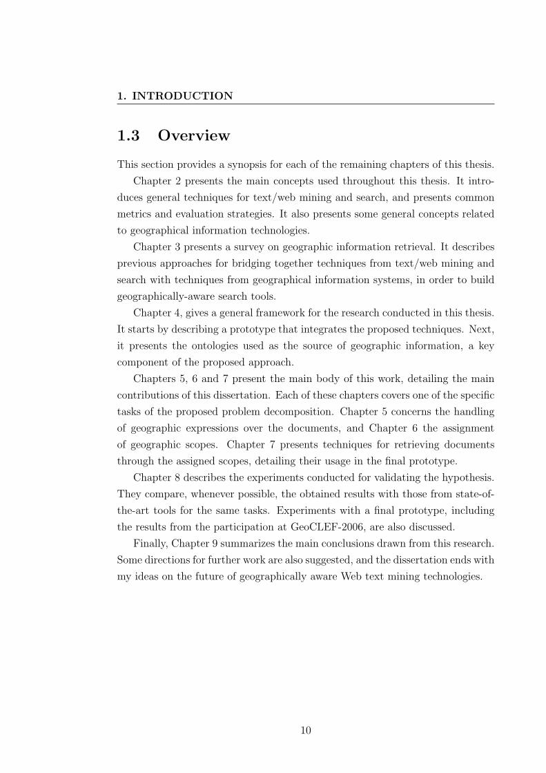
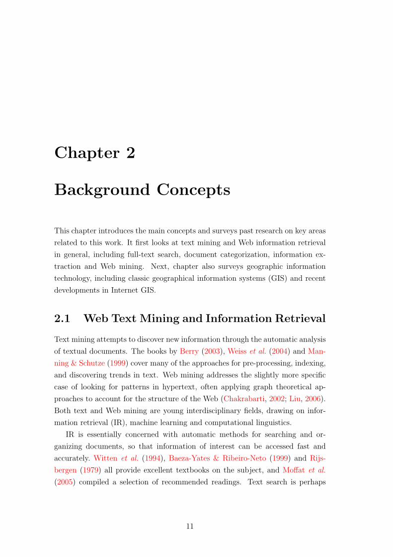
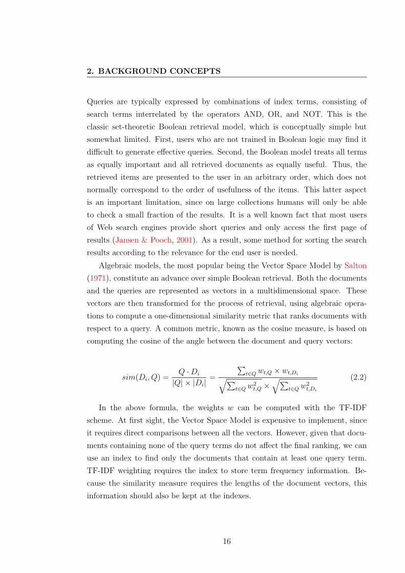
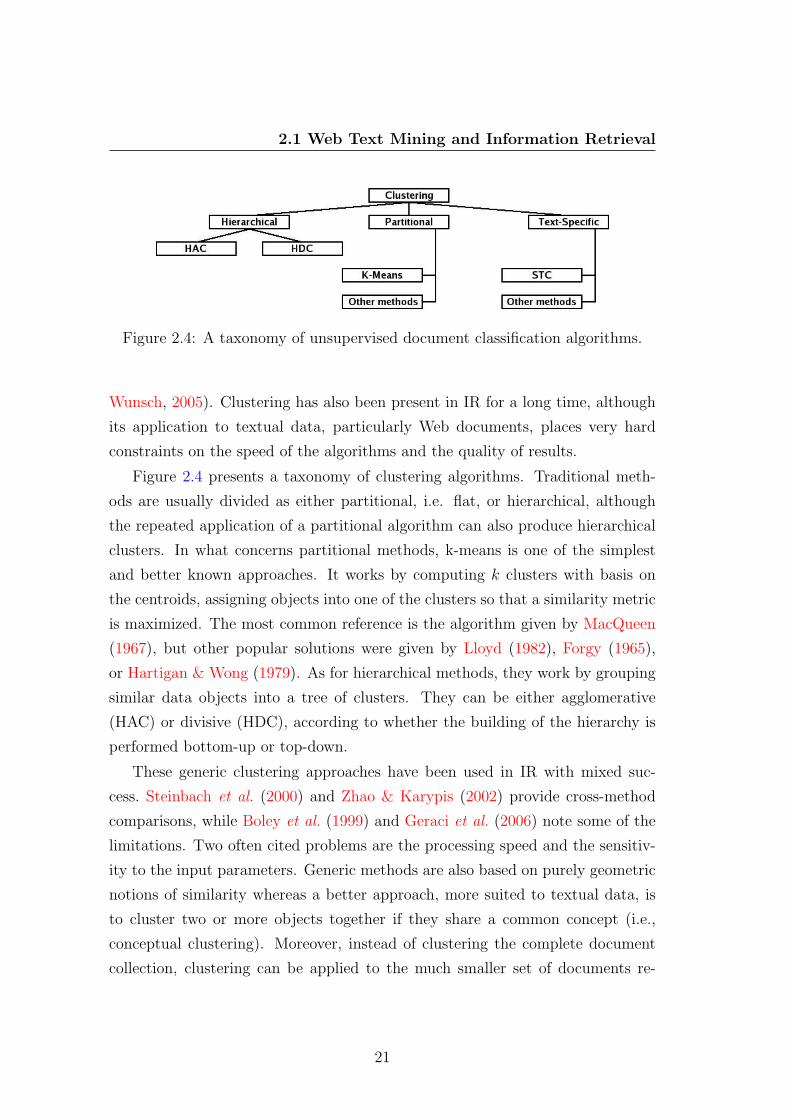
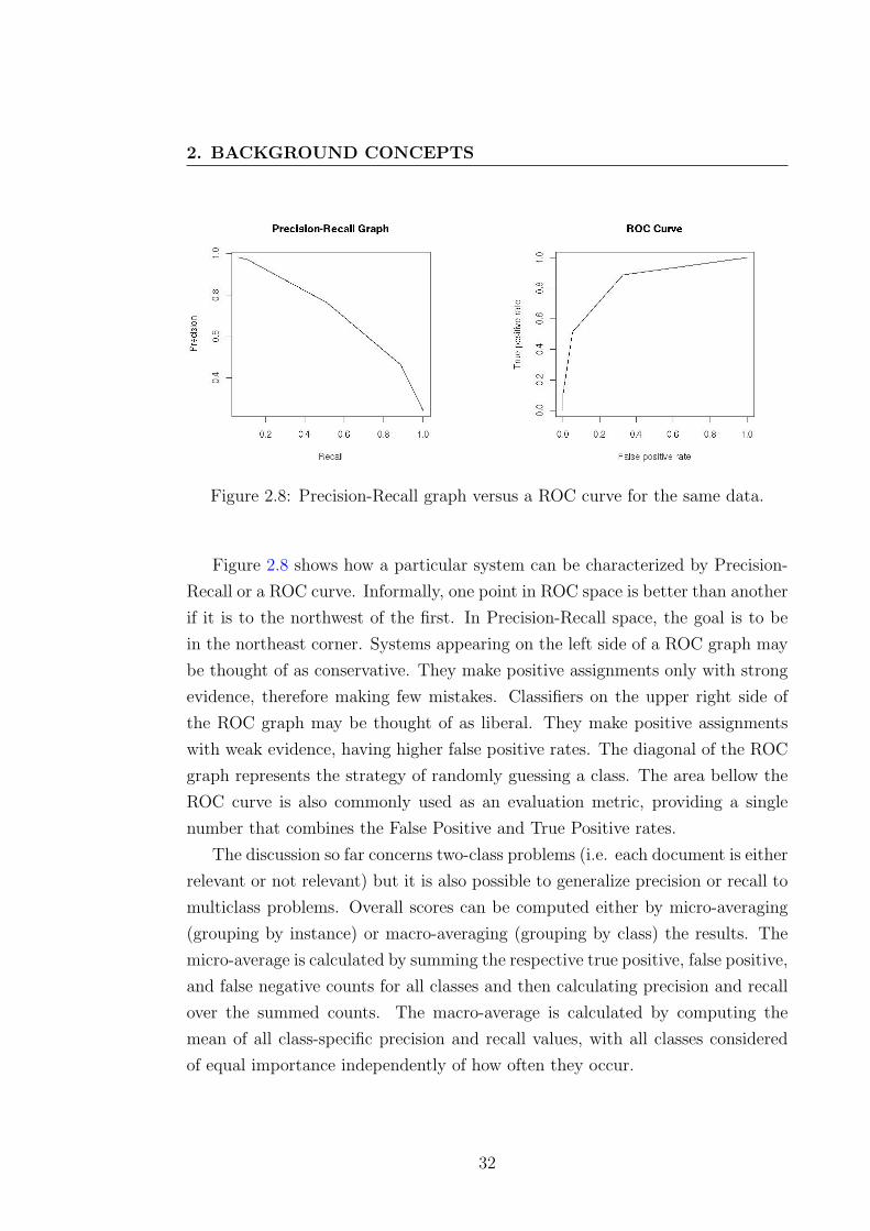
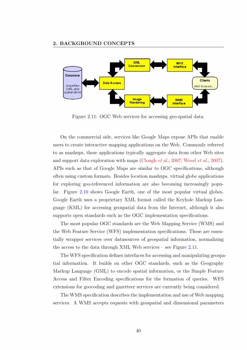
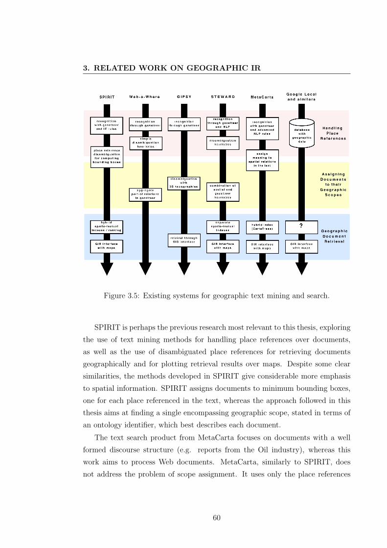
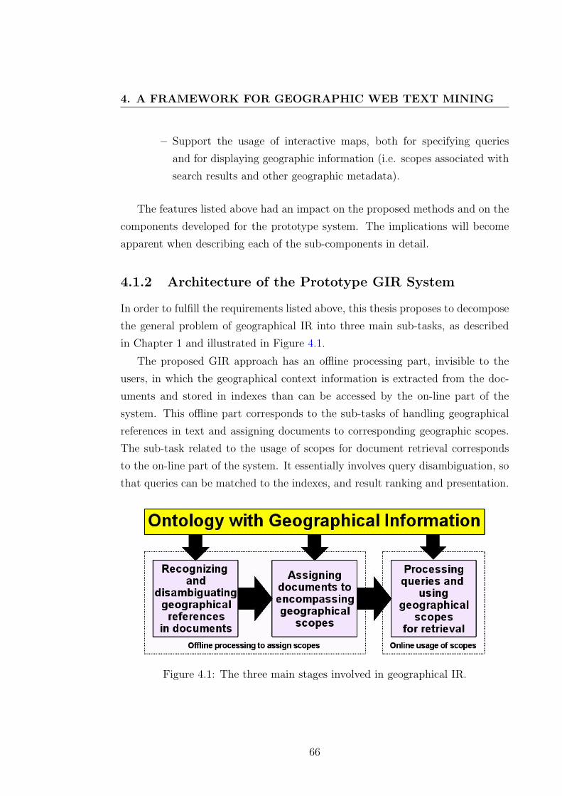
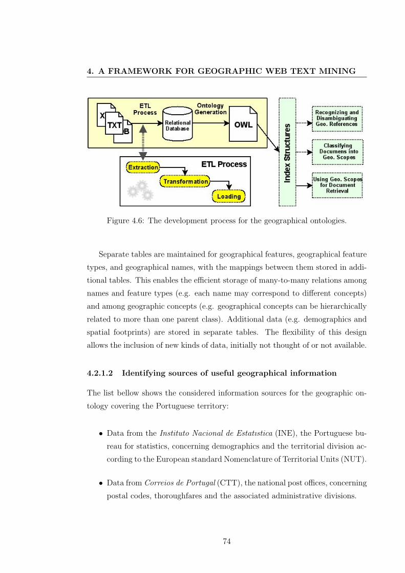
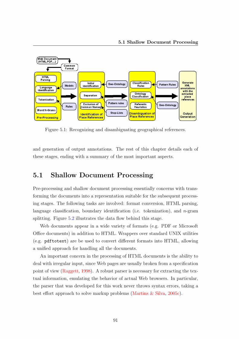
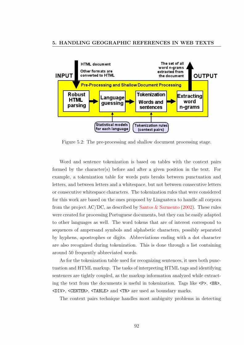
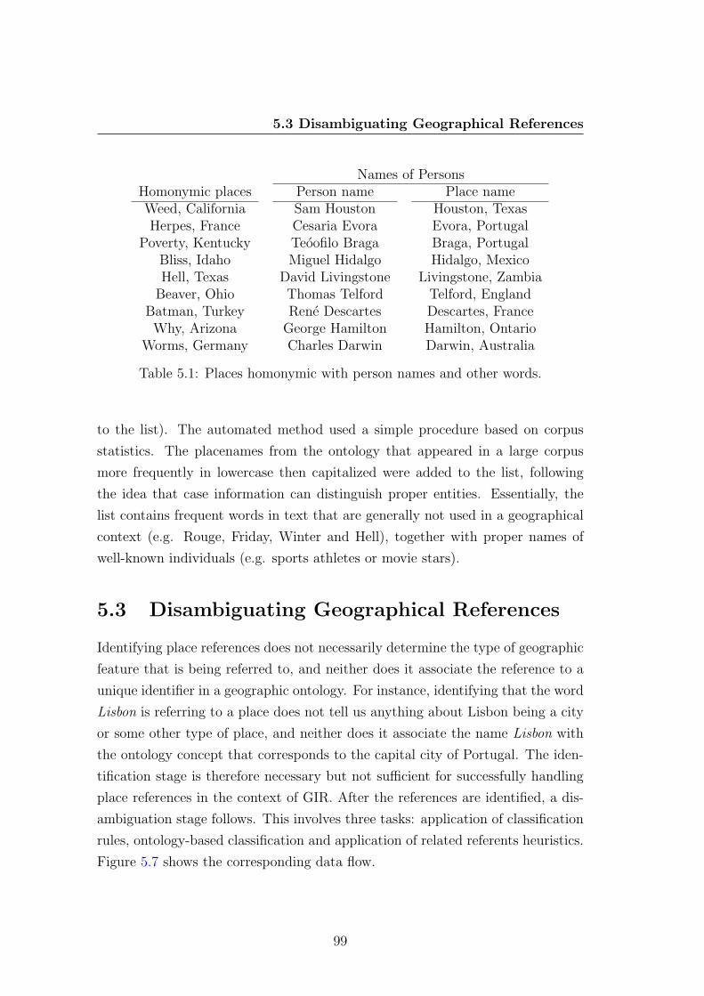
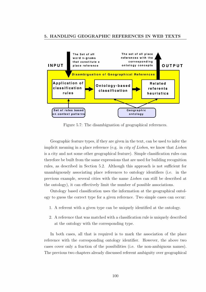
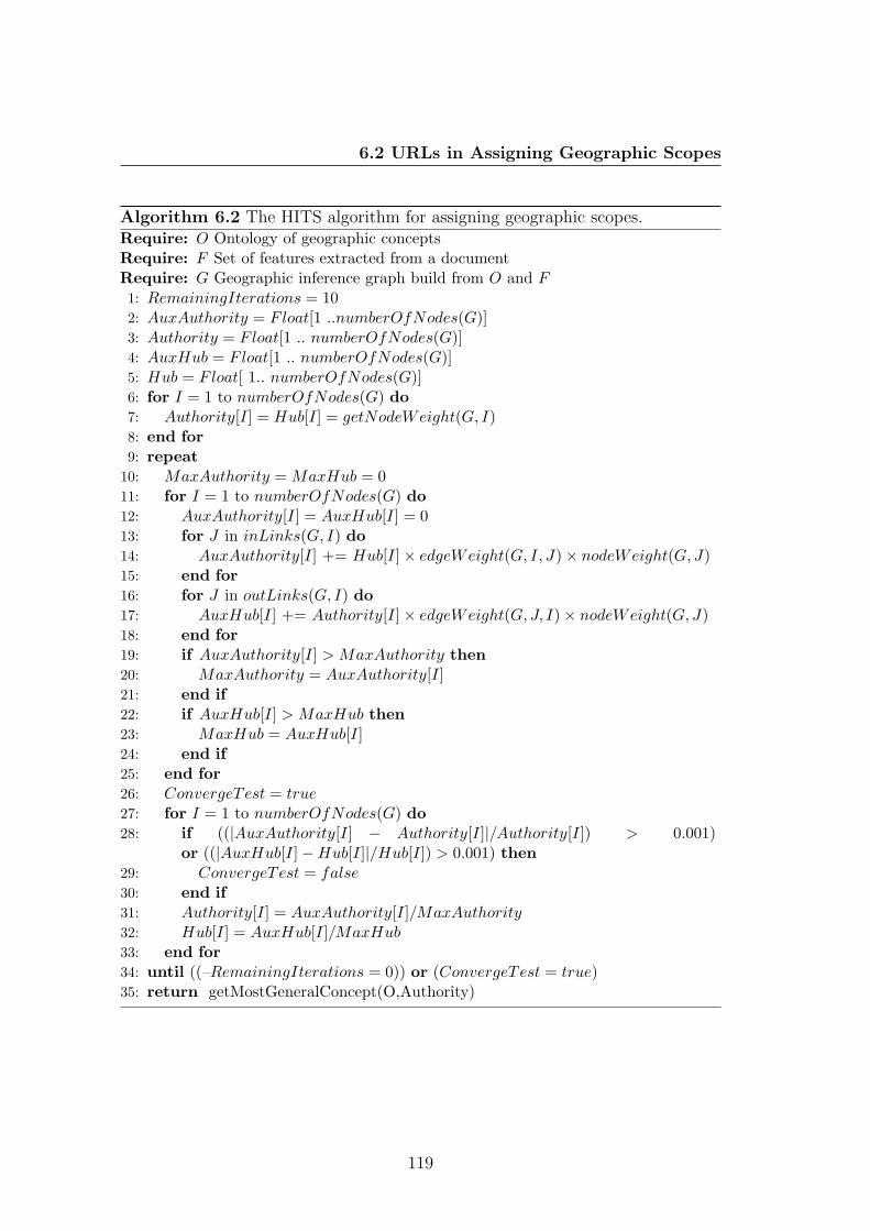
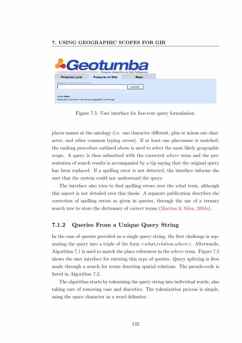
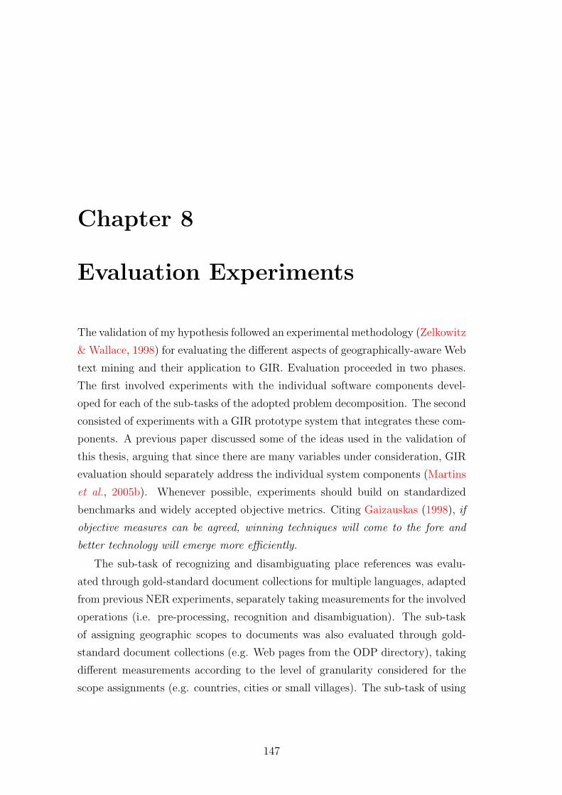
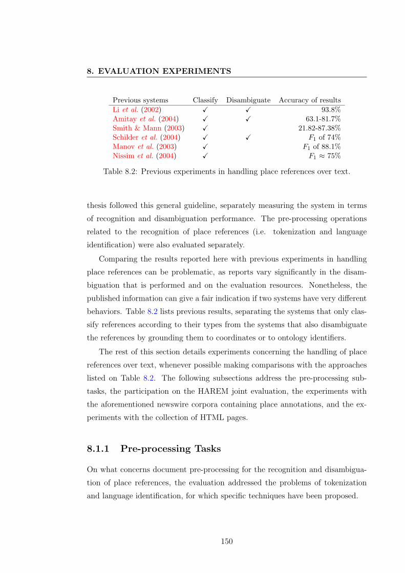
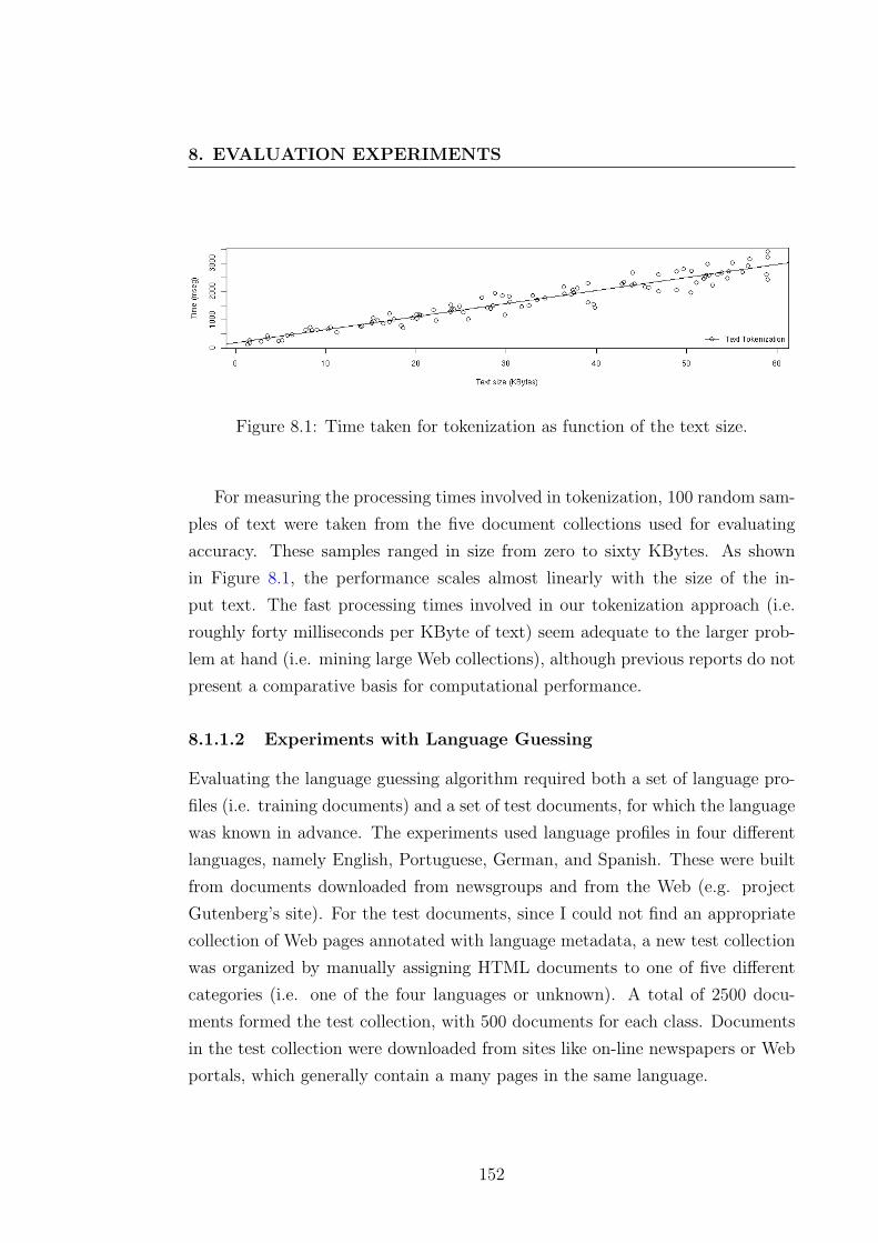
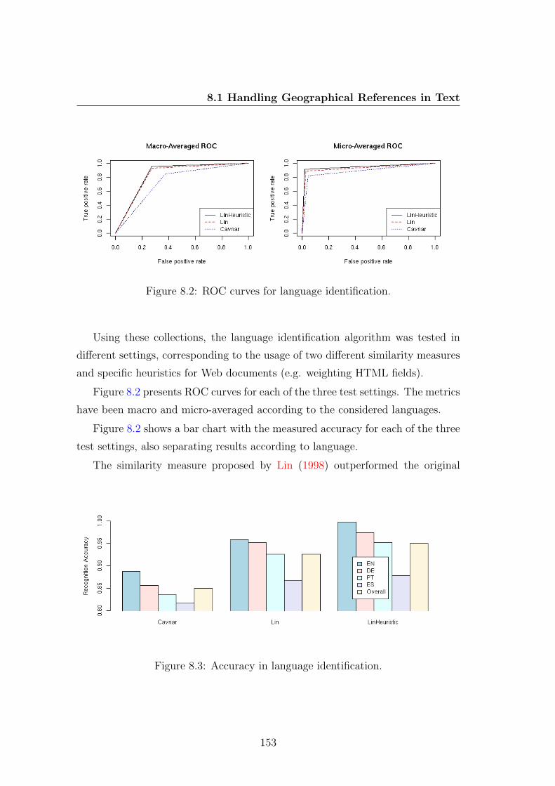
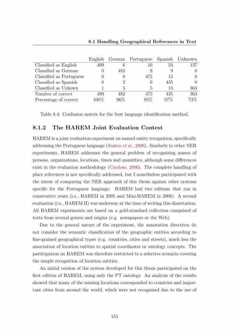
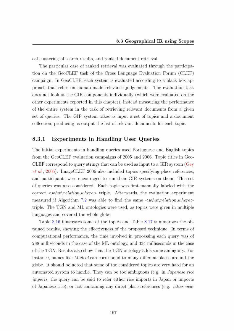
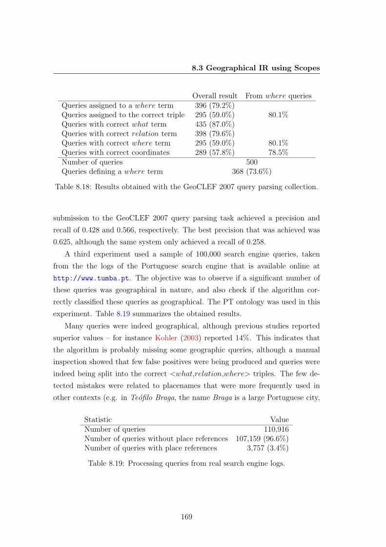
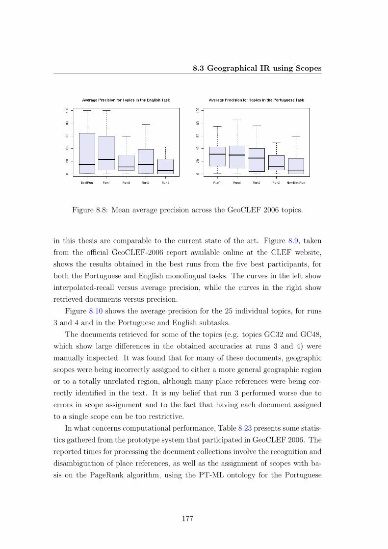
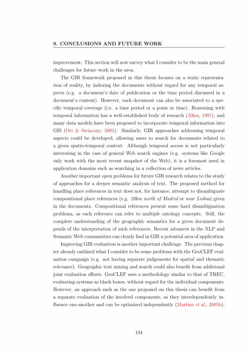
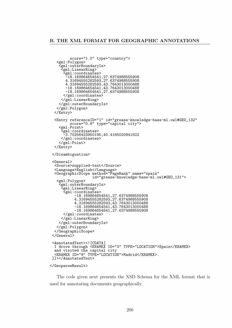
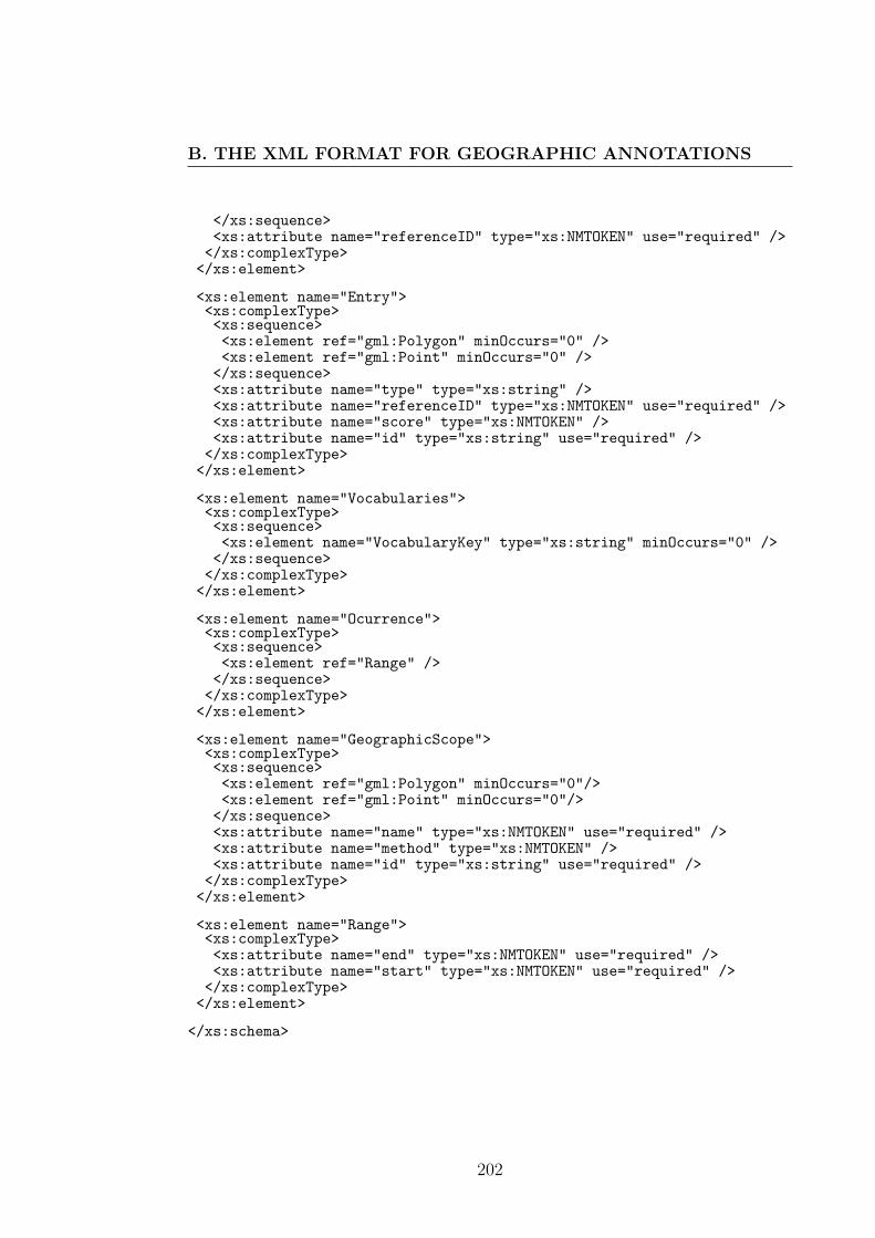
used for annotating documents geographically.

200

<?xml version="1.0" encoding="UTF-8" ?><xs:schema xmlns:xs="http://www.w3.org/2001/XMLSchema"

xmlns:gml="http://www.opengis.net/gml">

<xs:annotation><xs:documentation>XML Format for Document GeoParsing.</xs:documentation></xs:annotation>

<xs:import namespace="http://www.opengis.net/gml"schemaLocation="http://schemas.opengis.net/gml/3.0.0/base/gml.xsd"/>

<xs:element name="GeoparseResult"><xs:complexType><xs:sequence><xs:element ref="EntryCollection" minOccurs="0" /><xs:element ref="Disambiguation" minOccurs="0" /><xs:element ref="General" /><xs:element name="AnnotatedText" type="xs:string" /></xs:sequence></xs:complexType></xs:element>

<xs:element name="EntryCollection"><xs:complexType><xs:sequence><xs:element ref="PlaceName" maxOccurs="unbounded" /></xs:sequence></xs:complexType></xs:element>

<xs:element name="Disambiguation"><xs:complexType><xs:sequence><xs:element ref="Entry" maxOccurs="unbounded" /></xs:sequence></xs:complexType></xs:element>

<xs:element name="General"><xs:complexType><xs:sequence><xs:element name="Source" type="xs:string" /><xs:element name="Language" type="xs:string" /><xs:element ref="GeographicScope" minOccurs="0" /></xs:sequence></xs:complexType></xs:element>

<xs:element name="PlaceName"><xs:complexType><xs:sequence><xs:element ref="Vocabularies" /><xs:element name="TermName" type="xs:string" /><xs:element ref="Ocurrence" /><xs:element name="Label" type="xs:string" />

201

B. THE XML FORMAT FOR GEOGRAPHIC ANNOTATIONS

</xs:sequence><xs:attribute name="referenceID" type="xs:NMTOKEN" use="required" /></xs:complexType>

</xs:element>

<xs:element name="Entry"><xs:complexType><xs:sequence><xs:element ref="gml:Polygon" minOccurs="0" /><xs:element ref="gml:Point" minOccurs="0" /></xs:sequence><xs:attribute name="type" type="xs:string" /><xs:attribute name="referenceID" type="xs:NMTOKEN" use="required" /><xs:attribute name="score" type="xs:NMTOKEN" /><xs:attribute name="id" type="xs:string" use="required" /></xs:complexType>

</xs:element>

<xs:element name="Vocabularies"><xs:complexType><xs:sequence><xs:element name="VocabularyKey" type="xs:string" minOccurs="0" /></xs:sequence></xs:complexType>

</xs:element>

<xs:element name="Ocurrence"><xs:complexType><xs:sequence><xs:element ref="Range" /></xs:sequence></xs:complexType></xs:element>

<xs:element name="GeographicScope"><xs:complexType><xs:sequence><xs:element ref="gml:Polygon" minOccurs="0"/><xs:element ref="gml:Point" minOccurs="0"/></xs:sequence><xs:attribute name="name" type="xs:NMTOKEN" use="required" /><xs:attribute name="method" type="xs:NMTOKEN" /><xs:attribute name="id" type="xs:string" use="required" /></xs:complexType></xs:element>

<xs:element name="Range"><xs:complexType><xs:attribute name="end" type="xs:NMTOKEN" use="required" /><xs:attribute name="start" type="xs:NMTOKEN" use="required" /></xs:complexType></xs:element>

</xs:schema>

202

References

Afonso, S., Bick, E., Haber, R. & Santos, D. (2002). Floresta sinta(c)tica:

A treebank for Portuguese. In Proceedings of LREC-02, the 3rd International

Conference on Language Resources and Evaluation, 1698–1703.

Agichtein, E. (2005). Scaling information extraction to large document collec-

tions. IEEE Data Engineering Bulletin, 28, 3–10.

Alani, H., Jones, C.B. & Tudhope, D. (2000). Associative and spatial rela-

tionships in thesaurus-based retrieval. In Proceedings of ECDL-00, the 4th Eu-

ropean Conference on Research and Advanced Technology for Digital Libraries ,

45–58.

Allen, J.F. (1991). Time and time again: The many ways to represent time.

International Journal of Intelligent Systems , 6, 10–23.

Amitay, E. (1997). Hypertext: The importance of being different . Master’s thesis,

Centre for Cognitive Science, University of Edinburgh.

Amitay, E. (2001). What lays in the layout: Using anchor-paragraph arrange-

ments to extract descriptions of Web documents . Ph.D. thesis, Macquarie Uni-

versity.

Amitay, E., Har’El, N., Sivan, R. & Soffer, A. (2004). Web-a-Where:

Geotagging Web content. In Proceedings of SIGIR-04, the 27th International

ACM Conference on Research and Development in Information Retrieval , 273–

280.

203

REFERENCES

Andogah, G., Bouma, G., Nerbonne, J. & Koster, E. (2008). Geograph-

ical scope resolution. In Proceedings of the LREC 2008 Workshop on Method-

ologies and Resources for Processing Spatial Language, 4–10.

Andrade, L. (2008). Processing geographic queries and architectural experiments

in the Tumba! search engine. Master’s thesis, University of Lisbon, Faculty of

Sciences, Department of Informatics.

Annitto, R. & Kelly, C. (1993). Modified reverse geocoding: A methodology

for developing accurate address ranges. In Proceedings of URISA-93, the 1993

Conference of the Urban and Regional Information Systems Association, 55–63.

Arampatzis, A., van Kreveld, M., Reinbacher, I., Jones, C.B., Vaid,

S., Clough, P., Joho, H. & Sanderson, M. (2006). Web-based delineation

of imprecise regions. Computers, Environment and Urban Systems , 30, 436–

459.

Arasu, A., Cho, J., Garcia-Molia, H., Paepcke, A. & Raghavan, S.

(2001). Searching the Web. ACM Transactions on Internet Technology , 1, 2–

43.

Arpinar, I.B., Sheth, A., Ramakrishnan, C., Usery, E.L., Azami, M. &

Kwan, M.P. (2006). Geospatial ontology development and semantic analytics.

Transactions in GIS , 10, 551–575.

Axelrod, A. (2003). On building a high performance gazetteer database. In

Proceedings of the NAACL-HLT-03 Workshop on the Analysis of Geographic

References , 63–68.

Baeza-Yates, R. & Ribeiro-Neto, B. (1999). Modern Information Retrieval .

Addison Wesley.

Balmin, A., Hristidis, V. & Papakonstantinou, Y. (2004). ObjectRank:

Authority-based keyword search in databases. In Proceedings of VLDB-04, the

30th Conference on Very Large Data Bases , 796–798.

204

REFERENCES

Beckmann, N., Kriegel, H.P., Schneider, R. & Seeger, B. (1990). The

R∗-tree: An efficient and robust access method for points and rectangles. ACM

SIGMOD Record , 19, 322 – 331.

Berry, M., ed. (2003). Survey of text mining: Clustering, classification, and

retrieval . Springer-Verlag.

Bharat, K. & Henzinger, M.R. (1998). Improved algorithms for topic dis-

tillation in a hyperlinked environment. In Proceedings of SIGIR-98, the 21st

International ACM Conference on Research and Development in Information

Retrieval , 104–111.

Boley, D., Gini, M., Gross, R., Han, E.H., Karypis, G., Kumar, V.,

Mobasher, B., Moore, J. & Hastings, K. (1999). Partitioning-based

clustering for Web document categorization. Decision Support Systems , 27,

329–341.

Borbinha, J. (2006). DIGMAP: European libraries and geographic information.

In Proceedings of EC-GI&GIS-06, the 13th European Commission Workshop

on Geographic Information and Geographical Information Systems .

Bot, R.S., fang Brook Wu, Y., Chen, X. & Li, Q. (2005). Generating bet-

ter concept hierarchies using automatic document classification. In Proceedings

of CIKM-05, the 14th International Conference on Information and Knowledge

Management , 281–282.

Braschler, M. & Peters, C. (2004). Cross-Language Evaluation Forum:

Objectives, results, achievements. Information Retrieval , 7, 7–31.

Brill, E. (1992). A simple rule-based part of speech tagger. In Proceedings of

ANLP-92, the 3rd Conference on Applied Natural Language Processing , 152–

155.

Bucher, B., Clough, P., Purves, R. & Syed, A.K. (2005). Geographic IR

systems: Requirements and evaluation. In Proceedings of ICC-05, the 12th In-

ternational Cartographic Conference, (http://www.dcs.gla.ac.uk/~hideo/

pub/icc05/icc05.pdf).

205

REFERENCES

Buckland, M. & Gay, F. (1994). The relationship between recall and preci-

sion. Journal of the American Society of Information Science and Technology ,

45, 12–19.

Buckley, C. & Voorhees, E.M. (2000). Evaluating evaluation measure sta-

bility. In Proceedings of SIGIR-00,the 23rd International ACM Conference on

Research and Development in Information Retrieval , 33–40.

Buckley, C. & Voorhees, E.M. (2004). Retrieval evaluation with incom-

plete information. In Proceedings of SIGIR-04, the 27th International ACM

Conference on Research and Development in Information Retrieval , 25–32.

Burrough, P.A. & Frank, A.U., eds. (1996). Geographic Objects with inde-

terminate boundaries . Taylor and Francis.

Butler, D. (2006). Virtual globes: The Web-wide world. Nature, 439, 776–778.

Buyukkokten, O., Cho, J., Garcia-Molina, H. & Gravano, L. (1999).

Exploiting geographical location information of Web pages. In Proceedings of

WebDB-99, the 1999 SIGMOD Workshop on the Web and Databases , 91–96.

Cafarella, M., Downey, D., Soderland, S. & Etzioni, O. (2005). Know-

ItNow: Fast, scalable information extraction from the Web. In Proceedings of

HLT-EMNLP-05, the 2005 Conference on Human Language Technology and

Empirical Methods in Natural Language Processing , 563–570.

Cai, G. (2002). GeoVSM: An integrated retrieval model for geographical infor-

mation. In Proceedings of GISscience-02, the 2nd International Conference on

Geographic Information Science, 65–79.

Cardoso, N. (2006). Avaliacao de sistemas de reconhecimento de entidades

mencionadas . Master’s thesis, OPorto University, Faculty of Engineering.

Cardoso, N., Andrade, L., Simoes, A. & Silva, M.J. (2005a). The XLDB

group participation at the CLEF2005 ad-hoc task. In Proceedings of CLEF-05,

the 6th Cross-Language Evaluation Forum Workshop, 54–60.

206

REFERENCES

Cardoso, N., Martins, B., Chaves, M., Andrade, L. & Silva, M.J.

(2005b). The XLDB group at GeoCLEF 2005. In Proceedings of CLEF-05, the

6th Cross-Language Evaluation Forum Workshop, 997–1006.

Cardoso, N., Cruz, D., Chaves, M. & Silva, M.J. (2007). Using geographic

signatures as query and document scopes in geographic IR. In Proceedings of

CLEF-2007, the 8th Cross-Language Evaluation Forum Workshop, 784–795.

Carpenter, B. (2004). Phrasal queries with LingPipe and Lucene. In Proceed-

ings of TREC-04, the 13th Text REtrieval Conference, 221–229.

Carreras, X., Marques, L. & Padro, L. (2002). Named entity extraction

using AdaBoost. In Proceedings of CoNLL-2002, the 6th Conference on Natural

Language Learning , 1–4.

Cavnar, W.B. & Trenkle, J.M. (1994). N-gram-based text categorization.

In Proceedings of SDAIR-94, the 3rd Annual Symposium on Document Analysis

and Information Retrieval , 161–175.

Chakrabarti, S. (2002). Mining the Web: Discovering knowledge from hyper-

text data. Morgan Kaufmann.

Chakrabarti, S., Dom, B.E. & Indyk, P. (1998). Enhanced hypertext cat-

egorization using hyperlinks. In Proceedings of SIGMOD-98, the 17th Interna-

tional ACM Conference on Management of Data, 307–318.

Chaves, M., Martins, B. & Silva, M.J. (2005). GKB: A geographic knowl-

edge base. DI/FCUL TR 05–12, University of Lisbon, Faculty of Sciences,

Department of Informatics.

Chaves, M.S. & Santos, D. (2006). What kinds of geographical information

are there in the Portuguese Web? In Proceedings of PROPOR-2006, the 7th

Workshop on Computational Processing of Written and Spoken Language, 264–

267.

Chen, Y.Y., Suel, T. & Markowetz, A. (2006). Efficient query processing

in geographic Web search engines. In Proceedings of SIGMOD-06, the 25th

International ACM Conference on Management of Data, 277–288.

207

REFERENCES

Chin, J.P., Diehl, V.A. & Norman, K.L. (1988). Development of an instru-

ment measuring user satisfaction of the human-computer interface. In Proceed-

ings of CHI-88, the 1988 SIGCHI Conference on Human Factors in Computing

Systems , 213–218.

Chinchor, N. & Robinson, P. (1997). MUC-7 named entity task defi-

nition. In Proceedings of MUC-7, the 7th Message Understanding Confer-

ence, (http://www-nlpir.nist.gov/related_projects/muc/proceedings/

ne_task.html).

Chinchor, N.A. (1998). Overview of MUC-7/MET-2. In Proceedings of MUC-7,

the 7th Message Understanding Conference, (http://www-nlpir.nist.gov/

related_projects/muc/proceedings/muc_7_toc.html).

Clarke, K.C. (2001). Getting started with geographic information systems .

Prentice Hall.

Clough, P. (2005). Extracting metadata for spatially-aware information re-

trieval on the Internet. In Proceedings of GIR-05, the 2nd Workshop on Geo-

graphic Information Retrieval , 25–30.

Clough, P. & Sanderson, M. (2004). A proposal for compara-

tive evaluation of automatic annotation for geo-referenced documents.

In Proceedings of GIR-04, the 1st Workshop on Geographic Informa-

tion Retrieval , (http://dis.shef.ac.uk/mark/publications/my_papers/

SIGIR2004-geo-workshop.pdf).

Clough, P., Purves, R. & Joho, H. (2006). Judging the spatial relevance of

documents for GIR. In Proceedings of ECIR-06, the 28th European Conference

on Information Retrieval , 548–552.

Clough, P., Pasley, R., Siersdorfer, S., Pedro, J.S. & Sanderson, M.

(2007). Visualising the South Yorkshire floods of ’07. In Proceedings of GIR-07,

the 4th Workshop on Geographic Information Retrieval , 93–94.

Cohn, A.G. & Hazarika, S.M. (2001). Qualitative spatial representation and

reasoning: An overview. Fundamenta Informaticae, 46, 1–29.

208

REFERENCES

Conyon, M.J. & Muldoon, M.R. (2008). Ranking the importance of boards

of directors. Tech. Rep. 2006-65, Manchester Institute for Mathematical Sci-

ences.

Costa, M. & Silva, M.J. (2005). Indexacao distribuıda de coleccoes Web de

larga escala. IEEE Latin America Transactions , 3, 2–8.

Cunningham, H., Maynard, D., Bontcheva, K. & Tablan, V. (2002).

GATE: A framework and graphical development environment for robust NLP

tools and applications. In Proceedings of the 40th Anniversary Meeting of the

Association for Computational Linguistics , 168–175.

Davis, J. & Goadrich, M. (2006). The relationship between precision-recall

and ROC curves. In Proceedings of ICML-06, the 23rd International Conference

on Machine Learning , 233–240.

de Melo, G. & Siersdorfe, S. (2007). Multilingual text classification us-

ing ontologies. In Proceedings of ECIR-07, the 29th European Conference on

Information Retrieval , 541–548.

Deerwester, S.C., Dumais, S.T., Landauer, T.K., Furnas, G.W. &

Harshman, R.A. (1990). Indexing by latent semantic analysis. Journal of the

American Society of Information Science, 41, 391–407.

Delboni, T.M. (2005). Positioning expressions as sources of geographic context

mining . Master’s thesis, Federal University of Minas Gerais.

Dill, S., Eiron, N., Gibson, D., Gruhl, D., Guha, R., Jhingran, A.,

Kanungo, T., Rajagopalan, S., Tomkins, A., Tomlin, J.A. & Zien,

J.Y. (2003). SemTag and Seeker: Bootstrapping the Semantic Web via auto-

mated semantic annotation. In Proceedings of WWW-03, the 12th International

World Wide Web Conference, 178–186.

Dimitrov, M. (2002). A light-weight approach to coreference resolution for

named entities in text . Master’s thesis, Departmant of Information Technolo-

gies, Faculty of Mathematics and Informatics, University of Sofia.

209

REFERENCES

Ding, J., Gravano, L. & Shivakumar, N. (2000). Computing geographical

scopes of Web resources. In Proceedings of VLDB-00, the 26th Conference on

Very Large Data Bases , 545–556.

Dumais, S.T. & Chen, H. (2000). Hierarchical classification of Web content.

In Proceedings of SIGIR-00, 23rd International ACM Conference on Research

and Development in Information Retrieval , 256–263.

Efthimiadis, E.N. (1996). Query expansion. Annual Review of Information

Systems and Technology , 31, 121–187.

Egenhofer, M. (1991). Reasoning about binary topological relations. In Pro-

ceedings of SSD-91, the 2nd Symposium on Large Spatial Databases , 143–160.

Egenhofer, M. & Mark, D.M. (1995). Naive geography. In Proceedings of

COSIT-95, the 7th International Conference on Spatial Information Theory ,

1–15.

Egenhofer, M.J. (2002). Toward the semantic geospatial Web. In Proceedings

of GIS-02, the 10th ACM International Symposium on Advances in Geographic

Information Systems , 1–4.

Eiron, N. & McCurley, K.S. (2003). Analysis of anchor text for Web search.

In Proceedings of SIGIR-03, the 25th International ACM Conference on Re-

search and Development in Information Retrieval , 459–460.

Eiron, N., McCurley, K.S. & Tomlin, J.A. (2004). Ranking the Web

frontier. In Proceedings of WWW-04, the 13th International Conference on the

World Wide Web, 309–318.

Etzioni, O., Cafarella, M., Downey, D., Kok, S., Popescu, A.M.,

Shaked, T., Soderland, S., Weld, D.S. & Yates, A. (2004). Web-scale

information extraction in KnowITAll. In Proceedings of WWW-04, the 13th

International World Wide Web Conference, 100–110.

Fan, W., Gordon, M.D. & Pathak, P. (2004). A generic ranking function

discovery framework by genetic programming for information retrieval. Infor-

mation Processing and Management , 40, 587–602.

210

REFERENCES

Fawcett, T. (2003). ROC graphs: Notes and practical considerations for data

mining researchers. Tech. Rep. HPL-2003-4, Hewlett-Packard Laboratories.

Ferragina, P. & Gulli, A. (2005). A personalized search engine based on

Web-snippet hierarchical clustering. In Proceedings of WWW-05, the 14th In-

ternational World Wide Web Conference, 801–810.

Florian, R., Ittycheriah, A., Jing, H. & Zhang, T. (2003). Named entity

recognition through classifier combination. In Proceedings of CoNLL-2003, the

7th Conference on Natural Language Learning , 168–171.

Forgy, E.W. (1965). Cluster analysis of multivariate data: Efficiency versus

interpretability of classifications. Biometrics , 21, 768–769.

Frantzi, K.T. & Ananiadou, S. (1996). Extracting nested collocations. In

Proceedings of COLING-96, the 16th International Conference on Computa-

tional Linguistics , 41–46.

Freitag, D. (1998). Machine learning for information extraction in informal do-

mains . Ph.D. thesis, Department of Computer Science, Carnegie-Mellon Uni-

versity.

Freitas, S. (2008). User interfaces for geographic information retrieval systems .

Master’s thesis, University of Lisbon, Faculty of Sciences, Department of In-

formatics.

Frontiera, P. (2004). A probabilistic approach to spatial ranking for geographic

information retrieval . Ph.D. thesis, Department of Landscape Architecture and

Envorimental Planning, University of California at Berkley.

Fu, G., Jones, C.B. & Abdelmoty, A.I. (2005). Ontology-based spatial

query expansion in information retrieval. In Proceedings of ODBASE-05, the

4th International Conference on Ontologies, Databases and Applications of Se-

mantics , 1466–1482.

Gaede, V. & Gunther, O. (1998). Multidimensional access methods. ACM

Computing Surveys , 30, 170–231.

211

REFERENCES

Gahegan, M. (1995). Proximity operators for qualitative spatial reasoning. In

A.U. Frank & W. Kuhn, eds., Spatial information theory: A theoretical basis

for GIS , 31–44, Springer-Verlag.

Gaizauskas, R. (1998). Evaluation in language and speech technology. Journal

of Computer Speech and Language, 3, 249–262.

Gale, W., Church, K. & Yarowsky, D. (1992). One sense per discourse. In

Proceedings of the HLT-1992 Speech and Natural Language Workshop, 233–237.

Garbin, E. & Mani, I. (2005). Disambiguating toponyms in news. In Proceed-

ings of HLT-EMNLP-05, the 2005 Conference on Human Language Technology

and Empirical Methods in Natural Language Processing , 363–370.

Geraci, F., Pellegrini, M., Pisati, P. & Sebastiani, F. (2006). A scalable

algorithm for high-quality clustering of Web snippets. In Proceedings of SAC-

06, the 21st ACM Symposium on Applied Computing , 1058–1062.

Gey, F., Larson, R., Sanderson, M., Joho, H. & Clough, P. (2005).

GeoCLEF: The CLEF 2005 cross-language geographic information retrieval

track. In Proceedings of CLEF-05, the 7th Cross-Language Evaluation Forum

Workshop, 908–919.

Ghani, R., Slattery, S. & Yang, Y. (2001). Hypertext categorization using

hyperlink patterns and metadata. In Proceedings of ICML-01, the 18th Inter-

national Conference on Machine Learning , 178–185.

Godoy, F. & Rodrıguez, A. (2004). Defining and comparing content measures

of topological relations. GeoInformatica, 8, 347–371.

Goldberg, D.W., Wilson, J.P. & Knoblock, C.A. (2007). From text to

geographic coordinates: The current state of geocoding. Journal of the Urban

and Regional Information Systems Association, 19, 33–46.

Golder, S.A. & Huberman, B.A. (2005). The structure of collaborative tag-

ging systems. Journal of Information Science, 32, 198–208.

212

REFERENCES

Gomes, D. (2007). Web Modelling for Web Warehouse Design. Ph.D. thesis,

University of Lisbon.

Gomes, D. & Silva, M.J. (2008). The viuva negra crawler: an experience

report. Software: Practice and Experience, 2, 161–168.

Gravano, L., Hatzivassiloglou, V. & Lichtenstein, R. (2003). Catego-

rizing Web queries according to geographical locality. In Proceedings of CIKM-

03, the 12th International Conference on Information and Knowledge Manage-

ment , 225–333.

Grefenstette, G. & Tapanainen, P. (1994). What is a word, what is a

sentence? Problems of tokenization. In Proceedings of COMPLEX-94, the 3rd

International Conference on Computational Lexicography and Text Research,

79–87.

Grobelnik, M., Mladenic, D. & Milic-Frayling, N. (2000). Text mining

as integration of several related research areas: Report on KDD’2000 workshop

on text mining. SIGKDD Explorations , 2, 99–102.

Gruhl, D., Chavet, L., Gibson, D., Meyer, J., Pattanayak, P.,

Tomkins, A. & Zien, J. (2004). How to build a WebFountain: An archi-

tecture for very large-scale text analytics. IBM Systems Journal , 43, 64–77.

Gueye, B., Ziviani, A., Crovella, M. & Fdida, S. (2006). Constraint-

based geolocation of Internet hosts. IEEE/ACM Transactions on Networking ,

14, 1219–123.

Gutierrez, M. & Rodrıguez, A. (2004). Querying heterogeneous spatial

databases: Combining an ontology with similarity functions. In Proceedings

of CoMoGIS-04, the 1st International Workshop on Conceptual Modeling for

GIS , 160–171.

Guttman, A. (1984). R-Trees: A dynamic index structure for spatial search-

ing. In Proceedings of SIGMOD-84, the 3rd International ACM Conference on

Management of Data, 47–57.

213

REFERENCES

Hahn, U., Gotz, T., Brown, E.W., Cunningham, H. & Nyberg, E.,

eds. (2008). Towards Enhanced Interoperability for Large HLT Systems: UIMA

for NLP , (http://www.lrec-conf.org/proceedings/lrec2008/workshops/

W16_Proceedings.pdf).

Han, E.H. (1999). Text categorization using weight adjusted k-nearest neighbor

classification. Ph.D. thesis, University of Minnesota.

Harpring, P. (1997). Proper words in proper places: The thesaurus of geo-

graphic names. MDA Information, 3, 5–12.

Hartigan, J.A. & Wong, M.A. (1979). A k-means clustering algorithm. Ap-

plied Statistics , 28, 100–108.

Hassan, S., Mihalcea, R. & Banea, C. (2007). Random-walk term weighting

for improved text classification. International Journal for Semantic Computing ,

1, 421–439.

Haveliwala, T. (1999). Efficient computation of PageRank. Tech. Rep. 1999-

31, Stanford University.

Hawking, D., Craswell, N., Thistlewaite, P. & Harman, D. (1999). Re-

sults and challenges in Web search evaluation. Computer Networks , 31, 1321–

1330.

Heinzle, F. & Sester, M. (2004). Derivation of implicit information from spa-

tial data sets with data mining. In Proceedings of ISPRS-04, the 20th Congress

of the International Society for Photogrammetry and Remote Sensing , 335–340.

Hill, L.L. (2000). Core elements of digital gazetteers: Placenames, categories,

and footprints. In Proceedings of ECDL-00, the 4th European Conference on

Research and Advanced Technology for Digital Libraries , 280–291.

Himmelstein, M. (2005). Local search: The Internet is the yellow pages. IEEE

Computer , 38, 26–34.

Hirschman, L. (1998). The evolution of evaluation: Lessons from the message

understanding conferences. Computer Speech and Language, 12, 281–305.

214

REFERENCES

Hollander, M. & Wolfe, D.A. (1999). Nonparametric statistical methods .

John Wiley & Sons.

Hull, D. (1993). Using statistical tests in the evaluation of retrieval experi-

ments. In Proceedings of SIGIR-93, the 16th International ACM Conference

on Research and Development in Information Retrieval , 329–338.

Ide, N. & Veronis, J. (1998). Word sense disambiguation: The state of the

art. Computational Linguistics , 24, 1–40.

Janee, G. & Frew, J. (2004). Spatial search, ranking and interoperability. In

Proceedings of GIR-04, the 1st Workshop on Geographic Information Retrieval ,

(http://www.geo.unizh.ch/~rsp/gir/abstracts/janee.pdf).

Jansen, B.J. & Pooch, U.W. (2001). A review of Web searching studies and a

framework for future research. Journal of the American Society of Information

Science, 52, 235–246.

Jarvelin, K. & Kekalainen, J. (2000). IR evaluation methods for retrieving

highly relevant documents. In Proceedings of SIGIR-00, the 23rd International

ACM Conference on Research and Development in Information Retrieval , 41–

48.

Jeh, G. & Widom, J. (2002). Scaling personalized Web search. Tech. Rep.

2002-12, Stanford University.

Jing, Y. & Baluja, S. (2008). PageRank for product image search. In Pro-

ceedings of WWW-08, the 17th International World Wide Web Conference,

307–316.

Jones, C.B., Alani, H. & Tudhope, D. (2001). Geographical information

retrieval with ontologies of place. In Proceedings of COSIT-01, the 3rd Inter-

national Conference on Spatial Information Theory , 322–335.

Jones, C.B., Abdelmoty, A.I., Finch, D., Fu, G. & Vaid, S. (2004). The

SPIRIT spatial search engine: Architecture, ontologies and spatial indexing. In

Proceedings of GIScience-04, the 3rd International Conference on Geographic

Information Science, 125–139.

215

REFERENCES

Kamvar, S.D., Haveliwala, T.H. & Golub, G.H. (2003a). Adaptive meth-

ods for the computation of PageRank. Tech. Rep. 2003-26, Stanford University.

Kamvar, S.D., Haveliwala, T.H., Manning, C. & Golub, G.H. (2003b).

Extrapolation methods for accelerating PageRank computations. In Proceed-

ings of WWW-03, the 12th International World Wide Web Conference, 261–

270.

Kamvar, S.D., Haveliwala, T.H., Manning, C.D. & Golub, G.H.

(2003c). Exploiting the block structure of the Web for computing PageRank.

Tech. Rep. 2003-17, Stanford University.

Kan, M.Y. & Thi, H.O.N. (2005). Fast webpage classification using URL

features. In Proceedings of CIKM-05, the 14th Conference on Information and

Knowledge Management , 325–326.

Kantrowitz, M., Mohit, B. & Mittal, V. (2000). Stemming and its effects

on TF-IDF ranking. In Proceedings of SIGIR-00, the 23rd International ACM

Conference on Research and Development in Information Retrieval , 357–359.

Katz, G., Mani, I. & Tenbrink, T., eds. (2008). Proceedings of

the LREC 2008 Workshop on Methodologies and Resources for Process-

ing Spatial Language, (http://www.sfbtr8.uni-bremen.de/SpatialLREC/

LREC-WS12-Proceedings.pdf).

Kessler, M.M. (1963). Bibliographic coupling between scientific papers. Amer-

ican Documentation, 14, 10–25.

Khalil, A. & Liu, Y. (2004). Experiments with PageRank computation. Tech.

Rep. 603, Computer Science Department, Indiana University.

Kleinberg, J.M. (1999). Authoritative sources in a hyperlinked environment.

Journal of the ACM , 46, 604–632.

Knuth, D.E. (1984). The TEXbook . Addison-Wesley.

Kohler, J. (2003). Analysing search engine queries for the use of geographic

terms . Master’s thesis, University of Sheffield.

216

REFERENCES

Kolas, D., Hebeler, J. & Dean, M. (2005). Geospatial semantic Web :

Architecture of ontologies. In Proceedings of GeoS-05, the 1st International

Conference on GeoSpatial Semantics , 183–194.

Korfhage, R. (1998). Information storage and retrieval . Wiley.

Kornai, A. & Sundheim, B., eds. (2003). Proceedings of the HLT-NAACL

2003 Workshop on Analysis of Geographic References , Association for Compu-

tational Linguistics.

Kraaij, W., Westerveld, T. & Hiemstra, D. (2002). The importance of

prior probabilities for entry page search. In Proceedings of SIGIR-02, the 25th

International ACM Conference on Research and Development in Information

Retrieval , 27–34.

Kruskal, J. (1956). On the shortest spanning subtree and the traveling salesman

problem. Proceedings of the American Mathematical Society , 48–50.

Kwon, O.W. & Lee, J.H. (2003). Text categorization based on k-nearest neigh-

bor approach for Web site classification. Information Processing and Manage-

ment , 39, 25–44.

Lafferty, J., McCallum, A. & Pereira, F. (2001). Conditional random

fields: Probabilistic models for segmenting and labeling sequence data. In Pro-

ceedings of ICML-01, the 18th International Conference on Machine Learning ,

282–289.

Lamport, L. (1986). LATEX: A document preparation system. Addison-Wesley.

Langville, A.N. & Meyer, C.D. (2004). Deeper inside PageRank. Internet

Mathematics , 1, 335–400.

Lansing, J. (2001). Geoparser service: Draft candidate implementation specifi-

cation. Discussion Paper 01-035, Open GeoSpatial Consortium.

Larson, R.R. (1995). Geographic information retrieval and spatial browsing. In

L.C. Smith & M. Gluck, eds., Geographic Information Systems and Libraries:

217

REFERENCES

Patrons, Maps, and Spatial Information, 81–123, Graduate School of Library

and Information Science, University of Illinois at Urbana-Champaign.

Larson, R.R. & Frontiera, P. (2004a). Geographic information retrieval

(GIR) ranking methods for digital libraries. In Proceedings of JCDL-04, the

4th ACM/IEEE-CS Joint Conference on Digital Libraries , 415–421.

Larson, R.R. & Frontiera, P. (2004b). Spatial ranking methods for geo-

graphic information retrieval (GIR) in digital libraries. In Proceedings of ECDL-

04, the 8th European Conference on Research and Advanced Technology for

Digital Libraries , 45–57.

Leidner, J.L. (2004). Towards a reference corpus for automatic toponym reso-

lution evaluation. In Proceedings of GIR-04, the 1st Workshop on Geographic

Information Retrieval , (http://www.geo.unizh.ch/~rsp/gir/abstracts/

leidner.pdf).

Leidner, J.L. (2007). Toponym resolution in text: Annotation, evaluation and

applications of spatial grounding of place names . Ph.D. thesis, School of Infor-

matics, University of Edinburgh.

Leidner, J.L., Sinclair, G. & Webber, B. (2003). Grounding spatial named

entities for information extraction and question answering. In Proceedings of

the HLT-NAACL 2003 Workshop on Analysis of Geographic References , 31–38.

Lewis, D.D. (1998). Naive (Bayes) at forty: The independence assumption in

information retrieval. In Proceedings of ECML-98, 10th European Conference

on Machine Learning , 4–15.

Lewis, D.D., Yang, Y., Rose, T.G. & Li, F. (2004). RCV1: A new bench-

mark collection for text categorization research. Journal of Machine Learning

Research, 5, 361–397.

Lewis, J.R. (1995). IBM computer usability satisfaction questionnaires: Psy-

chometric evaluation and instructions for use. International Journal of Human-

Computer Interaction, 7, 57–78.

218

REFERENCES

Li, H., Srihari, R., Niu, C. & Li, W. (2002). Location normalization for

information extraction. In Proceedings of COLING-02, the 19th International

Conference on Computational Linguistics , 1–7.

Li, W. (1992). Random texts exhibit Zipf’s-law-like word frequency distribution.

IEEE Transactions on Information Theory , 38, 1842–1845.

Li, Y., Moffat, A., Stokes, N. & Cavedon, L. (2006). Exploring probabilis-

tic toponym resolution for geographical information retrieval. In Proceedings of

GIR-06, the 3rd Workshop on Geographical Information Retrieval , 17–22.

Li, Z., Wang, C., Xie, X. & Ma, W.Y. (2007). Query parsing task for

GeoCLEF 2007 report. In Proceedings of CLEF-2007, the 8th Cross-Language

Evaluation Forum Workshop, 38–44.

Lieberman, M.D., Samet, H., Sankaranarayanan, J. & Sperling, J.

(2007). STEWARD: Architecture of a spatio-textual search engine. In Pro-

ceedings of GIS-07, the 15th ACM International Symposium on Advances in

Geographic Information Systems , 1–8.

Lin, D. (1998). An information-theoretic definition of similarity. In Proceedings

of ICML-98, the 15th International Conference on Machine Learning , 296–304.

Lin, H.C., Y.-Y. & Salvendy, G. (1997). A proposed index of usability:

A method for comparing the relative usability of different software systems.

Behaviour and Information Technology , 16, 267–278.

Liu, B. (2006). Web Data Mining : Exploring Hyperlinks, Contents and Usage

Data. Springer.

Lloyd, R. & Heivly, C. (1987). Systematic distortions in urban cognitive

maps. Annals of the Association of American Geographers , 77, 191–207.

Lloyd, S.P. (1982). Least squares quantization in PCM. IEEE Transactions on

Information Theory , 28, 128–137.

219

REFERENCES

MacQueen, J.B. (1967). Some methods for classification and analysis of mul-

tivariate observations. In Proceedings of the 5th Berkeley Symposium on Math-

ematical Statistics and Probability , 281–297.

Maindonald, J. & Braun, J. (2003). Data analysis and graphics using R.

Cambridge University Press.

Malouf, R. (2002). Markov models for language-independent named entity

recognition. In Proceedings of CoNLL-2002, the 6th Conference on Natural

Language Learning , 187–190.

Mandl, T., Gey, F., Nunzio, G.D., Ferro, N., Sanderson, M., Santos,

D. & Womser-Hacker, C. (2008). An evaluation resource for geographic

information retrieval. In Proceedings of LREC-08, the 6th International Con-

ference on Language Resources and Evaluation, 153–165.

Manguinhas, H., Martins, B., Borbinha, J. & Siabato, W. (2008). The

DIGMAP geo-temporal Web gazetteer service. In Proceedings of the 3rd Inter-

national Workshop on Digital Approaches to Cartographic Heritage.

Manning, C.D. & Schutze, H. (1999). Foundations of statistical natural lan-

guage processing . The MIT Press.

Manov, D., Kiryakov, A., Popov, B., Bontcheva, K., Maynard, D.

& Cunningham, H. (2003). Experiments with geographic knowledge for in-

formation extraction. In Proceedings of the HLT-NAACL 2003 Workshop on

Analysis of Geographic References , 1–9.

Mark, D.M., Freksa, C., Hirtle, S.C., Lloyd, R. & Tversky, B. (1999).

Cognitive models of geographical space. International Journal of Geographical

Information Science, 13, 747–774.

Markowetz, A. (2004). Geographic information retrieval. Diploma Thesis at

Philipps University.

220

REFERENCES

Marlow, C., Naaman, M., danah boyd & Davis, M. (2006). HT06,

tagging paper, taxonomy, Flickr, academic article, toread. In Proceedings of

HYPERTEXT-06, the 7th ACM Conference on Hypertext and Hypermedia,

31–40.

Marshakova, I. (1973). System of document connections based on references.

Nauchno-Teknicheskaia Informatsiia, 2, 3–8.

Martins, B. & Silva, M. (2005a). Language identification in Web pages. In

Proceedings of SAC-05, the 20th ACM Symposium on Applied Computing , 764–

768.

Martins, B. & Silva, M.J. (2004a). Spelling correction for search engine

queries. In Proceedings of ESTAL-04, Espana for Natural Language Processing,

the 4th International Conference on Advances in Natural Language Processing ,

372–383.

Martins, B. & Silva, M.J. (2004b). A statistical study of the WPT-03 corpus.

DI/FCUL TR 04–04, University of Lisbon, Faculty of Sciences, Department of

Informatics.

Martins, B. & Silva, M.J. (2005b). A graph-ranking algorithm for geo-

referencing documents. In Proceedings of ICDM-05, the 5th IEEE International

Conference on Data Mining , 741–744.

Martins, B. & Silva, M.J. (2005c). The WebCAT framework : Automatic

generation of meta-data for Web resources. In Proceedings of WI-2005, The

2005 IEEE/WIC/ACM International Conference on Web Intelligence, 236–

242.

Martins, B. & Silva, M.J. (2006). O HAREM e a avaliacao de sistemas para

o reconhecimento de entidades geograficas em textos na lıngua portuguesa. In

D. Santos & N. Cardoso, eds., Reconhecimento de entidades mencionadas em

portugues: Documentacao e actas do HAREM, a primeira avaliacao conjunta

na area, chap. 6, 76–86.

221

REFERENCES

Martins, B., Silva, M.J. & Andrade, L. (2005a). Indexing and ranking in

Geo-IR systems. In Proceedings of GIR-05, the 2nd Workshop on Geographic

Information Retrieval , 31–34.

Martins, B., Silva, M.J. & Chaves, M. (2005b). Challenges and resources

for evaluating geographical IR. In Proceedings of GIR-05, the 2nd Workshop

on Geographic Information Retrieval , 65–69.

Martins, B., Cardoso, N., Chaves, M., Andrade, L. & Silva, M.J.

(2006a). The university of Lisbon at GeoCLEF 2006. In Proceedings of CLEF-

2006, the 7th Cross-Language Evaluation Forum Workshop, 986–994.

Martins, B., Silva, M.J. & Chaves, M. (2006b). O sistema CaGE no

HAREM : Reconhecimento de entidades geograficas em textos na lıngua por-

tuguesa. In D. Santos & N. Cardoso, eds., Reconhecimento de entidades

mencionadas em portugues: Documentacao e actas do HAREM, a primeira

avaliacao conjunta na area, chap. 8, 97–112.

Martins, B., Silva, M.J., Freitas, S. & Afonso, A.P. (2006c). Handling

locations in search engine queries. In Proceedings of GIR-06, the 3rd Workshop

on Geographic Information Retrieval , 24–30.

Martins, B., Manguinhas, H. & Borbinha, J. (2008). Extracting and

exploring the geo-temporal semantics of textual resources. In Proceedings of

ICSC-06, the 2nd IEEE International Conference on Semantic Computing ,

71–80.

May, W. (1999). Information extraction and integration with Florid : The Mon-

dial case study. Tech. Rep. 131, Universitat Freiburg, Institut fur Informatik.

McCurley, K.S. (2001). Geospatial mapping and navigation of the Web. In

Proceedings of WWW-01, the 10th International World Wide Web Conference,

221–229.

Mehler, A., Bao, Y., Li, X., Wang, Y. & Skiena, S. (2006). Spatial

analysis of news sources. IEEE Transactions on Visualization and Computer

Graphics , 12, 765–772.

222

REFERENCES

Mihalcea, R. & Tarau, P. (2004). TextRank: Bringing order into texts.

In Proceedings of EMNLP-04, the 2004 Conference on Empirical Methods in

Natural Language Processing , 404–411.

Mikheev, A., Moens, M. & Grover, C. (1999). Named entity recognition

without gazetteers. In Proceedings of EACL-99, the 9th Conference of the Eu-

ropean Chapter of the Association for Computational Linguistics , 1–8.

Milgram, S. (1976). Psychological maps of Paris. In H.M. Proshansky, ed.,

Environmental Psychology: People and Their Physical Settings , 104–124, Holt

and Rinehart and Winston.

Miller, E.L., Shen, D., Liu, J. & Nicholas, C. (2000). Performance and

scalability of a large-scale n-gram based information retrieval system. Journal

of Digital Information, 1, 1–25.

Mitra, M., Singhal, A. & Buckley, C. (1998). Improving automatic query

expansion. In Proceedings of SIGIR-98, the 21st International ACM Conference

on Research and Development in Information Retrieval , 206–214.

Mizzaro, S. (1997). Relevance: The whole history. Journal of the American

Society for Information Science, 9, 810–832.

Moens, M.F. (2006). Information extraction: Algorithms and prospects in a

retrieval context . Springer.

Moffat, A., Zobel, J. & Hawking, D. (2005). Recommended reading for IR

research students. SIGIR Forum, 39, 3–14.

Nadeau, D. (2007). Semi-supervised named entity recognition: Learning to rec-

ognize 100 entity types with little supervision. Ph.D. thesis, University of Ot-

tawa.

Ng, V. (2003). Machine learning for coreference resolution: Recent successes and

future challenges. Tech. Rep. 1918, Cornell University.

223

REFERENCES

Nielsen, J. & Landauer, T.K. (1993). A mathematical model of the finding

of usability problems. In Proceedings CHI-93, the 1993 International ACM

Conference on Human Factors in Computing Systems , 206–213.

Nielsen, J. & Mack, R.L. (1994). Usability inspection methods . John Wiley

& Sons.

Nissim, M., Matheson, C. & Reid, J. (2004). Recognising geographical

entities in Scottish historical documents. In Proceedings of GIR-04, the 1st

Workshop on Geographic Information Retrieval , (http://www.ltg.ed.ac.uk/

seer/papers/gir2004.pdf).

O’Neill, E.T., Lavoie, B.F. & Bennett, R. (2003). Trends in the evolution

of the public Web : 1998 - 2002. D-Lib Magazine, 9, (http://www.dlib.org/

dlib/april03/lavoie/04lavoie.html).

Osinski, S. & Weiss, D. (2004). Carrot2: An open source framework for search

results clustering. In Proceedings of ECIR-04, the 26th European Conference

on Information Retrieval , 13–14.

O’Sullivan, D. & Unwin, D.J. (2002). Geographic information analysis . John

Wiley & Sons.

Ott, T. & Swiaczny, F. (2001). Time-integrative geographic information sys-

tems : Management and analysis of spatio-temporal data. Springer.

Overell, S.E. & Ruger, S. (2007). Geographic co-occurrence as a tool for

GIR. In Proceedings of GIR-07, the 4th Workshop on Geographic Information

Retrieval , 71–76.

Padmanabhan, V.N. & Subramanian, L. (2001). Determining the geographic

location of Internet hosts. SIGMETRICS Performance Evaluation Review , 29,

324–325.

Page, L., Brin, S., Motwani, R. & Winograd, T. (1997). The PageRank

citation ranking: Bringing order to the Web. Tech. Rep. 1997-0072, Standford

University.

224

REFERENCES

Papadias, D. & Kavouras, M. (1994). Acquiring, representing and processing

spatial relations. In Proceedings of SSDH-94, the 6th International Symposium

on Spatial Data Handling , 631–643.

Papadias, D. & Theodoridis, Y. (1997). Spatial relations, minimum bound-

ing rectangles, and spatial data structures. International Journal of Geograph-

ical Information Science, 11, 111–138.

Pasca, M., Lin, D., Bigham, J., Lifchits, A. & Jain, A. (2006). Names

and similarities on the web: Fact extraction in the fast lane. In Proceedings of

COLING-ACL-06, the 21st International Conference on Computational Lin-

guistics and 44th Annual Meeting of the Association for Computational Lin-

guistics , 809–816.

Petasis, G., Cucchiarelli, A., Velardi, P., Paliouras, G., Karkalet-

sis, V. & Spyropoulos, C.D. (2000). Automatic adaptation of proper noun

dictionaries through cooperation of machine learning and probabilistic meth-

ods. In Proceedings of SIGIR-00, the 23rd International ACM Conference on

Research and Development in Information Retrieval , 128–135.

Porter, M.F. (1980). An algorithm for suffix stripping. Program, 14, 130–137.

Porter, M.F. (2001). Snowball: A language for stemming algorithms. (http:

//snowball.tartarus.org/texts/introduction.html).

Purves, R. & Jones, C., eds. (2005). Proceedings of GIR-05, the 2nd Workshop

on Geographic Information Retrieval held at CIKM-2005 , ACM Press.

Purves, R., Clough, P. & Joho, H. (2005). Identifying imprecise regions for

geographic information retrieval using the Web. In Proceedings of GISRUK-05,

the 13th Annual Conference on GIS Research on the UK , 313–318.

Pustejovsky, J., Knippen, R., Littman, J. & Saurı, R. (2005). Temporal

and event information in natural language text. Computers and the Humani-

ties , 39, 123–164.

225

REFERENCES

Raggett, D. (1998). Clean up your Web pages with HP’s HTML TIDY. Com-

puter Networks and ISDN Systems , 30, 730–732.

Rahm, E. & Do, H.H. (2000). Data cleaning: Problems and current approaches.

IEEE Data Engineering Bulletin, 23, 3–13.

Rauch, E., Bukatin, M. & Baker, K. (2003). A confidence-based framework

for disambiguating geographic terms. In Proceedings of the NAACL-HLT-03

Workshop on the Analysis of Geographic References , 50–54.

Richardson, M. & Domingos, P. (2002). The intelligent surfer: Probabilis-

tic combination of link and content information in PageRank. In Advances in

Neural Information Processing Systems, Proceedings of the 14th Conference on

Neural Information Processing Systems , 1441–1448, MIT Press.

Rigaux, P., Scholl, M., Voisard, A. & Scholl, M. (2001). Introduction

to spatial databases: Applications to GIS . Morgan Kaufmann.

Rijsbergen, C.J. (1979). Information retrieval . Butterworths.

Robertson, S., Zaragoza, H. & Taylor, M. (2004). Simple BM25 extension

to multiple weighted fields. In Proceedings of CIKM-04, the 13th International

Conference on Information and Knowledge Management , 42–49.

Robertson, S.E. & Walker, S. (1994). Some simple effective approximations

to the 2-Poisson model for probabilistic weighted retrieval. In Proceedings of

SIGIR-94, the 17th International ACM Conference on Research and Develop-

ment in Information Retrieval , 232–241.

Robertson, S.E., Walker, S., Hancock-Beaulieu, M., Gull, A. & Lau,

M. (1992). Okapi at TREC-3. In Proceedings of TREC-3, the 3rd Text RE-

trieval Conference, 21–30.

Rodrıguez, A. & Egenhofer, M. (2004). Comparing geospatial entity classes:

An asymmetric and context-dependent similarity measure. International Jour-

nal of Geographic Information Science, 18, 229–256.

226

REFERENCES

Root, R.W. & Draper, S. (1983). Questionnaires as a software evaluation

tool. In Proceedings of CHI-83, the 1983 SIGCHI Conference on Human Fac-

tors in Computing Systems , 83–87.

Salton, G., ed. (1971). The SMART retrieval system: Experiments in automatic

document processing . Prentice-Hall.

Salton, G. & Buckley, C. (1988). Term-weighting approaches in automatic

text retrieval. Information Processing and Management , 24, 513–523.

Sanderson, M. & Lawrie, D. (2000). Building, testing and applying con-

cept hierarchies. In B. Croft, ed., Advances in Information Retrieval: Recent

Research from the CIIR, 235–266, Kluwer Academic Publishers.

Santos, D. & Cardoso, N., eds. (2007). Reconhecimento de entidades

mencionadas em portugues: Documentacao e actas do HAREM, a primeira

avaliacao conjunta na area. (http://acdc.linguateca.pt/aval_conjunta/

LivroHAREM/Livro-SantosCardoso2007.pdf).

Santos, D. & Sarmento, L. (2002). O projecto AC/DC: Acesso a corpora /

disponibilizacao de corpora. In Actas do XVIII Encontro da Associacao Por-

tuguesa de Linguıstica, 705–717.

Santos, D., Seco, N., Cardoso, N. & Vilela, R. (2006). HAREM: An

advanced NER evaluation contest for Portuguese. In Proceedings of LREC 06,

the 5th International Conference on Language Resources and Evaluation, 1986–

1991.

Saracevic, T., Hersh, W. & Over, P. (2001). Special issue on interactivity

at the text retrieval conference. In Information Processing and Management ,

vol. 37(3), Pergamon Press.

Schilder, F., Versley, Y. & Habel, C. (2004). Extracting spatial infor-

mation: Grounding, classifying and linking spatial expressions. In Proceed-

ings GIR-04, the 1st Workshop on Geographic Information Retrieval , (http:

//www.geo.unizh.ch/~rsp/gir/abstracts/schilder.pdf).

227

REFERENCES

Scott, S. & Matwin, S. (1998). Text classification using WordNet hyper-

nyms. In Proceedings of the COLING-ACL-98 Workshop on Use of WordNet

in Natural Language Processing Systems , 38–44.

Sebastiani, F. (2002). Machine learning in automated text categorization. ACM

Computing Surveys , 34, 1–47.

Sehgal, V., Getoor, L. & D’Viechnicki, P. (2006). Entity resolution in

geospatial data integration. In Proceedings of GIS-06, the 14th ACM Interna-

tional Symposium on Advances on Geographical Information Systems , 83–90.

Sengar, V., Joshi, T., Joy, J., Prakash, S. & Toyama, K. (2007). Robust

location search from text queries. In Proceedings of GIS-07, the 15th ACM

International symposium on advances in geographic information systems , 1–8.

Shariff, R., Egenhofer, M. & Mark, D.M. (1998). Natural language spa-

tial relations between linear and areal objects: The topology and metric of

English language terms. International Journal of Geographical Information Sci-

ence, 12, 215–246.

Shehata, S., Karray, F. & Kamel, M. (2007). A concept-based model for

enhancing text categorization. In Proceedings of KDD-07, the 13th Internar-

tional Conference on Knowledge Discovery and Data Mining , 629–637.

Siefkes, C. & Siniakov, P. (2005). An overview and classification of adaptive

approaches to information extraction. Journal on Data Semantics , 4, 172–21.

Simon, H. (1979). Rational decision-making in business organizations. American

Economic Review , 69, 493–513.

Small, H. (1973). Co-citation in the scientific literature: A new measure of

the relationship between two documents. Journal of the American Society of

Information Science.

Smith, D.A. & Crane, G. (2001). Disambiguating geographic names in a his-

torical digital library. In Proceedings of ECDL-01, the 5th European Conference

on Research and Advanced Technology for Digital Libraries , 127–136.

228

REFERENCES

Smith, D.A. & Mann, G.S. (2003). Bootstrapping toponym classifiers. In Pro-

ceedings of the HLT-NAACL 2003 Workshop on Analysis of Geographic Refer-

ences , 45–49.

Soboroff, I. (2004). On evaluating Web search with very few relevant docu-

ments. In Proceedings of SIGIR-04, the 27th International ACM Conference

on Research and Development in Information Retrieval , 530–531.

Soler, T. & Marshall, J. (2003). A note on frame transformations with

applications to geodetic datums. GPS Solutions , 7, 23–32.

Song, R., Ji-RongWen, Shi, S., Xin, G., Tie-YanLiu, Qin, T.,

Xin Zheng, J.Z., Xue, G. & Ma, W.Y. (2004). Microsoft research Asia at

the Web track and TeraByte track of TREC 2004. In Proceedings of TREC-04,

the 13th Text REtrieval Conference, 500–261.

Soon, W.M., Ng, H.T. & Lim, D.C.Y. (2001). A machine learning approach

to coreference resolution of noun phrases. Computational Linguistics , 27, 521–

544.

Souza, L.A., Jr., C.A.D., Borges, K.A.V., Delboni, T.M. & Laender,

A.H.F. (2005). The role of gazetteers in geographic knowledge discovery on

the Web. In Proceedings of LA-Web-05, the 3rd Latin American Web Congress ,

157–165.

Steinbach, M., Karypis, G. & Kumar, V. (2000). A comparison of docu-

ment clustering techniques. Tech. Rep. 00-034, Department of Computer Sci-

ence and Engineering, University of Minnesota.

Stoica, E., Hearst, M.A. & Richardson, M. (2007). Automating creation

of hierarchical faceted metadata structures. In Proceedings of HLT-07, the 7th

International Conference on Human Language Technology Research, 244–251.

Sugar, W. (1995). User-centered perspective of information retrieval research

and analysis methods. Annual Review of Information Science and Technology ,

30, 77–109.

229

REFERENCES

Sundheim, B. (2002). Resources to facilitate progress in place name identifica-

tion and reference resolution. In Proceedings of HLT-02, the 2nd International

Conference on Human Language Technology Research, 319–324.

Tague-Sutcliffe, J. (1992). The pragmatics of information retrieval experi-

mentation, revisited. Information Processing and Management , 28, 467–490.

Tezuka, T. & Tanaka, K. (2005). Landmark extraction: A Web mining

approach. In Proceedings of COSIT-05, the 7th International Conference on

Spatial Information Theory , 379–396.

Tezuka, T., Lee, R., Takakura, H. & Kambayashi, Y. (2001). Models

for conceptual geographical prepositions based on Web resources. Journal of

Geographical Information and Decision Analysis , 5, 83–94.

Tezuka, T., Kurashima, T. & Tanaka, K. (2006). Toward tighter integra-

tion of Web search with a geographic information system. In Proceedings of

WWW-06, the 15th International World Wide Web Conference, 277–286.

Tjong, E.F. & Sang, K. (2002). Introduction to the CoNLL-02 shared task:

Language-independent named entity recognition. In Proceedings of CoNLL-02,

the 6th Conference on Natural Language Learning , 155–158.

Tjong, E.F., Sang, K. & Meulder, F.D. (2003). Introduction to the

CoNLL-03 shared task: Language-independent named entity recognition. In

Proceedings of CoNLL-03, the 7th Conference on Natural Language Learning ,

142–147.

Tobler, W. (1970). A computer model simulation of urban growth in the De-

troit region. Economic Geography , 46, 234–24.

Tudhope, D., Alani, H. & Jones, C. (2001). Augmenting thesaurus relation-

ships: Possibilities for retrieval. International Journal on Computer Science

and Information Systems , 1, (http://journals.tdl.org/jodi/article/

view/181/160).

230

REFERENCES

Turpin, A. & Scholer, F. (2006). User performance versus precision measures

for simple search tasks. In Proceedings of SIGIR-06, the 29th International

ACM Conference on Research and Development in Information Retrieval , 172–

181.

Turpin, A.H. & Hersh, W. (2001). Why batch and user evaluations do not

give the same results. In Proceedings of SIGIR-01, the 24th International ACM

Conference on Research and Development in Information Retrieval , 225–231.

Upstill, T.G. (2005). Document ranking using Web evidence. Ph.D. thesis, The

Australian National University.

Uryupina, O. (2003). Semi-supervised learning of geographical gazetteers from

the Internet. In Proceedings of the HLT-NAACL 2003 Workshop on Analysis

of Geographic References , 18–25.

Vaid, S., Jones, C.B., Joho, H. & Sanderson, M. (2005). Spatio-textual

indexing for geographical search on the Web. In Proceedings of SSTD-05, the

9th International Symposium on Spatial and Temporal Databases , 218–235.

van Kreveld, M., Reinbacher, I., Arampatzis, A. & van Zwol, R.

(2004). Distributed ranking methods for geographic information retrieval. In

Proceedings of SSDH-04, the 11th International Symposium on Spatial Data

Handling , 231–243.

van Kreveld, M., Reinbacher, I., Arampatzis, A. & Zwol, R.V. (2005).

Multi-dimensional scattered ranking methods for geographic information re-

trieval. Geoinformatica, 9, 61–84.

Vinay, V., Cox, I.J., Wood, K. & Milic-Frayling, N. (2005). A compar-

ison of dimensionality reduction techniques for text retrieval. In Proceedings of

ICMLA-05, the 4th International IEEE Conference on Machine Learning and

Applications , 293–298.

Voorhees, E.M. & Buckley, C. (2002). The effect of topic set size on retrieval

experiment error. In Proceedings of SIGIR-02, the 25th International ACM

Conference on Research and Development in Information Retrieval , 316–323.

231

REFERENCES

Voorhees, E.M. & Harman, D.K., eds. (2005). TREC : Experiment and

evaluation in information retrieval . MIT Press.

Wang, C., Xie, X., Wang, L., Lu, Y. & Ma, W.Y. (2005a). Detecting

geographic locations from Web resources. In Proceedings of GIR-05, the 2nd

Workshop on Geographic Information Retrieval , 17–24.

Wang, C., Xie, X., Wang, L., Lu, Y. & Ma, W.Y. (2005b). Web resource

geographic location classification and detection. In Proceedings of WWW-05,

the 14th International World Wide Web Conference, 1138–1139.

Wang, L., Wang, C., Xie, X., Forman, J., Lu, Y., Ma, W.Y. & Li, Y.

(2005c). Detecting dominant locations from search queries. In Proceedings of

SIGIR-05, the 28th International ACM Conference on Research and Develop-

ment in Information Retrieval , 424–431.

Weibel, S. & Dekkers, M. (2003). The state of the Dublin Core Metadata Ini-

tiative. D-Lib Magazine, 9, (http://www.dlib.org/dlib/april03/weibel/

04weibel.html).

Weiss, S.M., Indurkhya, N., Zhang, T. & Damerau, F. (2004). Text

mining: Predictive methods for analyzing unstructured information. Springer-

Verlag.

White, H.D. & McCain, K.W. (1989). Bibliometrics. Annual Review of In-

formation Science and Technology , 24, 119–186.

Wilcoxon, F. (1945). Individual comparisons by ranking methods. Biometrics ,

1, 80–83.

Wills, M.D. (2007). Hausdorff distance and convex sets. Journal of Convex

Analysis , 14, 109–118.

Witten, I.H., Moffat, A. & Bell, T.C. (1994). Managing gigabytes: Com-

pressing and indexing documents and images . Morgan Kaufmann.

232

REFERENCES

Wood, J., Dykes, J., Slingsby, A. & Clarke, K. (2007). Interactive visual

exploration of a large spatio-temporal dataset: Reflections on a geovisualiza-

tion mashup. IEEE Transactions on Visualization and Computer Graphics , 13,

1176–1183.

Woodruff, A. & Plaunt, C. (1994). GIPSY: Automated geographic indexing

of text documents. Journal of the American Society of Information Science,

45, 645–655.

Worboys, M. (1996). Metrics and topologies for geographic space. In Proceed-

ings of SSDH-96, the 1996 International Symposium on Spatial Data Handling ,

7A.1–7A.11.

Xu, R. & Wunsch, D. (2005). Survey of clustering algorithms. IEEE Transac-

tions on Neural Networks , 16, 645–678.

Yang, Y. (1999). An evaluation of statistical approaches to text categorization.

Information Retrieval , 1, 69–90.

Yang, Y. & Pederson, J. (1997). Feature selection in statistical learning of

text categorization. In Proceedings of ICML-97, the 14th International Confer-

ence on Machine Learning , 412–420.

Yergeau, F. (2003). UTF-8, a transformation format of ISO 10646. Tech. Rep.

RFC 3629, Internet Engineering Task Force.

Zamir, O.E. (1999). Clustering Web documents: A phrase-based method for

grouping search engine results . Ph.D. thesis, University of Washington.

Zelkowitz, M.V. & Wallace, D.R. (1998). Experimental models for vali-

dating technology. IEEE Computer , 31, 23–31.

Zeng, H.J., He, Q.C., Chen, Z., Ma, W.Y. & Ma, J. (2004). Learning to

cluster Web search results. In Proceedings of SIGIR-04, the 27th International

ACM Conference on Research and Development in Information Retrieval , 210–

217.

233

REFERENCES

Zhang, D. & Dong, Y. (2004). Semantic, hierarchical, online clustering of

Web search results. In Proceedings of APWEB-04, the 6th Asia Pacific Web

Conference, 69–78.

Zhao, Y. & Karypis, G. (2002). Evaluation of hierarchical clustering algo-

rithms for document datasets. In Proceedings of CIKM-02, the 11th Interna-

tional Conference on Information and Knowledge Management , 515–524.

Zhou, Y., Xie, X., Wang, C., Gong, Y. & Ma, W.Y. (2005). Hybrid index

structures for location-based Web search. In Proceedings of CIKM-05, the 14th

International Conference on Information and Knowledge Management , 155–

162.

Zipf, G.K. (1949). Human behaviour and the principle of least-effort . Addison-

Wesley.

Zobel, J. (1998). How reliable are the results of large-scale information retrieval

experiments? In Proceedings of SIGIR-98, the 21st International ACM Con-

ference on Research and Development in Information Retrieval , 307–314.

Zobel, J. (2004). Writing for computer science. Springer-Verlag.

Zobel, J. & Moffat, A. (1998). Exploring the similarity space. SIGIR Forum,

32, 18–34.

Zong, W., Wu, D., Sun, A., Lim, E.P. & Goh, D.H.L. (2005). On assigning

place names to geography related Web pages. In Proceedings of JCDL-05, the

5th ACM/IEEE-CS Joint Conference on Digital Libraries , 354–362.

234


Recommended