26
Contents Page 1 of 26 6 2015/07/14 file:///Z:/census01/HTML/Geography_metadata.htm

Contents
Page 1 of 266
2015/07/14file:///Z:/census01/HTML/Geography_metadata.htm

List of tables 3List of figures 4Glossary and abbreviationsSECTION A: THE GEOGRAPHY FRAME FOR CENSUS PRODUCTS1. Introduction2. Census 2001 geographical area hierarchy structure3. Enumeration area (EA)4. Place name4.1 Main place
4.2 Sub-place4.3 Intermediate and alternative names and types5. Wards6. New municipal structure6.1 Category B municipalities
6.2 District management areas6.3 Category A municipalities6.4 Category C municipalities7. Magisterial district8. ProvinceSECTION B: CROSS-BOUNDARY GEOGRAPHY ENTITIES1. Cross-boundary places2. Cross-boundary local municipalities3. Cross-boundary district management areas4. Cross-boundary metropolitan areas5. Cross-boundary district councils6. Cross-boundary magisterial districtsSECTION C: CONTENTS OF THE GIS SPATIAL CDCD name and contentsDetails of shapefile tablesTechnical specifications of each table
List of tables
Table 1: Sample from the EA master table 9Table 2: Misallocated EAs 9Table 3: Sample from the main place table 11Table 4: Sample from the sub-place table 11Table 5: Sample of sub-place names in more than one province or municipality 13Table 6: Place name level of each type of area 13Table 7: Local municipalities and DMAs where electoral wards are not defined 14Table 8: Sample from the electoral ward table 15Table 9: Sample from the municipality table 17Table 10: Sample from the district council and metro table 18Table 11: Sample from the magisterial district table 19Table 12: SA provinces and their codes 19Table 13: Sample from the cross-boundary main place table 21Table 14: Cross-boundary local municipality codes combined with the provincial code 21Table 15: Sample from the municipality table 22Table 16: Cross-boundary DMA codes combined with provincial code 23Table 17: Cross-boundary district councils 24Table 18: Sample from the DC or metro table 25Table 19: Cross-boundary MDs as they were coded in 1996 26Table 20: Cross-boundary MD codes combined with provincial code, 2001 27Table 21: Sample from the MD table 27
Page 2 of 266
2015/07/14file:///Z:/census01/HTML/Geography_metadata.htm
List of figures
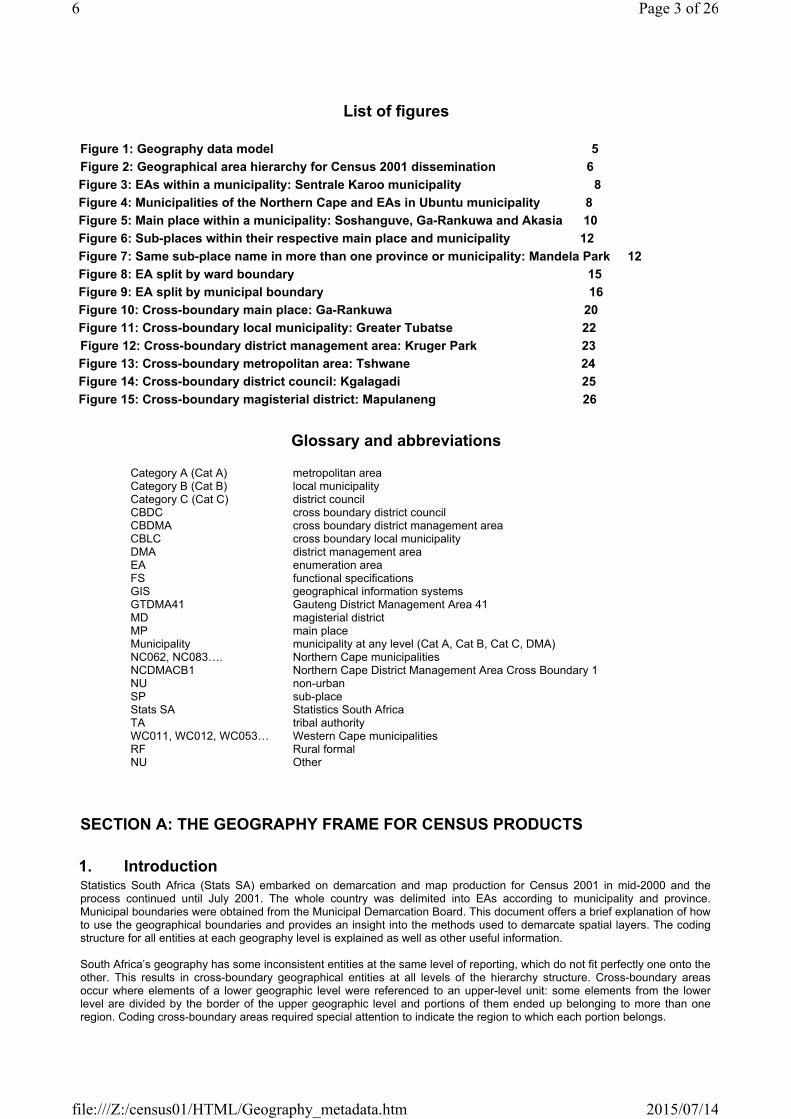
Figure 1: Geography data model 5Figure 2: Geographical area hierarchy for Census 2001 dissemination 6Figure 3: EAs within a municipality: Sentrale Karoo municipality 8Figure 4: Municipalities of the Northern Cape and EAs in Ubuntu municipality 8Figure 5: Main place within a municipality: Soshanguve, Ga-Rankuwa and Akasia 10Figure 6: Sub-places within their respective main place and municipality 12Figure 7: Same sub-place name in more than one province or municipality: Mandela Park 12Figure 8: EA split by ward boundary 15Figure 9: EA split by municipal boundary 16Figure 10: Cross-boundary main place: Ga-Rankuwa 20Figure 11: Cross-boundary local municipality: Greater Tubatse 22Figure 12: Cross-boundary district management area: Kruger Park 23Figure 13: Cross-boundary metropolitan area: Tshwane 24Figure 14: Cross-boundary district council: Kgalagadi 25Figure 15: Cross-boundary magisterial district: Mapulaneng 26
Glossary and abbreviations
Category A (Cat A) metropolitan areaCategory B (Cat B) local municipalityCategory C (Cat C) district councilCBDC cross boundary district councilCBDMA cross boundary district management areaCBLC cross boundary local municipalityDMA district management areaEA enumeration areaFS functional specificationsGIS geographical information systemsGTDMA41 Gauteng District Management Area 41MD magisterial districtMP main placeMunicipality municipality at any level (Cat A, Cat B, Cat C, DMA)NC062, NC083…. Northern Cape municipalitiesNCDMACB1 Northern Cape District Management Area Cross Boundary 1NU non-urbanSP sub-placeStats SA Statistics South AfricaTA tribal authorityWC011, WC012, WC053… Western Cape municipalitiesRF Rural formalNU Other
SECTION A: THE GEOGRAPHY FRAME FOR CENSUS PRODUCTS
1. IntroductionStatistics South Africa (Stats SA) embarked on demarcation and map production for Census 2001 in mid-2000 and the process continued until July 2001. The whole country was delimited into EAs according to municipality and province. Municipal boundaries were obtained from the Municipal Demarcation Board. This document offers a brief explanation of how to use the geographical boundaries and provides an insight into the methods used to demarcate spatial layers. The coding structure for all entities at each geography level is explained as well as other useful information.
South Africa’s geography has some inconsistent entities at the same level of reporting, which do not fit perfectly one onto the other. This results in cross-boundary geographical entities at all levels of the hierarchy structure. Cross-boundary areas occur where elements of a lower geographic level were referenced to an upper-level unit: some elements from the lower level are divided by the border of the upper geographic level and portions of them ended up belonging to more than one region. Coding cross-boundary areas required special attention to indicate the region to which each portion belongs.
Page 3 of 266
2015/07/14file:///Z:/census01/HTML/Geography_metadata.htm
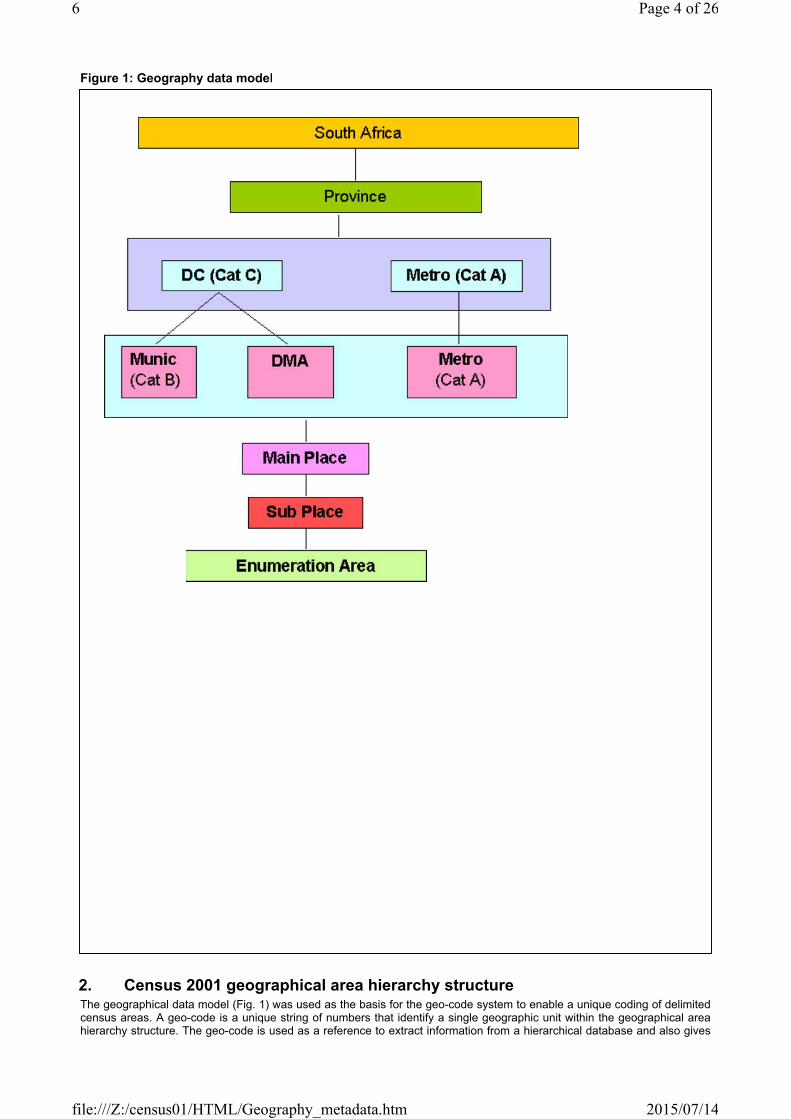
Figure 1: Geography data model
2. Census 2001 geographical area hierarchy structureThe geographical data model (Fig. 1) was used as the basis for the geo-code system to enable a unique coding of delimited census areas. A geo-code is a unique string of numbers that identify a single geographic unit within the geographical area hierarchy structure. The geo-code is used as a reference to extract information from a hierarchical database and also gives
Page 4 of 266
2015/07/14file:///Z:/census01/HTML/Geography_metadata.htm
a one-to-one relationship that assists in reporting at each level. In the hierarchy, different elements of the low-level category were referenced to a single unit of the upper level (e.g. a number of enumeration areas referenced to one municipality).
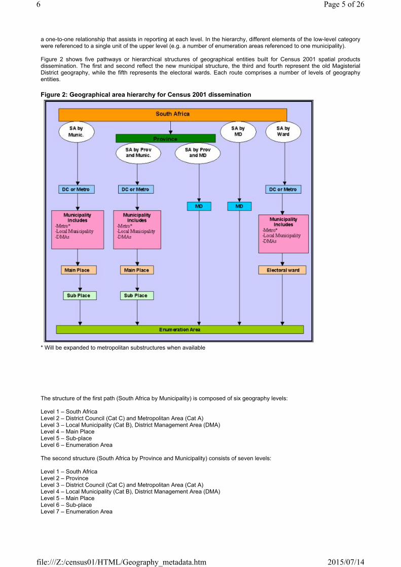
Figure 2 shows five pathways or hierarchical structures of geographical entities built for Census 2001 spatial products dissemination. The first and second reflect the new municipal structure, the third and fourth represent the old Magisterial District geography, while the fifth represents the electoral wards. Each route comprises a number of levels of geography entities.
Figure 2: Geographical area hierarchy for Census 2001 dissemination
* Will be expanded to metropolitan substructures when available
The structure of the first path (South Africa by Municipality) is composed of six geography levels:
Level 1 – South AfricaLevel 2 – District Council (Cat C) and Metropolitan Area (Cat A)Level 3 – Local Municipality (Cat B), District Management Area (DMA)Level 4 – Main Place Level 5 – Sub-place Level 6 – Enumeration Area
The second structure (South Africa by Province and Municipality) consists of seven levels:
Level 1 – South AfricaLevel 2 – ProvinceLevel 3 – District Council (Cat C) and Metropolitan Area (Cat A)Level 4 – Local Municipality (Cat B), District Management Area (DMA)Level 5 – Main PlaceLevel 6 – Sub-placeLevel 7 – Enumeration Area
Page 5 of 266
2015/07/14file:///Z:/census01/HTML/Geography_metadata.htm
The Magisterial District (MD) routes are alternatives, which preserve the old geography structure of Census ’96. These are also used for Census 2001 dissemination. The first (South Africa by Province and MD) has four levels of geographical entities:
Level 1 – South Africa Level 2 – ProvinceLevel 3 – Magisterial DistrictLevel 4 – Enumeration Area
The second (South Africa by MD) has three levels of geographical entities:
Level 1 – South Africa Level 2 – Magisterial DistrictLevel 3 – Enumeration Area
The structure of the Electoral Ward hierarchy (South Africa by Electoral Wards) consists of five levels:
Level 1 – South AfricaLevel 2 – District Council (Cat C) and Metropolitan Area (Cat A)Level 3 – Local Municipality (Cat B), District Management Area (DMA)Level 4 – WardLevel 5 – Enumeration Area
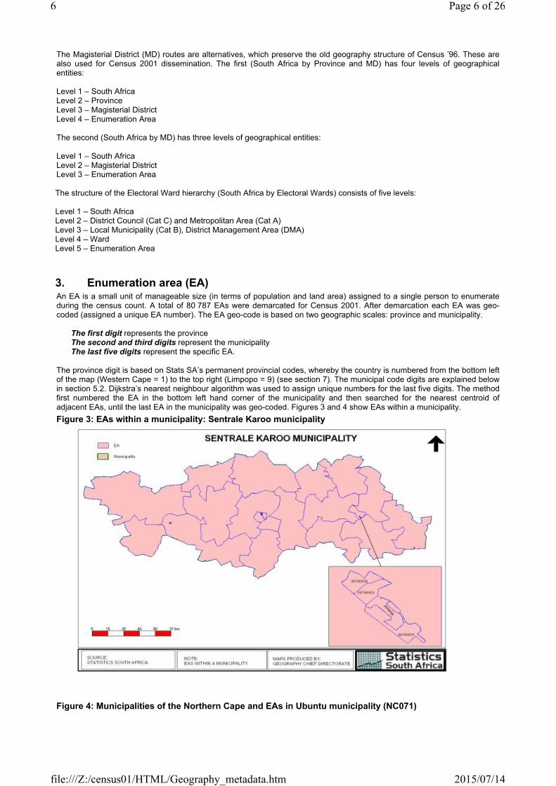
3. Enumeration area (EA)An EA is a small unit of manageable size (in terms of population and land area) assigned to a single person to enumerate during the census count. A total of 80 787 EAs were demarcated for Census 2001. After demarcation each EA was geo-coded (assigned a unique EA number). The EA geo-code is based on two geographic scales: province and municipality.
The first digit represents the provinceThe second and third digits represent the municipalityThe last five digits represent the specific EA.
The province digit is based on Stats SA’s permanent provincial codes, whereby the country is numbered from the bottom left of the map (Western Cape = 1) to the top right (Limpopo = 9) (see section 7). The municipal code digits are explained below in section 5.2. Dijkstra’s nearest neighbour algorithm was used to assign unique numbers for the last five digits. The method first numbered the EA in the bottom left hand corner of the municipality and then searched for the nearest centroid of adjacent EAs, until the last EA in the municipality was geo-coded. Figures 3 and 4 show EAs within a municipality.Figure 3: EAs within a municipality: Sentrale Karoo municipality
Figure 4: Municipalities of the Northern Cape and EAs in Ubuntu municipality (NC071)
Page 6 of 266
2015/07/14file:///Z:/census01/HTML/Geography_metadata.htm

Table 1 shows the structure of the EA master table on the GIS CD. This master table links all the geography boundaries together for the five routes in SuperCross.
Table 1: Sample from the EA master table
During Stats SA’s quality assurance process it was discovered that twenty EAs were misallocated at provincial level, while two were coded to the wrong province (Table 2). The former were misallocated in that they span a provincial boundary, and were allocated to one province whilst the greater area of the EA is in the other. This occurs because provincial and municipal boundaries are not aligned and sometimes cut through settlements.
Table 2: Misallocated EAs
Page 7 of 266
2015/07/14file:///Z:/census01/HTML/Geography_metadata.htm

4. Place nameThe place name is the most easily recognisable small area geographical entity at a local level. However, classification of place names by different types and levels of hierarchies is not simple. In order to take care of the vertical hierarchical structure built into the name code, two place name levels (main and sub) based on settlement name and type were used for Census 2001. To achieve the desired place name structure Stats SA developed an enhanced place name database for Census 2001. The product is an improvement on the 1996 place name database. The place names were audited (corrected, new names added and invalid names renamed) and coded. A main place name and sub-place name was assigned to each EA. EAs were rolled up to create the sub and main place layers in the geography hierarchy.
4.1 Main place The main place is level five in the geographical area hierarchy structure (Fig. 1). It is one level above the sub-place and one level below the municipality. Municipality names were used where main place names were not supplied.
A five-digit code was generated for each main place:
The first digit denotes the province, The second and third digit denote the municipality, and The last two digits identify a unique main place in the municipality.
Figure 5: Main places within a municipality: Soshanguve, Ga-Rankuwa and Akasia
Page 8 of 266
2015/07/14file:///Z:/census01/HTML/Geography_metadata.htm

Table 3 shows the structure of the main place table on the GIS CD. Each main place geo-code has a main place name.
Table 3: Sample from the main place table
There are 2 674 unique main place names, but altogether 3 109 main places were coded. This is a result of cross-boundary entities, as well as different main places having the same name (for example, Springs is found in Ekurhuleni, Mnquma and Lesedi municipalities). Cross-boundary coding is explained in Section B.
In cases where different main places have the same name, ‘Part 1’, ‘Part 2’, etc., has been inserted as a suffix to distinguish the names. In order to identify the exact main place required, users may need to refer to the main place look-up table, which can be found on the Stats SA website via the Census 2001 webpage → Census products → Electronic data → Placename lookup tables.
4.2 Sub-place This is the next spatial level up from the EA and one below the main place in the place name hierarchy (Figure 6). In cases where a sub-place is not defined the main place name has been used, with the suffix SP to indicate that this is a sub-place. An eight-digit geo-code was generated for each sub-place.
The first digit denotes the province, The second and third digits denote the municipality, The fourth and fifth digits identify the main place (as above), while The last three digits identify a unique sub-place within the main place.
The last five digits therefore identify a unique sub-place within a municipality.
Page 9 of 266
2015/07/14file:///Z:/census01/HTML/Geography_metadata.htm
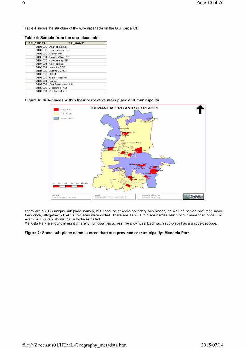
Table 4 shows the structure of the sub-place table on the GIS spatial CD.
Table 4: Sample from the sub-place table
Figure 6: Sub-places within their respective main place and municipality
There are 15 966 unique sub-place names, but because of cross-boundary sub-places, as well as names occurring more than once, altogether 21 243 sub-places were coded. There are 1 896 sub-place names which occur more than once. For example, Figure 7 shows that sub-places called Mandela Park are found in eight different municipalities across five provinces. Each such sub-place has a unique geocode.
Figure 7: Same sub-place name in more than one province or municipality: Mandela Park
Page 10 of 266
2015/07/14file:///Z:/census01/HTML/Geography_metadata.htm

Table 5 shows a sample of sub-place names used in more than one province or in different municipalities within the same province.
Table 5: Sample of sub-place names in more than one province or municipality
Full details of all sub-place names that occur more than once are given in the sub-place look-up table, which can be found on the Stats SA website (details as given above for the main place look-up table). This table should enable users to identify the geocode of the particular sub-place required.
4.3 Intermediate and alternative names and types An intermediate layer will be created for administrative areas found in the Transkei and the metropolitan substructures during maintenance. Alternative names already exist in Stats SA’s place name database. These will be linked to formal names to facilitate searching if clients do not know formal names.
Table 6 lists the type of areas treated as main place, intermediate place and sub-place.
Table 6: Place name level of each type of area Type of area Place name level
CityTownTownshipRF_MunicTribal authorityAdministration areaNational parksMD (as TA if not known)
Main place
Administration area (Transkei) Intermediate place
Page 11 of 266
2015/07/14file:///Z:/census01/HTML/Geography_metadata.htm

Metropolitan substructure (metros)SuburbSmall holdingResortIndustrialLocalityVillageWardFarm/NU (MD + NU)NONEInstitution (if main place is Park)
Sub-place
Names can vary for reasons of language (e.g. Cape Town/ Kaapstad), history (e.g. Thaba Tshwane/ Voortrekkerhoogte) or spelling (e.g. Umbumbulu/ Embumbulu). Other alternatives include sub-village and sub-ward.
5. WardsWards are clusters of voting district polygons obtained from the Independent Electoral Commission. The Municipal Demarcation Board (MDB) created wards in 2000. There are 3754 wards in 229 of the 237 local and metropolitan municipalities. In 8 local municipalities and 25 DMAs, there are no wards (86). Each ward was allocated a unique code. The structure of the code is as follows:
The first digit denotes the province, The second and third digits denote the district council, The fourth and fifth digits identify the municipality, while The last three digits identify the particular ward.
In the case of the 8 municipalities and the 25 DMAs without wards, the ward code allocated still has eight digits; with the last three digits being zeros (i.e. 000) and the ward number is given as zero.
Table 7: Local municipalities and DMAs where electoral wards are not defined
Due to the importance of ward data for municipal governance purposes, the MDB assisted Stats SA in developing a link table that maps the EA to the ward. This was done in 2003. Three scenarios for the allocation of the ward code to the EA were identified:
EAs that fall wholly within the wardEAs that have a minor overlap with the ward boundaryEAs that have a major overlap with the ward boundary
Page 12 of 266
2015/07/14file:///Z:/census01/HTML/Geography_metadata.htm

Figure 8: EA split by ward boundary
In cases where EAs were not wholly within ward boundaries (Figure 7), each EA was assessed using available data (i.e. sub- and main-place boundaries and aerial photography) in order to allocate it to a ward. In instances where EAs crossed municipal boundaries to keep a community together (Figure 8), the MDB examined the EA code to see how the EA had been assigned, and allocated it in the same way for ward purposes. This is to ensure that aggregated totals for the census data tally.
Table 8 shows the structure of the electoral ward table on the GIS spatial CD. Each electoral ward geo-code has an electoral ward number within each municipality (numbered from one upwards till the last).
Table 8: Sample from the electoral ward table
Figure 9: EA split by municipal boundary
Page 13 of 266
2015/07/14file:///Z:/census01/HTML/Geography_metadata.htm

6. New municipal structureThe Municipal Demarcation Board provided the new municipality boundaries to Stats SA in 2000. These boundaries were defined in mid-2000 when the new municipal structure replaced the old structure. The new structure consists of Category A municipalities, which are the metropolitan areas (Cat A or Metros), Category C municipalities, or district councils (Cat C or DCs), District Management Areas (DMAs) and Category B or local municipalities (Cat B). All local municipalities and DMAs fall within a district council. In total, there are six metropolitan areas, 47 district councils, 231 local municipalities and 25 DMAs.
These new municipal boundaries were used to demarcate EAs for the 2001 census. It should be noted that these boundaries do not all fit perfectly into the provincial boundaries as some municipalities straddle provincial boundaries, creating cross-boundary municipalities
6.1 Category B municipalities Key considerations in redetermining local municipality boundaries included: settlement type, the rationalisation of municipalities, manageable size and functionality. Local municipalities and DMAs are the next spatial level up from the main place. There are 231 Category B municipalities. Among them are eight cross-boundary municipalities. Stats SA use a two-digit code for each municipality within a province. These correspond to the MDB numbers as follows.
For example, in the Western Cape: 01, 02, …42 correspond to WC011, WC012 … WC053
In the case of cross-boundary municipalities, the first digit is an 8. For example, 81 and 82 correspond to the DMB numbers CBLC1 and CBLC2.
These two-digit codes are combined with the Stats SA provincial code to give a three-digit code. Thus, 101, 102, …142 correspond to WC011, WC012 … WC053.
In the case of cross-boundary municipalities, 381 refers to the portion of CBLC1 in the Northern Cape, and 681 to the portion in North West
Table 9: Sample from the municipality table
Page 14 of 266
2015/07/14file:///Z:/census01/HTML/Geography_metadata.htm

The MN_SA spatial file should be used to link data extracted through the South Africa by Municipality route in Supercross.
Table 9 shows the structure of the municipality table (this table contain local municipalities, DMAs and metros) on the GIS Spatial CD. Each municipality has a name and two codes: the MN_MDB_C and MN_CODE.
6.2 District management areas These are areas with both district and local municipality features, where the establishment of a local municipality is not appropriate (does not meet a set of requirements). DMAs are areas of special interest e.g. deserts and semi-arid areas, state-protected and conservation areas and special economic areas. There are 25 DMAs, four of which are cross-boundary. DMAs have a two-digit code. The first digit 9 identifies a DMA.
Thus in the Western Cape: 91, 92,…95 correspond to WCDMA01, WCDMA02 … WCDMA05.
These two digits are combined with the provincial code to give a three-digit code. : 191, 192 … 195.
6.3 Category A municipalities Metros and DCs are a level above the DMAs and local municipalities in the geography hierarchy. In 1999, the MDB published redetermined metropolitan and district council boundaries. Metropolitan areas are conurbations featuring high population density; intense movement of people, goods and services; extensive development; and multiple business districts and industrial areas. Other features include a complex and diverse economy, a single area where integrated development is desirable, and strong interdependent social and economic linkages between its constituent units. There are six metros in South Africa:
Cape Town, Ethekwini (Durban), Ekurhuleni (East Rand), Johannesburg,
Tshwane (Pretoria), Nelson Mandela (Port Elizabeth)
A two-digit code is used for the metros. The digit 7 denotes a metro while the second digit identifies the particular metro:71 – Cape Town72 – Ethekwini 73 – Ekurhuleni74 – Johannesburg75 – Nelson Mandela76 – Tshwane
These two-digit codes are combined with the provincial code to give a three-digit code:
171 – Cape Town572 – Durban773 – Ekurhuleni774 – Johannesburg
275 – Nelson Mandela776 – Tshwane for Gauteng province676 – Tshwane for North West province
NB: Note that Tshwane appears twice, with two different provincial codes, because it is a cross boundary metro.
Metropolitan areas are further subdivided into smaller administrative units called substructures.
Page 15 of 266
2015/07/14file:///Z:/census01/HTML/Geography_metadata.htm

NB: In the hierarchy, the metropolitan substructures are at the same level as local municipalities. Changes will be effected when substructure data and boundaries are obtained from metro councils.
6.4 Category C municipalities District councils were redetermined with the aim of strengthening them, and ensuring better coordination with other spheres of government, better planning and better resource allocation across the local municipalities of which they are made up. There are 42 DCs geo-coded from 1 to 43 (11 does not exist). In addition, there are also five cross-border DCs. The codes are:
1, 2, …43 = DC1, DC2, DC43 (DC11 does not exist)81, 82, 83, 84, 88 = CBDC1, CBDC2, CBDC3, CBDC4, CBDC8 (Cross-boundary district councils are identified
by the first digit 8)
Table 10: Sample from the district council and metro table
The DC_SA spatial file should be used to link data extracted through the South Africa by Municipality route in Supercross.
Table 10 shows the structure of the district council and metro table on the GIS Spatial CD. Each district council or metro has a name and two codes: the DC_MDB_C and DC_MN_C.
7. Magisterial districtThere are 354 MDs, numbered consecutively per province. A two-digit code is used to identify each MD. These two-digit codes are combined with the provincial code to give a three-digit cod. The following examples are Western Cape magisterial districts:Table 11: Sample from the magisterial district table
The MD_SA spatial file should be used to link data extracted through the South Africa by Magisterial District route in Supercross
Table 11 shows the structure of the magisterial district table on the GIS Spatial CD. Each magisterial district has a code and name: the MDB name and the Stats SA name.
8. ProvinceProvincial boundaries were obtained from Land Affairs in 1999. There are nine provinces in the country coded by Stats SA from 1 to 9. The codes are as follows:
Table 12: SA provinces and their codes
Page 16 of 266
2015/07/14file:///Z:/census01/HTML/Geography_metadata.htm
The PR_SA spatial file should be used to link data extracted through the South Africa by Province and Municipality as well as South Africa by Province and MD routes in Supercross.
SECTION B: CROSS-BOUNDARY GEOGRAPHY ENTITIESIn this section we consider all entities from the Municipality Demarcation Board or Stats SA (i.e. place name, magisterial district, district council, metro, local municipality or DMA) whose boundaries cross a provincial border. These geographic elements belong to more than one province. The coding structure of such entities always identifies the province to which each portion belongs. Cross-boundary entities at each geography level are discussed below.
NB: Extracting summary data involves rolling up EA data to any element of a geographic entity. Thus, to get summary data on cross-boundary areas the name of the geography element required should be used instead of the code. Codes will extract partial information since they are linked to the provinces.
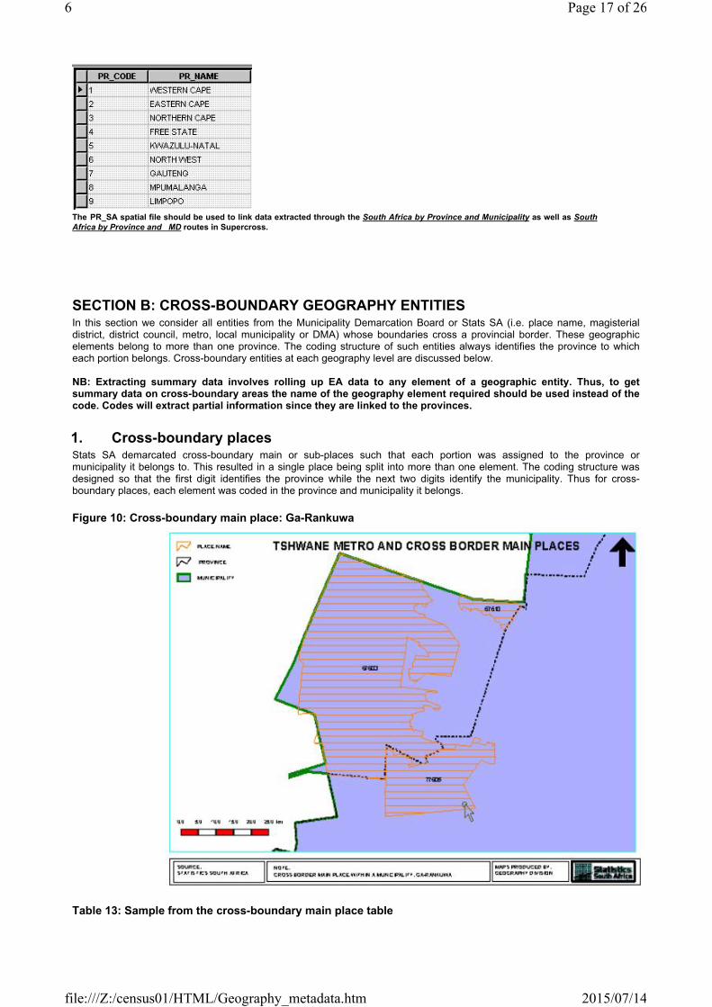
1. Cross-boundary placesStats SA demarcated cross-boundary main or sub-places such that each portion was assigned to the province or municipality it belongs to. This resulted in a single place being split into more than one element. The coding structure was designed so that the first digit identifies the province while the next two digits identify the municipality. Thus for cross-boundary places, each element was coded in the province and municipality it belongs.
Figure 10: Cross-boundary main place: Ga-Rankuwa
Table 13: Sample from the cross-boundary main place table
Page 17 of 266
2015/07/14file:///Z:/census01/HTML/Geography_metadata.htm
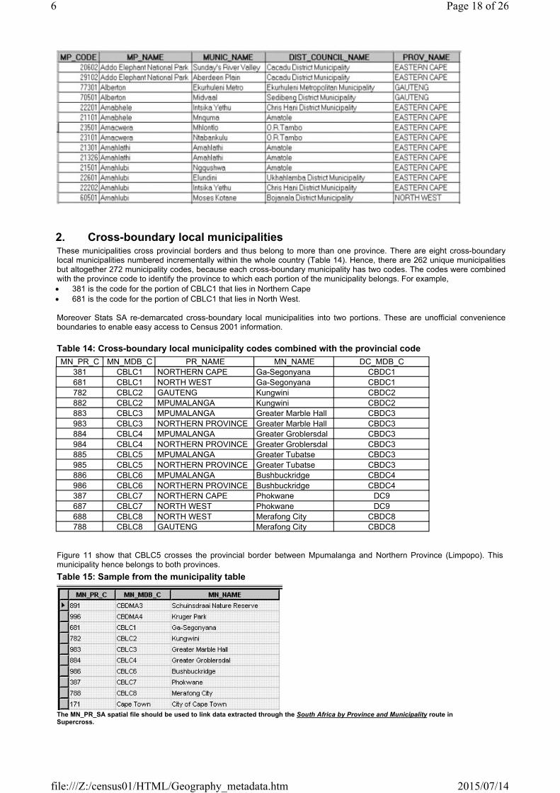
2. Cross-boundary local municipalitiesThese municipalities cross provincial borders and thus belong to more than one province. There are eight cross-boundary local municipalities numbered incrementally within the whole country (Table 14). Hence, there are 262 unique municipalities but altogether 272 municipality codes, because each cross-boundary municipality has two codes. The codes were combined with the province code to identify the province to which each portion of the municipality belongs. For example,
381 is the code for the portion of CBLC1 that lies in Northern Cape681 is the code for the portion of CBLC1 that lies in North West.
Moreover Stats SA re-demarcated cross-boundary local municipalities into two portions. These are unofficial convenience boundaries to enable easy access to Census 2001 information.
Table 14: Cross-boundary local municipality codes combined with the provincial codeMN_PR_C MN_MDB_C PR_NAME MN_NAME DC_MDB_C
381 CBLC1 NORTHERN CAPE Ga-Segonyana CBDC1681 CBLC1 NORTH WEST Ga-Segonyana CBDC1782 CBLC2 GAUTENG Kungwini CBDC2882 CBLC2 MPUMALANGA Kungwini CBDC2883 CBLC3 MPUMALANGA Greater Marble Hall CBDC3983 CBLC3 NORTHERN PROVINCE Greater Marble Hall CBDC3884 CBLC4 MPUMALANGA Greater Groblersdal CBDC3984 CBLC4 NORTHERN PROVINCE Greater Groblersdal CBDC3885 CBLC5 MPUMALANGA Greater Tubatse CBDC3985 CBLC5 NORTHERN PROVINCE Greater Tubatse CBDC3886 CBLC6 MPUMALANGA Bushbuckridge CBDC4986 CBLC6 NORTHERN PROVINCE Bushbuckridge CBDC4387 CBLC7 NORTHERN CAPE Phokwane DC9687 CBLC7 NORTH WEST Phokwane DC9688 CBLC8 NORTH WEST Merafong City CBDC8788 CBLC8 GAUTENG Merafong City CBDC8
Figure 11 show that CBLC5 crosses the provincial border between Mpumalanga and Northern Province (Limpopo). This municipality hence belongs to both provinces. Table 15: Sample from the municipality table
The MN_PR_SA spatial file should be used to link data extracted through the South Africa by Province and Municipality route in Supercross.
Page 18 of 266
2015/07/14file:///Z:/census01/HTML/Geography_metadata.htm

Table 15 shows the structure of the municipality table (MN_PR_SA) on the GIS Spatial CD. Each municipality has a name and two codes: the MN_PR_C and MN_MDB_C. There are 272 municipal codes, names and polygons in this file.
Figure 11: Cross-boundary local municipality: Greater Tubatse
3. Cross-boundary district management areasLike cross-boundary local municipalities, cross-boundary DMAs cross provincial borders and belong to more than one province. Figure 12 is an example of a cross-boundary DMA shared between Mpumalanga and Limpopo. Cross-boundary DMA codes are combined with the province code to identify the province to which each portion of the DMA belongs (Table 16).
Table 16: Cross-boundary DMA codes combined with provincial code
*CBDMA3 code is erroneously captured as 991 instead of 891 in SuperCross
Moreover Stats SA re-demarcated cross-boundary DMAs into two portions. These are unofficial convenience boundaries to enable easy access to Census 2001 information.
Figure 12: Cross-boundary district management area: Kruger Park
Page 19 of 266
2015/07/14file:///Z:/census01/HTML/Geography_metadata.htm

4. Cross-boundary metropolitan areasTshwane is a cross-boundary metro with portions in Gauteng and North West (Figure 13). It has two codes (see Section 5.3). Stats SA re-demarcated cross-boundary Tshwane into two portions. These are unofficial convenience boundaries to enable easy access to Census 2001 information.
Figure 13: Cross-boundary metropolitan area: Tshwane
5. Cross-boundary district councilsThere are five cross-boundary district councils (Table 17). Each cross-boundary district council has two codes. A two-digit code is used to identify the cross-boundary DCs, with the first digit (8) denoting cross-boundary. These digits are combined with the relevant province code to distinguish between the two portions:
381 – for the portion of CBDC1 that lies in Northern Cape681 – for the portion of CBDC1 that lies in North West
Page 20 of 266
2015/07/14file:///Z:/census01/HTML/Geography_metadata.htm

Moreover Stats SA re-demarcated cross-boundary district councils into two portions. These are unofficial convenience boundaries to enable easy access to Census 2001 information.
Table 17: Cross-boundary district councils
Table 18: Sample from the DC or metro table
The DC_PR_SA spatial file should be used to link data extracted through the South Africa by Province and Municipality route in Supercross.
Table 18 shows the structure of the DC or Metro table (DC_PR_SA) on the GIS Spatial CD. Each municipality has a name and two codes: the DC_PR_C and DC_MDB_C. There are 60 DC or Metro codes, names and polygons in this file.
Figure 14 shows an example of a cross-boundary district council.
Figure 14 Cross-boundary district council: Kgalagadi
Page 21 of 266
2015/07/14file:///Z:/census01/HTML/Geography_metadata.htm

6. Cross-boundary magisterial districtsTheoretically cross-boundary MDs do not exist since MD boundaries are supposed to be aligned with provincial borders. Two technical problems gave rise to cross-boundary MDs: MD boundaries not aligned with provincial borders and EAs wrongly coded. There are twelve such MDs across the whole country (Table 19). Four of these MDs contain wrongly coded EAs thus are also classified as cross-boundaries. There are 354 unique MDs but altogether 366 MD codes, because each cross-boundary MD has two codes. The cross-boundary MD code is combined with the provincial code to show where each part of the cross-boundary MD belongs, giving a four-digit code. The first digit represents the province and the second digit (8 or 9) stands for cross-boundary (Table 20).
Table 19: Cross-boundary MDs as they were coded in 1996
Moreover Stats SA re-demarcated cross-boundary MD into two portions. These are unofficial convenience boundaries to enable easy access to Census 2001 information.
Figure 15: Cross-boundary magisterial district: Mapulaneng
Table 20: Cross-boundary MD codes combined with provincial code, 2001
Page 22 of 266
2015/07/14file:///Z:/census01/HTML/Geography_metadata.htm

Table 21: Sample from the MD table
The MD_PR_SA spatial file should be used to link data extracted through theSouth Africa by Province and MD route in Supercross.
Table 21 shows the structure of the MD table (MD_PR_SA) on the GIS Spatial CD. Each DC or Metro has a code and two alternative names: the MDB name and the Stats SA name. There are 366 MD codes, names and polygons in this file.
SECTION C: CONTENTS OF THE GIS SPATIAL CD
The CD contains a GIS spatial folder with ten geography shapefiles, plus a metadata folder. The CD will be identified by its name and contents.
CD name and contents
Census 2001: GIS spatial data(Ref. No. 03-02-27 (2001))
An outline of the four dissemination routes in SuperCross is given with a combination of the geography shapefile according to their specific path.
South Africa by Municipality- DC_SA shapefiles - MN_SA shapefiles
- MP_SA shapefiles
Page 23 of 266
2015/07/14file:///Z:/census01/HTML/Geography_metadata.htm

- SP_SA shapefiles- EA_SA shapefiles
South Africa by Province and Municipality- PR_SA shapefiles- DC_PR_SA shapefiles - MN_PR_ A shapefiles- MP_SA shapefiles- SP_SA shapefiles- EA_SA shapefiles
South Africa by Magisterial District- MD_SA shapefiles- EA_SA shapefiles
South Africa by Province and Magisterial District- PR_SA shapefiles
- MD_PR_SA shapefiles- EA_SA shapefiles
South Africa by Electoral Ward- DC_SA shapefiles
- MN_SA shapefiles- MP_SA shapefiles- SP_SA shapefiles- EA_SA shapefiles
Metadata Document – metadata for all the geography boundaries.
It is recommended that clients use appropriate shapefile tables for each specific path.
Details of shapefile tables
The tables contain attribute tables and geography boundaries.
PR_SA This table contains all the provinces in SA and is used to link to South Africa by Province and Municipality as well as South Africa by Province and Magisterial routes in SuperCross.
DC_SA This table contains all the district councils and metros in SA with cross-boundary entities treated as a unit.DC_PR_SA This table contains all the district councils and metros in SA with cross-boundaries entities split
according to which province they belong to.MD_SA This table contains all the magisterial districts in SA with cross-boundary entities treated as a unit.MD_PR_SA This table contains all the magisterial districts in SA with cross-boundary entities split according to
which province they belong to.MN_SA This table contains all the municipalities (Cat A/ Cat B/ DMA) in SA with cross-boundary entities treated as a unit.MN_PR_SA This table contains all the municipalities (Cat A/ Cat B/ DMA) in SA with cross-boundary entities
according to which province they belong to.WD_SA This table contains all the wards in SA.MP_SA This table contains all the main places in SA.SP_SA This table contains all the sub-places in SA.EA_SA This table contains all the EAs, sub and main places, municipalities, metros, DCs, MDs and provinces in SA. It is
used to link all geography entities to with each other.
Technical specifications of each table
PR_SA Table (provinces)FIELD NAME DATA TYPE DESCRIPTIONPR_CODE Long integer The province codePR_NAME TEXT The name of the province
DC_SA Table (district councils and metros) FIELD NAME DATA TYPE DESCRIPTIONDC_MDB_C TEXT The DC or metro code as supplied by the Municipal
Demarcation Board (MDB)DC_NAME TEXT The name of the DC or metro
DC_MN_C Long integer The code used to link to the SA-by-municipality route in SuperCross
Page 24 of 266
2015/07/14file:///Z:/census01/HTML/Geography_metadata.htm

DC_PR_SA Table (district councils and metros) FIELD NAME DATA TYPE DESCRIPTIONDC_MDB_C TEXT The DC or metro code as supplied by the Municipal
Demarcation Board (MDB)DC_NAME TEXT The name of the DC or metro
DC_PR_C Long integer The code used to link to the SA-by-province and municipality route in SuperCross
MD_SA Table (magisterial districts)FIELD NAME DATA TYPE DESCRIPTIONMD_CODE Long integer The Census ‘96 code of the MD (used to link to SA by MD route
in SuperCross)MD_NAME TEXT Describes the Name of the MD
MD_PR_SA Table (magisterial districts)FIELD NAME DATA TYPE DESCRIPTIONMD_PR_C Long integer The MD code used to link to SA by province and MD route in
SuperCrossMD_NAME TEXT Describes the Name of the MD
MN_SA Table (municipalities)FIELD NAME DATA TYPE DESCRIPTIONMN_MDB_C TEXT The municipality code (Cat A/Cat B/DMA) as supplied by the
Municipal Demarcation Board (MDB)MN_NAME TEXT The name of the municipalityMN_CODE Long integer The code used to link to the SA-by-municipality route in
SuperCross
MN_SA Table (municipalities)FIELD NAME DATA TYPE DESCRIPTIONMN_MDB_C TEXT The municipality code (Cat A/Cat B/DMA) as supplied by the
Municipal Demarcation Board (MDB)MN_NAME TEXT The name of the municipalityMN_PR_C Long integer The code used to link to the SA-by-province and municipality
route in SuperCross
WD_SA Table (magisterial districts)FIELD NAME DATA TYPE DESCRIPTIONWD_CODE Long integer The ward code used to link to SA by electoral ward route in
SuperCrossWD_No TEXT Describes the Number of the ward within the municipality
MP_SA Table (main places)FIELD NAME DATA TYPE DESCRIPTIONMP_CODE Long integer The main place codeMP_NAME TEXT The name of the main place
SP_SA Table (sub-places)FIELD NAME DATA TYPE DESCRIPTIONSP_CODE Long integer The sub-place codeSP_NAME TEXT The name of the sub-place
EA_SA Table (enumeration areas) FIELD NAME DATA TYPE DESCRIPTIONEA_CODE Long integer The enumeration area codeSP_CODE Long integer The sub-place codeMP_CODE Long integer The main place codeWD_CODE Long integer The electoral ward code used to link to the SA-by-electoral ward
route in SuperCrossMN_CODE Long integer The municipality code used to link to the SA-by-municipality
route in SuperCrossMN_PR_C Long integer The municipality code used to link to the SA-by-province route in
SuperCrossMD_CODE Long integer
Page 25 of 266
2015/07/14file:///Z:/census01/HTML/Geography_metadata.htm

The Census ’96 MD code (used to link to SA-by-MD route in SuperCross)
MD_PR_C Long Integer The MD code used to link to the SA-by-province route in SuperCross
DC_MN_C Long integer The DC or Metro code used to link to the SA-by-municipality route in SuperCross
DC_PR_C Long integer The DC or Metro code used to link to the SA-by-province route in SuperCross
PR_CODE Long integer The province code
Page 26 of 266
2015/07/14file:///Z:/census01/HTML/Geography_metadata.htm


