Geolocation Estimation of Photos using a Hierarchical Model and Scene Classification Eric M¨ uller-Budack 1,2[0000-0002-6802-1241] , Kader Pustu-Iren 1[0000-0003-2891-9783] , and Ralph Ewerth 1,2[0000-0003-0918-6297] 1 Leibniz Information Centre for Science and Technology (TIB), Hannover, Germany 2 L3S Research Center, Leibniz Universit¨ at Hannover, Germany {eric.mueller,kader.pustu,ralph.ewerth}@tib.eu Abstract. While the successful estimation of a photo’s geolocation en- ables a number of interesting applications, it is also a very challenging task. Due to the complexity of the problem, most existing approaches are restricted to specific areas, imagery, or worldwide landmarks. Only a few proposals predict GPS coordinates without any limitations. In this paper, we introduce several deep learning methods, which pursue the lat- ter approach and treat geolocalization as a classification problem where the earth is subdivided into geographical cells. We propose to exploit hierarchical knowledge of multiple partitionings and additionally extract and take the photo’s scene content into account, i.e., indoor, natural, or urban setting etc. As a result, contextual information at different spa- tial resolutions as well as more specific features for various environmental settings are incorporated in the learning process of the convolutional neu- ral network. Experimental results on two benchmarks demonstrate the effectiveness of our approach outperforming the state of the art while using a significant lower number of training images and without relying on retrieval methods that require an appropriate reference dataset. Keywords: Geolocation Estimation · Scene Classification · Deep Learn- ing · Context-based Classification 1 Introduction Predicting the geographical location of photos without any prior knowledge is a very challenging task, since images taken from all over the earth depict a huge amount of variations, e.g., different daytimes, objects, or camera settings. In ad- dition, the images are often ambiguous and therefore provide only very few visual clues about their respective recording location. For these reasons, the majority of approaches simplifies photo geolocalization by restricting the problem to ur- ban photos of, for example, well-known landmarks and cities [3,25,34,43,45,48] or natural areas like deserts or mountains [5,33,38]. Only a few frameworks treat the task at global-scale without relying on specific imagery [13,14,39,42] or any other prior assumptions. These approaches particularly benefit from the advancements in deep learning [15,16,21] and the increasing number of publicly available large- scale image collections from platforms such as Flickr. Due to the complexity
Transcript
Geolocation Estimation of Photos using a
Hierarchical Model and Scene Classification
Eric Muller-Budack1,2[0000−0002−6802−1241], KaderPustu-Iren1[0000−0003−2891−9783], and Ralph Ewerth1,2[0000−0003−0918−6297]
1 Leibniz Information Centre for Science and Technology (TIB), Hannover, Germany2 L3S Research Center, Leibniz Universitat Hannover, Germany
{eric.mueller,kader.pustu,ralph.ewerth}@tib.eu
Abstract. While the successful estimation of a photo’s geolocation en-ables a number of interesting applications, it is also a very challengingtask. Due to the complexity of the problem, most existing approachesare restricted to specific areas, imagery, or worldwide landmarks. Only afew proposals predict GPS coordinates without any limitations. In thispaper, we introduce several deep learning methods, which pursue the lat-ter approach and treat geolocalization as a classification problem wherethe earth is subdivided into geographical cells. We propose to exploithierarchical knowledge of multiple partitionings and additionally extractand take the photo’s scene content into account, i.e., indoor, natural, orurban setting etc. As a result, contextual information at different spa-tial resolutions as well as more specific features for various environmentalsettings are incorporated in the learning process of the convolutional neu-ral network. Experimental results on two benchmarks demonstrate theeffectiveness of our approach outperforming the state of the art whileusing a significant lower number of training images and without relyingon retrieval methods that require an appropriate reference dataset.
Keywords: Geolocation Estimation · Scene Classification · Deep Learn-ing · Context-based Classification
1 Introduction
Predicting the geographical location of photos without any prior knowledge is avery challenging task, since images taken from all over the earth depict a hugeamount of variations, e.g., different daytimes, objects, or camera settings. In ad-dition, the images are often ambiguous and therefore provide only very few visualclues about their respective recording location. For these reasons, the majorityof approaches simplifies photo geolocalization by restricting the problem to ur-ban photos of, for example, well-known landmarks and cities [3,25,34,43,45,48] ornatural areas like deserts or mountains [5,33,38]. Only a few frameworks treat thetask at global-scale without relying on specific imagery [13,14,39,42] or any otherprior assumptions. These approaches particularly benefit from the advancementsin deep learning [15,16,21] and the increasing number of publicly available large-scale image collections from platforms such as Flickr. Due to the complexity
2 Eric Muller-Budack, Kader Pustu-Iren, Ralph Ewerth
Geo-taggedimages
Geo-CellPartitioning
Scene Classification
GeolocationEstimation
Query Image
Data
?
urban
New York (40.7,-73.9)
natural
Tokyo (35.7,139.7)
Canada (53.9, -119.2) Nepal (28.8, 83.9)
New York (40.7,-74.0)Chinatown, NY (40.7,-74.0)
indoor?
Photo by Christian Allinger (CC BY 2.0)
Photo by Jesse Davis(CC BY 2.0)
Photo by zenjiro(CC BY 2.0)
Photo by Jeff P(CC BY 2.0)
Photo by John Pavelka(CC BY 2.0)
Photo by Guillén Pérez(CC BY-ND 2.0)
Photo by Michael(CC BY 2.0)
Fig. 1. Left: Workflow of the proposed geolocation estimation approach. Right: Sampleimages of different locations for specific scene concepts.
of the problem and the unbalanced distribution of photos taken from all overthe earth, methods based on convolutional neural networks (CNNs) [39,42] treatphoto geolocalization as a classification task subdividing the earth into geograph-ical cells with a similar number of images. However, according to Vo et al. [39],even current CNNs are not able to memorize the visual appearance of the entireearth and to simultaneously learn a model for scene understanding. Moreover,geographical partitioning approaches [39,42] entail a trade-off problem. While afiner partitioning leads to a higher accuracy at city-scale (location error less than1 km), a coarser subdivision increases the performance at country-scale (750 km).In our opinion, one main reason for these problems is the huge diversity causedby various environmental settings, which requires specific features to distinguishdifferent locations. Referring to Figure 1, we argue that urban images mainly dif-fer in, e.g., architecture, people, and specific objects like cars or street signs. Onthe contrary, natural scenes like forests or indoor scenarios are most likely definedby features encoding the flora and fauna or the style of the interior furnishings,respectively. Therefore, we claim that photo geolocalization can greatly benefitfrom contextual knowledge about the environmental scene, since the diversity inthe data space could be drastically reduced.
In this paper, we address the aforementioned problems by (1) incorporat-ing hierarchical knowledge at different spatial resolutions in a multi-partitioningapproach, as well as (2) extracting and taking information about the respec-tive type of environmental settings (e.g., indoor, natural, and urban) into ac-count. We consider photo geolocalization as a classification task by subdividingthe earth into geographical cells with a balanced number of images (similar toPlaNet [42]). There are several contributions. We combine the outputs from allscales to exploit the hierarchical information of a CNN that is trained simulta-neously with labels from multiple partitionings to encode local and global infor-mation. Furthermore, we suggest two strategies to include information about therespective scene type: (a) deep networks that are trained separately with images
Geolocation Estimation using a Hierarchical Model and Scene Classification 3
of distinctive scene categories, and (b) a multi-task network trained with bothgeographical and scene labels. This should enable the CNN to learn specific fea-tures for estimating the GPS (Global Positioning System) coordinate of imagesin different environmental surroundings. The workflow is illustrated in Figure 1.
To the best of our knowledge, this is the first approach that considers sceneclassification and exploits hierarchical (geo)information to improve unrestrictedphoto geolocalization. Furthermore, we have used a state of the art CNN archi-tecture and our comprehensive experiments include an evaluation of the impactof different scene concepts. Experimental results on two different benchmarksdemonstrate that our approach outperforms the state of the art without rely-ing on image retrieval techniques (Im2GPS [13,14,39]), while using a significantlower number of training images compared to PlaNet [42] – making our approachmore feasible.
The remainder of the paper is organized as follows. In Section 2, we review re-lated work on photo geolocation estimation. The proposed framework to extractand utilize visual concepts of specific scenes and multiple earth partitionings toestimate the GPS coordinates of images is introduced in Section 3. Experimentalresults on two different benchmarks are presented and discussed in Section 4.Section 5 concludes the paper and outlines areas of future work.
2 Related Work
Related work on visual geolocalization can be roughly divided into two cate-gories: (1) proposals which are restricted to specific environments or imagery,and (2) approaches at planet-scale without any restrictions. In this section, wefocus on the second category since it is more closely related to our work. For amore comprehensive review, we refer to Brejcha and Cadık’s survey [8].
Many proposals of the first category are introduced at city-scale resolution re-stricting the problem to specific cities or landmarks. These mainly apply retrievaltechniques to match a query image against a reference dataset [3,12,18,20,29,34,46].Approaches that focus on landmark recognition use either a pre-defined set oflandmarks or cluster a given photo collection in an unsupervised manner to re-trieve the most interesting areas for geolocalization [4,23,28,48]. Other proposalsmatch query images against 3D models of cities [10,19,24,27,30]. However, theunderlying data collections of these methods are restricted to popular scenes andurban environments and therefore lack accuracy when predicting photos that donot have (many) instance matches. For this reason, some approaches additionallymake use of satellite aerial imagery to enhance the geolocalization in sparselycovered regions [35,40,44,45]. In this context, solutions are presented that matchan aerial query image against a reference dataset containing satellite images in awide baseline approach [2,6,43]. Some of these proposals [25,26] even address ge-olocation at planet-scale. But since these frameworks require a reference datasetthat contains satellite images, we still consider them as restricted frameworks.Only a minority of proposals has been designed for natural geolocalization ofimages depicting beaches [9,41], deserts [38], or mountains [5,33].
4 Eric Muller-Budack, Kader Pustu-Iren, Ralph Ewerth
All of the aforementioned proposals are restricted to well-covered regions,specific imagery, or environmental scenes. As a first attempt for planet-scale ge-olocation estimation, Hays and Efros [13] have introduced Im2GPS. They use aretrieval approach to match a given query image based on a combination of sixglobal image descriptors to a reference dataset consisting of more than six millionGPS-tagged images. The authors extend Im2GPS [14] by incorporating infor-mation on specific geometrical classes like sky and ground as well as an improvedretrieval technique. Weyand et al. [42] have introduced PlaNet, where the taskof geolocalization is treated as a classification problem. The earth is adaptivelysubdivided into geographical cells with a similar number of images that are usedto train a convolutional neural network. This approach noticeably outperformedIm2GPS, which encouraged Vo et al. [39] to learn a feature representation witha CNN to improve the Im2GPS framework. Using the extracted features of aquery photo, the (k)-nearest neighbors in the reference dataset based on kerneldensity estimation are retrieved. In this way, a multi-partitioning approach isintroduced to simultaneously learn photo-geolocation at different spatial resolu-tions. However, in contrast to our work this approach does not make use of thehierarchical knowledge given by the predictions at each scale.
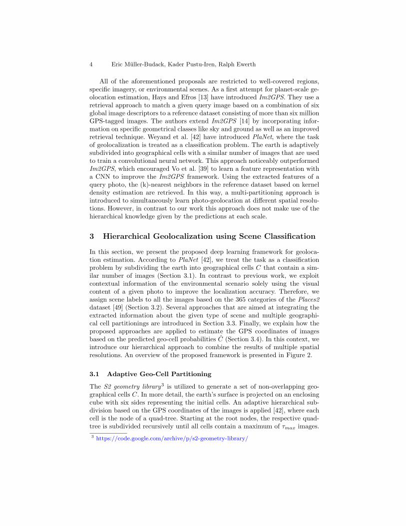
3 Hierarchical Geolocalization using Scene Classification
In this section, we present the proposed deep learning framework for geoloca-tion estimation. According to PlaNet [42], we treat the task as a classificationproblem by subdividing the earth into geographical cells C that contain a sim-ilar number of images (Section 3.1). In contrast to previous work, we exploitcontextual information of the environmental scenario solely using the visualcontent of a given photo to improve the localization accuracy. Therefore, weassign scene labels to all the images based on the 365 categories of the Places2dataset [49] (Section 3.2). Several approaches that are aimed at integrating theextracted information about the given type of scene and multiple geographi-cal cell partitionings are introduced in Section 3.3. Finally, we explain how theproposed approaches are applied to estimate the GPS coordinates of imagesbased on the predicted geo-cell probabilities C (Section 3.4). In this context, weintroduce our hierarchical approach to combine the results of multiple spatialresolutions. An overview of the proposed framework is presented in Figure 2.
3.1 Adaptive Geo-Cell Partitioning
The S2 geometry library3 is utilized to generate a set of non-overlapping geo-graphical cells C. In more detail, the earth’s surface is projected on an enclosingcube with six sides representing the initial cells. An adaptive hierarchical sub-division based on the GPS coordinates of the images is applied [42], where eachcell is the node of a quad-tree. Starting at the root nodes, the respective quad-tree is subdivided recursively until all cells contain a maximum of τmax images.
Geolocation Estimation using a Hierarchical Model and Scene Classification 5
Data Geo-Cell
Partitioning
Geo-Cells �
Scene Filtering
Scene Classification
? Scene Labels
Geo-Cells �
Geo-Cells �
Training
Geolocation Estimation
?
Cell Probabilities �
Cell Probabilities �
Cell Probabilities �
Scene Probabilties � Cell Probabilties � ∗
Prediction
Baseline steps (part of every network)
Multi-Partitioning Variant
Hierarchical Geo-Classification
Individual Scenery Networks (ISNs)
Multi-Task Network (MTN)
Fig. 2. Pipeline of the proposed geolocation estimation frameworks. Gray: Baselinesteps that are part of every network. Additional steps are visualized in different colors.Dashed elements are applied to all images before the training process takes place.
Afterwards, all resulting cells with less than τmin photos are discarded, becausethey most likely cover areas like poles or oceans which are hard to distinguish.
This approach has several advantages compared to a subdivision of the earthinto cells with roughly equally areas. On the one hand side, an adaptive subdi-vision prevents dataset biases and allows to create classes with a similar numberof images. On the other hand, fine cells in photographically well covered areasare generated. This enables a more accurate prediction of image locations whichmost likely depict interesting regions such as landmarks or cities.
3.2 Visual Scene Classification
To classify scenes and extract scene labels, the ResNet model [16] with 152 layers4
of the Places2 dataset [49] is applied. The model has been trained on more than16 million training images from 365 different place categories. This fits nicelywith our approach, since the resulting classifier already distinguishes images thatdepict specific environments. We predict the scene labels based on the sceneset S365 of all training images using the maximum probability of the outputvector. Based on the provided scene hierarchy5, we additionally extract labelsof the sets S16 and S3 containing 16 and three superordinate scene categories,respectively. We add the probabilities of all classes which are assigned to thesame superordinate category and generate the corresponding label. However,some scenes like barn are allocated to multiple superordinate categories (outdoor,natural ; outdoor, man-made), because they visually overlap. For this reason, wefirst divide the probability of these classes by the number of assigned categoriesto maintain the normalization. Please note, that we use the terms natural for”outdoor, natural” and urban for ”outdoor, man-made” in the rest of the paper.
6 Eric Muller-Budack, Kader Pustu-Iren, Ralph Ewerth
3.3 Geolocation Estimation
In this section, several approaches based on convolutional neural networks foran unrestricted planet-scale geolocalization are introduced. First, we present abaseline approach which is trained without using scene information and multiplegeographical partitionings. In the following, we describe how the information fordifferent spatial resolutions as well as environmental concepts are integrated inthe training process. In this context, two different approaches to utilize visualscene labels are proposed. An overview is provided in Figure 2.
Baseline: To evaluate the impact of the suggested approaches for geolocaliza-tion, we first present a baseline system that does not rely on information aboutthe environmental setting and different spatial resolutions. Therefore, we gener-ate a single geo-cell partitioning C as described in Section 3.1. For classification,we add a fully-connected layer on top of the global pooling layer of the ResNetarchitecture [16], where the number of output neurons corresponds to the num-ber of geo-cells |C|. During training the cross-entropy geolocalization loss Lsingle
geo
based on the probability distribution C and the ground-truth cell label encodedin a one-hot vector CGT is minimized.
Multi-Partitioning Variant: We propose to simultaneously learn geoloca-tion estimation at multiple spatial resolutions (according to Vo et al. [39]). Incontrast to the baseline approach, we add a fully-connected layer for the geo-graphical cells of all partitionings P = {C1, . . . , Cn}. The multi-partitioningclassification loss Lmulti
geo is calculated using the mean of the loss values Lsinglegeo
for every partitioning. As a consequence, the CNN is able to learn geographicalfeatures at different scales resulting in a more discriminative classifier. However,in contrast to Vo et al. [39] we further exploit the hierarchical knowledge for thefinal prediction. The details are presented in Section 3.4.
Individual Scene Networks (ISNs): In a first attempt to incorporate con-text information about the environmental setting for photo geolocalization, in-dividual networks for images depicting a specific scene are trained. For eachphotograph, we extract the scene probabilities using the scene classification pre-sented in Section 3.2. During the training, every image with a scene probabilitygreater than a threshold of τS is used as input for the respective Individual SceneNetwork (ISN). Following this approach offers the advantage, that the networkis solely trained on images depicting specific environmental scenarios. It greatlyreduces the diversity in the underlying data space and enables the network tolearn more specific features. On the contrary, it is necessary to train individualmodels for each scene concept, which is hard to manage if the number of dif-ferent concepts |S| becomes larger. For this reason, we suggest to fine-tune amodel, which was initially trained without scene restriction, with images of therespective environmental category.
Geolocation Estimation using a Hierarchical Model and Scene Classification 7
Multi-Task Network (MTN): Since the aforementioned method for geolo-cation estimation may become infeasible for a large amount of different envi-ronmental concepts, we aim for a more practicable approach using a networkwhich treats photo geolocalization and scene recognition as a multi-task prob-lem. In order to encourage the network to distinguish between images of differentenvironmental scenes, we simultaneously train two classifiers for these comple-mentary tasks. Adding another (complementary) task has proven to be efficientto improve the results of the main task [7,17,32,47]. More specifically, an ad-ditional fully-connected layer on top of the global pooling layer of the ResNetCNN architecture [16] is utilized. The number of output neurons of this layercorresponds to the amount of scene categories |S|. The weights of all other lay-ers in the network are completely shared. In addition, the scene loss Lscene
based on the ground-truth one-hot vector SGT and the scene probabilities S isminimized using the cross-entropy loss. The total loss Ltotal of the Multi-TaskNetwork (MTN) is defined by the sum of the geographical and scene loss.
3.4 Predicting Geolocations using Hierarchical Spatial Information
In order to estimate the GPS coordinate from the classification output, we applythe trained models from Section 3.3 on three evenly sampled crops of a givenquery image according to its orientation. Afterwards, the mean of the resultingclass probabilities of each crop is calculated. Please note that an additional stepfor testing is necessary for the Individual Scene Networks. In this case, the scenelabel is first predicted using the maximum probability as described in Section 3.2in order to feed the image into the respective ISN for geolocalization.
Standard Geo-Classification: Without relying on hierarchical information,we solely utilize the probabilities C of one given geo-cell partitioning C. In thisrespect, we assign the class label with the maximum probability to predict thegeographical cell. Applying the multi-partitioning approach in Section 3.3 we aretherefore able to obtain |P | class probabilities at different spatial resolutions. Inour opinion, the probabilities at all scales should be exploited to enhance thegeolocalization and to combine the capabilities of all partitionings.
Hierarchical Geo-Classification: To ensure that every geographical cell inthe finest representation can be uniquely connected to a larger parent area in anupper-level, a fixed threshold parameter τmin for the adaptive subdivision (Sec-tion 3.1) is applied. Thus, we are able to generate a geographical hierarchy fromthe different spatial resolutions. Inspired by the hierarchical object classificationapproach from YOLO9000 [31], we multiply the respective probabilities at eachlevel of the hierarchy. Consequently, the prediction for the finest subdivision canbe refined by incorporating the knowledge of coarser representations.
Class2GPS: Depending on the predicted class we extract the GPS coordinatesof the given query image. In contrast to Weyand et al. [42], we use the mean
8 Eric Muller-Budack, Kader Pustu-Iren, Ralph Ewerth
Table 1. Number of classes |C| foreach partitioning C with different thresh-olds τmin and τmax.
Table 2. Top-1 and Top-5 accuracy onthe validation set of the Places2 bench-mark [49] for different scene hierarchies.
Hierarchy Top-1 Top-5
S3 91.5% —S16 72.1% 97.1%S365 45.7% 77.3%
location of all training images in the predicted cell instead of the geographicalcenter. This is more precise for regions containing an interesting area where themajority of photos is taken. Imagine a geographical cell centered around an oceanand a city which is located at the cell boundary. In this example, the error usingthe geographical center would be very high, even if it is clear that the photo wasmost likely taken in the city.
4 Experimental Setup and Results
Training Data: We use a subset of the Yahoo Flickr Creative Commons 100Million dataset (YFCC100M ) [37] as input data for our approach. This subsetwas introduced for the MediaEval Placing Task 2016 (MP-16 ) [22] and includesaround five million geo-tagged images6 from Flickr without any restrictions.The dataset contains ambiguous photos of, e.g., indoor environments, food, andhumans for which the location is difficult to predict. Like Vo et al. [39] we excludeimages from the same authors as in the test datasets, which we use for evaluation.A ResNet model [15] is used which has been pre-trained on ImageNet [11] toavoid duplicate images by comparing the resulting feature vectors from the lastpooling layer. Overall, our training dataset consists of |I| = 4,723,695 images.
Partitioning Parameters: As explained in Section 3.4, we choose a constantvalue of τmin = 50 (according to PlaNet [42]) as the minimum threshold forthe adaptive subdivision, to enable the hierarchical classification approach. Ourgoal is to train the geolocation at multiple spatial resolutions. Therefore, thefollowing maximum thresholds τmax ∈ {1,000; 2,000; 5,000} are used. We se-lect these thresholds because the MP-16 dataset has approximately 16 timesless images than PlaNet [42] and we therefore aim to produce around
√16 less
classes (PlaNet has 26,263 cells) at the middle representation. Since we wantto show how fine and coarse representations can be efficiently combined, theother thresholds are specified to produce circa two times more and less classesthan the middle representation. The resulting number of classes |C| for differentpartitionings to train our deep learning approaches are shown in Table 1.
6 Available at: http://multimedia-commons.s3-website-us-west-2.amazonaws.com
Geolocation Estimation using a Hierarchical Model and Scene Classification 9
Scene Classification Parameters: The performance of the concept classifica-tion (Section 3.2) is evaluated on the Places2 validation dataset [49] containing36,500 images (100 for each scene). In Table 2 results for the different scenehierarchy levels are reported. The quality of the scene classification is very cru-cial for the ISNs presented in Section 3.3, because it defines the underlying dataspace. Since the top-1 accuracy of 91.5% already provides a good basis, we focuson a set of three scene concepts S3 = {indoor,natural, urban}. Furthermore, thislimits the amount of ISNs to a feasible number of three concepts. We suggestto apply a small threshold of τS = 0.3. Admittedly, this selection is somewhatarbitrary, but we intend to use images with similar scene probabilities as inputfor each ISN. This could be especially useful for images depicting rural areas,because they share visual information like architecture as well as flora and faunathat are beneficial for both environmental categories urban and natural. Thescene filtering yields a total of around 1.80M, 1.42M, and 2.34M training imagesfor the concepts indoor, natural, urban, respectively.
Network Training: The proposed approaches are trained using a ResNet ar-chitecture [16] with 101 convolutional layers. The weights are initialized by apre-trained ImageNet model [11]. To avoid overfitting, the data is augmented byrandomly selecting an area which covers at least 70% of the image with an aspectratio R between 3/4 ≤ R ≤ 4/3. Furthermore, the input images are randomlyflipped and subsequently cropped to 224 × 224 pixels. We use the StochasticGradient Descend (SGD) optimizer with an initial learning rate of 0.01, a mo-mentum of 0.9, and a weight decay of 0.0001. The learning rate is exponentiallylowered by a factor of 0.5 after every five training epochs. We initially trainthe networks for 15 epochs and a batch size of 128. We validate the CNNs on25,600 images of the YFCC100M dataset [37].
As described in Section 3.3, it could be beneficial to fine-tune the ISNs basedon a model which was initially trained without scene restriction. For a fair com-parison, all models are therefore fine-tuned for five epochs or until the loss onthe validation set converges. In this respect, the initial learning rate is decreasedto 0.001. Finally, the best model on the validation set is used for conducting theexperiments. The implementation is realized using the TensorFlow library [1] inPython. The trained models and all necessary data to reproduce our results areavailable at: https://github.com/TIBHannover/GeoEstimation
Test Setup: We evaluate our approaches on two public benchmarks datasets forgeolocation estimation. The Im2GPS test dataset [13] contains 237 photos, where5% are depicting specific tourist sites and the remaining are only recognizable ina generic sense. Because this benchmark is very small, Vo et al. [39] introduced anew datasets called Im2GPS3k that contains 3,000 images from Im2GPS (2,997images are provided with a GPS tag). The great circle distance (GCD) betweenthe predicted and ground-truth image location is calculated for evaluation. Assuggested by Hays and Efros [13], we report the geolocalization accuracy as thepercentage of test images that are predicted within a certain distance to the
10 Eric Muller-Budack, Kader Pustu-Iren, Ralph Ewerth
Table 3. Notation of the geolocalization approaches. T denotes whether the networkwas trained with a single/lone (L) or multiple (M) partition(s). C ∈ {c,m, f} indicateswhich cell partition (coarse (c), middle (m), fine (f)) is used for classification. If C isdenoted with a star (*) the hierarchical classification is utilized.
Notation Description
base (T,C) Baseline trained without scene informationISNs (T,C, S3) Individual Scene Networks using the scene set S3
MTN (T,C, S) Multi-Task Network using a scene set S ∈ {S3, S16, S365}
base (L,C) vs. base (M,C) on the Im2GPS test dataset
-2.5 +2.5
1
25
200
750
2,500
GC
Dth
reshold
[km
]
8.0
32.9
51.1
67.1
81.4
c-2.5 +2.5
13.5
36.3
50.6
64.1
79.7
m-2.5 +2.5
14.3
41.4
51.9
64.1
78.9
f-2.5 +2.5
14.3
41.4
51.9
64.1
78.9
f vs f*
base (L,C) vs. base (M,C) on the Im2GPS3k test dataset
-2.5 +2.5
1
25
200
750
2,500
GC
Dth
reshold
[km
]
6.1
23.3
34.0
48.4
64.9
c-2.5 +2.5
8.3
24.9
34.0
48.8
65.8
m-2.5 +2.5
9.7
25.8
33.8
46.7
63.8
f-2.5 +2.5
9.7
25.8
33.8
46.7
63.8
f vs f*
Fig. 3. Comparison of the geolocation approaches trained with and without multiplesubdivisions for different geo-cell partitionings C. First mentioned approach base (L,C)is used as reference and its accuracy is denoted in the middle of the x-axis.
ground-truth location. The notations of the proposed approaches are presentedin Table 3. The most significant results using the suggested multi-partitioningand scene concepts for geolocalization as well a comparison to the state of the artmethods are given in the related Sections. A complete list of results is providedin the supplemental material.
4.1 Evaluating the Multi-Partitioning Approach
The results for the baseline and the multi-partitioning approach are displayedin Figure 3. Surprisingly, no significant improvement using multiple partition-ings can be observed for the Im2GPS test dataset. But it is clearly visible thatthe results especially for the fine partitioning have improved for the Im2GPS3kdataset, which is more representative due to its larger size. This demonstratesthat the network is able to incorporate features at different spatial resolutionsand utilizes this knowledge to learn a more discriminative classifier. A similar ob-servation was made in the latest Im2GPS approach [39]. However, by exploitingthe hierarchical knowledge at different spatial resolutions the localization accu-racy can be indeed further increased. Figure 4 shows that the geo-location of the
Geolocation Estimation using a Hierarchical Model and Scene Classification 11
coarse (GCD: 1,366 km)
middle (GCD: 172 km)
fine (GCD: 5,305 km)
hierarchical (GCD: 50 km)
GT-LocationLatitude: 34.0652Longitude: -5.0001
Photo by Jorge Díaz(CC BY-NC-SA 2.0)
Fig. 4. Quantitative result using the prediction of the different partitioning outputlayers as well as the hierarchical result.
Table 4. Number of images on the evalu-ation datasets for different scene conceptsin S3.
Scenes Im2GPS Im2GPS3k
all 237 2,997
indoor 19 545natural 80 845urban 138 1,607
Table 5. Top-1 and Top-5 scene classifi-cation accuracies on the validation set ofthe Places2 benchmark [49] for differentMulti-Task Networks.
photo is predicted with a higher accuracy using the coarse and middle partition-ing compared to the finest representation. But, the capabilities of the networkin terms of spatial resolution are not fully exploited using coarser partitionings.The hierarchical information, however, leads to a more accurate prediction atthe finest scale and consequently to a better estimation of the photo’s GPS po-sition. Referring to the supplemental material and the next section, it is worthmentioning that the ISNs greatly benefit from the knowledge at multiple spatialresolutions. The results on both datasets improve drastically while using themulti-partitioning approach.
4.2 Evaluating the Individual Scene Networks
We apply the scene classifier introduced in Section 3.2 to extract the scene labelsfor all test images to evaluate the results for specific environmental settings. Theresulting number of images for every scene is presented in Table 4. Due to thelow number of images in the Im2GPS test dataset, we analyze the performanceof the ISNs on the Im2GPS3k dataset. However, referring to Table 6 and thesupplemental material, similar observations can be made for Im2GPS. The ge-olocation results do not improve when restricting a single-partitioning networkto specific concepts (Figure 5).On the other hand, using a multi-partitioning ap-proach with scene restrictions noticeably improves the geolocation estimation,in particular for urban and indoor photos. One possible explanation is that theintra-class variation for coarser subdivision with more images in larger areas
12 Eric Muller-Budack, Kader Pustu-Iren, Ralph Ewerth
base (L,m) vs. ISNs (L,m, S3) on the Im2GPS3k test dataset
-2.5 +2.5
1
25
200
750
2,500G
CD
thre
shold
[km
]
8.4
14.1
16.5
29.5
50.5
indoor-2.5 +2.5
2.0
15.0
28.6
44.3
60.9
natural-2.5 +2.5
11.6
33.8
42.8
57.7
73.5
urban-2.5 +2.5
8.3
24.9
34.0
48.8
65.8
overall
base (M,m) vs. ISNs (M,m,S3) on the Im2GPS3k test dataset
-2.5 +2.5
1
25
200
750
2,500
GC
Dth
reshold
[km
]
7.3
13.2
16.3
26.1
49.2
indoor-2.5 +2.5
2.1
15.7
31.7
46.6
61.3
natural-2.5 +2.5
11.6
34.8
43.2
57.4
72.7
urban-2.5 +2.5
8.2
25.5
35.1
48.7
65.2
overall
base (M, f*) vs. ISNs (M, f*, S3) on the Im2GPS3k test dataset
-2.5 +2.5
1
25
200
750
2,500
GC
Dth
reshold
[km
]
7.9
14.3
16.9
26.2
50.3
indoor-2.5 +2.5
3.3
17.5
32.0
46.3
61.7
natural-2.5 +2.5
13.8
36.3
43.9
58.4
73.6
urban-2.5 +2.5
9.7
27.0
35.6
49.1
66.0
overall
Fig. 5. Comparison of the Individual Scene Networks to the baseline approaches fordifferent scene concepts. First mentioned approach is used as reference and its accuracyis denoted in the middle of the x-axis.
is reduced. Therefore, the network is able to learn specific features for the re-spective scene concept. The best results are achieved for urban images, whichis intuitive since they often contain relevant cues for geolocation. It is also notsurprising that the performance of indoor photos is the lowest among all sceneconcepts, since the images can be ambiguous. Weyand et al. (PlaNet) [42]) evenconsider indoor images as noise. Despite only 1.42M natural images are availableto cover the huge diversity of very different scenes like beaches, mountains, andglaciers, we were able to improve the performance for this concept. We believethat the respective ISN mainly benefits from the hierarchical information, be-cause it enables the encoding of more global features such as different climaticzones. Overall, the results show that geolocation estimation benefits from train-ing with specific scene concepts and improves at nearly all GCD thresholds forevery scene category.
4.3 Evaluating the Multi-Task Network
We investigate the performance of the Multi-Task Network regarding the ge-olocation estimation (Figure 6) and scene classification (Table 5). Despite theresults demonstrate that the CNNs are able to learn both tasks simultaneously,geolocalization unfortunately does not benefit from learning an additional taskno matter which model we analyze. This underlines that the more important fact
Geolocation Estimation using a Hierarchical Model and Scene Classification 13
base (M, f*) vs. MTN (M, f*, S3) on the Im2GPS3k test dataset
-2.5 +2.5
1
25
200
750
2,500G
CD
thre
shold
[km
]
7.9
14.3
16.9
26.2
50.3
indoor-2.5 +2.5
3.3
17.5
32.0
46.3
61.7
natural-2.5 +2.5
13.8
36.3
43.9
58.4
73.6
urban-2.5 +2.5
9.7
27.0
35.6
49.1
66.0
overall
Fig. 6. Comparison of the Multi-Task Network to the baseline approach for differentscene concepts S. First mentioned approach is used as reference and its accuracy isdenoted in the middle of the x-axis.
for predicting the GPS coordinates of photos is to reduce the diversity in theunderlying data space. Regarding scene classification, similar results comparedto the provided model of the Places2 dataset (Table 2) are achieved.
4.4 Comparison to the State of the Art
We can directly compare the results of our system base (L,m) to [L] 7011C net-work from Im2GPS [39] and PlaNet (6.2M) [42], since they have a similar num-ber of training images and geographical classes. In addition, PlaNet (91M) [42]can be considered as equivalent at larger scale. The multi-partitioning approachbase (M,m) is comparable to [M ] 7011C of Im2GPS [39]. The corresponding re-sults on the Im2GPS and Im2GPS3k test datasets are presented in Table 6.It is obvious that our proposed approaches significantly outperform the currentstate of the art methods. Interestingly, already our baseline approach base (L,m)noticeably outperforms its equivalents. For this reason, we investigate the in-fluence of the utilized ResNet architecture [16]. Therefore, we train the systembase (L,m) with VGG16 network [36] used in the Im2GPS approach [39]. The re-sult is denoted with base-vgg (L,m) and shows that the main improvement is ex-plained by the more powerful ResNet architecture. The system base-vggc (L,m)uses the geographical center of the predicted cell as location (like in PlaNet andIm2GPS ) instead of the mean GPS coordinate of all images that we suggestedin Section 3.4. This already noticeably improves the performance on street andcity level. Compared to Weyand et al. [42] we have used a less noisy trainingdataset. As described in the previous sections, the geolocalization can be furtherincreased by training the CNN with multiple partitionings and exploiting thehierarchical knowledge at all spatial resolutions. However, the best results areachieved when the ISNs are combined with the hierarchical approach that istrained with images of a specific visual scene concept.
5 Conclusions
In this paper, we have presented several deep learning approaches for planet-scalephoto geolocation estimation. For this purpose, scene information was exploited
14 Eric Muller-Budack, Kader Pustu-Iren, Ralph Ewerth
Table 6. Results on the Im2GPS (top) and Im2GPS3k (bottom) test sets. Percentageis the fraction of images localized within the given radius using the GCD distance.
MethodStreet City Region Country Continent1 km 25 km 200 km 750 km 2,500 km
to incorporate context about the environmental setting in the convolutional neu-ral network model. We have integrated the extracted knowledge in a classificationapproach by subdividing the earth into geographical cells. Furthermore, a multi-partitioning approach was leveraged that combines the hierarchical informationat different scales. Experimental results on two benchmarks have demonstratedthat our framework improves the state of the art in estimating the GPS coordi-nates of photos. We have shown that the convolutional neural network is enabledto learn specific features for the different environmental settings and spatial res-olutions, yielding a more discriminative classifier for geolocalization. Best resultswere achieved when the hierarchical approach was combined with scene classifi-cation. In contrast to previous work, the proposed framework does neither relyon an exemplary dataset for image retrieval nor on a training dataset that con-sists of several tens of millions images. In the future, we intend to investigatehow other contextual information like specific objects, image styles, daytimesand seasons can be exploited to improve geolocalization.
Acknowledgement
This work is financially supported by the German Research Foundation (DFG:Deutsche Forschungsgemeinschaft, project number: EW 134/4-1).
Geolocation Estimation using a Hierarchical Model and Scene Classification 15
References
1. Abadi, M., Agarwal, A., Barham, P., Brevdo, E., Chen, Z., Citro, C., Corrado, G.S.,Davis, A., Dean, J., Devin, M., et al.: Tensorflow: Large-scale machine learning onheterogeneous distributed systems. arXiv preprint arXiv:1603.04467 (2016)
2. Altwaijry, H., Trulls, E., Hays, J., Fua, P., Belongie, S.: Learning to match aerialimages with deep attentive architectures. In: IEEE Conference on Computer Visionand Pattern Recognition. pp. 3539–3547. IEEE (2016)
3. Arandjelovic, R., Gronat, P., Torii, A., Pajdla, T., Sivic, J.: Netvlad: Cnn archi-tecture for weakly supervised place recognition. In: IEEE Conference on ComputerVision and Pattern Recognition. pp. 5297–5307. IEEE (2016)
4. Avrithis, Y., Kalantidis, Y., Tolias, G., Spyrou, E.: Retrieving landmark and non-landmark images from community photo collections. In: International Conferenceon Multimedia. pp. 153–162. ACM (2010)
5. Baatz, G., Saurer, O., Koser, K., Pollefeys, M.: Large scale visual geo-localizationof images in mountainous terrain. In: European Conference on Computer Vision.pp. 517–530. Springer (2012)
6. Bansal, M., Daniilidis, K., Sawhney, H.: Ultrawide baseline facade matching forgeo-localization. In: Large-Scale Visual Geo-Localization, pp. 77–98. Springer(2016)
7. Bingel, J., Søgaard, A.: Identifying beneficial task relations for multi-task learningin deep neural networks. arXiv preprint arXiv:1702.08303 (2017)
9. Cao, L., Smith, J.R., Wen, Z., Yin, Z., Jin, X., Han, J.: Bluefinder: estimate wherea beach photo was taken. In: International Conference on World Wide Web. pp.469–470. ACM (2012)
10. Chen, D.M., Baatz, G., Koser, K., Tsai, S.S., Vedantham, R., Pylvanainen, T.,Roimela, K., Chen, X., Bach, J., Pollefeys, M., et al.: City-scale landmark identi-fication on mobile devices. In: IEEE Conference on Computer Vision and PatternRecognition. pp. 737–744. IEEE (2011)
11. Deng, J., Dong, W., Socher, R., Li, L.J., Li, K., Fei-Fei, L.: Imagenet: A large-scale hierarchical image database. In: IEEE Conference on Computer Vision andPattern Recognition. pp. 248–255. IEEE (2009)
12. Gordo, A., Almazan, J., Revaud, J., Larlus, D.: Deep image retrieval: Learningglobal representations for image search. In: European Conference on ComputerVision. pp. 241–257. Springer (2016)
13. Hays, J., Efros, A.A.: Im2gps: estimating geographic information from a singleimage. In: IEEE Conference on Computer Vision and Pattern Recognition. pp. 1–8. IEEE (2008)
14. Hays, J., Efros, A.A.: Large-scale image geolocalization. In: Multimodal LocationEstimation of Videos and Images, pp. 41–62. Springer (2015)
15. He, K., Zhang, X., Ren, S., Sun, J.: Deep residual learning for image recognition.In: IEEE Conference on Computer Vision and Pattern Recognition. pp. 770–778.IEEE (2016)
16. He, K., Zhang, X., Ren, S., Sun, J.: Identity mappings in deep residual networks.In: European Conference on Computer Vision. pp. 630–645. Springer (2016)
16 Eric Muller-Budack, Kader Pustu-Iren, Ralph Ewerth
18. Jin Kim, H., Dunn, E., Frahm, J.M.: Predicting good features for image geo-localization using per-bundle vlad. In: IEEE International Conference on ComputerVision. pp. 1170–1178. IEEE (2015)
19. Kendall, A., Grimes, M., Cipolla, R.: Posenet: A convolutional network for real-time 6-dof camera relocalization. In: IEEE International Conference on ComputerVision. pp. 2938–2946. IEEE (2015)
20. Kim, H.J., Dunn, E., Frahm, J.M.: Learned contextual feature reweighting forimage geo-localization. In: IEEE International Conference on Computer Vision.pp. 2136–2145. IEEE (2017)
21. Krizhevsky, A., Sutskever, I., Hinton, G.E.: Imagenet classification with deep con-volutional neural networks. In: Advances in Neural Information Processing Sys-tems. pp. 1097–1105. NIPS (2012)
22. Larson, M., Soleymani, M., Gravier, G., Ionescu, B., Jones, G.J.: The benchmark-ing initiative for multimedia evaluation: Mediaeval 2016. IEEE MultiMedia 24(1),93–96 (2017)
23. Li, Y., Crandall, D.J., Huttenlocher, D.P.: Landmark classification in large-scaleimage collections. In: International Conference on Computer Vision. pp. 1957–1964.IEEE (2009)
25. Lin, T.Y., Belongie, S., Hays, J.: Cross-view image geolocalization. In: IEEE Con-ference on Computer Vision and Pattern Recognition. pp. 891–898. IEEE (2013)
26. Lin, T.Y., Cui, Y., Belongie, S., Hays, J.: Learning deep representations for ground-to-aerial geolocalization. In: IEEE Conference on Computer Vision and PatternRecognition. pp. 5007–5015. IEEE (2015)
27. Liu, L., Li, H., Dai, Y.: Efficient global 2d-3d matching for camera localization ina large-scale 3d map. In: 2017 IEEE International Conference on Computer Vision(ICCV). pp. 2391–2400. IEEE (2017)
28. Quack, T., Leibe, B., Van Gool, L.: World-scale mining of objects and events fromcommunity photo collections. In: International Conference on Content-based Imageand Video Retrieval. pp. 47–56. ACM (2008)
29. Radenovic, F., Tolias, G., Chum, O.: Cnn image retrieval learns from bow: Unsu-pervised fine-tuning with hard examples. In: European Conference on ComputerVision. pp. 3–20. Springer (2016)
30. Ramalingam, S., Bouaziz, S., Sturm, P., Brand, M.: Skyline2gps: Localization inurban canyons using omni-skylines. In: International Conference on IntelligentRobots and Systems. pp. 3816–3823. IEEE (2010)
32. Ruder, S.: An overview of multi-task learning in deep neural networks. arXivpreprint arXiv:1706.05098 (2017)
33. Saurer, O., Baatz, G., Koser, K., Pollefeys, M., et al.: Image based geo-localizationin the alps. International Journal of Computer Vision 116(3), 213–225 (2016)
34. Schindler, G., Brown, M., Szeliski, R.: City-scale location recognition. In: IEEEConference on Computer Vision and Pattern Recognition. pp. 1–7. IEEE (2007)
35. Shan, Q., Wu, C., Curless, B., Furukawa, Y., Hernandez, C., Seitz, S.M.: Accurategeo-registration by ground-to-aerial image matching. In: International Conferenceon 3D Vision. vol. 1, pp. 525–532. IEEE (2014)
36. Simonyan, K., Zisserman, A.: Very deep convolutional networks for large-scaleimage recognition. arXiv preprint arXiv:1409.1556 (2014)
Geolocation Estimation using a Hierarchical Model and Scene Classification 17
37. Thomee, B., Shamma, D.A., Friedland, G., Elizalde, B., Ni, K., Poland, D., Borth,D., Li, L.J.: Yfcc100m: The new data in multimedia research. Communications ofthe ACM 59(2), 64–73 (2016)
38. Tzeng, E., Zhai, A., Clements, M., Townshend, R., Zakhor, A.: User-driven geolo-cation of untagged desert imagery using digital elevation models. In: IEEE Confer-ence on Computer Vision and Pattern Recognition Workshops. pp. 237–244. IEEE(2013)
39. Vo, N., Jacobs, N., Hays, J.: Revisiting im2gps in the deep learning era. arXivpreprint arXiv:1705.04838 (2017)
40. Vo, N.N., Hays, J.: Localizing and orienting street views using overhead imagery.In: European Conference on Computer Vision. pp. 494–509. Springer (2016)
41. Wang, Y., Cao, L.: Discovering latent clusters from geotagged beach images.In: International Conference on Advances in Multimedia Modeling. pp. 133–142.Springer (2013)
42. Weyand, T., Kostrikov, I., Philbin, J.: Planet-photo geolocation with convolutionalneural networks. In: European Conference on Computer Vision. pp. 37–55. Springer(2016)
43. Workman, S., Souvenir, R., Jacobs, N.: Wide-area image geolocalization with aerialreference imagery. In: IEEE International Conference on Computer Vision. pp.3961–3969. IEEE (2015)
44. Zamir, A.R., Shah, M.: Accurate image localization based on google maps streetview. In: European Conference on Computer Vision. pp. 255–268. Springer (2010)
45. Zamir, A.R., Shah, M.: Image geo-localization based on multiple nearest neighborfeature matching using generalized graphs. IEEE Transactions on Pattern Analysisand Machine Intelligence 36(8), 1546–1558 (2014)
46. Zemene, E., Tariku, Y., Idrees, H., Prati, A., Pelillo, M., Shah, M.: Large-scaleimage geo-localization using dominant sets. arXiv preprint arXiv:1702.01238 (2017)
47. Zhang, Z., Luo, P., Loy, C.C., Tang, X.: Learning deep representation for facealignment with auxiliary attributes. IEEE Transactions on Pattern Analysis andMachine Intelligence 38(5), 918–930 (2016)
48. Zheng, Y.T., Zhao, M., Song, Y., Adam, H., Buddemeier, U., Bissacco, A., Brucher,F., Chua, T.S., Neven, H.: Tour the world: building a web-scale landmark recog-nition engine. In: IEEE Conference on Computer Vision and Pattern Recognition.pp. 1085–1092. IEEE (2009)
49. Zhou, B., Lapedriza, A., Khosla, A., Oliva, A., Torralba, A.: Places: A 10 millionimage database for scene recognition. IEEE Transactions on Pattern Analysis andMachine Intelligence (2017)