Geologic Reconnaissance of Semisopochnoi Island 'Western Aleutian Islands -Alaska i By ROBERT R. COATS ..INVESTIGATIONS OF ALASKAN VOLCANOES GEOLOGICAL SURVEY BULLETIN 1028-O > Prepared in cooperation with the Office, t Chief of Engineers, U. S. Army UNITED STATES GOVERNMENT PRINTING OFFICE, WASHINGTON: 1959
Transcript
Geologic Reconnaissance of Semisopochnoi Island
'Western Aleutian Islands -Alaskai
By ROBERT R. COATS
..INVESTIGATIONS OF ALASKAN VOLCANOES
GEOLOGICAL SURVEY BULLETIN 1028-O
> Prepared in cooperation with the Office, t Chief of Engineers, U. S. Army
UNITED STATES GOVERNMENT PRINTING OFFICE, WASHINGTON: 1959
UNITED STATES DEPARTMENT OF THE INTERIOR
FRED A. SEATON, Secretary
GEOLOGICAL SURVEY
Thomas B. Nolan, Director
For sale by the Superintendent of Documents, U.S. Government Printing Office Washington 25, D.C. Price $1.25 (paper cover)
PREFACE
In October 1945 the War Department (now Department of the Army) requested the Geological Survey to undertake a program of volcano investigations in the Aleutian Islands-Alaska Penin sula area. The first field studies, under the general direction of G. D. Robinson, were made during the years 1946-48. The re sults of the first year's field, laboratory, and library work were hastily assembled as two administrative reports, and most of these data have been revised for publication in Geological Sur vey Bulletin 1028. Part of the early work was published in 1950 in Bulletin 974-B, "Volcanic Activity in the Aleutian Arc," and in 1951 in Bulletin 989-A, "Geology of Buldir Island, Aleutian Islands, Alaska," both by Robert R. Coats. During the years 1949-54 additional fieldwork was carried out under the direction of H. A. Powers. Unpublished results of the early work and all of the later studies are being incorporated as parts of Bulletin 1028.
The geological investigations covered by this report were re connaissance. The factual information presented is believed to be accurate, but many of the tentative interpretations and conclu sions will be modified as the investigations continue and knowl edge grows.
The investigations of 1946 were supported almost entirely by the Military Intelligence Division of the Office, Chief of En gineers, U. S. Army. From 1947 until 1955 the Departments of the Army, Navy, and Air Force joined to furnish financial and logistic assistance. The Geological Survey is indebted to the Office, Chief of Engineers, for its early recognition of the value of geologic studies in the Aleutian region, and to the several military departments for their support.
PagePLATE 59. Geologic map and section of Semisopochnoi Island, Aleutian
Islands ........._.._. ....._ .-_ .-... .. . In pocket60. A. Gentle southward-sloping remnant of the old Pochnoi
cone. B. Dissected cone of Ragged Top..._._..._. ...Facing 482 w61. Aerial view of the southeast coast of Semisopochnoi
Island . ----.. - -.-.-. --- ----- Facing 483 V62. A. View of flat-lying lava flows. B. Roche moutonnee on
east side of valley between Anvil Peak and Perret Ridge .---......... - .--. . ...Facing 488
63. A. Gully near Threequarter Cone. B. Dacitic pumice..Facing 48964. Aerial view of the southwest coast of Semisopochnoi
Island -....- .-.. __. Facing 49265. View looking southward from the west side of Ragged
Top _ .._. .._ . .....Facing 49366. Panorama of Mount Cerberus from the north and north
east ~ _._ . Facing 49667. A. Lava flow from Mount Cerberus. B. Lava toes. Facing 49768. A. Agglutinate. B. View on south side of Sugarloaf
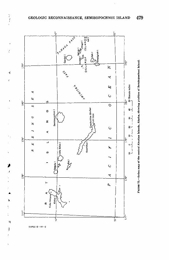
Peak . .._.......... _ ......... _.._.Facing 498FIGURE 73. Index map of central Aleutian Islands, showing position of
Semisopochnoi Island .... ___ . ..... . ..._ .__ ... . 47974. Variation diagram for volcanic rocks from Semisopochnoi
Island . ...... __ . ...._ _ ..._..... 50875. Relation of magnesia (MgO), iron (as FeO), and alkalies
(Na20 + K«0) in volcanic rocks from Semisopochnoi Island . . . 510
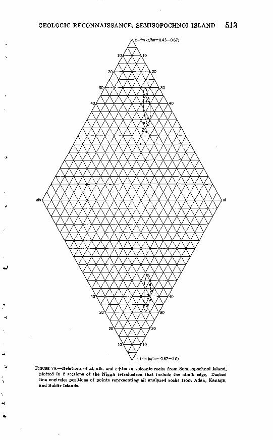
76. Relations of al, alk and c 4- fm in volcanic rocks fromSemisopochnoi Island, plotted in 2 sections of the Niggli ^ tetrahedron that include the alk-al edge... - 513
TABLES
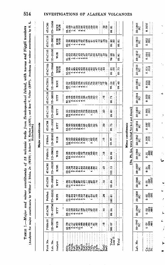
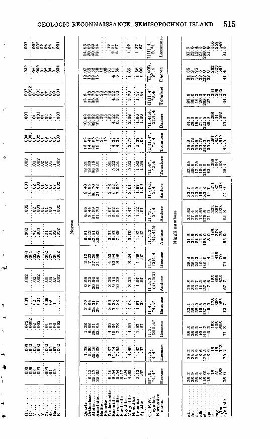
TABLE 1. Major and minor constituents of 15 volcanic rocks from Semisopochnoi Island, with norms and Niggli numbers-
Page
514
INVESTIGATIONS OF ALASKAN VOLCANOES
GEOLOGIC RECONNAISSANCE OF SEMISOPOCHNOI ISLAND, WESTERN ALEUTIAN ISLANDS, ALASKA
By ROBERT R. COATS
ABSTRACT
Semisopochnoi Island, the largest of the young volcanic islands of the western Aleutians, is the easternmost of the Rat Island group, and is near the southern extremity of the great Aleutian arc. The island consists entirely of volcanic rocks, and sediments derived from them, of probable Pleistocene and Recent age. It is a large shield-shaped basaltic volcano, with parasitic cones of andesite and basalt. The higher, central part, which once supported extensive glaciers, subsequently collapsed to form an elliptical caldera almost 5 miles in greatest width. The collapse was attended and, at least in part, caused by the extrusion in the form of glowing clouds of large volumes of pale-gray dacitic pumice and ash. In most of the present valleys there are thick deposits of this pumice and ash, but in the parts of the island that were sheltered from this flood of hot, gas-charged pumic and ash there are only thin layers. After the collapse, eruptions of basalt and basaltic pyroclastic material took place in the caldera. Recent composite cones of basaltic com position, 2 large and 1 small, have erupted intermittently and have built up domes of lava, the largest of which is nearly 3,000 feet high. The lava flows emitted from these cones have nearly filled the caldera floor, and cover a considerable area in the southeastern quarter of the island.
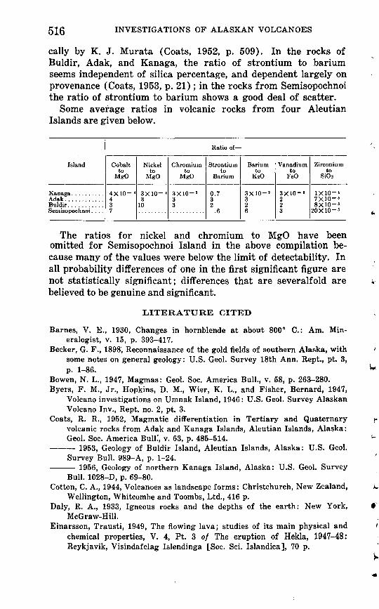
The rocks are generally poor in phenocrysts; the principal minerals are intermediate to calcic plagioclase, olivine, hypersthene, clinopyroxene, usually augite in the phenocrysts and augite or pigeonite in the groundmass, magnetite or ilmenite, apatite, quartz, and orthoclase. Hornblende is present only in the dacitic tuff erupted at the time of the formation of the caldera. The analyses indicate that the alkali-lime index is about 59, hence the province is calcalka- line, thus differing perceptibly in this respect from other Aleutian volcanoes from which extensive rock series have been analyzed. The relations of the oxides make it evident that the rocks of Semisopochnoi are somewhat enriched in iron in the intermediate composition range, thus departing slightly in this regard from the normal basalt-andesite-dacite sequence. The content of a few of the minor constituents in the rocks of Semisopochnoi differs significantly from that of the rocks of other western Aleutian islands.
477
478
Semisopochnoi Island, the largest of the young volcanic islands of the western Aleutians, is the easternmost of the Rat Island group, and is about 40 statute miles north-northwest of Con- stantine Harbor on the east end of Amchitka Island. Its proxi mity to the harbor and to Amchitka Air Force Base, which were being used in 1947, made the island easy to reach, and the vol canic activity that had recently occurred on it invited early study.
No geologic work seems to have been done on Semisopochnoi Island prior to the study made by me. My field assistant, Will F. Thompson, Jr., and I were landed on a small beach, just west of the south point of the island, on August 22, 1947, and re-em barked from the same beach on September 11. Much additional information about areas not reached during our study has been furnished by Howard A. Powers, who was stationed on board the USCGS ship Pioneer for one week in May 1949, and had several opportunities to land on the northeast, north, and west sides of the island.
The work would not have been possible without the friendly assistance received from Maj. John Davis, CAC, port commander, Adak, from John Mack, master of the FS 244, on which we were transported from Adak to Semisopochnoi, and from Dr. H. D. Gray, of the Fish and Wildlife Service ship Brown Bear, which took us from Semisopochnoi to Amchitka. The cooperation of Lt. Col. R. E. Ware, Corps of Engineers, post engineer, Adak, and of Commdr. J. M. Oseth, commander Naval Operating Base, Adak, is also gratefully acknowledged. We are also indebted to Commdr. B. Moore, Jr., commander Naval Air Facility, Adak, for arrang ing for aerial reconnaissance of the island, and to Capt. H. L. Underwood, Signal Corps, for assistance in obtaining radio- communication facilities.
GEOGRAPHY
LOCATION AND SIZE
Semisopochnoi Island (fig. 73) lies near the southernmost point of the Aleutian arc of active volcanoes, between long 179° 28' and 179° 45' E., and between lat 52°02' and 51°53' N. It is 12.4 miles long by 10.6 miles wide and, according to a planimet- ric measurement by Harold Drewes, has an area of 78.3 square miles.
177°
178°
179°
180°
179°
52°
1R
AT
I Ki
ska
Vo
lca
no
/^"?
Kis
ka \( /
T^^J^
1 1 j ________ "_
_
B
E
1 S
L
pvS
eg
ula
1
*VJ»
/"
""N
Litt
le S
itkin
1
^R
atl
^r-^
^>V"V
~'v
s>V"
*\
Am
chitk
a 1^
A
C
I F
RIN
G
S
AN
D
Sem
isop
ochn
oi 1
O
X A/^
\ C
onst
antin
e H
arb
or
^,C
J>
East
Cap
e l^~
-^~
^
1C
O
E
A
S
c,
^f,.
^^
^
.1D
EL
f t
C
E
A
N
Gar
eloi
1 O
-
0
"-X
^
-y0 &
Ogl
iuga
1
Kav
alga
1 O
o ^
-^
"VS
kag
ul
1
,RO
P
ISL
AN
DS
llakl
C~>
,.
* jj^"
3"
'
^A'm
atig
nak
1
177"
52°
51c
178°
17
9°
180°
10
0 10
20
30
40
50
Sta
tute
mile
s
179°
O
B § O w
o
o CO O
B B O
O a 2 o > « > i CO
FIG
UR
E 73.
Ind
ex m
ap o
f th
e ce
ntr
al A
leu
tian
Isl
and
s, A
lask
a, s
how
ing
pos
itio
n o
f S
emis
opoc
hn
oi I
slan
d.
480 INVESTIGATIONS OF ALASKAN VOLCANOES
ACCESSIBILITY
Most of the island is bordered by high rocky cliffs and many offshore reefs. Two broad sandy beaches on the southeast and two on the southwest sides of the island offer easy landing places when the surf is not too high. The island has a number of narrower, steeper, and more bouldery beaches, and even these may be used under favorable circumstances. Several trappers' cabins and the remains of a U.S. Army weather station offer shelter of a kind.
TOPOGRAPHY AND DRAINAGE
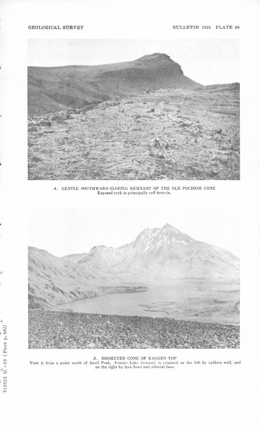
The topography of Semisopochnoi Island (pi. 59) has a greater degree of symmetry and simplicity than that of most Aleutian Islands of its size. The outer slopes consist of radially disposed, maturely dissected ridges and intervening valleys that are partly steep walled. Some of the valley floors are flattened by alluvia- tion, some are covered with exceedingly rough-textured flows of block lava, and some are partly filled with a youthfully dissected mass of soft volcanic material. The radial ridges (pi. 60A) terminate inland in a steep scarp that is 200 to 1,000 feet high and that faces a partly obliterated elliptical central depression. This depression is about 3.8 by 4.7 miles in diameter and its long axis trends northeastward. Such central depressions, more or less circular in form, are common in volcanic regions; the ex ample on Semisopochnoi will hereafter be referred to as the caldera, since it conforms closely to the definition of the term "caldera" as given by Williams (1941, p. 242). It is one of those "large volcanic depressions more or less circular ... in form, the diameters of which are many times greater than those of the included vent or vents." Above the general surface of the peripheral ridges and valleys rise several composite volcanic cones in various stages of dissection.
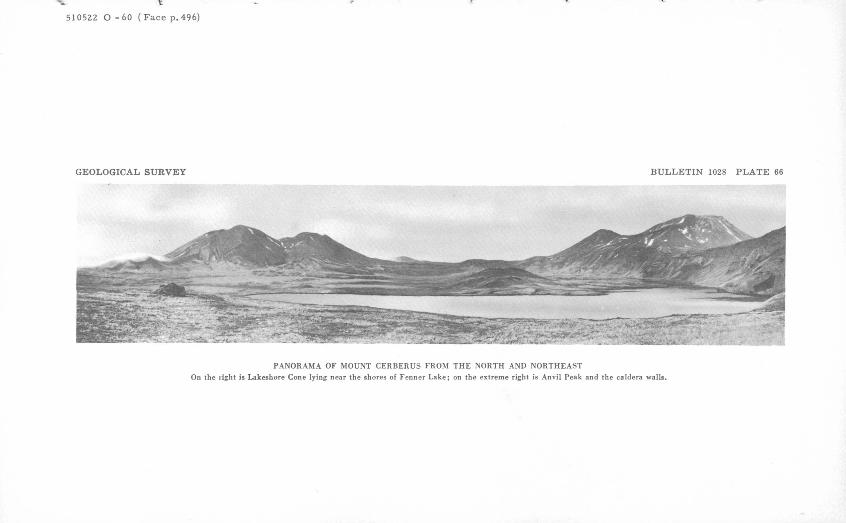
The highest of these cones is Anvil Peak, which attains an alti tude of 3,867 feet. Sugarloaf Peak, a conspicuous slightly dis sected cone, 2,808 feet high, and the parasitic cone on its south flank form a well-known landmark near the southeast coast. Farther to the north, a steep and deeply dissected cone, Ragged Top, is also a conspicuous topographic feature. The cen tral caldera has been partly filled, and its walls partly concealed, by the products of later eruptions, which have resulted in the erection of several volcanic cones, the largest of which is Mount Cerberus. As Mount Cerberus is southwest of the center of the
GEOLOGIC RECONNAISSANCE, SEMISOPOCHNOI ISLAND 481
caldera, the lowest point of the depression lies close to the frown ing cliffs on the north side. This part of the depression is oc cupied by a lake, Fenner Lake, about 2 miles long- and somewhat less than half a mile wide at the widest. The outlet of the lake, which is at an altitude of 250 feet, is a substantial stream of clear water, that flows southward between alluvial banks for about li/£ miles, and then enters a small pond. This pond, about 300 yards long, has been formed by the damming of the stream behind one of the latest lava flows from Mount Cerberus. The stream, confined between the flow and the northeast wall of the valley, plunges in several small falls down to the alluvial floor of the valley near the snout of the lava flow and then meanders toward the sea, which it enters about 2 miles east of the summit of Sugarloaf.
Fenner Creek, the outlet stream just described, is the largest stream on the island and the most constant in its flow, being stabilized not only by Fenner Lake, but by several large springs that feed its upper part. Its total flow, at a point just above the mouth, was estimated in August 1947 to be 250 cubic feet per second. Other streams, which occupy alluviated valleys near sea level, carry substantial amounts of water at relatively steady rates of flow, but the streams that cross highly permeable lava fluctuate widely, and often run dry except when supplied by rain or melting snow.
GEOLOGY
OLD VOLCANO POCHNOI VOLCANICS
The oldest rocks of Semisopochnoi Island are a sequence of tuff-breccia, lava, and agglomerate, and a minor amount of sand stone, herein called the Pochnoi volcanics, because the best ex posures appear to be west and north of Pochnoi Point. These rocks were apparently erupted by a volcano, which had approxi mately the same dimensions as the present island, whose center of eruption lay somewhere within the area of the present central depression.
In deduced form the old volcano corresponds fairly well with that of typical Hawaiian shield volcanoes. This resemblance, however, is chiefly in outward form and in the low dip of the materials that make up the structure, rather than in the type of materials, which on Semisopochnoi seem to be largely basaltic pyroclastic material and minor andesitic flows, rather than the
482 INVESTIGATIONS OF ALASKAN VOLCANOES
basaltic flows typical of Hawaii. The gentle dips of the pyroclas- tic rocks of the Pochnoi volcanics can perhaps be attributed to submarine accumulation. Alternatively, and perhaps more ac curately, the fundamental volcanic structure of the island might be referred to as a submarine tuff cone, the word "tuff" being used in its most general sense.
The rocks of this unit are now chiefly exposed in the north east, south, and southwest parts of the island, outside of the central lowland; elsewhere they are covered by the products of later volcanic eruptions. Many places mapped as Pochnoi vol canics are covered by a relatively thin, uneven layer of volcanic ash; this ash is either the light-gray dacitic ash of the caldera- forming eruption or the darker colored basaltic ash erupted from the Recent volcanoes, and has not been separately mapped. In the walls of the caldera in the northwest and northeast sectors, the Pochnoi volcanics extend to heights of 1,700 feet.
The oldest material recognized is a poorly sorted tuff-breccia that dips gently seaward. The fragments are mostly angular, and the largest are several feet in diameter. The fragments identified range in composition from olivine basalt through oli- vine-hypersthene basalt to hypersthene basalt. Yellow and brown stains, due to the development of limonitic and palagonitic alteration products, are common.
At Pochnoi Point a widespread flow of olivine basalt is promi nently exposed. Along the north coast of Pochnoi Point, about 11/2 miles south of Northeast Point, the lowest rock exposed in the sea cliff is basaltic lava. Its top is an eroded plane surface, possibly a wave-cut bench, on which is horizontally bedded lentic ular indurated sandstone. Further west, in the eastward facing cliff between 2,000 and 1,000 yards south of Northeast Point, the sandstone is covered by relatively unconsolidated scoria ag glomerate that underlies the surface for some distance inland. A line of springs marks the contact of the agglomerate on the indurated sandstone in the sea cliff. The sandstone is composed chiefly of black basaltic and yellow palagonitized glassy frag ments, but includes some short threads of palagonite that are believed to represent lava fountain debris. The sand is medium olive brown (5Y 4/4 ) l and ranges in grain size from medium- sized sand to coarse granules. According to Powers (oral com munication, 1949) these rocks were apparently deposited in
1 Symbols in parentheses after color names refer to Munsell system. Comparison has been made with the Rock-Color Chart (National Research Council, 1948).
GEOLOGICAL SURVEY BULLETIN 1028 PLATE 60
A. GENTLE SOUTHWARD-SLOPING REMNANT OF THE OLD POCHNOI CONE Exposed rock is principally tuff-breccia.
B. DISSECTED CONE OF RAGGED TOPView is from a point south of Anvil Peak. Fenner Lake (center) is retained on the left by caldera wall, and
on the right by lava flows and alluvial fans.
GEOLOGICAL SURVEY BULLETIN 1028 PLATE 61
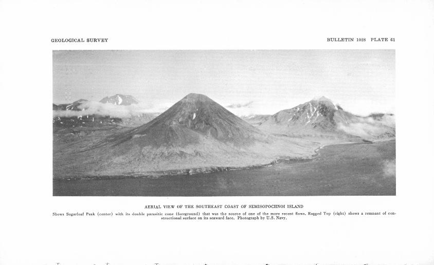
AERIAL VIEW OF THE SOUTHEAST COAST OF SEMISOPOCHNOI ISLAND
Shows Sugarloaf Peak (center) with its double parasitic cone (foreground) that was the source of one of the more recent flows. Ragged Top (right) shows a remnant of con structional surface on its seaward face. Photograph by U.S. Navy.
GEOLOGIC RECONNAISSANCE, SEMISOPOCHNOI ISLAND 483
partly sheltered embayments on the margin of the island during the time of eruption of the Pochnoi volcanics and during a stand of the sea higher than the present one.
In the sector of the old Pochnoi cone about a mile southwest of Mount Cerberus (pi. 60A), the predominant types of lava are platy to vesicular partly glassy augite-hypersthene andesite that is from medium light gray (N 6) to medium dark gray (N 4). Similar platy lava flows crop out between Sugarloaf Peak and the flood of younger lava from Cerberus that reaches the sea west of Sugarloaf. The headland about 2 miles south of Tuman Head seems to have been an isolated center of eruption, somewhat younger than the main cone, judging from the steep outward dips of the flows and pyroclastic rocks that rest upon the gently dipping older Pochnoi volcanics.
The rocks referred to in this unit may include unrecognized parasitic eruptive centers on the flank of the major volcano, similar to those separately described under the next two headings.
EARLY SUBSIDIARY CONES
The older subsidiary cones that once diversified the slopes of Pochnoi Volcano have been deeply dissected, and are now mere ruins of their former selves some of them very picturesque ruins. The most spectacular of these old cones is Ragged Top (pi. 60Z?), whose altitude, 2,965 feet, is probably not far from the maximum original height. As shown in plate 61, in which Ragged Top is the peak on the right-hand side, parts of what seem to be the original constructional surface of the cone are preserved. Such topographic features have been called planezes by Cotton (1944, p. 365), following de Martonne. The exposed core of the volcanic plug forms what appears in plates 605 and 61 to be the highest peak of the mountain.
What may be the oldest of the observed flows from Ragged Top is a flow 20 feet thick of medium-gray olivine basalt that forms the point just east of the outlet of Fenner Creek. The lower surface of the flow is slightly slaggy and scoriaceous, and the tuflfaceous agglomerate beneath has been reddened for a thickness of as much as 8 feet; this agglomerate, of which about 80 feet is exposed, is apparently conformable with the flow. About 90 percent of the total volume consists of fragments larger than one-fourth inch, and 50 percent of the fragments range in great est dimensions from 1*4 inches to 6 feet. Most of the fragments
484 INVESTIGATIONS OF ALASKAN VOLCANOES
are red to black lapilli of scoriaceous basalt, with subordinate subrounded fragments of accessory compact basalt. A foot-long fragment of a bipolar bomb was seen.
Another flow from Ragged Top, exposed in the caldera wall on the shoulder overlooking the central lowland, is a medium-gray (N 5) porphyritic augite-hypersthene andesite with a streaky texture.
To the north of the main peak, a number of bombs of varying composition and texture have been brought down to the floor of a cirque by disintegration of the weak pyroclastic rocks in which they were embedded. Some of the bombs and compact bread- crusted reheated blocks are as much as 3 feet in diameter. The bombs have a scoriaceous and irregular exterior and a compact interior, locally with cores of gabbroic texture. Nearly all these bombs are largely or partly glassy augite-hypersthene andesite and olivine-hypersthene-augite andesite. Some of the bombs and blocks are bleached and solfatarized, but it does not seem neces sary to infer that they were erupted after their alteration, as the material has been reworked by glaciers since its eruption.
Another of the older cones, at an altitude of 1,405 feet, lies southwest of Fenner Creek valley and north of the summit of Sugarloaf Peak. The material that crystallized in the throat of the old volcano now stands in steep cliffs, which face the outlet valley and the snout of one of the latest flows from Mount Cer berus. This is a light-gray (N 7) fine-grained phanerocrystalline olivine microgabbro. Slight deuteric alteration has produced some albite and nontronite, which line cavities and replace by- townite and olivine respectively. A finer grained phase of the rock in the neck is a medium-gray (N 5) compact porphyritic olivine basalt, which perhaps represents a later diking of the coarser gabbro described above.
The material that makes up the main structure of this cone north of the summit of Sugarloaf is partly tuffaceous agglomer ate, that contains bombs and accessory fragments, mainly of black vesicular basalt, as much as 10 inches in diameter. These pyroclastic rocks dip outward from the neck at angles that lo cally exceed 30°. Elsewhere the pyroclastic material may be considered a brecciaceous tuff that contains a few angular com pact to scoriaceous basaltic fragments as much as 8 inches in diameter in a matrix of sand and silt grade. The beds of pyroclas tic rock are as much as 20 feet thick. Lava flows make up only a small part of the cone; typical of these is a flow 4 feet thick of medium-brownish-gray (5R 5/1) aphanitic olivine basalt that
GEOLOGIC RECONNAISSANCE, SEMISOPOCHNOI ISLAND 485
contains a few small phenocrysts of plagioclase and many flat tened vesicles.
Tuman Head seems to be made up of flows and pyroclastic ma terial erupted from two distinct centers not far apart; the older center is nearer the coast. Each of the cones is about nine-tenths pyroclastic material that contains many bombs which generally are 1 or 2 inches, rarely as much as several feet in diameter; the larger ones are generally broken. Interbedded with the pyroclas tic rocks are a few stringy flows; most of these are 10 to 20 feet thick, but the lowest one exposed is about 30 feet thick. The flows generally consist of compact medium-gray to medium-light- gray (N 5 to N 6) seriate olivine basalt and olivine-hypersthene basalt; some contain numerous phenocrysts of plagioclase, and less numerous ones of olivine and augite. Another center of eruption, active somewhat later than the one that liberated most of the rocks of the northern part of Tuman Head, is repre sented by a peak 1,180 feet high about 1.6 miles east of South Tuman Point. The nature of the eruptions and the types of rocks appear to be similar to those of the older cone.
A peak 1,389 feet high about 3 miles east-southeast of South Tuman Point, is a remnant of another center, the crater of which has been completely destroyed by erosion.
What seems to be the remnants of two separate basaltic cones, rather similar in eruptive products to those of Tuman Point, form the 1,412-foot summit south of North Head, and the 1,193- foot summit three-fourths of a mile west of Northeast Point. Subsequent erosion has enlarged the constructional valley be tween the two cones and the valley is now partly filled with later rocks.
Ferret Ridge, the rugged comb ridge that forms the high mountain wall northeast of Fenner Lake, is probably, judging from the dips of its flows, the remnant of a steep cone that once surmounted the main shield volcano which forms the basic struc ture of the island. What is interpreted as a minor parasitic cone was apparently formed at about the same time as the cone of Perret Ridge over a vent lying just north of the west end of Fenner Lake; it is now exposed as a massive buttress in the steeply cliffed walls of the caldera. The only sample examined in thin section is a medium-gray vesicular olivine basalt that contains scarce hypersthene. The pyroxene of the groundmass is pigeonitic.
486 INVESTIGATIONS OF ALASKAN VOLCANOES
The only evidence of the age of the Pochnoi volcanics, which are unf ossilif erous, and the material of the associated subsidiary cones is the relation of these rocks to glacial erosion (see p. 488). Inasmuch as these rocks have been glacially eroded, and the vol canic structures have been dissected by cirques and U-shaped valleys, it is inferred that neither series can be younger than the latest glaciation, and the possibility of late Tertiary age cannot be excluded.
LATE PLEISTOCENE VOLCANOES
Three cones classed as late Pleistocene are distinguished from the earlier ones by their being less eroded. There is evidence that the period of formation of some of them overlapped that of the caldera. Two of the cones, altitude 914 and 1,705 feet, are cinder cones, or scoria rings, of basaltic material, and lie on a line that trends southeastward from the northern point of Tuman Head to the westernmost cone of Mount Cerberus. The third cone is Anvil Peak, 3,867 feet high, the highest point on the island; there is a parasitic cone, 3,230 feet high, southwest of the main summit.
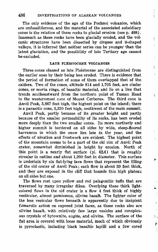
Anvil Peak, partly because of its greater height and partly because of the smaller permeability of its rocks, has been eroded more deeply than the two smaller cones. Its more northerly and higher summit is bordered on all sides by wide, steep-floored barrancos in which the snow lies late in the year, and the effects of nivation and frostwork are evident. The highest point of the mountain seems to be a part of the old rim of Anvil Peak crater, somewhat diminished in height by erosion. North of this point is a nearly flat surface (pi. 62A) that is roughly circular in outline and about 1,200 feet in diameter. This surface is underlain by six flat-lying lava flows that represent the filling of the old crater of Anvil Peak; each flow is about 20 feet thick, and they are exposed in the cliff that bounds this high plateau on all sides but one.
The flows rest upon yellow and red palagonitic tuffs that are traversed by many irregular dikes. Overlying these thick light- colored flows in the old crater is a flow 4 feet thick of highly vesticular, almost pumiceous, olivine basalt. The lighter color of the less vesicular flows beneath is apparently due to incipient fumarolic action on exposed joint faces, as these rocks also are olivine basalt, with relatively few large vesicles and conspicu ous crystals of bytownite, augite, and olivine. The surface of the flat area is covered with loose material, much of which obviously is pyroclastic, including black basaltic lapilli and a few cored
GEOLOGIC RECONNAISSANCE, SEMISOPOCHNOI ISLAND
bombs. The core of one of the bombs apparently was originally sandstone, and is now converted to an aggregate of tridymite and pale-brown glass that is cut by veinlets of black glass. In thin section this glass appears darker brown and is seen to con tain small well-formed prisms of pyroxene that range from augite to pigeonite. The glass also encloses a few corroded relicts of quartz. The rind of the bomb is glassy basalt and has phenocrysts of bytownite. Such accidental specimens of the underlying base ment are seldom brought up by the Aleutian volcanoes.
A small tuff ring about 21/2 miles east of South Tuman Point is 914 feet high and appears to be late Pleistocene. This struc ture has an external diameter of more than four-tenths of a mile, and the crater floor is about half that width. The crater rim is notably asymmetrical; its lowest point is only about 90 feet above the bottom of the crater, and its highest point is 384 feet above the bottom.
The mound of scoria, 1,705 feet high, about l 1/^ miles north west of the nearest cone of Mount Cerberus is also strongly asymmetrical and is called Threequarter Cone. One of its latest eruptive phases was the extrusion of a small lava flow that barely overtopped the low northwestern side of the crater. The almost wholly pyroclastic material erupted from this center ranges in structure from scoriaceous to compact. It consists of dark-gray or black to dusky-red glassy to cryptocrystalline augite andesite, containing sporadic hypersthene and olivine.
The asymmetry of both these cones probably was caused by strong winds blowing constantly from a single direction during a single brief eruptive episode.
Determining the relation of these late Pleistocene cones to the formation of the caldera is somewhat difficult. Both Anvil Peak and Threequarter Cone are transected by the walls of the cal dera, whose collapse was apparently due to the extravasation of a great volume of the dacitic pumice described on page 489; yet the material of Threequarter Cone definitely, and that of Anvil Peak possibly, overlies this pumice. In Threequarter Cone, the rela tions are so well exposed on the wall of the caldera that there can be no doubt of the relative age of the two formations. The material from Anvil Peak, on the other hand, that was seen to overlie the dacitic pumice may not have arrived at that position directly by eruption; a great mass of it may have slyd down the slope of the volcano, which is considerably dissected. It is also possible, as will be shown later, that the caldera was enlarged by subsidence after it was first formed, and that the walls now
5105ZZ O -60 -3
488 INVESTIGATIONS OF ALASKAN VOLCANOES
enclose a greater area than they did when the dacite pumice was being erupted, or when the caldera first collapsed, or at the time of the last eruptions of the late Pleistocene.
GLACIATION
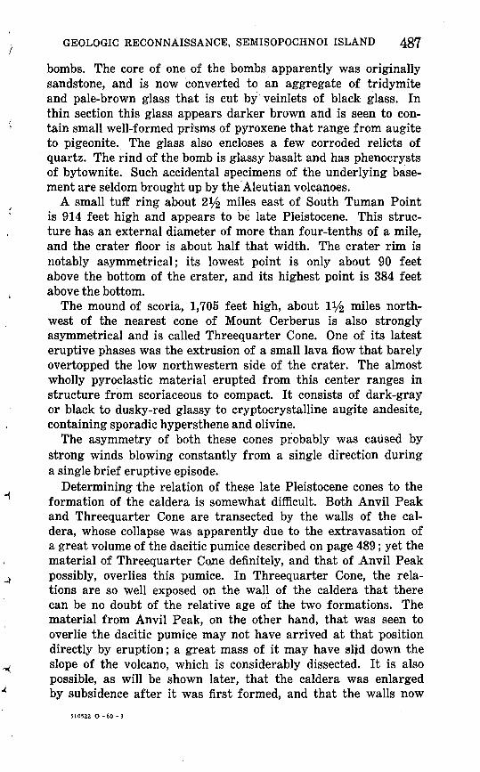
Evidence for the glaciation of Semisopochnoi Island is rather scanty. Aside from physiographic evidence, such as cirque basins and U-shaped valleys, the exposure of glacially shaped and stri ated bedrock found on the rim of the caldera (pi. Q2B) is the most substantial bit of evidence. No moraines or glacial tills were found in the course of the mapping, but any that may have existed must have been largely concealed beneath later volcanic and solifluctional deposits.
Characteristic cirquelike valley heads may be found on sev eral of the higher peaks, particularly on Ragged Top (2,965 feet) and Ferret Ridge (2,916 feet), though even on these the form of the cirques is relatively immature, lacking the flat or retrograde floor, and with headwall slopes of at most 60°. A few steep- walled, flat-floored valleys, remarkably cirquelike in form, have been found at low altitudes on Tuman Head, where the valley floors have altitudes of 300 to 500 feet above sea level, and on the headland just south of Tuman Head. Similar-shaped consequent valleys have been formed by stream erosion in the Hawaiian Islands (Hinds, 1925); possibly some of the low-level valleys on Semisopochnoi are similar in origin to the Hawaiian valleys. Similar valley forms, at similar altitudes, also have been formed, however, in northward-facing valley heads on Kiska Island; here the details of the glacial modeling are still visible, because there was no later volcanic activity in that part of the island.
Yet the much higher summit of Anvil Peak (3,867 feet) shows the effects of nivation rather than cirque erosion. The valley profiles differ but little from the average profile of the surface of a young volcanic cone. The lower slopes on the west side are modified by festoons of arcuate ridges; these ridges have not been examined in the field, but they closely resemble the solifluctional terraces common in periglacial areas.
This contrast between the degree of glaciation on the lower peaks and that on the highest peak of the island suggests strongly that Anvil Peak erupted periodically during the period of glacia tion, and thus maintained, through continual rejuvenation by fresh accretions of volcanic material, a youthful volcanic profile.
GEOLOGICAL SURVEY BULLETIN 1028 PLATE 62
A. VIEW OF FLAT-LYING LAVA FLOWS Flows are left after erosion of the crater they once filled on the north flank of Anvil Peak.
&&t%mm& .?- '&&%
B. ROCHE MOUTONNEE ON EAST SIDE OF VALLEY BETWEEN ANVIL PEAK AND FERRET RIDGE
View is a few hundred feet north of the caldera wall. Stoss (left) side faces toward the caldera. The trendof the striations is N. 20° E.
GEOLOGICAL SURVEY BULLETIN 1028 PLATE 68
1 inch
A. GULLY NEAR THREEQUARTER CONE
Cully is about 2 miles south of Thteequarter Cone. Shows 150 feet of dacitic pumice overlain by 2 feet of basaltic scoriaceous ash. In background, flow erupted from Mount Cerberus rests on the even surface of the ash.
B. DACITIC PUMICESpecimen shows the included fragments of old rock from walls of
magna chamber. Some fragments are softened, flattened, and drawnout; others are quite rigid. Photograph by N. E. Shupe.
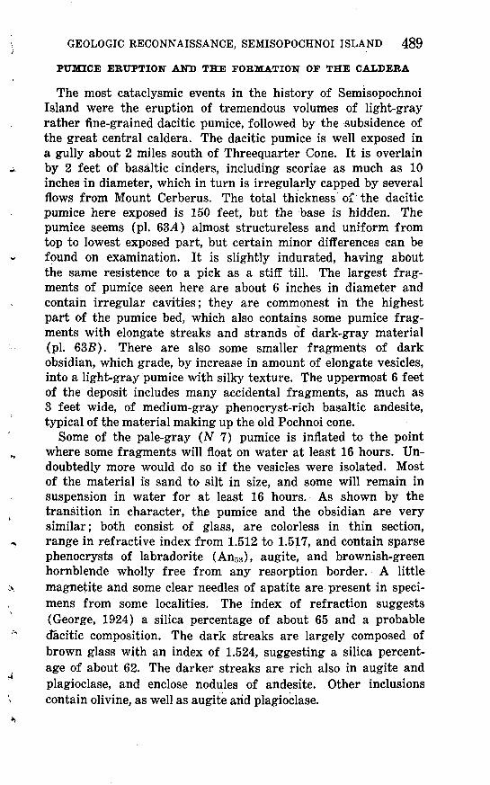
489PUMICE ERUPTION AND THE FORMATION OF THE CALDERA
The most cataclysmic events in the history of Semisopochnoi Island were the eruption of tremendous volumes of light-gray rather fine-grained dacitic pumice, followed by the subsidence of the great central caldera. The dacitic pumice is well exposed in a gully about 2 miles south of Threequarter Cone. It is overlain by 2 feet of basaltic cinders, including scoriae as much as 10 inches in diameter, which in turn is irregularly capped by several flows from Mount Cerberus. The total thickness of the dacitic pumice here exposed is 150 feet, but the base is hidden. The pumice seems (pi. 63A) almost structureless and uniform from top to lowest exposed part, but certain minor differences can be found on examination. It is slightly indurated, having about the same resistence to a pick as a stiif till. The largest frag ments of pumice seen here are about 6 inches in diameter and contain irregular cavities; they are commonest in the highest part of the pumice bed, which also contains some pumice frag ments with elongate streaks and strands of dark-gray material (pi. 635). There are also some smaller fragments of dark obsidian, which grade, by increase in amount of elongate vesicles, into a light-gray pumice with silky texture. The uppermost 6 feet of the deposit includes many accidental fragments, as much as 3 feet wide, of medium-gray phenocryst-rich basaltic andesite, typical of the material making up the old Pochnoi cone.
Some of the pale-gray (N 7) pumice is inflated to the point where some fragments will float on water at least 16 hours. Un doubtedly more would do so if the vesicles were isolated. Most of the material is sand to silt in size, and some will remain in suspension in water for at least 16 hours. As shown by the transition in character, the pumice and the obsidian are very similar; both consist of glass, are colorless in thin section, range in refractive index from 1.512 to 1.517, and contain sparse phenocrysts of labradorite (An53 ), augite, and brownish-green hornblende wholly free from any resorption border. A little magnetite and some clear needles of apatite are present in speci mens from some localities. The index of refraction suggests (George, 1924) a silica percentage of about 65 and a probable dacitic composition. The dark streaks are largely composed of brown glass with an index of 1.524, suggesting a silica percent age of about 62. The darker streaks are rich also in augite and plagioclase, and enclose nodules of andesite. Other inclusions contain olivine, as well as augite arid plagioclase.
490 INVESTIGATIONS OF ALASKAN VOLCANOES
It seems that a part of the superstructure of the volcano has been stoped into the magma chamber underneath, and that some of this more mafic rock of the old cone has been wholly or partly remelted and in part incorporated into the eruptible magma. Evidences of contamination are found in only a few of the frag ments of pumice. This fact suggests that the erupted material contained a much smaller proportion of material assimilated from the walls of the magma chamber than Fenner (1920, p. 593-596) thought to be the case at Katmai. Apparently the tear ing away and erosion of the walls of the conduit by the gas stream and the ejection of fragments of the old rock were im portant only toward the close of the cataclysm. The denser fragments of dacitic glass suggest that a part of the magma was chilled by contact with the atmosphere or with cold rock, an event that must have preceded the catastrophic emptying-out of the magma chamber. Perhaps relatively stiff, viscous dacitic glass was extruded as a tholoid, or dome, into the crater of the volcano, just before the eruption. The elongate tubular shape of the vesicles in the denser glass contrasts strongly with the more nearly spherical, irregular vesicles of the larger pumice frag ments, and suggests viscous flow rather than the turbulent ex pansion of a hot, volatile-rich glass from which the pressure has been suddenly released. The presence of the green hornblende completely free from any sign of oxidation or resorption indi cates that the glass could not have been exposed, for any ap preciable period, to conditions of high temperature and low pres sure, which have been shown by Barnes (1930) to result in oxidation of the hornblende. Kozu and his colleagues (1927) found that the oxidation of green hornblende can be completed over a narrow temperature range near 750° C. That the tem perature of the eruption must have been relatively low is shown by the lack of welding of the tuff.
VOLUME AND MODE OF ERUPTIOX
The total volume of material erupted will probably never be known with any degree of accuracy, as great thicknesses are now exposed by the sea cliff in some valleys, indicating that much material was carried beyond the shoreline. On land, the greatest observed thickness of the dacitic pumice is 160 feet, where it is overlain by the scoriae of Threequarter Cone. It is 140 feet thick in the wall of the caldera just south of Anvil Peak. The thickness ranges widely, however, and in many places is only 1 or 0 feet. In other places the pumice either was not deposited or
GEOLOGIC RECONNAISSANCE, SEMISOPOCHNOI ISLAND
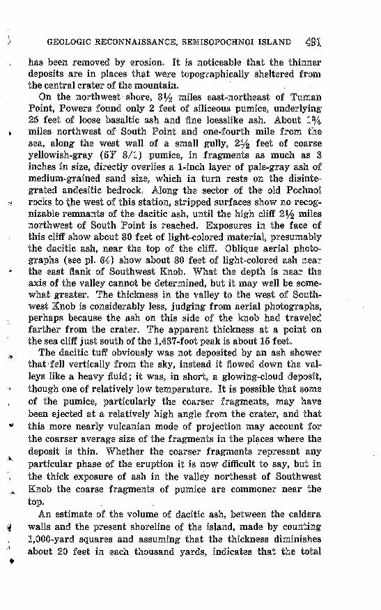
has been removed by erosion. It is noticeable that the thinner deposits are in places that were topographically sheltered from the central crater of the mountain.
On the northwest shore, 3% miles east-northeast of Tuman Point, Powers found only 2 feet of siliceous pumice, underlying 25 feet of loose basaltic ash and fine loesslike ash. About 1% miles northwest of South Point and one-fourth mile from the sea, along the west wall of a small gully, 2% feet of coarse yellowish-gray (57 8/1) pumice, in fragments as much as 3 inches in size, directly overlies a 1-inch layer of pale-gray ash of medium-grained sand size, which in turn rests on the disinte grated andesitic bedrock. Along the sector of the old Pochnoi rocks to the west of this station, stripped surfaces show no recog nizable remnants of the dacitic ash, until the high cliff 2% miles northwest of South Point is reached. Exposures in the face of this cliff show about 80 feet of light-colored material, presumably the dacitic ash, near the top of the cliff. Oblique aerial photo graphs (see pi. 64) show about 80 feet of light-colored ash near the east flank of Southwest Knob. What the depth is near the axis of the valley cannot be determined, but it may well be some what greater. The thickness in the valley to the west of South west Knob is considerably less, judging from aerial photographs, perhaps because the ash on this side of the knob had traveled farther from the crater. The apparent thickness at a point on the sea cliff just south of the 1,437-foot peak is about 15 feet.
The dacitic tuff obviously was not deposited by an ash shower that-fell vertically from the sky, instead it flowed down the val leys like a heavy fluid; it was, in short, a glowing-cloud deposit, though one of relatively low temperature. It is possible that some of the pumice, particularly the coarser fragments, may have been ejected at a relatively high angle from the crater, and that this more nearly vulcanian mode of projection may account for the coarser average size of the fragments in the places where the deposit is thin. Whether the coarser fragments represent any particular phase of the eruption it is now difficult to say, but in the thick exposure of ash in the valley northeast of Southwest Knob the coarse fragments of pumice are commoner near the
An estimate of the volume of dacitic ash, between the caldera walls and the present shoreline of the island, made by counting 1,000-yard squares and assuming that the thickness diminishes about 20 feet in each thousand yards, indicates that the total
492 INVESTIGATIONS OF ALASKAN VOLCANOES
volume has an order of magnitude of 1.5 X 10 6 cubic yards. As the present area of the caldera is about 51.5 X 10 6 square yards, the ash, not allowing for the considerable degree of por osity,2 would fill the caldera to a height of only 26 yards, or about 75 feet. Even the most generous estimates of material dispersed beyond the present shores of the island will not account for enough material to come near filling the great caldera in its primal state, for it occupies the heart of a mountain that once must have risen to a height of 5,000 feet or more.
This problem is the same as that faced by Williams (1941) at Crater Lake, by Byers and others (1947, p. 36) at Umnak Island, by Simons and Mathewson (1955, p. 36) at Great Sitkin Island, and by Coats (1956, p. 77) at Kanaga Island. In many parts of the world then, the volumes of material extravasated by caldera- forming eruptions are inadequate to account for the void into which the superstructure of the volcano has collapsed, and this fact must be something more than coincidental. Williams (1942, p. 105) has suggested that this material may be disposed of by intrusion into radial fractures opening at the time of maximum magmatic pressure, which as he has pointed out, is precisely the moment preceding the first explosion. It seems to me, however, that there are two objections to this hypothesis. There is in sufficient surface extrusion dating from the time of caldera for mation to account for any sizeable fraction of the surplus hot, gas-charged silicic magma that must have been in the magma chamber before the formation of the caldera. It is scarcely con ceivable that doming and stretching of the rock of the magma chamber adequate to produce fissures with so large a total vol ume (10.5 cubic miles, in the case of Crater Lake) should have produced only blind fissures, none of which reached the surface. This objection becomes especially telling when the mechanics of the doming and stretching are considered; for the steeply dipping radial cracks formed by stretching the solid cover of the mag matic blister would tend to be widest at the surface and grow narrower downwards surely an unfavorable circumstance for the production of "headed dikes" that terminate without reach ing the surface.
Two clues to a much more feasible method of disposing of the excess magma may be found. One of these is aiforded by studies of ground tilt at Kilauea, which have shown that the surface
2 The bulk specific gravity as measured on an 1,128-gram sample of the ash, including acci dental fragments, and after excavation and transportation, was 1.3. The probable specific gravity before excavation is 1.5. I am indebted to W. G. Schlecht for assistance in making this measure ment.
510522 O-60 (Face p.492)
GEOLOGICAL SUEVEY BULLETIN 1028 PLATE 64
AERIAL VIEW OF THE SOUTHWEST COAST OF SEMISOPOCHNOI ISLAND
Shows the irregular surface of a Recent flow (right) that is somewhat modified by ash deposits. Sea cliffs at left are light-colored dacitic ash overlain by Recent basaltic ash.Anvil Peak is in background. Photograph by U.S. Navy.
GEOLOGICAL SURVEY BULLETIN 1028 PLATE 65
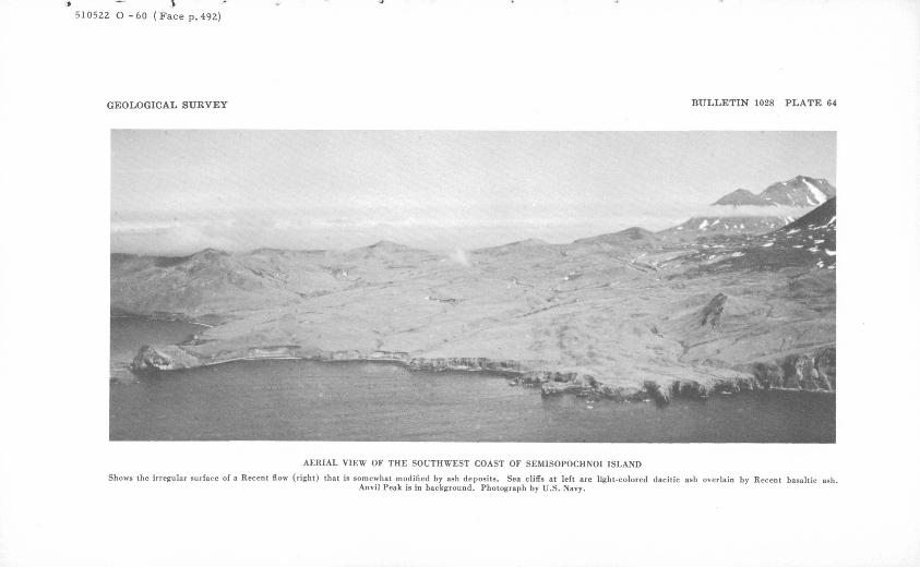
1
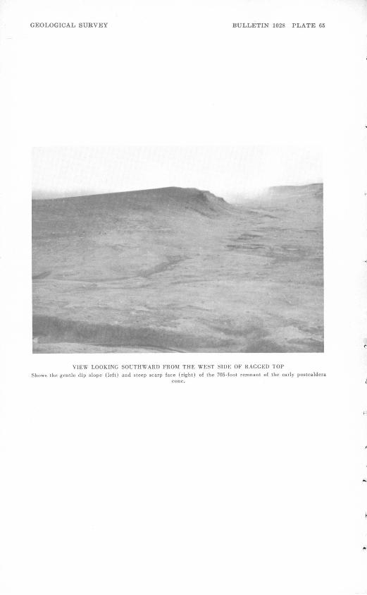
J
VIEW LOOKING SOUTHWARD FROM THE WEST SIDE OF RAGGED TOP
Shows the gentle dip slope (left) and steep scarp face (right) of the 705-foot remnant of the early postcalderacone.
493
here is affected by the rise of magma at Mauna Loa, and thus presumably by magrnatic tension in the Mauna Loa magma cham ber. I would infer a magma chamber that is not steep roofed, but has a considerable lateral extension; in other words it is blisterlike, or laccolithic in shape, in the Gilbertian sense. Given such a shape, space for the excess magmatic volume will much more readily be made by sheetlike or laccolithic intrusion than by diking of the superficial crust. As Hunt (1942, p. 198) has shown for the Henry Mountains, a considerable degree of stretch ing of the superjacent cover above an intrusive mass is possible. Here also, although dikes are present, they are negligible in vol ume by comparison with the laccoliths, which depart widely from the classic shape deduced by Gilbert. 3
The most telling objection to this explanation of the possible fate of the missing magmatic material is the lack of physio graphic evidence of the doming that it would involve. If the in jection were relatively sheetlike, little tilting of the superjacent cover would be expected; but if any considerable quantity of the missing magmatic material has been stowed away beyond the line of the caldera walls, there should be evidences of uplift, in the form of marine terraces about the shores of Semisopochnoi. If such terraces were ever present, they have been obscured by subsequent rise of the sea level, or isostatic sinking of the island in response to the added weight of the volcanic cone on the earth's crust.
A still greater difficulty is that the necessary intrusion can be accomplished only by a magma under considerable pressure, and the development of this pressure before the formation of the caldera hardly seems compatible with the creation of a substan tial void into which the superstructure of the mountain can collapse. It would seem probable that the intrusion could be accomplished only by a magma in which the pressures at a given depth were higher than at any previous time. But then it be comes difficult to see why the caldera-forming eruption should take place just after the intrusions, which have presumably got ten rid not only of the surplus of material, but also of the excess pressure.
Another possibility to which relatively little attention has been given is that a considerable degree of vesiculation had already taken place in the magma over a long period before eruption, so that a larger part of the bulk volume of the erupted pumice may
3 G. A. Macdonald (oral communication, 1956) has pointed out that there is no direct evidence, in older dissected Hawaiian volcanoes, for a magma chamber of this shape.
494 INVESTIGATIONS OF ALASKAN VOLCANOES
be credited to the cavity into which the mountain has collapsed. Williams (1942, p. 98) has suggested the possibility that there was some degree of vesicularity in the magma before eruption; but even if the volume of the vesicles in the pumice is included the calculated volume of the erupted material is less than the volume of the cavity. It seems certain thr\t much of the material must have been disposed of elsewhere, either by widespread sheet- like intrusions, or, in the case of Semisopochnoi, by flows of lava into the ocean.
Precise dating of the eruption of the dacitic pumice is difficult. The physiographic evidence of the truncated glacial valleys, now partly filled with ash, indicates that the caldera was formed after the latest glaciation. Glacial striae found on the saddle in the caldera wall.north of the west end of Fenner Lake also indi cates that caldera collapse was preceded by some glacial erosion. One outcrop (plate 62#) indicates that the glacial ice here moved northward nearly horizontally from left to right. This outcrop is about 60 feet higher than the axis of the valley, and a few hundred feet north of the edge of the caldera wall. There must have been a glacial gathering ground of some extent on the high ground that once occupied the place of the caldera.
EARLY POSTCALDERA ERUPTIONS
The dating of the various volcanic materials erupted since the caldera collapse cannot be precise, because in many places the earlier materials are completely buried beneath the later ones, and the products of the different vents cannot always be dis tinguished from one another. Dating must depend therefore on the degree of destruction or dissection, which is influenced not only by the nature of the material and the differing tectonic and erosional accidents that have befallen it but also by the dates of cessation of eruptive activity, rather than of its commencement.
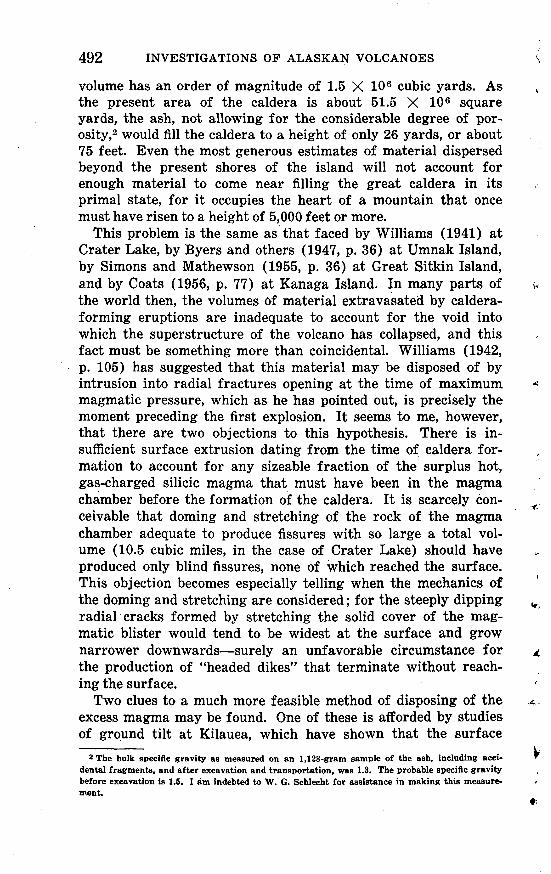
Of all the postcaldera structures, the one that has been most nearly destroyed is the one represented by a remnant that lies west of Ragged Top and north of Sugarloaf. The highest remain ing part of this cone reaches an altitude of 705 feet. As shown in plate 65, the upper surface is a dip slope, slightly modified, and declining eastward. Some of the material erupted by this cone extends down the present valley of Fenner Creek almost to the seashore, and the constructional upper surfaces, though sepa rated by later alluvium and lava flows, can readily be connected by projection across the intervening gaps.
GEOLOGIC RECONNAISSANCE, SEMISOPOCHNOI ISLAND 495
The gradient of the surface averages about 5 percent, but is about 2 percent near the mouth of the valley, where the upper surface, close to the present shoreline, is 160 to 200 feet above sea level. Such a gradient, projected, would bring the upper surface down to the present sea level at a distance of 8,000 to 10,000 feet beyond the present shoreline. If the rate of removal of the material by marine erosion was as rapid as the fragmental char acter of the material would suggest, it does not necessarily follow that the original upper surface was ever tangential to the surface of the sea, or that a primary constructional slope extended out to sea anything like the distance suggested by these computations. The gentle dip slope is terminated abruptly on the west by a low but steep scarp. At the base of the scarp is a constructional sur face of lava flows and detrital material that slopes gently north ward from Mount Cerberus. The origin of the scarp is not cer tain, but its orientation parallel with the caldera rim, its straight- ness, and its lack of dissection, suggest that it is a fault scarp, caused by renewed subsidence along faults within the original caldera-collapse faults, which lie nearly a mile farther south, and roughly parallel to them.
The material making up the cone is almost wholly pyroclastic. Just east of the scarp the material is largely tuff-breccia that contains angular fragments of medium-gray olivine basalt. A few thin flows of basalt are also exposed near the base of the scarp. On the south side of the valley of Fenner Creek at a point about a mile from the coast, the material may be better described as brecciaceous tuff, containing a few angular, com pact to scoriaceous basaltic fragments as much as 8 inches in diameter, though more than 5 percent of the fragments are less than H4 inches in diameter. Exposures are sparse, but at least one of the beds is as much as 20 feet thick. Elsewhere along the valley walls the material ranges from tuff-breccia to coarse dun- colored tuff.
RECENT CONES
Three Recent cones are distinguished on the map, together with the lava flows erupted from each: Mount Cerberus and Lakeshore Cone (pi. 66) within the caldera, and Sugarloaf Peak, which lies outside the caldera near the southern point of the island. There is not enough evidence to warrant any definite statement as to which is the oldest of these three. It is quite possible that renewed eruptions may take place at any of them.
510522 O -60 -4
496 INVESTIGATIONS OP ALASKAN VOLCANOES
MOUNT CMBBHHffiUS
The name Mount Cerberus has been given to a compound com posite volcano, which has three summits of nearly equal height, and which occupies most of the southern part of the old caldera. The three craters lie at the apices of a scalene triangle. They are not of equal size. The crater on the easternmost of the three peaks is smaller than the other two, and has to the northwest a large platform of irregular surface apparently built in a period of mild eruption during which the vent was shifting position slightly. About a mile to the east of the easternmost major sum mit is a small cone, now partly destroyed, that attains an altitude of about 860 feet.
Six lava flows from Cerberus have been distinguished on the map, and also an area underlain by a number of lava flows that were not mapped separately. The distinction between the sev eral flows rests mainly on the basis of age, and the principal criteria of age are the relative degrees to which the flows are buried with ash and covered with vegetation. Obviously these criteria must be used with caution, because the amount of ash on top of a flow depends not only on its age, but also on its posi tion with respect to the principal sources of ash, and on the un known wind directions prevailing at the time of the ash erup tions; the amount of vegetation, also, depends on the amount of ash, and on the altitude as well. These two criteria are fairly reliable, however, if used in discriminating between adjacent or nearly adjacent flows.
The numbering used on plate 59 reflects an endeavor to assign relative ages on the basis discussed above, the lowest number being assigned to the earliest flow. What is regarded as the youngest flow from Cerberus is one about 2,000 feet long, which was emitted near the base of the north side of the western cone. It is visible in the center of plate 66 as a small dark spot near the base of the cone. A somewhat older flow, about 2^ miles long, was emitted from a vent at an altitude of about 1,120 feet on the slopes of the easternmost cone. For most of its length it flowed at the base of the caldera wall, spreading out to a width of half a mile on the undissected detrital surface at the base of the cone but narrowing to a width of less than 300 feet where it emptied through a steep subsequent valley separating two remnants of the early postcaldera cone. Just below the nar rows it entered the valley of Fenner Creek, where it spread up stream for a few hundred yards and downstream for about 0.8 mile. In the lower part of its course two separate pulses of ex-
510522 O-60 (Face p.496)
GEOLOGICAL SURVEY BULLETIN 1028 PLATE 66
PANORAMA OF MOUNT CERBERUS FROM THE NORTH AND NORTHEAST
On the right is Lakeshore Cone lying near the shores of Fenner Lake; on the extreme right is Anvil Peak and the caldera walls.
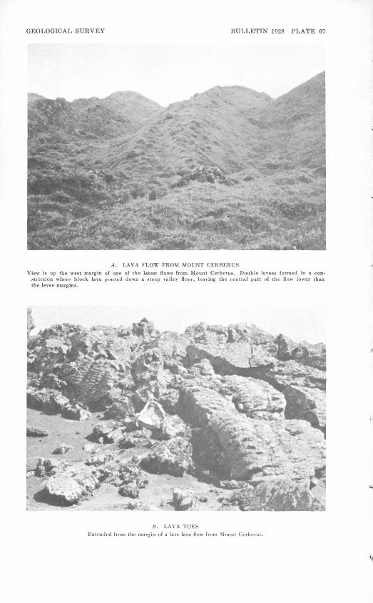
GEOLOGICAL SURVEY BULLETIN 1028 PLATE 67
A. LAVA FLOW FROM MOUNT CERBERUSView is up the west margin of one of the latest flows from Mount Cerberus. Double levees formed in a con
striction where block lava poured down a steep valley floor, leaving the central part of the flow lower than the levee margins.
B. LAVA TOESExtruded from the margin of a late lava flow from Mount Cerben
GEOLOGIC RECONNAISSANCE, SEMISOPOCHNOI ISLAND
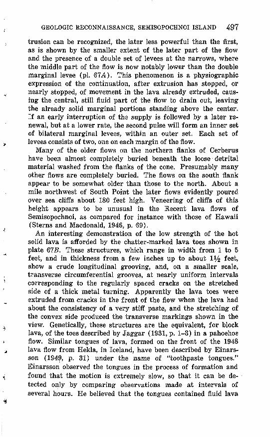
trusion can be recognized, the later less powerful than the first, as is shown by the smaller extent of the later part of the flow and the presence of a double set of levees at the narrows, where the middle part of the flow is now notably lower than the double marginal levee (pi. 67A). This phenomenon is a physiographic expression of the continuation, after extrusion has stopped, or nearly stopped, of movement in the lava already extruded, caus ing the central, still fluid part of the flow to drain out, leaving the already solid marginal portions standing above the center. If an early interruption of the supply is followed by a later re newal, but at a lower rate, the second pulse will form an inner set of bilateral marginal levees, within an outer set. Each set of levees consists of two, one on each margin of the flow.
Many of the older flows on the northern flanks of Cerberus have been almost completely buried beneath the loose detrital material washed from the flanks of the cone. Presumably many other flows are completely buried. The flows on the south flank appear to be somewhat older than those to the north. About a mile northwest of South Point the later flows evidently poured over sea cliffs about 180 feet high. Veneering of cliffs of this height appears to be unusual in the Recent lava flows of Semisopochnoi, as compared for instance with those of Hawaii (Sterns and Macdonald, 1946, p. 69).
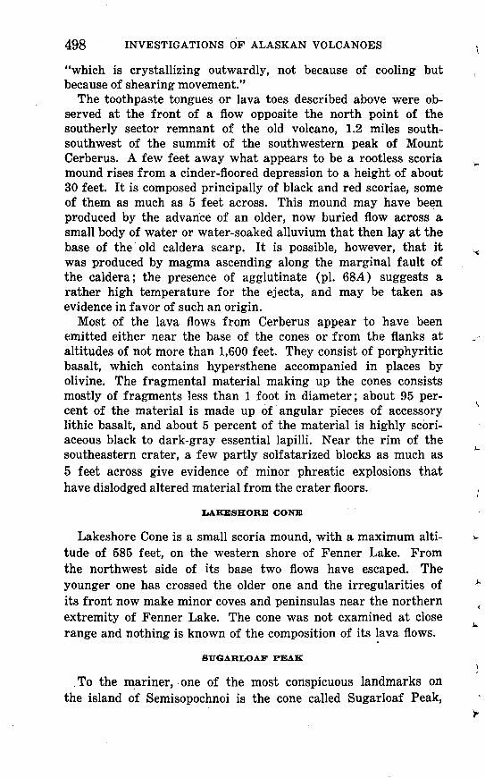
An interesting demonstration of the low strength of the hot solid lava is afforded by the chatter-marked lava toes shown in plate 67S. These structures, which range in width from 1 to 5 feet, and in thickness from a few inches up to about l 1/^ feet, show a crude longitudinal grooving, and, on a smaller scale, transverse circumferential grooves, at nearly uniform intervals corresponding to the regularly spaced cracks on the stretched side of a thick metal turning. Apparently the lava toes were extruded from cracks in the front of the flow when the lava had about the consistency of a very stiff paste, and the stretching of the convex side produced the transverse markings shown in the view. Genetically, these structures are the equivalent, for block lava, of the toes described by Jaggar (1931, p. 1-3) in a pahoehoe flow. Similar tongues of lava, formed on the front of the 1948 lava flow from Hekla, in Iceland, have been described by Einars- son (1949, p. 31) under the name of "toothpaste tongues." Einarsson observed the tongues in the process of formation and found that the motion is extremely slow, so that it can be de tected only by comparing observations made at intervals of several hours. He believed that the tongues contained fluid lava
498
"which is crystallizing outwardly, not because of cooling but because of shearing movement."
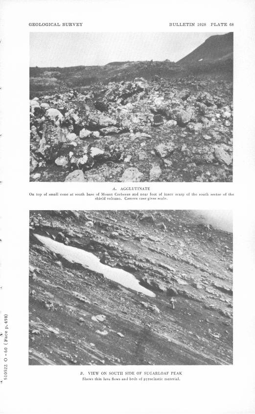
The toothpaste tongues or lava toes described above were ob served at the front of a flow opposite the north point of the southerly sector remnant of the old volcano, 1.2 miles south- southwest of the summit of the southwestern peak of Mount Cerberus. A few feet away what appears to be a rootless scoria mound rises from a cinder-floored depression to a height of about 30 feet. It is composed principally of black and red scoriae, some of them as much as 5 feet across. This mound may have been produced by the advance of an older, now buried flow across a small body of water or water-soaked alluvium that then lay at the base of the old caldera scarp. It is possible, however, that it was produced by magma ascending along the marginal fault of the caldera; the presence of agglutinate (pi. 68A) suggests a rather high temperature for the ejecta, and may be taken as evidence in favor of such an origin.
Most of the lava flows from Cerberus appear to have been emitted either near the base of the cones or from the flanks at altitudes of not more than 1,600 feet. They consist of porphyritic basalt, which contains hypersthene accompanied in places by olivine. The fragmental material making up the cones consists mostly of fragments less than 1 foot in diameter; about 95 per cent of the material is made up of angular pieces of accessory lithic basalt, and about 5 percent of the material is highly scori- aceous black to dark-gray essential lapilli. Near the rim of the southeastern crater, a few partly solfatarized blocks as much as 5 feet across give evidence of minor phreatic explosions that have dislodged altered material from the crater floors.
LAKESHORE CONE
Lakeshore Cone is a small scoria mound, with a maximum alti tude of 585 feet, on the western shore of Fenner Lake. From the northwest side of its base two flows have escaped. The younger one has crossed the older one and the irregularities of its front now make minor coves and peninsulas near the northern extremity of Fenner Lake. The cone was not examined at close range and nothing is known of the composition of its lava flows.
SUGARLOAF PEAK
To the mariner, one of the most conspicuous landmarks on the island of Semisopochnoi is the cone called Sugarloaf Peak,
GEOLOGICAL SURVEY BULLETIN 1028 PLATE 68
A. AGGLUTINATEOn top of small cone at south base of Mount Cerberus and near foot of inner scarp of the south sector of the
shield volcano. Camera case gives scale.
B. VIEW ON SOUTH SIDE OF SUGARLOAF PEAK
Shows thin Java flows and beds of pyroclastic material.
GEOLOGIC RECONNAISSANCE, SEMISOPOCHNOI ISLAND 499
which is 2,808 feet high. This is the most southerly of the higher cones of the island, and it still retains its original form, though nothing remains of the old crater but a rather shallow saucer, opening toward the northeast, with a cliffy escarpment a few feet high on some sides, suggesting that the whole surface of the mountain has been lowered somewhat by erosion. Sugarloaf is chiefly composed of loose materials, though thin lava flows, as much as 6 feet thick, make up a respectable proportion of its bulk. Many of the larger fragments seen in plate 6SB are fragments of these flows, detached by gravity when the flow became too viscous to move farther as a fluid.
On the southern flank of the main cone is a double parasitic cone. The higher part, 1,620 feet high, has a double crater; the more southerly and lower crater has on the south a narrow rim that rises 10 feet above the bottom of the crater, and 20 feet, in a steep cliff, above the gravity slope of cinders on the outer face of the cone. It is evident that gravity, wash, and the effects of the strong winds have lowered the whole surface of the cone about 30 feet since the latest eruption. Yet some traces of volcanic heat still remain, for lukewarm steam escapes feebly from the inter stices of a bed of reddened tuff-breccia and agglutinate cakes at the rim separating the two compartments of the double crater. The tips of the projecting filaments, wisps, and mammillae of glass along the steam-producing fissure are coated with opaline silica, which does not extend into the less accessible crevices of the fragments. It appears that the steam has transported and deposited the silica to form the opaline coating.
About 2,000 feet west of the double crater, and forming the other part of the parasitic cone, is a half-cone of scoriae about 1,050 feet high. One of the most recent flows escaped from the southern end of the gap between the two structures; it apparently was emitted at a steep tumulus, made up of broken fragments of the flow crust 3 or 4 feet thick standing at steep angles. About 90 percent of the 1,050-foot cone is composed of angular frag ments of basalt, the remainder being scoriaceous lapilli. A few larger blocks, about 10 percent of which are compact and the rest-scoriaceous, were also noted. Some of these blocks are bread- crusted, suggesting reheating, or disruption of a not quite solid lava. A few very small flow tongues, about 1 foot thick and 4 feet wide, are exposed on the outside of the cone. The faint, nearly horizontal circumferential banding seen on some photographs of the cone is due to the fact that the erosional surface is slightly steeper than the original surface of the cone.
INVESTIGATIONS OF ALASKAN VOLCANOES
The lava flows of Sugarloaf and its parasite, including the pyroclastic fragments, are olivine basalt and picritic olivine basalt, apparently without hypersthene. In lacking this mineral they differ notably from, those of Mount Cerberus which, with one doubtful exception, uniformly carry that mineral. As the two cones were active at nearly the same time, it may be that they tap different magma chambers, or different parts of the same chamber.
UNCONSOLIDATED DEPOSITS
ALLUVIUM, ELUVIUM, AND TALUS
The pyroclastic deposits of the various volcanic cones, par ticularly those consisting largely of fine ash, are readily set in motion when saturated with water, and move down the steeper slopes to form wide aprons of eluvium, deposited in part by mass movement of saturated material, in part by slope wash and stream transport. Most of the deposits thus formed have not been mapped, as they have not obscured the underlying con tacts; but extensive aprons have been formed on both sides of the lower part of Fenner Creek valley. The lower margins of these rest upon the terraces of tuff-breccia from the early post- caldera cone, which have protected them from removal by Fenner Creek.
Much larger bodies of alluvial material have formed in the bottoms of the wider stream valleys, particularly in those to the north of Ragged Top, and south of Tuman Head, and in that of Fenner Creek. Much of the material of the alluvium is reworked ash, some of it from the dacitic pumice eruption and some of it from the later basaltic eruptions. The cross profiles of these valleys in their alluviated reaches suggest that the bedrock floors lie some distance below present sea level.
SAND DUNES
Where the wider flat-floored valleys reach the sea the wind has erected a single or multiple dune ridge, parallel to the shore line. None of these ridges is more than 40 feet high. Whether a ridge is stationary or is migrating landward or seaward depends chiefly on the ratio of the supply of material by the local stream to the effectiveness of marine erosion in removing it. Where the rate of supply exceeds the rate of removal, the shoreline tends to advance seaward, and the drier material exposed at low tide is available to the wind for the building up of the dune ridge.
GEOLOGIC RECONNAISSANCE, SEMISOPOCHNOI ISLAND 501
Where the supply is insufficient, wave erosion removes the ridge and attacks the alluvium on the landward side of the ridge, un less the rate of eolian transport is greater than the rate of marine erosion. The presence of dune ridges at the mouths of all the alluviated valleys suggests that the supply of material that filled the valleys has not yet failed. As the beach progrades beyond the protection of the adjacent headlands, a kind of equi librium is probably established, governed chiefly by the variation inliffectiveness of wave attack with variation in exposure.
GEOLOGIC HISTORY
The oldest episode in the history of Semisopochnoi of which there is any record begins with the eruption of a series of basaltic tuff-breccia, followed by flows of mafic lava, building up a vol cano having nearly the dimensions of the present island and perhaps as much as 3,000 feet high. Upon the broad low dome thus erected several smaller and steeper cones of andesitic lava and pyroclastic material were superposed, including probably a central cone that raised the total height of the mountain to 5,000 or 6,000 feet. Small cones of basaltic material, consisting chiefly of cinders and bombs but including some lava flows, were constructed near the north and west coasts of the island. Much of this eruptive activity was preglacial, or at least precedes the latest glaciation, as shown by the fact that the cones produced have been dissected by glacial cirques and transected by glacial valleys. The activity was probably preceded by a time when the sea stood at least 80 feet higher than it does now, and the debris eroded from the volcanoes was locally deposited about the shores of the island as volcanic sand.
Near the end of the glacial period, the volcano produced a to tally new type of product. It had apparently been quiescent for some time, and the nature of the magma had changed by dif ferentiation during the interval, becoming much more silicic and rich in volatiles. Great volumes of hot, highly inflated, pale-gray dacitic pumice and dust were spewed out in the form of dense clouds, which rushed like torrents down the accessible valleys, overtopping low divides and filling up the lowest parts of the valleys to a depth of as much as 160 feet. The removal of the great volume of magma from the chamber by this eruption, and presumably also by unexposed intrusions extending laterally from it, prepared the way for the collapse of the top of the moun tain to form an elliptical caldera, almost 5 miles in greater di ameter. After a period of quiescence, eruptive activity was
502 INVESTIGATIONS OF ALASKAN VOLCANOES
renewed, but once again basaltic tuff-breccia predominated. The new eruptions built up a low cone on the southeastern part of the caldera, from which some of the erupted material escaped as mud flows over the rim of the caldera and filled the outlet valley to an unknown depth, forming a broad gentle slope that probably extended some distance out to sea beyond the present shore. Somewhat later, several cones on the northwest side of the volcano, the largest of which may have begun to erupt before the caldera collapse, again emitted basaltic and andesitic lava. Renewed downfaulting, on faults more or less concentric with the earlier ones that bounded the caldera, destroyed part of the tuff-breccia cone in the southeastern part of the caldera, and enlarged the caldera on the north and west. Subsequent erup tions have built up one major composite basaltic cone and a minor cone within the caldera, and another major cone outside the caldera near the southeast shore of the island.
HISTORIC VOLCANIC ACTIVITY
Records of eruptions on Semisopochnoi Island are very scant. Grewingk (1850, p. 232, 281) found four reports of "smoke" in the records of early explorers, for the years 1772, 1790, 1792, and 1830. Becker (1898, p. 17) reports that a volcano on the island was active in 1873. Since one report specified that the activity was in the interior of the island, and since the cone of Mount Cerberus is less dissected than that of Sugarloaf Peak, this part of the island was probably the source of the dated eruptions. It cannot be determined whether any of the lava flows distin guished on the map occurred in historic time, but one of the late flows from Cerberus may be less than 100 years old, for its vegetation is little heavier than that on flows 40 years old that may be seen at a slightly higher altitude on Kanaga Island.
FUTURE VOLCANIC ACTIVITY
The nature of the material erupted during the periodic minor eruptions of the smaller composite cones suggests that no greater Plinian eruption is to be expected on Semisopochnoi within the foreseeable future; this volcano has had its fling, and settled down to a humdrum existence. It is probable, however, that rela tively minor infrequent eruptions may occur from time to time, contributing new lava flows and ash layers, the latter measurable in inches, to the upbuilding- of the island surface. The effects OB neighboring islands will be negligible.
GEOLOGIC RECONNAISSANCE, SEMISOPOCHNOI ISLAND 503
PETROGRAPHY
POCHNOI VOLCANICS
The most mafic of the lava flows attributed to the Pochnoi volcanics is an olivine basalt, but the series includes rocks as silicic as hypersthene andesite vitrophyre. As the analyzed rocks were collected from widely separated areas, the age relations are not completely known, and it is possible that some of the rocks may have been erupted by some of the earlier subsidiary cones, perhaps even by cones centered within the area of the present caldera depression.
A sample of olivine basalt (P49Se4) collected by Powers 1*4 miles S. 32i/£° E. of Northeast Point, is a porphyritic dense medium-gray (N 5) slightly vesicular rock, with intergranular texture. The phenocrysts consist of plagioclase, which averages about An85 (as determined by the average index of refraction); olivine (Fa32 as determined by the mean index of refraction), about 6 percent of the rock and ranging in length from 0.1 to 1 mm; and sparse augite, ranging from 0.1 to 0.25 mm. The groundmass is chiefly plagioclase, averaging An57 ; augite gran ules that are apparently pigeonitic, as shown by a 2V of 35°; magnetite; and intersertal brown glass, charged with minute magnetite granules.
One-tenth of a mile northeast of the 1,405-foot peak (120,500' E., 288,200' N.) is a lava flow consisting of a medium-gray (N 5) sparsely porphyritic and vesicular augite andesite that contains very sparse macrophenocrysts (1 to 3 mm in size) of plagioclase (An62 ) and augite, which is dark green in hand specimen and very pale green in thin section. About 10 percent of the rock is microphenocrysts of plagioclase (0.4 mm long), ranging in com position from An48 to An55 ; about 1 percent of the rock is microphenocrysts of augite. The groundmass consists of plagio clase laths, augite granules, and magnetite granules (0.004 mm), with interstitial quartz and orthoclase, and a little cristobalite in the vesicles.
The most silicic rock attributed to this sequence is a hyper sthene dacite vitrophyre, at the 800-foot level on the ridge 244 miles northwest of South Point (126,300'E., 275,100'N). The flow from which the specimen came is not well exposed, but is certainly no more than 20 feet thick, and shows intricately con torted flow parting, parallel to the layering, which is an expres sion of the textural range from lithic to partly glassy. The part sectioned and analyzed was from the glassier phase, and is a medium-dark-gray (N 4) aphanitic dense lava, with planar struc-
504 INVESTIGATIONS OF ALASKAN VOLCANOES
ture and waxy luster, having about 10 percent of well-oriented microphenocrysts, principally plagioclase of composition An44, hypersthene (En80 ), augite, and a trace of magnetite and pseu- dodichroic apatite. The groundmass consists of plagioclase, au gite, and magnetite in pale glass. Vesicles are filled with cristoba- lite, locally replaced by tridymite.
EARLY SUBSIDIARY CONES
Specimen P49Sel6 is from the next to the lowest flow exposed on Tuman Head, (104,475'E., 3,450'N.). According to Powers, who collected this specimen, the section here, is largely pyroclas- tic and rich in bombs and scoria. The flow from which the speci men was collected ranges in thickness from 10 to 20 feet. The rock is dense medium-gray (N 5) olivine-hypersthene basalt, with seriate texture. The plagioclase, in crystals as much as 3 mm in size, averages An77, judging from the average refractive index. The olivine (Fa20 ) is in grains as much as one-half mm in diameter, and is pale yellowish green in hand specimen. The augite grains, which are as much as 1 mm in diameter, are yel lowish green in thin section. Hypersthene prisms are much smaller, on the average. Magnetite and apatite are recognizable accessories.
Specimen 47AC98 is a medium-brownish-gray (5R 5/1) dense lava, with planar vesicles, from a flow 4 feet thick on the flank of the denuded cone just south of Fenner Creek and north of Sug- arloaf (141,450'E., 280,500' N.). The texture is seriate, and intersertal. The constituents are plagioclase (0.01 to 1 mm in diameter) averaging about An77, augite (0.01 to 0.2 mm in di ameter), olivine (Fa30, determined from 2V), and magnetite, with intersertal glass.
Specimen 47AC99 is olivine basalt from one of the latest flows from Ragged Top (148,800' E., 276,000' N.). The flow is about 20 feet thick, consists of medium-gray (Af5) holocrystalline- porphyrytic dosemic basalt, with.pilotaxitic texture. The pheno- crysts consist of plagioclase (2 mm in diameter), averaging about An82, olivine (0.5 mm in diameter), augite (2 mm in diameter) that is dark green in hand specimen, and magnetite (0.5 mm in diameter). The groundmass consists of magnetite, augite, plagioclase, and interstitial orthoclase( ?).
LATE PLEISTOCENE VOLCANOES
Two analyses were made of the rocks from the cones that are relatively young, but older than part of the caldera collapse.
GEOLOGIC RECONNAISSANCE, SEMISOPOCHNOI ISLAND 505
One of these specimens, P49Sel4, (117,375 E., 10,750 N.) is from a flow, apparently derived from Anvil Peak, that predates the eruption of the dacitic tuff, according to Powers. This is a medium-brownish-gray (SYR 5/1) porphyritic, slightly vesicular basaltic andesite. The phenocrysts (3 mm in size) include by- townite (An82), olivine (Fai5 ), and sparse augite that is green in hand specimen. The groundmass is an hyalopilitic web of plagioclase microlites, augite, and magnetite.
Another fragment (47AC116) from an agglomerate from Threequarter Cone (121,700' E., 291,900' N.) is an andesite vitrophyre. This is a dark-gray rock, aphanitic, with small tabu lar plagioclase phenocrysts showing a parallel arrangement. About 5 percent of the rock is plagioclase phenocrysts (1 mm in diameter), having an average composition of An58 . A few pheno crysts are hypersthene and olivine. The groundmass is mostly plagioclase microlites (0.05 mm long), minute granules of aug ite (?), and magnetite dust, in brown glass, having an index of 1.546.
PUMICE ERUPTION
Three of the samples of the dacitic pumice eruption were ana lyzed. One sample (47AC113), is a composite representing the full thickness of the tuff, as exposed in a gully at 122,600' E., 284,250' N. No section was cut as it was not certain that one sec tion could properly represent the composite. Specimen 47AC90A is a fragment of pumice from the relatively thin layer that ac cumulated at 128,300'E., 273,500'N., in a protected sector of the old cone. This is largely a pumiceous clear glass of index 1.515, containing small shreds of dark-green glass of index 1.554. The clear glass has crystals of labradorite (An57), hypersthene, augite, green hornblende, and apatite. Another specimen is a fragment from the pumice, exposed in the caldera wall at 130,000'E., 297,000'N. This fragment consists of brown glass, of index 1.534 with elongate vesicles, sparse augite, plagioclase, and olivine. The high index of the glass and character of the minerals suggest a composition in the andesite range; the lower index of specimen 47AC90A suggests a silica percentage of about 66. It is probable that all the composite samples are contami nated dacite.
RECENT CONES
Late-central cones. Two analyzed specimens are available from Mount Cerberus, specimen 47AC88 (130,550' E., 270,000' N.) is from one of the longer flows that reached the coast, and
506 INVESTIGATIONS OF ALASKAN VOLCANOES
specimen 47AC110 (131,000' E., 282,250' N.) is from a relatively short flow, which was sampled on the southeast side of the south east peak of Mount Cerberus. The first is a medium-light-gray (N 6) porphyritic basaltic andesite; most of the visible pheno crysts are plagioclase, averaging An82, but there are also olivine, hypersthene, augite, and magnetite crystals. The olivine and augite are commoner and in larger crystals (0.5 mm in diame ter), than the hypersthene. The groundmass consists of plagio clase microlites with augite and magnetite and a mesostasis of glass.
The other flow (47AC110) is a dark-gray (N 3) dense vitro- phyre, with a seriate texture. About 25 percent of the rock is plagioclase (1 mm in size), averaging about An45 ; the other phenocrysts are augite, sparse hypersthene (En65 ) in slender needles, apatite as pseudodichroic prisms, and magnetite. The groundmass consists of plagioclase microlites, augite, and magne tite in pale-brown glass.
Late-lateral cone. The only Recent cone that has grown out side the caldera is Sugarloaf and the small parasitic cone on its south flank. Two samples were analyzed.
One of these (P49Se6) was from a very recent flow on the eastern shore (142,200' E., 269,550' N.), which Powers considered younger than the most recent eustatic bench, and which is un- mantled by ash. Powers estimated the thickness at more than 20 feet, and notes that there was much copper staining. It is a dense medium-gray rock with conspicuous green augite pheno crysts. It is seriate, with an intergranular texture. The prin cipal constituents are bytownite (An72), augite (Di7oHe38), and olivine (Fa35 ) as much as 1 mm in diameter, in part forming clots of small prisms, and magnetite. The groundmass augite is pleochroic from pale brown to pale green, has an 2V of 20°, and hence is rather pigeonitic. The augite phenocrysts also have thin pigeonitic outer zones.
Specimen 47AC80 (137,150' E., 271,850' N.) is from a compact block on the rim of the crater of the westernmost part of the small parasitic cone of Sugarloaf. It also is an olivine basalt, with plagioclase averaging An64 , olivine (Fa30 ) as much as 0.3 mm in diameter, augite less than 0.5 mm and green in hand specimen, and magnetite. The groundmass has an intergranular texture, with prisms of clinopyroxene and microlites of plagio clase (0.02 mm in diameter).
GEOLOGIC RECONNAISSANCE, SEMISOPOCHNOI ISLAND 507
CHEMISTRY
The analyses of 15 specimens from Semisopochnoi Island are shown in table 1, together with the spectrographic analyses for minor constituents, and the Niggli numbers. The rocks of Semi sopochnoi differ somewhat from those of other western Aleutian volcanoes. The total range of variation in silica content is greater than in other islands. Tlie rocks are slightly more alkalic, as in dicated by the fact that the alkali-lime index is 59, hence the province is calcalkaline (Peacock, 1931, p. 54). This compares with an index of 63 for Adak and Kanaga, 64.5 for Buldir, 65.5 for the common Japanese volcanic rocks (Tsuboi, 1934, p. 2271), and 63.8 for Katmai. On the other hand, the index for Semiso pochnoi is comparable with that of the Newberry volcano (Wil liams, 1935, p. 297), and contrasts with calcic High Cascade volcanoes. The differences between the Newberry volcano and the High Cascade volcanoes seem to be correctable with geo graphic position. No such difference can be seen here the Semi sopochnoi structure lies on the same line as the other recently active volcanoes of this area. The only structural feature of the Aleutians that seems to distinguish Semisopochnoi Island from the other islands is the occurrence of the great curving subma rine feature of Petrel Bank, which extends, with a trend changing gradually from the northeastward through north to west, for a dis tance of about 240 miles. The geologic significance of this feature is unknown. Nor is there any difference in time both Semisopochnoi and Kanaga have been active in Recent time.
DIFFERENTIATION AT SEMISOPOCHNOI
In the differentiation diagram (fig. 74), three separate sets of trend lines are indicated for the major constituents A1203, FeO (including 0.9 Fe203 ), CaO, and MgO. These are indicated as Early, Late central, and Late lateral. The Early trend includes the rocks of the main cone and of minor subsidiary cones, formed before the first collapse of the caldera, and the pumice associated with the formation of the caldera. The Late-central trend in cludes the rocks of Anvil Peak and Threequarter Cone, which are later than the pumice eruption and probably earlier than the latest caldera collapse, and the rocks of Mount Cerberus, essen tially Recent. The Late-lateral rocks are those of Sugarloaf Peak and its parasitic cone. The Early sequences are indicated by solid lines, the Late-central sequences by dashed lines, and the Late-lat eral sequences by dotted lines. For NajjO and K20, a single solid line represents the trend of each constituent. The differences between
508 INVESTIGATIONS OF ALASKAN VOLCANOES
50 55 60 WEIGHT PERCENT. Si02
65
FIGURE 74. Variation diagram for volcanic rocks from Semisopochnoi Island.
(See explanation on facing page.)
GEOLOGIC RECONNAISSANCE, SEMISOPOCHNOI ISLAND 509
the Early and Late trend lines are thought to be due to mixing of magmas or assimilation of material. For most constituents, the position of the Late-central lines can be explained by assuming a differentiation following a trend like that of the Early rocks, and beginning with an initial material consisting of a mixture of a primitive magma like the least silicic rock shown, with dacitic material closely resembling that erupted at the time of the formation of the caldera in other words, a resurgence of primitive magma into the basal portion of the old magma cham ber, still occupied by dacitic material, and the mixing of the two. The Late-lateral lines, comparatively short in trend, seem to be explainable as the product of hybridization of a similar primitive magma with material lying on the earlier course of magmatic evolution, at about 54 or 55 percent silica, and the evolution of this magma. This hypothesis is consistent with the idea that the evolution of the most silicic rocks has been confined to the central magma chamber, and that such rocks were available for purposes of hybridization only to magma rising in, or near the borders of, the old caldera.
A comparison of the differentiation curves for the analyzed Semisopochnoi rocks with those of Adak and Kanaga Island (Coats, 1952, p. 494) shows differences that are in part reflected by the difference in alkali-lime index. In general, it may be said that the alumina curve is higher, and declines more steeply in the Semisopochnoi rocks than in those from Adak and Kanaga. While the CaO line declines more steeply toward the silica-rich end, the iron, taken as FeO, shows no significant differences. The MgO line is consistently lower, and falls more rapidly toward the silicic side ; the Na20 and K20 lines both climb more steeply in the same direction. These trends are consistent with a dif-
Explanation for figure 74.
f Shield volcano and subsidiary cones
Early <I X
Caldera-forming pumice
,Late Pleistocene basaltic cones
Late central J
Mount Cerberus
Late lateral J ] Sugarloaf Peak
510 INVESTIGATIONS OF ALASKAN VOLCANOES
ferentiation that differs from that at Adak and Kanaga in the more effective removal of ferromagnesians, at first olivine, and later pyroxene. What causes could bring about such a trend is uncertain. Assimilation of a certain amount of aluminous sedi ments may have contributed to the effect.
By using the magnesia-iron oxide-alkali-metal oxide diagram that was used by Poldervaart (1949, p. 177-188), modified by combining 0.9 of the Fe203 with the FeO, the contrasts be tween Semisopochnoi rocks and those from some of the other Aleutian volcanoes are easily seen (fig. 75). For comparison, the positions of the 4 points representing the averages computed by Daly (1933, p. 9-17) for basalt, andesite, dacite, and rhyolite, are plotted; also the positions representing the analyses of 5 rocks from Buldir Island. The points representing the Daly av erages fall on a smooth curve that is convex toward the iron vertex, and trends toward a point on the iron-alkali side about 15 percent of the way from the alkali vertex to the iron vertex. The analyses of the Buldir rocks fall below the calcalkaline curve; those of the Semisopochnoi rocks fall somewhat above it,
FeO+0.9 Fe203
EXPLANATION
Semisopochnoi Island
Averages (Daly, 1933) for basalt, andesite, dacite, and rhyolite, in order from upper right to lower left
MgO
FIGURE 75. Relation of magnesia (MgO), iron (as FeO), and alkalies (Na20 + K20) in vol canic rocks from Semisopochnoi Island.
GEOLOGIC RECONNAISSANCE, SEMISOPOCHNOI ISLAND 511
on the average. The Adak and Kanaga rocks fall on, or equally to either side of, the curve (Coats, 1952, p. 500). These relations suggest that there has been a slight degree of iron enrichment in the intermediate rocks from Semisopochnoi Island.
Bowen (1947, p. 273) has suggested that the differences re flected by these differing trends are due to the retention of vola- tiles, consequent upon a less pervious roof, in the mass that follows the "normal" differentiation trend, and that iron enrich ment is due to substantially dry differentiation, in a mass with a thin and porous roof. The petrography of the several Aleutian Islands thus far studied is consistent with this explanation: the rocks of Adak and Kanaga commonly carry some hornblende; in those of Buldir hornblende, or pseudomorphs after hornblende, is very common, whereas not a single .rock from Semisopochnoi shows hornblende, except the dacitic pumice associated with the caldera-forming eruption. On the other hand Kennedy (1948, p. 529-549) has shown by experiment the influence of the partial pressure of oxygen in controlling the ferrous-ferric iron ratio and hence the early appearing phases. When oxygen pressure is modest, early crystallization of magnesio-spinel removes much of the iron and conditions a crystallization that will follow the "normal trend." If partial pressure of oxygen is very low, dif ferentiation toward an iron-rich residue will occur. None of Kennedy's experiments resulted in the production of hydroxyl- bearing ferromagnesians such as hornblende or biotite, that are commonly associated with the "normal" calcalkaline differentia tion trend. It seems likely that the addition of water under high pressure conditions would result in the crystallization of horn blende or biotite rather than pyroxene, that the hydrogen released by the formation of hydroxyl-containing minerals would suffice to keep the partial pressure of oxygen relatively low. If the magma is extruded, or intruded under shallow cover, the hornblende or biotite can and does react with the magma to form oxyhornblende or oxybiotite, or, under some conditions, to a mass of pyroxene plus magnetite, suggesting that the horn blende is more iron rich than the pyroxene. It is also possible that the basaltic magma has been contaminated by selective so lution of interstitial material, approaching granite in composi tion, in wallrocks and xenoliths, that has been carried into the magma along with the interstitial water (Kennedy, 1955, p. 492). Is it possible that the tectonic position of Semisopochnoi, at the intersection of the major Aleutian arc with the minor arc of the Petrel Bank, has resulted in more frequent dislocation of the
512 INVESTIGATIONS OF ALASKAN VOLCANOES
crust, easier ascent of the magma, with less assimilation of the wallrock, to relatively higher positions in the crust, and in easier loss of volatiles, thus resulting in a magmatic evolution that is characterized by a slightly greater early enrichment in iron than in the "normal" basalt-andesite-dacite-rhyolite sequence?
Some of the differences and resemblances between the rocks of Semisopochnoi and those of other Aleutian volcanoes are illumi nated by the Niggli plot of al, alk, and c+fm (fig. 76). The dashed line in the diagram encloses the positions of points representing all analyzed rocks from Buldir, Adak, and Kanaga Islands. The much greater spread of compositions on Semisopochnoi is evi dent. It is also evident that the chief differences are in the direc tion of increasing al plus alk in the rocks in which the ratio of c to fm is low, while alk is low where the ratio of c to fm is high. The diagram of figure 76 is a double triangle, corresponding to cross sections IV and V of Niggli's system, whereas the range of ratios for c to fm in the rocks of Adak, Kanaga, and Buldir is small enough so that the parameters could be adequately repre sented on a single section.
RARER CONSTITUENTS
The results of spectrographic analyses of the analyzed rocks are shown on table 1, together with a list of the elements looked for by the spectrographer, but not found. In the table, a dash for a particular constituent indicates that it was not found in that determination. The limits of sensitivity of the spectro graphic method used, for some of the elements shown as "not found," is as follows (K. J. Murata, written communication 1950).
There are insufficient data from which to compute precise ra tios (Coats, 1952, p. 511). In a general way, however, certain trends are evident. The ratio of cobalt to MgO seems to increase with increasing silica percentage, whereas the ratio of nickel to MgO show considerable scatter. The ratio of zirconium to silica increases with increasing silica percentage. The ratio of barium to K20, when spectrographic values are used for barium content, shows considerable scatter; if the few chemical determinations for barium are used, however, the ratio of barium to K20 is about the same as that (0.024) found in the rocks of Adak and Kanaga, from which the barium was determined spectrographi-
GEOLOGIC RECONNAISSANCE, SEMISOPOCHNOI ISLAND 513
, c+fm (c/fm=0.43-0.67)
A/VVVVVVVVV\AAAA/\A/VV\/V
c+fm (c/fm=0.67-1.0)
FIGURE 76. Relations of al, alk, and c+fm in volcanic rocks from Semisopochnoi Island, plotted in 2 sections of the Niggli tetrahedron that include the al-alk edge. Dashed line encircles positions of points representing all analyzed rocks from Adak, Kanaga, and Buldir Islands.
TABL
E 1
. M
ajor
and
min
or c
onst
itue
nts
of
15 v
olca
nic
rock
s fr
om
Sem
isop
ochn
oi I
slan
d, w
ith n
orm
s an
d N
iggli
num
bers
[Anal
yse
s fo
r m
ajor
const
ituen
ts b
y W
ilbur
J. B
lake
, Jr
. (W
JB)
; R
ober
t N
. E
ccher
(R
NE
) ;
and
Ray
T.
Tel
fer
(RT
T).
A
nal
yse
s fo
r m
ino
r co
nst
ituen
ts b
y E
. L
.H
ufs
chm
idt]
Maj
or c
onst
itu
ents
Fie
ld N
o.....
.
Lab
. N
o. .....
SiO
2 ..
....
...
Ala
Os.
....
.. .
FeO
. ..
....
..M
gO
....
.... .
CaO
. ........
Na
2O. ....
...
KzO
....
....
.H
2O+
. ......
HzO
....
....
TiO
2........
.C
O2.. .......
PzO
s...
.....
.C
l...........
F...........
.M
nO. ....
...
BaO
......
.. .
Tot
al ...
.
To
tal .
...
P4
9S
el6
ID-2
0750
WJB
49.7
018
.81
3.1
26.6
15.6
310
.45
2.9
8.9
9.0
9.0
41.
14 .01
.32
.18
100.
07
47A
C98
ID-1
9750
RT
T
50
.40
19.9
23
.28
6.3
2
9.7
12
.98
.87
.50
.18
.87
.00
.26
.16
99.9
4
P49
Se6
ID-2
05
50
WJB
51.6
219
.09
3.3
46
.44
4,. 1
79.2
83
.35
v 1-
. 14
..06
.01
1.0
2.0
1.2
8
.20
100.
01
47A
C99
ID-1
9850
RT
T
52.0
6
3.2
14.6
82
8Q
9.8
73.3
21.
09 .11
.06
.87
.00
.16
.19
99.8
4
47A
C80
ID-1
9250
RN
E
52.3
519
.26
2.1
87.3
43.6
58.4
13.6
41.2
4.3
9.0
91.0
4.0
2.3
1
.23
100.
15
P49S
el4
ID-2
0650
WJB
53.3
61
8.3
92.2
46.4
94.4
19.0
03.2
21.1
8.3
4.0
6.9
0.0
0.2
2
.18
99
.99
P49
Se4
ID-2
0450
WJB
55.3
818
.52
2.5
05.9
32.8
07.9
53.8
51.0
2.3
2.1
11.0
2.0
0.2
4
.19
99.8
3
47A
C88
ID-1
9350
RT
T
55
.88
19.5
52.4
34.8
32.2
58.0
83.7
51.
63 .01
.00
.79
.02
.33
.20
99
.75
47 A
C 1
16
ID-2
0250
RT
T
58
.55
16.9
42.0
95.8
52.6
26.
214.3
31.
79 .08
.02
1.02 .0
1.3
8
.20
99.0
9
47 A
C 1
18
ID-2
0350
RT
T
59.9
516
.49
3.6
63.6
82.1
04.9
34.2
62.3
8.3
1.2
3.9
9.0
0.5
5
.18
99.7
1
47A
C90
A
ID-1
9550
RN
E
60
.22
17.3
11.9
03
.60
1.7
04.2
84
.34
2.4
11.5
5.7
5.7
4.0
2.2
6.1
5.0
7.1
7.0
7
99.5
4
.06
99
.48
47A
C10
6
ID-1
9950
RN
EW
JB
AD Q
S16
.59
1.41
4.8
91.8
34
.45
4.6
32
.58
.64
.04
.90
.00
.47
.15
.06
.19
99.8
1
.08
99.7
5
47 A
C 1
13
ID-2
01
50
WJB
61
.03
16.6
31.
733.5
81.
754.4
34.5
22.4
72.2
9.1
3.7
0.0
0.2
4.1
8.0
7.1
6.0
7
99.9
8
.07
99.9
1
47A
C11
0
ID-2
00
50
RN
EW
JB
62.5
316
.29
1.26
4.8
51.
654.1
64.6
72.7
9.0
8.0
1.8
1.0
1.4
3.1
2.0
5.1
8.0
7
99.9
6
.05
99.9
1
47A
C89
ID-1
9450
RN
EW
JB
65.3
016
.08
1.17
3.81 Q
Q
2Q
9'
48
4
3.4
0
.06
.06
fiQ
.00
.22 .is 09
99.8
1
CQ i-3
i i
O
>
H
i i o 2 W O
*J > P M W o
f
o
Min
or c
onst
itu
ents
[Be,
Pb
, L
a, w
ere
look
ed f
or b
ut
not
fou
nd
]
Lab
. N
o. .....
Cu. ..
.......
Co..
....
....
.N
i...
....
...
.
50-1
847
SC
0.0
2.0
04.0
03
Kft
_1 Q
JQ
SC
0.0
2.0
03.0
02
50-1
856
SC
0.0
2.0
03.0
01
50-1
846
SC
0.01 .0
02.0
007
50-1
857
SC
0.0
1.0
03
en
i Q
AQ
sc
0.0
1.0
03.0
02
en
_i
Q1
O
SC
0.0
06
ni9
50-1
854
SC
0.00
7no
9
50-1
850
SC
0.00
1.0
02
50-1
844
SC
0.0
02
.001
50-1
851
SC
0.0
34
.002
50-1
853
SC
0.0
31
.032
50
1852
SC
0.0
04
.002
50-1
855
SC
0.0
02
.001
cn_ i
CM
O
sc
0.00
07
GEOLOGIC RECONNAISSANCE, SEMISOPOCHNOI ISLAND 515
OOOOOINO
OOOOOMC
ooooooooo
*O (N CO OO^Oi-i(Nt"COO OOOOOOOOO
iOCOO>^* Ni-Jh- OSOOOCN iHintN
* O O <N N tt) -*INT)<-*
r^cotNONOo <-H>n O CO CO CO ~* O 00 i 00
NCOOSX5 Tj<CO i-ii- iCOi-i
CO O CO CO IO 00 IN CO 00 *< t^ CO N rt "5 CO IO
CO-tfcOOO «*<« i- 1 1 I CO i-1
cocotNcocomc^iMco co o co oi IN 1-1 os in t- OiOOCO Tt«CD -H-HCO-H
t»Tt<inTj<cot»<Nco(OOOCNOCOOT* T-I CO CO IN iH 00 i-c in
INN. CO IO i^ (N in IN COri<COCOCOOlNCOC»00
C^ ^ 1C C* >O ^H ^ CO IN (N i-H t» IN CO
00 *T«I^CO
INO)CO>OOO COI>-O
-H (M * <N on oo coCOCOIN-HiO CO
*1Oor^o
T^INCO-HOTtl-HTtl^.'O
oocomoo i --i(NCO(N-HT)i ' t^
fun co OOOh-
OOCN(>.COCOCO-^T»icOt^
a> m co -H r^ t^. r^INCOINi-HCO | CO
oocsmt~C3500
-<Tt<OU5OO--CCO5t^
COOOOOOl^iO IN COINN^HCO | r^
co co co00 COO)
WSNIN-^CNN'H'J'COCO
ooomooo 1-1tNCOIN-HTl" | (^
CO COCO-H
INCOacOiOOSi-i^t-CN
O)COiOOO«500 IO INCOCN IN | t>
CO -I OO iOO
INCJ»OTt<O'<J<-HiOCOO
CO 00 CO 00 00 "5 CO INCON 1-1 1-( t>.
-H 1
: ; i '.& -~s : : e +
g .M N M^^i"3£ o"3'« c^ Sou
516 INVESTIGATIONS OF ALASKAN VOLCANOES
cally by K. J. Murata (Coats, 1952, p. 509). In the rocks of Buldir, Adak, and Kanaga, the ratio of strontium to barium seems independent of silica percentage, and dependent largely on provenance (Coats, 1953, p. 21); in the rocks from Semisopochnoi the ratio of strontium to barium shows a good deal of scatter.
Some average ratios in volcanic rocks from four Aleutian Islands are given below.
Island
Adak ............Buldir. ..........
Cobalt to
MgO
4v in <437
Nickel to
MgO
3X10- <3
10
Chromium to
MgO
Q v in '33
Ratio of
Strontium to
Barium
0.732
.6
Barium to
K2O
7y If) 2326
Vanadium to
FeO
3X10-'223
Zirconium to
Si02
ixio-<7X10- 58X10- 5
20X10- 5
The ratios for nickel and chromium to MgO have been omitted for Semisopochnoi Island in the above compilation be cause many of the values were below the limit of detectability. In all probability differences of one in the first significant figure are not statistically significant; differences that are severalfold are believed to be genuine and significant.
LITERATURE CITED
Barnes, V. E., 1930, Changes in hornblende at about 800° C.: Am. Min eralogist, v. 15, p. 393-417.
Decker, G. F., 1898, Reconnaissance of the gold fields of southern Alaska, withsome notes on general geology: U.S. Geol. Survey 18th Ann. Rept., pt. 3,p. 1-86.
Bowen, N. L., 1947, Magmas: Geol. Soc. America Bull., v. 58, p. 263-280. Byers, F. M., Jr., Hopkins, D. M., Wier, K. L., and Fisher, Bernard, 1947,
Volcano investigations on Umnak Island, 1946: U.S. Geol. Survey AlaskanVolcano Inv., Rept. no. 2, pt. 3.
Coats, R. R., 1952, Magmatic differentiation in Tertiary and Quaternaryvolcanic rocks from Adak and Kanaga Islands, Aleutian Islands, Alaska:Geol. Soc. America Bull.', v. 63, p. 485-514.
1953, Geology of Buldir Island, Aleutian Islands, Alaska: U.S. Geol. Survey Bull. 989-A, p. 1-24.
1956, Geology of northern Kanaga Island, Alaska: U.S. Geol. SurveyBull. 1028-D, p. 69-80.
Cotton, C. A., 1944, Volcanoes as landscape forms: Christchurch, New Zealand,Wellington, Whitcombe and Toombs, Ltd., 416 p.
Daly, R. A., 1933, Igneous rocks and the depths of the earth: New York,McGraw-Hill.
Einarsson, Trausti, 1949, The flowing lava; studies of its main physical andchemical properties, V. 4, Pt. 3 of The eruption of Hekla, 1947-48:Reykjavik, Visindafelag Islendinga [Soc. Sci. Islandica], 70 p.
GEOLOGIC RECONNAISSANCE, SEMISOPOCHNOI ISLAND 517
Fenner, C. N., 1920, The Katmai region, Alaska, and the great eruption of1912: Jour. Geology, v. 28, no. 7, p. 569-606.
George, W. 0., 1924, The relation of the physical properties of natural glassesto their composition: Jour. Geology, v. 32, p. 353-372.
Grewingk, Constantin, 1850, Beitrag zur Kenntniss der orographischen undgeognostischen Beschaffenheit der Nordwest Kiiste Amerikas, mit denanliegenden Inseln: Russ. K. min. Gesell. Verh., St. Petersburg, 1848-49.
Hinds, N. E. A., 1925, Amphitheater valley heads: Jour. Geology, v. 33,p. 816-818.
Hunt, C. B., 1942, New interpretation of some laccolithic mountains and itspossible bearing on structural traps for oil and gas: Am. Assoc. PetroleumGeologists Bull., v. 26, no. 2, p. 197-203.
Jaggar, T. A., 1931, Lava stalactites, stalagmite, toes, and "squeeze-ups":Volcano Letter no. 345, p. 1-3.
Kennedy, G. C., 1948, Equilibrium between volatiles and iron oxides in igneousrocks: Am. Jour. Sci., 5th ser., v. 246, p. 529-549.
1955, Some aspects of the role of water in rock melts in Poldervaart, A., ed., Crust of the earth a symposium: Geol. Soc. America Spec. Paper 62, p. 489-504.
Kozu, Shukusuke, Yoshiki, Bunpei, and Kani, Koichi, 1927, Note on the study of the transformation of common hornblende to basaltic hornblende at 750° C.; Tohoku Imp. Univ. Sci. Repts., ser. 3, v. 3, nos 2, 3.
Peacock, M. A., 1931, Classification of igneous rock series: Jour. Geology, v. 39, p. 54-67.
Poldervaart, Arie, 1949, Three methods of graphic representation of chemical analyses of igneous rocks: Royal Soc. South Africa Trans., v. 32, p. 177-188.
Simons, F. S., and Matthewson, D. E., 1955, Geology of Great Sitkin Island, Alaska: U.S. Geol. Survey Bull. 1028-B, p., 21-43.
Stearns, H. T., and Macdonald, G. A., 1946, Geology and ground-water re sources of the Island of Hawaii: Hawaii Div. Hydrography Bull. 9.
Tsuboi, Seitaro, 1934, Some remarks on the petrology of the common volcanic rocks of Japan: Pacific Sci. Cong., 5th, Canada 1933, Proc., v. 3, p. 2271-2273.
Williams, Howel, 1935, Newberry volcano of central Oregon: Geol. Soc. America Bull., v. 46, p. 253-304.
1941, Calderas and their origin: California Univ., Dept. Geol. Sci. Bull., v. 25, no. 6, p. 239-346.
1942, The geology of Crater Lake National Park, Oregon: CarnegieInst. Washington Pub. 540.