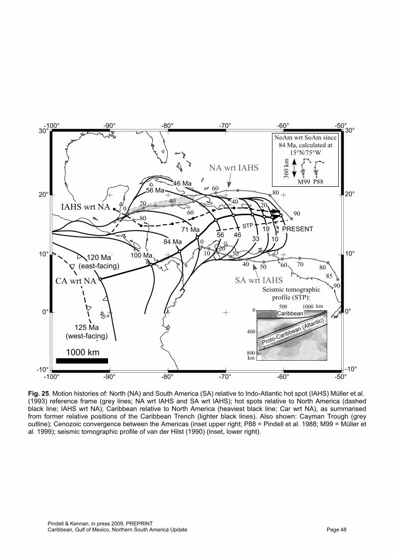
Tectonic evolution of the Gulf of Mexico, Caribbean and northern South America in the mantle reference frame: an update James Pindell 1,2 & Lorcan Kennan 1 1. Tectonic Analysis Ltd., Chestnut House, Duncton, West Sussex, GU28 0LH, UK 2. Also at: Dept. Earth Science, Rice University, Houston, TX 77002, USA Email: [email protected]Abstract: We present an updated synthesis of the widely accepted “single-arc Pacific- origin” and “Yucatán-rotation” models for Caribbean and Gulf of Mexico evolution, respectively. 14 palaeogeographic maps through time integrate new concepts and alterations to earlier models. Pre-Aptian maps are presented in a North American reference frame. Aptian and younger maps are presented in an Indo-Atlantic hot spot reference frame which demonstrates the surprising simplicity of Caribbean–American interaction. We use the Müller et al. (1993) reference frame because the motions of the Americas are smoothest in this reference frame, and because it does not differ significantly, at least since c. 90 Ma, from more recent “moving hot spot” reference frames. The Caribbean oceanic lithosphere has moved little relative to the hot spots in the Cenozoic, but moved north at c. 50 km/Ma during the Cretaceous, while the American plates have drifted west much farther and faster and thus are responsible for most Caribbean–American relative motion history. New or revised features of this model, generally driven by new data sets, include: (1) refined reconstruction of western Pangaea; (2) refined rotational motions of the Yucatán Block during the evolution of the Gulf of Mexico; (3) an origin for the Caribbean Arc that invokes Aptian conversion to a southwest-dipping subduction zone of a trans-American plate boundary from Chortís to Ecuador that was part sinistral transform (northern Caribbean) and part pre-existing arc (eastern, southern Caribbean); (4) acknowledgement that the Caribbean basalt plateau may pertain to the palaeo-Galapagos hot spot, the occurrence of which was partly controlled by a Proto-Caribbean slab gap beneath the Caribbean Plate; (5) Campanian initiation of subduction at the Panama–Costa Rica Arc, although a sinistral transform boundary probably pre-dated subduction initiation here; (6) inception of a north-vergent crustal inversion zone along northern South America to account for Cenozoic convergence between the Americas ahead of the Caribbean Plate; (7) a fan-like, asymmetric rift opening model for the Grenada Basin, where the Margarita and Tobago footwall crustal slivers were exhumed from beneath the southeast Aves Ridge hanging wall; (8) an origin for the Early Cretaceous HP/LT metamorphism in the El Tambor units along the Motagua Fault Zone that relates to subduction of Farallon crust along western Mexico (and then translated along the trans-American plate boundary prior to onset of SW-dipping subduction beneath the Caribbean Arc) rather than to collision of Chortis with Southern Mexico; (9) Middle Miocene tectonic escape of Panamanian crustal slivers, followed by Late Miocene and Recent eastward movement of the “Panama Block” that is faster than that of the Caribbean Plate, allowed by the inception of E–W trans-Costa Rica shear zones. The updated model integrates new concepts and global plate motion models in an internally consistent way, and can be used to test and guide more local research across the Gulf of Mexico, the Caribbean, and northern South America. Using examples from the regional evolution, the processes of slab break off and flat slab subduction are assessed in relation to plate interactions in the hot spot reference frame. The realisation that the Bullard et al. (1965) reconstruction of the Equatorial Atlantic margins was dramatically in error due to the inclusion of post-rift sediment build up along the Amazon margin (Pindell & Dewey, 1982; Pindell, 1985a; Klitgord & Schouten, 1986) led to major advances in the understanding of the evolution of the Gulf of Mexico and Caribbean regions. By backstripping the margin and tightening the crustal fit between northern Brazil and western Africa, Pindell & Dewey (1982) and Pindell (1985a) showed that the gap between Texas and Venezuela upon Atlantic closure was far smaller than that shown by Bullard et al., and that a satisfactory Alleghanian reconstruction could only be achieved with Yucatán inserted into the Gulf, in an orientation that was rotated some Publication expected late 2009. In: James, K., Lorente, M. A. & Pindell, J. (eds) The geology and evolution of the region between North and South America, Geological Society of London, Special Publication. Pindell & Kennan, in press 2009, PREPRINT Caribbean, Gulf of Mexico, Northern South America Update Page 1
Transcript
Tectonic evolution of the Gulf of Mexico, Caribbean and northern South America in the mantle reference frame: an update
James Pindell1,2 & Lorcan Kennan1
1. Tectonic Analysis Ltd., Chestnut House, Duncton, West Sussex, GU28 0LH, UK 2. Also at: Dept. Earth Science, Rice University, Houston, TX 77002, USA
Abstract: We present an updated synthesis of the widely accepted “single-arc Pacific-origin” and “Yucatán-rotation” models for Caribbean and Gulf of Mexico evolution, respectively. 14 palaeogeographic maps through time integrate new concepts and alterations to earlier models. Pre-Aptian maps are presented in a North American reference frame. Aptian and younger maps are presented in an Indo-Atlantic hot spot reference frame which demonstrates the surprising simplicity of Caribbean–American interaction. We use the Müller et al. (1993) reference frame because the motions of the Americas are smoothest in this reference frame, and because it does not differ significantly, at least since c. 90 Ma, from more recent “moving hot spot” reference frames. The Caribbean oceanic lithosphere has moved little relative to the hot spots in the Cenozoic, but moved north at c. 50 km/Ma during the Cretaceous, while the American plates have drifted west much farther and faster and thus are responsible for most Caribbean–American relative motion history. New or revised features of this model, generally driven by new data sets, include: (1) refined reconstruction of western Pangaea; (2) refined rotational motions of the Yucatán Block during the evolution of the Gulf of Mexico; (3) an origin for the Caribbean Arc that invokes Aptian conversion to a southwest-dipping subduction zone of a trans-American plate boundary from Chortís to Ecuador that was part sinistral transform (northern Caribbean) and part pre-existing arc (eastern, southern Caribbean); (4) acknowledgement that the Caribbean basalt plateau may pertain to the palaeo-Galapagos hot spot, the occurrence of which was partly controlled by a Proto-Caribbean slab gap beneath the Caribbean Plate; (5) Campanian initiation of subduction at the Panama–Costa Rica Arc, although a sinistral transform boundary probably pre-dated subduction initiation here; (6) inception of a north-vergent crustal inversion zone along northern South America to account for Cenozoic convergence between the Americas ahead of the Caribbean Plate; (7) a fan-like, asymmetric rift opening model for the Grenada Basin, where the Margarita and Tobago footwall crustal slivers were exhumed from beneath the southeast Aves Ridge hanging wall; (8) an origin for the Early Cretaceous HP/LT metamorphism in the El Tambor units along the Motagua Fault Zone that relates to subduction of Farallon crust along western Mexico (and then translated along the trans-American plate boundary prior to onset of SW-dipping subduction beneath the Caribbean Arc) rather than to collision of Chortis with Southern Mexico; (9) Middle Miocene tectonic escape of Panamanian crustal slivers, followed by Late Miocene and Recent eastward movement of the “Panama Block” that is faster than that of the Caribbean Plate, allowed by the inception of E–W trans-Costa Rica shear zones. The updated model integrates new concepts and global plate motion models in an internally consistent way, and can be used to test and guide more local research across the Gulf of Mexico, the Caribbean, and northern South America. Using examples from the regional evolution, the processes of slab break off and flat slab subduction are assessed in relation to plate interactions in the hot spot reference frame.
The realisation that the Bullard et al. (1965) reconstruction of the Equatorial Atlantic margins was dramatically in error due to the inclusion of post-rift sediment build up along the Amazon margin (Pindell & Dewey, 1982; Pindell, 1985a; Klitgord & Schouten, 1986) led to major advances in the understanding of the evolution of the Gulf of Mexico and Caribbean regions. By backstripping the margin and tightening the crustal fit between northern Brazil and western Africa, Pindell & Dewey (1982) and Pindell (1985a) showed that the gap between Texas and Venezuela upon Atlantic closure was far smaller than that shown by Bullard et al., and that a satisfactory Alleghanian reconstruction could only be achieved with Yucatán inserted into the Gulf, in an orientation that was rotated some
Publication expected late 2009.In: James, K., Lorente, M. A. & Pindell, J. (eds) The geology and evolution of the region between North and South America,Geological Society of London, Special Publication.
Pindell & Kennan, in press 2009, PREPRINTCaribbean, Gulf of Mexico, Northern South America Update Page 1
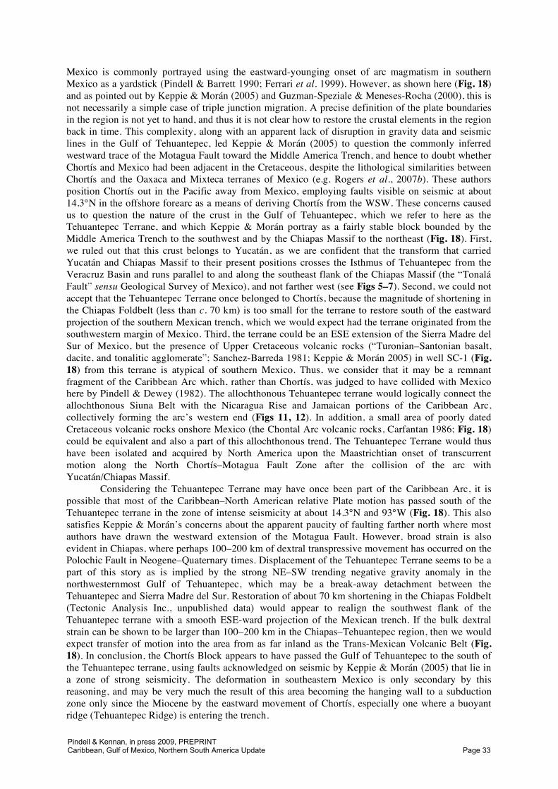
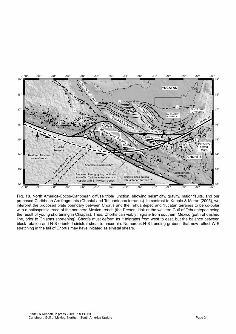
TehuantepecTerrane
Edge mother salt
Arcuate FZs
Basin &Rangeextension
RioGrande
Rift
Trans-MexicanVolcanic Belt
YucatánRifts andBasins
CaymanTrough
ChiapasFTB
Oceanic crust
CampecheSalt
Sigsbee Salt
TriassicRift
Basins
East CoastMagneticAnomaly
CARIBBEANPLATE
Flexural Bulge
E. MexicoTransform
YucatánBasin
Late Cret.Shelf Edge
CubanSuture
-105° -100° -95° -90° -85° -80° -75°
-105° -100° -95° -90° -85° -80° -75°
15°
20°
25°
30°
35°
15°
20°
25°
30°
35°
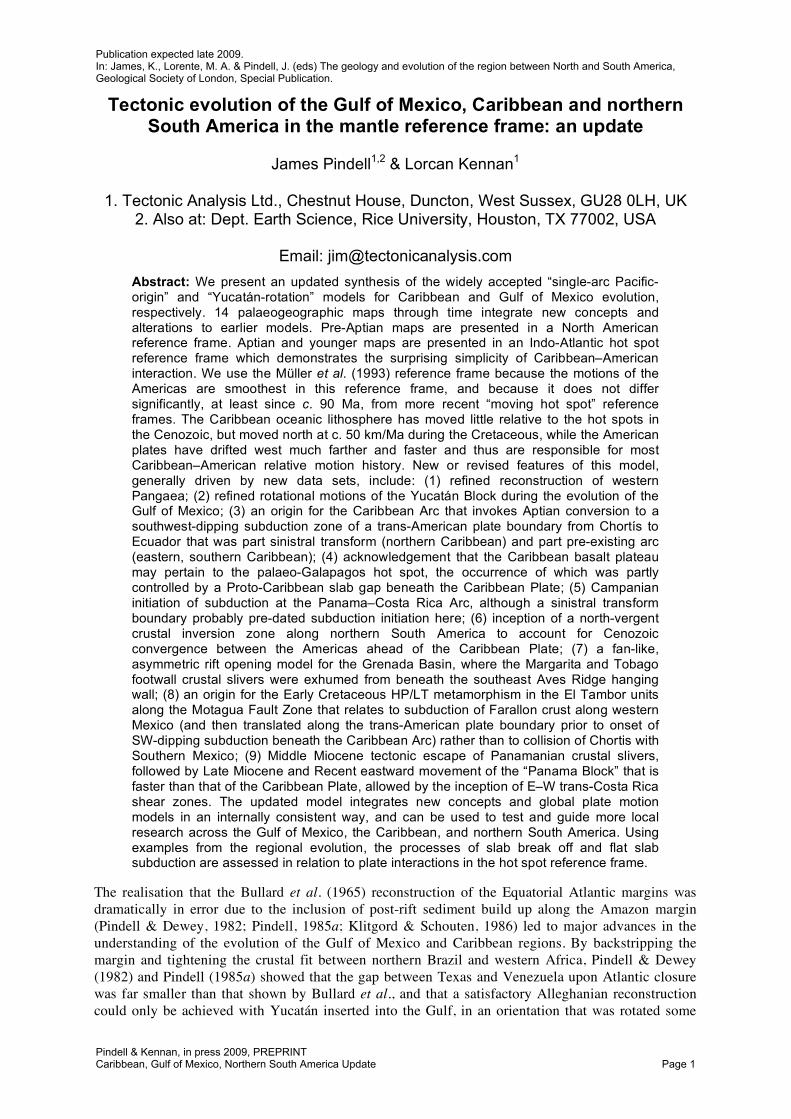
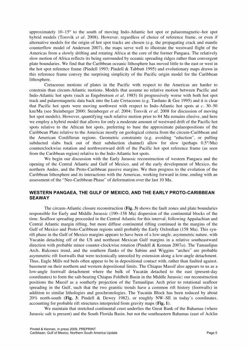
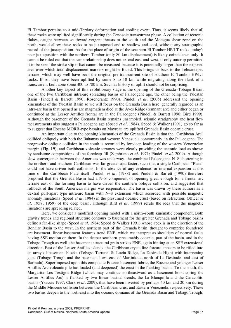
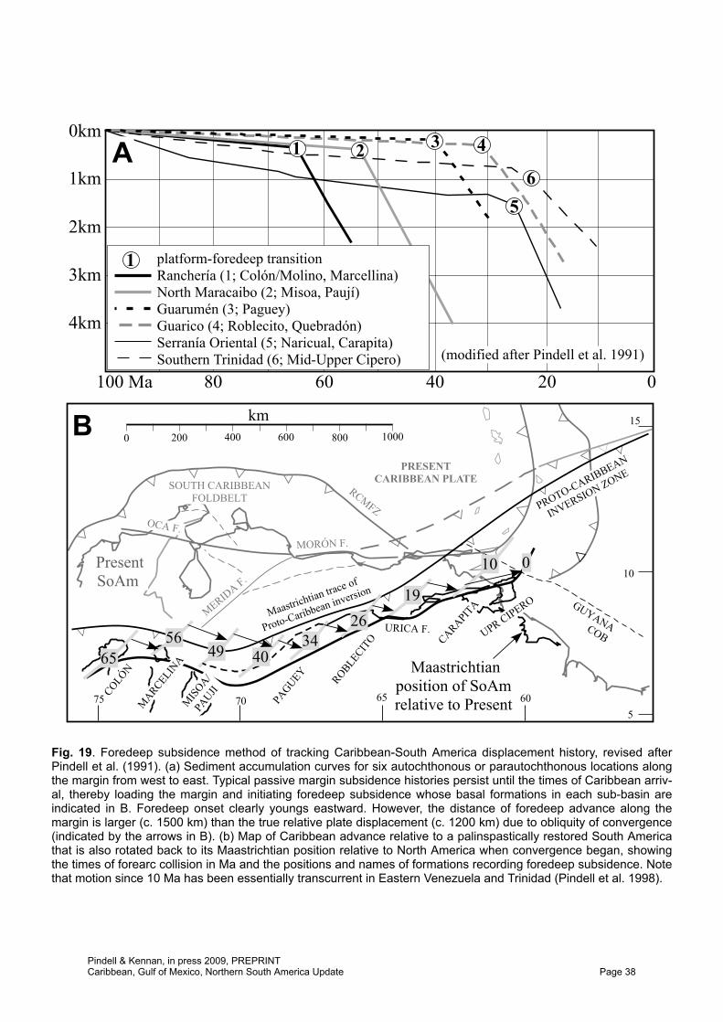
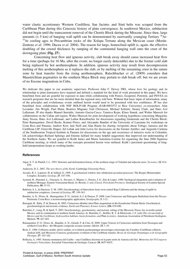
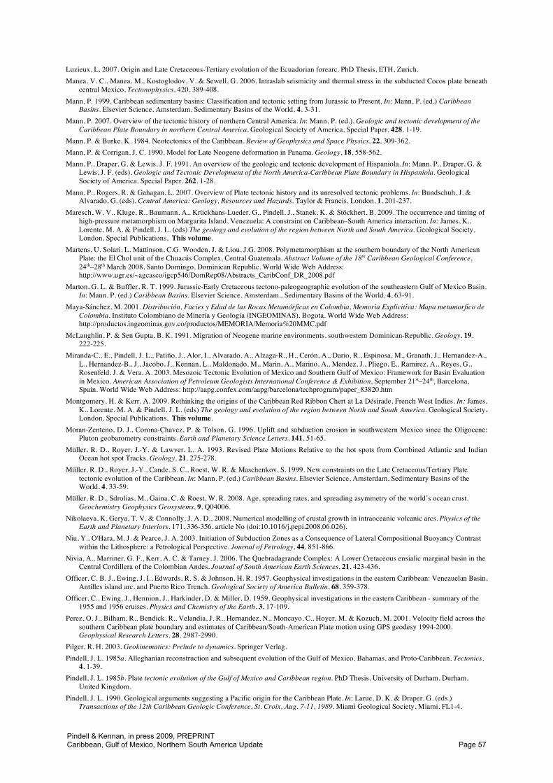
Fig. 1. Present day tectonic map of the Gulf of Mexico region.
Pindell & Kennan, in press 2009, PREPRINTCaribbean, Gulf of Mexico, Northern South America Update Page 2
45–60° clockwise relative to its present orientation. In addition, this adjustment to the Atlantic closure greatly simplified the Cretaceous relative motion history between the Americas over earlier kinematic models (e.g. Ladd 1976; Sclater et al. 1977), leading to the conclusion that the Americas have moved little with respect to each other since the Campanian while the relative eastward migration of the Pacific-derived Caribbean Plate has been the dominant story (Pindell 1985b; Pindell et al. 1988; Burke 1988). It was also evident that this relative migration history was due mainly to the westward drift of the Americas past a Caribbean Plate that was nearly stationary in the hot spot reference frame (Pindell and Dewey, 1982; Duncan and Hargraves 1984; Pindell et al. 1988; Pindell 1993). Since these realisations, most recently corroborated by Müller et al. (1999), both the rotation of Yucatán during the opening of the Gulf of Mexico and the Pacific origin of the Caribbean oceanic lithosphere have gained increasing favour as the concepts and implications have been digested and tested by expanding data sets (Stephan et al. 1990; Schouten & Klitgord 1994; Stöckhert et al. 1995; Diebold et al. 1999; Driscoll & Diebold 1999; Kerr et al. 1999, 2003; Mann 1999; Dickinson & Lawton 2001; Miranda et al. 2003; Jacques et al. 2004; Bird et al. 2005; Imbert 2005; Imbert & Philippe 2005; Pindell et al. 2005).
In this paper, we update the “Yucatán-rotation” model for the Gulf of Mexico (Pindell and Dewey 1982; Fig. 1) and the “single-arc Pacific-origin” model for the Caribbean region (Pindell 1985b; Pindell et al. 1988; Fig. 2) by integrating into the original models a number of concepts and the implications of key data sets developed in recent years. We believe the collected arguments for a Pacific origin of the Caribbean oceanic lithosphere are overwhelmingly clear (Pindell 1990, 1993; Pindell et al. 2005; 2006; 2009) so we will not repeat them here. However, we will take the opportunity to highlight key pro-Pacific factors when expedient, as well as to point out why various objections to the Pacific model put forth in recent years are invalid.
PLATE RECONSTRUCTIONS AND REFERENCE FRAMES
Our circum-Atlantic assembly uses the Central Atlantic reconstruction of Le Pichon & Fox (1971) which despite being an early paper best superposes the East Coast and West African magnetic anomalies, and the Equatorial Atlantic reconstruction of Pindell et al. (2006). For spreading history, we use the marine magnetic anomaly reconstructions of Müller et al. (1999), Pindell et al. (1988) and Roest et al. (1992) for various anomaly pairs in the Equatorial and Central Atlantic, the integration of which was checked for internal consistency. Our palaeogeographic maps are drawn in the North American reference frame prior to the Aptian, and in the Indo-Atlantic hot spot reference frame of Müller et al. (1993) for times since the Aptian, when such a reference frame is more likely to be meaningful. Torsvik et al. (2008) has compared different hot spot reference frames, including fixed Indo-Atlantic (or African) hot spots, moving Indo-Atlantic hot spots, and moving global hot spots and has found that all are similar within error back to 84 Ma, and agree well with palaeomagnetic data. Thus, the choice of a particular Indo-Atlantic reference frame for Late Cretaceous-Recent reconstructions is not critical. Prior to 84 Ma, the positions of major continents calculated from hot spot tracks drift south and rotate with respect to their positions calculated from palaeomagnetic data, perhaps indicating significant hot spot motion or true polar wander.
Both the relative and the absolute positions of the major continents on our maps since anomaly 34 (84 Ma) are quite reliable. Our 100 Ma reconstruction (interpolation) within the Cretaceous magnetic quiet period (124.61–84 Ma) is subject to greater uncertainty (but still less than c. 100 km) because there are no magnetic anomaly determinations for this period, although satellite depictions of fracture zones do define the flow lines, if not the rates of motion, between Africa and the Americas for that interval. The M0 (124.61 Ma, Early Aptian, in the recent Gradstein et al. 2004 timescale) and older Mesozoic anomalies are reliably identified and we have a high degree of confidence in the Aptian and older Equatorial Atlantic closure fit; thus, the 125 Ma and older reconstructions reliably show the relative positions of the major continents. Their absolute positions are less certain because of the Albian and older differences between various hot spot and palaeomagnetic reference frames. Early Cretaceous palaeo-longitudes of the continents are consistent to less than 5° between different models, but there is significant latitudinal variation and some rotation. The Müller et al. (1993) fixed Indo-Atlantic hot spot model used here places the Americas
Pindell & Kennan, in press 2009, PREPRINTCaribbean, Gulf of Mexico, Northern South America Update Page 3
Tiburón FZ
ColombianBasin
PanamaFoldbelt
MiddleAmericaTrench
Cocos PlateNazcaPlate C
.Cor
d.
W. C
ord.
Caribbean
allochthons
GuyanaShieldEastern
Cordillera
Maracaibo
MéridaAndes
Orinoco
GuyanaEscarpment
S. InteriorOriental
BarbadosPrism
GrenadaBasin
AvesRidgeSouth Caribbean Foldbelt
Venezuela Basin
Barracuda FZAnegada
Puerto Rico Trench
Central Atlantic Ocean
P. Rico
BeataRidge
Hess Escarpment
SanAndrésGraben
Chortís
Trough
NicaraguaRise
Motagua
Bahamas
Jamaica
Cuba
Cuban Suture
S. FloridaBasin
Yuca
tán
Bord
erla
ndsYucatán
Yucatán Basin
CampechePlatform Hispaniola
Restraining Bend
Cayman
PanamaBlock
-90 -85 -80 -75 -70 -65 -60 -55
-90 -85 -80 -75 -70 -65 -60 -55
5
10
15
20
25
5
10
15
20
25
Ven.Borderlands
Falcón
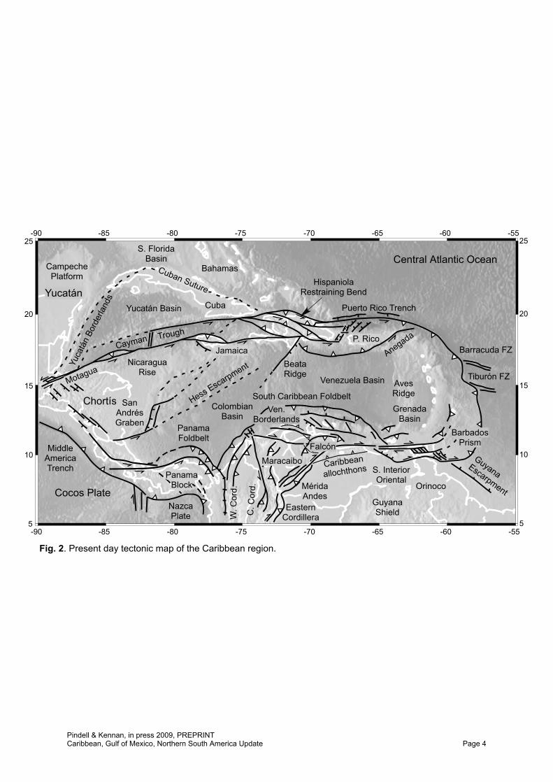
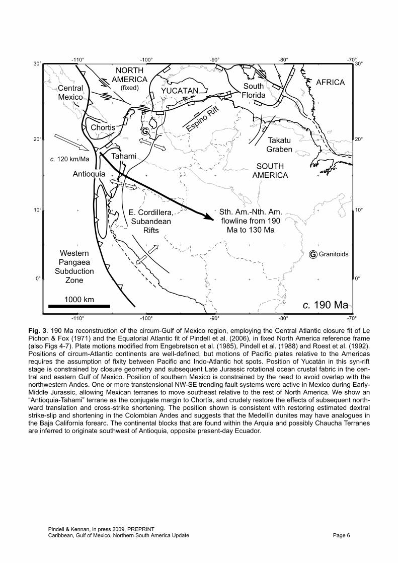
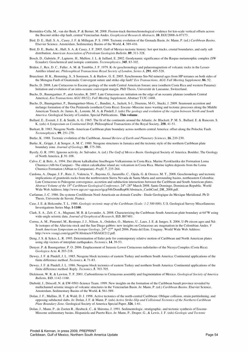
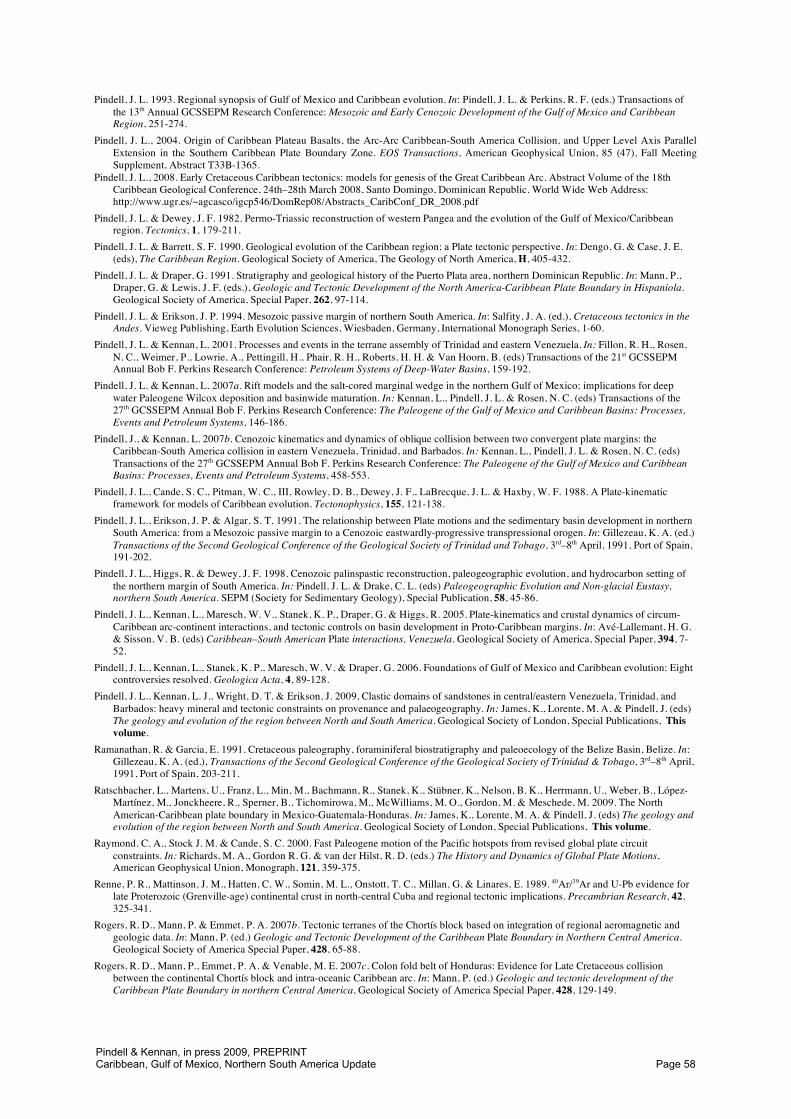
Fig. 2. Present day tectonic map of the Caribbean region.
Pindell & Kennan, in press 2009, PREPRINTCaribbean, Gulf of Mexico, Northern South America Update Page 4
approximately 10–15° to the south of moving Indo-Atlantic hot spot or palaeomagnetic–hot spot hybrid models (Torsvik et al. 2008). However, regardless of choice of reference frame, or even if alternative models for the origin of hot spot tracks are chosen (e.g. the propagating crack and mantle counterflow model of Anderson 2007), the maps serve well to illustrate the westward flight of the Americas from a slowly drifting and rotating Africa at the core of the former Pangaea. The relatively slow motion of Africa reflects its being surrounded by oceanic spreading ridges rather than convergent plate boundaries. We find that the Caribbean oceanic lithosphere has moved little to the east or west in the hot spot reference frame (Pindell 1993; Pindell & Tabbutt 1995) and evolutionary maps drawn in this reference frame convey the surprising simplicity of the Pacific origin model for the Caribbean lithosphere.
Cretaceous motions of plates in the Pacific with respect to the Americas are harder to constrain than circum-Atlantic motions. Models that assume no relative motion between Pacific and Indo-Atlantic hot spots (such as Engebretson et al. 1985) fit progressively worse with both hot spot track and palaeomagnetic data back into the Late Cretaceous (e.g. Tarduno & Gee 1995) and it is clear that Pacific hot spots were moving northwest with respect to Indo-Atlantic hot spots at c. 30–50 km/Ma (see Steinberger 2000; Steinberger et al. 2004; Torsvik et al. 2008 for discussion of moving hot spot models). However, quantifying such relative motion prior to 84 Ma remains elusive, and here we employ a hybrid model that allows for only a moderate amount of westward drift of the Pacific hot spots relative to the African hot spots, preferring to base the approximate palaeopositions of the Caribbean Plate relative to the Americas mostly on geological criteria from the circum-Caribbean and the American Cordilleran regions. Geometric constraints (e.g. avoiding “eduction”, or pulling subducted slabs back out of their subduction channel) allow for slow (perhaps 0.5°/Ma) counterclockwise rotation and northwestward drift of the Pacific hot spot reference frame (as seen from the Caribbean region) relative to the Indo-Atlantic hot spots.
We begin our discussion with the Early Jurassic reconstruction of western Pangaea and the opening of the Central Atlantic and Gulf of Mexico, and of the early development of Mexico, the northern Andes, and the Proto-Caribbean passive margins. We then progress to the evolution of the Caribbean lithosphere and its interactions with the Americas, working forward in time, ending with an assessment of the “Neo-Caribbean Phase” of deformation over the last 10 Ma.
WESTERN PANGAEA, THE GULF OF MEXICO, AND THE EARLY PROTO-CARIBBEAN SEAWAY
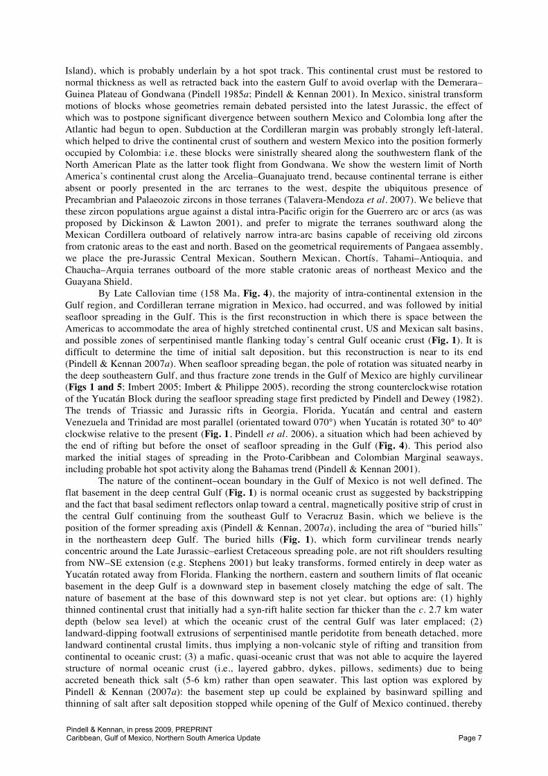
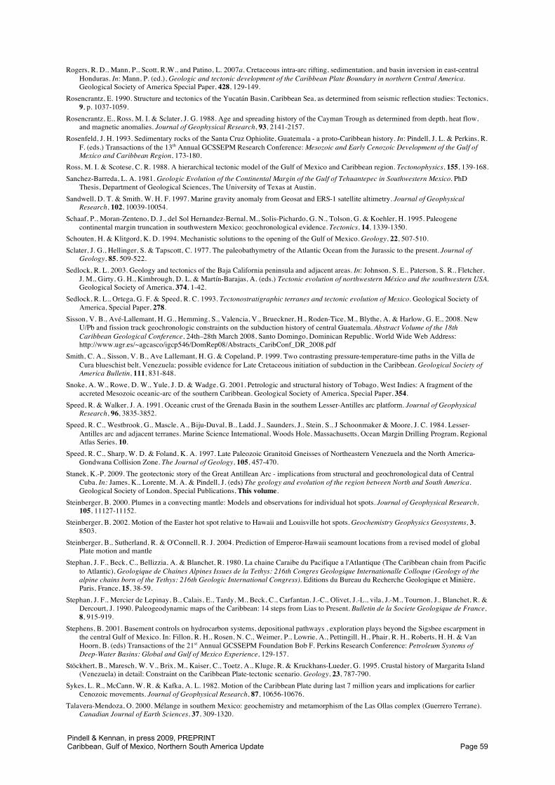
The circum-Atlantic closure reconstruction (Fig. 3) shows the fault zones and plate boundaries responsible for Early and Middle Jurassic (190–158 Ma) dispersion of the continental blocks of the time. Seafloor spreading proceeded in the Central Atlantic for this interval, following Appalachian and Central Atlantic margin rifting, but more diffuse continental rifting continued in the margins of the Gulf of Mexico and Proto-Caribbean regions until probably the Early Oxfordian (158 Ma). This syn-rift phase in the Gulf of Mexico margins appears to have been of a low-angle, asymmetric nature, with Yucatán detaching off of the US and northeast Mexican Gulf margins in a relative southeastward direction with probable minor counter-clockwise rotation (Pindell & Kennan 2007a). The Tamaulipas Arch, Balcones trend, and the southern flanks of the Sabine and Wiggins “arches” are probable asymmetric rift footwalls that were tectonically unroofed by extension along a low-angle detachment. Thus, Eagle Mills red beds often appear to be in depositional contact with, rather than faulted against, basement on their northern and western depositional limits. The Chiapas Massif also appears to us as a low-angle footwall detachment where the bulk of Yucatán detached to the east (present-day coordinates) to form the salt-bearing Chiapas Foldbelt Basin in the Middle Jurassic; our reconstruction positions the Massif as a southerly projection of the Tamaulipas Arch prior to rotational seafloor spreading in the Gulf, such that the two granitic trends have a common rift history (footwalls) in addition to similar lithologies and geochronologies. The Yucatán Block has been reduced by about 20% north-south (Fig. 3; Pindell & Dewey 1982), or roughly NW–SE in today’s coordinates, accounting for probable rift structures interpreted from gravity maps (Fig. 1).
We maintain that stretched continental crust underlies the Great Bank of the Bahamas (where Jurassic salt is present) and the South Florida Basin, but not the southeastern Bahamas (east of Acklin
Pindell & Kennan, in press 2009, PREPRINTCaribbean, Gulf of Mexico, Northern South America Update Page 5
YUCATAN SouthFlorida
E. Cordillera,Subandean
Rifts
CentralMexico
SOUTHAMERICA
NORTHAMERICA
(fixed)
1000 km
AFRICA
Antioquia
TakatuGraben
GChortis
Sth. Am.-Nth. Am.flowline from 190
Ma to 130 Ma
WesternPangaea
SubductionZone
Espino Rift
c. 190 Ma
0°
-100°
-70°
-70°
-80°
-110°
-90°
30°
-100°
-90°
-110°
20°
0°
30°
10° 10°
20°
-80°
c. 120 km/Ma Tahami
G Granitoids
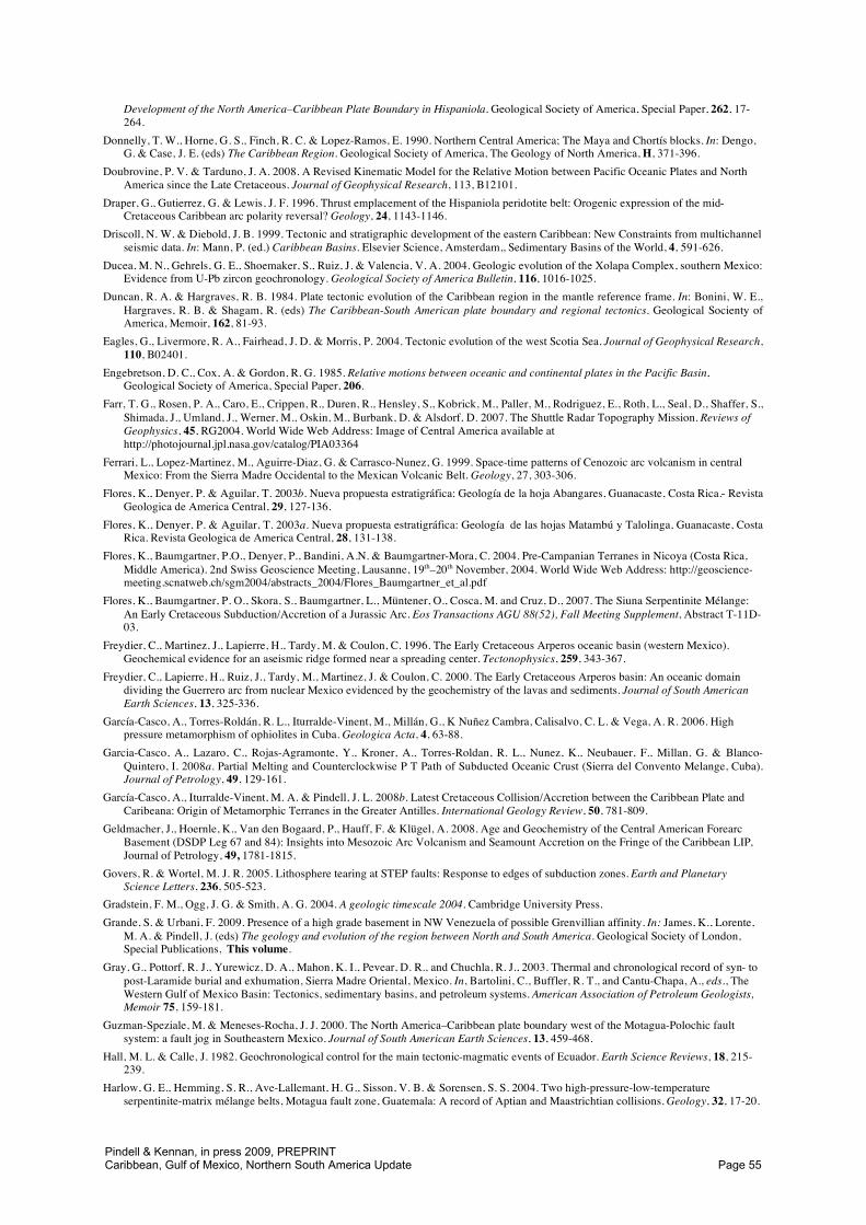
Fig. 3. 190 Ma reconstruction of the circum-Gulf of Mexico region, employing the Central Atlantic closure fit of LePichon & Fox (1971) and the Equatorial Atlantic fit of Pindell et al. (2006), in fixed North America reference frame(also Figs 4-7). Plate motions modified from Engebretson et al. (1985), Pindell et al. (1988) and Roest et al. (1992).Positions of circum-Atlantic continents are well-defined, but motions of Pacific plates relative to the Americasrequires the assumption of fixity between Pacific and Indo-Atlantic hot spots. Position of Yucatán in this syn-riftstage is constrained by closure geometry and subsequent Late Jurassic rotational ocean crustal fabric in the cen-tral and eastern Gulf of Mexico. Position of southern Mexico is constrained by the need to avoid overlap with thenorthwestern Andes. One or more transtensional NW-SE trending fault systems were active in Mexico during Early-Middle Jurassic, allowing Mexican terranes to move southeast relative to the rest of North America. We show an“Antioquia-Tahami” terrane as the conjugate margin to Chortís, and crudely restore the effects of subsequent north-ward translation and cross-strike shortening. The position shown is consistent with restoring estimated dextralstrike-slip and shortening in the Colombian Andes and suggests that the Medellín dunites may have analogues inthe Baja California forearc. The continental blocks that are found within the Arquia and possibly Chaucha Terranesare inferred to originate southwest of Antioquia, opposite present-day Ecuador.
Pindell & Kennan, in press 2009, PREPRINTCaribbean, Gulf of Mexico, Northern South America Update Page 6
Island), which is probably underlain by a hot spot track. This continental crust must be restored to normal thickness as well as retracted back into the eastern Gulf to avoid overlap with the Demerara–Guinea Plateau of Gondwana (Pindell 1985a; Pindell & Kennan 2001). In Mexico, sinistral transform motions of blocks whose geometries remain debated persisted into the latest Jurassic, the effect of which was to postpone significant divergence between southern Mexico and Colombia long after the Atlantic had begun to open. Subduction at the Cordilleran margin was probably strongly left-lateral, which helped to drive the continental crust of southern and western Mexico into the position formerly occupied by Colombia: i.e. these blocks were sinistrally sheared along the southwestern flank of the North American Plate as the latter took flight from Gondwana. We show the western limit of North America’s continental crust along the Arcelia–Guanajuato trend, because continental terrane is either absent or poorly presented in the arc terranes to the west, despite the ubiquitous presence of Precambrian and Palaeozoic zircons in those terranes (Talavera-Mendoza et al. 2007). We believe that these zircon populations argue against a distal intra-Pacific origin for the Guerrero arc or arcs (as was proposed by Dickinson & Lawton 2001), and prefer to migrate the terranes southward along the Mexican Cordillera outboard of relatively narrow intra-arc basins capable of receiving old zircons from cratonic areas to the east and north. Based on the geometrical requirements of Pangaea assembly, we place the pre-Jurassic Central Mexican, Southern Mexican, Chortís, Tahami–Antioquia, and Chaucha–Arquia terranes outboard of the more stable cratonic areas of northeast Mexico and the Guayana Shield.
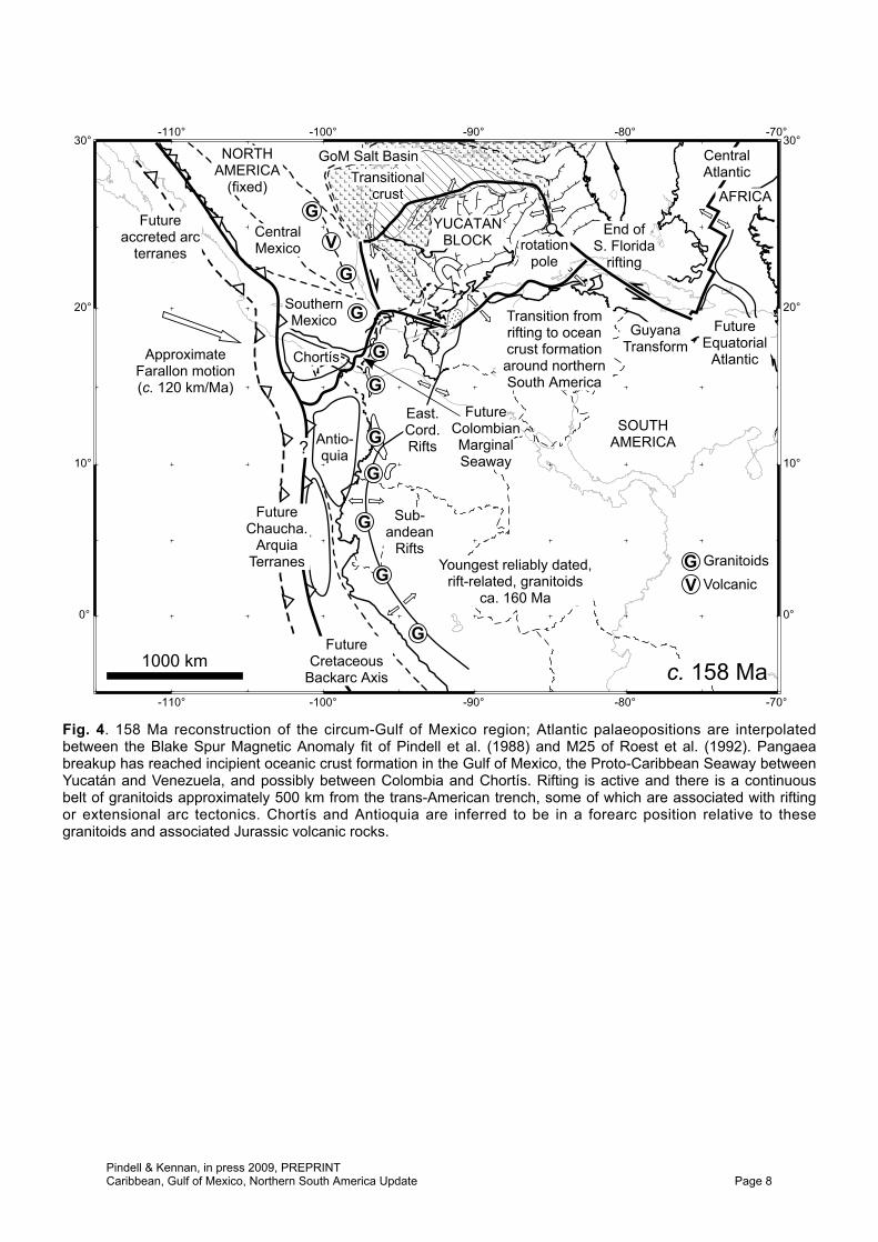
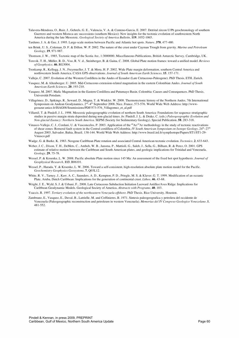
By Late Callovian time (158 Ma, Fig. 4), the majority of intra-continental extension in the Gulf region, and Cordilleran terrane migration in Mexico, had occurred, and was followed by initial seafloor spreading in the Gulf. This is the first reconstruction in which there is space between the Americas to accommodate the area of highly stretched continental crust, US and Mexican salt basins, and possible zones of serpentinised mantle flanking today’s central Gulf oceanic crust (Fig. 1). It is difficult to determine the time of initial salt deposition, but this reconstruction is near to its end (Pindell & Kennan 2007a). When seafloor spreading began, the pole of rotation was situated nearby in the deep southeastern Gulf, and thus fracture zone trends in the Gulf of Mexico are highly curvilinear (Figs 1 and 5; Imbert 2005; Imbert & Philippe 2005), recording the strong counterclockwise rotation of the Yucatán Block during the seafloor spreading stage first predicted by Pindell and Dewey (1982). The trends of Triassic and Jurassic rifts in Georgia, Florida, Yucatán and central and eastern Venezuela and Trinidad are most parallel (orientated toward 070°) when Yucatán is rotated 30° to 40° clockwise relative to the present (Fig. 1, Pindell et al. 2006), a situation which had been achieved by the end of rifting but before the onset of seafloor spreading in the Gulf (Fig. 4). This period also marked the initial stages of spreading in the Proto-Caribbean and Colombian Marginal seaways, including probable hot spot activity along the Bahamas trend (Pindell & Kennan 2001).
The nature of the continent–ocean boundary in the Gulf of Mexico is not well defined. The flat basement in the deep central Gulf (Fig. 1) is normal oceanic crust as suggested by backstripping and the fact that basal sediment reflectors onlap toward a central, magnetically positive strip of crust in the central Gulf continuing from the southeast Gulf to Veracruz Basin, which we believe is the position of the former spreading axis (Pindell & Kennan, 2007a), including the area of “buried hills” in the northeastern deep Gulf. The buried hills (Fig. 1), which form curvilinear trends nearly concentric around the Late Jurassic–earliest Cretaceous spreading pole, are not rift shoulders resulting from NW–SE extension (e.g. Stephens 2001) but leaky transforms, formed entirely in deep water as Yucatán rotated away from Florida. Flanking the northern, eastern and southern limits of flat oceanic basement in the deep Gulf is a downward step in basement closely matching the edge of salt. The nature of basement at the base of this downward step is not yet clear, but options are: (1) highly thinned continental crust that initially had a syn-rift halite section far thicker than the c. 2.7 km water depth (below sea level) at which the oceanic crust of the central Gulf was later emplaced; (2) landward-dipping footwall extrusions of serpentinised mantle peridotite from beneath detached, more landward continental crustal limits, thus implying a non-volcanic style of rifting and transition from continental to oceanic crust; (3) a mafic, quasi-oceanic crust that was not able to acquire the layered structure of normal oceanic crust (i.e., layered gabbro, dykes, pillows, sediments) due to being accreted beneath thick salt (5-6 km) rather than open seawater. This last option was explored by Pindell & Kennan (2007a): the basement step up could be explained by basinward spilling and thinning of salt after salt deposition stopped while opening of the Gulf of Mexico continued, thereby
Pindell & Kennan, in press 2009, PREPRINTCaribbean, Gulf of Mexico, Northern South America Update Page 7
-110°
-110°
-100°
-100°
-90°
-90°
-80°
-80°
-70°
-70°
0° 0°
10° 10°
20° 20°
30° 30°
ApproximateFarallon motion(c. 120 km/Ma)
East.Cord.Rifts
GoM Salt Basin
End ofS. Florida
rifting
Chortís
GuyanaTransform
NORTHAMERICA
(fixed)
CentralAtlantic
YUCATANBLOCK
FutureEquatorial
Atlantic
CentralMexico
Transition fromrifting to oceancrust formationaround northernSouth America
Sub-andean
Rifts
SOUTHAMERICA
SouthernMexico
1000 km
?
AFRICA
FutureColombianMarginalSeaway
G
Youngest reliably dated,rift-related, granitoids
ca. 160 Ma
G
G
G
G
G
G
G
G
G
VFuture
accreted arcterranes
FutureChaucha.
ArquiaTerranes
c. 158 Ma
rotationpole
Transitionalcrust
FutureCretaceous
Backarc Axis
Antio-quia
GV
GranitoidsVolcanic
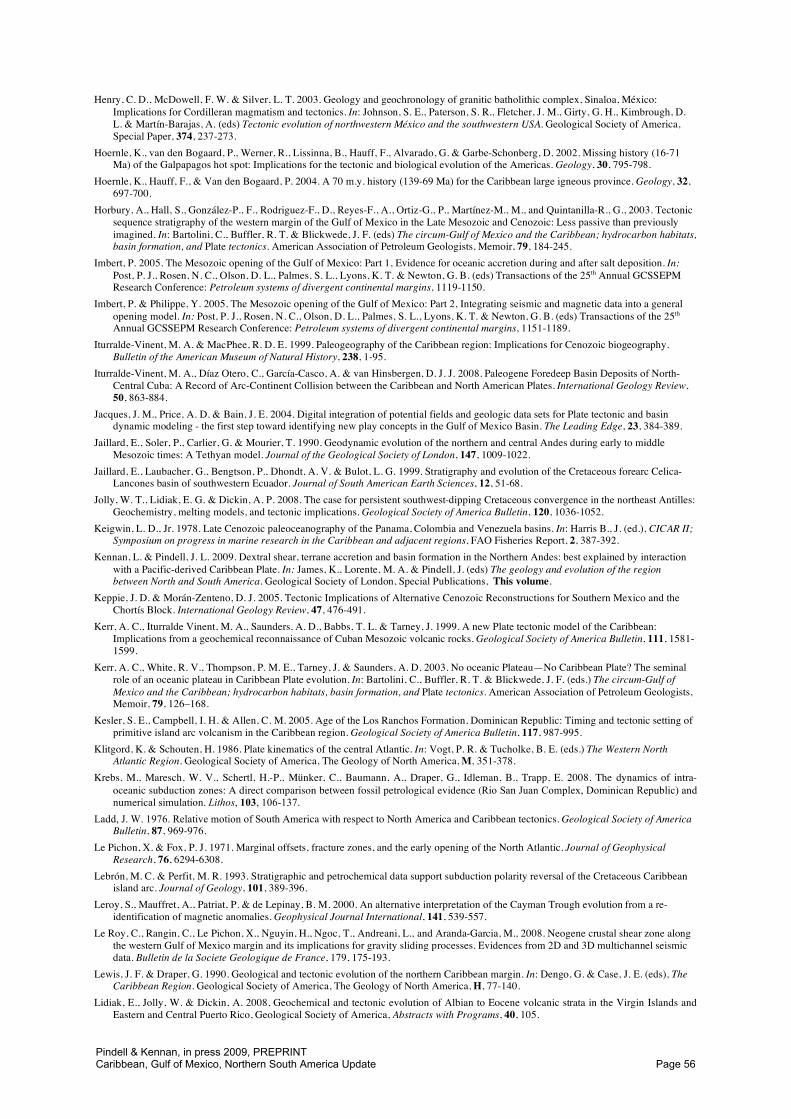
Fig. 4. 158 Ma reconstruction of the circum-Gulf of Mexico region; Atlantic palaeopositions are interpolatedbetween the Blake Spur Magnetic Anomaly fit of Pindell et al. (1988) and M25 of Roest et al. (1992). Pangaeabreakup has reached incipient oceanic crust formation in the Gulf of Mexico, the Proto-Caribbean Seaway betweenYucatán and Venezuela, and possibly between Colombia and Chortís. Rifting is active and there is a continuousbelt of granitoids approximately 500 km from the trans-American trench, some of which are associated with riftingor extensional arc tectonics. Chortís and Antioquia are inferred to be in a forearc position relative to thesegranitoids and associated Jurassic volcanic rocks.
Pindell & Kennan, in press 2009, PREPRINTCaribbean, Gulf of Mexico, Northern South America Update Page 8
1000 km
V
V
V
V
V
G
G
c. 148 Ma
CentralMexico
Sub-andean
Rifts
Chortís
Terraneaccretion and
migration
ColombianMarginalSeaway
ApproximateFarallon motion(c. 100 km/Ma)
GuyanaTransform
SouthernMexico
YUCATANBLOCK
FutureChaucha.
ArquiaTerranes
SOUTHAMERICA
NORTHAMERICA
(fixed)
Proto-CaribbeanSeaway
Separation of US,Mexican salt basins
CentralAtlantic
Caribeana
Bahamashot spot
0°
-100°
-70°
-70°
-80°
-110°
-90°
30°
-100°
-90°
-110°
20°
0°
30°
10° 10°
20°
-80°
Antio-quia
GV
GranitoidsVolcanic
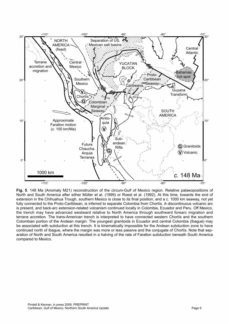
Fig. 5. 148 Ma (Anomaly M21) reconstruction of the circum-Gulf of Mexico region. Relative palaeopositions ofNorth and South America after either Müller et al. (1999) or Roest et al. (1992). At this time, towards the end ofextension in the Chihuahua Trough, southern Mexico is close to its final position, and a c. 1000 km seaway, not yetfully connected to the Proto-Caribbean, is inferred to separate Colombia from Chortís. A discontinuous volcanic arcis present, and back-arc extension-related volcanism continued locally in Colombia, Ecuador and Peru. Off Mexico,the trench may have advanced westward relative to North America through southward forearc migration andterrane accretion. The trans-American trench is interpreted to have connected western Chortís and the southernColombian portion of the Andean margin. The youngest granitoids in Ecuador and central Colombia (Ibagué) maybe associated with subduction at this trench. It is kinematically impossible for the Andean subduction zone to havecontinued north of Ibague, where the margin was more or less passive and the conjugate of Chortís. Note that sep-aration of North and South America resulted in a halving of the rate of Farallon subduction beneath South Americacompared to Mexico.
Pindell & Kennan, in press 2009, PREPRINTCaribbean, Gulf of Mexico, Northern South America Update Page 9
allowing progressively shallower accretion of oceanic crust until the salt pinched out (stopped spilling basinward), thus defining the line where the oceanic crust proceeded to form thereafter at 2.7 km depth (open seawater). However, all options remain viable until further data are released or collected. Our reconstructions (Figs 3–5) show that the eastern Gulf underwent a sharp (roughly 90°) change in extensional direction when seafloor spreading began in about Early Oxfordian time. The kinematics of the creation of the basement step up in the first two of the above three options will adhere to the NW–SE extensional stage, whereas the third option will adhere to the spreading stage. Along the western Gulf margin, the continent–ocean boundary is a fracture zone rather than a rift (Pindell 1985a; Pindell et al. 2006), with high continental basement rather than a deep rift to its west such that the downward step noted above is not seen. There, the reconstructed Tamaulipas Arch–Chiapas Massif formed the footwall to the low-angle Yucatán detachment, whose hanging wall cut-off now lies below the Campeche salt basin, but at the onset of seafloor spreading the new spreading system cut into this former footwall and carried the Chiapas Massif portion of it southward with Yucatán.
Along the Cordillera, a fairly continuous belt of granitoids and extrusive volcanic rocks, generally with subduction-related calc-alkaline arc geochemistry (e.g. Bartolini et al. 2003), lies some 300–500 km inboard from the proposed site of the trench axis, when plotted palinspastically (Fig. 4). The relatively inboard position of this arc (compared to typically 150–200 km) with respect to the trench suggests flat-slab subduction, which may have pertained to the rate of plate convergence (fast), the age of the downgoing plate (young), and/or to the motion of the Americas over the mantle (westward drifting). Note that the Chortís, Tahami–Antioquia and Chaucha–Arquia terranes are interpreted to lie in a continental forearc position in this reconstruction, the along strike position of which remains unclear.
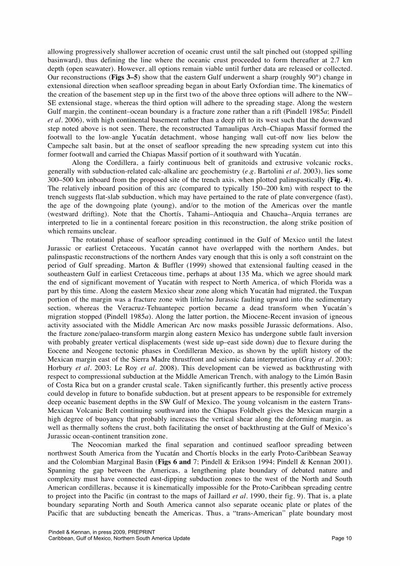
The rotational phase of seafloor spreading continued in the Gulf of Mexico until the latest Jurassic or earliest Cretaceous. Yucatán cannot have overlapped with the northern Andes, but palinspastic reconstructions of the northern Andes vary enough that this is only a soft constraint on the period of Gulf spreading. Marton & Buffler (1999) showed that extensional faulting ceased in the southeastern Gulf in earliest Cretaceous time, perhaps at about 135 Ma, which we agree should mark the end of significant movement of Yucatán with respect to North America, of which Florida was a part by this time. Along the eastern Mexico shear zone along which Yucatán had migrated, the Tuxpan portion of the margin was a fracture zone with little/no Jurassic faulting upward into the sedimentary section, whereas the Veracruz-Tehuantepec portion became a dead transform when Yucatán’s migration stopped (Pindell 1985a). Along the latter portion, the Miocene-Recent invasion of igneous activity associated with the Middle American Arc now masks possible Jurassic deformations. Also, the fracture zone/palaeo-transform margin along eastern Mexico has undergone subtle fault inversion with probably greater vertical displacements (west side up–east side down) due to flexure during the Eocene and Neogene tectonic phases in Cordilleran Mexico, as shown by the uplift history of the Mexican margin east of the Sierra Madre thrustfront and seismic data interpretation (Gray et al. 2003; Horbury et al. 2003; Le Roy et al. 2008). This development can be viewed as backthrusting with respect to compressional subduction at the Middle American Trench, with analogy to the Limón Basin of Costa Rica but on a grander crustal scale. Taken significantly further, this presently active process could develop in future to bonafide subduction, but at present appears to be responsible for extremely deep oceanic basement depths in the SW Gulf of Mexico. The young volcanism in the eastern Trans-Mexican Volcanic Belt continuing southward into the Chiapas Foldbelt gives the Mexican margin a high degree of buoyancy that probably increases the vertical shear along the deforming margin, as well as thermally softens the crust, both facilitating the onset of backthrusting at the Gulf of Mexico’s Jurassic ocean-continent transition zone.
The Neocomian marked the final separation and continued seafloor spreading between northwest South America from the Yucatán and Chortís blocks in the early Proto-Caribbean Seaway and the Colombian Marginal Basin (Figs 6 and 7; Pindell & Erikson 1994; Pindell & Kennan 2001). Spanning the gap between the Americas, a lengthening plate boundary of debated nature and complexity must have connected east-dipping subduction zones to the west of the North and South American cordilleras, because it is kinematically impossible for the Proto-Caribbean spreading centre to project into the Pacific (in contrast to the maps of Jaillard et al. 1990, their fig. 9). That is, a plate boundary separating North and South America cannot also separate oceanic plate or plates of the Pacific that are subducting beneath the Americas. Thus, a “trans-American” plate boundary most
Pindell & Kennan, in press 2009, PREPRINTCaribbean, Gulf of Mexico, Northern South America Update Page 10
1000 km
Antio-quia
E. Cord. Riftsremain active
FA-SAalmost purestrike-slip
V
V
V
V
VMinor maficintrusions
Ecuadorianbackarc
basin
MigratingGuerreroterranes
BRaspas??
C. Mex.back-arcbasin?
B
B
Jamaica
S. Tambor?
BLas OllasZihuatanejo V
Cubanterranes
V
V
c. 130 Ma
final poleposition
Curvilinearfrac. zones
SubandeanRifts inactive
Chortís
ColombianMarginalSeaway
ApproximateFarallon motion(c. 50 km/Ma)
GuyanaTransform
YUCATANin place
SOUTHAMERICA
NORTHAMERICA
(fixed)
Proto-CaribbeanSeaway
CentralAtlantic
Caribeanasediments
Bahamashot spot
0°
-100°
-70°
-70°
-80°
-110°
-90°
30°
-100°
-90°
-110°
20°
0°
30°
10° 10°
20°
-80°
Salt Basin
Salt Basin
GV
GranitoidsVolcanic
B HP/LT
Desirade
N. Tambor?
Teloloapan
Approximate 130Ma position of
future Caribbeanlithosphere
ExtinctSpreading
Centre
Fig. 6. 130 Ma reconstruction of the circum-Gulf of Mexico and Caribbean region. Rotational oceanic crust forma-tion is completed in the Gulf of Mexico, and Yucatán has stopped migrating with respect to North America. An oce-anic back-arc basin is inferred to separate the trans-American arc from southern Colombia and Ecuador and to bethe source of many of the 140-130 Ma ultramafic and mafic rocks that separate the Arquia and Quebradagrandeterranes in Colombia from the rest of the Central Cordillera. The southern end of the arc joins South America in thevicinity of the Celica Arc near the present-day Peru-Ecuador border. In Colombia east of this back-arc basin, thereis no subduction-related arc activity and no evidence for a subduction zone trending northeast along the Colombianmargin. Some of the separation of the Americas was accommodated by ongoing rifting in the Eastern Cordillera,with associated minor mafic magmatism. The trans-American plate boundary had lengthened by both internalextension and southward migration of arc and forearc terranes along Mexico/ Chortís, assisted by oblique subduc-tion of the Farallon Plate beneath North America. The positions shown for the ancestral Nicaragua Rise and Cubanterranes outside southern Mexico are compatable with the likely rates of subduction, strike-slip and separation ofthe Americas. Note that Farallon subduction beneath South America may have been slow (c. 25 mm/a) west ofEcuador swinging towards trench-parallel strike-slip farther south. The indicated palaeoposition of future Caribbeancrust (assuming an Early Cretaceous basement) is consistent with calculated rates of Farallon motion with respectto the Americas (Engebretson et al. 1985), but subject to considerable error because the relative motions of Pacificand Indo-Atlantic hot spots cannot be constrained prior to c. 84 Ma. Possible palaeo-positions of the El Tambor c.130 Ma HP/LT rocks are shown between the future Nicaragua Rise and Siuna terranes, south of the Las Ollasblueschists of southern Mexico. Very low geothermal gradients inferred for the southern El Tambor HP/LT rocksmay suggest an origin in a cold, relatively rapid and long-lived subduction zone such as Farallon-North Americarather than a narrow, transient subduction zone between Chortís and southern Mexico (e.g. Mann et al. 2007).Strike-slip displacement of these terranes from southern Mexico may play a role in their exhumation prior toemplacement against the Yucatán Block later in the Cretaceous. The Raspas blueschist of southern Ecuador(Arculus et al. 1999; Bosch et al. 2002) may also originate at a west-facing trench.
Pindell & Kennan, in press 2009, PREPRINTCaribbean, Gulf of Mexico, Northern South America Update Page 11
V
V
EasternCordillera
Rifts
Future Caribbean Trench1000 km
V Minor maficintrusions
V
V
V
V
Cuban/Hispterranes
End of Andeanback-arc opening
V
Sinaloa Arc
Santiago PeakV
G
FutureFA/CAtrench
Nic. Rise
Siuna
Future Caribbe-an crust (part ofFarallon) lay towest of Inter-
American Arc atthis time
VJamaica
FutureAlisitos
Arc
Quebradagrande arc,back-arc on olderArquia basement c. 125 Ma
La Desirade
0°
-100°
-70°
-70°
-80°
-110°
-90°
30°
-100°
-90°
-110°
20°
0°
30°
10° 10°
20°
-80°
GV
GranitoidsVolcanic
YUCATANBLOCK
ApproximateFarallon motion(c. 60 km/Ma)
NORTHAMERICA
(fixed)
C. Mex.back-arcbasin?
SOUTHAMERICA
Caribeanasediments
CentralAtlantic
Chortís
Proto-CaribbeanSeaway
Antio-quia
Bahamashot spot
Zihuatanejo
Teloloapan
Sonora Arc
BermejaComplex?
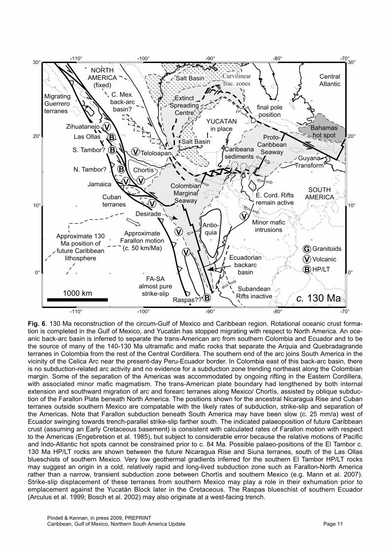
Fig. 7. 125 Ma reconstruction of the circum-Gulf of Mexico and Caribbean region, showing the trans-American Arcimmediately before the initiation of west-dipping subduction and onset of Caribbean Arc volcanism, and prior todevelopment of the Alisitos arc of Baja Mexico. The Sonora, Sinaloa, Zihuatanejo and Teloloapan arcs in Mexicoare shown 200-500 km inboard of a single Farallon-Mexico subduction zone, possibly on a basement of previouslyaccreted oceanic crust and continental sediment without continental basement (hence their oceanic island arccharacter). Southward migration of Zihuatanejo terrane during Aptian-Albian time later results in an apparent dou-ble arc in southwest Mexico. The Americas are still separating and transform faults continued to draw the Siuna,Nicaragua Rise/Jamaica and Cuban terranes southeast of Chortís. The position of the future Caribbean trench isshown at this northern transform margin and within the Andean back-arc basin in the south (dashed). The width ofthe Andean back-arc is not constrained. In this relatively autochthonous interpretation of the Guerrero Arc, the“Arperos Ocean” is interpreted as one or more narrow intra-arc or back-arc basins that may link to Proto-CaribbeanSeaway via the Cuicateco Terrane, rather than being a broad oceanic basin separating an east-facing Guerrero Arcfrom Chortís and central Mexico (e.g. Freydier et al. 1996, 2000).
Pindell & Kennan, in press 2009, PREPRINTCaribbean, Gulf of Mexico, Northern South America Update Page 12
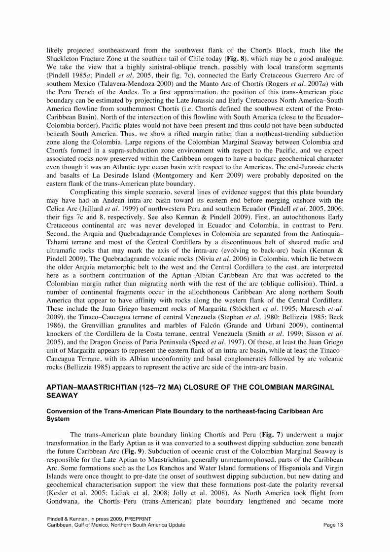
likely projected southeastward from the southwest flank of the Chortís Block, much like the Shackleton Fracture Zone at the southern tail of Chile today (Fig. 8), which may be a good analogue. We take the view that a highly sinistral-oblique trench, possibly with local transform segments (Pindell 1985a; Pindell et al. 2005, their fig. 7c), connected the Early Cretaceous Guerrero Arc of southern Mexico (Talavera-Mendoza 2000) and the Manto Arc of Chortís (Rogers et al. 2007a) with the Peru Trench of the Andes. To a first approximation, the position of this trans-American plate boundary can be estimated by projecting the Late Jurassic and Early Cretaceous North America–South America flowline from southernmost Chortís (i.e. Chortís defined the southwest extent of the Proto-Caribbean Basin). North of the intersection of this flowline with South America (close to the Ecuador–Colombia border), Pacific plates would not have been present and thus could not have been subducted beneath South America. Thus, we show a rifted margin rather than a northeast-trending subduction zone along the Colombia. Large regions of the Colombian Marginal Seaway between Colombia and Chortís formed in a supra-subduction zone environment with respect to the Pacific, and we expect associated rocks now preserved within the Caribbean orogen to have a backarc geochemical character even though it was an Atlantic type ocean basin with respect to the Americas. The end-Jurassic cherts and basalts of La Desirade Island (Montgomery and Kerr 2009) were probably deposited on the eastern flank of the trans-American plate boundary.
Complicating this simple scenario, several lines of evidence suggest that this plate boundary may have had an Andean intra-arc basin toward its eastern end before merging onshore with the Celica Arc (Jaillard et al. 1999) of northwestern Peru and southern Ecuador (Pindell et al. 2005, 2006, their figs 7c and 8, respectively. See also Kennan & Pindell 2009). First, an autochthonous Early Cretaceous continental arc was never developed in Ecuador and Colombia, in contrast to Peru. Second, the Arquia and Quebradagrande Complexes in Colombia are separated from the Antioquia–Tahami terrane and most of the Central Cordillera by a discontinuous belt of sheared mafic and ultramafic rocks that may mark the axis of the intra-arc (evolving to back-arc) basin (Kennan & Pindell 2009). The Quebradagrande volcanic rocks (Nivia et al. 2006) in Colombia, which lie between the older Arquia metamorphic belt to the west and the Central Cordillera to the east, are interpreted here as a southern continuation of the Aptian–Albian Caribbean Arc that was accreted to the Colombian margin rather than migrating north with the rest of the arc (oblique collision). Third, a number of continental fragments occur in the allochthonous Caribbean Arc along northern South America that appear to have affinity with rocks along the western flank of the Central Cordillera. These include the Juan Griego basement rocks of Margarita (Stöckhert et al. 1995; Maresch et al. 2009), the Tinaco–Caucagua terrane of central Venezuela (Stephan et al. 1980; Bellizzia 1985; Beck 1986), the Grenvillian granulites and marbles of Falcón (Grande and Urbani 2009), continental knockers of the Cordillera de la Costa terrane, central Venezuela (Smith et al. 1999; Sisson et al. 2005), and the Dragon Gneiss of Paria Peninsula (Speed et al. 1997). Of these, at least the Juan Griego unit of Margarita appears to represent the eastern flank of an intra-arc basin, while at least the Tinaco–Caucagua Terrane, with its Albian unconformity and basal conglomerates followed by arc volcanic rocks (Bellizzia 1985) appears to represent the active arc side of the intra-arc basin.
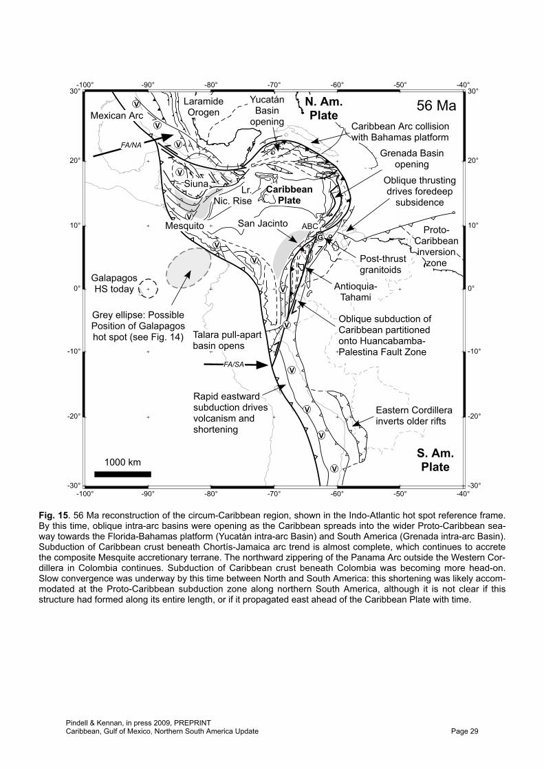
APTIAN–MAASTRICHTIAN (125–72 MA) CLOSURE OF THE COLOMBIAN MARGINAL SEAWAY
Conversion of the Trans-American Plate Boundary to the northeast-facing Caribbean Arc System
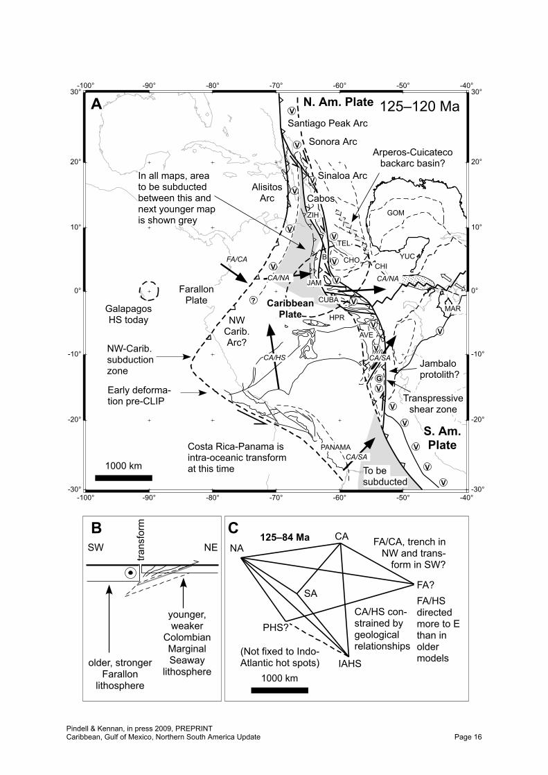
The trans-American plate boundary linking Chortís and Peru (Fig. 7) underwent a major transformation in the Early Aptian as it was converted to a southwest dipping subduction zone beneath the future Caribbean Arc (Fig. 9). Subduction of oceanic crust of the Colombian Marginal Seaway is responsible for the Late Aptian to Maastrichtian, generally unmetamorphosed, parts of the Caribbean Arc. Some formations such as the Los Ranchos and Water Island formations of Hispaniola and Virgin Islands were once thought to pre-date the onset of southwest dipping subduction, but new dating and geochemical characterisation support the view that these formations post-date the polarity reversal (Kesler et al. 2005; Lidiak et al. 2008; Jolly et al. 2008). As North America took flight from Gondwana, the Chortís–Peru (trans-American) plate boundary lengthened and became more
Pindell & Kennan, in press 2009, PREPRINTCaribbean, Gulf of Mexico, Northern South America Update Page 13
Magellanes Plate(until 6.5 Ma)
ScotiaPlate
AntarcticPlate
-80° -75° -70° -65° -60° -55° -50°
-80° -75° -70° -65° -60° -55° -50°
-60° -60°
-55° -55°
-50° -50°
PhoenixPlate
SouthAmerican
Plate
West Scotia Ridge(extinct since 6.5 Ma)
Phoenix Ridge(extinct since
3.3 Ma)
SE transfer of Andeansubduction mélange andpossible forearc slivers
Approx. continent-ocean boundary
conver-gence
direction
Fig. 8. Free-air gravity map, from Sandwell & Smith (1997), of the Tierra del Fuego and Shackleton Fracture Zonearea, southern Chile. Major plates and plate boundaries active during the Late Cenozoic are simplified afterThomson (1985) and Eagles et al. (2004). Note how the Andes Trench veers eastwards into the transform/fracturezone, allowing sinistral secondary faults in the forearc to carry arc, forearc and subduction channel terranes somedistance along the greater transform zone. In addition, the transform ties into the western Scotia spreading centrein a geometry that would satisfy the perceived plate kinematics of the Late Jurassic southern tip of the North Ameri-can Cordillera and Proto-Caribbean spreading centre, providing a possible analogue.
Pindell & Kennan, in press 2009, PREPRINTCaribbean, Gulf of Mexico, Northern South America Update Page 14
transcurrent. Where the trans-American plate boundary had remained an east-dipping subduction zone, arc polarity reversal resulted with the potential for the pre- and post-Aptian arc axes to be superposed; however, any transform portions of the boundary would have been the site of subduction initiation only (Pindell et al. 2005, 2006; Pindell 2008). The palaeo-geometry of the margin suggests that subduction polarity reversal more likely occurred in the southeastern part of the arc (to become the Aves Ridge?), while subduction initiation in the northwest part (now the Greater Antilles) more likely occurred at more of a transform boundary. In both settings, initiation of southwest-dipping subduction can be constrained, in general, by the oldest ages of HP/LT metamorphism in circum-Caribbean subduction complexes/sutures and the onset of arc magmatism related to that subduction. Both aspects point to the Aptian, or 125–114 Ma (Pindell 1993; Stöckhert et al. 1995; Smith et al., 1999; Snoke et al. 2001; Harlow et al. 2004; Pindell et al. 2005; Garcia Casco et al. 2006; Maresch et al. 2009; Stanek et al. 2009).
However, there may well have been the added complexity at the western end of the trans-American arc that Late Jurassic and/or Early Cretaceous trench, forearc and arc materials lying originally west of Mexico and Chortís (e.g. Las Ollas Complex, Talavera-Mendoza 2000; and west-central Baja California, Baldwin & Harrison 1989) were dragged by the sinistral component of oblique subduction some distance southeast along the trans-American boundary. Some insight on this process comes from considering similar tectonic settings such as the southern tip of Chile today (Fig. 8), where slivers of Andean forearc rocks, or mélange containing continental blocks, may be moving southeast along the sinistral Shackleton Fracture Zone. If so, such terranes would become amalgamated within the roots of the western parts of the Caribbean Arc upon the onset of southwest-dipping subduction. We offer this as an explanation for why two western Caribbean HP/LT localities are significantly older than (1) other circum-Caribbean HP/LT rocks and (2) the Late Aptian/Albian–Eocene Antillean magmatic cycle: the 139 Ma age for HP/LT metamorphism in the Siuna terrane of Nicaragua (Flores et al., 2007; Baumgartner et al. 2008) and the 132 Ma ages for HP/LT rocks in the El Tambor unit of central Guatemala (Brueckner et al. 2005). It may also be the mechanism by which Grenvillian aged blocks found their way into the allochthonous subduction mélange of central Cuba (Renne et al. 1989); such basement rock types are not known in the autochthonous margins of the Proto-Caribbean, but do occur in southwest Mexico.
Arc volcanism became more prevalent in the Caribbean Arc during Late Aptian–Albian time, including sections in Jamaica, Cuba, Hispaniola, Puerto Rico, the Villa de Cura Group of Venezuela, Tobago, and elsewhere. However, there is a general lack of arc-derived tuffs in the Proto-Caribbean passive margins until the Maastrichtian–Cenozoic (initial contamination of these margins by arc-derived tuffs youngs eastward), a primary argument by Pindell (1990) for the Pacific origin of the Caribbean arcs. Significant spatial separation between the volcanic Caribbean arcs and the non-volcanic Proto-Caribbean passive margins is clearly indicated. However, there are a few examples of Early Cretaceous volcanic rocks in these margins. First, an 11-cm bentonite is known from a well in the Albian level of the La Luna Group (La Grita unit, see Villamil & Pindell 1998) in the Maracaibo Basin (PDVSA pers. comm. 1994), but the mineralogy (and any possible arc relationship) is unknown to us. Second, there are low volumes of mafic rocks mostly associated with extensional basins in the Eastern Cordillera of Colombia (Vasquez & Altenberger 2007) and in the Oriente Basin of Ecuador (Barragán et al. 2005). Where geochemical data are available, an alkaline, extensional or possibly plume-related character is indicated, rather than a supra-subduction zone or arc character. Most of these rocks post-date the onset of southwest dipping subduction in the Caribbean Arc, but a few are as old as 136–132 Ma, approximately of the same age as many of the mafic rocks inferred to define the trace of the former Andean back-arc basin. These data, deriving from the only known magmatic rocks of the time, reinforce our view that there was no arc and hence no subduction zone along the Colombian margin during Early Cretaceous time (see also Kennan & Pindell 2009). Third, Early Cretaceous “bentonites” have been identified in the Punta Gorda borehole in southern Belize (Punta Gorda Formation; Ramanathan & Garcia 1991), cuttings of which have recently been obtained by us courtesy of Brian Holland (Belize Minerals). Analyses for mineralogy are pending to determine magmatic affinity. Should these prove to be arc-related, we would judge that the nearest known coeval arc volcanism, in the Chortís Block (Ratschbacher et al. 2009), was able to reach Belize, 800 km away (a distance commonly covered by airfall tuffs today) and at a palaeolatitude of about 3°N (Fig. 9).
Pindell & Kennan, in press 2009, PREPRINTCaribbean, Gulf of Mexico, Northern South America Update Page 15
-100°
-100°
-90°
-90°
-80°
-80°
-70°
-70°
-60°
-60°
-50°
-50°
-40°
-40°
-30° -30°
-20° -20°
-10° -10°
0° 0°
10° 10°
20° 20°
30° 30°N. Am. Plate
S. Am.Plate
YUC
GOM
GalapagosHS today
FarallonPlate
TEL
To besubducted
Transpressiveshear zone
Jambaloprotolith?
NWCarib.Arc?
HPR
Costa Rica-Panama isintra-oceanic transformat this time
Early deforma-tion pre-CLIP V
V
V
V
V
V
V
V
V
V
V
V
GV
1000 km
125–120 Ma
AVE
CA/HS
FA/CA
CA/SA
CA/NAJAM
B
Santiago Peak Arc
Sonora ArcV
?
V
V
VAlisitosArc
V
CHI
MAR
Sinaloa ArcV
ZIH
PANAMA
Arperos-Cuicatecobackarc basin?
CHO
Cabos
NW-Carib.subductionzone
CUBACaribbeanPlate
A
CA/SA
CA/NA
In all maps, areato be subductedbetween this andnext younger mapis shown grey
B
IAHS
NA
SA
CA
FA?
PHS?
FA/HSdirectedmore to Ethan inoldermodels
1000 km
(Not fixed to Indo-Atlantic hot spots)
FA/CA, trench inNW and trans-
form in SW?
CA/HS con-strained bygeologicalrelationships
125–84 Ma
older, strongerFarallon
lithosphere
younger,weaker
ColombianMarginalSeaway
lithosphere
SW NE
C
trans
form
Pindell & Kennan, in press 2009, PREPRINTCaribbean, Gulf of Mexico, Northern South America Update Page 16
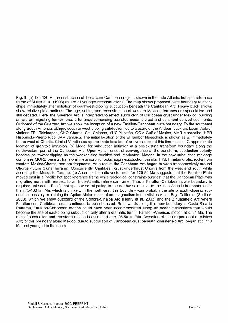
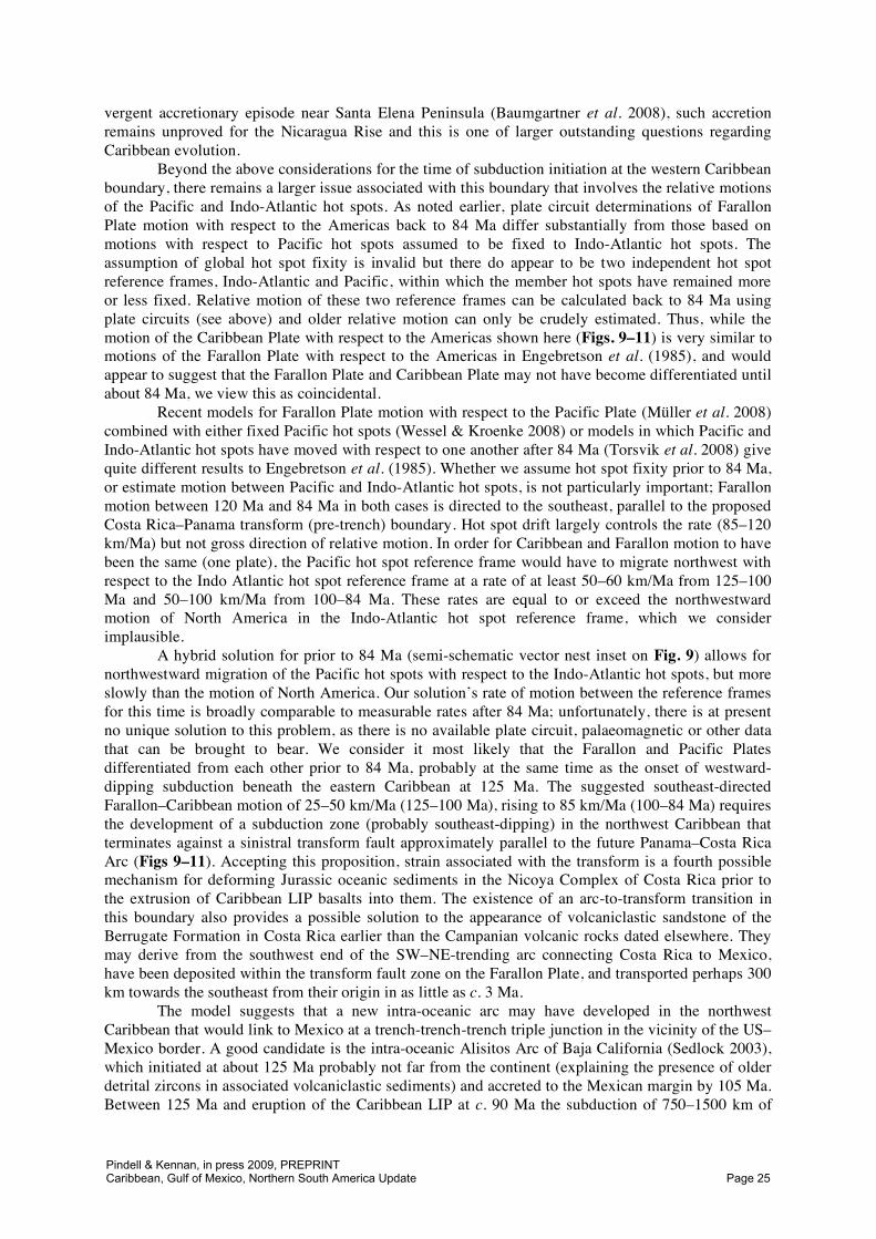
Fig. 9. (a) 125-120 Ma reconstruction of the circum-Caribbean region, shown in the Indo-Atlantic hot spot referenceframe of Müller et al. (1993) as are all younger reconstructions. The map shows proposed plate boundary relation-ships immediately after initiation of southwest-dipping subduction beneath the Caribbean Arc. Heavy black arrowsshow relative plate motions. The age, setting and reconstruction of western Mexican terranes are speculative andstill debated. Here, the Guerrero Arc is interpreted to reflect subducton of Caribbean crust under Mexico, buildingan arc on migrating former forearc terranes comprising accreted oceanic crust and continent-derived sediments.Outboard of the Guerrero Arc we show the inception of a new Farallon-Caribbean plate boundary. To the southeastalong South America, oblique south or west-dipping subduction led to closure of the Andean back-arc basin. Abbre-viations TEL Teloloapan, CHO Chortís, CHI Chiapas, YUC Yucatán, GOM Gulf of Mexico, MAR Maracaibo, HPRHispaniola-Puerto Rico, JAM Jamaica. The initial location of the El Tambor blueschists is shown as B, immediatelyto the west of Chortís. Circled V indicates approximate location of arc volcanism at this time, circled G approximatelocation of granitoid intrusion. (b) Model for subduction initiation at a pre-existing transform boundary along thenorthwestern part of the Caribbean Arc. Upon Aptian onset of convergence at the transform, subduction polaritybecame southwest-dipping as the weaker side buckled and imbricated. Material in the new subduction melangecomprises MORB basalts, transform metamorphic rocks, supra-subduction basalts, HP/LT metamorphic rocks fromwestern Mexico/Chortis, and arc fragments. As a result, the Caribbean Arc began to wrap transpressively aroundChortís (future Siuna Terrane). Concurrently, Caribbean crust underthrust Chortís from the west and south whileaccreting the Mesquito Terrane. (c) A semi-schematic vector nest for 125-84 Ma suggests that the Farallon Platemoved east in a Pacific hot spot reference frame while geological constraints suggest that the Caribbean Plate wasmigrating north with respect to an Indo-Atlantic reference frame. Thus a Farallon-Caribbean plate boundary isrequired unless the Pacific hot spots were migrating to the northwest relative to the Indo-Atlantic hot spots fasterthan 75-100 km/Ma, which is unlikely. In the northwest, this boundary was probably the site of south-dipping sub-duction, possibly explaining the Aptian-Albian onset of arc magmatism in the Alisitos Arc in Baja California (Sedlock2003), which we show outboard of the Sonora-Sinaloa Arc (Henry et al. 2003) and the Zihuatanejo Arc whereFarallon-cum-Caribbean crust continued to be subducted. Southwards along this new boundary in Costa Rica toPanama, Farallon-Caribbean motion could have been accommodated along an oceanic transform that wouldbecome the site of east-dipping subduction only after a dramatic turn in Farallon-Americas motion at c. 84 Ma. Therate of subduction and transform motion is estimated at c. 25-50 km/Ma. Accretion of the arc portion (i.e. AlisitosArc) of this boundary along Mexico, due to subduction of Caribbean crust beneath Zihuatenejo Arc, began at c. 110Ma and younged to the south.
Pindell & Kennan, in press 2009, PREPRINTCaribbean, Gulf of Mexico, Northern South America Update Page 17
However, another possibility is that they pertain to the transtensional plate boundary separating Yucatán and Guajíra during Neocomian time.
The northwest South America–Caribbean plate boundary zone in the Cretaceous
Following the probable Aptian onset of southwest dipping subduction beneath the Caribbean Arc, motion of the arc and future Caribbean lithosphere behind it relative to South America was almost parallel to the overall NNE-trend of the Ecuador–Colombia margin, particularly after about 100 Ma. Associated structures are dextral strike-slip to dextral transpressive throughout the Ecuadorian Cordillera Real and Colombian Central Cordilleran terranes and initial cooling ages in these areas range from 120–85 Ma, consistent with the plate boundaries shown (Figs 9–11, see Kennan & Pindell 2009 for more detail). Dextral shearing started the slow migration of Antioquia north towards its present position. Deformation was initially ductile, becoming brittle towards the end of the Cretaceous, when we suspect the Huancabamba–Palestina Fault Zone became active. Further, we consider that a STEP fault (“subduction–transform edge propagator”, Govers & Wortel 2005) may have defined the termination of the Caribbean trench at the South American continent-ocean boundary for this transcurrent stage; the tear was propagated along the boundary by the loading effect of the advancing Caribbean Arc.
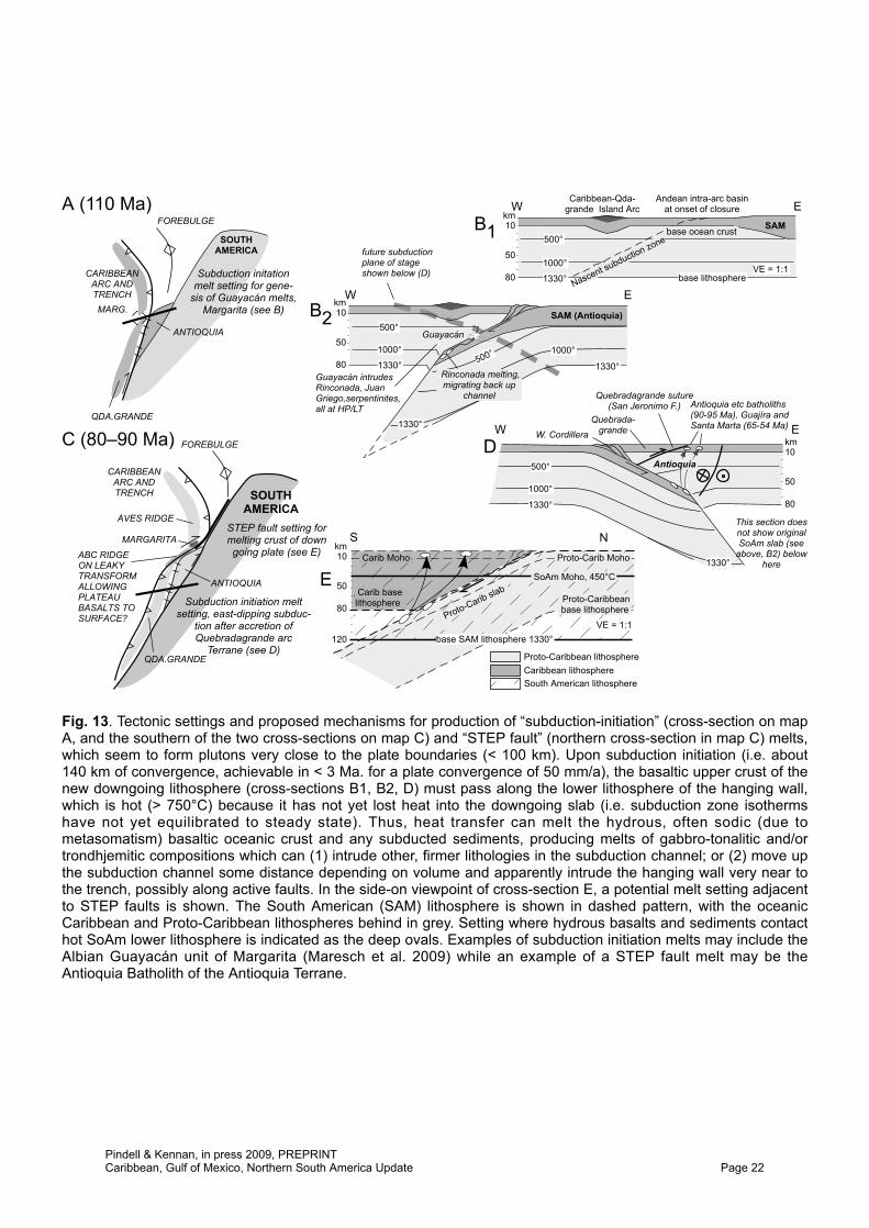
We identify the former existence of a mainly tonalite–trondhjemite belt of intrusive rocks along the Albian–Early Eocene Andes–Caribbean plate boundary that becomes apparent when Caribbean–South American plate motions are restored for that time. Candidates for this belt include Tobago (Tobago Plutonic Series, Snoke et al. 2001), at least some parts of the Leeward Antilles Islands (e.g. Aruba Batholith, Wright et al. 2008), the Guayacán trondhjemite of Margarita (Maresch et al. 2009), several intrusives in Guajíra and Santa Marta (Cardona et al. 2008), and the Antioquia, Buga, and several other nearby plutons (Kennan & Pindell 2009). The interesting aspect about all these intrusions is that they lie within 100 km, and on both sides of or within, our reconstructed Caribbean–South America plate boundary zone (Figs 11, 12), which is too close for these to be normal arc-related intrusions. Instead, we propose a model of tonalite/trondhjemite production by the re-melting of mafic crust of the “slab nose” upon subduction initiation (e.g. Nikolaeva et al. 2008; Garcia-Casco et al. 2008a), where basaltic crust of the downgoing plate was juxtaposed with lower lithosphere of an adjacent plate that was still hot because the cooling effect from subduction had been minimal by the time of melting. Hence, the basalts underwent anatexis and intruded other subducted components (e.g. Guayacán meta-trondhjemite of Margarita; Maresch et al. 2009) and stocks and plutons along the plate boundary at shallower levels. Figure 13 offers settings where subduction initiation could occur along the northern Andes, which should have been diachronous northwards. However, this new hypothesis for the origin of these magmas needs to be tested and refined as there are large uncertainties concerning the location of various plutons relative to the plate boundary in this model. For example, the Aruba Batholith (89 Ma gabbro-tonalite; Wright et al. 2008) has a very similar geochemistry to the Turonian–Coniacian (c. 94–90 Ma) Aruba lava formation in which it sits (White et al. 1999; Wright et al. 2008); the pluton may simply be a late equivalent of the extrusive lavas, all of which relate to the Caribbean LIP (see below), initially situated on the Caribbean Plate some distance southwest (prior to accretion) of the new east-dipping accretionary plate boundary, rather than being due to the hypothetical mechanism outlined above (Fig. 13). The onset of subduction here pertains to the Late Cretaceous slowing/cessation of spreading between the Americas (Pindell et al. 1988; Müller et al. 1999), such that Caribbean–South American relative plate motion evolved from dextral strike-slip to dextral convergence (Fig. 12). However, no magmatic arc has developed above this Benioff Zone at typical distances from the trench, due mainly to the flat geometry and slow rate of subduction of the buoyant Caribbean slab.
The North America–Caribbean plate boundary zone in the Cretaceous
In the western part of the Caribbean Arc, the onset of southwest-dipping subduction (possibly at a transform boundary) produced an E–W-trending transpressive shear zone that lengthened with time by sinistral shear along cross faults, and by axis parallel extension. Continued oblique convergence of the arc, and any pre-Aptian rocks within it, with the southern and eastern margins of
Pindell & Kennan, in press 2009, PREPRINTCaribbean, Gulf of Mexico, Northern South America Update Page 18
-100°
-100°
-90°
-90°
-80°
-80°
-70°
-70°
-60°
-60°
-50°
-50°
-40°
-40°
-30° -30°
-20° -20°
-10° -10°
0° 0°
10° 10°
20° 20°
30° 30°
B
V
?
VV
V
V
V
G
V
1000 km
100 Ma
CA/SA
FA/CA
CA/HS
CA/SA
CA/NA
V
V
G
Arcelia?
Early defm.within arc &coastalbatholith
AccretedAlisitos Arc
Early deformationpre-CLIP
Jambaló?
NW migration of Pacifichotspots with respect to Indo-Atlantic allows future CostaRica-Panama to be essentiallyintra-oceanic transform
Invertedback-arcbasin
Cordillera Realdextral shearzone
MedellínDunite?
N. Am. Plate
S. Am.Plate
Mesquito
East-dippingsubductionresumes
Caribeana
CaribbeanPlate
GuerreroArc
SLABGAP
MargaritaHPLT core
GalapagosHS today
Invertedrifts
ProposedFarallon-
Caribbeansubduction
zone
easternJamaica?
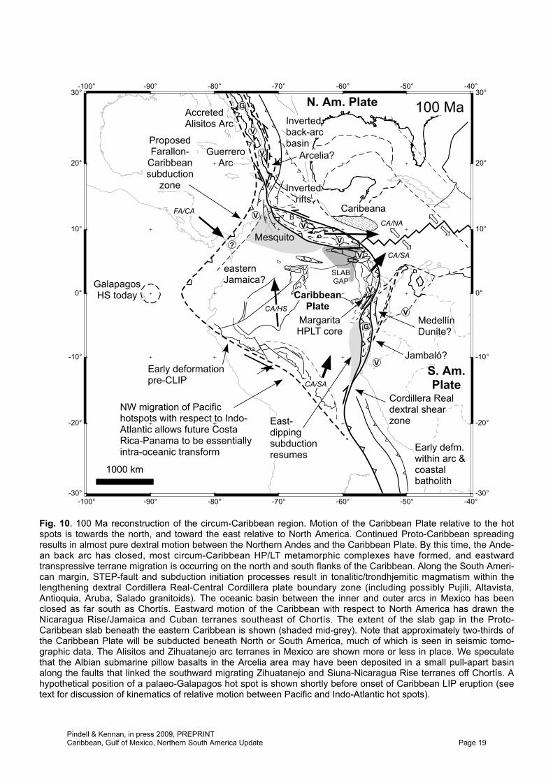
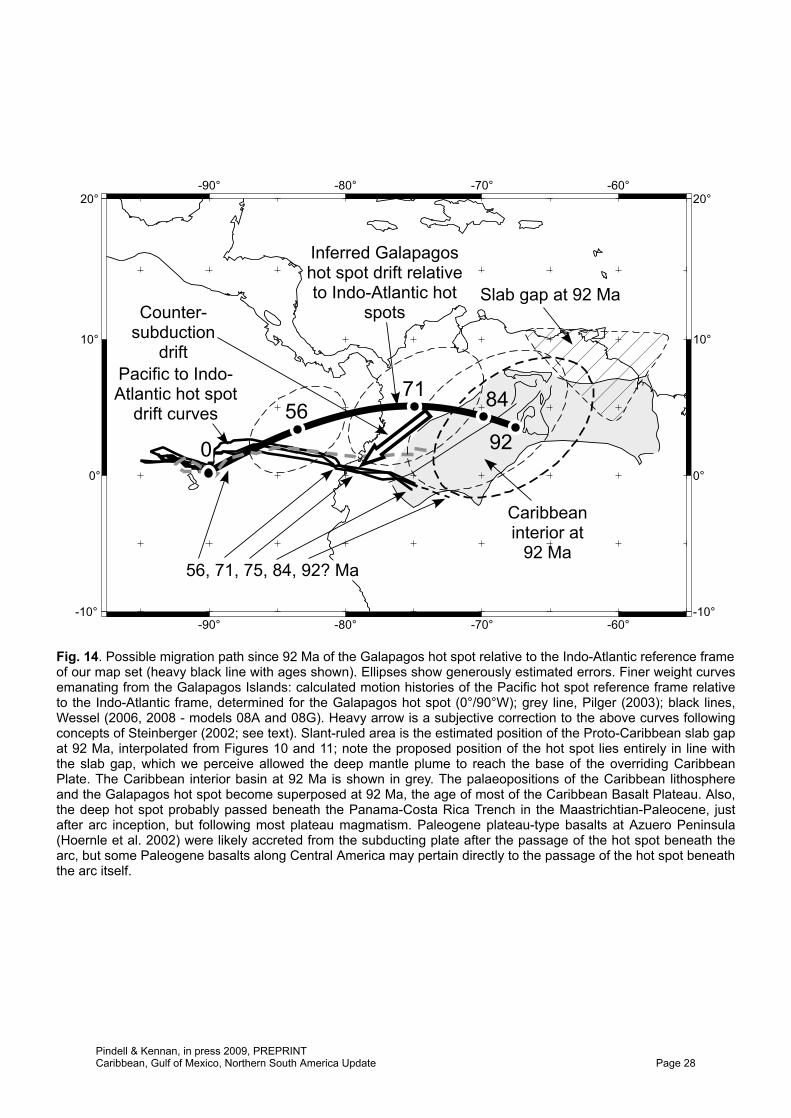
Fig. 10. 100 Ma reconstruction of the circum-Caribbean region. Motion of the Caribbean Plate relative to the hotspots is towards the north, and toward the east relative to North America. Continued Proto-Caribbean spreadingresults in almost pure dextral motion between the Northern Andes and the Caribbean Plate. By this time, the Ande-an back arc has closed, most circum-Caribbean HP/LT metamorphic complexes have formed, and eastwardtranspressive terrane migration is occurring on the north and south flanks of the Caribbean. Along the South Ameri-can margin, STEP-fault and subduction initiation processes result in tonalitic/trondhjemitic magmatism within thelengthening dextral Cordillera Real-Central Cordillera plate boundary zone (including possibly Pujili, Altavista,Antioquia, Aruba, Salado granitoids). The oceanic basin between the inner and outer arcs in Mexico has beenclosed as far south as Chortís. Eastward motion of the Caribbean with respect to North America has drawn theNicaragua Rise/Jamaica and Cuban terranes southeast of Chortís. The extent of the slab gap in the Proto-Caribbean slab beneath the eastern Caribbean is shown (shaded mid-grey). Note that approximately two-thirds ofthe Caribbean Plate will be subducted beneath North or South America, much of which is seen in seismic tomo-graphic data. The Alisitos and Zihuatanejo arc terranes in Mexico are shown more or less in place. We speculatethat the Albian submarine pillow basalts in the Arcelia area may have been deposited in a small pull-apart basinalong the faults that linked the southward migrating Zihuatanejo and Siuna-Nicaragua Rise terranes off Chortís. Ahypothetical position of a palaeo-Galapagos hot spot is shown shortly before onset of Caribbean LIP eruption (seetext for discussion of kinematics of relative motion between Pacific and Indo-Atlantic hot spots).
Pindell & Kennan, in press 2009, PREPRINTCaribbean, Gulf of Mexico, Northern South America Update Page 19
-100°
-100°
-90°
-90°
-80°
-80°
-70°
-70°
-60°
-60°
-50°
-50°
-40°
-40°
-30° -30°
-20° -20°
-10° -10°
0° 0°
10° 10°
20° 20°
30° 30°
V
G
V
V
V
V
V
?
?V
V
G
G
G
V
V
V
G
V
V
V
V
V
G
Plume or riftvolcanism
Granitoids
Counterclockwise rota-tion of FA-CA motionpops former transformand initiates CostaRica-Panama Arc byCampanian (Berrugate,Rio Cala etc arcs)
Onsetshortening
Cordillera Realdextral shear
zone
CentralCordillerashearing
N. Am.Plate
S. Am.Plate
Mesquito
Caribeana
CaribbeanPlate
GuerreroArc
SLABGAP
Onset of subduction,arc volcanism in
interval 84-71 Ma
Back-arcrifting inBolivia
84 Ma
CA/SA
FA/CA
CA/HS
CA/SA
CA/NARough
basement(no LIP)
ABC Isl.
Grey ellipse: PossiblePosition of Galapagoshot spot (see Fig. 14)
1000 km
GalapagosHS today
FA/SA
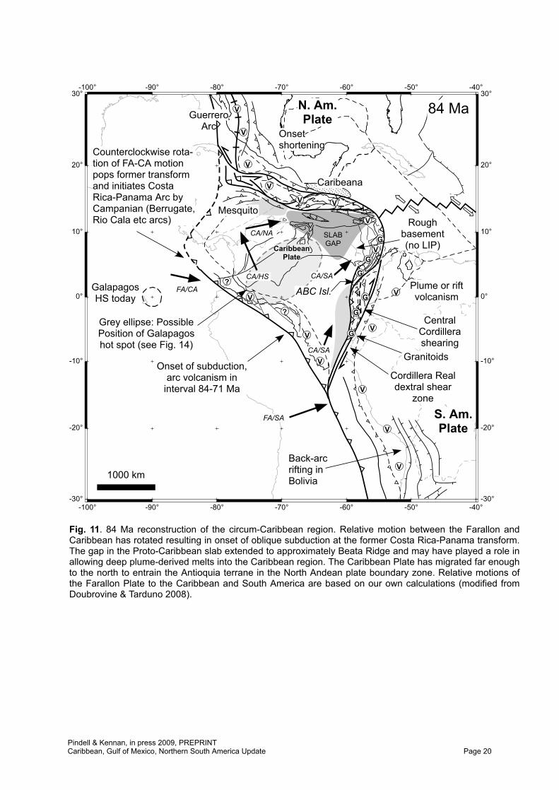
Fig. 11. 84 Ma reconstruction of the circum-Caribbean region. Relative motion between the Farallon andCaribbean has rotated resulting in onset of oblique subduction at the former Costa Rica-Panama transform.The gap in the Proto-Caribbean slab extended to approximately Beata Ridge and may have played a role inallowing deep plume-derived melts into the Caribbean region. The Caribbean Plate has migrated far enoughto the north to entrain the Antioquia terrane in the North Andean plate boundary zone. Relative motions ofthe Farallon Plate to the Caribbean and South America are based on our own calculations (modified fromDoubrovine & Tarduno 2008).
Pindell & Kennan, in press 2009, PREPRINTCaribbean, Gulf of Mexico, Northern South America Update Page 20
-100°
-100°
-90°
-90°
-80°
-80°
-70°
-70°
-60°
-60°
-50°
-50°
-40°
-40°
-30° -30°
-20° -20°
-10° -10°
0° 0°
10° 10°
20° 20°
30° 30°
V
V
V
V
V
V
V
V
V
G
V
V
V
V
V
Plume or riftvolcanism
Area to besubducted
Ductile shear zone abandoned
Cent. Cord. shearing
Mesquito
Renewed volcanism
CaribbeanPlate
SLABGAP
Post-rift strata
Siuna
Ophiolitesemplaced
Carib. Arccollision
W. Cord uplift and firstwest-derived sediments
Brittle faults step south
Antioquia
West. Cord.
ABCArc established
during Late Cret.
1000 km
71 Ma
CA/SA
FA/CA
CA/HS
CA/NA
??
FA/SA
FA/CA
FA/NA
N. Am.Plate
Guerrero Arc
S. Am.Plate
Grey ellipse: PossiblePosition of Galapagoshot spot (see Fig. 14)
GalapagosHS today
NascentProto-
Caribbeaninversion
zone
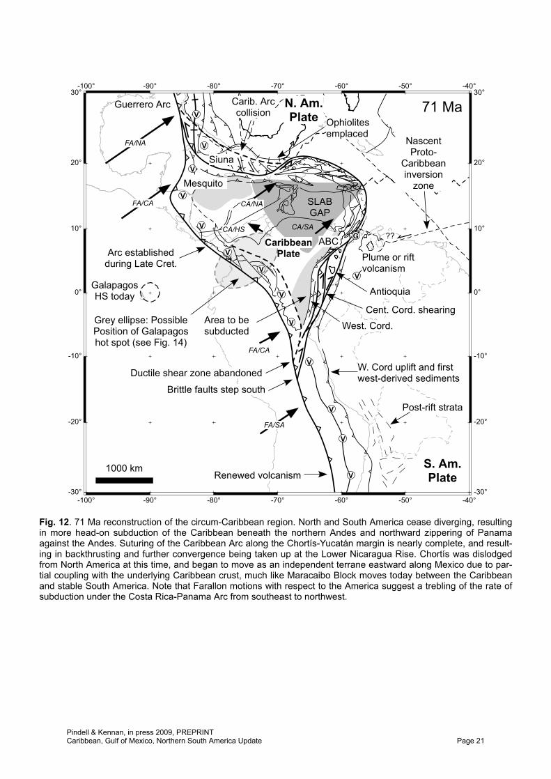
Fig. 12. 71 Ma reconstruction of the circum-Caribbean region. North and South America cease diverging, resultingin more head-on subduction of the Caribbean beneath the northern Andes and northward zippering of Panamaagainst the Andes. Suturing of the Caribbean Arc along the Chortís-Yucatán margin is nearly complete, and result-ing in backthrusting and further convergence being taken up at the Lower Nicaragua Rise. Chortís was dislodgedfrom North America at this time, and began to move as an independent terrane eastward along Mexico due to par-tial coupling with the underlying Caribbean crust, much like Maracaibo Block moves today between the Caribbeanand stable South America. Note that Farallon motions with respect to the America suggest a trebling of the rate ofsubduction under the Costa Rica-Panama Arc from southeast to northwest.
Pindell & Kennan, in press 2009, PREPRINTCaribbean, Gulf of Mexico, Northern South America Update Page 21
1330°
500°
1330°
1330°
1000°500° 1000°
B2Guayacán
SAM (Antioquia)
Rinconada melting,migrating back up
channel
Guayacán intrudesRinconada, JuanGriego,serpentinites,all at HP/LT
Antioquia etc batholiths(90-95 Ma), Guajíra andSanta Marta (65-54 Ma)
D
Quebradagrande suture(San Jeronimo F.)
Antioquia
Quebrada-grande EW W. Cordillera
50
10
80
km
500°
1000°
1330°
1330°
This section doesnot show originalSoAm slab (see
above, B2) belowhere
Fig. 13. Tectonic settings and proposed mechanisms for production of “subduction-initiation” (cross-section on mapA, and the southern of the two cross-sections on map C) and “STEP fault” (northern cross-section in map C) melts,which seem to form plutons very close to the plate boundaries (< 100 km). Upon subduction initiation (i.e. about140 km of convergence, achievable in < 3 Ma. for a plate convergence of 50 mm/a), the basaltic upper crust of thenew downgoing lithosphere (cross-sections B1, B2, D) must pass along the lower lithosphere of the hanging wall,which is hot (> 750°C) because it has not yet lost heat into the downgoing slab (i.e. subduction zone isothermshave not yet equilibrated to steady state). Thus, heat transfer can melt the hydrous, often sodic (due tometasomatism) basaltic oceanic crust and any subducted sediments, producing melts of gabbro-tonalitic and/ortrondhjemitic compositions which can (1) intrude other, firmer lithologies in the subduction channel; or (2) move upthe subduction channel some distance depending on volume and apparently intrude the hanging wall very near tothe trench, possibly along active faults. In the side-on viewpoint of cross-section E, a potential melt setting adjacentto STEP faults is shown. The South American (SAM) lithosphere is shown in dashed pattern, with the oceanicCaribbean and Proto-Caribbean lithospheres behind in grey. Setting where hydrous basalts and sediments contacthot SoAm lower lithosphere is indicated as the deep ovals. Examples of subduction initiation melts may include theAlbian Guayacán unit of Margarita (Maresch et al. 2009) while an example of a STEP fault melt may be theAntioquia Batholith of the Antioquia Terrane.
Pindell & Kennan, in press 2009, PREPRINTCaribbean, Gulf of Mexico, Northern South America Update Page 22
the Chortís Block would have led to north-vergent emplacement of the Siuna Terrane (Figs 10 and 11). We generally follow the syntheses of Pindell et al. (2005) and Rogers et al. (2007b, c) but further propose that the Siuna Belt of Nicaragua and Honduras continues on our palinspastic reconstruction to the east-southeast into the Chontal arc remnants in southeasternmost Mexico (Carfantan, 1986), and then into the “Tehuantepec Terrane” in the Gulf of Tehuantepec (see below, and Fig. 18), and on to the east into the Nicaragua Rise and Jamaica and into Cuba in the Caribbean Arc. This belt comprises arc and HP/LT subduction channel rocks that appear to be thrust northward onto the former North American margin. The emplacement was diachronous to the northeast, culminating in the Maastrichtian with the overthrusting of the southern Yucatán margin and Caribeana sediment pile, and creating the Sepur foredeep section of northern Guatemala (Pindell & Dewey 1982; Rosenfeld 1993; Garcia-Casco et al. 2008b). The occurrence of 132 and 139 Ma HP/LT rocks in this belt (Brueckner et al. 2005; Flores et al. 2007; Baumgartner et al. 2008) indicates to us that such Early Cretaceous material in this belt was dragged by transcurrent shear along the trans-American plate boundary from the western flank of Chortís (Figs 7–9).
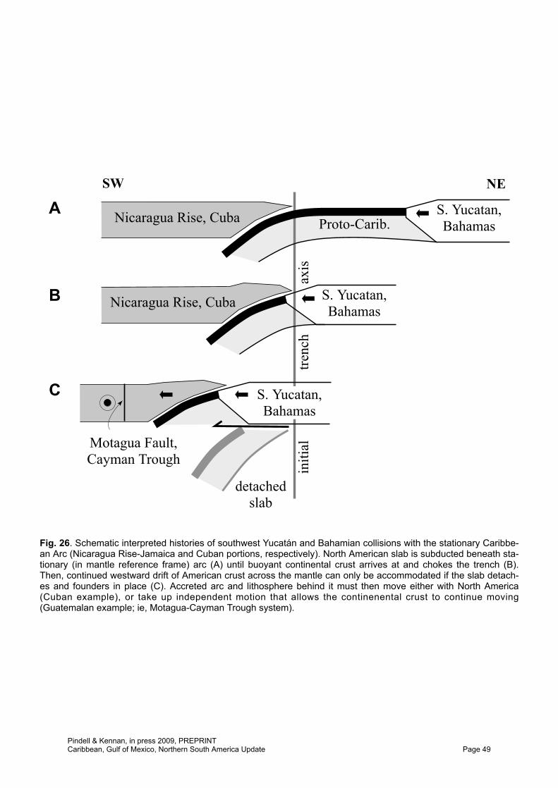
In response to the collision of the Caribbean Arc with eastern Chortís and southern Yucatán, northward subduction beneath the accreted terranes (Siuna, Tehuantepec, Nicaragua Rise, Jamaica) was established or renewed by backthrusting along a trend which may have been the site of pre-120 Ma eastward dipping subduction, with arc development continuing therein through the Early Eocene. Underthrusting of Caribbean lithosphere beneath the Chortís continental block was instrumental in the eventual acquisition of Chortís as part of the Caribbean Plate: we suspect that the subduction angle was low such that Chortís was effectively obducted onto the Caribbean Plate although shortening continued, much like the Maracaibo Block has been obducted onto the Caribbean Plate since the Oligocene (also flat slab, and still undergoing minor relative motion), such that the Maracaibo “block” is loosely being carried upon the Caribbean Plate as well. From a seismological perspective, the Mérida Andes today define the primary present Caribbean–South America plate boundary, whereas the South Caribbean foldbelt is the petrological (and longer term evolutionary) plate boundary. Like Maracaibo today, upon the underthrusting of Caribbean crust beneath Chortís in a flat slab geometry, basal coupling was likely strong enough by the Campanian–Maastrichtian to tear the Chortís hanging wall promontory from North America as the latter continued to drift to the west in the hot spot reference frame, thereby gradually transferring Chortís to the Caribbean lithosphere, a process completed by Eocene time.
Initiation of the western Caribbean plate boundary
The age of initiation of the western Caribbean plate boundary, defined today and during the Cenozoic by the Panama–Costa Rica Arc remains a critical issue for two reasons. First, it defines when the Caribbean and Farallon Plates became kinematically independent. Provided no additional plates in the eastern Pacific, Farallon Plate motions should define the motion and development of the Caribbean Arc until the western Caribbean boundary was formed. Second, if the inception of the western Caribbean subduction zone post-dated the general 88–92 Ma age of most Caribbean LIP extrusion, then the “Caribbean” LIP would actually have been a “Farallon” LIP in the absence of a boundary to differentiate the two plates.
Discrepancies for the age of inception range from the Aptian (Pindell & Kennan 2001), through Campanian (e.g. Pindell & Barrett 1990) to Palaeogene (Ross & Scotese 1988). The Aptian age proposed by Pindell & Kennan (2001) was based on the Calvo & Bolz (1994) claim that island arc volcaniclastic sandstones in the accretionary Nicoya Complex of Costa Rica are as old as Albian. However, Flores et al. (2003a, b; 2004; also Bandini et al. 2008) have since dated this section, called the Berrugate Formation, as Coniacian to lowest Campanian (88–83 Ma), and hence the stratigraphic inferrence for an Albian arc no longer exists. Arc magmatism was more certainly underway by 75 Ma based on geochemical analysis of dated exposed outcrops in Panama (Buchs et al. 2007; Buchs 2008). However, if the “arc” designation (Flores et al, 2004; Calvo & Bolz 1994) for the Berrugate Formation volcaniclastic rocks is correct, then it is possible that the sediments were sourced from unidentified arc rocks possibly now buried beneath the Cenozoic arc. In either case, a reasonable age for subduction initiation might be 80–88 Ma, considering that a slab needs several million years to reach depths
Pindell & Kennan, in press 2009, PREPRINTCaribbean, Gulf of Mexico, Northern South America Update Page 23
where melt can be generated. Such an age is at the young end of follows the period of most LIP extrusion (Kerr et al. 2003).
From the above, subduction at the southwestern Caribbean plate boundary appears to have begun just after the period of LIP extrusion. Thus the following mid-Cretaceous setting can be proposed for the western Caribbean. In the absence of a western Caribbean Benioff Zone, there would be no necessary southwestern limit to the area that might have been intruded by plume-type magmatism rising in or near the Proto-Caribbean slab gap, and the field of LIP magmatism might have extended farther southwest within the Farallon Plate than the future Panama–Costa Rica Trench. It is thus possible that the trench formed within the LIP field with perhaps some LIP extrusive rocks situated or still forming to the southwest of the impending plate boundary. Subsequent subduction at the trench would have led quickly to the accretion of LIP seamounts and plateau material at the Panama–Costa Rica accretionary complexes (e.g. Osa and Nicoya peninsulas, Hoernle et al. 2002; Buchs et al., 2009; Baumgartner et al. 2008). These accreted rocks would be potentially genetically and temporally correlative to the LIP rocks on the internal Caribbean Plate, such as those in Southern Hispaniola, Aruba, Curacaõ, eastern Jamaica, the lower Nicaragua Rise, and the basinal DSDP holes, because there was no subducting plate boundary to separate them when they formed. Such a site for subduction initiation adheres to the mechanical modelling of Niu et al. (2003), in which lateral buoyancy contrast between the thick/depleted oceanic plateau lithosphere and normal oceanic lithosphere plays a key role in initiating subduction beneath the more buoyant feature, which in this case would have been the core of the recently extruded Caribbean LIP. Also in this case, the initiation of northeast-dipping subduction agrees with a first order change in motion of the Farallon Plate with respect to the Caribbean. Preliminary calculations suggest that in the few million years prior to 84 Ma, Farallon motion was to the southeast with respect to the Caribbean, at some 85-120 km/Ma more or less parallel to the proposed Costa Rica–Panama transform margin (Figs 9–11). After 84 Ma, Farallon motion with respect to the Caribbean turned towards the east at about 55 km/Ma, which would substantially add to the horizontal stress at the margin of the LIP.
The idea of initiating the Costa Rica–Panama subduction zone within an active LIP field has another potential implication for the northwestern Nicoya Complex. There, highly deformed Jurassic radiolarites are encased with intrusive contact in younger (mid-Cretaceous) LIP type basalts (Denyer & Baumgartner 2006; Baumgartner et al. 2008). These authors offer two mechanisms for how this may have been achieved: (1) mid-Cretaceous LIP intrusion incorporated the original sedimentary strata on older crust as it formed a plateau; and (2) the deformed radiolarite slumped from the terrane at or north of the Santa Elena Peninsula (Costa Rica) and onto the LIP surface as it was extruded. Here, we offer a third option, which is that the nascent Costa Rica–Panama subduction zone continued to be the site of local LIP magmatism while initial shortening was beginning. The radiolarite may have been deformed by Coniacian–Santonian accretionary tectonism, concurrent with or followed by Santonian/younger basaltic melt flowing up the juvenile lithospheric scale fault zone that would become the subduction channel. The Nicoya Complex, then, could have formed in exactly the same setting where it occurs today, in the hanging wall of the Costa Rica–Panama Trench, with no need of further tectonic complexity, accretion, or translation. A fourth option will be suggested in the following section.
We accept that subduction at the Panama–Costa Rica Arc was initiated by Campanian time, defining a southwestern trailing edge of a “Caribbean Plate” (Fig. 11), with the boundary probably continuing southeast towards northern Peru. As with most of Costa Rica and Panama (except the Berrugate Formation), new age data for primitive island arc rocks from the southern end of this plate boundary (present-day Ecuadorian forearc), also suggest a post-Santonian, most likely Campanian, age for subduction initiation (Luzieux 2007; Vallejo 2007). In addition, the position and orientation of the Caribbean lithosphere shown (Fig. 11) leaves a large oceanic gap between northern Costa Rica and Chortís–Nicaragua Rise–Jamaica. As pointed out by Pindell & Barrett (1990), such a swath of crust between these arcs allows for contraction between them in the form of northward-dipping subduction. This allowed (1) Chortís–Jamaica to move east along Mexico while the Caribbean lithosphere moves northeast; (2) provides an explanation for continuous arc magmatism in Nicaragua Rise–Jamaica through the Early Eocene that otherwise is difficult to conceive of; and (3) predicts that the area of rough bathymetry of the lower Nicaragua Rise (below San Pedro Escarpment) was the site of subduction accretion of Caribbean upper crustal elements. However, apart from the Santa Rosa south-
Pindell & Kennan, in press 2009, PREPRINTCaribbean, Gulf of Mexico, Northern South America Update Page 24
vergent accretionary episode near Santa Elena Peninsula (Baumgartner et al. 2008), such accretion remains unproved for the Nicaragua Rise and this is one of larger outstanding questions regarding Caribbean evolution.
Beyond the above considerations for the time of subduction initiation at the western Caribbean boundary, there remains a larger issue associated with this boundary that involves the relative motions of the Pacific and Indo-Atlantic hot spots. As noted earlier, plate circuit determinations of Farallon Plate motion with respect to the Americas back to 84 Ma differ substantially from those based on motions with respect to Pacific hot spots assumed to be fixed to Indo-Atlantic hot spots. The assumption of global hot spot fixity is invalid but there do appear to be two independent hot spot reference frames, Indo-Atlantic and Pacific, within which the member hot spots have remained more or less fixed. Relative motion of these two reference frames can be calculated back to 84 Ma using plate circuits (see above) and older relative motion can only be crudely estimated. Thus, while the motion of the Caribbean Plate with respect to the Americas shown here (Figs. 9–11) is very similar to motions of the Farallon Plate with respect to the Americas in Engebretson et al. (1985), and would appear to suggest that the Farallon Plate and Caribbean Plate may not have become differentiated until about 84 Ma, we view this as coincidental.
Recent models for Farallon Plate motion with respect to the Pacific Plate (Müller et al. 2008) combined with either fixed Pacific hot spots (Wessel & Kroenke 2008) or models in which Pacific and Indo-Atlantic hot spots have moved with respect to one another after 84 Ma (Torsvik et al. 2008) give quite different results to Engebretson et al. (1985). Whether we assume hot spot fixity prior to 84 Ma, or estimate motion between Pacific and Indo-Atlantic hot spots, is not particularly important; Farallon motion between 120 Ma and 84 Ma in both cases is directed to the southeast, parallel to the proposed Costa Rica–Panama transform (pre-trench) boundary. Hot spot drift largely controls the rate (85–120 km/Ma) but not gross direction of relative motion. In order for Caribbean and Farallon motion to have been the same (one plate), the Pacific hot spot reference frame would have to migrate northwest with respect to the Indo Atlantic hot spot reference frame at a rate of at least 50–60 km/Ma from 125–100 Ma and 50–100 km/Ma from 100–84 Ma. These rates are equal to or exceed the northwestward motion of North America in the Indo-Atlantic hot spot reference frame, which we consider implausible.
A hybrid solution for prior to 84 Ma (semi-schematic vector nest inset on Fig. 9) allows for northwestward migration of the Pacific hot spots with respect to the Indo-Atlantic hot spots, but more slowly than the motion of North America. Our solution’s rate of motion between the reference frames for this time is broadly comparable to measurable rates after 84 Ma; unfortunately, there is at present no unique solution to this problem, as there is no available plate circuit, palaeomagnetic or other data that can be brought to bear. We consider it most likely that the Farallon and Pacific Plates differentiated from each other prior to 84 Ma, probably at the same time as the onset of westward-dipping subduction beneath the eastern Caribbean at 125 Ma. The suggested southeast-directed Farallon–Caribbean motion of 25–50 km/Ma (125–100 Ma), rising to 85 km/Ma (100–84 Ma) requires the development of a subduction zone (probably southeast-dipping) in the northwest Caribbean that terminates against a sinistral transform fault approximately parallel to the future Panama–Costa Rica Arc (Figs 9–11). Accepting this proposition, strain associated with the transform is a fourth possible mechanism for deforming Jurassic oceanic sediments in the Nicoya Complex of Costa Rica prior to the extrusion of Caribbean LIP basalts into them. The existence of an arc-to-transform transition in this boundary also provides a possible solution to the appearance of volcaniclastic sandstone of the Berrugate Formation in Costa Rica earlier than the Campanian volcanic rocks dated elsewhere. They may derive from the southwest end of the SW–NE-trending arc connecting Costa Rica to Mexico, have been deposited within the transform fault zone on the Farallon Plate, and transported perhaps 300 km towards the southeast from their origin in as little as c. 3 Ma.
The model suggests that a new intra-oceanic arc may have developed in the northwest Caribbean that would link to Mexico at a trench-trench-trench triple junction in the vicinity of the US–Mexico border. A good candidate is the intra-oceanic Alisitos Arc of Baja California (Sedlock 2003), which initiated at about 125 Ma probably not far from the continent (explaining the presence of older detrital zircons in associated volcaniclastic sediments) and accreted to the Mexican margin by 105 Ma. Between 125 Ma and eruption of the Caribbean LIP at c. 90 Ma the subduction of 750–1500 km of
Pindell & Kennan, in press 2009, PREPRINTCaribbean, Gulf of Mexico, Northern South America Update Page 25
Farallon crust beneath the northwest Caribbean would not prevent the eruption of plume-derived plateau basalts farther south.
Accretion of the Alisitos Arc and southward triple junction migration is a necessary consequence of the proposed plate configuration (Fig. 9). Intra-oceanic arc fragments accreted farther south than Baja may include the forearc of Central America (Geldmacher et al. 2008). The Caribbean–Chortís relative motions shown in our maps suggest that the trench-trench-trench triple junction migrated south until about 100 Ma, and thereafter the northeast-trending plate boundary was subducted beneath Chortís (Fig. 11). The rate of this plate boundary subduction would have increased markedly at about 84 Ma, when Farallon–Caribbean relative motion direction rotated towards the east. Associated burial, imbrication and uplift may be the origin of the c. 80 Ma thermal event that affected Guatemalan forearc rocks (Geldmacher et al. 2008). Much of the Mesquito Composite Oceanic Terrane (Baumgartner et al. 2008) between the continental Chortís Block and the Central American trench may be the result of the accretion-subduction of the trailing edge Caribbean Arc, while the Siuna Terrane southeast of Chortís may comprise leading edge Caribbean Arc and HP/LT rocks accreted to Chortís prior to the Albian, immediately before Mesquito accretion started. The 84 Ma change in Farallon–Caribbean relative motion initiated northeast-dipping subduction at the site of the proposed transform fault southwest of Costa Rica–Panama, leading to the onset of arc volcanism in those areas (Fig. 11). At the same time, slower and more oblique subduction on the proposed northeast-trending trench may have led to reduced arc volcanism between Costa Rica and Central America.
The Caribbean LIP (Large Igneous Province)
Between the North and South American zones of Caribbean plate boundary deformation, the Caribbean large igneous province (LIP), or plateau, was extruded across much of the pre-existing Caribbean oceanic lithosphere, in which coeval NE–SW extensional faulting was occurring (Driscoll & Diebold 1999; Diebold 2009). Pindell (2004) and Pindell et al. (2006) pointed out that the concurrence of seafloor spreading between North and South America and the consumption of the Colombian Marginal Seaway beneath the Caribbean lithosphere leads to the nearly inescapable conclusion that subduction of the Proto-Caribbean spreading ridge produced a slab gap beneath the Caribbean lithosphere from 125 Ma (onset of southwest-dipping subduction) through about 72 Ma (termination of Proto-Caribbean seafloor spreading). These authors loosely suggested that the Caribbean LIP might relate to mantle convection (ie, to the Proto-Caribbean spreading cell) associated with this slab gap, as this age range effectively brackets the age of most Caribbean LIP extrusion (Kerr 2003). Indeed, our plate reconstructions herein (Figs 10–12) place the slab gap directly beneath much of, but certainly not all, the Caribbean LIP’s known occurrence at the appropriate time. This includes our interpretation for the original area of the Bath-Dunrobin Formation of eastern Jamaica, recently classified as plume-related (Hastie et al. 2008), although the Bath-Dunrobin Formation may not have merged with the rest of Jamaica until Early Eocene time, after a history of end-Cretaceous accretion into the Lower Nicaragua Rise and subsequent NE-trending sinistral shear along with the Blue Mountain HP/LT suite. However, it is difficult to model the slab gap as having reached the southwestern Caribbean region: areas such as Costa Rica, Panama, and the Pacific coastal zone down to Ecuador probably did not overlie the Proto-Caribbean slab gap, so the slab gap concept is probably not a sole explanation for the Caribbean LIP. Having said that, it remains difficult to judge whether exposed “plateau-related rocks” along the Pacific forearc such as at the Nicoya and Azueros Peninsulas and Gorgona Island represent the Caribbean Plate’s hanging wall, with direct implications for the Caribbean LIP, or Farallon Plate seamounts/plateaus that were accreted into the Caribbean Plate’s forearc during subduction, with little implication for the Caribbean. Nonetheless, other areas of mid-Cretaceous “LIP-like” magmatism include the Oriente Basin of Ecuador (Barragan et al. 2005), Texas (Byerly 1991), and the Eastern Cordillera of Colombia (Vasquez & Altenberger 2005), which of course cannot pertain to a Proto-Caribbean slab gap model. In addition, geochemical arguments seem to require a deep mantle plume source for many of the Caribbean LIP magmas (Kerr, 2003), at odds with the idea of a convective spreading cell source in a slab gap. Thus, the mid-Cretaceous was a time of widespread igneous activity in the region with a probable deep mantle source, and only some of this activity occurred above the Proto-Caribbean slab gap. For these various reasons, we presently
Pindell & Kennan, in press 2009, PREPRINTCaribbean, Gulf of Mexico, Northern South America Update Page 26
consider that the Caribbean LIP was largely fed by deep mantle plume(s), but that the Proto-Caribbean slab gap allowed plume magmatism to reach the central and northeastern parts of the Caribbean lithosphere, perhaps focused by rising along the site of the subducted Proto-Caribbean convective spreading cell (a subducted Icelandic-type setting). Once the plume(s) reached the base of the Caribbean lithosphere, plume magma may have spread laterally over a larger area (possibly beyond the strict limits of the slab gap), from which it was locally able to propagate toward the surface along extensional faults at crustal (brittle) levels.
The slab gap concept appears to reconcile how large areas of the mid-Cretaceous Caribbean LIP show no sign of a supra-subduction signature, despite the strong probability that the LIP was extuded while southwest-dipping subduction of Proto-Caribbean lithosphere beneath the Caribbean Arc had occurred since the Aptian (Pindell 2004). We might also expect the LIP magmas above the Proto-Caribbean slabs flanking the slab gap to show some slab contamination, although no such contamination has yet been recognised. However, areas where this might have occurred have not necessarily been analysed. One such area that is predicted by our reconstructions to have overlain a subducted Proto-Caribbean slab flank, and that might show such contamination with further study, is the southwestern portion of Hispaniola (Sierras des Neiba and Bahoruco).
Accepting a mantle plume role in the Caribbean LIP, a point of ongoing debate is whether the palaeo-Galapagos hotspot was involved (Duncan and Hargraves 1984), if it indeed existed in the mid-Cretaceous (Hoernle et al. 2004). In view of the discussion above, integration of plate circuit data back to 84 Ma (Doubrovine & Tarduno, 2008) and Pacific Plate motion with respect to Pacific hot spots (Pilger 2003, after Raymond et al. 2000; Wessel et al. 2006; Wessel & Kroenke 2008) allow us to identify a significant westward drift of the Pacific hot spot reference frame relative to the Müller et al. (1993) Indo-Atlantic hot spot reference frame (Fig. 14). In addition, we extrapolate the curves back to 92 Ma, the approximate onset of most Caribbean plateau basalt magmatism. By placing the end points of these curves on the Galapagos Islands in the Indo-Atlantic hot spot projection of our maps, the curves denote the migration of the Galapagos hot spot by some 2200 km relative to the Indo-Atlantic reference frame. In addition, Steinberger (2002) proposed that the Easter Island hot spot drifts west relative to other Pacific hot spots at 10–20 mm/a due to return mantle flow from the Andes Trench. We suggest that the Galapagos hot spot may have behaved similarly with respect to Panama–Costa Rica Trench since its inception at about 75 Ma. If so, then this drift may add perhaps 800 km to the movement of the hot spot relative to the Indo-Atlantic hot spots compared to the plate circuit calculations (heavy grey arrow on Fig. 14, deviating from the Pacific drift curves at about 75 Ma). The solid flow line shown with ages is our estimate of the sum of these two processes. The two curves are drawn parallel from 92 to 75 Ma, after which time subduction may have driven the hot spot westwards relative to the central Pacific hotspots. We have crudely estimated the possible area (subject to large error) in which Galapagos hot spot magmatism may have occurred at the times shown. We suggest that there is a plausible match between the 92 Ma position of the predicted area of Galapagos hot spot magmatism and the 92 Ma position of the Caribbean basalt plateau (interpolated between the position on our 100 Ma and 84 Ma maps, Figs 10 and 11). Larger or smaller values for the subduction-related drift than 800 km would produce a less satisfactory fit. We chose this value because it is reasonable and provides a good match, but there is no independent way of refining the estimate, defining errors, or proving the Galapagos hot spot–Caribbean plateau relationship. Models that track the position of the Galapagos hot spot in the Indo-Atlantic reference frame or assume Cretaceous to Present fixity of Pacific and Indo-Atlantic hot spots fail to place the Galapagos hot spot beneath the Caribbean Plate (Pindell et al. 2006), but accounting for relative motion between these reference frames since 84 Ma (the oldest possible plate circuit) and possible westward or southwestward additional drift of the Galapagos hot spot due to deep return flow in the mantle driven by subduction suggests that a palaeo-Galapagos hot spot may well have been the source of the Caribbean Plateau, with the added factor that the Proto-Caribbean slab gap helped to focus the basalts very near to the Antilles volcanic arc. We show the position of the possible palaeo-Galapagos hot spot in relation to the Caribbean Plate, as reconstructed in Figure 14, on Figures 11, 12, and 15.
Pindell & Kennan, in press 2009, PREPRINTCaribbean, Gulf of Mexico, Northern South America Update Page 27
92
847156
Slab gap at 92 Ma
Caribbeaninterior at
92 Ma
-90° -80° -70° -60°
-90° -80° -70° -60°
-10°
0°
10°
20°
-10°
0°
10°
20°
Counter-subduction
drift
Inferred Galapagoshot spot drift relativeto Indo-Atlantic hot
spots
56, 71, 75, 84, 92? Ma
0
Pacific to Indo-Atlantic hot spot
drift curves
Fig. 14. Possible migration path since 92 Ma of the Galapagos hot spot relative to the Indo-Atlantic reference frameof our map set (heavy black line with ages shown). Ellipses show generously estimated errors. Finer weight curvesemanating from the Galapagos Islands: calculated motion histories of the Pacific hot spot reference frame relativeto the Indo-Atlantic frame, determined for the Galapagos hot spot (0°/90°W); grey line, Pilger (2003); black lines,Wessel (2006, 2008 - models 08A and 08G). Heavy arrow is a subjective correction to the above curves followingconcepts of Steinberger (2002; see text). Slant-ruled area is the estimated position of the Proto-Caribbean slab gapat 92 Ma, interpolated from Figures 10 and 11; note the proposed position of the hot spot lies entirely in line withthe slab gap, which we perceive allowed the deep mantle plume to reach the base of the overriding CaribbeanPlate. The Caribbean interior basin at 92 Ma is shown in grey. The palaeopositions of the Caribbean lithosphereand the Galapagos hot spot become superposed at 92 Ma, the age of most of the Caribbean Basalt Plateau. Also,the deep hot spot probably passed beneath the Panama-Costa Rica Trench in the Maastrichtian-Paleocene, justafter arc inception, but following most plateau magmatism. Paleogene plateau-type basalts at Azuero Peninsula(Hoernle et al. 2002) were likely accreted from the subducting plate after the passage of the hot spot beneath thearc, but some Paleogene basalts along Central America may pertain directly to the passage of the hot spot beneaththe arc itself.
Pindell & Kennan, in press 2009, PREPRINTCaribbean, Gulf of Mexico, Northern South America Update Page 28
Oblique subduction ofCaribbean partitionedonto Huancabamba-Palestina Fault Zone
Antioquia-Tahami
ABC
LaramideOrogen
Post-thrustgranitoids
San Jacinto
Grenada Basinopening
Oblique thrustingdrives foredeep
subsidence
1000 km
56 Ma
Mesquito
Mexican Arc
Proto-Caribbeaninversion
zone
Siuna
S. Am.Plate
N. Am.Plate
Grey ellipse: PossiblePosition of Galapagoshot spot (see Fig. 14)
GalapagosHS today
FA/NA
FA/SA
Fig. 15. 56 Ma reconstruction of the circum-Caribbean region, shown in the Indo-Atlantic hot spot reference frame.By this time, oblique intra-arc basins were opening as the Caribbean spreads into the wider Proto-Caribbean sea-way towards the Florida-Bahamas platform (Yucatán intra-arc Basin) and South America (Grenada intra-arc Basin).Subduction of Caribbean crust beneath Chortís-Jamaica arc trend is almost complete, which continues to accretethe composite Mesquite accretionary terrane. The northward zippering of the Panama Arc outside the Western Cor-dillera in Colombia continues. Subduction of Caribbean crust beneath Colombia was becoming more head-on.Slow convergence was underway by this time between North and South America: this shortening was likely accom-modated at the Proto-Caribbean subduction zone along northern South America, although it is not clear if thisstructure had formed along its entire length, or if it propagated east ahead of the Caribbean Plate with time.
Pindell & Kennan, in press 2009, PREPRINTCaribbean, Gulf of Mexico, Northern South America Update Page 29
Comparison with alternative scenarios for Aptian–Maastrichtian evolution of the Caribbean
In addition to the above Pacific-origin Caribbean model, there are two other types of Pacific-origin model for Cretaceous time: the “far-travelled Farallon–Guerrero Arc model” (e.g. Dickinson & Lawton 2001; Mann et al. 2007), and the “delayed polarity reversal model” (e.g. Burke 1988; Kerr et al. 2003). Both these models have features that appear to be incompatible with geological observations in the circum-Caribbean region.
Far-travelled Farallon–Guerrero Arc models place a subduction zone at the leading edge of the Farallon Plate (that is, future Caribbean lithosphere) far to the west of the Americas at c. 125 Ma, migrating east and consuming “Mescalera” or “Arperos” oceanic lithosphere which itself is presumed to concurrently subduct eastward beneath the Cordilleran and Trans-American plate boundary. Apparent geological contradictions include: (1) the lack of an explanation for continental crustal fragments or continent-derived sediment in the Caribbean and Guerrero arcs; (2) the timing of interaction of the Caribbean Plate with the Trans-American Arc (90 Ma) that we believe is 30 Ma too late (in the Mann et al. 2007 version at least); and (3) lack of evidence for amalgamation of two discrete arcs and subduction complexes in the Caribbean Arc.
Delayed polarity-reversal models call for east-dipping subduction of Farallon lithosphere beneath the Trans-American Arc until c. 80–88 Ma, when it is proposed that the Trans-American trench was choked by the newly erupted Caribbean basalt plateau, thus forcing subduction polarity to reverse. A key argument for this model is that the basalt plateau occurs very near to the Caribbean Arc (especially in Hispaniola), and that this magmatic incompatibility can be resolved by allowing for subduction of some amount of intervening crust (between the plateau and arc) prior to juxtaposition. However, accepting that the line of juxtaposition (lower Nicaragua Rise, Los Pozos Fault zone in central Hispaniola, and the Muertos Trough) is the site of post-plateau shortening and dislocation (Pindell & Barrett 1990; Dolan et al. 1991; maps herein), this argument becomes less compelling. Further, delayed reversal models do not explain: (1) the history of HP/LT metamorphism in the northern Caribbean beginning at about 118 Ma; (2) the lack a disruptive event at 80–90 Ma in the P-T-t paths of such rocks; or (3) lack of evidence for major arc-wide uplift, erosion and cooling at 80–90 Ma. Further still, we wish to emphasise that the slab gap aspect of our model herein does allow for plume rocks to be emplaced quite near to, but not within, the active Caribbean Arc (Fig. 11).
MAASTRICHTIAN–PALAEOGENE EXPANSION OF THE CARIBBEAN PLATE INTO THE PROTO-CARIBBEAN SEAWAY
The Maastrichtian–Palaeogene evolutionary interval (Figs 12 and 15–17) involves: (1) the cessation of Proto-Caribbean seafloor spreading by 71 Ma (Pindell et al. 1988; Müller et al. 1999); (2) north-vergent inversion (potentially developing into south-dipping subduction) along the foot of the northern South American rifted margin (Pindell et al. 1991, 2006; Pindell & Kennan, 2007b); (3) the migration of the Caribbean Arc from the Yucatán–Guajíra “bottleneck” to the Bahamas and western Venezuelan collision zones (Pindell et al. 1988, 2005); (4) the opening of the Yucatán (Pindell et al. 2005) and Grenada (revised model proposed here) intra-arc basins as a means of the arc expanding into the Proto-Caribbean Seaway, which was wider than the Yucatán–Guajíra bottleneck, and maintaining collisional continuity with the American margins (Pindell & Barrett 1990); (5) the migration of Chortís–Nicaragua Rise–Jamaica along southwestern Mexico/Yucatán (Pindell et al. 1988); (6) polarity reversal/onset of northward dipping subduction of Caribbean lithosphere at the Lower Nicaragua Rise, which we believe was the cause of arc magmatism in the eastward migrating Nicaragua Rise–Jamaica and took up the convergence between that terrane and the Caribbean Plate while the latter migrated northeast into the Proto-Caribbean Seaway (Pindell & Barrett 1990); and (7) the poorly-dated Eocene amalgamation of the Chortís and Panama–Costa Rica arcs into a single Middle American arc. Here, we will focus new considerations on the Motagua Fault Zone of Guatemala and the opening history of the Grenada and the Tobago basins.
Figure 18 shows the relationship of the Motagua Fault Zone of Guatemala to the broad and diffuse Cocos–North America–Caribbean triple junction in southern Mexico, Guatemala, and El Salvador. A smooth and continuous eastward migration of Chortís from a position off southwest
Pindell & Kennan, in press 2009, PREPRINTCaribbean, Gulf of Mexico, Northern South America Update Page 30
-100°
-100°
-90°
-90°
-80°
-80°
-70°
-70°
-60°
-60°
-50°
-50°
-40°
-40°
-30° -30°
-20° -20°
-10° -10°
0° 0°
10° 10°
20° 20°
30° 30°
NIC
PANMAR
HIS
AVE
YUC
CHI
GOM
CHO
GRAN
PR
Past position ofpresent coastlinein hotspot refer-ence frame
FarallonPlate
46 Ma
Palinspastic restorationof present coastline
Proto-CaribbeanInversion
Zone
EasternCordilleraAltiplano
SIU
1000 km
GalapagosHS today
S. Am.Plate
N. Am.Plate
FA/NA
FA/SA
CaribbeanPlate
Fig. 16. 46 Ma reconstruction of the circum-Caribbean region, shown in the Indo-Atlantic hot spot reference frame.Northward drift of the Caribbean (in the hot spot frame) has stopped. Collision of Cuba with the Bahamas Platformterminated the opening of the Yucatán Basin and resulted in continued Caribbean-North America relative motionoccurring on the Cayman Trough. The end of subduction beneath Chortís and Nicaragua Rise resulted in theirbeing incorporated into (but actually onto) the Caribbean Plate. The southeastern Caribbean Plate advanced south-east toward the central Venezuelan margin along the Lara transfer zone northeast of Lake Maracaibo. The south-ern part of the Panama Arc was accreting into the Ecuadorian forearc. Caribbean-South America motion rotatesalmost orthogonal to the Huancabamba-Palestina Fault Zone slowing the rate of northward terrane migration in theNorthern Andes.
Pindell & Kennan, in press 2009, PREPRINTCaribbean, Gulf of Mexico, Northern South America Update Page 31
1000 km
33 Ma
-100°
-100°
-90°
-90°
-80°
-80°
-70°
-70°
-60°
-60°
-50°
-50°
-40°
-40°
-30° -30°
-20° -20°
-10° -10°
0° 0°
10° 10°
20° 20°
30° 30°
CAY
PANMAR
HIS
AVE
YUC
CHI
GOM
CHO
GUA
PR
Altiplano
GalapagosHS today
CaribbeanPlate
FarallonPlate
N. Am.Plate
S. Am.Plate
FA/SA
Proto-CaribbeanInversion
Zone
FA/NA
Past position ofpresent coastlinein hotspot refer-ence frame
Palinspastic restorationof present coastline
Fig. 17. 33 Ma reconstruction of the circum-Caribbean region, shown in the Indo-Atlantic hot spot reference frame.North America-Caribbean plate boundary is taking on the form of today‘s boundary system. South America-Caribbean motion is ESE-directed, resulting in overthrusting of Caribbean terranes onto central and eastern Vene-zuela. Southeast dipping subduction beneath the northern Andes at the western South Caribbean Foldbelt waspropagating eastward to the north of Maracaibo Block. As the oblique collision progressed along Venezuela, contin-ued convergence would necessarily transfer to this eastward-propagating, south-dipping South Caribbean Foldbelt.
Pindell & Kennan, in press 2009, PREPRINTCaribbean, Gulf of Mexico, Northern South America Update Page 32
Mexico is commonly portrayed using the eastward-younging onset of arc magmatism in southern Mexico as a yardstick (Pindell & Barrett 1990; Ferrari et al. 1999). However, as shown here (Fig. 18) and as pointed out by Keppie & Morán (2005) and Guzman-Speziale & Meneses-Rocha (2000), this is not necessarily a simple case of triple junction migration. A precise definition of the plate boundaries in the region is not yet to hand, and thus it is not clear how to restore the crustal elements in the region back in time. This complexity, along with an apparent lack of disruption in gravity data and seismic lines in the Gulf of Tehuantepec, led Keppie & Morán (2005) to question the commonly inferred westward trace of the Motagua Fault toward the Middle America Trench, and hence to doubt whether Chortís and Mexico had been adjacent in the Cretaceous, despite the lithological similarities between Chortís and the Oaxaca and Mixteca terranes of Mexico (e.g. Rogers et al., 2007b). These authors position Chortís out in the Pacific away from Mexico, employing faults visible on seismic at about 14.3°N in the offshore forearc as a means of deriving Chortís from the WSW. These concerns caused us to question the nature of the crust in the Gulf of Tehuantepec, which we refer to here as the Tehuantepec Terrane, and which Keppie & Morán portray as a fairly stable block bounded by the Middle America Trench to the southwest and by the Chiapas Massif to the northeast (Fig. 18). First, we ruled out that this crust belongs to Yucatán, as we are confident that the transform that carried Yucatán and Chiapas Massif to their present positions crosses the Isthmus of Tehuantepec from the Veracruz Basin and runs parallel to and along the southeast flank of the Chiapas Massif (the “Tonalá Fault” sensu Geological Survey of Mexico), and not farther west (see Figs 5–7). Second, we could not accept that the Tehuantepec Terrane once belonged to Chortís, because the magnitude of shortening in the Chiapas Foldbelt (less than c. 70 km) is too small for the terrane to restore south of the eastward projection of the southern Mexican trench, which we would expect had the terrane originated from the southwestern margin of Mexico. Third, the terrane could be an ESE extension of the Sierra Madre del Sur of Mexico, but the presence of Upper Cretaceous volcanic rocks (“Turonian–Santonian basalt, dacite, and tonalitic agglomerate”; Sanchez-Barreda 1981; Keppie & Morán 2005) in well SC-1 (Fig. 18) from this terrane is atypical of southern Mexico. Thus, we consider that it may be a remnant fragment of the Caribbean Arc which, rather than Chortís, was judged to have collided with Mexico here by Pindell & Dewey (1982). The allochthonous Tehuantepec terrane would logically connect the allochthonous Siuna Belt with the Nicaragua Rise and Jamaican portions of the Caribbean Arc, collectively forming the arc’s western end (Figs 11, 12). In addition, a small area of poorly dated Cretaceous volcanic rocks onshore Mexico (the Chontal Arc volcanic rocks, Carfantan 1986; Fig. 18) could be equivalent and also a part of this allochthonous trend. The Tehuantepec Terrane would thus have been isolated and acquired by North America upon the Maastrichtian onset of transcurrent motion along the North Chortís–Motagua Fault Zone after the collision of the arc with Yucatán/Chiapas Massif.
Considering the Tehuantepec Terrane may have once been part of the Caribbean Arc, it is possible that most of the Caribbean–North American relative Plate motion has passed south of the Tehuantepec terrane in the zone of intense seismicity at about 14.3°N and 93°W (Fig. 18). This also satisfies Keppie & Morán’s concerns about the apparent paucity of faulting farther north where most authors have drawn the westward extension of the Motagua Fault. However, broad strain is also evident in Chiapas, where perhaps 100–200 km of dextral transpressive movement has occurred on the Polochic Fault in Neogene–Quaternary times. Displacement of the Tehuantepec Terrane seems to be a part of this story as is implied by the strong NE–SW trending negative gravity anomaly in the northwesternmost Gulf of Tehuantepec, which may be a break-away detachment between the Tehuantepec and Sierra Madre del Sur. Restoration of about 70 km shortening in the Chiapas Foldbelt (Tectonic Analysis Inc., unpublished data) would appear to realign the southwest flank of the Tehuantepec terrane with a smooth ESE-ward projection of the Mexican trench. If the bulk dextral strain can be shown to be larger than 100–200 km in the Chiapas–Tehuantepec region, then we would expect transfer of motion into the area from as far inland as the Trans-Mexican Volcanic Belt (Fig. 18). In conclusion, the Chortís Block appears to have passed the Gulf of Tehuantepec to the south of the Tehuantepec terrane, using faults acknowledged on seismic by Keppie & Morán (2005) that lie in a zone of strong seismicity. The deformation in southeastern Mexico is only secondary by this reasoning, and may be very much the result of this area becoming the hanging wall to a subduction zone only since the Miocene by the eastward movement of Chortís, especially one where a buoyant ridge (Tehuantepec Ridge) is entering the trench.
Pindell & Kennan, in press 2009, PREPRINTCaribbean, Gulf of Mexico, Northern South America Update Page 33
-100°
-100°
-99°
-99°
-98°
-98°
-97°
-97°
-96°
-96°
-95°
-95°
-94°
-94°
-93°
-93°
-92°
-92°
-91°
-91°
-90°
-90°
-89°
-89°
-88°
-88°
-87°
-87°
12° 12°
13° 13°
14° 14°
15° 15°
16° 16°
17° 17°
18° 18°
19° 19°
POLOCHIC FZ
MOTAGUA FZ
JOC.-CHAM. FZ
CHIAPAS MASSIF
CHIAPAS FOLDBELT
LOMA
BONITA-VIBORAFZ
TONALA FZ
Anomalous seismicity?
SWAN ISLAND FZ
Restored Miocenetrace of trench
Proposed throughgoing continua-tion of N. Caribbean transform iscopolar with S. Mexican trench
Seismic lines acrossTehuantepec Terrane
Tehu
antep
ecRidg
e
Pervasivenormalfaults
Accreted Cret.terranes
YUCATÁN
CHORTÍS
?
?
??
?
?
EL TAMBORN, S HPLT
Wells
SANTA CRUZOPHIOLITE
ChontalTerrane
Tehuantepec Terrane
Fig. 18. North America-Cocos-Caribbean diffuse triple junction, showing seismicity, gravity, major faults, and ourproposed Caribbean Arc fragments (Chontal and Tehuantepec terranes). In contrast to Keppie & Morán (2005), weinterpret the proposed plate boundary between Chortís and the Tehuantepec and Yucatán terranes to be co-polarwith a palinspastic trace of the southern Mexico trench (the Present kink at the western Gulf of Tehuantepec beingthe result of young shortening in Chiapas). Thus, Chortís can viably migrate from southern Mexico (path of dashedline, prior to Chiapas shortening). Chortís must deform as it migrates from west to east, but the balance betweenblock rotation and N-S oriented sinistral shear is uncertain. Numerous N-S trending grabens that now reflect W-Estretching in the tail of Chortís may have initiated as sinistal shears.
Pindell & Kennan, in press 2009, PREPRINTCaribbean, Gulf of Mexico, Northern South America Update Page 34
Acknowledging the possible existence of a swath of Caribbean Arc forearc in the Gulf of Tehuantepec, which should possess HP/LT metamorphic rocks like all the other circum-Caribbean forearc terranes, is potentially significant with regard to assessing the history of the Motagua Fault Zone. Donnelly et al. (1990) built a case for a Chortís–Yucatán collision, and argued that the nearby occurrences of the El Tambor HP/LT rocks on the northern and southern flanks of the Motagua Valley disproved a large strike slip displacement along the Motagua Fault. This view requires the Cayman Trough to be seen as something other than a Tertiary pull-apart basin, which in turn makes it difficult to reconcile the Eocene to Recent history of subduction related magmatism in the Lesser Antilles, which requires significant (c. 1000 km) Caribbean–North America displacement. Since then, 40Ar-39Ar cooling ages on the northern and southern El Tambor HP/LT rocks have been shown to be different, i.e., c. 120 Ma and 70 Ma, respectively, and this discovery, in conjunction with an acceptance of the overwhelming evidence for large displacements on the Motagua Fault Zone, led to the proposal of the former existence of two entirely distinct subduction zones with opposing polarities and different times of collisional uplift (Harlow et al. 2004). The 120 Ma cooling event was interpreted as an emplacement of the southern El Tambor rocks onto Chortís (N-dipping subduction) which occurred between Chortís and southwest Mexico, while the 70 Ma collision, emplacing the northern El Tambor rocks onto Yucatán (S-dipping subduction), was interpreted as Pindell & Dewey (1982) did as marking the collision between the Caribbean Arc and Yucatán. The different collisional settings were proposed in order to allow the acknowledged large strike slip offset to bring the southern and northern Tambor units together today. This complex model survives, despite the more recent acquisition of Nm-Nd ages on both the northern and southern Tambor units of about 132 Ma (Brueckner et al. 2005; Ratschbacher et al. 2009), which suggests instead to us that they may both have formed in the same subduction zone, though not necessarily in the same place. In addition, a hypothetical Late Jurassic rifting event between Chortís and Mexico is proposed as part of this model (Mann, 2007) in order to create an oceanic basin that might have started to close by 130 Ma and been sutured by 120 Ma.
We do not accept that the proposed rift event led to the opening of a seaway with oceanic crust basement between Chortís and southern Mexico; we see no evidence for a rifted margin on northern Chortís on a scale compatible with creation of an oceanic basin, and neither is there any sign of a Late Jurassic–Early Cretaceous north-facing sedimentary margin or syn-collisional foredeep basin in northern Chortís onto which the southern El Tambor was supposedly emplaced during the Aptian, which appears to have been a time of extension in central Chortís (Rogers et al. 2007a). Instead, we stick to the original Chortís–Mexico relationship of Pindell & Dewey (1982), Pindell et al. (1988), and Rosenfeld (1993) in which the Caribbean Arc, rather than Chortís, collided with southern Chiapas Massif and southern Yucatán to create the Motagua ophiolitic Suture with its HP/LT rocks, and in which Chortís later migrated eastward to create the Motagua shear zone. At issue is the mode and timing of juxtaposition of the El Tambor South unit with the Las Ovejas metamorphic rocks and San Diego Phyllite of the Chortís Block. Pindell & Barrett (1990) stated in their note added in proof, that “emplacement of the [southern] El Tambor onto Chortís could be a Cenozoic extrusion (flower structure) during strike slip [on Motagua Fault], prior to most Neogene motion through Guatemala on the Polochic Fault (Burkart, 1983). In cross section only, the resulting orogen appears as a collision between Chortís and Yucatán.” Similarly, the appearance of a collision between Chortís and southern Mexico may be misleading. If, during southeastward transpressive migration of Chortís towards its present position, strain were strongly partitioned between sinistral slip and orthogonal thrusting, it would be possible to superimpose Cenozoic sinistral shear on slightly older thrust structures while Chortís lay south of Tehuantepec.
Pindell et al. (2005) compiled data to show that HP/LT metamorphic ages in the Caribbean Arc span the period of active Caribbean Arc subduction, from the onset of southwest-dipping subduction to collision. In Cuba and in Hispaniola, cooling ages on HP/LT mineral suites begin at about 118 Ma and continue up to about 70 Ma in Cuba (Garcia-Casco et al. 2008b; Stanek et al. 2009) and younger in Hispaniola (Krebs, et al. 2008), defining the period of subduction from initiation to collision with “Caribeana”, a sediment pile deposited along southern Yucatán, and the Bahamas. The Cuban ages in particular are within the errors of the 40Ar-39Ar cooling ages for the two groups of El Tambor HP/LT rocks (northern and southern), a fact that we expect is significant, possibly placing both El Tambor HP/LT units along the same Caribbean Arc trench, although originally separated by
Pindell & Kennan, in press 2009, PREPRINTCaribbean, Gulf of Mexico, Northern South America Update Page 35
many hundred km along strike. However, 132 Ma Sm-Nd ages from the Guatemalan rocks have not yet been found in Cuba or Hispaniola.
We propose a history for the southern and northern El Tambor suites that is intimately related to that of the Caribbean Arc, and has nothing to do with a hypothetical Chortís–Mexico collision. In the Late Jurassic and Early Cretaceous, eastward-dipping subduction beneath the Americas is indicated by continental volcanic arc belts east of coeval subduction complexes at the coast. We infer that Chortís was part of this continental belt, and that the dense rocks beneath the Sandino Basin of western Chortís pertain to a primary east-dipping Benioff Zone that remains active today, although it has stepped westward somewhat since the Early Cretaceous. As the gap between the Americas grew between 140–125 Ma, a largely transcurrent boundary spanned the gap between Chortís and Ecuador, along which arc, forearc, and subduction complex terranes of western Mexico and Chortís, mostly oceanic but partly continental, should have migrated southeast due to the obliquity of convergence, taking up a position south of Chortís along the transcurrent plate boundary. We consider the El Tambor North and South as well as the Siuna terrane with its 139 Ma 40Ar-39Ar age (Baumgartner et al. 2008), as well as Grenville age continental blocks in the subduction mélange of central Cuba (Renne et al. 1989), were carried along in this manner. We suggest that these HP/LT terranes lay southwest of Acapulco at 130 Ma (Fig. 6). By the early Aptian, Farallon–North American relative motion became much more NE-SW (Engebretson et al. 1985), triggering convergence at the previously transcurrent boundary which we argue was manifested as the onset of southwest-dipping subduction of Proto-Caribbean lithosphere beneath the band of terranes that would go on to form the underpinnings of the Caribbean Arc (Pindell et al. 2005). The inception of southwest-dipping subduction began the cooling and uplift, possibly by subduction zone counterflow, of HP/LT metamorphic rocks in the new Caribbean Arc hanging wall. The southern El Tambor eclogites were uplifted early on (c. 125–118 Ma), and subsequently remained above the 40Ar-39Ar blocking temperature in the hanging wall. Continued Southwest-dipping subduction into the Late Cretaceous produced younger HP/LT rocks as well, and the initial collision of the Tehuantepec–Nicaragua Rise–Jamaica terrane with the southern Chiapas Massif and Yucatán margin caused HP/LT metamorphism in some of the passive margin sediment wedge strata (Caribeana, Garcia-Casco et al. 2008b) and some Yucatán marginal basement slices (e.g. Chuacús Formation, Martens et al. 2008). This belt of marginal basement and overlying sediments was uplifted and cooled in the Maastrichtian by obduction onto Yucatán, imbricating Proto-Caribbean oceanic crust (Santa Cruz Ophiolite) and Yucatán shelf strata (Cobán, Campur), and producing the Sepur foredeep basin (E-ward younging) of northern Guatemala and Belize (Pindell & Dewey 1982). The obduction set the Maastrichtian 40Ar-39Ar cooling ages for northern El Tambor and Chuacús HP/LT rocks (Harlow et al. 2004). In this model, the fact that the northern El Tambor unit carries a 132 Ma Sm-Nd age, like the southern El Tambor, could imply that (1) the northern El Tambor is equivalent to but along strike of the southern El Tambor, but that it was subducted deeper again after 120 Ma to reset the 40Ar-39Ar age in the subduction channel prior to uplift at 70 Ma, or (2) some of the original 132 Ma HP/LT material remained continuously above the 40Ar-39Ar blocking temperature (i.e. presumably deeper) until the Maastrichtian. Either possibility is interesting: the former suggests that rock can flow upwards and downwards in a subduction channel before final exhumation, the latter that rock may reside at depth in subduction channels for long periods of time (60 Ma).
From the above, we appear to have a simple means of introducing HP/LT complexes with cooling ages ranging from Early Cretaceous (and potentially older) through Maastrichtian along the southern flank of Chiapas Massif–southern Yucatán, including in the Gulf of Tehuantepec, without invoking collision of Chortís with Mexico or Yucatán, for which evidence is lacking. This is the also the case in Cuba and Hispaniola where Chortís–Yucatán collision obviously never occurred. The question is, then, can the southern El Tambor rocks be emplaced onto Chortís during a non-collisional strike slip migration of Chortís along the zone of arc accretion against Yucatán? Sisson et al. (2008) reported fission track ages for the northern basement rocks of Chortís of 35–15 Ma, demonstrating that these rocks cooled through 200–100°C and were situated at considerable depth prior to this time. The uplift presumably pertains to compressional extrusion of rock adjacent to the Motagua Fault Zone. Nearby occurrences of Upper Cretaceous and Palaeogene strata (Valle del Angeles and Subinal) attest to this vertical uplift being only local, adjacent to the fault. In addition, Ratschbacher et al. (2009) shows that the metamorphism and migmatisation of the Las Ovejas unit associated with the southern
Pindell & Kennan, in press 2009, PREPRINTCaribbean, Gulf of Mexico, Northern South America Update Page 36
El Tambor pertains to a mid-Tertiary deformation and cooling event. Thus, it seems likely that all these rocks were uplifted significantly during the Cenozoic transcurrent phase. A collection of tectonic flakes, caught between southward-vergent thrusts to the south and the Motagua shear zone on the north, would allow these rocks to be juxtaposed and to shallow and cool, without any stratigraphic record of the juxtaposition. As for the place of origin of the southern El Tambor HP/LT rocks, today's near juxtaposition with the northern Tambor (only 80 km displacement) is likely coincidence only. It cannot be ruled out that the same relationship does not extend east and west, if only outcrop permitted it to be seen; the strike slip offset cannot be measured because it is potentially larger than the exposed area over which total displacement markers might be found. This brings us back to the Tehuantepec terrane, which may well have been the original pre-transcurrent site of southern El Tambor HP/LT rocks. If so, they have been uplifted by some 8 to 10 km while migrating along the flank of a transcurrent fault zone some 400 to 700 km. Such as history of uplift should not be surprising.
Another key aspect of this evolutionary stage is the opening of the Grenada–Tobago Basin, one of the two Caribbean intra-arc spreading basins of Palaeogene age, the other being the Yucatán Basin (Pindell & Barrett 1990; Rosencrantz 1990). Pindell et al. (2005) addressed the opening kinematics of the Yucatán Basin so we will focus on the Grenada Basin here, generally regarded as an intra-arc basin that opened as arc magmatism died at the Aves Ridge (remnant arc) and either began or continued at the Lesser Antilles frontal arc in the Palaeogene (Pindell & Barrett 1990; Bird 1999). Although the basement of the Grenada Basin remains unsampled, seismic stratigraphy and heat flow measurements also suggest a Palaeogene age (Speed et al. 1984). Speed & Walker (1991) go so far as to suggest that Eocene MORB-type basalts on Mayreau are uplifted Grenada Basin oceanic crust.
An important clue to the opening kinematics of the Grenada Basin is that the “Caribbean Arc” collided obliquely with both the Bahamas and western Venezuela concurrently, in the Palaeogene. The progressive oblique collision in the south is recorded by foredeep loading of the western Venezuelan margin (Fig. 19), and Caribbean volcanic terranes were clearly providing the tectonic load as shown by sandstone compositions of the foredeep fill (Zambrano et al. 1971; Pindell et al. 2009). Although slow convergence between the Americas was underway, the combined Palaeogene N–S shortening in the northern and southern Caribbean was far greater and faster, such that a single Caribbean “Plate” could not have driven both collisions. In the absence of any evidence for internal expansion at this time of the Caribbean Plate itself, Pindell et al. (1988) and Pindell & Barrett (1990) therefore proposed that the Grenada Basin had a N–S component of opening great enough for a frontal arc terrane east of the forming basin to have driven the southern oblique collision, and suggested that rollback of the South American margin was responsible. The basin was drawn by these authors as a dextral pull-apart type intra-arc basin with N–S extension which accorded with possible magnetic anomaly lineations (Speed et al. 1984) in the presumed oceanic crust (based on refraction; Officer et al. 1957, 1959) of the deep basin, although Bird et al. (1999) refute the idea that the magnetic lineations are spreading related.
Here, we consider a modified opening model with a north–south kinematic component. Both gravity trends and regional structure contours to basement for the greater Grenada and Tobago basins define a fan-like shape (Speed et al. 1984; Speed & Walker 1991) whose apex is in the direction of the Bonaire Basin to the west. In the northern part of the Grenada basin, thought to comprise foundered arc basement, linear basement features trend ENE, which we interpret as shoulders of normal faults having SSE motion on them. In the deeper southern, presumably oceanic, part of the basin, and in the Tobago Trough as well, the basement structural grain strikes ENE, again hinting at an SSE extensional direction. East of the Lesser Antilles islands, the Caribbean crystalline forearc appears to be rifted into an array of basement blocks (Tobago Terrane, St Lucia Ridge, La Desirade High) with intervening gaps (Tobago Trough and the basement lows east of Martinique, north of La Desirade, and east of Barbuda). Superimposed upon this composite Eocene basement fabric, the Eocene and younger Lesser Antilles Arc volcanic pile has loaded (and deepened) the crust in the flanking basins. To the south, the Margarita–Los Testigos Ridge (which may continue northeastward as a basement horst coring the Lesser Antilles Arc) is flanked by two linear basinal trends, the La Blanquilla and the Caracolito basins (Ysaccis 1997; Clark et al. 2009), that have been inverted by perhaps 40 km and 20 km during the Middle Miocene collision between the Caribbean crust and Eastern Venezuela, respectively. These two basins deepen to the northeast into the oceanic domains of the Grenada Basin and Tobago Trough.
Pindell & Kennan, in press 2009, PREPRINTCaribbean, Gulf of Mexico, Northern South America Update Page 37
Fig. 19. Foredeep subsidence method of tracking Caribbean-South America displacement history, revised afterPindell et al. (1991). (a) Sediment accumulation curves for six autochthonous or parautochthonous locations alongthe margin from west to east. Typical passive margin subsidence histories persist until the times of Caribbean arriv-al, thereby loading the margin and initiating foredeep subsidence whose basal formations in each sub-basin areindicated in B. Foredeep onset clearly youngs eastward. However, the distance of foredeep advance along themargin is larger (c. 1500 km) than the true relative plate displacement (c. 1200 km) due to obliquity of convergence(indicated by the arrows in B). (b) Map of Caribbean advance relative to a palinspastically restored South Americathat is also rotated back to its Maastrichtian position relative to North America when convergence began, showingthe times of forearc collision in Ma and the positions and names of formations recording foredeep subsidence. Notethat motion since 10 Ma has been essentially transcurrent in Eastern Venezuela and Trinidad (Pindell et al. 1998).
Pindell & Kennan, in press 2009, PREPRINTCaribbean, Gulf of Mexico, Northern South America Update Page 38
We have reconstructed the Grenada and related basins to a pre-rift configuration, relative to the Caribbean Plate, in a model of Eocene NNW–SSE radial intra-arc rifting and seafloor spreading that employs the above noted structures and fabrics (Fig. 20). We presume that the opening was driven by gravitational collapse of the Caribbean Arc in the direction allowed by roll back of Jurassic Proto-Caribbean oceanic lithosphere (Pindell 1993), as the arc rounded the Guajíra salient of Colombia. Extensional opening involved the southeastward expulsion (northwest-dipping asymmetric rift) of the Villa de Cura, Margarita, and Tobago forearc terranes (effectively comprising the subduction channel) from beneath the Aves Ridge remnant arc hanging wall (hence little apparent extension in the eastern Aves Ridge but note the 10 km depth to the Aves Ridge hanging wall cut-off), but ceased when the forearc terrane collided with the Venezuelan margin, by the Oligocene. Beginning with a simplified basement terrane map (Fig. 20a), we then restore 200 km of post-10 Ma dextral movement on the El Pilar Fault (Fig. 20b). We then restore Early and Middle Miocene NW–SE compressional basement inversion structures in the Blanquilla and Caracolito sub-basins (Fig. 20c), keeping the Gulf of Barcelona primitive arc volcanic zone (Ysaccis 1997) and the correlative three main pieces of the Villa de Cura Klippe as part of the southeastern Caribbean forearc. This produces, for the purposes of this paper, an end Middle Eocene, pre-collisional, post-Grenada Basin opening, shape for the southeastern Caribbean forearc. Next, we progressively close the eastern basins by rotating the southeast Caribbean forearc composite terrane northwards, roughly orthogonal to structural trends. Figure 20d closes the Tobago Basin, restoring the eastern Tobago Terrane against the St. Lucia Ridge. Figure 20e then closes most of the oceanic part of the Grenada Basin. Finally, Figure 20f closes both the Caracolito and La Blanquilla basins, whose early faults appear to have been oblique low-angle detachment normal faults that dipped to the northwest, as well as the gravitational low east of Barbuda. In this model, the Bonaire intra-arc basin is viewed as having a genetic association with the Grenada basin system, although with far less extension (nearer to the gross pole of rotation) and hence little to no Palaeogene oceanic crust. The regional Caribbean reconstructions herein employ the reconstructed shape for the southeastern Caribbean (Figure 20f) for Maastrichtian and older times.
This model for the Grenada Basin seems viable enough and explains most structures, but still it remains to be tested. Another option that would also allow for continuous convergence between Caribbean terranes and western Venezuela is for the Northern Andes to have migrated 100–200 km northeastward along precursor faults (e.g. Caparo Fault) in the Mérida Andes during the Palaeocene–Eocene. Aymard et al. (1990) showed that local fault controlled basins and local uplifts with truncation to the Jurassic level are overlain by Tertiary molasse in the Apure Basin, but the age of the molasse is debated and thus it is not clear if this deformation is Palaeogene or Neogene. Nonetheless, the idea of a limited amount of Palaeogene dextral shear, during Lara Nappe emplacement, accords with the Maastrichtian onset of Caribbean subduction beneath Colombia.
EOCENE–MIDDLE MIOCENE TRANSCURRENCE AND OBLIQUE COLLISION ALONG NORTHERN SOUTH AMERICA
During this period, the American plates further engulfed the Caribbean lithosphere and arc between them (Figs 17, 21, and 22). Caribbean–American relative motion was recorded by (1) opening of the Cayman Trough pull-apart basin [note: Cayman Trough magnetic anomalies (Rosencrantz et al. 1988; Leroy et al. 2000; ten Brink et al. 2002) may record the basement fault fabric rather than/in addition to seafloor spreading anomalies, but nevertheless they strike N–S over some 900–1000 km, making a N–S opening direction highly unlikely]; (2) Eocene and younger Lesser Antillean arc magmatism (Briden et al. 1979); (3) the eastward migration of arc magmatism in southwest Mexico as the motion of Chortís exposed that margin to subduction (Pindell et al. 1988; Schaaf et al. 1995; Ferrari et al. 1999); (4) the migrating Caribbean foredeep along northern South America (Dewey & Pindell 1986; Pindell et al. 1991; Fig. 19); (5) the progressive collision and closure between the trailing edge of Caribbean lithosphere (Panama) and Colombia (Keigwin 1978; Pindell et al. 1998; Kennan & Pindell 2009); and (6) the transcurrent separation of northern Hispaniola from Cuba, and the transpressional assembly of the Hispaniolan terranes, along eastward strands of the Cayman Trough transform system (Pindell et al. 1988, 1998; Iturralde-Vinent & McPhee 1999). In addition, the E–W compression resulting from progressive flat-slab overthrusting of
Pindell & Kennan, in press 2009, PREPRINTCaribbean, Gulf of Mexico, Northern South America Update Page 39
10°
12°
14°
16°
18°
A) 0 Ma
Marg
Villa de Cura
El Pilar
AvesRidge
GrenadaBasin
5
6
7
4
89
10
11
6
78
9
blind wedge
Tobago
-66° -64° -62° -60°
E) 56 MaDesirade
10°
12°
14°
16°
18°
Margarita
-66° -64° -62° -60°
D) 46 Ma
Martinique
C) 38 Ma
Marg
TobagoBasin
St Lucia
BlanquillaCaracolito
-66° -64° -62° -60°
F) 71 Ma
B) 12 Ma
Marg
Villa de Cura
Tobago
AvesRidge
GrenadaBasin
Margarita
CaracolitoMargarita
Fig. 20. Fan-like opening/closure model for the Palaeogene intra-arc Grenada and Tobago basins, and the migra-tion of the Tobago, Margarita and Villa de Cura terranes from the Aves Ridge, driven by subduction zone roll backafter the Caribbean Arc had rounded the Guajíra corner, and before collisional choking of the trench by the centralVenezuelan margin. The N-S component of opening allowed the leading Caribbean terranes to movetranspressionally southeastward along the western Venezuelan margin, while the rest of the Caribbean Platemoved more easterly relative to South America. The resulting Maastrichtian palinspastic reconstruction portrays thesoutheast edge of the Caribbean crust as a fairly straight margin, the result of having migrated along the northwestflank of the Guajíra salient in the Maastrichtian, with possible shedding of additional Caribbean forearc materialalong the western flank of Colombia.
Pindell & Kennan, in press 2009, PREPRINTCaribbean, Gulf of Mexico, Northern South America Update Page 40
-100°
-100°
-90°
-90°
-80°
-80°
-70°
-70°
-60°
-60°
-50°
-50°
-40°
-40°
-30° -30°
-20° -20°
-10° -10°
0° 0°
10° 10°
20° 20°
30° 30°
CocosPlate
CAY
PANMAR
HIS
AVE
YUC
CHI
GOM
CHO
SER
PR
c. 4 Ma afterbreakup
Altiplano
1000 km
19 Ma
GalapagosHS today
S. Am.Plate
Palinspastic restorationof present coastline
NZ/SA
N. Am.Plate
Past position ofpresent coastlinein hotspot refer-ence frame
NazcaPlate
Proto-CaribbeanInversion
Zone
CaribbeanPlate
Fig. 21. 19 Ma reconstruction of the circum-Caribbean region, shown in the Indo-Atlantic hot spot reference frame.At this time, the tail of Chortís has moved far enough to the east that any N-S sinistral shear is not required, but W-E extension continues. Oblique collision along South America has started to encompass the Serranía Oriental ofVenezuela and Trinidad, and the South Caribbean foldbelt is now taking up most of the continued convergence tothe west. The Margarita (or Roques Canyon) transfer fault is feeding into the Urica transfer, thus allowing shorten-ing to proceed in the Serranía Oriental. The Panama (PAN) Arc is choking the Western Cordillera-Sinú Trench andstarts to escape to the northwest, relative to the Caribbean, bounded by northwest-trending sinistral faults and driv-ing NW-directed thrusting in the western North Panama Fold Belt. Shortening at Colombia‘s Eastern Cordillera andnortheastward migration of the Maracaibo Block is underway, adding in turn to the shortening at the South Caribbe-an Foldbelt. The Galapagos Ridge was subducting somewhere along the Panama or Colombian margin.
Pindell & Kennan, in press 2009, PREPRINTCaribbean, Gulf of Mexico, Northern South America Update Page 41
South America onto the relatively buoyant Caribbean lithosphere (Pindell et al. 1998, 2009) undoubtedly played a major role in the Late Oligocene and younger northeastward tectonic escape of the Northern Andes terranes along the Mérida Andes.
Relative to North America, Caribbean motion during this period was roughly parallel to the Cayman Trough. However, because the American plates were slowly converging, accumulating 200–360 km of shortening increasing westward from Trinidad to Colombia (Pindell et al. 1988; Müller et al. 1999), the southern Caribbean boundary was much more convergent. Where the Caribbean–South America plate boundary was developing (i.e. west of the Lesser Antilles Trench), collision proceeded obliquely. To the east of the Lesser Antilles, shortening was probably initiated before Caribbean arrival by inversion or possibly even minor subduction at the Proto-Caribbean inversion zone or trench (Pindell et al. 1991, 2006). In the Caribbean–South America oblique collision zone, Caribbean forearc rocks such as the Villa de Cura complex, Carúpano Basin, and Tobago Terrane basements as well as outer parts of the former continental margin ahead of them were thrust southeast onto the inner margin and underwent axis-parallel extension (Fig. 23). We reiterate Pindell & Barrett (1990) that the majority of the total Caribbean–South America displacement is situated at the sole of the Caribbean allochthonous belt and thus is not measurable with offset markers along strike slip faults at the surface. The high-angle strike slip faults (e.g. Oca, Boconó, Morón, and El Pilar Faults) that cut the thrust-soled allochthons have developed well after allochthon emplacement, and mostly in relation to the Neo-Caribbean Phase (see below; Dewey & Pindell 1986, Pindell & Barrett 1990). These faults certainly should have displacements far less than the total predicted relative Caribbean–South America displacement; they post-date and have little or nothing to do with the Caribbean–South American collision which emplaced the allochthonous belt of Caribbean rocks along northern South America.
Concerning the progressive collision of Panama with Colombia, the tectonic escape model employed by Wadge & Burke (1983), Mann & Corrigan (1990), and Pindell (1993) probably occurred during the Early and Middle Miocene rather than being active today. The northwest-trending faults in Panama that those authors employed as escape structures are apparent on radar topography images (e.g. Farr et al. 2007), but it is not clear that these remain active or significant today. For reasons given in the next section, we favour the view that these faults and their associated folds were active until about 9 Ma rather than continuing to younger times, and thus that the tectonic escape mechanism ended at that time, to be replaced by a setting in which the Choco Block is driven eastward relative to the Caribbean Plate by the underriding Nazca Plate (see Neo-Caribbean Phase, below).
THE “NEO-CARIBBEAN PHASE” OF CARIBBEAN EVOLUTION: 10 MA TO PRESENT
Dewey & Pindell (1986) showed that the eastward-diachronous Caribbean foredeep basin along northern South America (Fig. 19) advanced at an average rate of 20 mm/a over the Cenozoic. Concerning the azimuth of motion, an essentially E–W azimuth for the southeast Caribbean was employed by Robertson & Burke (1989) in the north Trinidad offshore. Algar & Pindell (1993) confirmed that Trinidad had a younger structural style which accords with E–W transcurrence (085°), but that this was superposed onto an older style (pre-10 Ma) that was more compressive. The 085° azimuth in the southeast Caribbean was corroborated by an updated assessment of circum-Caribbean plate boundary seismicity, which also indicated an 070° azimuth of relative motion in the northeast Caribbean (Deng & Sykes 1995). GPS positioning results (Dolan et al., 1998; Demets, 2000; Perez et al. 2001; Weber et al. 2001) have confirmed the 20 mm/a rate and the 070° and 085° azimuths for the northeast and southeast Caribbean, respectively (Fig. 24).
These azimuths and rate afford a fairly good understanding of Caribbean neotectonics and structural development in most areas back to about 10 Ma (compare Figs 22 and 24). However, the present is not a very satisfactory key to the past in the Caribbean because extending the current azimuths of motion prior to about 10 Ma produces various unacceptable crustal overlaps between the Caribbean and South America. The last 10 Ma, called the “Neo-Caribbean Phase” by Pindell & Barrett (1990), has seen a range of sub-regional tectonic developments whose differences with pre-Late Miocene tectonic patterns have been, in our view, under-appreciated. As a result, there has been a tendency for workers to either project the significance of young features such as the El Pilar Fault of Eastern Venezuela (Fig. 2) too far back in time, and to neglect the full significance of older features
Pindell & Kennan, in press 2009, PREPRINTCaribbean, Gulf of Mexico, Northern South America Update Page 42
1000 km
10 Ma
-100°
-100°
-90°
-90°
-80°
-80°
-70°
-70°
-60°
-60°
-50°
-50°
-40°
-40°
-30° -30°
-20° -20°
-10° -10°
0° 0°
10° 10°
20° 20°
30° 30°
CocosPlate
CAY
PAN MAR
HIS
AVE
YUC
CHI
GOM
CHO
SER
PR
Restored positionof present borders
gray and black arrows arepre- and post-10 Ma azi-muths of Caribbean/SouthAmerica relative motion
GalapagosHS today
NazcaPlate
NZ/SA
Palinspastic restorationof present coastline
Past position ofpresent coastlinein hotspot refer-ence frame
N. Am.Plate
AltiplanoS. Am.Plate
CaribbeanPlate
Fig. 22. 10 Ma reconstruction of the circum-Caribbean region, shown in the Indo-Atlantic hot spot reference frame.At 10 Ma, a fundamental shift in Caribbean motion with respect to the Americas, resulting in 085°-directed dextralshear dominating the SE Caribbean, and 070°-directed transpression dominating the northern Caribbean. TheCocos-Nazca Plate boundary jumped at this time to the Panama Fracture Zone. The Panama Block has becomepartly coupled to the Nazca Plate, resulting in a Panama-Colombia collision that is presently occurring nearly twiceas fast as Caribbean-South America relative motion; thus, the northwest escape of the Panama slivers has ceased.
Pindell & Kennan, in press 2009, PREPRINTCaribbean, Gulf of Mexico, Northern South America Update Page 43
C: cross section CDcollision achieved by thrusts
wedging obliquely into forelandstrata; may propagate upwardW E
blind thrustfront X’Y’ @ T2South American autochthon
Caribbean allochthons
and imbricated parautochthon
A: map view
AB
platemotion
C
D
X’
Y’
Y
X
Hanging wall cutoff
flow lines of allochthons
Footwall cutoff
E
F
XY < X’Y’
Fig. 23. Tectonic style in the allochthonous thrust belt during Eocene-Middle Miocene dextral oblique collision alongnorthern South America. Thrustfront X-Y migrates to thrustfront X‘-Y’, and necessarily becomes longer by axis par-allel extension. At shallow levels (< 6-8 km) near the thrustfront, length increase is achieved by low angle exten-sional detachment along lateral ramps and tear faults. These rarely propagate down into the autochthon, howeverpiano key faults in the autochthon allow for differential amounts of load-induced subsidence; these seem to nucle-ate on former Jurassic marginal offsets in the margin (e.g. Urica and Bohordal faults). Section A-B (in B) showsextensional style in the allochthon; accommodation space on the allochthon (piggy-back basins) can be created ifthe E-W thinning in the allochthon exceeds the uplift due to N-S shortening. Where the strike slip component of lat-eral ramps allows for advance of the thrustfront into the foreland basin (C), the structural style is commonly that of aconvergent blind wedge where N-vergent backthrusting of foreland strata occurs above the advancing blind wedge.If motion is sufficient, tear faulting may propagate up into the foreland strata allowing along the lateral ramp, whileforeland folding occurs ahead of the thrusts. In seismic sections in positions such as section E-F, extension andcompression would be coeval. We suggest that when interpreting seismic data in oblique collision zones, axis par-allel extension along lateral ramps should be the first working hypothesis to be considered.
Pindell & Kennan, in press 2009, PREPRINTCaribbean, Gulf of Mexico, Northern South America Update Page 44
such as the basal thrusts of Caribbean allochthons along northern South America (Fig. 2), where most Caribbean–South American displacement has occurred (Pindell et al 1988). The cause of the Neo-Caribbean Phase appears to have been, in the eastern Caribbean at least, a late Middle Miocene change of about 15° in the Caribbean Plate’s azimuth of motion relative to the American plates, from 085° to 070° for North America and from 100° to 085° for South America (Algar & Pindell 1993; Pindell et al. 1998), and possibly to the hot spot reference frame as well (Müller et al. 1993; see below). It is difficult to reconcile pre-Late Miocene evolution of the Caribbean margins with the Present azimuth of relative motion.
Figure 22 shows the Caribbean region at 10 Ma, in which the Caribbean interior has been retracted 200 km westward along the present azimuths noted above, and the bulk of Neo-Caribbean Phase structures have been palinspastically restored. Prior to 10 Ma, Caribbean flow lines were probably convex northward, mimicking the bounding faults of the Cayman Trough, at potentially varying curvatures (Pindell et al. 1998). We now expand upon the following five sub-regional developments, in addition to the Gulf of Tehuantepec area already discussed, where the Neo-Caribbean Phase has most strongly obscured earlier tectonic patterns:
(1) Southeast Caribbean: The linear Morón–Cariaco Basin–El Pilar–Gulf of Paria Basin fault system
and additional splays through Trinidad crosscut the Middle Miocene fold-thrust structures of Eastern Venezuela and Trinidad that had resulted from Caribbean collision of that age (Pindell & Kennan 2007b). The new (post-10 Ma) plate boundary configuration is also associated with a primary change in Late Miocene and younger deposition (Algar & Pindell 1993; Ysaccis 1997; Pindell et al. 1998, 2005). An important result of this reconstruction is that the Orchila Basin–Margarita Fault aligns with the Urica Fault. These two faults are lateral ramps to the South Caribbean and Serranía Oriental fold-thrust belts, respectively. For at least the Early and Middle Miocene and possibly older, these presently-displaced faults served as a primary transfer fault crossing the orogenic float between the South Caribbean Foldbelt and the Serranía del Interior Oriental of Venezuela.
(2) Northern Andes: The northeastward extrusion of the Maracaibo Block (Mann & Burke 1984) is suspected of having begun in the Late Oligocene (Pindell et al. 1998) or Early Miocene (Bermudez et al. 2008), but the coarsening of flanking orogenic molasse, increase in foreland subsidence history, and the ratio of fission track ages on basement rocks younger and older than 10 Ma in the Mérida Andes indicates that uplift and, probably, tectonic escape have accelerated at that time. This in turn has the effect of strengthening the rate of shortening along the South Caribbean Foldbelt, which is the free face that takes up much of the northerly component of Andean/Maracaibo extrusion. The effect of this development is to amplify the appearance that the Caribbean Plate is subducting beneath South America, which is true, but this detracts from the fact that in the Eocene–Oligocene the Caribbean Plate’s leading fringe was obducted southeastwards onto the South American margin in a west-to-east diachronous history of oblique collision. As that collision culminated, the polarity of shortening was reversed, earlier in the west, and the site of continued shortening stepped out to the South Caribbean foldbelt. It is important to recognise that many hundreds of km of relative plate displacement between South America and the Caribbean had occurred prior to the onset of this backthrusting at the South Caribbean Foldbelt.
(3) The “Panama Block”: GPS data (e.g. Trenkamp et al. 2002) show that Panama and the Sierra Baudó are converging with South America faster (40 mm/a) than the Caribbean Plate is converging with South America (20 mm/a). Thus the tectonic escape model invoked by Wadge & Burke (1983), Mann & Corrigan (1990), and Pindell (1993), wherein slices of Panama are being backthrust to the northwest onto the Caribbean Plate, is not currently operating, although it probably did so earlier in the collision (Middle to Late Miocene). In our view, Panama is probably moving east faster than the Caribbean Plate because the former is partially coupled at its crustal base to the north-dipping Nazca Plate which moves east toward South America at > 60 mm/a. Panama is now overthrusting Caribbean crust on Panama’s northeastern flank, and not its northwest flank (Fig. 2). Thus, we deduce that there should be E–W shear zones crossing Costa Rica that account for this late eastward displacement. Inspection of radar imagery shows that indeed there are strong topographic lineaments precisely where differences in GPS motions
Pindell & Kennan, in press 2009, PREPRINTCaribbean, Gulf of Mexico, Northern South America Update Page 45
predict them to be, although seismicity along these zones rarely exceeds magnitude 4 events. Here we employ the term “Panama Block” to denote the general area that moves east faster than the Caribbean Plate, subject to refinement. We consider that the onset of coupling with the Nazca Plate was coeval with the c. 9 Ma jump in plate boundary position from the Malpelo Ridge (now extinct) to the Panama Fracture Zone; thus, if the Panama tectonic escape model is valid, it probably was a Middle Miocene to earliest Late Miocene phenomenon. The folds recording motion along the escape faults (Mann & Corrigan 1990) appear to be onlapped by flanking strata, rather than the youngest strata being folded, suggesting that Late Miocene termination of folding might be supported by the geology. Careful dating of these sediments may better demonstrate when the folds were active.
(4) Hispaniola: As the eastern tip of the Bahamas has progressively approached the terranes of Hispaniola over the last 10 Ma, several previously strike-slip or moderately transpressive structures in Hispaniola have become greatly tightened, the result of which has been an increase in shortening relative to transcurrence leading to 3000 m topography in the Central Cordillera and the creation of the Hispaniola restraining bend of the North Caribbean plate boundary (Pindell & Draper 1991). However, the geology of Hispaniola is very diverse, and prior to this stage numerous terranes oriented generally WNW–ESE had been amalgamated by large values of sinistral strike slip offset (Pindell & Barrett 1990; Lewis & Draper 1990; Mann et al. 1991). The entire southwestern half of the island, probably everywhere south of the San Juan Valley, comprises elevated Caribbean seafloor rather than island arc material, whose clean micritic siliceous and chalky mid-Tertiary limestones received no arc-derived clastic detritus until well into the Miocene as a result of transcurrent motions on the Los Pozos Fault Zone (McLaughlin & Sen Gupta, 1991; Pindell & Barrett, 1990).
(5) Jamaica: Like Hispaniola, Jamaica occupies a transpressional bend and hence is being uplifted by transpression onto the southeast flank of the Cayman Trough (Case & Holcombe 1980; Pindell et al. 1988). Sykes et al. (1982) showed that the southeastern Cayman Trough is seismically active, allowing for an uncertain amount of east-west transcurrent slip through the Jamaica area. Although Late Neogene faulting is known onshore Jamaica (Burke et al. 1980), radar and other topographic imagery appears to discount the probability of primary onshore through-going faults that may define the main locus of slip. Pindell et al. (1988) inferred that the primary site of such slip lies instead at the foot of the northern Jamaican slope. The Late Miocene–Recent uplift of Jamaica (by transpression) probably records the onset of transcurrent motion along this flank of the Cayman Trough; up to 20 km of transpressional movement may have occurred here in that time, judging from offset markers along the zone.
Figure 22, which accounts for the above aspects of the Neo-Caribbean Phase, may be used as
a template to better understand Middle Miocene Caribbean processes and developments. For example, it can be used to assess the southeastern Caribbean collision zone without the complication of having been dissected and offset 200 km by the east-west El Pilar transcurrent fault (e.g. Pindell & Kennan, 2007b). Also, by retraction of transpression in the Chiapas Foldbelt of southern Mexico, the southern flank of the Tehuantepec terrane aligns with the southwest Mexican Trench, restoring the smooth curvilinear transform trend along which the Chortís Block migrated since the Maastrichtian. Palinspastic reconstructions such as this afford more accurate interpretations of progressive history through time: for a region like the Caribbean, assessing tectonic evolution is best done palinspastically, so that the effects of younger events are removed from the period in question.
DISCUSSION
Caribbean motion in the hot spot reference frame
We can readily reconstruct the motion history of a point (southern Hispaniola) in the centre of the stable Caribbean oceanic lithosphere (i.e. not including the accreted Chortís Block) relative to the Indo-Atlantic reference frame (Fig. 24). This history can be broken into two main stages. The Cretaceous stage involves northward translation of about 25° palaeo-latitude with little vertical-axis
Pindell & Kennan, in press 2009, PREPRINTCaribbean, Gulf of Mexico, Northern South America Update Page 46
rotation. During the Cenozoic stage, the Caribbean Plate has been nearly stationary in the hot spot reference frame. It seems remarkable that the absolute plate migration of the Caribbean lithosphere is so minimal given the regional geological complexity of the plate boundaries: the Americas have moved much farther over the hot spot reference frame in the same period, and most of the geological complexity of the Caribbean region results from the plate boundary interactions that result from those larger scale motions. As the American margins were wrapped around the Caribbean Plate, mélanges, blocks, and slivers of crust from the former North American and South American Cordillera have been left behind on the edges of the Caribbean Plate and are now found mixed with Caribbean rocks along the mobile North and South American–Caribbean plate boundary zones as fault and subduction mélange, olistostromes, and remnant klippes of former thrust sheets. Caribbean evolution has influenced the geology and evolution of the American Cordillera from Baja California to northern Peru, and assessments of Cordilleran history between these widespread localities will need to consider the former interactions with the Caribbean lithosphere.
To summarise the plate motions, Figure 25 shows the motion of North and South America in the Müller et al. (1993) Indo-Atlantic hot spot reference frame (grey lines younging westward, show net Cenozoic convergence is shown in the inset at upper right). Note how closely the North America/ hot spot line mimics the Cayman Trough (grey shape) in length and average trend, suggesting that not only does the Trough record Caribbean/North America motion history back to 50 Ma, but also North America/ hot spot motion history. In addition, we have inverted the North America motion history to show the motion of the hot spot reference frame relative to North America measured at a point in the eastern Caribbean (dashed black line younging eastward). We also show the progressive advance of the Caribbean lithosphere relative to the Americas (lighter black lines), summarised by the heaviest black line younging eastward. Comparison between the dashed and the heavy black lines provides a measure of how closely the Caribbean has remained in the Indo-Atlantic reference frame through time; for the Cenozoic, the two lines are equivalent within probable error, but in the Cretaceous the Caribbean begins to drift southward back in time, in accord with the curve in Figure 24. Finally, the seismic tomographic profile (line STP and inset at lower right; van der Hilst 1990) shows at least 1500 km of subducted Atlantic slab beneath the Caribbean providing a direct visual measure of Caribbean–American migration.
Implications of Caribbean evolution for slab break off and flat slab subduction
Since at least the Campanian, the Caribbean Plate has been anchored in the Indo-Atlantic mantle reference frame by its two bounding Benioff Zones (Pindell et al. 1988; Pindell 1993). The above evolutionary model comprises a number of tectonic settings and events that can be assessed for tectonic processes. Here we address two such settings for their implications for slab break off and flat slab subduction. The first setting is where North and South America serve as the downgoing (choking) plate during collision with an arc that is stationary in the mantle reference frame; examples include the Maastrichtian South Yucatán–Caribbean Arc collision and the Eocene Bahamas–Caribbean Arc collision. The second is where these westward drifting plates serve as the overriding plate during east-dipping subduction of oceanic crust beneath them; examples include the Cenozoic history of Caribbean subduction beneath Colombia, and the Neogene history of Cocos subduction beneath southwestern Mexico, the latter of which has been a consequence of the Tertiary eastward translation of the Chortís Block from along the Mexican margin (Pindell et al. 1988).
Cross sections representing the southwest Yucatán and southwest Bahamas collisional events, each of which involved west-dipping subduction of oceanic slab attached to westward-migrating American continental crust, are shown in Figure 26. Prior to arc–continent collision at each, convergence occurred by American (Proto-Caribbean) oceanic crust entering sub-Caribbean mantle, such as is occurring at the Lesser Antilles today. Upon collision, however, buoyant continental crust choked the subduction zone such that continued westward drift of the American continental lithospheres could only be accommodated by the continents detaching from and overthrusting their former oceanic slabs. This is because the dipping slabs cannot move laterally through the mantle as fast as the plate at the surface can move; we conclude that the slabs must be left behind to founder in the mantle near the point of collision. Thus, there may be a horizontal shear parameter in addition to negative buoyancy (e.g. Davies & von Blanckenburg 1995) involved in severing the lithosphere
Pindell & Kennan, in press 2009, PREPRINTCaribbean, Gulf of Mexico, Northern South America Update Page 47
-100° -90° -80° -70° -60° -50°
-100° -90° -80° -70° -60° -50°
-10° -10°
0° 0°
10° 10°
20° 20°
30° 30°
1000 km
120 Ma(east-facing)
100 Ma
84 Ma
71 Ma56 46 33
1910
CA wrt NA
IAHS wrt NA
P88M99
360
km
NoAm wrt SoAm since84 Ma, calculated at
15°N/75°W
90
8060
40200
858070605040
3020
0
90
10
PRESENT
56 Ma46 Ma
Proto-Caribbean (Atlantic)Caribbean0 500 1000 km
400
800km
Seismic tomographicprofile (STP):
STP
NA wrt IAHS
SA wrt IAHS
6040
80
125 Ma(west-facing)
20
Fig. 25. Motion histories of: North (NA) and South America (SA) relative to Indo-Atlantic hot spot (IAHS) Müller et al.(1993) reference frame (grey lines; NA wrt IAHS and SA wrt IAHS); hot spots relative to North America (dashedblack line; IAHS wrt NA); Caribbean relative to North America (heaviest black line; Car wrt NA), as summarisedfrom former relative positions of the Caribbean Trench (lighter black lines). Also shown: Cayman Trough (greyoutline); Cenozoic convergence between the Americas (inset upper right; P88 = Pindell et al. 1988; M99 = Müller etal. 1999); seismic tomographic profile of van der Hilst (1990) (inset, lower right).
Pindell & Kennan, in press 2009, PREPRINTCaribbean, Gulf of Mexico, Northern South America Update Page 48
Fig. 26. Schematic interpreted histories of southwest Yucatán and Bahamian collisions with the stationary Caribbe-an Arc (Nicaragua Rise-Jamaica and Cuban portions, respectively). North American slab is subducted beneath sta-tionary (in mantle reference frame) arc (A) until buoyant continental crust arrives at and chokes the trench (B).Then, continued westward drift of American crust across the mantle can only be accommodated if the slab detach-es and founders in place (C). Accreted arc and lithosphere behind it must then move either with North America(Cuban example), or take up independent motion that allows the continenental crust to continue moving(Guatemalan example; ie, Motagua-Cayman Trough system).
initi
altre
nch
axis
S. Yucatan,Bahamas
Nicaragua Rise, Cuba
Proto-Carib.
Motagua Fault,Cayman Trough
Nicaragua Rise, Cuba
S. Yucatan,Bahamas
S. Yucatan,Bahamas
detachedslab
SW NE
C
B
A
Pindell & Kennan, in press 2009, PREPRINTCaribbean, Gulf of Mexico, Northern South America Update Page 49
during slab break off. Slab break off from the Yucatán margin has been suspected previously due to the apparent post-collisionall uplift (Pindell et al. 2005) as well as some late collisional igneous activity (Ratschbacher 2009). It is not clear from any existing mantle tomography where these slabs currently lie. However, the palaeo-sites of the Yucatán and Bahamian collisions relative to today’s geography are the eastern Colombian Basin and the Silver Plain off the northeast flank of the Bahamas (23°N, 70°W), respectively; relative to the mantle, those are the positions where southern Yucatán was situated in the Campanian, and where the southwest Bahamian margin was situated in the Eocene. It may be that a tear in the slab was initiated along the Yucatán margin, which then progressively migrated eastward with continuing collision along the foot of the Belize margin (Pindell et al. 2005), and eventually along the foot of the Bahamas Platform. Pindell & Kennan (2007b) interpreted the tomography of van der Hilst (1990) to suggest that the tear has reached Hispaniola at present. If this progressive tear model is correct, then there may be a very large remnant of the Proto-Caribbean slab accumulating in the mantle in a zone between the Colombian Basin and the Silver Plain. Unfortunately, little tomographic data are available for this area to test this idea. Finally, we wish to point out that such a progressive tear would provide an elegant explanation for the Late Maastrichtian-Middle Eocene opening of the Yucatán intra-arc basin. This opening is normally attributed to rollback (Pindell et al., 1988) that is often taken as a passive gravitational process, but the model outlined here is dynamic in that the apparent rollback is driven not by gravitational subsidence of the slab but rather by the locking of the slab in the mantle while the North American plate drifted west, thereby actively tearing the slab northward along the Belize margin (implying in turn that the foot of the Belize passive margin was weaker than the oceanic lithosphere of the Proto-Caribbean Sea). The northwest flank of the Caribbean Arc (ie, central Cuba) accordingly collapsed into the site of dynamic subsidence (trench) caused by the westard motion of North American lithosphere; hence opening the Yucatán Basin.
Moving now to cases of flat slab subdution, Benioff Zone seismicity (Pardo & Suarez 2005; Manea et al. 2006) and seismic tomography (van der Hilst & Mann 1994) show that both southwest Mexico and northwest Colombia are sites of flat-slab subduction, where east-dipping subduction of oceanic slabs occurs beneath the hanging walls of westward-migrating American continental lithospheres (see cross-sections in Fig. 27). In these localities, the continental hanging walls either continuously advance across the trench axis (Colombia) or progressively approach the trench axis as the intervening Chortís Block escapes east, and then advance across it (southwest Mexico). Both are specifically because of westward drift of the Americas across the mantle. The effect is to superpose the footwall and hanging wall crusts to create areas of roughly double crustal thickness where only a single crustal thickness had existed previously. This is because, for these examples at least, slab roll back is slower than the westward drift of the Americas. Only some 750 km of Caribbean lithosphere remains visible beneath Colombia in seismic tomography (Fig. 27), but some 1150–1200 km of total plate displacement has occurred since the Maastrichtian onset of subduction (Fig. 25). If we consider that Andean shortening accounts for perhaps 150 km of that, we judge that the eastern 250–300 km of the subducted slab has become thermally equilibrated and can no longer be seen in the tomography.
The two processes (slab break off and flat slab suduction) produce different effects at the surface, namely in heat flow history/igneous activity and development of unconformities. Concerning unconformities, the examples of slab break (Guatemala and Cuba) show modest post-orogenic uplift and erosion on the order of 1–2 km, judging from the fact that foredeep basin sections as young as the collisions remain locally preserved (Rosenfeld 1993; Iturralde-Vinent et al. 2008). Such unconformities are presumably produced or enhanced by isostatic rebound upon detachment of the slab (loss of negative buoyancy). In contrast, the examples of flat slab subduction (western Colombia, southwest Mexico) show far more extreme uplift and erosion, perhaps as much as 5–7 km. In Colombia, the Maastrichtian onset of subduction generated the regional “Middle Eocene” unconformity which, judging from seismic reflection records in the western Middle Magdalena Valley and denudation of the Central Cordillera, cut downward by more than 5 km through the entire Jurassic–Cretaceous section over the Cordillera Central (Fig. 28). Basement was broadly exposed and deeply eroded at this time in the Central Cordillera, supplying clastic detritus from Jurassic, Palaeozoic and Precambrian source terranes to the Palaeocene–Early Eocene Matatere and other flysch units of western and central (but not eastern) Venezuela. Such drastic uplift is the effect of nearly doubling the crustal thickness by crustal scale ramping. Much of Colombia’s basaltic and deep
Pindell & Kennan, in press 2009, PREPRINTCaribbean, Gulf of Mexico, Northern South America Update Page 50
>750 km subduction
100
300
500
trench
CARIB
NAZCAMinimum extentCaribbean flat slab
15°
17°
Tomographicsection
Seismic tomographic image (Van derHilst and Mann 1994), their sectionC. Triangles, arc volcanoes; Arrows,rough relative motion vectors forNazca-SoAm, and Caribbean-northern Andes.
5, Present day
ECMF 750 1000 1250
NW SoAmCaribbean
1, 60 Ma
CaribbeanNW SoAm
2, 40 Ma homocline of Fig. 28
CaribbeanNW SoAm
3, 25 Ma
NW SoAmECMF4, <10 Ma
Caribbean Méridaquakes
initi
altre
nch
axis
After Pardo& Suarez, 1995
ISODEPTH CONTOURS (KM)96100104
20
162040
6080 100
20
16
96100104
TMVB
A
B
5, Present (actual)
SW MexicoCocosChortis arc
SW MexicoCocos
arc
SW MexicoCocos
arc
SW MexicoCocos
Chortis MFarc
1, 60 Ma
4, <20 Ma
3, 30 Ma
2, 45 Ma
MF
Flat-Slab region
Distance from trench (km)
Dep
th(k
m)
After Manea et al. (2006)
50
100
150100 200 300 400
TMVBA B
CocosMexico
initi
altre
nch
axis
Fig. 27. A, cross sections of the development of southwest Mexico, showing the conversion of southwest Mexicofrom the north flank of an intra-continental transform to the hanging wall of the Middle American Trench as a resultof the progressive transcurrent removal of the westwardly tapering Chortís Block from the cross section (sectiondrawn in North American reference frame). At about 18-20 Ma, Mexican basement impinged on Cocos Plate, andcontinued westward migration of Mexico occurred by telescoping of Mexico onto the northeast-dipping slab, whichprobably involved subduction erosion of lower hanging wall crust and also produced large uplift (> 5 km). Presentday geometry (result of sections) is also shown according to Pardo and Suarez (1995) and Manea et al. (2006).Movement of SW Mexico across the mantle for the last 25 million years is shown by 5 Ma increments (dots onheavy grey line). The flat-slab geometry of some 300 km from the trench corresponds well to the 300 km of NorthAmerica-mantle motion since the time Chortís left the cross section (c. 18 Ma). B, cross sections of the develop-ment of northwest Colombia. showing initiation and continuation of Tertiary overriding by northwest South Americaonto the stationary Caribbean Plate. Uplift was large in the Eocene (> 5 km, section 2), as South American crustwas initially ramped onto buoyant Caribbean lithosphere, roughly doubling the crustal thickness. After a Middle Ter-tiary relaxation due to slower westward drift by South America then (Pindell et al. 1998), convergence has intensi-fied again since the Late Oligocene, and in addition to orthogonal orogenic shortening this convergence has alsobeen relieved by tectonic escape along the Eastern Cordillera-Mérida transpressive fault system (ECMF). Note thatthe Caribbean slab is not subducting into the mantle, but South America is overthrusting it. No arc has developed,as the rate of aqueous addition to the mantle wedge is presumably too slow in the absence of a subduction compo-nent of motion by the Caribbean. Subduction-related arc volcanoes (triangles) are restricted to the hanging wallabove the Nazca Plate only.
Pindell & Kennan, in press 2009, PREPRINTCaribbean, Gulf of Mexico, Northern South America Update Page 51
W E
Data courtesy Ecopetrol, Tectonic Analysis Inc.
Late Eocene and younger
Mesozoic-Early Eocene
Eocene unconformity
Central Cordillerabasement
Seismic line
ECM
MVCC
Bogotá
Fig. 28. E-W seismic section (about 20 km long), Middle Magdalena Basin (MMV), Colombia, location roughlyshown in inset which also shows approximate position of Maastrichtian trench initiation for subduction of Caribbeanlithosphere, the Romeral Fault Zone. The section shows the Eocene subaerial unconformity at several km depthsubsurface, which had cut down to basement level in the Central Cordillera (CC) and which had exposed most ofColombia at that time. Homoclinal dip of Jurassic-Early Eocene stratal section records westward increasing uplift ofbasement as South American crust was first thrust (ramped) onto the Caribbean lithosphere at the onset of subduc-tion. The unconformity is buried by Late Eocene-Oligocene and younger section, most of which is foredeep fill relat-ed to Eastern Cordillera (EC) uplift. Data are courtesy of Ecopetrol and Tectonic Analysis Inc.
Pindell & Kennan, in press 2009, PREPRINTCaribbean, Gulf of Mexico, Northern South America Update Page 52
water clastic accretionary Western Cordillera, San Jacinto, and Sinú belts was scraped from the Caribbean Plate during this Cenozoic history of plate convergence. In southwest Mexico, subduction did not begin until the transcurrent removal of the Chortís Block during the Miocene. Since then, large amounts (> 5 km) of hanging wall uplift can be demonstrated by eastwardly younging Tertiary 40Ar-39Ar cooling ages in Precambrian rocks of the Xolapa Terrane along the Mexican coast (Morán-Zenteno et al. 1996; Ducea et al. 2004). The reason for large, homoclinal uplift is, again, the effective doubling of the crustal thickness by ramping of the continental hanging wall onto the crust of the downgoing plate (Fig. 27).
Concerning heat flow and igneous activity, slab break away should cause increased heat flow for a time (perhaps for 10 Ma. after the event; no longer easily detectable) due to the former cold slab being replaced by hot aesthenosphere. In addition, igneous activity may result from decompression melting of this aesthensphere as it replaces the slab, or by melting of the remaining crust in the suture zone by heat transfer from the rising aesthenosphere. Ratschbacher et al. (2009) considers that Maastrichtian pegmatites in the southern Maya Block may pertain to slab break off, but we are aware of no Eocene magmatism in Cuba.
We dedicate this paper to our academic supervisor, Professor John F. Dewey FRS, whose love for geology and its relationship to plate kinematics have inspired and defined a standard for the kind of work presented in this paper. We have benefitted from and are grateful for exposure to data while collaborating with Pemex, Ecopetrol, Petrotrin, and PDVSA on research programs that are far more detailed than the regional story told here. Without that basic input of information, many of the principles and evolutionary events outlined herein would need to be presented with less confidence. JP has also benefitted from collaboration with NSF BOLIVAR Program (EAR-0003572 to Rice University) co-researchers Alan Levander, Jim Wright, Paul Mann, Beatrice Magnani, Gail Christeson, Michael Schmitz, Stoney Clark, and Hans Avé Lallemant. JP also thanks Manuel Iturralde, Antonio Garcia-Casco, Yamirca Rojas, Klaus Stanek, and Walter Maresch for collaboration on the Cuban sub-region; Walter Maresch for joint development of working hypotheses concerning Margarita; Jinny Sisson, Hans Avé Lallemant, and Lothar Ratschbacher for discussions regarding Guatemala and the Chortís Block; Peter Baumgartner, David Buchs, Kennet Flores, and Alexandre Bandini of the University of Lausanne for workshops on Costa Rica and Panama; Andrew Kerr, Iain Neill and Alan Hastie for sharing viewpoints about Tobago, Jamaica and the Caribbean LIP; Grenville Draper, Ed Lidiak and John Lewis for discussions on the Greater Antilles; and Augustín Cardona of the Smithsonian Tropical Institute in Panama for discussions on the age and occurrence of intrusive rocks in Colombia. LK acknowledges Richard Spikings and Etienne Jaillard for many helpful suggestions that improved our understanding of the Northern Andes. We are grateful to Keith James and Maria Antonieta–Lorente for organising the June 2006 Sigüenza Caribbean meeting, at which many of the concepts presented herein were outlined. Keith’s persistent questioning of long-held interpretations keeps us working harder.
References
Algar, S. T. & Pindell, J. L. 1993. Structure and deformation history of the northern range of Trinidad and adjacent areas. Tectonics, 12, 814-829.
Anderson, D. L. 2007. The new theory of the Earth. Cambridge University Press. Arculus, R. J., Lapierre, H. & Jaillard, E. 1999. A geochemical window into subduction-accretion processes: The Raspas Metamorphic
Complex, Ecuador. Geology, 27, 547-550. Aymard, R., Pimentel, L., Chaouch, A., Navarro, J., Mijares, J., Pereira, J. G., Eitz & Lopez. 1990. Geological integration and evaluation of
northern Monagas, Eastern Venezuelan Basin. In: Brooks, J. (ed.) Classic Petroleum Provinces. Geological Society of London Special Publication, 50, 37-53.
Baldwin, S. L. & Harrison, T. M. 1989. Geochronology of blueschists from west-central Baja California and the timing of uplift in subduction complexes. Journal of Geology, 97, 149-163.
Bandini, A. N., Flores, K., Baumgartner, P. O., Jackett, S.-J. & Denyer, P. 2008. Late Cretaceous and Paleogene Radiolaria from the Nicoya Peninsula, Costa Rica: a tectonostratigraphic application. Stratigraphy, 5, 3-21.
Barragán, R., Baby, P. & Duncan, R. 2005. Cretaceous alkaline intra-Plate magmatism in the Ecuadorian Oriente Basin: Geochemical, geochronological and tectonic evidence. Earth and Planetary Science Letters, 236, 670-690.
Bartolini, C., Lang, H. & Spell, T. 2003. Geochronology, geochemistry, and tectonic setting of the Mesozoic Nazas Arc in north-central Mexico, and its continuation to northern South America. In: Bartolini, C., Buffler, R. T. & Blickwede, J. F. (eds) The circum-Gulf of Mexico and the Caribbean; hydrocarbon habitats, basin formation, and Plate tectonics. American Association of Petroleum Geologists, Memoir, 79, 427-461.
Baumgartner, P. O., Flores, K., Bandini, A. N., Girault, F. & Cruz, D. 2008. Upper Triassic to Cretaceous radiolaria from Nicaragua and northern Costa Rica - the Mesquito composite oceanic terrane. Ofioliti, 33, 1-19.
Beck, C. 1986. Collision caraibe, derive andine, et evolution geodynamique mesozoique-cenozoique des Caraibes (Caribbean collision, Andean drift, and Mesozoic-Cenozoic geodynamic evolution of the Caribbean islands). Revue de Geologie Dynamique et de Geographie Physique, 27, 163-182.
Bellizzia, A. 1985. Sistema montanosa del Caribe – una Cordillera aloctona en la parte norte de America del Sur. Memorias del VI Congreso Geologico Venezolano. Sociedad Venezolana de Geologia, Caracas, 10, 6657-6835.
Pindell & Kennan, in press 2009, PREPRINTCaribbean, Gulf of Mexico, Northern South America Update Page 53
Bermúdez-Cella, M., van der Beek, P. & Bernet, M. 2008. Fission-track thermochronological evidence for km-scale vertical offsets across the Boconó strike-slip fault, central Venezuelan Andes. Geophysical Research Abstracts, 10, EGU2008-A-07173.
Bird, D. E., Hall, S. A., Casey, J. F. & Millegan, P. S. 1999. Tectonic evolution of the Grenada Basin. In: Mann, P. (ed.) Caribbean Basins. Elsevier Science, Amsterdam, Sedimentary Basins of the World, 4, 389-416.
Bird, D. E., Burke, K., Hall, S. A. & Casey, J. F. 2005. Gulf of Mexico tectonic history: hot spot tracks, crustal boundaries, and early salt distribution. American Association of Petroleum Geologists Bulletin, 89, 311-328.
Bosch, D., Gabriele, P., Lapierre, H., Malfere, J. L. & Jaillard, E. 2002. Geodynamic significance of the Raspas metamorphic complex (SW Ecuador): Geochemical and isotopic contraints. Tectonophysics, 345, 83-102.
Briden, J., Rex, D. C., Faller, A. M. & Tomblin, J. F. 1979. K-Ar geochronology and palaeomagnetism of volcanic rocks in the Lesser-Antilles island arc. Philosophical Transactions Royal Society of London, Series A, 291, 485-528.
Brueckner, H. K., Hemming, S., S Sorensen, S. & Harlow, G. E. 2005. Synchronous Sm-Nd mineral ages from HP terranes on both sides of the Motagua Fault of Guatemala: Convergent suture and strike-slip fault? Eos Transactions, AGU Fall Meeting Supplement, 86, 52.
Buchs, D. 2008. Late Cretaceous to Eocene geology of the south Central American forearc area (southern Costa Rica and western Panama): Initiation and evolution of an intra-oceanic convergent margin. PhD Thesis, Université de Lausanne, Switzerland.
Buchs, D., Baumgartner, P., and Arculus, R. 2007. Late Cretaceous arc initiation on the edge of an oceanic plateau (southern Central America), Eos Transactions AGU 88(52), Fall Meeting Supplement, Abstract T13C-1468.
Buchs, D., Baumgartner, P., Baumgartner-Mora, C., Bandini, A., Jackett, S-J., Diserens, M-O., Stucki, J. 2009. Seamount accretion and melange formation of the Osa Peninsula (southern Costa Rica): Eocene–Miocene mass wasting and tectonic processes along the Middle American Trench. In: James, K., Lorente, M. A. & Pindell, J. (eds) The geology and evolution of the region between North and South America. Geological Society of London, Special Publications, This volume.
Bullard, E., Everett, J. E. & Smith, A. G. 1965. The fit of the continents around the Atlantic. In: Blackett, P. M. S., Bullard, E. & Runcorn, S. K. (eds) A Symposium on Continental Drift, Philosophical Transactions of the Royal Society, 258, 41-51.
Burkart, B. 1983. Neogene North–American-Caribbean plate boundary across northern central America: offset along the Polochic Fault. Tectonophysics, 99, 251-270.
Burke, K. 1988. Tectonic evolution of the Caribbean. Annual Review of Earth and Planetary Sciences, 16, 210-230. Burke, K., Grippi, J. & Sengor, A. M. C. 1980. Neogene structures in Jamaica and the tectonic style of the northern Caribbean plate
boundary zone. Journal of Geology, 88, 375-386. Byerly, G. R. 1991. Igneous activity. In: Salvador, A. (ed.) The Gulf of Mexico Basin. Geological Society of America, Boulder, The Geology
of North America, J, 91-108. Calvo, C. & Bolz, A. 1994. Der älteste kalkalkaline Inselbogen-Vulkanismus in Costa Rica. Marine Pyroklastika der Formation Loma
Chumico (Alb bis Campan) - The oldest calcalkaline island arc volcanism in Costa Rica. Marine tephra deposits from the Loma Chumico Formation (Albian to Campanian). Profil, 7, 235-264.
Cardona, A., Duque, J. F., Ruiz, J., Valencia, V., Bayona, G., Jaramillo, C., Ojeda, G. & Orozco, M. T., 2008. Geochronology and tectonic implications of granitoids rocks from the northwestern Sierra Nevada de Santa Marta and surrounding basins, northeastern Colombia: Late Cretaceous to Paleogene convergence, accretion and subduction interactions between the Caribbean and South American plates. Abstract Volume of the 18th Caribbean Geological Conference, 24th–28th March 2008, Santo Domingo, Dominican Republic. World Wide Web Address: http://www.ugr.es/~agcasco/igcp546/DomRep08/Abstracts_CaribConf_DR_2008.pdf.
Carfantan, J.-C. 1986. Du systeme Cordillerain Nord-Americain au domain Caraibe - Etude Geologique du Mexique Meridional. Ph D Thesis, Universite de Savoie, France.
Case, J. E. & Holcombe, T. L. 1980, Geologic-tectonic map of the Caribbean (Scale: 1:2 500 000). U.S. Geological Survey Miscellaneous Investigations Series Map, I-1100.
Clark, S. A., Zelt, C. A., Magnani, M. B. & Levander, A. 2008. Characterizing the Caribbean–South American plate boundary at 64°W using wide-angle seismic data. Journal of Geophysical Research, 113, B07401.
Correa, A. M., Pimentel, M., Restrepo, J. J., Nilson, A., Ordoñez, O., Martens, U., Laux, J. E. & Junges, S. 2006. U-Pb zircon ages and Nd-Sr isotopes of the Altavista stock and the San Diego gabbro: new insights on Cretaceous arc magmatism in the Colombian Andes, V South American Symposium on Isotope Geology, 24th–27th April 2006, Punta del Este, Uruguay. World Wide Web Address: http://www.vssagi.com/igcp478/AbstractsVSSAGI/212.pdf.
Deng, J. S. & Sykes, L. R. 1995. Determination of Euler pole for contemporary relative motion of Caribbean and North American plates using slip vectors of interplate earthquakes. Tectonics, 14, 39-53.
Denyer, P. & Baumgartner, P. O. 2006. Emplacement of Jurassic-Lower Cretaceous radiolarites of the Nicoya Complex (Costa Rica). Geologica Acta, 4, 203-218.
Dewey, J. F. & Pindell, J. L. 1985. Neogene block tectonics of eastern Turkey and northern South America: Continental applications of the finite difference method. Tectonics, 4, 71-83.
Dewey, J. F. & Pindell, J. L. 1986. Neogene block tectonics of eastern Turkey and northern South America: Continental applications of the finite difference method: Reply. Tectonics, 5, 703-705.
Dickinson, W. R. & Lawton, T. F. 2001. Carboniferous to Cretaceous assembly and fragmentation of Mexico. Geological Society of America Bulletin, 113, 1142-1160.
Diebold, J., Driscoll, N. & EW-9501-Science Team. 1999. New insights on the formation of the Caribbean basalt province revealed by multichannel seismic images of volcanic structures in the Venezuelan Basin. In: Mann, P. (ed.) Caribbean Basins. Elsevier Science, Amsterdam, Sedimentary Basins of the World, 4, 561-589.
Dolan, J. F., Mullins, H. T. & Wald, D. J. 1998. Active tectonics of the north-central Caribbean: Oblique collision, strain partitiohning, and opposing subducted slabs. In: Dolan, J. F. & Mann, P. (eds) Active Strike-Slip and Collisional Tectonics of the Northern Caribbean Plate Boundary Zone. Geological Society of America Special Paper, 326, 1-61.
Dolan, J., Mann, P., de Zoeten R., Heubeck, C., & Shiroma, J. 1991. Sedimentologic, stratigraphic, and tectonic synthesis of Eocene-Miocene sedimentary basins, Hispaniola and Puerto Rico. In: Mann, P., Draper, G., & Lewis, J. F. (eds) Geologic and Tectonic
Pindell & Kennan, in press 2009, PREPRINTCaribbean, Gulf of Mexico, Northern South America Update Page 54
Development of the North America–Caribbean Plate Boundary in Hispaniola. Geological Society of America, Special Paper, 262, 17-264.
Donnelly, T. W., Horne, G. S., Finch, R. C. & Lopez-Ramos, E. 1990. Northern Central America; The Maya and Chortís blocks. In: Dengo, G. & Case, J. E. (eds) The Caribbean Region. Geological Society of America, The Geology of North America, H, 371-396.
Doubrovine, P. V. & Tarduno, J. A. 2008. A Revised Kinematic Model for the Relative Motion between Pacific Oceanic Plates and North America since the Late Cretaceous. Journal of Geophysical Research, 113, B12101.
Draper, G., Gutierrez, G. & Lewis, J. F. 1996. Thrust emplacement of the Hispaniola peridotite belt: Orogenic expression of the mid-Cretaceous Caribbean arc polarity reversal? Geology, 24, 1143-1146.
Driscoll, N. W. & Diebold, J. B. 1999. Tectonic and stratigraphic development of the eastern Caribbean: New Constraints from multichannel seismic data. In: Mann, P. (ed.) Caribbean Basins. Elsevier Science, Amsterdam,, Sedimentary Basins of the World, 4, 591-626.
Ducea, M. N., Gehrels, G. E., Shoemaker, S., Ruiz, J. & Valencia, V. A. 2004. Geologic evolution of the Xolapa Complex, southern Mexico: Evidence from U-Pb zircon geochronology. Geological Society of America Bulletin, 116, 1016-1025.
Duncan, R. A. & Hargraves, R. B. 1984. Plate tectonic evolution of the Caribbean region in the mantle reference frame. In: Bonini, W. E., Hargraves, R. B. & Shagam, R. (eds) The Caribbean-South American plate boundary and regional tectonics. Geological Socienty of America, Memoir, 162, 81-93.
Eagles, G., Livermore, R. A., Fairhead, J. D. & Morris, P. 2004. Tectonic evolution of the west Scotia Sea. Journal of Geophysical Research, 110, B02401.
Engebretson, D. C., Cox, A. & Gordon, R. G. 1985. Relative motions between oceanic and continental plates in the Pacific Basin, Geological Society of America, Special Paper, 206.
Farr, T. G., Rosen, P. A., Caro, E., Crippen, R., Duren, R., Hensley, S., Kobrick, M., Paller, M., Rodriguez, E., Roth, L., Seal, D., Shaffer, S., Shimada, J., Umland, J., Werner, M., Oskin, M., Burbank, D. & Alsdorf, D. 2007. The Shuttle Radar Topography Mission. Reviews of Geophysics, 45, RG2004. World Wide Web Address: Image of Central America available at http://photojournal.jpl.nasa.gov/catalog/PIA03364
Ferrari, L., Lopez-Martinez, M., Aguirre-Diaz, G. & Carrasco-Nunez, G. 1999. Space-time patterns of Cenozoic arc volcanism in central Mexico: From the Sierra Madre Occidental to the Mexican Volcanic Belt. Geology, 27, 303-306.
Flores, K., Denyer, P. & Aguilar, T. 2003b. Nueva propuesta estratigráfica: Geología de la hoja Abangares, Guanacaste, Costa Rica.- Revista Geologica de America Central, 29, 127-136.
Flores, K., Denyer, P. & Aguilar, T. 2003a. Nueva propuesta estratigráfica: Geología de las hojas Matambú y Talolinga, Guanacaste, Costa Rica. Revista Geologica de America Central, 28, 131-138.
Flores, K., Baumgartner, P.O., Denyer, P., Bandini, A.N. & Baumgartner-Mora, C. 2004. Pre-Campanian Terranes in Nicoya (Costa Rica, Middle America). 2nd Swiss Geoscience Meeting, Lausanne, 19th–20th November, 2004. World Wide Web Address: http://geoscience-meeting.scnatweb.ch/sgm2004/abstracts_2004/Flores_Baumgartner_et_al.pdf
Flores, K., Baumgartner, P. O., Skora, S., Baumgartner, L., Müntener, O., Cosca, M. and Cruz, D., 2007. The Siuna Serpentinite Mélange: An Early Cretaceous Subduction/Accretion of a Jurassic Arc. Eos Transactions AGU 88(52), Fall Meeting Supplement, Abstract T-11D-03.
Freydier, C., Martinez, J., Lapierre, H., Tardy, M. & Coulon, C. 1996. The Early Cretaceous Arperos oceanic basin (western Mexico). Geochemical evidence for an aseismic ridge formed near a spreading center. Tectonophysics, 259, 343-367.
Freydier, C., Lapierre, H., Ruiz, J., Tardy, M., Martinez, J. & Coulon, C. 2000. The Early Cretaceous Arperos basin: An oceanic domain dividing the Guerrero arc from nuclear Mexico evidenced by the geochemistry of the lavas and sediments. Journal of South American Earth Sciences, 13, 325-336.
García-Casco, A., Torres-Roldán, R. L., Iturralde-Vinent, M., Millán, G., K Nuñez Cambra, Calisalvo, C. L. & Vega, A. R. 2006. High pressure metamorphism of ophiolites in Cuba. Geologica Acta, 4, 63-88.
Garcia-Casco, A., Lazaro, C., Rojas-Agramonte, Y., Kroner, A., Torres-Roldan, R. L., Nunez, K., Neubauer, F., Millan, G. & Blanco-Quintero, I. 2008a. Partial Melting and Counterclockwise P T Path of Subducted Oceanic Crust (Sierra del Convento Melange, Cuba). Journal of Petrology, 49, 129-161.
García-Casco, A., Iturralde-Vinent, M. A. & Pindell, J. L. 2008b. Latest Cretaceous Collision/Accretion between the Caribbean Plate and Caribeana: Origin of Metamorphic Terranes in the Greater Antilles. International Geology Review, 50, 781-809.
Geldmacher, J., Hoernle, K., Van den Bogaard, P., Hauff, F. & Klügel, A. 2008. Age and Geochemistry of the Central American Forearc Basement (DSDP Leg 67 and 84): Insights into Mesozoic Arc Volcanism and Seamount Accretion on the Fringe of the Caribbean LIP, Journal of Petrology, 49, 1781-1815.
Govers, R. & Wortel, M. J. R. 2005. Lithosphere tearing at STEP faults: Response to edges of subduction zones. Earth and Planetary Science Letters, 236, 505-523.
Gradstein, F. M., Ogg, J. G. & Smith, A. G. 2004. A geologic timescale 2004. Cambridge University Press. Grande, S. & Urbani, F. 2009. Presence of a high grade basement in NW Venezuela of possible Grenvillian affinity. In: James, K., Lorente,
M. A. & Pindell, J. (eds) The geology and evolution of the region between North and South America. Geological Society of London, Special Publications, This volume.
Gray, G., Pottorf, R. J., Yurewicz, D. A., Mahon, K. I., Pevear, D. R., and Chuchla, R. J., 2003. Thermal and chronological record of syn- to post-Laramide burial and exhumation, Sierra Madre Oriental, Mexico. In, Bartolini, C., Buffler, R. T., and Cantu-Chapa, A., eds., The Western Gulf of Mexico Basin: Tectonics, sedimentary basins, and petroleum systems. American Association of Petroleum Geologists, Memoir 75, 159-181.
Guzman-Speziale, M. & Meneses-Rocha, J. J. 2000. The North America–Caribbean plate boundary west of the Motagua-Polochic fault system: a fault jog in Southeastern Mexico. Journal of South American Earth Sciences, 13, 459-468.
Hall, M. L. & Calle, J. 1982. Geochronological control for the main tectonic-magmatic events of Ecuador. Earth Science Reviews, 18, 215-239.
Harlow, G. E., Hemming, S. R., Ave-Lallemant, H. G., Sisson, V. B. & Sorensen, S. S. 2004. Two high-pressure-low-temperature serpentinite-matrix mélange belts, Motagua fault zone, Guatemala: A record of Aptian and Maastrichtian collisions. Geology, 32, 17-20.
Pindell & Kennan, in press 2009, PREPRINTCaribbean, Gulf of Mexico, Northern South America Update Page 55
Henry, C. D., McDowell, F. W. & Silver, L. T. 2003. Geology and geochronology of granitic batholithic complex, Sinaloa, México: Implications for Cordilleran magmatism and tectonics. In: Johnson, S. E., Paterson, S. R., Fletcher, J. M., Girty, G. H., Kimbrough, D. L. & Martín-Barajas, A. (eds) Tectonic evolution of northwestern México and the southwestern USA. Geological Society of America, Special Paper, 374, 237-273.
Hoernle, K., van den Bogaard, P., Werner, R., Lissinna, B., Hauff, F., Alvarado, G. & Garbe-Schonberg, D. 2002. Missing history (16-71 Ma) of the Galpapagos hot spot: Implications for the tectonic and biological evolution of the Americas. Geology, 30, 795-798.
Hoernle, K., Hauff, F., & Van den Bogaard, P. 2004. A 70 m.y. history (139-69 Ma) for the Caribbean large igneous province. Geology, 32, 697-700.
Horbury, A., Hall, S., González-P., F., Rodriguez-F., D., Reyes-F., A., Ortiz-G., P., Martínez-M., M., and Quintanilla-R., G., 2003. Tectonic sequence stratigraphy of the western margin of the Gulf of Mexico in the Late Mesozoic and Cenozoic: Less passive than previously imagined. In: Bartolini, C., Buffler, R. T. & Blickwede, J. F. (eds) The circum-Gulf of Mexico and the Caribbean; hydrocarbon habitats, basin formation, and Plate tectonics. American Association of Petroleum Geologists, Memoir, 79, 184-245.
Imbert, P. 2005. The Mesozoic opening of the Gulf of Mexico: Part 1, Evidence for oceanic accretion during and after salt deposition. In: Post, P. J., Rosen, N. C., Olson, D. L., Palmes, S. L., Lyons, K. T. & Newton, G. B. (eds) Transactions of the 25th Annual GCSSEPM Research Conference: Petroleum systems of divergent continental margins, 1119-1150.
Imbert, P. & Philippe, Y. 2005. The Mesozoic opening of the Gulf of Mexico: Part 2, Integrating seismic and magnetic data into a general opening model. In: Post, P. J., Rosen, N. C., Olson, D. L., Palmes, S. L., Lyons, K. T. & Newton, G. B. (eds) Transactions of the 25th Annual GCSSEPM Research Conference: Petroleum systems of divergent continental margins, 1151-1189.
Iturralde-Vinent, M. A. & MacPhee, R. D. E. 1999. Paleogeography of the Caribbean region: Implications for Cenozoic biogeography. Bulletin of the American Museum of Natural History, 238, 1-95.
Iturralde-Vinent, M. A., Díaz Otero, C., García-Casco, A. & van Hinsbergen, D. J. J. 2008. Paleogene Foredeep Basin Deposits of North-Central Cuba: A Record of Arc-Continent Collision between the Caribbean and North American Plates. International Geology Review, 50, 863-884.
Jacques, J. M., Price, A. D. & Bain, J. E. 2004. Digital integration of potential fields and geologic data sets for Plate tectonic and basin dynamic modeling - the first step toward identifying new play concepts in the Gulf of Mexico Basin. The Leading Edge, 23, 384-389.
Jaillard, E., Soler, P., Carlier, G. & Mourier, T. 1990. Geodynamic evolution of the northern and central Andes during early to middle Mesozoic times: A Tethyan model. Journal of the Geological Society of London, 147, 1009-1022.
Jaillard, E., Laubacher, G., Bengtson, P., Dhondt, A. V. & Bulot, L. G. 1999. Stratigraphy and evolution of the Cretaceous forearc Celica-Lancones basin of southwestern Ecuador. Journal of South American Earth Sciences, 12, 51-68.
Jolly, W. T., Lidiak, E. G. & Dickin, A. P. 2008. The case for persistent southwest-dipping Cretaceous convergence in the northeast Antilles: Geochemistry, melting models, and tectonic implications. Geological Society of America Bulletin, 120, 1036-1052.
Keigwin, L. D., Jr. 1978. Late Cenozoic paleoceanography of the Panama, Colombia and Venezuela basins. In: Harris B., J. (ed.), CICAR II; Symposium on progress in marine research in the Caribbean and adjacent regions, FAO Fisheries Report, 2, 387-392.
Kennan, L. & Pindell, J. L. 2009. Dextral shear, terrane accretion and basin formation in the Northern Andes: best explained by interaction with a Pacific-derived Caribbean Plate. In: James, K., Lorente, M. A. & Pindell, J. (eds) The geology and evolution of the region between North and South America. Geological Society of London, Special Publications, This volume.
Keppie, J. D. & Morán-Zenteno, D. J. 2005. Tectonic Implications of Alternative Cenozoic Reconstructions for Southern Mexico and the Chortís Block. International Geology Review, 47, 476-491.
Kerr, A. C., Iturralde Vinent, M. A., Saunders, A. D., Babbs, T. L. & Tarney, J. 1999. A new Plate tectonic model of the Caribbean: Implications from a geochemical reconnaissance of Cuban Mesozoic volcanic rocks. Geological Society of America Bulletin, 111, 1581-1599.
Kerr, A. C., White, R. V., Thompson, P. M. E., Tarney, J. & Saunders, A. D. 2003. No oceanic Plateau—No Caribbean Plate? The seminal role of an oceanic plateau in Caribbean Plate evolution. In: Bartolini, C., Buffler, R. T. & Blickwede, J. F. (eds.) The circum-Gulf of Mexico and the Caribbean; hydrocarbon habitats, basin formation, and Plate tectonics. American Association of Petroleum Geologists, Memoir, 79, 126–168.
Kesler, S. E., Campbell, I. H. & Allen, C. M. 2005. Age of the Los Ranchos Formation, Dominican Republic: Timing and tectonic setting of primitive island arc volcanism in the Caribbean region. Geological Society of America Bulletin, 117, 987-995.
Klitgord, K. & Schouten, H. 1986. Plate kinematics of the central Atlantic. In: Vogt, P. R. & Tucholke, B. E. (eds.) The Western North Atlantic Region. Geological Society of America, The Geology of North America, M, 351-378.
Krebs, M., Maresch, W. V., Schertl, H.-P., Münker, C., Baumann, A., Draper, G., Idleman, B., Trapp, E. 2008. The dynamics of intra-oceanic subduction zones: A direct comparison between fossil petrological evidence (Rio San Juan Complex, Dominican Republic) and numerical simulation. Lithos, 103, 106-137.
Ladd, J. W. 1976. Relative motion of South America with respect to North America and Caribbean tectonics. Geological Society of America Bulletin, 87, 969-976.
Le Pichon, X. & Fox, P. J. 1971. Marginal offsets, fracture zones, and the early opening of the North Atlantic. Journal of Geophysical Research, 76, 6294-6308.
Lebrón, M. C. & Perfit, M. R. 1993. Stratigraphic and petrochemical data support subduction polarity reversal of the Cretaceous Caribbean island arc. Journal of Geology, 101, 389-396.
Leroy, S., Mauffret, A., Patriat, P. & de Lepinay, B. M. 2000. An alternative interpretation of the Cayman Trough evolution from a re-identification of magnetic anomalies. Geophysical Journal International, 141, 539-557.
Le Roy, C., Rangin, C., Le Pichon, X., Nguyin, H., Ngoc, T., Andreani, L., and Aranda-Garcia, M., 2008. Neogene crustal shear zone along the western Gulf of Mexico margin and its implications for gravity sliding processes. Evidences from 2D and 3D multichannel seismic data. Bulletin de la Societe Geologique de France, 179, 175-193.
Lewis, J. F. & Draper, G. 1990. Geological and tectonic evolution of the northern Caribbean margin. In: Dengo, G. & Case, J. E. (eds), The Caribbean Region. Geological Society of America, The Geology of North America, H, 77-140.
Lidiak, E., Jolly, W. & Dickin, A. 2008, Geochemical and tectonic evolution of Albian to Eocene volcanic strata in the Virgin Islands and Eastern and Central Puerto Rico, Geological Society of America, Abstracts with Programs, 40, 105.
Pindell & Kennan, in press 2009, PREPRINTCaribbean, Gulf of Mexico, Northern South America Update Page 56
Luzieux, L. 2007. Origin and Late Cretaceous-Tertiary evolution of the Ecuadorian forearc. PhD Thesis, ETH, Zurich. Manea, V. C., Manea, M., Kostoglodov, V. & Sewell, G. 2006, Intraslab seismicity and thermal stress in the subducted Cocos plate beneath
central Mexico, Tectonophysics, 420, 389-408. Mann, P. 1999. Caribbean sedimentary basins: Classification and tectonic setting from Jurassic to Present. In: Mann, P. (ed.) Caribbean
Basins. Elsevier Science, Amsterdam, Sedimentary Basins of the World, 4, 3-31. Mann, P. 2007. Overview of the tectonic history of northern Central America. In: Mann, P. (ed.), Geologic and tectonic development of the
Caribbean Plate Boundary in northern Central America, Geological Society of America, Special Paper, 428, 1-19. Mann, P. & Burke, K. 1984. Neotectonics of the Caribbean. Review of Geophysics and Space Physics, 22, 309-362. Mann, P. & Corrigan, J. C. 1990. Model for Late Neogene deformation in Panama. Geology, 18, 558-562. Mann, P., Draper, G. & Lewis, J. F. 1991. An overview of the geologic and tectonic development of Hispaniola. In: Mann, P., Draper, G. &
Lewis, J. F. (eds), Geologic and Tectonic Development of the North America-Caribbean Plate Boundary in Hispaniola. Geological Society of America, Special Paper, 262, 1-28.
Mann, P., Rogers, R. & Gahagan, L. 2007. Overview of Plate tectonic history and its unresolved tectonic problems. In: Bundschuh, J. & Alvarado, G. (eds), Central America: Geology, Resources and Hazards. Taylor & Francis, London, 1, 201-237.
Maresch, W. V., Kluge, R., Baumann, A., Krückhans-Lueder, G., Pindell, J., Stanek, K. & Stöckhert, B. 2009. The occurrence and timing of high-pressure metamorphism on Margarita Island, Venezuela: A constraint on Caribbean–South America interaction. In: James, K., Lorente, M. A. & Pindell, J. L. (eds) The geology and evolution of the region between North and South America. Geological Society, London, Special Publications, This volume.
Martens, U. Solari, L. Mattinson, C.G. Wooden, J. & Liou, J.G. 2008. Polymetamorphism at the southern boundary of the North American Plate: the El Chol unit of the Chuacús Complex, Central Guatemala. Abstract Volume of the 18th Caribbean Geological Conference, 24th–28th March 2008, Santo Domingo, Dominican Republic. World Wide Web Address: http://www.ugr.es/~agcasco/igcp546/DomRep08/Abstracts_CaribConf_DR_2008.pdf
Marton, G. L. & Buffler, R. T. 1999. Jurassic-Early Cretaceous tectono-paleogeographic evolution of the southeastern Gulf of Mexico Basin. In: Mann, P. (ed.) Caribbean Basins. Elsevier Science, Amsterdam,, Sedimentary Basins of the World, 4, 63-91.
Maya-Sánchez, M. 2001. Distribución, Facies y Edad de las Rocas Metamórficas en Colombia, Memoria Explicitiva: Mapa metamorfico de Colombia. Instituto Colombiano de Minería y Geología (INGEOMINAS), Bogota. World Wide Web Address: http://productos.ingeominas.gov.co/productos/MEMORIA/Memoria%20MMC.pdf
McLaughlin, P. & Sen Gupta, B. K. 1991. Migration of Neogene marine environments, southwestern Dominican-Republic. Geology, 19, 222-225.
Miranda-C., E., Pindell, J. L., Patiño, J., Alor, I., Alvarado, A., Alzaga-R., H., Cerón, A., Dario, R., Espinosa, M., Granath, J., Hernandez-A., L., Hernandez-B., J., Jacobo, J., Kennan, L., Maldonado, M., Marin, A., Marino, A., Mendez, J., Pliego, E., Ramirez, A., Reyes, G., Rosenfeld, J. & Vera, A. 2003. Mesozoic Tectonic Evolution of Mexico and Southern Gulf of Mexico: Framework for Basin Evaluation in Mexico. American Association of Petroleum Geologists International Conference & Exhibition, September 21st–24th, Barcelona, Spain. World Wide Web Address: http://aapg.confex.com/aapg/barcelona/techprogram/paper_83820.htm
Montgomery, H. & Kerr, A. 2009. Rethinking the origins of the Caribbean Red Ribbon Chert at La Désirade, French West Indies. In: James, K., Lorente, M. A. & Pindell, J. L. (eds) The geology and evolution of the region between North and South America. Geological Society, London, Special Publications, This volume.
Moran-Zenteno, D. J., Corona-Chavez, P. & Tolson, G. 1996. Uplift and subduction erosion in southwestern Mexico since the Oligocene: Pluton geobarometry constraints. Earth and Planetary Science Letters, 141, 51-65.
Müller, R. D., Royer, J.-Y. & Lawver, L. A. 1993. Revised Plate Motions Relative to the hot spots from Combined Atlantic and Indian Ocean hot spot Tracks. Geology, 21, 275-278.
Müller, R. D., Royer, J.-Y., Cande, S. C., Roest, W. R. & Maschenkov, S. 1999. New constraints on the Late Cretaceous/Tertiary Plate tectonic evolution of the Caribbean. In: Mann, P. (ed.) Caribbean Basins. Elsevier Science, Amsterdam, Sedimentary Basins of the World, 4, 33-59.
Müller, R. D., Sdrolias, M., Gaina, C. & Roest, W. R. 2008. Age, spreading rates, and spreading asymmetry of the world’s ocean crust. Geochemistry Geophysics Geosystems, 9, Q04006.
Nikolaeva, K, Gerya, T. V. & Connolly, J. A. D., 2008, Numerical modelling of crustal growth in intraoceanic volcanic arcs. Physics of the Earth and Planetary Interiors, 171, 336-356, article No (doi:10.1016/j.pepi.2008.06.026).
Niu, Y., O'Hara, M. J. & Pearce, J. A. 2003. Initiation of Subduction Zones as a Consequence of Lateral Compositional Buoyancy Contrast within the Lithosphere: a Petrological Perspective. Journal of Petrology, 44, 851-866.
Nivia, A., Marriner, G. F., Kerr, A. C. & Tarney, J. 2006. The Quebradagrande Complex: A Lower Cretaceous ensialic marginal basin in the Central Cordillera of the Colombian Andes. Journal of South American Earth Sciences, 21, 423-436.
Officer, C. B. J., Ewing, J. I., Edwards, R. S. & Johnson, H. R. 1957. Geophysical investigations in the eastern Caribbean: Venezuelan Basin, Antilles island arc, and Puerto Rico Trench. Geological Society of America Bulletin, 68, 359-378.
Officer, C., Ewing, J., Hennion, J., Harkinder, D. & Miller, D. 1959. Geophysical investigations in the eastern Caribbean - summary of the 1955 and 1956 cruises. Physics and Chemistry of the Earth, 3, 17-109.
Perez, O. J., Bilham, R., Bendick, R., Velandia, J. R., Hernandez, N., Moncayo, C., Hoyer, M. & Kozuch, M. 2001. Velocity field across the southern Caribbean plate boundary and estimates of Caribbean/South-American Plate motion using GPS geodesy 1994-2000. Geophysical Research Letters, 28, 2987-2990.
Pilger, R. H. 2003. Geokinematics: Prelude to dynamics. Springer Verlag. Pindell, J. L. 1985a. Alleghanian reconstruction and subsequent evolution of the Gulf of Mexico, Bahamas, and Proto-Caribbean. Tectonics,
4, 1-39. Pindell, J. L. 1985b. Plate tectonic evolution of the Gulf of Mexico and Caribbean region. PhD Thesis, University of Durham, Durham,
United Kingdom. Pindell, J. L. 1990. Geological arguments suggesting a Pacific origin for the Caribbean Plate. In: Larue, D. K. & Draper, G. (eds.)
Transactions of the 12th Caribbean Geologic Conference, St. Croix, Aug. 7-11, 1989. Miami Geological Society, Miami, FL1-4.
Pindell & Kennan, in press 2009, PREPRINTCaribbean, Gulf of Mexico, Northern South America Update Page 57
Pindell, J. L. 1993. Regional synopsis of Gulf of Mexico and Caribbean evolution. In: Pindell, J. L. & Perkins, R. F. (eds.) Transactions of the 13th Annual GCSSEPM Research Conference: Mesozoic and Early Cenozoic Development of the Gulf of Mexico and Caribbean Region, 251-274.
Pindell, J. L., 2004. Origin of Caribbean Plateau Basalts, the Arc-Arc Caribbean-South America Collision, and Upper Level Axis Parallel Extension in the Southern Caribbean Plate Boundary Zone. EOS Transactions, American Geophysical Union, 85 (47), Fall Meeting Supplement, Abstract T33B-1365.
Pindell, J. L., 2008. Early Cretaceous Caribbean tectonics: models for genesis of the Great Caribbean Arc. Abstract Volume of the 18th Caribbean Geological Conference, 24th–28th March 2008, Santo Domingo, Dominican Republic. World Wide Web Address: http://www.ugr.es/~agcasco/igcp546/DomRep08/Abstracts_CaribConf_DR_2008.pdf
Pindell, J. L. & Dewey, J. F. 1982. Permo-Triassic reconstruction of western Pangea and the evolution of the Gulf of Mexico/Caribbean region. Tectonics, 1, 179-211.
Pindell, J. L. & Barrett, S. F. 1990. Geological evolution of the Caribbean region; a Plate tectonic perspective. In: Dengo, G. & Case, J. E. (eds), The Caribbean Region. Geological Society of America, The Geology of North America, H, 405-432.
Pindell, J. L. & Draper, G. 1991. Stratigraphy and geological history of the Puerto Plata area, northern Dominican Republic. In: Mann, P., Draper, G. & Lewis, J. F. (eds.), Geologic and Tectonic Development of the North America-Caribbean Plate Boundary in Hispaniola. Geological Society of America, Special Paper, 262, 97-114.
Pindell, J. L. & Erikson, J. P. 1994. Mesozoic passive margin of northern South America. In: Salfity, J. A. (ed.), Cretaceous tectonics in the Andes. Vieweg Publishing, Earth Evolution Sciences, Wiesbaden, Germany, International Monograph Series, 1-60.
Pindell, J. L. & Kennan, L. 2001. Processes and events in the terrane assembly of Trinidad and eastern Venezuela. In: Fillon, R. H., Rosen, N. C., Weimer, P., Lowrie, A., Pettingill, H., Phair, R. H., Roberts, H. H. & Van Hoorn, B. (eds) Transactions of the 21st GCSSEPM Annual Bob F. Perkins Research Conference: Petroleum Systems of Deep-Water Basins, 159-192.
Pindell, J. L. & Kennan, L. 2007a. Rift models and the salt-cored marginal wedge in the northern Gulf of Mexico: implications for deep water Paleogene Wilcox deposition and basinwide maturation. In: Kennan, L., Pindell, J. L. & Rosen, N. C. (eds) Transactions of the 27th GCSSEPM Annual Bob F. Perkins Research Conference: The Paleogene of the Gulf of Mexico and Caribbean Basins: Processes, Events and Petroleum Systems, 146-186.
Pindell, J., & Kennan, L. 2007b. Cenozoic kinematics and dynamics of oblique collision between two convergent plate margins: the Caribbean-South America collision in eastern Venezuela, Trinidad, and Barbados. In: Kennan, L., Pindell, J. L. & Rosen, N. C. (eds) Transactions of the 27th GCSSEPM Annual Bob F. Perkins Research Conference: The Paleogene of the Gulf of Mexico and Caribbean Basins: Processes, Events and Petroleum Systems, 458-553.
Pindell, J. L., Cande, S. C., Pitman, W. C., III, Rowley, D. B., Dewey, J. F., LaBrecque, J. L. & Haxby, W. F. 1988. A Plate-kinematic framework for models of Caribbean evolution. Tectonophysics, 155, 121-138.
Pindell, J. L., Erikson, J. P. & Algar, S. T. 1991. The relationship between Plate motions and the sedimentary basin development in northern South America: from a Mesozoic passive margin to a Cenozoic eastwardly-progressive transpressional orogen. In: Gillezeau, K. A. (ed.) Transactions of the Second Geological Conference of the Geological Society of Trinidad and Tobago, 3rd–8th April, 1991, Port of Spain, 191-202.
Pindell, J. L., Higgs, R. & Dewey, J. F. 1998. Cenozoic palinspastic reconstruction, paleogeographic evolution, and hydrocarbon setting of the northern margin of South America. In: Pindell, J. L. & Drake, C. L. (eds) Paleogeographic Evolution and Non-glacial Eustasy, northern South America. SEPM (Society for Sedimentary Geology), Special Publication, 58, 45-86.
Pindell, J. L., Kennan, L., Maresch, W. V., Stanek, K. P., Draper, G. & Higgs, R. 2005. Plate-kinematics and crustal dynamics of circum-Caribbean arc-continent interactions, and tectonic controls on basin development in Proto-Caribbean margins. In: Avé-Lallemant, H. G. & Sisson, V. B. (eds) Caribbean–South American Plate interactions, Venezuela. Geological Society of America, Special Paper, 394, 7-52.
Pindell, J. L., Kennan, L., Stanek, K. P., Maresch, W. V. & Draper, G. 2006. Foundations of Gulf of Mexico and Caribbean evolution: Eight controversies resolved. Geologica Acta, 4, 89-128.
Pindell, J. L., Kennan, L. J., Wright, D. T. & Erikson, J. 2009, Clastic domains of sandstones in central/eastern Venezuela, Trinidad, and Barbados: heavy mineral and tectonic constraints on provenance and palaeogeography. In: James, K., Lorente, M. A. & Pindell, J. (eds) The geology and evolution of the region between North and South America. Geological Society of London, Special Publications, This volume.
Ramanathan, R. & Garcia, E. 1991. Cretaceous paleography, foraminiferal biostratigraphy and paleoecology of the Belize Basin, Belize. In: Gillezeau, K. A. (ed.), Transactions of the Second Geological Conference of the Geological Society of Trinidad & Tobago, 3rd–8th April, 1991, Port of Spain, 203-211.
Ratschbacher, L., Martens, U., Franz, L., Min, M., Bachmann, R., Stanek, K., Stübner, K., Nelson, B. K., Herrmann, U., Weber, B., López-Martínez, M., Jonckheere, R., Sperner, B., Tichomirowa, M., McWilliams, M. O., Gordon, M. & Meschede, M. 2009. The North American-Caribbean plate boundary in Mexico-Guatemala-Honduras. In: James, K., Lorente, M. A. & Pindell, J. (eds) The geology and evolution of the region between North and South America. Geological Society of London, Special Publications, This volume.
Raymond, C. A., Stock J. M. & Cande, S. C. 2000. Fast Paleogene motion of the Pacific hotspots from revised global plate circuit constraints. In: Richards, M. A., Gordon R. G. & van der Hilst, R. D. (eds.) The History and Dynamics of Global Plate Motions, American Geophysical Union, Monograph, 121, 359-375.
Renne, P. R., Mattinson, J. M., Hatten, C. W., Somin, M. L., Onstott, T. C., Millan, G. & Linares, E. 1989. 40Ar/39Ar and U-Pb evidence for late Proterozoic (Grenville-age) continental crust in north-central Cuba and regional tectonic implications. Precambrian Research, 42, 325-341.
Rogers, R. D., Mann, P. & Emmet, P. A. 2007b. Tectonic terranes of the Chortís block based on integration of regional aeromagnetic and geologic data. In: Mann, P. (ed.) Geologic and Tectonic Development of the Caribbean Plate Boundary in Northern Central America. Geological Society of America Special Paper, 428, 65-88.
Rogers, R. D., Mann, P., Emmet, P. A. & Venable, M. E. 2007c. Colon fold belt of Honduras: Evidence for Late Cretaceous collision between the continental Chortís block and intra-oceanic Caribbean arc. In: Mann, P. (ed.) Geologic and tectonic development of the Caribbean Plate Boundary in northern Central America, Geological Society of America Special Paper, 428, 129-149.
Pindell & Kennan, in press 2009, PREPRINTCaribbean, Gulf of Mexico, Northern South America Update Page 58
Rogers, R. D., Mann, P., Scott, R.W., and Patino, L. 2007a. Cretaceous intra-arc rifting, sedimentation, and basin inversion in east-central Honduras. In: Mann, P. (ed.), Geologic and tectonic development of the Caribbean Plate Boundary in northern Central America. Geological Society of America Special Paper, 428, 129-149.
Rosencrantz, E. 1990. Structure and tectonics of the Yucatán Basin, Caribbean Sea, as determined from seismic reflection studies: Tectonics, 9, p. 1037-1059.
Rosencrantz, E., Ross, M. I. & Sclater, J. G. 1988. Age and spreading history of the Cayman Trough as determined from depth, heat flow, and magnetic anomalies. Journal of Geophysical Research, 93, 2141-2157.
Rosenfeld, J. H. 1993. Sedimentary rocks of the Santa Cruz Ophiolite, Guatemala - a proto-Caribbean history. In: Pindell, J. L. & Perkins, R. F. (eds.) Transactions of the 13th Annual GCSSEPM Research Conference: Mesozoic and Early Cenozoic Development of the Gulf of Mexico and Caribbean Region, 173-180.
Ross, M. I. & Scotese, C. R. 1988. A hierarchical tectonic model of the Gulf of Mexico and Caribbean region. Tectonophysics, 155, 139-168. Sanchez-Barreda, L. A. 1981. Geologic Evolution of the Continental Margin of the Gulf of Tehuantepec in Southwestern Mexico. PhD
Thesis, Department of Geological Sciences, The University of Texas at Austin. Sandwell, D. T. & Smith, W. H. F. 1997. Marine gravity anomaly from Geosat and ERS-1 satellite altimetry. Journal of Geophysical
Research, 102, 10039-10054. Schaaf, P., Moran-Zenteno, D. J., del Sol Hernandez-Bernal, M., Solis-Pichardo, G. N., Tolson, G. & Koehler, H. 1995. Paleogene
continental margin truncation in southwestern Mexico; geochronological evidence. Tectonics, 14, 1339-1350. Schouten, H. & Klitgord, K. D. 1994. Mechanistic solutions to the opening of the Gulf of Mexico. Geology, 22, 507-510. Sclater, J. G., Hellinger, S. & Tapscott, C. 1977. The paleobathymetry of the Atlantic Ocean from the Jurassic to the present. Journal of
Geology, 85, 509-522. Sedlock, R. L. 2003. Geology and tectonics of the Baja California peninsula and adjacent areas. In: Johnson, S. E., Paterson, S. R., Fletcher,
J. M., Girty, G. H., Kimbrough, D. L. & Martín-Barajas, A. (eds.) Tectonic evolution of northwestern México and the southwestern USA. Geological Society of America, 374, 1-42.
Sedlock, R. L., Ortega, G. F. & Speed, R. C. 1993. Tectonostratigraphic terranes and tectonic evolution of Mexico. Geological Society of America, Special Paper, 278.
Sisson, V. B., Avé-Lallemant, H. G., Hemming, S., Valencia, V., Brueckner, H., Roden-Tice, M., Blythe, A. & Harlow, G. E., 2008. New U/Pb and fission track geochronologic constraints on the subduction history of central Guatemala. Abstract Volume of the 18th Caribbean Geological Conference, 24th–28th March 2008, Santo Domingo, Dominican Republic. World Wide Web Address: http://www.ugr.es/~agcasco/igcp546/DomRep08/Abstracts_CaribConf_DR_2008.pdf
Smith, C. A., Sisson, V. B., Ave Lallemant, H. G. & Copeland, P. 1999. Two contrasting pressure-temperature-time paths in the Villa de Cura blueschist belt, Venezuela; possible evidence for Late Cretaceous initiation of subduction in the Caribbean. Geological Society of America Bulletin, 111, 831-848.
Snoke, A. W., Rowe, D. W., Yule, J. D. & Wadge, G. 2001. Petrologic and structural history of Tobago, West Indies: A fragment of the accreted Mesozoic oceanic-arc of the southern Caribbean. Geological Society of America, Special Paper, 354.
Speed, R. & Walker, J. A. 1991. Oceanic crust of the Grenada Basin in the southem Lesser-Antilles arc platform. Journal of Geophysical Research, 96, 3835-3852.
Speed, R. C., Westbrook, G., Mascle, A., Biju-Duval, B., Ladd, J., Saunders, J., Stein, S., J Schoonmaker & Moore, J. C. 1984. Lesser-Antilles arc and adjacent terranes. Marine Science Intemational, Woods Hole, Massachusetts, Ocean Margin Drilling Program, Regional Atlas Series, 10.
Speed, R. C., Sharp, W. D. & Foland, K. A. 1997. Late Paleozoic Granitoid Gneisses of Northeastern Venezuela and the North America- Gondwana Collision Zone. The Journal of Geology, 105, 457-470.
Stanek, K.-P. 2009. The geotectonic story of the Great Antillean Arc - implications from structural and geochronological data of Central Cuba. In: James, K., Lorente, M. A. & Pindell, J. (eds) The geology and evolution of the region between North and South America. Geological Society of London, Special Publications, This volume.
Steinberger, B. 2000. Plumes in a convecting mantle: Models and observations for individual hot spots. Journal of Geophysical Research, 105, 11127-11152.
Steinberger, B. 2002. Motion of the Easter hot spot relative to Hawaii and Louisville hot spots. Geochemistry Geophysics Geosystems, 3, 8503.
Steinberger, B., Sutherland, R. & O'Connell, R. J. 2004. Prediction of Emperor-Hawaii seamount locations from a revised model of global Plate motion and mantle
Stephan, J. F., Beck, C., Bellizzia, A. & Blanchet, R. 1980. La chaine Caraibe du Pacifique a l'Atlantique (The Caribbean chain from Pacific to Atlantic), Geologique de Chaines Alpines Issues de la Tethys: 216th Congres Geologique Internationalle Colloque (Geology of the alpine chains born of the Tethys: 216th Geologic International Congress). Editions du Bureau du Recherche Geologique et Minière, Paris, France, 15, 38-59.
Stephan, J. F., Mercier de Lepinay, B., Calais, E., Tardy, M., Beck, C., Carfantan, J.-C., Olivet, J.-L., vila, J.-M., Tournon, J., Blanchet, R. & Dercourt, J. 1990. Paleogeodynamic maps of the Caribbean: 14 steps from Lias to Present. Bulletin de la Societe Geologique de France, 8, 915-919.
Stephens, B. 2001. Basement controls on hydrocarbon systems, depositional pathways , exploration plays beyond the Sigsbee escarpment in the central Gulf of Mexico. In: Fillon, R. H., Rosen, N. C., Weimer, P., Lowrie, A., Pettingill, H., Phair, R. H., Roberts, H. H. & Van Hoorn, B. (eds) Transactions of the 21st Annual GCSSEPM Foundation Bob F. Perkins Research Conference: Petroleum Systems of Deep-Water Basins: Global and Gulf of Mexico Experience, 129-157.
Stöckhert, B., Maresch, W. V., Brix, M., Kaiser, C., Toetz, A., Kluge, R. & Kruckhans-Lueder, G. 1995. Crustal history of Margarita Island (Venezuela) in detail: Constraint on the Caribbean Plate-tectonic scenario. Geology, 23, 787-790.
Sykes, L. R., McCann, W. R. & Kafka, A. L. 1982. Motion of the Caribbean Plate during last 7 million years and implications for earlier Cenozoic movements. Journal of Geophysical Research, 87, 10656-10676.
Talavera-Mendoza, O. 2000. Mélange in southern Mexico: geochemistry and metamorphism of the Las Ollas complex (Guerrero Terrane). Canadian Journal of Earth Sciences, 37, 309-1320.
Pindell & Kennan, in press 2009, PREPRINTCaribbean, Gulf of Mexico, Northern South America Update Page 59
Talavera-Mendoza, O., Ruiz, J., Gehrels, G. E., Valencia, V. A. & Centeno-Garcia, E. 2007. Detrital zircon U/Pb geochronology of southern Guerrero and western Mixteca arc successions (southern Mexico): New insights for the tectonic evolution of southwestern North America during the late Mesozoic. Geological Society of America Bulletin, 119, 1052-1065.
Tarduno, J. A. & Gee, J. 1995. Large-scale motion between Pacific and Atlantic hot spots. Nature, 378, 477-480. ten Brink, U. S., Coleman, D. F. & Dillon, W. P. 2002. The nature of the crust under Cayman Trough from gravity. Marine and Petroleum
Geology, 19, 971-987. Thomson, J. W., 1985, Tectonic map of the Scotia Arc, 1:3000000, Miscellaneous Publications, British Antarctic Survey, Cambridge, UK. Torsvik, T. H., Müller, R. D., Voo, R. V. d., Steinberger, B. & Gaina, C. 2008. Global Plate motion frames: toward a unified model. Reviews
of Geophysics, 46, RG3004. Trenkamp, R., Kellogg, J. N., Freymueller, J. T. & Mora, H. P. 2002. Wide Plate margin deformation, southern Central America and
northwestern South America, CASA GPS observations. Journal of South American Earth Sciences, 15, 157-171. Vallejo, C. 2007. Evolution of the Western Cordillera in the Andes of Ecuador (Late Cretaceous-Paleogene). PhD Thesis, ETH, Zurich. Vasquez, M. & Altenberger, U. 2005. Mid-Cretaceous extension-related magmatism in the eastern Colombian Andes. Journal of South
American Earth Sciences, 20, 193-210. Vasquez, M. 2007. Mafic Magmatism in the Eastern Cordillera and Putumayo Basin, Colombia: Causes and Consequences. PhD Thesis,
Universität Potsdam. Villagómez, D., Spikings, R., Seward, D., Magna, T. & Winkler, W. 2008. Thermotectonic history of the Northern Andes, 7th International
Symposium on Andean Geodynamics, 2nd–4th September 2008, Nice, France, 573-576. World Wide Web Address: http://www-geoazur.unice.fr/ISAG08/Soumissions/PDF/573-576_Villagomez_et_al.pdf
Villamil, T. & Pindell, J. L. 1998. Mesozoic paleogeographic evolution of northern South America: Foundations for sequence stratigraphic studies in passive margin strata deposited during non-glacial times. In: Pindell, J. L. & Drake, C. (eds.) Paleogeographic Evolution and Non-glacial Eustacy: Northern South America. SEPM (Society for Sedimentary Geology), Special Publication, 58, 283-318.
Vinasco-Vallejo, C. J., Cordani, U. & Vasconcelos, P. 2003. Application of the 40Ar/39Ar methodology in the study of tectonic reactivations of shear zones: Romeral fault system in the Central cordillera of Colombia, IV South American Symposium on Isotope Geology, 24th–27th August 2003, Salvador, Bahia, Brazil, 138-144. World Wide Web Address: http://www.brasil.ird.fr/sympIsotope/Papers/ST1/ST1-29-Vinasco.pdf
Wadge, G. & Burke, K. 1983. Neogene Caribbean Plate rotation and associated Central American tectonic evolution. Tectonics, 2, 633-643. Weber, J. C., Dixon, T. H., DeMets, C., Ambeh, W. B., Jansma, P., Mattioli, G., Saleh, J., Sella, G., Bilham, R. & Perez, O. 2001. GPS
estimate of relative motion between the Caribbean and South American plates, and geologic implications for Trinidad and Venezuela. Geology, 29, 75-78.
Wessel, P. & Kroenke, L. W. 2008. Pacific absolute Plate motion since 145 Ma: An assessment of the fixed hot spot hypothesis. Journal of Geophysical Research, 113, B06101.
Wessel, P., Harada, Y. & Kroenke, L. W. 2006. Toward a self-consistent, high-resolution absolute plate motion model for the Pacific. Geochemistry Geophysics Geosystems, 7, Q03L12.
White, R. V., Tarney, J., Kerr, A. C., Saunders, A. D., Kempton, P. D., Pringle, M. S. & Klaver, G. T. 1999. Modification of an oceanic Plate, Aruba, Dutch Caribbean: Implications for the generation of continental crust. Lithos, 46, 43-68.
Wright, J. E., Wyld, S. J. & Urbani, F., 2008. Late Cretaceous Subduction Initiation Leeward Antilles/Aves Ridge: Implications for Caribbean Geodynamic Models. Geological Society of America, Abstracts with Programs, 40, 103.
Ysaccis, R. 1997. Tertiary evolution of the northeastern Venezuela offshore. PhD Thesis, Rice University, Houston. Zambrano, E., Vasquez, E., Duval, B., Latrielle, M. and Coffinieres, B. 1971. Sintesis paleogeografica y petrolera del occidente de
Venezuela (Paleogeographic reconstruction and petroleum in western Venezuela). Memorias del IV Congreso Geologico Venezolano, 1, 481-552.
Pindell & Kennan, in press 2009, PREPRINTCaribbean, Gulf of Mexico, Northern South America Update Page 60