26
Geological Survey of Western Australia Basin Studies Program

Geological Survey of Western Australia
Basin Studies Program
Government of Western Australia Department of Mines and PetroleumGovernment of Western Australia Department of Mines and Petroleum
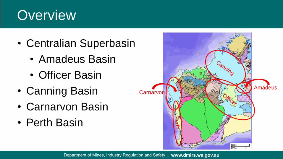
Overview
• Centralian Superbasin
• Amadeus Basin
• Officer Basin
• Canning Basin
• Carnarvon Basin
• Perth Basin
AmadeusCarnarvon

Government of Western Australia Department of Mines and PetroleumGovernment of Western Australia Department of Mines and Petroleum
Centralian Superbasin: Amadeus Basin

Government of Western Australia Department of Mines and PetroleumGovernment of Western Australia Department of Mines and Petroleum
Amadeus BasinMACDONALD 1:250,000 Map
• Map: MACDONALD 1:250,000
map
published June 2018

Government of Western Australia Department of Mines and PetroleumGovernment of Western Australia Department of Mines and Petroleum
Amadeus BasinPublications
• Record: Revised Neoproterozoic
stratigraphy in the Mount Connor
area, Amadeus Basin, Northern
Territory
published August 2018 as joint NTGS/GSWA
• Record: Complete expanded
extent and improved correlation of
the Aralka Formation, Amadeus
Basin (to be published as a NTGS
/ GSWA record)
Completed & to be published 2018/19
Bonython Range, WA. Salt tectonics of the Bitter Springs Group
Aralka Formation Stromatolite

Government of Western Australia Department of Mines and PetroleumGovernment of Western Australia Department of Mines and Petroleum
Amadeus BasinFuture Publications
• Record: Complete
biostratigraphic framework of the
western Amadeus Basin
• Report: Revised stratigraphy and
structural interpretation of the
western Amadeus Basin
Bonython Range, Surface Anticlinorium – Amadeus Basin (WA)
Loves Creek Formation, Columnar Stromatolites
Amadeus Basin

Government of Western Australia Department of Mines and PetroleumGovernment of Western Australia Department of Mines and Petroleum
Centralian Superbasin: Officer Basin
Government of Western Australia Department of Mines and PetroleumGovernment of Western Australia Department of Mines and Petroleum
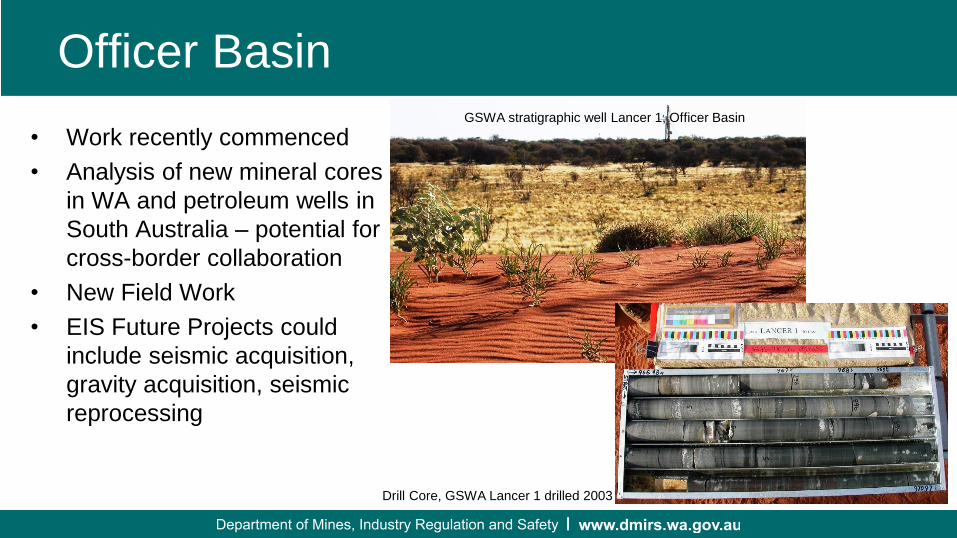
Officer Basin
• Work recently commenced
• Analysis of new mineral cores
in WA and petroleum wells in
South Australia – potential for
cross-border collaboration
• New Field Work
• EIS Future Projects could
include seismic acquisition,
gravity acquisition, seismic
reprocessing
GSWA stratigraphic well Lancer 1, Officer Basin
Drill Core, GSWA Lancer 1 drilled 2003

Government of Western Australia Department of Mines and PetroleumGovernment of Western Australia Department of Mines and Petroleum
Canning Basin

Government of Western Australia Department of Mines and PetroleumGovernment of Western Australia Department of Mines and Petroleum

Government of Western Australia Department of Mines and PetroleumGovernment of Western Australia Department of Mines and Petroleum
Canning Basin Collaborative Core Analysis Project
• Collaborative research: Petroleum systems and CO2
geosequestration potential with GA and industry. Several
publications released already and more to come
Current participation:
Olympic 1 and Senagi 1 (Buru Energy)
Theia 1 (Finder Exploration)
• Digital Core Atlases:
Olympic 1 and Theia 1
released
Senagi 1 near complete
to be published 2018/2019

Government of Western Australia Department of Mines and PetroleumGovernment of Western Australia Department of Mines and Petroleum
Canning Basin Field Work and Drone Technology
• Field Work: Prices Creek Group to correlate with
the subsurface Nambeet and Willara Formations;
and mapping the Lucas Outlier
• Bringing the outcrop to the office: creating
outcrop photogrammetry, amalgamating with
multiple analysis taken directly from field samples
Drone photo of the Lucas Outlier
Lucas Formation Type Section
Digital Elevation Model of the Lucas Outlier
Lucas Formation Type Section

Government of Western Australia Department of Mines and PetroleumGovernment of Western Australia Department of Mines and Petroleum
Canning Basin Stratigraphic & Coal Projects
• Project: Review of the
stratigraphy and correlation of
Mid-Carboniferous – Lower
Permian palynology and
stratigraphy
• Project: Review of the
stratigraphy and correlation of
the Fairfield Group, Canning
Basin
• Record: Coal Resources of
the Canning Basin
Stratigraphic correlation
of the Grant Group

Government of Western Australia Department of Mines and PetroleumGovernment of Western Australia Department of Mines and Petroleum
Canning Basin New SEEBASE model by FrogTech
• Canning Basin
SEEBASE
released February 2018
• Marked increase in the
resolution of the Canning
Basin depth to basement
model compared to the
2005 version
• Other products include
basement faults, crustal
architecture, basement
composition and
basement heat flow
2005 OZSEEBASE 2017 Canning SEEBASE

Government of Western Australia Department of Mines and PetroleumGovernment of Western Australia Department of Mines and Petroleum
Canning BasinKidson Sub-basin Seismic Survey
• Kidson Sub-basin deep crustal Seismic Survey, co-funded by GA as part of Exploring for the
Future and DMIRS Exploration Incentive Scheme
Acquisition of 872 km between 17 June & 7 August 2018. Release of data at APPEA 2019
Kidson Sub-basin seismic
survey

Government of Western Australia Department of Mines and PetroleumGovernment of Western Australia Department of Mines and Petroleum
Canning BasinOther Seismic Activity
• Seismic reprocessing: Kidson
Sub-basin, Cobb Embayment and
western regional lines
Commenced January 2018
Completed September 2018
• Passive seismic: GSWA–UWA–
Chinese Academy of Science
(funding)
Stations deployed

Government of Western Australia Department of Mines and PetroleumGovernment of Western Australia Department of Mines and Petroleum
Canning BasinGeophysical Seismic Interpretation & Mapping projects
• First Region report published:
Report 178 - A seismic interpretation of
the southwestern Canning Basin, Western
Australia
• Report: A seismic interpretation of the
Broome Platform, Willara Sub-basin and
Munro Arch of the Canning Basin, WA
expected release in 2018/2019
• Report: Interpretation of the Kidson Sub-
basin deep crustal Seismic Survey
expected release in 2019/2020
• Report: A seismic interpretation of the
Crossland Platform, Kidson Sub-basin and
Ryan Shelf of the Canning Basin, WA
expected release in 2020/2021
Seismic Interpretation & mapping projects
Kidson Sub-basin Seismic Survey
Seismic Reprocessing
SW Canning - Published
Willara S-b, Broome Platform - Peer Review
Kidson S-b, Crossland Platform – underway

Government of Western Australia Department of Mines and PetroleumGovernment of Western Australia Department of Mines and Petroleum
Canning BasinCobb Embayment
• Cobb Embayment – Field work
completed. Record to incorporate the
results of seismic reprocessing
Cobb Embayment

Government of Western Australia Department of Mines and PetroleumGovernment of Western Australia Department of Mines and Petroleum
Carnarvon Basin
Government of Western Australia Department of Mines and PetroleumGovernment of Western Australia Department of Mines and Petroleum
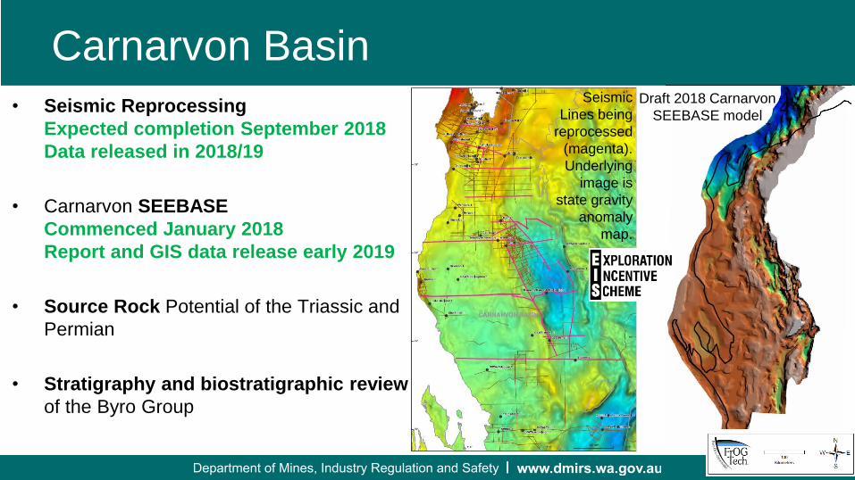
Carnarvon Basin
• Seismic Reprocessing
Expected completion September 2018
Data released in 2018/19
• Carnarvon SEEBASE
Commenced January 2018
Report and GIS data release early 2019
• Source Rock Potential of the Triassic and
Permian
• Stratigraphy and biostratigraphic review
of the Byro Group
Draft 2018 Carnarvon
SEEBASE model
Location Map
of Seismic
Reprocessing
Seismic
Lines being
reprocessed
(magenta).
Underlying
image is
state gravity
anomaly
map.

Government of Western Australia Department of Mines and PetroleumGovernment of Western Australia Department of Mines and Petroleum
Perth Basin
Oil

Government of Western Australia Department of Mines and PetroleumGovernment of Western Australia Department of Mines and Petroleum
Perth Basin Publications
• Report 174 – A review of palynology from the Harvey
region, southern Perth Basin
Released 19/3/2018
• Report 184 – Regional seismic interpretation and
structure of the southern Perth Basin
to be published 2018/2019 FY
• Report 188 – Petroleum geochemistry and petroleum
systems of the Perth Basin
to be published 2018/2019 FY
• Record – Mesozoic Coal Resources of the Perth
Basin
to be published 2018/2019 FY
Depth to Basement - Southern Perth Basin

Government of Western Australia Department of Mines and PetroleumGovernment of Western Australia Department of Mines and Petroleum
Perth BasinPassive Seismic
• Short exploratory
deployment to map the
Moho and crustal velocity
of the Perth Basin
• Trillium compact 20 s and
120 s seismometers used
• Very noisy data/complex
structure
• Moho estimated from N-S
line
• See difference across
Yilgarn boundary
Government of Western Australia Department of Mines and PetroleumGovernment of Western Australia Department of Mines and Petroleum
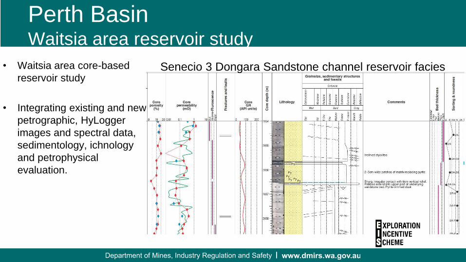
Perth BasinWaitsia area reservoir study
• Waitsia area core-based
reservoir study
• Integrating existing and new
petrographic, HyLogger
images and spectral data,
sedimentology, ichnology
and petrophysical
evaluation.
Senecio 3 Dongara Sandstone channel reservoir facies

Government of Western Australia Department of Mines and PetroleumGovernment of Western Australia Department of Mines and Petroleum
Basin StudiesLong Term Strategy
Core,
Ctgs, SWC
Field Work
Revised
Stratigraphy
Petroleum
Potential
Gravity
AcquisitionGeophysical Interpretation
& Mapping
Revised Structure &
Structural History
New Descriptions &
Analysis
Seismic
Reprocessing
Seismic
Acquisition
Source Rock
Potential
3D Depth
Models
Reservoir Studies
SEEBASE
New correlations &
age control
Revised
Biostratigraphy
Basement
studies

Government of Western Australia Department of Mines and PetroleumGovernment of Western Australia Department of Mines and Petroleum
Whole of State & Other Projects
• Mesozoic Booklet
• Compilation of Source Rocks of WA
• Lignite resources of the Eucla Basin and southern WA
• Paleontology Reports
• Bonaparte Basin
– Field Work and Mapping
– Source Rock


