66
Geology and Ground- Water Resources of Outagamie County Wisconsin By E. F. LEROUX GEOLOGICAL SURVEY WATER-SUPPLY PAPER 1421 UNITED STATES GOVERNMENT PRINTING OFFICE. WASHINGTON : 1957

Geology and GroundWater Resources of Outagamie County Wisconsin By E. F. LEROUX
GEOLOGICAL SURVEY WATER-SUPPLY PAPER 1421
UNITED STATES GOVERNMENT PRINTING OFFICE. WASHINGTON : 1957
UNITED STATES DEPARTMENT OF THE INTERIOR
FRED A. SEATON, Secretary
GEOLOGICAL SURVEY
Thomas B. Nolan, Director
For sale by the Superintendent of Documents, U. S. Government Printin~ Office Washin~ton 25, D. C. - Price 25 cents'(paper cover)
CONTENTS
Page Abstract__________________________________________________________ 1 Introduction______________________________________________________ 2
Purpose and scope_____________________________________________ 2 Method of investigation________________________________________ 2 Acknowledginents_____________________________________________ 3 Previous reports_______________________________________________ 3
Description of the area_____________________________________________ 3 Location and extent__ _ _ _ _ _ _ _ _ _ _ _ _ _ _ _ _ _ _ _ _ _ _ _ _ _ _ _ _ _ _ _ _ _ _ _ _ _ _ _ _ _ 3 Culture______________________________________________________ 4 Topography__________________________________________________ 4 Drainage_____________________________________________________ 5 Clinlate______________________________________________________ 5
Geologic units and their water-bearing properties______________________ 6 Precambrian rocks_____________________________________________ 6 Paleozoic rocks________________________________________________ 8
Cambrian system_____________ _ _ _ _ _ _ _ _ _ _ _ _ _ _ _ _ _ _ _ _ _ _ _ _ _ _ _ _ _ 8 Upper Cambrian series_________________________________ 8
Ordovician system_________________________________________ 9 Prairie du Chien group_________________________________ 9 St. Peter sandstone____________________________________ 11 Platteville formation and Galena dolomite________________ 12 Maquoketa shale______________________________________ J 2
Cenozoicrocks________________________________________________ 13 Quaternary system_________________________________________ 13
Pleistocene deposits____________________________________ 13 Recent deposUs_______________________________________ 14
Bedrockstructure_________________________________________________ 14 Bedrocktopography_______________________________________________ 15 Geologic history___________________________________________________ 16 Groundwater_____________________________________________________ 17
Source and movement__________________________________________ 17 Water levels_ _ _ _ _ _ _ _ _ _ _ _ _ _ _ _ _ _ _ _ _ _ _ _ _ _ _ _ _ _ _ _ _ _ _ _ _ _ _ _ _ _ _ _ _ _ _ _ _ _ 19 Use__________________________________________________________ 24 Wells________________________________________________________ 24
Springs------------------------------------------------------~ 38 Pumping tests_________________________________________________ 39
Seymour tests_____________________________________________ 39 Appleton test_____________________________________________ 41 Horton ville tests_ _ _ _ _ _ _ _ _ _ _ _ _ _ _ _ _ _ _ _ _ _ _ _ _ _ _ _ _ _ _ _ _ _ _ _ _ _ _ _ _ _ 41
Quality_______________________________________________________ 41 Conclu~ons_______________________________________________________ 44 Well logs_________________________________________________________ 44 Literature cited___________________________________________________ 54 Index____________________________________________________________ 57
III
IV CONTENTS
ILLUSTRATIONS
[All plates in pocket]
PLATE 1. Map of Outagamie County, Wis., showing location of wells. 2. Map of the bedrock geology of Outagamie County, Wis. 3. Geologic sections of Outagamie County, Wis. 4. Bedrock-surface map of Outagamie County, ·wis. 5. M3p of Outagamie County, Wis., showing the piezometric surface
in April 1954. 6. Hydrographs of wells at Seymour, Wis., during pumping test. 7. Logarithmic diagrams for water-analysis data, Outagamie County,
Wis. Page
FIGURE 1. Average monthly temperature and precipitation, Outagamie
TABLE 1.
2.
3.
4.
5. 6. 7.
8.
9. 10.
11.
County, Wis _ _ _ _ _ _ _ _ _ _ _ _ _ _ _ _ _ _ _ _ _ _ _ _ _ _ _ _ _ _ _ _ _ _ _ _ _ _ _ _ 6
2. Histogram (A) and cumulative-frequency curve (B) for a sandstone of Cambrian age, Outagamie County, Wis_ _ _ _ _ 8
3. Water level in well Ou 2, Kaukauna, Wis_________________ 19 4. Water levels in two wells and cumulative departure from
normal precipitation during 1947-55, Outagamie County, Wis________________________________________________ 20
TABLES
Description and vmter-bearing characteristics of geologic units in Outagamie County, Wis______________________________ 7
Specific capacity and yield factor of \vells in the Upper Cam-brian series__ _ _ _ _ _ _ _ _ _ _ _ _ _ _ _ _ _ _ _ _ _ _ _ _ _ _ _ _ _ _ _ _ _ _ _ _ _ _ _ _ _ _ 10
Specific capacity and yield factor of ·wells in the St. Peter sand-stone_________________________________________________ 11
Calculated movement of water to the southeast in Outagamie County, Wis___ _ _ _ _ _ _ _ _ _ _ _ _ _ _ _ _ _ _ _ _ _ _ _ _ _ _ _ _ _ _ _ _ _ _ _ _ _ _ _ _ 18
\Vater levels in wells in Outagamie County, Wis_____________ 21 Records of wells in Outagamie County, Wis_________________ 25 Distances, in feet, between pumped well and observation wells
used during pumping tests at Seymour, Wis _ _ _ _ _ _ _ _ _ _ _ _ _ _ _ 40 Coefficients of transmissibility and storage at Seymour, \Vis.,
Apr. 18-22, 1949 _____________________________ - _ _ __ _ _ _ _ _ 40
Chemical analyses of ground water in Outagamie County, Wis __ . 42 Materials penetrated by wells in Outagamie County, Wis. (In-
terpretation by F. T. Thwaites)________________________ 45 Materials penetrated by wells in Outagamie County, Wis. (In-
terpretation by the author)______________________________ 50

GEOLOGY AND GROUND-WATER RESOURCES OF OUTAGAMIE COUNTY, WISCONSIN
By E. F. LERoux
ABSTRACT
Outagamie County is in east-central Wisconsin. It has no serious groundwater problem at present, but the county is important as a recharge area for the principal aquifers supplying water to Brown County and industrial Green Bay to the east.
The county is covered by glacial drift and lake deposits of the Wisconsin stage of glaciation. In the northwestern quarter of the county these deposits rest upon Precambrian crystalline rocks; throughout the remainder of the county they are underlain by sandstone, limestone, dolomite, and shale of Cambrian and Ordovician age. ·where they are sufficiently thick, and where more productive formations are absent, glacial sand and gravel are an important source of ground water. The major sources, however, are the St. Peter sandstone, of Ordovician age, and the sandstones of the Upper Cambrian series. The Precambrian crystalline rocks, which underlie all the county, yield little or no water to wells.
The regional dip of the Paleozoic bedrocks is 25 to 30 feet per mile eastward and southeastward. There are no major folds, but the thickness of each geologic unit may change from place to place because of predepositional or postdepositional erosion. There is no conclusive evidence of major faulting in the area.
Ground water in Outagamie County occurs under both water-table (unconfined) and artesian (confined) conditions. The source of the ground water is precipitation which falls on the surface and percolates downward into the underlying permeable materials. Regional movement of ground water in the eastern third of the county is controlled by the bedrock structure, and the discharge is toward the east and south. Throughout the rest of the county the movement of water is controlled mainly by bedrock and surface topography, and the water moves toward the streams and bedrock valleys.
Water-level :fluctuations follow definite patterns. Where the effects of pumping are at a minimum, water levels reach a high in April or May, decline through the summer months owing to natural discharge, and lack of recharge, and do not begin to recover until after the ground thaws in the spring. In areas of heavy pumping where this pattern is distorted, the lowest water levels occur in the early fall and recoveries begin in October or November after the period of heaviest pumping.
Pumpage in the county was estimated to be about 9.0 million gallons per day (mgd) in 1951 and 1952. Nearly half of this was for industrial, commercial, and public-supply use along the Fox River. Wells, most of which are drilled by the cable-tool method, range in diameter from 3 to 16 inches and in depth from 10 or 20 feet to 804 feet. In the alluvium and glacial drift 1~- to 2¥2-inch driven wells are common.
1
2 GEOLOGY, GROUND-WATER RESOURCES, OUTAGAMIE COUNTY, WIS.
Pumping tests were made to determine the hydraulic characteristics of the aquifers at Seymour, Appleton, and Hortonville. The average coefficient of transmissibility at Seymour is about 18,000 gpd per foot; at Appleton it is about 19,000 gpd per foot. The coefficients of storage are 0.00022 and 0.00015 at Seymour and Appleton, respectively. Movement of ground water out of the county, assuming an average transmissibility of 18,000 gpd per foot, was calculated to be more than 10 mgd toward the southeast.
The ground water differs greatly in chemical quality from well to well, but it is generally a very hard calcium magnesium bicarbonate water, some of it high in iron. To aid in determining the source of well waters, 22 chemical analyses were plotted on a logarithmic diagram to obtain characteristic patterns for waters from several geologic sources.
INTRODUCTION
PURPOSE AND SCOPE
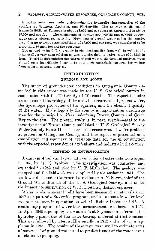
The study of ground-water conditions in Outagamie County described in this report ·was made by the U. S. Geological Survey in cooperation with the University of vVisconsin. The report includes a discussion of the geology of the area, the occurrence of ground water, the hydrologic properties of the aquifers, and the chemical quality of the water. Hydrologically the county is important as a recharge area for the principal aquifers underlying Brown County and Green Bay to the east. The present study is, in part, supplemental to the investigation of Brown County published as U. S. Geological Survey Water-Supply Paper 1190. There is no serious ground-water problem at present in Outagamie County, and this report is presented as a cmnpilation and summary of available data for use in conjunction with the expected expansion of agriculture and industry in the county.
METHOD OF INVESTIGATION
A canvass of wells and systematic collection of other data were begun in 1951 by vV. C. Walton. The investigation was continued and expanded in 1952 and 1953 by V. T. ~1:cCauley. The geology was mapped and the fieldwork was completed by the author in 1954. The work was done under the general direction of A. N. Sayre, chief of the Ground Water Branch of the U. S. Geological Survey, and under the immediate supervision of ~T. J. Drescher, district engineer.
Water levels in several wells have been measured at intervals since 1947 as a part of a Statmovicle program, and an automa,tic water-level recorder has been in operation on well Ou 2 since December 1946. A continuing program of water-level measurements was begun in 1952. In April 1949 a pumping test was made at Seymour to determine the hydrologic properties of the water-bearing material at that location. This was followed by a test at Hortonville in 1953 and another in Appleton in 1954. The results of these tests were used to estimate rates of movement of ground water and to predict trends of the water levels in relation to pumping.
INTRODUCTION 3
Reconnaissance geologic mapping of the county was done on vVisconsin Land Inventory maps at a scale of about 1 inch to the n1ile; most of the county has not been topographically n1apped. Field Inapping was based on examination of outcrops and land forms. Subsurface control is from drillers' logs and frmn logs based on examination of drill cuttings by F. T. Thwaites of the \Visconsin Geological Survey.
ACKNOWLEDGMENTS
The success and value of a study such as this depend in large part on the cooperation and assistance of local persons. The willing cooperation of well owners, well drillers, civil officials, and private citizens is greatly appreciated. The pumping tests would not have been possible without the cooperation of vV alter Muehle, superintendent of the Seymour vV ater Department; Arthur Dunn, Hortonville water superintendent; Walter Schroder, president of the Fox Valley Canning Co.; and W. Segar of the Badger Consolidated Cooperative Dairy.
The author wishes especially to thank F. T. Thwaites, vVisconsin Geological Survey, for the use of his field notes and G. F. Hanson, State Geologist, for his review of the report.
Members of the Bureau of Sanitary Engineering, Wisconsin State Board of Health, contributed greatly to the report by giving access to files of well records and pumpage data. Chemical analysis of water samples, which were collected by members of the U. S. Geological Survey, was made by chemists of the vVisconsin State Laboratory of Hygiene.
PREVIOUS REPORTS
Martin (1932) presents a fairly complete list of early reports on the geology of \Visconsin. Reports by Cha1nberlin (1877), "'\Veidman and Schultz ( 1915), and Thwaites ( 1943) contain much information pertinent to the geology and ground-water resources of Outagamie County. A soil survey by Whitson and others (1921) and a discussion of the geography of the Fox River valley by Whitbeck (1915) provide additional historical and geographical information.
DESCRIPTION OF THE AREA
LOCATION AND EXTENT
Outagamie County is in east-central "'\Visconsin, north of Lake Winnebago and southwest of Green Bay, between latitudes 44°14' and 44°36' N. and longitudes 88°11' and 88°44' \V. (pl. 1). The county is rectangular, about 27 miles long, east-west, and 24 miles wide; it has an area of about 646 square miles. Appleton ( 1950 pop. 34,010) is the principal city and the county seat.
4 GEOLOGY, GROUND-WATER RESOURCES, OUTAGAMIE COUNTY, WIS.
CULTURE
In 1950 the county's population was 81,722. About 61 percent of the population lives in the urban areas along the Fox River, about 20 percent on farms, and about 19 percent in villages.
More than 90 percent of the land was in farms in 1949. The farms are small, averaging about 109 acres as compared with 138 acres for the State. Seventy-eight percent are classed by the U. S. Census as dairy farms, and 89 percent of the farm income is from livestock and livestock products. The county ranks 7th in milk production ( 412,500,000 lbs. in 1953) and 13th in cheese production ( 15,587,000 lbs. in 1953) in the State.
Industrial growth has been due almost entirely to the abundant water and power furnished by the Fox River. The world's first hydroelectric central station started operation in Appleton in 1882, and electricity has played an important role in industrial development since that time. The principal industries are associated with food processing, and knitting, and the manufacture and processing of paper, wood products, metal products, and machinery. Closely associated with the growth and development of the area is Lawrence College, at Appleton, founded in 1847, 10 years before the city was incorporated.
TOPOGRAPHY
Only small, isolated areas in Outagamie County have been covered by adequate topographic mapping. The well altitudes and rock-outcrop altitudes used in this report were obtained with an aneroid altimeter using U. S. Coast and Geodetic Survey and U. S. Geological Survey bench marks for control. The highest altitude obtained by this method is 1,015 feet above n1ean sea level at the top of a drumlin along the north edge of sec. 33, T. 22 N., R. 16 E., about 3.5 miles east of Hortonville. This hill is probably the highest point in the county, although several other drumlins near Hortonville reach altitudes o£ more than 1,000 feet. The lowest measured well altitude ( Ou 43) is 620 feet above mean sea level in Kaukauna. However, the lowest point in the county is about 600 feet where the Fox River enters Brown County, about 4.5 miles northeast of l{aukauna.
The county may conveniently be divided into three topographic units. The flat northwestern quarter, bounded on the south and east by the escarpment of the cuesta formed by rocks of the Prairie du Chien group, is covered by glacial-lake deposits and Recent flood-plain deposits. Along both sides of the Fox River is another area of relatively flat but well-drained land, formed by glacial-lake deposits. The remainder of the county is a gently rolling countryside of drumlins, moraines, and occasional small scarps and cliffs of bedrock exposed through thin glacial drift.
DESCRIPTION OF THE AREA 5
DRAINAGE
Essentially all of Outagamie County, except for the land drained by Duck Creek, is included within the Fox River drainage basin.
Fron1 the northern boundary of the county, near Leeman, the Wolf River flows parallel to the escarpment formed by the Prairie du Chien group southward through Shiocton to a point about 3 miles northeast of Hortonville, where it turns abruptly to the west and flows through New London. It is joined at Shiocton by the Shioc River, which drains the area north and west of Seymour, and at New London by the Embarrass River, which drains the extreme northwestern part of the county. The drainage basin of the Wolf River above New London has an area of about 2,240 square miles, about 400 square miles being in Outagamie County. The average daily discharge at New London is 1,793 cubic feet per second (cfs) (Paulsen and others, 1952). The Wolf River is a slow-moving, 1neandering stream as it traverses the flat, poorly drained northwestern quarter of the county. The gradient from Shawano, 47 miles upstream, to New London averages only about 0.8 foot per mile (Smith, 1908). From New London the river flows southwestward through Waupaca County and into Winnebago County, where it joins the Fox River, which flows into Lake 'Vinnebago at Oshkosh.
The lower Fox RiverJeaves the northwest corner of Lake Winnebago at Neenah-Menasha, about 5 river miles south of Appleton. In its 35-mile course to Green Bay it falls about 4.8 feet per mile (Smith, 1908). However, most of this fall is over rapids in the reach from Appleton to Kaukauna, where it drops nearly 10 feet per 1nile. At Rapide Croche Dam, about 12 miles downstream from Appleton, the average discharge is 4,242 cfs (Paulsen and others, 1952) from a drainage area of 6,150 square miles.
The remainder of the county is drained by Duck Creek, which flows generally south from Seymour, about 6.5 miles north of Little Chute, it turns abruptly to the northeast and flows between two prominent ridges out of the county and, 17 or 18 miles farther northeast, into Green Bay.
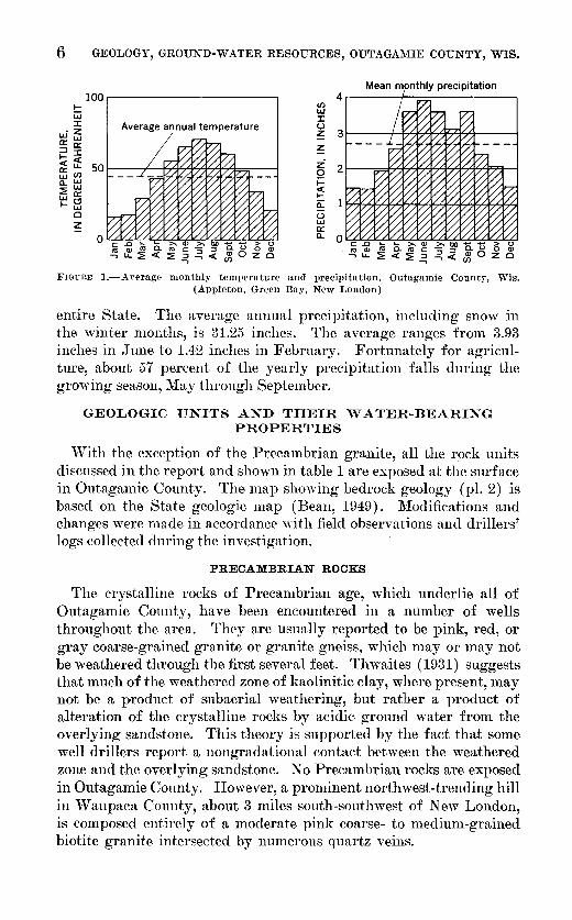
CLIMATE
The climate of Outagamie County is characterized by mild, humid summers and rather long, severe winters. The growing season averages 163 days at Appleton, 151 days at New London, and 134 days about 27 miles north of New London at Shawano. Four months of the year, December through March, have an average temperature below 32° F; the 5 months from May through September are generally free from frost (fig. 1). Average monthly temperatures range from a high of 70.9° Fin July to a low of 16.2° Fin January. The mean annual temperature is 43.6° F, which is 0.2° F above the annual mean for the
423220-57-2
6 GEOLOGY, GROUND-WATER RESOURCES, OUTAGAMIE COUNTY, WIS.
Mean monthly precipitation lOOr---------------------,
l- V) LLJ
4
Ui J:
LLiffi O::a::
~~ <u.. ~~ a...LLJ ~0:
~8 0
~
Average annual temperature J: ()
~ ~ z-
2 0 i= c( I-ii: (3 LLJ 0: a..
FIGURE I.-Average monthly temperature and precipitation, Outagamie County, Wis. (Appleton, Green Bay, New London)
entire State. The average annual precipitation, including snow in the winter months, is 31.25 inches. The average ranges from 3.93 inches in June to 1.42 inches in February. Fortunately for agriculture, about 57 percent of the yearly precipitation falls during the growing season, May through September.
GEOLOGIC UNITS AND THEIR WATER-BEARING PROPERTIES
vVith the exception of the Precambrian granite, all the rock units discussed in the report and shown in table 1 are exposed at the surface in Outagamie County. The map showing bedrock geology (pl. 2) is based on the State geologic map (Bean, 1949). Modifications and changes were made in accordance 'Yith field observations and drillers' logs collected during the investigation.
PRECAMBRIAN ROCKS
The crystalline rocks of Precambrian age, which underlie all of Outagamie County, have been encountered in a number of wells throughout the area. They are usually reported to be pink, red, or gray coarse-grained granite or granite gneiss, which may or may not be weathered through the first several feet. Thwaites ( 1931) suggests that much of the weathered zone of kaolinitic clay, where present, may not be a product of subaerial weathering, but rather a product of alteration of the crystalline rocks by acidic ground water fr01n the overlying sandstone. This theory is supported by the fact that some well drillers report a nongradational contact between the weathered zone and the overlying sandstone. No Precambrian rocks are exposed in Outagamie County. However, a prominent northwest-trending hill in Waupaca County, about 3 miles south-southwest of New London, is composed entirely of a moderate pink coarse- to medium-grained biotite granite intersected by numerous quartz veins.

TABLE 1.-Description and water-bea1·ing characteristics of geologic units in Outagamie Oou,nty, W,is.
Maximum Maximum Description System Geologic unit depth to thickness \Vater-bearing characteristics
top (fect)I (fcct)I Drill cuttings 2 Outcrop observations 3
Quater- Recent river and swamp 0 ? ---------- --------- ----------------- Silt, sand, and. peat. Not determined. nary. deposits.
Pleistocene deposits. ? 510 Glacial drift, mostly till; sand, clay, . Glacial drift, mostly till, and lake Good yields where sufficiently thick. silt, gmvel, boulders. clay. Moderate-red to dark-yel- Flowing wells and seepage sprin~s
lowish-orange silty clay; sand, common. Only source of ground-gravel, silt, boulders. water supply in northwest part of
county. ----- --------------Ordo- Maquoketa shale. 7 209 Shale, blue, dolomitic, calcareous; Shale, light-bluish-gray, thin- Yields very small quantities of high-
vi- thin beds of shaly blue-gray dolo- bedded. 'rhin beds of dolomite. ly mineralized water to a few cian. mite. domestic and stock wells.
Galena dolomite and 216 211 Dolomite, sandy, gray to bluish- Dolomite, thin-bedded to blocky Yields small amounts of water along Platteville formation, gray. Sar,dstonr, fine-to medium- and massive. Greenish-gray to bedding planes ::md from sandy undifferentiated. grained, gray; usually ncar base of yellowish-gray; sandy, silty, oolitic zones.
formation. in places. ----------------
St. Peter sandstone. 424 171 Sandstone, fine- to coarse-grained, Sandstone, fine- to coarse-grained, Good yields, but limited by presence pink, gray, and white; some chPrt. well-rounded, soft, friablr; banded of shale and relatively small thick-Thin layers of sandy gray and rrd rmle-reddish-brown and grayish- ness of formation. shale. orange, occasionally white.
-~--------------- ------ ---- ----------------Prairie du Chien group. 490+ 235+ Dolomite, gray, pink, and red, com- Dolomite, usually massive, yellow- Small quantities of water obtained
monly sandy and shaly; layers of ish-gray; chert layers common. from cracks and sandy zones. chert. Sandstone, fine- to mr- Occasional sandy and shaly zones. dium-grained, white. Shale, rrd and green.
---Cam- Upper Cambrian series. 490+ 458+ Sandstone, very fine to coarsr- Sandstone, very fine to coarse- Yields large amounts of water, espe-
brian. grained; pink, white, gray, and grained, well-rounded; interbed- cially from the lower portion which red; occasionally sbaly and dolo- dcd soft, hard, and friablr; pale is less dolomitic. mitic. Dolomite, soft, sandy, yrllowish-orange and white to with red and greenish-gray dolo- medium -gray. Some pyrite. mitic siltstone.
Pre- 800 Granite, pink, gray, and red; weath- Granite, coarse- to medium-grained, Essentially impermeable. May cam- ered at the top. moderate-pink, biotitic. (Crops yield some water from weathered brian. out in Waupaca County.) and creviccd zone.
---------- --~- - -------- ~-
t Based on well logs. 2 By F. T. Thwaites. 3 By E. F. LeRoux.
C1 trj 0 t"' 0 C1 ~
0
~ H 1-3 UJ.
~ t::;
1-3 P:1 trj H
~
~ > 1-3 M ~
~ tr1 > ~ z C1
"d ~ 0 "d tr1 ~ 1-3 ~
tr1 UJ.
""
8 GEOLOGY, GROUND-WATER RESOURCES, OUTAGAMIE COUNTY, WIS.
The crystalline rocks yield little or no water to wells. A very small amount might be obtained from cracks in the rock or from the weathered zone, but drilling usually ceases shortly after reaching granite.
PALEOZOIC ROCKS
CAMBRIAN SYSTEM
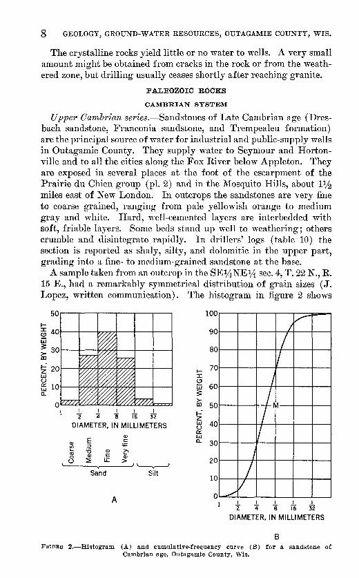
Upper Cambrian series.-Sandstones of Late Cambrian age (Dresbach sandstone, Franconia sandstone, and Tre1npealeu formation) are the principal source of water for industrial and public-supply wells in Outagamie County. They supply water to Seymour and Hortonville and to all the cities along the Fox River below Appleton. They are exposed in several places at the foot of the escarpment of the Prairie du Chien group (pl. 2) and in the Mosquito Hills, about llh miles east of New London. In outcrops the sandstones are very fine to coarse grained, ranging from pale yellowish orange to medium gray and white. Hard, well-cemented layers are interbedded with soft, friable layers. Some beds stand up well to weathering; others crumble and disintegrate rapidly. In drillers' logs (table 10) the section is reported as shaly, silty, and dolomitic in the upper part, grading into a fine- to 1nedium-grained sandstone at the base.
A sample taken from an outcrop in the SE14NEJA sec. 4, T. 22 N., R. 15 E., had a remarkably symmetrical distribution of grain sizes ( J. Lopez, written communication). The histogram in figure 2 shows
1-a 401---+--~ry/,~--~----+--~ w 3: 30 t---+----v":'177'7t---t---+--~ >-00
!i 20 1----{,~7'7&',..,.,....,..7&'7~1---+--~ LLI (_)
f5 10 1----f:,~~,..,.,...,..%"7'7441---+---l a..
_!_ ..!. I j_ _!_ 2 4 8 16 32
DIAMETER, IN MILLIMETERS
E Q)
Q) c
(/J ::::l '+=
ro :0 Q) ~ 0 Q) c Q)
(_) ~ i.L > '-----v----'
Sand Silt
A
100
90
80
1- 70
/,.-I I
:::c (.!)
w 60 3: >-00 50 t-" z LLI 40 (_) 0::: L&.J a.. 30
I I I M
!j
20
10
I
I ./
v 0
I t * ~ ~ ~ DIAMETER, IN MILLIMETERS
8 FIGURE 2.-Histogram (A) and cumulative-frequency curve (B) for a sandstone of
Cambrian age, Outagamie County, Wis.

GEOLOGIC UNITS AND THEIR WATER-BEARING PROPERTIES 9
that about 40 percent of the grains were in the fine-sand range, the remainder being divided almost equally between the larger and the smaller sizes. The cumulative-frequency curve shows that the mean grain size is about ~6 mm (fine grained) ; it gives also a 1nore exact picture of the gradation between grain size units in the sample.
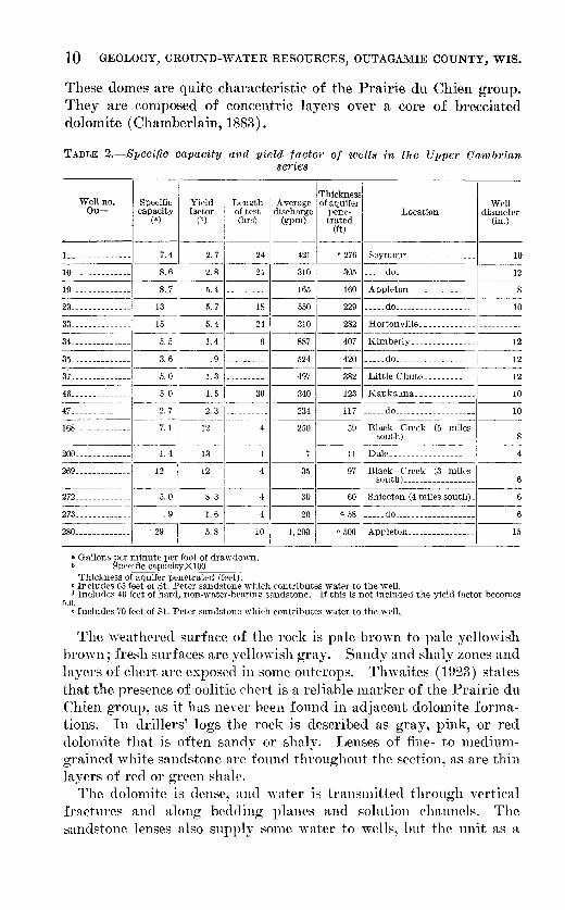
Although the Upper Cambrian series is the most important aquifer in Outagamie County, a comparison of specific capacities and yield factors (tables 2 and 3) shows the St. Peter sandstone to have a much higher permeability. The specific capacity of a well (yield per unit of drawdown, generally expressed as gallons per minute per foot of drawdown) is an indication of both the water-yielding capacity of wells and the relative transn1issibility of the water-bearing materials they penetrate. The yield factor (Poland and others) is an indication of the relative permeability of the water-bearing material. It is expressed as gallons per minute per foot of drawdown per 100 feet of aquifer penetrated. The specific capacity and yield factor of a well are representative of the water-bearing material within the area of influence of the well. In tests of short duration the area of influence is relatively small. As the well continues to pump, the area of influence expands and the specific capacity and yield factor may change, owing to changes in the character of the water-bearing material sampled by the expanding cone of influence. For this reason, comparisons between tests o:f equal length are the most consistent.
Table 2 summarizes the available data on specific capacity and yield factor for 16 wells. Wells Ou 19, 23, and 280 in Appleton have almost identical yield :factors, as do the two wells in Seymour. The lower yield factors :for the wells in l{imberly, Little Chute, and Kaukauna indicate lower permeability. Drillers' logs of these wells show that the water-bearing material is finer grained and contains more silt and siltstone than that penetrated by the wells in Appleton. The relatively high yield factors of the remaining wells may be due to their location near the outcrop area or may reflect the smaller dicharge and shorter duration of the tests.
ORDOVICIAN SYSTEM
Prairie du Chien g1·oup.-The Prairie du Chien group of Ordovician age, the Lower Magnesian o:f early reports, is composed of the Oneota dolomite, the New Richmond sandstone, and the Shakopee dolomite (Thwaites, 1923), but it was not subdivided in this investigation. It is best exhibited in the prominent escarpment which forms the southern and eastern boundaries of the flat northwestern quarter of Outaga1nie County. It is exposed also in many active quarries where rock is obtained for use as road material. An interesting :feature of several o:f these quarries (that in the SE~SE~ sec. 17, T. 24 N., R. 17 E., :for example) is the domelike structure that is revealed.
10 GEOLOGY, GROUND-WATER RESOURCES, OUTAGAMIE COUNTY, WIS.
These domes are quite characteristic of the Prairie du Chien group. They are composed of concentric layers over a core of brecciated dolmnite (Chamberlain, 1883).
TABLE 2.-Speci{ic capacity and yield factor of wells in the Upper Cambrian se1·ies
Well no. Ou- I
Specific capacity
(a)
Yield factor
(t)
Length or test (hrs)
Thickness Average of aquifer
discharge pene-(gpm) trated
(ft)
Location Well
diameter (in.)
-----1--------- -------i---------1·---!_______________ 7. 4 2. 7 24 421 c 276 Seymour _______________ _ 10 -----,1--- -------------J---------1·---10______________ 8. 6 2.8 24 310 305 _____ do __________________ _ 12 -----11-------------------------1----19______________ 8. 7 5.4 __________ 165 160 Appleton________________ 8 -----:1---------------1·---·1---------1----23______________ 13 5. 7 18 550 229 _____ do___________________ 10 -----1--------- ----1----1----"-------·1----33______________ 15 5. 4 24 310 282 Hortonville ______________________ _ -------1---------------- ----1·---------1----34______________ 5. 5 1.4 887 407 Kimberly_______________ 12 -------------------------1·---------1----35______________ 3. 6 . 9 __________ 524 420 _____ do___________________ 12 ------1--------------------1·---------1----37______________ 5.0 1.3 __________ 497 382 Little Chute____________ 12 -----il-----------------1---------1·---46______________ 5. 0 1. 5 30 340 123 Kaukauna______________ 10 -----·1-----1---- ------------1·-------·-47-------------- 2. 7 2. 3 ---------- 234 117 _____ do __________________ _ 10 -----11--------- --------1----------168_ ------------ 7.1 12 250 59 Black Creek (5 miles
south)_________________ 8 --------- ------------·---1---------1---200.------------ 1. 4 13 11 Dale____________________ 4 ------,!--------------·--1----------
269_ ------------ 12 12 4 35 97 Black Creek: (3 miles south) ________________ _
-----11---------------------------272_____________ 5.0 8.3 4 30 60 Shiocton (4milessouth)_
-27_3_-_-__ -_-__ -__ -_-__ -_ 11 _____ 9 --1-.6- ---4-~---20- d 58 _____ do __________________ _
280_ ------------ 29 ~--5-. 8- --l0~--1, 200 --.-5-0-0 -~I· _A_p_p_.le-to_n _____ -__ -_-__ -_-__ -__ -_-__ -l---1-5
a Gallons per minute per foot of drawdown. b Specific capacityXlOO
Thickness of aquifer penetrated (feet). c Includes G5 feet of St. Peter sandstone which contributes water to the well. d Includes 40 feet of hard, non-water-bearing sandstone. If this is not included the yield factor becomes
5.0. . • Includes 70 feet of St. Peter sandstone which contributes water to the well.
The weathered surface of the rock is pale brown to pale yellowish brO\vn; fresh surfaces are yellO\vish gray. Sanely and shaly zones and layers of chert are exposed in some outcrops. Thwaites ( 1923) states that the presence of oolitic chert is a reliable marker of the Prairie du Chien group, as it has never been found in adjacent dolomite formations. In drillers' logs the rock is described as gray, pink, or red dolomite that is often sanely or shaly. Lenses of fine- to mediumgrained white sandstone are found throughout the section, as are thin layers of red or green shale.
The dolomite is dense, and 'Yater is transmitted through vertical fractures and along bedding planes and solution channels. The sandstone lenses also supply some water to wells, but the unit as a

GEOLOGIC UNITS AND THEIR WATER-BEARING PROPERTIES 11
whole is not as productive as the overlying and underlying sandstone units. However, many domestic and stock wells obtain a small but adequate supply frmn the Prairie du Chien. Well Ou 278 was pumped at 12 gallons per minute for 2 hours, the water level lowering 2 feet. In a comparable test, well On 15, which taps both the Platteville formation and Galena dolomite and the Prairie du Chien group, yielded 150 gallons per minute but with a drawdown of 150 feet.
St. Peter sandstone.-The St. Peter sandstone of Ordovician age crops out at the base of escarpments topped by the Platteville formation and Galena dolmnite or is buried by Pleistocene and Recent deposits in low, swampy areas. It is a soft, friable sandstone that usually weathers to a pale reddish brown. Fresh surfaces show a reddish-brown and grayish-orange banding and occasional zones of pure "'hite sand. The well-rounded grains range in size :frmn fine to coarse and appear well sorted. The drill cuttings are described as fine- to coarse-grained pink, gray, and white sandstone with some chert. Thin layers of sandy gray and reel shale are disseminated throughout the section but usually are more common near the base.
The St. Peter sandstone is an important supplier of water to stock and dmnestic \Yells but it is absent in most \Yells in the industrial area along the Fox River. Table 3 shows that the relatively slight importance of the St. Peter as an aquifer in Outagamie County is a reflection of the thinness of the sandstone. Yield factors of 3 of the 4 \Yells tapping the St. Peter are considerably higher than those of wells tapping the Upper Can1brian series (table 2), showing that, were the St. Peter sandstone as thick and extensive as the Upper Cambrian series, it would easily surpass that series as an aquifer. The short duration of the tests cited in table 3 may account, in part, :for the high yield factors, but similar tests of wells in the Upper Cambrian series do not give comparably high figures.
TABLE 3.-Specific capacity aid yield factor of wells in the St. Petn· sandstone
I I
I I Average !Thickness Well no. Ou- Specific Yield Length ofidischargel of aqui-
itrated (ft)
Location \Yell diameter
(in.) capacity II factor 2 test (hrs) (gpm) , fer prm•-
-76 ___ -_-__ -__ -__ -_-__ -__ -l--1-0- --5-0 - ---4 --1-0 ~---20_ 1 __ -Se-y-In-o-ur_(_2_m_il_es-e-as_t_) _-_ 1
---
-------------------1 85______________ 4. 0 33 I 4 1 8 I 12 A~~litt)~~-~=~~~~e_s_~~~:~:-
' '----1------------91_ _____________ 1 2. 9 ~--14-5 - ---2~·----;o~ 2 Hortonville (5 miles
I
I , 1
southeast)______ ______ 6
ZOL---~~~--6.-0 1
--9.-1 1
1
'---1 ~~--3o!--6-6ll Seymour (1 mile south- ~~---1 j west)__________________ 5
6
I Gallons per minute per foot of drawdown. 2 Specific capacitvX100
Thickness of aquifer penetrated (feet).
12 GEOLOGY, GROUND-WATER RESOURCES, OUTAGAMIE COUNTY, WIS.
Platte,ville formation and Galena dolomite.-No attempt was made to differentiate the Platteville formation and the Galena dolomite. The Decorah :formation could not be recognized. The unit crops out in many small scarps and is exposed in quarries and stream beds throughout the eastern portion of the county. Many of the older quarries have been abandoned but several large ones are still supplying rock. The Fox River has cut through the overlying glacial drift to the Platteville and Galena unit throughout its reach in Outagamie County, and Duck Creek exposes the formation in several places (pl. 2).
As seen in outcrops, the weathered surface of the rock is usually grayish orange; fresh surfaces range from greenish gray to yellowish gray. Numerous sandy or silty zones weather rapidly, allowing blocks of the more crystalline rock to break off along vertical fractures and slump or fall from the scarps. Other outcrops reveal a series of thin beds with very thin shaly partings between the dolomite layers. In drill cuttings the Platteville and Galena section is recognized by its precl01ninantly gray to bluish-gray color, and there may be as much as 20 feet of fine- to medimn-grained gray sandstone ( Ou 19) near the base of the unit.
The Platteville and Galena :formations contribute water to many domestic and stock wells in the county. At least 2 schools (Ou 279, Ou 285) and 1 industrial plant (On 38) rely entirely on this unit for their water supplies. Yields are generally small, and drawdowns are excessive in most of the wells. Some domestic and stock wells that penetrate almost the full thickness of the Platteville and Galena are reported to "pump dry" after a short period of pumping. The presence of recoverable water is evidence that the formation is not an ideal confining bed and that it probably transmits some water to recharge the underlying formations where their head is below that of the Platteville and Galena. Drescher ( 1953) states that where the Platteville and Galena formations are overlain by the more impervious ~faquoketa shale it is of little importance as an aquifer. This indicates that the water moves downward through cracks and solution openings more easily than along the nearly horizontal bedding planes.
Maquoketa shale.-The Maquoketa shale underlies the glacial drift in an area of about 1 square mile in the extreme southeastern corner of Outagamie County. It is a light bluish-gray thin-bedded shale with thin layers of dolomite. In well logs it is described as a blue calcareous or dolomitic shale with some layers of shaly blue or gray dolomite. The shale acts as an effective confining bed for the underlying formations and yields little or no water to wells. It has been reported, however, that well Ou 48 obtains its water entirely from the Maquoketa shale.
. · •· GEOLOGIC UNITS AND THEIR WATER-BEARING PROPERTIES 13
CENOZOIC ROCKS
QUATERNARY SYSTEM
Pleistocene deposits.-Glacial deposits of the vVisconsin stage, which cover Outagamie County, consist of lake deposits and glacial drift. The lake deposits are exposed at or near the surface .over most of the western two-thirds of the county but are covered by ground moraine of the Valders Substage (Thwaites, 1943) in the eastern part. They consist of layers of silt and clay deposited in deep portions of Lake Oshkosh (Thwaites, 1943), zones o:f fine-to medium sand deposited in shallow water, and beach sand and gravel laid down around the. edge of the lake. The glacial drift in Outagamie County includes both stratified and unstratified deposits. Ground moraine, terminal moraines, and drumlins are composed of unsorted and unstratified material left by the glacier and not reworked by water. Eskers formed by swiftly flowing subglacial streams and. consisting of roughly stratified sand and gravel are usually somewhat distorted by slump and.povered by unstratified till left by the melting ice sheet. More or less irregular bodies of sorted sand and gravel are found in places within the body of the drift.
Pleistocene deposits are the only water source for wells in the northwest quarter of the county. They fun1ish adequat.e supplies to domestic and farm wells and for several public-supply systems. New London is supplied by three wells in drift and alluvium, and the village of Black Creek is supplied by a single well ( Ou 71), pumping as much as 170,000 gallons per day from 43 feet of coarse gravel and sand. The specific capacity of the well is 18 gpm per foot of drawdown and the yield factor (p. 9) is 42. In a discussion of Pleistocene deposits the term yield factor has a very limited significance because of the rapid change in character of the water-bearing material. For example, well Ou 169 has a yield factor of only 3.3, yet it penetrates 21 feet of what appears to be the same kind of sand and gravel as that tapped by Ou 71 about half a mile away.
In the southern and eastern parts of the county most of the wells obtain water fron1 the consolidated rocks, and the unconsolidated Pleistocene deposits are cased out to prevent caving. However, many wells obtain sufficient water for domestic and farm use from small, discontinuous sand and gravel lenses, confined in the Pleistocene clay. Bec.ause of the discontinuity of the Pleistocene beds, the artesian systems developed locally are small and unrelated, each resulting from recharge on nearby high ground.
'fhwaites (1943) has published a detailed study of the Pleistoc(_•ne geology of part of northeastern vVisconsin. It includes all of Outagamie County except the small portion south of the Fox River.
423220-57-:3
14 GEOLOGY, GROUND-WATER RESOURCES, OUTAGAMIE COUNTY, WIS.
Recent deposits.-The Recent deposits consist n1ostly of silt and very fine sand deposited on the flood plains of the Wolf, Embarrass, and Shioc Rivers. They include also about 55,000 acres of peat (Whitson and others, 1921), which is continually forming in the swamps and marshes. Areas of peat are scattered throughout the county but are Inost extensive in the western half. The pent tleposits in a given swamp are usually thickest near the center, 'vhere they sometimes extend to depths of more than 10 feet below the surface.
The thickness of the Recent river deposits in the northw'estern quarter of the county is not known. Riverbanks here are lo,v, and flooding of the adjacent lands during high water is quite common. The very fine sand and silt deposited at these times are not important as a source of ground water.
BEDROCK STRUCTURE
The regional bedrock structure is one of gentle dips to the east and southeast (pl. 3). The rocks in Brown County dip at about 30 to 35 feet per n1ile about S. 70° E. (Drescher, 1953). In eastern Outagamie County the dip, determined from well logs and altitudes, is 25 to 30 feet per mileS. 60° E. The few well logs available for wells in the southwestern quarter of the county indicate that the direction of dip there may be nearly S. 45° E.
Because of the nature of their deposition and subsequent erosion, there is a great range in the thickness of most of the geologic units. The Precambrian floor is an uneven surface that slopes generally 20 to 30 feet per mile toward the east and south. Lying unconformably upon this crystalline floor, the Upper Cambrian series fills in the depressions and covers the areas of low relief, producing a relatively flat inclined plane. The base of the Prairie du Chien group is relatively fiat, but its upper surface is described by Chamberlin (1877) as being highly undulating and billowy. The origin of the undulations or domes is uncertain. They have been attributed to Cryptozoon reefs, tectonic deformation, subaerial erosion, and compaction of sediinents. The presence of brecciated material within the domes, however, indicates that they were formed after deposition of the original sediments.
The St. Peter sandstone '\vas deposited on the undulating surface of the Prairie du Chien group. It fills in the low areas and generally covers the domes, again producing a relatively even surface. However, where the relief of the Prairie du Chien is unusually great, the sandstone is n1issing from the high areas and the Platteville and Galena formations rest djrectly upon the dolomite of the Prairie du Chien group (geologic sections A-A' a.nd D-D'). This may be the situation in the areas G miles west of Freedom and about 6 miJes

BEDROCK TOPOGRAPHY 15
west of Appleton where the boundaries of the St. Peter sandstone are shown as dashed lines on the geologic map (pl. 2). Field observations in these areas indicate that the formation is absent, and it is not encountered in wells immediately to the east. Except where they have been acted upon by glacial and preglacial erosion, the Platteville and Galena formations have a more uniform thickness than any of the other geologic units. The unit has an even upper surface and rests upon a similar surface formed by the St. Peter sandstone and the Prairie du Chien group.
A west-trending fault along the Wolf River and Bear Creek has been reported by Chamberlin (1877) and others. The only evidence of a fault observed during this investigation is the peculiar . rightangle turn in theW olf River northeast of Hortonville and the straightline effect caused by Bear Creek coming in from the east. Such a straight-line effect, however, is often the only surface expression of a fault and is sufficient reason for further investigation. The. fault is not evident in geologic section D-D' (pl. 3), which shows only a flattening of the apparent dip probably caused by a change in trend of the line of section (see geologic map, pl. 2). The movement of ground water in the area does not appear to be controlled by a fault (pl. 5), and there is no definite indication of a fault on the bedrocksurfacemap (pl. 4).
No other major faults or anomalies in structure have been found~ The odd bedrock pattern in the vicinity of Seymour (pl. 2) is due not to structure butrather to the preglacial valley that heads in that area~
BEDROCK TOPOGRAPHY
In an area where the glacial drift is an important aquifier, it is necessary to define the buried surface of the consolidated rocks. A 1nap showing contours on the bedrock surface may reveal preglacial valleys and depressions that have no surface expression. These valleys and depressions have been filled with glacial debris which may constitute an additional source of ground water.
The bedrock-contour map (pl. 4) was constructed frmn data obtained in drillers' logs and from field observations of quarries .and other outcrops and surface topography. The altitudes are frmn aneroid-altimeter traverses using U. S. Coast and Geodetic Survey and U. S. Geological Survey bench marks as control. The lack of sufficient surface and subsurface control, the irregularity of the bedrock surface, and the variable thickness of the drift all tend to limit the accuracy of a map of this type. However, the general character and the dominant features of the buried surface are probably as sho·wn on the map.
The outstanding feature of the preglacial landscape is the large buried Ya11ey ·which may be traeed from near Seymour to Shiocton.
16 GEOLOGY, GROUND-WATER RESOURCES, OUTAGAMIE COUNTY, WIS.
It is quite narrow and reaches a depth of 512 feet below the land surface at Black Creek. Although the valley may have been deepened and modified by ice advances, it was probably formed by a pre-Pleistocene stream flowing south westward and emptying into the ancestral vVolf River at Shiocton. Two smaller valleys to the north also seem to terminate along the course of the present Wolf River, which flows southward to a point about 3 miles northeast of Hortonville where it is joined by a deep, narrow valley from the east. The straight-line effect caused by this confluence has been discussed in the section on bedrock structure. The fact that the present-day streams conform so well to the preglacial drainage pattern is due to the thinness of the drift in much of the county. Although the old channels are buried beneath hundreds of feet of sediments, the streams are still controlled by the same bedrock configurations etched out by their ancestors.
Other prmninent features of the old surface are the Mosquito Hills about 11;2 miles east of New London. They are preglacial erosional remnants o:f the Upper Cambrian series which were modified by the advancing ice. A cut-and-fill terrace, which may be an early stream terrace or a wave-cut bench from the time of Lake Oshkosh (Thwaites, 1943), was observed on the west side of the mounds.
The bedrock-topography map used in conjunction with land-surface altitudes shows that the glacial drift is thickest in the buried valleys and in the general area north and west of the Prairie du Chien escarpment. The bedrock surface in the remainder of the county is relatively flat, with no evidence of any great thickness of drift except in drumlins and eskers.
GEOLOGIC HISTORY
The Precambrian rocks that underlie all of Outagamie County were formed during the earliest geologic era. In "'~isconsin · these rocks consist of igneous rocks, as well as of sedimentary rocks that have been altered by heat and pressure. The Precambrian landscape was rugged and mountainous; even after long periods of exposure to the elements it was still dominated by many hills and ridges.
After the close of the Precan1brian the area was covered by a sea into which layer after layer of sediment was deposited. The sea was not stationary, and alternating layers of sandstone, limestone, and shale were deposited as the water advanced and retreated. At times the sea retreated entirely, leaving the deposits exposed to subaerial erosion and continental deposition. From the time of final retreat of the sea until the advent of the Pleistocene glaciers, the rocks were sub~ jected to weathering and erosion. It was during this interval that the bedrock valleys (pl. 4) were cut by the ancestral vVolf River and its tributaries.

GROUND WATER 17
Modification of the land surface during Pleistocene glaciation was accomplished more by deposition than by erosion. The valleys were filled, moraines were built up, and new drainage patterns were formed. As the ice front withdrew from its last major advance, much of Outagamie County was again covered by fresh water, of a glacial lake (Thwaites, 1943). Lake sediments were deposited, and then the water withdrew, leaving the land surface much as it appears today. Little erosion has taken place, and deposition has been restricted to floodplain deposits of silt and sand along the streams and to organic deposits in lakes and swamps.
GROUND WATER
SOURCE AND MOVEMENT
'.Phe piezometric surface of a water-bearing formation, or aquifer, may be defined as that surface represented by the water level in wells or other large openings. If the water is not confined by imper1neable material, the piezometric surface is called the water table. Under artesian conditions the water is confined under pressure by relatively impermeable material, and the piezometric surface is above the top of the aquifer. Ground water occurs under both artesian and watertable conditions in Outagamie County. Water-table conditions prevail locally in bodies of clean sand or gravel, and in limestone and dolomite where the water moves freely through cracks and solution openings that are connected with the atmosphere. Artesian water occurs locally, confined by layers of silt or clay, in the glacial drift and is the source of many springs and flowing wells. It occurs also throughout the bedrock aquifers wherever it is confined by relatively impermeable dolomite and shale. The confining material is not totally impermeable, and there is much slow leakage through the beds, so that over a long period of time the water may be considered as a single water body rather than several water bodies.
The direction of movement of ground water is illustrated by the piezometric map (pl. 5), which was constructed from water-level measurements made in 91 wells during April 1954. The wells do not represent any one aquifer, as most wells are cased only through the drift, and the leaky-artesian conditions that prevail in much of the county make it impossible to assign a water level to a specific aquifer without a driller's log and casing record of the well. The contour lines represent points of equal altitude on the piezometric surface. Because water flm.vs down the hydraulic gradient, the direction of movement at any given point can be determined. Natural n1ovement is controlled by discharge, recharge, topography, and geologic structure. It is altered by local pumping and by recharge from man-made reservoirs. In the eastern third of Outagamie County the water flows

18 GEOLOGY, GROUND-WATER RESOURCES, OUTAGAMIE COUNTY, WIS.
southeastward. The direction of flow is the result of natural discharge into the Fox River, of recharge from the large area to the west, of municipal and industrial pumping along the Fox River from Lake vVinnebago to Green Bay, and of the eastward dip of the bedrock. Industrial and municipal pumping has increased the gradient and hence the volume of water moving toward the areas of discharge, but it has not greatly changed the direction of ground-water movement. An increase in gradient at any given place may also be due to a decrease in permeability of the water-bearing material or to a local increase ·in recharge.
The quantity of water moving out of the county to the southeast was computed by applying Darcy's law to the area between the 780- and 700-:foot contours running northeast from Appleton. From Darcy's law it follows that the quantity of water discharged in a unit of time ( Q) is equal to the product of the average permeability of the material (P) ,the hydraulic gradient (1), and the cross-sectional area through
which the water moves (A). It may be written in the form Q=TIL, where Tis the transmissibility and Lis the length of the section perpendicular to the direction of flow. An approximate T of 18,000 gpd per foot was obtained from pumping tests at Seymour and Appletpn. L :is the average length of the contours between the limiting ':How lines A-Band 0-D (pl. 5). The gradient, I, is averaged as the quotient of the area between the contours divided by the average length of the contours. Table 4 summarizes the data and results of the computations.
TABLE 4.-0alculated movement of water to the southeast in Outagamie County, Wis.
T I L Q Contour interval (feet) (gpd per (foot per (miles) (mgd)
foot) foot)
------------------1------------780-740_ -------------------------------------------------------- 18, ()()() 0. 0036 740-700_ -------------------------------------------------------- 18, ()()() . 0040
29.6 Z7. 7
10.1 10.5
The amount of water moving southeastward is more than 10 mgd. Of this, about 4.5 mgd is pumped from wells along the Fox River from Appleton to Kaukauna. A large quantity is discharged naturally into the river, and the remainder flows downvalley toward the city of Green Bay, where the pumpage is estimated to average about 12.5mgd.
Throughout the remainder of Outagamie County ground-water movement is controlled mainly by surface and bedrock topography. The water flows outward from the high areas toward lower ground, where it may come to the surface through seeps and springs. The large bedrock valley near Seymour influences ground-water move-
GROUND WATER 19
ment in the central part of the county. Water moves toward the valley from both sides and then 'vestward toward the Wolf River. The number and distribution of control wells in the northwestern part of the county did not justify the drawing o£ piezometric contours in this area. The water here is in glacial drift, ai1d, except in a few places where it is confined by impermeable layers, it exists under water-table conditions. The gradient appears to be quite flat, the water moving toward the 1V olf and Embarrass Rivers .. ··
The source of the ground water is precipitation. Recharge to the Paleozoic rocks takes place by percolation through the glacial drift into the subjacent sandstones or dolomites and thence downward into the deeper lying formations. The best opportunities for recharge are in areas where the sandstones crop out or are covered only by permeable glacial deposits. The piezometric map shows that where a strean1 influences ground-water movement the flow is usuallytoward the stream, indicating that water is entering rather than leaving the stream.
In areas of local recharge, the seasonal distribution of rainfall and seasonal changes in temperature have a pronounced effect on water levels. Rainfall on a recharge area may add water to the groundwater body; it also reduces the demand for ground water, thus tending to· maintain natural conditions. High temperatures create a greater dmnand for water and a consequent lowering of water levels. High temperatures also increase the rates of evaporation and transpiration, thus reducing the amount of water available for recharge.
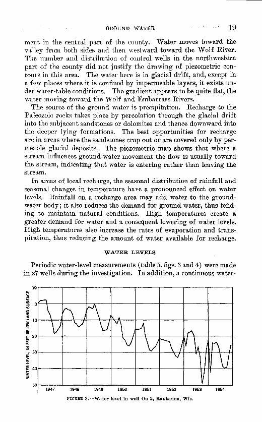
WATER LEVELS
Periodic water-level measurements (table 5, figs. 3 and 4) were made in 27 wells during the investigation. In addition, a continuous water-
10r-----~-----r----~------r-----~-----r----~-----. ILl
~ ~ 0~+---+-----~-r--~------~----+-----~----~----~ f/)
0 z ~ 10~-4--~-4--~--~-#~~--~----+-----~-----4----~ ~ ILl CD ~ 20~----~-----r-----+--;--+~~--+------h~~-+------; ~ ..... z J 30~----+-----~-----+------~--~+---~~--~-H+-4--H ILl G; ..... ~ ~~----+------r-----+------~----+-----~---444~~~
~ 50~----~----~----~------~----~----~----~----~
1947 1948 1949 1950 1951 1952 1953 1954
FIGURE 3.-Water level in well Ou 2, Kaukauna, Wis.

20 GEOLOGY, GROUND-WATER RESOURCES, OUTAGAMIE COUNTY, WIS.
15
A ,,~ ----.-,. ---~ K~ ~us ,,,
A 1\ .. '\. lr \_ ' ',,~ V'\_ ---\ V"\ ~ '~
\ ' Cumulative departure V ,\.. 1\ -.. .~ .... ,, ... ,'' ',,
\.......
~ L--J ~ ' v
L/\ ... , II.', .,.,'"
"VVV ..
1946 1947 1948 1949 1950 1951 1952 1953 1954 1955
FIGURE 4.-Water levels in two wells and cumulative departure from normal precipitation since 1947-55, Outagamie County, Wis.
level recorder has been in operation on well Ou 2 since December 1946. More than 90 wells were measured in April 1954 for use in construction of the piezometric map (pl. 5).
Fluctuations caused by pumping from a water-table aquifer represent actual removal of water from the aquifer and usually are relatively small. In an artesian aquifer the fluctuations caused by pumping are relatively rapid and large, as they represent mostly changes in pressure within the system. E
1vaporation of water directly from the ground
water body and evaporation from plants (transpiration) are effective when the ground-water body is at or near the land surface. Barometric and other pressure effects on water levels are most pronounced in wells tapping confined water. Atmospheric pressure is transmitted through the well to the elastic artesian aquifer, and the well acts as a water barometer.
Fluctuations in water level may be grouped into three categories: short-term (ranging from a few seconds or minutes to several days) ; seasonal; and long-term. Nearly instantaneous fluctuations may be the result of loading of the aquifer by railroad trains, of earthquakes, of pumping from wells, etc. Diurnal or semidiurnal fluctuations may be caused by pumping, diurnal barometric changes, earth tides, or evaporation and transportation. Weekly fluctuations may occur as a result of a decrease. in industrial and municipal pumping on weekends.

GROUND WATER
· TABLE 5.-Wat~r levels in wells in Otttagamie Oount1J, Wis.
Date
July 19, 1951__ _________ _ Aug. 21_ ______________ _ Dec. 6 _________________ _ Feb. 8, 1952 ___________ _ Apr. ll ________________ _ June 13 ________________ _ Aug.l4 _______________ _ Oct .. lQ ________________ _
July 25, 1951-----------Sept. 21.--c------------Dec. 6 _________________ _ Feb. 8,1952 ___________ _ Apr. 10 ____ ~---------- __ Aug. 14 _______________ _
Julyf27, 19si ____________ j
1
Sept. 2L ______________ _ Feb. 8, 1952 ___________ _
Apr. 11-----.------------~ June 13 ________________ _ Aug. 14---~---------- __ Oct. 10.---,------------
June 25, 1952 __________ _ Dec. 9 _____ c ___________ _ Mar. 23, 1953 __________ _ May.26. __ ;- ___ ---. ----
Aug, 6, 1952 .. _ ·-------Dec. 9 _________________ _
~:~ i:~_1:~~~=:====:==
Aug. 27, 1952 __________ _ Dec. 9 _________________ _ Mar. 23, 1953-----------May 26 _______________ _
~~~ .. g~~-~~~~=========::1 Mar. 23, 1953 __________ _
Sept. 9, 1952.-----------~ Dec. 10 ________________ _ Mar. 24, 1953 __________ _
[Measurements in feet below land-surface datum]
\Vell Ou 19
Depth to water
Date Date Depth to water
Depth to ~:water
----------- ---- ---------1·---38.00 39.00 34.00 30.00 30.00 34.00 42.00: 35.00
77.95 77.03 72.98 68.69 67.93 75.59
56.96 57.36 56.16 59.64 55.83 55.33 57.31
71.761 71.89 72.20 I 72.02
71.80 71.89 71.91 72.79
32.10 33.48 33.80 32.91
Dec. 4,1952 __________ _ Jan. 29, 1953 __________ _ Apr. 9 ________________ _ June 5 ________________ _ Aug. 7 _______________ _
Oct. 16----------------Jan. 8, 1954 ___________ _ Mar. 4 _______________ _
Well Ou 24
Oct. 10, 1952 __________ _ Dec. 5 ________________ _ Jan. 29, 1953 __________ _ Apr. 9 ________________ _ Oct.l6 _______________ _ Jan. 8, 1954 ___________ _
Well Ou 29
I Dec. 5,1952-----------1 Jan. 29, 1953 __________ _
1 i~r~ t_::============= I
Oct. 16 __ --------------Jan. 8, 1954 ___________ _
I
Well Ou41
Sept. 4, 1953 __________ _ Jan. 7, 1954 ___________ _ Mar. 3 _______________ _ Apr. 26 _______________ _
Well Ou 59
Aug. 13, 1953 _________ _ Jan. 7, 1954 ___________ _ Mar. 3 _______________ _ Apr. 28·---------------
Well Ou 65
Aug. 2, 1953 __________ _ Jan. 7, 1954 ___________ _ Mar. 4. ______________ _ Apr. 28 _______________ _
Well Ou 70
81.2211 May 26, 1953----------~ 82.38 Aug. 13 ______________ _ 82.65 Jan. 7, 1954 ___________ _
Well Ou 74
0. 41 II July 16. 1953 ___________
1
a 1.48 July 30, 1954. _________ _ a 1. 61 Sept. 2L---- ----------
29.00 28.31 27.98 30.73 41.03 37.65 30.41 30.35
74.64 68.76 67.55 66.58 77.54 68.75
57.18 57.43 56.20 54.88 56.81 58.30 58.14
77.14 72.83 72.88 74.05
73.12 72.81 73.07 73.18
32.97 34.51 34.77 35.01
May 5, 1954 __________ _ July g _____________ ·- .. Sept. 10 ______________ _ Nov. 18 ______________ _ Mar. 16, 1955 _________ _
Mar. 4, 1954.----------May 5----------------Sept. 10---------------Mar. 16, 1955 _________ _
Mar. 4, 1954 ___________ ... ;.:: May 5---------------July 8-----------------Sept. 10 ______________ _ Nov.l8 ______________ _
I Mar. 16, 1955 _________ _
July 30, 1954 __________ _ Sept. 22--------------"
July 30, 1954----------" Sept. 22 ______________ _
Nov. 18---------------
July 29, 1954 __________ _ Sept. 22---------------Nov.17 ______________ _
80.21 II July 30. 1954 ___________
1 81.67 Sept. 22---------------83.59 Nov. 17---------------
33.98 38.32 40.02 34.32 29.35
70.25 72.06 79.44 70.74
58.61 57.78 57.50 58.04 55.69 57.10
75.40 76.03
69.31 70.76 72.82
34.04 35.03 35.08
83.53 84.01 81.84
a 1. 9611 Nov. 18, 1954----------~ Flowing. 0.21 0.37
a Feet above land-surface datum.
423220-57--4

22 GEOLOGY, GROUND-WATER RESOURCES, OUTAGAMIE COUNTY, WIS.
TABLE 5.-Water levels in wells in Outagamie Oounty, Wis.-Continued
Well Ou 82
Date Depth to water
Date Depth to water
Date Depth to water
--------·- ---- ------------11---------1·----Sept. 11, 1952 __________ _ Dec. 10 ________________ _ Mar. 24, 1953 __________ _
Oct. 2, 1952 ____________ _ Dec. 9 _________________ _ Mar. 23, 1953 __________ _ May 26 .. -~------------
Nov. 6, 1952 ___________ _ Dec. 10 ________________ _ Mar. 24, 1953 __________ _ May 26 _______________ _
May 28,1953·----------~ Aug. 13 _______________ _ Jan. 8, 1954 _______ ------
June 25, 1953 ___________ 1 Aug. 2-----------------Jan. 7, 1954 ____________ _
June 25, 1953-----------~ Aug. 2-----------------Jan. 7, 1954 ____________ _
June 26, 1953 ___________ ,
July 1, 1953-------------~ Aug. 13 _______________ _ Jan. 7, 1954 ____________ _
July 1, 1953-------------~ Aug. 13 _______________ _ Jan. 7, 1954 ____________ _
July 13, 1953 ____________ 1 Aug. 13----------------Jan. 7, 1954 ____________ _
July 13, 1953 ____________ 1 Aug. 13----------------Jan. 8, 1954 ____________ _
43.89 44.39 42.32
7. 97 11.53 3.86 5.55
8.23 7.05 6.46 7.00
May 26, 1953 _________ _ Aug.13 ______________ _ Mar. 4, 1954.----------
Well Ou 87
Aug. 13, 1953 _________ _ Jan. 7, 1954------------Mar. 4----------------Apr. 27 _______________ _
Well Ou 95
Aug. 13, 1953 _________ _ Jan. 8, 1954 ___________ _ Mar. 4----------------Apr. 27 _______________ _
Well Ou 105
2. 31 II Mar. 4, 1954-----------~ 4. 73 Apr. 27 _______________ _ 6.38 July 29 _______________ _
Well Ou 121
24.8511 Mar. 4, 1954-----------~ 22.93 Apr. 28 _______________ _ 24.22 July 29 _______________ _
Well Ou 125
32.41 II Mar. 4, 1954-----------~ 32.42 Apr. 28 _______________ _ 34.54 July 29 _______________ _
Well Ou 136
12.6911 Mar. 4, 1954 ___________ ,
Well Ou 152
7. 2611 Mar. 4, 1954 ___________ 1 7. 79 Apr. 29 .... ------"-----10.19 July 29 _______________ _
Well Ou 155
1.4411 Mar. 4, 1954.----------~ 1. 74 July 29 _______________ _ 3. 02 Sept. 2L .. ------------
Well Ou 169
12.2911 Mar. 4, 1954-----------~ 11.88 Apr. 29 _______________ _ 13.04 July 29 _______________ _
Well Ou 170
6. 7211 Mar. 4, 1954-----------~ 7. 43 July 29 _______________ _
8. 76 Sept. 2L.-------------
40.65 43.74 46.34
8.63 14.95 12.54 9.86
9.24 10.24 8.11 9.38
Apr. 27, 1954.---------
July 30, 1954 __________ _ Sept. 2L------ --------Nov. 21---------------
July 30, 1954 __________ _ Sept. 2L--------------Nov.17 ______________ _
6. 2811 Sept. 21, 1954 __________ , ~~ Nov.l7 ______________ _
24.5411 Sept. 22, 1954.---------~ 24.54 Nov. 17---------------24.95
34.1211 Sept. 22, 1954.---------1 33.38 Nov.17 ______________ _ 33.82
I
13.3411 Apr.28,1954 __________ ,
11.1411 Sept. 22, 1954.---------~ 10.50 Nov. 17---------------8.82
3.1711 Nov. 17, 1954.---------~ 2.10 1.84
13.7811 Sept. 21, 1954----------1 13.74 Nov. 17 ______________ _ 12.91
I
9.8211 Nov.17,1954----------~ 7.38 7.90
44.31
11.93 12.20 6.88
8. 76 9.05 7.50
6.51 3.15
24.55 21.71
35.50 33.08
11.68
9.35 7.02
1.03
13.50 10.59
5.94

GROUND WATER
TABIB·5.-Water levels in weZls in Outagamie Oounty, Wis.-Continued
Well Ou 179
23
Date Depth to Date Depth to Date Depth to water water water
July 14, 1953___________ 8.01 Mar. 4, 1954___________ 9.35 Nov.17, 1954__________ 7.86 Sept. 4_________________ 8. 27 July 29---------------- 8. 58 Jan. 8, 1954------------- 9.16 Sept. 2L -------------- 8. 84
July 22, 1953 ___________ 1 Jan. 7, 1954 ____________ _
July 23, 1953.----------1 Sept. 4_ ~-------·------~ Jan. 8, 1954-------------
Sept. 1, 1953 ____________ 1 Jan. 8, 1954 ____________ _ Mar. 4. _ ------------ __ _
Sept. 3, 1953.-----------1 Jan. 8, 1954 ____________ _
Oct. 1~,-~------------~ Jan:S, 19M __ • _________ _
Mar. 4. -·--·-----------
Well Ou 203
58.0911 Mar. 4, 1954-----------1 58.26 July 29----------------
Well Ou217
7.8911 Mar. 4, 1954 ..••. ------~ 7. 94. -July 29 _______________ _ 6.30 Sept. 2L.-------------
Well Ou238
8.4211 Apr. 27, 1954·---------~ 6. 74 July 30. ______________ _ 7.11 Sept. 2L --------------
Well Ou 246
4.4711 July29,1954 __________ 1 4. 60 Sept. 2L--------------
Well Ou 258
7.1511.Apr. 27, 1954 __________ 1 8. 41 July 30 _______________ _ 6.-89 Sept. 2L --·-----------
58.3711 Sept. 22, 1954----------1 45.34 Nov. 17 _ --------------
t! II Nov.17, 1954 .• --------~
~:llll Nov.17, 1954---------~ 6.68
4. 6311 Nov. 17, 1954----------1 4.01
!: ~ II Nov. 17, 1954 ••.••. ---~
57.49 34.77
5.98
5.43
2.51
2.93
Seasonal fluctuations are due to seasonal variations in pumping, evaporation and transpiration, and recharge. Normally, water levels decline through the summer as a result of reduced recharge (due to increased evaporation and transpiration) and of drainage into streams. The decline continues through the winter months when the ground is frozen and recharge is at a minimum. Recharge is greatest in the spring, owing to snow melt and spring rains. In southeastern Outagamie County the pattern is distorted by pumping along the Fox River. Hydrographs (figs. 3 and 4) show that the lowest water levels occur in the early fall at the end of the period of heaviest industrial and municipal pumping. Recovery is rapid, and a nearly stable condition is reached early the following year. The water level in well'Ou 3, which of the three wells illustrated is that·Ieast affected by pumping, follows more closely the natural influences of recharge and discharge. It continues to decline during the winter and reaches its maximum recovery in April or May.
Long-tern1 trends in water levels are the result of precipitation and temperature cycles or of pumping trends. About 8 years of records are available for wells Ou 2, 3, and 5 (figs. 3 and 4). All three

24 GEOLOGY, GROUND-WATER RESOURCES, OUTAGAMIE COUNTY, WIS.
wells a-re ·affected by increased pumping at Green Bay and along the Fox River, and all three hydrographs show a downward trend during the period of record. However, the cumulative-departu,re curve for precipitation in Outagamie County also shows a downward trend during this period. The. curve follows quite closely the trend- of the hydrographs, indicating that the precipitation cycle has· a definite influence on water levels. The effects of precipitation and temperature cycles on water levels are accentuated by corresponding pumping cycles; for example, high temperatures and lack of precipitation,: which reduce recharge and cause water levels to decline, usuallJresrilt in increased pumping, which has a similar effect. Wells Ou 2 and 5 are deep wells near the area of maximum withdrawal and relatively far from the recharge area. Here the effect of pumping is at a maximum and the effect of fluctuations in precipitation are minimized. \.V ell Ou 3 is a shallow well located· near the outcrop area, where water levels are influenced by precipitation cycles.' This influence is shown by the trend of the hydrograph, which follows very closely the cumulative-departure curve for precipitation. The well is west of the recharge boundary, determined by Drescher ( 1953), for the Green Bay area and should not be greatly affected by withdrawals at Green Bay. ;, ,.
USE
Withdrawal of ground water in Outagamie County in 1951 and 1952 is estimated to have averaged about 9.0 mgd. Industrial, commercial, and public-supply pumping along the Fox River .accotmts for 48 percent of the total. The city of Appleton and • th,e paper mills use Fox River water. but pumping by other industries and businesses in the Appleton area amounts to about 1.7 mgd. The cities of Kaukauna, Little Chute, Kimberly, and Combined Locks use ground water at the rate of 2.6 mgd for all purposes. Pumpage in the remainder of the county, estimated to be about 4.6 mgd, is predominantly for domestic and general farm use. The estimate is based on pumpage figures supplied; by the villages and on an estimated average consumption of 40 gallons per day (gpd) per person for rural areas, 35 gpd per cow for milk cows and associated dairy servicing, 12 gpd for cattle and horses, and smaller amounts for other animals.
WELLS
The locations of the 287 wells visited during the investigation are shown on plate 1. The data assembled for each well are listed in table 6. Wells are numbered consecutively in the order visited and prefixed by the letters Ou to show that they are in Outagamie County.

TABLE 6.-Reco·rds of wells in Outagamic County, lVis. [<.~a, Rceent alluvium and Pleistocene d(~uosits; Om, Maquokrta shale; Ogp, Gal!lna dolomitr, and Platteville formation; Osp, St. Peter s:1.ndstonc; Ope, Prairie <lu Chien group;
£s. Upper Camhrian serirs; AC, Air conditioning; Des, Destroyed; Dom, Domestic; Ind, Industrial; PS, Public supply; RR, RaUrqad; S, Stock; Un, Unused] . ·------- ·- -----------------
I I : ?f' ... ..
-·- ?.rincipal aquifer Water level Altf-
Well I I tude of Depth Depth ::;~':;; I ·· ...... ·1 .·. No. Location O\n1er Yeai' larid of of TO!ok·l JJ•IOW I · I Usc Ou- drilled surface well casing ?asing Geol?gic DeptQ ness land Date of (feet) (feet) (fret) (mches) · umt to top pene- surface measurement
(feet) trated (feet) (feet)
·----· ---------------------N\'.;IiSW.Y.£ SPC. 28,
'!'. 24 N., H.. 18 E. City of Seymour_ ___________ 1934 788 406 202 12-10 £s ________ 195 211 ---------- --------------- PS.
NE.Y4SW% sec. 24, City of Kaukauna __________ 1909 645 798 208 12 £s ________ 368 410 +1.84 Dec. 4,1946 Un. '1'. 21 N., R. 18 E.
SE.Y.£NE~4 sec. 2, William Vanden HuefeL ____ 1942 790 110 3.') 5 Osp _______ 55 50 26.67 Apr. 16, 1947 s. '!'. 23 N., R. 18 E.
SEr4N"\V~ sec. 5, Marvin Murphy ______ ···---- ---------- -------- 400± -------- 8 ------------ -------- -------- 32.25 May 14,1947 Un. '1'. 21 N., R. 18 E.
SW74::-JE74 sec. 4, Ka:.1kauna "\Vater and Elec- 1929 660 408 69 6 Osp _______ 237 171 21.19 Oct. 30, 1947 Dom. T. 21 N., R. 19 E. tric.
NWXN"\\ji sec. ln, Wisconsin State Rl'forma- ---------- 776 192 82 6 Osp _______ 178 14 ----------- --------------- PS. T. 2·1 N., H. 19 E. tory.
NE~.{N"\Y}-4 Sl'C. 33, Seymour Canning Co ______ l!JlO 796 235 6 ------------ -------- -------- 32.80 December Un. '!'. 24 N., R. 18 E. 1952.
NE\INW~ see. 33, _____ do ___________________ 1929 79(i 350 193 12 £s _____ 220 130 ---------- --------------- Ind. 'l'. 24 N., R. 1~ E.
KW74NW)i see. :33, Green Bay and ""l'strrn ---------- 791 ------- --- ----- -------- --- -------- -------- ---------- --------------- Un. '1'. 24 N., R. 18 E. Railroad Co.
10 NE}iNE~i sec. 32, City of Seymour. ___________ 1947 188 500 270 10 £s ________ 195 305 ---------- --------------- PS. 'I'. 24 N., R. 18 E.
11 xm.;J:SE~-4 sec. 29, Outagamie County _________ ---------- 700 140 5 ------------ -------- -------- 18.23 Apr. 18, 1949 PS. T. 24 N., R. 18 E.
12 NE~iS\V 1:j sec. 35, John VanderZanden _______ ·-------- -------- -------- -------- 4 ------------ -------- -------- 41. 2.1 Oct. 5,1949 Un. '!'. 24 N., R 18 E.
1:3 SW!iSEh: sec. 2(>, Fox River Paper Corp ______ 1900? -------- 250± -------- 6 ------------ -------- -------- ---------- --------------- Un. T. ·>f N, R. 17 E. 14 NWUSEU sec. 26, _____ do ______________________
1900? -------- 250± -- 6 ------------ -------- -------- ---------- --------------- Un. 'l'. :::l ,~ .• R. 17 E.
July 18 1951 AC. I NW};f0JE!i sec. 36, Institute of Paper Chcrnis- 1942 765 24!J 71 10 Ogp, Ope. 68 181 129 'l'. 21 N., R. 17 E. try.
Ind.· :'\"1\'~iNE)i sec. ::15, Appleton Machine Co 1900'! -------- 100± -- ----- 4 ------------ -------- _ _._ _____ _. __ ... ------ ---------------T. n N., R. 17 E. ~
~17 SW7,iSW!:j.' sec. 26, Geo. ·walters Brrwery _ 1900'? -------- -------- -------- -~-------- -------- --~~ ~~~-~~-- -------- ---------- --- _________ .., __ Inu. '1'. ~lN., R. 17 E.
July 19, 1951 Inti. 18 S W;!o~SW!-i sec. 2fl, _____ do ______________ 1948 790 520 c ~ • ~ - 8-6 -----·------- 96 T. :!1 N., R. liE. --- '-. ~ -~----- ---
,.
0 ~
~ t::l
~ 1'!.2 to
~ 01

r_rABLE 6.-llecot·ds ot wells Vn, Outauamie Oounty, Wis.-Continued t-J --------c------------- ~
~~~1 I Location I Owner jl Year I ttJJ~~f I D1rth I De.Jfth I ~~~f I Princilpal aquH:hlck- Bclo~atedevel u., ~ Ou- drilled surface w~ll casing casing Geologic · pepth ness land Date of b
(feet) (foot) (feet) (inches) unit to top pene- surface measurement 0 (feet) trated (feet) ~ ~~ ~
------ -- 0 19 SE;!i'SIV;\4' sec. 35, Wisconsin-Michigan Power 1946 728 450 54 8 £s. _ ------ 290 160 38 July 19, 1951 Un. ~
'1'. 21 N., R. 17 E. Co. q 20 NW;liNW74 sec. 23, North Star Locker PlanL.. 1947 830 410 100 6 £s________ 345 65 ---------- --------------- Ind. z
T. 21 N., R. 17 E. !:::' 21 SW}4SW~i sec. 26, Outagamie County_________ 1941 777 433 215 8 £s________ 340 93 96.67 July 20,1951 AC. 1
T.~1N.,R.17E. ::;t 22 NW;\iNW;\4' sec. 34, Consolidated Badger Coop 1946 806 528 128 10 £s________ 315 213 ---------- --------------- Ind. >
T. 21 N., R. 17 E. Dairy. t-3 23 NW;!iNW~i' sec. 34, _____ do______________________ 1949 806 538 130 10 £s________ 309 229 ---------- --------------- Ind. t"'.l
T. 21 N., R. 17 E. ~ 24 NW;\iNW;\4' sec. 25, Appleton Coated Paper Co.. 1928 763 501 244 12 £s________ 344 157 77.95 July 25,1951 Un.
T. 21 N ., R. 17 E. ~· 25 NW;\iNE;\4' sec. 29, Valley Locker Co___________ 1947 781 312 65 6 £s________ 205 107 __________ --------------- Ind. t"'.l
T. 21 N., R. 17 E. ~ 26 SE;\iSE;\4' sec. 20, OutagamieCountyHospitaL 1950 754 662 158 10 £s________ 225 437 43.47 July 26,1950 PS. q
T. 21 N., R. 17 E. ~ 27 SE~SE;\4' sec. 20, _____ do.--------------------- 1890 -------- 700± -------- ---------- ------------ -------- -------- ---------- --------------- PS. C
'l'. 21 N., R. 17 E. t"'.l 28 SW;\iNE;\4' sec. 26, Tuttle Paper Press Co ______ ------------------ 250± 103 5 ----~------- -------- -------- ---------- --------------- PS. UJ
'I'. 21 N., R. 17 E. ... 29 NE;\iSE;\4' sec. 15, Highland Memorial Park.. 1935 839 300± -------- ---------- ------------ -------- -------- 56.96 July 27,1951 0 T. 21 N., R. 17 E. q 30 SE;\iSE;\4' sec. 22, Fox River Valley Knitting 1902 -------- 360 -------- 5 ------------ -------- -------- ---------- --------------- Ind. 8
T. 21 N., R. 17 E. Co. > 31 SE;\iSW;\4' sec, 23, G. M. Hahn._______________ 1948 798 368 -------- 6 Osp_______ 350 18 ---------- --------------- AC. 0
'l'. 21 N., R. 17 E. . . > 32 NW7;1SE74 sec. 26, Conway HoteL _____________ ------------------ 700± -------- 6 £s ________ -------- -------- ---------- --------------- PS. ~
T. 21 N., R. 17 E. 1-4
33 NW;liSE;!-i sec~ 35, City of Hortonville_________ 1946 772 340 -·------ ---------- £s________ 58 282 17.5 June 23,1952 PS. t"'.l T. 22 N., R. l5 E. . C
34 NW;\iSW;\4' seo. 21, VillageofKimberly _________ 1924 717 661 119 12 £s________ 350 407 ------------------------- PS. 0 T. 21 N., R. \8 E. ~
35 NE;\iNW;\4' sec .. 28, ..... do ..•. ------------.------ 1939 731 804 148 12 £s _______ _- 380 420 ---------- ------------.--- PS. T. 21 N., R. 18 E. ,. .
36 SW;!-iSW).i sec. 22, VillageofLittleCbute ...... 1923 679 734 102 12 £s________ 345 385 41.1 June 24,1952 PS. T. 21 N., R. 18 E. . - '"
37 NWUNEU sec. 21, ..... do______________________ 1948 731· 772 153 12 £s________ 390 382 ---------- ----·---------- PS. ~ T. 21 N., R. 18 E. ~
!'IJ

38 NE,l1NWU sec. 21, T. 21 N., R. 18 E,
39 NW~iSW~ sec. 21. T. 21 N., R. 18 E.
40 NWXNW~ sec. 27, T. 21 N., R. 18 E.
41 SW~NW~ sec. 31, '1'. 21 N., R. 19 E.
42 SW~N E~ sec. 24, T. 21 N., R. 18 E.
43 SE~NE~ sec. 24, T. 21 N., R. 18 E.
44 NE~SWX sec. 24, T. 21 N., R. 18 E.
45 swxsw~ sec. 24, T. 21 N., R. 18 E.
46 SE}4SE1,{ sec. 23, '1'. 21 N., R. 18 E.
47 NW74NWU sec. 25, T. 21 N., R.18E.
48 SE~iNEXI sec. 28, T. 21 N., R. 19 E.
49 SEr.!SEH sec. 21, '1'. 21 N., R. 19 E.
50 ]\,j"E74NEU sec. 32, T. 21 N., R. 19 E.
51 SW~NW~ sec. 21, 'l'. 21 N., R. 19 E.
52 NE~iSEU sec. 9, T. 21 N., R. 19 E.
53 NE)iNE~ sec. 12, T. 21 N., R. 17 E.
54 NE~NW~ sec. 16, T. 21 N., R. 18 E.
55 SW~NW~ sec. 3, T. 21 N., R. 18 E.
56 NE~NEU sec. 3, 'l'. 21 N., R. 16 E.
57 NE~SE~ sec. 3, '1'. 21 N., R. 16 E.
58 SEUSE~i sec. 35, 'l'. 22 N., R. 17 E.
59 NW~NEU sec. 17, T. 21 N., R. 19 E.
60 NEUNE:J-4 sec. 28, T. 22 N., R. 18 E.
61 NWUNWX sec. 13, T. n N., R.18E.
62 SW~NWU sec. 13, T. 21 N., R. 18 E.
53 SE_!,.4SW% sec. 25, T. 22 N., R. 18 E.
Little Chute Bottling Co ___ J 1950
Kimberly-Clark Paper Co __ ---------- --------
Combined Locks Paper Co__ 1925 665
Peter Loderbauer___________ 1927 735
Thilmany Pulp & Paper Co_ 1934 660
_do______________________ 1941 620
City of Kaukauna__________ 1921 648
_do_______________________ 1935 642
_do_______________________ 1945 720
_do_______________________ 1945 704
Leo Schmidt________________ 1949 784
R. Vanderloop_ ----------- __ 1950 704
Louis Mischler______________ 1921 729
Frank Nytes________________ 1900? 693
Peter Feldkamp ____________ ---------- 658
Robert Van HandeL_______ 1950 770
Vv'illiam Van GralL________ 1948 728
Alois Jansen ________________ ---------- 729
St. Mary's Congregation____ 1938 915
Henry Griesbach ___________ ---------- 890
Delmar SchmeicheL________ 1951 841
Richard Lamers_____________ __________ 673
George Diedrick____________ 1941 737
Lester Besaw_-------------- 1947 715
Ben PahL _ ----------------- ---------- 723
William Walsh ______________ ---------- 171
6S
711
227
581
714
332
726
733
570
557
91
370
152
102
171
659
58
29
65
141
101
34
121
159
135
28
130
100
100
29
8 Ogp ______ _ 58 10
8 £s _______ _ 349 415
6 Ogp ______ _ 65 146
6 £s _______ _ 466 115
16-14 -cs _______ _ 356 358
10 Osp ______ _ 170 90
15.% £s _______ _ 340 386
16 £s _______ _ 370 363
10 -cs _______ _ 445 125 ~
10 £s. _ ------ 440 117
6 Om ______ _ 28 63
6
6
4
3
6
1------------1--------'--------
8--6
4
1------------ '-------- '----- ---
1------------1--------' --------
1------------I--------'--------
1------------1--------' --------
1------------1--------' --------
1------------1--------' --------6 I £s _______ _ 201 I 458
--------'- -------' ----------I------- -----1--------'---- ----
174 40± 6 1------------I--------'--------96±1. ______ _1 4 1------------I-------_, __ ------
120
90
4 I Ogp ______ _ 001 30
6
6
6
1------------I--------'--------
1------------1--------'--------
1------------1--------'--------
71.76
am n33
Rn
«M R~
nM ~M
-~
52.37
59.47
71.80
26.05
53.69
60.31
35.69
----------------- ... -------- ... ------------------June 25,1952
---------------
---------------,.. _____________ ..
---------------------------------------------Aug. 5,1952
Aug. 5,1952
Aug. 6,1952
Aug. 6, 1952
Aug. 6,1952
Aug. 7,1952
Aug. 7,1952
Aug. 8,1952
---------------Aug. 7,1952
Nov. 6,1952
Aug. 6,1952
Aug. 8,1952
Aug. 26, 1952
Aug. 26, 1952
Aug. 26, 1952
Ind.
Ind.
PS.
Dom,S.
Ind.
Ind.
PS.
PS. ...
PS. :.-PS.
Dom,S.
s. Dom,S.
Dom,S.
Dom,S.
Dom.
Dom,S.
Dom,S.
Un.
Dom,S.
Dom.
Dom,S.
Dom,S.
Dom,S.
Dom.
Dom, S.
0 ~ 0
~ t:l
~ t'l:l P::l
~ '-l

TABLE 6.-Records of wells in Outagamie Oounty, Wis.-Continued ~ ------------~- - ,, 00
weu I I I I t~J!i~r I Depth I Depth I Diam-1 p''"'("' aqul[" --:-:~"-""' ~o .. _~ ~:~ · __ ·: :. ~ '\"o. Location Owner Year land of of eter of Thick- Below 1-- use· 0 On- drilled surface well - casing casing Geologic Depth ness land -: -Date ·of - , _ _ b
(feet) (feet) (feet) (inches) unit to top pene- surface measurement Cj) (feet) trated (feet) ~
(feet) ... ------------------- 0
64 NW~NW~4 sec. 14, Herbert Van]Wychen _______ ---------- 759 -------- -------- 6 ------------ -------- -------- 24.68 Aug.I27,1952 Dom, ~ 'I'. 22 N., R. 18 E. · c:l
65 SW~NW~ sec. 18, Mark Kerkhoff ____________ 1950 735 52 32± 6 ------------ -------- ------- 32.10 Aug. 27,1952 Dom, S. z 1'.22N.,R.19E. t;j
66 NW~4'NW~4' sec. 16, Pete Kieffer _ _ __________ ---------- 700 -------- -------- 6 ------------ -------- -------- 41.05 Aug. 27,1952 Dom, S. t
'I'. 22 N., R. 19 E. ~ 67 SE!iNEI4 sec. 29, Joe Mrnnen ___ --------- 697 320 -------- 6 ------------ -------- -------- 52.52 Aug. 27,1952 Dom, S. l>-
'1'. 22 :"·· R 1!1 E. _ r-3 f)8 NW);4~1V!-{ sec. 5, Rohert Van llelou .... ____ ------- 710 96? -------- 4 ------------ -------- ________ 79.38 Aug. 27,1952 Dom, S. t:r.1
'I'. 21 N., R. 19 E. ~ 69 SE~4SE;4 sec. 2, Austin Diedrich ___________ ---------- 711 72 -------- 4 Ogp _______ -------- -------- 28.82 Aug. 27,1952 Dom, S. ~
'I'. 21 N., R. 18 E. t:r.1 70 SW!{NW~i sec. 18, Orville Krabbe _____________ ---------- 856 136 -------- 4 ------------ -------- -------- 81.22 Aug. 28,1952 Dom, S. 00
'I'. 22 N., H. 18 E. 0 71 SEI.{S'rV~sec.9. VillageofBlackCreek _______ 1941 789 158 130 10 Qa._______ 115 40 21 Sept. 8,1952 PS. c:l
'r. 23 N., H.. 17 E. ~ 72 SE 1{SW~ sec. 7, New London Utilities _______ ---------------------------------- 4 ------------ -------- -------- ---------- ----------"---- PS. n
't'. 22 N., R. 15 E. t:r.1 73 SE~SW_1.4 sec. 7, _____ do ______________________ ---------- -------- 76 46 24 ------------ -------- -------- ---------- --------------- PS. Ul
1'. 22 N., R. 15 E. ... 14 SW~ii'~E~4 sec. 2'J, Shiocton Produce Co 1947 766 411 -------- 6 ------------ -------- -------- . 41 Sept. 9,1952 Ind. 0
1'. 23 N., R. 16 E. Q 7.5 SWl,iNE~ sec. 29, Shiocton Kraut Co H12\l? 765 295 ----·--- 6 ------------ -------- -------- S. 31 Sept. 9,1952 Ind. r-3
'!'. 2:{ N ., H. 16 E. > 76 NW!-iNE~ sec. 35, John Vander Zandrn _______ 19!i2 796 89 38 s-.6 Osp_______ 69 20 1:J. 12 Sept. 10,1952 I)om, S. Q
T.24N.,R.l8K r: 77 ~'iF_!.iNE~i sec. 21, N. Van HandeL____ ---------- 802 68 -------- 4 ------------ __ ----- -------- 3:1.98 Sept. 10,1952 Dom, S. S:::
'T'.23N.,R.l8E. H 78 SW!-iSW~ SPc. 9, Jerry Geencn____ _ _________ ---------- 820 160 5 6 ------------ __ 22.48 Sept. 10,1952 Dom. t:r.1
T.22N.,R.18E. Q 79 SW~{SE~ sec. 35, Fox Valley Canning Co _____ ---------- 794 335± -------- 10 £s________ 60 275 --------------- Ind. 0
'1'. 22 N., H.. 15 E. Q 80 sw:{sE:4 sec. 35, _____ do __________ -·--------- _ _________ 793 210± ________ 6 -cs.~------ a. G4 n •c:. 10.1952 lnd. z
'f.22N.,R.15E. . r-3 81 t{E~;4SE~ Si'C. 35, R. E. Schweh _______________ ---------- 801 108 ------ _ 6 £8 _____________ .c_ _ Ind. ~
~r. 22 N., R. 15 E. "' 82 SEY.iSEy4 sec. 2, American 'I'ele;•l1olle & 'l'el· 1930 845 134 S:l 4}'2 £s .... c... 80 i 54 4:!. S~l s,.,,L 11, 1952 Ind. ~
T. 21 N., R. lfi E. egraph. I ~ rn

~
M
~
~
~
M
~
00
m n ~
M
%
00
M
~
00
wo Jill
W2
103
104
lO!i
lUG
107
108
NW~NE}i sec. 29, 'I'. 22 N., R. 15 R.
NW~~E!-4 se~. 32, '1'. 21 N., R. 17 E.
Sj~7.!NE~ se~. 18, 'I'. 21 N., R. 17 E.
NW}4SE7~ sec. 26, T. 21 N., R. 17 E. NW~NEX sec. 19,
T. 22 N., R. 17 E. NE~4NEX ~e~. 5,
T. 21 N., R. 15 E. SE!4NWX sec. 15,
T. 21 N., R. 15 E. NE~NW~ sec. 25,
'1'. 21 N., R. 15 E. SW7~SW>4 se~. 14,
'1'. 21 N., R. 16 E. NW>~NWX sec. 5,
'r. 21 N., R. 17 E. SW~NEX sec. 33,
'I'. 22 N., R. 17 E. SW74SE~ sec. 31,
'1'. 22 N., R. 16 E. N E~NW>~ sec. 20,
1'. 22 N.I R. 16 E. SWXNW~ sec. 27,
'1'. 22 N., R. 16 E. SEXSEX S3C. 8,
T. 23 N.i R. 17 E. SW~NW~ sec. 33,
T. 21 N., R. 19 E. NWXSW~ sec. 6,
T. 21 N., R. 19 E. N"E7.!NW~ sec. 33,
T. 21 N., R. 19 E. SE7.!NE74 sec. 31,
'1'. 23 N., R. 17 .!<~. NWXSWX sec. 23,
T. 21 N., R. 18 E. SWXNW~ sec. 29,
'I'.21N.,R.19E. NW)r.j'fnVX sec. 32,
T. 21 N., R. 17 E. NE~SW% sec. 29,
T. 21 N .• R.16E. NW7.!NW~ sec. 36,
'1'. 21 N., H. 15 E. NW~NW7~ sec. 33,
T. 22 N., R. 16 E. NW~NWX sec. 26,
'1'. 21 N., R. 16 E.
Fox Valley Canning Co
Fred Yelg ___________ _
Charles Milbauer ___ _
Rio_Theater ________________ _
Peter Williamson __________ _
Franklin Gruetzmacher ____ .
Don SelL ______ _
Emil Tullock _______ _
Virginia Findley ____ _
H. F. McCarthy_ -----
Landwehr & Hackel Gravel Co.
Elmer Collar __ _
John Ross _____ _
Vernon Kern ___ _
Borden Condensed Milk Co
Mike Weiss _______________ _
George Lambie ____________ _
Henry Mischler_ _________ _
Outagamie County _________ _
Riverview Sanatorium ____ _
Eleanor Hansen ________ _
William Martin ___________ _
Scrto Balliet_ __________ _
R. .T. Winkler_ ________ _
V. Leppla.--------------
1951
- 1951. -
1931
1951
1950
1948
1952
1951
1952
1918
1926
1927
1924
1925
19~
1952
1949
1951
1943
748
773
~5
769
796
800
874
826
826
848
813
M5
777
863
788
796
7()9
790
827
667
742
767
776
838
963
900±
102
112
-514
-~
1-59
'\.'3 41
~--30
67
104+.-- ------
116
Q1
124
135
112
73
40
66
111
100±---------
484
4~
311}/z
486
305
302
370
49
142
138
U!O
265
10
90
49
100
337':1
65
148
2HI - -------1------- -I-----.-_, ____ -. ----1---------------
,6 j-:O.~P--"---P ~~qs{L-"--·
Un.
.-cs.-. ,_ .. __ _ 6 l-£s _______ _ 6 -£g _______ _
. 90
100
-350
80
110
12
12
164
""' 16
49
------------1--------'- -------
6 1------------1--------'- -------
6 l-£s _______ _ 89 3
4 1------------1--------'--- ------
1------------ ·----- --- ,_-------
: j-cs --6 Qa _______ _
Qa _______ _
8-6 Osp ______ _
6 Ogp, Ope_
6 Osp ______ _
10 -£s --------8 Ogp ______ _
120
100
2
424
90
415
91
25
15
12
510
66
222
71
214
190
6 1-----.------1-------- '----- ---
Osp ____ _
6 l-£s ____ _
6 . -£s-:__~~-~---
-£s .••.. ---
4
42
128
126
165
7
14
12
15
~-,?1
24.16
7. 97
56.43
38.90
28.01
18.04
77.19
19.43
43.2
8.23
49.12
31.08
~.02
2. 81
64.50
O~t. 1, 1952 Dom .
O~t. . 1, 1952 :Po~. s. -------------- -AC.
Oct. 2, 1952 Dom, S.
Nov. 5,1952 Dom, S.
Nov. 5,1952 Dom, S.
Nov. 5, 1952 Dom.
Nov. 6, 1952 Dom.
Nov. 6, 1952 Dom, S.
Dec. 11, 1952 Ind.
Nov. 6,1952 Dom.
Nov. 6,1952 Un.
Nov. 6,1952 Dom, S.
Un.
-1---------------1 Dom.
-j-·------------- Dom.
¥~Y 26, 1953 Dom.
------------ Des.
------------ PS.
May 26, Hl53 Dom.
--1 Dom.
May 28, 1953 Dom.
May 28, 1953 Dom, S.
l_c _____________ Dom, S.
------------- nom, S.
~ 0
~ I::'
~ t::1 pj
1::-.,j (0

TABLE 6.-Records of wells in Outagamie County, Wis.-Continued. ~
Alti-~
1
. I Pr~cipal aquifer -Water level ·.O Well tude of Depth Depth Diam- . ~f::l!l No. Location Owner Year land of . of eter of Thick- Below Use )~ Ou- I I drilled I surface well • casing casing Geologie I Dep. th ness lan4 Date of · b
(feet) (feet) · (feet) (inches) unit to ~op pene- surface measurement 0 (f~et) trated (feet) ~ · (feet) -.
--------- --- 0 109 NEMNWU sec. 25, E. L. Lippert_______________ 1950 829 -------- -------- 6 £s.-- ____ -------- -------- 39.-66 May 29,1953 Dom. ~
T.21N.,R.15E Q 110 NEMSEU sec. 34, Elmer H. Schroeder _________ ---------- 918 98 -------- 6 ------------ ________ ------·- 76,16 May 29,1953 Dom, S. z
T. 21N., R. 16 E. t:1 111 NEUNE}-4 sec. 3~ Richard Van SchyndeL____ 1951 752 305 35 6 Osp_______ 240 10 32.90 May 13,1953 Dom, S. 1
T. 22 N., R. 18 ,!!;, =a 112 NEKNE,U s<>c. 13, Jacob Behle .. --------------- 1953 756 120 59 6 ------------ ________ ________ 3ft.16 June 23,1953 . >
T. 21 N., R. 17 E. 8. 113 NEUSEM sec. 27, Clem Gitter__ _______________ ---------- 905 200+ -------- 4 ------------ -------- ________ 64.82 June 23,1953 Dom, S. t:zj
T. 21 N., R. 16 E. ~ 114 SWMNWU sec. 25, Evangelical Lutheran 1944 884 134 30 6-5 £s________ 60 74 84.37 June 23,1953 Dom, ~
T. 22 N., R. 16 E. Church. PS. 115 8'\YUSWU sec. 30, George BohL_______________ 1949 854 304 96 6 Ogp, Ope 96 208 ---------- -·-·----------- Dom, S. ?h
T.22N.,R.18E. 0 llti SEUl';E~ src. 36, Harry Brockmann __________ ---------- 880 8 8 60 ------------ ________ ________ 3.34 June 24,1953 Dom, S. d
T. 22 N., R. 17 E. ~ 117 SEUSEU sec. 6, Roy M. Riessenweber_______ 1942 794 130 63 5 Osp_______ 96 34 ---------- --------------- Dom. C
?~ ~2 Ni,H. 18 E. . ·l'!'J 118 N~ hSE~ sec. 21, Arron RiehL_______________ 1942 841 80 57 5 Ope_______ 57 23 ---------- --------------- Dom, S. 00
T. 23 N., R. 17 E. ... 119 SEUSEU sec. 1R, Lawrence Dudek____________ 1942 777 137 137 4~~ Qa________ 137 ________ ---------- --------------- Dom, S. 0
T. 24 N., R. 17 E. d 120 NE~4NWM sec. 12, Mrs. Geo. Laird____________ 1945 824 99 99 4 Qa________ 88 11 ---------- --------------- Dom. 8
T. 22 N., R. 16 E. > 121 NWUNWU sec. 14, Arnold Hooyman and Joe 1942 756 83 53 5 Osp_______ 53 30 24.85 June 25,1953 Dom. 0
T. 22 N., R. 18 E. Heckel. ;>; 122 NWUSEU-sec. 6, Marvin Murphy____________ 1944 727 67 47 5 Ogp_______ 47 20 3.60 June 25,1953 S. ~
T. 22 N.,.R. 19 E. . ...,. 123 NW%NEM sec.1, Norman Austin_____________ 1948 767 113 96 6 Osp_______ 100 13 00.76 June 25,1953 Dom, S. tr.l
rr:'· 22N.-;'R. 18 E. . C 124 S'\\ UNWU sec. 29, Melvm Van Den Berg ______ ---------- 725 120 58 6 OsP--~---- 107 13 ---------- --------------- Dom. 0
T. 23 N .. R. 19 E. d 125 SEUNE;!>i sec. 30, Immaculate Conception 1953 729 122 6572 6 ----~----~--- -------- -------- -82.41 June 25,1953 PS. ·.· z
, '1'. 231-f·· R. 19.E. Misskn. ; 8 126 SEUN" U sec. 20, Chester Smith .... --·------- ---------- 733 92 92 6 Qa ..• "~--- 90 2 "48.12 June 25,1953 Dom, S. 1o0:1 '1'. 23 N., R. 19 E. · . ...
127 SEUNEU sec. 7, John Van Boxtle____________ 1945 762 144 48 6 Osp_______ 100 44 41.51 June 25,1953 Dam, S. ..d T. 23 N., R. 19 E. ~
!ll

121:i 1 NW74NW74sec.7, T. 23 N., R .. l9 E.
129 NE7~SE~ sec. 12, T. 23 N., R. 18 E.
130 SE~SE~ sec. 33, T. 24 N., R. 18 E.
131 NE~NE~ sec: 5, T. 23 N., R .. \8 E.
132 SW~SE~ sec: 9, T. 23 N., R .. 18 E.
133 sw~sw~ sec .. 5, T. 23 N., R .. 18 E.
134 SE~S'V~ sec. 30, T. 24 N., R. 18 E.
135 SE~SW~ sec. 20, 'l'. 24 N., R. 18 E.
136 NW;!4SW~ sec. 20, 'r. 24 N., R. 18 E.
137 NW~NW~ Se'c. 21, T. 24 N., R. 18 E.
138 SW~NW~ sec. 21, T. 24 N., R. ~8 E.
139 SE~SE~ sec. 1, T. 23 N., R. 17 E.
140 SE~·~SE~ sec. 1, T. 23 N., R. 17 E.
141 SE~NE3i sec. 23, T. 24 N., R. 18 E.
142 NW,liSW~ sec. 30, T. 24 N., R. 19 E.
143 NW7~SW~ sec. 30, T. 24 N., R. 19 E.
144 NW~NE~ sec. 13, T. 24 N., R. 18 E.
145 SE,\iSE,\4' sec. 6, T. 24N., R.19E.
146 NE,liNE~ sec. 15, T. 24 N., R. 18 E.
147 NE,\iNE;\4 sec. 15, T. 24 N., R. 18 E.
148 SEHSE,\4' sec. 8, T. 24 N., R. 18 E.
149 SE}iSE,\4' sec. 7, T. 24 N., R. 18 E.
150 SE;!4SW~ sec. 15, T. 24 N., R. 17 E.
151 SE~NE~ sec. 20, T. 24 N., R. 18 E.
152 SW,\iSE,\4' sec. 12, T. 23 N., R. 17 E.
153 NE,liSW~ £ec, 2, T. 23 N., R. 17 E.
Hernanl Van de Vort_______ 1945
Wm. and John Van Boxtle__ 1949
Claud Schamberg___________ 1945
Robert Schultz______________ 1943
Winfred Cleereman_________ 1945
Lawrence Barclay___________ 1944
Evert McBain______________ 1944
Earl Court__________________ 1944
Hugo Baehler_______________ 1944
Fenton Gardner_____________ 1945
Roger Gardner______________ 1945
Frank Kirzek_______________ 1952
.do_______________________ 1944
George Lindsley____________ 1944
Andrew Schmidt____________ 1946
.do_______________________ 1915±
Elmer Ashman______________ 1945
Harlin Schmidt_____________ 1943
Kranzusch Bros_____________ 1953
.do_______________________ 1931
Herbert Krahn______________ 1946
Leonard Montie____________ 1944
Chester Gritt. _ ------------- 1945
Ray Elsen__________________ 1945
Corbin Graunke____________ 1943
Lambert Sanderfoot _________ , _ ---------
766
767
825
839
819
853
777
830
861
848
807
796
803
791
791
803
777
829
884
891
838
812
793
783
73
141
104
64
82
80
119
153
41
130
140
8
41
168
105
20
102
66
212
~
102
90
47
36
85~§
18~~
~
~
~
M
M
14~
119
u w 14
1W
8
M~
H
u ~
~
~
~
16
18
. 45
36
85
18
tl
6
6
8--5
6
6
5
6
6
6
48
6
6
6
48
6
6
6
42
6
6
6
48
Ogp ______ _
Osp ______ _
Osp ______ _
Osp ______ _
Osp ______ _
Osp ______ _
Qa _______ _
Ope ______ _
Ope ______ _
Osp ______ _
Ope ______ ~
Qa _______ _
Osp ______ _
Ogp ______ _
Osp ______ ,
28
115
~
28
48
46
44
17
29
35
110
6
32
75
76
45
26
46
36
34
34
75
136
12
75
30
2
9
93
29
1------------1--------' --------
Ogp .•..•••
Ogp ______ _
Ogp, Ope.
35
33
62
67
33
150
12.69
.82
8.10
13.54
11.50
76.88
Qa _______ -, --------,--------,----------Osp ______ _
Osp ______ _
Ope ______ _
80
53
45
22
37
2
Qa _______ _
------------I--------'-·------35 r-·----T----;~~~-
1------------1--------·- ------- 9. 70
---------------
---------------.............................................
---~------- .... -- .. ----·-------------------------------------------------------June 26, 1953
-------- ... ------------------------------------June 26,1953
------------------------------June 30, 1953
June 30, 1953
June 30, 1953
June 30, 1953
---------------
---------------
---------------______ .,. ________
---------------July 1,1953
July 1,1953
Dom,S.
Dom
Dom,S.
Ind.
Dom,S.
Dom,S.
Dom,S.
Dom,S.
Dom,S.
Dom,S.
Dom,S.
Dom,S.
Un.
Dom, S.
s. Dom.
Dom.
Dom, S.
Un.
Dom, S.
Dom, S.
Dom, S.
Dom, S.
Dom.
Un.
Dom, S.
G:l !=t'
~ 1:::1
~~·· t_:Ej !=t'
~ ~
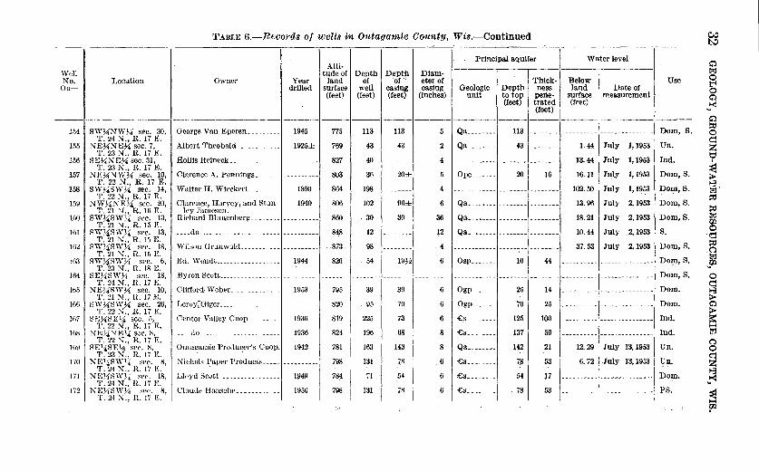
TABI,E 6.-Records of wells in Otttauamie County, Wis.-Continued t:5 -----
Principal aquifer Water level 0
Altl-1 I I I Well I I I I tude of Depth Dept:h Diam-Bolow ~--
l:j 0 No. Location Owner Year land of of c: eter of I · I Thlok- Use t'4 Ou- drilled surface well casi_ng casing Geologic Depth ness land Date of 0 (feet) (feet) (feet) (inches) unit to top pene- surface measurement Q
(feet) trated (feet) .... 1-<1 (feet)
-- ---------- ------------------ ------------ 0 SW_7.iNW~ sec. 30, George Van Eperen _________ 1945 775 113 113 5 Qa ________ 113 Dom, S.
~ 154 -------- ---------- --------------- 0
T. 24 N., R. 17 E. Un.
~ 155 NE~NE~ sec. 7, Albert Theobald ____________ 1925± 769 43 43 2 Qa ________ 43 -------- 1. 44 July 1,1953 z T. 23 N., R. 17 E. t:;1 156 SE~NE~ sec. 31, Hollis Reineck _____________ ---------- 827 40 -------- 4 ------------ -------- -------- 13.44 July 1,1953 Ind. I
'1'. 23 N., R. 1i E. Dom,S. ~ 157 NR~:\!W~ sec. 10, Clarence A. Pennings_. ··--------- 803 36 20± 5 Ope _______ 20 16 16.11 July 1,1953
T. 22 N., R. 17 E. Walter H. Wieckert_ __ 4 July 1,1953 Dom,S.
~ 158 SW~SW;\4 sec. 14, 1890 864 198 -------- ------------ ........................ -------- 102.50 l:j"
T. 22 N., R. 17 E. Clarence, Harvey, and Stan- Qa ________ July Dom,S.
~ 159 NW~4NE;\4 sec. 20, 1940 806 102 96± 6 -------- 13.96 2,1953
~ T. 21 N., R. 111 E. ley Jameson. lliO SW~SW:\4 ~ec. 13, Richard Blunenhe.rg ________ ---- ·-- --- 860 30 30 36 Qa ___ .~--- -------- -------- 18.21 July 2,1953 Dom,S. l:j
T. 21 N., R. 15 E. Qa __ "----- July _2, 1953 s. ~ 161 SW;\4SW_7.i sec. 13, _____ do _______ ,_ -"---- ______ ---------- 848 12 ----- l2 -------- -------- 10.44 d T. 21 N., R. 15 E.
Dom,S. ~ Hi2 SW~SW;\4 sec. 18, Wilson Grunwald_ ----- ---------- 8TJ 98 -------- 4 ------------ -------- 37.53 July 2,1953 .C T. :.!1 ;'\;-., R. 15 E. Dom,S.
l:j 163 sw~sw~ sPc. 6, Ed. Wendt__ __ 1944 820 54 I9H 6 Osp _______ 10 44 ---------- ·-------------- .... '(/2
T. 23 N., R. 18 E. 164 SE74SW74 sec. 18, Byron S0ott. ______________ ---------- -------- ·------- -------- ---- ----- ----------- -~-------- -------- ---------- --------------- Dom, S. 0
T. 24 N., H. 17 E. q 165 NE;liSW~ sec. 10, Clifford. Webe.r_ _____________ 1953 795 39 39 6 Ogp ______ 25 14 ---------- --------------- Dom.
~ T. 21 N., .. R. 17 E. 166 SW~SW~ sec. 26, Leruy:Giger __________________ 820 95 70 6 Ogp _______ 70 . 25 ...:--------- --------------- Dom. 0
T. 22 N., H. 17 E. -cs. ------- Ind. ~ 1117 SE.)iSE}-i sec. 5, Center Valley Coop _________ 1936 819 225 73 6 125 100 ---------- ----- ·---------
T. 22 N., R. 17 E. 1-j
H\8 NE~-4NE%: sec. 8, __ .,.do _________ -------------- 1936 824 196 08 8 -cs __ ------ 137 59 ---------- --------------- Ind. l:j
T. 22 N., R. 17 E. Outagamie Pro<lucer's Coop. Qa ________ July 13, 1953 Un.
Q lt19 SE14SE¥.!. sec. X, 1942 781 163 143 8 142 21 12.29 0
T. 23 N., H. 17 K. July 13,1953 l!n. ~ 170 NE~iS\'f1,4 sec. s, Nichols Paper PrD<luct~L __ .
---~------- 798 131 78 6 £g ___ ---- 7S 53 6.72 'f. 24 N., R. 17 E. 8
171 NE~<!SWH sec. 18, Ll••Yd Beott_ _____________ ~-- 1\14!-1 78:4 .71 54 6 £s ___ -oe··- 54 l7 ___ ... __ ............. - ... __ .. ___ .... _____ .,..._ D{)m. ... ~ '1'. 24 N., R. li K 172 NI<~~SW;\4 sec. 8, Claude Hanschl' _________ --1 1!150 798 131 78 6 -cs_ ------- 78 53 ----------~----- ---------- PS.
~ 1'. 24 ~., R. 17 E. I
f11
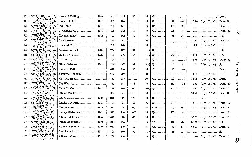
Leonard Colling_____________ 1949
Robert Thies________________ 1951
Ed Kemp___________________ 1941
J. Ciesielczyk_______________ 1951
Leeman SchooL____________ 1952
Lewis Reese __________________________ _
Richard Reese ______________ ----------
Oakland SchooL___________ 1930
A. E. Gritt__ _________ .. ______ 1938
173 NW>iNEU sec. 3, T.24~1 R.18E.
174 SEUNE~ sec. 4, T. 24 N . .t ,R. 18 E
175 NWUNE~ sec. 5, T. 24 N.1 ,R. 17 E.
176 NE%'NW~ sec. 5, T. 24 N., R. 17 E.
177 NW~NEU sec. 9, T. 24 N., R. 16 E.
178 SW%'NEU sec. 9, T. 24 N., R. 16 E.
179 SWUNEU sec. 9, T. 24 N., R. 16 E.
180 NW%'SWU sec. 22, T. 24 N., R. 16 E.
181 SEUSEU sec. 7, T. 23 N., R. 17 E.
182 SEUSEU sec. 7, 1-----uu ____________ _ T. 23 N., R. 17 E.
183 NEUNEU sec. 25, T. 24 N., R. 17 E.
184 SWUNEU sec. 27, T. 24 N., R. 17 E.
185 1 NEUNEU sec. 34, '1', 24 N.1 ,R. 17 E.
186 NWUSW~ sec. 28, T. 24 N.
1. R. 17 E.
187 NWUSWU sec. 1, T. 23 ~-, R. 16 E.
188 SEUSWy4 sec. 24, T. 24 ~·; R. 16 E.
189 SEUNE~ sec. 14, T. 24 N.1 ,R. 17 E.
190 SWUNW ~ sec. 16, T. 23 ~.1 R. 17 E.
191 SEUNE~ sec. 17t..
1938
Elmer Winters ______________ , 1942
T. 23 ~·; R. 17 J:<;. 192 SWUSEy4 sec. 15,
T. 23 N.i R. 17 E. 193 SWUNWU sec. 15,
T. 23 N., R. 17 E. 194 NEUNWU sec. 10,
T. 22 N.i R. 16 E. 195 NWUNE~ sec. 9,
T. 22 N., R. 16 E. 196 SWUN"EU sec. 4,
T. 22 N., R. 16 E. 197 NW>iNWU sec. 35,
T. 23 N., R. 16 E. 198 NWUNWU sec. 22,
T. 23 N., R. 16 E.
Robert Mielke _____________ _
Clarence Hurkman _____________________ _
Carl Mauthe _________________________ _
Joe Weber __________________________ _
John Tiekler________________ 1941
Elmer Mueller _______________________ _
Leo Gauss__________________ 1943
Linder Peterson_____________ 1943
Herman Seitz_______________ 1915
Henry Dieterrich_ ---------- 1941
Clifford Schlintz____________ 1950
Ellington SchooL___________ 1952
Carlton Schlintz____________ 1949
Joe Conrad__________________ 1941
Clinton Mack_______________ 1914
8ti7
861
795
804
797
799
797
772
796
796
791
817
777
780
770
779
834
811
810
812
816
841
913
796
767
85
230
151
242
102
67
140
137
246
72
97
143
739
285
181
103
51
337
57
84
154
80
175
148
100
190
40
236
70
137
246
72
97
42
171
103
270
57
60
100?
80
10
90
61 Ogp_ 6 Ogp ______ _
6 Qa _______ _
90
141
6 I £s _______ J 235
4
6
£s _______ _ 68
140
10
34
76.25
11.42
8.0
4721 Qa_--- ---- '--- -- ---•- -------,---------
4721 Qa _______ _
4 Qa _______ _
4Y2 Qa _______ _
£s_- ------
246
72
40
60
57
83
8
10 £s ________ , ________ , _______ _
6 I £s _______ _
4721 Qa _______ _
169
103
12
6 1------------1--------'- -------
19.36
30.10
. 91
4.00
12:98
1. 52
2. 25
10.95
6 I Qa ________
1
________
1
________
1
________ _
6 Qa ________________ -------- 12.01
4 I Ope ______ _
Qa _______ _
60
150
60
4
17.31
Qa .... - ____ J ____ -.. -..1. ---- ... ..1 22. 80
41 -cs _______ _ 6 £s _______ _
4Y2 -cs _______ _
122
61
88
53
87
12
38.48
69.77
Qa _______ J _______ J _______ J 2.46
---------·-----
Apr. 28, 195!
. ---------------
. ----------------
. ---------------
July 14, 1953
l July 14, 1953
. ---------------July 14, 1953
July 14, 1953
July 15, 1953
- ---------------
July 15, 1953
July 15, 1953
July 15, 1953
July 15, 1953
July 15, 1953
. ---------------July 16, 1953
July 16, 1953
. ---------------
July 16, 1953
July 16, 1953
July 16, 1953
. ---------------
July 16, 1953
Dom.
Dom,S.
Dom, S.
Dom, S .
PS.
Dom, S.
Un.
PS .
Un.
Dom, S.
s. Dom.
Ind.
Dom.
Dorn, S.
Dom, S.
Dorn, S.
Dom, S.
Dom, S.
Dom, S.
Dom, S.
PS
Dom, S.
s. Dom, S.
Q ~ o·
~ t:::l
~ ~ t:J ~
~~

TABLE 6.-Records of wells in Outagamie Oounty, Wi8.-Continued ~
Alti-~ I I I Principal aquifer Water level Q Well tude of Depth Depth Diam- 1:1;2 No. Location Owner Year land-·. of of eter of · · Thick- Below Use 0 Ou- I I I drilled I surface: well casing casing Geologic I Depth I ness land Date of b
(feet) : (feet) (feet) (inches) unit· to top pene- surface measurement Q (feet) trated (feet) 1-<l
(feet) "' --------- --- Q
199 NE~NW~ sec. 18, W. G. Bishoff_______________ 1953 783 68 68 6 Qa________ 63 5 16.58 July 16,1953 Dom, S. ~ T. 23 N., R. 17 E. q
200 NW~NW~ sec. 27, Milo Haulc_________________ 1937 785 66 22 4 -£s________ 55 11 ---------- --------------- Dom. z T. 21 N., R. 15 E. t:1
201 NE~NE~ sec. 6, Joe Rein.___________________ 1941 855 105 14 5 Osp_______ 39 66 ---------- --------------- Dom, S. • T. 23 N.j,R. 18 E. . · :a
202 NW~NEy4 sec. 12, Mrs. Rhemhold Miller______ 1944 785 114 114 6 Osp_______ 96 18 ---------- --------------- Dom, S. > T. 23 N., ~: 17 E. 1-3
203 NW~NW~ sec. 8, Mrs. Warren Barclay....... 1900± 864 95 15± 4 Osp ....... -------- -------- 58.09 July 22,1953 Un. 1:1;2 T. 23 N., R. 18 E. .. ~
204 SW~SW;\4 sec. 17, Charles Baumgartner....... 1949 811 127 89 6 Osp _______ ........ -------- 15.14 July 22,1953 Dom, S. '1'. 23 N.; R. 18 E. ·· ~
205 SW~SW~ sec.28, Golden Rule SchooL ....... ---------- 805 45 -------- 6 ------------ -------- -------- 7.62 July 22,1953 PS. 1:1;2 T. 23 N.;R. 18 E. ~
206 NE~NEK sec. 32, Carlton Sievert _____________ ---------- 80S 40 -------- 4 Ogp_______ 13 27 11.76 July 22,1953 U)1. q T. 23 N.~ ,R. 18 E. . ~
207 NE~NWXt sec. 32, ..... do.---------------------- 1952 824 200 31~ 6 Osp ....... -------- -------- 53.17 July 22,1953 Dom, S. C T. 23, N:, R. 18 E. 1:1;2
208 SE~SW~sec. 29, Harvey Thomas............ 1952 805 81 20 6 Osp....... 42 39 ---------- -------------- UJ T. 2.1 N:, R. 18 E. '""
209 SW~NW% sec. 35, Louis Planert .... ___________ ---------- 758 156 -------- 6 ------------ -------- -------- 17.99 July 22,1953 Un. 0 T. 23 N., R. 18 E. d
210 SE~NE~sec.14, Heitpas _____________________ ---------- 774 -------- -------- 6 ------------ -------- -------- 17.87 July 22,1953 s. ~ T. 23 N.,lL 18 E. >
211 NE~SE~ sec. 8, Tesch Bros.. ________________ ---------- 903 130 -------- 6 Ogp....... 00 40 48.04 July 23,1953 Un. Q T. 24 N.; R. 18 E. ?;
212 NE~NE~ sec. 6, Lawrence Grochowski.. _____ ---------- 886 55 -------- 4 ------------ -------- -------- 16.69 July 23,1953 Un. ~ T. 24 N.; R. 18 E. . H
213 NW~NE:J4 sec. 6, ...•. dO----------------------- ---------- 875 90 -------- 4 ------------ -------- -------- 22.45 July 23,1953 Dom, S. [;l T. 24 N., R. 18 E. . 0
214 NE~NE~ sec. 4, Be.nny Banker .. ____________ ---------- 872 -------- -------- 4 Ope ....... -------- -------- 30.90 July 22,1953 Dom, S. 0 T. 24 N;, R. 17 E. :· q
215 NW~NW~ sec. 12, Alvin Carpenter ..•......... ---------- 792 78 78 ---------- ------------ -------- -------- 6. 20 July 23,1953 Dom, S. z T. 24 N.;· R. 16 E. 1-3
216 SW~SW~ sec. 23, Louis Planert............... 1951 790 -------- -------- 4 -----------· -------- -------- 12.07 July 23,1953 Dom, S. 1-<l T. 24 N.; R.16 E. . ..
217 SW~SW~ sec. 27, George Gorum .............. ---------- 775 45 -------- 3 ------------ -------- -------- 7.89 July 23,1953 Un. ~ T. 24 N., R. 16 E. 1:1
fP.
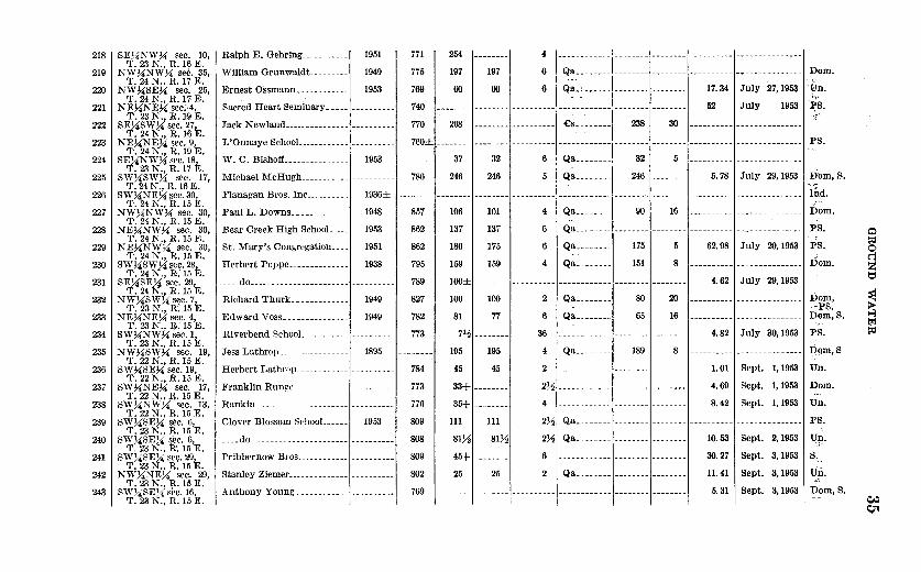
218
219
220
221
222
223
224
225
226
227
228
229
230
231
232
233
234
235
236
237
238
239
240
241
242
243
SE~NW~ sec. 10, T. 23 N., R. 1~ E. NW~NW~ sec. 35,
T. 24 N., R. 17 E. NW~SE~ sec.- 25,
T. 24 N., R. 17 E. NE~NEKsec>4, T.23~1 R.19E.
SE~SWn sec.27, T. 24 N., R. 16 E.
NE~NE~ sec. 9, T. 24 N., R. 19 E.
SE~NW~ sec. 18, T. 23 N., R. 17 E.
sw~sw~ sec. 17, T. 24 N., R.16 E.
SW~NE~ !,lee. 30, T. 24 N., R. 15 E.
NW~NW~ sec. 30, T. 24 N., R. 15 E.
NE~NW~ sec. 30, T. 24 N.l R. 15 E.
NE~NW~ sec. 30, T. 24 N., R.15 E.
sw~sw~ sec. 28, T. 24 N.~ R. 15 E.
SE~SE~ sec. 29, T. 24 N., R.15 E.
NW~SW~ s~e. 7, T. 23 N., R.15 E.
NE~NEJ4 sec. 4, T. 23 N., }!;.15 E.
SW~NW~ sec. 1, T. 23 N., R. 15 E.
NW!4SW~ ·sec. 19, T.22~1 R.15E.
SWJ4SEy4 sec. 19, T. 22 N., R. 15 E.
SW~NE~ ·sec. 17, T. 22 N., R. 15 E. SW~NW~ sec. 13,
T. 22 N., R;15 E. SW~SE~ sec. 6,
T. 23 N., R. 15 E. SW!4SE!4 sec. 6,
T. 23 N., :R. 1.5 E. SW~SEy4 se9. 29~
T. 23 N., R. 15 jj;,
NW!iNE~ · sec. 29, T. 23 N., R. 15 E.
SW!4SE!4 silc. 16, T. 23 N., R; 15 E.
Ralph E. Gehring ___________ l1951
William Grunwaldt_________ 1949
Ernest Ossmann____________ 1953
Sacred Heart Seminary _____ , _________ _
Jack Newland _______________ , _________ _
L'Onnaye SchooL-----------~----------
W. C. Bishoff_______________ 1953
Michael McHugh ___________ , _________ _
Flanagan Bros. Inc__________ 1936±
PaulL. Downs_____________ 1948
Bear Creek High SchooL ___ 1953
St. Mary's Congregation____ 1951
Herbert Poppe______________ 1938
flo
Richard Thurk _____________ l 1949
Edward Voss_______________ 1949
River bend SchooL __________ , _________ _
Jess Lathrop_ 1895
Herbert Lathr;,p_ -----------~------ ___ _
Franklin Runge ______________ _
Rankin _______ _
Clover Blossom SC'hooL ___ _I 1953
flo
Pribbernow Bros .. ---------·----------
Stanley Ziemer ______________ , _________ _
Anthony Young .
771
775
769
740
770
254
197
60
197
60
4
6
6
1------------ '-------- ·--------' ---------- ---------------
ci~~: ~~~~~~ ~~~~:~~~~ ~~~~~~~~~ ~---- ~;~;~-. ---------------July 27, 1953
• ------- '-------- '--- -------1----- ••• --- -I--------'-----.-- 52 JUly 1953
268 £s _______ _ 238 30 . ---------------760±1- -------1--------1----------1----------- -I--------'--------'----------. ---------------
786
37
246
32
246
6
5
Qa _______ _
Qa ______ --
32
246
5
5. 78
' ---------------
July 29, 1953
--------' --------' --------' ----------1------------1--------' ________ ,- ---------. ---------------857
862
862
795
106
137
180
159
101
137
175
159
4
6
6
4
Qa _______ _ 90 16
Qa.-------,- -------,--------,---------Qa _______ _
Qa _______ _ 175
151
62.98
8
789 I loo±1 ________
1 _________ t·---------t··-----·-------- 4.62
827
782
773
100
81
712
195
45
33+
35+
100
77
--------195
45
--------
--------
2
6
36
4
2
272
4
Qa _______ _
Qa _______ _
Qa _______ _
80
65
189
20
16
8
1------------1- -------·- -------
1------------ '---- ---- '-- ------1------------1-------- , __ ------
4.82
1.01
4.69
8.42
. ---------------
. ---------------
July 20, 1953
. ---------------
July 29, 1953
. ---------------
. ---------------July 30,1953
. ---------------Sept. 1, 1953
Sept. 1, 1953
Sept. 1, 1953
784
773
776
809
808
809
802
769
111 111 272 Qa.- ------ ·-------- ·-------- ·----- -----. -------------- ...
8172 8172 272 Qa._- ----- ·----- --- , __ ------
45+ -------- 6 ·--1--------·--------i
25 25 2 Qa_----- -- ', _____ --- ·--------
--------'--- ----- ·----------1------ ------1-------- '--------
10.53
30.27
11.41
5. 31
Sept. 2, 1953
Sept. 3, 1953
Sept. 3, 1953 I
Sept. 3, 1953
Dom.
Un. ~-,.
~8. ;!'
PS.
Dom,S.
11d.
Dom. PS. 0 PS. ~
0
Dom. ~ z t:l
Dom, ~ ~PS. ~m,S. 1-3
t-:.1 PS. ~
I)qm, S
Un.
Dom. .,.
Un.
PS.
u~.
8.
Un. ,)..~
:Dom,s. C/o:) Qt
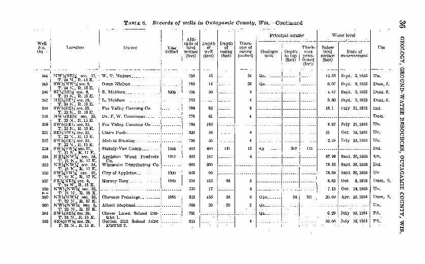
TABLE 6.-Recot·ds of wells in Outagamie County, Wis.-Continued ~
Alti-~ _
1
I I _ Principal aquifer _ Water !evel ~ Well tude of Depth Depth Diam- ------------- ---. ---~------- tz:l No. J"'ocation Own<'r Year land of ··of eter of Thick- Below · Use 0 Ou- I I I drilled I surface well casing casing Geologic I Depth I ness land Date of S
(feet) (feet) (feet) (inches) unit to top pene- surface measurement ~ (feet) trated (feet) ~
(feet) " ------------- -------- ----- ~
244 NW7.l'SE7.!' sec. 17, W. T. Nielson______________ __________ 795 16 ________ 24 Qa________ ________ ________ 12.35 Sept. 3,1953 Un. ~ T. 24 N., R. 15 E. ~
245 SW7.l'NW7.! see. 9, Owen Nielson ______________ __________ 789 14 ________ 36 Qa ________________ -------- 8. 07 Sept. 3,1953 Dom, S. z T. 24 N., R. 15 E. t::::l
246 SE7.l'SE%; sec. 6, E. Meidam_________________ 1908 798 50 -------- 4 ____________ -------- ________ 4.47 Sept. 3,1953 Dom. S. • T. 21 N., R. 15 E. :;1
247 NE7.!'SE;a sec. 18, L. Meidam. ________________ __________ 793 ________ ________ 4 ____________ ________ ________ 3. 80 Sept. 3,1953 Dom, S. > T. 24 N., R. 15 E. 8
248 SW~SE7.!' sec. 35, Fox Valley Canning Co_______________ 789 82 _______ 6 ____________ -------- -------- 16.1 July 21,1953 Ind. t:z:J T. 22 N., R. 15 E. ~
249 NW7.!'SE~ sec. 35, Dr. F. W. Cousineau_________________ 778 61 4 ------------ -------- ________ ---------- --------------- Dom. ~ T. 22 N., R. 15 E. tz:l
250 I SW7.l'SE!4 sec. 35, Fox Valley Canning Co _____ ---------- 789 180 ____ ___ _ ______ -------- ________ 8. 87 July 21,1953 Un. Ul T.22N.,R.15E. 0
251 SE~SW7.!' sec. 35, Claire Poole_________________ ______ ___ 820 58 4 31 Oct. 19,1953 Un. Cl T. 22 N., R. 15 E. ~
252 SW~SEl-:i sec. 35. Melvin Buesing___________________ 790 56 _____ 4 _____ 2.24 July 23,1953 Un. (") T. 22 N., R. 15 E. tz:1
253 SW7.l'SW7.l'sec.27, Stokely-VanCamp__________ 1934 802 480 141 12 £s________ 307 173 ---------- --------------- Ind. Ul T.21N.,R.17E. "'
254 NEUNW7.!' sec. 34, Appleton Wood Products 1917 803 147 4 ------------ -------- ________ 67.99 Sept. 30,1953 Un. 0 T. 21 N., R. 17 E. Co. ~
255 NE7.l'NWU sec. 34, Wisconsin Distributing Co_---------- 802 300 -------- ---·------ -------------------- ________ 78.55 Sept. 30,1953 Ind. 8 T. 21 N., R. 17 E. >
256 SW7.l'SW~ sec. 27, City of Appleton____________ 1900 803 96 ____________ ------ ____________ -------- ________ 78.88 Sept. 30,1953 Un 0 T. 21 N., R. 17 E. >
257 SEUNE7.!' sec. 8, Harvey Borg________________ 1949 794 103 98 5 ---------·-- -------- ___ 8.82 Oct. 8,1953 Dom, S. ~ T. 24 N., R.15 E. ~
258 NWUNWU sec. 32, ------------------------------ ---------- 770 17 -------- 4 ___________ ___ 7.15 Oct. 14,1953 Ur1 . .,_.. T. 21 N., R. 16 E. c 259 NEUNWU sec. 10, Clarence Pennings__________ 1954 813 135 36 6 Ope________ 34 101 20.69 Apr. 23,1954 Dom, S. 0
T. 22 N., R. 17 E. ~ 260 NWUNWU sec. 8, Albert Stephani..___________ 769 20 20 2 Qa ________ --- ---- .. ---- . --------- --------------- Un. z
T. 23 N., R. 17 E. . · - ·- · · . . 8 261 SWUSEU sec. 29, Clover Lawn School DlS- 791 --------~-------- Qa________ ____ 6.29 July 29,1954 PS. ~
T. 24 N., R. 15 E. trict 1. - . . . "' 262 SEUSW~sec.29, Go19-en Hill School Joint __________ 813 ________ -------- 4 ------------ . __ __I 38.66 July 28,1954 PS. :a
T. 23 N ., R. 15 E. DlStrict 2. I ··I '""' rn

263 SWUNWU sec. 24, T. 22 N., R. 16 E.
Carl Timm _________________ 195.3 776 342 172 6 £s _________ 180 162 ---------- --------------- Dom.
264 NEUNEU sec. 5, Harold Conradt _____________ ------·--- 803 -------- ....................... ---------- --·--------- --------- -------- ---------- --------------- Dom. T.22N.,R.16E.
----.do ______________ ------ ___ Flowing_ Sept. 1,1954 Un. 265 SWUSEU sec. 32, ---------- 770 ......................... ---·---- 4 ------------ -------- ....................... T.23N.,R.16E.
Flowing_ Sept. 1, 1954 s. 266 NWUSWU sec. 17, ----------- ·- ------ ... ----------- ---------- 768 -------- -------- 2 ------------ -------- ........................ T. 22 N ., R. 16 E.
800 Qa ________ s. 267 NW;4SWU sec. 13, Edw. Halloran ______________ 1953 100 100 6 96 4 ---------- ---------------T. 22 N., R. 16 E.
268 SWUSWU sec. 29, Black Creek School Dis- 1942 827 56 30 4~ ----------·- -------- -------- ---------- --------------- Un. T. 23 N., R. 17 E. trict 4.
269 SWUSWU sec. 29, Black Creek School District 1953 827 43 43 6 £s ________ 61 97 ---------- --------------- PS. T. 23 N., R. 17 E. 4.
270 SEUNWU sec. 9, Unused SchooL _____________ ---------- 839 -------- -------- 4 ------------ -------- -------- 17.17 Sept. 2, 1954 Un. T. 21 N., R. 15 E.
271 SEUNWU sec. 13, John McCandless ___________ 1938 799 84 37 4~ £g ________ 37 47 9.01 Oct. 7,1954 Dom.
272 T. 22 N., R. 16 E.
SEUNWU sec. 17, Wm. Cummings ____________ 1954 806 125 65 6 £s ________ 65 60 34.31 Oct. 7,1954 Dom,S. T. 22 N., R. 16 E.
273 SWUNEU, sec. 17, Peter Wied _________________ 1954 834 85 43 6 £s ________ 27 58 ---------- --------------- Dom. 0
T. 22 N., R. 16 E. ~ 274 SWUSWU sec. 27, Seymour Creamery _________ 1947± 802 235 96 ---------- Ogp, Ope_ 96 139 ---------- --------------- Ind. 0
T. 24 N., R. 18 E. ~ 275 SWUSWU sec. 8, T. L. Knapstein ____________ 1952± 760± 205 140 3 Qa ________ 140 65 Flowing Oct. 8,1954 Dom.
T. 22 N~ R. 16 E. t:' 276 SEUSW 'l. sec. 20, Wm. Marcks ________________ 1954 780 150± -------- 6 £s.- ------ 130 20 ---------- --------------- Dom. T. 24 NJl· 17 E.
~ 277 NWUSW ,_ sec. 28, ------------------------------ 780 91 -------- ---------- £s ________ 280 220 ---------- --------------- Oil test. T. 24 N~ R. 17 E.
278 SEUNE1'l. sec. 11, School District_ _____________ 1941 862 91 38 4~ Ope _______ 427 64 ---------- --------------- PS. 1-3 T. 24 N., R. 17 E. trl
279 NEUNEU sec. 1, County Line RchooL _______ 1946 804 63 40 6 Ogp _______ 38 25 ---------- --------------- PS. ~ T. 24 N., R. 18 E.
Ind. 280 SWUSWU sec. 27, Stokely-VanCamp __________ 1954 804 745 152 16 £s ________ 315 428 ---------- ---------------281
T. 21 N., R. 17 E. NEUNEU sec. 31, Crystal Spring "chooL ______ ·--------- 776 80 -------- 472 Qa ________ -------- -------- ---------- --------------- PS.
282 T. 24 N., R. 18 E.
NWUNEU sec. 31, K. Kollath ____ - ---------- ---------- 776 130 80 4Y2 Qa_ ------- -------- -------- ---------- --------------- Dom, S.
283 T. 24 N.f4.R. 18 E.
SWUNW 'l. sec. 24, A. Techlin _____ ----------- 1942 861 355 168 5 £s ________ 258 97 ---------- --------------- Dom, S.
284 T. 22 N., R. 17 E.
SWUSWU sec. 8, ------------------------------ ---------- 771 70± ___ .,. ____
6 ------------ -------- -------- 12.39 Nov. 18,1954 s. T. 24 N.f4.R. 19 E.
2851 NEJ{NW, "''· 7, School District 9 ____________ 1954 852 154 42 6 Ogp _______ 42 112 ---------- --------------- PS.
T. 21 N., R. 17 E. 286 SWUNEU sec. 33, W. Williams ________________ 1902 820 102 77 4 £s ________ 77 25
T. 23 N., R. 16 E. 287 SWUNWU sec. 3, ----- - ... ----------------------- 783 200± --·----- __ .. _______ Qa ________ 40 160+~----------,
T. 23 N., R. 15 E. I
~ 'l

38 GEOLOGY, GROUND-WATER RESOURCES, OUTAGAMIE COUNTY, WIS.
Drilled wells range in diameter from 3 to 16 inches, depending upon the size and type of pump to be used and the yield required. Those ending in consolidated rock are usually cased only through the drift; those penetrating just the drift use perforated casing or screen to keep the hole open and to allow water to enter the well. Some wells ending in coarse sand or gravel are cased with unperforated pipe, and water enters through the open bottom of the casing.
1Vhen a relatively small quantity of water is needed for stock or domestic use, a well may be driven into sandy deposits of the glacial drift· or lake sediments. Such wells are usually 11;4 to 21;2 ·inches in diameter and have a well point or a length of slotted pipe n~ar the bottom. The driven well is best suited to the sandy areas in the northwestern quarter of the county. .
A few dug wells are still in use for domestic and stock supplies, but most of them have been replaced by ch·illed or driven: wells. The dug wells are 3 to 5 feet in diameter and as n1uch as 30 fe~t deep. They have been dug by hand or by power shovel and are lined with stone to prevent caving. The material penetrated must be firm and must stand without caving, so the wells are usually dug through clay to the top of a n1ore permeable underlying bed.
Twenty-four of the wells visited exceed 500 feet in depth. Of these, 20 are industrial or municipal wells along the Fox River. The deepest well visited is Ou 35, drilled for the Village of IGmberly and ending in granite at 804 feet. The average depth of the 257 wells whose depth is known is 195 feet, the median depth of the same wells is 127 feetthat is, 128 wells are less than and 128 wells are more than 127 feet deep.
SPRINGS
A spring is the discharge of ground water, under hydrostatic pressure, at the land surface or into lakes and streams. There are many different types of springs, but the two most common in Outagamie County may be classed as seepage and contact springs. Seepage springs represent an outcrop of the w·ater table and may disappear during periods of water-table decline. They are most numerous in the low, marshy areas along the vVolf and Embarrass Rivers, where there is a considerable amount of efHuent seepage. Although most marshy areas are the result of efHuent ground-water seepage, in most places the seepage is not concentrated enough to be classed as a spring.
Contact springs occur when the contact between a permeable and an impermeable formation is exposed at the surface. Along the Fox River, ground water percolates downward through the glacial drift to the top of the less permeable Platteville formation, where some of the water moves laterally toward the river and issues as springs along the sides of the valley. At the base of the escarpment of Prairie du

GROUND WATER 39
Chien rocks between Hortonville and New London the process is reversed. Here artesian water rising in the permeable sandstone of Cambrian age is partly retarded by the overlying dolomite of the Prairie du Chien group and flows to the surface along the contact near the base of the scarp.
Weidman and Schultz report that springs were a common source of water supply in the county at the time of their report (1915), but now few are in use.
PUMPING TESTS
Determination of the hydraulic characteristics of an aquifer is essential in predicting the effects of withdrawal of water from it. The term coefficient of transmissibility is used to designate the amount of water, in gallons, that will pass in 1 day across a vertical strip of the aquifer, 1 foot wide and extending the full thickness of the aquifer, under a unit hydraulic gradient. The coefficient of storage of an aquifer is the volume of water it releases from or takes into storage per unit surface area of the aquifer per unit change in the component of head normal to that surface. ·
The most reliable short-term method o:£ determining the hydraulic characteristics of an aquifer is to apply the nonequilibrium formula of Theis· (1935) to observations of the amount and rate of change in the piezometric surface at or near a discharging well.
The nonequilibrium formula is : 114.6 Q
s=-T-W(tt)
i "" e-"du u2 u3 u4 where W(u)= -- =-0.577216-log
0u+u- -+- -- ···
'tl u 2·2! 3·3! 4-4! 1.87r2S
and u= --Tt
where s= drawdown, in feet, at observation well Q = discharge, in gallons per minute T= coefficient of transmissibility, in gpd/ft r= distance, in feet, from observation well to pumped well S= coefficient of storage t= time, in days, since pumping started
To develop the formula it was assumed that the aquifer is infinite in extent and confined between impermeable beds, that it transmits water equally in all directions and releases water from storage instantaneously with a decline in artesian head, and that its hydraulic characteristics do not change. It is recognized that these are ideal conditions which are never completely satisfied in nature, but in many areas they are substantially satisfied.
SEYMOUR TESTS
The pumping tests at Seymour in April1949 consisted of pumping wells that tap sandstone of Cambrian age and observing the effects produced on the piezometric surface. Water-level measurements. were
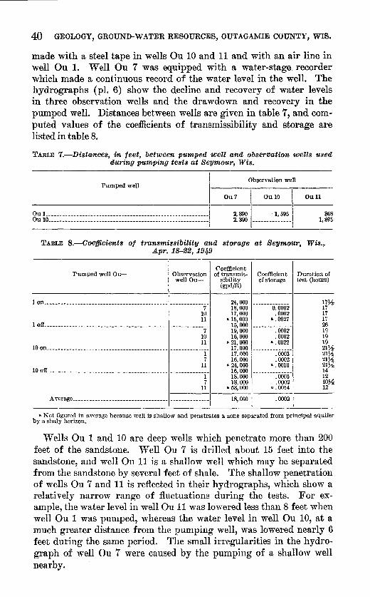
40 GEOLOGY, GROUND-WATER RESOURCES, OUTAGAlVllE COUNTY, WIS.
made with a steel tape in wells Ou 10 and 11 and with an air line in well Ou 1. Well Ou 7 was equipped with a water-stage recorder which made a continuous record of the water level in the well. The hydrographs (pl. 6) show the decline and recovery of water levels in three observation wells and the drawdown and recovery in the pumped well. Distances between wells are given in table 7, and computed values of the coefficients of transmissibility and storage are listed in table 8.
TABLE 7.-Distances, in feet, between pumped well and observation wells used during pumping tests at Seymour, Wis.
Pumped well
Ou L_ --- _ ----------------------------------- ________________ _ Ou 10 _____ ------------ _ ---------------------- _____ ------ _____ _
Ou7
2,890 2,390
Observation well
Ou 10
·1,595
Ou11
368 1;875
TABLE 8.-0oejficient.s of transmissibility and storage at Seymour, Wis.~ Apr. 18-22, 191,9
Coefficient Pumped well Ou- Observation of transmis- Coefficient Duration of
well Ou- sibility of storage test (honrs} (gpd/ft)
1 on--------------------------- __ ------------ ________________ _ 7
10 11 1 off.----------- _____________________________________________ _ 7
10 11 10 on ________________________________________________________ _
1 7
11 10 off------------------------------------------ --------------
1 7
11
Average _____________ ----------- __________ ,_------_------
24,000 18,000 17,000
B 15,000 15,000 19,000 16,000
a 21,000 17,000 17,000 16,000
a 24,000 16,000 18,000 18,000
B 53,000
18,000
--------------0.0002
.0002 ".0027
--------------.0002 .0002
a .0022 --------------
.0003
.0002 & • 0010
--------------.0003 .0002
& • 0014
.0002
17~ 17 17 17 26 19 19 19 2l>f 21~ 21~ 21>f 14 12 lO>f 12
a Not figured in average because well is shallow and penetrates a zone separated from principal aquifer by a shaly horizon.
Wells Ou 1 and 10 are deep wells which penetrate more than 200 feet of the sandstone. "'\V ell Ou 7 is drilled about 15 feet into the sandstone, and well On 11 is a shallow well which may be separated from the sandstone by several feet of shale. The shallow penetration of wells Ou 7 and 11 is reflected in their hydrographs, which show a relatively narrow range of fluctuations during the tests. For example, the water level in well Ou 11 was lowered less than 8 feet when well Ou 1 was pun1ped, whereas the water level in well Ou 10, at a much greater distance from the pumping well, was lowered nearly 6 feet during the same period. The stnall irregularities in the hydrograph of well Ou 7 were caused by the pumping of a shallow well nearby.

GROUND WATER 41
APPLETON TEST
In March 1954 a test was made in Appleton, using well Ou 22 as the pumped well and well Ou 253 as an observation well. The wells are 1,115 feet apart and both are open in the St. Peter sandstone, the dolomite of the Prairie du Chien group, and the underlying sandstone of Cambrian age. The average coefficient of transmissiLility obtained :from the drawdown and recovery tests is about 19,000 gpd per :foot. Tlie average coefficient of storage :for the two tests is about 0.00015. The coefficients are based on measurements in only one observation well and may not be representative. However, they are in close agreement with values obtained in the Seymour tests, and the specific capacities of the wells are similar to those of other wells in the Appleton area.
HORTONVILLE TESTS
In Hortonville, pumping tests were made in October 1953 using 1vells Ou 33 and 80 as pumped wells and Ou 81 and 248-252 as observation wells. The pumped wells tap sandstone of Cambrian age which lies immediately below the glacial drift in this area.
Values obtained for the coefficient of transmissibility (T) range fron1 about 27,000 to about 75,000 gpd per foot and average about 43,000 gpd. Values of the coefficient of storage ( S) range from about 0.00006 to about 0.0009 and average about 0.0004. The wide range in T and S values, which is attributed to local recharge and the :fact that some of the observation wells may terminate in the glacial drift, make it impossible to apply the values to a prediction of interference or water-level trends.
QUALITY
Chemical analyses of 37 samples of ground water from Outagamie County are listed in table 9. The chemical quality of the water differs greatly from well to well. For example, the mean hardness· is about ;385 ppm (median 300 ppm) , but the range in hardness is :from 1,200 ppm to 58 ppm. Although the water generally is very hard, the dissolved-solids content averages about 540 pp1n (median about 350 ppm) ; a limit of 500 ppm is recommended by the U. S. Public Health Service (1946) for drinking and culinary water. The sulfate concentration ranges from 815 ppm to less than 1 ppm and averages about 169 ppm (median 30 ppm). The limit suggested by the Public Health Service for sulfate is 250 pp1n. I-Iigh iron content is a problem in many wells. A concentration of 27 ppm is reported in well Ou 56. However, in 34 analyses listed in table 9 the range is from 4.0 ppm to 0.0 ppm and the average is about 0.8 ppm (median 0.4 ppm). The median is 0.1 ppm above the limit set by the Public Health Service for iron, or iron and n1anganese together.

Well No. Ou-
--L ______
------- ---2 ____ -- -----
10 ___ --- --- --- ------17 _____ --- --- ----26 ________ ------------ - ------33 ________ -
- -------·---34 ___ ----- --------- --------36 ___ 44 ____ -------
45 ___ -- ---------4U ___
·---47--- -- ---4!L __ ---lA ____ f\5 ____ 71___ iL ---'i3 ___ --- ---7·1 ---
x.~----- -----Xi_ - -- ----\!L --- ---103 _____
--- ---105 _______ -----------J]L_ ____
---\14 ___ --125 _____ -- -- -----l:J3 _____ 1::!8 ------ -----15\l ____ -- ---165 ____
187---- --l~IL --------25~1 _____ - -- ----2!10 ___
TABLE 9.-0hemical analy.<Jes of ground water in Outagamie Oou.nty, Wis.
[Results in parts per million except pH; analyses by Wisconsin State Board of Health)
Date of Dissolved Iron (Fe) Calcium Magnesium Bicarbon- Sulfate Chloride collection solids (Ca) (Mg} ate (HCOa) (SO.) (Cl)
1935 221 1.4 ---------- - ------------ 193 8 5 a 1911 1, 350 ------------ 272 21 ------------ 604 12 1935 1, 460 .4 ------------ ---- ------- 209 815 15
Aug. 7, 1946 328 1.2 69 30 373 20 2. 5 (a) 647 ------------ 158 31 ----- ------ 296 7.1
1946 310 .8 70 27 331 30 3.5 Mar. 11, 1949 346 .o 73 34 423 3.0 2.0
1935 480 .3 ------------ ------------ 376 122 10 _____ do _______ 475 . 5 ------------ ------ ---- 293 152 8.0 _ ____ do _______ 960 ------- ---- ------------ ------ ----- 224 481 10 Mar. 6,1946 1,040 .3 261 16 212 560 11 _ ____ cto ______ 1, 220 .4 312 16 222 660 14 Sept. 30, 1946 ,')90 .2 135 20 2.57 245 12 ____ do ___ 548 .2 125 16 241) 210 12 Apr. 8,1954 1, 670 1.8 362 68 456 725 28 _ ____ do ______ 354 . 1 65 19 183 108 5. 5 Apr. 23, HJ~4 1, 020 .li 171 64 449 330 8.0 FPb. 16, 19ii0 180 .0 20 17 190 11 4.0
HJ35 246 . 2 --- ----- ---- -- ---- 268 22 8 _____ do ___ 279 .4 309 16 3 Apr. 23, l!!!i4 302 .2 31 26 232 16 2. 0 Mar. 25, 1954 368 1.2 58 43 381 24 14 _____ do ____ 370 .0 68 36 327 24 6.0 _____ do _______ 300 .6 34 40 320 12 3.1) Apr. 8, 1954 1, 010 .4 142 29 78 500 41 Mar. 25, Hi54 290 4. 0 56 34 356 2. 5 2.0 Apr. 8,1954 298 .4 41 30 307 13 5. 5 _____ do ______ 520 l.tl 8'i 44 417 49 44 Apr. 23, 1954 218 . 1 :n 20 217 22 2. 0 _____ do _______ 352 4. 0 68 30 325 33 1.5 _____ do _______ 288 1.6 56 2!! 320 7. 0 1.5 Apr. 8, 1964 258 .3 29 3fl 278 21 3.0 Mar. 25, 1954 362 .tl 53 39 412 2.0 2. 5 Apr. 23, 1954 196 .0 HI 4. 8 120 47 10 _____ do _______ tl30 1.2 98 50 400 73 35 _____ do ________ 2~16 1.0 26 41 354 .0 3. 0 _____ do. _____ 238.1 .1 29 25 264 .5 2.0
a 'Y<·iclman, 8nmul'l, and Schultz, A. R., 191.5. p. 493.
Fluoride I U:ardness (F) as CaCOa
--------.-- 150 ------- ---·-- 765
--------0~2-970 285
------------ 522 .5 265 .1 320
------------ 450 ------------ 380
--------2~6 620 585
2. 0 670 1.9 385 2. 0 300 1.0 1, 200 1.9 244 1. 2 732 .2 120
------ ----- 260 ---- ------- 250
.2 176
. 1 341 <.1 322
.2 270 1.4 475 .2 288 . 7 235
<.1 403 .9 164 . 1 299 .4 262 .2 236 .4 330 .6 58
<.1 472 . 3 268 .4 181
pH
------------------------------------
7. 4 ------------
7.4 7.4
------------------------------------
7.3 7.3 7. 4 7. 4 7.1 7.8 7. 3 7. 7
-----------------------
8. 7. 7. 7. 7. 7. 7. 7. 7. 7. 7. 8. 7. 8. 7. 7. 8.
7 0 8 3 4 7 0
~ ~
0 t%.1 0 t:"' 0
.. ~ 0 ~ 0 0 z '='
~ 1-3 t<l ~
~ t<l Ul 0
~ 0 t<l
,.Ul
0
~ ~ t<l 0 0
~ ... ~
~ rn

GROUND WATER 43
Information on the chemical character o:f ground water is important to all users o:f this valuable resource. It is also an important tool :for use by the hydrologist interested in the source and movement of water. A table of analyses, such as table 9, presents the available data but the form is not readily adaptable for interpretive work. In the past, several illustrative Inethods have been used to show the similarity or dissimilarity of various waters. These methods include the bar graph, the pi~ diagram, the trilinear plot, and others, each of which has advantages and disadvantages. R. C. Vorhis of the U. S. Geological Survey lias suggested for interpretive work the use of a logarithmic diagram ( ~cl~9~.llm;, 1935) adopt~d by the French hydrogeologists in Tunisia, Algeria, and French Morocco. The diagram consists o:f vertical logarithmic scales for constituents and properties, and the graph is a series of straight-line segments connecting the values plotted for each analysis (pl. 7). The similarity or difference of two analyses is readily apparent from a comparison of their graphs. Loga~ithmic graphs for 22 analyses are shown on plate 7. They
are grouped by geologic source to show that the source is the predominant factor cin. deterlni11ing the pattern of the graph. The :form of the graphs in diagra1n A is distinctive and is characteristic :for wells that tap all the Paleozoic forinations below the Maquoketa shale. Water from the Maquoketa shale is similar to, but more highly mineralized than, watm~ from the Platteville and Galena formations ( diagra1n B). \Vater from rocks of the Upper Cambrian series ( diagran1 0) is generally .characterized by a low chloride and sulfate content. Well Ou 10, ·which does not fit this pattern, is an old well caR~d through the Prairie du Chien. However, the graph for Ou 10 cfosely resembles those of diagram D, indicating that water from the Prairie du Chien nn1st be entering the 'vell through a defective casing, raising the sulfate content of the water sampled. The patterns of diagrams D a.nd E are noticeably 'alike. They represent water from similar n1aterial but of a different age.
The graphs for well Ou 114 (diagram 0), Ou 196 ( diagran1 D), and Ou 85 (diagram E) are anomalous because of an abnormally high chloride content. This is attributed to their location near poorly drained, marshy areas where the chloride concentration of the water is inereased by surface evaporation of the stagnant water. The pattern of diagram F, representing water frmn Pleistocene deposits, is somewhat similar to that of diagrams D and E, except :for the nearly straight line formed by the calcimn-magnesium-hardness plot.
The logarithmic diagram has been useful in the study of the geology and ground water of Outagamie County. Although a limited number of analyses v.rere made and plotted, a definite tendency toward charaeteristic patterns for the Yarious sources of water "Tas

44 GEOLOGY, GROUND-WATER RESOURCES, OUTAGAMIE COUNTY, WIS.
evident. Where other evidence was inconclusive, comparisons of water-analysis graphs helped in determining the source and movement of water and in establishing geologic boundaries.
CONCLUSIONS
More than three-fourths of Outagamie County is underlain by thick beds of sandstone of Cambrian age which supply most of the water to industrial and public-supply wells along the Fox River. Consolidated rocks of the St. Peter sandstone, Platteville formation and Galena dolonite, and Prairie du Chien group and unconsolidated deposits of Pleistocene age are tapped by many domestic and farm wells and probably could be developed to a much greater extent. An especially promising reservoir is the buried preglacial valley that heads near Seymour.
Recharge occurs throughout most of the county but is greatest in areas where the sandstones are at or near the surface. Practically all recharge is from local precipitation. Ground-water discharge occurs naturally by flow from contact and seepage springs; by diffused seepage into swamps, from which it is evaporated and transpired, and into streams; and by underflow to the south and east. Ground-wat~r pumpage along the Fox River in Outagamie County
was about 4.3 mgd in 1952. There is no evidence of overdraft at present, but additional pumping tests should be made to determine the acquifer characteristics in localities other than the few already tested, to enable prediction of water-level trends and interference that would result from additional development.
WELL LOGS
Tables 10 and 11 contain selected logs of wells drilled in Outagamie County. The descriptions and stratigraphic correlations in table 10 are by F. T. Thwaites of the Wisconsin Geological Survey from his examination of drill cuttings from each well. In table 11, descriptions of the material penetrated are those of the driller and stratigraphic correlations are by the author.
Logs of 337 wells were collected from several sources during the investigation. Of these, 161 were located in the field, 49 logs were used in construction of the geologic sections, and 45 logs are published in tables 10 and 11. Essentially all drilling in the county is by the cable-tool method. This method, when used by experienced drillers facilities accurate logging of wells.

WELL LOGS 45
TABLE 10.-Materials penetrated by wells in Outagamie County, Wis.
[Interpretation by F. T. Thwaites, Wisconsin Geological Sur>ey, on basis of examination of drill cuttingsl
"\Veil Ou 2, NE~SW~4 sec. 24, T. 21 N., R. 18 E.
Thickness Depth (feet) (feet)
Galena Dolomite and Platteville formation: Limestone _________ ------------------------------------._---------------------- 170 170
St. Peter sandstone: Dolomite, light-gray __________________________________________________________ _ Sandstone, medium- to fine-grained, gray, dolomitic _________________________ __ Sandstone, fine-grained; pebbles, pmk; chert, white ___________________________ _
3 173 13 1S6 14 200
Prairie du Chien group: Dolomite, light-gray; some shale, green _______________________________________ _ Sandstone, medium-grained, white; chert, white; shale, green ________________ __ Dolomite, light-gray; some chert, white _______________________________________ _
42 242 11 253
115 368 Upper Cambrian series:
Sandstone, fine-grained, light-gray; shale, red, dolomitic _____________________ __ 12 380 Dolomite, dark-red. ________________ ---- ____ -------- _____ --------_. ___________ _ Sandstone, medium-gray; some pink and red, dolomitic_----------------------Sandstone, medium-grained, white _____________________________________ ------_ Sandstone, medium-grained, white, some red, dolomitic _____________________ __ Sandstone, medium- to fine-grained, white __________________________________ __
Precambrian:
23 403 105 508 1i7 685
15 700 78 778
GranitE', red and gray_-------------------------------------------------------- 20Y2 798~2
Well Ou 5, SW~SE~ sec. 4, T. 21 N., R. 19 E.
Glacial drift: No samples ____ .. _________ . _________ . _____ ._ .... __ • ___________________________ _ Galena dolomite and Platteville formation:
66 66
Dolomite, gray. ________________ ------ ____ -------- ___________________________ __
B~~~~m~: fi~~; 6ftifs'h~~~i~:~~:~ ~== = == == = == = = = = = = = = = = = = = == = = = = ==== = = = === = = = = = Dolomite, gray and blue _________ ---------------------------------------------_
29 95 15 110
5 115 24 139
Dolomite, blue; some gray _____ ----------------------- __________ ------- ______ __ Dolomite, light and dark-gray------------------------- _________ ---------------Dolomite, light-gray _______________ : _________ .. ______________________________ __ Dolomite, dark-blue; some gray ___ ----- _________ ---------- _____ --------------_
B~i~:~i~: ~~; v.·erisan<iy~-==== ~ =: ~=~=:: = ===: =~ = = = = = = = = = = = === = =:::: ===::: ===::
fl 145 20 165
5 170 17 187 45 232
5 237 St. Peter sandstone:
Sandstone, coarse- to medium-grained, gray _________________________________ __ Sandstone, medium-grained, white. ________ ----- _____________________________ _ Sandstone, medium-grained, white and pink ________________________________ __ Sandstone, medium-grained, white .. _________________________________________ _ Sandstone, medium- to fine-grained, very light gray---------------------------
~~~~~~~~; :~~~~:=rr~&~~: ~:r::~ -~~-i:~~== ================= ================~
11 248 58 295 17 312 21 33.'3 50 383
5 388 20 408
Well Ou 19, NE~NW~ sec. 35, T. 21 N., R.17 E.
Glacial drift: No samples ... ----- ______ -- ___ ----- .• ---- ....... ___ •. __ ... ______ •.•.. _____ • ___ _
Galena dolomite and Platteville formation: 24 24
B~~~:i~~: R~~t~~~;a~~e~r,a~liife: = = ==== = = = = = = = = = = = = ==== = = = ==== = = = = === = = = === = = Dolomite, light-gray ________________ ------- .. --- ______________________________ _ Sandstone, fine- to medium-grained, light-gray, dolomitic; dolomite, very light
gray ____________ ._. _____ .. ______ .. -- __ -- ..• ---_ .. _____ . ___________ ---._. ____ _
16 40 10 50 30 80
20 100 Prairie du Chien group:
Dolomite, light-gray, sandy_._~-- __ ----- __ --------------_---------.-----------Dolomite, llght-gray ______________ ... ------------- ____________________________ _ Dolomite, light-gray; sandstone, medium-to fine-grained, light-gray ___________ _
Eg~~~f~i: ~ii~H~~:~~~~~~·~ ~~~~~~ ~: = = = = == = = ==== = = = = = = = == = = = = ==== = = = === = = == == = Sandstone, fine- to medium-grained, light-gray, pink, dolomitic; chert.. _______ _ Upper Cambrian series:
~cl~:;;f~~·s~~Ji.~!~~~r~:.~ia~~g~~f~~======================================= Sandstone, fine-grained, gray, red, dolomitic, glauconitic _____________________ __ Sandstone, medium- to fine-grained, light-gray, dolomitic; shale, red __________ __ Sandstone, medium- to fine-grained, light-gray, dolomitic _____________________ _ Sandstone, very fine to medium-grained, light-gray, dolomitic _______________ __ Sandstone, coarse- to fine-grained, light-gray, dolomitic ________________________ _ Sandstone, fine- to medium-coarse-grained, light-gray ________________________ __
10 110 30 140
5 145 15 160 55 215 60 275 15 290
10 300 15 315 10 325 45 370 20 390 15 405 15 420 30 450
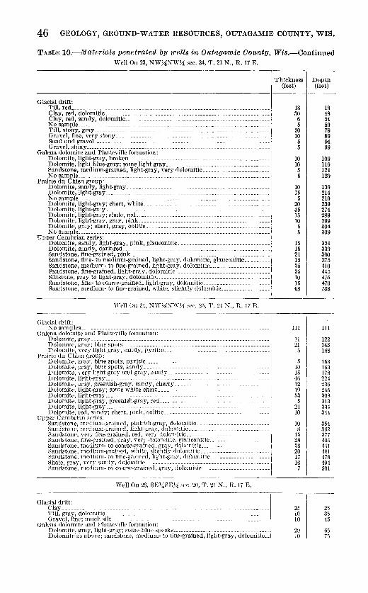
46 GEOLOGY, GROUND-WATER RESOURCES, OUTAGAMIE COUNTY, WIS.
TABLE 10.-liiaterials penetrated by wells in Outagamie County, Wis.-Continued Well Ou 23, NW_!4NW_!4 sec. 34, T. 21 N., R. 17 E.
Glacial drift: Till, red _____ ------------------------------------------------------------------Clay, red, dolomitic __________________________________________________________ _ Clay, red, sandy, dolomitic _______________ -------------------------------------No sample ___________________________________ ------- ________ ------- __ ---- ____ --Till, stony, gray ______________________________________________________________ _ Gravel, fine, very stony ______________________________________________________ _ Sand and graveL _____________________________________________________________ _ Gravel, stony _________________________________________________________________ _
Galena dolomite and Platteville formation: Dolomite, light-gray, broken _________________________________________________ _ Dolomite, light blue-gray; some light gray ____________________________________ _ Sandstone, medium-grained, light-gray, very dolomitic _______________________ _ No sample ____________________ ----- __________ --- ____________ -- ______________ ---
Prairie du Chien group: Dolomite, sandy, light-gray __________________________________________________ _ Dolomite, light-gray __________________________________________________________ _ No sample ____________________________________________________________________ _ Dolomite, light-gray; chert, white __________________ --------------------- _____ _ Dolomite, light-gray __________________________________________________________ _ Dolomite, light-gray; shale, red _______________ ------------------ ______________ _ Dolomite, light-gray, gray, pink ______________________________________________ _
~~l~~~ie~~-~~ :~~r_t~ -~~~~:_o_~l!~~c ___ ~~ ~ ~ =~ = ~ ~ ~ ~ =~ ~ ~ ~ ~ ~=~ ~== = ~== ==~= ~== = ~ = ~ ==== =! Upper Cambrian series: j
Dolom~te, sandy, light-gray, pink, glauconitic _________________________________ 1 Dolomite, sandy, dark-red ________________________ -------------- _______________ ,
Sandstone, fine-grained, pink __________________________________________________ i Sandstone, fine- to medium-grained, light-gray, dolomitic, glauconitic _________ j Sandstone, medium- to fine-grained, light-gray, dolomitic .. --------------------1 Sandstone, fine-grained, light-gray, dolomitic __________________________________ 1
Siltstone, gray ~o light-gr~y, <_lolomi_tic_: ___ -.--------.- ~ ____ ---------------------/ Sandstone, fine _to coarse gram~d, hgh_t !!ra~, ?olorr_utw ___ ~-.------------------- 1 Sandstone, medmm- to fine-gramed, white, slightly dolomitiC------------------~
Vi'ell Ou 24, NiY_!4XI''}i sec. 2.5, T. 21 N., R. 17 E.
Glacial drift: No samples ____ --- __ ------ ___ --- __ ------ ____ --_.-- ____ ----------------- ____ ----~-
Galena dolomite and Platteville formation:
g~~~~n:: i~!~; tii1e"~p-;t·s---~= =========~ ==== = = = = == = = = ~ == ============ == ========= '1 Dolomite, veQ.' light gray, sandy, pyritic _________ -----------------------------~
Prairie du Chien group: Dolomite, gray, blue spots, pyritic ____________________________________________ _ Dolomite, gray, blue spots, sandy ____________________________________________ _ Dolomite, yery lis;ht gray and gray, sandy ___ ---------------------------------- 1
fi~l~Eil~; ft:~~~~:;~-~~~~g:~rh~~~~~~~~c~~~0~ ~ ~ ~ ~ = = = = = = =: = = =: = =:: = = =:: =::=:====I g~~~~n~: n~~t~~~~~~-gi~~e~lsh=g~ay ~ ~~d_-_----= == = = = = = = = = == ~ = == == = = == = = = = = = ~ = = = == =! Dolomite, light-gray ___________ --- ___________ ----- _______________ -------- _____ -~ Dolomite, reel, sandy-; chert, pink, oolitic _____________________________________ _
"Fpper Cambrian series: Sandstone, me-lium-grained, pinkish-gray, rlolomitic _________________________ _
§:~~~i~~~: ~~~:1,i~~~g:~~~~;~j. 1;~~~-~~;~· (~~;~~m~ ~ ~ = = = = = = = = = = ~ === = = = = = = = = = = = = = i Sandstone, fine-grained, gray, Yery rlolon:itic, glauconitic ______________________ , Sandstone, mtdium- to coarse-grained, gray, riolomitic ... ----------------------i Sandstone, medium-gmi!le,l, white, slightly clolomitic ... ----------------------i ~andsto.:;e: m_e'li,um- to_ fi~e-gra~1~ed, light-gra-y, dolomitic ______________________
1
.
::;hale, gta}, 'er~ sandy, c.olomitic _____________ -------------------------------Sandstone, medium- to coarse-grained, gray, dolomitic _________________________
1
\Yell Ou 26, SE;liSE_!4 sec. 20, 'I'. 21 N., R. 17 E.
Glacial drift: Clay _______________________________________ -- ______________ ------ ____________ _ Till, gray, dolomitic __________________________________________________________ _ Gravel, fine; much silt_ _______________________________________________________ _
Galena dolomite and Platteville formation: Dolomite, gray, light-gray; some blue specks __________________________________ _ Dolomite as above; sandstone, medium- to fine-grained, light-gray, dolomitic ..
Thickness (feet)
18 30
6 5
20 10
5 5
10 10 5 5
10 75
5 20 35 15 10 5 5
15 15 21 15 35 35 10 15 68
111
11 21
5
5 10 15 46 12 1!l 53
5 21 10
10 8
15 28 36 20 17 16
7
25 10 10
20 10
Depth (feet)
18 48 54 59 79 89 94 99
109 119 124 129
139 214 219 239 274 289 299 304 309
324 339 360 375 410 445 455 470 538
Ill
122 143 148
153 163 178 224 236 255 308 313 334 344
354 362 377 405 441 461 478 494 501
25 35 45
65 75
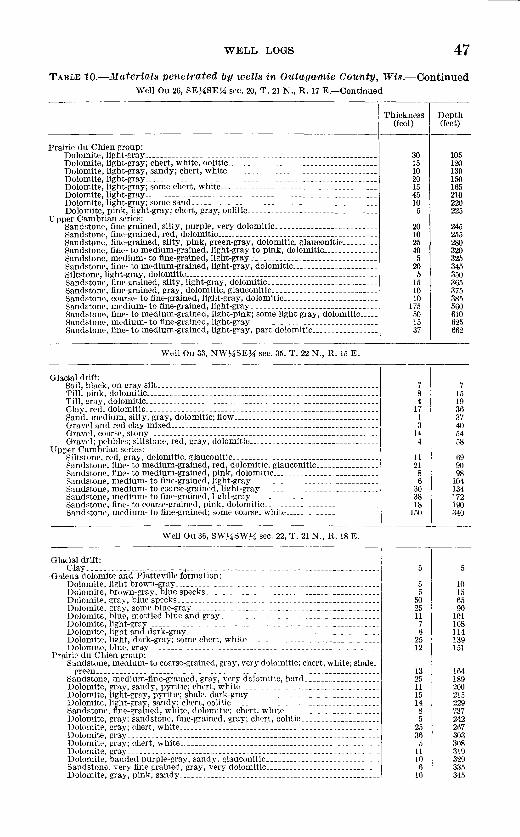
WELL LOGS 47
TABLE 10.-Materials penetrated by wells in Outagamie County, Wis.-Continued Well Ou 26, SE~4SEH sec. 20, T. 21 N., R. 17 E.-Continued
Thickness Depth (feet) (feet)
Prairie du Chien group: Dolomite, light-gray __________________________________________________________ _ 30 105 Dolomite, light-gray; chert, white, oolitic ________________ ---------------- _____ _ Dolomite, light-gray, sandy; chert, white _____________________________________ _
15 120 10 130
Dolomite, light-gray __________________________________________________________ _ Dolomite, light-gray; some chert, white _______________________________________ _
20 150 15 165 Dolomite, light-gray __________________________________________________________ _ 45 210
Dolomite, light-gray; some sand ______________________________________________ _ Dolomite, pink, light-gray; chert, gray, oolitic ________________________________ _
10 220 5 225
Upper Cambrian series: Sandstone, fine-grained, silty, purple, very dolomitic _________________________ _ Sandstone, fine-grained, red, dolomitic ___________________ ----------------------Sandstone, fine-grained, silty, pink, green-gray, dolomitic, glauconitic ________ _ Sandstone, fine- to medium-grained, light-gray to pink, dolomitic _____________ _ Sandstone, medium- to fine-grained, light·gray _______________________________ _
20 245 10 255 25 280 40 320 5 325
Sandstone, fine- to medium-grained, light-gray, dolomitic _____________________ _ 20 345 Siltstone, light-gray, dolomitic ________________________________________________ _ Sandstone, fine-grained, silty, light-gray, dolomitic ___________________________ _ Sandstone, fine-grained, gray, dolomitic, glauconitic __________________________ _
5 350 15 365 10 375
Sandstone, coarse- to fine-grain<'d, light-gray, dolomitic _______________________ _ Sandstone, medium- to fine-grained, light-gray_-------------------------------
10 385 175 560
Sandstone, fine- to medium-graint'd, light-pink; some light gray, dolomitic ____ _ 50 610 Sandstone, medium- to fine-grained, light-gray_-------------------------------Sandstone, fine- to medium-grained, light-gray, part dolomitic ________________ _
15 625 37 662
Well Ou 33, NW7iSE7i sec. 35, T. 22 N., R. 15 E.
Glacial drift: Soil, black, on gray silt _____ --- ____________ ---- _______________________________ _ 7 7 Till, pink, dolomitic __________________________________________________________ _ 8 15 Till, gray, dolomitic __________________________________________________________ _ 4 19 Clay, red, dolomitic __________________________________________________________ _ Sand, medium, silty, gray, dolomitic; flow ____________________________________ _
17 36 1 37
Gravel and red clay mixed _________________ -- _________________________________ _ 3 40 Gravel, coarse, stony _________________________________________________________ _ Gravel; pebbles; siltstone, red, gray, dolomitic ________________________________ _
14 54 4 58
Upper Cambrian series: Siltstone, red, gray, dolomitic, glauconitic ______________ ---------------- ______ _ 11 69 Sandstone, fine- to meclium-graine.d, red, dolomitic, glauconitic _______________ _ 21 90 Sandstone, fine- to medium-grained, pink, dolomitic __________________________ _ 8 98 Sandstone, medium- to fine-graint>d, light-gray -------------------------------Sandstone, medium- to coarse-grained, light-gray _____________________________ _ Sandstone, medium- to fine-grained, light-gray ------------------------------~ ~and~tone, fine-.to coarse-grain~d, p~nk, dolomitic ___ ;-------------------------i:landstone, medmm- to fine-gramed, some coarse, white _______________________ _
6 104 30 134 38 172 18 190
150 340
\Yell Ou 36, SW~~SW~i sec. 22, T. 21 N., R. 18 E.
Glacial drift: Clay _____________________ -_-+ ___________ - _______________ -- __________________ _
Galena dolomite and PlatteYille formation: Dolomite, light brown-gray ___________________________________________________ _ 5 10 Dolomite, brown-gray, blne specks ______________________ ---------------------- 5 15 Dolomitr, gray, blue speeks ___________ ------------------------------ _________ _ 50 65 Dolomite, gray, some blue-gray . ----------------------------------------------Dolomite, blue, mottled blue and gray _______________________________________ _
25 90 11 101 Dolomite, light-gray ________________ . _________________________________________ _
Dolomite, light and dark-gray ______________________________ -------------------7 108 6 114
Dolomite, light, dark-gray; some ehert, white _________________________________ _ Dolomite. blue, gray _________________________________________________________ _ 25 139
12 151 Prairie du Chien group:
Sandstone, meaium- to coarse-grained, gray, very dolomitic; chert, white; shale, green ___________ - ___ --------- ------------------------------------------------ 13 164
Sandstone, medium-fine-grained, gray, Yery dolomitic, hard __________________ _ Dolomite, gray, sandy, pyritic; chert, white __________________________________ _ Dolomite, light-gray, pyritic; shale, dark-gray ________________________________ _
25 189 11 200 15 215
Dolomite, light-gray, sandy; chert. ooli+,ic ------------------------------------- 14 229 Sandstone, fine.-grained, w bitE\ dolomitic; chert, w bite _______________________ _ 8 237 Dolomite, f,!;ray; sandstone, fine-grained, gray; chert, oolitic ___________________ _ 5 242 Dolomite, gray; chert, white ______________________________ -------------------- 25 267 J)olomite, gray __________________________________________ ----------------- ____ _ 36 303 Dolomite, gray; chert, white __ --------------------------------------------- ___ _ 5 308 Dolomite, gray ___________________________________ ------------------------ ____ _ Dolomite, banded purple-gray, sandy. glauconitic ____________________________ _
11 319 10 329
Sandstone, very fine grained, gray, very dolomitic ____________________________ _ 6 335 Dolomite, gray, pink, sandy __________________________________________________ _ 10 345
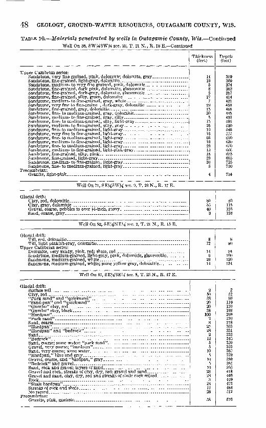
48 GEOLOGY, GROUND-WATER RESOURCES, OUTAGAMIE COUNTY, WIS.
TABLE 10.-Materials penetrated by uells in Outagamie County, Wis.-Continued Well Ou 36, SW~4SW~4 sec. 22, T. 21 N., R. 18 E.-Continued
Upper Cambrian series: Sandstone, very fine grained, pink, dolomitic; dolomite, gray------------------Sandstone, fine-grained, light-gray, dolomitic. _______________ ------------------Sandstone, medium- to very fine grained, pink, dolomitic _____________________ _ Sandstone, fine-grained, dark pink, dolomitic, glauconitic ---------------------Sandstone, fine-grained, dark-gray, dolomitic, glauconitic _____________________ _ Sandstone, fine-grained, silty. green, dolomitic.--------------------------------Sandstone, medium- to fine-grained, gray, white _____________________________ __ Sandstone, very fine to fine-graine , dark-gray, dolomitic _____________________ _ Sandstone, fine-grained, gray, dolomitic._-------------------------------------Sandstone, fine- to medium-grained, gray, dolomitic __________________________ _ Sandstone, medium- to fine-grained, gray, silty _______________________________ _ Sandstone, fine- to medium-grained, silty, light-gray __________________________ _ Sandstone, medium- to fine-grained, silty, gray _______________________________ _ Sandstone, fine- to medium-grained, light-gray._ .. ----------------------------Sandstone, very fine to fine-grained, light-gray ________________________________ _ Sandstone, fine- to medium-grained, light-gray __ . ____ -------------------------Sandstone, medium- to fine-grained, light-gray. ___ ----------------------------Sandstone, fine- to medium-grained, light-gray ____ ----------------------------Sandstone, medium- to fine-grained, light-pink-gray. __ ------------------------Sandstone, fine-grained, silty, pink ________________ ----------------------------Sandstone, fine-grained, light-gray ____ . ____________ . ________ ------- _____ . _____ _ Sandstone, medium- to fine-graineC..,light-gray _______________________________ _ Sandstone, fine- to medium-grained, light-gray __ . ____ -------------------------
Precambrian: Granite, light-pink __ -------------------------------- _________ -----------------
Well Ou 71, SEUSWU sec. 9, T. 23 N., R. 1i E.
Glacial drift: Clay, red, dolomitic.---------------- _______ .. _____ ._. ____ . ______________ . ____ _ Clay, gray, dolomitic ------------------ ______ ------ ________ -------------------Gravel, coarse, pebbles to over ~-2-inch, stony _________________________________ _ Sand, coarse, gray_--------------- ____________ ... ______ ------------------------
Well Ou 82, SE}~NEU sec. 2, T. 21 N., R. 15 E.
Glacial drift:
~m: 1ig<i;td;l~~~~~iia~i: <ioioillitfci_-:: === = = = = == = = = = = = = = = = = = = == = = = = = = = = = = = === = = = = Upper Cambrian series: Dolomite, very sandy, pink. red; shale, red ___________________________________ _ Sandstone, medium-grained, light-gray, pink, dolomitic, glauconitic _________ __ Sandstone, medium-grained, white._ ... ______ ._-- _____ -- __ .. _---------.------. Sandstone, medium-grained, white; some yellow gray, dolomitic. ____________ __
Well Ou 97, SEUSEU sec. 8, T. 23 N., R. 17 E.
Glacial drift: Surface soiL--------------------_.-------._. __ . ___ ._. ______ . _______ .. ______ ._ ..
~~ic'Ii~~iid"·; afi<i ''quicksand-,;:=============================================== "Sand-pan" and "quicksand"_. ______ .. _ .. _ .. _____________________________ . __ _
::g~:~~;; ~I:~; b!~ck:-::::== ====== = = == == == = = = = = = = = = = === = = = ==== = = = ==== == ======== "Hardpan" __________ ------- _____________________ . ____________________________ _ "Pack sand" __ -- _____________________________________________________________ _ Sand, coarse __________________________________ - _______________________________ _ "Hardpan" ____________________________________________________________________ _ "Hardpan" and "bedrock"---------- _________ -_____________ -_---_-_-------- __ _ Sand _____ --------- ______ .. ____ . ______________ . _______________________________ _ "Bedrock" __ . ___ . __________________________________________________ . _________ _
~~~~e~0~~~~ gg:::;e;v.~~i~~~~~~9~ ~~~~:~ == =:: =::: = = =: =: =: = = = ==== = = = =====: ======: Sand. very coarse; some water ______________________________ -- __ - _____ - ___ --_--"Hardpan," blue and gray-----------------------------·-----------------------Gravel, coarse, and "hardpan," gray_------- ____________ -------------------- _ "Bedrock" and graveL _________________________ ----- _______ - _______ -____ -- ___ _ Sand, rock and gravel; layers of mud.--------·--------------------------------Gravel and rock, streaks of clay, dry, red; gravel and sand ____________________ _ Gravel and sand, clay, dry, red and streaks of shale rock mixed _______________ _ Rock _____________________________________________________________ . ___________ _ "Shale hardpan" _____________________________________________________________ _ Streaks of rock and shale._-------- ___ ----- ___ ------------------_---_-----------No record ___________________________ ----------------------_-------------------
Precamb~an: . . . Granite, pink, gneiSSIC ______ ------------ ____ ------ ____________________________ _
Thickness Depth (feet) (feet)
14 10 5 8 5
27 7
29 15 20
5 15 25 10 15 65 10 20 10 15 20 30
5
4
80 35 40 3
8 72
14 6
20 14
2 50 38 20 20 38
100 2 8
21> 28 2
12 5 5
10 5
10 5
10 23 28
3 24 11 28
58
359 369 374 382 387 414 421 450 465 485 490 505 530 540 555 620 630 650 660 675 695 725 730
734
80 115 155 158
8 80
94 100 120 134
2 52 \JO
110 130 168 268 270 278 303 331 333 345 350 355 365 370 380 385 395 418 446 449 473 484 512
570

WELL LOGS 49
'l'ARLE 10.-Jfaterials penetrated by wells in Outagamie County, Wis.-Continued Well Ou 101, SE}1:NE7J; sec. 31, T. 23 N., R. 17 E.
Glacial drift: Gravel and sand ..... _______ ---------------------------------------------------
Prairie du Chien group: Dolomite, gray _________________________________________ ------------------ ____ _ Dolomite, brownish-gray, sandy, pyritiC----------------------------·----------Dolomite, gray _________________________ ------- ____ ----------------------------Dolomite, pink and gray .. __ -------------------------------------------------_ Dolomite, gray, green, and pink; chert, white, oolitic _________________________ _
Upper Cambrian series: Sandstone, medium-grained, gray, dolomitic. _________________________________ _ Sandstone, very fine grained, pink, red and gray, dolomitic .. _________________ _ Sandstone, very fine grained, red and gray, very dolomitic, hard ______________ _ Dolomite, sandy, red, glauconitic __________________________ .---------- ________ _ Sandstone, very fine grained, dark red, dolomitic, glauconitic _________________ _ Sandstone, medium-grained, gray and pink, dolomitic. _______________________ _ Sandstone, very fine grained, gray, dolomitic, some glauconite ________________ _ Sandstone, medium-fine-grained, white, dolomitic, glauconitic ________________ _ Sandstone, medium-to fine-grained, light-gray, dolomitic, hard _______________ _ Sandstone, like above with streaks of gray dolomite. ___ --------------- _______ _ Sandstone, medium-to-fine-grained, white. ______________ -------------- _______ _ Sandstone, medium-to-fine-grained, white, streaks of pink dolomite ___________ _ Sandstone, fine-to-coarse-grained, white ________________ ------------------- ____ _
Well Ou 102, NWUS\V7J; sec. 23, T. 21 N., R. 18 E.
Glacial drift: Till, red, dolomitic.-----------------------------------------------------------Clay, gray, dolomitic ____________ ----------------------------------------------Till, gray, dolomitic ______ ------ ________ --_--- __ -------------------------------
Galena dolomite and Platteville formation: Dolomite, gray _____________________________________________ - _____________ -- __ _ Dolomite, light-gray ______ ---- ___________ --------------------------------------Dolomite, light-gray and gray ____________ ------------------------------ __ -----Dolomite, blue-gray ____________________________ -------------------------------No samples _______ ------ ________________________________ -_-----_. _______ --.----Dolomite, light-gray-------------------- __ ------------------------------------Dolomite, gray and light-gray------------------------------------------------Dolomite, light-gray; much sand_---------------------------------------------~
Prairie du Chien group: Dolomite, light-gray, green spots. _____ ------- _______ --------------------------Dolomite, light-gray ___ .--._.- ______________ -_---------------------------------Dolomite, light-gray; chert, dense and oolitic, red and gray; sandstone, fine-
grained, white, very dolomitic. _________ -- ____________ ------ ______ -_--_--- __ _ Dolomite, light-gray ____ .------- ____ -------------------------------------------
Well Ou 280, NW7J;N'\V?4 sec. 34, T. 21 N., R. 17 E.
U lacial drift: Sand, fine, gray-pink, weathered.---------------------------------------------· Till, pink, dolomitic ______ ---- ________ - __ --------------------------------------Gravel, fine, stony _____ ------- ____________________________ ---- ___ --------------'fill, light yellow-gray _____ ---- _____________ . __________ .----- ____________ -----_
Galena dolomite and Platteville formation: Dolomite, light-gray; some light blue-gray ____________________________________ _ Sandstone, medium-to fine-grained, light-gray, dolomitic .... ------------------
St. Peter sandstone: l'andstone, fine-to medium-grained, very light gray ___________________________ _ Chert, gray, pink-gray ________ -------------------------------------------------Rhale, red; chert, green-gray, pink .. _. __ ------ _____ . __ .----.- ____ -----.-------_ Chert, gray, yellow-gray, pink-gray; quartzite, fine-grained, light-gray ________ _
Prairie du Chien group: Dolomite, very light gray------- __ -------------- _______ ---------------------- __ Dolomite, light-gray to very light gray_---------------------------------------Dolomite, light-gray __________________ ----------- _____ .------------------------Dolomite, light-gray, pink, some sand ________________________________________ _ Dolomite, very light gray, light-gray_----------------------------------------Dolomite, very light gray, sandy; chert, gray, oolitic.--------------------------
Upper Cambrian series: Sandstone, very fine-grained, very light gray, dolomitiC------------------------Sandstone, very fine grained to silty, orange-pink, dolomitic __________________ _ Siltstone, red-brown, red, red-orange, green-gray, glauconitic, dolomitic; shale,
gray-green .. _____________________________ . ___________ .--... __ -----_----- .. __ _ Sandstone, fine-grained, pale-red, dolomitic, glauconitic _______________________ _ Sandstone, fine-grained, light pink-gray, dolomitic, glauconitic.--------------Sandstone, fine- to medium-grained, light-gray, dolomitic, some glauconite .... Sandstone, fine-grained, light-gray, some glauconite ___________________________ _ Siltstone, light medium-grained, gray, dolomitic, hard ________________________ _ Sandstone, fine- to coarse-grained, light-gray, dolomitiC------------------------
Thickness Depth (feet) (feet)
8H 8~2
5~2 14 5 19
31 50 30 80 11 91
8 99 19 118 6 124 6 130 5 135
75 210 5 215
15 230 10 240 10 250 25 275 20 295 10 305
10 10 10 20 5 25
30 55 30 85 20 105 20 125 20 145 10 155 40 195 20 215
20 235 10 245
40 285 17 302
5 5 80 85 5 90 5 95
10 105 10 115
20 135 5 140 5 145
40 185
30 215 20 235 40 275 5 280
30 310 5 315
10 325 5 330
25 355 5 360
10 370 65 435 15 450 5 455
10 465

50 GEOLOGY, GROUND-WATER RESOURCES, OUTAGAMIE COUNTY, WIS.
TABLE 10.-Materials penetrated by wells in Outagamie Cotmty, Wis.-Continued Well Ou 280, NW~4NW~4 sec. 34, T. 21 N., R. 17 E.-Continued
Upper Cambrian series-Continued Sandstone, fine- to medium-grained, very light gray __________________________ _ Sandstone, medium- to fine-grained, very light gray--------------------------Sandstone, fine- to medium-grained, very light gray_--------------------------Sandstone, medium- to fine-grained, very light gray __________________________ _ Sandstone, fine- to medium-grained, very light gray_-------------------------Sandstone, medium- to fine-grained, very light gray_--------------------------Sandstone, very fine to medium-grained, very light gray ______________________ _ Sandstone, fine- to medium-grained, very light gray_--------------------------Sandstone, very fine to medium-grained, very light gray ______________________ _ Sandstone, medium- to fine-grained, very light gray_-------------------------Sandstone, fine- to medium-grained, very light gray_-------------------------Sandstone, medium- to fine-grained, very light gray_--------------------------Sandstone, fine- to medium-grained, very light gray __________________________ _
Thickness I (feet)
45 5
110 5
25 5
20 10 10
5 10
5 25
TABLE 11.-Matet·-ials penetrated by wells in Outagamie Cotmty, Wis.
Depth (feet)
510 515 625 630 655 660 680 690 700 705 715 720 745
Interpretation, by the author, of drillers' logs from the files of the Wisconsin State Board of Health]
Well Ou 104, NWXSEX sec. 32, T. 21 N., R. 17 E.
Alluvium and drift: Clay _________________ ---------------------------------------------------------GraveL ______________________________________________________________________ _
Galena dolomite and Platteville formation: Lime rock _____________________ -------- _______ --- _____ ---- ____ -----------------
St. Peter sandstone: Sandstone ____________________________________________________________________ _
Well Ou 105, NEXSWX sec. 29, T. 21 N., R. 16 E.
Alluvium and drift: Gravel and sand _____________________________________________________________ -_ Sand and clay ________________________________________________________________ _
Prairie du Chien group: Limestone ____________________________________________________________________ _ Upper Cambrian series: Sandstone ____________________________________________________________________ _
Well Ou 106, NWXSWX sec. 36, T. 21 N., R. 15 E.
Alluvium and drift: Sand and graveL _____________________________________________________________ _ Prairie du Chien group: Limestone ____________________________________________________________________ _ Upper Cambrian series: Sandstone ____________________________________________________________________ _
"Well Ou 107, NWXNWX sec. 33, T. 22 N., R. 16 E.
Alluvium and drift: Clay ____ ----------- __ -----_---------------- __ ---------------------------------Clay and sand ____________ -----------------------------------------------------Sand __ ------------------------------------------------------------------------Hardpan __ -______ -- __ ---- ____ ------ __ ----- ___ ---------------------------------
Prairie du Chien group: Limestone _____ ----------------------------------------------------------------
Upper Cambrian series: Sandstone, red_----------------------------------------------------------------
'Yell Ou 111, NEXNEX sec. 32, T. 22 N., R. 18 E.
Alluvium and drift: Clay ____ -----_----------------------------------------------------------------
Galena dolomite, Platteville formation, and Prairie du Chien group: Limestone _______ --------------------------------------------------------------Sandstone _______ --- __ ---- ___ --------------------------------------------------Limestone ________ -------------------------------------------------------------
Thickness (feet)
10 23Y2
8Y2
30 12
86
14
40
86
12
10 40 10 5
100
15
34
206 10 55
Depth (feet)
10 33~-i
42
49
30 42
128
142
40
126
138
10 50 60 65
165
180
34
240 250 305

WELL LOGS 51
TABLE 11.-Jfaterials penetrated by wells ·in Outagamie County, Wis.-Continued 'Vel! Ou 115, SW>:;tSW}i sec. 30, T. 22 N., R. 18 E.
Alluvium and drift: Clay ___ ------------------------------------------------------- _______________ _ Sand and graveL_c ______ ----- _____ --------------------------------------------Hardpan and stones_------- ___ - __ --- ________ --_-------------------- ____ ------_
Galena dolomite, Platteville formation, and Prairie du Chien group: Shell limestone __________ - ____ - __ ---- _______ - _______ ----- ___ ---------_--------_ Lilnestone ________ -- __ -- ---------------- __ ------ -------------------------------
Well Ou 117, SE}4SE}4 sec. 6, T. 22 N., R. 18 E.
Alluvium and drift: Clay ____ ------------------------------- _________________ ----------------------Sand _________________________________________________________________________ _ Hardpan _____________________________________________________________________ _
Galena dolomite and Platteville formation: Hard rock ____________________________________________________________________ _ St. Peter sandstone: Sandstone ____________________________________________________________________ _
Well Ou 119, SE}4SE}4 sec. 18, T. 24 ~., R. 17 E.
Well Ou 124, SE>:t~E>:t sec. 30, T. 23 N., R. 19 E.
Alluvium and drift: Sand _________________________________________________________________________ _ Clay ________________________________________________ -------------------- _____ _ Hardpan ________________________________________ ---------_-------------------_ Clay _________ --_--------------------------------------------------------------
Galena dolomite and Platteville formation: Limestone ____________________________________________________________________ _
St. Peter sandstone: Shale _________________________________________________________________________ _ Limestone ________________________________________ ----------------------------_ Shale _________________________________________________________________________ _ Sandstone ____________________________________________________________________ _
'Vell Ou 126, NW>:tSW}i sec. 20, T. 23 N., R. 19 E.
Alluvium and drift: Sand _________________________________________________________________________ _ Clay _________________________________________________________________________ _ Hardpan _____________________________________________________________________ _ Clay _________________________________________________________________________ _ GraveL ______________________________________________________________________ _
Well On 152, SE>:tSW}i sec. 12, T. 23 N., R. 17 E.
Alluvium and drift: Clay _______ ---- ______ ---------------------------------------------------------Hardpan _____________________________________________________________________ _ Clay _________________________________________________________________________ _ Hardpan _____________________________________________________________________ _
Well Onl54, SE>:t~W>:t sec. 30, T. 24 N., R. 17 E.
Alluvium and drift:
I Thickness Depth
(feet) (feet)
15 45 30
6 208
40 17 16
23
34
28 40 49 20
20 6
16 16
42
2 1 4
13
46 11 1l 12 2
42 4
10 297'2
15 60 90
96 304
40 57 73
96
130
28 68
117 137
20 26 42 58
100
102 103 107 120
46 67 78 90 92
42 46 56 85~-
Soil and sand__________________________________________________________________ 6 6 Clay _____ --------------- ________________ ----------------- __ ----------------___ 20 26 Quicksand_____________________________________________________________________ 15 51 Clay__________________________________________________________________________ 53 103 Hardpan______________________________________________________________________ 10 113 Sand and graveL ___________________________________________________________________________________ _
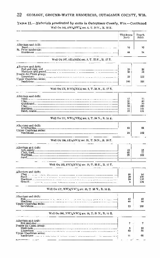
52 GEOLOGY, GROUND-WATER RESOURCES, OUTAGAMIE COUNTY, WIS.
TABLE 11.-Materials penetrated by wells in Outagamie Oounty, Wis.-Continued Well Ou 163, SlV!-'4SW}i sec. 6, T. 23 N., R. 18 E.
I
I Thickness Depth
(feet) (feet)
Alluvium and drift: I Sand ___________ ---------------------- _____ . __________ ------ __ ------___________ 10 10
St. ~~~ds~~~~~:~~~~------ __________________________________________ ---------------I 44 54
Well Ou 167, SE}~SEK: sec. 5, T. 22 N., R. 17 E.
;:Jl!i.r~!~'i!~)::: ::::::::::::::::::::::::::::::::::::::::::::::::::::::::1
u pp:r~~:~~:~·'~':::::: :::::::::::::: ::::::::::::::::::::::::::::: :::::::::I Well Ou 175, N'\YK:NEK: sec. 5, T. 24 N., R. 17 E.
Alluvium and drift: I
8~~;~~~=-~=== = ===== == = === = == ===== = = = = = = = = = = = ===== = === === = ====== = = = === = == ==== = Clay ____________ -------------------- ________ -------- ____________ . __________ ---~
§I~g;~!rse= ========== = == == ==== = = == === = = = == = = = === = = = ====== == = ==== = = = == == = = = = ==.
Well Ou 177, N"\VK:NEK: sec. 9, T. 24 N., R. 16 E.
Alluvium and drift: Overburden ________________________________ -_- __ ---- ___ -------_----- _____ -----
1Jpper Cambrian series: Sandstone ______________ ----- _______________ --- ______________ -- ___ -- _______ ----
Well Ou 188, SE}iSWK: sec. 24, T. 24 N., R. 16 E.
50 I 23
52
100
15 25 30 60 11 10
I
:I
50 73
125
225
15 40 70
130 141 151
68
102
Alluvium and drift: I
i¥p~~~~ ~~~;;;=; :;~==~;~:;;~;=~: ~~=~ ~~=~~:~ ~ ~=~~~~~::~:~=~~ ==~~~=~~~~=~~~:~I- -----!!_ -------~~--Well Ou 193, S'\YK:N'\Y}i sec. 15, T. 23 N., R. 17 E.
Well Ou 197, NW}iNW~-'4 sec. 35, T. 23 N., R. 16 E.
Alluvium and drift: I SoiL __________ -_----- ____ ----------------.-------------------------------------
Upi:~~~~~~~~~e~~~~~ ~ ~ ~~ ~~~~~ ~~~~~~ ~ ~ ~ ~ ~ ~~ ~ ~ ~ ~ ~ ~~ ~~ ~ ~~~ ~ ~ ~ ~~ ~~~ ~~ ~~ ~~~~ ~ ~ ~ ~~ ~~~~ 1
Well Ou 200, NW}iNWK: sec. 26, T. 21 N., R. 15 E.
Alluvium and drift: Soil and clay----·------------------------- _____ ------------------ _______ -------
Prairie du Chien group: Shell rock ____ -------_----- ___ --- _____ -- _____ --_- __ ---- __ ----------------------Limestone ___ ----------------------------- __ -----------------------------------
upper Cambrian series: Sandstone ______________ ----- ___ --- _________ ----- ___ ------ __ -------------------
80 20 50 4
40 48
12
6 42
11
80 100 150 154
40 88
100
7
13 55
66

WELL LOGS 53
TABLE H.-Materials penetrated by wells in Outagamie Oounty, Wis.-Continued Well Ou 206, NE}4NE}4 sec. 32, T. 23 N., R. 18 E.
Thickness Depth (feet) (feet)
Alluvium and drift: SoiL __________________________________________________________________________ _
Galena dolomite and Platteville formation: Limestone ______________________________________________________ -_----- ___ -----
Well Ou 227, NWUNWU sec. 30, T. 24 N., R. 15 E.
Alluvium and drift: Clay--- _______________________________ --- __________________________________ ----
~:~, agge ~~~~ == = = = = = = = = = = = = = = = === = = ===== = = = = == = = = = = == = = = = == = === = = = ==== = = = ===== Sand, medium ________________________________________________________________ _
Well Ou 230, SW}iSW}i sec. 28, T. 24 N., R. 15 E.
Alluvium and drift: I Soil and clay, red ________ ------- ________________________________ ----------- ___ _ Quicksand ___________________________________________________________ ----------Clay, blue and stones _________________________________________________________ _ Sand _________________________________________________________________________ _
Clay, red; sand, stones ___ -----------------------------------------------------Clay, blue __________________ ------------ ______________________________ ---------0 ravel ________________________________________ ------- _--- _- _- _---------- _____ -
Well Ou 232, NW}iS"\V}i sec. 7, T. 23 N., R. 15 E.
Alluvium and drift: Sand _________________________________________________________________________ _ Clay _________________________________________________________________________ _ Sand and graveL _______________ ------------- ___ ---------- ___ ------------------
Well Ou 235, NWUSW}i sec. 19, T. 22 N., R.15 E.
Well Ou 263, SWUNWU sec. 24, T. 22 N., R. 16 E.
Alluvium and drift: Clay __________________________ -------------- _________________________________ _ Sand and clay _________________________________ ----------- ________ -------------Sand ___________________________ ------------- _________________________________ _ Hardpan _____________________________________________________________________ _ Sand _____________________________ ----------- _________________________________ _ Rock _________________________________________________________________________ _
Upper Cambrian series: Sandstone ________________ --- ________ ----------------- ___ _
Well Ou 272, SEUNW}i sec. 17, T. 22 N., R. 16 E.
Alluvium and drift: Clay and stones ________________________________ -------------------------------Sand _________________________________________________________________________ _
Upper Cambrian series: Sand rock __________________________________________________ ------------------_
Well Ou 275, SW}iSW}i sec. 8, T. 22 N., R. 16 E.
13
27
22 68 11 5
25 10 40
3 50 23 8
25 55 20
106 67
7 9 8
10 20 00 20 62 8
162
43 22
00
Clay, sand, gravel, and hardp"n----------------------------------------------- 205 Alluvium and drift:
1
I Rock (could not drill farther) __________________________________________________ ------------
13
40
22 90
101 106
25 35 75 78
128 151 159
25 80
100
106 173 180 189 197
10 30 90
110 172 180 342
43 65
125
205 205
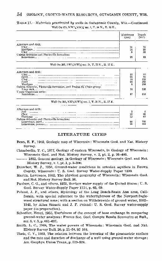
.54 GEOLOGY, GROUND-WATER RESOURCES, OUTAGAMIE COUNTY, WIS.
TABLE H.-Materials penetrated by 'Wells in Outagamie County, Wis.-Continued Well Ou 279, NW~NW~ sec. 1, T. 24 N., R. 18 E.
I Tb;okn"" (feet)
Alluvium and drift: Clay _____ ----- _______________________________________________________ ----- ___ _ Hardpan _____________________________________________________________________ _ Clay _________________________________________________________________________ _
Galena dolomite and Platteville formation: Limestone _______________ ------------- ___________________ ----------- __ ----- ___ _
Well Ou 283, SW~NW~ sec. 24, T, 22 N., R. 17 E.
Alluvium and drift: ' Clay __________________________________________________________________________ I Sand __________________________________________________________________________ ' Clay _________________________________________________________________________ _ Sand _________________________________________________________________________ _ Hardpan _____________________________________________________________________ _
Galena dolomite, Platteville formation, and Prairie du Chien group: Lime rock ____________________________________________________________________ _ Upper Cam brian series:
Sandstone _____ - ______ ------------------------------------------------------- --j
Well Ou 285, NE~NW}4 sec. 7, T. 21 N., R. 17 E.
Alluvium and drift: SoiL ______________________________________________________________ ----- ______ _ Clay ___ ---- ________________________________________________ ---- ___ ------------Hardpan _____________________________________________________________________ _
Galena dolomite and Platteville formation: Limestone, hard ____________________________________ - __ ------------------------Limestone, porous ___________________________________ --------------------------
LITERATURE CITED
16 14 8
25
35 60 28 60
5
70
97
5 25 12
88 24
Depth (feet)
16 30 38
63
35 95
123 183 188
258
355
5 30 42
130 154
Bean, E. F., 1949, Geologic map of ·wisconsin: 'Visconsin Geol. and Nat. History Survey.
Chamberlin, T. C., 1877, Geology of eastern Wisconsin, in Geology of Wisconsin: Wisconsin Geol. and Nat. History Survey, v. 2, pt. 2, p. 91-405.
--- 1883, General geology, in Geology of Wisconsin: Wisconsin Geol. and Nat. History Survey, v.1, pt.1, p. 3-300.
Drescher, W. J., 1953, Ground-water conditions in artesian aquifers in Brown. County, Wisconsin: U. S. Geol. Survey Water-Supply Paper 1190.
Martin, Lawrence, 1932, The physical geography of Wisconsin: Wisconsin Geol. and Nat. History Survey Bull. 36.
Paulsen, C. G., and others, 1952, Surface water supply of the United States: U. S. Geol. Survey Water-Supply Paper 1174, p. 65, 69.
Poland, J. ]'., and others, Hydrology of the Long Beach-Santa Ana area, California, with special reference to the watertightness of the Newport-Inglewood structural zone; with a section on Withdrawals of ground water, 1932-1941, by Allen Sinnott and J. F. Poland: U. S. Geol. Survey water-supply paper (in preparation).
Schoeller, Henri, 1935, Usefulness of the concept of base exchange in comparing ground-water analyses : France Soc. Geol. Compte Rendu Sommaire et Bull., ser.5,v.5,p.651-657.
Smith, L. C., 1908, The water powers of Wisconsin: Wisconsin Geol. and Nat. History Survey Bull. 20, p. 21-54, 95-104.
Theis, C. V., 1935, The relation between the lowering of the piezometric surface and the rate and duration of discharge of a well using ground-water storage: Am. Geophys. Union Trans., p. 519-524.
LITERATURE CITED 55
Thwaites, F. T., 1923, The Paleozoic rocks found in deep wells in Wisconsin and northern Illinois: Jour. Geology, v. 31, p. 529-555.
--- 1931, Buried pre-Cambrian of Wisconsin: Geol. Soc. America Bull., v. 42, p. 719-750.
--- 1943, Pleistocene of part of northeastern Wisconsin : Geol. Soc. America Bull., v. 54, p. 87-144.
U. S. Public Health Service, 1946, Drinking water standards: Public health repts., v. 61, no.ll, p. 371-384.
Weidman, Samuel, and Schultz, A.. R., 1915, The underground and surface water supplies of Wisconsin: Wisconsin Geol. and Nat. History Survey Bull. 35, p. 486-493.
Whitbeck, R. H., 1915, The geography of the Fox-Winnebago Valley: Wisconsin Geol. and Nat. History Survey Bull. 42.
Whitson, A. R., and others, 1921, Soil survey of Outagamie County, Wisconsin: Wisconsin Geol. and Nat. History Survey Bull. 54D, Soil ser. 26.


INDEX
Page Page Abstract______________________________________ 1 New London, Wis---------------------------- 5,13 Acknowledgments____________________________ 3 New Richmond sandstone____________________ 9 Appleton, Wis ________________________ 3, 4, 5, 9, 18,41 Nonequilibrium formula______________________ 39
Aquifers __________ ------------------------- 11, 17,39 Artesian water ___ ----------------- ________ 13, 17,39 Oneota dolomite __________ -------------------- 9
Oshkosh, Lake _______________________________ 13,16
Bear Creek _____________ ------- _________ ------ 15 Bedrock structure ____________________________ 14-15 Paleozoic rocks_______________________________ 8-12
Bedrock topographY-------------------------- 15-16 Cambrian system________________________ 8-9 Black Creek, Wis ____________________________ 13,16 Ordovician system _______________________ 9-12
Cenozoic rocks _______________________________ 13-14
Chert, oolitic ______________ ------_____________ 10 Climate______________________________________ ~
Peat_ ____________________________ ----_________ 14 Piezometric map _____________________ 17, 19, 20; pl. 5 Piezometric surface, definition________________ 17 Platteville formation and Galena dolomite __ 7, 12, 44
Combined Locks, Wis _______________________ _ 24 Pleistocene deposits __________________________ 7,13 Conclusions _____________ ------ ______________ _ 44 Population, Outagamie County 1950__________ 4 Culture ________________________ -------- _____ _
Darcy's law---------------------------------- 18 Deposition ______________ ----- __________ ------ 17 Domes _______________________________________ 9,14
Drainage __ --------------------_______________ 5 Dresbach sandstone__________________________ 8 Drilling ________ ------------------ ____________ 38,44 Drumlins _______________ -------------------- 4, 13,16 Duck Creek, Wis _____________________________ 5,12
Embarrass River ___________________________ 5,14,38
Prairie du Chien group ___________ 4, 7, 9-11,14,15,44
Precambrian rocks ___ -----------------_______ 6-8 Precipitation ____________________________ 6, 19, 23,24
Previous reports______________________________ 3 Public Health Service, water quality stand-
ards._____________________________ 41 Pumping tests ________________________________ 39-41
Purpose of investigation______________________ 2
Quarries______________________________________ 9, 12 Quaternary system ___________________________ 13-14
Erosion _______________________________________ 16,17 Rapide Croche Dam __ -----------------------Eskers ________________________________________ 13,16 Recent deposits_______________________________ 14 Extent of area________________________________ 3 Recharge_---------------- ___________ 17, 18, 19, 23, 44
Farms _______________________________________ _ Faults________________________________________ 15 Fox River_ ______________ 4, 5, 8, 11.12, 18, 23, 24, 38,44 Fox River drainage basin_____________________ 5 Franconia sandstone _________________________ _
Galena dolomite (See Platteville formation) __ 7, 12,44 Geologic units ___________________________ 6-14; pl. 2 Glacial stage, Wisconsin______________________ 13 Graphs, logarithmic, for water analyses ____ 43; pl. 7 Green Bay, Wis ______________________________ 3,18 Ground water ________________________________ 17-44
levels _____________________________________ 19-24
St. Peter sandstone ______________ 7, 9, 11, 14, 15. 41,44 Scope of investigation________________________ 2 Seymour, Wis ____________________________ 5, 8, 15,18 Shakopee dolomite___________________________ 9 Shioc River__________________________________ 5,14 Shiocton, Wis_ __ ____ _ _ _ _ _ ___ _ _ _ _ ___ _ _ _ _ ___ _ _ _ 5 Specific capacity ____________________________ 9-11,13 Springs _______________________________________ 38-39
Storage coefficient____________________________ 39 at Appleton______________________________ 41 at Hortonville____________________________ 41 at Seymour_______________________________ 40
movement_ ___________ -------------------- 17-19 Temperature ___________ --------------------- 5, 6, 19 quality ___________________________________ 41-44 TilL_________________________________________
13 source __________________________________ 8,17-19 T h use ___________ ---------------------------- 24 opograp Y---------- ------------------------
Transmissibility coefficient .. ________________ _ Hortonville, Wis_ ----------------------- 8, 15, 16,41 at Appleton _____________________________ _ Hydrographs _________________________________ 23, 40 at Hortonville ________________________ -__ _
at Seymour ______________ -----------------Trempealeau formation ______________________ _ Industrial growth, Outagamie County _______ _
Introduction ________________________________ _
University of Wisconsin _____________________ _
39 41 41 40 8
Kaukauna, Wis __ ------------------------- 18, 19,24 Kimberly, Wis _______________________________ 24,38 Upper Cambrian series ___________________ 7-9,14,16
Lawrence College_____________________________ Water-bearing properties of geologic units _____ 6-14 Literature cited ______________________________ 54-55 Well logs ____ --------------------------------- 44-54
Little Chute, Wis____________________________ 24 Wells --------------------------------- 24-38; pl. 6 Location of area______________________________ 3 records __________________ ----------------- 25-37
\Vinnebago, Lake ________ -------------------- 5, 18 Mapping, geologic reconnaissance_____________ 3 Wisconsin State Board of Health_____________ 3 Maquoketa shale ___________________________ 7, 12,43 Wisconsin State Laboratory of Hygiene______ 3 Method of investigation ______________ -------- 2-3 Wolf River_______________________ 5, 14, 15, 16, 19,38 Moraines, glaciaL-------------- ______________ 13, 17 Mosquito Hills_______________________________ 8, 16 Yield factor __ • _____________________________ 9-11, 13
57


