Geology, Geochemistry, and Uranium Favorability of Tertiary Rocks in South-Central Alaska A. Geology, Geochemistry, and Uranium Favorability of the Tertiary Kenai Group in the Susitna Lowlands at the Northern End of Cook Inlet Basin, Alaska By Kendell A. Dickinson B. Geology, Geochemistry, and Uranium Favorability of Tertiary Continental Sedimentary Rocks in the Northwestern Part of the Cook Inlet Area, Alaska By Kendell A. Dickinson, John A. Campbell, and William F. Dula, Jr. u.s. GEOLOGICAL SURVEY BULLETIN 2098 UNITED STATES GOVERNMENT PRINTING OFFICE, WASHINGTON: 1995
Transcript
Geology, Geochemistry, and Uranium Favorabilityof Tertiary Rocks in South-Central Alaska
A. Geology, Geochemistry, and Uranium Favorability of theTertiary Kenai Group in the Susitna Lowlands at theNorthern End of Cook Inlet Basin, AlaskaBy Kendell A. Dickinson
B. Geology, Geochemistry, and Uranium Favorability ofTertiary Continental Sedimentary Rocks in theNorthwestern Part of the Cook Inlet Area, AlaskaBy Kendell A. Dickinson, John A. Campbell, and William F. Dula, Jr.
u.s. GEOLOGICAL SURVEY BULLETIN 2098
UNITED STATES GOVERNMENT PRINTING OFFICE, WASHINGTON: 1995
u.s. DEPARTMENT OF THE INTERIOR
BRUCE BABBITT, Secretary
u.s. GEOLOGICAL SURVEY
Gordon P. Eaton, Director
Published in the Central Region, Denver, ColoradoManuscript approved for publication May 12, 1994Edited by Judith StoeserPhotocomposition by Shelly FieldsGraphics prepared by Shelly Fields and Carol Quesenberry
For sale by U.S. Geological Survey, Information ServicesBox 25286, MS 306, Federal Center
Denver, CO 80225
Any use of trade, product, or firm names in this publication is for descriptive purposes only anddoes not imply endorsement by the U.S. Government.
Library of Congress Cataloging·in-Publication Data
Dickinson, Kendell A., 1931-Geology, geochemistry, and uranium favorability of Tertiary rocks in south-central
Includes bibliographical references.Contents; A. Geology, geochemistry, and uranium favorability of the Tertiary Kenai
Group in the Susitna Lowlands at the northern end of Cook Inlet Basin, Alaska I by KendellA. Dickinson - B. Geology, geochemistry, and uranium favorability of Tertiary continental sedimentary rocks in the northwestern part of the Cook Inlet area, Alaska I byKendell A. Dickinson, John A. Campbell, and William F. Dula, Jr.
1. Geology, Stratigraphic-Tertiary. 2. Geology-Alaska-Cook InletRegion. 3. Uranium ores-Alaska-Cook Inlet Region. I. Campbell, John A. (JohnArthur), 1930- . II. Dula, William Frederick. III. Title. IV. Series.QE75.B9 no. 2098[QE69l]557.3 s-dc20 94-25919[553.4'932'097983] CIP
Geology, Geochemistry, and Uranium Favorability of theTertiary Kenai Group in the Susitna Lowlands at theNorthern End of Cook Inlet Basin, Alaska
By Kendell A. Dickinson
URANIUM FAVORABILITY OF TERTIARY ROCKS, SOUTH-CENTRAL ALASKA
u.s. GEOLOGICAL SURVEY BULLETIN 2098-A
UNITED STATES GOVERNMENT PRINTING OFFICE, WASHINGTON : 1995
CONTENTS
Abstract AlIntroduction.... 1Geology........................................................................................................................... 3Tertiary Sedimentary Rocks 3Methods........................................................................................................................... 6Statistical Analysis.......................................................................................................... 7Clay Minerals.................................................................................................................. 11Uranium Favorability 11References Cited.......... 13Appendix l-Chemical and Mineralogical Data for Samples of the Tyonek(?) and
Sterling(?) Formations of the Tertiary Kenai Group 15Appendix 2-Measured Sections of the Tyonek(?) and Sterling(?) Formations of
the Tertiary Kenai Group............................................................................................ 18
FIGURES
1. Index map of south-central Alaska showing study area.......... A22. Map showing geology of the Susitna Lowlands area and locations of measured sections 43. Chart showing stratigraphy of Tertiary sedimentary rocks in Cook Inlet Basin and Susitna Lowlands areas 54. Photograph showing rocks of the Kenai Group on Fairview Mountain 65. Scatterplots of uranium versus thorium, copper, and vanadium for samples of the Kenai Group.............................. 106. Photograph showing rocks of the Sterling(?) Formation at Camp Creek 12
TABLES
1. X-ray diffractogram peaks (Cu, K-alpha radiation) measured for the rock samples in the study............................... A62. Correlation coefficient matrix for data set . 83. Varimax factor analysis for five factors 94. Clay contents of selected samples 11
Geology, Geochemistry, and Uranium Favorability of theTertiary Kenai Group in the Susitna Lowlands at the
Northern End of Cook Inlet Basin, Alaska
By Kendell A. Dickinson
ABSTRACT
The Susitna Lowlands at the northern end of the CookInlet Basin in south-central Alaska are underlain by morethan 940 m of continental clastic rocks that are approximately correlative with the Tertiary Kenai Group farther tothe south in the basin. The Susitna Lowlands section, whichconsists mostly of nonmarine conglomerate, sandstone, andshale and smaller amounts of bedded coal, is divided into theTyonek(?) and Sterling(?) Formations. Parts of this sectionwere measured and sampled during reconnaissance studiesin 1977 and 1978 to determine favorability for uraniumdeposits. Samples were analyzed for uranium, thorium, and19 other elements, and minerals were identified by X-ray diffraction. Statistical studies of the chemical and mineralogical data suggest that uranium is associated with copper,titanium, scandium, and aluminum, that chlorite and illite aredetrital clay minerals, and that smectite and kaolinite arediagenetic.
Although the Kenai Group in the Susitna Lowlandsexhibits most if not all of the favorable characteristics forepigenetic sedimentary uranium deposits, no significantlarge deposits are known. Uranium is epigeneticallyenriched (72 ppm eU30 g) in a kaolinitic mudstone layerassociated with a thin coal bed in the Sterling(?) Formationat Camp Creek. The Sterling(?) is more highly oxidized thanthe underlying Tyonek(?) Formation and probably as awhole contains more epigenetic uranium. The positive correlation between uranium and copper suggests that copper mayalso have been epigenetically enriched.
A correlation coefficient matrix and an R-mode factoranalysis using a five-factor model were determinined for thechemical and mineralogical data base of 29 samples. Thefactors are interpreted to represent fine-grained clayey sediments, rare earth elements, feldspathic coarse-grained sediments, iron-manganese, and altered fine-grained sediments.
INTRODUCTION
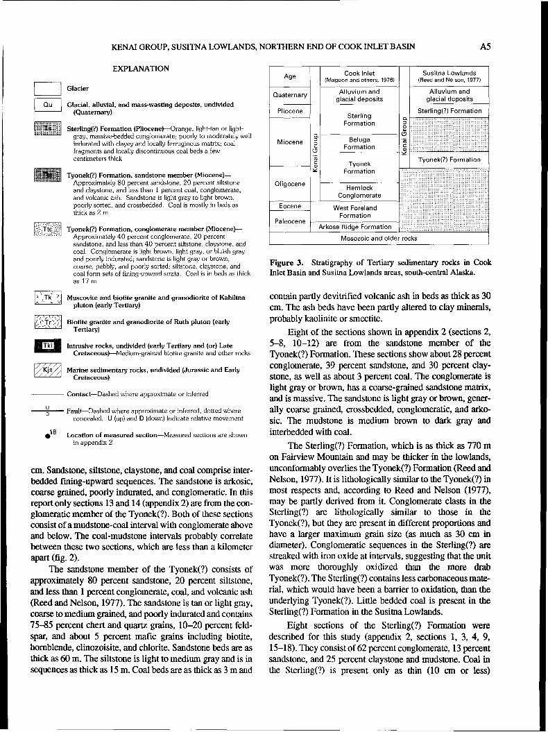
The Susitna Lowlands area (fig. 1) is a northern extension of the Cook Inlet Basin in south-central Alaska (Wahrhaftig, 1965). It contains a sequence of Tertiary continentalsedimentary rocks of the Kenai Group that includes theMiocene Tyonek(?) and the Pliocene Sterling(?) Formations(Reed and Nelson, 1980). These rocks approximately correlate with the Kenai Group in the main part of the Cook InletBasin to the south where the Kenai Group, in ascendingorder, consists of the Oligocene Hemlock Conglomerate, theOligocene and Miocene Tyonek Formation, the MioceneBeluga Formation, and the Miocene and Pliocene SterlingFormation (Magoon and others, 1976).
Early interest in Tertiary sedimentary rocks of CookInlet was motivated by the demand for coal. Coal resourcesof the northwestern part of the Cook Inlet area weredescribed by Barnes (1966). Oil was discovered in 1957(Parkinson, 1962), and much of the later interest in the areawas stimulated by the search for petroleum (Calderwood andFackler, 1966, 1972; Crick, 1971; Kirschner and Lyon,1973). During the late 1970's interest developed in the uranium potential of the Kenai Group because the unit containsthe necessary elements ofa uranium resource area. Croff andothers (1977) considered the area of this report favorable forsandstone-hosted uranium deposits. The area contains potentially favorable uranium sources in the form offelsic igneousrocks within and near the study area and in the Alaska andAleutian Ranges to the northwest. In addition, the potentialhost rocks contain igneous constituents that could have supplied uranium to the circulating ground water. Thick Tertiarysequences of porous sandstone and conglomerate formfavorable uranium host rocks. These possible host rocks contain abundant organic material that could have produced thechemically reducing environment necessary for depositionof the uranium (Dickinson and Campbell, 1978).
Al
A2 URANIUM FAVORABILITY OF TERTIARY ROCKS. soum-CENTRAL ALASKA
70 0 _
ALASKA
500I
1400
\ _11)"
\\\
\\\
\
1000 KILOMETERSI
14501540
63 0r------ ~..__-------'1
TONZONA PLUTON
Shirley Lakep
....-"-h;;:::::::>--······_···
MOUNTAINS
.........
59 0 <------_---.f..- _
100I
200 KILOMETERSI
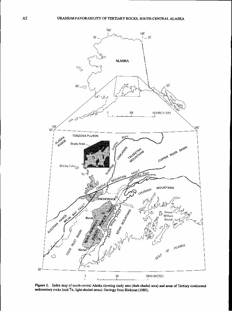
Figure 1. Index map of south-central Alaska showing study area (dark-shaded area) and areas of Tertiary continentalsedimentary rocks (unit Tc, light-shaded areas). Geology from Biekman (1980).
KENAI GROUP, SUSIlNA LOWLANDS, NORTIlERN END OF COOK INLET BASIN A3
The study area includes an area of scattered outcrops onthe west side of the Susitna River valley north of the CastleMountain fault (fig. 1, 2). The study area extends fromHewitt Lake on the south to the vicinity of Kahiltna Lake onthe north. It includes outcrops west of the Yentna River, atFairview Mountain, and in the Peters Hills and Cache Creekareas. These outcrops were selected because of their accessibility from a base camp at Talkeetna, Alaska, during theperiod available for fieldwork. Samples of the Tertiary sedimentary rocks as described herein were collected during areconnaissance survey by helicopter August 16-23, 1977and on a one-day return trip to one of the sites on July 30,1978.
Eighteen sections were measured, and 29 samples werecollected (fig. 2). The present report is based on chemicaland mineralogical analyses of the samples (appendix 1) andon the described sections (appendix 2). These data providenew insight into diagenesis and sedimentation of tlle Tertiaryunits, as well as their favorability for uranium deposits.
Acknowledgments.-Gary Skipp prepared the orientedclay mineral mounts for X-ray diffraction studies and operated the X-ray diffraction machine. Samples were chemically analyzed in laboratories of the U.S. Geological Surveyat Lakewood, Colorado. D.M. McKown supervised theradiochemical analysis, J.E. Taggart supervised the X-ray spectroscopy analysis, and D.E. Detra and L.R. Laymansupervised the optical spectroscopy analysis.
GEOLOGY
The Cook Inlet Basin in the coastal area of south-central Alaska is mostly to the southeast of tlle present studyarea (Wahrhaftig, 1985). The basin separates tlle Aleutianand Alaska Ranges on the northwest from the Kenai andChugach Ranges on the southeast (fig. 1). The TalkeetnaMountains and the Copper River Basin are to the northeastof Cook Inlet Basin. The Cook Inlet Basin is about 100 by300 km; its axis is oriented about N. 25° E. It contains asequence of nonmarine Tertiary sedimentary rocks as thickas 8,500 m comprising the Oligocene to Pliocene KenaiGroup and the underlying Paleocene and Eocene West Foreland Formation (fig. 3). These Tertiary rocks overlie Jurassicand Cretaceous rocks (Kremer and Stadnicky, 1985) andunderlie Quaternary alluvium and glacial deposits.
The Cook Inlet Basin is generally bounded on the eastby the Border Ranges fault (Knik fault of Magoon and others, 1976), which strikes about N. 30° E. (fig. 1). The BruinBay fault, which generally forms the western margin of thebasin, extends northward about N. 45° E. and intersects tlleCastle Mountain fault in the northern part of the basin. TheCastle Mountain fault trends about N. 60° E. and generallyforms the northwestern boundary of tlle basin (fig. 1). Undivided equivalents of the Kenai Group and tlle West ForelandFormation extend north of the Castle Mountain fault into the
Susitna Lowlands. Otller minor faults and lineaments havebeen mapped on the Kenai Peninsula. Several gentle anticlines and synclines, whose axes parallel the long axis of tllebasin, were mapped by Magoon and others (1976) in theeastern half of tlle Cook Inlet Basin (fig. 1). Water of CookInlet covers most of the northwest half of tlle basin.
The study area, to the north of the Cook Inlet Basin,contains scattered outcrops of tlle Miocene Tyonek(?) andPliocene Sterling(?) Formations. Much of tlle study area iscovered by Quaternary sedimentary deposits and glacial ice.The Tyonek(?) is unconformably underlain by thicksequences of Jurassic and Cretaceous metamorphic and sedimentary rocks including litllic graywacke, phyllite, andshale and locally interbedded lenses of quartz and chert conglomerate. This sequence contains thin beds of fossiliferouslimestone and radiolarian chert with Jurassic and Cretaceousfossils in some areas and a few beds ofred ferruginous sandstone in other areas. The rocks have been altered by thermalmetamorphism near plutons and by low-grade metamorphism in other areas (Reed and Nelson, 1980).
Parts of two early Tertiary plutons are present in tllestudy area: the southeastern part of the Kahiltna pluton andtlle soutllern part of the Rutll pluton (fig. 2). The Kahiltnapluton consists of fine- to coarse-grained biotite and biotitemuscovite granite and granodiorite. The southern part of theRuth pluton consists of coarse-grained biotite granite andgranodiorite tllat is locally weathered to grus and containsrare muscovite and hOrnblende. Two small granitic intrusivebodies also are present in the study area (fig. 2) (Reed andNelson, 1977).
TERTIARY SEDIMENTARY ROCKS
The Tertiary sedimentary rocks of tlle Cook Inlet Basinwere first referred to as tlle Kenai Group by Dall and Harris(1892), who assigned the group to the Miocene. Barnes andCobb (1959) and Parkinson (1962) referred to the samerocks as tlle Kenai Formation. The Kenai Group was laterdivided into five formations (Calderwood and Fackler 1966,1972; Crick, 1971; Magoon and others, 1976), in ascendingorder, tlle West Foreland Formation, Hemlock Conglomerate, Tyonek Formation, Beluga Formation, and Sterling Formation. Subsequently, Magoon and otllers (1976) removedtlle West Foreland Formation from tlle Kenai Group (fig. 3).
In tlle Susitna Lowlands area, north of tlle Castle Mountain fault (fig. I), tlle Kenai Group, which has a minimumtllickness of 940 m, was divided into a lower, Miocene unitdesignated tlle Tyonek(?) Formation and an upper, Plioceneunit designated tlle Sterling(?) Formation (fig. 4) (Reed andNelson, 1980). The Tyonek Formation was also mappedalong tlle soutllern margin of tlle study area by Magoon andotllers (1976). The West Foreland Formation, Hemlock Conglomerate, and Beluga Formation have not been recognizedin the study area. The Alaska Range to tlle northwest and tlle
A4 URANIUM FAVORABILITY OF TERTIARY ROCKS, SOUTH-CENTRAL ALASKA
'I~TtS\,/ }i
Vau Tt~ ~Tts
Tki
~ !r3
I
<au L
au
~1,
Figure 2 (above and facing column). Geology of the Susitna Lowlands area, Cook Inlet Basin, south-central Alaska. Locations of measured sections are also shown. Map area is shown in figure 1. Geology modified from Reed and Nelson (1977,1980).
Talkeetna Mountains to the northeast were important sediment sources for the Kenai Group in the Susitna Lowlands.
The Tyonek(?) Foonation, which has a minimum thickness of 170 m, is divided into sandstone and conglomeratemembers (fig. 2). The sandstone member conformably overlies or is interbedded with the conglomerate member. The
conglomerate member of the Tyonek(?) consists of 40 percent or more conglomerate, 20 percent sandstone, and lessthan 40 percent siltstone, claystone, and coal (Reed and Nelson 1977). The conglomerate, which is poorly indurated andfoons massive beds, is light brown, light gray, or bluish gray.Clasts are well rounded and their maximum size is about 10
KENAI GROUP, SUSITNA LOWLANDS, NORTHERN END OF COOK INLET BASIN AS
Tyonek(?) Formation
Susitna Lowlands(Reed and Nelson, 19771
Alluvium andglacial deposits
Sterling(?) Formation
HemlockConglomerate
West ForelandFormation
Eocene
Paleocene
Oligocene
Age Cook Inlet(Magoon and others, 1976)
Quaternary Alluvium andglacial deposits
PlioceneSterling c.
Formation :::J0
c. t5Miocene :::J Beluga 'me Formation c
<.:I 1Il~
'mc Tyonek1Il~ Formation
Arkose Ridge Formation
Mesozoic and older rocks
Figure 3. Stratigraphy of Tertiary sedimentary rocks in CookInlet Basin and Susitna Lowlands areas, south-central Alaska.
EXPLANATION
Sterling(?) Formation (Pliocene)-Orange, light-tan or lightgray, massive-bedded conglomerate; poorly to moderately wellindurated with clayey and locally ferruginous matrix; coalfragments and locally discontinuous coal beds a fewcentimeters thick
Tyonek(?) Formation, sandstone member (Miocene)Approximately 80 percent sandstone, 20 percent siltstoneand claystone, and less than 1 percent coal, conglomerate,and volcanic ash. Sandstone is light gray to light brown,poorly sorted, and crossbedded. Coal is mostly in beds asthick as 2 m
Glacial, alluvial, and mass-wasting deposits, undivided(Quaternary)
Glacier
Tyonek(?) Formation, conglomerate member (Miocene}--Approximately 40 percent conglomerate, 20 percentsandstone, and less than 40 percent siltstone, claystone, andcoal. Conglomerate is light brown, light gray, or bluish grayand poorly indurated; sandstone is light gray or brown,coarse, pebbly, and poorly sorted; siltstone, claystone, andcoal form sets of fining-upward strata. Coal is in beds as thickas 17 m
---- Contact-Dashed where approximate or inferred
Location of measured section-Measured sections are shownin appendix 2
Biotite granite and granodiorite of Ruth pluton (earlyTertiary)
contain partly devitrified volcanic ash in beds as thick as 30cm. The ash beds have been partly altered to clay minerals,probably kaolinite or smectite.
Eight of the sections shown in appendix 2 (sections 2,5-8, 10-12) are from the sandstone member of theTyonek(?) Formation. These sections show about 28 percentconglomerate, 39 percent sandstone, and 30 percent claystone, as well as about 3 percent coal. The conglomerate islight gray or brown, has a coarse-grained sandstone matrix,and is massive. The sandstone is light gray or brown, generally coarse grained, crossbedded, conglomeratic, and arkosic. The mudstone is medium brown to dark gray andinterbedded with coal.
The Sterling(?) Formation, which is as thick as 770 mon Fairview Mountain and may be thicker in the lowlands,unconformably overlies the Tyonek(?) Formation (Reed andNelson, 1977). It is lithologically similar to the Tyonek(?) inmost respects and, according to Reed and Nelson (1977),may be partly derived from it. Conglomerate clasts in theSterling(?) are lithologically similar to those in theTyonek(?), but they are present in different proportions andhave a larger maximum grain size (as much as 30 em indiameter). Conglomeratic sequences in the Sterling(?) arestreaked with iron oxide at intervals, suggesting that the unitwas more thoroughly oxidized than the more drabTyonek(?). The Sterling(?) contains less carbonaceous material, which would have been a barrier to oxidation, than theunderlying Tyonek(?). Little bedded coal is present in theSterling(?) Formation in the Susitna Lowlands.
Eight sections of the Sterling(?) Formation weredescribed for this study (appendix 2, sections 1, 3, 4, 9,15-18). They consistof62 percent conglomerate, 13 percentsandstone, and 25 percent claystone and mudstone. Coal inthe Sterling(?) is present only as thin (10 em or less)
Muscovite and biotite granite and granodiorite of Kahiltnapluton (early Tertiary)
Intrusive rocks, undivided (early Tertiary and (or) LateCretaceous)-Medium-grained biotite granite and other rocks
~ Marine sedimentary rocks, undivided (Jurassic and EarlyCretaceous)
--i:-~-- Fault-Dashed where approximate or inferred, dotted whereconcealed. U (up) and D (down) indicate relative movement
cm. Sandstone, siltstone, claystone, and coal comprise interbedded fming-upward sequences. The sandstone is arkosic,coarse grained, poorly indurated, and conglomeratic. In thisreport only sections 13 and 14 (appendix 2) are from the conglomeratic member of the Tyonek(?). Both of these sectionsconsist of a mudstone-coal interval with conglomerate aboveand below. The coal-mudstone intervals probably correlatebetween these two sections, which are less than a kilometerapart (fig. 2).
The sandstone member of the Tyonek(?) consists ofapproximately 80 percent sandstone, 20 percent siltstone,and less than 1 percent conglomerate, coal, and volcanic ash(Reed and Nelson, 1977). The sandstone is tan or light gray,coarse to medium grained, and poorly indurated and contains75~5 percent chert and quartz grains, 10-20 percent feldspar, and about 5 percent mafic grains including biotite,hornblende, clinozoisite, and chlorite. Sandstone beds are asthick as 60 m. The siltstone is light to medium gray and is insequences as thick as 15 m. Coal beds are as thick as 3 m and
A6 URANIUM FAVORABILITY OF TERTIARY ROCKS, SOUill-CENTRAL ALASKA
Figure 4. Several hundred meters of rocks of the Tertiary Kenai Group r on Fairview Mountain,Susitna Lowlands, south-central Alaska. Rock units: Ts, Sterling (?) Formation; Tts, sandstone member of Tyonek (?) Formation.
discontinuous beds or as clasts. One thin coal bed at CampCreek (section 15) is overlain by a bed of kaolinitic mudstone about 30 cm thick. One of the samples from this bed(sample 28, appendix 1) contained 72 ppm uranium.
METHODS
The samples were analyzed for 21 elements and 6 minerals. Sample localities are shown in figure 2 and in measured sections in appendix 2. A data set was preparedcontaining 29 samples.
Uranium and thorium contents were determined usingthe delayed-neutron method (Millard, 1976). Elemental values were determined using the six-step semiquantitativespectroscopy method (Myers and others, 1961). Mineralogical determinations were made by X-ray diffraction of wholerock cell mounts. For a few samples, oriented mounts of the<2-micron clay fractions were X-rayed after air-drying, glycolation, and heating to 550°C. The whole-rock X-ray diffraction data were obtained under conditions as uniform aspossible for all of the runs. The same preparation procedures,instrument, and instrument settings were used for all samples. All the runs were made continuously, and a standardsample was X-rayed before and after each daily run. Allanalyses were made using sample splits.
The relative abundances of quartz, feldspar, chlorite,illite, smectite, and amphibole were determined by measuring the areas of the X-ray diffraction peaks (in square inches)
Table 1. X-ray diffractogram peaks (Cu, Ka radiation)measured for the rock samples in the study.
Mineral X-ray diffraction Crystallographicpeak (degrees 28) index
as recorded on the whole-rock diffractograms. IIIite, asdetermined, includes the clay mineral illite and mica undifferentiated. The peaks measured for each mineral are listedin table 1. The areas of individual X-ray diffraction peaksprovide estimates of the relative abundances of the minerals.The X-ray diffraction data do not, however, represent theabsolute abundances of the minerals.
A factor analysis and matrix of correlation coefficientsfor the data set in appendix I were calculated using a commercial program (Hintze, 1992). These analyses suggestmany relationships that otherwise might be missed whenperusing the data. The number of samples analyzed is toolow, however, to represent comprehensively the total thickness of the combined Tyonek(?) and Sterling(?) Formations.The statistical analyses only represent the distribution andrelationships of elements and minerals in the sample set.
KENAI GROUP, SUSITNA LOWLANDS, NORTIlERN END OF COOK INLET BASIN A7
For the few qualified values in appendix I, the following substitutions were made. For values listed as N (notdetected), half of the lower detection limit was used; for values listed as L (detected, but not determined), three-fourthsof the lower detection limit was used; for values prefixed by<, three-fourths of the less than value was used; for valueslisted as G (greater than 10 percent), 12.5 percent was used.Beryllium, boron, and lead were excluded from the statisticalcalculations because of the large number of qualified valuesfor these elements. Kaolinite and smectite were not includedbecause most of the samples contained none. Sample number28 was excluded because it was enriched in uranium.
STATISTICAL ANALYSIS
Mineralogical and chemical data for the Kenai Group inthe Susitna Lowlands are given in appendix 1. Arithmeticmeans and standard deviations are given for the minerals andelements for each of the two stratigraphic units. A correlationcoefficient matrix (table 2) and a five-factor model of an Rmode factor analysis (table 3) (Harmon, 1960) are presentedfor the data in appendix 1. The degree of correlation for allpairs of variables is shown by the correlation coefficients.The purpose of the factor analysis is to group related variables to reduce the amount of variation that must be interpreted and to investigate the underlying causes. The factorsare calculated from the correlation matrix. The factor analysis includes the varimax rotation, which is rotation of the factors around the orthogonal axes. Varimax rotation enhancesdifferences in factor loadings (Hintze, 1992). Factor loadingsare the correlations between each variable and the factors.The sum of the squares of the factor loadings for each variable is equal to the communality, the proportion ofeach variable explained by the analysis. For more completedescriptions of factor analysis and its geological applicationsee Davis (1986) and Koch and Link, (1971).
A five-factor model was chosen because it is the simplest model that offers a reasonable explanation of theobserved data and because it gives high communalities forthe variables of primary interest. which include uranium andthorium.
The geologic processes that underlie statistical factorsare interpreted to be source area, sorting and alteration duringtransport and deposition, and postdepositional alteration(diagenesis). Differences in mineralogical and chemicalmakeup of the source areas result in differences in the composition of the sediment produced. During transport, the sediment is sorted into finer clay and coarser sand. The sand andclay fractions have somewhat different mineralogical andchemical makeup. Chemical and mineralogical alterationmay also occur during sediment transport. Diagenesis resultsin changes in mineralogical and chemical makeup after lithification. The calculated factors represent combinations ofthe above processes that in some cases make interpretationspeculative.
Factor one.-Factor one consists ofpotassium, chlorite,chromium, illite, magnesium, and zirconium (table 3). Inpart, this factor represents the claystone and mudstone containing the fine-grained clay minerals chlorite and illite.There is a strong correlation between chlorite and illite in therocks of the Kenai Group, not only in this area, but also inthe Tyonek-Capps Glacier area (Dickinson and others, thisvolume) and on the Kenai Peninsula (Dickinson and Skipp,1992). Magnesium and potassium are expected in this factorbecause magnesium is a constituent of chlorite and potassium is a constituent of illfte. The occurrence of chromiuimand zirconium in this factor is less easy to explain. Magnesium and chromium both suggest a relation to a mafic sourcearea.
Factor two.-Factor two consists of Cu, Sc, Ga, V, Ba,AI, Ni, U, and Ti (table 3). The relationships between theseelements are complex and not entirely clear. The factor contains uranium, which is epigenetically enriched in three ofthe samples (fig. 5A) and otherwise is related to thorium(1"=+0.36) and other elements. The relation between uraniumand copper (1"=+0.8, table 2, fig. 5B) suggests that some parallel enrichment of the copper in the epigenetic environmentmay also have occurred, as discussed later. Vanadium isrelated to uranium (1"=+0.53, table 2, fig 5C). Vanadium istypically related to carbonaceous material in sedimentaryrock, and the relation between uranium and carbonaceousmaterial in enriched samples may explain this correlation.Uranium ore on the Colorado Plateau also typically containslarge amounts of vanadium (Fischer, 1968). Nickel and copper together with chromium, which has a high secondaryloading in this factor, are linked by their common occurrencein sulfide minerals. Factor two also includes gallium and aluminum, which are commonly present together in finegrained sediments and sedimentary rocks (hydrolysates)because of similar ionic potential (Mason, 1966,p. 163-164). Scandium, which is also in this factor, is generally present in greater amounts in fine-grained sedimentaryrocks than in sandstone. Titanium, which is in this factordespite the low value of its loading (-0.59, table 3), is commonly enriched in placer deposits, and its occurrence here isnot explained. In general, this factor is interpreted to represent altered fine-grained sedimentary rocks.
Factor three.-Factor three consists of plagioclase,sodium, strontium, and calcium (table 3). Plagioclase ispresent mainly as detrital grains in sandstone and coarserclastic rocks. Strontium, calcium, and sodium are all presentin plagioclase. Strontium substitutes for calcium in plagioclase because of similar ionic charge and radius. A correlation between strontium and calcium is expected in graniticbut not in basaltic rocks.
Factor [our.-Factor four consists only of iron andmanganese (table 3). These two elements behave similarly inoxidation-reduction environments and frequently are presenttogether in oxide or hydroxide minerals. They are presenttogether in the Sterling and Beluga Formations on the Kenai
A8 URANIUM FAVORABILTIY OF TERTIARY ROCKS, SOUm-CENTRAL ALASKA
Table 2. Correlation coefficient matrix for data set.[Data set is given in appendix 1]
Peninsula (Dickinson and Skipp, 1992) but not in rocks ofthe Kenai Group in the Tyonek-Capps Glacier area (Dickinson and others, this volume). Manganese is leached beforeiron in soils and follows iron in precipitation in sediments.
Factor jive.-Quartz is at the positive pole in factorfive, and ytterbium, thorium, and yttrium are at the negative
pole (table 3). The distribution of quartz is complex becauseit is present as grains of all sizes, including clay sizes, andpossibly also as an alteration product, although none wasidentified. Ytterbium and yttrium are rare earth elementsand, as such, can be expected to be present together becauseof similar geochemical characteristics.
KENAI GROUP, SUSITNA LOWLANDS, NORTIIERN END OF COOK INLET BASIN A9
Table 2. Correlation coefficient matrix for data set-Continued.
dicate Sterling (1) Formation. Sample numberC URANIUM, IN PARTS PER MILLION 28, which is a uranium outlier, is not included.
KENAI GROUP, SUSIlNA LOWLANDS, NORTHERN END OF COOK INLET BASIN All
Table 4. Clay content of selected samples.[Sample numbers refer to appendixes 1 and 2. X indicates present indetectable amount; leaders (--) indicates not detected]
Uranium is also positively correlated with Ti, Sc, V, AI,Y, Yb, and Ga (table 2). In the Capps Glacier area (fig. 1)uranium is associated with Th, Ga, K, Yb, Y, and V (Dickinson and others, this volume), and in the Kenai Peninsula areafarther to the south the only strong elemental associationswith uranium are thorium and chromium (Dickinson andSkipp, 1992). These associations are believed to be mostlydetrital in nature in both areas. The strong associationbetween uranium and thorium in the Tyonek-Capps Glacierand Kenai Peninsula areas indicates that uranium has notbeen mobilized in these rocks. The uranium-thorium association in the Susitna Lowlands is weaker (r=0.36, table 2).Figure 5A shows that the correlation between uranium andthorium holds true for most of the samples in the SusitnaLowlands but not for those with the higher uranium values.If the two outliers shown in figure 5 are omitted, the correlation is stronger (r=+O.6). The accuracy of thorium measurements by the delayed neutron method decreases in sampleshaving high uranium contents, making the relationships difficult to quantify in samples enriched in uranium.
Judging from its color, the Sterling(?) Formation ismore oxidized than the underlying Tyonek(?) Formation.The Sterling(?) lacks carbonaceous material and containsvery little bedded coal that would retard oxidation. TheTyonek(?), on the other hand, contains abundant bedded coaland other carbonaceous material that could act as a barrier towidespread oxidation. Uranium was apparently mobilizedby oxidizing ground water in the Sterling(?) and deposited inlocally reducing environments. In the Susitna Lowlandsarea, the Sterling(?) Formation therefore has a higher potential for epigenetically enriched uranium deposits than doesthe Tyonek(?).
In addition to the uranium occurrences in the Sterling(?) Fonnation, other uranium occurrences are present in andnear the study area These include uraniferous resistate minerals in stream placers in the Cache Creek and upper PetersCreek areas, high uranium values in heavy-mineral samplesfrom the Kahiltna and Ruth plutons (fig. 2), hydrothermal
CLAY MINERALS
Of the clay minerals present in rocks of the KenaiGroup (table 4), chlorite and illite are interpreted as detrital,and kaolinite and smectite are thought to be mostly diagenetic. Chlorite and illite are abundant in samples that showno evidence of diagenesis. In addition, chlorite and illite areclosely associated in samples of the Kenai Group from theSusitna Lowlands (r=+O.77), from the Capps Glacier area(r=+O.67) (Dickinson and others, this volume), and from theKenai Peninsula area (r=+O.9) (Dickinson and Skipp, 1992).This association would be improbable if either the illite orthe chlorite was of diagenetic origin.
Most of the smectite probably formed from volcanicmaterial originally contained in the sediments, but some of itmay have been altered prior to sediment deposition and is,therefore, detrital (Dickinson and others, this volume). Thekaolinite has not been extensively studied but apparently isassociated with coal beds or other occurrences of abundantcarbonaceous material. The kaolinite probably fonneddiagenetically from volcanic material in the acidic conditions that developed in the peat-fonning environment. Thevitreous volcanic component of these sediments is notdetectable by X-ray diffraction, and the smectite or kaolinite,which is detectable by X-ray diffraction, may be a reasonable indicator of original volcanic material in the sediments.
URANIUM FAVORABILITY
In the data set for this study, three samples from theSterling(?) Formation contained more than 10 ppm U(appendix 1). Uranium at these concentrations in sedimentary rocks probably results from epigenetic enrichment. Thisorigin is especially likely for a kaolinitic mudstone samplefrom the Sterling (?) Formation in the Camp Creek area thatcontains 72 ppm U30S (sample 28, fig. 6, appendix 1). Thesample was collected within a few centimeters above a thincoal bed that could have produced the reducing environmentnecessary to precipitate uranium from ground water. Epigenetic enrichment of copper, which, similar to uranium, ismobilized by oxidizing solutions and precipitated in reducing environments, may also have occurred. The copper values in the data set are not high, averaging 48 ppm for theSterling(?) Formation and 65 ppm for the Tyonek(?) Fonnation (appendix 1), compared to an average of 30 ppm forigneous rocks of the upper continental crust (Wedepohl,1971). There is, however, a fairly strong correlation betweenuranium and copper in the data set presented here (r=+0.8,table 2, fig. 5A). The correlation coefficient for uranium andcopper is +0.48 for the data set from the Tyonek-eapps Glacier area (Dickinson and others, this volume) and +0.31 forthe data set from Kenai Peninsula area (Dickinson andSkipp, 1992).
A12 URANIUM FAVORABILITY OF TERTIARY ROCKS, SOUlH-CENTRAL ALASKA
Figure 6. Sterling(?) Fonnation at Camp Creek (section 15, appendix 2).A, Close-up view; sample 27 is gray clayey sandstone, sample 28 uraniferous kaolinitic mudstone, and sample 29 barrenkaolinitic mudstone. Sample bags show collections locations. Hammer is shown for scale. B, General view showing approximate area ofA (indicated by outline).
vein deposits in the Tonzona pluton, and mineralizationalong fractures or joints near Shirley Lake (fig. 1). Robinsonand others (1955) reported eU values as high as 0.009 percent equivalent U30 g in concentrates from Quaternarystream gravels along Cache Creek and upper Peters Creek inthe study area. Uranium and thorium were contained ingrains of zircon, monazite, and uranothorianite that were
found in the concentrates. Reed and others (1978) suggestedthat some of these minerals were derived from erosion of theKenai Group. Curtin and others (1979) reported a uraniumvalue of 2,200 ppm for a selected nonmagnetic heavy-mineral concentrate ofa stream-sediment sample on the Kahiltnapluton. Other samples from the pluton contained much lessuranium. A significant uranium occurrence is present at the
KENAI GROUP, SUSITNA LOWLANDS, NORTHERN END OF COOK INLETBAS~ A13
Mespelt proSpect, which is associated with the Late Cretaceous or early Tertiary Tonzona pluton about 35 kIn northwest of the northern margin of the study area (fig. 1). Thisprospect is a hydrothermal vein deposit, and zeunerite andmetazeunerite (copper-uranium arsenates) are present (Maloney and Thomas, 1966). A minor supergene uranium occurrence is present in and around joints and fractures in abasaltic and andesitic tuff near Shirley Lake (Freeman,1963), about 25 kIn west of the southwest comer of the studyarea (fig. 1).
Friedman and Hinderman (1978) described two uranium occurrences in the Talkeetna 2° quadrangle, one atTonzona pluton and one in the Cache Creek area. Bothoccurrences are described preceding. Friedman and Hinderman listed only the Tonzona pluton as an area favorable forcommercial-size uranium deposits in the Talkeetna quadrangle but did not evaluate the Tertiary sedimentary rocks considered herein for that area.
REFERENCES CITED
Barnes, F.F., 1966, Geology and coal resources of the Beluga-Yentna region, Alaska: U.S. Geological Survey Bulletin 1202-C,54 p.
Barnes, F.F., and Cobb, E.H., 1959, Geology and coal resources ofthe Homer district, Kenai coal field, Alaska: U.S. GeologicalSurvey Bulletin 1058-F, p. 217-260.
Beikman, H.M., 1980, Geologic map of Alaska: U.S. GeologicalSurvey, scale 1:2,500,000.
Calderwood, K.W., and Fackler, W.C., 1966, Significant oil andgas developments in Alaska, 1965-1966 [abs.]: AmericanAssociation of Petroleum Geologists Bulletin, v. 50, no. 9,p. 2029-2030.
---1972, Proposed stratigraphic nomenclature for KenaiGroup, Cook Inlet Basin, Alaska: American Association ofPetroleum Geologists Bulletin, v. 56, no. 4, p. 739-754.
Crick, R.W., 1971, Potential petroleum reserves, Cook Inlet, Alaska: American Association of Petroleum Geologists Memoir15,v. 1,p. 109-119.
Croff, C., Lessman, J., Bigelow, C., and Ruzicka, J., 1977, Uraniumfavorability of the Cook Inlet Basin, Alaska: Prepared byWGM Inc., Anchorage, Alaska, for the U.S. Department ofEnergy, Grand Junction Office, v. 1,163 p., v. 2, 138 p., v. 3,56 maps.
Curtin, G.C., O'Leary, R.M., Tripp, R.B., and Cooley, E.F., 1979,Geochemical and generalized geologic maps showing the distribution and abundance of thorium lind the distribution of uranium in the central Alaska Range, Talkeetna quadrangle,Alaska: U.S. Geological Survey Open-File Report, scale1:250,000.
Dall, W.H., and Harris, G.D., 1892, Correlation papers, Neogene:U.S. Geological Survey Bulletin 84, p. 234-236.
Davis, J.C., 1986, Statistics and data analysis in geology (2nd ed.):New York, Wiley, 646 p.
Dickinson, K.A, and Campbell, J.A., 1978, Epigenetic mineralization and areas favorable for uranium exploration in Tertiarycontinental sedimentary rock in south-central Alaska, a preliminary report: U.S. Geological Survey Open-File Report78-757, 14 p.
Dickinson, K.A., and Skipp, G.L., 1992, Clay mineral depositionalfacies and uranium resource potential in part of the TertiaryKenai Group, Kenai Peninsula, Alaska: U.S. Geological Survey Bulletin 1999, p. 81-99.
Fischer, R.P., 1968, The uranium and vanadium deposits of the Colorado Plateau region, in Ore deposits of the United States.1933-1967 (Graton-Sales Volume): New York, AmericanInstitute of Mining, Metallurgical, and Petroleum Engineers,v. 1, p. 735-746.
Freeman, V.L., 1963, Examination of uranium prospects,1956-Shirley Lake, in Contributions to economic geology ofAlaska: U.S. Geological Survey Bulletin 1155, p. 29-30.
Friedman, G.R., and Hinderman, T.K., 1982, National uraniumresource evaluation, Talkeetna quadrangle, Alaska, U.S.Department of Energy Open-File Report PGJIF-Q58(82), 27 p.
Harmon, H.H., 1960, Modem factor analysis (2nd rev. ed.): Chicago, University of Chicago Press, 471 p.
Hintze, lL., 1992, Number cruncher statistical system, advancedstatistics, version 5.3, reference manual: Kaysville, Utah, J.L.Hintze, 424 p.
Kirschner, C.E., and Lyon, C.A, 1973, Stratigraphic and tectonicdevelopment of Cook Inlet petroleum province, in Pitcher,M.G., ed. Arctic geology: American Association of PetroleumGeologists Memoir 19, p. 396-407.
Koch, G.S., Jr., and Link, R.F., 1971, Statistical analysis of geological data, volume 2: New York, Dover, 417 p.
Kremer, M. C., and Stadnicky, George, 1985, Tertiary stratigraphyof the Kenai Peninsula-Cook Inlet region, in Sisson, Alexandra, ed., Guide to the geology ofthe Kenai Peninsula: Anchorage, Alaska Geological Society, p. 24-42.
Maloney, R.P., and Thomas, B.I., 1966, Investigation of Purkeypileprospects, Kushkokwim River Basin, Alaska: U.S. Bureau ofMines Open-File Report, 12 p.
Mason, Brian, 1966, Principles of geochemistry (3rd ed.): NewYork, Wiley, 329 p.
Millard, D.J., Jr., 1976, Determinations of uranium and thorium inUSGS standard rocks by the delayed neutron technique: U.S.GeologicalSurvey Professional Paper 840, p. 61-65.
Myers, AT., Havens, R.G., and Dunton, PJ., 1961, A spetrochemical method for the analysis of rocks, minerals and ores: U.S.Geological Survey Bulletin 1084-1, p. 1207-1229.
Parkinson, L.J., 1962, One field, one giant-The story of Swanson
River: Oil and Gas Journal, v. 60, no. 13, p. 180-183.
Reed, B.L., and Nelson, S.W., 1977, Geologic map, Talkeetnaquadrangle: U.S. Geological Survey Miscellaneous Field Studies Map MF-870-A, scale 1:250,000.
A14 URANIUM FAVORABILITY OF TERTIARY ROCKS, SOUTII-CENTRAL ALASKA
--1980, Geologic map of the Talkeetna quadrangle, Alaska:U.S. Geological Survey Miscellaneous Investigations 1-1174,scale 1:250,000.
Reed, B.L., Nelson, S.W., Curtin, G.C., and Singer, D.A., 1978,Mineral resources map of the Talkeetna quadrangle, Alaska:U.S. Geological Survey Miscellaneous Field Studies MapMF-870-D, scale 1:250,000.
Robinson, G.D., Wedow, Helmuth, Jr., and Lyons, B.B., 1955,Radioactivity in the Cache Creek area, Yentna District, Alaska,1945: U.S. Geological Survey Bulletin 1024-A, p. 1-23.
Wahrhaftig, Clyde, 1965, Physiographic divisions of Alaska: U.S.Geological Survey Professional Paper 482, 52 p.
Wedepohl, K.H., 1971, Geochemistry: New York, Holt, Rinehart,Winston 231 p.
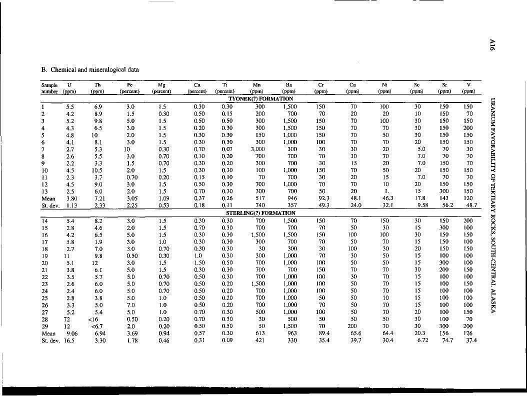
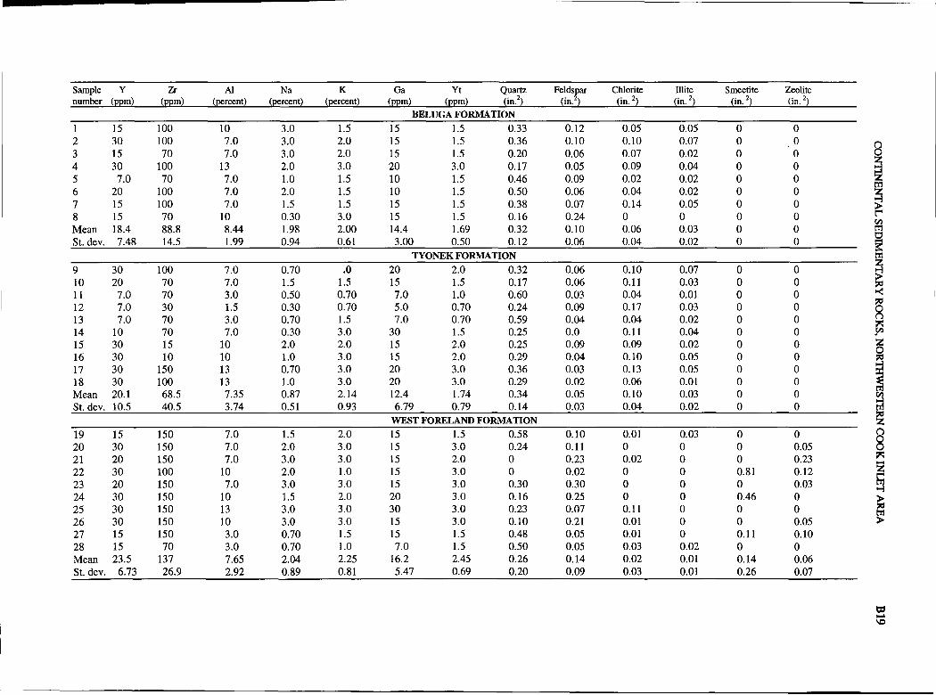
APPENDIX I-CHEMICAL AND MINERALOGICAL DATA FOR SAMPLES OF THETYONEK(?) AND STERLING(?) FORMATIONS OF THE TERTIARY KENAI GROUP
Samples are shown by number in the measured sections of appendix 2. Elements are in parts per million (ppm) or percent,as indicated at top of column. Values for quartz, plagioclase, chlorite, illite, smectite, and amphibole are peak area in squareinches; the crystallographic indices of the peaks measured are given in table 1. Mean is the arithmetic mean; St. Dev. is standard deviation. For values listed as N (not detected), half of the lower detection limit was used; for values listed as L (detected,but not determined), three-fourths of the lower detection limit was used; for values prefixed with <, three-fourths of the lessthan value was used; for values listed as G (greater than 10 percent), 12.5 percent was used.
A15
Rock type
Claystone, gray-brown, dense, micaceousSandstone, gray-brown, dense, micaceousClaystone, light-brown, dense, micaceousClaystone, medium-gray to brown, denseClaystone, light-gray, sandy, micaceous, noncalcareousSiltstone, medium-gray, noncalcareousMudstone, gray, mottled; reddish-brown sideriteSandstone, brown, hard, noncalcareousSandstone, gray, soft, medium- to coarse-grainedMudstone, medium- to light-gray, dense; iron oxideSandstone, gray-brown, medium-grained, soft, siltyMudstone, gray-brown, dense, micaceous, metallic lusterSandstone, brown, very fine grained, soft, silty
KENAI GROUP, SUSITNA LOWLANDS, NORTIlERN END OF COOK INLET BASIN
>....01
B. Chemical and mineralogical data
Sample U Ih Fe Mg Ca Ii Mn Ba Cr Cu Ni Sc Sr Vnumber (ppm) (ppm) (percent) (percent) (percent) (percent) (ppm) (ppm) (ppm) (ppm) (ppm) (ppm) (ppm) (ppm)
Sample y Lr AI Na K Ga Yb Quartz Plag. Chlorite illite Smectite KaoliniteNumber (oom) (oom) (nP.rrpnt) (nPrrpnt) (~~cent) (ppm) (ppm) (in.2) (in. 2) (in.2) (in?) (in.2 ) (in?TYONEK(?) FORMATION
A18 URANIUM FAVORABILITY OF TERTIARY ROCKS, SOUTII-CENTRAL ALASKA
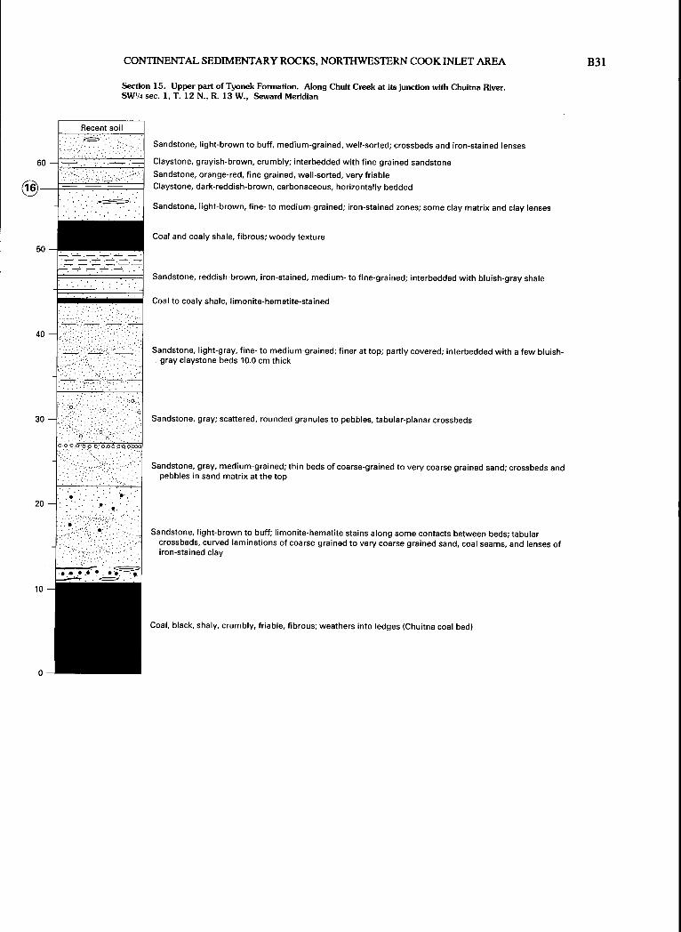
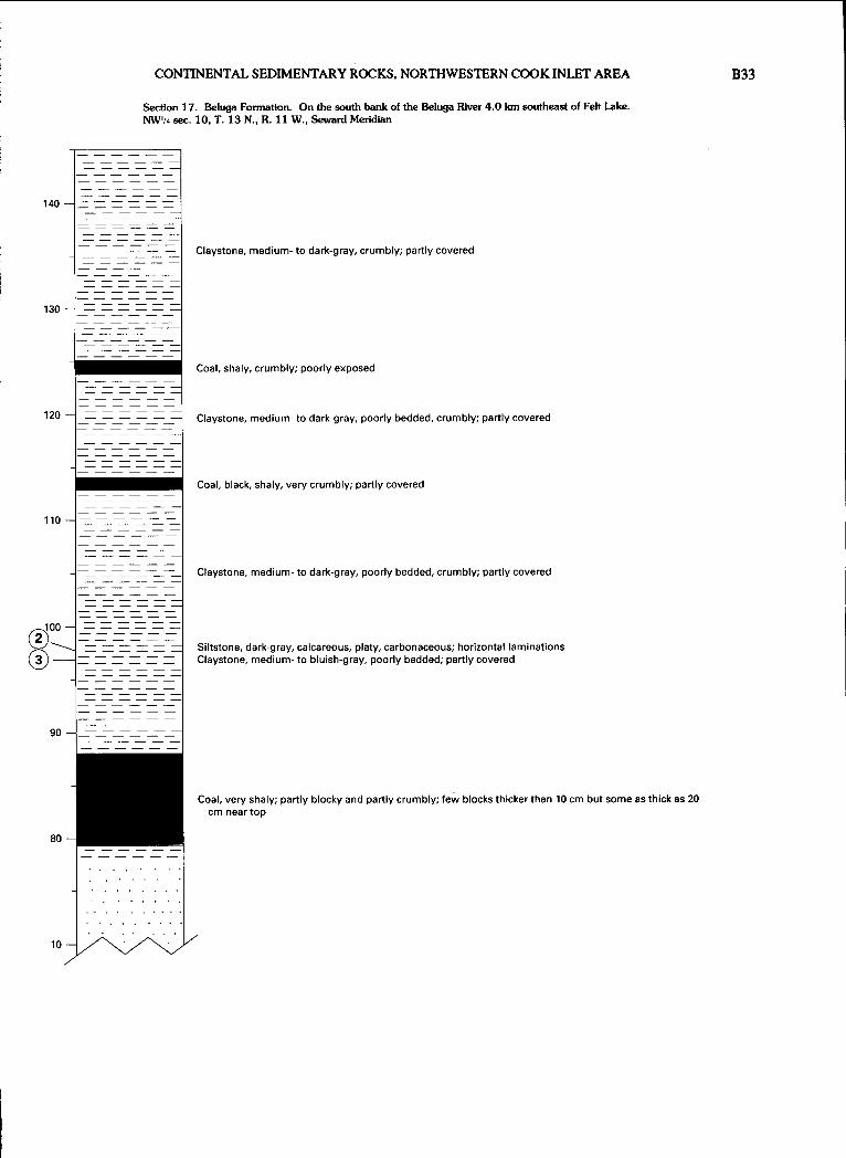
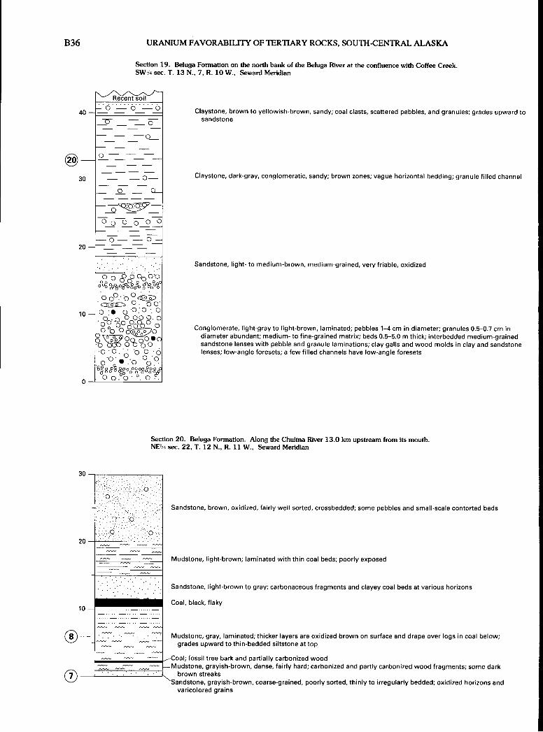
APPENDIX 2-MEASURED SECTIONS OF THE TYONEK(?) AND STERLING(?)FORMATIONS OF THE TERTIARY KENAI GROUP
Locations of sections are shown in figure. 2. Section scales are in meters; sample numbers are circled and in bold, alongside scale.
Section 1. Sterling(?) Fonnation. Along Cottonwood Creek 2.8 kIn northeast of the junction of Cottonwood and Peters Creeks.SE4NW';"NW';" sec. 33, T. 29 N., R. 8 Wo, Seward Meridian
Claystone, medium- to light-gray, poorly bedded, crumbly; sandy at top, silty zones, wood fragments, horizontalyellowish-brown streaks, and scattered pebbles
Sandstone, light-gray, fine- to coarse-grained; fines upward; vague bedding marked by pebble zones and lenses
Conglomerate, light-gray; fine-grained sand matrix; fines upward from pebbles to granules; fine- to medium-grainedlenticular sandstone interbeds, with channeled bases and tabular-planar crossbeds
Claystone, medium-gray to reddish-brown, massive; silty zones and color laminations
Sandstone, fine-grained, and siltstone, light-brown, massive; interbedded at base and top with light-gray claystonelayers 5-10 em thick
Section 2o Tyonek(?) Fonnation. On Cottonwood Creek 1.4 kIn northeast of the junction of Cottonwood and Peters Creeks.SWlf.ISW';"SE';" sec. 32, T. 29 No, R. 8 Wo, Seward Meridian
~IRecent SOl
. 0 : : : ". o.
20 -'.
..0."
. ", 0"
Sandstone, light-brown, coarse-grained to very coarse grained; scattered granules; vague horizontal bedding;granule-pebble lenses 20 cm-1 m thick; clayey at top
10 . '. . . . '.
0-:=-~~~~~c~~~~-==---=:
~------ -----------f------------
Conglomerate, light-brown; well-rounded pebbles 1-2 cm in diameter; sand matrix; horizontal interbeds ofmedium-grained sandstone
Conglomerate, light-brown; well-rounded pebbles 1-2 cm in diameter; sand matrix; horizontal interbeds ofmedium-grained sandstone
KENAI GROUP, SUSI1NA LOWLANDS, NORTIIERN END OF COOK INLET BASIN
Section 3. Sterling(?) Formation. On Columbia Creek 0.6 km northeast of the junction of Columbia and Cache Creeks.NWl,i,NW1,i,NW',i, sec. 14, T. 18 N., R. 9 W., Seward Meridian
A19
@
Conglomerate, light-grayish-brown; pebbles to cobbles; medium-grained sandstone matrix; interbedded sandstonelenses 2-5 cm thick; fines upward to claystone; imbricated pebbles
Sandstone, Iight- to reddish-brown, medium- to coarse-grained; conglomeratic at top; interbedded with granulepebble lenses; tabular-planar crossbeds
Section 4. Sterling(?) Formation. Along Cache Creek at the junction of Cache and Trout Creeks.NE',i,SP,i,SP,i, sec. 20, T. 28 N., R. 9 W., Seward Meridian
Modern soil
50
40
30
®
20
10
o
. ,°'0.0
... '0'
Q. ',' ~.o
. 0 .0'
:ioo·iqb~:6.··b~o:.g.0. . 0 . . 0..
2.: ..:?O··::?:·.~:·6~·6:
Conglomerate, medium- to grayish-brown; pebbles 3-5 cm in diameter; poorly developed horizontal beds 1-2 mthick; argillaceous sandstone lenses
Claystone, medium- to bluish-gray, massive; vague bedding 2-10 m thick
Sandstone, medium-brown, medium-grained; beds 3-20 cm thick; low-angle foreset crossbeds and granule-pebblelenses 5-10 cm thick
Conglomerate, Iight- to medium-brown; pebbles to cobbles 3-20 cm in diameter; grain-supported sandstone matrix,sequence fines upward; very low angle foreset crossbeds of longitudinal bar type
A20 URANIUM FAVORABILITY OF TERTIARY ROCKS, SOUlH-CENTRAL ALASKA
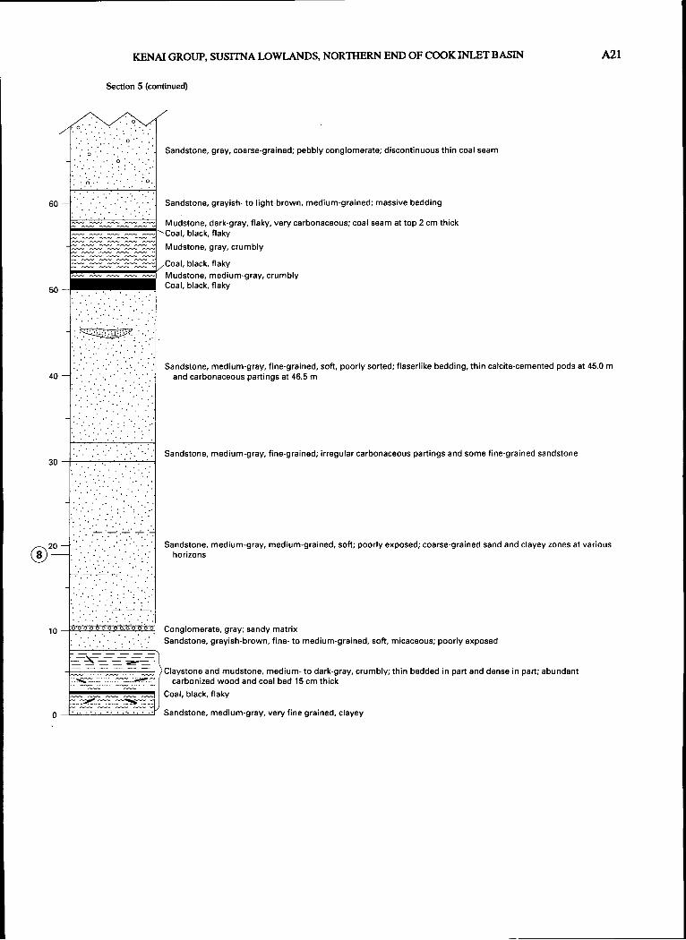
Section 5. TyonekmFormation. On Peters Creek 2.4 kIn south of Petersville. Center sec. 33, T. 28 N., R. 8 W.,Seward Meridian
Sandstone, brown-mottled, reddish-brown, fine-grained, oxidized, soft; calcareous concretions 0.2 m by 1 m at132.5 m, clay veins, and thinly bedded mudstone at 135.0 m
Covered
Claystone, medium-gray, dense, chunky; some silty beds and interbedded fine-grained sandstone and mudstone
- - -.-.__e-~ --=..0 --=-' -=-..0 -=- -=- Claystone, medium-gray, silty, massive, very poorly bedded; grades laterally into coal; coal clasts and coalified
roots; reddish-brown streaks
o
Covered
Coal, black, shaly
KENAI GROUP, SUSIlNA LOWLANDS, NORTIIERN END OF COOK INLET BASIN
Section 7. Tyonek(?) Fonnation. On Cache Creek 1.0 km north of the junction of Cache and Spruce Creeks.NE'/.SW1,4SE'/. sec. 13, T. 27 N., R. 10 W., Seward Meridian
Modern soil
Sandstone
Coal, black, shaly; wood fragments
A23
70
60
50
40
30
20
_....:.........---.:...-._.-
'.'~: ..~.
;z:,.:,:.;; . -.;~.:.. '~.q'
Claystone; mostly covered
Sandstone, light-gray to reddish-brown, medium- to coarse-grained; partly covered; tabular crossbeds, low-angleforesets, and large tabular-planar crossbeds
Claystone, medium-gray, and interbedded sandstone, light-gray, medium- to coarse-grained; sandstone containsscattered pebbles and tabular-planar crossbeds
Sandstone, medium-gray, medium- to coarse-grained; reddish-brown streaks mark horizontal beds and tabularplanar crossbeds; coarse-grained to very coarse grained granules concentrated in crossbeds
Claystone, light- to brownish-gray, massive; horizontal laminations 1 mm-1 cm thick
Sandstone, medium- to brownish-gray, medium-grained; clayey upward; reddish-brown streaks; tabular-planar andtrough crossbeds 1-2 m thick
Claystone, light-gray, poorly bedded, and interbedded sandstone, 1-2 cm thick, fine-grained
Sandstone, medium-gray, medium- to coarse-grained; grades upward to claystone; coarse-grained to very coarsegrained sand lenses, claystone clasts, scattered wood fragments, and rock fragments
Sandstone, medium-gray, medium- to coarse-grained, massive; ripple-drift crossbeds and coal fragments
Claystone, light-gray, massive, very poorly bedded; reddish-brown streaksCoal, black, shaly, medium-bedded, very woodyClaystone, medium-bluish-gray; mostly covered
A24 URANIUM FAVORABILITY OF TERTIARY ROCKS, soUm-CENTRAL ALASKA
Section 8. Tyonek(?) Formation. On west bank of Cache Creek 0.5 Ian north of the junction of Cache and Dollar Creeks.SP4NW'4SE'.4 sec. I, T. 27 N., R. 10 W., Seward Meridian
-.~'-:...
. " .: .I- :-"
Sandstone, medium-brown to medium-gray, fine- to coarse-grained; claystone 20 cm thick at base
Conglomerate, light-gray; abundant pebbles 2-4 mm in diameter; medium-grained, grain-supported sand matrix;sandstone lenses 20-30 cm thick
Conglomerate, light- to medium-gray, pebbles, cobbles, and scattered boulders; reddish-brown, coarse-grained,grain-supported sandstone matrix
Sandstone, medium-gray, medfum to fine-grained; wood fragments 20 cm by 1 m suspended in sandstone; mostly,covered
. ','
Sandstone, medium-gray to brown, medium-grained, clayey; scattered wood fragments
Coal, shaly, woody; fibrous plant material
..........
-------=20 - --=---~~~~~ Claystone, medium- to light-gray, massive to crumbly; reddish-brown streaks; shale at top
Coal, interbedded with clayey coal in seams 5-10 cm thick and crumbly, light-gray claystone
o
1-------
t~~~~~1------=
Claystone, medium-bluish-gray to light-gray, crumbly; a few brown, fine- to medium-grained clayey sandstonelenses
Sandstone, brown, fine- to medium-grained; woody fragments 4 by 40 cm; mostly covered
Claystone, light-gray, massive at base; reddish-brown streaks parallel with bedding; crumbly and shaly at 4.0 m;dark- and light-gray laminations 1-3 cm thick
KENAI GROUP, SUSI1NA LOWLANDS, NORTIIERN END OF COOK INLET BASIN
Section 9. Sterling(?) Fonnation. On the east bank of Cache Creek 2.6 km south of the junction of Cache and Spruce Creeks and 5.8 kmnortheast of the junction of Cache Creek and the Kahiltna River. NW%SW';"NW% sec. 30, T. 27 N., R. 9 W., Seward Meridian
Sandstone, medium-gray, interbedded with conglomerate; maximum grain diameter 12 em; some grains havelimonitic coating; gray conglomeratic sandstone matrix
Conglomerate, gray; maximum grain diameter 15 em; faint large-scale crossbeds, fragments of wood, and finegrained poorly sorted sandstone lenses; clayey limonite-stained coarse-grained sandstone matrix
Covered
A26 URANIUM FAVORABILITY OF TERTIARY ROCKS, SOU1H-CENTRAL ALASKA
Section 10. Tyonek(?) Formation. On the east bank of Cache Creek 2.8 kIn south of the junction of Cache and Spruce Creeks and5.6 kIn northeast of the junction of Cache Creek and the Kahiltna River. SW'.4NW1,4 sec. 30, T. 27 N., R. 9 W., Seward Meridian
Sandstone, brown with gray streaks, fine- to medium-grained; oxidized iron zones; crossbed sets 10-20 cm thick
Coal, black, flaky; wood fragments
Mudstone, gray, micaceous, oxidized; reddish-brown at base; poorly exposed
Sandstone, brown, medium-grained, poorly sorted, soft; no structure apparent; mostly covered by slope wash
60
50
Coal, black, flaky; wood; two beds 10-20 cm thick of light-gray, very fine grained, moderately hard sandstone
~~~~:t:~~~*,Sandstone,gray, soft, clayey; abundant plant fragments and micaMudstone, medium-grained; grades upward to fine-grained, soft sandstone; plant fragmentsSandstone, brown, fine-grained, soft; gray streaks; reddish-brown oxidized beds, carbonized plant fossils, and traces
of mica
Mudstone, medium-gray; few brown streaks
Covered
Sandstone, gray and brown, fine-grained; irregular horizontal beds, carbonized plant matter, and mica40
Mudstone, gray, crumbly, carbonaceousCoalMudstone, medium-gray, partly iron stained, carbonaceous, hard, flaky; thin coal bed at 34.4 m, carbonaceous
material at 35.0 m, and scattered plant matterI'!!'!!i~~!""!'!!'!!'!!'_~~~Covered
Coal30 -iliijiiiii~ Mudstone, medium-gray, flaky; abundant carbonized wood fragments and 6 cm thick coal bed at 31.3 m
CoveredCoal and interbedded mudstone
k'-'---~--'--~-~"Sandstone, medium-gray, very fine grained to fine-grained, soft; fines upward to medium-gray, crumbly mudstone
Covered
Covered
Coal, black, crumblyMudstone, brown, crumbly
Sandstone, medium-gray, fine- to coarse-grained; interbedded gray and brown oxidized clayey sandstone
KENAI GROUP, SUSITNA LOWLANDS, NORTHERN END OF COOK INLET BASIN
Section 11. Tyonek(?) Fonnation. On Lake Creek 6.3 krn west of Shulin Lake. SWIASE%NW% sec. 30, T. 42 N., R. 9 W.,Seward Meridian
~o 0~~~~
~~~~
A27
200
190
180
170
160
150
140
130
=0 ==~~--...-v~~== 0~~~~~
-0- - - -0-
-="o--=-" -=- -=- -=-- - - -0-------
- - -0- --------
o
o 000
o 0
o·
Mudstone, light-medium-gray, mostly covered, contains floating pebbles and cobbles 2-20 cm in diameter; zones ofgrain support
Conglomerate, light-reddish-brown; rounded pebbles and cobbles 1-5 cm in diameter; massive horizontal beds1-2 m thick; vague suggestion of low-angle crossbeds
Conglomerate, light-gray; pebbles, cobbles, and boulders 1.0-2.0 m in diameter; sandstone-granule matrix
Mudstone, medium-gray, conglomeratic; granules and scattered pebbles; mostly covered
Conglomerate, light-gray to reddish-brown; grain-supported sand matrix; pebbles and cobbles 1-40 cm in diameter;medium- to coarse-grained sandstone lenses 5-10 cm thick and 10-20 m long; low-angle foreset crossbeds
A28 URANIUM FAVORABILITY OF TERTIARY ROCKS, SOUlH-CENTRAL ALASKA
Conglomerate, light-gray to reddish-brown; grain-supported sand matrix; pebbles and cobbles 1-40 cm indiameter; medium- to coarse-grained sandstone lenses 5-10 cm thick and 10-20 m long; low-angle foresetcrossbeds
Covered
Claystone, light-gray, sandy; mostly covered
Covered
Coal to clayey coal, black, massive; seams 2-4 cm thick
Claystone and very fine grained clayey sandstone, light-gray to reddish-brown, streaked, massiveCoal, black, channeled
Claystone, light-gray, arenaceous, partly covered
Sandstone and claystone interbedded with granule-pebble conglomerate, light-gray to light-reddish-brown;horizontal beds 1-2 m thick
-----.._. - .--.: ..:........ -'
50
Sandstone interbedded with pebble-granule conglomerate, light-brown to Iight-reddish-brown, and claystone,light-gray, well-sorted
KENAI GROUP, SUSITNA LOWLANDS, NORTIlERN END OF COOK INLET BASIN A29
Section 12. Tyonek(?) Formation. On the east bank of Lake Creek 3.3 km west of Shulin Lake.NW',4NW1j.,NE% sec. 33, T. 24. N., R. 9 W., Seward Meridian
Sandstone, medium-brown, fine-grained, well-sorted, soft; horizontal beds in lower part, crossbed sets 0.7 m thicknear top; gravel in lower part
Mudstone, medium-brown, flaky, soft, crumbly, dense, very sandy; medium- to dark-gray near top; carbonized woodfragments
Sandstone, brown, fine-grained to very fine grained; iron oxide bands; gray, thin-bedded, fairly well sortedsandstone bed about 0.5 m from top
Sandstone, light-brown, pebbly; trough crossbeds as thick as 1 m, conglomerate layers in troughs; scoured base
30
60 -,--0-,,0---0-,--0-,,0,-----0-0-,--0
OoOo~oooo.':..-0;-0 00 00 0 Conglomerate, very clayey; maximum grain diameter 30 cm
Conglomerate, brown, pebbly; maximum grain diameter 2 cm; reddish-brown sandy matrix; scoured base
Sandstone and conglomerate, brown, medium- to coarse-grained; crossbed sets 30 cm thick; abundant mudstoneclasts
10 :. : 0 Sandstone, light- to medium-brown, medium-grained, conglomeratic; some near horizontal beds, low-anglecrossbeds, and vague troughs
Mudstone, dark-gray, sandy; fine-grained mica and carbonaceous fragments
Conglomerate, brown, moderately hard; maximum grain diameter 7 cm; grades upward to dark fine-grainedsandstone; medium-brown, medium-grained sandstone interbeds 30 em thick
A30 URANIUM FAVORABIUIY OF TERTIARY ROCKS, SOUlH-CENTRAL ALASKA
Section 13. Tyonek(?) Fonnation. On the northwest flank of Fairview Mountain above the head of Cottonwood Creek.SE'4NE4NE4 sec. 13, T. 26 N., R. 12 W., Seward Meridian
Conglomerate, medium-gray to reddish-brown; sandstone matrix; pebbles and cobbles 1-15 cm in diameter; mostly
covered
70
60
Section 14. Tyonek(?) Fonnation. On the west flank of Fairview Mountain at the head of Cottonwood Creek.NE'4NW'4NWl;" sec. 7, To 26 No, R. 12 Wo, Seward Meridian
Mudstone, gray, thin-bedded to laminated; oxidized near surface; poorly exposed in places; some very silty andvery clayey layers
KENAI GROUP, SUSITNA LOWLANDS, NORTIIERN END OF COOK INLET BASIN A31
Section 14 (continued)
Mudstone, gray, thin-bedded to laminated; oxidized near surface; poorly exposed in places; some very silty andvery clayey layers
30
Mudstone, medium-gray; dark-gray and carbonaceous at base; surface oxidized brown; laminated, very clayey; afew layers of siltstone and carbonized plant fragments at top
Coal; lower half dense and laminated, upper part flaky
Claystone, medium-gray, crumbly, silty; thinly bedded to laminated, micaceous intervals
Coal, hard, dense, laminatedMudstone, light-medium-gray, soft, crumbly; some fine-grained mica
Section 15. Sterling(?) Formation. On Camp Creek 0.8 km west of the junction of Camp and Pass Creeks.NW'I.SEI.4NEI.4 sec. 29, T. 27 N., R. 12 W., Seward Meridian
Modern soil
Conglomerate and sandstone, light-green ish-gray; pebbles and cobbles 1-10 cm in diameter; horizontal beds ofconglomerate interbedded with sandstone lenses; low-angle foreset beds
Conglomerate and sandstone, light-brown; interbedded medium- to coarse-grained sandstone lenses; pebbles1-3 cm in diameter; medium-grained grain-supported sandstone matrix; low-angle foreset beds; oxidizedintervals
Conglomerate, light-grayish-brown, massive; pebbles 1-5 cm in diameter; medium-grained to very coarse grainedmatrix; reddish-brown streaks and scattered clasts; partly covered
o
0. '0' ·'0 . 0. 0.'0' . '.~
o;~~:~~~~~~~~~-~~-~-~~ Claystone, light-orange to brown and pale-yellowish-orange, kaolinitic, uraniferousr. Coal, brown; black streaks; beds 10 cm thick; discontinuous:: '.~.: g..' Mudstone, gray, hard, micaceous
0'.' '0
~.~~.~Q~Oo~0000008''Q00009000'. '0·o 0 0 0 000
000
0o 0 000 0 0 0
o 00 0 0o 0 0 0
00 0 0 00
A32
o
URANIUM FAVORABILITY OF TERTIARY ROCKS, SOUTII-CENTRAL ALASKA
Section 16. Sterling(?) Formation. On Camp Creek 0.8 km north of airstrip. SE'/<oSE'hSE'/<o sec. 20, T. 27 N., R. 12 N.,Seward Meridian
~Modern soil
Conglomerate, light-gray; grain-supported, medium- to coarse-grained sandstone matrix; low-angle foresets andtabular-planar crossbeds, granule lenses, and suspended pebbles in sandstone lenses
Conglomerate, reddish-brown; pebbles 1-4 cm in diameter; coarse-grained sandstone matrixSandstone, brown to reddish-brown, coarse-grainedClaystone, medium- to bluish-gray, massive; possibly varved
Section 17. Sterling(?) Formation. On the Kichatna River on a northwest-facing cliff on the south side of the river.SE'hNW'hNE'/<o sec. 33, T. 24 N., R. 14 W., Seward Meridian
~o~~o~o~~o Claystone, medium-gray, massive, poorly-sorted; contains floating pebbles and cobbles
==-------=30 - =-~=-~=-~=-~_===_=-~ Claystone, medium-gray, blocky; beds 5-10 cm thick
1-------------------
......------
Sandstone, medium-gray, massive; mostly covered
Claystone, medium- to light-gray; very blocky, varved
Sandstone, reddish-brown, coarse-grained to very coarse grained; fines upward to very fine grained sandstonecontaining granule lenses
Conglomerate, light- to reddish-brown; pebbles and cobbles 1-20 cm in diameter; coarse-grained sandstone matrix;a few lenses 5'-20 cm thick of medium- and coarse-grained sandstone; a few low-angle foreset beds
KENAI GROUP, SUSITNA LOWLANDS, NORTHERN END OF COOK INLET BASIN
Section 18. Sterling(?) Fonnation. On Johnson Creek on the southwest-facing cliff. SE',4SWlf"NW% sec. 24, T. 23 N.,R. 14 W., Seward Meridian
A33
40
@ ------j~=_c=~~=,j30
,0
'0o,0' 0,·0'0'
o 0"00
20
10
Claystone. dark-gray, crumbly, silty; very poorly sorted, vague horizontal bedding
Conglomerate, light-brown; reddish-brown streaks; grain-supported, fine- to medium-grained sandstone matrix;pebbles and cobbles 1-20 cm in diameter; reddish-brown, medium-grained sandstone lenses and low-angle andtrough crossbeds
Geology, Geochemistry, and Uranium Favorability ofTertiary Continental Sedimentary Rocks in theNorthwestern Part of the Cook Inlet Area, Alaska
By Kendell A. Dickinson, John A. Campbell, and William F. Dula, Jr.
URANIUM FAVORABILITY OF TERTIARY ROCKS, SOUTH-CENTRAL ALASKA
U.S. GEOLOGICAL SURVEY BULLETIN 2098-B
UNITED STATES GOVERNMENT PRINTING OFFICE, WASHINGTON: 1995
West Foreland Fonnation 3Tyonek Fonnation................................................................................................. 5Beluga Fonnation................................................ 6
Methods........................................................................................................................... 6Statistical Analysis.......................................................................................................... 8Sediment Sources 9Clay Minerals and Zeolites 10UraniUlD Favorability 12Conclusions..................... 14References Cited 15Appendix l-Chemical and Mineralogical Data for Samples of the
West Foreland, Tyonek, and Beluga Fonnations........................................................ 17Appendix 2-Measured Sections of the West Foreland, Tyonek, and
Beluga Fonnations 20
FIGURES
1. Index map of south-central Alaska showing study area................................................. B22. Map showing geology of the Tyonek-Capps Glacier area and locations of measured sections................................. 43. Chart showing stratigraphy of Tertiary sedimentary rocks in Cook Inlet Basin area 54. Photograph showing Tyonek Fonnation along Coal Creek 65. Photographs showing Tyonek Fonnation near toe of Capps Glacier.......................................................................... 76. Electron micrograph showing detrital texture in mudstone of the Beluga Fonnation 97. Photographs showing tuffaceous sedimentary rocks of the West Foreland Fonnation 138. Scatterplot of uranium versus thorium for samples of the West Foreland, Tyonek, and Beluga Fonnations 14
TABLES
1. X-ray diffractogram peaks (Cu, K-alpha radiation) measured for rock samples in the study.................................... B82. Correlation coefficient matrix for data set 103. Varimax factor analysis for five factors...................................................................................................................... 124. X-ray diffraction counts for clay minerals and zeolites for samples having high clay contents................................. 12
Geology, Geochemistry, and Uranium Favorability ofTertiary Continental Sedimentary Rocks in the
Northwestern Part of the Cook Inlet Area, Alaska
By Kendell A. Dickinson, l John A. Campbell,2 and William F. Dula, Jr.3
ABSTRACT
The Paleocene and Eocene West Foreland Formation,the Oligocene and Miocene Tyonek Formation, and theMiocene Beluga Formation are present in the Tyonek-CappsGlacier area northwest of Cook Inlet, south-central Alaska.Several thousand feet of Tertiary continental sedimentaryrocks baving many characteristics favorable for uraniumdeposits are present in these units. These rocks consistmainly of mudstone, sandstone, and conglomerate that con-tain abundant carbonaceous material. .
Samples of mudstone, sandstone, and conglomeratecollected from 21 localities were analyzed for uranium, thorium, and 19 other elements, and minerals were determinedby X-ray diffraction. Analysis of chemical and mineralogical data suggests that the primary source area for the WestForeland Formation is the Alaska Range to the northwestand for the Tyonek and Beluga Formations the Chugach andKenai Ranges to the east. Smectite and zeolite formed diagenetically from volcanic materials in the sediments. The WestForeland Formation contains more volcanic material, zeolite, and smectite than the overlying units. Although thepotential for commercial-sized uranium deposits is low, theWest Foreland Fonnation is believed to be more favorablefor significant uranium deposits than the other units becauseof the greater amount of volcanic detritus within it and thegreater amount of alteration that took place in this unit.
INTRODUCTION
The Cook Inlet area in south-central Alaska (fig. 1) contains a thick sequence of Tertiary continental sedimentary
lU.S. Geological Survey, Lakewood, Colorado.2port Lewis College, Durango, Colorado.3ARCO Exploration and Production Technology Co., Plano, Texas.
rocks that includes, in ascending order, the Paleocene toEocene West Foreland Formation, the Oligocene HemlockConglomerate, the Oligocene to Miocene Tyonek Formation, the Miocene Beluga Formation, and the Miocene andPliocene Sterling Formation. Except for the West ForelandFormation, these formations are included in the KenaiGroup. Interest in the possibility of uranium deposits in theserocks developed mainly because the sequence contains thickarkosic sandstone beds and abundant carbonaceous materialand bas possible sources of uranium in volcanic rocks of theAleutian and Alaska Ranges to the northwest.
Early interest in the Tertiary sedimentary rocks ofCookInlet was motivated by the demand for coal. Coal resourcesof the northwestern part of the Cook Inlet area weredescribed by Barnes (1966). Oil was discovered in the areain 1957 (Parkinson, 1962), and mucb of the later interest inthe area was stimulated by the search for petroleum (Calderwood and Fackler, 1966, 1972; Crick, 1971; Kirschner andLyon, 1973; Hayes and others, 1976). Interest in uraniumduring the late 1970's resulted in further study of the Tertiarysedimentary sequence (Croff and others, 1977; Dickinsonand Campbell, 1978). The Beluga and Sterling Formationswere described by Kremer and Stadnicky (1985) andMagoon and Egbert (1986).
Tbe area as discussed berein extends from the vicinityofTyonek on the northwest sbore ofCook Inlet inland northwestward along the Cbuitna and Beluga Rivers to the area ofCapps and Triumvirate Glaciers. Samples of Tertiary rockswere collected during a reconnaissance survey by belicopterbetween August 6 and 13, 1977. Twenty-six sections (fig. 2)were measured in the study area, and samples were collected. The present report is based on cbemical and mineralogical analyses of the samples (appendix 1) and on themeasured sections (appendix 2). Tbese data provide newinsigbt into the depositional and diagenetic bistory of theseunits as well as their favorability for uranium deposits.
Acknowledgments.-Gary Skipp prepared oriented claymineral mounts for X-ray diffraction studies and operated
Bl
B2 URANIUM FAVORABILITY OF TERTIARY ROCKS, SOUllI-CENTRAL ALASKA
160"I
70"_
ALASKA
500t
\,,\,,\
1000 KILOMETERSI
145"154"63"I----------~---I
MOUNTAINS
.-/.;,.r:::::=-- _ ....-..
TONZONA PLUTON
Shirley Lakep
Study Area
......
59"'-----__--..L ---'
100I
200 KILOMETERSI
Figure 1. Index map of south-eentral Alaska showing study area (dark screen) and areas of Tertiary continentalsedimentary rocks (unit Tc). Geology modified from Biekman (1980).
CONTINENTAL SEDIMENTARY ROCKS, NORTIIWESTERN COOK INLET AREA B3
the X-ray diffraction machine. Samples were chemicallyanalyzed in the analytical laboratories of the U.S. GeologicalSurvey at Lakewood, Colorado. Radiochemical and X-rayfluorescence analyses were made under the supervision ofD.M. McKown and J.E. Taggart. X-ray spectroscopy analyses were made under the supervision ofD.E. Detra and L.R.Layman.
GEOLOGY
Scattered outcrops of the Tertiary continental sedimentary rocks are present along the northwest edge of the CookInlet Basin (fig. 2) (Magoon and others, 1976). Much of thestudy area is covered by Quaternary sediments, glacial ice,and the waters of Cook Inlet. The area also contains Tertiaryand Quaternary volcanic rocks of basaltic and andesitic composition, Cretaceous and Tertiary felsic igneous rocks, andJurassic and Cretaceous metamorphic and sedimentaryrocks. The Tertiary sedimentary rocks generally dip at lowangles southeastward into the Cook Inlet Basin.
The Cook Inlet Basin, in the coastal area of south-central Alaska, separates the Aleutian and Alaska Ranges to thenorthwest from the Kenai and Chugach Ranges to the southeast (fig. 1). The Talkeetna Mountains and the Copper RiverBasin are to the northeast. The Cook Inlet basin is about 100by 300 kID in area; its long axis is oriented about N. 250 E. Itcontains about 8,500 m of mostly nonmarine Tertiary sedimentary rocks that comprise the Oligocene to PlioceneKenai Group and the underlying Paleocene and Eocene WestForeland Formation (fig. 3). The Tertiary rocks overlieJurassic and Cretaceous rocks (Kremer and Stadnicky, 1985)and underlie Quaternary alluvium and glacial deposits.
The Cook Inlet Basin is generally bounded on the eastby the Border Ranges fault (Knik fault of Magoon and others, 1976), which trends about N. 300 E. (fig. 1). The BruinBay fault, which forms the western margin of the basin,extends northward about N. 450 E. It intersects the CastleMountain fault in the northern part of the basin. The CastleMountain fault trends about N. 600 E. and generally formsthe northwestern boundary of the basin (fig. 1). Undifferentiated lithic equivalents of the Kenai Group and the WestForeland Formation extend north of the Castle Mountainfault into the Susitna Lowlands. Other minor faults and lineaments have been mapped on the Kenai Peninsula. Severalanticlines and synclines, whose axes approximately parallelthe long axis of the basin, were mapped by Magoon and others (1976) in the eastern half of the Cook Inlet Basin. Waterof Cook Inlet covers most of the northwest half of the basin.
TERTIARY SEDIMENTARY ROCKS
Tertiary sedimentary rocks of the Cook Inlet Basinwere named the Kenai Group by Dall and Harris (1892), whoassigned the group to the Miocene. Barnes and Cobb (1959)and Parkinson (1962) called these same rocks the Kenai
Formation. Subsequently, the Kenai Group was divided intofive formations, in ascending order, the West Foreland Formation, Hemlock Conglomerate, Tyonek Formation, BelugaFormation, and Sterling Formation (Calderwood and Fackler1966, 1972; Crick, 1971). Later, Magoon and others (1976)removed the West Foreland Formation from the KenaiGroup (fig. 3).
In the study area the Tertiary sequence, in ascendingorder, consists of the West Foreland Formation (Paleoceneand Eocene) and the Tyonek (Oligocene and Miocene) andBeluga (Miocene) Formations of the Kenai Group (fig. 3).The Hemlock Conglomerate was not identified, and the Sterling Formation does not crop out in the Tyonek~appsGlacier area. Basal rocks of the Kenai Group are separated inplaces from the underlying West Foreland Formation by anangular unconformity.
WEST FORELAND FORMATION
The Paleocene and Eocene West Foreland Formationconsists mostly of claystone and tuffaceous sandstone at thetype section, which was established by CalderWood andFackler (1972) in the subsurface in Pan American Oil Company's West Foreland no. 1 well, in sec. 21, T. 8 N., R.14 W., Seward Meridian. The thickness at the type section,which is at West Foreland on the west shore of Cook Inletabout 25 kID south of the study area, is 271 m. In the studyarea the Hemlock Conglomerate has not been identified, andthe West Foreland is unconformably overlain by the TyonekFormation. In some areas the West Foreland Formationoverlies the Paleocene Arkose Ridge Formation (Magoonand others, 1976), but at the type section and in the reportarea it unconformably overlies Jurassic rocks (Calderwoodand Fackler, 1972; Kremer and Stadnicky, 1985).
About two-thirds of the outcrops of the West ForelandFormation in the study area consists of brown to grayishbrown polymictic conglomerate. The remaining one-thirdconsists mostly of light-brown lithic sandstone but alsoincludes small amounts of claystone and coal (sections 1-9,appendix 2). The conglomerate clasts are mostly granite,volcanic rocks, and metamorphic rocks (Adkison and others,1975). Barnes (1966) reported a tuff bed more than 9 m thickin the southern part of the study area. An ash bed 7 m thickis also present at the type section (Calderwood and Fackler,1976). The volcanic beds were not sampled for this study.Descriptions of the West Foreland are given in Barnes(1966), who considered it part of the Kenai Formation, andin Adkison and others (1975) and CalderwoOd and Fackler(1972).
In the study area the West Foreland was deposited primarily as alluvial fans. The massive conglomerate beds weredeposited close to the mountain front and may have fonnedas debris flows on alluvial fans while uplift was occurring.The remaining sandstone and mudstone beds are fluvialdeposits.
~~
15]000'
OS Y/J\ r// / // I "yu // / / ) ,Y//~ c:::~
C\
~,~ ....~~
oZt~ E::"r1
Os ~0~
6;-~
Os 0"r1
;j~
~-<~
R~
.(1)
~c:::~htTlZ;d>t"'">t"'">
Os I I(I)
~
152°00'
WOO' 1////////////J .:li L I /
o 5 10 20 30 KILOMETERSI I I I I I I I I
CONTINENTAL SEDIMENTARY ROCKS, NORTHWESTERN COOK INLET AREA B5
" --.0 " N
.,g ~:;l
.~001 U ii 'l:l"tl '" 01 '6 cC 01~ ,S ~ 8-til "tl"tl
c..2 til tile- til u CfJ "2' '" ~~
(1J .5 -0 :;l "g~ ..9l 0 0
'"til :g :e c~
Ol til 01 Cl 01 0U u u '" '.:;Jtil 0 " -0Ol -- 0 1l 0Ol '" " £1: "'j! u til~0 ~~ ~ 0: 'l:l'6 01 til
~~~Ol 01 01 '"::s'" ..c: E til '"co ... :;l 01 0l('.J 0.., Ol
S >< j~1""8 ;;. 01 -0>.& ::s Ol_ 01 0 -.:.0'C 0 S U til ... til ~ E o " «iG'o Ol .:s 'c;;'~ Ol ... 0.Cl gi C 01 ..I<ll'-'6~ ~ ~ § ti c Ol o ... o 0-0- til
~.5
_ 01
1:0 .~ 0- gj~C ~ «l'"'~ <:i '" 0- ~~ - til~u
_ ::s 0C c 2 0-
lS " :;;: '-'Ol '":l > 0 '" ..c: ::J til ... o ,- e;<.:l ::.: u ..: CfJ I- ... ..J <;j II)
00 ++~l:l .;;
-7/ C 0:~\' en II)
'l:l::JCl • 't !ij~.:- -S;Z; \\::l C0 0 0
i= '" 0
c co<t: '";Z; .~ ~<t: lXl 8-l ... 00..
~..::><:~]LU
-g .~ "'iii '"0 el '"til g;a
"tl co § U
" ::J iO-0~
0
~~Ol 'o..sd 01 '0"tl o 0 " lJJ U
~'" >
til .±:~
'" >-~c el 'iii Ol~
C ::J .D '2' ~ gfC 'U .!9 " el Ol- -0",::s "1:: ~ " u.2' ""'" til
]~~til 01 0 0- til U 'E",I- t5 ~O .0'iii ~ ... Ol'8.g -0
~ E. :;u t:-el "0 til ~-'~0- ~u " CfJ "tl 01 ~ 0-Ol~ 1 c " ~~"tl .D " til 2 ~g c '" eOJ g-'; -0 Ol OlZi Ol
g;~" Be '"c j g til C C'" '"t; CfJ Ol01 '" "'t.:::U til til "tl
~ .5I . 1 0 u-o '" c: c:
~ o " til ...
'2'1 Ol .g> u.l til o:l 01 til
'" C 0 '7;li l~ g II) C
'" til 0- Ol C ~til C til U "tl0i o " e- 0 c o 0S ~ E~
c- ,~ 0
~~-- til 01 0til i!:! til '""tl ~ ~ s""8 ,~ -0 N
~ E ~..2 c"tl c ::s '" ... til 0 II) .:aQj til 0'" C 01 0 o '" C.S s -S '"~'5 0 u.. ..:;: -;-
'" 0 ~ .9~ "tl 2 '" '" N .....~Ol '$ ~ ...: ... c til ...: til "t 0.:= u u E ::.: 8 til 1;; 8 E. til >-0..:$E e~ :::-0 ::s... 0 Qj E 0- co",
0 til Ol u..!9 u..~~
... 0 u1l ..9 ~... -=-1Q os g~ 0- ,~ 0-
~til u.. OJ C 0- 0,S! .!!! ::s til ... u OJ C til - § til til II) CU uo u '" 0 ::s o 0
Figure 3. Stratigraphy of Tertiary sedimentary rocks in Cook Inlet Basin area. Ages from Magoon and others (1976).
TYONEK FORMATION
The type section of the Tyonek Fonnation designatedby Calderwood and Fackler (1972) is the sequence from1,311 to 3,642 m depth in the Pan American Petroleum Corporation's Tyonek State 17587 Number 2 well in sec. 30,T. 11 N., R. 11 W., Seward Meridian. Almost two-thirds ofthis 2,331-meter-thick unit consists of massive gray fme- tomedium-grained sandstone and interbedded gray claystone.The remainder of the unit consists mostly of light-to darkgray partly carbonaceous thin-bedded claystone. TheTyonek was placed in the Seldovian (provincial) Stage byWolfe and others (1966). The Tyonek confonnably overliesthe Hemlock Conglomerate and is conformably overlain bythe Beluga Formation.
Measured sections of the Tyonek Formation in thestudy area are about 45 percent sandstone, 40 percent claystone or mudstone, and 15 percent coal (sections 10-16,appendix 2). The sandstone is light gray or brown and fine tomedium grained, the claystone is light to medium gray, andthe coal is black and flaky or shaly. Typical sequences arefining upward, generally starting with crossbedded mediumto coarse-grained sandstone at the bottom, extending upwardinto mudstone or claystone, and, fmally, to coal (figs. 4, 5).According to Hite (1976) the Tyonek was deposited in apoorly drained alluvial valley. The fining-upward sequencesprobably represent deposition in and near meandering fluvialchannels.
B6 URANIUM FAVORABILITY OF TERTIARY ROCKS, SOUlH-CENTRAL ALASKA
Figure 4. Tyonek FOlmation along Coal Creek 3 km north of Beluga Lake. Near measured section 13 (fig. 2, appendix 2).
BELUGA FORMATION
The type section of the Beluga Formation consists of1,265 m of thin interbedded sandstone, siltstone, claystone,and lignitic to subbituminous coal. The type section is theBeluga River No. 1 well in sec. 35, T. 13 N., R. 10 W.,Seward Meridian, drilled in 1962 by Standard Oil Companyof California at the village of Beluga (fig. 2) (Crick, 1971;Calderwood and Fackler, 1972). The composition of the Beluga at the type section is similar to exposures near Homer atthe south end of the Kenai Peninsula (Adkison and others,1975). Rock types similar to those of the type section arepresent in the Deep Creek Unit well on the Kenai Peninsula(Adkison and Newman, 1973). Outcrops of the Beluga onthe Kenai Peninsula were assigned to the Homerian (provincial floristic) Stage by Wolfe and others (1966). Wolfe andTanai (1980) determined that these rocks are middle and lateMiocene in age based mainly on plant fossils.
Outcrops of the Beluga Formation in the lower reachesof the Chuitna and Beluga Rivers consist of mudstone andclaystone, sandstone, conglomerate, and coal in order ofdecreasing proportions (sections 17-21, appendix 2). Themudstone and claystone are medium gray and are intercalated with thin wavy beds of coal and carbonized plantdebris. The sandstone is light gray to brown, fine to coarsegrained, and partly crossbedded and has a clayey matrix.The formation was probably also deposited on a poorlydrained alluvial plain, but fming-upward sequences arelacking and the units are thicker than those in the TyonekFormation.
METHODS
Nine sections of the West Foreland Formation, sevensections of the Tyonek Formation, and five sections of theBeluga Formation were described and sampled (fig. 2,appendix 2). Twenty-eight samples, intended to be representative of the formations, were collected. Samples were collected from the predominant litologic types at each measuredsection. The samples were analyzed for 21 elements and 6minerals (appendix 1). Sample localities are shown in figure2 and in measured sections in appendix 2.
Uranium and thorium contents of the samples weredetermined using the delayed-neutron method (Millard,1976). Elemental abundances were determined using sixstep semiquantitative spectroscopy (Myers and others,1961). Beryllium, boron, and lead were omitted in the statistical calculations because of the large number of qualifiedvalues in these analyses. Mineralogical determinations weremade by X-ray diffraction of whole-rock cell mounts. Oriented mounts of the <2-micron clay fractions for a few samples were X-rayed after air-drying, glycolation, and heatingto 550°C. The whole-rock X-ray diffraction data wereobtained under conditions made as uniform as possible forall of the runs. The same preparation procedures and instrument settings were used for all samples. All the runs weremade continously, and a standard sample was X-rayedbefore and after each daily run. All analyses were made fromsample splits.
The relative abundances of quartz, feldspar, chlorite,illite, smectite, and a zeolite were determined by measuring
CONTINENTAL SEDIMENTARY ROCKS, NORTIIWESTERN COOK INLET AREA
Figure 5. Tyonek Formation near toe of Capps Glacier. Fining-upward sequences containing coalbeds (dark layers) at the top of each sequence. Near measured section 14 (fig. 2, appendix 2).A. Outcrop is approximately 80 m thick. B, Closer view ofA. Sequence is about 20 m thick.
B7
the areas of selected X-ray diffraction peaks (in squareinches) as recorded on the whole-rock diffractograms. Thezeolite is clinoptilolite or heulandite and perhaps a mixtureof the two. Illite, as determined, includes mica and the claymineral illite. The peaks measured for each mineral are listedin table 1. The areas of individual X-ray diffraction peaksprovide estimates of the relative abundances of minerals.The data do not, however, represent the absolute abundances
of minerals. Two thin sections also were made, and two samples of clay-bearing mudstone were examined using a scanning electron microscope.
A factor analysis was calculated using a commercialprogram (Hintze, 1992). The analysis suggests many interesting relationships that otherwise might be missed whenperusing the data. Some of the results, however, seem to defyinterpretation; this may reflect lack of randomness in sample
B8 URANIUM FAVORABILITY OF TERTIARY ROCKS, SOUTII-CENTRAL ALASKA
Table 1. X-ray diffractogram peaks (Cu, Ka radiation)measured for the rock samples in the study.
X-ray diffraction CrystallographicMineral peak (degrees 28) index
collection, too few samples, or various degrees of departurefrom normal distribution of the data.
STATISTICAL ANALYSIS
Mineralogical and chemical data for the West Foreland,Tyonek, and Beluga Formations in the Tyonek-Capps Glacier area are given in appendix 1. Arithmetic means and standard deviations are given for the minerals and elements foreach of the three stratigraphic units. A correlation coefficientmatrix (table 2) and a five-factor model of an R-mode factoranalysis (table 3) (Harmon, 1960) are presented for the datain appendix 1. The degree of correlation for all pairs of variables is shown by the correlation coefficients. The purposeof the factor analysis is to group related variables to reducethe amount of variation that must be interpreted and to investigate the underlying causes. The factors are calculated fromthe correlation matrix. The factor analysis includes the varimax rotation, which is rotation of the factors around theorthogonal axes. Varimax rotation enhances differences infactor loadings (Hintze, 1992). Factor loadings are the correlations between each variable and the factors. The sum of thesquares of the factor loadings for each variable is equal to thecommunality, the proportion of each variable explained bythe analysis. For more complete descriptions of factor analysis and its geological application see Davis (1986) andKoch and Link (1971). A five-factor analysis was chosen forpresentation because of its relative simplicity and becausereasonably high communalities were obtained for the variables of primary interest including uranium, thorium, smectite, and chlorite.
The geologic conditions that control the calculated factors are believed to be source area, sorting and alteration during transport and depoSition, and postdepositional alteration(diagenesis). Differences in mineralogical and chemicalmakeup ofrocks of the source area result in differences in thecomposition of the sediments produced. During transport,the sediments are sorted into finer clay and coarser feldspathic and lithic sand. Chemical and mineralogical alterationmay also occur during sediment transport. Diagenesis, suchas alteration of volcanic materials to clay and zeolite, may
also result in differences in mineralogical and chemicalmakeup of the rocks. The calculated factors represent combinations of the above processes that in some cases makeinterpretation speculative.
Factor one.-Factor one consists of Th, Yb, U, Y, AI,K, Ga, Sc, and Zr (table 3). Uranium and thorium are in minerals such as monazite or uranothorianite that are commonlypresent in heavy-mineral concentrates. This factor probablyrepresents sandstone and conglomerate that have concentrations of heavy minerals. Many examples of uranium and thorium concentration"s have been found in heavy-minerafdeposits in modern stream sediments in Alaska (Eakins,1969). Yttrium and ytterbium are rare earth elements commonly present in monazite, a placer constituent Zirconiumis present in zircon, which is also common in placer concentrates. Potassium, gallium, scandium, and aluminum are concentrated in the silicate phases that are present in sandstoneand conglomerate.
Factor two.-Factor two consists ofcopper, illite, chlorite, nickel, vanadium, and chromium (table 3). This factorapparently represents fine-grained sediments from a terranerich in metamorphic and basic igneous rocks. According toHayes and others (1976), illite and chlorite in the BelugaFormation on the Kenai Peninsula suggest a sediment sourcefrom metamorphic rocks in the Chugach Mountains. Illiteand chlorite are also concentrated in the finer grained mudstone and claystone. The copper, nickel, and chromium commonly are present tOgether in sulfide minerals and suggest amafic source of the sediments. Vanadium is associated withcarbonaceous materials, abundant in most of these rocks butmore abundant in the Tyonek and Beluga Formations than inthe West Foreland Formation (appendix 1).
Factor three.-Factor three contains smectite, iron,strontium, and titanium (table 3). Smectite apparentlyformed diagenetically from volcanic materials either beforeor after deposition of the sediments (fig. 6). The occurrenceof strontium in this factor suggests that the strontium mayhave been involved in the diagenetic alteration, perhaps inthe smectite as an exchangeable cation. Iron and titanium arepresent together in the mineral ilmenite, a heavy-mineralconstituent. The association of ilmenite with smectite andstrontium in this sample set is not understood.
Factor lour.-Factor four includes calcium, manganese, and magnesium at the positive pole and barium at thenegative pole (table 3). The calcium, manganese, and magnesium probably represent plagioclase and chlorite from apredominantly mafic source. Barium may have substitutedfor potassium in feldspar from a more felsic source. A relatively strong secondary loading of barium in factor five suggests involvement in diagenesis.
Factor five.-Factor five contains zeolite, feldspar, andsodium with positive loadings and quartz with a negativeloading (table 3). This factor probably represents feldspathicvolcanic clastic rocks in which zeolite has grown in the interstices (fig. 6). The relatively low primary loading and
CONTINENTAL SEDIMENTARY ROCKS, NORTIIWESTERN COOK INLET AREA
Figure 6. Electron micrograph showing detrital texture in mudstone of the Beluga Formation. Sample 2 (table 4, appendix 1).
B9
communality for sodium indicate that the distribution ofsodium is not well explained by the factor model. The presence at the opposite pole of quartz, which is complexly distributed among most sediments, suggests, perhaps, that thesediment source high in volcanic materials was low in quartzor that quartz was dissolved during diagenesis.
SEDIMENT SOURCES
Some obviously important sediment sources for thevarious Tertiary stratigraphic units in the Cook Inlet Basinare the Aleutian and Alaskan Ranges to the northwest andthe Kenai and Chugach Ranges to the southeast (Hayes andothers, 1976). Other possible sources include the ancestraldrainages of the Matanuska and Susitna Rivers (fig. 1),which drain the Talkeetna Mountains and the Copper RiverBasin. All of these sources probably contributed sedimentsto the Tertiary stratigraphic units during the Tertiary; however, certain generalizations can be made as to the relativeimportance of each (Dickinson and Skipp, 1992). The Aleutian-Alaskan Ranges source has been characterized as granitic and felsic volcanic in character and the Kenai-ChugachRanges source as metamorphic in character (Hayes and others, 1976). Heavy minerals also have been used to distinguish the two major sediment source areas (Hite, 1976;Biddle, 1977). The Aleutian-Alaska Ranges sedimentsources contain more hornblende and the Kenai-ChugachRanges sources contain more epidote and possibly more
garnet. The heavy-mineral contributions of the TalkeetnaMountains and the Copper River Basin sources areunknown.
The distribution of minerals and elements in the data forthe study area suggests that the Beluga and Tyonek Formations received their sediments primarily from the Kenai andChugach Ranges to the southeast and that the West ForelandFormation received its sediments primarily from the Aleutian and Alaska Ranges to the northwest. The low chloriteillite content and the volcanic component in the West Foreland (appendix 1) suggest the Aleutian-Alaskan Rangessource to the northwest. If the West Foreland Formation wasdeposited on alluvial fans near the mountain front, the sediment source would have necessarily been the AleutianAlaska Ranges. On the other hand, if we follow Hayes andothers (1976), the high chlorite and illite content in theTyonek and Beluga Formations suggests a predominant sediment source in the Kenai-Chugach Ranges to the southeast.The setting of the surrounding terrane and the location of thedeposits suggest that the source was valleys drained by theancestral Susitna and Matanuska Rivers. Either of theseareas could have supplied a large variety of.igneous, metamorphic, and sedimentary source materials.
Certain chemical and mineralogic differences are notedbetween the stratigraphic units described herein. Based onthe data presented in appendix 1, the West Foreland Formation is different from the Kenai Group in that it containsmore postassium, gallium, uranium, thoriium, ytterbium,sodium, barium, feldspar, smectite, and zeolite and less
BIO URANIUM FAVORABIUfY OF TERTIARY ROCKS, SQUill-CENTRAL ALASKA
Table 2. Correlation coefficient matrix for data.[Data set isgiven in appendix 1]
manganese, chromium, copper, vanadium, chlorite, andillite. These differences, although slight for some minerals orelements, reflect differences in source area, lithology, andalteration of the sediments during transport or afterdeposition.
CLAY MINERALS AND ZEOLITES
Clay minerals in the Kenai Group and West ForelandFormation in the Cook Inlet Basin can be divided into detrital and diagenetic groups (table 4). The zeolite, which
CONTINENTAL SEDIMENTARY ROCKS, NORTHWESTERN COOK INLET AREA Bll
Table 2. Correlation coefficient matrix for data set-Continued.
probably is mostly heulandite but may also contain someclinoptilolite, is diagenetic.
Chlorite and illite are interpreted as detrital in originbecause they are abundant in the unconsolidated, unaltered, or slightly altered rocks of the Tyonek and BelugaFormations and common in the West Foreland Formationover a wide area, and because they are abundant in theChugach-Kenai Ranges source rocks (Hayes and others,1976; Dickinson and Skipp, 1992). In addition, they display a detrital texture in electron micrographs (fig. 6).Chorite and illite are strongly correlated in the sample set(r=+O.67, table 2), probably because both chlorite andillite were deposited in the fine-grained fraction of the fluvial mudstone and claystone.
Some of the smectite may also be detrital, but most ofit formed diageneticaIly from tuffaceous material originallya part of the sediments. Volcanic grains in the mudstone arecoated by smectite in the West Foreland Formation (fig. 7).Smectite has a negative correlation with chlorite (r=-O.34)and illite (r=-O.31) (table 2) in the sample set (appendix 1).This relation could not be explained if the smectite wasdeposited as part of the [me fraction of the detrital component; therefore, much of the smectite must be diagenetic.
Abundant kaolinite and small amounts of montmorillonite (smectite), together with mixed-layer (layers not specified) clay, have been reported from the Capps and Chuitnacoal fields (Odum and others, 1988). The absence of kaolinite in the samples of this report is probably because thekaolinite is in rocks related to the coals, and samples of theserocks were not analyzed for clay minerals.
The zeolites, which consist of clinoptilolite and (or)heulandite, are in the interstices of sandstone and mudstoneand are diagenetic (fig. 7). X-ray energy-dispersive spectrometry indicates that the zeolite is rich in calcium relativeto potassium, which favors heulandite rather than clinoptilolite.
In the study area (fig. 1) the West Foreland Formationcontains more volcanic material than do units of the overlying Kenai Group (Adkison and others, 1975; Magoon andothers, 1976, Croff and others, 1977), and it also containsmore zeolite and smectite (table 4, appendix 1). The WestForeland contains less chlorite and illite than do the overlying units. Perhaps some smectite and zeolite formed fromthe volcanic component of the sediments, and the sediments were diluted by illite- and chlorite-barren volcanicmaterials.
B12 URANIUM FAVORABILITY OF TERTIARY ROCKS, SOUlH-CENTRAL ALASKA
Table 3. Varimax factor analysis for five factors.[Primary factor loadings are underlined]
Table 4. X-ray diffraction counts of oriented, glycolated mounts for clay minerals and zeolites from samples havinghigh clay contents.[Sample descriptions, analyses, and locations are given in appendixes 1 and 2. Cystallographic index for peak measured is given inparentheses (table 1). Leaders (--) indicate peak not detected]
Sample Stratigraphic Smectite Illite Chloritenumber unit (00l) (00l) (002)
12 Tyonek Formation 127 48 23021 West Foreland Formation 139 28 2722 West Foreland Formation 8724 West Foreland Formation 656 28 24
Zeolite and (or)heulandite (800)
10629
•
URANIUM FAVORABILITY
Tertiary sedimentary rocks in the study area probablyhave relatively low favorability for uranium deposits. Thisestimation is based on lack of evidence for widespread alteration of the potential host rocks in the study area and the lackof known uranium deposits. The high correlation betweenuranium and thorium (fig. 8, table 2) and the low ThIU ratio(<2 for each of the three formations) are regarded as unfavorable. The Uffh ratio is erratic in rocks that have been subjected to epigenesis because uranium is mobilized byoxidizing ground water and thorium is not. The uranium
content of the samples analyzed for this study ranges from2.0 to 4.9 ppm for the West Foreland Formation, from 1.4 to5 ppm for the Tyonek Formation, and from 1.7 to 4.9 ppmfor the Beluga Formation (appendix 1).
The West Foreland Formation may have a slightlyhigher favorability for uranium deposits in the study areathan the overlying Tyonek and Beluga Formations. TheWest Foreland Formation has a more granitic and felsic volcanic source than the Tyonek and the Beluga. In addition,more samples of the West Foreland contain diagenetic minerals, especially montmorillonite and zeolite (table 4, appendix 1). The presence of diagenetic minerals in the West
CONTINENTAL SEDIMENTARY ROCKS, NORTIlWESTERN COOK INLET AREA
Figure 7. Tuffaceous sedimentary rocks of West Foreland Formation. A, Photomicrograph showing zeolite crystals that grew in interstices of tuffaceous sandstone. Sample 27(table 4, appendix 1). B, Electron micrograph of siltstone showing zeolite (1) and smectite(2). Sample 22 (table 4, appendix 1).
B13
Foreland Fonnation increases the likelihood that epigeneticuranium mineralization occurred in these rocks.
The overall favorability for uranium in the Cook InletBasin was rated as low by Croff and others (1977). Theystated (p. 3, v. 1), however, "that certain fonnations containfavorable environments for sandstone-type uranium deposits." Of the fonnations studied herein, they ranked theTyonek Fonnation first in uranium favorability, the West
Foreland Fonnation second, and the Beluga Fonnation third.Their ratings were based on numerous factors including geologie age, depositional environment, provenance, and lithofacies of potential host rocks. Dickinson and Campbell(1978) rated the undivided Kenai Group and the West Foreland Fonnation in the Tyonek-Capps Glacier area higher inuranium favorability than corresponding rocks on the KenaiPeninsula and lower than generally correlative rocks in the
B14
12
URANIUM FAVORABILITY OF TERTIARY ROCKS, SOUlH-CENTRALALASKA
T
10 -
+ *za 8 -::J....J
*~ll:IJ.Jc..(/) + +l-ll: 6 -« .*c..
*~
;;i • * *:::Jii: 4 f-- * +aI • •l- •+ •
2 f--- + * +
I • I I I0 I I I I I1 1.5 2 2.5 3 3.5 4 4.5 5 5.5
URANIUM, IN PARTS PER MILLION
Figure 8. Scatterplot of uranium and thorium from samples of the West Foreland (asterisks), Tyonek (pluses), and Beluga Formations (rectangles) in the Cook Inlet Basin area.
Susitna Lowlands, based primarily on uranium and thoriumcontent of the potential host rocks.
In a study of the Tyonek 1:250,OOO-scale quadranglearea, Manning and Hinderman (1982) found no geologicenvironments favorable for uranium; however, theyincluded the Cook Inlet Basin in their category of "unevaluated environments." They listed two uranium occurrencesin the Tyonek quadrangle. One of these is near ShirleyLake in the northwestern part of the quadrangle, about55 kIn north of the northwest corner of the present studyarea. At Shirley Lake the uranium is on and adjacent tojoints or fractures in basaltic and andesitic tuff and breccia (Freeman, 1963) and most likely was precipitatedfrom ground water. The second uranium occurrence is inthe Tyonek Formation along the Kahiltna River, about 52kIn north of the northeast corner of the present studyarea; no geologic or geochemical information is available.A radioactive spring has been reported near Beluga Lake(Sainsbury, 1990). Neither the exact location of the springnor its relation to the Tyonek Formation, which crops outnortheast of the lake, is known to the authors. Sainsbury(1990) claimed that both the spring water and the springsediments are high in uranium and that the spring water ishigh in radon.
CONCLUSIONS
1. Uranium potential for the Tertiary Kenai Groupand the Paleocene and Eocene West Foreland Formation islow in the study area.
2. Uranium potential is higher for the West ForelandFormation than for the overlying Kenai Group because theWest Foreland contains more volcanic materials and moreevidence of epigenesis.
3. Volcanic materials in the Tertiary sedimentaryrocks in the study area have altered to a zeolite and to smectite.
4. A strong correlation between thorium and uranium(r=+0.81) in samples of Tertiary sedimentary rocks in thestudy area suggests that substantial amounts of uranium havenot been mobilized in oxidizing ground water.
5. Association of uranium with other rare earth elements including ytterbium suggests that uranium is abundantin a placer constituent of the sandstone.
6. Three principal clay mineral suites are present inTertiary sedimentary rocks of the study area: kaolinite,which is related to coal beds; chlorite and illite, which areclosely associated (r=+0.67) detrital clays common in allof the sediment source areas but more abundant in the
CONTINENTAL SEDIMENTARY ROCKS, NORTHWESTERN COOK INLET AREA B15
Kenai-Chugach Ranges-derived sediments than in theAleutian-Alaska Ranges-derived sediments; and smectite,which resulted from alteration of the volcanic materialsderived from the Aleutian-Alaska Ranges.
7. Copper, nickel, and chromium, which are moreabundant in mafic rocks and which are present in sulfideminerals, are associated with the illite-chlorite clays of thestudy area The clays suggest a relation to the KenaiChugach Ranges source, which is probably more mafic thanthe Aleutian-Alaska Ranges source.
8. Titanium and iron are closely associated (r=+O.66)and probably are present together in the mineral ilmenite.Ilmenite represents a more felsic source, probably the Aleutian-Alaska Ranges. Titanium and iron are also associatedwith smectite, which is an alteration product of the volcanicmaterials more common in the Aleutian-Alaska Rangessource.
9. The cations of calcium, manganese, and magnesium are associated with and probably represent the plagioclase and chlorite from mafic igneous rocks andmetamorphic rocks of the Chugach-Kenai Ranges sedimentsource area.
REFERENCES CITED
Adkison, W.L., Kelley, IS., and Newman, K.R., 1975, Lithologyand palynology of the Beluga and Sterling Formations exposednear Homer, Kenai Peninsula, Alaska: U.S. Geological SurveyOpen-File Report 75-383, 239 p.
Adkison, W.L., and Newman, K.R., 1973, Lithologic characteristics and palynology of Upper Cretaceous and Tertiary rocks inthe Deep Creek Unit well, Kenai Peninsula, Alaska: U.S. Geological Survey Open-File Report, 271 p.
Barnes, F.F., 1966, Geology and coal resources of the Beluga-Yentna region, Alaska: U.S. Geological Survey Bulletin 1202-C,54 p.
Barnes, F.F., and Cobb, E.H., 1959, Geology and coal resources ofthe Homer district, Kenai coal field, Alaska: U.S. GeologicalSurvey Bulletin 1058-F, p. 217-260.
Beikman, H.M., 1980, Geologic map of Alaska: U.S. GeologicalSurvey, scale 1:2,500,000.
Biddle, K.T., 1977, Preliminary study of heavy minerals from theBeluga and Sterling Formations exposed near Homer, KenaiPeninsula, Alaska: U.S. Geological Survey Open-File Report77-874,12 p.
Calderwood, K.W., and Fackler, W.C., 1966, Significant oil andgas developments in Alaska, 1965-1966 [abs.]: AmericanAssociation of Petroleum Geologists Bulletin, v. 50, no. 9,p.2029-2030.
--1972, Proposed stratigraphic nomenclature for KenaiGroup, Cook Inlet Basin, Alaska: American Association ofPetroleum Geologists Bulletin, v. 56, no. 4, p. 739-754.
Crick, R.W., 1971, Potential petroleum reserves, Cook Inlet, Alaska: American Association of Petroleum Geologists Memoir15,v. l,p. 109-119.
Croff, C., Lessman, J., Bigelow, C., and Ruzicka, 1,1977, Uraniumfavorability of the Cook Inlet Basin, Alaska: Prepared byWGM Inc., Anchorage, Alaska, for the U.S. Department ofEnergy, Grand Junction Office, v. 1, 163 p., v. 2, 138 p., v. 3,56 maps.
Dall, W.H., and Harris, G.D., 1892, Correlation papers, Neogene:U.S. Geological Survey Bulletin 84, p 234-236.
Davis, J.C., 1986, Statistics and data analysis in geology (2nd ed.):New York, Wiley, 646 p.
Dickinson, K.A., and Campbell, lA., 1978, Epigenetic mineralization and areas favorable for uranium exploration in Tertiarycontinental sedimentary rock in south-central Alaska, a preliminary report: U.S. Geological Survey Open-File Report78-757, 14 p.
Dickinson, K.A., and Skipp, G.L., 1992, Clay mineral depositionalfacies and uranium resource potential in part of the TertiaryKenai Group, Kenai Peninsula, Alaska: U.S. Geological Survey Bulletin 1999, p. 81-99.
Eakins, G.R., 1969, Uranium in Alaska: Division of Mines andGeology, Department of Natural Resources, State of Alaska,Report 38, 49 p.
Freeman, V.L., 1963, Examination of uranium prospects,1956-Shirley Lake, in Contributions to economic geology ofAlaska: U.S. Geological Survey Bulletin 1155, p. 29-30.
Harmon, H.H., 1960, Modem factor analysis (2nd rev. ed.): Chicago, University of Chicago Press, 471 p.
Hayes, J.B., Harms, J.C., and Wilson, T., Jr., 1976, Contrastsbetween braided and meandering stream deposits, Beluga andSterling Formations (Tertiary), Cook Inlet, Alaska, in Miller,T.P., ed., Recent and ancient sedimentary environments ofAlaska: Alaska Geological Society Symposium, Proceedings,p. Jl-J26.
Hintze, J.L., 1992, Number cruncher statistical system, version 5.3,reference manual: Kaysville, Utah, J.L. Hintze, 424 p.
Hite, D.M., 1976, Some sedimentary aspects of the Kenai Group,Cook Inlet, Alaska, in Miller, T.P., ed., Recent and ancient sedimentary environments in Alaska: Alaska Geological SocietySymposium, Proceedings, p. 11-122.
Kirschner, C.E., and Lyon, C.A., 1973, Stratigraphic and tectonicdevelopment of Cook Inlet Petroleum Province, in Pitcher,M.G., ed., Arctic geology: American Association of PetroleumGeologists Memoir 19, p. 396-407.
Koch, G.S., Jr., and Link, R.F., 1971, Statistical analysis of geological data, volume 2: New York, Dover, 417 p.
Kremer, M.C., and Stadnicky, George, 1985, Tertiary stratigraphyof the Kenai Peninsula-Cook Inlet region, in Sisson, Alexandra, ed., Guide to the geology of the Kenai Peninsula: Anchorage, Alaska Geological Society, p. 24-42.
Magoon, L.B., and Egbert, R.M., 1986, Framework geology andsandstone composition, in Magoon, L.B., ed., Geologic studiesof the lower Cook Inlet COST No. 1 well, Alaska outer continental shelf: U.S. Geological Survey Bulletin 1596, p. 65-90.
Manning, K.H., and Hinderman, T.K., 1982, National uraniumresource evaluation-Tyonek quadrangle, Alaska: U.S.Department of Energy Open-File Report POJ 059(82) 18 p.
B16 URANIUM FAVORABILITY OF TERTIARY ROCKS, SOUTII-CENTRAL ALASKA
Millard, D.J., Jr., 1976, Determinations of uranium and thorium inUSGS standard rocks by the delayed neutron technique: U.S.Geological Survey Professional Paper 840, p. 61-{i5.
Myers, A.T., Havens, R.G., and Dunton, Pol., 1961, A spetrochemical method for the analysis of rocks, minerals and ores: U.S.Geological Survey Bulletin 1084-1, p. 1207-1229.
Odum, J.K., Yehle, L.A., Schmoll, H.R., Gardner, C.A., Dearborn,L.L., 1988, Lithological, geotechnical properties analysis, andgeophysical log intetpretation of U.S. Geological Survey drillholes lC-79, 2C-80, CW 81-2, and CE 82-1, Tyonek Formation, Upper Cook Inlet region, Alaska: U.S. Geological SurveyBulletin 1835, 27 p.
Parkinson, Lol., 1962, One field, one giant-The story ofSwanson River: Oil and Gas Journal, v. 60, no. 13,p.180-183.
Sainsbury, C.L., 1990, Rocks and wings: Denver, C.L. Sainsbury,273 p.
Wolfe, JA, Hopkins, D.M., and Leopold, E.R., 1966, Tertiarystratigraphy and paleobotany of the Cook Inlet region,Alaska: U.S. Geological Survey Professional Paper 39B-A,32p.
Wolfe, J.A., and Tanai, Toshimasa, 1980, The Miocene SeldoviaPoint flora from the Kenai Group, Alaska: U.S. GeologicalSurvey Professional Paper 1105, 52 p.
CONTINENTAL SEDIMENTARY ROCKS, NORTHWESTERN COOK INLET AREA B17
APPENDIX I-CHEMICAL AND MINERALOGICAL DATA FORSAMPLES OF THE WEST FORELAND, TYONEK, AND BELUGA FORMATIONS
Samples are shown by number in measured sections of appendix 2. Elements are in parts per million (ppm) or percent,as indicated at top ofcolumn. Values for quartz, feldspar, chlorite, illite, smectite, and zeolite are peak areas in square inches;the crystallographic indices of the peaks measured are given in table 1. Mean is the arithmetic mean; St. dev. is standarddeviation.
Sample U Th Fe Mg Ca Ti Mn Ba Cr Cu Ni Sc Sr Vnumber (ppm) (ppm) (percent) (percent) (percent) (percent) (ppm) (ppm) (ppm) (ppm) (ppm) (ppm) (ppm) (ppm)
Sandstone, brown, fairly hard; poorly exposed; conglomerate beds at various intervals
Conglomerate, grayish-brown, thick-bedded; well-rounded grains as much as 6 cm in diameter; some bedshard
CONTINENTAL SEDIMENTARY ROCKS, NORTIIWESTERN COOK INLET AREA B21
Section 2. West Foreland Fonnatlon. East bank of the Theodore River. SE'/4 sec. 23, T. 15 N., R. 10 W., Seward Meridian
Sandstone, light-brown, friable, covered
50
40
Conglomerate claystone, bluish-gray; rounded pebbles 1-5 cm in diameter suspended in matrix; top 1.0 mdark-gray mudstone
Conglomerate, orangish-red; horizontal beds 0.5--1.0 m thick; abundant rounded pebbles 2-5 cm in diameter;grain-supported medium- to coarse-grained sand matrix; foreset and tabular-planar crossbeds; coal clasts;channel deposits and sand lenses 1.0-2.0 m thick; crossbeds typical of longitudinal bars
Sandstone, brown, fine-grained; silty, light-gray claystone interbeds 1.0-2.0 cm thick
30Conglomerate, yellowish-brown; granules to pebbles; coarse-grained sand matrix
Claystone, conglomeratic, dark-gray, massive; pebbles and cobbles 2-10 cm in diameter suspended inmatrix; pebbles 1-3 cm in diameter at top; locally oxidized to deep orange red; local zones of grainsupport
0- -
oo
Claystone, dark-bluish-gray; dark and light horizontal laminations 2-4 cm thick (organic rich); scatteredgranules and pebbles as large as 5 cm; few reddish-brown streaks
Conglomerate, yellowish-brown, moderately well rounded; grain supported; oxidized, granules, pebbles,and cobbles 2.0 mm-10 cm in diameter; tabular planar crossbeds 1.0 m thick
Section 3. West Foreland Formation. West bank of the Theodore River 15.5 kIn upstream from Its mouth.SW'/4 sec. 36, T. 15 N., R. 10 W., Seward Meridian
Conglomerate, light-gray to brown; vague horizontal bedding; fine-grained sandstone matrix, variable grainto matrix support; pebbles generally-5 cm in diameter; maximum clast size 10.0 cm
Sandstone to conglomerate, reddish- to yellowish-brown, tuffaceous, oxidized; granule-sized clasts; thin claylenses and coaly layers
Clay, light-brown, soft; interbedded black carbonaceous clay and light-brown sandstone
Sandstone, light-brown, soft, clayey, micaceous
Clay, light-brown, crumbly
Sandstone, light-brown, fine-grained, clayey
Sandstone, light-brown, fine- to medium-grained
Sandstone, light-brown, medium- to coarse-grained; conglomerate beds and lenses as thick as 30 cm
B23
Covered
O----L----------.J
Section 7. Lower part of the West Foreland Fonnation. South side of Capps Glacier. NW'/4 sec. 22, T. 14 N., R. 15 W.,Seward Meridian
o. 0 0 0= 0 =0 o· 0 0
@ 0 0 0 080 0 0
0 00 0 0
0 0 00
0 ·00
0 0 0
70
Conglomerate, yellow to brown and yellowish-orange; oxidized zones; coarse-grained to very coarsegrained sand matrix; rounded pebbles, cobbles, and boulders 1-40 cm in diameter
Sandstone, brown to grayish-brown, medium-grained to very coarse grained, crumbly, friable, massive;poor horizontal bedding; light-brown to green, very fine grained sandstone and claystone lens, 0.5-40.cm thick
Claystone, dark-reddish-brown, silty, very poorly bedded, sparsely carbonaceous
o
60
50
-'-'-: .. '.' ;--:.
0.000·0'0·0.000
00.0 00 .
. 0 0 0 0 0
o 0 0 '0.0
o 0 0 0
0'0'00'0
. 0 .0 0·0.
~oo.0' 0 ·0 ·0
o 0 . 0
Sandstone, green to buff, very fine grained, poorly bedded, well-cemented, noncalcareous, shaly; horizontallayers of wood fragments, green patches, and layers of clay clasts
Conglomerate, light-brown, medium-grained to very coarse grained; sand matrix, massive horizontal beds4 m thick; conglomeratic sandstone lenses 0.5 m thick by about 15 m wide
B24 URANIUM FAVORABIUfY OF TERTIARY ROCKS, SOUm-CENTRAL ALASKA
Section 7 (continued)
~/' ~ ? .00 0 00·0·0. ·00
... :0: . '.' '. ::.;.~:.}sandstone, dark-brown, medium-grained to very coarse grained, thick-bedded; trough crossbed sets: .' 20-40 cm thick; scattered rounded pebbles 1-5 cm in diameter
40 -~:.'=.:.:.:~.:~:.::~...==$;~~.... ...
.0
.··()'::o<· :'0 :0:"
_: >: ·::0::···· "0.' :
.... ~ :
30 - . 0
_ '9.. '0' •.
o
.6 '..
Sandstone, dark-brown, medium-grained; mostly covered; horizontally massive horizontal bedding;conglomeratic zones with rounded pebbles 1-5 cm in diameter; more conglomeratic upward
:'0:· '. "6 p'. p·.·o:·00.0' .0'.'0'0'
20 - :.' .0. :qQ<;) ? ": :6..' Conglomerate, dark- to yellowish-brown, horizontally bedded; sandy matrix; pebbles 1-4 cm in diameter0.'0.' '0 o ...
:6.·~:~~·'o·:O.~.'~b'
-
10 -:
o' .
.0: .~.
~.. , o'
. ' .. .
Sandstone, yellow to brown, coarse-grained, conglomeratic, thick-bedded; partly covered; scattered,rounded, green to gray volcanic pebble~; medium-grained sandstone lenses in bottom 1 m; yellow tobrown, medium-grained sandstone near top
Sandstone, light-green to gray, clayey; fines upward to siltstone and silty claystone
Conglomerate, yellow to brown, sandy; rounded, scattered pebbles
Conglomerate, light-brown to gray; abundant rounded pebbles 3-5 cm in diameter; maximum particle size15 cm; top layer of yellow to brown, oxidized sandstone
CONTINENTAL SEDIMENTARY ROCKS, NORTIlWESTERN COOK INLET AREA B25
Section 8. Upper part of the West Foreland Formation. 12.5 km west of toe of Capps Glacier. NW'/4 sec. 22, T. 14 N.,R. 15 W., Seward Meridian
?~ ~~~oo~~~o~~'~O()~:·eP·?CO.o9~O dJ ~.:o.~ ~:6
Sandstone, light-grayish-brown, fine- to coarse-grained, soft, poorly sorted; a few thin conglomerate beds
Mudstone, grayish-brown, crumbly, blocky; dark-gray coating on fractures
Sandstone, grayish-brown, fairly soft, crumbly
140 -0 .0 0 '0
6 ..
·0 0 00 .'
'.0' .0 " '·0
o' '.0'130 - '0
'0. :0"
.Q:. ·"0" '.0. o'
:0.. "0:.. '
.0
. '0'
.. 0',Conglomerate, gray to grayish-brown, very sandy, soft
120 -"0 '.0'.:'. 'D', .
'. 0:. '0' "0."
o .
. 0:·:Q
0" . p. o·110 - .' o .
. . 0'
- .
100 - . ":-~~ ~ ~---- ~ ~ ~
.' . '.' . ".' .... ,':
Mudstone, light-grayish-brown, brittle, sandy at intervals; conchoidal fracture with dark-gray coating onsurfaces; scarce carbonized plant fragments
-. ·f.·~·.Z·Conglomerate, light- to medium-gray, sandy, soft, massive; maximum clast size 20 cm; a few thin beds of
grayish-brown hard sandstone containing volcanic pebbles, plant fragments, and interbedded graymudstone
o'
.0'-
'0 ·-0.0 '·0o .'0'.
'.0' . 'Q' O.0'. ·0.0' Q
o· o·p
10-0 0.0
o ··(Y.O. 0. 0 .
. '0' '0" ·0' o·
'''0. -0 :0: o·'.6<: 0.'.0
. '.0.':
B26 URANIUM FAVORABIlITY OF TERTIARY ROCKS, SOUlH-CENTRAL ALASKA
Section 9. West Foreland Formation. Along the Chuitna River 8.0 kIn northwest of its confluence with Chuit Creek.SEll. sec. 19, T. 13 N., R. 13 W., Seward Meridian
Conglomerate, light-brown, horizontally bedded; granules and pebbles, maximum clast size of 2 m; verycoarse grained interbedded sandstone
Sandstone and conglomerate, light-brown; pebbles 1-2 cm in diameter in bedding planes; troughs with low-angle foresets
o. oOOQOOoo"
',' $10000:. '00.000' •
Sandstone and conglomerate, light-brown; same as below but coarser; pebbles to cobbles
@720
10
• '.0,0 ·oo~· •Sandstone, light-brown, coarse-grained to very coarse grained, conglomeratic; some low-angle foresets;
some pebble-bearing horizontal beds
Sandstone, brown; interbedded with light-gray claystone
Conglomerate and sandstone, reddish-brown (oxidized). coarse-grained to very coarse grained; scatteredgranules and cobbles and lenses with low-angle crossbeds
Conglomerate, brown; yellowish-brown oxidized zones; granules to pebbles; coarse sand matrix; a few coalylenses; crossbeds; clay lenses
Conglomerate and sandstone, light-brown, medium- to coarse-grained; low-angle foreset crossbeds andtrough crossbeds
Sandstone, medium- to coarse-grained, friable; scattered pebbles; partly covered
CONTINENTAL SEDIMENTARY ROCKS, NORTIlWESTERN COOK INLET AREA
Section 10. Tyonek Fonnation and Pleistocene glacial till. Along Coal Creek 5 km south of Coal Creek Lake.SE'/4 sec. 26, T. 16 N., R. 13 W., Seward Meridian
Coal, black, flaky, silty; light colored on weathered surfaces
Mudstone, gray to brown, micaceous; a few beds of medium-gray to grayish-brown sandstone
Section 11. Tyonek Fonnation and Pleistocene glacial till. Along Coal Creek 3 km north of Beluga Lake.SW'/4 sec. 31, T. 16 N., R. 12 W., Seward Meridian
00 000020 ••. ,. ~ . ~
. 00"'··· ..000% .
10
®~~-~~~
~=-~Ei59~
EITl--=--o ----'..:.:~=_~__~__~_ ___..J
Conglomerate, reddish-brown; Pleistocene glacial till; boulders as much as 1 m in diameter
Sandstone, light-grayish-brown, medium- to coarse-grained; reddish-brown at base; varicolored grains; thirregular beds have oxidized tops and layers of carbonaceous particles; interbedded conglomerate atvarious horizons; coal fragments at top, rounded coal pebbles at base; some layers contain pebbles andcobbles as much as 10 cm in diameter
Coal, black, flaky
Clay, gray, soft; oxidized reddish-brown at base; carbonaceous fragments
Coal, black, flaky
Mudstone, medium-gray; blocky fracture; brown on weathered surfaces; carbonized wood in thin layers atintervals; traces of mica; calcareous concretions 0,15 by 0.5 m
B28
80
70
60
50
URANIUM FAVORABILITY OF TERTIARY ROCKS, SOUlH-CENTRAL ALASKA
Section 12. Tyonek Fonnation on the south side,andnear the toe of Capps Glacier. SWI/4, sec. 10, T. 14 N., R. 14 W.,Seward Meridian .
Claystone, gray; interbedded with shaly coal beds about 30.0-40.0 cm thick
Claystone, gray, sandy
Coal, gray, shaly; 0.5-1.5 m thick
-- -- -- -- Claystone, gray; partly covered
Claystone, light-gray; thin coal beds about 1 m apart at top
Shale, g~ay, interbedded with shaly coal; coal beds about 1 m thick separated by shale beds 1-2 m thick;uppermost coal bed contains less shale
Sandstone, brown; deposited in channels cut into underlying beds; channel sandstone is generally massiveand has slight horizontal color banding
30
20--.••••••@)
~-... ~~.
10 ----~
o
Siltstone and fine-grained sandstone, light-brown; siltstone and sandstone beds 1.0-1.5 m thick separatedby shale beds 10-20 cm thick that form small escarpments
Coal, black, shaly
Claystone, light- to dark-gray, crumbly, shaly; darker layers are coaly
Claystone and crumbly shale, light-gray; grades upward to shaly coal beds 10-20 cm thick separated byclaystone beds 30-40 cm thick
Claystone, light- to bluish-gray, poorly bedded; mostly covered
Coal, black, shaly, interbedded with claystone; pinches out
Claystone, light-gray, crumbly; reddish-brown color bands; light and dark (carbonaceous) laminations
Coal, black to grayish-brown, shaly; grades upward to clayey shale
Sandstone, light-gray, medium-grained; interbedded with gray claystone at
Sandstone, light-gray to brown, fine-grained; shaly and coaly at top
Claystone, gray to brown, very poorly bedded, crumbly, shaly; coaly at top
CONTINENTAL SEDIMENTARY ROCKS, NORTHWESTERN COOK INLET AREA
Section 13. Lower part of the Tyonek Fonnatlon. On Capps Creek, 3 miles south of the toe of Capps Glacier.SW'/4 sec. 24, R. 14 W., T. 14 N., Seward Meridian
Sandstone, light-brown, fine- to medium-grained; iron-stained zones; some clay matrix and clay lenses
Coal and coaly shale, fibrous; woody texture
Sandstone, reddish-brown, iron-stained, medium- to fine-grained; interbedded with bluiSh-gray shale
Coal to coaly shale, limonite-hematite-stained
Sandstone, light-gray, fine- to medium-grained; finer at top; partly covered; interbedded with a few bluish, gray claystone beds 10.0 cm thick
Sandstone, gray; scattered, rounded granules to pebbles, tabular-planar crossbeds
Sandstone, gray, medium-grained; thin beds of coarse-grained to very coarse grained sand; crossbeds andpebbles in sand matrix at the top
Sandstone, light-brown to buff; limonite-hematite stains along some contacts between beds; tabularcrossbeds, curved laminations of coarse-grained to very coarse grained sand, coal seams, and lenses ofiron-stained clay
B32 URANIUM FAVORABILITY OF TERTIARY ROCKS, SQUm-CENTRAL ALASKA
Section 16. Upper part of the Tyonek Formation. Along the Chultna River 18.0 kIn upstream from its mouth.NEIl. sec. 8, T. 12 N., R. 12 W., Seward Meridian
Sandstone, light- to reddish-brown, very friable, well-sorted, medium-grained, crossbedded; well-developedhorizontal planar beds 0.5-1.0 m thick with coal layers and rounded pebbles along contacts between beds;crossbeds have tangential bases
Coal, black, very shaly, flaky; fibrous wood, wood fragments, and horizontal laminationsChuitna coal bed
Claystone, light-greenish-gray, irregularly bedded; interbedded with sandstone lenses; shaly at top
...... '.<d::;; ::. 6 :.. '.. 0.
____ 0 __
0---.1..---------'
Sandstone, light-brown, fine- to medium-grained; reddish brown staining; a few clay layers 13 cmthick Claystone, light-gray; beds 12 cm thick; medium-grained sandstone lenses
Sandstone, light- to reddish-brown, fine- to medium-grained; scattered pebbles at base, lenses of pebbles,and beds and lenses of clay
Claystone, medium-gray, sandy; scattered igneous pebbles and some coal clasts
140
130
120
110
CONTINENTAL SEDIMENTARY ROCKS, NORTHWESTERN COOK INLET AREA
Section 17. Beluga Fonnatlon. On the south bank of the Beluga River 4.0 kIn southeast of Felt Lake.NW'/4 sec. 10, T. 13 N., R. 11 W., Seward Meridian
Claystone, medium- to dark-gray, crumbly; partly covered
------Coal, shaly, crumbly; poorly exposed
Claystone, medium- to dark-gray, poorly bedded, crumbly; partly covered
------
Coal, black, shaly, very crumbly; partly covered
Claystone, medium- to dark-gray, poorly bedded, crumbly; partly covered
Coal, very shaly; partly blocky and partly crumbly; few blocks thicker than 10 cm but some as thick as 20cm near top
B34
60
URANIUM FAVORABIUIY OF TERTIARY ROCKS, SOUlH-CENTRAL ALASKA
Section 17 (continued)
Sandstone, light-gray, friable, crumbly; medium gray on fresh surfaces; partly covered; scattered, roundedgranules and pebbles; locally cemented with medium- to fine-grained calcite; good horizontal laminationsabout 1-3 cm apart
Coal; bottom 2 m shaly, top blocky; a few crumbly beds
50 ..•....~ ....
cC®::>.......... ~.
'0' .....= ..
.~.
30
.. : : '. '. c:O:=:=::::>
20
...~'.
10
'.~'.'.'
o ---L.:-:........:.......:... ....:......:.........:......:.......:...J'
Sandstone, light-gray, medium grained; scattered pebbles and lenses 5-10 cm thick of granuleconglomerate and claystone that has red to brown oxidized laminations; weathers into mostly coveredpinnacles
Sandstone, light-gray, medium-grained; clay matrix; lenses of medium-grained sandstone; hard beds withbrown rim 20 cm 1.0 m thick; weathers into vertical spires of badland like topography
CONTINENTAL SEDIMENTARY ROCKS, NORTI-IWESTERN COOK INLET AREA
Section 18. Beluga Formation. On Beluga River 13.5 km northwest of Beluga. NEI/4 sec. 14, T. 13 N., R. 11 W.,Seward Meridian
90 -r---:--,-----
Sandstone, gray and brown, medium- to coarse-grained, crossbedded; crossbed sets 15 em thick and faintlarge-scale crossbeds
®
B35
80
70
Conglomerate, gray and brown, soft, sandy; maximum grain size 3 em; clast upward to mudstone andsandstone
Sandstone, light-gray, fine-grained, soft
Mudstone, medium-gray, dense, soft, crumbly
Sandstone, light-gray and brown, fine-grained, crossbedded; interbeds and clasts of reddish-brown clay
60
Mudstone, medium-grayish-brown, laminated
Sandstone, grayish-brown, fine-grained, soft
.;::-~~~~~~---:; Mudstone, medium-grayish-brown, laminated; grades upward to fine-grained sandstone
40
30
20
10
o
'.~'
. '. . .~~~
Covered; reddish-brown cindery material from burning coal
Coal; some woody fragments; partly covered
Mudstone, medium-grayish-brown, soft, crumbly; laminated or thin bedded at intervals; grades to finegrained sandstone in places
Sandstone, medium-grayish-brown, soft, fine-grained, clayey; grades upward to siltstone and mudstone
B36 URANIUM FAVORABILITY OF TERTIARY ROCKS, SOUTII-CENTRAL ALASKA
Section 19. Beluga Fonnatlon on the north bank of the Beluga River at the confluence with Coffee Creek.SWl/4 sec. T. 13 N., 7, R. 10 W., Seward Meridian
Recent soil
40
30
20
_v _-_0
0- -_-
_0
...Q...-
Claystone, brown to yellowish-brown, sandy; coal clasts, scattered pebbles, and granules; grades upward tosandstone
Sandstone, light- to medium-brown, medium-grained, very friable, oxidized
Conglomerate, light-gray to light-brown, laminated; pebbles 1-4 em in diameter; granules 0.5-0.7 em indiameter abundant; medium- to fine-grained matrix; beds 0.5-5.0 m thick; interbedded medium-grainedsandstone lenses with pebble and granule laminations; clay galls and wood molds in clay and sandstonelenses; low-angle foresets; a few filled channels have low-angle foresets
Section 20. Beluga Fonnatlon. Along the Chuitna River 13.0 km upstream from its mouth.NE l/4 sec. 22, T. 12 N., R. 11 W., Seward Meridian
10
®
Sandstone, brown, oxidized, fairly well sorted, crossbedded; some pebbles and small-scale contorted beds
Mudstone, light-brown; laminated with thin coal beds; poorly exposed
Sandstone, light-brown to gray; carbonaceous fragments and clayey coal beds at various horizons
Coal, black, flaky
Mudstone, gray, laminated; thicker layers are oxidized brown on surface and drape over logs in coal below;grades upward to thin-bedded siltstone at top
Coal; fossil tree bark and partially carbonized wood~---...---""'-- Mudstone, grayish-brown, dense, fairly hard; carbonized and partly carbonized wood fragments; some dark
0j\ ----l--'---'--'---'-----'--.J'o..,. brown streaks\..V Sandstone, grayish-brown, coarse-grained, poorly sorted, thinly to irregularly bedded; oxidized horizons and
varicolored grains
CONTINENTAL SEDIMENTARY ROCKS, NORTIlWESTERN COOK INLET AREA
Section 21. Beluga Formation. On the south bank of the Chuitna River 8.0 kIn upstream from its mouth.SW1/4 sec. 20, T. 12 N., R. 11 W., Seward Meridian
50 ---,-------
B37
Conglomerate, gray to brown; grain-supported, sandy matrix is more sandy upward; pebbles to cobbles,maximum clast size 2.0 em
Conglomerate, gray to brown, sandy; interbedded with thin sandstone layers
Conglomerate, gray to brown, sandy; granules to pebbles, maximum clast size 1-3 em; interbedded withmedium-grained sandstone beds 10 em thick; scattered igneous clasts as large as 10 cm
Conglomerate, gray to brown, sandy; granules to pebbles; grain-supported coarse-grained to very coarsegrained sand matrix; coal seam 2 m thick
Sandstone, light-brown to brown; fines upward from fine-grained to very fine grained; oxidized reddishbrown lenses, bluish-gray clay beds, reddish-brown coaly laminations, and coal clasts
Sandstone, brown, fine- to medium-grained; sandstone beds 10-30 cm thick interbedded with bluish-grayclay beds 10 cm thick; igneous pebbles; zones of reddish-brown, oxidized pebbly sandstone
30 -
Covered
20,-----------1-- -
---
-.-- - --
-- --10---
--~---
I-- - -
O--'--==----==-------J
Claystone, Iight- to bluish-gray, shaly; irregular horizontal laminations; pods of coal 10-20 cm thick and1-2 m wide; partly covered