54
JORHAT ENGINEERING COLLEGE DEPARTMENT OF CIVIL ENGINEERING ENGINEERING GEOLOGY ENGINEERING GEOLOGY ENGINEERING GEOLOGY ENGINEERING GEOLOGY LAB MANUAL LAB MANUAL LAB MANUAL LAB MANUAL

JORHAT ENGINEERING COLLEGE
DEPARTMENT OF CIVIL ENGINEERING
ENGINEERING GEOLOGY ENGINEERING GEOLOGY ENGINEERING GEOLOGY ENGINEERING GEOLOGY
LAB MANUALLAB MANUALLAB MANUALLAB MANUAL
1
Experiment
No
Experiment Page No
Aim, Objectives, Theory and Procedures of
Experiment 1 to 5 2-3
1 Geological cross section and study of
geological map no-1 4-6
2 Geological cross section and study of
geological map no-2 7-9
3 Geological cross section and study of
geological map no-3 10-11
4 Geological cross section and study of
geological map no-4 12-13
5. Geological cross section and study of
geological map no-5 14-15
6 Study of physical properties and Identification of
minerals . 16-29
7 Megascopic description and identification of
Igneous rocks . 30-36
8 Megascopic description and identification of
Sedimetary rocks . 37-41
9 Megascopic description and identification of
Metamorphic rocks . 42-46
10 Dip and Strike Problems : To measure dip, dip
direction and strike of given formations
47-53

2
EXPERIMENT (1to 5)
Interpretation and drawing of sections for
geological maps
AIM: The aim of this unit is to draw a geological section along X-Y axis and interpret the geological
map.
OBJECTIVES:
After drawing the profile students will be able to
• Describe the geology of the area
• Explain the structure of the area
• Describe the topography
• Explain the succession of the beds
• List out the beds
EQUIPMENTS REQUIRED: Maps, Scale, Set Square, Papers, Pencils etc.
THEORY:-
A cross section should be consistent with all the available data, although there are often several
viable interpretations of the same data. Most cross sections are drawn to true scale, that is, where
the horizontal scale is the same as the vertical scale. This means the true dip of the rock units are
shown. Vertical exaggeration, where the vertical scale is increased relative to the horizontal, is
sometimes used to make a cross section clearer. However, it also increases the dips of the rock
units exaggerating the geological structures.
PROCEDURE:
Step 1: Determine the line along which to draw the section. The line of section should be
representative of the study area, be perpendicular to the major structural feature of the area (e.g.
large scale folds or faults), cross as many structural features as possible and run through areas
with the most data readings.

3
Step 2: Draw a straight line (Strike line) along the points of intersection of bedding plane and
contour line. Draw another strike line for the same bedding plane with consecutive contour to
calculate the dip of the bed and direction. Determine true dip and apparent dip along the section.
Note: Never draw one straight line for one bedding plane and a second straight line for another
Bedding plane for calculation of dip
Step 3: Transfer the topographic information from the map to the section. Project the height of
each topographic contour, where it crosses the line of section, on to the section and draw in the
topography
Step 4: Transfer the lithological boundaries, faults etc onto cross section in the same way.
Step 5: Transfer bedding readings on to the section, correcting for apparent dip if necessary. Plot
the readings at the height at which they occur, so where a reading is extrapolated from a greater
or lesser height than the topography of the cross section plot it above or below the topography as
appropriate.
Step 6: Using the bedding readings as a guide, draw in the Lithological boundaries both above
and below the surface. Geology extended above the topography is shown by dashed lines. When
drawing the section always consider what is geologically reasonable behavior for the layers, e.g.
sudden changes in a unit’s thickness or dip should be justifiable.
PRECAUTION
Draw two straight lines for the same bedding plain to calculate the dip of the bed
Note: Never draw on straight line for one bedding plane and a second straight line for another
Bedding plane for calculation of dip
QUESTIONS FOR VIVA-VOCE
1. What is strike of a formation
2. What is apparent dip and true dip ?
3. What are the advantages of drawing section from Geological Map

4
EXPERIMENT - 1 : Draw a geological section along X-Y axis and interpret the
geological map. (GEOLOGICAL MAP -1)

5
GEOLOGICAL INTERPRETATION
1) TOPOGRAPHY OF THE AREA
The area represented on the map is a hilly one. A hill of 700 feet is found to the south
eastern part of the area. Another hill of 800 feet height is found on the western side of
the area. The two hills are separated by the valley. One more hill of 800 feet is partially
visible in the north western direction.
One valley of 400 feet depth is found in the north eastern part. Another one of 400 feet
depth in the south western side and third valley of 600 feet depth is found in the north
western side of the area.
2) LITHOLOGY OF THE AREA
There are three types of rocks existing in the area. They are as follows:
GRIT-
LIMESTONE -
SHALE -
3) GEOLOGICAL STRUCTURES
The area represented on the map is very simple one. The area has not been subjected
to any folding or faulting. The area is also devoid of many major joints or fractures. The
beds are striking in north-south direction and the true dip of the bed is equal to 6.5°
towards east and apparent dip is about 5.5° towards east.
4) GEOLOGICAL HISTORY
The area representing the maps is composed of sedimentary rocks. The rocks were
deposited in a sedimentary environment. Shale was first deposited in the area, then
limestone was deposited above shale and finally grit was deposited in the area. After the
deposition and compaction entire area is uplifted and subsequently eroded to give rise to
present configuration.
O O
O O O O
ΔΔΔΔ

6
The sequence of deposition are as follows:
GRIT -
LIMESTONE -
SHALE -
5) IGNEOUS ACTIVITY
There is no igneous activity found in the area.
··············
O O
O O O O
ΔΔΔΔ
7
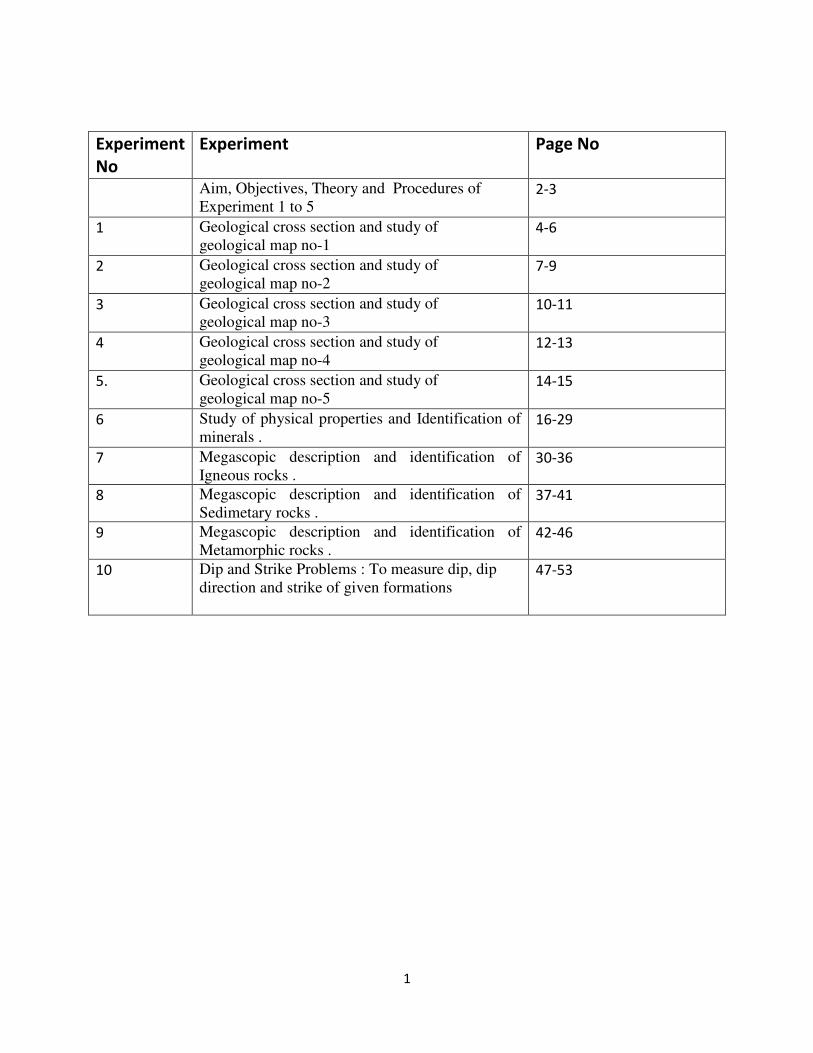
EXPERIMENT - 2 : Draw a geological section along X-Y axis and interpret the
geological map. (GEOLOGICAL MAP -2)
GEOLOGICAL INTERPRETATION
GEOLOGICAL INTERPRETATION
1) TOPOGRAPHY OF THE AREA
The area represented on the map is a hilly one. A hill of 1200 feet is found on the north
eastern part of the area. Another hill of 1200 feet is partially visible on the southern part
of the area.

8
A valley of 400 feet depth is present on the south western part of the area. Another
valley of 700 feet depth is present on the south eastern part of the area. The two hills
are separated by the valley.
2) LITHOLOGY OF THE AREA
There are five different types of rocks present in the area. They are- Mudstone, Shale,
Limestone, Sandstone, and Grit.
GRIT -
SANDSTONE -
LIMESTONE -
SHALE -
MUD STONE -
3) GEOLOGICAL STRUCTURE
The area represented in this map is a simple one. The area has not been subjected to
any folding, faulting, joint fracture, etc. The loads are striking north-south and are
dipping towards the west. The true dip of the beds is 6.5° west and apparent dip is 5.5°
towards west.
4) GEOLOGICAL HISTORY
The rock beds comprising the area were deposited in a sedimentary environment
(basin). Mudstone was deposited first which is followed by shale, limestone, sandstone
and then grit. Mudstone is the oldest rock and grit is the youngest rock. After deposition
O O
O O O O
· · · · · ·
· · · · · · ·
ɤ ɤ ɤ ɤ ɤ
ɤ ɤ ɤ ɤ ɤ
˅ ˅ ˅ ˅ ˅
˅ ˅ ˅ ˅ ˅

9
and compaction, the entire area has been uplifted and subsequently eroded, giving this
present configuration. The sequences of deposition are as follows:
GRIT -
SANDSTONE -
LIMESTONE -
SHALE -
MUD STONE -
5) IGNEOUS ACTIVITY
There is no igneous activity found in the area.
■ ■ ■ ■ ■ ■ ■ ■ ■ ■
O O
O O O O
· · · · · ·
· · · · · · ·
ɤ ɤ ɤ ɤ ɤ
ɤ ɤ ɤ ɤ ɤ
˅ ˅ ˅ ˅ ˅
˅ ˅ ˅ ˅ ˅

10
EXPERIMENT - 3 : Draw a geological section along X-Y axis and interpret the
geological map. (GEOLOGICAL MAP -3)

11
GEOLOGICAL INTERPRETATION
12
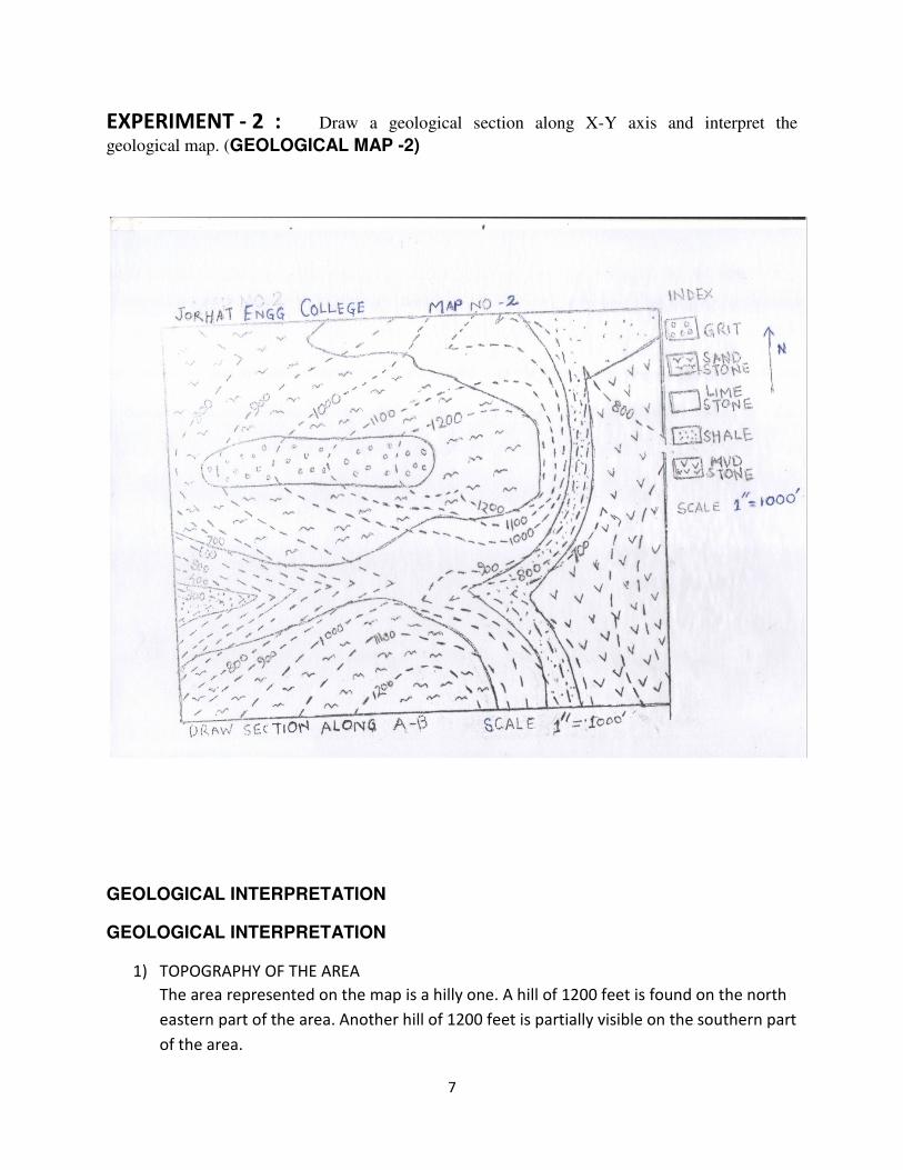
EXPERIMENT - 4 : Draw a geological section along X-Y axis and interpret the
geological map. (GEOLOGICAL MAP -4)

13
GEOLOGICAL INTERPRETATION
The dam site is situated at 900’ elevation above m.s.l which is suitable level for
reservoir. The merits and demerits of the proposed gravity dam that indicated on
the given geological map is given below:-
Merits:
(i) The topography of the dam site is favourable, because the reservoir is
situated in between 500’ and 600’ contours and hence there is gradual
increase in height on the both sides of the proposed dam site.
(ii) The possibility of the sliding of the dam is less because it will be constructed
in Sandstone and Quartzite.
(iii) The river is narrow, so the cost of construction will be less.
(iv) The lithology is favourable for dam site.
(v) The horizontal nature of the bed in both side of the proposed dam will
prevent extra leakage.
Demerits:
(i) The fault FF is passed through the reservoir site which may cause leakage of
water.
(ii) Considering the lithology of the reservoir site, it is situated above Limestone
and Schist, so there is possibility of developing fissures within Limestone
by the process of solution and it may cause leakage of water.
Conclusion:
For preparing for a good dam site in the proposed area, the appropriate grouting
should be provided for prevention of leakage through fault and Limestone bed.
Appropriate measure against the silting from upstream side of the dam should be
taken.

14
EXPERIMENT - 5 : Draw a geological section along X-Y axis and interpret the
geological map. (GEOLOGICAL MAP -5)
15
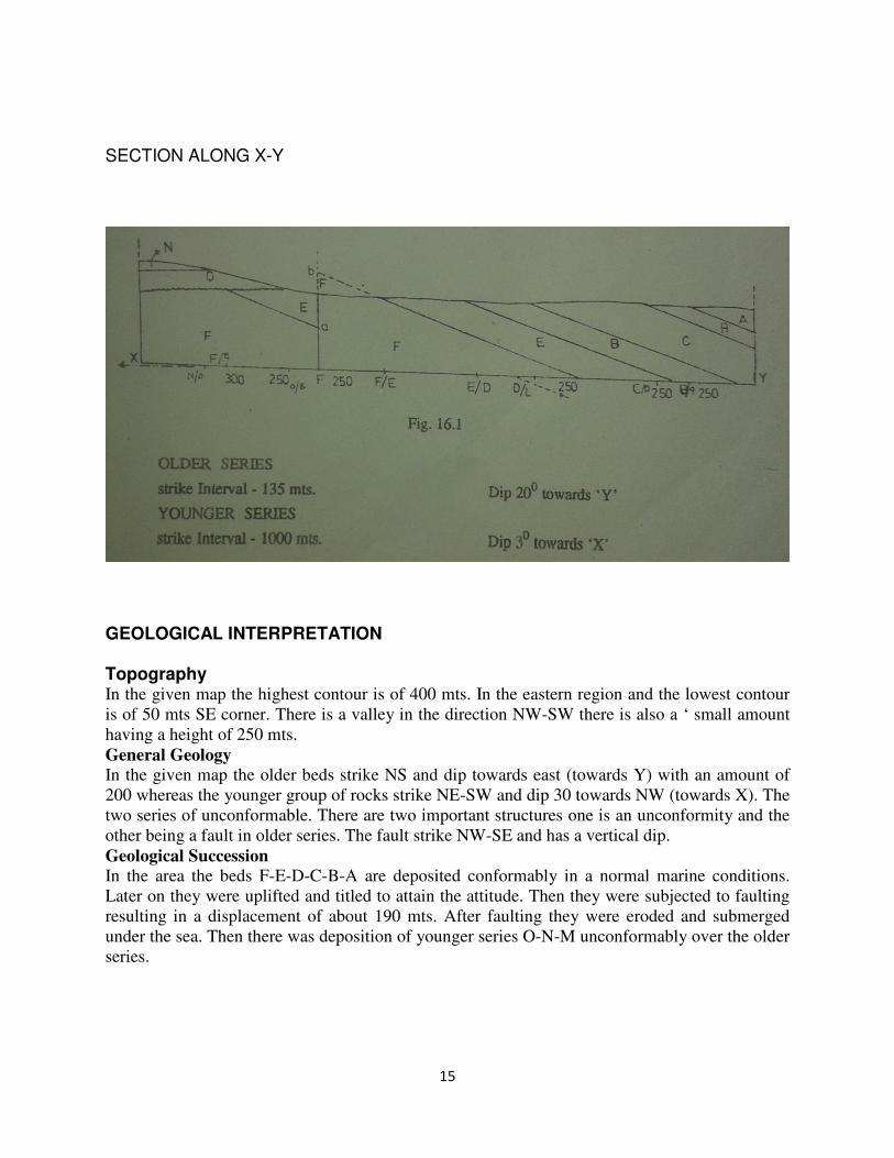
SECTION ALONG X-Y
GEOLOGICAL INTERPRETATION Topography In the given map the highest contour is of 400 mts. In the eastern region and the lowest contour
is of 50 mts SE corner. There is a valley in the direction NW-SW there is also a ‘ small amount
having a height of 250 mts.
General Geology
In the given map the older beds strike NS and dip towards east (towards Y) with an amount of
200 whereas the younger group of rocks strike NE-SW and dip 30 towards NW (towards X). The
two series of unconformable. There are two important structures one is an unconformity and the
other being a fault in older series. The fault strike NW-SE and has a vertical dip.
Geological Succession
In the area the beds F-E-D-C-B-A are deposited conformably in a normal marine conditions.
Later on they were uplifted and titled to attain the attitude. Then they were subjected to faulting
resulting in a displacement of about 190 mts. After faulting they were eroded and submerged
under the sea. Then there was deposition of younger series O-N-M unconformably over the older
series.
16
EXPERIMENT – 6
Study of physical properties and
Identification of minerals referred
Under theory
AIM:
The aim of this unit is to study and identify some important minerals.
OBJECTIVES
After completing this unit students should be able to:
• Identify the important rock forming minerals.
• Recognize the minerals of rocks
Apparatus: Unglazed porcelain plate (known as a streak plate),hardness scale
Theory Mineral : Mineral are defined as naturally occurring, inorganic, solids with a definite chemical
composition and a regular, internal crystalline structure. Different chemical composition results in
different minerals. Mineral are the building blocks of rocks.
Mineral Physical Property chart
Physical
Property
Definition Testing Method
Cleavage Breakage of a mineral
along planes of weakness
in the crystal structure
Examine the mineral for area where the mineral is broken.
Look for area where the light reflects from planar surfaces.
This can be easily confused with a crystal face and is the most
difficult properties for student to master
Color Visible light spectrum
radiation reflected from a
mineral.
look at the sample and determine its color white, green, black,
clear etc.
crystal
forms
Geometric shape of a
crystal or mineral
examine and describe the geometric shape of the mineral,
cubic, hexagonal, etc. Not commonly seen in most lab
samples
Fractures Breakage of a mineral, not
along planes of weakness
in the crystal structure
Examine the mineral for area where the mineral is broken.
Describe the breakage as either irregular or conchoidal (has
the appearance of broken glass)
Hardness Resistance to scratching or
abrasion
Use mineral of know hardness from the Mohs hardness Kits.
Scratch the unknown mineral with a know hardness to
determine which is harder. Continue doing this with harder or
softer minerals from the kit until the hardness is determined.
luster Character of the light
reflected by a mineral
Look at the samples to determine if the mineral is metallic in
appearance or non metallic. Vitreous, like glass and earthy
(like dirt, or other Powderly material)
Magnetism Electromagnetic force
generated by an object or
electric field.
Use of magnet to determined in an introductory lab.
Specific Ratio of the mass of a Generally not determined in an introductory lab.

17
gravity mineral to the mass of an
equal volume of water
Streak Color of the mineral when
it is powdered
Grind a small amount of a mineral into a powder on a
porcelain streak plate and determine the color of the powder.
Transparent Stages of transparency of
mineral
Table -2 Moh's scale of Hardness
Hardness Mineral
1 Talc
2 Gypsum
3 Calcite
4 Fluorite
5 Apatite
6 Orthoclase
7 Quartz
8 Topaz
9 Corundum
10 Diamond
Table - 3) Specific Gravity of the Impotant Minerals
Mineral Specific Gravity
Graphite 2.23
Quartz 2.65
Feldspars 2.6- 2.75
Fluorite 3.18
Topaz 3.53
Corundum 4.02
Barite 4.45
Pyrite 5.02
Galena 7.5
Cinnabar 8.1
Copper 8.9
Silver 10.5
PRECAUTIONS:
1. Handle carefully the soft and flaky minerals.
2. After using the minerals from hardness box put them in proper space assigned for the
particular mineral of the hardness scale.

18
QUESTIONS FOR VIVA-VOCE
1. Questions may be asked from the physical properties of minerals and their uses and
importance
(i) FELDSPAR
1.Form : Tabular
2. Colour: Pale Pink
3.Streak : White
4. Luster : Vitreous
5.Fracture : Uneven
6.Cleavage : Absent
7. Transparency: Opaque
8. Hardness : 6-7
9. Specific Gravity: Medium
10. Uses : Tiles
11. Name of the Specimen : Feldspar
12. Chemical Composition : KAISi3O8

19
(ii) QUARTZ
1. FORM : Crystalline
2. Colour : Colourless
3. Streak: Colourless
4. Luster : Vitreous
5. Fracture : Uneven
6. Cleavage : Absent
7. Transparency : Transparent
8. Hardness : 7
9. Specific Gravity: High
10. Name of the Specimen : Quartz
11. Uses : Used as gemstone and in watch industries etc
12. Chemical Composition : SiO2

20
(iii) Gypsum
1. FORM : Crystalline
2. Colour : White
3. Streak: White
4. Luster : Sub-Vitreous
5. Fracture : Even
6. Cleavage : 2 sets
7. Transparency : Opaque
8. Hardness : 2
9. Specific Gravity: Medium
10. Name of the Specimen : Gypsum
11. Uses : Used as Fertilizer, manufacturing of cement and plaster of Paris
12. Chemical Composition : SiO2

21
(iv) MUSCOVITE
1. Form : Lamellar/Flaky
2. Colour : White
3. Streak : White
4. Luster : Vitreous
5. Fracture : Uneven
6. Cleavage : One set Basal Cleavage
7. Transparency : Transparent in individual layer & opaque as whole
8. Hardness : 2 to 3
9. Specific Gravity : Medium (2.5)
10. Uses : Poor conductor of heat
11. Name of the Specimen : Muscovite
12. Chemical Composition : KAI2(AI Si3) O10 (OH, F)2

22
(v) ASBESTOS
1. Form : Fibrous
2. Colour : Green and White
3. Streak : white
4. Luster : Silky
5. Fracture : Hackly
6. Cleavage : Absent
7. Transparency : Opaque
8. Hardness : 4 to 6
9. Specific Gravity : High (3 to 4.5)
10. Uses : It is used to make sheets
11. Name of the Specimen : Asbestos
12. Chemical Composition: Hydrous silicate of Mg, Al.

23
(vi) CALCITE
1. Form : Bladed
2. Colour : Honey Yellow
3. Streak : White
4. Lustre : Vitrous
5. Fracture : Uneven
6. Cleavage : Absent
7. Diaphaneity : Opaque
8. Hardness : 5
9. Specific : 2.5 to 3
10. Name of the Specimen: Calcite
11. Uses : Bombs, gun powders, anti – air craft
12. Chemical Composition: Caco3

24
(vii) GALENA
1. Form : Massive
2. Colour : Gray and black
3. Streak : Black
4. Lustre : Metallic
5. Fracture : Absent
6. Cleavage : Absent
7. Transparency : Opaque
8. Hardness : 2-3
9. Specific : High ( 5.5)
10. Name of the Specimen : Galena
11. Uses : Ornamental and atomic purposes
12. Chemical Composition : PbS

25
(viii) HAEMETITE
1. Form : Massive
2. Colour : Reddish Black
3. Streak : Cherry red
4. Luster : Metallic
5. Fracture : Absent
6. Cleavage : Absent
7. Transparency : Opaque
8. Hardness : 2-3
9. Specific : High
10. Name of the Specimen: Hematite
11. Uses : Steel, and iron industries
13.Chemical Composition: Fe2O3

26
(ix) BAUXITE
1. Form : Concretionary (Pisolitic)
2. Colour : Reddish Brown
3. Streak : Brown
4. Lustre : Earthy
5. Fracture : Uneven
6. Cleavage : Absent
7. Transparency : Opaque
8. Hardness : 3-4
9. Specific : High (3)
10. Name of the Specimen : Bauxite
11. Uses : Aluminum ore
12. Chemical Composition : Al2O3, 2H2O

27
(x) GRAPHITE
1. Form : Massive
2. Colour : Black
3. Streak : Black
4. Lustre : Sub-metallic
5. Fracture : Uneven
6. Cleavage : Absent
7. Transparency : Opaque
8. Hardness : 2-3
9. Specific : Medium
10. Name of the Specimen : Graphite
11. Uses : In pencils ,as a lubricant. It has many electrical uses, primarily because it is the only common
nonmetal that is a good conductor of electricity.
12. Chemical Composition : C

28
(xi) CHROMITE
1. Form : Granular
2. Colour : Black
3. Streak : Light brown
4. Lustre : Sub-metallic
5. Fracture : Absent
6. Cleavage : Absent
7. Transparency : Opaque
8. Hardness : 6-7
9. Specific : High (4.5-4.7)
10. Name of the Specimen : Chromite
11. Uses : Ore of Chromium, refractory
12. Chemical Composition : FeCr2O4

29
(Xii) CHALCO PYRITE
1. Form : Massive
2. Colour : Golden yellow
3. Streak : black
4. Lustre : Sub-metallic
5. Fracture : Absent
6. Cleavage : Absent
7. Transparency : Opaque
8. Hardness : 3-4
9. Specific : High (4.1-4.3)
10. Name of the Specimen : Chalco Pyrite
11. Uses : Ore of copper
12. Chemical Composition : CuFeS2

30
EXPERIMENT – 7,8 and 9
Megascopic description
and identification of rocks referred
Under theory
OBJECTIVE: Megascopic description and identification of rocks referred Under theory .
EXPERIMENT 7: IDENTIFICATION OF IGNEOUS ROCKS
AIM :The aim of this unit is to study and identify different types of Igneous rocks
OBJECTIVES:
After completing this Unit, students should be able to Describe the
• Different types of Igenous rocks (volcanic, Hypabasal and plutonic rocks).
• Main factors used in the classification of igneous rocks.
• Order of crytallisation in which minerals are formed.
• Petrogenesis.
QUESTIONS FOR VIVA-VOCE
1. How Igneous, sedimentary and Metamorphic rocks are formed?
2. Why some rocks are fine grained where as some are coarse grained?
3. What are the uses of various rocks?
4. What controls the colour of rocks?

31
GRANITES
Granites are of two types, based on their coulour (a) pink granite, in which the Kfeldspars are
more predominant than the plagioclase feldspars. (b) Grey granite, in which the lagioclase
feldspars are more predominant than the k-feldspars. They exhibit two distinct types of a)
Equigranular b) Inequigranular (porphyritic). They are the most abundant rock types among
other igneous rocks. In hand specimen, granite is a light colored coarse grained granular rock. It
is mainly composed of quartz, feldspars, and micas. Apatite, magnetite, zircon and sphene are
found as accessories. The coarse grained texture indicates that the rock is formed under the
plutonic conditions.
1. Colour : Leucocratic
2. Mineralogy
a) essential minerals : quartz, alkali feldspar and micas
b) accessory : apatite, magnetite, zircon, sphene, and Hornblende.
3. Texture : Coarse grained, equigranular.
4. Specific gravity : Medium
5. Type : Plutonic
6.. Mode of formation : Formed at great depth due to slow cooling of magma at high pressure
and high temperature
7.. Name of the rock : Granite

32
PORPHYRITIC GRANITE
1. Colour : Leucocratic
2. Mineralogy
a) essential minerals : quartz, alkali feldspar and micas
b) accessory : apatite, magnetite, zircon, sphene, and Hornblende.
3. Texture : Coarse grained, inequigranular (Porhyritic texture).
4. Specific gravity : Medium
5. Type : Plutonic
6.. Mode of formation : Formed at great depth due to slow cooling of magma at high pressure
and high temperature
7. Mode of Occurrence : Big batholiths to small pluton
8. Name of the rock : Porphyritic Granite
9. Use: As building stones, Road metals, Railway ballast, Ornamentation

33
BASALT
BASALT Basalt is a dark-ash coloured fine grained rock. It is mainly composed of labradorite Plagioclase
augite pyroxene. Magnetite, olivine and apatite are found as accessories. Quartz,calcite and
zeolities are found as secondary minerals in cavities and vesicles of the rock. The fine grained
texture indicates that the rock is formed under volcanic conditions
1. Colour : Melnocratic
2. Mineralogy
a) essential minerals : Plagioclase Feldspar, Pyroxene (Augite)
b) accessory : Hornblende, magnetite and apatite
3. Texture : Fine grained
4. Specific gravity : High
5. Type : Volcanic
6.. Mode of formation : Due to fast cooling of lava as surface intrusive and extrusive
7. Mode of Occurrence : Sills, flows, and dykes
8.. Name of the rock : Compact Basalt
9.. Use: As building stones, Road metals, Railway ballast,

34
VESICULAR BASALT
1. Colour : Melnocratic
2. Mineralogy
a) essential minerals : Plagioclase Feldspar, Pyroxene (Augite)
b) accessory : Hornblende, magnetite and apatite
3. Texture : Fine grained
4. Structure: Partly vesicular and partly amygdaloidal
5. Specific gravity : High
6. Type : Volcanic
7.. Mode of formation : Due to fast cooling of lava as surface intrusive and extrusive
8. Mode of Occurrence : Sills, flows, and dykes
9.. Name of the rock : Vesicular Basalt
10. Use: Due to presence of vesicles, less use

35
SYENITE
1. Colour : Mesocratic
2. Mineralogy
a) essential minerals : Alkali Feldspar, Plagioclase Feldspar, Mica
b) accessory : Hornblende, magnetite and apatite
3. Texture : Medium grained
4. Specific gravity : Medium
5. Type : Plutonic
6.. Mode of formation : Due to slow cooling of magma
7. Mode of Occurrence : As intrusive rock
8.. Name of the rock : Syenite
9.. Use: As building stones, Road metals, Railway ballast,
36
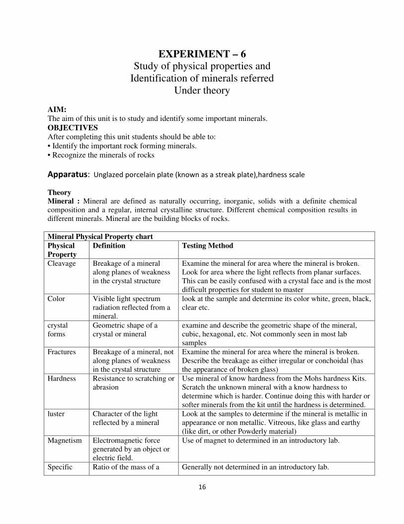
RHYOLITE
1. Colour : Leucocratic
2. Mineralogy
a) essential minerals : Alkali Feldspar, Quartz, Mica
b) accessory : Hornblende, magnetite and apatite
3. Texture : Fine grained
4. Structure: Flow structure
5. Specific gravity : High
6. Type : Plutonic
7.. Mode of formation : Due to slow cooling of magma
8. Mode of Occurrence : Sills, flows, and dykes
9.. Name of the rock : Rhyolite
10. Use: As building stones, Road metals, Railway ballast,
37
EXPERIMENT-8: IDENTIFICATION OF SEDIMENTARY ROCKS
AIM:
The aim of this unit is to provide students the description of some important sedimentary rocks.
OBJECTIVES
After completing this unit you should be able to:
• Identify the sedimentary rocks
• Recognize the minerals of sedimentary rocks
• Describe the textures & formation of sedimentary rocks.
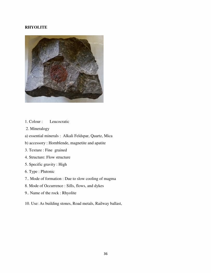
SANDSTONE It is most common clastic rock founded in basinal environments such as river, lakes and marginal
seas. It is formed due to consolidation of sand particles. The sand particles are mainly made up
of rounded quartz grains. In hand specimen, it is in brown or yellow or grey or buff colour, and
exhibits medium grained texture. Sometimes size grading and rippling features are seen in it.
Well sorting of grains is a characteristic feature of many sandstones. If a sandstone is completely
composed of quartz, it is termed as orthoquarzite. If a sandstone contains 75% of quartz and 25%
of feldspar, it terms as arkose. If a sandstone has more than 30% of matrix of clay, chlorite and
glauconite, it terms as greywacks. A fine grained greywake (sandstone) terms into shale.
1. Colour: Grey white
2. Mineralogy : Quartz with little amount of feldspar
3. Cementing materials: Siliceous or ferruginous or both
4. Texture:
a) Grain size : Medium grained
b)Grain shape : Rounded to sub rounded
5. Type: Arenaceous
6. Clastic / Nonclastic : Clastic (mechanically formed)
7. Name: sandstone
8. Use: As building stones, Road metals, Railway ballast

38
LIMESTONE
It is a fine grained non clastic sedimentary rock that has been formed by the precipitation of
calcium carbonate solutions which are derived from seawater. In handspecimen. It looks grey
and exhibits fine grained texture. It is made up of mainly calcite. There are many varieties of
limestone. It is a limestone is porous with full of foramineral shells, it terms as chalk. If a
limestone contains shells of brachiopods or Lamellibranchs, it terms as shelly limestone. If a
limestone contains high volums percentage of dolomite, it grades into dolomite.
1. Colour: Grey
2. Mineralogy : Calcite
3. Cementing materials: Calcareous
4. Texture:
a) Grain size : Coarse grained
b)Grain shape : Rounded to sub rounded
5. Type: Calcareous
6. Clastic / Nonclastic : Non-Clastic (Chemically formed)
7. Name: Lime stone
8. Use: In cement factories

39
SHALE
It is a fine grained argillaceous sedimentary rock that have been formed by the consolidation of
beds of mud, clay or silt. The mud and clay are in chlorite, muscovite nd quartz. In
handspecimen, it has varied colours like grey, brown black or yellow and exhibits fine grained
texure and thin layering.
1. Colour: Black
2. Mineralogy : Clay 3. Cementing materials: Siliceous or ferruginous
4. Texture:
a) Grain size : Fine grained
b)Grain shape : Variable
5. Type: Argillaceous
6. Clastic / Nonclastic : Clastic (Mechanically formed)
7. Name: Shale
8. Use: Building materials

40
Laterite
Laterite is a soil and rock type rich in iron and aluminium, and is commonly considered to
have formed in hot and wet tropical areas. Nearly all laterites are of rusty-red coloration, because
of high iron oxide content. They develop by intensive and long-lasting weathering of the
underlying parent rock. Tropical weathering (laterization) is a prolonged process of chemical
weathering which produces a wide variety in the thickness, grade, chemistry and ore mineralogy
of the resulting soils.
1. Colour: Red
2. Mineralogy : Clay minerals, Fe2O3, Al2O3 3. Cementing materials: Self cemented
4. Texture:
a) Grain size : Fine grained (Concretionary)
b)Grain shape : Variable
5. Type: Argillaceous
6. Clastic / Nonclastic : Clastic (Mechanically formed)
7. Name: Laterite
8. Use: Building stone, road metal, ore of iron, bauxite.

41
CONGLOMERATE
It is a common rudaceous rock formed under continental environment. It is mainly
consolidated with rounded and subrounded pebbles and gravels. These pebbles and gravels are
made up of quartz, feldspars and rock fragments. Ferrugeneous and siliceous cementing
materials envelop the pebbles and gravels.
In handspecimen, the rock is easily distinguished from breccias by its characteristic rounded
pebbles and gravels. The systematic description of the rock is given below.
1. Clastic/ Nonclastic : Clastic
2. Colour : shades of grey, brown
3. Mineralogy : Quartz feldspars, clay, hematite and limonite (goethite)
4. Structure : Rounded rudite
5. Texture
(a) Grain size : Coarse grained
(b) Grain shape : Rounded to subrounded
(c) Sorting : Poorly sorted
6. Nature of matric : Ferrugeneous and siliceous
7. Name : Conglomerate

42
EXPERIMENT9: IDENTIFICATION OF METAMORPHIC ROCKS
AIM
The aim of this unit, is to provide students about description of metamorphic rocks.
OBJECTIVES
After completing this unit, you should be able to
• Describe the different types of metamorphic rocks
• Describe the mineralogy of different types of rocks
SLATE
Slate is a fine grained lowgrade regional metamorphism rock; which is transformed from shale
by regional metamorphism. It is characterized by slaty cleavage, along which it splits into thin
sheets or layers. State is variable in its colour from grey to black.
1. Colour : Black
2. Mineralogy : Muscovite, chlorite, feldspar, quartz
3. Structure : Sheet or layers with slaty cleavage
4. Type of metamorphism : Regional metamorphism
5. Conditions of metamorphism : Low pressure and low temperature
6. Nature of parent rock : Pelitic (shale)
7. Name of the rock : Slate
8. Use: Building stone. Road Materials

43
MARBLE
Marble is either contact (thermal) or regional metamorphic rock transformed from a
metamorphosed limestone. It is a coarse grained granular rock commonly exhibits white colour
(but some marbles may be in different colours due to impurities). Its colour, texture, soft and
smooth surfaces promote the rock into commercial grade in building industry.
1. Colour : White
2. Mineralogy : Calcite
3. Structure : Granulose
4. Type of metamorphism : Contact (thermal) metamorphism
5. Conditions of metamorphism : High temperature and low pressure
6. Nature of parent rock : Limestone
7. Name of the rock : Marble
8. Use: Building stone, ornamentation

44
QUARTZITE
It is a metamorphosed sandstone formed under either contact or regional metamorphism. In hand
specimen, it is rather earthy white to brown in colour and exhibits granular form. It is mainly
composed of recrystallized quartz. Its colour. Texture, hard and toughness promote the rock into
commercial grade in building industry.
1. Colour : White
2. Mineralogy : Quartz
3. Structure : Granulose
4. Type of metamorphism : Contact (Thermal) metamorphism
5. Conditions of metamorphism : High temperature and low pressure
6. Nature of parent rock : Sandstone
7. Name of the rock : Quartzite
8. Use: Building materials, Road metals etc.

45
SCHISTS
Schists of many kinds (or varieties) depending upon their colour and composition. All of them
have a unique character i.e. Schistosity or foliation. They are common rock type of the
Precambrian terrains. Inhandspecimen they are coarse grained rocks and are in different shades
of colours from dark green to brown and also exhibit characteristic foliation. They are mainly
composed of phyllosilicates and double chain silicates. They are derived from either sedimentary
or igneous rocks by the regional metamorphism.
.
1. Colour : Black
2. Mineralogy : Bioite, garnet, quartz
3. Structure : Schistose or foliation
4. Type of metamorphism : Medium grade regional metamorphism
5. Conditions of metamorphism : Moderate pressure and temperature
6. Nature of parent rock : Pelitic (shale)
7. Name of the rock : Mica schist
46
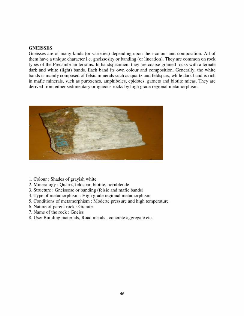
GNEISSES
Gneisses are of many kinds (or varieties) depending upon their colour and composition. All of
them have a unique character i.e. gneissosity or banding (or lineation). They are common on rock
types of the Precambrian terrains. In handspecimen, they are coarse grained rocks with alternate
dark and white (light) bands. Each band its own colour and composition. Generally, the white
bands is mainly composed of felsic minerals such as quartz and feldspars, while dark band is rich
in mafic minerals, such as puroxenes, amphiboles, epidotes, garnets and biotite micas. They are
derived from either sedimentary or igneous rocks by high grade regional metamorphism.
1. Colour : Shades of grayish white
2. Mineralogy : Quartz, feldspar, biotite, hornblende
3. Structure : Gneissose or banding (felsic and mafic bands)
4. Type of metamorphism : High grade regional metamorphism
5. Conditions of metamorphism : Moderte pressure and high temperature
6. Nature of parent rock : Granite
7. Name of the rock : Gneiss
8. Use: Building materials, Road metals , concrete aggregate etc.

47
EXPERIMENT NO 10
DIP AND STRIKE PROBLEM
AIM
The aim of this unit is to determine the direction and amount of dip of the geological formation.
OBJECTIVES
After solving the problem students should will be able to:
• Determine the dip amount and dip direction of the geological formations
• Determine the true thickness of the formations
QUESTIONS FOR VIVA-VOCE:
1. Why it is important to determine the dip and strike of beds?
(I) DETERMINATION OF TRUE DIP DIRECTION [T.D.D.] AND TRUE DIP
Problem :A bed of sandstone dips at an angle of 30°
in a direction of S 30°E and 30° along
S15°W. Find the amount of true dip?

48
Procedure :
1. Draw a circle by convenient radius and mark N.S.E.W directions with O as center.
2. Draw the line OP = S30°E and OR = S15°W.
3. Draw a perpendicular to the line OP from P point O which cuts the circle at Q.Now at Q
draw a complementary angle [90° - 30° = 60°] which cuts the line OP at point P. Join PQ.
4. Similarly draw a perpendicular to the line OR from point O which cuts the circle at S.
Draw a complementary angle [90° - 30° = 60°] which cuts the line OR at point R. Join
RS.
5. Now join the points P and R, which is the strike direction.
6. For finding amount of true dip draw a perpendicular from O to the line PR which meets
the line PR at A. Join OA.
Draw a perpendicular to the line OA from point O, which cuts the cirlcle at B. Join AB. Now
angle OAB will give the amount of true dip and OA is the direction of true dip.
Result : True Dip Amount TDA = 30°
True Dip Direction : TDD = S8°E

49
EXERCISE
1. The apparent dip of a coal bed is 30° in a direction of S30°E and in a direction of S58°W
with an apparent dip of 45°. Find the direction and amount of true dip.
Result : TDA = OAB = 49°
TDD = OA = S8°E
2. A limestone bed dips 30° along S25E and dips 33° along N85°E. Determine its true dip.
Result : TDA = OAB = 36°
TDD = OA = N8°E
3. In a dam site a bed of limestone dips 25° along NW and 20° along NEE. Determine its
true dip.
Result : TDA = OAB = 36°
TDD = OA = N6°E
4. A coal bed dips 30° along S30°W and 38° along N60°W. Determine its true dip.
Result : TDA = OAB = 42°
TDD = OA = S85°W
5. At a dam site a bed of Quartzite dips 28° along N20°E and 34° along S80°E. Determine
its true dip.
Result : TDA = OAB = 38°
TDD = OA = N68°E
(II) METHOD : DETERMINATION OF APPARENT DIP AMOUNT [A.D.A]
PROBLEM: Coal seam dips 35° along S40°W. Detremine the amount of apparent dip in the
direction of S75°W.
T.D.A. = 35°
A.D.A = ?
T.D.D. = S40°W
A.D.D. = S75°W

50
PROCEDURE :
1. Draw a circle by convenient radius and mark N.S.E.W. directions with O as center.
2. Draw a line OP = S40°W. Draw a perpendicular to the line OP from point O which cuts
the circle at Q. Now at Q draw a complementary angle 90° - 35° = 55° which cuts the line
OP at point P. Join PQ.
3. From the intersection point P draw a parallel line to the line OQ that is the strike line.
4. Let a line equal to S75°W , which cuts the strike line at point R. Join OR-OR line.
5. Draw a perpendicular to the line OR from point O, which cuts the circle at S. Join R and
S. Measure angle ORS, which is the amount of apparent dip.
NOTE : ORS should be less than the true dip. Amount given in the problem.
Result : ADA along N70°W = ORS = 30°.
EXERCISE
1. A bed of sandstone dips 40° along east. Determine the amount of dip along N60°E and
SE.
Result : Apparent dip amount along SE = 3°
Apparent dip amount along N60°E = 32°
51
2. A bed of sandstone dips 40° along N60°E. Determine the amount of apparent dip along
S80°E and N27.5°E.
Result : Apparent dip along S80°E = 32°
Apparent dip along N27.5°E = 36°
3. A coal seam is exposed around a colliery. It shows a true dip of 48° along S30°W.
Determine the amount of inclination along S10°E and S60°W.
Result : Apparent dip along S10°E = 40°
Apparent dip along S60°W = 43°
4. In a reservoir site a bed of Quartzite has maximum inclination of 40° along N40°W. Find
its inclination along North and N60°W.
Result : Apparent dip along North = 23°
Apparent dip along N60°W = 43°
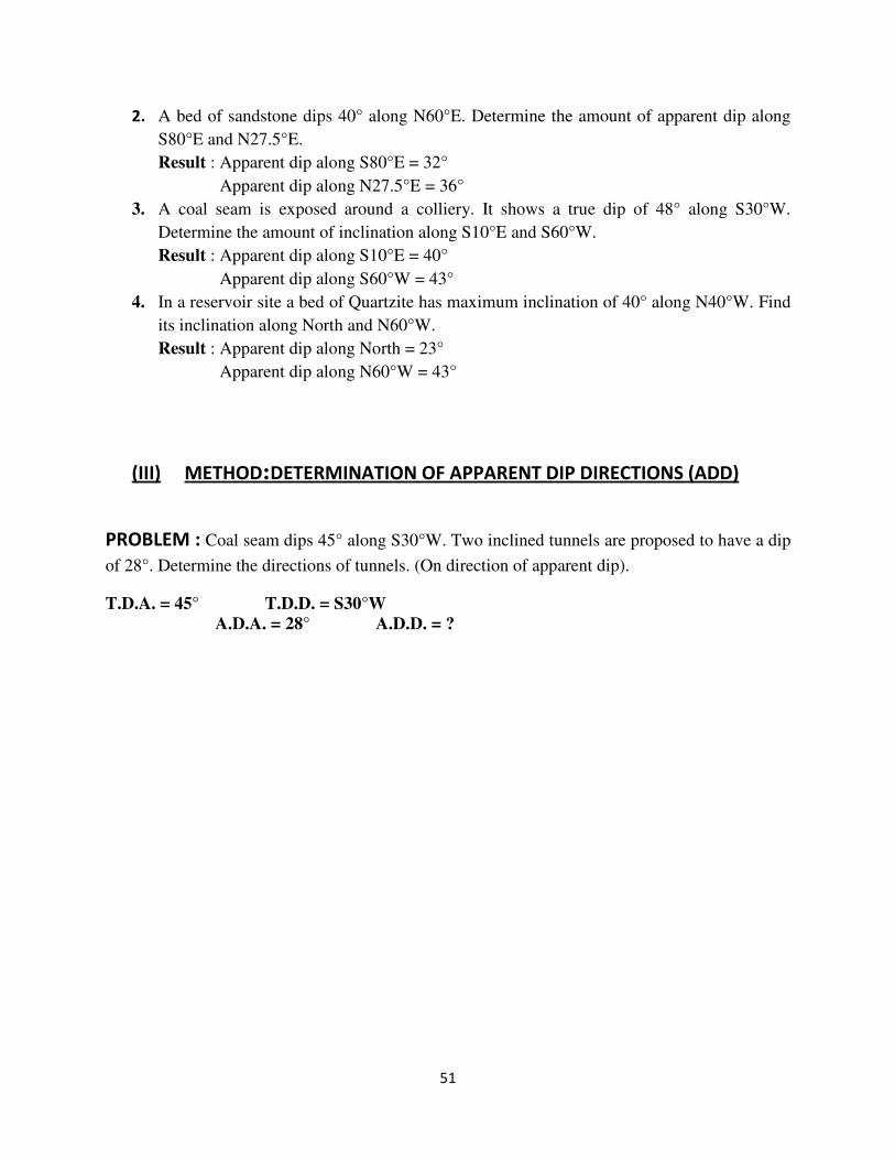
(III) METHOD:DETERMINATION OF APPARENT DIP DIRECTIONS (ADD)
PROBLEM : Coal seam dips 45° along S30°W. Two inclined tunnels are proposed to have a dip
of 28°. Determine the directions of tunnels. (On direction of apparent dip).
T.D.A. = 45° T.D.D. = S30°W
A.D.A. = 28° A.D.D. = ?

52
PROCEDURE :
1. Draw a circle by convenient radius and mark N.S.E.W. directions with O as center.
2. Draw a line OP = S40°W. Draw a perpendicular to the line OP from point O which cuts
the circle at Q. Now at Q draw a complementary angle 90° - 35° = 55° which cuts the line
OP at point P. Join PQ.
3. From the intersection point P draw a parallel line to the line OQ that is the strike line.
4. Select any arbitrary line (Direction) says north. From point N draw a complementary
angle 90° - 28° = 62° that cuts the east lien at point C.
Now with O as centre OC as radius drw=aw two arcs. So that it cuts the strike line on
both the directions at points AB respectively.Join OA and OB.
NOTE : OA and OB are the directions of apparent dip.
RESULT: ADD1, OA = S30°E ADD2, OB = S35°W.

53
EXERCISE
1. A bed of Shale is found to have a true dip of 45° in the direction of N80°E. Find the
direction along which the bed will have an apparent dip of 36°
Result : ADD1, OA = N50°E
ADD2, OB = S34°E
2. A coal seam dips 45° along S50°W. Two inclined tunnels are proposed to have a dip of
28°.Determine the direction of tunnels.
Result : ADD1, OA = 28° along S85°W
ADD2, OB = 28° along S33°W


