Geology of Brookhaven National Laboratory and Vicinity, Suffolk County New York GEOLOGICAL SURVEY BULLETIN 1156-A This report concerns work done on behalf of the U.S. Atomic Energy Commission
Transcript
Geology of Brookhaven National Laboratory and Vicinity, Suffolk County New York
GEOLOGICAL SURVEY BULLETIN 1156-A
This report concerns work done on behalf of the U.S. Atomic Energy Commission
Geology of Brookhaven National Laboratory and Vicinity, Suffolk County New YorkBy WALLACE DE LACUNA
STUDIES OF SITES FOR NUCLEAR ENERGY FACILITIES BROOKHAVEN NATIONAL LABORATORY
GEOLOGICAL SURVEY BULLETIN 1156-A
This report concerns work done on behalf of the U.S. Atomic Energy Commission
This series of reports provides a basis for evaluating results of a possible nuclear incident upon the hydrologic environment
UNITED STATES GOVERNMENT PRINTING OFFICE, WASHINGTON: 1963
UNITED STATES DEPARTMENT OF THE INTERIOR
STEWART L. UDALL, Secretary
GEOLOGICAL SURVEY
Thomas B. Nolan, Director
For sale by the Superintendent of Documents, U.S. Government Printing Office Washington 25, D.C.
Purpose and scope of investigation._____________________________ 2Previous investigations.._______________________________________ 3Location of area_______________________________________________ 4Well-numbering system._______________________________________ 4
Topography._____________________________________________________ 4Summary of stratigraphy.__________________________________________ 7
Bedrock....._______________________________________________ 11Configuration of the bedrock surface-------.-----.-------.--. 12
Formations of Late Cretaceous age---------_--_-_-----------_-_- 12Raritan formation...................__________________ 12
Lloyd sand member of the Raritan formation___________ 13Clay member of the Raritan formation.__________________ 15Water-bearing properties_____________________________ 16
Magothy(?) formation______________________-___________-__ 17Water-bearing properties_______________________________ 19Configuration of the Magothy(?) surface__-_-___-_-_-____ 20
Deposits of Pleistocene age__________________________-_______-__ 22Gardiners clay______--_-_____-__--_-_____-_--_-_--_--_---_ 22
Unidentified unit.___________...____________ 28Moraine deposits and outwash-_________________________ 30Clay at ManorviUe____________________________________ 32Surficial silt and clay______-____-__-___-___-___-_-__ 33
Deposits of Recent age______________________________________ 34References cited__-_-______--_-___-________________________________ 34
ILLUSTRATIONS
[Plates are in pocket]
PLATE 1. Map of central Suffolk County.2. Geologic sections A-A' and B-B'.
l*ageFIGURE 1. Outline map of Long Island___________________________ A5
Page TABLE 1. Physical character and water-bearing properties of the geologic
units underlying central Suffolk County._________________ A8in
STUDIES OF SITES FOR NUCLEAR ENERGY FACILITIES BROOKHAVEN NATIONAL LABORATORY
GEOLOGY OF BROOKHAVEN NATIONAL LABORATORY AND VICINITY, SUFFOLK COUNTY, NEW YORK
By WALLACE DE LAGUNA
ABSTRACT
In connection with the construction and operation of atomic research facilities at the Brookhaven National Laboratory, the U.S. Geological Survey made a study of the geologic and ground-water conditions at and near the Laboratory. The area is in central Suffolk County, about 60 miles east of New York City, and extends in a 26-mile-wide strip across the island from Long Island Sound on the north to the Atlantic Ocean on the south. The geologic fleldwork consisted of examination of surface outcrops and the supervision of the drilling of and exami nation of samples from shallow test wells 100 to 200 feet deep and two deep test wells about 1,600 feet deep.
The gently rolling land surface at the Laboratory is bordered by two lines of hills; the Harbor Hill moraine on the north, and the Ronkonkoma moraine on the south. A broad flat, relatively featureless outwash plain extends south from the Ronkonkoma moraine to the tidal swamps, bays, and barrier beaches, which form the southern boundary of the area. The Carmans, Forge, and Peconic Rivers, and their tributaries, carry most of the surface water.
Six principal stratigraphic units, some containing subdivisions of local impor tance, were recognized in the test holes and surface exposures. At the bottom is the southeasterly sloping bedrock of Precambrian age, which is at a depth of about 1,500 feet beneath the Laboratory. Above the bedrock is the Raritan formation of Cretaceous age about 500 feet thick, which is divided into the lower Lloyd sand member and an upper clay member. Resting on the clay member of the Raritan formation is about 900 feet of sand, sandy clay, and some gravelly beds, which have been tentatively assigned to the Magothy(?) formation. The Gardiners clay, an interglacial deposit of Pleistocene age, overlies the Magothy (?) formation in much of the area. The Gardiners is 10 to 20 feet thick at Brook- haven National Laboratory, but it thickens appreciably to the south. Above the Gardiners clay are upper Pleistocene deposits, which have a maximum thickness of about 200 feet. Locally these deposits are divided into an unidentified unit of sand and gravel characterized by a greenish color, a unit of silt and clay recog nized near Manorville, and the Harbor Hill and Ronkonkoma moraine deposits and associated outwash deposits. Recent deposits of gravel, sand, silt, and clay are restricted to stream channels, bays, and beaches, and are generally less than 40 feet thick.
Al
A2 STUDIES OF SITES FOR NUCLEAR ENERGY FACILITIES
Fresh water under artesian pressure occurs in several permeable zones in the Raritan and Magothy (?) formations. Most of the water in the upper Pleistocene deposits is unconfined and fresh, and it is the principal source of supply. Recent deposits are not a source of water except for small supplies at scattered localities on the barrier beaches.
INTRODUCTION
PURPOSE AND SCOPE OF INVESTIGATION
In the fall of 1946, the War Department, then in charge of the atomic energy program, requested the U.S. Geological Survey to prepare a preliminary report on the possible water-supply problems of the proposed nuclear research laboratory at Camp Upton. In the fall of 1947, the Geological Survey began a detailed investigation of the ground-water conditions in the vicinity of the Laboratory with par ticular reference to the effect of a hypothetical accidental release to the environment of radioactive wastes. The routine operation of Brook- haven National Laboratory does not constitute a hazard because of the very stringent precautions that the Laboratory exercise in han dling and disposing of radioactive materials. The work on which the present report is based began in March 1948. During the first 2 years, 2 deep test wells and about 12 shallow observation wells were drilled. As a guide to the installation of test wells, an attempt was made to obtain information on the subsurface geology by earth-resistivity ob servations, but the method was found to be poorly adapted to the conditions in the area.
During this same period, 95 samples of surface and ground waters were collected and shipped to Washington for analysis. On the basis of the data provided by this work, a second water-sampling program was set up in November 1950 to monitor the surface-water and ground- water supplies of the area, but this sampling was stopped in the summer of 1953 because the program was felt to be unsound.
Some instrumental leveling was done in the first year or two, and in 1949 the Topographic Division of the Geological Survey estab lished a network of bench marks covering the area of immediate inter est. This made it possible to convert water-level measurements to a sea-level datum so that accurate water-table contour maps could be drawn.
A more detailed study of the hydrology began in 1950; a detailed pumping test was run at the end of that year. In 1951 the observation- well net was expanded, and in 1952 a study was made of the hydrology of the Carmans River. At the same time, an attempt was made to estimate the amount of water lost annually by evaporation and by transpiration so that an estimate could be made of the recharge to the ground-water reservoir.
GEOLOGY, BROOKHAVEN NATIONAL LABORATORY VICINITY A3
Attempts were made during the first year to measure the rate of movement of the ground water directly by tracers. The work pro vided answers which seemed to be valid, but it was dropped because of the complexity of the theoretical and practical problems involved. Some laboratory work with dye solutions was attempted later to il lustrate the pattern of movement of contaminated liquids, but again problems involved in faithfully representing natural conditions were not satisfactorily solved.
The investigation was made under the immediate supervision of M. L. Brashears, Jr., and J. E. Upson, former district geologists. The organization and preparation of the report were coordinated by C. V. Theis and J. E. Upson.
PREVIOUS INVESTIGATIONS
Previous work on the hydrology and geology of Long Island has dealt either with Long Island as a whole or with the western part. In 1903 the water-supply problems of Greater New York were studied in detail by the Commission on Additional Water Supplies and described in a report by Burr, Hering, and Freeman (1904). This report re lated primarily to the occurrence and availability of ground water in Nassau County and western Suffolk County. In 1906, this study was enlarged to investigate the possibility of developing 250 mgd. (million gallons per day) of water from Suffolk County by extending the Brooklyn aqueduct eastward along the south shore through Patchogue, Moriches, and Quogue. Branches and collecting works were to tap, among other sources, the Carmans River and the lower Peconic. A report on this study was made by Spears (1908). Because of the general interest in the problem of water supply at this time, and as the result of a cooperative agreement with the Commission on Addi tional Water Supply, the U.S. Geological Survey made a study of both the geology and the hydrology of all Long Island in the years 1902-05. The results of this investigation were published under the authorship of Yeatch and others (1906). Later, geologic investigations were made by Fuller (1914).
In 1932, the U.S. Geological Survey returned to the study of Long Island under cooperative agreements with the New York State Water Resources Commission (formerly Water Power and Control Commis sion) and with Nassau County. Later, these agreements were extended to include Suffolk County.
The principal publications dealing with central Suffolk County that have resulted from these cooperative investigations are listed under "References cited." These reports are concerned mainly with the problem areas of western Long Island, and little has been published
A4 STUDIES OF SITES FOR NUCLEAR ENERGY FACILITIES
for Suffolk County except for the reports on the mapping of the aqui fers by Suter, de Laguna, and Perlmutter (1949), and the mapping of the water table by Lusczynski and Johnson (1952). Among the inde pendent workers who have contributed to the glacial geology of Long Island are MacClintock and Richards (1936) and Fleming (1935).
LOCATION OP AREA
Brookhaven National Laboratory is on the site of Camp Upton, formerly an Army post during World Wars I and II. It is nearly in the geographical center of Long Island, about 60 miles east of New York City. (See fig. 1) The Laboratory tract is an irregular poly gon that is roughly rectangular and about 2.5 miles on a side.
Brookhaven National Laboratory lies in a strip across the island about 13 miles wide extending approximately north-south between long 72°45' and 73° W. This area (fig. 1) is referred to in this report as the Upton area from the post office address of the Laboratory, and it is the area of principal concern in the hydrologic part of this report.
The geologic studies cover a somewhat wider area (fig. 1), as it was felt desirable to include some information from adjoining areas where wells had been drilled deep enough to reach beds of Cretaceous age. This larger area, extending from about long 73°07'30" W. on the west to long 72°37'30" W. on the east, a distance of about 26 miles, is here called central Suffolk County.
WELL-NUMBERING SYSTEM
Numbers of wells mentioned in the text and shown on illustrations of this report are those assigned by the New York State Water Re sources Commission. Wells are numbered serially and are designated by letter prefix according to the county in which they are: S for Suf folk County and N for Nassau County. Records and logs of wells referred to in this report are either published in Bulletins GW 4, 9, and 31 of the New York Water Resources Commission or may be examined at the Geological Survey office at 1505 Kellum Place, Mineola, N.Y. The location of wells referred to in this report are shown on plate 1.
TOPOGRAPHY
Brookhaven National Laboratory is on gently rolling ground in the upper part of the Peconic River valley, which is bordered by two lines of low hills. These extend beyond the limits of the valley east and west nearly the full length of Long Island and form its most promi nent topographic features. The northern line of hills, known as the Harbor Hill moraine, lies along the north shore of Long Island; the
41'
10
0 10
20
30
Ml
g O
O I O
.52!
PIG
DEB
1._
Out
line
of
map
of
Lon
g Is
land
, sh
owin
g lo
catio
n of
Bro
okha
ven
Nat
iona
l L
abor
ator
y an
d ad
join
ing
area
s.
A6 STUDIES OF SITES FOR NUCLEAR ENERGY FACILITIES
southern line of hills, the Ronkonkoma moraine, trends along the center of Long Island and passes just south of Brookhaven National Laboratory. (See pi. 1.)
Just west of Brookhaven National Laboratory, the two moraines are connected by a narrow north-south ridge, which gives the neigh boring hamlet of Ridge its name. East of this ridge, and enclosed by it and two moraines, is the Manorville basin (pi. 1), on the relatively high west margin of which are the main Laboratory grounds. The basin forms the upper drainage area of the Peconic River. It is partly enclosed on the east south of Calverton by Bald Hill, a salient of the Ronkokoma moraine, so that the surface drainage of the Manorville basin is poor, and much of the land near the river is swampy. East of Calverton, the valley widens and forms the Riverhead basin (pi. 1).
West of the north-south ridge is the narrow, straight valley of the Carmans River, branches of which formerly drained Artist Lake and a pond at Middle Island. To the east, along the south margin of the Harbor Hill moraine are two large kettle holes, Long Pond and Deep Pond.
Just west of the Carmans River, another ridge extends north from Coram Hill and nearly joins one of the wide low spurs extending south from the Harbor Hill moraine. West of this ridge, between the two moraines, is the Selden basin (pi. 1), a wide shallow basin that has no surface-drainage outlet.
South of the Ronkonkoma moraine is a comparatively flat feature less plain of irregular width. This surface slopes gently to the south, where it merges into a swamp and then passes under Great South Bay and Moriches Bay. The shoreline is indented by many small estuaries that are the drowned mouths of the small streams that drain tho plain. The principal irregularities of the plain south of Brookhaven National Laboratory are the valleys of the Carmans River, which head north of the moraine, and the much shorter Forge River which heads in the Ronkonkoma moraine just south and southeast of the Laboratory.
Between the mouths of the Carmans and the Forge Rivers, the south shore bays are divided by a wide tongue of land which extends nearly across to Fire Island Beach. This tongue is occupied by the summer community of Mastic and by the southern part of another community called Mastic Beach. To the east is Moriches Bay; to the west is Great South Bay. The bays are bordered on the south by a long Jiarrow line of barrier beaches.
The north shore of central Suffolk County is bordered by a long line of steep bluffs overlooking Long Island Sound. These bluffs form a series of shallow arcs, concave northward, each of which is 8 to
GEOLOGY, BROOKHAVEN NATIONAL LABORATORY VICINITY A7
10 miles long. The line of bluffs is broken by several small embay- ments such as at Mount Sinai Harbor and Wading Eiver. These embayments have flat swampy bottoms and are bordered on the south by an abrupt line of hills. West of Port Jefferson the shoreline is much less regular, because it comprises a succession of bays and necks.
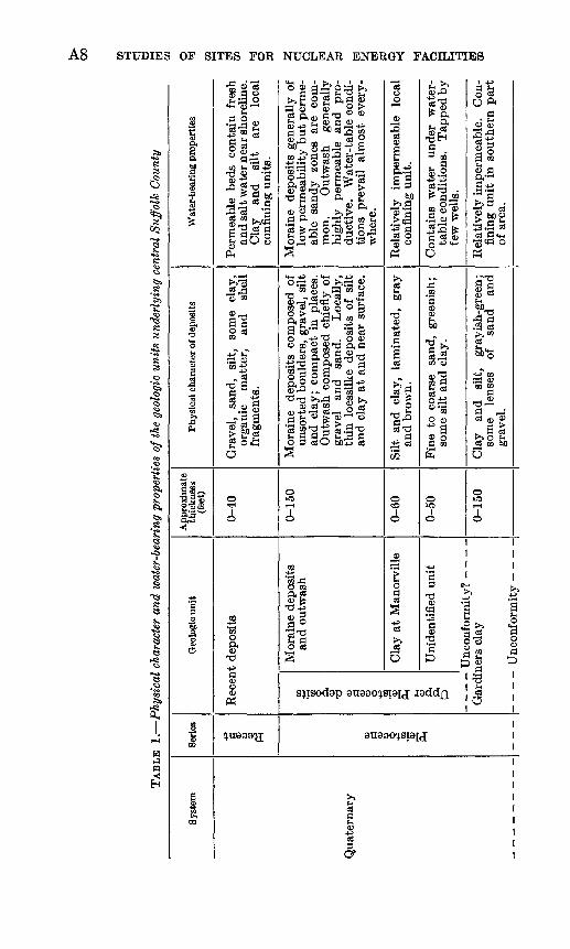
SUMMARY OF STRATIGRAPHY
Six principal stratigraphic units, some of which include sub divisions of minor importance, were recognized in the test drilling at Brookhaven National Laboratory and have been identified in well logs and at exposures in central Suffolk County (table 1). Their general relationships are indicated diagrammatically in figure 2, and their lithology, as determined in the two deep test wells at Brook- haven National Laboratory, is indicated in figure 3. Plate 2 shows the lithologic characteristics of the uppermost units, particularly those of Pleistocene age. Plate 1 shows the location of wells used in preparing the report; the cross sections are shown in plate 2.
At the base is the oldest of the stratigraphic units, the bedrock of pre-Cretaceous age, to which no fomiational name has been attached. Above the bedrock is the Earitan formation of Cretaceous age, which is as much as 500 feet thick. This formation has two members. The lower, as much as 300 feet thick, called the Lloyd sand member, is composed of coarse-grained sand, gravel, and some clay. The upper member, as much as 200 feet thick, is mostly clay and is called the clay member of the Earitan formation. Overlaying the Raritan for mation is the Magothy (?) formation, also of Cretaceous age. Beneath Brookhaven National Laboratory this formation consists of about 900 feet of mostly clayey sand, and it includes beds of clay and of sand and gravel.
Beneath most of the laboratory tract, and in general beneath the southern half of central Suffolk County, the Magothy (?) formation is overlain unconformably by the Gardiners clay of Pleistocene age. Within Brookhaven National Laboratory and for a few miles to the south, test wells showed the Gardiners clay to be 10 to 20 feet thick and to be composed of clay containing sand and gravel. Still farther south, along the ocean shore, the Magothy (?) formation is overlain by 150 feet or more of clay, silt, and clayey sand, which in texture, color, and composition is somewhat like the Gardiners clay, but which resembles neither the Magothy (?) below nor the upper Pleistocene deposits above. This material is tentatively referred to as the Gardiners clay, although it is possible that detailed paleontologic studies may show that other units are present in some places (Peri- mutter and Crandell, 1959).
> GO
CO
TAB
LE 1
. P
hysi
cal
char
acte
r an
d w
ater
-bea
ring
pro
pert
ies
of th
e ge
olog
ic u
nits
und
erly
ing
cent
ral
Suff
olk
Cou
nty
Syst
em
Qua
tern
ary
Serie
s
+3
fl o> o s I Pleistocen
e I
Geo
logi
c un
it
Rec
ent
depo
sits
Upper
Pleistocene
deposits
Mor
aine
dep
osit
s an
d ou
twas
h
Cla
y at
Man
orvi
lle
Uni
dent
ifie
d un
it
Gar
dine
rs c
lay
T
Tn
p.n
nfr
vrm
it.v
App
roxi
mat
e th
ickn
ess
(fee
t)
0-40
0-15
0
0-60
0-50
0-15
0
Phys
ical
cha
ract
er o
f dep
osits
Gra
vel,
sand
, si
lt,
som
e cl
ay,
orga
nic
mat
ter,
an
d sh
ell
frag
men
ts.
Mor
aine
de
posi
ts c
ompo
sed
of
unso
rted
bou
lder
s, g
rave
l, si
lt
and
clay
; co
mpa
ct i
n pl
aces
. O
utw
ash
com
pose
d ch
iefl
y of
gr
avel
an
d sa
nd.
Loc
ally
, th
in l
oess
like
depo
sits
of
silt
an
d cl
ay a
t an
d ne
ar s
urfa
ce.
Silt
and
clay
, la
min
ated
, gr
ay
and
brow
n.
Fin
e to
coa
rse
sand
, gr
eeni
sh;
som
e si
lt a
nd c
lay.
Cla
y an
d si
lt,
gray
ish-
gree
n;
som
e le
nses
of
sa
nd
and
grav
el.
Wat
er-b
eari
ng p
rope
rtie
s
Per
mea
ble
beds
co
ntai
n fr
esh
and
salt
wat
er n
ear s
hore
line.
C
lay
and
silt
ar
e lo
cal
conf
inin
g un
its.
Mor
aine
de
posi
ts g
ener
ally
of
low
per
mea
bili
ty b
ut p
erm
e
able
sa
ndy
zone
s ar
e co
m
mon
. O
utw
ash
gene
rally
hi
ghly
pe
rmea
ble
and
pro
du
ctiv
e.
Wat
er-t
able
con
di
tion
s pr
evai
l al
mos
t ev
ery
w
here
.
Rel
ativ
ely
impe
rmea
ble
loca
l co
nfin
ing
unit
.
Con
tain
s w
ater
un
der
wat
er-
tabl
e co
nditi
ons.
T
appe
d by
fe
w w
ells
.
Rel
ativ
ely
impe
rmea
ble.
C
on
fini
ng u
nit
in s
outh
ern
par
t of
are
a.
3 GQ
GEOLOGY, BROOKHAVEN NATIONAL LABORATORY VICINITY A9
>»i 03 dS 1^ d'S!o"5 §-2aj osd _ | O«"* » ^ ^
o> S'^ «Bft * 073
bfl ?H
a5
* E^ w^ ft^
fine to coarse, clayey, ss of clay; coarse basal containing gravel. Lig- is abundant. Light and gray are predominant
73 d § .-s g03^ N
OQ
03
|
O
r-T
d_o03
1j/^N
¥58.03
§
xo>^
3. -a03 dO) ri
elatively imperm tensive confining i
tf
^» ^.-s
03 a . Jj °3 'd
03 0) 0073 ti f-i
O
73 00 Sd .^
>» S-i O03 M t»
O
OO(M
rH
II
K^» ^
*S "^
CH ?H^-( *J^
o 2 aso >>§g^
'os'^'os §3'-S^. gJjTS
^ ^ S
o . £^* bJO <FHfli ^ rt
srmeable zones an sources of wat tapped by pumpi] present. Water artesian pressure.
P-i
II05
kjs- o
1*Mo3
93
03
73 Q} ad ,0 0303
OQ
OOCO
CO1 1
o55
,2 S03
elatively imperme
an aquifer.
tf
ic-gneiss, upper 30-50 feet erately to highly weath-
.1^7373 fl 0 <D
g S §3 O
1S-io>
JO
o>s >>'S 'ad ^c3 bw ,2
73 d^i O
^ ao2
1 73j uoiq.Tsuuoj uBq.uTS'jj o1 1
^o^n
£?~*aw i .2s i c S 1 &
1 d 0 ' d« g
S £
t '
o
SEA
LEVE
L
400'
800'
1200
'
1600
'
2000
'
Long
Isla
ndS
U
pper
B
rook
have
nA
tlant
ic
Plei
stoc
ene
Ron
konk
oma
Nat
iona
lO
cean
de
posi
ts \
mor
aine
_ ̂
Lab
orat
ory
Har
bor
Hill
mor
aine
NC
onne
ctic
utLo
ng I
slan
d So
und
012345
MIL
ES
PIO
UBB
2. G
ener
aliz
ed c
ross
sec
tion
alo
ng l
ong
72°5
2'30
" W
. in
cen
tral
Suf
folk
Cou
nty.
GEOLOGY, BROOKHAVEN NATIONAL LABORATORY VICINITY All
The sixth major stratigraphic unit is called the upper Pleistocene deposits, an informal term used to describe the glacial deposits which, in nearly all Long Island, overlie the Gardiners clay or the Magothy (?) formation. Most of these deposits consist of sand and gravel which, with local silt and clay, form the stratified outwash and morainal deposits of presumed Wisconsin age. Their maximum known thickness is about 200 feet. The formational units into which Fuller (1914, p. 80-176) divided these deposits have not been recog nized within the area of this report. However, some distinctive sub divisions were recognized. For example, overlying the Gardiners clay in the southern half of the report area is a greenish sand 25- to 50-feet thick of uncertain origin, but apparently the oldest outwash material in this area. It has not been named and, therefore, is called here the unidentified unit. At Manorville, and probably beneath a surrounding area of several square miles, there is a varved clay in the middle of the upper Pleistocene deposits. In the lower part of the Peconic Eiver valley, beneath the south-shore beaches and in a buried valley south of Mount Sinai Harbor, the upper Pleistocene deposits include a complex series of alternating layers of sand, silt, and clay, some fossiliferous, which may in part represent the Gardiners clay. Despite these variations, however, most of the upper Pleistocene deposits form a comparatively uniform blanket of sand and gravel.
The current differentiation of stratigraphic units on Long Island is the result of gradual refinement of knowledge based largely on data from wells. Substantial contributions were made by Thompson, Wells, and Blank (1937), and more recently by Suter, de Laguna, and Perlmutter (1949). Most of the formations recognized here occur nearly everywhere beneath Long Island.
BEDROCK:
The bedrock which underlies the unconsolidated deposits is known principally from well records. It includes hard, dense schist, gneiss, and granite similar in character to that which underlies much of the mainland in nearby parts of New York and Connecticut. These rocks were previously thought to be of Precambrian age, but now many geologists believe that some of them are metamorphosed early Paleo zoic age sediments. Data from well records and samples on Long Island do not warrant any identification except of rock type.
Two deep test wells (S6409 and S6434, pi. 1) penetrated bedrock at a depth of nearly 1,600 feet beneath Brookhaven National Labora tory. The bedrock was found to be a hard, banded, granitic gneiss. Microscopic examination showed it to be composed of about 50 per cent plagioclase (oligoclase and andesine) feldspar, about 50 percent
A12 STUDIES OF SITES FOR NUCLEAR ENERGY FACILITIES
quartz, about 1 percent biotite, and a trace of garnet. The plagio- clase feldspar in the sample from well S6434 contained a little more sodium than that from S6409; otherwise, the two samples were identical.
This bedrock contains no openings capable of holding or trans mitting appreciable quantities of water, thus it forms the base of the water-bearing material beneath Brookhaven National Laboratory.
In Connecticut, the bedrock includes, in addition to the gneiss and schist, a body of sandstone, shale, and diabase of Triassic age which could conceivably extend south from New Haven as far as Long Island. Seismic studies (Oliver and Drake, 1951, p. 1295) suggest that it does not. No rocks of Triassic age have been found in any wells drilled on Long Island.
CONFIGURATION OP THE BEDROCK SURFACE
The shape of the upper surface of the bedrock of Long Island is best known beneath the west end of the island (de Laguna and Brashears, 1948). Here the bedrock surface, as indicated by well rec ords, has a maximum relief of about 100 feet, except where it is near the surface and may have been modified by erosion in Pleistocene or Eecent time. The apparent low relief and local deep weathering of the bedrock in western Long Island as shown by well logs (de Laguna and Brashears, 1948, p. 8) suggest that the surface had reached an advanced stage of peneplanation. Indeed, the surface is considered to be part of the Fall Zone peneplain (Von Engeln, 1942, p. 353). The most recent map of the bedrock surface underlying Long Island (Suter, and others, 1949, pis. 8, 9, and 10) shows that this surface slopes southeast about 80 feet per mile beneath most of Long Island. It seems to slope more southerly at the east end of Long Island. If the surface represents a peneplain, the relief on the bedrock surface in the Brookhaven area is not likely to be greater than 50 to 100 feet.
FORMATIONS OF LATE CRETACEOUS AGE
RARITAN FORMATION
The Earitan formation rests directly on highly to slightly weath ered bedrock. The formation is probably entirely continental and was laid down as a costal-plain deposit by streams flowing off the uplifted Fall Zone peneplain. The name Earitan was applied to the Long Island deposits by Veatch and others (1906, p. 23) who cor related the formation with deposits of the same name in New Jersey. On Long Island the formation has two fairly distinct members; the Lloyd sand member below, and a clay member above.
GEOLOGY, BROOKHAVEN NATIONAL LABORATORY VICINITY A13
The formation probably occurs beneath all central Suffolk County. Northward the Lloyd sand thins and probably pinches out beneath Long Island Sound, and the clay member may do likewise. South ward the formation extends a considerable distance offshore, possibly as far as the continental shelf (about 100 miles), where the beds probably have lithologic characteristics different from those beneath Long Island.
At many wells the position of the contact with overlying deposits, and in fact between the members themselves, cannot be defined pre cisely. Nevertheless, the units are distinctive in their general characteristics.
LLOYD SAND MEMBER OF THE RARITAN FORMATION
The Lloyd sand member is a fairly uniform and extensive unit consisting predominantly of sand and gravel with some clay. It is known only from well logs. At the two deep test wells (S6409 and S6434) at Brookhaven National Laboratory, it is separated from the hard crystalline bedrock by 15 to 30 feet of tough, white, structureless clay containing scattered angular grains of quartz, which is consid ered to be weathered bedrock. At the same wells, the upper contact of the Lloyd sand member with the overlying clay member is fairly definitely marked by a change in the lithology of the sediments.
As shown by the columnar section (fig. 3) of well S6409, the Lloyd sand member is about 300 feet thick. It is largely composed of fine to coarse sand containing silt and clay in the interstices. It also includes beds of clay or sandy clay and coarser textured beds that contain gravel. Near the middle, the unit consists chiefly of sand and coarse gravel, which contains some pebbles at least 2 inches in diameter. The voids between the pebbles are for the most part filled with sand and some clay. The porosity of the unit is, therefore, appreciably less than that of a well-sorted sand or gravel. A somewhat similar se quence of material was found at well S6434. The dominantly sandy material which makes up the bulk of the unit here rests directly on highly weathered bedrock.
The pebbles and the sand found in the Lloyd member at Brook- haven National Laboratory and elsewhere on Long Island are com posed almost entirely of quartz. This composition suggests that the material was derived from a region in which the climate was warm and the rate of erosion slow, so that all but the most resistant ma terial was entirely decomposed. The clay is entirely or dominantly kaolinite, a mineral indicative of complete weathering.
675117 63 3
A14 STUDIES OF SITES FOR NUCLEAR ENERGY FACILITIES
The cores, the drill cuttings, the rate of drilling, and other evidence suggests that the Lloyd found at Brookhaven National Laboratory is in many respects similar to that found in western Suffolk, Nassau, Queens, and Kings Counties where more than a hundred wells have been drilled into it. In both the Laboratory wells and in a well drilled at Port Jefferson, however, the interstitial clay seems to be tougher and more tightly packed than it is farther west.
H Lloyd sand memberQ;
I Well screen^? <
NORTHEAST
FIGURE 3. Columnar sections and electric log of deep test wells at Brookhaven NationalLaboratory.
GEOLOGY, BROOKHAVEN NATIONAL LABORATORY VICINITY A15
EXPLANATION
Numbers arranged in order of estimated decreasing permeabilityUnit Unit
No. Description of unit No. Description of unit1 Sand, or sand and gravel, clean; 6 Clay, mixed with some sand, and
little or no silt or clay. containing beds of clayey sand.2 Sand, coarse, or sand and gravel; 7 Clay, tough; containing little sand,
includes some clay. 8 Bedrock weathered. Original rock3 Sand, fine or medium; includes texture no longer visible, but ma-
some clay. terial has not been transported4 Sand, coarse, or sand and gravel; or sorted by water.
mixed with considerable clay 9 Bedrock, weathered. Original ig-and containing beds of clay. neous texture visible, but most
5 Sand, fine to medium; mixed with minerals except quartz much al-considerable clay and containing tered chemically,beds of clay. 10 Bedrock, fresh. May show some
staining or discoloration.
In the western part of Long Island, the Lloyd ranges in thickness from about 350 feet on the south shore to a few tens of feet along the north shore, where in a few places it is absent. These variations in thickness apparently represent the form in which the Lloyd was originally deposited. At Port Jefferson the Lloyd has a thickness of 135 feet, which shows that it thins to the north in central Suffolk County also. Indeed, it is possible that beneath Long Island Sound, the Lloyd sand pinches out and that the overlying clay member of the Earitan overlaps it and extends beyond it. (See fig. 2.) Thus, al though penetrated by only a few wells in the report area, the Lloyd probably is a continuous unit of substantial thickness.
CLAY MEMBER OF THE RARITAN FORMATION
The clay member, which overlies the Lloyd sand, makes up the balance of the Raritan formation. At Brookhaven National Labora tory, the top of the clay member is 975 feet below sea level at well S6409 and 940 feet below at S6434. In both wells, its thickness was less than 200 feet. It is largely composed of tough dark-gray or black lignitic clay and some red and white clay and includes some sandy layers and thin lenses of gravel. It also contains some light-gray silty and sandy clay. It is not clearly bedded, as the textures and colors grade into one another. Zones which contain well marked, narrow bands of light silty clay alternate with darker clay which may repre sent annual variations in rate of deposition, as between a rainy and dry season.
The clay member shows little if any systematic variation in thick ness on Long Island. In most of the carefully logged wells that penetrate it, the clay is about 200 feet thick, and at least some of the
A16 STUDIES OF SITES FOR NUCLEAR ENERGY FACILITIES
greater or lesser thicknesses reported may be due to difficulty in plac ing the contacts, for these depend only on differences in lithology. In parts of King County, and in northern Queens and Nassau Coun ties, where the top of the clay member is at or near sea level, the mem ber is much less than 200 feet thick and in places it may be absent. This is probably due to local erosion, most of which probably took place in late Tertiary or Pleistocene time. Where the clay member is found at greater depths, as in central Suffolk County, there is no evi dence of erosion, but the data are scanty. Thompson, Wells, and Blank (1937, p. 455) suggest that in Kings and Queens Counties, channels were cut into the clay member at the close of Raritan time and then filled with sand or other permeable material at the beginning of Magothy(?) deposition. There is no evidence that such deep erosion and deposition took place within the area investigated; the Lloyd member in central Suffolk County is everywhere covered by the clay member.
Like the Lloyd member below and the Magothy (?) formation above, the clay member has not yielded any fossils except plant re mains and is probably nonmarine. The scattered pieces and grains of lignite, the widely distributed spores and pollen, the casts of twigs and leaves, and the possible varving suggest deposition on a coastal plain by generally sluggish but sometimes flooded rivers, that drained a deeply weathered area of moderate relief. It is possible, but unlikely, that some of the rivers crossing this plain maintained their channels in the same place over long periods of time, because aggrading streams commonly build up both their banks and their beds and then shift some distance laterally to lower ground. Accordingly, the coarser grained materials found locally probably are lenses of limited extent both horizontally and vertically. However, at places these may act as relatively permeable but devious paths for the movement of water.
WATER-BEARING PROPERTIES
The Lloyd sand is one of the most important aquifers on Long Is land largely because it yields adequate supplies of good quality water in areas, generally beneath the margins of Long Island, where sup plies from overlying formations are inadequate or are contaminated by or readily subject to contamination by sea water. The Lloyd can sup ply water under these circumstances because it is overlain by the relatively impermeable and virtually continuous blanket of the clay member.
The problem of how fresh water moves into and out of the Lloyd has been considered by many investigators. Such movement may occur by means of valleys cut through the clay member or by slow
GEOLOGY, BROOKHAVEN NATIONAL LABORATORY VICINITY A17
seepage of water through the clay (Suter, and others, 1949, p. 16). As there is little evidence of deep buried valleys in the clay member in central Suffolk County, it is likely that most of the movement of water into and out of the Lloyd is by means of slow seepage through the overlying clay. Lusczynski (oral communication) speculates that if the clay member has an average permeability of 0.2 to 0.3 gpd per square ft, then quite possibly all the water in the Lloyd reaches the unit by percolation through the clay member. Wenzel (1942, p. 13) gives the permeability of a clay (sample No. 2278) that is similar to the clay member of the Raritan as 0.2 gpd per ft, which suggests that there is no compelling need to assume permeable channelways. In any event, movement of water through the clay member of the Raritan either up or down doubtless is very slow in most places.
Although the water from the Lloyd is relatively high in iron con tent, the usefulness of the aquifer in central Suffolk County is more seriously compromised by the probability of poor yield, as exemplified by the two Brookhaven National Laboratory wells. In the western part of the island, many wells tapping the Lloyd sand member have a specific capacity between 10 and 20, which means that they yield 10 to 20 gpm per ft of drawdown. Test well S6409 at Brookhaven National Laboratory was finished with 25 feet of screen and had a specific capacity of about 2. The other deep test well, S6434, was under- reamed and gravel-packed and finished with 80 feet of screen, but it had a specific capacity of only 2.5. The principal reason for these low yields seems to be the toughness of the interstitial clay in the deposits, which made it difficult to wash the clay out thoroughly during the development. Much of the same type of tough interstitial clay was found in the cores from test well S5901 at Port Jefferson.
MAGOTHY(?) FORMATION
The Magothy(?) formation in central Suffolk County is a thick body of continental deposits composed of lenses of sand, sandy clay, clay, and some gravel. It rests on the Raritan formation and is in turn unconf ormably overlain by upper Pleistocene deposits. The greatest thickness, revealed by drilling, is about 1,000 feet. The present upper surface of the Magothy (?) on Long Island is an erosional surface, and the original total thickness is not known.
The type area of the Magothy formation is in Maryland along the Magothy River, where it was first described by Darton (1893, p. 407- 419). W. O. Crosby (1910) and later Horace R. Blank (written com munication, 1935) suggested that the Cretaceous deposits overlying the Raritan formation on Long Island were a greatly thickened ex tension of the Magothy formation of New Jersey. Later work (Perl-
A18 STUDIES OF SITES FOR NUCLEAR ENERGY FACILITIES
mutter and Crandell, 1959, p. 1060-1076) shows that the uppermost part of the Magothy (?) formation beneath the south shore of Suffolk County includes marine beds possibly equivalent in age to the Mon- mouth group of New Jersey. In this report, as in recent publications by Survey authors, the name Magothy when applied to the upper part of the Long Island Cretaceous, is followed by a question mark to indi cate the doubt. Examination of pollen and spores may lead to both a reliable correlation of the Cretaceous deposits on Long Island with those of New Jersey and to the establishment of a useful type sequence for Long Island itself.
The Magothy (?) formation underlies most of Long Island except for parts of Kings and Queens Counties and northwestern Nassau County where it was removed by erosion. It may extend beneath Long Island Sound, but is probably truncated by erosion and overlain by Pleistocene deposits. (See fig. 2.) To the south, the Magothy (?) formation, like the Earitan, extends out under the sea, where it also probably changes from a terrestrial to a marine deposit.
The formation crops out at only a few places on Long Island, most of them in northern Nassau County, so that the formation is known chiefly from well records. At test wells S6409 and S6434, the Magothy (?) is about 885 and 819 feet thick, respectively. (See fig. 3.) Well S5901 at Port Jefferson, 12 miles northwest of Brookhaven Na tional Laboratory, passed through nearly 500 feet of the Magothy (?) formation, and well S128 about 5 miles southwest of the Laboratory penetrated about 760 feet of the Magothy (?) and did not reach the bottom of the f ormation.
The Magothy (?) at Brookhaven National Laboratory has about the same characteristics as elsewhere on Long Island. It is composed of beds of poorly sorted quartzose sand mixed with and interbedded with silt and clay, and locally it contains pebbles or small lenses of gravel. Sandy clay and clayey sand make up most of the fine beds, but there are also several thick beds of clay. In both of the deep test wells (S6409 and S6434), the basal 100-150 feet of the Magothy (?) contains a greater proportion of coarse-grained material. This con sists partly of coarse sand and gravel that contains pebbles as much as 2 or 3 inches in diameter. The voids are largely filled with silt and soft clay, however, and the coarse-grained beds are separated by beds of sandy clay. A similar coarse-grained zone can be distin guished in most, reliable well logs in other parts of Long Island (J. J. Geraghty, written communication, 1953). It is best described as a zone, immediately overlying the clay member of the Raritan, in which relatively coarse-grained permeable material is commonly found.
The Magothy (?) formation typically contains several clay layers, some of them as much as 50 feet thick. Where the Magothy (?) itself
GEOLOGY, BROOKHAVEN NATIONAL LABORATORY VICINITY A19
is thick, the aggregate thickness of the clay beds is nearly as great as that of the clay member of the Karitan. Even in the western part of the Island, where wells are close together, it is difficult or impossible to trace any of these clay beds from one well to the next; hence, they are probably lenticular and individually of small extent. Thus, they probably do not constitute as effective a barrier to the movement of ground water as the clay member of the Raritan formation.
WATER-BEARING PROPERTIES
Although it consists in part of beds of dense clay and layers of coarse sand and gravel, by far the greater part of the Magothy (?) formation is made up of sandy clay and clayey sand. Thus, although the formation as a whole is probably less permeable than the Lloyd because of its thickness it can transmit and store large amounts of ground water. Also, there are no effective barriers to the movement of water through the formation except locally. Wells that are con structed and developed carefully generally yield large quantities of water from all but the most clayey parts of the formation. In other parts of Long Island, the beds of gravel at the base of the Magothy (?) and the lenses of sand and gravel of smaller extent that occur at various zones within the formation also yield substantial quantities of water. The Magothy (?) is important as an alternate aquifer in the event that the water in the overlying upper Pleistocene deposits becomes contaminated.
A well near Brookhaven National Laboratory that produces water from the Magothy (?) is S5902 at Port Jefferson. The aquifer tapped by this well is apparently not the basal Magothy, but a coarse-grained zone 100 feet higher. Well S5901, only 0.2 mile from S5902, did not penetrate productive water-bearing material in the Magothy (?) and was abandoned. This is one of a very few places in central Suffolk County where difficulty has been encountered in obtaining water. At most other places, where adequate supplies of water are not available from the upper Pleistocene, ample supplies have been developed from the Magothy (?) formation.
The highly productive beds of the Magothy (?) are by no means confined to the basal zone, but there is no other zone in which a reliable supply can be predicted. Rather it is a case of drilling carefully until material of appropriate grain size and permeability is found. Both of the deep wells at Brookhaven National Laboratory penetrated consid erable material in the Magothy (?) from which water might be ob tained. Well S6434 was screened temporarily between 656 and 676 feet and tested by pumping. Even with only 20 feet of screen, no gravel pack, and little development the zone yielded water at a specific capacity of 15 gpm per ft of drawdown.
A20 STUDIES OF SITES FOR NUCLEAR ENERGY FACILITIES
CONFIGURATION OF THE MAGOTHY(!) SURFACE
Between the Late Cretaceous and the end of Tertiary time, the Raritan and Magothy (?) formations were tilted gently to the south and considerably dissected by streams. The shape of the land surface thus formed is important for it is related to the thickness and distribu tion of the younger deposits resting on it. As these younger deposits have somewhat different hydrologic properties than the Cretaceous beds, their thickness is a matter of considerable importance to this report. In particular, extensive valleys now filled with permeable de posits occur in the western part of Long Island. If similar valleys are present in central Suffolk County, they might provide buried channel- ways for the movement of ground water. Although few wells pene trate to the Cretaceous in central Suffolk County, the general shape of the surface may be inferred from its configuration in the western part of the Island, where more data are available, and by inference from, the general geology.
When the coastal plain formed on the Magothy (?) deposits began to be eroded, the lower reaches of the ancestral Housatonic and Connecticut Rivers probably were the first main streams flowing south or southeast across the area which subsequently became Long Island. As these streams trenched themselves, tributaries called subsequent streams developed along the outcrops of the less resistant beds and in particular along the contact of the Cretaceous deposits and the crys talline bedrock. As the main streams cut deeper, the tributaries which followed this contact migrated southward down the slope of the sur face of the more resistant bedrock and removed in the process a wider and wider strip of the Cretaceous cover. The inner lowland so formed is the site of Long Island Sound, and the cuesta ridge to the south of it forms the core of Long Island. Thus, in general, the surface of the Cretaceous deposits of Long Island in pre-Pleistocene time probably consisted of gentle south-dipping slopes (dipslopes), steep north- facing slopes (scarp slopes) scarred by short steep valleys, and 'a few main stream valleys, the original consequent streams, which traversed across or detoured around the cuesta ridges.
Whether or not such a major stream valley crossed central Suffolk County is not known. Veatch and others (1906, pi. QA) suggest that the ancestral Housatonic River at first crossed the area not far west of the present site of Brookhaven National Laboratory. Well records suggest that there is a buried valley extending at least a few miles south of Mount Sinai Harbor, but there is no evidence to show that this valley extends across the island. Even if the Housantonic River crossed the island, such a remnant of its valley might well be a short segment only across the higher part of the postulated cuesta ridge.
GEOLOGY, BROOKHAVEN NATIONAL LABORATORY VICINITY A21
Veatch (1906, pis. QB and W) believed that the ancient Housatonic and Connecticut Rivers were eventually deflected westward where they entered the inner lowland, as the result of steam piracy, and flowed across the west end of Long Island as the ancient Sound River. Veatch thought that this river flowed to the west rather than to the east, partly because the Delaware, Susquehanna, and Potomac Rivers turn west where they cross the basal Cretaceous beds, and partly be cause well records revealed segments of buried valleys in southern Queens County and in south-central Kings County. Veatch (1906, pi. 6Z>) suggested also that the ancestral Housatonic and Connecticut Rivers were deflected east around the end of Long Island during the late Pleistocene time.
Many of the well records in central Suffolk County are generalized, and the correlations are somewhat questionable. However, within and a short distance south of the Laboratory area, several test wells were cored and the samples carefully studied. Interpretations as to the position of the Cretaceous surface at these wells are considered to be reasonably accurate. Data were particularly sought in the area south and southeast of Brookhaven National Laboratory, for this is the general direction of movement of the ground water from the Labora tory. These core identifications show that the Cretaceous surface is 92 feet below sea level at the southwest corner of the laboratory tract (well S6409, pi. 2). From here the surface slopes down gently to the south and southeast to 149 feet below sea level at well S6457 near Route 27, and it slopes down to about 140 feet below sea level at well S6460 (pi. 2). Still farther south, the position of the upper surface of the Cretaceous beds is uncertain, but it may be as much as 250 to 300 feet below sea level to the south according to interpretation of drillers' logs. Conceivably some of the clay correlated as Gardiners may be part of the Magothy( ?) formation.
Beneath Brookhaven National Laboratory north of well S6409, the Cretaceous surface slopes to the north and is 161 feet below sea level at the northeast corner of Brookhaven National Laboratory (well S6458, pi. 2). Still farther north, few reliable well records are avail able, but the surface probably rises along the north shore in the vicinity of Shoreham, perhaps even to altitudes above sea level. West along the north shore, near Mount Sinai Harbor, is the valley already referred to, and still farther west, in Port Jefferson, well records and one exposure show clearly that the Cretaceous surface is 50 feet or more above sea level. A small buried ridge which appears to trend east-west beneath the southern boundary of Brookhaven National Laboratory may be part of a minor cuesta.
East of Brookhaven National Laboratory, beneath the valley of the modern Peconic River, there may be a buried valley of considerable
A22 STUDIES OF SITES FOR NUCLEAR ENERGY FACILITIES
extent. Wells at Manorville and Eiverhead reached the Magothy (?) at considerable depths below sea level.
The total relief on the surface of the Cretaceous deposits in central Suffolk County is about 400 feet. Except for parts of the north shore, which are outside of the area of immediate interest to Brookhaven National Laboratory, the Cretaceous surface is very gently sloping, and the valleys and ridges referred to are but very minor undulations on a generally flat and nearly level surface.
DEPOSITS OF PLEISTOCENE AGE
During the Pleistocene epoch there were four major glacial stages. These were separated by three relatively warm interglacial stages. Long Island is about at the southern limit of the last major advance of the ice, the Wisconsin stage, and perhaps near the limit of the ice front of the earlier glacial stages.
In central Suffolk County, the deposits of Pleistocene age com prise : the Gardiners clay, believed to be a shallow marine deposit of the last major interglacial stage; and a complex sequence of glacial and nonglacial deposits, probably all of Wisconsin age, grouped under the name upper Pleistocene deposits. (See pi. 2.) The Jameco gravel found in western Long Island and the Mannetto gravel identified near the Nassau-Suffolk County boundary have not been recognized in central Suffolk County.
GARDINERS CL.AY
In about the southern half of central Suffolk County, the Magothy (?) formation is overlain unconformably by a fossiliferous marine clay that probably is the equivalent of the Gardiners clay as defined and described by Fuller (1914, p. 92). The type locality of this formation is on Gardiners Island at the east of Peconic Bay. It is not possible to trace the deposits from the type locality to Long Island proper; therefore, the name Gardiners clay in this report is restricted to the fossiliferous clay beneath much of the southern part of the area that is between the upper Pleistocene deposits above and the Magothy (?) formation below.
In most of Long Island, except where it has locally been deformed by ice shove, the top of the Gardiners clay is about 50 feet or more below present sea level. In central Suffolk County, it is everywhere about 100 feet below sea level or deeper. The nonmarine clays exposed at or about sea level along the north shore of Long Island, described by Fuller as Gardiners clay, are no longer believed to be part of that formation (Weiss, 1954, p. 148).
As used in this report, the Gardiners clay comprises three somewhat different types of material that occur in three separate bodies and
GEOLOGY, BROOKHAVEN NATIONAL LABORATORY VICINITY A23
that may or may not be contiguous with one another. These bodies are somewhat different lithologically and thus have somewhat different effects on the movement of ground water.
One of these is a thin body of clay or clay and sand that extends, in the area where it is best known, from about the northern border of Brookhaven National Laboratory as far south as Route 27 at well S6457 (pis. 1, 2). Similar deposits were penetrated by wells S128 and S95 to the west. Most wells in the area do not penetrate the Cretaceous beds, so the extent and continuity of the Gardiners is not known. However, it appears to underlie a belt around 6 miles wide north and south, roughly north of Route 27, and extending east and west across central Suffolk County. In this belt, the Gardiners clay is about 10 feet thick. The altitude of its upper surface is 101 feet below seal evel at S6456 (pi. 2), 91 feet below at S 6459 (pi. 2), and 130 feet below at S 6457 (pi. 1). Where penerated by these wells, the formation is composed of tough dark-gray to green sandy clay that contains a few pebbles. The green color is in part due to a small amount of glauconite and a small amount of green clay minerals.
A few pelecypod and gastrapod shells were found in the Gardiners clay at several of the wells in this area. At well S6409, a thin layer of dark brown peat underlies the clay. None of this material was particularly diagnostic; the peat being described by E. S. Barghoorn (Harvard Univ., written communication, 1952) as yielding only conifer pollen grains, Lycopodium spores, and other evidence of arboreal flora, which suggests a climate similar to, or more probably, slightly colder than the present.
Microf ossils in the Gardiners were somewhat more indicative. Law rence Weiss, formerly of the Geological Survey, prepared a report (1954) of the foraminifera obtained from cores and other samples. The foraminifera, and to a lesser degree the diatoms (K. E. Lohman, written communication, 1950), suggest strongly that the thin northern part of the formation in the vicinity of the laboratory was deposited in a shallow body of brackish water, not unlike the bays that fringe the southern shore of Long Island today. The fossil forms are largely identical with those living in the present bays. They do not resemble the forms living in the less well protected and more saline water of Long Island Sound. Similar forms are also found in protected waters to the north along the New England coast, which suggests that the Gardiners clay was formed during an interglacial period when the climate was similar to or perhaps a little colder than now. This conclusion agrees with the less conclusive evidence furnished by the peat. Also indicative of a somewhat colder climate is the altitude of the top of the clay, which suggests that sea level at the time of
A24 STUDIES OF SITES FOR NUCLEAR ENERGY FACILITIES
deposition was 50 to 100 feet lower than at present. This could be true if the glaciers and polar icecaps of the time were more extensive than those of today. MacClintock and Richards (1936, p. 330-331) suggest that the Gardiners clay is the equivalent of the Cape May formation of New Jersey, and they indicated on a map the probable position of the shoreline in New Jersey, New York, and Connecticut when the Cape May formation and the Gardiners clay were deposited. On this map, the sea level is shown as higher than at present in New Jersey, but lower than at present in Long Island and Connecticut. This would suggest that the land had been susequently tilted, or that the two formations are not actually contemporaneous.
The second body of the Gardiners clay, as here considered, comprises the thick clay penertated by wells S5591, S8549, and others (pi. 2), south of Route 27. The upper surface of this clay is at about 130 feet below sea level, but the lower contact slopes seaward so that the unit attains its greatest apparent thickness at well S8549 (pi. 2), where it consists of a nearly continuous body of tough generally green clay. A similar sequence, not quite so thick, was penetrated in well S5591 (pi. 2). Predominantly clay beds, as much as 80 feet thick, occur at depths of 130 feet below sea level at other southerly wells such as S6187 and S152. Thus, these thick clays may extend along the entire shore from Blue Point to Westhampton Beach and possibly beyond.
Clays of such thickness seem to be inconsistent with the apparent mode of deposition of the thin clay to the north. Also, the basis for an age determination is not firm. Hence, the thick clay may not be en tirely of Gardiners age and may include beds of the Magothy (?) formation. Similar thick clays have been found farther west beneath Fire Island Beach, and Cretaceous foraminif era have been found in some of them (Perlmutter and Crandell, 1959, p. 1066-1067). How ever, the writer feels that lithologically the clay here discussed is not typical of the Magothy(?), and believes that if it is not Gardiners it must wholly or partly belong to some intervening formation hitherto unidentified.
A third body of deposits tentatively correlated with the Gardiners clay comprises certain fossiliferous sands and clays found in wells in the Riverhead area and south of Mount Sinai Harbor. As explained in foregoing paragraphs, it is likely that valleys were cut into the sur face of the Magothy (?) formation at both of these places during the Tertiary. These valleys may have been invaded by the sea during deposition of the Gardiners clay. At well S5140 in Riverhead, Weiss (1954) found microfossils similar to those present in the Gardiners clay beneath Brookhaven National Laboratory and considered that the beds represent a shore facies of the Gardiners clay. These fossils
GEOLOGY, BROOKHAVEN NATIONAL LABORATORY VICINITY A25
were present in two sand layers and in an intervening clay penetrated between depths of 70 and 101 feet below sea level. Shells also were reported in fine sand at 33 feet below sea level at about 1.5 miles east- northeast, but no samples were available for study. The fossiliferous sand 33 feet below sea level is presumably pre-Wisconsin if it is over lain by glacial outwash. However, at this comparatively shallow depth, the overlying material may be of Recent age.
In the Mount Sinai Harbor area, clay or sand and clay containing shells have been found in several wells at depths below sea level as follows: S43, -60 to -200 feet; S2650, -10 feet; S9087, -60 to -70 feet; and S108 at about 100 feet. These are approximate fig ures, and as the area was overridden by later ice sheets, the clay may have been deformed by ice shove. The foraminifera from well S2650 were briefly examined by N. M. Perlmutter who found them similar to those described by Weiss from the Gardiners clay. The material is therefore, like the sand at Riverhead, probably interglacial, and pos sibly contemporaneous with the Gardiners clay.
WATER-BEARING PROPERTIES
With respect to water-bearing properties, the chief concern is with the predominantly clayey parts of the Gardiners that lie beneath and south of Brookhaven National Laboratory. Beneath the laboratory and roughly north of Route 27, the thin supposedly lagoonal portion of the Gardiners, as here distinguished, lies between the highly perme able upper Pleistocene deposits above and the moderately permeable Cretaceous formations below. The effectiveness of this part of the Gardiners clay as a barrier to ground-water movement is an important factor in determining whether contamination reaching the ground water in the glacial sands would be carried down to the lower aqui fers. The beds of tough clay are probably relatively impermeable, but they do not appear to occur in sufficiently thick and continuous strata to form a fully effective barrier to ground-water movement. If the Gardiners clay was indeed formed in a bay such as those which now fringe the south shore of the Island, and if the sea level rose from 140 feet to 90 feet during deposition, the formation would then probably consist of overlapping lenses of clay with zones of coarser grained silt and sand around the margins and local silty or sandy zones throughout. Indeed, the logs of wells S6457 and S6459 indicate that such sandy zones exist. Accordingly, this part of the Gardiners clay is apparently not a continuous and complete barrier to ground-water movement over the whole area, although the tough clay zones probably are effective barriers locally.
A26 STUDIES OF SITES FOR NUCLEAR ENERGY FACILITIES
Certain hydrologic data, discussed more fully by de Laguna (written communication, 1962) bear out this conclusion. The hydraulic head differential across the clay in the area south of the Laboratory, as measured at wells S6456, S6459, and S6460 is on the order of half a foot. The clay therefore must be sufficiently impermeable to restrict somewhat the movement of water, which here is from upper to lower strata. However, the sandy zones in the clay, which as far as is known may occur anywhere, would offer relatively little restriction to the movement of water, which could then pass downward wherever the hydraulic gradient is favorable. Thus, taking the unit as a whole, water can pass through the Gardiners clay, although at a slow rate, in small amounts and probably at most places only by circuitous routes.
The thicker beds of clay and sand and clay beneath the south shore of the island, which were referred to the Gardiners clay, are doubtless appreciably more effective as a barrier to the movement of ground water than the thin beds of clay farther north. This is due not only to their greater thickness but also to the inferred greater continuity of the clays, although the log of well S1592 (pi. 2) suggests that there are sandy zones even in this material. However, the significance of these characteristics is less than in the clay to the north, because the southern clay beds lie within the area where ground water is moving upward rather than downward. The thick clay in the vicinity of well S5591 and southward greatly retards the actual movement of water from the deeper formations. In fact, it may force relatively large amounts of water to discharge upward in more northern areas, per haps through more permeable deposits such as those penetrated by well S1592.
The scattered fossiliferous sands and clays in the Eiverhead and Mount Sinai Harbor areas are impossible to evaluate hydrologically as their structure and distribution are not known. It would appear, however, that they are but a part of a geologically complex filling of the buried valleys in these areas, and that the details of the hydrology of these areas is likely to be similarly complex. These areas are re mote from the Laboratory and their hydrology is of correspondingly small importance to the basic problems of this report.
UPPER PLEISTOCENE DEPOSITS
The term upper Pleistocene deposits was used by the writer in 1948 (de Laguna, 1948, p. 16) to include all the Pleistocene deposits on Long Island above the Gardiners clay. Fuller (1914, p. 106-176) divides this material into three formations: the Jacob sand, thought to grade downward into the Gardiners clay; the Manhasset forma tion, thick glacial deposits presumably of Illinoian age; and a thin, surficial veneer considered to be Wisconsin drift. Subsequent work
GEOLOGY, BROOKHAVEN NATIONAL LABORATORY VICINITY A27
suggests that the Jacob sand is not a separate formation, and that the Manhasset formation is actually largely, if not entirely, of Wisconsin age.
The Jacob sand, as described by Fuller (1914, p. 106), consists of very fine sand, silt, and rock flour, which are plastic when wet, but which contain little true clay. The color is very light gray, or yellow or buff. Fuller gives no thickness for the unit. According to Fuller, the Jacob sand is exposed at several places in wave-cut bluffs at or near sea level along the north shore of Long Island and at the type area at Jacobs Point, 15 miles northeast of Brookhaven National Laboratory. At places, the Jacob sand grades downward into a brown silty clay which Fuller believed to be the Gardiners clay, but this clay contains no fossils and is no longer believed to be Gardiners. Also, Fuller's suggestion (1914, p. 105-106 and fig. 77) that the non- fossiliferous Jacob sand at the type locality and elsewhere along the north shore is equivalent to fine-grained f ossilif erous sand which over lies the Gardiners clay on Gardiners Island probably is incorrect. This f ossilif erous sand probably should be considered part of the Gardiners clay (MacClintock and Richards, 1936). In its type area the Jacob sand does not appear to be a true stratigraphic unit, but rather to comprise beds and lenses, each of rather limited extent, of fine sand, silt, and rock flour probably deposited in quiet water ponded along the ice front. Deposits comparable to the Jacob sand are not rec ognized in well logs beneath the central or southern part of Long Island.
The type locality of the Manhasset formation of Fuller is in Man hasset in northern Nassau. County, where thick deposits of glacial sand and gravel contain a thin intercalated bed of clayey till. The lower gravel Fuller called the Hempstead gravel member, the till was called the Montauk till member (after the type locality at Montauk Point), and the gravel above the till was called the Herod gravel member, although the correlation of this particular gravel with the sand and gravel at Herod Point in central Suffolk County is also uncertain. Fuller believed that only the top few feet of till which overlies the Manhasset formation at the type locality was deposited by the Wisconsin ice sheet. This belief was based on an interpreta tion of the physiography with which subsequent workers have not been in agreement. Wells (1935, p. 121-122) and Fleming (1935, p. 222) state that they could find no evidence of weathering or erosion to indicate that there was an interglacial period at any time subsequent to the deposition of the Gardiners clay. The writer agrees with this opinion.
Fleming (1935, p. 216-238) proposes a three-fold subdivision of the post-Gardiners glacial material into Herod, Montauk, and Latest, as
A28 STUDIES OP SITES FOR NUCLEAR ENERGY FACILITIES
he believes that three separate advances of the Wisconsin ice were represented. The writer found no evidence in central Suffolk County, however, of three ice sheets. The glacial deposits observed in the Brookhaven National Laboratory area appear to be the product of two ice advances similar in character and probably both of Wisconsin age.
The Konkonkoma and Harbor Hill moraines as mapped by Fuller (1914, pi. 1) are accepted with slight modification; and the bulk of the upper Pleistocene deposits are considered to be outwash from the same glaciers that formed the moraines. The chief points of disagree ment with Fuller are: (1) the Manhasset formation, as defined by Fuller, is not considered to occur within the area and does not underlie the two outwash deposits at shallow depth as he believed; (2) the outwash is believed to be substantially thicker than Fuller thought; and (3) the thin till (supposedly ground moraine of the Konkonkoma advance), which Fuller maps as underlying central Suffolk County and considerable territory to the north and west, is not believed to be present. This last unit is here replaced by Konkonkoma and Harbor Hill outwash as discussed in the following paragraphs.
On the other hand, some units are here recognized in the upper Pleistocene that Fuller had little or no chance of observing. The first of these, called the unidentified unit (Weiss, 1954, p. 148), occurs at the base of the upper Pleistocene deposits. The second unit is clay, some of it varved, which is best known from cores from a test well at Manorville. Lastly are some thin surficia'l fine-grained deposits, not typical outwash, that occur in the upper part of the Harbor Hill outwash in the headwaters of the Peconic River in or near the eastern part of Brookhaven National Laboratory.
Thus in summary, the upper Pleistocene deposits in the vicinty of Brookhaven National Laboratory comprise the Harbor Hill and Ron- konkoma moraine deposits and outwash, which are indistinguishable on the basis of texture and composition alone, but which occupy some what different physiographic positions; and three minor units, differ entiated on the basis of their composition: the unidentified unit, the clay at Manorville, and fine-grained surficial deposits of limited but uncertain extent.
UNIDENTIFIED UNIT
South of Brookhaven National Laboratory, and for an unknown distance east and west, the Gardiners clay is overlain by 25 to 50 feet of sand or clay and sand characterized by a greenish color which is referred to as the unidentified unit. Beneath the southern half of the laboratory tract, and south to Route 27, this material forms the basal part of the upper Pleistocene deposits. Its relation to the other units
GEOLOGY, BROOKHAVEN NATIONAL LABORATORY VICINITY A29
in this area is shown in plate 2. Similar greenish deposits are re ported in wells as far west as Patchogue (well S7519) and as far east as West Hampton Beach (wells S9973 and S152). It probably extends beyond these areas. The northern limit of the unit has been located only at Brookhaven National Laboratory where test drilling indicates that this unit extends north of well S6459 (pi. 2). To the south, the unit can be traced nearly as far as well S1592 (pi. 2), but beyond this point the greenish deposits cannot be distinguished in well logs from similar material that may be part of the Gardiners clay or older deposits. The data from other wells along the south shore of the Island are not adequate to define the unit.
The unidentified unit, in the vicinity of Brookhaven National Laboratory, where it is most clearly defined, is composed of fine- to medium-grained white and gray sand, and 5 to 10 percent of inter stitial green clay. The sand grains consist mostly of quartz, but some other minerals also are present, principally feldspar, amphibole, and garnet. The green clay was identified by Clarence Boss (written communication, 1949) as nontronite, but probably there are other clay minerals present. Some broken grains of reworked glauconite are also present; and the nontronite may well have been formed by the weathering of glauconite. Elsewhere, the unit apparently contains considerable clay or sandy clay.
Samples of sand were collected for mechanical analysis from well S6456. The texture of the sample of greenish sand is not distinctive. The amounts and proportions of fine and medium sand are similar to those in some of the upper Pleistocene outwash; the content of coarse and very coarse material is small. Mmeralogically the greenish sand differs from the overlying outwash mainly in the apparent absence of biotite and the presence of glauconite. It appears to have a more varied mineral content than the Gardiners clay.
The origin of the unit is uncertain, but it is here considered to be part of the upper Pleistocene deposits because of its general mineral- ogic and lithologic similarity to the sands of those deposits. The glauconite may well have been derived from the shallow marine de posits in Long Island Sound, then dry, by the first advance of the ice across this area, and it need not have come from the area of the Atlantic Ocean to the south.
WATEB-BEARING PROPERTIES
The unidentified unit, although very similar in texture to much of the outwash, contains less coarse sand, and probably on the average a little more clay. The difference is difficult to estimate quantitatively.
A30 STUDIES OF SITES FOR NUCLEAR ENERGY FACILITIES
However, it may be inferred that the movement of the ground water in the unidentified unit is somewhat slower than it is in the overlying material. Even a small difference may be of some importance. As shown in a later section, a body of contaminated liquid of even slightly greater density than the normal ground water will tend to sink to the bottom of the aquifer. Also, the adsorptive and ion-exchange ca pacity of the nontronite and glauconite in the unit is appreciably higher than that of the overlying outwash. It is concluded, therefore, that following a spill or leak, any contaminated water which sinks into the unidentified unit at the bottom of the upper Pleistocene, will move less rapidly and be subject to more adsorption than it would be in the overlying material.
MORAINE DEPOSITS AND OUTWASH
The moraine deposits and outwash comprise four separate units: the Eonkonkoma moraine, outwash and other meltwater deposits from the Eonkonkoma ice, the Harbor Hill moraine, and outwash from the Harbor Hill ice. These units are distinguishable topo graphically, but not lithologically with present information.
The Eonkonkoma moraine is a line of irregular hills that lies im mediately south of Brookhaven National Laboratory (pi. 1). It ex tends eastward past South Manor, where it forms the south side of the Manorville Basin, and still farther east through Bald Hill. It also extends westward, paralleling the Carmans Eiver valley at Yaphank, and then crosses that valley and includes Coram Hill and others to the west.
The Eonkonkoma outwash underlies and forms the sloping but fairly smooth terrain south of Brookhaven National Laboratory, and also the irregular hills on and among which the main Laboratory tract is situated. These hills are considered to be kames formed during the late stages of melting of the Eonkonkoma glacier.
The Harbor Hill moraine (pi. 1) lies along the north shore of Long Island and is of little direct concern in connection with the ground- water problems of the Laboratory. Outwash from the Harbor Hill ice, however, extends southward to within about l 1/^ miles of the north boundary of Brookhaven National Laboratory, and to the east it extends south of the Peconic Eiver and underlies most of the Manor ville Basin. It is believed that meltwater from the Harbor Hill ice flowed down the site of the Carmans Eiver, through the gap in the Eonkonkoma moraine, and into the narrow tongue that broadened at the south to form a fanlike feature; the broad, flat area where the communities of Mastic and Mastic Beach are now located (pi. 1).
Within the Laboratory tract, except for the thin, surficial clay and
GEOLOGY, BROOKHAVEN NATIONAL LABORATORY VICINITY A31
silt described below, all these morainal and outwash deposits are lithologically inseparable and form virtually a single water-bearing unit. As a unit, these deposits rest upon the unidentified unit and, where that unit is missing or unrecognizable, upon the Gardiners clay. At places, where the Gardiners is missing, it rests on the Magothy (?) formation. In the laboratory area, it is from 100 to more than 200 feet thick. Its thickness, altitude, relationships to underlying forma tions, and general lithologic characteristics are shown by the cross sections in plate 2.
The moraine and outwash deposits are a crudely stratified body of clean sand and gravel which contains very little clay or silt, and only locally a few boulders. The sand grains are mostly quartz with small amounts of alkali feldspar, mica, amphibole, and other minerals. As indicated by a few exposures, the sand is well but coarsely bedded. Individual beds are difficult to define, as variations in texture are gradational.
Cores from some of the test holes reveal thin layers of silt or clay, which at most are 1 to 2 inches thick. Thicker lenses of clay are absent in the immediate vicinity of the Laboratory, but they are exposed locally along the north shore, especially at Wildwood State Park and Rocky Point (pi. 1). These lenses of silt and clay were probably deposited in small lakes formed between the retreating face of the Harbor Hill ice sheet and the Harbor Hill moraine. They are not more than 20 to 30 feet thick, and the majority are less than 10 feet thick. They appear to be at most a few hundred yards long. All these beds of silt and clay are near sea level, and they are evidently the material identified as the Jacob sand and the Gardiners clay by Fuller (1914).
No systematic variations in texture were actually observed in the glacial outwash or moraine deposits, and indeed to detect any would probably require a statistical study of a considerable number of large samples. The data available, however, suggest that the Ronkonkoma outwash becomes finer grained south of the Ronkonkoma moraine, and that the lower part of the outwash is somewhat finer than the upper part. No such generalization appears to hold for the material north of the Ronkonkoma moraine.
WATER-BEAKING PROPERTIES
Because of their similarity in structure and texture, the moraine and outwash deposits are considered a hydrologic unit. In the Labora tory area, the water table lies within what is probably the Ronkonkoma outwash, so that this deposit is of primary concern. The clean, coarse sand and gravel is very porous and highly permeable. It makes a
A32 STUDIES OF SITES FOR NUCLEAR ENERGY FACILITIES
porous soil, so that a high proportion of the rainfall infiltrates where it falls; there is virtually no surface runoff. Because of their high porosity, the deposits store large quantities of water. Because of their high permeability, the deposits yield large quantities of water to wells and are the source of nearly all the ground water pumped in central Suffolk County.
So far as is known there are no effective barriers to the movement of water anywhere in the unit. However, because the deposits are lenticular, there may be substantial variation in permeability over short distances. The permeability of the deposits south of the Ron- konkoma moraine may decrease slightly with depth and with distance to the south.
Some of these minor variations in water-bearing characteristics might become significant in connection with possible movement of a contaminant. As the moraine deposits and outwash were deposited by water flowing in general from north to south, it is reasonable to suppose that individual lenses of sand and gravel are themselves elongated in this direction. Thus, there may be threads of relatively permeable material along which water might move a little more rapidly under proper hydraulic conditions. Also, there may be either fine- or coarse-grained deposits localized beneath and along the valleys of the principal streams, such as the Carmans or Forge Rivers.
Finally, as discussed by de Laguna (written communication, 1962) there is apparently a substantial difference between permeabilities in the horizontal and vertical directions.
CLAY AT MANOKVILLE
A test well (S10,384) drilled by a private contractor near Manor- ville (pi. 1) penetrated a bed of tough clay which was underlain and overlain by outwash sand and gravel, between 2 and 33 feet below sea level. The lower part of this clay has typical glacial varving, which indicates that it was deposited in a lake left in the Manorville basin during the ice retreat. Similar clay was found in well S6422 from 4 to 62 feet below sea level. East, in the Riverhead basin, several wells penetrated what are probably equivalent beds of clay 15 to 30 feet below sea level. Three of these reached the bottom of the clay at 74, 81, and 130 feet below sea level. It is tentatively suggested that the varved clay at well S10,384 is possible interglacial, at least intersub- stage, and may separate Ronkonkoma from Harbor Hill outwash. Whether the clays penetrated by the other wells to the east and to the west are of the same unit is not known. There are, however, clay and silt of Gardiners age at about these depths in the eastern part of the Riverhead basin, and in well logs it would be impossible to distinguish
GEOLOGY, BROOKHAVEN NATIONAL LABORATORY VICINITY A33
between them and the clay at Manorville. Wells for which there are reliable logs are not so located as to permit a determination of the con tinuity and extent of this clay. However, if the clay is post-Ronkon- koma, the temporary lake in which it formed presumably would have been limited to the north of the Ronkonkoma moraine, and the clay itself should occur correspondingly. It was not found in the Labora tory area, nor to the south of Brookhaven National Laboratory. West of the Laboratory, in the upper valley of the Carmans River, there are few data, and none to indicate the presence of a comparable clay.
The clay at Manorville, if laterally extensive, probably exerts a con siderable influence on the movement of the ground water in the upper Pleistocene deposits in the area where it occurs. The water table is some 35 feet above sea level at Manorville, so that there is about 35 feet of saturated sand and gravel above the clay. The clay at well 810,384 is about 31 feet thick, and it is underlain by about 42 feet of sand and gravel. Movement of water between the upper and lower strata is certainly considerably impeded by the clay, and presumably artesian conditions prevail in the lower strata, although water-level measurements are not available to indicate the head difference. It is also possible that in some parts of the Manorville basin the water in the deposits beneath the clay flows southeastward toward and even tually to the south shore, whereas the water in the deposits above the clay discharges into the Peconic River. The clay appears to termi nate, however, well to the east of the Laboratory, so that it does not influence directly the movement of ground water in the areas of poten tial contamination, but it may well be an important factor in the hy drology of the central and lower Peconic River valley.
SURFICIAL SILT AND CLAY
In the east third of the Laboratory area, test drilling and shallow excavations have revealed in places thin deposits of silt and clay. The material is discontinuous and unevenly distributed. It is at most 5 or 10 feet thick, and is generally found at or very near the surface; and not deeper than 20 to 30 feet. It appears to be more widespread in the slightly lower land along the Peconic River and minor headwater tributaries than in higher ground. It may have been first deposited by the wind as loess, shortly after the retreat of the ice sheets and before a vegetative cover had developed; and subsequently moved by running water and redeposited on lower land. Some of it may have originated as waterlain material, and some may be unreworked loess. The extent of the deposits is determined in part by hydrologic data.
These deposits are sufficiently fine grained so that they appreciably impede the movement of shallow ground water. They hold water at or near the land surface, and thus locally form swampy areas or ponds.
A34 STUDIES OP SITES FOR NUCLEAR ENERGY FACILITIES
Also, they impede the downward movement of water enough so that at times when the level in the main underlying water body declines, they support perched or semiperched water bodies. Similarly, when the level in the main underlying water body rises, these fine-grained deposits confine the water under slight artesian pressure. These re lationships are areally complex because the deposits are discontinuous and occur close to the water table. The deposits affect the movement of shallow water into and out of the Peconic River and associated ponds, swamps, and drainage ditches in a rather complex way, and thus they have a bearing on the possible movement of contaminated waters in and outside the eastern part of the Laboratory area.
DEPOSITS OF RECENT AGE
Deposits of Recent age comprise gravel and sand on beaches, or ganic matter, silt and clay in tidal swamps, gravel, and sand and silt in stream channels. These deposits are thin and discontinuous, and they occur chiefly along the shores of the present Long Island Sound, the open ocean, bays behind barrier beach and various bars, and along the channels of the few larger streams. They are not suffi ciently extensive to make it important to differentiate them from underlying deposits (almost everywhere the upper Pleistocene de posits) upon which they rest unconformably.
They are generally neither thick enough nor extensive enough to comprise any appreciable ground-water reservoirs. Nearly all these deposits are remote from the Laboratory and there is no immediate problem in regard to their possible contamination.
REFERENCES CITED
Burr, W. H., Bering, Rudolph, and Freeman, J. R., 1904, Report of the commis sion on additional water supply for the City of New York: New York, MartinB. Brown Co., 980 p.
Crosby, W. O., 1910, Report of the geological relations of the ground water ofLong Island: New York City Board of Water Supply, open-file report, 64 p.
Darton, N. H., 1893, The Magothy formation of northeastern Maryland: Am. Jour.Sci., 3d ser., v. 45, p. 407-419.
de Laguna, W., and Brashears, M. L., Jr., 1948, The configuration of the rockfloor in western Long Island: New York Water Power and Control Comni.Bull. GW-13, 86 p.
Fleming, W. L. S., 1935, Glacial geology of central Long Island: Am. Jour. Sci.,5th ser. r v. 30, p. 216-238.
Fuller, M. L., 1914, The geology of Long Island, N.Y.: U.S. Geol. Survey Prof.Paper 82, 231 p.
Johnson, A. H., and others, 1952, Record of wells in Suffolk County, N.Y.:New York Water Power and Control Comm. Bull. GW-31,137 p.
Legette, R. M., and others, 1938, Record of wells in Suffolk County, N.Y.: NewYork Water Power and Control Comm. Bull GW-4,19 p.
GEOLOGY, BROOKHAVEN NATIONAL LABORATORY VICINITY A36
Lusczynski, N. J., and Johnson, A. H., 1951, The water table in Long Island, NewYork, in January 1951: New York Water Power and Control Comm. Bull.GW-27, 28 p.
MacClintock, Paul, and Richards, H. G., 1936, Correlation of late Pleistocenemarine and glacial deposits of New Jersey and New York: Geol. Soe.America Bull., v. 47, no. 3, p. 289-338.
Oliver, J. B., and Drake, C. L., 1951, Geophysical investigations in the emergedand submerged Atlantic Coastal Plain: Geol. Soc. America Bull., v. 62,p. 1287-1296.
Perlmutter, N. M., and Crandell, H. C., 1959, Geology and ground-water suppliesof the south-shore beaches of Long Island, N.Y.: New York Acad. Sci.Annals, v. 80, art. 4, p. 1060-1076.
Roberts, C. M. and Brashears, M. L., Jr., 1945, Record of wells in Suffolk County,N.Y., supplement 1: New York Water Power and Control Comm. Bull.GW-9, 155 p.
Spear, W. EJ., 1908, Long Island sources, an additional supply of water for theCity of New York: New York City Board of Water Supply, v. 1, p. 55-102.
Suter, Russell, de Laguna, Wallace, and Perlmutter, N. M., 1949, Mapping ofgeologic formations and aquifers of Long Island, N.Y.: New York StateWater Power and Control Comm. Bull. GW-18,178 p.
Thompson, D. G., Wells, P. G., and Blank, H. R., 1937, Recent geologic studieson Long Island with respect to ground-water supplies: Econ. Geology,v. 32, no. 4, p. 451-470.
Veatch, A. C., and others, 1906, Underground water resources of Long Island,N.Y.: U.S. Geol. Survey Prof. Paper 44, 394 p.
Von Engeln, O. D., 1942, Geomorphology, systematic and regional: New York,The MacMillan Co., 655 p.
Weiss, Lawrence, 1954, Poraminifera and origin of the Gardiners clay (Pleis tocene), eastern Long Island, N.Y.: U.S. Geol. Survey Prof. Paper 254-G,p. 143-162.
Wells, P. G., 1935, Reconsideration of the Pleistocene geology of Long Island[abs.]: Geol. Soc. America Proc., 1934, p. 121-122.
Wenzel, L. K., 1942, Methods for determining permeability of water-bearingmaterials: U.S. Geol. Survey Water-Supply Paper 887, 192 p.