Geology of Florida Albert C. Hine College of Marine Science University of South Florida Florida Oblique aerial photograph of a barrier island (Cayo Costa) on Florida’s Gulf of Mexico coastline that is actively prograding as a result of a local abundance of quartz sand. A large, complex, vegetated offshore spit system has built up on an ebb-tidal delta creating a small lagoon which may become a freshwater wetland or lake in time if sufficient sand is supplied to stabilize the spit. This photograph amply demonstrates how tidal inlets affect adjacent shorelines.
Transcript
Geology of FloridaAlbert C. HineCollege of Marine ScienceUniversity of South Florida
The geologic past of Florida is mostly out of sight with its maximum elevation atonly ~105 m (in the panhandle) and much of south Florida is virtually flat. Thesurface of Florida is dominated by subtle shorelines from previous sea-levelhigh-stands, karst-generated lakes, and small river drainage basins What we seeare modern geologic (and biologic) environments, some that are world famoussuch as the Everglades, the coral reefs, and the beaches. But, where did all of thiscome from? Does Florida have a geologic history other than the usual mantraabout having been “derived from the sea”? If so, what events of the geologic pastconverged to produce the Florida we see today?
To answer these questions, this module has two objectives: (1) to provide a rapidtransit through geologic time to describe the key events of Florida’s past emphasizingprocesses, and (2) to present the high-profile modern geologic features in Florida thathave made the State a world-class destination for visitors.
About the AuthorAlbert C. Hine is the Associate Dean and Professor in the College of MarineScience at the University of South Florida. He earned his A.B. from DartmouthCollege; M.S. from the University of Massachusetts, Amherst; and Ph.D. from theUniversity of South Carolina, Columbia—all in the geological sciences. Dr. Hineis a broadly-trained geological oceanographer who has addressed sedimentarygeology and stratigraphy problems from the estuarine system out to the base ofslope. Along with his associates and graduate students, they have defined theresponse of coastal and shelf depositional systems to sea-level fluctuations,climate changes, western boundary currents, antecedent topography, and sedimentsupply. Specifically this includes geologic origin and evolution of submerged paleo-shorelines, reefs (relict and active), shelf sand bodies, open marine marsh systems,barrier islands, and back-barrier environments and how they might have interactedwith each other in the past.
Areas of specialization for Dr. Hine include: Geologic processes and products ofshallow marine sedimentary environments. Development, history, stratigraphy, andsedimentation of carbonate platforms. Coastal geology, coastal wetlands, sequencestratigraphy, interpretation of seismic reflection data and seafloor mapping andinterpretation.
Visit Cengage LearningCustom Solutions online at www.cengagecustom.com
For your lifelong learning needs:www.academic.cengage.com
Oblique aerial photograph ofa barrier island (Cayo Costa)on Florida’s Gulf of Mexicocoastline that is activelyprograding as a result of alocal abundance of quartzsand. A large, complex,vegetated offshore spitsystem has built up on anebb-tidal delta creating asmall lagoon which maybecome a freshwater wetlandor lake in time if sufficientsand is supplied to stabilizethe spit. This photographamply demonstrates howtidal inlets affect adjacentshorelines.
28390_00_cover.qxd 1/16/09 4:03 PM Page 1
Geologic Map of the State of Florida with lithostratigraphic units and cross sections. Map generated by the Florida Geological Survey. Seenames of individual contributors printed on map.
Flor
ida
Geol
ogic
al S
urve
y
28390_02_insidecover.qxd 1/16/09 10:05 AM Page ii
ESSENTIAL QUESTIONS TO ASKFlorida.1 Introduction
� What is the link between natural scenery and geology?� Why is geology important?� What are the primary geomorphologic features that dominate Florida’s topography?
Florida.2 State of Florida and the Florida Platform� For coastal or island states, does geology end at the coastline, and why or why not?� What geologic features define the Florida Platform?� What is a prominent former sea-level indicator?
Florida.3 A Brief Geologic History of Florida� What are the three fundamental components of the Florida Platform?� Where did the basement rocks come from? � What are the four basic ingredients needed to construct a carbonate platform?
Florida.4 The Emergence of Modern Florida� What types of rocks constitute the Florida Keys?� Why does Florida have so many wetlands?� Why are there significant plant-dominated shorelines in Florida?
Note: The Geological Society of America’s 1999 Geologic Time Scale was used: www.geosociety.org/science/timescale/timescl.pdf
28390_01_body.qxd 1/16/09 9:59 AM Page 1
Florida.1IntroductionGeology is amazing in that it provides a rational, scientificexplanation for landscapes and their accompanying scenery.One does not need an earth science background to be inawe of the Himalayas or the Grand Canyon. But the originof the Himalayas, for example, and how these mountainsaffect their own weather to produce the glaciers that havesculpted them provide a scientific perspective that makesthem all the more wonderful. Even subtle variations inthe Earth’s surface provide geologic narratives. So, in thissense, geology is a powerful tool to understand much ofwhat we see in the physical world and all life containedtherein. It is a visual science like no other. Additionally,geologic knowledge leads us to locate critical resourcesthat we consume, provides us with knowledge to protectand conserve those resources and our environment, andprovides us a tool to predict and therefore prepare forevents that affect our lives. So, geology’s societal relevanceis unquestioned.
Those who teach geology can lead students to outcrop-pings to see the rocks that compose the Earth’s crust and topeer into the Earth’s past. If you live in the western UnitedStates, geology is before you in the vistas of the RockyMountains, for example. Mountain ranges exhibit extraordi-nary scenic diversity, are pure beauty, and are pure geology—three qualities that should be linked in everyone’s mind.
In Florida, on the other hand, with its maximum eleva-tion at only approximately 105 meters (in the Panhandle)and much of south Florida virtually flat, with only a fewmeters of relief and lying only a few meters above sea level,the geologic past is mostly out of sight (Figure Florida.1).The surface morphology of Florida is dominated mostly bysubtle paleoshorelines from previous sea-level highstands,karst-generated lakes, and small river drainage basins(Figure Florida.2). What we see are modern geologic (andbiologic) environments—some that are world famous, suchas the Everglades, the coral reefs, and the beaches. But,where did all of this come from? Does Florida have a geo-logic history other than the usual mantra about having been“derived from the sea”? If so, what events of the geologicpast converged to produce the Florida we see today?
2 Geology of Florida
� Figure Florida.1 Image of Florida showing topography and basic morphologic features. Much of Florida is low topographically, with the highestelevations associated with the dissected coastal plain in the Panhandle. Ancient shoreline trends are shown cut by the modern river drainage system.
Imag
e fro
m F
lorid
a Ge
olog
ical
Sur
vey
28390_01_body.qxd 1/16/09 9:59 AM Page 2
Florida.2 State of Florida and the Florida Platform 3
This chapter seeks to answer these questions, and indoing so has the following two objectives: (1) to provide arapid transit through geologic time to describe the keyevents of Florida’s past, emphasizing processes, and (2) topresent some of the high-profile modern geologic featuresin Florida that have made the state a world-class destinationfor visitors.
Section Florida.1 Summary● The science of geology explains the Earth’s topogra-phy and therefore its scenery and scenic diversity.
● Florida is topographically low and flat, so little of itsgeologic history is revealed in its geomorphology. Most ofthis history is hidden deep beneath the surface. Florida’ssurface is dominated by (1) past sea-level events revealed inpaleoshorelines, scarps, and terraces; (2) the present-dayriver drainage patterns; and (3) karst features.
● Florida supports significant modern geologic environ-ments such as (1) long and diverse coastlines and estuar-ies, (2) coral reefs, (3) and wetlands.
distinct geologic boundaries, Florida is a platform thatextends well offshore, out to the base of its continentalslope to the east and south and to the base of the WestFlorida Escarpment to the west. Consider it to be a huge,flat plateau with sloping sides that drop off into deep water.The elevation of today’s sea level defines the size of thestate of Florida and shape of the coastline. However, thisview is but a snapshot in time. Sea level has fluctuated oversignificant amplitudes (hundreds of meters) and over manycycles whose periods have extended from thousands to mil-lions of years, not counting the very high frequency cyclesdriven by climate, weather, and the astronomical tides.During the glacial and interglacial cycles of the Quaternary,sea level rose and fell by approximately 120 meters. We arein an interglacial period now, but some 18,000 years ago(18 kya), during the Last Glacial Maximum (LGM), so muchwater had been withdrawn from the ocean to form theNorthern Hemisphere’s continental ice sheets that Florida’swest coast would have been approximately 150 kilometersfarther out on the west Florida shelf. The state of Florida,as defined by its coastline, would have been twice the sizethat it is today. As evidence, geological oceanographershave identified and radiocarbon-dated a number of drownedshorelines that were once active thousands of years ago atlower sea level but that are now submerged in deep water—these are called paleoshorelines.
In a geologic sense, Florida is much more aptly definedby the margins of the Florida Platform: (1) the base of theWest Florida Escarpment at sea to the west (approximately3,200 meters deep), (2) the now-buried Georgia ChannelSystem that extends southwest to northeast across southGeorgia on the north, and (3) the Straits of Florida to the eastand south (Figure Florida.3). The Florida Platform was oncepart of the much larger Florida–Bahamas Platform that wasbounded by rift or transcurrent (faulted) margins farther to
� Figure Florida.2 Digital orthophoto quarter quadrangle imageof north-central Florida showing basic morphological features—linearpaleoshoreline trends punctuated by sinkholes. Small, moderndrainage patterns are common as well.
Failed Rifted Margin
Georgia Channel Seaway Complex
PassiveRiftedMargin
BahamasBahamasFractureFractureZoneZone
BahamasFractureZone
Florida BahamasEscarpment
BahamasEscarpment
ComplexTranscurrentMargin
Collision Margin
Complex Rifted M
argin Stra
its
of
Flo
rid
a
F l o r i d a –B a h a m a s P l a t f o r m
F l o r i d a –B a h a m a s P l a t f o r m
� Figure Florida.3 Map of the Florida–Bahamas–Greater Antillesregion. Florida, the Blake Plateau, and the Bahamas were all partof one enormous carbonate platform. The structural boundariesdefining this area are shown. The Straits of Florida now separatethe Florida Platform from the Bahamas Platform.
Florida.2State of Florida and the FloridaPlatformMost people think of Florida in terms of its land portionthat is defined by the shoreline and the state’s boundarieswith Georgia and Alabama. But, as a geologic entity with Im
age
from
Goo
gle
Earth
28390_01_body.qxd 1/16/09 9:59 AM Page 3
the east where the submarine relief of the Florida-BahamasEscarpment is more than 4,000 meters (Figure Florida.4).
This chapter focuses primarily on peninsular Florida andnot the Panhandle. The geology of the Panhandle is essen-tially a southern extension of Georgia and Alabama.Additionally, this chapter presents the key events that haveshaped Florida over geologic time. The stratigraphicnomenclature, formational names, ages, and lithologiesmay be found in many other resources.
the backbone of peninsular Florida. Second, lying on top ofthis backbone is a 2- to 6-kilometer-thick carbonate (lime-stone, dolomite) and evaporite sedimentary rock successionpunctured by dissolution features, many of which have surfi-cial expression (see Figure Florida.4). Finally, these sedimen-tary rocks are covered by a relatively thin 1- to 150-meterveneer of mostly siliciclastic sands—at least on the subaeri-ally exposed portion of the Florida Platform. The quartzcover is what we all see when we look at the ground closely,and it is also visible from afar in space.
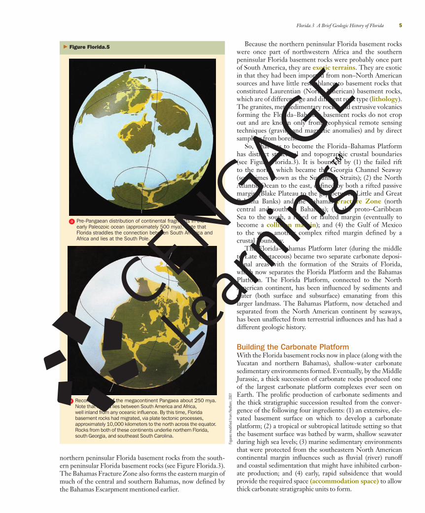
Where to Begin?The basement rocks underlying Florida originally extendedacross South America and northwest Africa, forming onecontinental landmass located at the South Pole (FigureFlorida.5a). Over millions of years in the late Paleozoic, themegacontinent Pangaea was assembled and the Yucatan–Florida–Bahamas basement rocks were located approxi-mately 10,000 kilometers to the north, in the central portionof the megacontinent far from any ocean (Figure Florida.5b).As part of the Wilson cycle, megacontinents break upand form new ocean basins. Approximately 250 millionyears ago (250 mya), Laurentia (North America) andGondwana (most of the rest of the continental mass includ-ing Africa and South America) began to pull apart, andby 180 mya the early North Atlantic Ocean began toform, with oceanic crust (basaltic, extrusive igneous rocks)appearing. Through a very complex and poorly understoodrifting system over the next 40 million years, the NorthAtlantic Ocean widened, the Gulf of Mexico opened, and theproto–Caribbean Sea opened. Ultimately, this east-to-westseafloor-spreading propagation formed a global, tropicalseaway called Tethys.
However, the rifting and seafloor spreading in the NorthAtlantic split off a segment of northwestern Africa, leavingit behind as part of the new North American Plate. Thiswould become the basement beneath much of peninsularFlorida. During the early part of the extension phase, a riftvalley system, or a series of grabens, formed across south-ern Georgia. Had rifting and seafloor spreading continuedto occur here, northern peninsular Florida never wouldhave formed. Instead, the rifting ceased, leaving behind agraben complex that filled with seawater during sea-levelhighstands, thus separating and isolating northern peninsu-lar Florida from the rest of North America by a current-dominated seaway (Georgia Channel Seaway system).
Nearly simultaneously, two continental blocks (theYucatan Block and the Florida Straits Block) were transport-ed by a different seafloor spreading, or transform fault sys-tem, that eventually formed the Gulf of Mexico ocean basin.One of these blocks, the Florida Straits Block, moved to theeast along a transform fault. The space created became partof the Gulf of Mexico. The Florida Straits Block now under-lies the southern portion of the peninsular Florida and muchof the Bahama Banks. The formerly active fault is now knownas the Bahamas Fracture Zone and extends northwest tosoutheast beneath central peninsular Florida, separating the
4 Geology of Florida
� Figure Florida.4 Generalized west-to-east cross-section extendingacross the Florida and Bahamas platforms. The carbonate FloridaPlatform was built on mostly Paleozoic and Mesozoic rocks that onceformed part of Africa and South America. This basement antecedenthigh forms the backbone of peninsular Florida. In some places, thecarbonates are approximately 14 kilometers thick. This huge platformis defined by two major submarine erosional escarpments—the WestFlorida Escarpment (approximately 2 kilometers relief) and theFlorida–Bahamas Escarpment (approximately 4 kilometers relief). A thinquartz sand veneer overlies the Florida Platform.
Imag
e fro
m G
oogl
e Ea
rth
Section Florida.2 Summary● The geology of Florida should not be defined by thepresent-day coastline, which is but a snapshot in geologictime. Instead, the geology of Florida is defined by geologicfeatures that outline the much larger Florida Platform.
● The size of the emergent, dry, subaerially exposed por-tion of the Florida Platform has varied enormously overgeologic time due to numerous sea-level fluctuations.
Florida.3A Brief Geologic History of FloridaBuilding BlocksNow that the lateral extent of the Florida Platform hasbeen defined, we turn to its vertical, internal extent, whichconsists of three building blocks, or components. First, theFlorida Platform rests on Paleozoic-age to Mesozoic-ageigneous and metasedimentary rocks that form its basement—continental crust and thinned transitional crust. This forms
28390_01_body.qxd 1/16/09 9:59 AM Page 4
Florida.3 A Brief Geologic History of Florida 5
Because the northern peninsular Florida basement rockswere once part of northwestern Africa and the southernpeninsular Florida basement rocks were probably once partof South America, they are exotic terrains. They are exoticin that they had been imported from non–North Americansources and have little resemblance to basement rocks thatconstituted Laurentian (North American) basement rocks,which are of different age and different rock type (lithology).The granites, metasedimentary rocks, and extrusive volcanicsforming the Florida–Bahamas basement rocks do not cropout and are known only from geophysical remote sensingtechniques (gravity and magnetic anomalies) and by directsampling from boreholes.
So, what was to become the Florida–Bahamas Platformhas distinct structural and topographic crustal boundaries(see Figure Florida.3). It is bounded by (1) the failed riftto the north, which became the Georgia Channel Seaway(sometimes known as the Suwannee Straits); (2) the NorthAtlantic Ocean to the east, defined by both a rifted passivemargin (Blake Plateau to the gap between Little and GreatBahama Banks) and the Bahamas Fracture Zone (northcentral and southern Bahamas); (3) the proto–CaribbeanSea to the south, a rifted or faulted margin (eventually tobecome a collision margin); and (4) the Gulf of Mexicoto the west, another complex rifted margin defined by acrustal boundary.
The Florida–Bahamas Platform later (during the middleto Late Cretaceous) became two separate carbonate deposi-tional areas with the formation of the Straits of Florida,which now separates the Florida Platform and the BahamasPlatform. The Florida Platform, connected to the NorthAmerican continent, has been influenced by sediments andwater (both surface and subsurface) emanating from thislarger landmass. The Bahamas Platform, now detached andseparated from the North American continent by seaways,has been unaffected from terrestrial influences and has had adifferent geologic history.
Building the Carbonate PlatformWith the Florida basement rocks now in place (along with theYucatan and northern Bahamas), shallow-water carbonatesedimentary environments formed. Eventually, by the MiddleJurassic, a thick succession of carbonate rocks produced oneof the largest carbonate platform complexes ever seen onEarth. The prolific production of carbonate sediments andthe thick stratigraphic succession resulted from the conver-gence of the following four ingredients: (1) an extensive, ele-vated basement surface on which to develop a carbonateplatform; (2) a tropical or subtropical latitude setting so thatthe basement surface was bathed by warm, shallow seawaterduring high sea levels; (3) marine sedimentary environmentsthat were protected from the southeastern North Americancontinental margin influences such as fluvial (river) runoffand coastal sedimentation that might have inhibited carbon-ate production; and (4) early, rapid subsidence that wouldprovide the required space (accommodation space) to allowthick carbonate stratigraphic units to form.
� Figure Florida.5
Figu
res
mod
ified
from
Red
fern
, 200
1
Reconstruction of the megacontinent Pangaea about 250 mya.Note that Florida lies between South America and Africa,well inland from any oceanic influence. By this time, Floridabasement rocks had migrated, via plate tectonic processes,approximately 10,000 kilometers to the north across the equator.Rocks from both of these continents underlie northern Florida,south Georgia, and southeast South Carolina.
Pre-Pangaean distribution of continental fragments in theearly Paleozoic ocean (approximately 500 mya). Note thatFlorida straddles the connection between South America andAfrica and lies at the South Pole.
a
b
northern peninsular Florida basement rocks from the south-ern peninsular Florida basement rocks (see Figure Florida.3).The Bahamas Fracture Zone also forms the eastern margin ofmuch of the central and southern Bahamas, now defined bythe Bahamas Escarpment mentioned earlier.
28390_01_body.qxd 1/16/09 9:59 AM Page 5
6 Geology of Florida
to the early formation of the carbonate gigabank (a really bigplatform—bigger than a megabank). When sea level waslower, this huge platform was subaerially exposed, creatingunconformities that define the boundaries of stratigraphicunits. But, essentially, for millions of years, shallow-watercarbonate sedimentary environments persisted and createdmuch of the thick carbonate cover overlying the nowdeeply buried basement rocks. Later, starting in the earlyCenozoic, a number of geologic events significantly alteredthe pristine carbonate sedimentary regime.
Altering the PlatformPlatform Drowning—Stressing the Carbonate FactoryThe first of the platform-altering events was the drowningof the west Florida margin starting in the Early to middleCretaceous (100 to 80 mya). Drowning means that theseafloor’s ability to accumulate carbonate sediments is lessthan the overall subsidence rate. As a result, the shelfbecomes deeper and eventually falls below the photic zone,thus compromising the ability of the carbonate factory toproduce sediments. A distinctive character of the FloridaPlatform is the broad, wide, gently westward sloping ramp(not a shallow rim) of the west Florida shelf that terminatesapproximately 1,800 meters deep on top of the WestFlorida Escarpment (see Figure Florida.4). The West FloridaEscarpment then drops precipitously, to 3,200 meters in thedeep Gulf of Mexico. Some speculate that this broad, wide,sloping shelf may have resulted from environmental crisesinvolving global oceanic anoxic events (OAE) that initiallystressed the carbonate factory during the Cretaceous.
From approximately 100 to 80 mya, significant volcanicemanations on the oceanic crust from deep mantle plumes(from primarily the western Pacific Ocean) enriched theatmosphere with carbon dioxide (CO2), a potent greenhouse
These factors allowed for the development of a huge car-bonate platform to form in the Yucatan–Florida–Bahamasarea. They also allowed this platform to extend all the wayup to present-day Nova Scotia to form a gigaplatform—6,000 kilometers long, up to 1,000 kilometers wide in places,and eventually up to 14 kilometers thick—probably the largestcarbonate platform complex ever on Earth. The platform-building zenith appeared approximately 140 mya in the LateJurassic. Eventually, the platforms extending up the NorthAmerican east coast were finally buried, where they nowlie several kilometers beneath the present-day siliciclastic-dominated continental shelves.
Carbonate platforms often have predictable distributionof depositional environments. Along rimmed margins,which face the deep ocean, there is a slope or steep escarp-ment that plunges into as much as 5 kilometers of water(see Figure Florida.4). Here, sediments that are shed fromthe platform top accumulate to form the platform slope.These are fine-grained sediments that may have coarsermaterial embedded within, sometimes huge, building-sizeblocks that have slumped downslope because of gravity-induced instability. The shallow margin may be dominatedby reef-building organisms that form a rigid framework orstrong tidal flows on or off the platform may form extensivesand bores (which consist of ooids or rounded skeletalgrains). During the Mesozoic, rudistid (a bivalve) reefswere dominant—not coral reefs. Farther into the platform,the wave and tidal energy dissipates and a huge, shallow shelflagoon resides. Here, a benthic community of seagrasses, cal-careous-producing algae, mollusks, bryozoans, foraminifera,and many other calcareous-secreting organisms produce car-bonate sedimentary material ranging from coarse shellygravel to fine-grained muds. Carbonate islands made fromwind-blown carbonate sand dunes, extensive tidal flats,beaches, offshore sand bodies, interior lakes, and the likecreate a complex mosaic of closely spaced but quite differ-ent sedimentary environments. The carbonate sedimentsformed in these depositional environments eventuallybecame carbonate rock (Figure Florida.6).
With the Florida–Bahamas Platform approximately1,000 kilometers wide, water circulation at the middle ofthe platform at times became very sluggish, evaporationbegan to dominate, salinities became elevated, and eventuallyevaporite minerals such as gypsum and anhydrite precipi-tated. Later dissolution of these evaporites within the plat-form yielded hypersaline brines, which continue to sustainstrange and unusual life forms in the deep waters along thesouthwestern Florida platform margin, where they leak outinto the deep marine environment. Here, the brines supportchemosynthetic organisms similar to those found at ventsalong the mid-ocean ridge. Finding these vent-type benthiccommunities (bacterial mats, tube worms, clams, shrimp,etc.) in waters approximately 3 kilometers deep at the base ofthe West Florida Escarpment has been one of the majoroceanographic discoveries in Florida in recent decades.
The extended sea-level highstand during the CretaceousGreenhouse Earth and its prolonged warmth were essential
� Figure Florida.6 Digital orthophoto quarter quadrangle imageof a limestone rock quarry near the west Florida Gulf of Mexicocoastline. Florida is a major producer of carbonate rock.
28390_01_body.qxd 1/16/09 9:59 AM Page 6
Florida.3 A Brief Geologic History of Florida 7
migrated some 2,000 kilometers to the northeast into theproto–Caribbean Sea through the 3,000-kilometer gapthat separates North America from South America (Fig-ure Florida.7). It consumed the proto–Caribbean Sea oceanbasin crust through subduction. By approximately 84 mya,the island arc moved by the Yucatan Block (Platform), break-ing off a carbonate section that eventually became western-most Cuba. By 56 mya, the island arc collided with the passivesouth margin of the Florida–Bahamas carbonate platform.
Because the Florida–Bahamas Platform is relatively lessdense material (limestone) than ocean crust (igneous rocks),these thick carbonates were too buoyant to be subducted.The relative movement of the volcanic arc carrying theearly Greater Antilles islands essentially stalled. But therewas significant deformation and uplift as a result, creatingfolds, thrust sheets, and faults in Cuba. In western Cuba,Jurassic carbonate slope facies derived from the shallowplatforms to the north were uplifted to form 300-meter-high, steep-sided, rounded hills called mogotes, whichwere sculpted by 50 million years of karstic erosionalprocesses, as suggested before.
However, this topography and tectonically derived struc-tures are not seen in Florida. The geologic and topographiccontrast between south Florida and central-western Cubacould not be more different. The overall effects of this oro-genic event on the Florida–Bahamas Platform were thatperhaps as much as 50 kilometers of carbonate platform(and associated slope) material became part of Cuba andthat flexural loading as a result of the collision depressedsouthern Florida, creating the southern Straits of Floridaand likely drowning part of the Florida–Bahamas Platform.
So, although there does not appear to be significant upliftand deformation in peninsular Florida as a result of theAntillean Orogeny, the collision with this Cretaceous islandarc did contribute to Florida’s isolation by possibly establish-ing, deepening, and extending the southern Straits of Florida.
� Figure Florida.7 Diagram depicting the Caribbean Platemigrating into the gap between North America and South America at72 mya. The Greater Antilles, including Cuba, eventually collidedwith the Yucatan–Florida–Bahamas Platform approximately 56 mya,consuming the south margin of this carbonate platform complex.
gas. As a result of high CO2, global temperature and thusglobal sea level rose to probably its highest elevation in theEarth’s history (combination of no glaciers, seawater expan-sion, and smaller ocean basin volume). This period of time iscalled the Greenhouse Earth. Global warmth probablyreduced atmospheric circulation, and the oceans becamestratified with anoxic water lying beneath a shallow mixedzone. This stratification allowed anoxic water to move uponto shallow carbonate platforms during times of high sealevel, sometimes destroying benthic communities and theirability to produce carbonate sediment. This lack of sedimentproduction, coupled with persistent passive margin tectonicsubsidence, caused the west Florida margin to fall below thephotic zone. Rather than a wide, shallow, flat-topped carbon-ate platform, a gently sloping carbonate ramp formed, everdeepening to the west, drowning the carbonate sedimentproduction factory.
These environmental crises (OAEs) might have formed aportion of the Straits of Florida and some of the seawayswithin the modern Bahamas, thus segmenting this gigabankinto smaller shallow banks separated by deep seaways. Thisselective drowning to the south and east may have begun toseparate Florida from the Bahamas by forming a deep seaway.It is possible that the Cuban collision (see later discussion ofthe Antillean Orogeny) with the Yucatan–Florida–BahamasPlatform contributed to the drowning and segmentation ofthe Florida–Bahamas Platform as well.
Thus, the platform segmentation is an important eventin that it defines when Florida and the northern Bahamasbecame separated into distinctly different geologicprovinces. Before, they were essentially the same feature.Afterward, the Bahamas remained isolated from the effects(i.e., enhanced nutrients, low oxygen, turbidity from riverrunoff, sands from longshore sand transport) of theNorth American continent and remain one of the classiccarbonate-producing environments in the world. Floridaremained attached to North America and began to be influ-enced by siliciclastic input, particularly starting in the earlyto middle Cenozoic.
Antillean Orogeny—Deforming the Platform Fromthe Middle Jurassic to the Early Paleocene, theFlorida–Bahamas carbonate platform extended into theproto–Caribbean Sea much farther south than it does today.However, a tectonic collision between a Cretaceous vol-canic island arc system and this carbonate platform complexcreated the Greater Antilles. This tectonic collision is calledthe Antillean Orogeny, and it occurred approximately 56 to50 mya.
The geologic details of the origin and tectonic history ofthe modern Caribbean ocean basin and its effects on itsmargins are some of the most complex and controversialtopics in plate tectonic motion studies today. However,there is widespread acceptance that the Greater Antillesvolcanic island arc system began to form about 120 mya inthe eastern Pacific Ocean associated with a subductionzone. This island arc (leading edge of the Caribbean Plate)
Figu
re m
odifi
ed fr
om R
edfe
rn, 2
001
28390_01_body.qxd 1/16/09 9:59 AM Page 7
8 Geology of Florida
on the later development of the Florida Platform. If anyevidence of this event exists within the Florida Platform, itlies deep in the subsurface. Nevertheless, the tsunamiformed by this event should have washed across the sub-merged platform, probably leaving some yet-undetectedsignature in the sediments and rocks.
Groundwater and Springs—Dissolving the PlatformAlmost from the initial deposition of the first carbonaterocks on top of the basement, acidic groundwaters began todissolve cavities within them and etched subaerially exposedsurfaces on them. Karstification is both an internal and anexternal process. As the carbonate rocks became older andthicker, these dissolved, open spaces or caves became largerand more interconnected. Some caves extend for many kilo-meters and may occur at great depth into the subsurface(Figure Florida.8). When freshwater tables are supported bysurrounding saline groundwater, mixing-zone dissolutionoccurs and causes more cavities to form. Additionally, rocksfracture because of differential loading or subsidence, seis-mic activity, earth tides, intraplate stress, and other ongo-ing earth forces, thus further interconnecting subterraneanopen spaces.
In sedimentary rocks, aquifers form where there isprominent groundwater flow through relatively distinctzones. Beneath the Florida Platform lies the Florida aquifersystem—a huge porous and permeable zone (extending intoAlabama, Georgia, and South Carolina, where it is rechargedby rainfall and surface runoff. The Florida aquifer system ful-fills much of the freshwater needs for the people, industry,and agriculture in the state.
Where cavities form near the ground surface, sinkholescreate depressions that fill with water, thus vertically linkingsurface waters and the underlying aquifer (Figures Florida.9and Florida.10). In the past sinkholes were used as waste-disposal sites—which provided the potential for widespreadsubterranean pollution. Much of Florida’s geomorphology isdominated by sinkhole-derived lakes that form as a result ofsinkhole clusters. There are approximately 7,700 karst-formed lakes more than 10 acres (approximately 4,000square meters) in size in Florida. Perhaps the 100-meter-wide, 30-meter-deep sinkhole that appeared over a 3-dayperiod in May 1981 in Winter Park, causing $4 million indamage, is the best known example of relatively recent sink-hole activity in Florida and the geohazard such sinkholespose (Figure Florida.10).
Where the potentiometric surface is projected above asinkhole, artesian conditions exist because water flows fromthe orifice and forms a spring. Florida is world famous for its“gin-clear” springs that make for popular tourist attractionswith glass-bottom boats, as well as public parks for recre-ation. Of the 78 known first-magnitude springs (meaningthey discharge more than 100 cubic feet per second—8.5 cubic meters per second) in the United States, Floridaboasts 33 of them. There are more than 700 springs in Florida(Figure Florida.11). These springs have nearly constant tem-perature year-round and are warmer than coastal waters arein the winter; thus, they attract manatees. Concentrations of
� Figure Florida.8 Cartoon depiction of subterranean dissolutionof carbonate rock that forms variously shaped and oriented cavities.
Figu
re s
uppl
ied
by th
e US
GS
� Figure Florida.9 Map showing distribution of sinkholes in Florida.Note that sinkholes are more likely to be located in central and northFlorida, where older carbonate rocks crop out or are covered only by athin veneer of quartz-rich sediment. (See geologic map on inside cover.)
Map
sup
plie
d by
the
USGS
The K/T Boundary Bolide Event—A Nonevent inFlorida One of best known geologic events is identifiedby the K/T boundary (65.5 mya). The extinction of thedinosaurs is widely attributed to the impact of a large mete-orite into the nearby Yucatan Peninsula. Florida was but ashort distance away, and one might expect a noticeable geo-logic effect. Because this extraterrestrial event predates thetectonic collision between Cuba and the Florida–Bahamascarbonate margin, there was a small but deepwater basinbetween the Greater Antilles and the carbonate platform.The shock of the impact event probably destabilized thehigh-relief carbonate platform slopes, producing enormoussubmarine landslides. Portions of these sediment gravityflows (landslides) can now be found uplifted in Cuba, butthere is no evidence that this impact had a significant effect
28390_01_body.qxd 1/16/09 9:59 AM Page 8
these protected marine mammals make springs even moreenvironmentally significant. Given sufficient discharge,these springs form rivers, perhaps the most famous of whichis the Suwannee River, which is fed by at least 50 knownsprings and probably countless more. The Big Bend coast ofFlorida has many of these spring-fed streams, which com-monly have Native American names such as Pithlachascotee,Weeki Wachee, Chassahowitzka, Homosassa, Waccasassa,
Florida.3 A Brief Geologic History of Florida 9
Withlacoochee, and Wakulla (Figure Florida.11). Somesmaller streams emanate from springs and flow across theground surface, only to disappear down another sinkhole.
Seafloor investigation has shown that springs are activelydischarging onto Florida’s continental shelf. Additionally,a number of springs discharge warm (approximately 31°C)seawater and mineral-enriched (i.e., Cl�1, SO4
�2, Na�1,K�1, Ca�2, Mg�2, and HCO3
�2) water, indicating an interiorsource and plumbing system distinct from the clear fresh-water. The most famous example is Warm Mineral Spring(an onshore spring) in Sarasota County, commonly referredto as Ponce de León’s Fountain of Youth. Sinkholes andsprings are also paleontologic and archeologic treasuretroves containing fossils, bones, and artifacts.
Along the Big Bend coast, Eocene rocks of theOcala Limestone are exposed and have been etched bykarst processes—probably for millions of years (FigureFlorida.12). This sediment-starved coastline features count-less limestone high areas that support less-salt-tolerantplants within the extensive open marine marshes formingisland hammocks. Probe-rod profile cross-sections acrossthis marsh show that local relief of the underlying carbon-ate rocks is nearly 10 meters, revealing extensive rock disso-lution (inland, karst areas often have buried sinks with arelief of more than 50 meters). Indeed, some marsh creeksdo not meander as expected but are confined to rectilinearfracture patterns in the carbonate bedrock lying in thevery shallow subsurface. Where they are drowned by
� Figure Florida.10 Aerial photo of the famous Winter Parksinkhole that suddenly appeared in May 1981.
Phot
ogra
ph fr
om To
m S
cott
� Figure Florida.11 Map showing distribution of springs in Florida. Location of major springs is similar to that of Florida’s sinkholes.
Map
from
Gar
y M
addo
x, F
lorid
a De
partm
ent o
f Env
ironm
enta
l Pro
tect
ion
28390_01_body.qxd 1/16/09 10:00 AM Page 9
sea-level rise, these rocky high areas partially support hugeoyster reefs.
Finally, an unresolved issue in Florida’s geology is theelevation of west-central peninsular Florida, where thesekarstified Eocene carbonates crop out. Rocks of similar agelie hundreds of meters in the subsurface in the northernBahamas, for example. This elevated area, properly knownas the Ocala Platform, has been called the Ocala Arch, theOcala Upland, the Ocala Blister Dome, and the OcalaUplift, but the process of uplift has not been fully explainedor widely accepted. One explanation (not fully accepted)attributes the process to isostatic adjustment, which iscaused by the dissolution and export of carbonate rockmass, whereby the dissolved rock leaves the platform. Thiswould allow uplift to occur as a result of a reduction in thelithostatic load. Perhaps there are other regional tectonicprocesses at work, but this theory does demonstrate apotentially significant additional effect of widespread disso-lution of rocks within carbonate platforms.
Hydrocarbons in Florida Fluids other than water thatmigrate through rocks include oil and gas. In spite of thefact that Florida borders the Gulf of Mexico, one of thegiant hydrocarbon provinces on Earth, there is relativelylittle oil or gas produced from land-based sites in Florida.There are two widely spaced oil fields—the Sunnilandtrend in south peninsular Florida and the Jay trend in thewestern Panhandle. Approximately 100 kilometers offshorethe extreme western Panhandle in the DeSoto Canyonarea, in water depths ranging from hundreds of meters to1,000 meters, is a highly productive area—particularly forgas. But this area is located off-platform in a geologic senseand is not related to the shallow-water carbonate rocks thatunderlie most of the Florida Platform. The relatively lowhydrocarbon productivity from the platform is most likely aresult of the lack of source rocks and structural and strati-graphic features that are required to trap upwardly migrat-ing hydrocarbons.
Siliciclastic Invasion—Burying the Platform As men-tioned earlier, the third building block constituting theFlorida Platform is the thin siliciclastic veneer overlyingthe limestone and dolomite carbonates. Although volumet-rically tiny compared to the volume of carbonate rock thatforms the Florida Platform, the quartz sand cover is whatpeople see when they visit the state. Indeed, the sand onthe state’s famous beaches is mostly quartz, admixed withskeletal debris from nearshore benthic communities. Thisskeletal material is what makes for the great sea-shell huntingon Florida’s beaches. But quartz sand is the dominantsediment on those beaches.
Quartz (SiO2) is the most abundant mineral (feldspar isthe most abundant mineral in oceanic crust) in the conti-nental crust of the Earth and one of the most durable.Quartz sediments are originally produced during themechanical and chemical weathering of granitic typerocks—found in deeply eroded mountain ranges.Therefore, Florida’s quartz sand must have originated in
the southern Appalachian Mountains. There is no localsource of quartz because the crystalline basement rocks aredeeply buried.
Thus, the following two questions immediately come tomind: (1) when did quartz-rich sands (and gravels) reachpeninsular Florida, and (2) what was the mode of sedimenttransport?
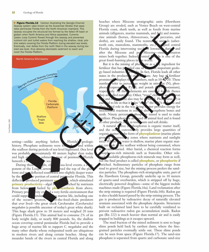
The Georgia Channel Seaway (see Figures Florida.3 andFlorida.13) acted as a dynamic boundary by preventingnutrient-rich and turbid waters from negatively affectingthe carbonate sediment-producing factory for much of theMesozoic and up until the middle Oligocene. Probablyduring the extreme sea-level lowstand during the middleOligocene (approximately 28 mya), prograding river deltasfilled in the Georgia Channel Seaway so that, during theensuing sea-level highstand, quartz sediments could betransported across the seaway and onto the northern portionof the Florida Platform. Once reaching the platform, a long,complex transport pathway extended all the way downpeninsular Florida, terminating at the Pourtales Terrace, asubmarine erosional feature lying in 200 to 300 meters ofwater (Figure Florida.14). Beneath the Everglades and theFlorida Keys lies the Long Key Formation of the LateMiocene to Late Pliocene that contains quartz gravel and isapproximately 150 meters thick. How such significant quan-tities of siliciclastic sediment could travel such a great dis-tance down the highest part of the platform and be depositedin deep water has been the subject of some conjecture.
One theory says that much of the north to south trans-port occurred by longshore currents set up by breakingwaves on beaches. The extensive, linear beach ridges seenin aerial photos or in space imagery indicate that Floridahas been influenced by multiple sea-level fluctuations in thepast (see Figures Florida.1 and Florida.2). With a netsoutherly transport, sands and gravels in the surf zone asso-ciated with these paleoshorelines must have been the domi-nant mode of movement, terminating at the southern endof the Lake Wales Ridge—a primary geomorphologic fea-ture that extends down the peninsula. South of this feature,quartz sand and gravel transport occurred in a paleofluvialsystem, as shown by a southward-prograding delta systemthat probably terminated at the present location of theFlorida Keys. Here, river deltas probably introduced thesesediments into the marine system, which built a siliciclasticshelf and slope system that ultimately reached the 250- to400-meter-deep Pourtales Terrace. This concluded a nearly1,000-kilometer-long siliciclastic sediment transport systemthat began with quartz sediments being released from thebasement rocks that form the Piedmont and Blue Ridge ofthe southern Appalachian Mountains.
In the Pleistocene, carbonate sedimentation conditionsreturned, and these siliciclastic sediments were covered andburied beneath what are now the Everglades and the Keys.
Phosphates—Changing the Platform’s OceanographicRegime During the Miocene, several specific events on theFlorida Platform converged to create a unique depositional
10 Geology of Florida
28390_01_body.qxd 1/16/09 10:00 AM Page 10
Florida.3 A Brief Geologic History of Florida 11
� Figure Florida.12 Geologic map of Florida illustrating exposure of Eocene-age and Oligocene-age limestone in the Big Bend area. Theexposed rocks are karstified and have an irregular surface that, when flooded, forms hundreds of marsh islands. The lack of sedimentary cover onthis karst surface and the low wave energy have formed this unusual marsh-dominated, open-marine coastline.
From
the
Flor
ida
Geol
ogic
al S
urve
y
28390_01_body.qxd 1/16/09 10:00 AM Page 11
setting—unlike anything before in Florida’s geologichistory. Phosphate sediments were formed on and withinthe seafloor during periods of sea-level highstand. (Sea levelwas probably approximately 40 meters higher than todayand high enough to submerge most of peninsular Floridabeneath a broad, shallow sea.
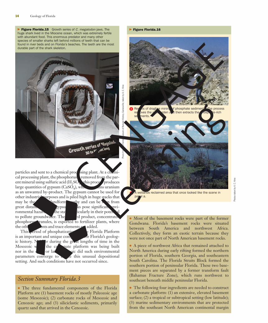
During these multiple, elevated sea-level events, a com-ponent of the Loop Current traversed the top of the plat-form and was deflected southward into slightly deeper waterby the shallower portion of central peninsular Florida. Thisdeflection produced persistent upwelling, which stimulatedprimary productivity—algal blooms enriched by nutrientsfrom below and fueled by photosynthesis from above.Primary productivity created a very fertile environment thatcould support abundant complex marine life, including oneof the ocean’s greatest, top-of-the-food-chain predatorsthat ever lived—the great shark Carcharodon (Carcharocles)megalodon (a possible ancestor of today’s great white shark).This huge shark grew to 18 meters and weighed 20 tons(Figure Florida.15). This animal had to consume 2% of itsbody weight daily, or nearly 800 pounds. So, the shallowocean covering central peninsular Florida had to provide ahuge array of marine life to support C. megalodon and themany other sharks whose redeposited teeth are ubiquitousin modern rivers and along certain beaches. Along themeander bends of the rivers in central Florida and along
12 Geology of Florida
beaches where Miocene stratigraphic units (HawthornGroup) are eroded, such as Venice Beach on west-centralFlorida coast, shark teeth, as well as fossils from marineanimals (alligators, marine mammals, and fish) and nonma-rine animals (horses, rhinoceroses, bears, peccaries, andsloths), are easily found. The nonmarine animals (saber-tooth cats, mastodons, mammoths, etc.) occupied centralFlorida during intervening sea-level lowstands during andafter the Miocene and post-Miocene—resedimentationmixes both together. Indeed, central Florida is one of thegreat fossil-hunting places in the world.
But it is the mining of phosphate as a key ingredient forfertilizer that has provided one of the most important geolo-gy-based industries in Florida. In fact, Florida leads all otherstates in the production of phosphate. Any bag of fertilizerprominently displays three numbers, such as 10-15-20. Thesenumbers refer to percentage weight in nitrogen (N), phos-phorus (expressed as P2O5), and potash (K2O—potassium),respectively. All three elements are essential for life (hencethey are called nutrients). Other, “trace” elements such as iron(Fe) and copper (Cu) also may be included. Phosphorus (P) isessential to life in that it helps “shape” the DNA molecule andplays a vital role in the way living matter provides energy forbiochemical reactions in cells; it also strengthens bones andteeth. Ninety percent of phosphate mined is used to makefertilizer. Phosphorus is also used in animal feed and is foundin other products, such as toothpaste and soft drinks.
A natural source of phosphorus is organic matter itself,and the ocean conveniently provides large quantities oforganic matter in the form of phytoplankton (marine plantsgrowing in upwelling zones where nutrients and sunlightmix). Where the water is shallow, marine plant organic mat-ter can sink to the seafloor without being consumed, whereit becomes buried. After burial, a chemical reaction formsphosphorus-rich minerals such as francolite. Other rela-tively insoluble phosphorus-rich minerals may form as well,but the final product is called phosphate, or phosphorite ifenriched. Sedimentary particles of phosphate range frommud to gravel size, but the mining process prefers the sand-size particles. The phosphate-rich stratigraphic units, part ofthe Hawthorn Group, generally underlie up to 10 metersof quartz-sand overburden, which is stripped off by huge,electrically powered draglines—some of the biggest mobilemachines made (Figure Florida.16a). Land reclamation afterthe strip mining is required (Figure Florida.16b). Radon gasis also a health hazard posed by the strip-mining process. Thegas is produced by radioactive decay of naturally elevateduranium associated with the phosphate deposits. Structuresbuilt on reclaimed land have to be carefully ventilated toprevent radioactive radon gas accumulation inside. Radongas (Rn 222) is much heavier than normal air and is easilytrapped in buildings as it escapes upward.
The mud fraction of the mined sediment is sent to hugeslime ponds held back by earthen dams, where the fine-grained particles eventually settle out. These slime pondscan be seen from space (Figure Florida.17). The sand-sizephosphate is separated from quartz and carbonate sand-size
Georgia Channel Seaway Complex
FloridaCarbonatePlatform
North America Siliciclastics
ShallowTropicSeas Bahama
PlatformBahamaPlatform
� Figure Florida.13 Cartoon illustrating the Georgia ChannelSeaway system (also known as the Suwannee Straits) that sepa-rates peninsular Florida from the North American mainland. Thisseaway occupies the structural low formed by the failed rift basin orgraben when North America and Africa separated. Currents(paleo–Loop Current) flowed through this seaway and preventednutrient-rich and turbid waters from reaching the shallow, clear, pris-tine waters covering the Florida Platform during elevated sea levels.Eventually, river deltas from the north filled in the seaway during low-ered sea level, thus allowing siliciclastic sediment to reach andcover the Florida Platform.
From
Red
fern
, 200
1
28390_01_body.qxd 1/16/09 10:00 AM Page 12
Florida.3 A Brief Geologic History of Florida 13
� Figure Florida.14 Depiction of the siliciclastic sediment transport pathway extending from south Georgia to the Straits of Florida. Sedimentswere transported by longshore transport and formed multiple shorelines down most of peninsular Florida. These sediments were further transportedto the south, probably via high-discharge, local rivers and streams, and formed river deltas that extended to the Florida Keys. Marine currents anddownslope sediment gravity processes carried the siliciclastics into the deep water of the Straits of Florida.
From
Hin
e et
al.,
in p
ress
28390_01_body.qxd 1/16/09 10:00 AM Page 13
particles and sent to a chemical processing plant. At a chemi-cal processing plant, the phosphorus is removed from the par-ent mineral using sulfuric acid (H2SO4); this process produceslarge quantities of gypsum (CaSO4), which contains uraniumas an unwanted by-product. The gypsum cannot be used forother industrial purposes and is piled high in huge stacks thatmay be the highest landform nearby and can be seen fromgreat distances. These gypsum stacks pose significant envi-ronmental hazards for the state, particularly in their potentialto pollute groundwater. The finished product, concentratedphosphorus granules, is exported to fertilizer plants, wherethe other nutrients and trace elements are added.
This period of phosphatization on the Florida Platformis an important and unique component for Florida’s geolog-ic history. Neither during the great lengths of time in theMesozoic while the carbonate platform was being builtnor in the early or late Cenozoic did such environmentalparameters converge to create this unusual depositionalsetting. And such conditions have not occurred since.
14 Geology of Florida
Section Summary Florida.3 ● The three fundamental components of the FloridaPlatform are (1) basement rocks of mostly Paleozoic age(some Mesozoic); (2) carbonate rocks of Mesozoic andCenozoic age; and (3) siliciclastic sediments, primarilyquartz sand that arrived in the Cenozoic.
� Figure Florida.15 Growth series of C. megalodon jaws. Thehuge shark lived in the Miocene ocean, which was extremely fertilewith abundant food. This enormous predator and many otherspecies of smaller sharks left behind millions of teeth that can befound in river beds and on Florida’s beaches. The teeth are the mostdurable part of the shark skeleton.
Phot
o fro
m th
e Fl
orid
a M
useu
m o
f Nat
ural
His
tory
, Gai
nesv
ille;
take
n by
A. C
. Hin
e
� Figure Florida.16
A wetlands reclaimed area that once looked like the scene inpanel a.
Results of dragline mining of phosphate sediments. The processremoves the overburden and then extracts the phosphate-richsediments.
a
b
Phot
os ta
ken
by A
. C. H
ine
● Most of the basement rocks were part of the formerGondwana. Florida’s basement rocks were situatedbetween South America and northwest Africa.Collectively, they form an exotic terrain because theywere not once part of North American basement rocks.
● A piece of northwest Africa that remained attached toNorth America during early rifting formed the northernportion of Florida, southern Georgia, and southeasternSouth Carolina. The Florida Straits Block formed thesouthern portion of peninsular Florida. These two base-ment pieces are separated by a former transform fault(Bahamas Fracture Zone), which runs northwest tosoutheast beneath middle peninsular Florida.
● The following four ingredients are needed to constructa carbonate platform: (1) an extensive, elevated basementsurface; (2) a tropical or subtropical setting (low latitude);(3) marine sedimentary environments that are protectedfrom the southeast North American continental margin
28390_01_body.qxd 1/16/09 10:00 AM Page 14
Florida.3 A Brief Geologic History of Florida 15
� Figure Florida.17 Digital orthophoto quarter quadrangle image of slime ponds in central peninsularFlorida. These are huge artificial bodies of water supported by earthen dikes into which muddy water isplaced so that the fine-grained particles separated from the coarser sediment can settle out of suspen-sion. The water is then recycled.
influences; and (4) early, rapid subsidence that providesthe required accommodation space for thick carbonatestratigraphic units to fill in.
● In a wide, shallow carbonate platform, water exchangewith the open ocean is greatly reduced. This leads toincreased salinity because of evaporation. Eventually thisleads to the precipitation of evaporite minerals.
● Carbonate-producing sedimentary environments(carbonate factory) may not be able to produce or retainsediments (because of export) to keep up with sea-level rise or long-term tectonic subsidence or both. Ifthe carbonate platform and its carbonate sediment-producing factory cannot keep up, it becomessubmerged deeper and deeper with time. With sub-mergence into darkness, the light-dependent, benthicorganisms can no longer exist because the seafloor hassubsided below the photic zone. Thus, the platform is“drowned.”
● A carbonate-rimmed margin has a shallow reef and/orislands perched along the edge just before the platformdrops off abruptly into deeper water. A carbonate rampis a shelf that deepens gradually seaward.
● The middle Cretaceous is known as the period ofGreenhouse Earth because of the elevated CO2 levels,enhanced warmth, lack of ice, and elevated sea level.
● The Yucatan–Florida–Bahamas Platform complex wasdeformed when the southern extent of the complex wasuplifted and incorporated into Cuba. Also, the southernStraits of Florida were probably formed as a result offlexural loading during the collision.
● The meteorite (bolide) that struck the YucatanPeninsula, defining the K/T boundary, might havecaused the collapse of the carbonate platform marginsleading to submarine landslides. Coarse sediments mayhave been transported onto and across the FloridaPlatform as a result of the tsunami washing over it.However, to date no evidence of this impact event hasbeen found within the Florida Platform.
● Fracturing of rocks leads to enhanced permeability,slightly acidic rainfall, and mixing of different salinitywater masses. This mixing creates slightly undersaturatedwater (with respect to calcium carbonate) that is capable ofdissolving limestone. The process of dissolving carbonaterock forms cavities within the rock—some of which col-lapse, creating sinkholes on the surface. Sinkhole for-mation and “acid-etching” of the surface carbonates bothcreate karst topography.
● Widespread dissolution of carbonate rocks produces alarge aquifer. Flowing water in the aquifer provides arich water resource for humans.
28390_01_body.qxd 1/16/09 10:00 AM Page 15
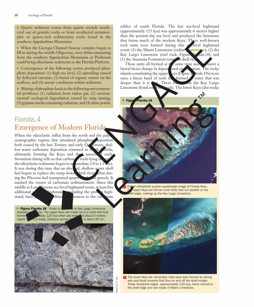
edifice of south Florida. The last sea-level highstand(approximately 125 kya) was approximately 6 meters higherthan the present-day sea level and produced the limestonethat forms much of the modern Keys. Three well-knownrock units were formed during this sea-level highstandevent: (1) the Miami Limestone (oolitic grainstone), (2) theKey Largo Limestone (reef rock; Figure Florida.18), and(3) the Anastasia Formation (coquina shell rich).
These units all formed at the same time and represent alateral facies change in depositional environment. The rockyislands constituting the upper Keys (Figure Florida.19a) wereonce a linear band of reefs that formed in water that wasdeeper than it is now. These rocks form the Key LargoLimestone (fossil coral reef rock). The lower Keys (also rocky
16 Geology of Florida
Florida.4Emergence of Modern FloridaWhen the siliciclastic influx from the north and the paleo-ceanographic regime that simulated phosphate depositionboth ceased by the late Tertiary and early Quaternary, shal-low-water carbonate deposition returned to south Florida,ultimately forming the Keys and their associated reefs.Strontium dating tells us that carbonate rocks lying on top ofthe siliciclastic sediments began to accumulate 2.0 to 1.5 mya.It was during this time that an elevated, shallow-water shelfhad begun to replace the ramp down which river deltas dur-ing the Pliocene had transported quartz sands and gravels. Itmarked the return of carbonate sedimentation. Since thismiddle to Late Pliocene sea-level highstand event, at least fiveadditional sea-level highstands, including the present high-stand, have provided additional sequences to the carbonate
� Figure Florida.18 Fossil in situ coral in Key Largo Limestoneexposed in outcrop. The upper Keys are made up of a coral reef thatformed approximately 125 kya when sea level was about 6 metershigher than it is today. Distance across the image is about 60 cm.
Phot
o by
A. C
. Hin
e
� Figure Florida.19
The lower Keys are cemented, tidal sand bars formed by strongebb-and-flood currents that flow on and off the shelf margin.These limestone ridges, approximately 125 kya, trend normal tothe shelf edge and are made of Miami Limestone.
Digital orthophoto quarter quadrangle image of Florida Keys.The upper Keys are former coral reefs that run parallel to theshelf edge, making up the Key Largo Limestone.
a
b
● Quartz sediment comes from quartz crystals weath-ered out of granitic rocks or from weathered metamor-phic or quartz-rich sedimentary rocks found in thesouthern Appalachian Mountains.
● When the Georgia Channel Seaway complex began tofill in during the middle Oligocene, river deltas emanatingfrom the southern Appalachian Mountains or Piedmontcould bring siliciclastic sediments to the Florida Platform.
● Convergence of the following events produced phos-phate deposition: (1) high sea level, (2) upwelling causedby deflected currents, (3) burial of organic matter on theseafloor, and (4) anoxic conditions within sediment.
● Mining of phosphate leads to the following environmen-tal problems: (1) radiation from radon gas, (2) environ-mental/ ecological degradation caused by strip mining,(3) gypsum stacks containing radiation, and (4) slime ponds.
28390_01_body.qxd 1/16/09 10:00 AM Page 16
islands, but not fossil coral reefs) to the south, and the area inMiami area to the north, were tidal bars formed by strongebb-and-flood tidal currents that flowed on and off the shelfmargin (Figure Florida.19b).
The lower Keys are fundamentally different in terms ofgeomorphology and lithology than the upper Keys becausethey are made of cemented oolitic grainstone (a type ofcarbonate, sand-size sediment) and not reef rock. Theseformer tidal bars also lie north of the upper Keys reef rockand extend to the boundary between Broward and PalmBeach counties.
These individual islands (the former tidal bars) are ori-ented normal to the bank edge, in contrast to the upper Keys,which run parallel to the bank edge. The reef rock (commonlycalled keystone) of the upper Keys was mined extensively atWindley Key—now the Windley Key Fossil Reef State Park(http://www.floridastateparks.org/windleykey)—where exca-vations reveal hundreds if not thousands of fossil corals intheir original growth position (see Figure Florida.18). It isone of the best coral reef outcrops in the United States.These reef rocks have been the source of the facing stoneused for many building in south Florida.
The Miami Limestone and the Key Largo Limestonehave been subaerially exposed for approximately 125 k.y. A
Florida.4 Emergence of Modern Florida 17
distinctive feature covering these rocks is a red imperme-able crust called caliche (also called duricrust)—a lithifiedpaleosol that formed during this 125 k.y. time frame. Thereddish color comes from their 4% to 6% iron content,derived from atmospheric dust that arrived from Africa.Actually, the various Pleistocene-age carbonate formationswithin the Miami and Key Largo Limestones are defined bysimilar crusts, making these features significant stratigraphicmarkers.
Finally, near Boca Raton, the Miami Limestone interfin-gers with the Anastasia Formation, which extends north-ward along the east coast of Florida.
WetlandsFlorida is well-known for its freshwater wetlands, which resultfrom the state’s flat topography, low elevation, high watertable, poor surface drainage, and humid subtropical climate.Starting with the Okefenokee Swamp mostly in south Georgia(which is partially drained by Florida’s Suwannee River) andextending south to where the Everglades discharges intoFlorida Bay, wetlands commonly dominate the state’s scenery(Figure Florida.20). Originally viewed as useless swamplandthat provided breeding areas for disease-carrying mosquitoes,these areas once were drained by digging canals. But wetlands
� Figure Florida.20 Distribution of rivers and wetlands in Florida. Wetlands, including the Everglades,are numerous in Florida because of its flat terrain, restricted drainage, low elevation, and humid climate.
Map
from
U.S
. Geo
logi
cal S
urve
y
28390_01_body.qxd 1/16/09 10:01 AM Page 17
now are viewed as critically important environments andecological habitats and are mostly protected.
From a geologic perspective, wetlands are modernequivalents of ancient coal-forming environments.Geologists have used the lower coastal plain of the south-eastern United States, including north Florida, as a modernanalog to explain the abundant Carboniferous coal depositsmined in the Appalachian Mountains of Kentucky, WestVirginia, and Pennsylvania. Other important wetlands areassociated with slow-moving streams such as theWithlacoochee River (Green Swamp) and the KissimmeeRiver. Finally, wetlands are potentially important archeo-logical sites because of the anoxic conditions (good forpreservation) found in their organic-rich sediments.
A discussion of the geology of Florida would not be com-plete without mention of the Everglades, a unique wetlandenvironment on Earth and the third largest national park(by area) in the lower 48 states (Figures Florida.21a andFlorida.21b). The Everglades is better known for its ecologyand its wildlife than as a geologic environment. Most likely,such “rivers of grass” were probably more common in the geo-logic past, particularly during the extreme sea-level highstandsthat flooded low-lying subtropical and tropical continents.
The Everglades, 60 kilometers wide and 160 kilometerslong, dominates the geography of south Florida. A southward-moving sheet of freshwater supports mainly saw grass(Cladium jamaicense). The Everglades is laterally confined tosouth-central peninsular Florida by higher terrain on boththe eastern and the western margins. It rests on a broad,flat, nearly featureless carbonate rock surface, whichformed the floor of a shelf lagoon during the last inter-glacial event approximately 125 kya, when sea level wasabout 6 meters higher than it is today. When subaeriallyexposed during the ensuing sea-level lowstand, the carbon-ate sediments deposited on the seafloor became cementedand formed the base of the Everglades.
The Everglades is an unusual environment, whichrequired a confluence of unusual conditions to form: (1) abroad, low-relief gently sloping surface; (2) a surface posi-tioned nearly at sea level so that there is a broad transitionbetween nonmarine and marine environments; (3) a surfaceflow of water laterally confined by elevated margins; (4) suffi-cient rainfall; (5) no substantive vertical exchange withpermeable units beneath to reduce surface runoff; and(6) oxidation of organic matter so that wide, expansive, andhighly water-tolerant grasslands grow rather than heavilywooded swamps. However, in some depressions in theEverglades, approximately 4 meters of mangrove peat haveaccumulated. But, for the most part, over great expanses, thePleistocene limestone karst surface is exposed. In some areas,this karst limestone surface is overlain by up to 1 meter ofcalcite mud, the precipitate of carbonate-charged freshwater.
The Everglades has been greatly affected by humandevelopment in south Florida. About 50% of the originalarea of the Everglades has been converted to agriculture.The diversion of water flow, the heavy use of fertilizers, andthe introduction of exotic plant and animal species form thegreatest environmental threats. Additionally, the specter
18 Geology of Florida
of rising sea level caused by global climate change couldconvert this vast wetland into a shallow, open sea with onlya 1- to 2-meter rise, which some predict might happen inthe next 100 to 200 years. The Everglades is at a crucialpoint in its history: it appears that human activity, eitherdirectly or indirectly, may cause this unique environment toshift upslope further landward or even disappear.
CoastlinesFlorida has one of the longest coastlines in the UnitedStates, and it is this feature, perhaps, that draws so manypeople to the state (see cover photo). Beautiful beaches (seeFigures Florida.22 and Florida.23) have made Florida’scoastline world famous, but, surprisingly, as much as 33% ofthe coast consists of sand-barren, rocky, and vegetated
� Figure Florida.21
Oblique aerial photo of western portion of Everglades revealingwide expanses of very shallow water and plant communitiestypical of this environment.
Digital orthophoto quarter quadrangle (DOQQ) image of theEverglades. This freshwater “river of grass” is confined laterally bytopographically higher areas so that flow is directed to the southinto Florida Bay—a very low-energy carbonate mud-dominatedenvironment. This is one of the most unusual geologic andbiologic environments on Earth.
a
b
Tom
Sco
tt, F
lorid
a Ge
olog
ical
Sur
vey
28390_01_body.qxd 1/16/09 10:01 AM Page 18
(marsh and mangrove) zones. From the western Panhandleto Key West, and up to Jacksonville, there is enormouscoastal variability resulting from differences in sedimentsupply, biologic activity, wave energy, tidal range, storm fre-quency, and climate. Pensacola and Key West enjoy signifi-cantly different climates and therefore significantly differentcoastal environments, ranging from washover-dominatedsandy barrier islands along the northern Gulf coast toPleistocene-age reefs and lithified submarine carbonate sandbores that form the Keys. Figure Florida.24 shows the fiveprimary coastal compartments that define Florida’s coast-line. These compartments can be divided into two majorcoastal types: (1) barrier islands or (2) plant dominated. Thecoastline of the islands forming the Keys is generally highlyvariable, ranging from rocky and small pocket beaches toplant-dominated coastline, and is not included in thisscheme. No barrier islands occur in the Florida Keys.
Barrier Islands Florida’s barrier islands constitute thesingle largest coastline category and dominate the state’s eastcoast. Barrier islands are the coastal features that are the mostheavily affected by development, and they also are extremelyvulnerable to chronic erosion, storm-surge flooding, andinlet migration. Hence most coastal engineering structuresare found along barrier-island coastlines. Managing coastaldevelopment is a huge environmental issue in Florida. Also,densely populated areas pose large risks during hurricaneseason, for both people and infrastructure.
The barrier islands are geologically young features—most formed in the past few thousand years, probably as aresult of reduced rate of sea-level rise in the late Holocene.It was during this time, when there was an abundance ofsand, that barrier islands prograded, or built seaward, bycreating beach ridges and widened. These islands eventuallysupported maritime forests. Sanibel Island is an outstandingexample of this process, with its multiple beach ridgescovered with trees (Figure Florida.25a). Where local orregional sand supply was reduced, washover-dominatedbarrier islands formed. These narrow, topographically lowerislands were (and are) more frequently flooded by stormsurge, which causes water-carrying sand to flow from theseaward side into the back-barrier lagoon. Through thisprocess these islands migrate or transgress landward.Barrier island migration poses huge problems for humanhabitation and development because of the seaward-sidesand loss. Santa Rosa Island along the Panhandle is agood example of a washover-dominated barrier island(Figure Florida.25b). Where heavily developed, many ofthese islands support lengthy seawalls and require frequentsand replenishment.
Florida.4 Emergence of Modern Florida 19
� Figure Florida.22 Typical “Chamber of Commerce” beachscene in Florida. Sands are almost entirely composed of quartz.
� Figure Florida.23 Red mangrove (Rhizophora mangle) that iscommonly found in low energy coastal environments of centralFlorida. These plants dominate the Ten Thousand Islands coastalzone of southwest Florida.
88° W31°30’ N
APALACHICOLARIVERDELTANORTHWEST BARRIER
CHAIN
79° W31°30’ N
88° W24° N
GULF OF M
EXICO
GULF OF M
EXICO
ATL
AN
TIC
OCE
AN
ATL
AN
TIC
OCE
AN
GULF OF M
EXICO
FLORID
A
ATL
AN
TIC
OCE
AN
79° W24° N
BIG BEND
MARSH CO
ASTW
EST-CENTRA
L BARRIER
CHA
IN
TEN THOUSAND IS.TEN THOUSAND IS.MANGROVE COASTMANGROVE COASTTEN THOUSAND IS.MANGROVE COAST
FLORID
A
EAST CO
AST BA
RRIER CHA
IN
EVERGLADES
200 m
200
m
� Figure Florida.24 Map showing five major coastal sectors ofFlorida. Most people know about Florida’s famous white, sandybeaches, but approximately 33% of Florida’s coastline is dominatedby plants and mud.
Image of Santa Rosa Island on the western Florida Panhandle coast. This is a washover-dominatedisland that is easily flooded during storm surges. The flooding erodes sand from the seaward side anddeposits it on the lagoon side, causing the entire island to migrate landward.
DOQQ image of Sanibel Island—a seaward-prograding, beach ridge–and maritime forest–dominatedbarrier island. This type of island has an abundance of sand because it lies at the end of a longshoretransport system.
a
b
28390_01_body.qxd 1/16/09 10:02 AM Page 20
Florida.4 Emergence of Modern Florida 21
� Figure Florida.26 Digital orthophoto quarter quadrangle image of Caladesi Island. This is an impor-tant barrier island to visit because it displays a range of geologic and biologic environments.
The length of a barrier island is defined by its tidalinlets, which allow tidal waters in lagoons to be exchangedwith the open ocean. The inlets are unstable because of thelongshore transport of sand in the surf zone moving alongadjacent beaches, causing inlets to migrate laterally or fillin. Stabilizing the inlets has also posed an enormous coastalmanagement issue—one that is controversial and costly.
An excellent example of a barrier island that demonstratesa variety of geomorphologic and environmental features isCaladesi Island in Pinellas County (Figure Florida.26). Theisland is a state park accessible only by boat. The island sup-ports a back-barrier mangrove, a maritime forest on beachridges (former dune ridges), and actively forming vegetateddunes. It also features a closed, or filled, inlet to the south andan active inlet to the north. The north end of this island hasbeen overwashed by storm surges.
Florida’s barrier-island coast also contains two distinctmajor geomorphologic features: (1) the Apalachicola RiverDelta, rimmed by beach ridge–dominated barrier islandsprojecting out into the Gulf of Mexico, and (2) the CapeCanaveral cuspate foreland that projects out into theAtlantic Ocean on the east coast (Figure Florida.27a andFlorida.27b). Aerial and space imagery clearly shows thatcuspate forelands formed in this location during previoussea-level highstands, suggesting that this coastal featuremight be controlled by underlying antecedent topography.
Plant-Dominated Coastlines—Big Bend CoastlineFlorida’s Gulf of Mexico coast has two large sectors that lacksufficient sand to form barrier islands. Additionally, bothhave very low wave energy. Hence they are dominated byplants. In the Big Bend area, karstified Eocene to Oligocenelimestone crops out (see Figure Florida.12) and supports athin muddy marsh dominated by Juncus roemerianus—orblack needle rush (Figure Florida.28a and Florida.28b). Thisarea receives sufficiently frequent freezes to make survival ofmangroves impossible. Karst bedrock high areas in themarsh support small islands of trees called marsh hammocks.Offshore, these bedrock nubs support oyster reefs—some ofthese massive shell beds extend for tens of kilometers in thenearshore zone parallel to the marsh coast. Marsh tidalcreeks commonly follow rectilinear joint patterns in thebedrock rather than meandering freely. Because of the verylow topographic gradient on the limestone bedrock surface(1/5,000 ratio), the Big Bend area has very low wave energyand may be viewed as an incipient epicontinental sea.
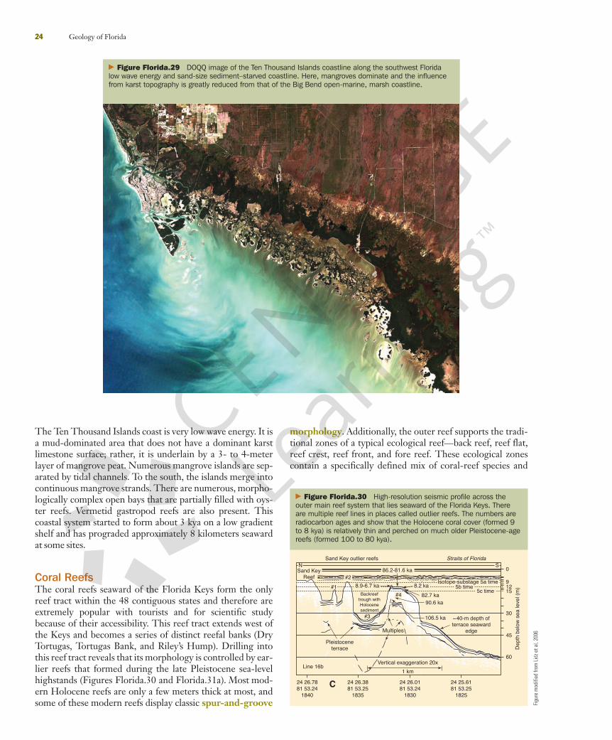
Plant-Dominated Coastlines—Ten Thousand IslandsSouth of the west-central barrier islands (extending just northof Tampa Bay to just south of Naples) are the Ten ThousandIslands, which are mangrove islands (Figure Florida.29).Mangroves outcompete marsh grasses in warmer climates, sothis area appears vastly differently than the Big Bend coast.
28390_01_body.qxd 1/16/09 10:02 AM Page 21
22 Geology of Florida
� Figure Florida.27
DOQQ image of the Cape Canaveral cuspate foreland showing the modern featureand a Pleistocene-age counterpart just landward. A cuspate foreland along this partof Florida’s east coast has probably been present over many sea-level fluctuations.Its location may be controlled be underlying antecedent topography or spatialchanges in offshore wave energy.
DOQQ image of St. Vincent Island—an excellent example of a beach ridge–dominated barrier island. This is one of the barrier islands rimming theApalachicola River Delta. These barrier islands occur here because of theabundance of sand once provided by the river delta.
a
b
28390_01_body.qxd 1/16/09 10:02 AM Page 22
Florida.4 Emergence of Modern Florida 23
� Figure Florida.28
DOQQ image of detail of a marsh-dominated coast illustrating numerous marshislands, oyster reefs, marsh peninsulas, and extensive tidal creeks (Crystal Bay).
DOQQ image of Florida’s Big Bend marsh-dominated coastline. The coastline is lowwave energy and is starved of sand-size sediment—hence no barrier islands and fewbeaches have developed. Instead, the irregular karst surface on exposed limestonesupports a thin, open-marine marsh. The karst topography controls the distribution ofmarsh islands, marsh hammocks, and tidal creeks.
a
b
28390_01_body.qxd 1/16/09 10:02 AM Page 23
24 Geology of Florida
The Ten Thousand Islands coast is very low wave energy. It isa mud-dominated area that does not have a dominant karstlimestone surface; rather, it is underlain by a 3- to 4-meterlayer of mangrove peat. Numerous mangrove islands are sep-arated by tidal channels. To the south, the islands merge intocontinuous mangrove strands. There are numerous, morpho-logically complex open bays that are partially filled with oys-ter reefs. Vermetid gastropod reefs are also present. Thiscoastal system started to form about 3 kya on a low gradientshelf and has prograded approximately 8 kilometers seawardat some sites.
Coral ReefsThe coral reefs seaward of the Florida Keys form the onlyreef tract within the 48 contiguous states and therefore areextremely popular with tourists and for scientific studybecause of their accessibility. This reef tract extends west ofthe Keys and becomes a series of distinct reefal banks (DryTortugas, Tortugas Bank, and Riley’s Hump). Drilling intothis reef tract reveals that its morphology is controlled by ear-lier reefs that formed during the late Pleistocene sea-levelhighstands (Figures Florida.30 and Florida.31a). Most mod-ern Holocene reefs are only a few meters thick at most, andsome of these modern reefs display classic spur-and-groove
morphology. Additionally, the outer reef supports the tradi-tional zones of a typical ecological reef—back reef, reef flat,reef crest, reef front, and fore reef. These ecological zonescontain a specifically defined mix of coral-reef species and
� Figure Florida.29 DOQQ image of the Ten Thousand Islands coastline along the southwest Floridalow wave energy and sand-size sediment–starved coastline. Here, mangroves dominate and the influencefrom karst topography is greatly reduced from that of the Big Bend open-marine, marsh coastline.
0
91215
30
45
24 25.6181 53.25
1825
24 26.0181 53.24
1830
Vertical exaggeration 20x
1 kmLine 16b
Pleistoceneterrace
~40-m depth ofterrace seaward
edge
90.6 ka
24 26.7881 53.24
1840
C 24 26.3881 53.25
1835
60
#1
#2
#3
Backreeftrough withHolocenesediment
8.9-6.7 ka
86.2-81.6 ka
Sand Key outlier reefs Straits of Florida
82.7 ka
Dep
th b
elow
sea
leve
l (m
)
106.5 ka
Multiples
NSand Key
Reef
S
#4
8.2 kaIsotope-substage 5a time
5b time5c time
� Figure Florida.30 High-resolution seismic profile across theouter main reef system that lies seaward of the Florida Keys. Thereare multiple reef lines in places called outlier reefs. The numbers areradiocarbon ages and show that the Holocene coral cover (formed 9to 8 kya) is relatively thin and perched on much older Pleistocene-agereefs (formed 100 to 80 kya).
Figu
re m
odifi
ed fr
om L
idz e
t al,
2006
28390_01_body.qxd 1/16/09 10:02 AM Page 24
Florida.4 Emergence of Modern Florida 25
� Figure Florida.31
Multibeam color image of the southern portion of Pulley Ridge,revealing a drowned barrier island that has been preservedbecause of rapid cementation of carbonate sands.
Multibeam color image showing detailed bathymetry ofRiley’s Hump reef bank.
a
b
Pane
l a fr
om M
allin
son
et a
l., 2
003;
pan
el b
from
Jar
rett
et a
l., 2
005
other benthic assemblages. Behind the more massive outerreefs are thousands of smaller patch reefs that were construct-ed by a less diverse coral fauna.
The Keys coral reefs, unfortunately, have experiencedwidespread environmental degradation. Several factorshave contributed to this: (1) extensive human infrastructureintroducing excessive nutrients and turbidity; (2) possiblyincreased sea surface temperatures; (3) possibly increasedultraviolet (UV) exposure; and (4) diseases introduced, per-haps, from African dust events. Additionally, even recentocean acidification may have an impact on the living coralcommunity far into the future, but this is highly speculativeat the moment. There are now widespread zones whereno living stony corals remain. In these areas, coral hasbeen replaced by soft coral, algal, and sponge benthiccommunities.
A recent discovery much farther to the west in muchdeeper water (65 to 75 meters) revealed a healthy light-dependent coral reef mantling a cemented paleoshoreline—Pulley Ridge (Figures Florida.31b, and Florida.32). Here,rather than having inimical shelf waters, this portionof the platform is bathed by oligotrophic waters fromLoop Current incursions, thus allowing the deepestlight-dependent coral reef on the U.S. continental shelfto thrive.
Section Florida.4 Summary● The Florida Keys are made up of the following threetypes of rock: (1) reef rock—Key Largo Limestone;(2) oolitic grainstone—Miami Limestone; and (3) paleo-sols, caliche, and duricrust.
● Florida has so many wetlands because of its flat topog-raphy, low elevation (near sea level), restricted drainageand high water table, and humid climate. The low,regional shelf gradient and sand-starved areas have pro-duced marsh- and mangrove-dominated coastlines thatlack beaches and barrier islands. Both are mud-dominatedsedimentary systems. The Big Bend marsh coast is situ-ated on a karst carbonate rock surface that controlsmuch of the coastal morphology. To the south, the TenThousand Island coastline is dominated by many man-grove islands. Mangrove plants are extremely sensitive tofreezes, so they rarely extend north of the Tampa Bayarea. Carbonate rock does not significantly affect thecoastal morphology along this coastline.
● If sea level rose a couple of meters, much of the low-lying Everglades would be flooded by seawater, whichwould form a broad, shallow, open sea.
● Washover-dominated barrier islands are topographi-cally low and are easily flooded during storm surges.This allows sand from the seaward beach to be trans-ported across the island. These islands migrate landwardinto their lagoons in this manner. Beach ridge–dominated
28390_01_body.qxd 1/16/09 10:02 AM Page 25
26 Geology of Florida
� Figure Florida.32 Bottom photo of the typically very thin, platy,light-dependent living corals on the Pulley Ridge drowned barrier-island shoreline. These corals are growing in 65 to 75 meters ofwater, making this the deepest known light-dependent coral reef onthe U.S. continental shelf.
Phot
ogra
phs
from
Tim
Tayl
or
barrier islands have an abundance of sand brought tothem in the longshore transport system, build dunes, aretopographically higher and prograde seaward.
● The topography created by former reef structuresaffects the formation of new coral reefs on the Floridashelf. Also, the marine environmental conditions (warm,clear, normal salinity) are ideal for coral reef development.
● Highly turbid, nutrient-rich marine waters that havelarge changes in temperature hinder development of coralreefs. Excess human infrastructure leads to pollution ofseawater, which also harms the reefs.
● The development of the deep coral reef at Pulley Ridgeresulted from a hard substrate in the form of a cemented-drowned beach ridge–dominated barrier island that wasfrequently bathed by very clear, oligotrophic waters.
AcknowledgmentsI would like to thank all of my graduate students who haveworked on various aspects of Florida’s geology, particularlythe marsh coastlines, the continental shelf, the paleoshore-lines, and the coral reefs. Special thanks go to Dr. StanleyD. Locker, whose expertise, imagination, and effort wereessential to the success of most of the fieldwork our groupperformed in Florida. Stan is simply amazing. I would liketo thank many people with whom I have worked over theyears or with whom I have discussed Florida geology issues,especially Richard (Skip) A. Davis, Stan Riggs, Bob Halley,Gene Shinn, Kevin Cunningham, Tom Missimer, PamelaHallock, Jeff Ryan, Hank Mullins, Conrad Neumann,Charlie Paull, Don McNeill, Dave Mallinson, Terry Edgar,Jack Kindinger, Dan Belknap, Tom Scott, Gren Draper,Hal Wanless, Dick Buffler, Bob Ginsburg, Barbara Lidz,
Ellen Prager, and Walt Jaap. The research performed wasfunded mostly by NOAA-Sea Grant, NOAA-NURC,ONR, USGS-St. Petersburg, and FL-DEP. Ann Tihanskyat the USGS has been a great help. The USGS provided anumber of images, as did the Florida Wildlife ResearchInstitute and the Florida Geological Survey. Gary Maddox,Florida Department of Environmental Protection, pro-vided an important image. Thanks go to Mr. Tim Taylor ofthe R/V Tiburon, Inc., for use of the underwater photos ofPulley Ridge. I thank Dr. David Palandro and ReneBaumstark for providing the vertical images (DOQQ) ofvarious sections of Florida. I thank the Florida GeologicalSurvey for much advice and assistance.
I thank two anonymous reviewers as well as Drs. DonMcNeill, Thomas Scott, Mark Stewart, Grenville Draper,and Eugene Shinn for reviewing sections of this chapter.
Review WorkbookESSENTIAL QUESTIONS SUMMARYFlorida.1 Introduction� What is the link between natural scenery and geology?All topography on Earth, from ocean basins and mountain ranges tosmall sinkholes, is controlled by past geological processes.Determining what those processes have been and when they occurredexplains how the shape of the Earth’s surface (and therefore scenerywith plants) was created.
� Why is geology important?Geology provides us with tools to understand the Earth’s past so thatwe can protect the present and prepare for the future. It is a sciencethat allows us to understand and mitigate hazards posed by Earth’sprocesses, to find raw materials needed to drive our modern society,
and to develop techniques to minimize human impact on naturalsystems.
� What are the primary geomorphologic features that dominate Florida’stopography?The primary geomorphologic features of Florida’s topography includepaleoshorelines, beach ridges, terraces, karst-formed lakes and depres-sions, rivers, and wetlands.
Florida.2 State of Florida and the Florida Platform� For coastal or island states, does geology end at the coastline, and why orwhy not?No, stratigraphic sections and geologic structures continue seawardbeneath the coastline, shelf and slope, ultimately reaching some othergeologic boundary or transition.
28390_01_body.qxd 1/16/09 10:02 AM Page 26
Review Workbook 27
� What geologic features define the Florida Platform?Faulted margins resulting from rifting or transcurrent motion definethe original Florida Platform before collision with the Antillesvolcanic island arc. The sedimentary cover and major morphologicfeatures are commonly controlled by the antecedent topographycreated by these structural features.
� What is a prominent former sea-level indicator?Two examples are preserved shorelines above or below present-daysea level and now-dead, former shallow-water coral reefs that lie indeep water.
Florida.3 A Brief Geologic History of Florida� What are the three fundamental components of the Florida Platform?The three fundamental components of the Florida Platform are(1) basement rocks of mostly Paleozoic age (some Mesozoic); (2) carbonate rocks of Mesozoic and Cenozoic age; and (3) siliciclasticsediments, primarily quartz sand, that arrived in the Cenozoic.
� Where did the basement rocks come from? Most of the basement rocks were part of the former Gondwana.Florida’s basement rocks were situated between South America andnorthwest Africa. Collectively, they formed an exotic terrain becausethey were not once part of North American basement rocks.
� What are the four basic ingredients needed to construct a carbonate platform?The following four ingredients are needed to construct a carbonateplatform:
1. An extensive, elevated basement surface.2. A tropical or subtropical setting (low latitude).
3. Marine sedimentary environments that are protected fromcontinental margin influences.4. Early, rapid subsidence that provides the required accommodationspace for thick carbonate stratigraphic units to fill in.
Florida.4 Emergence of Modern Florida� What types of rocks constitute the Florida Keys?The Florida Keys are made up of the following three types of rock:
� Why does Florida have so many wetlands?Florida has so many wetlands because of its flat topography, low ele-vation (near sea level), restricted drainage and high water table, andhumid climate.
� Why are there significant plant-dominated shorelines in Florida? The low, regional shelf gradient and sand-starved areas haveproduced marsh and mangrove-dominated coastlines that lackbeaches and barrier islands. Both are mud-dominated sedimentarysystems. The Big Bend marsh coast is situated on a karst carbonaterock surface that controls much of the coastal morphology. To thesouth, the Ten Thousand Island coastline is dominated by manymangrove islands. Mangrove plants are extremely sensitive tofreezes, so they rarely extend north of the Tampa Bay area.Carbonate rock does not significantly affect the coastal morphologyalong this coastline.
ESSENTIAL TERMS TO KNOWAccommodation space – the space in which sediments can accu-mulate, for example, a very shallow continental shelf has little accom-modation space (little water depth) in which sediments can buildvertically.
Anhydrite – evaporite mineral anhydrous calcium sulfate (CaSO4).
Antecedent topography – topography created from a previousgeologic event that might control follow-on geologic processes andsedimentation.
Antillean Orogeny – tectonic collision between the leading edgeof the northeast migrating Caribbean Plate supporting a volcanicisland arc system and a section of the passive margin of the NorthAmerican Plate supporting a carbonate platform system(Yucatan–Florida–Bahamas Platform complex). This collisionoccurred largely between 56 mya and 50 mya. The result of the colli-sion eventually created the modern Greater Antilles Islands of Cuba,Hispaniola, Puerto Rico, and Jamaica. See Orogeny.
Aquifer – a section of rock that is permeable and water bearing,from which groundwater can be easily extracted.
Artesian conditions – water that will flow upward out of a wellwithout need for pumping as a result of an aquifer being confined byan impermeable cover.
Bathymetry – measurement of depth below sea level in the ocean.
Beach ridges – a continuous line of sand dunes along a coastlinethat commonly is vegetated. They form when an abundance of sandis introduced to the beach by the longshore transport system, andthe sand dries out on the beach during low tide. Onshore windsthen blow the sand inland to be trapped by the first line ofvegetation. Here is where the beach ridge (actually a dune line)begins to form.
Bolide – a very large impactor. The United States Geological Surveyuses the term to mean a generic, large crater-forming projectile “to imply
that we do not know the precise nature of the impacting body . . . whether it is arocky or metallic asteroid, or an icy comet, for example”.
Carbonate factory – general term for a sedimentary depositionalsystem that generates carbonate sediments.
Chemosynthetic or Chemosynthesis – a biologic conversionof carbon molecules such as CO2 and nutrients into organic matterusing oxidation of inorganic molecules. The inorganic moleculesinclude hydrogen sulfide or methane as the source of energy ratherthan sunlight in photosynthesis.
Collision margin – continental landmass on a plate boundary thathas collided with another plate boundary. The west coast of SouthAmerica is a good example of a modern collision margin.
Cuspate foreland – a triangular, bulbous projection on a sandycoast caused by variations in direction and magnitude of thelongshore transport of sediment.
Epicontinental sea – a large body of shallow salt water thatoverlies a continent. Hudson Bay is a good example.
Evaporite – minerals formed by the evaporation of water—generallyseawater that becomes brine and the crystals form in the brine.
Exotic terrain – a body of continental crust that has been importedfrom another source area.
Facies – body of rock or sediment with specific or distinctivecharacteristics.
Feldspar – group of rock-forming minerals making up 60% of theEarth’s crust. They are K, Al, Ca, Na silicates.
Flexural loading – elastic response of crust when mass in form ofrocks, sediments, or water is placed on it.
Fracture zone – linear feature in ocean crust resulting from motionalong a transform fault.
Graben – a normal-fault-bounded linear basin.
28390_01_body.qxd 1/16/09 10:02 AM Page 27
Grainstone – a carbonate rock consisting of cemented, sand-sizecarbonate grains.
Gypsum – a common evaporite mineral (CaSO4-2H2O).
Hypersaline brines – waters that are super-enriched in dissolvedsalts.
Inimical shelf waters – seawater on the shelf that is harmful toreef growth because it is too warm, too cold, too nutrient rich, ortoo turbid.
Intraplate stress – tectonic forces transmitted within and insidea single tectonic plate sometimes deforming the plate interior.
Isostatic adjustment – a response of the crust when a load isplaced on it or removed; that is, the crust moves downward when anice sheet accumulates on it during an ice age and rebounds upwardwhen the ice sheet melts.
K/T boundary – time boundary between Cretaceous (abbreviatedas “K” by convention) and Tertiary (T) occurring 65.5 mya. It iswidely accepted that an extraterrestrial object (see Bolide) impactedthe Earth, forming a huge crater beneath the modern Yucatan. It isalso widely accepted that this event caused mass extinction of life,including extinction of the dinosaurs.
Lithology – a type of rock, e.g., granite, ooid grainstone.
Lithostatic load – a mass of rock or sediment placed on a section ofcrust (this can create an isostatic adjustment).
Longshore sand transport – movement of sand in the surf zonealong the beach by breaking waves.
Mixing zone – a groundwater condition whereby freshwater andsaltwater mix along a boundary generally in coastal areas. Where thisoccurs, dissolution of carbonate rock is accelerated.
Mogotes – geomorphologic features encountered in the Caribbean,especially in Cuba. They are hills (approximately 300 meters high)of limestone and represent mature karst topography. They arecharacterized by their rounded, towerlike structure.
Ocean acidification – decreasing pH or increasing acidity ofseawater caused when elevated CO2 in the atmosphere is absorbedinto the ocean.
Oceanic anoxic event (OAE) – when the Earth’s ocean becamedepleted of oxygen beneath the surface waters. OAEs occurred duringperiods of high CO2 and warm temperatures and caused massextinctions. The middle Cretaceous was a time of multiple OAEs.
Oceanic crust – denser portion of the Earth’s crust underlyingocean basins consisting of magnesium-rich and iron-rich silicateminerals. Extrusive rocks are basalts; intrusive rocks are gabbros.
Oligotrophic – water that is lacking in nutrients and thereforevery clear easily transmitting light.
Ooids/oolitic – sand-size carbonate grains that have a nucleus(e.g., skeletal fragment, fecal pellet) coated by layers of additionalcarbonate mineral. Oolitic means a mixture of ooids and othercarbonate sand-size sediment.
Orogeny – a mountain-building event caused by plate motion,leading to a collision of the edges of two plates.
Oxidation – loss of electrons by a molecule, atom, or ion. Carboncan be oxidized to make carbon dioxide (CO2).
Paleosol – a fossil soil horizon sometimes lithified to a form adistinctive crust.
Permeable – an ability of rocks or sediments to transmit fluid.Aquifers are permeable, so groundwater easily flows through them.
Phosphate – a charged group of atoms, or an ion made up of aphosphorus atom and four oxygen atoms (PO4) and carries three neg-ative charges. The phosphate ion combines with various atoms andmolecules within living organisms to form many different compoundsessential to life. It is the common name for sedimentary depositscontaining grains having minerals with the element phosphorus (P)in their structure.
Phosphorite – a sediment or rock with high concentration ofphosphate.
Photic zone – the depth of water within which photosynthesis canoccur. This is highly dependent on water clarity, but generally is lessthan 200 meters deep.
Photosynthesis – a biochemical process in which light energy(sunlight) is turned into chemical energy by using CO2 and H2Oto form organic matter and releasing O2.
Phytoplankton – group of microscopic plants that grow in thesurface waters of the ocean as a result of photosynthesis.Phytoplankton is the base of the ocean’s food chain.
Potentiometric surface – a potentiometric surface is theimaginary line where a given reservoir of fluid will “equalize out to”if allowed to flow vertically in an aquifer. Potentiometric surfacesexplain how phenomena like artesian wells occur.
Primary productivity – the production of plants or algae in thesurface waters by photosynthesis.
Prograded – building seaward, such as prograding river deltas orprograding shorelines.
Ramp – a carbonate shelf that gradually deepens further offshore.The west Florida shelf, Campeche Bank, and the Persian Gulf aregood examples.
Rectilinear fracture pattern – a fracture pattern in rocks orientedas right angles.
Rimmed margin – a carbonate shelf or platform that is flat andshallow and has an elevated depositional rim, such as coral reefsand/or islands seaward of which the platform drops off steeply intomuch deeper water. The Great Barrier Reef or windward margins ofthe Bahamas are good examples.
Rudistid – a type of bivalve (mollusk, now extinct) dominating andforming reefs in the Mesozoic. All reefs are not necessarily made ofcorals.
Sediment gravity flow – sedimentary process or deposit formed bysediment-laden, higher density bottom currents flowing downslope.
Siliciclastic – sediment that has a mineralogy containing silicon.Quartz is the dominant siliciclastic sediment.
Spur-and-groove morphology – a series of ridges and ravinesoriented downslope along the high-energy, seaward side of a reef.
Stratigraphic succession – a vertical section of sedimentary rocks(one sedimentary rock formation resting on top and thereforesucceeding the one below it).
Subduction zone – an area on Earth where two tectonic platesmeet and move toward one another, with one sliding underneath theother and moving down into the mantle, at rates typically measured incentimeters per year.
Transcurrent – a strike-slip, or horizontal motion along a large-scalefault system.
Transform fault – a special type of strike-slip fault that terminatesabruptly at spreading centers.
Transitional crust – a type of the Earth’s crust formed along riftedmargins that includes extension and mixing of continental and oceaniccrust.
28 Geology of Florida
28390_01_body.qxd 1/16/09 10:02 AM Page 28
Review Workbook 29
Tsunami – a series of waves created as the seafloor is rapidly displacedvertically. Earthquakes, mass movements (underwater landslides), somevolcanic eruptions, large asteroid impacts, and testing of nuclearweapons at sea all have the potential to generate a tsunami.
Unconformity – a buried erosion surface separating two rock mass-es or strata of different ages, indicating that sediment deposition wasnot continuous.
Upwelling – water that is brought up from the depth by currents.Generally, these waters are enriched in nutrients.
Vermetid – a marine gastropod (snail) that forms calcareous shelltubes in masses and creates reefs.
Volcanic island arc – a chain of volcanic islands formed by platetectonics as an oceanic tectonic plate subducts under another tectonicplate and produces magma.
Washover – sand deposited on a barrier island type of coastline dur-ing a storm.
Wilson cycle – the opening and closing of an ocean basin.
What fundamentally controls the shape of a state’s coastline overvarious geologic time periods?
How did the Gulf of Mexico form?
Explain why there are two components of Florida’s basement rocks.
Why would a wide, shallow carbonate platform produce evaporiteminerals?
What is meant by platform drowning?
What is the difference between a rimmed margin and a ramp?
What is the Greenhouse Earth?
How was the Yucatan–Florida–Bahamas Platform complex deformed?
What might have been the effects on the Florida Platform resultingfrom the bolide impact at the K-T boundary?
What ingredients are necessary for extensive internal and surficialkarst features to develop?
Do springs always produce cool freshwater?
Of what importance is the dissolution of carbonate rocks in theFlorida Platform?
Where does the quartz sediment originate?
How and when were quartz-rich sediments introduced onto theFlorida Platform?
Which events converged to produce phosphate deposition?
Why were there so many large marine predators in the Miocene?
Why are marine and terrestrial fossils mixed together?
What are some of the environmental problems associated withmining phosphate?
If sea level rose a couple of meters, what would the Everglades looklike?
What is the primary difference between a washover-dominatedbarrier island and a beach ridge–dominated barrier island?
What is a fundamental control on the distribution of coral reefs onthe Florida shelf?
Review Questions
Bryan, J. R., Scott, T. M., & Means, G. H. (2008). Roadside geology ofFlorida. Missoula, MT: Mountain Press Publishing.
Cape Canaveral National Seashore: http://www.nps.gov/cana/
Everglades National Park: http://nps.gov/ever/
Florida Association of Professional Geologists: http://fapg.aipg.org
Florida Department of Environmental Protection:http://www.dep.state.fl.us/coastal/
Florida Fish and Wildlife Research Institute:http://floridamarine.org/
U.S. Geological Survey in Florida: http://fisc.er.usgs.gov/
Windley Key Fossil Reef Geological State Park: http://www.floridastateparks.org/windleykey/default.cfm
Florida Resources
1. Calculate the average rate of subsidence of the edge of the westernmargin of the Florida Platform since the time of the middleCretaceous unconformity or sequence boundary. You will need todetermine the depth below modern-day sea level of this surface andthe age of the middle Cretaceous (answer is in one of the figures). Ifsea level was approximately 200 m higher at that point in time, howwould it factor into your calculation? Now, assuming the westernmargin of Florida Platform was in shallow water at the time of themiddle Cretaceous, how fast would it take to drown this area given aphotic zone that is 200 m deep? What other factors would have to beconsidered in this calculation?
2. If the west Florida shelf has a gradient of 1:3000, what was theaverage rate of shoreline movement (horizontal translation) over thepast 18,000 years when sea level was approximately 120 m lower thanit is today as a result of the Last Glacial Maximum?
3. Using Google Earth imagery, print out a section of centralpeninsular Florida and map the major geomorphologic features.
Apply Your Knowledge Questions
28390_01_body.qxd 1/16/09 10:02 AM Page 29
Geology of FloridaAlbert C. HineCollege of Marine ScienceUniversity of South Florida
The geologic past of Florida is mostly out of sight with its maximum elevation atonly ~105 m (in the panhandle) and much of south Florida is virtually flat. Thesurface of Florida is dominated by subtle shorelines from previous sea-levelhigh-stands, karst-generated lakes, and small river drainage basins What we seeare modern geologic (and biologic) environments, some that are world famoussuch as the Everglades, the coral reefs, and the beaches. But, where did all of thiscome from? Does Florida have a geologic history other than the usual mantraabout having been “derived from the sea”? If so, what events of the geologic pastconverged to produce the Florida we see today?
To answer these questions, this module has two objectives: (1) to provide a rapidtransit through geologic time to describe the key events of Florida’s past emphasizingprocesses, and (2) to present the high-profile modern geologic features in Florida thathave made the State a world-class destination for visitors.
About the AuthorAlbert C. Hine is the Associate Dean and Professor in the College of MarineScience at the University of South Florida. He earned his A.B. from DartmouthCollege; M.S. from the University of Massachusetts, Amherst; and Ph.D. from theUniversity of South Carolina, Columbia—all in the geological sciences. Dr. Hineis a broadly-trained geological oceanographer who has addressed sedimentarygeology and stratigraphy problems from the estuarine system out to the base ofslope. Along with his associates and graduate students, they have defined theresponse of coastal and shelf depositional systems to sea-level fluctuations,climate changes, western boundary currents, antecedent topography, and sedimentsupply. Specifically this includes geologic origin and evolution of submerged paleo-shorelines, reefs (relict and active), shelf sand bodies, open marine marsh systems,barrier islands, and back-barrier environments and how they might have interactedwith each other in the past.
Areas of specialization for Dr. Hine include: Geologic processes and products ofshallow marine sedimentary environments. Development, history, stratigraphy, andsedimentation of carbonate platforms. Coastal geology, coastal wetlands, sequencestratigraphy, interpretation of seismic reflection data and seafloor mapping andinterpretation.
Visit Cengage LearningCustom Solutions online at www.cengagecustom.com
For your lifelong learning needs:www.academic.cengage.com
Oblique aerial photograph ofa barrier island (Cayo Costa)on Florida’s Gulf of Mexicocoastline that is activelyprograding as a result of alocal abundance of quartzsand. A large, complex,vegetated offshore spitsystem has built up on anebb-tidal delta creating asmall lagoon which maybecome a freshwater wetlandor lake in time if sufficientsand is supplied to stabilizethe spit. This photographamply demonstrates howtidal inlets affect adjacentshorelines.