Geology of Montana Preliminary Report of United States Survey of Montana Portions of Adjacent Territories; Being a Fifth Report of Progress. by F. V. Hayden The American Naturalist, Vol. 7, No. 6 (Jun., 1873), pp. 352-360 Published by: The University of Chicago Press for The American Society of Naturalists Stable URL: http://www.jstor.org/stable/2448668 . Accessed: 19/05/2014 21:08 Your use of the JSTOR archive indicates your acceptance of the Terms & Conditions of Use, available at . http://www.jstor.org/page/info/about/policies/terms.jsp . JSTOR is a not-for-profit service that helps scholars, researchers, and students discover, use, and build upon a wide range of content in a trusted digital archive. We use information technology and tools to increase productivity and facilitate new forms of scholarship. For more information about JSTOR, please contact [email protected]. . The University of Chicago Press and The American Society of Naturalists are collaborating with JSTOR to digitize, preserve and extend access to The American Naturalist. http://www.jstor.org This content downloaded from 193.105.154.109 on Mon, 19 May 2014 21:08:25 PM All use subject to JSTOR Terms and Conditions
Transcript
Geology of MontanaPreliminary Report of United States Survey of Montana Portions of Adjacent Territories;Being a Fifth Report of Progress. by F. V. HaydenThe American Naturalist, Vol. 7, No. 6 (Jun., 1873), pp. 352-360Published by: The University of Chicago Press for The American Society of NaturalistsStable URL: http://www.jstor.org/stable/2448668 .
Accessed: 19/05/2014 21:08
Your use of the JSTOR archive indicates your acceptance of the Terms & Conditions of Use, available at .http://www.jstor.org/page/info/about/policies/terms.jsp
.JSTOR is a not-for-profit service that helps scholars, researchers, and students discover, use, and build upon a wide range ofcontent in a trusted digital archive. We use information technology and tools to increase productivity and facilitate new formsof scholarship. For more information about JSTOR, please contact [email protected].
.
The University of Chicago Press and The American Society of Naturalists are collaborating with JSTOR todigitize, preserve and extend access to The American Naturalist.
http://www.jstor.org
This content downloaded from 193.105.154.109 on Mon, 19 May 2014 21:08:25 PMAll use subject to JSTOR Terms and Conditions
nature, and who expose then in certain brilliant mathematic laws, enhanced by the attraction of difficulties overcome, and of secrets unveiled. Vain efforts! They are only deceiving mirages. Ten, twenty, thirty years of observation dissipate them, and demon- strate their insufficiency and falsity. It is observation alone. Observe! Always observe! Do not leave a single corner of the globe without the minute observations of travelling and of resi- dent geologists; and then we can generalize, and the mysteries of our planet will be unveiled and systematized in a synthesis, solid, logical with facts, well balanced and truly philosophical.
REVIEWS AND BOOK NOTICES. GEOLOGY _O1' MONTANA. * - Full of interest as this volume is to
naturalists and geologists, it also forms the most authentic account we have of the youngest of our territories ;- and as such, with its fully illustrated accounts of the hot springs and geysers of the Yellowstone and its tributaries, the graphic description of the wonders of the Yellowstone lake and falls, and of the Yellowstone National Park, together with the results of Messrs. Lesquereux and Cope's paleontological discoveries, will make the work excel- lent reading for any one not specially versed in science.
The White Mountain hot springs on Gardiner's River, will first engage our attention. They are not so numerous nor so wonderful as those of the Yellowstone valley or Fire Hole basin, but are much more accessible, and were, at the time the party surveyed them, frequented by a number of invalids, especially those suffer- ing from cutaneous diseases. We quote Prof. Hayden's account.
"iWe pitched our camp at the foot of the principal mountain, by the side of the stream that contained the aggregated waters of the hot springs above, which, by the time they had reached our camp, were sufficiently cooled for our use. Before us was a hill 200 feet high, composed of the calcareous deposit of the hot springs, with a system of step-like terraces which would defy any description by words. The eye alone could convey any adequate conception to the mind. The steep sides of the hill were ornamented with a
*Preliminary Report of United States Survey of Montana and Portions of Adjacent Territories; being a Fifth Annual Report of Progress. By F. V. Hayden, U. S. Geolo- gist, Washington, 1872, 8vo. pp. 538. With Maps and Illustrations.
This content downloaded from 193.105.154.109 on Mon, 19 May 2014 21:08:25 PMAll use subject to JSTOR Terms and Conditions
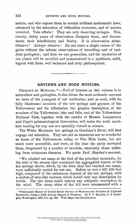
series of semicircular basins, with margins varying in height from a few inches to 6 or 8 feet, and so beautifully scalloped and adorned with a kind of bead-work that the beholder stands amazed at this marvel of nature's handiwork. Add to this, a snow-white ground, with very variety of shade, of- scarlet, green, and yellow, as brilliant as the brightest of our aniline dyes. The pools or basins are of all sizes, from a few inches to 6 or 8 feet in diameter, and from. 2 inches to 2 feet deep. As the water flows from the spring
Fig. 71, over the mountain side Fig ____ I: -from one basin to an-
__________________________________ other, it loses continu- -_____________________ _ t ly a portion of its
heat,. and the bather _____-{can find any desirable
______________ ~tmpeatue.At the ___top of h ilteei
a broad flat terrace cov- ered more or less with
__g these basins, one hun-. dred and fifty to two
____ ~~~hundred yards in diam- eter, and many of them going to decay. Here
bWe f4id the largest, fin- __ctly xran n thaest, and most active
_____ - sping of the group at the present time. The
___ _ ~~~largest spring is very .7 ~~~near the outerl margin
of the terrace and is 25 by 40 feet in, diameter, the water so per- fectly transparent that one can look down into the beautiful ultramarine depth to the bottom of the basin. The sides o the basin are ornamented with coral-like
_____sforms, with a great variety of shades, ____ from pure white to a bright cream-yellow,
Liberty Cap. and the blue sky reflected in the trans- parent waters gives an azure tint to the
whole which surpasses all art. The calcareous deposit around the rim is also most elegantly ornamented, but, like the icy cover- ing of a pool, extends, from the edge toward the centre, and this projects over the basin until it is not more Ithan a fourth of an inch thick. These springs have one or more centres of ebullition, and in this group it is constant, seldom rising more than two to four inches above the surface. From various portions of the rim the water flows out in moderate quantities over the sides of the hill. Whenever it gathers into a channel- and flows quite swiftly, basins
AMER. NATURALIST, VOL. VII. 23
This content downloaded from 193.105.154.109 on Mon, 19 May 2014 21:08:25 PMAll use subject to JSTOR Terms and Conditions
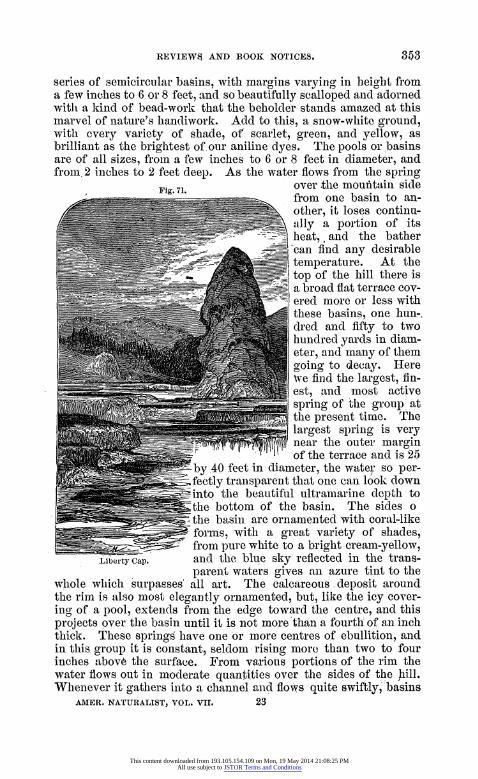
with sides from 2 to 8 feet high are formed, with the ornamented designs proportionately coarse, but when the water flows slowly, myriads of the little basins are formed, one below the other, with a kind of irregular system, as it might be called, which constitutes the difference between the works of nature and works of art. The water holds a great amount of lime in solution. It also contains
Fig. 72.
some soda, alumina and magnesia. The ebullition is largely due to the emission of large quantities of car- bonic acid gas. As these waters flow down the sides of the mountain,
~ they constantly deposit more or less of this calcareous sediment in almost
r every possible variety of form. Un- derneath the sides of many of these pools are rows of stalactites of all sizes, many of them exquisitely or- namented, formed by the dripping
eneal View of Ovflow of Great the water over the margins of the Spring, Gardiners River basins."
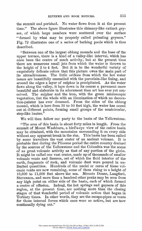
" Liberty Cap (Fig. 71) is un- doubtedly," says our author, " the remains of an extinct geyser." The water was forced up with considerable power,.and probably without intermission, building up its own crater until the pressure beneath was exhausted, and then it gradually closed itself over at
This content downloaded from 193.105.154.109 on Mon, 19 May 2014 21:08:25 PMAll use subject to JSTOR Terms and Conditions
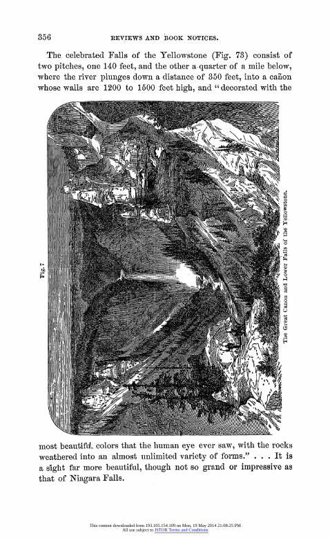
the summit and perished. No water flows from it at the present time." The above figure illustrates this chimney-like extinct gey- ser, of which large numbers were scattered over the surface "formed by what may be properly called pulsating geysers." Fig. 72 illustrates, one of a series of bathing pools which is thiis described.
"Between one of the largest oblong mounds and the base of the upper terrace, there is a kind of a valley-like interval, which has once been the centre of much activity, but at the present time there are numerous small jets from which the water is thrown to the height of 2 to 4 feet. But it is to the wonderful variety of exquisitely delicate colors that this picture owes the main part of its attractiveness. The little orifices from which the hot water issues are beautifully enamelled with the porcelain-like lining, and around the edges a layer of sulphur is precipitated. As the water flows along the valley, it lays down in its course a pavement more beautiful and elaborate in its adornment than art has ever yet con- ceived. The sulphur and the iron, with the green microscopic vegetation, tint the whole with an illumination of which no decora- tion-painter has ever dreamed. From the sides of the oblong mound, which is here from 30 to 50 feet high, the water has oozed out at different points, forming small groups of the semicircular, step-like basins."
We will then follow our party to the basin of the Yellowstone. "The area of this basin is about forty miles in length. From the
summit of Mount Washburn, a bird's-eye view of the entire basin may be obtained, with the mountains surrounding it on every side without any apparent break in the rim. This basin has been called by some travellers the vast crater of an ancient volcano. It is probable that during the Pliocene period the entire country drained by the sources of the Yellowstone and the Columbia was the scene of as great volcanic activity as that of any portion of the globe. It might be called one vast crater, made up of thousands of smaller volcanic vents and fissures, out of which the fluid interior of the earth, fragments of rock, and volcanic dust were poured in u1n- limited quantities. Hundreds of the nuclei or cores of these vol- canic vents are now remaining, some of them rising to a height of 10,000 to 11,000 feet above the sea. Mounts Doane, Langford, Stevenson, and more than a hundred'other peaks may be seen from any high point on either side of the basin, each of which formed a centre of effusion. Indeed, the hot springs and geysers of this region, at the present time, are nothing more than the closing stages of that wonderful period of volcanic action that began in Tertiary times. In other words, they are the escape-pipes or vents for those internal forces which once were so active, but are how continually dying out."
This content downloaded from 193.105.154.109 on Mon, 19 May 2014 21:08:25 PMAll use subject to JSTOR Terms and Conditions
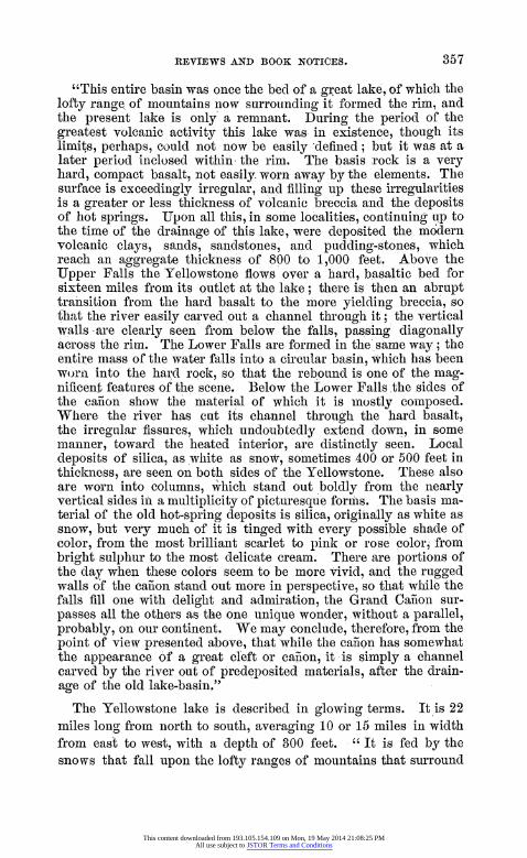
The celebrated Falls of the Yellowstone (Fig. 73) consist of two pitches, one 140 feet,.and the other a-quarter of a mile below, where the river plunges down a distance of 350 feet, into a canon whose walls are 1200 to 1600 feet high, and "decorated with the
most beautiful colors that the human eye ever saw, with the rocks weathered into an almost unlimited variety of forms." . . . It is a sight far more beautiful, though not so grand or impressive as that of Niagara Falls.
This content downloaded from 193.105.154.109 on Mon, 19 May 2014 21:08:25 PMAll use subject to JSTOR Terms and Conditions
"This entire basin was once the bed of a great lake, of which the lofty range, of mountains now surrounding it formed the rim, and the present lake is only a remnant. During the period of the greatest volcanic activity this lake was in existence, though its limits, perhaps, could not now be easily defined; but it was at a later period inclosed within the rim. The basis rock is a very hard, compact basalt, not easily. worn away by the elements. The surface is exceedingly irregular, and filling up these irregularities is a greater or less thickness of volcanic breccia and the deposits of hot springs. Upon all this, in some localities, continuing Lip to the time of the drainage of this lake, were deposited the modern volcanic clays, sands, sandstones, and pudding-stones, which reach an aggregate thickness of 800 to 1,000 feet. Above the Upper Falls the Yellowstone flows over a hard, basaltic bed for sixteen miles from its outlet at the lake; there is then an abrupt transition from the hard basalt to the more yielding breccia, so that the river easily carved out a channel through it; the vertical walls-are clearly seen from below the falls, passing diagonally across the rim. The Lower Falls are formed in the same way; the entire mass of the water falls into a circular basin, which has been worn into the hard rock, so that the rebound is one of the mag- nificent features of the scene. Below the Lower Falls the sides of the canon show the material of which it is mostly composed. Where the river has cut its channel through the hard basalt, the irregular fissures, which undoubtedly extend down, in some manner, toward the heated interior, are distinctly seen. Local deposits of silica, as white as snow, sometimes 400 or 500 feet in thickness, are seen on both sides of the Yellowstone. These also are worn into columns, which stand out boldly from the nearly vertical sides in a multiplicity of picturesque forms. The basis ma- terial of the old hot-spring deposits is silica, originally as white as snow, but very much of it is tinged with every possible shade of color, from the most brilliant scarlet to pink or rose color, from bright sulphur to the most delicate cream. There are portions of the day when these colors seem to be more vivid, and the rugged walls of the ca-non stand out more in perspective, so that while the falls fill one with delight and admiration, the Grand Caiion sur- passes all the others as the one unique wonder, without a parallel, probably, on our continent. We may conclude, therefore, from the point of view presented above, that while the cafion has somewhat the appearance of a great cleft or canon, it -is simply a channel carved by the river out of predeposited materials, after the drain- age of the old lake-basin."
The Yellowstone lake is described in glowing terms. It is 22 miles long from north to south, averaging 10 or 15 miles ill width from east to west, with a depth of 300 feet. "It is fed by the snows that fall upon the lofty ranges of mountains that surround
This content downloaded from 193.105.154.109 on Mon, 19 May 2014 21:08:25 PMAll use subject to JSTOR Terms and Conditions
it on every side. The water of the lake has at all seasons nearly the temperature of cold spring-water."
Happily this wonderful basin, or Yellowstone Park, has by Con- gress been set apart as a National Park, and thus its attractions will remain forever free to all, and we trust safe from injury by curiosity venders et id omne genus.
Before leaving Prof. Hayden's report we may call attention to the soda springs at the bend of Bear river, describing them in the words of the report.
"At the bend of Bear river is located the most interesting group of soda springs known on the continent. They occupy an area of about six square miles, though the number is not great. At this time they may be called simply remnants of former greatness. Numerous mounds of dead or dying springs are scattered every- where, and only a few seem to be in active operation. So far as the manner of building up the calcareous mounds is concerned, it does not differ from that of the hot springs in the Yellowstone valley, and it may be that they were boiling springs at some period in the past. At the present time they are not usually much above the temperature of ordinary spring-water. In one or two instances the active springs were found to be lukewarm. Nearly all the springs were in a constant state of more or less agitation from the bubbles of gas that were ever escaping. In a few cases the water is thrown up 2 to 4 feet. One spring with a basin 10 feet in diam- eter, with the surface covered over with bubbling points from car- bonic acid gas escaping, had a temperature of 61Wo; another bub- bling spring, 650. The Bear river cross-cuts a number of the mounds, thus revealing the secret of their structure. The mounds vary from a few feet to twenty or thirty feet high, built up, in the same way as the hot spring cones, by overlapping layers. There are many of these mounds, which show, by the steepness of the sides, the amount of hydrostatic pressure. Many of the chimneys are nearly vertical, with the inner surface coated over with.a sort of porcelain."
The second, third and fourth parts of the reports contain valua- ble contributions from Messrs. Thomas, Lesquereux, Cope, Leidy, Meek, Horn, Uhler, Edwards, Porter and Beaman.
Mr. Lesquereux gives the following summary of his views de- duced from the study of our Tertiary and Cretaceous flora.
"1 1st. The Tertiary flora of North America is, by its types, in- timately related to the Cretaceous flora of the same country.
2d. All the essential types of our present arborescent flora are already marked in the Cretaceous of our continent, and become
This content downloaded from 193.105.154.109 on Mon, 19 May 2014 21:08:25 PMAll use subject to JSTOR Terms and Conditions
more distinct and more numerous in the Tertiary; therefore the origin of our actual flora is, like its facies, truly North American.
3d. Some types of the North American Tertiary and Cretaceous flora appear already in the same formations of Greenland, Spitz- bergen, and Iceland; the derivation of these types is therefore apparently from the arctic regions.
4th. The relation of the North American Tertiary flora with that of the same formation of Europe is marked only for North Ameri- can types, but does not exist at all for those which are not rep- resented in the living flora of this continent. Therefore the European Tertiary flora partly originates from North American types, either directly from our continent or derived from the arctic regions.
5th. The relation of the Tertiary flora of Greenland and Spitz- bergen with ours indicates, at the Tertiary and Cretaceous epochs, land connection of the northern islands with our continent.
6th. The species of plants common to the Cretaceous and Ter- tiary formations of the arctic regions and of our continent indicate, in the mean temperature influencing geographical distribution of vegetation, a difference, ini +, equal to about a5 of latitude for the Tertiary and Cretaceous epochs.
7th. The same kind of observations on the geographical distribu- tion of vegetable species shows at the Tertiary and Cretaceous times differences of temperature according to latitude, analogous to what is remarked at our time by the characters of the southern and northern vegetation."
We quote with much satisfaction. the conclusions of so able a paleontologist as Mr. Lesquereux that the European Tertiary flora partly originated from arctic North America. We may be par- doned for referring to our own view expressed in 1865. From a study of the quaternary fossils of Labrador and New E-Vgland, we ventured on general grounds, though not a botanist, to dissent from the view of Dr. J. D. Hooker, that the flora of northeastern arctic America was essentially Scandinavian in its origin.*
Dr. Horn discourses on the distribution of the Coleoptera col- lected on the plains of the Rocky Mountains and the mountains of Oregon and Montana. The species, owing to the variation in alti- tude, temperature, and the food plants, vary in a corresponding ratio. He remarks on this subject as follows:-
"Eleodes obscure Say affords a beautiful illustration of the ex- tent to which this divergence may be carried. As a general rule I find, not only in Eleodes, but also in many other genera, that the
* Observations on the Glacial Phenomena of Labrador and Maine. Read Oct. 4, 1868. (Memoirs Boston Society of Natural History, 1867.)
This content downloaded from 193.105.154.109 on Mon, 19 May 2014 21:08:25 PMAll use subject to JSTOR Terms and Conditions
higher the elevation or the colder the climate, the rougher and more deeply sculptured is the species. The smoother.forms of E. obscura may therefore be expected in the southern regions in which it oc- curs; for example, var. dispeisa is New Mexican, elytra with scarcely any traces of stri; ; var. obscura, elytra distinctly sulcate, but not deeply, is from Colorado and Southern Idaho. As we advance to the west the elytra -are more deeply sulfate, as in var. arata, while var. sulcipennis, from nearer the Pacific coast, has deeply salcate elytra, with very convex interspaces. The same variation of sculpture occurs in Calosoma luxatum Say, which starts in Colorado with comparatively smooth elytra, until in Van- couver we find the elytra covered with lines of granular elevations, forming the variety known as C. pimelloides Walker. The two ex- tremes of each series above noted appear to differ widely from each other, and to be entitled to rank as distinct species. In. the foregoing remarks reference only has been made to variations within specific limits. The same law appears to hold between dif- ferent species. In the genus Omus the most roughly sculptured species occurs in Washington Territory (0. Dejeanii Reiche), and the smoothest (0. lcevis Horn) from near Visalia, California. The object of the preceding remarks is to explain what appears to be a law of variation for our western slope, and thus cause the unnec- essary multiplication of species, founded on slight characters, to be avoided.
Species everywhere in -our fau-na appear to be distributed on lines of country presenting uas nearly as possible similar meteoro- logical conditions. Thus many Oregon forms extend southward into California, gradually seeking a higher mountain habitat as the region becomes warmer. Two species illustrate this - Tragosoma Harrisii and Phryganophilus collaris. Both extend their habitat from Maine to California, following the cooler regions westward from Maine through the Canadas and Red River region, thence northward nearly to Sitka. From the latter point southward to Oregon both occur at the ordinary level, and rising as a more southern region is reached, until at the latitude of Visalia they occur only a short distance below the snow-line, at an altitude of from ten to twelve thousand feet.
From Southern California species have extended along the des- ert regions bordering the Colorado river to Utah. Two instances are presented in the collection just examined-Calosoma semilceve and Anisodactylus piceus. Species advancing from the region just cited cannot be expected to cross the Rocky Mountains. Our common Harpalus ccliginosus extends westward over all obstacles until the base of the Sierra Nevada is reached. It has not yet occurred in California proper."
The volume concludes with important papers on the Hemiptera by Mr. Uhler, and an extended essay on the Orthoptera by Prof. Thomas, illustrated by two plates.
This content downloaded from 193.105.154.109 on Mon, 19 May 2014 21:08:25 PMAll use subject to JSTOR Terms and Conditions