30
Geology of National Parks of Central/Southern Kenya and Northern Tanzania
Geology of National Parks of Central/SouthernKenya and Northern Tanzania


Roger N. Scoon
Geology of National Parksof Central/Southern Kenyaand Northern TanzaniaGeotourism of the Gregory Rift Valley,Active Volcanism and Regional Plateaus
123
Roger N. ScoonDepartment of GeologyRhodes UniversityGrahamstownSouth Africa
Every effort has been made to contact the copyright holders of the figures and tables which have been reproduced fromother sources. Anyone who has not been properly credited is requested to contact the publishers, so that dueacknowledgment may be made in subsequent editions.
ISBN 978-3-319-73784-3 ISBN 978-3-319-73785-0 (eBook)https://doi.org/10.1007/978-3-319-73785-0
Library of Congress Control Number: 2017963521
© Springer International Publishing AG, part of Springer Nature 2018This work is subject to copyright. All rights are reserved by the Publisher, whether the whole or part of the material isconcerned, specifically the rights of translation, reprinting, reuse of illustrations, recitation, broadcasting, reproductionon microfilms or in any other physical way, and transmission or information storage and retrieval, electronicadaptation, computer software, or by similar or dissimilar methodology now known or hereafter developed.The use of general descriptive names, registered names, trademarks, service marks, etc. in this publication does notimply, even in the absence of a specific statement, that such names are exempt from the relevant protective laws andregulations and therefore free for general use.The publisher, the authors and the editors are safe to assume that the advice and information in this book are believedto be true and accurate at the date of publication. Neither the publisher nor the authors or the editors give a warranty,express or implied, with respect to the material contained herein or for any errors or omissions that may have beenmade. The publisher remains neutral with regard to jurisdictional claims in published maps and institutionalaffiliations.
Cover photographs: Front cover (and p. ii): The Ash Cone in the giant caldera of Mount Meru, Arusha National Park innorthern Tanzania, which last erupted in 1910 (photograph by the author). Back cover: The author and his wife.
Printed on acid-free paper
This Springer imprint is published by the registered company Springer International Publishing AG partof Springer NatureThe registered company address is: Gewerbestrasse 11, 6330 Cham, Switzerland

The Western Escarpment of the Gregory Rift Valley near Lake Natron, northern Tanzania, as viewed looking northwards from theslopes of Oldoinyo Lengai is made up of multiple, near-horizontal layers of lava and tephra. The braided drainage system in thevalley is indicative of a recently formed land surface (by R.N. Scoon)
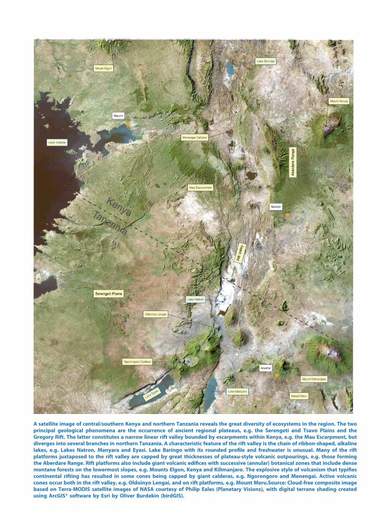
A satellite image of central/southern Kenya and northern Tanzania reveals the great diversity of ecosystems in the region. The twoprincipal geological phenomena are the occurrence of ancient regional plateaus, e.g. the Serengeti and Tsavo Plains and theGregory Rift. The latter constitutes a narrow linear rift valley bounded by escarpments within Kenya, e.g. the Mau Escarpment, butdiverges into several branches in northern Tanzania. A characteristic feature of the rift valley is the chain of ribbon-shaped, alkalinelakes, e.g. Lakes Natron, Manyara and Eyasi. Lake Baringo with its rounded profile and freshwater is unusual. Many of the riftplatforms juxtaposed to the rift valley are capped by great thicknesses of plateau-style volcanic outpourings, e.g. those formingthe Aberdare Range. Rift platforms also include giant volcanic edifices with successive (annular) botanical zones that include densemontane forests on the lowermost slopes, e.g. Mounts Elgon, Kenya and Kilimanjaro. The explosive style of volcanism that typifiescontinental rifting has resulted in some cones being capped by giant calderas, e.g. Ngorongoro and Menengai. Active volcaniccones occur both in the rift valley, e.g. Oldoinyo Lengai, and on rift platforms, e.g. Mount Meru.Source: Cloud-free composite imagebased on Terra-MODIS satellite images of NASA courtesy of Philip Eales (Planetary Visions), with digital terrane shading createdusing ArcGIS® software by Esri by Oliver Burdekin (birdGIS).

National Parks, Reserves and Conservation Areas
Central and Southern Kenya:
Aberdare; Amboseli; Chyulu Hills; Hell’s Gate; Lake Baringo; Lake Bogoria; Lake Naivasha;Lake Nakuru; Mount Longonot; Mount Elgon*; Mount Kenya; Tsavo West
Northern Tanzania:
Arusha (Mount Meru); Kilimanjaro; Lake Eyasi; Lake Manyara; Lake Natron and theOldoinyo Lengai Volcano; Ngorongoro; Oldupai Gorge and Laetoli; Serengeti
*Includes a park in Uganda.
vii
Preface
The national parks, reserves and conservation areas of central/southern Kenya and northernTanzania host some of the largest and most diverse concentrations of wildlife remaining onEarth. They also have remarkable potential for geotourism and creation of geoparks.1 Manyof the most spectacular landforms are associated with the dominant geological feature of theregion, the East African Rift System (EARS). Kenya and northern Tanzania are transected bythe Gregory Rift, the eastern branch of a system that extends in its entirety for over 6,000 km.The most prominent expression of the rift is a narrow, down-faulted linear valley bordered byspectacular escarpments (Frontispiece 1). The EARS also constitutes one of the largest vol-canic provinces on Earth. Sections of the rift valley resemble lunar landscapes in areas ofparticularly intensive volcanism. An unusual feature of the Gregory Rift is the occurrence ofgiant volcanic edifices on the rift platforms (Cover). A satellite image (Frontispiece 2) revealsmany of these features including the chain of ribbon-shaped lakes which characterise the riftvalley.
The rift platforms which constrain the Gregory Rift Valley have been uplifted to elevationssufficiently high as to report a temperate climate with montane forests, despite the equatorialsetting. Montane forests also occur on the higher volcanic cones, several of which are amongthe largest free-standing mountains on Earth. The two highest peaks in the region, Kilimanjaro(a dormant volcano) and Mount Kenya (an extinct volcano), are capped by the relicts offast-melting icefields and glaciers. The region includes two ‘Natural Wonders of the World’,the Serengeti Plains, famed for the biannual migration of almost two million grazers, and theNgorongoro Caldera, a self-contained reserve created by a catastrophic volcanic eruption. Thepalaeoanthropological sites of Oldupai Gorge and Laetoli, where some of the most importantdiscoveries of hominin fossils and footprints have been made, are located between Ngoron-goro and the Serengeti.
The region is underlain in some areas by crystalline metamorphic rocks of the basementcomplexes. The Serengeti Plains, for example, reveals exposures of the Lake Victoria Terranewhich contains some of the oldest rocks on Earth (oldest ages reported in this area are 2.810 Ga).The Tsavo Plains include exposures of the Mozambique Belt, an extensive group of rocks withan average age of 800–500 Ma. A characteristic feature of the East African landscape is theoccurrence of regional plateaus; they formed due to repeated episodes of uplift and erosionassociated with the breakup of the ancient supercontinent of Gondwana (commencing atapproximately 180 Ma). It is these cycles of uplift and erosion which enabled the basementcomplexes to be exposed on surface. The EARS is a relatively recent event which commenced atapproximately 30 Ma. Rifting is stretching and thinning the African Plate. The main periods offaulting in the Gregory Rift are even younger (3.7–1.4 Ma). Continental rifting is invariablyassociated with the alkaline style of magmas, and volcanism of the EARS is further charac-terised by highly explosive Plinian-style eruptions. Numerous catastrophic events are preserved
1Geopark: A Geopark is a unified area that advances the protection and use of geological heritage in asustainable way, and promotes the economic well-being of the people who live there. There are GlobalGeoparks and National Geoparks (Wikipedia).
ix

in the geological record; these include giant calderas and sector collapses which have generatedamong the largest debris avalanches recorded. The high sodium content of these magmas,together with restricted catchments and high rates of evaporation, resulted in the extremealkalinity of many lakes in the Gregory Rift Valley.
The interrelationship between wildlife and geology is emphasised. The relatively youthfulvolcanic uplands, for example, provide a range of ecosystems and supply groundwater to themuch older regional plateaus that would otherwise be far too arid to support large concen-trations of wildlife. The intensity of volcanism is not compatible with the generalised view ofendless plains and vast herds that migrate over ancient, unchanged landscapes. The geologicalrecord provides evidence of persistent changes. Recent eruptions of the active OldoinyoLengai Volcano have resulted in the spread of ashes onto the Serengeti Plains which supportthe nutrient-rich short grasses on which the migrating grazers congregate annually. The epi-sodic nature of the rifting and volcanism produced smaller and smaller geological terranes.This may have resulted in the remarkable diversity of species for which East Africa is sorenowned. Anomalously rapid speciation may have been triggered as a reaction to these newterranes as well as to the unusually high concentrations of radioactive minerals. Initiation ofnew species by Darwinian evolution during the Pliocene and Pleistocene epochs (5.3 Ma–11,500 BP), including hominins, occurred in remarkably short time intervals during extremeclimatic cycles (e.g. the Ice Ages) and intense volcanism. The Holocene epoch represents arelatively quiescent period in which Homo sapiens thrived during a time of modest climaticcycles and less intense volcanism.
Grahamstown, South Africa Roger N. Scoon
x Preface

Acknowledgements
This contribution would not have been possible without the detailed maps produced by theGeological Surveys of Kenya and Tanzania, together with mapping and research reports of theBritish Geological Survey in East Africa. The research by Louis and Mary Leakey andRichard Hay at Oldupai Gorge and Laetoli, together with the detailed studies of B. H. Bakeron the Gregory Rift, Kenya, and by J. B. Dawson on the carbonatite volcanism at OldoinyoLengai, northern Tanzania, stands out from the extensive data base. The contribution of LynWhitfield who drafted the maps and diagrams was particularly important. Satellite and digitalterrane images were provided and processed by Philip Eales (Planetary Vision) and OliverBurdekin (birdGIS). The 1995 field trip of the Mineralogical Society of South Africa tonorthern Tanzania planted the seed for the book and this continued with a similar trip led bythe author as part of the 35th International Geological Congress, Cape Town (2016). Thesupport of Morris and Richard Viljoen during these excursions, as well as discussions over theensuing years is greatly appreciated. Reviews by Professor Carl Anhaeusser and M. J. Wilsongreatly improved an earlier draft. The support and encouragement of Petra Van Steenbergen,Executive Editor at Springer, was also invaluable. Photographs by the author reflect contrastsbetween visits during ‘dry seasons’ (June 1995; September 2016) and ‘wet seasons’ (January1980; December 1998; February 2004; January 2012; January 2015). Finally, I thank my wife,Amelia, for accompanying me on many of the field excursions and mountain hikes. We bothgratefully acknowledge the private guides and rangers who provided safe guidance andstimulating discussions during our visits to national parks and reserves, particularly whilsttrekking on Kilimanjaro (1980), Oldoinyo Lengai (1995), Mount Meru (2004), Mount Elgon(2012) and Mounts Longonot and Kenya (2015).
xi

Contents
Part I Overview
1 Introduction . . . . . . . . . . . . . . . . . . . . . . . . . . . . . . . . . . . . . . . . . . . . . . . . . . . . . 31.1 Introduction. . . . . . . . . . . . . . . . . . . . . . . . . . . . . . . . . . . . . . . . . . . . . . . . 41.2 Wildlife and Geology . . . . . . . . . . . . . . . . . . . . . . . . . . . . . . . . . . . . . . . . 41.3 The Gregory Rift. . . . . . . . . . . . . . . . . . . . . . . . . . . . . . . . . . . . . . . . . . . . 51.4 Land Surfaces . . . . . . . . . . . . . . . . . . . . . . . . . . . . . . . . . . . . . . . . . . . . . . 71.5 Ecological Regions . . . . . . . . . . . . . . . . . . . . . . . . . . . . . . . . . . . . . . . . . . 71.6 Distribution of Species . . . . . . . . . . . . . . . . . . . . . . . . . . . . . . . . . . . . . . . 71.7 Rapid Speciation . . . . . . . . . . . . . . . . . . . . . . . . . . . . . . . . . . . . . . . . . . . . 81.8 Layout of the Book. . . . . . . . . . . . . . . . . . . . . . . . . . . . . . . . . . . . . . . . . . 8References . . . . . . . . . . . . . . . . . . . . . . . . . . . . . . . . . . . . . . . . . . . . . . . . . . . . . . . 10
2 Geological Framework . . . . . . . . . . . . . . . . . . . . . . . . . . . . . . . . . . . . . . . . . . . . 112.1 Introduction. . . . . . . . . . . . . . . . . . . . . . . . . . . . . . . . . . . . . . . . . . . . . . . . 122.2 Basement Complexes . . . . . . . . . . . . . . . . . . . . . . . . . . . . . . . . . . . . . . . . 122.3 Regional Plateaus . . . . . . . . . . . . . . . . . . . . . . . . . . . . . . . . . . . . . . . . . . . 152.4 East African Rift System. . . . . . . . . . . . . . . . . . . . . . . . . . . . . . . . . . . . . . 152.5 Hominins . . . . . . . . . . . . . . . . . . . . . . . . . . . . . . . . . . . . . . . . . . . . . . . . . 152.6 Late Pleistocene Ice Ages and the Holocene Epoch . . . . . . . . . . . . . . . . . 152.7 Discussion. . . . . . . . . . . . . . . . . . . . . . . . . . . . . . . . . . . . . . . . . . . . . . . . . 18
3 The East African Rift System . . . . . . . . . . . . . . . . . . . . . . . . . . . . . . . . . . . . . . . 193.1 Introduction. . . . . . . . . . . . . . . . . . . . . . . . . . . . . . . . . . . . . . . . . . . . . . . . 203.2 Historical Descriptions . . . . . . . . . . . . . . . . . . . . . . . . . . . . . . . . . . . . . . . 203.3 Geomorphology. . . . . . . . . . . . . . . . . . . . . . . . . . . . . . . . . . . . . . . . . . . . . 213.4 Seismic Activity . . . . . . . . . . . . . . . . . . . . . . . . . . . . . . . . . . . . . . . . . . . . 223.5 Development and Propagation of the EARS . . . . . . . . . . . . . . . . . . . . . . . 233.6 Rift Volcanism and Magma Plumes . . . . . . . . . . . . . . . . . . . . . . . . . . . . . 233.7 Sedimentary Basins and Lakes . . . . . . . . . . . . . . . . . . . . . . . . . . . . . . . . . 233.8 Lake Victoria and the Victoria Nile . . . . . . . . . . . . . . . . . . . . . . . . . . . . . 24References . . . . . . . . . . . . . . . . . . . . . . . . . . . . . . . . . . . . . . . . . . . . . . . . . . . . . . . 28
Part II Regional Geology
4 Basement Complexes and Regional Plateaus . . . . . . . . . . . . . . . . . . . . . . . . . . . 314.1 Introduction. . . . . . . . . . . . . . . . . . . . . . . . . . . . . . . . . . . . . . . . . . . . . . . . 324.2 Archaean: Lake Victoria Terrane. . . . . . . . . . . . . . . . . . . . . . . . . . . . . . . . 324.3 Palaeoproterozoic: Central African Craton . . . . . . . . . . . . . . . . . . . . . . . . 334.4 Mesoproterozoic: Formation of Rodinia . . . . . . . . . . . . . . . . . . . . . . . . . . 334.5 Neoproterozoic: Breakup of Rodinia . . . . . . . . . . . . . . . . . . . . . . . . . . . . . 334.6 Mesozoic–Palaeogene: Breakup of Gondwana . . . . . . . . . . . . . . . . . . . . . 344.7 Regional Plateau . . . . . . . . . . . . . . . . . . . . . . . . . . . . . . . . . . . . . . . . . . . . 35
xiii

4.8 Mineralisation of the Lake Victoria Terrane . . . . . . . . . . . . . . . . . . . . . . . 354.9 Gemstones in the Mozambique Belt . . . . . . . . . . . . . . . . . . . . . . . . . . . . . 35References . . . . . . . . . . . . . . . . . . . . . . . . . . . . . . . . . . . . . . . . . . . . . . . . . . . . . . . 38
5 The Gregory Rift . . . . . . . . . . . . . . . . . . . . . . . . . . . . . . . . . . . . . . . . . . . . . . . . . 395.1 Introduction. . . . . . . . . . . . . . . . . . . . . . . . . . . . . . . . . . . . . . . . . . . . . . . . 405.2 Three Stages of Rifting . . . . . . . . . . . . . . . . . . . . . . . . . . . . . . . . . . . . . . . 425.3 Subdivision of the Volcanism . . . . . . . . . . . . . . . . . . . . . . . . . . . . . . . . . . 425.4 Pre-rift Stage of Doming and Volcanism in Central/Southern Kenya . . . . 425.5 The Half-Graben and Full Graben Stages in Central/Southern Kenya . . . . 425.6 The Northern Tanzania Divergence. . . . . . . . . . . . . . . . . . . . . . . . . . . . . . 455.7 Volcanism of the Half-Graben and Full Graben Stages in
Central/Southern Kenya . . . . . . . . . . . . . . . . . . . . . . . . . . . . . . . . . . . . . . 475.8 Rift-Related Volcanism in Northern Tanzania . . . . . . . . . . . . . . . . . . . . . . 475.9 Composition of the Volcanism . . . . . . . . . . . . . . . . . . . . . . . . . . . . . . . . . 505.10 Volcanic Output and Explosiveness . . . . . . . . . . . . . . . . . . . . . . . . . . . . . 525.11 Other Volcanic Features . . . . . . . . . . . . . . . . . . . . . . . . . . . . . . . . . . . . . . 525.12 Sedimentary Basins . . . . . . . . . . . . . . . . . . . . . . . . . . . . . . . . . . . . . . . . . . 535.13 Rift Valley Lakes . . . . . . . . . . . . . . . . . . . . . . . . . . . . . . . . . . . . . . . . . . . 53References . . . . . . . . . . . . . . . . . . . . . . . . . . . . . . . . . . . . . . . . . . . . . . . . . . . . . . . 57
6 Late Pleistocene Ice Ages and the Holocene Epoch . . . . . . . . . . . . . . . . . . . . . . 596.1 Introduction. . . . . . . . . . . . . . . . . . . . . . . . . . . . . . . . . . . . . . . . . . . . . . . . 606.2 Late Pleistocene Ice Ages . . . . . . . . . . . . . . . . . . . . . . . . . . . . . . . . . . . . . 606.3 Holocene Climatic Cycles . . . . . . . . . . . . . . . . . . . . . . . . . . . . . . . . . . . . . 616.4 Monsoon . . . . . . . . . . . . . . . . . . . . . . . . . . . . . . . . . . . . . . . . . . . . . . . . . . 616.5 Palaeo-Lakes . . . . . . . . . . . . . . . . . . . . . . . . . . . . . . . . . . . . . . . . . . . . . . . 636.6 Historical Lakes . . . . . . . . . . . . . . . . . . . . . . . . . . . . . . . . . . . . . . . . . . . . 636.7 Active Volcanism . . . . . . . . . . . . . . . . . . . . . . . . . . . . . . . . . . . . . . . . . . . 636.8 Montane Forests . . . . . . . . . . . . . . . . . . . . . . . . . . . . . . . . . . . . . . . . . . . . 64References . . . . . . . . . . . . . . . . . . . . . . . . . . . . . . . . . . . . . . . . . . . . . . . . . . . . . . . 66
Part III National Parks, Reserves and Conservation Areas
7 Serengeti National Park . . . . . . . . . . . . . . . . . . . . . . . . . . . . . . . . . . . . . . . . . . . 697.1 Introduction. . . . . . . . . . . . . . . . . . . . . . . . . . . . . . . . . . . . . . . . . . . . . . . . 707.2 Approaches . . . . . . . . . . . . . . . . . . . . . . . . . . . . . . . . . . . . . . . . . . . . . . . . 707.3 Geological Framework . . . . . . . . . . . . . . . . . . . . . . . . . . . . . . . . . . . . . . . 727.4 Greenstones of the Lake Victoria Terrane . . . . . . . . . . . . . . . . . . . . . . . . . 727.5 Granite-Gneiss Plutons of the Lake Victoria Terrane . . . . . . . . . . . . . . . . 727.6 Mozambique Belt . . . . . . . . . . . . . . . . . . . . . . . . . . . . . . . . . . . . . . . . . . . 737.7 Ikorongo Group. . . . . . . . . . . . . . . . . . . . . . . . . . . . . . . . . . . . . . . . . . . . . 737.8 Neogene Age Sequences . . . . . . . . . . . . . . . . . . . . . . . . . . . . . . . . . . . . . . 737.9 Holocene Volcanic Ash. . . . . . . . . . . . . . . . . . . . . . . . . . . . . . . . . . . . . . . 737.10 Rivers and Lakes . . . . . . . . . . . . . . . . . . . . . . . . . . . . . . . . . . . . . . . . . . . 737.11 Economic Ore Deposits. . . . . . . . . . . . . . . . . . . . . . . . . . . . . . . . . . . . . . . 737.12 Migration . . . . . . . . . . . . . . . . . . . . . . . . . . . . . . . . . . . . . . . . . . . . . . . . . 747.13 Koppies. . . . . . . . . . . . . . . . . . . . . . . . . . . . . . . . . . . . . . . . . . . . . . . . . . . 74References . . . . . . . . . . . . . . . . . . . . . . . . . . . . . . . . . . . . . . . . . . . . . . . . . . . . . . . 79
8 Mount Elgon National Park(s) . . . . . . . . . . . . . . . . . . . . . . . . . . . . . . . . . . . . . . 818.1 Introduction. . . . . . . . . . . . . . . . . . . . . . . . . . . . . . . . . . . . . . . . . . . . . . . . 828.2 Pre-rift Volcanism . . . . . . . . . . . . . . . . . . . . . . . . . . . . . . . . . . . . . . . . . . . 838.3 Basement . . . . . . . . . . . . . . . . . . . . . . . . . . . . . . . . . . . . . . . . . . . . . . . . . 848.4 Volcanology . . . . . . . . . . . . . . . . . . . . . . . . . . . . . . . . . . . . . . . . . . . . . . . 848.5 Summit Plateau . . . . . . . . . . . . . . . . . . . . . . . . . . . . . . . . . . . . . . . . . . . . . 85
xiv Contents
8.6 Hot Springs and Caves . . . . . . . . . . . . . . . . . . . . . . . . . . . . . . . . . . . . . . . 868.7 Botanical Zones . . . . . . . . . . . . . . . . . . . . . . . . . . . . . . . . . . . . . . . . . . . . 868.8 Landslides . . . . . . . . . . . . . . . . . . . . . . . . . . . . . . . . . . . . . . . . . . . . . . . . . 86References . . . . . . . . . . . . . . . . . . . . . . . . . . . . . . . . . . . . . . . . . . . . . . . . . . . . . . . 90
9 Aberdare and Mount Kenya National Parks . . . . . . . . . . . . . . . . . . . . . . . . . . . 919.1 Introduction. . . . . . . . . . . . . . . . . . . . . . . . . . . . . . . . . . . . . . . . . . . . . . . . 929.2 Aberdare National Park . . . . . . . . . . . . . . . . . . . . . . . . . . . . . . . . . . . . . . . 92
9.2.1 Simbara and Satima Volcanics. . . . . . . . . . . . . . . . . . . . . . . . . . . 949.2.2 Younger Volcanics. . . . . . . . . . . . . . . . . . . . . . . . . . . . . . . . . . . . 94
9.3 Mount Kenya National Park . . . . . . . . . . . . . . . . . . . . . . . . . . . . . . . . . . . 949.3.1 Central Peaks . . . . . . . . . . . . . . . . . . . . . . . . . . . . . . . . . . . . . . . . 949.3.2 Mount Kenya Volcanic Suite . . . . . . . . . . . . . . . . . . . . . . . . . . . . 959.3.3 Main Volcanic Component (1–3). . . . . . . . . . . . . . . . . . . . . . . . . 969.3.4 Nepheline Syenite Intrusive (4) . . . . . . . . . . . . . . . . . . . . . . . . . . 969.3.5 Later Parasitic Activity (5–6) . . . . . . . . . . . . . . . . . . . . . . . . . . . . 969.3.6 Slope Glaciers . . . . . . . . . . . . . . . . . . . . . . . . . . . . . . . . . . . . . . . 97
9.4 Unusual Flora and Fauna . . . . . . . . . . . . . . . . . . . . . . . . . . . . . . . . . . . . . 97References . . . . . . . . . . . . . . . . . . . . . . . . . . . . . . . . . . . . . . . . . . . . . . . . . . . . . . . 101
10 Ngorongoro Conservation Area . . . . . . . . . . . . . . . . . . . . . . . . . . . . . . . . . . . . . 10310.1 Introduction. . . . . . . . . . . . . . . . . . . . . . . . . . . . . . . . . . . . . . . . . . . . . . . . 10410.2 Approaches . . . . . . . . . . . . . . . . . . . . . . . . . . . . . . . . . . . . . . . . . . . . . . . . 10610.3 Ecosystems . . . . . . . . . . . . . . . . . . . . . . . . . . . . . . . . . . . . . . . . . . . . . . . . 10710.4 Geological Framework . . . . . . . . . . . . . . . . . . . . . . . . . . . . . . . . . . . . . . . 10710.5 The Mozambique Belt. . . . . . . . . . . . . . . . . . . . . . . . . . . . . . . . . . . . . . . . 10710.6 Ngorongoro Volcanic Complex. . . . . . . . . . . . . . . . . . . . . . . . . . . . . . . . . 107
10.6.1 Ngorongoro . . . . . . . . . . . . . . . . . . . . . . . . . . . . . . . . . . . . . . . . . 10810.6.2 Olmoti . . . . . . . . . . . . . . . . . . . . . . . . . . . . . . . . . . . . . . . . . . . . . 10810.6.3 Empakaai . . . . . . . . . . . . . . . . . . . . . . . . . . . . . . . . . . . . . . . . . . . 10810.6.4 Loolmalasin . . . . . . . . . . . . . . . . . . . . . . . . . . . . . . . . . . . . . . . . . 11010.6.5 Sadiman, Lemagrut, and Oldeani . . . . . . . . . . . . . . . . . . . . . . . . . 110
10.7 Rift-Related Sedimentary Basins . . . . . . . . . . . . . . . . . . . . . . . . . . . . . . . . 11010.8 Wind Blown Ash from Oldoinyo Lengai . . . . . . . . . . . . . . . . . . . . . . . . . 11010.9 Treks. . . . . . . . . . . . . . . . . . . . . . . . . . . . . . . . . . . . . . . . . . . . . . . . . . . . . 110References . . . . . . . . . . . . . . . . . . . . . . . . . . . . . . . . . . . . . . . . . . . . . . . . . . . . . . . 114
11 Oldupai Gorge and Laetoli . . . . . . . . . . . . . . . . . . . . . . . . . . . . . . . . . . . . . . . . . 11511.1 Introduction. . . . . . . . . . . . . . . . . . . . . . . . . . . . . . . . . . . . . . . . . . . . . . . . 11611.2 Location . . . . . . . . . . . . . . . . . . . . . . . . . . . . . . . . . . . . . . . . . . . . . . . . . . 11711.3 History of the Discoveries. . . . . . . . . . . . . . . . . . . . . . . . . . . . . . . . . . . . . 11711.4 Geology of Oldupai . . . . . . . . . . . . . . . . . . . . . . . . . . . . . . . . . . . . . . . . . 11811.5 Details of the Oldupai Group . . . . . . . . . . . . . . . . . . . . . . . . . . . . . . . . . . 118
11.5.1 Lowermost Beds I–II . . . . . . . . . . . . . . . . . . . . . . . . . . . . . . . . . . 12111.5.2 Intermediate Beds III–IV . . . . . . . . . . . . . . . . . . . . . . . . . . . . . . . 12111.5.3 Uppermost Beds V–VII . . . . . . . . . . . . . . . . . . . . . . . . . . . . . . . . 12111.5.4 Faulting . . . . . . . . . . . . . . . . . . . . . . . . . . . . . . . . . . . . . . . . . . . . 121
11.6 Geology of Laetoli . . . . . . . . . . . . . . . . . . . . . . . . . . . . . . . . . . . . . . . . . . 12211.7 Hominins . . . . . . . . . . . . . . . . . . . . . . . . . . . . . . . . . . . . . . . . . . . . . . . . . 12211.8 Other Fossils and Oldowan Tools . . . . . . . . . . . . . . . . . . . . . . . . . . . . . . . 123References . . . . . . . . . . . . . . . . . . . . . . . . . . . . . . . . . . . . . . . . . . . . . . . . . . . . . . . 127
12 Kilimanjaro National Park . . . . . . . . . . . . . . . . . . . . . . . . . . . . . . . . . . . . . . . . . 12912.1 Introduction. . . . . . . . . . . . . . . . . . . . . . . . . . . . . . . . . . . . . . . . . . . . . . . . 13012.2 Botanical Zones . . . . . . . . . . . . . . . . . . . . . . . . . . . . . . . . . . . . . . . . . . . . 13012.3 Regional Geology . . . . . . . . . . . . . . . . . . . . . . . . . . . . . . . . . . . . . . . . . . . 131
Contents xv

12.4 Volcanic Centres . . . . . . . . . . . . . . . . . . . . . . . . . . . . . . . . . . . . . . . . . . . . 13212.4.1 Shira . . . . . . . . . . . . . . . . . . . . . . . . . . . . . . . . . . . . . . . . . . . . . . 13212.4.2 Mawenzi . . . . . . . . . . . . . . . . . . . . . . . . . . . . . . . . . . . . . . . . . . . 13212.4.3 Kibo. . . . . . . . . . . . . . . . . . . . . . . . . . . . . . . . . . . . . . . . . . . . . . . 132
12.5 Reusch Crater . . . . . . . . . . . . . . . . . . . . . . . . . . . . . . . . . . . . . . . . . . . . . . 13412.6 Parasitic Volcanism. . . . . . . . . . . . . . . . . . . . . . . . . . . . . . . . . . . . . . . . . . 13412.7 Icefields. . . . . . . . . . . . . . . . . . . . . . . . . . . . . . . . . . . . . . . . . . . . . . . . . . . 13512.8 Holocene Recession . . . . . . . . . . . . . . . . . . . . . . . . . . . . . . . . . . . . . . . . . 13612.9 Trekking . . . . . . . . . . . . . . . . . . . . . . . . . . . . . . . . . . . . . . . . . . . . . . . . . . 136References . . . . . . . . . . . . . . . . . . . . . . . . . . . . . . . . . . . . . . . . . . . . . . . . . . . . . . . 140
13 Arusha National Park (Mount Meru) . . . . . . . . . . . . . . . . . . . . . . . . . . . . . . . . 14113.1 Introduction. . . . . . . . . . . . . . . . . . . . . . . . . . . . . . . . . . . . . . . . . . . . . . . . 14213.2 Mythology. . . . . . . . . . . . . . . . . . . . . . . . . . . . . . . . . . . . . . . . . . . . . . . . . 14213.3 Older Volcanic Terranes . . . . . . . . . . . . . . . . . . . . . . . . . . . . . . . . . . . . . . 14313.4 Main Volcanism . . . . . . . . . . . . . . . . . . . . . . . . . . . . . . . . . . . . . . . . . . . . 14513.5 Sector Collapse and the Momella DAD . . . . . . . . . . . . . . . . . . . . . . . . . . 14713.6 Momella Lakes . . . . . . . . . . . . . . . . . . . . . . . . . . . . . . . . . . . . . . . . . . . . . 14713.7 Ash Cone . . . . . . . . . . . . . . . . . . . . . . . . . . . . . . . . . . . . . . . . . . . . . . . . . 14813.8 Ecosystems . . . . . . . . . . . . . . . . . . . . . . . . . . . . . . . . . . . . . . . . . . . . . . . . 14813.9 Tourism. . . . . . . . . . . . . . . . . . . . . . . . . . . . . . . . . . . . . . . . . . . . . . . . . . . 149References . . . . . . . . . . . . . . . . . . . . . . . . . . . . . . . . . . . . . . . . . . . . . . . . . . . . . . . 153
14 Amboseli, Chyulu Hills and Tsavo West National Parks . . . . . . . . . . . . . . . . . 15514.1 Introduction. . . . . . . . . . . . . . . . . . . . . . . . . . . . . . . . . . . . . . . . . . . . . . . . 15614.2 Regional Geology . . . . . . . . . . . . . . . . . . . . . . . . . . . . . . . . . . . . . . . . . . . 15614.3 Amboseli National Park . . . . . . . . . . . . . . . . . . . . . . . . . . . . . . . . . . . . . . 158
14.3.1 Environmental Changes . . . . . . . . . . . . . . . . . . . . . . . . . . . . . . . . 15914.3.2 Groundwater . . . . . . . . . . . . . . . . . . . . . . . . . . . . . . . . . . . . . . . . 159
14.4 Chyulu Hills National Park . . . . . . . . . . . . . . . . . . . . . . . . . . . . . . . . . . . . 15914.5 Tsavo West National Park. . . . . . . . . . . . . . . . . . . . . . . . . . . . . . . . . . . . . 160
14.5.1 Mozambique Belt. . . . . . . . . . . . . . . . . . . . . . . . . . . . . . . . . . . . . 16014.5.2 Pleistocene and Holocene Volcanism. . . . . . . . . . . . . . . . . . . . . . 16014.5.3 Mzima Springs. . . . . . . . . . . . . . . . . . . . . . . . . . . . . . . . . . . . . . . 160
References . . . . . . . . . . . . . . . . . . . . . . . . . . . . . . . . . . . . . . . . . . . . . . . . . . . . . . . 165
15 Lakes of the Gregory Rift Valley: Baringo, Bogoria, Nakuru,Elmenteita, Magadi, Manyara and Eyasi . . . . . . . . . . . . . . . . . . . . . . . . . . . . . . 16715.1 Introduction. . . . . . . . . . . . . . . . . . . . . . . . . . . . . . . . . . . . . . . . . . . . . . . . 16815.2 Palaeo-Lakes . . . . . . . . . . . . . . . . . . . . . . . . . . . . . . . . . . . . . . . . . . . . . . . 16815.3 Lake Baringo National Park . . . . . . . . . . . . . . . . . . . . . . . . . . . . . . . . . . . 17015.4 Lake Bogoria National Reserve. . . . . . . . . . . . . . . . . . . . . . . . . . . . . . . . . 17115.5 Lake Nakuru National Park. . . . . . . . . . . . . . . . . . . . . . . . . . . . . . . . . . . . 17215.6 Lake Elmenteita . . . . . . . . . . . . . . . . . . . . . . . . . . . . . . . . . . . . . . . . . . . . 17415.7 Lake Magadi . . . . . . . . . . . . . . . . . . . . . . . . . . . . . . . . . . . . . . . . . . . . . . . 17415.8 Lake Manyara National Park. . . . . . . . . . . . . . . . . . . . . . . . . . . . . . . . . . . 17415.9 Lake Eyasi . . . . . . . . . . . . . . . . . . . . . . . . . . . . . . . . . . . . . . . . . . . . . . . . 17515.10 RAMSAR Status and Flamingo . . . . . . . . . . . . . . . . . . . . . . . . . . . . . . . . 175References . . . . . . . . . . . . . . . . . . . . . . . . . . . . . . . . . . . . . . . . . . . . . . . . . . . . . . . 180
16 Lake Naivasha and the Mount Longonot and Hell’s GateNational Parks . . . . . . . . . . . . . . . . . . . . . . . . . . . . . . . . . . . . . . . . . . . . . . . . . . . 18116.1 Introduction. . . . . . . . . . . . . . . . . . . . . . . . . . . . . . . . . . . . . . . . . . . . . . . . 18216.2 Regional Geology . . . . . . . . . . . . . . . . . . . . . . . . . . . . . . . . . . . . . . . . . . . 182
xvi Contents
16.3 Lake Naivasha. . . . . . . . . . . . . . . . . . . . . . . . . . . . . . . . . . . . . . . . . . . . . . 18416.4 Mount Longonot National Park. . . . . . . . . . . . . . . . . . . . . . . . . . . . . . . . . 185
16.4.1 Volcanic Activity . . . . . . . . . . . . . . . . . . . . . . . . . . . . . . . . . . . . . 18516.4.2 Magma Chamber . . . . . . . . . . . . . . . . . . . . . . . . . . . . . . . . . . . . . 185
16.5 Hell’s Gate National Park . . . . . . . . . . . . . . . . . . . . . . . . . . . . . . . . . . . . . 18616.5.1 Volcanic Pile . . . . . . . . . . . . . . . . . . . . . . . . . . . . . . . . . . . . . . . . 18616.5.2 Njorowa Gorge . . . . . . . . . . . . . . . . . . . . . . . . . . . . . . . . . . . . . . 18616.5.3 Obsidian. . . . . . . . . . . . . . . . . . . . . . . . . . . . . . . . . . . . . . . . . . . . 186
16.6 Hiking Trails . . . . . . . . . . . . . . . . . . . . . . . . . . . . . . . . . . . . . . . . . . . . . . . 18716.7 Geothermal Fields . . . . . . . . . . . . . . . . . . . . . . . . . . . . . . . . . . . . . . . . . . . 187References . . . . . . . . . . . . . . . . . . . . . . . . . . . . . . . . . . . . . . . . . . . . . . . . . . . . . . . 192
17 Lake Natron and the Oldoinyo Lengai Volcano . . . . . . . . . . . . . . . . . . . . . . . . 19317.1 Introduction. . . . . . . . . . . . . . . . . . . . . . . . . . . . . . . . . . . . . . . . . . . . . . . . 19417.2 Volcanism of the Region . . . . . . . . . . . . . . . . . . . . . . . . . . . . . . . . . . . . . 19517.3 Lake Natron . . . . . . . . . . . . . . . . . . . . . . . . . . . . . . . . . . . . . . . . . . . . . . . 19517.4 Oldoinyo Lengai . . . . . . . . . . . . . . . . . . . . . . . . . . . . . . . . . . . . . . . . . . . . 197
17.4.1 Historical Activity . . . . . . . . . . . . . . . . . . . . . . . . . . . . . . . . . . . . 19717.4.2 Petrology . . . . . . . . . . . . . . . . . . . . . . . . . . . . . . . . . . . . . . . . . . . 19817.4.3 Natrocarbonatite . . . . . . . . . . . . . . . . . . . . . . . . . . . . . . . . . . . . . . 19917.4.4 The Summit Crater (1960–2006) . . . . . . . . . . . . . . . . . . . . . . . . . 19917.4.5 Recent Activity (2007–2016) . . . . . . . . . . . . . . . . . . . . . . . . . . . . 200
17.5 Deposits in the Rift Valley . . . . . . . . . . . . . . . . . . . . . . . . . . . . . . . . . . . . 20017.6 Trekking and Footprints . . . . . . . . . . . . . . . . . . . . . . . . . . . . . . . . . . . . . . 200References . . . . . . . . . . . . . . . . . . . . . . . . . . . . . . . . . . . . . . . . . . . . . . . . . . . . . . . 206
About the Author . . . . . . . . . . . . . . . . . . . . . . . . . . . . . . . . . . . . . . . . . . . . . . . . . . . . 207
Glossary . . . . . . . . . . . . . . . . . . . . . . . . . . . . . . . . . . . . . . . . . . . . . . . . . . . . . . . . . . . . 209
Index . . . . . . . . . . . . . . . . . . . . . . . . . . . . . . . . . . . . . . . . . . . . . . . . . . . . . . . . . . . . . . 217
Contents xvii

Abbreviations
BP Years before presentDAD Debris Avalanche DepositEARS East African Rift SystemGa Billions of YearsMa Millions of yearsNCA Ngorongoro Conservation AreaRAMSAR Conservation on Wetlands signed in RAMSAR, Iran in 1971
xix

List of Figures
Fig. 1.1 Map of the national parks, reserves and conservation areas ofcentral/southern Kenya and northern Tanzania. Mount Elgonincludes a national park in both Kenya and Uganda . . . . . . . . . . . . . . . . . . 5
Fig. 1.2 A satellite image of East Africa reveals the extent of the three branchesof the East Africa Rift System. The Gregory Rift is characterisedby a chain of small ribbon-shaped, typically shallow and alkaline lakes,whereas the Albertine Rift includes some of the largest freshwaterlakes on Earth . . . . . . . . . . . . . . . . . . . . . . . . . . . . . . . . . . . . . . . . . . . . . . . 6
Fig. 2.1 Simplified geological map of East Africa compiled from various sourcesincluding the 1:1,000,000 scale Geological Map of Kenya and the1:2,000,000 scale Geological Map of Tanzania. The three branchesof the EARS, Ethiopian, Gregory and Albertine, are truncated by older,Cretaceous-age rifts. Rift valleys contain extensive sequences ofNeogene-age volcanic rocks and localised sedimentary basins. Riftplatforms to the Ethiopian and Gregory Rifts are dominated byNeogene-age volcanics. . . . . . . . . . . . . . . . . . . . . . . . . . . . . . . . . . . . . . . . . 13
Fig. 2.2 Simplified stratigraphic column for East Africa. Ages (Ma) incorporatelatest recommendations of the International Union of Geological Scienceswith the exception of the Pliocene–Pleistocene boundary which is retainedat the traditional age of 1.8 Ma (not 2.58 Ma) as this would impactseverely on published literature pertaining to many of the sites in northernTanzania, including Oldupai Gorge . . . . . . . . . . . . . . . . . . . . . . . . . . . . . . . 14
Fig. 3.1 Sketch map of the African Plate showing the boundaries and extentof the East African Rift System. Major seismic events and activevolcanoes are aligned with plate boundaries and rifts . . . . . . . . . . . . . . . . . 22
Fig. 3.2 Schematic diagrams showing a pre-rift stage a and a full grabenstage b with the EARS ascribed to a mantle plume . . . . . . . . . . . . . . . . . . . 24
Fig. 3.3 Lakes Albert and Edward in the Albertine Rift demarcate the boundarybetween Uganda and the DRC. The Victoria Nile exits Lake Victoriaat Jinja and flows northwest into Lake Albert via the sinuousLake Kyoga . . . . . . . . . . . . . . . . . . . . . . . . . . . . . . . . . . . . . . . . . . . . . . . . . 25
Fig. 4.1 Reconstructions of cratons and supercontinents from an Africanperspective. a The Archaean-age cratonic nuclei—they includethe Congo (CC), Kaapvaal (KVC), Tanzania (TC) and Zimbabwe(ZC) components—are not necessarily in their current position;b Enlarged Archaean–Palaeoproterozoic cratons include the CentralAfrican (CAC) and Kalahari (KC) features (in situ); c Cratons were furtherenlarged into far more extensive basement terranes during theMesoproterozoic; d The supercontinent of Rodinia broke up due toNeoproterozoic-age rifting at approximately 850–700 Ma; e Africaexisted at the approximate centre of the supercontinent of Gondwanaat approximately 250 Ma . . . . . . . . . . . . . . . . . . . . . . . . . . . . . . . . . . . . . . . 34
xxi

Fig. 5.1 A digital terrane image shows the principal physiological featuresof the region, the narrow Gregory Rift Valley in central and southernKenya, the divergence in northern Tanzania, the high altitude of the riftplatforms and the immensity of some of the volcanic edifices. Courtesyof Oliver Burdekin, birdGIS, with digital terrain shading created usingArcGIS® software by Esri . . . . . . . . . . . . . . . . . . . . . . . . . . . . . . . . . . . . . . 41
Fig. 5.2 Simplified geological map of central and southern Kenya compiledfrom various sources including the 1:1,000,000 scale map of the Ministryof Energy and Regional Development of Kenya (1987 Edition)and with some updates and changes. The Miocene-age volcanism ismostly associated with the half-graben stage of rifting (Late Miocene),as the pre-rift (Early Miocene) volcanism is of restricted occurrence . . . . . . 43
Fig. 5.3 Geological section of central Kenya based on Lake Nakuru(latitude 0° 21′ South) and extending from the Kisumu Gulf(Lake Victoria) to the eastern slopes of Mount Kenya. The thicknessof the volcanics associated with the Gregory Rift is schematic. Theyoungest (Holocene) volcanics are restricted to the centre of the rift valleywith the Older (Miocene and Pliocene) Volcanics on the rift platforms.The Mount Kenya Volcanics are an example of the extensiveness of thevolcanism on the Eastern Rift Platform. Pleistocene-age volcanics aremissing from this section but they can be assumed to occur in stratigraphicsequence . . . . . . . . . . . . . . . . . . . . . . . . . . . . . . . . . . . . . . . . . . . . . . . . . . . 44
Fig. 5.4 Simplified structure of the northern Tanzanian divergence basedon Dawson (2008). Rifts are mostly infilled by volcanic terraneswith some small sedimentary basins (not shown). The Tanzanian Craton,part of the Central African craton occurs to the west of the dashed line;the Mozambique Belt occurs to the east. . . . . . . . . . . . . . . . . . . . . . . . . . . . 45
Fig. 5.5 Simplified geological map of northern Tanzania (after Dawson 2008).The divergence includes small grabens, but is dominated byplateau-style volcanics, the Ngorongoro Volcanic complex and numerousadditional volcanic edifices. Discrete cones include the following: Burko(Bu); Essimingor (Es); Gelai (Ge); Kerimasi (Ke); Kibo (Ki); Ketumbeine(Kb); Lemagrut (Le) or Makarot; Loolmalasin (Lo); Mawenzi (Ma);Monduli (Mon); Mosonik (Mo); Ngurdoto (Nd); Oldeani (Ol); OldoinyoDili (Odi); Oldoinyo Lengai (Od); Oldoinyo Sambu (Os); Sadiman (Sa);Shira (Sh) and Tarosera (Ta). Three of the cones include giant calderas:Empakaai (Ec); Ngorongoro (Nc) and Olmoti (Oc). Sediment-filledgrabens include the following: Engaruka (Eng); Erumkoko (Erg); Eyasi(Eg); Lembolos (Lg); Manyara (Mg); Natron (Ng); Oljoro (Og);Pangani (Pg) and Yaida (Yg) . . . . . . . . . . . . . . . . . . . . . . . . . . . . . . . . . . . . 46
Fig. 5.6 Geological section of northern Tanzania based on the Ngorongoro Caldera(latitude 3° 10′ South) and extending from the Eastern Serengeti Plainsto Mount Meru and the lower, southern slopes of Kilimanjaro. Localitiesin brackets (Lake Ndutu, Oldupai Gorge, Kibo, etc.) are located northof the line but are included for reference. The thickness of the volcanicsassociated with the Gregory Rift is schematic. The Older Volcanism(mostly Pliocene on this section) is particularly extensive in the Eyasihalf-graben with the Younger Volcanism restricted to discrete centresin the divergence, notably Meru and parts of Kilimanjaro . . . . . . . . . . . . . . 48
Fig. 5.7 A digital terrane image of part of northern Tanzania shows the prominentescarpments on the western sides of the Natron–Manyara and Eyasihalf-grabens as well as the larger volcanic cones and calderas. Courtesyof Oliver Burdekin, birdGIS, with digital terrain shading created usingArcGIS® software by Esri . . . . . . . . . . . . . . . . . . . . . . . . . . . . . . . . . . . . . . 49
xxii List of Figures

Fig. 5.8 a The TAS diagram, a plot of total alkali (sodium and potassium oxides)versus silica, is a popular method of categorising volcanic rocks. The lineX-Y is used to separate the alkaline group (above) from the sub-alkalinegroup (below). Basaltic rocks include three categories, alkali basalt,transitional basalt (shaded area straddling the division) and subalkalibasalt. The unusual carbonatite volcanic rocks cannot be plotted on thisdiagram, although they can be considered as an extension of the highlyalkaline foidite group (which includes nephelinite and leucite);b Lavas from the Gregory Rift, Kenya plotted on a TAS diagram definethree groups (after Baker 1987): Group (i) nephelinite–phonolite (allsamples plotting in the foidite field are nephelinite); Group (ii) alkalibasalt/basanite–phonolite; and Group (iii) transitional basalt–trachyte–alkali rhyolite. Arrows illustrate evolution trends with decreasing age;c The relative output of the three branches of the EARS expressed byrelative proportions of volcanics subdivided by colour index (after Barberiet al. 1982). In a broad sense, the melanocratic, mesocratic and leucocraticgroups correspond with chemical classifications, basic (>52% SiO2),intermediate (52–63% SiO2) and acid (>63% SiO2), respectively;d Volcanoes that generate pyroclastic fall deposits can be divided intogroups based on a plot of fragmentation index (percentage of deposit withgrains finer than 1 mm) against the area of dispersal (after Walker 1973and Wright et al. 1980). The relatively quiescent Hawaiian andStrombolian styles of eruptions are dominated by lavas and ash-falldeposits with very limited distribution, whereas the catastrophic Plinianand ultra-Plinian eruptions have larger components of pyroclastics thatdisperse over great distances. Shaded area includes the bulk of eruptions.Volcanoes located above the line are associated with either relativelyshort-lived explosive eruptions (Vulcanian) or systems that haveinteracted with water (Surtseyan or Phreatoplinian). Most of the volcanoesassociated with the Gregory Rift fall within the sub-Plinian and Pliniandivisions. . . . . . . . . . . . . . . . . . . . . . . . . . . . . . . . . . . . . . . . . . . . . . . . . . . . 51
Fig. 6.1 Map showing some features of the Holocene geology, includingpalaeo-lakes and active and dormant volcanoes, in the Gregory RiftValley of central/southern Kenya and northern Tanzania. The inset showsthe location of the Chyulu Hills in southern Kenya . . . . . . . . . . . . . . . . . . . 62
Fig. 7.1 Geological map of the Serengeti National Park simplified and updatedfrom various sources including Pickering (1964), MacFarlane (1965)and Barth (1990). The Holocene age of the calcareous ash is after Dawson(2008) and identification of the Ikorongo Group is after Kasanzu andManya (2010) . . . . . . . . . . . . . . . . . . . . . . . . . . . . . . . . . . . . . . . . . . . . . . . 71
Fig. 8.1 Location map of the Elgon Volcano relative to Ugandaand the Albertine Rift . . . . . . . . . . . . . . . . . . . . . . . . . . . . . . . . . . . . . . . . . 83
Fig. 8.2 Mount Elgon reveals extensive montane forests on the central slopes(dark green) and in the central depression (probably a caldera)of the summit plateau . . . . . . . . . . . . . . . . . . . . . . . . . . . . . . . . . . . . . . . . . 84
Fig. 8.3 Geological map of Mount Elgon simplified from various sourcesincluding Woolley (2001). The Miocene age volcano, an exampleof the pre-Rift volcanism associated with the EARS, is locatedon the eastern edge of the Central African Craton . . . . . . . . . . . . . . . . . . . . 85
Fig. 9.1 Geological map of the Aberdare National Park simplifiedfrom the Kijabe Quarter Degree Sheet 43 (southwest)and Nyeri Quarter Degree Sheet 43 (northeast) . . . . . . . . . . . . . . . . . . . . . . 93
List of Figures xxiii

Fig. 9.2 Geological map of the Mount Kenya National Park simplifiedfrom the Mount Kenya Quarter Degree Sheet 44 (southwest) and Baker(1967). The bulk of the volcano is comprised of lavas and agglomerates,but the central peaks correlate with one of several intrusive bodies ofnephelinite syenite . . . . . . . . . . . . . . . . . . . . . . . . . . . . . . . . . . . . . . . . . . . . 95
Fig. 10.1 Satellite image of the Ngorongoro Conservation Area (NCA)and the Natron-Manyara branch of the Gregory Rift (approximate widthof view 150 km). Most of the NCA is situated in the Eyasi Half-graben,a structural block defined by major and subordinate faults that areinvariably downthrown to the east. A major fault demarcates the westernboundary of the rift valley. The Oldupai River system (on the SerengetiPlains) is unusual in that it drains eastward, into the Olbalbal Swamps(OS). Note the contrast between the lush, well-vegetated NgorongoroHighlands in the centre of the image (dark green) and the much drier areas(beige) to the east (rift valley) and west (Serengeti Plains). Thesoutheastern boundary of the Ngorongoro Highlands demarcates theboundary of the NCA with farmland of the Mbulu Plateau (dark brown).Three of the eight centres in the Ngorongoro Volcanic complex includecalderas: Empakaai (EC), Ngorongoro (NC), and Olmoti (OC).Four of the volcanoes form prominent cones: Lemagrut (LE),Loolmalasin (LO), Oldeani (OL), and Sadiman (SA). Gelai (GE),Kerimasi (KE), and Oldoinyo Lengai (OD) are younger cones located inthe rift valley. Ketumbeine (KB) is a Pliocene age cone located in thedivergence.. . . . . . . . . . . . . . . . . . . . . . . . . . . . . . . . . . . . . . . . . . . . . . . . . . 105
Fig. 10.2 Map of the Ngorongoro Conservation Area simplified from the geologicalmapping of Pickering (1958, 1964, 1965), Orridge (1965), and Dawson(2008) . . . . . . . . . . . . . . . . . . . . . . . . . . . . . . . . . . . . . . . . . . . . . . . . . . . . . 106
Fig. 10.3 Geological map of the Ngorongoro Caldera and part of the OlmotiCaldera, simplified from the Geological Survey of Tanzania 1:125,000quarter degree sheet 53 (Pickering 1965) . . . . . . . . . . . . . . . . . . . . . . . . . . . 109
Fig. 11.1 Geological map of the Oldupai Basin based on Stollhofen and Stanistreet(2012), showing the estimated extent of the palaeo-lake (original modifiedfrom earlier studies including Hay 1994). In the Late Pleistocene,localised tectonism of the regional plateau west of the rift valley causedthe palaeo-lake to start draining along the eastward-flowing Oldupai Riversystem. The river eroded some of the earlier-formed (Pliocene and EarlyPleistocene) beds within the Oldupai Group that had originally beendeposited unconformably on the Ngorongoro Volcanics . . . . . . . . . . . . . . . 119
Fig. 11.2 a Stratigraphy of Oldupai Gorge with estimated ages from various sourcesincluding Hay (1994), Deino (2012), and Blumenschine et al. (2012);b Details of the Pliocene-age Bed I and the lowermost part of thePleistocene-age Bed II modified from Stollhofen and Stanistreet (2012),but with radiometric dates of Deino (2012) . . . . . . . . . . . . . . . . . . . . . . . . . 120
Fig. 12.1 Image of the Kilimanjaro massif showing part of the National Parkand the successive botanical zones. The lower slopes include large areas,where the montane forest has been cleared for farmland. The ReuschCrater on the summit of Kibo is clearly visible . . . . . . . . . . . . . . . . . . . . . . 131
Fig. 12.2 Geological map of the Kilimanjaro massif simplified from Downieand Wilkinson (1972). The Small-rhomb Porphyry Group is includedwith the Lent Group. . . . . . . . . . . . . . . . . . . . . . . . . . . . . . . . . . . . . . . . . . . 133
xxiv List of Figures

Fig. 12.3 Image of the upper slopes of Kibo showing the eroded caldera whichincludes the Furtwängler Glacier (FG), the last remaining ice sheet on thesummit plateau. The Kersten and Decken glaciers are relicts of slopeglaciers in the Southern Ice Field. . . . . . . . . . . . . . . . . . . . . . . . . . . . . . . . . 134
Fig. 12.4 Map of the Kibo summit plateau based on Mitchell (1971) withdistribution of icefields in 1912 and 2011 from Hardy (2011).The outer rim of the caldera correlates approximatelywith the 18,500-foot contour . . . . . . . . . . . . . . . . . . . . . . . . . . . . . . . . . . . . 135
Fig. 13.1 The Arusha National Park is dominated by the giant coneof Mount Meru . . . . . . . . . . . . . . . . . . . . . . . . . . . . . . . . . . . . . . . . . . . . . . 143
Fig. 13.2 Three-dimensional satellite image looking northwest over Mount Merutowards the older Monduli and Tarosera volcanoes. Meru includes anannular ring of forest on the lower slopes and a massive, partiallycollapsed caldera, open to the east, with a central cone of ash and cinder.Little Meru is visible as a small triangular-shaped cone on the northeasternslopes. The Ngurdoto Crater occurs in the foreground. The hummockyground and lakes associated with the Momella DAD occur eastof the Meru Caldera and north of the Ngurdoto Crater . . . . . . . . . . . . . . . . 144
Fig. 13.3 Geological map of the Arusha National Park and surrounding areasimplified from the Geological Survey of Tanzania 1:125,000 quarterdegree sheet 55. The original terminology, relative ages and mappingunits of Wilkinson et al. (1983) are retained, e.g. use of laharrather than DAD. Recent studies suggest the Summit Group may beyounger than the Momella Lahar (or DAD). . . . . . . . . . . . . . . . . . . . . . . . . 146
Fig. 13.4 View of Mount St. Helens and surrounding area (width of viewapproximately 150 km) looking south-east using elevation data producedby the Shuttle Radar Topography Mission in 2000. The explosive eruptionof 18 May 1980, caused the upper 400 m of the mountain to collapse, slideand spread northward, covering much of the adjacent terrane (lowerleft). The distinctive, shortened form of the cone with its summit cratercan be compared with the more typical triangular peaks of Mount Adamand Mount Hood (background left and right, respectively). Thedevastation caused by the avalanche and blast is still apparent 20 yearslater. The high rainfall has led to the substantial erosion of the poorlyconsolidated landslide material. The colour coding is related totopographic height (green at lower elevations, rising through yellow andtan, to white at the higher elevations). A similar scene of devastation canbe presumed to have resulted from the sector collapse and Momella DADat Meru more than 7,000 years ago . . . . . . . . . . . . . . . . . . . . . . . . . . . . . . . 148
Fig. 14.1 110-km-wide satellite image of part of southeastern Kenya and northernTanzania including the Amboseli, Chyulu Hills and Tsavo West NationalParks . . . . . . . . . . . . . . . . . . . . . . . . . . . . . . . . . . . . . . . . . . . . . . . . . . . . . . 157
Fig. 14.2 Simplified geological map of the Amboseli, Chyulu Hills and TsavoWest National Parks. Areas of interest include: (1) Shaitani lava flow;(2) Chaimu cinder cone and lava flow; (3) Rhino Valley; (4) MzimaSprings; (5) Poacher’s Lookout and (6) Noomotio Hill . . . . . . . . . . . . . . . . 158
Fig. 15.1 Lakes in the Gregory Rift Valley of central/southern Kenya and northernTanzania. Small lakes occurring outside of the rift valley are restrictedto very specific localities such as calderas (e.g. Ngorongoro), debrisavalanche deposits (e.g. Momella), or warps on the regional plateaus(e.g. Lake Amboseli) . . . . . . . . . . . . . . . . . . . . . . . . . . . . . . . . . . . . . . . . . . 169
Fig. 15.2 Geological map of the area around Lakes Baringo and Bogoria simplifiedfrom various sources including Woolley (2001). . . . . . . . . . . . . . . . . . . . . . 170
List of Figures xxv
Fig. 15.3 Geological map of the area around Lakes Nakuru and Elmenteitasimplified from the Nakuru Quarter Degree Sheet 43 (1966) andaccompanying report by McCall (1967) . . . . . . . . . . . . . . . . . . . . . . . . . . . . 173
Fig. 16.1 a Location map of Lake Naivasha and Mount Longonot and Hell’sGate National Parks, Kenya; b Geological map of the Mount LongonotVolcano and Olkaria Volcanic complex, simplified from Clarke et al.(1990) and Woolley (2001) . . . . . . . . . . . . . . . . . . . . . . . . . . . . . . . . . . . . . 183
Fig. 16.2 Image showing surface displacement at Mount Longonot over the periodJune 2004–May 2006 looking northwest over Lake Naivasha towards theMau Escarpment. The uplift, reported in intervals of 3, 6, and 9 cm, isascribed to expansion of the subsurface magma chamber . . . . . . . . . . . . . . 184
Fig. 17.1 Simplified geological map of the area around Oldoinyo Lengai based onthe Quarter Degree Sheet 39, Angata Salei (1961). . . . . . . . . . . . . . . . . . . . 196
Fig. 17.2 The unusual colour of the northern part of Lake Natron in this satelliteimage is due to the red photosynthesising pigmentin the cyanobacteria . . . . . . . . . . . . . . . . . . . . . . . . . . . . . . . . . . . . . . . . . . . 198
xxvi List of Figures
List of Plates
Plate 1.1 Migration of wildebeest and zebra in the vicinity of Lake Ndutuon the Serengeti Plains. . . . . . . . . . . . . . . . . . . . . . . . . . . . . . . . . . . . . . . . 4
Plate 1.2 East Africa reveals a diversity of wildlife. Predators such as lion (a)and cheetah (b) are often found on the flanks of small hills (or koppies)on the Serengeti Plains, northern Tanzania. Primates such as mountaingorilla in Rwanda (c) and chimpanzee in Uganda (d) are restricted toforests in the vicinity of the Albertine Rift. The lesser flamingo (pink)mixes with the greater flamingo (white) on Lake Elmenteita, Kenya(e) with the latter being particularly abundant on Lake Nakuru, Kenya(f). Photographs (e) and (f) courtesy of Peter Prokosch from the albumAfrican Diversity . . . . . . . . . . . . . . . . . . . . . . . . . . . . . . . . . . . . . . . . . . . . 9
Plate 2.1 The spectacular volcanic edifices of Kibo (foreground) and Mawenziare the two highest peaks within the Kilimanjaro massif. Kibo is cappedby a collapsed caldera that includes the dormant Reusch Crater . . . . . . . . 12
Plate 2.2 a Clusters of volcanic cones in the Marsabit Region of northern Kenyaare located on the eastern platform of the Gregory Rift; b One of a groupof volcanic craters with sodas lakes on the Kazinga Plains, QueenElisabeth National Park, Uganda . . . . . . . . . . . . . . . . . . . . . . . . . . . . . . . . 16
Plate 2.3 a Lake Elmenteita, Kenya is located in the Gregory Rift beneath theMbaruk Escarpment, Kenya. Photograph by Peter Prokosch from thealbum African Diversity; b View of the Furtwängler Glacier, the lastice sheet entirely located on the summit plateau of Kibo (Kilimanjaro),looking north towards the Northern Ice field over the Alpine desert . . . . . 17
Plate 3.1 Linear escarpments associated with the boundary faults of the rift valleyin southern Kenya can be traced for tens of kilometres . . . . . . . . . . . . . . . 20
Plate 3.2 a The Victoria Nile plunges over the regional escarpment associated with theeastern edge of the Albertine Rift at Murchison Falls, Uganda; b TheVictoria Nile below the Murchison Falls is constricted within a narrow gorgecomprised of resistant rocks of the Uganda Gneiss complex. . . . . . . . . . . . . . 26
Plate 3.3 a The Olkaria geothermal field, Hell’s Gate National Park is exploitingheat from a relatively shallow magma chamber; b Steam is ventedfrom wellheads under excess pressure . . . . . . . . . . . . . . . . . . . . . . . . . . . . 27
Plate 4.1 The regional plateau north of the Tarangiri National Park, locatedsouthwest of Arusha in northern Tanzania, is underlain by deeply erodedbasement complexes with higher relief in the background associatedwith the Ngorongoro Highlands, part of the EARS . . . . . . . . . . . . . . . . . . 32
Plate 4.2 a Archaean-age greenstones in the Seronera area of the SerengetiNational Park include dark-coloured amphibolite; b Archaean-agegranite-gneiss in the Lobo area of the Serengeti National Parkis characteristically crisscrossed by veins of light-colouredgranite pegmatite . . . . . . . . . . . . . . . . . . . . . . . . . . . . . . . . . . . . . . . . . . . . 36
xxvii

Plate 4.3 a Archaean-age granite in the Moru Koppies of the Serengeti NationalPark projects above the regional plateau. Spheroidal boulders formas a result of onionskin weathering (exfoliation) of rocks with very littlefoliation; b Archaean-age granite in the Moru Koppies of the SerengetiNational Park Serengeti forms tabular or finger-shaped bodies(also known as tors) due to localised jointing . . . . . . . . . . . . . . . . . . . . . . 37
Plate 5.1 The escarpment west of Lake Manyara, the western boundary faultof the Natron–Manyara half-graben, consists of multiple layers ofvolcanic lavas, ashes and pyroclastics . . . . . . . . . . . . . . . . . . . . . . . . . . . . 40
Plate 5.2 Exposures in the Engare Sero Gorge near Lake Natron include (a)A massive layer of basaltic lava (black) that overlies a bed of nepheliniticvolcanic ash (pale green-grey); (b) A nephelinite lava with abundantlithic fragments has a characteristic pale green-grey colour . . . . . . . . . . . . 54
Plate 5.3 Exposures in the Engare Sero Gorge near Lake Natron include(a) Basaltic lava with prominent columnar jointing;(b) Nephelinitic breccia dyke that cuts a layer of basaltic lava . . . . . . . . . 55
Plate 5.4 Exposures in the Engare Sero Gorge near Lake Natron include(a) Debris avalanche deposits, with considerable variability of block size;(b) The angular nature of blocks of varying compositions (lavas, ashes,etc.) is the characteristic of debris avalanche deposits . . . . . . . . . . . . . . . . 56
Plate 6.1 The slopes of Mount Meru are covered by extensive montane forestswhich regenerated after the catastrophic eruption of approximately7,800–7,000 BP . . . . . . . . . . . . . . . . . . . . . . . . . . . . . . . . . . . . . . . . . . . . . 60
Plate 6.2 a The active Nabiyotum Crater, Lake Turkana, is a spectacular site.Photograph by Christian Strebel; b The summit crater of OldoinyoLengai prior to the 2008 eruption looking south towards the extinctKerimasi Volcano. . . . . . . . . . . . . . . . . . . . . . . . . . . . . . . . . . . . . . . . . . . . 65
Plate 7.1 Koppie or small hill of Archaean-age granite-gneiss, EasternSerengeti Plains . . . . . . . . . . . . . . . . . . . . . . . . . . . . . . . . . . . . . . . . . . . . . 70
Plate 7.2 a Archaean-age greenstones are exposed in the bed of the OrangiRiver where the dark colours and steep dips are characteristic, Serengeti;b Archaean-age granite-gneiss forms low, whale-backed outcropsin the Lobo area, Serengeti . . . . . . . . . . . . . . . . . . . . . . . . . . . . . . . . . . . . 75
Plate 7.3 a Quartzite of the Mozambique Belt crops out in the Oldupai River;b Ikorongo Group sedimentary rocks are associated with prominent,flat-topped ridges in the Seronera area, Serengeti . . . . . . . . . . . . . . . . . . . . 76
Plate 7.4 a Major rivers in the Serengeti, such as the Mara, near the border withKenya, have carved shallow, alluvium-filled channels in the regionalplateau; b Wildebeest crossing southwards over the Mara Rivernext to outcrops of Archaean granite-gneiss. . . . . . . . . . . . . . . . . . . . . . . . 77
Plate 7.5 a Carvings into the Archaean-age granite-gneiss at Gong Rock, MoruKoppies, were made by the Maasai for ceremonial purposes, Serengeti;b Rock paintings made by the Maasai on Archaean-age granite-gneiss atMoru Koppies, Serengeti . . . . . . . . . . . . . . . . . . . . . . . . . . . . . . . . . . . . . . 78
Plate 8.1 The saddle leading to Wagagai Peak on the Ugandan side of MountElgon separates the caldera (left), from the outer slopes (right) . . . . . . . . . 82
Plate 8.2 a The giant, dome-shaped mass of Mount Elgon rises above the forestedlower slopes of the regional plateau on the Uganda side; b Heathlandsand moorlands occupy the high slopes of Mount Elgon, near the rimof the caldera, Uganda . . . . . . . . . . . . . . . . . . . . . . . . . . . . . . . . . . . . . . . . 87
xxviii List of Plates

Plate 8.3 a Cliffs of light-coloured nephelinite ashes can be observedon the lower slopes of Mount Elgon, Uganda; b Nephelinite agglomeratewith medium and small clasts, Mount Elgon, Uganda . . . . . . . . . . . . . . . . 88
Plate 8.4 a Heathlands with giant groundsel and lobelia occur in the centralcaldera of Mount Elgon, Uganda; b Lower western slopes of MountElgon, Uganda, are intensively farmed in an area of high rainfalland nutrient-rich volcanic soils; c Landslide in the Bududa Districton the lower slopes of Mount Elgon. . . . . . . . . . . . . . . . . . . . . . . . . . . . . . 89
Plate 9.1 The Naro Moru entrance gate to the Mount Kenya National Parkprovides a view of the gentle outer slopes that characterise the bulkof the volcano . . . . . . . . . . . . . . . . . . . . . . . . . . . . . . . . . . . . . . . . . . . . . . 92
Plate 9.2 a Rolling, thickly forested hills of the Aberdare Range give way to heathand moorland on the high summits; b Thomson’s Falls near Nyahururuplunges some 72 m over Miocene age volcanic lavas . . . . . . . . . . . . . . . . 98
Plate 9.3 a The rocky central peaks of Mount Kenya including the highest pointsof Batian (5,199 m) and Nelion (5,188 m) are associated with an intrusivebody, or plug, of nepheline syenite that blocked the main conduit;b The forested lower slopes of Mount Kenya are replaced by heathand moorland at an altitude of approximately 3,800 m. Rocky outcropsreveal exposures of lavas with near-horizontal bedding . . . . . . . . . . . . . . . 99
Plate 9.4 a The porphyritic phonolite lavas of Mount Kenya may containclosely-packed phenocrysts of plagioclase; b Agglomerates with clastsseveral tens of cm in size indicative of violent eruptions are a commonfeature on the upper slopes of Mount Kenya; c The high moorlandsof Mount Kenya include the endemic Lobelia keniensis . . . . . . . . . . . . . . 100
Plate 10.1 The lush paradise of the Ngoitokitok Springs in the Ngorongoro Calderais located beneath the northern caldera wall which in turn is overlookedby the flanks of the Olmoti Volcano . . . . . . . . . . . . . . . . . . . . . . . . . . . . . 104
Plate 10.2 The Ngorongoro Caldera and the alkaline Lake Magadi in the wet(a) and dry (b) seasons . . . . . . . . . . . . . . . . . . . . . . . . . . . . . . . . . . . . . . . 111
Plate 10.3 a The outer slopes of the Ngorongoro Volcano include nutrient-rich soilsthat are intensively farmed; b The Empakaai Caldera reveals thicklyforested inner slopes and a central lake . . . . . . . . . . . . . . . . . . . . . . . . . . . 112
Plate 10.4 a Isolated, barchan-style dune of black volcanic ash derivedfrom Oldoinyo Lengai, Shifting Sands near Oldupai Gorge;b The front of the dune (which is migrating westward towardsthe right of the photograph) reveals a steep slope and distinctiveouter horns . . . . . . . . . . . . . . . . . . . . . . . . . . . . . . . . . . . . . . . . . . . . . . . . . 113
Plate 11.1 A view of the north side of Oldupai Gorge close to the visitor’s centrereveals details of the lowermost formations of the Oldupai Group.Beds I and II (separated by the Marker Tuff) are dominated bypale-coloured sequences of clays, sands and volcanic ashes,with Bed III forming the well-defined buttes of red-coloured sands.The most significant hominin fossils have been excavatedfrom Beds I and II. The Naabi Ignimbrite is exposed in the dry bedof the ephemeral river . . . . . . . . . . . . . . . . . . . . . . . . . . . . . . . . . . . . . . . . 116
Plate 11.2 a View looking towards the Visitor’s Centre at Oldupai Gorge closeto the confluence with the Side Gorge shows how the ephemeral river haseroded down onto the resistant Naabi Ignimbrite (black), with Bed I(pale grey), Bed II (grey) and Bed III (reddish-brown) restricted to thesidewalls; b View looking east over the buttes of Bed III towards theNgorongoro Highlands from where the tephra in Beds I and IIwas sourced . . . . . . . . . . . . . . . . . . . . . . . . . . . . . . . . . . . . . . . . . . . . . . . . 124
List of Plates xxix

Plate 11.3 a The discovery site of Zinjanthropus boisei (FLK) in Bed I, whichoccurs beneath a sequence of clays (light) and volcanic ashes (dark)is marked by a stone cairn and plaque, Oldupai Gorge; b The lower jawand parts of a hand of Homo habilis were discovered at the FLK-Southsite, also in Bed I, Oldupai Gorge . . . . . . . . . . . . . . . . . . . . . . . . . . . . . . . 125
Plate 11.4 a Laetoli is located in an area of badland erosion; the museum is visiblein background; b New gullies continue to develop in the river bed atLaetoli; c View of the rock pavement under which the footprints atLaetoli are buried, looking northeast towards the riverbed with extinctvolcanoes of the Ngorongoro Highlands in the background;d Reconstruction and cast of the footprints made by Australopithecusafarensis, Laetoli Museum . . . . . . . . . . . . . . . . . . . . . . . . . . . . . . . . . . . . . 126
Plate 11.5 a Reconstruction of the cast of the 1.85 Ma-old cranium of Zinjanthropusboisei (OH-5) discovered in Bed I at Oldupai Gorge by Mary Leakeyin 1959, with the lower jaw (Peninj mandible) found by Kamoya Kimeuin Peninj, near Lake Natron, in 1964. Photograph by Lillyundfreya of theWestfälisches Musuem; b Replica of the 1.9 Ma-old cranium of Homohabilis (KNM-ER1813) which was discovered by Kamoya Kimeu atKoobi Fora, Kenya, in 1973. Photograph by Locutus Borg . . . . . . . . . . . . 127
Plate 12.1 Western slopes of Kibo viewed from Mount Meru. Uhuru Peak occurson the caldera rim near the Southern Ice Field (right), with the relictsof the Northern Ice Field just visible on the ridge (left) . . . . . . . . . . . . . . . 130
Plate 12.2 a The gentle shoulders and immense size of the Kilimanjaro massifviewed from the northern side, Amboseli, Kenya; b Viewof the Saddle on the Marangu Route looking towards the outer wallsof the Kibo Caldera . . . . . . . . . . . . . . . . . . . . . . . . . . . . . . . . . . . . . . . . . . 137
Plate 12.3 a Aerial photograph of the Kibo ice cap looking south shows theextensiveness of the historical ice cap, the raised southern rim of thecaldera, and the Reusch Crater (1938); b Part of the SouthernIce Field, Kibo (1980) . . . . . . . . . . . . . . . . . . . . . . . . . . . . . . . . . . . . . . . . 138
Plate 12.4 a The Northern Ice Field on the summit plateau of Kibo. Photographcourtesy of Douglas Hardy, University of Massachusetts Geosciences(2012). b View looking north near Uhuru Peak, Kilimanjaro, with theNorthern Ice Field (background) and relict of the Furtwangler Glacierlocated on the ash-strewn surface of the Reusch Crater (foreground).Photograph courtesy of Douglas Hardy, University of MassachusettsGeosciences (September 2017) who observed that the size of the ice area inthe Furtwangler Glacier was some 32% less than two years previously . . . . 139
Plate 13.1 The giant, horseshoe-shaped caldera at Mount Meru containsthe Ash Cone which last erupted in 1910. The unvegetated flowsin the foreground are also evidence of relatively recent activity althoughthey have not been radiometrically dated . . . . . . . . . . . . . . . . . . . . . . . . . . 142
Plate 13.2 a View of the summit ridge of Meru looking south includes gentlydipping layers of well-bedded lavas and ashes with the rocky,dome-shaped outcrop of Socialist Peak visible in the background;b The resistant rock dome of Socialist Peak is comprised of lavasof the Summit Group, one of the youngest componentsof the volcano . . . . . . . . . . . . . . . . . . . . . . . . . . . . . . . . . . . . . . . . . . . . . . 150
Plate 13.3 a The flanks of the Meru Caldera include inter-layered depositsof fine- and coarse-grained ash; b The internal western wall of the MeruCaldera is built up of multiple beds of lava and ash. The prominentcontact in the upper part of the face may be relatedto the Momella event . . . . . . . . . . . . . . . . . . . . . . . . . . . . . . . . . . . . . . . . . 151
xxx List of Plates

Plate 13.4 a The hummocky ground on the lower eastern slopes of Mount Meruis associated with the Momella DAD; b Greater and Lesser Flamingofringe Big Momella Lake with hummocky ground typical of the debrisavalanche deposit also visible . . . . . . . . . . . . . . . . . . . . . . . . . . . . . . . . . . 152
Plate 13.5 a The sheer western wall of the Meru Caldera glows in the early morninglight behind the Miriakamba Huts; b Sunrise on the summit of Merucasts a triangular shadow of Kilimanjaro; c The Ngurdoto Craterprovides a glimpse into a verdant ‘lost world’, as access is deniedto this park-within-a-park . . . . . . . . . . . . . . . . . . . . . . . . . . . . . . . . . . . . . . 153
Plate 14.1 The source of the Shaitani lava (1865–1866) can be traced to a craterand cinder cone in the Chyulu Hills (back right). The basaltic flowreveals a central ridge and cinder-dominated flanks . . . . . . . . . . . . . . . . . . 156
Plate 14.2 a View from Noomotio Hill, Amboseli, reveals the eroded rootsof a parasitic volcanic cone (part of the Kibo volcanism), enclosedby swamps fed by groundwater from the Kilimanjaro massif.The arid plains that are so characteristic of Amboseli are visiblein the background; b Calcrete terraces on the margin of the drybed of Lake Amboseli . . . . . . . . . . . . . . . . . . . . . . . . . . . . . . . . . . . . . . . . 161
Plate 14.3 a View looking north from the dry plains of Tsavo West along the spineof the Chyulu Hills; b Mtito Andei entrance gate to Tsavo West NationalPark, ‘Ancient Land of Lions and Lava’ . . . . . . . . . . . . . . . . . . . . . . . . . . 162
Plate 14.4 a The Chaimu cinder cone, Tsavo West is sparsely vegetated;b The Chaimu lava flow (1865–1866) unconformably overlies theapproximately 550 Ma old granite of the Mozambique Belt,Tsavo West . . . . . . . . . . . . . . . . . . . . . . . . . . . . . . . . . . . . . . . . . . . . . . . . 163
Plate 14.5 a The Shaitani lava flow was erupted from a vent on the southeasternside of a cinder cone in the Chyulu Hills; b Lush oasis of the MzimaSprings, Tsavo West, which includes an underwaterviewing chamber . . . . . . . . . . . . . . . . . . . . . . . . . . . . . . . . . . . . . . . . . . . . 164
Plate 15.1 Hot springs and algae associated with geothermal activityon the foreshore of Lake Bogoria. The Siracho Escarpment(the eastern wall of the rift valley) is visible in the background. . . . . . . . . 168
Plate 15.2 a Rivers in the Lake Baringo basin have carved narrow gorgesin the volcanic lavas on the western side of the rift valley;b Basaltic lavas on Ol Kokwe Island, Lake Baringo . . . . . . . . . . . . . . . . . 176
Plate 15.3 a Sulphurous waters near geysers and hot springs pond on the edgeof Lake Bogoria; b The Lake Bogoria National Reserve was establishedin 1973 to conserve the area around ‘Lake Hannington’; c The northernforeshore of Lake Bogoria includes extensive salt flats with cliff faces(foreground) of the Bogoria Volcanics and the Siracho Escarpment(background) . . . . . . . . . . . . . . . . . . . . . . . . . . . . . . . . . . . . . . . . . . . . . . . 177
Plate 15.4 a The high water level in 2015 resulted in flooding of the northernforeshore of Lake Nakuru; b View of Lake Nakuru from Baboon Cliff,a resistant rampart of lavas and ashes . . . . . . . . . . . . . . . . . . . . . . . . . . . . 178
Plate 15.5 a View of the soda ash works on the eastern shore of Lake Magadi(centre) with part of the Nguruman Escarpment (background) in southernKenya; b Hot springs have created deposits of travertine with algaeon the western shore of Lake Manyara . . . . . . . . . . . . . . . . . . . . . . . . . . . 179
Plate 16.1 The near-vertical walls of Njorowa Gorge, Hell’s Gate National Parkare composed of multiple layers of finely bedded volcanic ash.The yellow coloration is typical of rhyolitic compositionsassociated with highly explosive volcanism . . . . . . . . . . . . . . . . . . . . . . . . 182
List of Plates xxxi

Plate 16.2 a The main cone of Mount Longonot viewed from the northern slopes;b The thickly forested summit crater of the Longonot Volcano appearsas a lost wilderness . . . . . . . . . . . . . . . . . . . . . . . . . . . . . . . . . . . . . . . . . . 188
Plate 16.3 a The exposed rim of the caldera viewed from the southern sideof the main cone, Mount Longonot. Deeply eroded, pale volcanic ashis visible in the foreground; b Pale coloured pyroclastics with abundantlithic fragments can be observed on the rim of the summit crater, MountLongonot . . . . . . . . . . . . . . . . . . . . . . . . . . . . . . . . . . . . . . . . . . . . . . . . . . 189
Plate 16.4 a Columnar jointed ignimbrite at the base of the cliffs near the ElsaGate, Hell’s Gate; b Fine-scale layering of rhyolitic volcanic ashindicative of a subaqueous origin, Njorowa Gorge, Hell’s Gate . . . . . . . . . 190
Plate 16.5 Obsidian is abundant in Njorowa Gorge, occurring within a finelybanded rhyolite (a) and in fist-sized lumps erodedfrom a large vein (b) . . . . . . . . . . . . . . . . . . . . . . . . . . . . . . . . . . . . . . . . . 191
Plate 17.1 The spectacular cone of Oldoinyo Lengai rises abruptlyfrom the floor of the Gregory Rift near Lake Natron . . . . . . . . . . . . . . . . . 194
Plate 17.2 a Natron includes freshwater streams and ponds on the southwesternfringe of an otherwise highly toxic lake. The two water types do not mixreadily. The view includes the Gelai Volcano in the far distance; b Mudcracks in sodium carbonate salt deposits reveal characteristic hexagonalpatterns, Lake Natron . . . . . . . . . . . . . . . . . . . . . . . . . . . . . . . . . . . . . . . . . 201
Plate 17.3 a Pale grey natrocarbonatite ash mantled the upper flanks of OldoinyoLengai beneath the active northern crater in 1995; b Ascent of OldoinyoLengai in 1995 included scrambling on partially consolidatedvolcanic ash . . . . . . . . . . . . . . . . . . . . . . . . . . . . . . . . . . . . . . . . . . . . . . . . 202
Plate 17.4 a The flanks of the northern crater of Oldoinyo Lengai consistedof layers of pale grey and white natrocarbonatite ash in 1995;b The northern crater of Oldoinyo Lengai included activevents in 1995 . . . . . . . . . . . . . . . . . . . . . . . . . . . . . . . . . . . . . . . . . . . . . . . 203
Plate 17.5 a Thin pahoehoe (ropy-textured) flows of natrocarbonatite lavafrom the 1993 eruption in the northern crater of Oldoinyo Lengaiwere observed in 1995. The overlying aa (blocky) flow was severelyweathered and broken (due to volume change associated with formationof the secondary minerals) in comparison to the smooth-lookingpahoehoe flows; b A channel in one of the 1993 pahoehoe flowsof natrocarbonatite lava in the northern crater of Oldoinyo Lengai,was notably hotter in comparison to the outer parts of the flowswhen observed in 1995 . . . . . . . . . . . . . . . . . . . . . . . . . . . . . . . . . . . . . . . 204
Plate 17.6 a The summit crater of Oldoinyo Lengai is currently inaccessible;b Fossilised footprints of Homo sapiens located to the south of LakeNatron occur in volcanic ash (natrocarbonatite) erupted fromthe Oldoinyo Lengai Volcano . . . . . . . . . . . . . . . . . . . . . . . . . . . . . . . . . . 205
xxxii List of Plates

List of Boxes
Box 3.1 Rifting and Continental Drift. . . . . . . . . . . . . . . . . . . . . . . . . . . . . . . . . . . . 21Box 5.1 Calderas and Plinian Eruptions . . . . . . . . . . . . . . . . . . . . . . . . . . . . . . . . . . 52Box 13.1 Meru and Mount St. Helens . . . . . . . . . . . . . . . . . . . . . . . . . . . . . . . . . . . . 147
xxxiii

List of Tables
Table 6.1 Table of active and dormant volcanoes . . . . . . . . . . . . . . . . . . . . . . . . . . . 64
xxxv


