Geology of the Parachinar Quadrangle, Pakistan GEOLOGICAL SURVEY PROFESSIONAL PAPER 716-F Prepared in cooperation with the Geological Survey of Pakistan, under the auspices of the Government of Pakistan and the Agency for International Development, U.S. Department of State
Transcript
Geology of the Parachinar Quadrangle,
Pakistan
GEOLOGICAL SURVEY PROFESSIONAL PAPER 716-F
Prepared in cooperation with the Geological Survey of Pakistan, under the auspices of the Government of Pakistan and the Agency for International Development, U.S. Department of State
Geology of the Parachinar Quadrangle,
Pakistan
By CHARLES R. MEISSNER, MUZAFFAR HUSSAIN, M. A. RASHID, and U. B. SETHI
GEOLOGICAL INVESTIGATIONS IN PAKISTAN
GEOLOGICAL SURVEY PROFESSIONAL PAPER 716-F
Prepared in cooperation with the Geological Survey of Pakistan, under the auspices of the Government of Pakistan and the Agency for International Development, U.S. Department of State
A detailed review of the geology in the northwest part of Pakistan
UNITED STATES GOVERNMENT PRINTING OFFICE, WASHINGTON : 1975
UNITED STATES DEPARTMENT OF THE INTERIOR
ROGERS C. B. MORTON, Secretary
GEOLOGICAL SURVEY
V. E. McKelvey, Director
Library of Congress catalog-card No. 74-600009
For sale by the Superintendent of Documents, U.S. Government Printing Office Washington, D.C. 20402 Price 95 cents (paper cover)
Stock No. 2401-02479
FOREWORD
In 1956, the Geological Survey of Pakistan and the U.S. Geological Survey began a cooperative program to intensify the mapping and appraisal of the geological resources of Pakistan. The program was initiated under an agree ment dated October 1955 between the Government of Pakistan and the Inter national Cooperation Administration, predecessor of the Agency for Inter national Development, U.S. Department of State. It included joint geological reconnaissance of unmapped areas, detailed mapping and appraisal of mineral districts, and development of facilities and staff to increase the capacity of the Geological Survey of Pakistan.
This volume entitled "Geological Investigations in Pakistan" is intended to present some of the more significant results of the cooperative program in Pakistan, which extended from 1956 to 1970. It consists of papers that have been prepared by U.S. Geological Survey geologists and by their counterparts in the Geological Survey of Pakistan, summarizing the investigations believed to be most important for those interested in the geology and resources of Paki stan. More detailed information from these investigations, as well as reports from other studies made during the program, are available from the Geological Survey of Pakistan in Quetta. Much of the regional geological information obtained during this program, and from surveys made earlier, was summarized in a new Geological Map of Pakistan prepared cooperatively and published by the Geological Survey of Pakistan in 1964.
The cooperative program in Pakistan, which directly involved the services of about 110 professional personnel from Pakistan and 43 from the United States, operated successively under the direction of four Directors-General of the Geological Survey of Pakistan and three Chiefs of Party appointed by the U.S. Geological Survey. Program directors for Pakistan were E. R. Gee (1956 59), N. M. Khan (1959-64), A. F. M. M. Haque (1964-69), and A. M. Khan (1969-70). United States participation was supervised by J. A. Reinemuml (1956-63), M. G. White (1963-66), and D. L. Rossman (1967 70), each of whom also served as senior geologic consultant to the Director-General.
Geologic specialists provided by the U.S. Geological Survey were supple mented by four mining engineers from the U.S. Bureau of Mines, who provided collateral assistance to the Pakistan Department of Mineral Development, and by a drilling specialist and an administrative specialist from the Agency for International Development. The Geological Survey of Pakistan, through the Ministry of Industries and Natural Resources, provided counterpart personnel facilities, and services for the program, and arranged cooperative support from the Pakistan Department of Mineral Development, as well as from the Pakistan Industrial Development Corporation, Pakistan Council of Scientific and Industrial Research, and other agencies concerned with resource development.
in
IV FOREWORD
This program would not have been possible without the excellent support of all agencies involved, both in Pakistan and the United States. The geological information and institutional growth obtained through this program should contribute significantly toward orderly economic and scientific development in one of Asia's largest and newest nations.
Abdul Mannan Khan, Director-General Geological Survey of Pakistan
John A. Reinemund, Chief Office of International Geology U. S. Geological Survey
Location and extent of the area........................................ 1Purpose and scope of the report...........................-. . 1Previous work ...................................................................... 2Acknowledgments ............................................................. 2
Sirki Shale ................................................................. F13Miocene Series ................................................................... 13
Rawalpindi Group ...................................................... 13Murree Formation ............................._............... 14Kamlial Formation ............................................ 14
Pliocene Series .................................................................... 14Siwalik Group ............................................................ 14
PLATE 1. Reconnaissance geologic map and cross section of the Parachinar quadrange, Pakistan ............................In pocket
FIGURE 1. Map showing location of measured stratigraphic sections in the Parachinar quadrangle and the west halfof the Kohat quadrangle, Pakistan...................................................................................................... ........ ... . F2
2. Correlation of measured stratigraphic sections from Dhana Nai to Samana. .......................................................... 63. Correlation of measured stratigraphic sections from Chale Talao to Jatta. ............................................................ 84. Correlation of measured stratigraphic sections from Samana to Togh................................................................................. 115. Correlation of measured stratigraphic sections from Dargai to Totaki and Banda Daud Shah...................................... 15
TABLE
TABLE 1. Generalized sequence of rock formations in the Parachinar quadrangle .Page
F4
GEOLOGICAL INVESTIGATIONS IN PAKISTAN
GEOLOGY OF THE PARACHINAR QUADRANGLE, PAKISTAN
By CHARLES R. MEissNER, 1 MUZAFFAR HussAiN,2 M. A. RASHiD,2and U. B. SETHi2
ABSTRACT
The Parachinar quadrangle occupies approximately 3,500 square miles along the western border of Pakistan. The area consists mainly of sedimentary rocks that range in age from Jurassic to Pliocene. Twenty-three stratigraphic units, most of them having formally accepted names, have an aggregate stratigraphic thickness of more than 23,000 feet; more than 13,000 feet is late Tertiary. Sixteen stratigraphic sections provide much detailed information on the lithology and strati- graphic relations of the rock units. The work was correlated with that done in the Kohat quadrangle to the east and the Bannu quadrangle to the south.
Of major stratigraphic importance is the juxtaposition along a thrust fault of two distinct facies of Cretaceous rocks in the quadrangle, a shale facies on the west and a limestone facies on the east. This thrust plate of Cretaceous rocks may be related to the collision of peninsular India with Asia.
The Parachinar quadrangle includes parts of three structural provinces: (1) In the north, east-trending folds and north- dipping faults belong to the Himalayan Mountain system; (2) in the southeast, the smaller east-trending folds and faults are typical of the plateau region south of the Himalayan front; and (3) in the west, the thrust plate of Cretaceous rocks of the shaly facies (Kurram Formation) has moved eastward over rocks of the other two provinces.
Mineral investigations have disclosed the northwestern limits of large deposits of gypsum and rock salt of Eocene age. Large deposits of both commodities underlie about 100 square miles in the southeast part of the quadrangle. Salt is being mined at Bahadur Khel. High-quality soapstone, in veins, is present near Gujarghuna village in the high mountains of the northwest part of the quadrangle. Chalcopyrite is disseminated in sand stone near the same village. A small deposit of manganese has been found near Thai on the Kurram River.
INTRODUCTION LOCATION AND EXTENT OF THE AREA
The part of Pakistan covered by this report is approximately 3,500 square miles, between lat 33° and 34° N. and long 70° and 71° E. (fig. 1). It includes parts of the Khyber Agency, Kohat special area, Kohat District, Kurram Agency, North Waziristan Agency, Bannu special area, and the Bannu District. Afghan-
^.S. Geological Survey. 2Geological Survey of Pakistan.
istan borders the quadrangle on the north and west. The city of Bannu is on the south border of the quadrangle, and the town of Parachinar is in the north west corner. The terrain is mountainous, but except for the high mountains in the northern areas, it is accessible through a network of roads.
PURPOSE AND SCOPE OF THE REPORT
The region from the Indus River west to the Afghan border and from Peshawar south to Bannu (Survey of Pakistan topographic sheets 38 0 and 38 K) was selected for geologic mapping and mineral investiga tions as an activity of the Mineral Exploration and Development Program undertaken by the U.S. Geo logical Survey and the Geological Survey of Pakistan on behalf of the Government of Pakistan and the U.S. Agency for International Development, U.S. Depart ment of State. Geologic mapping was necessary to evaluate the mineral potential of the region. The first phase of the work included mapping the eastern part of this region, the Kohat quadrangle (Survey of Pakistan topographic sheet 38 0). A report has been prepared on the stratigraphy of the Kohat quadrangle (Meissner and others, 1973); a separate report (Rashid and others, 1965) summarized information on the mineral deposits of this area.
The second phase of the work included mapping the western part of the region the Parachinar quadrangle (Survey of Pakistan topographic sheet 38 K and parts of 38 F/16, 38 G/13, and 38 J, adjacent to northwest corner of sheet 38 K). The present report summarizes the stratigraphy and mineral resources of the Para chinar quadrangle and includes a reconnaissance geologic map (pi. 1).
Approximately 80 percent of the quadrangle is within tribal agencies where it is difficult or impossible to obtain permission to enter. For this reason, direct field observations are few, especially in the western and northern parts of the area, and aerial photographs
Fl
F2 GEOLOGICAL INVESTIGATIONS IN PAKISTAN
70* 30' 71'30'
AFGHANISTAN
PAKISTAN
Fort LockhartSH,NWAm SECTION^
Shinwari^ SECTION *
/ DriANA NAI SECTIO
GURGURir Mardan Khel°~SECJION _,** = * = =
Banda Baud Shah
CHALE TALAO SECTION,*;
GINGARAI SECTION t
33*70*
33' 71-30'
15 MILES
FIGURE 1. Location of measured stratigraphic sections in the Parachinar quadrangle and the west half of the Kohat quadrangle,Pakistan.
provided most of the geologic information. Structural observations were also limited.
PREVIOUS WORK
A. B. Wynne, Geological Survey of India, reported in 1879 on a geological reconnaissance in the region. In 1926 Davies referred to the geology of Kohat and the homotaxial position of the salt marl at Bahadur Khel, and in 1927 he described the "Ranikot beds" at Thai. He also prepared a geologic map and described the fossil fauna of parts of the Samana Range (1930).
M. I. Ahmad,3 Geological Survey of Pakistan, mapped part of the mountain front north of Parachinar in
3Ahmad, M. I. [19647], Geologic map of part of Survey of Pakistan topographic sheet 38 K/l: unpub. map. on file with Geol. Survey Pakistan drawing office, Quetta, Pakistan.
1954. R. A. K. Tahirkheli and A. N. Fatmi,4 both of the Geological Survey of Pakistan, did geologic map ping in parts of the area covered by Survey of Pakistan topographic sheets 38 K/2 and 38 K/6 (Kurram River valley), and Fatmi5 mapped part of the area covered by 38 K/7.
ACKNOWLEDGMENTS
Thanks are due Mesbahuddin Ahmed, Chief, Region al Geology Branch, Geological Survey of Pakistan, for guidance during stratigraphic work and geological mapping in the Parachinar quadrangle. Except as
Taharkheli, R. A. K., and Fatmi, A. N. [I960?], Geologic map of part of Survey of Pakistan topographic sheets 38 K/2 and 38 K/6: unpub. map, on file with Geol. Survey Pakistan drawing office, Quetta, Pakistan.
Tatmi, A. N. [1962?], Geologic map of part of Survey of Pakistan topographic sheets 38 K/6 and 38 K/7: unpub. map, on file with Geol. Survey Pakistan drawing office, Quetta, Pakistan.
GEOLOGY OF THE PARACHINAR QUADRANGLE F3
noted in the text, the fossils were identified by E. B. Fritz, U.S. Geological Survey staff in Pakistan, and by A. N. Fatmi, Geological Survey of Pakistan.
GEOLOGIC SETTING
The Parachinar quadrangle is underlain by sedimen tary rocks ranging in age from Jurassic to Pliocene. In the northwest corner of the quadrangle, near the Afghan border, basalt sills intrude rocks which may be of Jurassic and Cretaceous age. The sedimentary rocks in that area are partially metamorphosed and in places are mineralized.
The sedimentary rocks are intensely folded and faulted. The northern part of the region is underlain by Jurassic, Cretaceous, and Paleocene limestone, sandstone, and shale which have a total thickness of more than 5,000 ft. This sequence of rocks forms the highest mountains (Tirah Range) of the region; these mountains, in general, trend west and northwest across the northern third of the map area.
South of the Tirah Range, Eocene, Miocene, and Pliocene rocks occupy most of the lower tracts in the southern and eastern parts of the area. The Eocene rocks consist of limestone, clay, shale, sandstone, gypsum, and rock salt. The thickness of exposed Eocene rocks averages about 1,750 ft. The Miocene and Pliocene sequence consists of sandstone, shale, siltstone, conglomerate, and cobble beds totaling more than 13,600 ft in thickness. The ridges of Eocene, Miocene, and Pliocene rocks trend west across the southeastern side of the area; westward, toward the Kurram River, they bifurcate, one branch turning northwest and the other branch, southwest.
A belt of mountains 5-15 miles wide occupies the western part of the area near the Afghan border. The rock units in this belt are more than 1,800 ft thick stratigraphically and consist of mostly Cretaceous and possibly some Jurassic variegated red, brown, and green shale and thin beds of limestone and sandstone. The lithology of the Cretaceous rocks in this belt is different from that of the Cretaceous to the east; in places, the two facies are in juxtaposition along a thrust fault. Klippen of the overthrust sheet of the western facies are present in the northern half of the quadrangle as far as 20 miles east of the fault front, and thrusting seems to have come from the west. The klippen are in contact with rocks ranging in age from Jurassic to Tertiary; along the southern part of the area, the variegated Cretaceous rocks are faulted against rocks of Paleocene, or Miocene and Pliocene age. The topography of this mountain belt along the west side of the Parachinar quadrangle is hummocky and has irregularly trending ridges.
STRATIGRAPHY
The stratigraphic nomenclature used in this report is based on the recommendations and decisions of the Stratigraphic Committee of Pakistan (Day and others, 1962). Since 1961, the Stratigraphic Committee has been holding meetings on the stratigraphy of Pakistan, the object of which is the preparation of a revised stratigraphic lexicon of Pakistan. This lexicon has not been published yet, but for the most part the strati- graphic names used in this report are in accordance with the recommendations of the Committee.
The regional stratigraphy of the Parachinar quad rangle is described from 11 widely spaced sequences measured by members of the project, and from five other sequences measured by A. N. Fatmi (unpub. data, 1965). In no place is the entire uninterrupted stratigraphic sequence exposed. The formations include sedimentary rocks of Jurassic to Pliocene age. Table 1 shows the lithologic relations, thicknesses, and strati- graphic positions of the rock units. Fossil analyses and age identifications were made by A. N. Fatmi and Edward B. Fritz. Where no diagnostic fossils were found, age identifications established by earlier workers were used.
The usage of the terms "thin bedded," "medium bedded," "thick bedded" and "massive" in this report are relative, but if thickness categories are desired, they should be interpreted as follows: massive, more than 20 ft thick; thick, 5-20 ft thick; medium, 1-5 ft thick; thin, 2 in. to 1 ft thick; and very thin, less than 2 in. thick.
JURASSIC SYSTEM
DATTA FORMATION
The Datta Formation was named by Walter Danil- chik and S. M. I. Shah (unpub. data, 1960) for the exposures of rocks thought to be Lower Jurassic near the locality of Datta in the Surghar Range east of the Parachinar quadrangle.
The Datta Formation in the Parachinar quadrangle has been described by A. N. Fatmi (unpub. data, 1965) at Shinwari and Darsamand (fig. 1). The formation was not mapped separately at these localities, where it is included in Jurassic rocks undifferentiated, but it was mapped separately in the northwestern part of the area (pi. 1). The formation forms steep slopes and consists of thin- to medium-bedded limestone that contains beds of nodular marl, calcareous shale, and quartzose, ferruginous, and calcareous sandstone. The limestone is gray to dark gray, fine to coarse crystal line, and contains scattered sandy, oolitic, and fossil shell beds. The shale is gray to dark gray, greenish gray, and red. It is splintery and calcareous. The
F4 GEOLOGICAL INVESTIGATIONS IN PAKISTAN
TABLE 1. Generalized sequence of rock formations in the Parachinar quadrangle
Description Western area
T3G'3,
1 &
I0
Dhok Pathan Formation: Upper member: cobble and pebble conglomerate and sandstone; lower member: sandstone containing conglomerate lenses, beds of siltstone and silty clay; forms ridges; more than 3,000 ft thick.
Nagri Formation: Sandstone, clay, and silty clay, con glomeratic; forms hogback ridges; 3,500 ft thick.
Chinji Formation: Clay and sandstone; forms valleys; 4,000 ft thick.
Kamlial Formation: Upper member: sandstone, con glomeratic, containing clay and lenses of siltstone; lower member: sandstone and clay; forms ridges; as much as 2,825 ft thick.
Murree Formation: Clay, silty claystone, and sandstone, conglomeratic grit layers; 134 ft thick.
-Unconformity-
Kohat Formation: Habib Hahi Limestone Member: limestone, medium bedded to massive, at places thin bedded; thickness ranges from 45 to 890 ft. Includes Sirki Shale at its top near Togh. Sirki Shale: Brown, containing impure limestone. Sadkal Member: Shale and limestone; 30 ft thick (locally absent). Kaladhand Member: Limestone, thin to medium bedded, contain ing beds of shale; thickness ranges from 40 to 300 ft.
Mami Khel Clay: Clay with thin beds of dolomitic lime stone at top, and beds of sandstone; thickness ranges from 2 to 460 ft (locally absent).
Jatta Gypsum: Southeasternmost outcrops; gypsum, banded, massive to bedded; as much as 230 ft thick.
Bahadur Khel Salt: Southeasternmost outcrops; rock salt containing clay layers; maximum exposure 320 ft thick.
Panoba Shale: Underlies Mami Khel Clay except in southernmost outcrops; shale, yellowish gray, olive gray, containing beds of sandstone and limestone, nodular in places, calcareous; more than 625 ft thick.
Patala Formation: Shale, brown, yellowish gray, olive- gray, similar in appearance to the overlying Panoba Shale, nodular in places; contains beds of argillaceous limestone, sandstone; contains coral; as much as 1,950 ft thick.
Hangu Formation: Sandstone, quartzose, conglomeratic, crossbedded; 250 ft thick.
-Unconformity-
Darsamand Limestone: Upper member: light gray, aphanitic, thick bedded, containing beds of shale; lower member: light gray to olive gray, dense, flaggy, thin to medium bedded lenticular beds of marl and shale; 370 ft thick.
Lumshiwal Sandstone: Sandstone, locally white, quartz ose; otherwise dark green, gray, soft, glauconitic; 600 ft thick.
Chichali Formation: Sandstone and shale, dark green, dark gray, glauconitic contains belemnites and ammon ites; 60 ft thick.
Cretaceous quartzite: light colored, medium bedded to massive, conglomeratic; contains mafic igneous intru sive rocks in extreme northwest.
-Unconformity-
Kurram Formation; western facies present along western part of region, in places thrust faulted against Cre taceous rocks of eastern facies; variegated shale, red, brown, and green, thin platy limestone and sand stone; 1,815 ft thick.
GEOLOGY OF THE PARACHINAR QUADRANGLE F5
TABLE 1. Generalized sequence of rock formations in the Parachinar quadrangle Continued
Description Western area
_o
"3
Unconformity
Samana Suk Limestone: Limestone, medium to thick bedded, oolitic; partly metamorphosed in extreme northwest; 615 ft thick.
Datta Formation: Interbedded limestone, sandstone, and shale, partly metamorphosed in extreme northwest; 1,300 ft thick.
Mafic igneous rocks: Basalt sills intrude Jurassic and Cretaceous rocks.
Mapped locally as Jurassic
rocks undiffer
entiated.
sandstone is light gray to reddish brown, quartzose, ferruginous, in thin to thick beds. Crossbedding and ripple marks are common sedimentary features.
Nearly 1,300 ft of the formation is exposed at Shinwari, the basal members being cut out by a fault; 480 ft is exposed in the core of the Darsamand anticline (fig. 2). Partly metamorphosed limestone and shale, believed to be the Datta Formation (Jurassic rocks undifferentiated, pi. 1), have been observed northwest of Parachinar near the Afghan border. Intrusive bodies of basalt also are present in this area, and the associ ated mineralization is described briefly in the section on mineral resources.
The Datta Formation in the Parachinar quadrangle contains some sandstone and shale beds, whereas in the Kohat quadrangle it is mostly limestone and con tains fewer clastic rocks. According to Fatmi (unpub. data, 1965), the upper contact with the Samana Suk Limestone is gradational, marked by 15-20 ft of sandy beds.
SAMANA SUK LIMESTONE
The Upper Jurassic Samana Suk Limestone was named by Da vies (1930, p. 3) for rocks in the Samana Range near Fort Lockhart (fig. 1) in the east-central part of the Parachinar quadrangle. Complete sequences of the Samana Suk Limestone have been measured by Fatmi (unpub. data, 1965) at Shinwari and Darsa- mand, and part of the sequence was measured at Samana and Khadimak (fig. 2). The formation was mapped separately in the northwestern part of the area, but elsewhere it is included in Jurassic rocks undifferentiated.
The gray to dark-gray limestone is dense to coarsely crystalline, thick bedded, and forms cliffs* It contains oolitic beds and megafossil fragments. The thickness of the formation ranges from 615 ft at Shinwari to 562 ft at Darsamand. The limestone exposed in the core of the Samana anticline is more than 345 ft thick, whereas at Khadimak only the uppermost few feet are exposed. Partly metamorphosed limestone, known locally as marble, is present 5 miles north of Parachinar and is believed to be the Samana Suk Limestone.
Fatmi (unpub. data, 1965) reported the presence of Belemnopsis sp. and perisphinctid ammonites, which suggest a Middle to Late Jurassic age. The contact be tween the Samana Suk Limestone and the Cretaceous Lumshiwal-Chichali Formations is unconformable, and is marked by a pitted, grooved, ferruginous, and weathered surface.
JURASSIC ROCKS UNDIFFERENTIATED
Most of the rocks of Jurassic age have not been differentiated within the mapped area because, in much of it, the Samana Suk Limestone and the Datta Formation could not be distinguished on the aerial photographs that were used for mapping formational contacts in th*e inaccessible mountain regions. Else where, differentiation was avoided for simplicity of mapping at a scale of 1:250,000.
The undifferentiated Jurassic rocks are composed of gray to dark-gray thin- to thick-bedded oolitic limestone and interbedded sandstone and shale. Some beds contain megafossil fragments. Partly metamor phosed rocks and igneous intrusive rocks are west of Parachinar in the northwestern corner of the map area.
CRETACEOUS SYSTEM
DISTRIBUTION OF FACIES
The two distinct facies of Cretaceous rocks in the Parachinar quadrangle are a limestone-quartzite facies on the east and a predominantly shale facies on the west. The eastern facies includes the Chichali Forma tion, the Lumshiwal Sandstone, and the Darsamand Limestone. The western facies is not subdivided in this report, but it is tentatively called the Kurram Formation after the Kurram River, which flows across the formation at many places. Fatmi (unpub. data, 1965) defined three separate stratigraphic units for the western facies at Dhana Nai, and he used the name Kurram Formation for the middle unit. The authors have not recognized his subdivision. The two facies are in contact along a low-angle thrust fault along which the Kurram Formation has been displaced to the east for a considerable but unknown distance.
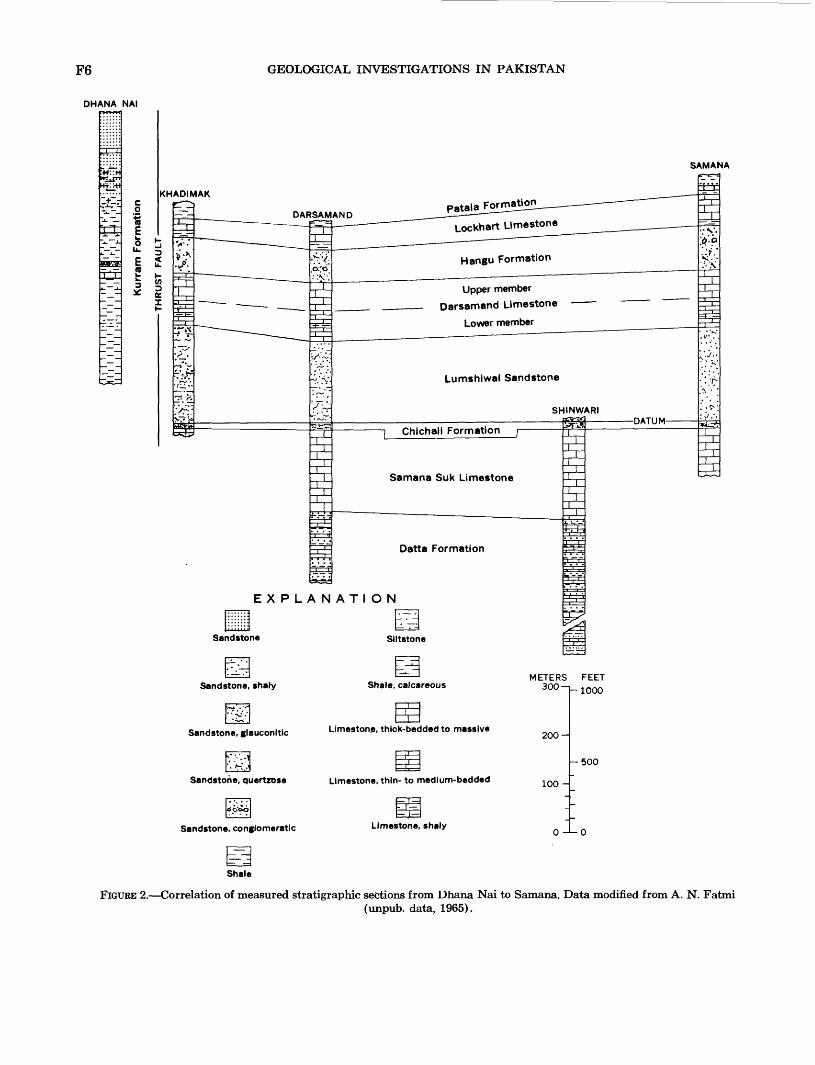
F6 GEOLOGICAL INVESTIGATIONS IN PAKISTAN
DHANA NAI
:+*
ISKHADIMAK
SAMANA
PatalaFormation
Lockhart Limestone
Hangu Formation
Upper member
Darsamand Limestone
Lower member
Lumshiwal Sandstone
Chichali Formation
Samana Suk Limestone
Datta Formation
EXPLANATION
Shale, calcareousSandstone, shaty
Limestone, thick-bedded to massiveSandstone, glauconitlc
Limestone, thin- to medium-beddedSandstone, quertzose
Limestone, shalySandstone, conglomeratic
Shale
FIGURE 2. Correlation of measured stratigraphic sections from Dhana Nai to Samana. Data modified from A. N. Fatmi(unpub. data, 1965).
GEOLOGY OF THE PARACHINAR QUADRANGLE F7
Klippen composed of the Kurram Formation rest on bedrock ranging from Jurassic to Tertiary in age.
QUARTZITE
Quartzite of probable Cretaceous age forms the crest of the high mountain range north of Parachinar and has been traced on aerial photographs along the north border of the mapped area (pi. 1). The quartzite overlies Jurassic rocks in normal position and looks like the quartzite equivalent of the light-colored quartz- ose Lumshiwal Sandstone (see below) found in the Samana anticline.
The quartzite is white, light gray to brownish white, medium bedded to massive, very hard, and conglomer atic. It contains basalt sills, which are mineralized in places (see section on mineral resources), near the Afghan border, northwest of Parachinar.
CHICHALI FORMATION
The Chichali Formation was named by Danilchik (1961) from exposures at Chichali Pass in the Surghar Range east of the Parachinar quadrangle. The for mation has been measured by Fatmi at Samana, Darsamand, Shinwari, and Khadimak in the Parachinar quadrangle (fig. 2). The Chichali Formation is mapped with the Lumshiwal Sandstone on the geologic map (pi. 1). It crops out on the flanks of anticlines and in the center of synclines in the northeastern part of the area. The formation consists of rusty-brown to dark-green massive soft friable glauconitic sandstone, and of massive sandy shale. Thicknesses at Samana and Darsamand range from 55 to 60 ft and from 40 to 45 ft at Khadimak. The formation is soft and forms a bench above the cliff-forming Samana Suk Limestone.
Abundant ammonites and belemnites collected and identified by Fatmi establish the age of the formation as Early Cretaceous. The upper contact is conformable with the Lumshiwal Sandstone.
LUMSHIWAL SANDSTONE
The Lumshiwal Sandstone was named by Gee (1945) from a locality in the Salt Range east of the quadrangle. The formation has been measured by Fatmi (unpub. data, 1965) at Samana, Darsamand, and Khadimak (fig. 2). It has not been mapped separately but is combined with the Chichali Forma tion, where it is found on the flanks of anticlines and center of synclines in the northeastern part of the area (pi. 1).
At Khadimak this unit consists of soft green glauco nitic sandstone and sandy shale, whereas at Samana
it is hard light-gray to white quartzose sandstone. The sandstone is well bedded at Samana, but bedding is indistinct at Khadimak.
The thickness of the Lumshiwal Sandstone is 650 ft at Samana, 687 ft at Khadimak, and 551 ft at Darsamand. The formation forms a steep slope.
The upper contact of the Lumshiwal Sandstone with the Darsamand Limestone appears to be unconform- able. The upper surface of the Lumshiwal contains abundant limonitic fossil casts, suggesting that it has been exposed to weathering. The contact becomes transitional, however, in the eastern part of the Kohat quadrangle.
DARSAMAND LIMESTONE
The name Darsamand Limestone was proposed by Fatmi (unpub. data, 1965) for Upper Cretaceous rocks exposed at Darsamand in the Parachinar quadrangle. The formation is found in synclines and on the flanks of anticlines in the northeastern part of the Parachinar quadrangle (pi. 1.).
The Darsamand Limestone is well exposed at Samana, Darsamand, and Khadimak and is divided into two members (fig. 2). The lower member is light gray to olive gray, flaggy, thin to medium bedded, dense, and includes thin lenticular beds of soft nodular marl and shale. The formation averages about 200 ft in thickness, and it forms a steep slope. The contact with the upper member is gradational.
Fatmi has identified the Foraminifera Globotruncana sp. and Rotalipora sp. which suggest a Late Cretaceous age.
The upper member, which forms cliffs, is gray, dense, and thick bedded to massive, except at Khadimak where the upper 40-50 ft is thin to medium bedded and includes some thin beds of calcareous shale. The average thickness is 180 ft. At Samana, the upper contact of this member is irregular and iron stained, which suggests an unconformable contact with the Paleocene Hangu Formation. Meissner, Master, Rashid, and Hussain (1974) have noted that the contact becomes gradational to the east in the Kohat quadrangle.
KURRAM FORMATION
The name Kurram Formation is proposed here for the western facies of the Cretaceous sequence described above. Because of faulting, no exposure of the entire formation was found, but part of the formation was measured by Fatmi at Dhana Nai (fig. 2) and by members of the project at Chale Talao (fig. 3). No type locality has as yet been designated, because this
F8 GEOLOGICAL INVESTIGATIONS IN PAKISTAN
ABBASIBAN DA DALLAN
Habib Rahi Limestone Member
Patala FormationPanoba Shale
EXPLANATION
TBahadur Khel Panoba Shale salt
METERS FEET 200-
-600
Limestone, thin- to medium-bedded-
100-
Satt
r 300
Limestone, thick-bedded to massive
:-!-: Kurram Formation
FIGURE 3. Correlation of measured stratigraphic sections from Chale Talao to Jatta.
part of Pakistan is restricted and the most complete section has not been found. The formation is named after the Kurram River which flows across the forma tion along much of its course; the Kurram Formation along the Kurram River is temporarily considered the type locality.
The Kurram Formation is composed mostly of variegated red, brownish-red, chocolate-brown, brown, green, and gray shale, mudstone, and siltstone, con taining layers of very thin bedded platy limestone, which is commonly light gray, but which in places is mottled pink or red and light gray. The limestone is dense to lithographic, argillaceous, in many places cherty. In places it is oolitic. Three types of sandstone also form part of the Kurram Formation: One is yellow to rusty brown, soft, poorly sorted, and fine to coarse grained; the second is greenish brown, fine grained, and contains conglomerate beds; the third is green or
gray, fine grained, and hard. All the sandstone is ferruginous, and the weathered surfaces generally are coated with black desert varnish.
The Kurram Formation is intensely folded, faulted, and crumpled and forms irregular, hummocky hills. Most of the outcrops of this formation are within tribal agencies; further work will be necessary to describe the unit completely. The formation extends south into the Bannu quadrangle where it is mapped as Cre taceous rocks undifferentiated (W. H. Hemphill and A. H. Kidwai, written commun., 1964). The southern border of the Parachinar quadrangle (lat. 33°N.) is the arbitrary boundary between these two map units. Volcanic and mafic intrusive rocks containing man ganese are present in the Kurram Formation about 2 miles west of Thai (see section on mineral resources).
At the Chale Talao measured section, the Kurram Formation is in fault contact with the Paleocene Patala
GEOLOGY OF THE PARACHINAR QUADRANGLE F9
Formation (fig. 3); 1,066 ft of the Kurram Formation also was measured but it is not certain whether this is repeated or continuous thickness.
No fossils were found in the Kurram Formation at Chale Talao, but samples collected from this formation elsewhere yielded a few specimens of Globotruncana and belemnites. Algae in samples of the Kurram For mation equivalent in Afghanistan have been identified by Dr. Kaever of the West German Geological Mission to Afghanistan (oral commun., 1964) as Late Jurassic to Cretaceous in age.
CRETACEOUS ROCKS UNDIFFERENTIATED
Undifferentiated Cretaceous rocks were plotted from aerial photographs of certain regions of the inaccessible mountains in the northeastern part of the mapped area (pi. 1).
These Cretaceous rocks consist of light-gray apha- nitic thin- to thick-bedded limestone that contains thin beds of shale and dark-green and dark-gray glauconitic sandstone and shale. The description of these rocks is based on the known characteristics of Cretaceous formations that are mapped separately elsewhere.
PALEOCENE SERIES
HANGU FORMATION
The Hangu Formation was named by Meissner, Master, Rashid, and Hussain (1974) for exposures of lower Paleocene rocks in the Kohat quadrangle east of the Parachinar quadrangle. The type locality is along the south flank of the Kohat range, a few miles east of the mapped area, where it changes laterally from sandstone to limestone and shale.
The Hangu Formation in the Parachinar quadrangle was measured by Fatmi (unpub. data, 1965) at Samana, Darsamand, and Khadimak (fig. 2) where it consists of light-gray to reddish-brown quartzose sand stone. Ferruginous material in the sandstone imparts a specklecj or banded appearance to some beds. The sandstone is fine to coarse grained, thick bedded, and includes conglomerate beds. Graded bedding and cross- bedding are common. The formation forms a steep slope or cliff along its belt of outcrop. It is 300 ft thick at Samana, 200 ft thick at Darsamand, and about 250 ft thick at Khadimak. The formation is found on the flanks of anticlines in the northeastern quadrant of the Parachinar quadrangle (pi. 1). The upper contact with the Lockhart Limestone is gradational.
LOCKHART LIMESTONE
The Lockhart Limestone was named by Davies (1930, p. 10) from exposures near the Samana anti cline at Fort Lockhart in the east-central part of
the Parachinar quadrangle. The formation has been measured by Fatmi (unpub. data, 1965) at Samana, Darsamand, and Khadimak (fig. 2), where it is present is folded mountain ranges (pi. 1).
The Lockhart Limestone forms cliffs, is gray to dark gray, dense to medium crystalline, and thick bedded to massive. In places it is rubbly and nodular because of weathering. At Samana, the lower 50 ft of the limestone is flaggy and splintery, and the basal 20-25 ft of this interval contains beds of shale. The thickness of the formation ranges from 120 ft at Khadimak to about 200 ft at Samana.
Some zones in the limestone contain abundant Foraminifera, corals, algae, and mollusks of Paleocene age (Davies, 1930). The upper contact appears to be conformable with the Patala Formation.
PATALA FORMATION
The name Patala Formation is taken from the Patala shales of Davies and Pinfold (1937,p. 7), who described these rocks in the Patala Nala in the Surghar Range east of the Parachinar quadrangle. The name Patala Formation, rather than Patala shales, is used by the Stratigraphic Committee of Pakistan because the unit contains lithologic types other than shale.
The formation is partly exposed in the broad valley that trends northeast, then east, across the central part of the area (pi. 1). At no place was an exposure of the entire formation found. Parts of the formation were measured at Samana, Darsamand, Khadimak (fig. 2), and Chale Talao (fig. 3).
At Samana the Patala Formation is composed of gray and greenish-gray shale containing layers of lime stone and calcareous sandstone in the lower part, and a hard, somewhat brecciated limestone at the top. About 114 ft of rocks in this formation is exposed to the north of the Samana anticline. At Khadimak, a thickness of about 116 ft of the Patala Formation is exposed on the flanks of the Khadimak anticline. Here the formation consists of greenish-gray and dark-gray shale, calcareous shale, marl, and sandy brecciated limestone, and interbeds of calcareous sandstone. Part of the Patala Formation is exposed on the flank of the Darsamand anticline.
The Patala Formation at Chale Talao is 1,948 ft thick. The upper 100 ft is chocolate brown, dull-red to orange shale, whereas most of the remainder of the section is brownish-gray, yellowish-gray, olive-gray, or greenish-gray shale, nodular at places, and some argillaceous limestone. The formation contains a few beds of pinkish-brown or yellow-brown sandstone. This sandstone is fine grained, hard, and shaly in places.
The Patala Formation contains zones of Ostrea,pele-
F10 GEOLOGICAL INVESTIGATIONS IN PAKISTAN
cypods, coral fragments, and plentiful Foraminifera. Globorotalia pseudomenardii and G. velasconensis, collected from a sample taken about 80 ft below the top of the formation, indicate a late Paleocene age; other diagnostic Foraminifera, collected from samples lower in the section, definitely identify the Patala Formation at Chale Talao as Paleocene.
The upper contact is unconformable with the Kamlial Formation of Miocene age at Chale Talao. However, northeast of Chale Talao and south of the mountain range where the exposures at Samana, Dars- amand, and Khadimak were measured, is a broad east-west valley underlain mostly by shale. The Patala Formation crops out along the south flank of the range on the north side of the valley, and the Panoba Shale crops out along the south side of the valley. The contact between the Patala Formation and the over lying Panoba Shale is probably under the alluvium that covers most of the valley (fig. 4).
The name Thai Formation was proposed by Fatmi (unpub. data, 1965) for isolated outcrops of Paleocene rocks north and east of the town of Thai; he divided the formation into .three members which he proposed to call, from older to younger, the Sanghroba Sand stone Member, the Mulla Bata Limestone Member, and the Shkalai Shale Member. These outcrops have been seen by the authors and seem to be lithologic variations of the Patala Formation. Further work is necessary to corroborate Fatmi's division.
PALEOCENE ROCKS UNDIFFERENTIATED
Paleocene rocks undifferentiated were mapped from aerial photographs of parts of the mountainous region in the northern part of the mapped area (pi. 1) where individual formations could not be recognized on the photographs. These rocks are believed to be the equivalent of the Hangu Formation, the Lockhart Limestone, and the Patala Formation.
Lithologic characteristics of the Paleocene rocks undifferentiated are assumed from the description of individual Paleocene formations. The Paleocene rocks are composed of brown, yellowish-gray, and olive-gray shale and argillaceous limestone and sandstone, dark- gray massive nodular-weathering limestone, and light-gray to reddish-brown quartzose conglomeratic sandstone.
EOCENE SERIES
PANOBA SHALE
The Panoba shales were named by Eames (1952, p. 167, 169) for exposures near the village of Panoba in the Kohat quadrangle, east of the Parachinar quad rangle. The Stratigraphic Committee of Pakistan has approved the formal name Panoba Shale.
Exposures of the formation in the Parachinar quadrangle are found in the cores of anticlines in the southeastern quadrant (pi. 1). No exposures of the complete thickness of the Panoba Shale were found because the base is covered by alluvium; parts of the formation were measured at seven localities: Pitau, Togh, Pungi, Gurguri, Abbasi Banda, Dalian, and Mardan Khel. The Panoba Shale is gray, light gray, greenish gray, yellowish gray, yellowish brown, or olive green; at the Abbasi Banda section, the upper part of the Panoba is mottled yellow, reddish brown, light gray, and black. The shale is calcareous and slightly silty and contains small clay nodules. In it are beds of yellowish-brown to dark-brown fine- to coarse-grained sandstone, in places containing pebbles of chert, quartz- ite, and limestone. Thin beds of argillaceous limestone are present. The formation forms valleys.
The thickest measurement of Panoba Shale is 625 ft at Mardan Khel (fig. 3). The unit pinches out in a westerly direction across the Parachinar quadrangle; at Abbasi Banda, about 118 ft of Panoba is exposed, but at Chale Talao, the Panoba and all other Eocene beds are absent, and the Paleocene Patala Formation is in unconformable contact with the Miocene Kamlial Formation. The Panoba Shale extends southward into the Bannu quadrangle where it is mapped as the Ghazij Shale (W. H. Hemphill and A. H. Kidwai, written commun., 1964). The southern border of the Parachinar quadrangle (lat. 33°N.) is the arbitrary boundary between these two formations. A more suit able boundary may be made if additional fieldwork reveals a sharp change in the shale between the Parachinar area to the north and Bannu area to the south.
Foraminifera, including Lockhartia hunti, which were collected from samples of the Panoba Shale, have been identified as probably early Eocene.
The upper contact of the Panoba Shale is uncon formable. The overlying formation in most places is the Mami Khel Clay, but in the Kohat quadrangle north of the village of Khumari (fig. 1), about 3 miles east-northeast of Mardan Khel, the Panoba Shale is overlain by a thin layer of the Bahadur Khel Salt. At Jatta, in the Kohat quadrangle, the Panoba is not exposed (fig. 3). The Panoba Shale is presumed to underlie the rock salt at Bahadur Khel, and in the Kohat quadrangle the rock salt may partly replace the Panoba Shale as a lateral facies change (Meissner and others, 1974).
BAHADUR KHEL SALT
The Bahadur Khel Salt was named by Meissner, Master, Rashid, and Hussain (1974) for exposures
GEOLOGY OF THE PARACHINAR QUADRANGLE Fll
TOGH
EXPLANATION
Sandstone, conglomeratic
Shale, stlty
Limestone, thick-bedded to massive
Limestone, thin- to medium-bedded
Dolomite
Sirki Shale
Habib Rahi
Limestone Member
Sadkal Member |=
Kaladhand Member
Mami Khel Clay *~
Panoba Shale
dst=^=
t 'i
4=
^4=?i=
1 ,i
=t=
i?..~/J
!= ̂ L*i.
ar^Si*
SAMANA
-T :T~
i1/Yv
yV-ii ,i
; X .'
»*> '.'* -V
/ .'^e"
. iII ,. ii
Patala Formation
Lockhart Limestone
Hangu Formation
Upper member
Darsamand Limestone
Lower member
Lumshiwal Sandstone
Chichali Formation
Samana Suk Limeston
METERS FEET 300 > 1000
200-
100-
rsoo
FIGURE 4. Correlation of measured stratigraphic sections from Samana to Togh.
of rock salt in the Bahadur Khel salt quarry in the southeast corner of the Parachinar quadrangle (pi. 1). Ths Bahadur Khel Salt is color-banded light-gray and dark-gray translucent to opaque rock salt which con
tains sparse clear crystals; it includes very thin layers of green or greenish-gray clay.
The Bahadur Khel Salt was measured on the north side of the Bahadur Khel rock salt quarry where the
F12 GEOLOGICAL INVESTIGATIONS IN PAKISTAN
exposed thickness of the salt is 320 ft. About miles east of the measured outcrop, a drill hole penetrated more than 1,700 ft of rock salt (Rashid and others, 1965). About 3 miles west of Bahadur Khel the rock salt pinches out. The salt is also known to extend to a point about 9 miles north of Bahadur Khel, about 1 mile south of Mardan Khel. There is a small exposure of the Bahadur Khel Salt in the Kohat quadrangle at Khumari, approximately 3 miles east-northeast of Mardan Khel. The approximate western limit of the rock salt trends from Khumari through Mardan Khel south to about 3 miles west of Bahadur Khel (fig. 1).
No fossils have been found in the rock salt, but on the basis of its stratigraphic position above the Panoba Shale and below overlying lower Eocene formations, it is probably early Eocene in age (also see section on mineral resources).
JATTA GYPSUM
The Jatta Gypsum was named by Meissner, Master, Rashid, and Hussain (1974) from exposures in the Jatta salt quarry in the Kohat quadrangle (fig. 3). The formation is massive, white, light gray, light brown, and green, and has light and dark color banding.
The Jatta Gypsum crops out in several narrow anticlines in the southeastern corner of the Parachinar quadrangle (pi. 1). At the Bahadur Khel salt quarry the gypsum is 230 ft thick, but, like the Bahadur Khel Salt, it pinches out to the north and west. The feather edge of the gypsum is 4 miles or more west of the edge of the rock salt.
Where the Bahadur Khel Salt is absent, the Jatta Gypsum is underlain by the Panoba Shale. The gypsum is conformably overlain by the Mami Khel Clay.
CHHARAT GROUP
The Chharat Group was named by the Stratigraphic Committee of Pakistan (1964b), and the type locality was designated near Chharat in the Campbellpur quad rangle, east of the Parachinar quadrangle. The Chharat Group, as defined by the committee, consists of two formations: the Mami Khel Clay and the overlying Kohat Formation. Apparently the committee chose the name Chharat Group to maintain the continuity of nomenclature dating from Eames (1952), when he named the Lower Chharat, which is now the Mami Khel Clay, and the Upper Chharat, which is now the Kaladhand and Sadkal Members of the Kohat Forma tion. The committee includes in the Chharat Group the closely related Habib Rahi Limestone Member of the Kohat Formation, formerly named the Kohat Limestone by Eames.
MAMI KHEL CLAY
The Mami Khel Clay was named by Meissner, Master, Rashid, and Hussain (1974) from exposures about 2 miles north of Mami Khel village in the Kohat quadrangle. It is the lower of two formations in the Chharat Group.
In the Parachinar quadrangle, the Mami Khel Clay includes clay beds which are red to brownish red, mottled red, green, and gray, or banded reddish brown and green. The clay is soft, poorly stratified, silty and sandy, calcareous, and in places gypsiferous. Interbedded sandstone is dark brown to reddish brown to brownish gray, and in places yellowish green. It weathers red, is poorly sorted, and contains quartz grains, black mineral grains, and chert pebbles. The sandstone is thin to medium bedded, hard, and cal careous. In many places a dolomitic limestone or dolomite bed is present at the top of the Mami Khel Clay. This bed is very light gray with a yellowish- brown tint, earthy looking, dense, and breaks down with an uneven fracture. The limestone ranges from 2 to 20 ft in thickness and, in places, contains beds of shaly limestone. At Abbasi Banda, a layer 4 in. thick at the top of the dolomitic limestone gives off a strong fetid odor.
The formation forms slopes and depressions and is exposed on the flanks of narrow anticlines in the south eastern quadrant of the Parachinar quadrangle (pi. 1). It ranges in thickness from 2 ft at Abbasi Banda to a maximum of 458 ft at Bahadur Khel. In areas where exposures are very thin it is not shown on the map.
Regionally, the Mami Khel Clay thins from east to west across the quadrangle (fig. 3) and is absent at Chale Talao.
Fossils are rare in this formation, but the presence of the Foraminifera Lockhartia hunti, Dictoyoconus, and Nummulites daviesi? identify it as Eocene in age, probably early Eocene. The upper contact with the Kohat Formation is unconformable.
KOHAT FORMATION
The name Kohat Formation was adopted by the Stratigraphic Committee of Pakistan (1964b) for the predominantly limestone sequence found overlying the Mami Khel Clay in the Kohat quadrangle. The Kohat Formation, as defined by the committee, is the upper formation of the Chharat Group and is composed of three members: in ascending order, the Kaladhand Member, the Sadkal Member, and the Habib Rahi Limestone Member.
The Kaladhand Member was originally named Kaladhand Limestone by Eames (1952, p. 167-168)
GEOLOGY OF THE PARACHINAR QUADRANGLE F13
for limestone exposed in the Kaladhand Algad in the Kohat quadrangle.
The Kaladhand Member is exposed at the base of narrow limestone ridges in the southeastern quadrant of the Parachinar quadrangle. It consists mainly of light- to dark-gray dense to coarsely crystalline lime stone; it is mostly thin to medium bedded, but in places is thick bedded. The limestone contains many joints, is shaly in places, and has thin beds of hard gray shale. At Gingarai, 46 ft of gray shale is included at the base of the Kaladhand Member. Calcite veins are common in the limestone. The member ranges in thickness from 38 feet at Pungi to 464 ft at Togh. It is believed to thin from east to west and is absent at Chale Talao (fig. 3).
The Foraminifera Dictyoconoides vredenburgi, Fas- ciolites oblonga (d'Orbigny)!, and Orbitolites com- planatas identify the Kaladhand Member as Eocene, probably early Eocene in age. The upper contact with the Sadkal Member is transitional; however, the Sadkal is either absent locally or was not recognized in about half the measured outcrops.
The Sadkal Member was named by Meissner, Master, Rashid, and Hussain (1973) from exposures near the locality of Sadkal in the Campbellpur quad rangle east of the Parachinar quadrangle. At Sadkal the member is composed of green and greenish gray shale which contains numerous Nummulites tests, but in the Parachinar quadrangle the member is mostly limestone and is difficult to distinguish from the under lying Kaladhand Member.
The limestone is cream colored or gray, finely crys talline, thin bedded, and contains interbedded shale. The shale is gray, red, variegated yellow and brown, calcareous, nodular, and contains thin beds of lime stone. Carbonaceous shale containing a 4-in. bed of lignite forms the base of the member at Abbasi Banda.
The Sadkal Member ranges in thickness from 14 to 49 ft. The outcrop at Pungi contains an abundance of nondiagnostic Nummulites sp. The upper contact with the Habib Rahi Limestone Member is conformable.
The Habib Rahi Limestone Member was designated by the Stratigraphic Committee of Pakistan (1946b) to replace the Kohat Limestone of Davies (1940, p. 202; 1943) named from exposures in the Kohat quad rangle. As defined by the committee, the Habib Rahi is traceable from its type locality at the Sui gas field about 300 miles south of the Kohat and Parachinar quadrangles. South of the Parachinar quadrangle, in the Bannu quadrangle, the Habib Rahi Limestone Member is the basal member of the Kirthar Formation (W. H. Hemphill and A. H. Kidwai, written commun., 1964). The southern border of the Parachinar quad
rangle (lat. 33°N.) is the arbitrary boundary between the Kohat Formation and the Kirthar Formation. The Habib Rahi Limestone Member is the only rock unit common to the two formations.
The Habib Rahi Limestone Member forms the top of long narrow limestone ridges in the southeastern quadrant of the Parachinar quadrangle (the upper part of the Kohat Formation (pi. 1). The member is cream to yellowish brown, or pink, dense to finely crystalline limestone, thin bedded to massive, and rubbly. In a few places are very thin beds of shale.
The Habib Rahi Limestone Member at the Togh section is 891 ft thick (fig. 4); thicknesses elsewhere range from 45 to 312 ft. At Abbasi Banda, the lime stone is 45 ft thick, and the member thins southwest- ward along the outcrop and pinches out about 6 miles north of Chale Talao section (fig. 3). The Foraminifera Orbitolites complanata and Dictyoconus indicus iden tify the member as Eocene in age.
The upper contact of the Kohat Formation in most places is unconformable with the Murree and Kamlial Formations of the Rawalpindi Group; one exception is the conformable contact at Togh with what is believed to be the Sirki Shale.
SIRKI SHALE
Eames (1952, p. 168) described 15 ft of brown shale and interbedded impure limestone near Sirki Paila (lat 33°27'N., long 71°3'E.) in the Kohat quadrangle (fig. 1). Because of its limited areal extent, Meissner, Master, Rashid, and Hussain (1973) have not mapped this shale in the Kohat and Parachinar quadrangles. At Togh in the Parachinar quadrangle, about 3^ miles west of Sirki Paila, limestone and shale above the Kohat Formation may be equivalent to the Sirki Shale (fig. 4), but this is not well established. The upper part of the unit consists of 39 ft of limestone, brownish gray with a yellow tinge, coarse crystalline, moderately hard, with very thin beds of shale. The lower part of the unit consists of 53 ft of yellowish-brown platy thin-bedded shale, interbedded with yellowish-brown limestone. The unit contains numerous Nummulites and is Eocene in age.
The Sirki Shale was not found elsewhere in the Parachinar quadrangle. Its upper contact is uncon formable with the Miocene Kamlial Formation.
MIOCENE SERIES
RAWALPINDI GROUP
The Rawalpindi Group was named by the Strati- graphic Committee of Pakistan (1964b), and the type
F14 GEOLOGICAL INVESTIGATIONS IN PAKISTAN
locality was designated near the city of Rawalpindi (east of the Parachinar quadrangle). The group, as defined by the committee, consists of two formations. The Kamlial Formation is the upper unit and the Murree Formation, the lower; they are continental deposits. Apparently the committee believes that the Murree and Kamlial Formations, although distinctive lithologically, are closely enough related in their depositional history to be a group.
MURREE FORMATION
The rocks now included in the Murree Formation were first distinguished and mapped by Wynne (1874, p. 66), who called them the Murree series, at Murree (lat 33°54'N., long 73°27'E.) in the Rawalpindi dis trict. The first use of the term "formation" rather than the term "series" to identify these rocks is unknown, but Murree Formation has been accepted by the Stratigraphic Committee of Pakistan as the formal name.
The Murree Formation is very thin or absent along the western border of the Kohat quadrangle (Meissner and others, 1974). In the Parachinar quadrangle, the Murree Formation was measured at Dargai and Pungi (too thin to show on map, pi. 1) and mapped in the center of a syncline near the east-central edge of the quadrangle. At Dargai, the Murree Formation is com posed of brick-red clay, silty claystone, and purple to dark-brown sandstone (fig. 5). The sandstone is medium to coarse grained, thin bedded, flaggy, cross- bedded, and contains conglomerate lenses and layers of grit. A conglomerate bed 4 ft thick is in unconform- able contact with the underlying Kohat Formation. The formation is 134 ft thick, and its upper contact is conformable with the Kamlial Formation.
The Murree Formation at Pungi is purple to reddish- brown medium-grained thin-bedded hard sandstone containing pebbles of chert. The formation is at the top of the sequence at Pungi and was not measured. An 8-ft-thick bed of concretionary nodules lies between the Murree Formation and the underlying Kohat Formation. No fossils were found in the Murree at Dargai and Pungi, but the formation elsewhere is Miocene in age (Holland and others, 1956, p. 174- 175).
KAMLIAL FORMATION
The Kamlial Formation was originally named the Kamlial stage by Pinfold (1918, p. 154) for rocks at Kamlial (lat 33°17'N., long 72°35'E.). Lewis (1937, p. 202) referred to the same rocks as the Kamlial Formation. The name Kamlial Formation was formally
accepted by the Stratigraphic Committee of Pakistan (1964a).
The Kamlial Formation, the upper formation of the Rawalpindi Group, consists of sandstone and inter- beded clay and shale and conglomerate lenses. The sandstone is light gray, gray, or greenish gray, and in many places has a "salt and pepper" pattern of light quartz grains mixed with dark mica flakes and ferro- magnesian minerals. It generally is poorly sorted. Crossbedding is a common feature. The sandstone is moderately hard, forming hogback ridges and cliffs in the southeastern quadrant of the Parachinar quad rangle (pi. 1). The clay and shale are dull red, chocolate brown to dark brown, silty, and contain lenses of siltstone. The base of the Kamlial, where it is in unconformable contact with the Kohat Formation, contains pebbles of limestone from the Kohat. This suggests uplift and erosion of the limestone prior to deposition of the Kamlial.
A complete sequence of the Kamlial-Formation was measured at Dargai, where it is 2,825 ft thick. This is a greater thickness than that measured at Banda Daud Shah in the Kohat quadrangle, about 26 miles east of Dargai; however, the lithology in the two exposures is similar (fig. 5).
No diagnostic fossils were found in the Kamlial at Dargai, but the formation is said to be Miocene (Stratigraphic Committee of Pakistan, written com- mun., 1963). The upper contact of the Kamlial with the Chinji Formation is conformable.
PLIOCENE SERIES
SIWALIK GROUP
In December 1963 the Stratigraphic Committee of Pakistan designated the name Siwalik Group and defined it to include the Chinji Formation as the lower unit, the Nagri Formation as the middle unit, and the Dhok Pathan Formation as the top unit. These units are of continental origin.
CHINJI FORMATION
The Chinji Formation was originally named the Chinji stage by Pilgrim (1913, p. 267) for the type section at the village of Chinji in the Salt Range east of the quadrangle. Lewis (1937, p. 200) referred to the same rocks as the Chinji Formation, and this formal name has been accepted by the Stratigraphic Com mittee of Pakistan.
The formation is exposed in broad synclines in the southeastern part of the Parachinar quadrangle (pi. 1) and forms valleys, slopes, and, in places, low ridges.
GEOLOGY OF THE PARACHINAR QUADRANGLE P15
DATUM -
Nagri Formation
Chinji Formation
Kamlial Formation
Murree Formation
COMPOSITE SECTIONTOTAKI, SOUTHEAST TOTAKI,
AND BANDA DAUD SHAH
EXPLANAT1ON
Cobble beds
Conglomerate beds and lenses
METERS FEET 1-4000
1000-
Clay and shale
500-
Silty clay and siltstorte
K-2000
Sandstone
FIGURE 5. Correlation of measured stratigraphic sections from Dargai to Totaki and Banda Daud Shah.
F16 GEOLOGICAL INVESTIGATIONS IN PAKISTAN
A complete sequence of the formation was measured at Dargai where it is composed of clay and beds of sandstone. The clay is orange, red, dark brown, or gray, and forms valleys and slopes. It is silty and contains thin lenticular beds of siltstone and sandstone. The fine- to coarse-grained sandstone is light gray, greenish gray, conglomeratic, and crossbedded. The thickness of the Chinji at Dargai is 4,145 ft, which is greater than at Banda Baud Shah in the Kohat quad rangle (fig. 5). The lithology of the two sequences is similar, but the formation is bright red at Banda Baud Shah and darker at Bargai.
The Chinji Formation is conformable with the overlying Nagri Formation. The age of the Chinji in the Kohat quadrangle is Pliocene and is assumed to be the same in the Parachinar quadrangle. Positive determination of the Chinji Formation in the Kohat quadrangle as Pliocene was made on the basis of a jawbone, complete with teeth, of the mastodon Tetra- lophodon falconeri found in the formation. It was identified by Br. Bavid Bunkle (U.S. Natl. Mus., oral commun., 1963) as the remains of a mastodon that lived exclusively in the Pliocene. (For more informa tion on the Chinji Formation, see Meissner and others, 1974.)
NAGRI FORMATION
The Nagri Formation was originally named the Nagri stage by Pilgrim (1913, p. 267, 318, 321) from rocks near the village of Nagri (lat 32°40'N., long 72°14'E.). Lewis (1937, p. 199) referred to these same rocks as the Nagri Formation, and the Stratigraphic Committee of Pakistan has accepted this name for the unit.
The formation is found in broad synclines in the southeastern part of the Parachinar quadrangle (pi. 1).
A complete sequence of the Nagri Formation, 3,510 ft thick, was measured at Bargai (fig. 5). It is com posed of sandstone, clay, and silty clay. The sandstone is greenish gray or light gray, medium to coarse grained, medium bedded to massive, and contains lenses of conglomerate and is crossbedded. The clay is orange, reddish gray, or gray, and has conglomerate lenses. The silty clay is red, reddish gray, orange, or brown. The main difference between the Nagri and the underlying Chinji Formation is that the Nagri contains about 70 percent sandstone and forms ridges, whereas the Chinji is mostly clay and forms valleys.
The Nagri Formation at Bargai is thinner than at Totaki section in the Kohat quadrangle (fig. 5), but the lithology at the two places is similar.
The age of the Nagri is considered to be Pliocene (Holland and others, 1956). The upper contact with the Bhok Pathan Formation is gradational.
DHOK PATHAN FORMATION
The Bhok Pathan stage was named by Pilgrim (1913, p. 278, 307) after a village on the Soan River (lat 33°07'N., long. 72°14'E.). Lewis (1937, p. 198) referred to these same rocks as the Bhok Pathan Formation, and the Stratigraphic Committee of Pakistan has accepted Lewis' name for this formation.
The formation is found in the center of a broad syncline in the southern part of the Parachinar quad rangle (pi. 1). An incomplete sequence was measured at Bargai (fig. 5). The lower half of the measured sequence, which is 1,693 ft thick, consists of very light gray, bluish-gray, or gray fine- to medium-grained sandstone, containing lenses of conglomerate and beds of siltstone and silty clay. The conglomerate consists mostly of pebbles but also contains cobbles as much as 6 in. in diameter. At the base of this unit is greenish-gray to yellowish-green fine- to coarse-grained sandstone which is locally crossbedded. The upper half of the section, which is 1,418 ft thick, forms scarps and consists of boulder to pebble conglomerate in a soft sandstone matrix. The diameters of the cobbles and pebbles in the conglomerate range from a few inches to a foot. The cobbles and pebbles are oriented with their long axes parallel to bedding. They are subrounded fragments of limestone from the Kohat Formation, as well as quartzite, chert, granite, schist, gneiss, and angular fragments of serpentine ranging in size from 1 to 8 in. In places, there are beds of gray medium- to coarse-grained crossbedded sandstone. Near the middle of this upper unit are two brownish- gray silty clay beds, each about 25 ft thick.
The Bhok Pathan Formation at Bargai is correlated with the Bhok Pathan southeast of Totaki in the Kohat quadrangle (fig. 5). The formation southeast of Totaki contains conglomerate lenses in sandstone; however, it contains few cobbles, and the conglomerate beds are much less abundant. The fact that the conglomerate lenses are more numerous at Bargai, compared with southeast Totaki, suggests that Bargai was closer to the source of sedimentation.
The boulder to pebble conglomerate unit of the Bhok Pathan Formation occupies the center of a broad syncline which forms a topographic high. No fossils were found in the Bhok Pathan at Bargai. It is recorded in the Lexique Stratigraphique International (Holland and others, 1956, p. 70) as Pliocene.
The Kamlial, Chinji, Nagri, and Bhok Pathan For mations of the Parachinar quadrangle abut the Litra and Chaudhwan Formations of the Bannu quadrangle (W. H. Hemphill and A. H. Kidwai, written commun., 1964) at the border of the two quadrangles. The boundary of these two formations is arbitrarily placed
GEOLOGY OF THE PARACHINAR QUADRANGLE F17
at this border, which is lat. 33°N. The Kamlial and associated formations have been traced and identified in the field from their type localities in the Potwar Plateau nearly 100 miles to the east, and the Litra and Chaudhwan Formations, as mapped by Hemphill and Kidwai, have been traced from their type localities 100 miles or more to the south. Lateral lithologic variations in these rocks make it difficult to correlate the two sets of terms between the Parachinar and Bannu quadrangles. When the opportunity arises for additional fieldwork, the outcrops should be followed along strike to determine where the Kamlial and associated formations merge into and become a part of the Litra and Chaudhwan Formations, and vice versa. Possibly this will be a zone of interfingering rocks which can be described to replace the arbitrary boundary at lat. 33°N.
HOLOCENE DEPOSITS
Alluvium in the map area (pi. 1) includes all types of unconsolidated surficial deposits of silt, sand, and gravel. Most of these deposits are water-laid by the Kurram River system, although there are alluvial fans from the mountain front along the southern border of the Parachinar quadrangle. Smaller streams in the northern mountainous region have formed rather broad alluvium-filled valleys.
MAFIC IGNEOUS ROCKS
Basalt sills have been mapped just southwest of the village of Thai on the west side of the Kurram River, and west and northwest of Parachinar near the Afghan border (pi. 1). Age of the igneous rocks is unknown; they intrude rocks of Jurassic and Cretaceous age.
STRUCTURE
Structurally the Parachinar quadrangle is one of the most interesting and complex areas in Pakistan, as it covers parts of three structural provinces and is an area that fits the concept that India was rafted from the south on a lithosphere plate that has collided with the Asian continent, as described by Dewey and Bird (1970) and Dietz and Holden (1970). In the north the quadrangle includes east-trending folds and north-dipping faults affecting Mesozoic rocks of the high ranges that extend eastward along the front of the Himalayan Mountain system. In the southeast, it includes smaller and more complex east-trending folds and faults affecting Tertiary rocks, typical of the plateau region south of the Himalayan front. In the west it includes part of a thrust plate of Cretaceous rocks, which covers and abuts the structures of the other two provinces. The overthrust Cretaceous rocks
(Kurram Formation) probably are part of the Asian tectonic plate, and the rocks of the other two structural provinces are part of the Indian tectonic plate.
Because much of the area within the Parachinar quadrangle was inaccessible and the time available for this survey was short, detailed mapping of structural elements needed to analyze the relationship between these three structural blocks could not be undertaken. From the evidence at hand, however, it appears that the thrust plate of Cretaceous rocks (Kurram Forma tion) probably moved relatively eastward, overriding rocks ranging in age from Jurassic to Pliocene. The thrust plate is wedge shaped, and as the wedge moved eastward it appears to have deformed the underlying rocks, bending the preexisting east-trending structures and causing the structures to bifurcate across the central part of the map area. As a result, structures in the underlying block near the thrust plate trend southwest in the south-central part of the quadrangle and northwest in the north-central part.
The gross truncation of structures near the thrust and the fact that the thrust plate has not generally been deformed into east-trending structures (as would otherwise be expected) suggests that the thrust plate moved from the west after most of the structures in the underlying block were formed. However, after the thrust plate of Cretaceous rocks was emplaced, it appears that north-south compressive stress was renewed, producing folds in the frontal part of the plate. As a result of this folding and subsequent erosion, klippen of the Cretaceous Kurram Formation are present on both sides of the Tirah Range, and Jurassic and younger rocks beneath the thrust plate are exposed in several areas in the center of the quadrangle.
The Parachinar quadrangle offers an exceptional opportunity for study of the structural features associ ated with the impingement of the Sulaiman Mountain system, which extends southward from the quadrangle along the west side of Pakistan, against the Himalayan system to the north. The area of impingement of these two mountain systems is probably very close or at least closely associated with the point of collision between the two continents. The importance of the location of this quadrangle, at the junction of these two systems, is evident by reference to the Geological Map of Pakistan (Bakr and Jackson, 1960).
Detailed mapping and analysis of the structures, as well as the overthrust sheet of Cretaceous rocks, should contribute much, not only to the understanding of the structural evolution and interrelations of the two systems, but also to the origin of the structural salients in Pakistan and their relation to continental drift.
F18 GEOLOGICAL INVESTIGATIONS IN PAKISTAN
MINERAL RESOURCES
GYPSUM
Gypsum deposits of Eocene age (Jatta Gypsum) found in the Kohat quadrangle (Rashid and others, 1965) extend west for a short distance into the Parachinar quadrangle. An area of approximately 175 square miles in the southeast corner of the Parachinar quadrangle is underlain by gypsum beds (pi. 1). They are 230 ft thick near the Bahadur Khel tunnel on the Kohat-Bannu highway (lat 33°09'45"E) long 70°57' 45"E) but pinch out a short distance to the north and west. The gypsum is banded green, light brown and white, and has intercalated green clay beds. It is found usually in the core of anticlines which are often asym metric or overturned to the south.
At present, there is not much demand for gypsum in the Parachinar quadrangle; if exploration interest increases in the future, the most promising deposit would be Bahadur Khel where the gypsum is thick and relatively pure, and the area is easily accessible.
ROCK SALT
The Eocene rock salt deposits (Bahadur Khel Salt) found in the Kohat quadrangle (Rashid and others, 1965) continue west for a short distance into the Parachinar quadrangle. An area of approximately 90 square miles in the southeastern corner of the Para chinar quadrangle is underlain by rock salt (pi. 1). Maximum exposed thickness of the salt is 320 ft at the Bahadur Khel quarry (lat 33°09', long 70°58'E.) but it wedges out a short distance to the north and west. The Geological Survey of Pakistan drilled a hole at Bahadur Khel to a depth of 4,512 ft without reach ing the base of the salt; the average dip of the salt beds was 70°N., and the actual stratigraphic thick ness penetrated was about 1,700 ft. The salt is light gray and contains grayish-green clay beds. It is found usually in the core of anticlines but also is exposed by faulting. A salt quarry in operation at Bahadur Khel produces 150 tons daily, and an increase in demand for salt could be met easily by expanding operations there.
SOAPSTONE
A soapstone deposit at an altitude of about 11,500 ft in the Kharwala Valley is approximately 2 l/2 miles N. 32° W. of the village of Gujarghuna (lat 33°59'12"- N., long 69°55'33"E.) (pi. 1). Gujarghuna village can be reached via Ali Mangal post by a mule trail that follows the Peiwar Creek. The soapstone forms two parallel beds 60 ft apart which strike east along the trend of the mountain for an unknown distance and dip 25°-40° N. The lower bed is 2 ft thick and the
upper bed is 4^ ft thick. They are interbedded with white to brownish-white quartzite and separated by a layer, probably a sill, of basalt which has intruded the quartzite. The soapstone is white with a light bluish tint; mineralogical analysis by the Geological Survey of Pakistan has found it to be pure steatite.
It is recommended that this area be mapped in detail to evaluate the feasibility of mining this high- quality soapstone.
COPPER
A deposit of chalcopyrite, at an altitude of 10,500 ft, north of Churoke Valley, is 1% miles N. 16° W. of the village of Gujarghuna. A 120-ft-high cliff of Cre taceous (?) quartzite is impregnated and partially replaced by chalcopyrite in an area at least 150 ft long. Lateral extension of the mineralized rocks was not explored because of the nearly impassable cliff. The bed of quartzite dips 35° N. and strikes east along the mountain front. It is underlain by black dense thin- bedded limestone which is in turn underlain by black friable paper shale. Both the shale and the limestone have a "baked" appearance as if they have been exposed to extreme heat. The black shale has been intruded by a basalt sill 4 ft thick. A mineralogical analysis of samples of the chalcopyrite-bearing quartz ite showed chalcopyrite altered to green and brown goethite, hematite, and malachite.
Detailed mapping is recommended, where accessi bility allows, to determine the extent of the copper deposit, and studies are necessary to give the per centage of rock replaced by copper mineralization, distribution and form of replacement, relative amounts of copper and iron sulfides, and possible ore reserves.
MANGANESE
A deposit of manganese ore in Khapianga hill (lat 33°20'N., long 70°32/E.), about 2 miles west of the village of Thai and 1 1/2 miles west of the Kurram River (pi. 1), was investigated by Klinger (1963) of the U.S. Geological Survey. The following description is a sum mary of his report.
The manganese ore is a mass of pyrolusite and chert occurring at the contact between mafic igneous rocks and thin-bedded cherty limestone of Cretaceous age. The ore is very hard and highly siliceous (50-60 per cent chert and has an average manganese content of probably less than 25 percent, although small pockets of nearly pure manganese oxide are present. Trench ing of the ore body indicated that it is about 12 ft wide, possibly 35 ft long, and in one place at least 7 ft deep. Assuming a volume-weight ratio of 12 cu ft per long ton, it is estimated that a total of 85 tons of ore is present (including 25 tons measured, 25 tons indi-
GEOLOGY OF THE PARACHINAR QUADRANGLE F19
cated, and 35 tons inferred). Assuming that excavation work that was underway showed a continuous length of 35 ft, an additional 100 tons of ore may be present. No future work is recommended.
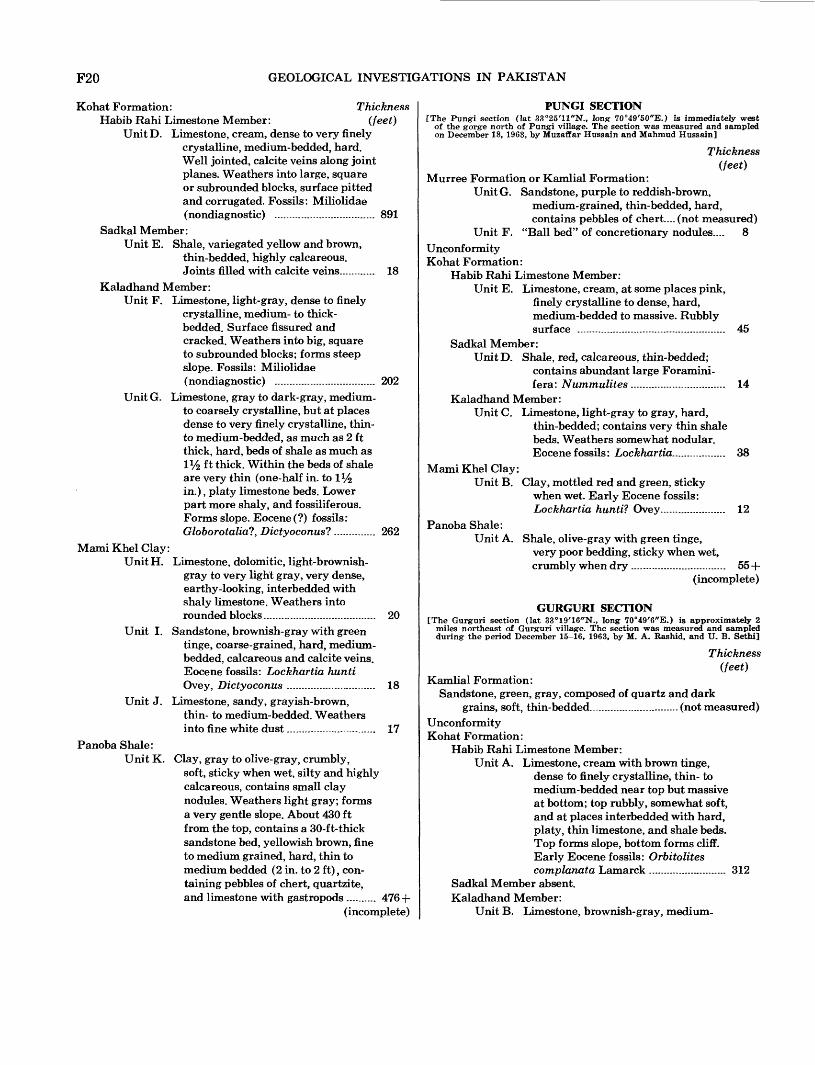
MEASURED SEQUENCES OF STRATIGRAPHIC UNITS
Eleven stratigraphic sequences masured by the authors and five measured by A. N. Fatmi of the Geological Survey of Pakistan provide the basis for the descriptions of the rock formations in the quad rangle. These sequences are described in the following pages. Figure 1 shows locations of the sections.
BAHADUR KHEL SECTION[The Bahadur Khel section (lat 33°10'20"N., long 70°58'30"E.) is near the
highway tunnel in the north flank of the Bahadur Khel anticline at the north side of the salt quarry. The section was measured and sampled during the period October 26-27, 1963, by Muzaffar Hussain and U. B. Sethi]
Thickness(feet)
Chinji Formation:Clay, bright-red, and thin beds of siltstone......not measured
Kamlial Formation:Unit G. Sandstone, greenish-gray to gray with
brown tinge, well-sorted, medium- to thick-bedded, and thin beds of clay. Forms ridges. Clay, red, 100 ft thick near the middle of the unit........ . 465
Unit F. Conglomerate, matrix composed of sandstone containing pebbles of underlying limestone of Kohat Formation . . . - 10
Unconformity Kohat Formation:
Habib Rahi Limestone Member:Unit E. Limestone, cream with brown tinge,
dense to finely crystalline, thick- bedded, rubbly...................................... 82
Sadkal Member and Kaladhand Member:Unit D. Limestone, shaly, brownish-gray to
gray, medium crystalline, thin- to medium-bedded, shale beds. Base more shaly ............................................ 74
Mami Khel Clay:Unit C. Clay, dull-red to red, silty, poor strati
fication. At the top is 4V£ -ft-thick dolomitic limestone bed. The upper part of the unit, about 80 ft thick, is sandy and contains sandstone beds, dark brown to reddish-brown, medium to coarse grained, thin to medium bedded.................................... 458
Jatta Gypsum:Unit B. Gypsum, whitish-green to green,
hard, massive, and banded.................. 230Bahadur Khel Salt:
Unit A. Rock salt, whitish-gray, hard, trans lucent to opaque; contains clayey bands...................................................... 320 +
(incomplete)
PITAU SECTION[The Pitau section (lat 33°24'26"N., long 70°40'37"E.) is three-fourths of a
mile northwest of Pitau Peak, 1 mile S. 15° E. of the Darsamand railway station. The section was measured and sampled on November 25, 1963, by M. A. Rashid, Muzaffar Hussain, U. B. Sethi, and Manured Hussain]
Thickness(feet)
Kamlial Formation:Unit I. Clay, dark-brown, soft; sandstone,
TOGH SECTION[The Togh section (lat 33°26'29"N., long 70°59'16"E.) is a mile east of Togh
village. The section was measured and sampled during the period November 28 to December 1, 1963, by M. A. Rashid, Muzaffar Hussain, U. B. Sethi, and Mahmud Hussain]
Thickness(feet)
Murree Formation:Unit A. Sandstone, dark-brown, fine- to
Unit B. Limestone, brownish-gray with yellow tinge, coarsely crystalline, moder ately hard; contains very thin beds of shale. Weathers yellowish brown, forms rounded blocks. Abundant fossils (Eocene?): Nummulites ........ 39
Unit C. Shale, yellowish-brown, platy, thin- bedded, weathers soft, interbedded with limestone, yellowish brown, thin to medium bedded; forms valley. Eocene (?) fossils: Nummulites ........ 53
UnitD. Limestone, cream, dense to very finely crystalline, medium-bedded, hard. Well jointed, calcite veins along joint planes. Weathers into large, square or subrounded blocks, surface pitted and corrugated. Fossils: Miliolidae (nondiagnostic) .................................. 891
Sadkal Member:Unit E. Shale, variegated yellow and brown,
thin-bedded, highly calcareous. Joints filled with calcite veins............ 18
Kaladhand Member:Unit F. Limestone, light-gray, dense to finely
crystalline, medium- to thick- bedded. Surface fissured and cracked. Weathers into big, square to subrounded blocks; forms steep slope. Fossils: Miliolidae (nondiagnostic) .................................. 202
UnitG. Limestone, gray to dark-gray, medium- to coarsely crystalline, but at places dense to very finely crystalline, thin- to medium-bedded, as much as 2 ft thick, hard, beds of shale as much as iy2 ft thick. Within the beds of shale are very thin (one-half in. to 1% in.), platy limestone beds. Lower part more shaly, and fossiliferous. Forms slope. Eocene (?) fossils: Globorotalia?, Dictyoconus?.............. 262
Mami Khel Clay:Unit H. Limestone, dolomitic, light-brownish-
gray to very light gray, very dense, earthy-looking, interbedded with shaly limestone. Weathers into rounded blocks...................................... 20
Unit I. Sandstone, brownish-gray with green tinge, coarse-grained, hard, medium- bedded, calcareous and calcite veins. Eocene fossils: Lockhartia hunti Ovey, Dictyoconus .............................. 18
Unit J. Limestone, sandy, grayish-brown,thin- to medium-bedded. Weathersinto fine white dust.............................. 17
Panoba Shale:Unit K. Clay, gray to olive-gray, crumbly,
soft, sticky when wet, silty and highly calcareous, contains small clay nodules. Weathers light gray; forms a very gentle slope. About 430 ft from the top, contains a 30-ft-thick sandstone bed, yellowish brown, fine to medium grained, hard, thin to medium bedded (2 in. to 2 ft), con taining pebbles of chert, quartzite, and limestone with gastropods .......... 476 +
(incomplete)
PUNGI SECTION[The Pungi section (lat 33°25'11"N., long 70°49'50"E.) is immediately west
of the gorge north of Pungi village. The section was measured and sampled on December 18, 1963, by Muzaffar Hussain and Mahmud Hussain]
Thickness(feet)
Murree Formation or Kamlial Formation:Unit G. Sandstone, purple to reddish-brown,
medium-grained, thin-bedded, hard, contains pebbles of chert....(not measured)
Unit F. "Ball bed" of concretionary nodules.... 8Unconformity Kohat Formation:
Habib Rahi Limestone Member:Unit E. Limestone, cream, at some places pink,
finely crystalline to dense, hard, medium-bedded to massive. Rubbly surface .................................................. 45
Habib Rahi Limestone Member:Unit A. Limestone, cream with brown tinge,
dense to finely crystalline, thin- to medium-bedded near top but massive at bottom; top rubbly, somewhat soft, and at places interbedded with hard, platy, thin limestone, and shale beds. Top forms slope, bottom forms cliff. Early Eocene fossils: Orbitolites complanata Lamarck .......................... 312
Sadkal Member absent. Kaladhand Member:
Unit B. Limestone, brownish-gray, medium-
GEOLOGY OF THE PARACHINAR QUADRANGLE F21
Thickness(feet)
Kohat Formation ContinuedKaladhand Member Continued
to coarse crystalline, thin- to medium-bedded (6 in. to 2 ft), hard, jointed contains thin, hard, platy shale beds . 74
Unit C. Limestone, brownish-gray, top verycoarsely crystalline, bottom medium to coarsely crystalline, thin- to medium-bedded containing soft calcareous shale beds. Bottom is shaly and nodular................................ 52
MamiKhelClay:Unit D. Sandstone, yellowish-green (brown in
places) weathering dull or bright red; hard, poorly sorted, thin to medium bedded, calcareous; contains quartz grains, black mineral grains, and chert pebbles. Clay, dull red to light-greenish-red and gray (variegated), soft, crumbly, calcareous, and silty............................ 64
Panoba Shale:Unit E. Clay, olive-gray, crumbly, soft, cal
careous, sticky when wet, silty; con tains small clay nodules. Approxi mately 490 ft from top is a sandstone bed, grayish brown to dark brown, coarse grained, containing pebbles of chert and quartzite.......................... 495+
(incomplete)
ABBASI BANDA SECTION[The Abbasi Banda section (lat 33°21'21"N., long 70°35'E.) is approximately
three-fourths of a mile S. 5° W. of Abbasi Banda village, on the south side of the Shkalai Nala. The section was measured and sampled on December 19, 1963, by M. A. Rashid and U. B. Sethi]
Thickness(feet)
Kamlial Formation:Sandstone and shale........................................ (not measured)
Unconformity Kohat Formation:
Habib Rahi Limestone Member:Unit A. Limestone, cream, thin- to medium-
bedded, and thin beds of clay. Eocene fossils: Lockhartia hunti Ovey, Dictyoconus indicus? Davies.. 26
Unit B. Limestone, yellowish-brown, thin- bedded, argillaceous-looking, and thin beds of clay.................................... 31
Sadkal Member:Unit C. Shale, gray, nodular, and thin beds of
limestone. Carbonaceous shale at base; wet and very sticky on the surface, dry inside. Contains 4-in. bed of lignite. Early Eocene fossils: Lockhartia hunti? Ovey...................... 15
Kaladhand Member absent.
MamiKhelClay:Unit D. Limestone, dolomitic, chalky white with
yellowish-brown tinge, dense, breaks into uneven surface. A 4-in-thick limestone bed at the top of the dolomitic limestone gives a strong fetid odor .............................................. 2
Panoba Shale:Unit E. Clay, mottled yellow, reddish-brown,
and black, and argillaceous lime stone. Early Eocene fossils: Lockhartia hunti? Ovey...................... 118+
(incomplete)
DALLAN SECTION[The Dalian section (lat 33°21'29"N., long 70°38'45WE.) is three-fourths of a
mile west of Dalian village. The section was measured and sampled on December 19 1963, by Muzaffar Hussain and Mahmud Hussain]
Thickness(feet)
Kamlial Formation:Unit F. Sandstone, greenish-gray, fine- to
medium-grained, well-sorted and massive; contains current bedding.................................. (not measured)
Unconformity Kohat Formation:
Habib Rahi Limestone Member:Unit E. Limestone, cream, dense to finely
crystalline, medium-bedded to mas sive. Weathered surface rubbly.......... 139
Sadkal Member (?):Unit D. Limestone, cream, finely crystalline,
thin-bedded, and alternate thin beds of shale. Limestone contains Foraminifera. Some beds of nodular shaly limestone .................................... 49
Kaladhand Member:Unit C. Limestone, light- to medium-gray, finely
crystalline, thin-bedded (2-6 in.), calcite veins, thin shale beds. Some places more shale than limestone. .. 73
Mami Khel Clay:Unit B. Clay, mottled red and green, poorly
stratified. Early Eocene fossils: Num- mulites daviesi? (de Cizancourt)...... 23
Panoba Shale:Unit A. Shale, olive-green with yellow tinge,
MARDAN KHEL SECTION[The Mardan Khel section (lat 33°20'32"N., long 70°59'21"E.) is 1% miles
north-northeast of Mardan Khel village along a sharp gorge which joins Urmar Algad to the south. The section was measured and sampled during the period December 24-28, 1963, by M. A. Rashid, Muzaffar Hussain, and U. B. Sethi]
Kohat Formation:Habib Rahi Limestone Member:
Unit F. Limestone, cream, thin- to thick-
F22 GEOLOGICAL INVESTIGATIONS IN PAKISTAN
Kohat Formation Continued Thickness Habib Rahi Limestone Member Continued (feet)
bedded; upper part rubbly and shat tered. Forms a cliff. Eocene fossils: Orbitolites complanata Lamarck, Dictyoconus indicus Davies................ 172
Sadkal Member and Kaladhand Member:Unit E. Limestone, dark-gray, gray to light-
gray, dense to medium-crystalline, thin-bedded. At places, limestone is flaggy, shaly, and very thin bedded. Early Eocene fossils: Lockhartia huntil Ovey, Dictyoconus indicus? Davies .................................................... 288
Mami Khel Clay:UnitD. Limestone, dolomitic .............................. 4Unit C. Sandstone and clay interbedded.
Unit B. Sandstone and thin beds of olive-gray shale. Sandstone, fine- to medium- grained, thin-bedded (3 in. to 1 ft).... 78
Unit A. Shale, olive-green, interbedded withbrownish-gray sandstone and beds of calcareous shale, silty in upper part.. 547+
(incomplete)
DARGAI SECTION[The Dargai section (lat 33°13'27"N., long 70°44'E.) is 13 miles, northeast of
Daryoba fort, less than a mile west of Dargai village. The section was measured and sampled during the period January 10-18, 1964, by M. A. Rashid, Muzaffar Hussain, U. B. Sethi, and Mahmud Hussain]
Thickness(feet)
Dhok Pathan Formation:Unit J. Conglomerate and sandstone. Cobbles
and pebbles are a few inches to ft in diameter and have sandstone matrix. The cobbles and pebbles are oriented with the long axis parallel to bed ding; they are composed of limestone from the Kohat Formation, as well as quartzite, chert, granite, schist, gneiss, and angular fragments of serpentine ranging in size from 1 to 8 in. Sand stone is gray, medium to coarse grained, massive, crossbedded. Near middle part of unit are two silty clay beds, each about 25 ft thick, brownish gray, soft................................................ 1,418
(incomplete)Unit H & I. Sandstone, very light gray, bluish-
gray, and gray, fine- to medium- grained and conglomerate lenses (cobbles 6 in. in diameter, pebbles dominating), interbedded with silt and silty clay. Crossbedded. Weathers into bricklike pieces. Sandstone, lower third of unit, greenish-gray to yellowish-green, fine- to coarse-grained, crossbedded at places. Forms ridges ........................ 1,693
ThicknessNagri Formation: (feet)
Unit G. Sandstone, clay, and silty clay: Sand stone, greenish-gray, light-gray, medium- to coarse-grained, medium- bedded to massive, black mineral grains, conglomerate lenses, cross- bedded; weathers into brick-shaped and "sculptured" pieces. Clay, orange, reddish-gray, gray; contains conglomerate lenses. Silty clay, red, reddish-gray, orange, and brown........ 3,510
Chinji Formation:Unit F. Clay and sandstone: Clay, red, dark-
brown, gray, in places orange; contains thin lenticular sandstone beds and siltstone beds. Sandstone, light-gray, light-greenish-gray, fine- to coarse grained, conglomeratic, contains thin beds of red clay and silty clay: crossbedded, soft, weathers into bricklike blocks...................................... 2,140
Unit E. Sandstone and clay. Sandstone, light- gray, greenish-gray and gray, cross- bedded, soft; contains thin beds of clay, dull red to dark brown, silty, and beds of siltstone. Weathers into small rectangular pieces of rock.......... 2,005
Kamlial Formation:UnitD. Sandstone, light-gray, "salt and pepper,"
becoming greenish gray down section; fine to coarse grained, poorly sorted, at places conglomeratic, crossbedded, moderately hard; interbedded with clay, dull red to dark brown, con tains lenses of siltstone........................ 1,645
Unit C. Sandstone, greenish-gray to "salt and pepper," fine- to medium-grained, angular to subangular grains; moder ately hard, crossbedded, mica flakes and ferromagnesian mineral grains, conglomerate lenses, and bands of very coarse sandstone. Lower half, sandstone, becomes brownish gray to gray. Clay, interbedded with sand stone in upper two-thirds of unit, is chocolate colored to dull brown, dull red to dark brown, silty. Upper half of lower third of unit is a 229-ft-thick clay bed .................................................. 1,180
Murree Formation(?):Clay and silty claystone, brick-red, silty claystone,
and sandstone, purple to dark brown, medium to coarse grained, thin bedded, flaggy, crossbedded, containing conglomerate lenses and grit layers. At the base is a 4-ft-thick conglomerate bed............ 134
Unconformity Kohat Formation:
Habib Rahi Limestone Member:Unit B. Limestone, cream, dense to finely
crystalline, thin- to medium-bedded(6 in. to 2 ft), top rubbly; forms cliff.. 157
GEOLOGY OF THE PARACHINAR QUADRANGLE F23
Kohat Formation Continued Thickness Sadkal Member and Kaladhand Member: (feet)
Unit A. Limestone, light-gray to gray withyellow tinge, thin- to medium-bedded 73
Panoba Shale:Shale, olive-gray to gray and sticky
when wet........................................................ (not measured)
GINGARAI SECTION[The Gingarai section (lat 33°5'N., long 70°30'40"E.) is about one-third mile
north of Gingarai Nala, which is about 3 miles northwest of the Baran Dam headworks of the Kurram River. The section was measured and sampled on March 12, 1964, by Muzaftar Hussain and U. B. Sethi]
Unit A. Clay, reddish-brown, alternating withgreen layers, sticky, gypsiferous............ 45
Panoba Shale:Shale, olive-gray to gray ................................(not measured)
CHALE TALAO SECTION[The Chale Talao section (lat 33°12'N., long 70°25'E.) is along the Chale
Talao Algad, about 2 miles south of Olam Piquet, along the Thal-Mir Ali Cantonment road. The section was measured and sampled during the period March 21-23, 1964, by Muzaffar Hussain and U. B. Sethi]
Patala Formation:Unit A. Shale, chocolate-brown to dull-red to
orange; very crumbly. In a sample taken from the top of this unit, near the contact with sandstone of the Kamlial Formation, the presence of the genus Rotalipora indicates reworking of a basal Late Cretaceous form in an otherwise Tertiary fossil assemblage: Globigerina trilocu- linoides Plummer, Globorotalia aff. angulata White, G. pseudomenardii, Belli, G. aff. velascoensis Cushman, G. acuta, Toolmin ............................ 100
Unit B. Shale, brownish-gray, yellowish-gray, olive-gray, greenish-gray, nodular at places with argillaceous limestone,
ThicknessPatala Formation Continued (feet)
and sandstone, pinkish brown, or yellowish brown, fine grained, hard, well sorted, at places shaly. Zones of fossil fragments (Ostrea, pelecypods, corals). Paleocene fossils: Miscel lanea White, Globigerina trilocu- linoides Plummer, Globorotalia angulata White, G. pseudomenardii Belli, G. aff. pseudobulloides Plum mer, G. soldadoensis, G. velascoensis Cushman. Globorotalia pseudo menardii and G. velascoensis in a sample taken 80 ft below the top of the unit are good indications of late Paleocene age ............................ 1,848
Fault Contact Kurram Formation:
Unit C. Shale, greenish-gray, chocolate-brown, yellowish-chocolate-brown, dark- brownish-red, friable, rare thin beds of brecciated limestone containing fragments of belemnites .................. 1,066 +
(incomplete)
REFERENCES CITED
Bakr, M. A. and Jackson, R. O., 1964, Geological map of Paki stan: Pakistan Geol. Survey, scale 1:2,000,000.
Danilchick, Walter, 1961, The iron formation of the Surghar and western Salt Ranges, Mianwali District, West Pakistan, in Short papers in the geologic and hydrologic sciences. U.S. Geol. Survey Prof. Paper 424-D, p. D228-D231.
Davies, L. M., 1926, Notes on the geology of Kohat with refer ence to the homotaxial position of the salt marl at Bahadur Khel: Asiatic Soc. Jour, and Proc., Bengal, new ser., v. 20, p. 207-224.
1927, The Ranikot beds at Thai (North-West Frontier Province of India): Geol. Soc. London Quart. Jour., v. 83, p. 260-290.
1930, The fossil fauna of the Samana Range and some neighbouring areas: India Geol. Survey Mem., Palaeon- tologia Indica, new ser., v. 15, 15 p., geol. map, scale 1:63,360.
1940, The upper Khirthar beds of northwest India: Geol. Soc. London Quart. Jour., v. 96, pt. 2, no. 382, p. 199-230.
-1943, Tertiary Echinoidea of the Kohat-Potwar basin[India]: Geol. Soc. London Quart. Jour., v. 99, pt. 1-2, no.393-394, p. 63-79.
Davies, L. M., and Pinfold, E. S., 1937, The Eocene beds of thePunjab Salt Range: India Geol. Survey Mem., Palaeontol-ogia Indica, new ser., 24, no. 1, 79 p.
Day, A. E., and others, 1962, Stratigraphic code of Pakistan:Pakistan Geol. Survey Mem., v. 4, pt. 1, 8 p.
Dewey, J. F., and Bird, J. M., 1970, Mountain belts and thenew global tectonics: Jour. Geophys. Research, v. 75, no.14, p. 2625-2647.
Dietz, R. S., and Holden, J. C., 1970, The breakup of Pangaea:Sci. America, v. 223, no. 4, p. 30-41.
Eames, F. E., 1952, A contribution to the study of the Eocene inwestern Pakistan and western India; Part A, The geologyof standard sections in the western Punjab and in the
F24 GEOLOGICAL INVESTIGATIONS IN PAKISTAN
Kohat District: Geol. Soc. London Quart. Jour., v. 107, pt. 2, no. 426, p. 159-171.
Gee, E. R., 1945, The age of the saline series of the Punjab and of Kohat: Natl. Acad. Sci., India, Proe., Sec. B, v. 14, pt. 6, p. 269-310.
Holland, T. H., and others, 1956, Lexique stratigraphique inter national; volume III, Asie, f. 8a, India, Pakistan, Nepal, Bhutan; 8b, Burma; 8c, Ceylon: Paris, Internat. Geol. Cong., Comm. Stratig., Centre Natl. Rech. Sei., 404 p.
Klinger, F. L., 1963, Monthly report of operations for October: Pakistan Geol. Survey open-file report.
Lewis, G. E., 1937, A new Siwalik correlation [India}: Am. Jour. Sci., ser. 5, v. 33, no. 195, p. 191-204.
Meissner, C. R., Master, J. M., Rashid, M. A., and Hussain, Muzaffar, 1974, Stratigraphy of the Kohat quadrangle, Pakistan: U.S. Geol. Survey Prof. Paper 716-D, 89 p.
Pilgrim, G. E., 1913, The correlation of the Siwaliks with mam mal horizons of Europe: India Geol. Survey Recs., v. 43, p. 264-326, pis. 26-28.
Pinfold, E. S., 1918, Notes on structure and stratigraphy in the
north-west Punjab: India Geol. Survey Recs., v. 49, p. 137-160.
Rashid, M. A., Hussain, Muzaffar, Master, J. M., and Meiss ner, C. R., 1965, Mineral deposits of the eastern Kohat region, West Pakistan: Pakistan Geol. Survey Recs., v. 13, pt. 2,16 p.
Stratigraphic Committee of Pakistan, 1963, Minutes of the 5th Meeting [December]: Pakistan Geol. Survey open-file report.
Stratigraphic Committee of Pakistan, 1964a, Minutes of the 6th Meeting [February]: Pakistan Geol. Survey open-file report.
1964b, Minutes of the 7th Meeting [April]: PakistanGeol. Survey open-file report.
Wynne, A. B., 1874, Notes on the geology of the neighbourhoodof Mari hill station in the Punjab: India Geol. SurveyRecs., v. 7, pt. 2, p. 64-74.
1879, A geological reconnaissance from the Indus at Kushalgarh to the Kurram at Thai on the Afghan frontier: India Geol. Survey Rees., v. 12, p. 100-114.
>' ' U.S. GOVERNMENT PRINTING OFFICE: 1975 O 585 471 /2 7