UNITED STATES DEPARTMENT OF THE INTERIOR Harold L. Ickes, Secretary GEOLOGICAL SURVEY W. C. Mendenhall, Director Bulletin 926-D GEOLOGY OF THE PORTAGE PASS AREA, ALASKA BY F. F. BARNES Mineral resources of Alaska 1939 (Pages 211-235) UNITED STATES GOVERNMENT PRINTING OFFICE WASHINGTON : 1943 For sale by the Superintendent of Documents, Washington, D. C. «------ > Price 20 cents
Transcript
UNITED STATES DEPARTMENT OF THE INTERIOR Harold L. Ickes, Secretary
GEOLOGICAL SURVEY W. C. Mendenhall, Director
Bulletin 926-D
GEOLOGY OF THE PORTAGE PASS AREA, ALASKA
BY
F. F. BARNES
Mineral resources of Alaska 1939
(Pages 211-235)
UNITED STATES
GOVERNMENT PRINTING OFFICE
WASHINGTON : 1943
For sale by the Superintendent of Documents, Washington, D. C. «------ > Price 20 cents
General geology__-.-_----__.____.__-_____-----__-_-___._-_-______._ 218Principal features.___.______________'__-_--__________-_.________ 218Graywacke-slate series.________________________________________ 219
Character and distribution..._______--_-.-_-___________.____ 219« Gray wacke..___.___.-_____._._._-_-.____.___.__..___.____ 219
Slate and argillite.._.__.______,_.______.-___'_______._____ 220Conglomerate and limestone.________________________________ 221Origin_______-____________._____-__-______________________ 221Age and correlation.__ ______.__.__________________._______ 222Structure..... ____________- ____-___-_________-_____.______ 222
Quaternary deposits._____________.________-__-___-_---_-_____- 229History of glaciation.______________________________________ 229Glacial deposits.__________________________________________ 232Recent deposits.'.__________________-_--_-__-_-_-_-___-_-__ 232
Mineralization _________________________________________________ 233Summary of engineering problems_____________.,D_-_-----_-_-___--___ 233Index...____________.____________---__--_-_________---. 235
ILLUSTRATIONS s Page
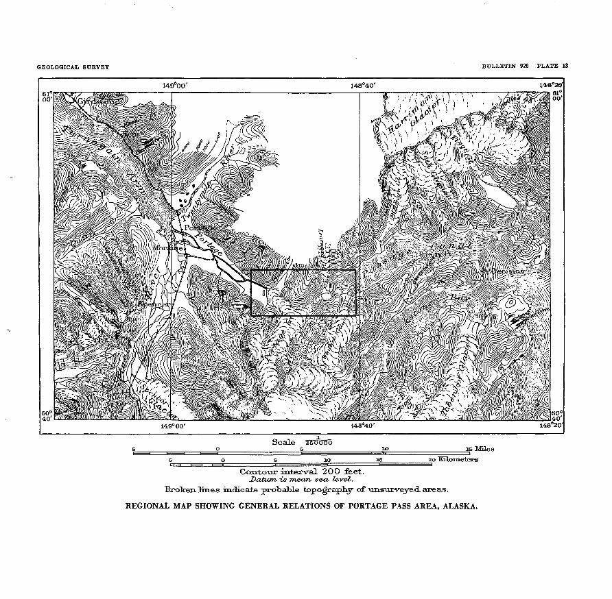
PLATE 13. Regional map showing general relations of Portage Pass area,Alaska.--.__________.__-______-______________--__----- 214
14. A, East slope of Portage Shoulder from head of Passage- Canal;B, View west from Portage Shoulder down Portage Valley.... 222
15. South slope of Portage Shoulder______-____-___---.------__ 22216. Geologic map of the Portage Pass area.__-____.___-___---_- 226
in
IV ' CONTENTS
PagePLATE 17. A, Breccia of argillite fragments in matrix of graywacke en
west slope of Portage Shoulder; B, Lower part of Portage Glacier, from Turnagain Shoulder....______________________ 230
18. N6v6 fields and upper part of Portage Glacier, from PortageShoulder___________---_--___-_______---___________.___ 230
19. Whittier Glacier, as seen from Passage Canal: A, In 1914; B,.In 1940...____________________________________________ 230
20. View across head of Passage Canal from the southeast, showingLearnard Glacier: A, In 1914; B, In 1940...._____________ 234
21. A, Debris-covered ice ridges below Learnard Glacier, as seen from foot of Portage Shoulder in 1914; B, West slope of Port age Shoulder, showing large fold in beds of slate and gray wacke- _______________________________________________ 234
FIGUEE 7. Index map showing location of Portage Pass area..--_-______ 212
GEOLOGY OF THE PORTAGE PASS AREA, ALASKA
By F. F. BARNES
ABSTRACT
The Portage Pass area is in south-central Alaska, and includes part of the narrow neck of land that joins the Kenai Peninsula with the mainland to the north. This region is in general mountainous, elevations ranging from sea level to more than 4,000 feet on the peaks bordering the area. Several glaciers, all of which are apparently receding, extend into the area. Vegetation, chiefly alder and cotton- wood on the valley lowlands and some spruce and hemlock on the lower slopes, extends to an elevation of about 1,000 feet, above which the slopes are bare except for occasional clumps of brush.
The bedrock of the entire area is slate, argillite, and graywacke, apparently part of the same great series that extends from the Kenai Peninsula into the Prince William Sound region and is at least in part of Cretaceous age. The only igneous rocks recognized in the area are a few acidic dikes and a small diabase dike. Small, irregular quartz veinlets are widespread.
The structure is not only complex but, owing to extensive metamorphism, is in many places obscure. A general northeast strike and steep to vertical dips of both bedding and cleavage planes are the rule, but there appears to be some broad folding along steeply northeast-pitching axes. Although no large faults have been recognized, much movement has occurred along many small faults, shear zones, and bedding planes. All observed faults and shear zones trend northeastward.
There are no mines in this area. Some mineralization of quartz veins was noted at a few places, and some prospecting has been done, but no workable deposits are known.
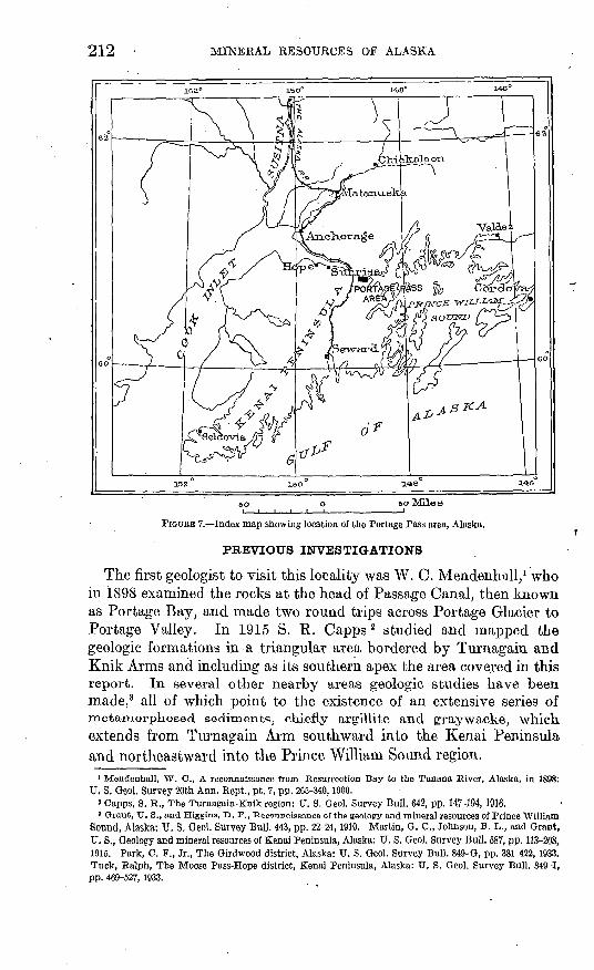
LOCATION AND AREA
Portage Pass is in south-central Alaska between the heads of Pas sage Canal, a western arm of Prince William Sound, and Turnagain Arm, the eastern extension of Cook Inlet. (See fig. 7 and pi. 13.) This pass lies in a nearly continuous depression occupied by Turn- again Arm, Portage Valley, and Passage Canal that separates the Chugach Mountains on the north from the Kenai Mountains, their lithological and structural continuation to the south.
The area included in the present study is about 6 miles long from east to west and ranges in width from 0.5 to 1.5 miles, covering in all about 8 square miles. It lies between latitude 60°45'30" and 60°47'30" north and longitude 148°41' and 148°52' west.
211
212 MINERAL RESOURCES OF ALASKA
150°
BO Miles
FIGURE 7. Index map showing location of the Portage Pass area, Alaska.
PREVIOUS INVESTIGATIONS
The first geologist to visit this locality was W. C. Mendenhall, 1 who in 1898 examined the rocks at the head of Passage Canal, then known as Portage Bay, and made two round trips across Portage Glacier to Portage Valley. In 1.915 S. R. Capps 2 studied and mapped the geologic formations in a triangular area bordered by Turnagain and Knik Arms and including as its southern apex the area covered in this report. In several other nearby areas geologic studies have been made, 3 all of which point to the existence of an extensive series of metamorphosed sediments, chiefly argillite and graywacke, which extends from Turnagain Arm southward into the Kenai Peninsula and northeastward into the Prince William Sound region.
» Mendenhall, W. C., A reconnaissance from Resurrection Bay to the Tanana River, Alaska, in 1898: U. S. Geol. Survey 20th Ann. Eept., pt. 7, pp. 265-340,1900.
2 Capps, S. R., The Turnagain-Knik region: U. S. Geol. Survey Bull. 642, pp. 147-194, 1916.* Grant, XJ. S., and Higgins, D. P., Reconnaissance of the geology and mineral resources of Prince William
Sound, Alaska: U. S. Geol. Survey Bull. 443, pp. 22-24,1910. Martin, G. C., Johnson, B. L., and Grant, U. S., Geology and mineral resources of Kenai Peninsula, Alaska: U. S. Geol. Survey Bull. 587, pp. 113-208, 1915. Park, C. F., Jr., The Girdwood district, Alaska: U. S. Geol. Survey Bull. 849-G, pp. 381-422, 1933. Tuck, Ralph., The Moose Pass-Hope district, Kenai Peninsula, Alaska: U. S. Geol. Survey Bull. 849-1, pp. 469-527, 1933.
GEOLOGY OF THE PORTAGE PASS AREA, ALASKA. 213
No detailed topographic map has been made of the area around Portage Pass, although in 1913 C. E. Giffin'4 made a topographic reconnaissance of the Portage Glacier region, including the area de scribed in this report. \[n 1914 engineers of the Alaskan Engineering Commission made a detailed topographic map of the deltas and val ley bottoms along the route of a proposed railroad from Passage Canal to Turnagain Arm but did not map the mountain slopes north of Portage Glacier.
PRESENT INVESTIGATION
The present investigation was made by the Alaska Railroad, with the cooperation of the Geological Survey, for the primary purpose of determining the feasibility of constructing a railroad to connect the present line at the head of Turnagain Arm with tidewater at the head of Passage Canal. The principal objectives of the study were to determine not only the probable effect of nearby glaciers and glacial streams on the operation and maintenance of the proposed railroad but also the general character and structure of rocks that would be encountered in tunnels and cuts along the route.
To accomplish these objectives the writer and two assistants, and an engineering party from the Alaska Railroad in charge of Porter Berry- hill, left Anchorage on July 6, 1939, traveling by train to Seward and by steamer to Valdez, where a gas boat was engaged to take the party, equipment, and supplies to the head of Passage Canal. This point was reached on July 8, and field work was carried on from a camp at the head of the bay until August 19, when the entire party returned by the same route to Portage station, on the Alaska Railroad at the head of Turnagain Arm, and moved the camp by motorboat and back packing to a point about 6 miles up Portage Valley, near the foot of Portage Glacier. Field work was continued from this camp until September 20.
The area was mapped geologically on a scale of 400 feet to 1 inch. No suitable topographic base map of the entire area was available, but a contour map. on the above scale, made in 1914 by W. C. Guerin and R. J. Weir, of the Alaskan 'Engineering Commission, which showed the topography of the deltas and stream valleys, was used as a base for the areas covered and as a -starting point for the geologic mapping of the adjacent and intervening mountain slopes. These slopes were mapped by compass traverses and tied in to numerous control points established by triangulation and stadia.
The geology of this area as it bears on the problems of construction of the proposed railroad was discussed in an unpublished report sub mitted to the general manager of the Alaska Railroad. The present
< Giffin, C. E., in Brooks, A. H,, and others, mineral resources of Alaska, 1913: U. S. Oeol. Survey Bull. 592, p. 50, pi. 2, 1914.
214 MINERAL RESOURCES OF ALASKA
report is intended to give, in a form as complete as possible from the results of the field work on the above problems, a description of the general geology and geography of an area that heretofore has received only passing notice from geologists. The engineering aspects are briefly outlined in a final summary.
GEOGKAPHY
DRAINAGE
The greater part of the drainage of the highland area considered in this report is to the west by way of the main lobe of Portage Glacier and Placer Creek, both of which discharge into Portage Lake, a body of water more than a mile long, 3,000 feet wide, and 400 feet in maximum depth, formed by recession and disintegration of the glacier front. From the outlet of the lake Portage Creek flows north westward about 7 miles through a mile-wide, gravel-floored valley to empty into the head of Turnagain Arm. It is a moderately swift stream, falling about 100 feet in its 7-mile length, and has only a slightly braided channel. Except during low stages, it is navigable by small power boats to its source in Portage Lake. Although it has the high turbidity characteristic of glacial streams in this region, Portage Creek now carries comparatively little sediment, as all but the finest particles brought down by Placer Creek and Portage Glacier settle out in Portage Lake. The channel of Portage Creek is consequently exceptionally free from sand and gravel bars, its bed consisting mainly of cobbles and boulders inherited from an earlier stage in its history.
Placer Creek, whose principal source is a number of small glaciers that rim the head of its valley north of the area discussed in this report, is a typically braided glacial stream in its upper reaches, consisting of a network of many interlacing channels flowing over a broad, gently southward-sloping, outwash plain. Near the northern boundary of the mapped area, however, the many braided channels all swing abruptly to the west side of the valley and unite in a single stream, which follows that side of the valley to its mouth at Portage Lake. This sudden change in the channel pattern is due to the existence, in the lower half mile of the valley, of another outwash plain that slopes up the valley northward from the belt of mdraine that extends completely across the mouth to the channel of Placer Creek on the west side. The moraine and north-sloping outwash plain were both developed by Portage Glacier in a former, more advanced stage. The water of Placer Creek is generally only slightly turbid, although a small delta that the creek is building into the lake shows that some sand and fine gravel are being carried.
A small part of the drainage from Portage Glacier and all the drain age from the area east of Portage Pass flow into Passage Canal. All
Broken lines indicate probaible topograplry- of \uasxirveyed areas.
REGIONAL MAP SHOWING GENERAL RELATIONS OF PORTAGE PASS AREA, ALASKA.
GEOLOGY OF THE PORTAGE PASS AREA, ALASKA 215
the streams are short, only the one from the eastern lobe of Portage Glacier exceeding a mile in length, but they attain sufficient volume after warm or rainy periods to be difficult to cross on foot.
The flow of all the streams in this vicinity is highly variable, ranging widely with changes in daily temperature and rainfall. None of the
streams appear to be actively aggrading their channels at present,the dominant process, where any noticeable change is evident, being
^enlargement of channels through the deltas by both downward andlateral cutting. Some aggradation is occurring near the outer marginof the delta at the head of Passage Canal, where the gradient islessened, but farther up their courses the same streams are degrading.
TOPOGRAPHY
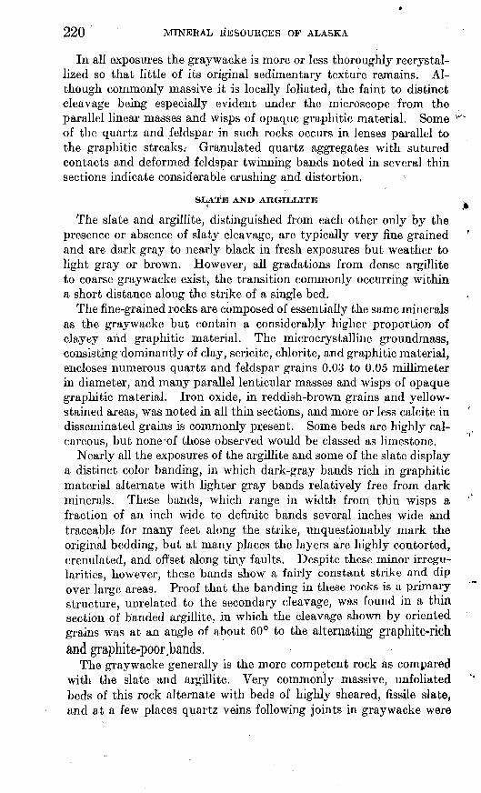
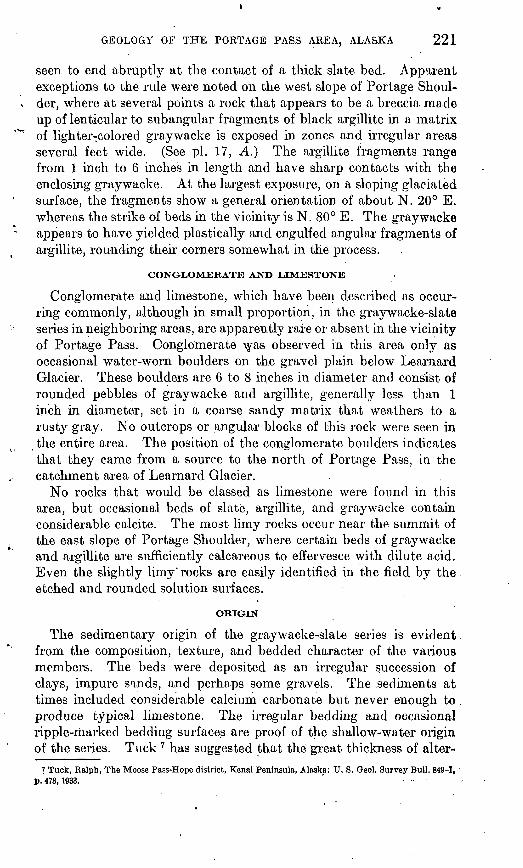
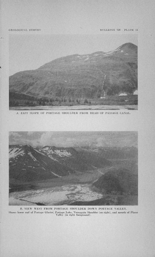
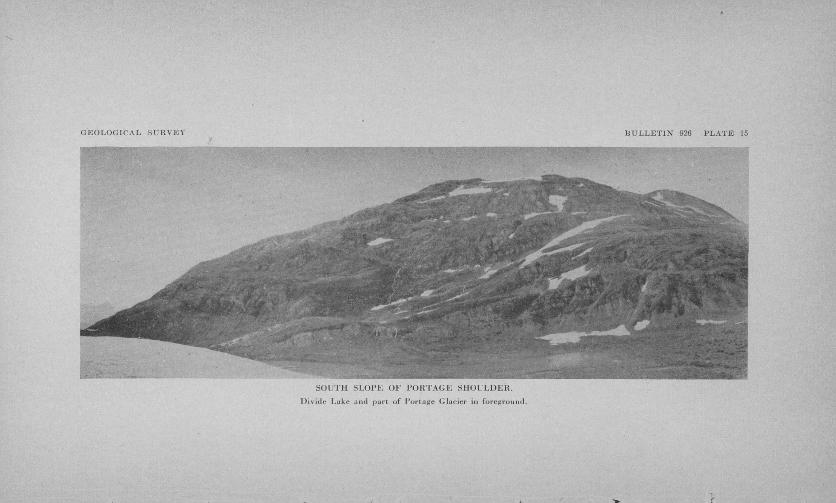
The topography in the'vicinity of Portage Pass is that of steep, rugged mountains that have been greatly modified by glaciation. The slopes of the two shoulders north of Portage Glacier have average inclinations of more than 30° and in broad view appear smooth and rounded. In detail, however, they are broken by numerous nearly vertical cliffs and, particularly on the south and east slopes of the east ridge, herein called Portage Shoulder, by a succession of rock grooves and benches of considerable size, carved by glacier action. (See pis. 14, A, 15.) The south slopes of both shoulders have been oversteepened at their bases by Portage Glacier. Portage Shoulder, which is the main divide, has a comparatively flat summit, which is about 2,000 feet wide from, east to west and slopes gently southward to the escarpment overlooking Portage Glacier.
The area studied in detail ranges in altitude from sea level at Passage Canal to about 3,000 feet on the summit of Portage Shoulder. The ridge west of Placer Valley, which has been called Turnagain Shoulder (see pi. 14, B), is, a spur descending southward from a general elevation of about 3,000 feet but is only about 1,500 feet in elevation at the north edge of the area mapped. Craggy peaks to the north and south of the Portage Pass depression reach elevations of more than 4,000 feet. The upper lim.it of glaciation, judging from the topography and the presence of "striated and polished rock surfaces, was at least 3,000 feet above sea level. Perched morainal material, probably a lateral moraine of Learnard Glacier, lies at an elevation of 3,500 feet or more near the top of the slope west of the glacier. (See pi. 20, B.)
Portage and Placer Creeks flow through broad but steep-sided, gravel-floored, typically aggraded glacial valleys. (See pi. 14, B.) Streams in the eastern part of the area pass immediately from the steep mountain slopes onto extensive deltas at the head and on the south side of Passage Canal. Whittier Delta, on the south side of the bay, has the shape of a nearly symmetrical fan with a fairly uni form seaward slope of about 165 feet to the mile. The delta at the
473152 42 2
216 MINERAL RESOURCES OF ALASKA
head of Passage Canal, apparently built up jointly by eastward draining from Portage Pass and by drainage from Learnard Glacier, has a seaward slope ranging from about 130 feet per mile in the southern part to more than 300 feet per mile along its north edge. The northern half of this delta has been overridden by Learnard Glacier and left covered with irregular piles and ridges of angular blocks of slate and graywacke. These ridges include an outer, more or less continuous terminal moraine about 15 feet high that loops around the morainal area in a semicircle, and an inner, less continu ous and more irregular moraine that is roughly parallel to the first and 400 to 600 feet closer to the mouth of the canyon from which Learnard Glacier deployed onto the delta.
CLIMATE
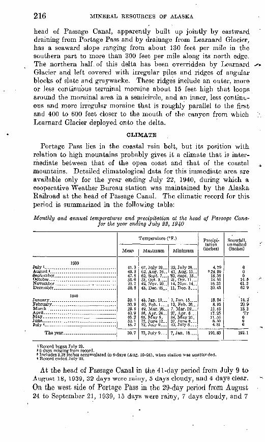
Portage Pass lies in the coastal rain belt, but its position with relation to high mountains probably gives it a climate that is inter mediate between that of the open coast and that of the coastal mountains. Detailed climatological data for this immediate area are available only for the year ending July 22, 1940, during which a cooperative Weather Bureau station was maintained by the Alaska Railroad at the head of Passage Canal. The climatic record for this period is summarized in the following table:
Monthly and annual temperatures and precipitation at the head of Passage Cana* for the year ending July 22, 1940
1939 July I......... ...........................August 3 __September _ __ ... .October....
67, July 29... 62, Aug. 16.. 62, Sept. 7 53, Oct. 3.... 42, Nov. 20.. 43, Dec. 26_.
43, Jan. 12... 40, Feb. 1... 49, Mar. 26.. 56, Apr. 24... 65, May 8 72, June 12.. 73, July 9_
73, July 9.. .
Minimum
39, July 28... 41, Aug. 11.. S3, Sept. 15.. 21, Oct. 11... 14, Nov. 14.. 11, Dec. 3.. .
7, Jan. 15.... 12, Feb,26.._ 7, Mar. 19... 27, Apr. 6... 34, May 25.. 37, June 6..- 42, July 8.. .
7, Jan. 15....
Precipi tation
(inches)
4.79 3 24. 90
18.36 13.56 16.33 32.43
18.94 8.95
11.45 17.25 11.56 8.50 4.81
191. 83
Snowfall, unmelted (inches)
0 0 0
14.5 61.3 62.9
' 14. 2 20. » 18.3 Tr 000
192.1
i Record began July 23.3 6 days missing from record.* Includes 3.38 inches accumulated in 6-days (Aug. 19-24), when station was unattended.* Record ended July 22.
At the head of Passage Canal in the 41-day "period from July 9 to August 18, 1939, 32 days were rainy, 5 days cloudy, and 4 days Clear.On the west side of Portage Pass in the 29-day period from August 24 to September 21, 1939, 15 days were rainy, 7 days cloudy, and 7
GEOLOGY OF THE PORTAGE PASS AREA, ALASKA 217
days clear. However, the summer of 1939 was an exceptionally wet season in all parts of south-central Alaska, so the above figures are not regarded as truly representative. Survey parties of the Alaskan Engineering Commission reported much rain in the Portage Pass area in the summer of 1914.
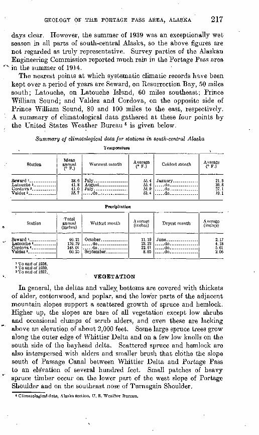
The nearest points at which systematic climatic records have been kept over a period of years are Seward, on Resurrection Bay, 50 miles south; Latouche, on Latouche Island, 60 miles southeast; Prince William Sound; and Valdez and Cordova, on the opposite side of Prince William Sound, 80 and 100 miles to the east, respectively. A summary of climatological data gathered at these four points by the United States Weather Bureau 6 is given below.
Summary of climatological data for stations in south-central AlaskaTemperature
i To end of 1936. > To end of 1930. »To end of 1937.
VEGETATION
In general, the deltas and valley bottoms are covered with thickets of alder, cottonwood, and poplar, and the lower parts of the adjacent mountain slopes support a scattered growth of spruce and hemlock. Higher up, the slopes are bare of all vegetation except low shrubs and occasional clumps of scrub alders, and even these are lacking above an elevation of about 2,000 feet. Some large spruce trees grow along the outer edge of Whittier Delta and on a few low knolls on the south side of the bayhead delta. Scattered spruce and hemlock are also interspersed with alders and smaller brush that clothe the slope south of Passage Canal between Whittier Delta and Portage Pass to an ele'vation of several hundred feet. Small patches of heavy spruce timber occur on the lower part of the west slope of Portage Shoulder and on the southeast nose of Turn again Shoulder.' Climatological data, Alaska section, U. S. Weather Bureau.
218 MINERAL RESOURCES OF ALASKA
ROUTES AND TRAILS
The eastern approach to Portage Pass is readily accessible to deep- water vessels by way of Passage Canal. It was possible as late as 1914 to cross from Passage Canal through Portage Pass to Portage Valley by way of a trail over Portage Glacier, but by 1939 recession and ablation of the glacier had made this route impracticable for summer travel. Because of the numerous large crevasses and serac ice on the surface of the glacier and the unscalable cliffs, the 1939 party found it necessary to climb 3,000 feet to the summit of Portage Shoulder to cross' from Passage Canal to Placer Creek Valley.
The western part of the pass area can be easily reached, except dur ing extreme high water, by about 6 miles of trail up Portage Creek Valley from the railroad at Portage station. Placer Creek Valley can be reached from the west either by way of a foot trail that climbs to a height of about 1,000 feet over the ridge of Turnagain Shoulder or by boat across Portage Lake.
GAME
Large game animals in this area include mountain goats, moose, and black bears. No mountain sheep were seen in 1939, although they were reported to have been seen near the foot of Portage Glacier several years previously. Goats were seen in considerable numbers on Portage Shoulder and on the ridges south and southwest of Portage Glacier, and moose tracks were abundant along Portage Creek. Black bears were seen in Portage and Placer Valleys.
Of the smaller animals, beavers appeared to be fairly abundant along Portage and Placer Creek, and marmots were numerous at the east end of Portage Pass. Rabbits apparently were scarce or absent.
The only game birds noted were ptarmigan, which were frequently seen at higher elevations.
GENERAL GEOLOGY
PRINCIPAL FEATURES
The distribution of rocks in the Portage Pass area is shown on plate 16. The entire area is underlain by a thick series of altered sediments, consisting of a rather uniform succession of irregularly bedded mudstones and impure sandstones that have been intensely folded, contorted, faulted, and generally metamorphosed to slate, argillite, and graywacke. This series is of somewhat uncertain age, but it is known to be at least in part Cretaceous and may be entirely Mesozoic.6
Intrusive igneous rocks are rare in this vicinity, the only known occurrences being five acidic dikes near the head of Passage Canal
o Capps, S. R., Geology of the Alaska Railroad region: U. S. Geol. Survey Bull. 907, p. 59,1940.
GEOLOGY OF THE PORTAGE P'ASS AREA, ALASKA ' 219
and a small basic dike on the west slope of Portage Shoulder, but small quartz nests, seams, and stringers are of widespread occurrence and are particularly abundant in certain zones. No eruptive rocks were noted in this area, although beds and lenses of greenstone are
'< rather common in the graywacke-slate series in neighboring areas.The only other formations exposed in this vicinity are unconsolidated
Quaternary deposits, which include glacial sand and gravel on all the valley floors and deltas and coarse, angular morainic material below Portage and Learnard Glaciers.
GRAYWACKE-SLATE SERIES
CHARACTER AND DISTRIBUTION
Irregularly bedded rocks, consisting principally of graywacke, slate, and argil] ite but possibly in eluding occasional small lenses of lime stone and conglomerate, are exposed over the entire area except where covered by Pleistocene and Recent deposits. The individual beds range in thickness from a fraction of an inch to 100 feet or more, although the graywacke beds are commonly 1 to 4 feet thick and those of the slate and argillite 2 to 6 inches thick. The series as a whole is characterized by an absence of recognizable key beds and by a lack of persistency in individual beds. A conspicuous graywacke bed in a given locality invariably pinches -out or grades into slate or argillite within a few hundred feet. No attempt was made to map graywacke, slate, and argillite separately, although a few fairly dis tinct zones or areas consisting predominantly of a single rock type were seen in the field.
GRAYWACKE
The graywacke is a fine- to medium-grained ro'ck, ranging from medium to dark gray, that is composed principally of quartz, feld spar, and graphitic material. At many places in the area the gray wacke includes abundant angular fragments of slate or argillite 1 to 2 millimeters hi diameter. Epidote, chlorite, and iron oxide were found in several thin sections, but original ferromagnesian minerals are generally lacking. Minute crystals of apatite and occasional small grains of titanite are fairly common constituents.
Quartz and feldspar occur as semirounded to angular grains, 0.2 to 0.5 millimeter in diameter, thickly scattered in a finer matrix of quartz, feldspar, sericite, kaolin, and chlorite. The feldspar is mainly albite, possibly oligoclase in a few thin sections, and generally shows considerable alteration to sericite. Much of the calcite occurs as scattered grains or as thin streaks or layers parallel to the bedding and is probably syngenetic, but the occurrence of both macroscopic and microscopic veinlets in a few specimens suggests that at least part of the calcite has been introduced.
220 MINERAL RESOURCES OF ALASKA
In all exposures the graywacke is more or less thoroughly recrystal- lized so that little of its original sedimentary texture remains. Al though commonly massive it is locally foliated, the faint to distinct cleavage being especially evident under the microscope from the parallel linear masses and wisps of opaque graphitic material. Some of the quartz and feldspar in such rocks occurs in lenses parallel to the graphitic streaks.- Granulated quartz aggregates with sutured contacts and deformed, feldspar twinning bands noted in several thin sections indicate considerable crushing and distortion.
SLATE AND ARGIULITE
The slate and argillite, distinguished from each other only by the presence or absence of slaty cleavage, are typically very fine grained and are dark gray to nearly black in fresh exposures but weather to light gray or brown. However, all gradations from dense argillite to coarse graywacke exist, the transition commonly occurring within a short distance along the strike of a single bed.
The fine-grained rocks are composed of essentially the same minerals as the graywacke but contain a considerably higher proportion of clayey and graphitic material. The microcrystallme groundmass, consisting dominantly of clay, sericite, chlorite, and graphitic material, encloses numerous quartz and feldspar grains 0.03 to 0.05 millimeter in diameter, and many parallel lenticular masses and wisps of opaque graphitic material. Iron oxide, in reddish-brown grains and yellow- stained areas, was noted in all thin sections, and more or less calcite in disseminated grains is commonly present. Some beds are highly cal careous, but none-of those observed would be classed as limestone.
Nearly all the exposures of the argillite and some of the slate display a distinct color banding, in which dark-gray bands rich in graphitic material alternate with lighter gray bands relatively free from dark minerals. These bands, which range in width from thin wisps a fraction of an inch wide to definite bands several inches wide and traceable for many feet along the strike, unquestionably mark the original bedding, but at many places the layers are highly contorted, crenulated, and offset along tiny faults. Despite these minor irregu larities, however, these bands show a fairly constant strike and dip over large areas. Proof that the banding in these rocks is a primary structure, unrelated to the secondary cleavage, was found in a thin section of banded argillite, in which the cleavage shown by oriented grains was at an angle of about 60° to the alternating graphite-richand graphite-poor .bands.
The graywacke generally is the more competent rock as compared with the slate and argillite. Very commonly massive, unfoliated beds of this rock alternate with beds of highly sheared, fissile slate, and at a few places quartz veins following joints in graywacke were
GEOLOGY OF THE PORTAGE PASS AREA, ALASKA 221
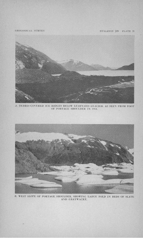
seen to end abruptly at the contact of a thick slate bed. Apparent exceptions to the rule were noted on the west slope of Portage Shoul der, where at several points a rock that appears to be a breacia made up of lenticular to subangular fragments of black argillite in a matrix of lighter-colored graywacke is exposed in zones and irregular areas several feet wide. (See pi. 17, A.} The argillite fragments range from 1 inch to 6 inches in length and have sharp contacts with the enclosing graywacke. At the largest exposure, on a sloping glaciated surface, the fragments show a general orientation of about N. 20° E. whereas the strike of beds in the vicinity is N. 80° E. The graywacke appears to have yielded plastically and engulfed angular fragments of argillite, rounding their corners somewhat in the process.
CONGLOMERATE AND LIMESTONE
Conglomerate and limestone, which have been described as occur ring commonly, although in small proportion, in the graywacke-slate series in neighboring areas, are apparently rare or absent in the vicinity of Portage Pass. Conglomerate was observed in this area only as occasional water-worn boulders on the gravel plain below Learnard Glacier. These boulders are 6 to 8 inches in diameter and consist of rounded pebbles of graywacke and argillite, generally less than 1 inch in diameter, set in a coarse sandy matrix that weathers to a rusty gray. No outcrops or angular blocks of this rock were seen in the entire area. The position of the conglomerate boulders indicates that they came from a source to the north of Portage Pass, in the catchment area of Learnard Glacier. ,
No rocks that would be classed as limestone were found in this area, but occasional beds of slate, argillite, and graywacke contain considerable calcite. The most limy rocks occur near the summit of the east slope of Portage Shoulder, where certain beds of graywacke and argillite are sufficiently calcareous to effervesce with dilute acid. Even the slightly limy' rocks are easily identified in the field by the etched and rounded solution surfaces.
ORIGIN
The sedimentary origin of the graywacke-slate series is evident, from the composition, texture, and bedded character of the various members. The beds were deposited as an irregular succession of clays, impure sands, and perhaps some gravels. The .sediments at times included considerable calcium carbonate but never enough to produce typical limestone. The irregular bedding and occasional ripple-marked bedding surfaces are proof of the shallow-water origin of the series. Tuck 7 has suggested that the great thickness of alter-
? Tuck, Ralph, The Moose Pass-Hope district, Kenai Peninsula, Alaska: U. S. Oeol. Survey Bull. 849-1, p. 478,1933.
222 MINERAL RESOURCES OF ALASKA
nating slates and graywackes was deposited in rhythmic cycles in an intermittently but progressively sinking shallow basin.
AGE AND CORRELATION
No new information on the age of the graywacke-slate series of the Kenai-Chugach Range was found in the Portage Pass area. It is concluded, on the basis of lithologic similarity and continuity, that the rocks in this area belong to the same general period.of deposition as those in the Girdwood district, in which Cretaceous fossils have been found. Capps,8 in summarizing available information on the age and correlation of these rocks, states:
As originally described by Mendenhall these rocks were tentatively assigned to the upper Paleozoic. More recently fossils have been found in this group that showed a part of it, at least, to be of Cretaceous age.
In the Girdwood district of Turnagain Arm, Park made several fossil collec tions, all of the same Organism, that were identified as of Cretaceous, probably Upper Cretaceous age. Furthermore, it is now known that at least a large part of the slates and graywackes of the Chugach Mountains and Kenai Peninsula are younger than the Jurassic volcanic rockso and older' than the Eocene coal-bearing beds of the Matanuska Valley and western Kenai Peninsula. No unquestioned Paleozoic fossils have been found anywhere in this great series of sedimentary rocks. It is true that fossils of any kind are rare, but such as have been found invariably point to a Mesozoic age, and as paleontologic evidence has accumu lated, the areas of these rocks that might be classified as Paleozoic have shrunk. As the positive evidence so far obtained points to a Mesozoic age for the slates, argillites, graywackes, and greenstones of Kenai Peninsula and the Chugach Mountains, and as no unquestioned evidence of their Paleozoic age has been found, these rocks are mapped * * * as of undifferentiated Mesozoic age.
STRUCTURE
The structure of the graywacke-slate series is not only complex but also exceedingly difficult to decipher because of the lithologic uniformity of the series as a whole, the lack 'of continuity of single lithologic units, and the absence of any distinctive strata that would serve as reference beds in working out details of structure. Conse quently, little success has attended attempts to interpret the detailed structure and estimate the thickness of the series.
The beds exposed in the Portage Pass area correspond closely with published descriptions of the same series in nearby localities, except that the slates and graywackes in this area, which lies directly across the main axis of the Kenai-Chugach Range, appear in general to be somewhat more intensely deformed and recrystallized than those in areas farther west, away from the orogenic axis. The following general description by Capps 9 of the structure of the slates and graywackes of the Kenai-Chugach Mountains as a whole applies with equal accuracy to the principal features of the structure in the Portage Pass area. ;
s Capps, S. R., op. cit., p. 59. 1 .» Capps, S. R., op. cit., pp. 58-59.
GEOLOGICAL SURVEY BULLETIN 926 PLATE 14
A. EAST SLOPE OF PORTAGE SHOULDER FROM HEAD OF PASSAGE CANAL.
B. VIEW WEST FROM PORTAGE SHOULDER DOWN PORTAGE VALLEY.Shows lower end of Portage Glacier, Portage Lake, Turnagain Shoulder (on right), and mouth of Placer
Valley (in right foreground).
GEOLOGICAL SURVEY HT'I.LETIN" 926 PLATE 15
SOUTH SLOPE OF PORTAGE SHOULDER.
Divide Lake and part of Portage Glacier in foreground.
GEOLOGY OF THE PORTAGE PASS AREA, ALASKA 223
Throughout the area in which they occur the slates and graywackes are highly tilted and folded, locally with intricate contortion and crumpling. In general, however, the beds stand at steep angles and strike parallel to the axis of the range. Over long distances the beds dip at angles of 60° to 90°, with no direct evidence of duplication by faulting or folding, but here and there is evidence that close fold ing has occurred, and there are many faults of unknown displacement.
The rocks throughout most of the area show a genera] tendency to strike northeastward, roughly parallel to the mountain axis, and dip 65° to 90° northwest. In a few places, however, variations from the general trend outline many small folds and a few large ones. In other places intense deformation and metamorphism have com pletely obliterated the bedding, commonly by the superposition of foliation or slaty cleavage. Several small north east-trending faultsand shear zones were seen.
FOLDS
Variations in strike and dip that appear to Outline steeply pitching major folds occur near the foot of the south slope and on the summit of Portage Shoulder, also along the northwest shore of Portage Lake at the base of Turnagain Shoulder. At both points on Portage Shoulder the structure appears to be the sharply folded, nearly angular trough of an open syncline pitching 60° to 75° north or northeast. The fold on the west slope is the best exposed and is probably typical of the major folding in the vicinity. There a series of essentially vertical beds of graywacke and some slate trends southwestward down the slope. (See pi. 21, 5.) About halfway down, these beds begin to swing around toward a west strike and a steep north dip. The in tensity of the curvature of this folding increases toward the north, from a broad, open fold extending clown the southwest spur of the mountain to an abrupt, almost angular fold near the head of the larg est gorge on the west slope, where southwest-trending vertical beds swing around sharply within a few feet to a northwest strike and a northeast dip of about 75°. At the point of this fold the beds showy evidence of intense squeezing, shearing, and flowage in the form of contorted, offset, and pinched-out bedding and are all penetrated by numerous irregular quartz veins and stringers.
The structure on Turnagain Shoulder is apparently an anticline, likewise pitching steeply north or northeast. At one point the thin- bedded argillite and graywacke, dipping 60° to vertical, swing around from a strike of N. 80° E. to-N. 15° W. within 600 feet.
None of these folds could be traced far, the space between them being occupied by apparently unfolded, essentially vertical" beds following the general northeast regional trend, or by areas of crumpled or foliated slate and graywacke in which the bedding is either entirely obliterated or so highly contorted as to be unrecognizable. Possible extensions of some folds are lost beneath Portage Glacier a,nd the Quaterngfery deposits in Portage and Placer Valleys.
473152 42 3
224 MINERAL RESOURCES OF ALASKA
It is generally assumed that the tremendous apparent thickness of the slate-graywacke series in the Kenai Peninsula and Prince William Sound region is in large part due to .repetition of beds by isoclinal folding. Such folds have been reported as of common occurrence in the Moose Pass-Hope district. 10 In the Portage Pass area no isoclinal folding was definitely recognized. The major structures appeared to be steeply pitching open> folds, as. in none of them could the strike be traced around an arc of more than 90° to 100° before being lost. However, the presence of broad belts of northeast-trending beds on all sides of the folded areas make it appear highly probable that the folded beds, had they not lost their identity in the intervening crum pled and foliated locks, would be continuous with the northeast- trending beds as a series of large-scale steeply northeast-pitching isoclinal folds. Such a series of folds would account for considerable repetition of beds in the area. No clues as to the major structures could be obtained from drag folds, which, except for a few poorly developed crenulations, are absent. -
A most perplexing feature of the structure of this area is the presence, in close association with vertical beds and steeply pitching major folds, of smaller folds with only moderate dips and nearly horizontal axes. One such fold, a northeast-trending anticline with dips on the limbs of as little as 25° and a slight pitch to the northeast, is on the west slope of Portage Shoulder, apparently on or near the axis of the large northeast-plunging syncline described above. A second small northeast-trending anticline, with limbs dipping about 35° and a northeast pitch of 5°, is well exposed in the midst of an area of steeply dipping to vertical strata along the summit of the east slope of Portage Shoulder. Traced northeastward this fold apparently steepens in pitch to about 50° to conform with the steep dips on each side.
Southwest of the fold on the summit of Portage Shoulder, thin- bedded slate and graywacke, exposed here and there through the snow field that lies on the gentle slope, show strikes varying irregularly from northeast to northwest and dips ranging from 35° to vertical. The whole mass gives the general impression of having been squeezed and kneaded until all trace of orderly arrangement along fold axes was lost.
Folding and deformation throughout the Portage Pass area was accompanied by much slipping and shearing along bedding planes, as shown by the common occurrence of slickenside surfaces along these planes.
CLEAVAGE
Rock cleavage and foliation are of widespread occurrence in the locks of the Portage Pass area. The slates have a distinct cleavage that at different points would be described as fissility, foliation, or,
10 Tuck, Ralph, op. cit., p. 484.
GEOLOGY OF THE PORTAGE PASS AREA, ALASKA
rarely, schistosity. In even the most fissile rocks, however, the cleavage is not of the quality associated with roofing slates. Where the rocks have undergone 'exceptional stress the cleavage planes are irregular and undulating, giving the rock a foliated or schistose parting.
Although the rocks described as arglllite display no visible cleavage in hand specimens, thin sections show at : least an incipient cleavage marked by oriented streaks oil graphitic material, blades of sericite, and lenses of quartz and feldspar.
The graywacke, though generally massive, has in many places a poor to distinct cleavage or foliation along which the rocks part more or less readily into thin plates or lenses. This cleavage or foliation does not bear a definite relation to the bedding. The two are essentially parallel over large areas, particularly where the bedding follows the northeast regional trend, but wherever the bedding changes in strike the cleavage, which rarely varies from a northeast strike and a more or less vertical dip, generally cuts across the stratification at angles of as much as 90°. The general relation is well shown in the large fold on the south slope of Portage Shoulder. On the east side of the fold, where the beds trend about N. 60° E. and dip steeply northwest, the cleavage closely follows the bedding; but farther west the same beds swing around to an east strike and a dip of about 50° north, and the cleavage, which here strikes north to northeast and is essentially vertical, cuts across the bedding at a wide angle.
JOINTS
Joints are common in the thicker graywacke beds, less so in the thinner beds, and rare but not entirely absent in the slate. As many as three distinct sets of joints were noted in single exposures, one set generally following the bedding. In some of the thicker graywacke beds the bedding joints could be traced for several hundred feet, but in other beds the joints in general were poorly developed and of limited extent. Although the joints occur with various orientations and do not appear to be related to any definite pattern over large areas, verti cal joints with north to northwest strikes are by far the most common. Many of the -north-striking joints have been foUowed by quartz veinlets. ^.
FAULTS
No large faults of regional extent were recognized in the Portage Pass area, but several small faults and shear zones, all with a general northeast trend parallel to the regional structure, were noted in various parts of the area. All these appeared to be of small displacement, the maximum being about 10 feet, and they either died out within short distances or were lost beneath talus or snow. Most of these small faults were apparent only from the, offset bedding, the fault plane
226 MINERAL RESOURCES OF ALASKA'
itself being invisible, and they were obviously contemporaneous with or older than the deep-seated deformation and metamorphism that characterizes these rocks. Two faults mapped on the south slope of Portage Shoulder may be much younger, as they are marked by dis tinct open fractures. One of these is a simple fracture along which the drag and offset of the bedding indicate that the northwest side moved about 4 feet northeast in the plane of the outcrop. The second fault, about 70 feet north of the first, appears in part of its length as an open fracture and in part as a sheared and shattered zone about 4 feet wide. The drag indicates that the northwest side of this fault also moved northeast, but the amount of displacement could not be determined. The fault was traced for 500 feet and disappeared under talus and soil at both ends.
In addition to faults with measurable displacement, numerous narrow zones were observed that were marked by sheared and shattered rock in which movement was evident only from polished and grooved slickenside surfaces; in these, owing to lack of distinctive bedding planes, the amount of displacement could not be determined. Several prominent fractures and fissures were seen in the inaccessible cliffs that border the north edge of Portage Glacier. These may mark faults of considerable displacement, but no evidence of them was found on the slope to the north. The bluffs at the foot of Turnagain Shoulder opposite the mouth of Placer Creek are cut by several verti cal or steeply dipping fissures that extend up the face of the cliff and appear to strike north or northwest. Polished and grooved slicken side surfaces along some of these fissures indicate movement, but, as the rock is identical on both sides of each fissure and the fissures apparently die out a short distance up the slope, the amount of movement apparently was not great.
The features described in the preceding paragraphs are the more conspicuous evidences of the strong stresses that these rocks have undergone. Detailed examination of many outcrops showed that much of the adjustment in response to these stresses occurred on a much smaller scale throughout the rock mass. Widespread indications of slipping along bedding planes have already been mentioned. I7.i addition, many exposures of the more intensely deformed, highly_ foliated rock show numerous minute shear planes or slickenside surfaces between individual folia.
The general lithologic uniformity and the irregular bedding of the slates and graywackes make the detection of faults exceedingly difficult except under the most favorable conditions; consequently, it is pos sible that many existing faults, perhaps some of major proportions were not detected. On the other hand, the presence of numerous minor faults and shear planes, and particularly the evidence of myriad minor adjustments to stress within the rock mass, suggest that- most
BULLETIN 926 PLATE 16
GEOLOGICAL SURVEY
I48°5l' 49'
EXPLANATION
Fault or shear zone-L?"
Strike and dip of beds
Strike of vertical beds
Intrusive igneous rocksStrike and dip of cleavage
o oStrike of vertical cleavage
(Quartz diorite and 3/or/te ~cf/'Mes and Sff/son Passage Cana/, a/bite gnzru'te diJca in, Aortage floss, c/ta&ase dtke or> west sAjoe °offbrtage Shou/derJ
Graywacke, slate, and argilliteContour interval 25O feet Datum is mean sea /eve/
Geology by F.F". Barnes. Surveyed by the Alaska Railroad in 1939. Position of glaciers in 1914 from maps by W.C.Guerin and R.aWeir. Elevations of geologic contacts determined by aneroid barometer
GEOLOGIC MAP OF THE PORTAGE PASS AREA, ALASKA.
GEOLOGY OF THE PORTAGE PASS AREA, ALASKA 227
of the relief from stresses may have been accomplished by these minor movements rather than by the development of major faults of regional extent. The presence of many faults of small displacement is believed by Tuck \ l to explain the absence of large faults in the slates and graywackes of the Moose Pass-Hope district.
IGNEOUS BOCKS
The only known igneous rocks in this area, aside from the ubiquitous quartz veinlets, are the five acidic dikes exposed along the south shore of Passage Canal and in Portage Pass, and a small basic dike on the west slope of Portage Shoulder. Possibly more dikes are present, particularly of the basic type, but in view of the excellent exposures throughout the area, probably not many were overlooked.
ACIDIC DIKES
Four light-colored dikes, 3, 4, 7, and 100 feet thick, respectively, are exposed in the bluffs along the south shore of Passage Canal west of Whittier Delta, where they are intruded into a series of slate and graywacke beds. These dikes all strike northeast and dip about 65° northwest, approximately parallel to the foliation of the enclosing rocks.
The three smaller dikes, which are indistinguishable from one another megascopically, consist of light-gray somewhat altered fine-grained rock, spotted with numerous dark-green blades of chlorite. Under the microscope they are all of essentially the same composition, the chief components being andesine, quartz, chlorite, and sericite. Accessory minerals include calcite, magnetite, and epidote. Two of these dikes are porphyritic and are classified as quartz diorite porphyry, but the third has only rare feldspar phenocrysts and much less quartz ands corresponds to a fine-grained diorite. The 100-foot dike, exposed in the bluff at the head, of Passage Canal, differs from the others both in texture and composition, being coarser grained, with an average grain size of about 1 millimeter, and having more quartz and a slightly more acidic plagioclase, probably oligoclase. This rock is nonpor- phyritic and is classified as quartz diorite.
A fifth acidic dike was traced-for 1,500 feet northeastward across the rocky ridge that blocks the east end of Portage Pass. This dike is about 7 feet thick and has a strike of N. 60° E. and a nearly vertical dip. The rock, similar in appearance to the dikes on Passage Canal, was found by microscopic examination to be composed of quartz, albite, sericite, calcite, and chlorite. It has a fine-grained groundmass of feldspar and quartz and abundant phenocrysts of albite and some of quartz, 0.5 to 1.0 millimeter in diameter. Extensive alteration makes
11 Tuck. Kaloh. op. cit., pp. 485-486.
228 * MINERAL RESOURCES OF ALASKA
the original character of this rock uncertain, but on the basis of its present composition it is classified as an albite granite porphyry.
In general, all these dikes have sharp contacts with the enclosing rocks, although one of them includes fragments of slate along one con tact, and two of them contain thin quartz veins, which have been (i intruded along one contact. Although no pronounced contact meta- jnorphism was noted along any of these dikes, the graywacke near the foot wall of the largest dike is apparently somewhat silicified, being more than usually dense and without foliation. The rock of the larg est dike was fractured after solidification, as shown by a prominent set of transverse joints, several of which contain thin quartz veins. One large vein, 1 to 2 feet thick, is mineralized, containing numerous nests and scattered grains of sulfides, mainly arsenopyrite. This vein is approximately parallel in strike but opposite in dip to the dike, dipping about 30° southeast. It has been exposed for about 100 feet along the strike in a shallow trench.
QUAKTZ VEINS
Quartz veins, ranging from a fraction of an inch to several inches in thickness, occur in irregular nests and interlacing networks and as injected lenses and pods between folia and along joints in the slate and graywacke in all parts of the Portage Pass area. These quartz veinlets are particularly abundant along zones in which the enclosing rocks have undergone exceptionally intense deformation. To the
1 west, on Turnagain Shoulder, they are somewhat less abundant than on Portage Shoulder, but this impression may be due at least in part to poorer exposures on the western ridge.
At a few points quartz injections were noted along the planes of small faults and in gash veins in the drag areas on both sides, and in many exposures the quartz veins and lenses have undergone the same intimate folding and contortion as the enclosing rock/ These rela tions suggest that the introduction of quartz was in part earlier and in part contemporaneous with the more intense deformation. The most persistent veins are those that follow northward-trending joint planes. Few of these veins are mineralized, the only notable example, aside from the vein in the large dike described above, being near the footof the south slope of Portage Shoulder. There a rusty oxidized zone about 100 feet wide follows a series of parallel northward-trending veins, which range in thickness from 2 inches to 1 foot. These veins contain sulfides, largerly weathered to iron oxide, which has stained the enclosing graywacke. It was noted that the veins all end abruptly .at the contact with an overlying thick bed of slate.
BASIC DIKES
A small diabase dike was traced for a few hundred feet in a general northeast direction up the head of a deep gorge on the west slope of
GEOLOGY OF THE PORTAGE PASS AREA, ALASKA 229
Portage Shoulder. This dike, which ranges from 2 feet to a few inches in thickness, is considerably deformed, being offset by minor faults, and pinches out repeatedly, but it cuts across the major folds in the enclosing slate and graywacke.
In hand specimens this rock is dark greenish-gray, fine grained and equigranular and weathers to a dark brown or tan. Under the micro scope it shows an ophitic texture, with laths of labradorite and inter stitial chlorite and augite. Magnetite and rarely calcite are also pres ent, the latter associated with chlorite as an alteration product after augite.
AGE AND CORRELATION
. All that is definitely known of the age of these dikes is that they are younger than the slate and graywacke that they intrude, and that the basic dike, the largest diorite dikes, and the quartz veinlets, all having been somewhat deformed, are older than the latest deformation that the enclosing rocks have undergone.
As the acidic dikes in this area are lithologically similar to dikes in neighboring areas and bear the same structural relations to the graywacke-slate sepes, they are probably of the same age, generally regarded as late Cretaceous or post-Cretaceous.
QUATERNARY DEPOSITS
HISTORY OF GLACIATION
The Portage Pass area was the scene of extensive Pleistocene gla- ciation. The region was at one time overriden by a vast mass of ice that buried all but the highest peaks. The ice mass apparently flowed both from the south and from the north toward the Portage Pass depression, in which it divided, part flowing northeastward to enlarge and deepen the valley that is now Passage Canal, and part moving northwestward down Portage Valley to Turnagain Arm., Glacial striae, polished rock surfaces, and ice-carved benches and grooves were found on Portage and Turnagain Shoulders up to eleva tions of about 2,000 feet above sea level. Smooth rounded, topography, as on the nearly flat summit of Portage -Shoulder, suggests that thick ice.sheets have overriden areas as much as 3,000 feet in elevation. The perched moraine west of Learnard Glacier, estimated to be at least 3,500 feet above sea level, proves that ice rose to at least this level.
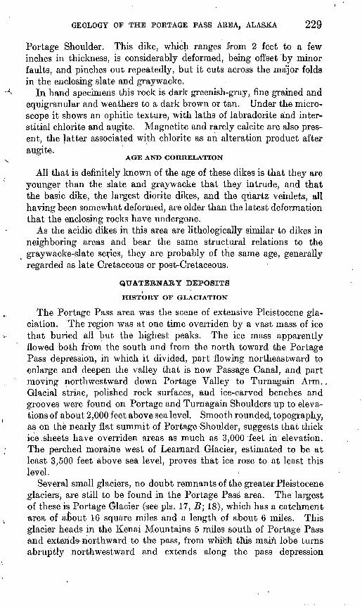
Several small glaciers, no doubt remnants of the greater Pleistocene glaciers, are still to be found in the Portage Pass area. The largest of these is Portage Glacier (see pis. 17, B; 18), which has a catchment area of about 16 square miles and a length of about 6 miles. This glacier heads in the Kenai Mountains 5 miles south of Portage Pass and extends- northward to the pass, from which this main lobe turns abruptly northwestward and extends along the pass depression
230 MINERAL RESOURCES OF ALASKA
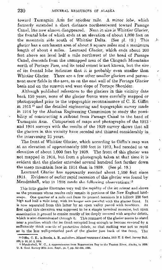
toward Turnagain Arm for another mile. A minor lobe, which formerly extended a short distance northeastward toward Passage Canal, hUs now almost disappeared. Next in size is Whittier Glacier, the frontal-lobe of which ends at an elevation of about 1,000 feet on the mountain side south of Whittier Delta. (See pi. 19.) This glacier has a catchment area of about 8 square miles and a maximum length of about 4 miles. Learnard Glacier, which ends about 200 feet above sea level half a mile northwest of the head of Passage Canal, descends from the unmapped area of the Chugach Mountains north of Portage Pass, and its total extent is not known, but the size of its frontal lobe indicates that it is probably even smaller than Whittier Glacier. There are a few other smaller glaciers and perma nent snow fields in the area, as on the east wall of the Portage Glacier basis and on the summit and west slope of Portage Shoulder.
Although published references to the glaciers in this vicinity date back 150 years, none of the glacier fronts were carefully mapped or photographed prior to the topographic reconnaissance of C. E. Giffin in 1913 12 and the detailed engineering and topographic survey made in 1914 by the Alaskan Engineering Commission to study the possi bility of constructing a railroad from Passage Canal to the head of Turnagain Arm. Comparison of maps and photographs of the 1913 and 1914 surveys with the results of the 1939 survey shows that all the glaciers in this vicinity have receded and thinned considerably in the intervening 25 years.
The front of Whittier Glacier, which according to Giffin's map was at an elevation of approximately 600 feet in 1913, had receded to an elevation of about 1,000 feet by 1939. The front of this glacier was not mapped in 1914, but from a photograph taken at that time it is evident that the glacier extended several hundred feet farther down the steep mountain face in 1914 than in 1939. (See pi. 19.)
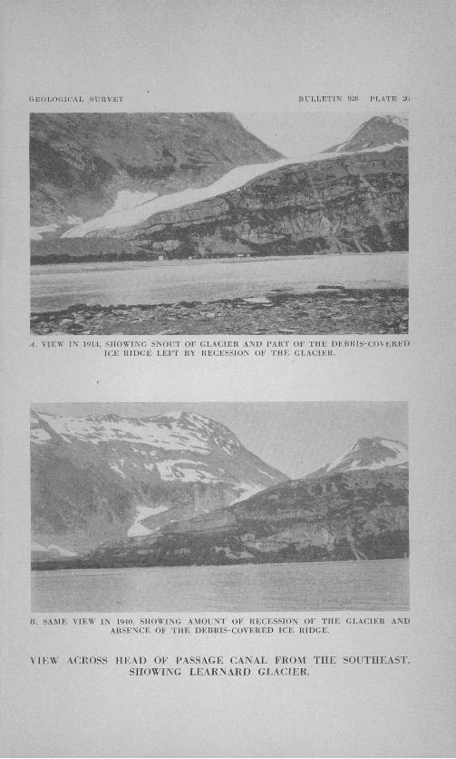
Learnard Glacier has apparently receded about 1,500 feet since 1914. Evidence of earlier rapid recession of this glacier was found by Mendenhall, who in 1898 made the following observations: 13
This little glacier illustrates very well the rapidity of the ice retreat and shows us the processes whose results only remain in portions of the New England land scape. One quarter of a mile out from its present terminus is a hillock 220 feet high and half a mile long, with its longer axis parallel with the glacier front. It is now separated from this latter by an open valley paved with bowlders. At first sight this elevation was supposed to be a simple terminal moraine, but upon examination it proved to consist mostly of ice deeply covered with angular debris, which is also disseminated through it. This remnant of the glacier seems to stand near a position which the ice front occupied long enough to become covered by a sufficiently thick mantle of protective debris, so that melting was not so rapid as in the less well-protected part of the glacier just back of the front. The
12 Giffin, C. E., in Brooks, A. H., and'others, Mineral resources of Alaska, 1913: U. S. Geol. Survey Bull. 592, p. 50, pi. 2, 1914.
13 Mendenhall, W. C., A reconnaissance from Resurrection Bay to the Tanana River, Alaska, in 1898: U. S. Geol. Survey 20th Ann. Rept,, pt. 7, pp. 325-326, 1900.
GEOLOGICAL. SURVEY BULLETIN 926 PLATE 17
A. BRECCIA OF ARGILLITE FRAGMENTS IN MATRIX OF (;i(\'i \\ \( k I <i\ \\ KST SLOPEOF PORTAGE SHOULDER.
B. J.o\\ KK I'MiT Oh' POHTAGK Cl.\CIKK KKOM TURNAGAIN SHOl LDEH.
GEOLOGICAL SURVEY BULLETIN 920 PLATE 18
\EVK FIELDS AND I'l'PKK PART OF PORTAGE GLACIER. FROM PUKTAGE SHOULDER.
GEOLOGICAL SURVEY BULLETIN 926 PLATE 19
A. IN 19H.
B. IN 1940.
WHITTIER GLACIER, AS SEEN FROM PASSAGE CANAL.
GEOLOGY OF THE PORTAGE PASS AREA, ALASKA 231
separation from the glacier was probably facilitated by the exit of the subglacial .stream through a tunnel back of the protecting mantle. The combined melting from above and below soon removed this neck, leaving the former front isolated as it stands today. Since its isolation it has been shrinking each summer, and now occupies less than half of its original area. Around its seaward side is a belt of rough ground of slight relief covered with angular and unsorted material, which has been let down into position by the melting of the ice front. The outer rim of this zone is somewhat higher than the inner portion, giving it the form of a shallow amphitheater facing the remnant of the glacier which remains. The stability of the position of maximum advance'for a short time due to the balance between flow and melting at the front accounts for the slightly greater accumulation there .and the building of the low rubble wall.
Additional data on this same feature were furnished by the surveys of 1914 and 1939. The 1914 map shows at this place, instead of a "hillock 220 feet high and half a mile long," a hill rising only 170 feet above sea level, or 120 feet above its base, and only 1,000 feet long, although a similar ridge ending 600 feet to the west was probably formerly continuous. Photographs of the same date show a steep- sided ridge or mound of loose rock resembling a mine dump. (See pis. 20, A; 21, A) When this locality was visited by the writer in 1939 this ridge had entirely disappeared (see pi. 20, J5), its site being occupied by low heaps and ridges of coarse blocks that are'accordant in elevation with the general seaward-sloping surface of the morainal area. The highest point on the moraine in this general vicinity was only 70 feet above sea level.
The above observations show that the debris-covered remnant of the glacier front diminished 50 feet in maximum elevation between 1898 and 1914 and lost another 100 feet between 1914 and 1939. By 1939, probably no ice remained under the debris at this locality.
Portage Glacier, the largest in the area, has shown by far the greatest amount of recession and ablation since 1914., The vestigial east lobe has receded more than 2,000 feet, and the northeast margin of the glacier along the base of Portage Shoulder has thinned so that it now stands several hundred feet lower down the slope. The horizontal movement of this margin, as shown by successive mapping in 1914 and 1939, has been 300 to 600 feet, varying with the steepness of the slope. (See pi. 16.) Although elevations of the margin were not closely determined at either date the degree of slope indicates that this margin is at least 200 feet lower than it was in 1914. This conclusion is supported by photographs which show that the general surface of the glacier at its widest part, just above the sharp bend, has been lowered through ablation 200 feet or more since 1914. Also, unweathered gravel was traced at least 200 feet up the mountain slope at several points. Remapping of the front of the main lobe showed a recession of about 2,000 feet, the space back of the 1914 position being occupied by a body of water, herein called Portage Lake, which is about 3,000 feet in maximum width and contains many floating ice blocks, some
232 MINERAL RESOURCES OF ALASKA
of them several hundred feet long. Soundings in this lake revealed a maximum depth of 400 feet at the glacier front 2,000 feet southeast of the tip of Turnagain Shoulder, and depths of more than 200 feet at several places within 400 to 600 feet of the south and west shores. At two places near the mouth of Placer Creek the sounding weight.met hard rock beneath 70 feet of water, but at all other places the bottom con sisted of soft gray clay or glacial flour. The deepest part of this lake is at least 300 feet below sea level, as the lake surface at the time of sounding was at an elevation of 96 feet.
Little was learned of the recent history of the glaciers in this area from morainic deposits and vegetation. The only well-developed moraines are those below Learnard Glacier and across Portage and Placer Valleys below Portage Glacier. Several morainic ridges were found below both glaciers, indicating either successive advances or pauses in recession, but as the only vegetation on or associated with any of the ridges was the quick-growing alder and COttonwood, no conclusive evidence of the approximate maximum length of time since the moraines were formed was available. However, small patches of unweathered gravel perched 200 feet or more up the south slope of Portage Shoulder and 250 feet above Portage Lake on the slopes of Turnagain Shoulder show that ice extended to those elevations in comparatively recent time.
GLACIAL, DEPOSITS
Glacial deposits in this area include the moraines below Learnard and Portage Glaciers and the fluvioglacial material that has accumu lated to great depths in Portage and Placer Valleys, at the head of Passage Canal, and on Whittier Delta. No moraines were noted on the steep slope below Whittier Glacier. The moraines below Learnard Glacier consist predominantly of jumbled heaps and ridges of coarse angular blocks of slate and graywacke, including very little fine material, between which occasional patches of sand and gravel have accumulated. ' The belts of moraine across Placer and Portage Valleys are in part of similar coarse blocks but also include certain ridges that consist dominantly of rounded pebbles, sand, and finer material.
RECENT DEPOSITS
Recent deposits consist of the silt, sand, gravel, and boulders beingdeposited along the lower courses of the present streams, immediatelyover and largely.indistinguishable from the fluvioglacial deposits. No distinct marine or fluviatile terraces have been developed in this area, the only recognizable Kecent physiographic forms being occasional steep alluvial cones of fresh, unweathered gravel and boulders, such as those at the foot of the west slope of Portage Shoulder on the floor of the Placer Creek Valley.
GEOLOGY OF TU.E PORTAGE PASS AREA, ALASKA 233
MINERALIZATION
There are- no active mining developments in the Portage Pass area.. An old claim at the head of Passage Canal includes the mineralized vein associated with the large diorite dike exposed in the bluffs south of the bay. Very little development work has been done on this claim, and so far as known no workable deposits have been found. Some mineralization has occurred at a few other places in the area, notably near the base of the south slope of Portage Shoulder and at the mouth of Placer Creek, but none of these occurrences appeared promising as sources of valuable minerals.
The discovery of a copper lode "on the north side of the Portage Glacier Pass" was reported in 1915, 14 but no development work is known to have been done on it. The nearest active mining develop ment is a gold-lode mine on the north side of Passage Canal about 8 miles from its head. This property is reported to have yielded some excellent prospects in gold.16
SUMMARY OF ENGINEERING PROBLEMS
The results of this investigation that bear directly on problems of engineering and construction may be briefly summarized, as follows:
Available evidence indicates that all glaciers in this area are receding and thinning rapidly and that the streams emanating from them are no longer carrying heavy debris loads but are becoming stabilized 'in definite channels. It is therefore concluded that neither the glaciers nor the glacial streams offer a serious threat to possible engineering developments.
Geologic field study brought out no conditions that would seem to make tunnel construction infeasible. The bedrock of the entire area consists of an irregularly bedded series of graywacke, slate, and argillite, which has been considerably deformed and faulted on a minor scale, but no evidence was found of extensive faults or shear zones tliat might introduce serious problems of tunnel drainage or make an excessive amount of timbering and lining necessary.
Although large snowslides are of common occurrence in many parts of this area, the most suitable locations for tunnel portals, railroad yards, and town sites are singularly free from evidence of destructive avalanches. For example, although large snowslides occur on the west slope of Portage Shoulder, the logical site for the west portal of a tunnel through the mountain lies under a short, heavily timbered slope that is separated from the main mountain face by a deep transverse gorge, which diverts all slides from the precipitous slopes above. Portal sites on both sides of Turnagain Shoulder and on the east side of
" Johnson, B. L., Mining on Prince William Sound; TJ. S. Qeol. Survey Bull. 642, p. 139,1916. » Mofflt, F. H., in Smith, P. S., Mineral industry of Alaska in 1937; U. S. Qeol. Survey Bull. 910-A,
p. 27,1939.
234 MINERAL RESOURCES OP'ALASKA
Portage Shoulder are probably subject to occasional small slides but not to those of major proportions.
Possible locations for town sites, railroad yards, and other develop ments include Whittier Delta and the southern part of a delta at the head of Passage Canal, on each of which about 150 acres of gravel plain would be available, and the moderately sloping hillside east of Whittier Delta facing the bay. Whittier Delta and the hillside to the east have an advantage over the site at the head of the bay in being practically free from danger of flood and in being closer to the proposed dock site just east of Whittier Delta. .
GEOLOGICAL SURVEY BULLETIN 926 PLATE 20
, I!.,, IN 1914, SHOWING SNOUT OF GLACIER AND PART OF THE DEBRIS-COVERED ICE RIDGE LEFT BY RECESSION OF THE GLACIER.
B. SAMF. A1K\\ l\ 1'HII. SHOWING AMOUNT OF UFCFSSION OF THE GI.U'.IKIi AND ABSENCE OF THE DEBKIS-COV KKED 1CK RIDGE.
VIEW ACROSS HEAD OF PASSAGE CANAL FROM THE SOUTHEAST, SHOWING LEARNARD GLACIER.
GEOLOGICAL SURVEY BULLETIN 920 PLATE 21
A. DEBRIS-COVERED ICE RIDGES BELOW LEAKNARD GLACIER, AS SEEN FROM FOOT OF PORTAGE SHOULDER IN 1914.
B. WEST SLOPE OF PORTAGE SHOULDER, SHOWING LARGE FOLD IN BEDS OIAND GHAYWACKE.
INDEX
Page Abstract-..-------.-----------.------.------. 211Age of the rocks..._.... .....-..-.__ 218Altitudes in thearea--... ........ .... 215Argillite, character and occurrence of.__ 220-221,
pi. 17, A
Capps, S. R., quoted--.------......-.---.. 222,223Climate of the area.------------------------ 216-217Climatological data for south-central Alaska,
summary of......._.___.__ 217Conglomerate, character and occurrence of-.. 221 Copper, occurence of--- ---.__..._- . 233
Deltas on Passage Canal..__._._.._.. 215 Diabase, occurrence of.._....____._ 228-229Dikes, acidic, character and occurrence of.... 218,
227-228basic, character and occurrence of.. 219,228-229
Dock site on Passage Canal, proposed, locationof-.....--.---.-............... 234
Drainage in the area..- _...___.-.... 214-215
Engineering problems, summary of.____ 233-234
Game in the area... ._ _._ ..- 218 Geography of the area_...__._ 214-218, pi. 13 Geologic map of the area...---....-...-.. 218, pi. 16Glacial deposits. .---------------'--------- 232Glaciation in the area, history of.. __.. _. 229-232,
Gold, occurence of-.------------------ . . 233Graywacke, character and occurrence of_ 219-221,
pi. 17, AGraywacke-slate series, age and correlation of.. 222
character and distribution of---------.. 219origin of.... __..._ ____.._... 221-222structure of........---.---.... 222-227, pi. 21, B
Greenstone, occurrence of......._.,_.__.. 219
Igneous rocks, age of ..-I.... ...._... 218,229description of......__.........__ 218,227-229
Investigations in the area, history of.___ 212-213
Knik Arm, mapping of area near____ 212, pi. 13
PageLearnard Glacier, description of..__ 221-231, pi. 20 Limy rocks, occurrence of .. ........ 221Location of the area__. ___. __ 211, 212, pi. 13
Mendenhall, W. C., quoted ... .... 230-231 Mineralization in the area.- ..-...-.. .- 233
Passage Canal, location and features of____ 211,pis. 13,20'
Placer Creek, description of _......_ 214, pi. 13Portage Bay. See Passage Canal." Portage Creek, description of.._.___ 214, pi. 13 Portage Glacier, description of. .. _. 229-230,
231, pis. 17, B, 18 Portage Lake, features of. ... .... 214, pi. 13Portage Shoulder, features of...________ 215,
pis. 14, A, 15, 17, A, 21, BPortage Valley, location of_..._____ 211, pi. 13 Precipitation at head of Passage Canal,
monthly and annual..... -. . 216
Quartz veins, character and occurrence of_.. 228 Quaternary deposits, description of.... 219,229-232'
Railroad yards, possible locations for ..... 234Recent deposits--.... __........_._ .__ 232Routes and trails...---....----------------... 218
Slate, character and occurrence of.......... 220-221Streams, flow of ____......_ .-.... . 215Structure in the area...---------- 222-229, pi. 21, B
Temperature at head of Passage Canal,monthly and annual....... . 216
Topography of the area .. . . ...... 215-216Town sites, possible locations for_____... 234 Tunnels, feasibility of construction of. ... 233 Turnagain Arm, location of . ._ 211, pi. 13 Turnagain Shoulder, features of. ... 215, pi. 14, B
Vegetation in the area....-------------------- 217
Weather Bureau station on Passage Canal,records of...... .-..___._ 216-217
Whittier Delta, features of --------- 215Whittier Glacier, features of--...---- 230, pi. 19