114
O pi O r O O < O T! § 2! Geology of the Varney and Gameron Quadrangles, Madison County > Montana GEOLOGICAL SURVEY BULLETIN 1459 O O 2 H > z I to

O pi Or O O <
OT!
§2!
Geology of the Varney and Gameron Quadrangles, Madison County > Montana
GEOLOGICAL SURVEY BULLETIN 1459
O
O 2H> z
I
to


Geology of the Varney and Cameron Quadrangles, Madison County, Montana
By JARVIS B. HADLEY
With a chapter on PALEONTOLOGY AND CORRELATION OF THE MADISON GROUP ON BALDY MOUNTAIN
By WILLIAM J. SANDO and J. THOMAS DUTRO, Jr.
GEOLOGICAL S U R V E Y BULLETIN 1459
Description of the Paleozoic, Mesozoic, and Cenozoic stratigraphy and structure of the northern Gravelly Range, Montana
UNITED STATES GOVERNMENT PRINTING OFFICE, WASHINGTON : 1980

UNITED STATES DEPARTMENT OF THE INTERIOR
CECIL D. ANDRUS, Secretary
GEOLOGICAL SURVEY
H. William Menard, Director
Library of Congress Cataloging in Publication Data
Hadley, Jarvis Bardwell.Geology of the Varney and Cameron quadrangles, Madison County, Montana.(Bibliography: 110 p. Geological Survey bulletin ; 1459)1. Geology Montana Madison Co. 2. Paleontology Montana Madison Co. 3.Stratigraphic correlation Montana Madison Co. I. Sando, William Jasper, jointauthor. II. Dutro, J. Thomas, joint author. III. Title. IV. Series: UnitedStates. Geological Survey. Bulletin ; 1459.
QE75.B9 no. 1459 [QE134.M25] 557.3'08s 78-606068 [557.86'663]
For sale by Superintendent of Documents, U.S. Government Printing Office Washington, D.C. 20402
Stock Number 024-001-03229-5

CONTENTS
PageAbstract ____________________________________________ 1Introduction __________________________________________________ 1
Acknowledgments __________________________________________ 2Geologic setting ______________________________________ 2Paleozoic rocks ___________ ______________________ _____________ 11
Flathead Sandstone and Wolsey Shale ___________________ 11Meagher Limestone _______________________ ____ ____ _____ 12Park Shale _________________________________ 15Pilgrim Dolomite or Limestone ______ _____-- 16Red Lion Formation and Bighorn Dolomite _____-________ 20Jefferson Dolomite or Limestone ______ _____________ ___ 22Three Forks Formation ___________________________________ 29Madison Group _______________________________________ 31
Lodgepole Limestone _______________ ____ ______ _____ 31Mission Canyon Limestone ___ ________ __ __ __ 32Paleontology and correlation of the Madison Group on Baldy
Mountain, by William J. Sando and J. Thomas Dutro, Jr __ 33Big Snowy Group and Amsden Formation _____________________ 46Quadrant Quartzite or Formation ___________________ ________ 57Shedhorn Sandstone _________________________________________ 58
Mesozoic rocks ________________________________________________ 62Dinwoody Formation __________________________________ 62Ellis Group ________________________________ 63Morrison Formation _____________________________ 68Kootenai Formation _______________________________ 69Thermopolis Shale ______________________________ 72Frontier Formation ________________________________________ 75Upper Cretaceous volcanic and volcaniclastic rocks _____________ 78
Cenozoic rocks ________________________________ 81Sphinx Conglomerate ______________________________________ 81Tertiary volcanic rocks and gravel ________________________ 83Lower Tertiary erosion surface and colluvial deposits __________ 88Rhyolite ash-flow tuff ____________________________ 89Freshwater limestone ______________________________________ 91Quaternary deposits _________________________ _ _ 93
Glacial deposits _________________________________________ 93Boulder deposits of uncertain origin _____________________ 96Alluvial fans and gravel of the Madison Valley ____________ 97Gravel of the Ruby River valley __________________ 98Landslide deposits _________________________________ 99
m

IV CONTENTS
PageStructural geology _______________________________ 100
Laramide structural features _______________________ 100Cenozoic normal faults _____________________________ 103
Selected references _______________________________ 105
ILLUSTRATIONS
PageFIGURE 1. Columnar sections of the Bighorn Dolomite, Red Lion For
mation, and Pilgrim Dolomite or Limestone, Varney quad rangle _____________---________________ 18
2. Columnar sections of the Amsden Formation and underly ing beds, Varney quadrangle __________ 48
3. Columnar sections of the Shedhorn Sandstone and Phos-phoria Formation, Varney quadrangle _______ __ 60
4. Columnar sections of the Ellis Group and the upper partof the Dinwoody Formation _______________________ 66
5. Columnar section showing position of numbered fossil col lections from Cretaceous rocks, Varney quadrangle ____ 74
6. Photograph showing Tertiary volcanic rocks, Varney quad rangle ________________________________ 84
7. Photograph showing faulted rhyolite ash-flow tuff, MadisonRiver valley _________________________ 90
8. Photograph showing Tertiary limestone in lower canyon ofWigwam Creek, Varney quadrangle ______________ 92
9. Map showing relation of the Greenhorn and Snowcrestfaults in the vicinity of Ruby River Canyon __________ 101
TABLES
TABLE 1. Stratigraphic units in the Varney quadrangle ___________2. Stratigraphic units in the Cameron quadrangle ________3. Invertebrate fossils collected from the Madison Group on
Baldy Mountain __________________________
Page
37
40

GEOLOGY OF THEVARNEY AND CAMERON QUADRANGLES,
MADISON COUNTY, MONTANA
By JARVIS B. HADLEY*
ABSTRACT
In the Gravelly Range, west of the Madison Valley in southwestern Mon tana, Paleozoic rocks about 1,500 m thick range in age from Middle Cam brian to Permian; Mesozoic rocks about 1,400 m thick range in age from Early Triassic to Late Cretaceous. The lithology, thickness, and age of each of 21 mapped Paleozoic and Mesozoic units and the extent of several locally distributed Tertiary and Quaternary units are summarized.
Variations from the usual Paleozoic sequence in southwestern Montana show that 245 m of Middle and Upper Cambrian and Ordovician rocks were eroded from a local uplift in pre-Late Devonian time and that 200 m of Upper Mississippian rocks (Big Snowy Group or its equivalents), present in the western part of the area, are absent in the eastern part, probably because of uplift and erosion before deposition of the Amsden Formation.
The structure of the western part of the area is dominated by Laramide folds and thrust faults, including low-angle faults on which Precambrian and Paleozoic rocks have been carried several kilometers eastward over Upper Cretaceous rocks. The eastern part of the area is dominated by high- angle faults associated with downfaulting of the adjacent Madison Valley in late Tertiary and Quaternary time. Tertiary rocks, mainly cobble gravel and various volcanic rocks probably of Eocene to Miocene age, were deposited on a surface now tilted northeastward from the crest of the Gravelly Range to near the present level of the Madison River. Farther south, the Madison Valley seems to have subsided mainly by faulting on both sides.
INTRODUCTION
The northern part of the Gravelly Range and adjacent areas were studied as a part of the U.S. Geological Survey's investiga tions ;of the structure and stratigraphy of the disturbed belt in western Montana. Geologic mapping of the Varney and Cameron quadrangles began in 1956 and was essentially complete by 1960. Final field checking of the geologic maps was completed in 1965. A preliminary report on the geology of the area was published
* Deceased.
2 GEOLOGY, VARNEY AND CAMERON QUADRANGLES, MONT.
as a part of the Billings Geological Society's symposium on the West Yellowstone-earthquake area (Hadley, 1960). The 1:62,500- scale maps of the two quadrangles, containing geologic structure sections, were published in 1969 (Hadley, 1969a, b).
This report, left in nearly completed manuscript form at the time of the writer's death in 1974, was revised and completed for publication by J. T. Dutro, Jr.
ACKNOWLEDGMENTS
The writer was assisted during the field-mapping phase of the work by G. H. Haddock, R. W. Kistler, Harold Masursky, and R. W. Swanson in 1956; J. J. Branco and E. H. McKee in 1957; P. W. Birkeland in 1958; W. D. Long in 1959; and E. J. Young in 1965.
This report has benefited from lively discussions in the field, and during the compilation stages, with M. R. Klepper, J. D. Love, W. J. McMannis, John Montagne, G. M. Richmond, G. D. Robin son, and I .J. Witkind, all of whom were deeply involved in similar work in nearby areas at the time.
The writer was visited in 1956, 1957, and 1958 by J. T. Dutro, Jr., and W. J. Sando, who measured the sections of the Madison Group and the Big Snowy-Amsden interval on Baldy Mountain. The results of their studies have been incorporated as a chapter in this report. W. A. Cobban helped with the field studies of the Cretaceous rocks and collected fossils from them in 1958, and R. W. Imlay gave similar assistance with the Jurassic strata in 1959.
Fossils from other stratigraphic units were identified by R. W. Brown, W. A. Cobban, H. M. Duncan, J. T. Dutro, Jr., W. H. Hass, R. W. Imlay, Estella Leopold, A. R. Palmer, John Pojeta, Jr., W. J. Sando, N. J. Silberling, I. G. Sohn, D. W. Taylor, R. H. Tschudy, J. A. Wolfe, and E. L. Yochelson. Thanks are expressed to all these people for their insights into the age significance and environmental implications of the fossils.
GEOLOGIC SETTING
The stratigraphic sequences in the Varney and Cameron quad rangles are similar, but the two areas complement each other so as to provide a complete geologic history of the region (see tables 1 and 2). For example, most of the Tertiary units are best de veloped in the Cameron quadrangle, and the thick sequence of Upper Cretaceous volcanic rocks is not present in the Varney

GEOLOGIC SETTING 3
TABLE 1. Stratigraphic units in the Varney quadrangle
Thickness (meters)
Quaternary System:Till and cobble gravel.
Tertiary System:Limestone fanglomerate, unconsolidated cobble gravel, basalt and
basaltic andesite flows and associated tuff, fresh-water limestone and associated tuffaceous sediments, rhyolite ash-flow tuft0.
Unconformity. Cretaceous System:
Upper Cretaceous Series:Frontier Formation: Medium- to fine-grained sandstone and
grayish-olive to brownish-gray mudstone, minor shale and a few thin lenticular limestone and coal beds. Coarser sand stone, irregularly bedded, forms units 1.5 to 9 m thick at approximately 60-m intervals. Abundant plant debris in lower part. A unit 60 to 90 m thick, about 60 m above the base of the formation, contains bentonitic or zeolitic clay- stone; sandstone containing reddish-orange heulandite; also thin beds of porcellanite interbedded with greenish-gray claystone and sandstone ____-____-__----_-_________-__-_ 900±
Lower Cretaceous Series:Thermopolis Shale (110 m):
Upper sandstone member: Sandstone, gray medium- grained, argillaceous, and somewhat calcareous, irregu larly and discordantly thin- to thick-bedded _______ 15-25
Middle shale member: Silty clay shale, dark-gray, moder ately fissile, thin-bedded, contains thin layers, lenses, and nodules of dark-gray iron-carbonate rock, and minor thin beds of quartzose sandstone ___________________ 60-80
Lower sandstone member: Sandstone, fine- to medium- grained, quartzose, commonly quartzitic and rusty, thin- bedded and commonly finely current-bedded with ripple marks. Interbeds of shale in upper and lower parts, abundant worm burrows in upper part ______________ 12-15
Kootenai Formation (120-170 m) :Shale member: Light- to moderate-gray silty clay shale,
variably fissile, increasingly sandy toward top ________ 12-23Limestone member: Limestone, microcrystalline to fine
grained, commonly oolitic, medium-bedded (5-60 cm), thin shale beds in upper part. Several beds are crowded with small gastropods _____________________________ 17
Claystone member: Claystone; lower part red, containing minor beds of argillaceous limestone and limestone pebble conglomerate; upper part gray, containing large nodules of olive- to reddish-gray, very fine grained limestone ___________________________ 80-90
Basal sandstone member: Light-gray, medium- to coarse grained argillaceous sandstone containing abundant chert grains, locally pebbly, or chert-pebble conglom erate, irregularly bedded, lenticular ________________ 4.5-60

4 GEOLOGY, VARNEY AND CAMERON QUADRANGLES, MONT.
TABLE 1. Stratigraphic units in the Varney quadrangle Continued
Thickness (meters)
Unconformity. Jurassic System:
Upper Jurassic Series:Morrison Formation: Silty claystone or mudstone, gray, green,
maroon, olive-brown, or brownish-black; upper part light to moderate gray and carbonaceous, containing minor sand stone, mostly fine grained, but locally like overlying unit __ 60-80
Unconformity. Middle and Upper Jurassic Series:
Ellis Group: Mainly limestone, medium- to thick-bedded, commonly sandy, calcarenitic, or quartzose; indistinct fine current-bedding; interbeds of silty shale and argillaceous limestone; uppermost beds finely oolitic. About half a meter of limestone- and chert-pebble conglomerate locally at the base of the unit _____________________________________ 40-45
Disconformity. Triassic System:
Lower Triassic Series:Dinwoody Formation: Dolomite, shale, and sandstone;
lower part is thin-bedded yellow-gray dolomite inter- bedded with silty or finely sandy shale; upper part is medium-bedded yellowish-gray dolomite thin- to thick- bedded, commonly finely to coarsely current-bedded ______ 70-115
Permian System:Shedhorn Sandstone: Mostly sandstone, fine- to medium-
grained, gray, medium- to thin-bedded; subordinate chert, thin-bedded, containing shaly partings, to massive, con taining remnants of partly replaced sandstone; dolomite, light-gray, fine-grained, cherty, medium-bedded; minor dark-gray phosphatic shale ___________________________ 60-72
Pennsylvanian System: ,Quadrant Quartzite: Quartz sandstone, fine-grained, white,
yellow, or orange, generally calcareous but locally quartz- itic, indistinctly thick-bedded, locally coarsely crossbedded; lower part is locally a breccia containing abundant frag ments of light-gray compact dolomite in a fine sandstone matrix _____________________________ 80-150
Pennsylvanian and Mississippian Systems:Amsden Formation: Limestone and dolomite, gray, yellow,
or pink, cherty, in part argillaceous, medium-bedded, mod erately fossiliferous; minor beds of gray, red, or purple shale in lower part; a basal unit, 6 to 45 m thick, of red or orange calcareous mudstone or fine quartzose sand stone, has a few lenses of limestone- and chert-pebble conglomerate containing shell fragments and fish teeth __ 50-75
Unconformity. Mississippian System:
Upper Mississippian Series:Big Snowy Group, undivided: Red and gray calcareous
shale, siltstone, and sandstone overlain by limestone, fine- to medium-grained to coarsely bioclastic, medium-

GEOLOGIC SETTING 5
TABLE 1. Stratigraphic units in the Varney quadrangle Continued
Thickness (meters)
Mississippian System ContinuedUpper Mississippian Series Continued
to thick-bedded, commonly very fossiliferous; locally dark- gray nodular chert and beds of dark-gray fissile shale; absent east of Greenhorn fault ________________________ 200
Lower and Upper Mississippian Series:Mission Canyon Limestone: Limestone, microcrystalline to
medium-grained or coarsely bioclastic, locally oolitic, gen erally thick-bedded (0.6-9 m) ; locally dolomite or dolo- mitic limestone; weathers light gray; large pockets of solution breccia in upper part ________________________ 290-380
Lower Mississippian Series:Lodgepole Limestone: Limestone, medium-bedded (8-30
cm), in part finely current-bedded containing partings and beds of yellowish-brown shale, highly fossiliferous; com monly contains a 9-m unit of thick-bedded, medium- to coarse-grained limestone about 30 m below top _________ 190-240
Mississippian and Devonian Systems:Three Forks Formation (70-90 m) :
Sappington Member: Argillaceous sandstone and sandy siltstone, yellowish-orange, calcareous, and indis tinctly bedded, grading to shale below _____________ 20-25
Trident Member: Dark fossiliferous shale and inter- bedded limestone ______________________ 23-28
Logan Gulch Member: Olive-gray limestone, 3 to 21 m, microcrystalline to very fine grained, thick-bedded, commonly brecciated; underlain by dolomite and lime stone breccia that has abundant red argillaceous matrix, 15 to 30 m, nonbedded; probably an evaporite breccia.
Devonian System:Upper Devonian Series:
Jefferson Dolomite: Dolomite, medium-grained, moderate to dark-yellowish-brown, thick-bedded, vuggy, and petrolif erous; interbedded with dolomite, compact, finely crystal line, moderate yellowish-brown to yellowish-orange, thin- bedded, locally current-bedded; minor shale and dolomite breccia; some limestone in lower 30 m _________________ 110-115
Unconformity.
Ordovician System:Bighorn Dolomite: Dolomite, light-gray to white, coarsely
mottled, thick-bedded; absent east of Greenhorn fault ___ 18-43 Cambrian System:
Upper Cambrian Series:Red Lion Formation: Basal red and green shale overlain by
dolomite, silty or finely sandy, quartzose, thin-bedded and current-bedded, containing prominent partings and beds of red, yellow, green, or purple shale; many beds of flat-

6 GEOLOGY, VARNEY AND CAMERON QUADRANGLES, MONT.
TABLE 1. Stratigraphic units in the Varney quadrangle Continued
Thickness (meters)
Cambrian System ContinuedUpper Cambrian Series Continued
pebble conglomerate; some fine-grained quartz sandstonein lower part; absent east of Greenhorn fault __________ 34-58
Pilgrim Dolomite: Mostly dolomite, fine-grained, moder ate- to pale yellowish-gray; lower part thin-bedded and containing many greenish or reddish shaly partings, minor silty shale, and intraformational conglomerate; upper part mostly thick- to medium-bedded, fewer part ings, uppermost 6 to 18 m consisting of sandy dolomite containing lenses and thin beds of fine-grained white or pink quartz sandstone; absent east of Greenhorn fault __ 110-130
Middle Cambrian Series:Park Shale: Green or red, fissile, noncalcareous shale,
minor thin beds of limestone and intraformational lime stone conglomerate; upper part red, silty, and calcareous; absent east of Greenhorn fault _______________________ 46-53
Meagher Limestone: Mostly dolomite, mottled light- to mod erate-yellowish-brown, fine- to medium-grained, thin- to thick-bedded, locally weakly petroliferous; upper and lower parts locally are limestone, olive-gray, mottled yel lowish-orange, or red, thin-bedded, shaly partings ______ 110-120
Wolsey Shale: Green fissile shale and sandy shale contain ing thin beds of glauconitic sandstone; upper part is yellowish-brown or buff, fine-grained, highly calcareous sandstone grading to limestone of overlying unit ______ 15-60
Flathead Quartzite: Yellow, orange, red, or white calcareous to quartzitic or hematitic sandstone medium-bedded and current-bedded, containing partings and thin beds of fine grained sandstone or greenish-gray sandy shale ________ 30
Unconformity. Precambrian rocks:
Gneiss, schist, dolomite, marble, quartzite, amphibolite, phyl- lite, granite, pegmatite, and mafic intrusive rocks.

GEOLOGIC SETTING 7
TABLE 2. Stratigraphic units in the Cameron quadrangle
Thickness (meters)
Quaternary System: Pleistocene:
Till, cobble gravel, and colluvial deposits. Tertiary System:
Pliocene (?).Limestone: Pale-yellowish-gray, porous, and poorly bed
ded limestone; contains fresh-water pelecypods and algae ___________________________ 15
Rhyolite ash-flow tuff: Compact to welded rhyolite crystal tuff and poorly consolidated tuff; locally contains fragments of Precambrian rocks __________ 18
Eocene:Andesite and basalt flows: Compact to vesicular olivine,
andesite, and basalt ______________________ 30Gravel and tuff: Pebble and cobble gravel containing
cobbles and small boulders of Precambrian rocks and sparse fragments of Paleozoic limestone, indurated tuff, and fossil wood; overlain locally by weakly in durated tuff _____________________________ 45
Sphinx Conglomerate: Coarse limestone fanglomerate that has silty calcareous matrix __________________ 300
Unconformity. Cretaceous System:
Upper Cretaceous Series:Volcanic conglomerate: Well-rounded pebbles, cobbles,
boulders of various volcanic rocks and sparse pebbles of chert, jasper, mudstone, sandstone, and quartzite in volcanic sandstone matrix. Subordinate volcanic breccia and few beds of volcanic sandstone or mud- stone _____________________________ 180
Volcanic breccia: Polylithic breccia of various ande- sitic rocks, clasts generally 5 to 30 cm in matrix of similar composition, nonbedded. Includes some mono lithic breccia and volcanic conglomerate, also a few thin andesite flows ________________________ 300
Sandstone unit: Volcanic sandstone and conglomerate containing rare plant-bearing layers, medium- to dark-greenish gray, medium- to very coarse-grained, thin- to thick-bedded and locally current-bedded. Con glomerate beds 0.6 m to 9 m thick contain well- rounded pebbles of chert, quartzite, and sparse vol canic rocks, mostly 2.5 to 5 cm in diameter. Unit gradational with underlying unit over a few tens of meters ___________________________ 90-150
Frontier Formation and Colorado Group undivided: Shale, mudstone, calcareous sandstone, and minor sandy limestone. Sandstone, light-gray, thick- to thin- bedded, commonly lenticular, locally coarsely cross-

8 GEOLOGY, VARNEY AND CAMERON QUADRANGLES, MONT.
TABLE 2. Stratigraphic units in the Cameron quadrangle Continued
' Thickness (meters)
Cretaceous System ContinuedUpper Cretaceous Series Continued
bedded. Shale and mudstone, medium- to dark-gray, poorly bedded to laminated. Sparse plant and wood debris _____________________________ 1,375
Lower Cretaceous Series:Thermopolis Shale: Dark-gray silty shale and underlying
thin-bedded quartzose sandstone. Exposed mainly along Tolman Creek ___________________________ 23
Kootenai Formation: Coarse-grained argillaceous sandstoneand conglomerate, claystone, and limestone _________ _ 54
Jurassic System:Upper Jurassic Series:
Morrison Formation: Varicolored mudstone and sandstone.Poorly exposed _______________________________ 70
Unconformity.Upper and Middle Jurassic Series:
Ellis Group: Sandstone, limestone, and shale includingparts of the Swift, Rierdon, and Sawtooth Formations ___ 55
Disconformity. Triassic System:
Lower Triassic Series:Dinwoody Formation: Sandstone, dolomite, and dolomitic
shale __________________________________ 60 Permian,System:
Shedhorn Sandstone and Phosphoria Formation: Cherty sandstone, dolomite, shale, bedded and nodular chert, oolitic phosphate rock _____________________________ 60
Pennsylvariian System:Quadrant Quartzite: Quartzite and calcareous quartz sand
stone, white or yellow, coarsely crossbedded. Breccia of dolomite blocks near base ____________________________ 120(?)
Pennsylvanian and Mississippian Systems:Amsden Formation: Shale, dolomite, and limestone; little
exposed ________________________________ 30(?) Unconformity. Mississippian System:
Lower and Upper Mississippian Series:Mission Canyon Limestone: Thick-bedded limestone and dolo^
mite, minor nodular and bedded chert __-___________ 300Lower Mississippian Series:
Lodgepole Limestone: Medium- to thin-bedded limestonecontaining shaly interbeds and partings ______________ 240
Mississippian and Devonian Systems:Three Forks Formation: Mainly shale. Very little exposed 30
Devonian System:Jefferson Dolomite: Medium- to thick-bedded dolomite rang
ing from dark brown and porous to light brown and compact. Sparsely fossiliferous __________________ 90
GEOLOGIC SETTING 9
TABLE 2. Stratigraphic units in the Cameron quadrangle Continued
Thickness (meters)
Unconformity. Ordovician System:
Bighorn Dolomite: Medium-bedded, light-gray, compactdolomite. Exposed only at eastern edge of quadrangle __ 7.5
Cambrian System:Upper Cambrian Series:
Red Lion Formation: Red calcareous sandstone and red and green sandy shale. Exposed only at east edge of quad rangle __________________________ 18
Pilgrim Limestone: Dolomitic limestone, thin-bedded, nodu lar to laminated, commonly mottled. Few beds of compact gray dolomite __________________________________ 120
Middle Cambrian Series:Park Shale: Fissile green micaceous shale, has abundant
thin limestone layers in lower part; minor nodular lime stone containing green shale partings and beds in upper part ______________________________ 3
Meagher Limestone: Thin-bedded slabby limestone, bluish gray, with orange argillaceous mottles. Locally dolomite replaces limestone _________________________ 120
Wolsey Shale: Sandstone, argillaceous and micaceous, con taining abundant worm burrows, commonly highly glauco- nitic; green ishale partings in lower part. Upper part strongly calcareous, grading to overlying unit _______ 38
Flathead Sandstone: Quartz sandstone, slightly feldspathic, medium- to coarse-grained and locally pebbly, medium- bedded, containing green shale partings; commonly cross- bedded _______________________________ 7.5
Unconformity. Precambrian System:
Cherry Creek Formation:Quartzite unit: Quartzite, gray, biotitic, variously feld
spathic, locally white or green, medium- to thin- bedded, minor interbedded quartz-mica schist _______ 300
Upper dolomite unit: Dolomite marble in units 30 to 90 m thick, interbedded with kyanite-staurolite-biotite schist and gneiss and feldspathic quartzite _______ 460
Quartzite and schist unit: Mica schist, phyllite, and quartzite _______________________________ 460
Lower dolomite unit: Dolomite marble, fine- to coarse grained, locally contains thin layers of quartzite or micaceous schist _________________________________ 1,500
Lower schist unit: Micaceous schist and phyllite, mus- covitic to iron-rich, locally calcareous, in part of vol canic origin. Many thin persistent quartzite beds. Minor schistose volcaniclastic rocks, actinolitic green schist, dolomite, and thin-bedded magnetite-rich quartzite (iron formation) _______________________ 2,450

10 GEOLOGY, VARNEY AND CAMERON QUADRANGLES, MONT.
quadrangle. On the other hand, certain Paleozoic units (such as the Big- Snowy Group and the Three Forks Formation) are well exposed in the Varney quadrangle but are absent or poorly ex posed in the Cameron quadrangle.
Mesozoic and Paleozoic formations are similar in the two areas, but average thicknesses vary considerably for some units. The Thermopolis Shale (of former usage)' thickens westward from 23 m to about 110 m. A parallel thickening of the Kootenai For mation takes place from about 53 m in the Cameron quadrangle to more than 150 m in the Varney quadrangle.
The Morrison Formation, Ellis Group, Dinwoody Formation, Shedhorn Sandstone, and Quadrant Quartzite show similar litho- logic characteristics and variations in thickness across the region. The Amsden Formation is poorly developed in the Cameron quad rangle, and the Big Snowy Group, so well represented in parts of the Varney quadrangle, is not found to the east in the Cameron quadrangle.
The Madison Group, with its consistent Lodgepole and Mis sion Canyon Limestones, maintains a fairly consistent lithology and thickness throughout the region. The Three Forks Formation is well exposed on Baldy Mountain but is thinner and very poorly exposed in the Cameron quadrangle. The Jefferson Dolomite thickens slightly from east to west, and the Bighorn Dolomite is found only west of the Greenhorn fault in the Varney quadrangle and at the east edge of the Cameron quadrangle.
Most of the Cambrian units show similar lithologic and thick ness patterns throughout the area, except for the Park Shale, which is absent east of the Greenhorn fault in the Varney quad rangle and is only about 3 m thick where it occurs in the Cameron quadrangle.
The earliest of these variations appears in the thinning of the Flathead Sandstone and Wolsey Shale (both Middle Cambrian) from a combined thickness of more than 90 m in the northern part of the Varney quadrangle to about 20 m near its south eastern corner. The Wolsey Shale, here about 15 m thick, is largely calcareous sandstone; it represents the upper part of the formation farther north and lies on 5 m or less of Flathead Sand stone. The thinning is probably due to overlap onto a rising slope of Precambrian rocks, the thin Flathead facies occupying a higher stratigraphic position here than elsewhere.
1 The Thermopolis Shale is now geographically restricted from Montana by Rice (1976) for U.S. Geological Survey usage; its rocks are now replaced in Montana by the Muddy Sandstone, the Skull Creek Shale, the basal part of the Mowry Shale, or the Fall Rivet- Sandstone. Hadley's mapping was completed before this restriction.

GEOLOGY, VARNEY AND CAMERON QUADRANGLES, MONT. H
PALEOZOIC ROCKS
FLATHEAD SANDSTONE AND WOLSEY SHALE
Basal Cambrian strata throughout the Varney and Cameron quadrangles are quartzite and sandstone characteristic of the Flathead Sandstone, as recognized throughout southwestern Mon tana and adjacent areas (Klepper and others, 1957). The lower part of the formation consists of red-, orange-, pink-, or brown- weathering medium- to coarse-grained orthoquartzite, medium bedded and commonly crossbedded; the upper part consists large ly of finer grained calcareous sandstone, thinner bedded, and con taining partings and thin beds of green micaceous shale. Red colors, presumably due to syngenetic hematite, are more pro nounced in the lower beds; most of the higher beds are pale yel lowish gray or white. Layers and lenses of quartz-pebble con glomerate 30 cm or less thick occur mostly in the lower part of the formation. Rare fragments of quartz, as much as 8 cm across and generally more angular than the smaller fragments, are con fined to the basal meter of the formation, especially where it rests on Precambrian granitic rocks containing pegmatite. Such large clasts may be accompanied by large fragments of feldspar, but the quartzite and sandstone beds are not conspicuously feld- spathic and nowhere contain more than 10 percent feldspar. The upper part of the Flathead is generally calcareous sandstone, medium to fine grained, locally quartzitic in beds 10 to 30 cm thick. Shaly partings are commonly coated with fine clastic mica and marked by abundant worm castings and trails.
The base of the Wolsey Shale is marked in most places by a poorly exposed interval containing float of greenish fissile to silty shale and thin-bedded fucoidal glauconitic sandstone. Rarely, a little dark-red glauconitic limestone appears in this interval. The upper beds of the Wolsey throughout the Varney quadrangle are dominantly sandstone, pale orange to yellowish gray and thin bedded. They are everywhere moderately to strongly calcareous and locally grade to slabby, very sandy limestone. Sandstone and sandy limestone of this type occupy most of the upper half of the formation throughout the eastern part of the Gravelly Range.
On Baldy Mountain and southward in the Greenhorn Range, the upper part of the Wolsey consists of 18 m or more of fine grained sandstone, which is argillaceous and dolomitic rather than calcareous, and moderate to dark yellowish orange. It locally con tains abundant glauconite, forming greensand beds several centi meters thick. Similar beds of greensand in the Wolsey on Indian
12 GEOLOGY, VARNEY AND CAMERON QUADRANGLES, MONT.
Creek in the eastern part of the Cameron quadrangle are as much as 30 cm thick.
Because the upper limit of the Flathead Sandstone is rarely ex posed, the thickness of the formation is not precisely known. Measurement of the beds in the better exposures along the eastern side of the Gravelly Range indicates that the Flathead is at least 19 m thick near the mouth of Dry Hollow and decreases in thick ness southeastward to less than 6 m on Hyde Creek in the south west part of the Cameron quadrangle. Less well exposed sections to the north and west indicate a thickness of as much as 27 m on Baldy Mountain and only slightly less throughout most of the Greenhorn Range. In the two best exposed sections on the western flank of the Madison Range in the eastern part of the Cameron quadrangle, the Flathead is 7.5 to 12 m thick.
The full thickness of the Wolsey Shale is not revealed in any exposures in the Varney or Cameron quadrangles, but, in general, its thickness varies with that of the underlying Flathead. Its maximum thickness is about 75 m near Dry Hollow and farther north; thickness decreases southeastward to a minimum of about 15 m at Cherry Creek and at Hyde Creek. On Baldy Mountain and in most of the Greenhorn Range, the Wolsey is 60 m or less thick; in the Cameron quadrangle, it is estimated at 20 to 37 m.
MEAGHER LIMESTONE
The Wolsey Shale is succeeded by 105 to 120 m of carbonate beds that are assigned to the Meagher Limestone (Deiss, 1936). This formation consists of two> contrasting lithologic fades a thin-bedded nodular limestone facies and a brown, less distinctly bedded dolomite facies. The dolomite facies is confined to the upper part of the formation on the eastern side of the Gravelly Range in the Varney quadrangle, but it occupies most of the for mation throughout the Greenhorn Range.
The limestone facies of the Meagher consists largely of thin- to medium-bedded, fine-grained to aphanitic limestone, light to moderate bluish, olive, or reddish gray characterized by pale-yel lowish-orange or yellowish-brown argillaceous mottles. It is vari ably argillaceous and much of the limestone consists of layers of small carbonate lumps 2.5 to 5 cm across in a matrix of argil laceous limestone or dolomitic shale. Local thin units of limestone are evenly thin bedded or laminated and contain thin beds of fossiliferous calcareous shale. (See stratigraphic section 1.)
The dolomite facies consists typically of light- to moderate- brownish-gray, yellowish-brown, or, rarely, dark-brown dolomite,

PALEOZOIC ROCKS 13
Stratigraphic section 1(.Flathead Sandstone and Meagher Limestone, north side of Dry Hollow, sec. 1, T. 8 S., R.
2 W., Varney quadrangle. Measured by J. B. Hadley |
Thickness (meters)
Basal Devonian beds Unconformity. Meagher Limestone:
27. Limestone, light-olive to brownish-gray, bright-orange silty mottles, very fine grained, thin-bedded, and somewhat nodular. Most beds partly, many beds wholly, altered to dolomite preserving the orange mottling. Upper 0.5 m is limestone containing abun dant Girvanella ___________________ _ _ 3
26. Dolomite as in the two underlying units, but including large remnants of limestone, yellowish-orange-mot tled, thin-bedded, nodular. Units as much as a meter thick pass laterally from limestone to dolomite within a few centimeters _____________________- 8.5
25. Dolomite, moderate-brownish-gray with pale yellowish- brown mottling, thin-bedded, nodular; bedding similar to that of limestone of lower units _______________ 5
24. Dolomite, dark-brown, coarsely crystalline, in calcareousmatrix _______________________________________ 0.6
23. Dolomite, light- to moderate-brown, medium- to veryfine grained, thin- and evenly bedded _____________ 4.5
22. Dolomite, grayish- to yellowish-brown, weathering gray, calcareous, mostly massive, little bedding; darker medium-grained dolomite surrounded by finer grained lighter colored dolomite _____-____--_____- 16
21. Dolomite, in alternating layers 2 to 35 cm thick, fine grained, light-grayish-brown and medium-grained dark-reddish-brown; moderately calcareous. Most of interval shows indistinct thin bedding ___________ 7
20. Dolomite, moderate-yellowish-brown, fine-grained; bed ding indistinct and masked by dolomitization. The yellowish silty mottling and the bedding characteris tics of the limestone are faintly preserved. Grades into underlying limestone through 30- to 50-cm interval __________________________ 8
19. Limestone, like underlying unit, but containing many ramifying bodies of brownish-gray dolomite. Abun dant "tube structures" _________________ 2.7
18. Limestone, light- to moderate-olive-gray mottled with pale yellowish orange, grading to medium yellowish brown; largely massive and having indistinct bedding 8.8
17. Limestone, moderate-olive-gray, little mottling, medium- bedded to 25 cm _____________________ 2.7
16. Limestone, very thin bedded and containing abundantyellow shale beds; abundant trilobite fragments ____ 0.9
15. Limestone, mottled, thin-bedded, nodular; abundanttrilobite fragments _____________________________ 3.7

14 GEOLOGY, VARNEY AND CAMERON QUADRANGLES, MONT.
Stratigraphic section 1 Continued
Thickness (meters)
Meagher Limestone Continued14. Limestone, nodular, very shaly ______________________ 0.913. Limestone, mottled, thin-bedded, nodular, contains sev
eral beds of reddish-gray aphanitic limestone 15 to 30 cm thick ___________________________ 3.7
12. Limestone, light-olive-gray with light- to dark-orange- yellow mottles, fine-grained to aphanitic; thin-bedded, strongly nodular near base; lower 1.2 m shaly, con taining more scattered limestone nodules ______ 24
11. Covered. Thickness probably 9 to 15 m _______ ___ 1210. Limestone, mottled light-olive-gray and pale-reddish-
brown, weathers light olive gray with dark-yellowish orange mottles; thin-bedded (2-15 cm), finely crystal line; bedding even, finely nodular; abundant trilobite fragments _________________________-__-_-_------ 7.6
Total thickness Meagher Limestone __________ 120
Covered. Largely Wolsey Shale ____--_____-__________________ 80Flathead Sandstone:
9. Poorly exposed. Sandstone, like underlying unit, but somewhat thinner bedded. Near top of interval, 2 to 5 cm of red, coarsely crystalline limestone contains hematite ovoids and glauconite. Glauconitic sandstone float _____________________________ 4.6
8. Sandstone, very pale orange with limonite spots, thin- bedded (2-8 cm), fine-grained, somewhat calcareous; partings micaceous, pale-green, shaly, containing abundant worm casts. Bedding surfaces very lumpy 3.7
7. Covered. Float is thin-bedded quartzitic sandstone con taining chips of green shale ______________________ 1.2
6. Sandstone, pale-orange quartzitic, medium-bedded, to coarse-grained. Clayey sandstone pellets form lenses or pockets as much as 30 cm long ________________ 3
5. Sandstone, very fine grained, silty, micaceous and fissile;wavy bedded ____________________________________ 1.5
4. Orthoquartzite __________________________________ 0.33. Granule sandstone containing angular fragments of
quartz and minor feldspar to 15 mm in diameter ____ 0.62. Quartz sandstone and quartzite, white to very pale
orange, variably carbonatic, fine- to medium-grained; beds 15 cm to 1 m thick __________________________ 2.5
1. Quartz sandstone, grayish-orange, fine- to medium- grained, variably siliceous cement; basal 0.6 m hema- titic, moderate reddish brown, micaceous partings __ 1.5
Total thickness Flathead Sandstone _________ 19Unconformity. Precambrian basement:
Calcite marble, upper part decomposed and reddish; poorly exposed.

PALEOZOIC ROCKS 15
showing variously preserved remnants of sedimentary structures characteristic of the limestone facies. The characteristic mottling is commonly preserved as lighter brown mottles in darker brown dolomite. Bedding is, however, commonly obscured so that the dolomite facies appears thicker bedded and is more resistant than the limestone facies. Most fossils have been obliterated in the dolomite facies, but characteristic tubes or branching twiglike structures filled with white calcite are abundant in some beds.
From a mapping standpoint, the contacts between the two facies are fairly well defined, although the thickness of the limestone facies of the Varney quadrangle varies from about 15 m in the southeastern part to somewhat more than 60 m in the east-central part. The limestone is about 45 m thick on Baldy Mountain but appears to be only 9 to 15 m thick where sandwiched between dolomite units in the lower part of the formation, farther south in the Greenhorn Range. Limestone appears at or near the top of the Meagher in several places throughout the Varney quad rangle. Where the rocks of the two facies are in contact, there is abundant evidence of progressive replacement of limestone by idiomorphic saccharoidal dolomite. Limestone units 3 to 6 m thick are penetrated by irregularly ramifying bodies of dolomitized and partly dolomitized rock in which dolomite rhombohedra are increasingly abundant in the more calcic or aphanitic parts of the limestone beds, and the finer grained and lighter colored argil laceous material remains.
PARK SHALE
The name Park Shale was given by Weed (1899) and emended by Deiss (1936) to designate a unit between the Meagher Lime stone and the overlying Pilgrim Dolomite or Limestone in the Little Belt Mountains of west-central Montana. The term has since been applied to a remarkably persistent shale unit of Middle and Late Cambrian age throughout southwestern Montana. This unit succeeds the Meagher Limestone throughout the Greenhorn Range and in the Madison Range; it is absent, however, in the northern part of the Gravelly Range east of the Greenhorn fault, where it and the overlying Cambrian and Ordovician rocks were removed by erosion before deposition of the Jefferson Dolomite in early Late Devonian time.
The Park Shale is poorly exposed in most places but is ap proximately 55 m thick in the least deformed sections, where its thickness could be estimated. On the east ridge of Baldy Mountain, the lower part of the unit consists largely of dark-greenish-gray

16 GEOLOGY, VARNEY AND CAMERON QUADRANGLES, MONT.
noncalcareous clay shale containing many thin beds of purplish- or reddish-gray limestone and a few beds of intraf ormational limestone conglomerate and brownish-gray limestone containing abundant fragments of a small linguloid brachiopod. The upper part of the unit in this section is dominantly red and green silty shale that becomes calcareous upward.
An unusually complete exposure of the Park Shale on the north ern slope of Sheep Mountain (sec. 21, T. 8 S., R. 3 W.) shows 30 m of fissile noncalcareous grayish-green shale, red in the upper 4.5 m. The upper 9 to 12 m of this section contains nodular layers of dark-brown dolomitic siltstone less than 2.5 cm thick. In the only good exposure of the formation seen in the Cameron quad rangle on the north side of the canyon of Indian Creek, the Park Shale is much reduced in thickness by faulting. What is left con sists of green fissile shale that contains many regular beds less than 2.5 m thick of nodular limestone as well as thin-bedded nodular limestone containing green shale partings.
PILGRIM DOLOMITE OR LIMESTONE
A thick carbonate unit overlying the Park Shale is referred to the Pilgrim Dolomite or Limestone in accordance with recent usage in western Montana (Hanson, 1952; Klepper and others, 1957; Robinson, 1963). The Pilgrim is a conspicuously exposed formation' 110 to 120 m thick in the western part of the Varney quadrangle and near the eastern border of the Cameron quad rangle. It is absent, however, throughout the eastern flank of the Gravelly Range, where Devonian rocks rest directly on the Meagher Limestone. Although the Pilgrim consists largely of limestone in its type locality and throughout much of western Montana (Deiss, 1936, p. 1333-1335; Hanson, 1951, p. 56; McMannis, 1955, p. 1394-1395), it is nearly all dolomite in the Varney quadrangle.
On Baldy Mountain and throughout the Greenhorn Range, the Pilgrim can be divided somewhat loosely into four lithologically distinct parts: (1) a lowermost unit consisting of thin-bedded silty or shaly dolomite, (2) a middle unit of limestone, (3) an upper medium- to thick-bedded dolomite, and (4) an uppermost unit of quartzose sandy dolomite.
The lowermost unit consists of thin-bedded, light-yellowish- gray or light-yellowish-brown dolomite containing greenish- or yellowish-gray silty laminae or partings and weathering to platy fragments. Medium-bedded mottled dolomite forms subordinate
PALEOZOIC ROCKS 17
units in some sections of the lowermost unit, and the basal 3 to 9 m is commonly of this type. Thin beds of flat-pebble conglom erate containing fragments of dolomite 0.8 cm thick and 6.5 cm long are associated with sandy and silty, current-bedded dolomite in the upper part of this unit on Baldy Mountain. The thickness of the lowermost, thin-bedded dolomite ranges from 43 m to 72 m (see fig. 1).
The upper dolomite is 12 to 50 m thick and is characterized by beds of light-yellowish-gray dolomite, 0.3 to 0.9 m thick, locally interbedded with thinner bedded or laminated dolomite. Thicker beds commonly have a distinctly mottled or brecciated appearance on weathered surfaces. This unit also shows small-scale current bedding at many places.
The dolomite of both these units is generally finely crystalline and compact and rarely shows the coarse idiomorphic dolomite replacement texture characteristic of the Meagher Limestone. Details of sedimentation, such as lamination and current bed ding, are better preserved, and the rocks are nowhere dark or petroliferous.
The middle limestone unit consists of modular or thin-bedded blue-gray limestone mottled orange or yellowish orange, much resembling parts of the Meagher Limestone and dissimilar to most of the Pilgrim in the area. Silty, shaly, or fine sandy interbeds are somewhat coarser than the detrital material in the Meagher. The limestone beds are generally confined to a unit 15 to 25 m thick in the middle and lower parts of the formation (fig. 1). They first appear about 60 m above the base of the formation in the northeastern part of sec. 4, T. 8 S,, R. 3 W. Farther southwest, the limestone is much lower in the formation, but a well-exposed section of the Pilgrim in sec. 4, T. 9 S. P R. 3 W., shows no lime stone at all.
The uppermost part of the Pilgrim throughout the Greenhorn Range is characterized by medium- to thick-bedded dolomite con taining fine- to medium-grained quartz sand in widely varied amounts. Sandy beds range from slightly sandy dolomite to dolo- mitic quartz sandstone in beds or lenses a few centimeters to a meter in thickness. They are conspicuously crossbedded in many places. This sandy interval increases in thickness southward from 6 m on Baldy Mountain to 21 m in sec. 22, T. 8 S., R. 3 W. A similar unit can be recognized farther south in the Greenhorn Range but is not sufficiently exposed there to provide estimates of its thickness.

18 GEOLOGY, VARNEY AND CAMERON QUADRANGLES, MONT.
1 2 3 JEFFERSON DOLOMITE
METERS100 -i
75-
50 -
o-
7 / / /
PILGRIM DOLOMITE
OR LIMESTONE
/ / /
EXPLANATION
Sandstone and dolomite sandstone
Limestone
Dolomite, thick to thin bedded and irregularly bedded
/ a /
Dolomite, intraformational conglomerate
Dolomite, sandy, shaly partings
Shale
FIGURE 1. Columnar sections of the Bighorn Dolomite, Red Lion

PALEOZOIC ROCKS
5
LOCATION OF SECTIONS
1. Baldy Mountain, sec. 27, T. 7 S., R. 3 W.
2. Steep gully in west half, sec. 27, T. 7 S., R. 3 W.
3. Baldy Mountain, west ridge, sec. 33, T. 7 S., R. 3 W.
4. NEK sec. 4, T. 9 S., R. 3 W.
5. NWV4 sec. 23, T. 8S...R. 3 W.
6. SEV4 sec. 20, T. 8 S., R. 3 W.
19
JEFFERSON DOLOMITE
PILGRIM DOLOMITE
OR LIMESTONE
PARK SHALE
Formation, and Pilgrim Dolomite or Limestone, Varney quadrangle.

20 GEOLOGY, VARNEY AND CAMERON QUADRANGLES, MONT.
In the limited exposures of the Pilgrim along the eastern border of the Cameron quadrangle, the formation has about the same thickness as in Varney quadrangle but is composed almost entirely of limestone. The limestone is generally medium to thin bedded and nodular, locally laminated by beds of dolomitic silt- stone or silty dolomite. Yellowish-orange or pale-red mottling is common, and a few thin beds in the lower part of the formation contain abundant glauconite.
The basal contact of the Pilgrim on the underlying Park Shale is not exposed in the Varney quadrangle, but the presence of thin limestone beds in the upper part of the Park, as indicated by float at several places, suggests a transition from shale to carbonate deposition. At altitude 2,200 m, on the north wall of the canyon of Indian Creek in the Cameron quadrangle, the con tact is fully exposed and shows a transitional interval at least 12 m thick in the upper part of the Park Shale.
RED LION FORMATION AND BIGHORN DOLOMITE
Immediately above the Pilgrim Dolomite or Limestone on Baldy Mountain and throughout the Greenhorn Range is about 30 m of thin-bedded dolomite, calcareous siltstone, and dolomitic pebble conglomerate, underlain by a thin basal red or green shale. This sequence contains trilobite and brachiopod fragments of Cam brian aspect and is considered to be the equivalent of the Red Lion Formation of the Philipsburg district (Emmons and Calkins, 1913, p. 61-63) and the Snowy Range Formation recognized in south-central Montana (Dorf and Lochman, 1940, p. 545-547; Grant, 1965). According to recent usage in southwestern Mon tana, the unit is assigned to the Red Lion (Hanson, 1952, p. 17, 30, 37; Klepper and others, 1957, p. 12-14). This unit is over lain throughout most of its extent by a conspicuously exposed thick-bedded to massive light-gray dolomite, which has been as signed to the Bighorn Dolomite of Middle and Late Ordovician age by Hanson (1952, sec. 9, p. 30, sec. 22, p. 37, and sec. 8, p. 28). Like the other Upper Cambrian rocks, the Red Lion and the overlying dolomite are absent throughout the eastern flank of the Gravelly Range, having been removed by pre-Late Devonian erosion.
Although the basal beds of the Red Lion Formation are gen erally concealed, they are everywhere represented by abundant chips of red and green fissile to sandy shale in the soil cover. The interval is estimated to be 3 to 10 m thick.

PALEOZOIC ROCKS 21
The main part of the Red Lion in the Greenhorn Range con sists of variegated light-yellowish, pinkish, or brownish-gray dolomite, thin bedded, commonly silty or fine sandy, and weathered to slabby or slaty fragments. Greenish, tan, or reddish-gray shaly interbeds and partings are characteristic of the unit, as are crink ly or strongly wavy bedding surfaces. Many thin beds of dolo mite pebble conglomerate occur in the upper 9 to 12 m of the formation in the vicinity of Baldy Mountain. The lower part tends to be sandy and includes a few beds of glauconite-bearing quartz- ose sandstone or dolarenite (fig. 1). Fragments of trilobite molts and shells of Billingsella and Eoorthis were found in shaly beds in most sections of the formation. According to A. R. Palmer (written commun., 1959), these genera are associated charac teristically in beds of early Franconian (middle Late Cambrian) age.
These rocks differ considerably from the limestone and inter- bedded shale characteristic of the Red Lion and Snowy Range Formations in their type areas, and correlation with subdivisions such as the Sage or Grove Creek Limestone Members of the Snowy Range does not seem feasible. The basal red and green shale, however, is probably the same as the Dry Creek Shale Member of the Snowy Range, as defined by Lochman-Balk (1950) and by Grant (1965, p. 10-12). The rest of the formation more nearly resembles, in its sandy and silty beds, the dominantly clastic sequence described as Red Lion Formation in the south ern Elkhorn Mountains some 100 km to the north (Klepper and others, 1957, p. 10-12).
The rocks in the Greenhorn Range provisionally assigned to the Bighorn Dolomite of Middle and Late Ordovician age by Hanson (1952, p. 22) are massive to medium-bedded, light-gray or white dolomite, commonly irregularly mottled darker gray. Beds a few meters thick of laminated nonfisslle dolomite also occur. They rest directly on thinner bedded variegated dolomite of the Red Lion and form a prominent bedrock rib between the less resistant rocks of the Red Lion and the lower part of the Jefferson Dolo mite. The exposed thickness of the unit ranges generally from 18 to 43 m; the 128 m assigned to the Bighorn on Sheep Mountain in sec. 21, T. 8 S., R. 3 W., by Hanson (1952, p. 30) represents the maximum thickness of 43 m repeated by faults, together with infaulted beds of the overlying Jefferson Dolomite.
No fossil evidence indicating the age of this dolomite unit has been found, and correlation with the Bighorn was made apparent ly on the basis of its stratigraphic position and lithologic similar-

22 GEOLOGY, VARNEY AND CAMERON QUADRANGLES, MONT.
ity to the rocks in the Madison Range to the east, previously re garded as marking the western limit of the Bighorn in south- central Montana (Sloss and Moritz, 1951, p. 2147-2148). Both the Bighorn and the Red Lion are missing, apparently because of pre-Jefferson erosion, in the narrow belt of Paleozoic rocks in the vicinity of Indian Creek in the eastern part of the Cameron quadrangle. In the northeastern corner of sec. 32, T. 8 S., R. 2 E., a few hundred feet east of the quadrangle boundary, however, the Pilgrim is overlain by 18 m of poorly exposed red calcareous sand stone and green sandy shale and 7.6 m of medium-bedded light- gray dolomite that probably represent the Red Lion and Bighorn, respectively.
JEFFERSON DOLOMITE OR LIMESTONE
The rocks immediately overlying the Cambrian sequence and the Bighorn Dolomite in the Varney and Cameron quadrangles are regarded as belonging to the Jefferson Dolomite or Limestone of Late Devonian age. Originally described from exposures near Three Forks, Mont., 65 km north of the present report area, the Jefferson has been recognized throughout a wide area in Montana and adjacent parts of the neighboring States (Sloss and Laird, 1947). In the present area, the Jefferson is 75 to 120 m thick and consists largely of dolomite and minor interbedded shale, claystone, and limestone. Beds equivalent to the Maywood For mation (Middle and Upper Devonian) of the Philipsburg area may be present, but they are lithologically distinct from the May- wood as described in nearby areas and are here included in the Jefferson.
The Jefferson consists mainly of yellowish or brown dolomite, medium to thick bedded, commonly unusually dark and petrolif erous. Much of it forms alternating sequences of light-yellowish- gray compact dolomite and contrasting dusky-brown dolomite that is medium to coarsely saccaroidal, porous, and strongly petroliferous (stratigraphic section 2). The latter rock type weathers to large float blocks that mark the presence of the Jef ferson in many places where the other rocks are not exposed. Calcite-filled solution cavities, lenses of collapse breccia, and sparse ovoid or irregularly bedded dark chert are other features that serve to distinguish the Jefferson from the Cambrian dolomites. The fomation is moderately fossiliferous, although dolomitization has obscured or destroyed organic remains in many places. The most commonly observed forms are Amphipora and Phillipsastrea, which can be found in almost any large exposure of the forma-

PALEOZOIC ROCKS 23
Stratigraphic section 2[Three Forks Formation and Jefferson Dolomite, north side of Ruby Creek near junction
with Beartrap Canyon, Varney quadrangle. Measured by .1. B. Hadley and W. D. Long |
Thickness (meters)
Lodgepole Limestone (incomplete) :Calcarenite, coarsely crystalline, containing fragments of yellow
sandy siltstone; sharp contact with underlying unit ________ 1.0Three Forks Formation:
Sappington Member:44. Siltstone, dark-yellow-orange, argillaceous and calcar
eous, becoming more sandy upward, indistinctly bedded, partings 2.5 to 25 cm apart _________________ 9.0
Trident Member:43. Poorly exposed. Few outcrops of limestone like unit 42 29.0
(Fault, nearly vertical, northwestern side down about 3 m)
42. Limestone, pale-grayish-yellow, argillaceous, thinly andindistinctly bedded, platy weathering _____________ 4.0
Logan Gulch Member:41. Limestone, moderate-grayish-brown, microcrystalline,
nonbedded, much broken and slumped into under lying breccia _________________-_--__-______---__- 3.0
40. Breccia, coarse, chaotic, consisting of fragments of yel lowish-brown and yellowish-gray dolomite, both com pact and thin bedded, in a grayish-yellow, argilla ceous, silty, and calcareous matrix. Fragments are 2.5 to 60 cm in diameter; many in upper half of unit are limestone similar to overlying unit ____________ 15.0
Total thickness Three Forks Formation ____ 61
Jefferson Dolomite:39. Covered. Probably similar to underlying unit ________ 5.238. Dolomite, moderate-grayish-orange to pale-red, argilla
ceous and calcareous, thin-bedded and platy contain ing argillaceous partings ______________________ 1.5
37. Dolomite, light-yellowish-gray, compact, nonbedded,fractured and rubbly weathering __________________ 9.9
36. Mostly covered. Probably shale, lower part red ______ 4.635. Shale, red and yellow, dolomitic, 0.4 m yellow argilla
ceous dolomite ____________________________ 1.334. Dolomite, pale- to moderate-yellowish-brown; lower 1.5
m compact and blocky; upper 2.1 m porous, thick- bedded, and indistinctly current bedded; similar to unit 28 ____________________________ 3.6
33. Dolomite, dark-yellowish-brown, indistinctly bedded,blocky weathering, moderately petroliferous _______ 4.6
32. Dolomite, grayish-yellow, argillaceous, grading upwardto more compact dolomite as in unit 1 __________ 1.2
31. Claystone, grayish-yellow to yellowish-gray, dolomitic, poorly exposed; contains brachiopod fragments; forms slope below 8-m cliff ___________________ 3.6
30. Dolomite, like unit 28 _____________________ 1.4

24 GEOLOGY, VARNEY AND CAMERON QUADRANGLES, MONT.
Stratigraphic section 2 Continued
Thickness (meters)
Jefferson Dolomite Continued29. Poorly exposed. Lower part is dolomite, moderate-red
dish-orange to very pale olive-gray, microcrystalline, argillaceous; middle part is moderate to dark-brown dolomite; upper part is dolomitic claystone and shale 2.9
28. Dolomite, moderate-yellowish-brown, medium crystalline; lower part compact and brecciated, upper part friable, laminated; sandy texture is due to leaching of calcium carbonate ______________________________________ 1.3
27. Dolomite, compact like unit 1, blocky weathering _ 2.126. Dolomite, compact, nonbedded, weathering to irregular
rubble _____________________________ 0.925. Dolomite, pale-yellowish-brown, compact, 25-cm beds,
jointed like unit 1 _______-_____---______-_------- 0.924. Dolomite, moderate- to dark-yellowish-brown, finely
crystalline, mostly thin bedded, partly porous and indistinctly bedded, weathers to small blocks ________ 5.5
23. Shale and claystone, red and yellow as in basal part of unit 21, dolomitic; basal contact sharp, top sharp but undulating ________________________________ 1.2
22. Dolomite, moderate- to dark-yellowish-brown, poorly bedded, locally a breccia. Thirty-centimeter bed 0.6 m above base contains abundant poorly preserved corals and brachiopods __________________________ 3.0
21. Dolomite, yellowish-brown, finely crystalline, grading downward to pale-yellowish-brown argillaceous dolo mite and this in turn to a basal 30 cm of red and yellow silty shale containing fragments of yellow dolomite and dark chert -_--____-_______________ 1.4
20. Dolomite breccia consisting of fragments of dark- brown, medium-crystalline dolomite in a matrix of dark-yellowish-orange dolomite. The basal 30 cm is very fine grained, pale-yellowish-brown dolomite ____ 1.0
19. Dolomite, dark-yellowish-brown, medium crystalline, ir regularly laminated, containing abundant egg-shaped chert nodules 4 cm in diameter. Lower part is finely crystalline compact dolomite like unit 1, brecciated, argillaceous and yellow at base. Base of unit contains lenses as much as 10 cm thick of fragmental micro- crystalline quartz ____________________________ 1.4
18. Dolomite, like unit 16 but lacks chert; somewhat brec ciated and fossils less abundant; abundant algal structures in top 30 cm grades into unit 17 ________ 3.7
17. Dolomite, moderate-yellowish brown, finely crystalline. Lower part is thin bedded, containing lenses of argil laceous siltstone; middle is dolomite breccia containing dark-brown chert nodules as much as 13 cm in diam eter; upper is compact like unit 1 _________________ 1.2

PALEOZOIC ROCKS 25
Stratigraphic section 2 Continued
Thickness ( meters)
Jefferson Dolomite Continued16. Dolomite, moderate- to dark-yellowish-brown, medium
crystalline, porous, locally vuggy and strongly pe troliferous; lower part medium bedded; upper part current bedded. Basal 1.5 m contains sparse chert nodules as much as 5 cm diameter and abundant corals __________________________________________ 4.2
15. Dolomite, pale-yellowish-gray, very finely crystalline, blocky weathering; two beds 20 cm thick containing parting of pale-greenish-yellow shale ____________ 0.4
14. Dolomite, dark-yellowish-brown, medium crystalline, compact to moderately porous, moderately petro liferous; impersistent partings 5 to 10 cm apart, blocky weathering; contains poorly preserved Phil- lipsastrea. Upper 30 cm is laminated and current bedded and grades into unit 13 ____________________ 1.5
13. Shale and dolomite. Shale is pale-greenish-yellow (10Y 8/4)', dolomitic, contains fragments and thin beds of pale-red argillaceous dolomite, grades upward into compact dolomite, variegated yellowish gray, orange, and brown, finely crystalline _____________ 0.8
12. Dolomite, dark-yellowish-brown to grayish-brown (5YR 3/2), finely crystalline, moderately porous and petro liferous, beds 2 to 15 cm thick, blocky weathering; upper meter lighter colored and more compact ______ 4.7
11. Dolomite, pale-yellowish-gray (5Y 7/4), finely crystal line, compact ___________________________________ 0.3
10. Dolomite, finely crystalline to microcrystalline; alter nating laminae yellowish-brown and grayish-red ar gillaceous dolomite, in part brecciated, platy weather ing ________________________________ 1.0
9. Dolomite, moderate yellowish-brown (10F.R 5/4) to pale-yellowish-brown (1QYR 7/2), finely crystalline, thin-bedded to laminated, porous, thin lenses of fine breccia _____________________________ 1.4
8. Dolomite, grayish-red (10/2 4/2), finely crystalline,laminated _______________________________ 0.5
7. Dolomite, pale-yellowish-orange, yellowish-brown and moderate-reddish-orange, finely crystalline, bedding 3 to 25 mm; irregular lenses of reddish dolomite breccia 0.5
6. Dolomite, mostly like unit 2 but more compact; top 8cm laminated _________________________________ 0.6
5. Dolomite, moderate-brown (5F.R4/2), finely crystalline,laminated by reddish partings; grades into unit 4 __ 0.4
4. Dolomite, dark-yellowish-brown (1QYR 3/2), finelycrystalline, compact, bedding thin and indistinct ____ 0.9
3. Dolomite, dark- to moderate-yellowish-brown, finely crystalline, compact, medium-bedded, vertically jointed ___________________________________ 0.8
1 Color designations are based on the "Rock-Color Chart" of the National Research Council (Goddard and others, 1948).

26 GEOLOGY, VARNEY AND CAMERON QUADRANGLES, MONT.
Stratigraphic section 2 ContinuedThickness (meters)
Jefferson Dolomite Continued2. Dolomite, dark-yellowish-brown, finely crystalline,
partly thin bedded and compact, partly porous and brecciated, the latter type forming lenses and ir regular crosscutting bodies 2.5 to 30 cm thick; moderately petroliferous _________________________ 1.0
1. Dolomite, yellowish-brown, compact, finely crystalline, beds 15 to 25 cm thick, close vertical joints, weathers to small smooth-surfaced blocks and chips _________ 0.3
End of good exposure. Partial thickness Jefferson Dolomite __________________ 82.7
tion. Brachiopod remains, crinoid columnals, and columnar algal stromatolites appear in some of the better exposed sections.
Claystone or shale, generally associated with argillaceous dolo mite, is present in units 0.3 to 4.6 m thick throughout the middle and upper parts of the formation but appears rarely in outcrops. In an unusually well exposed section of the middle and upper parts of the formations on Ruby Creek in the southeastern corner of the Varney quadrangle (stratigraphic section 2), shale and clay- stone amount to nearly 15 percent of the formation. These argillaceous beds are calcareous and generally thin; they weather prominently red, yellow, or brownish gray. They commonly grade to argillaceous dolomite or limestone.
Limestone is rare in most of the Jefferson in the Varney quad rangle, but it is an important constituent of the lowermost 30 m of the formation along the eastern slope of the Gravelly Range. These basal beds are largely concealed on gentle slopes below the more resistant and typical dolomite beds of the Jefferson and above the cliff-forming dolomite of the Meagher Limestone. Rea sonably complete exposures of this unit were found, however, on the crests of two narrow ridges on the northern side of Morgan Gulch in SW^ sec. 13, T. 8 S., R. 2 W., and south of Cherry Creek in SW^4 sec. 6, T. 9 S., R. 1 W. (stratigraphic section 3). In these three sections, the basal unit of the Jefferson is 27 to 38 m thick and consists largely of interbedded dolomite and lime stone. The dolomite beds are compact, fine to medium crystalline, light yellow to medium dark brown, generally thin bedded or laminated, and commonly silty. The limestone is light colored, yellowish, olive, or brownish gray, or faintly pink; it is medium to thin bedded or platy and forms units 0.3 to 6 m thick, locally altered to dark-brown petroliferous dolomite like the typical Jef-

PALEOZOIC ROCKS 27
Stratigraphic section 3[Lower part of Jefferson Dolomite, north side of Morgan Gulch, SW. corner, sec. 13. T. 8 S.,
R. 2 W., Varney quadrangle. Measured by J. B. Hadley]
Thickness (meters)
Top of section (incomplete) :14. Dolomite, dark-brown, moderately well bedded 13. Limestone, medium-olive-gray with pink tinges, indis
tinctly bedded; contains a few thin-shelled brachio- pods _________________________________________ 5.5
12. Covered ______________________________ 4.6 11. Dolomite, dark-brownish-gray, petroliferous, indistinctly
bedded/beds 25 to 45 cm thick __________________ 4.6(Section offset 150 m)
10. Dolomite, light-yellowish-brown mottled with light brownish-gray, finely crystalline, medium-bedded, blocky weathering _______________________________ 2.1
9 Limestone, moderate-olive-gray, medium-bedded ____ 3.4 8. Dolomite, very light yellowish gray, laminated, slabby
to blocky weathering _____________________________ 3.47. Limestone, like unit 4 ______________________________ 0.96. Limestone, light- to moderate-brownish-gray, fine
grained, laminated to thin-bedded. Top bed is lime stone, 15 to 25 cm thick, microcrystalline, indistinctly fragmental, dark-olive-gray __________________ 3.7
5. Largely covered interval. Few small exposures of lime stone like unit 4 _________________________________ 6.1
4. Limestone, light-brownish- to yellowish-gray with abundant pink and orange tints, fine-grained to micro- crystalline, medium- to thin-bedded and platy; 7.5-cm chert layer near top; a few thin beds in upper part contain Amphipora ------------------------------ 4.0
3. Dolomite like unit 2, but includes beds 15 cm thick oflaminated and lighter colored dolomite ____________ 2.1
2. Dolomite, medium- to dark-brownish-gray, mediumcrystalline, nonbedded, strongly petroliferous ______ 3.7
1. Dolomite, yellow, fine-grained, platy-weathering (floatonly) _______________________________ 3.0
Partial thickness of Jefferson Dolomite ______ 47Unconformity Meagher Limestone:
Dolomite, pale- to moderate-grayish-yellow, thin-bedded, 15-cmlayer containing Girvanella at top _________________ 3.4
ferson. The limestone is found throughout all but the basal 6 to 9 m of the unit and makes up 35 to 60 percent of the three best exposed sections. Amphipora, thin-shelled brachiopods, and dark chert, all characteristic of the Jefferson, occur in small quantities in various parts of the unit.
In a well-exposed section on Baldy Mountain, the lower part of the Jefferson is entirely dolomite; the basal bed lies, with an

28 GEOLOGY, VARNEY AND CAMERON QUADRANGLES, MONT.
essentially conformable contact, on 23 m of thick-bedded, light- gray dolomite assigned to the Bighorn. Farther south in the Greenhorn Range, the lower 30 m of the Jefferson is very poorly exposed, but no evidence of limestone was seen.
According to J. T. Dutro, Jr. (written commun., 1957, 1975), four collections of fossils from the Jefferson Dolomite in the Varney quadrangle indicate a Late Devonian (Frasnian) age for the formation. Three of these collections are from the section on the north slope of Baldy Mountain (NWVi sec. 27, T. 7 S., R. 3 W.)- Amphiporat is abundant 10 m above the base of the formation, thamnoporoid and alveolitid corals are found about 18 m above the base, and the colonial rugose coral Phillipsastrea was collected 66 m above the base. Brachiopods from low in the Jef ferson on the northern side of Morgan Gulch (SW J/4 sec. 13, T. 8 S., R. 2 W.) include Atrypa sp. and Cyrtospirifer sp. No oc currences of Atrypa above the Frasnian are known, and Phillips astrea is a common Frasnian coral in many parts of western North America.
Devonian rocks underlying the Jefferson Dolomite or Limestone have been reported from several areas in southwestern Montana, but they are difficult to correlate because they are poorly exposed and their thickness and lithologic character vary considerably from place to place. A sequence of light-gray and buff-weathering limestone and shale 60 to 90 m thick, which has a prominent sand stone near the base, was termed the Maywood Formation in the Philipsburg district by Emmons and Calkins (1913, p. 64-65). The upper part of this sequence resembles the basal part of the Jefferson unit described herein, but the latter contains no sand stone and, unlike the Maywood, does contain fossils and chert like those in the overlying Jefferson. In the Three Forks area, beds assigned to the Maywood by Robinson (1963, p. 24-26) con sist of 9 to 30 m of highly colored siltstone and mudstone and in- terbedded limestone in the upper part. The lower part contains thin lenses of siltstone pebble conglomerate in a few places. As in the southern Elkhorn Mountains, where 12.5 m of silty dolo mite, dolomitic siltstone, shale, sandstone, and very minor lime stone were assigned to the Maywood (Klepper and others, 1957, p. 13), the Maywood is mostly a clastic rather than a carbonate unit and is not readily correctable on lithologic grounds with the basal part of the Jefferson in the Varney quadrangle. No dense dark limestone comparable with that found in the main part of the Jefferson at other localities, such as at Logan, Mont. (Sloss and

PALEOZOIC ROCKS 29
Laird, 1947, p. 1409), occurs in the lower part of the Jefferson sequence in the Varney quadrangle.
THREE FORKS FORMATION
The rocks that overlie the Jefferson Dolomite or Limestone throughout the Varney quadrangle are assigned to the Three Forks Formation as denned by Sandberg (1965). Subdivisions proposed by Sandberg include the Logan Gulch Member, which lies directly on the Jefferson Dolomite, followed in ascending order by the Trident and Sappington Members. All three of these mem bers can be recognized in the Varney quadrangle, where they have a combined thickness of about 90 m.
Logan Gulch Member. The Logan Gulch Member iof the Three Forks Formation consists of a lower unit of limestone and dolo- miite breccia about 30 m thick, overlain by an easily recognizable brownish, purplish-gray, or chocolate-colored limestone generally 15 to 22 m thick. The breccia unit consists of abundant fragments of pinkish- or reddish-orange limestone and light-yellowish- gray or grayish-orange dolomite 30 cm or less to a meter in diameter, randomly embedded in a matrix of coarse calcite and red argillaceous nonbedded limestone. Even where it is not ex posed, the presence of the breccia is commonly marked by red soil. Large fragments of the overlying brown limestone appear in the upper part of the breccia unit in the better exposures, support ing interpretations by previous workers that the breccia unit is a collapse breccia caused by removal of easily soluble evaporite minerals. The presence of similar though much thinner breccia beds in the upper part of the Jefferson (unit 20, stratigraphic section 2) also supports Sloss' contention that the red breccia represents a continuation of sedimentation in restricted basins under the conditions of semiaridity that characterize parts of the Jefferson and contemporaneous formations in the northern Rocky Mountains (Sloss and Laird, 1947, p. 1410).
In contrast to the red breccia, the limestone of the Logan Gulch Member is commonly exposed and forms a conspicuous narrow ridge between the breccia and the overlying Trident Member. In most exposures, the limestone unit is recognized by its finely crystalline to aphanitic texture and characteristic purplish- or chocolate-brown color. It is generally massive, in part thin bedded or laminated, and is commonly brecciated and veined by white calcite. The limestone unit ranges in thickness from a minimum of 13 m at Dry Hollow to 22 m on the northwestern slope of Baldy Mountain. It is nearly unfossiliferous, although brachiopods, iden-

30 GEOLOGY, VARNEY AND CAMERON QUADRANGLES, MONT.
tified as Cyrtospirifer by J. T. Dutro, Jr. (oral commun., 1958), were found at one locality on the north slope of Baldy Mountain.
Trident Member. As denned by Sandberg (1965), the Trident Member of the Three Forks Formation includes dark fossiliferous shale and interbedded limestone that were the basis for the original description of the Three Forks (Peale, 1893, p. 29-32). The only good exposure of the Trident in the report area is in a roadcut on Call Road at the north side of Dry Hollow, where approximately 12 m of greenish- to dark-gray shale and inter- bedded fossiliferous limestone overlies about 15 m of poorly ex posed light-yellowish-gray or yellowish-orange platy argillaceous limestone that, in turn, overlies the chocolate-brown limestone of the Logan Gulch Member. Somewhat farther south, in Morgan Gulch, the yellow limestone in the Trident is 22 m thick and also lies on the limestone of the Logan Gulch. The Trident, very rarely exposed in the report area, is usually represented by a covered interval in which fragments of the platy yellow limestone are the only indication of its presence. Because of lack of exposure, the thickness of shale and interbedded limestone in the Trident is not well known but is probably not much greater than that at Dry Hollow.
Sappington Member. The upper part of the Three Forks For mation throughout the report area consists of distinctive yellow ish-orange calcareous siltstone and fine calcareous and silty sandstone corresponding to the Sappington Sandstone Member of earlier reports (Sloss and Laird, 1947, p. 1411; Sandberg, 1962). Except for the limestone unit of the Logan Gulch Member, the Sappington Member is the most commonly exposed part of the Three Forks in the Varney and Cameron quadrangles and is commonly recognized as float in poorly exposed intervals. It con sists largely of yellow-weathering, strongly calcareous or argil laceous siltstone and fine silty quartz sandstone, locally grading to very argillaceous limestone. The sand component typically in creases upward; the limestone is generally found in the lower part and resembles the yellowish-orange limestone in the lower part of the Trident. The base of the member is not exposed in the report area, but in the better exposed sections, the Sappington is at least 18 m thick. It is overlain by the basal beds of the Madison Group, and this contact is exposed at several places on Baldy Mountain and in the section on Ruby Creek (stratigraphic section 2). In these exposures, the uppermost sandy beds of the Sappington are overlain by coarse bioclastic calcarenite 0.6 to 0.9 m -thick that locally contains small fragments of the underlying sandstone. The

PALEOZOIC ROCKS 31
black shale, which in other areas intervenes between the Sapping- ton and the Madison Group (McMannis, 1955, p. 1397; Sloss and Laird, 1947, p. 1411), is not present.
MADISON GROUP
The Three Forks Formation is overlain by a very thick succes sion of carbonate rocks known throughout the region as the Madison Limestone or Group. These rocks are well exposed in the Varney quadrangle, notably on Baldy Mountain and in the lower part of the canyon of Wigwam Creek. They also form the high peak in sec. 21 and 22, T. 8 S., R. 3 W., and are prominent in the belt of Paleozoic rocks at the eastern edge of the Cameron quad rangle. Their average thickness in these areas is about 550 m. Following the usage established by Sloss and Hamblin (1942), the Madison Group in the Varney and Cameron quadrangles is divided into a lower thinner bedded formation, the Lodgepole Limestone, and an upper thicker bedded formation, the Mission Canyon Lime stone. The type sections of the Madison Group and its constituent parts were recently described in detail by Sando and Dutro (1974).
LODGEPOLE LIMESTONE
The Lodgepole Limestone consists of thin- to medium-bedded, bluish- to brownish-gray limestone characterized by thin interbeds and partings of yellowish- or brownish-gray calcareous shale or argillaceous limestone. Thicker beds are generally 0.3 to 0.9 m thick, are commonly calcarenitic,.and contain bioclastic material, especially in their lower parts. Thinner beds are 2.5 to 12 cm thick and generally consist of calcilutite and fine calcareous sandstone. Although the lower parts of many beds are somewhat coarser than the upper parts, graded bedding like that in turbidites is not common; the dominant bedding consists of parallel beds of lami nae and small-scale cross lamination indicating deposition by rather weak currents. Shaly beds are generally 1 to 10 cm thick, but, locally, shale and (or) argillaceous limestone form stratified units as much as 1 m thick. Chert is not abundant anywhere in the formation; where present, it is commonly porous rather than compact and occurs as irregular ramifying masses or small dis continuous bodies along the bedding.
Argillaceous beds diminish in number and thickness upward in the Lodgepole, and intervals 1 to 9 m thick of thicker bedded, coarser limestone are found in the upper 30 m or so on Baldy Mountain and elsewhere. One such unit, 9 m thick and 38 m below

32 GEOLOGY, VARNEY AND CAMERON QUADRANGLES, MONT.
the top of the formation, is recognizable in several exposures in the northeastern part of the Varney quadrangle. The top of the Lodgepole is placed, for convenience, at the upper limit of con spicuously thin- or medium-bedded limestone containing shaly partings, and the transition to the thicker bedded, essentially non- argillaceous limestone of the Mission Canyon is generally abrupt. The base of the Lodgepole is well defined at many localities where the basal bed is a moderately coarse bioclastic limestone 0.6 to 0.9 m thick that lies directly on yellow calcareous sandstone or siltstone of the Sappington Member of the Three Forks Formation.
Thickness1 of the Lodgepole, as calculated from map data in the better exposed areas, ranges from 190 m in the southern part of the Greenhorn Range and 200 m at Morgan Gulch to 240 m at Baldy Mountain and in the Wigwam Creek Canyon. The last figure agrees well with the thickness of 230 m reported by Sando and Dutro (1960, pi. 1) in a measured section on Baldy Mountain. The Lodgepole is also about 240 m thick at the eastern edge of the Cameron quadrangle.
MISSION CANYON LIMESTONE
The Mission Canyon Limestone is conspicuously thicker bedded than the Lodgepole, lacks argillaceous beds and partings, and has mostly coarser beds. Thin-bedded limestone or dolomite appears locally but is generally not argillaceous. Many of the thicker beds, 1 to 1.5 m thick, are bioclastic 'or epiclastic calcarenite that may be cross laminated in parallel or concave sets 30 cm or more thick. A few beds in the middle and upper parts of the formation are oolitic. In contrast to the Lodgepole, a considerable part of the Mission Canyon is dolomite, generally somewhat darker and browner than the normal limestone but usually detectable only by chemical means. Nearly one-third of the formation, as recorded by Sando and Dutro (1960), is dolomite, as is a large part of both thin- and thick-bedded rocks in the section in Wigwam Creek Canyon. Nodular or ovoid chert is sparingly present in the lower part of the formation but is more abundant and more regularly bedded in the upper part. Lenses of solution or collapse breccia 1 to 6 or more meters thick are fairly common in the uppermost 30 to 60 m of the formation, especially in the vicinity of Wigwam Creek. They are commonly partly filled with reddish argillaceous deposits and are considered to have been produced during erosion of the Madison Group before deposition of the overlying Amsden Formation.

PALEOZOIC ROCKS 33
The thickness of the Mission Canyon, calculated from map measurements, ranges from about 300 m on Baldy Mountain and 305 m on Wigwam Creek to 370 m or 380 m in the central part of the Greenhorn Range and on Ruby Creek in the southeastern part of the Varney quadrangle. It appears to be about 300 m thick in the Cameroon quadrangle.
PALEONTOLOGY AND CORRELATION OF THE MADISON GROUP ON BALDY MOUNTAIN
BY WILLIAM J. SANDO AND |. THOMAS DUTKO, JR.
An excellent section of the Madison Group is exposed on the north flank of Baldy Mountain in the northwestern quarter of the Varney quadrangle. This section was studied in detail in the summer of 1958 as a part of biostratigraphic studies of the Madi- sion, in the northern Rocky Mountain region. A description of the section is presented below.
Section of Madison Group on Baldy Mountain('Section begins at base of Lodgepole Limestone exposed in SE 1/, NW/i sec. 27, T. 7 S., R. 3 W., Madison County, at an altitude of about 2,700 m and proceeds upspur above Garrison mine to unit 48 in Mission Canyon exposed at crest of ridge. Units 48-51 measured in S'X> sec. 26. Section measured by W. J. Sando and J. T. Dutro, Jr., 1958. U.S. Geol. Survey
upper Paleozoic fossil localities (USGS -PC; see table 3) given in parentheses |
Thickness (meters)
Big Snowy-Amsden sequence:52. Covered. Red-weathered, fine-grained sandstone and
siltstone intermingled with limestone float from below; one bed seemingly in place at contact; about 9 m of relief noted along contact.
Madison Group:Mission Canyon Limestone:
51. Limestone, fine-grained, like unit 12; probably most of unit is pelletal; crinoidal and other bioclastic debris 5 percent or less; chert about 20 percent; beds 0.3 to 0.9 m thick; forms mas sive benches on slope (USGS 17493-PC from lower 6 m) ______________________ 38.0
50. Covered. Limestone and chert float from unit below 24.049. Limestone, dark-yellowish-brown, fine-grained,
weathering medium light to light gray; oolitic in part, very little bioclastic debris; about 20 percent orange-weathering irregular chert sheets; beds 1 to 1.5 m thick; forms massive bench (USGS 17492-PC, 21 m above base- __ 16.0
48. Limestone, dark- to pale-yellowish-brown, weather ing medium light to light gray, fine-grained, no bioclastic debris; 10 percent brown-weathering chert nodules; beds 0.6 to 1.5 m thick; unit partly

34 GEOLOGY, VARNEY AND CAMERON QUADRANGLES, MONT.
Section of Madison Group on Baldy Mountain Continued
Thickness (meters)
Madison Group ContinuedMission Canyon Limestone Continued
brecciated, breccia is dominantly limestone hav ing a carbonate matrix; forms south slope of ridge (USGS 17963-PC, 15 m above base; 17964- PC from lower 6 m) _________________ 16.6
47. Limestone breccia; limestone fragments 3 cm or less in diameter, fine-grained, weathering medium light gray in yellowish-weathering matrix; about 90 percent covered ___________________ 11.3
46. Dolomite, like unit 45; about 90 percent covered __ 19.845. Dolomite, pale- to dark-yellowish-brown, weather
ing yellowish gray to pale yellowish brown, mostly fine-grained, finely laminated; bioclastic debris 5 to 10 percent; indistinct beds; chert about 20 percent, consists of brownish to jaspery nodules, feathery stringers, some subspherical nodules having concentric bands; beds 3 to 30 cm thick, platy; much brecciation and evidence of faulting _________________________ 26.0
44. Limestone, medium- to coarse-grained, crinoidal, like unit 42; chert 10 percent; upper contact gradational; top of unit is at crest of ridge, cairn marks top (USGS 17961-PC 0.6 m above base) _ 3.7
43. Dolomite, dark-yellowish-brown, weathering light olive gray to yellowish gray, fine- to medium grained, scattered coarse crinoidal debris; about 20 percent brown and pink smooth chert nodules; beds 6 to 30 cm thick; both contacts gradational 3.0
42. Limestone, colors like unit 41, medium- to coarse grained, crinoidal; chert as in unit 41 about 20 percent, crossbedded _______________________ 7.0
41. Limestone, mostly dark-yellowish-brown, weather ing medium light to light gray, fine-grained; about 10 to 20 percent coarse bioclastic debris; 10 percent smooth brown-weathering chert nod ules and tabular lenses; scattered brownish- weathered dolomitic nests; beds 1 to 1.5 m thick; forms massive cliffs (USGS 17959-PC, float from lower 15 m; 17960-PC, 9 to 15 m above base, 17962-PC, 9 m above base) ____________ 21.4
40. Dolomite, colors like unit 34; fine-grained, very little bioclastic debris; about 5 percent smooth, brown-weathering chert nodules; beds 0.3 to 0.6 m thick; forms prominent notch below top of ridge __________________________ 16.2
39. Limestone, medium- to coarse-grained, crinoidal,like unit 22, massive ________________ 10.0

PALEOZOIC ROCKS 35
Section of Madison Group on Baldy Mountain Continued
Th iclcncsn (meters)
Madison Group ContinuedMission Canyon Limestone Continued
38. Dolomite, colors like unit 34, medium- to coarse grained, crinoidal; beds 0.3 m thick ____ __ 2.4
37. Limestone, medium- to coarse-grained, crinoidal, like unit 22; about 10 percent smooth brown- weathering chert nodules; beds 1 to 1.5 m thick; travertine-filled joints; forms massive cliffs (USGS 17958-PC, 0.6 m below top) ________ 11.0
36. Dolomitic limestone, medium- to coarse-grained,crinoidal; upper contact gradational _____ 0.6
35. Limestone, medium- to coarse-grained, crinoidal, like unit 22; upper contact gradational (USGS 17957-PC, from upper half) ____________ 0.6
34. Dolomite, dark-yellowish-brown, weathering light olive gray to yellowish gray, fine- to medium- grained ; many beds have 1- to 5-mm lamination; worm burrows common; bioclastic debris 5 per cent or less; about 10 percent brownish-weather ing chert in smooth and feathery irregular nod ules, mostly in lower half; beds 0.3 to 0.6 m thick __________________________ 4.6
33. Limestone, medium- to coarse-grained, crinoidal, like unit 22; a 0.3-m bed of fine-grained dolomitic limestone 1.5 m below top; about 10 percent jaspery, brown-weathering irregular chert nod ules; crossbedded ____________________ 7.0
32. Dolomite, like unit 30; crinoidal and bryozoan debris throughout and concentrated in lower 1.2 m; 5 percent brownish chert nodules and string ers; beds 0.3 to 0.9 m thick (USGS 17956- PC, float at middle) _________________ 20.7
31. Limestone, coarse-grained, crinoidal, like unit 22; crossbedded; a single bed that forms massive cliff; gradational into unit above ___________________ 5.5
30. Dolomite dark-yellowish-brown, weathering light olive gray to yellowish gray, fine- to medium- grained; interbedded micrite and bryozoan- crinoidal debris; less than 5 percent dark-brown chert nodules and stringers; beds 9 to 60 cm thick; forms rubble-covered notch (USGS 17955- PC, float from unit) _________________ 15.5
29. Limestone, medium- to coarse-grained, crinoidal, like unit 22; crossbedded; beds 0.2 to 1.1 m thick; grades into unit above ______________ 2.7
Total Mission Canyon Limestone ______ 284
Lodgepole Limestone:Woodhurst Limestone Member:
28. Limestone, like unit 25 but bedding averages a little thinner (3 to 9 cm) and nodular bedding is more common; upper 1.5 m dolomitic; unit

36 GEOLOGY, VARNEY AND CAMERON QUADRANGLES, MONT.
Section of Madison Group on Baldy Mountain Continued
Thickness* (meters)
Madison Group ContinuedLodgepole Limestone Continued
Woodhurst Limestone Member Continuedforms massive cliff because silty beds do not weather free ________________________________ 14.5
27. Limestone, like unit 25 (USGS 17953-PC, fromfloat throughout; 17954-PC, 0.6 m below top) __ 21.4
26. Limestone, like unit 25; bedding deformed by fault that cuts across bedding at an angle of 40° to 60° _____________________________________ 3.4
25. Limestone, fine- to coarse-grained; fine-grained limestone beds 6 to 15 cm thick compose about 80 percent of unit; yellowish- to purplish-weather ing silty partings are about 10 percent of unit; coarse-grained crinoidal limestone beds as much as 30 cm thick are about 10 percent of unit; fossils mostly in silty partings, Zoophycos and other trace fossils common (USGS 17951-PC, 4.3 to 4.6 m above base; 17952-PC, 10 m above base) __________________________ 12.5
24. Limestone, medium- to coarse-grained, crinoidal, like unit 22; beds 0.3 to 0.9 m thick (USGS 17950-PC, 1.5 to 2.4 m above base) _________ 2.7
23. Limestone, fine- to coarse-grained, like unit 20;forms notch ________________________ 2.0
22. Limestone, dark- to pale-yellowish-brown, weather ing medium light to light gray, medium- to coarse-grained; consists of medium- to coarse grained crinoidal debris in micrite matrix; crossbedded; beds 15 to 60 cm thick; forms prominent cliff ____________________________ 4.3
21. Limestone, like unit 20, but coarse bioclastic beds constitute about 30 percent of unit; many yellow ish-weathering silty beds (USGS 17947-PC, 3 m above base; 17948-PC, 4.3 m above base; 17949-PC, 1.8 m below top) ____________ 9.0
20. Limestone, fine- to coarse-grained, like unit 18; includes several 30-cm beds of coarse bioclastic limestone; nodular-bedded in part; bedding planes weather yellowish and purplish; abundant worm tracks; many cross joints filled with dog tooth spar; upper half mostly covered by talus (USGS 17945-PC, 5.8 m above base; 17946-PC, float 25 m above base probably from bed in upper meter) _________________________ 27.4
19. Limestone, fine- to coarse-grained; micrite to fine calcarenite (50 percent), silty beds (10 percent), coarse bioclastic beds (20 percent); about 20 percent chert as in unit 17; beds 6 to 30 cm thick (USGS 17944-PC, 1.2 to 1.5 m above base) 5.6

PALEOZOIC ROCKS 37
Section of Madison Group on Baldy Mountain Continued
Thickness (meters)
Madison Group ContinuedLodgepole Limestone Continued
Woodhurst Limestone Member Continued18. Limestone, fine- to coarse-grained; micrite to fine
calcarenite (70 percent), silty beds (10 percent), coarse bioclastic beds (20 percent); beds 6 to 30 cm thick (USGS 17941-PC, from lower 30 cm; 17942-PC, 7.3 m above base; 17943-PC, 9.5 m above base) _________________________________ 11.0
17. Limestone, olive-gray to light-olive-gray, weather ing medium to light gray, fine- to coarse-grained; micrite to fine calcarenite (65 percent), silty, yellowish-weathering beds (10 percent), coarse bioclastic beds (5 percent) ; brownish-weather ing chert in spongy irregular sheets and nodules (20 percent) ; worm tracks; forms prominent bench (USGS 17939-PC, 0.9 m above base; 17940-PC, 4.6 m above base) __________ 7.8
16. Limestone, fine- to coarse-grained; micrite to fine calcarenite (50 percent); silty, argillaceous platy beds (20 percent), coarse bioclastic beds (30 per cent) ; bedding planes weather yellowish and purplish; limestone is olive gray, weathering medium light and light gray; Zoophycos and other trace fossils; unit is poorly resistant (USGS 17936-PC, 1.2 m above base; 17937-PC, float 1.5 m above base; 17938-PC, from upper 0.6 m) __________________________ 7.9
15. Limestone, like unit 14 but contains more bio clastic beds (about 20 percent) and about 10 percent fuzzy tabular lenses of incipient brown chert; forms bench; first occurrence of Vesiculo- phyllum 0.6 m below top (USGS 17930-PC, from lower 30 cm; 17931-PC, 3 m above base; 17932-PC, float throughout; 17933-PC, 5.2 m above base; 17934-PC, 1.5 m below top; 17935- PC, 0.6 m below top) ________________ 12.2
14. Limestone, fine- to coarse-grained; interbedded micrite to calcarenite (90 percent) and coarse bioclastic debris in thin beds and lenses (10 per cent) ; platy beds weather yellowish and purple; Zoophycos and other trace fossils common; beds 6 to 30 cm thick, bedding irregular; forms cliffy slope (USGS 17927-PC, float 3 m above base; 17928-PC, 7.6 m above base; 17929-PC, 10.7 m above base) ________________________________ 12.5
13. Limestone, medium-gray to olive-gray, weathering medium light gray with much orange stain, coarse-grained, bioclastic; contains about 10 per cent pebbles of fine-grained limestone; cross-

38 GEOLOGY, VARNEY AND CAMERON QUADRANGLES, MONT.
Section of Madison Group on Baldy Mountain Continued
Thickness (meters)
Madison Group ContinuedLodgepole Limestone Continued
Woodhurst Limestone Member Continuedbedded; first occurrence of Homalophyllites (USGS 17926-PC, from throughout unit) ___ __1.5
Total Woodhurst Limestone Member ofLodgepole Limestone ____________ 155.8
Paine Shale Member:12. Limestone, fine-grained, argillaceous, like unit 4;
well-laminated, faint irregular laminae 1 to 4 mm thick; contains mud-ball structures, worm tracks poorly exposed, forms rubbly slope ________ 10.4
11. Limestone, fine-grained, argillaceous, like unit 3; weathers platy and hackly; laminae 1 to 2 mm thick; forms prominent bench ______________ 1.8
10. Limestone, fine- to medium-grained, argillaceous; interbedded micrite, like unit 4 (85 percent), and fine calcarenite, like unit 5 (15 percent); upper 15 m poorly exposed; forms rubbly slope (USGS 17920-PC, 0.3-0.6 m above base; 17921-PC, 3 m above base; 17922-PC, 6 m above base; 17923- PC, float from lower 6 m; 17924-PC, float throughout unit; 17925-PC, float from upper 16 m) __________________________ 22.5
9. Limestone, medium-grained, like unit 5; 10 percent incipient ferruginous chert in layers; mud- cracks^) _______________________ 0.9
8. Limestone, fine-grained, like unit 4 (USGS 17919-PC from throughout unit) ____________________ 1.5
7. Limestone, mottled orange, medium-grained, likeunit 5, crossbedded ______________________ 0.2
6. Limestone, fine-grained, like unit 4; purple bedding surfaces common in silty beds (USGS 17918-PC, 1.8 m above base) ___________________________ 3.7
5. Limestone, grayish-brown, weathering brownish gray, medium-grained; laminated, crossbedded fine calcarenite; small nodules of orange-weath ered ferruginous chert; one bed ______________ 0.2
4. Limestone, fine-grained, argillaceous, like unit 3 but more conspicuously bedded; beds 6 to 15 cm thick, separated by 3- to 12-cm beds of silty, purplish platy limestone; limonite concretions: spaghettilike worm markings; forms rubbly slope (USGS 17916-PC, 4.5 m below top; 17917-PC, upper 0.9 m) _____________________ 13.7
3. Limestone, olive- to light-olive-gray, weathering medium light to light gray, fine-grained, argil laceous; micrite and silt-sized carbonate; beds 9 to 30 cm thick; silty layers define bedding planes but are not conspicuous; about 5 percent

PALEOZOIC ROCKS 39
Section of Madison Group on Baldy Mountain Continued
Thickness (meters)
Madison Group ContinuedLodgepole Limestone Continued
Paine Shale Member Continuedscattered hematite nodules 3 cm in average diam eter; forms prominent hackly bench (USGS 17911-PC, from lower 0.6 m; 17912-PC, 2 to 3 m above base; 17913-PC, 5.5 to 7 m above base; 17914-PC, 8.2 to 10 m above base; 17915-PC, 11 to 14.5 m above base) __________________ 16.8
2. Limestone, olive-gray, weathering medium to medium light gray, mottled orange; coarse grained, crinoidal; beds 30 cm thick __________ 0.9
Total Paine Shale Member of LodgepoleLimestone _________________________ 73.7
Total Lodgepole Limestone _____________ 229.5Total Madison Group __________________ 513.5
Three Forks Formation:Sappington Sandstone Member:
1. Quartz sandstone, dark-yellowish-brown, fine grained fucoidal; beds 30 cm thick; mostly covered.
A rich invertebrate fauna collected from the Baldy Mountain section permits biostratigraphic zonation of the Madison Group according to the scheme originally published by Sando and Dutro (1960). The results of subsequent study, by B. L. Mamet, of foraminiferal samples from this locality were incorporated in Sando, Mamet, and Dutro (1969). A list of megafossils from Baldy Mountain, showing their distribution in the Madison, is given in table 3.
All the lithic divisions of the type Madison are recognized in sequence, and representatives of Kinderhookian, Osagean, and lower Meramecian divisions of the type Mississippian have been established by means of the fossils (table 3). Zone boundaries are recognized principally on coral ranges. Zone A, originally reported by Sando and Dutro (1960) in the section, is no longer recognized here because of the lack of certain critical coral species. No brachiopods characteristic of Zone A occur in the section, and the presence of Leptagonia cf. L. analoga (Phillips) in the lowest collection confirms the evidence of the corals that the earliest fossils here are assignable to Zone B.
Characteristic Zone B brachiopod assemblages are found in the strata identified as this zone on the basis of corals. However, ranges of some brachiopod species are greater than those found in other sections in southwestern Montana. For example, Cyrtina

40 GEOLOGY, VARNEY AND CAMERON QUADRANGLES, MONT.
TARLE 3. -Invertebrate fossils collected from the Madison Group onBaldy
[Fossils collected by W. J. Sando and J. T. Dutro, Jr., and identified by Helen Duncan (bryozoans), J. T. Dutro, Jr. (brachiopods and
MEGAFOSSILS
PAINE SHALE MEMBERZONE B
Corals:Cyathaxonia cf. C_. tantilla (Miller)Permia? sp."Amplexus" sp.Zaphrentites spp.Homalophyllites spp."Menophyllum" cp.Canadiphyllum? sp.Vesiculophyllum sp.Horn corals, indet.Diphyphyllum sp.Lithostrotionella microstylum (White)Michelinia cf. M. expansa WhiteM.? sp.Aulopora sp.Syringopora aculeata CirtyS^. surcularia GirtyS. aff. s. surcularia Girty3. sp. indet.3yringoporoid coral
Bryor.oans:Cliotrypa? sp.F.ridopora sp.Fistuliporoid bryozoanRamiporalia sp.Fenestella cf. F. tenax UlrichF. spp.Polypora sp.Ptiloporella sp.Fencstrate bryozoanPenniretepora sp.Ptilopora sp."Rhombopora" sp.Streblotrypa? sp.Rhomboporoid bryozoanCystodictya sp.Dichotrypa sp.Trepostomatous bryozoan, ramose formBryozoan, indet.
X XXXXXX X XXX
XXXX X
Xxxxx
XX
XX X
xxxX XX X
PALEOZOIC ROCKS 41
Mountain (NW1/* sec. 27 and sec. 26, T. 7 S., R. 3 W., Madison County, Montana)
echinoderms), W. J. Sando (corals), and E. L. Yochelson (mollusks). Collections are arranged with lowest on left and highest on right.]
L 0 G E p Q L::MESTONEWOODl tUS LIM] !STONE ME) IER
I MISSION CANYON ' LIMESTONE
ZONE C: ZONE PUS( IS Upper : 'aleozoic :\>S8J1_Localities (-]>Cj
vo t>- co cvj o\mc\jvot~-coo>»Or-ic\jrr).3-invof-cpo>\o : .-iojr'~>.3-'
o\ o\ o\ o\ o\ o\ o\ o\ ay o\ o\ o*\ o\ cf\ o\ <j\ p\ o\ &*m.vo S-co cri c\j o - intininininvpvp^o^p
r-t .=! ro OJ ff VO CTs CT
ON
XXxxx x ;<xx xxx xxxxx
XX XX X XX X XX XXXX ys
x yX X XX X*
x xxx x x xx x
XX
xxxX
XX* XX Y 7
x x
Xxxxxxx
x?xxxXX
X XXX XXI
XX X

42 GEOLOGY, VARNEY AND CAMERON QUADRANGLE©,
TABLE 3. -Invertebrate fossils collected from the Madison Group on Baldy Mountain
MEGAFOSSILS
PAINE SHALE MEMBERZONE
Kchinoderms:Cryptoblastus cp.Aclinocrlnitid crlnoid columnals and platesPlatycrinit.es sp.Platycrlnltld crinoid columnals and platesEchlnoid plateo
Brachiopods:Philhedra sp.Rhipidomella sp.Schizophoria cf. S. swallovi (Hall)Leptafionia cf. L. analoga (Phillips)Schuchertella sp.Jchcllwjenella sp.Orthotctid brachiopoclCacnanoplia? logani (Norwood and Pratten)Hucosochonetes Igcanensis (Hall and Whitfield)i^. np.Chonetoid brachlopodOrbinaria sp.Marcinatia cf. M. burlingtonensis (Hall)M_. cf. M.. fcrnfLlenensi's" (Weller)M. CP.nuxtonia? cf. B.? viminalis (White)^j. ? ap.Ovatia sp.Echinpconchus cf. E. alternatus (Norwood and Pratten)Dictyoclostid brachiopodProductoid brachiopodAxiodeaneia platypleura Clark"Camarotoechia? sp.Tetracamera? sp.Khynchonelloid brachiopodL\unetria sp,Actinpconchus? sp.Composita madisonensis (Girty)C. humilis (Glrty)C. sp.Cleiothyriilina cf. £ tenuilineata (Rowley)C. cf. C. incrassata (Hall)C. aff. C. obmaxima (McChesney)C.? up.CrurithyrluV sp.
7X
?x
X XXX
XX

PALEOZOIC ROCKS 43
(NW1/* sec. 27 and sec. 26, T. 7 S., R. 3 W., Madison County, Montana) - Continued
L 0 I
-=» inW C\J
i ON ON
XX
X9
XXx
?*XX
X
XX
X
) G E P p :, E L::MESTDNEflOODl [UJISI LIMOISTQ^E MEj^BER ,
£QJ[£ C± 1USISS Upper I'aleozolc :\>S8il Localities f-fC)
\o c*» co ON o »-4 m^j" in c\j vo c*- co ON o H CM m in vo t^ cp u\ o »H CM m^ CMCMCMCymmmmmmmmmm^tJt^-^j-^j-^j-^t^t^r^tininininin?!^^^^^^^^^:^^^^:^!^^^!^^?!^^^^^^^^
!
XX X XX XX X X XXX
X X XXX XX X XX
X XXXXxx x
X XX X XXXXX X X> X
X X XXX X X XX XX X X XX X ?XXX XX V V y V\/ A/\ A A J\x xxx
X X? 9
xxX
XXX >
X X ?X
Xx xx x x xX XX XX X
x x x x? xxx
X X
X XX X X XX XT
XXX XX X XX XXxxx
X
1 MISSION CANYONLIMESTONE
ZONE Co J ZONE P
...in vo IS oo o> CM o in' in m m m vo voON ON C7N ON ON ON O"
X
,H -3" rOCM (f^o ^o ^o ON oON ON ON -^t" -ct
Xj
X

44 GEOLOGY, VARNEY AND CAMERON QUADRANGLES, MONT.
TABLE 3. - Invertebrate fossils collected from the Madison Group on Baldy Mountain
MEGAFOSSILS
PAINE SHALE MEMBERZONE
rowleyi Weller 'S." blplicotdes Weller
Ambocoelid brachlopod Cyrtlna cf. C.. burlingtonensis Rowley C.? sp.Unispirifer cf. tJ. centronatus (Winchell) U. op..Amcsopleuru? cf. A.? semifurcatus (Girty) A.? sp. Imbrcxia sp. Spirifer cf. S."Spirit'rr" cf. _ ________ S. sp. (small)Aiit-hracospirifer aff. A. keokuk (Hall) A. up.Tylothyris? sp. Martinia rostrata Girty Torynifer cf. T. cooperensis (Swallow) T. '. sp.Bracnythyris cf. B. suborbicularis (Hall) J3. sp.Spiriferold brachlopod Syringothyris sp.Punctosplrifer cf. P. solidirostris (White) P. sp.Hustedia? sp.Beecheria? chouteauensis (Weller) B. ? sp.Terebratuloid brachlopod Brachiopod fragments, indet.
Gastropods:Straparollus (Euomphalus) cf. S. (E.) subplanus (Hall)S. (E.) sp. Indet.Rhineoderma cf. R. pealeana (Girty)R. sp. indet.Pleurotomarlacean gastropod cf. EotrochusMourlonia sp."Pleurotomaria" cf. "P." br&zeriana GirtyPleurotomariacean gastropod cf. WorthfniaPlatyceras (Platyceras) n. $p. (splno^e)P. (P.) spp.P. (Orthonychia) sp.High-spired gastropod cf. LpxonemaMeekospira? elegans (Girty)
x XXKx xX X
XX
XXX
XX XX X
X
XX
X X

PALEOZOIC ROCKS 45
(NWk sec. 27 and sec. 26, T. 7 S., R. 8 W., Madison County, Montana)-Continued
L 0
-=! inCvJ C\JON ON
X
XX
X
X
? ?
-
X£
»GEPoi,E L::MESTONEWOODIEURST LIMESTONE MEIIBER i
Jf 0] IE Cj 1USlrS Upper Paleozoic :\>ssil Localities (-fC)
vo r- oo ON o i-» fi^t mcMvo^cooNOHCMtri^j-invoc~-cooNOi-ic\iro^J'ONONONONONON ONONONONONONONONONJONONONONPNONONPNONONONONONOJ
X XXXX
x xxxx < xxxx xx xxxX X XX X
K X X K X
XXXX XXX
X? xX X XX *
XX XX
X Xy \> v^X X ^ ^^ ^ ^^ ^^ i^ ^ N^ ^K ^^ ^ /\ ^ VN J<\ ^ ^ /\ 'S^
?X X
X XXX XX
X
X , XXX XX
XX
X
XX
XX XX X& X X_ X X_Z XX X X_Xx x xrx x x x
^.
1 MISSION CANYONLIMESTONE
i ZONE Co J ZONE P^
IfN.VD f-CO ON CM Oin' in in in m vo voON ON ON ON ON ON CT
X
?
X
X
H -=! OO CM (^vo vO vO ON O1ON ON ON ^t ^J ^ D^ ^ C*"
X
X
X
46 GEOLOGY, VARNEY AND CAMERON QUADRANGLES, MONT.
cf. C. burlingtonensis Rowley, previously thought to be confined to Zone B, ranges upward as high as USGS 17940-PC (U.S. Geological Survey upper Paleozoic fossil locality).
Zone Ci marks the advent of the corals Homalophyllites and Vesiculophyllum in the sequence as well as Lithostrotionella micro- stylum (White) and Michelinia cf. M. expansa White, which are indices of the zone. This zone in this section has most of the brachiopod taxa that characterize the zone in many places in the northern Rockies, but, again, some of the ranges are modified. Rugosochonetes loganensis (Hall and Whitfield) begins lower in this section than normal, being found as low as USGS 17917-PC. However, it does range above Zone C,, and the Ci-C 2 boundary is a sharp one.
An interesting rhynchonelloid species, common in this section but rare elsewhere, is Axiodeaneia platypleura Clark. This elon gate and straight-'sided shell, first described from the Baldy Mountain locality, ranges through the upper part of Zone B into the lower part of Zone d (USGS 17919-PC through 17932-PC).
Zone C 2 is characterized by continuation of the corals Homal ophyllites and Vesiculophyllum. Zone D is recognized by the appearance of the new coral elements Diphyphyllum and Zaphri- phyllum. Zones C 2 and D have very few brachiopods, but those that do occur are indicative forms. Anthracospirifer cf. A. keokuk (Hall), Cleiothyridina aff. C. obmaxima (McChesney), and a large Spirifer are found in Zone C 2 ; Anthracospirifer sp., Tetraca- meral sp., and a large orthotetid brachiopod occur in Zone D.
Zone B is regarded as Kinderhookian in age. Osagean-age beds include Zones C, and C 2 . Zone D is of early Meramecian (Salem) age.
BIG SNOWY GROUP AND AMSDEN FORMATION
The rocks that overlie the Madison Group1 in central and western Montana consist of a varied assemblage of limestone, shale, and red beds, whose age and stratigraphic relations have been debated for many years. In central Montana, the rocks in question have been generally assigned to the Big Snowy Group (Scott, 1935; Gardner, 1959); in Wyoming, they usually have been referred to the Amsden Formation and the Sacajawea Formation of Branson (1937).
In the Varney quadrangle, the rocks between the Madison Group and the Quadrant Quartzite are represented by two quite different sequences. One sequence, exposed in the Gravelly Range east of the Greenhorn fault, is less than 75 m thick, appears to be largely of

PALEOZOIC ROCKS 47
Early Penngylvaniatt age, and is tentatively correlated with the upper part of the Amsden Formation of north-central Wyoming. The other sequence, exposed in the vicinity of Baldy Mountain ftflfi farther south in the Greenhorn Range, is nearly 275 m thick afid includes beds of Pennsylvanian age as well as beds of Late Mississippiaii &<g@ f Which are correlated with the Big Snowy Group.
Rocks assigned to the Big Snowy Group can be traced for sev eral kilometers in the Greenhorn Range along the ridges leading east and south from Baldy Mountain and across the floor of the cirque at the head of Arasta Creek. Measured sections in this belt are shown in figure 2. The lower 60 m or so of the Big Snowy Group is generally covered, but appears to consist largely of silty clay shale arid calcareous sandstone and minor interbedded green ish-gray gherty limestone. The clastic rocks are characteristically red, although gf6ehish-gray shale is locally abundant. Sandstone and red color are more common in the lower part of this interval; interbedded limestone is more common in the upper part. These dominantly clastic rocks are overlain by a sequence 76 to 110 m thick of thin- to thick-bedded limestone, generally pale olive gray and commonly very fossiliferous. A unit of coarse bioclastic lime stone 7.6 to 12 m thick (unit 7, stratigraphic section 4) was traced for several miles, and a bed containing abundant corals of the species Caninia excentrica in growth position, identified by W. J. Sando, was found in two of the sections studied. The interbedded shale in this dominantly limestone interval is silty clay shale, nowhere sandy, generally dark greenish or olive gray, and lacking megafossils.
Little correlation could be established with the six formations of the Big Snowy Group as described in the Big Snowy Mountains, 275 km northeast of the Varney quadrangle (Gardner, 1959). The basal 60 m of red silty shale and sandstone, however, is similar to the Kibbey Sandstone or Formation that rests unconformably on the Madison Limestone in the Big Snowy Mountains (Scott, 1935, p. 1026). The overlying sequence of fossiliferous limestone and shale in the Varney quadrangle may contain equivalents of the Otter and Heath Formations, but direct correlation has not been made.
Fossil collections by J. T. Dutro, Jr., and W. J. Sando from parts of section 147 (fig. 2) contain an abundant shelly fauna of Late Mississippian age (J. T. Dutro, Jr., written commun., 1970).
The thinner post-Madison rocks east of the Greenhorn fault (fig. 2, columnar sections W. C., 166, 170, 242) consist largely of
48 GEOLOGY, VARNEY AND CAMERON QUADRANGLES, MONT.
W.C. 166 170QUADRANT QUARTZITE OR FORMATION
242
4-
3-
2-
0-1
17969 float
MISSIONCANYON
LIMESTONE
LOCATION OF SECTIONSW.C. North side Wigwam Creek canyon, Gravelly Range
166. 1.6 km northwest of Crockett Lake, Gravelly Range
170. 1.6 km southwest of Crockett Lake, Gravelly Range
242. Head of Middle Fork, Warm Springs Creek, Gravelly Range
147. Floor of cirque on Arasta Creek, Greenhorn Range
161. South ridge Baldy Mountain, Greenhorn Range
152. South ridge Baldy Mountain, Greenhorn Range » USGS Upper Paleozoic locality number
FIGURE 2. Columnar sections of the Amsden For
varicolored limestone, dolomite, and shale; shale becomes increas ingly abundant in the lower part of the unit. The top of the unit is fairly well denned by the appearance of clean, well-sorted white

PALEOZOIC ROCKS 49
147 161 152
QUADRANT QUARTZITE OR FORMATION
\
\
\
:
/ / /
i i ii i
r^
J ii i_
i IPIV-T
AMSDEN FORMATION
-17502 ., ^^
p 17501 1.^
- 17500 Caninia torquia
/Caninia excentrica
//
/X
XX /
-17498 Caninia excentrica
/ // /
/ / / /
i ' ! '
r r J '-r
-H-H
i i
LM-i i
z_-
"."- -i
^ ;^
iV'-V.
_-
_ _»i
~ ~_"
TO
' -1"- -
4-1 , 1
1 ! 1
1 1
E
?
JIG !
Hr-jr
/i /
m i i~.~~.W:#:-$&.
' * ! '&
__ ?SNOWY GROUP
Fault
EXPLANATION
Sandstone
Shale
Dolomite
Limestone
Sandy shale
i i
----
-Z--Z--
i-^.~:
i ii i
£p-H-r
Conglomeratic sandstone
Shaly sandstone
mation and underlying beds, Varney quadrangle.
quartz sandstone of the Quadrant Quartzite or Formation, which commonly contains unoriented fragments of lightrgray dolomite. The clastic rocks of the lower part of the unit are dominantly red,

50 GEOLOGY, VARNEY AND CAMERON QUADRANGLES, MONT.
sandy, or silty shale or mudstone and fine-grained red silty sand stone. They lie directly on the Mission Canyon Limestone ; a vari ation in thickness apparently reflects karst topography. This re lation is well exposed on the north wall of the Wigwam Creek Canyon (fig. 2, columnar section W. C.), where the basal clastic unit, 1 to 6 m thick, which consists of unsorted reddish-brown mudstone and scattered small fragments of chert, appears to rep resent a residuum accumulated on the underlying limestone and little reworked during deposition of the overlying rocks. Else where, the clastic beds are a good deal thicker and more distinctly bedded (fig. 2, columnar sections 166 and 170). Interbeds of medium- to fine-grained calcareous sandstone are locally current bedded and contain well-rounded pebbles of chert and various types of limestone along with waterworn shells and fish teeth. Fossil collections from two of these sections (fig. 2, columnar sec tions W. . and 242) yielded only Early Pennsylvanian species, with the single exception of a chaetetiform bryozoan, possibly of Mississippian age ( J. T. Dutro, Jr., written commun., 1970) .
Correlative sections west of the Greenhorn fault (fig. 2, colum nar sections 152 and 161) lie on beds assigned to the Big Snowy Group, as previously described. These sections contain significantly more shale in their upper parts than do the sections to the east, but they otherwise contain similar varicolored limestone and dolo mite. Fossils collected from beds 52 to 72 m below the Quadrant Quartzite (columnar section 147) are Early Pennsylvanian (J. T. Dutro, Jr., and W. J. Sando, written commun., 1970) .
Although the upper part of the post-Madison, pre-Quadrant sequence in the Varney quadrangle is clearly of Early Pennsylva nian age, correlation with the type Amsden Formation of north- central Wyoming is questionable. Possibly one or more of the thin sandstone units shown in columnar sections 161, 166, 170, and 152 (fig. 2) may be the Darwin Sandstone Member, considered to be the basal member of the Amsden in nearby parts of northwestern Wyoming (Sando and others, 1975), but which, if any, of these thin sandstone units may have regional significance is not known.
Stratigraphic section 4[Amsden Formation and Big Snowy Group, NW^ sec. 35 and SW 1/^ sec. 26, T. 7 S., R. 3
W., Varney quadrangle. Measured by J. B. Hadley and E. H. McKee]
Thickness (meters)
Quadrant Quartzite (incomplete) :20. Dolomite, massive, brecciated, medium to coarsely crystal
line, calcareous; in part contains abundant white quartz grains and fragments of light-gray fine-grained dolo mite and white quartzite ______ _ ___________________ 12
PALEOZOIC ROCKS 51
Stratigraphic section 4 Continued
Thickness (meters)
Quadrant Quartzite (incomplete) Continued19. Sandstone, white, weathering light brown, calcareous, poor
ly bedded, abundant well-rounded grains.18. Covered ____________________________-__ 18
Amsden Formation:17. Dolomite, light-yellowish-gray to pale-yellowish-orange,
medium- to coarse-grained; in part thin bedded (1-10 cm); in part massive and brecciated, containing frag ments of limestone and dolomite in limestone matrix. Upper meter is limestone, aphanitic, containing promi nent calcite grains, light olive gray __________________ 4.6
16. Covered _________________________________ 2615. Limestone, light-yellowish-gray, and dolomite, fine- to
medium-crystalline, highly calcareous; thick to thin bedded, containing beds of fine sandstone, moderate red dish brown to pale red and dolomitic, and grayish-pink sandy dolomite. Thin bed of white quartz sandstone in upper part. Top bed of unit is light-gray limestone, 55 cm thick, like unit 13. Fossil collection USGS 17052-PC, 1.5 m below top of unit ______-______-_____-__------- 6
14. Lower 4.5 m poorly exposed, probably mudstone; chips in soil are fine sandy mudstone, pale green, purplish gray, and red, dolomitic. Upper part is limestone, light-yellow ish-gray to pale-yellowish-orange variegated, fine-grained to aphanitic, thin- to medium-bedded. Considerable com pact chert, reddish to brownish, in nodules and thin lenses. One 60-cm bed bioclastic calcarenite. Fossil collec tion USGS 17501-PC, 3.7 to 7 m above base of unit.__ 11
13. Limestone, yellowish-gray to pale-brown, aphanitic to finely crystalline, medium-bedded; minor yellowish- to reddish- brown compact chert in lenses 5 cm and less thick. Fossil collection USGS 17500-PC, 3.7 m above base of unit __ 4.6
12. Covered _______________________________ 50 Big Snowy Group:
11. Limestone ____________________________________________ 310. Covered _______________________________ 6
9. Limestone, lower part olive gray to brownish gray, medium bedded, containing thin argillaceous beds; upper part, medium dark gray to olive gray, medium bedded, finely crystalline, considerable olive- to dark-gray chert lenses and nodules. Fossiliferous, 30- to 60-cm Caninia reef. Fossil collection USGS 17498-PC, from beds in upper part of unit ________________________________ 6
8. Covered ______________________________ 7.5 (Section offset 1.2 km to northwest)
7. Limestone, thick-bedded, in part cross laminated, coarsely crystalline and bioclastic, locally aphanitic; forms promi-
52 GEOLOGY, VARNEY AND CAMERON QUADRANGLES, MONT.
Stratigraphic section 4 ContinuedThickness (meters)
Big Snowy Group Continuednent ridge. Fossiliferous, prominent zone of horn corals 3 m below top of unit. Fossil collections USGS 17496-PC and 17497-PC ____________________________ 11
6. Limestone, grayish-orange to pale-brown, mainly thin bedded, platy, in part argillaceous, interbedded with 8- cm beds olive-gray limestone; like unit 4, but less argillaceous _______________________________________ 7
5. Poorly exposed on crest of ridge. Limestone, yellowish- brown and dark-gray, medium to moderately thin bedded, ramifying chert; upper 0.6 to 6 m coarsely bioclastic. Fossil collection 4.6 m below top, USGS 17495-PC ___ 20
4. Limestone, light-olive-gray, medium bedded, aphanitic to medium crystalline containing beds of yellowish-gray, yellowish-orange, and reddish variegated argillacous lime stone, few nodules dark-gray chert in lower part. Fossil collection from upper 7 m, USGS 17494-PC _______ 15
3. Shale, dark- to dusky-yellowish-brown, calcareous, silty, fissile, interbedded with olive-gray argillaceous, medium- bedded limestone. Bedding disturbed; thickness approxi mate ________-________________________________ 15
2. Largely covered. Includes at least 30 m clastic red beds ___ 55 Mission Canyon Limestone:
1. Limestone, moderate-yellowish-brown and aphanitic to light- brownish-gray and medium to coarsely crystalline, some bioclastic. Two coral zones 40 to 45 m below top ________ 84
The following fossil collections were made by J. T. Dutro, Jr., and W. J. Sando from beds between the Mission Canyon Limestone and the Quadrant Quartzite in the cirque valley at the head of Arasta Creek, just east of Baldy Mountain. The corals were identi fied by W. J. Sando; bryozoans, by Helen Duncan; pelecypods, by John Pojeta, Jr.; gastropods, by E. L. Yochelson; and brachiopods, by J. T. Dutro, Jr., all of the U.S. Geological Survey.
Upper Mississippian:USGS 17494-PC. Big Snowy Group about 30 m above the basal red-
bed unit. Unit 4, Stratigraphic section 4.trepostomatous bryozoan (encrusting form), undet.Fenestella sp.Septopora sp.rhomboporoid bryozoan, genus indet.Orbiculoidea sp.Orthotetes! sp.Nix angulata EastonOvatia cf. 0. ovata(Hall)Flexaria sp.Inflatia cf. I. inflata (McChesney)
PALEOZOIC ROCKS 53
Upper Mississippian Continued USGS 17494-PC Continued
Crurithyrisl sp.Punctospirifer transversus (McChesney) Limipecten sp. Aviculopecten sp. IPteronites sp. Myalina sp. Cypricardella sp. Nuculopsis sp. Phestia sp. Septimyalina sp. Parallelodon sp. ISphenotis sp. crassatellacean, indet. Platyceras sp. Bellerophon sp.Straparollus (Euomphalus) sp. pleurotomarian gastropod, indet. Euphemites cf. J£. sacajawensis Branson "Bulimorpha" sp. Knightites (Retispira) sp. Paleostylus (Pzeudozygopleura) sp.
USGS 17495-PC, Big Snowy Group about 45 m above the basal red- bed unit. Unit 5, stratigraphic section 4.
crinoid columnals, indet.echinoid plates and spines, indet. cidaridZaphrentitesl sp.Inflatia sp.Anthracospirifer sp.Composita sp.Crurithyris sp.Punctospirifer transversus (McChesney)Reticulariina spinosa (Norwood and Pratten)Eumetria sp.Cranaenal sp.terebratuloid, indet.
USGS 17496-PC, Big Snowy Group about 60 m above the basal red- bed unit. Unit 7, stratigraphic section 4.
crinoid columnals, indet.echinoid plates and spines, indet. cidaridPentremites sp.Zaphrentitesl sp.Michelinia cf. "Pleurodictyum meekanumt" of Nelson
(1962)ramose and fenestrate bryozoans, undet. Orthotetes sp. Nix angulata Easton
54 GEOLOGY, VARNEY AND CAMERON QUADRANGLES, MONT.
Upper Mississippian Continued
USGS 17496-PC Continued
chonetid, indet.Inflatia sp.Flexaria sp.Ovatia sp.Avonial sp.productoid fragments, indet.Anthracospirifer sp.Composite, sp.Eumetria sp.Punctospirifer transversus (McChesney)Reticulariina spinosa (Norwood and Pratten)Girty ellal sp.terebratuloid, indet.Cypricardella sp.Parallelodon sp.INuculopsis sp.Septimyalina sp.Cypricardinia sp.nuculoid pelecypod, indet.pelecypods, indet.Euphemites sp.Bellerophon sp.cf. Pleurotomaria brazeriana GirtyKnightites"! sp.Naticopsis sp.Agnesial sp.Straparollus (Euomphalus) sp.gastropod, indet.orthoconic cephalopod, undet.
USGS 17497-PC, Big Snowy Group. Unit 7, stratigraphic section 4; essentially same level as USGS 17496-PC.
echinoderm columnals, indet.Pentremites sp.Zaphrentitesl cf. Z.? spinulosa Milne-Edwards and HaimeMichelinia cf. "Pleurodictyum meekanuml" of Nelson
(1962)chaetetiform bryozoan, undet. Inflatia sp. < Flexaria sp. Krotovial sp. Avom'a? sp.Spirifer brazerianus Girty Anthracospirifer aff. A. curvilateralis (Easton) Composita sp. Toryniferl sp. Septimyalina sp.

PALEOZOIC ROCKS SB
Upper Mississippian Continued USGS 17497-PC Continued
Phestia sp.cf. Palaeoneilo sp.cf. Similodonta sp.aff. Nuculopsis sp."Phanerotrema" brazeriana Girtycephalopod, indet.bone and tooth fragments, indet.
USGS 17498-PC, Big Snowy Group about 75 m above the basal red- bed unit. Unit 9, stratigraphic section 4.
Caninia excentrica (Meek)Fenestella sp.rhomboporoid bryozoan, undet.Chonetes sp.Inflatia spp.Flexaria sp.Krotovial sp.Spirifer brazerianus Girty (abundant)Anthracospirifer n. sp.Cleiothyridina aff. C. sublamellosa (Hall)Composita cf. C. subquadrata (Hall)Torynifer cf. T. setigera (Hall)Reticulariina spinosa (Norwood and Pratten)Dielasma! sp.Cranaenal sp.Conocardium sp.Straparollus (Euomphalus) sp.bellerophontacean gastropod, indet.trilobite pygidium, undet.
Lower Pennsylvanian:USGS 17500-PC, Amsden(?) Formation about 46 m below the Quad
rant Quartzite. Unit 13, stratigraphic section 4.Caninia cf. C. torquia (Owen)Antiquatonia cf. A. pernodosa EastonRugoclostusl sp.Linoproductus cf. L. nodosus (Newberry) of EastonAnthracospirifer cf. A. occiduus Sadlick
USGS 17501-PC, Amsden(?) Formation, about 43 m below the Quad rant Quartzite. Unit 14, stratigraphic section 4.
echinoid plates and spines, indet.trepostomatous bryozoan, indet.Derbyia sp.orthotetid, indet.Antiquatonia cf. A. pernodosa EastonLinoproductus cf. L. nodosus (Newberry) of EastonRugoclostusl sp.productoid fragments, indet.Anthracospirifer sp.Composital sp.
56 GEOLOGY, VARNEY AND CAMERON QUADRANGLES, MONT.
Lower Pennsylvania!! ContinuedUSGS 17502-PC, Amsden(?) Formation, about 30 m below the Quad
rant Quartzite. Unit 15, stratigraphic section 4.Fasciculiamplexus cf. F. contortus Easton Schizophoria cf. S. depressa Easton
The following fossil collections were made from the Amsden( ?) Formation at other localities. Identifications were made as indi cated above.
USGS 17506-PC, Amsden(?) Formation 33 m below Quadrant Quartz ite, north side of Wigwam Creek Canyon, Varney quadrangle,
stenoporoid and rhomboporoid bryozoans, undet. echinoderm debris, indet. echinoid plate and spine, indet. orthotetid, indet.Chonetes cf. C. pseudoliratus Easton Antiquatonia sp.Linoproductus cf. L. nodosus (Newberry) of Easton Anthracospirifer cf. A. occiduus Sadlick Composita cf. C. sulcata Weller cf. Wilkingia sp. pteriacean pelecypod, indet. trilobite pygidia, indet.
USGS 24075-PC, Amsden(?) Formation 24 m below Quadrant Quartz ite, SE corner, sec. 8 (unsurveyed), T. 9 S., R. 2 W., Varney quad rangle.
echinoderm debris, indet.ramose bryozoans, undet.Orbiculoidea sp.Chonetes pseudolirata EastonLinoproductus cf. L. nodosus (Newberry) of EastonAntiquatonia sp.Rugoclostusl sp.Anthracospirifer cf. A. occiduus Sadlickcf. Septmyalina sp.straparollid gastropod, undet.
The overall aspect of the faunas in the Big Snowy Group is that of the assemblage found in the Heath Formation in the type area in the Big Snowy Mountains (Easton, 1962). An exception is the fauna of unit 9 (USGS 17498-PC) which has, in addition, two major elements from the upper part of the Monroe Canyon Forma tion of southeastern Idaho. This locality and a similar occurrence of these western faunas at Indian Creek, Mont., were reported by Dutro and Sando (1963). Thus, this sequence on Baldy Mountain
PALEOZOIC ROCKS 57
is of considerable importance in regional correlations, for it sug gests interrelationships between central Montana platform de posits of the Big Snowy Group and the thicker miogeosynclinal sequence of southeastern Idaho.
The Pennsylvanian faunas of the Amsden Formation contain a distinctive assemblage that includes Caninia cf. C. tor quid (Meek) and Anthracospirifer cf. A. occiduns Sadlick. The age of these faunas is Middle Pennsylvanian, probably pO'st-Morrowan.
QUADRANT QUARTZITE OR FORMATION
The beds provisionally assigned to the Amsden Formation in the Varney quadrangle are succeeded by 110 m of clean quartz sand stone or quartzite referred to throughout the region as the Quad rant Quartzite or Formation of Pennsylvanian age. The larger part of the formation consists of quartz sandstone, variably cal careous or quartzitic, weathering white or pale yellowish or pink ish gray. The rock consists almost entirely of quartz grains and calcareous or siliceous cement and is generally fine to very fine grained, although a few quartz pebbles as much as 1 cm in diam eter were seen in the basal beds at one or two places. It is typi cally thick to medium bedded and commonly contains thick sets of steeply inclined parallel crossbeds or laminae. Characteristic ex posures are ledges or large blocks rounded and pitted by solution of the carbonate cement.
The lower part of the formation includes pale-yellowish-gray or white, medium- or thin-bedded dolomite, either as interbedded units 0.6 to 3 m thick or as detached blocks chaotically embedded in structureless sandstone. In one of the better exposed sections of the Quadrant, on Wigwam Creek, interbedded dolomite amounts to 60 percent of the lower 25 m of the formation. Elsewhere, as in most exposures in the vicinity of Baldy Mountain, dolomite in the lower part of the Quadrant occurs largely as blocks, probably frag mented before lithification of the enclosing sandstone. Similar dolo mite-sandstone breccia also occurs near the top of the formation, notably on the ridge northwest of Crockett Lake, where the basal beds of the overlying formation are also dolomite.
The contact between the basal part of the Quadrant and the variegated dolomite of the underlying Amsden Formation appears to be conformable and is marked by the abrupt appearance of one or more beds of clean sandstone 0.3 m or more thick, above which similar sandstone is abundant if not the dominant lithologic type. In contrast to the generally fossiliferous Amsden, the Quadrant is essentially devoid of megafossils in the Varney area.
58 GEOLOGY, VARNEY AND CAMERON QUADRANGLES, MONT:
The Quadrant throughout the Varney quadrangle is 9(3 to llO hi thick. It is somewhat thicker in localities a few kilometers to the' south and southwest, where 113 m of Quadrant is reporteo! in' tne Snowcrest Range and 163 m, in the southern part of the Gravelly Range (Mann, 1960, p. 117).
SHEDHORN SANDSTONE
Rocks of Permian age, 43 to 72 m thick, overlie the Quadrant Quartzite and are overlain conformably by the Dinwoody Forma tion of Triassic age throughout the Varney and Cameron quad rangles. The rocks in this stratigraphic interval in southwestern Montana and adjoining areas have received much detailed study because they contain phosphate and other minor elements. From these studies, two systems of stratigraphic nomenclature have emerged; in one system, the rocks between the Quadrant and the Dinwoody are assigned to unnamed lithostratigraphic subdivi sions of the Phosphoria Formation (Cressman, 1955; Sheldon, 1957) ; in the other, the rocks of the same interval are assigned to the Phosphoria Formation, Park City Formation, and Shed- horn Sandstone (McKelvey and others, 1956). In the Varney and Cameron quadrangles, these rocks are less than 75 m thick in contrast to much thicker sections in nearby parts of western Montana and southeastern Idaho. The rocks are largely sand stone, chert, and minor dolomite belonging to the upper un named divisions of the Phosphoria, that is, to units C, D, and E of Cressman (1955), or to the Shedhorn Sandstone (Cressman and Swanson, 1959). Correlated sections of the Shedhorn Sand stone and Phosphoria Formation are shown on figure 3. Dark mudstone and phosphate rocks similar to the Phosphoria of southeastern Idaho are thin and inconspicuous in the Varney and Cameron quadrangles.
Most of the Shedhorn Sandstone in these two quadrangles is pale- to moderate-gray, yellowish-gray, or grayish-orange sand stone, variably cherty, calcareous, or quartzitic. It is mostly fine to medium grained and well sorted, although fine- to coarse grained, poorly sorted or pebbly sandstone occurs sparingly near the base and top of the formation. It is variably medium to thin bedded or indistinctly thick bedded, especially where cherty. The sandstone of the Shedhorn differs from that of the Quadrant by its darker color, more varied grain size and sorting, abundant dark grains of chert and other minerals, and yellowish-brown chert replacing the sandstone in various degrees. In many sam ples of the cherty sandstone or sandy chert, tiny rodlike sponge

PALEOZOIC ROCKS 59
spicules are visible when a hand lens is used, and thin sections also reveal variously shaped grains and ooliths of phosphorite and chert.
Bedded or massive chert, in 3- to 15-m-thick units, makes re sistant beds, which are exposed as low ridges and cliffs within the formation throughout the Varney quadrangle. The chert is light gray, reddish or brownish gray, or dusky yellow, massive to thinly and irregularly bedded, and more or less sandy. Massive chert and partly chertified sandstone are commonly full of voids, which are apparently caused by weathering of the parts of the sandstone that retained a carbonate cement; this feature gives to outcrops a disorganized rubbly appearance. All gradations exist, from calcareous sandstone to sandy chert containing 5 to 20 percent of corroded quartz grains. In thin section, the chert is seen to have replaced quartz grains, ooliths, and tubular struc tures probably of organic origin.
Dolomite is confined to the lower part of the formation, where it occurs in units a meter to as much as 15 m thick including minor sandstone beds. The dolomite is mostly light gray, compact and finely crystalline, and medium bedded. In the southwestern end of the Greenhorn Range, dolomite is interbedded with chert.
Reasonably complete exposures of the Shedhorn Sandstone are found on the north wall of the Wigwam Creek Canyon just south of sec. 33, T. 7 S., R. 2 W., on the ridge northwest of Crockett Lake in the southwestern corner of sec. 12, T. 8 S., R. 3 W., and on the northern side of Warm Springs Creek in sec. 22, T. 9 S., R. 3 W. Detailed study of these sections and other exposures in the Varney quadrangle and published sections of the formation on Indian Creek just east of the Cameron quadrangle (Cressman, 1955, pi. 1) and at Lazyman Hill (Swanson and others, 1953, p. 13-15), 2 or 3 km south of the Varney quadrangle, indicates that the formation in the Varney and Cameron quadrangles includes units , D, and E of the Phosphoria Formation. At Warm Springs Creek, 8 m of unit A and 0.6 m of mudstone and phosphate rock of unit B have been reported (Swanson and others, 1953, pi. 12), but these units were not found elsewhere in the area.
Unit E, 29 to 40 m thick in the Varney quadrangle, consists of sandstone, cherty sandstone, and chert. The most conspicuous chert unit is 12 to 18 m thick and occurs at the base of unit C; it consists of well-bedded chert in the lower part, overlain by in creasingly sandy and less well bedded chert, grading upward to cherty sandstone. A thinner discontinuous unit, about 3 m thick, of thin-bedded chert containing shaly partings, is found 8 to 11
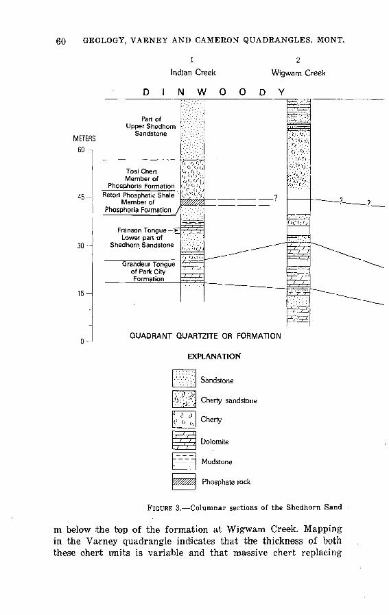
60 GEOLOGY, VARNEY AND CAMERON QUADRANGLES, MONT.
1
Indian Creek
N W O O
Wigwam Creek
D Y
METERS 60^
45-
30-
15-
O-1
Part of Upper Shedhorn
Sandstone
Tosi Chert Member of
Phosphoria FormationRetort Phosphatic Shale
Member ofPhosphoria Formation /
Lower part of
Grandeur Tongueof Park City Formation
"' 0 c, tj <><, 0 c, 0 <i f > f <)
c/->V(/Jj £,($'//
tffifflft
"i7'"7r(. '... <
'>tt '-H/J
O Oot) ;.- - x
?
^ ^____ - ^"
_____ --^^"
-
' :; ' ''
F^^
( : . tjr, i'v'-'^.'-'v
^ 'V'tit
.V/.'^y'/
Oo<j 0
n rr
7 V/ /; ' ^ y
/ /
^
^P^
"" ~ __?
^^^^^^^
^^^^
^^-^
^^~
QUADRANT QUARTZITE OR FORMATION
EXPLANATION
Sandstone
Cherty sandstone
Cherty
Dolomite
Mudstone
Phosphate rock
FIGURE 3. Columnar sections of the Shedhorn Sand
m below the top of the formation at Wigwam Creek. Mapping in the Varney quadrangle indicates that the thickness of both these chert units is variable and that massive chert replacing

PALEOZOIC ROCKS 61
Northwest of Crockett Lake
Warm Springs Creek
Lazyman Hill
FORMATION
-? -?- _ ? _
~~ -- __^
>.}/; <; iv' ( \\<lj-<-'>-
>o(>o(( i 0 "-'
O-trO.f-1
^^
rgT.-^f-
,i.y '/,',].(
»V$'
(' (i ';!)(
-J^r; ?/ :iffii^VjO'jf) 1 J^
^i^l^fliJI>y 'i i> n
', M , M , ,
^
ft
'aAW/ii
^&^.
LOCATION OF SECTIO
1. Type section of Shedhom Sandstone, Indie 20, T. 8 S., R. 2 E.
2. Canyon of Wigwam Creek, north wall, sec. Measured by R. W. Swanson, J. B. Hac and G. H. Haddock, 1956
3. South edge of sec. 12, T. 8 S., R. 3 W. 1 Hadley, 1957
~
__ . ~ - =-
NS n Creek, SEVi sec.
33,T.7S.,R.2W. iley, H. Masursky,
\Measured by J. B. \
\
V.V.o.'',1
: ;.' /.-; ;/.'
l^.
1 11 1
II 11 '/ I-, 1
' 1 /
^^^^-^ -^-T^:
^_:l^^_
i i
4. North side of Warm Springs Creek, sec. 22, T. 9 S., R. 3 W. From Swanson and others (1953, p. 11-12)
5. Lazyman Hill, crest of Gravelly Range 2.4 km south of Vamey quadrangle. From Swanson and others (1953, p. 13-15)
stone and Phosphoria Formation, Varney quadrangle.
sandstone occurs at other straitigraphic positions in unit E. Sand stone in the upper 9 to 15 m of unit E includes poorly sorted, thin-bedded, and crossbedded sandstone and sandy dolomite, com-
62 GEOLOGY, VARNEY AND CAMERON QUADRANGLES, MONT.
monly containing glauconite and well-worn fragments of bryo- zoans and molluscan shells.
The beds immediately below the main chert of unit E are rarely exposed except by trenching. At Warm Springs Creek, they are reported as including 3 m of phosphate rocks and mudstone assigned to unit D (Swanson and others, 1953, p. 11-12). Similar rocks were found in small landslide deposits or float in the con cealed interval at a few other places in the quadrangle, but none were exposed in place. Six m of dark mudstione and 15 cm of phosphatic sandstone were found near the crest of the southern end of the Greenhorn Range just west of the Varney quadrangle boundary 1.5 km or so north of the Ruby River water gap. Dark- brown oily shale 0.6 m thick and a few centimeters of oolitic phosphate rock were found in the canyon of Tolman Creek (sec. 10, T. 7 S., R. 1 E.) near the northern border of the Cameron quadrangle. Presumably these beds represent unit D, but in both places, the beds are strongly overturned, folded, or faulted; hence, their stratigraphic position is uncertain.
Because of insufficient exposure of unit D and the underlying beds, the lower part of the Shedhorn Sandstone is not well de nned in the Varney quadrangle. It consists largely of gray sand stone and light-gray, variously calcareous dolomite in isolated beds or units as much as 15 m thick at or near the base of the formation. These rocks are lithologically similar to those of unit C, as described from localities not far west and southwest of the quadrangle (Cressman, 1955). According to the terminology of McKelvey and others (1956), the thicker dolomite units are con sidered to represent tongues of the Park City Formation in or below the Shedhorn Sandstone.
MESOZOIC ROCKS
DINWOODY FORMATION
The Shedhorn Sandstone is overlain throughout the Varney and Cameron quadrangles by the Dinwoody Formation of Early Triassic age. The formation consists largely of interbedded silty shale, argillaceous and calcareous sandstone, and yellow-weather ing, platy to blocky dolomite or silty limestone, all poorly exposed in most of the area,
The lowermost part of the Dinwoody in most localities is easily recognized platy, grayish-yellow dolomite, commonly containing specimens of Lingula on the bedding surfaces; this dolomite is found as float in an interval that is probably mostly shale. Higher
MESOZOIC ROCKS 63
are thigkgr bedded dolomite that becomes increasingly argil laceous and calcar-e,oii§ upward anjl is interbedded with silty shale or mudstone and very fine grained argillaceous and dolomitic sandstone. In the section on the North Fork of Warm Springs Creek, several cyclic units appear, in each of which medium- fy&d{led dolomite is succeeded gradationally by thinner bedded dolomite, which becomes increasingly argillaceous and sandy and interbedded with sandstone toward the top of the unit. The upper most b&ds, gp§ cpmmpnjy medium-bedded argillaceous sandstone pyerlain, with sharp contact, by dolomite of the next cycle. Some f the thicker dolomite beds are bioclastic and show fine current
the Icjwer boundary of the Dinwoody is quite well defined in the Varney quadrangle, the upper boundary is not. For example, in areas immediately south of the Varney quad rangle, the Dinwoody is overlain by red silty sandstone, siltstone, and shale of the Woodside Formation (Moritz, 1951, p. 1791; Mann, 1960, p. 117-120). Although similar beds appear in the Ruby River water gap at Canyon Camp just west of the Varney Qua.drangle boundary, no red beds occur in the few exposures of this interval in the quadrangle. The upper 12 to 30 m of the Din- woody in the central part of the Varney quadrangle and on Indian Creek, although not red, is largely yellowish-brown sandstone and shale that might represent a featheredge of the Woodside Formation.
Mollusks in the Dinwoody are sparse and poorly preserved. All those collected were long-ranging species found in rocks of late Paleozoic and Early Triassic age (N. J. Silberling, written commun., 1958). Linguloid brachiopods are in general agreement with Lingula borealis Bittner, described by Newell and Kummel (1942) from the Dinwoody of western Wyoming, southeastern Idaho, and southwestern Montana. The Lingula zone was estab lished by Newell and Kummel as the lowermost Triassic zone in this area. Nevertheless, these brachiopods are also similar to rep resentatives of Lingula ranging from Cambrian to Holocene. Lingula, in the absence of normal marine forms such as articulate brachiopods and cephalopoda, is commonly used as an indicator of brackish or poorly oxygenated water (N. J. Silberling, written commun., 1956).
ELLIS GROUP
A succession of sandy 'siltstone, shale, and interbedded lime stone, 45 to 60 m thick, that overlies the Dinwoody throughout the

64 GEOLOGY, VARNEY AND CAMERON QUADRANGLES, MONT.
Varney and Cameron quadrangles represents the Ellis Group of Middle and Late Jurassic age. All three formations of the group, as defined in northwestern Montana some 325 km northwest of the report area (Cobban, 1945; Moritz, 1951, p. 1802-1813), can be recognized in the Varney quadrangle.
The uppermost of these formation®, the Swift Formation or Sandstone, consists of massive grayish^orange, fine-grained sand stone, 4.6 m thick in the northern part of the Gravelly Range and 12 m thick in the Greenhorn' Range. The basal few centimeters commonly contain small well-rounded pebbles of chert and rest with sharp contact on a unit of light-brown oolitic limestone and interbedded clay shale 4.6 to 6 m thick. The oolitic limestone is characteristic of the Rierdon Formation. The remainder of the Ellis Group in the Varney quadrangle consists of 40 to 55 m of interbedded argillaceous and sandy limestone, shale, and sand stone, most of which has been assigned to the Sawtooth Forma tion by previous workers in the region (Moritz, 1951, p. 1804). Shale and sandstone predominate in the lower part of the forma tion, limestone and shale, in the upper part, which is generally better exposed. In the section on French Gulch (fig. 4, columnar section 2), the base of the Sawtooth is assumed to be a 3-m bed of brownish-gray limestone containing abundant angular granules and pebbles of chert in the basal 0.3 to 0.9 m, which rests on medium-bedded grayish-orange dolomitic sandstone. The base of this chert-pebble bed may represent the regional disconformity between the Ellis Group and the underlying Dinwoody or Wood- side. Elsewhere in the report area, hlowever, no clear lithologic break marks this boundary.
In the absence of such a break, the base of the Ellis was taken at the upper limit of the cyclic dolomite and sandstone beds of the upper part of the Dinwoody.
The limestone of the Ellis Group in the Varney quadrangle is generally fossiliferous and yielded the following species, identi fied by R. W. Imlay (written commun., 1958), probably all from the Sawtooth:
Pentacrinus asteriscus Meek and Hayden Pleuromya subcompressa (Meek) Astrocoenia hyatti WellsLima (Plagiostoma) occidentalis Hall and Whitfield Trigonia americana Meek Camptonectes plates siformis WhiteUnidentified species of Ostrea, Pinna, Isognomon, Quen-
stedtial, and worm tubes

MESOZOIC ROCKS 65
In his regional study of the Twin Creek Limestone, Imlay (1967) discussed and correlated all the related Middle and lower Upper Jurassic units in the central and northern Rocky Moun tains. Imlay considered the lower part of the Sawtooth Forma tion to be of late Bajocian age, the upper part of the Sawtooth to be of Bathonian age, and the Rierdon Formation to be of late Bathtonian and early Callovian age.
Stratigraphic section 5[Ellis Group and Dinwoody Formation, north side of French Gulch near middle of sec. (> (unsurveyed), T. 9 S., R. 2 W., Varney quadrangle. Measured by P. W. Birkeland and J. B.
Haclleyl
ThickneBH (meters)
Ellis Group, near base of Morrison Formation:21. Limestone, upper 2.8 m, moderate-brownish-gray, finely
oolitic, bedding indistinct 10 to 25 cm, forms cliff along crest of ridge. Lower 1.8 m, dark-greenish-gray to yel lowish brown, silty to finely sandy, variable to large amounts of fine quartz sand and minor sandy and argillaceous beds, thinly current bedded _______________ 4.6
20. Mostly covered. Upper part is clayey, calcareous, yellowish- brown siltstone ____________________________________ 2.4
19. Limestone, moderate-yellowish-brown, massive, calcarenitic.Lower part abundantly fossiliferous; forms low cliff ___ 1.5
18. Covered. Upper part, exposed by digging, is moderately fis sile argillaceous limestone ________________-_-_-----__ 2.1
17. Limestone, moderate- to dark-yellowish-brown, finely crys talline to fine sandy, fine quartz sand throughout, bedding medium to thick, few impersistent shaly partings, abun dant fine current lamination on weathered surfaces. Fine ly laminated calcilutite at top and oolitic limestone at base; forms cliff ________________________________ 8.8
16. Covered. Probably mostly yellowish-brown, finely currentbedded siltstone _______________________________ 2.8
15. Limestone, light-brownish-gray, very fine sandy, quartzose, massive, indistinct current lamination. Upper 30 cm is dark brownish gray, oolitic, petroliferous _______-- 2.1
14. Mudstone, moderate-yellowish-brown, fine sandy, mostly cov ered _______________________________________ 1.5
13. Limestone, massive, finely clastic, conchoidal fracture. Finecalcarenite to calcilutite. Many fossil fragments ______ 8.5
12. Mostly covered. Probably argillaceous limestone and shale. Basal 3 m exposed in offset part of section 75 m to the north is dark- to light-brownish-gray, fine- to medium- grained, porous and somewhat petroliferous, poorly bedded limestone. Basal 30 cm is breccia, including small angular chert fragments and rounded claystone frag ments in limestone matrix, in sharp contact with under lying beds __________________________________ 12
Total thickness of Ellis Group ____________ 47
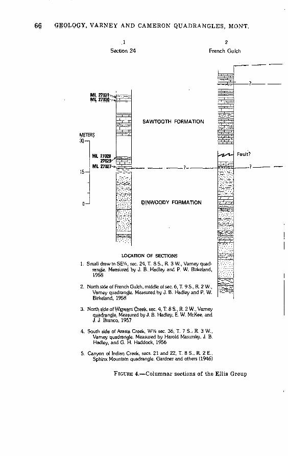
66 gEQLQGY, VARNEY AND CAMERON QUADRANGLES, MONT.
.1
Section 24 French Gulch
ML 27031^ Ml 2703|j
METERS
15-
0 i
ML 27028 27029'
ML 27027-
"!', I','
m^iiJr
hVV^VT!
T .V".1.';'-'*
fr* ' ' 'r.4i'
,_ ,-,-_~' '7~ ' 7' '-T
SAWTOOTH FORMATION
7
QINWOQQY FORMATION
LOCATION OF SECTIONS
SE%, sec. 24, T. 8 S., R. 3 W., Vamey quad- jsured by J. B..Hadley and P. W. Birkeland,
:rench Gulch, middle of sec. 6, T. 9 S., R. 2 W., drangle. Measured by J. B. Hadley and P. W. 1Q58
CT=4r=
i=r l 4 ..l. r . S/iife?^-j'.U
ft 1 ,( ,
"ZclfZf,'
c-2--y.
'^ :..<'.<.
fe^
p
Fault?
?
1958
Birkeland, 1958
3. North side of Wigwam Creek, sec. 4, T. 8 S., R. 2 W., Vamey quadrangle.. Measured by J, B. Hadley, E. W. McKee, and J. J. Branco, 1957
4. South side of Arasta Creek, WVfe sec. 36, T. 7 S. ; R. 3 W., Vamey quadrangle. Measured by Harold Masursky, J. B: Hadley, and G. H. Haddock, 1956
5. Canyon of Indian Creek, sees. 21 and 22, T. 8 S., R. 2 E., Sphinx Mountain quadrangle. Gardner and others (1946)
FIGURE 4. Columnar sections of the Ellis Group

MESOZOIC ROCKS 67
3 4
Wigwam Creek Arasta Cr MORRISON FORMATION ......
7 .
!
I
L
i E
i3
5n
J
¥
E^
m\ \
EXPLANATION
Sandstone
>] Cherty sandstone
B:-T^-=-r_
| i 1 i j|
--=Tr
c/ /
**TSl*
/ /
/ /
S*^**
. / . / :
^.^y?.f.:f> Y
5
eek Indian Creek
___J\/!ORRISON FORMATION
SWIFT FORMATION
RIERDON FORMATION
SAWTOOTH FORMATION
^,^^
Hi
S3§ 1,1,
=W=n
^F
1;ML 19619
Fault?
DINWOODY FORMATION
Fault?
SHEDHORN SANDSTONE
Dolomite
Limestone
pl d Mudstone or shale
|rl£f2^ Sandy shale
ML 27027 USGS Mesozoic locality number
and the upper part of the Dinwoody Formation.

68 GEOLOGY, VARNEY AND CAMERON QUADRANGLES, MONT.
Stratigraphic section 5 Continued
Thickness (meters)
Dinwoody Formation:11. Sandstone, lower 3 m fissile, remainder grayish-orange,
light-yellowish-gray, and pale-orange, medium-bedded (5-60 cm), fine-grained, dolomitic, forms cliff _________ 13
10. Dolomite, lower part interbedded with equal amount of fissile dolomitic sandstone; upper 4 m light-gray, thick- bedded to massive, porous, and containing poorly pre served fossil fragments; forms cliff _________________ 7
9. Poorly exposed. Basal 1.8 m is sandstone, thin bedded and laminated like unit 5; top meter is more fissile sandstone; remainder is probably fissile sandstone and silty shale__ 9
8. Mostly covered. Massive dolomite 1.5 m thick, like unit 10 in lower part; remainder probably fissile dolomitic sand stone and shale __________________________________ 7
7. Sandstone, dolomitic, fine-grained, and quartzose, thick bedded and current laminated, some crossbed sets 20 cm thick; forms cliff ________________________________ 3.3
6. Mostly sandstone, dolomitic, very fine grained, and fissile. Two or more beds, 38 cm thick, of yellowish- to light- greenish-gray dolomite; one contains small poorly pre served gastropods and is somewhat petroliferous _______ 5.5
5. Sandstone, light-yellowish-brown, fine-grained, beds 5 to 30 cm; in part finely laminated and current-bedded; a few partings coated with very fine grained muscovite; forms cliff ___________________________________ 8
4. Largely covered. One outcrop plus float indicates silty to fine sandy, thin- to very thin bedded, micaceous and finely laminated, pi aty-weather ing dolomite. Considerable silty shale probably present. Contains poorly preserved speci mens of Myalina __________________________________ 7.6
3. Dolomite, like unit 1, somewhat thicker bedded (2-30 cm) __ 2.12. Covered. Probably dolomite shale and thin-bedded dolomite 2.81. Dolomite, pale-yellowish-brown to yellowish-gray, finely
crystalline, thin-bedded; two beds in lower part are 30 cm thick; argillaceous partings common, also thin interbeds dolomitic mudstone _______________________________ 6.7
Partial thickness of Dinwoody Formation _______ 72Base of measured section about 45 m above Shedhorn Sandstone
MORRISON FORMATION
Immediately succeeding the Ellis Group is a thick unit of non- resistant clayey rock referred to the Morrison Formation of Late Jurassic age. It is characteristically very poorly exposed, but, be cause of its highly plastic and unstable consistency, it can be commonly recognized by a distinctive hillock-and-sag-pond topog raphy a result of gravity sliding. In several places, especially in
MESOZOIC ROCKS 69
the drainage of the South Fork and Middle Fork of Warm Springs Creek, the sag ponds have been enlarged by beaver dams.
Judging from the few good exposures, such as those just north west of Moose Lake in sec. 25, T. 8 S., R. 3 W., on the north slope of the ridge 1.3 km west-southwest of bench mark 8523 on the Gravelly Ridge road, and on the ridge south of Arasta Creek in sec. 36, T. 7 S., R. 3 W, the Morrison Formation consists mainly of dark-greenish-gray to reddish-brown or maroon claystone and mudstone, poorly bedded, and containing sparsely distributed cal careous concretions and thin indurated beds of calcareous mud- srtjone. Thin beds of fine- to very fine grained orange-weathering sandstone are commonly present in the middle and upper parts of the formation; sandstone seems to be unusually abundant in a poorly exposed section on the north side of the Wigman Creek Canyon southeast of Horse Hill.
No fossils were found in the formation, but distinctive well- rounded and polished chert pebbles, found nowhere else in the area, are sparsely scattered throughout its outcrop area. A few large dinosaur bones displayed by residents of Ennis are said to have been found in the Morrison farther south in the Gravelly Range.
The Morrison Formation lies on various beds of the Ellis Group, apparently on sandstone of the Swift Formation in the vicinity of Wigwam and Arasta Creeks and on the Rierdon or Sawtooth elsewhere in the area. Thickness of the Morrison is estimated at about 75 m in most places.
KOOTENAI FORMATION
The Kootenai Formation, widely distributed and having many distinctive lithologic features, marks the beginning of Cretaceous time throughout much of western Montana and adjacent areas. The formation is exposed at many places along the crest and western slopes of the Gravelly Range and locally in the Green horn and Madison Ranges. Throughout this extent, four well- defined members can be recognized a basal sandstone unit, suc ceeded by a thick unit of clayey mudstone, a thinner unit of limestone, and a top unit of variably fissile clay shale and sand stone. The formation as a whole is 140 to 170 m thick.
Basal sandstone. The lowest member of the Kootenai consists of light-gray, medium- to coarse-grained argillaceous sandstone and chert-pebble conglomerate, marking an abrupt change from the dark clay of the underlying Morrision Formation. The sand stone is typically composed of quartz grains and large quantities

70 GEOLOGY, VARNEY AND CAMERON QUADRANGLES, MONT.
of dark chert grains that give the rock the distinctive "salt and pepper" appearance commonly reported in the literature. The largely white clay matrix contains little or no carbonate cement. The lower beds' of the unit are typically medium t|o thick bedded (1-3 m) and commonly show abundant steeply inclined planar crossbeds. Lenses and thin layers of conglomerate contain chert pebbles 5 to 25 mm in diameter. The upper beds of the unit are generally somewhat finer grained, more argillaceous and quartz- ose, and thinner and more regularly bedded. At a few places they clontain small particles of coaly material. In some sections, for example, the section exposed just southeast of Moose Lake, the basal sandstone unit has two major upward-fining sequences, each about 15 m thick. Impressions of leaves and stems of plants were found in the unit in a few places; in exposures northwest of Moose Lake, compressed tree trunks are represented by fluted molds as much as 2 m long and 22 cm wide, marked by narrow ridges 2 to 5 cm apart at right angles to the fluting.
Thickness of the basal Kootenai sandstone unit is generally about 30 m, although it ranges from less than 15 m in some places to more than 38 m in others.
Mudstone unit. The basal sandstone unit is overlain by poorly to moderately bedded mudstone and claystone ranging from light olive gray to dusky red or reddish brown. The lower part of this unit is commonly mudstone containing scattered grains of quartz and dark chert like that in the underlying beds; also present are thin units 'of thin-bedded sandstone, sandy or silty limestone, and limestone conglomerate. The upper part of the unit is gen erally somewhat more clayey, is indistinctly bedded in layers 0.6 to 0.9 m thick, and is generally gray rather than red. An unusual ly good exposure of the lower 43 m of the mudstone unit was found near the top of ithe ridge about 1 km north of the canyon in the lower part of the Warm Springs Creek (sec. 22, T. 9 S., R. 3 W.). Thickness of the unit as a whole is estimated at about 75 m in most places.
Limestone unit. Above the mudstone unit lies a persistent and easily recognizable unit about 15 m thick, consisting almost wholly of pale-yellowish-brown or yellowish-gray limestone, thin to medium bedded and somewhat argillaceous. Some of the lime stone beds are composed of limestone fragments ranging in size from coarse s'and to small pebbles; others are conspicuously oolitic. Still lothers are crowded with small gastropods of onie or two species, resulting in a distinctive rock recognized throughout large areas where the Kootenai Formation is known. The lime-
MESOZOIC ROCKS 71
stone unit is 17 m thick in the best exposed section, just west of the canyon of Warm Springs Creek (stratigraphic section 6), and is about this thick at most other places in the area, except on the ridge south of Arasta Creek, where it is about 25 m thick.
Stratigraphic section 6(Limestone unit in Kootenai Formation1, north side Warm Springs Canyon, NW corner sec.
22, T. 9 S., R. 3 W., Varney quadrangle. Measured by J. B. HadleyJ
ThiclcncsH (meters)
Covered.8. Limestone, like unit 6, medium- to thick-bedded, lacking
shale interbeds; abundant gastropods in several beds; top bed 45 cm thick is microcrystalline to oolitic. Upper 1.5 m partly covered, may be shaly ________________ 4.9
7. Limestone, microcrystalline, like units 2 and 4 __________ 0.66. Limestone, moderate-brownish-gray, medium- to thick-
bedded (5-60 cm), finely crystalline; contains beds of shale 5 to 30 cm thick showing crumpling and duplica tion by low-angle reverse faulting. Upper 30 to 60 cm is highly oolitic; at base is 60 cm moderately gray fissile shale containing thin limestone beds _________________ 5.3
5. Limestone, like unit 3; upper 60 cm highly oolitic ____._ 1.74. Limestone, like unit 2, medium-bedded (8-35 cm) ________ 2.13. Limestone, moderate-brownish-gray, darker than unit 2,
microcrystalline to finely crystalline and oolitic, medium- bedded (8-30 cm), abundant gastropods _______________ 1.2
2. Limestone, moderate-brownish-gray, strong close jointing, at right angles to bedding, weathers to wedge-shaped chips _______________________________ " 0.8
Mudstone unit: 1. Mudstone, light-brownish-gray, calcareous, nonbedded ____ 1.5
A fossil collection from the upper part of the limestone unit, 375 m east-northeast of the southwest corner of sec. 13, T. 9 S., R. 3 W. (fig. 5), USGS paleont. loc. D-1765, yielded the follow ing lacustrine species identified by W. A. Cobban and I. G. Sohn (written commun., 1958,1959) :
Pelecypoda Unio farri, StantonGastropoda Reesidella montanensis StantonOstracoda Cyprideal anomala"! Peck
Shale unit. Above the limestone unit and below a characteristic marine sandstone at .the base of the Colorado Group, is a little- exposed interval, 15 to 30 m thick, of dark-brown to medium- gray clay shale and claystone, variably fissile and sandy. It is well exposed only on the Warm Springs Creek road just east of Davis Creek in sec. 22, T. 8 S., R. 3 W., where a small collection
72 GEOLOGY, VARNEY AND CAMERON QUADRANGLES, MONT.
of lacustrine ostracodes and pelecypods was made, I. G. Sohn and W. A. Cobban (written commun., 1958, 1959) give the following species:
Ostracoda Cypridea wyomingensis Jones, sensu Peck 1941Cypridea anomala Peck 1941
Pelecypoda Eupera onestae (McLearn)
Three samples of shale from the upper shale unit on the Warm Springs Creek road 0.16 km east of Davis Gulch (fig. 5, USGS paleobot. loc. D-1830) yielded abundant gymnosperm pollen along with the fresh-water alga Botryococcus; no angiosperm pollen was present (R. H. Tschudy, written commun., 1962). Each of four samples from the mudstone unit of the Kootenai proved to be barren of both pollen and spores.
THERMOPOLIS SHALE 1
Above the gray shale and sandstone of the upper part of the Kootenai Formation is a unit about 110 m thick, consisting large ly of dark-gray shale. This unit is recognized throughout north ern Wyoming, where it is referred to as the Thermopolis Shale; it is mapped as far east as the Black Hills, where it is called the Skull Creek Shale. It grades downward into thin-bedded rusty quartz sandstone, marked by worm casts and trails, and lenticular, clean, current-bedded quartz sandstone, which is taken as mark ing the base of the formation. In northern Wyoming, the rusty sandstone beds are generally included in the upper part of the Cleverly Formation, which is equivalent to the Kootenai Forma tion of Montana. Above the dark shale is 15 m or less of dirty, coarser grained, thicker bedded sandstone that has been mapped with the Thermopolis Shale, but it equally well might be con sidered the basal unit of the overlying Frontier Formation.
A conspicuous characteristic of the basal sandstone of the Thermopolis in the Varney quadrangle is the presense of 6 m or less of clean quartz sandstone or quartzite that is strongly cur rent bedded, overlain by thin-bedded gray or rusty sandstone marked by shaly partings and abundant worm casts and burrows. These basal sandstone beds are a minor ledge maker and can be recognized at many places, either in outcrop or in float. On Arasta Creek, they overlie 13 m of fine-grained fissile argillaceous sand stone and sandy shale assigned to the upper part of the Kootenai
'The name Thermopolis Shale is now geographically restricted from Montana by Rice (1976) for U.S. Geological Survey usage; rocks in Montana formerly called Thermopolis Shale are now called the Muddy Sandstone, the Skull Creek Shale, the basal part of the Mowry Shale, or the Fall River Sandstone. Hadley's mapping was completed before this restriction.
MESOZOIC ROCKS 73
Formation. Although unfossiliferous, the sandstone at the base of the Thermopolis and in the uppermost part of the Kootenai appears to indicate a rather abrupt transition from nonmarine to marine conditions of deposition.
Although nonresistant and rarely well exposed, the dark-shale unit can be seen near the confluence of the Middle and South Forks of Warm Springs Creek and on the west bank of Davis Creek just above its junction with Warm Springs Creek. The shale is gen erally medium gray to very dark gray and moderately fissile; its upper part is commonly silty or sandy and less fissile. Dark-red ironstone has resulted from weathering of thin lenses and nodules of ferruginous carbonate. Thickness of the shale unit is estimated at 75 to 82 m.
The dark-shale member is overlain throughout the Varney quad rangle by a prominent sandstone unit approximately 15 m thick, which is similar in lithologic character and stratigraphic posi tion to the Muddy Sandstone farther east and northeast in Mon tana. In the Varney quadrangle, this sandstone is a minor ledge maker; it is medium gray, medium grained, argillaceous, and calcareous and is generally "dirty," containing abundant dark grains. Clay galls and fragments are common in some beds. Bed ding characteristics range from thin bedded and flaggy weather ing to thick bedded and coarsely current bedded. This sandstone unit is similar in many respects to those in the overlying Frontier Formation.
The Thermopolis is sparingly fossiliferous. Palynomorphs found in three samples from near the base, middle, and top of the dark-shale unit (fig. 5, USGS paleotoot. loc. D-1422, 1423, 1424)were identified by E. B. Leopold as follows:
Classopolis cf. torosus (Reiss) Couper (the dominantspecies)
Inaperturopollenites dubius Pot. Pityosporites labdacus Pot. Abietineaepollenites cf. dunrobensis Couper Gleicheniidites senonicus Ross Monocolpopollenites (Gingko type) Eboracia cf. lobofolia (Phill.) Thomas Stereisporites psilatus Ross
"The assemblage is identical in all three samples. The sedi ments contain about 300 pollen and spore grains per gram. The forms present are land plants of the gymnosperm and fern groups, and no higher plant (dicot) pollen could be found. I con clude the materials are of Lower Cretaceous age and that the
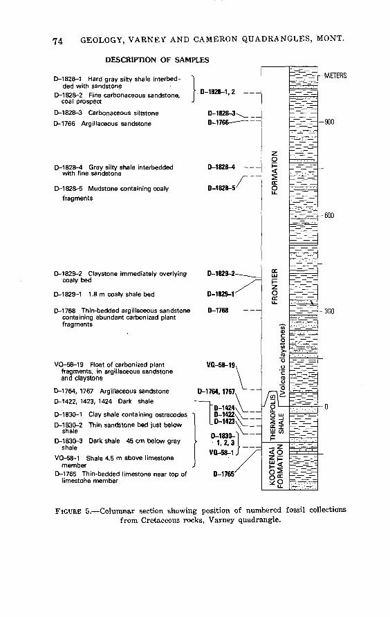
74 GEOLOGY, VARNEY AND CAMERON QUADRANGLES, MONT.
DESCRIPTION OF SAMPLES
D-1828-1 Hard gray silty shale interbed- ded with sandstone
D-1828-2 Fine carbonaceous sandstone, coal prospect
D-1828-3 Carbonaceous siltstone
D-1766 Argillaceous sandstone
D-1828-4 Gray silty shale interbedded with fine sandstone
D-1828-5 Mudstone containing coaly fragments
D-1829-2 Claystone immediately overlying coaly bed
D-1829-1 1.8-m coaly shale bed
D-1768 Thin-bedded argillaceous sandstone containing abundant carbonized plant fragments
VQ-58-19 Float of carbonized plant fragments, in argillaceous sandstone and claystone
D-1764, 1767 Argillaceous sandstone
D-1422, 1423, 1424 Dark shale
D-1830-1 Clay shale containing ostracodes "
D-1830-2 Thin sandstone bed just below shale
D-1830-3 Dark shale 45 cm below gray shale
VQ-58-1 Shale 4.5 m above limestone member
D-1765 Thin-bedded limestone near top of limestone member
" D-1828-1, 2 -
D-1828-3\_ D-1766
D-1828-4
D-1828-5/
D 1R9O_9
o-ms-r
D-1768
VQ-58-19,
D-1764, 1767.
hD-1424\\_ D-1422A"
|_D-1423\V~~
D-1830-1
" ' 1. 2, 3 1 VO458-1J /-
D-1 765
JLJS] FRONTIER FORMATION
(Volcanic claystones)
THERMOPC SHALE
KOOTENAI FORMATION
zP^>-
H "^r£Z
^SH:
-z^-z^
"FvJ^I
~ ~r
I ^-
^H^fx
Hz ~T 1
T7; , .-r-T
_
iSriz^iH
rL-^r.^:
*
'^~ 1-
,^;ri'~r
=S^
' ^' ' :: : :.
-METERS
-900
-600
-300
-0
FIGURE 5. Columnar section showing position of numbered fossil collections from Cretaceous rocks, Varney quadrangle.
MESOZOIC ROCKS 75
depositional environment could be either nearshore marine or continental lacustrine." (E. B. Leopold, written commun., 1959).
Fossils collected from the upper sandstone member of the Thermopolis Shale near the NW corner of sec. 23, and southeast of the NW corner of sec. 15, both in T. 9 S., R. 3 W., (fig. 5, USGS paleont. loc. D-1764, 1767) consist entirely of the shallow-water marine species Ostrea anomioides Meek (W. A. Cobban, written commun., 1958.)
FRONTIER FORMATION
The rocks above the Thermopolis Shale in the Varney and Cameron quadrangles constitute several thousand meters of sand stone, mudstone, and shale and minor coal and limestone, of mixed fluviatile and shallow-marine or estuarine origin. Because rocks of nonmarine or estuarine origin appear to be dominant, they are assigned to the Frontier Formation 'of Late Cretaceous age. Bentonitic claystone, thin beds of porcellanite, and pink or reddish zeolite-bearing beds indicate 'a strong volcanic contribu tion in the basal 110 m of the formation. The best exposures are along the Ruby River road west of Warm Springs Creek and in low bluffs along the west side of Warm Springs Creek west and southwest of Warm Springs Cow Camp.
Most of the Frontier Formation in the two quadrangles con sists of gray mudstone or claystone and drab or olive-gray sand stone, fine to medium grained, in beds 30 to 90 cm thick. Coarser sandstone occurs in discontinuous units 3 to 12 m thick every few hundred meters throughout the formation. This sandstone is typically medium to coarse grained, is coarsely and irregularly crossbedded, and appears to be fluviatile. Clay galls and rare chert pebbles occur in some beds. Much of the finer grained sand stone and mudstone is highly calcareous and grades locally to finely sandy or argillaceous limestone in lenses 30 to 60 cm thick. Much of the finer noncalcareous sandstone, especially in the lower 600 m, contains abundant coalified plant debris, and thin coal- bearing beds in the middle and upper parts of the formation have been explored in prospect workings at two places near the Ruby River road.
The basal unit, which is rich in volcanic materials (strati- graphic section 7), consists largely of soft-grayish-olive and greenish-gray claystone and subordinate argillaceous sandstone. Much of the claystone shows "popcorn" weathering surfaces, re sulting from swelling of bentonite, or is variegated salmon pink, pale orange, or reddish brown because of the presence of minute

76 GEOLOGY, VARNEY AND CAMERON QUADRANGLES, MONT.
crystals of heulandite. Thin resistant beds in the claystone are silicified tuffaceous layers (porcellanite) or reddish indurated zeolitic sandstone containing abundant highly altered shards. Most sandstone of this unit is quartz-poor and contains abundant angular clasts of plagioclase, feldspar, chert, biotite, and, rarely, pyroxene. Similar bentonitic and zeolitic rocks are reported in the basal part of the Frontier or in the underlying Mowry Shale and equivalent rocks at localities in northern Wyoming and north western Montana (Love and others, 1948; Cobban, and others, 1959).
The stratigraphy of the upper part of the Frontier Formation in the Gameron quadrangle is complicated by the presence of many concordant and semiconoordant intrusive sheets of andesite porphyry abundantly exposed on Cedar Mountain and adjacent ridges. Thick shale units on some of these ridges in the upper part of the sequence on Cedar Mountain may be more properly correlated with members of the Colorado Group farther east.
Stratigraphic section 7[Basal volcanic unit of Frontier formation, west side of Warm Springs Creek, W 1/^ sec. 14,
T. 9 S., R. 3 W., Varney quadrangle. Measured by ,1. B. Hadley and P. W. Birkeland]
Thickness (meters)
End of exposure.12. Clay, grayish-olive (10F 4/2) to dark-yellowish-brown and
zeolitic or grayish-brown (5YR 4/2') ; probably bentonitic with "popcorn" surface ___________________________ 7.6
11. Sandstone, moderate- to pale-reddish-orange, medium- to fine grained, indistinctly current laminated. Coarser material contains abundant heulandite and possibly shards. Blocky weathering, resistant ___________________ 1.2
10. Claystone, olive-gray, soft. Thin sandstone bed at top ______ 3.09. Lower 1.2 m is sandstone containing abundant dark mica,
overlain by clayey reddish-brown sandstone, purplish (zeolitic) toward top. Upper part is mainly olive-gray to reddish claystone. At top is dark-gray claystone 0.6 m thick containing abundant heulandite, overlain by 25 cm medium-dark-gray porcellanite, weathering light gray, irregularly laminated ____________________________ 5.8
8. Claystone, variegated reddish-brown, olive-gray, and dark- gray with red flecks; mostly zeolitic _________--__----___ 4.6
(Section offset 120 m to south at top of unit 7)7. Claystone, olive-gray and greenish-gray, mostly nonresistant.
Two darker gray resistant beds contain cavities filled with red heulandite and green sepiolite ____________________ 4.9
6. Sandstone, 1.5 m thick, medium- to fine-grained, argillaceous, micaceous, and fissile, overlain by olive-gray claystone that has minor fissile sandstone in lower part ______________ 8.8
5. Covered ___________________________ __ _______ 4.0

MESOZOIC ROCKS 77
Strati graphic section 7 Continued
Thickness (meters)
4. Claystone and sandstone like unit 2, nonresistant; 15 cm resistant dark-greenish-gray claystone at top; similar bed 2.8 m below top _________________________ 8.2
3. Claystone, medium-dark-gray, resistant, interbedded withsofter claystone ______________________________________ 1.5
2. Claystone as in unit 1, interbedded with sandstone, argilla ceous, nonresistant, grayish-yellow (5F 7/4). Bedding units 5 cm to 1.2 m thick. Includes several thin beds of resistant silty or fine sandy claystone; "popcorn" surface 18.0
1. Claystone, light-olive-gray to olive-black (5GY 5/2 to 5Y 2/1), silty. Interbeds 8 to 15 cm thick of siltstone and fine grained calcareous "salt-and-pepper" sandstone. Upper 3 m is fine-grained argillaceous friable sandstone, moderately fissile, nonresistant __________________________________ 10.7
Upper sandstone unit of Thermopolis Shale.
The easily deformed rocks of the Frontier Formation underlie major thrust faults in both the Varney and Cameron quadrangles, so that it is difficult to make proper allowance for repetition by folding and thrusting in estimating the thickness of the forma tion. Approximate measurements along the Ruby River road sug gest that beds at least 1,070 m thick are present above the Ther mopolis Shale. The formation may be thicker in the Cameron quadrangle, where it is overlain by Upper Cretaceous volcanic and volcaniclastic rocks. A thickness of 1,100 m has been esti mated in the Sphinx Mountain area immediately east of the Cameron quadrangle (Beck, 1960, p. 131).
Both plant and invertebrate animal remains are found through out most of the Frontier Formation in the Varney quadrangle. A collection from argillaceous sandstone containing abundant plant debris, about 300 m above the base of the formation in Golden Sucker Gulch (fig. 5, USGS paleont. loc. D-1768), yielded the following (W. A. Cobban, written commun., 1958) : Ostrea sp.; Anomia aff. A. micronema Meek; Corbicula sp.; Corbula n. sp. Another collection, about 900 m above the base (fig. 5, USGS paleont. loc. D-1766) northwest of Schoolmarm Gulch, yielded the following species: Ostrea soleniscus Meek; Corbicula sp.; Corbula n. sp. Cobban reported that these collections repre sent brackish-water faunas, the lower one of late Colorado age and the upper one of probable late Colorado age.

78 GEOLOGY, VARNEY AND CAMERON QUADRANGLES, MONT.
A small collection of plant leaves and stems of early Late Cre taceous aspect, associated with silicified logs in the lower part of the volcanic unit at the base of the formation near Vigilante Ranger Station (fig. 5, field loc. VQ-58-19), was studied by R. W. Brown, who listed the following (written commun., 1958) : Anemia fremonti Knowlton; Cladophlebis readi Brown; Glei- chenia nordenskioldi Heer; Sequoia or Araucarites; coniferous wood; dicotyledonous leaves.
Samples of claystone and shale from several horizons in the Frontier Formation in the section exposed along Ruby River in sees. 17 and 20, T. 9 S., R. 3 W. (fig. 5, USGS paleobot. loc. D- 1828, -1829), were studied for palynomorphs by R. H. Tschudy (written commun., 1962). Of 14 samples collected, 7 were barren; these included 3 samples of silty claystone and shale from the middle of the Frontier section and all 4 samples of claystone from the basal volcanic unit. Samples of silty shale, mudstone, and fine argillaceous sandstone, especially those containing carbonized plant debris, yielded sparse to abundant angiosperm pollen as well as considerable amounts of gymno'sperm pollen and pteridophyte spores. Three samples of silty shale and fine sandstone from the upper part of the section yielded histrichospheres, suggesting, ac cording to Tschudy, marine conditions of deposition. In only one of the seven productive samples (D-l828-5) were the materials sufficiently abundant and well preserved to permit grain counts. Palynomorphs in the other six samples were either too poorly preserved or too sparse to reveal more than the presence of a few forms.
UPPER CRETACEOUS VOLCANIC AND VOLCANICLASTIC ROCKS
No Mesozoic rocks younger than the Frontier Formation ap pear in the Varney quadrangle; in the northeastern part of the Cameron quadrangle, however, the Frontier is succeeded by more than 600 m of volcaniclastic rocks of Late Cretaceous age. These rocks are well exposed on the ridges south of Cedar Mountain and along the several forks of Bear Creek and extend several kilometers eastward into the Sphinx Mountain quadrangle, where they have been correlated with the Livingston Group (Beck, 1960, p. 131-132). In the Cameron quadrangle, these rocks can be readily divided into a basal unit of volcanic sandstone, silt- stone, and pebble conglomerate; a middle unit of polymictic vol canic breccia; and an upper unit of coarse volcanic conglomerate. They are overlain unconformably by the Sphinx Conglomerate of Eocene age.

MESOZOIC ROCKS 79
Volcanic sandstone unit. The base of the volcanic sandstone unit is marked by the abrupt appearance, above the light-colored "salt-and-pepper" sandstone of the Frontier Formation, of dark- greenish-gray or brownish-gray, medium- to very coarse-grained sandstone, consisting largely of crystals, crystal fragments, and volcanic rock fragments similar to those in the overlying breccia and conglomerate. Angular fragments and nearly euhedral crystals of twinned and zoned plagioclase are the most abundant consti tuents; other minerals are clinopyroxene, magnetite, hornblende, and biotite in order of decreasing abundance. Chert and quartz grains are generally rare, and the ferromagnesian minerals are commonly wholly or partly altered to chlorite.
The sandstone is generally well bedded and commonly cross- bedded, showing sorting and concentration of the heavier min erals, especially magnetite, by current action. Lenses of pebble conglomerate containing subangular clasts of dark chert and well- rounded pebbles of various volcanic rocks and some quartzite oc cur throughout the unit. Volcanic clasts are generally fewer in the stratigraphically lower lenses but become predominant in the higher ones. Units 15 or more meters thick of lighter colored feldspathic sandstone of Frontier aspect occur within the basal unit at several places. Some beds also contain abundant carbonized plant debris and impressions of leaves and stems of several species of plants.
Beds of soft, white-weathering tuff containing quartz or bio tite crystals were found in a few places in the volcanic sand stone unit. Three such beds, 30, 60, and 150 cm thick, occur in the upper part of the unit on the ridge between North and Middle Forks of Bear Creek.
The basal volcanic sandstone unit is generally too poorly ex posed or too much deformed to permit detailed measurement of its thickness. The thickness as measured from map data ranges from 90 to 210 m.
Volcanic breccia unit. The volcanic sandstone unit is abrupt ly succeeded by a thick mass of poorly bedded rock composed largely of angular fragments and blocks of andesite or basaltic andesite. The fragments range from less than 3 cm to a meter or so in diameter and include several types of pyroxene-, horn blende- , or biotite-bearing andesite firmly cemented in a matrix consisting of finer particles of the same materials. These rocks are dark greenish gray, olive gray, or reddish gray depending upon their state of oxidation. Units 15 m or more thick common ly show little or no sorting or bedding, but interbeds of finer

80 GEOLOGY, VARNEY AND CAMERON QUADRANGLES, MONT.
grained tuff-breccia or coarse volcanic sandstone are fairly com mon. Most fragments are highly angular and show little abra sion, but well-rounded cobbles and small boulders are locally intermixed, and layers composed largely of rounded fragments appear locally, especially in the upper part of the unit.
Thin sections of 12 samples of the larger fragments in the breccia unit were taken from, fresh talus along the North Fork of Bear Creek in the northwest corner of sec. 31, T. 7 S., R. 2 E. The rocks studied are all porphyritic; nearly all contain 10 to 35 percent phenocrysts of calcic andesine or labradorite, and most contain 3 to 20 percent phenocrysts of augite. A few contain phenocrysts of hornblende rather than augite, and some contain small amounts of highly altered biotite in addition to augite. The moderately felsic matrix contains abundant plagioclase laths 0.1 mm long and finer grained ferromagnesian constituents. Some reddish-gray samples are so strongly oxidized that most of the ferromagnesian minerals have been replaced by hematite and quartz. Many samples contain collapsed vesicles filled by chlorite and chalcedonic quartz.
In a few places in the breccia unit, thick bodies of unusually uniform and little brecciated pyroxene andesite may represent lava flows in place. At several places, the breccia unit is cut by dikes of amygdaloidal andesite porphyry characterized by promi nent tabular plagioclase phenocrysts 3 to 10 mm long. No well- defined or mappable units were found, however.
Thickness of the breccia unit, as estimated from map measure ments, is 300 to 400 m.
Volcanic conglomerate unit. Overlying the volcanic breccia unit is a few hundred meters of cobble and boulder conglomerate essentially composed of the various kinds of volcanic rocks that make up the breccia. The clasts are generally well rounded, and their common large size in a given bed ranges from 12 to 30 cm. Boulders 60 to 90 cm in diameter are fairly common, however, and a few are as large as 150 cm in diameter. The matrix is coarse, dark-greenish- or reddish-gray volcanic sandstone, like that in the basal sandstone unit but less well sorted. Conglomerate forms beds several meters thick of poorly sorted material like that in mudflows or alluvial-fan deposits, containing much matrix separating adjacent clasts. Beds of volcanic sandstone and silt- stone and lenses of pebble conglomerate that have mixed volcanic and nonvolcanic components are locally present, as are minor amounts of breccia like that in the underlying unit.
MESOZOIC ROCKS 81
Maximum thickness of the conglomerate unit is about 180 m.Correlation and age. Although Peale (1896) and Beck (1960)
correlated the volcaniclastic rocks of the Madison Range with the Livingston Group (Livingston Formation of Weed, 1893), the unusually coarse texture and domrnantly volcanic composition of these rocks suggest that they are part of the Elkhorn Mountains volcanic field and are best correlated with the lower member of the Elkhorn Mountains Volcanics in the southern Elkhorn Moun tains, 100 km north-northwest of the Cameron quadrangle (Klepper and others, 1957, p. 32-33). This unit is described as 900 m of fragmental andesitic rocks, mainly poorly sorted to un- sorted breccia, and volcanic conglomerate, whose fragments are commonly 30 cm or less in diameter. The rocks in the Cameron quadrangle seem to fit this description, whereas rocks found throughout the Livingston Group in its type area are finer grained and contain greater proportions of nonvolcanic material (Roberts, 1963; Klepper and others, 1957, p. 40).
No new information on the age of these volcanic rocks was found in the Varney-Cameron area, and the age assignment of Klepper and others (1957) is followed. The basal volcanic sand stone unit seems to be an integral part of the overlying deposi- tional sequence, but whether it lies conformably or unconforma- bly on the Frontier Formation is not clear in the area studied be cause of the lack of detailed stratigraphic information in the upper part of the Frontier. The abrupt appearance of pebble con glomerate in the basal unit, however, suggests a radical change in regional stream gradients, presumably resulting from uplift tp the north and northwest in Late Cretaceous time.
CENOZOIC ROCKS
SPHINX CONGLOMERATE
The oldest of the Cenozoic deposits in the Varney-Cameron area is a distinctive red limestone fanglomerate, the Sphinx Conglom erate, conspicuously exposed on Sphinx Mountain, 1.6 km east of the Cameron quadrangle. About 600 m of this rock is exposed in The Helmet (sec. 5, R. 8 S., T. 2 E.; not the prominent hill of Precambrian dolomite so labeled on the geologic map (Hadley, 1969a)). Three much smaller remnants of the Sphinx Conglom erate were found on the crest of the Gravelly Range in the south ern part of the Varney quadrangle. Apparently the unit was once far more extensive and has been largely removed from the Var ney-Cameron area.

82 GEOLOGY, VARNEY AND CAMERON QUADRANGLES, MONT.
The Sphinx Conglomerate typically consists of subrounded to well-rounded cobbles and boulders of various Paleozoic and Mesozoic rocks in a matrix of coarse, pale- to moderate-reddish- brown, calcareous and argillaceous sandstone or mudstone. The common large size of the rock fragments is 20 to 25 cm in the Gravelly Range and 60 cm on The Helmet; the largest boulders seen were about 90 cm in diameter. Sorting is poor and bedding indistinct except for a few thin lenses of pebbly sandstone here and there. In extensive exposures in the cirque wall on the north east side of Sphinx Mountain, Beck (1960, p. 132-133) described large-scale planar cross stratification of units as much as 90 m thick and ascribed this structure to coalescing alluvial fans along an ancestral mountain front.
Although fragments of many of the Paleozoic and Mesozoic for mations are represented in most exposures of the fanglomerate, their proportions vary from bed to bed and from place to place within the formation. An exposure of 18 m of the basal part of the formation in the Gravelly Range, for example, contains abundant fragments of limestone of the Madison Group and Amsden Formation and sandstone or quartzite of the Quadrant Quartzite and Shedhorn Sandstone. Fragments of the Meagher Limestone and Flathead Quartzite are present in small amounts, and a very few small fragments of phyllite and other Precambrian rocks also appear in this exposure. The basal fanglomerate in The Helmet contains many large cobbles and boulders, including sand stone of the Quadrant, the Shedhorn, and the Kootenai and dolo mite or limestone of the Mission Canyon, the Amsden (?), and the Shedhorn (?). Other Paleozoic rocks are poorly represented, and no Precambrian rock types were seen there. This kind of varia tion suggests a strong influence of local sources on the fanglom erate deposits.
The Sphinx Conglomerate was somewhat arbitrarily assigned to the Eocene by Peale (1896, p. 3), who reported no fossil evi dence ; little has been found since to improve on that assignment. The formation in the Cameron quadrangle and on Sphinx Moun tain unconformably overlies sharply folded and thrust-faulted rocks, here correlated with the Elkhorn Mountains Volcanics, yet the fanglomerate on The Helmet is folded in a syncline which has beds dipping at least 25° and subordinate folds of even sharper flexure. Thus, the Sphinx Conglomerate is clearly contemporan eous with Laramide regional deformation but, unfortunately, has provided no biostratigraphic evidence on which to date more pre cisely these Laramide structures.
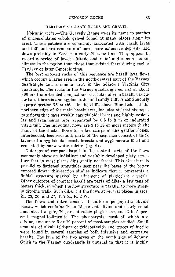
CENOZOIC ROCKS 83
TERTIARY VOLCANIC ROCKS AND GRAVEL
Volcanic rocks. The Gravelly Range owes its name to patches of unconsolidated cobble gravel found at many places along its crest. These patches are commonly associated with basalt lavas and tuff and are remnants of once more extensive deposits laid down probably in Eocene to early Miocene time. They appear to record a period of lower altitude and relief and a more humid climate in the region than those that existed there during earlier Tertiary or later Cenozoic time.
The best exposed rocks of this sequence are basalt lava flows which occupy a large area in the north-central part of the Varney quadrangle and a similar area in the adjacent Virginia City quadrangle. The rocks in the Varney quadrangle consist of about 300 m of interbedded compact and vesicular olivine basalt, vesicu lar basalt breccia and agglomerate, and sandy tuff. A continuously exposed section 75 m thick in the cliffs above Blue Lake, at the northern edge of the main basalt area, includes at least six sepa rate flows that have weakly amygdaloidal bases and highly vesicu lar and fragmental tops, separated by 0.6 to 3 m of indurated vitric tuff. The individual flows are 9 to 18 or more meters thick; many of the thicker flows form low scarps on the gentler slopes. Interbedded, less resistant, parts of the sequence consist of thick layers of amygdaloidal basalt breccia and agglomerate filled and cemented by snow-white calcite (fig. 6).
Outcrops of compact basalt in the central parts of the flows commonly show an indistinct and variably developed platy struc ture that in most places dips gently northeast. This structure is parallel to flattened amygdules seen near the bases of the better exposed flows; thin-section studies indicate that it represents a fluidal structure marked by alinement of plagioclase crystals. Other outcrops of compact basalt are parts of dikes a few tens of meters thick, in which the flow structure is parallel to more steep ly dipping walls. Such dikes cut the flows at several places in sees. 21, 23, 26, and 27, T. 7 S., R. 2 W.
The flows and dikes consist of uniform porphyritic olivine basalt, which contains 10 to 15 percent olivine and nearly equal amounts of augite, 70 percent calcic plagioclase, and 2 to 5 per cent magnetite-ilmenite. The phenocrysts, most of which are olivine, amount to 5 or 10 percent of most samples studied. Small amounts of alkali feldspar or feldspathoids and traces of biotite were found in several samples of both intrusive and extrusive basalts. The lava of the two areas on the north side of Johnny Gulch in the Varney quadrangle is unusual in that it is highly

84 GEOLOGY, VARNEY AND CAMERON QUADRANGLES, MONT.
FIGURE 6. Tertiary volcanic rocks, S% sec. 23, T. 7 S., and R. 1 W., Varney quadrangle. Photographs by Harold Masursky. A, Interbedded highly amyg- daloidal basalt and scoria breccia. B, Detail of contact between amyg- daloidal basalt and overlying breccia. White matrix is mainly crystalline calcite. Scale is 18 cm long.

CENOZOIC ROCKS 85
porous, low in olivine, and rich in opaque iron oxide, apparently replacing olivine and possibly other iron-silicate minerals. Chemi cal analysis shows that the lava is andesitic or latitic in composi tion, but it appears to have been considerably altered, possibly by gas fluxing during eruption.
Marvin and others (1974) presented K-Ar age determinations on igneous rocks from the nearby Virginia City and Black Butte areas. Ages range from 50 m.y. for Eocene andesite-dacite porphyry to 33 m.y. 34 m.y. for the overlying Oligocene basalts to 23 m.y. for the lower Miocene basalt plug near Black Butte, just south of the Varney quadrangle. Concerning these ages, the writers (p. 17) stated:
The K-Ar ages reveal a more complex Tertiary igneous history than was previously known. In the Virginia City area, the difference of about 16-17 my between the Eocene andesite-dacite porphyry (50 my) and the overlying Oligocene basalts (33-34 my) was not apparent from geologic mapping. The basalts occurring at various places along the crest 'of the Gravelly Range, from the area of Virginia City southward to the vicinity of Black Butte, would have been considered contemporaneous; however, if the Black Butte plug was a source of adjacent basalt flows, the volcanic activity spanned about 10 my from mid-Oligocene (34 my) to early Miocene (23 my).
In most of the areas described, the lava lies on gravel or tuff, the tuff being more widespread than the gravel. Tuff is especially abundant in, the vicinity of the Axolotl Lakes, which are sag ponds on a thick sliding blanket of tuff beneath the main lava sequence. Good exposures of the tuff are rare, but its presence is commonly revealed airound small animal burrows. In the better exposures, it is a light-gray rock with orange or pink tinges, composed of fine sand- to silt-sized particles. It is generally poorly sorted and lacks stratification, but generally not indurated, and weathers to smiall blocky fragments in a viscous clayey mud, which flows readily. In a few places, the tuff is distinctly bedded and contains thin lenses of pebble gravel.
Samples of tuff examined under the microscope consist of shards and other glassy material (70-98 percent) and angular grains of various minerals of volcanic and detrital origin (2-25 percent). Plagioclase, olivine, and augite, which are approxi mately the same ratio as in the lava, make up most of the crystal line component. Other minerals, present only in trace amounts, in clude hornblende, biotite, muscovite, epidote, tremolite, and tour maline, mostly derived from Precambrian rocks. Most of the non- volcanic components are fine particles presumably mixed with the tuff during eruption rather than during deposition.

86 GEOLOGY, VARNEY AND CAMERON QUADRANGLES, MONT.
In general, the tuff appears to represent ash falls deposited at a considerable distance from eruptive sources and locally re worked by water. Most of it appears to have fallen before the eruption of the main lava sequence and to have filled depressions between ridges of eroded Paleozoic and Mesozoic rocks. Essential ly similar tuff between individual flows, however, indicates that explosive volcanism continued during the accumulation of basalt flows.
Gravel. On the basis of geographic location and local strati- graphic relations, the Tertiary gravel can be assigned to three groups of deposits. One is found in a narrow linear belt at 2,500 to 2,600 m altitude, trending north-northwest along the crest of the Gravelly Range across the Greenhorn fault into the northern part of the Greenhorn Range. Another group, at lower altitudes, is north of Wigwam Creek and west of the large area of tuff and basalt in the northern part of the Varney quadrangle. The third group is in low hills nearly buried by alluvial fans at the foot of the Madison Range in the southern part of the Cameron quadrangle.
The gravel in the linear belt along the crest of the Gravelly Range consists of well-rounded cobbles and boulders, some as much as a meter in diameter, mainly of Precambrian granitic and gneissic rocks similar to those exposed northwest of the Green horn fault. Other rock types in this gravel are Paleozoic quartz- ite and sandstone and especially well rounded cobbles of hard gray quartzite, possibly derived from the Belt Supergroup, whose nearest exposures are now nearly 80 km north or west of the Varney quadrangle. Minor amounts of local limestone are rep resented in the gravel; however, in several exposures, the gravel contains largely resistant quartzite, chert, and sandstone, and limestone fragments are conspicuously absent. At two places in this belt, the gravel is associated with blocky accumulations and jumbled outcrops of olivine basalt that are topographically higher than the gravel and apparently overlie it. At another place, 300 m southwest of the junction of Warm Springs Road and Gravelly Ridge Road, the gravel is apparently overlain by tuff. An excep tional exposure in a landslide scar at the northwest edge of the gravel hill west of Crockett Lake revealed the following section of gravel and interbedded volcanic rocks:

CENOZOIC ROCKS 87
Stratigraphic section 8| Tertiary gravel and interbedded volcanic rocks, east side sec. 25, T. X S., R. tt W., Varney
quadrangle)
Thickncsit (meters)
8. Gravel containing well-rounded pebbles, cobbles, and boulders as large as 1.5 m; mainly Precambrian rocks, such as quairtzite, granite, and gneiss; few large angular blocks Kootenai sand stone and Shedhorn cherty sandstone; no limestone. Smaller clasts of deeply weathered sandstone and volcanic rocks. Matrix is coarse yellow clayey sand, noncalcareous, leached and oxi dized. No sign of glacial origin ___________________________ 30
7. Basalt flow, compact base, vesicular top ____________________ 66. Andesite(?) porphyry, purplish-gray, weathered, possibly in
trusive _____________-______.__________-__ 6(?) 5. Volcanic breccia interbedded with compact olivine basalt in
layers 30 to 90 cm thick ______________-__ __-- 8 4. Tuff, light-gray, sandy; plant fragments __-_---_-__---_------ 1.53. Bentonitic clay _____________________________ 0.32. Sand, light-gray, tuffaceous, moderately coarse, well-bedded ____ 1.21. Cobble gravel, well-rounded clasts in coarse sand matrix, poorly
bedded; common large size smaller than in upper gravel ______ 15+
Outcrops of compact olivine basalt in the gravel on the narrow ridge in the northwestern part of sec. 9, T. 8 S., R. 3 W. appear to be part of a dike that cuts the gravel, confirming evidence else where that the gravel, in part at least, is older than the olivine basalt flows.
The outcrops east of the Madison River in the Cameron quad rangle show a similar sequence of gravel overlain by tuff and olivine basalt flows. Pebbles and small cobbles in this gravel in clude several kinds of Precambrian granitic and gneissic rocks as well as basaltic lava, tuff, and some Paleozoic limestone. This gravel is considered to be equivalent in age to the gravel on the crest of the Gravelly Range.
A sequence of boulder and cobble gravel overlain by tuff and agglomerate as much as 150 m thick, which in turn is overlain by olivine basalt flows, was reported by Mann (1954, p. 37-43) from localities farther south along the crest of the Gravelly Range. Vertebrate fossils in the tuff from these localities are early Oligocene in age, according to Mann.
The gravel north of Wigwam Creek is more problematical; it is poorly exposed, and its relation to the adjacent volcanic rocks is obscure. It consists almost wholly of fragments of locally de rived Precambrian rocks and contains only minor amounts of younger rocks, which are commonly large angular blocks or slabs of Cambrian quartzite or limestone, obviously of very local origin.

88 GEOLOGY, VARNEY AND CAMERON QUADRANGLES, MONT.
Some large blocks of Precambrian rocks are 1.5 to 3 m in longest dimension and cannot have traveled far from their sources, pre sumably in the adjacent Precambrian terrane. Cobbles and small boulders of basalt appear in this gravel at several places. In the only good exposure (NE corner sec. 7, T. 7 S., R. 3 W.), large pebbles and small cobbles are embedded in a matrix of yellow, variably clayey sand, which is poorly sorted and poorly stratified. The exposed thickness of the gravel at this locality may be as much as 30 m.
The stratigraphic relation of this gravel to the adjacent tuff and basalt flows is not clear from exposures seen in the Varney quadrangle. Abundant cobbles and small boulders lie on the olivine basalt of the isolated outcrop areas in sees. 7 and 31, T. 7 S., R. 3 W., prompting an earlier conclusion that the gravel was in- terbedded in the lower part of the basalt sequence. However, the gravel is not known to underlie any of the basalt flows and does not appear at the margin of the flows or tuff northeast or south of the main basalt pile. Rounded pebbles, small cobbles, and a few large boulders are scattered here and there in the large area of tuff in the Axolotl Lakes area, but whether these fragments rep resent gravel beneath the tuff or whether they have been moved down from the gravel areas to the west during the extensive land- sliding of the tuff is not clear. On balance, the evidence seems to favor the interpretation that this gravel is younger than the volcanic rocks and occupies valleys cut perhaps in later Tertiary time. The large blocks may even have been deposited by local glaciers during the Pleistocene.
LOWER TERTIARY EROSION SURFACE AND COLLUVIAL DEPOSITS
The gravel and volcanic rocks previously described were de posited on a surface of folded and eroded Precambrian, Paleozoic, and Mesozoic rocks whose relief was considerably less than that of the present landscape and which has been tilted or downwarped northeastward since the lower Tertiary materials were laid down. This surface extends for long distances at altitudes of 2,500 to 2,600 m along the crest of the Gravelly Range; it appears to have continued as a valley floor across the Greenhorn fault about 360 m below the highest summits of Baldy Mountain and the peak in sec. 28, T. 8 S., R. 3 W. Beneath the large area of basal flows and tuff, the surface slopes northeast toward the Madison Valley at 50 to 75 m/km; a similar slope is found by comparing the al titudes of gravel, tuff, and lava remnants in the southern part of the Varney quadrangle. As this slope is considerably less than

CENOZOIC ROCKS 89
the average or even the minimum dip of the flow structure in the basalt, it seems likely that the basalt pile was thickest near its northwestern edge and that the direction of flow was gen erally northeastward.
Massive movements of blocky colluvium appear to have taken place on this surface somewhat later than the deposition of the gravel and volcanic rocks. These movements are principally re corded in two anomalous areas of very large blocks of chert and cherty quartzite of the Shedhorn Sandstone. The larger of these areas occupies about 0.6 km 2 south of Horse Hill on the north side of Wigwam Creek Canyon. Blocks as much as 18 m long litter this area, lying in red clayey soil on the mudstone of the Kootenai Formation. The probable bedrock source for these blocks is the outcrop belt of Shedhorn across the canyon to the southeast, and the blocks presumably moved by gravity northwestward on the precanyon slope.
RHYOLITE ASH-FLOW TUFF
Extensive remnants of rhyolite in the southern parts of the Varney and Cameron quadrangles record the arrival of what was probably a large sheet of ash-flow tuff that spread northward from a source somewhere near the margin of the Yellowstone volcanic field. The field evidence indicates that most of the de posits were produced during a single eruption; they filled valleys whose floors were about 150 m above the present levels of Ruby Creek and Ruby River.
Along the west side of the Madison River in the southwestern part of the Cameron quadrangle the rhyolite is at least 18 m thick, although the better exposures include only 7 to 11 m of the more resistant lower and middle parts of the sheet (fig. 7). The main part of the sheet is compact lithic rhyolite containing conspicuous crystal fragments of sanidine and quartz. It is chalky and pinkish gray or pale red to medium brownish gray or reddish brown. Some layers are strongly spherulitic and contain elliptical voids, 1 to 2 cm long, flattened parallel to a megascopic platy structure in the more compact rhyolite. The lithic parts of the sheet are underlain in several places by a basal layer 30 to 90 cm thick of medium- to dark-gray glassy rock, which also con tains abundant crystal fragments. Upper parts of the sheet grade upward to less compact tuff, part of which has been stripped away, leaving broad benches like that in sees. 35 and 36, T. 9 S., R. 1 W. In several places, the more resistant parts of the tuff lie on crudely bedded vitric tuff containing abundant rounded frag-

CD O o M
O
f
O
O a o 2
O f M
OT
FIG
UR
E 7
. F
au
lted
rh
yoli
te
ash-
flow
tuf
f ex
pose
d in
bl
uffs
al
ong
wes
t si
de o
f th
e M
adis
on
Riv
er v
alle
y,
sec.
1,
T.
10 S
., R
. 1
W.,
Clif
f L
ake
quad
rang
le.
Vie
w w
est
from
hig
hway
0.8
km
sou
th o
f C
amer
on q
uadr
angl
e.

CENOZOIC ROCKS 91
merits of pumice and subangular fragments of various local Pre- cambrian rocks, 0.5 to 6.5 cm in diameter. On Johnny Gulch in El/2 sec. 9, T. 9 S., R. 1 W., the rhyolite lies on approximately .18 m. of volcanic mudflow deposits, including vesicular and com pact olivine basalt.
A few smaller remnants of essentially similar rhyolite were found in the valley of Ruby River in the southwestern part of the Varney quadrangle. In the larger remnants, compact crystal- lithic tuff at least 12 m thick is underlain by 30 to 60 cm of dark- gray glassy rock, which lies directly on bedrock.
The rhyolite is everywhere composed of shards, small pumice fragments, and angular crystal fragments of sanidine, quartz, sodic plagioclase, and, rarely, pyroxene. The rock ranges from loosely cemented nan-welded to extremely compact welded tuff. The light-colored lithic parts are partially to completely devitrified, but the dark obsidianlike basal layers, although highly welded, are still largely glass. In some specimens of the basal welded tuff, the shards have been folded on a microscopic scale, apparently by small movements within the flow after deposition. Devitrification has produced a variety of axiolitic and spherulitic textures simi lar to those described by Ross and Smith (1961) in ash-flow tuff from many localities throughout the world.
The eruption of the flow took place when the topography of the region was similar to that of today but before maximum down- faulting of the Madison Valley and deposition of the Quaternary alluvial gravels on the valley floor." Fragments of olivine basalt in and beneath the base of the tuff sheet indicate that the rhyolite is younger than the basalt lavas in the Gravelly Range and on the floor of the Madison Valley. However, moraines and outwash gravels, probably of Bull Lake age, are found along Ruby Creek and Ruby River in terrace remnants only 60 m lower than the rhyolite, which, therefore, may be not greatly older than the Bull Lake Glaciation. Although a late Tertiary age has been assumed for the rhyolite, it may be as young as early Pleistocene.
FRESHWATER LIMESTONE
An extensive unit of freshwater limestone is exposed in a series of low hills just west of the Madison River in the north eastern part of the Varney quadrangle and the northwestern part of the Cameron quadrangle. This rock is easily recognizable, pale yellowish brown to light brownish gray, moderately to poorly indurated, crudely bedded, and commonly porous and permeated by small solution cavities along the bedding. It commonly con-
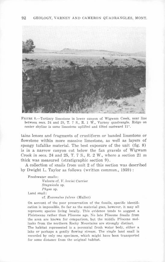
92 GEOLOGY, VARNEY AND CAMERON QUADRANGLES, MONT.
FIGURE 8. Tertiary limestone in lower canyon of Wigwam Creek, near line between sees. 24 and 25, T. 7 S., R. 1 W., Varney quadrangle. Ridge on center skyline is same limestone uplifted and tilted eastward 11°.
tains lenses and fragments of crustiform or banded limestone or flowstone within more massive limestone, as well as layers of spongy tufalike material. The best exposure of the unit (fig. 8) is in a narrow canyon cut below the fan gravels of Wigwam Creek in sees. 24 and 25, T. 7 S., R. 2 W., where a section 21 m thick was measured (stratigraphic section 9).
A collection of snails from unit 2 of this section was described by Dwight L. Taylor as follows (written commun., 1959) :
Freshwater snails:Valcata cf. V. lewisi CurrierStagnicola sp.Physa sp.
Land snail:cf. Euconulus fulvus (Muller)
On account of the poor preservation of the fossils, specific identifi cation is impossible. So far as the material goes, however, it may all represent species living locally. This evidence tends to suggest a Pleistocene rather than Pliocene age. No late Pliocene fossils from the area are known for comparison, but the middle Pliocene mol- lusks from the northern Rocky Mountains are strongly distinct. The habitat represented is a perennial fresh water body, either a lake or perhaps a gently flowing stream. The single land snail is recorded by only one specimen, which might have been transported for some distance from the original habitat.
CENOZOIC ROCKS 93
Stratigraphic section 9[Tertiary limestone, SE^ sec. 24, T. 7 S., R. 2 W. t Varney quadrangle]
Thickness (meters)
5. Limestone, like unit 3, more weathered, abundant solution cavities; much flowstone and tuf alike material; overlain by gravel _________________________ ___ 7.6
4. Limestone, light-brownish-gray, nonresistant, laminated withcross-fibrous calcite in straight even layers ______ _____ 1.5
3. Limestone, similar to unit 2, less compact and less distinctly bedded; locally platy or laminated; contains porous inter- layers _____________________________ 3.7
2. Limestone, mostly light yellowish brown, porous and vuggy; many solution cavities to 5 cm in diameter. Bedding in distinct but even, locally curved and truncated by over lying beds. Locally spongy and tufalike, containing hollow tubes 4.5 or less in diameter. Lower part: more compact and resistant; includes fossiliferous lens 30 cm by 4 m near base of unit ____________________________________ 6.8
1. Limestone, light-brownish-gray, porous to compact; locally includes flowstone mantling more compact limestone. Con tains rounded pebbles 0.5 to 13 cm in diameter of upper Paleozoic and Mesozoic sandstone and quartzite, upper Paleozoic limestone and chert, Precambrian granite, and olivine basalt _____________________________ 2,1
Base not exposed.
Bedding in the limestone unit dips generally eastward 3° to 12°; locally, however, beds dipping as much as 20° were seen. The variations probably represent originally nearly horizontal beds tilted eastward by late Cenozoic faulting in the Madison, Val ley. In the excellent exposures on Wigwam Creek, however, dip variations of as much as 10° occur within the unit; structural relations suggest that the steeper dips may have resulted from fault movements during deposition of the limestone.
The geomorphic and structural relations of the Tertiary lime stone are similar to those of the ash-flow tuff, which, therefore, may have been deposited ait about the sarnie time. Both limestone and tuff contain fragments of olivine basalt presumably derived from the lava nearby to the west, and both have been displaced about the same amount by the normal faults of the Madison Val ley floor.
QUATERNARY DEPOSITS
GLACIAL DEPOSITS
Direct glacial deposits in the Varney and Cameron quadrangles consist of till deposited by valley glaciers flowing from cirques on isolated summits in the Gravelly and Greenhorn Ranges and from

94 GEOLOGY, VARNEY AND CAMERON QUADRANGLES, MONT.
several strongly glaciated valleys in the Madison Range. They may also include some considerably older deposits of bouldery material found in unusual topographic situations on the eastern flank of the Gravelly Range. Glaciers on Baldy Mountain in the northwestern part of the Varney quadrangle and on Specimen Butte at the head of Ruby Creek just south of the quadrangle boundary were all short, originating in cirques at about 2,750 m altitude and descending the northern and eastern slopes for dis tances of 1.5 to 6.5 km, Glaciers in the Madison Range were some what longer; those in the canyons of Wolf Creek and the South Fork of Indian Creek flowed 11 to 13 km from cirques at about 3,000 m in altitude and reached the range front at 1,890 to 1,950 m. A glacier of similar length occupied the valley of Noman Creek just east of the Cameron quadrangle and flowed into the main valley of Indian Creek, ending at an altitude of 1,950 m about 3 km short of the range front.
The extent of the ice is recorded by many discontinuous lateral moraines in the lower parts of the valleys and by well-developed lobate end moraines of those glaciers that reached the alluvial floor of the Madison Valley. The surfaces of the morainal deposits are generally characterized by more or less well-rounded boulders, some as much as 3 to 4.5 m in size, derived from bedrock sources within the glaciated valleys. For example, the moraines on the headwaters of Wigwam Creek on the east side of Baldy Moun tain contain only Paleozoic and Mesozoic rocks, whereas the ad jacent Tertiary gravel contains abundant Precambrian clasts. However, a few Precambrian clasts derived from the gravel were incorporated in the basal parts of these moraines. The deposits s'how well-developed morainal ridges as much as 18 m high, with intervening swales and a few undrained depressions in spite of their relatively steep overall slopes.
End-moraine complexes at the mouths of the canyons of Wolf and Indian Creeks in the Cameron quadrangle are especially well preserved. As Alden (1953, p. 180-181) pointed out, the moraines on Indian Creek were deposited by a glacier descending the South Fork while the lower part of the main valley remained ungla- ciated. These morainal complexes contain many well-defined lobate morainal ridges, unbreached depressions, and large blocks scat tered about their surfaces.
On both Wolf Creek and the South Fork of Indian Creek, sub dued lateral moraines :along the canyon walls reach altitudes of 150 to 180 m above the present valley floors. They represent ice either at a somewhat higher and older level of erosion, or thicker

CENOZOIC ROCKS 95
than that which produced the end moraines, for the gradients of these higher moraines suggest that their terminal lobes would have extended farther out on the alluvial valley floor than the existing end mioraines. Older, more extensive end moraines may have been depressed by faulting and partly buried beneath the alluvial fan. This is best shown at the mouth of Wolf Creek canyon, where a lateral moraine at an altitude of 2,200 m on the north wall appears to be cut off abruptly at the canyon mouth more than 120 m above the surface of the younger end moraine on the valley floor just outside the canyon.
Evidence for older and younger, or higher and lower level, glaciations is not so clear in the other glaciated valleys of the area. Lateral moraines 120 to 135 m above Ruby Creek in the southeastern part of the Varney quadrangle may correspond to the higher lateral moraines in the Madison Range. The ice on Ruby Creek did not extend beyond the mapped moraines, for the lower part of the canyon shows no evidence of glacial action. Remnants of bouldery terrace deposits on the north wall of the canyon about 45 m above the present streambed suggest that the valley floor at the time of maximum glaciation was graded ap proximately to the surface of the alluvial fan at the mouth of the valley.
The existence of mo-re than one stage of glaciation in the Madi son Range was suggested by Alden (1953, p. 63, 180-181), who assigned ntost of the moraines on Indian Creek and elsewhere in the range to lowan or Illinoian and higher level deposits to early Pleistocene glaciation. Subsequently, Richmond (1964, p. 225- 227) recognized deposits in the nearby Yellowstone Park area as belonging to the Bull Lake and Pinedale Glaciations, as well as to one or moire pre-Bull Lake glaciations. He suggested that the Pinedale is approximately contemporaneous with the Wisconsin Glaciation in the midcontinent region and that the Bull Lake Glaciation is either early Wisconsin or represents a pre-Wiscon- sin, post-Illinoian glaciation not recognized in the midcontinent. Whether the higher and lower moraines I have mapped as older and younger till in the Madison Range represent two glaciations separated by an interval of extensive deglaciation is debatable, but they were formed probably during one or both of the two stades of the Bull Lake Glaciation recognized by Richmond. Com parable morainial deposits in the valley of Beaver Creek, a tribu tary to the Madison River just northwest of Hebgen Lake in the adjacent Hebgen Dam quadrangle, were assigned to the older stade of Bull Lake Glaciation by Richmond. These moraines are

96 GEOLOGY, VARNEY AND CAMERON QUADRANGLES, MONT.
smoothed and resemble the older or outer moraines for example, those on Baldy Mountain and the older moraines in the Madison Range. Moraines of the Pinedale Glaciation, according- to Rich mond, are confined to the upper 3 to 5 km of glaciated valleys in the Hebgen Lake area. Nevertheless, the state of preservation of the end moraines on Indian and Wolf Creeks suggests that these may be of Pinedale age (see Richmond, 1965, p. 224).
BOULDER DEPOSITS OF UNCERTAIN ORIGIN
Unusual deposits of subangular blocks in a dark-brown clayey matrix occupy interfluve areas extending in a horseshoe-shaped pattern across the headwaters of Morgan Gulch, Cherry Creek, and Johnny Gulch in the east-central part of the Varney quad rangle. The deposits consist of angular to subangular blocks and moderately rounded cobbles of various Paleozoic and Mesozoic rocks, among which the most conspicuous are cherty sandstone of the Shedhorn Sandstone, Quadrant Quartzite, sandstone and conglomerate of the Kootenai Formation, Flathead Quartzite, and much weathered Precambrian granite and gneiss. The material is not well exposed, but the matrix appears to be very clayey and the deposits unsorted. Most of the fragments are of local origin. Blocks of the Kootenai Formation are abundant in the western part of the deposits on Morgan Gulch, but they become obviously fewer eastward, as do, in succession, blocks of the Shedhorn and the Quadrant. In the eastern part of the deposit farther down Morgan Gulch, Precambrian granitic blocks, some as much as 4.6 m long, are abundant as well as blocks of Flathead Quartzite. Near the head of Johnny Gulch, the bouldery deposits contain many small fragments of dark-gray phyllite and iron-rich quartz- ite that can have come only from areas of Precambrian rocks at lower altitudes to the east.
The surface of these deposits, especially in the headwaters of Morgan Gulch, includes small undrained depressions resembling subdued knob-and-kettle topography comparable with the more recent morainal deposits southeast of Baldy Mountain. Although landsliding might explain the depressions, the clear evidence of transportation westward from topographically lower source areas and the horseshoe shape of the deposits as a whole strongly sug gest that they are morainal material deposited by a broad tongue of ice that moved westward from highlands in the Madison Range. Presumably this took place before the present Madison structural valley was formed, for there is no evidence of similar deposits on the floor of the valley, and moraines in the Madison Range barely reach the present range front.

CENOZOIC ROCKS 97
Remnants of formerly extensive glacial deposits at levels 300 or more meters above present valley floors at many places in the Madison Range and nearby areas have commonly been referred to the "Buffalo Till," presumably of pre-Wisconsin age. Those in the northern part of the Madison Range have been described by Hall (1960, p. 197-199) as being on the eastern slope of the range, 30 to 50 km east of the deposits under discussion, and having come from source areas nearer the crest of the range to the west. Hall also pointed out that similar bouldery deposits on the crest of the Gravelly Range near Black Butte contain striated stones and lie on a striated pavement that indicates ice movement in the direction N.65°W. These were described by Atwood and Atwood (1945) as till of Eocene age and later by Mann (1954, p. 37-43; 1960, p. 122-123) as representing mudflow deposits of probable Oligocene age. Whether the deposits in these widely sepa rated places are closely related in time and process is still con jectural. As Hall (1960) pointed out, they may have resulted from widespread glacial activity, probably of pre-Wisconsin age, whose deposits have been radically dismembered by late Cenozoic normal faulting and canyon cutting in the region.
ALLUVIAL FANS AND GRAVEL OF THE MADISON VALLEY
Most of the floor of the Madison Valley is occupied by variably coarse cobble gravel carried into it by the larger streams on either side. These deposits have formed a series of partly coalescing alluvial fans on both sides of the valley, which originally merged with a narrow northward-sloping alluvial plain in the axial part of the valley. Although this surface of alluviation has been eroded and dissected in many places, large remnants are pre served in the north-central part of the Cameron quadrangle in what is called the Cameron Bench and in many of the fans on the west side of the river. Because the altitude is higher and the relief is greater in the Madison Range to the east than in the Gravelly Range to the west, the fans east of the river have grown larger than their counterparts west of it, producing the present asymmetrical position of the river. Since construction of the Cameron Bench, the Madison River has cut its channel nearly 60 m below its former alluviated valley floor. Concurrently, Indian Creek, Wolf Creek, Ruby Creek, and other tributaries have be come entrenched in their respective fans, and the Madison has carved a distinctive set of erosional terraces. Most of the larger fans east of the river have been eroded to some degree, leaving remnants of the original constructional surfaces 1 to 6 m or more above the present fan surfaces. Most of this erosion appears to

98 GEOLOGY, VARNEY AND CAMERON QUADRANGLES, MONT.
have resulted from lowering the bed of the Madison River; some erosion near the fan heads may be due to relative uplift of the mountain block along the Madison Range fault system.
A series of somewhat older and steeper fans and aprons, of mixed alluvial and colluvial material, mantle the lower slopes of the Madison Range front. All these have been eroded, some rather deeply for example, those south of Bear Creek and adjacent to Corral Creek. These deposits appear to have been brought down by short streams descending the mountain front on steep gradi ents and to have been tectonically raised relative to the axial part of the valley. They are surmounted and locally overlapped by landslide material from the actively rising bedrock slopes of the mountain front.
Alden (1953, p. 71) thought that the Cameron Bench was early Pleistocene in age, thereby implying that the associated fan gravels were early Pleistocene or older. Although this may be true for much of the underlying valley fill, relations between the larger fans and the glacial deposits in the Varney and Cameron quadrangles indicate that construction of the fans and the Cameron Bench continued at least until the beginning of Bull Lake Glaciation, which Richmond (1970, p. 15) believed followed the Sangamon Interglaciation 120,000 to 130,000 years ago. The younger end moraines on Indian Creek and on Wolf Creek appear to have been laid down on the apices of the fans shortly before the erosion previously described. Thus, the age of the Cameron Bench and the associated alluvial fans of the Madison Valley is probably at least as young as Sangamon in terms of the American midcontinent Pleistocene sequence. If the end moraines produced at older and higher ice levels have indeed been dropped and part ly buried by the fans, this fact would suggest that building of the fans continued into early Wisconsin time.
GRAVEL OF THE RUBY RIVER VALLEY
Thin gravel caps spurs and dissected terraces adjacent to Ruby River and Warm Springs Creek in the southwestern part of the Varney quadrangle. This deposit is largely cobble gravel and a few small boulders composed mainly of Paleozoic sandstone and limestone. The gravel along Warm, Springs Creek also contains clasts of Precambrian rocks and Tertiary basalt and rhyolite. The Precambrian rocks and basalt presumably were derived from Tertiary gravel and lava in the Gravelly Range. The gravel gen erally is not more than 6 or 9 m thick and appears to be remnants of a sheet that sloped steeply toward Ruby River and Warm

CENOZOIC ROCKS 99
Springs Creek and whose lowest points were about 30 m above the present streams. Prevalence of Quadrant Quartzite in the gravel south of the confluence of Warm Springs Creek shows that this particular gravel came largely from the Snowcrest Range west of Ruby River.
Remnants of a depositional surface not eroded or covered by the gravel are preserved on several steep spurs sloping eastward from the Greenhorn Range along Timber Creek and on a similar spur sloping westward along the south side of Squaw Creek. In these places, the surface is mantled by large and small colluvial blocks derived from the surmounting slopes. By analogy with the Quaternary deposits in the Madison River valley, the gravel in the Ruby River valley probably was also deposited near the time of the latest glacial maximum and has been undergoing ero sion since then.
LANDSLIDE DEPOSITS
Evidence of large-scale mass movement of exposed rocks down the present topographic slopes is widespread in the Gravelly Range and along the steep faulted front of the Madison Range. Th!e results range from the irregular ridges and sag ponds, char acteristic of outcrop areas of the Morrison Formation, to visible landslide scars surmounting chaotic masses of disturbed bedrock. Where landslide movements have been sufficient to carry signifi cant amounts of one formation over another, these deposits have been mapped as colluvial or landslide deposits. Such deposits in clude earthflows of mudstone of the Morrison Formation in the South Fork of Warm Springs Creek, of Kootenai Formation and Thermopolis Shale east of Romy Lake, and a mudflow of softened Sphinx Conglomerate in Grindstone Gulch, all in the Gravelly Range. Also included are a landslide mass of Precambrian dolo mite just north of the Bear Creek Ranger Station and several earthflows of Cretaceous mudstone and sandstone farther north along the front of the Madison Range.
A similar origin may be ascribed to an unusual pile of angular blocks of the basal sandstone of the Kootenai Formation 2.5 km north of the Crockett Lake Ranger Station in the Gravelly Range. Many of the blocks in this area are 3 m in diameter, and some are as large as 9 m. They are adjacent to two outcrop areas of the Kootenai Formation, from which they were probably derived by slumping of the underlying Morrison Formation.
Some of the landslides have obviously taken place within the past decade or two, but most are grassed over or forested. Most

100 GEOLOGY, VARNEY AND CAMERON QUADRANGLES, MONT.
of the activity, therefore, probably coincided with the colder climate during glacial advances in. the region, when melting of accumulated ice and snow provided excessive soil moisture and opportunities for intensive frost action.
STRUCTURAL GEOLOGY
The structural pattern in the Phanerozoic rocks of the Varney and Cameron quadrangles has resulted from two distinct periods and contrasting types of deformation. Episodes of Laramide orogeny, essentially compressional in character, produced two major belts of thrust and tear faults along with northwest-trend ing folds and associated high-angle thrust faults in the Paleozoic and Mesozoic rocks. Later erogenic events were, by contrast, largely extensional. They resulted in relative depression of a major structural block in the Madison Valley, complementary strong uplift of the western side of the Madison Range, and at tendant steep normal faults in both the Madison and Gravelly Ranges. Most of this deformation took place in late Cenozoic time, and it continues to the present.
LARAMIDE STRUCTURAL FEATURES
Laramide structural features are concentrated in two belts of faults and folds, a western belt in the Greenhorn Range, con tinuing northeastward across the northern end of the Gravelly Range in the Varney quadrangle, and an eastern belt along the west front of the Madison Range in the Cameron quadrangle. The eastern belt is much obscured by normal faulting and is covered by basin fill in the northern part of the Cameron quadrangle, but it becomes more visible as it trends away from the range front in the east-central part of the quadrangle and continues south eastward in the adjacent Sphinx Mountain and Hebgen Dam quadrangles.
A major fault zone extends along the east side of the Green horn, Range from a point about 1.6 km northeast of Ruby River to the northern part of the Varney quadrangle, where it disap pears beneath gravel and volcanic rocks of Tertiary age. This fault was first recognized by Mann (1954, p. 52), who called it the Greenhorn thrust. It represents a major structural break bringing complexly deformed Precambrian and Paleozoic rocks eastward over less deformed Upper Cretaceous rocks. The mini mum stratigraphic displacement is 3,000 m, and the horizontal displacement is probably 8 km or more. Attempts to contour the fault surface along the outcrop belt between Ruby River and the North Fork of Wigwam Creek suggest that much of its ir-

STRUCTURAL GEOLOGY 101
regular trace results from local variations in attitude. The strike of the fault along segments 1.5 to 3 km long appears to vary from nearly due north to N. 40° E., and the dip may range from less than 20° to considerably more at various places. The fault trace is offset by right-lateral tear faults, notably just west of the quadrangle boundary, where the Greenhorn fault is offset more than 1.5 km on a steeply dipping fault trending N. 30° W. (%. 9).
112°
45°05'
45W
EXPLANATION
UPPER CRETACEOUS ROCKS
TRIASSIC, JURASSIC AND LOWER CRETACEOUS ROCKS
PALEOZOIC ROCKS
p PRECAMBRIAN ROCKS
?=- Thrust fault T on upper plate; dashed where inferred. Arrows show relative movement
0 2 5 KILOMETERS
FIGURE 9. Relation of the Greenhorn and Snowcrest faults in the vicinityof Ruby River Canyon.

102 GEOLOGY, VARNEY AND CAMERON QUADRANGLES, MONT.
The Greenhorn fault has not been located north of the cover of Tertiary rocks in the northern part of the Varney quadrangle. One intriguing clue to its location, however, is provided by the small outcrops of Precambrian dolomite surrounded by tuff in sec. 8, T. 7 S., R. 2 W. If these outcrops are part of the Green horn thrust block, the northern continuation of the fault must be between them and the outcropping Jurassic rocks nearby to the east. The fault has also not been traced in detail southwest of the Varney quadrangle. It may continue across the Ruby River into the Snowcrest Range, or it may be overlapped by a second major fault, the Snowcrest fault, which has been mapped for many kilo meters along the west side of the Snowcrest Range (fig. 9).
Southwest of Ruby River, the Thermopolis Shale, the Kootenai Formation, and older Mesozoic and Paleozoic formations appear at the northern end of a belt of steeply dipping and overturned strata that extends southwestward the full length of the Snowcrest Range (Klepper, 1950, pi. 16). This belt represents the western limb of a major syncline whose eastern limb includes the gently dipping rocks of the southern part of the Gravelly Range and whose axis is approximately along the upper course of the Ruby River.
East of the Greenhorn fault in the Varney quadrangle, two major northwest-trending anticlines appear in the Paleozoic and Mesozoic rocks the Warm Springs anticline and a larger anti cline near the center of the quadrangle. Both folds are cut longi tudinally by high-angle thrust faults; similar faults cut the west- dipping beds throughout the central part of the quadrangle. Small compressional folds a few meters in amplitude and minor bedding- plane thrust faults are found locally almost to the eastern limit of the Paleozoic rocks in the Gravelly Range.
Structural features of the eastern Laramide fault belt are simi lar to those of the western belt. They are best seen in the ridges on either side of Indian Creek, in the Cameron quadrangle, where steeply dipping and strongly overturned Paleozoic rocks are as sociated with a major thrust fault that brings Precambrian gneiss and dolomite eastward over rocks as high in the section as the Frontier Formation. Beds immediately beneath the fault are lo cally overturned as much as 60°; beds farther east are folded and sliced by subsidiary thrust faults. Similar relations north of Bear Creek are obscured by younger normal faults which give rise to peculiar structural relations along the Madison Range front. For example, a small block of Precambrian granitic rock exposed be tween Burger and Mill Creeks (sees. 22 and 27, T. 7 S., R. 1 E.)

STRUCTURAL GEOLOGY 103
apparently represents part of the overthrust dropped by normal faulting against the much younger Cretaceous rocks beneath the fault. How complex these relations can get is well shown in the exposures on the range front at Tolman Creek near the northern quadrangle boundary.
The youngest formation affected by the Larami.de deformation is the Sphinx Conglomerate of Eocene age. Although this unit lies unconformably on folded and faulted rock ranging from Mis- sissippian to Late Cretaceous age, including the volcanic and vol- caniclastic rocks in the Cameron quadrangle, the Sphinx Con glomerate at the eastern border of the quadrangle is strongly folded on northwest-trending axes parallel to other folds of late Mesozoic to early Tertiary age.
CENOZOIC NORMAL FAULTS
The eastern part of the Gravelly Range and the west front of the Madison Range are dominated structurally by normal faults resulting from regional deformation beginning in middle or late Tertiary time and continuing to the present. In contrast to the compres'sional deformation of the Laramide orogeny, the late Cenozoic deformation has resulted in crustal extension and rela tive depression of major structural features like the Madison Val ley. It was accompanied by extensive volcanism not far south of the Varney and Cameron quadrangles.
The master feature in this area is the Madison Range fault, recognized and named by Pardee (1950, p. 369) as a system of en echelon faults along the western front of the Madison Range and the eastern border of the Madison Valley. The course of the frontal fault system is marked by easily visible recent fault scarps on the gravel fans and colluvial slopes throughout the Cameron quadrangle and for many kilometers north and south of it. De tailed mapping in the Cameron quadrangle shows that the range- front fault system consists of three parallel overlapping segments about 5 km apart, each trending north-northwest along the north- trending range front. Each of the downdropped blocks bounded by these faults has been tilted northward and probably westward, like a series of piano keys hinged at their southern ends. The three main fault segments are largely concealed by the accumu lated surficial deposits along the foot of the range, but their traces are outlined by prominent fault scarps in these deposits. In par ticular, the location of the western fault is indicated by two dis tinct scarps that were overlooked during the fieldwork but are readily seen on air photographs. One of these scarps trends

104 GEOLOGY, VARNEY AND CAMERON QUADRANGLES, MONT.
N. 10 E. through sees. 7 and 18, T. 7 S., R. 1 E.; the other trends N. 5° W. in the western part of sees, 9 and 16, T. 8 S., R. 1 E.
Only one locality provided, bedrock exposures of any of the faults. A 9-m zone of brecciated granitic gneiss trending N. 40° W. can be traced along the western slope of The Wedge in the south eastern corner of the Cameron quadrangle. Abundant slicken- siided fault surfaces within the breccia dip steeply westward and show striae about parallel to their dip. Angular fragments of gneiss and fault gouge are cemented by carbonate, amor phous silica, and iron oxide. Some fragments also show argillic alteration.
Estimates of the amount of movement on the faults of the Madison Range system are difficult because no well-defined fea tures can be correlated across them. Tertiary gravel and volcanic rocks that appear on the downdropped blocks along the eastern side of the Madison Valley may have been eroded from some of the higher blocks, but similar deposits have not been found in the Madison Range in the vicinity of the range front. Neverthe less, cumulative depression of the valley floor on these faults in the northern part of the Cameron quadrangle must amount to a few thousand meters.
Much smaller displacements are found on many of the faults that cut the Paleozoic rocks along the west side of the Madison Valley. Stratigraphic displacements on these faults are easily measurable and range from less than 30 m to a maximum of 750 m on the faults shown near the west end of structure section B-B' on the geologic map of the Cameron quadrangle (Hadley, 1969a).
Many of these faults are in a zone trending about N. 40° W., extending roughly parallel to the major segments of the Madison Range fault system into the north-central part of the Varney quadrangle. Others form a set of faults trending east-northeast, parallel to foliation and lithic boundaries in the adjacent Pre- cambrian rocks. Relative displacement is down on the east side of most of these faults, contributing toward depression of the western margin of the Madison Valley. In general, these displace ments are larger on the southern faults' of the group, indicating increasing downfaulting of the western side of the valley in this direction.
The normal faults displace the youngest bedrock units in the area, including the upper Tertiary (?) limestone and ash-flow tuffs. The recent fault scarps show that major movements have taken place on some 50 km of the Madison Range fault probably

SELECTED REFERENCES 105
within the past 1,000 years. Minor movements took place on the same fault system several kilometers south of the Cameron quad rangle during the Hebgen Lake earthquake of 1959 (Myers and Hamilton, 1964, p. 77-78). Relations, of faulted moraines at the range front on Wolf Creek in the southeastern part of the Cameron quadrangle, previously described, indicate downfault- ing of the floor of the Madison Valley by as much as 120 m since Bull Lake Glaciation about 30,000 years ago.
SELECTED REFERENCES
Alden, W. C., 1953, Physiography and glacial geology of western Montana and adjacent areas: U.S. Geol. Survey Prof. Paper 231, 200 p.
Atwood, W. W., and Atwood, W. W., Jr., 1945, The physiographic history of an Eocene skyline moraine in western Montana: Jour. Geology, v. 53, no. 3, p. 191-199.
Beck, F. M., 1960, Geology of the Sphinx Mountain area, Madison and Gal- latin Co., Montana, in West Yellowstone Earthquake area: Billings Geol. Soc., llth Ann. Field Conf., Sept. 1960, [Guidebook], p. 129-134.
Blake, 0. D., 1959, Big Snowy stratigraphy in the area adjacent to the Rocky Mountain front, in Sawtooth-Disturbed Belt area [Montana]: Billings Geol. Soc., 10th Ann. Field Conf., August 13-15, 1959, [Guidebook], p. 64-68.
Branson, C. C., 1937, Stratigraphy and fauna of the Sacajawea Formation, Mississippian, of Wyoming: Jour. Paleontology, v. 11, no. 8, p. 650-660.
Burger, H. R., Ill, 1969, Structural evolution of the southwestern Tobacco Root Mountains, Montana: Geol. Soc. America Bull., v. 80, no. 7, p. 1329-1342.
Cobban, W. A., 1945, Marine Jurassic formations of Sweetgrass arch, Mon tana: Am. Assoc. Petroleum Geologists Bull., v. 29, no. 9, p. 1262-1303.
1951, Colorado shale of central and northwestern Montana and equiva lent rocks of Black Hills: Am. Assoc. Petroleum Geologists Bull., v. 35, no. 10, p. 2170-2198.
Cobban, W. A., and Reeside, J. B., Jr., 1952, Correlation of the Cretaceous formations of the Western Interior of the United States: Geol. Soc. America Bull., v. 63, no. 10, p. 1011-1044.
Cobban, W. A., Erdmann, C. E., Limbe, R. W., and Maughan, E. K., 1959, Revision of Colorado group on Sweetgrass arch, Montana: Am. Assoc. Petroleum Geologists Bull., v. 43, no. 12, p. 2786-2796.
Cressman, E. R., 1955, Physical stratigraphy of the Phosphoria Formation in part of southwestern Montana: U.S. Geol. Survey Bull. 1027-A, p. A1-A31.
Cressman, E. R., and Swanson, R. W., 1959, Shedhorn sandstone, in McKelvey, V. E., and others, The Phosphoria, Park City, and Shedhorn Formations in the western phosphate field: U.S. Geol. Survey Prof. Paper 313-A, p. A31-A33.
Deiss, C. F., 1936, Revision of type Cambrian formations and sections of Mon tana and Yellowstone National Park: Geol. Soc. America Bull., v. 47, no. 8, p. 1257-1342, 2 pis., 10 figs.
Dorf, Erling, and Lochman, Christina, 1940, Upper Cambrian formations in southern Montana: Geol. Soc. America Bull., v. 51, no. 4, p. 541-556.

106 GEOLOGY, VARNEY AND CAMERON QUADRANGLES, MONT.
Dorr, J. A., Jr., 1954, Very late Miocene (late Barstovian) mammal fauna from the Madison Valley Formation, Montana [abs.]: Geol. Soc. America Bull., v. 65, no. 12, pt. 2, p. 1245.
Dutro, J. T., Jr., and Sando, W. J., 1963, Age of certain post-Madison rocks in southwestern Montana and western Wyoming: U.S. Geol. Survey Prof. Paper 475-B, p. B93-B94.
Easton, W. H., 1962, Carboniferous formations and faunas of central Mon tana: U.S. Geol. Survey Prof. Paper 348, 126 p., 13 pis.
Emmons, W. H., and Calkins, F. C., 1913, Geology and ore deposits of the Philipsburg quadrangle, Montana: U.S. Geol. Survey Prof. Paper 78, 271 p.
Gardner, L. S., 1959, Revision of Big Snowy Group in central Montana: Am. Assoc. Petroleum Geologists Bull., v. 43, no. 2, p. 329-349.
Gardner, L. S., Hendricks, T. A., Hadley, H. D., and Rogers, C. P., Jr., 1946, Stratigraphic sections of upper Paleozoic and Mesozoic rocks in south- central Montana: Montana Bur. Mines and Geology Mem. 24, 100 p.
Goddard, E. N., and others, 1948, Rock-color chart: Washington, D.C., Natl. Research Council, 6 p. (Republished by Geol. Soc. America, 1951; re printed 1970.)
Grant, R. E., 1965, Faunas and stratigraphy of the Snowy Range Formation (Upper Cambrian) in southwestern Montana and northwestern Wyoming: Geol. Soc. America Mem. 96, 171 p.
Hadley, J. B., 1960, Geology of the northern part of the Gravelly Range, Madison County, Montana, in West Yellowstone Earthquake area: Bill ings Geol. Soc., llth Ann. Field Conf., Sept. 1960, [Guidebook], p. 149-153.
1969a, Geologic map of the Cameron quadrangle, Madison County, Mon tana: U.S. Geol. Survey Geol. Quad. Map GQ-813, scale 1:62,500, sections.
-1969b, Geologic map of the Varney quadrangle, Madison County, Montana: U.S. Geol. Survey Geol. Quad. Map GQ-814, scale 1:62,500, sections.
Hall, W. B., 1960, Multiple glaciation in the Madison and Gallatin Ranges,southwestern Montana, in West Yellowstone Earthquake area: BillingsGeol. Soc., llth Ann. Field Conf., Sept. 1960, [Guidebook], p. 191-199.
Hanson, A. M., 1951, Distribution and origin of Cambrian limestone anddolomite: Montana Acad. Sci. Proc., v. 10, p. 53-67.
1952, Cambrian stratigraphy in southwestern Montana: Montana Bur. Mines and Geology Mem. 33, 46 p.
Heinrich, E. W., 1950, Sillimanite deposits of the Dillon region, Montana:Montana Bur: Mines and Geology Mem. 30, 43 p.
Imlay, R. W., 1967, Twin Creek Limestone (Jurassic) in the Western Interiorof the United States: U.S. Geol. Survey Prof. Paper 540, 105, p., 16 pis.,18 figs.
Klepper, M. R., 1950, A geologic reconnaissance of parts of Beaverhead andMadison Counties, Montana: U.S. Geol. Survey Bull. 969-C, p. C55-C85.
Klepper, M. R., Weeks, R. A., and Ruppel, E. T., 1957, Geology of the south ern Elkhorn Mountains, Jefferson and Broadwater Counties, Montana:U.S. Geol. Survey Prof. Paper 292, 82 p.
Lochman-Balk, Christina, 1950, Status of Dry Creek Shale of central Montana:Am. Assoc. Petroleum Geologists Bull., v. 34, no. 11, p. 2200-2222.
Love, J. D., and others, 1948, Stratigraphic sections of Jurassic and Cretaceousrocks in the Jackson Hole area, northwestern Wyoming: Wyoming Geol.Survey Bull. 40, 48 p.

SELECTED REFERENCES 107
Lowell, W. R., and Klepper, M. R., 1953, Beaverhead Formation, a Laramide deposit in Beaverhead County, Montana: Geol. Soc. America Bull., v. 64, no. 2, p. 235-243.
Mann, J. A., 1954, Geology of part of the Gravelly Range, Montana: Yellow- stone-Bighorn Research Proj., Contr. 190, 92 p.
1960, Geology of part of the Gravelly Range area, Montana, in West Yellowstone Earthquake area: Billings Geol. Soc., llth Ann. Field Conf., Sept. 1960, [Guidebook], p. 114-127.
Mairvin, R. F., Wier, K. L., Mehnert, H. H., and Merritt, V. M., 1974, K-Ar ages of selected Tertiary igneous rocks in southwestern Montana: Isochron/West, no. 10, p. 17-20.
McKelvey, V. E., Williams, J. S., Sheldon, R. P., Cressman, E. R., Cheney, T. M., and Swanson, R. W., 1956, Summary description of Phosphoria, Park City and Shedhorn Formations in western phosphate field: Am. Assoc. Petroleum Geologists Bull., v. 40, no. 12, p. 2826-2863.
McMannis, W. J., 1955, Geology of the Bridger Range, Montana: Geol. Soc. America Bull., v. 66, no. 11, p. 1385-1430.
Moritz, C. A., 1951, Triassic and Jurassic stratigraphy of southwestern Mon tana: Am. Assoc. Petroleum Geologists Bull., v. 35, no. 8, p. 1781-1814.
Myers, W. B., and Hamilton, Warren, 1964, Deformation accompanying the Hebgen Lake earthquake of August 17, 1959, in The Hebgen Lake, Mon tana, earthquake of August 17, 1959: U.S. Geol. Survey Prof. Paper 435-1, p. 155-198.
Newell, N. D., and Kummel, Bernhard, Jr., 1942, Lower Eo-Triassic stratig raphy, western Wyoming and southeast Idaho: Geol. Soc. America Bull., v. 53, no. 6, p. 937-995, 3 pis., 5 figs.
Pardee, J. T., 1950, Late Cenozoic block faulting in western Montana: Geol. Soc. America Bull., v. 61, no. 4, p. 359-406.
Peale, A. C., 1893, The Paleozoic section in the vicinity of Three Forks, Montana: U.S. Geol. Survey Bull. 110, 56 p.
1896, Description of the Three Forks sheet [Montana]: U.S. Geol. Survey Geol. Atlas, Folio 24, 5 p., maps.
Reid, R. R., 1957, Bedrock geology of the north end of the Tobacco Root Mountains, Madison County, Montana: Montana Bur. Mines and Geology Mem. 36, 27 p.
Rice, D. D., 1976, Revision of Cretaceous nomenclature of the northern Great Plains in Montana, North Dakota, and South Dakota: U.S. Geol. Survey Bull. 1422-A, p. A66-A67.
Richmond, G. M., 1964, Glacial geology of the West Yellowstone basin and adjacent parts of Yellowstone National Park, in The Hebgen Lake, Mon tana, earthquake of August 17, 1959: U.S. Geol. Survey Prof. Paper 435-T, p. T223-T236.
1965r Glaciation of the Rocky Mountains, in Wright, H. E., and Frey, D. G., eds., The Quaternary of the United States: Princeton, N.J., Prince- ton University Press, p. 217-230.
-1970, Comparison of the Quaternary stratigraphy of the Alps andRocky Mountains: Quaternary Research, v. 1, no. 1, p. 3-28.
Roberts, A. E., 1963, The Livingston Group of south-central Montana: U.S.Geol, Survey Prof. Paper 475-B, p. B86-B92.
Robinson, G. D., 1963, Geology of the Three Forks quadrangle, Montana: U.S.Geol. Survey Prof. Paper 370, 143 p.
Ross, C. S., and Smith, R. L., 1961, Ash-flow tuft's Their origin, geologicrelations and identification: U.S. Geol. Survey Prof. Paper 366, 81 p.

108 GEOLOGY, VARNEY AND CAMERON QUADRANGLES, MONT.
Sandberg, C. A., 1962, Stratigraphic section of type Three Forks and Jeffer son Formations at Logan, Montana, in Three Forks-Belt Mountains area, and symposium The Devonian system of Montana and adjacent areas: Billings Geol. Soc., 13th Ann. Field Conf., 1962, [Guidebook], p. 47-50.
1965, Nomenclature and correlation of lithologic subdivisions of the Jefferson and Three Forks Formations of southern Montana and northern Wyoming: U.S. Geol. Survey Bull. 1194-N, 18 p.
Sando, W. J., and Dutro, J. T., Jr., 1960, Stratigraphy and coral zonation of the Madison Group and Brazer Dolomite in northeastern Utah, western Wyoming, and southwestern Montana, in Overthrust belt of southwestern Wyoming and adjacent areas: Wyoming Geol. Assoc., 15th Ann. Field Conf., 1960, Guidebook, p. 117-126.
1974, Type sections of the Madison Group (Mississippian) and its sub divisions in Montana: U.S. Geol. Survey Prof. Paper 842, 22 p.
Sando, W. J., Gordon, Mackenzie, Jr., and Dutro, J. T., Jr., 1975, Stratig raphy and geologic history of the Amsden Formation (Mississippian and Pennsylvanian) of Wyoming: U.S. Geol. Survey Prof. Paper 848-A, 83 p., 11 pis. 22 figs.
Sando, W. J., Mamet, B. L., and Dutro, J. T., Jr., 1969, Carboniferous mega- faunal and microfaunal zonation in the northern Cordillera of the United States: U.S. Geol. Survey Prof. Paper 613-E, 29 p.
Scholten, Robert, Keenmon, K. A., and Kupsch, W. 0., 1955, Geology of the Lima region, southwestern Montana and adjacent Idaho: Geol. Soc. America Bull., v. 66, no. 4, p. 345-404.
Scott, H. W., 1935, Some Carboniferous stratigraphy in Montana and north western Wyoming: Jour. Geology, v. 43, no. 8, pt. 2, p. 1011-1032.
Sheldon, R. P., 1957, Physical stratigraphy of the Phosphoria Formation in northwestern Wyoming: U.S. Geol. Survey Bull. 1042-E, p. E105-E185.
Sloss, L. L., 1950, Paleozoic sedimentation in Montana area: Am. Assoc. Petro leum Geologists Bull., v. 34, no. 3, p. 423-451.
Sloss, L. L., and Hamblin, R. H., 1942, Stratigraphy and insoluble residues of Madison Group (Mississippian) of Montana: Am. Assoc. Petroleum Geologists Bull., v. 26, no. 3, p. 305-335, 11 figs.
Sloss, L. L., and Laird, W. M., 1947, Devonian system in central and north western Montana: Am. Assoc. Petroleum Geologists Bull., v. 31, no. 8, p. 1404-1430.
Sloss, L. L., and Moritz, C. A., 1951, Paleozoic stratigraphy of southwestern Montana: Am. Assoc. Petroleum Geologists Bull., v. 35, no. 10, p. 2135-2169.
Swanson, R. W., Cressman, E. R., Jones, R. S., and Replogle, B. K., 1953, Stratigraphic sections of the Phosphoria Formation in Montana; pt. 2, 1949-50: U.S. Geol. Survey Circ. 303, 21 p.
Wanless, H. R., Belknap, R. L., and Foster, Helen, 1955, Paleozoic and Mesozoic rocks of Gros Ventre, Teton, Hoback, and Snake River ranges. Wyoming: Geol. Soc. America Mem. 63, 90 p., 13 pis.
Weed, W. H., 1893, The Laramie and overlying Livingston Formation in Montana: U.S. Geol. Survey Bull. 105, p. 10-41.
1899, Description of the Fort Benton quadrangle [Montana]: U.S. Geol. Survey Geol. Atlas, Folio 55, 7 p., maps.
to U.S. GOVERNMENT PRINTING OFFICE: 1980 O 311-344/18


