1
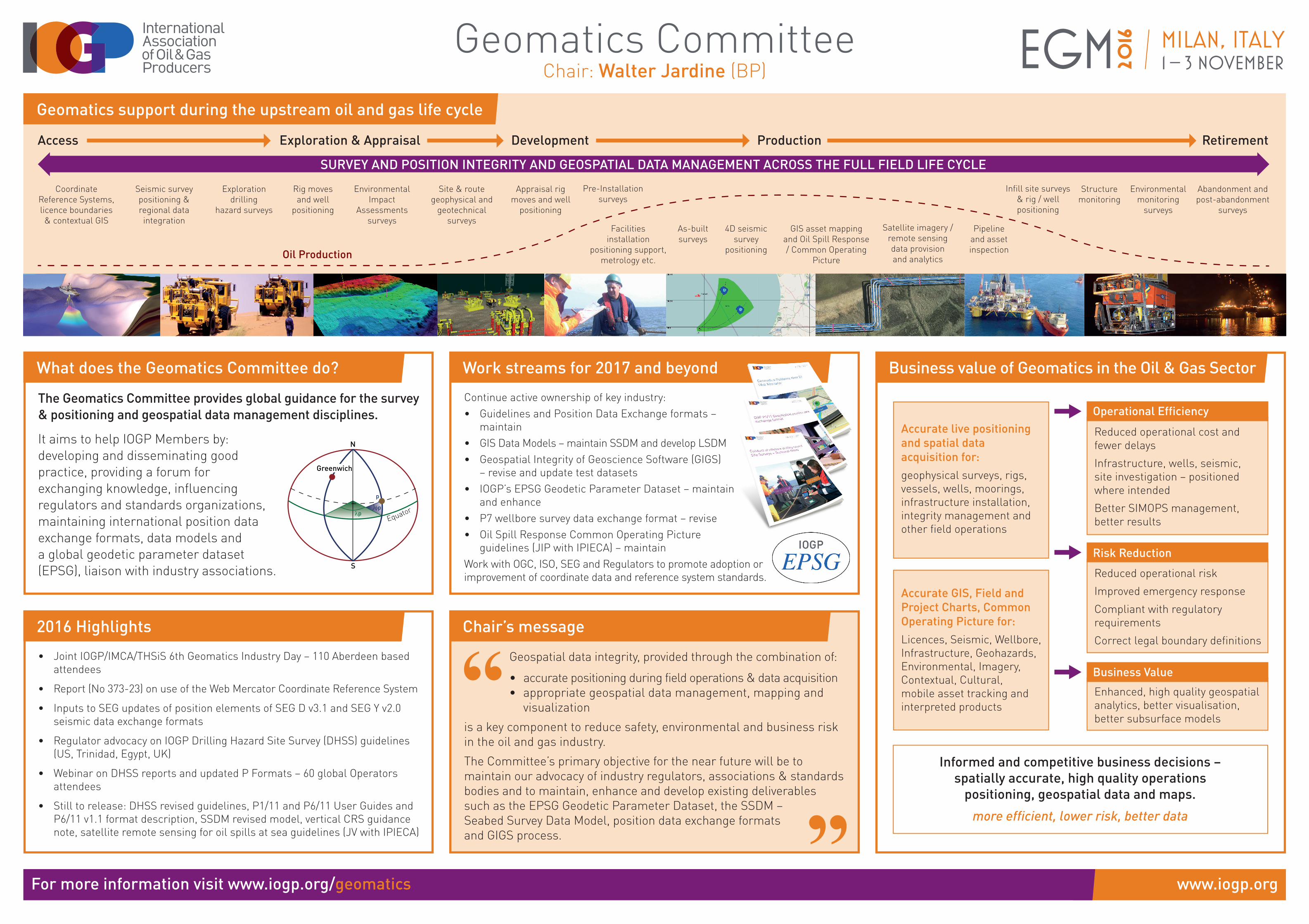
www.iogp.org EGM 2016 Milan, Italy 1 – 3 NOVEMBER For more information visit www.iogp.org/geomatics Oil Production Access Exploration & Appraisal Development Production Retirement SURVEY AND POSITION INTEGRITY AND GEOSPATIAL DATA MANAGEMENT ACROSS THE FULL FIELD LIFE CYCLE Coordinate Reference Systems, licence boundaries & contextual GIS Seismic survey positioning & regional data integration Exploration drilling hazard surveys Rig moves and well positioning Environmental Impact Assessments surveys Site & route geophysical and geotechnical surveys Appraisal rig moves and well positioning Pre-Installation surveys Facilities installation positioning support, metrology etc. As-built surveys 4D seismic survey positioning Infill site surveys & rig / well positioning GIS asset mapping and Oil Spill Response / Common Operating Picture Pipeline and asset inspection Structure monitoring Satellite imagery / remote sensing data provision and analytics Environmental monitoring surveys Abandonment and post-abandonment surveys The Geomatics Committee provides global guidance for the survey & positioning and geospatial data management disciplines. It aims to help IOGP Members by: developing and disseminating good practice, providing a forum for exchanging knowledge, influencing regulators and standards organizations, maintaining international position data exchange formats, data models and a global geodetic parameter dataset (EPSG), liaison with industry associations. Continue active ownership of key industry: • Guidelines and Position Data Exchange formats – maintain • GIS Data Models – maintain SSDM and develop LSDM • Geospatial Integrity of Geoscience Software (GIGS) – revise and update test datasets • IOGP’s EPSG Geodetic Parameter Dataset – maintain and enhance • P7 wellbore survey data exchange format – revise • Oil Spill Response Common Operating Picture guidelines (JIP with IPIECA) – maintain Work with OGC, ISO, SEG and Regulators to promote adoption or improvement of coordinate data and reference system standards. • Joint IOGP/IMCA/THSiS 6th Geomatics Industry Day – 110 Aberdeen based attendees • Report (No 373-23) on use of the Web Mercator Coordinate Reference System • Inputs to SEG updates of position elements of SEG D v3.1 and SEG Y v2.0 seismic data exchange formats • Regulator advocacy on IOGP Drilling Hazard Site Survey (DHSS) guidelines (US, Trinidad, Egypt, UK) • Webinar on DHSS reports and updated P Formats – 60 global Operators attendees • Still to release: DHSS revised guidelines, P1/11 and P6/11 User Guides and P6/11 v1.1 format description, SSDM revised model, vertical CRS guidance note, satellite remote sensing for oil spills at sea guidelines (JV with IPIECA) Accurate live positioning and spatial data acquisition for: geophysical surveys, rigs, vessels, wells, moorings, infrastructure installation, integrity management and other field operations Accurate GIS, Field and Project Charts, Common Operating Picture for: Licences, Seismic, Wellbore, Infrastructure, Geohazards, Environmental, Imagery, Contextual, Cultural, mobile asset tracking and interpreted products Reduced operational cost and fewer delays Infrastructure, wells, seismic, site investigation – positioned where intended Better SIMOPS management, better results Reduced operational risk Improved emergency response Compliant with regulatory requirements Correct legal boundary definitions Enhanced, high quality geospatial analytics, better visualisation, better subsurface models Informed and competitive business decisions – spatially accurate, high quality operations positioning, geospatial data and maps. more efficient, lower risk, better data Operational Efficiency Risk Reduction Business Value Geospatial data integrity, provided through the combination of: • accurate positioning during field operations & data acquisition • appropriate geospatial data management, mapping and visualization is a key component to reduce safety, environmental and business risk in the oil and gas industry. The Committee’s primary objective for the near future will be to maintain our advocacy of industry regulators, associations & standards bodies and to maintain, enhance and develop existing deliverables such as the EPSG Geodetic Parameter Dataset, the SSDM – Seabed Survey Data Model, position data exchange formats and GIGS process. What does the Geomatics Committee do? Work streams for 2017 and beyond 2016 Highlights Business value of Geomatics in the Oil & Gas Sector Chair’s message Geomatics Committee Chair: Walter Jardine (BP) Geomatics support during the upstream oil and gas life cycle


![P6 Malpractice & Misconduct 2015 [1] - ITC First · P6 ITC Malpractice and ... P6 Malpractice and Misconduct Policy [1] January 2015 . P6 ITC ... therefore instigated the following](https://static.documents.pub/doc/80x56/5b81492b7f8b9a2b678c0861/p6-malpractice-misconduct-2015-1-itc-first-p6-itc-malpractice-and-.jpg)


