Publicações da Associação Portuguesa de Geomorfólogos, Vol. IV, APGeom, Lisboa, 2006, p.35 - 46 GEOMORPHOLOGY AND COASTAL DYNAMICS OF THE FIGUEIRA DA FOZ REGION 1-2 Pedro Proença e Cunha; António Campar; Anabela Ramos; Lúcio Cunha; Jorge Dinis 1. Introduction In the Figueira da Foz region the main geomorphological units are (fig. 5.1): (i) a Holocene dune field as the main feature of the littoral plain, including several phases of sand mobilization and dune formation; (ii) a limestone massif tilted southwards – the Serra da Boa Viagem, with the top corresponding to a very old wave-cut platform by a marine incursion (Piacenzian ?) and a staircase of marine terraces facing the Atlantic Ocean; (iii) the Mondego River estuary which was almost undisturbed until the mid 20 th century, with except for an embankment near the river mouth; the recent growth of Figueira da Foz urban areas and harbour have changed the local landscape; (iv) a 42 km long beach-dune system (Figueira da Foz – São Pedro de Moel), currently being eroded by the sea 2. The Serra da Boa Viagem hill and the Northern dune field The Serra da Boa Viagem hill is a massif made up of Jurassic limestones, with marls and sandstones, dipping towards South. Its Northern face is a fault scarp (fig. 5.1). The top is a a very old platform reaching 258 m a.s.l., dipping Southeast, probably cut by Piacenzian (?) marine incursion which also deposited quartz-rich sands. On the Western slope of Mondego Cape, the marine terrace deposits are mainly made up of very coarse to medium sandstones. The wave-cut terraces around 108 m a.s.l. have marine coarse sands and gravels including abundant quartz and some carbonate bioclasts. It is planar cross-bedded and partially cemented by calcite; conglomeratic lags are mainly composed by quartz and quartzite pebbles. In the outcrop near the lighthouse, the deposit points out a palaeo-shoreline angle, and its composition highlights the significant stability palaeo-cliff. Further North, a beach deposit of the same terrace also includes bioclasts of molluscs and crustaceous of seawaters environments colder than today. 1 4 th , 5 th and 6 th Stops - Bandeira sightseeing, Montego Cape lighthouse and Cova beach. 2 POCTI/CTE-GEX/58120/2004, approved by the Fundação para a Ciência e a Tecnologia and co-founded by the FEDER 35
Transcript
Publicações da Associação Portuguesa de Geomorfólogos, Vol. IV, APGeom, Lisboa, 2006, p.35 - 46
GEOMORPHOLOGY AND COASTAL DYNAMICS OF THE FIGUEIRA DA FOZ REGION1-2
Pedro Proença e Cunha; António Campar; Anabela Ramos; Lúcio Cunha; Jorge Dinis
1. Introduction
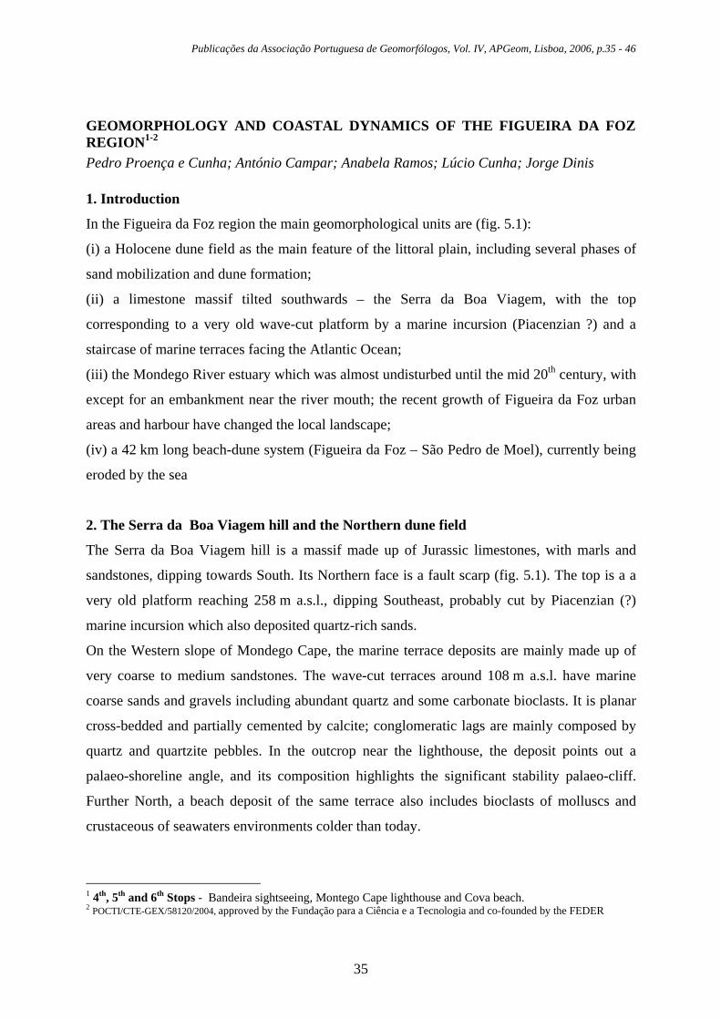
In the Figueira da Foz region the main geomorphological units are (fig. 5.1):
(i) a Holocene dune field as the main feature of the littoral plain, including several phases of
sand mobilization and dune formation;
(ii) a limestone massif tilted southwards – the Serra da Boa Viagem, with the top
corresponding to a very old wave-cut platform by a marine incursion (Piacenzian ?) and a
staircase of marine terraces facing the Atlantic Ocean;
(iii) the Mondego River estuary which was almost undisturbed until the mid 20th century, with
except for an embankment near the river mouth; the recent growth of Figueira da Foz urban
areas and harbour have changed the local landscape;
(iv) a 42 km long beach-dune system (Figueira da Foz – São Pedro de Moel), currently being
eroded by the sea
2. The Serra da Boa Viagem hill and the Northern dune field
The Serra da Boa Viagem hill is a massif made up of Jurassic limestones, with marls and
sandstones, dipping towards South. Its Northern face is a fault scarp (fig. 5.1). The top is a a
very old platform reaching 258 m a.s.l., dipping Southeast, probably cut by Piacenzian (?)
marine incursion which also deposited quartz-rich sands.
On the Western slope of Mondego Cape, the marine terrace deposits are mainly made up of
very coarse to medium sandstones. The wave-cut terraces around 108 m a.s.l. have marine
coarse sands and gravels including abundant quartz and some carbonate bioclasts. It is planar
cross-bedded and partially cemented by calcite; conglomeratic lags are mainly composed by
quartz and quartzite pebbles. In the outcrop near the lighthouse, the deposit points out a
palaeo-shoreline angle, and its composition highlights the significant stability palaeo-cliff.
Further North, a beach deposit of the same terrace also includes bioclasts of molluscs and
crustaceous of seawaters environments colder than today.
1 4th, 5th and 6th Stops - Bandeira sightseeing, Montego Cape lighthouse and Cova beach. 2 POCTI/CTE-GEX/58120/2004, approved by the Fundação para a Ciência e a Tecnologia and co-founded by the FEDER
35
Pedro Proença e Cunha; António Campar; Anabela Ramos; Lúcio Cunha; Jorge Dinis
Fig. 5.1 – Geomorphological map of the Figueira da Foz region. (A. Ramos & L. Cunha).
36
Geomorphology and coastal dynamics of the Figueira da Foz region
The beach deposit is covered by a by colluvium (including angular limestone clasts). The age
of this marine terrace, could be early to middle Pleistocene (?) (Soares et al, in press).
Near the base of the cape slope, another marine terrace (Murtinheira deposit) lies between 2
and 8 m a.s.l., assigned to the last interglacial period (Soares et al, 1993; Soares et al, in
press).
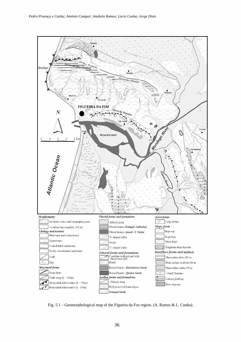
In the limestone massif, two episodes of karstification have been recognized (Almeida, 2001).
The older episode probably occurs after the Piacenzian marine incursion and karst features are
covered by sand; these features consist of dolines up tp 15 m deep, funnel-shaped and
sometimes caved-in dish-shaped and swallow-holes and caves (fig. 5.2). The second episode
is superficial and probably took place during and after the main uplift phase of the massif
(Gelasian to Pleistocene ?).
Fig. 5.2 – Dolines of the Boa Viagem hill (Almeida, 2001). A - Aalenian; Bj - Bajocian; Bt - Batonian; C - Calovian; O - Oxfordian; Ki - Early Kimmeridgian; K-P - Kimmeridgian-Tithonian; 1 - doline; 2 - road; 3 - stream; 4 - contour line; 5 - geological contact.
The terraces of the Mondego River are also represented in this region (Ramos, 2000).
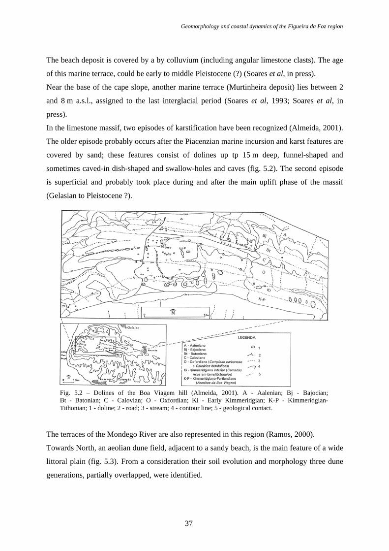
Towards North, an aeolian dune field, adjacent to a sandy beach, is the main feature of a wide
littoral plain (fig. 5.3). From a consideration their soil evolution and morphology three dune
generations, partially overlapped, were identified.
37
Pedro Proença e Cunha; António Campar; Anabela Ramos; Lúcio Cunha; Jorge Dinis
Fig. 5.3 – Quiaios dune field (Almeida, 1995). 1 - Coastline; 2 - Dune crests; 3 - Sharp lee faces; 4 - Serra da Boa Viagem northern limit.
The oldest dunes constitute an eastern belt and are intensely farmed. Their morphology is
quite smooth and they have an organized hydrological network. A podzol with a hardened B-
horizon has developed at the top of these dunes. Most of the dunes are parabolic and oriented
NW-SE. Dating performed by Carvalho & Granja (1997) in similar soils at Cortegaça (around
50-70 km to the North) has given an age of at least 1500 years BP.
The dunes’ second generation has a well preserved parabolic aeolian morphology, related to
W dominant winds. These dunes have soils evolving towards a podzol but as yet without a
hardened horizon yet. Its larger outcrop is located in a triangle close to Quiaios (fig. 5.3).
These dunes are not yet dated but we presume they were built during the Little Ice Age or
even before.
The latest dune generation was transgressive with an average speed of 20 m/yr till it was
covered with a maritime pinewood seeded between 1921 and 1940. It is built by linear dunes
(transverse and oblique) oriented W-E. A regosoil with a pH from weakly acid to basic has
38
Geomorphology and coastal dynamics of the Figueira da Foz region
developed in these sands. It represents most of the dune surface and its eastern boundary, with
the oldest dunes, is marked by a linear sequence of inter-dune lakes.
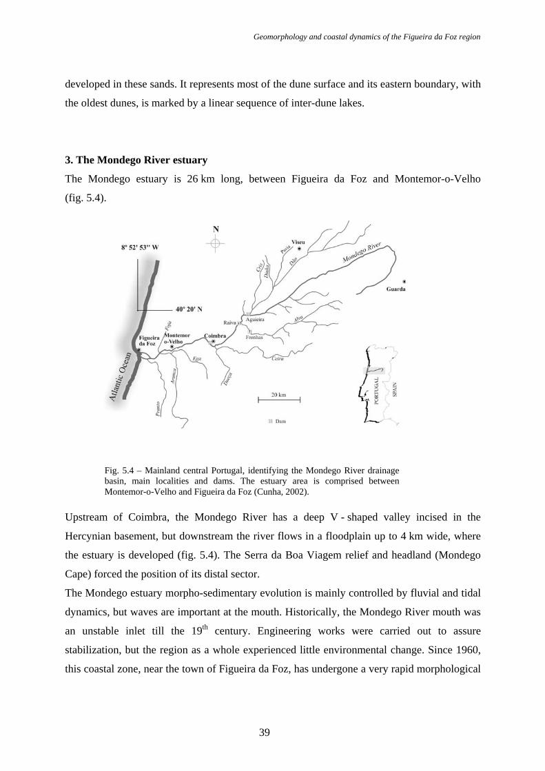
3. The Mondego River estuary
The Mondego estuary is 26 km long, between Figueira da Foz and Montemor-o-Velho
(fig. 5.4).
Fig. 5.4 – Mainland central Portugal, identifying the Mondego River drainage basin, main localities and dams. The estuary area is comprised between Montemor-o-Velho and Figueira da Foz (Cunha, 2002).
Upstream of Coimbra, the Mondego River has a deep V - shaped valley incised in the
Hercynian basement, but downstream the river flows in a floodplain up to 4 km wide, where
the estuary is developed (fig. 5.4). The Serra da Boa Viagem relief and headland (Mondego
Cape) forced the position of its distal sector.
The Mondego estuary morpho-sedimentary evolution is mainly controlled by fluvial and tidal
dynamics, but waves are important at the mouth. Historically, the Mondego River mouth was
an unstable inlet till the 19th century. Engineering works were carried out to assure
stabilization, but the region as a whole experienced little environmental change. Since 1960,
this coastal zone, near the town of Figueira da Foz, has undergone a very rapid morphological
39
Pedro Proença e Cunha; António Campar; Anabela Ramos; Lúcio Cunha; Jorge Dinis
change caused by intense human activities in the Mondego drainage basin and in the highly
dynamic coastal zone (Cunha et al., 1997a).
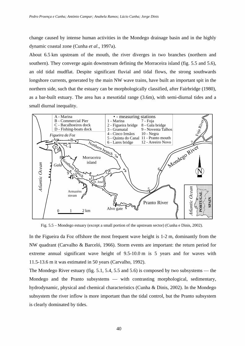
About 6.5 km upstream of the mouth, the river diverges in two branches (northern and
southern). They converge again downstream defining the Morraceira island (fig. 5.5 and 5.6),
an old tidal mudflat. Despite significant fluvial and tidal flows, the strong southwards
longshore currents, generated by the main NW wave trains, have built an important spit in the
northern side, such that the estuary can be morphologically classified, after Fairbridge (1980),
as a bar-built estuary. The area has a mesotidal range (3.6m), with semi-diurnal tides and a
small diurnal inequality.
0 1 2 km Alvo gate
N•9
• - measuring stations
•
•
• •
• •
•
•
•
•
Figueira da Foz
Morraceiraisland
Pranto River
Gala
1 - Marina2 - Figueira bridge3 - Gramatal4 - Cinco Irmãos5 - Quinta do Canal6 - Lares bridge
A - MarinaB - Commercial PierC - Bacalhoeiros dockD - Fishing-boats dock
A•
Fig. 5.5 – Mondego estuary (except a small portion of the upstream sector) (Cunha e Dinis, 2002).
In the Figueira da Foz offshore the most frequent wave height is 1-2 m, dominantly from the
NW quadrant (Carvalho & Barceló, 1966). Storm events are important: the return period for
extreme annual significant wave height of 9.5-10.0 m is 5 years and for waves with
11.5-13.6 m it was estimated in 50 years (Carvalho, 1992).
The Mondego River estuary (fig. 5.1, 5.4, 5.5 and 5.6) is composed by two subsystems — the
Mondego and the Pranto subsystems — with contrasting morphological, sedimentary,
hydrodynamic, physical and chemical characteristics (Cunha & Dinis, 2002). In the Mondego
subsystem the river inflow is more important than the tidal control, but the Pranto subsystem
is clearly dominated by tides.
40
Geomorphology and coastal dynamics of the Figueira da Foz region
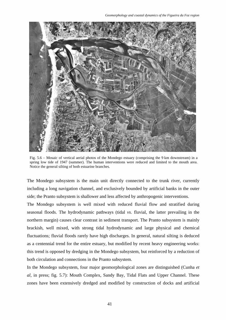
Fig. 5.6 – Mosaic of vertical aerial photos of the Mondego estuary (comprising the 9 km downstream) in a spring low tide of 1947 (summer). The human interventions were reduced and limited to the mouth area. Notice the general silting of both estuarine branches.
The Mondego subsystem is the main unit directly connected to the trunk river, currently
including a long navigation channel, and exclusively bounded by artificial banks in the outer
side; the Pranto subsystem is shallower and less affected by anthropogenic interventions.
The Mondego subsystem is well mixed with reduced fluvial flow and stratified during
seasonal floods. The hydrodynamic pathways (tidal vs. fluvial, the latter prevailing in the
northern margin) causes clear contrast in sediment transport. The Pranto subsystem is mainly
brackish, well mixed, with strong tidal hydrodynamic and large physical and chemical
fluctuations; fluvial floods rarely have high discharges. In general, natural silting is deduced
as a centennial trend for the entire estuary, but modified by recent heavy engineering works:
this trend is opposed by dredging in the Mondego subsystem, but reinforced by a reduction of
both circulation and connections in the Pranto subsystem.
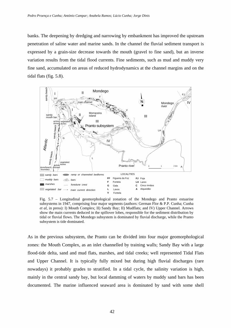
In the Mondego subsystem, four major geomorphological zones are distinguished (Cunha et
al, in press; fig. 5.7): Mouth Complex, Sandy Bay, Tidal Flats and Upper Channel. These
zones have been extensively dredged and modified by construction of docks and artificial
41
Pedro Proença e Cunha; António Campar; Anabela Ramos; Lúcio Cunha; Jorge Dinis
banks. The deepening by dredging and narrowing by embankment has improved the upstream
penetration of saline water and marine sands. In the channel the fluvial sediment transport is
expressed by a grain-size decrease towards the mouth (gravel to fine sand), but an inverse
variation results from the tidal flood currents. Fine sediments, such as mud and muddy very
fine sand, accumulated on areas of reduced hydrodynamics at the channel margins and on the
tidal flats (fig. 5.8).
main channel
F
Pranto river
Mondegoriver
Morraceiraisland
Mondego
Pranto subsystem
L
A
LA
FJ
C
V
FF
G
dune/beach boundary
activedunes
vegetateddunes
sandy bars
muddy bars
marshes
vegetated bar
ramp or channeled bedforms
main current direction
IV
foredune crest
barsFF Figueira da FozF FontelaG GalaL LavosV Fontela
FJ FojaLA LaresC Cinco IrmãosA Alqueidão
LOCALITIES
0 1 2 km
vegetateddunes
activedunes
IV
III
II
sandymouth bar
I
III
III
Fig. 5.7 – Longitudinal geomorphological zonation of the Mondego and Pranto estuarine subsystems in 1947, comprising four major segments (authors: German Flor & P.P. Cunha; Cunha et al, in press): I) Mouth Complex; II) Sandy Bay; II) Mudflats; and IV) Upper Channel. Arrows show the main currents deduced in the spillover lobes, responsible for the sediment distribution by tidal or fluvial flows. The Mondego subsystem is dominated by fluvial discharge, while the Pranto subsystem is tide dominated.
As in the previous subsystem, the Pranto can be divided into four major geomorphological
zones: the Mouth Complex, as an inlet channelled by training walls; Sandy Bay with a large
flood-tide delta, sand and mud flats, marshes, and tidal creeks; well represented Tidal Flats
and Upper Channel. It is typically fully mixed but during high fluvial discharges (rare
nowadays) it probably grades to stratified. In a tidal cycle, the salinity variation is high,
mainly in the central sandy bay, but local damming of waters by muddy sand bars has been
documented. The marine influenced seaward area is dominated by sand with some shell
42
Geomorphology and coastal dynamics of the Figueira da Foz region
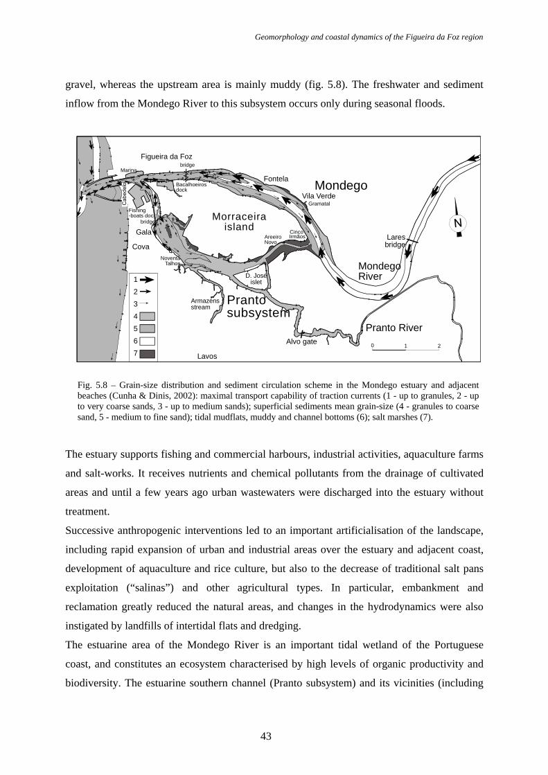
gravel, whereas the upstream area is mainly muddy (fig. 5.8). The freshwater and sediment
inflow from the Mondego River to this subsystem occurs only during seasonal floods.
0 1 2
D. Joséislet
Cinco Irmãos
NoventaTalhos
bridge
bridge
AreeiroNovo
Gramatal
Marina
Armazénsstream
Bacalhoeirosdock
Fishing-boats dock
1234567
Gala
Alvo gate
MondegoRiver
Prantosubsystem
Pranto River
Morraceiraisland
Lavos
Laresbridge
Figueira da Foz
Fontela
Cova
Vila VerdeMondego
Fig. 5.8 – Grain-size distribution and sediment circulation scheme in the Mondego estuary and adjacent beaches (Cunha & Dinis, 2002): maximal transport capability of traction currents (1 - up to granules, 2 - up to very coarse sands, 3 - up to medium sands); superficial sediments mean grain-size (4 - granules to coarse sand, 5 - medium to fine sand); tidal mudflats, muddy and channel bottoms (6); salt marshes (7).
The estuary supports fishing and commercial harbours, industrial activities, aquaculture farms
and salt-works. It receives nutrients and chemical pollutants from the drainage of cultivated
areas and until a few years ago urban wastewaters were discharged into the estuary without
treatment.
Successive anthropogenic interventions led to an important artificialisation of the landscape,
including rapid expansion of urban and industrial areas over the estuary and adjacent coast,
development of aquaculture and rice culture, but also to the decrease of traditional salt pans
exploitation (“salinas”) and other agricultural types. In particular, embankment and
reclamation greatly reduced the natural areas, and changes in the hydrodynamics were also
instigated by landfills of intertidal flats and dredging.
The estuarine area of the Mondego River is an important tidal wetland of the Portuguese
coast, and constitutes an ecosystem characterised by high levels of organic productivity and
biodiversity. The estuarine southern channel (Pranto subsystem) and its vicinities (including
43
Pedro Proença e Cunha; António Campar; Anabela Ramos; Lúcio Cunha; Jorge Dinis
the Morraceira Island) are one of the few remaining relatively pristine areas of the lower
sector of the Mondego river; they are mainly affected by traditional human activities with low
environmental impact, such as fishing and salt-works (“salinas”). However, in the Morraceira
Island, large areas of “salinas” are being transformed into “fish-farms”. The sedimentary sub-
systems, with their particular hydrodynamics and sediments, are an important natural heritage,
a beautiful landscape and constitute biological specific substrata. The “salinas”, salt marshes
and intertidal mud flats are extremely valuable for breeding water birds, shorebirds and other
migrants (Cunha et al, 1997c).
Synthesising the evolution of this estuarine system during the last decades, several major
consequences must be stressed. Contrasting with the intense silting, mainly by fluvial
sediments and still obvious in 1947 (fig. 5.6), the later severe reduction of sediments in the
estuary resulted from the upstream retention by dams and the removal by sand mining and
dredging. Moreover, the dynamics of the system were reduced by stabilisation of fluvial
discharge, as well as tidal prism decrease due to successive landfills of intertidal flats. The
inlet narrowing and reduction of the upstream connection with the Mondego subsystem
accelerated the silting in the Pranto subsystem. For harbour maintenance and enlargement,
large volumes are removed from the sedimentary system (see data from the Port Authority of
Figueira da Foz and environmental agencies, in Cunha & Dinis, 1998). The trapping of sandy
sediments with marine and fluvial provenance in the Mondego subsystem is a feedback effect
of the intense dredging and energy reduction, but it does not balance the fluvial sediment
starvation and the removal of sediments. The aforementioned fluvial and coastal heavy
engineering works had major environmental impacts, particularly the drastic reduction of
sedimentary inflow from the Mondego River to the littoral. This inverted the coastal
progradation caused by man-driven high discharge of river sediment during the previous
centuries.
3. Cova beach
In the beaches adjacent to the estuary the longshore drift is reduced and persists towards the
south from May to October, but during the remaining months the transport is important in
both North and South directions (Vicente, 1990), resulting in general southward trend (Cunha
e Dinis, 1998). The jetties built in 1965-67, to stabilise port access, produced huge effects on
the coastal morphology and sand drift: large updrift accumulation of sand against the northern
44
Geomorphology and coastal dynamics of the Figueira da Foz region
jetty led to sand mining, while the erosion hit the beaches located southward. The Cova beach
shows intense erosion, already reaching the foredune, compelling to the construction of groins
and seawalls (Cunha et al., 1997a; Cunha & Dinis, 1998).
The beach consists mainly of coarse to medium sand and the associated dune fields are
dominated by fine sands. The influence of wave dynamics is the main control on beaches and
estuary mouth grain-size, morphology and evolution (Carvalho & Barceló 1966; Cunha &
Dinis, 1998). The narrow beach south of the river mouth is made up of mainly mainly
medium sand and is nourished by both the longshore current and the local erosion of the
aeolian dune field (fig. 5.6, 5.7 and 5.8).
Compared with the dune field located north of the Serra da Boa Viagem relief, the dune
system extending south of the Mondego estuary has a relative similar stratigraphy and
morphology, allowing the presumption of an identical timing and nature (Bernardes et al,
2001). Over the oldest and deeply podzolised generation, a second unit of dune sands includes
a thin level of estuarine lagoon mud and muddy sands rich in organic matter and shells.
Radiocarbon dating of samples collected around 10 km of Figueira da Foz yielded an age of
2950±100 BP for a peat sample and 2060±90 BP for lamellibranchs and gastropods (both
calibrated ages; Bernardes et al., 2001). The Figueira da Foz – Nazaré dune field has a
maximum width of 9 km and includes several dune morphologies. Its evolution results from
combination of several natural controls, but recently mainly from anthropogenic effects since
the middle Ages. The successive phases of the pine forest expansion were the most important
factor minimizing dune migration (André, 1996; André et al., 2001). ). The first stabilization
measures to curtail sand drift occurred as earlier as the 13th century when a royal decree
ordered the planting of maritime pine (Pinus pinaster) to establish the forest of Pinhal do Rei
in order to protect the interior region, namely localities and farming areas from sand invasion.
Currently, the deterioration of the primary dune is expressed by wave cut, frequent blowouts,
initiated mainly by pedestrian access, and overwashes. The dune field in this area is
undergoing a rapid reduction due to urban/industrial expansion and is also affected by waste
disposal, sand mining, etc. (Cunha, 1998).
References Almeida, A.C. (2001). A carsificação da Serra da Boa Viagem: um processo quaternário. Estudos do
Quaternário, 4 : 29-33.
45
Pedro Proença e Cunha; António Campar; Anabela Ramos; Lúcio Cunha; Jorge Dinis
Almeida, A.C. (1995). As Dunas de Quiaios, Gândara e Serra da Boa Viagem. Uma abordagem ecológica da paisagem. PhD Thesis, University of Coimbra, 305 pp.
André, J.N. (1996). Morfologia litoral da área compreendida entre o Cabo Mondego e S. Pedro de Moel. Master Thesis in Geography, Univ. of Coimbra, 164 pp.
André, J.N.; Rebelo, F. & Cunha, P.P. (2001). Morfologia dunar e movimentação de areias entre a lagoa da Ervedeira e o limite sul da Mata Nacional de Leiria. Territorium, Revista de Geografia Física aplicada no ordenamento do território e gestão de riscos naturais, 8 : 51-68.
Bernardes, C.A., Noivo, L.M. & Corrochano, A. (2001). Evolution of Holocene coastal dunes at Leirosa, south of Cape Mondego, Portugal. Thalassas, Vigo, 17 (2) : 47-56.
Carvalho, G. Soares de & Granja, H. M. (1997). Ambientes do Plistocénico superior e do Holocénico na zona costeira do noroeste de Portugal. (Estado actual do conhecimento sobre os seus problemas), Cuaternario Ibérico : 55-66.
Carvalho, J.R. & Barceló (1966). Agitação marítima na costa Oeste de Portugal Metropolitano - Contribuição para o seu estudo. Memórias nº 290. Laboratório Nacional de Engenharia Civil, Lisboa.
Carvalho, M. (1992). Valores extremos de agitação marítima (Figueira da Foz). Tratamento local dos dados existentes. Report 13/92-A, PO-WAVES. Instituto Hidrográfico-Laboratório Nacional de Engenharia Civil, Lisboa.
Cunha, P.P. (1998). Impactes antrópicos na área dunar da Figueira da Foz - Leirosa. In: Associação Eurocoast-Portugal (Editor) - Dunas da Zona Costeira de Portugal : 105-118.
Cunha, P.P. (2002). Vulnerabilidade e risco resultante da ocupação de uma planície aluvial – o exemplo das cheias do rio Mondego (Portugal central), no inverno de 2000/2001. Territorium, 9 : 13-36.
Cunha, P.P. & Dinis, J.L. (1998). A erosão nas praias do Cabo Mondego à Figueira da Foz (Portugal centro-oeste), de 1995 a 1998. Territorium, 5 : 31-50.
Cunha, P.P. & Dinis, J.L. (2002). Sedimentary dynamics of the Mondego estuary. In M.A. Pardal, J. C. Marques & M. A. S. Graça (editors), Aquatic ecology of the Mondego river basin. Global importance of local experience. Chapter 1.4 : 43-62, Imprensa da Universidade, Coimbra.
Cunha, P.P.; Pinto, J. & Dinis, J.L. (1997a). Evolução da fisiografia e ocupação antrópica na área estuarina do Rio Mondego e região envolvente (Portugal centro-oeste), desde 1947. Territorium, 4 : 99-124.
Cunha, P.P.; Silva, A.F.; André, J.N. & Cabral, M.C. (1997c). Considerações sobre a evolução actual do litoral entre a Figueira da Foz e Nazaré. In: Associação Eurocoast-Portugal (Editor) - “Colectânea de ideias sobre a zona costeira de Portugal”, Porto : 489-502.
Cunha, P.P.; Freitas, H.; Marques, J.C.; Dinis, J.L. & Caetano, P. (1997b) – A protecção e gestão de áreas estuarinas - importância da ilha da Murraceira e do sub-sistema estuarini do Pranto (estuário do Mondego, Portugal). In Colectânea de Ideias sobre A Zona Costeira de Portugal, Associação Eurocoast- Portugal (ed.), Porto : 473-488.
Dinis, J.L. & Cunha, P.P. (1998). Impactes antrópicos no sistema sedimentar do Estuário do Mondego. Sociedade e Território, 27 : 47-59.
Fairbridge, R.W. (1980). The estuary: its definition and geodynamic cycles. In E. Olausson & I. Cato (ed.) – Chemistry and Biogeochemistry of Estuaries, Wiley, New Cork : 1-35.
Ramos, A. (2000). Organização e significado dos depósitos mais recentes da zona vestibular do rio Mondego. Master Thesis in Geosciences, Univ. de Coimbra, 200 pp.
Soares, A.F.; Callapez, P. & Marques, J.F. (in press). O Depósito do Farol no Cabo Mondego, Memórias e Notícias, Coimbra.
Soares, A.F.; Cunha, L.; Marques, J.F.; Almeida, A.C. & Lapa, M.L.R. (1993). Depósitos de vertente no Cabo Mondego. Integração no modelo evolutivo do Quaternário do Baixo Mondego. Actas da III Reunião do Quaternário Ibérico, Coimbra : 199-208.