108


Recommended citation: J.T. Teller, L.H. Thorleifson, G. Matile and W.C. Brisbin,1996. Sedimentology, Geomorphology and History of the Central Lake AgassizBasin Field Trip Guidebook B2; Geological Association ofCanadalMineralogical Association of Canada Annual Meeting, Winnipeg,Manitoba, May 27-29, 1996.
© 1996:This book, or portions of it, may not be reproduced in any form without written permission of theGeological Association of Canada, Winnipeg Section. Additional copies can be purchased fromthe Geological Association of Canada, Winnipeg Section. Details are given on the back cover.
Electronic Capture, 2008 The PDF file from which this document was printed was generated by scanning an original copy of the publication. Because the capture method used was 'Searchable Image (Exact)', it was not possible to proofread the resulting file to remove errors resulting from the capture process. Users should therefore verify critical information in an original copy of the publication.

SEDIMENTOLOGY, GEOMORPHOLOGY, AND HISTORY OFTHE CENTRAL LAKE AGASSIZ BASIN
TABLE OF CONTENTS
The Winnipeg Area 1General Introduction to Lake Agassiz 4
DAY 1: Winnipeg to Delta Marsh Field Station 6STOP 1: Delta Marsh Field Station. . . . . . . . . . . . . . . . . . . . . . . .. . 10
DAY2:
DAY 3:
Delta Marsh Field Station to Brandon to Bruxelles, ReturnEn Route to Next Stop 14STOP 2: Campbell Beach Ridge at Arden 14
En Route to Next Stop 18STOP 3: Distal Sediments of Assiniboine Fan-Delta 18
En Route to Next Stop 19STOP 4: Flood Gravels at Head of Assiniboine Fan-Delta 24
En Route to Next Stop 24STOP 5: Stott Buffalo Jump and Assiniboine Spillway - LUNCH 28
En Route to Next Stop 28STOP 6: Spruce Woods 29
En Route to Next Stop 31STOP 7: Bruxelles Glaciotectonic Cut 34
STOP 8: Pembina Spillway View 34
Delta Marsh Field Station to Latimer Gully to WinnipegEn Route to Next Stop 36
STOP 9: Distal Fan Sediment , 36STOP 10: Valley Fill Sediments (Latimer Gully) 36
STOP 11: Deep Basin Landforms of Lake Agassiz 42
References Cited 49
Appendix"Review of Lake Agassiz history" (L.H. Thorleifson) 55
"History of late glacial runoff along the southwestern margin of theLaurentide Ice Sheet" (Kehew and Teller, 1994; selected pages) .... 85
"Glacial lake outbursts along the mid-continent margins of the LaurentideIce Sheet" (Kehew and Lord, 1987; selected pages) 93


"
LA
KE
MA
NIT
OB
A St.
Lau
Vic
lDri.
1H
illsid
eSe
PAR
CPR
OV
.G
RA
ND
BEA
IPROV.PAR~
Gra
ndS
uch
Gra
ncM
arai
i
THE WINNIPEG AREA
The Quaternary sediments in the Winnipeg area (population 650,000) overlieOrdovician and Silurian bedrock, dominated by dolomite and dolomitic limestone. Thebedrock geology is shown on the "Manitoba Geological Highway Map" (separate foldedmap). This map also describes and discusses a number of "geological highlights" of thePrecambrian, Paleozoic, Mesozoic, and Cenozoic geology and history of the province,including several maps and block diagrams about the late Pleistoc~ne.
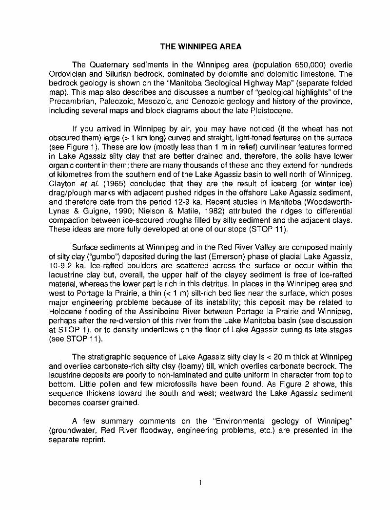
If you arrived in Winnipeg by air, you may have noticed (if the wheat has notobscured them) large (> 1 km long} curved and straight, light-toned features on the surface(see Figure 1). These are low (mostly less than 1 m in relief) curvilinear features formedin Lake Agassiz silty clay that are better drained and, therefore, the soils have lowerorganic content in them; there are many thousands of these and they extend for hundredsof kilometres from the southern end of the Lake Agassiz basin to well north of Winnipeg.Clayton et al. (1965) concluded that they are the result of iceberg (or winter ice)drag/plough marks with adjacent pushed ridges in the offshore Lake Agassiz sediment,and therefore date from the period 12-9 ka. Recent studies in Manitoba (WoodsworthLynas & Guigne, 1990; Nielson & Matile, 1982) attributed the ridges to differentialcompaction between ice-scoured troughs filled by silty sediment and the adjacent clays.These ideas are more fully developed at one of our stops (STOP 11).
Surface sediments at Winnipeg and in the Red River Valley are composed mainlyof silty clay ("gumbo") deposited during the last (Emerson) phase of glacial Lake Agassiz,10-9.2 ka. Ice-rafted boulders are scattered across the surface or occur within thelacustrine clay but, overall, the upper half of the clayey sediment is free of ice-raftedmaterial, whereas the lower part is rich in this detritus. In places in the Winnipeg area andwest to Portage la Prairie, a thin « 1 m) silt-rich bed lies near the surface, which posesmajor engineering problems because of its instability; this deposit may be related toHolocene flooding of the Assiniboine River between Portage la Prairie and Winnipeg,perhaps after the re-diversion of this river from the Lake Manitoba basin (see discussionat STOP 1), or to density underflows on the floor of Lake Agassiz during its late stages(see STOP 11).
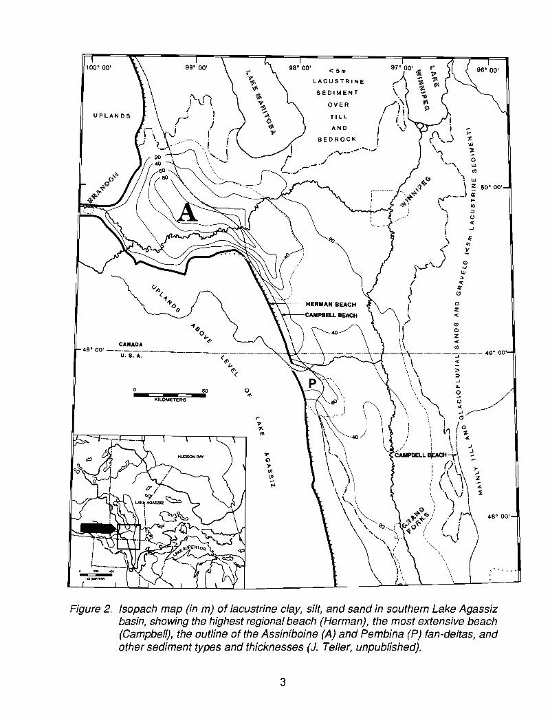
The stratigraphic sequence of Lake Agassiz silty clay is < 20 m thick at Winnipegand overlies carbonate-rich silty clay (loamy) till, which overlies carbonate bedrock. Thelacustrine deposits are poorly to non-laminated and quite uniform in character from top tobottom. Little pollen and few microfossils have been found. As Figure 2 shows, thissequence thickens toward the south and west; westward the Lake Agassiz sedimentbecomes coarser grained.
A few summary comments on the "Environmental geology of Winnipeg"(groundwater, Red River floodway, engineering problems, etc.) are presented in theseparate repri nt.
1

1 kilometre
Figure 1. Iceberg scour marks on floor of Lake Agassiz southeast of Winnipeg. The lightertones are more silty, better drained, and relatively low in organic matter.
2
......
~~
;.---------- "\ +'~
i .»..~I ~)
i
n '(' .,....J\
''''\\. 0
......, Ul
\. '"~ w\ :z 50' 00'
(".1'--'-) ~• CIl....... ~
\ ()
i -<i -J
\ :",'" .!:::
>~,-S'''\....1 ~
j ~
! :
< "I ~.J -<
I ~i z
I. -<
\\ '"._.~'t"'-'-'-'-'-:"-'-'- 49' 00
\ \ -<\ . -\ \ ~\ \ ~\, \. 0 /" () /\',\ -< //\. ..J /--\ \.... c)'
\ ! 1 0I V1 I ~" I I .L
I \ I ~CAMPBELL sPCH~\ ~
I :::I)' ...I (, \ \ ,..
I i~ ',' ~! \ \. i\ ~\ . \. \ ~\ \ .J, .) I
Q! . \\ " "+-4:-fJ::;/'/ /4 48' 00'
\ \, <b CG:O~ ,/ ( i \\ ". ',L " \,,·\.I 1\ '.) " . /\ \. / ", I\ \\ ,I\ \\ "I\;\ \ I\ . \ \ \! \ \
TI L L
OVER
SEDIMENT
<5m
LACUSTRINE
\/\
/ /.. . I/ I'. . \
AND ,\...
BEDROCK ,...",.. ....... ,.".
/ ......._.r .
(. .-./
.""......../
o"'"
50
KILOMETERS
o
49' 00' -·-,:,-:-s:A·.-·-'-'-'-'-'-'-'-----'-'-'-'-'(~
t-~(
Figure 2. Isopach map (in m) of lacustrine clay, silt, and sand in southern Lake Agassizbasin, showing the highest regional beach (Herman), the most extensive beach(Campbell), the outline of the Assiniboine (A) and Pembina (P) fan-deltas, andother sediment types and thicknesses (J. Teller, unpublished).
3
GENERAL INTRODUCTION TO LAKE AGASSIZ
Glacial Lake Agassiz not only was important in the late glacial history of this region,but also helped control the routing of meltwater from the western Laurentide Ice Sheet (aswell as intluence the retreat and readvance/surging of this ice sheet) (see, for example,Teller, 1987,1990, 1995; Clayton et al., 1984). Hydrological systems "downstream" weresignificantly influenced by the highly variable overflow from Lake Agassiz, and the recordof its overflow into the Mississippi River valley, Great Lakes, St. Lawrence valley, andMackenzie valley is only now being evaluated. In turn, the imp'act of water variably routedfrom the Agassiz basin (Figure 3) has been implicated in altering late glacial oceancirculation and climate (e.g. Broeckef et a. I. , 1988,1989, <1990; Keigwin et al., 1991).
Therefore, the history of Lake Agassiz and its overflow (Figure 3) is important toNorth American deglaciation and to considerations of global change. For many of thechanges it may be true that "LAKE AGASSIZ DID IT".
The route of this fieldtrip is shown on the photocopied highway map, with the stopsnumbered. There are a number of key components in the Lake Agassiz system that areessential for an understanding of how this huge glaciohydrological system worked,including the location of the ice margin, the lake's outlets, and isostasy. Data on all of thesecome from the sediments and morphology of the Lake Agassiz basin and from variousspillways, lakes, and oceans outside of its 2,000,000 km2 drainage basin.
We will visit a selection of sites that, hopefully, will convey an idea of what is in thecentral Lake Agassiz basin, and about how the system operated during its 4000-5000 yearlife during the last deglaciation. There are a number of controversial aspects, and thehistory of this giant lake and its impact on systems "downstream" are today beinginvestigated with greater rigour than ever before. Part of the difficulty relates to the size ofthe lake (and the remoteness of the bulk of its evidence) - the lake spans about 15° oflatitude and 20° of longitude. "New discoveries" in one corner of the basin, for example inthe Northwestern Outlet area, cannot be treated in isolation from "evidence" andinterpretations in other areas, for example in the Southern Outlet (1500 km away), andeven in the Gulf of Mexico, because the whole system is interactive.
A section in the Appendix to this Fieldguide, "Review of Lake Agassiz history"provides background on the evolution of ideas about the history of the lake and describesthe main components used to make these interpretations; a revised history of the lake isalso presented, mainly as a series of maps and diagrams with expanded captions (Figures27-41). No doubt some aspects of this history will be controversial, and there arealternative scenarios to some parts of the reconstruction. Further re'finements andrevisions no doubt will occur, and we encourage all researchers to contribute to ourunderstanding of this important lake.
The fieldtrip will look at 1) offshore and nearshore sediments and morphology(STOPS 1,3,9, 10, 11), 2) shoreline sediments and morphology (STOPS 1, 2), 3) t1uvialmorphology and deposits of inflow spillways (STOPS 4, 5, 8), 4) aeolian deposits (STOP6), and 5) glacial sediments (STOPS 7, 10).
4

AF.tCTIC OCEAN
Dr--i\0 \\~\\ )7,..,\\ ... \
\'1;..\\ "~ \\'~:~\
\ ,- \,~,,'" ,
, A'\ ',.>" ,': '
o 600! ,
kilometers
Figure 3. Major overflow routes from the Lake Agassiz basin, showing total area evercovered by the lake (stippled) and the outline of its drainage basin (J. Teller,unpublished).
5

DAY 1
WINNIPEG TO DELTA MARSH FIELD STATION
We travel west around the city of Winnipeg on the Perimeter Highway to the TransCanada Highway (No.1) and head west toward Portage la Prairie. There is almost no reliefon the Lake Agassiz plain, except for a few metres of incision by postglacial rivers (mainlythe Red and Assiniboine rivers and its small tributaries) and for the subtle (1-3 m) almostimperceptible swells and swales related to ice-scour marks and tJ'edrock'relief (see Figure1 and STOP 11). Surface materials are dominantly silty clay with local veneers of silt.
As the elevation rises toward the west (by about 30 m in the 80 km betweenWinnipeg and Portage la Prairie), surface and subsurface Lake Agassiz sediments becomesomewhat more silty because the source for much of the offshore sediment in this regionwas the Assiniboine Spillway, which entered the basin along the western side of the lake.
On the eastern side of the town of Portage la Prairie (population 13,500) is the Fortla Reine Museum and Pioneer Village. Some of the buildings are original structures movedto this site from nearby areas, others are replicas. The village and the artifacts in eachbuilding are intended to show the way of life in the eastern Prairie region of Canada fromthe 18th through the early 20th century. There is an old fort and trading post, loghomestead, country church and school, barn and machinery, fire hall, railway display, andmore.
Today the Assiniboine River Diversion, which we cross en route to the Field Station(Figure 4), is the only link between the Assiniboine River and Lake Manitoba; this channelcarries excess spring melt from the Assiniboine River to the lake for several months eachspring in order to alleviate the flood threat in this very flat region. During the Holocene, thenatural terminus of this river has fluctuated between Lake Manitoba and the Red River atWinnipeg, 100 km to the east, where it is today (see Figures 5,6, and 7). This influx ofclastic sediment had a major impact on the sedimentology of the basin, which we willdiscuss at STOP 1. Relicts of the old Assiniboine River distributaries to the lake arescattered throughout the region (see Figure 6) between the modern river (Portage laPrairie area) and the present shoreline. Figure 4 shows one of these old distributarychannels (Blind Channel) and the modern Assiniboine Diversion that links the AssiniboineRiver and Lake Manitoba. We cross both of these en route to the Field Station, which islocated on the modern beach that lies between the lake and the truncated end of BlindChannel (Figure 4).
6

:. :
../
-_ ..iIJ..••-
-_~::...
1 km
-.
Ditch
CAN. iAN
_.
t-----+---+----+---+------+--~----l-60--+---+---
\ I.. • 48 \49
_~~~D_·_·~~~ ~ j-+H...t»---HI-~-+---+-i+_--_Ii__'l+!__I_-_+_-~--.:::..::t,i..--.52:_____1I+_··-_r··.:<..j+______j
..........
Jr···/
-t--1\---+-t-----t+---1k----ti-+-i+---+-----!--+----.;----t\\-51-++--+\---I---I
Figure 4. Map showing Delta Marsh Field Station on barrier beach between LakeManitoba and the marsh. Blind Channel, one of the mid-Holocene distributariesof the Assiniboine River can be seen, as can the Assiniboine River Diversionchannel that diverts excess spring runoff from the modern Assiniboine River(near Portage la Prairie) north into Lake Manitoba. Our route, which ishighlighted, crosses Blind Channel several times.
7
a
•
b
•
•
c
•
d
•
.OAKLAND
~,_ LAKE BOUNDARY TODAY
o 5 10 15 20i !
Kilometre I
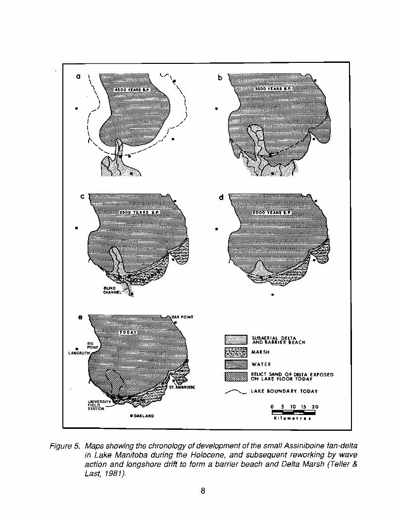
Figure 5. Maps showing the chronology of development of the small Assiniboine fan-deltain Lake Manitoba during the Holocene, and subsequent reworking by waveaction and longshore drift to form a barrier beach and Delta Marsh (Teller &Last, 1981).
8

( I )WlLLOWBEND PHASE7030 YEARS AGO
(2)FLEE ISLAND PHASE
(:3)LONG LAKE-HIGH BLUFFPHASE (7)
,,,,,-- .......,
( 4)BLIND PHASE4520 YEARS AGO,
\ " ....... -,I ,.,-' ,..",-----..............\ , .... ...\, , ...-.I' ,, -'",,
( 6)MILL PHASE1300 YEARS AGO
----- ......,- ...... _, ......-...----
,I ...... - ..... ,I .,' ",----- __, , ,' ........
" , 'I .-, , I' ,, I ,-'"
, I''--"'",,
(5)LASALLE PHASE2980 YEARS AGO
(8)ASSlNIBOINE PHASEPRESENT,,
I, "I /' ...... " __, '\ \,,',' ,'-
, I,'" f, ,,' I
'-- ...... ~.l ",.,~ , __ ........., , ..... _ tJ' .....
~ ,,; ...... ,. ....~..._-----
(7 )CURTIS RIDGE PHASE700 YEARS AGO,
\ ",,--,, I ...... ' ..... -------_, "".... "' ..... .--------, \ I ", '", , '_.... '"
, I ' ".... , I ,
\ I ", '"
Figure 6. Schematic evolution of Assiniboine River distributaries during the Holocene(Rannie et al., 1989).
9

STOP 1 and OVERNIGHT \DELTA MARSH FIELD STATION AND OVERVIEW OF LATE QUATERNARY
SEDIMENTATION
The University of Manitoba Delta Marsh Field Station was established in 1966,originally being a private lodge for duck hunters. Today, it serves mainly as a base forbiological research activities in the region.
The Field Station lies on a sand barrier, constructed during the Holocene by thereworking of old fluvio-deltaic sediments (Figure 5) at the south end of Lake Manitoba.Behind the barrier is Delta Marsh, one, of the largest waterfowl staging areas in NorthAmerica.
As discussed at this stop, the level of Lake Manitoba has fluctuated dramaticallysince its inception following the lowering of Lake Agassiz below its rim, probably about8200 BP. Ostracodes, diatoms, pollen, stable isotopes, and sediment characteristics in thelake reflect these changes, as does the history of the Assiniboine River to the east, andwere the result of several interacting factors:
(1) differential isostatic rebound, which shifted the water mass from north tosouth in the basin,
(2) erosion of the northern outlet,(3) variable influx of the Assiniboine River,(4) climate,(5) variable contribution (composition and relative volume) of groundwater.
Articles by Teller & Last (1981, 1982), Last & Teller (1983), Last (1982, 1984),Rannie et al. (1989), Nambudiri et al. (1980), Nambudiri & Shay (1986), Last et al. (1994),and others elaborate on various aspects of sedimentation and history in this basin. Currentstudies by Risberg, Curry, Ito, Last, and Teller will be discussed at this stop.
The early history of Lake Manitoba is largely the history of Lake Agassiz in thisregion, because it formed a sub-basin on the 'floor of Lake Agassiz for several thousandyears. Once Agassiz levels fell below the rim of Lake Manitoba, the lake became largelyindependent of its "parent" lake, although regional climate and hydrology, includinggroundwater flow, must have been influenced by Lake Agassiz for some time after this.After Lake Agassiz fell to about the Gimli beach level, its waters were confined by tillcovered Paleozoic bedrock to the north, east, and west (its basin is in a glacially-scouredtrough) and by a now-buried ridge of till just south of the modern Delta Marsh area (Fentonand Anderson, 1971; Teller & Last, 1981); overflow at this time, as today, was eastwardthrough the Fairford River channel toward Lake Winnipeg (Figure 7).
Sediments deposited in the early stages of Lake Manitoba (Le. during its earlyAgassiz phase) are silty clays containing ice-rafted clasts (bedrock, till, and silt fragments).Above this, there are only a few obvious lithological differences in the sequence except inthe southern end of the Lake Manitoba basin where sandy sediment from the AssiniboineRiver forms a Holocene fan-delta (Figure 5).
10

•••••••••••••••: ,...... ~
.~
o~
s" ••••••..••
~ ~p ~-z. •- .-\ .•o •
(Jl ••p •
••
o 40 80
Ki lomelres
•••••••••••••
Figure 7. Lake Manitoba (patterned) and major lakes and rivers of the region, includingthe Fairford River outlet from the lake. The dashed line represents the ManitobaEscarpment which separates the low and relatively flat area to the east (i.e. theAgassiz basin) from the elevated area to the west (Teller & Last, 1981).
Within the lower few metres of cores from drill holes that have penetrated the entirelate Quaternary lacustrine sequence, there are almost no Quaternary organic remains.Investigations for diatoms (by Risberg), ostracodes (by Forester and Curry), and molluscs(by Pip) show the oldest sediments to be almost barren of fauna and flora; the occasionalpresence of the ostracode Candona subtriangulata in this lower zone (Last et al., 1994;Curry et al., 1995) indicates a cold dilute lake, which has been interpreted to represent theLake Agassiz phase (ca. 11-8.2 ka) of Lake Manitoba.
11

Dating of the lower (Lake Agassiz) part of the sequence has been fraught withproblems. Samples of dark-colored muds are known to have been contaminated by finelydisseminated old carbon, based on the presence of high percentages (up to 80%) of preQuaternary palynomorphs (Teller et al., 1981; Nambudiri et al., 1980; Teller & Last, 1981);although dates on these samples were "corrected" by using the percentage of oldpalynomorphs as an indicator of total old carbon, they remain at best general chronologicalindicators. Because of the scarcity of organics in the Agassiz part of the sequence, furtherresolution may not be possible; a new AMS date of 4040±40 (Woods Hole #OS-02659;S.M. Colman, 1994, written commun.) on ostracode valves from this lower zone has addedconfusion and probably relates to a labelling error.
5180 values on ostracode valves in the Agassiz part of the sequence are relativelylow at -15 to -17 %0 PDB (Last et al., 1994).
Although no dates clearly define the end of the Agassiz phase of Lake Manitoba,it is interpreted to have occurred around 9.2 ka (Teller & Last, 1981). This change ismarked by an abrupt increase in diatoms and ostracodes and by changes in some othermeasured parameters such as magnetics, moisture content, and MgC03 contel1t in calcite.
The history of Lake Manitoba after it became independent from glacial Lake Agassizis complex. Diatoms (Risberg), ostracodes (Curry), stable isotopes (Ito), and variousphysical and mineralogical parameters (Last and Teller) are being used to interpret thevarying hydrological conditions in the basin, which were a function of isostasy, outleterosion, variable influx of the Assiniboine River, climate, and variable contribution ofgroundwater. Lake levels and the chemistry of this shallow lake (Z =4.5 m; Z max =6.3 m)fluctuated substantially.
The Holocene history of Lake Manitoba has been studied from 48 short « 4 m)cores and 6 long cores collected by Livingstone coring and by Shelby tubes in hollow-stemaugers from winter ice in the South Basin. More than 15,000 analyses have been made,including grain size, moisture content, clay mineralogy, carbonate mineralogy, quartz andfeldspar content, pH, Eh, magnetics, organic matter content, organic typing, trace elementanalyses (K, Na, Ca, Mg, Fe, Mn, P, Zn, Cd, Cu, Pb, Hg, CI, S), and stable isotopes.Detailed studies of the pollen, ostracodes, and diatoms (and other siliceous microfossils)also have provided important paleoenvironmental insight.
Major problems (uncertainties) have occurred in resolving the chronology of eventsin the basin, because most of the vegetal organic material is microscopic and some hasbeen contaminated by pre-Quaternary organics; mollusc and ostracodes shells are eithertoo few in number to be dated (in the early, Agassiz part of the sequence) or are potentiallycontaminated by the "hard-water effect".
Diatoms and ostracodes suggest that waters were fresh to brackish in the earlyHolocene. The combination of warming temperatures, differential isostatic rebound, and(possibly) changes in groundwater discharge are reflected by diatoms, phytoliths,ostracodes, oxygen isotopes, and calcite geochemistry in sediments of this large but veryshallow lake. Evidence within and to the south of the basin is that the Assiniboine River,
12

which today by-passes the lake, played an important role during the mid-Holocene (Figure5; Teller & Last, 1981; Rannie et al., 1989). Water depths varied during this period asretlected by several low-moisture, pedogenic-like zones in the sediment (Teller & Last,1982).
Another dramatic change in sediment parameters, especially in diatoms,ostracodes, (5180, calcite, and moisture content occurred at 4-5 ka; these changes overliea widespread low moisture zone found in every core that penetrated to a depth of 3.5 min the sediment, and represents a period of prolonged low (or no) water in the basin whenPIE ratios were low and the Assiniboine River was diverted away from the basin. The finaldiversion of the river away from the basin, higher PIE ratios, continuing differential isostaticrebound, and (possibly) changes in groundwater discharge have resulted in varyingbrackish water conditions over the past several thousand years.
Abstracts for this GAC meeting by Curry and Ito et al. can be consulted for furtherelaboration.
The barrier beach on wl"lich Delta Marsh Field Station lies formed largely by thereworking of Assiniboine River fluvio-deltaic sediments, and has been transgressing southover marsh sediments for at least 3000 years, in part because of differential isostaticrebound. In places along the face of the beach, these marsh sediments are being reexposed, along with the organic-acid stained bones and teeth of bison.
Because new data from a new core is being studied as this Guidebook is beingprepared, a more elaborate, and possibly revised, history of the lake will be presented anddiscussed at this stop.
13
DAV2
DELTA MARSH FIELD STATION TO BRANDON TO BRUXELLES, RETURNSeven Stops
EN ROUTE TO NEXT STOPWest from Delta Marsh Field Station we traverse the flat silty clay surface of the
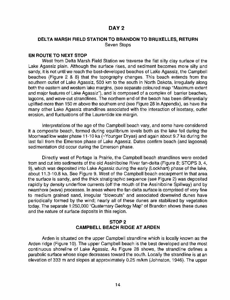
Lake Agassiz plain. Although the surface rises, and sediment becomes more silty andsandy, it is not until we reach the best-developed beaches of LaKe Agassiz, the Campbellbeaches (Figure 2 & 8) that the topography changes. This beach extends from thesouthern outlet of Lake Agassiz, 500 km to the south in North Dakota, irregularly alongboth the eastern and western lake margins, (see separate coloured map "Maximum extentand major features of Lake Agassiz"), and is composed of a complex of barrier beaches,lagoons, and wave-cut strandlines. The northern end of the beach has been differentiallyuplifted more than 150 m above the southern end (see Figure 28 in Appendix), as have themany other Lake Agassiz strandlines associated with the interaction of isostasy, outleterosion, and fluctuations of the Laurentide ice margin.
Interpretations of the age of the Campbell beach vary, and some have consideredit a composite beach, formed during equilibrium levels both as the lake fell during theMoorhead low water phase 11-10 ka (-Younger Dryas) and again about 9.7 ka during thelast fall from the Emerson phase of Lake Agassiz. Dates confirm beach (and lagoonal)sedimentation did occur during the Emerson phase.
Directly west of Portage la Prairie, the Campbell beach strandlines were erodedfrom and cut into sediments of the old Assiniboine River fan-delta (Figure 8; STOPS 3, 4,9), which was deposited into Lake Agassiz during the early (Lockhart) phase of the lake,about 11.3-10.8 ka. See Figure 9. West of the Campbell beach escarpment in that areathe surface is sandy, and the thick stratigraphic sequence (see Figure 2) was depositedrapidly by density underflow currents (off the mouth of the Assiniboine Spillway) and bynearshore (wave) processes. In areas where the fan-delta surface is comprised of very fineto medium grained sand, irregular "blowouts" and associated downwind dunes haveperiodically formed by the wind; nearly all of these dunes are stabilized by vegetationtoday. The separate 1:250,000 "Quaternary Geology Map" of Brandon shows these dunesand the nature of surface deposits in this region.
STOP 2CAMPBELL BEACH RIDGE AT ARDEN
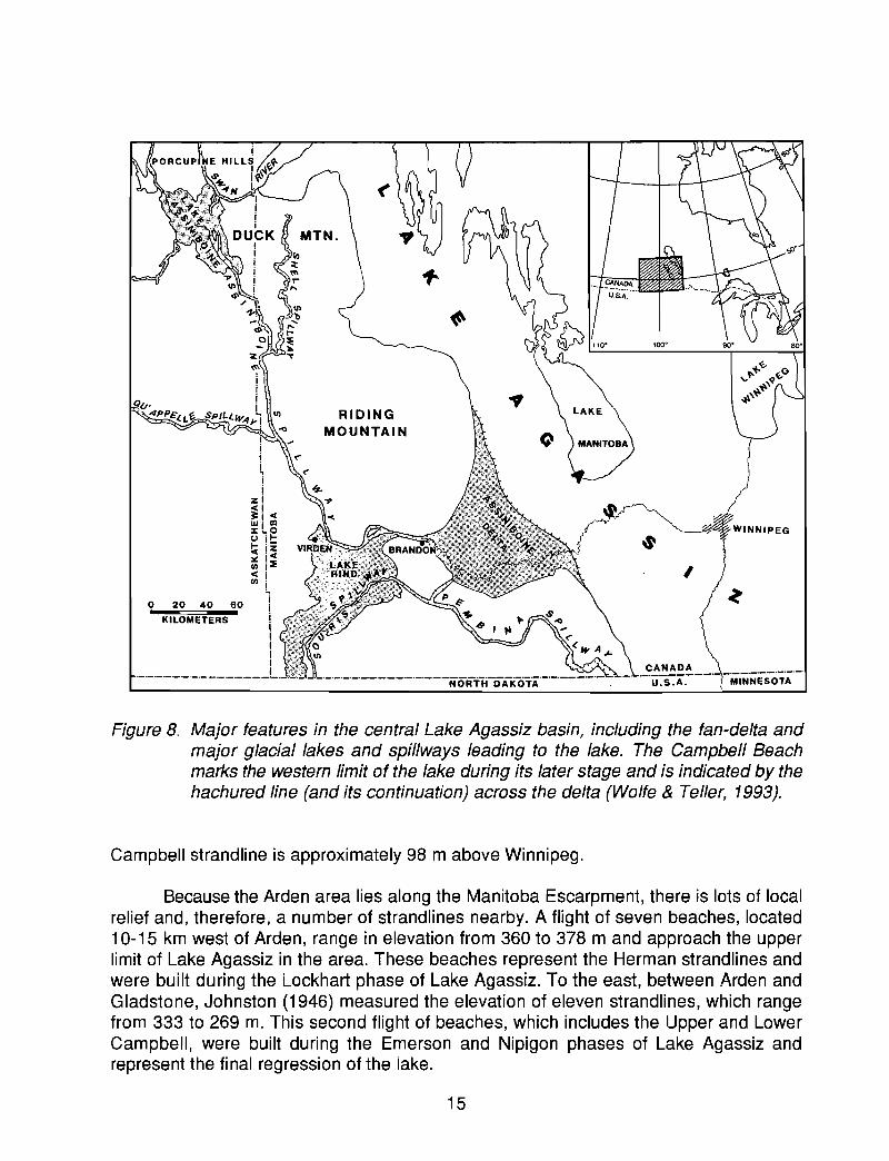
Arden is situated on the upper Campbell strandline which is locally known as theArden ridge (Figure 10). The upper Campbell beach is the best developed and the mostcontinuous shoreline of Lake Agassiz. As Figure 28 shows, the strandline defines aparabolic surface whose slope decreases toward the south. Locally the strandline is at anelevation of 333 m and slopes at approximately 0.25 m/km (Johnston, 1946). The upper
14
Iij
i,ii
zi;1 <~L~() jl-~ iz:.: j<III j::E
~!L
o 20 40 60 IKILOMETERS I
iijj
._._._._._._._._._._._._._._._L.
I
._. ._C?~!l.~.~~._._. ,_._.-._._._._._._.U.S.A. i MINNESOTA
Figure 8. Major features in the central Lake Agassiz basin, including the fan-delta andmajor glacial lakes and spillways leading to the lake. The Campbell Beachmarks the western limit of the lake during its later stage and is indicated by thehachured line (and its continuation) across the delta (Wolfe & Teller, 1993).
Campbell strandline is approximately 98 m above Winnipeg.
Because the Arden area lies along the Manitoba Escarpment, there is lots of localrelief and, therefore, a number of strandlines nearby. A flight of seven beaches, located10-15 km west of Arden, range in elevation from 360 to 378 m and approach the upperlimit of Lake Agassiz in the area. These beaches represent the Herman strandlines andwere built during the Lockhart phase of Lake Agassiz. To the east, between Arden andGladstone, Johnston (1946) measured the elevation of eleven strandlines, which rangefrom 333 to 269 m. This second flight of beaches, which includes the Upper and LowerCampbell, were built during the Emerson and Nipigon phases of Lake Agassiz andrepresent the final regression of the lake.
15

In addition to their importance in establishing the history of Lake Agassiz, beacheswere vital to paleo-Indians and early settlers. They are 'high and dry' and continuous formany kilometres; as such they provided excellent transportation routes. This wasespecially important in spring when the surrounding lower areas were wet. Also, becausethey are relatively easy to dig, they provided good burial sites. Beaches are still consideredto be an excellent choice for road building and cemetery plots.
Figure 9. Proglacial lakes along the western Laurentide ice margin about 11.3 ka; theglacial boundary and additional area of Lake Agassiz at 11 ka are shown byheavy dashed line. All lakes in this region overflowed south into the MississippiRiver at this time. A =Lake Regina, B =Lake Souris, C =Lake Hind, D =LakeAgassiz (Lockhart Phase), E = Lake Superior (Duluth Phase), F = Lake Michigan(Calumet Phase) (Teller, 1987).
16
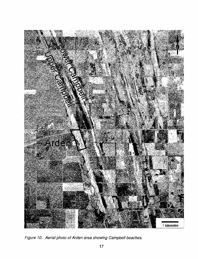
Figure 10. Aerial photo of Arden area showing Campbell beaches.
17
1 kilometre

Section Description:In the fall of 1995, a sand and gravel pit, 1 km east of Arden, provided a good
example of the sediments formed in the lower Campbell beach in this area. The lowerCampbell is 10m below the upper Campbell strandline in this area. As sand and gravelpits tend to be active on a somewhat random basis and a clean pit face is not certain, asubstitute pit may be chosen. As a result, the section description is purposely generalized.
The deposit consists of >2 m gently dipping sand and pebble gravel with low angletruncations and 10 cm of cross-bedded sand units (paleocurrent = 130 0
, although multipledirections were observed).
EN ROUTE TO NEXT STOPFor about 8 km south of Arden, the Campbell beach continues as a barrier island,
composed of sandy to gravelly, flat-bedded sediment, with a marshy paleolagoon just tothe west; Highway 352 is built on this barrier beach. Farther south, the road lies mainlyalong the base of a small escarpment, cut by Lake Agassiz waves into older fine sandsand silts. These fine sediments were deposited by density underflow currents into the lakewhen it was at higher levels during the Lockhart phase, and are part of the distalaccumulation of the Assiniboine River fan-delta complex. Therefore, the bulk of theCampbell beach along this stretch is composed of these wave-eroded sands, and onlyoccasionally is a coarser Campbell beach distinguishable. To the west of this wave-cutshoreline, the surface of the Lockhart underflow fan has been dissected by spring sapping,because these sands and silts overlie clayey impermeable offshore sediment. In someareas, as discussed later, this surface has been reworked into dunes during the Holocene.
Shortly after we reach the Trans Canada Highway we turn south on Highway 34 atthe town of Austin. Just after this, the road rises up over the Campbell Beach, which is awave-eroded escarpment into the older Lockhart underflow fan sands and silts that we seeat STOP 3. Note the old steam tractors and farm machinery on tile shoreline at tileManitoba Agricultural Museum.
About 4 km farther south is a cut into the distal fine-grained sediments of theAssiniboine fan-delta, whose apex lies 70 km to the west at Brandon (see Brandon1:250,000 "Quaternary Geology Map").
STOP 3DISTAL SEDIMENTS OF ASSINIBOINE FAN-DELTA
Exposed here are 9 m of well-laminated and bedded silt and very fine sand thatdisplay a wide variety of sedimentary structures and deformational (loading) structures. Allof these features suggest rapid sediment influx to this site, probably by density underflowcurrents entering Lake Agassiz from> 50 km to the west.
These sediments were deposited during the early stage of Lake Agassiz (ca. 11.310.8 ka in this region), and are typical of the distal part of the Assiniboine fan-delta. Thethickness of the Assiniboine fan-delta exceeds 50 m in places (see Figure 2) and coversan area of about 6400 km2 west of the Campbell beach escarpment. From bottom to topthere is a gradation from more distal to slightly more proximal sediments.
18

The general stratigraphy at this site is:4 m Silt to clayey silt, interbedded with silty very fine sand; well-laminated and
cross laminated with ripples and climbing ripples, several intervals containhighly deformed bedding and occasional faults (mobilized during rapidaccumulation over high water content zones), light olive brown (2.5 Y 5/4).
5+ m Silty clay grading up into silt, scattered variably coloured silt clasts in basalpart decreasing upward; some deformational structures, poorlylaminated to massive in lower part becoming laminated in upper part,upper boundary gradational, dark olive, grey .(~y; 3/2) at basebecoming light yellowish brown (2.5 Y 6/4) in upper part.
These sediments are typical of those found throughout this part of the Assiniboinefan-delta, and were deposited in waters up to 70 m in depth; we will see a similar sequenceat STOP 9. They are interpreted as representing a period of rapid sediment influx to thewestern side of the lake through the Assiniboine Spillway, whose mouth lay at least 50 kmto the west. A long core collected 28 km to the west of STOP 3, 7 km southeast ofCarberry, contained 68 m of offshore clay (near the base) that grades upward into silty finesand (near the top). The sequence overlies till. Some of this sediment influx was relatedto catastrophic bursts of water from other ice-marginal lakes to the west of Lake Agassiz(e.g. Kehew & Teller, 1994a; Sun, 1993); this topic will be discussed at STOPS 4 and 5.
Rapid sedimentation is indicated by the climbing ripples and deformationalstructures. Some wave reworking may have taken place, and the top of the sequence mayhave been eroded away as Lake Agassiz fell to the Moorhead low-water phase after 11ka. Subsequently, when the lake rose again during the Emerson phase, wave erosionoccurred around the periphery of this underflow fan, resulting in formation of the Campbellstrandline (see Figure 2).
EN ROUTE TO NEXT STOPWe return to the Trans Canada Highway and proceed west over the Assiniboine
fan-delta surface, which rises slowly toward its apex at Brandon. In some places where thesurface sediment is dominantly very fine to medium grained sand, wind deflation hasoccurred when the surface vegetation has been disturbed. Blowouts and associated dunes(only a few are nicely parabolic) have developed over a large area (see 1:250,000"Brandon Quaternary Geology Map"). Today the only active area is the Bald Head Hills,about 22 km south of tl1e town of Carberry (Figure 17).
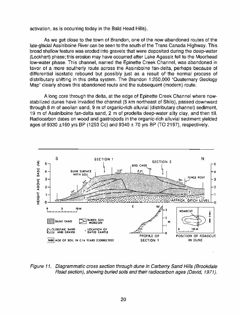
In some of the roadcuts through the aeolian dunes in the Assiniboine fan-delta, youcan see dark zones within the sand dunes. These are weakly-developed soils, formed onancient sand dune surfaces and later buried by advancing dunes. There are many suchsoils throughout this area, some which have been radiocarbon dated. The dates indicatethat periods of relative stability (soil development) alternated with active dune migrationthroughout at least the past 3700 years (see cross section, Figure 11). Some of thesepaleosols may be (or may have been) extensively developed over the region (as is thecase today), others may only have been locally formed in the wetter interdune areas.Likewise, active dune migration probably occurred at times over a widespread area, whileat other times activation occurred only locally (as temporary blowouts or sub-regional
19
activation, as is occurring today in the Bald Head Hills).
As we get close to the town of Brandon, one of the now-abandoned routes of thelate-glacial Assiniboine River can be seen to the south of the Trans Canada Highway. Thisbroad shallow feature was eroded into gravels that were deposited during the deep-water(Lockhart) phase; this erosion may have occurred after Lake Agassiz fell to the Moorheadlow-water phase. T~lis channel, named the Epinette Creek Channel, was abandoned infavor of a more southerly route across the Assiniboine fan-delta, perhaps because ofdifferential isostatic rebound but possibly just as a result of-the normal process ofdistributary shifting in this delta system. The Brandon 1:250,000 "Quaternary GeologyMap" clearly shows this abandoned route and the subsequent (modern) route.
A long core through the delta, at the edge of Epinette Creek Channel where nowstabilized dunes have invaded the channel (5 km northeast of Shilo), passed downwardthrough 8 m of aeolian sand, 9 m of organic-rich alluvial (distributary channel) sediment,19 m of Assiniboine fan-delta sand, 2 m of prodelta deep-water silty clay, and then till.Radiocarbon dates on wood and gastropods in-the organic-rich alluvial sediment yieldedages of 9330 ±160 yrs BP (1253 Cc) and 9340 ± 70 yrs BP (TO 2197), respectively.
2
4
3
5
JI
N
ISO M,o,
POSITION OF ROADCUTIN DUNE
2M
1
PROFILE OFSECTION 1
E
• LOCAliON OFDA TED SAMPLE
R"J BURIED SOIL~ HORIZON
s
t~\%Wj DUNE SAND
~ DELTAIC SAND~ AND GRAVEL
136BoI AGE OF SOIL IN C·l~ YEARS (CORRECTED)
w~ 4!Xl
W 3>o~ 2I:I:c:J
~ 0 -'--_-'-- ---'....L:....o."O""":"'~.............,'-"-=--'L..:...:..I..&.:...L...................._.a........=......!..._"_"'_'_'"_.....::..::.......i..L__:....:.:.....:.....:..:.=..:..:.__=...:...cc..::..:...:.__=_=_..:....=..::'_'_ 0
o 5 10MI , I , • I , I , ! !
Figure 11. Diagrammatic cross section through dune in Carberry Sand Hills (BrookdaleRoad section), showing buried soils and their radiocarbon ages (David, 1971).
20

The city of Brandon (population 39,400) lies adjacent to the Assiniboine River valleywhich has entrenched itself into the apex of the old Assiniboine fan-delta. This is anunderfit river; its valley was cut mainly during late glacial and early postglacial time bymeltwater. The valley (and the area for about 10 km on either side) occupies one of thebroad gaps eroded through the Cretaceous shale escarpment along the western boundaryof Lake Agassiz; this Cretaceous sequence is capped in places by resistant (siliceous)Odanah shale and forms a nearly continuous east-facing escarpment for > 1000 km, fromNorth Dakota, across Manitoba, and into Saskatchewan.
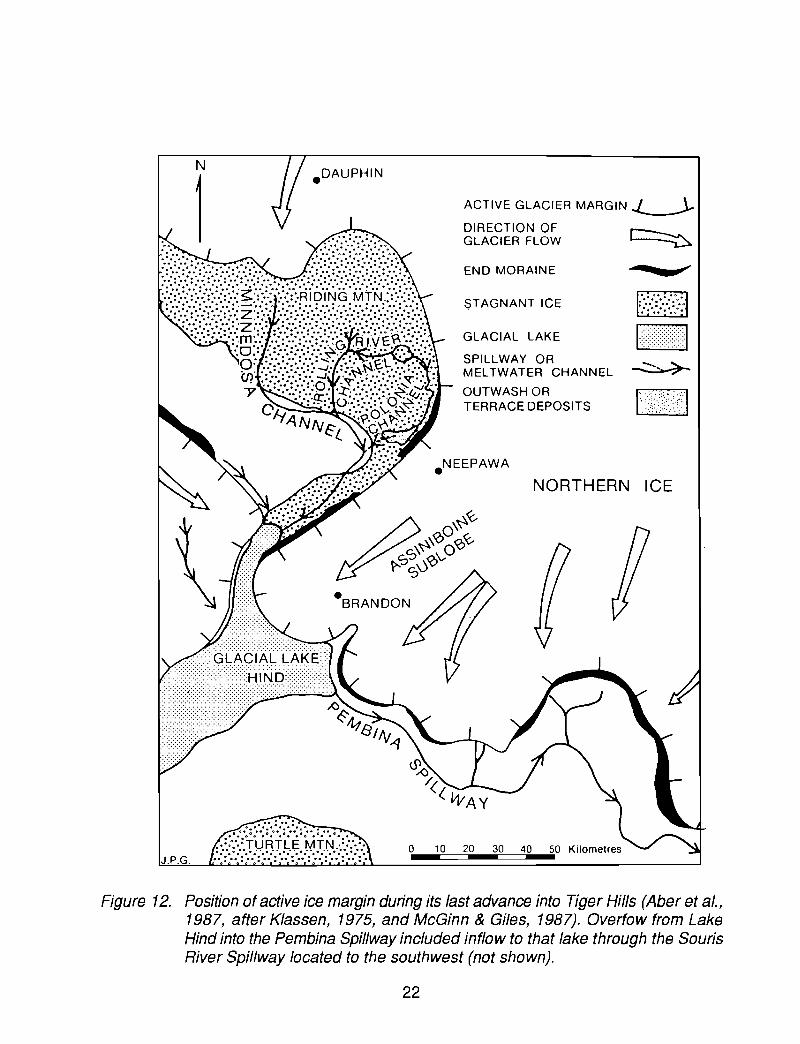
The last advance of ice into the southern Lake Agassiz basin of Manitoba pushedwestward through this broad ,gap before 11 ka (Figure 12), depositing the DarlingfordAlexander end moraine (see this end moraine on Brandon and Virden 1:250,000"Quaternary Geology Maps"). After this ice wasted away, Lake Brandon formed betweenthe moraine and ice margin (Figure 13A).
Subsequently, meltwater from the Souris and Qu'Appelle valleys, which drainedmuch of the glaciated and just-deglaciated region oHhe southern Canadian Prairies at thistime, topped the Darlingford-Alexander moraine in the Brandon region along a broad (>15 km) 'front (Figure 13B), scouring shallow channels into the surface, which are todayabandoned and armoured in many places by cobbles and boulders. We will see theseupland channels en route to STOP 5. This eventually led to establishment of the presentcourse of the Assiniboine River through the city of Brandon and deposition of theAssiniboine fan-delta. This glacial river provided the largest flow of meltwater to glacialLake Agassiz during its early history. Klassen (1975) and Christiansen (1960; 1961)describe the nature of this spillway, its sediments and history, and of the Qu'Appelle valley,which is its westward extension across the Prairies. Kehew and Teller (1994a) discuss thenature and history of all major spillways to the west of Lake Agassiz, and part of this paperis included in the Appendix to the Guidebook.
To the west of the Darlingford-Alexander moraine lies the glacial Lake Hind basin,a flat surface of silty to sandy clay, capped in places by small aeolian dunes and blowouts.This former lake basin covers 4900 km2 and is connected to the glacial Lake Souris basinsouth along the Souris River in North Dakota. Water was impounded in this low area untilthe Pembina spillway was entrenched (Figure 12, STOP 8) and overfow through the newAssiniboine River Spillway at Brandon was established. This entrenchment and thedrainage of Lakes Hind and Souris may have occurred as a result of catastrophic floodingthrough the Souris River valley from glacial Lake Regina (e.g. Kehew, 1982; Kehew andClayton, 1983).
The nature of the flow of water through the Assiniboine Spillway and other lateglacial channels of the Prairies will be discussed at STOPS 4 and 5. Part of the classicpaper by Kehew and Lord (1987) on glacial lake outburst foods and their impact ondownstream valleys and lakes is included in the Appendix to this Guidebook.
21
.DAUPHIN
- ~-~~
~~
~
NORTHERN ICE
$TAGNANT ICE
END MORAINE
ACTIVE GLACIER MARGIN~
DIRECTION OF r---...,..GLACIER FLOW ---v
GLACIAL LAKE
SPILLWAY ORMELTWATER CHANNEL
OUTWASH ORTERRACE DEPOSITS
.NEEPAWA
o 10 20 30
0.0 ° 0 ° .. 0° • D· •II .0 0 •• 0. 0 0 ••••• 0 •• 'II
.. ::·:::T·URTLE MTN.~::·:··.0··.,0•• - .•..• - .• - .• - .••••••
J. P.G. ..:: DO 0°:.0:: DO 0°: •••• : DO 0°: DO: : DO:: DO O· :·0
Figure 12. Position ofactive ice margin during its last advance into Tiger Hills (Aber et a/.,1987, after Klassen, 1975, and McGinn & Giles, 1987). Overfow from LakeHind into the Pembina Spillway included inflow to that lake through the SourisRiver Spillway located to the southwest (not shown).
22

A
B
LakeHind
Red River Lobe
Red .River Lobe
Lake Agassiz
Figure 13. A. Formation of glacial Lake Brandon between the Alexander end moraineand the retreating Red River Lobe.
B. Early Assiniboine fan-delta formation after the moraine was breached,initiating the Assiniboine Spillway through Brandon (Sun, 1993).
23

STOP 4FLOOD GRAVELS AT HEAD OF ASSINIBOINE FAN-DELTA
Between the towns of Shilo and Brandon lie coarse gravels deposited in the apexof the Assiniboine fan-delta. A number of pits expose eastward-dipping foreset bedsbelieved to have been deposited by rapidly accumulating Gilbert-type delta foresets duringmeltwater Hoods (catastrop~lic?) from the Canadian Prairies.
Either A or B will be visited: only general descriptions are given because of. the rapidlychanging development of pits in t~lis area.
A. A pit in section 5, T.1 0, R.17 (located at E-7 of Figure 14) exposes thick (4-5 m)foresets composed of cobbly gravel. These foresets have been traced for about akilometre to the east in continuous cuts and by ground-penetrating radar (see radar profilein Figure 15).
Overlying the foresets is a metre of gravel. Underlying the forsets (only occasionallyexposed) are horizontally bedded gravels and, below that, a unit of fine gravel in 1-m-thickforsets which contain an abundance of coal pebbles. Because it seems that coal can onlyhave been derived from the region to the southwest (in the Souris River basin VB. theAssiniboine-Qu'Appelle River basin), these lower gravels may have been carried to thissite by a catastrophic 'flood through the Souris spillway.
B. This gravel pit is in an elongated (streamlined) erosional remnant of theAssiniboine fan-delta, located at E-5 of Figure 14. The forsets dip eastward and extendacross this NW-SE oriented erosional residual, which was formed after the forsets weredeposited. Ground-penetrating radar confirms the eastward extension of this dip in the hill.
The thick (up to 6 m) coarse gravel forsets are crudely graded and contain largecobbles and boulders (up to 0.8 m in diameter). Some of these clasts are made of till,some of shale. The presence of soft clasts like these is typical in deposits left by highdischarge, hyperconcentrated flows (Lord and Kehew, 1987) that rapidly erode channels.Various estimates for maximum flows through Prairie spillways, based on various methodsof paleohydraulic flow calculation, range from 1 x 10⁴ to 1 x 10⁶ m3/sec.
The thick cross-beds overlie> 4 m of gravel, which is flat bedded or has a broadchannel-fill geometry. Till underlies the Huvial sediment in the Assiniboine spillway and onthe scoured uplands south of Brandon, and is exposed at the surface in places betweenthe elongated hills (see Brandon 1: 250,000) "Quaternary Geology Map".
EN ROUTE TO NEXT STOPAlthough the Assiniboine Spillway west of Brandon may roughly follow a pre-last
glaciation bedrock valley (Klassen, 1975), its present form is largely the result of meltwaterevents associated with the last deglaciation. As described by Sun & Teller (in press), thevalley between glacial Lake Hind and Lake Agassiz was first eroded when ice wasted backfar enough to allow part of the overflow from Lake Hind to take this route (Figure 12). Thisoutflow, which may have been related to the catastrophic outburst through the Souris
24

Spillway from glacial Lake Regina (Kehew & Clayton, 1983; Kehew & Lord, 1986, 1987;Sun & Teller, in press), scoured the uplands west of Brandon forming the subuplandchannels we cross en route to STOP 5. Residual "islands" in this broad zone of earlyAssiniboine Spillway development are elongated, and coarse gravel as well as local lagsof boulders are present; all of this suggests that discharge may have been abrupt andcatastrophic (see Kehew & Lord, 1987, in Appendix to this Guidebook).
Flow through this part of the Assiniboine spillway was supplemented by runoff fromthe upper Assiniboine River Spillway, which included catastrop~lic tlood bursts from glacialLake Assiniboine (Wolfe & Teller, 1993, 1995). Eventually, all water from the upperAssiniboine and its "tributary" Qu'Appelle Spillway (Figure 16) were routed through theAssiniboine Spillway at Brandon.
R20W R19W R18W R17W
TplO
LEGEND
Tp9 I"" :oJ1 Elevated area
I......... "I Channels &grooves
o 5 10 km1-'__---"'"'__-----l'
Tp81- --l- ......_~_ _oI!
Figure 14. Geomorphology of the western Assiniboine fan-delta, showing streamlined(elliptical) erosional hills and flood grooves in subupland areas (mainly southand west of Brandon) and in the main spillway (Sun, 1993).
25

~
~?
C-' iC0
os;,('J
o('.')
Figure 15. Ground-penetrating radar profile through residual streamlined hill (E-7 of Figure14), showing thick foresets of Assiniboine fan-delta (Sun, 1993, after data byH. Jol & O. Smith).
26

LAKEINDIAN HEAD
RIDING MTN
TIGER HILLS
.c>~
• '4fl!1INA
~~ •• _ .. ~ATURTLE
Figure 16. Glacial spillways, lake basins, and elevated areas of the region west of thecentral Lake Agassiz basin (Sun & Teller, in press, after Kehew & Teller, 1994).
27

STOP 5STOTT BUFFALO JUMP AND ASSINIBOINE SPILLWAY
LUNCH STOP
A lunch break will be taken at the Stott Buffalo Jump stop, located within theAssiniboine spillway. The archaeological importance of the Stott site was originallyrecognized by the land owner, Frank Stott, in the early 1940's, upon the discovery ofartifacts in freshly plowed fields. Major archaeological excavations were conducted in1947-1952 and again in 1982, uncovering burial mounds and large pits full of bison bones.
Blackduck people have utilized the area for at least 1200 years. Buffalo werestampeded along mile-long driving lines into the spillway, where they would be seriouslyinjured by the steep dropoff and could easily be killed en masse and butchered nearby.The paleo-Indians used virtually all of the carcass; the meat was made into jerky andpemmican in an attempt to preserve it; the bones were made into tools, ornaments, and'bone butter' (fat produced from boiling), while the hides were made into shelter, clothing,and containers.
Most spillway channels in the Canadian Pra.iries are deep, steep-sided trenches thathave few large tributaries. Scoured subupland valleys with streamlined erosional residualsand coarse boulder lags commonly lie along these spillways (see Kehew & Lord, 1987, inAppendix to the Guidebook). Erosion of the trench progresses from the broad subuplandzone of erosion ('outer zone") to the development of longitudinal grooves, and eventuallyto entrenchment of one of these grooves. The size and depth of the resulting flood trenchis a function of the rate and total volume of the flow. The present-day size of the manycatastrophically-eroded spillways in Saskatchewan, North Dakota, and Manitoba is theresult of several floods (see Kehew & Teller, 1994, in Appendix to this Guidebook);terraces within these spillways may reflect these multiple flood events.
In many places below the floor of the lower Assiniboine Spillway, including thatportion between the Stott site and Brandon, coarse gravel (waning flood deposit) is present(Klassen, 1983). In the Stott-Brandon area, Klassen (1983) states that gravel is overlainby clay which may have been deposited when Lake Agassiz levels rose and drowned thelower Assiniboine Spillway; in turn, these clays are capped by Holocene alluvium.
EN ROUTE TO NEXT STOPThe road between Stott and Brandon lies within the Assiniboine Spillway. Its walls
are steep-sided with occasional small ''terraces'' armoured by boulders visible on the northside; boulder "lines" are also occasionally visible along the valley wall, and probablyrepresent the remnants of flood-eroded levels. The uplands along the southern margin ofthe valley contain residual streamlined hills, scoured zones, and boulder lags.
About 40 km east of Brandon our route turns south off the Trans Canada Highwayat Carberry and again crosses the Assiniboine fan-delta, which is covered by stabilizedsand dunes that roughly coincide with the very fine to medium grained fan-delta sedimentfrom which they were derived. As noted before, these dunes have been periodically activeduring the Holocene (David, 1971). Near the town of Carberry, our route passes across
28

a potato growing area, which is irrigated by the Assiniboine Delta Aquifer. To the south, theroad crosses a small shallow vestige of the Epinette Creek distributary channel that wesaw just east of Brandon; here, the former channel has been obscured by dune activity.Near the modern Assiniboine River valley, with its cutoff meander loops and oxbow lakes,we pass by Spruce Woods Provincial Park, which has many trails through the dunes,including the only area with active dunes, the Bald Head Hills (Figure 17).
STOP 6SPRUCE WOODS
This stop is in Spruce Woods Provincial Park and will highlight:
1) the sandy sediments of the mid-fan which have been extensively reworked byeolian processes;
2) the well-developed meandering form of the Assiniboine River;3) gradual incision of the Assiniboine River valley into the fan;4) slope failures in sandy sediments along the Assiniboine River;5) distinctive modern biota of the Spruce Woods region.
In contrast to tile coarse sediments at the apex of the fan at Brandon, the mid-fanis dominated by fine to medium sand. In Spruce Woods Provincial Park these depositshave been reworked into dunes (Figure 17). Sets of parabolic dunes migratingsoutheastward emanate from ridges which may represent relict longitudinal dunes. Thenotes of surveyors who traversed this area in the 1870's, which are available in theManitoba Archives, include descriptions of dunes that are comparable to the present formof these features.
The Assiniboine river has eroded a valley over 50 metres deep in this portion of thefan. Information regarding the timing of this downcutting has been obtained from datedraised alluvial deposits. AS m sequence of fossiliferous fine grained sediments will beexamined at this STOP located near Highway 5, 2 km north of the Ernest Thompson SetonBridge.
Sediment samples collected along the river were examined for macro-fossils byR.E. Vance (GSC). Several complete gastropod fragments and a Chara oogonium at 3 m,as well as wood fragments at 2 and 3 m, were recovered. Sediments from the site alsowere examined for ostracodes by C. Rodrigues (University of Windsor). Ostracodes werenot observed in samples from 1.5 and 2.0 depth, but Candona sp. and Cyclopris sp. wererecovered from samples taken at 2.5 and 3.0 m. In a sample from 4.0 m depth, lownumbers of etched and probably reworked valves of the ostracodes Candona obtusa andI/yocypris gibba were recovered. Delorme (1989) noted that I/ycopris gibba is mainlyconfined to moving water.
Wood from slumped sediments similar in appearance to the in situ sediments weredated at 2600 ± 70 (BGS-1816). Wood in overlying sand, of probable eolian origin, wasdated at 2500 ± 70 (BGS-1817). Similar sediments, including fossiliferous silt and peat,outcropping on the north bank of the Assiniboine River 6 km southwest of the Ernest
29

1 kilometre
Figure 17. Aerialphoto of Spruce Woods area, showing the Bald Head Hills active dunes(west of the highway) in the largely stabilized dune field; note the meanders,oxbows, and meander scrolls along the Assiniboine River, which has beenentrenched below the surface of the Assiniboine fan-delta and its cappingdunes.
30

Thompson Seton Bridge yielded a more diverse biota. Abundant insect remains wererecovered by D. Schwert of North Dakota State University. Numerous Scirpus, Carex, andother Cyperaceae seeds, as well as Typha, Potomageton , and ZannicheIlia seeds wereidentified by R.E. Vance. Wood from this site yielded a radiocarbon age of 6400 ± 90(BGS-1821). Wood from another similar site located 5 km northwest of the Highway 34bridge yielded an age of 2330 ± 70 (BGS-1822).
These sediments are interpreted as alluvium, and the elevation of the top of thesesediments precludes deposition by the modern river. Gradual downcutting of the river sinceretreat of Lake Agassiz is indicated, with incision on the order of 5 metres in the lateHolocene. Slow incision probably relates to the fact that much of the river bed through thefan rests on till, as well as Cretaceous bedrock north of Holland.
EN ROUTE TO NEXT STOPOur route takes us to Glenboro, where we turn east on Highway 2 along the south
side of the Assiniboine fan-delta. To the south we can see the more elevated and irregulartopography of the drift-mantled shale bedrock. Many hills in this region are composed ofshale; some of these hills as well as many in North Dakota and Saskatchewan, consist ofice-thrust masses of shale bedrock, and Bluernle & Clayton (1984) show that therecommonly is a socket (depression) today up-How from the hill that reflects where the shale(and drift) mass came from (Figure 18).
After we turn south on Highway 34 at Holland, we pass by a large hill (>75 m high,>5 km2
) named Verdigen Hill that probably is composed of one or more large masses ofglacier-thrust shale and glacial drift. Our route passes along the south side of this hill,where there is an exposure of displaced shale, dipping much more steeply than in-placebedrock does.
These uplands (the eastern Tiger Hills) are characterized by disordered terrainconsisting of irregularly distributed hills and depressions. However, many of the hills haverelief in excess of that expected in terrains typical of glacial stagnation. Although naturalexposures are few, road cuts, borrow pits, and water well drill logs indicate surficialgeology consistent with the ice thrusting of bedrock, followed by stagnation. Road cuts onthe Hanks of large hills have exposed folded or tilted Cretaceous Riding MountainFormation (Odanah Member), suggesting that such hills are partly composed of glaciallythrust bedrock blocks (e.g. Verdigen Hill, 4 km east of Bruxelles). Water well drill logs alsosuggest the repetition of bedrock and till to depths of several tens of metres. The borrowpit at Bruxelles (STOP 7) provides a more detailed look at these conditions.
The conditions for thrusting of bedrock by ice have been well documented by Aberet al. (1989) and others. These authors have interpreted ice thrusting of older stratified driftaccompanying the last advance into Manitoba to account for the origin and geology of theBrandon Hills to the northwest. It appears that similar thrusting, in this case involvingCretaceous shale, may have occurred throughout the Tiger Hills. The Tiger Hills thrustingmay have been promoted by the presence of the Manitoba Escarpment, in a mannersimilar to that shown for thrusting in the Turtle Mountains and along the MissouriEscarpment in North Dakota (Bluemle and Clayton, 1984) (Figure 18).
31

Actin glacier
Actiye Qlacl.,
Ie e-Iho"ed block
Figure 18. Schematic three-part diagram showing how ice thrusts may form. The topsketch shows how water under cryostatic pressure may move outward andforce overlying impermeable and weak strata such as shale upward into theactive flow path of the glacier (middle sketch). This ice thrust bedrock andassociated drift may be left as a hill, commonly with a lake-filled depressionupflow (Bluemle, 1992); Bluemle and Clayton (1984) refer to these as hilldepression forms.
32

E
;:'-~
!!l :Il m U>
1-'
" '"
o1
23
lIt
I
ME
TR
ES 1m
"DIS
PLA
CE
DB
ED
RO
CK
U(R
IDIN
GM
OU
NT
AIN
SH
AL
E)
1-'-"-
c;~,~"n
O"~.
."
~•
~'"
I"
•
;jJJ%E
r'~M'~"
'0.::.~~}.
(BE
DR
OC
K,
TIL
L,
OU
TW
AS
H)
'.'.•
J:S
~W
EA
TH
ER
ED
~
NW
Fig
ure
19.
Ske
tch
of
surf
icia
lgeo
logy
expo
sed
inth
eb
orr
ow
pit
behi
ndD
an's
Ser
vice
Sta
tion,
Bru
xelle
s,M
anito
ba(W
.B
risbi
n,un
publ
ishe
d).
Not
eth
ech
ange
inor
ient
atio
no
fthe
pitfa
cein
the
sect
ion
at
WIS
E.

STOP 7BRUXELLES GLACIOTECTONIC CUT
This stop is located in the borrow pit behind Dan's Service station in Bruxelles,Manitoba. A portion of the main excavation face in the pit, as depicted in Figure 19, is thesubject of this stop. Water wells within the town limits suggest that horizontal RidingMountain shales (Cretaceous) are at a minimum depth of 15 m. The cut reveals evidenceof the complex combination of processes involved in the development of Tiger Hills surficialgeology.
The pit face comprises two differing geologic domains separated by a youngerdisplacement (slump) surface. The easterly domain consists of two large shale bedrockslabs enveloped in poorly stratified drift; the northwesterly domain is a melange consistingof a chaotic mixture of till, outwash, and bedrock fragments.
The large shale enclaves of the easterly domain are interpreted as glacially thrustblocks from the underlying Riding Mountain Formation. Bedding in the blocks has beenfolded flexurally and reveals the presence of small incipient thrust faults. These structurestestify to some 1"listory of horizontal compression before the blocks became detached andincorporated within the ice. The present margins of the blocks are fracture surfacesindicating that thrust slabs, already containing complex folds, were probably much largerand were broken up during glacial transport. The material in which the shale blocks restis stratified and cross bedded. This domain, consisting of blocks and stratified drift, canbest be accounted for best by outwash envelopment of let-down slabs of displaced shale.
The melange at the northwest end of the pit face (to the right of the slump surface,Figure 19) is characterized by the mixing of three components, namely till, stratified drift,and shale bedrock. The mixing process is manifest in the overall jumbled appearance ofthe assemblage, in the contorted and discontinuous stratification of the outwash, and bythe convoluted margins of shale blocks which still retain folds inherited from the icethrusting. The origin of the melange is problematic; mixing by glaciotectonic shearing withelevated Huid pressure could be responsible; alternatively landsliding of a saturated masscould yield a similar product.
The displacement surface separating the two domains has been interpreted as alate slump structure, along which the hanging wall has moved down. If this interpretationis correct, the displacement surface is probably listric and the slump has resulted in aclockwise rotation of the hanging wall block. Such a scenario implies some surface reliefwith unstable slopes, and infers that the melange unit underlies the assemblage ofoutwash and shale blocks.
34
STOPSPEMBINA SPILLWAY VIEW
We approach the Pembina River Spillway from the north, along Highway 34, nearSwan Lake. The spillway connects the Lake Souris and Hind basins to Lake Agassiz(Figure 16), where the Pembina fan was deposited. Elson (1955) describes a complextrench which increases incrementally in size downstream, from 20-35 m deep by less than3 km wide above the Souris River trench, to 135 m deep by 6.5 km wide near LakeAgassiz. The Pembina Spillway is clearly shown on the separate Brandon 1:250,000"Quaternary Geology Map".
Portions of the spillway were initiated as meltwater steams drained the ice marginto the north and east into an early phase of Lake Agassiz (Elson, 1955). An advance of icearound 11.4 ka from the north within the Lake Agassiz basin, which formed the Edinburgmoraine (Fenton et al., 1983), partially infilled the channel.
Although the valley may have initially been eroded by meltwater from earlierglaciations, as is possible for other large bedrock valleys in the Prairies, the record knownin the Pembina Spillway has been related to the last deglaciation. Initially, this spillwayserved as an overnow route from proto Lake Hind and for runoff from the margins of theSouris and Red River ice lobes in Manitoba (Sun & Teller, in press). As ice retreated,meltwater from a large part of the southern Prairies, as far west as the Rocky Mountains,was diverted from its original route across North Dakota (which was through the Jamesand, later, Sheyenne spillways) into the Pembina Spillway, via Lakes Souris and Hind (seeFigures 5-8 in Kehew &Teller, 1994, in Appendix to this Guidebook). Catastrophic floodingfrom glacial Lake Regina before 11 ka contributed to the erosion of the Pembina Spillway(Kehew &Teller, 1994), as did an earlier flood from glacial Lake Arcola and glacial LakeMoose Mountain (Sun & Teller, in press). Terraces formed in response to successivelylower levels of Lake Agassiz (Elson, 1955). Today a series of shallow lakes, includingSwan Lake, have been dammed behind Holocene alluvial fans on the floor of the spillway.
35

DAY3
DELTA MARSH FIELD STATION TO LATIMER TO WINNIPEGThree Stops
EN ROUTE TO NEXT STOPThe trip from Delta Marsh to Portage la Prairie again crosses the complex of old
Assiniboine River alluvium and abandoned distributary channels (Figures 4-6). West ofPortage la Prairie, our route turns south onto Highway 242. Nea"r the town of Rossendale,we rise up over the Campbell strandline (Figure 20), eroded by Lake Agassiz waves intothe distal silts and fine sands of the Assiniboine fan-delta; these sediments were examinedat STOP 3 and will again be seen at STOP 9. The Assiniboine River, which has beenincised into the fan-delta, changes to an aggrading river downstream from the Campbellstrandline. The Rossendale area has been important for Lake Agassiz studies since Elson(1955) discovered buried organic material at the Rossendale gully and a fossiliferous valleyfill on terraces in the Assiniboine valley to the south (Figure 20). As we approach theAssiniboine River valley, multiple topographic levels may be observed, including themodern floodplain, the Campbell-level fill terrace, the sharply-defined break between theterrace and the surface of the Assiniboine fan-delta, and the still-higher glacial landscapeof the Tiger Hills in the distance.
STOP9DISTAL FAN SEDIMENTS
As a prelude to examining the fossiliferous sediments of the valley fill terrace, a briefstop will be made at the crest of the slope wl-lich rises from the terrace. In a small pit, thenonfossiliferous silty lower-fan sediments of the Assiniboine fan-delta may be seen. Thepresence of metres of undisturbed horizontal and rippled lamination, as well as lack offossils or bioturbation, is compatible with rapid sedimentation in the fan. The sectionexposes the following sediments:
0.0 - 0.4 m0.4 - 0.8 m0.8 - 1.4 m1.4 - 2.4 m
2.4 - 3.4 m
Ap horizon, siltSilt, massive, blockySilt, laminated and rippled, rodent burrowsSilt, fining upward, faintly defined strata diminishing in thickness from5 cm upward to 1 cm, isolated ripplesSilty fine sand, rippled
STOP 10VALLEY FILL SEDIMENTS (LATIMER SITE)
Attention to the Rossendale area was first drawn by Elson (1955). Whereas Upham(1895) did not recognize transgressions of Lake Agassiz, and Johnston (1916) only citednorthwestern Ontario stratigraphy to support his belief in a major lake level rise, Elsonadded a new dimension to Lake Agassiz studies with the recognition of fossiliferous valley
36

1 kilometre
Figure 20. Aerial photo of valley fill terrace along Assiniboine River, showing location ofSTOPS 9 and 10, the upper Campbell beach, and the Rossendale gully erodedinto paleolagoon sediments dated at 9.5 - 9.6 ka by Teller (1989).
37

fills. Best developed are a fill at the Norcross level in the Pembina Spillway, and theCampbell-level fill of the Assiniboine at a lower level. A less clear Norcross-level fill in theAssiniboine valley was confirmed by Elson (1967). Comparable terraces were reported byBrophy (1967) for the Sheyenne valley of North Dakota, another major spillway enteringthe Lake Agassiz basin 'from the west.
Elson (1955, 1967) described the Campbell-level fill as a set of paired terraces,rising from 1050' (320 m) at the upper Campbell shoreline to about 1080' (330 m) north ofGlenboro, in the Spruce Woods area. The fill sediments were described as fossiliferoussand, silt, and clay which undergoes a transition from a fluvial deposit north of Glenboroto an estuarine-like facies south of Rossendale. Fossiliferous sediments in a flat-bottomedgully near Rossendale were regarded as also having been deposited during a rise to theCampbell shoreline. Additional data, including ostracode and mollusc identifications fromthe terrace south of Rossendale, were presented by Klassen and Elson (1972). Klassen(1972, 1975, 1983) also contributed additional data regarding the terraces in theAssiniboine valley near Rossendale, referred to by Klassen as the Campbell terrace.
Klassen (1983) summarized radiocarbon dates obtained from the Rossendale areafossiliferous deposits. These dates ranged 'from 9.7 to 12.4 ka, and were used to supportwhat has been referred to as the 'old chronology' for Des Moines lobe deglaciation. TheRossendale site was reexamined by Teller (1989), who demonstrated that the dates of12,400 ± 420 yr B.P. (Y-165) and 12,100 ± 160 yr B.P. (GSC-1319) should be rejected dueto the tendency of the dated subaquatic moss species, Scorpidium scorpioides, toaccumulate dissolved old carbon. New dates of 9600 ± 70 yr B.P. (TO-534) and 9510 ±90 yr B.P. (GSC-4490) were reported for wood from a similar depth at the same site.Paleontological data were cited by Teller (1989) to conclude that the Rossendale depositwas separated from a large lake, hence the gully was infilled as part of a protectedlagoonal environment.
A fundamental question regarding the Rossendale area fossiliferous deposits iswhether a rise in lake level is indeed required, or whether the fossiliferous valley fillterraces could be explained by a prolonged stable lake level.
If it accepted that the deposits are proof of a major rise in lake level, two scenariosmay be considered:
1) the sediments were deposited when Lake Agassiz rose to a Campbell level atthe beginning of the Emerson phase, and the dates presented by Teller (1989)represent prolonged occupation of the Campbell level; or
2) the deposits are the result of a rise in lake level that took place in mid- to lateEmerson phase time, perhaps due to the closure of a temporarily-openedeastern outlet. This event could then be called upon to explain the existence ofthe lower Campbell shoreline, due to differential uplift during the regression.The terraces are, however, 6 to 8 metres higher than the lower Campbellshore.
At this stop, we will examine a gully cut into the upstream margin of the Campbell-
38

Silty clay, massive to1.3m. large pairedpelecypod valves. thin siltyinterbeds occur at 1.3,1.5, 1.6 and 1.7m.
Fine to medium sand,cross-bedded. abruptcontacts with siltyinterbeds 5-1Oem thick.paleocurrent soulh tosoulheast.
Gravel concentration atlower contact. maximumgrain siZe....,1Oem. clastsangular to rounded, somestriated.
Fine sand, silty clay,sandler upward. pairedpelecypod valves.
Clayey silt and clay.finingupward. silty unitsdiminishing In thicknessupward. numerousangular silt clasts. lower14m rhythmically stratifiedbut variably andextensively deformed.pebbles present in lower3m but frequencydiminishes upwards.
4.7 -14.7m
o-1.8m
1.8 -4.7m
14.7 -33m
5m''"' '"
:"',",
~""',~
~"'~" :;-.....-...:
0-'-"
10m ~"-"'''-'''':\:
~"""""~''',''\: ~""~~~~"\
,-.;: :-.::::
,~~~~~,,,,, ,..
~~
15m~,
Om
20m
25m ------
Silt diamicto stratified.matrix supported.laminated.
Covered to river.
Silt diamicto massive.matrix supported•numerous facetedpebbles and cobbles withhorizontal upper surfaces.
33 -35.7m
35.7 -38m
38 -41m
•
----------
-------..--...-- -OGG-'-'..:--:... -:.._4 _
~-A-'I> ,. ~
•• .. .. A
-~... ,. A ..
30m
35m
Figure 21. Stratigraphic sequence through the Rossendale valley-fill terrace at the Latimersite.
39
level terrace in the Assiniboine valley. The site was first described by Elson (1955). Thisexposure of 38 m of sediments was subdivided from bottom to top into six major units(Figure 21) on the basis of 1995 field work:
1. Massive diamict: The lowest exposed unit in the gully is a massive, matrix supporteddiamicto An origin as basal till is implied by the massive structure of the deposit, as wellas by the presence of faceted and striated clasts.
Analysis of one sample at the GSC indicates that the <2 mm matrix of the till consistsof 49% sand, 45% silt, and 7% clay «2 micron). The <63 micron fraction includes 8%calcite and 39% dolomite, or a total of 47% carbonate. The 8-16 mm fraction consistsof 71 % carbonate, 6% shale, 21 % igneous and metamorphic clasts, and 2% other. The4-8 mm fraction consists of 70% carbonate, 5% shale, 23% igneous and metamorphicclasts, and 2% other. These analyses imply that this unit likely is derived from thenortheast, and may have been deposited by a late-glacial advance from the Interlake,perhaps the advance to the Darlingford and Edinburg Moraines which occurred prior toabout 11 ka.
2. Stratified diamict: Above a sharp contact with the massive diamict is stratified diamictfrom 33 to 35.7 m (Figure 21). T~lis deposit may be basal till comparable to subglacialmeltout till, but deposition in a proximal glaciolacustrine environment by slumping andrainout seems equally, or perhaps more, likely.
3. Deformed clay and silt rhythmites: A unit over 18 m in thickness, from 14,7 to 33 m,consists of clay and silt. The sequence fines upward, with silty units diminishing inthickness upward. Extensive deformation and brecciated silt may be observed. Pebblesare present, with greatest abundance low in the sequence.
The stratigraphic position of these sediments (viz. immediately overlying basal and/orproximal glacial sediments) and the clear indication of rhythmic sedimentation imply thatthese sediments were derived from the ice margin and were deposited in aglaciolacustrine environment. Deformation may be related to iceberg scour, and pebblesprobably are dropstones.
4. Cross-bedded sand: A 10-m-thick, non-fossiliferous, cross-bedded sand unit overliesan abrupt contact with the clay and underlies fossiliferous sand. Silty interbeds 5 to 10cm in thickness are present. The down-dip direction of the crossbeds is to the south andsoutheast. About five cycles of sedimentation may be observed in this unit. At the lowercontact of this unit is a concentration of angular to rounded gravel clasts up to 10 cm insize.
Three possible origins for this unit were considered: (1) subaqueous outwash derivedfrom the ice margin; (2) turbidity fan sediments of the Assiniboine fan-delta, depositedby catastrophic inflow from the Assiniboine Spillway; and (3) fluvial sediments depositedby the Assiniboine River as part of the valley fill sequence.
Derivation of this relatively coarse unit from the ice margin seems unlikely, due to the
40
position of the sediments above distal deposits. A resurgence of glaciofluvialsedimentation could be called upon, but an event of this nature has not been reportedfrom other sites in the region and no coarsening upward was observed.
Deposition of this deposit by the Assiniboine River seems unlikely due to its thickness(exceeding typical fluvial deposits in the area), structural and textural simplicity, and lackof bioturbation or fossils.
Rapid deposition from traction currents associated with turbid inflow from theAssiniboine Spillway seems the most likely origin, hence the deposit is interpreted aspart of the Assiniboine fan~delta complex, deposited prior to 11 ka during the LockhartPhase of Lake Agassiz. The lag at the lower contact indicates that some erosion tookplace, unless the clasts were ice-rafted. Perhaps the clasts are dropstones concentratedfrom the underlying clay.
5. Fossiliferous sand: Near the top of the sequence close to the surface of this terraceis the fossiliferous valley fill discussed by Elson (1955). The lower portion of thisfossiliferous sequence, from 1.8 to 4.7 m consists of fossiliferous silty sand. Richlyfossiliferous sediments from 3 m in depth were examined by E. Pip (University ofWinnipeg). The following molluscan taxa were observed:
Valvata tricarinata (Say, 1817)Probythinella lacustris (Baker, 1928)Amnicola Iimosa (Say, 1817)Lymnaea stagnalis (Linne, 1758)Stagnicola palustris (Muller, 1774)Fossaria exigua (Lea, 1841)F. parva (Lea, 1841)Physa gyrina (Say, 1821)Helisoma anceps (Manke, 1830)Gyraulus parvus (Say, 1817)G. circumstriatus (Tryon, 1866)Anodonta grandis (Say, 1829)Lampsilis radiata siliquoidea (Barnes, 1823)Sphaerium transversum (Say, 1817)Pisidium spp.
The following macrophyte taxa also were observed:
Potomageton sp.Utricularia vulgaris
Sediments from this unit also were examined for ostracodes by e.G. Rodrigues(University of Windsor). From 3 m, Candona obtusa, Cyclopris sp., IIyocypris gibba, andLimnocythere sp. were recovered. This ostracode assemblage indicates a relativelyshallow water environment. As was noted at STOP 6, IIyocypris gibba is mainly confinedto shallow, moving water (Delorme, 1989). Thus, assemblages containing IIyocypris
41
gibba, provided there is no reworking, indicate a stream, spring, or margin of a lake.This tremendously diverse biota indicates a shallow, eutrophic, lacustrine environmentwith high productivity and an abundance of organic matter. Shells from this unit weredated at 11,625 ± 130 (BGS-1819). This date is regarded as being much too old, on thebasis of correlation of the terrace to deposits of the Rossendale gully, dated at about 9.5ka by Teller (1989). Furthermore, a wood date of 9.7 ka was obtained from the terraceby Klassen (1983). The fossiliferous sediments therefore are assigned to the Emersonphase O'f Lake Agassiz, so an unconformity and a gap of many centuries is associatedwith the lower contact of this unit.
6. Fossiliferous clay: Capping the sequence is a silty clay unit from the terrace surfaceto 1.8 m depth. Silty interbeds are present, and fossiliferous portions of the unit includelarge paired pelecypod valves. Sediments from this unit also were examined forostracodes by C.G. Rodrigues (University of Windsor). A sample from 1 m depthcontained Cytherissa sp. And lIyocypris gibba. Hence deposition in shallow, movingwater can again be inferred on the basis of the ostracode fauna.
In summary, subglacial and proglacial sediments at the Latimer site are overlain byunderflow sediments of the Assiniboine fan-delta. Capping the sequence, above anunconformity that represents a long gap in time, are fossiliferous sediments containing afauna indicative of shallow, flowing water in a biologically-productive environment. Thevalley 'fill deposits are correlated to the Rossendale gully deposits, dated at 9.5 ka by Teller(1989), on the basis of association with the upper Campbell shoreline. The deposits implythat erosion of the valley was followed by aggradation in response to an incursion by thelake, as envisaged by Elson (1955), or at least prolonged occupation of the upperCampbell level. The similarity of the elevation of the terraces, about 320 m, to that of thenearby upper Campbell shoreline implies contemporaneity.
STOP 11DEEP BASIN LANDFORMS OF LAKE AGASSIZ
Approaching Winnipeg from the west, along Highway 3 about 5 km past Brunkild,the flat clay plain begins to take on a gently rolling topography. This ridge and swaletopography (linear clay ridges) is very subtle, but is noticeable using the highway andoncoming traffic as a reference. Vehicles will essentially disappear behind the upcomingridge and reappear on its crest.
Linear clay ridges are one of two prominent landforms found on the former 'floor ofglacial Lake Agassiz, the other being iceberg scours. Both features are difficult to see atground level, but are ubiquitous from the air. Both features have a long history of beingmisunderstood.
The linear clay ridges parallel regional ice flow and are up to 3 m high with aspacing of 1-3 km; they are found in areas of thick (commonly> 10m) clay deposits(Figure 22). Three hypotheses have been put forward as to their mode of formation: 1) theclay surface is mimicking the underlying fluted till surface; 2) the clay surface is mimickingthe underlying fluted till surface because of differential compaction due to dewatering of
42

the lake bottom sediments after the draining of Lake Agassiz; and 3) the clay surface itselfwas fluted by glacial ice advancing into glacial Lake Agassiz.
In the fall of 1995, a series of auger holes were drilled into two of these clay ridgesand the adjacent troughs. As can be seen in the cross section (Figure 23), the clay surfaceis mimicking the underlying till surface. Water content in the sediments ranges 'from 8% inthe compact basal till, to 17% in the soft glaciolacustine diamict, to 37% at the base of theclay, and to 24% in the near surface clay. Water content in the top 10m of lake bottomsediments in Lake Winnipeg today range from 50% to 75%. Mathematioally, re-wateringthe clay in the clay ridges would add approximately 3.4 m to the clay thickness in thetrough and only 1.8 m above.the till ridge. This would effectively flatten the clay surface,which is a more likely lake bottom configuration.
The glaciolacustrine diamict at the base of the lacustrine clay (Figure 24), generallyreferred to by engineers as 'putty till', is a common feature in the stratigraphy of theWinnipeg region. Genetically it can be either iceberg turbate, lacustrine clays with anabundance of ice-rafted detritus, or ice-proximal gravity flow sediment.
Another prominent landform of the clay plain in the Winnipeg region are icebergscour marks (Figure 1). The iceberg scour marks are up to 150 m wide and can be inexcess of 10 km long. Figure I shows a group of scours which are as large as any inManitoba, but they are also found in clusters which are significantly narrower and shorter.As a rule, iceberg scours which are located in depositional basins are positive silty features(ridges) (Woodworth-Lynas & Guigne, 1990), while those found on the till plain adjacentto the depositional basin are grooves (Figure 25). Where they appear as ridges today,there is still a groove in the clay below that ridge, which was infilled and partially buried bysilt.
The iceberg-scour ridges have long puzzled geologists. Hypotheses for theformation of these features have varied from permafrost action to the mimicking of theunderlying bedrock fracture pattern (see Mollard, 1983). Clayton et al. (1965) was the firstto suggest that the marks were the result of ice impinging on the lake floor, with lake iceas the suggested vehicle for pushing up the ridges. Dionne (1977) reported similar featuresfrom Lake Ojibway in Quebec and con'fidently attributed them to icebergs. Nielsen andMatile (1982) stated that by infilling the iceberg scours with silt from density underflows onthe Hoor of Lake Agassiz, subsequent differential compaction due to dewatering after thedraining of Lake Agassiz would cause the clay to significantly decrease in volume, whilethe silt essentially maintained its original volume. In this way, silt-infilled scours becomeridges.
Burial of the scours in the Winnipeg region by the silt has had the effect ofpreserving the ice-scoured clay morphology, internal structures, and the surface outlineof the scours. In 1987 and 1988, studies by the Centre for Cold Ocean ResourcesEngineering (Woodworth-Lynas & Guigne, 1990) delineated a series of low-angle thrustfaults and high-angle normal faults, which resulted in the creation of a detailed model forthe construction of these infilled grooves by the keel of icebergs impinging on the floor ofLake Agassiz (Figure 26). This model has since been invaluable in the design of oceanbottom pipelines.
43

Figure 22. Linear clay ridges west of Winnipeg. Shaded areas are well-drained Red RiverClay soils, whereas the intervening areas are generally more poorly drained soiltypes in slightly lower areas (based on Ehrlich et al., 1953, map). Note that boththe Assiniboine and La Salle Rivers have in part been "captured" by one ofthese troughs.
44

AA
AA
7
A~
A,
6AAb'AAAAA~
AA
AA
AA
AA
AA
AA
AA
AA
AA
AA
AA
AA
AA
AA
AA
AA
AA
AA
AA
A.
,AA
AA
AA
AA
AA
AA
AA
AA
~~AAAAAAAAAAAAAAAAAA
~AAAAAAAAAAAAAAAAAAAAA~
AAAAAAAAAAAAAAAAAAAAAAA~Aa~aaa
AA
AA
AA
AA
AA
AA
AA
AA
AA
AA
AA
AA
AA
AA
AX
AA
AA
AA
AA
AA
AA
AA
AA
AA
AA
AA
AA
AA
AA
6A
A6
AA
AA
AA
AA
AA
AA
AA
AA
A
:)
Gla
cio
lacu
str
ine
cla
y(l
)5
m0
fX¥JG
laci
ola
cust
rin
eu
dia
mic
tU
l
0 U
lA:A
:AjTi
II~
om
j0
0.5
1km
1I
II
II
I1
II
I
~D
olo
mit
iclim
esto
ne
Ho
rizo
nta
lsc
ale
Fig
ure
23.
Cro
ssse
ctio
nac
ross
two
of
the
pa
ralle
llin
ear
clay
ridge
sal
ong
Hig
hway
3n
ea
rO
ak
Blu
ff,w
esto
fW
inni
peg,
show
ing
the
unde
rlyin
gtil
lsur
face
whi
chth
eym
imic
k.

Figure 24. Stratified diamict northeast of Winnipeg, interpreted as an ice-proximalsediment gravity flow on the floor of Lake Agassiz.
46

Figure 25. Aerial photo of iceberg scour marks in till in the Interlake region.
47
1 kilometre

Lake bedI Early Tan - coloured
.:.:.:.:.: :-: :.:.:.:.:.:.: :307.:.:::::::::::::::5:-:·:······················:·:;;..·······:·:·~Silt.:.~:~P.O~.i.~
I "Brown and grey cloys
Approaching keel
Lake bed \\
g;;z""""'~
.................--
.......... -1-
1,11
~I 'r ICEBERG KEEL
Lake bed
J ..... . ... ... ...
. . .... ... ..... ..... ..... ....
Land surface today
o 10 20m,-'__----'-I__-----'I
Figure 26. Geological model of the construction of an iceberg scour mark on the floor ofLake Agassiz, modified from Woodworth-Lynas and Guigne (1990). The fifthdiagram depicts the ridge as we see it today, following dewatering of the clay.
48

REFERENCES CITED
Aber, J.C., Croot, D.G., and Fenton, M.M., 1989, Glaciotectonic land-forms and structures:Kluwer Academic Publication, Boston, 200 p.
Bluemle, J., 1992, Ice thrust topography in North Dakota: North Dakota Geological SurveyNewsletter, v. 19, no. 2, p. 16-21.
Bluemle, J., and Clayton, L., 1984, Large-scale glacial thrusting and related processes inNorth Dakota: Boreas, v. 13, p. 279-299.
Broecker, W.S., Andree, M., Wolfli, W., Oeschger, H., Bonani, G., Kennett, J., and Peteet,D., 1988, The chronology of the last deglaciation: implications to the cause of theYounger Dryas event: Paleoceanography, v. 3, p. 1-19.
Broecker, W.S., Bond, G., Klas, M., 1990, A salt oscillator in the glacial Atlantic? I. Theconcept: Paleoceanography, v. 5, p. 469-477.
Broecker, W.S., Kennett, J., Flower, B., Teller, J., Trumbore, S., Bonani, G., and Wol'fli, W.,1989, Routing of meltwater from the Laurentide Ice Sheet during the Younger Dryascold episode: Nature, v. 341, p. 318-321.
Brophy, J.A, 1967, Some aspects of the geological deposits of the south end of the LakeAgassiz basin: in Mayer-Oakes, W.J. (ed.), Life, Land and Water, University ofManitoba Press, Winnipeg, p. 97-105.
Christiansen, E.A, 1960, Geology and groundwater resources of the QU'Appelle area,Saskatchewan: Saskatchewan Research Council, Geology Division Report No. I.
Christiansen, E.A, 1961, Geology and groundwater resources of the Regina area,Saskatchewan: Saskatchewan Research Council, Geology Division Report NO.2.
Clayton, Lee, Laird, W.M., Klassen, R.W., and Kupsch, W.O., 1965, Intersecting minorlineations on Lake Agassiz plain: Journal of Geology, v. 73, p. 652-656.
Clayton, L, Teller, J.T., and Attig, J., 1984, Surging of the southwestern part of theLaurentide Ice Sheet: Boreas, v. 14, p. 235-241.
Curry, B.B., Teller, J.T., Last, W.M., and Ito, E., 1995, The paleohydrology of LakeManitoba, Canada, based on ostracodes: Geological Society of America, Abstractswith Programs, New Orleans, p. A-169.
David, P.P., 1971, The Brookdale Road section and its significance in the chronologicalstudies of dune activities in tile Brandon Hills of Manitoba: in Turnock, A.C. (ed.),Geoscience Studies in Manitoba, Geological Association of Canada Special Paper9, p. 293-299.
Delorme, L.D., 1989, Methods in Quaternary ecology #7 - Freshwater ostracodes:Geoscience Canada, v. 16, p. 85-90.
Dionne, J.C., 1977, Relict iceberg furrows on the floor of glacial Lake Ojibway, Quebecand Ontario: Maritime Sediments, v. 13, p. 79-81.
Ehrlich, W.A, Poyser, E.A, Pratt, L.E., and Ellis, J.H., 1964, Report of the reconnaissancesoil survey of Winnipeg and Morris Map Sheet areas, Manitoba Soil Survey SoilsReport, 5, 111 p.
Elson, J.A, 1955, Surficial geology of the Tiger Hills region, Manitoba: unpublished PhDthesis, Yale University, 316 p.
Elson, J.A, 1967, Geology of glacial Lake Agassiz: in Mayer-Oakes, W.J. (ed.) Life, Landand Water, University of Manitoba Press, Winnipeg, p. 36-95.
Fenton, M.M., and Anderson, D., 1971, Pleistocene stratigraphy of the Portage la Prairiearea, Manitoba: in Turnock, AC. (ed.), Geoscience Studies in Manitoba, Geological
49

Association of Canada Special Paper 9, p. 271-276.Fenton, M.M., Moran, S.R., Teller, J.T., and Clayton, Lee, 1983, Quaternary stratigraphy
and history in the southern part of the Lake Agassiz basin: in Teller, J.T., andClayton, Lee (eds.), Glacial Lake Agassiz, Geological Association of CanadaSpecial Paper 26, p. 49-74.
Johnston, W.A., 1916, The genesis of Lake Agassiz: a confirmation. Journal of Geology,v. 24, p. 625-638.
Johnston, W.A., 1946, Glacial Lake Agassiz with special reference to the mode ofdeformation of the beaches: Geological Survey of Canada Bulletin, v. 7,20 p.
Kehew, A.E., 1982, Catastrophic flood hypothesis for the origin of the Souris spillway,Saskatchewan and North Dakota: Geological Society of America Bulletin, v. 93, p.1051-1058.
Kehew, A.E., and Clayton, L., 1983, Late Wisconsinan Hoods and development of theSouris-Pembina spillway system in Saskatchewan, North Dakota, and Manitoba: inTeller, J.T., and Clayton, L. (eds.), Glacial Lake Agassiz, Geological Association ofCanada Special Paper 25, p. 187-209.
Kehew, A.E., and Lord, M.L., 1986, Origin and large-scale erosion features of glacial-lakespillways in the northern Great Plains: Geological Society of America Bulletin, v. 97,p. 162-177.
Kehew, A.E., and Lord, M.L., 1987, Glacial lake outbursts along the mid-continent marginsof the Laurentide Ice Sheet: in Mayer, L., and Nash, D. (eds.), CatastrophicFlooding, Allen and Unwin, Boston, p. 95-120.
Kehew, A.E., and Teller, J.T., 1994a, History of late glacial runoff along the southwesternmargin of the Laurentide Ice Sheet: Quaternary Science Reviews, v. 13, p. 859-877.
Kehew, A.E., and Teller, J.T., 1994b, Glacial-lake spillway incision and deposition of acoarse-grained fan near Watrous, Saskatchewan: Canadian Journal of EarthSciences, v. 31, p. 544-553.
Keigwin, L.D., Jones, G.A., Lehman, S.J., 1991, Deglacial meltwater discharge, NorthAtlantic deep circulation, and abrupt climatic change: Journal GeophysicalResearch, v. 96 (C9), p. 16,811-16,826.
Klassen, R.W., 1972, Wisconsin events and the Assiniboine and Qu'Appelle Valleys ofManitoba and Saskatchewan: Canadian Journal of Earth Sciences, v.9, p. 544-560.
Klassen, R.W., 1975, Quaternary geology and geomorphology of Assiniboine andQu'Appelle valleys of Manitoba and Saskatchewan: Geological Survey of CanadaBulletin 228,61 p.
Klassen, R.W., 1983, Assiniboine Delta and the Assiniboine-Qu'Appelle Valley system implications concerning the history of Lake Agassiz in southwestern Manitoba: inTeller, J.T., and Clayton, Lee (eds.), Glacial Lake Agassiz, Geological Associationof Canada Special Paper 26, p. 49-74.
Klassen, R.W., and Elson, J.A., 1972, Southwestern Manitoba: in Rutter, N.W., andChristiansen, E.A. (eds.), Quatenary geology and geomorphology betweenWinnipeg and the Rocky Mountains. International Geological Congress, GuidebookC-22, p. 3-23.
Komar, P.O., 1989, Flow-competence evaluations of the hydraulic parameters of floods:an assessment of the technique: in Bevin, K., and Carling, P. (eds.), Floods:hydrological, sedimentological, and geomorphological implications, Wiley, NewYork, p. 107-133.
50

Last, W.M., 1982, Holocene carbonate sedimentation in Lake Manitoba, Canada:Sedimentology, v. 29, p. 691-704.
Last, W.M., 1984, Modern sedimentology and hydrology of Lake Manitoba, Canada:Environmental Geology, v. 5, p. 177-190.
Last, W.M., and Teller, J.T., 1983, Holocene climate and hydrology of Lake Manitoba: inTeller, J.T., and Clayton, L. (eds.), Glacial Lake Agassiz, Geological Association ofCanada Special Paper 26, p. 333-353.
Last, W.M., Teller, J.T., and Forester, R.M., 1994, Paleohydrology and paleochemistry ofLake Manitoba, Canada: the isotope and ostracode records: Journal ofPaleolimnology, v. 12, p. 268-282.
Lord, M.L., and Kehew, A.E., 1987, Sedimentology and paleohydrology of glacial-lakeoutburst deposits in southeastern Saskatchewan and northwestern North Dakota,Geological Society of America Bulletin, v. 99, p. 663-673.
lVIoliard, J.D., 1983, the origin of reticulate and orbicular patterns on the Hoor of LakeAgassiz: in Teller, J.T., and Clayton, L. (eds.), Glacial Lake Agassiz, GeologicalAssociation of Canada Special Paper 26, p. 355-374.
Nambudiri, E.M.V., and Shay, C.T., 1986, Late Pleistocene and Holocene pollenstratigraphy of the Lake Manitoba basin, Canada: Palaeontographica Abt. B. Bd.202, p. 155-177.
Nambudiri, E.M.V., Teller, J.T., and Last, W.M., 1980, Pre-Quaternary microfossils - aguide to errors in radiocarbon dating: Geology, v. 8, p. 123-126.
Nielsen, E., and Matile, G., 1982, Till stratigraphy and prograciallacustrine deposits in theWinnipeg area: Geological Association of Canada Field Trip Guidebook, Trip 1, 22p.
Rannie, W.F., Thorleifson, L.H., and Teller, J.T., 1989, Holocene evolution of theAssiniboine River paleochannels and Portage la Prairie alluvial fan: CanadianJournal of Earth Sciences, v. 26, p. 1834-1841.
Sun, C.S, 1993, Quaternary geology and stratigraphy of the Assiniboine fan delta area,southwestern Manitoba: University of Manitoba, M.Sc. thesis, 180 p.
Sun, C.S., and Teller, J.T., in press, Reconstruction of glacial Lake Hind in southwesternManitoba, Canada: Journal of Paleolimnology.
Teller, J.T., 1981, The catastrophic drainage of glacial Lake Agassiz, Geological Societyof America, Abstracts with Programs, v. 13, p. 565.
Teller, J.T., 1987, Proglaciallakes and the southern margin of the Laurentide Ice Sheet:in Ruddiman, W.L., and Wright, H.E. (eds.), North America and adjacent oceansduring the last deglaciation, Geological Society of America, The Geology of NorthAmerica, v. K-3, p. 39-69.
Teller, J.T., 1989, Importance of the Rossendale Site in establishing a deglacialchronology along the southwestern margin of the Laurentide Ice Sheet: QuaternaryResearch, v. 32, p. 12-23.
Teller, J.T., 1990, Volume and routing of late-glacial runoff from the southern LaurentideIce Sheet: Quaternary Research, v. 34, p. 12-23.
Teller, J.T., 1995, The impact of large ice sheets on continental paleohydrology: inGregory, K.J., Starkel, L., and Baker, V.R. (eds.), Global continentalpaleohydrology, J. Wiley & Sons, New York, p. 109-129.
Teller, J.T., and Clayton, L. (eds.), 1983, Glacial Lake Agassiz: Geological Association ofCanada Special Paper 26, 451 p.
51

Teller, J.T., and Last, W.M., 1981, Late Quaternary history of Lake Manitoba, Canada:Quaternary Research, v. 16, p. 97-116.
Teller, J.T., and Last, W.M., 1982, Pedogenic horizons in post-glacial sediment of LakeManitoba, Canada: Earth Surface Processes and Landforms, v. 7, p. 367-379.
Teller, J.T., and Thorleifson, L.H., 1983, The Lake Agassiz-Lake Superior connection, inTeller, J.T., and Clayton, L. (eds.), Glacial Lake Agassiz: Geological Association ofCanada Special Paper 26, p. 261-290.
Teller, J.T., Thorleifson, L.H., Dredge, L.A., Hobbs, H.C., and Schreiner, B.C., 1983,Maximum extent and major features of Lake Agassi?: in Teller, J.T., and Clayton,L. (eds.), Glacial Lake Agassiz, Geological Association of Canada Special Paper 26,scale 1:3,000,000.
Upham, W., 1895, The Glacial Lake Agassiz: United States Geological Survey, Monograph25,658 p.
Wolfe, B., and Teller, J.T., 1993, Sedimentological and stratigrap~lic investigations of asequence of 106 varves from glacial Lake Assiniboine, Saskatchewan: Journal ofPaleolimnology, v. 9, p. 257-273.
Wolfe, B., and Teller, J.T., 1995, Sedimentation in ice-dammed glacial Lake Assiniboine,Saskatchewan, and catastrophic drainage down the Assiniboine Valley: Geographiephysique et Quaternaire, v. 49, p. 251-263.
Woodworth-Lynas, C.M.T., and Guigne, J.Y., 1990. Iceberg scours in the geologicalrecord: examples from glacial Lake Agassiz: in Dowdeswell, J.A., and Scourse, J.D.(eds.), Glacimarine Environments: Processes and Sediments, Geological SocietySpecial Publication No. 53, p. 217-223.
52

APPENDIX
53


REVIEW OF LAKE AGASSIZ HISTORY
L. H. Thorleifson, Geological Survey of Canada, 601 Booth Street, Ottawa ON K1 A OE8
ABSTRACTLake Agassiz research has been influenced over the past century by the
consequences of the fact that Warren Upham did not recognize a major transgression ofthe lake. Johnston established that two high lake level phases had occurred, but efforts todefend Upham by claiming that the second high level, the Emersol'l Phase, only reachedthe Campbell level (the lowest level to drain to the Minnesota River) became entrenched.Alluvial fills in valleys to the west, and the elevation of sediments deposited in the EmersonPhase, indicate, however, that the Emerson limit is the Norcross level. Furthermore, itappears likely that drainage switched between the Minnesota River and outlets across theMesabi Range during the first high-water period, the Lockhart Phase. The MoorheadPhase, a time of low lake level between 11 and 10 ka, was initiated by drainage to LakeSuperior, was maintained by drainage to the Clearwater River in Saskatchewan, and wasterminated by a major re-advance of the ice margin at about 10 ka. Following the EmersonPhase, the Morris Phase was a time of step-wise drainage to the Great Lakes and LakeOjibway, culminating in eastward drainage to incipient Hudson Bay.
INTRODUCTIONLake Agassiz was an immense ice-dammed lake that formed in the Hudson Bay
drainage of central North America during the last deglaciation (Upham, 1880, 1895),between about 12 and 8 ka BP (Clayton and Moran, 1982). Meltwater and nonglacialrunoff from an area exceeding two million km2 were channelled through the lake.Morphological features and sediments downstream in the Mississippi, Great Lakes, andMackenzie basins, as well as oceanic circulation, were influenced as Lake Agassizdischarge was redirected and as the volume of water stored in the basin fluctuated (Teller,1987, 1990; Broecker et al., 1989; Fisher and Smith, 1994; Lewis et al., 1994).
The lake was initiated as the margin of the Laurentide Ice Sheet retreated from theHudson Bay - Atlantic drainage divide, and land sloping to the north in the Red River valleywas inundated up to the level of the lowest available outlet across the divide. Initialdrainage to the Gulf of Mexico, mainly through the southern outlet at the Minnesota Rivervalley, was interrupted whenever lower outlets to the Atlantic or the Arctic Ocean wereuncovered by ice recession. The basin was tilted by differential postglacial isostaticrebound, so shorelines now rise in elevation to the northeast, and outlets in the north roserelative to those in the south during evolution of the lake. Lake Agassiz finally drained afterthe Laurentide Ice Sheet was breached by Hudson Bay.
Fluctuations in lake level are recorded in offshore stratigraphy. In North Dakota andMinnesota (Harris et al., 1974), a major fluctuation in water level is indicated by SherackFormation clay, which is separated from underlying Brenna Formation clay by wood andother subaerial organic remains, dated about 11 to 10 ka. Along the western shore arelarge sandy subaqueous turbidity fans, including the Sheyenne and Pembina Deltas inNorth Dakota, and the extensive Assiniboine Delta, with its apex at Brandon, Manitoba.Partially filling the narrow valleys which were cut into these fans by the rivers at their heads
55

are fossiliferous valley fills which mark transgressions of the lake (Elson, 1956, 1967).Radiocarbon dates and fossils from these deposits indicate the timing and extent of majorlake level fluctuations and the paleoecology of these episodes.
Shoreline features record a series of lake levels (Upham, 1895; Leverett, 1932;Johnston; 1946; Elson, 1967; Teller and Thorleifson, 1983). In Minnesota, east of andclearly connected to the southern outlet, four well developed shorelines are present nearthe towns, in descending order, of Herman, Norcross, Tintah, and Campbell (Upham,1890). North of the southern outlet are discontinuous higher shorelines and multiplefeatures whose correlation to these type localities is uncertain. Several more levels weredrained by lower outlets. The position of these shorelines relative to outlets and icemargins, and the chronological implications of their degree of differential uplift, indicate thepaleogeography of the lake.
Lake Agassiz has been examined over the past 170 years by scientHic explorers,government geological surveys, and academic researchers. Much work by Warren Uphamwas summarized in a United States Geological Survey (USGS) Monograph (Upham,1895). Additional work by the USGS was summarized by Leverett (1932) and work by theGeological Survey of Canada (GSC) culminated in a report by Johnston (1946). A LakeAgassiz conference held at the University of Manitoba in 1966 (Mayer-Oakes, ed., 1967)included a review of progress by Tamplin (1967) and led to a bibliography by Bannatyneet al. (1970). A Lake Agassiz symposium held at the Geological Association of Canadameeting in Winnipeg in 1982 (Teller and Clayton, eds., 1983) included a synthesis ofprogress (Elson, 1983). These symposia drew attention to the increasing role played byacademic research as well as by provincial and state geological surveys.
HISTORY OF LAKE AGASSIZ RESEARCHThe former existence of an extensive body of water in the Red River valley was first
documented by scientific explorers. Winchell (1873), who initiated geological surveys forthe state of Minnesota, was first to attribute the lake to glacial blockage of northwarddrainage.
The first major phase of research on Lake Agassiz began when Winchell ~Iired
Warren Upham. Following education and geological survey work in New Hampshire,Upham was employed by the Minnesota Geological Survey from 1879 to 1885 (Emmons,1935). His first field season, in 1879, was directed at the geology of central and westernMinnesota. A compelling aspect of his first report (Upham, 1880), is his meticulouspresentation of the glacial theory. Due to the suggested close association of the lake whichhad filled the Red River valley with the retreating ice margin, the name Lake Agassiz wasproposed in recognition of the first prominent advocate of the glacial theory. Uphamsubsequently conducted additional mapping for the Minnesota Survey, was then supportedby USGS, and, in 1887, extended mapping into Manitoba as far north as Riding Mountainwith the support of GSC. Upham (1895) summarized his work in the Lake Agassiz basin,south of Lakes Manitoba and Winnipeg, in a USGS monograph.
Upham made immense contributions to the advancement of science in general, andstudies of Lake Agassiz in particular. It is important, however, to recognize his errors, and
56
to understand that the implications of these errors persist to the present:
1) The Sherack problem resulted from Upham's mistaken interpretation of at leastthe upper clay in the Red River valley as postglacial alluvium. Upham reasonedthat the location of the deposits near the Red River, and not throughout thearea of former inundation, and the presence of organic remains such as logsand turf deep within the sequence, indicated an alluvial origin. Upham thereforehad no reason to suspect that Lake Agassiz did anything other than form andebb, while enlarging northward, during a sin91e episode of ice retreat, and itwas to this model that his interpretations were fitted. 'Upham therefore did notrecognize the second high phase of Lake Agassiz.
2) The Herman problem was recognized in print when Chamberlin (1895),Upham's supervisor, placed a dissenting chapter in his monograph. Chamberlinnoted that the Herman beach is poorly developed and does not vary acrossmoraines, and suggested that this feature formed by the limit of atransgression. These observations conflicted with. Upham's view that theHerman formed during ice recession from South Dakota to Riding Mountain.Chamberlin suggested that crustal subsidence was not complete until after theearly history of Lake Agassiz, causing a rise to the Herman.
Given Upham's earnest advocacy of the glacial theory, attribution of the filling ofLake Agassiz to undetermined forces to the north would have hindered his cause. He didnot relent, but Chamberlin's dissent was followed by the claim by Tyrrell (1896, 1898) thatLake Agassiz had formed by contact in northern Manitoba between a retreating westernglacier and an advancing eastern glacier. Tyrrell had dismantled the concept of theLaurentide Ice Sheet, claiming instead that multiple ice sheets had formed in differingspace and time. This concept was resisted by Upham (1913, 1914), but the concept of asingle Laurentide Ice Sheet, with a synchronous margin from the Prairies to the Atlantic,was lost until its re-establishment by Flint (1943). Upham's legacy suffered additionalerosion when Leverett (1912a, 1912b, 1932) concluded that Upham's glacial historyrequired substantial revision.
The Johnston era of Lake Agassiz research established the concept of two periodsof high lake level. Johnston (1914, 1915), who mapped the Rainy River district of Ontariofor the GSC, solved the Sherack problem by arguing convincingly that thick, calcareoussilt and clay well above the limit of fluvial action, and overlying organic material, mustindicate the re-filling of Lake Agassiz. Johnston (1916) went on to attempt a solution to theHerman problem, adding to Chamberlin's concerns about the lack of boulders on theHerman shore, which supposedly formed in contact with the ice margin. After indicatingthat the upper clay reaches elevations slightly above the Campbell level, Johnstonsuggested that Lake Agassiz had re-filled to the Herman shoreline.
In response, Upham (1917) maintained that Johnston's views were in error, and heappealed for a defence of his monograph. In support of his model, he cited the abundantsediment of the deltas formed in the Herman level, which must largely have beencontributed by a nearby ice margin to the west, and he suggested that rapid ablation hadprevented the formation of bergs which would have distributed boulders. Leverett (1917),
57

in what seemed to be an attempt to cool tempers, suggested, in defiance of Johnston'sreasoning, that it was probable that the southern outlet had been fully eroded by the earlyhigh lake phase, so Upham's model only required a supplementary chapter rather than aradical modification. Johnston (1921) appeared to acquiesce to Leverett's compromise,later stating that the Campbell shoreline probably marks the upper limit of the secondstage of the lake.
The Elson era was marked by the advent of radiocarbon dating, aerial photographs,and topographic maps. Elson (1956, 1967), who built on work by Zoltai (e.g. 1965) andPrest (1963), added much detail to the Lake Agassiz model, and drew attention to valleyfills at the Norcross and Campbell levels in the Pembina and Assiniboine valleys, featureslater reported for the Sheyenne River by Brophy (1967). A bewildering array of radiocarbondates on various materials caused Elson (1967) to suggest that southern Manitoba hadbeen deglaciated at about 13 ka, and that multiple oscillations of lake level had occurred.The Clayton and Moran era was a time of simplification. Dates on material other than woodwere rejected by Clayton and Moran (1982), and a 'young chronology', with deglaciationof southern Lake Agassiz at about 11.7 ka, resulted. Their lake level reconstruction wasmore consistent with lithostratigraphy than Elson's model. Valley fills were, however,ignored, and complete erosion of the southern outlet in the first high level phase wasmaintained. Elson's rise to Norcross was forgotten, apparently due to the lack ofradiocarbon confirmation for a rise above Campbell at -9.9 ka.
In summary, the most contentious issue in Lake Agassiz research has been the limitof the second high phase. That this should be an issue is remarkable, given that there isno evidence, nor has anyone ever claimed there is any evidence, indicating that thesouthern outlet was fully eroded in the first high-water phase, now known as the LockhartPhase. At best, it can only be said that Warren Upham was able to fit his observations intoa model with no transgressions above Campbell. This is not surprising, given his failure tocorrectly interpret the stratigraphy of fine-grained sediments in the Red River Valley. Itmust also be recalled that Upham's supervisor was so unconvinced that he placed adissenting chapter in Upham's monograph.
HISTORY OF LAKE AGASSIZ
a. Ice marginsA series of ice marginal positions apparently uninterrupted by extensive readvances
has been defined for Saskatchewan by Christiansen (1979) and Schreiner (1983). Incontrast, major readvances and prolonged pauses occurred in the Red River and Superiorbasins. Ice margins in southern Saskatchewan were correlated to the Dakotas, southernManitoba and Minnesota by Clayton and Moran (1982). Attig et al. (1985) correlatedmargins along the southern Superior basin, and the sequence of moraines in northwesternOntario were summarized by Prest (1970). The late phases of Lake Agassiz were incontact with ice margins discussed by Schreiner (1983), Klassen (1983), and Dredge(1983).
b. ShorelinesThe lake level defined on foot by Warren Upham in the 1880's has not been
58

thoroughly reexamined since the advent of aerial photographs and topographic maps.Consequently, the model has been repeatedly challenged (e.g. Kupsch, 1967).Nevertheless, the compilation of data by Johnston (1946), and fragmentary reexaminationby various authors, indicates that much of the model is reasonable. The isobases compiledby Teller and Thorleifson (1983; Figure 28) and a shoreline diagram which portrays thelevels discussed here (Figure 29) are meant to be schematic portrayals which outline thebroad structure of lake level variations. A full re-mapping of the shorelines, with definitionof water planes on the basis of appropriately plotted data, is urgently required, but willrequire much effort.
The Alice level (Figure 28 and 29) mapped by Bluemle (1974) is here associatedwith northward drainage to Lake Koochiching in northern Minnesota, as discussed byHobbs (1983), Fenton et al. (1983), and Clayton (1983). Correlations of northernMinnesota levels presented by Hobbs (1983) were modified using steeper water planegradients. One level of an independent Lake Koochiching, the Mizpah level, is attributedto the time before Lake Agassiz merged with Lake Koochiching at the Trail level. A secondmajor modi'fication is the suggestion that many mapped berms, particularly in NorthDakota, are subaqueous offshore bars, as proposed by Laird (1944, 1964) and Elson(1971). Consequently, signi'ficantly fewer levels are portrayed. Levels in the northrepresent a correlation to scattered data presented by Dredge (1983) and Klassen (1983),guided by the gradients of late shorelines in the Lake Ojibway basin at correlativeisobases, as presented by Vincent and Hardy (1979) and Veillette (1994). Two schematicMoorhead Phase levels, early and late, are presented on the basis of a compilation byWarman (1991). The gradient of marine limit is also plotted in order to constrainspeculation regarding the present gradient of late Lake Agassiz levels.
c. OutletsSeveral pathways of discharge are known with confidence, are inferred, or may
have drained Lake Agassiz. These include the southern outlet, northern Minnesota outlets,Thunder Bay area outlets, eastern outlets to Lake Nipigon and directly to Lake Superior,northwestern outlets to the Arctic Ocean through the Clearwater spillway and possiblyWollaston Lake, and poorly known probable connections to Lake Ojibway and possibly toearly Hudson Bay.
The southern outlet is a clearly de'fined spillway extending 'from the well developedshorelines of the Red River valley to the Mississippi River (Matsch and Wright, 1967;Matsch, 1983). This channel initially was cut by the downstream, ice marginal extensionof the Sheyenne spillway (Baker, 1966).
The Embarrass and Prairie outlets across the Mesabi range in northern Minnesota,and the Mcintosh spillway extending from Lake Agassiz to northern Minnesota have beendiscussed by Hobbs (1983), Clayton (1983), and Fenton et al. ( 1983). These outlets wereabove the level of Lake Agassiz at the time of final ice retreat from northern Minnesota dueto differential uplift.
Thunder Bay area outlets, in the Shebandowan and Savanne area whereglaciolacustrine sediments have been observed to cross the drainage divide (Johnston,
59
1946), have been inferred by Elson (1967) and Teller and Thorleifson (1983). Thorleifson(1983) concluded that eastward drainage at the beginning of the Lockhart Phase tookplace in the vicinity of the Minnesota/Ontario border, at North Lake, Flatrock Lake, andMatawin River.
Eastern outlets to the Nipigon basin are a complex of channels located between thedrainage divide and a former high level of Lake Nipigon confluent with the Superior basin(Antevs, 1931; Elson, 1957; Zoltai, 1967; Teller and Thorleifson, 1983). Additional possibleLake Agassiz outlets directly to Lake Superior are located at White Otter and Nagagami.
A single large channel in northwestern Saskatchewan, the Clearwater spillway,clearly carried an immense discharge from the Lake Agassiz drainage basin, possibly fromLake Agassiz itself, to the Arctic Ocean (Elson, 1967). A lack of clearly defined offshoresediments and shorelines connecting the main body of Lake Agassiz to the channel ledChristiansen (1979) and Schreiner (1983) to conclude that the Clearwater channel was theoutlet of a lake fed by meltwater derived from the nearby ice margin only. Smith and Fisher(1993) and Fisher and Smith (1994), however, have demonstrated a likely connection toLake Agassiz. Another possible outlet to the Mackenzie River is located at Wollaston Lakein northern Saskatchewan.
Lake Agassiz probably was confluent with the Kinojevis levels of Lake Ojibway aftera connection was permitted by retreat from the Agutua moraine (Teller and Thorleifson,1983; Dyke and Prest, 1987; Lewis and Anderson, 1989). Drainage would have beencontrolled by outlets to the Ottawa River (Vincent and Hardy, 1979; Veillette, 1994). TheFidler level of Lake Agassiz reported by Klassen (1983) is lower than the lowest Ojibwayoutlets, so marine waters must have first entered James Bay, and Lake Agassiz must havebeen drained eastward to the sea. The Echoing spillway in northern Manitoba, on theOntario border, is slightly below marine limit, but rapid final drainage of Lake Agassiz couldhave had sufficient head to scour to this depth. McDonald (1969) identified sedimentsprobably related to this drainage on the upper Fawn River in Ontario. Klassen (1983) andShoemaker (1992) have speculated that Lake Agassiz may have drained subglaciallyacross Hudson Bay, but no observations call for this to have happened.
d. StratigraphyThere have been several particularly important observations about the stratigraphy
in the Lake Agassiz basin that have contributed to our understanding of the history of thelake, namely (1) lacustrine clay is overlain by till north of the Edinburg moraine (Arndt,1977), (2) subaerial organic material lies between offshore clay units in the southern RedRiver valley and Lake of the Woods region, (3) fossiliferous valley fills are graded toNorcross and lower Campbell strandlines in the Assiniboine, Pembina, and Sheyennevalleys, and (4) there are sequences of rhythmites of probable annual origin innorthwestern Ontario (Antevs, 1951; Warman, 1991), which constrain dates fordeglaciation as well as fluctuations in the rate and provenance of sedimentation.
e. GeochronologyThe age of inception of Lake Agassiz has been estimated at 11.7 ka by Clayton and
60

Moran (1982), on the basis of interpolation between an advance into South Dakota at 12.3ka and the beginning of the Moorhead Phase at 10.9 ka. The final pre-Lake Agassizadvance in the Red River valley was correlated to the advance that overrode the TwoCreeks forest bed in the Lake Michigan basin.
Wood dates from the unconformity of the southern Lake Agassiz basin extend fromabout 9.9 to 10.9 ka (Moran et al., 1973). The former limit is much better constrained thanthe latter. The upper alluvial fill of the western valleys is undated. Sediments correlative tothe lower fill were dated at 9.5 ka by Teller (1989).
The varve record in Lake Superior (Teller and Mahnic, 1988; Thorleifson andKristjansson, 1993) indicates enhanced sedimentation correlated to the construction of theAgutua-Nakina moraines at about 8.2 ka. The ensuing cessation of varve sedimentationin Lake Superior at 8.0 ka (Mothershill, 1988) is correlated to the diversion of outwash toLake Ojibway, probably coinciding with the diversion oJ Lake Agassiz outflow to the OttawaRiver.
f. Proposed historyThe western margin of Lake Agassiz indicates three major events: 1) spillway
erosion and deposition of nonfossiliferous sediments as large subaqueous fans in theHerman level during deglaciation, 2) a major drop in lake level followed by a rise to aboutthe 350 m or Norcross level in the Pembina and Assiniboine valleys, 3) another drop inlake level followed by a rise to 320 m in these valleys, the Campbell level. The stratigraphyof the southern Red River valley indicates: 1) sedimentation of fine-grained sedimentsduring fluctuating ice retreat, 2) subaerial exposure, and 3) a transgression whosefine-grained deposits can be confidently traced at least up to the Campbell shoreline. Theupper limit of Brenna sediments, which were at least in part deposited in a Herman level,indicates that clay sedimentation in Lake Agassiz did not occur in less than tens of metresof water depth. It therefore is far more reasonable to correlate the Sherack Formation withthe upper or Norcross alluvial fill, rather than the lower. The lower fill may readily becorrelated to a late Emerson Phase temporary opening of an eastern outlet which hasbeen suggested by, for example, Johnston (1946).
An Emerson Phase maximum well above Campbell offers the following benefits: 1)unconvincing claims of clay sedimentation in negligible depth would no longer be required,2) a satisfactory explanation for the upper alluvial fill in the western valleys, 3) a reasonablescenario for distribution of red clay across northwestern Ontario, 4) an explanation forglaciolacustrine sediments across the drainage divide east of Thunder Bay, and 5) anexplanation for the gradient of the uplifted upper Campbell water plane, which is onlyslightly steeper than lower Campbell and is identical at correlative isobases to that of thepost-10-ka Duluth level in Lake Superior.
A solution to the Herman problem is proposed here (Figure 32). Temporarydrainage to Lake Superior, followed by differential uplift and re-occupation of the southernoutlet, would have produced the highest Herman beach on a landscape which had, slightlyearlier, been underlain by much stagnant ice (Bluemle, 1974).
61

Because the Cass phase, as defined by, for example, Fenton et al. (1983), isinsignificant relative to Lake Agassiz history as a whole, this very early period of LakeAgassiz history is here combined with the Lockhart Phase (Figure 29). The southern outletmay have been intermittently abandoned late in the Lockhart Phase, so the MoorheadPhase is defined as the first drop in water level which desiccated the Fargo area. TheEmerson Phase is marked by the reoccupation of the southern outlet until theabandonment of the lower Campbell shoreline. Drainage may have been routed to theMackenzie River through Wollaston Lake during a portion of Post-Emerson time, so theterm Morris Phase, introduced by Bjork and Keister (1983) and Bjork (1985), is used ratherthan Nipigon and Ojibway phases, introduced by Teller and Thorleifson (1983).
The Lockhart Phase (FIgures 30 to 33), which began after about 12 ka, was a timein which the Minnesota River and Mesabi Range outlets drained the lake, the basin southof Winnipeg was deglaciated, large discharges from the west cut the Sheyenne, Pembinaand Assiniboine spillways and deposited extensive subaqueous fans, and the BrennaFormation which makes up the majority of clay in the southern basin was deposited. Thesouthern outlet was eroded 15 m, down to the Herman level, by the ice marginal SheyenneRiver which flowed through Lake Agassiz.
The Moorhead Phase (Figures 34 and 35) began at about 10.9 ka as the ice marginretreated from the Steep Rock moraine at the Minnesota - Ontario border, initiatingeastward drainage to Lake Superior. The Eagle-Finlayson moraine was deposited with itseastern extension reoriented, possibly by this drainage, to its Brule position (Zoltai, 1961,1963, 1965, Prest, 1970). Continued ice retreat opened the Shebandowan outlet toThunder Bay and lake level fell dramatically. Subaerial vegetation colonized the US partof the basin, southeastern Manitoba, and the Rainy River district. During a millennium oflowered lake level, differential uplift would have gradually raised lake level, but opening ofthe Clearwater outlet in late Moorhead time maintained low levels.
The Emerson Phase (Figures 36 and 37) began at about 9.9 ka as the Superiorlobe dammed the Kaministikwia basin at the Marks moraine. Correlative ice advance to theDog Lake and Lac Seul moraines and the Arran tilllirnit in western Manitoba closed accessto Clearwater and Lake Agassiz 'filled to the Norcross level, inaugurating the EmersonPhase. Lake Agassiz was confluent with Lake Kaministikwia and red clay was depositedin deep water across northwestern Ontario for two to three decades. Western riversaggraded their lower courses and Sherack Formation silty clay was deposited offshore.The southern outlet was eroded to resistant bedrock and the strongly developed Campbellbeach formed. Ice retreat opened the Kaiashk outlet but, after about two centuries, areadvance to the Sioux Lookout moraine raised Lake Agassiz to the lower Campbell leveldue to differential uplift. Western rivers deposited another valley fill.
The Morris Phase, the final chapter of Lake Agassiz (Figures 38 to 41) was initiatedby retreat from the Sioux Lookout moraine. Final deglaciation of the Kaiashk outlet causedabandonment of the southern outlet. The Clearwater channel was now above LakeAgassiz. A succession of outlets to Lake Nipigon and later directly to Lake Superior wereopened. Drainage to the Ottawa River through Lake Ojibway may have occurred beforeand after a readvance at about 8.2 ka to the Agutua moraine. Marine inundation of Hudson
62

Bay occurred as Lake Ojibway was abruptly drained northward, leaving brecciated claysin its wake (Skinner, 1973). A deep Lake Agassiz, mostly resting north of a nearly dry LakeWinnipeg, was held back in northern Manitoba, until rapid eastward drainage scoured theEchoing spillway, which carried water to early Hudson Bay. Postglacial uplift has reducedthe area of Hudson Bay, but has greatly expanded the extent of Lake Winnipeg.
SUMMARY
The principal points emphasized here are: 1) that the earliest I~vels of Lake Agassizbuilt shorelines on stagnant ice well above the Herman level, 2) that-two outlets across theMesabi Range controlled Lake Agassiz for a portion of its early history, 3) that the highestHerman shoreline was formed as outlets fo the Superior basin were uplifted until thesouthern outlet to the Minnesota River was re-occupied, 4) that Lake Agassiz was loweredfrom the high level Lockhart Phase to the low Moorhead Phase by the opening of outletsto Thunder Bay and on to the Atlantic 'from 10.9 to about 10.3 ka, 5) that drainage to theArctic Ocean via the Clearwater River in Saskatchewan maintained low levels 'from about10.3 to 9.9 ka, 6) that a readvance at the start of the Emerson Phase at 9.9 ka, whichblocked western and eastern outlets, returned drainage to the southern outlet and hencethe Gulf of Mexico by raising Lake Agassiz to the Norcross level, at which time the upperfossiliferous fill of valleys along the western shore was deposited, 7) that the southernoutlet was eroded to the Campbell level for the first time during the Emerson Phase, 8) thata brief episode of eastward outflow in late Emerson time ended with a rise to the lowerCampbell shoreline and deposition of another alluvial fill, and 9) that the Morris Phasehistory of the lake, after final abandonment of the southern outlet, involved drainage toLake Nipigon and, in the very late history of the lake at about 8 ka, a possible brief episodeof northwestward drainage through Wollaston Lake, probable direct drainage tonortheastern Lake Superior, confluence with Lake Ojibway, and final drainage eastwardto Hudson Bay.
63
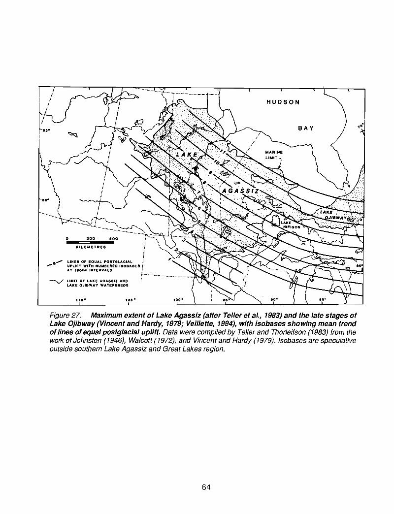
- ....v/ LIMIT OF LAKE AGASSIZ ANDLAKE OJISWAY WATERSHEDS
BAY
HUDSON
---400200
KILOMETRES
o
110·
---
........-
lIO·
'.
Figure 27. Maximum extent of Lake Agassiz (after Teller et al., 1983) and the late stages ofLake Ojibway (Vincent and Hardy, 1979; Veillette, 1994), with isobases showing mean trendof lines of equal postglacial uplift. Data were compiled by Teller and Thorleifson (1983) from thework ofJohnston (1946), Walcott (1972), and Vincent and Hardy (1979). Isobases are speculativeoutside southern Lake Agassiz and Great Lakes region.
64

1 • Southern2 - Mcintosh3 - Prairie4 - Embarrass5 - North Lake6 - Flatrock Lake7 - Matawin River8 - Shebandowan9 - Savanne
10 • Clearwater
Grand Forks
Lake Winnipeg
3~...CDeng)co<CDenCDg)
CDCi5
13I
12I
11I
10I
9I
8I
--- Late Moorhead
- - Early Moorhead
7I
6I
11 - Kaiashk12 - Kopka13 - Pillar14 - Armstrong15 - Pikitigushi16 - White Otter17 - Nagagami18 - Kinojevis19 - Wollaston20 - Echoing
4II
Outlets
3II
2II
1II
Figure 28. Schematic model for general configuration of Lake Agassiz shorelines, showingformer water planes and outlets (vertical bars) projected onto a vertical plane orthogonal tothe isobases depicted in Figure 27. Water planes are based on data from Johnston (1946),Bluemle (1974), Hobbs (1983), Dredge (1983), Klassen (1983), and Craig (1969). Dashed MoorheadPhase levels (Warman, 1991) are schematic approximations of shorelines which were inundated bythe subsequent rise in lake level.
65

AliceTrail
HermanHerman
HermanNorcross
Tintahu. Campbell
I. Campbell
McCauleyvilleBlanchard
HillsboroEmerado
OjataGladstone
BurnsideOssawa
StonewallThe Pas
GimliGrand Rapids
Drunken PointPonton
FidlerSea level
f------~-----_------r_----_-----....jl
11 ka 10 ka 9ka 8ka
ILL_oc_k_h_a_rl__...L1M_OO_rh_ea_d ....LI_E_rn_e_rs_o_n_I_M_o_rr_iS_P_h_a_s_e _
--•
Gulf of Mexico
_ Atlantic Ocean.? Arctic Ocean
I Hudson Bay
Figure 29. Schematic model for the trend and approximate relative magnitude of LakeAgassiz water level fluctuations, and subdivision of Lake Agassiz history as four phases.Suggested vertical range of Moorhead Phase levels are plotted with reference to the elevation oflater Morris Phase shorelines in North Dakota. Proposed routing of freshwater discharge from theLake Agassiz basin also is indicated.
66

. . . . . . . . .
. . . . . . . .. . . . . . . . .~ .,.. -. . .. . . . . . . . .. . . . .
. . . . . . . . . .. . . . . . . . . . . . . . . . . .. . . . . . . .. .. . . . . . .. .. . . . . . . . . . . . . . .. . . . . . . . . . . . .. . . . . . . . . . . . . . . .. . . . . . . . . .... . . . . . . . . . . . . . . . ................... . . . . . . . . . . . . . . . . .
. . . . . . . . .. . . . . . . . . . . . . . . .. . . . . . . . . . . . . . . . . .. . . . . . . . .
. . . . . .
· . . . . . . . .. . . . . . . . . . '. .. . . . . . . . . . . . . . . . . .. . . . . . . . . . . . . . . . . .. . . . . . . . . .. . . . . . . . . . . . . . . . . .. . . . . . . . . . . . . . .. .· . . . . . . . . . . . . . . . . .. . . . . . . .. . . . . . . . . . . . . . . . .. . . . . . . . . . . . . .. . . . . . . . .· . . . . . . . . . . . . . . . .·.................. . . . . . . . . . . . . . . . .. . . . . . . . . . . . . . . . . . . . . . .. . . . . . . . . . . . . . . . . . .. . . . . . . . .· . . . . . . . . . . . . . . . . .. .· . . . . . . . . . . . . . . . .· . . . . . . . . . . . . . . . . . . . . .. . . . . . . . . . . . . . . . . . . . . . . . . . . . . .. . . . . . . . . . . . . . . . . . . . . . . . . . . . .. . . . . . . . . . . . . . . . . . .. . . . . . . . . . . . .. . . . . . . . . . . . . . . . . . . . ., . . . . . . . . . . . . . . . . . . . . . .. . . . . . . . . . .· . . . . . . . . . . . . . . . . . . . . . . . .· . . . . . . . . . . . . . . . . . . .. . . . . . . . . .· . . . . . . . . . . . . . . . . ....................... . . . . . . . . . .. . . . . . . . . . . . . . . . . . .·................... . . . . . . . . . .· . . . . . . . . . . . . . . . . . . .. . . . . . . . .. .. . . . . . . . . . . . . . . . . . .. . : .. . . . . . . . . .
. . . . . . . . .r-._-7:
Figure 30. Lake Agassiz region paleogeography at -11.7 ka BP: Clayton and Moran (1982)correlated an advance to the Big Stone moraine, the final pre-Lake Agassiz margin in the Red Rivervalley, to the Maxwelton margin defined for southern Saskatchewan by Parizek (1964), to the Kensaland North Viking phases in North Dakota, and the maximum or Alborn phase, or possibly a retreatingmargin (Attig et al., 1985), of the St. Louis sublobe in northern Minnesota. Attig et al. (1985)correlated this event to the second occupation of the Nickerson moraine of the southwesternSuperior basin, which deposited the Barnum Formation, and to the Marenisco and late Athelstanemargins in Wisconsin and adjacent Michigan which correlate to the over-riding of the Two Creeksforest bed. As ice retreated from the Big Stone moraine, flowing water and small bodies of standingwater in the Lake Agassiz basin maintained a level of about 355 m, 30 m above the Herman leveland graded to the crest of the moraine (Baker, 1966; Fenton et al., 1983; Clayton, 1983). LakeAgassiz formed, surrounded by stagnant ice, as ice retreated sufficiently from the Big Stone morainefor the lake to extend from the North Dakota to the Minnesota shores of the valley. The southernoutlet was eroded to the Alice level (Bluemle, 1974), the highest shoreline here attributed to LakeAgassiz. As ice retreated in northern Minnesota, the Mizpah level of Lake Koochiching (Hobbs, 1983)was drained by both the Prairie and Embarrass spillways. A beach at 427 m (1400') at Mizpahreported by Hobbs (1983) is here correlated to the 436 m (1430') level at Togo and to the Norwoodlevel at 443 m (1450') at the Embarrass outlet.
67

· . . . . . . . . . . . . . . . . . . . . . . . . . . . . .· . . . . . . . . . . . . . . . . . . . . . . . . . . . . . .
. . . . . . . . . . . . . .· . . . . . . . . . . . . . .
. . . . . . . . . . . . . . . .. . . . . . . . . . . . . . . .
. . . . . . . . . . .. . . . . . . . . . . . . . . .. . . . . . . . . . . . . . . '
· . . . . . . . . . . .. . . . . . . . . . . .· . . . . . . . . . . . .· . . . . . . . . . . .· . . . . . . . . . . . .
· . . . . . . . . . . . . . .. . . . . . . . . . . . . . . . .. . . . . . . . . . . . . . . .· . . . . . . . . . . . . .· . . . . . . . . . . . . . . . . . . . . . . . . . . . .· . . . . . . . . . . . . . . . . . . . . . . . . . . . . .· . . . . . . . . . . . . . . . . . . . . . . . . . . . . .· . . . . . . . . . . . . .· . . . . . . . . . . . . . .
. . . . . . . . . . . . .. . . . . . . . . . . . .
. . . . . . . . . . . . . ,
· . . . . . . . . . . . . .. . . . . . . . . . . . . .
. . . . . . . . . . . . . . . ,· . . . . . . . . . . . . . .· . . . . . . . . . . . . . . .
· . . . . . . . . . . . . . . . .· . . . . . . . . . . . . . . .
· . . . . . . . . . . . . . .
. . . . . . . . . . . . . . .
. . . . . . . . . . . . . . . . . . .. . . . . . . . .. . . . . . . . . .
· . . . . . . . . . . . . .· . . . . . . . . . . . . . . .· . . . . . . . . . . . . . . .
· . . . . . . . . . . . . .. . . . . . . . . . . . . .· . . . . . . . . . . . . .. . . . . . . . . . . . . .. . . . . . . . . . . . . .. . . . . . . . . . . . . .
. . . . . . . . . . . . . .. . . . . . . . . . . . . .. . . . . . . . . . . . . .. . . . . . . . . . . . . . . . . . . . . . . . . . . . .· . . . . . . . . . . . . . . . . . . . . . . . . . . .
· . . . . . . . . . . . . . . .. . . . . . . . . . . . . . . .· . . . . . . . . . . . . . .
· . . . . . . . . . . . . . . .. . . . . . . . . . . . . . . .· . . . . . . . . . . . . . . .· . . . . . . . . . . . . . . . . . . . . . . . . . . . . . . .· . . . . . . . . . . . . . . . . . . . . . . . . . . . . .· . . . . . . . . . . . . . . . . . . . . . . . . . . . . .· . . . . . . . . . . . . . . . . . . . . . . . . . . . .· . . . . . . . . . . . . . . . . . . . . . . . . . . . . .· . . . . . . . . . . . . . . . . . . . . . . . . . . . .· . . . . . . . . . . . . . . . . . . . . . . . . . . . . .. . . . . . . . . . . . . . . . . . . . . . . . . . . .
· . . . . . . . . . . . . . .. . . . . . . . . . . . . . . .· . . . . . . . . . . . . . . . . . . . . . . . . . . . . .· . . . . . . . . . . . . . . .
. . . . . . . .
. . . . . . . . . . . . . . . . . .. . . . . . . . . . . . . . . . . .. . . . . . . . . . . . . . . . . . .. . . . . . . . . . . . . . . . . . . .,
. . . . . . . . . . . . . . . . . . . . . . . . .· . . . . . . . . . . . . . . .
Figure 31. Lake Agassiz region paleogeography at -11.5 ka BP: As the Wahpeton and Erskinemoraines (Leverett, 1932) were built in the Alice level of Lake Agassiz and the Mizpah level of LakeKoochiching, the ice margin to the west formed the Weyburn and Souris lobes (Clayton and Moran,1982). To the east, the St. Louis sublobe margin had retreated north of the Mesabi range and icein the Superior basin had retreated from the Marenisco and correlative positions (Attig et al., 1985).As ice retreated from this position, floodwater cut the Sheyenne spillway (Brophy, 1967; Brophy andBluemle, 1983; Kehew and Lord, 1986; Kehew and Teller, 1994) and deposited the Sheyenne fanin the Alice level at 335 m, 12 m above the Herman level (Fenton et al., 1983). A brief rise of LakeAgassiz during this flood may have caused the formation of the Mcintosh spillway, which extendsfrom the Red River valley to northern Minnesota and which deposited a fan at 389 m (1275') in theMizpah level of Lake Koochiching. Downcutting of the southern outlet to a water level of 323 m(1060'), later to govern the Herman level, caused flow to reverse in the Mcintosh channel.Downcutting of the Mesabi outlets lowered Lake Koochiching. As ice continued to retreat, thesouthern outlet was abandoned as Lake Agassiz fell to become confluent with this lower level ofLake Koochiching. Differential uplift of the Mesabi outlets caused Lake Agassiz to transgress andre-occupy the southern outlet, culminating in a three-outlet Trail level, which formed severalshorelines mapped by Hobbs (1983), including the 436 m (1430') terrace at Embarrass, a shorelineat 412 m (1350') at Gemmell, and the upper shoreline at Trail (381 m; 1250').
68

. . . . . . . . . . . . . ,",. . . . .'. . . . . . . . .. . . . . . . . . . . . . . \- . . . . . . . . . . . . .
r<~~~ •••••••••••••••••••••••
Figure 32. Lake Agassiz region paleogeography at -11.2 ka BP: The Condie moraine at Reginais correlated to the DarJingford moraine in southwestern Manitoba, the Edinburg and Holt morainesof the Red River valley, the Rainy River interlobate moraine (Bajc, 1991) of Ontario, and a lateroverridden margin to the east in the Superior basin. Glacial Lake Souris had formed and was drainedby the Sheyenne spillway. As ice retreated, a portion of Lake Agassiz discharge was diverted fromthe Mesabi and/or southern outlets to North Lake, located on the Minnesota-Ontario border. Openingof the nearby Flatrock Lake outlet probably caused abandonment of the southern outlet, butdifferential uplift of these outlets caused a transgression which at least partially returned flow to thesouthern outlet and formed what has been known as the highest Herman beach (Upham, 1895;Johnston, 1946). The Mesabi outlets were at this point elevated above the southern outlet bydifferential uplift. By this time, stagnant ice in eastern North Dakota had melted, so the Hermanshoreline is the highest undisturbed, readily apparent beach (Bluemle, 1974). This rising levelexplains the transgressive character of the Herman shoreline, as discussed by Chamberlin (1895).As ice to the west retreated, glacial Lakes Regina and Souris were drained. Floodwater first erodedthe Souris/Pembina spillway and subsequently the Qu'Appelle and Assiniboine spillways, depositingthe Pembina and Assiniboine fans in the Herman level. Elson (1967) reported an uninterruptedsequence of 500 varves, beginning with proximal units, on Lake of the Woods, at a site exposedduring the Moorhead Phase. This would imply deglaciation of Lake of the Woods at about 11.4 ka,earlier than implied here.
69

Figure 33. Lake Agassiz region paleogeography at -11.1 ka BP: An ice margin betweenSaskatoon and Regina, defined by Christiansen (1979), is here correlated to later overridden marginsin Manitoba and much of northwestern Ontario, to formation of the Steep Rock moraine on theMinnesota-Ontario border, and to the Porcupine phase of Lake Superior (Clayton 1983; Clayton1984; Attig et al., 1985). The southern outlet was eroded to a water level at 317 m (1040J, producinga second Herman level.
70
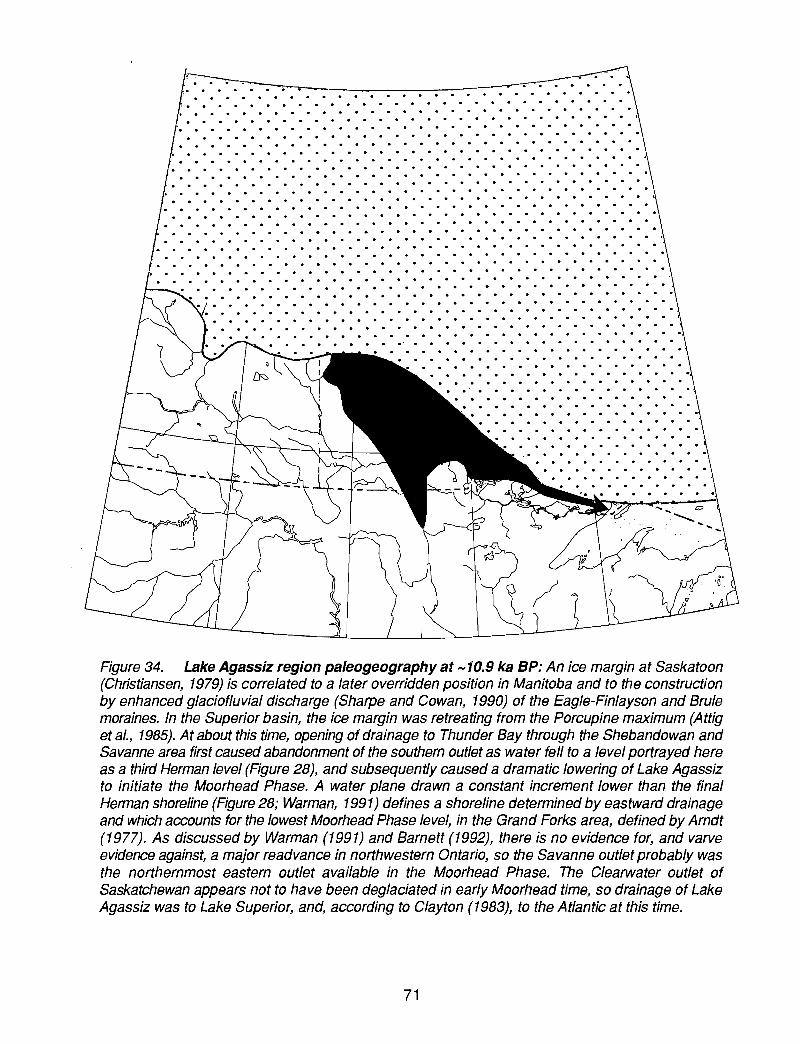
. . . . . . . . . . . . . . .
. . . . . . . . . . . .. . -.'. . . . . . . . . . . . . . . . . . . . . . . . . . . .. . . . . . . . . . . . . . . . . . . . . . . . . . .· . . . . . . . . . . . . . . . . . . . . . . . . . . . ~. . . . . . . . . . . . . . . . . . . . . . . . . .· . . . . . . . . . . . . .· . . . . . . . . . . . . . . . . . . . . . . . . . . . .
~ . . . . . . . . . . . . . . . . . . . . . . . . . . . . .• • • • • • • • • • • • • • • • • • • • • • • • • • • • • I. . . . . . . . . . . . . . . .. . . . . . . . . . . . . .· . . . . . . . . . . . . . . . . . . . . . . . . . . . . .. . . . . . . . . . . . . . . . . . . . . . . . . . . .· . . . . . . . . . . . . . . . . . . . . . . . . . . . . . .
• • • • • • • • • • • • • • • • • • • • • • • • • • • • • I
. . . . . . . . . . · . . . . . . . . . . . . . . . . . . .. . . . . . . . . . . . . . . . . . . . .
. . . . . . . . . . . . . .
. . . . . . . . . . . . . .
. . . . . . . . . . . . . . . . .. . . . . . . . . . . . . . . . . .
· . . . . . . . . . . . . . . . . . . . .. . . . . . . . . . . . . . . . . . . . .· . . . . . . . . . . . . . . . . . . .
. . . . . . . . . . . . . . . . . . . . . .
. . . . . . . . .
· . . . . . . . . . .· . . . . . . . . .
· • . • . • • • • • I. • • • • • • • • . • . • • • • • . • • • •· . . . . . . . . . . . . . . . . . . . .. . . . . . . . . . . . . . . . . . . .· . . . . . . . . . . . . . . . . . . . .. . . . . . . . . . . . . . . . . . . . . . .· . . . . . . . . . . . . . . . . . . .
· . . . . . . . . . . . . . . . . . . . . . . . . . . . . . . .· . . . . . . . . . . . . . . . . . . . . . . . . . . . . . . .· . . . . . . . . . . . . . . . . . . . . . . . . . . . . . .· . . . . . . . . . . . . . . . . . . . . . . . . . . . . . . .
Figure 34. Lake Agassiz region paleogeography at -10.9 ka BP: An ice margin at Saskatoon(Christiansen, 1979) is correlated to a later overridden position in Manitoba and to the constructionby enhanced glaciofluvial discharge (Sharpe and Cowan, 1990) of the Eagle-Finlayson and Brulemoraines. In the Superior basin, the ice margin was retreating from the Porcupine maximum (Attiget al., 1985). At about this time, opening of drainage to Thunder Bay through the Shebandowan andSavanne area first caused abandonment of the southern outlet as water fell to a level portrayed hereas a third Herman level (Figure 28), and subsequently caused a dramatic lowering of Lake Agassizto initiate the Moorhead Phase. A water plane drawn a constant increment lower than the finalHerman shoreline (Figure 28; Warman, 1991) defines a shoreline determined by eastward drainageand which accounts for the lowest Moorhead Phase level, in the Grand Forks area, defined by Arndt(1977). As discussed by Warman (1991) and Barnett (1992), there is no evidence for, and varveevidence against, a major readvance in northwestern Ontario, so the Savanne outlet probably wasthe northernmost eastern outlet available in the Moorhead Phase. The Clearwater outlet ofSaskatchewan appears not to have been deglaciated in early Moorhead time, so drainage of LakeAgassiz was to Lake Superior, and, according to Clayton (1983), to the Atlantic at this time.
71

. . . . .. . . . . . . · . . .. . . . . . .. .· . . . . . . . . . .· . . . . . .. . . .· .. .. . . . . . . . .· . . . . . . . . .. . .. . . . . .. . . . . . .· . . . . . . . . . .· . . . . . . . .. . .. . . . . . . . . . . . .· . . . . . . . . . . .· . . . . .. . . . . .· . . . . .. . .. . . . .
. . . . .. .. . . . . . . .
. .. .. . . . . .. . . . . .
. . . . . . . . . . . . .. . . . . . . . . . . . . . . . . . . . . . . .. . . . . . . . . . . .. . . . . . . . . .. . . . .. . . . . . . .
. . . . . . . . . . . .. .. . . . . . . . . . .. . . . . . . . . . .. . . . . .. . . . . . . . . . . . . . . . . . . . .. . . . . .. . . . . .. . . . . . . . . . .. . . . . . . . . . .. .. . . . .. . . . . . . .. . . .. . . .. . . . . '". .. . . . . . . .. . . .. . . . . . . . .. . . . . .. .. . . . . .. . . . . . . . .. .. .. .. . . . . .. . . . .. . . . .. . . . .. . . . . . . . . . .. . . . . . . .. . . .· . . . . . . . . .. .. . . . . . . .. . .. '. . . . . .. . . . . .· . . . . . . . . . . .. . . . . . .. . . . .. . .. .. . . . .. . .. .. . . . . . .· .. . . . .. . .. ..· . . . . . . .. . .. . . . . . . . . . . . . . . . . . . . . . .. . .. . . . . . . . . . .. . .. . . . . . . . .. . .· . . . . . . . . . .
. . . . . . . . . . . . . . . . . . . . . . . . . . . .. . . . . . . . . . . . . . . . . . . . . . . . . . . .. . . . . . . . . . . . . . . . . . . . . . . . . ... .. . . . . . . . . . .. . . . . . . . . . . . . . . .. . . . . . . . . . . . . . . . . . . . . .. . . .
Figure 35. Lake Agassiz region paleogeography at -10.4 ka BP: An ice margin north of PrinceAlbert, Saskatchewan (Christiansen, 1979) is correlated to a later overridden position in Manitoba,the construction of the Hartman moraine which was dated to 10.4 ka by Warman (1991) on the basisof 440 varves below the red clay marker at Dryden, and to an undetermined position north of LakeSuperior. Differential uplift of the Savanne outlet caused Lake Agassiz to transgress from GrandForks to south of Fargo. By late Moorhead time, differential uplift of the Thunder Bay outlets wouldhave drowned sites in southeastern Manitoba which now yield subaerial organic material dated tolate Moorhead time (MatHe and Thorleifson, 1996). It therefore is apparent that the Clearwaterspillway in western Saskatchewan must have been the late Moorhead outlet of Lake Agassiz, assuggested by Fisher and Smith (1994). Opening of this outlet again lowered Lake Agassiz, and adelta was deposited in the Fargo area at this time (Arndt, 1977; Fenton et al., 1983).
72
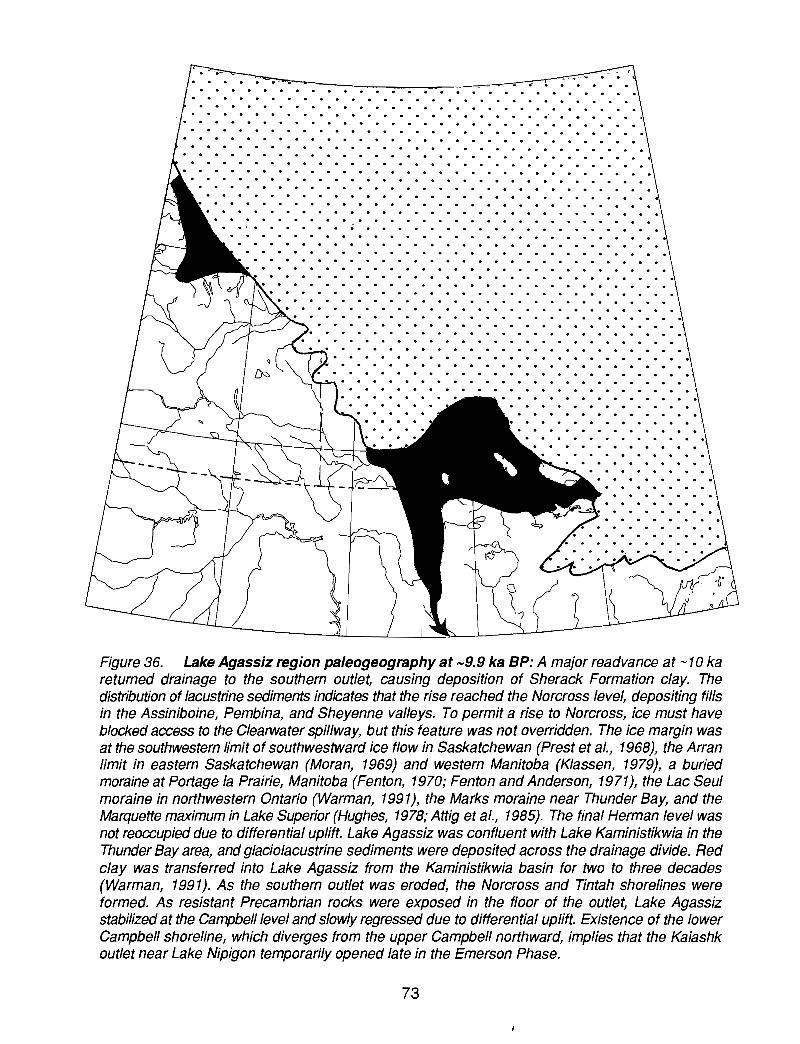
· . . . . . . . . . . . . . . . . .. .. .. .. . . . .
. . .. . . . . . . .. . . . . . . . . .
.. . . . . . .. . . . . . . . . . . . . .
· . . . . . . . . . . .. . . . . . .
· . .. .. .. .. .. .. . .. . .. .. . . . . . .. .. . . .. .· . . . . . .. . . .. . . . . . .. . . . . .· . . . . .. .. . . . . . . . . . . . . . . .
.. . . . . .. . . . . . . . . . . . . . . . .. . . . . .. . . . . . . . . . . . . . . . . . . . . .. . . . . . . . . . . . . . . . . . .. . . . . . . .. . . . . . . .. ... . .. . . . . . .. . . . . . . . .. ..'. . . . . .. . . . . . . . . . . . . . . . . . ... . . . . . . . . . .. . . . . . . . . . .. . . . .. . . . . . . . . . . . . . . . . . .. . . . . . ... . . . . . . . . . . . . . . . . . . . . . . . .. .. . . . . . . . . . . . . . . .. . . . . . . .. . . . . . . . . . . . . . . . . . . . .. . . . . .. ... . . . . . .. . . .. .. . . .. . . . . . . . . . . . . .. . . .. .. . . . .. . . . . . .. . . . .. . . .. . .. .. .. . . . . . .. .. . . . . . . . . .. .. . . .. .. . .. . . .. . .. . .. . . . . . .. . . . . .. . . .. ... .. . . .. . .. . . .. .. .. . . .. .. . . . .. .. .. .. . ... . . .. .. . . . . . . . . .. .. . . . . . . . . . ... . . . . . .. . . .. . . . . . . .. . . . . . .... . . . . .. .. . . . .. . . . . .. .. . . . . .. . .. . . .. . .. . .. . . .. . . . .. . . .. . . .. . .. .
. . . . . . . . . . . . . . . . . . . . . . . . . . . .• • • • • .. • • • .. • • • • • .. • • • • • • .' .. • • • • c· . . . . . . . . .. . . . . . . . . .. .· . .. . . . . . . . . . .. . . .. . . .
· .. . . . . . .. . . .. . . . . . . .. . . .. . . . . . . . . ... . . . . . . . . .. . . . . . . . . . . . . . . . .. . . .
Figure 36. Lake Agassiz region paleogeography at -9.9 ka BP: A major readvance at -10 kareturned drainage to the southern outlet, causing deposition of Sherack Formation clay. Thedistribution of lacustrine sediments indicates that the rise reached the Norcross level, depositing fillsin the Assiniboine, Pembina, and Sheyenne valleys. To permit a rise to Norcross, ice must haveblocked access to the Clearwater spillway, but this feature was not overridden. The ice margin wasat the southwestern limit of southwestward ice flow in Saskatchewan (Prest et al., 1968), the Arranlimit in eastern Saskatchewan (Moran, 1969) and western Manitoba (Klassen, 1979), a buriedmoraine at Portage la Prairie, Manitoba (Fenton, 1970; Fenton and Anderson, 1971), the Lac Seulmoraine in northwestern Ontario (Warman, 1991), the Marks moraine near Thunder Bay, and theMarquette maximum in Lake Superior (Hughes, 1978; Attig et al., 1985). The final Herman level wasnot reoccupied due to differential uplift. Lake Agassiz was confluent with Lake Kaministikwia in theThunder Bay area, and glaciolacustrine sediments were deposited across the drainage divide. Redclay was transferred into Lake Agassiz from the Kaministikwia basin for two to three decades(Warman, 1991). As the southern outlet was eroded, the Norcross and Tintah shorelines wereformed. As resistant Precambrian rocks were exposed in the floor of the outlet, Lake Agassizstabilized at the Campbell level and slowly regressed due to differential uplift. Existence of the lowerCampbell shoreline, which diverges from the upper Campbell northward, implies that the Kaiashkoutlet near Lake Nipigon temporarily opened late in the Emerson Phase.
73

· . . . . . . . . . . . . . . . . . . . . . . . . . . .. . . . . . . . . . . . . . . . . . . . .. . . . . . . .· . . . . . . . . . . . . . . . . . . . . . ., . . . . . .• • • • • • • • • • • • • • • • • • • • • :i. • • • • • • •
• • • • • • • • • • • • • • • • • • • • ·:1 • • • • • • • •· . . . . . . . . . . . . . . . . . . . . ,.. . . . . . . .· . . . . . . . . . . . . . . . . . . . ..; . . . . . . . .· . . . . . . . . . . . . . . . . . . . . ::. . . . . . . . .· . . . . . . . . . . . . . . . . . . . .' . . . . . . . .. . . . . . . . . . . . . . . . . . . . ,:. . . . . . . . .• . • • • • • • • . • • . • • . • • • • • . • • • • • . • • • • . . • • • • ·11 •••••••••••••••••
• • • • • • • • • • • • • • • • • • ·1: • • • • • • • • •. . . . . . . . . . . . . . . . . . ~. . . . . . . . .. . . . . . . . . . . . . . . . . .~ . . . . . . . . .• • • • • • • • • • • • • • • • • I;. • • • • • • • •
• • • • • • • • • • • • .'. • • .1 • • • • • • • • •
. . . . . . . . . . . . . . . . . . . . . . . .• • • • • • • • • • • • • • II. • • • • • • • • •
• • • • • • • • • • • • • ..1 • • • • • • • • •
Figure 37. Lake Agassiz region paleogeography at -9.3 ka BP: A retreating position of the icemargin in Saskatchewan is correlated to the Pas and George Island (Todd and Lewis, 1996)moraines in Manitoba, the Sioux Lookout moraine in northwestern Ontario, and the southern portionof the Nipigon moraine, and the North Shore ice margin of Lake Superior (Farrand, 1960). Theadvance to this margin at Sioux Lookout overrode varved clay (Hurst, 1933) and closed the Kaiashkoutlet. Lake Agassiz rose to the southern outlet, which produced the lower Campbell shoreline dueto differential uplift since abandonment of the Campbell. A fossiliferous valley fill was deposited bythe Assiniboine, Pembina, and Sheyenne Rivers. Correlative fill at Rossendale was dated at 9.5 kaby Teller (1989). As ice retreated from the Sioux Lookout moraine, a succession of outlets thatdrained into Lake Nipigon, and which were described by Elson (1957), Zoltai (1967), and Teller andThorleifson (1983), were opened. Lake Agassiz was lowered in step-wise manner, although everylowering was followed by slow transgression everywhere south of the outlet isobase due todifferential uplift of the outlet. Consequently, these shorelines converge to the south.
74

· . . . . . . . . . . . . . . . .· . . . . . . . . . . . . . . . . . . . . . .· . . . . . . . . . . . . . . . . . . . . . . . . .· . . . . . . . . . . . . . . . . . . .. . . . . . . . . . . . . . . . . . . . . . . . . . . . .· . . . . . . . . . . . . . . . . . . . . . .· . . . . . . . . . . . . .. . . . . . . . . .· . . . .. . . . .. . . . . .. . . . . . . . .. . .. . . .. . .· . . . . .. . . . . . .. . .. . . .. . . .. . . . . . .. .. . . .. . . . . . . .. . . . . .. . . . .. .. . . . .. .. . . .. . . . . . . . . . . . . . . . . . . . . . . . .. . .. . . . . .. . . . . . . . . . . . . . . . .. .. .. .... . . .. .. . . .. .. . .. . .. .. .. . .. .. .. .. . . .. .. . . .... .. .. .. .. .. . . . .. .. .. .. .. .. . .. .. .. . . .. .. .. .. . .... .. .. . . .. .. . .. . .. .. . . .. .. .. .. .. .. .. . .. .. .... .. . .. .. .. .. .. . . . .. .. .. . . .. . . .
.. . . .. .. .. . . .. . .. .. .. .. .. .. .. .... .. . . .. .. .. . .. .. .. .. . .. .. .. . ... .. .. .. .. .. .. .. . . .. .. .. . . . .. ..
.. .. .. .. .. .. .. .. .. .. . .. .. .. .. . . .... .. .. .. .. .. .. .. .. .. . .. .. .. .. .. .. .... .. .. . .. .. . .. .. . .. .. .. .. .. .. . .. ... .. .. .. . .. .. .. .. .. .. .. .. .. .. . .. .... .. . .. .. .. .. .. .. .. . . .. .. .. . .
Figure 38. Lake Agassiz region paleogeography at -8.2 ka BP: The final major moraine-buildingepisode occurred as the Cree Lake moraine in Saskatchewan (Schreiner, 1984), the Hargravemoraine in Manitoba (Klassen, 1983), and the Agutua-Nakina moraines in Ontario (Prest, 1963;1970) were deposited. Deposition of the Agutua-Nakina moraines by enhanced glaciofluvialdischarge was dated at about 8.2 ka by Thorleifson and Kristjansson (1993), on the basis of a LakeSuperior varve record reported by Teller and Mahnic (1988). Construction of these morainescoincided with the final episode of discharge to Lake Nipigon, from the Pas and possibly Gimli levelsof Lake Agassiz.
75
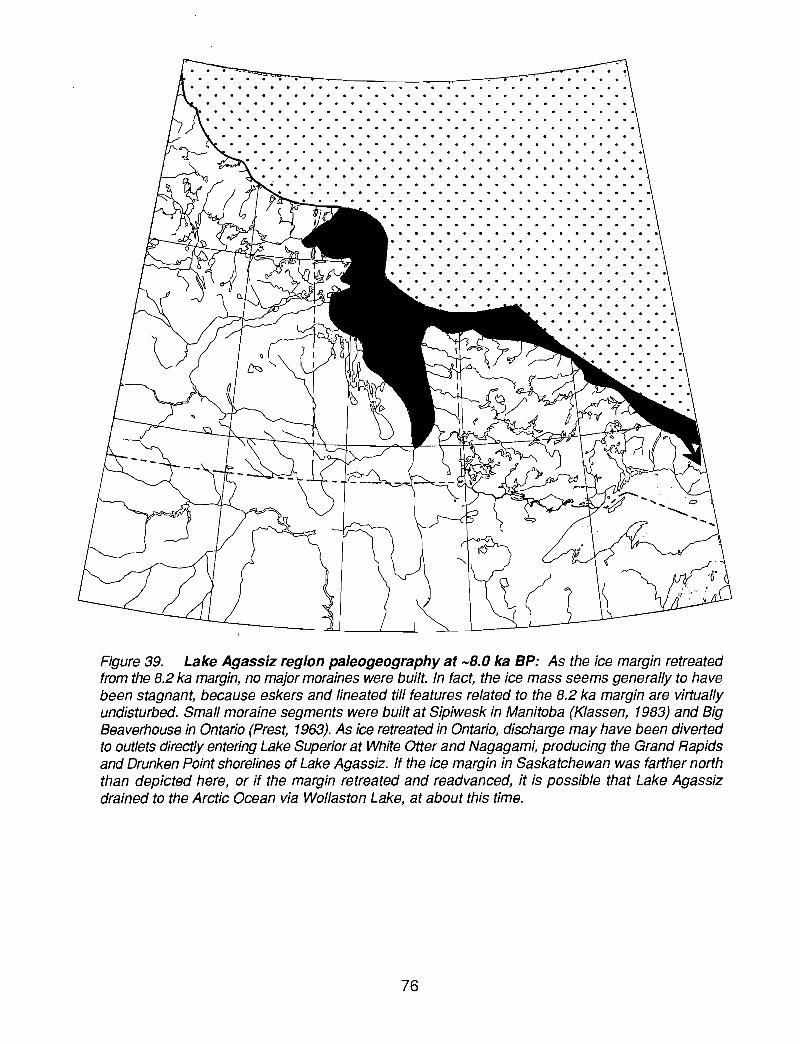
. . . . . . . . . . . . . . . . . . . . . . . . .. . . . . . . . . . . . . . . . . . . . . . . .'
Figure 39. Lake Agassiz region paleogeography at -8.0 ka BP: As the ice margin retreatedfrom the 8.2 ka margin, no major moraines were built. In fact, the ice mass seems generally to havebeen stagnant, because eskers and lineated till features related to the 8.2 ka margin are virtuallyundisturbed. Small moraine segments were built at Sipiwesk in Manitoba (Klassen, 1983) and BigBeaverhouse in Ontario (Prest, 1963). As ice retreated in Ontario, discharge may have been divertedto outlets directly entering Lake Superior at White Otter and Nagagami, producing the Grand Rapidsand Drunken Point shorelines of Lake Agassiz. If the ice margin in Saskatchewan was farther norththan depicted here, or if the margin retreated and readvanced, it is possible that Lake Agassizdrained to the Arctic Ocean via Wollaston Lake, at about this time.
76

. - - .. ,. --. . .~-..,. ..... . ... ......... . .. . . . . . . . . . . . . . . . . . . .. . . . . . . . . . . . . . . . . . . . . . . .. . . . . . . . . . . . . . . . . . . .
Figure 40. Lake Agassiz region paleogeography at -7.8 ka BP: As the margin of the stagnantice mass retreated by calving, to an undetermined retreat position, Lake Agassiz fell to the Pontonlevel, confluent with the late Kinojevis level of Lake Ojibway, which drained to the Ottawa River. Dueto tilting of the basins, relative to present, the southern portions of major lakes with outlets to thenorth, such as Lake Winnipeg, Lake Manitoba, and Lake of the Woods, were dry. Lake Nipigon, withan outlet to the south, was more extensive than present.
77
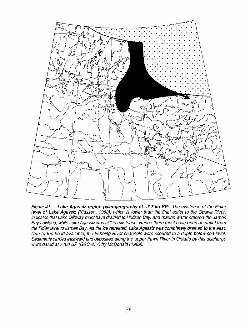
· . . . . . . . .
Figure 41. Lake Agassiz region paleogeography at -7.7 ka BP: The existence of the Fidlerlevel of Lake Agassiz (Klassen, 1983), which is lower than the final outlet to the Ottawa River,indicates that Lake Ojibway must have drained to Hudson Bay, and marine water entered the JamesBay Lowland, while Lake Agassiz was still in existence. Hence there must have been an outlet fromthe Fidler level to James Bay. As the ice retreated, Lake Agassiz was completely drained to the east.Due to the head available, the Echoing River channels were scoured to a depth below sea level.Sediments carried eastward and deposited along the upper Fawn River in Ontario by this dischargewere dated at 7400 BP (GSC-877) by McDonald (1969).
78
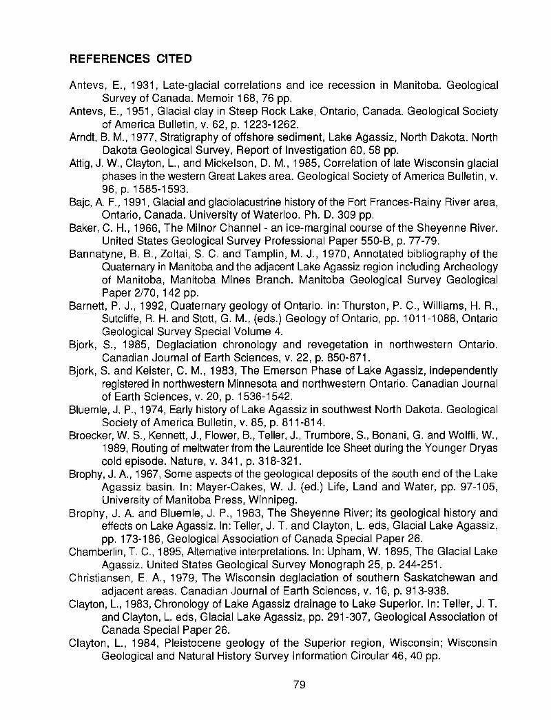
REFERENCES CITED
Antevs, E., 1931, Late-glacial correlations and ice recession in Manitoba. GeologicalSurvey of Canada. Memoir 168, 76 pp.
Antevs, E., 1951, Glacial clay in Steep Rock Lake, Ontario, Canada. Geological Societyof America Bulletin, v. 62, p. 1223-1262.
Arndt, B. M., 1977, Stratigraphy of offshore sediment, Lake Agassiz, North Dakota. NorthDakota Geological Survey, Report of Investigation 60, 58 pp.
Attig, J. W., Clayton, L., and Mickelson, D. M., 1985, Cororelation of late Wisconsin glacialphases in the western Great Lakes area. Geological Society of America Bulletin, v.96, p. 1585-1593.
Bajc, A F., 1991, Glacial and glaciolacustrine history of the Fort Frances-Rainy River area,Ontario, Canada. University of Waterloo. Ph. D. 309 pp.
Baker, C. H., 1966, The Milnor Channel - an ice-marginal course of the Sheyenne River.United States Geological Survey Professional Paper 550-B, p. 77-79.
Bannatyne, B. B., Zoltai, S. C. and Tamplin, M. J., 1970, Annotated bibliography of theQuaternary in Manitoba and the adjacent Lake Agassiz region including Archeologyof Manitoba, Manitoba Mines Branch. Manitoba Geological Survey GeologicalPaper 2/70, 142 pp.
Barnett, P. J., 1992, Quaternary geology of Ontario. In: Thurston, P. C., Williams, H. R.,Sutcliffe, R. H. and Stott, G. M., (eds.) Geology of Ontario, pp. 1011-1088, OntarioGeological Survey Special Volume 4.
Bjork, S., 1985, Deglaciation chronology and revegetation in northwestern Ontario.Canadian Journal of Earth Sciences, v. 22, p. 850-871.
Bjork, S. and Keister, C. M., 1983, The Emerson Phase of Lake Agassiz, independentlyregistered in northwestern Minnesota and northwestern Ontario. Canadian Journalof Earth Sciences, v. 20, p. 1536-1542.
Bluemle, J. P., 1974, Early history of Lake Agassiz in southwest North Dakota. GeologicalSociety of America Bulletin, v. 85, p. 811-814.
Broecker, W. S., Kennett, J., Flower, B., Teller, J., Trumbore, S., Bonani, G. and Wolfli, W.,1989, Routing of meltwater from the Laurentide Ice Sheet during the Younger Dryascold episode. Nature, v. 341, p. 318-321.
Brophy, J. A, 1967, Some aspects of the geological deposits of the south end of the LakeAgassiz basin. In: Mayer-Oakes, W. J. (ed.) Life, Land and Water, pp. 97-105,University of Manitoba Press, Winnipeg.
Brophy, J. A and Bluemle, J. P., 1983, The Sheyenne River; its geological history andeffects on Lake Agassiz. In: Teller, J. 1. and Clayton, L. eds, Glacial Lake Agassiz,pp. 173-186, Geological Association of Canada Special Paper 26.
Chamberlin,1. C., 1895, Alternative interpretations. In: Upham, W. 1895, The Glacial LakeAgassiz. United States Geological Survey Monograph 25, p. 244-251.
Christiansen, E. A, 1979, The Wisconsin deglaciation of southern Saskatchewan andadjacent areas. Canadian Journal of Earth Sciences, v. 16, p. 913-938.
Clayton, L., 1983, Chronology of Lake Agassiz drainage to Lake Superior. In: Teller, J. T.and Clayton, L. eds, Glacial Lake Agassiz, pp. 291-307, Geological Association ofCanada Special Paper 26.
Clayton, L., 1984, Pleistocene geology of the Superior region, Wisconsin; WisconsinGeological and Natural History Survey Information Circular 46,40 pp.
79

Clayton, L. and Moran, S. R., 1982, Chronology of late-Wisconsinan glaciation in middleNorth America. Quaternary Science Reviews, v. 1, p. 55-82.
Craig, B. G., 1969, Late-glacial and postglacial history of the Hudson Bay region. In: Hood,P. J. ed" Earth Science Symposium on Hudson Bay, Geological Survey of CanadaPaper 68-53, p. 63-77.
Dredge, L. A, 1983, Character and development of northern Lake Agassiz and its relationto Keewatin and Hudsonian ice regimes. In: Teller, J. T. and Clayton, L. eds, GlacialLake Agassiz, pp. 117-131, Geological Association of Canada Special Paper 26.
Dyke, A S. and Prest, V. K., 1987, Late Wisconsinan and Holocene_ history of theLaurentide Ice Sheet. Geographie physique et Quaternaire, V. 41, p. 237-263.
Elson, J. A, 1956, Surficial geology of the Tiger Hills region, Manitoba. Yale University.Ph.D. thesis, 316 pp.
Elson, J. A, 1957, Lake Agassiz and the Mankato-Valders problem. Science, v. 126, p.999-1002.Elson, J. A, 1967, Geology of Glacial Lake Agassiz. In: Mayer-Oakes, W. J. (ed.)Life, Land and Water, pp. 36-95, University of Manitoba Press, Winnipeg.
Elson,J. A, 1971, Roundness of Glacial Lake Agassiz Beach Pebbles. In: Turnock, A C.(ed.) Geoscience Studies in Manitoba, pp. 285-291, Geological Association ofCanada Special Paper 9.
Elson, J. A, 1983, Lake Agassiz - Discovery and a Century of Research. In: Teller, J. T.and Clayton, L. eds, Glacial Lake Agassiz, pp. 21-41, Geological Association ofCanada Special Paper 26.
Emmons, W. H., 1935, Memorial to Warren Upham. Geological Society of AmericaProceedings for 1934. p. 281-294.
Farrand, W. R., 1960, Former shorelines in western and northern Lake Superior basin.University of Michigan. Ph. D. 295 pp.
Fenton, M. M., 1970, The Pleistocene stratigraphy and surficial geology of the AssiniboineRiver to Lake Manitoba area, Manitoba. University of Manitoba. M. Sc. 121 pp.
Fenton, M. M. and Anderson, D., 1971, Pleistocene stratigraphy of the Portage la Prairiearea, Manitoba. In: Turnock, A C. (ed.) Geoscience Studies in Manitoba, pp.271-276, Geological Association of Canada Special Paper 9.
Fenton, M. M., Moran, S. R., Teller, J. T. and Clayton, L., 1983, Quaternary stratigraphyand l1istory in the southern part of the Lake Agassiz basin. In: Teller, J. T. andClayton, L. eds, Glacial Lake Agassiz, pp. 49-74, Geological Association of CanadaSpecial Paper 26.
Fisher,1. G. and Smith, D. G., 1994, Glacial Lake Agassiz: its northwest maximum extentand outlet in Saskatchewan Emerson Phase, Quaternary Science Reviews, v. 13.p.845-858.
Flint, R. F., 1943, Growth of the North American ice sheet during the Wisconsin age.Geological Society of America Bulletin, v. 54, p. 325-362.
Harris, K. L., Moran, S. R. and Clayton, L., 1974, Late Quaternary stratigraphicnomenclature, Red River Valley, North Dakota and Minnesota. North DakotaGeological Survey Miscellaneous Series, v. 52,47 pp.
Hobbs, H. C., 1983, Drainage relationship of Glacial Lake Aitkin and Upham and earlyLake Agassiz in northeastern Minnesota. In: Teller, J. T. and Clayton, L. eds,Glacial Lake Agassiz, pp. 245-259, Geological Association of Canada Special Paper26.
80

Hughes, J. D., 1978, A post Two Creeks buried forest in Michigan's northern Peninsula;Proceedings of the Institute on Lake Superior Geology, v. 24, p. 16.
Hurst, M. E., 1933, Geology of the Sioux Lookout area. Ontario Department of Mines. 41.part VI. p. 1-33.
Johnston, W. A, 1914, The calcareous drift and lacustrine deposits in Rainy River District,Ontario. Geological Survey of Canada. Summary Report for 1913. p. 170-177.
Johnston, W. A., 1915, Rainy River District, Ontario; surficial geology and soils. GeologicalSurvey of Canada, Memoir 82, 123 pp.
Johnston, W. A, 1916, The genesis of Lake Agassiz: a confirmation. Journal of Geology,v. 24, p. 625-638.
Johnston, W. A, 1921, Winnipegosis and upper Whitemouth river areas, Manitoba,Pleistocene and Recent Deposits. Geologica.l Survey of Canada, Memoir 128, 42pp.
Johnston, W. A, 1946, Glacial Lake Agassiz with special reference to the mode ofdeformation of the beaches. Geological Survey of Canada, Bulletin 7,20 pp.
Kehew, A E. and Lord, M. L., 1986, Origin and large-scale erosion features of glacial-lakespillways in the northern Great Plains. Geological Society of America Bulletin, v. 97,p. 162-177.
Kehew, A E. and Teller, J. T., 1994, History of late glacial runoff along the southwesternmargin of the Laurentide Ice Sheet. Quaternary Science Reviews. v. 13. p. 859-877.
Klassen, R. W., 1979, Pleistocene geology and geomorphology of the Riding Mountainand Duck Mountain area, Manitoba-Saskatchewan. Geological Survey of Canada,Memoir 396, 52 pp.
Klassen, R. W., 1983, Lake Agassiz and the late glacial history of northern Manitoba. In:Teller, J. T. and Clayton, L. eds, Glacial Lake Agassiz, pp. 97-115, GeologicalAssociation of Canada Special Paper 26.
Kupsch, W.O., 1967, Postglacial uplift - a review. In: Mayer-Oakes, W. J. (ed.) Ufe, Landand Water, pp. 155-186, University of Manitoba Press, Winnipeg.
Laird, W. M., 1944, The geology and ground water resources of the Emerado quadrangle.North Dakota Geological Survey, Bulletin 17,35 pp.
Laird, W. M., 1964, The problem of Lake Agassiz. Proceedings of the North DakotaAcademy of Science, v. 18, p. 114-134.
Leverett, F., 1912 a, Glacial investigations in Minnesota in 1911. Science. v. 35. p. 315.Leverett, F., 1912 b, Glacial investigations in Minnesota in 1911. Geological Association
of America Bulletin, v. 23, p. 732-735.Leverett, F., 1917, Records of Lake Agassiz in southeastern Manitoba and adjacent parts
of Ontario, Canada; Discussion. Geological Society of America Bulletin, v. 28, p.146.
Leverett, F., 1932, Quaternary geology of Minnesota and parts of adjacent states. UnitedStates Geological Survey. Professional Paper 161, 148 pp.
Lewis, C. F. M. and Anderson, T. W., 1989, Oscillations of levels and cool phases of theLaurentide Great Lakes caused by inflows from Lake Agassiz and Barlow-Ojibway.Journal of Paleolimnology, v. 2, p. 99-146.
Lewis, C. F. M., Moore, T. C., Jr., Rea, D. K., Dettman, D. L., Smith, A M., and Mayer, LA, 1994, Lakes of the Huron Basin: their record of runoff from the Laurentide IceSheet. Quaternary Science Reviews. v. 13. p. 891-922.
Matile, G. L. D. and Thorleifson, L. H., 1996, Prairie NATMAP: Evidence for Lake Agassiz
81
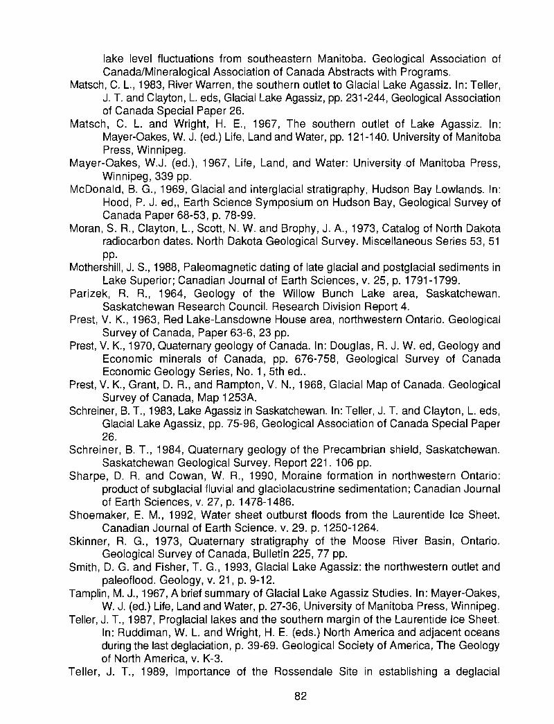
lake level fluctuations from southeastern Manitoba. Geological Association ofCanada/Mineralogical Association of Canada Abstracts with Programs.
Matsch, C. L., 1983, River Warren, the southern outlet to Glacial Lake Agassiz. In: Teller,J. T. and Clayton, L. eds, Glacial Lake Agassiz, pp. 231-244, Geological Associationof Canada Special Paper 26.
Matsch, C. L. and Wright, H. E., 1967, The southern outlet of Lake Agassiz. In:Mayer-Oakes, W. J. (ed.) Life, Land and Water, pp. 121-140. University of ManitobaPress, Winnipeg.
Mayer-Oakes, W.J. (ed.), 1967, Life, Land, and Water: University of Manitoba Press,Winnipeg, 339 pp.
McDonald, B. G., 1969, Glacial and interglacial stratigraphy, Hudson Bay Lowlands. In:Hood, P. J. ed" Earth Science Symposium on Hudson Bay, Geological Survey ofCanada Paper 68-53, p. 78-99.
Moran, S. R., Clayton, L., Scott, N. W. and Brophy, J. A., 1973, Catalog of North Dakotaradiocarbon dates. North Dakota Geological Survey. Miscellaneous Series 53, 51pp.
Mothershill, J. S., 1988, Paleomagnetic dating of late glacial and postglacial sediments inLake Superior; Canadian Journal of Earth Sciences, v. 25, p. 1791-1799.
Parizek, R. R., 1964, Geology of the Willow Bunch Lake area, Saskatchewan.Saskatchewan Research Council. Research Division Report 4.
Prest, V. K., 1963, Red Lake-Lansdowne House area, northwestern Ontario. GeologicalSurvey of Canada, Paper 63-6,23 pp.
Prest, V. K., 1970, Quaternary geology of Canada. In: Douglas, R. J. W. ed, Geology andEconomic minerals of Canada, pp. 676-758, Geological Survey of CanadaEconomic Geology Series, No.1, 5th ed..
Prest, V. K., Grant, D. R., and Rampton, V. N., 1968, Glacial Map of Canada. GeologicalSurvey of Canada, Map 1253A.
Schreiner, B. T., 1983, Lake Agassiz in Saskatchewan. In: Teller, J. 1. and Clayton, L. eds,Glacial Lake Agassiz, pp. 75-96, Geological Association of Canada Special Paper26.
Schreiner, B. T., 1984, Quaternary geology of the Precambrian shield, Saskatchewan.Saskatchewan Geological Survey. Report 221. 106 pp.
Sharpe, D. R. and Cowan, W. R., 1990, Moraine formation in northwestern Ontario:product of subglacial 'fluvial and glaciolacustrine sedimentation; Canadian Journalof Earth Sciences, v. 27, p. 1478-1486.
Shoemaker, E. M., 1992, Water sheet outburst floods from the Laurentide Ice Sheet.Canadian Journal of Earth Science. v. 29. p. 1250-1264.
Skinner, R. G., 1973, Quaternary stratigraphy of the Moose River Basin, Ontario.Geological Survey of Canada, Bulletin 225, 77 pp.
Smith, D. G. and Fisher, T. G., 1993, Glacial Lake Agassiz: the northwestern outlet andpaleoflood. Geology, v. 21, p. 9-12.
Tamplin, M. J., 1967, A brief summary of Glacial Lake Agassiz Studies. In: Mayer-Oakes,W. J. (ed.) Life, Land and Water, p. 27-36, University of Manitoba Press, Winnipeg.
Teller, J. 1., 1987, Proglaciallakes and the southern margin of the Laurentide Ice Sheet.In: Ruddiman, W. L. and Wright, H. E. (eds.) North America and adjacent oceansduring the last deglaciation, p. 39-69. Geological Society of America, The Geologyof North America, v. K-3.
Teller, J. T., 1989, Importance of the Rossendale Site in establishing a deglacial
82

chronology along the southwestern margin of the Laurentide Ice Sheet. QuaternaryResearch, v. 32, p. 12-23.
Teller, J. T., 1990, Volume and routing of late glacial runoff from the southern LaurentideIce Sheet. Quaternary Research, v. 34. p. 12-23.
Teller, J.T. and Clayton, L., eds, 1983, Glacial Lake Agassiz: Geological Association ofCanada Special Paper 26, 451 pp.
Teller, J. T. and Mahnic, P., 1988, History of sedimentation in the northwestern LakeSuperior basin and its relation to Lake Agassiz overflow. Canadian Journal of EarthSciences, v. 25, p. 1660-1673.
Teller, J. T. and Thorleifson, L. H., 1983, The Lake Agassiz - Lake Superior connection.In: Teller, J. T. and Clayton, L. eds, Glacial Lake Agassiz, pp. 261-290, GeologicalAssociation of Canada Special Paper 26.
Teller, J. T., Thorleifson, L. H., Dredge, L. A., Hobbs, H. C. and Schreiner, B. C., 1983,Maximum extent and major features of Lake Agassiz. In: Teller, J. T. and Clayton,L. eds, Glacial Lake Agassiz. Geological Association of Canada Special Paper 26.scale 1:3,000,000.
Thorleifson, L. H., 1983, The eastern outlets of Lake Agassiz. University of Manitoba. M.Sc. thesis, 87 pp.
Thorleifson, L. H. and Kristjansson, F. J., 1993, Quaternary geology and drift prospecting,Beardmore-Geraldton area, Ontario. Geological Survey of Canada, Memoir 435,146 pp.
Todd, B. J. and Lewis, C. F. M., 1996, Seismostratigraphy of Lake Winnipeg sediments.In: Todd, B. J., Lewis, C. F. M., Thorleifson, L. H., and Nielsen, E. (eds.) LakeWinnipeg Project: cruise report and scientific results, pp. 79-117. Geological Surveyof Canada Open File 3113.
Tyrrell, J. B., 1896, The genesis of Lake Agassiz. Journal of Geology, v. 4, p. 811-815.Tyrrell, J. B., 1898, The glaciation of north central Canada. Journal of Geology, v. 8, p.
147-160.Upham, W., 1880, Preliminary report on the geology of central and western Minnesota.
Geological and Natural History Survey of Minnesota. Eighth Annual Report, for1879. p. 70-125.
Upham, W., 1890, Report of exploration of the glacial Lake Agassiz in Manitoba.Geological Survey of Canada. Annual Report 1888-89, part E, 156 pp.
Upham, W., 1895, The Glacial Lake Agassiz. United States Geological Survey, Monograph25,658 pp.
Upham, W., 1913, The relation of the Keewatin and Labrador areas of glaciation. Science,v. 37, p. 457.
Upham, W., 1914, Fields of outflow of the North American ice sheet. XII InternationalGeological Congress (1913), Ottawa, p. 516-522.
Upham, W., 1917, Records of Lake Agassiz in southeastern Manitoba and adjacent partsof Ontario, Canada; Discussion. Geological Society of America Bulletin, v. 28, p.146.
Veillette, J. J., 1994, Evolution and paleohydrology of glacial Lakes Barlow and Ojibway.Quaternary Science Reviews, v. 13. p. 945-971.
Vincent, J-S. and Hardy, L., 1979, The evolution of glacial lakes Barlow and Ojibway,Quebec and Ontario. Geological Survey of Canada, Bulletin 316, 18 pp.
Walcott, R. I., 1972, Quaternary vertical movements in eastern North America: quantitativeevidence of glacio-isostatic rebound. Reviews of Geophysics and Space Physics,
83

v. 10, p. 849-884.Warman, T. A., 1991, Sedimentology and history of deglaciation in the Dryden, Ontario
area, and their bearing on the history of Lake Agassiz. University of Manitoba. M.Sc. thesis, 256 pp.
Winchell, N. H., 1873, First annual report, for 1872. Geological and Natural History Surveyof Minnesota, p. 63.
Zoltai, S. C., 1961, Glacial history of part of northwestern Ontario. Geological Associationof Canada Proceedings, v. 13, p. 61-83.
Zoltai, S. C., 1963, Glacial features of the Canadian Lakehead area. CanadianGeographer, v. 7, p.101-115.
Zoltai, S. C., 1965, Glacial features of the Quetico-Nipigon area, Ontario; CanadianJournal of Earth Sciences; v. 2, p. 247-269.
Zoltai, S. C., 1967, Eastern outlets of Lake Agassiz. In: Mayer-Oakes, W. J. (ed.) Life,Land and Water, pp. 107-120, University of Manitoba Press, Winnipeg.
84

PAGES 859-866 FROMKehew, A. E., and Teller, 1. T., 1994, History oflate glacial runoff along the southwestern
margin ofthe Laurentide Ice Sheet: Quaternary Science Reviews, v. 13, p. 859-877.
HISTORY OF LATE GLACIAL RUNOFF ALONG THE SOUTHWESTERNMARGIN OF THE LAURENTIDE ICE SHEET
ALAN E. KEHEW* and JAMES T. TELLERt*Departlllent ofGeology, Western Michigan Unil'ersity, Kalamazoo, M/49008. U.S.A.
tDepartmelll afGeological Sciences. Unil'ersity (~rManitoha, Winnipeg. Manitoha. Canada R3T 2N2
Abstract - The routing of runoff from the retreating Laurentid~ Icc Sheet was controlled by acombination of ice-marginal position and topogrolphy; isostatic d~pression also played an importantrole in the evolution of the ice-marginal landscape. A major redir.:ction of drainage occurred afterice retreated north of the Missouri Escarpment about I:? ka BP. Runoff that had previously flowedsouth 10 Ihe Missouri River could Ihen be rouled eastward to Lak~ Agassiz. which in tum drolined10 the upper Missi.~sippi River valley.
Changes in drainage routing in the region west of glacial Lake Agassiz typically were abrupt. asnew and lower paths along the retrealing ice margin became available. Each new basin was largerthan its predecessor and its headwaters extended farther west. Four distinct. sequential phases ofice-marginal drainage occurred between 12 and 10.7 ka BP: Ihe James. Sh~yenne. Souris-Pembinaand Qu·Appclle-Assiniboine. Starting wilh the Qu'Appelle-Assiniboine phase about 11.2 ka BP,Lake Aga.~si7. collected runoff fmm as far west as the Rocky Mountains. By about 10.7 ka BP. icehad retreated north of the lower reaches of the Saskatchewan Ri"er. allowing meltwater 10 by-passthe Qu'Appclle-Assiniboine basin. At about the same time, the easlern oUllets of Lakc Agassizopened. initiating drainage to the North Atlantic Ocean from this ,'ast region.
Drolinage routes evolved by a common sequence of evenls. beginning with Ihe impoundment ofproglaciallakes along Ihe ice margin. Most of Ihese lakes drained catastrophically. resulting in Iheformation of spillways with distinctive geomorphic fealUres thai include broad. scoured andstreamlined subupland channels along with subsequently incis~d narro\\". deep inner channels.Characleristic deposits of these outbursts include boulder mantlcs on subupland channel 110ors.boulder-grolvel bars within the inner channels, and large. primarily subaqueous fans in lake basinsthat received lhe 1100d bursl.~. These outbursts progressed from basin to basin. causing the drainageof olher proglacial lakcs, until they reached Lake Agassiz. Spillways associated wilh Ihe nexiyounger drainage phase were commonly incised across the abandoncd lake l1oors.
QSR
INTRODUCTION
As the Laurentide Ice Sheet wasted northward throughthe Interior Plains of the U.S. and Canada. meltwaterfrom the ice nowed in rapidly shifting, ice-marginaldrainage basins composed of deeply incised spillwaysconnecting proglacial-Iake basins. Landforms anddeposits associated with these drainageways reflect thestorage and rapid release of meltwater from proglaciallakes.
In the Interior Plains. widespread stagnation anddownwasting followed numerous. rapid advances oflobes of the Laurentide Ice Sheet (Clayton et al.. 1980:Clayton and Moran. 1982; Klassen. 1989; Christiansen,1979). Ablation of the stagnant ice was delayed bysupraglacial debris that formed a discontinuous coverover the ice. As the ice melted. isolated water-filleddepressions coalesced into ice-marginal lakes. Because ofthe regional northward slope. accentuated by differentialisostatic depression. lakes were ponded against the activeice margins to the north at successively lower elevationsduring deglaciation.
85
Drolinage of these proglacial lakes occurred periodically and abruptly as marginal barriers of ice or sedimentfailed, often because of large influxes of meltwater, allowing drainage in a matter of weeks or months.These outbursts commonly modified existing drdinageways or fonned new spillways with distinct characteristics. Discharge from the lakes flowed in spillways thatled to lower proglaciaJ lakes to the east and south. Fromthe inception of glacial Lake Agassiz at about 11.7 kaBP until its eastern outlets opened about 10.7 kaSP. proglacial lakes cast of the Missouri Escarpmentdrained in a west to east sequence that ended atLake Agassiz. During this time interval, Lake Agassizoverflowed through its southern outlet into theMississippi River valley and ultimately to the Gulf ofMexico before it abruptly shifted to overflow throughits eastern outlets to the Great Lakes (e.g. Fenton et al.,1983). The purpose of this paper is to describe themajor meltwater drainageways that formed along the icemargin and to summarize their chronological development, as it is currently understood. during this period oftime.

860 QUa/e/1/",.y Sciellce Re,·ie,,·.c Volume 13
FIG. 2. Model of spillway geomorphology. When existing valleys were too small to contain outburst discharges, these floodsscoured broad subupland areas (outer zone), forming streamlined erosional residuals. longitudinal grooves and boulder mantles. Incision of the spillway formed the inner channel, whichwas cut below the subupland surface. (From Kehew and Lord.
1986.)
fonning a relatively straight inner channel 1-2 km wideand 30-100 m deep (Fig. IB). Remnants of the initialphase of lake drainage were left as scoured uplandsflanking the deeply incised inner channel. Remnants ofcross-bedded outwash deposits also may remain at highlevels along one or both sides of the newly fonned channel if the spillway had an early braided-stream phase.Landforms and sediments characteristic of the scouredupland surfaces formed during the early pan of the outburst (Fig. 2) and include erosionally streamlined longitudinal hills. longitudinal.grooves. potholes. erosionaland depositional megaripples and boulder mantles (Lordand Kehew. 1986. 1987; Lord el al.• 1992; Sun. 1993).With the exception of Holocene alluvium. deposits withinthe deep inner channels are scarce. but where they dooccur. consist of poorly soned. very coarse-grained barsor bedrock terraces veneered by coarse gmvel suggestiveof high discharge. hyperconcentrated flow (Lord andKehew. 1987). PaleohydrauJic estimates for these outburst discharges. based on slope-area and competencetechniques. range between I x Ifr' and I x IO· m~/sec
(Lord and Kehew. 1987: Komar. 1989: Kehew and Teller,1994).
The specific causes for the drainage of proglaciallakes by the abrupt release of large slugs of water will bediscussed for individual spillway networks. but in mostcases. appear to relate to the failure or breaching andrapid erosion of their con lining margins. The morphologyof these valleys differs from normal glacial outwashstreams. which are aggradational systems. and from other
o I kmL.J
EXPLANATION
VErosional Residuol
JScorp
! lOng;tudinalGroove
~ Boulder Log
f ~hollow OlOnnel
ICE-MARGINAL LAKE DRAINAGE ANDGENERAL OVERVIEW OF SPILLWAY
GEOMORPHOLOGY
The geomorphology of proglacial lake spillways inthis and adjacent regions has been described by Kehewand Lord (1986, 1987. 1989). The history of deglaciationin this region has been summarized by Klassen (1972.1975. 1989). Christiansen (1979) and Clayton and Moran(1982). Many spillways in the Interior Plains were originally shallow valleys containing braided meltwaterstreams that headed near an ice margin prior to theirentrenchment by ice-marginal lake drainage (Fig. IA).The entrenchment phase of many spillway, occurredr.lpidly due to the release of erosive outbursts from thelakes. During the initial phase of an outburst from an icemarginal lake. the flow covered the broad. shallow valleyfloor and at times spilled out of its channel and overdrainage divides. unless the existing valley was deepenough to contain the flow. Where no valley was present.the initial outflow from the lake scoured broad shallowtracts as much as 10 km wide.
As the lake continued to drain. deep incision ensued.
FIG. I. Two stages in the development of proglacial lake spillways along the southwestern margin of the Laurentide IceSheet. (AI Shallow drainageways in existence during the earlyphases of deglaciation included braided meltwater streams.sUbglacial channels and older valleys that were not completelyburied by the subsequent ice advance. (B) Proglacial lakesformed along the ice margin due to isostatic depression ofthe crust and topographic barriers of stagnant ice or morainaldeposits. As the lakes grew during wasting of the ice sheet.the outlets were abruptly deepened during outburst floods andspillways downstream were deeply incised. Remnants of the
former valleys were left as high-level terraces.
86
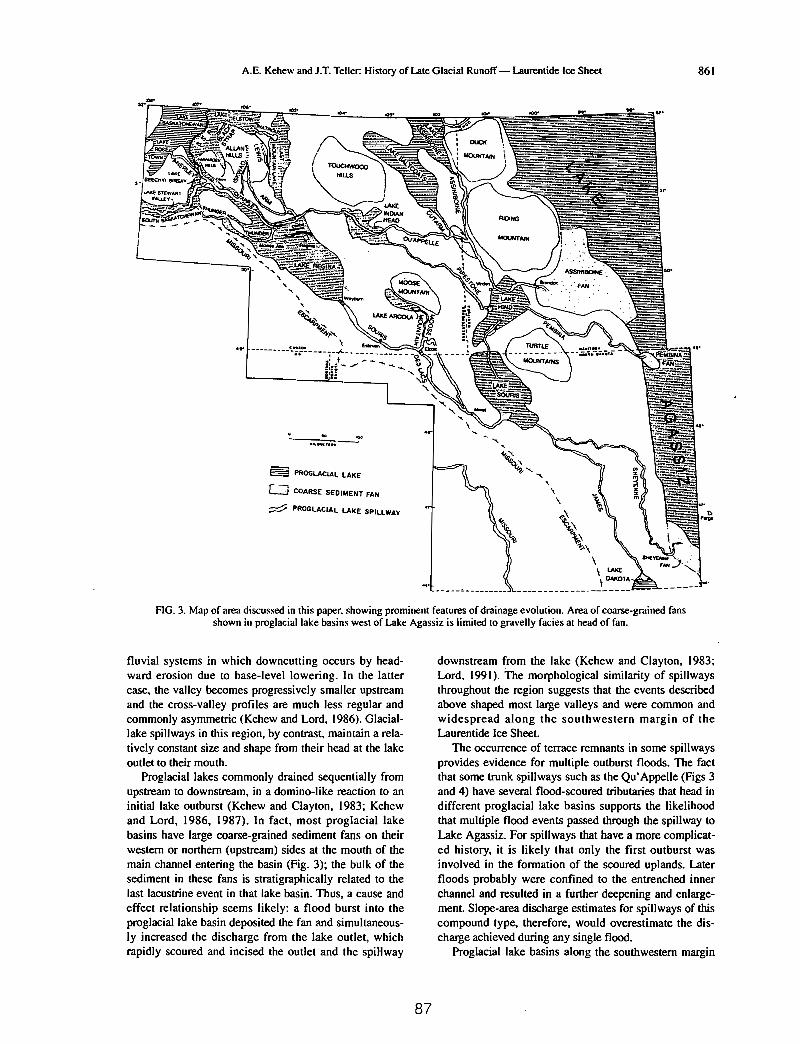
A.E. Kehew and J.T. Teller: History of Late Glacial Runoff - Laurentide Ice Sheet 86\
.,.
~ PROGLACIAl lAKE
o COARSE SEDIMENT FAN
;::;:V PROGlACIAl LAKE SPIUWAY
~" .... ,\\
~\
\~'1;.\
\\ LU<£\ llIU<OTA
FIG. 3. Map of area discussed in this paper. showing prominent features of drainage evolution. Area of coarse-grained fansshown in proglaciallake basins west of Lake Agassiz is limiled to gravelly facies at head of fan.
fluvial systems in which downcutting occurs by headward erosion due to base-level lowering. In the lattercase, the valley becomes progressively smaller upstreamand the cross-valley profiles are much less regular andcommonly asymmetric (Kehew and Lord, 1986). Glaciallake spillways in this region, by contrast, maintain a relatively constant size and shape from their head at the lakeoutlet to their mouth.
Proglacial lakes commonly drained sequentially fromupstream to downstream, in a domino-like reaction to aninitial lake outburst (Kehew and Clayton, 1983; Kehewand Lord, 1986, 1987). In fact, most proglacial lakebasins have large coarse-grained sediment fans on theirwestern or northern (upstream) sides at the mouth of themain channel entering the basin (Fig. 3); the bulk of thesediment in these fans is stratigraphically related to thelast lacustrine event in that lake basin. Thus, a cause andeffect relationship seems likely: a flood burst into theproglacial lake basin deposited the fan and simultaneously increased the discharge from the lake outlet, whichrapidly scoured and incised the outlet and the spiHway
87
downstream from the lake (Kehew and Clayton, 1983;Lord, \991). The morphological similarity of spillwaysthroughout the region suggests that the events describedabove shaped most large valleys and were common andwidespread along the southwestern margin of theLaurentide Ice Sheet.
The occurrence of terrace remnants in some spillwaysprovides evidence for multiple outburst floods. The factthat some trunk spillways such as the Qu'Appelle (Figs 3and 4) have several flood-scoured tributaries that head indifferent proglacial lake basins supports the likelihoodthat multiple flood events passed through the spillway toLalce Agassiz. For spillways that have a more complicated history, it is likely that only the first outburst wasinvolved in the formation of the scoured uplands. Laterfloods probably were confined to the entrenched innerchannel and resulted in a further deepening and enlargement. Slope-area discharge estimates for spillways of thiscompound type, therefore, would overestimate the discharge achieved during any single flood.
Proglacial lake basins along the southwestern margin

862 Quaternary Science Reviews: Volume 13
:::"':::::::: MAJOR DIVIDE S
KILOMETRES
.._1_ LAURENTIDE ICE
<100200
1100
o
FIG. 4. Generalized ice-marginal positions of the southwestern margin of the Laurentide Ice Sheet between Lake Agassizand the Rocky Mountains showing relationships with major drainage routes formed during deglaciation. Missouri
Escarpment (dashed) roughly coincides with the 12 ka ice margin along much of its eastern extent.
of the Laurentide Ice Sheet contain a diverse suite oflandforms and sediments. Coarse-grained fans, whichoccur at the mouths of spillway inlets, include subaerialdeposits as well as subaqueous underflow fan deposits.Although fine-grained offshore lake sediment occurs atthe surface near the center of some basins, the floors ofmany are covered by areally extensive deposits of thick,homogenous sand that resulted from flow expansion ofincoming outburst floods containing large volumes ofcoarse sediment eroded from the spillway leading to thelake. Glacial Lake Souris (Fig. 3), which contains thebest known fan of this type (Lord, 1991), illustrates theeffect of such a flood on a proglacial lake basin. TheLake Souris fan, which covers nearly half the basin, contains only the sand and coarser fraction of the flood sediment (approximately 8 km3), even though fine sedimenteroded from till and Tertiary sediment in the spillwaysmust have constituted the bulk of the total load. The lackof the silt and clay component indicates that the incomingflood initiated downcutting of the lake's outlet and led todrainage of the entire lake before the fine sediment could
settle out of suspension (Lord, 1991). Where there is atotal absence of fan or lacustrine deposits younger thanthe main fan in these basins, it indicates that the lake wasdrained at the time of spillway incision. Subsequent runoff into the basin eroded channels across the basin floor,some of which have characteristics that are typical offlood-eroded channels. In many basins, these channels donot lead across the lake floor to the former outlet throughwhich drainage occurred, but are eroded instead acrossthe northern side of the basin toward lower terrain thatmust have been blocked by ice at the time of lakedrainage. The Lake Regina, Lake Indian Head, LakeAssiniboine and Lake Hind basins are good examples ofthis relationship (Fig. 3).
The elevational relationships between lake outlets areconsistent from basin to basin; southern outlets are higherin elevation than are northern outlets. Greater isostaticdepression of the crust at the time of glaciation in thenorthern ends of these basins would have produced aneven greater relative difference in outlet elevations. Thus,when these lakes overflowed through their southern out-
88

A.E. Kehew and J.T. Teller: History of Late Glacial Runoff - Laurentide Ice Sheet 863
A-SPILLWAYS z:!z:>o::E
'"zoGl
Z
N
'""''''... ",..........:z:
"''''"...-'
z...lI:
'":z:
"...."'".....z...
lI:
'"
z:!z:>
fi ~ :........'" ..... :> ...-' " :>
'":>oa::.....lI:
......a::..'"""...-'Gl
.:IEa::..
z~'"x"...."'"..'"g
'"zo'" ..'" '"o '"o ...::E Ii:
'" '"ir a:::> :>o 0'" '" ..ffi ~ ~... lI: ::l:... 0 '":> -' ...
'" '"z "z ..~ -'
'" '":z: '"'" .,DRAINAGE :::
PHASE ~..10 ko-f-----+-+--+-+--+-t---+-t---+-t---+-t--+-t---1--t---1--f---t--f---+,,"""f----+IOko
I,,~I"QU'APPEllE - ASSINIBOINEII ka-f--...........:."7---',:-;.....;,;:..::..:.;.r=--l--T----;--.1-....J
----i---i ,SOURIS - PENBINA:±=:! .SHEYENNE I ,.
-t- I
JA'1ES
12ko-L------------------------------------------L..12ko
B-LAKES
DRAINAGEPHASE
'"~:>o'"'""..-'
.,z:z:
'""..-'
..z
'"'"'"'""..-'
.,..'":z:z...,~
'""..-'
..-'o"'"..'""..-'
>
'"-'-'~..'"...lI:
'"..'"...i
~
'"'"'"....>:z:
"'"'"'"...i
zlI:o..'"'"o'"'""..-'
z
!:z:"...."'"..'"'"":5
lI:o..'"-'
'"'""..-'
'""..-'z..::l:..'"..-'
'"....o"..-'..'"'""..-'
'"zo'"z'"'"...'""..-'
N
'""''''.. ",",en....
:z:"' ...
"..-'
10 k. T----t-----1----If---+---i--+---+--t----1----1I--+---+--+----+---t-lok.
,,0~<,;
t--------------------------------l Q'f'~
r-QU' APPElLE - ASSCNIBOINEII k.+-.::.--J-:....:.;;--:-:==--=-=====---------r
SOURIS-I!
=f=SHEYENNE
-t-JAMES~
........"
II k.
12k·-L-------------------------- -L12
k.
FIG. 5. Chronology of meltwater flow through various proglacial spillways (A) and the life span of related proglaciallakes(B) in the region west of Lake Agassiz. The scale is subdivided into named drainage phases; Lake Agassiz phases are
also shown.
lets, they must have been impounded by ice on theirnorthern margins. Only when the ice to the north hadthinned or receded could northern outlets have developed.
Large sediment fans were also deposited in LakeAgassiz at the mouths of drainage systems that carriedoutflow discharges from the lakes to the west. Threemajor fans, the Sheyenne, Pembina and Assiniboine (Fig.3), accumulated during the very short periods (200-500years; Fig. 5) when their drainage basins carried runofffrom the Laurentide ice margin to Lake Agassiz duringits Cass and Lockhart phases. As concluded by Kehew-and Clayton (1983), Fenton el al, (1983) and others, webelieve that the bulk of these fans were deposited as a
result of flood bursts from upstream proglacial lakes during these active periods of runoff.
The effects of meltwater outbursts on Lake Agassizitself from proglacial lakes to the west are not wellunderstood. Landforms in its southern overflow spillway,the Minnesota River valley, are characteristic of high-discharge erosive flows (Matsch, 1983; Kehew and Lord,1986) and it is possible that they formed as a result ofincoming floods from abruptly drained proglacial lakesalong the southwestern margin of the Laurentide IceSheet which, in turn, led to an abrupt increase in outflowfrom Lake Agassiz. However, the volume of inflow fromthese relatively small lakes to the west may have hadlittle impact on the outflow from Lake Agassiz because
89
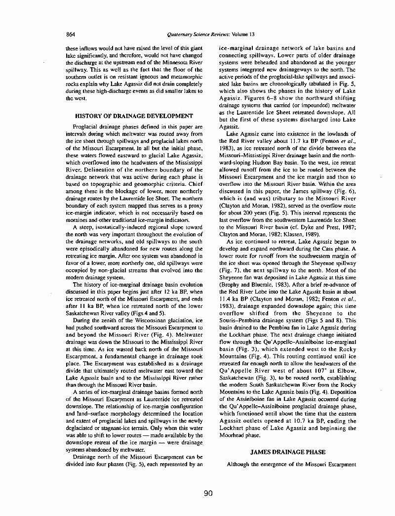
864 Quaternary Science Reviews: Volume 13
these inflows would not have raised the level of this giantlake significantly, and therefore, would not have changedthe discharge at the upstream end of the Minnesota Riverspillway. This as well as the fact that the floor of thesouthern outlet is on resistant igneous and metamorphicrocks explain why Lake Agassiz did not drain completelyduring these high-discharge events as did smaller lakes tothe west.
HISTORY OF DRAINAGE DEVELOPMENT
Proglacial drainage phases defined in this paper areintervals during which meltwater was routed away fromthe ice sheet through spillways and proglacial lakes northof the Missouri Escarpment. In all but the initial phase,these waters flowed eastward to glacial Lake Agassiz,which overflowed into the headwaters of the MississippiRiver. Delineation of the northern boundary of thedrainage network that was active during each phase isbased on topographic and geomorphic criteria. Chiefamong these is the blockage of lower, more northerlydrainage routes by the Laurentide Ice Sheet. The northernboundary of each system mapped thus serves as a proxyice-margin indicator, which is not necessarily based onmoraines and other traditional ice-margin indicators.
A steep, isostatically-induced regional slope towardthe north was very important throughout the evolution ofthe drainage networks, and old spillways to the southwere episodically abandoned for new routes along theretreating ice margin. After one system was abandoned infavor of a lower, more northerly one, old spillways wereoccupied by non-glacial streams that evolved into themodem drainage system.
The history of ice-marginal drainage basin evolutiondiscussed in this paper begins just after 12 ka BP, whenice retreated north of the Missouri Escarpment, and endsafter 11 ka BP, when ice retreated north of the lowerSaskatchewan River valley (Figs 4 and 5).
During the zenith of the Wisconsinan glaciation, icehad pushed southward across the Missouri Escarpment toand beyond the Missouri River (Fig. 4). Meltwaterdrainage was down the Missouri to the Mississippi Riverat this time. As ice wasted back north of the MissouriEscarpment, a fundamental change in drainage tookplace. The Escarpment was established as a drainagedivide that ultimately routed meltwater east toward theLake Agassiz basin and to the Mississippi River ratherthan through the Missouri River basin.
A series of ice-marginal drainage basins formed northof the Missouri Escarpment as Laurentide ice retreateddownslope. The relationship of ice-margin configurationand land-surface morphology determined the locationand extent of proglacial lakes and spillways in the newlydeglaciated or stagnant-ice terrain. Only when this waterwas able to shift to lower routes - made available by thedownslope retreat of the ice margin - were drainagesystems abandoned by meltwater.
Drainage north of the Missouri Escarpment can bedivided into four phases (Fig. 5), each represented by an
90
ice-marginal drainage network of lake basins andconnecting spillways. Lower parts of older drainagesystems were beheaded and abandoned as the youngersystems integrated new drainageways to the north. Theactive periods of the proglacial-Iake spillways and associated lake basins are chronologically tabulated in Fig. 5,which also shows the phases in the history of LakeAgassiz. Figures 6-8 show the northward shiftingdrainage systems that carried (or impounded) meltwateras the Laurentide Ice Sheet retreated downslope. Allbut the first of these systems discharged into LakeAgassiz.
Lake Agassiz came into existence in the lowlands ofthe Red River valley about 11.7 ka BP (Fenton et al.,1983), as ice retreated north of the divide between theMissouri-Mississippi River drainage ba~in and the northward-sloping Hudson Bay basin. To the west, ice retreatallowed runoff from the ice to be routed between theMissouri Escarpment and the ice margin and then tooverflow into the Missouri River basin. Within the areadiscussed in this paper, the James spillway (Fig. 6),which is (and was) tributary to the Missouri River(Clayton arid Moran, 1982), served as the overflow routefor about 200 years (Fig. 5). This interval represents thelast overflow from the southwestern Laurentide Ice Sheetto the Missouri River basin (cf. Dyke and Prest. 1987;Clayton and Moran, 1982; Klassen, 1989).
As ice continued to retreat, Lake Agassiz began todevelop and expand northward during the Cass phase. Alower route for runoff from the southwestern margin ofthe ice sheet was opened through the Sheyenne spillway(Fig. 7), the next spillway to the north. Most of theSheyenne fan wa~ deposited in Lake Agassiz at this time(Brophy and Bluemle, 1983). After a brief re-advance ofthe Red River Lobe into the Lake Agassiz basin at about11.4 ka BP (Clayton and Moran, 1982; Fenton et al.,1983), drainage expanded downslope again; this timeoverflow shifted from the Sheyenne to theSouris-Pembina drainage system (Figs 5 and 8). Thisbasin drained to the Pembina fan in Lake Agassiz duringthe Lockhart phase. The next drainage change initiatedflow through the Qu'Appelle-Assiniboine ice-marginalbasin (Fig. 3), which extended west to the RockyMountains (Fig. 4). This routing continued until iceretreated far enough north to allow the headwaters of theQu'Appelle River west of about lOT at Elbow,Saskatchewan (Fig. 3), to be routed north, establishingthe modem South Saskatchewan River from the RockyMountains to the Lake Agassiz basin (Fig. 4). Depositionof the Assiniboine fan in Lake Agassiz occurred duringthe Qu'Appelle-Assiniboine proglacial drainage phase,which functioned until about the time that the easternAgassiz outlets opened at 10.7 ka BP, ending theLockhart phase of Lake Agassiz and beginning theMoorhead phase.
JAMES DRAINAGE PHASE
Although the emergence of the Missouri Escarpment

A.E. Kehew and J.T. Teller: History of Late Glacial Runoff - Laurentide Ice Sheet 865
LAURENTIDE
o 100....,'-----',
\,
\1v. .
t
t
/ .
, , .._..._--_..•.••..•\ -\
---:-
co'"
\.0••
t
ICE
i.-:
t
-+
''';
-----_ ...."or.:
FIG. 6. Meltwater routes and lakes during the James drainage phase.
t t IJ + i-f I -J- I
I .I r .- / I
t,
/.i. ~:.. .~ .. .... 0' fl (
0O ...:"' I
".-I
0.°
FIG. 7. Meltwater routes and lakes during the Sheyenne drainage phase.
91

866 Qua/emary Science ReI-jews: Volume 13
LAURENTIDE
o lOOkm'-'----"
ICE
%
~
~\..u .... 0....
t i\~,,
.'•••• h •••••••••
FIG. 8. Meltwater routes and lakes during the Souris-Pembina drainage phase.
from beneath the ice sheet caused a major shift in. drainage paths, the first drainageways northeast of the
Escarpment (Fig. 6) still were connected to the MissouriRiver. This configuration, only a small part of which isshown on Fig. 6, includes the James spillway and LakeDakota. Meltwater that cut the James spillway largelyoriginated from the lake that first occupied the LakeSouris basin (Fig. 6). Because of subsequent events inthis lake basin, which probably included a glacialadvance across the basin (Schnacke, 1982; Kehew andClayton, 1983; Lord, 1988), the extent of the lake duringthe James phase is not known. lee of the Red River Lobe,which occupied the Lake Agassiz basin at this time(Clayton et al., 1980), appears to have prevented eastward drainage into the Sheyenne drainage system. Thus,runoff from most of the southwestern Laurentide IceSheet (west of the Agassiz basin) continued to be throughthe Missouri River basin until about 11.7 ka BP (Claytonand Moran, 1982; cf. Christiansen, 1979, Klassen, 1989,Fig.2.25c).
SHEYENNE DRAINAGE PHASE
As the Red River Lobe retreated, Lake Agassizformed in the Red River lowland south of the ice,expanding northward through time. A succession of
92
proglacial drainage systems evolved on the northwardsloping surface to the west of the Agassiz basin andlarge, coarse-grained fans were deposited at the mouthsof the rivers that carried meltwater from each of them.The first period of proglacial drainage into Lake Agassizis designated as the Sheyenne phase (Fig. 7). Brophy andBluemle (1983) summarized the history of ice-marginalfluctuations and drainage during this stage of LakeAgassiz.
The Sheyenne proglacial drainage basin extended westfrom the Sheyenne fan in Lake Agassiz to glacial LakeSouris, which supplied the water for subsequententrenchment of the Sheyenne spillway. The basin mayalso have included surface runoff from as far west asglacial Lake Regina, although we speculate that theregion immediately west of Lake Souris was still ice covered at this time. A northwest-southeast oriented eskernear Weyburn in the southern outlet of Lake Regina (Fig.3) (Christiansen, 1956) indicates that early meltwaterflow from this region, perhaps including that routedthrough the Sheyenne and James basins was throughglacial ice. Another possible route for this runoff was theDes Lacs spillway (Fig. 3), which probably formedbefore it carried water from the Lake Regina outburstduring the Souris-Pembina drainage phase (Lord, 1984,1988).
Meltwater drainage development in the Sheyenne

ABRIDGED FROMKehew, A. E., and Lord, M. L., 1987, Glacial-lake outbursts along the mid-continental
margins ofthe Laurentide ice-sheet: in L. Mayer and D. Nash (eds.), Catastrophicflooding: Allen Unwin, Boston, p. 95-120.
Glacial-lake outbursts along themid-continent margins -.9f the
Laurentide ice-sheet
Alan E. Kehew and Mark L. Lord
As water levels rose in the proglacial lakes, ice or debris dams failed causingthe incision of outlets and the release of tremendous volumes of water. Torrentialdischarges from the glacial-lake outbursts were diverted along the ice margin oraround ridges of ice-marg~sediment in the direction of decreasing elevation.Commonly, these flow paths led to lower glacial lakes. The voluminous influx ofmeltwater overloaded the capacity of smaller lakes, causing their outlets to be widened and deepened. If the outlet substrate was non-resistant, complete drainage ofthe lake took place. The outburst then migrated to the next lower lake basin augmented by the flow from the lake just inundated (Kehew and Clayton, 1983).
The first outburst recognized in the Great Plains originated from Lake Reginain Saskatchewan (Kehew, 1982) and proceeded to flow through Lakes Souris andHind on its path to Lake Agassiz. Recent investigations have shown that the LakeRegina outburst was not a rare, isolated event. In (~ct, it appears that the catastrophic partial or total drainage of glacial lakes was probably the most typical meltwater process along many segments of the Laurentide Ice Sheet. Other examples inthe Lake Agassiz region were described by Clayton (1983), Matsch (1983), andTeller and Thorleifson (1983). In the eastern Great Lakes region, outbursts fromLake Maumee were reported by Vaughn and Ash (1983) and Fraser and Bleuer
(1985). An event of this type in northern Illinois and Indiana was recognized asearly as 1925 by Ekblaw and Athy.
The purpose of this paper is to review the erosional and depositional effects ofLaurentide glacial-lake outbursts and to present new examples of these phenomena.Reconnaissance investigations suggest that glacial-lake outbursts are so commonin the area of the Laurentide Ice Sheet that they should be incorporated into allmodels of deglaciation. The effects of these events must figure prominently in thehistory of the Mississippi Valley, the evolution of the Mississippi fan and Louisiana slope in the Gulf of Mexico, and in the development of the drainage systemof most of northern North America.
93

EROSIONAL EFFECTS
The erosional capacity of glacial-lake outbursts was trulyenonnous. The spillways connecting glacial-lake basins on the prairies are easily visible on landsat imagery and rank among the most pronounced topographic features of the midcontinent region (Fig. 1). The volume of sediment eroded by outburst floods is equivalent to the volume of the spillway channels. Present spillway dimensions underestimate erosion because of thick sections of Holocene fill deposited in the spillways. The sediment eroded from spillway channels leading to the Mississippi Valley was deposited in the lower Mississippi Valley and/or the Gulf of Mexico. Inthe western plains, material eroded from spillways was deposited in glacial-lake basins.
Perhaps even more remarkable than the amount of erosion was the intensity oferosion. Outburst floods quickly trenched through the glacial drift and continueddowncutting into bedrock if the bedrock was poorly indurated. Cretaceous and Tertiary sedimentary rocks on the Great Plains were easily cut through by the floods.Studies of spillway fills in North Dakota (Boettger, 1986) indicate that there wasno continuous depositional phase in th~ spillway channels-Holocene sediment directly overlies bedrock on the spillwa{bottoms. Discharges therefore were shortlived and abruptly terminated.
Investigation of spillway morphology in the Dakotas, Minnesota, Manitoba,and Saskatchewan (Fig. 2) (Kehew and Lord, 1986) led to the development of ageneralized geomorphic model of spillway erosional features (Fig. 3). The mostdiagnostic criteria are listed in Table 1; these features are described in detail in Kehew and Lord (1986). In general, spillways are wide, deep channels that beginabruptly at glacial-lake outlets and maintain their size arid shape until they end atother lake basins. A flood origin for the valleys is indicated by the lack of tributary valleys of comparable size with the exception of other spillways. Spillwayscommonly terminate where they meet other glacial-lake basins (Kehew and Clayton, 1983), thus implying that glacial lakes were suddenly subjected to huge inflows of water. The depositional phenomena accompanying these cataclysmic inflows will be discussed in the following section.
Many spillways consist of two prominent components--a broad, gently slopingupper level (the outer zone), and a centrally positioned trench-.llike inner ~hannel(Figs. 3 and 4). Shallow flow initially covered the outer zone if no existing drainageway lay in the path of the outburst flood. The common lack of distinct outerzone margins suggests that stagnant ice formed the original channel bottom. Asincision of the outer zone progressed, boulders from the underlying till began to accumulate as a coarse channel-bottom lag. This boulder concentration increased theresistance to flow in the broad, shallow outer-zone channel. In Iresponse, the flow.began to carve out a narrow, deep inner channel at the center of the outer zonewhich provided less resistance to flow. In addition to me lag-covered surface, othercharacteristic outer-zone features include longitudinal grooves and streamlined residual hills (Kehew and Lord, 1986). Streamlined erosional residuals are protected
94

(\~,
SI
Gla
cial
Lake
Bas
in\, :
-:'~
Spi
llway
-A
reas
ofS
hallo
wA
nast
omos
ing
Cha
nnel
s
CD 01
Flg
ure
2.L
oca
tio
nm
apof
glac
ial
lake
san
dsp
illw
ays
wes
tof
Lak
eA
gass
iz.
o10
0km
Ir
I
N 1

Table 1. Geomorphic features of spillways produced by glacial outbursts.
GeneralLack of tributaries other than small Holocene valleys or other spill-
ways.Usually eontUnunderfit Holocene streams.Deeply entrenched.Trend at an angle to regional slope.Often parallel to ridges of ice-marginal deposits.Constant size from lake outlet to termination at topographically lower
lake basin or junction with other spillway.Terminate at large, coarse-grained sediment fans in glacial-lake basins.Channels eroded by flow that exceeded channel capacity may lead away
from spillway across drainage divides.May contain terraces representing multiple outbursts.
Inner channelTrench-like shape.Unifonn width and side slopes.Regular meander bends.Occasional bifurcation to fonn parallel or anastomosing channels separ-
ated by linear ridges or streamlined erosioQal residuals.May contain isolated erosional residual hills, us~any streamlined.1-3 kIn in width.25-100 m in depth.Lack of slip-off slopes.May contain bars of very coarse sediment along channel sides at infre-
/ quent intervals.
Outer zoneBroad, scoured swface.May contain shallow anastomosing channels.Boulder lag may be developed by incision into till.Longitudinal grooves.Streamlined erosional hills.
96

from erosion during flow as they attain the streamlined shape of an airfoil. Thisshape, which is approximated in plan view by the lemniscate loop (Komar, 1984),minimizes flow separation and drag on the landform (Fig. 5).
The inner channel of the spillways is the most diagnostic indicator of outburstflooding. The size and shape of these channels are not consistent with an origin bygradual downcutting by small streams. The width and depth of the inner channelscorrelate with discharges of 105 m3s-1 or more if bankfull flow is assumed (Kehewand Clayton, 1983; Lord, 1984). The uniform channel shape, constant valley-sideslope, and lack of slipoff slopes rule out gradual erosion of the channels. A compound origin, however, including multiple episodes of outburst flooding separatedby other types of fluvial activity, is very likely for some of the spillways. Multiple events are indicated by terraces underlain by outwash sediment and/or outburstflood sediment. In addition, some spillways were occupied by glacial meltwaterstreams after their incision.
Inner channels commonly contain erosional remnants produced by the bifurcation of the flow around obstacles or the simultaneous incision of two or morebranches of the inner channel. Long, parallel inner-channel segments separated bynarrow bedrock or till highs were presumably produced by concurrent erosion oftwo longitudinal grooves within the outer zone (Kehew and Lord, 1986). Shortererosional remnants in the inner channels include streamlined hills which, were preserved in the highly erosional flow because of their shape.
DEPOSITIONAL EFFECTS
As the capacity for erosion by glacial-lake outbw:S,ts was enormous, so was thepropensity for fonnation of deposits reflective of the huge volumes of sedimentcharged water that formed them. Eroded sediment was deposited as gravel barswithin the inner channels and large, coarse-grained fans in glacial takes recipient tothe outburst discharges. Deposition of the fine-g~ined fraction was limited to largebasins that did not drain completely during outburst inflows. In the glaciatedplains west of Lake Agassiz (Fig. 2), the source sediment for the outburst depositsconsists of poorly indurated till and bedrock. The till typically is composed of approximately equal parts sand, silt, and clay, with only a few percent gravel. Subjacent to the till is poorly indurated Paleocene and Cretaceous bedrock composed ofs~t and sand with minor amounts of fine sand and lignite. Most of the descriptionsof deposits in this section are based on detailed work in the Souris and Des Lacsspillways (Fig. 2). Similar deposits are present in the Qu'Appelle, Minnesota,Sheyenne, Assiniboine, and Thunder spillways.
The discharge hydrographs of glacial-lake outbursts were probably similar tothose of historical jokulhlaups, showing a steadily increasing discharge to a peakfollowed by a sudden cessation of flow--a pattern opposite to that of storm hydrographs (Marcus, 1960). As a consequence of the outburst discharge characteristics,flow competence within the spillways seldom decreased enough to permit deposi-
97

EXPLANATION,.,
'......
JlShall~~ Channel
~ Erosional Residual
! Scarp
I LongitudinalGroove
[Q1 80u Ider Lag
A OUTERr- ZONE
200".
'0'"
INNERCHANNEL OUTER
I r ZONE1A'
o I km~
Figure 3. Generalized geomorphic model of spillway morphology. (From Kehewand Lord, 1986)
tion of any of the sediment load. Most sediment eroded by glacial-lake outbursts inthe region west of lake Agassiz was dumped in glacial lakes. Though outburst deposits are relatively rare in the spillways, they are morphologically and texturallydistinct from other glaciofluvial deposits.
Spillway Deposits
Glacial-lake outburst deposits in spillways consist of large scale bars. The barsoccur in two depositional settings within the spillways: point bar positions and inalcoves formed by landslides during incision of the spillways (Fig. 6). The average dimensions of the bars are approximately 2 km in length, O. 5 km in width,and 20 m in thickness (Fig. 7). These bars are primary bedforms with little or nosubsequent alteration since their deposition. Bars of similar dimensions have been
98

A. E. KEHEW & M. L. LORD 103
Figure 4. Landsat image of Souris spillway in souLheasLern SaskaLchewan. OULer7.one is visible as the broad, non-cultivated area (5-10 I(m wide) nanking the incisedinner channel. Cultivation is prevented by surficial boulder lag in oULer zone. Northat top. Width of image approximately 200 km. Arrow indicates direction of now inspillway.
described in association with other cata5trophic floods, most notably those from theLake Bonneville and Glacial Lake Missoula floods (Malde, 1968; Baker, 1973).
Internally, the bars consist of massive, matrix-supported, very poorly sortedcobble gravel (Fig. 8) commonly containing boulders 1 m in diameter with exceptional boulders up to 3 m in diameter. The maximum grain size in the bars decreases in the downsueam direction and toward the side of the spillway. Texturally,in sharp contrast to the material eroded to fonn the spi II ways, the average composition of the bars is 2 percent clay plus silt, 17 percent sand, and 81 percent gravel(Lord, 1984). The erosive power of the outbursts can be shown by comparing theamount eroded by the discharges with the amount deposited within the spillways.For example, the Lake Regina outburst erod~d an estim:lll?d 26 km3 of sediment
99

B...~.~
laBGRAVEL
~. LANOSL,JOE
IIISPILLWAY
o 1kmL.-.J
Figure 6. Schematic diagram showing two positions in which large-scale barsformed within spillways: A. Point bar position deposit, B. Alcove deposit on thespillway side of a landslide.
Table 2. Comparison of textures and volumes of material eroded versus redeposited(within spillways) by the Glacial Lake Regina outburst
Sediment Sediment· Percent materialeroded deposited redeposited
In
spillwayPercent* Volume Percent** Volume
(km3 )- (km3)
CLAY+SILT 67 17.4 2 0.01 0.1SAND 28 7.3 17 0.13 1.8GRAVEL 5 1.3 81 0.61 46.1
TOTAL 100 26.0 100 0.75 2.9
* Data from Kehew (1983)** Data from Lord (1984)
100

GLACIAL-LAKE OUTBURST R..OODS
(mostly till) from the Souris and Des Lacs spillways (Fig. 2). By comparison,only an estimated o. 75 km3 of sediment, or 2. 9 percent, was redeposited withinthe spillways (Table 2) (Lord and Kehew, in review). The vast majority of sandand almost all of the silt and clay were conveyed through the spillway system intodownstream glacial lakes.
Flow during the outburst discharges was probably hyperconcentrated. This interpretation is consistent with estimated sediment-water concentrations. the highcompetence required to transport the sediment load, and the intennediate character ofthe bars between debris-flow and clear-water deposits. It is also likely that, oncematerial was entrained in'io flow. most clast sizes. including gravel. were transported in suspension. Deposition within the spillways was limited to areas of substantial flow expansion such as at bends in the spillways or alcoves created by landslides. and did not occur along the spillway bottoms. When deposition was trigsered by flow expansion, it occurred indiscriminate of clast size, resulting in deposits of massive. matrix-supported gravel.
Glacial Lake Deposits
The glacial lakes that received torrential discharges from th~ outbursts were therpajor sediment sinks for the eroded material. The form taken by the deposits intIle lakes was largely dependent on three factors: (1) the density of the inOow. (2)the lake basin morphology, and (3) the volume of the lake basin. The density ofthe sediment-laden outburst discharges was significantly greater than that of thesltilled lake water. As a result, inflows formed density currents that flowed alongt~e lake bottom and deposited underflow fans (Kehew and Clayton, 1983). Under
flows. because of their high density and low turbulence, may transport coarse sedirp.ent many kilometers past the inlet (Church and Gilbert, 1975). Underflow fans,because they do not prograde into lakes at the water level by fluvial action, tend tooe very well sorted and gradually fine away from the inlet (Fenton and others,
I •
~983; Kehew and Clayton, 1983). Underflow fans deposited by glacial-lake out-~ursts can be identified by their large areal extent and position at the mouth of aslpillway eroded by a glacial-lake outburst. Outwash processes are ruled out forthese deposits because they are not associated with valley trains, outwash "plains,or moraines.
Lakes with irregular boltom topography developed local flow conditions that¢sulted in complex sediment deposition patterns. The capacity of the lake to contpin the added volume of catastrophic inflows determined whether the recipient lakei,tself drained in a domino fashion. Where the influx triggered drainage of the recipient lakes. most of the fine-grained sediment--silt and clay. did not have sufficienttiime to settle out and was transported through the lake. In these cases, the lake acted similar to a very wide reach of a river with continuous throughflow rather than~ lake in which the entire sediment load is dumped. Morphologic evidence of a
domino-triggered lake drainage is incision into th~ fan by the spillway when thel~e started to drain.. Additional "evidence for simultaneous outburst inflow and out([ow from lake basins is summarized in Kehew and Clayton (1983).
101

WINNIPEG'96 GUIDEBOOK ORDER FORM
A1. Evolution of the Thompson Nickel Belt, Manitoba: Setting of Ni-CuDeposits in the Western Part of the Circum Superior Boundary Zone
W Bleeker and J. Macek $12.00 x no. of copies: _
A2. Late Holocene Environmental Changes in Southern ManitobaE. Nielsen, K. D. McLeod, E. Pip and J. C. Doering $8.00 x no. of copies: _
A3. Petrology and Mineralization of the Tanco Rare-Element Pegmatite,Southeastern Manitoba.
P. Cerny, S. Ercit and P. Vanstone $12.00 x no. of copies: _
A4. Lithostratigraphic Assembly of the Eastern Rice Lake GreenstoneBelt and Structural Setting of Gold Mineralization at Bissett, Manitoba.
K.H. Poulson, W Weber, R. Brommecker and D.Seneshen. $13.00 x no. of copies: _
A5/B6. Western Superior Transects: Wabigoon-Quetico-Shebandowenand English River-Winnipeg River-Wabigoon
G. Beakhouse, G. Stott, C. Blackburn, F. W Breaks, J. Ayer,D. Stone, C. Farrow and F. Corfu $13.00 x no. of copies: _
B1. Tectonic Assembly of the Paleoproterozoic Flin Flon Belt and Settingof VMS Deposits
E. Syme, A. Bailes and S. Lucas $15.00 x no. of copies: _
B2. Geomorphic and Sedimentological History of the Central LakeAgassiz Basin.
J. Teller, H. Thorleifson and G. Mati/e , " $14.00 x no. of copies: _
B3. Physical Volcanology, Hydrothermal Alteration and MassiveSulphide Deposits of the Sturgeon Lake Caldera
R. Morlon, G. Hudak and E. Koopman $10.00 x no. of copies: _
B4. Lower to Middle Paleozoic Stratigraphy of Southwestern ManitobaR. Bezys and H. R. McCabe $12.00 x no. of copies: _
B5. Geology of the Lac du Bonnet Batholith, Inside and Out:AECL's Underground Research Laboratory, S. E. Manitoba
R. Everitt, J. McMurry, C. Davison and A. Brown. $10.00 x no. of copies: _
B7. Industrial Minerals of S.E.ManitobaB. Schmidtke and J. Bamburak $3. 00 x no. of copies: _
The entire set may be purchased for $95.00 Subtotal:
+GST (7%)
+Postage and Handling
TOTAL
Orders should be sent to:Geological Association of Canada, Winnipeg Sectionc/o Geological Services Branch, Manitoba Energy and Mines1395 Ellice Ave., Suite 360Winnipeg, Manitoba R3G 3P2
Make cheques or money orders payable to "GAC-MAC '96". Add $2.00 per book for postage andhandling. For entire set add $10.00.


