Page 1
i
UNIVERSITY OF PORT HARCOURT
GEOPHYSICS,
a panacea for
NATIONAL WEALTH AND SAFETY
An Inaugural Lecture
By
PROF. JOSEPH O. EBENIRO [B.Sc. (Lagos); M.A., Ph.D., (Texas)]
Department of Physics, Faculty of Science
INAUGURAL LECTURE SERIES
NO. 84
MARCH 29, 2012
Page 2
ii
DEDICATION
This inaugural lecture is dedicated to GOD ALMIGHTY for
all his Mercies throughout my life. And secondly, to my
children – Joseph Jr., John, Jane (USA), James (USA) and
Joshua, who have made my life worth living even with all the
traumas. Without these children, I would not have been where
I am today. And finally to my elder brother – S/Sgt C. A.
Ebeniro (of the blessed memories) for giving me the head start.
Page 3
iii
ACKNOWLEDGEMENT
Mr. Vice Chancellor, Sir, in life no one is an island. Whatever
contributions one has made must be as a result of the
encouragements, assistance and even the contributions of
others in the person’s life. I will also use this singular
opportunity to acknowledge those many individuals and
organizations who have really made it possible for me to be
talking to you on this podium today. Whatever I am today
started from the village elementary school where Mr Francis
Nwachukwu took special interest in me pushing me hard to
excel in Arithmetic and elementary science. At the secondary
school level Reverend Father Ford (Blessed Memory) who
took me as one of his three sons in the school raised us to
appreciate discipline. Mr Maranzu taught me Geography from
where the appreciation of the workings of nature came into
focus. Mr Maranzu was really my gem, he turned me around
from a not so good a geography student to an “A-1” student in
the subject. This really resulted in creating the geoscientist
that I am today. Prof J. E. A. Oseimekhian put me into the
right pedestal of geophysics at the university level when after
giving me the basic geophysics course supervised my
undergraduate project on Deconvolution at the University of
Lagos. At this juncture, the seed of my geophysics career has
been sown. This career was consummated when Mr Fidelis
Nwokike and Dr Victor Moghalu (Borno Medical Clinic,
Maiduguri) facilitated my journey to the University of Texas at
Austin to continue with the quest for knowledge in
Geophysics. At the University of Texas, the great minds in
Geophysics gave out their best to me and my association with
that university has continued till today. Profs Yosio
Nakamura, Clark Wilson, Milo Backus, Paul Stoffa, John
Sclater, Jim Dorman, John Castagna etc are few of the greatest
geophysicist who bequitted to me the norms of the profession.
Page 4
iv
Ms Patty Ganey-Curry is a special family friend who is still
keeping my family at heart. All these persons I have
mentioned, though incomplete, share one thing in common.
They made me the geoscientist I am today. I will ever remain
grateful and pray to God to continue to give them long life and
prosperity.
Now let us come down to contemporary issues. The
acknowledgement will be incomplete without the mention of
the great people of University of Port Harcourt. Prof Charles
O. Ofoegbu encouraged and worked hard to enlist me into the
university when he was the Head of Department of Physics.
Prof Levi C. Amajor has remain to be a friend, mentor
confidant and among others a father. He encouraged and even
pushed me hard to apply for professorial assessment and even
almost physically pursued my assessment when it was
becoming extremely too long for the results to be released. He
has always been there for me to emulate especially with his
encouragements to keep in touch with the village setting. I
really appreciate you. To my colleagues, Prof O. E. Abumere
(my only foreign brother and current Dean, Faculty of
Science), Prof I. O. Owate (my orator), Dr. C. N. Ehirim (my
reliable mentee), I appreciate you all. To my former and
current post graduate students. especially Drs Meshach
Omudu, Ogagarue, Nwankwo, I implore you to keep the
profession going with the research we have started. Be
focused, consistent and principled, humane and still be firm in
your life dealings. Ms Ajidua, Mr Edoja, Mr Essien, Mr
Dagogo and other students whose research kept the dream of
geophysics in the department in top burner, I appreciate your
efforts. My colleagues at the CORDEC office, your hard
works under very strict and perfectionist supervision brought
out the best of service. You are all appreciated.
Page 5
v
Shell Petroleum Development Company (SPDC) has always
aided our geophysics research focus in the Department of
Physics. She equipped a Geophysics Analysis Laboratory and
had been funding researches being carried out in this
laboratory for our mutual benefit. I will ever remain
appreciative.
Let me here appreciate my good friend, Prof Don Baridam –
the former Vice Chancellor of University of Port Harcourt. He
really assisted me to be myself in the university by bringing
me out to face challenges never done before. I appreciate your
immense courage. I think you really captured my personality
when in your book – Raising the Bar you said “Ebeniro is one
man who believes that great feats could be accomplished
without unnecessarily mystifying simple issues. A man of
immense knowledge and versatility, Prof Ebeniro wears a
highly deceptive casual surface that hides a serious-minded
public officer with a knack for great accomplishments”.
Thank you, Sir, for your courage.
For the current Vice Chancellor, Prof J. A. Ajienka and his
team of principal officers, I will ever remain grateful for
allowing me time to make this presentation at this time. Our
friendship started long before you became the Vice Chancellor.
This friendship will also continue even after we all stand down
what we are doing now in our quest for excellence both within
and outside the university. Thank you sir and wish you all the
best.
Finally, what will I be doing here if not for the support and
encouragement of my immediate and extended family? My
aged father (Chief Michael Ebeniro Ukpabi of the blessed
memories) although a stark illiterate gave me a head start in
education. My mother (Mrs Margret Chimegbulem Ebeniro)
made sure we had food on the table to enable us survive the
Page 6
vi
war and continue with my quest for knowledge. My
immediate elder brother – S/Sgt Cyprian Adimoha Ebeniro
(Rtd) made sure I was sent to a secondary school under all
odds. Although, he is dead, he is still alive in me always. To
my immediate family Mrs Felicia Oyiriwonu Ike, Mr.
Batholomew Onyekachi Ebeniro, Mr Giles Ugochukwu
Ebeniro, Mrs Chinyere Asasa and Benerdette Baby Ebeniro,
you all have been an inspiration for me to continue to struggle
to make sure we get out of the situation we found ourselves at
birth. To my Children, Joseph Jr (Onyekwere) Jr., John
(Emeka), Jane (Adanma), James (Iyke), Joshua (Chimaobi),
you really grew up with me. I appreciate you all for your
steadfastness to succeed in life. You are my pride and remain
so also. God Bless you all.
There are so many others who are so dear to me on the quest
for knowledge and I could not accommodate in this
acknowledgement. Please bear with me and remain blessed.
Is it really possible to be what you are or what you want to be
without Someone Infinite? Definitely not! Thus, this
presentation will never be complete without acknowledging
the Almighty God - My Infinite Father, who has always been
my strength, courage and my all and all, guiding and
protecting me from the myriads of distractions and temptations
Page 7
1
GEOPHYSICS,
a panacea for
NATIONAL WEALTH AND SAFETY
By
PROF. JOSEPH O. EBENIRO
PROTOCOL
The Vice Chancellor,
Deputy Vice Chancellors,
Registrar and other Principal Officers,
Provost College of Health Sciences,
Dean School of Graduate Studies,
Dean Faculty of Education,
Deans of Faculties,
Distinguished Professors and Scholars,
Director of Institutes and Units,
Heads of Departments,
Distinguished Guests and Friends,
Great Students of Uniport,
Members of the Press,
Ladies and Gentlemen.
Page 8
2
Introduction
What is Geophysics?
The word “Geophysics” is developed from the two words
“Geo” – Earth and “Physics”- study of matter in relation to
energy. Thus, one can easily define the word as the science
that applies the principles of physics to the study of the earth.
In order to achieve this, measurements are made at or near the
earth surface to obtain data that when analyzed are used to
reveal the internal structures of the earth (rocks and minerals).
Interpretations of this data are capable of delineating local and
regional features which could be of economic importance to
the human being. Most features that would be of economic
interest comprise the concentrations of specific minerals
contained in pore spaces holding fluid of interest – water and
hydrocarbon. These concentrations are not usually common.
Thus Geophysics seeks to look for contrasts in rock properties
associated with uncommon specific structures which can
contain the minerals being sought for. These specific minerals
only show up as anomalies in the measured data. Geophysics
is a very broad subject and includes subjects that many would
not comprehend such as Oceanography, Seismology,
Volcanology, Magnetism, Gravitation, Meteorology and
Geodesy (Fig. 1)
Geophysics is classified into two major scales. These are the
Global Geophysics (GG) and Exploration Geophysics (EG).
Global Geophysics is that branch of geophysics that looks at
the whole earth. It is with this aspect that earthquake
seismology comes into focus. Exploration Geophysics is that
which looks at geographically restricted areas in the upper
crust in order to determine the distribution of physical
properties at depth. This provides a rapid and cost effective
means of deriving information of the subsurface resources of
Page 9
3
potential interest. The main goal is to identify and define
geologic strata that contain minerals and especially
hydrocarbon of economic interest.
Figure 1: General Geophysics Organogram
My Vice Chancellor sir, after this basic introduction of what
the word Geophysics represents, let us now introduce the main
geophysical surveying techniques that are in use today. There
are two broad divisions of geophysical surveying methods.
1. Those that make use of natural fields of the earth, and
2. Those that require the input into the ground of
artificially generated energy.
The natural field geophysics utilize gravitational, magnetic,
electrical and electromagnetic fields of the earth, searching for
local perturbations of these naturally occurring fields that may
be caused by concealed geological features of economic or
other interest. Generally, natural field methods can provide
information on earth properties to significantly greater depths
and the logistics for this method is quite simple. Artificial
Page 10
4
source geophysics involve the generation of local electrical or
electromagnetic fields that may be used analogously to natural
fields, or, in the most important single group of geophysical
surveying methods, the generation of seismic waves whose
propagation velocities and transmission paths through the
subsurface are mapped to provide information on the
distribution of geological boundaries at depth. Though,
artificial source methods are capable of producing a more
detailed and better resolved picture of the subsurface geology,
their logistics are laborious and requires a lot of expertise. The
depths of investigation are quite small in comparison.
The range of application of each method is determined by the
physical property of the earth material which it responds to
(Table 1). For example, the magnetic method is very suitable
for locating buried magnetite ore bodies because of their high
magnetic susceptibility. Similarly, seismic and electrical
methods are suitable for the location of a buried water table
because saturated rock may be distinguished by its higher
seismic velocity and higher electrical conductivity.
Geophysical surveys can be carried out in two modes:
reconnaissance and detailed. The distinction between the two
depends on the objective either to find features of interest in
geology and geophysics or to map those features.
Reconnaissance surveys are often carried out from the air
because of its high speed of operation. When the first
geophysical operations for location of oil and gas were carried
out in the Niger Delta, aerial gravity and magnetic surveys
were carried out mainly to locate the presence of large
sedimentary basin – the Niger Delta basin. This first round of
geophysical exploration techniques may highlight areas of
particular interest where further detailed seismic work needs to
be carried out. In such cases, both electrical and seismic
Page 11
5
methods are not applicable, since they require ground contrast
for the direct input of energy.
Table 1: Geophysical Surveying Methods Method Measured Parameters Physical Property
Seismic Travel time of reflected
and refracted seismic
waves
Density and elastic
moduli, which
determine the
velocity of seismic
waves
Gravity Spatial variations in the
strength of the
gravitational field of the
earth
Density of the earth
materials
Magnetic Spatial variations in the
strength of the
geomagnetic field of the
earth
Magnetic
susceptibility and
remanence
Electrical
Resistivity
Induced
Polarization
Self Potential
Earth Resistance
Polarization voltages or
frequency dependents
ground resistance
Electrical Potentials
Electrical
Conductivity
Electrical
Capacitance
Electrical
Conductivity
Electromagnetic Response to the
electromagnetic
radiation
Electrical
Conductivity and
inductance
Radar Travel times of
reflected radar pulse
Dielectric Constant
As a matter of fact, geophysical methods are often used in
combination. For example, the initial search for metalliferous
mineral deposits often utilizes airborne magnetic and
electromagnetic surveying. As mentioned earlier,
reconnaissance of continental shelf areas often includes
simultaneous gravity, magnetic and seismic surveying. In
offshore search for oil and gas, an initial gravity
Page 12
6
reconnaissance survey may reveal the presence of large
sedimentary basin that is subsequently explored using seismic
techniques. During interpretation, ambiguity arising from one
technique may be removed by considering the results of the
other technique. The main field of application of geophysical
surveying and their most appropriate surveying technique for
each application is shown in Table 2.
Table 2: Geophysical surveying applications
Application Appropriate
survey methods*
Exploration for oil and gas S, G, M, (EM)
Exploration for metals M, EM, E, SP, IP
Exploration for sand and
gravel
S, (E), (G)
Exploration for
underground Water
E, S, (G)
Engineering/Construction
site investigation
E, S, (G), (M)
*G: Gravity; M: Magnetics; S: Seismic; E: Electrical; SP: Self
Potential; IP: Induced Polarization; EM: Electromagnetic;
Subsidiary methods are in brackets.
At this juncture, Mr Vice Chancellor sir, I will have to limit
myself on the areas of geophysics that focus on the inaugural
lecture topic of National wealth and safety. National wealth is
dependent on the exploration and exploitation of oil and gas
for now. National safety will be focusing on taking a cursory
look at how we can respond to earth-related natural disasters
(earthquake). This points towards the recent earth tremors that
happened in both Haiti and Japan. How will we, as a nation,
respond to such if and when such phenomenon occurs around
us?
Page 13
7
Mr. Chairman Sir, our national wealth depends virtually on the
oil and gas which controls more than 90% of our national
wealth. The branches of geophysics that control this include
gravity, magnetic and seismic. Let me use this opportunity to
review their processes as they are used to explore for oil and
gas.
Gravity Method
This is a passive method that measures the spatial variations in
the earth’s gravitational field with its operative physical
property as the density/mass of the earth rocks that determine
the gravitational acceleration.
The basic physics law stated by the gravitation law shows that
any two bodies in the universe are attracted to themselves.
The law of attractions depends on the mass of the bodies and
their distance apart. Their mass is dependent on the force of
gravity which is dependent on the density. In gravity method
of geophysics, lateral density changes in the subsurface cause a
change in the force of gravity at the surface. The intensity of
the force of gravity due to a buried mass difference
(concentration or void) is superimposed on the larger force of
gravity due to the total mass of the earth. Thus, two
components of gravity forces are measured at the Earth's
surface: first, a general and relatively uniform component due
to the total earth, and second, a component of much smaller
size that varies due to lateral density changes (the gravity
anomaly) . By very precise measurement of gravity fields and
by careful correction for variations in the larger component
due to the whole Earth, a gravity survey can sometimes detect
natural or man-made voids, variations in the depth to bedrock,
and geologic structures of exploration and engineering
interest.
Page 14
8
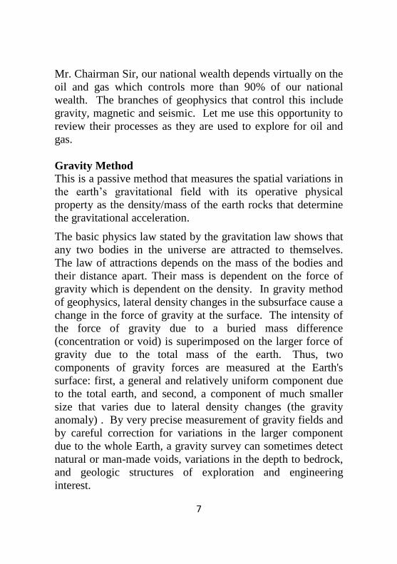
Figure 2: A Lacoste Romberg Gravimeter
In gravity prospecting, we measure very small variations in the
force of gravity from rocks within the earth using highly
precise equipment called a “gravimeter” (Fig. 2). Different
types of rocks have different densities, and the dense rocks
have the greater gravitational attraction. Application of gravity
methods include:-
Defining the size and extent of ore bodies
Depth of the Bedrock
Delineating intrusive bodies
Defining buried river channels
Demarcating faults (changing of anomaly shape)
Delineation of extent of sedimentary basins
Detection of salt dome and salt deposits and reefs(-ve
anomalies)
Delineation of the extent of the sedimentary basin is the major
application of this method adopted during the exploration of
oil and gas. Thus gravity method is used as a reconnaissance
tool before the use of more detailed methods to locate zones in
the earth where accumulation of oil and gas is possible.
Page 15
9
Magnetic Method
This is another passive method used to detect magnetic
anomalies within the earth’s magnetic field which are caused
by the magnetic properties of the underlying rocks. Its
operative physical property is the magnetic susceptibility and
remanance which determine magnetizability
In magnetic prospecting we look for variations in the magnetic
field of the earth. The magnetic field of sedimentary rocks is
usually much smaller than igneous or metamorphic rocks.
This lets us measure the thickness of the sedimentary section
of the earth’s crust.
Magnetic surveying investigates the subsurface geology of an
area by detecting magnetic anomalies within the Earth’s
magnetic field, which are caused by the magnetic properties of
the underlying rocks. Most rock-forming minerals are non-
magnetic but a few rock types contain sufficient amounts of
magnetic minerals, which can impart a magnetism to their host
rocks and thus produce detectable magnetic anomalies. Rock
magnetism has both magnitude and direction, the latter being
determined by the host rocks position relative to the past and
present magnetic poles of the Earth.
Page 16
10
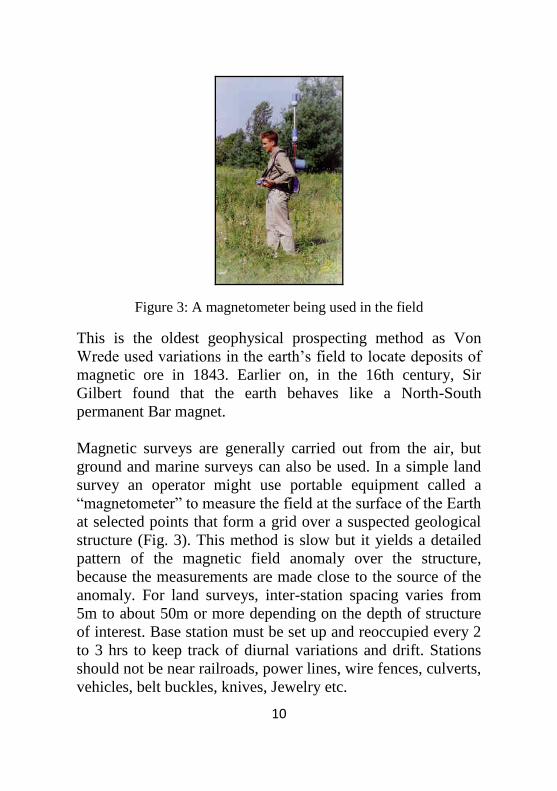
Figure 3: A magnetometer being used in the field
This is the oldest geophysical prospecting method as Von
Wrede used variations in the earth’s field to locate deposits of
magnetic ore in 1843. Earlier on, in the 16th century, Sir
Gilbert found that the earth behaves like a North-South
permanent Bar magnet.
Magnetic surveys are generally carried out from the air, but
ground and marine surveys can also be used. In a simple land
survey an operator might use portable equipment called a
“magnetometer” to measure the field at the surface of the Earth
at selected points that form a grid over a suspected geological
structure (Fig. 3). This method is slow but it yields a detailed
pattern of the magnetic field anomaly over the structure,
because the measurements are made close to the source of the
anomaly. For land surveys, inter-station spacing varies from
5m to about 50m or more depending on the depth of structure
of interest. Base station must be set up and reoccupied every 2
to 3 hrs to keep track of diurnal variations and drift. Stations
should not be near railroads, power lines, wire fences, culverts,
vehicles, belt buckles, knives, Jewelry etc.
Page 17
11
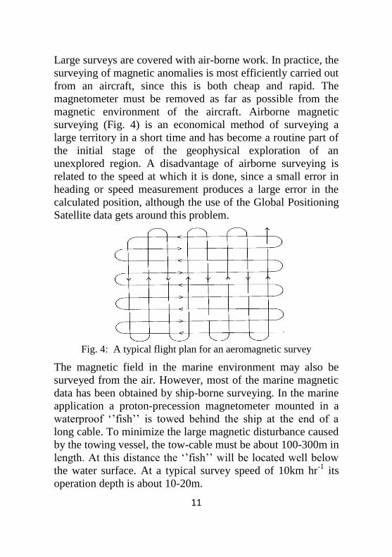
Large surveys are covered with air-borne work. In practice, the
surveying of magnetic anomalies is most efficiently carried out
from an aircraft, since this is both cheap and rapid. The
magnetometer must be removed as far as possible from the
magnetic environment of the aircraft. Airborne magnetic
surveying (Fig. 4) is an economical method of surveying a
large territory in a short time and has become a routine part of
the initial stage of the geophysical exploration of an
unexplored region. A disadvantage of airborne surveying is
related to the speed at which it is done, since a small error in
heading or speed measurement produces a large error in the
calculated position, although the use of the Global Positioning
Satellite data gets around this problem.
Fig. 4: A typical flight plan for an aeromagnetic survey
The magnetic field in the marine environment may also be
surveyed from the air. However, most of the marine magnetic
data has been obtained by ship-borne surveying. In the marine
application a proton-precession magnetometer mounted in a
waterproof ‘’fish’’ is towed behind the ship at the end of a
long cable. To minimize the large magnetic disturbance caused
by the towing vessel, the tow-cable must be about 100-300m in
length. At this distance the ‘’fish’’ will be located well below
the water surface. At a typical survey speed of 10km hr-1
its
operation depth is about 10-20m.
Page 18
12
Magnetic surveying is a very rapid and very cheap technique.
While not very widely used in hydrocarbon exploration,
magnetic surveying is a very useful aid in geological mapping
in areas with thick sedimentary cover and may reveal
intrusives, structural features if magnetic horizons such as
ferruginous sandstones, tuffs or lavas are present.
Alternatively, if the basin fill contains no magnetic sediments,
a magnetic survey has the ability to “see through” the cover to
disclose the nature and form of the crystalline basement and
thus the depth and character of the boundaries of the
sedimentary basin. In both cases, it might reveal the location of
structural traps within the sediments or features of basement
topography, which influenced the development of the basin
fill. Applications of magnetic method include:-
Investigation of large-scale crustal features
Search for metalliferous ore deposits bodies
Location of both massive sulphide deposits and iron ores
Used to map areas with thick sedimentary cover that may
reveal intrusives, structural features such as ferruginous
sandstones, tuffs or lavas
Also “sees through” the sedimentary cover to disclose the
nature and type of the crystalline basement thus revealing
the depth and character of the boundaries of the
sedimentary basin
Used to reveal the location of structural traps within the
sediments or features of the basement topography which
influenced the development of the basin fill
Used to reveal the position of the continents at various
times in the past – Continental drift, Seafloor spreading
“Seeing through” the sedimentary cover is the main feature of
this technique in the exploration for oil and gas. This reveals
the thickness of the overlying sediments which is usually
Page 19
13
analyzed to determine if the sediment is mature enough to
contain any hydrocarbon.
Seismic Method Seismic methods, in comparison to gravity and magnetic
methods, are active methods of geophysical methods. In
seismic surveying, seismic waves are propagated through the
earth’s interior and the travel times are measured of waves that
return to the surface after refraction or reflection at geological
boundaries within the earth. The magnitude of the travel times
are determined by the distance from the source to the detector
and the elastic properties of the materials between the source
and the detectors. These travel times may be converted into
depth values and, hence, the distribution of the subsurface
interfaces of geological and economic interest may be
systematically mapped. One of the first active seismic
experiments was conducted in 1845 by Robert Mallet when he
measured the time of transmission of surface waves generated
by an explosion using the ripple formed at the surface of
mercury after an explosion. In 1909, Andrija Mohorovicic
used travel-times from earthquake sources to perform a
seismic refraction experiment and discovered the existence of
the crust-mantle boundary now called the Moho.
The earliest uses of seismic observations for the exploration of
oil and mineral resources date back to the 1920s. The seismic
refraction technique was used extensively in Iran to delineate
structures that contained oil. The seismic reflection method,
now the most commonly used seismic method in the oil
industry, was first demonstrated in Oklahoma in 1921.
Seismic surveying methods as adopted for the oil and gas
industry are divided into two methods:- Refraction and
Reflection Seismology
Page 20
14
Refraction Seismology Refraction experiments are based on the times of arrival of the
initial ground movement generated by a source recorded at a
variety of distances. The source and receivers are separated by
distances that are large with respect to the depth of the
refracting surface (Fig. 5). The waves therefore travel over
great horizontal distances. Later-arriving complications in the
recorded ground motion are discarded. Thus, the data set
derived from refraction experiments consists of a series of
times versus distances. These are then interpreted in terms of
the depths to subsurface interfaces and the speeds at which
waves travels through the subsurface within each layer. These
speeds are controlled by a set of physical constants, called
elastic parameters that describe the material.
Figure 5: Refraction geometry
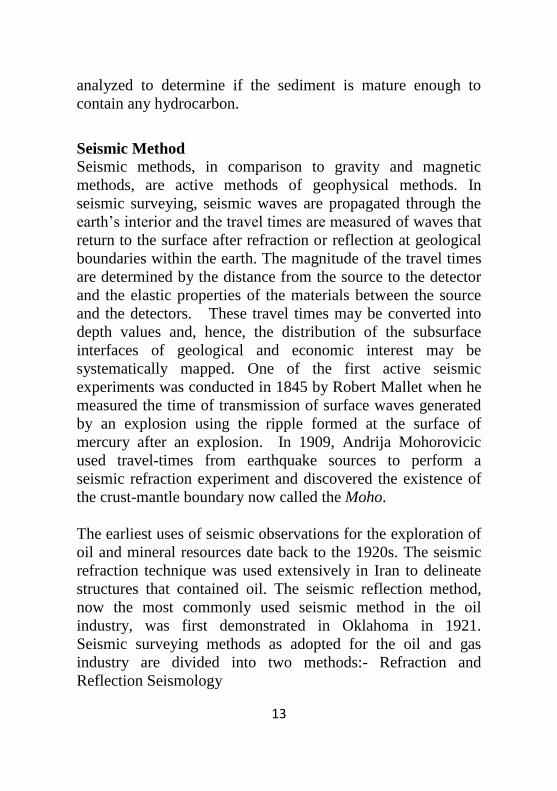
Reflection Seismology
In reflection seismology, elastic waves are injected into the
earth and geologic structures are mapped from the echoes
returning to the surface from the depths. In contrast with the
refraction seismology, reflection techniques measure travel
times of waves that arrive from subsurface interfaces between
media of different strength at offsets much smaller than the
depth of these interfaces (Fig. 6). In this sense, reflection
Page 21
15
seismology is a very sophisticated version of the echo
sounding used in submarines, ships, and radar systems. In
addition to examining the times of arrival of these, reflection
seismic processing extracts information about the subsurface
from the strength of the arrival (amplitude) and shape of the
ground motion. The travel time and amplitude depend on the
nature of the reflection boundary and on the path that the wave
has followed from the source to the reflection boundary and to
the receiver. Subsurface structures can be complex in shape
but like the refraction methods, are interpreted in terms of
boundaries separating material with differing elastic
parameters.
Although, reflection technique is more expensive to conduct,
the petroleum industry uses it in exclusion to other exploration
techniques. This is because of its potential for being more
powerful in terms of its ability to generate interpretable
observations over complex geological structures and its high
accuracy to provide the most detailed information necessary to
locate oil and gas from the surface. It provides sophistication
and requires a lot of expertise and experience.
Figure 6: Seismic Reflection Geometry
Page 22
16
My Vice Chancellor Sir, after the foregone introductory
remarks and the basic description of geophysical survey
techniques, I will now try to capture what, to my own belief,
the inaugural lecture is meant to convey to the society. To me,
I believe that an inaugural lecture gives the lecturer an
opportunity to showcase himself what he believes he has been
professing to the society. It is neither meant as a promotion
criterion or for a professor to come out and tell us about
himself without fulfilling quality aspect of the human endeavor
he has been working on throughout his academic life. With
this in mind, sir, I will here try to chronicle the trail of my
academic enquiry from inception and summarize by trying as
much as possible to emphasize what I believe is my own
contribution to knowledge.
My quest for knowledge began when after my high school
days, I was admitted to pursue a Higher School Certificate in
St. Augustine’s Nkwerre (now, Nkwerre High School) to study
a rare combination of subjects (Maths, Physics, Geography).
One may ask where this combination should lead someone in
life. At this point, my wish was to pursue a course in either one
of the following – Marine Engineering, Aeronautic
Engineering or Geosciences. I ended up with Physics in
University of Lagos where I did a project on Deconvolution
under the supervision of a foremost Geophysicist – Prof J. E.
A. Oseimehkian. Deconvolution is really a mathematical
operation which is designed to restore a wave-shape to the
form it was before it underwent a linear filtering action. This
project was carried out manually without the aid of computers.
One can imagine what was done then. This is really how I
started my journey into the geosciences world.
From this point, I will try to chronicle what I believe I have
been contributing to geosciences as a profession.
Page 23
17
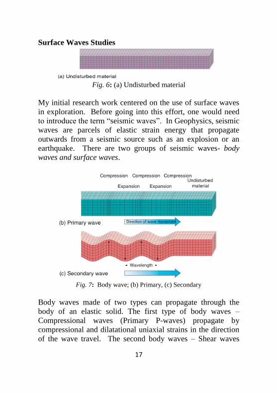
Surface Waves Studies
Fig. 6: (a) Undisturbed material
My initial research work centered on the use of surface waves
in exploration. Before going into this effort, one would need
to introduce the term “seismic waves”. In Geophysics, seismic
waves are parcels of elastic strain energy that propagate
outwards from a seismic source such as an explosion or an
earthquake. There are two groups of seismic waves- body
waves and surface waves.
Fig. 7: Body wave; (b) Primary, (c) Secondary
Body waves made of two types can propagate through the
body of an elastic solid. The first type of body waves –
Compressional waves (Primary P-waves) propagate by
compressional and dilatational uniaxial strains in the direction
of the wave travel. The second body waves – Shear waves
Page 24
18
(Secondary S-waves) propagate by a pure shear strain in a
direction perpendicular to the direction of wave travel (Fig. 7a,
b).
The surface waves propagate along the surface, or along the
boundary between two dissimilar solid media with associated
motions being elliptical in a plane perpendicular to the surface
and containing the direction of propagation (Rayleigh waves).
A second surface waves – Love waves are polarized shear
waves with an associated oscillatory particle motion parallel to
the free surface and perpendicular to the direction of wave
motion (Fig. 7d, e). These surface waves, because their
properties are considered as noise in exploration, all effort is
made to reduce their impact in exploration. They contain large
energies that travel longer distances since they decay slower
when compared to the body waves from the same sources.
Fig. 7: Surface wave; (d) Rayleigh, (e) Love
Though called noise in exploration, we analyzed these waves
recorded in the Texas Refugio County of the Gulf Coast of
America. In a crustal refraction experiment in Refugio
County, Texas, surface waves were identified as dispersed late
Page 25
19
arriving wave groups at ranges out to about 64 km (Fig. 8).
Our surface wave research analyzed these waves to obtain
smoothly varying P and S velocity structures by comparing
group and phase velocity data with dispersion curves
computed from a liquid and a layered solid. These analyses
provided information concerning the P velocity structure to a
depth of 1.0 km and the shear velocity structure to a few
hundred meters depth (Fig. 7). The fundamental mode
Rayleigh wave data suggest a sharp increase in shear velocity
at a depth of 175-200 m which is confirmed by a shale-sand
transition shown in an SP log near the station and a change in
porosity noted in the resistivity log associated with a change in
the shear strength of the sediments.
The results of this study were published in Geophysics and is
one of the earliest times where surface waves dispersion was
used as a means of determining the shallow velocity structures
of sediments. These are useful in exploration (Ebeniro et al.,
1983).
Figure 8: Typical Seismograms recorded at two stations
Page 26
20
Fig. 9: Smoothly varying velocity structure computed
from the surface wave data
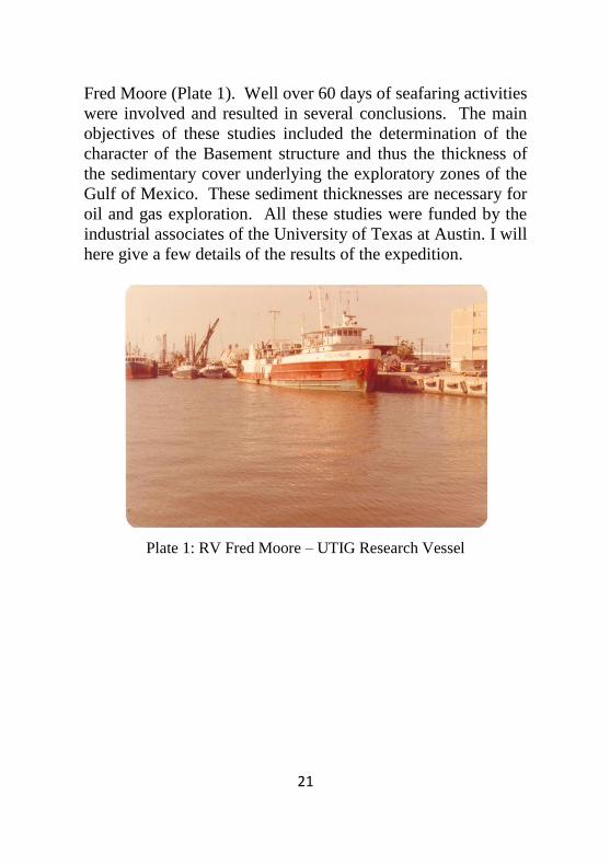
Beyond the surface waves, I further engaged in regional
studies in the Gulf of Mexico. These studies took me through
several scientific expeditions from Galveston, Texas through
the Alaminos Canyon, Green Canyon, North western Gulf of
Mexico and South Florida Bank area using the University of
Texas at Austin Research Vessels – RV Ida Green and RV
Page 27
21
Fred Moore (Plate 1). Well over 60 days of seafaring activities
were involved and resulted in several conclusions. The main
objectives of these studies included the determination of the
character of the Basement structure and thus the thickness of
the sedimentary cover underlying the exploratory zones of the
Gulf of Mexico. These sediment thicknesses are necessary for
oil and gas exploration. All these studies were funded by the
industrial associates of the University of Texas at Austin. I will
here give a few details of the results of the expedition.
Plate 1: RV Fred Moore – UTIG Research Vessel
Page 28
22
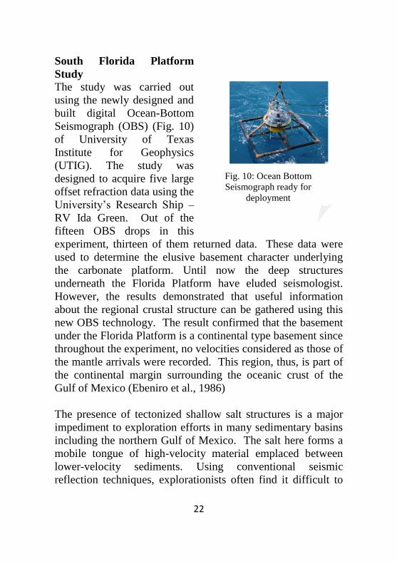
South Florida Platform
Study
The study was carried out
using the newly designed and
built digital Ocean-Bottom
Seismograph (OBS) (Fig. 10)
of University of Texas
Institute for Geophysics
(UTIG). The study was
designed to acquire five large
offset refraction data using the
University’s Research Ship –
RV Ida Green. Out of the
fifteen OBS drops in this
experiment, thirteen of them returned data. These data were
used to determine the elusive basement character underlying
the carbonate platform. Until now the deep structures
underneath the Florida Platform have eluded seismologist.
However, the results demonstrated that useful information
about the regional crustal structure can be gathered using this
new OBS technology. The result confirmed that the basement
under the Florida Platform is a continental type basement since
throughout the experiment, no velocities considered as those of
the mantle arrivals were recorded. This region, thus, is part of
the continental margin surrounding the oceanic crust of the
Gulf of Mexico (Ebeniro et al., 1986)
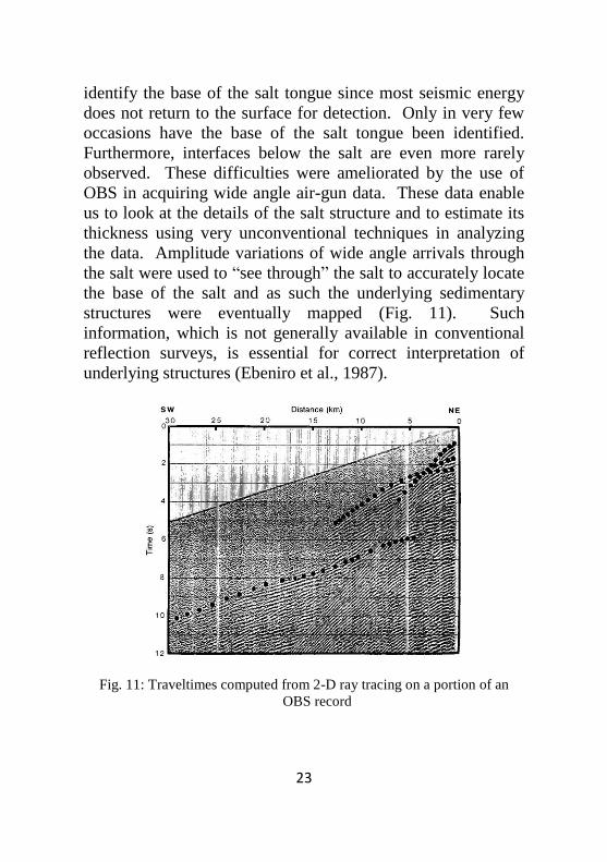
The presence of tectonized shallow salt structures is a major
impediment to exploration efforts in many sedimentary basins
including the northern Gulf of Mexico. The salt here forms a
mobile tongue of high-velocity material emplaced between
lower-velocity sediments. Using conventional seismic
reflection techniques, explorationists often find it difficult to
Fig. 10: Ocean Bottom
Seismograph ready for
deployment
Page 29
23
identify the base of the salt tongue since most seismic energy
does not return to the surface for detection. Only in very few
occasions have the base of the salt tongue been identified.
Furthermore, interfaces below the salt are even more rarely
observed. These difficulties were ameliorated by the use of
OBS in acquiring wide angle air-gun data. These data enable
us to look at the details of the salt structure and to estimate its
thickness using very unconventional techniques in analyzing
the data. Amplitude variations of wide angle arrivals through
the salt were used to “see through” the salt to accurately locate
the base of the salt and as such the underlying sedimentary
structures were eventually mapped (Fig. 11). Such
information, which is not generally available in conventional
reflection surveys, is essential for correct interpretation of
underlying structures (Ebeniro et al., 1987).
Fig. 11: Traveltimes computed from 2-D ray tracing on a portion of an
OBS record
Page 30
24
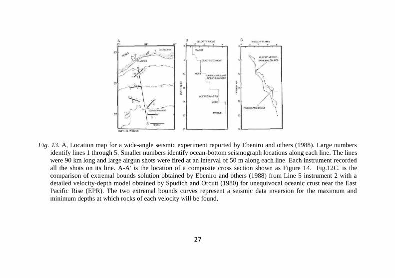
Northwestern Gulf of Mexico Study
Although the exploration for oil and gas in the Gulf of Mexico
has resulted in the acquisition of massive knowledge about the
thick infilling sediments of the area, the character, nature and
distribution of the underlying crust and mantle are much less
well known. The thought of this lack of knowledge resulted in
the determination to carry out extensive seismic
reflection/refraction survey to determine the nature of the crust
underneath the Gulf of Mexico basin. Several attempts at this
determination had been made before the study of Ebeniro et al,
(1988) revealed the crust in the central part of the Gulf basin is
really oceanic with typical thickness of about 6-8 km. We used
modern digital ocean-bottom seismographs (OBS) to record
large (4,000 in3), closely spaced (50 m) airgun shots at ranges
up to 90 km in the northern Gulf of Mexico (Fig. 13A). Their
Line 5 was located just south of the Sigsbee Escarpment (Figs.
13A and 14), the basin ward edge of an extensive salt(s) and
within crust identified as oceanic Fig. 13). These and data from
two other ocean-bottom seismographs along Line 5 allowed
Ebeniro and others (1988) to obtain a reasonably well-
constrained velocity-depth structure for the oceanic crust under
Line 5 (Figs. 13B and 13C).
Mr Vice Chancellor Sir, investigating the generalized cross-
section in Figure 14 shows two major findings. Firstly, we
have been able to define accurately the bottom of the
allochthonous salt body which has eluded seismologists for a
very long time just by using the characters of the wide angle
reflections as noted above. Secondly, there seems to be a
crustal thinning underneath the Line 3 location. This is being
interpreted for the first time that there exists alternate axis of
crustal extension during the formation of the Gulf of Mexico
basin which may have failed to proceed to sea floor spreading.
Page 31
25
This was the first time this interpretation was being made for
the Gulf of Mexico and has been quoted severally since this
report.
Fig. 12: Synthetic seismograms for two velocity models with shallow salt
showing the effect of the thickness of the shallow salt on the extent
of the refraction arrivals through the salt. Note the difference in the
extent of the strong salt refractions (Ebeniro et al., 1987).
My Vice Chancellor Sir, the foregone catalogues the initial
research efforts which I was engaged in before proceeding
back to Nigeria with a lot of enthusiasm. This enthusiasm
lulled for the lack of where withal in Research processes and
focus in the country. This did not stop me from continuing
with what I may call contemporary research efforts which I
had to adopt in the country. Amongst these are my sting in
Seismic Multiples and Velocity Studies, Environmental
Research, Water Resources Exploitation and Management
Page 32
26
Research and currently Seismic Analysis Research which has
culminated in the direct indication of bypassed hydrocarbon in
the mature fields of the Niger Delta. Let me use this
opportunity to give you a few highlights of the some of results
of the research efforts.
Page 33
27
Fig. 13. A, Location map for a wide-angle seismic experiment reported by Ebeniro and others (1988). Large numbers
identify lines 1 through 5. Smaller numbers identify ocean-bottom seismograph locations along each line. The lines
were 90 km long and large airgun shots were fired at an interval of 50 m along each line. Each instrument recorded
all the shots on its line. A-A' is the location of a composite cross section shown as Figure 14. Fig.12C. is the
comparison of extremal bounds solution obtained by Ebeniro and others (1988) from Line 5 instrument 2 with a
detailed velocity-depth model obtained by Spudich and Orcutt (1980) for unequivocal oceanic crust near the East
Pacific Rise (EPR). The two extremal bounds curves represent a seismic data inversion for the maximum and
minimum depths at which rocks of each velocity will be found.
Page 34
28
Fig. 14: Generalized cross section of the northern Gulf of Mexico margin from Ebeniro and others (1988); see Fig. 11A
for location of section line and data used). The interpreted horizons are dashed where not well constrained.
Oceanic crust is indicated by the v-pattern shading on the right side of the figure. The velocities and greater
thickness of the crust on the left are diagnostic of continental or modified continental crust. We suggest that it is all
thin transitional crust. There seems to be a crust thickness minimum under Line 3 that may correspond to an
alternate axis of crustal extension during the formation of the Gulf of Mexico basin that failed to proceed to sea-
floor spreading.
Page 35
29
Multiple Studies
In addition to the primary arrivals in seismic operations, there
exists in a layered subsurface, rays that may return to the
surface after reflections at more than one interface. These rays
are called multiple reflections (Fig. 15) and they cause a lot of
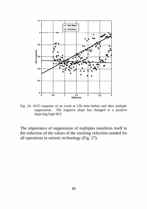
problems to the seismologist. The importance of suppressing
these arrivals in seismic operations was highlighted in the
published work (Ebeniro, 1994).
Fig. 15: Varying types of seismic multiples
One major example of the importance is the reduction in the
effectiveness of the slope of the DHI computations in seismic
analysis (Fig. 16). This figure shows the amplitude versus-
offset (AVO) response of a seismic CMP gather before and
after multiple suppression. This gather is recorded on a
gas/light oil sand. The distribution of the points on this
amplitude-offset crossplot prior to multiple suppression
demonstrates the interference of the multiples with the
primaries especially in the offset range of 1.0-2.5 km, an offset
range critical in AVO computation. The solid line is the least
square line fitted to the data points plotted along it. Although,
the calculated amplitude at zero offset decreased by about
40%, the slope increased more dramatically after multiple
suppression. This ensures the positive indication of the
presence of gas/light oil in the zone. A low scatter of the data
points is also observed after multiple suppression.
Page 36
30
Fig. 16: AVO response of an event at 3.8s time before and after multiple
suppression. The negative slope has changed to a positive
depicting high HCI
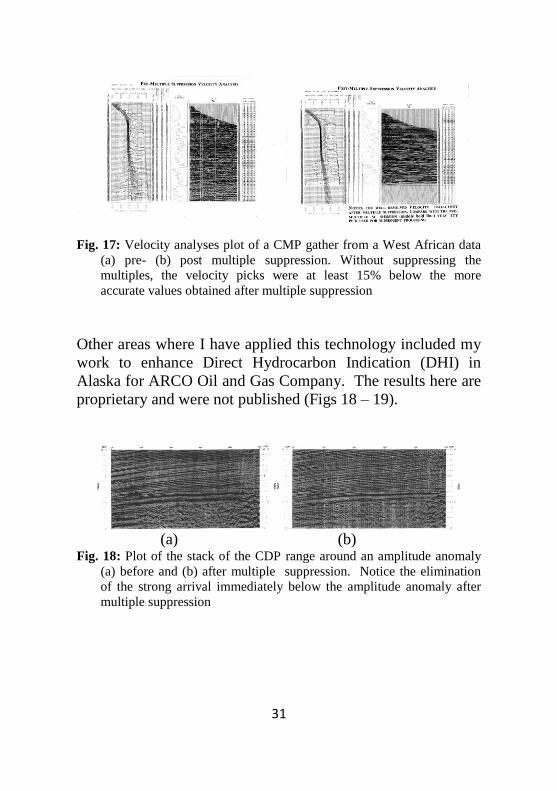
The importance of suppression of multiples manifests itself in
the reduction of the values of the stacking velocities needed for
all operations in seismic technology (Fig. 17).
Page 37
31
Fig. 17: Velocity analyses plot of a CMP gather from a West African data
(a) pre- (b) post multiple suppression. Without suppressing the
multiples, the velocity picks were at least 15% below the more
accurate values obtained after multiple suppression
Other areas where I have applied this technology included my
work to enhance Direct Hydrocarbon Indication (DHI) in
Alaska for ARCO Oil and Gas Company. The results here are
proprietary and were not published (Figs 18 – 19).
(a) (b)
Fig. 18: Plot of the stack of the CDP range around an amplitude anomaly
(a) before and (b) after multiple suppression. Notice the elimination
of the strong arrival immediately below the amplitude anomaly after
multiple suppression
Page 38
32
(a) (b)
Fig. 19: Plot of hydrocarbon indicator of the amplitude anomaly (a) before
and (b) after multiple suppression. True amplitudes plotted show the
enhancement of the amplitude after the multiple suppression.
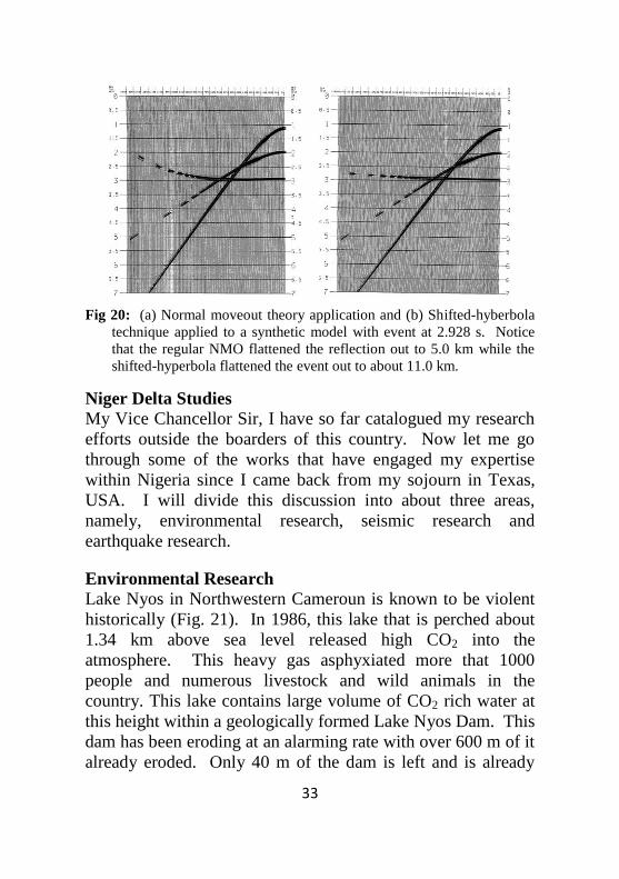
Velocity Studies
The accurate mapping of any subsurface structure is
determined by the accuracy with which the velocities of the
overlying structure are determined. Normal moveout
corrections applied to reflections in CMP gathers depend on
these velocities and are based on some assumptions of wave
propagation in the earth. Usually a small spread assumption is
made and this simplifies the computation by limiting the
indefinite travel time equation to just two terms. But currently,
large offsets are involved in seismic operations resulting in
better resolved velocity structures. I used the shifted-
hyperbolic technique of De Bazelaire (1988) to extend the
useable offset range of the synthetic data from 5.0 km to about
11.0 km (Ebeniro, 1994). Using these larger ranges will
improve the velocity information needed to improve
lithological information and structural content evaluation of
the subsurface (Fig. 20).
Page 39
33
Fig 20: (a) Normal moveout theory application and (b) Shifted-hyberbola
technique applied to a synthetic model with event at 2.928 s. Notice
that the regular NMO flattened the reflection out to 5.0 km while the
shifted-hyperbola flattened the event out to about 11.0 km.
Niger Delta Studies
My Vice Chancellor Sir, I have so far catalogued my research
efforts outside the boarders of this country. Now let me go
through some of the works that have engaged my expertise
within Nigeria since I came back from my sojourn in Texas,
USA. I will divide this discussion into about three areas,
namely, environmental research, seismic research and
earthquake research.
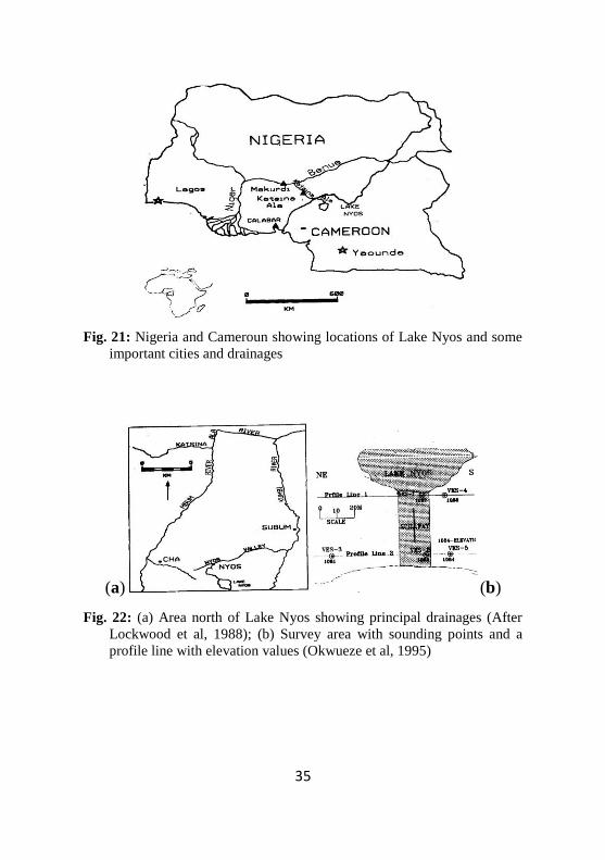
Environmental Research
Lake Nyos in Northwestern Cameroun is known to be violent
historically (Fig. 21). In 1986, this lake that is perched about
1.34 km above sea level released high CO2 into the
atmosphere. This heavy gas asphyxiated more that 1000
people and numerous livestock and wild animals in the
country. This lake contains large volume of CO2 rich water at
this height within a geologically formed Lake Nyos Dam. This
dam has been eroding at an alarming rate with over 600 m of it
already eroded. Only 40 m of the dam is left and is already
Page 40
34
weak as noticed from the lake waters spewing out underneath
the lowest part of the dam. Also, during the rainy seasons, the
lake water spills over the dam’s spillway into the valley below
(Fig. 22b). The failure of this containing dam is expected to
release millions of tons of CO2 rich water all the way from the
lake’s high elevation cascading North and East to Kumbi and
Mbum Rivers’ drainage system down to Katsina Ala River
Drainage system and other systems in Nigeria. This
phenomenon will flood all these drainages and all the other
adjourning low-lying areas and towns in Cameroun and up to
the densely populated Nigerian Towns including Katsina Ala,
Adikpo and even Obudu which are 155, 150 and 165 km away,
respectively from Lake Nyos. It is against this background
that the Nigeria Technical Committee on Earthquake
Phenomenon (NTCEP) set up a scientific team comprising
geoscientist and engineers to study the structural disposition of
the Lake Nyos Dam area(Plates 2-5). The results of the study
confirmed the presence of a shallow basement at 113 m depth
and the saturated pyroclast and weathered basement at a depth
of 110 m with probable 10 m thick agglomerate occurring at
about 6 m depth from the surface. This revelation suggests
that we must find a way to either strengthen the dam at its
lowest point or carry out a controlled release of the lake waters
to reduce its level and potential strength (Okwueze et al.,
1994).
Page 41
35
Fig. 21: Nigeria and Cameroun showing locations of Lake Nyos and some
important cities and drainages
(a) (b)
Fig. 22: (a) Area north of Lake Nyos showing principal drainages (After
Lockwood et al, 1988); (b) Survey area with sounding points and a
profile line with elevation values (Okwueze et al, 1995)
Page 42
36
Plate 2: Scientific Team standing on Lake Nyos Dam
Plate 3: Dr J. O. Ebeniro backing the Lake Nyos spillway
Page 43
37
Plate 4: Scientific Team taking a reading on top of the dam
Plate 5: A Cameroonian labourer standing on top of the spillway
Some other environmental studies include several
environmental pollution studies ranging from Environmental
Noise Assessment, Radiation Level Assessment, Gas-Flaring
studies and Investigation of Solid Waste Landfill problems.
The conclusions drawn from all these investigation have
already been published in diverse literature (Ebeniro and
Abumere, 1999; Avwiri and Ebeniro, 1998; Avwiri and
Ebeniro, 2002; Abumere et al., 1999; Ebeniro and Avwiri,
1996; Avwiri and Ebeniro, 1995; Ehirim et al. 2009a, Ehirim
et al., 2009b).
Page 44
38
Fig. 21: Interpreted 2-D Pseudo sections of the profiles (A - D) around a
waste landfill in Port Harcourt. Profile A is south of the landfill while
profiles B-D are located ESE of the landfill. The contaminated tongue
emanated from the landfill is moving at a rate of about 5 m per annum
at a depth of about the locations of the private boreholes in the
municipality.
Mr. Vice Chancellor Sir, permit me to now showcase what I
have been doing in the contemporary periods as it concerns my
research focus. As the country wants to increase the total
reserve base for hydrocarbons, it becomes imperative to
develop novel methods of finding more hydrocarbons. We thus
Page 45
39
have to go back to the drawing board to look into the depleted
fields and further investigate if we missed some of the
hydrocarbons during the earlier discoveries. Thus when I was
offered a sabbatical placement with SPDC in the early 2003, I
initiated two research areas viz – Direct Hydrocarbon
Indication (DHI) using crossplotting of rock properties and
Multiple Studies. Eventually, the first area was approved and
since then I have been working on it with my students. This
technique has continued to be very relevant in the
contemporary literature. We have therefore been pursuing it
with a lot of vigour and have thus generated a lot of results
most of which are yet to be published in the literature while
several are already published in the contemporary literature
(Ebeniro et al, 2003; Ebeniro, 2006; Ebeniro and Omudu,
2006; Omudu et al., 2007a; Omudu et al., 2007b; Omudu et al.,
2007c; Omudu and Ebeniro, 2007; Omudu et al., 2008).
Some of these results are currently being adopted in the
company to assess the mature fields of Niger Delta. Since
2009, we have been carrying out studies for SPDC to locate
by-passed petroleum in one of their mature fields in the
swamps of Niger Delta. This was completed last year and we
have started application of the techniques in other fields for
SPDC (Ajiduah et al., 2011; Edoja et al., 2011; Dagogo et al,
2011). Currently, we have also initiated another research focus
towards the use of surface waves observed in one of the land
acquisitions in exploration. This technique have been
successfully applied sometime ago in Texas. We hope to use
the results of this study to effectively improve our analysis of
velocities needed for inversion of seismic data.
Page 46
40
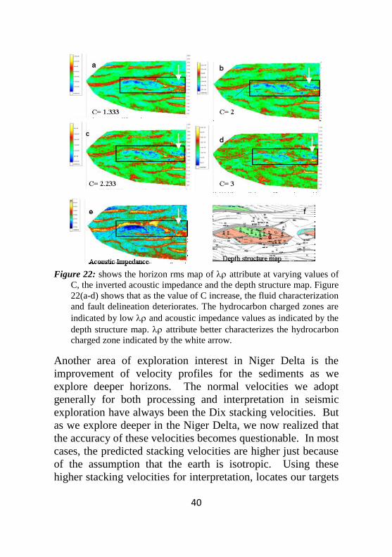
Figure 22: shows the horizon rms map of attribute at varying values of
C, the inverted acoustic impedance and the depth structure map. Figure
22(a-d) shows that as the value of C increase, the fluid characterization
and fault delineation deteriorates. The hydrocarbon charged zones are
indicated by low and acoustic impedance values as indicated by the
depth structure map. attribute better characterizes the hydrocarbon
charged zone indicated by the white arrow.
Another area of exploration interest in Niger Delta is the
improvement of velocity profiles for the sediments as we
explore deeper horizons. The normal velocities we adopt
generally for both processing and interpretation in seismic
exploration have always been the Dix stacking velocities. But
as we explore deeper in the Niger Delta, we now realized that
the accuracy of these velocities becomes questionable. In most
cases, the predicted stacking velocities are higher just because
of the assumption that the earth is isotropic. Using these
higher stacking velocities for interpretation, locates our targets
Page 47
41
at shallow depths. We have thus developed a more accurate
velocity mapping technique which takes into consideration the
anisotropic nature of Niger Delta sediments (Ogagarue et al.,
2010).
Fig. 23: Final isotropic and anisotropy-corrected velocity functions at a
CDP location along the survey
Haitian Earthquake: Is Nigeria Vulnerable?
Mr. Vice Chancellor Sir, in January 2010, the whole world was
jolted when a magnitude 7.0 earthquake hit one of the poorest
countries in this hemisphere (Fig. 24). Haitian Earthquake
claimed over 316,000 lives and almost destroyed the whole
country including the capital city of Port-Au-Prince. This
destruction brings to the fore-front the power of an earthquake
which one can expect in any major earthquake. This
earthquake is rated as the 5th
deadliest earthquake in the world.
The ability for the country to cope with such a disaster was
also noted. The reaction of the whole world to rally around the
affected persons shows that without others, most people cannot
expect to survive for a long time alone during natural and
unpredictable disasters.
Page 48
42
Major Tectonic Boundaries: Subduction Zones -purple, Ridges -red and Transform Faults -green
Figure 24: Major Tectonic Boundaries surrounding the Island of
Hispaniola: Subduction Zones-purple, Ridges-red and Transform
Faults-green. (http://neic.usgs.gov/neis/bulletin/neic_rja6_l,html)
Following the Haitian earthquake is the one that hit a well
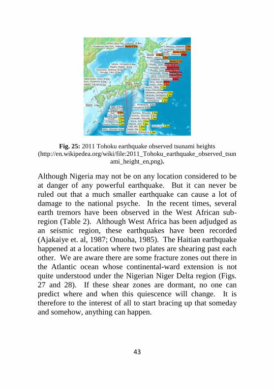
developed country of Japan in March 11, 2011. This
earthquake was rated as a 9.0 magnitude earthquake (Fig. 25).
This is about 20 times larger in power than that of the Haitian
earthquake. The devastation in Japan was not really caused by
the direct effect of the earthquake but the resultant flooding
caused by the surging ocean waters (tsunami). The earthquake
epicenter is about 70 km offshore Japanese coast with a depth
of about 32 km under the water. This great earthquake of our
time killed only 21,000 people as compared to the Haitian
earthquake that killed over 316,000 people. Japan will require
over $300bn to rebuild their destroyed infrastructure.
These two powerful earthquakes seem to call to question about
the preparedness of our country to handle natural disasters.
Page 49
43
Fig. 25: 2011 Tohoku earthquake observed tsunami heights
(http://en.wikipedea.org/wiki/file:2011_Tohoku_earthquake_observed_tsun
ami_height_en,png).
Although Nigeria may not be on any location considered to be
at danger of any powerful earthquake. But it can never be
ruled out that a much smaller earthquake can cause a lot of
damage to the national psyche. In the recent times, several
earth tremors have been observed in the West African sub-
region (Table 2). Although West Africa has been adjudged as
an seismic region, these earthquakes have been recorded
(Ajakaiye et. al, 1987; Onuoha, 1985). The Haitian earthquake
happened at a location where two plates are shearing past each
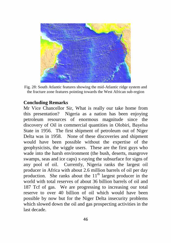
other. We are aware there are some fracture zones out there in
the Atlantic ocean whose continental-ward extension is not
quite understood under the Nigerian Niger Delta region (Figs.
27 and 28). If these shear zones are dormant, no one can
predict where and when this quiescence will change. It is
therefore to the interest of all to start bracing up that someday
and somehow, anything can happen.
Page 50
44
Table 2: Recent earth tremors recorded in West African Sub
region
S/N Location Year
1 Warri 1933
2 Accra June, 1939
3 Ohafia, Umuahia July, 1961
4 Ijebu-Ode 1963
5 Danbata, Kano July, 1975
6 Bauchi 1981
7 Yola December, 1984
8 Ijebu Ode August, 1984
9 Gombe 1985
10 Jere, Kaduna April, 1990
10 Ogun 2009
It could be in the nature of a relatively small earthquake
onshore. But if it happens offshore and generates some
tsunami, not necessarily the 40m water wave of Japan
earthquake, it could cause some major damages. As a mater of
fact, University of Port Harcourt is standing less than 6m
above sea level. Just a 10 m water wave will inundate the
university. What then will happen to all the costal region of
southern Nigeria from Calabar through Bonny, Warri, to
Lagos? Recently, there was great flooding of the Lekki
peninsular and some environs of Lagos City. We are yet to
come to terms on what really caused it. Could it be an
offshore event which no one has been able to ascertain because
of lack of seismic stations in the Country?
Page 51
45
Fig. 27: West African sub-region gravity responses showing the fracture
zones
Mr. Vice Chancellor Sir, are we really immuned to this natural
disasters called “earthquake”? I will not stand here and tell
you that Nigeria is indeed not vulnerable. Rather, I will request
that our governments should immediately harness our
resources to start sensitizing the populace of the possibility of
such no matter how small in magnitude. The situation in Haiti
should be a wake up call to all of us. Haitian earthquake
which is 20 times less in magnitude killed over 316,000 people
which is about 14 times the number of people killed after the
Japanese earthquake that killed only 21,000 people. Poverty
also took its own toll on the disaster.
Page 52
46
Fig. 28: South Atlantic features showing the mid-Atlantic ridge system and
the fracture zone features pointing towards the West African sub-region
Concluding Remarks
Mr Vice Chancellor Sir, What is really our take home from
this presentation? Nigeria as a nation has been enjoying
petroleum resources of enormous magnitude since the
discovery of Oil in commercial quantities in Olobiri, Bayelsa
State in 1956. The first shipment of petroleum out of Niger
Delta was in 1958. None of these discoveries and shipment
would have been possible without the expertise of the
geophysicists, the wiggle users. These are the first guys who
wade into the harsh environment (the bush, deserts, mangrove
swamps, seas and ice caps) x-raying the subsurface for signs of
any pool of oil. Currently, Nigeria ranks the largest oil
producer in Africa with about 2.6 million barrels of oil per day
production. She ranks about the 11th
largest producer in the
world with total reserves of about 36 billion barrels of oil and
187 Tcf of gas. We are progressing to increasing our total
reserve to over 40 billion of oil which would have been
possible by now but for the Niger Delta insecurity problems
which slowed down the oil and gas prospecting activities in the
last decade.
Page 53
47
We thus see that the wealth of the country, as at now
dependent on oil and gas resource, would not have been
possible without the ingenuity of the geophysicist. As a
medical doctor looks through the human body using the x-ray
technology, so does the geophysicist look through the earth for
the precious oil and gas using his own geophysical technology.
Note please, the geophysicists do it with the wiggles.
My people, this is the time we have to advise the government
at all levels to initiate the process of taking safety of both live
and property to heart. We should learn from the experiences
of other nations rather than others using our own experiences
to solve their problems. The experiences of the nation of Haiti
after the earthquake should be a wake-up call for us all. We
should not wait thinking it will never happen to us. Nothing is
sacrosanct in the earth since anything is possible.
Page 54
48
References
Ajakaiye, D. E., Daniyan, M. A., Ojo, S. B. and Onuoha, K.
M., 1987, The July 28, 1984 Southwestern Nigerian
Earthquake and its iumplication for the understanding of
tectonic structure of Nigeria. Journal of Geodynamics, v. 7,
p. 307-317
Adepelumi, A. A., 2009, Broadband Earthquake monitoring at
OAUIFE station, Nigeria.
Onuoha, K. M., 1985, Intraplate earthquakes: a discussion of
cases from the West African sun-region, Proceedings of the
3rd
international symposium on analysis of seismicity and
seismic risk, Liblice, Czechoslovakia, p. 232-239.
USGS Shakemap, 2010, United States of America Geological
Survey Earthquake Hazard program: Shakemap
http://earthquake.usgs.gov/earthquakes/shakemap/global/sh
ake/2010rja6/
USGS Shakemap, 2011, United States of America Geological
Survey Earthquake Hazard program:
http://en.wikipedia.org/wiki/file:2011Tohoku_earthquake_
observed_tsunami_heights_en.png
Publications
Ajiduah, S.W, J. O. Ebeniro, C. N. Ehirim, T. Dagogo and C.
A. Edoja, 2011, Locating By-Passed Oil Using
Petrophysical Parameters And Rock Attributes Derived
From 4-D Seismic Data: A Case Study Of Vok Field
Offshore Niger Delta. (Submitted)
Edoja, C. A, J. O. Ebeniro, C. N. Ehirim, S. W. Ajiduah and
T. Dagogo, 2011, Time-Lapse Seismic Amplitude Analysis
for Enhanced Prospect Definition. (Submitted)
Page 55
49
Dagogo, T,. J. O. Ebeniro, C. N. Ehirim, C. A. Edoja and S.
W. Ajiduah, 2011, Enhanced Prospect Definition using
Petrophysical Well Logs and 4-D Seismics. (Submitted)
Ehirim, C. N. and J. O. Ebeniro, 2010, Evaluation of Aquifer
characteristics and ground water potentials in Awka,
Southeast Nigeria using Vertical Electrical Sounding,
Asian Journ. of Earth Sciences. Pg. 1-9.
Ehirim, C. N., J. O. Ebeniro, 2010, 2D Resistivity imaging
applied to Ground Water Exploration in Awka, SE Nigeria,
Archives of Physics Research, 1(2), p.34-45
Ogagarue, D. O., Ebeniro, J. O. and Ehirim, C. N., 2010,
Velocity Anisotropy in the Niger Delta, A case study of
pre-stack time imaging with isotropic and anisotropic
velocity models, Archives of Physics Research, 1(2), p. 50-
57.
Chukwu, G. U., A. S. Ekine and J. O. Ebeniro, 2009, SP
anomalies around anticlinorium of Southeastern Nigeria,
Pacific Journ. of Sci. and Tech., 9(2), p 561-566.
Ehirim, C. N., J. O. Ebeniro and D. A. Ogwu, 2009 A
Geophysical and Hydro-Physiochemical Study of the
Containment Impact of a Solid Waste Landfill (SWL) in
Port Harcourt Municipality, Nigeria, Pacific Journ. Sc. and
Tech., 10(2), p. 596-603.
Ehirim, C. N., J. O. Ebeniro and O. P. Olanegan, 2009, A
Geophysical Investigation of Solid Waste Landfill using 2-
D Resistivity Imaging and Vertical Electrical Sounding
Methods in Port Harcourt Municipality, Nigeria, Pacific
Journ. Sc. And Tech., 10(2), p. 604-612.
Omudu, L. M., J. O. Ebeniro, M. Xynogalas, Nedo Osayande
and Sam Olotu, 2008, Fluid discrimination and reservoir
characterisation from onshore Niger Delta, SEG Expanded
Abstracts, Las Vegas, Texas.
Omudu, L. M., J. O. Ebeniro, M. Xynogalas and Sam Olotu,
2007, Optimizing Quantitative Interpretation for Reservior
Page 56
50
Characterization: Case study onshore Niger Delta. SPE
Journal.
Ogagarue, D. O., Ebeniro, J. O. and Ehirim, C. N., 2007,
Velocity Anisotropy in the Niger Delta sediments derived
from geophysical logs, Nigeria , Nigerian Journal of
Physics, Vol. 19 p. 237-245.
Omudu, L. M. and J. O. Ebeniro, 2007, Beyond Acoustic
Impedance: An Onshore Niger Delta Experience, SEG
Expanded Abstracts, San Antonio, Texas, p. 16-20.
Ehirim, C. N. and J. O. Ebeniro, Application of Azimuthal
Schlumberger-resistivity survey in Southeastern Nigeria,
Int. Journ. Nat. And Appl. Sciences, 2007.
Ebeniro, J. O. and C. N. Ehirim, 2006, Gully Erosion in
Southeastern Nigeria: An integrated geological and
geophysical study, Global Journal of Geological Sciences,
Vol. 1, pg. 21-28.
Omudu, L. M. and J. O. Ebeniro, 2005, Crossplotting of rock
properties for fluid discrimination using well data in
offshore Niger Delta, Nigerian Journal of Physics, Vol. 17
p. 16-20.
Ehirim, C. N. and J. O. Ebeniro, 2005, Tectonic trends
delineated from drainage lineament analysis and Azimuthal
Resistivity survey: A Case Study of S. E. Nigeria Gully
Erosion Belt, Global Journal. of Geological Science, vol. 4,
p. 21-28.
Akpabio, O., J. E. Ejedewe, J. O. Ebeniro and E. D. Uko,
2003, Geothermal gradients in the Niger Delta basin from
continuous temperature logs, Global Journal of Pure and
Applied Science, vol. 9, p. 265-272.
Avwiri G.O. and J.O Ebeniro, 2002, A survey of the
background radiation levels of the sub Industrial area of
Port Harcourt, Global Journal of Pure and Applied Science,
vol. 8, p. 111-113
Page 57
51
Ebeniro, J.O., and O.E. Abumere, 1999, Environmental Noise
Assessment of an Industrial plant, Nigerian Journal of
Physics, Vol. 11, p. 97-105
Abumere, O.E., J.O. Ebeniro and S.N. Ogbodo, 1999,
Investigation of Environmental Noise within Port Harcourt
City Metropolis, Nigerian Journal of Physics vol. 11 p.
129-132
Awviri, G.O. and J.O. Ebeniro, 1998, External Environmental
Radiation in an Industrial area of Rivers State, Nigerian
Journal of Physics, Vol. 19, p. 105-107
Etim, D. Uko, C.O. Ofoegbu, J.O. Ebeniro and C.C.
Chukwueke, 1997, Present Day Heat flow in the Northern
Niger Delta, Nigeria, NAPE Bulletin, Vol. 12.
Ebeniro, J.O. and Avwiri, G.O., 1996, Environmental
pollution due to Gas-flaring at Oyigbo Area of Rivers
State, Nigeria Journal of Physics, vol. 8S, p. 7-10
Nwaobi, U.S., J.O. Ebeniro and J.C. Obilo, 1996, The effect
of fluid content (gas, oil, and brine) on offset dependent
Reflectivity (AVO), Nigerian Journal of Physics, vol. 8S,
p. 21-24.
Avwiri, G.O, and J.O. Ebeniro, 1995, Environmental Impact
of Gas-Flaring at Obrikom area of Rivers State, Nigerian
Journal of Physics, Vol. 7, p. 73-76.
Okwueze, E.E., J.O. Ebeniro and M. Mbogning, 1995, The
Geo-electric structure of Lake Nyos dam, Cameroon and its
geologic Implications, Nigerian Journal of Mining and
Geology, vol. 30 No. 1, p 1-5
Ebeniro, J.O., 1995, Seismic Velocity Determination from
Large offset data, Nigerian Journal of Mining and
Geology, Vol. 30, No. 1, p. 29-37.
Ebeniro, J.O., 1994, Importance of Multiple Suppression in
Seismic Exploration, Nigerian Journal of Mining and
Geology, Vol. 29, No 2, p. 183-193.
Page 58
52
Uko, E. D., A.S. Ekine, J.O. Ebeniro and C.O. Ofoegbu.
1992, Weathering structure of East Niger Delta, Nigeria,
Geophysics, Vol. 56, No. 9., p. 1228-1233.
Ebeniro, J.O., and C.O. Ofoegbu, 1991, Rock properties for
seismic modeling, Nigeria Journal of Mining and Geology,
Vol. 28, No. 2, p. 293-302.
Uko, E. D., A.S. Ekine, J.O. Ebeniro, 1991, Weathering
structure of East Niger Delta, A low velocity study, NAPE
Bulletin, 6, No 1, p. 67-74.
Mbonu, P.D.C., J.O. Ebeniro, C.O. Ofoegbu and A.S. Ekine,
1991, Geoelectric Sounding for the determination of
Aquifer Characteristic in parts of the Umuahia area of
Nigeria. Geophysics; Vol. 55, No. 2, p. 284-291.
Ofoegbu, C.O., and J.O. Ebeniro, 1989, A computer program
for the interpretation of Magnetic anomalies due to dyke-
like bodies. Nigerian Journal of Mining and Mining and
Geology; Vol. 25 Nos 1&2, p. 155-158.
Ebeniro, J.O, C.O. Ofoegbu and Yosio Nakamura, 1989,
Large Offset Digital Refraction Survey Using Ocean
Bottom Seismograph, Nigerian Journal of Mining and
Geology; Vol. 25 Nos 1&2, p. 251-258
Ofoegbu, C.O., M.I. Odigi and J.O. Ebeniro, 1989, On the
tectonic evolution of Benue Trough of Nigeria. I, The
Benue Trough, Structure and Evolution, C.O. Ofoegbu
(ed.), Friedr. Viewing and Sohn, Braunschweing
Wiesbaden, p. 207-216
Ebeniro, J.O., Yosio Nakamura, D.S. Sawyer, and W.P.
O’Brien Jr., 1987, Sedimentary and crustal structure of the
northwestern Gulf of Mexico, Journal of Geophysical
Research; Vol. 93, p. 9075-9092.
Ebeniro, J.O., Yosio Nakamura, and D.S Sawyer, 1987,
Estimating the thickness of shallow salt from seismic
refractions, Geophysics; vol. 52, No. 12, p. 1708-1714.
Page 59
53
Ebeniro, J.O., W.P. O’Brien Jr, and F. Jeanne. Shaub, 1986,
Crustal structure of the South Florida Platform, Eastern
Gulf of Mexico: an ocean-bottom seismograph refraction
study. Marine Geophysical Researches, Vol. 8, p. 363-382.
Ebeniro, J.O, C.R. Wilson and J.H. Dorman, 1983,
Propagation of dispersed Compressional and Rayleigh
waves on the Texas costal plain. Geophysics, vol. 48, No.
1, p. 27-35.
BOOKS
Owate, I. O., J.O. Ebeniro, O.E. Abumere, G.O. Avwiri, E.O.
Chukwuocha and C.U. Okujagu, 1995, Rudiments of
Physics (Mechanics and Properties of Matter), Tanus
Books Nigeria Limited, Lagos.
Abumere, O. E., J.O Ebeniro, I.O Owate, A.S. Ekine, G.U.
Okujagu and T.M, Abbey, 2002, Introductory University
Physics (Mechanics and Properties of matter), Acotec
Technologies, Port Harcourt
Owate, I. O., J.O. Ebeniro, O.E Abumere, G.O Avwiri, E.O.
Chukwuocha and C.U. Okujagu, 2000, Rudiments of
Physics (Electricity, Magnetism, Light and Sound), Acotec
Technologies, Port Harcourt.
Ebeniro, J.O., I.O. Owate and Igho Joe, 1996, Computer
Appreciation and Basic Applications, Acotec
Technologies, Port Harcourt.
Owate, I. O., J.O. Ebeniro, O.E. Abumere, G.O. Avwiri, E.O.
Chukwuocha and C.U. Okujagu, 1995, Rudiments of
Physics (Mechanics and Properties of Matter), Rescue
Publishers, Nigeria.
Page 60
54
COMMISSIONED TECHNICAL MONOGRAPHS
(CONFIDENTIAL)
Ebeniro, J.O., 1997, Environmental assessment of Elelenwa
Dumpsite – Vertical Electric Sounding. Technical
Monograph, Commissioned by Environmatics (A.E.C) Ltd.
Port Harcourt, 52 p.
Ebeniro, J.O., 1996, Surface geophysical survey – Vertical
Electric Sounding – for the citing of Water Borehole at
Ordec LP-Gas Bottling Plants at Umuaku-Uli, Anambra
State, Technical Monograph commissioned by Siljay
Concept (Nig) Ltd., Lagos, 23p.
Ebeniro, J.O, 1995, Environmental Site Assessment of
Potentially Polluted Area (PPA) around Ughelli
Exploration Megabelt – Vertical Electric Sounding,
Technical Monograph commissioned by Prodec-Fugro
Consultants (Nig.) Ltd. Port Harcourt, 33 p.
Ebeniro, J.O., 1994, Geophysical Investigation of Ughelli
Quality Control Centre – Vertical Electric Sounding,
Technical Monograph commissioned by Prodec &
associates (Nig.) Ltd. Port Harcourt, 13 p.
Ebeniro, J.O., 1994, Geophysical Investigation of Waste
Disposal Site (Ughelli West) – Vertical Electric Sounding,
Technical Monograph commissioned by Prodec &
Associates (Nig.) Ltd. Port Harcourt, 13 p.
Ebeniro, J.O., 1994, Geophysical Investigation of Abandoned
Wastepit – Vertical Electric Sounding, Technical
Monograph commissioned by Prodec & Associated (Nig.)
Ltd. Port Harcourt, 23 p.
Ebeniro, J.O., 1992, Strategies for processing Line AC086-17
– Offshore Congo, ARCO Oil and Gas Company, Research
and Technical Services Technical Report, 13 p.
Page 61
55
Ebeniro, J.O., 1992, A study of multiple problems in Algeria,
ARCO Oil and Gas Company, Research and Technical
Services Technical Report, 42 p.
Ebeniro, J.O., 1991, AVO processing of Beaufort Sea Seismic
data, ARCO Oil and Gas Company, Research and
Technical Services Technical Report, 8p.
Ebeniro, J.O., 1991 Multiple Suppression Routine – RAMR,
ARCO Oil and Gas Company, Research and Technical
Services Technical Report, 14 p.
Ebeniro, J.O, .O, J.E. Gaiser and D. Corrigan, 1991, Seismic
velocity determination from Large offset data, ARCO Oil
and Gas Company, Research and Technical Report, 23 p.
Sawyer, D.S., J.O, Ebeniro, W.P O’Brien Jr., C.J. Tsai, and
Yosio Nakamura, 1986, Gulf of Mexico seismic refraction
study: Alaminos Canyon OBS experiment. The University
of Texas Institute for Geophysics ,Technical Report No.
42. 26 p.
Ebeniro, J.O., Dale S. Sawyer, Yosio Nakamura, F. Jeanne
Shaub, and William P.O’Brien Jr., 1985, Deep structure of
the shelf and slope of the Northern Gulf of Mexico: an
Ocean-Bottom Seismograph – Air Gun experiment. The
University of Texas Institute for Geophysics Technical
Report No. 41. 37 p.
Nakamura, Y., D.S. Sawyer, J.O. Ebeniro, W.P. O’Brien Jr.,
F. Jeanne Shaub, and J. Oberst, 1985, Crustal structure of
the Green Canyon Area, Northern Gulf of Mexico: An
Ocean-Bottom Seismograph experiment. The University of
Texas Institution for Geophysics Technical Report No. 38.
26 p.
Ebeniro, J.O, and W.P. O’Brien Jr., 1984, Crustal structure of
South Florida Bank using the Texas Advance Digital OBS.
The University of Texas Institute for Geophysics Technical
Report, No. 32, 87 p.
Page 62
56
Thesis and Dissertation Ebeniro, J. O., 1986, Structure and Crustal type of the
Northwestern Gulf of Mexico derived from very large
offset seismic data, Ph. D. Dissertation. The University of
Texas at Austin, Texas, 149 p.
Ebeniro, J.O, 1981, Surface wave studies in the Gulf Coast
Area. Master of Art Thesis. The University of Texas at
Austin. 217 p.
PUBLISHED ABSTRACTS/PRESENTATIONS
Ajiduah, S.W., Ebeniro, J. O., Ehirim, C. N., 2011, Locating
by-passed oil using 4D seismic data. Oral Presentation in
the 33rd
Annual NIP Conference, Ibadan.
Ebeniro, J. O., 2010, Haitian January 2010 Earthquake: Is
Nigeria Vulnerable. Invited paper for NAPE Section, Port
Harcourt
Omudu, L. M., J. O. Ebeniro, M. Xynogalas, Nedo Osayande
and Sam Olotu, 2008, Fluid discrimination and reservoir
characterization from onshore Niger Delta, Presented at the
78th
Annual Conference of the Society of Exploration
Geophysicists (SEG), Las Vegas, Nevada.
Omudu, L. M., Ebeniro J.O., M. Xynogalas, and Nedo
Osayande, 2007, Fluid Factor, Moduli Ratio and Reservoir
Characterization: A Niger Delta Experience, Presented at
the 2007 NAPE International Conference, Abuja, Nigeria
Omudu, L. M., Ebeniro J.O., M. and Nedo Osayande, 2007,
Crossplot and Descriptive Statistics for lithology and fluid
discrimination, Presented at the 2007 NAPE International
Conference, Abuja, Nigeria
Omudu, L. M., Ebeniro J.O., M. Xynogalas, O. Adesanya and
Nedo Osayande, 2007, Beyond Acoustic Impedance: An
onshore Niger Delta Experience, Presented at the 77th
Annual Conference of the Soceity of Exploration
Geophysicists (SEG), San Antonio, Texas.
Page 63
57
Ehirim, C. N., Ebeniro, J. O. and O. P. Olanegan, 2007, A
Geophysical Investigation of Slid Waste landfill using 2D
Resistivity imaging and Vertical Electrical Sounding
methods in Port Harcourt Municipality, Rivers State,
Nigeria, Presented at the 30th
Annual Conference of the
Nigeria Institute of Physics, Ojo, Lagos State.
Ehirim, C. N. and Ebeniro, J. O. 2007, Presented at the 30th
Annual Conference of the Nigeria Institute of Physics, Ojo,
Lagos State.
Ebeniro, J. O. and Omudu, L. M., 2006, Cross plotting of
elastic parameters and inversion of seismic data for Fluid
and Lithology Discrimination, Invited paper presented at
NAPE Section, Port Harcourt
Ebeniro, J.O, 2006, Amplitude versus Offset in Exploration
Geophysics, Presented at Advanced Geophysics
Workshop, AGRL, Ahmadu Bello University, Zaria
Ebeniro, J.O, 2006, Application of Seismic Tomography to
Engineering Geophysics, Presented at Advanced
Geophysics Workshop, AGRL, Ahmadu Bello University,
Zaria
Ebeniro J.O., R.S.U. Dike, L.U. Udochu and A.A.A. Ezebilo,
2003, Crossplotting and Direct Hydrocarbon indication in
the Niger Delta Presented at the 21st Annual Conference of
the Nigeria Association of Petroleum
Explorationist(NAPE), Abuja, FCT.
Abumere, O.E., J.O Ebeniro and S.N Ogbodo, 2001,
Investigation of Environmental Noise within Port Harcourt
City Metropolis, Presented at the 24th
Annual Conference
of the Nigeria Institute of Physics, Ogbomosho, Osun
State.
Ebeniro, J.O, 2000, Role of the University on New
Technology Acquisition, Proceedings, Committee of Vice-
Chancellors of Nigerian Federal University 18th
Annual
Seminar, Port Harcourt, Nigeria, p. 144
Page 64
58
Ebeniro, J.O., 1999, Groundwater Assessment of Niger Delta
Petroleum Exploration Zone – Ughelli Exploration
Megabelt. Presented at the 2nd
Annual conference of the
Nigerian Institute of Physics, Akure, Ondo State.
Avwiri, G. O. and J.O. Ebeniro, 1998, A Survey of the
Background Radiation Level of the Industrial Areas of
Rivers State, Nigeria. Presented at the 21st Annual
Conference of the Nigerian Institute of Physics, Ago-
Iwoye, Ogun State.
Avwiri, G. O. and J.O. Ebeniro, 1997, Background Radiation
Studies in the Industrial Area of Port Harcourt, Presented
at the 20th
Annual Conference of the Nigerian Institute of
Physics, Minna.
Nwaobi, U.S., J.O. Ebeniro and J.C. Obilo, 1996, The effect
of Fluid content (Gas, Oil, Brine) on offset dependent
Reflectivity (AVO), Presented at the 19th
Annual
Conference of the Nigerian Institute of Physics, Port
Harcourt.
Ebeniro, J.O., G.O. Avwiri, and C. Olisa, 1996,
Environmental Pollution due to Gas Flaring at Oyigbo area
of Rivers State, Presented at the 19th
Annual conference of
the Nigerian Institute of Physics, Port Harcourt.
Okoroma, E.A., C.O. Ofoegbu and J.O. Ebeniro, 1995,
Geoelectric Investigation in Ogba area, Rivers State,
Nigeria, proc. Nigerian Mining and Geosciences Society,
Calabar, Nigeria.
Onwusiri, H.N., J.O. Ebeniro, and A.S. Ekine, 1995, The
Computation of LVL parameters in the Western Niger
Delta, Proc. Nigerian Mining and Geosciences Society,
Calabar, Nigeria.
Avwiri, G.O., Ebeniro, J.O., and A.O. Ihejirika, 1994,
Environmental Impact of Gas flaring at Obrikom Area of
Rivers State., Presented at the 17th
Annual Conference of
the Nigerian Institute of Physics, Ekpoma.
Page 65
59
Mbonu, P.D.C., J.O. Ebeniro, C.O. Ofoegbu and A.S. Ekine,
1989, Geoelectric Sounding for the determination of
Aquifer characteristics in parts of Umuahia Area of
Nigeria. Proc. Nigerian Institute of Physics, Benin,
Nigeria.
Adeogba, Tola, A.S. Ekine and J.O. Ebeniro, 1989, Direct
Hydrocarbon Indicator evaluation by comparison of
compressional and shear wave seismic data, Proc. Nigerian
Institute of Physics, Benin, Nigeria
Ebeniro, J.O., C.O. Ofoegbu and Yosio Nakamura, 1988,
Long range Digital Refraction Survey at sea. Nigerian
Institute of Physics, Ahmadu Bello University, Zaria,
Nigeria.
Ebeniro, J.O., 1987, The structure of Shallow salt from wide-
angle seismic observations, Proc. 10th annual conference,
Nigeria Institute of Physics, University of Ibadan, Nigeria,
p. 51
Nakamura, Y., D.S. Sawyer, J.O. Ebeniro, W.P. O’Brien Jr.,
F. Jeanne Shaub, J. Oberst, K. MacKenzie, and A.E.
Maxwell, 1985, Deep crustal structure in the Northern Gulf
of Mexico: Ocean-Bottom Seismograph (OBS) – Air Gun
experiments. Proc. 23rd
General Assembly of IASPEI,
Tokyo, Japan.
Nakamura, Y., D.S. Sawyer, W.P. O’Brien Jr., K. Mackenzie,
J.O. Ebeniro, and A.E. Maxwell, 1985, Deep crustal
structure in the Northern Gulf of Mexico – An Air
Gun/OBS seismic experiment. EOS, Trans. Am. Geophs.
Union. 65, 1007.
Sawyer, D.S., Y. Nakamura, W.P. O’Brien Jr. and J. O
Ebeniro, 1985, Crustal type and structure, Northern Gulf
of Mexico – An Ocean Bottom Seismograph – Air gun
seismic transect. Proc. Annual AAPG Convention New
Orleans, Louisiana. AAPG Vol. 65 No. 3
Page 66
60
Ebeniro, J. O., W.P. O’Brien Jr., and S.K. Chatterjee, 1984,
Crustal structure of South Florida Bank derived from
Ocean Bottom Seismometer refraction profiles. Proc.
Annual AAPG Convention, San Antonio, Texas, AAPG
Vol. 64. No. 4. p. 423.
Ebeniro J. O., 1983, OBS recorded surface waves. Their
dispersion and possible application to exploration. Proc.
Semi – Annual Institute for Geophysics Industrial
Associates meeting, Austin, TX, p. 8 – 11
Ebeniro J. O., C.R. Wilson and J.H Dorman, 1981,
Propagation of dispersed compressional and Rayleigh
waves on the Texas Coastal Plain, Proc. 50th
Annual SEG
convention, Houston Texas, Geophysics 1980, Vol. 46 No.
4 p. 422.
Page 67
61
WHO IS PROFESSOR JOSEPH O. EBENIRO?
Joseph Onukansi Ebeniro was born in a little roadside rural
village – Amainyiukwu Ihitte, Imo State. After his initial
primary and secondary education in the rural settings, he
ventured into the city of Lagos for his university education
where he obtained a Bachelor degree in Special Physics from
the University of Lagos. Beyond here, he left the shores of
Nigeria, but focused on what he wanted, to pursue a doctoral
degree in Geological Sciences from the University of Texas at
Austin. He eventually completed his higher degrees (M. A and
Ph. D) in 1986 before joining the University of Port Harcourt
as a lecturer 1 on arriving back to the country in 1987. Joseph
O. Ebeniro rose to the rank of a senior lecturer a year later and
became a Professor of Physics barely 8 eight years after
joining the University of Port Harcourt and barely 9 years after
obtaining his Doctoral degree. The following year, in
collaboration with the then Head of Department, Prof C. O.
Ofoegbu, we started the graduate programme in Applied
Geophysics in the Department of Physics. In 1990, Joseph
was invited back to USA on a research fellowship with ARCO
Oil and Gas Company, Plano, Texas. This invitation was to
carry out several researches on wide angle seismic operation,
the use of ground roll on exploration, multiple suppression and
Page 68
62
amplitude studies using data from differing geological and
complex environments. These he accomplished within the two
years he was with the company before coming back to
continue his contribution to the development of the University.
For these 25 years in the university, he has served and made
very significant contributions to the growth of the university
ranging from serving as a Head of Department (1992 – 1995)
to a member of the Governing Council of the University of
Port Harcourt. In 2005, he was appointed to serve as the
Managing Director, Consultancy, Research and Development
Centre (CORDEC). At the point of this appointment,
CORDEC was moribund, owing salaries to her staff up to
seven months, owing FIRS tax for several years, owing her
consultants for jobs they have completed and could not
generate any monies for the university. This situation negates
the vision of the establishment of the Consultancy. Currently,
CORDEC has established itself in the nation and has
contributed immensely some revenues to the coffers of the
University under his directorship. She has even broken into
construction, carrying out several construction projects within
the university thereby saving a lot of funds which could have
been paid to outside contractors. CORDEC is indeed a very
viable company. Prof Ebeniro was really an insider in the last
administration which is being adjudged one of the best, if not
the best, performing University of Port Harcourt
administration. He has also continued to contribute his
knowledge and experience to the current administration of Prof
J. A. Ajienka.
Outside the university, Joseph has served in several capacities
of leadership, including the Chairman of Physics Writer Series
(2006 – 2010), Fellow, Nigerian Institute of Physics,
Geophysical Advisor and Specialist Consultant (SPDC),
Chairman, EIA review panel, Federal Ministry of
Page 69
63
Environment, Member National Technical Committee on
Earthquake Phenomenon (NTCEP) and Scientific team to Lake
Nyos, Cameroun, Member, Scientific Committee of the
International Junior Science Olympiad (IJSO), Federal
Ministry of Science and Technology and Member of the
Membership Committee of Society of Exploration
Geophysicist, Tulsa, USA.
Currently, he attracted SPDC to establish a Geophysical Data
Analysis Laboratory in the Department of Physics for research
and training of Graduate students. He is now researching on
locating by-passed petroleum in the matured fields of the Niger
Delta in this laboratory. This is funded by SPDC. The annual
Engineering and Geosciences Summer School was also
brought into the University by his association with SPDC. This
school trains high performers from four to five universities in
the Niger Delta with faculties wholly drawn from SPDC and I
acting as the Coordinator in collaboration with the University
Liaison office of Shell. Prof Ebeniro has also attracted the
extension of five international software licenses (RokDoc,
Hampson-Russel, Seisware, OpenTech and GEDCO) into the
Geophysical Laboratory. These softwares are currently being
used in a myriad of researches at the laboratory under his
advice. He single-handedly negotiated the linkage between
University of Texas at Austin, Texas and the University of Port
Harcourt. The linkage ensures staff, students and research
exchanges between the two universities also the linkage has
culminated in the donation of over 40 cartons of current books
and journals from the Prof Yosio Nakamura, his Ph. D.
supervisor and an emeritus professor of University of Texas
Jackson School of Geosciences.
Page 70
64
Prof Joseph O. Ebeniro has to his credit over 90 academic
publications in various aspects of his field. He has supervised
and examined many Masters Degree and several Doctoral
degree candidates.
This is the way it is, for now and thank you for listening. God
bless you all.
Prof. Israel Owate