62
® ® Geospatial Innovations along Four Dimensions New Zealand Geospatial Research Conference George Percivall OGC CTO, Chief Engineer [email protected] © 2015 Open Geospatial Consortium
| Date post: | 14-Apr-2017 |
| Category: |
Engineering |
| Upload: | george-percivall |
| View: | 810 times |
| Download: | 1 times |

®®
Geospatial Innovations along Four Dimensions
New Zealand Geospatial Research Conference
George PercivallOGC CTO, Chief Engineer
© 2015 Open Geospatial Consortium

OGC®
Geospatial Innovations along Four Dimensions
• Spatial Representation• New Data Sources • Computer Engineering• Application Areas
© 2015 Open Geospatial Consortium

OGC®
My perspective
• Physics, remote sensing, systems engineering
• NASA weather satellite and information systems
• Standards for science and engineering
• OGC CTO
© 2015 Open Geospatial Consortium

OGC®
The OGC Mission
Global forum for collaboration of developers and users of
spatial data products and services; and to advance development of international
standards for geospatial interoperability.
Urban Model of Berlin based on OGC CityGML
Source: www.3d-stadtmodell-berlin.de
Copyright © 2014 Open Geospatial Consortium

OGC®
© 2015 Open Geospatial Consortium
Spatial Representation

OGC®
Power of Location
• 1st law of geography: "Everything is related to everything else, but near things are more related than distant things.” – Waldo Tobler
• By measuring the entropy of each individual’s trajectory, we find a 93% potential predictability in user mobility – Limits of Predictability in Human Mobility, Science 2010
• “Location targeting is holy grail for marketers”– Sir Martin Sorrell, WPP CEO, MWC 2011
© 2013 Open Geospatial Consortium 6

OGC®
Region-Centric Geospatial Information
Feature-Centric Geospatial Information
Human-Centric Geospatial Information
Device-Centric Geospatial Information
1980s 1990s 2000s 2010s
Source of slide: Steve Liang, Univ. Calgary and chairman of OGC Sensor Web 4 IoT
Progression of geospatial information
© 2013 Open Geospatial Consortium, Inc. 7

OGC®
What is CityGML?
- GML3 application schema(encoding standard)
- Information modeling approach (conceptual and logical model, physical exists)
The thing that makes geography interoperable in 3D.

OGC®
3D city modeling
far more than the 3D visualizationof reality
• geometry and its appearance are only one aspect of an entity)
• Key issue:Semantic modeling meaning / structure / relationships
Enabling geospatial smart city services Need for standards to integrate data

OGC®
24th of April, 2008
Availability of semantics
CityGML: (Up to) Complex objects with structured geometry Semantics Geometr
y
– Geometric entities know WHAT they are– Semantic entities know WHERE they are and what their spatial
extents are

OGC®
Levels of Detail – Multiple Representation

OGC®
An urban geospatial information integration standard
Copyright © 2015 Open Geospatial Consortium

OGC®
Semantic 3D City Model of Berlin
>500,000 buildings;• fully-automatically generated
from 2D cadastre footprints & airborne laserscanning data.
• textures (automatically extracted from aerial images)
• semantic information (includesdata from cadastre)
• 3D utility networks from the energy providers
• modeled according to CityGML www.virtual-berlin.deSource: Nagel, Kolbe, 2010

OGC®
Indoor Geo-Portal
Indoor mCommerce
Emergency Control
Services for handicapped persons
Cruise Ship
Hospital
Indoor LBS
Indoor SecurityIndoor Robot
IndoorGML
Copyright © 2014 Open Geospatial Consortium© 2014 Open Geospatial Consortium

OGC®
nroom
gml::id=001
`
Option 2: Geometry in IndoorGML
Option 3: No Geometry
CityGML data
IndoorGML data
GM_Solid (or GM_Surface)
Option 1: External
Reference to room in CityGML
Three options to represent geometry of each cell
15
Geometry options for IndoorGML Cells

OGC®
• Poincare Duality– Conversion from original (primal space) to dual space– Given a N-D (e.g. 3D) space,
conversion from k D object N-k (e.g. 3 – k) D objects
Dual Space3D 0D
2D 1D
Solid Node
Surface(Boundary)
Edge
16
Topology between Cells
A Graph
Primary Space

OGC®
Example: Wall and Door as Space Boundary
Cell R2
Cell R1
R1
R2
EXTTopographic Space
B1
D1D3
D4
B2
B3B4
B5
Ext D1
D3
D4 D2
B2
B3B1
B5
B4
Non-navigable Link (Adjacency)
Navigable Link (Connectivity)
Dual Space17
Topology between Cells

OGC®
Example – Multi-Layered Space
Non-Navigable SpaceStair
Room 1 Room 2
Room 3
Room 1 Room 2
Room 3bRoom 3a
WiFi A WiFi B
WiFi AB

OGC®
Indoor 3D mapping drone
Copyright © 2015 Open Geospatial Consortium
Real-Time Visual-Inertial Mapping, Re-localization and Planning Onboard MAVs in Unknown EnvironmentsM. Burri, H. Oleynikova, M. Achtelik and R. Siegwart IEEE/RSJ Intl Conf. Intelligent Robots and Systems, Sept 28 - Oct 2, 2015. Hamburg, Germany

OGC®
OGC Point Cloud Working Group
• Established in July 2015
• Focus on all types of point clouds:LiDAR/laser, bathymetric, meteorologic, photogrammetric…

OGC®
Discrete Global Grid Systems
Source: Matt Purss, Geoscience Australia
National Nested Grid
SCENZ-Grid
Earth System Spatial Grid
Snyder Grid

OGC®
Discrete Global Grid System (DGGS) Standards Working Group (SWG)
• Develop common criteria that will define conformant DGGSs– Considering Goodchild criteria
• Develop conceptual standard to facilitate data fusion between DGGSs using OGC Standards– to make them interoperable – with
conventional and other DGGS data– to standardize operations on them
• Engage stakeholders to encourage new use cases and adoption of interoperability through DGGSs
http://www.opengeospatial.org/projects/groups/dggsswg

OGC®
© 2015 Open Geospatial Consortium
Spatial Representation Research Questions
• Efficient construction of building models– Outdoor, Indoor, Underground
• Indoor location determination– Positioning, navigation and timing for indoors
• Processing on DGGSs– Interpolation, Big Data processing

OGC®
© 2015 Open Geospatial Consortium
New Data Sources

OGC®
Sensors Everywhere(Things or Devices)
50 billions Internet-connected things by 2020

OGC®
Sensors and Actuators
Copyright © 2015 Open Geospatial Consortium

OGC®
OGC Sensor Web Enablement
• Quickly discover sensors and sensor data (secure or public) that can meet my needs – location, observables, quality, ability to task
• Obtain sensor information in a standard encoding that is understandable by me and my software
• Readily access sensor observations in a common manner, and in a form specific to my needs
• Task sensors, when possible, to meet my specific needs• Subscribe to and receive alerts when a sensor measures a
particular phenomenon
© 2015 Open Geospatial Consortium 27

OGC®
OGC SensorThings for IoT
• Builds on OGC Sensor Web Enablement (SWE) standards that are operational around the world
• Builds on Web protocols; easy-to-use RESTful style • OGC candidate standard for open access to IoT devices
Copyright © 2015 Open Geospatial Consortium
http://ogc-iot.github.io/ogc-iot-api/datamodel.html

OGC®
Framework for UAS using OGC SWE
• UAV challenges– sensors publish data in
unpredictable manner.– proprietary access to data
• Need to integrated data stream web publishing
• Framework to simplify integration in an interoperable way using OGC SWE standards
Copyright © 2015 Open Geospatial Consortium
Source: Rieke, M., Foerster, T., Broering, A. 14th AGILE International Conference

OGC®
Using SensorML to manage UAS complexity
• Manage proliferation of sensors on UAV platforms – Mission planning: after the most appropriate UAV is determined, it is
time to choose which kind of sensor will be accompany to the UAV. • Using SensorML to manage specifications
– Platforms: helicopter, quadcopter, blimp and airplane– Sensors: micro analog, HD camera, lowlight and thermal camera– In a database to support processing, e.g., MATLAB, BPEL
Copyright © 2015 Open Geospatial Consortium
Source: C. Avci,, Halmstad University

OGC®
© 2015 Open Geospatial Consortium 31
slide based on work by Alex Robin© 2015 Open Geospatial Consortium
Citizens Observatories

OGC®
Using Social Media in Geospatial Analysis
Copyright © 2015 Open Geospatial Consortium
Social MediaAPIsSilos
GeoSPARQL Linked Data REST API
Web AccessLayer
Human-orientedClients
. . .
OGC Interfaces for Social MediaSocial Media Analysis WPS

OGC®
New Data Sources Research Questions
• IoT interoperability– Multiple IoT communication stacks all need location and sensors
• UAVs– Plug and play sensors on platforms– Crowdsourcing with UAVs
• Social media– From unstructured to structured
© 2015 Open Geospatial Consortium

OGC®
Geospatial Innovations along Four Dimensions
• Spatial Representation• New Data Sources • Computer Engineering• Application Areas
© 2015 Open Geospatial Consortium

OGC®
© 2015 Open Geospatial Consortium
Computer Engineering
OGC®
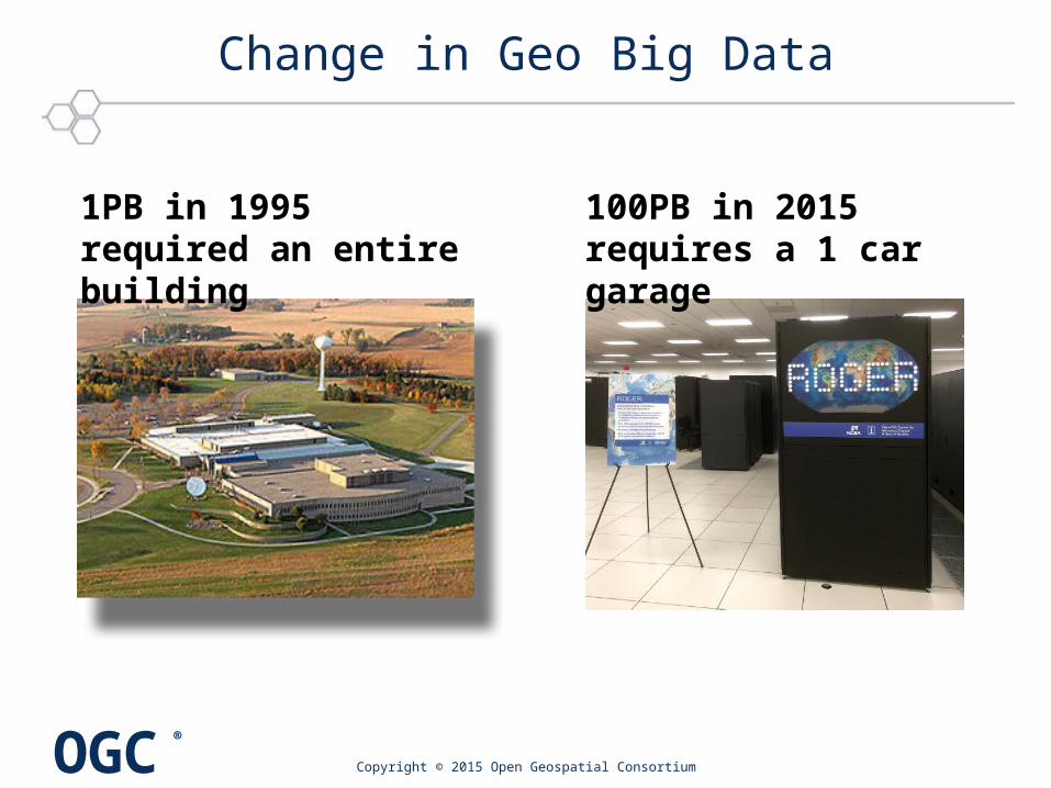
Change in Geo Big Data
Copyright © 2015 Open Geospatial Consortium
1PB in 1995 required an entire building
100PB in 2015 requires a 1 car garage

OGC®
MultiSolidCoverage
• n-D "space/time-varying phenomenon" • [ISO 19123, OGC 09-146r2]
Big Data Variety: Coverages
«FeatureType»AbstractCoverage
MultiPointCoverage
MultiCurveCoverage
MultiSurfaceCoverage
GridCoverage
ReferenceableGridCoverage
RectifiedGridCoverage

OGC®
Web Coverage Service (WCS)
• WCS Core: Simple & efficient access to spatio-temporal coverages, in any suitable format– subset = trim | slice
• WCS Extensions: additional, optional functionality facets• WCS Application Profiles: domain-oriented bundling
38

OGC®
Web Coverage Processing Service
• QL for nD sensor, image, simulation, statistics data [OGC 08-068r2]– Syntax close to XQuery (WCPS 2.0: integration)
• Ex: "From MODIS scenes M1, M2, and M3, the difference between red and nir, as TIFF where nir exceeds 127 somewhere”for $c in ( M1, M2, M3 )where some( $c.nir > 127 )return encode( $c.red - $c.nir, “image/tiff“ )
(tiff1,
tiff2)

OGC®
Geospatial Analytics
• Analytic exploitation of the space-time features will usher in advances in high-quality prediction systems. – Space time features: the highest order bits - Jonas, Tucker
• Using algorithmic extraction and big data graphs to create and relate entities on the Web, organising them through a semantic taxonomy and enabling natural access– The future is ‘Where’" - S. Lawler, Bing
© 2013 Open Geospatial Consortium 40

OGC®
Big Data Spatial Analytics - GeoWave
Copyright © 2015 Open Geospatial Consortium
Geographic objects and operators in Apache Accumulo
Advanced support for OGC spatial types: 3D and temporal
GeoServer plugin for OGC Web Serviceshttp://ngageoint.github.io/geowave/

OGC®
OGC Moving Features Encoding Standard
• "Moving features" data describes such things as vehicles, pedestrians, airplanes and ships.– This is Big Data – high volume, high velocity.
• CSV and XML encodings of ISO 19141
Copyright © 2015 Open Geospatial Consortium

OGC®
Moving features in a temporal CRS
Copyright © 2013 Open Geospatial Consortium
time
Spatial plane
1 prism = 1 leaf + 1 sweep(&attribute)
End leaf of tracks
id=1
Id=2
11:11:20.835 11:11:26.215 11:11:28.021 11:11:30.127
(C)
(B)(D)
(A)
ISO19141 a basis for OGC Moving Features Standard

OGC®
Market Reality - Mobile First
• “Millennials would rather give up driving than their smartphone or laptop” – Zipcar survey
© 2013 Open Geospatial Consortium 44
http://www.slideshare.net/kleinerperkins/2012-kpcb-internet-trends-yearend-update
• Geospatial services need to consider: “the other end of the spectrum has customers who do not use laptops and computers. They use cell phones and tablets.”– Ola Rollen, President and CEO, Hexagon AB
http://issuu.com/geospatialworld/docs/geospatial-world-annual-edition-january-2013

OGC®
OGC and Mobile
Open GeoSMSGeoPackageOWS ContextARML 2
Points of Interest3D VisualizationIndoorGMLSensorThings (IoT)Moving Features
© 2015 Open Geospatial Consortium

OGC®
OGC Open GeoSMS
• Characteristics– Multilingual– Multi-device– Harmonized with many existing
applications– Incorporates relevant
ISO standards
• Significant potential for many applications
• Adopted in 2011• Submitted to International
Telecommunications Union
© 2015 Open Geospatial Consortium

OGC®
3D Portrayal Services
• Service interface for web-based scene graph rendering and image based rendering of 3D city models
• Use several encodings and protocols
© 2013 Open Geospatial Consortium
Scenegraph
Images
47

OGC®
First multi-vendor Augmented Reality Open Interoperability Demonstration
© 2014 Open Geospatial Consortium 48
>50 Millionusers
+ + =
AR content encoded in OGC ARML 2.0 draft standard
Organized by AR StandardsCommunity Demonstrated at Mobile World Congress 2014
http://www.opengeospatial.org/pressroom/pressreleases/1967http://www.wired.com/beyond_the_beyond/2014/02/augmented-reality-interoperability-demo/

OGC®
Computer Engineering Research Questions
• Geotemporal on Big Data– Apache Big Data Platforms
• Grid databases– Applied to complex coverages
• Moving features– Analytics on spatial-temporal tracks
• Portrayal– 3D and AR
• Mobile, mobile, mobile
© 2015 Open Geospatial Consortium

OGC®
© 2015 Open Geospatial Consortium
Application Areas

OGC®
Geospatial Information and Technologies Inform and Enhance Decision Making
Emergency / Disaster Management
Aviation Flight Information /
Safety
Meteorology, Hydrology, Ocean
Monitoring
Source: DigitalGlobe

OGC®
• Urgent need for more information on soils at varying geographic scales
• Diversity of data makes integration and harmonisation difficult
• Soil data needs to be freely available and in formats that can be readily used for a wide range of purposes
• Need for harmonization of methods
UN General Assembly declared 2015 The International Year of Soils

OGC®
OGC Soil Interoperability Experiment
International Union of Soil Sciences (IUSS) proposed the IE to OGC in May 2015
• IE Initiators– Landcare Research – ISRIC World Soil Information– CSIRO
• Participating Organizations– Federation University (Aus), CRA-ABP (Italy), USGS Office of Water
Information, NRCS – USDA (US), Horizons Regional Council (NZ)
Copyright © 2015 Open Geospatial Consortium

OGC®
Goals of the Soil IE achieved
• Primary focus: –Develop and test a
Soil Markup Language, a GML compatible encoding for soil features
• Successful demonstration at OGC meeting, 2015-12-03– Using WMS, WFS, WPS

OGC®
Urban Resilience with Coastal Inundation
Copyright © 2015 Open Geospatial Consortium
Coastal Inundation as a result of Sea-Level Rise – 2025 Projection
Climate and Human Security: • Social unrest with displaced population due to climate change• Integrating spatial and non-spatial models of human geography• OGC Web Processing Service (WPS) for model interoperability

OGC®
Copyright © 2015 Open Geospatial Consortium
What to look for in the Testbed 11 video
• Simplified interaction with predictive models for anticipation of warnings and opportunities
• Data collection from network-challenged field operations to test models and fill in gaps in context
• Integrated security and open data together providing content and context to all customers
• Web-first strategy based on multi-vendor interoperability
Unique innovation process to advance
open access through standards

OGC®
Testbed 11 Video
Copyright © 2015 Open Geospatial Consortium
OGC Testbed 11 YouTube Playlist

OGC®
Join Testbed 12
Copyright © 2015 Open Geospatial Consortium
OGC’s interoperability innovation lab
Contact Dr. Terry Idol, [email protected] Executive Director, OGC Interoperability Program
OrDr. Scott Serich, Ph.D, JD, Testbed 12 Initiative Director

OGC®
Blog
© 2013 Open Geospatial Consortium 59
http://www.opengeospatial.org/blog/1814

OGC®
Thanks to New Zealand
For OGC contributions• Land Information New
Zealand– Byron Cochrane
• Landcare Research NZ– David Medyckyj-Scott,– Alistair Ritchie– Robert Gibb
For conference• University of Canterbury
– Kathryn Salm– Wendy Lawson
© 2015 Open Geospatial Consortium

OGC®
For Details on OGC Standards…
OGC Standards– Freely available– www.opengeospatial.org/standards
George Percivallgpercivall at opengeospatial.org @percivall
61

OGC®


