14
Spanish Hydrography GRI product: Implementation of INSPIRE Directive in a reference theme Paloma Abad Power Geospatial Reference Information

Spanish Hydrography GRI product:Implementation of INSPIRE Directive
in a reference theme Paloma Abad Power
Geospatial Reference Information

Introduction
2
NEED: It is necessary to develop GRI of hydrography in order to:
Provide a framework for locating geographic features unambiguously Be provided by an authoritative body Fulfil INSPIRE and user requirements:
Mapping (Physical waters) Modelling and spatial analyses (Hydro Network)
Hydro Network Digital Terrain Models: Hydro‐DTM, Flow accumulation, directions Pfaffstetter code (degree of branching)
VIABILITY: It is possible to automate the hydro capture through flow
accumulation calculations over the DTM obtained from LIDAR points Complete coverage of Spain with lidar (density of 1point/2m2) Defined update cycle: 6 years
PHASES: GRI_HY v.0
From existing data
GRY_HY v.1 As much automatic as possible, at the highest resolution and sustainable.
Sil River

User requirements
3
Satisfy user requirements at different levels: CCHH, regional, national, european and global
Develop a coordinated capture
INSPIRE conformant
High resolution (exy=3m, ez=0.5m)
High quality: geometric, semantic y topological
Objective and sustainable: automatic
DTM consistent
Hydrological hierarchical code (Pfatstetter):
Provided by the water national body
Ebro River

Production System GRI_HY v.0
4
GRI v.0: from existing hydrography in the Topographic Database at 1:25k obtained from photogrammetric restitution techniques
Some editions to:Create a continuous topological network (axes through standing waters)Water surfaces from polylinesAssign the Pfafstetter hydro code from an external body (conflation)
Positional accuracy: exy = 2 – 3 m ; ez < 10 mFinished and available since august 2016
Tormes River

Application Schema
5
Data Specification on Hydrography is developed considering 2 use cases:
Use case 1: Mapping (physical waters)The representation of all main hydrographic elements, both natural andartificial, is needed to provide a map background for orientation and tounderstand place relationship. The schema has been extended to meetnational requirements, adding new attributes and defining codelists for somefree text data types
Use case 2: Modelling and spatial analyses (Network)To enable GIS‐based analysis and modelling for the following applications (hydrology, water supply, flood control, risk assessment, environmental impact analysis, etc.)It includes a topological network of rivers and channelsThe Spanish GRI_HY network model is identical to the one defined in INSPIRE data specifications. In this case, the difficulty consisted on creating the fictitious axis that did not exist previously.

Publication GRI_HY v.0
6
GRI v.0 is accessible thought WMS, WMTS and WFSView service: WMS. (Physical waters)
http://www.ign.es/wms‐inspire/ign‐base?request=GetCapabilities&service=WMS
View Service: WMTSOne style
Style for each theme shall be as defined in the "Portrayal" section of the [INS DS, Article 14]
IGN national style.
Llobregat River

7
GRI v.0 is accessible though WMS, WMTS and WFS– Download service enabling copies of complete spatial datasets, or of parts of such
sets, to be downloaded.– WFS for physical waters schema • http://www.ign.es/wfs‐inspire/hidrografia?request=GetCapabilities&service=WFS
hy‐p:Crossing hy‐p:DamOrWeir hy‐p:DrainageBasin hy‐p:Watercourse
hy‐p:Falls hy‐p:Ford hy‐p:Lock hy‐p:Wetland
hy‐p:ShorelineConstruction hy‐p:RiverBasin hy‐p:StandingWater
Publication GRI_HY v.0
Pisuerga River

GRI v.0 is accessible though download service• The next month: WFS will include information from network schema
• The geometry used in the network model or for reporting is derived from the physical waters geometry
• WFS will publish more objects spatial
Publication GRI_HY v.0
Guadiana River
9
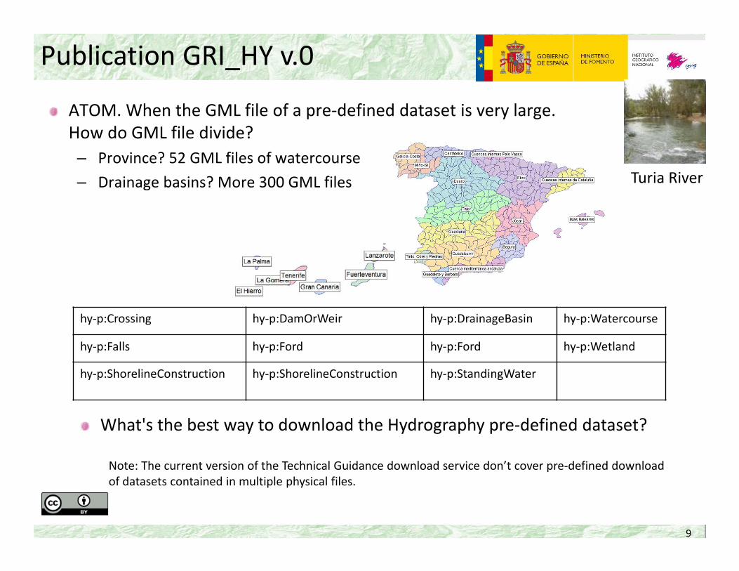
ATOM. When the GML file of a pre‐defined dataset is very large. How do GML file divide?– Province? 52 GML files of watercourse– Drainage basins? More 300 GML files
hy‐p:Crossing hy‐p:DamOrWeir hy‐p:DrainageBasin hy‐p:Watercourse
hy‐p:Falls hy‐p:Ford hy‐p:Ford hy‐p:Wetland
hy‐p:ShorelineConstruction hy‐p:ShorelineConstruction hy‐p:StandingWater
Publication GRI_HY v.0
What's the best way to download the Hydrography pre‐defined dataset?
Note: The current version of the Technical Guidance download service don’t cover pre‐defined download of datasets contained in multiple physical files.
Turia River

10
GRI_HY v.1: as automatic as possible, at higher resolution and sustainable
• Geometry: LIDAR points covering Spain (1 point/2m2) ‐> DTM02 ‐> Flow accumulation‐> Automatic Hydro Network (RHA)
• Attributes: conflation with GRI_HY v.0 ‐> Basic Hydro Network (RHB) ‐> Editing• Conflict areas to edit:
• Urban• Flat• Riverside vegetation• Artificial network
• Positional accuracy: exy = 2 – 3 m ; ez < 0,5 m• DMT02 consistent
Production System GRI_HY v.1
Tajo River

11
DTM correction for being hydrological. Water surface correction: create DTM inside water surfaces
Building integration as obstaclesDTM correction over transport networkHydrographic network extraction
Production System GRI_HY v.1
Miño River
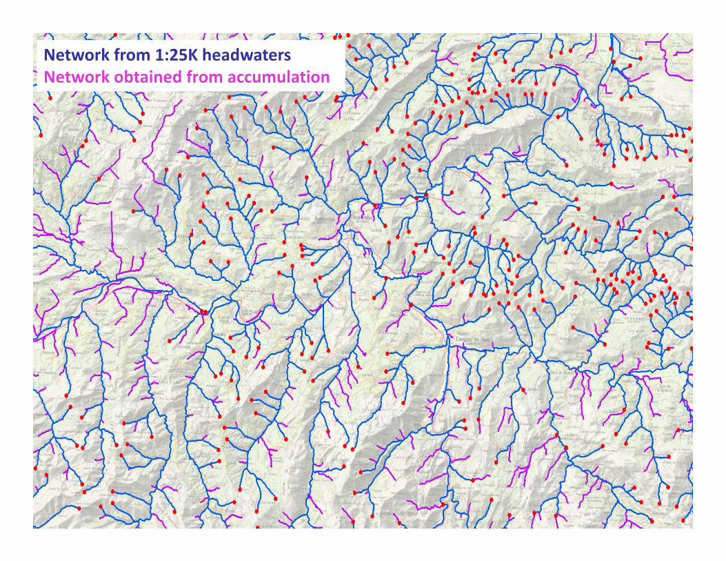
Network from 1:25K headwatersNetwork obtained from accumulation

Future
13
2017: To finish quality control and quality evaluation GRI_HY v1 Data publication through the download services Stablish the maintenance and update of the data
Research: Improve automatic classification of LiDAR points Improve automatic extraction of the hydrographic network:
lessons learnt Analyse other parameters: slope, soil type, etc.
Collaborate with the autonomous regions to improve the data
Duero River

Budget
14
Outsource GRI_HY v.0: 248.000 € GRI_HY v.1 (COTESA + SRM + ESRI + TRAGSATEC + IECISA): 300.000 €
Not considered in the budget: LiDAR data capture IGN human resources:
Data preparationPaperworkQuality controlDatabase loadWeb services generation
Jucar River


