Geostatistics Portal A platform for census data visualization Mirosław Migacz Chief GIS Specialist Central Statistical Office of Poland [email protected]www.linkedin.com/in/migacz INSPIRE Conference 2013: The Green Rennaisance Florence, June 26th 2013
Transcript
Geostatistics Portal A platform for census data visualization
• About the project • Functionalities and layout • Cartographic presentation methods • INSPIRE services
2
Agenda
GEOSTATISTICS PORTAL
3
GEO.STAT.GOV.PL LAUNCHING JUNE 2013 with:
• CHOROPLETH MAPS WITH AGRICULTURAL CENSUS 2010 RESULTS
• INSPIRE SERVICES FOR STATISTICAL UNITS
Plans for the rest of the year 2013
GEOSTATISTICS PORTAL
4
• diagram maps with Agricultural Census 2010 results • choropleth maps with Population and Housing Census 2011
resuts • diagram maps with Population and Housing Census 2011
resuts • INSPIRE services for Population Distribution (Demography)
FUNCTIONALITIES AND LAYOUT
Geostatistics Portal functionalities
GEOSTATISTICS PORTAL
6
geovisualization of census’ results • Agricultural Census 2010 • Population and Housing Census 2011
publishing spatial data maintained within official statistics • statistical regions • census areas
publishing INSPIRE services for two annex III themes • statistical units • population distribution (demography)
advanced spatial analyses on microdata • for authorised users within official statistics
Geovisualisation of census results
All statistical data georeferenced to a point
Agricultural Census 2010
• Census data collected with spatial reference to: • agricultural holding location • holder’s dwelling location
Population and Housing Census 2011 • Census data collected with spatial
reference to: • dwelling location
GEOSTATISTICS PORTAL
7
LOCATION
Land Parcel Identification
System
Statistical address points
Census data storage and use
GEOSTATISTICS PORTAL
8
Municipality (LAU2)
County (LAU1)
Subregion (NUTS3)
Voivodeship (NUTS2)
Region (NUTS1) • Geostatistics Portal database stores census’ results aggregated to units of territorial division (down to LAU2)
• For each thematic phenomena absolute (non-standarized) values are stored
• Not all data stored in the Portal is published for unauthorized users due to statistical data confidentiality issues
Default view
GEOSTATISTICS PORTAL
9
Statistical division
GEOSTATISTICS PORTAL
10
Object identification
GEOSTATISTICS PORTAL
11
12
Line based selection and buffering
GEOSTATISTICS PORTAL
13
Line based buffering
GEOSTATISTICS PORTAL
14
Polygon based buffering
GEOSTATISTICS PORTAL
CARTOGRAPHIC PRESENTATION METHODS
Cartographic presentation methods
GEOSTATISTICS PORTAL
16
• choropleth maps • diagram maps
– circle • proportional, • structural, • proportional & structural,
– bar • proportional, • structural, • proportional & structural,
– complex
Diagram map
GEOSTATISTICS PORTAL
17
A cartographic presentation method for visualisation of absolute data. Since absolute data are stored in the Geostatistics Portal database, they can be directly visualised on diagram maps.
Choropleth map
GEOSTATISTICS PORTAL
18
A cartographic presentation method for visualisation of standarized data – statistical indicators. Geostatistics Portal stores a set of normalization attributes, which allow on-the-fly calculation of statistical indicators to be presented on choropleth maps.
User defined parameters for choropleth maps
GEOSTATISTICS PORTAL
19
THEMATIC PHENOMENA LIST
STATISTICAL INDICATORS
AGGREGATION LEVEL
NUMBER OF CLASSES
CLASSES CALCULATION METHODS
COLOR SCALE
TRANSPARENCY
LABELS AND BORDERS VISIBILITY
Choropleth map
GEOSTATISTICS PORTAL
20
Percentage of holdings that keep 1 sow within all holdings in a voivodeship (NUTS2)
Diagram map (circle, proportional)
GEOSTATISTICS PORTAL
21
Crop area in each subregion (NUTS3)
Diagram map (bar, proportional)
GEOSTATISTICS PORTAL
22 Grain crops area in each subregion (NUTS3)
Diagram map (circle, structural)
GEOSTATISTICS PORTAL
23
Structure of cultivation areas of 5 basic grains in each voivodeship (NUTS2)
Diagram map (circle, proportional & structural)
GEOSTATISTICS PORTAL
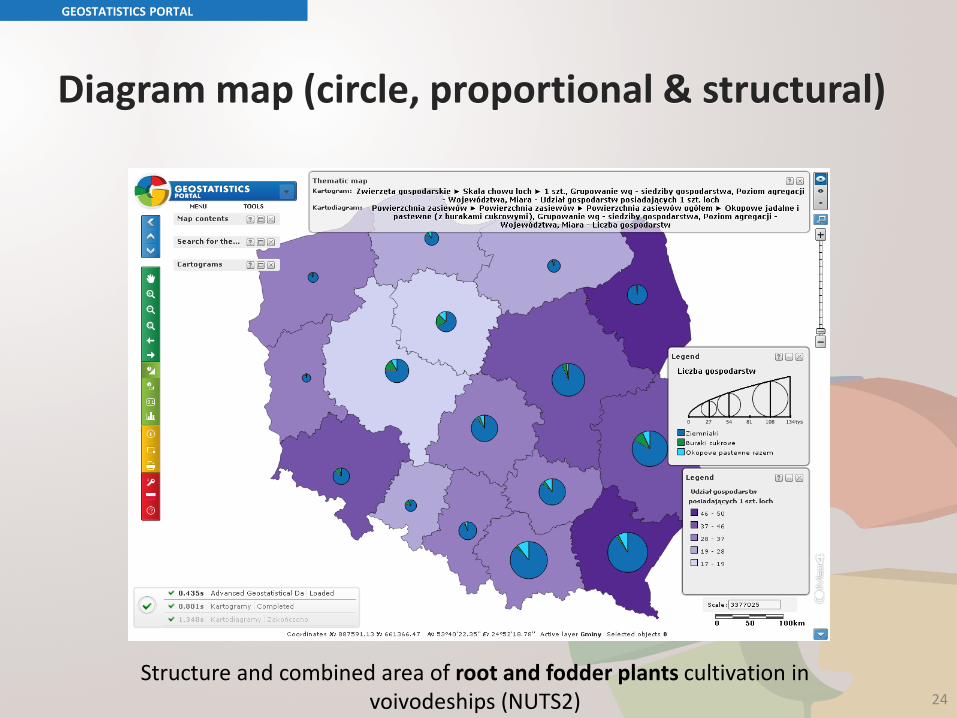
24 Structure and combined area of root and fodder plants cultivation in
voivodeships (NUTS2)
Diagram map (bar, structural)
GEOSTATISTICS PORTAL
25
Structure and cultivation areas for various fodder crops in voivodeships (NUTS2)
Diagram map (bar, proportional & structural)
GEOSTATISTICS PORTAL
26 Structure and combined value of seed crops in voivodeships (NUTS2)
Diagram map (complex)
GEOSTATISTICS PORTAL
27
- Number of holdings with gardens - Number of holdings with plowed grounds - Number of holdings with permanent cultivation
Bar chart
GEOSTATISTICS PORTAL
28
INSPIRE SERVICES
Spatial data themes
GEOSTATISTICS PORTAL
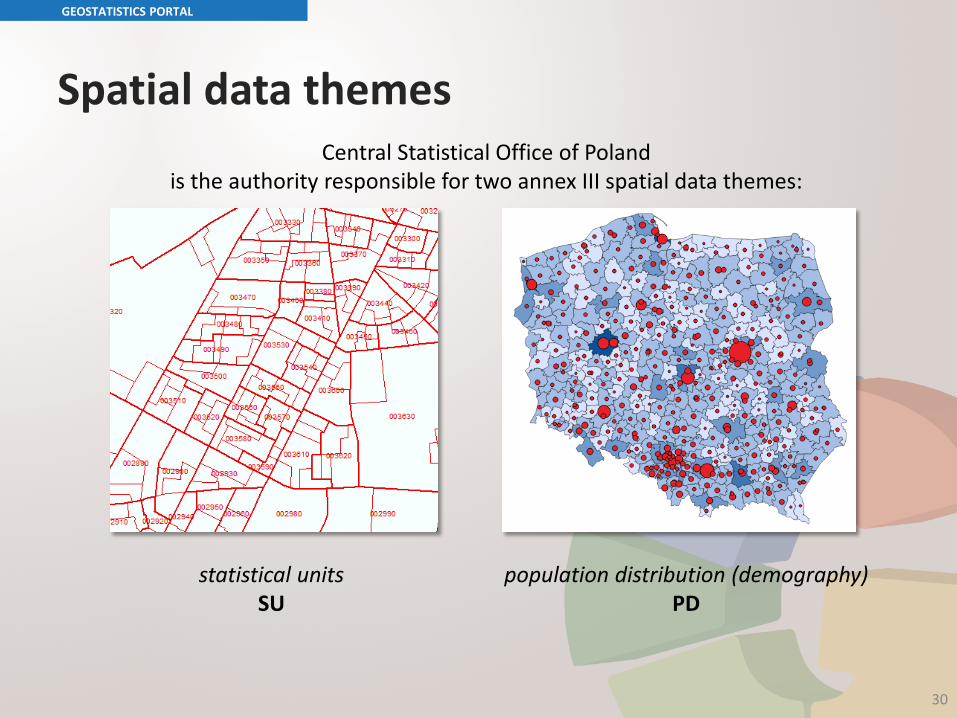
Central Statistical Office of Poland is the authority responsible for two annex III spatial data themes:
statistical units SU
population distribution (demography) PD
30
INSPIRE deadlines
3 XII 2013 • Discovery services • View services • Download services (datasets don’t have to be compliant with
data specifications) • Metadata for data sets and services
OCTOBER 2020 • Compliance with data specifications needs to be achieved
GEOSTATISTICS PORTAL
31
INSPIRE services in the Geostatistics Portal
• discovery service – running, • view service:
– statistical units – running, – population distribution (demography) – 3rd quarter 2013,
• download service: – statistical units – running, compliant with the data specification, – population distribution (demography) – 3rd quarter 2013, will be
compliant with the data specification,
• metadata – published for existing data sets and services.
GEOSTATISTICS PORTAL
Discovery Service
• metadata search engine in the Geostatistics Portal
• discovery service running – compliant with OGC CSW 2.0.2. specification
GEOSTATISTICS PORTAL
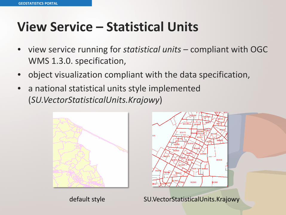
View Service – Statistical Units • view service running for statistical units – compliant with OGC
WMS 1.3.0. specification, • object visualization compliant with the data specification, • a national statistical units style implemented
(SU.VectorStatisticalUnits.Krajowy)
GEOSTATISTICS PORTAL
default style SU.VectorStatisticalUnits.Krajowy
Download Service – Statistical Units • download service for statistical units running as predefined
dataset download service (compliant with Technical Guidance for the implementation of INSPIRE Download Services 3.0),
• service is running on Atom 1.0 and OpenSearch 1.1., • statistical units data set divided into 16 GML files – one for
each voivodeship, • data sets are compliant with the data specification for