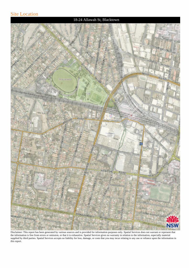
Disclaimer: This report has been generated by various sources and is provided for information purposes only. Spatial Services does not warrant or represent thatthe information is free from errors or omission, or that it is exhaustive. Spatial Services gives no warranty in relation to the information, especially materialsupplied by third parties. Spatial Services accepts no liability for loss, damage, or costs that you may incur relating to any use or reliance upon the information inthis report.
rahsn
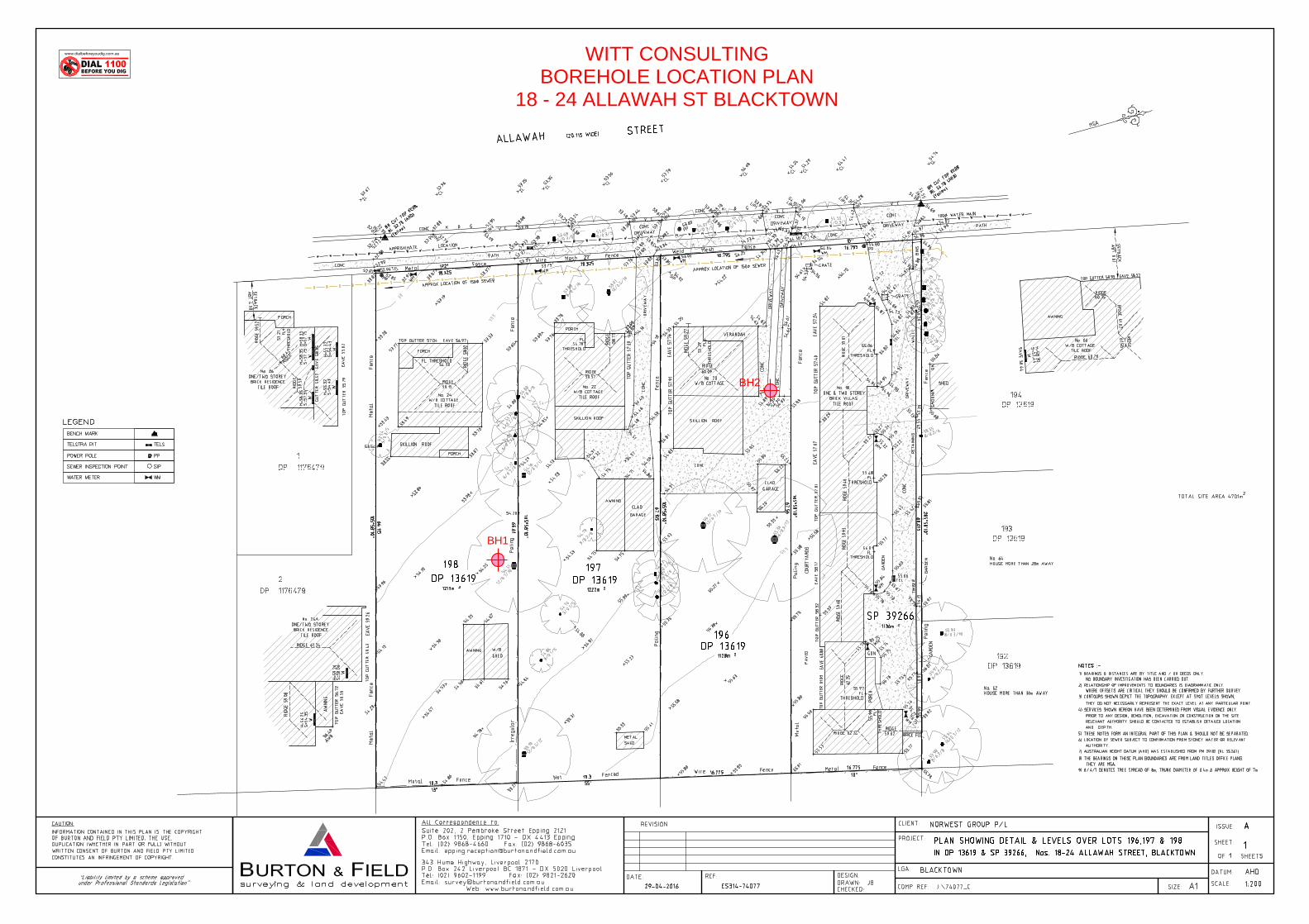
Polygon
rahsn
Callout
Site Location
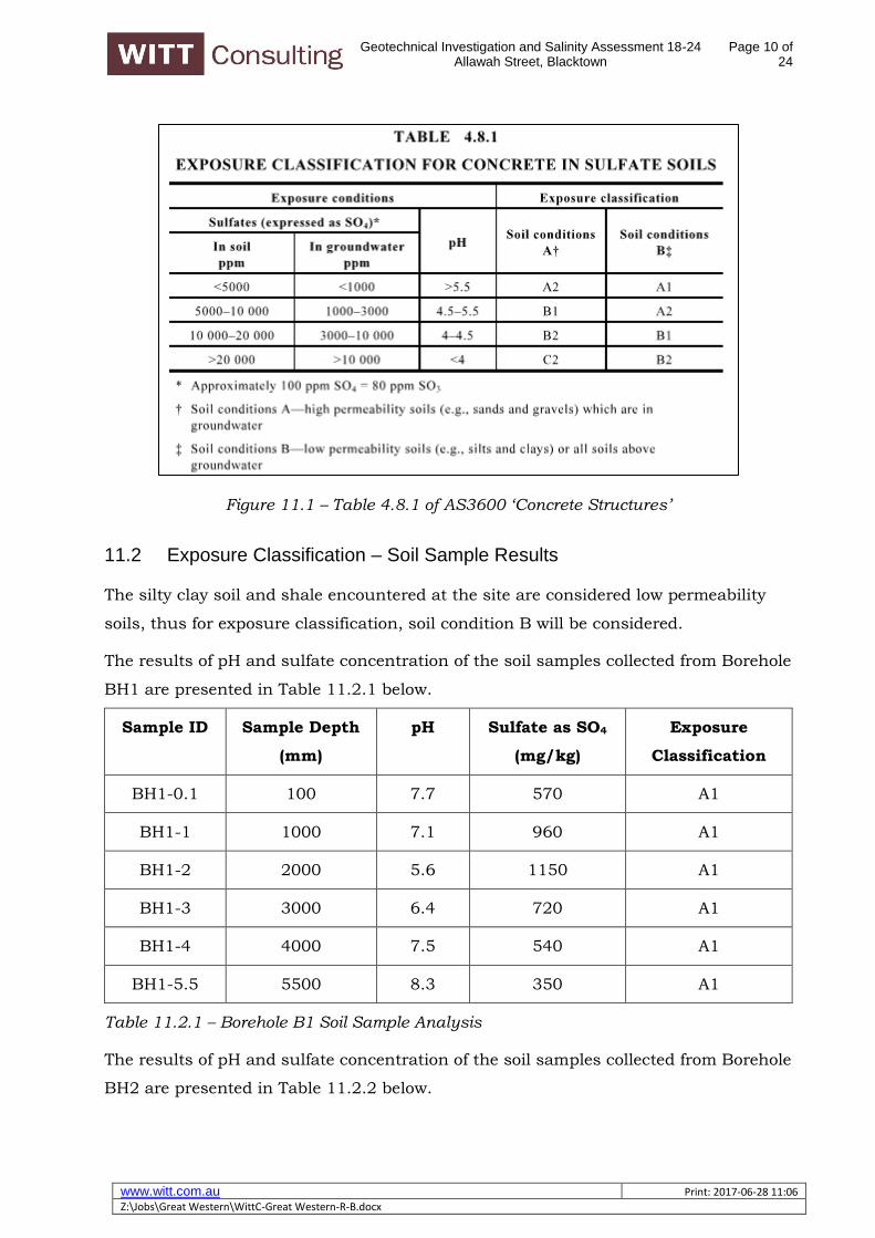
Geotechnical Investigation and Salinity Assessment 18-24 Allawah Street, Blacktown
Landscape—gently undulating rises on Wianamatta Group shales. Local relief to 30 m, slopes usually >5%. Broad rounded crests and ridges with gently inclined slopes. Cleared Eucalypt woodland and tall open-forest (dry schlerophyll forest).
Soils—shallow to moderately deep (>100 cm) hardsetting mottled texture contrast soils, red and brown podzolic soils (Dr3.21, Dr3.31, Db2.11, Db2.21) on crests grading to yellow podzolic soils (Dy2.11, Dy3.11) on lower slopes and in drainage lines.
Limitations—localised seasonal waterlogging, localised water erosion hazard, moderately reactive highly plastic subsoil, localised surface movement potential. LOCATION
Occurs extensively on the Cumberland Lowlands. Examples include Blacktown, Mount Druitt, Glossodia and Leppington.
Isolated examples are found at Bilpin on the Blue Mountains plateau surface and along the Silverdale Road south of Wallacia.
LANDSCAPE
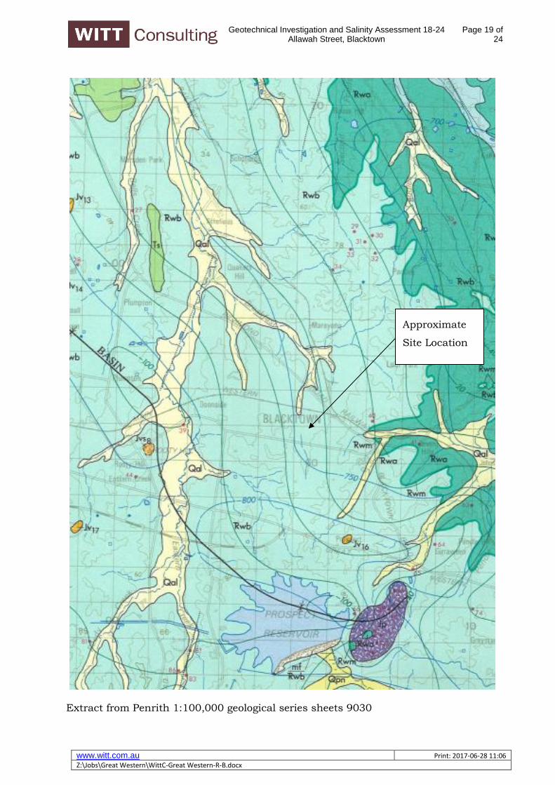
Geology
Wianamatta Group—Ashfield Shale consisting of laminite and dark grey siltstone, Bringelly Shale which consists of shale with occasional calcareous claystone, laminite and infrequent coal, and Minchinbury Sandstone consisting of fine to medium-grained quartz lithic sandstone.
36
Topography
Gently undulating rises on Wianamatta Shale with local relief 10–30 m and slopes generally >5% but occasionally up to 10%. Crests and ridges are broad (200–600 m) and rounded with convex upper slopes grading into concave lower slopes. Outcrops of shale do not occur naturally on the surface. They may occur, however, where soils have been removed.
Vegetation
Almost completely cleared open-forest and open-woodland (dry sclerophyll forest). The original woodland and open-forest were dominated by Eucalyptus tereticornis (forest red gum), E. crebra (narrow-leaved ironbark), E. moluccana (grey box) and E. maculata (spotted gum) (Benson, 1981).
Further west near Penrith remnant stands of E. punctata (grey gum) occur. Between Liverpool and St Marys the dominant species are E. globoidea (white stringybark) and E. fibrosa (broad-leaved ironbark), with E. longifolia (woollybutt) as an understorey species. Individual trees or small stands of E. sideroxylon (mugga ironbark) are occasionally found on crests.
Landuse
The dominant landuses are intensive residential (Fairfield, Blacktown and Mt Druitt), horticulture and animal husbandry (Vineyard, Scheyville and Leppington) and light and heavy industry (Yennora and Moorebank).
Existing Erosion
No appreciable erosion occurs on this unit. Minor sheet and gully erosion may be found where surface vegetation is not maintained.
Associated Soil Landscapes
South Creek (sc) soil landscape occurs along drainage depressions. Picton (pn) soil landscape occurs on steeper south and southeast facing slopes. Small areas of Luddenham (lu) soil landscape may also occur. SOILS Dominant Soil Materials bt1—Friable brownish black loam. This is a friable brownish black loam to clay loam with moderately pedal subangular blocky structure and rough-faced porous ped fabric. This material occurs as topsoil (A horizon). Peds are well defined subangular blocky and range in size from 2 mm to 20 mm. Surface condition is friable. Colour is brownish black (10YR 2/2) but can range from dark reddish brown (5YR 3/2) to dark yellowish brown (10YR 3/4). The pH varies from moderately acid (pH 5.5) to neutral (pH 7.0). Rounded iron indurated fine gravel-sized shale fragments and charcoal fragments are sometimes present. Roots are common. bt2—Hardsetting brown clay loam. This is a brown clay loam to silty clay loam which is hardsetting on exposure or when completely dried out. It has apedal massive to weakly pedal structure and slowly porous earthy fabric. It occurs as an A2 horizon. Peds when present are weakly developed, subangular blocky and are rough faced and porous. They range in size between 20–50 mm. This material is water repellent when extremely dry. Colour is dark brown (7.5YR 4/3) but can range from dark reddish brown (2.5YR 3/3) to dark brown (10YR 3/3). The pH varies from moderately acid (pH 5.0) to slightly acid (pH 6.5). Platy, iron indurated gravel-sized shale fragments are common. Charcoal fragments and roots are rarely present. bt3—Strongly pedal, mottled brown light clay. This is a brown light to medium clay with strongly pedal polyhedral or sub-angular to blocky structure and smooth-faced dense ped fabric. This material usually occurs as subsoil (B horizon). Texture often increases with depth. Peds range in size from 5–20 mm. Colour is brown (7.5YR 4/6) but may range from reddish brown (2.5YR 4/6) to brown (10YR 4/6). Frequent red, yellow or grey mottles occur
37
often becoming more numerous with depth. The pH varies from strongly acid (pH 4.5) to slightly acid (pH 6.5). Fine to coarse gravel-sized shale fragments are common and often occur in stratified bands. Both roots and charcoal fragments are rare. bt4—Light grey plastic mottled clay. This is a plastic light grey silty clay to heavy clay with moderately pedal polyhedral to subangular blocky structure and smoothfaced dense ped fabric. This material usually occurs as deep subsoil above shale bedrock (B3 or C horizon). Peds range in size from 2–20 mm. Colour is usually light grey (10YR 7/1) or, less commonly, greyish yellow (2.5YR 6/2). Red, yellow or grey mottles are common. The pH varies from strongly acid (pH 4.0) to moderately acid (pH 5.5). Strongly weathered ironstone concretions and rock fragments are common. Gravel-sized shale fragments and roots are occasionally present. Charcoal fragments are rare. Occurrence and Relationships Crests. On crests and ridges up to 30 cm of friable brownish black loam (bt1) overlies 10–20 cm of hardsetting brown clay loam (bt2) and up to 90 cm of strongly pedal, brown mottled light clay (bt3) [red podzolic soils (Dr 3.21, 3.11) and brown podzolic soils (Db 2.11)]. bt1 is occasionally absent. Boundaries between the soil materials are usually clear. Total soil depth is <100 cm. Upper slopes and Midslopes. Up to 30 cm of bt1 overlies 10–20 cm of bt2 and 20–50 cm of bt5. This in turn overlies up to 100 cm of a light grey plastic mottled clay (bt4) [red podzolic soils (Dr 3.21), brown podzolic soils (Db 2.21). Occasionally bt1 is absent. The boundaries between the soil materials are usually clear. Total soil depth is<200 cm. Lower sideslopes. Up to 30 cm of bt1 overlies 10–30 cm of bt2 and 40–100 cm of bt3. Below bt3 there is usually >100 cm of bt4 [yellow podzolic soils Dy 2.11, Dy 3.11)]. The boundaries between the soil materials are clear. Total soil depth is >200 cm. LIMITATIONS TO DEVELOPMENT Soil Limitations btl Strongly acid bt2 Hardsetting Low fertility Strongly acid High aluminium toxicity bt3 High shrink-swell (localised) Low wet strength Low permeability Low available water capacity Salinity (localised) Sodicity (localised) Very low fertility Very strongly acid Very high aluminium toxicity bt4 High shrink-swell (localised) Low wet strength Stoniness Low available water capacity Low permeability Salinity (localised) Sodicity (localised) Low fertility Strongly acid Very high aluminium toxicity High erodibility (localised)
38
Fertility General fertility is low to moderate. Soil materials have low to moderate available water capacity, low CEC values, hardsetting surfaces (bt2), very low phosphorus and low to very low nitrogen levels. The subsoils (bt3, bt4) may be locally sodic with low permeability. When bt1 is present its higher organic matter content and moderate nitrogen levels result in higher general fertility. Erodibility Blacktown soil materials have moderate erodibility. The topsoils (bt1, bt2) are often hardsetting and they have high fine sand and silt content but they also have high to moderate organic matter content. The subsoils (bt3, bt4) are very low in organic matter. Where they are also highly dispersible and occasionally sodic the erodibility is high. Erosion Hazard The erosion hazard for non-concentrated flows is slight to moderate but ranges from low to very high. Calculated soil loss during the first twelve months of urban development for topsoil and exposed subsoil tends to be low (7–11 t/ha). Soil erosion hazard for concentrated flows is moderate to high. Surface Movement Potential The deep clay soils are moderately reactive. These are generally found on side-slopes and footslopes. Shallower soils on forests are slightly reactive. Landscape Limitations Seasonal waterlogging (localised), water erosion hazard (localised), surface movement potential (localised). Urban Capability High capability for urban development with appropriate foundation design. Rural Capability Small portions of this soil landscape which have not been urbanised are capable of sustaining regular cultivation and grazing.
Distribution diagram of the Blacktown soil landscape showing the occurrence and relationship of dominant soil materials.
Geotechnical Investigation and Salinity Assessment 18-24 Allawah Street, Blacktown
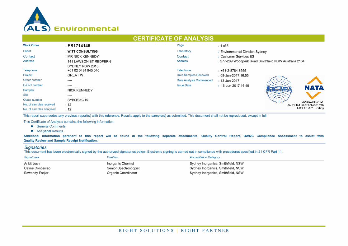
:Project GREAT W Date Samples Received : 08-Jun-2017 16:55
:Order number ---- Date Analysis Commenced : 13-Jun-2017
:C-O-C number ---- Issue Date : 16-Jun-2017 16:49
Sampler : NICK KENNEDY
Site : ----
Quote number : SYBQ/319/15
12:No. of samples received
12:No. of samples analysed
This report supersedes any previous report(s) with this reference. Results apply to the sample(s) as submitted. This document shall not be reproduced, except in full.
This Certificate of Analysis contains the following information:
l General Comments
l Analytical Results
Additional information pertinent to this report will be found in the following separate attachments: Quality Control Report, QA/QC Compliance Assessment to assist with
Quality Review and Sample Receipt Notification.
SignatoriesThis document has been electronically signed by the authorized signatories below. Electronic signing is carried out in compliance with procedures specified in 21 CFR Part 11.
Signatories Accreditation CategoryPosition
Ankit Joshi Inorganic Chemist Sydney Inorganics, Smithfield, NSW
Celine Conceicao Senior Spectroscopist Sydney Inorganics, Smithfield, NSW
Edwandy Fadjar Organic Coordinator Sydney Inorganics, Smithfield, NSW
R I G H T S O L U T I O N S | R I G H T P A R T N E R
2 of 5:Page
Work Order :
:Client
ES1714145
GREAT W:Project
WITT CONSULTING
General Comments
The analytical procedures used by the Environmental Division have been developed from established internationally recognized procedures such as those published by the USEPA, APHA, AS and NEPM. In house
developed procedures are employed in the absence of documented standards or by client request.
Where moisture determination has been performed, results are reported on a dry weight basis.
Where a reported less than (<) result is higher than the LOR, this may be due to primary sample extract/digestate dilution and/or insufficient sample for analysis.
Where the LOR of a reported result differs from standard LOR, this may be due to high moisture content, insufficient sample (reduced weight employed) or matrix interference.
When no sampling time is provided, the sampling time will default 00:00 on the date of sampling. If no sampling date is provided, the sampling date will be assumed by the laboratory and displayed in brackets without a
time component.
Where a result is required to meet compliance limits the associated uncertainty must be considered. Refer to the ALS Contact for details.
CAS Number = CAS registry number from database maintained by Chemical Abstracts Services. The Chemical Abstracts Service is a division of the American Chemical Society.
LOR = Limit of reporting
^ = This result is computed from individual analyte detections at or above the level of reporting