Proceedings World Geothermal Congress 2015 Melbourne, Australia, 19-25 April 2015 1 Geothermal Exploration in Eritrea – Country Update Ermias Yohannes Department of Mines, P.O.Box 272, Asmara, Eritrea [email protected]Keywords: Geothermal, Eritrea, Alid, Nabro-Dubbi, rift ABSTRACT Harnessing the geothermal potential in Eritrea has a significant impact on the economic development as the country relies on its electric power generation from imported refined petroleum products, which is wholly based on oil burning plants. The impact can be viewed by both the unreliable cost fluctuation mainly increment of fuel cost coupled with the unfriendly environment. Therefore geothermal energy will have an important input in alleviating expenditure on foreign currency while safeguarding the environment. The tectonic setting and geological makeup of the south-eastern coastal zone of Eritrea is a favorable site for having geothermal resources that are potential for the development of geothermal resources mainly for electrical generation and utilization. Alid and Nabro-Dubbi fields are the notable places with ample geothermal manifestations. The volcanism of 2011 in Nabro has made impact at present by sealing the surface. There are considerable low temperature-thermal springs that have a potential for recreation spas, health and mineral water bottling, and etc, which occur at around the Asmara-Massawa highway, close to Gulf of Zula and within the Danakil Depression, which mostly do not show any immediate association with recent magmatism. The completion of some of the surface studies at Alid prompts here to concentrate on the recent work that was performed. A more than 250 0 C reservoir temperature was estimated using gas geothermometers from Alid geothermal prospect. A 70°N trending high fracture zone is well marked on the FFD contour plot. The low resistivity anomaly of the preliminary resistivity survey conducted on the Ghinda-Darere is in line with the contour plot. The hydrogeological assessment performed regionally indicates that the recharge area is mainly from three catchments with inputs mainly from the highland area. The resistivity survey that was conducted recently has shown an interesting anomaly at the rift floor and opened a wider perspective in exploration. 1. INTRODUCTION Geothermal energy has become an important energy option, both for heating and power generation. This lies mainly on its impact to the environment. Since Eritrea lies within the African rift system, the potential of having geothermal energy for the use of electricity is high. The advantage of a geothermal energy resource for Eritrea is not only based on its environmental impact but also mitigates the use of fossil fuel, which the country is spending on using hard currency. For this reason, the government has given a priority to this sector and investigations are still commencing. The tectonic setting and geological make-up of the southern coastal zone of Eritrea shows that it has good potential for the development of geothermal resources. Surface manifestations are abundant on some of the Danakil zone mainly associated with volcanic activities of which the Alid and Nabbro-Dubbi fields of geothermal manifestations are prominent. Figure 1. Location map of ALid and Nabro-Dubbi in relation to the African Rift Valley
Transcript
Proceedings World Geothermal Congress 2015
Melbourne, Australia, 19-25 April 2015
1
Geothermal Exploration in Eritrea – Country Update
Harnessing the geothermal potential in Eritrea has a significant impact on the economic development as the country relies on its
electric power generation from imported refined petroleum products, which is wholly based on oil burning plants. The impact can
be viewed by both the unreliable cost fluctuation mainly increment of fuel cost coupled with the unfriendly environment.
Therefore geothermal energy will have an important input in alleviating expenditure on foreign currency while safeguarding the
environment. The tectonic setting and geological makeup of the south-eastern coastal zone of Eritrea is a favorable site for having
geothermal resources that are potential for the development of geothermal resources mainly for electrical generation and
utilization. Alid and Nabro-Dubbi fields are the notable places with ample geothermal manifestations. The volcanism of 2011 in
Nabro has made impact at present by sealing the surface.
There are considerable low temperature-thermal springs that have a potential for recreation spas, health and mineral water bottling,
and etc, which occur at around the Asmara-Massawa highway, close to Gulf of Zula and within the Danakil Depression, which
mostly do not show any immediate association with recent magmatism.
The completion of some of the surface studies at Alid prompts here to concentrate on the recent work that was performed. A more
than 2500C reservoir temperature was estimated using gas geothermometers from Alid geothermal prospect. A 70°N trending high
fracture zone is well marked on the FFD contour plot. The low resistivity anomaly of the preliminary resistivity survey conducted
on the Ghinda-Darere is in line with the contour plot. The hydrogeological assessment performed regionally indicates that the
recharge area is mainly from three catchments with inputs mainly from the highland area. The resistivity survey that was
conducted recently has shown an interesting anomaly at the rift floor and opened a wider perspective in exploration.
1. INTRODUCTION
Geothermal energy has become an important energy option, both for heating and power generation. This lies mainly on its impact
to the environment. Since Eritrea lies within the African rift system, the potential of having geothermal energy for the use of
electricity is high. The advantage of a geothermal energy resource for Eritrea is not only based on its environmental impact but also
mitigates the use of fossil fuel, which the country is spending on using hard currency. For this reason, the government has given a
priority to this sector and investigations are still commencing. The tectonic setting and geological make-up of the southern coastal
zone of Eritrea shows that it has good potential for the development of geothermal resources. Surface manifestations are abundant
on some of the Danakil zone mainly associated with volcanic activities of which the Alid and Nabbro-Dubbi fields of geothermal
manifestations are prominent.
Figure 1. Location map of ALid and Nabro-Dubbi in relation to the African Rift Valley
Yohannes
2
Since the most expeditious progression to power development can be achieved at Alid due to the completion of some of the
essential surface studies there, which show a good possibility for resource development, the report here concentrates mainly on
recent studies carried out on Alid.
1.1 Previous studies
Previous works are mainly concentrated on the low temperature hot springs and Alid volcanic center. Angelo Marini from the
Italian Institute for Military Geography in 1902 during Italian colony initiated a preliminary study on the Alid geothermal
manifestations (Marini, 1938). Subsequent decades, however no documented studies on geothermal exploration commenced till
1973, when UNDP sponsored work was done which included a reconnaissance survey by a Geological Survey of Ethiopia team
(UNDP, 1973). The first survey they located thermal springs along the Asmara-Massawa road and in the Gulf of Zula area south of
Massawa. A second one was launched from the south during the same year and visited some of the fumaroles that occur on Alid
volcano. In 1992, the late Prof. Giorgio Marinelli and a staff member from the Department of Energy visited the Alid area and
prepared a proposal for a detailed study. The Ministry of Energy and Mines refined this proposal later. This laid the basis for the
geological and geochemical studies carried out in the area. In 1994, Mikhail Beyth of the Geological Survey of Israel surveyed the
Alid hydrothermal area for the possibility of epithermal gold deposition (Beyth, 1996).
The only detailed geological and geochemical investigation work in 1996 was carried out at Alid and its surroundings during
January and February 1996, by a team of staff from the United States Geological Survey (USGS) and the Ministry of Energy and
Mines of Eritrea (MEM). The work was financed by USAID and the team led by Robert Fournier of the USGS (Clynne et al.,
1996). A high temperature reservoir is estimated below the surface of Alid volcanic centre, as the geothermometry analysis of gas
samples depicted. A two phase conceptual model, a vapour dominated at the base and steam dominated at the top was proposed
through reinterpreting the water and gas samples of the 1996 USGS-MEM data (Yohannes, 2004).
A fault and fracture analysis was performed on the Alid dome in 2005 and found three structural trends that influence the
geothermal fluid path (Yohannes et al, 2005 or Yohannes, 2007). Based on the result of the structure a shallow resistivity profiling
was conducted on the small locality from Ghinda to Darere (Goitom et al, 2005). But a comprehensive resistivity survey was
conducted recently on the Alid dome and adjacent rift floor using mainly MT and TEM methods. A hydrogeological assessment on
catchment basis was also carried out in 2005 to have a better understanding on the ground water flow in the area (Andemariam,
2006). In 2008, an MT/TEM resistivity survey was implemented with the sponsorship of ICEIDA (Icelandic International Agency)
in Alid depicting an anomaly at the rift floor (Eysteinsson et al, 2009). However no anomaly zone was depicted on the hill top due
to lack of metallic bar penetrating on the hard rock.
2. TECTONIC SETTING
The East African Rift is a zone of crustal extension, in which part of the eastern African continent; Somalia Plate is pulling away
from its parent African plate along one arm, separating the divergent blocks that stem from the Afar triple junction. The Afar
Depression or the Danakil Depression is a plate tectonic triple junction, where the spreading ridges that are forming the Red Sea
and the Gulf of Aden emerge on land and meet the East African Rift. The western margin of the triangle extends to the Red Sea,
while the south-eastern part extends to the Gulf of Aden off the Arabian Peninsula. The growth of the Danakil Depression can be
viewed in two phases of development. The continental rifting phase marks the change of volcanics from undersaturated trap series
basalt to the transitional basalts and associated peralkaline silicic of the rifting phase. The crustal separation phase of the Danakil
tectonic development commenced at about 4 to 3.5 Ma ago, which eventually gave rise to the present day configuration of the Afar
Triangle.
Crustal opening was initiated at the end of the continental rifting phase of the tectonic development of the Afar region during the
late Miocene (22-15 Ma), however the main volcanic activities took place at Danakil block at about 4-3.5 Ma. The Alid volcanic
centre is located right on the axis of the Danakil Depression in between the Red Sea and the Afar triple junction; whereas Nabro-
Dubbi is situated within the triangle along the line that extends NNE to Kod Ali (Figure 2). Much of the rift consists of down-
dropped crustal sections, bounded by deep-rooted normal faults (forming grabens) that cut into the basaltic lavas, extruded in the
resulting.
The two volcanic centres are separated by a Danakil Horst, where a Proterozoic metamorphic rocks and Mesozoic sediments are
exposed.
Recent studies on present day movement of plates close to the Red-Sea shows that the plates move in segments i.e., there are more
spreading centers or axes. This will reinforce the positioning of active zones that will in turn be important in delineating the
geothermal resource areas. The Danakil Depression and possibly the Nabro-Kod Ali transverse structure could be centers of crustal
spreading deciphering from the relative motion of plates (Figure 3).
3. GEOLOGICAL AND GEOTHERMAL SETTING
The suitable tectonic environment of the Danakil Depression subordinated by recent magmatic activities favour a high heat flow on
the upper zone of the crust. Consequently several places of surface manifestations of the high temperature fields associated with
recent magmatism and low temperature hot springs related with no recent magmatic activities occur in the Danakil Depression and
escarpment of the Red Sea.
3.1 Surface manifestation of high temperature zone - Alid volcanic centre Regionally the Alid volcanic centre is located within the axis of the Danakil Depression that extends NNW from the Afar triple
junction on the graben trace of crustal spreading centre consists of rifted and faulted young deposits of sediments and basaltic
flows. Metamorphic complex to the west and basaltic flows forming plateau to the east shoulders the plain.
Yohannes
3
Figure 2. Regional Geological Map of the Danakil Depression. Much of the rift consists of down-dropped crustal sections,
bounded by deep-rooted normal faults (forming grabens) that cut into the basaltic lavas.
Figure 3. Motion of crustal segments from continuous GPS reading showing different displacement rates (McClusky et al,
2010).
3.1.1 Geological setting
Alid is a very late-Pleistocene structural dome formed by shallow intrusion of rhyolitic magma, some of which vented as lavas and
pyroclastic flows.
Yohannes
4
It is characterized by large-scale rhyolitic volcanism associated with E-W extension. The Alid volcanic centre consists primarily of
rhyolite both as massive and as pumice deposits, olivine basalt, and Red Series sediments (See Figure 4). Volumetrically the
rhyolite and olivine basalt are most abundant. Although volcanism culminated with fissure flows of basaltic lava on adjacent areas,
the youngest eruption on the dome is the rhyolite, which dated for about 33 thousand years.
Figure 4. Geological map of Alid geothermal prospect.
Red series sediments are conspicuous at the side and top part of the dome. It contains gypsum layers within the bed. Shouldering
effect of the rhyolite emplacement tilts it at the hillside. Olivine basalt occurs mainly at the top of the dome. Ignimbritic flows are
only confined within the caldera for thin circular pattern surrounding the volcanic centre.
Vitrified flows occur in some places within the rhyolite. Pumice covers the plateau portion of the mountain. Roof pendants of
kyanite schists expose close to Illegedi. Some of the Illegedi geothermal manifestation occurs in this rock type.
3.1.2 Geothermal setting
Hot mineralized fluids discharge from many locations within the Alid volcanic centre, of which most of the manifestations
discharge boiling fluids that release free gases. These manifestations, which are either fumaroles or hot springs, are confined to the
northern part of the Alid dome. In most cases, the free gas issues sulphur, as a result it precipitates in the form of sulphosalts.
Sulphosalts and clays are the main constituents of the alteration zone. The intense of alteration, however, varies from place to place.
Hot springs are more likely to occur where the depth to water table is shallow and subsurface geothermal systems are more likely to
be discovered in areas where hot springs are present at the surface. Alteration is wide and intensive at Illegedi and Darere (Figure
5). Sulphosalts and clays of various colours are conspicuous both of present and old precipitates, of which yellowish colored mainly
representing sulphosalts and brown clays, are abundant. Emission of gases through fumaroles is intensive and spatially distributed
widely along the stream.
Old silica alterations at places make the rock hardened as clearly observed on Ghinda hill. At Illegedi silica emanations on the
present sites form salty-like features in thin crusts. Apart from sulphosalts, clays and silica precipitates, considerable malachite
stains occur at Humbebet manifestation. The latter alteration could be a potential target for mineral exploration. Geothermal surface
manifestations represented by steaming grounds are abundant in Alid. Areas of steaming ground include north of Abakri, parts of
Miski Merhada, and Hulma, the northern flank of the dome.
These places of steaming grounds are safe havens of grasses, where the areas are always green. Smokes commonly emanate
through steam vents, however steaming in other surfaces are also observed.
Yohannes
5
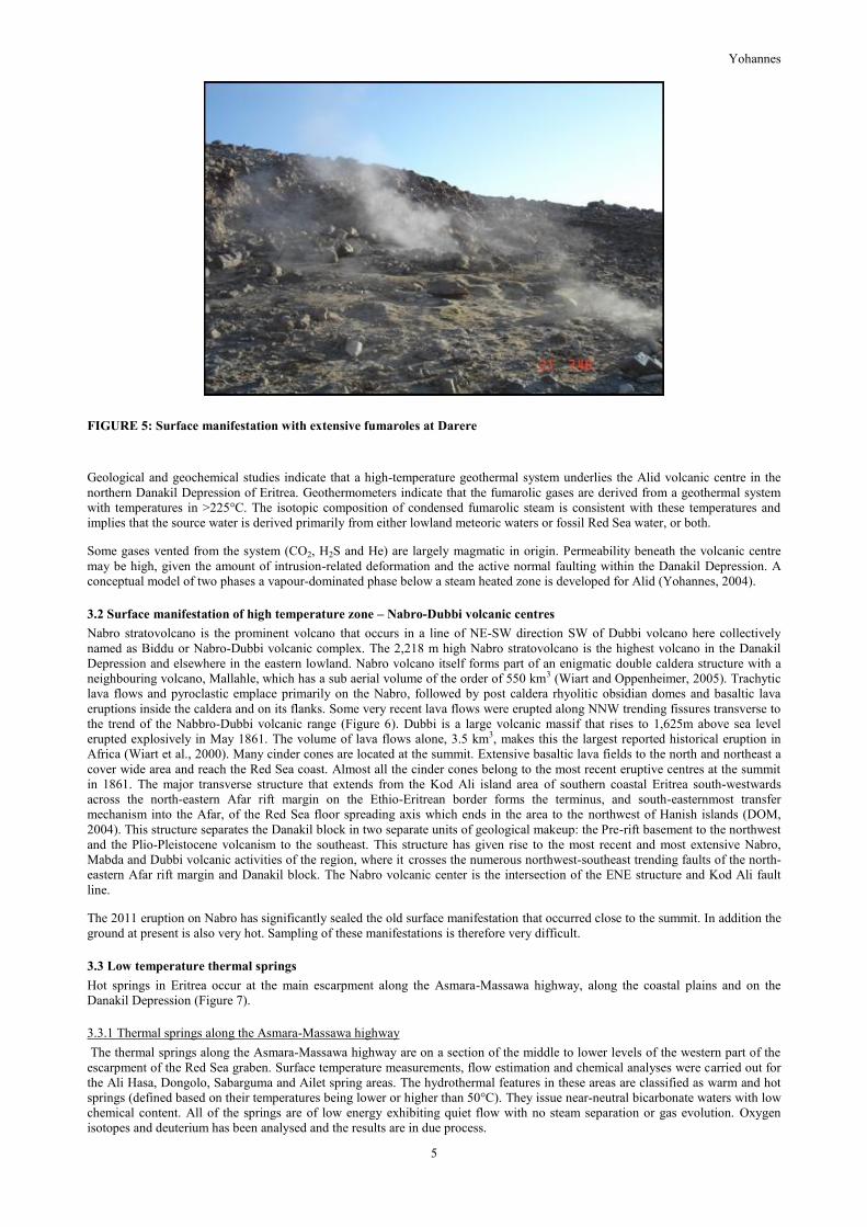
FIGURE 5: Surface manifestation with extensive fumaroles at Darere
Geological and geochemical studies indicate that a high-temperature geothermal system underlies the Alid volcanic centre in the
northern Danakil Depression of Eritrea. Geothermometers indicate that the fumarolic gases are derived from a geothermal system
with temperatures in >225°C. The isotopic composition of condensed fumarolic steam is consistent with these temperatures and
implies that the source water is derived primarily from either lowland meteoric waters or fossil Red Sea water, or both.
Some gases vented from the system (CO2, H2S and He) are largely magmatic in origin. Permeability beneath the volcanic centre
may be high, given the amount of intrusion-related deformation and the active normal faulting within the Danakil Depression. A
conceptual model of two phases a vapour-dominated phase below a steam heated zone is developed for Alid (Yohannes, 2004).
3.2 Surface manifestation of high temperature zone – Nabro-Dubbi volcanic centres
Nabro stratovolcano is the prominent volcano that occurs in a line of NE-SW direction SW of Dubbi volcano here collectively
named as Biddu or Nabro-Dubbi volcanic complex. The 2,218 m high Nabro stratovolcano is the highest volcano in the Danakil
Depression and elsewhere in the eastern lowland. Nabro volcano itself forms part of an enigmatic double caldera structure with a
neighbouring volcano, Mallahle, which has a sub aerial volume of the order of 550 km3 (Wiart and Oppenheimer, 2005). Trachytic
lava flows and pyroclastic emplace primarily on the Nabro, followed by post caldera rhyolitic obsidian domes and basaltic lava
eruptions inside the caldera and on its flanks. Some very recent lava flows were erupted along NNW trending fissures transverse to
the trend of the Nabbro-Dubbi volcanic range (Figure 6). Dubbi is a large volcanic massif that rises to 1,625m above sea level
erupted explosively in May 1861. The volume of lava flows alone, 3.5 km3, makes this the largest reported historical eruption in
Africa (Wiart et al., 2000). Many cinder cones are located at the summit. Extensive basaltic lava fields to the north and northeast a
cover wide area and reach the Red Sea coast. Almost all the cinder cones belong to the most recent eruptive centres at the summit
in 1861. The major transverse structure that extends from the Kod Ali island area of southern coastal Eritrea south-westwards
across the north-eastern Afar rift margin on the Ethio-Eritrean border forms the terminus, and south-easternmost transfer
mechanism into the Afar, of the Red Sea floor spreading axis which ends in the area to the northwest of Hanish islands (DOM,
2004). This structure separates the Danakil block in two separate units of geological makeup: the Pre-rift basement to the northwest
and the Plio-Pleistocene volcanism to the southeast. This structure has given rise to the most recent and most extensive Nabro,
Mabda and Dubbi volcanic activities of the region, where it crosses the numerous northwest-southeast trending faults of the north-
eastern Afar rift margin and Danakil block. The Nabro volcanic center is the intersection of the ENE structure and Kod Ali fault
line.
The 2011 eruption on Nabro has significantly sealed the old surface manifestation that occurred close to the summit. In addition the
ground at present is also very hot. Sampling of these manifestations is therefore very difficult.
3.3 Low temperature thermal springs
Hot springs in Eritrea occur at the main escarpment along the Asmara-Massawa highway, along the coastal plains and on the
Danakil Depression (Figure 7).
3.3.1 Thermal springs along the Asmara-Massawa highway
The thermal springs along the Asmara-Massawa highway are on a section of the middle to lower levels of the western part of the
escarpment of the Red Sea graben. Surface temperature measurements, flow estimation and chemical analyses were carried out for
the Ali Hasa, Dongolo, Sabarguma and Ailet spring areas. The hydrothermal features in these areas are classified as warm and hot
springs (defined based on their temperatures being lower or higher than 50°C). They issue near-neutral bicarbonate waters with low
chemical content. All of the springs are of low energy exhibiting quiet flow with no steam separation or gas evolution. Oxygen
isotopes and deuterium has been analysed and the results are in due process.
Yohannes
6
FIGURE 6: Geological interpretation of Nabro-Dubbi area, notice the intersection of structures (DOM, 2004).
FIGURE 7: Location map of hot springs; locations 1 and 2 are around the Gulf of Zula, 3 is on the way to Asmara-Massawa
and 4 on the Danakil Depression
3.3.2 Gulf of Zula area
Thermal springs occur at Ua-a and Acfat, thermal water wells in Arafali and Zula villages, all to the west of the Gulf of Zula, and
in Gelti area on the south side of the gulf. Ua-a thermal spring is located about 20 km northwest of Foro village, situated to the
north of Zula town. It occurs in an area covered by fluvial deposits, has a large discharge, a water temperature of 36°C and pH of
7.5. The Acfat group of thermal springs is located about 4 km north of Zula village and about 1.5 km from the sea. The main spring
has a temperature of 43°C, a large discharge and a pH of 7.0. The springs occur on the edge of a swamp. A large diameter dug well
located in Erafayle village is 10 m deep. Another in Zula town is 20 m deep. Both wells have thermal water with a temperature of
Yohannes
7
36°C and a pH of 7.0. The Gelti group of thermal springs consists of a large number of thermal springs located on the seashore. The
water chemistry indicates a large measure of mixing with seawater. Low-pressure steam vents are located within about 200 m of the
shore, being steam thought to be separated at low pressure from underground water bodies flowing toward the seashore.
All the hot springs mentioned above, except for Gelti, the thermal waters along Asmara-Massawa highway in terrain made up of
Precambrian rocks and thermal springs close to Gulf of Zula do not show any immediate association with magmatism. They are
thought to owe their occurrence to ascent, through the rift marginal faults, of waters heated at depth under typically crustal
geothermal conditions, with relatively low geothermal gradients. They are judged to have no association with large volume and
high temperature fluid circulation at shallow levels. They are thus believed to have no potential for large-scale commercial
development for power generation. They otherwise have potential for small-scale, low-temperature, non-power applications,
including for mineral water bottling, health and recreation spas etc., as already demonstrated at the Dongolo, Sabarguma and Ailet
springs which have histories of bottling popular brands of mineral water.
The Gelti area thermal springs occur in terrain made up of Quaternary basalt lava. These springs seem to be associated with
heating in underground zones of relatively elevated temperature but it is not certain if they are associated with high temperature and
volume of hot water circulation at shallow depth, due to the absence of signs of recent silicic volcanism indicating the existence of
a young shallow magma intrusion. Being in the coastal area, and also having association with high permeability rocks that may
allow hot water production in adequate volume, the area holds promise for low temperature geothermal resource application in such
uses as fish drying etc.
4. HYDROGEOLOGY OF ALID AND SURROUNDINGS
In general, the study area is divided into two major sources of surface water. These are the eastern and the western surface waters
relative to the location of Alid dome that drains from the Danakil horst and the highland plateau, respectively (Andemariam, et al.
2006). The western surface water flow has relatively gentle topography leading to slow to moderate run off. Recharge occurs in the
valleys of the Alluvium cover and other permeable rocks.
Water that reaches the Samoti plain partly infiltrates and partly evaporates. Evaporation exceeds percolation because the
temperature is very high. The amount of water that infiltrates appears to come out, through a fault, in the form of a hot spring in
Lake Bada. Rainfall is very little. Some highly jointed and fractured stratoid basalts occur east of Alid, and provide opportunities
for direct and indirect infiltration to the plains both north and south of Alid. The regional structure east of Alid, which is reported
by Clynne et al. (1996) as “Alid Graben master fault”, has a great contribution to the Wengebo and Samoti ground water recharge
and to the Alid geothermal potential indirectly.
In the highlands, however, the amount of infiltration is relatively high through the permeable formations at times of intense rainfall
and this water moves to the lowlands indirectly as part of ground water.
From the hydrogeological point of view the study area is mainly divided into three catchments based on the drainage flow patterns
(see Figure 8).
1. Wengebo catchment
2. Alid or central catchment area
3. Samoti catchment
Most of the run off from the escarpment percolates into the Pleistocene sediments and boulder beds, where it travels as shallow
ground water and replenishes the evaporating Alat oasis which is located at the north-western margin of the Samoti plain, south of
Alid.
FIGURE 8: Catchments of Alid and surrounding: a, Wengebo (northern part) b, Alid (central small catchment) c, Samoti
(southern catchment)
Yohannes
8
The hydrogeology of Alid and surrounding is mainly governed by:
1. Topographic level.
2. Presence of cemented sand and clay deposits, which act as barriers.
3. The ground water level is higher than the surface water. Therefore it feeds the surface water.
From geological and hydrogeological observations, the Wengebo catchment drains directly to Alid and it can be assumed that the
catchment is a feeder of surface and subsurface water to the Alid geothermal reservoir. In addition the ground water from Drawler
River can possibly feed the Alid Geothermal field because the river follows an East-West Fault. However, the Samoti catchment is
a discharge area with very little contribution, if any, in recharging the ground water to the Alid geothermal potential.
5. ALID GEOTHERMAL SYSTEM – ASSESSMENT FROM LINEAMENTS
Geologic lineament mapping is considered an important tool in geothermal exploration. Geothermal systems are associated with
areas of active faulting (Koenig and Mcnitt, 1983), because faults and fracture systems are the principal means by which meteoric
fluids penetrate deeply into the crust (Coolbaugh and Bedell, 2004). Recent study (Soengkono, 1999) shows that geothermal
reservoir is significantly influenced by faults and fractures that can easily be mapped from surface expressions, as they are often
marked by topographic lineaments. Besides statistical studies based on “weights of evidence model” shows that young volcanics
and faults have a positive weight in predicting favourable sites of geothermal systems (Coolbaugh and Bedell, 2004).
Faults recorded in the Alid area are mainly of normal faults type with some strike-slip faults. The opening of the fractures ranges
from mm scale to tenth centimetres; particularly the E-W has a wide opening. Fractures and faults were measured along surface
manifestation. The relationship between the local surface manifestation and fracture were assessed clearly and described below
briefly. Various structural directions were identified in association with the geothermal manifestation. Steaming grounds are mainly
associated with the 70°N, although generally the surface manifestations are aligned at NNW, at Illeghedi, the prominent surface
manifestation of the area. The NNW fractures are common on most of the surface manifestations. The E-W fractures have wide
spacings that occur in almost all the manifestations. The lineaments in Alid form a complex pattern but distinct sets of directions.
The systematic examination of faults falls into three major directions related to different tectonic origin by looking at the geological
exposures:
1. Lineaments striking ENE (60°-70°): common lineament, related to major axis of the dome.
2. Lineaments striking NNW (330°-340°): Frequently observed especially at north and south of the dome, related to the
trend of the depression.
3. Lineaments striking E-W (270°-280°): These are common as dykes and fractures related to rift tectonics.
An analysis of detailed aerial photographs of approximately 1:20,000 scale and land sat maps both of the image and shaded relief
plots was made to identify lineaments mainly caused by faults and fractures in the Alid area.
A dense lineament pattern is mapped out as shown on Figure 9. ENE lineaments are dominant at the central part of the area while
northerly striking faults and fractures are concentrated on the southern and northern parts of the dome.
FIGURE 9: Contour plot of Alid area using FFD analysis. Note the high values lie on the Darere-Illeghedi line. It is
superimposed on aerial photo.
Yohannes
9
A contour map of fault and fracture density (FFD), defined as the total length of lineaments per unit area, was constructed for the
area (Figure 9).
The zone of high FFD complies well with the central manifestation zone where areas of high surface manifestation occur. It extends
for about 5 km along a linear pattern. Two peaks of anomalous high areas occur in the close to Darere and Illegedi area. It has a
direction of 70°N beyond the limit of surface manifestation.
The trend is well conformable with the major NNE fracture system. It shows that the major surface manifestations of the area are
well in agreement with the FFD contour map. This suggests the significance influence of geological structures on the hydrology of
the geothermal system at Alid.
6. ALID GEOTHERMAL SYSTEM - ASSESSMENT FROM RESISTIVITY SURVEY
The geological and geochemistry performed on the Alid dome pointed out that a geothermal reservoir can occur beneath the Alid
dome. To justify this and know the extent and depth of the reservoir, a geophysical survey was anticipated. Since MT resistivity
survey has the ability to penetrate deep resistivity structures (some tens or hundreds of kilometers), and is practically the only
method for studying deep resistivity structures it was proposed in Alid. Accordingly, with the fund from ICEIDA, ISOR (Icelandic
Geosurvey) and the Eritrean Geological Survey, they carried out a MT survey on Alid dome and adjacent area.
Resistivity maps at various depths were drawn ranging from 400 meters above sea level to 10,000 meters below sea level (m.b.s.l).
At 3,500 m.b.sl. (Figure 10) and below a clear low resistivity NNW-SSE body is depicted west of the mountain and connected to
the broader WSW-ENE low resistivity to the south.
Figure 10. Resistivity map at 3500 meters below sea level. Coordinates are in UTM, km units.
The following conclusion on the resistivity structures has been drawn from the MT resistivity study on Alid:
A SW-NE Lineament. A conductive zone is seen down to about 6–7 km depth (and even more in some places) in the
south and southwest of Mt. Alid. This zone has a sharp vertical boundary or a lineament in the depth interval from 1/2-2
km depth shown by a yellow line on Figure 11. This boundary is best seen on the isoresistivity map at 1 km b.s.l. in
Figure 10.
A low resistivity body defined by the NNW-SSE brown line below the western part of Mt Alid and to the west of the
mountain there is a low resistivity body, approximately 3 km wide. It reaches the highest elevation at 2–3 km b.s.l., and
extending down to a depth of about 7 km.
Beneath most of Mt Alid there is a rather high resistivity, compared to the surroundings, and no deep conductor, except in
the westernmost sounding on the mountain.
Yohannes
10
Figure 11. The yellow line shows the location of the vertical resistivity boundary between 1/2 and 2 km depth. The brown
contour lines outline the low resistivity body west of Mt. Alid at about 2 km depth. Red dots are geothermal vents on
Mt. Alid.
An attempt has been done to relate the anomaly with the geotectonic set up of the area. The ENE direction low resistive anomaly
result marked at 3,500 meters b.s.l. is an important structure that extends even westward to the metamorphic basement (Yohannes,
2010). It is a deep seated as it juxtaposed the low grade and high-grade metamorphic complexes at the same topographic level. In
addition, the direction is also in line with the emplacement trend of the dome, which makes more interesting in dealing with the
fluid movement.
7. SUMMARY AND CONCLUSION
The tectonic setting and geological makeup of the Danakil Depression provides a suitable environment for the occurrence of
geothermal energy.
Alid and Nabro-Dubbi are the two potential targets for high temperature identified from surface studies so far carried out. The
estimated high reservoir temperature (greater than 220oC) from previous studies at Alid gives reason to conduct hydrogeology and
fracture analysis aiming at selection up-flow zones.
From the hydrogeological point of view, it is found out that highland water is the source of water for Alid.
Lineaments including measurements of faults and fractures at mesoscopic scale and interpreted from aerial photographs and digital
images were analyzed to better define areas of thermal flows at Alid. In order to clearly sort out the relationship between the faults
and fractures and thermal flow all the geothermal manifestations were assessed.
Most of the geothermal manifestations are associated with fractures and faults. Rosette and field investigation indicate that
lineaments at Alid are of three types: lineaments striking ENE (60°-70°), NNW (330°-340°), and striking E-W (270°-280°).
The maximum lineament zone defined by ENE strike is well marked on the FFD analysis in line with the major fracture set of the
area. Two high values depicted on the contour map are well accompanies with the thermal manifestation thus worth to commence
geophysical investigation and/or drill slim hole to map temperature gradient of the area.
The MT resistivity conducted at Alid depicted a very interesting and new site at the rift floor rather than beneath the Alid mount.
Therefore it is imperative to study the area in a wider perspective.
The current study recommends the following detail work to be commenced in the future on Alid:
Conduct CO2 and other gases (radon and mercury) mapping on the Alid dome to know the gas outflow zone and select a
site for a possible drill site target.
Gravity and microseismicity is also important to Mt Alid and the surrounding area in order to clearly define the target.
Perform the following prospect investigation on Nabro-Dubbi:
Yohannes
11
Conduct geological mapping.
Collect and analyze water and gas samples and perform geochemical interpretation.
Isotope hydrogeology has been conducted at Alid and low temperature fields, the result will be interpreted, and for Nabro-Dubbi
prospects the study will be conducted in the near future.
The 2011 volcanism in Nabro-Dubbi prospect is still too hot to perform exploration at or close to the summit. In addition as
discussed the location of surface manifestations are sealed by pyroclastic falls.
REFERENCES
Andemariam, T., Woldeyohannes, D., and Misghina, M., 2006: Geology and hydrogeology of Alid and surrounding. Eritrean
Department of Mines, Draft report.
Beyth, M., 1996: Preliminary assessment of the Alid geothermal field, Eritrea. Geological Survey of Israel current research, 10,
124-128.
Clynne, M.A., Duffield, W.A., Fournier, R.O., Weldegiorgis, L., Janik, C.J., Kahsai, G., Lowenstern, J., Weldemariam, K., and
Tesfai, T., 1996: Geothermal potential of the Alid Volcanic Center, Danakil depression, Eritrea. U.S. Geol. Survey, final
report to U.S. Agency for International Development under the terms of PASA No. AOT-0002-P-00-5033-00, 46 pp.
Coolbaugh, M.F., and Bedell, R., 2004: A simplification of weights of evidence using density function and fuzzy distribution: using
geothermal systems in Nevada as an example, Geological Association of Canada Special Paper “GIS applications in the Earth
Sciences”, in press.
Department of Mines (DOM), 2004: Eritrea geothermal project pipeline proposed for implementation under ARGeo. Eritrean
Department of Mines, Draft report.
Eysteinsson H., Teklesenbet A., Rosenkjaer G.K., and Karlsdottir R., 2009: Resistivity survey in Alid geothermal area, Eritrea.
ISOR-2009/016 report, Iceland, 42pp.
Koenig, J.B., and McNitt, J.R., 1983, Controls on the location and intensity of magmatic and non-magmatic geothermal systems in
the Basin and Range province. Geothermal Resource Council Special Report 13, 93 p.