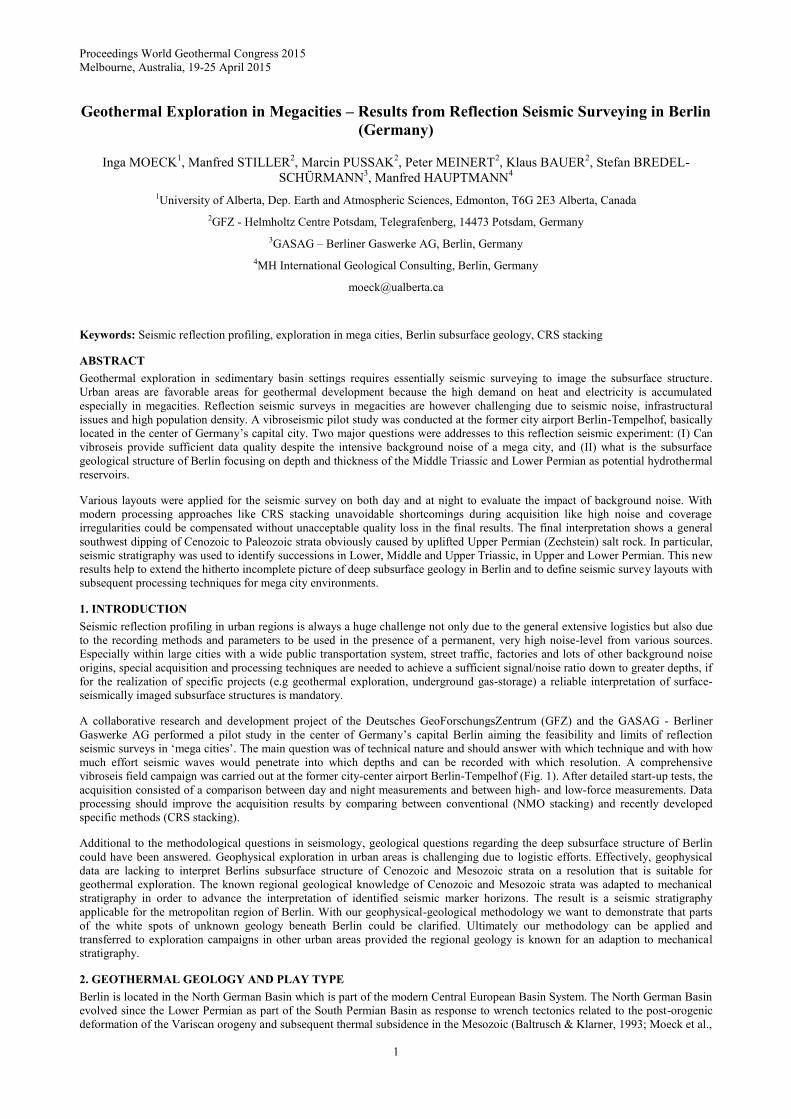
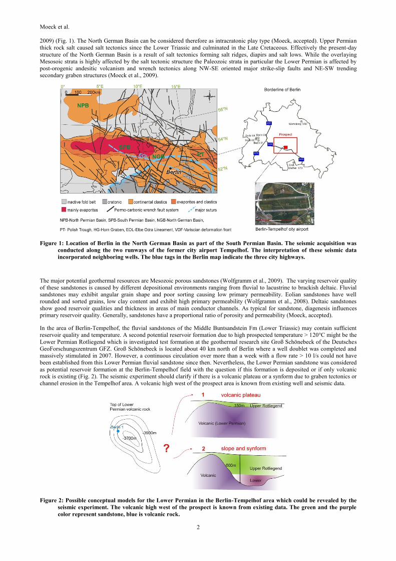
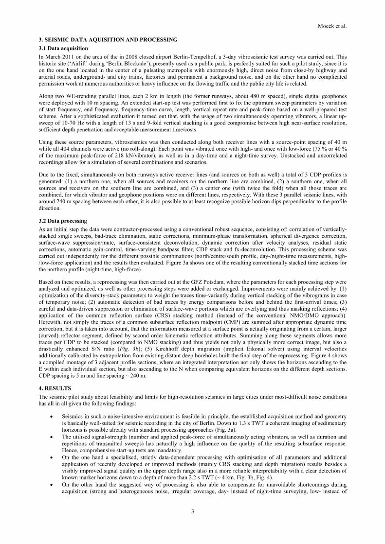
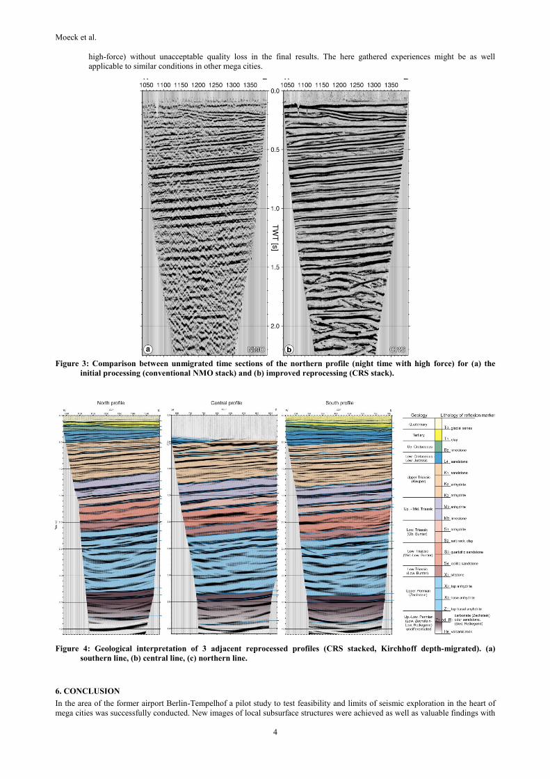
Proceedings World Geothermal Congress 2015 Melbourne, Australia, 19-25 April 2015 1 Geothermal Exploration in Megacities – Results from Reflection Seismic Surveying in Berlin (Germany) Inga MOECK 1 , Manfred STILLER 2 , Marcin PUSSAK 2 , Peter MEINERT 2 , Klaus BAUER 2 , Stefan BREDEL- SCHÜRMANN 3 , Manfred HAUPTMANN 4 1 University of Alberta, Dep. Earth and Atmospheric Sciences, Edmonton, T6G 2E3 Alberta, Canada 2 GFZ - Helmholtz Centre Potsdam, Telegrafenberg, 14473 Potsdam, Germany 3 GASAG – Berliner Gaswerke AG, Berlin, Germany 4 MH International Geological Consulting, Berlin, Germany [email protected]Keywords: Seismic reflection profiling, exploration in mega cities, Berlin subsurface geology, CRS stacking ABSTRACT Geothermal exploration in sedimentary basin settings requires essentially seismic surveying to image the subsurface structure. Urban areas are favorable areas for geothermal development because the high demand on heat and electricity is accumulated especially in megacities. Reflection seismic surveys in megacities are however challenging due to seismic noise, infrastructural issues and high population density. A vibroseismic pilot study was conducted at the former city airport Berlin-Tempelhof, basically located in the center of Germany’s capital city. Two major questions were addresses to this reflection seismic experiment: (I) Can vibroseis provide sufficient data quality despite the intensive background noise of a mega city, and (II) what is the subsurface geological structure of Berlin focusing on depth and thickness of the Middle Triassic and Lower Permian as potential hydrothermal reservoirs. Various layouts were applied for the seismic survey on both day and at night to evaluate the impact of background noise. With modern processing approaches like CRS stacking unavoidable shortcomings during acquisition like high noise and coverage irregularities could be compensated without unacceptable quality loss in the final results. The final interpretation shows a general southwest dipping of Cenozoic to Paleozoic strata obviously caused by uplifted Upper Permian (Zechstein) salt rock. In particular, seismic stratigraphy was used to identify successions in Lower, Middle and Upper Triassic, in Upper and Lower Permian. This new results help to extend the hitherto incomplete picture of deep subsurface geology in Berlin and to define seismic survey layouts with subsequent processing techniques for mega city environments. 1. INTRODUCTION Seismic reflection profiling in urban regions is always a huge challenge not only due to the general extensive logistics but also due to the recording methods and parameters to be used in the presence of a permanent, very high noise-level from various sources. Especially within large cities with a wide public transportation system, street traffic, factories and lots of other background noise origins, special acquisition and processing techniques are needed to achieve a sufficient signal/noise ratio down to greater depths, if for the realization of specific projects (e.g geothermal exploration, underground gas-storage) a reliable interpretation of surface- seismically imaged subsurface structures is mandatory. A collaborative research and development project of the Deutsches GeoForschungsZentrum (GFZ) and the GASAG - Berliner Gaswerke AG performed a pilot study in the center of Germany’s capital Berlin aiming the feasibility and limits of reflection seismic surveys in ‘mega cities’. The main question was of technical nature and should answer with which technique and with how much effort seismic waves would penetrate into which depths and can be recorded with which resolution. A comprehensive vibroseis field campaign was carried out at the former city-center airport Berlin-Tempelhof (Fig. 1). After detailed start-up tests, the acquisition consisted of a comparison between day and night measurements and between high- and low-force measurements. Data processing should improve the acquisition results by comparing between conventional (NMO stacking) and recently developed specific methods (CRS stacking). Additional to the methodological questions in seismology, geological questions regarding the deep subsurface structure of Berlin could have been answered. Geophysical exploration in urban areas is challenging due to logistic efforts. Effectively, geophysical data are lacking to interpret Berlins subsurface structure of Cenozoic and Mesozoic strata on a resolution that is suitable for geothermal exploration. The known regional geological knowledge of Cenozoic and Mesozoic strata was adapted to mechanical stratigraphy in order to advance the interpretation of identified seismic marker horizons. The result is a seismic stratigraphy applicable for the metropolitan region of Berlin. With our geophysical-geological methodology we want to demonstrate that parts of the white spots of unknown geology beneath Berlin could be clarified. Ultimately our methodology can be applied and transferred to exploration campaigns in other urban areas provided the regional geology is known for an adaption to mechanical stratigraphy. 2. GEOTHERMAL GEOLOGY AND PLAY TYPE Berlin is located in the North German Basin which is part of the modern Central European Basin System. The North German Basin evolved since the Lower Permian as part of the South Permian Basin as response to wrench tectonics related to the post-orogenic deformation of the Variscan orogeny and subsequent thermal subsidence in the Mesozoic (Baltrusch & Klarner, 1993; Moeck et al.,
Transcript
Proceedings World Geothermal Congress 2015
Melbourne, Australia, 19-25 April 2015
1
Geothermal Exploration in Megacities – Results from Reflection Seismic Surveying in Berlin
(Germany)
Inga MOECK1, Manfred STILLER
2, Marcin PUSSAK
2, Peter MEINERT
2, Klaus BAUER
2, Stefan BREDEL-
SCHÜRMANN3, Manfred HAUPTMANN
4
1University of Alberta, Dep. Earth and Atmospheric Sciences, Edmonton, T6G 2E3 Alberta, Canada
2GFZ - Helmholtz Centre Potsdam, Telegrafenberg, 14473 Potsdam, Germany
3GASAG – Berliner Gaswerke AG, Berlin, Germany
4MH International Geological Consulting, Berlin, Germany