EXAMPLE NEA INVESTIGATION A-LEVEL GEOGRAPHY (7037) Marked NEA investigation with commentary and completed marksheet An example NEA portfolio with completed marksheet and examiner commentary "The environmental and social impacts of the South Devon link road" Version 1.0 Spring 2020 A-LEVEL
Transcript
EXAMPLE NEA INVESTIGATION
A-LEVELGEOGRAPHY(7037)
Marked NEA investigation with commentary and completed marksheet
An example NEA portfolio with completed marksheet and examiner commentary
"The environmental and social impacts of the South Devon link road"
AQA Education (AQA) is a registered charity (number 1073334) and a company limited by guarantee registered in England and Wales (number 3644723). Our registered address is AQA, Devas Street, Manchester M15 6EX.
7037/C/CRF
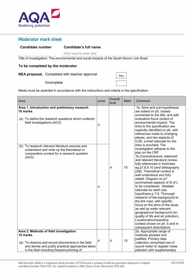
Moderator mark sheet
Candidate number Candidate’s full name
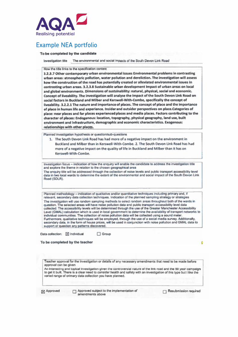
Click here to enter text. Title of investigation: The environmental and social impacts of the South Devon Link Road
To be completed by the moderator
NEA proposal. Completed with teacher approval
Incomplete
Marks must be awarded in accordance with the instructions and criteria in the specification.
Area Level Overall level Mark Comment
Area 1. Introduction and preliminary research 10 marks
(a) To define the research questions which underpinfield investigations (AO3)
4
4 10
1a. Aims and sub-hypotheses are stated on p5, closely connected to the title, and with evaluative focus (extent of environmental impact). The links to the specification are explicitly identified on p6, with references made to changing places, and two aspects of CUE; a brief rationale for the links is provided. The investigation adheres to the plan on the CRF 1b.Comprehensive, balanced and relevant literature review, fully referenced in footnotes eg p7,8,9,10 (and bibliography p38). Theoretical context is well understood and fully stated. Diagram on p7 summarises aspects of Q of L to be considered. Detailed rationale for each sub- hypothesis p 7-9. Thorough research of the background to the link road, with specific focus on the aims of the study as well as wider relevant geographical background (on quality of life and air pollution). Locational/comparative context shown on p4 ,5 and in subsequent descriptions
(b) To research relevant literature sources andunderstand and write up the theoretical orcomparative context for a research question(AO3)
4
Area 2. Methods of field investigation 15 marks
(a) To observe and record phenomena in the fieldand devise and justify practical approaches takenin the field including frequency/timing of
4 4 15
2a. Appropriate range of methods adopted and justified. Primary data collection comprised use of sound meter to register noise pollution with supplementary
Yes
observation, sampling, and data collection approaches (AO3)
GMAL calculation to measure accessibility, and online questionnaire sent via local community facebook pages. Secondary data consisted of estate agent house price information. Photograph headlines and photographic support used where relevant. Justification for each method is thorough and linked to each sub-hypothesis. Sampling strategy for noise survey stated-random sampling approach using grid and number table to generate fieldwork sites. Other sampling strategies inferred or stated eg opportunistic sampling for questionnaires, randomly generated grids for house price data. Size of sample is indicated for most surveys-eg 10 locations with 5 measurements of noise level. Dates and times stated. Detailed use of approaches. Thorough justification ( generally) Level 4 2b. Thorough demonstration of K and U relevant to the investigation. Methods are explained fully, in a step by step approach, showing practical knowledge of field methodologies. Level 4 2c. All techniques are followed up and implemented. Data is of good quality and relevant to the investigation. Sample size is suitable to the scope of the investigation, eg 129 responses to the online questionnaire. Level 4
(b) To demonstrate practical knowledge and understanding of field methodologies appropriate to the investigation of human and physical processes (AO3)
4
(c) To implement chosen methodologies to collect data/information of good quality and relevant to the topic under investigation (AO3)
4
Area 3. Methods of critical analysis 20 marks (a) To demonstrate knowledge and understanding
of the techniques appropriate for analysing field data and information and for representing results, and show ability to select suitable quantitative or qualitative approaches and to apply them (AO3)
4
4 20
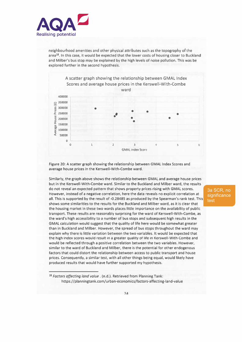
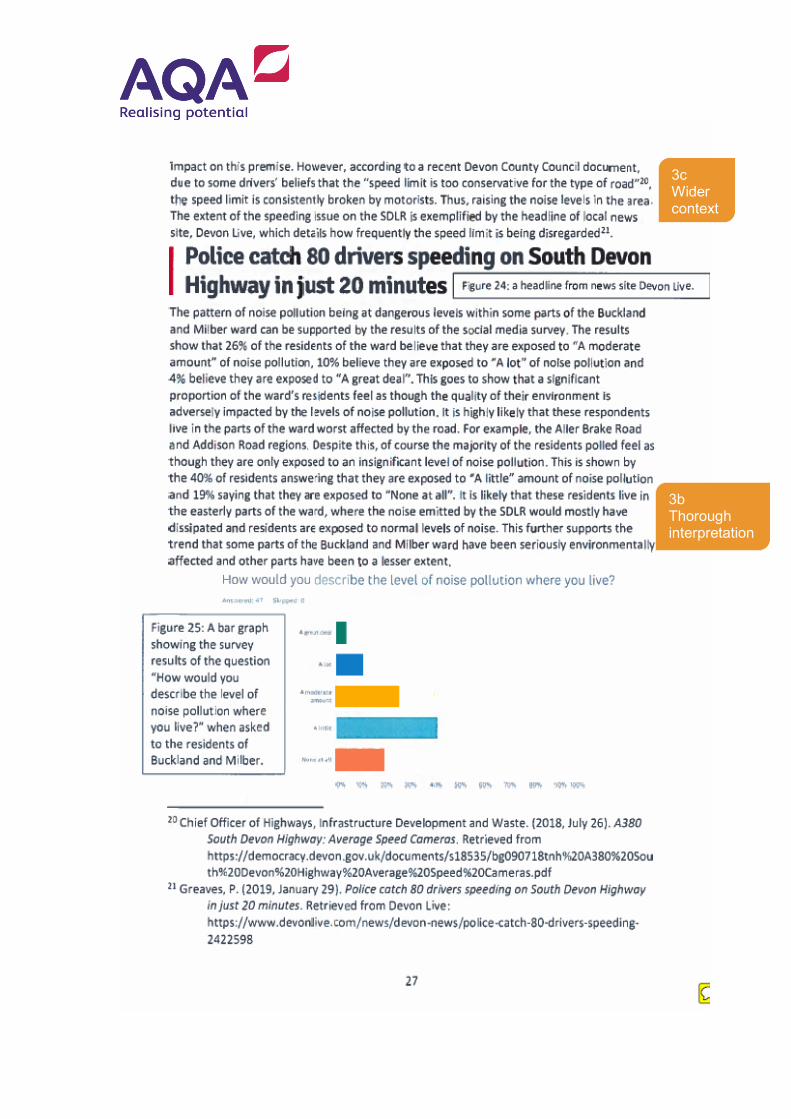
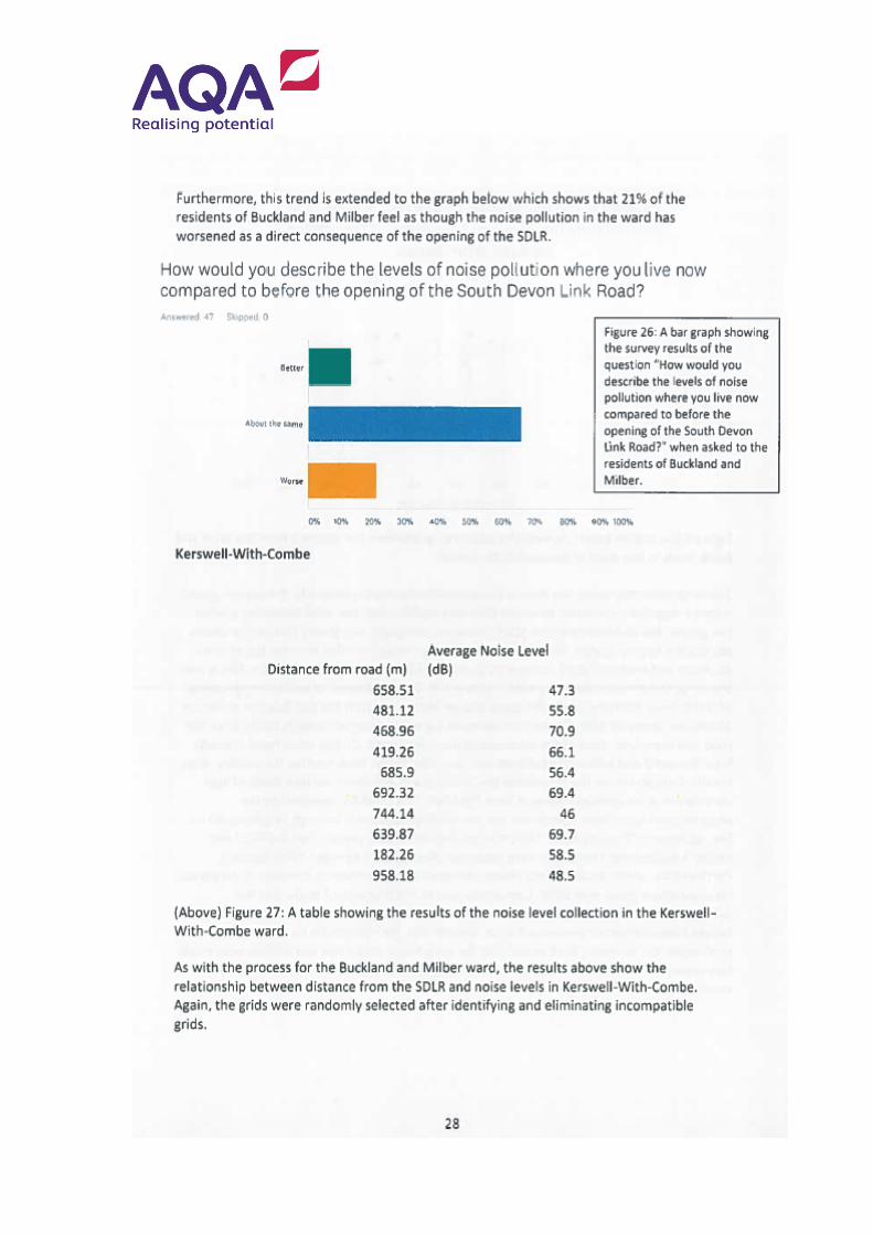
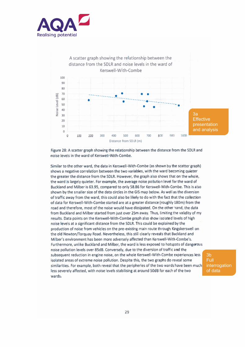
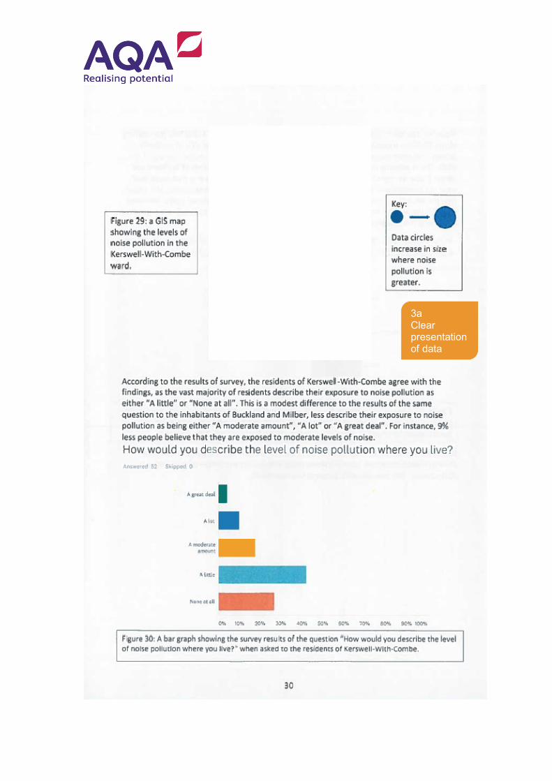
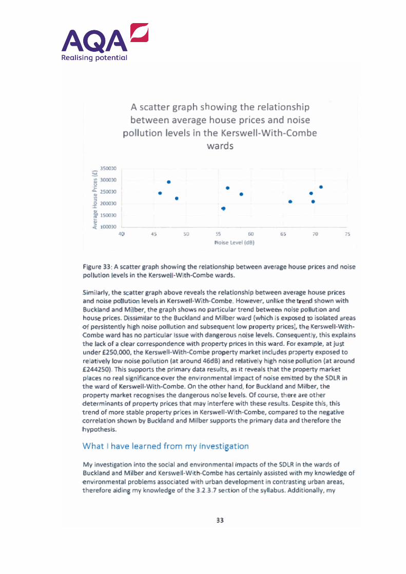
3a. A range of qualitative and quantitative techniques is used to present and analyse the data, including labelled photographs, facebook screenshot, located circles shaded to show GMAL scores p17, bar graphs, pie charts, scatter graphs p23-24, located proportional circles to show noise levels p26 and 30, with some raw and processed data in appendix. ARC/GIS is used effectively to show spatial patterns. Some maps lack conventions. Further
(b) To demonstrate the ability to interrogate and critically examine field data in order to comment on its accuracy and/or the extent to which it is representative, and use the experience to extend geographical understanding (AO3)
4+
(c) To apply existing knowledge, theory and concepts to order and understand field observations (AO2)
4
statistical analysis including Spearman rank test, some with test of significance eg p26. Thorough ability to select suitable methods for analysis and presentation. Level 4 3b.Results are fully interrogated. Each set of results is considered and links made between data sets. Data is thoroughly manipulated and reasons given. Detailed explanations of findings, with anomalies explained. Interpretations closely linked to sub hypotheses. Some recognition of limitations of sample size eg p 34 and its impacts on the reliability of the investigation. Level 4 3c. Links are made with theoretical context throughout, eg p23, p26 with further references to literature eg p26, 27. Analysis is interwoven into broader geographical context. Clear links back to spec content as reflection of improved understanding of social and environmental impacts p33-34. Effective application Level 4
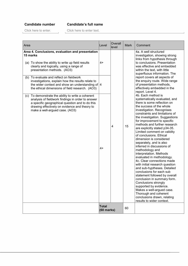
Candidate number Candidate’s full name
Click here to enter. Click here to enter text.
Area Level Overall level Mark Comment
Area 4. Conclusions, evaluation and presentation 15 marks (a) To show the ability to write up field results
clearly and logically, using a range of presentation methods. (AO3)
4+
4 15
4a. A well structured investigation, showing strong links from hypothesis through to conclusions. Presentation was effective and embedded within the text, with little superfluous information. The report covers all aspects of the enquiry route. Wide range of presentation methods, effectively embedded in the report. Level 4. 4b. Each method is systematically evaluated, and there is some reflection on the success of the whole investigation. Recognises constraints and limitations of the investigation. Suggestions for improvement to specific methods and further research are explicitly stated p34-35. Limited comment on validity of conclusions. Ethical dimension is considered separately, and is also inferred in discussions of methodology and interpretation. Methods evaluated in methodology. 4c. Clear connections made with initial research question and sub-hyptheses. Detailed conclusions for each sub statement followed by overall conclusion in summary form. Conclusions strongly supported by evidence. Makes a well-argued case. Thorough and coherent conclusions drawn, relating results to wider context.
(b) To evaluate and reflect on fieldwork investigations, explain how the results relate to the wider context and show an understanding of the ethical dimensions of field research. (AO3)
4
(c) To demonstrate the ability to write a coherent analysis of fieldwork findings in order to answer a specific geographical question and to do this drawing effectively on evidence and theory to make a well-argued case. (AO3)
4+
Total (60 marks) 60
Details of additional assistance given Record here details of any assistance given to this candidate which is beyond that given to the class as a whole and beyond that described in the specification (continue on a separate sheet if necessary). Click here to enter text.
Concluding comments Click here to enter text.
Example NEA portfolio
4a Evidence of organisation and sequence
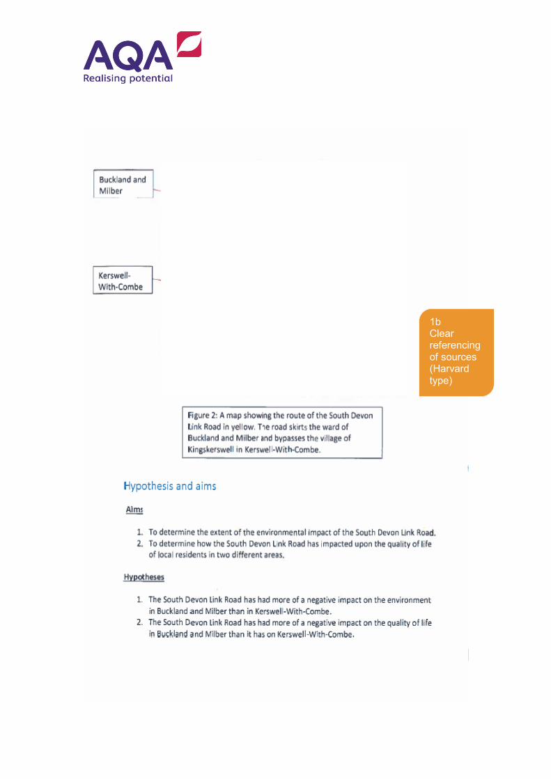
1b Clear referencing of sources (Harvard type)
Some images in this document have had to be removed for copyright reasons.
1b Clear referencing of sources (Harvard type)
1a Thorough understanding of specification links
1b Clear rational for hypothesis
1b Comparative context
1b Well developed theoretical context
1a L4 - Hypotheses effectively identified. Fully referenced to specification
1b L4 - Thorough use of literature sources. Detailed theoretical and comparative contexts.
2a Sampling strategies
2b Explanation of methodology
2a Explanation of sec data sources
2a Sampling justification
2b Explanation
2b Systematic explanation
2a Frequencies and timings stated
2a Sampling, frequencies
2b Clear explanation
3b Awareness of unrepresentative sample size
3a Appropriate technique, with justification.
2a Method justified
2b Full explanation
4b Evaluates method
2b Thorough explanation
2a - Wide range and thorough justification of methods, with sampling size and type stated.
2b - Detailed explanation of methods
2c - Comprehensive programme of data collection, all carried out
3a Clear presentation
3b Thorough interpretation
3a Simple presentation
3b Critical examination of data
3a Basic presentation
3b Thorough interrogation of data
3b Effective interpretation
3b Systematic interpretation. Some links between data sets
3a Clear presentation and analysis
3a SCR, no significance test
3b Detailed interpretation
3a SCR, no significance test
3b Thorough analysis 3c Broader context
3a Effective presentation and analysis
3c Wider context
3b Thorough interpretation
3a Effective presentation and analysis
3b Full interrogation of data
3a Clear presentation of data
3b Thorough critical interpretation
3a Effective presentation and analysis
3b Detailed interpretation
3c Wider context of study acknowledged
3a L4 - Wide range of suitable techniques-both analysis and presentation 3b L4 - Thorough interpretation, linked to wider context 3c. L4 - Effective application of theory and concepts
4b Evaluation of methods
3b Reflects on sample size
4b Effective evaluation-limitations of methodology, possible improvements and wider context
4b Understands ethical dimension
4c Detailed summary of findings for each hypothesis
4c Link to wider/ comparative context
4c Clear evidence-based overall conclusion
4a. L4 - Fluent and logical report. Wide range of presentation methods 4b. L4 - Effective evaluation, with link to wider context 4c. L4 - Thorough conclusion based on evidence
1b Thorough literature review 4a Evidence of organisation
EXAMPLE RESPONSE
A-LEVELGEOGRAPHY(7037)
Marked Papers7737-1 36 marks Q3 Q7 Redacted
Lorem ipsum dolor sit amet, consectetur adipiscing elit, sed do eiusmod tempor incididunt ut labore et dolore magna aliqua. Ut enim ad minim veniam, quis nostrud exercitation ullamco laboris nisi ut aliquip ex ea commodo consequat. Duis aute irure dolor in reprehenderit in voluptate velit esse cillum dolore eu fugiat nulla pariatur. Excepteur sint occaecat cupidatat non proident, sunt in culpa qui officia deserunt mollit anim id est laborum.


![July 27, 2009IETF NEA Meeting1 NEA Working Group IETF 75 nea[-request]@ietf.org Co-chairs: Steve Hanna shanna@juniper.netshanna@juniper.net.](https://static.documents.pub/doc/80x56/56649ee75503460f94bf7641/july-27-2009ietf-nea-meeting1-nea-working-group-ietf-75-nea-requestietforg.jpg)


